tectonics and mud volcano development in the gulf of …eprints.ucm.es/16746/1/1-s3.pdftectonics and...
TRANSCRIPT

Tectonics and mud volcano development in the Gulf of Cidiz
T. Medialdea a.*, L. Somoza a, L.M. Pinheiro b, M.C. Fernandez-Puga C, ].T. Vazquez d, R. Lean a, M.K. lvanove, V. Magalhaes b.f, V. Diaz-del-Rio d, R. Vegas g
• Marine Geology Division, fGME Geological Survey afSpain, Rios Rosas 23, 28003 Madrid, Spain
b Departamento de Geociencias and CESM1, Universidade de Aveiro, 3810-193 Aveiro, Portugal C Facultad de Ciencias del Mar, Universidad de Cadiz, Puerto Real, 1151O-Cadiz, Spain
d Instituto Espaiio[ de Oceanografia, Fuengiro/a 29640 Malaga, Spain
" UNESCO Centre for Marine Geosciences, Moscow State University, Russia
f Departamento de Geo/ogia Marinha, Instituto Nacional de E ngenharia, Tecnologia e Inovm;Eio LP., 2721-866 Alfragide, Portugal g Departamento de Geodinamica, Fae C Geol6gicas, Universidad Complutense, 28040-Madrid, Spain
ABSTRACT
Keywords:
mud volcanoes
hydrocarbon seeps
fluid venting
diapirism
tectonics
Gulf of Cadiz
Many structures associated with fluid escape, including mud volcanoes, mud-carbonate mounds, pockmarks
and slides, have been identified and characterized in the Gulf of Cadiz. Most of the mud volcanoes following
NE-SW and NW-SE main trends are found at 350-2000 m depth in the eastern domain of the Gulf of cadiz,
which corresponds to the Betic-Rifean Margin. Scattered mud volcanoes have also been recognized on the
lower slope at 2300-3900 m depth. The major tectonic structures are thrust faults, extensional faults, strike
slip faults and diapirs. All these tectonic structures have provided escape pathways for overpressured
material and fluids or have favoured upward fluid movement along the sedimentary column and eventually
the build up of mud volcanoes. In this work we present images of the mud volcano plumbing systems and the
relationship between regional tectonics and mud volcano development. Seismic profiles acquired during the
TASYO 2000 and MVSEISjTIR-15 cruises are used to image and interpret the link between the mud volcano
edifices and the subsurface tectonic structures.
1. Introduction
Data collected in the last few years have revealed the importance
of sea-floor structures related to hydrocarbon fluid venting on the
continental slope of the Gulf of Gidiz. Major fluid venting features in
the Gulf of Gidiz have sizes ranging from kilometres to hundreds of
metres and have been grouped into three main types: 1) pockmarks
(Baraza and Ercilla, 1996; Casas et al., 2003; Lean et al., 2006); 2) mud
volcanoes, some bearing gas hydrates in both the Iberian (Somoza
et al., 2002; Pinheiro et al., 2003) and the Moroccan margins (Ivanov
et al., 2000; Gardner, 2001; Kopf et al., 2004; Van Rensbergen et al.,
2005); and 3) carbonate-mud mounds bearing carbonate chimneys,
crusts and slabs (Dlaz-del-Rlo et al., 2003; Magalhaes et al., 2004;
Femandez-Puga et al., 2007).
Three main relationships have been identified between mud
volcano development and geological environments (Dimitrov,
2002): (1) the occurrence of a close relationship between mud
volcanism and tectonics (Kopf, 2002; Huguen et al., 2004; Panahi,
2005), especially in compressional settings (Milkov, 2000); (2) the
existence of deep potential source layers in the sedimentary
succession (Feyzullayev et al., 2005); and (3) the location of mud
volcanoes where hydrocarbons have been or are actively being
generated (Guliyev and Feizullayev, 1997; Yusifov and Rabinowitz,
2004). The Gulf of Cadiz fulfils all these interrelations (Somoza et al.,
1999, 2001; Garda Mojonero and Martlnez del Olmo, 2001;
Ovsyannikov et al., 2003; Van Rensbergen et al., 2005; Pinheiro
et al., 2006; Lean et al., 2007; Femandez-Puga et al., 2007).
To date, most of the published work on mud volcanism has been
aimed at studying the fluid venting structures, the morphology and
geometry of the edifices and the geochemistry and origin of the fluids.
Little attention has been paid to mud volcano occurrence in relation to
tectonics, which is still poorly constrained. The large number of mud
volcanoes identified in the Gulf of Cadiz, their distribution along
different sectors of the margin and their location in different tectonic
settings provides the possibility of studying the development of mud
volcanism in a tectonically active area under a compressive/transpres
sional regime with a high level of seismicity. In this work we image
and document the relationship between tectonics and mud volcano
development on the Betic-Rifean margin and lower slope. With this
aim we use seismic profiles acquired during the TASYO Project and the
MVSEIS/TIR-15 cruises to analyze the "mud volcano system" structure
and the relationship between its genesis and tectonics. The images
presented correspond to "mud volcano systems" located in different
sectors of the continental slope, where the tectonic structure varies.

We use the term "mud volcano system" in the sense given by Stewart
and Davis (2006): "a set of structures associated with a constructional
edifice (mud volcano) and the feeder complex that connects the
volcano to its source stratigraphic unit".
2. Geological background
The present geological structure of the Gulf of Gidiz is the result of the
European-African plate convergence motion, dextral strike-slip along the
Azores-Gibraltar Plate BOlllldary and the westwards migration of the
Betic-Rifean Arc. This plate convergence lasted from Mid-Oligocene up to
Lite Miocene times and then continued with slow Lite Miocene to Recent
NW convergence (Dewey et al., 1989; Vazquez and Vegas, 2000;
Rosenbaum et al., 2002). Westward drift and collision of the Alboran
Domain with the North African and southern Iberian margins in the Early
Middle Miocene caused the development of the Betic-Rifean Belt (Figs. 1
and 2) and as a consequence the radial emplacement of huge
allochthonous masses (the so-called "Olistostrome Unit"), here named
the Allochthonous Unit of the Gulf of Cadiz (AUGC), on the Guadalquivir
Basin (Iberian foreland), the Rharb Basin (North African foreland) and the
Gulf ofc:adiz (Torelli et al., 1997; Maldonado et al., 1999; Medialdea et al.,
2004).
This complex geodynamic evolution is recorded in the architecture and
tectonic structure of the continental margin of the Gulf of c:adiz, which has
a series of physiographic, morphological and geological features and a
geodynamic framework that have focused the attention of many
researchers. Among these features, the following stand out: 1) an irregular
physiography, with an outstanding development of a broad continental
slope; 2) the emplacement of a chaotic body, the AUGC, which occupies
the central part of the Gulf of c:adiz; 3) complex tectonics with large-scale
diapiric processes throughout the entire continental margin; 4) the
occurrence of gas and gas hydrates, and eventually 5) the formation of sea
floor features related to hydrocarbon seepage, including many mud
volcanoes (Fig. 1). All these geological features are in a close relationship.
The continental slope extends from 140 m depth to the Horseshoe and
Seine abyssal plains, reaching a width of about 300 km (Hernandez
Molina et al., 2003). The sedimentary cover of the slope consists ofTriassic
to Quaternary materials (Maldonado et al., 1999), and ranges in thickness
from: 2-2.5 s Two-Way Travel Time (lWTI) on the middle continental
slope to 2-3.5 s (lWTI) on the lower slope, and again to 2-2.5 s (lWTI) on the abyssal plains (Medialdea et al, 2004). The AUGCmentioned above
represents the thid<est unit of the sedimentary cover (Fig. lB). It is a
wedge-shaped unit which extends from the Iberian Peninsula and
Morocco to the Horseshoe and Seine Abyssal Plains. The structure consists
of low-angle thrust sheets affected by later gravitational collapse and
reactivated thrusting (Torelli et al., 1997; Maldonado et al., 1999;
Medialdea et al., 2004). The AUGC consists of a mixture of Triassic,
Cretaceous, Paleogene and Neogene sedimentary units, overlying a
Palaeozoic basement (Maldonado et al., 1999). It involves a huge volume
of mud and salt diapirism ofTriassic salt units and undercompacted Early
Middle Miocene plastic marls (Maestro et al., 2003). The origin of this
chaotic body is highly controversial. It has been interpreted as a complex of
olistostromes caused by gravitational sliding and thrust tectonics (Torelli
et al., 1997; Medialdea et al., 2004). Its emplacement on the Atlantic realm
has been related to the western migration of the Alboran terrain as a
consequence of an once active subduction zone (Royden, 1993; Lonergan
and White, 1997; Rosenbaum et al., 2002; Medialdea et al, 2004; lribarren
et al., 2007). Alternatively, Gutscher et al. (2002) proposed that this
subduction is still active beneath Gibraltar. There is a general agreement
on the age of emplacement of this unit, which has been established as Lite
Tortonian in the Gulf of Cadiz (Torelli et al., 1997; Maldonado et al., 1999;
Somoza et al, 1999; Medialdea et al., 2004), although the AUGC was later
reactivated in the Late Miocene to Present as the result of the NW
compression. This feature appears as a chaotic, highly diffractive body on
the seismic profiles. The chaotic character attributed to the AUGC is due to
its heterogeneous composition and internal deformation produced by
diapirs, strike-slip faults, extensional faults, thrust faults, slides and fluid
venting structures (Figs. 1 and 2). Extensive mud diapirism has been
reported throughout the Gulf of c:adiz margin, especially on the slope
(Somoza et al, 1999; Maldonado et al., 1999; Lowrie et al., 1999; Maestro
et al., 2003; Somoza et al., 2003; Femandez-Puga et al., 2007).
Along the Gulf of Cadiz continental margin, the origin of hydro
carbon-related fluid venting structures is related to the occurrence of
both thermogenic and biogenic gas within the AUGC (Maldonado et al.,
1999; Mazurenko et al., 2003). The 50 mud volcanoes confirmed by
coring so far are cone-shaped sea-floor edifices ranging from 800 to
3500 m in diameter, which can tower in places up to 300 m above the
seabed. They are produced by mud and fluid (water, brine, gas, oil)
eruptions as the result of degassing processes in deeper reservoirs
(Hensen et al., 2007), intercalated with periods of inactivity. Most mud
volcanoes are built up of episodes of mud-breccia flows (Somoza et al.,
2003; Van Rensbergen et al., 2005) with evident indications of gas
saturation: degassing structures, a strongH2S smell and chemosynthetic
fauna (e.g. Pinheiro et al., 2003; SOIIIDza et al., 2003).
3. Methodology and data sources
The results of this work are mainly based on the interpretation of
multichannel seismic profiles collected during the TASYO 2000 cruise
along the Iberian margin and in deep waters on the lower slope (Fig.
3) in the framework of the MVSEIS Project and the UNESCO IOC TTR
Programme. Data related to new mud volcano discoveries obtained
recently on the MVSEIS08 Cruise have also been added. This work
would not have been possible without the results obtained from the
extensive dataset acquired during several surveys carried out aboard
the Pro! Logachev, Hesperides and Cornide de Saavedra research
vessels, which allowed discovering and investigating the diverse
sea-floor structures related to fluid venting along the Gulf of Cadiz. An
important contribution was also provided by the side scan sonar
mosaic of Dr. Joan Gardner from the Naval Research Laboratory,
Washington DC (Gardner, 2001). During these cruises, in addition to
swath bathymetry data obtained with a multibeam echosounder
(Simrad EM-12), the geophysical data acquired include multichannel
and single-channel seismic reflection profiles, surface (12 kHz) and
high resolution deep-towed (30-100 kHz) side scan sonar and
underwater video profiles. Targets of interest previously selected on
multibeam bathymetric maps, backscatter maps and seismic profiles
were sampled with dredges, TV-controlled grabs and gravity cores.
The seismic dataset presented in this work includes high- to medium
resolution seismic profiles that were obtained with a Topographic
Parametric Echosounder (TOPAS) with a maximum penetration of
100 m and a Sparker system with an energy source of 3500-7000 J and
a recording length of 2 s. The seismic data were recorded using Delph2
Triton Elics-software. Furthermore, 1728 km of multichannel seismic
profiles were obtained during the TASYO 2000 cruise (Fig. 3). The
multichannel seismic data were acquired with a five BOLT airgun array of
22.45 and 34.8 1 capadty and a lElEDYNE 96-channel streamer of 2.5 km
length, and were recorded for 10 s at a 2 IllS sampling rate. The shot
interval was 50 m. Seismic data were poststack time-migrated at the
Instituto Andaluz de Gencias de la Tierra. fledermouse software was used
to analyze the multibeam data, and Kingdom Suite software was used to
produce the seismic images.
4. Results
4.1. Tectonics and diapirism
The NW to WNW-directed compressional regime is responsible for
the development of NE-SW, ENE-WSW, NW-SE and WNW-ESE
tectonic structures on the lower slope and abyssal plains, where either
the sedimentary cover or the continental and oceanic basement are
involved (Fig. 1 ). Compressional structures consist of thrust faults and

A
37"
B wsw
E �
w
.13A
Seine Abyssal Plain
o Mesozoic, Subbetic
D Triassic
o o
w
Mud Volcano
* Mud Volcano recenUy discovered in MVSEIS08 Cruise
TASYO·1
w
Salt diapir
I Mar1y+salt diapirs
.�. -::.!':' �"'''''- o .�_��_",,50 km � ,
Flysh units
Upper Jurassic· Lower Aptian
D D
Upper CretaceousLower Eocene
AUGC D Miocene-Quaternary
6·
Bathymetry (m)
Oiapiric ridge
r Gravitational collapse
Fault
ENE
Units

z
z o '" '"
BOW
Iberian Massif
800
Plate Covergence
Direction
rw 6°W
� Fronts of the r"" Allochthonous Unit
� Thrust Fault * Mud Volcano Mud Volcano recently * discovered in MVSEISOB Cruise
• Southportuguese Zone
• MesQzoic, Betie External Zone
•
D
Betie Internal Zone • Flysch Units
Miocene D Pliocene/Quaternary
Fig. 2. Simplified geological map of the Gulf ofcadiz showing the main fronts of the AUGC (modified from Medialdea et ai., 2004) and the mud-carbonate mounds and mud volcanoes
identified in the Gulf of Cadiz. Mud volcano data taken from Ivanov et al. (2000). Gardner (2001), Pinheiro et al. (2003), Somoza et al. (2003) and Schwenk et al. (2006). Mud
carbonate mounds location taken from Diaz-del-Rio et al. (2003).
folds related to deformation of the basement and the sedimentary
cover or to diapiric structures. Major extensional structures consist of a
system of listric faults on the continental shelf in front of Gidiz, rooted
at the AUGC, which bound the diapiric ridges to the north (Fig. 1).
Extensional faults were produced by the gravitational collapse at the
back of the AUGC as it advanced seaward in the Pliocene-Quatemary
(Somoza et al., 1999; Maestro et al., 2003; Femandez-Puga et al., 2007).
Other extensional structures are normal faults rooted at the top of
Fig. 1. A) Map of the Gulf ofC.ldiz (modified from Medialdea. 2007) based on interpretation ofMCS lines with the location of main outcropping and very shallow diapirs. faults. mud
volcanoes and mud-carbonate mounds. FSb: Subbetic Front; FF: Flysch Front. Mud volcanoes recently discovered after Somoza et al. (2008). B) Line-drawing derived from the MCS
profile TASYO 1 that crosses the Gulf of Cadiz. See Fig. lA for location.

diapirs (crestal faults), which can reach the sea-floor. Transcurrent
structures are active right-lateral strike-slip faults trending NW-SE to
WNW-ESE (Fig. 1), with a compressional component situated on the
lower slope, in the northeastern part of the Horseshoe Abyssal Plain
and Coral Patch Ridge (Medialdea et al., 2004; Medialdea, 2007) and
on the Moroccan margin. Two types of diapirism have been recognized
on the seismic profiles (Fig. 1): salt diapirism related to the Mesozoic
evaporites and marly diapirism associated with the AUGC (Medialdea,
2007; Fernandez-Puga et al., 2007). The main halokinetic structures
are concentrated on the continental shelf and upper-middle slope of
the Iberian margin and on the Moroccan slope (Figs. 1 and 4). Buried
diapirs have also been recognized in seismic profiles in the central and
western part of the Gulf of Cadiz (Fig. lB). On the South Portuguese
margin, the diapirs are made up of lower jurassic and Triassic evaporites
that overlie the basement (Terrinha et al., 2002). They can be identified on
the bathymetric map (Fig. 1) as rolll1ded domes that deform the sea-floor,
such as the Lolita diapir (Figs. 1 and 4), but in other cases they do not crop
out. These diapirs were formed after the AUGC emplacement in the upper
Miocene, because they cut through it On the Moroccan margin, several
salt domes of 3-5 km diameter were mapped with multibeam data
acquired on the TASYO-2000 and GAP cruises (Fig. lA and B). They follow
ENE-WSW trends, have oval or rolll1ded morphologies and cut and
deformed almost the whole sedimentary cover. These diapirs are
constituted by Triassic evaporites deposited during the early rifting
phase that gave rise to the opening of the Atlantic (Pautot et al., 1970).
The formation of marly diapirs in relation to the AUGC has been
studied on the Iberian margin (Fig. lA). They are mainly composed of
Miocene clay and marls and Triassic evaporites and are represented by
rounded or oval domes slightly buried or outcropping. The diapirs are
grouped forming NE-SW ridges, parallel to the Subbetic Front (FSb in
Fig. lA), up to 85 km long and 4 km wide, producing a relief of 250 m
(Somoza et al., 2003; Fernandez-Pugaet al., 2007). The largest diapiric
-- TASYO Seismic Lines
structures are the Cadiz Diapiric Ridge, the Guadalquivir Diapiric
Ridge and the Dofiana Diapiric Ridge, with lengths of 43, 86 and
53 km, respectively (Figs. 4 and 5). The genesis of marly diapirs has
taken place from the upper Miocene to Present and has been related to
extensional or compressional tectonics.
4.2. fluid escape pathways and tectonics
Fluid migration appears to be fault-controlled (Somoza et al.,
2003; Medialdea et al., 2004; Pinheiro et al., 2006; Fernandez-Puga et
al., 2007). As noted above, in the Gulf of Cadiz the major tectonic
structures are thrust faults, strike-slip faults, extensional faults and
diapirs, which have been mapped from multichannel seismic data
(Somoza et al., 1999; Maldonado et al., 1999; Medialdea et al., 2004).
All these tectonic structures have favoured the upward fluid move
ment and/or have provided an escape pathway for overpressured
material and fluids along the sedimentary column to eventually build
up the mud volcanoes.
Mud volcanoes are distributed in three main areas of the Gulf of
Cadiz (Figs. 1 and 2). Most of them are found on the slope at 350-
2000 m depth, either on the northern Iberian margin (Tasyo and GDR
mud volcano fields) trending NE-SW (Lean et al., 2001; Somoza et al.,
2003; Dlaz-del-Rio et al., 2003) or on the Moroccan margin (the Al Arraiche mud volcano field), following an approximately NW-SE
direction (Mazurenko et al., 2003; Pinheiro et al., 2003; Van
Rensbergen et al., 2005; Pinheiro et al., 2006). Both of these margins
represent the offshore prolongation of the Betic-Rifean Belt and the
corresponding foreland basins (the Guadalquivir Basin in the Iberian
Peninsula and the Rharb Basin in Morocco, to the north and south of
the Gibraltar Arc). The occurrence of mud volcanoes seem to diminish
westwards, where relatively few single mud volcanoes have been
identified on the lower slope at 2300-3900 m depth.
ANASTASYA 99 Seismic Lines ANASTASYA 00 Seismic Lines
Fig. 3. Location ofTASYO multichannel seismic lines and previous surveys (Anastasya99 and AnastasyaoO) in the Gulf of Cldiz.

4.2.1. Betic-Rifean margin
In this part of the margin, major NE-SW and NW-SE trends are
determined by the Betic and AUGC structures (Figs. 1 and 2). The region
is characterized by successive arcuate thrusts corresponding from E to W
to the Flysch and Subbetic materials in the internal area and to the AUGC
in the more external domains. Westwards the basement dips to the east,
under a sedimentary cover of about 2.5-3 s (TWIT) thickness, which
A goW
IQ:] Salt diapirs
[!] Mud volcanoes
B c
corresponds mainly to the AUGC, structured in thrusting sheets that
advance seaward, reaching progressively further distances along a
seaward-dipping basal surface. This sector of the margin is characterized
by salt and mart nappes which were later affected by extensional
collapses, the widespread development of diapirs associated with the
AUGC and a great variety of fluid venting structures above them,
including numerous mud volcanoes and mud-carbonate mOlll1ds that
3600
TASYO-12 LOLlTA
z o ..... '"
o '" '"
Fig. 4. A) Map of the shale/salt diapirs and NE-SW trending diapiric ridges on the upper-middle slope of the Gulf of Cadiz (Modified from Fernandez-Puga et ai., 2007):
B) Bathymetric map of the Lolita salt diapir obtained with multibeam data: see Figs, lA and 4A for location: C) Multichannel seismic profile across the Lolita salt structure where the
diapir can be observed rising from below the AUGC

clearly control the slope morphology (Fig. lA). According to seismic
and well data (Maldonado et al., 1999), the allochthonous masses
involved in the continental shelf and upper slope are Miocene clays and
marls (Langhian to Upper Tortonian), fragments of Mesozoic and
plastic Triassic materials and even lower Cenozoic units.
Mud volcanoes are located at a depth range (350-2000 m) similar
to that of other mud volcano clusters found on the Mediterranean
Ridge (Camerlenghi et al., 1995; Huguen et al., 2004), the Black Sea
(Dimitrov, 2002; Bohrmann et al., 2003) and California (Orange et al.,
1999). They are associated with shallow/outcropping or buried diapirs
that form a set of parallel ridges, as can be clearly observed in the
multichannel seismic line TASYO 8 (Fig. 5). This line crosses the Bank of
Guadalquivir, a basement high where Variscan rock outcrops, and the
NE-SW Dofiana and Guadalquivir diapiric ridges which display a NE
SW trend, parallel to the Bank (Fig. 1). Along the profile and from NW to
SE, the size of the diapirs increases while the depth of the diapir crests
decreases. The AUGC is covered by Pliocene-Quaternary sediments
folded and deformed by the upward migration of the diapirs almost to
the sea-floor, indicating that these structures were active until recent
times. Chaotic and transparent seismic fades suggesting the presence of
gas usually appear at the top of these diapirs and dome structures and
sometimes in the overlying sediments. These transparent facies
disappear towards the surface at about 300-500 ms (TWIT) below
the sea-floor (Fig. 5). Faults generated on top of the diapirs as a conse
quence of their emplacement establish a pathway for transport and fluid
migration.
The Dofiana Diapiric Ridge is represented in line TASYO 8 by the
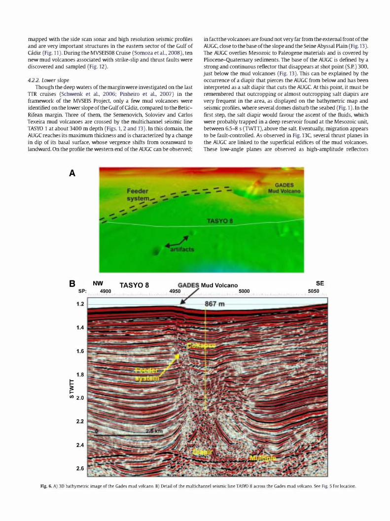
diapirs located next to the Guadalquivir Bank (Figs. 4 and 5). The Gades
mud volcano is found over this ridge very close to this seismic line
(Fig. 6), and is clearly linked to a diapir next to the Guadalquivir Bank,
as can be observed in Fig. 5. Fluid expulsion through the sediments, and
subsequent mass deficiency generate a gravity collapse. A collapse is
clearly imaged under the volcano by broken concave reflections related
to the fluid and mud evacuation towards the overlying mud volcano
and the extensional faults that link the summit of the diapir at 860 m
depth to the sea-floor (Fig. 6). The Gades mud volcano, whose 3D
image is displayed in Fig. 6A, is found at the crosspoint of one of these
faults with the sea-floor, where upward-dipping reflectors indicate
mud and fluids ascending to the sea-floor. Transparent fades,
indicating gas occurrence, have been observed within the diapir and
the sediments found over the NW diapiric flank, which extends to the
Guadalquivir Channel (Fig. 5).
Towards the SE, the seismic profile TASYO 8 crosses the Guadalqui
vir Diapiric Ridge, next to the Iberico and Cornide carbonate-mud
mounds (Fig. 7), where abundant carbonate crusts and chimneys were
collected (Dlaz-del-Rlo et al., 2003). The mud mounds appear to be
linked to a shallower diapir, connected to the sea-bottom through
several conduits marl<ed by acoustic blanking. No collapse is observed.
The feeder system is more complex if we consider that the ridge
appears to be also fed from a nearby diapir, as can be inferred from the
transparent fades that extends from its summit to the Gidiz channel at
the base of the scarp of the Guadalquivir Diapiric Ridge. In this case
there is a multiple source, so the fluid flux should be more diffused.
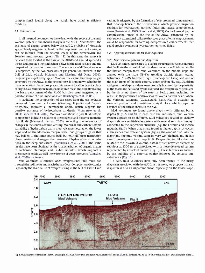
Southwards, the Tasyo mud volcano is located between the Iberian
and Moroccan margin and was crossed by seismic line TASYO 1 (Figs. 2
and 8).lt is a volcano linked to a deep and small diapir (1350 m depth
from sea-bottom) piercing a basin (Fig. 9) that surrounds the Subbetic
Front (Fig. 1). This basin is filled by a middle Miocene-Quaternary
depositional sequence of more than 1.5-2 s (TWIT) thick at the back
of the AUGC, formed by the subsequent extensional collapse of the
westwards advancing allochthonous masses (Fig. lB).
Under the mud volcano, in the detail of multichannel seismic
profile TASYO 1, we can differentiate an outcropping edifice over a
buried one, forming two stacked bicones and a common feeder system,
which give the typical image of a Christmas tree (Figs. 9 and 10) similar
to that observed on the Anastasya mud volcano (Somoza et al., 2003).
The Christmas tree appearance reveals different periods of activity
(Somoza et al., 2003). The bicones are about 300 m high and 3-3.5 km
wide (Fig. lOA). The upper one is more sharply defined, with reflections
ending against the boundary of the bicone. The bicones are connected to
the diapir by crestal faults that develop on top of its summit and
constitute the system that feeds the bicones. The occurrence of a stack of
two bicones bears witness to two major episodes of mud and fluid
migration and extrusion activity over time, with a very short dormant
period between them, as can be concluded from the lack of a
sedimentary layer between them. The bicones are formed by an initial
cone link to a feeder system connected to the overpressured mud
(Stewart and Davies, 2006). The formation of the bicones is due to the
later subsidence and collapse of the mud volcano edifice.
Finally, we can conclude from the map displayed in Fig. 1, that mud
volcanoes of the Moroccan margin are distributed along a NW-SE
direction, probably corresponding to NW-SE strike-slip faults that
intersects the arcuate thrusts of the margin (as reported by Pinheiro
et al., 2003, 2006; Somoza et al., 2008). These strike-slip faults can be
Fig. 5. Multichannel seismic line TASYO 8 across the Dofiana and Guadalquivir Diapiric ridges. See Fig. 2 for location. Inset shows location of Figs. 6 and 7.
mapped with the side scan sonar and high resolution seismic profiles
and are very important structures in the eastern sector of the Gulf of
Gidiz (Fig. 11). During the MVSEIS08 Cruise (Somoza et al., 2008), ten
new mud volcanoes associated with strike-slip and thrust faults were
discovered and sampled (Fig. 12).
4.2.2. Lower slope
Though the deep waters of the margin were investigated on the last
TIR cruises (Schwenk et al., 2006; Pinheiro et al., 2007) in the
framework of the MVSEIS Project, only a few mud volcanoes were
identified on the lower slope of the Gulf of Gidiz, compared to the Betic
Rifean margin. Three of them, the Semenovich, Soloviev and Carlos
Texeira mud volcanoes are crossed by the multichannel seismic line
TASYO 1 at about 3400 m depth (Figs. 1, 2 and 13). In this domain, the
AUGC reaches its maximum thickness and is characterized by a change
in dip of its basal surface, whose vergence shifts from oceanward to
landward. On the profile the western end of the AUGC can be observed;
A
in factthe volcanoes are found not very far from the external front of the
AUGC, close to the base of the slope and the Seine Abyssal Plain (Fig. 13).
The AUGC overlies Mesozoic to Paleogene materials and is covered by
Pliocene-Quaternary sediments. The base of the AUGC is defined by a
strong and continuous reflector that disappears at shot point (S.P.) 300,
just below the mud volcanoes (Fig. 13). This can be explained by the
occurrence of a diapir that pierces the AUGC from below and has been
interpreted as a salt diapir that cuts the AUGC. At this point, it must be
remembered that outcrop ping or almost outcropping salt diapirs are
very frequent in the area, as displayed on the bathymetric map and
seismic profiles, where several domes disturb the seabed (Fig. 1). In the
first step, the salt diapir would favour the ascent of the fluids, which
were probably trapped in a deep reservoir found at the Mesozoic unit,
between 6.5-8 s (TWIT), above the salt Eventually, migration appears
to be fault-controlled. As observed in Fig. BC, several thrust planes in
the AUGC are linked to the superficial edifices of the mud volcanoes.
These low-angle planes are observed as high-amplitude reflectors
B NW TASYO 8 wwt:� Mud Volcano SE 5050 SP: 4900 4950 5000
, d. d .. ,I, , . I .. I, .. I . ,I ...
1.2
1.4
1.6
1.8 � � en 2.0
2.2
2.4
2.6
Ag. 6. A) 3D bathymetric image of the Gades mud volcano. B) Detail of the multichannel seismic line TASYO 8 across the Gades mud volcano. See Fig. 5 for location.

within the AUGC. Therefore, in this case the development of the mud
volcanoes is related to the fault system of the AUGC and the salt diapirs,
but not to the marly clay diapirs associated with this unit in other areas.
Thrust fault planes acting as conduits seem to have connected the
source and the superficial mud volcano edifice, after the fluid escape
took place aided by the ascending diapir. A study of the gas from mud
volcanoes on the lower slope (Bonjardim and Carlos Ribeiro) points to a
mixture of thermogenic and biogenic gas and redeposition of the
migrated/mixed gas at shallow depths, possibly within the AUGC and/
or Pliocene-Quatemary material (Mazurenko et al., 2003; Stadniskaia
et aI., 2006).
SP:
NW 0.8
0 2.5 km
1.2
� '"
1.6
2.0
2.4
2.8
5. Discussion
As derived from the analysis of seismic profiles, the build up of
mud volcanoes in the Gulf of Gidiz comprises two main steps: an
initial step related to diapirism and a second step of fault-controlled
fluid and mud-flow extrusion and building of the mud volcano
edifices. Tectonics plays two main roles in the genesis of mud
volcanoes: firstly, it is responsible for the development of pressur
ized compartments and secondly, faults and diapirs favour the mud
and fluid rise from the source along faults and fractures. Seismic
images suggest that several structures (extensional, strike-slip or
TASY08
Seismic chimneys
t
Fig. 7. A) Detail of the multichannel seismic line TASYO 8 across the Guadalquivir Diapiric Ridge. close to the Cornide and Iberico mud-carbonate mounds. See Fig. 2 for location;
B) Sparker profile of the Iberico carbonate-mud mound; C) UndelWater picture of the carbonate chimneys lying at the sea-floor taken during the Anastasya 00 cruise.
compressional faults) along the margin have acted as efficient
conduits.
5.1. fluid sources
In all the mud volcanoes we have dealt with, the source of the mud
volcano system in the Iberian margin is the AUGC Nevertheless, the
existence of deeper sources below the AUGC, probably of Mesozoic
age, is clearly suggested at least for the deep water mud volcanoes, as
can be inferred from the seismic image of the Semenovich and
Soloviev mud volcano system (Fig. 13). In this case, the source is
believed to be located at the base of the AUGC and a salt diapir and a
thrust fault provide the connection between the mud volcano and the
deep-sited hydrocarbon reservoirs. The existence of different sources
is supported by the two processes of gas generation invoked in the
Gulf of Gidiz (Garda Mojonero and Martlnez del Olmo, 2001):
biogenic gas expelled by upper Miocene shales and thermogenic gas
generated by the AUGC In the second case, it is unknown whether its
main generation phase took place at its current location or at its place
of origin. Gas generation in Mesozoic source rocks and fluid flow along
the basal detachment of the AUGC has also been suggested as a
possible source of fluid injection (Van Rensbergen et al., 2005).
In addition, the composition of the gases from the gas hydrates
recovered from mud volcanoes (Ginsburg, Bojardin and Captain
Arutyunov) indicates a thermogenic origin, which suggests the
possible existence of hydrocarbons at depth (Mazurenko et al.,
2003; Pinheiro et al., 2006). Moreover, variations in pore fluid isotopic
composition indicate a mixing of thermogenic and biogenic methane
rich fluids (Mazurenko et al., 2003), reflecting the existence of
changes in the sources of fluid venting. Molecular and carbon isotopic
variability of hydrocarbon gas in mud volcanoes located on the lower
slope and on the Moroccan margin reveal two groups of gases that
may belong to the same source beds but with different maturation
characteristics, and suggest the presence of hydrocarbon accumula
tions in the deep subsurface (Stadniskaia et al., 2006). The same
results have been obtained by the characterization of organic matter
in carbonate chimneys and Fe-Mn nodules, which support a
thermogenic origin as well the existence of deep reservoirs (Gonzalez
et al., 2009-this issue).
Mud volcanism is initiated when overpressured fluid muds rise
through the sediments and reach the sea-floor. Compressional tectonics
is possibly the main cause of overpressuring in the Gulf of Cadiz. Fluid
SP: 7000 6900 6800 6700 6600
venting is triggered by the formation of overpressured compartments
that develop beneath thrust structures, which provide migration
conduits for hydrocarbon-enriched fluids and lateral compressional
stress (Lowrie et al., 1999; Somoza et al., 2003). On the lower slope, the
compressional stress at the toe of the AUGC, enhanced by the
subsequent extensional collapse that took place after its emplacement,
could be responsible for forming overpressured compartments that
could provide avenues of hydrocarbon-enriched fluids.
5.2. Triggering mechanisms for fluid expulsion
5.2.1. Mud volcano systems and diapirism
Mud volcanoes are related to diapiric structures of various natures
that facilitate the ascent of fluids and! or can work as fluid sources. On
the Iberian margin most mud volcanoes on the middle slope are
aligned with the main NE-SW trending diapiric ridges located
between a NE-SW basement high (Guadalquivir Bank) and one of
the main fronts of the Betic external zones (FSb in Fig. lA). Diapirism
and genesis of diapiric ridges were probably favoured by the plasticity
of the marls and salts and by the overload and overpressure produced
by the thrusting sheets of the external Betic zones, including the
AUGC, as they advanced northwestwards over a narrow basin, where
the Variscan basement (Guadalquivir Bank, Fig. 1) occupies an
elevated position and constitutes a rigid block which stops the
advance of the thrust sheets to the NW.
Mud volcanoes are found above diapirs with different burial
depths (Figs. 5 and 8). In each case the subsurface mud volcano
system appears to be different. Mud volcanoes related to shallow
diapirs show a multi-feeder system with several seismic chimneys
connected to the superficial structure (e.g. the Cornide and Iberico
mounds, Fig. 7). When diapirs are found at higher depths, as occurs
in the Gades mud volcano system (Fig. 4), the conduit that links the
diapir and the mud volcano appears very well defined, and in this
case it corresponds to a deep fault. Deeper diapirs, like the one
related to the Tasyo mud volcano, a small structure which pierces the
sea-floor at 1300 m, are associated with a more developed system
represented by a stack of bicones (Fig. 8). These bicones are formed
by the building of a external edifice followed by collapse and
subsidence (Fig. 10).
To date, mud volcanoes have only been related to the marly
diapirism associated with the AUGC In this work, we propose that salt
diapirism is also an important factor, especially on the lower slope,
6500 6400 6300 6200 0.4r---------------------------------------------------------,
WSW TASYO 1 ENE
0.8
1.2 CAPTAIN ARUTYUNOV TASYO
1.6
to U)
2.4
2.8
Fig. 8. Multichannel seismic line TASYO 1 crossing the Captain Arutyunov and Tasyo mud volcanoes. See Figs. lA and 2 for location and lB for interpretation. Inset shows location of Fig. 9.
wsw TASYO 1 ENE SP: 6700 6650 6600 6550 6500 6450 6400 6350
1.6
1.8
2.0
I-I-;: I-'" 2.4
2.6
2.8
3.0
3.2
2.0
� '"
2.2
2.4 DIAPIR \
/
DIAPIR
2.6
Fig. 9. Detail of the multichannel seismic line TASYO 1 across the Tasyo mud volcano and the corresponding line-drawing, where the whole mud volcano system can be observed,
including the stack of two bicones. See Figs. 2 and 8 for location.
where the salt diapirs can drag the existing fluids in the units they
cross in their upward movement, and therefore facilitate the fluid
migration to the sea-floor. The low number of mud volcanoes on the
lower slope in comparison with the Iberian-Moroccan upper-middle
slope could be related to a lesser development of diapirs, though other
factors can be considered.

A TASYO MUD VOLCANO Detail of the bicones
B
35· 4o'-i<"',..."" ... ��i
35·
Fig. 10. A) Detail of the multichannel seismic line TASYO 1, shown in Fig. 9, across the Tasyo mud volcano, where the stack of two bicones is displayed. B) Multibeam image of the
Tasyo mud volcano (constructed with data from TASYO and GAP cruises, Kopf et ai., 2004).
5.2.2. Mud volcanoes and faults Faults act as the feeder systems that connect the source and the
superficial mud volcano edifices. Fluid migration through the
sediments to the sea-floor appears to be controlled by faulting, since
some of the mud volcanoes and mud-carbonated mounds are aligned
following the NE-SW and NW-SE direction of major faults and the
NE-SW trending diapiric ridges related to AUGC thrusts in the NE
sector of the Gulf of Gidiz.
It has been proposed that major mud volcanoes and gas-related
features are determined by fault systems associated with diapiric
activity. This assumption can be applied to the Iberian margin but
not to the lower slope, where tectonic structures such as thrust
faults, unrelated to diapirs affecting the AUGC, act as escape
pathways for fluids. On the lower slope, the mud volcanoes
identified so far seem to be linked to arcuate fronts that represent
the thrust sheets of the AUGC or in other cases to strike-slip faults
(Pinheiro et al., 2006).
6. Conclusions
There is a close relationship between fluid escape structures and
tectonic structures determined by the development of the Betic
Rifean orogen and the neotectonic activity that took place under
the convergent regime between the African and Eurasian plates. In
the Gulf of Gidiz tectonics related to the compressive regime
represents the major control for fluid migration.
It is inferred from seismic images that mud volcanoes are
tectonically controlled by structures resulting from the NW
compressional regime. Diapirism is a key factor in mud volcano
development, as can be concluded from seismic images, in which
mud volcanoes are always found above or associated with diapirs
at different burial depths. It has been determined that not only
marly diapirism related to the AUGC is important, but also salt
diapirism. Diapirs and faults allow overpressured muds and fluids
to be extruded to the surface. In the first step mud volcanoes and

Fig. 11. Interpreted side scan sonar image (OKEAN) and high resolution seismic line (PSAT-271) from the TIR15 cruise on the Moroccan margin across a NW-SE right-lateral strike
slip fault. showing its possible intersection with a thrust fault; A) and B) Single-channel seismic reflection profile PSAT 271; e) corresponding interpreted 9.5 kHz OKEAN side scan
sonar profile. Inset in (e) shows uninterpreted data. D: mud(?) diapir. See Fig. 2 for location.
fluid venting are related to diapiric development. In each case the
subsurface mud volcano system appears to be different. Over
pressured sediments find their way up to the surface along fault
planes. Mud volcanoes have been observed in connection with
normal faults, strike-slip and thrust faults.
We proposed a broad division of mud volcanoes into two groups
according to their distribution, their relationship with tectonics
NW+-
and diapirism, the nature of diapirism, the tectonic setting, the
characteristics and thickness of the AUGC and fault-control. The
first group consists of the mud volcanoes and mud-carbonate
mounds found on the Betic-Rifean margin at 350 and 2000 m
depth, and the second group comprises all the mud volcanoes
found on the lower continental slope at 2300-3900 m depth.
Whereas on the lower slope mud volcanoes are isolated, without
Almanzor Mud Volcano
Fig.12.3D bathymetric image of the Almanzor mud volcano discovered during the MVSEIS08 Cruise. Themud volcano is located on the Moroccan margin on the same strike-slip fault
displayed in Fig. 11. See Fig. 2 for location.

A wsw ENE SP 6400
B wsw ENE c wsw ENE
Carlos Texeira
4.4 -I------------c
4.8
U) 5.2
Fig. 13. A) Western segment of the multichannel seismic line TASYO 1 crossing the Semenovitch, Soloviev and (arias Texeira mud volcanoes. See Figs. 1 and 2 for location. Insets show location of detailed profiles B) and C) where thrust faults
related to the mud volcanoes are indicated.

any noticeable dominant trend, on the Betic Rifean margin mud
volcanoes are clustered in several fields and in groups forming
linear zones related to W-E to WNW-ESE dextral strike-slip faults
or thrust faults and diapirs.
Acknowledgements
We thank all those who participated in the research cruises of the
TASYO project and the TIR Cruises, especially the captains and crews of
the research vessels BID Cornide de Saavedra, BID Hesperides and
Professor Logachev. We are also very grateful to Emilia Gulmezova for
multichannel seismic data processing. This research was flll1ded by the
Spanish Marine Science and Technology Programme, under the TASYO
Project (MAR 98-0209) and the GADES Project (REN2002-04117-C03/
MAR) within the framework of the Spanish-Portuguese agreement for
scientific co-operation. The TIR-15 cruise was funded by the MVSEIS
project, jointly with the UNESCO/IOCTIR Programme and Moscow State
University. This work is a contribution to the ESF EuroCORE-Euro
MARGINS projects MVSEIS (0l-LEC-EMA24F /PDCfM72003/DIV /
40018, REN2002-11669-EMAR) and MOUNDFORCE (01-LEC-EMA06F,
REN2002-11668-E-MAR). It is also a contribution to the Consolider
Ingenio 2010 CSD2006-0041-"TOPOIBERIA".
References
Baraza. j.. Ercilla. G .. 1996. Gas-Charged sediments and large pockmark-like features on the Gulf of cadiz slope (SW Spain). Mar. Pet. Geo!. 13 (2). 253-261.
Bohrmann. G .. Ivanov. M.. Foucher. J.-P .. Spiess. v.. Bialas. j.. Greinert. l. Weinrebe. w.. Abegg. E. Aloisi. G .. Artemov. y.. Blinova. V .. Drews. M.. Heidersdorf. E. Krabbenhoft,
A., Klaucke, I., Krastel. S., Leder, T., Polikarpov, I., Saburova, M., Schmale, D., Seifert. R., Volkonskaya, A., Zillmer, M., 2003. Mud volcanoes and gas hydrates in the Black Sea: new data from Dvurechenskii and Odessa mud volcanoes. Geo-Mar. Lett. 23, 239-249.
camerlenghi, A., Cita, M.B., Della Vedova, B., Fusi, N., Mirabile, L, Pellis, G., 1995. Geophysical evidence of mud diapirism on the Mediterranean Ridge Accretionary
Complex. Mar. Geophys. Res. 17, 115-141. casas, D., Ercilla, G., Baraza, j.. 2003. Acoustic evidences of gas in the continental slope
sediments of the Gulf of Cadiz (E Atlantic). Geo-Mar. Lett. 23, 300-310. Dewey, J.E, Helman, M.L., Turco, E., Hutton, D.H.W., Knott, S.D., 1989. Kinematics of the
Western Mediterranean. In: Coward, M.P., Dietrich, D., Park, R.G. (Eds.), Alpine Tectonics. Geo!. Soc. London Spec. Pub!., vo!. 45, pp. 265-283.
Diaz-del-Rio, V., Somoza, L., Martinez-Frias, j.. Mata, M.P., Delgado, A., Hernandez
Molina, El. Lunar, R, Martin-Rubi, lA., Maestro, A., Fernandez-Puga, M.C, Leon, R., Llave, E., Medialdea, T., Vazquez. IT., 2003. Vast fields of hydrocarbon-derived carbonate chimneys related to the accretionary wedge/olistostrome of the Gulf of cadiz. Mar. Geo!. 195, 177-200.
Dimitrov, L.I., 2002. Mud volcanoes-the most important pathway for degassing deeply buried sediments. Earth Sci. Rev. 59, 49-76.
Fernandez-Puga, M.C, Vazquez,lT., Somoza, L., Diaz del Rio, v., Medialdea, T., Mata, M.P.,
Leon, R., 2007. Gas-related morphologies and diapirism in the Gulf of cadiz. GeoMar. Lett. 27 (2-4), 213-221.
Feyzullayev, AA, Kadirov, EA., Aliyev, CS., 2005. Mud volcano model resulting from geophysical and geochemical research. In: Martinelli, G., Panahi, B. (Eds.), Mud Volcanoes, Geodynamics and Seismicity. NATO Science Series. Springer, The Netherlands, pp. 251-262.
Garcia Mojonero, C, Martinez del Olmo, W., 2001. One sea level fall and four different gas plays: the Gulf of cadiz Basin, SW Spain. In: Fillon, R.H., Rosen, N.C (Eds.),
Program and Abstracts, GCSSEMP Foundation 21st Annual Bob E Perkins Research Conference, pp. 357-367.
Gardner, J.M., 2001. Mud volcanoes revealed and sampled on the Western Moroccan continental margin. Geophys. Res. Lett. 28 (2), 339-342.
Gonzalez, F.J., Somoza, L, Lunar, R., Martinez-Frias,J., Martin Rubi, lA., Torres, T., Ortiz, E. j.. Diaz del Rio, v., Pinheiro, L.M., Magalhaes, v., 2009. Hydrocarbon-derived ferromanganese nodules in carbonate-mud mounds from the Gulf of Cadiz: mud
breccia sediments and clasts as nucleation sites. Mar. Geo!. 261. 64-81 (this issue). Guliyev, I.S., Feizullayev, AA, 1997. All about mud volcanoes. NAFTA Press Pub!. House,
Baku. 120 pp. Gutscher, MA, Malod, l. Rehault. J.P., Contrucci, I., Klingelhoefer, E, Mendes-Victor, L.,
Spakman, W., 2002. Evidence for active subduction beneath Gibraltar. Geology 30 (12), 1071-1074.
Hensen, C, Nuzzo, M., Hornibrook, E., Pinheiro, L.M., Bock, B., Magalhaes, v., Bruckman,
w., 2007. Sources of mud volcano fluids in the Gulf of Cadiz-indications for hydrothermal imprint. Geochim. Cosmochim. Acta 71. 1232-1248.
Hernandez-Molina, l. Uave, E., Somoza, L., Fernandez-Puga, M.C, Maestro, A., Leon, R., Medialdea, T., Barnolas, A., Garcia, M., Diaz-del-Rio, V., Fernandez-Salas, L.M., Vazquez, J.T., Lobo, E, Alveirinho Dias, j.. Rodero, j.. Gardner, j.. 2003. Looking for clues to paleoceanographic imprints: a diagnosis of the Gulf of cadiz Contourite Depositional Systems. Geology 31. 19-22.
Huguen, C, Masc1e, j.. Chaumillon, E., Kopf, A., Woodside, l. litter, T., 2004. Structural setting and tectonic control of the mud volcanoes from the central Mediterranean Ridge (Eastern Mediterranean). Mar. Geo!. 209, 245-263.
Iribarren, L., Verges, l. Camurri, E, Fullea, j.. Fernandez, M., 2007. The structure of the Atlantic-Mediterranean transition zone from the Alboran Sea to the Horseshoe
Abyssal Plain (Iberia-Africa plate boundary). Mar. Geo!. 243, 97-119. Ivanov, M.K, Kenyon, N., Nielsen, T., Wheeler, A., Monteiro, H., Gradner, l. Comas, M.,
Akhmanov, A., Akhmetzhanov, G., 2000. Goals and principal results of the TIR-9 cruise. 10C/Unesco Workshop Report 168, pp. 3-4.
Kopf, A., 2002. Significance of mud volcanism. Rev. Geophys. 40 (2). doi:10.1029/ 2000RG000093.
Kopf, A., Cruise Participants, 2004. Report and preliminary results of SONNE Cruise
S0175, Miami-Bremerhaven, 12.11-30.12.2003. Berichte, fachbereich Geowissenschaften, Universitat Bremen. No 228, 218 pp.
Leon. R., Somoza, L., Ivanov, M.K, Diaz-del-Rio, v., Lobato, A., Hernandez-Molina, El. Fernandez-Puga, M.C, Maestro, A., Medialdea, T., Alveirinho-Dias, lM., Vazquez, T., 2001. Seabed morphology and gas venting in the Gulf of cadiz mudvolcano area: imagery of multibeam data and ultra-high resolution data. In: Akhmanov, G.,
Suzyumov, A. (Eds.), Geological Processes on Deep-water European Margins. IOC Workshop Report. vo!. 175, pp. 43-45.
Leon, R., Somoza, L., Medialdea, T., Maestro, A., Diaz-Del-Rio, V., Fernandez-Puga, M.C, 2006. Classification of sea-floor features associated with methane seeps along the Gulf of cadiz continental margin. Deep-Sea Res. 53, 1464-1481.
Leon, R., Somoza, L, Medialdea, T., Gonzalez, El. Diaz del Rio, V., Fernandez-Puga, M.C, Maestro, A., Mata, M.P., 2007. Sea-floor features related to hydrocarbon seeps in
deepwater carbonate-mud mounds of the Gulf of cadiz: from mud flows to carbonate precipitates. Geo-Mar. Lett. 27 (2-4), 237-247.
Lonergan, L., White, N., 1997. Origin of the Betic-Rif mountain belt. Tectonics 16 (3), 504-522.
Lowrie, A., Hamite, R., Moffett. S., Somoza, L., Maestro, A, Lerche, I., 1999. Potential pressure compartments sub-salt in the Gulf of Mexico and beneath massive debris flows in the Gulf of cadiz. 19th Annual Bob. E Perkins Conference Abstracts,
Advanced Reservoir Characterization for the 21st Century. GCSSEPM Foundation, Houston, Texas, USA. pp. 271-280.
Maestro, A., Somoza, L., Medialdea, T., Talbot. Cj., Lowrie, A., Vazquez, IT., Diaz-del-Rio, v., 2003. Large-scale slope failure involving Triassic and Middle Miocene salt and shale in the Gulf of cadiz (Atlantic Iberian Margin). Terra Nova 15, 380-391.
Magalhaes, V., Vasconcelos, C, Pinheiro, L., Gaspar, L., Ivanov, M., Diaz-del-Rio, V., Somoza, L, Gadner, j.. 2004. Methane related autigenic carbonates, chimneys and crust. from
the Gulf of Cadiz. 32nd International geological congress. Florence (Italy), 2004. International Union ofGeologicalSdence (lUGS). In: T18.01-Deep biosphere. CDROM.
Maldonado, A., Somoza, L., Pallares, L, 1999. The Betic orogen and the Iberian-African boundary in the Gulf of cadiz: geological evolution (central North Atlantic). Mar. Geo!. 155, 9-43.
Mazurenko, L.L., Soloviev, VA, Gardner, J.M., Ivanov, M.K, 2003. Gas hydrates in the Ginsburg and Yuma mud volcano sediments (Moroccan margin) : results of chemical and isotopic studies of pore water. Mar. Geo!. 195, 201-210.
Medialdea, T., 2007. Estructura y evolucion tectonica del Golfo de Cadiz. Pub. Instituto Geologico y Minero de Espana, Serie Tesis Doctorales, n° 8, Madrid. 328 pp.
Medialdea, T., Vegas, R., Somoza, L., Vazquez, J.T., Maldonado, A., Diaz-del-Rio, V., Maestro, A., COrdoba, D., Fernandez-Puga, M.C, 2004. Structure and evolution of the "Olistostrome" complex of the Gibraltar Arc in the Gulf of cadiz (eastern Central Atlantic): evidence from two long seismic cross-sections. Mar. Geo!. 209, 173-198.
Milkov, A.v., 2000. Worlwide distribution of submarine mud volcanoes and associated
gas hydrates. Mar. Geo!. 167, 29-42. Orange, D.L., Greene, H.G., Reed, D., Martin, J.B., McHugh, CM., Ryan, W.B.E, Maher, N.,
Stakes, D., Barry, j.. 1999. Widespread fluid expulsion on a translational continental margin: mud volcanoes, fault zones, headless canyons, and organic-rich substrate in Monterey Bay, california. GSA Bull. Ill, 992-1009.
Ovsyannikov, D.O., Sadekov, A.Y., Kozlova. E.v., 2003. Rock fragments from mud volcanic deposits of the Gulf of Cadiz: an insight into the Eocene-Pliocene sedimentary
succession of the basin. Mar. Geo!. 195, 211-221. Panahi, B.M., 2005. Mud volcanism, geodynamics and seismicity of Azerbaijan and the
caspian Sea region. In: Martinelli, G., Panahi, B. (Eds.), Mud Volcanoes, Geodynamics and Seismicity. NATO Science Series. Springer, The Netherlands, pp. 89-104.
Pautot. G., Auzende, lM., Le Pichon, X., 1970. Continuous deep sea salt layer along north Atlantic margins related to early phase of rining. Nature 227, 351-354.
Pinheiro, L., Ivanov, M.K, Sautkin, A, Akhmanov, G., Magalhaes, V., Volkonskaya, A.,
Monteiro,J.H., Somoza, L., Gardner,j.. Hamouni, N., Cunha, M.R., 2003. Mud volcanism in the Gulf ofCadiz: results from the TIR-10 cruise. Mar. Geo!. 195, 131-151.
Pinheiro, L.M., Magalhaes, V., Somoza, L., Gardner.l. Ivanov. M., Kopf, A., Rensbergen, P.v., Monteiro, J.H., Euromargins-MVSEIS Team, 2006. Structural control of mud volcanism and hydrocarbon-rich fluid seepage in the Gulf ofCadiz: recent results from the TIR-15 cruise. In: Masc1e, l. Sakellariou, D., Briand, E (Eds.), Fluid Seepages/Mud Volcanoes in the Mediterranean and Adjacent Domains. CIESM
Workshop Monographs, vo!. 29, pp. 53-58. Monaco. Pinheiro, L.M., Roque, C, Schwenk, E, Ding, j.. Crespo, l. Gonzalez, El. Belova, A., Lemos,
C, Duarte, l. El Fellah, B., 2007. Seismic data. Preliminary results of investigations during the TIR-15 of R.v. "Prof. Logachev". Cruise Report. Deep-water cold seeps, sedimentary environments and ecosystems of the Black and Thyrrenian Seas and the Gulf of cadiz Intergovernmental Oceanographic Commission Technical Series, UNESCO Paris 72, 59-66.
Rosenbaum, G., Lister. G.S., Duboz, C, 2002. Relative motions of Africa, Iberia and Europe during Alpine orogeny. Tectonophysics 359, 117-129.
Royden, L.H., 1993. Evolution of retreating subduction boundaries forms during continental collision. Tectonics 12 (3), 629-638.

Schwenk, T, Pinheiro, L, Roque, C, Fokin, t, Pinto, C, TIR15j4 scientific crew, 2006, Imaging mud volcanoes and tectonic structures in the Gulf of Cadiz-first seismic results of TIR15j4, Workshop Report Intergovernmental Oceanographic Commission, Moscow, p, 89,
Somoza, L, Maestro, A, Lowrie, A, 1999, Allochthonous blocks as hydrocarbon traps in
the Gulf of Cadiz. Offshore TechnoL Conf. 10889, 571-577. Somoza, L, Ivanov, MK., Pinheiro, L, Maestro, A, Lowrie, A, Vazquez, J,T, Gardner, J"
Medialdea, T, Fernandez-Puga, MC, 2001. Structural and tectonic control of fluid seeps and mud volcanoes in the Gulf of Cadiz, In: Akhmanov, G" Suzyumov, A (Eds,), Geological processes on deep-water European margins, IOC Workshop Report, voL 175, pp, 41-42,
Somoza, L, Gardner,J" Diaz-del-Rio, v., Vazquez,J,T, Pinheiro, LM, Hernandez-Molina,
FJ" TASYOjANASTASYA shipboard scientific parties, 2002, Numerous methane gasrelated sea floor structures identified in the Gulf of cadiz, Eos Trans, AGU 83 (47), 541-549,
Somoza, L, Diaz-del-Rio, V" Leon, R, Ivanov, M, Fernandez-Puga, MC, Gardner, J,M, Hernandez-Molina, FJ" Pinheiro, LM, Rodero, J" Lobato, A, Maestro, A, Vazquez,J,T, Medialdea, T, Fernandez-Salas, LM" 2003, Seabed morphology and hydrocarbon
seepage in the Gulf of Cadiz mud volcano area: acoustic imagelY, multibeam and ultrahigh resolution seismic data Mar, GeoL 195, 153-176,
Somoza, L, l\IWSEIS_08 Team, 2008. New discovelY of mud volcanoes related to active strike-slip faults and thrusting ridges in the Moroccan margin (Gulf of cadiz,
Eastern CentraIAtlantic), 9th International Conference on Gas in Marine Sediments, Bremen, 2 pp,
Stadniskaia, A, Ivanov, M.K, Blinova, v., Kreulen, R, van Weering, TeE., 2006, Molecular and carbon isotopic variability of hydrocarbon gases from mud volcanoes in the Gulf of cadiz, NE Atlantic, Mar. Pet GeoL 23, 281-296,
Stewart, SA, Davis, RJ" 2006, Structure and emplacement of mud volcano systems in the South caspian Basin, AAPG Bull. 90 (5), 771-786,
Terrinha, PA, Ribeiro, C, Kullberg,J,C, Lopes, C, Rocha, R, Ribeiro,A, 2002, Compressive episodes and faunal isolation during rifting, Southwest Iberia, J, GeoL 110, 101-113.
Torelli, L, Sartori, R, Zitellini, N" 1997, The giant chaotic body in the Atlantic Ocean off Gibraltar: new results from a deep seismic reflection survey, Mar. Pet GeoL 14, 125-138.
Van Rensbergen, p" Depreiter, D" Pannemans, B., Moerkerke, G" van Rooij, D" Marsset, B" Akhmanov, G" Blinova, V" Ivanov, M" Rachidi, M, Magalhaes, V" Pinheiro, L, Cunha, M" Henriet, J,P., 2005, The Arraiche mud volcano field at the Moroccan Atlantic slope, Gulf of Cadiz, Mar, GeoL 219, 1-17,
Vazquez, J,T, Vegas, R, 2000, Estilos diferentes de deformacion en el limite de placas entre Africa y Eurasia, desde el Arco de la Herradura al Mar de Alboran, 2° Asamblea
Hispano Portuguesa de Geodesia y Geofisica 19, 147-148. Yusifov, M, Rabinowitz, P,D" 2004, Oassification of mud volcanoes in the South Caspian
Basin, offshore Azerbaijan, Mar. Pet GeoL 21, 965-975,