technical report documentation page 1. report no. 2 ... · pdf filegeographic information...
TRANSCRIPT
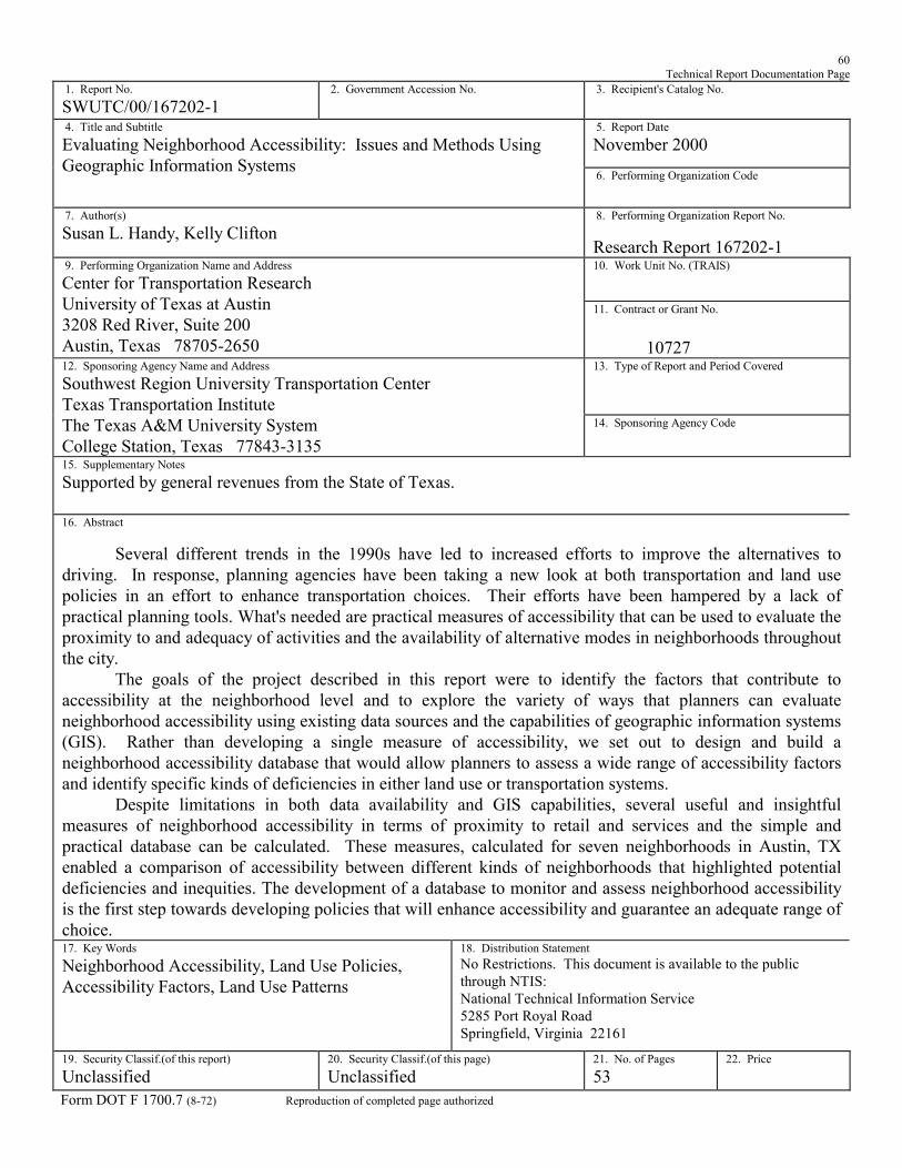
60 Technical Report Documentation Page
1. Report No. SWUTC/00/167202-1
2. Government Accession No.
3. Recipient's Catalog No. 5. Report Date November 2000
4. Title and Subtitle Evaluating Neighborhood Accessibility: Issues and Methods Using Geographic Information Systems
6. Performing Organization Code
7. Author(s) Susan L. Handy, Kelly Clifton
8. Performing Organization Report No. Research Report 167202-1 10. Work Unit No. (TRAIS)
9. Performing Organization Name and Address Center for Transportation Research University of Texas at Austin 3208 Red River, Suite 200 Austin, Texas 78705-2650
11. Contract or Grant No. 10727 13. Type of Report and Period Covered
12. Sponsoring Agency Name and Address Southwest Region University Transportation Center Texas Transportation Institute The Texas A&M University System College Station, Texas 77843-3135
14. Sponsoring Agency Code
15. Supplementary Notes Supported by general revenues from the State of Texas.
16. Abstract
Several different trends in the 1990s have led to increased efforts to improve the alternatives to driving. In response, planning agencies have been taking a new look at both transportation and land use policies in an effort to enhance transportation choices. Their efforts have been hampered by a lack of practical planning tools. What's needed are practical measures of accessibility that can be used to evaluate the proximity to and adequacy of activities and the availability of alternative modes in neighborhoods throughout the city.
The goals of the project described in this report were to identify the factors that contribute to accessibility at the neighborhood level and to explore the variety of ways that planners can evaluate neighborhood accessibility using existing data sources and the capabilities of geographic information systems (GIS). Rather than developing a single measure of accessibility, we set out to design and build a neighborhood accessibility database that would allow planners to assess a wide range of accessibility factors and identify specific kinds of deficiencies in either land use or transportation systems.
Despite limitations in both data availability and GIS capabilities, several useful and insightful measures of neighborhood accessibility in terms of proximity to retail and services and the simple and practical database can be calculated. These measures, calculated for seven neighborhoods in Austin, TX enabled a comparison of accessibility between different kinds of neighborhoods that highlighted potential deficiencies and inequities. The development of a database to monitor and assess neighborhood accessibility is the first step towards developing policies that will enhance accessibility and guarantee an adequate range of choice. 17. Key Words Neighborhood Accessibility, Land Use Policies, Accessibility Factors, Land Use Patterns
18. Distribution Statement No Restrictions. This document is available to the public through NTIS: National Technical Information Service 5285 Port Royal Road Springfield, Virginia 22161
19. Security Classif.(of this report) Unclassified
20. Security Classif.(of this page) Unclassified
21. No. of Pages 53
22. Price
Form DOT F 1700.7 (8-72) Reproduction of completed page authorized


EVALUATING NEIGHBORHOOD ACCESSIBILITY: ISSUES AND METHODS USING
GEOGRAPHIC INFORMATION SYSTEMS
by
Susan L. Handy
Kelly Clifton
Research Report SWUTC/00/167202-1
Southwest Region University Transportation Center Center for Transportation Research The University of Texas at Austin
Austin, TX 78712
November 2000

ii
Disclaimer
The contents of this report reflect the views of the authors, who
are responsible for the facts and the accuracy of the information
presented herein. This document is disseminated under the
sponsorship of the Department of Transportation, University
Transportation Centers Program, in the interest of information
exchange. The U.S. Government assumes no liability for the
contents or use thereof.

iii
ABSTRACT
Several different trends in the 1990s have led to increased efforts to improve the
alternatives to driving. In response, planning agencies have been taking a new look at both
transportation and land use policies in an effort to enhance transportation choices. Their efforts
have been hampered by a lack of practical planning tools. What's needed are practical measures
of accessibility that can be used to evaluate the proximity to and adequacy of activities and the
availability of alternative modes in neighborhoods throughout the city.
The goals of the project described in this report were to identify the factors that contribute
to accessibility at the neighborhood level and to explore the variety of ways that planners can
evaluate neighborhood accessibility using existing data sources and the capabilities of geographic
information systems (GIS). Rather than developing a single measure of accessibility, we set out
to design and build a neighborhood accessibility database that would allow planners to assess a
wide range of accessibility factors and identify specific kinds of deficiencies in either land use or
transportation systems.
Despite limitations in both data availability and GIS capabilities, several useful and
insightful measures of neighborhood accessibility in terms of proximity to retail and services and
the simple and practical database can be calculated. These measures, calculated for seven
neighborhoods in Austin, TX enabled a comparison of accessibility between different kinds of
neighborhoods that highlighted potential deficiencies and inequities. The development of a
database to monitor and assess neighborhood accessibility is the first step towards developing
policies that will enhance accessibility and guarantee an adequate range of choice.

iv
ACKNOWLEDGEMENTS
This publication was developed as a part of the University Transportation Centers Program which
is funded 50% with general revenue funds from the State of Texas. The authors would like to
thank Paul Frank and Meghan Weiters at the City of Austin Neighborhood Planning Program and
Dr. Barbara Parmenter and Lisa Weston of the Community and Regional Planning Program at the
University of Texas for their for their valuable input and guidance on this project.

v
EXECUTIVE SUMMARY
Several different trends in the 1990s have led to increased efforts to improve the
alternatives to driving. In response, planning agencies have been taking a new look at both
transportation and land use policies in an effort to enhance transportation choices. Their efforts
have been hampered, however, by a dearth of applicable planning tools, particularly measures or
indicators they can use to evaluate the adequacy of current policies or the impacts of proposed
policies at the neighborhood level. Planners are beginning to turn to accessibility measures to fill
this need. As generally defined, accessibility reflects the ease of reaching needed or desired
activities and thus reflects characteristics of both the land use system (where activities are
located) and the transportation system (how the locations of activities are linked). Despite an
extensive academic literature, examples of the actual use of accessibility measures in planning
are relatively scarce, and the literature offers few approaches that adequately assess accessibility
at the neighborhood level for different modes of travel. What's needed are practical measures of
accessibility that can be used to evaluate the proximity to and adequacy of activities and the
availability of alternative modes in neighborhoods throughout the city.
The goals of the project described here were twofold: first, to identify the factors that
contribute to accessibility at the neighborhood level, and second, to explore the variety of ways
that planners can evaluate neighborhood accessibility using existing data sources and the
capabilities of geographic information systems (GIS). Rather than developing a single measure of
accessibility, we set out to design and build a neighborhood accessibility database that would
allow planners to assess a wide range of accessibility factors and identify specific kinds of
deficiencies in either land use or transportation systems.
The first step in designing a neighborhood accessibility database was to identify the range
of factors that contribute to accessibility for residents of a neighborhood. Although few studies
address this need directly, we found a number of studies which provide insights into the factors
that matter to residents and a smaller number which provide ways of measuring these factors.
Activity factors include those that relate to the activity itself, such as the size of the activity or the
quality of the products or services provided, and those that relate to the design of the site where
the activity is located, such as the density and mix of activities found at the site. Transportation
factors can be categorized as impedance factors (e.g. distance, time, cost), level-of-service
factors (e.g. crowding, directness of route, information availability), terminal factors (e.g. parking
availability, intermodal connections, terminal design), and comfort factors (e.g. traffic speed,
lighting, weather, scenery). The set of factors and their relative importance is somewhat different
for each mode. For both activity and transportation factors, the research suggests that qualitative
and subjective factors are important enough to residents that planners must consider them.

vi
Practical data limitations hinder the ability of planners to evaluate these neighborhood
accessibility factors on a city-wide basis. Usually, data on qualitative and subjective factors are not
readily available; these factors are hard to assess and the accuracy and stability of the
observations are often questionable. Available land use data include data on residents from the
Census of Population and Housing down to the block level and data on employment from
Metropolitan Planning Organizations at a census tract or traffic analysis zone level. In addition,
telephone directory listings in electronic format are available commercially and provide the name
of the business, its Standard Industrial Classification, and its street address with geocoding.
Although these databases have important limitations, the availability of disaggregate business
data for an entire urban area permits a detailed analysis at both the local and regional level.
Available data on transportation factors are usually limited to automobile and transit travel
distances, times, and costs. Data on infrastructure for pedestrians and bicycles are not generally
available, although the situation seems to be changing.
The spatial nature of both land use patterns and transportation networks lends itself to
evaluation using a geographic information system. A GIS has several built-in capabilities that
enable the analysis of a variety of accessibility factors. The buffering capabilities of GIS allow for
a simple analysis of proximity to retail and services at several distances from the neighborhood. A
number of useful accessibility measures can be readily calculated from the available land use
data using this buffering capability. We defined the retail intensity as the total number of all retail
establishments that occur within the neighborhood boundaries. We defined the diversity of
development as the number of different types of establishments, as defined by SIC codes, that
occur within a specified area. Finally, we defined retail choice as the number of establishments of
a particular type that occurs in the neighborhood. All of these measures can be normalized by
population or land area to facilitate comparisons between neighborhoods. In addition, location
quotients, a technique borrowed from the field of regional economics, can be calculated that
compare the share of local businesses that a particular type of business represents in the
neighborhood to the share for the city or region as a whole. This measure can be used to show a
relatively high concentration of activities in a certain area, or the converse, a relative lack of
activities
These measures may provide a useful and insightful analysis of neighborhood
accessibility in terms of proximity to retail and services. However, they do not reflect the structure
or characteristics of the transportation system, particularly for transportation modes other than
driving, and they focus on the entire neighborhood as the unit of analysis. These limitations reflect
limitations in both data availability and the structure of GIS. Several recent research projects
demonstrate some of the ways that GIS can be used to evaluate accessibility but also reflect the

vii
limitations of current GIS technology and data sources. In all these examples, researchers point
to the poser of visualization as an important benefit of the use of GIS for accessibility analysis.
To explore the usefulness of the alternative measures of neighborhood accessibility, we
chose as case studies seven neighborhoods in Austin that vary in their physical form, era of
development, location within the city, and socio-economic characteristics. For the seven
neighborhoods we calculated the intensity, diversity, and choice measures, as well as the location
quotients, for business types deemed most important to neighborhood access. These measures
proved useful in illustrating differences in accessibility that occur in neighborhood development
patterns. Neighborhoods built in the 1970s and 1980s were shown to provide much lower levels
of accessibility than neighborhoods built before WWII or even in the 1950s and 1960s. This
finding is due at least partly to the location of these neighborhoods at the fringe of the
metropolitan area. In addition the measures pointed to deficiencies in lower-income
neighborhoods, not so much in terms of the numbers of establishments but rather in the types of
establishments found there.
Although the available data and the capabilities of GIS fall short of providing planners with
a full assessment of the factors that influence neighborhood accessibility, the simple analysis that
is currently possible still yields useful information and helps to identify important differences in
accessibility between neighborhoods. Even with limited data and limited GIS capabilities, it is
possible to generate useful measures of neighborhood accessibility. Fortunately, both the data
available to planning departments and the facility of planning staff with GIS are improving.
Planners have an interesting opportunity to help the process along by making data collection itself
an important part of the planning process - to use data collection as a way to facilitate public
involvement and build technical capacity within neighborhoods as well as to build a city-wide
database. Planners can also use the mapping capabilities of GIS to facilitate input from the
neighborhood by helping residents to visualize and understand the implications of the data.
Providing the neighborhood planning team with direct access to a GIS and sufficient training to
use it effectively would be even better � and may not be as costly or impractical as one might
think, as demonstrated by a growing number of examples. The development of a database to
monitor and assess neighborhood accessibility is the first step towards developing policies that
will enhance accessibility and guarantee an adequate range of choice - for both activities and the
means to reach them - for all.

viii

ix
TABLE OF CONTENTS
Chapter 1 INTRODUCTION 1
Chapter 2 MEASURING ACCESSIBILITY 3
Activity Factors 5
Transportation Factors 7
Chapter 3 DATA ISSUES AND NEEDS 11
Land Use Data 11
Transportation Data 12
Chapter 4 GIS ANALYSIS CAPABILITIES 15
Possibilities 15
Limitations 16
Examples 18
Chapter 5 AUSTIN EXAMPLE 21
Intensity, Diversity, and Choice 22
Intensity 24
Diversity 26
Choice 28
Discussion 31
Location Quotients 32
Coverage 34
Chapter 6 CONCLUSIONS 37
REFERENCES 39

x
LIST OF FIGURES
5.1 Supermarket Coverage for Cesar Chavez Neighborhood: Street Network
Within 1 Mile of Supermarket 36

xi
LIST OF TABLES
2.1 Activity Factors 6
2.2 Transportation Factors by Mode 8
5.1 Neighborhood Characteristics 22
5.2 Land Uses Represented by SIC Codes 23
5.3 Neighborhood Commercial Development Intensity 25
5.4 Neighborhood Commercial Intensity - Normalized by Area 26
5.5 Neighborhood Commercial Intensity - Normalized by Population 27
5.6 Neighborhood Commercial Diversity 27
5.7 Neighborhood Commercial Diversity - Normalized by Area 28
5.8 Neighborhood Commercial Diversity - Normalized by Population 29
5.9 Neighborhood Commercial Choice - Basic Types 30
5.10 Neighborhood Commercial Choice - Most Frequent Establishment Types 31
5.11 Neighborhood Location Quotients - Selected Types 33
5.12 Neighborhood Coverage - Selected Types 35

xii

1
CHAPTER 1. INTRODUCTION
Several different trends in the 1990s have led to increased efforts to improve the
alternatives to driving. Federal transportation policy, as shaped by the Intermodal Surface
Transportation Efficiency Act of 1991 and the Transportation Equity Act for the 21st Century of
1998, now emphasizes transit as well as walking and biking out of concern for both the
environment and equity of service. The New Urbanism movement has focused attention on how
the design of neighborhoods encourages or discourages walking, among other things, and has
given weight the idea that land use regulations are also an important element of a transportation
program. In addition, the relative lack of services in lower-income neighborhoods, where
residents have more limited options for transportation, has been the target of renewed attention in
recent years. In response, planning agencies have been taking a new look at both transportation
and land use policies in an effort to enhance transportation choices. Their efforts have been
hampered, however, by a dearth of applicable planning tools, particularly measures or indicators
they can use to evaluate the adequacy of current policies or the impacts of proposed policies at
the neighborhood level.
Planners are beginning to turn to accessibility measures to fill this need. As generally
defined, accessibility reflects the ease of reaching needed or desired activities and thus reflects
characteristics of both the land use system (where activities are located) and the transportation
system (how the locations of activities are linked). An extensive academic literature on
accessibility measures produced over several decades suggests many ways to define and
measure accessibility, though examples of the actual use of accessibility measures in planning
are relatively scarce. In addition, the literature offers few approaches that adequately assess
accessibility at the neighborhood level for different modes of travel. What's needed are practical
measures of accessibility that can be used to evaluate the proximity to and adequacy of activities
and the availability of alternative modes in neighborhoods throughout the city.
The development of such measures presents interesting challenges. While traditional
measures of accessibility focus on the distance to and size of potential destinations, for example,
other characteristics of the local environment may have an important impact on travel options,
particularly modes like walking and biking that also depend on how comfortable and safe the route
feels. Traditional measures often assume that all residents care equally about the same factors
and the same activities, when in fact preferences and needs vary from household to household.
Of course, incorporating these qualities into an assessment of accessibility would require data that
are not readily available nor easy to collect, a real obstacle to developing practical accessibility
measures. Planners may find some help, however, in geographic information systems (GIS),

2
which offer a unique tool for managing and analyzing data on the variety of land use and
transportation characteristics that contribute to neighborhood accessibility.
The goals of the project described here were thus twofold: first, to identify the factors that
contribute to accessibility at the neighborhood level, and second, to explore the variety of ways
that planners can evaluate accessibility using existing data sources and the capabilities of
geographic information systems (GIS). Rather than developing a single measure of accessibility,
we set out to design and build a neighborhood accessibility database that would allow planners to
assess a wide range of accessibility factors and identify specific kinds of deficiencies in either land
use or transportation systems. Although we found the available data on characteristics of
alternative modes of transportation and the capabilities of GIS to analyze transportation linkages
more limited than we'd hoped, the simple and practical database we were able to construct for
Austin, TX enabled a comparison of accessibility between different kinds of neighborhoods that
highlighted potential deficiencies and inequities. Our hope is that this work will prove useful in the
growing number of neighborhood planning programs found in Austin and throughout the country.
In Chapter 2, we provide a short review of the literature on accessibility measures and
summarize existing research that identifies the range of factors that contribute to neighborhood
accessibility. Chapters 3 and 4 include assessments of the kinds of land use and transportation
data commonly available to planning departments and of the capabilities of GIS to help planners
make sense of the data. In Chapter 5 we present an example of how this approach to evaluating
neighborhood accessibility can highlight deficiencies and inequities using a sample of
neighborhoods from Austin, TX. Finally, in Chapter 6 we consider possible improvements to the
approach presented here that might be possible with additional data collection and more
sophisticated analysis and discuss the role of GIS and accessibility measures in the neighborhood
planning process.

3
CHAPTER 2. MEASURING ACCESSIBILITY
Accessibility is an important concept for urban planners in that it reflects the possibilities
for activities, such as work or shopping, available to residents of a neighborhood or a city or a
metropolitan area. Accessibility is determined by attributes of both the activity patterns and the
transportation system in the area. The spatial distribution of activities, as determined by land
development patterns, and their qualities and attributes are important components of accessibility,
as are the qualities and attributes of the transportation system that links these activities, such as
travel time and monetary costs by mode. Although most researchers agree on this general
definition of the concept of accessibility, they have developed a wide variety of ways to measure it.
The literature on accessibility measures has a long history. Most measures can be
classified as one of three basic types (Handy and Niemeier 1996). Cumulative opportunities
measures are the simplest type. These measures count the number of opportunities reached
within a given distance or travel time and give an indication of the range of choice available to
residents. Gravity-based measures are derived from the denominator of the gravity model used
to predict trip distribution; these measures weight the amount of activity at different destinations by
the cost (or time or distance) to get there. The third type of measure is based on random utility
theory, in which the probability of an individual making a particular choice depends on the utility of
that choice relative to the utility of all choices; the accessibility measure comes from the
denominator of the model and reflects the total utility of all choices. All three types of measures
require that the activities and the transportation system be characterized in some way. In general,
the three approaches offer different trade-offs between the simplicity and ease of comprehension
of the measure and the sophistication with which the activities and transportation system are
characterized. The more sophisticated measures also require the more sophisticated data.
Whatever the form of the measure, the key is to measure accessibility in terms that
matter to people in their assessment of the options available to them (Handy and Niemeier 1996).
For the activity component of accessibility, this means knowing something about what activities
and what characteristics of different activities matter to people. A neighborhood resident might
value proximity to a supermarket but not care about being near a motel, for example, and he
might care about the atmosphere of the supermarket as much as the relative prices of the goods
sold there. For the transportation component of accessibility, this means knowing something
about what characteristics of different modes of travel matter to people. A resident may be most
concerned about the time it takes to get to a destination using different modes, or may focus more
on cost.
In developing a practical technique for assessing neighborhood accessibility, then, a

4
number of questions must be addressed. First, what factors tend to matter most to residents?
Clearly it is impossible to measure, let alone know, every factor that matters to every resident.
Fortunately, a number of studies help to identify the factors that seem to matter most to most
residents. We compile a list of these factors below. Second, what kind of data are available or can
be collected about these factors? The data commonly used by planning departments miss many
of the factors important to neighborhood accessibility and may not be available in a useful format
if they are available at all. Some factors are reasonably objective and can be easily measured,
while others involve significant subjectivity and are not so easily quantified. We explore these
issues in Chapter 3.
Third, how can planners make sense of the available data on neighborhood accessibility
factors? Traditional accessibility measures can, depending on their structure, specification, and
calibration, combine a number of important factors into a single, all-encompassing measure of
accessibility. This approach, however, may be neither practical nor desirable for planning
purposes. The more complex the measure, the more data and the more analysis skill required,
limiting the ability of most planning departments to develop such measures. The development of
utility-based measures, for example, is probably beyond the capability of most departments. In
addition, much important information is lost when the data are collapsed into a single or even a
few measures. Traditional measures of accessibility may help planners identify neighborhoods
where accessibility is relatively high or relatively low, but they do not, on their own, point to the
specific factors contributing to high or low accessibility for residents. As an alternative, we explore
the practicality and effectiveness of using GIS to manage and analyze a database of
neighborhood accessibility factors. This effort is described in Chapters 4 and 5.
Finally, the use of the neighborhood as the spatial unit of analysis presents both
opportunities and challenges. Analysis at the neighborhood level allows for a more detailed
examination of the qualitative characteristics of the local environment than would an analysis at a
larger geographic level. However, if neighborhoods are defined by their natural boundaries
(usually major arterials or open space), their areas and populations may vary considerably. Thus,
some normalization by area or population may be necessary in order to compare accessibility
between neighborhoods. In addition, accessibility may vary considerably within a neighborhood
depending on the distribution of retail and services relative to the distribution of population within
and among adjacent neighborhoods. Thus, it is important to also evaluate accessibility from
different points within the neighborhood. This evaluation requires a more sophisticated analysis,
including some sampling of points within the neighborhood and a more accurate estimate of
distances between points. These issues are highlighted in the example presented in Chapter 5.
The first step in designing a neighborhood accessibility database is to identify the range of
factors that contribute to accessibility for residents of a neighborhood. Although few studies

5
address this need directly, we found a number of studies which provide insights into the factors
that matter to residents and a smaller number which provide ways of measuring these factors. We
found more research that spoke to transportation factors than to activity factors, but in both cases
the research suggests that qualitative and subjective factors are important enough to residents
that planners must consider them.
ACTIVITY FACTORS The most basic characterization of activity is that a particular type of activity can be found
at a particular location. Cumulative opportunities measures, for example, typically reflect a simple
tally of locations of a particular type of activity. Another common approach is to account for the
relative amount of activity at each location, usually measured in terms of the number of
employees or sometimes the square footage of building found at each location. This approach is
commonly used in both gravity measures and utility measures of accessibility. But beyond the
existence of an activity and the amount of an activity at a particular location, what factors influence
the attractiveness of a particular destination to residents?
Our previous research has identified several specific characteristics that residents
consider in evaluating the activities in and around their neighborhood; these characteristics range
from mostly objective to highly subjective ( Handy et al. 1998; Handy and Clifton forthcoming). The
more objective factors for an activity such as grocery shopping include size of store, prices, ease
of parking, and range of product selection. More subjective factors include quality of products,
crowds, length of check-out lines. Highly subjective factors like atmosphere also matter. The
relative importance of such factors is difficult to assess, however. Not only does the importance of
these factors vary by individual, but it may vary at different times for each individual: residents may
use different criteria in evaluating stores for major food shopping than for a trip for a gallon of milk,
for example.
Recker and Kostyniuk (1978) also studied factors that influence destination choice for
grocery shopping trips in urban areas. Their study included a survey of respondents� perceptions
of grocery stores they frequented on a variety of different attributes. Using factor analysis, they
reduced these attributes into four factors: quality (determined by reasonable prices, variety of
items, meat quality, produce quality, selection of goods, and has items other stores don�t),
accessibility (determined by ease of getting home from store, to store from work, and to store
from home), convenience (determined by parking facilities, proximity to other shops, hours of
operation, ease of finding items in store, and crowding in store), and service (acceptance of credit
cards, check cashing, ease of returning goods). In the destination choice models estimated, only
the service factor proved insignificant.

6
Research in the field of retailing, of course, provides additional insights into factors that
influence the customer�s choice of a particular establishment. A 1980 study by Nevin and
Houston, for example, looked at the role of image in the attractiveness of urban shopping areas.
Besides factors such as the quality of stores, the variety of stores, product quality and selection,
and general price level, they found that the availability of lunch/refreshments, the adequacy of
comfort areas, the friendliness of the atmosphere, the helpfulness of store personnel, and
whether the center was an easy place to take children also contributed to the attractiveness of a
shopping area.
These studies suggest a list of factors that contribute to the attractiveness of a particular
activity site. These factors can be grouped as relating to the activity itself or relating to the design
of the site (Table 2-1). This list is by no means exhaustive, but it gives a sense of the wide range
of factors that contribute to attractiveness. It is also important to remember that the relative
importance of these factors will vary depending on the type of activity.
TABLE 2-1. ACTIVITY FACTORS
Factors Related to Activity Itself:size and scalequality of products/servicesvariety of products/servicesprice of products/serviceshours of operationcrowds/linesinterior designatmosphere ownership (local vs. chain)customer recognition
Factors Related to Site Design:mix of activities at sitedensity of activities at siteparking facilitiesatmospherelandscape design
What activities to include in an assessment of neighborhood accessibility is also an
important question. Most examples of accessibility measures in the literature use total retail and
service employment, without further differentiation of activity types. Some studies focus on
specific kinds of activities, such as grocery shopping (Handy and Neimeier 1996) or health care
services (Wachs and Kumagai 1973). Our previous study gives some indication of the local

7
businesses most frequently used by residents of six Austin neighborhoods. Supermarkets and
grocery stores topped the list, followed by drug stores, restaurants, discount stores, convenience
stores, video stores, Laundromats or cleaners, and bakeries (Handy, et al. 1998). This list can
serve as a guide to activities to include in an assessment of neighborhood accessibility. What it
leaves out, however, are possible high-priority activities not located in or near these six
neighborhoods.
TRANSPORTATION FACTORS Just as important as the activities found in and around the neighborhood are the options
residents have for getting there. Distance and time are used most often as measures of
impedance in accessibility functions and represent the burden required to travel to a particular
destination - an important factor but not the only one. While distance and time can be important
considerations in the decision to drive, walk, bike, or ride transit, additional factors contribute to
the varying degrees of accessibility offered by different modes of travel in different neighborhoods.
Mode choice models and level-of-service measures as well as exploratory studies suggest a long
list of transportation factors that contribute to neighborhood accessibility for different modes
(Table 2-2). These factors can be categorized as impedance factors, level-of-service factors,
terminal factors, and comfort factors.
Accessibility factors for drivers are, perhaps, the most straightforward. Mode choice
models consistently show that travel time, or sometimes a generalized travel cost including travel
time and monetary costs, is the most significant factor to drivers. Other factors that influence the
travel time or cost, including traffic volumes, signalization, directness of route, and continuity of
route, may also be important. Drivers may consider the availability and cost of parking at the
destination. Comfort factors may also play an important role for some drivers in their perception
of accessibility: poor lighting, bad weather, excessively high or low traffic speeds, high volumes of
traffic, unappealing scenery, inadequate signage, or poor pavement condition may contribute to a
negative perception of accessibility. The importance of these perceptual factors is mostly
undocumented. Work by Ullrich (1991), however, shows that the kind of chaotic visual
environments found along many (if not most) arterials in metropolitan areas significantly increases
levels of stress for drivers.

8
TABLE 2-2. TRANSPORTATION FACTORS BY MODE
Mode choice models show that travel time is the most significant factor in the decision to
use transit as well. However, most models also show that transit users differentiate between in-
vehicle and out-of-vehicle time, assigning significantly greater cost to the latter. This finding
reflects the exposure of the transit user to the elements as well as to the uncertainty of transit
Automobile Transit Walking Bicycling
Impedance Factorsdistance X X X Xin-vehicle time X Xout-of-vehicle time X X X Xcost X Xtopography X X
Level of Service Factorsvolumes/crowding X X X Xsignalization X X X Xservice frequency Xhours of operation Xdirectness of route X X X Xcontinuity of route X X X Xinformation availability Xsignage X X X Xfacility widths X X Xvehicle design X X Xshelter X X Xbenches X X
Terminal Factorsparking availability X X Xparking cost X Xterminal locations Xintermodal connections X X Xterminal design X X X X
Comfort Factorstraffic speed X X X Xtraffic volumes X X X Xpavement condition X X X Xlighting X X X Xweather X X X Xshade X X Xscenery X X X Xcrime/police presence X X Xcleanliness X X Xconflicts with other modes X X X Xother users X X X X

9
service as he waits for a transit vehicle. As a result, amenities such as benches and shelters are
important to transit users, as are factors that influence how safe transit users feel while waiting,
including lighting, the speed and volume of passing traffic, crime levels in the area, etc. A study
of customer satisfaction among riders of the Bay Area Rapid Transit (BART) system (Weinstein
2000), for example, used factor analysis to group over forty attributes of the system into eight
factors influencing satisfaction, listed in order of relative importance: service and information
timeliness, station entry and exit (including length of lines, reliability of fare gates, availability of
escalators and elevators, etc.), train cleanliness and comfort (determined by noise levels, graffiti,
cleanliness of windows, temperature, seat comfort, etc.), station cleanliness, police presence (in
stations, parking lots, and on trains), policy enforcement (such as no smoking, eating, or drinking),
and parking (car and bicycle parking plus lighting).
Although pedestrians also are sensitive to travel time and are limited in how far they can
travel by the slow pace of walking, they are also highly sensitive to the character and quality of the
environment through which they walk. Our previous study showed that perceptions of safety,
shade, and the presence of other people were important determinants of the frequency with which
residents walked in the neighborhood (Handy, et al. 1998). Several recent efforts to evaluate the
pedestrian environment also point to important accessibility factors. In the LUTRAQ studies, a
Pedestrian Environmental Factor (PEF) was calculated from four factors: ease of street crossing,
sidewalk continuity, local street connectivity, and topography (1000 Friends of Oregon 1993). In
Fort Collins, CO, a pedestrian level-of-service measure is used in evaluating the traffic impacts of
new development. This measure incorporates the directness of street layout, the continuity of
sidewalks, the width of street crossings, visual interest and amenities, and security/safety
evaluations (Moe and Reavis, undated). The City of Gainesville, FL, developed a pedestrian level-
of-service measure that included the provision of a pedestrian facility (characterized by continuity,
width, parallel alternatives), conflicts (driveways and side streets, pedestrian signal delay, crossing
width, speed limits, presence of medians), amenities (buffers, benches, lighting, shade trees),
motor vehicle level-of-service (to reflect volumes of traffic), maintenance, and transportation
demand management or multi-modal policies (Dixon 1995). Sarkar (1993) used a pedestrian
level of service measure based on safety, security, comfort and convenience, continuity, system
coherence, and attractiveness to evaluate the street environment in European cities. Pedestrian
level-of-service is also influenced by the degree to which sidewalks and curb ramps meet the
requirements of the Americans with Disabilities Act. Sidewalk characteristics such as driveway
crossings, cross slopes, small changes in level (including irregularities), clearance widths, and
protruding objects determine the accessibility of sidewalks to persons with disabilities (Axelson, et
al. 1999) � and to parents with strollers, kids on skateboards or scooters or bicycles, and
pedestrians in general.

10
Bicycle riders are influenced by a mostly parallel set of factors. The National Bicycling
and Walking Study included an assessment of the reasons why bicycling is not being used more
extensively (FHWA 1992). In reviewing a number of surveys on bicycle use, this study found that
primary deterrents to cycling included traffic safety concerns, adverse weather, inadequate
parking, and road conditions, and that secondary deterrents included fear of crime, lack of bicycle
routes, inconsiderate drivers, and inability to bring bicycles on the bus. The FHWA has, more
recently, developed a "bicycle compatibility index" to evaluate the appropriateness of a roadway
for bicycle use. This index includes the presence of a bicycle lane, the width of the lane, the width
of the curb lane, traffic volume in the curb lane and other lanes, speed of traffic, the presence of a
parking lane and its occupancy, truck volumes, parking turnover, and right-turn volumes (FHWA
1999). The City of Gainesville also developed a bicycle level-of-service measure, similar to its
pedestrian measure but with slightly different definitions of each factor (Dixon 1995).
11
CHAPTER 3. DATA NEEDS AND ISSUES
Practical data limitations hinder the ability of planners to evaluate these neighborhood
accessibility factors on a city-wide basis. While some relevant data may be available, complete
information in formats compatible with computer applications often is not. Usually, data on
qualitative and subjective factors are not readily available; these factors are hard to assess and
the accuracy and stability of the observations are often questionable. Gathering detailed
information about activity systems and transportation systems, let alone residents� perceptions of
them, would require a time-consuming and costly data collection effort. Planners must weigh the
costs of collecting such data with the potential benefits.
LAND USE DATA At a minimum, an accessibility analysis requires information about what kinds of activities
exist and where they are located. The availability of land use data and its level of detail often vary
by local planning department. Data about residents are the easiest to find. The Bureau of the
Census provides aggregate socio-economic data down to the census tract, block group, and even
block level; however, since the Census is only conducted every ten years, it may not reflect recent
changes on the neighborhood level. Some jurisdictions may have updates of the Census data for
population and, more rarely, socio-economic characteristics.
Data about employment are more difficult to find. Most Metropolitan Planning
Organizations and some cities have developed databases of employment by type by area (census
tract or traffic analysis zone), but the quality of such data is notoriously poor and the categories of
employment are usually quite broad. Data on floor space by type of commercial or industrial use
can sometimes be extracted from the databases of local tax assessors, and zoning classifications
are also sometimes used as an indication of land use. However, it is often difficult to find accurate
and specific information about current land uses in electronic format, and collecting detailed
information through field work can be laborious and time consuming. In most cases, data on the
amount of several general categories of activities at the zone or tract level are available, if nothing
more.
Telephone directory listings for both businesses and residences provide more specific
data on what land uses are located where and are readily available in electronic format. For this
study, we used the Select Deluxe CD-ROM for the year 1996. These data include business or
residential name, address, phone number, and geographic coordinates in latitude and longitude.
Business listings also include approximations of the appropriate Standard Industrial Classification
(SIC) codes to the four-digit level.

12
The use of telephone listings as a source for land use data offers several advantages.
First, the data are readily available and relatively inexpensive. The CD-ROM can be purchased at
many computer software retail stores, and data for the entire United States cost less than $150 as
of this writing. Second, the SIC approximation allows for easy classification of business types and
thus permits disaggregate analysis on specific industries or services. Third, the addresses for
business and residential listings are already geocoded and can be easily imported in to GIS
software. Last, the availability of disaggregate data for an entire urban area permits a detailed
analysis at both the local and regional level.
However, using these data for accessibility analysis also has its drawbacks. First,
establishments and households with multiple telephones are over-represented in the database as
are households where each person using a phone number is listed in the directory, and those
businesses and residences without a phone at the time of publication of the directory are missing
from the data set. Second, the SIC codes provided in the data are only approximations based
upon the category under which the business is listed within the yellow pages. In addition,
businesses turnover with some frequency so that the most current data available may no longer
be accurate, and those listings that do not include an address in the telephone directory will be
omitted. Finally, although these data provide detailed information about the location and type of
establishment, other land use characteristics cannot be obtained from this data set; no
information about the size, quality, or site design of the businesses are included.
TRANSPORTATION DATA The availability and detail of transportation information also varies widely by planning
department. Transportation data often describe average characteristics of the system at the zone,
city or regional level and may mask many of the variations that occur within the neighborhood.
Usually, detailed data for modes other than driving are not readily available.
Network files can be obtained from the Bureau of the Census in the TIGER/Line files.
These files may require some modification to capture changes made in the road network since
publication and ensure the necessary level of detail. Enhanced and updated network files can be
obtained from private vendors and sometimes from MPOs or other local agencies. These files
allow for distance calculations between points on the network, although travel times are usually
more important to residents. Estimating the travel times between two points requires estimations
of the average travel speeds for each link in the network, which for drivers is dependent upon
traffic volumes. Data on automobile travel times are available from regional transportation
planning models usually maintained by MPOs. These data can be problematic, however: they are
often rough approximations, not available for most local roads in the network, out of date, rarely

13
reflect temporal variations, and reflect zone-to-zone rather than point-to-point times. As an
alternative, speeds limits can be used to estimate travel time, but speed limit data are often still
not available in GIS format. The problem of compiling the necessary transportation data is
complicated by the lack of coordination between various government agencies responsible for
data on different transportation factors.
Data for alternate modes is often difficult to locate. For transit, data about the location of
transit stops, routes, capacity and schedules are usually available but may not be in electronic
format. Accurate information about the presence of benches, shelters, and lighting, crime and
safety statistics, and intermodal access is less often available. Collecting this type of detailed
information usually requires fieldwork. For example, as of this writing, Capital Metro, the transit
authority in Austin, TX, has data on the locations of transit stops in electronic format that can
easily be incorporated into a GIS analysis. However, this data contains no additional information
about the stops, such as presence of bus shelters, that might be valuable in an accessibility
analysis. Ridership information has been available in electronic format by route and stop, but bus
routes themselves have been put into electronic format only recently.
Data on infrastructure for pedestrians and bicycling are not generally available, although
this situation seems to be changing. Some cities may have an inventory of sidewalks but such
data seem rarely to be in electronic form. In the mid-1990s, the City of Portland completed a city-
wide sidewalk inventory that required considerable time and labor. In 1995, students in the
Neighborhood Transportation Planning class at the University of Texas completed a sidewalk
inventory for one neighborhood in Austin that included not only the mapping of where sidewalks
were found within the neighborhood but also an assessment of the condition and characteristics
of the sidewalks. This data collection effort took approximately ten people and two solid days of
work to complete. Data on other factors that influence the quality of the walking and biking
experience, such as tree canopy, can sometimes be extracted from aerial photos. Data on more
qualitative factors, such as the quality of the scenery and the presence of interesting houses or
gardens to look at, can only be evaluated through field work and the development of criteria by
which to judge such factors. The LUTRAQ study used such a system to evaluate less qualitative
factors such as topography and the interconnectedness of the street network (1000 Friends of
Oregon).
The changing attitudes about alternate modes and the availability of federal funding for
transit, bicycling, and pedestrian projects have influenced some planning agencies to focus more
attention on the deficits in data related to these modes. In Austin, TX, an extensive data collection
effort was initiated to gather information about the street conditions and physical characteristics
along existing and proposed bike routes and their adjacent streets. Data about traffic volumes and

14
speeds, pavement conditions, street and lane widths, presence and continuity of bike lanes,
number of stop signs and traffic signals along the route, and other objective criteria were
compiled. Based on this information, the street segments were then ranked for bicycle friendliness
and published on the bicycle route maps for distribution to the public. This model, when applied to
all modes, represents a first step towards building a database of accessibility factors for use in
both neighborhood and city-wide analysis.

15
CHAPTER 4. GIS ANALYSIS CAPABILITIES
The spatial nature of both land use patterns and transportation networks lends itself to
evaluation using a geographic information system. With the increasing availability of spatial data
and desktop GIS software packages, planners have acquired new analytical tools to evaluate
needs and assess the benefits of policy alternatives. A GIS has several built-in capabilities that
enable the analysis of a variety of accessibility factors. However, we found that while GIS has
sufficient capabilities to evaluate the land use component of accessibility, our ability to analyze
transportation linkages with GIS was limited in important ways. At the same time, several
innovative applications of GIS to planning problems in recent research projects suggest that the
full potential of GIS has yet to be reached.
POSSIBILITIES The buffering capabilities of GIS allow for a simple analysis of proximity to retail and
services at several distances from the neighborhood. For example, in a disaggregate analysis of
travel behavior, Crane and Crepeau (1998) employed this buffering capability to incorporate
neighborhood street design characteristics directly surrounding each household in the study.
However, the use of straight-line distances in most buffering applications masks differences in
network structure that might mean significant differences in distance and time, an issue discussed
in the next section.
A number of useful accessibility measures can be readily calculated from the available
land use data using this buffering capability. We defined the retail intensity as the total number of
all retail establishments that occur within the neighborhood boundaries (or within some fixed
distance beyond the boundary). This measure reflects the overall amount of commercial
development within a neighborhood, although data on the size of different businesses are not
available. We defined the diversity of development as the number of different types of
establishments, as defined by SIC codes, that occur within a specified area. Finally, we defined
retail choice as the number of establishment of a particular type that occurs in the neighborhood;
for example, the number of grocery stores or pharmacies. All of these measures can also be
normalized by population or land area to facilitate comparisons between neighborhoods.
A simple example can illustrate the different information about a neighborhood each
measure conveys. Say that two neighborhoods have a similar intensity of development, each with
20 establishments within a reasonable walking distance. However, Neighborhood A has relatively
lower retail diversity (with 3 different types of establishments: grocery stores, bakeries, and

16
restaurants) when compared to Neighborhood B (with 8 different types of establishments: grocery
stores, bakeries, laundries/dry cleaners, pharmacies, restaurants, banks, clothiers, and liquor
stores). On the other hand, the measures show that Neighborhood A has much more choice in
certain establishments as there are over 10 bakeries to choose from within walking distance
compared to only 3 bakeries in Neighborhood B.
The land use data and buffering capabilities may also be used to show a relatively high
concentration of activities in a certain area � or the converse, a relative lack of activities. The
concept of a location quotient, widely used in the analysis of regional economies, is useful here. A
location quotient in the context of neighborhood accessibility compares the share of local
businesses that a particular type of business represents in the neighborhood to the share for the
city or region as a whole. A location quotient greater than one indicates a higher concentration of
an activity in the neighborhood than occurs in the region as a whole; a value less than one
indicates less concentration. If, for example, in Neighborhood B in the above example, liquor
stores make up 10% of all establishments, whereas liquor stores make up 2% of all
establishments city-wide, the location quotient would be 5.0 for liquor stores for the neighborhood.
This would suggest an over concentration of liquor stores in this neighborhood and could reflect
greater demand on the part of local residents for liquor or the use of local liquor stores by
residents from elsewhere in the city. In general, location quotients of less than one for important
businesses or services would be of concern for a neighborhood, but location quotients greater
than one for businesses that have negative impacts on a neighborhood (such as increasing traffic
or encouraging alcoholism) would also be of concern.
LIMITATIONS These measures may provide a useful and insightful analysis of neighborhood
accessibility in terms of proximity to retail and services. However, they do not reflect the structure
or characteristics of the transportation system, particularly for transportation modes other than
driving, and they focus on the entire neighborhood as the unit of analysis. While these limitations
are due partly to data limitations, they are also related to the structure of GIS. One important
feature of desktop GIS packages is the display of different types of data in different layers. For
example, point data such as residential locations or business establishments may be displayed in
one layer while linear data such as street networks are displayed in another. This feature, which
facilitates other types of spatial analysis and is a valuable tool for illustrating the combined effects
of many different data types, can limit the ability to easily perform some operations that are useful
for transportation applications.
In particular, in analyzing accessibility at the neighborhood level, it is desirable to calculate
17
network point-to-point distances between households and the business establishments in an area.
ArcView is one commercially available package that permits easy computation of the network
distance between two points, a household location and the nearest grocery store, for example.
Calculating the average straight-line distance between one household and all of the possible
commercial establishments is also computationally tractable. However, the ideal neighborhood
analysis would use point-to-point network distances (or better yet, travel times by mode) for all
possible combinations of origins and destinations or at least a sufficiently large sample of origins.
As of this writing, this function cannot be performed using the standard user interfaces and
requires customized script to perform. Luckily, such scripts are increasingly available via the
Internet, which is proving to be a valuable source of add-on capability for many GIS platforms.
This limitation leads to important limitations on accessibility measures. For example, a
potentially useful accessibility measure is the distance to the nearest destination of a certain type;
the distance to the closest medical facility may be one indicator of a neighborhood�s access to
health care, for example. GIS packages can easily determine which location of a particular type
of establishment is closest to a given household but cannot readily make this determination for an
entire neighborhood. This problem could be resolved, in part, by using neighborhood centroids to
represent the aggregation of individual households. However, much of the value of performing an
analysis on a neighborhood level would be lost, the variations in accessibility within neighborhoods
would be masked with aggregation, and the accuracy of the point-to-point network distance
calculations using centroids is questionable.
Transportation modeling programs, on the other hand, are ideally suited to estimating a
from-to matrix of network travel times or distances. Most Metropolitan Planning Organizations and
some cities maintain their own transportation models for forecasting travel demand and evaluating
proposed transportation investments. Typically, these models operate on a zone system, so that
travel times between zones are estimated. Because zones are usually the size of a census tract
or so, the travel times estimated for these models are too coarse for the purposes of evaluating
neighborhood accessibility. However, if a more detailed network, incorporating local and collector
streets and designating each potential destination as a node in the network, is used, then these
programs can be used to easily estimate a matrix of point-to-point distances or times. Our
previous studies used the TRANPLAN package to estimate network travel times from households
in our travel surveys to various retail destinations in and around the neighborhood (Handy 1996b;
Handy et al. 1997). This approach enabled a household-level assessment of accessibility and an
analysis of variations in accessibility within the neighborhood.
An alternative approach to the use of point-to-point distances is to map the portions of the
network within a specified distance of a specified location, or what we termed �coverage.� This
analysis is relatively straightforward using the network capabilities of GIS. The results can then be

18
presented in graphic format or can be converted into numeric form as the length of the streets
within the specified distance of the destination as a percentage of the total length of the street
network within the neighborhood. If residences are evenly distributed throughout the street
network, then this measure gives a reasonable approximation of the share residents within the
specified distance of the destination. The advantage of this measure over the intensity, diversity,
and choice measures defined above is that it reflects the structure of the street network within the
neighborhood and provides a more refined assessment of accessibility to nearby destinations.
EXAMPLES Several recent research projects demonstrate some of the ways that GIS can be used to
evaluate accessibility but also reflect the limitations of current GIS technology and data sources.
In all these examples, researchers point to the power of visualization as an important benefit of
the use of GIS for accessibility analysis.
Talen (1998) used GIS to evaluate the distribution of public facilities, such as parks, in
terms of the match between the facilities provided and the needs of residents and in terms of the
equity of the distribution across socio-economic groups. Four different measures of access from
census blocks to parks were calculated: "gravity model," with parks weighted by size and
separation distance between origin and each park destination; "minimizing travel cost,"
determined by the straight-line distance between each origin and each park destination; "covering
objectives," measuring the number of parks located within a critical distance (essentially a
cumulative opportunities measure); and "minimum distance" between each origin and the nearest
park. Her "equity mapping" approach involved mapping the distribution of accessibility measures
and the distribution of socio-economic data in order to evaluate spatial variation and characterize
spatial association; statistical tests of spatial autocorrelation between accessibility and socio-
economic characteristics were discussed but not presented. This study demonstrates the power
of GIS as a tool for evaluating accessibility across an urban area and for evaluating the impact of
public facilities plans on the equity of accessibility patterns. As Talen points out, the analysis can
be refined through more precise measurement of accessibility, including an assessment of the
quality of the facility or service, the use of origin zones smaller than census blocks, and more
sophisticated measures of transportation. However, the increased costs of data collection and
analysis may outweigh any benefits from increased precision: "The real benefit of the approach
outlined in this paper is that it is a technique that is readily available to local planners."
A study by Grengs (2000) underway at Cornell University uses GIS to evaluate
accessibility of inner-city neighborhoods to supermarkets. His initial approach was to use a buffer
of a given distance around a busline that serves a supermarket and then to analyze the portion of
19
each traffic analysis zone within the buffer area. Assuming that population and households are
uniformly distributed throughout the zone, the area within the buffer can then be translated into the
share of population within the buffer and, in particular, the share of carless households within the
buffer. Grengs points to several limitations of this analysis. First, the analysis would ideally
account for the affordability and quality of products offered by each supermarket. Second, the
buffers were drawn around bus lines, rather than bus stops, given limitations of the data. Third,
only transit trips possible without transfers were considered. Fourth, the approach estimates
equal accessibility for households with and without cars. Nevertheless, an application of the
analysis approach to Syracuse, NY points to (probably underestimated) disparities in accessibility
to supermarkets for low-income and African-American households.
The British government's Planning Policy Guidance 13, which encourages development
plans that promote development at locations accessible by modes other than the car and that
improve access by non-car modes, has led to the creation of at least two models that evaluate
accessibility using GIS. One project evaluated both the accessibility of a particular residential
location to public transit ("local accessibility") and the accessibility of locations to specific
destinations using public transit ("network accessibility") (Hillman and Pool 1997). Local
accessibility was calculated as a combination of the walk time to a transit stop and the average
wait time for service at that stop. For each residential location, access to all possible stops was
evaluated and combined into one measure. Network accessibility was calculated by defining a set
of destinations (such as schools or shopping centers) and identifying the transit routes that link the
residential zone to the selected destinations. The total travel time, including walking to the stop,
waiting at the stop, riding on the transit vehicle, any waiting for a transfer, and walking to the
destination. An integrated system consisting of a GIS and public transit planning software was
used to compile an extensive database on land uses, transit system characteristics, and
population characteristics and to calculate accessibility measures. Applications for this tool
include: the evaluation of proposed service changes in the transit system, the identification of
areas of need based on accessibility levels and the distribution of specific population segments,
and the assessment of public or private development proposals. But the fact that the required
data on public transit systems are not always readily available has been an obstacle to the more
widespread use of this tool.
A second U.K. project focused selected destinations and the determination of the number
of residents within various travel times of a destination by each transportation mode (Hardcastle
and Cleeve 1995). Although data on land uses and road networks were readily available for this
model, estimates of travel times by mode were relatively crude, depending on assumptions about
the match between the pedestrian network and the road network, for example, and about average
travel speeds by mode. The developers of this model suggest taking into account pedestrian

20
paths and bicycle trails, topography, bicycle parking, and other transportation factors. Suggested
applications included the development of accessibility profiles for an area, evaluation of the
potential of alternative locations for parking facilities, analysis of the match between travel
patterns and transportation facilities and services, and assessment of road network needs over
time.

21
CHAPTER 5. AUSTIN EXAMPLE
To explore the usefulness of the alternative measures of neighborhood accessibility
defined in Chapter 4, we chose as case studies six neighborhoods in Austin from our earlier study
(Handy, et al. 1997) and added an additional neighborhood for comparison. The neighborhoods
vary in their physical form, era of development, location within the city, and socio-economic
characteristics. These variations allow for comparisons across neighborhoods and the testing of
assumptions about how accessibility varies in different types of neighborhoods.
The physical form of a neighborhood is generally related to its era of development. Pre-
W.W.II neighborhoods are usually different from those developed later in a variety of ways:
rectilinear street grids, narrower streets, a greater mix of housing styles and sizes, occasionally
neighborhood stores. Neighborhoods were classified as �traditional� (pre-W.W.II), �early-modern�
(post-W.W.II to 1960s), and �late-modern� (1960s to present). We assumed that traditional
neighborhoods would have greater intensity and diversity of retail and service destinations within a
short distance, but that these differences would tend to wash out at greater distances from the
neighborhood. Location of the neighborhood relative to the center of Austin is also important
because of its potential influence on accessibility. A more central location, we assumed, would
mean better accessibility in terms of intensity, diversity, and choice beyond the neighborhood than
a location at the fringe of the city. Finally, the socio-economic characteristics of a neighborhood
may influence the numbers and types of businesses found there; for example, some businesses
may shun lower-income neighborhoods that offer little profit potential, but upper-income
neighborhoods may have more success in keeping unwanted away from the neighborhood.
In the earlier study, one pair of each type of neighborhoods was selected, with one
neighborhood from each pair located north of Town Lake (which bi-sects the city just south of
downtown) and the other south but both located similar distances from downtown (Table 5-1).
These three pairs allow for a testing of differences between types of neighborhoods as well as an
analysis of variation between neighborhoods of the same type. For the current study, the Cesar
Chavez neighborhood was also included. The physical form of this neighborhood, located just to
the east of downtown and north of Town Lake, is similar to that of the other traditional
neighborhoods, but the residents of this neighborhood are more ethnically diverse and have a
lower average income than residents of the other six neighborhoods. These differences enable
some comparison of neighborhood accessibility across socio-economic characteristics.

22
TABLE 5-1. NEIGHBORHOOD CHARACTERISTICS
1990 1990Nbhd Nbhd Square Popu- MedianType Location Miles lation Income
Old West Austin Traditional Central 0.75 4,311 21,910$ North
Travis Heights Traditional Central 0.99 5,666 24,551$ South
Cherrywood Early Central 0.50 4,137 28,206$ Modern North
Zilker Early Central 0.82 4,741 25,359$ Modern South
Wells Branch Late Fringe 0.64 5,005 38,862$ Modern North
Tanglewood Late Fringe 1.00 5,650 34,873$ Modern South
Cesar Chavez Traditional Central 0.76 3,958 13,272$ North
INTENSITY, DIVERSITY, AND CHOICE For the seven neighborhoods, we calculated the intensity, diversity, and choice measures
described in the previous chapter. In these calculations, three issues emerged: what land uses
should be included, what buffering distances should be used, and what normalization - population
or area - if any, should be used? On the first issue, we used SIC codes to extract retail and
service establishments deemed most important to neighborhood access from the Select Deluxe
database. We included all establishments classified as retail trade (SIC codes 5200 to 5999) plus
establishments from various other selected categories, as listed in Table 5-2. We excluded legal
and medical services from this analysis because of the large number of individual listings for
private practitioners in both fields; a separate analysis for these important activities could be
insightful.

23
TABLE 5-2. LAND USES ARE REPRESENTED BY SIC CODES
SIC Code Description
5200 - 5999 Retail Trade: establishments engaged in selling merchandise for personal or household consumption and rendering services incidental to the sale of the goods
6021 - 6062 Commercial Banks, Savings Institutions, and Credit Unions
7211 - 7219 Laundry, Cleaning, and Garment Services
7231 - 7241 Beauty and Barber Shops
7251 Shoe Repair Shops
7299 Miscellaneous Personal Services
7832 Motion Picture Services
7841 Video Tape Rental
7933 Bowling Centers
7991 - 7999 Amusement and Recreation Services
8231 Libraries
8351 Child Day Care Services
8412 - 8422 Museums, Art Galleries, Botanical Gardens
Source: Standard Industrial Classification Manual 1987. Washington, DC:Executive Office of the President, Office of Management and Government, 1987.
On the second issue, we selected several different buffering distances in order to
evaluate the sensitivity of the results to the distance chosen. We calculated each measure for
establishments within the boundaries of the neighborhood and within distances of 1/4 mile, 1/2
mile, one mile, and two miles from the neighborhood boundaries. These distances reflect the
potential for walking and biking as well as short automobile trips. Shorter distances should
emphasize development patterns within the neighborhood itself, while longer distances should
emphasize development patterns in the areas surrounding the neighborhood and thus the location
of the neighborhood within the region.
On the third issue, we calculated raw measures as well as measures normalized by
population and by land area in order to test the sensitivity of the results to the normalization

24
method used. None of the three versions seems to have an inherent advantage over the others.
Rather, each version offers a slightly different interpretation and may be appropriate in different
situations. The raw numbers, for example, give an indication of the actual numbers of
establishments or types of establishments available to residents and thus may be the version that
most directly evaluates accessibility from the residents� perspective. Normalized by land area
(measured in square miles), the measures account for relative distances from points within the
neighborhood to surrounding destinations, at least in a crude sort of way, and may be more
closely associated with travel patterns than the other measures are. Normalized by population,
the measures speak more directly to equity in terms of the relative amount of retail or service
activity per person in a neighborhood and illustrate how uniformly establishments of a particular
type are distributed across a metropolitan area.
Intensity The measures of intensity of retail and service development give an indication of the
overall accessibility for residents of the neighborhoods. The total number of establishments within
the neighborhood and various distances from the neighborhood suggest that residents of Old
West Austin have considerably higher accessibility than residents of the other neighborhoods,
while the two late-modern neighborhoods, Wells Branch and Tanglewood, have considerably
lower accessibility (Table 5-3). At a distance of 1/4 miles, the rank ordering of the neighborhoods
changes somewhat, with Zilker now showing the highest level of accessibility. At greater
distances, the location relative to downtown begins to impact the rankings; this impact is seen at
1/2 mile for Cesar Chavez, 1 mile for Old West Austin and Travis Heights, and 2 miles for Zilker.
At all distances, the late-modern neighborhoods, located at the fringe of the city, show the lowest
levels of accessibility.

25
TABLE 5-3. NEIGHBORHOOD COMMERCIAL DEVELOPMENT INTENSITY
Commercial Establishments Within�
Nbhd 1/4 mile 1/2 mile 1 mile 2 miles
Old West Austin 146 (1) 256 (2) 356 (2) 2196 (1) 3172 (3)
Travis Heights 72 (3) 174 (4) 317 (3) 2153 (2) 3157 (4)
Cherrywood 49 (5) 147 (5) 236 (5) 448 (5) 3455 (1)
Zilker 91 (2) 273 (1) 307 (4) 1050 (4) 3421 (2)
Wells Branch 25 (6) 49 (6) 87 (6) 108 (6) 180 (7)
Tanglewood 9 (7) 46 (7) 67 (7) 93 (7) 255 (6)
Cesar Chavez 68 (4) 193 (3) 1681 (1) 2089 (3) 3086 (5)
Rank shown in parentheses.
Normalizing the intensity measures by the size of the neighborhood in terms of square
miles or population also impacts the rankings, although the general patterns seen with the raw
measures still hold. When the number of commercial establishments is normalized by square
miles of the neighborhood (Table 5-4), Travis Heights drops in the rankings and Cherrywood
jumps in the rankings for most buffer distances. This result reflects the fact that Cherrywood is
the smallest neighborhood and Travis Heights one of the largest neighborhoods in terms of land
area. But as was the case for the raw measures, the late-modern neighborhoods stay at the
bottom of the rankings, and the effect of location relative to downtown can be seen as the buffer
distance increases. When the number of commercial establishments is normalized by the
population of the neighborhood (Table 5-5), Cesar Chavez ranks somewhat higher than on the
raw measures and Travis Heights ranks somewhat lower, reflecting the relatively low population in
Cesar Chavez and the relatively high population in Travis Heights. Again, the late-modern
neighborhoods consistently rank lowest.

26
TABLE 5-4. NEIGHBORHOOD COMMERCIAL INTENSITY - NORMALIZED BY AREA
Commercial Establishments per Square Mile Within�
Nbhd 1/4 mile 1/2 mile 1 mile 2 miles
Old West Austin 195 (1) 341 (1) 475 (2) 2928 (1) 4229 (1)
Travis Heights 73 (5) 176 (5) 320 (5) 2175 (3) 3189 (3)
Cherrywood 98 (3) 294 (3) 472 (3) 896 (5) 6910 (5)
Zilker 111 (2) 329 (2) 374 (4) 1280 (4) 4172 (4)
Wells Branch 39 (6) 77 (6) 136 (6) 169 (6) 281 (6)
Tanglewood 9 (7) 46 (7) 67 (7) 93 (7) 255 (7)
Cesar Chavez 89 (4) 254 (4) 2212 (1) 2749 (2) 4061 (2)
Rank shown in parentheses.
Diversity The measures of diversity are calculated as the number of different types of
establishments (as defined by SIC code) rather than the number of establishments. The rankings
for the raw diversity measures are similar to those for intensity - not surprising, since the number
of different types of establishments is likely to increase as the total number of establishments
increases (Table 5-6). Across the different buffering distances, Old West Austin ranks somewhat
lower on diversity than intensity, while Travis Heights ranks somewhat higher. This result
suggests that while Old West Austin had a relatively high number of establishments, they are

27
TABLE 5-5. NEIGHBORHOOD COMMERCIAL INTENSITY - NORMALIZED BY POPULATION
Commercial Establishments per 1,000 Residents Within�
Nbhd 1/4 mile 1/2 mile 1 mile 2 miles
Old West Austin 34 (1) 59 (1) 83 (2) 509 (2) 736 (3)
Travis Heights 13 (4) 31 (5) 56 (5) 380 (3) 557 (5)
Cherrywood 12 (5) 36 (4) 57 (4) 108 (5) 835 (1)
Zilker 19 (2) 58 (2) 65 (3) 221 (4) 722 (4)
Wells Branch 5 (6) 10 (6) 17 (6) 22 (6) 36 (7)
Tanglewood 2 (7) 8 (7) 12 (7) 16 (7) 45 (6)
Cesar Chavez 17 (3) 49 (3) 425 (1) 528 (1) 780 (2)
Rank shown in parentheses.
TABLE 5-6. NEIGHBORHOOD COMMERCIAL DIVERSITY
Number of Establishment Types Within�
Nbhd 1/4 mile 1/2 mile 1 mile 2 miles
Old West Austin 40 (1) 46 (3) 48 (2) 77 (3) 78 (5)
Travis Heights 32 (2) 48 (2) 57 (3) 79 (1) 79 (3)
Cherrywood 22 (5) 39 (4) 46 (5) 59 (5) 81 (1)
Zilker 32 (2) 49 (1) 50 (4) 69 (4) 79 (3)
Wells Branch 15 (6) 22 (6) 32 (6) 36 (6) 45 (6)
Tanglewood 6 (7) 22 (6) 29 (7) 32 (7) 53 (7)
Cesar Chavez 25 (4) 39 (4) 77 (1) 78 (2) 80 (2)
Rank shown in parentheses.

28
distributed across relatively fewer different types. Residents of this neighborhood may thus have
fewer of their retail and service needs met nearby. On the other hand, they should have more
establishments to choose from within each establishment type, as shown below. The late-modern
neighborhoods, which consistently ranked lowest on intensity, also consistently rank lowest on
diversity. The normalization options produce the same effects as they did for the intensity
measures (Tables 5-7 and 5-8): the largest neighborhoods in terms of land area or population
drop in the rankings while the smallest ones jump, at least when the raw measures are relatively
close to begin with.
TABLE 5-7. NEIGHBORHOOD COMMERCIAL DIVERSITY - NORMALIZED BY AREA
Number of Establishment Types per Square Mile within�
Nbhd 1/4 mile 1/2 mile 1 mile 2 miles
Old West Austin 53 (1) 61 (2) 64 (3) 103 (2) 104 (3)
Travis Heights 32 (5) 48 (5) 58 (5) 80 (5) 80 (5)
Cherrywood 44 (2) 78 (1) 92 (2) 118 (1) 162 (1)
Zilker 39 (3) 60 (3) 61 (4) 84 (4) 96 (4)
Wells Branch 23 (6) 34 (6) 50 (6) 56 (6) 70 (6)
Tanglewood 6 (7) 22 (7) 29 (7) 32 (7) 53 (7)
Cesar Chavez 33 (4) 51 (4) 101 (1) 103 (2) 105 (2)
Rank shown in parentheses.
Choice Choice measures illustrate the number of options a resident has when selecting a
particular type of establishment, as shown in Table 5-9 for five types of establishments: food
stores, restaurants, child care services, liquor stores, and pharmacies. Several patterns can be
seen in this table. First, residents have many more choices for some types of establishments

29
TABLE 5-8. NEIGHBORHOOD COMMERCIAL DIVERSITY - NORMALIZED BY POPULATION
Number of Establishment Types per 1000 Residents within�
Nbhd 1/4 mile 1/2 mile 1 mile 2 miles
Old West Austin 9.3 (1) 10.7 (1) 11.1 (1) 17.9 (1) 18.1 (2)
Travis Heights 5.6 (3) 8.5 (4) 10.1 (4) 13.9 (4) 13.9 (4)
Cherrywood 5.3 (4) 9.4 (3) 11.1 (1) 14.3 (3) 19.6 (1)
Zilker 6.7 (2) 10.3 (2) 10.5 (3) 14.6 (2) 16.7 (3)
Wells Branch 3.0 (6) 4.4 (6) 6.4 (6) 7.2 (6) 9.0 (7)
Tanglewood 1.1 (7) 3.9 (7) 5.1 (7) 5.7 (7) 9.4 (6)
Cesar Chavez 3.8 (5) 5.6 (5) 8.1 (5) 9.1 (5) 11.4 (5)
Rank shown in parentheses.
than others; choices for eating places are especially abundant. Second, the neighborhoods that
ranked high on intensity measures also tend to rank high on choice measures, although high
rankings on diversity measures tend to mean lower rankings on choice measures. If a
neighborhood has enough development - high intensity, that is - it may offer relatively high levels
of diversity and choice, however, as is the case in Old West Austin. The late-modern
neighborhoods, not surprisingly, also rank lowest on choice measures. The effect of buffering
distance on choice measures is similar to its effect on intensity and diversity measures: as
distance increases, the measure increasingly reflects the location of the neighborhood relative to
downtown. The effect of the normalization options on choice measures is also similar to its effect
on intensity and diversity measures; because of the complexity of the comparisons, the tables for
the normalized measures have been omitted here.
The importance of evaluating access to specific uses becomes clear in looking at the
results for Cesar Chavez, which ranked fourth on intensity and diversity measures for short
distances but is ranked lowest on choice for grocery stores, arguably the most basic retail need.

30
TABLE 5-9. NEIGHBORHOOD COMMERCIAL CHOICE - BASIC TYPES
Number of Establishments by Type�
Grocery Eating Child Liquor DrugStores Places care Stores Stores
Within Neighborhood:Old West Austin 5 16 3 2 2Travis Heights 4 15 4 2 1Cherrywood 5 3 3 0 0Zilker 6 10 2 0 0Wells Branch 2 6 2 0 0Tanglewood 3 2 1 0 0Cesar Chavez 2 7 4 0 0
Within 1/4 Mile:Old West Austin 7 32 5 5 3Travis Heights 10 42 6 2 1Cherrywood 5 3 3 0 0Zilker 11 46 4 1 2Wells Branch 3 11 3 0 0Tanglewood 5 9 2 2 0Cesar Chavez 8 31 6 3 3
Within 1/2 Mile:Old West Austin 8 44 8 7 3Travis Heights 19 70 8 4 1Cherrywood 23 48 8 3 0Zilker 14 50 8 1 2Wells Branch 4 15 5 1 0Tanglewood 5 11 4 3 1Cesar Chavez 41 197 27 12 22
Within 1 Mile:Old West Austin 43 312 29 19 28Travis Heights 69 312 34 21 21Cherrywood 34 80 15 5 2Zilker 35 160 21 8 4Wells Branch 6 17 5 1 0Tanglewood 7 13 6 3 1Cesar Chavez 58 287 32 22 26
Within 2 Miles:Old West Austin 90 467 59 32 42Travis Heights 14 487 62 37 34Cherrywood 136 503 91 36 46Zilker 100 492 79 30 37Wells Branch 11 34 8 5 0Tanglewood 22 36 17 6 2Cesar Chavez 127 490 57 31 33

31
A look at the three types of establishments with the highest number of establishments within the
various buffer distances for each neighborhood (Table 5-10) also suggests problems for Cesar
Chavez: within the neighborhood, drinking places tops the list with eleven establishments,
followed by used auto lots with nine establishments. In this case, having many choices is
probably not such a good thing for residents of the neighborhood.
TABLE 5-10. NEIGHBORHOOD COMMERCIAL CHOICE -
MOST FREQUENT ESTABLISHMENT TYPES
Numbers of Establishments by Type per Square Mile within�
Nbhd 1/4 mile 1/2 mile 1 mile 2 miles
Old Beauty shops 23 Eating places 43 Beauty shops 63 Eating places 416 Eating places 623West Eating places 21 Beauty shops 32 Eating places 59 Misc pers svc 197 Misc pers svc 264Austin Resale 15 Misc pers svc 24 Misc pers svc 33 Computer 152 Beauty shops 259
Travis Eating places 15 Eating places 42 Eating places 71 Eating places 315 Eating places 492Heights Resale 6 Resale 16 Grocery stores 19 Misc pers svc 121 Beauty shops 165
Grocery stores 4 Grocery stores 10 Resale 18 Computer 106 Misc pers svc 164
Zilker Eating places 12 Eating places 56 Eating places 61 Eating places 195 Eating places 600Resale 12 Beauty shops 34 Beauty shops 37 Beauty shops 117 Misc pers svc 274Beauty shops 10 Auto/home sup 23 Auto/home sup 24 Misc pers svc 56 Beauty shops 252
Cherry- Florists 16 Eating places 54 Eating places 96 Eating places 160 Eating places 1006Wood Computer 12 Grocery Stores 26 Grocery Stores 46 Beauty Shops 72 Beauty Shops 388
Grocery stores 10 Florists 20 Beauty shops 36 Grocery stores 68 Misc pers svc 360
Tangle- Grocery stores 3 Eating places 9 Eating places 11 Eating places 13 Eating places 36wood Eating places 2 Grocery stores 5 Grocery stores 5 Misc. retail 10 Beauty shops 23
Upholstery 1 Auto/home sup 4 Auto/home sup 4 Grocery stores 7 Grocery stores 22
Wells Eating places 9 Eating places 17 Eating places 23 Eating places 27 Eating places 53Branch Grocery stores 3 Used Auto 8 Building matls 11 Used Auto 19 Misc food stores 19
Florists 3 Drycleaning 6 Used Auto 11 Building matls 13 Used Auto 19
Cesar Drinking places 14 Drinking places 49 Eating places 259 Eating places 378 Eating places 645Chavez Used auto 12 Eating places 41 Misc pers svc 155 Misc pers svc 171 Beauty shops 222
Eating places 9 Used Auto 13 Computer 114 Computer 136 Misc pers svc 218
Discussion These measures are useful in illustrating differences in accessibility that occur in
neighborhood development patterns. In particular, late-modern neighborhoods were shown to
provide much lower levels of accessibility on all three measures than traditional or early-modern
neighborhoods. Not only do these neighborhoods have a limited number of establishments within

32
their boundaries or even within a quarter mile of their boundaries, their location at the fringe of the
metropolitan area means that they have substantially fewer establishments within even two miles
of the neighborhood than do the centrally-located neighborhoods. In addition, the measures point
to deficiencies in accessibility in lower-income neighborhoods, not so much in terms of the
numbers of establishment but rather in the types of establishments found there.
However, planners must use this approach to measuring accessibility carefully. The
choice of buffer distance was found to have a significant impact on the results of the analysis.
While comparing the results for several different buffer distances can be cumbersome (as this
report shows), using just one buffer distance might be misleading. Depending on the purpose of
the analysis, the use of one short distance and one longer distance might provide the most
meaningful results. The choice of normalization option was found to have a less significant
impact on the overall results of the analysis. However, the results did change significantly for
neighborhoods that were much larger or much smaller than the others. Each approach has a
somewhat different interpretation.
This example also helps to illustrate the limitations of these accessibility measures. Most
obviously, they reflect land use patterns but completely ignore characteristics of the transportation
system such as network distances, travel times, or the availability of alternative modes. These
measures also say nothing about the size or characteristics of the establishments, important
factors in determining how well these establishments meet the needs and preferences of
residents.
LOCATION QUOTIENTS Location quotients, as described in Chapter 4, compare the share of establishments of a
certain type within a neighborhood to the share of establishments of this type for the city overall.
A value greater than one indicates that the neighborhood has a greater share of establishments of
that type than the city as a whole and may thus be over served; a value less than one indicates
that the neighborhood may be under served. The location quotients for grocery stores, eating
places, and drinking places found within the boundaries of the seven neighborhoods, as shown in
Table 5-11, reveal some interesting differences between the neighborhoods but also suggest
some of the limitations of the land use data.

33
TABLE 5-11. NEIGHBORHOOD LOCATION QUOTIENTS - SELECTED TYPES
Share of Establishments� Location Quotient*�
Grocery Eating Drinking Grocery Eating DrinkingStores Places Places Stores Places Places
Total City 15.1% 5.2% 1.7% - - -
Old West Austin 3.4% 11.0% 0.0% 0.2 2.1 0.0
Travis Heights 5.6% 20.8% 2.8% 0.4 4.0 1.6
Cherrywood 10.2% 6.1% 0.0% 0.7 1.2 0.0
Zilker 6.6% 11.0% 1.1% 0.4 2.1 0.6
Wells Branch 8.0% 24.0% 4.0% 0.5 4.6 2.3
Tanglewood 33.3% 22.2% 0.0% 2.2 4.2 0.0
Cesar Chavez 2.9% 10.3% 16.2% 0.2 2.0 9.3
* Share of neighborhood establishments/share of city establishments
First, all of the neighborhoods except for Tanglewood appear to be under served relative
to the regional overall in grocery stores. This result may be driven by two factors: one, that
neighborhoods are also served by grocery stores beyond their boundaries, and two, that many of
the establishments included in this category are combined convenience store - gas stations, a
significant portion of which are located along highways and away from neighborhood areas.
Second, all of the neighborhoods appear to be over served in eating places. This result is
surprising but may reflect a locational pattern of restaurants that favors neighborhood areas. The
results for grocery stores and eating places suggest that a more useful approach might be to
calculate location quotients relative to a neighborhood average rather than to the city overall. In
contrast, the location quotients for drinking places reveal large differences between the
neighborhoods, with four having a lower share of drinking places than the city overall and three
having a greater share. Most notably, the Cesar Chavez neighborhood has over nine times the
share of drinking establishments as the city overall. In this case, the location quotient has
highlighted a potentially serious issue for the neighborhood.
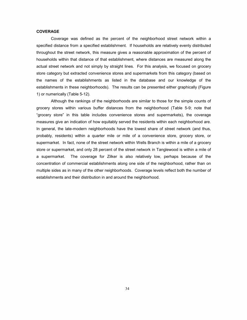
34
COVERAGE Coverage was defined as the percent of the neighborhood street network within a
specified distance from a specified establishment. If households are relatively evenly distributed
throughout the street network, this measure gives a reasonable approximation of the percent of
households within that distance of that establishment, where distances are measured along the
actual street network and not simply by straight lines. For this analysis, we focused on grocery
store category but extracted convenience stores and supermarkets from this category (based on
the names of the establishments as listed in the database and our knowledge of the
establishments in these neighborhoods). The results can be presented either graphically (Figure
1) or numerically (Table 5-12).
Although the rankings of the neighborhoods are similar to those for the simple counts of
grocery stores within various buffer distances from the neighborhood (Table 5-9; note that
�grocery store� in this table includes convenience stores and supermarkets), the coverage
measures give an indication of how equitably served the residents within each neighborhood are.
In general, the late-modern neighborhoods have the lowest share of street network (and thus,
probably, residents) within a quarter mile or mile of a convenience store, grocery store, or
supermarket. In fact, none of the street network within Wells Branch is within a mile of a grocery
store or supermarket, and only 28 percent of the street network in Tanglewood is within a mile of
a supermarket. The coverage for Zilker is also relatively low, perhaps because of the
concentration of commercial establishments along one side of the neighborhood, rather than on
multiple sides as in many of the other neighborhoods. Coverage levels reflect both the number of
establishments and their distribution in and around the neighborhood.

35
TABLE 5-12. NEIGHBORHOOD COVERAGE - SELECTED TYPES
Percent of Street Network Percent of Street NetworkWithin 1/4 Mile of� Within 1 Mile of�
Conv. Grocery Super- Conv. Grocery Super-Store Store market Store Store market
Old West Austin 19% 27% 7% 100% 100% 79%
Travis Heights 23% 8% 4% 100% 100% 62%
Cherrywood 37% 8% 6% 100% 100% 100%
Zilker 10% 19% 4% 84% 87% 39%
Wells Branch 18% 0% 0% 91% 0% 0%
Tanglewood 9% 4% 1% 75% 45% 28%
Cesar Chavez 22% 26% 0% 100% 100% 75%

36
Figure 5-1. Supermarket coverage for Cesar Chavez Neighborhood: street network within 1 mile of supermarket

37
CHAPTER 6. CONCLUSIONS
Although the available data and the capabilities of GIS fall short of providing planners with
a full assessment of the factors that influence neighborhood accessibility, the simple analysis that
is currently possible still yields useful information and helps to identify important differences in
accessibility between neighborhoods. Even with limited data and limited GIS capabilities, it is
possible to generate useful measures of neighborhood accessibility. Fortunately, both the data
available to planning departments and the facility of planning staff with GIS are improving. But
what options do planning departments have to help the process along?
One way is to invest a lot of money. Developing a comprehensive neighborhood
accessibility database would require a significant commitment of resources on the part of a
planning department. First, the collection of data beyond the very basic data likely to be available
to the department requires extensive field work. Once such data have been collected, the
database must also be maintained and periodically updated. Second, the purchase and operation
of a GIS itself demands significant resources. These systems are not cheap, nor are they
especially easy to use, so that additional staff training may be required. Many planning
departments now have a GIS as well as trained staff, but capabilities may vary significantly from
city to city.
Another way is to make data collection itself an important part of the planning process -
to use data collection as a way to facilitate public involvement and build technical capacity within
neighborhoods. In Austin's neighborhood planning program, for example, residents and other
local stakeholders are responsible for developing their own plan for the neighborhood, with
guidance and some assistance from city staff. An early task is to compile data about existing
conditions in the neighborhood, such as inventories of existing land uses and infrastructure and
an assessment of the condition of infrastructure. In addition, the planning team is required to
conduct surveys of residents as to their concerns and priorities. This approach has many
benefits. Such data collection efforts are labor intensive and thus gets many volunteers from the
neighborhood involved. Those who do participate will learn what kinds of information are useful
for planning purposes and what kinds of techniques are effective in collecting that information.
Participants are likely to understand and appreciate the results more than if city staff simply
presented the results to them. These data can also be incorporated into a city-wide database.
Neighborhood planning teams will probably have to rely on city staff for anything beyond
basic analysis of the data, particularly GIS analysis. The mapping capabilities of GIS, however,
may also help to facilitate input from the neighborhood by helping residents to visualize and
understand the implications of the data. Some of the examples presented in Chapter 4

38
demonstrate ways that GIS-based accessibility measures can be used to assess transportation
and land use needs and to evaluate proposed plans and policies. If structured as an interactive
process involving staff and neighborhood residents, these analyses could prove especially fruitful.
Providing the neighborhood planning team with direct access to a GIS and sufficient
training to use it effectively would be even better � and may not be as costly or impractical as one
might think, as demonstrated by a growing number of examples. In 1993, a group of graduate
students at the University of Wisconsin-Milwaukee developed a process for training neighborhood
residents to use GIS to analyze a publicly-accessible database of property characteristics,
including ownership, zoning, land use, assessed value, and other useful information (Myers 1994).
One step in the process included a walk through the neighborhood to collect information about the
condition of properties in the neighborhood. The project succeeded in providing neighborhood
residents with the capability to use GIS to analyze and address a variety of problems in the
neighborhood. In Philadelphia, the city has allocated funds to Community Development
Corporations (CDCs) for GIS hardware, software, and training so that the CDCs can better
illustrate the quality and character of the environment of the neighborhood (Casey and Pederson
2000). Such examples hint at the power of GIS not only as a planning tool but also as a public
involvement technique.
Whatever approach is taken, investment of the necessary resources on the part of the
city should be justified easily. Providing adequate accessibility to services, jobs, public facilities,
and other activities is an important planning function but one that most planning departments have
not sufficiently fulfilled. The development of a database to monitor and assess neighborhood
accessibility is the first step towards developing policies that will enhance accessibility and
guarantee an adequate range of choice - for both destinations and the means to reach them - for
all.

39
REFERENCES
Axelson, Peter W., Kathleen M. Wong, and Julie B. Kirschbaum. 1999. Development of an
Assessment Process to Evaluate Sidewalk Accessibility. Paper presented at the 78th Annual
Meeting of the Transportation Research Board, Washington, DC, January.
Casey, Liza and Tom Pederson. Urbanizing GIS: Philadelphia's Strategy to Bring GIS to
Neighborhood Planning. Available at [http://pasture.ecn.purdue.edu/~aggrass/esri95/to150/p107
.html]. October 27.
City of Fort Collins. 1996. Pedestrian Plan. Prepared by Bolloffet and Associates with Shapins
Associates and Zimmer-Gunsul-Frasxa. Fort Collins, CO: City of Ft. Collins.
Crane, Randall and Richard Crepeau. 1998. Does Neighborhood Design Influence Travel?: A
Behavioral Analysis of Travel Diary and GIS Data. Transportation Research D Vol. 3, No 4.
Dixon, Linda. 1995. Adopting Corridor-Specific Performance Measures for Bicycle and
Pedestrian Level of Service. Transportation Planning, Vol. XXII, No. 2 (Summer).
Federal Highway Administration. 1992. Case Study No. 1: Reasons Why Bicycling and Walking
Are and Are Not Being Used More Extensively as Travel Modes. Publication No. FHWA-PD-92-
041.
Federal Highway Administration. 1999. The Bicycle Compatibility Index: A Level of Service
Concept. Publication No. FHWA-RD-99-127.
Grengs, Joe. 2000. Sprawl, Supermarkets, and Troubled Transit: Disadvantage in the Inner City
of Syracuse. Cornell University, June 13.
Handy, Susan. 1996a. Urban Form and Pedestrian Choices: A Study of Austin Neighborhoods,
Transportation Research Record 1552.
Handy, Susan. 1996b. Understanding the Link Between Urban Form and Nonwork Travel
Behavior, Journal of Planning Education and Research Vol. 15, No. 3.

40
Handy, S L and Niemeier, D A. 1997. Measuring Accessibility: an Exploration of Issues and
Alternatives Environment and Planning A Vol. 29.
Handy, Susan and Kelly Clifton. Forthcoming. Local Shopping as a Strategy for Reducing
Automobile Travel. Transportation.
Handy, Susan, Kelly Clifton, and Janice Fisher. 1998. The Effectiveness of Land Use Policies as a
Strategy for Reducing Automobile Dependence: A Study of Austin Neighborhoods. Research
Report, Southwest Region University Transportation Center, The University of Texas at Austin,
September.
Hardcastle, David and Ian Cleeve. 1995. Accessibility Modelling Using GIS. Geographic
Information Systems: Proceedings of Serminar N held at the PTRC European Transport Forum,
University of Warwick, England, Vol. P400.
Hilbers, Hans D. and Erik J. Verroen. 1993. Measuring Accessibility, A Key Factor for Successful
Transport and Land-Use Planning Strategies. Environmental Issues: Proceedings of Seminar A
held at the PTRC European Transport, Highways and Planning 21st Annual Meeting, Vol. P363.
Hillman, Richard and Graham Pool. 1997. GIS-Based Innovations for Modelling Public Transport
Accessibility. Traffic Engineering + Control, October, pp. 554-559.
Moe, Ray A. and Kathleen Reavis. Undated. Pedestrian LOS Level of Service. Balloffet and
Associates, Inc., for the City of Fort Collins.
Myers, Jim. 1994. Metcalfe Park Neighborhood Residents Association Housing GIS Project:
Applying Geographic Information Systems to Neighborhood Planning. URISA, pp. 875-886.
Nevin and Houston. 1980. Image as a Component of Attraction to Intra-Urban Shopping Areas.
Journal of Retailing, Vol. 56, No. 85.
Recker, Wilfred W. and Lidia P. Kostyniuk. 1978. Factors Influencing Destination Choice for the
Urban Grocery Shopping Trip. Transportation. Vol. 7, pp. 19-33.
Sarkar, Sheila. 1993. Determination of Service Levels for Pedestrians, with European Examples

41
Transportation Research Record 1405.
Talen, Emily. 1998. Visualizing Fairness: Equity Maps for Planners. Journal of the American
Planning Association Winter.
1000 Friends of Oregon. 1993. Making the Land Use Transportation Air Quality Connection: The
Pedestrian Environment: Vol. 4A Portland, OR: 1000 Friends of Oregon.
Tolley, R.S. and B.J. Turton. 1995. Transport Systems, Policy and Planning: A Geographical
Approach. Longman Scientific and Technical.
Ulrich, Roger, et al. 1991. Stress Recovery During Exposure to Natural and Urban
Environments. Texas A&M University.
Wachs, Martin and T. Gordon Kumagai. 1973. Physical Accessibility as a Social Indicator.
Socio-Economic Planning Science. Vol. 7, pp. 437-456.
Weinstein, Aaron. 2000. Customer Satisfaction Among Transit Riders � "How Do Customers
Rank The Relative Importance Of Various Service Attributes?" Paper No. 00-0700, presented at
the 79th Annual Meeting of the Transportation Research Board, Washington, DC, January.