teanaway community forest glacier …file.dnr.wa.gov/publications/ger_gsp_teanaway.pdf · teanaway...
TRANSCRIPT
● Teanaway Basalt is the source of the “Ellensburg Blue” agate. Warm groundwater rich in silica flowed through the basalt and formed the agate. The agate erodes from the basalt and is transported toward Ellensburg by rivers.
● Rocks here are from the Eocene epoch and record a time before the Cascade Range existed. Instead, you would have found meandering rivers, low hills, and swamps instead of mountains. The river deposits and swamps were compressed by overlying rock and heated by the Earth to become sandstone and coal.
● Coal was mined here for about 80 years—the product of ancient swamps buried and heated over time. These swamps are preserved in rocks along Cle Elum Ridge.
● Glaciers once filled the Yakima and Cle Elum river valleys. These glaciers blocked the Teanaway River and formed a temporary lake.
● The Eocene was a period of tectonic tumult in Washington. The Earth split and formed narrow basins and sinuous mountains. Teanaway Basalt poured out from thousands of fissures and filled the valleys. Because the basalt is so resistant to erosion, these ancient valley bottoms are now high ridges.
● The climate was significantly warmer during the Eocene, and large palm-like trees are occasionally found as fossils in rocks of this age. Horses—originally the size of modern-day coyotes—first appear in the fossil record at this time.
TEANAWAY COMMUNITY FOREST glacier
ice-dammed lake
Teanaway R idge
Cle Elum Ridge
bedrockglacial sediment
SEATTLE
PULLMAN
SPOKANE
YAKIMA
VANCOUVERVANCOUVER
BELLINGHAM
OLYMPIA
1212
195
2
2
395
12
39597
101
97
90
5
90
5
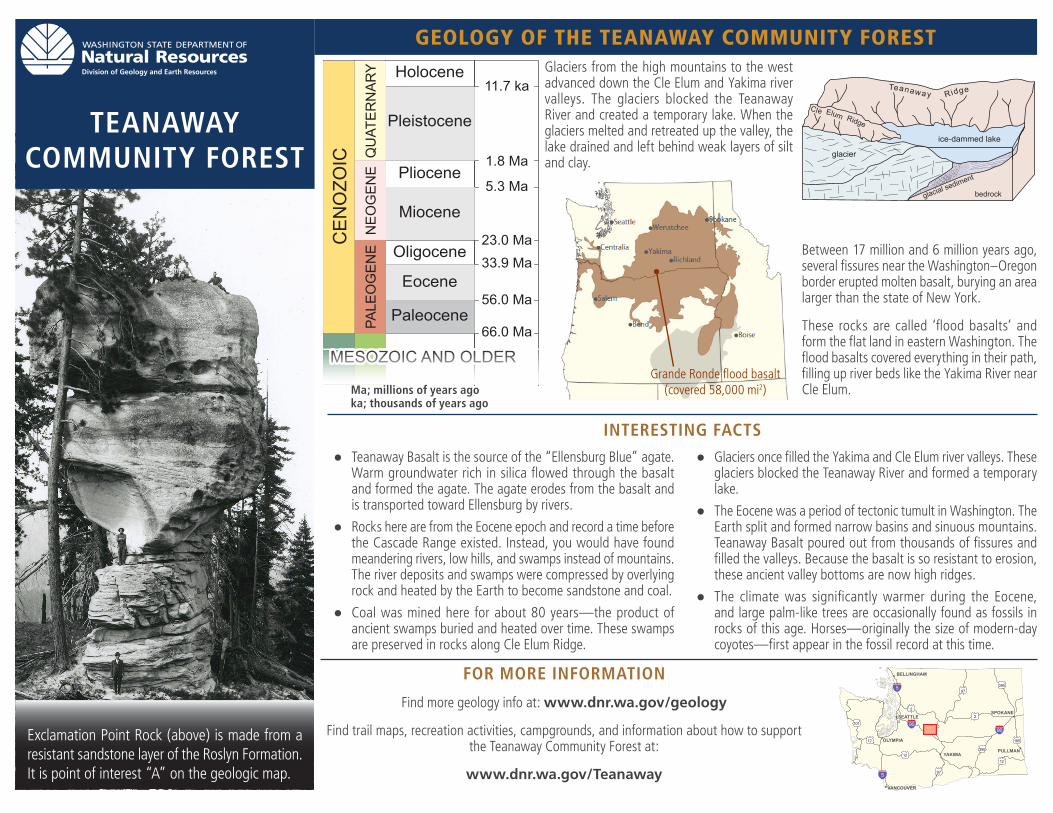
Grande Ronde flood basalt (covered 58,000 mi2)
Exclamation Point Rock (above) is made from a resistant sandstone layer of the Roslyn Formation. It is point of interest “A” on the geologic map.
FOR MORE INFORMATION
Find more geology info at: www.dnr.wa.gov/geology
Find trail maps, recreation activities, campgrounds, and information about how to support the Teanaway Community Forest at:
www.dnr.wa.gov/Teanaway
CEN
OZO
ICMESOZOIC AND OLDER
NEO
GEN
EPA
LEO
GEN
EQ
UAT
ERN
ARY
Paleocene
Eocene
Oligocene
Miocene
Pliocene
Pleistocene
Holocene11.7 ka
1.8 Ma
5.3 Ma
23.0 Ma33.9 Ma
56.0 Ma
66.0 Ma
Ma; millions of years agoka; thousands of years ago
Glaciers from the high mountains to the west advanced down the Cle Elum and Yakima river valleys. The glaciers blocked the Teanaway River and created a temporary lake. When the glaciers melted and retreated up the valley, the lake drained and left behind weak layers of silt and clay.
Between 17 million and 6 million years ago, several fissures near the Washington–Oregon border erupted molten basalt, burying an area larger than the state of New York.
These rocks are called ‘flood basalts’ and form the flat land in eastern Washington. The flood basalts covered everything in their path, filling up river beds like the Yakima River near Cle Elum.
INTERESTING FACTS
GEOLOGY OF THE TEANAWAY COMMUNITY FOREST
● Over 60 million tons of coal were mined from the rocks of the upper Roslyn Formation between 1882 and 1963. An estimated 240 million tons of coal remains, but it is currently uneconomical to mine.
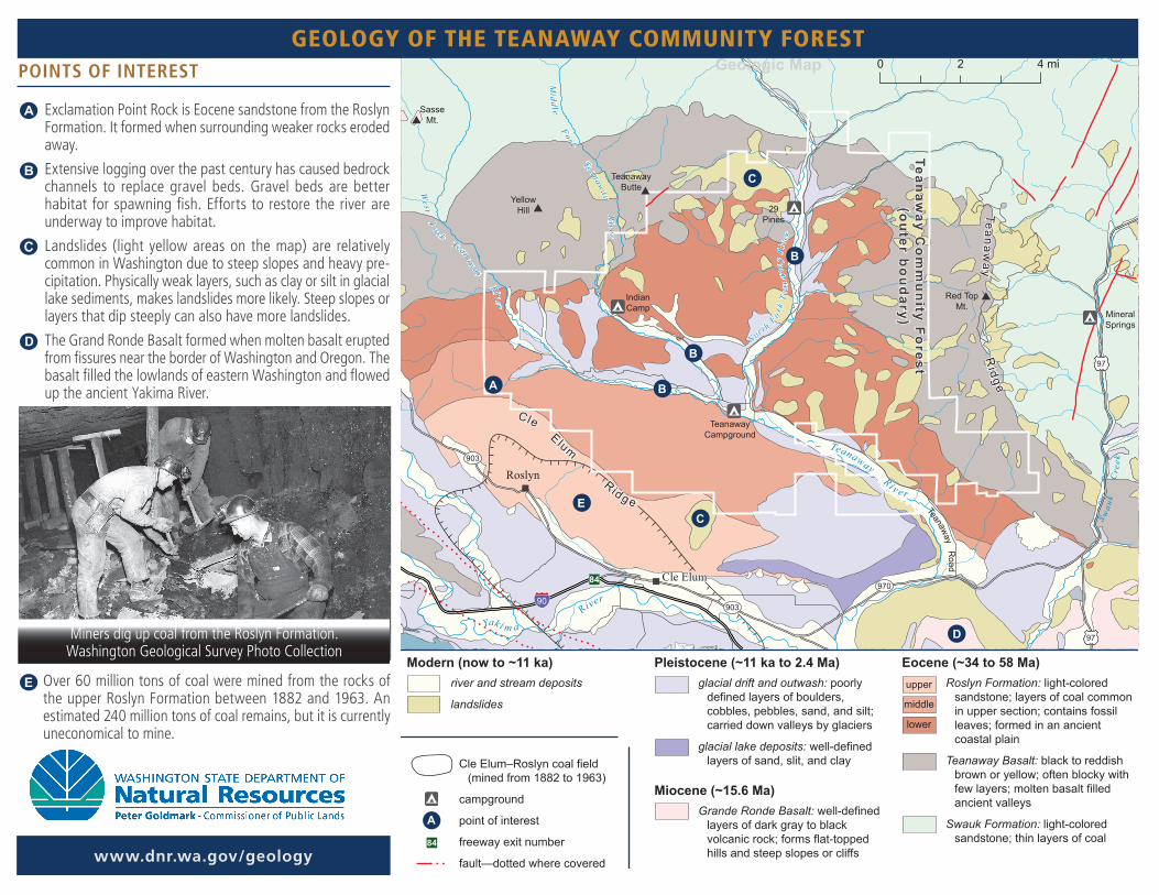
POINTS OF INTEREST
● Exclamation Point Rock is Eocene sandstone from the Roslyn Formation. It formed when surrounding weaker rocks eroded away.
● Extensive logging over the past century has caused bedrock channels to replace gravel beds. Gravel beds are better habitat for spawning fish. Efforts to restore the river are underway to improve habitat.
● Landslides (light yellow areas on the map) are relatively common in Washington due to steep slopes and heavy pre-cipitation. Physically weak layers, such as clay or silt in glacial lake sediments, makes landslides more likely. Steep slopes or layers that dip steeply can also have more landslides.
● The Grand Ronde Basalt formed when molten basalt erupted from fissures near the border of Washington and Oregon. The basalt filled the lowlands of eastern Washington and flowed up the ancient Yakima River.
Teanaw
ay Co
mm
un
ity Fo
rest(o
uter b
ou
dary)
84
A
B
B
B
C
D
E
Geologic Map 0 2 4 mi
A
Modern (now to ~11 ka)river and stream deposits
landslides
Pleistocene (~11 ka to 2.4 Ma)glacial drift and outwash: poorly
defined layers of boulders, cobbles, pebbles, sand, and silt; carried down valleys by glaciers
glacial lake deposits: well-defined layers of sand, slit, and clay
Miocene (~15.6 Ma)Grande Ronde Basalt: well-defined
layers of dark gray to black volcanic rock; forms flat-topped hills and steep slopes or cliffs
Eocene (~34 to 58 Ma)Roslyn Formation: light-colored
sandstone; layers of coal common in upper section; contains fossil leaves; formed in an ancient coastal plain
Teanaway Basalt: black to reddish brown or yellow; often blocky with few layers; molten basalt filled ancient valleys
Swauk Formation: light-colored sandstone; thin layers of coal
Cle Elum–Roslyn coal field (mined from 1882 to 1963)
campground
point of interest
freeway exit number
fault—dotted where covered
upper
middle
lower
84
C
TeanawayCampground
IndianCamp
29Pines
R
iver
Teanaway Ri v e r
Teanaway Ro ad
Midd le Fork Teanaw
ay River
West F
o r k Teanaway Ri ve r
S wau
k
Cr e
ek
Teanaway R
idge
Cle Elum Ridg e
MineralSprings
Red TopMt.
TeanawayButte
SasseMt.
YellowHill
97
97
903
903
970
90
Yaki m a
Cle Elum
Roslyn
Nort h Fo
rk T
e an
away
Riv
er
Miners dig up coal from the Roslyn Formation. Washington Geological Survey Photo Collection
www.dnr.wa.gov/geology
GEOLOGY OF THE TEANAWAY COMMUNITY FOREST