the teanaway: geologic & physical geographic patterns · the teanaway: geologic & physical...
TRANSCRIPT
The Teanaway: Geologic & Physical Geographic Patterns
Field Trip Leader: Dr. Karl Lillquist
Geography DepartmentCentral Washington University
Ellensburg Chapter Ice Age Floods Institute
29 September 2013
1
Preliminaries
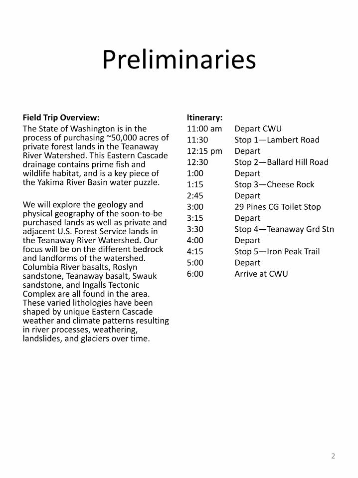
Field Trip Overview:The State of Washington is in the process of purchasing ~50,000 acres of private forest lands in the TeanawayRiver Watershed. This Eastern Cascade drainage contains prime fish and wildlife habitat, and is a key piece of the Yakima River Basin water puzzle.
We will explore the geology and physical geography of the soon-to-be purchased lands as well as private and adjacent U.S. Forest Service lands in the Teanaway River Watershed. Our focus will be on the different bedrock and landforms of the watershed. Columbia River basalts, Roslyn sandstone, Teanaway basalt, Swauksandstone, and Ingalls Tectonic Complex are all found in the area. These varied lithologies have been shaped by unique Eastern Cascade weather and climate patterns resulting in river processes, weathering, landslides, and glaciers over time.
Itinerary:11:00 am Depart CWU11:30 Stop 1—Lambert Road12:15 pm Depart12:30 Stop 2—Ballard Hill Road1:00 Depart1:15 Stop 3—Cheese Rock 2:45 Depart3:00 29 Pines CG Toilet Stop3:15 Depart3:30 Stop 4—Teanaway Grd Stn4:00 Depart4:15 Stop 5—Iron Peak Trail5:00 Depart6:00 Arrive at CWU
2
En route to Stop 1
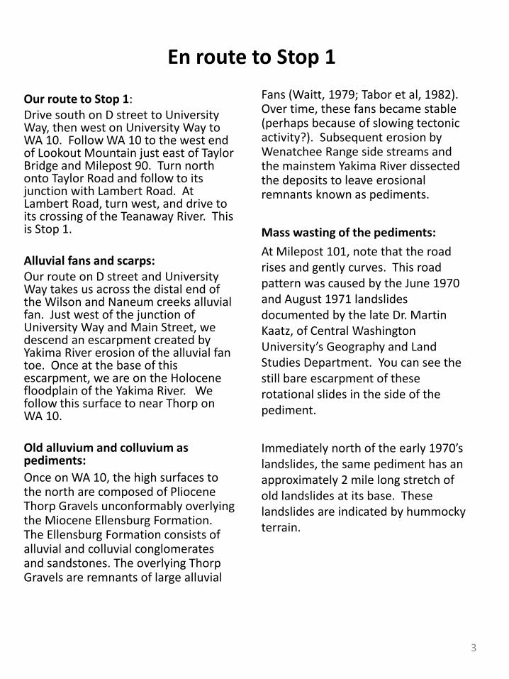
Our route to Stop 1: Drive south on D street to University Way, then west on University Way to WA 10. Follow WA 10 to the west end of Lookout Mountain just east of Taylor Bridge and Milepost 90. Turn north onto Taylor Road and follow to its junction with Lambert Road. At Lambert Road, turn west, and drive to its crossing of the Teanaway River. This is Stop 1.
Alluvial fans and scarps:Our route on D street and University Way takes us across the distal end of the Wilson and Naneum creeks alluvial fan. Just west of the junction of University Way and Main Street, we descend an escarpment created by Yakima River erosion of the alluvial fan toe. Once at the base of this escarpment, we are on the Holocene floodplain of the Yakima River. We follow this surface to near Thorp on WA 10.
Old alluvium and colluvium as pediments: Once on WA 10, the high surfaces to the north are composed of Pliocene Thorp Gravels unconformably overlying the Miocene Ellensburg Formation. The Ellensburg Formation consists of alluvial and colluvial conglomerates and sandstones. The overlying Thorp Gravels are remnants of large alluvial
Fans (Waitt, 1979; Tabor et al, 1982). Over time, these fans became stable (perhaps because of slowing tectonic activity?). Subsequent erosion by Wenatchee Range side streams and the mainstem Yakima River dissected the deposits to leave erosional remnants known as pediments.
Mass wasting of the pediments: At Milepost 101, note that the road rises and gently curves. This road pattern was caused by the June 1970 and August 1971 landslides documented by the late Dr. Martin Kaatz, of Central Washington University’s Geography and Land Studies Department. You can see the still bare escarpment of these rotational slides in the side of the pediment.
Immediately north of the early 1970’s landslides, the same pediment has an approximately 2 mile long stretch of old landslides at its base. These landslides are indicated by hummocky terrain.
3
En route to Stop 1 (cont)
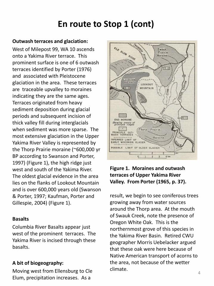
Outwash terraces and glaciation:West of Milepost 99, WA 10 ascends onto a Yakima River terrace. This prominent surface is one of 6 outwash terraces identified by Porter (1976) and associated with Pleistocene glaciation in the area. These terraces are traceable upvalley to moraines indicating they are the same ages. Terraces originated from heavy sediment deposition during glacial periods and subsequent incision of thick valley fill during interglacialswhen sediment was more sparse. The most extensive glaciation in the Upper Yakima River Valley is represented by the Thorp Prairie moraine (~600,000 yrBP according to Swanson and Porter, 1997) (Figure 1), the high ridge just west and south of the Yakima River. The oldest glacial evidence in the area lies on the flanks of Lookout Mountain and is over 600,000 years old (Swanson & Porter, 1997; Kaufman, Porter and Gillespie, 2004) (Figure 1).
BasaltsColumbia River Basalts appear just west of the prominent terraces. The Yakima River is incised through these basalts.
A bit of biogeography:Moving west from Ellensburg to Cle Elum, precipitation increases. As a
result, we begin to see coniferous trees growing away from water sources around the Thorp area. At the mouth of Swauk Creek, note the presence of Oregon White Oak. This is the northernmost grove of this species in the Yakima River Basin. Retired CWU geographer Morris Uebelacker argued that these oak were here because of Native American transport of acorns to the area, not because of the wetter climate.
Figure 1. Moraines and outwash terraces of Upper Yakima River Valley. From Porter (1965, p. 37).
4
Stop 1—Teanaway River @ Lambert Road
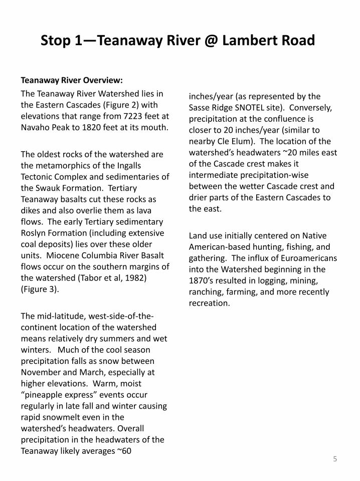
Teanaway River Overview:The Teanaway River Watershed lies in the Eastern Cascades (Figure 2) with elevations that range from 7223 feet at Navaho Peak to 1820 feet at its mouth.
The oldest rocks of the watershed are the metamorphics of the Ingalls Tectonic Complex and sedimentaries of the Swauk Formation. Tertiary Teanaway basalts cut these rocks as dikes and also overlie them as lava flows. The early Tertiary sedimentary Roslyn Formation (including extensive coal deposits) lies over these older units. Miocene Columbia River Basalt flows occur on the southern margins of the watershed (Tabor et al, 1982) (Figure 3).
The mid-latitude, west-side-of-the-continent location of the watershed means relatively dry summers and wet winters. Much of the cool season precipitation falls as snow between November and March, especially at higher elevations. Warm, moist “pineapple express” events occur regularly in late fall and winter causing rapid snowmelt even in the watershed’s headwaters. Overall precipitation in the headwaters of the Teanaway likely averages ~60
inches/year (as represented by the Sasse Ridge SNOTEL site). Conversely, precipitation at the confluence is closer to 20 inches/year (similar to nearby Cle Elum). The location of the watershed’s headwaters ~20 miles east of the Cascade crest makes it intermediate precipitation-wise between the wetter Cascade crest and drier parts of the Eastern Cascades to the east.
Land use initially centered on Native American-based hunting, fishing, and gathering. The influx of Euroamericansinto the Watershed beginning in the 1870’s resulted in logging, mining, ranching, farming, and more recently recreation.
5
Stop 1 (cont)
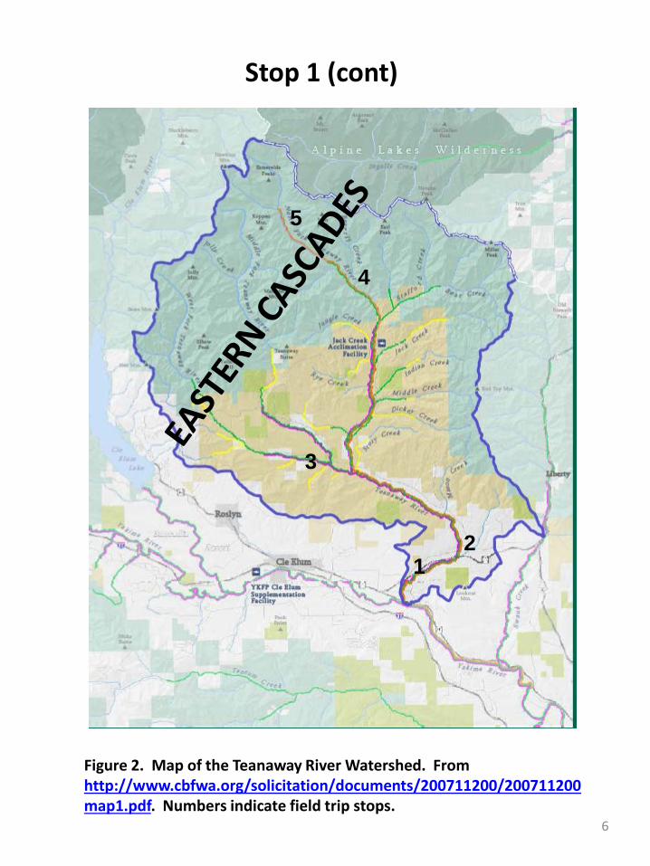
Figure 2. Map of the Teanaway River Watershed. From http://www.cbfwa.org/solicitation/documents/200711200/200711200map1.pdf. Numbers indicate field trip stops.
12
3
4
5
6
Stop 1 (cont)
1
2
3
4
5
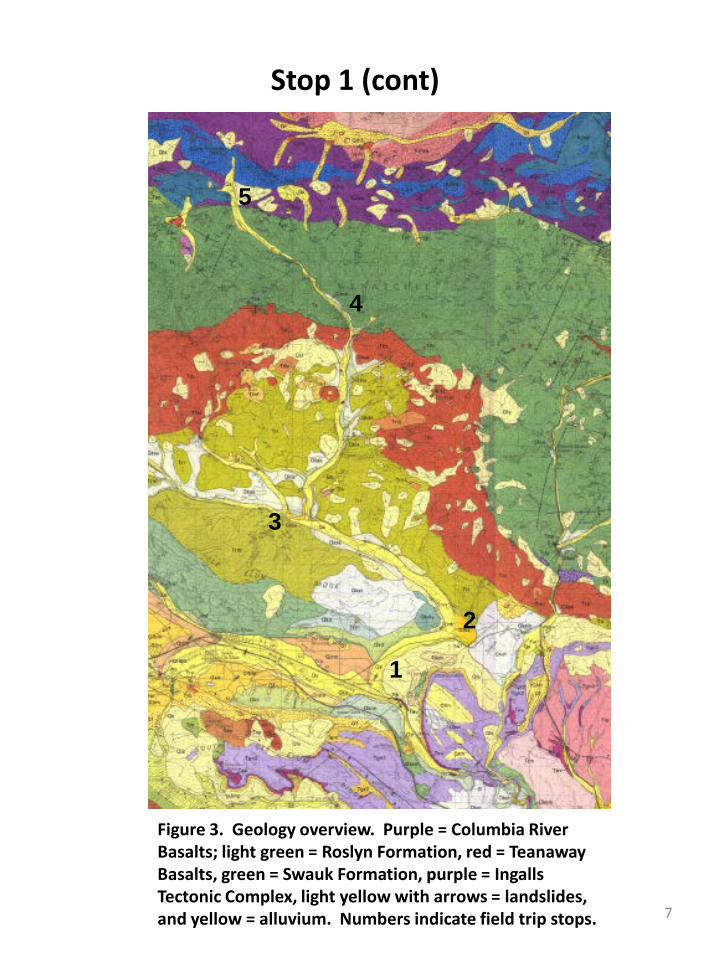
Figure 3. Geology overview. Purple = Columbia River Basalts; light green = Roslyn Formation, red = TeanawayBasalts, green = Swauk Formation, purple = Ingalls Tectonic Complex, light yellow with arrows = landslides, and yellow = alluvium. Numbers indicate field trip stops. 7
Stop 1 (cont)
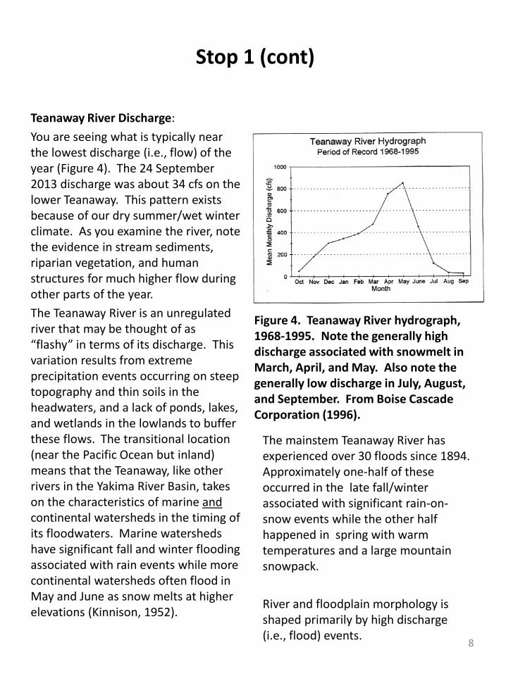
Teanaway River Discharge:You are seeing what is typically near the lowest discharge (i.e., flow) of the year (Figure 4). The 24 September 2013 discharge was about 34 cfs on the lower Teanaway. This pattern exists because of our dry summer/wet winter climate. As you examine the river, note the evidence in stream sediments, riparian vegetation, and human structures for much higher flow during other parts of the year. The Teanaway River is an unregulated river that may be thought of as “flashy” in terms of its discharge. This variation results from extreme precipitation events occurring on steep topography and thin soils in the headwaters, and a lack of ponds, lakes, and wetlands in the lowlands to buffer these flows. The transitional location (near the Pacific Ocean but inland) means that the Teanaway, like other rivers in the Yakima River Basin, takes on the characteristics of marine andcontinental watersheds in the timing of its floodwaters. Marine watersheds have significant fall and winter flooding associated with rain events while more continental watersheds often flood in May and June as snow melts at higher elevations (Kinnison, 1952).
The mainstem Teanaway River has experienced over 30 floods since 1894. Approximately one-half of these occurred in the late fall/winter associated with significant rain-on-snow events while the other half happened in spring with warm temperatures and a large mountain snowpack.
River and floodplain morphology is shaped primarily by high discharge (i.e., flood) events.
Figure 4. Teanaway River hydrograph, 1968-1995. Note the generally high discharge associated with snowmelt in March, April, and May. Also note the generally low discharge in July, August, and September. From Boise Cascade Corporation (1996).
8

Stop 1 (cont)
River and Floodplain Morphology:The morphology of the lower Teanaway River floodplain is that of an alluvial meandering stream (Figure 5). Rounded gravels characterize the alluvial deposits and are a mix of the various rocks of the watershed. The key features of such a river are point bars characterized by lower velocities and deposition, and cutbanksassociated with higher velocities and erosion. Both features are visible from the bridge. Over time, these features migrate downstream. During floods new channels form as we see to the east of our site (Figure 6)
Figure 5. Diagram of a typical meandering stream system. http://thebritishgeographer.weebly.com/river-landforms.html
1
Figure 6. Google Earth view of lower Teanaway River and Stop 1. Abandoned channels indicated by arrows.
9
Stop 1 (cont)
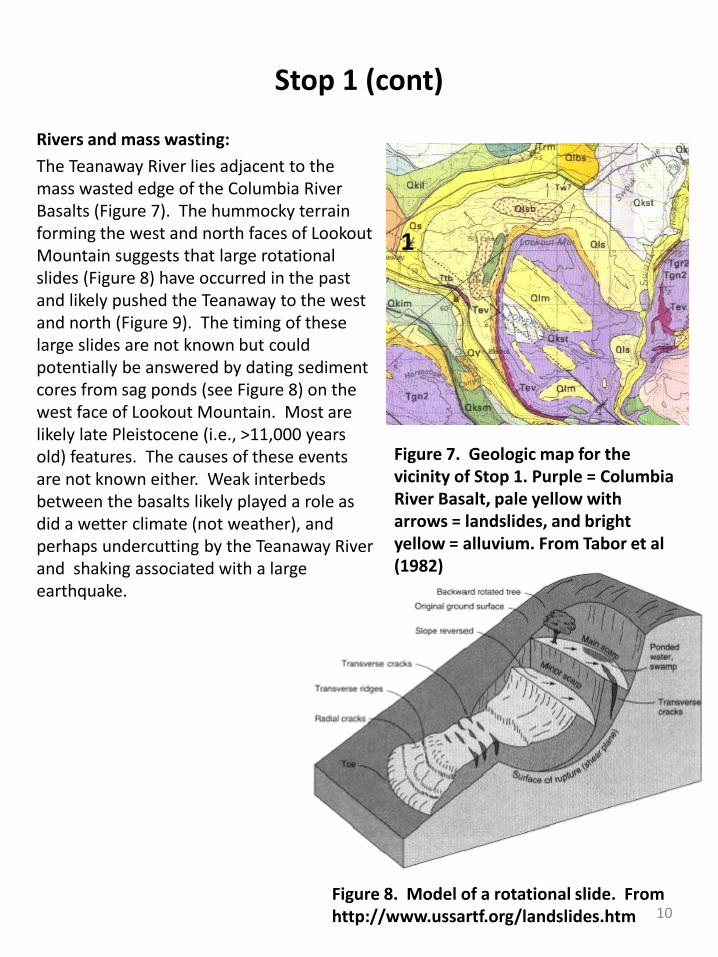
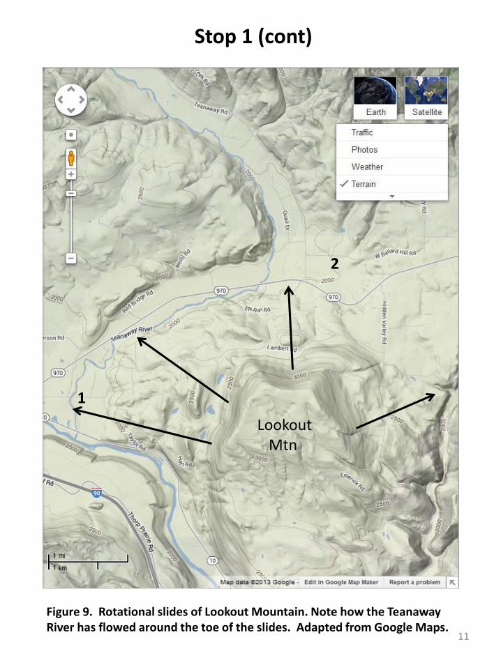
Rivers and mass wasting: The Teanaway River lies adjacent to the mass wasted edge of the Columbia River Basalts (Figure 7). The hummocky terrain forming the west and north faces of Lookout Mountain suggests that large rotational slides (Figure 8) have occurred in the past and likely pushed the Teanaway to the west and north (Figure 9). The timing of these large slides are not known but could potentially be answered by dating sediment cores from sag ponds (see Figure 8) on the west face of Lookout Mountain. Most are likely late Pleistocene (i.e., >11,000 years old) features. The causes of these events are not known either. Weak interbedsbetween the basalts likely played a role as did a wetter climate (not weather), and perhaps undercutting by the Teanaway River and shaking associated with a large earthquake.
Figure 8. Model of a rotational slide. From http://www.ussartf.org/landslides.htm
Figure 7. Geologic map for the vicinity of Stop 1. Purple = Columbia River Basalt, pale yellow with arrows = landslides, and bright yellow = alluvium. From Tabor et al (1982)
1
10
Stop 1 (cont)
Lookout Mtn
1
Figure 9. Rotational slides of Lookout Mountain. Note how the TeanawayRiver has flowed around the toe of the slides. Adapted from Google Maps.
2
11
En route to Stop 2
Continue west on Lambert Road to its junction with WA 970. The undulating terrain immediately west of the Lambert Road is likely the remains of a middle Pleistocene moraine associated with the Upper Yakima River glacier.
Turn right (east) onto WA 970. The road is on the Yakima River floodplain until again crossing the moraine. There, it is again on the floodplain of the Teanaway River. Notice how the Teanaway is tight against the landslides of Lookout Mountain.
Cross the Teanaway River and ascend a large alluvial fan from Lookout Mountain. Near the apex of the fan, turn (left) north onto Teanaway Road.
Travel north approximately 0.5 miles before turning right (east) onto the Ballard Hill Road. Park on the south (right) shoulder of the road near the Teanaway Ranch.
Please note: The owners of the Teanaway Ranch maintain the ditch in which we are parked. Please leave it as clean or cleaner than you found it.
12
Stop 2—Ballard Hill Road
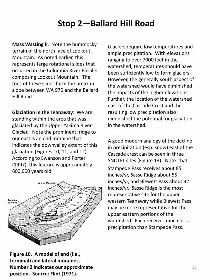
Mass Wasting II. Note the hummocky terrain of the north face of Lookout Mountain. As noted earlier, this represents large rotational slides that occurred in the Columbia River Basalts composing Lookout Mountain. The toes of these slides form the break in slope between WA 970 and the Ballard Hill Road.
Glaciation in the Teanaway: We are standing within the area that was glaciated by the Upper Yakima River Glacier. Note the prominent ridge to our east is an end moraine that indicates the downvalley extent of this glaciation (Figures 10, 11, and 12). According to Swanson and Porter (1997), this feature is approximately 600,000 years old.
Glaciers require low temperatures and ample precipitation. With elevations ranging to over 7000 feet in the watershed, temperatures should have been sufficiently low to form glaciers. However, the generally south aspect of the watershed would have diminished the impacts of the higher elevations. Further, the location of the watershed east of the Cascade Crest and the resulting low precipitation also diminished the potential for glaciation in the watershed.
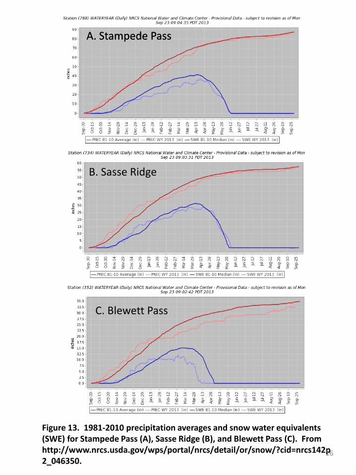
A good modern analogy of the decline in precipitation (esp. snow) east of the Cascade crest can be seen in three SNOTEL sites (Figure 13). Note thatStampede Pass receives about 85 inches/yr, Sasse Ridge about 55 inches/yr, and Blewett Pass about 32 inches/yr. Sasse Ridge is the most representative site for the upper western Teanaway while Blewett Pass may be more representative for the upper eastern portions of the watershed. Each receives much less precipitation than Stampede Pass.
Figure 10. A model of end (i.e., terminal) and lateral moraines. Number 2 indicates our approximate position. Source: Flint (1971).
2
13
Stop 2 (cont)
End Moraine
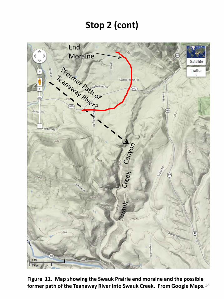
Figure 11. Map showing the Swauk Prairie end moraine and the possible former path of the Teanaway River into Swauk Creek. From Google Maps.14
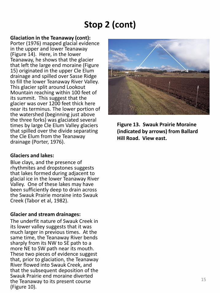
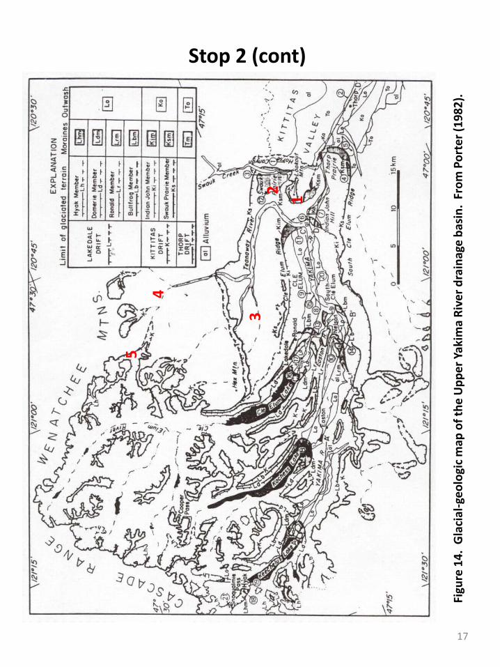
Stop 2 (cont)Glaciation in the Teanaway (cont): Porter (1976) mapped glacial evidence in the upper and lower Teanaway(Figure 14). Here, in the lower Teanaway, he shows that the glacier that left the large end moraine (Figure 15) originated in the upper Cle Elumdrainage and spilled over Sasse Ridge to fill the lower Teanaway River Valley. This glacier split around Lookout Mountain reaching within 100 feet of its summit. This suggest that the glacier was over 1200 feet thick here near its terminus. The lower portion of the watershed (beginning just above the three forks) was glaciated several times by large Cle Elum Valley glaciers that spilled over the divide separating the Cle Elum from the Teanawaydrainage (Porter, 1976).
Glaciers and lakes: Blue clays, and the presence of rhythmites and dropstones suggests that lakes formed during adjacent to glacial ice in the lower Teanaway River Valley. One of these lakes may have been sufficiently deep to drain across the Swauk Prairie moraine into SwaukCreek (Tabor et al, 1982).
Glacier and stream drainages: The underfit nature of Swauk Creek in its lower valley suggests that it was much larger in previous times. At the same time, the Teanaway River bendssharply from its NW to SE path to a more NE to SW path near its mouth. These two pieces of evidence suggest that, prior to glaciation, the TeanawayRiver flowed into Swauk Creek, and that the subsequent deposition of the Swauk Prairie end moraine diverted the Teanaway to its present course (Figure 10).
Figure 13. Swauk Prairie Moraine (indicated by arrows) from Ballard Hill Road. View east.
15
Stop 1
Figure 13. 1981-2010 precipitation averages and snow water equivalents (SWE) for Stampede Pass (A), Sasse Ridge (B), and Blewett Pass (C). From http://www.nrcs.usda.gov/wps/portal/nrcs/detail/or/snow/?cid=nrcs142p2_046350.
A. Stampede Pass
B. Sasse Ridge
A. Stampede Pass
C. Blewett Pass
16
Stop 2 (cont)
Figu
re 1
4. G
laci
al-g
eolo
gic m
ap o
f the
Upp
er Y
akim
a Ri
ver d
rain
age
basi
n. F
rom
Por
ter (
1982
).
123
4
5
17
En route to Stop 3Turn around on the Ballard Hill Road and return to Teanaway Road. Turn north (right) and proceed upvalley. Note that the geology changes dramatically (Figure 3). TeanawayRidge to our east (right) is composed of Eocene Teanaway Basalts. These basalts are differentiated from the Miocene Columbia River Basalts by their characteristic red color caused by advanced weathering. Ahead and to our left are the bright white sandstones of the later Eocene Roslyn Formation.
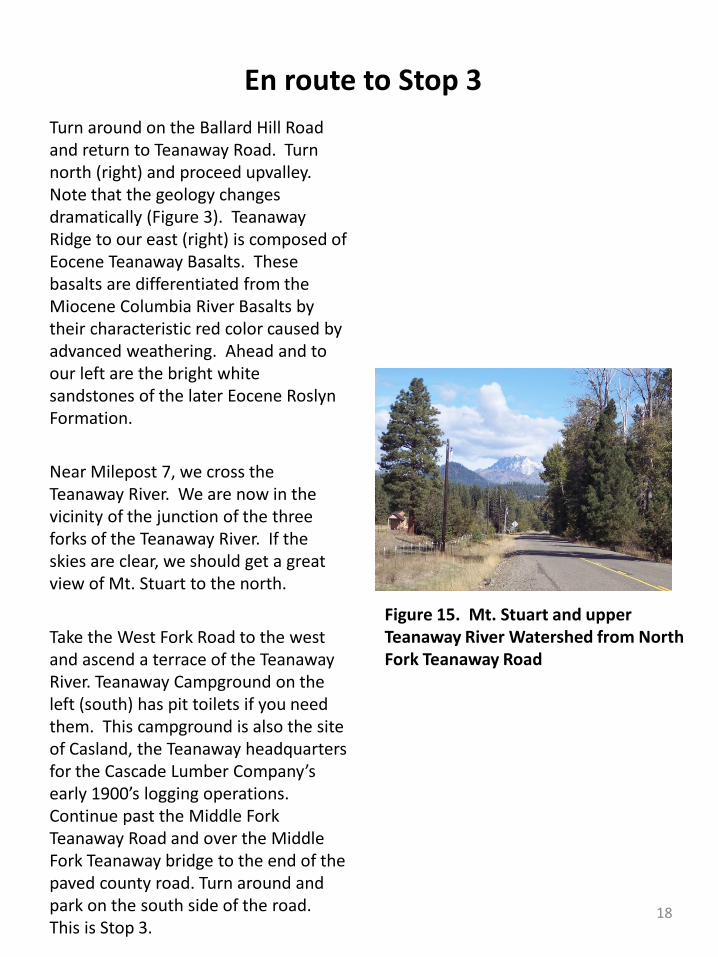
Near Milepost 7, we cross the Teanaway River. We are now in the vicinity of the junction of the three forks of the Teanaway River. If the skies are clear, we should get a great view of Mt. Stuart to the north.
Take the West Fork Road to the west and ascend a terrace of the TeanawayRiver. Teanaway Campground on the left (south) has pit toilets if you need them. This campground is also the site of Casland, the Teanaway headquarters for the Cascade Lumber Company’s early 1900’s logging operations. Continue past the Middle Fork Teanaway Road and over the Middle Fork Teanaway bridge to the end of the paved county road. Turn around and park on the south side of the road. This is Stop 3.
Figure 15. Mt. Stuart and upper Teanaway River Watershed from North Fork Teanaway Road
18
Stop 3—Slickrock and Cheese RockFrom the parking area, follow the gravel road across the West Fork Teanaway and into the mouth of Carlson Canyon. Note the very low discharge of the West Fork late in the dry season. The mouth of Carlson Canyon was the site of Camp Illahee, a camp for kids. Access to the former camp is limited by recent erosion and the creation of a gully that we cross. As we ascend the trail, note the sandy soils reflecting the adjacent sandstone.
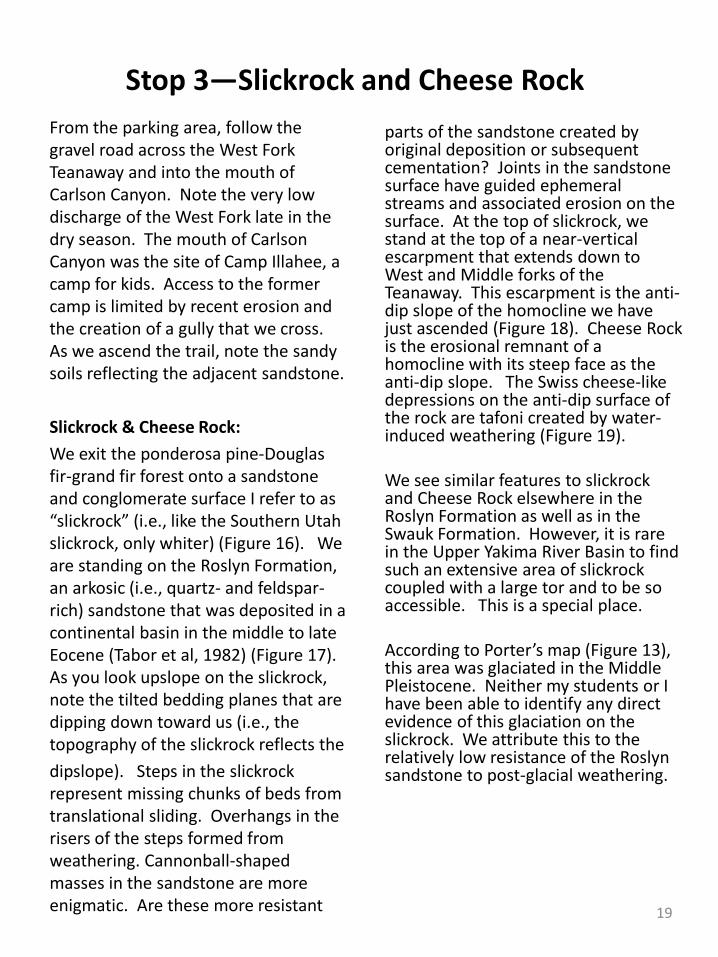
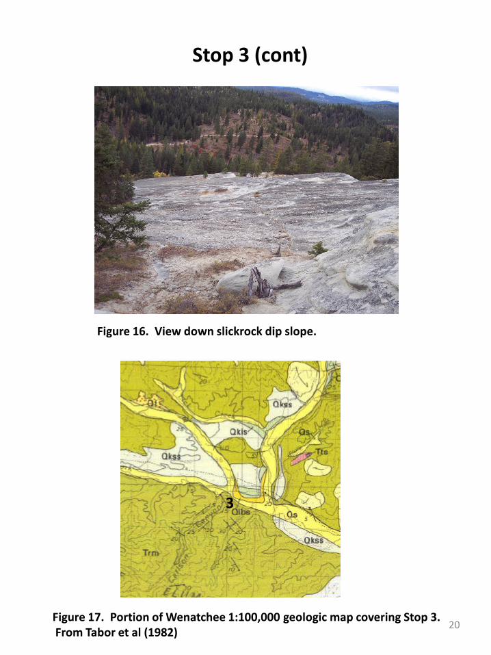
Slickrock & Cheese Rock: We exit the ponderosa pine-Douglas fir-grand fir forest onto a sandstone and conglomerate surface I refer to as “slickrock” (i.e., like the Southern Utah slickrock, only whiter) (Figure 16). We are standing on the Roslyn Formation, an arkosic (i.e., quartz- and feldspar-rich) sandstone that was deposited in a continental basin in the middle to late Eocene (Tabor et al, 1982) (Figure 17). As you look upslope on the slickrock, note the tilted bedding planes that are dipping down toward us (i.e., the topography of the slickrock reflects thedipslope). Steps in the slickrockrepresent missing chunks of beds from translational sliding. Overhangs in the risers of the steps formed from weathering. Cannonball-shaped masses in the sandstone are more enigmatic. Are these more resistant
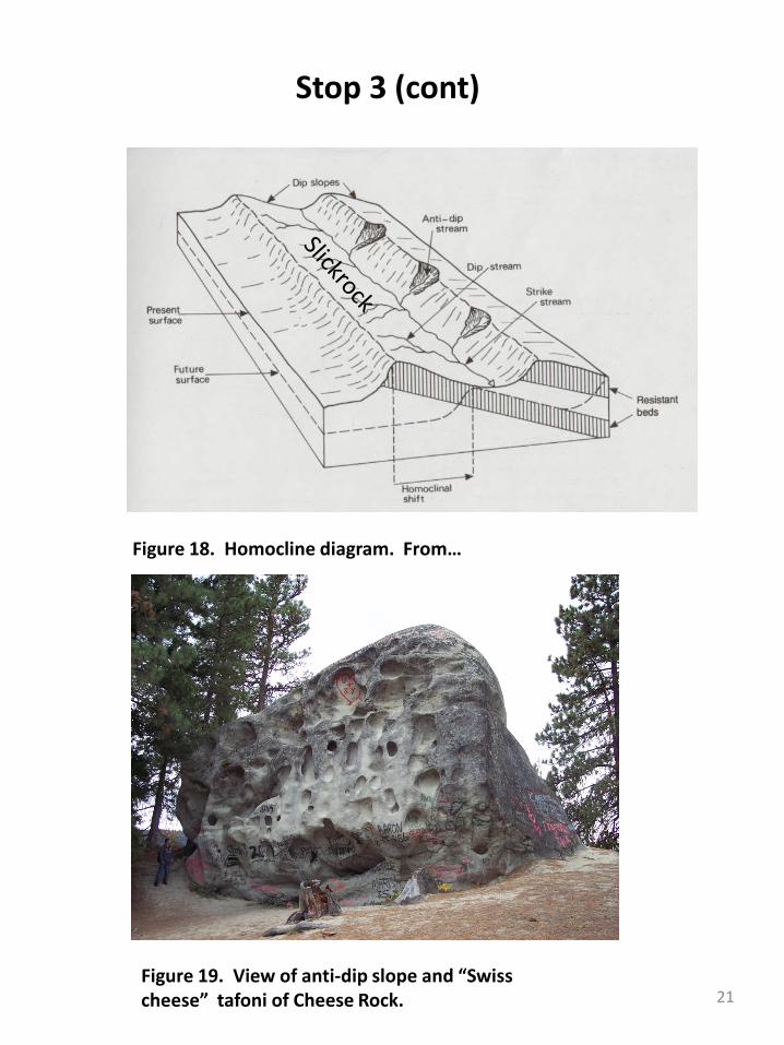
parts of the sandstone created by original deposition or subsequent cementation? Joints in the sandstone surface have guided ephemeral streams and associated erosion on the surface. At the top of slickrock, we stand at the top of a near-vertical escarpment that extends down to West and Middle forks of the Teanaway. This escarpment is the anti-dip slope of the homocline we have just ascended (Figure 18). Cheese Rock is the erosional remnant of a homocline with its steep face as the anti-dip slope. The Swiss cheese-like depressions on the anti-dip surface of the rock are tafoni created by water-induced weathering (Figure 19).
We see similar features to slickrockand Cheese Rock elsewhere in the Roslyn Formation as well as in the Swauk Formation. However, it is rare in the Upper Yakima River Basin to find such an extensive area of slickrockcoupled with a large tor and to be so accessible. This is a special place.
According to Porter’s map (Figure 13), this area was glaciated in the Middle Pleistocene. Neither my students or I have been able to identify any direct evidence of this glaciation on the slickrock. We attribute this to the relatively low resistance of the Roslyn sandstone to post-glacial weathering.
19
Stop 3 (cont)
Figure 16. View down slickrock dip slope.
Figure 17. Portion of Wenatchee 1:100,000 geologic map covering Stop 3. From Tabor et al (1982)
3
20
Stop 3 (cont)
Figure 19. View of anti-dip slope and “Swiss cheese” tafoni of Cheese Rock.
Figure 18. Homocline diagram. From…
21
En route to Stop 4
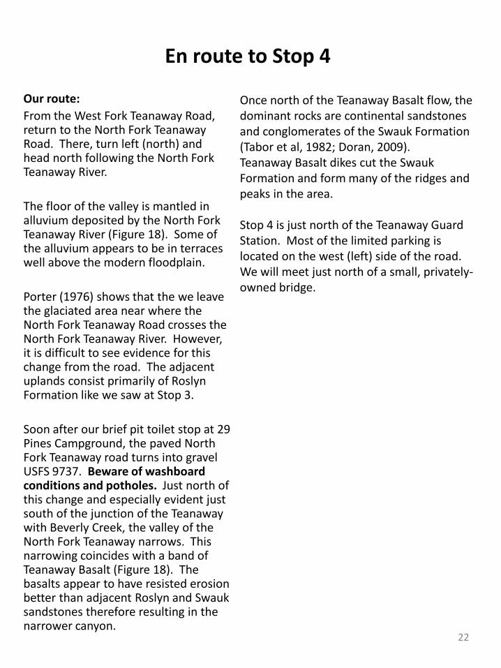
Our route:From the West Fork Teanaway Road, return to the North Fork TeanawayRoad. There, turn left (north) and head north following the North Fork Teanaway River.
The floor of the valley is mantled in alluvium deposited by the North Fork Teanaway River (Figure 18). Some of the alluvium appears to be in terraces well above the modern floodplain.
Porter (1976) shows that the we leave the glaciated area near where the North Fork Teanaway Road crosses the North Fork Teanaway River. However, it is difficult to see evidence for this change from the road. The adjacent uplands consist primarily of Roslyn Formation like we saw at Stop 3.
Soon after our brief pit toilet stop at 29 Pines Campground, the paved North Fork Teanaway road turns into gravel USFS 9737. Beware of washboard conditions and potholes. Just north of this change and especially evident just south of the junction of the Teanawaywith Beverly Creek, the valley of the North Fork Teanaway narrows. This narrowing coincides with a band of Teanaway Basalt (Figure 18). The basalts appear to have resisted erosion better than adjacent Roslyn and Swauksandstones therefore resulting in the narrower canyon.
Once north of the Teanaway Basalt flow, the dominant rocks are continental sandstones and conglomerates of the Swauk Formation (Tabor et al, 1982; Doran, 2009). Teanaway Basalt dikes cut the SwaukFormation and form many of the ridges and peaks in the area.
Stop 4 is just north of the Teanaway Guard Station. Most of the limited parking is located on the west (left) side of the road. We will meet just north of a small, privately-owned bridge.
22
Stop 4—Teanaway Guard Station
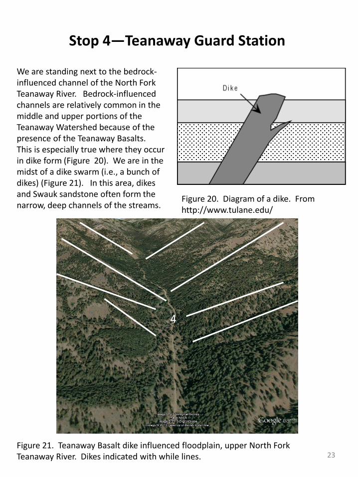
We are standing next to the bedrock-influenced channel of the North Fork Teanaway River. Bedrock-influenced channels are relatively common in the middle and upper portions of the Teanaway Watershed because of the presence of the Teanaway Basalts. This is especially true where they occur in dike form (Figure 20). We are in the midst of a dike swarm (i.e., a bunch of dikes) (Figure 21). In this area, dikes and Swauk sandstone often form the narrow, deep channels of the streams.
Figure 20. Diagram of a dike. From http://www.tulane.edu/
Figure 21. Teanaway Basalt dike influenced floodplain, upper North Fork Teanaway River. Dikes indicated with while lines.
4
23
En route to Stop 5
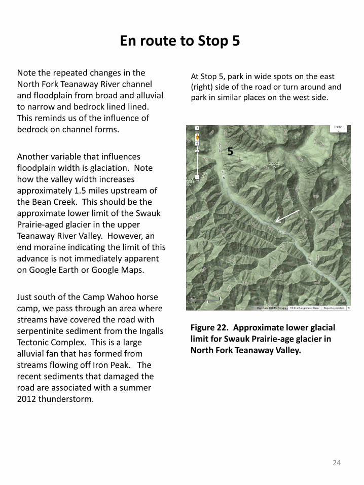
Note the repeated changes in the North Fork Teanaway River channel and floodplain from broad and alluvial to narrow and bedrock lined lined. This reminds us of the influence of bedrock on channel forms.
Another variable that influences floodplain width is glaciation. Note how the valley width increases approximately 1.5 miles upstream of the Bean Creek. This should be the approximate lower limit of the SwaukPrairie-aged glacier in the upper Teanaway River Valley. However, an end moraine indicating the limit of this advance is not immediately apparent on Google Earth or Google Maps.
Just south of the Camp Wahoo horse camp, we pass through an area where streams have covered the road with serpentinite sediment from the Ingalls Tectonic Complex. This is a large alluvial fan that has formed from streams flowing off Iron Peak. The recent sediments that damaged the road are associated with a summer 2012 thunderstorm.
At Stop 5, park in wide spots on the east (right) side of the road or turn around and park in similar places on the west side.
Figure 22. Approximate lower glacial limit for Swauk Prairie-age glacier in North Fork Teanaway Valley.
5
24
Stop 5—Iron Creek Trailhead
From the parking spot, hike up the Iron Peak trail to a good viewpoint.
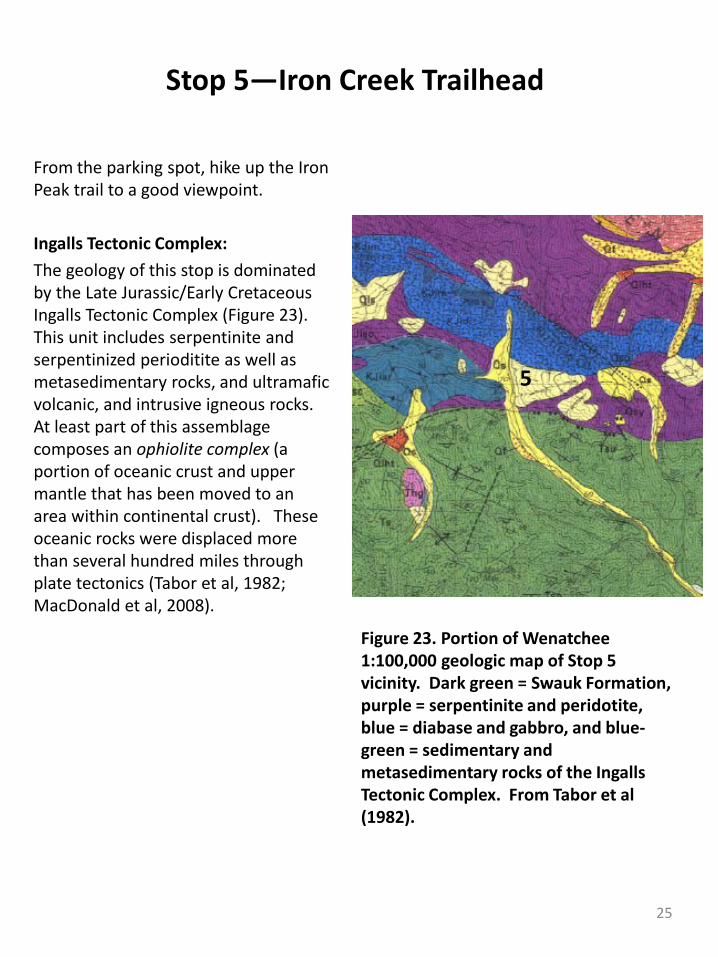
Ingalls Tectonic Complex: The geology of this stop is dominated by the Late Jurassic/Early Cretaceous Ingalls Tectonic Complex (Figure 23). This unit includes serpentinite and serpentinized perioditite as well as metasedimentary rocks, and ultramafic volcanic, and intrusive igneous rocks. At least part of this assemblage composes an ophiolite complex (a portion of oceanic crust and upper mantle that has been moved to an area within continental crust). These oceanic rocks were displaced more than several hundred miles through plate tectonics (Tabor et al, 1982; MacDonald et al, 2008).
Figure 23. Portion of Wenatchee 1:100,000 geologic map of Stop 5 vicinity. Dark green = Swauk Formation, purple = serpentinite and peridotite, blue = diabase and gabbro, and blue-green = sedimentary and metasedimentary rocks of the Ingalls Tectonic Complex. From Tabor et al (1982).
5
25
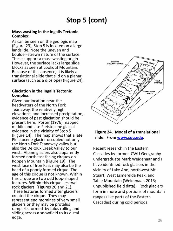
Stop 5 (cont)Mass wasting in the Ingalls Tectonic Complex:As can be seen on the geologic map (Figure 23), Stop 5 is located on a large landslide. Note the uneven and boulder-strewn nature of the surface. These support a mass wasting origin. However, the surface lacks large slide blocks as seen at Lookout Mountain. Because of this absence, it is likely a translational slide that slid on a planar surface (such as a dipslope) (Figure 24).
Glaciation in the Ingalls Tectonic Complex:Given our location near the headwaters of the North Fork Teanaway, the relatively high elevations, and increased precipitation, evidence of past glaciation should be present here. Porter (1976) mapped middle and late Pleistocene glacial evidence in the vicinity of Stop 5 (Figure 14). The map shows that a late Pleistocene glacier occupied not only the North Fork Teanaway valley but also the DeRoux Creek Valley to our west. Alpine glaciers also apparently formed northeast facing cirques on Koppen Mountain (Figure 19). The west face of Iron Pass may also be the head of a poorly formed cirque. The age of this cirque is not known. Within this cirque are two odd loop-shaped features. Within this cirque lies two rock glaciers (Figures 20 and 21). These features formed after glaciers created the cirque. They may represent end moraines of very small glaciers or they may be protalusramparts formed by talus rolling and sliding across a snowfield to its distal edge.
Figure 24. Model of a translational slide. From www.suu.edu.
Recent research in the Eastern Cascades by former CWU Geography undergraduate Mark Weidenaar and I have identified rock glaciers in the vicinity of Lake Ann, northwest Mt. Stuart, West Esmerelda Peak, and Table Mountain (Weidenaar, 2013; unpublished field data). Rock glaciers form in more arid portions of mountain ranges (like parts of the Eastern Cascades) during cold periods.
26
Stop 5 (cont)
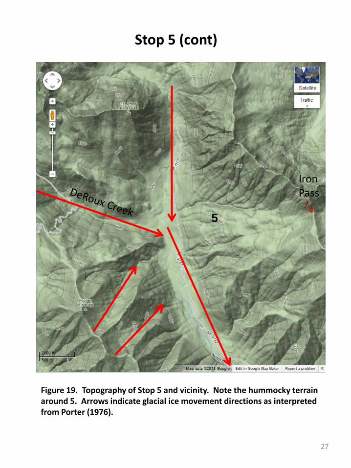
Figure 19. Topography of Stop 5 and vicinity. Note the hummocky terrain around 5. Arrows indicate glacial ice movement directions as interpreted from Porter (1976).
5
IronPass
27
Stop 5 (cont)
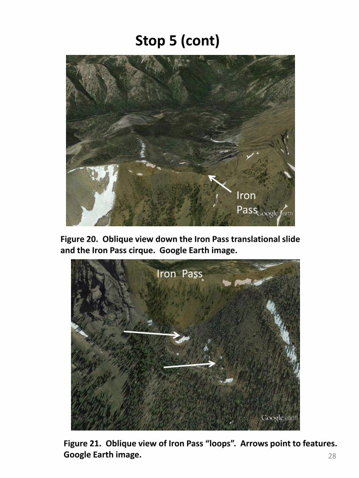
Figure 20. Oblique view down the Iron Pass translational slideand the Iron Pass cirque. Google Earth image.
Figure 21. Oblique view of Iron Pass “loops”. Arrows point to features. Google Earth image.
Iron Pass
IronPass
28
Selected References
Boise Cascade Corporation. 1996. North Fork Teanaway River Watershed Analysis. P. C-28. Boise, ID.
Doran, B.A. 2009. Structure of the Swauk Formation and Teanaway dike swarm , Washington Cascades. M.S. Thesis. San Jose State University.
Kinnison, H.B. 1952. Evaluation of streamflow records in Yakima River Basin Washington. U.S. Geological Survey Circular 180.
MacDonald, J.H., Jr., G.D. Harper, R.B. Miller, J.S. Miller, A.N. Mlinarevic, and C.E. Schultz. 2008. The Ingalls Ophiolite Complex, central Cascades, Washington: Geochemistry, tectonic setting, and regional correlations. In J.E. Wright and J.W. Shervais, eds., Ophiolites, Arcs, and Batholiths: A Tribute to Cliff Hopson. Geological Society of America Special Paper 438, p. 133-159.
Porter, S.C. 1976. Pleistocene glaciation in the southern part of the North Cascade range, Washington. Geological Society of America Bulletin 87: 61-75.
Porter, S.C. and T.W. Swanson. 2008. 36Cl dating of the classic Pleistocene glacial record in the northeastern Cascade Range, Washington. American Journal of Science 308: 130-166.
Swanson, T.W. and S.C. Porter. 1997. Cosmogenic isotope ages of moraines in the southeastern North Cascade Range. Pacific Northwest Friends of the Pleistocene Field Excursion. September 19-21.
Tabor, R.W., R.B. Waitt, Jr., V.A. Frizzell, Jr., D.A. Swanson, G.R. Byerly, and R.D. Bentley. 1982. Geologic map of the Wenatchee 1: 100,000 quadrangle, Central Washington. U.S. Geological Survey Miscellaneous Investigations Map I-1311.
Waitt, R.B., Jr. 1979. Late Cenozoic deposits, landforms, stratigraphy, and tectonism in Kittitas Valley, Washington. U.S. Geological Survey Professional Paper 1127.
Weidenaar, M. 2013. Rock glaciers in the Eastern Cascades, Washington. Senior Thesis, Science Honors Research Program, Central Washington University.
29