ta no. 4756-cam tonle sap lowland stabilization project cambodia
TRANSCRIPT
TA No. 4756-CAM TONLE SAP LOWLAND STABILIZATION PROJECT
CAMBODIA
RRA Summary Survey Report
Receiver:
Asian Development Bank
November 2006
In cooperation with:
TA No. 4756-CAM TONLE SAP LOWLAND STABILIZATION PROJECT
CAMBODIA
RRA Summary Survey Report
Receiver:
Asian Development Bank
November 2006
In cooperation with:
Table of contents
LIST OF ABBREVIATIONS 4
SUMMARY 5
1 INTRODUCTION & METHODOLOGY 8
1.1 Background 8 1.2 Survey Methodology 9 1.3 Selection of RRA Contractor 10 1.4 Performance 12 1.5 Selection of Study Villages 15 2 LAND USE 21
2.1 Project Area 21 2.2 Maps 25 2.3 Transects 28 2.4 Summary 31 3 SUSTAINABLE LIVELIHOODS 32
3.1 Vulnerability 32 3.2 Assets & Pentagon Configuration 35 3.3 Summary 46 4 WEALTH RANKING 48
4.1 The Exercise 48 4.2 Results 48 4.3 Summary 53 5 SEASONAL CALENDAR 54
5.1 Nature of the Exercise 54 5.2 Gender 54 5.3 Cultivation & Pollution 55 5.4 Grazing and the Alienation of Land 60 5.5 Ceremonial Obligations 61 5.6 Summary 61 6 MOBILITY 62
6.1 Daily movements 62 6.2 Seasonal migration 64 6.3 Circular migration 65 6.4 Summary 67 7 INSTITUTIONAL RELATIONSHIPS 69
1
7.1 Summary 72 8 DEVELOPMENT PRIORITIES 73
8.1 Gender Analysis of Priority Ranking 75 8.2 Gender Summary of Highest Ranking Issues 77 8.3 Summary 80 9 CONCLUSIONS AND RECOMMENDATIONS 82
9.1 Conclusions 82 9.2 Recommendations 86
APPENDICES 89
APPENDIX 1 LIST OF SUB-PROJECTS SUGESTED BY VILLAGERS 90
1.1 Srah Kaev 91 1.2 Tuol Roka 91 1.3 Ta Vak 92 1.4 Kleng Por 92 1.5 Beng 93 1.6 Ansa Kdam 93 1.7 Chrab 94 1.8 Thmei 94 1.9 Bansay Traeng 95 1.10 Spean 95 1.11 Preah Ponlea 95 1.12 Rung Chrey 96 1.13 Roka Chhmoul 96 1.14 Ream Kon 97 1.15 Voat Kandal 97 1.16 Prey Svay 98 1.17 Pralay Chrey 98 1.18 Ph’av Thmei 98 1.19 Kandal 99 1.20 Sreh Kaeut 99 1.21 Doun Kaev 100 1.22 Doun On 100 1.23 Trapaeng Russei 100 1.24 Srah 100 1.25 Tnaot 101 1.26 Kiri Meanon 101 1.27 Trav Bak 101 1.28 Phka Rumchek 102 1.29 K’en 102 1.30 Phlaoch 102 1.31 Prasat 103 1.32 Slaeng Khpos 103
2
APPENDIX 2 TOPOGRAPHICAL MAPS SHOWING RRA/PRA STUDY VILLAGES 104
Table of Figures FIGURE 1: EXAMPLE OF VILLAGE SKETCH MAP ........................................ 27 FIGURE 2 EXAMPLE OF TRANSECT. ANSA KDAM VILLAGE ........................ 29 FIGURE 3 SUSTAINABLE LIVELIHOODS PENTAGON................................... 36 FIGURE 4: KAMPONG CHHNANG PENTAGONS........................................... 38 FIGURE 5: PURSAT PENTAGONS .............................................................. 39 FIGURE 6: BATTAMBANG PENTAGONS – THMA KOUL DISTRICT ................. 40 T
FIGURE 7: BATTAMBANG PENTAGONS – MOUNG RUSSEI & SANGKAE DISTRICTS .............................................................................. 41
FIGURE 8: BANTEAY MEANCHEY PENTAGONS .......................................... 42 FIGURE 9: SIEM REAP PENTAGONS – PUOK DISTRICT .............................. 43 FIGURE 10: SIEM REAP PENTAGONS – PRASAT BAKAONG & SOUTRE
DISTRICTS .............................................................................. 44 FIGURE 11: KAMPONG THOM PENTAGONS ................................................. 45 FIGURE 12: EXAMPLE OF SEASONAL CALENDAR. SPEAN VILLAGE, THMA
KOUL DISTRICT 56 FIGURE 13: MOBILITY MAP EXAMPLE: POOR & VERY POOR HOUSEHOLDS
SIEM REAP ............................................................................. 63 FIGURE 14: TRAPEANG RUSSEI VENN DIAGRAM SHOWING INSTITUTIONAL
NETWORK............................................................................... 71 FIGURE 15: WATER MANAGEMENT – IRRIGATION ISSUES FOR RICE
CULTIVATION (30 / 32 VILLAGES) ............................................. 77 FIGURE 16: ROADS, BRIDGES AND CULVERTS (28 / 32 VILLAGES).............. 77 FIGURE 17: HEALTH AND HYGIENE (28 / 32 VILLAGES) ............................... 78 FIGURE 18: DOMESTIC WATER SUPPLY (26 / 32 VILLAGES)........................ 78 FIGURE 19: ACCESS TO EDUCATION (19 / 32 VILLAGES) ............................ 79 FIGURE 20: IMPROVED FISHERIES MANAGEMENT (12 / 32 VILLAGES)......... 79 FIGURE 21: FOOD SECURITY (10 / 32 VILLAGES) ....................................... 80
List of Tables TABLE 1: GREATER TSLSP AREA.......................................................... 15 TABLE 2: SHORTLIST OF TSLSP RRA SURVEY SITES............................. 17 TABLE 3: TONLE SAP LAND STABILIZATION PROJECT RRA SURVEY SITES 18 TABLE 4: SCHEMATIC CLASSIFICATION OF LAND TYPES IN RRA SURVEY
AREA...................................................................................... 24 TABLE 5 SUMMARY OF WEALTH GROUPS IN RRA STUDY VILLAGES ....... 49 TABLE 6 RANKED WEALTH GROUPS IN RRA STUDY VILLAGES.............. 51 TABLE 7: MAJOR ISSUES RANKED BY 32 STUDY VILLAGES...................... 75 TABLE 8: MINOR ISSUES RANKED BY A FEW OF THE STUDY VILLAGES..... 76
3
List of Abbreviations ADB Asian Development Bank AEA Agro-Ecological Analysis (Used by Dept Agr. Extn) A&WR Agriculture & Water Resources CC Commune Council CDP Commune Development Plan CMDG Cambodia Millennium Development Goals CSD Council for Social Development DH&RW Department of Hydrology & River Works DoG Department of Geography DOWRAM (Provincial) Department of Water resources and
Meteorology EDP External Development Partner FHHH Female Headed Households FWUC Farmer Water User Community HH Household IRAP Integrated Rural Action Planning MAFF Ministry of Agriculture, Forestry, and Fisheries MDG Millennium Development Goals MEF Ministry of Economics and Finance MLUPC Ministry of Land Management, Urban Planning and
Construction MOE Ministry of Environment MOI Ministry of Interior MOP Ministry of Planning MOWA Ministry of Women’s Affairs MOWRAM Ministry of Water Resources and Meteorology MPWT Ministry of Public Works and Transport MRC Mekong River Commission MRD Ministry of Rural Development MSME Micro, Small and Medium Enterprises NGO Non-Governmental Organization PCU Project Coordination Unit PLA Participatory Learning and Action PMU Project Management Unit PRA Participatory Rural Appraisal PRDC Provincial Rural Development Committee RGC Royal Government of Cambodia RRA Rapid Rural Appraisal SEDP Social and Economic Development Plan SL Sustainable Livelihoods SME Small and Medium Enterprises SPSS Statistical Package for the Social Sciences TA Technical Assistance TL Team Leader TSBR Tonle Sap Biosphere Reserve TSBRS Tonle Sap Biosphere Reserve Secretariat TSEMP Tonle Sap Environmental Management Project TSLSP Tonle Sap Lowland Stabilization Project TSSL Tonle Sap Sustainable Livelihoods VDC Village Development Committee WSUG Water Supply User Group
4
SUMMARY Between 30 August and 18 October 2006 a contracted RRA team of 9 -10 mostly young people under the leadership of Kaing Khim and the supervision of the TSLSP PRA Specialist visited 32 villages, spoke to 16 commune chiefs, 14 district governors or their deputies, and six heads or their deputies of the Department of Water Resources and Meteorology in the six provinces either bordering on or close to the Tonle Sap.
The officials were asked for their advice on where the RRA team should work. Final selection of villages was made from a list compiled in a formal manner in Phnom Penh and approved by H.E. Veng Sakhon.
In each of the selected villages a three day RRA exercise was carried out using interactive participatory tools chosen from the PRA inventory. The PRA specialist is satisfied that although these tools were rarely used in an exemplary participatory manner a good standard was achieved and is confident the results are reliable.
This report provides a summary of findings. What RRA facilitators were told by villagers. The original hand written village field reports in Khmer are held by the TSLSP along with the English Word translation, RRA Working Reports. There is an Khmer and English report for each province.
The main findings in the same order in which they are discussed in the Summary text are:
• Right from the early exercises, partly because participants thought the RRA team was from MOWRAM but also because they consider it to be a matter of considerable importance, villagers suggested projects that involved rehabilitating water management infrastructure built largely during Khmer Rouge times.
• As many as 90% of rural people included in the survey are extremely vulnerable to shocks, especially seasonal shortfalls in rain and/or flooding. Any serious local ‘drought’, heavy rainfall or flood quickly places 50% of households in extenuating circumstances. Poor health and the costs involved in finding a cure can ruin a family.
• Socioeconomic differentiation has gone very quickly and the difference between the rich and poor is growing rapidly. Rehabilitation of ‘irrigation’ structures will largely benefit the better off but this is not always the case.
• The poor have few resources to fall back on and women headed households are disproportionately represented in this group.
• The Sustainable Livelihood Pentagons illustrate the fact that the capital/assets endowment of any two villages is rarely the same. In terms of available human skills, natural resources, access to credit and other funds, physical infrastructure, and social/political capital each village has its own configuration. Sensitive, sociologically
5
intervention is needed to make the most of potential change and develop positive synergies.
• One of the best ways of doing this is to engage in participatory planning followed by the funding of village centred action plans. The psychosocial cost of inequality are considerable. Strategies that can ameliorate this and empower people even in modest ways can make a difference.
• Women are a major presence in all agricultural activities and must be deliberately included in any agricultural extension work.
• Ceremonial occasions rank high in peoples expenditure. Attendance at pagoda events and marking family events such as weddings are matters of dignity, status and pride.
• The most important crop of the year is the main wet season crop of rice. Farmers aspired to grow a second wet season and another dry rice crop. For most yields are poor, a single crop is harvested and most families do not grow enough rice to meet their needs.
• Although farmers said they would prefer to grow more rice as an alternative to leaving home and seeking off farm employment during agricultural slow periods, few really believe this is possible.
• Rural people would like training to enhance their knowledge and skills as both farmers but perhaps more importantly as wage labourers so they can, respectively, use their agricultural resources more efficiently and more profitably, and earn higher wages.
• Off farm employment accounts for an increasingly large proportion of people livelihoods.
• Agricultural production has been adversely effected by pollution. Floating rice is now rarely grown. Where farmers are forced to rely on lake water to establish and maintain their wet rice they complained of a variety of problems relating to sour, murky water and toxic deposits of cinder like material along the shore line.
• A large proportion of rural households own livestock and when pastures dry up on middle land fields they feed their animals by taking them down to the dry season lake bed.
• The flood plain is not open range in the sense that each year people fight for access to empty territory, it is a populated landscape, with allotted estates, subject to laws of traditional tenure and transhumance. Indigenous Khmer are increasingly shocked when they return to these lands to find they have been sold or leased out to commercial interests by corrupt officials.
• Mobility is extremely important.
o Daily movements include long bicycle rides of 30 kilometres each way to spend the day on a building site for a wage of 4000 – 5000riel ($1.0 to $1.25); visits to fields and neighbouring forest; local employment on neighbouring farms.
6
o Seasonal migration between farm and distant employment as far away as Phnom Penh, Siem Reap, Battambang, Thailand and Malaysia or movement down onto the lake bed.
o Circular migration conducted over longer periods to destinations listed above.
• The draw of urban employment is very strong. People are well aware that those with certified skills get paid higher wages. One village not too far from the Angkor National Park placed high on their list of priorities the need for a teacher of English who could train their child so they could find work in the tourist industry!
• Villagers from poorer and more isolated areas were less willing to go far afield and were more likely to look to their local environment for sustenance and modestly aid work.
• An examination of institutional relationships revealed the importance of NGOs in the inner circle of trusted organisations
• Development priorities broken down by gender revealed a high level of agreement between men and women on what they thought needed to be done.
• A list of 32 potential sub projects was prepared principally for assessment by TSLSP specialists. Although these mostly concern water resource management this should not be allowed to obscure the many other priorities identified by villagers and which may well have great development potential.
• The conclusion raised matters similar to those listed in this summary.
• The recommendations touch on:
o Participatory Learning and Action (PLA) as a community planning strategy:
o A role for NGOs in eventual project implementation:
o The need to set up a Commune Council development fund like that of the NRDP:
o Sub-project possibilities other than those listed in the main body of the text
o Indigenous Khmer tenure rights and
o A suggested reconfiguration of the project area.
7
1 I N T R O D U C T I O N & M E T H O D O L O G Y
1 . 1 B a c k g r o u n d
Design of an appropriate Participatory Rural Appraisal (PRA) approach commenced 14 August following the arrival of the international PRA specialist. The task was conceived in a manner consistent with project documents and as advised by the Team Leader.
The principal purpose of the survey was to collect information on rural livelihoods, especially of those people who live for most of the year in villages above the wet season, high water level of the Tonle Sap who move into the Transition Zone during the dry season. By focusing on issues relating to resource use, water management, vulnerability, poverty alleviation, food security, mobility and the cross cutting issues of gender and environmental sustainability it was hoped that the information collected would make a significant contribution to the preparation of the Tonle Sap Land Stabilisation Project in the form of both RRA Working Reports one on each province and this RRA Survey Report.
Framework of Project Objectives
More specifically briefing instructions emphasised that the PPTA needed to fulfil the following objectives, find ways to:
• promote Sustainable Livelihoods and reduce vulnerability; • set up better water resource management systems and
structures (e.g. flood control, drainage, irrigation, domestic water supply);
• increase the returns in kind and cash from agriculture; and, • identify opportunities for increasing off-farm income.
Initial work focused on the scope of the task, the time and resources available, village selection, and, without sacrificing best practice principles, set up a field survey to cover as many villages as possible.
It was decided that the best way to do this was to recruit an experienced team capable of carrying out a sociologically informed Rapid Rural Appraisal (RRA) using selected PLA/PRA tools.
Scope of Study
It was decided that a total of 32 villages could be surveyed. Village studies would be conducted in four villages simultaneously by pairs of facilitators contracted as an RRA team working under their own leader. Over a notional seven day week they would spend three days in each study village, have three days for writing up results including debriefing, and one
8
day of rest. Fieldwork was scheduled to work around the important national holiday of Phchum Ben, allow for a critical mid-term review and a concluding review which left several days for back-tracking to run checks and fill in gaps as was found to be useful or necessary,.
These facilitators were accompanied into the field by a monitoring team responsible for triangulating results and following up on matters of specialist competence and interest. In this way the RRA exercise provided a platform for complementary investigations constructed in such a manner so as not to disrupt on-going RRA work and as much as possible strengthen results.
This monitoring team included, as available: national consultant on gender, environmental matters, and agro-ecosystems; MOWRAM/DOWRAM and other local government representatives. Both teams were accompanied throughout by the international PRA specialist who took responsibility for overall management and coordination of the exercise.
This report presents the results of the survey.
First Tasks
The first tasks focused on the preparation of:
• a TSLSP RRA Methodology: Rapid Rural Appraisal Guide for Fieldwork to outline what would be done and how;
• RRA contractor selection criteria to guide the appointment of an appropriate team;
• village selection criteria to guide the choice of study sites
1 . 2 S u r v e y M e t h o d o l o g y
A TSLSP RRA Methodology: Rapid Rural Appraisal Guide for Fieldwork was prepared and included as an Appendix in the Inception Report. A short list of PRA tools and RRA tasks was detailed (Appendix 1) and to ensure compatibility and comparability, clear instructions (accompanied by a guide in Khmer) given on how each task was to be both performed and reported. The latter included daily debriefings on the information collected and regular delivery of results in Khmer to the international PRA specialist.
As the RRA guideline was prepared drafts were given to the sub-contracted team leader. She received a final copy a week in advance of the start of fieldwork. Over the first two weeks of fieldwork the list of tasks was slightly modified to better serve the objectives of the survey, more appropriately fit field conditions, and clarify what was being asked of the field team. Reporting formats were standardised so that data listed for each village could be easily found and summarised in an appropriate way.
9
1 . 3 S e l e c t i o n o f R R A C o n t r a c t o r
The recruitment of a suitable RRA team to undertake the participatory livelihood survey was underway before the replacement PRA TA arrived (13 August 2006). Up to this time and continuing after his arrival the recruitment process was managed by Ly Moni Roth, the Community Development Specialist.
Selection Criteria
Immediately following his arrival the international PRA specialist put a set of selection criteria in place which specified that the:
• Appointee must be familiar with Participatory Learning and Action principles and best practice
• Appointee must have a proven track record for having successfully carried out participatory survey work in the field
• Appointee must have the capacity to quickly recruit, and over the survey period, manage a team that will daily field at least eight reliable and experienced Khmer speaking facilitators for 50 of the 60 days that will be spent in the Project provinces.
It was decided that preference would be given to an applicant with leadership qualities, who was flexible, pragmatic and was:
• a competent reader and speaker of English who could assist with translation work both during and following the completion of fieldwork;
• able to contribute to the analysis of the information collected; and finally,
• able to assemble a gender balanced team.
Framework
The design of the participatory livelihood survey was drawn up to:
• fit the allocated budget
• specify field tasks,
• lay down fieldwork guidelines
• make provision for refresher, calibration training for the survey team prior to fieldwork to ensure the consistency/comparability of information collected
• optimise the reliability of the information collected
• allow time for consistent recording and translation of field datum
• plan for timely closure of the exercise and early release of results.
10
Selected Contractor
Ms Kaing Khim met the criteria and subsequently proved to be a very active, skilled manager and conscientious partner who did her best to comply with requests from the international PRA specialist and throughout the exercise supervised her team with considerable skill.
Following her appointment a group of ten experienced fieldworkers was confirmed and assured the TSLSP that they were prepared to work continually over a two month period (September – October) in an appropriate number of villages selected by Project people in consultation with officials from both the Department of Water Resources and Meteorology (DOWRAM), and Department of Local Administration (DOLA) and commune chiefs from a TSLSP Project List.
Assumptions and the Need for Training
It was assumed that the facilitators would be familiar with the selected PLA/PRA tools, and bring experience from previous assignments of a similar nature to the task. It was hoped that they would bring a maturity of judgement and a willingness and capability to follow, in a disciplined manner, the procedures outlined in the guide.
This was expecting a lot but partly because available time leading up to the start of fieldwork was so short (commenced 31 August) it was also convenient. Initial attention focused on ensuring that a consistent approach was used in the field. An initial calibration meeting was held in Phnom Penh on Best Practice (Appendix 2) followed by on-the-job-training in Kampong Chhnang.
Contracted Tasks
The contract committed facilitators to a demanding schedule (Appendix 5) of three days in each village accompanied by evening debriefing sessions, followed by three days debriefing and report writing. As participating outsiders running the RRA their responsibility was to build a good relationship with village leaders and other people interested and engaged with what the team was doing. On the basis of these relationships and visits around the village they were expected to develop a good understanding of the livelihood conditions shared, and challenges faced by the people, especially those relating to water management and food security. The team was required to present what they had learnt from the chosen PLA/PRA Tools both verbally to the study group as a whole using flip charts and the like, and subsequently in written reports.
A written report in Khmer was prepared immediately following the conclusion of each village study and put together as a handwritten report. One on each province. This report, accompanied by a rough translation into English was supposed to be delivered to the international PRA specialist within a week of completing fieldwork in each province.
11
This subsequently proved to be unworkable. The international PRA specialists’ understanding of what was going on, and what information was being collected was largely limited to what could be directly observed in the course of field visits while work was in progress.
This translation bottleneck seriously delayed close evaluation of results and the consequences of rushing through exercises, asking leading questions and documenting stereotypes proved to be difficult to correct. The RRA team was kept exceptionally busy, often had to work in uncomfortable circumstances and as the field exercise progressed became increasingly tired. Rather than harangue the team with stepped up demands the international consultant opted to maintain morale and rely on work with the English speaking monitoring team to collect information that would enable a critical cross check to be made of RRA results1.
Facilitating RRA Team
The facilitating or RRA team was asked to prepare themselves to answer questions posed by both international and national specialists on matters relating to the focus of the specialists’ investigations (e.g. gender, environment, agriculture, micro-finance and off farm income generation). As indicated above the facilitating team was to be helped in this by the active participation of the national specialists in the RRA as monitors, independent enumerators, and advisors. Their contribution to the triangulation of information was from the very start acknowledged as a critical role.
1 . 4 P e r f o r m a n c e
The first few days of fieldwork indicated that facilitators were not following the guidelines provided by the TSLSP but were doing whatever they had done before with other projects. This was disappointing and reason for consternation. Although facilitators were keen, apparently willing to cooperate, and carried a lot of good will to the lead tasks; in the field they were not aware of their shortcomings as facilitators of participatory methodology. Among the performance shortfalls were:
• a fixation on tools as outputs rather than modes of engagement. Throughout the survey this continued to undermine the participatory nature of the work. Without exception the RRA team tended to treat the tools as the basic output rather than an opportunity to learn from village participants. When asked to specifically make three observations on what they had learned from an exercise other than what was recorded in the output format the team seemed to be at a loss as to what to write.
• Too much time was spent recording information of doubtful use, and a few facilitators ran sessions in which they talked and asked
1 The last of the Khmer reports and final translated versions were delivered to the
TSLSP on Monday 30 October 2006.
12
questions all the way through exercises, never “giving up the stick”. As a consequence facilitators documented what they expected to find and villagers told them what they expected to hear. As the survey was known to have been initiated through MOWRAM villagers expected that irrigation would be the principal focus of any follow up. Wherever possible “irrigation systems” were identified as the main development challenge.2
• There was a strong tendency to rush things. Eventually the international PRA specialist had to insist that those running village studies had to take not less than three days for each village study, make visits to households, walk the talk, take a look around and as often as conditions allowed, conduct exercises on a large scale on the ground so that all those attending could take part. In the absence of direct supervision this instruction was systematically ignored and as the team tired it became increasingly difficult to insist that they take their time.
On-going Training
Before the facilitation teams left the first round of studies in Kampong Chhnang these issues had become evident and were tackled head on in both evening feedback sessions and a day set aside for this purpose. In the attempt to embed best practice provision was made for on-going monitoring and mentoring. In Pursat a marked improvement was noted but problems persisted.
Immediately prior to the important Khmer cultural festival of Phchum Ben, and following the first two and a half weeks of fieldwork, a two day First Critical Review workshop (18-19 September) was held in Phnom Penh. Emphasis was given to articulating intuitive understanding using the Assets Pentagon, a way of diagrammatically representing accessible capital in terms of: the presence of human vocational skills; social cohesion and leadership; natural resources such as soil, water, forest and so forth; physical infrastructure of roads, communication services, health facilities, modes of transport, animal and mechanical power available for farming, marketing goods and so forth; and, lastly access to financial services such as credit, banking services, savings groups and the like.
The exercise was interesting in the way it revealed the urban bias of facilitators. People wearing rough clothes in which to work were automatically classified as poor. Although many of the communities studied were well organised, had a lot of mutual support groups, a good echelon of NGOs to help them out, reasonably good access to credit and so on, facilitators is did not always see this in a positive light. Pentagon lines for social and financial capital were often drawn in a negative way, closer to
2 To be fair this bias was largely a function of DOWRAM advice. As the TSLS
Project’s main partner DOWRAM officials steered study site select into areas in which they have a strong interest in seeing water management work undertaken.
13
the centre than was justified. The presence of good soils and plenty of water was ignored if the remaining forest had recently been cut down and so forth.
Quality and Reliability of Results
These critical comments are provided to enable those using the results available in the six provincial RRA Working Reports to do so in an informed manner. As long as shortcomings can be identified and taken into account then the dangers of being misled can be minimised.
A start was made on editing and writing notes for all the figures and tables presented in individual village reports. Unfortunately, owing largely to late delivery there was not enough time to bring all studies up to a good level of presentation. Only the figures and tables in the Kampong Chhnang volume have a brief commentary in English. To speed up the process Kaing Khim wrote brief remarks in English in the Khmer Reports hand written reports. Where translation obfuscations remain in the English translation readers are advised to refer to the original reports in Khmer and seek clarification from a Khmer speaker who has a good command of English.
More Controversial Matters
As with any study conducted in haste the findings should be subject to continuing scrutiny and scepticism. As mentioned above a constant attempt was made to triangulate and verify findings. It is not always in villagers interest to tell the truth and if facilitators failed to reach across the credibility divide by remaining privileged, preoccupied, urban outsiders they could easily be misled.
For instance John McKinnon was told in response to a direct question, posed through an interpreter, had a villager in Siem Reap sold any land? The response was no, he had not sold any land “because this would be tantamount to selling off the inheritance he held in trust for his children”. Nice words. As it subsequently turned out the informant was one of 60 land agents who had arranged for some of his own land as well as that of neighbours to be sold to land speculators investing blind from Phnom Penh.
Information on sensitive issues was rarely volunteered and when they was, tended to be under reported. In Kampong Thom, forest on the seasonal flood bed of the lake cleared for dry season rice cultivation was first given as 400 ha of which 70-80 ha was said to be planted. Before fieldwork came to an end the amount of land cleared had increased to well over 1000 ha.
Villagers do not make a habit of giving visitors information that does not reflect well on themselves, and do not normally volunteer information critical of those whom they see as their political and social superiors. The acquisition of land and lakes in the flood zone by outsiders with money and influence through provincial and district officials was rarely given in focus group discussions but conveyed in the course of walking talking field visits and then to consultants rather than the sedentary RRA teams.
14
1 . 5 S e l e c t i o n o f S t u d y V i l l a g e s
Project Area
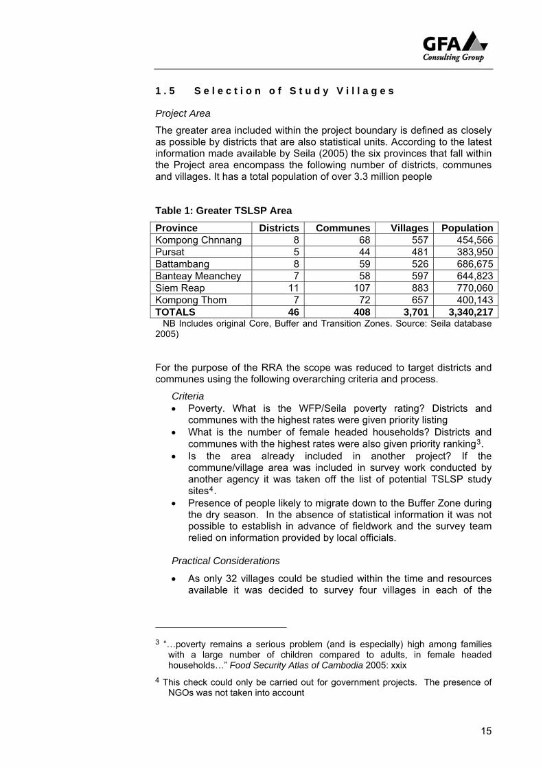
The greater area included within the project boundary is defined as closely as possible by districts that are also statistical units. According to the latest information made available by Seila (2005) the six provinces that fall within the Project area encompass the following number of districts, communes and villages. It has a total population of over 3.3 million people
Table 1: Greater TSLSP Area
Province Districts Communes Villages Population Kompong Chnnang 8 68 557 454,566Pursat 5 44 481 383,950Battambang 8 59 526 686,675Banteay Meanchey 7 58 597 644,823Siem Reap 11 107 883 770,060Kompong Thom 7 72 657 400,143TOTALS 46 408 3,701 3,340,217 NB Includes original Core, Buffer and Transition Zones. Source: Seila database 2005)
For the purpose of the RRA the scope was reduced to target districts and communes using the following overarching criteria and process.
Criteria • Poverty. What is the WFP/Seila poverty rating? Districts and
communes with the highest rates were given priority listing • What is the number of female headed households? Districts and
communes with the highest rates were also given priority ranking3. • Is the area already included in another project? If the
commune/village area was included in survey work conducted by another agency it was taken off the list of potential TSLSP study sites4.
• Presence of people likely to migrate down to the Buffer Zone during the dry season. In the absence of statistical information it was not possible to establish in advance of fieldwork and the survey team relied on information provided by local officials.
Practical Considerations
• As only 32 villages could be studied within the time and resources available it was decided to survey four villages in each of the
3 “…poverty remains a serious problem (and is especially) high among families
with a large number of children compared to adults, in female headed households…” Food Security Atlas of Cambodia 2005: xxix
4 This check could only be carried out for government projects. The presence of NGOs was not taken into account
15
smaller provinces and eight in each of the provinces with larger populations (Battambang and Siem Reap5).
• Distance from the Tonle Sap was also considered. Large areas well away from the lake in the upper reaches of the basin catchment were given lower priority listing (ie. Northwest Banteay Meanchey [Svay Chek] and the eastern section of Kampong Thom which lies in the Mekong catchment [Kraya])6.
• A representative sample of Agro-ecological zones. Without moving too far away from the lake shore a deliberate effort was made to include land at slightly higher elevations. (See
• Accessibility. As survey work was conducted at the height of the rainy season only communes and villages that were accessible by four wheel drive and (in more difficult circumstances) motorcycle were included in the survey. Because of the time factor villages more than five kilometres walk from a usable road were excluded from the study.
Process
• A short list (summarised Table 2 below) was drawn up by Project staff and given to H.E. Veng Sakhon, Secretary of State, MOWRAM for approval
• It was assumed that the approved list would be forwarded to provincial DOWRAM officers and referred to DOLA district officials (District Magistrates and Commune Chiefs). This was not the case and on several occasions the team was asked to work in areas not included on our list. In all but one case this request was refused.
• Before the survey team commenced work they asked local officials to identify villages in which it was most likely that people could be found who migrate down to the Tonlesap Buffer or Core Zones during the dry season.
5 There is a slight urban bias in this that can be defended as part of access to good
roads and the rapidity with which the survey had to be carried out over the middle of the rainy season.
6 These areas were subsequently excluded from the Project area.
16
17
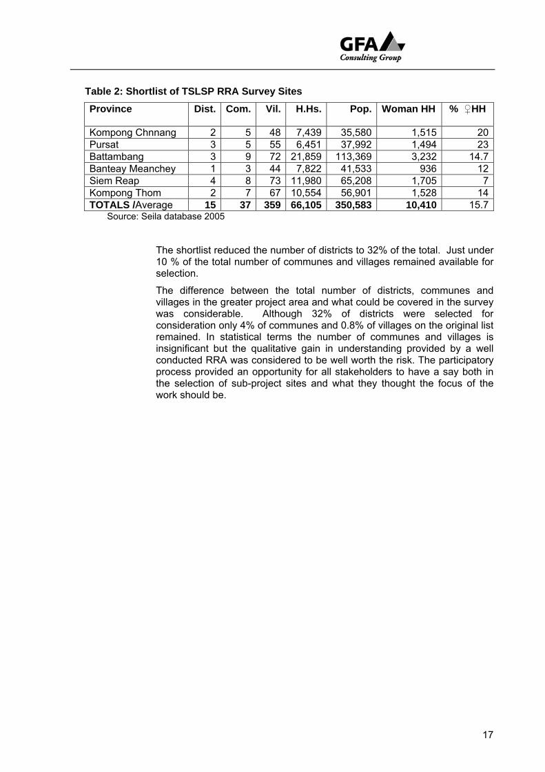
Table 2: Shortlist of TSLSP RRA Survey Sites
Province Dist. Com. Vil. H.Hs. Pop. Woman HH
% ♀HH
Kompong Chnnang 2 5 48 7,439 35,580 1,515 20Pursat 3 5 55 6,451 37,992 1,494 23Battambang 3 9 72 21,859 113,369 3,232 14.7Banteay Meanchey 1 3 44 7,822 41,533 936 12Siem Reap 4 8 73 11,980 65,208 1,705 7Kompong Thom 2 7 67 10,554 56,901 1,528 14TOTALS /Average 15 37 359 66,105 350,583 10,410 15.7
Source: Seila database 2005
The shortlist reduced the number of districts to 32% of the total. Just under 10 % of the total number of communes and villages remained available for selection.
The difference between the total number of districts, communes and villages in the greater project area and what could be covered in the survey was considerable. Although 32% of districts were selected for consideration only 4% of communes and 0.8% of villages on the original list remained. In statistical terms the number of communes and villages is insignificant but the qualitative gain in understanding provided by a well conducted RRA was considered to be well worth the risk. The participatory process provided an opportunity for all stakeholders to have a say both in the selection of sub-project sites and what they thought the focus of the work should be.
18
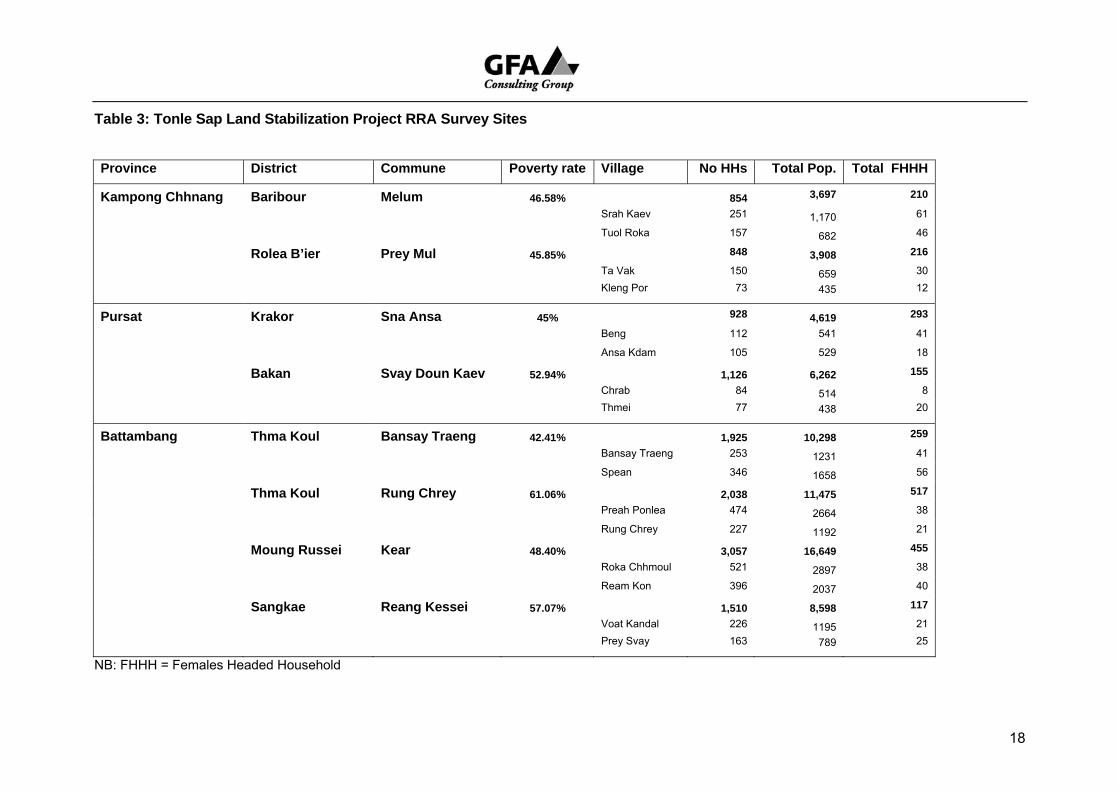
Table 3: Tonle Sap Land Stabilization Project RRA Survey Sites Province District Commune Poverty rate Village No HHs Total Pop. Total FHHH
Kampong Chhnang Baribour Melum 46.58% 854 3,697 210
Srah Kaev 251 1,170 61
Tuol Roka 157 682 46
Rolea B’ier Prey Mul 45.85% 848 3,908 216
Ta Vak 150 659 30
Kleng Por 73 435 12
Pursat Krakor Sna Ansa 45% 928 4,619 293
Beng 112 541 41
Ansa Kdam 105 529 18
Bakan Svay Doun Kaev 52.94% 1,126 6,262 155
Chrab 84 514 8
Thmei 77 438 20
Battambang Thma Koul Bansay Traeng 42.41% 1,925 10,298 259
Bansay Traeng 253 1231 41
Spean 346 1658 56
Thma Koul Rung Chrey 61.06% 2,038 11,475 517
Preah Ponlea 474 2664 38
Rung Chrey 227 1192 21
Moung Russei Kear 48.40% 3,057 16,649 455
Roka Chhmoul 521 2897 38
Ream Kon 396 2037 40
Sangkae Reang Kessei 57.07% 1,510 8,598 117
Voat Kandal 226 1195 21
Prey Svay 163 789 25
NB: FHHH = Females Headed Household

19
Banteay Meanchey Mongkol Borei Kouk Ballangk 31.84% 1,189 6,979 115
Pralay Chrey 126 700 15
Ph'av Thmei 108 651 7
Preah Netr Preah Preah Netr Preah 28.45% 2,658 13,415 399 Kandal 248 1,115 3 Sreh Kaeut 290 1,467 33
Siem Reap Puok Doun Kaev 81.89% 2,145 11,711 350
Doun Kaev 204 1,129 19
Doun On 181 1,014 14
Reul 84.21 2,214 12,343 363
Trapeang Russei 206 1,204 25
Srah 225 1,164 32
Prasat Bakaong Ampil 89.32% 1,095 6,055 154
Tnaot 75 428 4
Kiri Meanon 209 1,133 18
Soutr Nikom Ta Yaek 80.80% 1,947 10,708 252
Trav Bak 125 729 28 Phka Rumchek 201 1,208 46
Kompong Thom Stoung Chamnar Leu 76.31% 1,894 10,839 228
K’en 304 1,686 0
Phlaoch 121 558 22
Kompong Svay San Kor 76.07% 2,802 15,383 439
Prasat 106 556 26 Slaeng Khpos 114 702 16
Source: Seila Data 2005
Limitations
Project specialists cannot expect the results to provide more than a fraction of their data needs. Specialists specifically wanting access to a wider set of qualitative results and quantitative data from participatory studies would do well to pursue complementary information held by:
• Cambodia Australia Agricultural Extension data base for information on commune agro-ecosystems
• TSSL Project carried out Purposive PRAs in 33 villages included in the TSLSP area located in Battambang, Siem Reap, Kampong Thom, Kampong Chhnang, Pursat.
• NRDP for PLA/PRA reports covering Battambang, Banteay Meanchey and Siem Reap for mostly the upper part of the Tonle Sap catchment.
• ECOSORN, Battambang, Banteay Meanchey and Siem Reap (unconfirmed).
The TSLSP Livelihood Survey was conducted in villages included in the RRA survey area and provides detailed reconstructed household level data.
Results
Results are reported under the following headings which follow the reporting sequence of the RRA Teams:
• Land Use
• Sustainable Livelihoods
• Wealth Ranking
• Seasonal Calendar
• Mobility
• Institutional Relationships
• Development Priorities
• List of Potential Sub-Projects
• Conclusions and Recommendations
20
2 L A N D U S E
2 . 1 P r o j e c t A r e a
The TSLSP was first asked to focus its attention on the largely unoccupied Transition Zone that stretches from the upslope boundary of the area in close proximity to the shore of the Great Lake called the Buffer Zone to a few meters under the 10 meter contour, the high water mark of the Tonle Sap at the peak of the rainy season. Highways 5 and 6 demarcate the boundary of the Transition Zone in a very practical way, these roads are literally the high ways above the seasonal flood level.
Using the road itself as an arbitrary boundary did not make much practical sense. Those who might receive investments from a project would have to live on the lake side of the road: those on the other side would be ignored. To avoid this idiosyncrasy a decision was taken to broaden the area under consideration to encompass the districts that saddle the Highway.
The 32 villages scattered over this area (Figure 1) that were visited by the RRA team can in turn be placed in eco-agricultural zones that enable us to classify their conditions in a manner not too dissimilar to that followed by the Cambodia Australia Agricultural Extension Project7. Each village can be placed in one of three major divisions: Upland, Middle land, Lowland.
Although named for elevation, elevation as a single characteristic is far from dominant. Soil type might do just as well but even then generally speaking the soils are: heavily leached, sandy, with low organic content, acidic, and infertile with a low cation exchange capacity. Some soils described as lateritic, compact quickly, seriously reducing aeration and percolation. Some soils on the annual flood plain bed of the lake that is exposed in the dry season are quite rich in sedimentary and organic material. The configuration offered below provides only a very broad description.
The features of each zone introduced by its distinguishing characteristics are as follows:
• Upland High fields (sre leu)8: sandy and lateritic soils, low fertility, low water holding capacity, only possible to grow early maturing varieties of rice (170 day).
Land. In study area land at higher elevations away from Tonle Sap, several meters above 10 meter contour but well below 20 meter contour. Category does not include prominent isolated hills in the Buffer Zone.
7 Had there been time to train the TSLSP survey team the RRA AEA land
classification system would have been used in the field. Unfortunately this was not possible. It is hoped that the classification system adopted is compatible
8 Field typology taken from Solieng Mak (1997) R..L.R. Farming in Cambodia: A Study of Agricultural Change Unpublished PhD, thesis University of Western Australia, Hawkesbury.
21
Soils & Crops. Region characterised by white and grey, heavily leached, acidic sandy soils. Rain fed upland and paddy rice yields low, average 1000kg/ha. Range 500kg/ha to 1,500kg/ha. Other crops seen growing included peanut, maize, sugar cane, pandanus, coconut.
History Land mostly recently settled and brought under cultivation, pioneer fringe. Cleared from low canopy, dry, open forest. Agriculture has relatively low development potential
Villages Selected villages range from 73 - 225 households, average population 669 (range 428 – 1,164). Higher proportion of poor and very poor households with less adventurous and less well paid engagement with labour market
Mobility many landless rural people forced to make up shortfall in food production by securing livelihood in off farm work, gathering NTFP, wage labour. Some make seasonal migration down to flood plain close to shore of Tonle Sap (Kleng Por9). Many collect firewood; some timber from upland forests (Ansor Kadam, Srah)
• Middle Land, middle or medium fields (sre kandal): sandy loams with impervious clay subsoil that makes it possible to pond water over the rainy season and grow longer term rice (200 day).
Land. Middle elevation land above 10 meter contour where surface run off is more likely to collect.
Soils & Crops Wide range of soils from those relatively higher in sedimentary material organic material (ie. Thmei and Thma Koul district) to grey and brown sandy soils in the lower fields of Ansor Kadam. Farmers rely on rainfall and surface run off to grow paddy rice. Very small fields of dry season rice grown here and there.
History Land settled for longer. Close to neck of Tonle Sap lake where the distance between the bank of the Tonle Sap River and the 20 meter contour is relatively short the range or eco-agricultural zones are also close to each other. As the basin widens the distance increases and the better soils associated with a higher water table must, in the past have been associated with high canopy rainforest. None of this remains.
Villages are much bigger on average than Upland and Lowland communities. Selected villages consist of a range from 121 - 553 households with an average population of 1,344 (range 588 – 2,897). People generally have a higher standard of living, better education and fewer very poor householders.
Mobility Villagers on the whole better serviced by access to markets, including labour markets. Influence of proximity to urban areas more marked, daily wage labour and circular migration to Thai border for agricultural and factory work more likely. For those
9 Unless stated otherwise proper names are the names of villages.
22
23
households with a lot of livestock movement down to the flood plain becomes necessary as the grass supply literally dries up
• Lowland low fields (sre krom): sandy loams found in association with a higher ground water table, slightly more organic material, annual flooding of several months duration is expected. Farmers here and on Middle Land also have access to what are termed deep fields (sre trapeang or sre jumreou) that can be kept flooded for most of the year
Land All these villages lay on the lake side of Highways 5 and 6 and are directly affected in one way or another by the rise and fall of the lake. The villages mostly sit not far about the 10 meter contour. In the wet season most of the land is inundated. In the dry season the wet season bed of the lake is exposed. The water table remains relatively high, dry season cropping on residual moisture is possible and grass for livestock is available. Many people move down to flood plain to feed their livestock, catch fish in the ponds that are left, make plahoc and gather firewood. A few along the southeast neck of the lake and along the Tonle Sap River clear land for farms.
Soils and Crops Soils contain more sedimentary and organic material. In the past before the water rose farmers would plant floating rice (still planted in Mongkol Borei). As the water advanced onto paddy lands shorter stem varieties of wet rice would become better established. As the water dropped an attempt was made to capture the water and grow recession or dry rice.
History Most of these villages have a well established history and are associated with a Wat. The pattern of farming described above largely remain with the exception of floating rice which, for one reason or another, is not grown as much as it was in the past. Commercial development, the sale and long term lease of land on the seasonal flood plain are current trends that appear to be working against the best interests of maintaining the biosphere. In the opinion of some farmers this is threat: for others who are receiving some financial compensation for the loss of land it is seen as an unexpected windfall.
Villages the number of households in areas selected for study range from 77 – 396 households with an average population of 881 (range 514 – 2,037). There were a considerable number of landless people in these villages many of whom had arrived after land was allocated in 1989 during the Vietnamese occupation.
Mobility Seasonal movement down toward the lake shore is common. In some villages some 90%of households send at least one member of their household to camp down on the flood plain. Some cut forest to establish gardens
The placement of villages within this broad configuration is presented over the page
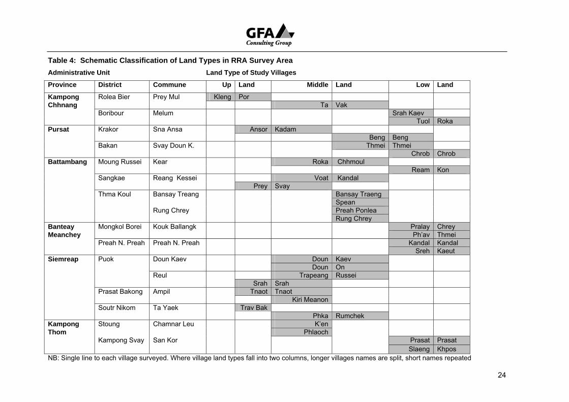
24
Table 4: Schematic Classification of Land Types in RRA Survey Area Administrative Unit Land Type of Study Villages
Province District Commune Up Land Middle Land Low Land
Kampong Rolea Bier Prey Mul Kleng Por Chhnang Ta Vak Boribour Melum Srah Kaev Tuol Roka Pursat Krakor Sna Ansa Ansor Kadam Beng Beng Bakan Svay Doun K. Thmei Thmei Chrob Chrob Battambang Moung Russei Kear Roka Chhmoul Ream Kon Sangkae Reang Kessei Voat Kandal Prey Svay Thma Koul Bansay Treang Bansay Traeng Spean Rung Chrey Preah Ponlea Rung Chrey Banteay Mongkol Borei Kouk Ballangk Pralay Chrey Meanchey Ph’av Thmei Preah N. Preah Preah N. Preah Kandal Kandal Sreh Kaeut Siemreap Puok Doun Kaev Doun Kaev Doun On Reul Trapeang Russei Srah Srah Prasat Bakong Ampil Tnaot Tnaot Kiri Meanon Soutr Nikom Ta Yaek Trav Bak Phka Rumchek Kampong Stoung Chamnar Leu K’en Thom Phlaoch Kampong Svay San Kor Prasat Prasat Slaeng Khpos NB: Single line to each village surveyed. Where village land types fall into two columns, longer villages names are split, short names repeated
2 . 2 M a p s
The agro-ecological pattern of rural land use around the Tonle Sap both reflect and a to a certain extent determine the conditions of daily life. Where a village is sited defines resource limitations and opportunities; possibilities and obstacles. One of the first exercises chosen for the RRA was the PRA village map and transect as a way of encouraging participants to talk about their environment and in the process:
• construct a simple inventory of available resources;
• find out what use is made of the land, water, and vegetation etc.;
• explore issues that arise out of both natural and man made features.
A request was made to make maps large enough for people to walk over and around them. A variety of techniques were used depending on conditions. Some maps were drawn with a stick on sandy ground under the shade of a rain tree, some drawn with chalk on rough concrete floors. When it rained facilitators set up camp under shelter and got villagers to sketch charts of their domain on large sheets of paper.
The maps are not meant to be accurate representations of the landscape but prompts for discussion. However, a good level of cartographical competence is always pleasing. From this point of view the maps are disappointing. Villagers like to start with the main village road(s) and houses. The facilitators drew boundaries on the exercise which left little room for villagers to draw the land around the village and as a consequence the scale is out of proportion. When the recorders copied the original maps they distorted the results even further.
Reproducing the RRA charts and calling them maps is a little like reproducing the breakfast Picasso threw to his dog and calling it art. Only one of the better ones is provided here as an example but there one has been drawn for each of the study villages, scanned, re-labelled in English and reproduced in the six volumes of the RRA Working Reports. These are basically rough English translations of the hand written Khmer reports. All have been rearranged to make them easier to read but only a few have been edited and notes added. They were still being put together as this RRA Summary Report was being written and it was not possible for the PRA specialist to simultaneously bring both up to a good standard of presentation in the time available.
The RRA Working Reports give tabulated results for each exercise but only a few include the three principal observations facilitators were asked to provide for each tool. This was one of the weakest aspects of the RRA work but even where written observations are not provided comments during preparation of the map invariably became part of the ongoing investigation and informed not only the preparation of the Transect but also:
• the Issues Matrix which in turn led to,
• prioritizing problems and challenges; and,
• Problem Tree Analysis of potential sub-projects.
25
The most significant output of the sketch maps became a part of the process. The PRA specialist is satisfied that villagers knowledge was articulated and their development preferences recorded.
Issues arising: Pol Pot lives
One of the first issues raised by villagers all around the lake made reference to water management structures erected during the Pol Pot which because of faulty design, hasty and poor construction quickly fell into disrepair. Rehabilitation was the first request. The imagination of villagers appears to still be captured by the utopian project that nearly destroyed them.
To remain true to the participatory purpose of the RRA to articulate the priorities of villagers and local officials, this priority is repeated in this report. However, it should be made quite clear that this is not necessarily the most sensible view. In most cases the figures likely to come out of a cost/benefit analysis do not add up. The cost of removing the ruins, rebuilding structures to a professional standard and measuring estimated gains that might be made from agricultural production do not, even to the untrained observer, present a very promising picture. There are more sophisticated options that perhaps require less money but certainly require more thought. These are listed in the Recommendations at the end of this report.
26
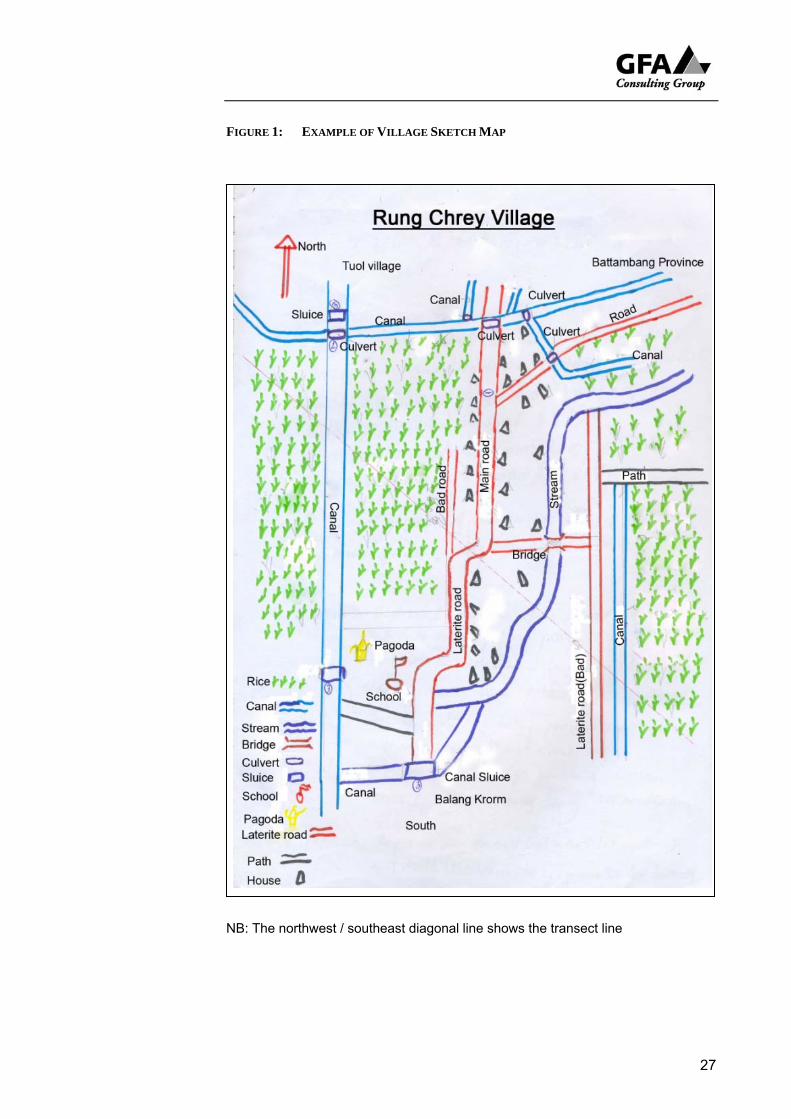
FIGURE 1: EXAMPLE OF VILLAGE SKETCH MAP
NB: The northwest / southeast diagonal line shows the transect line
27
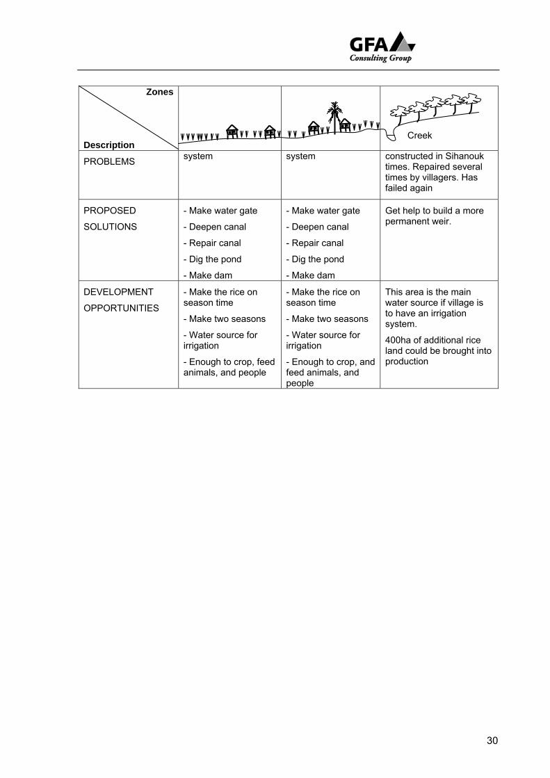
2 . 3 T r a n s e c t s
In real PRA/PLA exercises preparation of Transects engages facilitators in, so to speak, walking the line. Walking with a group of villagers through the village and across the fields and land around the settlement and talking about what can be seen. In this RRA it was the consultant team that did the walking and talking and the RRA recorder and facilitator working entirely separately who drew the transect. This is not a good way to achieve line accuracy but it made efficient use of time.
As a consequence the transect lines themselves cannot be taken literally. The vertical exaggeration is extreme. A more accurate line drawn to scale would show a minimum variation in elevation and perhaps a gentle slope to account for a rise and fall of a few metres.
What is of value however is the reminder the transects provide of the multitude of micro environments within the generalised, schematic configuration offered above (Table 4) as land types of the survey sites. The indigenous land classification refers to specific fields (e.g. high fields [sre leu], middle or medium fields [sre kandal], low fields [sre krom] and deep fields [sre trapeang or sre jumreou]) and provides a strongly farmer centred approach to representation.
The point is that features assigned to broad swathes of land can be misleading. Within any of the general land type categories assigned above there are often a multiplicity of micro environments. Hollows (trapaeng) and ox bow lakes (boeng) left along the now high and dry bed of an ancient river replicate in miniature the feature of land on the annual flood plain of the Tonle Sap. There are moderate high fields in middle land (kandal) and so forth. The relativity of the values and lower level of generalisation needs to be acknowledged. When a farmer talks of a mountain (phnom) and it looks like a low hill this should not be read as an absence of perspective and lack of knowledge but the manifestation of a different knowledge informed by a different perspective.
To enhance the cross reference value of the information a format was designed that incorporated features of the transect used in the Agro-Ecological Analysis system of the Cambodian – Australian, Agricultural Extension Project which make reference to Major Problems, Proposed Solutions and Development Opportunities.
Here again the exercise was mounted principally to provide an opportunity for farmers to discuss issues.
In the example below the RRA facilitators remained in the village for the duration of the survey. The consultants did the walking and went up to a site where a diversion weir had been built during Sihanouk times in the 1950s. It had eventually washed out and villagers had repaired it several times by filling sacks with sand and piling them on top of each other. On the understanding that a structure farmers deem useful enough to repair themselves might well qualify for sub project listing the site was visited and referred to the local engineer and agro-ecologist for inspection.
28
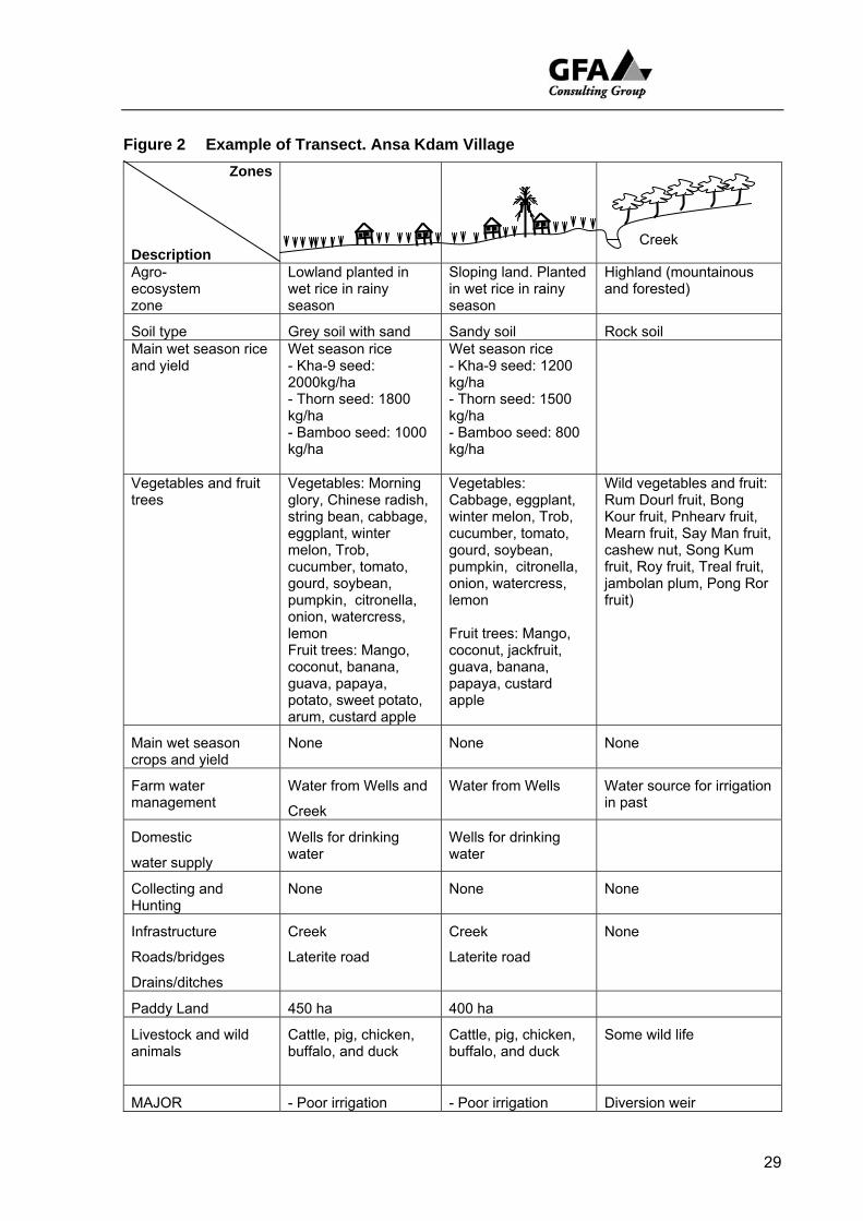
Figure 2 Example of Transect. Ansa Kdam Village Zones
Description
Agro- ecosystem zone
Lowland planted in wet rice in rainy season
Sloping land. Planted in wet rice in rainy season
Highland (mountainous and forested)
Soil type Grey soil with sand Sandy soil Rock soil Main wet season rice and yield
Wet season rice - Kha-9 seed: 2000kg/ha - Thorn seed: 1800 kg/ha - Bamboo seed: 1000 kg/ha
Wet season rice - Kha-9 seed: 1200 kg/ha - Thorn seed: 1500 kg/ha - Bamboo seed: 800 kg/ha
Vegetables and fruit trees
Vegetables: Morning glory, Chinese radish, string bean, cabbage, eggplant, winter melon, Trob, cucumber, tomato, gourd, soybean, pumpkin, citronella, onion, watercress, lemon Fruit trees: Mango, coconut, banana, guava, papaya, potato, sweet potato, arum, custard apple
Vegetables: Cabbage, eggplant, winter melon, Trob, cucumber, tomato, gourd, soybean, pumpkin, citronella, onion, watercress, lemon Fruit trees: Mango, coconut, jackfruit, guava, banana, papaya, custard apple
Wild vegetables and fruit: Rum Dourl fruit, Bong Kour fruit, Pnhearv fruit, Mearn fruit, Say Man fruit, cashew nut, Song Kum fruit, Roy fruit, Treal fruit, jambolan plum, Pong Ror fruit)
Main wet season crops and yield
None None None
Farm water management
Water from Wells and
Creek
Water from Wells Water source for irrigation in past
Domestic
water supply
Wells for drinking water
Wells for drinking water
Collecting and Hunting
None None None
Infrastructure
Roads/bridges
Drains/ditches
Creek
Laterite road
Creek
Laterite road
None
Paddy Land 450 ha 400 ha
Livestock and wild animals
Cattle, pig, chicken, buffalo, and duck
Cattle, pig, chicken, buffalo, and duck
Some wild life
MAJOR - Poor irrigation - Poor irrigation Diversion weir
Creek
29
Zones Description
PROBLEMS
system system constructed in Sihanouk times. Repaired several times by villagers. Has failed again
PROPOSED
SOLUTIONS
- Make water gate
- Deepen canal
- Repair canal
- Dig the pond
- Make dam
- Make water gate
- Deepen canal
- Repair canal
- Dig the pond
- Make dam
Get help to build a more permanent weir.
DEVELOPMENT
OPPORTUNITIES
- Make the rice on season time
- Make two seasons
- Water source for irrigation
- Enough to crop, feed animals, and people
- Make the rice on season time
- Make two seasons
- Water source for irrigation
- Enough to crop, and feed animals, and people
This area is the main water source if village is to have an irrigation system.
400ha of additional rice land could be brought into production
Creek
30
2 . 4 S u m m a r y
Maps and Transects were prepared for a reasonably representative sample of land use types in the project area. In the course of drawing sketch maps of, and transects through their village estates rural villagers brought up their concerns that focused largely on their ability to secure a livelihood from the land. Landowners want to produce more, even landless participants in the survey wanted the productive capability of the land improved because it would generate more paid employment.
Farmers talk about water as the critical factor but this needs to be placed in a wider context. Soil fertility, the use of compost and fertiliser, soil structure, drainage (flooding of rice is a serious problem in some areas). In nine of the 32 villages visited farmers requested agricultural training, in 21 of the 32 villages both men and women ranked access to better seed, fertiliser, pest control and so forth as a development priority.
The issues brought up most frequently are rice and water management. Conditions set a challenge. Rice is grown largely under rain fed conditions and rainfall is unreliable it is not surprising that survey participants indicated that at the beginning of the rainy season they want:
• more surface run off from early rains to be diverted to where it can be used to start their main wet season rice;
• while their rice is growing, access to more reliable supplies of water to maintain it; and,
• towards the end of the rainy season enough water to finish it.
At the end of the rainy season they want to stop as much water from draining away as they can in the hope that there will be enough water to grow a dry season crop of rice. They believe this can be achieved by:
• storing water in large recession tanks, ponds and deep canals the latter built at least partly for this purpose;
• closing water gates especially installed for the purpose on inlet-outlet canals;
• rehabilitating Pol Pot structures.
On the middle lands especially pumping is an important part of both early and late, wet and dry season strategies. Development of larger scale gravity fed systems is restricted to commercial holdings of interesting and perhaps problematic provenance
Larger scale water works proposed by rural participants appear to form the substance of potential sub-projects and need to be considered further.
There were many smaller issues concerning water management that came out of these two exercises (water drainage, culverts, bridges and fields counter-productively flooded) that might best be managed by commune based funds with work being contracted out and undertaken by locals.
Khmer cannot live by water and rice alone. The broader context needs to be considered. This is attempted in the next chapter.
31
3 S U S T A I N A B L E L I V E L I H O O D S
3 . 1 V u l n e r a b i l i t y
Concern for the failure of established approaches to poverty alleviation has led to a more open and iterative proposal defined in the Sustainable Livelihoods (SL) Framework. Leading aid agencies have given SL attention as an approach to poverty alleviation. Instead of working in a linear manner to isolate key aspects of poverty the SL approach advises development intervention agencies to look at:
• the complex arena in which vulnerability is manifest, for example, in shocks, adverse population and market trends, and seasonal events (floods, droughts etc.);
• the way in which vulnerability is tied to poor access to assets (human, natural, financial, physical and social capital) and the way these are articulated .
In pursuing their survival strategies the poor must cope with profound subordination in which their ability to access wider civil, private and public sector services is often impeded. Isolation, lack of knowledge, political alienation, cultural prejudice and so forth deny poor farmers access to structures and processes that would otherwise enable them to strengthen their position.
It was the specific configuration of these factors in real communities that the TSLSP RRA survey set out to examine by first establishing
• the livelihood platform of material assets or capital available to a community
• how access to these resources is modified by social relations, institutions, and organisations
• and how in the context of trends, shocks and seasonality
• this results in a livelihood strategy.
For farmers around the Tonle Sap as elsewhere in Cambodia, livelihood strategies must work within a context limited and enabled by activities that make use of both available natural resources (cultivation, fishing, animal husbandry etc) and other socioeconomic generated resources such as trade, paid employment, remittances etc. These in turn have effects on livelihood security (will the building boom continue to provide employment in Siem Reap?), and environmental sustainability (will continuing development of the commercial cultivation of recession rice on the inundation bed of the Tonle Sap have a detrimental impact on the biosphere?).
32
Given the resources and time available the goal of carrying out a full SL analysis was overly ambitious but the following observations can be made with reasonable confidence
Observations
Many of the people in the rural communities reviewed in the course of this survey are vulnerable to shocks. These include accidents and ill health; seasonal shortages of rainfall (especially at the beginning of the rainy season); seasonal shortages of water (especially drinking water during the dry season) and to start and finish both wet and dry rice crops; food shortages especially shortfalls in the rice harvest caused by an unreliable supply of water; and trends which have worked against them including rapid population increase and increasing differentiation between the better off and the poor.
Historic characteristics recorded in the PRA specialists note book include observations on:
• the rapidity with which socioeconomic differentiation has occurred since land reform in 1989; and
• how those returning after this date from both camps in Thailand (post 1993) and following the cessation of hostilities between the RGC and the Khmer Rouge (1997)10 missed out on the allocation of land .
These people make up a large proportion of the landless. In Chrab (Pursat) some 30 households of returnees from Thailand and Trav Bak (Siem Reap) some 10 families from Anlong Veng now earn by far the greater part of their livelihood from wage labour. These are people who work in the fields of others, seek agricultural work elsewhere as it becomes available and in the absence of tenure rights on the flood plain and lack of livestock to feed appear to rarely venture down to the lake in the dry season.
It is no surprise that being either landless or land short impacts disadvantageously on the access of these households to other assets (i.e. credit, health services).
Vulnerability of Women Headed Households
Another common characteristic of the most vulnerable households is that a disproportionate number are headed by women. On average women headed households made up 14.5% of the total in surveyed villages. For Kampong Chhnang, Pursat and Kompong Thom the average was closer to 20%.
10 Several survey villages in Siem Reap received people after the 1997 settlement
from the northwestern Khmer Rouge HQ at Anlong Veng
33
Khmer convention refers to these women as widows which implies a disadvantageous bereavement. In fact death of a woman’s partner or father of her children is rarely the case. Most women described as ‘widowed’ have been abandoned for long enough to be considered divorced. They are more often than not seriously disadvantaged by separation, sometimes left with dependents such as younger children and elderly parents to support, and reduced access to adult labour. Their capacity to farm, trade and travel declines. When they or one of their children fall ill and they have to seek medical advice outside the village they quickly run up debts. Because of this many had lost what land they had. Their poverty keeps their children out of school which in turn contributes to the chances of passing on their economic under privilege to another generation.
Some women are widowed and those the RRA team interviewed were usually older, some childless and often very poor. One older widow in Prasat, Kompong Thom talked of picking rice gleanings left on the ground after harvest, gathering what she could from the land around the village and doing whatever work was available to get the wherewithal to eat. Her poverty had not silenced her. Fellow villagers acknowledged her predicament and were entertained by the way she joked so bravely about the indignities associated with her poverty.
Precipitation and Availability of Water
Even for those with land a crop is not guaranteed. Rice needs water and rainfall is far from reliable. Farmers within each of the zones (described in the previous chapter as high fields, middle and low) experience the same shortcomings that are characteristic of the region and which are repeated from a scientific perspective Paul Mosley (TSLSP Report on Water Availability, September 2006).
Analysis emphasizes how variable - and unreliable – is the rainfall… at the beginning of the wet season, when farmers are establishing their crops (Mosley 2006: 61)
Farmers is every zone talked of the importance of early rains as the single most important factor in establishing their main wet rice crop.
Pollution of Tonle Sap
Farmers on low fields close to the lake who could look to the rising waters of the Tonle Sap as a source of irrigation also preferred fresh water. They talked of how water at the leading edge of the rising water was sour and coloured, deposited cinders11 along its leading edge, and did not nurture the young rice like rain water. Some talked of this polluted lake water posing more of a threat than a source of support for their wet season rice. The decline of floating rice may also be related to the deterioration of water quality.
11 “Cinders” is a direct translation from Khmer. The name given to the pollutant
deposit left behind by the Tonle Sap flood waters
34
Shortage of Water
Everywhere farmers when asked to score and prioritise problems and development opportunities voted consistently for better water storage raised under the rubric of irrigation. Again this preference is entirely in agreement with the judgement of the TSLSP hydrologist
Rainfall in the Tonle Sap basin is in total and on average, more that sufficient for productive rain-fed agriculture…. However, variability and unpredictability are a severe hindrance to farmers, particularly because the bulk of rain tends to fall in intense downpours and runs off rather than entering the soil. There is great scope for harvesting and storing runoff… (Mosley 2006: 61))
Farmers implicitly assert again and again, “If we could store more water we could grow more rice. We think this should be done whatever the cost”. The cost they believe they do not have to pay is sometimes extravagant12
Rain-fed conditions are never easy for farmers. Clearly vulnerability would be reduced by any changes made to improve:
• the controlled diversion of surface/stream and river run off during the Monsoon onto rice fields; and,
• the capture and storage of surface water at the end of the rainy season to grow either recession/dry rice and other crops .
It is not a question of whether or not this should be done but what is an acceptable cost benefit ratio.
3 . 2 A s s e t s & P e n t a g o n C o n f i g u r a t i o n
Much more can be written about vulnerability but only information on the livelihood platform of material assets or capital available to the RRA survey communities was collected in the field (Main Assets). The first step in analysis was taken by the RRA team initially in discussion with both the domestic and PRA consultants by talking through the formulation of pentagon diagrams. The purpose was to provide a framework the survey team could use to evaluate community strengths and weaknesses.
Human resources: individual skills and qualifications of villagers;
Social and political organization: connections, coherence, sense of solidarity;
12 In Battambang farmers in Roka Chhmoul, Kear commune, Moung Russei district
prioritized substantial weirs on the Stueng Moung; villagers in Prey Svay, Reang Kessei commune, Sangkae district significant earth works and the rehabilitation of a major dam on the Stueng Sangkae. These are discussed below
35
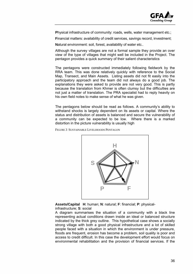
Physical infrastructure of community: roads, wells, water management etc.;
Financial matters: availability of credit services, savings record, investment;
Natural environment: soil, forest, availability of water etc..
Although the survey villages are not a formal sample they provide an over view of the type of villages that might well be included in the Project. The pentagon provides a quick summary of their salient characteristics
The pentagons were constructed immediately following fieldwork by the RRA team. This was done relatively quickly with reference to the Social Map, Transect, and Main Assets. Listing assets did not fit easily into the participatory approach and the team did not always do a good job. The explanations they were asked to provide are not very good. This is partly because the translation from Khmer is often clumsy but the difficulties are not just a matter of translation. The PRA specialist had to reply heavily on his own field notes to make sense of what he was given.
The pentagons below should be read as follows. A community’s ability to withstand shocks is largely dependent on its assets or capital. Where the status and distribution of assets is balanced and secure the vulnerability of a community can be expected to be low. Where there is a marked distortion in the picture vulnerability is usually high
FIGURE 3 SUSTAINABLE LIVELIHOODS PENTAGON
H
N
FP
S
Assets/Capital H: human; N: natural; F: financial; P: physical-infrastructure; S: social A diagram summarises the situation of a community with a black line representing actual conditions drawn inside an ideal or balanced structure indicated by the thick grey outline. This hypothetical case shows a socially strong village with both a good physical infrastructure and a lot of skilled people faced with a situation in which the environment is under pressure, floods are frequent, erosion has become a problem, soil quality is poor and access to credit difficult. In this case the development effort would focus on environmental rehabilitation and the provision of financial services. If the
36

37
pressure on N and F can be lifted this would indicate that the situation has been reversed and that development is underway.
A pentagon was prepared for each of the study villages. The associated notes for Kampong Chhnang, Pursat and Battambang were prepared by the PRA specialist. Those for Banteay Meanchey, Siem Reap and Kompong Thom are heavily edited from notes provided by the RRA team. This change in the reporting format does not fundamentally alter the content although the latter take more of a note form.
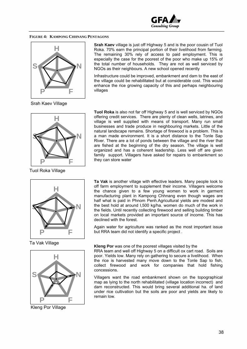
FIGURE 4: KAMPONG CHHNANG PENTAGONS
38
Srah Kaev village is just off Highway 5 and is the poor cousin of Tuol Roka. 70% earn the principal portion of their livelihood from farming. The remaining 30% rely of access to paid employment. This is especially the case for the poorest of the poor who make up 15% of the total number of households. They are not as well serviced by NGOs as their neighbours. A new school opened recently
Infrastructure could be improved, embankment and dam to the east of the village could be rehabilitated but at considerable cost. This would enhance the rice growing capacity of this and perhaps neighbouring
llages
Srah Kaev Village
Tuol Roka Village
Ta Vak Village
Kleng Por Village
vi
th
Ab
re
S
H
P F
N
Tuol Roka is also not far off Highway 5 and is well serviced by NGOs offering credit services. There are plenty of clean wells, latrines, and village is well supplied with means of transport. Many run small businesses and trade produce in neighbouring markets. Little of the natural landscape remains. Shortage of firewood is a problem. This is a man made environment. It is a short distance to the Tonle Sap River. There are a lot of ponds between the village and the river that are fished at the beginning of the dry season. The village is well organized and has a coherent leadership. Less well off are given family support. Villagers have asked for repairs to embankment so
ey can store water
Ta Vak is another village with effective leaders. Many people look to off farm employment to supplement their income. Villagers welcome the chance given to a few young women to work in garment manufacturing plant in Kampong Chhnang even though wages are half what is paid in Phnom Penh.Agricultural yields are modest and the best hold at around I,500 kg/ha. women do much of the work in the fields. Until recently collecting firewood and selling building timber on local markets provided an important source of income. This has declined with the forest.
S
H
P F
N
gain water for agriculture was ranked as the most important issue ut RRA team did not identify a specific project .
Kleng Por was one of the poorest villages visited by the RRA team and well off Highway 5 on a difficult ox cart road. Soils are poor. Yields low. Many rely on gathering to secure a livelihood. When the rice is harvested many move down to the Tonle Sap to fish, collect firewood and work for companies that hold fishing concessions.
Villagers want the road embankment shown on the topographical map as lying to the north rehabilitated (village location incorrect) and dam reconstructed. This would bring several additional ha. of land under rice cultivation but the soils are poor and yields are likely to
main low.
S
H
P F
N
S
H
P F
N
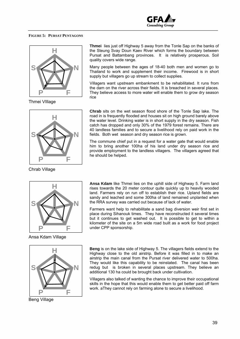
FIGURE 5: PURSAT PENTAGONS
Thmei lies just off Highway 5 away from the Tonle Sap on the banks of the Steung Svay Doun Kaev River which forms the boundary between Pursat and Battambang provinces. It is relatively prosperous. Soil quality covers wide range.
Many people between the ages of 18-40 both men and women go to Thailand to work and supplement their income. Firewood is in short supply but villagers go up stream to collect supplies.
Villagers want upstream embankment to be rehabilitated. It runs from dam on the river across their fields. It is breached in several places. ey believe access to more water will enable them to grow dry season e
39
Thmei VIllage
Chrab Village
Ansa Kdam Village
Beng Village
theThric
he
kilun
wo
Chrab sits on the wet season flood shore of the Tonle Sap lake. The road in is frequently flooded and houses sit on high ground barely above the water level. Drinking water is in short supply in the dry season. Fish catch has dropped and only 30% of the 1979 forest remains. There are 40 landless families and to secure a livelihood rely on paid work in the fields. Both wet season and dry season rice is grown.
The commune chief put in a request for a water gate that would enable him to bring another 100ha of his land under dry season rice and provide employment to the landless villagers. The villagers agreed that
should be helped.
Ansa Kdam like Thmei lies on the uphill side of Highway 5. Farm land rises towards the 20 meter contour quite quickly up to heavily wooded land. Farmers rely on run off to establish their rice. Upland fields are sandy and leached and some 300ha of land remained unplanted when the RRA survey was carried out because of lack of water.
Farmers want help to rehabilitate a sand bag diversion weir first set in place during Sihanouk times. They have reconstructed it several times but it continues to get washed out. It is possible to get to within a
ometer of the site on a 5m wide road built as a work for food project der CPP sponsorship.
Beng is on the lake side of Highway 5. The villagers fields extend to the Highway close to the old airstrip. Before it was filled in to make an airstrip the main canal from the Pursat river delivered water to 500ha. They would like this capability to be reinstated. The canal has been redug but is broken in several places upstream. They believe an additional 130 ha could be brought back under cultivation.
Villagers also talked of wanting the chance to improve their occupational skills in the hope that this would enable them to get better paid off farm
rk. aThey cannot rely on farming alone to secure a livelihood.
S
H
P F
N
S
H
P F
N
S
H
P F
N
S
H
P F
N
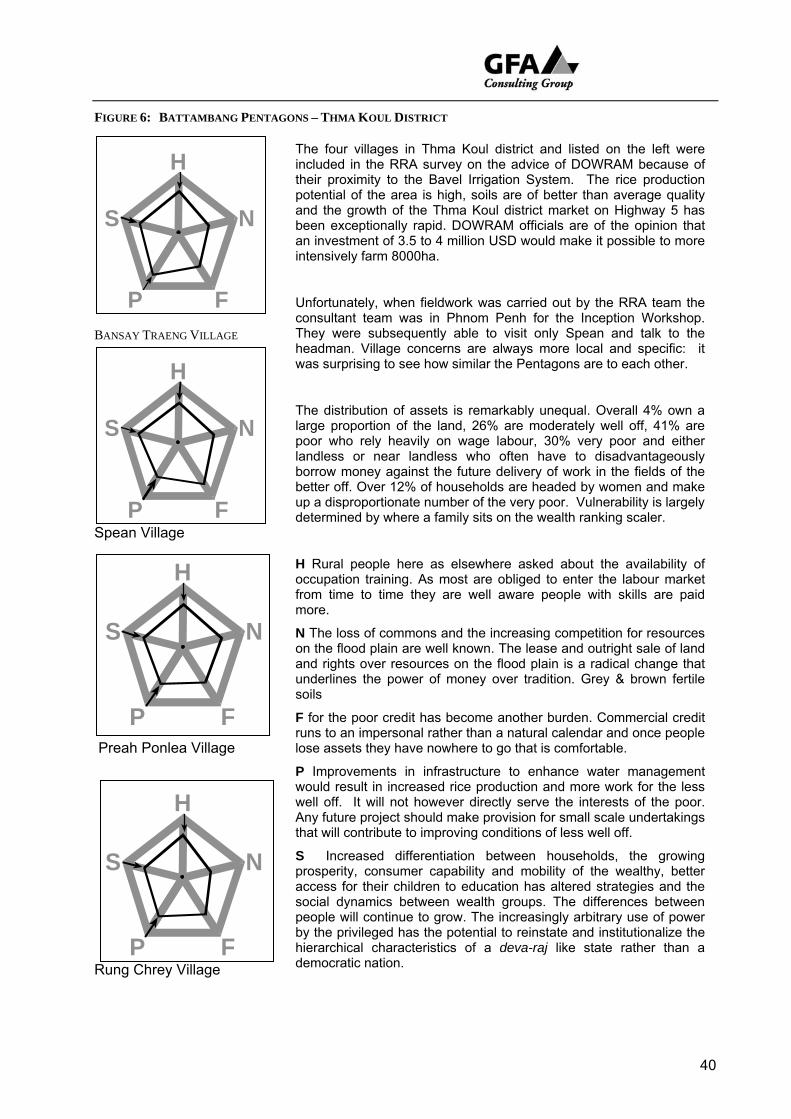
FIGURE 6: BATTAMBANG PENTAGONS – THMA KOUL DISTRICT
40
BANSAY TRAENG VILLAGE
Spean Village
Preah Ponlea Village
Rung Chrey Village
The four villages in Thma Koul district and listed on the left were included in the RRA survey on the advice of DOWRAM because of their proximity to the Bavel Irrigation System. The rice production potential of the area is high, soils are of better than average quality and the growth of the Thma Koul district market on Highway 5 has been exceptionally rapid. DOWRAM officials are of the opinion that an investment of 3.5 to 4 million USD would make it possible to more intensively farm 8000ha.
U
ud
F frun
by hiede
nfortunately, when fieldwork was carried out by the RRA team the consultant team was in Phnom Penh for the Inception Workshop. They were subsequently able to visit only Spean and talk to the headman. Village concerns are always more local and specific: it was surprising to see how similar the Pentagons are to each other.
The distribution of assets is remarkably unequal. Overall 4% own a large proportion of the land, 26% are moderately well off, 41% are poor who rely heavily on wage labour, 30% very poor and either landless or near landless who often have to disadvantageously borrow money against the future delivery of work in the fields of the better off. Over 12% of households are headed by women and make
p a disproportionate number of the very poor. Vulnerability is largely etermined by where a family sits on the wealth ranking scaler.
H Rural people here as elsewhere asked about the availability of occupation training. As most are obliged to enter the labour market from time to time they are well aware people with skills are paid more.
N The loss of commons and the increasing competition for resources on the flood plain are well known. The lease and outright sale of land and rights over resources on the flood plain is a radical change that underlines the power of money over tradition. Grey & brown fertile soils
or the poor credit has become another burden. Commercial credit s to an impersonal rather than a natural calendar and once people
lose assets they have nowhere to go that is comfortable.
P Improvements in infrastructure to enhance water management would result in increased rice production and more work for the less well off. It will not however directly serve the interests of the poor. Any future project should make provision for small scale undertakings that will contribute to improving conditions of less well off.
S Increased differentiation between households, the growing prosperity, consumer capability and mobility of the wealthy, better access for their children to education has altered strategies and the social dynamics between wealth groups. The differences between people will continue to grow. The increasingly arbitrary use of power
the privileged has the potential to reinstate and institutionalize the rarchical characteristics of a deva-raj like state rather than a mocratic nation.
S
H
P F
N
S
H
P F
N
S
H
P F
N
S
H
P F
N
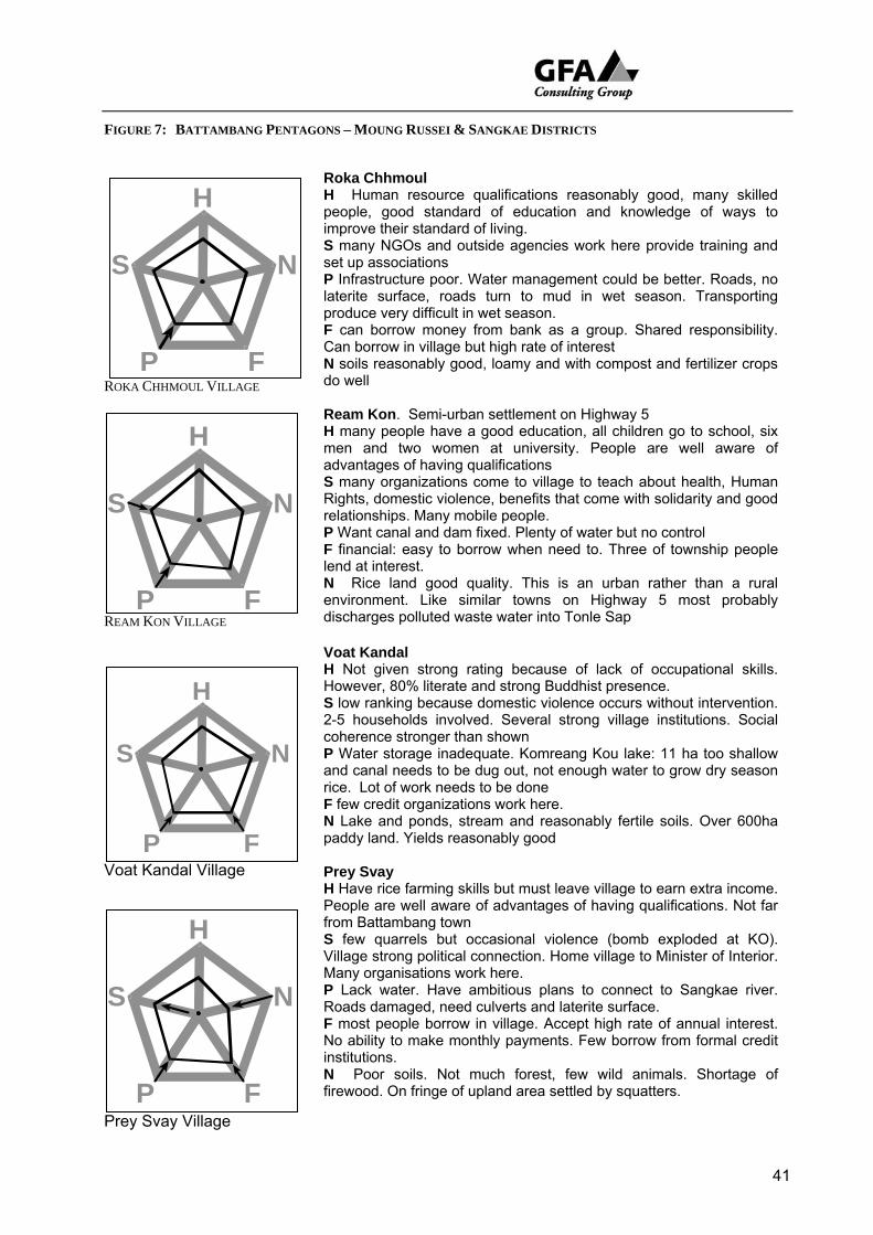
FIGURE 7: BATTAMBANG PENTAGONS – MOUNG RUSSEI & SANGKAE DISTRICTS
41
ROKA CHHMOUL VILLAGE
REAM KON VILLAGE
Voat Kandal Village
Prey Svay Village
S
H
P F
N
Roka Chhmoul H Human resource qualifications reasonably good, many skilled people, good standard of education and knowledge of ways to improve their standard of living. S many NGOs and outside agencies work here provide training and set up associations P Infrastructure poor. Water management could be better. Roads, no laterite surface, roads turn to mud in wet season. Transporting produce very difficult in wet season. F can borrow money from bank as a group. Shared responsibility.
borrow in village but high rate of interest Can N sodo w
N envidisc
N firew
ils reasonably good, loamy and with compost and fertilizer crops ell
Ream Kon. Semi-urban settlement on Highway 5 H many people have a good education, all children go to school, six men and two women at university. People are well aware of advantages of having qualifications S many organizations come to village to teach about health, Human Rights, domestic violence, benefits that come with solidarity and good relationships. Many mobile people. P Want canal and dam fixed. Plenty of water but no control
P F
S
H
N
F financial: easy to borrow when need to. Three of township people lend at interest.
Rice land good quality. This is an urban rather than a rural ronment. Like similar towns on Highway 5 most probably harges polluted waste water into Tonle Sap
Voat Kandal H Not given strong rating because of lack of occupational skills. However, 80% literate and strong Buddhist presence. S low ranking because domestic violence occurs without intervention. 2-5 households involved. Several strong village institutions. Social coherence stronger than shown P Water storage inadequate. Komreang Kou lake: 11 ha too shallow and canal needs to be dug out, not enough water to grow dry season rice. Lot of work needs to be done F few credit organizations work here. N Lake and ponds, stream and reasonably fertile soils. Over 600ha paddy land. Yields reasonably good Prey Svay H Have rice farming skills but must leave village to earn extra income. People are well aware of advantages of having qualifications. Not far from Battambang town S few quarrels but occasional violence (bomb exploded at KO). Village strong political connection. Home village to Minister of Interior. Many organisations work here. P Lack water. Have ambitious plans to connect to Sangkae river. Roads damaged, need culverts and laterite surface. F most people borrow in village. Accept high rate of annual interest. No ability to make monthly payments. Few borrow from formal credit institutions.
Poor soils. Not much forest, few wild animals. Shortage of ood. On fringe of upland area settled by squatters.
S
H
P F
N
S
H
P F
N
FIGURE 8: BANTEAY MEANCHEY PENTAGONS
Pralay Chrey
H Good, all children go to school, many skilled people. Over 70% can read and write, 2 study at university. S Lot of outside organisations. Some domestic violence and trouble. 10 Cham families. Ceremonies disrupted by gangs of kids. Villagers suspicious of outsiders
42
Pralay Chrey Village
Ph’av Thmei Village
Kandal Village
Sreh Kaeut Village
P Laterite road in good condition but difficult in wet season. Shallow canal, and no water control gates. F Good. A lot of credit organizations. Easy for people to borrow and set
usiness. Village money lenders charge higher rate of interest than institutions.
up bother
N few
fro
wate
N transformed to human environment. Wet rice, floating (flood?) rice, some dry rice if enough water.
Ph’av Thmei H Low rating. Few skilled people in village. Low technical knowledge brought to farming. Use little or no fertiliser. Most older people illiterate. S Many outside organizations come in to help and provide training. Villagers get on well with each other. Rarely any trouble. P No school nor health centre. Villager want a culvert put in place to allow water to drain from fields. At moment flooding places rice at risk. F few credit organisations, ACLEDA & private providers only
natural resources of note. Reasonable soils,
Kandal
H Most have an education and good range of skills. All children go to school, 100% people can read and write, 5 students at university. S good because of many organizations help. Good sense of solidarity between villagers. No domestic violence, few quarrels, and good morale. P 3 conservative areas, 2 laterite roads, 18 lined wells, 2 pumping wells, 3520m canal, rice mill. Rehabilitation work required on water gate. Three ponds, transport situation good. F Plenty of credit agencies as well money lenders N Lot of wild animals, birds, fish, lakes, streams. Good rice land inside and outside village estate. Fish conservation area set up with assistance
m UNDP and Fisheries Dept.
Sreh Kaeut
H Most children go to school. Villagers have wide range of different skills. People need these for off farm work S Many organisations good morale but there are youth gangs, domestic violence P Good laterite road but school needs repair, canal too shallow, no water in dry season. F Credit organisations AMK, HATHA, Cambodia Village Bank. People also borrow privately. High rate of default. N 18 lakes (fish and plant rice), rice land (470ha wet season rice, 30ha plantation land, streams, enough water but lost in dry season because no
r gates. Lot of insects & pests.
S
H
P F
N
S
H
P F
N
S
H
P F
N
S
H
P F
N
FIGURE 9: SIEM REAP PENTAGONS – PUOK DISTRICT
Doun Kaev
43
Doun Kaev Village
H 60% villagers literate. Many other educated people with skills who they can earn good money. Off farm employment important
Doun On Village
Trapeang Russei Village
Srah Village
S Many institutions and organizations worked here before and have since moved to other less well off villages. Coherent leadership and sense of solidarity. P lack water gate on canal, road seriously damaged difficult to travel in rainy season. F many micro credit institutions from which money can be borrowed as
ded. neeN fe
N Rbask
dry the
N Swet prote
w natural resources. Forest gone. Soils not particularly good, yields are low.
Doun On
H There are many educated people. People have a wide range of skills such as palm taping, fishing, and skills like distilling alcohol, trading, running taxis etc S Many organizations come to help in the village and village has its own savings groups. P Small roads, some damaged; good wells, no water storage jars; no canals or latrines. F Poor access to credit resource.
easonable rice lands, some access to rattan for weaving flat ets. A few small wild animals, a lot of fish in wet season, and some
grass.
S
H
P F
N
S
H
P F
N
Trapeang Russei
H Many skilled people with range of occupations associated with commercial development of Siem Reap and construction industry. S Many organizations active in village. The line could well be drawn further out. P No canal and not enough water in dry season either to drink or use for agriculture. Some latrines, one well equipped with pump. F Many organizations come to provide credit. N There are ponds like Trapeang Smonh which retains a little water in
season, a shallow stream, and other natural ponds that dry up over hot season. This is a transformed cultural rather than natural
landscape.
Srah
H Only 2% adults are literate and many infected with TB S 45 households headed by woman. An extremely poor village Only a few organizations come to help. Isolated. One private donor but can not provide all required. P Road and bridge damaged. Shallow canal, few latrines, and not enough water in dry season. F Only AMK provides a credit service.
S
H
P F
N
S
H
P F
N
tream, shallow natural pond, rice land sandy acidic soils. Only one season crop. Short term variety, low yield. Forest Association to ct remaining 150 ha of trees. Village relatively recently established.
FIGURE 10: SIEM REAP PENTAGONS – PRASAT BAKAONG & SOUTRE DISTRICTS
44
Tnaot Village
Tnaot
H there are many skilled people employed in Siem Reap in the construction industry. Villagers make the most of job opportunities but only 50% of villagers are literate S Many different organization and government institutions work in village but people split between different political parties. Difficult to maintain order. Quarrels common P Roads, canals, and wells mostly damaged.
Kiri Meanon Village
Trav Bak Village
Phka Rumchek Village
F MpeopN the
P Hointo A
F CrN Lo
N Goand
any organizations and business men come to lend money but few le borrow. Interest rates high. re are few natural resources such as forest left in village. Soils are
poor
Kiri Meanon
H A lot of disadvantaged people. Eighteen women headed households, 8 men and one woman handicapped by mine and war injuries. Many people employed in construction as both skilled and unskilled workers. S Village lies in area demarcated as part of the Angkor World Heritage Site. It has become engaged in the Siem Reap boom and people tend to look outside the village for their livelihood. Some land has been sold to outsiders.
useholds rely on rain and lake water for domestic supply. Roads SPARA area good.
S
H
P F
N
F Access to service providers but people afraid to borrow. N One shallow natural pond. Soils poor, infertile.
Trav Bak
H Many people with skills but some 40 households from Anlong Veng (with Khmer Rouge from early 1970s) missed out on education. 10% literate. 55% children go to school. 15 people actively selling land. S Several outside organizations work here, some demoralised drinkers (mostly very poor), little violence, good security, and strong sense of solidarity although lot of land sold. P Two damaged roads, damaged bridge, shallow and little canal, no school, no market, and no hospital.
edit services not at all good. No agencies work here. t of good farm land, wild animals, fish, thatch for and leaves from a
tree that can be used as natural fertilizer.
Phka Rumchek
H Many people literate. Have trade skills, work for reasonable wages. Spend a lot of time away S Strong and there are many organizations that come to help with building school and constructing wells. P Difficult roads in wet season, canal needs work, wells can only be used in wet season F 4 credit agencies work in village. Easy to borrow when need to.
S
H
P F
N
S
H
P F
N
S
H
P F
N
od resources overall but poor conditions for farming. Soils infertile sandy, do not hold water. Dry season difficult.
FIGURE 11: KAMPONG THOM PENTAGONS
K’en
H Few trained and educated people. Craft skills include mat weaving, making fish traps (Poung). Products not sold. S NGOs help out: World Vision very generous. Village well organised but people interested in things outside village. P Many shortfalls. Canal needs rehab work, no toilets, few wells, shortage drinking water in dry season. Laterite road built without enough culverts and bridges. Paddy fields flood F Credit agencies operate. Villagers can get money when needed at
rates of interest. Some prefer local money lenders who work on al cycle not monthly repayment.
K’en Village
Plaoch Village
Prasat Village
Slaeng Khpos Village
high annu
F Barepa
P RovillagF AC
DifficF 2
N water shortage, wet season rice yields low. Have cleared 400ha. flooded forest. 50 households plant 70-80 ha. Yields good 5000-6000 kg/ha
Plaoch
H Most children go to school both girls and boys. Wide range of occupational skills with market value. S Lot of NGOs and outside agencies have helped out. Villagers want more help with road and water control. P House lots flooded in wet season. Need better control and better out lets. Getting to school difficult because of flooding. Cannot grow dry season rice. Not enough stored water.
nks and NGOs offer credit but people unwilling to use ability to y poor. Prefer local money lender.
N Only 120 ha of wet season rice land, low yields because too frequently badly flooded and rice under water for too long
Prasat
H many fishermen. All children go to school. 55% adults literate. Good range handicrafts and agricultural skills i.e. mat weaving, construct bamboo fish cages etc. S Many NGOs and others donate: well, cattle and buffalo banks, road construction, school, and cure nerve disease. No notes provided on social coherence.
ads, canals, wells in reasonably good condition. Transport needs of e well served. LEDA bank. Village money lenders in neighbouring town charge
high rate of interest. Villagers borrow to enhance earnings rather than meet emergencies. N village conservative area formed to maintain quality of environment. Slaeng Khpos H Most children go to school. Most of older generation are illiterate but have many practical trade skills. S Well set up. Many outside organizations come to help and teach. No notes on coherence and integrity of village itself but several different political parties represented and Buddhist organisations work well. Juveniles misbehave. P Many roads poorly maintained. Flood control needed. Damaged.
ult to travel in both dry and wet season. credit institutions, low rate of interest but few borrow. Monthly
payments difficult to meet N Few benefits from close proximity to Tonle Sap.
S
H
P F
N
S
H
P F
N
S
H
P F
N
S
H
P F
N
45
3 . 3 S u m m a r y
The review of the relatively fixed issue of assets/capital constantly drew attention to the strategies used by rural people to manage the resources to which they have access. The family/household may form the principal structure around which socioeconomic activities are organised but the strength and range of a typical family operation increasingly extends well beyond both the farm gate and the village boundary. Much less than half the householders ranked in the RRA exercises produce enough food to feed their families. They cannot secure an acceptable livelihood on what they produce on their farms, what they grow, and the animals they raise to survive.
• They must fish and gather firewood and timber from the wider environment in which they live. This takes some down to the annual flood plain of the Tonle Sap, up into the hills and into local forests in search of feed for their livestock, food for their tables as well as other commodities and supplies.
• They must seek wage labour or payment in kind on neighbouring farms, take delivery of rice and pay later with work often for a reduced wage.
• They must seek paid employment in neighbouring towns and provinces as well as the closest neighbouring country, Thailand or as far away as Malaysia.
They are well aware that education, vocational and occupational training can help them earn more. They look to outside agencies, NGOs and government for help and although there is an unhealthy element of dependency in this, much of what they would like done far exceeds their resources. They want to enhance their management of rainy season run off and their access to dry season storage of water both for agriculture and drinking. They have yet to come completely to terms with what they need to organise for themselves and what can be done for them let alone the post socialist, post conflict, new world in which they find themselves,. It is widely accepted that traditional configurations of social interaction such as those conducted within a patron client relationship, reciprocal exchange (provas dei) and the like are no longer as strong as the were in the past. The internal coherence of villages has changed. Villages have never been isolated, self sufficient mutually dependent communities but today even more so than ever before mutual family support is under stress. This is not misplaced nostalgia for distant good old days. The basic mode and scale of production has changed. Today farmers rely less on each other for status and support, and more on the market and what the outside world can provide. Links between the village and the outside world are subordinated within a broader rural urban hierarchy, control of which remains largely in the hands of outsiders. Strengthening farmers connections and enhancing their ability to operate within it is part of the Sustainable Livelihoods agenda.
46
It was not possible within the scope of the RRA survey to find a pathway through these challenges but it was interesting to hear farmers all around the Tonle Sap requesting occupational training. Nor was it possible to clearly identify agencies (administrative structures) and ways of working (processes) that work, partly work, or do not work for villagers and within which a project might best work but NGOs are everywhere and have a much clearer idea of how to work in villages than most government agencies. It was however pleasing to learn that rural people are willing to enter into participatory planning exercises and appreciate the chance to let their voice be heard. It is strongly recommended that an informed, interactive participatory approach be included in the project under consideration. Within the hierarchy of needs large scale infrastructure sub projects may lie well beyond rural peoples technical and management expertise but small scale undertakings could well be managed by villagers. Access to the resources to do this could easily be managed in such a way as to strengthen their capability to do things for themselves, enhance their ability to take decisions and decide what they want rather than wait for handouts that may well not be relevant. The links between the principal types of assets or capital describe a series of situations that are not exclusively determined by one form of capital or another, the nodes are interdependent. Rather than focus on negative shortcomings and problems the pentagons encourage us to consider interrelationships and explore the territory for possible synergies. The most flexible categories are human resources and social/political capital. The status of the former can be improved by providing education and training. The latter can be enhanced by participatory planning exercises with a concrete output, action plans that remain under the control of the initiating village group. Establishment of Sustainable Livelihoods transforming structures and processes can best be conducted as part of a recommended implementation participatory approach. If properly informed a project could build villagers capacity to organise themselves and pursue support from outside sources. Support for example:
• village committees to better perform tasks they have defined;
• take villagers special interests to agencies that can do something about them;
• link villagers to NGOs that are in a better position to represent their concerns in a wider set of forums.
• advise how villagers can better access and manage resource nodes by designing extended Action Plans, preparing applications for funding, and drawing local officials into negotiation processes.
Based on the RRA experience the PRA consultant is of the opinion that a more sociologically informed participatory approach provides a paradigm for an ongoing engagement that would empower villagers.
47
4 W E A L T H R A N K I N G
4 . 1 T h e E x e r c i s e
This exercise provided the best insight of the RRA exercise into how resources are distributed throughout a village and who has what. Each village was encouraged to set its own criteria but the prompt list used by facilitators tended to pre-empt the villager role. Other than insisting on four groups no attempt was made to impose a standard set of characteristics. The RRA team was carefully instructed to follow a consistent methodology outlined in the TSLSP RRA handbook. At the beginning of fieldwork they took shortcuts and in the course of the first fifteen studies were occasionally willing to naively accept villager shortcuts. Several village chiefs, even while lists of voters was being complied by commune chiefs and district governors insisted that they did not have a list of village households. The team was told that in such cases they should assemble lists of their own taking every third household from the village sketch map. Surprisingly they did not ever have to do this. Where the number of households exceeded 300, rather than attempt to place every household in the village, the team was encouraged to select a sample by taking the name of every third household from the village headman’s list and subject these to the approved intuitive sorting method.
4 . 2 R e s u l t s
Apart from a very few deviations and one failure to quantify the number of households sorted (Kleng Por) the results, if not perfect are consistent and provide an accurate socioeconomic profile of the study villages. Rather than repeat what is readily available readers who would like to know the details are referred to the manual. Differentiation In the short period that has elapsed since land, formerly held collectively under a form of state socialism was distributed, differentiation has been rapid. This differentiation between those who have enough land to grow their own rice needs and those who do not have enough is growing rapidly. Landownership is one of the most critical factors in determining family welfare. Land was distributed in most villages as late as 1989 during the Vietnamese occupation along relatively egalitarian lines. The total amount of land was equally divided on a per capita basis regardless of age and sex. The interests of those who at this time had either retreated with the Khmer Rouge armies or evacuated to Thailand were not considered. These people missed out and when they returned well after the Paris accord and during UNTAC times (1993) or later after the settlement with the Khmer rouge (1997) there was usually little or no land to distribute and these people have largely gone without. Some settled new areas and carved villages out of the forest. Many have gone from place to place looking for a home. Most late comers returned to their pre-conflict homes
48
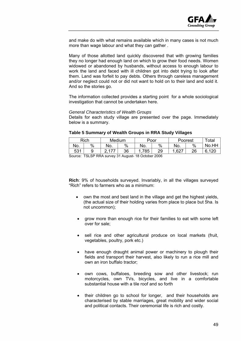
and make do with what remains available which in many cases is not much more than wage labour and what they can gather . Many of those allotted land quickly discovered that with growing families they no longer had enough land on which to grow their food needs. Women widowed or abandoned by husbands, without access to enough labour to work the land and faced with ill children got into debt trying to look after them. Land was forfeit to pay debts. Others through careless management and/or neglect could not or did not want to hold on to their land and sold it. And so the stories go. The information collected provides a starting point for a whole sociological investigation that cannot be undertaken here. General Characteristics of Wealth Groups Details for each study village are presented over the page. Immediately below is a summary. Table 5 Summary of Wealth Groups in RRA Study Villages
Rich Medium Poor Poorest No. % No. % No. % No. %
Total No.HH
531 9 2,177 36 1,785 29 1,627 26 6,120 Source: TSLSP RRA survey 31 August- 18 October 2006
Rich: 9% of households surveyed. Invariably, in all the villages surveyed “Rich” refers to farmers who as a minimum:
• own the most and best land in the village and get the highest yields, (the actual size of their holding varies from place to place but 5ha. Is not uncommon);
• grow more than enough rice for their families to eat with some left over for sale;
• sell rice and other agricultural produce on local markets (fruit, vegetables, poultry, pork etc.)
• have enough draught animal power or machinery to plough their fields and transport their harvest, also likely to run a rice mill and own an iron buffalo tractor;
• own cows, buffaloes, breeding sow and other livestock; run motorcycles, own TVs, bicycles, and live in a comfortable substantial house with a tile roof and so forth
• their children go to school for longer, and their households are characterised by stable marriages, great mobility and wider social and political contacts. Their ceremonial life is rich and costly.
49
50
• some lend money but not necessarily as part of a money making enterprise in itself. They advance rice to families in need and collect in labour delivered at a reduced rate. Rarely borrow.
Medium: 36% of households surveyed, the largest group.
• This group own fields that are barely adequate, smaller area than the rich and less productive
• In a good year most can produce enough rice for their family but they are vulnerable. If the harvest fails or is not as good as expected these families can find themselves buying up to three months supply of rice.
• They are likely to borrow money from formal agencies, NGOs like AMK, PRASAC sometimes engage in wage labour especially if they have skills that are well paid (e.g. carpenter, garment manufacture). People in this group are also likely to be adventurous and go themselves or send sons to work in Thailand.
• They usually own draught animals, plough their own fields and run an ox cart. Many own a few cows or buffaloes, fatten and keep a pig or two
• They may own bicycles, a TV, live in a substantial house with a tile or zinc roof.
• Their children attend school to a higher grade than less well off. Children may attend secondary school
• Their credit is good and they usually do not experience difficulty in borrowing from neighbours or sell livestock to make up for production shortfalls.
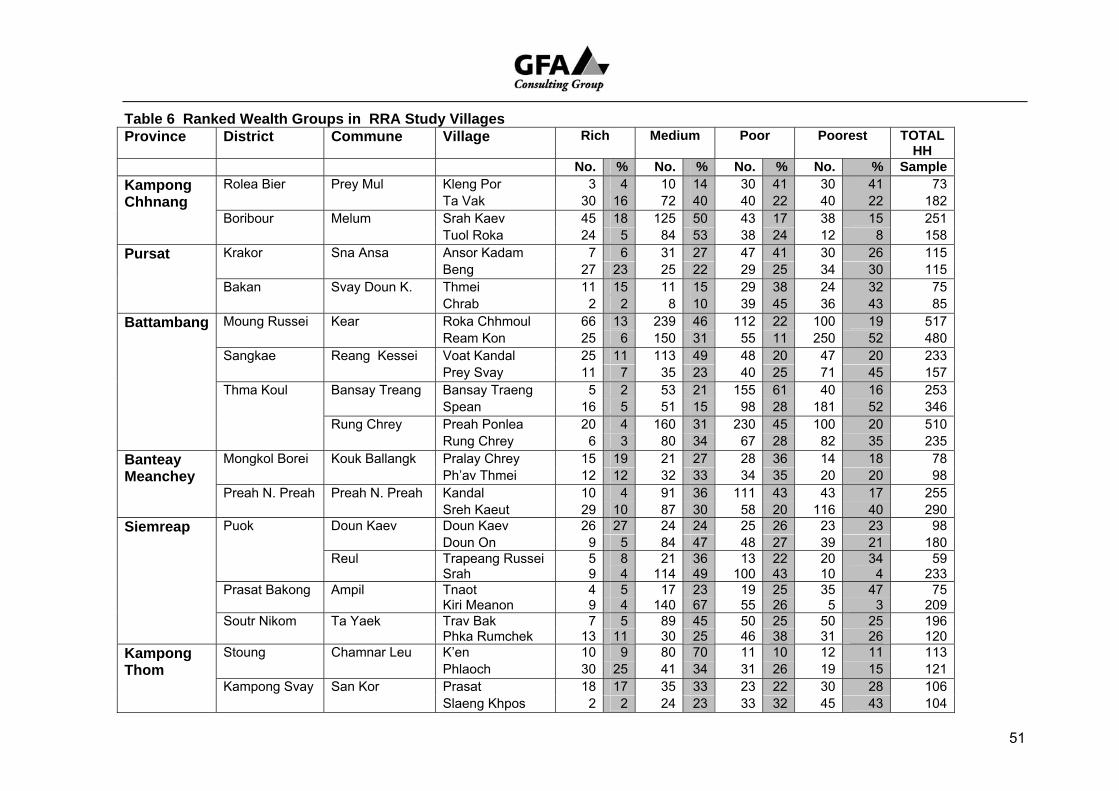
51
Table 6 Ranked Wealth Groups in RRA Study Villages Province District Commune Village Rich Medium Poor Poorest
TOTAL
HH No. % No. % o.N % o.N % SampleKampong Rolea Bier Prey Mul Kleng Por 3 4 10 14 30 41 30 41 73Chhnang Ta Vak 30 16 72 40 40 22 40 22 182 Boribour Melum Srah Kaev 45 18 125 50 43 17 38 15 251 Tuol Roka 24 5 84 53 38 24 12 8 158Pursat Krakor Sna Ansa Ansor Kadam 7 6 31 27 47 41 30 26 115 Beng 27 23 25 22 29 25 34 30 115 Bakan Svay Doun K. Thmei 11 15 11 15 29 38 24 32 75 Chrab 2 2 8 10 39 45 36 43 85Battambang Moung Russei Kear Roka Chhmoul 66 13 239 46 112 22 100 19 517 Ream Kon 25 6 150 31 55 11 250 52 480 Sangkae Reang Kessei Voat Kandal 25 11 113 49 48 20 47 20 233 Prey Svay 11 7 35 23 40 25 71 45 157 Thma Koul Bansay Treang Bansay Traeng 5 2 53 21 155 61 40 16 253 Spean 16 5 51 15 98 28 181 52 346 Rung Chrey Preah Ponlea 20 4 160 31 230 45 100 20 510 Rung Chrey 6 3 80 34 67 28 82 35 235Banteay Mongkol Borei Kouk Ballangk Pralay Chrey 15 19 21 27 28 36 14 18 78Meanchey Ph’av Thmei 12 12 32 33 34 35 20 20 98 Preah N. Preah Preah N. Preah Kandal 10 4 91 36 111 43 43 17 255 Sreh Kaeut 29 10 87 30 58 20 116 40 290Siemreap Puok Doun Kaev Doun Kaev 26 27 24 24 25 26 23 23 98 Doun On 9 5 84 47 48 27 39 21 180 Reul Trapeang Russei 5 8 21 36 13 22 20 34 59 Srah 9 4 114 49 100 43 10 4 233 Prasat Bakong Ampil Tnaot 4 5 17 23 19 25 35 47 75 Kiri Meanon 9 4 140 67 55 26 5 3 209 Soutr Nikom Ta Yaek Trav Bak 7 5 89 45 50 25 50 25 196 Phka Rumchek 13 11 30 25 46 38 31 26 120Kampong Stoung Chamnar Leu K’en 10 9 80 70 11 10 12 11 113Thom Phlaoch 30 25 41 34 31 26 19 15 121 Kampong Svay San Kor Prasat 18 17 35 33 23 22 30 28 106 Slaeng Khpos 2 2 24 23 33 32 45 43 104
Poor 29% of households surveyed were assigned to this group. These households are much more vulnerable and more dependent on wage labour.
• They do not own enough land of high enough quality to grow their rice needs. The land often has poorer access to water
• Only grow enough rice to last their households for 3-9 months (in some villages enough for 6-8 months would qualify a family as a Medium household)
• To make ends meet a family must gather food, fish and enter paid employment. If work cannot be found close to home, principally men, but also women look for work in neighbouring villages, towns and cities. In some areas closer to the border mainly men will go to Thailand.
• Some may own a cow or two and run chickens.
• The cost of keeping children at school is demanding and they are likely to be taken out of school early.
• Household demographic likely to show a disadvantageous ratio between workers and dependents. Difficult to get enough food on the table, indebtedness common; stress often leads to domestic violence, drinking, marriage breakdown. High proportion of “widowed” households
• In times of medical emergencies and the like they need to borrow locally and experience difficulty in discharging debts.
Poorest made up 26% of the total number of households surveyed. For them life is definitely a struggle.
• Many own and work a small area of land from as little as 0.05 to as much as 0.20 or more. Many more are landless. In some villages as many as 40 households are without land. 13 The land is of poor agricultural potential, the owners have little capacity to invest in fertiliser or the like and their yields are poor (500kg/ha or less)
• They grew little of their rice and food needs, must gather what they can, take rice in payment for work, and purchase the greater part of what they eat.
13 Ream Kon, Kear commune, Moung Russei district in Battambang should not be
listed among the poorest it is a semi urban settlement on Highway 5, the poorest, “landless” of 250 households are principally service industry workers
52
• Earning capacity low, largely restricted to unskilled labouring work.
• Have little or no credit worthiness because they are unable to repay loans in cash. Pay back food credits in labour often costed at disadvantageous rates to cover unpaid interest.
• Rely on family assistance where it is available. In absence of family social morale low, vulnerability high. Houses made of leaf and bamboo. Acquiring basic needs of food, shelter and clothing present a huge challenge.
4 . 3 S u m m a r y
The data indicates a degree of vulnerability that is worrying. If their capacity to face contingencies is to be taken into account 91% of households cannot rely on the land they farm and/or resources available in their immediate environment to survive. If they are to secure a livelihood they must look in one way or another to the world outside their home village to provide earning opportunities. Rural villages must be seen as dependent parts of a larger outside world.
It will become increasingly difficult for people to support themselves from their land. It would be unrealistic for the project to promote the idea that this is possible. Increasingly rapid differentiation is most likely to result in the continuing concentration of land in the hands of fewer and fewer better off farmers. Rural people like people all over the country want a better life and this is more likely to come with better paid employment opportunities perhaps within the wider region rather than within Cambodia.
55% of the households surveyed are poor or very poor. In the absence of work being available outside the village it is highly likely that these people would soon become very hungry. The implications of this are immense. In pursuing coping strategies the rural poor face profound subordination in which their ability to access wider civil, private and public sector services is often impeded by isolation, lack of knowledge, political alienation, cultural prejudice and so forth which denies access to existing transforming structures and processes or more importantly, building their own, which might enable them to strengthen their position. The importance of this should not be overlooked. The psychosocial impacts of inequality are considerable (Wilkinson: 1996; 2005). Any strategy that can ameliorate this and empower people in even modest ways by giving them a part in deciding what they need to do to make their lives better might well make a difference. The willingness of people to sit down with the RRA team and discuss their affairs indicates a place to start. Implementation of any project that follows the current TSLSP exercise must recommend a role for the on-going engagement of villagers in a carefully thought out participatory process.
53
5 S E A S O N A L C A L E N D A R
5 . 1 N a t u r e o f t h e E x e r c i s e
The Seasonal Calendar was used to map inputs into different farming and other economic and social activities during the year with a strong emphasis on gender. It was also intended to show patterns of stress and vulnerability, food shortage, human and livestock health patterns and important social and cultural activities. Done properly the diagram enables people to record activities and events and highlight particularly busy times of the year.
When a calendar is drawn on a large scale the exercise allows for the participation of many people. This provides an excellent opportunity for facilitators to interrogate the data with village participants and establish who does what and when, as well as what people do to cope with difficult times.
Unfortunately despite constant attempts to change facilitator attitudes this exercise was constantly abbreviated in a manner that prevented villagers from expressing themselves and providing the RRA team with a rare learning experience. Facilitators unnecessarily dominated proceedings, constructed and disassembled lines as they were completed and denied participants the chance to reflect on the overall relationship between different events that occur at about the same time.
To be fair the time constraint was felt very keenly by the team and they opted for efficiency at the cost of quality. In the early days of the survey, given the teams urban background this placed them at somewhat of a disadvantage. The facilitators working in Tuol Roka for example produced a calendar that shows rice being sown before the land was ploughed. This may well be the fault of careless transcription by the closeted translator and could be explained with a few additional questions but obviously should not have entered the record. If the fault lies at the field level then inadequate consultation with participants would account for the error.
5 . 2 G e n d e r
What the calendar shows most clearly is the heavy input of women into farming activities. This is especially heavily marked in villages in which farming provides only part of rural peoples livelihood and men must find off farm work to make up the deficit. Generally women are less mobile but the situation in many villages makes nonsense of this statement.
In Thma Kuol commune for instance as many men as women are likely to take up field harvesting contracts in Thailand. Whether a woman goes or not has more to do with her age and status and the nature of the job. An older married woman from a rich household is unlikely to seek wage labour anywhere but if her daughter can get a job as a garment factory worker the household is most likely to consider this a boon. A gang of agricultural workers travelling as a group to Thailand is more likely to include women. Casual workers travelling alone are more likely to be men.
When it comes to the rice crop men still do the ploughing and do their share of the harvest but the dominant role of women in all other tasks associated
54
55
with both wet season and dry season rice is clear. Women also take a large part of the responsibility for growing dry season crops like water melon, cucumber, maintaining kitchen gardens and providing animal care.
Overall men are the principal fishers and in some areas are more likely to trade agricultural goods. Anybody who has spent any time in rural markets will be quick to add that selling at the market is dominated by women and in the case referred to above trading is limited largely to the sale of agricultural produce to traders rather than selling from the market. Again it is difficult to generalise. In Thma Koul women do most of the selling of farm produce. .
The closer the data is scrutinised the more difficult it is to generalise. Few if any agricultural tasks are absolutely fixed by gender. The fields of a woman headed household are just as likely as not to be ploughed by the owner.
The implications for agricultural extension workers is quite clear. As equal if not always principal partners as farm managers women must be given a degree of attention equal to their role. This is even more important when the number of women headed households is taken into account.
The greatest impediment to the role of women being properly acknowledged by inviting their participation in extension courses and the like is the total number of tasks they perform as part of their routine as a parent, household manager, and farmer. Their heavy work load leaves them with very little discretionary time to take time off especially if it takes them away from their homes.
Wage labour
In provinces in which it is possible to find work on construction sites young people both men and women are likely to spend more than a 12 hour day getting to work, doing the job and returning home in the evening.
This was certainly the case in Siem Reap where young people from Puok in the north and Prasart Bakong in the south would get up at 4am, be on the road by 5am and in Siem Reap town before 8am to start work on a construction site. At the end of the day they would make the return journey and not get back to their home villages before 7pm. The average daily wage for this effort is a modest 5000 -6000 Riel. ($1.25 – $1.50).
A special report will be prepared by the gender specialist
5 . 3 C u l t i v a t i o n & P o l l u t i o n
Wet Season Rice
By far the most important crop is the main wet season rice crop which is grown largely under rain fed conditions. As has been documented by Paul Mosley (Report on Water Availability, September 2006: 61) the Monsoon does not always cooperate.
On upland fields and middle lands wet rice yields are not only affected by variable rainfall and the availability of water, soil quality also plays a big part. On the higher sandy, acidic soils with little organic material yields are as low as 500 kg/ha but mostly fall between 1,000 and 1,500 kg/ha. Where they could afford it farmers cultivating these yellow and grey sandy soils
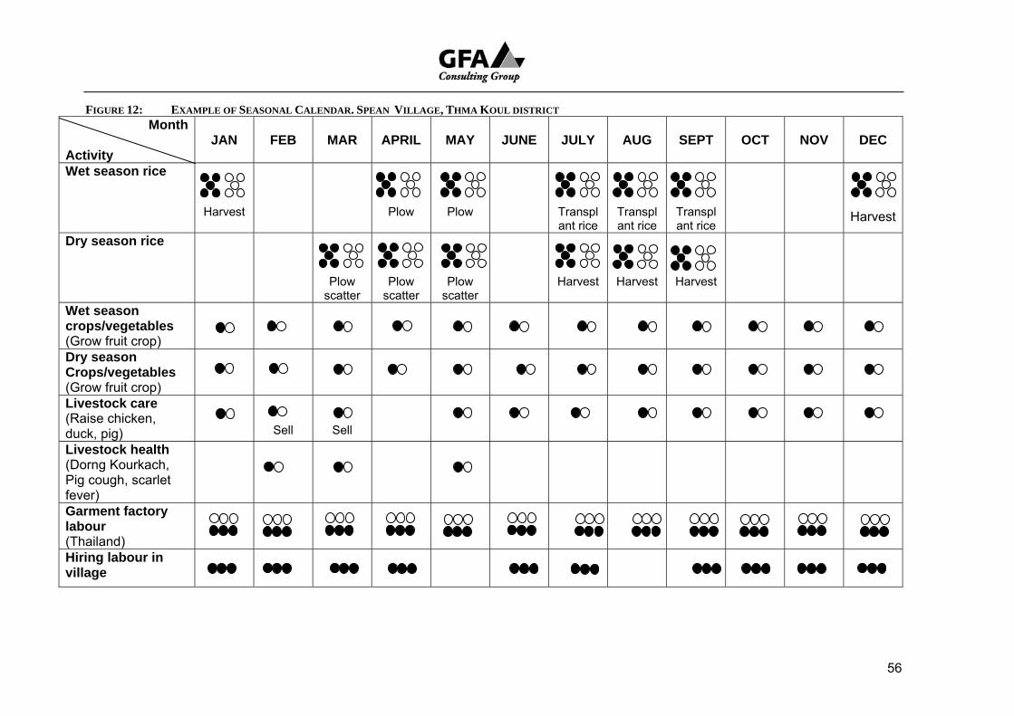
FIGURE 12: EXAMPLE OF SEASONAL CALENDAR. SPEAN VILLAGE, THMA KOUL DISTRICT Month
Activity
JAN
FEB
MAR
APRIL
MAY
JUNE
JULY
AUG
SEPT
OCT
NOV
DEC
Wet season rice
Harvest
Plow
Plow
Transplant rice
Transplant rice
Transplant rice
Harvest
Dry season rice
Plow scatter
Plow scatter
Plow scatter
Harvest
Harvest
Harvest
Wet season crops/vegetables (Grow fruit crop)
Dry season Crops/vegetables (Grow fruit crop)
Livestock care (Raise chicken, duck, pig)
Sell
Sell
Livestock health (Dorng Kourkach, Pig cough, scarlet fever)
Garment factory labour (Thailand)
Hiring labour in village
56
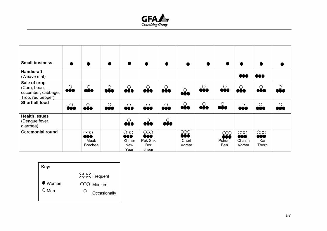
Small business
57
Handicraft (Weave mat)
Sale of crop (Corn, bean, cucumber, cabbage, Trob, red pepper)
Shortfall food
Health issues (Dengue fever, diarrhea)
Ceremonial round
Meak Borchea
Khmer New Year
Pek Sak Bor
chear
Chorl Vorsar
Pchum Ben
Chainh Vorsar
Kar Thern
Key:
Women
Men
Frequent
Medium
Occasionally
applied fertilizer (urea) usually between 50 kg and 20 kg/ha. but as much as 200kg/ha was put on fields of commercially grown rice on the relatively fertile soils of the Thma Koul district. Most farmers reported an increase in the use of fertilizer mixed with compost and told the RRA team that failure to do so resulted in greatly reduced yields.
On lowlands wet season rice is also the most common crop. In the north in Mongel Borei farmers talked of a preference for fresh water running down towards the lake with which to establish rice. If farmers had to rely on the early flood waters of the lake coming the other way the growth of seedlings was likely to be stunted and growth extremely slow. The water at the leading edge of the rising water was described as sour, acidic, a strange green milky colour.
Pollution is a problem. In the south at Slaeng Khpos in San Kor commune at the neck of the Tonle Sap close to the Stung Sen Core Area farmers talked of soil in the lower sections of their paddy fields just below the flood line becoming polluted by a deposit of cinders in which nothing would grow. As mentioned below the demise of floating rice is largely credited to pollution.
Most farmers grew several types of rice. Short term rice that matures in three to four months is favoured because it does not require a reliable supply of water over a longer period. The more traditional varieties have a longer maturation process and require a more reliable source of water.
Above all farmers voiced a strong interest in acquiring greater control over, and better access to water to grow more rice. In particular they want an enhanced capacity to capture early surface run-off; an increased ability to store water in canals, ditches, ponds over the main part of the season; a greater capacity to hold water to finish the crop at the end of the wet season; enough water stored to carry over to the dry season for another crop.
Floating rice
In the recent past those who live in Lowland villages close to the 10 metre contour just above the flood season, high level water mark, grew floating rice. In some places it is still grown (Mongkol Borei) but is less commonly found than in the past.
Floating rice was planted when the rainy season gets under way on land that could quite quickly become the bed of the lake and covered by up to a maximum five or six metres of water. Yields were never as good as most varieties of wet season rice (under 1 tonne/ha.) Returns were however, considered good enough to make an important contribution to household rice stores. RRA results indicate that this is no longer the case.
The exact reasons for the decline of floating rice are not clear. Farmers in Pursat cultivating land in close proximity to the lake shore explained that they had stopped growing floating rice because they had lost the seed of a particular variety that grew well in five or six metres of water. Attempts by a helpful NGO to replace it did not work: the substitute seed was unable to grow tall enough, quickly enough to keep its head above water long enough to set seed.
58
This simple explanation is appealing because it defines the problem in terms that make a solution look obvious: obtain suitable seed from either somewhere around the lake or overseas and the problem is solved.
Unfortunately subsequent field visits in Banteay Meanchey (Mongkol Borei and Preah Netr Preah) presented the issue in a more complex and pessimistic way. Farmers who have seed talked of ceasing to grow floating rice because yields were too low. According to these farmers low yields were the result of damage to the rice caused by the sour character and quality on the leading edge of the lake water as it rises: pollution of the rising water resulted in poor growth and weak plants.
Although there was not time to seek scientific observations that might identify the precise nature of either water contamination or the damage to plants, farmers universally agreed that the yields of floating rice have declined and those to whom we spoke no longer considered it a worthwhile crop. In Stoung district it was said, perhaps carelessly, that over 10,000 ha of former floating rice areas have been abandoned. This was put down to the “turbidity” which was rather mysteriously identified as a characteristic of the leading edge of the rising water closest to the shore line. A more scientific description of the problem is needed.
Dry season/recession rice
The RRA team encountered a strong interest in growing dry season or recession rice which is planted where residual soil moisture is high and enough water can be stored in ditches, reservoirs (ponds/earth tanks) in close proximity to cultivable areas to provide supplementary irrigation.
Where possible recession rice is planted both:
• in rain fed bunded fields sometimes well above the shore of the annual flood plain into which stored water may be pumped from holding areas. Such storage facilities were in some places also seen as a possible way of establishing seed beds for the rainy season or finish rice crops at the end of a poor Monsoon; and,
• on the bed of the lake as water levels drop. It is here on the alluvial
soils that the best yields are obtained. Under commercial cultivation these are reliably over 5 tonne per ha and under less capital intensive management (fertilizer, insecticides and herbicides) villagers can get 3,000 to 4,000kg /ha.
It is the latter type of farming that is likely to have a substantial impact on the ecology of the land. Farmers in both Mongkol Borei commune on the north end of the lake and San Kor commune on the south end complained about pollutants. Pollution and commercial development The scale of some of the commercial operations in Kompong Thom are remarkable. Leases have been taken out with local officials on land formerly worked by villagers. The villagers are usually offered either:
• a pro-forma opportunity to take up fields in the development area; or • payment of some compensation.
59
Until now, because of the high cost of inputs, heavy top down management, and their uncomfortably subordinate position farmers have chosen the compensation option. Rather than distribute the money directly to farmers the money has been used to set up a credit fund which is open to all villagers In Chamar Kraom commune development consists of building a tank (if the maps are to be believed ) of 1 and 2km² (See RRA Working Report 6, Kompong Thom Province). The walls are said to be several metres high. The paddy fields are formed below the tank and water is released as required. When and as needed pumps may also be used. As these tanks were under water when the RRA was carried out they could not be seen. Another visit needs to be made and scheduled at a better time of year.
5 . 4 G r a z i n g a n d t h e A l i e n a t i o n o f L a n d
Livestock are an important part of the asset assembly of rural people. Everybody owns some animals. Even the poorest of the poor are likely to own a few chickens.
As a general rule the wealthier the household the more livestock owned. The wealth ranking tables show this quite clearly. For less well off households buffalos and cows provide a walking insurance policy. When money is needed to meet an emergency an animal can be sold.
A census of livestock was not attempted but from the number of animal along rural roads, tethered clear of the rice fields village herds must be large. Looking after them is a demand that spills over onto the land use of the Tonle Sap annual flood plain.
Farmers with traditional tenure rights to the lake bed talked of a yearly relocation down in the direction of the Tonle Sap to feed their livestock. Following the main rice harvest (January) when the soils begin to dry and the grass on the upland and middle lands withers whole families or in some cases just young men take their cows and buffalo on to the grassland above the lake shore. In some villages in Siem Reap the RRA team was told that 90% of households send at least one of two members of the family down to the flood plain where they are expected to remain until Khmer New Year (April) when the first rains come in and preparation of the fields should begin.
It is only villages with a tradition of transhumance and a place to go who do this. The flood plain is not an open range common but a territory with claimants whose families have often used specific areas for generations. As is discussed below under Mobility rural people moving to cool season pastures and lakes left behind on the flood plain are increasingly shocked to find that the land on which their stilted houses are built to provide seasonal shelter have been sold or leased out by corrupt officials to moneyed interests intent on either the commercial or leisure development of what farmers consider to be theirs.
60
5 . 5 C e r e m o n i a l O b l i g a t i o n s
What figured large in peoples lives were the occasions that mark the ceremonial round. Holidays such as Phchum Bin, Khmer New Year and Holy Days on the Buddhist Calendar were particularly important. National holidays celebrated in the capital by civil servants and the like were not considered to be so important
Here again there was little gender bias in the results. Men and women participated equally and, when a donation or contribution to a new building was proposed each household gave as much as it could afford. Even the very poor participated by contributing a small amount. Although no attempt was made to collect exact figures on what was spent, mobility maps show that pilgrimages to special sites were often a feature of these occasions.
Households used these occasions to demonstrate their membership in the community and maintain their dignity.
5 . 6 S u m m a r y
What the calendar shows most clearly is the heavy input of women into farming activities. This is especially marked in villages and for socioeconomic groups in which farming provides only a part of peoples livelihood and men must find off farm work elsewhere to make up the household food and daily living deficits.
The overall allocation of labour shows that a wide range of tasks are performed. Labour shortages can occur at peak periods and those away on migrant labour tasks usually return at these times (land preparation, harvest). We have already seen that a strict division of labour along gender lines is not a feature of the rural calendar. Although gender enters into calculations, age and skill are also figure prominently in the allocation of work.
Because such a large proportion of households depend on earnings from off farm work the role of the young, fit and healthy plays an important part in determining wealth and welfare. It is the young who undertake work in garment factories and who are expected to cycle for several hours a day to Siem Reap from outlying districts to earn money for their families.
Although there was always talk of the need to grow more rice either as a second wet season crop or a dry season crop it was not only the unavailability of water that made this problematic. Yields are low. !,500kg/ha was considered satisfactory and many farmers harvest much less than this. The consultants were inclined to ask, even if water was miraculously made available would the effort involved in producing another crop be worth it? If off farm employment provided better returns, why should farmers bother? The development potential of agriculture around the lake appears to be very limited.
61
6 M O B I L I T Y
The RRA team was asked to interview three or four households in each village, one from each wealth group to both check the ranking itself and map family mobility. The exercise was designed to elicit movements people made: daily, short term (of a week or so), long term (several months or so), seasonally and backed up by the destinations chosen.
The first few sets of interviews for Kampong Chhnang were not well done. One map was considered enough for the whole village. In Pursat results were better but as with so many of the exercises the accompanying observations at the meta information level were not recorded. Overall the level of detail remained disappointing and the interesting stores remained missing. Little more was gathered than could have been more systematically collected with a purely quantitative questionnaire.
What clearly emerged from the study was the high level of mobility and the critical role it plays in the coping strategies of all the rural RRA participants to whom the team spoke. As expected the best well off make more longer trips for both business and pleasure than any other group. There is an element of compulsion to most journeys made by others. All but the rich rely to some extent on off farm employment to secure a livelihood and destinations as far away as Thailand figure remarkably frequently in individual family strategies.
6 . 1 D a i l y m o v e m e n t s
Daily movements were largely restricted to village, fields, surrounding forest and waterways and market. Current activities tended to dominate responses. Rice was mostly recently planted and weeding had not yet become a necessity. Here and there early short term rice was being harvested (Crab). Mainly fishing but also trapping frogs were still on the daily agenda. The period over which the survey was conducted was also a time of food shortage and fish provide an important source of protein.
Poorer households accepted work in the village for wages as low as 3000 Riel and were just as likely to accept rice as payment. Many were employed in work they were obliged to provide as a part of a reciprocal arrangement (provos dei) under which they had borrowed food or money and were now paying off the debt. This mostly involved work in the fields. Poorer households also spent a lot of time foraging for food and looking for work. Those who lived close to market towns sought work as porters
In Siem Riep as already mentioned many young people cycled daily into town from distances of more than 30 kilometers. Their expected daily wage working as labourers on construction sites was 5000 Riel. In some cases gender discrimination was practiced and women were paid 1000 Riel less than men. If the worker could offer a skill or were qualified carpenters there daily rate was more in the vicinity of 10,000 to 12,000 Riel.
As has been observed elsewhere in this report rural people were well aware of the advantage of higher wages received by those with qualifications and skills and frequently listed occupational training as a development request.
62
FIGURE 13: MOBILITY MAP EXAMPLE: POOR & VERY POOR HOUSEHOLDS SIEM REAP
C
hor M
ount
ain
- Hire
d la
bour
. Tra
nspo
rt a
nd
cut f
irew
ood
& ti
mbe
r - P
aid:
300
0-40
00R
/day
Hea
lth c
entr
e - M
edic
al c
heck
up
Thai
land
- W
ork
as h
ired
labo
ur
- Inc
ome:
200
00R
/da y
Siem
Rea
p
- Wor
k on
con
stru
ctio
n si
tes
- Inc
ome:
600
0-80
00R
/day
- Put
in s
ewer
pip
es
Mar
ket
- Wor
k on
con
stru
ctio
n si
tes
- Hire
d to
saw
woo
d
Tonl
e Sa
p La
ke
- Pai
d co
mm
erci
al fi
sher
- Par
t of 4
man
team
Sm
ourn
h N
atur
al p
ond
- Go
fishi
ng fo
r one
day
- B
oth
men
and
wom
en
Mov
e do
wn
to T
onle
Sap
- G
o fis
hing
and
tend
cat
tle
(2-3
day
s)
63
6 . 2 S e a s o n a l m i g r a t i o n
Farming work related to rice cultivation formed the focus of seasonal work. Establishing seedling beds, preparing the fields shortly after the first rains involves a lot of work and men were expected to be home with their families to do the ploughing and sowing. The other busy time is the harvest at the end of the western calendar year which sometimes spills over to January.
If there is not enough paid employment available in the village or immediate vicinity men are likely to leave their home village when the rice is planted and look for work elsewhere. Many show considerable initiative. In some villages up to 90% of households like the villagers of K’en in Kampong Thom will send at least one person off to the flood plain and gather around a body of water close to the Tonle Sap like Boeng Kamou and make it their home for the season. Other rural people like the villagers of Trav Bak (Siem Reap) for whom seasonal migration to the Great Lake is not an inherited practice shorter forays into the upland forest of Svay Leu is more likely to attract their attention over shorter period of a couple of weeks at a time.
Sale of grass
In the wet season because the area over which cattle and buffalo can range is limited they are restricted to higher land and road embankments. Available grass is quickly eaten out. Fodder is often in short supply and men in villages close to the rising waters of the lake spend their days harvesting ‘floating’ grass from canoes and transporting it to market where it is sold in bundles to farmers on the middle lands. For many householders in Preah Netr Preah commune (Banteay Meanchey) this was an important activity
Recession rice
Commercially grown dry season rice on the lake bed commences as the lake drops to its lower dry season level and the ground becomes firm enough to run tractors without getting bogged. Farmers dry season fields in this area tend to be closer to the low season shore line so their planting is delayed. Establishing this rice is an urgent business, the rice has to be harvested before the lake rises again. For a while at least this crop improves the chances of local employment.
Seasonal transhumance: temporary homes on lake bed
Perhaps the most significant movement of interest to the TRLSP is the seasonal migration of rural people down onto the seasonally flooded bed of the Tonle Sap.
The greater number of people move after the harvest of the wet season rice when residual ground moisture on higher land drops and areas in which they pasture livestock begin to dry up, the grass becomes sparse and what remains turns brown.
By this time travelling over the dried bed of the lake is not too difficult. Some farmers undertake a journey of more than 60 kilometres, taking most of their family and a large part of their household piled up on a trailer pulled behind an iron buffalo tractor. Better off farmers like this go down to residual lakes, take up residence in cool season houses, fish, make plahoc
64
and like all the other temporary residents of the flood plain return to their upland homes after Khmer New Year when the first rains come in.
Feed for Livestock
For most farmers this discretionary aspect is replaced by a very real need to move livestock down to where they can find enough feed. Livestock are particularly important in communities in which farmers do not have access to enough land to grow their own rice needs, for insurance in time of medical or ceremonial need and so forth. On open range lands there is enough grass to provide the needs of a large herd but access is part of a cultural understanding. Tenure rights certainly apply to families taking up residence in places close to good fishing. The team was told that in some places land had been cleared and was cultivated over the dry season. Traditional rights of tenure also applied to this land. Grazing rights are more complex and less fixed.
Indigenous Tenure
The point is that traditional rights of tenure apply across the board and any interlopers who come in and alienate land for commercial purposes are not welcome.
Management of the transition zone must include these tenure holders and acknowledge their position as indigenous people with established rights to resources. Under regimes of low population, restrained harvesting of fish, good management of waste, organic farming in the watershed of the greater Tonle Sap Basin and use of a minimum of chemical fertilizer, herbicide and insecticide: the migration of people down to the seasonally inundated area was sustainable. The advent of modern farming, the use of more chemicals, the presence of more people has inevitably brought in its train increased demands on the ecosystem. As the principal land users these people must be included in deciding on future management of the transition zone
In Chamar Kraom commune just south of the RRA target commune of Chamar Leu in Kampong Thom indigenous tenure rights were informally acknowledged in the form of an allocation of one of four tanks to villagers. The villagers in turn rented it back to the company for which they were paid a rent of $3000 (2005) divided between 10 villages, notionally $300 each, of which the commune retained part to meet Seila local contribution fees in support of approved Local Planning Process projects and individual villages set up credit circles.
Not all developers nor local officials are prepared to acknowledge indigenous rights. In Battambang the sale/lease of a lake in the transition zone was discovered as a fait accompli. Land and waters used for generations by farmers had for a considerable fee been given by local officials to developers who denied the indigenous tenure holders access to their rights. If the ADB is concerned for indigenous rights is this not a concern that should be extended to indigenous Khmer?
6 . 3 C i r c u l a r m i g r a t i o n
Although movement down to the lake and back or up to the forest and down again is a type of short term circular migration, the term is used here
65
to refer to movement conducted over a longer period in pursuit of commercial gain.
Garment industry
Employment in the garment industry involves a considerable number of young women throughout the study area. From the record compiled by the study team these young women are paid on average $40 a month and manage to remit on average up to $20 a month to their parents household. They are obliged to take up residence in Phnom Penh where they often share accommodation in crowded quarters, and where the opportunity is offered are willing to undertake extended hours overtime work to increase their wages. This additional work can push their wage up to $70 a month and although it is most probably apocryphal, the team was told of one young woman who in one month managed to earn over $100.
The impact of this addition source of income on the average rural household is considerable. In Ta Vak, Pursat it was an addition that made life comfortable. For the few families in Kleng Por who were fortunate to have a few daughter so employed it provided them with the money to buy their basic needs. Whatever criticism ad charges of exploitation to which the industry is subject it is not a view held by the villagers. Employment in the garment industry is seen as a privilege and a privilege for which, as necessary, they are willing to pay those who recruit labour.
The numbers can be quite high and the impact of the demography of a village profound. K’en village, Kompong Thom with a total population of 1,686 had 105 young people away in Phnom Penh, the majority of them young women, and 108 most young men in Thailand.
These women stay on the job for as long as they can but as they age they are increasingly likely to lose their job. If they marry, become pregnant, as they lose their youthful vigour their chances of remaining diminish. They are classified here as circular migrants because their engagement is considered to be age specific. The young men in Thailand are subject to an even briefer tenure and their period away rarely exceeds a year.
Work in Thailand
All around the Tonle Sap the team met people who had made the return journey to Thailand. This is relatively short term migration. Most came from Battambang and Banteay Meanchey but as noted in the paragraph above Kompong Thom is not too far away. The majority had gone to the border area to harvest beans and other agricultural crops but engagement through labour contractors took people into the construction industry and factory work for months at a time. The difference in the wages alone makes it worthwhile. For example the labourers from poorer families in Siem Reap could earn up to $5 a day in Thailand when the best paid work he could find in Cambodia paid only $1.50 or at best $2.
The attraction of such well paid work encourages some to take the risk of entering Thailand without the proper papers and/or in the absence of a patron. Difficulties are strew in the path of such people.
According to villagers their illegal status leaves them open to exploitation and they are invariably paid lower wages. If they are caught and convicted any money they have managed to save is taken from them, they are jailed for three months and then expelled.
66

Most labour is recruited by people who make this their business and charge different fees depending on where they are. In Kompong Thom the standard charge to arrange a passport and visa is 1,200 baht (approximately $33). In Battambang (several villages) a fee of 300,000 Riel ($75) was paid to arrange papers, transport and work. In Battambang the most common destination were commercial farms close to the border. People are put to work harvesting field crops like beans and the like.
6 . 4 S u m m a r y
For the better off mobility is a discretionary privilege: for the poor it is a matter of necessity.
Daily migration and extended circular migration to metropolitan or agro-industrial areas in search of wage labour was found to be of major importance. It involved both women and men in the younger age cohorts and in some cases removed over two hundred people for extended periods over several months at a time. In the village of K’en in Kampong Thom 12.6% of young people were away in either Phnom Penh or Thailand. In the neighbouring village of Phlaoch 48 young women were working in garment factories in Phnom Penh and according to their parents, welcomed heavy overtime hours which would enable them to get their monthly payments into the $70 range. In the same village 23 young men were in Thailand working in the construction industry. In the study villages of Battambang, and Banteay Meanchey this pattern was repeated but destinations in Thailand replaced Phnom Penh.
In the Siem Reap study areas nearly all young people had taken or were taking the long daily bicycle ride into town from Puok district and Prasat Bakong district in search of labouring jobs on construction sites. Depending on the distance they have to travel, people leave their homes between 4 and 5am and return after dark, between 7 and 8pm. Some carry their food with them and others make do with what they can buy along the way. In some cases children were taken out of school to make the ride. One of the RRA team went so far as to point out that in some villages the rate of youth employment was so high that it appeared that the adults were largely living off the earnings of their children. As schools were only just resuming over the period of our visit it was not possible to verify this remark by direct observation.
The draw of urban employment is very strong. It was estimated that for every village with reasonable access to transport and in which fieldwork was carried out up to 20% of families may send at least one member of their household to find wage labour in cities like Battambang, Siem Reap and Phnom Phen. This trend to urban or agro-industrial employment is most probably of greater long term significance than the draw of seasonal migration down to the Tonle Sap. It appeared that people from better serviced villages with a higher level of formal education were much more likely than those from less well serviced villages to:
• seek work in more sophisticated and differentiated labour markets; and
• send younger people away for longer periods.
67
Those who are better off have a more confident world view, have more vocational skills, are familiar with travel options, are more likely to be able to keep in touch with relatives by mobile phone, and most probably better equipped to extend their vocational training and arrange for remittance of earnings back to family.
In most cases proximity to urban centres seemed to determine this response. The village of Ream Kon, Kear commune in Battambang which straddles Highway 5 and to which an RRA team was assigned by DOWRAM (largely because of a failed water management system on the Stoeng Moung Russei (river) was in fact a peri-urban settlement. Half of the residents earned their living providing the servicing needs of both:
• rural people in the surrounding countryside (markets, basic commodities, fuel) vehicles, passengers; and,
• other people from truck drivers to passengers travelling between Phnom Penh and the northwest towns of Poi Pet, Sisophon and Battambang.
The farmer bias of the focus group saw to it that the urban interests of the mistakenly classified 250 landless urban households were entirely ignored.
At the lower end of the socioeconomic scale the more isolated, the less well educated, more heavily subordinated, the less well off are more likely to look to their immediate natural environment for life support such as fishing, hunting and gathering or limit their search for work to rural Cambodia.
For example:
• Apart from a few daughters employed in the garment industry the people of Kleng Por, Prey Mul commune in Kampong Chhnang looked solely employment along the Tonle Sap to make what they could of a difficult situation.
• In Srah village, Reul commune, Siem Reap villagers arrived after the Paris settlement and cleared farms in the forest. Only one or two people can read and write. For residents even getting out to Highway 6 is expensive and it costs up to $13 to hire a motorized vehicle to take them to Siem Reap town. They are too far away from the town to travel back and forth each day. People survive as best they can on what is available locally
The poorest, landless villagers of Trav Bak are also Khmer Rouge refugees. They came home from Anlong Vieng in 1997 to find all the village land had been allocated. They live on what they can gather, cut firewood for sale in an adjoining forest, make thatching from Imperata grass and rather than go further a field in search of better paid employment the adults in these 40 households chose to plant and harvest rice in Battambang and Banteay Meanchey.
It appears that the future of rural people around the Tonle Sap will increasingly rely on a prosperous and growing urban sector. How this might be incorporated into a project design remains to be considered.
68
7 I N S T I T U T I O N A L R E L A T I O N S H I P S
Initially the Venn diagram presented facilitators with a challenge they did not cope with very well. Instead of listing and ranking the importance of the various institutions villagers maintained relationships with, and then placing these on the diagram in a manner which indicated the distance/closeness of these institutions to the villagers, facilitators tended to merge the two. The institutions that were important were all close to the village; the least important far away: there was no tension between the rank and placement. This was one exercise that was mastered and the results achieved by the RRA team improved over the course of fieldwork.
An example is presented over the page, the Venn diagram for Trapaeng Russei (Figure 13) of one of the better exercises and replicates the pattern found in many other villages.
When included for consideration the importance and proximity of the village chief and the commune chief was repeated in most diagrams. These are the two institutions that are most indispensable. The central position of the traditional birth attendant is pleasing and may say something about the presence of two reproductive health NGOs working in the village.
What is remarkable though is not only the number of NGOs working in the community (10) but the fact that three of them are included in the inner circle: RACHA14, CARITAS (Catholic Church aid agency) and Forever Friendship. Villagers are saying that they have a closer relationship with these NGOs than they have with most of the formal Khmer government agencies with whom they have a relationship including the Seila Programme, Health Centre, and market. The lack of engagement with other important institutions such as the Pagoda and school raises questions that require explanation but unfortunately this is not part of the record of the exercise available in English.
NGOs named in Figure 13
CARITAS Catholic Church aid agency
CWDA Cambodian Women’s Development Agency
DC District Credit (Name not confirmed)
FF Forever Friendship (Name not confirmed)
LICADHO Cambodian League for the Promotion and Defence of Human Rights
LP Literacy Programme (Name not confirmed)
RACHA Reproductive and Child Health Alliance
RHAC Reproductive Health Association of Cambodia
14 RACHA is an abbreviation of what is sometimes listed as RACHANA
69

WV World Vision
YCC Youth Council of Cambodia
70
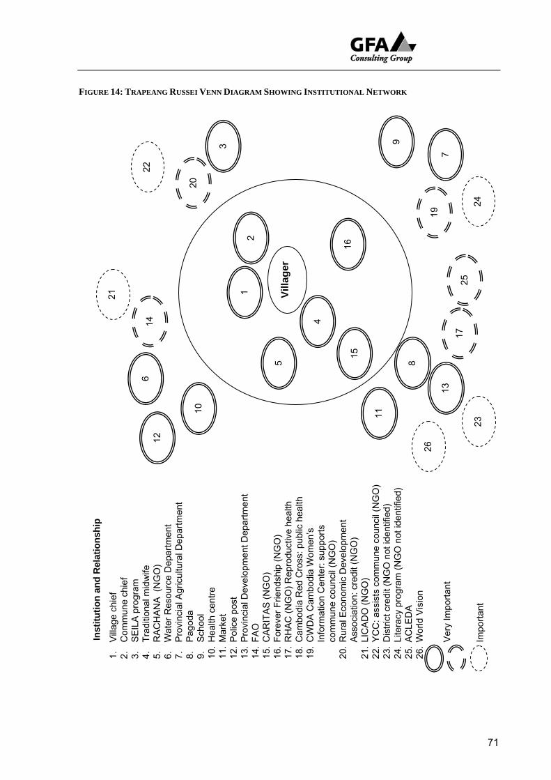
FIGURE 14: TRAPEANG RUSSEI VENN DIAGRAM SHOWING INSTITUTIONAL NETWORK
Villa
ger
1 21
2
5
4
15
16
12
3
10
22
14
20
6
11
8
13
19
17
26
23
24
7
9
25
Inst
itutio
n an
d R
elat
ions
hip
1.
Villa
ge c
hief
2.
C
omm
une
chie
f 3.
S
EIL
A p
rogr
am
4.
Trad
ition
al m
idw
ife
5.
RA
CH
AN
A (
NG
O)
6.
Wat
er R
esou
rce
Dep
artm
ent
7.
Pro
vinc
ial A
gric
ultu
ral D
epar
tmen
t 8.
P
agod
a 9.
S
choo
l 10
. H
ealth
cen
tre
11.
Mar
ket
12.
Pol
ice
post
13
. P
rovi
ncia
l Dev
elop
men
t Dep
artm
ent
14.
FAO
15
. C
AR
ITA
S (N
GO
) 16
. Fo
reve
r Frie
ndsh
ip (N
GO
) 17
. R
HAC
(NG
O) R
epro
duct
ive
heal
th
18.
Cam
bodi
a R
ed C
ross
: pub
lic h
ealth
19
. C
WD
A C
ambo
dia
Wom
en’s
In
form
atio
n C
ente
r: su
ppor
ts
com
mun
e co
unci
l (N
GO
) 20
. R
ural
Eco
nom
ic D
evel
opm
ent
Asso
ciat
ion:
cre
dit (
NG
O)
21.
LIC
AD
O (N
GO
) 22
. Y
CC
: ass
ists
com
mun
e co
unci
l (N
GO
) 23
. D
istri
ct c
redi
t (N
GO
not
iden
tifie
d)
24.
Lite
racy
pro
gram
(NG
O n
ot id
entif
ied)
25
. A
CLE
DA
26
. W
orld
Vis
ion
Ver
y Im
porta
nt
Impo
rtant
71
7 . 1 S u m m a r y
What this diagram has to say, given that the observations can be verified with reference to similar diagrams reproduced in the RRA Working Reports is that to be effective at grassroots level projects need to work with all three of the following: commune chiefs, village chiefs and NGOs. There may be up to 144 NGOs working in the region of the Tonle Sap, many employ civil servants and provide the living wage the government cannot afford. Subcontracting NGOs to carry out livelihood enhancement work makes good sense.
Decentralisation and de-concentration is not just about spreading government departments and bureaucratic processes, most of all it should focus on empowering citizens to manage their own affairs. Anything that contributes to strengthening the commune and the position of village chiefs, and here in Trapaeng Russei anything that can be done to revive the missing Village Development Committee would promote and enhance self government.
72
8 D E V E L O P M E N T P R I O R I T I E S
In the course of the RRA an Issues Matrix was kept. Both the RRA team and consultants were asked to record matters as they came up in the course of PRA tools, or out of casual conversation that presented a problem, challenge or suggested as an idea or plan about how to change things for the better. Towards the end of each village RRA these issues were put together, reviewed and in keeping with the policy of asking women and men to provide separate evaluations, women and men were given a set of one of two differently coloured counters to allocated as they thought fit. The allocation took the form of voting according to how important the individual man or woman thought the matters were/are. The resulting scores were used to rank the issues and form the underlying rational for the tables and figures presented in this chapter.
The unprocessed data is available in the six RRA Working Reports. A digital summary for each village showing a gender specific ranking is available on the TSLSP Z drive under PRA Specialist, RRA Results.
The information from the RRA Working Reports has for convenience been grouped to allow all the results to be assembled and summarised. Without entering into a tedious explanation of the details involved those with a special interest should refer to the RRA Working Reports, look at the right hand column in Table 7. If it is still difficult to follow what has been done, refer the matter to the PRA Specialist.
As Table 7 shows there is a high level of agreement between men and women on what is important.
Water management, especially as it concerns agriculture was the top issue raised by 94% of villages and is a major concern for both men and women. This category includes the diversion, capture and storage of water principally for growing rice. No distinction is made in the table between main season wet rice and dry rice but farmers all around the lake made a case for improved water supply that encompassed everything from reliable single cropping to extensive multiple cropping depending on how they evaluated the rice growing potential of their local environment.
Tanks and ponds from which the intention was to gravity feed or pump water to irrigate rice was included in this category. Ponds to hand irrigate vegetables, water livestock and so forth would in practical terms could have been included but because of the difficulty of excluding purely domestic tasks such as washing bodies, clothes and dishes it was decided to separate this in a Pond category of its own.
That there should be such a gender agreement about water for agricultural purposes is hardly surprising. As was shown in the Seasonal Calendar data farming is a shared enterprise in which both men and women play and important role. Only ploughing is dominated by men. All other tasks including management and planning is shared equally with women.
Roads and Bridges – communications was raised by 28 of the 32 study villages and overall ranked second by women and first equal by men. Roads are not a TSLSP priority but no attempt was made in the RRA exercise to influence the outcome.
73
Here some matters of agricultural importance have been obscured. Roads form embankments. Too often less than satisfactory arrangements are made to allow for controlled surface run off. After heavy rains water builds up behind these embankments and floods rice fields. If the water stands for too long the rice drowns. This is a consequence of building roads with too few bridges and/or culverts. This matter could equally as well be considered a matter of agricultural importance but then so could roads. Farmers especially in relatively isolated areas talked about the difficulty of getting anywhere in the wet season, getting children to school, getting sick people and pregnant mothers to medical centres, getting produce to markets, getting to work and so on. The problem was not just limited to isolated areas. Farmers in areas of high rice production like Thma Koul were equally vociferous. There, not far from National Highway 58 early crops of harvested rice were stranded in the fields. If produce cannot be transported to dry storage this does not make for good business.
Health and hygiene related issues were raised in 28 of the 32 villages (87%). The category includes a wide range of items. Latrines for instance were listed with surprising frequency. At first the consultant was highly suspicious of this as if it was being strongly suggested by RRA facilitators. When brought up in monitoring meetings this was denied. This matter was never really properly settled. If could well be that government and NGO awareness raising programmes are working and villager listing was spontaneous. Health centres and the availability of medications was a general matter of concern. Overall health and hygiene matters were ranked slightly higher by women (3) than men (5).
Wells, drinking water another matter of wide concern with over 80% of villages addressing the matter was ranked in a manner similar to that of health and hygiene. Here initial counting was confused by the translation of “jar” into “barrel”, a term used just as frequently for “irrigation tanks” and it took a while for this confusion to be cleared up and the ranking now fairly represents the level of community concern.
Seeds, fertilizers and pest control focused particularly strongly on the infestation of crabs and rats and the impact this was having on rice production. This is a major issue of concern raised by 65% of villages most of which are in lowland areas close to the Tonle Sap. An attempt to control this infestation has resulted in farmers using pesticides that kill fish and other aquatic life thus raising the level of pollution that farmers closest to the lake complain of. This problem of pollution was raised by farmers in both Mongkol Borei (Banteay Meanchey) and Kompong Thom.
Rather than run through each line in Table 7 readers can easily see for themselves how the listed matters are rated.
A similar layout is used for Table 8 which lists most but not all of the minor issues raised in village studies. Minor in this case means that only three or fewer than three villages raised this matter. Given that specific issues can be very important the label of ”minor” should not be used to dismiss the matter but remind us that effective development needs to be negotiated in specific participatory terms rather than implemented as top-down generalisations.
74
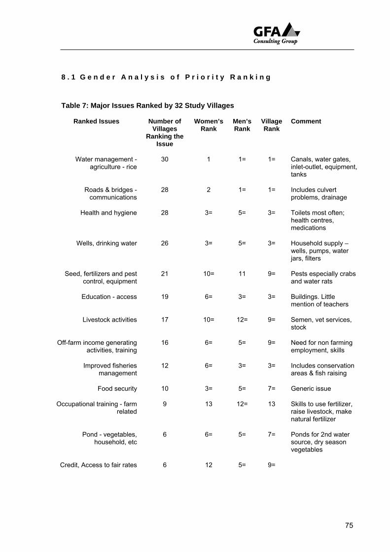
8 . 1 G e n d e r A n a l y s i s o f P r i o r i t y R a n k i n g
Table 7: Major Issues Ranked by 32 Study Villages
Ranked Issues Number of Villages
Ranking the Issue
Women’s Rank
Men’s Rank
Village Rank
Comment
Water management - agriculture - rice
30 1 1= 1= Canals, water gates, inlet-outlet, equipment, tanks
Roads & bridges - communications
28 2 1= 1= Includes culvert problems, drainage
Health and hygiene 28 3= 5= 3= Toilets most often; health centres, medications
Wells, drinking water 26 3= 5= 3= Household supply – wells, pumps, water jars, filters
Seed, fertilizers and pest control, equipment
21 10= 11 9= Pests especially crabs and water rats
Education - access 19 6= 3= 3= Buildings. Little mention of teachers
Livestock activities 17 10= 12= 9= Semen, vet services, stock
Off-farm income generating activities, training
16 6= 5= 9= Need for non farming employment, skills
Improved fisheries management
12 6= 3= 3= Includes conservation areas & fish raising
Food security 10 3= 5= 7= Generic issue
Occupational training - farm related
9 13 12= 13 Skills to use fertilizer, raise livestock, make natural fertilizer
Pond - vegetables, household, etc
6 6= 5= 7= Ponds for 2nd water source, dry season vegetables
Credit, Access to fair rates 6 12 5= 9=
75
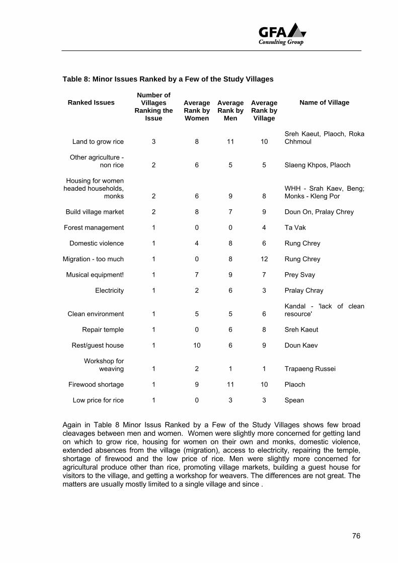
Table 8: Minor Issues Ranked by a Few of the Study Villages
Ranked Issues
Number of Villages
Ranking the Issue
Average Rank by Women
Average Rank by
Men
Average Rank by Village
Name of Village
Land to grow rice 3 8 11 10 Sreh Kaeut, Plaoch, Roka Chhmoul
Other agriculture - non rice 2 6 5 5 Slaeng Khpos, Plaoch
Housing for women headed households,
monks 2 6 9 8 WHH - Srah Kaev, Beng; Monks - Kleng Por
Build village market 2 8 7 9 Doun On, Pralay Chrey
Forest management 1 0 0 4 Ta Vak
Domestic violence 1 4 8 6 Rung Chrey
Migration - too much 1 0 8 12 Rung Chrey
Musical equipment! 1 7 9 7 Prey Svay
Electricity 1 2 6 3 Pralay Chray
Clean environment 1 5 5 6 Kandal - 'lack of clean resource'
Repair temple 1 0 6 8 Sreh Kaeut
Rest/guest house 1 10 6 9 Doun Kaev
Workshop for weaving 1 2 1 1 Trapaeng Russei
Firewood shortage 1 9 11 10 Plaoch
Low price for rice 1 0 3 3 Spean
Again in Table 8 Minor Issus Ranked by a Few of the Study Villages shows few broad cleavages between men and women. Women were slightly more concerned for getting land on which to grow rice, housing for women on their own and monks, domestic violence, extended absences from the village (migration), access to electricity, repairing the temple, shortage of firewood and the low price of rice. Men were slightly more concerned for agricultural produce other than rice, promoting village markets, building a guest house for visitors to the village, and getting a workshop for weavers. The differences are not great. The matters are usually mostly limited to a single village and since .
76
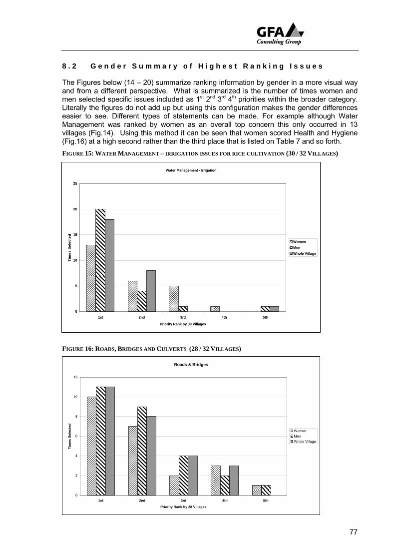
8 . 2 G e n d e r S u m m a r y o f H i g h e s t R a n k i n g I s s u e s
The Figures below (14 – 20) summarize ranking information by gender in a more visual way and from a different perspective. What is summarized is the number of times women and men selected specific issues included as 1st 2nd 3rd 4th priorities within the broader category. Literally the figures do not add up but using this configuration makes the gender differences easier to see. Different types of statements can be made. For example although Water Management was ranked by women as an overall top concern this only occurred in 13 villages (Fig.14). Using this method it can be seen that women scored Health and Hygiene (Fig.16) at a high second rather than the third place that is listed on Table 7 and so forth. FIGURE 15: WATER MANAGEMENT – IRRIGATION ISSUES FOR RICE CULTIVATION (30 / 32 VILLAGES)
Water Management - Irrigation
0
5
10
15
20
25
1st 2nd 3rd 4th 5th
Priority Rank by 30 Villages
Tim
es S
elec
ted
WomenMenWhole Village
FIGURE 16: ROADS, BRIDGES AND CULVERTS (28 / 32 VILLAGES)
Roads & Bridges
0
2
4
6
8
10
12
1st 2nd 3rd 4th 5th
Priority Rank by 28 Villages
Tim
es S
elec
ted
WomenMenWhole Village
77
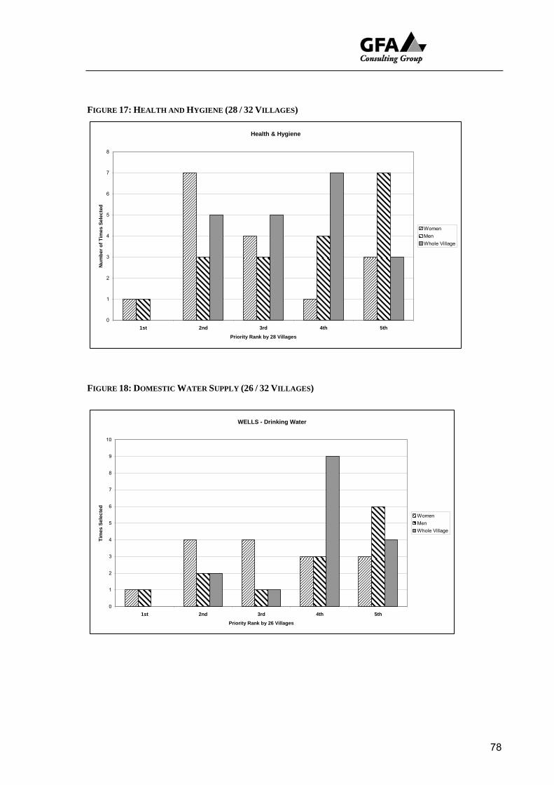
FIGURE 17: HEALTH AND HYGIENE (28 / 32 VILLAGES)
Health & Hygiene
0
1
2
3
4
5
6
7
8
1st 2nd 3rd 4th 5th
Priority Rank by 28 Villages
Num
ber o
f Tim
es S
elec
ted
WomenMenWhole Village
FIGURE 18: DOMESTIC WATER SUPPLY (26 / 32 VILLAGES)
WELLS - Drinking Water
0
1
2
3
4
5
6
7
8
9
10
1st 2nd 3rd 4th 5th
Priority Rank by 26 Villages
Tim
es S
elec
ted
WomenMenWhole Village
78
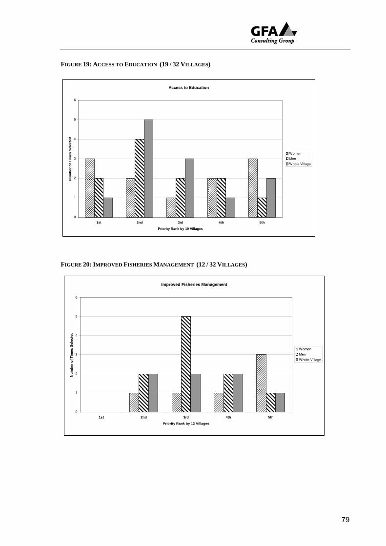
FIGURE 19: ACCESS TO EDUCATION (19 / 32 VILLAGES)
Access to Education
0
1
2
3
4
5
6
1st 2nd 3rd 4th 5th
Priority Rank by 19 Villages
Num
ber o
f Tim
es S
elec
ted
WomenMenWhole Village
FIGURE 20: IMPROVED FISHERIES MANAGEMENT (12 / 32 VILLAGES)
Improved Fisheries Management
0
1
2
3
4
5
6
1st 2nd 3rd 4th 5th
Priority Rank by 12 Villages
Num
ber o
f Tim
es S
elec
ted
WomenMenWhole Village
79
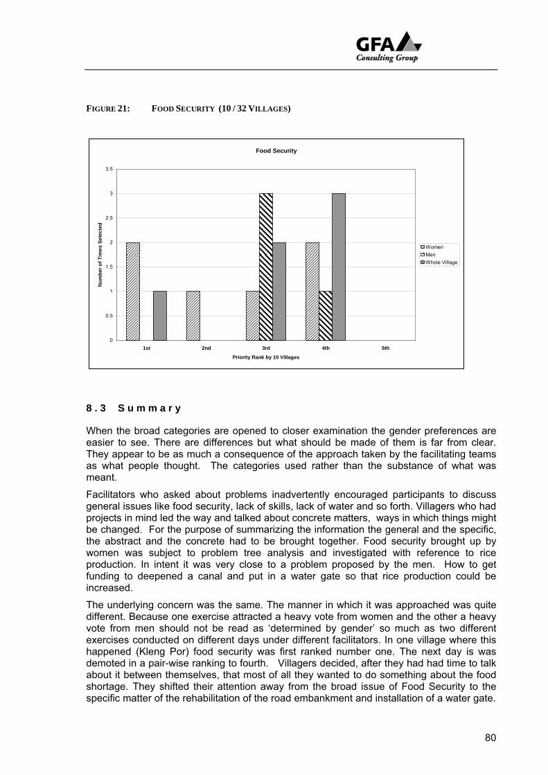
FIGURE 21: FOOD SECURITY (10 / 32 VILLAGES)
Food Security
0
0.5
1
1.5
2
2.5
3
3.5
1st 2nd 3rd 4th 5th
Priority Rank by 10 Villages
Num
ber o
f Tim
es S
elec
ted
WomenMenWhole Village
8 . 3 S u m m a r y
When the broad categories are opened to closer examination the gender preferences are easier to see. There are differences but what should be made of them is far from clear. They appear to be as much a consequence of the approach taken by the facilitating teams as what people thought. The categories used rather than the substance of what was meant.
Facilitators who asked about problems inadvertently encouraged participants to discuss general issues like food security, lack of skills, lack of water and so forth. Villagers who had projects in mind led the way and talked about concrete matters, ways in which things might be changed. For the purpose of summarizing the information the general and the specific, the abstract and the concrete had to be brought together. Food security brought up by women was subject to problem tree analysis and investigated with reference to rice production. In intent it was very close to a problem proposed by the men. How to get funding to deepened a canal and put in a water gate so that rice production could be increased.
The underlying concern was the same. The manner in which it was approached was quite different. Because one exercise attracted a heavy vote from women and the other a heavy vote from men should not be read as ‘determined by gender’ so much as two different exercises conducted on different days under different facilitators. In one village where this happened (Kleng Por) food security was first ranked number one. The next day is was demoted in a pair-wise ranking to fourth. Villagers decided, after they had had time to talk about it between themselves, that most of all they wanted to do something about the food shortage. They shifted their attention away from the broad issue of Food Security to the specific matter of the rehabilitation of the road embankment and installation of a water gate.
80
Overall there is a high level of agreement between men and women on major issues, that is issues that were raised in most villages. Access to water and water management was a high priority issue regardless of gender. This is not surprising. Women fulfil an extremely important role in agriculture. They put as much work as men into the effort to produce a good crop of rice.
Women showed a slightly greater concern for health and hygiene, drinking water, and food security but these do not significantly off set a high level of agreement on the importance of roads and bridges, access to education, livestock management, the importance of off farm employment and so forth.
Because of the abstract nature of many of these prioritised issues/problems they do not always automatically lead on from high priority, to problem tree analysis and action plan. The following chapter entitled a list of potential sub-projects lists projects that have had to be extracted and sometime constructed from the information collected rather than emerging easily from it.
81
9 C O N C L U S I O N S A N D R E C O M M E N D A T I O N S
The villages selected provided a reasonable sample of communities in the Project area. They were located across the different agro-ecological zones, including Upland consisting of mainly high fields, Middle Land and Lowland on or about the 10m contour. They ranged from very poor with a poverty rating of 89% to relatively well off with a rating of 28%. An attempt was to bias the selection to poor villages and find people who migrate down to the Tonle Sap in the dry season.
The RRA survey team used a set of PR tools designed to optimise villager participation and stimulate discussion between them about their situation, problems, challenges and development priorities. One of the principal objectives was to get them to articulate their own views and to record this in a way that would feed into project preparation.
The RRA team were good at recording what they asked for. They were neither particularly good at listening nor inquisitive enough to learn as much as they could from villagers. As a participatory exercise this was definitely a Rapid Rural Appraisal and not a fully interactive learning and action engagement.
Villagers were pleased to join. They were not paid. They volunteered their time freely and many used the opportunity to talk with some passion about their situation. The monitoring consultant team that accompanied the RRA team were constantly surprised by villager willingness to visit sites, in some cases arrange transport and share their views.
The information collected is of variable quality, the English translation may not do justice to the original field record, but overall the PRA Specialist is satisfied that the information collected is reliable, provides a good record of what was collected and can be used with confidence by the TSLSP specialists responsible for preparing the PPTA.
9 . 1 C o n c l u s i o n s
Maps and Transects Discussions focused on sketch maps and transects stimulated talk of what farmers want especially at the beginning of the rainy season
• more surface run off from early rains to be diverted to where it can be used to start their main wet season rice;
• while their rice is growing, access to more reliable supplies of water to maintain it; and,
• towards the end of the rainy season enough water to finish it.
At the end of the rainy season they want to stop as much water from draining away as they can in the hope that there will be enough water to grow a dry season crop of rice. They believe this can be achieved by:
• storing water in large recession tanks, ponds and deep canals the latter built at least partly for this purpose;
82
• closing water gates especially installed for the purpose on inlet-outlet canals;
• rehabilitating Pol Pot structures.
On the middle lands especially pumping is an important part of both early and late, wet and dry season strategies. Development of larger scale gravity fed systems is restricted to intensively worked commercial holdings on the lake bed.
Sustainable Livelihoods The majority of rural people in the area surveyed are vulnerable to shocks. These include accidents and ill health; seasonal shortages of rainfall (especially at the beginning of the rainy season); seasonal shortages of water (especially drinking water during the dry season) and to start and finish both wet and dry rice crops; food shortages especially shortfalls in the rice harvest caused by an unreliable supply of water; and trends which have worked against them including rapid population increase and increasing differentiation between the better off and the poor.
Rapid socioeconomic differentiation is running increasingly quickly and the labour market which is already of critical importance in peoples livelihood strategies is likely to play an even more significant role in their lives.
Women headed households are particularly vulnerable. On average women headed households made up an 14.5% of households in the villages surveyed. They are more often than not seriously disadvantaged by separation, sometimes left with dependents such as younger children and elderly parents to support, and reduced access to adult labour. Their capacity to farm, trade and travel declines. When they or one of their children fall ill and they have to seek medical advice outside the village they quickly run up debts. Because of this many had lost what land they had. Their poverty keeps their children out of school which in turn contributes to the chances of passing on their economic under privilege to another generation.
Availability of water is a major factor in determining people’s vulnerability. Any improvement in the management of water resources is a contribution to alleviating rural poverty.
Pollution of the Tonle Sap disadvantageously impacts on farmers on the lowlands, especially in Kampong Thom. Farmers want access to fresh water to establish their wet season rice and off set reliance on lake water.
Pentagon Configuration of Capital/Assets was prepared to provide a summary of the strengths and weaknesses of each of the survey villages.
It was found that The family/household may form the principal structure around which socioeconomic activities are organised but the strength and range of a typical family operation increasingly extends well beyond both the farm gate and the village boundary. Much less than half the householders ranked in the RRA exercises produce enough food to feed their families. They cannot secure an acceptable livelihood on what they produce on their farms, what they grow, and the animals they raise to survive.
• They must fish and gather firewood and timber from the wider environment in which they live. This takes some down to the annual
83
flood plain of the Tonle Sap, up into the hills and into local forests in search of feed for their livestock, food for their tables as well as other commodities and supplies.
• They must seek wage labour or payment in kind on neighbouring farms, take delivery of rice and pay later with work often for a reduced wage.
• They must seek paid employment in neighbouring towns and provinces as well as the closest neighbouring country, Thailand. Some go as far a field as Malaysia
Rural - urban hierarchy. Links between the village and the outside world are subordinated within a broader rural urban hierarchy, control of which remains largely in the hands of outsiders. Strengthening farmers connections and enhancing their ability to operate within it is part of the Sustainable Livelihoods agenda. It was not possible within the scope of the RRA survey to find a pathway through these challenges but it was interesting to hear farmers all around the Tonle Sap requesting occupational training. Nor was it possible to clearly identify agencies (administrative structures) and ways of working (processes) that work, partly work, or do not work for villagers and within which a project might best work but NGOs are everywhere and (as the review of Institution Relationships showed (Chapt. 7) have a better relationship with villagers than most government agencies.
Wealth Ranking The data indicates a degree of vulnerability that is worrying. If their capacity to face contingencies is to be taken into account 91% of households cannot rely on the land they farm and/or resources available in their immediate environment to survive.
55% of the households surveyed are poor or very poor. In the absence of work being available outside the village it is highly likely that these people would soon become very hungry. The implications of this are immense. In pursuing coping strategies the rural poor face profound subordination in which their ability to access wider civil, private and public sector services is often impeded by isolation, lack of knowledge, political alienation, cultural prejudice and so forth which denies access to existing transforming structures and processes or more importantly, building their own, which might enable them to strengthen their position.
Seasonal Calendar What the calendar shows most clearly is the heavy input of women into farming activities. Women provide at least half the rice production labour. This is especially marked in villages and for socioeconomic groups in which farming provides only a part of peoples livelihood and men must find off farm work to make up the shortfalls.
The overall allocation of labour shows that a wide range of tasks are performed. Labour shortages can occur at peak periods and those away on
84
migrant labour tasks usually return at these times (land preparation, harvest). We have already seen that a strict division of labour along gender lines is not a feature of the rural calendar. Although gender enters into calculations, age and skill are also figure prominently in the allocation of work.
Because such a large proportion of household livelihoods depends on earnings from off farm work the role of the young, fit and healthy plays and important part in determining wealth and welfare. It is the young who undertake work in garment factories and who are expected to cycle for several hours a day to Siem Reap from outlying districts to earn money for their families.
Mobility People must be mobile to survive.
Daily migration and extended circular migration to metropolitan or agro-industrial areas in search of wage labour was found to be of major importance. It involved both women and men in the younger age cohorts and in some cases removed over two hundred people for extended periods over several months at a time.
The draw of urban employment is very strong. It was estimated that for every village with reasonable access to transport and in which fieldwork was carried out up to 20% of families may send at least one member of their household to find wage labour in cities like Battambang, Siem Reap and Phnom Phen. This trend to urban or agro-industrial employment is most probably of greater long term significance than the draw of seasonal migration down to the Tonle Sap. It appeared that people from better serviced villages with a higher level of formal education were much more likely than those from less well serviced villages to:
• seek work in more sophisticated and differentiated labour markets; and,
• send younger people away for longer periods.
At the lower end of the socioeconomic scale the more isolated, the less well educated, more heavily subordinated, the less well off are more likely to look to their immediate natural environment for life support such as fishing, hunting and gathering or limit their search for work to rural Cambodia.
The future of rural people around the Tonle Sap will increasingly rely on a prosperous and growing urban sector.
Institutional Relationships To be effective at grassroots level projects need to work with:
• commune chiefs;
• village chiefs; and,
• NGOs.
There may be up to 144 NGOs working in the region of the Tonle Sap, many employ civil servants and provide the living wage the government
85
cannot afford. Subcontracting NGOs to carry out livelihood enhancement work makes good sense.
Decentralisation and de-concentration is not just about spreading government departments and bureaucratic processes, most of all it should focus on empowering citizens to manage their own affairs.
Development Priorities and Gender Overall there is a high level of agreement between men and women on major issues, that is issues that were raised in most villages. Access to water and water management was a high priority issue regardless of gender. This is not surprising. Women play an extremely important role in agriculture and in terms of labour input do as much if not more than men to produce a good rice crop.
Women showed a slightly greater concern for health and hygiene, drinking water, and food security but these do not significantly off set a high level of agreement on the importance of roads and bridges, access to education, livestock management, the importance of off farm employment and so forth.
List of Potential Subprojects Thirty two potential subprojects have been compiled from the list of prioritised development issues, one for each village surveyed as a way of illustrating what villagers are asking for. This approach places a great deal of emphasis on what can be done for villagers and planned as a top down investment rather than what villagers can do for themselves. The ideal would be to leave identification of sub-projects to the project implementations stage when appropriate participatory planning exercises could be mounted and with a minimum of delay followed up. Unfortunately this does not meet the conventional needs of project preparation but the emphasis on sub-projects should not be allowed to obscure other matters arising out of the prioritising exercise. Agricultural extension could be designed to address the challenge of food security. Off farm employment is a large part of rural peoples livelihoods and occupational training that might improve their wages would be appreciated. Serious consideration should also be given to setting up Commune Council develpopment Funds so that rural people can be supported to carry out small scale infrastructural development work for themselves.
9 . 2 R e c o m m e n d a t i o n s
Participatory Learning and Action (PLA) The PLA approach to community planning should be a recommended part of any project implementation. Villagers respond well to the opportunity to review their resources and identify development work. With skilled facilitation these exercises could be guided through a process to develop action plans.
86
NGO Role. NGOs maintain a close relationship with villagers, they are trusted, have implementation experience and should be recruited to undertake the livelihood enhancement work built into the project.
Commune Council Development Fund A Commune Council Development Fund modelled on the Northwestern Rural Development Project should be given serious consideration as a way of providing support for small scale infrastructure that does not require a high level of technical input. This would avoid bureaucratic delays, strengthen the role of the commune and empower villagers.
Sub-project priorities should not focus exclusively on water management infrastructure, consideration should be given to designing support for other matters prioritised by villagers such as:
• Roads and bridges: especially look at flooding problems caused by inadequate provision of culverts and the possibility of using roads as embankments/dams and fitted with water gates
• Health and hygiene. Interest in use of latrines as a public health measure appears to be gaining village support.
• Wells and other means of securing supply of drinking water: pumps, water jars, filters
• Provision of agricultural inputs: seed, fertiliser,, pest control and equipment
• Access to education. School buildings were mentioned frequently but the associated problem of staffing, and community role in managing schools was rarely if ever mentioned.
• Support for management of livestock. Cows and buffalo provide an important source of savings for farmers and for the landless and near landless offers a way to acquire a fragile hold on property. Access to vet services, semen and breeding stock were all of interest.
• Occupational Training.
o Off farm earnings are particularly important and a large proportion of peoples livelihood is secured from paid employment. Rural people know the value of training and
87
educational qualifications and believe occupational training would enhance their earning capacity
o Farm related training was requested. Rural people want to know more about making the best sort of compost, buying and applying fertiliser, raising livestock
• Fisheries. Rural people around the lake are aware that catches are dropping and want support for conservation strategies. Interest in raising fish is growing.
• Water for small scale irrigation. Villagers expressed an interest in getting better access to ponds, tanks etc., stored water that could be used to raise vegetables.
• Credit. Rural people want access to credit at fair rates under repayment systems that fit into the agricultural cycle. Monthly payments that had to be made regardless of the circumstances were criticised as unfair and difficult. People were afraid to borrow because the repayment schedule was in their view too arbitrary. Often village money lender was preferred. Although their interest rates are higher they are more flexible.
• Many small building projects were listed under Minor Issues such as:
o village guest house (sala) for meetings, visitors, visiting monks;
o weaving workshop;
o village market.
Indigenous Khmer tenure rights to the exposed dry season lake bed should be acknowledged, land use controlled and commercial alienation and development of the land stopped. This is recommended as one of few socially informed ways of maintaining the Tonle Sap biosphere
Project Area Serious consideration should be given to focusing the project in the three southeast provinces at the neck of the lake closest to the Tonle Sap River, especially Kompong Thom where intensive commercial development of the exposed dry season Tonle Sap lake bed is taking place. If the principal thrust of the TSLSP is to protect the biosphere then this is a good place as any to guide development along a more friendly environmental path
88

A P P E N D I C E S
Appendix 1. List of Sub-Projects Suggested by Villagers Appendix 2. Topographical Maps Showing RRA Study Villages
89
A P P E N D I X 1 List of sub-projects suggested by villagers This list has been compiled from development issues prioritised by villagers. As pointed out in Chapter 8 all issues arising out of the RRA interactive process were subject to this treatment.
Sometimes issues are identified in very broad terms and sometimes, at least in translation are not clear. Nevertheless, no matter how imperfect the labelling, the prioritising process makes it possible to appreciate what worries people, how issues are seen, how women and men prioritised them and so forth. In many cases villagers identified problems but did not know what could be done about them. These matters were left hanging. At the end of RRA village exercises when facilitators were looking for concrete proposals participants returned to the things they knew could be done even if they could never pay for them. They returned to water resource management infrastructure and requested the rehabilitation of broken Pol Pot structures.
Preparation of the TSLSP PPTA is set up on the assumption that sub-projects will be identified and examined for both their engineering and hydrological feasibility, and their likely environmental impact. It is this type of sub-project suggested by villagers that are listed here
How infrastructure sub projects were identified
Initial selection of RRA study sites carefully followed criteria set down in the project documents and followed up in Phnom Penh in consultation with MOWRAM officials. Initial selection left the field relatively wide open to whatever suggestions might arise.
Final selection of sites was shared with the TSLSP principal coordinating partner, the provincial departments of the Ministry of Water Resources and Meteorology. DOWRAM officials were consulted before visits were made to district governors and commune chiefs.
This process biased the selection procedure and because local officials associated the RRA team with DOWRAM both they and villagers themselves believed that when the study teams arrived a water resources project was as good as on offer. DOWRAM appeared on Venn diagrams because of villager courtesy rather than a well earned presence.
One of the first things the study teams did when they arrived in villages was to make it quite clear to RRA participants that the facilitators did not represent any special interests; that they wanted villagers to feel free to speak openly about the challenges they faced. The RRA team was not in a position to promise anything and any action that might follow the survey work would not be decided until the end of 2008.
The initial bias however ensured that water management issues were given attention and that people in many of the sites chosen already had in mind a sub-project that might be worthy of consideration. In the absence of precise instruction concerning the size of water management subprojects that might be considered no attempt was made to filter out suggested work that might be of a scale well beyond the scope of what might eventually be attempted.
90
As roads were explicitly excluded from consideration but remains on the comprehensive list discussed with villagers(Table 8 Gender Disaggregated Development Priorities).
It must also be acknowledged that following presentation of the Inception Report (14 September) and in direct response to an ADB request DOWRAM officials went out of their way to help the study team direct their attention to communities in which people move, after harvesting their wet season rice, down on the annual flood plain of the Tonle Sap.
The following list was partly compiled on the basis of observations made by DOWRAM and local DOLA officials including commune chiefs but emerged principally from discussions with villagers who brought the matters to the attention of facilitators and/or recorders so that they could be:
• listed on an Issues Matrix; • scored alongside other issues ; • placed in priority order; and if chosen for further attention, • analyzed; and if appropriate, and as time allowed, • reviewed to see what implementation might involve.
Topographical maps could only be prepared after villages were selected and fieldwork completed. Nearly all villages are accurately located but some of the sub-project sites may be incorrect. Not all planning details assembled by the RRA teams have been included in the list and those using it are advised to check the appropriate RRA Working Report.
1 . 1 S r a h K a e v
Rehabilitate breached Earth Embankment (visited) To the east of the village lies a water control structure built during the Pol Pot years. It is shown on the 1: 100,000 topographical map and consists of an inverted V shaped earth dam designed to retain water when the level of the Tonle Sap river drops at the end of the rainy season. The hand built embankment was breached shortly after the Khmer Rouge abandoned the area in 1978 and has gradually deteriorated since then. It has not been possible to control the flow of water into and out of the partly encircled area for sometime. More recently the water gates were routed and collapsed. The villagers want the structure to be rehabilitated. And argue that it would increase their rice production capacity several times over. If the dam and gates were fully functional they would grow recession rice
Map Melum commune !: 100,000. Srah Kaev is close to Highway 5, just 3 kilometre south of Melum
1 . 2 T u o l R o k a
Repair Breached levee/embankment (not visited). Discussion focused on the breakdown of the water management system (33% of vote). An old embankment to the east of the village close to the Tonle Sap River has been seriously breached in several places, the water gate that controlled the intake
91
and release of water has collapsed leaving the land between the village and the Tonle Sap River difficult to use. Replacement of the water gates was given top priority. Farmers know the system worked in the past and believe it could be made to work again.
Villagers are convinced that rehabilitation would have a major impact on their ability to produce a good crop of dry season rice.
The embankment is clearly shown on the Melum commune 1: 100,000 topographical map and lies only a few hundred kilometres east of the eastern side of the village
Map Melum commune !: 100,000. Tuol Roka is close to Highway 5, just a kilometre or so from Melum
1 . 3 T a V a k
Deepen pond and fix inlet/outlet gate (not visited) The villagers principal concern was to increase their store of water by draining and deepening a village pond and putting in place a water gate that would enable them to allow water to flow in when surface levels are high and close when water levels drop. Unfortunately the group of specialists accompanying the RRA team did not visit the site and are unable to add any details to what they were told by the team which relied heavily on what they were told rather than getting out and taking a look themselves. Fieldwork was accompanied by heavy rain and it was not so easy to get about.
Map Prey Mul commune !: 100,000. Ta Vak is close to Highway 53 not far from Prey Mul
1 . 4 K l e n g P o r
Rehabilitate road/embankment and water gates/dam bridge (visited) The village underwent development during the Pol Pot period. The large earth dam which lies just beyond the Wat and is shown on the topographical map forms the road into the village. It was built between 1976 -77 as part of an ambitious water control system. Villagers temporarily abandoned the site following the Vietnamese invasion. When life settled down again the site was reoccupied.
By 1983 the dam had been breached in several places. Since then the channels have aggraded, the main gate was scoured out and collapsed in 2000. In the rainy season a substantial river now runs between the village and the oxcart road out to Highway 5. Villagers leaving the village have to ford the river by foot and when the water is running high can carry very little. Small children are unable to go to school and even making the journey from the village to the Wat can be an adventure for adults.
Case for Rehabilitation of Dam (includes bridge and water gate)
Villagers documented a case using trend lines that showed how over a period of five years,
• although the area planted in rice had increased threefold,
92
• in the absence of a reliable water supply rice production had fallen from 2000kg/ha to 500kg/ha,
• the total rice yield had dropped from 100 to 75 tonnes.
According to these figures, which may be apocryphal, in 2000 the average harvest per household was 2000kg. By 2005 this had dropped to 900 kg.
Rehabilitation would be expensive. Whether the number of people and the poor nature of the soils justifies investment is a matter that needs to be considered by the appropriate specialists.
Map On the Prey Mul commune 1: 100,000 topographical sheet the difficult road in is shown by a broken line that starts out close to Ta Vak on the other side of National Road 53. The road joins the embankment where the broken line transects a blue line (canal) at point 27. The village would be more accurately located if it was placed at this point.
Map Prey Mul commune !: 100,000. Kleng Por is 7-8 km from Highway 53, west of Ta Vak.
1 . 5 B e n g
Repair main canal from Pursat river 12km away (visited), fix breaches up stream and make it deeper so that canal could deliver water at the beginning of the wet season and also stored water at the end of the rainy season that could be used to provide supplementary irrigation for a dry season rice crop. Although only a few would benefit directly from improved irrigation, this was ranked high in importance because, villagers said any increase I cropping would mean more work for them. This would enable them to pay the costs of schooling for their children. (It was not recorded whether this choice was made under ‘duress’ – the presence of the land owners who would gain from the work). Canal just reopened to Beng. Closed in 90s by UNTAC authorities who filled in the canal to lengthen the runway at the Pursat airport. The governor recently had this section of the canal dug out and a culvert put in. The people of Beng were disappointed that amount of water that came through was much lower than expected. Villagers also requested help in digging wells deeper so they would have drinking water in the dry season.
Map Sna Ansa commune just 1km north of Sna Ansar, and north of Highway 5. The canal is shown as a blue line running parallel with the Highway
1 . 6 A n s a K d a m
Rehabilitate earth diversion weir (visited) (in priority ranking listed misleadingly as “Lack of inlet outlet system” Stream shown of topographical
93
map 1: 100,000 running north – south to the east of the village. Village estate/territory runs up to the hills to 20 and 30 metre contour. Original structure built in Sihanouk times. Villagers have repaired it several times with sacks filled with sandy soil but the stream tends to work its way around the structure and rejoin the stream bed.
Villagers told the consultant team that 600ha or wet rice paddies could be irrigated. Although the soils are not particularly good yields of 1,500kg/ha could be expected as long as water levels were maintained. At the moment only 100ha of paddy land in the same area can be planted.
This looked like a particularly good possible sub project because the farmers themselves have several times fixed the weir using their own resources and labour.
Map Sna Ansa commune just 1km south of Sna Ansar commune HQ, and south of Highway 5.
1 . 7 C h r a b
Install water gate (visited) proposed by commune chief and in a consultation process of which he was not a part, villagers voted overwhelmingly in favour of such a structure. According to local informants between 150 and 250ha could be irrigated and double cropped with a wet rice and recession rice crop being grown. The commune chief owns 100ha of the land that would be brought under full cultivation
In this relatively small village there are 43 landless families (initially recorded as 20) that rely largely on work in the fields to earn a living. They are paid 12,000 Riel /30are harvested or approximately 36,000 Riel/ha. Similar amounts are paid for transplanting. Because of high levels of indebtedness many work in the fields for reduced wages to pay off debts.
Map Svay Doun Kaev commune, shown on topographical sheet in west Bakan district on the boundary between Prasat and Battambang provinces, north of commune HQ about 6 km from Highway 5 on the Stueng Svay Doun Kaev.
1 . 8 T h m e i
Repair breaches in earth dam south of village (visited) Earth dam could channel water diverted by sluice gates from the Stueng Svay Doun Kaev onto fields that are a part of the flood plain. The farmers believe this would both give them earlier access to water and enable them to hold more water at the end of the wet season to finish their rice. Sketch map is included in the RRA Working Reports
Map Svay Doun Kaev commune, topographical map. Shows Thmei in west Bakan district on the boundary between Prasat and Battambang provinces, south of commune HQ about 1km from Highway 5. west boundary of the village is the Stueng Svay Doun Kaev.
94
1 . 9 B a n s a y T r a e n g
Rehabilitate canal and inlet outlet (neither site nor village visited) Village survey conducted over period of Inception Report. No notes included in RRA Working Report.
Map Thma Koul district, 1: 140,000 topographical map. Bansay Traeng village lies close to the main road (National Highway 58?) that leads off Highway 5 from Thma Koul district HQ.. Area lies close to a rapidly expanding market, water is relatively plentiful, in eastern sector of Bavel irrigation scheme (?)
1 . 1 0 S p e a n
Repair/replace water-gate. Inlet outlet (not visited) Village survey conducted over period of Inception Report. No notes included in RRA Working Report. Village visited a week after RRA team had carried out their survey but their results were not yet available. Village chief did not enlarge on this the second choice but a proposal to put in an all weather footpath to neighbouring hamlets that would enable them to get to market and their children to get to school..
First choice of RRA exercise was to widen and upgrade the road out into the fields so the harvest could be bought in wet conditions. A lot of double cropping and transporting wet season harvest difficult.
Map Thma Koul district, 1: 140,000 topographical map. Spean village lies just a kilometre or so from the main road (National Highway 58?) that leads off Highway 5 from Thma Koul district HQ.. Area lies close to a rapidly expanding market, water is relatively plentiful, in eastern sector of Bavel irrigation scheme (?)
1 . 1 1 P r e a h P o n l e a
Rehabilitate canal system (neither site nor village visited) Village survey conducted over period of Inception Report. No notes included in RRA Working Report.
As for Spean the choice that came out of the RRA exercise was to widen and upgrade the road out into the fields so the harvest could be bought in wet conditions. A lot of double cropping and transporting wet season harvest difficult.
Map Thma Koul district, 1: 140,000 topographical map. Preah Ponlea village is to the north of Thma Koul, 3-4 km along National Highway 59 or so from Highway 5 at the turn off close to Boeng Pring. The area lies on the Ou Samroang.
95
1 . 1 2 R u n g C h r e y
Several
• Repair of national Highway 59 [32%♀&♂] (neither site nor village visited) Village survey conducted over period of Inception Report. No notes included in RRA Working Report. Despite the decision not to list roads (road was listed first on farmers list) the closest other infrastructure projects listed in order of priority were:
• School (no notes)
• Build bridge and canal: 4m
• Install clean water supply and well with pump (second on women’s list, 22% of their vote)
• Reconstruct inlet/outlet system
As a reminder that infrastructure does not always dominate the list, next in order was Occupational training People go to both Thailand and Malaysia for work. In the absence of explanatory notes it is assumed that training was being requested for off farm skills
Map Thma Koul district, 1: 140,000 topographical map. Rung Chrey village lies to the east of Thma Koul, 14km along National Highway 58 (?) from the Thma Koul commune HQ on Highway 5 .
1 . 1 3 R o k a C h h m o u l
Water gates, inlet/outlet system (visited) The damaged water gates are on 17th April Canal that leads from a major sluice gate/dam (Preaek Chik?) on the Stueng Moung Russei (above the 30m contour?) a river with a substantial flow. Villagers would like the main dam itself fixed (some of the uprights are compromised) but they know the cost of this would be substantial. However they believe that if only the 17th April Canal was rehabilitated (slightly deepened) they would get early wet season water and if the gates worked they would be able to stop the water draining away when the level of the river dropped. District governor believes that rehabilitation would make water available to five communes. This seemed to be slightly exaggerated. According to locals the canal worked up to 1985 but the bed has built up and no longer carries much water. Attempts were made to deepen part of the canal under a 1998 food for work grant arranged by Angkhor Khrom Aphiwat Phum. The commune applied for funding to Seila but this failed.
The damaged water gate lies at the junction of the on the 17th April Canal and a canal that flows out into a stream that forms the central west boundary to the commune.
Map Kear commune sheet 1:100,000 Roka Chhmoul lies 10km south of Moung Russei district between the 20 and 30m contour. The suggested project is 7k to the south of the village
96
1 . 1 4 R e a m K o n
Rehabilitate irrigation system (water gate inlet/outlet system) and distribution canals (visited) Half if not more of the people in this semi urban town on the Highway 5 are employed in service sector activities. There is however a lot of farmland on the north side of the settlement that runs down into the Transition Zone. A weir on the Stueng Russei has washed out but still divides the river. Part of the flow continues down the natural water course(Stueng Moung), the diverted section flows down what appears to be a man made or straightened water course also named the Stueng Moung behind an earth embankment and around two water gates. Farmers would like to have more control over water flows and at least stop water flowing away at the end of the rainy season. The weirs are quite large (5-6m high).
The consultant team walked to structures across paddy land. Photographs are logged on the TSLSP system
Map Kear commune sheet 1:100,000 Ream Kon lies 0.5km southeast of Moung Russei district HQ, on and to the northeast of Highway 5. The requested project is approximately 3km off the main road.
1 . 1 5 V o a t K a n d a l
Dredge Boeng Svay Cheat15 to increase amount of stored water for village water supply (visited). Villagers talked of draining and digging out what they described as a natural pond16 which is filled by a stream. They want to drain it because of the current toxic quality of the water. No reason given for this. The stream may well concentrate impact of fertiliser (urea?) and alter the Ph factor of the water (needs to be checked). Villagers did not suggest dredging that was added by the team. The RRA Working Report in English is particularly obtuse. The project is described as “Dig new canal and drain lake to do the barrel stock the water”. If the Khmer “barrel” is rendered as “tank” the meaning is a lot clearer. Dredging would be an easier and more efficient way to do the job but if villager ownership would be compromised and the more immediate benefit of making additional rice available makes more sense then perhaps a food for work approach should be given preference. The consultant team did not measure the size of the boeng
Map Sangkae district, 1: 170,000 topographical map. Voat Kandal village lies 5km south of Reang Kesei commune HQ to the south of Sangkae, at a turnoff 24km southeast along National Highway 5 and a further 14km west off the Highway through Kampong Pring commune.
15 The villagers name for it is Boeng Kampong Goa 16 From the map the boeng describes a rectangle. It could be an ancient Khmer
structure or it is a pond that has been modified so often over the years that it appears to be man made.
97
1 . 1 6 P r e y S v a y
Drain and deepen the old canal to increase the store of water for establishing and finishing rice and growing vegetables (visited). District governor drew the RRA teams attention to this project before and villagers brought it up. Work has commenced with a grant from H.E So Kaen (spell?) Minister of the Interior. This is his natal village.
Ambitious plan is to deepen the 7km canal from the village and join it to the Sangkae river with a 4km stretch of canal to Bay Damram or Chhou Teal, south of Voat Ta Muem (this needs to be checked). In some places the canal will have to be deepened by 1-2 metres to allow the water to flow through. The district governor volunteered that it would cost $100,000 to do the work.
The search for water has emerged out of recent events. Successive years of drought (2001-3 inclusive) resulted in between 60-70% of the annual rice crop being lost. As a consequence farmers had to borrow to survive and were eventually unable to meet their accumulated debts. Many have had had to sell their land to urban buyers and now work as tenant farmers. There are 20 landless households. Many people work in Thailand on commercial farms and cross the border illegally, the latter get paid as little as 30 – 70 baht a day. Many undertake daily work in Battambang (25km away). The team was told 70 families had left the village to find land elsewhere.
Map Sangkae district, 1: 170,000 topographical map. Prey Svay village lies 4km north of Voat Kandal and is slightly closer to Reang Kesei commune HQ to the south of Sangkae, at a turnoff 18km southeast along National Highway 5 and a further 14km west off the Highway through Reang Kesei commune.
1 . 1 7 P r a l a y C h r e y
Canal, dam, water gate inlet/outlet system (visited). Few details were recorded. Project called for comprehensive upgrading. Flooding made access difficult.
Map Kouk Ballangk commune 1: 100,000 sheet village 7km East of Highway 5. Proposed project immediately to south of village
1 . 1 8 P h ’ a v T h m e i
Build new weir and put water control culvert system in place on Ou Ta Det stream (visited) At flood time when the team visited it was not possible to see the stream bed, the whole landscape was under water. Villagers explained their proposal with reference to the inflow and out flow of water and the necessity to maintain a balance. The villagers prefer to establish rice with fresh water from upland areas through a system of linked creeks. They are also relatively close to the Tonle Sap and in their southern most fields they plant floating rice. If the water in the Tonle Sap rises before water is available from the uplands for their wet rice then they have to make
98
do with this until they can dilute it with fresh water. At the end of the wet rice season when the lake waters drop they like to retain as much water as possible and grow a dry season crop of recession rice. At the moment their water control system is not as efficient as they would like it to be. Their project to build a new weir and put a better water control culvert system in place would improve management and make it possible to grow more rice.
Map Kouk Ballangk commune 1: 100,000 sheet village 13km East of Highway 5. Proposed project again immediately south of village
1 . 1 9 K a n d a l
Water control system, embankment, weirs and water gate system (visited) Villagers want the canal that runs to the east of the embankment which runs on a north/south axis from Kandal to Sreh Kaeut deepened, the embankment built up and surfaced with laterite so it can be used as a road in the rainy season without putting people’s lives at risk. The principal purpose is to store water at the end of the rainy season when the Tonle Sap retreats. They believe this would enable them to raise fish and grow a second crop of rice. They believe that if construction was accompanied by maintenance training they could manage it efficiently and sustainably
This is a priority.
They also want to repair the embankment which joins the structure discussed above and runs slightly off an east west axis (see topo map). It is breached in several places most notably at Ou Kouri Damrei. This is another unfinished Pol Pot work. Locals refer to the Widowed Bridge, (photo on Z drive) a water gate along the embankment that was never completed and was supposed to control the inflow and outflow of water into the more intensively farmland of Preah Netr Preah.
The commune chief also discussed the possibility of opening canals to a reservoir on the north side of Highway 6 to provide Preah Netr Preah with the advantage of early fresh water, so they would not have to rely on the increasingly polluted water of the lake.
Map Preah Netr Preah commune, 1: 100,000 sheet village 2.5 km south of Preah Netr Preah district HQ off Highway 6. Project embankments clearly visible on map.
1 . 2 0 S r e h K a e u t
Water control system, embankment, weirs and water gate system (Project sites not visited) Although the consultant team was able to visit the RRA team in action they were unable to make a field visit to see what the villagers had in mind and place the proposed work clearly on the map. There did however appear to be considerable overlap between the neighbouring village of Kandal. Reference to irrigation, water control and so forth focused on the same body of water and the same embankments.
Sreh Kaeut lies slightly outside, to the south of the embankment., there is more landlessness and near landlessness and a greater interest was shown in occupational training that would improve people’s ability to get better wages from off farm employment.
99
Follow up work is needed to identify specific undertakings and give substance to the problems explored by the RRA team.
Map Preah Netr Preah commune, 1: 100,000 sheet Sreh Kaeut village lies 6km south of Preah Netr Preah district HQ off Highway 6. Project embankments are clearly visible on map.
1 . 2 1 D o u n K a e v
No water storage (tank, priority 4). No canal, inlet/ outlet system (irrigation) was ranked number (priority 10). (Project sites not visited) Villagers gave precedence to road repair, occupational training (off farm) and getting a teacher of English before water storage. This exercise was run by the least engaged RRA team and perhaps the unusual results were partly a function of their inexperience. The result did emphasise the importance off farm employment is given and the team itself did not impose this response with leading questions.
Water storage was a dry season issue. Villagers wanted a source of water for domestic use other than for drinking. This needs to be checked
Map Doun Kaev commune, 1: 100,000 sheet (with Reul commune) Doun Kaev village lies 2km north of Doun Kaev commune HQ
1 . 2 2 D o u n O n
Pond for raising fish (priority 4) and water storage tank (priority 5) (Potential sites not visited). These projects came out of RRA exercise and were not placed on the ground. It was raining heavily off and on during the consultants visit and villagers were not interested in walking in the rain.
Road was a much more urgent infrastructure issue. As this is not included in the possible list of sub projects it was not followed up.
Map Doun Kaev commune, 1: 100,000 sheet (with Reul commune) Doun On village lies 4km north of Doun Kaev commune HQ
1 . 2 3 T r a p a e n g R u s s e i
Construct dam and water gate inlet/outlet system. Water storage, wells and fish raising pond were all listed among the top five concerns. (No site visits. Heavy rain). Again these preferences came solely out of the RRA exercise and were not checked by consultants.
Map Reul commune, 1: 100,000 sheet (with Doun Kaev commune). Trapaeng Russei village lies 8.5 km north of Puok district HQ before travellers reach Reul commune HQ
1 . 2 4 S r a h
Construct canal and water gate inlet/outlet system second priority after road. (No site visits. Heavy rain) Extremely poor village with large number of TB cases (84% poverty rating). Villagers complained that their canal
100
was too narrow /small and although their weir had been repaired it did not deliver enough water. Soils of upland type, poor, sandy. Farmers believe they could grow potatoes and vegetables if they had better access to water.
Map Reul commune, 1: 100,000 sheet (with Doun Kaev commune). Srah village lies 4km east of Reul commune HQ.
1 . 2 5 T n a o t
Road repair and construction of school placed first on list of priorities. Wells 4th on list, toilets 5th. (Village visited. Sites not identified) Village small, not enough land, lot of land sold for $80/ha a few years ago now selling for $10,000 $15,000/ha because of close proximity to World Heritage Site, Angkor Park. Rice yields low, 1,200kg/ha to 1,500kg/ha maximum. With price of land sky rocketing and the potential for agriculture so low villagers feel it is better to sell up and do something else they just don’t know where to go.
Map Ampil commune, 1: 100,000 sheet, . Srah village lies 4km northeast of Ampil commune HQ.
1 . 2 6 K i r i M e a n o n
Wells, pond (fish), and irrigation canal were all given relatively low ranking. Village visited sites not identified).
Village slightly better served with access to water (cf Tnaot) but here again land sales are high and over 100 young people go to Siem Reap for work. Greater part of villager income comes from off farm sources. Sixty people in village have arranged or can arrange land sales. Prices here lower than Tnoat because Kiri Meanon lies inside the Angkor Park boundary
Map Ampil commune, 1: 100,000 sheet, . Kiri Meanon village lies 6km by road northeast of Ampil commune HQ. Not far from Banteay Sri
1 . 2 7 T r a v B a k
Deepen irrigation canals Villagers many from Khmer Rouge background talked of digging a main canal. Total length 4000m, width: 3m, depth 1.5m; and 5 distribution canals. Total length 500m, width: 1.5m, deep high with a bund of 1m. (Visited. Walked along old canal) The work plan indicates that they intend to dig these by hand. There are 30 landless households in this village without so much as a house plot. Most returned from Anlong Veng following the peace agreement of 1997. These people would not benefit from any improvement in the productivity of the land but were keen to see activity that would create paid employment.
Map Ta Yaek commune, 1: 100,000 sheet. Trav Bak village is 3km northeast from Ta Yaek commune HQ. Lies on relatively steep sloping land between 30 and 40m contours.
101
1 . 2 8 P h k a R u m c h e k
Drain and deepen the old natural pond (Flooding prevented an on site visit but location seen from a distance) Villagers want to rehabilitate an old pond which over the years has become shallow. The intend to drain it, dig it out and have it ready for 2007 rainy season. They hope it will give them a reliable supply of water for dry season domestic use.
Map Ta Yaek commune, 1: 100,000 sheet. Phka Rumchek village is 3km south of Ta Yaek commune HQ.
1 . 2 9 K ’ e n
Build tank to hold water to grow dry season rice [close to Chy Mous Mountain] (Village visited but not project site) Not clear if land already cleared of forest but village intend to divide 400ha between them which belongs to the village chief and plant dry season rice. This could well be close to Tonle Sap shore and what villagers have in mind is to build a smaller version of the huge tanks being made by commercial interests in the commune to the south, Chamnar Kraom? This requires further investigation. Villagers also prioritised wells (priority 2) and canals and water gate for wet season rice (priority 4).
The DOWRAM priority of connecting to 30th September Reservoir (Stoung Reservoir) may have been attractive to villagers because it would deliver high quality fresh water at the beginning of the rainy season but it was not something villagers knew anything about and did not enter their calculations
Map Chamnar Leu commune, 1: 100,000 sheet. K’en village is 2km southeast in a straight line from Chamnar Leu commune HQ. The proposed project site is available on the topographical map provided by DOWRAM (Kompong Thom) and included in the RRA Working Report 6
1 . 3 0 P h l a o c h
Build bridge 4m x 4m, and canal 2 km long, 3m wide, 0.5m deep.(Village visited but project not seen) This ambitious project came up for discussion following the departure of the consultant team but may relate to deepening and increasing the capacity of the canal that runs through the village that is fed by 30th September reservoir (if only indirectly). This canal is drawn onto the PRA consultant sketch map included in the RRA Working Report 6 .
Drainage culvert and water gate(?)(Visited and checked) This matter was under discussion during consultant visit and is marked on the sketch map referred to above. 25ha of rice land is periodically placed in danger by the build up of water in the field on the other side of the road close to the school. Given the scale of this project it could perhaps best be managed under a commune fund provision.
Map Chamnar Leu commune, 1: 100,000 sheet. Phlaoch village is 4km northeast Chamnar Leu commune HQ.
102
1 . 3 1 P r a s a t
Water gate link to 30th September canal and deepening of connecting canal (Up stream visit but connection not traced). The objective is to access fresh water for early establishment of rice and retain some for finishing. The wet rice fields of this village have been as low as 500 – 800kg/ha which they blame on polluted lake water. Areas in their fields in which rice will not grow because of a deposit of “cinders” (literal translation). Village has tried to grow recession rice but without much luck. Problems with isolated fields. Attacked by pests like rats (crabs not mentioned here as in Mongkol Borei and Preah Netr Preah in a similar environment).
A few farmers in the commune talked about the concerns they had with the development of big commercial recession rice growing enterprises on the bed of the annually flooded area. They traditionally use this land in the dry season but could be easily displaced by more powerful commercial interlopers. They were also concerned that the troubles they are currently having with pollution could get worse.
The point is that fresh water is taking on increasing value.
Map San Kor commune, 1: 100,000 sheet. Prasart village is 4km south of San Kor commune HQ.
1 . 3 2 S l a e n g K h p o s
Canal to access 30th September. (Village visited but connection not traced) Farmers believe that if this was built it would enable them to get enough good water to retain some to grow dry season rice and other additional crops. Their field are small and at the moment intensive use is risky, a lot of investment is necessary and they must use a lot of fertilizer. Some years they get a high yield but in some years the yields are low because foul water from the Tonle Sap floods their fields. This is the same sort of water in which floating rice will not grow. It inhibits growth. In this case then the objective is to get enough clean water to help their rice grow.
Map San Kor commune, 1: 100,000 sheet. Slaeng Khpos village is 2.5 km due west of both Prasart and the 13th September canal.
103

A P P E N D I X 2
Topographical Maps Showing RRA Study Villages
104