sustainable water management in the city of the future
DESCRIPTION
As part of the Integrated Project for Global Change and Ecosystems, this is Water Sensitive Urban Design Manual (WSUD) was written in 2006 by Jacqueline Hoyer, Wolfgang Dickhaut, Lukas Kronawitter, Björn Weber and discusses Principles and Inspiration for Sustainable Stormwater Management in the City of the Future. It is published by Jovis Jovis Verlag, Berlin and HafenCity Universität, Hamburg, Germany, and sponsored by the European CommissionTRANSCRIPT
018530 - SWITCH
Sustainable Water Management in the City of the Future Integrated Project Global Change and Ecosystems
Water Sensitive Urban Design
Principles and Inspiration for Sustainable Stormwater Management in the City of the Future
- Manual –
Published by jovis jovis Verlag GmbH, Kurfürstenstraße 15/16, D-10785 Berlin,
in March 2011 ISBN 978-3-86859-106-4
Due date: M 60 Actual submission date: M 60
Start date of project: 1 February 2006 Duration: 60 months Organisation name of lead contractor for this deliverable: HafenCity Universität, Hamburg, Germany
Final Version
Project co-funded by the European Commission within the Sixth Framework Programme (2002-2006)
Dissemination Level
PU Public X
PP Restricted to other programme participants (including Commission Services)
RE Restricted to a group specified by the consortium (including Commission Services)
CO Confidential only for members of the consortium (including Commission Services)

Jacqueline Hoyer, Wolfgang Dickhaut, Lukas Kronawitter, Björn Weber
Water Sensitive Urban Design
Principles and Inspiration for Sustainable Stormwater Management in the
City of the Future
Manual
Imprint: Jacqueline Hoyer, Wolfgang Dickhaut, Lukas Kronawitter, Björn Weber: Water Sensitive Urban Design – Principles and Inspiration for Sustainable Stormwater Management in the City of the Future. HCU Team: Dipl.-Ing. Jacqueline Hoyer (concept, tex); Prof. Dr.-Ing. Wolfgang Dickhaut (concept, project leader); BArch Lukas Kronawitter (text); Dipl.-Geogr. Björn Weber (support) Collaboration on texts: Björn Weber (5.3.2), Maren Derneden (2.5); Iwona Wagner (5.2.3) English corrections/ translations: Jonathan Long, Lukas Kronawitter Layout, text design and typesetting: Christian-Maria Götz Figures printed with permission of: Atelier Dreiseitl (40, 56, 57, 77-79, 81); Bureau of Environmental Services, City of Portland, Oregon, USA, 2010 (16-20, 22, 23); M. Derneden (11, 45); DE URBANISTEN (25-28); A. Diem and Diem Baker GbR (47, 51, 52); J. Eckart (14); J. Gerstenberg (42, 44, 46); Koch Landscape Architecture (68, 73, 74); Kontor Freiraumplanung Tradowski Möller (41, 43); J. Lee (8, 54, 59-66); Municipality of Rotterdam (24, 29, 30); M. Peel (3); STEG Stadtentwicklung GmbH (48); I. Wagner/M. Zalewski (31-32)
Elaborated in the context of the research project SWITCH – Managing Water for the City of the Future www.switchurbanwater.eu On basis of work from Heike Langenbach, Jochen Eckart, Gerko Schröder (SWITCH Team at HCU 2/2006-7/2009) Project coordination:
UNESCO-IHE Westvest 7
2611 AX Delft, Netherlands SWITCH Project is funded by the Sixth Framework Programme of the European Union.
HafenCity Universität Hamburg (HCU) Hebebrandstraße 1 D-22297 Hamburg
www.hcu-hamburg.de
Hamburg, January 2011. © HafenCity Universität Hamburg 2011 Jacqueline Hoyer, Wolfgang Dickhaut, Lukas Kronawitter, Björn Weber Available as publication by: jovis Verlag GmbH, Kurfürstenstraße 15/16, D-10785 Berlin ISBN 978-3-86859-106-4
Content:
Foreword 3
1 Introduction 5
2 Background 6 2.1 Water in cities 6 2.2 The importance of water worldwide 6 2.3 Conventional stormwater management in cities 7 2.4 Problems of conventional stormwater management in cities 8 2.5 Stormwater in different climate zones around the world 9
3 The ideas of Water Sensitive Urban Design and
Sustainable Stormwater Management 14 3.1 Definitions 14
3.1.1 What is Water Sensitive Urban Design? 14 3.1.2 What is Sustainable Stormwater Management? 14 3.1.3 What does Sustainable Stormwater Management mean in
terms of Water Sensitive Urban Design? 16
3.2 Technical elements and solutions 17 3.2.1 Rainwater use 17 3.2.2 Treatment 17 3.2.3 Detention and infiltration 19 3.2.4 Conveyance 21 3.2.5 Evapotranspiration 21
3.3 Drivers 22
3.3.1 International and national regulations 22 3.3.2 Engineering standards and guidelines 24 3.3.3 Local regulations 25 3.3.4 Incentives 26 3.3.5 Summary 27
4 Principles for successful water sensitive urban design 28
4.1 Why principles are necessary? 28 4.2 Overview of principles 29 4.3 Detailed description of principles 30
5 Case studies 35
5.1 Overview 35 5.1.1 Structure of case study presentations – what information is given? 35 5.1.2 Overview of case studies presented –
which case studies for which principles? 36
5.2 Large scale case studies 39 5.2.1 Portland, Oregon, USA: From Grey to Green 40 5.2.2 Rotterdam, Netherlands: Waterplan 2 47 5.2.3 Lodz, Poland: Blue-Green Network 53
5.3 Medium scale case studies 58
5.3.1 Tanner Springs Park (Portland, Oregon, USA) 59 5.3.2 Trabrennbahn Farmsen (Hamburg, Germany) 65 5.3.3 Hohlgrabenäcker (Stuttgart, Germany) 71
5.4 Small scale case studies 77
5.4.1 Potsdamer Platz (Berlin, Germany) 78 5.4.2 10th @ Hoyt Apartments (Portland, Oregon, USA) 85 5.4.3 Prisma Nürnberg (Nürnberg, Germany) 91
5.5 Link to other interesting case studies 97
6 Conclusions 100
Important SWITCH links 101
References 103

3
FOREWORD
This manual on Water Sensitive Urban Design is dedicated to all those involved in the planning, design and maintenance of stormwater management and in urban design. Its intention is to explore the possible innovations spanning the topic of sustainable stormwater management and to show how it can be applied in cities while taking up the opportunities to use it for increasing the cities’ amenity and quality of life.
This manual was developed within the scope of SWITCH. SWITCH is a research project, funded by the European Union, which focuses on innovative Water Management for the City of the Future (www.switchurbanwater.eu). The aim of SWITCH is to initiate a paradigm shift in urban water management from existing ad hoc solutions to a more coherent and integrated approach. More than 33 partners from all over the world are involved in this project.
The topics covered by SWITCH are:
Urban Water Paradigm Shift Stormwater Management Efficient Water Supply and Use Waste Water Urban Water Planning Governance and Institutions
Considering the vision of SWITCH for an integrated sustainable water management, this manual was elaborated by the HafenCity University of Hamburg in close collaboration with various SWITCH partners including the UNESCO IHE, the University of Birmingham, the University of Lodz, and Middlesex University (full list of SWITCH Partners can be found in appendix). The cooperative research from all SWITCH Partners draws conclusions that have been included in this book, in order to make them usable for other cities interested in applying measures of sustainable stormwater management while also considering urban design aspects. In particular, a report by Middlesex University develops best management practice (BMP) principles for the management of stormwater as part of an integrated urban water strategy (Shutes/Raggatt 2010). This report complements the principles laid out in this book and is recommended to be read in association with this book. In addition to SWITCH research results, valuable information was gained from the experiences of the professionals responsible for the projects. Site visits and personal interviews were conducted to get better insight into the trials and successes of the case studies presented in this book.
Furthermore, it was determined that an assessment system could help guide the reader to conclusions about how Water Sensitive Urban Design methods could be implemented into future projects. The assessment system of this book is simply organized via traffic light symbols, red, yellow, and green. Additionally, information sources are cited separately to not disturb the evaluations of the case studies. In many cases, reviews were coordinated with project designers and other experts to ensure a high quality, impartial, and broad assessment of the projects.

4
It is the wish of SWITCH and the authors to make decentralised stormwater management to be used more often and in a higher calibre in the future. With the help of the Water Sensitive Urban Design approach, this goal can become a reality. The experiences presented in this book, are invaluable to professionals further seeking to develop the themes of sustainable stormwater management and integrate them throughout urban design and architectural projects.

5
1 INTRODUCTION
Sustainable stormwater management can be used to create places that serve both the demands of urban drainage and urban planning. From the urban drainage point of view, people want to have a system that is reliable, simple to construct and easy to maintain, while also considering its costs. Alongside, from the view of urban planning, sustainable stormwater systems should be beautiful, meaningful, and educational (Echols 2007, 1). Up to now, these two perspectives seem to have been contradicting one another.
During the last years various techniques for sustainable stormwater management have been developed and legislation has been advanced (see chapter 3.2 and 3.3). However and unfortunately, stormwater facilities have often been engineered without considering ecological, social or aesthetic qualities. Even manuals on sustainable stormwater management have mostly not cared about these qualities up to this point.
In fact, ecological, social and aesthetic qualities are important because they influence the public perception and acceptance of the systems. Still, too few sustainable stormwater management systems have been applied in a manner that is appreciated by the public. For that reason, sustainable stormwater management is either seen as messy or unusual when it is not designed in a pleasing way or badly maintained, or in turn, people do not use sustainable stormwater management measures, because they do not see a clear added value for extra costs (Echols 2007, 2).
The intention of this manual is to show that urban design and urban stormwater management can be integrated by following the approach of Water Sensitive Urban Design (WSUD). Therefore this manual:
provides an overview of what Water Sensitive Urban Design is about; creates guidelines by setting principles for WSUD; presents case studies in support with WSUD principles to discuss valuable strategies
and techniques; while:
• focusing on urban areas in temperate climates; • and emphasizing urban design linked to urban stormwater management.
6
2 BACKGROUND 2.1 Water in cities Water appears in cities as
wastewater and greywater managed by urban sanitation systems; drinking water for daily use (drinking, cooking); stormwater that needs to be drained from hard surfaces (roofs, streets, etc.) to
prevent flooding and keep streets and buildings dry and safe; natural water bodies (e.g. rivers, lakes, brooks); and artificial water bodies and features in open spaces (e.g. fountains, water basins,
water streams) contributing to the amenity of cities (improving micro climate, reducing dust and air pollutants, and providing recreation).
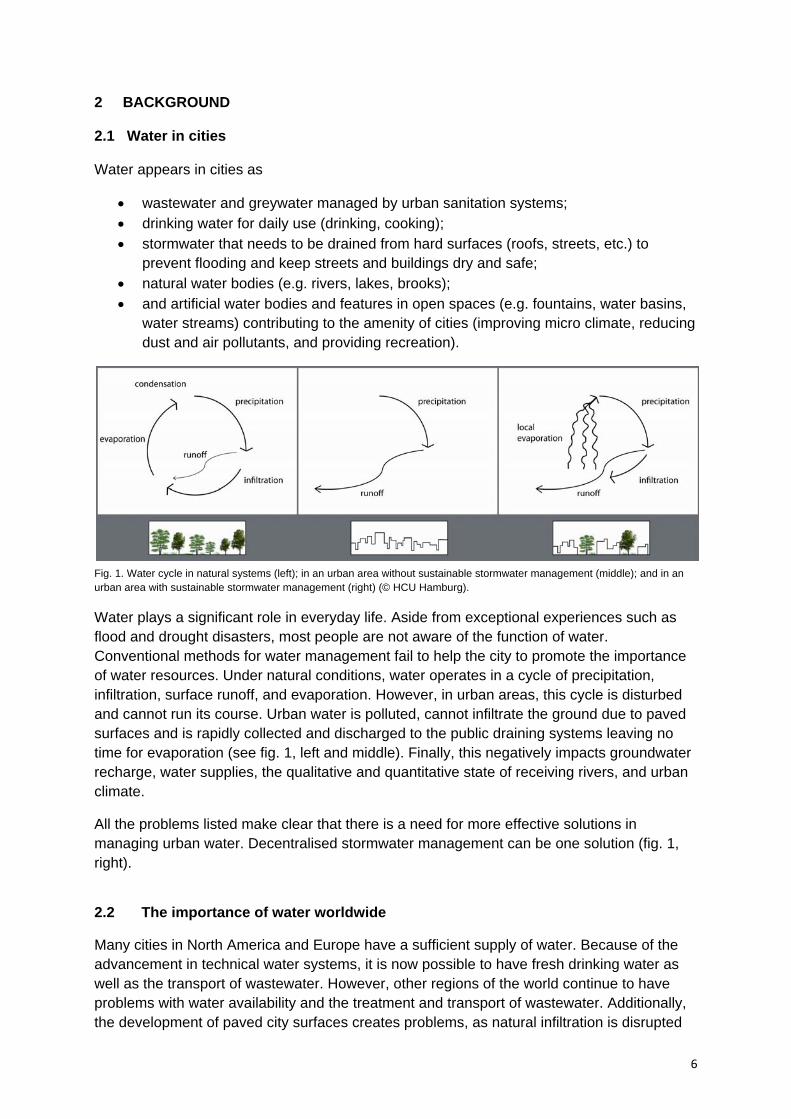
Fig. 1. Water cycle in natural systems (left); in an urban area without sustainable stormwater management (middle); and in an urban area with sustainable stormwater management (right) (© HCU Hamburg).
Water plays a significant role in everyday life. Aside from exceptional experiences such as flood and drought disasters, most people are not aware of the function of water. Conventional methods for water management fail to help the city to promote the importance of water resources. Under natural conditions, water operates in a cycle of precipitation, infiltration, surface runoff, and evaporation. However, in urban areas, this cycle is disturbed and cannot run its course. Urban water is polluted, cannot infiltrate the ground due to paved surfaces and is rapidly collected and discharged to the public draining systems leaving no time for evaporation (see fig. 1, left and middle). Finally, this negatively impacts groundwater recharge, water supplies, the qualitative and quantitative state of receiving rivers, and urban climate.
All the problems listed make clear that there is a need for more effective solutions in managing urban water. Decentralised stormwater management can be one solution (fig. 1, right).
2.2 The importance of water worldwide
Many cities in North America and Europe have a sufficient supply of water. Because of the advancement in technical water systems, it is now possible to have fresh drinking water as well as the transport of wastewater. However, other regions of the world continue to have problems with water availability and the treatment and transport of wastewater. Additionally, the development of paved city surfaces creates problems, as natural infiltration is disrupted
7
by soil sealing leading to increased surface runoff and heightened flood risks. Furthermore, considering climate change, the frequency of drought and flood events in the coming years will continue to increase. The Third World Water Development Report (United Nations World Water Development Report 2009) ascertained that:
more than 4 billion people still do not have access to safe, fresh water, while global water consumption increases (compare box 1);
regions of high water stress are growing as well as their population - it is predicted that in 2030 about half of the world’s population will be living in regions with high water stress;
the frequency of water related disasters, such as flood catastrophes or droughts, have been twice as large per decade between 1996 and 2005 as between 1950 and 1980 and have caused five times more damage - this trend is predicted to increase in the coming years.
Box 1. The average daily water consumption in European countries is 220 litres per person. In North America and Japan it is 350 litres per person, while in sub-Saharan Africa only 10-20 litres per person is used (World Water Council, 2010). India, China and the United States as well as Pakistan, Japan, Thailand, Indonesia, Bangladesh, Mexico and the Russian Federation are the largest water users (United Nations World Water Development Report 2009). 2.3 Conventional stormwater management in cities
Because 10-90% of city surfaces are completely sealed (see box 2), water cycles are severely affected. Urban areas, when compared to natural systems, have increased surface runoff, a notable reduction in groundwater recharge from precipitation, and a lower evaporation rate (see fig. 2). If the rainwater from the paved areas is not managed, it results in the flooding of roads and buildings. To avoid this, many cities have implemented a sewage system that drains water as well as regulates domestic and industrial wastewater. There are two types of sewage systems:
1) Combined sewerage systems: Wastewater and stormwater are collected in one pipe network. Mixed water is conducted to the wastewater treatment plant, then cleaned and discharged into the river.
2) Separate sewerage systems: Wastewater and stormwater are collected in two separate networks. The wastewater is conducted to the wastewater treatment plant while the stormwater pipe directly discharges to the receiving water (in case it does not contain pollutants) or is treated separately before discharged into the river. (Heber 1998, p. 4f.; Ganther 2002, p. 72ff.)
Box 2. In rural areas, impervious coverage may only be one or two percent. In residential areas, coverage increases from about 10 percent in low-density suburban areas to over 50 percent in multi-family communities. In industrial and commercial areas, coverage rises above 70 percent. In dense metropolises it is over 90 percent. (Schueler 2000)

8
Fig. 2. Runoff, infiltration and evaporation rates in urban areas (left) in comparison to natural systems (right) (© HCU Hamburg).
2.4 Problems of conventional stormwater management in cities
Conventional stormwater management systems quickly collect stormwater runoff and drain it from the city. These highly efficient systems have improved over time and cities are heavily reliant on them. However, conventional stormwater management still raises many concerns:
• Conventional systems are beneficial as they rapidly drain stormwater from surfaces, but in return, it reduces groundwater infiltration and lowers groundwater recharge rates. Moreover, decreasing groundwater recharge rates can limit available drinking water in cities.
• Conventional systems have negative effects on local climate, because infiltration and evaporation are reduced. The cities’ climate becomes warmer and dryer compared to the surrounding areas. This is also known as the Heat Island Effect.
• Conventional systems increase the risk of flooding. Sewer systems can exacerbate flood conditions during heavy periods of rain, causing overflows to receiving rivers. Storm sewer overflow increases the spread of pollution.
• Conventional systems cannot adapt to uncertain or changing conditions from increased city development and climate change, leading to unmanageable stormwater runoff. Adapting to these changes call for higher running costs and investments, which municipalities may not be able to afford in the near future.
To a large extent, current conventional stormwater management systems are neither sustainable nor adaptable to changing climates or developing conditions. Additionally, increased awareness of water resources is necessary for the widespread collective responsibility towards water. With many of the water systems underground in conventional stormwater management, residents and inhabitants are less likely to understand and appreciate stormwater management. Visible water systems can greatly change attitudes and promote intelligent use towards water resources. In this line, it will be necessary to reform stormwater management and initiate a paradigm shift in urban water management. The ideas of Sustainable Stormwater Management and Water Sensitive Urban Design have the
9
potential to address these issues and should be considered for future developments or retrofits in urban areas. Box 3. ‘The management of stormwater runoff in conventional urban developments has been driven by an attitude that reflects the view that stormwater runoff has no value as a useful resource, is environmentally benign and adds little to the amenity (aesthetic, recreation, education, etc) of an urban environment. Consequently, conventional urban stormwater management has focused on providing highly efficient drainage systems to rapidly collect and remove stormwater runoff […]. These systems kept stormwater runoff “out of sight” and consequently “out of mind”.’ (Wong 2006)
2.5 Stormwater in different climate zones around the world
Owing to the differences in climate around the world, people in different regions encounter different problems when trying to manage stormwater.
If you compare different cities' climates around the world, you can identify differences within and between various climate zones. Examples are dry seasons, rainfall during particular months or extreme seasonal variations. The main factors which determine climatic conditions are the location's latitude and the intensity of insolation (= the amount of sunlight that reaches the earth’s surface). This creates different zones with similar temperatures which stretch around the globe in bands (solar climate zones). However, defining zones on insolation alone is not enough, because other relevant factors and elements influence the climate to a greater or lesser extent in different parts of the planet: Climatic factors and elements (Forkel 2010).
Climatic factors are processes that lead to the formation of a climate type. The traditional climatic factors include the following:
• Insolation, its strength varies depending on latitude (solar climate); • Distribution of landmasses and bodies of tater (maritime and continental climate); • Altitude (mountain climate); • Composition of atmosphere; • Circulation of atmosphere (secondary – it depends on the other climatic factors).
The main climatic elements which influence climate both individually and collectively include the following (Hupfer/Kuttler 2006, 238):
- Precipitation; - Air temperature, air pressure and humidity; - Wind speed and direction; - Cloud covers degree; - Energy budget and heat balance; - Evaporation. Using this knowledge, attempts have been made to construct a system that depicts homogenous climate zones. Climate classifications are used to illustrate climate zones, and these classifications define climate types for highly varied combinations of climatic elements and factors, along with the effects they have on the planet's surface and vice versa
10
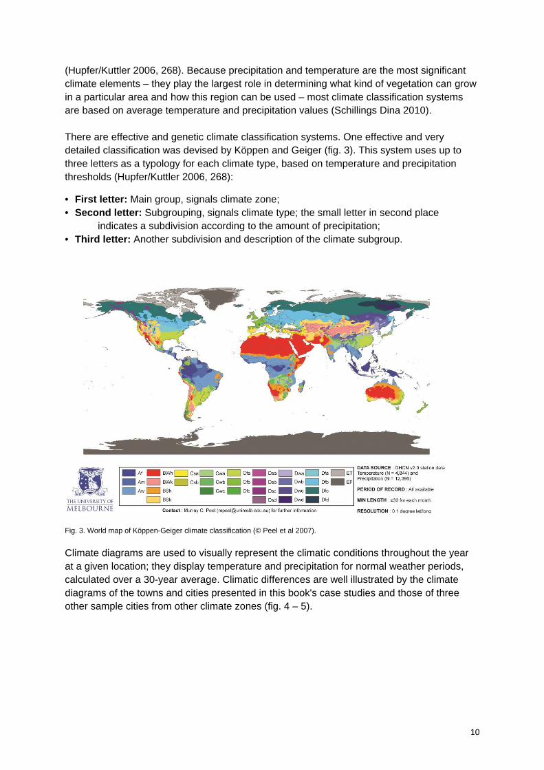
(Hupfer/Kuttler 2006, 268). Because precipitation and temperature are the most significant climate elements – they play the largest role in determining what kind of vegetation can grow in a particular area and how this region can be used – most climate classification systems are based on average temperature and precipitation values (Schillings Dina 2010). There are effective and genetic climate classification systems. One effective and very detailed classification was devised by Köppen and Geiger (fig. 3). This system uses up to three letters as a typology for each climate type, based on temperature and precipitation thresholds (Hupfer/Kuttler 2006, 268):
• First letter: Main group, signals climate zone; • Second letter: Subgrouping, signals climate type; the small letter in second place
indicates a subdivision according to the amount of precipitation; • Third letter: Another subdivision and description of the climate subgroup.
Fig. 3. World map of Köppen-Geiger climate classification (© Peel et al 2007).
Climate diagrams are used to visually represent the climatic conditions throughout the year at a given location; they display temperature and precipitation for normal weather periods, calculated over a 30-year average. Climatic differences are well illustrated by the climate diagrams of the towns and cities presented in this book's case studies and those of three other sample cities from other climate zones (fig. 4 – 5).
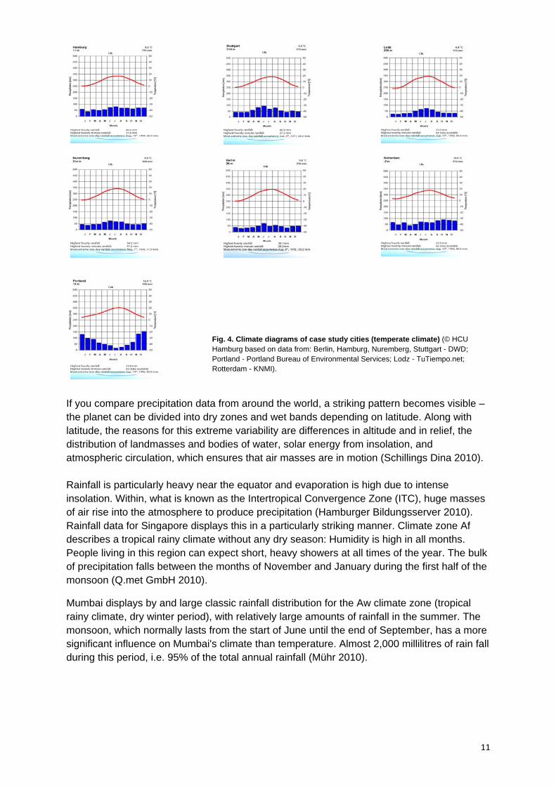
11
Fig. 4. Climate diagrams of case study cities (temperate climate) (© HCU Hamburg based on data from: Berlin, Hamburg, Nuremberg, Stuttgart - DWD; Portland - Portland Bureau of Environmental Services; Lodz - TuTiempo.net; Rotterdam - KNMI).
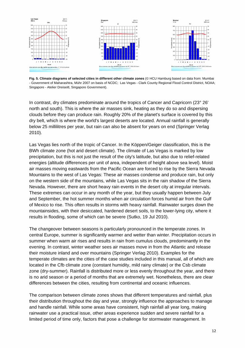
If you compare precipitation data from around the world, a striking pattern becomes visible – the planet can be divided into dry zones and wet bands depending on latitude. Along with latitude, the reasons for this extreme variability are differences in altitude and in relief, the distribution of landmasses and bodies of water, solar energy from insolation, and atmospheric circulation, which ensures that air masses are in motion (Schillings Dina 2010). Rainfall is particularly heavy near the equator and evaporation is high due to intense insolation. Within, what is known as the Intertropical Convergence Zone (ITC), huge masses of air rise into the atmosphere to produce precipitation (Hamburger Bildungsserver 2010). Rainfall data for Singapore displays this in a particularly striking manner. Climate zone Af describes a tropical rainy climate without any dry season: Humidity is high in all months. People living in this region can expect short, heavy showers at all times of the year. The bulk of precipitation falls between the months of November and January during the first half of the monsoon (Q.met GmbH 2010).
Mumbai displays by and large classic rainfall distribution for the Aw climate zone (tropical rainy climate, dry winter period), with relatively large amounts of rainfall in the summer. The monsoon, which normally lasts from the start of June until the end of September, has a more significant influence on Mumbai's climate than temperature. Almost 2,000 millilitres of rain fall during this period, i.e. 95% of the total annual rainfall (Mühr 2010).
12
Fig. 5. Climate diagrams of selected cities in different other climate zones (© HCU Hamburg based on data from: Mumbai - Government of Maharashtra, Mühr 2007 on basis of NCDC; Las Vegas - Clark County Regional Flood Control District, NOAA; Singapore - Atelier Dreiseitl, Singapore Government).
In contrast, dry climates predominate around the tropics of Cancer and Capricorn (23° 26' north and south). This is where the air masses sink, heating as they do so and dispersing clouds before they can produce rain. Roughly 20% of the planet's surface is covered by this dry belt, which is where the world's largest deserts are located. Annual rainfall is generally below 25 millilitres per year, but rain can also be absent for years on end (Springer Verlag 2010). Las Vegas lies north of the tropic of Cancer. In the Köppen/Geiger classification, this is the BWh climate zone (hot arid desert climate). The climate of Las Vegas is marked by low precipitation, but this is not just the result of the city's latitude, but also due to relief-related energies (altitude differences per unit of area, independent of height above sea level). Moist air masses moving eastwards from the Pacific Ocean are forced to rise by the Sierra Nevada Mountains to the west of Las Vegas: These air masses condense and produce rain, but only on the western side of the mountains, while Las Vegas sits in the rain shadow of the Sierra Nevada. However, there are short heavy rain events in the desert city at irregular intervals. These extremes can occur in any month of the year, but they usually happen between July and September, the hot summer months when air circulation forces humid air from the Gulf of Mexico to rise. This often results in storms with heavy rainfall. Rainwater surges down the mountainsides, with their desiccated, hardened desert soils, to the lower-lying city, where it results in flooding, some of which can be severe (Sutko, 19 Jul 2010). The changeover between seasons is particularly pronounced in the temperate zones. In central Europe, summer is significantly warmer and wetter than winter. Precipitation occurs in summer when warm air rises and results in rain from cumulus clouds, predominantly in the evening. In contrast, winter weather sees air masses move in from the Atlantic and release their moisture inland and over mountains (Springer Verlag 2010). Examples for the temperate climates are the cities of the case studies included in this manual, all of which are located in the Cfb climate zone (constant humidity, mild rainy climate) or the Csb climate zone (dry-summer). Rainfall is distributed more or less evenly throughout the year, and there is no arid season or a period of months that are extremely wet. Nonetheless, there are clear differences between the cities, resulting from continental and oceanic influences. The comparison between climate zones shows that different temperatures and rainfall, plus their distribution throughout the day and year, strongly influence the approaches to manage and handle rainfall. While some areas have consistent, high rainfall all year long, making rainwater use a practical issue, other areas experience sudden and severe rainfall for a limited period of time only, factors that pose a challenge for stormwater management. In

13
addition to the climatic factors, there can also be differences in the amount of rainfall and how it is distributed within a climate zone, which makes it necessary to continuously adapt measures undertaken for decentralised stormwater management so that they suit the climate conditions prevalent in a given location. The cases outlined in this manual focus on cities in temperate regions, because constant levels of rainfall all year round make it possible to develop an extensive range of approaches to decentralised stormwater management, which showcase a wide variety of solutions. The examples outlined are to be seen less as “how-to guides” that can simply be transferred to other places, but instead as sources of inspiration, which show different ideas and approaches, and stimulate ingenuity.
14
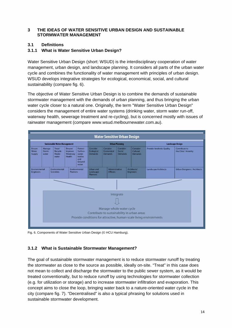
3 THE IDEAS OF WATER SENSITIVE URBAN DESIGN AND SUSTAINABLE STORMWATER MANAGEMENT 3.1 Definitions 3.1.1 What is Water Sensitive Urban Design? Water Sensitive Urban Design (short: WSUD) is the interdisciplinary cooperation of water management, urban design, and landscape planning. It considers all parts of the urban water cycle and combines the functionality of water management with principles of urban design. WSUD develops integrative strategies for ecological, economical, social, and cultural sustainability (compare fig. 6).
The objective of Water Sensitive Urban Design is to combine the demands of sustainable stormwater management with the demands of urban planning, and thus bringing the urban water cycle closer to a natural one. Originally, the term "Water Sensitive Urban Design" considers the management of entire water systems (drinking water, storm water run-off, waterway health, sewerage treatment and re-cycling), but is concerned mostly with issues of rainwater management (compare www.wsud.melbournewater.com.au).
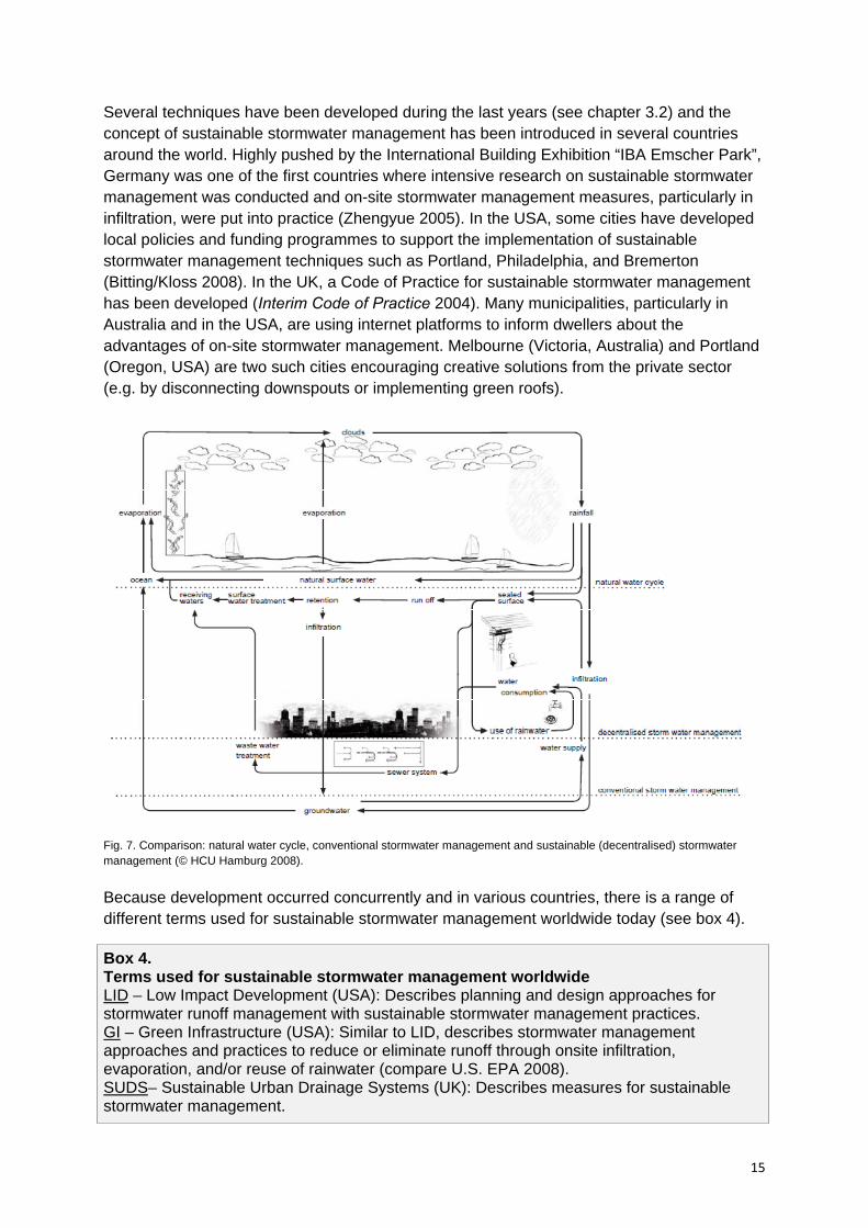
Fig. 6. Components of Water Sensitive Urban Design (© HCU Hamburg). 3.1.2 What is Sustainable Stormwater Management? The goal of sustainable stormwater management is to reduce stormwater runoff by treating the stormwater as close to the source as possible, ideally on-site. “Treat” in this case does not mean to collect and discharge the stormwater to the public sewer system, as it would be treated conventionally, but to reduce runoff by using technologies for stormwater collection (e.g. for utilization or storage) and to increase stormwater infiltration and evaporation. This concept aims to close the loop, bringing water back to a nature-oriented water cycle in the city (compare fig. 7). “Decentralised” is also a typical phrasing for solutions used in sustainable stormwater development.
15
Several techniques have been developed during the last years (see chapter 3.2) and the concept of sustainable stormwater management has been introduced in several countries around the world. Highly pushed by the International Building Exhibition “IBA Emscher Park”, Germany was one of the first countries where intensive research on sustainable stormwater management was conducted and on-site stormwater management measures, particularly in infiltration, were put into practice (Zhengyue 2005). In the USA, some cities have developed local policies and funding programmes to support the implementation of sustainable stormwater management techniques such as Portland, Philadelphia, and Bremerton (Bitting/Kloss 2008). In the UK, a Code of Practice for sustainable stormwater management has been developed (Interim Code of Practice 2004). Many municipalities, particularly in Australia and in the USA, are using internet platforms to inform dwellers about the advantages of on-site stormwater management. Melbourne (Victoria, Australia) and Portland (Oregon, USA) are two such cities encouraging creative solutions from the private sector (e.g. by disconnecting downspouts or implementing green roofs).
Fig. 7. Comparison: natural water cycle, conventional stormwater management and sustainable (decentralised) stormwater management (© HCU Hamburg 2008).
Because development occurred concurrently and in various countries, there is a range of different terms used for sustainable stormwater management worldwide today (see box 4). Box 4. Terms used for sustainable stormwater management worldwide LID – Low Impact Development (USA): Describes planning and design approaches for stormwater runoff management with sustainable stormwater management practices. GI – Green Infrastructure (USA): Similar to LID, describes stormwater management approaches and practices to reduce or eliminate runoff through onsite infiltration, evaporation, and/or reuse of rainwater (compare U.S. EPA 2008). SUDS– Sustainable Urban Drainage Systems (UK): Describes measures for sustainable stormwater management.

16
BMP–Best Management Practices (Europe): Describes measures for sustainable stormwater management. DRWM - Decentralised Rainwater/Stormwater Management (Germany): Describes measures and techniques. IURWM – Integrated Urban Resource Water Management (global): Describes an integrated approach to manage urban water (not only stormwater). WSUD – Water Sensitive Urban Design (particularly Australia): Describes an approach that aims to integrate sustainable water management, particularly decentralised storm water management, into urban design. 3.1.3 What does Sustainable Stormwater Management mean in terms of Water Sensitive Urban Design? Past experiences with sustainable stormwater management in cities have made it clear that an integrative approach linking urban design demands must be formed. Water Sensitive Urban Design provides this link. Although Water Sensitive Urban Design considers all parts of the urban water cycle, stormwater is a key element, both as a resource, and for the protection of receiving rivers (Melbourne Water 2005). In turn, decentralised stormwater management can benefit from integrating with urban design demands. For that reason the Water Sensitive Urban Design approach is predominantly used in its application on urban stormwater management that aims to recreate a natural-oriented water cycle while contributing to the amenity of the city. According to the Urban Stormwater - Best Practice Environmental Management Guidelines of the Victorian Stormwater Committee (The Urban Stormwater Best Practice Environmental Management Guidelines 1999), the goals of WSUD from a stormwater management and planning perspective are:
Protection of natural water systems within urban developments Protection of the water quality by using filtration and retention techniques Reduction of stormwater runoff and peak flows by using local detention and retention
measures and minimizing impervious areas Reduction of drainage infrastructure and the related development costs, whilst
improving sustainability and amenity of urban areas Integration of stormwater management into the landscape by incorporating multiple
use corridors that contribute to the visual and recreational amenity of urban areas
On basis of these goals, principles for WSUD in terms of stormwater management are described in chapter 4. These can be seen as recommendations for planners and practitioners in the sector of water management and urban design planning.
17
3.2 Technical elements and solutions There are many technical solutions for facilitating sustainable stormwater management. These solutions were developed as responses to specific stormwater management needs and site situations, each with unique characteristics, advantages and disadvantages. Appropriate selection of methods is important for the success of any system, but there is not necessarily a “right answer”. In fact, the ideal solution is often several methods appropriately linked (Woods-Ballard 2007, 5.1). In the context of Water Sensitive Urban Design, it is especially important to pair solutions appropriately with land use. For example, a pedestrian walkway is the ideal place for an open stormwater canal, but if sited next to a busy road, debris could disrupt the canal flows, and the canal could disrupt traffic and parking. The following is a description of some essential methods for sustainable stormwater management. There are many other options, but these methods in particular correspond to landscape, architectural, and urban planning concepts. Methods are grouped according to their primary function: water use, treatment, detention and infiltration, conveyance, and evapotranspiration. In most cases methods serve several functions. A general description is provided for each method listed as well as a description of potential for implementation in urban design. Additional information with regard to construction and dimensioning of different stormwater management measures is given by different country-specific guidelines and manuals (for links see chapter 3.3.2 or Scholes/Revitt 2008). See also SWITCH deliverables Scholes/Shutes 2007 and Shutes 2008 for more information regarding specific methods. 3.2.1 Rainwater use Water usage has practical advantages in that it reduces service demand and saves energy, resources, and cost over time. Methods that utilize rainwater as a resource also serve to detain this water. This dual functionality makes water harvesting an attractive decentralised method, when feasible. Rainwater harvesting General description Rainwater harvesting cisterns or water butts can be underground or aboveground. Cisterns are typically larger storage devices that can be used for water supply such as toilets or fire sprinklers when treated. Water butts are smaller off-line storage devices used for garden irrigation. In some cases, ponds can even be used to store and filter water for use in gardens or as potable water. Urban Design Implication Harvesting methods can be adapted for larger complexes or individual buildings. Aboveground storage systems can be incorporated into landscape or architectural design as fountains, pools, etc.
3.2.2 Treatment Stromwater treatment is necessary before use in domestic water services or before infiltration into the ground if runoff does not meet quality standards specified by applicable guidelines. Bioretention, biotopes, and gravel or sand filters are corresponding options for stormwater treatment.

18
Bioretention General description Bioretention areas are shallow landscaped depressions, which typically drain from below and rely on engineered soils and enhanced vegetation and filtration to remove pollution and reduce downstream runoff. These systems manage and treat runoff from frequent rainfall events. Urban Design Implication Bioretention systems come in various sizes and shapes, and support different types of vegetation. Because of this variety, bioretention systems can be landscaped and adapted for a variety of urban spaces. During dry periods, these spaces can be used for recreation. If carefully designed visitors can also enjoy the water retained after heavy rainfall.
Biotopes General description A biotope as it pertains to sustainable stormwater management is a landscape of plants and sometimes animals deliberately assembled for ecological stability. Biotopes can be used to improve water quality through natural oxygenation and other processes, typically with reed beds and other wetland growth (fig. 8). Urban Design Implication Biotopes are used to improve water quality, but also add to the aesthetic amenity of ponds or water features. As a landscape feature, reed beds can be strategically placed to shelter a site from wind or unpleasant views and frame public spaces or walking paths. Wind, moving through the reeds creates a soothing atmosphere and educates visitors on natural processes while increasing biodiversity in the city.
Gravel or sand filters General description Filter systems are above ground or below ground chambers that are designed to treat surface water runoff, typically with gravel or sand as the primary filter medium. More technical filtration systems exist if required (fig. 9). Urban Design Implication Surface filters can be integrated into landscape, architectural, and urban design as edging along green spaces, canals, or buildings.
Fig. 8. Biotope in Malmö, Sweden (© J. Lee). Fig. 9. Debris filter canal in Malmö, Sweden (© L. Kronawitter)
19
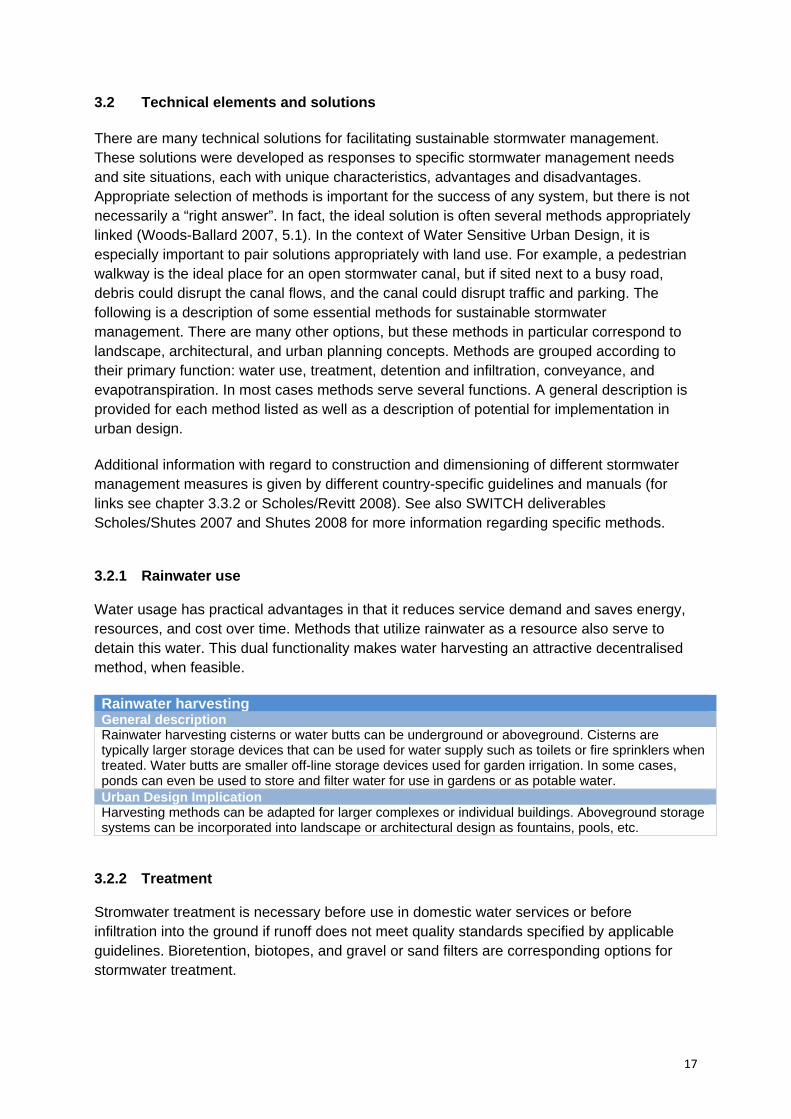
3.2.3 Detention and infiltration Rainwater is detained to lower the risk of flooding, reduce surface water flows, reduce stress on stormwater sewers, and restore natural hydrology. Typically, detention systems temporarily store water and gradually infiltrate it into the ground or convey it to be infiltrated elsewhere. Rooftop retention General description Methods for rooftop retention generally consist of a multi-layered structure, designed according to the function and size of the roof system. Green roofs are either extensive (fig. 10) or intensive. Extensive green roofs are lighter and feature hardy succulent plants. Intensive green roofs are heavy and feature a thicker growing medium to support deep-rooted vegetation. The construction of brown roofs is similar to green roofs, but brown roofs utilize locally sourced material, such as gravel, debris, and soil, and are typically intended to mitigate habitat loss in new development. Urban Design Implication Green roofs can have an affect on the performance and appearance of individual buildings as well as entire cities. For designers, a green roof is not just an effective roofing material but also an opportunity for linking the structured building to the landscape. Green roofs are a visual improvement over hard surface rooftops, and can be enjoyed from inside the building or even designed as an accessible garden. On the city scale green roofs replace lost habitat, repairing urban ecology, and biodiversity. Additionally, there is a direct correlation to physical human health because green roofs increase evaporation and transpiration, curbing the heat island affect. There are psychological benefits to bringing green spaces closer to building inhabitants as well.
Permeable paving General description Permeable pavement includes pavers, asphalt, or concrete that allows water to pass through into a specially-designed sub grade gravel bed or other porous medium. Permeable pavement systems retain water in the sub grade, where it can infiltrate into the ground, evaporate, or be drained from the system (fig. 11). Urban Design Implication Pavement systems can be designed for vehicular or pedestrian traffic and are especially useful in urban situations where space is a commodity. The dual usage allows for both water retention and hard surfaces to coexist in the same area. Recent technologies provide a variety of pavement designs, which when properly specified can add to the aesthetic amenity of a space. Permeable paving can also be used to slow or quiet traffic and some systems can even be planted.
Left: Fig. 10. Green roof in Elmshorn, Germany (© W. Dickhaut). Right: Fig. 11. Permable pavement, New York City, New York, USA (© M. Derneden).
20
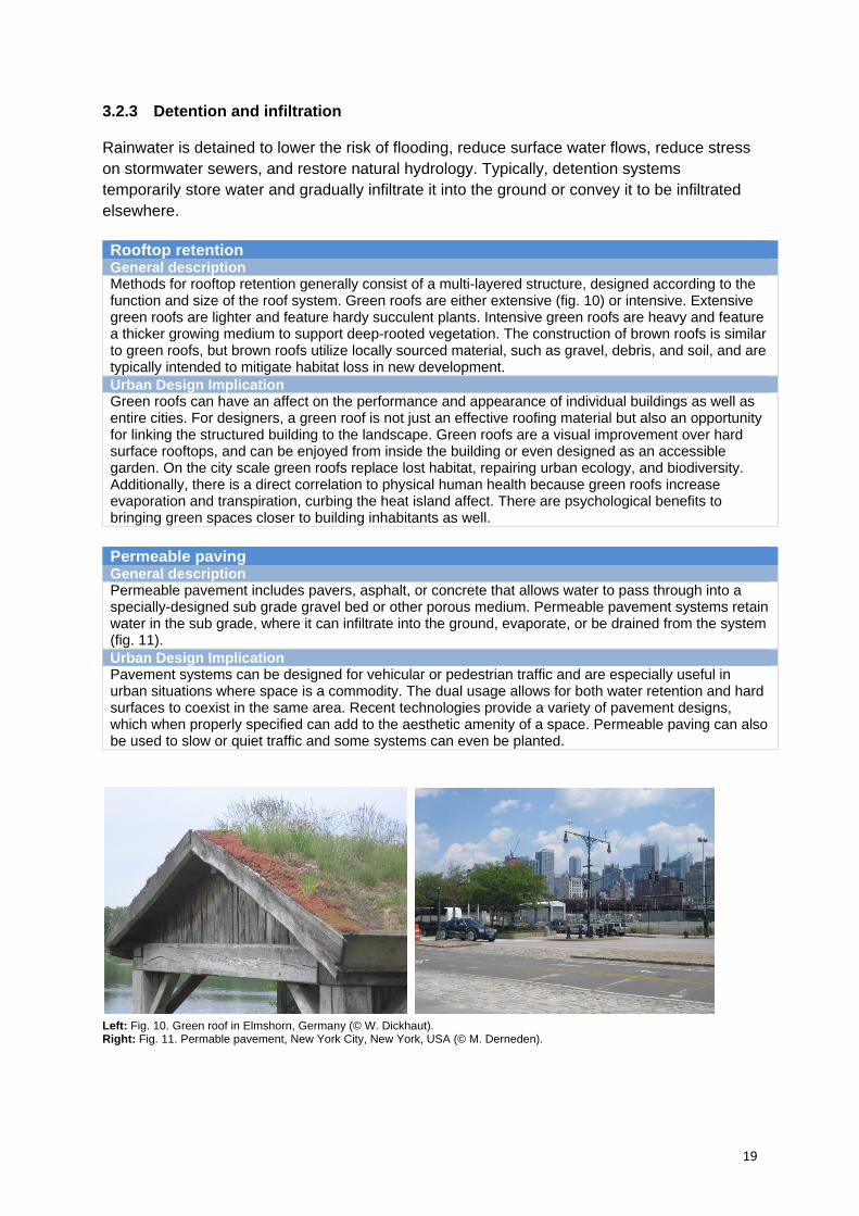
Infiltration zones and trenches General description Infiltration zones and trenches are concentrated planted spaces for rapid infiltration of surface water. These systems can be highly technical featuring strata for retention, filtration, and infiltration such as gravel, sand, and other minerals or substructures. Design criteria are highly specific to rainwater intensities, local soil conditions and available space (fig. 12). Urban Design Implication Infiltration zones and trenches can be incorporated into diverse settings including public and private gardens, roadside planters, parks, driveways, sidewalks, median strips. These installations can be used in conjunction with street quieting measures and other traffic control installations. Infiltration zones and trenches can be used to beautify a neighbourhood, especially those that are heavily paved. When integrated into the sidewalk or street, community health and public perception of the environment can drastically improve. Infiltration zones can also be integrated into the landscape of existing residences, offices, gardens, pocket parks, and large public parks. Typical applications are street planters and rain gardens.
Swales General description Swales are linear vegetated drainage features that store or convey surface water. Swales can either have an impermeable base and therefore be designed only for water transport and downstream management, or permeable for infiltration during conveyance (fig. 13). Urban Design Implication Swales can be integrated in open spaces and public park settings. However, they need some space. When carefully designed, the delicate slope of swales creates an interesting landscape that can even be utilized for recreation when dry.
Geocellular systems General description Geocellular or modular systems are prefabricated structures installed underground to store and slowly infiltrate stormwater. Systems come in a variety of sizes and can service large quantities of stormwater. Urban Design Implication Geocellular systems are useful in high-density urban areas where space is a commodity because they are invisible on the street surface.
Left: Fig. 12. Rain garden, Police Department, City of Brisbane, California, USA (© J. Hoyer). Right: Fig. 13. Swale, Police Department, City of Brisbane, California, USA (© J. Hoyer).
21
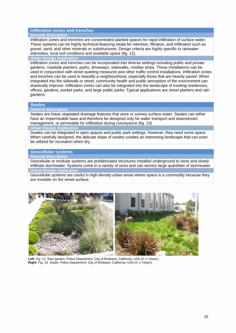
Detention pond (dry) General description Detention ponds (dry) are surface storage basins that attenuate and hold stormwater runoff. While water is held in the pond, particulates settle. Water is then slowly infiltrated or drained into additional conveyance systems or surface water. Systems are typically dry until periods of heavy rainfall (fig. 14). Urban Design Implication Detention ponds are constructed to hold rainwater. However, when a pond is dry it can be utilized for recreational use. Also, dry detention ponds can be landscaped and therefore easily incorporated into park planning and design.
Detention pond (wet) General description Wet detention ponds store and hold rainwater. They can be designed to circulate water through filtration devices, such as biotopes, improving water quality as required either for downstream infiltration, or in conjunction with other solutions for use in irrigation or appropriate water supply. The main difference to other systems is that they consistently hold water (fig. 15). Urban Design Implication Water in urban spaces is an aesthetic amenity that increases humidity, lowers summer temperatures and provides a space for recreation. When water features are incorporated into planning and architectural design, perception and use of the space immediately improves.
Left: Fig. 14. Detention pond (dry), Gelsenkirchen, Germany (© J. Eckart). Right: Fig. 15. Detention pond (wet) in Tanner Springs Park, Portland, Oregon, USA (© J. Hoyer).
3.2.4 Conveyance
Open stormwater canals/ drains General description Open stormwater canals are an alternative to underground sewers. Canals can convey stormwater from impervious surfaces, such as rooftops and streets, into underground sewer systems or decentralised management systems (compare case study Trabrennbahn Farmsen). Urban Design Implication Open stormwater canals can dramatically change the perception of an urban space. Open water flows excite pedestrians and encourage children to play. Additionally, canals can provide a visible link between other systems in a management train, educating viewers on the water cycle. Canals can also be planted and linked to filters, cascades, or pools, changing the interaction of rainwater and space planning.
3.2.5 Evapotranspiration Evapotranspiration is an integral and vital component of the water cycle. Plants consume water and transpire, and water bodies exposed to heat and sun evaporate. This process has an effect on temperature, humidity and precipitation. Unfortunately, contemporary cities are

22
often heavily paved, lacking vegetation and water and massive materials absorb and radiate heat – commonly known as the heat island effect. Passive evapotranspiration General description Passive evapotranspiration refers to the concept of utilizing the inherent qualities; transpiration and evaporation to improve indoor and outdoor climate. Essentially, green spaces create a more comfortable climate. Urban Design Implication All vegetated systems can be considered as contributing to passive evapotranspiration. Also more vegetation in the city also means less hard surfaces. This is especially important in cities with extreme temperatures in summer months and a high incidence of heat islanding, such as New York City. More specific systems can also be sized to target and improve individual local microclimates (compare case study Potsdamer Platz).
3.3 Drivers
Around the world various regulation strategies, guidelines, and engineering standards have been developed as a basis for sustainable stormwater management. This chapter gives an overview of current international and national regulations, engineering standards and guidelines, local regulations and incentives. Research primarily focused on Europe (particularly Germany and UK), Australia and the USA.
3.3.1 International and national regulations
Sustainable stormwater management is ideally based on international and national regulations. The state of the art in developing these regulations differs worldwide. In Europe, in the USA, and in Australia, legislation is widely developed and can give inspiration to those countries and regions worldwide yet to create a legal basis for sustainable stormwater management.
In Europe legislation for decentralised stormwater management is quite advanced. Via the Water Framework Directive of the European Union, all countries have already or are going to develop country related legislation for all issues concerning water management (including stormwater).
The Water Framework Directive of the European Union serves to organize governing zones, foster communication and collaboration, and develop goals for the protection and revitalization of water systems (Water Framework Directive 2000). Previous European water regulation standards focused on drinking water, fishing, bathing, and groundwater, and targets substances dangerous to human welfare. The Water Framework Directive expands
Active evapotranspiration General description Active methods utilize water systems to directly change or influence the temperature or air quality of public spaces or within buildings. Such methods include rainwater walls, (compare case study Prisma Nürnberg) fountains, and pools. Systems can be supplemented by technical systems. Fans for example can circulate cool air from the water surface, or building skins can take advantage of cooler air currents from water surfaces. Urban Design Implication Water is a desired feature both inside and outside of buildings. By directly incorporating water with building design this adds to the aesthetic amenity of the space. This is in addition to the likely benefits from “air conditioning” savings and lowered energy footprint.
23
EU water legislation and endeavours to create a more comprehensive plan for European wide management practices and quality standards, most importantly, putting a high priority on the environment in its entirety, instead of focusing solely on human health concerns. Ecological protection is a priority in the directive and applies to all waters regardless of purpose, i.e. drinking or bathing. Also, through the treaty, the environment can be managed through a unified approach that considers the watershed in its entirety without being inhibited by political borders. River Basin Management districts were redrawn to better address and develop regional management schemes. Boundaries often traverse national borders, demonstrating the importance of such treaties.
Germany has taken an especially strong federal role in the support and regulation of sustainable water management solutions. The 2010 Germany Water Resources Act (Wasserhaushaltsgesetz 2010) establishes clear directives for water resource management, including groundwater pollution and degradation, urban wastewater treatment, environmental protection, and flood risks, and establishes frameworks for community action networks, largely believed in Germany and other countries to be the first course of action in implementing systems. For years, water sensitive or “decentralised” solutions (as typically referenced in Germany) have been a water management goal. Recently, decentralised methods were officially adopted as the preferred method for stormwater management. Decentralised methods are therefore to be considered first and implemented when possible (Wasserhaushaltsgesetz 2010). The German Waste Water Levy Act (Abwasserab-gabengesetz 2009) strongly follows the “polluter pays” principle. It is the first nationwide environmental tax and places financial responsibility of cleanup with polluters.
Also the United Kingdom has taken a very supportive stance on water sensitive development, typically referred to in the UK as Sustainable Urban Drainage Systems (SUDS). Although not required, SUDS are repeatedly listed as preferred solutions for stormwater management. In the context of regional planning for example, the very recent “Planning Policy Statement 25 for Development and Flood Risk” (Planning Policy Statement 25 2006) requires that SUDS specifically be considered at every level of flood risk planning. Similarly, the Town and Country Planning Assessment of Environmental Effects Regulations (The Town and Country Planning Regulations 1999) determine that SUDS may be used to mitigate negative impacts on the environment. In the building sector, “Document H” (Approved Document H 2006) establishes a hierarchy of building water management that favours infiltration over piped systems.
In Australia, WSUD strategies are recommended for new developments, although they are not required by national regulations. More importantly, recent collaboration between Commonwealth, State, and Municipal governments has sparked state environmental legislation and planning policy directed towards the specific development of WSUD strategies. The Council of Australian Governments (COAG) has taken big steps to progress water reforms specifically in urban environments. On June 25 2004, the Intergovernmental Agreement on a National Water Initiative (Intergovernmental Agreement on a National Water Initiative 2004) was signed, demonstrating Australia's shared commitment for water reform and in 2008 COAG agreed to work on a programme on water, which includes progressive urban water reforms. To date there are nine Water Implementation Plans (one of which is for national implementation) aiming to provide healthy, safe and reliable water supplies, increase water use efficiency, encourage re-use and recycling of wastewater, facilitate water trading, and improve pricing (Australian Government, National Water Commission 2010).

24
In the USA water quality regulation at the federal level establishes baseline quality and management criteria, but specifics are typically under state or regional authority. Water quality is federally ensured by the Clean Water Act. This act provides the statutory authority to regulate water pollution and aims to “restore and maintain the chemical, physical, and biological integrity of the Nation's waters” (Clean Water Act 1972). The Environmental Protection Agency (EPA) acts as the organizing body for water quality regulation in the United States, setting national standards for pollution (Water Quality Standards - WQS). Pollution is controlled through the National Pollutant Discharge Elimination System (NPDES), which is responsible for the issuance of permits to polluters contributing discharges directly to water bodies, which in many cases includes pollution via storm drains. NPDES permits are typically issued by authorized states or municipalities, and are coordinated with local WQS (US EPA 2009b).
3.3.2 Engineering standards and guidelines
Many countries have established guidelines for construction and management of decentralised water systems. In most cases, permits for rainwater retention or groundwater infiltration are considered alternatives to existing stormwater systems, and receiving a permit for the construction of decentralised solutions means being granted a variance from conventional stormwater regulation. Guidelines are established for the engineering as well as the process for implementation of decentralised solutions as an alternative.
German water regulation however already views decentralised stormwater management as an acceptable, if not preferred, alternative to conventional systems. The German Association for Water Management, Wastewater, and Waste (Deutsche Vereinigung für Wasserwirtshaft, Abwasser und Abfall) has adopted water management engineering regulations to include sections on the planning, building, and servicing of rainwater infiltration systems, and decentralised stormwater treatment standards. These documents, the DWA-M 153 (Handlungsempfehlungen zum Umgang mit Regenwasser 2007) and DWA-A 138 (Planung, Bau, und Betrieb von Anlagen zur Versickerung von Niederschlagswasser 2005) offer technical stormwater design specifications for engineers working on water retention, infiltration, and treatment.
UK standards for sustainable stormwater drainage are based on the Construction Industry Research and Information Association (CIRIA) guidelines and recommendations for Sustainable Drainage Systems (SUDS). There are several publications available for developers, planners, and engineers for designing such projects, with topics including implementation, planning, management, and technical guidance. Literature is appropriately grouped by region, with England and Wales (Sustainable urban drainage systems - Design manual for England and Wales 2000), and Northern Ireland and Scotland (Sustainable urban drainage systems - Design manual for Scotland and Northern Ireland 2000) and by subject (full list can be found on the website: www.ciria.org.uk/suds/publications.htm). The “Interim Code of Practice” (Interim Code of Practice for Sustainable Drainage Systems 2004) provides a strategic approach to the allocation of maintenance and responsibility; “The Best Practice Manual” (Sustainable urban drainage systems - Best practice manual for England, Scotland, Wales and Northern Ireland 2001) covers wider aspects, addressing the legislative issues and how organisations may work together in employing SUDS; And technical guidance is provided by “Sustainable Drainage Systems: Hydraulic, Structural and Water Quality Advice” (Sustainable drainage systems - Hydraulic, structural and water quality

25
advice 2004) that summarises current knowledge on the best approaches to design and construction of sustainable drainage systems.
In Australia guidelines are being developed in national, regional, and local arenas. For example, following the criteria of the National Water Initiative, the Environment Protection Heritage Council and the National Resource Management Council, in conjunction with the National Health and Medical Research Council, developed guidelines for using rainwater, including managing environmental risks, stormwater harvesting, and recharging Aquifers (Australian Environment Protection and Heritage Council 2010).
Guidelines have also been established by different states. The Victorian Stormwater Committee; a partnership between Environment Protection Authority (EPA) and Melbourne Water Corporation, have established the Urban Stormwater Best Practice Environmental Management Guidelines (BPEMG) (The Urban Stormwater Best Practice Environmental Management Guidelines 1999). This leading guide provides urban land use planners, whether in regional or metropolitan arenas, with a framework for water sensitive stormwater management. Although not a technical manual this guideline has been a starting point for many of the recent WSUD projects in Australia. Similarly, although less frequently, local authorities also have a role in determining standards. The City of Melbourne, working closely with Victoria provides developers and planners with WSUD Engineering Procedures, Guidelines for Constructed Wetlands Systems, and Project Management Guidelines as part of a city-wide campaign for water sensitive development (Melbourne Water 2010).
Stormwater standards and guidelines in the USA are organized via Best Management Practice (BMP) Manuals (US EPA 2010). Although the EPA is responsible for general BMP guidelines, individual states and sometimes municipalities are authorized to develop their own BMPs. Typically, BMPs pertain to water quality via storm drain systems and do not include decentralised measures (also typically referred to as Low Impact Development and Green Infrastructure in the United States) in the overall programme design. However, in some instances, such as managing construction site runoff, BMPs specify decentralised stormwater management practices for an NPDES permit such as the utilization of drainage swales or erosion controls (e.g. State of California Construction Site BMP Manual 2003, 26&35).
Although BMPs do not directly incorporate decentralised methods, it is clear that the federal government largely supports sustainable stormwater management for future development. In September 2008, the EPA began releasing a Green Infrastructure Municipal Handbook, giving advice to cities on implementing, funding and promoting green infrastructure such as green streets or rainwater harvesting methods (US EPA 2009a). Additionally, the EPA’s Water Quality Scorecard was developed to “help local governments identify opportunities to remove barriers, and revise and create codes, ordinances, and incentives for better water quality protection” (US EPA 2009c).
3.3.3 Local regulations
In Australia, state authorities provide policy, strategic guidelines, or technical parameters while local authorities determine project (or water system) specific provisions for development. Victoria for example has a history of water legislation, which has been crucial in recent WSUD permissions. Legislation stems back to the 1970 State Environmental Protection Policy requiring that stormwater should not harm humans or animals, surface or

26
groundwater. Also relevant, the 1989 Water Act in Southern Australia identified rights to water use and paved the way for local or individual rainwater harvesting and infiltration strategies. Similarly, in the Northern Territory the Planning Act established new criteria for development and the Local Government Act expanded local authority to regulate stormwater (McManus 2009, 9). These acts jointly established the regulatory basis for localized stormwater management schemes.
Permission and licenses for local water schemes and WSUD infrastructure projects are issued locally. The cities of Melbourne and Sydney strongly support WSUD for stormwater management and strive to make the licensing process as painless as possible. Melbourne already provides detailed guidelines but also describes how to meet Melbourne water quality and pollution requirements. In addition to literature, projects are monitored and mapped on a website displaying recent installations (Melbourne Water 2010).
In the USA the Environmental Protection Agency is the regulatory institution for water management but regulation on the local level has recently been more aggressive in adopting sustainable stormwater management practices. Philadelphia’s stormwater regulation, for example, requires that projects infiltrate/manage the first 1 inch of rainfall from all directly connected impervious surfaces (Philadelphia Water Department 2006, S.600.5). Similarly, Portland has developed landmark storm water regulations including a mandatory hierarchy that requires on-site infiltration with surface vegetation above all other practices (Portland Bureau of Environmental Services 2004, 1-18). In the USA, also quality standards for infiltration are stated on local level.
It is likely that, with support from the EPA, the local municipalities will drive sustainable stormwater management from the bottom up in coming years. The case of New York (compare chapter 5.5) shows that some cities began to develop integrated plans for sustainable stormwater management in an informal process. New York planners surveyed the possibilities for using decentralised methods for stormwater management and elaborated strategies for implementation. This plan is part of the plaNYC 2030, New York’s overall master plan for further sustainable development.
Experience shows that although national and international standards are the basis for sustainable stormwater management, water authority is successful when organized locally. By setting the prices to be paid to discharge rainwater into the sewer system and providing possibilities to be excluded from these charges when using decentralised methods for managing rainwater (such as green roofs or infiltration areas), cities have a big influence on whether decentralised methods for stormwater management are used or not. Furthermore city authorities have the possibility to stipulate a compulsory usage of decentralised rainwater management methods for new developments (by including as a rule in the specific development plan) or to provide subsidies. Notably, the observation that water management does not necessarily need to be overtaken by individual cities is shown by the example of the Emscher Region (see chapter 5.5), where management is organized through a regional division that agreed to make the usage of decentralised methods for stormwater management a must when developing new areas.
3.3.4 Incentives
There are two different options to push the implementation of sustainable stormwater management in cities: direct subsidies and indirect subsidies.

27
Direct subsidies are funds provided by city authorities or the federal state to support measures of sustainable stormwater management. For example, the recent Obama administration Economic Recovery Act in the USA allocated funds ($6.680.000) for “green infrastructure, water or energy efficiency improvements, or other environmentally innovative activities” (Hanlon/ Dougherty 2009, 5:C:21 21). Specific example projects have included ca. $445.000 for landscape swales, $445.000 for a filtration pond, and $100.000 for the removal of impervious surfaces (Hanlon/ Dougherty 2009, 5:C:21 24-26). As another example, in Germany there are several funding options provided to support the implementation of green roofs. The German Green Roofs Association (Deutscher Dachgärtnerverband) in cooperation with the HafenCity University of Hamburg recently collaborated on a guide that gives municipalities advice on which funding options can be used to enhance the implementation of green roofs in their community (Ansel et al. 2011).
Indirect subsidies are given by different cities around the world through offering a stormwater discount when private property owners use sustainable stormwater measures for managing their stormwater and reducing their impervious surface area. The City of Portland, Oregon, USA for example states on its website: “If you manage stormwater on your property, you can receive up to a 100% discount on your on-site stormwater management charges because your actions help protect rivers, streams and groundwater from the damaging effect of stormwater runoff” (Portland Bureau of Environmental Services 2010d).
3.3.5 Summary
Although there are different regulatory structures, roles, and policy traditions in play in Germany, the UK, Australia, and in the United States, this study shows that each country actively supports sustainable development in water management. All selected countries demonstrate favouritism, at least in terms of technology, for decentralised solutions. Germany is the farthest in terms of offering the least resistance to project implementation, because standards are already written into engineering code as viable and preferred solutions. The UK also utilizes a detailed set of engineering standards, and is beginning to initiate regulations that encourage decentralised solutions. For certain projects, such as flood control, there may be a large influx of SUDS projects in the UK. Federal oversight in Australia and the USA is limited, but Australia’s states are well organized in terms of communication and established agreements to prioritize decentralised solutions (WSUD in Australia). In the USA, the federal authority, the EPA, certainly favours decentralised solutions, but is not actively pursuing regulatory control. Instead, information is presented and encouraged via incentives. Most activity in the USA is then happening at the local level, where every major city, and many smaller cities and towns, are in the process of developing, refining, and implementing their own strategies for the transition to sustainable water management. Although regulation clearly plays a role in the implementation of sustainable water management, it appears that even without strict controls and specification, decentralised projects will continue to grow in favour in the years to come. The shared experiences of these national examples demonstrate that providing information and guidance is very good for projects to be initiated. As technological awareness and advancement progresses, it is entirely possible that in a short period, decentralised solutions will be adopted into engineering standards as the norm.
28
4 PRINCIPLES FOR SUCCESSFUL WATER SENSITIVE URBAN DESIGN
4.1 Why principles are necessary?
Stormwater management for future cities needs to be ecologically, economically and socially sustainable. Successful stormwater management carefully addresses these concerns.
Through various techniques, decentralised stormwater management has already contributed to increasing sustainability in water management. Nevertheless, decentralised stormwater management approaches are underutilized and public as well as professional acceptance is still quite low.
The main deficiencies are:
Lack of Implementation: Despite legal and political support for decentralised solutions (see chapter 3.3),
implementation is limited. Decentralised stormwater solutions are underestimated in their functionality and are
not really seen as alternative options towards conventional solutions.
Planning authorities are accustomed to conventional stormwater solutions. Shifting the approval and licensing process is especially complicated and will require time.
Missing or Lacking Integrated Approaches:
Most decentralised stormwater solutions do not consider urban design in terms of contributing to the aesthetics and amenity of urban areas.
Decentralised stormwater solutions, when implemented, are typically not integrated in overall planning concepts. Similarly, planning concepts typically regard stormwater as solely a technical concern, and decentralised solutions are rarely considered during conceptual phases.
Integrated stormwater management, i.e. a cooperative work of professionals from different disciplines such as planners, engineers, and architects, is not common practice.
Lack of Knowledge, Acceptance and Awareness:
Professionals involved in the planning for water and city planning are not aware of the advantages and ideas of decentralised concepts.
There is almost no consideration of social issues (usability, public acceptance, awareness of dwellers, education (e.g. school rain gardens)) and the aesthetic value of rainwater management measures and facilities.
Conventional stormwater management keeps stormwater out of sight and out of mind. Local inhabitants are not aware of the problems connected with rainwater management and the advantages of decentralised solutions.
To counteract these challenges, SWITCH has developed principles that should be considered in order to combine the technologies of sustainable stormwater management with urban design in creating sustainable, liveable and attractive cities.
29
Box 5. Decentralised stormwater management is not really seen as an alternative to conventional solutions: Despite a good legal framework, and an acknowledged demand for decentralised methods,
implementation is still limited. Planners and authorities are often still concerned about the full functionality and
applicability of WSUD. The water in many places is set to drain into the existing public sewer system. Retrofitting
the existing system, including the planning and approval process, in order to embrace WSUD is a difficult and lengthy process.
Investors and property owners see additional costs as a barrier to the implementation of WSUD.
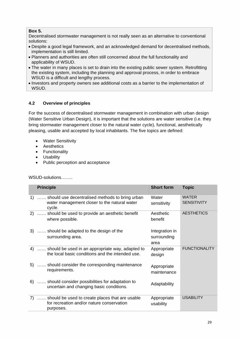
4.2 Overview of principles
For the success of decentralised stormwater management in combination with urban design (Water Sensitive Urban Design), it is important that the solutions are water sensitive (i.e. they bring stormwater management closer to the natural water cycle), functional, aesthetically pleasing, usable and accepted by local inhabitants. The five topics are defined:
Water Sensitivity Aesthetics Functionality Usability Public perception and acceptance
WSUD-solutions……..
Principle Short form Topic
1) …… should use decentralised methods to bring urban water management closer to the natural water
cycle.
Water sensitivity
WATER SENSITIVITY
2) …… should be used to provide an aesthetic benefit where possible.
3) …… should be adapted to the design of the surrounding area.
Aesthetic benefit Integration in surrounding area
AESTHETICS
4) …… should be used in an appropriate way, adapted to the local basic conditions and the intended use.
5) …… should consider the corresponding maintenance requirements.
6) …… should consider possibilities for adaptation to
uncertain and changing basic conditions.
Appropriate design Appropriate maintenance Adaptability
FUNCTIONALITY
7) …… should be used to create places that are usable for recreation and/or nature conservation purposes.
Appropriate usability
USABILITY
30
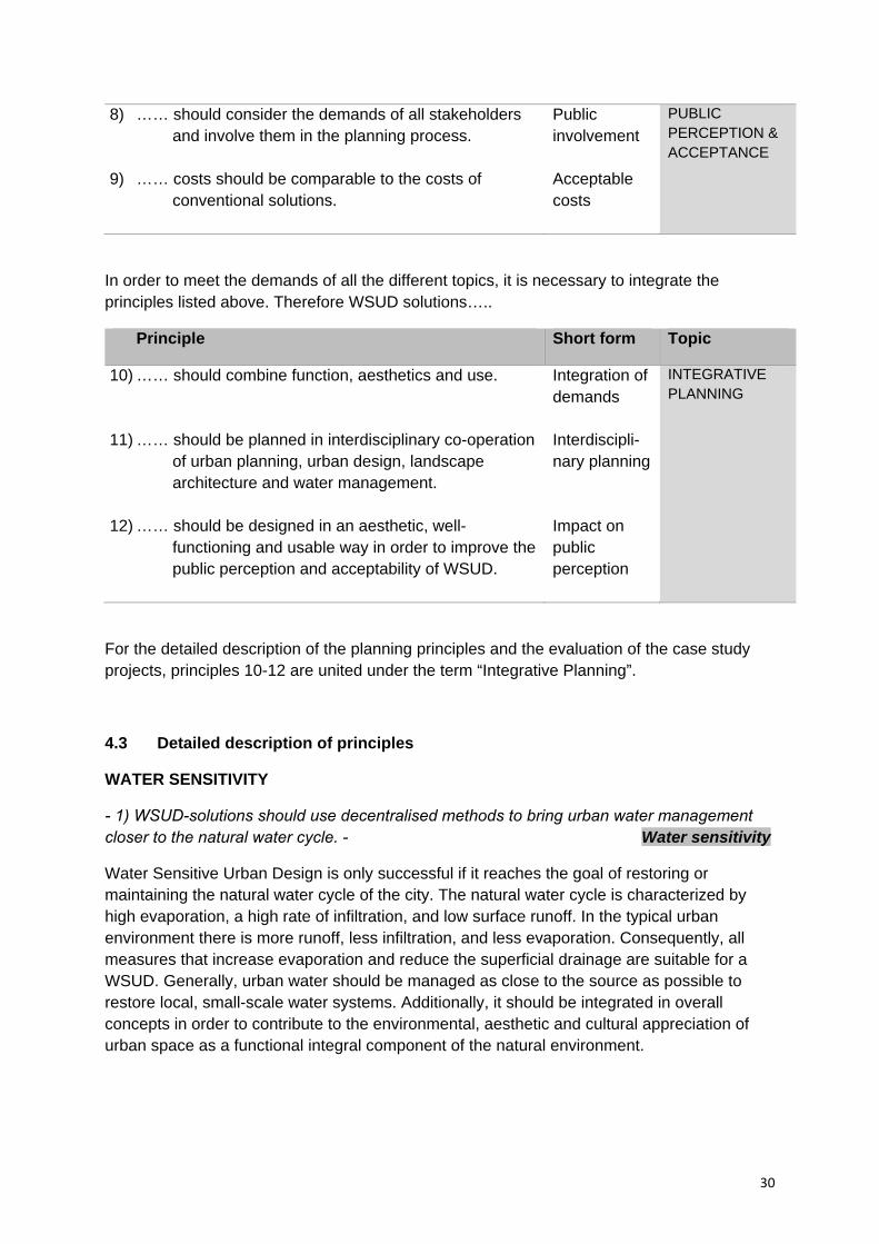
8) …… should consider the demands of all stakeholders and involve them in the planning process.
9) …… costs should be comparable to the costs of conventional solutions.
Public involvement Acceptable costs
PUBLIC PERCEPTION & ACCEPTANCE
In order to meet the demands of all the different topics, it is necessary to integrate the principles listed above. Therefore WSUD solutions…..
Principle Short form Topic
10) …… should combine function, aesthetics and use.
11) …… should be planned in interdisciplinary co-operation of urban planning, urban design, landscape architecture and water management.
12) …… should be designed in an aesthetic, well- functioning and usable way in order to improve the public perception and acceptability of WSUD.
Integration of demands Interdiscipli- nary planning Impact on public perception
INTEGRATIVE PLANNING
For the detailed description of the planning principles and the evaluation of the case study projects, principles 10-12 are united under the term “Integrative Planning”.
4.3 Detailed description of principles
WATER SENSITIVITY
- 1) WSUD-solutions should use decentralised methods to bring urban water management closer to the natural water cycle. - Water sensitivity
Water Sensitive Urban Design is only successful if it reaches the goal of restoring or maintaining the natural water cycle of the city. The natural water cycle is characterized by high evaporation, a high rate of infiltration, and low surface runoff. In the typical urban environment there is more runoff, less infiltration, and less evaporation. Consequently, all measures that increase evaporation and reduce the superficial drainage are suitable for a WSUD. Generally, urban water should be managed as close to the source as possible to restore local, small-scale water systems. Additionally, it should be integrated in overall concepts in order to contribute to the environmental, aesthetic and cultural appreciation of urban space as a functional integral component of the natural environment.
31
AESTHETICS
- 2) WSUD-solutions should be used to provide an aesthetic benefit where possible. – Aesthetic benefit
WSUD can improve public awareness for stormwater by making stormwater visible in the design of public and private open spaces in the city.
Making stormwater visible: Herbert Dreiseitl correctly stated that “Stormwater management is more than a technical solution for securing water resources - it is also a design problem” (translated from Dreiseitl 1998, 17). Conventional stormwater systems are out of sight and out of mind. However, when stormwater is used as a visible design element, it captures the attention of city inhabitants. The flowing water invites city residents to follow the natural processes of the water cycle, making daily and seasonal changes noticeable, and even enjoyable. When residents are living alongside the dynamic process of stormwater flow, they are more likely to appreciate and understand the importance of the water cycle in urban areas and can potentially become more aware and sensitive to the limitations of water as a resource.
Using stormwater to improve the quality of public and private spaces: Decentralised stormwater management measures can improve not only the visual aesthetics but also the quality of life in a city. Green spaces and water are key factors for the quality of life in cities (cities with a high rate of green spaces and water bodies have always been leaders in terms of liveability). Decentralised stormwater management helps to increase the occurrence of such spaces, making a significant contribution towards sustainable living. With this in mind, decentralised stormwater solutions can ideally be used for upgrading distressed areas or improving new housing and industrial estates.
- 3) WSUD-solutions should be adapted to the design of the surrounding urban landscape. – Integration in surrounding area
The individual design of stormwater solutions should be adapted to the surrounding area (buildings, urban structures, landscapes). For example, just as a rectangular concrete catchment basin is not appropriate for a natural landscape, a wildly landscaped stormwater pond may not be appropriately sited in the centre of a city. Although decentralised stormwater management often works with natural structures, it is not restricted to them. In fact, creative, manufactured materials and designs can provide functional, pleasing, and even intellectually stimulating environments, particularly in dense urban areas. The range of possibilities is almost limitless. WSUD solutions should engage the city, respond to the environment, and invite use and attention.
FUNCTIONALITY
- 4) WSUD-solutions should be used in an appropriate way, adapted to the local conditions and the intended use. - Appropriate design
WSUD-solutions should be designed according to the local environment. Solutions are typically very site-specific. It is therefore always necessary to fully consider the site, including
32
topography, ground permeability, water table levels, and water quality among other issues. Additionally, planners should be aware of the variety of available technical measures and the possibility to combine measures to optimize site-specific water management solutions. The right choice will include many factors, but is dependent particularly on the intended use (should water be infiltrated, restored, or used?), the available space, and the shape of the surrounding area.
- 5) WSUD-solutions should consider the corresponding maintenance requirements. – Appropriate maintenance
Decentralised stormwater management measures rely heavily on maintenance and upkeep to guarantee performance. Maintenance is often not taken into account or is carelessly facilitated. Inadequate maintenance, on green roofs or green streets for example, not only affects performance but significantly detracts from the aesthetic value of the installation. To prevent such tragedies, long-term care should always be considered during planning. This means, firstly, that care plans and caretakers should be established during planning and secondly, that only those solutions should be implemented, for which reliable care is ensured.
- 6) WSUD- solutions should consider possibilities for adaptation to uncertain and changing basic conditions (e.g. extreme climate events, demographic change, possibilities for further development). - Adaptability
The conditions for stormwater management in cities may change in the future. One reason is climate change (increased frequency of high rainfall events, more dry periods). Another is the effect of demographic or economic changes (such as population growth or reduction and economic boom or regression). It is the nature of change to be uncertain. For these reasons, WSUD-solutions should be developed, like any other urban infrastructure or architectural solution, to be flexible for future conditions, such as extreme weather events or future demographic and economic situations.
USABILITY
- 7) WSUD-solutions should be used to create places that are usable for recreation and/or nature conservation purposes. - Appropriate usability
"Stormwater is a fastidious free moving element, and can not use arbitrary space" (translated from Londong/Nothnagel 1999, 52). Infiltration and retention of stormwater typically requires a large area and space in a city is often hard to come by. It often comes into question: could these valuable spaces be better used for recreational or conservational purposes instead of being used for stormwater management? The solution is simple: WSUD-solutions should aim to unite the demands of both. The best part of WSUD as a tool for stormwater management is that a wide array of solutions when appropriately designed can easily complement any recreational or natural environment.

33
PUBLIC PERCEPTION AND ACCEPTANCE
- 8) WSUD-solutions should consider the demands of all stakeholders and involve them in the planning process. - Public involvement
One aim of good city planning is to create cities and districts that respond to residents and which residents can respond to. It is often necessary to involve residents, owners and users in the planning process - so acceptance and appropriate use and care of urban spaces can be sustained. Additionally, through community participation, the needs and wishes of local residents and other stakeholders can be known. This is crucial for ongoing WSUD development. Direct discussion with stakeholders offers the opportunity to discuss the advantages and disadvantages of decentralised stormwater management and hopefully to eliminate prejudices. If the future users of the facilities are not known in the planning process (e.g. when planning new developments), flexible solutions should be used that can be adapted to individual needs.
- 9) WSUD-solution costs should be comparable to the costs of conventional solutions. – Acceptable costs
In order to achieve broad acceptance of WSUD-solutions with decision makers and future users, the whole-life costs of decentralised stormwater management systems should be comparable or less than conventional solutions. Technically complex, expensive, and difficult to maintain solutions should be avoided. A potential argument for WSUD exists in multiple used spaces, such as recreational spaces that provide the dual function of stormwater management. Here, overall costs can be considerably less than when separately paying for stormwater infrastructure and recreational space. Maintenance costs can also be jointly considered.
INTEGRATIVE PLANNING
- 10) WSUD-solutions should combine function, aesthetics and usability. – Integration of demands
WSUD aims to address the potential of decentralised stormwater management and use it as a key element for the creation of open spaces and urban developments. Therefore an integration of function, aesthetics and usability is necessary.
- 11) WSUD-solutions should be planned in interdisciplinary co-operation of urban planning, urban design, landscape architecture and water management. – Interdisciplinary planning
Water Sensitive Urban Design integrates fields such as water management, urban planning, urban design and landscape architecture. The ideas of the Water Sensitive Design approach can therefore only be implemented by a team of professional planners from the different sectors, such as water (civil engineers), urban development (urban planners), architecture (architects, urban designers) and landscape (landscape architects), and also the leaders of

34
the local authorities (e.g. administrative officers). Cooperation should always take place as early as possible in the planning process and subsequently at various planning levels. The earlier cooperation takes place, the better the different demands can be coordinated and more likely satisfactory solutions can be produced.
- 12) WSUD-solutions should be designed in an aesthetic, well-functioning and usable way in order to improve the public perception and acceptability of WSUD. – Impact on public perception
Rather than technical issues, acceptance is often the biggest problem in the implementation of a decentralised stormwater management concept. WSUD as an urban design concept is after all, relatively new. However, despite its infancy, many good examples, such as those presented in this book, are already in existence. Exposure to such examples can help to promote a better understanding of decentralised stormwater management and can lead to broader acceptance and even desire to see such projects spring up in every city. These success stories should eliminate reservations and generate enthusiasm for sustainable stormwater management and what it can mean for tomorrow’s cities.
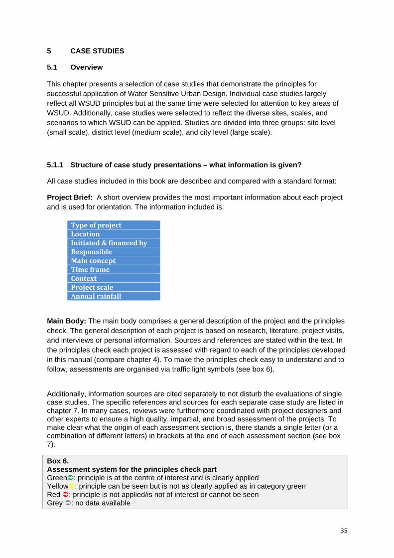
35
5 CASE STUDIES
5.1 Overview This chapter presents a selection of case studies that demonstrate the principles for successful application of Water Sensitive Urban Design. Individual case studies largely reflect all WSUD principles but at the same time were selected for attention to key areas of WSUD. Additionally, case studies were selected to reflect the diverse sites, scales, and scenarios to which WSUD can be applied. Studies are divided into three groups: site level (small scale), district level (medium scale), and city level (large scale).
5.1.1 Structure of case study presentations – what information is given?
All case studies included in this book are described and compared with a standard format:
Project Brief: A short overview provides the most important information about each project and is used for orientation. The information included is:
Main Body: The main body comprises a general description of the project and the principles check. The general description of each project is based on research, literature, project visits, and interviews or personal information. Sources and references are stated within the text. In the principles check each project is assessed with regard to each of the principles developed in this manual (compare chapter 4). To make the principles check easy to understand and to follow, assessments are organised via traffic light symbols (see box 6).
Additionally, information sources are cited separately to not disturb the evaluations of single case studies. The specific references and sources for each separate case study are listed in chapter 7. In many cases, reviews were furthermore coordinated with project designers and other experts to ensure a high quality, impartial, and broad assessment of the projects. To make clear what the origin of each assessment section is, there stands a single letter (or a combination of different letters) in brackets at the end of each assessment section (see box 7). Box 6. Assessment system for the principles check part Green: principle is at the centre of interest and is clearly applied Yellow: principle can be seen but is not as clearly applied as in category green Red : principle is not applied/is not of interest or cannot be seen Grey : no data available
Type of project Location Initiated & financed by Responsible Main concept Time frame Context Project scale Annual rainfall
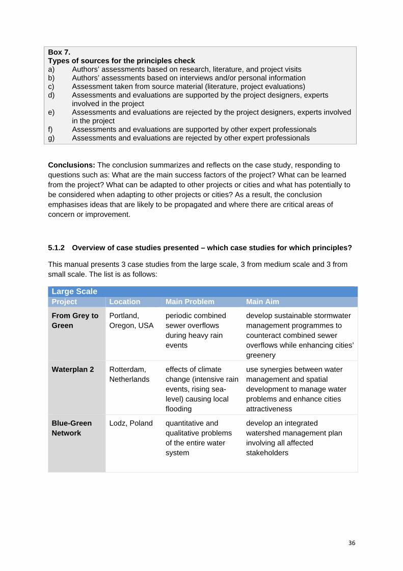
36
Box 7. Types of sources for the principles check a) Authors’ assessments based on research, literature, and project visits b) Authors’ assessments based on interviews and/or personal information c) Assessment taken from source material (literature, project evaluations) d) Assessments and evaluations are supported by the project designers, experts
involved in the project e) Assessments and evaluations are rejected by the project designers, experts involved
in the project f) Assessments and evaluations are supported by other expert professionals g) Assessments and evaluations are rejected by other expert professionals Conclusions: The conclusion summarizes and reflects on the case study, responding to questions such as: What are the main success factors of the project? What can be learned from the project? What can be adapted to other projects or cities and what has potentially to be considered when adapting to other projects or cities? As a result, the conclusion emphasises ideas that are likely to be propagated and where there are critical areas of concern or improvement.
5.1.2 Overview of case studies presented – which case studies for which principles?
This manual presents 3 case studies from the large scale, 3 from medium scale and 3 from small scale. The list is as follows:
Large Scale Project Location Main Problem Main Aim
From Grey to Green
Portland, Oregon, USA
periodic combined sewer overflows during heavy rain events
develop sustainable stormwater management programmes to counteract combined sewer overflows while enhancing cities’ greenery
Waterplan 2 Rotterdam, Netherlands
effects of climate change (intensive rain events, rising sea-level) causing local flooding
use synergies between water management and spatial development to manage water problems and enhance cities attractiveness
Blue-Green Network
Lodz, Poland quantitative and qualitative problems of the entire water system
develop an integrated watershed management plan involving all affected stakeholders
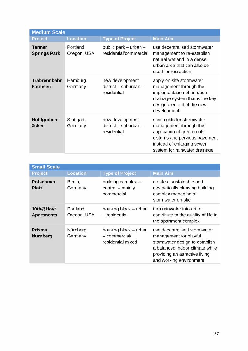
37
Medium Scale Project Location Type of Project Main Aim
Tanner Springs Park
Portland, Oregon, USA
public park – urban – residential/commercial
use decentralised stormwater management to re-establish natural wetland in a dense urban area that can also be used for recreation
Trabrennbahn Farmsen
Hamburg, Germany
new development district – suburban – residential
apply on-site stormwater management through the implementation of an open drainage system that is the key design element of the new development
Hohlgraben-äcker
Stuttgart, Germany
new development district – suburban – residential
save costs for stormwater management through the application of green roofs, cisterns and pervious pavement instead of enlarging sewer system for rainwater drainage
Small Scale Project Location Type of Project Main Aim
Potsdamer Platz
Berlin, Germany
building complex – central – mainly commercial
create a sustainable and aesthetically pleasing building complex managing all stormwater on-site
10th@Hoyt Apartments
Portland, Oregon, USA
housing block – urban – residential
turn rainwater into art to contribute to the quality of life in the apartment complex
Prisma Nürnberg
Nürnberg, Germany
housing block – urban – commercial/ residential mixed
use decentralised stormwater management for playful stormwater design to establish a balanced indoor climate while providing an attractive living and working environment
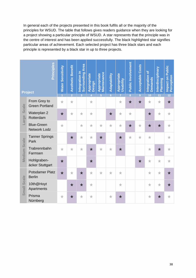
38
In general each of the projects presented in this book fulfils all or the majority of the principles for WSUD. The table that follows gives readers guidance when they are looking for a project showing a particular principle of WSUD. A star represents that the principle was in the centre of interest and has been applied successfully. The black highlighted star signifies particular areas of achievement. Each selected project has three black stars and each principle is represented by a black star in up to three projects.
Project Wat
er S
ensi
tivi
ty
Aes
thet
ic B
enef
it
Inte
gra
tio
n in
S
urr
ou
nd
ing
Are
a
Ap
pro
pri
ate
Des
ign
Ap
pro
pri
ate
Mai
nte
nan
ce
Ad
apta
bili
ty
Ap
pro
pri
ate
Usa
bili
ty
Pu
blic
Invo
lvem
ent
Acc
epta
ble
Co
sts
Inte
gra
tio
n o
f D
eman
ds
Inte
rdis
cip
linar
y P
lan
nin
g
Imp
act
on
Pu
blic
P
erce
pti
on
1 2 3 4 5 6 7 8 9 10 11 12
Lar
ge
Sca
le From Grey to
Green Portland * * * * * * * * *Waterplan 2 Rotterdam * * * * * * * * * *
Blue-Green Network Lodz * * * * * * * * * * *
Med
ium
Sc
ale
Tanner Springs Park
* * * * * * * * *
Trabrennbahn Farmsen * * * * * * * * * *
Hohlgraben-äcker Stuttgart * * * * * *
Sm
all S
cale
Potsdamer Platz Berlin * * * * * * * * * *
10th@Hoyt Apartments
* * * * * * *
Prisma Nürnberg * * * * * * * * *
Pri
nci
ple
s

39
5.2 Large scale case studies
Portland, Oregon, USA: From Grey to Green Rotterdam, Netherlands: Waterplan 2
Lodz, Poland: Blue-Green Network
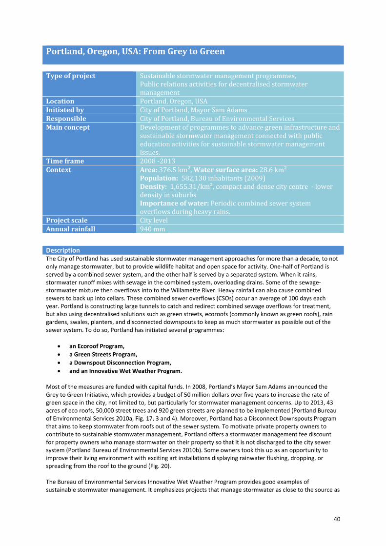
40
Portland, Oregon, USA: From Grey to Green
Type of project Sustainable stormwater management programmes, Public relations activities for decentralised stormwater management
Location Portland, Oregon, USAInitiated by City of Portland, Mayor Sam AdamsResponsible City of Portland, Bureau of Environmental Services Main concept Development of programmes to advance green infrastructure and
sustainable stormwater management connected with public education activities for sustainable stormwater management issues.
Time frame 2008 ‐2013Context Area: 376.5 km², Water surface area: 28.6 km²
Population: 582,130 inhabitants (2009) Density: 1,655.31/km², compact and dense city centre ‐ lower density in suburbs Importance of water: Periodic combined sewer system overflows during heavy rains.
Project scale City levelAnnual rainfall 940 mm
Description The City of Portland has used sustainable stormwater management approaches for more than a decade, to not only manage stormwater, but to provide wildlife habitat and open space for activity. One‐half of Portland is served by a combined sewer system, and the other half is served by a separated system. When it rains, stormwater runoff mixes with sewage in the combined system, overloading drains. Some of the sewage‐stormwater mixture then overflows into to the Willamette River. Heavy rainfall can also cause combined sewers to back up into cellars. These combined sewer overflows (CSOs) occur an average of 100 days each year. Portland is constructing large tunnels to catch and redirect combined sewage overflows for treatment, but also using decentralised solutions such as green streets, ecoroofs (commonly known as green roofs), rain gardens, swales, planters, and disconnected downspouts to keep as much stormwater as possible out of the sewer system. To do so, Portland has initiated several programmes:
an Ecoroof Program,
a Green Streets Program,
a Downspout Disconnection Program,
and an Innovative Wet Weather Program. Most of the measures are funded with capital funds. In 2008, Portland’s Mayor Sam Adams announced the Grey to Green Initiative, which provides a budget of 50 million dollars over five years to increase the rate of green space in the city, not limited to, but particularly for stormwater management concerns. Up to 2013, 43 acres of eco roofs, 50,000 street trees and 920 green streets are planned to be implemented (Portland Bureau of Environmental Services 2010a, Fig. 17, 3 and 4). Moreover, Portland has a Disconnect Downspouts Program that aims to keep stormwater from roofs out of the sewer system. To motivate private property owners to contribute to sustainable stormwater management, Portland offers a stormwater management fee discount for property owners who manage stormwater on their property so that it is not discharged to the city sewer system (Portland Bureau of Environmental Services 2010b). Some owners took this up as an opportunity to improve their living environment with exciting art installations displaying rainwater flushing, dropping, or spreading from the roof to the ground (Fig. 20). The Bureau of Environmental Services Innovative Wet Weather Program provides good examples of sustainable stormwater management. It emphasizes projects that manage stormwater as close to the source as

41
Fig. 16. Portland initial projects in sustainable stormwater management, funded with a budget of 2.6 million dollars granted by the U.S. Environmental Protection Agency (EPA) between 2002 and 2005 (© Bureau of Environmental Services, City of Portland Oregon, USA).
possible, using vegetation to slow, retain and filter stormwater. With a budget of $2.6 million granted by the U.S. Environmental Protection Agency (EPA) beginning in 2002, over 25 innovative public and private projects throughout the city were funded that today serve as demonstration projects showing sustainable stormwater management solutions (Fig. 16). Also the Environmental Services website (www.portlandonline.com/bes) provides good examples of implemented projects, while also giving extensive explanations of all of these programmes. In addition, the city has issued a series of brochures and fact sheets outlining various methods for decentralizing stormwater management and integrating it into the city's infrastructure.
Fig. 17. The SW 12th Avenue Green Street project: One of the various green streets projects in Portland (© Bureau of Environmental Services, City of Portland Oregon, USA).

42
Fig. 18. Map showing where green streets will primarily be implemented throughout the City of Portland (© Bureau of Environmental Services, City of Portland Oregon, USA).
Besides providing funds and information, Portland is doing public education. Therefore, Environmental Services has "created opportunities for Portland’s residents to have fun while learning about sustainable best management practices (BMPs) for dealing with stormwater" (Buranen 2009). Educational opportunities include cycling and walking tours, a green streets and ecoroof virtual tour, as well as a Landscapes For Rain art exhibition (Portland Bureau of Environmental services 2010d). The Environmental Services website therefore provides downloadable maps for three separate walking tours, an ecoroof tour and a cycling tour showing a mix of different stormwater techniques (Fig. 22). Additional virtual tours on ecoroofs and green streets even
Fig. 19. The City of Portland established an Ecoroof Program providing information and finances for privates; One great example is the eco roof of Wyatt Apartments (© Bureau of Environmental Services, City of Portland Oregon, USA).
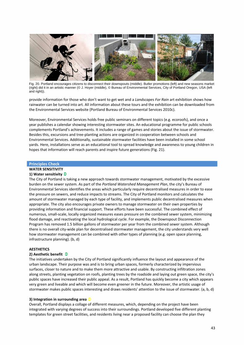
43
Fig. 20. Portland encourages citizens to disconnect their downspouts (middle). Butler promotions (left) and new seasons market (right) did it in an artistic manner (© J. Hoyer (middle), © Bureau of Environmental Services, City of Portland Oregon, USA (left and right)).
provide information for those who don’t want to get wet and a Landscapes For Rain art exhibition shows how rainwater can be turned into art. All information about these tours and the exhibition can be downloaded from the Environmental Services website (Portland Bureau of Environmental Services 2010c). Moreover, Environmental Services holds free public seminars on different topics (e.g. ecoroofs), and once a year publishes a calendar showing interesting stormwater sites. An educational programme for public schools complements Portland’s achievements. It includes a range of games and stories about the issue of stormwater. Besides this, excursions and tree‐planting actions are organized in cooperation between schools and Environmental Services. Additionally, sustainable stormwater facilities have been installed in some school yards. Here, installations serve as an educational tool to spread knowledge and awareness to young children in hopes that information will reach parents and inspire future generations (Fig. 21).
Principles Check WATER SENSITIVITY 1) Water sensitivity The City of Portland is taking a new approach towards stormwater management, motivated by the excessive burden on the sewer system. As part of the Portland Watershed Management Plan, the city’s Bureau of Environmental Services identifies the areas which particularly require decentralised measures in order to ease the pressure on sewers, and reduce impacts to streams. The City of Portland monitors and calculates the amount of stormwater managed by each type of facility, and implements public decentralised measures when appropriate. The city also encourages private owners to manage stormwater on their own properties by providing information and financial support. These efforts have been successful. The combined effect of numerous, small‐scale, locally organized measures eases pressure on the combined sewer system, minimizing flood damage, and reactivating the local hydrological cycle. For example, the Downspout Disconnection Program has removed 1.5 billion gallons of stormwater per year from the combined sewer system. Although there is no overall city‐wide plan for decentralised stormwater management, the city understands very well how stormwater management can be combined with other types of planning (e.g. open space planning, infrastructure planning). (b, d) AESTHETICS 2) Aesthetic benefit The initiatives undertaken by the City of Portland significantly influence the layout and appearance of the urban landscape. Their purpose was and is to bring urban spaces, formerly characterized by impervious surfaces, closer to nature and to make them more attractive and usable. By constructing infiltration zones along streets, planting vegetation on roofs, planting trees by the roadside and laying out green space, the city's public spaces have increased their public appeal. As a result, Portland has quickly become a city which appears very green and liveable and which will become even greener in the future. Moreover, the artistic usage of stormwater makes public spaces interesting and draws residents' attention to the issue of stormwater. (a, b, d) 3) Integration in surrounding area Overall, Portland displays a collage of different measures, which, depending on the project have been integrated with varying degrees of success into their surroundings. Portland developed five different planting templates for green street facilities, and residents living near a proposed facility can choose the plan they
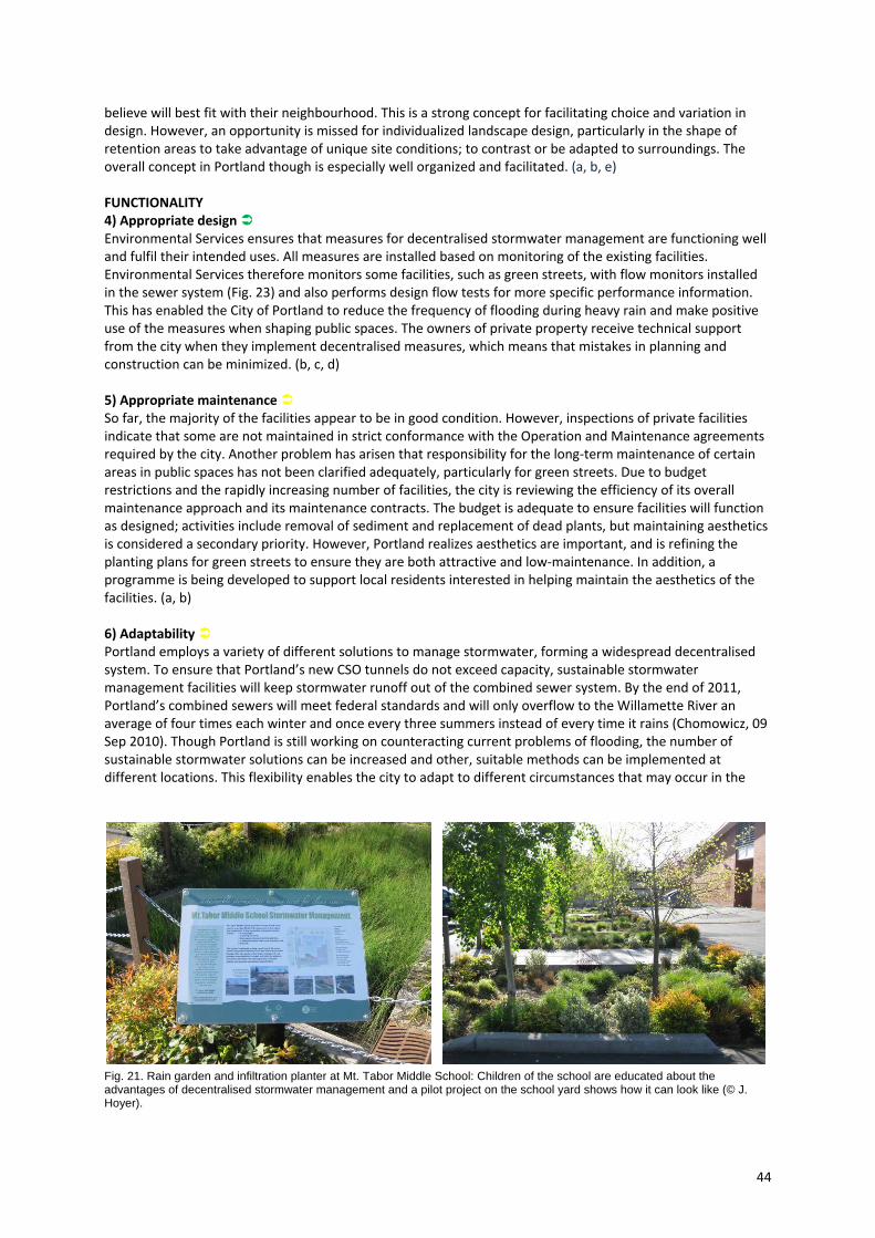
44
believe will best fit with their neighbourhood. This is a strong concept for facilitating choice and variation in design. However, an opportunity is missed for individualized landscape design, particularly in the shape of retention areas to take advantage of unique site conditions; to contrast or be adapted to surroundings. The overall concept in Portland though is especially well organized and facilitated. (a, b, e) FUNCTIONALITY 4) Appropriate design Environmental Services ensures that measures for decentralised stormwater management are functioning well and fulfil their intended uses. All measures are installed based on monitoring of the existing facilities. Environmental Services therefore monitors some facilities, such as green streets, with flow monitors installed in the sewer system (Fig. 23) and also performs design flow tests for more specific performance information. This has enabled the City of Portland to reduce the frequency of flooding during heavy rain and make positive use of the measures when shaping public spaces. The owners of private property receive technical support from the city when they implement decentralised measures, which means that mistakes in planning and construction can be minimized. (b, c, d) 5) Appropriate maintenance So far, the majority of the facilities appear to be in good condition. However, inspections of private facilities indicate that some are not maintained in strict conformance with the Operation and Maintenance agreements required by the city. Another problem has arisen that responsibility for the long‐term maintenance of certain areas in public spaces has not been clarified adequately, particularly for green streets. Due to budget restrictions and the rapidly increasing number of facilities, the city is reviewing the efficiency of its overall maintenance approach and its maintenance contracts. The budget is adequate to ensure facilities will function as designed; activities include removal of sediment and replacement of dead plants, but maintaining aesthetics is considered a secondary priority. However, Portland realizes aesthetics are important, and is refining the planting plans for green streets to ensure they are both attractive and low‐maintenance. In addition, a programme is being developed to support local residents interested in helping maintain the aesthetics of the facilities. (a, b) 6) Adaptability Portland employs a variety of different solutions to manage stormwater, forming a widespread decentralised system. To ensure that Portland’s new CSO tunnels do not exceed capacity, sustainable stormwater management facilities will keep stormwater runoff out of the combined sewer system. By the end of 2011, Portland’s combined sewers will meet federal standards and will only overflow to the Willamette River an average of four times each winter and once every three summers instead of every time it rains (Chomowicz, 09 Sep 2010). Though Portland is still working on counteracting current problems of flooding, the number of sustainable stormwater solutions can be increased and other, suitable methods can be implemented at different locations. This flexibility enables the city to adapt to different circumstances that may occur in the
Fig. 21. Rain garden and infiltration planter at Mt. Tabor Middle School: Children of the school are educated about the advantages of decentralised stormwater management and a pilot project on the school yard shows how it can look like (© J. Hoyer).
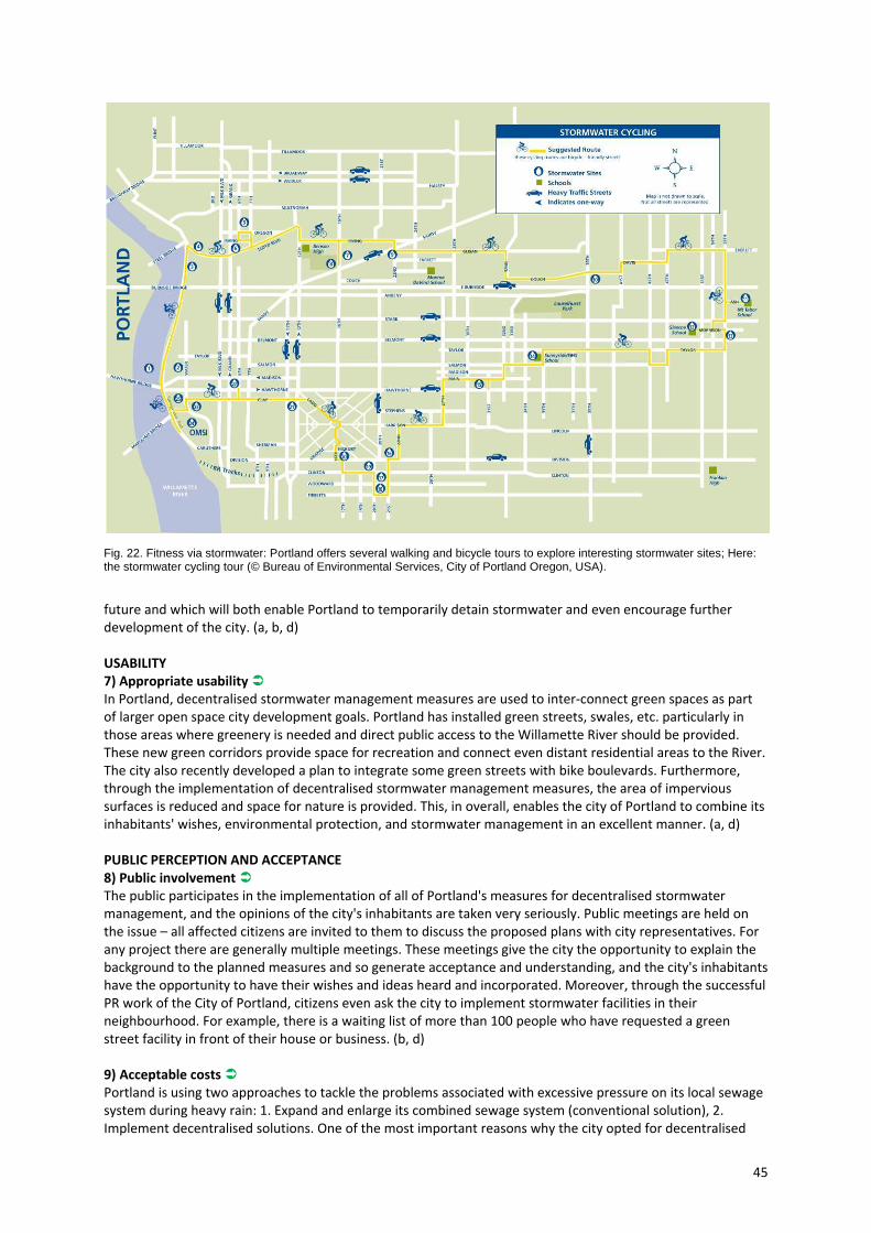
45
Fig. 22. Fitness via stormwater: Portland offers several walking and bicycle tours to explore interesting stormwater sites; Here: the stormwater cycling tour (© Bureau of Environmental Services, City of Portland Oregon, USA).
future and which will both enable Portland to temporarily detain stormwater and even encourage further development of the city. (a, b, d) USABILITY 7) Appropriate usability In Portland, decentralised stormwater management measures are used to inter‐connect green spaces as part of larger open space city development goals. Portland has installed green streets, swales, etc. particularly in those areas where greenery is needed and direct public access to the Willamette River should be provided. These new green corridors provide space for recreation and connect even distant residential areas to the River. The city also recently developed a plan to integrate some green streets with bike boulevards. Furthermore, through the implementation of decentralised stormwater management measures, the area of impervious surfaces is reduced and space for nature is provided. This, in overall, enables the city of Portland to combine its inhabitants' wishes, environmental protection, and stormwater management in an excellent manner. (a, d) PUBLIC PERCEPTION AND ACCEPTANCE 8) Public involvement The public participates in the implementation of all of Portland's measures for decentralised stormwater management, and the opinions of the city's inhabitants are taken very seriously. Public meetings are held on the issue – all affected citizens are invited to them to discuss the proposed plans with city representatives. For any project there are generally multiple meetings. These meetings give the city the opportunity to explain the background to the planned measures and so generate acceptance and understanding, and the city's inhabitants have the opportunity to have their wishes and ideas heard and incorporated. Moreover, through the successful PR work of the City of Portland, citizens even ask the city to implement stormwater facilities in their neighbourhood. For example, there is a waiting list of more than 100 people who have requested a green street facility in front of their house or business. (b, d) 9) Acceptable costs Portland is using two approaches to tackle the problems associated with excessive pressure on its local sewage system during heavy rain: 1. Expand and enlarge its combined sewage system (conventional solution), 2. Implement decentralised solutions. One of the most important reasons why the city opted for decentralised

46
solutions was their reduced cost compared to conventional solutions. The decentralised measures in public spaces are funded by capital funds and the money from the Grey to Green initiative. Portland also has received grants to fund sustainable stormwater management solutions. For example, the Innovative Wet Weather Program is funded with a grant from the federal Environmental Protection Agency. In addition, there are also private initiatives which can be co‐financed with municipal funding after negotiations. (b, d) INTEGRATIVE PLANNING 10) Integration of demands + 11) Interdisciplinary planning + 12) Impact on public perception The City of Portland understands very well how to integrate ideas for decentralised stormwater management with urban development goals. This is evident by highly effective strategy to use decentralised methods to lower pressure on stormwater infrastructure, repair the local water cycle, meet open space planning objectives (e.g. connecting green spaces to the Willamette River) and respond to local communities. Decentralised installations are sometimes even viewed by the public as community gardens, strengthening local identity. Intensive and creative public outreach largely contributed to this success, and also has increased public awareness and acceptance of decentralised methods and knowledge of stormwater issues in general. Ultimately, the resolve of the City of Portland and participation of Portland residents plays a major role in helping to make the city famous as the "Most Sustainable City in the USA" (Sustainlane 2010). (a, c, d)
Fig. 23. Monitoring at Glencoe Elementary School showed that the implemented rain garden significantly reduces the inflow volumes to the combined sewer system (© Bureau of Environmental Services, City of Portland Oregon, USA (left) and J. Hoyer (right)).
What can be learned from the city & adaptability to other cities The City of Portland is a good example of how decentralised stormwater management can be applied on city level through coordinated initiatives, rather than direct planning. In this case, because of existing pressure on the combined system, the initiative came about more or less by necessity. But a potential crisis afforded an opportunity. The Grey to Green Initiative demonstrates that individual site specific decentralised measures can function on their own and be linked together to manage stormwater on district or even potentially at an urban scale. Green roofs, infiltration areas, pervious surface materials, and other such measures all make a small contribution to a more sustainable handling of water resources and when integrated with urban planning or landscape design, the potential exists to make a city more attractive. Furthermore the case of Portland shows that when decentralised stormwater planning becomes publicly known, it has a positive impact on the inhabitants' identification with the city and with the issue of stormwater, prompting private citizens to take part in this development.
47
Rotterdam, Netherlands: Waterplan 2
Type of project Integrated water management plan Location Rotterdam, NetherlandsInitiated & financed by
City of Rotterdam
Responsible Waterplan 2 Rotterdam: Rotterdam City Council (Public Works, dS+V and the Rotterdam Development Cooperation); Hollandse Delta Water Board; Higher Water Board of Schieland and Krimpenerwaard; Higher Water Board of Delfland Water squares: Rotterdam City Council, VHP and Urban Affairs in cooperation with Water Boards and Planning Offices (De Urbanisten, Studio Marco Vermeulen)
Main concept Using water as an opportunity to make a city more attractive by creating and implementing new solutions for stormwater storage in densely built urban areas and by following an integrative approach.
Time frame 2007‐ 2030 Context Area (City of Rotterdam): 319 km2, Water surface area: 113 km2
Population: 603,425 inhabitants (2010) Density: 2,850 inhabitants/km2, densely built city characterized by Europe’s biggest harbour Importance of water: Rotterdam is located 2 meters below sea level; heavy rain and limited sewer and pumping station capacity lead to flooding problems; situation will be made more serious by effects of climate change.
Project scale City level Annual rainfall 816 mm
Description After Amsterdam, Rotterdam is the second largest city in the Netherlands. It is home to the largest port in Europe and, until surpassed by Shanghai in 2004, it was the world’s busiest port. Rotterdam’s cityscape is heavily influenced by harbour development. Due to the fact that Rotterdam is situated 2 meters below sea level, the city is surrounded by dykes and has a complex pumping system that protects the city from flooding. Up to now, water management strategies viewed water primarily as an invasive threat, focusing on safety, quantity and quality issues. This changed in 2007, when it became increasingly clear that Rotterdam will be seriously affected by climate change (higher water level due to rising sea levels; flooding caused by increased rainfall) (Municipality of Rotterdam et al. 2007a). At the same time, Rotterdam was fighting with population decline, particularly among working people, and other issues like the redevelopment of older harbour areas. In response Rotterdam developed Waterplan 2, a comprehensive joint approach to spatial planning and water management. As a delta city, Rotterdam has long considered water to be one of its main attractions, and now, with the second water plan, Rotterdam utilizes water as opportunity, focusing on management strategies that provide safety while improving the cityscape and encouraging interaction with water. The main intention is to implement the following goals throughout the city, creating the planned Rotterdam Watercity 2030.

48
Fig. 24. Waterplan 2 sees Rotterdam integrate urban and water management planning (© Municipality of Rotterdam).
Rotterdam Waterplan 2 aims are (Municipality of Rotterdam et al. 2007a):
Protection: Protect Rotterdam against flooding, both inside and outside the dykes.
Clean Water: Ensure water quality required by the European framework directive on water to improve the cities’ amenity.
Attractive City: Integrate urban planning with water management to solve water problems and enhance the city's attractiveness as a place to live, work and relax.
Sewers: Reorganize stormwater runoff via decentralised innovative solutions that perfectly match the specific area.
These aims should be reached by implementing innovative solutions for water management that also enhance the urban quality, such as green roofs, water squares, water gardens, and innovative detention areas (e.g. temporary storage of rainwater in underground parking garages, etc.). In addition, a map was developed that shows where these measures should be put into practice (Fig. 24) and an Implementation Program 2007 – 2012 laid out the timeframe for implementation and further concept development. One of the most innovative solutions used by the City of Rotterdam is the water square (also known as water plaza). Invented by De Urbanisten and Studio Marco Vermeulen, this solution contributes to the quality of public space and uses technical systems to manage stormwater. During dry periods, the square is used as an open public space, while during heavy rains, the square is used for temporary rainwater storage. A pilot type of water square has been designed and will be implemented to detect problems and improve the concept. Initial implementation is planned for 2011 at two different sites. (Boer 2010; Jacobs, 01 Sep 2010) The design of the pilot type of the water square includes a sports field and a playground. The area is located about 1 meter below the level of the surrounding ground and flanked on all sides by steps where people can sit and watch. The pitch is divided into different areas for playing, set at different levels (Fig. 25). For 90% of the year, the space is dry and used for recreation. The space changes its function only during heavy rain: Then rainwater flows visibly into the square – starting at the playground area, filling the carefully arranged hollows in the ground and gradually creates streams, brooks and small ponds. If the rain lasts longer, the sports field fills up as well (Fig. 28). When fully filled, the water square can hold a maximum of 1,000 cubic metres. After the rain ends, the rainwater will stay for a few hours and then is slowly discharged to Rotterdam’s sewer systems. (Boer 2010)
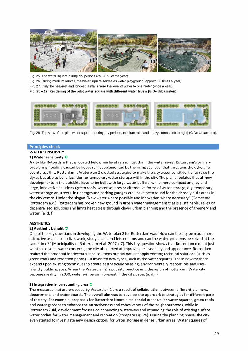
49
Fig. 25. The water square during dry periods (ca. 90 % of the year).
Fig. 26. During medium rainfall, the water square serves as water playground (approx. 30 times a year).
Fig. 27. Only the heaviest and longest rainfalls raise the level of water to one meter (once a year).
Fig. 25 – 27. Rendering of the pilot water square with different water levels (© De Urbanisten).
Fig. 28. Top view of the pilot water square - during dry periods, medium rain, and heavy storms (left to right) (© De Urbanisten).
Principles check WATER SENSITIVITY 1) Water sensitivity A city like Rotterdam that is located below sea level cannot just drain the water away. Rotterdam’s primary problem is flooding caused by heavy rain supplemented by the rising sea level that threatens the dykes. To counteract this, Rotterdam’s Waterplan 2 created strategies to make the city water sensitive, i.e. to raise the dykes but also to build facilities for temporary water storage within the city. The plan stipulates that all new developments in the outskirts have to be built with large water buffers, while more compact and, by and large, innovative solutions (green roofs, water squares or alternative forms of water storage, e.g. temporary water storage on streets, in underground parking garages etc.) have been found for the densely built areas in the city centre. Under the slogan “New water where possible and innovation where necessary” (Gemeente Rotterdam n.d.), Rotterdam has broken new ground in urban water management that is sustainable, relies on decentralised solutions and limits heat stress through clever urban planning and the presence of greenery and water. (a, d, f) AESTHETICS 2) Aesthetic benefit One of the key questions in developing the Waterplan 2 for Rotterdam was “How can the city be made more attractive as a place to live, work, study and spend leisure time, and can the water problems be solved at the same time?” (Municipality of Rotterdam et al. 2007a, 7). This key question shows that Rotterdam did not just want to solve its water concerns, the city also aimed at improving its liveability and appearance. Rotterdam realized the potential for decentralised solutions but did not just apply existing technical solutions (such as green roofs and retention ponds) – it invented new types, such as the water squares. These new methods expand upon existing techniques to create aesthetically pleasing, environmentally responsible and user‐friendly public spaces. When the Waterplan 2 is put into practice and the vision of Rotterdam Watercity becomes reality in 2030, water will be omnipresent in the cityscape. (a, d, f) 3) Integration in surrounding area The measures that are proposed by Waterplan 2 are a result of collaboration between different planners, departments and water boards. The overall aim was to develop site‐appropriate‐strategies for different parts of the city. For example, proposals for Rotterdam Noord's residential areas utilize water squares, green roofs and water gardens to enhance the attractiveness and cohesiveness of the neighbourhoods, while in Rotterdam Zuid, development focuses on connecting waterways and expanding the role of existing surface water bodies for water management and recreation (compare Fig. 24). During the planning phase, the city even started to investigate new design options for water storage in dense urban areas: Water squares of

50
different size and shape, water streets (= specially designed streets that are lower than normal streets to allow temporary water storage), cisterns below ground (e.g. parking garages), green roofs and blue roofs (blue roof = roof for temporary storage of water, green roof = planted roof, water is detained by the substratum and evaporated by plants). (a, d, f)
Fig. 29. Rotterdam has identified where water squares should ideally be located (© Municipality of Rotterdam). FUNCTIONALITY 4) Appropriate design Rotterdam’s Waterplan 2 provides all information necessary for implementing the scheme, and shows where each solution should be implemented and how it could be designed to reach the intended aim. Although the particular design of each facility is determined by the planners at the site level, preliminary design studies and calculations have been made. For Example: To identify the locations that are suitable for creating water squares, height measurements were taken, flow‐off simulations modelled and water detention capacities calculated (Fig. 29). At the same time, the planners commissioned design studies to illustrate how the water squares could be laid out (Fig. 30). In addition, they studied the entire cityscape to identify buildings, which were suitable for retrofitting with green and blue roofs. Furthermore, pilot projects such as a public underground parking garage at the Rotterdam Museum Park, which has a retention cistern that holds water during heavy rain, serve to provide information for future projects. (a, d, f) 5) Appropriate maintenance Up to now, maintenance has worked well in Rotterdam and therefore was not considered specifically in Waterplan 2. The majority of measures that will be implemented as result of the water plan are located in public space. Different municipal departments of the City of Rotterdam will care for appropriate maintenance: Underground water storage will be maintained by the water management department, water squares will be partly maintained by the water management department and Roteb (public cleaning service) and green roofs will be maintained privately. However, responsibility has not been clarified for some measures yet, e.g. for the proposed open water channels to be created in the south part of the city. So, further negotiations between the City of Rotterdam and the water boards will be necessary. (a, b, d, f) 6) Adaptability Rotterdam’s Waterplan 2 was developed in connection to the Rotterdam Climate Proof programme (Gemeente Rotterdam n.d.). The main intention of this programme is to make Rotterdam secure, economically strong and attractive by developing strategies that enable the city to adapt to changing
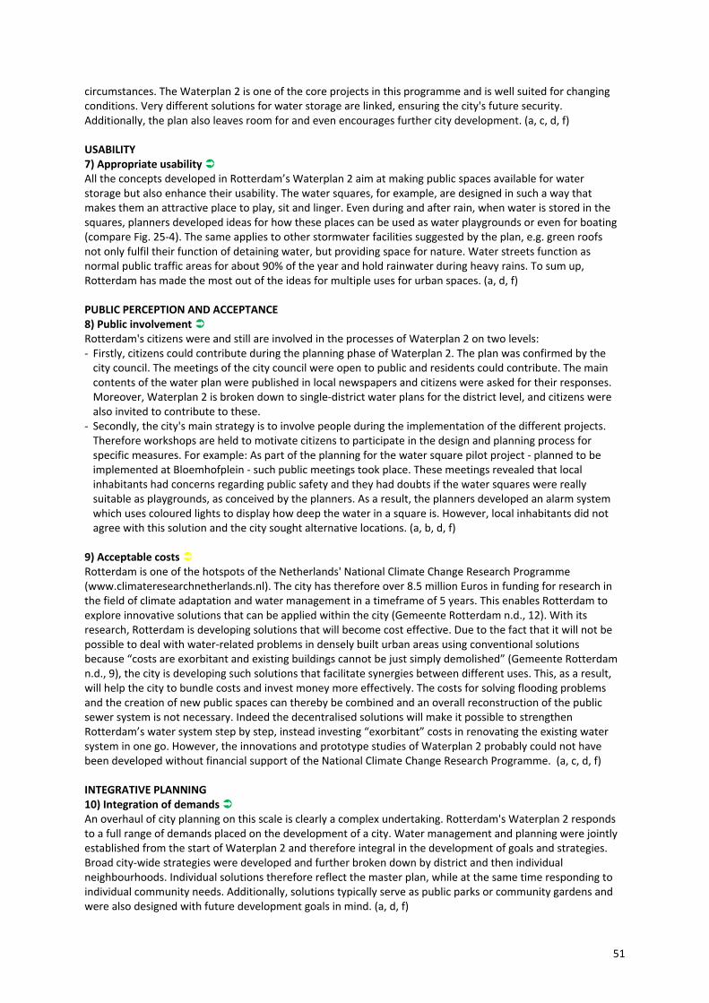
51
circumstances. The Waterplan 2 is one of the core projects in this programme and is well suited for changing conditions. Very different solutions for water storage are linked, ensuring the city's future security. Additionally, the plan also leaves room for and even encourages further city development. (a, c, d, f) USABILITY 7) Appropriate usability All the concepts developed in Rotterdam’s Waterplan 2 aim at making public spaces available for water storage but also enhance their usability. The water squares, for example, are designed in such a way that makes them an attractive place to play, sit and linger. Even during and after rain, when water is stored in the squares, planners developed ideas for how these places can be used as water playgrounds or even for boating (compare Fig. 25‐4). The same applies to other stormwater facilities suggested by the plan, e.g. green roofs not only fulfil their function of detaining water, but providing space for nature. Water streets function as normal public traffic areas for about 90% of the year and hold rainwater during heavy rains. To sum up, Rotterdam has made the most out of the ideas for multiple uses for urban spaces. (a, d, f) PUBLIC PERCEPTION AND ACCEPTANCE 8) Public involvement Rotterdam's citizens were and still are involved in the processes of Waterplan 2 on two levels: ‐ Firstly, citizens could contribute during the planning phase of Waterplan 2. The plan was confirmed by the city council. The meetings of the city council were open to public and residents could contribute. The main contents of the water plan were published in local newspapers and citizens were asked for their responses. Moreover, Waterplan 2 is broken down to single‐district water plans for the district level, and citizens were also invited to contribute to these.
‐ Secondly, the city's main strategy is to involve people during the implementation of the different projects. Therefore workshops are held to motivate citizens to participate in the design and planning process for specific measures. For example: As part of the planning for the water square pilot project ‐ planned to be implemented at Bloemhofplein ‐ such public meetings took place. These meetings revealed that local inhabitants had concerns regarding public safety and they had doubts if the water squares were really suitable as playgrounds, as conceived by the planners. As a result, the planners developed an alarm system which uses coloured lights to display how deep the water in a square is. However, local inhabitants did not agree with this solution and the city sought alternative locations. (a, b, d, f)
9) Acceptable costs Rotterdam is one of the hotspots of the Netherlands' National Climate Change Research Programme (www.climateresearchnetherlands.nl). The city has therefore over 8.5 million Euros in funding for research in the field of climate adaptation and water management in a timeframe of 5 years. This enables Rotterdam to explore innovative solutions that can be applied within the city (Gemeente Rotterdam n.d., 12). With its research, Rotterdam is developing solutions that will become cost effective. Due to the fact that it will not be possible to deal with water‐related problems in densely built urban areas using conventional solutions because “costs are exorbitant and existing buildings cannot be just simply demolished” (Gemeente Rotterdam n.d., 9), the city is developing such solutions that facilitate synergies between different uses. This, as a result, will help the city to bundle costs and invest money more effectively. The costs for solving flooding problems and the creation of new public spaces can thereby be combined and an overall reconstruction of the public sewer system is not necessary. Indeed the decentralised solutions will make it possible to strengthen Rotterdam’s water system step by step, instead investing “exorbitant” costs in renovating the existing water system in one go. However, the innovations and prototype studies of Waterplan 2 probably could not have been developed without financial support of the National Climate Change Research Programme. (a, c, d, f) INTEGRATIVE PLANNING 10) Integration of demands An overhaul of city planning on this scale is clearly a complex undertaking. Rotterdam's Waterplan 2 responds to a full range of demands placed on the development of a city. Water management and planning were jointly established from the start of Waterplan 2 and therefore integral in the development of goals and strategies. Broad city‐wide strategies were developed and further broken down by district and then individual neighbourhoods. Individual solutions therefore reflect the master plan, while at the same time responding to individual community needs. Additionally, solutions typically serve as public parks or community gardens and were also designed with future development goals in mind. (a, d, f)
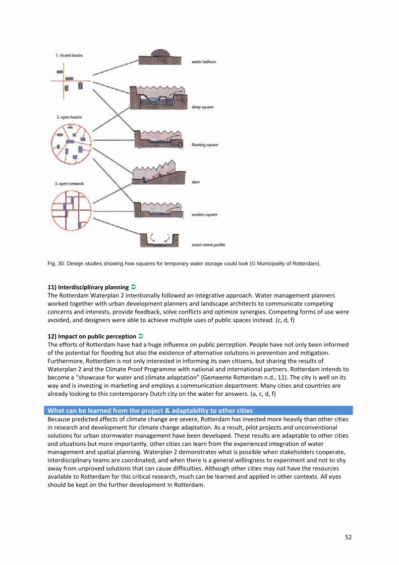
52
Fig. 30. Design studies showing how squares for temporary water storage could look (© Municipality of Rotterdam).
11) Interdisciplinary planning The Rotterdam Waterplan 2 intentionally followed an integrative approach. Water management planners worked together with urban development planners and landscape architects to communicate competing concerns and interests, provide feedback, solve conflicts and optimize synergies. Competing forms of use were avoided, and designers were able to achieve multiple uses of public spaces instead. (c, d, f) 12) Impact on public perception The efforts of Rotterdam have had a huge influence on public perception. People have not only been informed of the potential for flooding but also the existence of alternative solutions in prevention and mitigation. Furthermore, Rotterdam is not only interested in informing its own citizens, but sharing the results of Waterplan 2 and the Climate Proof Programme with national and international partners. Rotterdam intends to become a “showcase for water and climate adaptation” (Gemeente Rotterdam n.d., 11). The city is well on its way and is investing in marketing and employs a communication department. Many cities and countries are already looking to this contemporary Dutch city on the water for answers. (a, c, d, f)
What can be learned from the project & adaptability to other cities Because predicted affects of climate change are severe, Rotterdam has invested more heavily than other cities in research and development for climate change adaptation. As a result, pilot projects and unconventional solutions for urban stormwater management have been developed. These results are adaptable to other cities and situations but more importantly, other cities can learn from the experienced integration of water management and spatial planning. Waterplan 2 demonstrates what is possible when stakeholders cooperate, interdisciplinary teams are coordinated, and when there is a general willingness to experiment and not to shy away from unproved solutions that can cause difficulties. Although other cities may not have the resources available to Rotterdam for this critical research, much can be learned and applied in other contexts. All eyes should be kept on the further development in Rotterdam.

53
Lodz, Poland: BlueGreen Network
Type of project Integrated urban watersheds management plan involving all stakeholders
Location City of Lodz, PolandInitiated & financed by SWITCH‐Project, the city mayor's grants (spin‐off project)Responsible University of Lodz, Department of Applied Ecology; European
Regional Centre for Ecohydrology under the auspices of UNESCO; Municipal Office of the City of Lodz
Main concept Application of innovative research results in urban water management through a Learning Alliance (LA) methodology: Implementation of system solutions derived from ecohydrological principles for sustainable development of the city, based on developing and facilitating a Learning Alliance for managing urban watersheds, decentralised stormwater management measures and integrated urban planning (Blue‐Green Network).
Context
Area: 293.25 km² Population: 744,541 inhabitants (2009) Density: 2,539 inhabitants/km² Importance of water: 18 streams, mostly canalized and covered in the 19th century; critical for sustainability of the city due to its location on the watershed divide. Sokolowka river: Sokolowka river flow across the northern part of Lodz, towards its suburbs. The majority of the flow results from stormwater supplied to the river by over 50 outlets. Most of the river has been canalized using concrete slabs, however the middle and lower section of the valley has retained a semi‐natural character, with patches of meadows, wetlands and forest. Aside of being a stormwater receiver, the river serves for recreational purposes for the people living in the nearby housing areas and for the rest of the city. Its restoration has therefore become one of the city’s priorities.
Project scale City levelAnnual rainfall 516 mm
Description The City of Lodz, located right in the centre of Poland, was formerly a manufacturing centre for the textile industry. It was therefore known as "the Polish Manchester". Economical changes in the last decades of the 20th century brought a considerable change to the city: The industrial sector collapsed and the population declined. When developing strategies for revitalization, Lodz recalled its roots as a city characterized by rivers. In fact, the city's coat of arms depicts a boat. However, Lodz’s rivers were previously canalized, partly covered, and in some sections polluted by illegal sewerage discharge. Additionally, dense urban development reduced the ability of the landscape to retain water, and has thus led to seasonal flooding. Lodz decided to anchor its development plans to restoring its rivers and using them as an attractive key element in its new urban development. The landscape and the rivers have started to be restored under the focus of ecohydrological aspects (Zalewski/Wagner 2005; Butterworth et al. 2008). Supported by the research project SWITCH, researchers from the University of Lodz and the Municipality of Lodz joined to initiate a Learning Alliance (a group of local stakeholders from the private and public sectors including local government, water services providers, decision makers, as well as citizenry involved in urban water issues) to make a step forward in counteracting Lodz’s water management problems. The main aim of this group was to identify priority issues to be addressed by research and through the implementation of demonstration projects, resulting in an integrated spatial planning for the city.

54
Demonstration projects included the implementation of sustainable stormwater management solutions and the application of ecosystem biotechnologies for restoring the water cycle and rehabilitating aquatic ecosystems (compare Fig. 31). The scientific and conceptual background was provided by the concept of Ecohydrology, initially developed at the University of Lodz and European Regional Centre for Ecohydrology under the auspices of UNESCO, in cooperation with international group of scientists within the framework of the International Hydrological Programme of UNESCO (Zalewski et al. 1997). The experience gained through research and demonstration projects was used as basis for an integrated water and city planning concept. This included (Wagner/Zalewski 2009): ‐ Elaboration of recommendations for the protection, management and spatial development for all river corridors in Lodz;
‐ Formulation of recommendations for the spatial development of the city with regard to stormwater management;
‐ Development of a new concept for the spatial development of Lodz, taking into consideration the specific importance of water and green areas in the city ‐ the Blue‐Green Network (Fig. 32).
Fig. 31. Interventions within and resulted from the SWITCH Learning Alliance in Lodz, constructed, under development and in design process, in the Sokolowka River valley (Wagner/Zalewski 2009, updated).
Principles Check WATER SENSITIVITY 1) Water sensitivity Lodz has done and still is doing a lot to rehabilitate the degraded water cycle within the city. One of the major goals of the ecohydrology concept is to provide a scientific background to the city's activities in order to achieve this goal. The efforts of the city have resulted in the formulation of the Blue‐Green Network concept, which strives to bring rivers back to the surface (where possible) and improve water quality, while also promoting sustainable stormwater management techniques. Though Lodz is still at the beginning of the process, when realized, new development will have positive effects on the city’s ecological health. (a, d)
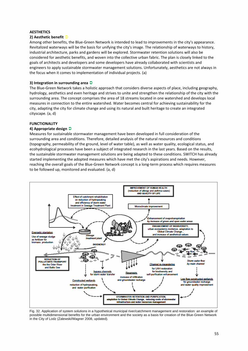
55
AESTHETICS 2) Aesthetic benefit Among other benefits, the Blue‐Green Network is intended to lead to improvements in the city's appearance. Revitalized waterways will be the basis for unifying the city's image. The relationship of waterways to history, industrial architecture, parks and gardens will be explored. Stormwater retention solutions will also be considered for aesthetic benefits, and woven into the collective urban fabric. The plan is closely linked to the goals of architects and developers and some developers have already collaborated with scientists and engineers to apply sustainable stormwater management solutions. Unfortunately, aesthetics are not always in the focus when it comes to implementation of individual projects. (a) 3) Integration in surrounding area The Blue‐Green Network takes a holistic approach that considers diverse aspects of place, including geography, hydrology, aesthetics and even heritage and strives to unite and strengthen the relationship of the city with the surrounding area. The concept comprises the area of 18 streams located in one watershed and develops local measures in connection to the entire watershed. Water becomes central for achieving sustainability for the city, adapting the city for climate change and using its natural and built heritage to create an integrated cityscape. (a, d) FUNCTIONALITY 4) Appropriate design Measures for sustainable stormwater management have been developed in full consideration of the surrounding area and conditions. Therefore, detailed analysis of the natural resources and conditions (topography, permeability of the ground, level of water table), as well as water quality, ecological status, and ecohydrological processes have been a subject of integrated research in the last years. Based on the results, the sustainable stormwater management solutions are being adapted to these conditions. SWITCH has already started implementing the adopted measures which have met the city's aspirations and needs. However, reaching the overall goals of the Blue‐Green Network concept is a long‐term process which requires measures to be followed up, monitored and evaluated. (a, d)
Fig. 32. Application of system solutions in a hypothetical municipal river/catchment management and restoration: an example of possible multidimensional benefits for the urban environment and the society as a basis for creation of the Blue-Green Network in the City of Lodz (Zalewski/Wagner 2008, updated).
56
5) Appropriate maintenance Maintenance of implemented projects will be ensured by the appropriate administrative structures related to the local government (the City of Lodz Office, the regional government, the city’s cooperatives and other members of SWICTH). (a, d) 6) Adaptability The geographical watershed location of the city and the availability of water resources present major limitations to Lodz’s sustainable development in the face of global climate changes. Rainwater is the only source of water available for the ecosystem, and it is predicted that the amount of rain will decrease. The introduction of systems for rainwater retention and purification is therefore crucial for sustaining green spaces, improving air humidity and human health, which all are fundamental for adaptation to global climate change. In doing so, Lodz is on the right track. (a, d) USABILITY 7) Appropriate usability Via the Blue‐Green Network concept, the City of Lodz is facilitating multifunctional purposes. The aim of the concept was not only to rehabilitate rivers but also to improve inhabitants’ health and the city’s image, to reduce costs and provide new workplaces ‐ all in all, to contribute to the city’s sustainability. Therefore, in addition to water management, the Blue‐Green Network concept includes ideas for creating and improving public spaces, recreational areas, alternative communication pathways (e.g. bicycle paths), and for retrofitting the recreational and traffic infrastructure of the city. (a, d) PUBLIC PERCEPTION AND ACCEPTANCE 8) Public involvement Though the process is at a relatively early stage, Lodz is doing a lot to include and inform the public. Initial outreach included broad‐based consultations with NGOs. This in turn led to new concepts (e.g. including bicycle transport into the Blue‐Green Network, as well as running an internet forum for identifying new areas to be included into the network by the local community). Currently, a social campaign is being developed (advertisements, billboards, webpage, etc.) with the objective of informing the public about stormwater management as an important resource. New concepts always take time to be accepted; therefore the Learning Alliance will go on facilitating the process in the future in order to improve understanding and gain acceptance for sustainable urban water management. (a, d) 9) Acceptable costs The City of Lodz has been very successful in fundraising and was therefore able to initiate more projects for the city’s improvement than it could have done without additional funding. Attempts have been particularly made to identify new sources for funding for innovations in stormwater management throughout the city – both for research activities and the implementation of pilot projects. One project called “Life +”, which aims at demonstrating the application of the ecohydrological restoration of rivers and ponds in recreational areas, including stormwater retention and purification – is already running with financing from the EU and key Learning Alliance's members. Moreover, there is a common interest in continuing co‐operation between scientists and decision makers, including fundraising. (a, d) INTEGRATIVE PLANNING 10) Integration of demands The Blue‐Green Network concept is a main result of Lodz’s researchers and Learning Alliance activities, showing the integrated approach in the matter of water management and urban space planning in the city. Integrating the demands of the recreational and traffic infrastructures with water management purposes, the concept developed a combination of different functions in the city space that meet the demands of the inhabitants, of its natural environment, the economic development and improvement of the city’s image. Based on this concept, an integrated strategic document focusing on water management in the city and including issues of water, environment, infrastructure, architecture, spatial planning and public participation is currently being developed. This plan will integrate all stakeholders’ demands, including not only the water‐related decision makers, but also other stakeholders. (a, d)
57
11) Interdisciplinary planning The Learning Alliance (LA) in Lodz provided opportunities for all stakeholders to work in a cooperative process, which was facilitated by a city coordinator. Starting with a core group of key stakeholders, including key departments in the city government and the water services providers (WWTP, Lodz's municipal utilities and waterworks), the group has grown over the years, and currently consists of over 70 members representing over 30 organizations, including municipal authorities and bodies, researchers, media, schools, NGOs and others. The researchers included biologists, ecologists, hydrologists, climatologists, sociologists, medical scientists, and engineers. All the city and regional planning offices were involved in the SWITCH process: the Municipal Planning Office, the Regional Planning Office, as well as private planning companies working with the city. All stakeholders took part in the development process of the Blue‐Green Network and therefore contributed to Lodz’s further development towards being a sustainable city. (a, d) 12) Impact on public perception Thanks to the Learning Alliance and media involvement, it is possible to observe how public perception and acceptance are increasing. There have been several reports, both on the regional and national levels, including TV and radio interviews, films and newspaper information. Media communications were often followed by internet discussions including the general public. NGOs involved in the LA (as already described above) have been engaged in raising public awareness regarding the importance of water, the green side of the city and their integration improving the quality of life in the city. (a, d)
What can be learned from the project & adaptability to other cities In European cities, society has increasing expectations regarding quality of life. Nowadays, this goes far beyond access to basic services: It is now largely related to a healthy and friendly environment. This relates in turn to properly functioning water and land ecosystems and their ability to provide ecosystem amenities. The Lodz example shows that there are commonalities among cities, however each of the solutions needs a local, context‐sensitive adaptation. The concepts developed for Lodz were based on the city's specifics, and developed by taking into account its geographical conditions, historical aspects and social context. The solutions were possible thanks to close co‐operation between science and practitioners. Involving stakeholders from areas other than just water is a long and difficult process; however with time it yields new innovation and makes the approach more integrated.

58
5.3 Medium scale case studies
Tanner Springs Park (Portland, Oregon, USA) Trabrennbahn Farmsen (Hamburg, Germany)
Hohlgrabenäcker (Stuttgart, Germany)
59
Tanner Springs Park (Portland, Oregon, USA)
Type of project Public parkLocation Portland, Oregon, USAInitiated & financed by City of Portland, Portland Parks & Recreation Responsible
Overall concept/Master plan: City of Portland, Portland Parks & Recreation Department with landscape architecture firm Peter Walker & Partners Design and water concept: Atelier Dreiseitl (planning and design), GreenWorks, P.C. (supervision) Consultants: KPFF Consulting Engineers (civil engineers), CMS Collaborative, Inc. (water feature consultant), Cooke Scientific Services (wetland ecologist), R&W Engineering (electrical engineer)
Main concept Using sustainable stormwater management to re‐establish natural wetlands and create a functional, beautiful public park in a dense urban area.
Time frame Planning: 2002‐2004, Construction: 2004‐2005 Context Park size: 4,800 m², Pearl district area: 1.21 km²
Pearl district population: 1,113 inhabitants (2000) Density: 920/km², dense urban area – residential use (mixed with some commercial facilities) Importance of water: The Pearl District was a former wetland; The Tanner Creek that was channelled underground at the beginning of the 20th century, formerly flowed openly through this area.
Project scale District levelAnnual rainfall 940 mm
Description The Pearl District is centrally located in the city of Portland, Oregon. Over the last 30 years, it has developed from an aging industrial quarter into a socially and ethnically diverse neighbourhood with an inspiring atmosphere. The area was originally a wetland of the Tanner Creek, which is now channelled beneath the street surface. Gradually, surfaces were paved and the tracks were laid for industry. Following the decline of the industry sector, the city of Portland decided to redevelop the Pearl District for commercial and residential use. However, because of its industrial roots, and significant network of railroad infrastructure, the district suffered from a lack of green spaces. A master plan was developed to counter this shortage of green spaces, while contributing to the overall ecological revitalization of the city. This concept, developed by Peter Walker & Partners includes 3 different types of parks that create a green corridor from Portland’s downtown to the Willamette river in the north. Tanner Springs is one of these green spaces, for which the designers set two guidelines, “Evoke the feel of a wetland, and make the park a destination for contemplation” (Johns 2005/2009). Planning for this park began in 2003. The responsible planning team consisted of Atelier Dreiseitl Waterscapes from Überlingen, Germany, that worked in collaboration with the local landscape architects Greenworks PC, and other consultants. The construction took place from 2004 to 2005. (Dreiseitl/Grau 2006, 12‐17; Portland Parks & Recreation 2010) Tanner Springs Park is located in the centre of the Pearl District. Surrounded by residential buildings (Fig. 33), the park is characterized by irregularly shaped open water, alluding to the original marshlands that once existed. In several areas of this park there are small artificial springs trickling down to a sunken man‐made pond. The pond also is the key element of the stormwater management in this area. Adjacent city sidewalks drain into the pond, where water is captured and can gradually evaporate. The movement of water from surface sources into the park creates an inviting environment, especially one of exploration for children.
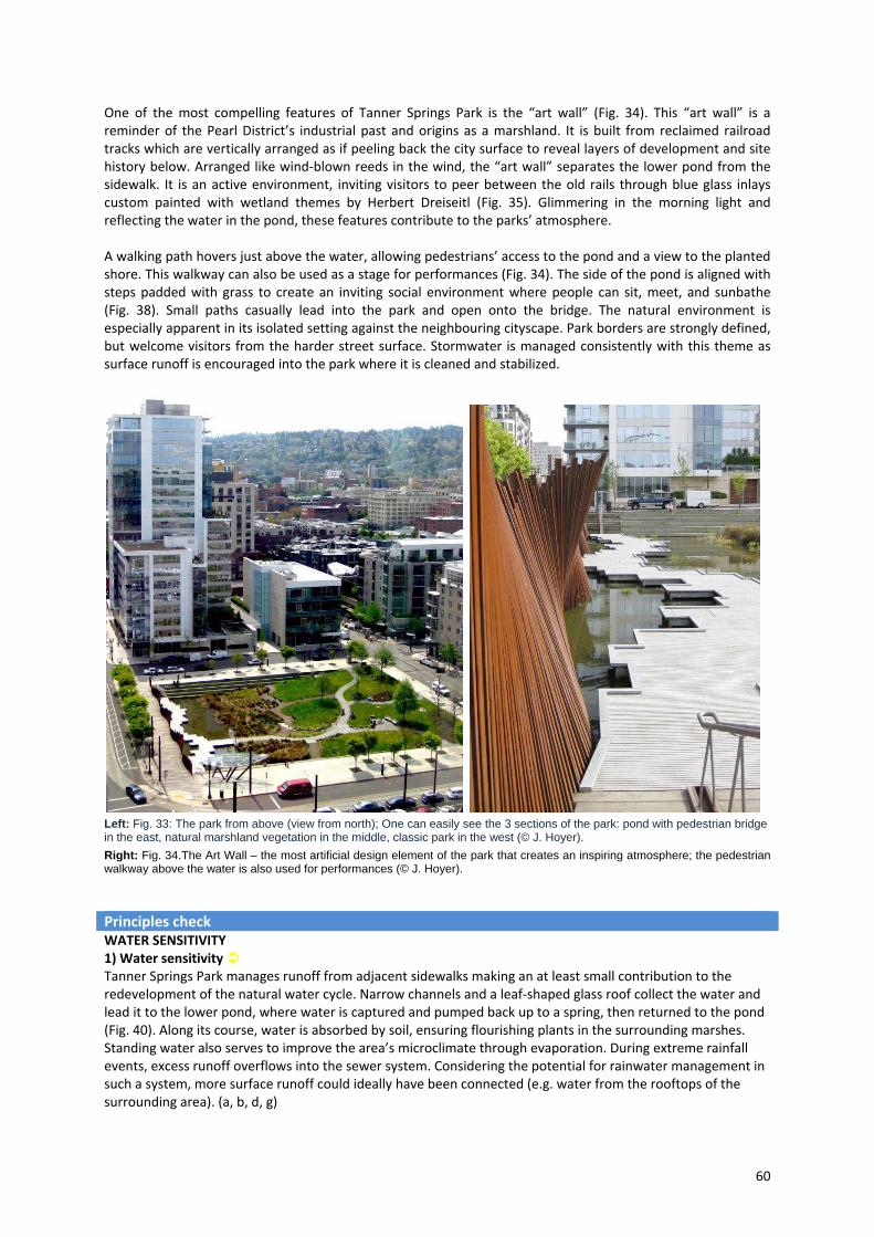
60
One of the most compelling features of Tanner Springs Park is the “art wall” (Fig. 34). This “art wall” is a reminder of the Pearl District’s industrial past and origins as a marshland. It is built from reclaimed railroad tracks which are vertically arranged as if peeling back the city surface to reveal layers of development and site history below. Arranged like wind‐blown reeds in the wind, the “art wall” separates the lower pond from the sidewalk. It is an active environment, inviting visitors to peer between the old rails through blue glass inlays custom painted with wetland themes by Herbert Dreiseitl (Fig. 35). Glimmering in the morning light and reflecting the water in the pond, these features contribute to the parks’ atmosphere. A walking path hovers just above the water, allowing pedestrians’ access to the pond and a view to the planted shore. This walkway can also be used as a stage for performances (Fig. 34). The side of the pond is aligned with steps padded with grass to create an inviting social environment where people can sit, meet, and sunbathe (Fig. 38). Small paths casually lead into the park and open onto the bridge. The natural environment is especially apparent in its isolated setting against the neighbouring cityscape. Park borders are strongly defined, but welcome visitors from the harder street surface. Stormwater is managed consistently with this theme as surface runoff is encouraged into the park where it is cleaned and stabilized.
Left: Fig. 33: The park from above (view from north); One can easily see the 3 sections of the park: pond with pedestrian bridge in the east, natural marshland vegetation in the middle, classic park in the west (© J. Hoyer).
Right: Fig. 34.The Art Wall – the most artificial design element of the park that creates an inspiring atmosphere; the pedestrian walkway above the water is also used for performances (© J. Hoyer).
Principles check
WATER SENSITIVITY 1) Water sensitivity Tanner Springs Park manages runoff from adjacent sidewalks making an at least small contribution to the redevelopment of the natural water cycle. Narrow channels and a leaf‐shaped glass roof collect the water and lead it to the lower pond, where water is captured and pumped back up to a spring, then returned to the pond (Fig. 40). Along its course, water is absorbed by soil, ensuring flourishing plants in the surrounding marshes. Standing water also serves to improve the area’s microclimate through evaporation. During extreme rainfall events, excess runoff overflows into the sewer system. Considering the potential for rainwater management in such a system, more surface runoff could ideally have been connected (e.g. water from the rooftops of the surrounding area). (a, b, d, g)
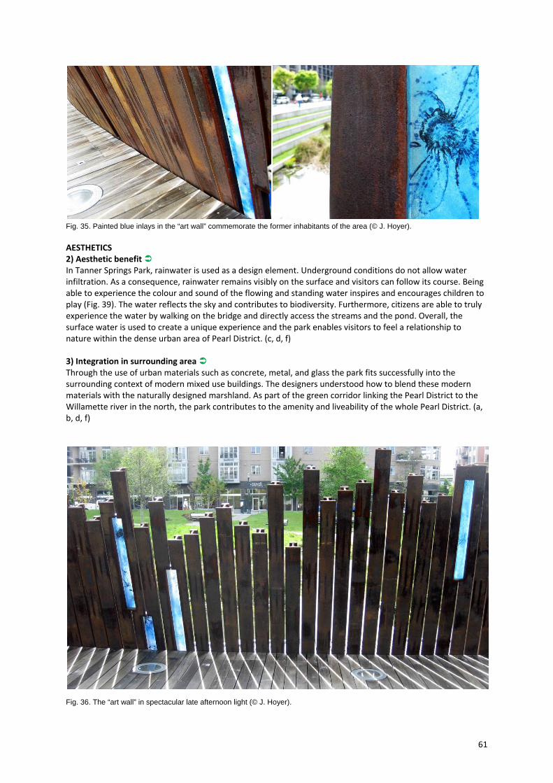
61
Fig. 35. Painted blue inlays in the “art wall” commemorate the former inhabitants of the area (© J. Hoyer).
AESTHETICS 2) Aesthetic benefit In Tanner Springs Park, rainwater is used as a design element. Underground conditions do not allow water infiltration. As a consequence, rainwater remains visibly on the surface and visitors can follow its course. Being able to experience the colour and sound of the flowing and standing water inspires and encourages children to play (Fig. 39). The water reflects the sky and contributes to biodiversity. Furthermore, citizens are able to truly experience the water by walking on the bridge and directly access the streams and the pond. Overall, the surface water is used to create a unique experience and the park enables visitors to feel a relationship to nature within the dense urban area of Pearl District. (c, d, f) 3) Integration in surrounding area Through the use of urban materials such as concrete, metal, and glass the park fits successfully into the surrounding context of modern mixed use buildings. The designers understood how to blend these modern materials with the naturally designed marshland. As part of the green corridor linking the Pearl District to the Willamette river in the north, the park contributes to the amenity and liveability of the whole Pearl District. (a, b, d, f)
Fig. 36. The “art wall” in spectacular late afternoon light (© J. Hoyer).
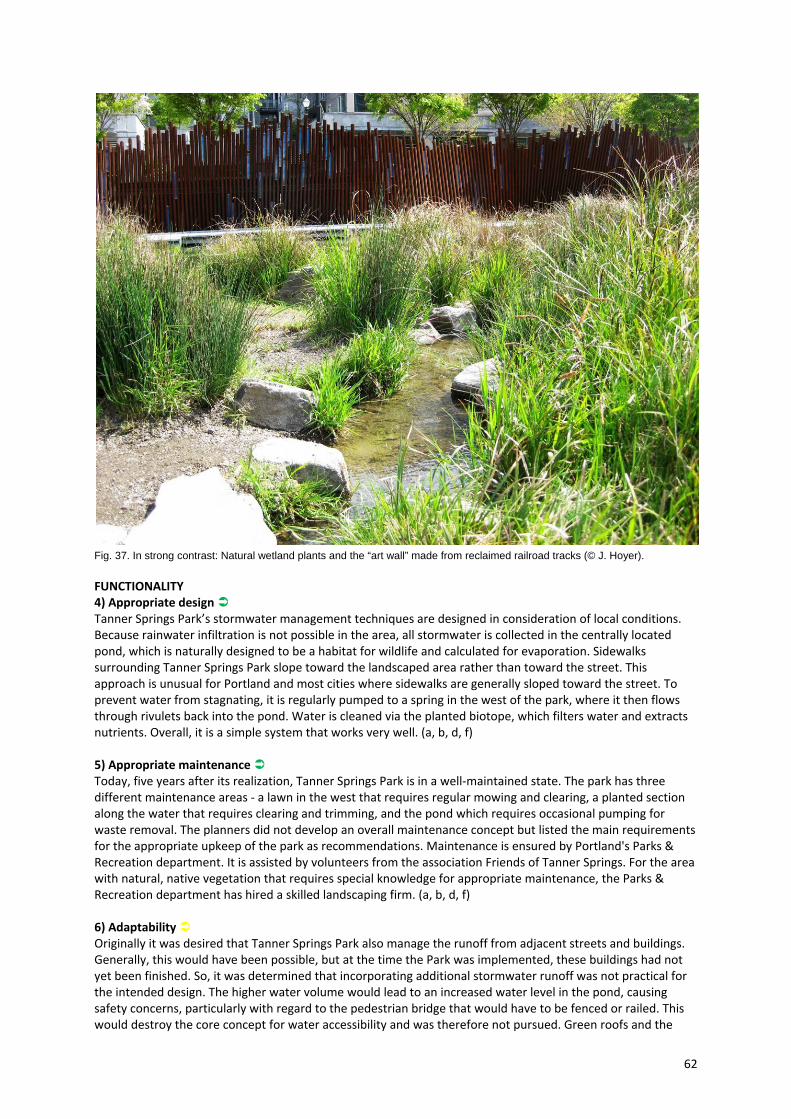
62
Fig. 37. In strong contrast: Natural wetland plants and the “art wall” made from reclaimed railroad tracks (© J. Hoyer).
FUNCTIONALITY 4) Appropriate design Tanner Springs Park’s stormwater management techniques are designed in consideration of local conditions. Because rainwater infiltration is not possible in the area, all stormwater is collected in the centrally located pond, which is naturally designed to be a habitat for wildlife and calculated for evaporation. Sidewalks surrounding Tanner Springs Park slope toward the landscaped area rather than toward the street. This approach is unusual for Portland and most cities where sidewalks are generally sloped toward the street. To prevent water from stagnating, it is regularly pumped to a spring in the west of the park, where it then flows through rivulets back into the pond. Water is cleaned via the planted biotope, which filters water and extracts nutrients. Overall, it is a simple system that works very well. (a, b, d, f) 5) Appropriate maintenance Today, five years after its realization, Tanner Springs Park is in a well‐maintained state. The park has three different maintenance areas ‐ a lawn in the west that requires regular mowing and clearing, a planted section along the water that requires clearing and trimming, and the pond which requires occasional pumping for waste removal. The planners did not develop an overall maintenance concept but listed the main requirements for the appropriate upkeep of the park as recommendations. Maintenance is ensured by Portland's Parks & Recreation department. It is assisted by volunteers from the association Friends of Tanner Springs. For the area with natural, native vegetation that requires special knowledge for appropriate maintenance, the Parks & Recreation department has hired a skilled landscaping firm. (a, b, d, f) 6) Adaptability Originally it was desired that Tanner Springs Park also manage the runoff from adjacent streets and buildings. Generally, this would have been possible, but at the time the Park was implemented, these buildings had not yet been finished. So, it was determined that incorporating additional stormwater runoff was not practical for the intended design. The higher water volume would lead to an increased water level in the pond, causing safety concerns, particularly with regard to the pedestrian bridge that would have to be fenced or railed. This would destroy the core concept for water accessibility and was therefore not pursued. Green roofs and the
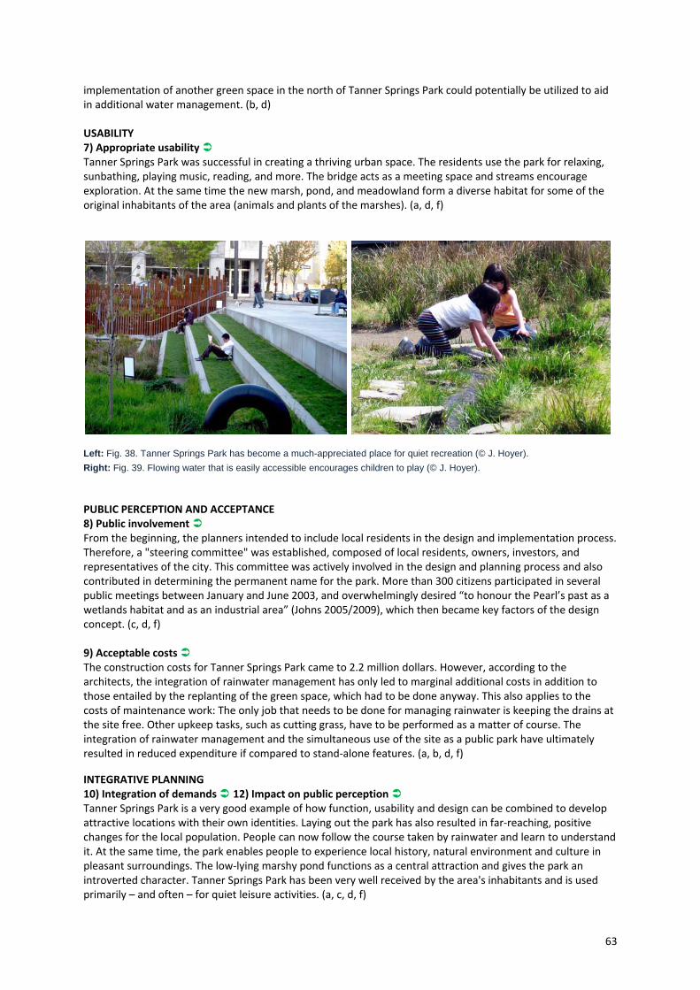
63
implementation of another green space in the north of Tanner Springs Park could potentially be utilized to aid in additional water management. (b, d) USABILITY 7) Appropriate usability Tanner Springs Park was successful in creating a thriving urban space. The residents use the park for relaxing, sunbathing, playing music, reading, and more. The bridge acts as a meeting space and streams encourage exploration. At the same time the new marsh, pond, and meadowland form a diverse habitat for some of the original inhabitants of the area (animals and plants of the marshes). (a, d, f)
Left: Fig. 38. Tanner Springs Park has become a much-appreciated place for quiet recreation (© J. Hoyer).
Right: Fig. 39. Flowing water that is easily accessible encourages children to play (© J. Hoyer).
PUBLIC PERCEPTION AND ACCEPTANCE 8) Public involvement From the beginning, the planners intended to include local residents in the design and implementation process. Therefore, a "steering committee" was established, composed of local residents, owners, investors, and representatives of the city. This committee was actively involved in the design and planning process and also contributed in determining the permanent name for the park. More than 300 citizens participated in several public meetings between January and June 2003, and overwhelmingly desired “to honour the Pearl’s past as a wetlands habitat and as an industrial area” (Johns 2005/2009), which then became key factors of the design concept. (c, d, f) 9) Acceptable costs The construction costs for Tanner Springs Park came to 2.2 million dollars. However, according to the architects, the integration of rainwater management has only led to marginal additional costs in addition to those entailed by the replanting of the green space, which had to be done anyway. This also applies to the costs of maintenance work: The only job that needs to be done for managing rainwater is keeping the drains at the site free. Other upkeep tasks, such as cutting grass, have to be performed as a matter of course. The integration of rainwater management and the simultaneous use of the site as a public park have ultimately resulted in reduced expenditure if compared to stand‐alone features. (a, b, d, f)
INTEGRATIVE PLANNING 10) Integration of demands 12) Impact on public perception Tanner Springs Park is a very good example of how function, usability and design can be combined to develop attractive locations with their own identities. Laying out the park has also resulted in far‐reaching, positive changes for the local population. People can now follow the course taken by rainwater and learn to understand it. At the same time, the park enables people to experience local history, natural environment and culture in pleasant surroundings. The low‐lying marshy pond functions as a central attraction and gives the park an introverted character. Tanner Springs Park has been very well received by the area's inhabitants and is used primarily – and often – for quiet leisure activities. (a, c, d, f)

64
Fig. 40. Water concept for Tanner Springs Park: All rainwater from the walkways of the adjacent streets is visibly (e.g. via leaf-shaped rainwater pavilion (right)) or invisibly lead to the retention pond (left: © Atelier Dreiseitl; right: © J. Hoyer).
11) Interdisciplinary planning From the beginning, Tanner Springs Park was designed from the perspective of urban planning and landscape architecture, something which is reflected in the formal language and usability of the park. Also, planners who work with water were involved. However, stormwater management could have been implemented more successfully by gathering the stormwater runoff from a larger area. This could have been reached through an earlier cooperation between the city's urban planning and water management departments, i.e. during the phase when the master plan for the Pearl District was drawn up. The park was constructed when the master plan was already in place, therefore a more comprehensive stormwater management was not practical. (a, b, d)
What can be learned from the project & adaptability to other cities Tanner Springs Park is a prime example of how decentralised stormwater management can be realized in a public park setting, and how measures for decentralised stormwater management can lead to an attractive design. Project planning and implementation was well considered and is an exceptional case study for future projects. However, it should be noted that just like the marsh pond in Tanner Springs Park, measures should be carefully selected for public appeal and functionality. An ideal for each site and situation exists, and it is the task of the designers and stakeholders to find a balance between stormwater management and urban design.
65
Trabrennbahn Farmsen (Hamburg, Germany)
Type of project Newly developed residential areaLocation Hamburg, GermanyInitiated & financed by
Herz family, GATOR Beteiligungsgesellschaft mbH
Responsible Concept: PPL Planungsbüro Professor Laage, NPS und Partner GbR, Hamburg (urban design, architecture), L+O Dresel‐Gurr‐Herbst (landscape architecture) Water and Landscape Design: KFP ‐ Kontor Freiraumplanung, Hamburg (landscape architecture) Consultants: wfw ‐ Nordconsult GmbH, Hamburg (traffic concept); Schnittger Architekten, Kiel, NPS und Partner GbR, Hamburg (construction supervision); Bezirk Wandsbek (urban administration)
Main concept Application of an open drainage system as a key design element for a newly built residential estate; design reflects the former function of the site as a harness racetrack.
Time frame Planning: 1993‐1995, Construction: 1st phase 1995‐1997, 2nd phase 1997‐2000
Context Area: 15.1 ha; Water surface area: 1.7 haPopulation: 1,158 flat units Density: 2,757 inhabitants/km²(district Farmsen‐Berne) Importance of water: Open drainage system follows the track of the former harness racetrack; existing ponds in the centre of the quarter are a relic of the former brickyard and now used for retention of stormwater; due to the low permeability of the underground stormwater infiltration is not possible.
Project scale District levelAnnual rainfall 770 mm
Description The residential area Trabrennbahn Farmsen is situated in the northeast of Hamburg (Germany) and has a long history. Formerly a brickyard in the 19th century, the area was transformed into a racetrack for harness from 1911‐1976. During that time, the area became a national attraction (GATOR n. d.). Since 1965, the site has been part of the property of the Herz family. With the decline of the tradition of horse racing, the harness racetrack was abandoned in 1976 and was not used for a long time. At the beginning of the 1990s, the municipality of Hamburg decided to develop the area for residential use. Due to long standing vacancy, the area was revisited by nature and become a place of high ecological value (FIBICH & MERTINS 2000). A competition for the redevelopment of the area was announced in 1992. A planning team consisting of PPL (urban design and architecture) and L+O Dresel‐Gurr‐Herbst (landscape architecture) won this competition. The final landscape and water concept was designed by Kontor Freiraumplanung. The history of the area as a harness racetrack and a brickyard visibly influenced the design of the urban development plan (Fig. 41). The residential buildings are arranged in an oval manner (Fig. 42), alluding to the former location of the racetrack. The centre of the quarter is kept free of development to conserve existing habitats and to allow further habitat development (FHH 2005). The whole area is designed as a pedestrian zone. All cars are parked in a multi‐storey car park, located at the edge of the development. A pedestrian promenade connects the buildings of the inner and outer oval course and provides informal play areas for children of all ages. Parallel to this promenade, linear water channels ‐ the site's most impressive stormwater management facilities ‐ are located.
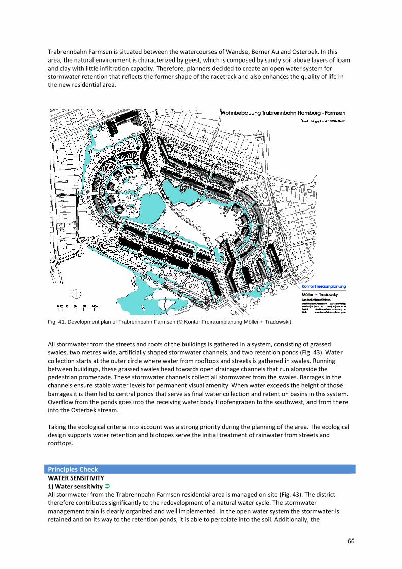
66
Trabrennbahn Farmsen is situated between the watercourses of Wandse, Berner Au and Osterbek. In this area, the natural environment is characterized by geest, which is composed by sandy soil above layers of loam and clay with little infiltration capacity. Therefore, planners decided to create an open water system for stormwater retention that reflects the former shape of the racetrack and also enhances the quality of life in the new residential area.
Fig. 41. Development plan of Trabrennbahn Farmsen (© Kontor Freiraumplanung Möller + Tradowski).
All stormwater from the streets and roofs of the buildings is gathered in a system, consisting of grassed swales, two metres wide, artificially shaped stormwater channels, and two retention ponds (Fig. 43). Water collection starts at the outer circle where water from rooftops and streets is gathered in swales. Running between buildings, these grassed swales head towards open drainage channels that run alongside the pedestrian promenade. These stormwater channels collect all stormwater from the swales. Barrages in the channels ensure stable water levels for permanent visual amenity. When water exceeds the height of those barrages it is then led to central ponds that serve as final water collection and retention basins in this system. Overflow from the ponds goes into the receiving water body Hopfengraben to the southwest, and from there into the Osterbek stream. Taking the ecological criteria into account was a strong priority during the planning of the area. The ecological design supports water retention and biotopes serve the initial treatment of rainwater from streets and rooftops.
Principles Check WATER SENSITIVITY 1) Water sensitivity All stormwater from the Trabrennbahn Farmsen residential area is managed on‐site (Fig. 43). The district therefore contributes significantly to the redevelopment of a natural water cycle. The stormwater management train is clearly organized and well implemented. In the open water system the stormwater is retained and on its way to the retention ponds, it is able to percolate into the soil. Additionally, the

67
microclimate of the site is positively affected because of high evaporation rates resulting from open water areas. As a result, connection to rainwater sewers was not necessary. (a, b, f) AESTHETICS 2) Aesthetic benefit Stormwater is a major element to the overall Trabrennbahn Farmsen design concept. Rainwater is always visible on the surface. The visibility of water, in swales, channels, and ponds defines the character of the settlement. Residents are in constant contact with the water ‐ able to follow its course and experience the sound, smell, and feel of the water. The design of embankments makes water easily accessible and in order to prevent accidents, the depth of water has been reduced along embankments. Only a small number of
Fig. 42. The former racetrack is echoed by the oval layout of the buildings (© J. Gerstenberg).
Fig. 43. Function scheme of the drainage system (© Kontor Freiraumplanung Möller + Tradowski, modified).
handrails and fences are needed. Also, the barrages ensure a constant water level in the channels and help avoid an unpleasant odour in summer (Fig. 45). Most importantly, the ecological design aims to maintain the previously existing natural state of the site while being adapted as a highly valued residential space. Inhabitants can therefore live securely with nature and utilize open green spaces within a densely populated area – a rare commodity in status quo planning and development (Fig. 46). (a, b, f)
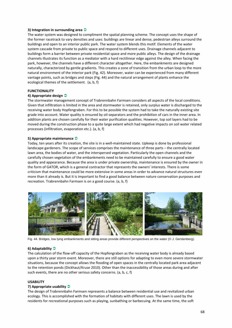
68
3) Integration in surrounding area The water system was designed to compliment the spatial planning scheme. The concept uses the shape of the former racetrack to vary densities and uses: buildings are linear and dense, pedestrian alleys surround the buildings and open to an interior public park. The water system blends this motif. Elements of the water system cascade from private to public space and respond to different uses. Drainage channels adjacent to buildings form a barrier between private residential space and more public alleys. The design of the drainage channels illustrates its function as a mediator with a hard rectilinear edge against the alley. When facing the park, however, the channels have a different character altogether. Here, the embankments are designed naturally, characterized by gentle gradients. This creates a zone of transition from the urban loop to the more natural environment of the interior park (Fig. 42). Moreover, water can be experienced from many different vantage points, such as bridges and steps (Fig. 44) and the natural arrangement of plants enhance the ecological themes of the settlement. (a, b, f)
FUNCTIONALITY 4) Appropriate design The stormwater management concept of Trabrennbahn Farmsen considers all aspects of the local conditions. Given that infiltration is limited in the area and stormwater is retained, only surplus water is discharged to the receiving water body Hopfengraben. For this to be possible the system had to take the naturally existing site grade into account. Water quality is ensured by oil‐separators and the prohibition of cars in the inner area. In addition plants are chosen carefully for their water purification qualities. However, top soil layers had to be moved during the construction phase to a quite large extent which had negative impacts on soil water related processes (infiltration, evaporation etc.). (a, b, f) 5) Appropriate maintenance Today, ten years after its creation, the site is in a well‐maintained state. Upkeep is done by professional landscape gardeners. The scope of services comprises the maintenance of three parts – the centrally located lawn area, the bodies of water, and the interspersed vegetation. Particularly the open channels and the carefully chosen vegetation of the embankments need to be maintained carefully to ensure a good water quality and appearance. Because the area is under private ownership, maintenance is ensured by the owner in the form of GATOR, which is a general contractor that represents the owners' interests. There is some criticism that maintenance could be more extensive in some areas in order to advance natural structures even more than it already is. But it is important to find a good balance between nature conservation purposes and recreation. Trabrennbahn Farmsen is on a good course. (a, b, f)
Fig. 44. Bridges, low lying embankments and sitting areas provide different perspectives on the water (© J. Gerstenberg). 6) Adaptability The calculation of the flow‐off capacity of the Hopfengraben as the receiving water body is already based upon a thirty year storm event. Moreover, there are still options for adapting to even more severe stormwater situations, because the concept allows the flooding of open spaces in the centrally located park area adjacent to the retention ponds (Dickhaut/Kruse 2010). Other than the inaccessibility of those areas during and after such events, there are no other serious safety concerns. (a, b, c, f) USABILITY 7) Appropriate usability The design of Trabrennbahn Farmsen represents a balance between residential use and revitalized urban ecology. This is accomplished with the formation of habitats with different uses. The lawn is used by the residents for recreational purposes such as playing, sunbathing or barbecuing. At the same time, the soft
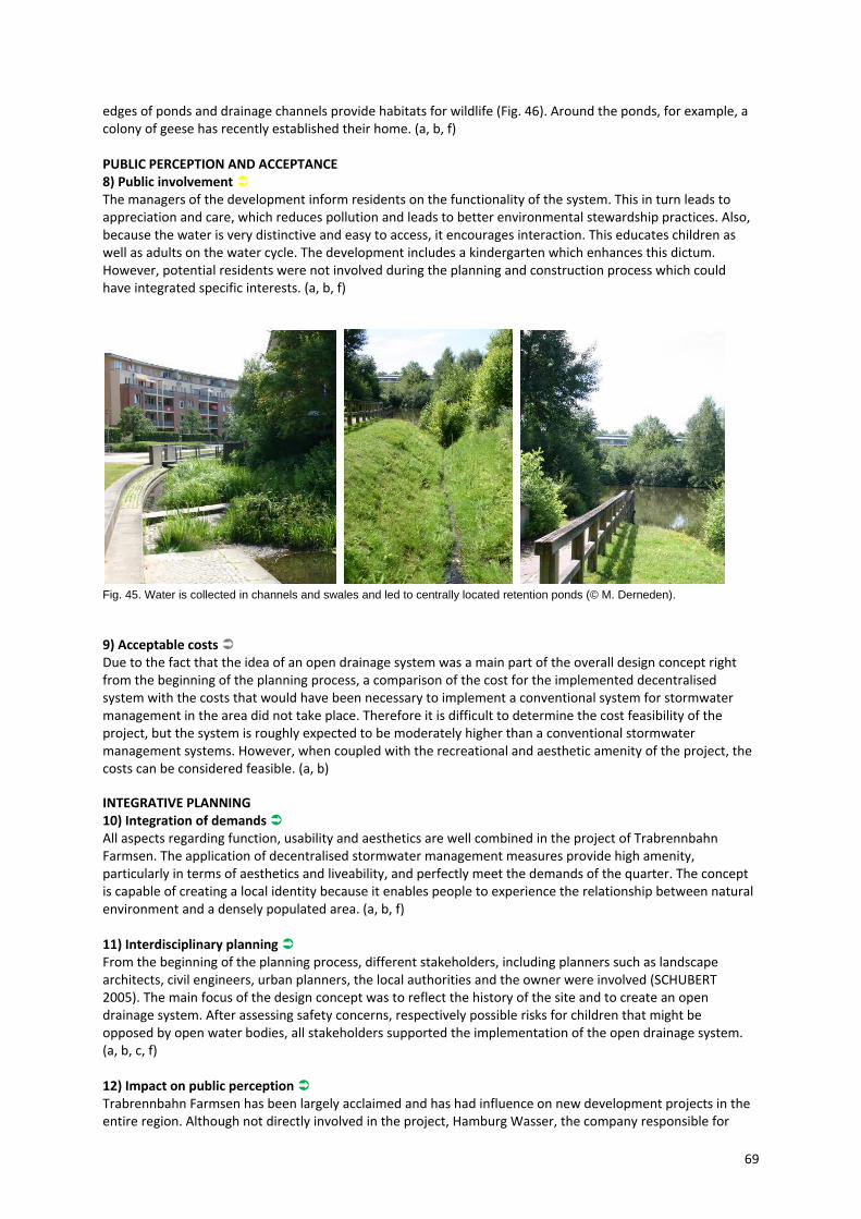
69
edges of ponds and drainage channels provide habitats for wildlife (Fig. 46). Around the ponds, for example, a colony of geese has recently established their home. (a, b, f) PUBLIC PERCEPTION AND ACCEPTANCE 8) Public involvement The managers of the development inform residents on the functionality of the system. This in turn leads to appreciation and care, which reduces pollution and leads to better environmental stewardship practices. Also, because the water is very distinctive and easy to access, it encourages interaction. This educates children as well as adults on the water cycle. The development includes a kindergarten which enhances this dictum. However, potential residents were not involved during the planning and construction process which could have integrated specific interests. (a, b, f)
Fig. 45. Water is collected in channels and swales and led to centrally located retention ponds (© M. Derneden).
9) Acceptable costs Due to the fact that the idea of an open drainage system was a main part of the overall design concept right from the beginning of the planning process, a comparison of the cost for the implemented decentralised system with the costs that would have been necessary to implement a conventional system for stormwater management in the area did not take place. Therefore it is difficult to determine the cost feasibility of the project, but the system is roughly expected to be moderately higher than a conventional stormwater management systems. However, when coupled with the recreational and aesthetic amenity of the project, the costs can be considered feasible. (a, b) INTEGRATIVE PLANNING 10) Integration of demands All aspects regarding function, usability and aesthetics are well combined in the project of Trabrennbahn Farmsen. The application of decentralised stormwater management measures provide high amenity, particularly in terms of aesthetics and liveability, and perfectly meet the demands of the quarter. The concept is capable of creating a local identity because it enables people to experience the relationship between natural environment and a densely populated area. (a, b, f) 11) Interdisciplinary planning From the beginning of the planning process, different stakeholders, including planners such as landscape architects, civil engineers, urban planners, the local authorities and the owner were involved (SCHUBERT 2005). The main focus of the design concept was to reflect the history of the site and to create an open drainage system. After assessing safety concerns, respectively possible risks for children that might be opposed by open water bodies, all stakeholders supported the implementation of the open drainage system. (a, b, c, f) 12) Impact on public perception Trabrennbahn Farmsen has been largely acclaimed and has had influence on new development projects in the entire region. Although not directly involved in the project, Hamburg Wasser, the company responsible for
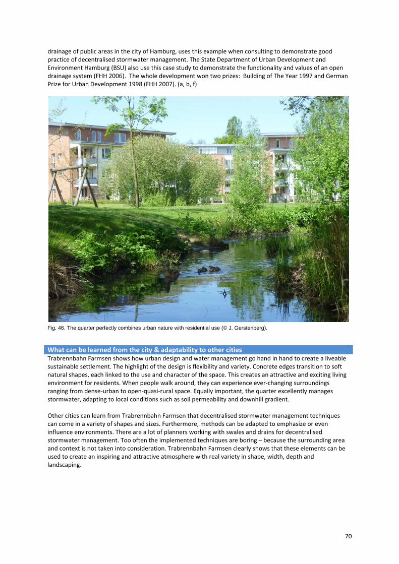
70
drainage of public areas in the city of Hamburg, uses this example when consulting to demonstrate good practice of decentralised stormwater management. The State Department of Urban Development and Environment Hamburg (BSU) also use this case study to demonstrate the functionality and values of an open drainage system (FHH 2006). The whole development won two prizes: Building of The Year 1997 and German Prize for Urban Development 1998 (FHH 2007). (a, b, f)
Fig. 46. The quarter perfectly combines urban nature with residential use (© J. Gerstenberg).
What can be learned from the city & adaptability to other cities Trabrennbahn Farmsen shows how urban design and water management go hand in hand to create a liveable sustainable settlement. The highlight of the design is flexibility and variety. Concrete edges transition to soft natural shapes, each linked to the use and character of the space. This creates an attractive and exciting living environment for residents. When people walk around, they can experience ever‐changing surroundings ranging from dense‐urban to open‐quasi‐rural space. Equally important, the quarter excellently manages stormwater, adapting to local conditions such as soil permeability and downhill gradient. Other cities can learn from Trabrennbahn Farmsen that decentralised stormwater management techniques can come in a variety of shapes and sizes. Furthermore, methods can be adapted to emphasize or even influence environments. There are a lot of planners working with swales and drains for decentralised stormwater management. Too often the implemented techniques are boring – because the surrounding area and context is not taken into consideration. Trabrennbahn Farmsen clearly shows that these elements can be used to create an inspiring and attractive atmosphere with real variety in shape, width, depth and landscaping.
71
Hohlgrabenäcker (Stuttgart, Germany)
Type of project New development district for mainly residential use Location Stuttgart, GermanyInitiated by Municipality of StuttgartFinanced by City/ different property developers and private owners Responsible Development plan: STEG Stadtentwicklung GmbH, Stuttgart
(urban planning) Stormwater management concept and overall design: diem.baker GbR (water engineering) Landscape concept and design: Planstatt Johann Senner (landscape architecture) Building design and specific stormwater management design on site level (incl. green roofs and cisterns): different architects
Main concept Save costs of stormwater management through the application of green roofs, cisterns and pervious pavement instead enlarging sewer system for rainwater drainage.
Time frame Planning: 2003‐2007; Construction: 2007–today (2010) Context Area: 16.7 ha; Green roof area: 18,300 m²
Population/Density: Semi‐dense site with 265 private homes and 9 apartment buildings. Importance of water: Legal and municipal requirements have restricted stormwater flow from the development site to the public sewer system to 30%.
Project scale District levelAnnual rainfall 719 mm
Description In the district of Zuffenhausen, a northern suburb of Stuttgart, the City of Stuttgart is developing a new building site with single‐family housing (detached, semi‐detached and row houses) and 9 buildings with apartments. The main aim for developing this area is to create a building site that is sustainable and fulfils the requirements established by water‐related legislation in Baden‐Württemberg (Stuttgart is the capital of the state of Baden‐Württemberg) and by Stuttgart city council while considering local hydrological conditions. Baden‐Württemberg's water act (article 45 b, para. 3) requires on‐site stormwater infiltration or the separate drainage of stormwater for all new sites. Moreover, the municipality of Stuttgart required the reduction of stormwater runoff from the new Hohlgrabenäcker site to a maximum of 30%, because of the limited capacity of existing sewers in this area. To fulfil these requirements, planners worked on a concept that could manage as much stormwater as possible on‐site. Soil analyses showed that soils in the upper layer are predominantly cohesive and homogenous, and they are therefore unsuitable for stormwater infiltration. Furthermore, steep hillsides (sometimes with a gradient of over 10%) were an additional barrier for the application of surface stormwater infiltration techniques. For these reasons planners could not work with comprehensive stormwater infiltration, so a combination of different elements for decentralised stormwater management was initiated: Green roofs, cisterns and pervious pavement. The development plan for the residential area of Hohlgrabenäcker specified which measures should be put into practice and where they should be implemented. ‐ Green roofs are specified for runoff minimisation in the more densely built areas of the new site, which consists mainly of row houses and apartment buildings (Fig. 47). Furthermore, all paved areas are to be designed with permeable coverings to allow stormwater infiltration. Unique to this area is that the obligatory use of green roofs was already included in the land development plan for Stuttgart, but mainly as impact mitigation requirement rather than for urban drainage purposes. Planners refined the design of the green
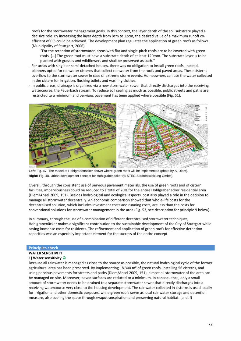
72
roofs for the stormwater management goals. In this context, the layer depth of the soil substrate played a decisive role. By increasing the layer depth from 8cm to 12cm, the desired value of a maximum runoff co‐efficient of 0.3 could be achieved. The development plan regulates the application of green roofs as follows (Municipality of Stuttgart, 2006):
“For the retention of stormwater, areas with flat and single‐pitch roofs are to be covered with green roofs. […] The green roof must have a substrate depth of at least 120mm. The substrate layer is to be planted with grasses and wildflowers and shall be preserved as such.”
‐ For areas with single or semi‐detached houses, there was no obligation to install green roofs. Instead, planners opted for rainwater cisterns that collect rainwater from the roofs and paved areas. These cisterns overflow to the stormwater sewer in case of extreme storm events. Homeowners can use the water collected in the cistern for irrigation, flushing toilets and washing clothes.
‐ In public areas, drainage is organized via a new stormwater sewer that directly discharges into the receiving watercourse, the Feuerbach stream. To reduce soil sealing as much as possible, public streets and paths are restricted to a minimum and pervious pavement has been applied where possible (Fig. 51).
Left: Fig. 47. The model of Hohlgrabenäcker shows where green roofs will be implemented (photo by A. Diem).
Right: Fig. 48. Urban development concept for Hohlgrabenäcker (© STEG Stadtentwicklung GmbH).
Overall, through the consistent use of pervious pavement materials, the use of green roofs and of cistern facilities, imperviousness could be reduced to a total of 20% for the entire Hohlgrabenäcker residential area (Diem/Ansel 2009, 151). Besides hydrological and ecological aspects, cost also played a role in the decision to manage all stormwater decentrally. An economic comparison showed that whole‐life costs for the decentralised solution, which includes investment costs and running costs, are less than the costs for conventional solutions for stormwater management in the area (Fig. 53, see description for principle 9 below).
In summary, through the use of a combination of different decentralised stormwater techniques, Hohlgrabenäcker makes a significant contribution to the sustainable development of the City of Stuttgart while saving immense costs for residents. The refinement and application of green roofs for effective detention capacities was an especially important element for the success of the entire concept.
Principles check WATER SENSITIVITY 1) Water sensitivity Because all rainwater is managed as close to the source as possible, the natural hydrological cycle of the former agricultural area has been preserved. By implementing 18,300 m² of green roofs, installing 56 cisterns, and using pervious pavements for streets and paths (Diem/Ansel 2009, 151), almost all stormwater of the area can be managed on site. Moreover, paved surfaces are reduced to a minimum. In consequence, only a small amount of stormwater needs to be drained to a separate stormwater sewer that directly discharges into a receiving watercourse very close to the housing development. The rainwater collected in cisterns is used locally for irrigation and other domestic purposes, while green roofs serve as local rainwater storage and detention measure, also cooling the space through evapotranspiration and preserving natural habitat. (a, d, f)
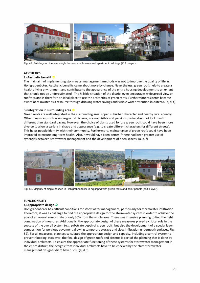
73
Fig. 49. Buildings on the site: single houses, row houses and apartment buildings (© J. Hoyer).
AESTHETICS 2) Aesthetic benefit The main aim of implementing stormwater management methods was not to improve the quality of life in Hohlgrabenäcker. Aesthetic benefits came about more by chance. Nevertheless, green roofs help to create a healthy living environment and contribute to the appearance of the entire housing development to an extent that should not be underestimated. The hillside situation of the district even encourages widespread view on rooftops and is therefore an ideal place to use the aesthetics of green roofs. Furthermore residents become aware of rainwater as a resource through drinking water savings and visible water retention in cisterns. (a, d, f) 3) Integration in surrounding area Green roofs are well integrated in the surrounding area’s open suburban character and nearby rural country. Other measures, such as underground cisterns, are not visible and pervious paving does not look much different than standard paving. However, the choice of plants used for the green roofs could have been more diverse to allow a variety in shape and appearance (e.g. to create different characters for different streets). This helps people identify with their community. Furthermore, maintenance of green roofs could have been improved to ensure long‐term health. Also, it would have been better if there had been greater use of synergies between stormwater management and the development of open spaces. (a, d, f)
Fig. 50. Majority of single houses in Hohlgrabenäcker is equipped with green roofs and solar panels (© J. Hoyer).
FUNCTIONALITY 4) Appropriate design Hohlgrabenäcker has difficult conditions for stormwater management, particularly for stormwater infiltration. Therefore, it was a challenge to find the appropriate design for the stormwater system in order to achieve the goal of an overall run‐off rate of only 30% from the whole area. There was intensive planning to find the right combination of measures. Additionally, the appropriate design of these measures played a critical role in the success of the overall system (e.g. substrate depth of green roofs, but also the development of a special layer composition for pervious pavement allowing temporary storage and slow infiltration underneath surfaces, Fig. 52). For all measures, planners calculated the appropriate design and capacity, including a control system to prevent flooding. However, the final design of green roofs and cisterns is part of the planning that is done by individual architects. To ensure the appropriate functioning of these systems for stormwater management in the entire district, the designs from individual architects have to be checked by the chief stormwater management designer diem.baker GbR. (a, d, f)

74
5) Appropriate maintenance Maintenance of stormwater facilities is shared between the city and private owners. Pervious pavement on streets and paths as well as drains underneath the streets are kept clean by the city’s department for streets (Tiefbauamt), while upkeep of green roofs and cisterns is the duty of the homeowners, who also clean pervious pavements on private property. Though architects and homeowners have been informed about the maintenance requirements for green roofs and cisterns by the main development committee, there is no overall monitor to ensure professionalism or guarantee functionality. Time will tell if this is a problem. (a, b, d, f) 6) Adaptability The stormwater facilities have been designed to cope with a severe stormwater event that is statistically likely to happen once every 5 years. When there are more intense rains, the secure control system protects the area from flooding by leading all additional water, which exceeds the capacity of the green roofs and cisterns, directly to the receiving watercourse (Feuerbach). However, it should be noted that this will put pressure on the Feuerbach, both in terms of quality and quantity. Moreover, due to the fact that the stormwater system implemented in Hohlgrabenäcker connects the construction of buildings with the creation of detention capacities, further development (e.g. the enlargement of the settlement in the future) is easily possible. (a, b, d, f) USABILITY 7) Appropriate usability All features of the stormwater system are integrated in the settlement in such a way that there are no restrictions on use. Cisterns are located below ground and greenery on roofs utilizes space that is normally not used. It was the planners' aim to find a system that did not take up much space in public areas to preserve space for real estate. However, opportunities to use decentralised stormwater management techniques to create multifunctional spaces have not been taken up. (a, d, f)
Fig. 51. Only main roads are asphalted, while residential streets and paths are paved with pervious materials (© left: J. Hoyer, right: A. Diem).
PUBLIC PERCEPTION AND ACCEPTANCE 8) Public involvement In accordance with Germany's Federal Building Code (Baugesetzbuch), public involvement took place during the drafting of the development plan for the entire district. In this phase, the minimization of environment impact resulting from the construction of the new settlement was discussed. Due to the fact that the area used to feature orchards and a plant nursery and was important for conservation reasons, it became increasingly clear that the environmentally responsible handling of major resources was necessary. This attitude made it easier to implement the idea of decentralised stormwater management for Hohlgrabenäcker. The second phase of public involvement is the implementation of stormwater measures on private properties. Because architects are responsible for the final design of green roofs and cisterns, homeowners can decide major components by themselves, e.g. the plants used for the green roofs or the capacity of the cisterns for private usage in addition to the required volume for stormwater retention (3 m³). However, it should be noted that

75
Fig. 52. Standard cross-section of pervious pavement on streets and paths (© drawing: Diem/Baker GbR, photo: J. Hoyer).
stakeholder involvement, although well orchestrated by the urban developer STEG, did not exceed what is required by legislation. (b, d, f) 9) Acceptable costs A comparison of investment costs showed that the decentralised stormwater system implemented in Hohlgrabenäcker is less expensive (€532,900) than the conventional solution that would have been required for the site (€938,000). The main cost differences result from property costs that would have been necessary to buy the land for a central stormwater basin, its construction costs and the costs that result from having to build a larger sewer (Fig. 53). The application of decentral stormwater facilities even continues to save costs: Maintenance costs for public sewers are reduced and maintenance costs for the central stormwater basin do not have to be taken into account. Due to the fact that the degree of imperviousness of the entire area is only 20 %, stormwater fees amounting to more than €770,400 could be saved over a period of 30 years. Moreover, residents will be able to save further by using rainwater for domestic appliances that are normally run using drinking water. To sum up, over a period of 30 years the implemented decentralised system for stormwater management at Hohlgrabenäcker will save more than €1 million over conventional stormwater management in this area. (a, d, f) INTEGRATIVE PLANNING 10) Integration of demands + 11) Interdisciplinary planning The development plan for Hohlgrabenäcker is a cooperative work from urban designers, civil engineers and landscape architects. Up until now, urban drainage was typically designed after development plans were finalized. Therefore it was difficult to specify decentralised management methods on private properties. But because all land use types play a role in stormwater reduction, early communication and cooperation is crucial to establish both private and public space solutions. Fortunately this communication took place in the early planning stages at Hohlgrabenäcker resulting in a comprehensive plan that utilizes both private residences and public space for stormwater management. Additionally, some synergies are established (e.g. use of green roofs for nature conservation and storm water management purposes), and space and finances are used effectively. (a, d, f)
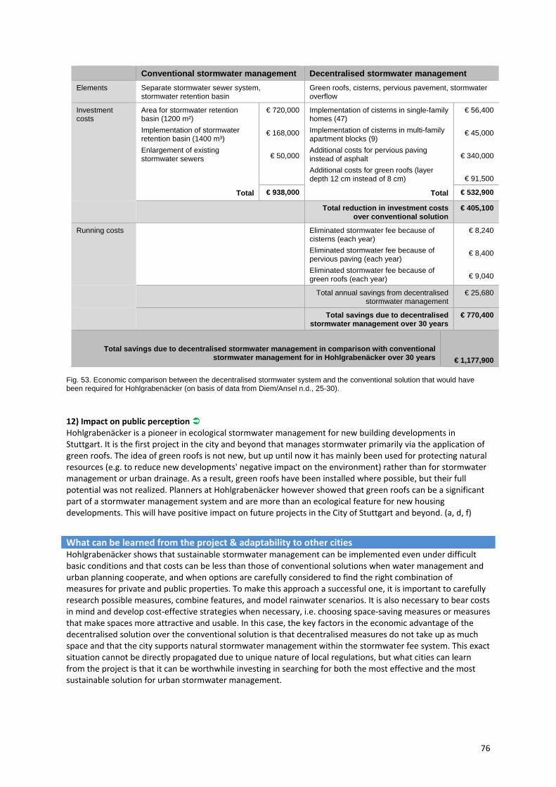
76
Conventional stormwater management Decentralised stormwater management
Elements Separate stormwater sewer system, stormwater retention basin
Green roofs, cisterns, pervious pavement, stormwater overflow
Investment costs
Area for stormwater retention basin (1200 m²)
Implementation of stormwater retention basin (1400 m³)
Enlargement of existing stormwater sewers
Total
€ 720,000
€ 168,000
€ 50,000
Implementation of cisterns in single-family homes (47)
Implementation of cisterns in multi-family apartment blocks (9)
Additional costs for pervious paving instead of asphalt
Additional costs for green roofs (layer depth 12 cm instead of 8 cm)
Total
€ 56,400
€ 45,000
€ 340,000
€ 91,500
€ 938,000 € 532,900
Total reduction in investment costs over conventional solution
€ 405,100
Running costs Eliminated stormwater fee because of cisterns (each year)
Eliminated stormwater fee because of pervious paving (each year)
Eliminated stormwater fee because of green roofs (each year)
€ 8,240
€ 8,400
€ 9,040
Total annual savings from decentralised stormwater management
€ 25,680
Total savings due to decentralised stormwater management over 30 years
€ 770,400
Total savings due to decentralised stormwater management in comparison with conventional stormwater management for in Hohlgrabenäcker over 30 years
€ 1,177,900
Fig. 53. Economic comparison between the decentralised stormwater system and the conventional solution that would have been required for Hohlgrabenäcker (on basis of data from Diem/Ansel n.d., 25-30).
12) Impact on public perception Hohlgrabenäcker is a pioneer in ecological stormwater management for new building developments in Stuttgart. It is the first project in the city and beyond that manages stormwater primarily via the application of green roofs. The idea of green roofs is not new, but up until now it has mainly been used for protecting natural resources (e.g. to reduce new developments' negative impact on the environment) rather than for stormwater management or urban drainage. As a result, green roofs have been installed where possible, but their full potential was not realized. Planners at Hohlgrabenäcker however showed that green roofs can be a significant part of a stormwater management system and are more than an ecological feature for new housing developments. This will have positive impact on future projects in the City of Stuttgart and beyond. (a, d, f)
What can be learned from the project & adaptability to other cities Hohlgrabenäcker shows that sustainable stormwater management can be implemented even under difficult basic conditions and that costs can be less than those of conventional solutions when water management and urban planning cooperate, and when options are carefully considered to find the right combination of measures for private and public properties. To make this approach a successful one, it is important to carefully research possible measures, combine features, and model rainwater scenarios. It is also necessary to bear costs in mind and develop cost‐effective strategies when necessary, i.e. choosing space‐saving measures or measures that make spaces more attractive and usable. In this case, the key factors in the economic advantage of the decentralised solution over the conventional solution is that decentralised measures do not take up as much space and that the city supports natural stormwater management within the stormwater fee system. This exact situation cannot be directly propagated due to unique nature of local regulations, but what cities can learn from the project is that it can be worthwhile investing in searching for both the most effective and the most sustainable solution for urban stormwater management.

77
5.4 Small scale case studies
Potsdamer Platz (Berlin, Germany) 10th @ Hoyt Apartments (Portland, Oregon, USA)
Prisma Nürnberg (Nürnberg, Germany)
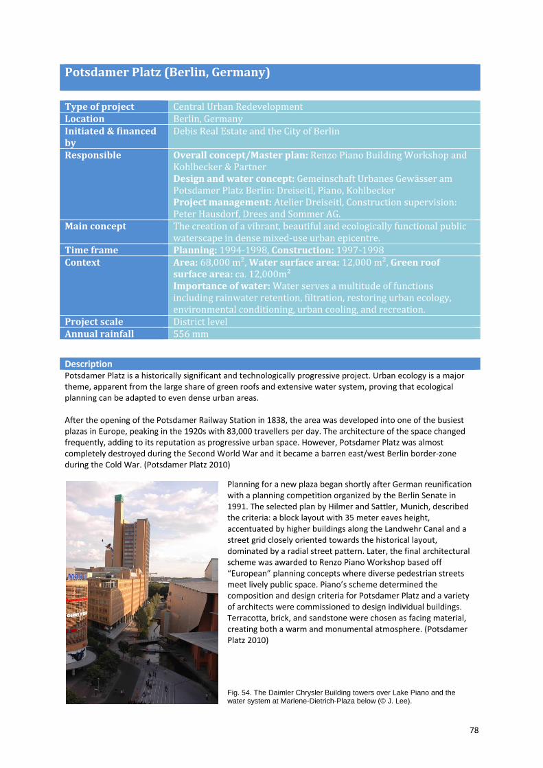
78
Potsdamer Platz (Berlin, Germany)
Type of project Central Urban RedevelopmentLocation Berlin, GermanyInitiated & financed by
Debis Real Estate and the City of Berlin
Responsible
Overall concept/Master plan: Renzo Piano Building Workshop and Kohlbecker & Partner Design and water concept: Gemeinschaft Urbanes Gewässer am Potsdamer Platz Berlin: Dreiseitl, Piano, Kohlbecker Project management: Atelier Dreiseitl, Construction supervision: Peter Hausdorf, Drees and Sommer AG.
Main concept The creation of a vibrant, beautiful and ecologically functional public waterscape in dense mixed‐use urban epicentre.
Time frame Planning: 1994‐1998, Construction: 1997‐1998 Context Area: 68,000 m²,Water surface area: 12,000 m², Green roof
surface area: ca. 12,000m² Importance of water: Water serves a multitude of functions including rainwater retention, filtration, restoring urban ecology, environmental conditioning, urban cooling, and recreation.
Project scale District levelAnnual rainfall 556 mm
Description Potsdamer Platz is a historically significant and technologically progressive project. Urban ecology is a major theme, apparent from the large share of green roofs and extensive water system, proving that ecological planning can be adapted to even dense urban areas. After the opening of the Potsdamer Railway Station in 1838, the area was developed into one of the busiest plazas in Europe, peaking in the 1920s with 83,000 travellers per day. The architecture of the space changed frequently, adding to its reputation as progressive urban space. However, Potsdamer Platz was almost completely destroyed during the Second World War and it became a barren east/west Berlin border‐zone during the Cold War. (Potsdamer Platz 2010)
Planning for a new plaza began shortly after German reunification with a planning competition organized by the Berlin Senate in 1991. The selected plan by Hilmer and Sattler, Munich, described the criteria: a block layout with 35 meter eaves height, accentuated by higher buildings along the Landwehr Canal and a street grid closely oriented towards the historical layout, dominated by a radial street pattern. Later, the final architectural scheme was awarded to Renzo Piano Workshop based off “European” planning concepts where diverse pedestrian streets meet lively public space. Piano’s scheme determined the composition and design criteria for Potsdamer Platz and a variety of architects were commissioned to design individual buildings. Terracotta, brick, and sandstone were chosen as facing material, creating both a warm and monumental atmosphere. (Potsdamer Platz 2010)
Fig. 54. The Daimler Chrysler Building towers over Lake Piano and the water system at Marlene-Dietrich-Plaza below (© J. Lee).
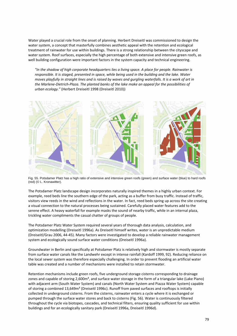
79
Water played a crucial role from the onset of planning. Herbert Dreiseitl was commissioned to design the water system, a concept that masterfully combines aesthetic appeal with the retention and ecological treatment of rainwater for use within buildings. There is a strong relationship between the cityscape and water system. Roof surfaces, especially the high percentage of both extensive and intensive green roofs, as well building configuration were important factors in the system capacity and technical engineering.
"In the shadow of high corporate headquarters lies a living space. A place for people. Rainwater is responsible. It is staged, presented in space, while being used in the building and the lake. Water moves playfully in straight lines and is raised by waves and gurgling waterfalls. It is a work of art in the Marlene‐Dietrich‐Plaza. The planted banks of the lake make an appeal for the possibilities of urban ecology.” (Herbert Dreiseitl 1998 (Dreiseitl 2010))
Fig. 55. Potsdamer Platz has a high ratio of extensive and intensive green roofs (green) and surface water (blue) to hard roofs (red) (© L. Kronawitter).
The Potsdamer Platz landscape design incorporates naturally inspired themes in a highly urban context. For example, reed beds line the southern edge of the park, acting as a buffer from busy traffic. Instead of traffic, visitors view reeds in the wind and reflections in the water. In fact, reed beds spring up across the site creating a visual connection to the natural processes being sustained. Carefully placed water features add to the serene effect. A heavy waterfall for example masks the sound of nearby traffic, while in an internal plaza, trickling water compliments the casual chatter of groups of people. The Potsdamer Platz Water System required several years of thorough data analysis, calculation, and optimization modelling (Dreiseitl 1996a). As Dreiseitl himself writes, water is an unpredictable medium (Dreiseitl/Grau 2006, 44‐45). Many factors were investigated to develop a reliable rainwater management system and ecologically sound surface water conditions (Dreiseitl 1996a). Groundwater in Berlin and specifically at Potsdamer Platz is relatively high and stormwater is mostly separate from surface water canals like the Landwehr except in intense rainfall (Kardoff 1999, 92). Reducing reliance on the local sewer system was therefore especially challenging. In order to prevent flooding an artificial water table was created and a number of mechanisms were installed to retain stormwater. Retention mechanisms include green roofs, five underground storage cisterns corresponding to drainage zones and capable of storing 2,600m³, and surface water storage in the form of a triangular lake (Lake Piano) with adjacent arm (South Water System) and canals (North Water System and Piazza Water System) capable of storing a combined 13,649m³ (Dreiseitl 1996c). Runoff from paved surfaces and rooftops is initially collected in underground cisterns. From the cisterns, rainwater enters a cycle where it is exchanged or pumped through the surface water stores and back to cisterns (Fig. 56). Water is continuously filtered throughout the cycle via biotopes, cascades, and technical filters, ensuring quality sufficient for use within buildings and for an ecologically sanitary park (Dreiseitl 1996a, Dreiseitl 1996d).
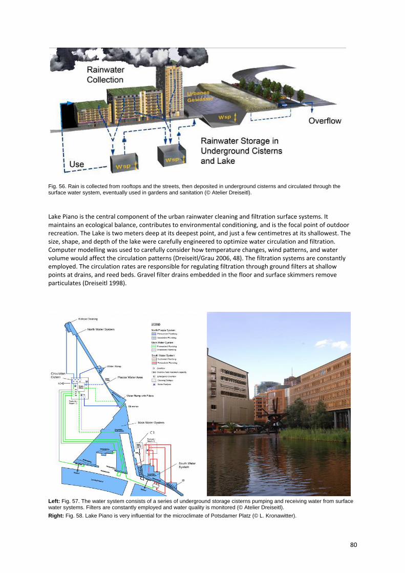
80
Fig. 56. Rain is collected from rooftops and the streets, then deposited in underground cisterns and circulated through the surface water system, eventually used in gardens and sanitation (© Atelier Dreiseitl).
Lake Piano is the central component of the urban rainwater cleaning and filtration surface systems. It maintains an ecological balance, contributes to environmental conditioning, and is the focal point of outdoor recreation. The Lake is two meters deep at its deepest point, and just a few centimetres at its shallowest. The size, shape, and depth of the lake were carefully engineered to optimize water circulation and filtration. Computer modelling was used to carefully consider how temperature changes, wind patterns, and water volume would affect the circulation patterns (Dreiseitl/Grau 2006, 48). The filtration systems are constantly employed. The circulation rates are responsible for regulating filtration through ground filters at shallow points at drains, and reed beds. Gravel filter drains embedded in the floor and surface skimmers remove particulates (Dreiseitl 1998).
Left: Fig. 57. The water system consists of a series of underground storage cisterns pumping and receiving water from surface water systems. Filters are constantly employed and water quality is monitored (© Atelier Dreiseitl).
Right: Fig. 58. Lake Piano is very influential for the microclimate of Potsdamer Platz (© L. Kronawitter).
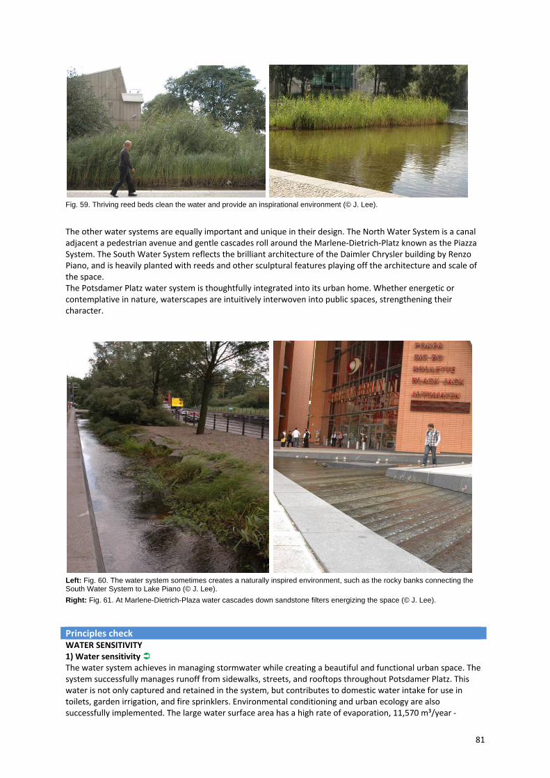
81
Fig. 59. Thriving reed beds clean the water and provide an inspirational environment (© J. Lee).
The other water systems are equally important and unique in their design. The North Water System is a canal adjacent a pedestrian avenue and gentle cascades roll around the Marlene‐Dietrich‐Platz known as the Piazza System. The South Water System reflects the brilliant architecture of the Daimler Chrysler building by Renzo Piano, and is heavily planted with reeds and other sculptural features playing off the architecture and scale of the space. The Potsdamer Platz water system is thoughtfully integrated into its urban home. Whether energetic or contemplative in nature, waterscapes are intuitively interwoven into public spaces, strengthening their character.
Left: Fig. 60. The water system sometimes creates a naturally inspired environment, such as the rocky banks connecting the South Water System to Lake Piano (© J. Lee).
Right: Fig. 61. At Marlene-Dietrich-Plaza water cascades down sandstone filters energizing the space (© J. Lee).
Principles check
WATER SENSITIVITY 1) Water sensitivity The water system achieves in managing stormwater while creating a beautiful and functional urban space. The system successfully manages runoff from sidewalks, streets, and rooftops throughout Potsdamer Platz. This water is not only captured and retained in the system, but contributes to domestic water intake for use in toilets, garden irrigation, and fire sprinklers. Environmental conditioning and urban ecology are also successfully implemented. The large water surface area has a high rate of evaporation, 11,570 m³/year ‐

82
Left: Fig. 62. At Marlene-Dietrich-Plaza, the water system has an urban aesthetic that responds to the surrounding building forms (© J. Lee). Right: Fig. 63. The Daimler Chrysler building is partially surrounded by cool wetland ponds creating an appeal for nature in the city (© J. Lee).
roughly half the annual rainfall (Dreiseitl 1996a). This moisture measurably contributes to the local microclimate, lowering temperatures by a few degrees in summer. Building interiors are passively cooled through a façade skin designed by Piano to accept cooler air from the lake surface. (a, c, d, f)
AESTHETICS 2) Aesthetic benefit At Marlene‐Dietrich‐Plaza, water takes on different character, now playfully flowing from two directions, gently rippling over subtle deviations and sharply cut sandstone, which also serves to filter the rainwater. Here water is fully accessible, and visitors are compelled to look, learn, and play. Visitors are invited across bridges, or to walk along dense reeds (fig. PP 06). In each area, the water’s edge varies constantly, sometimes more natural, such as a gravel beach among the reeds on the eastern bank of Lake Piano, or a stony embankment along the slender canal connecting the South Water System to the Lake (fig. PP 07). Marlene‐Dietrich‐Platz on the other hand has more polished urban aesthetic (fig. PP 08). But most importantly, all elements of the water system, whether organic or technological in their composition, are always sensitive and responsive to water as a medium, and the surrounding context. (a, d, f)
3) Integration in surrounding area The water system was a component of the master plan from the beginning and for this reason is well integrated into the surrounding architecture and space planning. The triangular shape of Lake Piano responds to the Landwehr Canal while integrating well into the angular master plan and precise building forms. As seen in fig. PP 09 of Marlene‐Dietrich‐Platz, the form of the pools creates a direct correlation with the eave above. There is also consistency in the selection of terra cotta tiles and natural wild wetland landscaping (Fig. 63). Additionally, nearly all of the buildings have arcades at ground level and sidewalks up to eight meters wide provide enough space for circulation and for pedestrians who wish to stop and admire the water. (a, d, f) FUNCTIONALITY 4) Appropriate design The main success of the Potsdamer Platz water system is the integration of functions, including rainwater detention, storage, usage as well as rainwater treatment. It is a complete system that is working well due to its complex but also effective design. The biotopes and filters successfully maintain park ecology and sufficient quality for building services. Water quality is assured via monitors and has improved since construction. During very heavy rainfall, overflow is possible from the cisterns into the sewer system, or from Lake Piano into the Landwehr Canal. (a, c, d, f) 5) Appropriate maintenance Over a decade after its realization Potsdamer Platz is well‐maintained. Algae were a slight problem from the onset. At first, carp were introduced to balance the algae. This helped, but the pools still need to be drained

83
and cleaned a few times a year, especially at the shallow zones where the sun penetrates fully, inducing algae growth. Maintenance is adequately appropriated by several specialty firms and barring a few brief cleaning periods the pools are in pristine condition. The Institute for Applied Aquatic Ecology GmbH (Institut für angewandte Gewässerökologie) in Seddin, Germany, regularly monitors and maintains the ecological balance of the system. Special care is also taken to ensure the health of the plants. (a, c, d, f) 6) Adaptability Through the combination of various measures and techniques the rainwater management system at Potsdamer Platz is able to cope with extreme variations in rainfall. It was specifically designed to support a 10 year rainfall event. Also a reserve of 15cm between the normal and the maximum water level was included in the main water system. This creates an additional allowance of 1300m³. Over that, a 44m long flood control wall limits and directs overflow into the Landwehr Canal. Underground storage cisterns also have an additional flood capacity of 900 m³, which remains free for periods of excessive rain. With so many methods in play, Potsdamer Platz is not likely to flood. (a, b, d, f) USABILITY 7) Appropriate usability Potsdamer Platz water systems are highly functional in terms of combining ecology and recreation. It is a refreshing atmosphere that defies the sterile commercial archetype. Working professionals, children, families, local residents, and tourists come together to enjoy the healthy and interesting spaces provided by the water. The playful stepping‐stones sited outside the Daimler Chrysler Building are visited by a diverse set of persons and activities (Fig. 64). Cafes line Lake Piano giving the impression of a harbour front, not a dense city centre (Fig. 66). Small gravel beaches are visited by bathing birds and children in passing (Fig. 65). (a, d, f) PUBLIC PERCEPTION AND ACCEPTANCE 8) Public involvement The public was not involved in the conceptualization and design of the water system. The motivations for the project were to create an environment that would maintain high rent potential while at the same time promoting lively, healthy public space. Although the public was not directly involved in its inception, it’s clear that the project is well perceived from the public by the growth in usage and popularity as an events centre. (b, d, f)
Left: Fig. 64. Visitors come in all shapes and sizes, drawn by the irresistible appeal of flowing water (© J. Lee).
Middle: Fig. 65. Birds bathe on the gravel banks of Lake Piano. A healthy ecology ensures a diverse environment, even in the city (© J. Lee).
Right: Fig. 66. In the warm Berlin summer cafes along the water are full of patrons taking a break from the paved city to sit near the water (© J. Lee).
9) Acceptable costs The cost associated with construction and maintenance of the system is high. Construction of the water system including technical installations and landscape design was roughly 9 million Euros or 900 Euros/m². Maintaining the ecologically sensitive environment is also expensive and presumably energy intensive. It was only possible here because of the high profile status of the project. The return on investment likely comes in the form of high rent yields, additional tourism or press. Regardless, it’s difficult to determine the value of such a culturally significant project. It’s also worth noting that 80% of the time rainwater is used before city domestic water. This percentage is generally considered the basis for cost feasibility of a rainwater retention
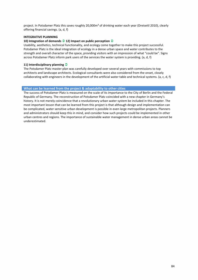
84
project. In Potsdamer Platz this saves roughly 20,000m³ of drinking water each year (Dreiseitl 2010), clearly offering financial savings. (a, d, f)
INTEGRATIVE PLANNING 10) Integration of demands 12) Impact on public perception Usability, aesthetics, technical functionality, and ecology come together to make this project successful. Potsdamer Platz is the ideal integration of ecology in a dense urban space and water contributes to the strength and overall character of the space, providing visitors with an impression of what “could be”. Signs across Potsdamer Platz inform park users of the services the water system is providing. (a, d, f)
11) Interdisciplinary planning The Potsdamer Platz master plan was carefully developed over several years with commissions to top architects and landscape architects. Ecological consultants were also considered from the onset, closely collaborating with engineers in the development of the artificial water table and technical systems. (a, c, d, f)
What can be learned from the project & adaptability to other cities The success of Potsdamer Platz is measured on the scale of its importance to the City of Berlin and the Federal Republic of Germany. The reconstruction of Potsdamer Platz coincided with a new chapter in Germany’s history. It is not merely coincidence that a revolutionary urban water system be included in this chapter. The most important lesson that can be learned from this project is that although design and implementation can be complicated, water sensitive urban development is possible in even large metropolitan projects. Planners and administrators should keep this in mind, and consider how such projects could be implemented in other urban centres and regions. The importance of sustainable water management in dense urban areas cannot be underestimated.
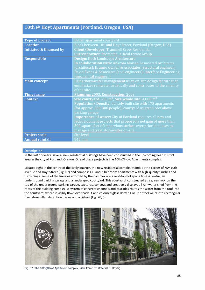
85
10th @ Hoyt Apartments (Portland, Oregon, USA)
Type of project Urban apartment courtyardLocation Block between 10th and Hoyt Street, Portland (Oregon, USA)Initiated & financed by Client/Developer: Trammell Crow Residential
Current owner: Prometheus Real Estate Group Responsible Design: Koch Landscape Architecture
In collaboration with: Ankrom Moisan Associated Architects (architects); Kramer Gehlen & Associates (structural engineer); David Evans & Associates (civil engineers); Interface Engineering (mechanical engineer)
Main concept Using stormwater management as an on‐site design feature that emphasizes rainwater artistically and contributes to the amenity of the site.
Time frame Planning: 2003, Construction: 2003 Context Size courtyard: 790 m², Size whole site: 4,800 m²
Population/ Density: densely built site with 178 apartments (for approx. 250‐300 people); courtyard as green roof above parking garage Importance of water: City of Portland requires all new and redevelopment projects that proposed a net gain of more than 500 square feet of impervious surface over prior land uses to manage and treat stormwater on‐site.
Project scale Site levelAnnual rainfall 940 mm
Description In the last 15 years, several new residential buildings have been constructed in the up‐coming Pearl District area in the city of Portland, Oregon. One of these projects is the 10th@Hoyt Apartments complex. Located right in the centre of the lively quarter, the new residential complex stands at the corner of NW 10th Avenue and Hoyt Street (Fig. 67) and comprises 1‐ and 2‐bedroom apartments with high‐quality finishes and furnishings. Some of the luxuries afforded by the complex are a roof‐top hot spa, a fitness centre, an underground parking garage and a landscaped courtyard. This courtyard, constructed as a green roof on the top of the underground parking garage, captures, conveys and creatively displays all rainwater shed from the roofs of the building complex. A system of concrete channels and cascades routes the water from the roof into the courtyard, where it visibly flows over back lit and coloured glass dotted Cor‐Ten steel weirs into rectangular river stone filled detention basins and a cistern (Fig. 70, 5).
Fig. 67. The 10th@Hoyt Apartment complex, view from 10th street (© J. Hoyer).

86
One of the main factors that affected the development of the 10th@Hoyt Apartment courtyard was the City of Portland’s code requiring a surface stormwater detention facility for all new and re‐development projects proposing a net increase of more than 500 square feet (approx. 46 m2) of impervious surface (Portland Bureau of Environmental Services, cited in: Rodes 2007, 6). The developer and the landscape architecture firm Koch Landscape Architecture took up this requirement as an opportunity. They decided to do more than just meet this requirement: They aimed to display the rainwater and to use it in a unique way to create an elegant, urban space.
Fig. 68. Site plan (© Koch Landscape Architecture).
Left: Fig. 69. Central seating area with wooden furniture and plant pots (© J. Hoyer). Right: Fig. 70 . One of the 3 cascades leading stormwater from the roof to detention basins filled with riverbed stones (© J. Hoyer).
The whole courtyard is designed in an elegant manner and creates a sense of sanctuary. A bronze‐coloured gate separates the courtyard from the street and turns it into a "pocket of privacy – a surprising moment of calm and elegance" (ASLA Oregon Merit Award Jury). Stylish wooden benches and large planted pots fill the centre of the space (Fig. 69). Around the central seating area, downspouts run down from the roof and empty into concrete channels and cascades: these in turn route rainwater into river stone‐filled detention basins, and

87
a 4,000 gallon‐cistern underneath the surface. There water is stored for up to 30 hours and then is gradually discharged to the public stormwater system (Fig. 74). Two Cor‐Ten steel fountains pierced with coloured glass run as long as the cistern is filled and so bring the water back to the surface again for up to 30 hours after rain (Fig. 72). Ornamental plantings grace the arrangement and create a connection between the building's hard materials and the technical elements necessary for managing the rainwater. One special feature of the courtyard's design is the lighting. In addition to cable lights hanging overhead, each series of channels empty water over metal weirs that are punctuated with glass buttons that glow at night, thereby creates a very special atmosphere (Fig. 73). Overall, execution of 10@Hoyt Apartment courtyard provides a „nice, refined execution, a carefully crafted formal parlour for the residences” (ASLA Oregon Merit Award Jury), which handles rainwater in a unique and very creative way.
Principles Check WATER SENSITIVITY 1) Water sensitivity Detention is required for new development projects by the City of Portland and this is what the project fulfils in terms of water sensitivity. The courtyards’ stormwater management reduces the excess runoff rate, suspend solids and pollutants, and therefore contributes to counteract Portland’s problem of sewer system overload (compare case study Portland: From Grey to Green), but Echols/Pennypacker (2006, 27‐28) wanted the system to do more than just detention. In their opinion, the courtyards’ rainwater management system could have been made more comprehensive by also using the rainwater for irrigating plants in the yards. This would have reduced both the volume and frequency of water discharged into the municipal sewer system. (c) AESTHETICS 2) Aesthetic benefit 10th@Hoyt Apartment courtyard turned rainwater design into art. This has positive effects on the quality of life in the apartment complex. It makes rainwater visible and enables visitors and residences to follow the flow of water from the roof to the ground, even when it is not raining. Steven Koch from Koch Landscape Architecture said: “You can do a lot of things to mitigate the impacts of stormwater, but typical and mostly mechanical methods provide no cultural or aesthetic function; the function here is detention and human delight” (Steven Koch, cited in: Rodes 2007, 8). (a, d)
Fig. 71. Water from the roof tops splashes over sculptural cascades and Cor-Ten steel weirs before it disappears between river stones (© J. Hoyer).
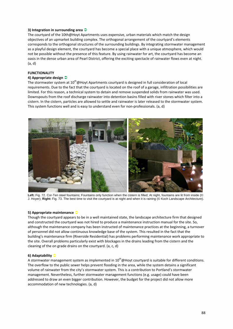
88
3) Integration in surrounding area The courtyard of the 10th@Hoyt Apartments uses expensive, urban materials which match the design objectives of an upmarket building complex. The orthogonal arrangement of the courtyard’s elements corresponds to the orthogonal structures of the surrounding buildings. By integrating stormwater management as a playful design element, the courtyard has become a special place with a unique atmosphere, which would not be possible without the presence of this feature. By using rainwater for art, the courtyard has become an oasis in the dense urban area of Pearl District, offering the exciting spectacle of rainwater flows even at night. (a, d) FUNCTIONALITY 4) Appropriate design The stormwater system at 10th@Hoyt Apartments courtyard is designed in full consideration of local requirements. Due to the fact that the courtyard is located on the roof of a garage, infiltration possibilities are limited. For this reason, a technical system to detain and remove suspended solids from rainwater was used. Downspouts from the roof discharge rainwater into detention basins filled with river stones which filter into a cistern. In the cistern, particles are allowed to settle and rainwater is later released to the stormwater system. This system functions well and is easy to understand even for non‐professionals. (a, d)
Left: Fig. 72. Cor-Ten steel fountains; Fountains only function when the cistern is filled; At night, fountains are lit from inside (© J. Hoyer); Right: Fig. 73. The best time to visit the courtyard is at night and when it is raining (© Koch Landscape Architecture).
5) Appropriate maintenance Though the courtyard appears to be in a well maintained state, the landscape architecture firm that designed and constructed the courtyard was not hired to produce a maintenance instruction manual for the site. So, although the maintenance company has been instructed of maintenance practices at the beginning, a turnover of personnel did not allow continuous knowledge base of the system. This resulted in the fact that the building's maintenance firm (Riverside Residential) has problems performing maintenance work appropriate to the site. Overall problems particularly exist with blockages in the drains leading from the cistern and the cleaning of the on grade drains on the courtyard. (a, c, d) 6) Adaptability A stormwater management system as implemented in 10th@Hoyt courtyard is suitable for different conditions. The overflow to the public sewer helps prevent flooding in the area, while the system detains a significant volume of rainwater from the city’s stormwater system. This is a contribution to Portland’s stormwater management. Nevertheless, further stormwater management functions (e.g. usage) could have been addressed to draw an even bigger contribution. However, the budget for the project did not allow more accommodation of new technologies. (a, d)
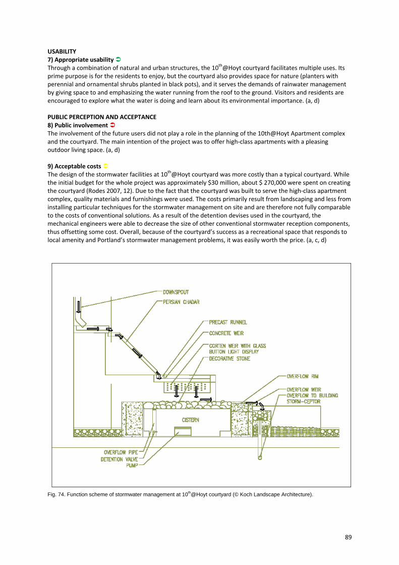
89
USABILITY 7) Appropriate usability Through a combination of natural and urban structures, the 10th@Hoyt courtyard facilitates multiple uses. Its prime purpose is for the residents to enjoy, but the courtyard also provides space for nature (planters with perennial and ornamental shrubs planted in black pots), and it serves the demands of rainwater management by giving space to and emphasizing the water running from the roof to the ground. Visitors and residents are encouraged to explore what the water is doing and learn about its environmental importance. (a, d) PUBLIC PERCEPTION AND ACCEPTANCE 8) Public involvement The involvement of the future users did not play a role in the planning of the 10th@Hoyt Apartment complex and the courtyard. The main intention of the project was to offer high‐class apartments with a pleasing outdoor living space. (a, d) 9) Acceptable costs The design of the stormwater facilities at 10th@Hoyt courtyard was more costly than a typical courtyard. While the initial budget for the whole project was approximately $30 million, about $ 270,000 were spent on creating the courtyard (Rodes 2007, 12). Due to the fact that the courtyard was built to serve the high‐class apartment complex, quality materials and furnishings were used. The costs primarily result from landscaping and less from installing particular techniques for the stormwater management on site and are therefore not fully comparable to the costs of conventional solutions. As a result of the detention devises used in the courtyard, the mechanical engineers were able to decrease the size of other conventional stormwater reception components, thus offsetting some cost. Overall, because of the courtyard’s success as a recreational space that responds to local amenity and Portland’s stormwater management problems, it was easily worth the price. (a, c, d)
Fig. 74. Function scheme of stormwater management at 10th@Hoyt courtyard (© Koch Landscape Architecture).
90
INTEGRATIVE PLANNING 10) Integrating demands Function, usability and aesthetics are masterfully combined. “10th@Hoyt courtyard offers an example of artful rainwater design that is particularly strong in addressing the idea of rainwater as an amenity and is quite innovative [...] in managing stormwater” (Echols/Pennypacker 2006, 28). (a, c, d) 11) Interdisciplinary planning Different planners, ranging from landscape architects up to civil engineers, were involved in the planning phase where rainwater design was an early consideration. Due above all to the rain art and landscaping, the project has become one that is highly regarded among professionals and residents. Stuart Echols, who did a lot of research on artful rainwater design with 10th@Hoyt as a case study, has summated: “All of the stormwater professionals that I’ve spoken to recognize that it is Landscape Architecture that made this (project) valuable and not the engineering” (Echols cited in Rodes 2007, 4), but without engineering, the landscaping would not make sense. (a, c, d) 12) Impact on public perception The 10th@Hoyt courtyard is a good example that shows how a pleasing design can introduce sustainable stormwater concepts to a broader public audience. The 10th@Hoyt courtyard won two awards; the Merit Award from ASLA Oregon in 2010, and the Green Roofs for Healthy Cities Award (Special Recognition) in 2006. Furthermore, the courtyard is also perceived well by the citizens and the city representatives. It is a place that promotes awareness of issues regarding stormwater, where people can learn about water quality and its positive effects on the amenity of a site. For this reason, the City of Portland included the 10th@Hoyt courtyard in their Landscapes for Rain – the Art of Stormwater exhibition (compare case study Portland: From Grey to Green) which recommends that citizens of Portland visit the site as motivation to draw their own contribution regarding sustainable stormwater management in the city. (a, c, d)
What can be learned from the project & adaptability to other cities “This project is one of the top, if not the top example currently of artful rainwater design in the United States” (Echols cited in Rodes 2007, 31). The 10th@Hoyt Apartment courtyard shows very well how rainwater can be creatively displayed and treated. It is furthermore a brilliant example which people can learn from. The design of this courtyard has opened and will continue to open the eyes of both professionals (landscape architects, architects, engineers) and non‐professionals (developers, residents) to the value of aesthetically pleasing stormwater design. From this project, other cities and planners can learn that it is worth taking the opportunity to use rainwater management facilities as a means of offering a clear value‐added amenity that attracts business and creates a desirable image – it should not just be a case of finding the lowest‐cost solution to meet local requirements. Various stormwater mitigation technologies have been developed over the years, but the “important part that needs to be recognized and considered by the community is the idea of taking that stormwater and creating art out of it” (Rodes 2007, 22).
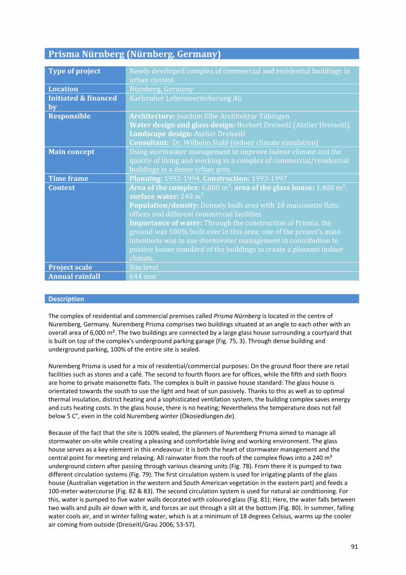
91
Prisma Nürnberg (Nürnberg, Germany)
Type of project Newly developed complex of commercial and residential buildings in urban context
Location Nürnberg, GermanyInitiated & financed by
Karlsruher Lebensversicherung AG
Responsible Architecture: Joachim Elbe Architektur Tübingen Water design and glass design: Herbert Dreiseitl (Atelier Dreiseitl) Landscape design: Atelier Dreiseitl Consultant: Dr. Wilhelm Stahl (indoor climate simulation)
Main concept Using stormwater management to improve indoor climate and the quality of living and working in a complex of commercial/residential buildings in a dense urban area.
Time frame Planning: 1992‐1994, Construction: 1993‐1997 Context Area of the complex: 6,000 m²; area of the glass house: 1,400 m²;
surface water: 240 m² Population/density: Densely built area with 18 maisonette flats, offices and different commercial facilities Importance of water: Through the construction of Prisma, the ground was 100% built over in this area; one of the project's main intentions was to use stormwater management in contribution to passive house standard of the buildings to create a pleasant indoor climate.
Project scale Site level Annual rainfall 644 mm
Description The complex of residential and commercial premises called Prisma Nürnberg is located in the centre of Nuremberg, Germany. Nuremberg Prisma comprises two buildings situated at an angle to each other with an overall area of 6,000 m². The two buildings are connected by a large glass house surrounding a courtyard that is built on top of the complex's underground parking garage (Fig. 75, 3). Through dense building and underground parking, 100% of the entire site is sealed. Nuremberg Prisma is used for a mix of residential/commercial purposes: On the ground floor there are retail facilities such as stores and a café. The second to fourth floors are for offices, while the fifth and sixth floors are home to private maisonette flats. The complex is built in passive house standard: The glass house is orientated towards the south to use the light and heat of sun passively. Thanks to this as well as to optimal thermal insulation, district heating and a sophisticated ventilation system, the building complex saves energy and cuts heating costs. In the glass house, there is no heating; Nevertheless the temperature does not fall below 5 C°, even in the cold Nuremberg winter (Ökosiedlungen.de). Because of the fact that the site is 100% sealed, the planners of Nuremberg Prisma aimed to manage all stormwater on‐site while creating a pleasing and comfortable living and working environment. The glass house serves as a key element in this endeavour: It is both the heart of stormwater management and the central point for meeting and relaxing. All rainwater from the roofs of the complex flows into a 240 m³ underground cistern after passing through various cleaning units (Fig. 78). From there it is pumped to two different circulation systems (Fig. 79). The first circulation system is used for irrigating plants of the glass house (Australian vegetation in the western and South American vegetation in the eastern part) and feeds a 100‐meter watercourse (Fig. 82 & 83). The second circulation system is used for natural air conditioning. For this, water is pumped to five water walls decorated with coloured glass (Fig. 81); Here, the water falls between two walls and pulls air down with it, and forces air out through a slit at the bottom (Fig. 80). In summer, falling water cools air, and in winter falling water, which is at a minimum of 18 degrees Celsius, warms up the cooler air coming from outside (Dreiseitl/Grau 2006, 53‐57).

92
Fig. 75. The glass house is 4 storeys high and creates a pleasant atmosphere with tropical vegetation, a water course and a small internal pond (© J. Hoyer).
Before being implemented in Nuremberg Prisma, simulations were undertaken to investigate the cooling and heating capacity of natural air conditioning. The results of the survey were confirmed in practice. In summer, plants and natural air conditioning lower air temperatures by up to 3°C. Additionally, ventilation can be regulated during night. The glass house can be opened, allowing twice as much cool air to blow through the building complex, lowering inside temperatures (Ökosiedlungen.de). Stormwater management in Nuremberg Prisma is artificial and natural at the same time. All rainwater is managed on site and is used to create a place that stimulates the senses and encourages visitors to take a deep breath, even within a dense urban surrounding.
Principles check WATER SENSITIVITY 1) Water sensitivity The stormwater management system of Nuremberg Prisma is highly water sensitive. All water from the roofs is captured in tubs on the fifth floor and in the outdoor pond. In the tubs and on way to the underground cistern it is constantly cleaned in purification biotopes. All water collected in the cistern is used within the building for irrigation, for fire‐fighting, and for feeding the open water system, which consists of water walls, indoor and outdoor ponds and a water course. Surplus water is lead to an underground gravel‐filled retention, from where it can percolate into the ground. A connection to the public rainwater sewer was not necessary. Thanks to this concept, the stormwater management at Nuremberg Prisma helps to increase the rate of evaporation and infiltration, and creates balanced temperature and humidity ‐ in contrast to the dry, dirty air typical of city centres. (a, d)

93
Left: Fig. 76. Café area in the glass house (© J. Hoyer). Right: Fig. 77. View inside the glass house. Vegetation areas in 3rd and 4th storey capture rainwater and slowly discharge to the pond on the ground floor (© Atelier Dreiseitl).
AESTHETICS 2) Aesthetic benefit The lush vegetation as well as the presence of water add to the aesthetic amenity of Prisma Nuremberg. It gives the building its character as a warm, inviting, leisurely space. Rainwater is present everywhere and in different forms: as falling water in water walls, as flowing water in the water course, and as standing water in ponds. Splashing water at different locations creates an acoustic element that people can enjoy and sunlight reflects the flowing and falling water, changing the colour and texture of artistically painted water walls. (a, c, d) 3) Integration in surrounding area Although located at an important traffic junction, the Prisma offers a quiet place for work and contemplation – an oasis in between the densely built urban area. This has been possible through the clever arrangement of the buildings. “Like Nuremberg's medieval walled city, Prisma shows protective sheer walls to the outside world, and creates a sheltered inner realm. The green foyer entrance is the equivalent of a drawbridge in a fortified city, only opened to let in citizens, trade and commerce. However in stark contrast to medieval Nuremberg, the modern ecological model is filled with light and greenery” (Dawson 1997). The stormwater management facilities are also well integrated in the overall design concept. All technical components like the cistern or the pumps are arranged in a compact manner and mostly located beyond the surface. (a, c, d) FUNCTIONALITY 4) Appropriate design It is difficult to incorporate stormwater management in city centre locations. In Nuremberg, however, this challenge was mastered via the use of compact, multi‐functional elements, all of which were developed specially for the conditions of the site. The low level of groundwater made it possible to use infiltration techniques without endangering the building’s stability and rainwater quality is guaranteed by the use of a large number of purification steps (cleaning biotopes, sediment filter in the cistern). In result, the designers have been able to create a complete, natural stormwater management system that suite the requirements of its lively urban surroundings. (a, d)

94
5) Appropriate maintenance Nuremberg Prisma deploys a system that works with natural systems and greenery – maintenance is therefore important for long lasting performance. Due to the very close cooperation with planners during the concept design and implementation the owner knows and cares about upkeep requirements. Today, 13 years after its implementation, the rainwater system in Nuremberg Prisma is in a well maintained state. However, specialist knowledge is required to care for the South American and Australian plants, and this has occasionally been lacking (e.g. in planting areas on balconies in the upper storeys). (a, b, d) 6) Adaptability The stormwater management system of Prisma Nuremberg is built for a ten years storm event, but consists of many different elements and can therefore cope with even more frequent and intense rain events. The cistern underneath the building complex can hold up to 240 m³ of rainwater. Moreover, plant pots located inside and outside the roof capture rainwater over an area of 1,000 m² and the intern and extern ponds serve additional rainwater detention. Water volumes that exceed the capacity of the system are temporarily stored in a 50 m³ gravel‐filled retention area underneath the building and from there – due to the sound permeability of the soil – easily percolate into the ground (compare Fig. 78). (a, b, d) USABILITY 7) Appropriate usability At Nuremberg Prisma, stormwater management facilities are integrated in the overall glass house in a way that encourages different uses. Currently, a café uses the majority of the garden space in the atrium (Fig. 76). People can sit there and enjoy coffee or lunch while listening to falling and flowing water. Overall, the glass house creates an inspiring and relaxing atmosphere for all the people living and working in the Prisma. Although the building is publicly accessible and comprises offices and surgeries, the design of the glass house offers intimate spaces, where people can relax and forget about busy life. (a, d)
Left: Fig. 78. Rainwater concept for Prisma includes facilities for collecting, storing, purifying and infiltrating (© Atelier Dreiseitl). Right: Fig. 79. In Nuremberg Prisma, rainwater is used for natural air conditioning, fire fighting and irrigation (© Atelier Dreiseitl).
95
Left: Fig. 80. Artistically designed water walls of coloured glass lead fresh and temperature-adjusted air into the glass house (© J. Hoyer). Right: Fig. 81. Function diagram of the water walls/natural air condition (© Atelier Dreiseitl).
PUBLIC PERCEPTION AND ACCEPTANCE 8) Public involvement The project was planned and built by the insurance company Karlsruher Lebensversicherung AG. Their main intention was to create an attractive complex of buildings where offices, flats and shops can be easily let. Due to the fact that the building is privately owned and managed, public participation did not take place during the planning process. (b, d) 9) Acceptable costs Nuremberg Prisma cost DM 75 million, including site, fees and financing (Dawson 1997). It was the main intention of Atelier Dreiseitl to use a system that can be implemented and maintained for a minimal price (Brückmann 2003). However, at one stage of the planning process, the glass house including the stormwater management facilities were in danger of being struck from the design (Dawson 1997). They were considered to be an investment risk, because their extra plumbing outweighed the advantages presented by rainwater use. What planners did not consider at this stage was that if the glass house and water walls were not be there, walls facing into the glass house would have to be weatherproofed, air conditioning would have to be installed and energy savings would be smaller. In fact, the stormwater management concept is not only an addition to the building; it is part of the building concept. Indeed, Prisma’s energy saving construction and the passive building system including the water walls saves over 8,000 litre of oil per heating period. Moreover, appropriate orientation, shading, natural ventilation through water walls as well as the regulation of humidity, oxygen supply and air cleaning by plants save capital costs and servicing for air‐conditioning equipment. (a, c, d) INTEGRATIVE PLANNING 10) Integration of demands + 11) Interdisciplinary planning + 12) Impact on public perception From the start, the building in Nuremberg took for a holistic approach, which was to encompass the responsible use of urban space and deliver the environmentally friendly utilisation of natural resources, energy, materials and water. As a result, the planning process aimed to produce an ecologically oriented

96
building that combined excellent architecture and maximum comfort at the same time. From the very start, planning included a wide range of disciplines. This enabled the demands relating to the function, aesthetics and use of Nuremberg Prisma to be combined and met successfully, and synergies (e.g. the use of the water walls instead of a typical office air conditioning system) could be effectively used. At the same time, stormwater management was integrated with the building's architectural forms to such an extent that one is inconceivable without the other. The result is a functioning and adaptable stormwater management system, which provides people a special experience and lends the building a unique character making it worth visiting to take in its sounds, colours and the atmosphere created by the rainwater. This can in turn exert a positive influence on how Nuremberg's citizens perceive and accept decentralised stormwater management. (a, d)
Fig. 82 & 83. A water course, which is artificially shaped at the beginning and then turns into a nature-oriented design, uses rainwater collected in the underground cistern (© J. Hoyer).
What can be learned from the project & adaptability to other cities The project of Nuremberg Prisma shows that rainwater can be processed on‐site, even in densely built city centre locations, and that this treatment can be done in a design‐oriented way. City‐centre sites actually require designers to find a vocabulary that can turn the site into something special instead of sticking to common practices such as swales or infiltration ditches. What is important above all, particularly for public buildings such as Nuremberg Prisma, is to use a design that generates a positive public opinion for decentralised stormwater management. Nuremberg Prisma successfully achieves this. In this line, it is an excellent case cities can learn from. They can try to make private investors interested in and enthusiastic for projects such as this one and give them the necessary professional and technical support to implement themselves. However, “[m]uch depends on the client being able to persuade enough commercial tenants to share in the dream” (Dawson 1997).
97
5.5 Link to other interesting case studies
New York, USA: plaNYC 2030 and Sustainable Stormwater Management Plan 2008 (large scale) In 2008, New York City developed a Sustainable Stormwater Management Plan (City of New York 2010b) to find solutions for managing urban stormwater not only by using conventional methods but also decentralised techniques. This process is part of the plaNYC 2030 initiative (City of New York 2010a). In a survey, possibilities for using decentralised methods were identified, and the resulting local strategies and measures will be put into practice in coming years. Further information City of New York (2010a). PlaNYC 2030 - A greener, greater New York. Available: http://www.nyc.gov/html/planyc2030/html/home/home.shtml, accessed: July 06, 2010. City of New York (2010b). PlaNYC 2030 - A greener, greater New York. Sustainable Stormwater Management Plan 2008. Available: http://www.nyc.gov/html/planyc2030/html/stormwater/stormwater.shtml, accessed: July 06, 2010. Emscher Region, Germany: IBA “Emscher Park” (large scale) The Emscher region is located along the Emscher River. Due to mining activities in this region the Emscher River was transformed into an artificial water course, primarily functioning as open sewer for wastewater and rainwater. Beginning in the early 1990s, the degraded system was replaced with sanitary sewers and decentralised stormwater management techniques. The target was to reduce the total amount of stormwater carried by the system by 15 %. A regional cooperation was formed between municipalities in the Emscher region, the Environmental Ministry and the Emscher Cooperative (Emscher Genossenschaft) called “Zukunftsvereinbarung Regenwasser”. This cooperation ensured stormwater disconnection and agreed to make decentralised stormwater management a must for new developments. Information on decentralised stormwater techniques and implemented case studies is provided on a website (in German, listed below). Further information Emscher Genossenschaft. Regen auf richtigen Wegen. http://www.emscher-regen.de/regenwasser/regenwasser.php, accessed: October 26, 2010. Londong, Dieter; Nothnagel, Annette (Eds., 1999). Bauen mit Regenwasser : Aus der Praxis von Projekten. München: Oldenburg Verlag. Singapore: Integrated Water Management (large scale) Singapore is an island state without natural aquifers. It is just 700 square kilometers but has a population of 4.5 million people. Three decades ago, Singapore was faced with severe water shortages, flooding, water pollution and the canalisation of rivers. Since then, tremendous progress has been made through efficient demand and supply management practices. Besides others, these practices include rainwater harvesting for use as drinking water, the reduction of the per capita consumption of water in households, and the launch of a new long-term initiative called Active, Beautiful, Clean Waters Programme (ABC). The ABC Programme aims to transform drains, channels and reservoirs into naturally oriented streams, rivers and lakes in order to revive and beautify public spaces. Further information Jieying, Loh (2009). Water management: Learning from Singapore’s water success. Available: http://www.workingwithwater.net/view/934/water-management-learning-from-singapores-water-success-/ , accessed: October 26, 2010. Tortajada, Cecilia (2006): Water Management in Singapore. In: Water Resources Development, vol. 22, no. 2, 227-240. Available: http://www.adb.org/water/knowledge-center/awdo/br01.pdf, accessed: October 26, 2010.

98
Melbourne, Australia: WSUD and Melbourne Water (large scale) In 2001, The Urban Stormwater Best Practice Environmental Management Guidelines were developed by Melbourne Water and Australian EPA under the auspices of the Victorian Stormwater Committee (EPA/MAV 2001). This document pushed the City of Melbourne to develop a leading programme for Water Sensitive Urban Design. Melbourne Water acts as the main body in this system. They promote sustainable stormwater management by providing information and guidance to councils across greater Melbourne. A public website provides information on WSUD and includes a GIS-database showing all implemented measures categorized by type of measure, specified use, responsible authority and location (wsud.melbournewater.com.au). Further information Melbourne Water. Water Sensitive Urban Design. http://www.wsud.melbournewater.com.au/, accessed: March 19, 2010. The Urban Stormwater Best Practice Environmental Management Guidelines (BPEMG) (1999). Published by Commonwealth Scientific and Industrial Research Organisation (CSIRO). Available: http://www.publish.csiro.au/?act=view_file&file_id=SA0601i.pdf, accessed: July 20, 2010. Birmingham, UK: Eastside (medium scale) In the City of Birmingham, population rise and subsequent development has led to increased soil sealing and increased stormwater and wastewater loads in the combined sewer system - which is responsible for draining most of Birmingham. These issues have led to local flooding and sewer overflows. At the same time the City of Birmingham has been focusing on regenerating its city centre. In this context, 170 hectares of the post-industrial Eastside quarter were targeted for mixed use redevelopment. This provided an opportunity for improved stormwater management. Extensive green roofs and a new city park were cornerstones in the scheme which will successfully ease pressure on the sewers. This scheme will also generally impact the ecological health of the city centre. For example the planned measures will create habitat for the black redstart bird, which favoured the area before regeneration started. Further information Birmingham City Council. Major Developments: Eastside. http://www.birmingham.gov.uk/eastside, accessed: October 27, 2010. Switch Birmingham Learning Alliance. http://switchbirmingham.wordpress.com/, accessed: October 27, 2010. Ludwigsburg, Germany: Arkadien Asperg (medium scale) The multifamily housing district Arkadien Asperg, designed by Elbe Architects (architecture) and Atelier Dreiseitl (water management and landscape architecture), utilizes rainwater in a special way. Rainwater is collected in private cisterns for domestic use and feeds a naturally designed stream – the central feature for open spaces in the district. Accompanied by a modest footpath, the stream is well integrated into the warm, consciously Mediterranean architecture. Neighbouring gardens and play areas for children (providing features for playing with water) are included in the scheme. Arkadien Asperg won the German Real Estate Award for Housing in 2003. Further information Dreiseitl, Herbert; Grau, Dieter (Eds, 2009). Recent Waterscapes. Planning, Building and Designing with Water. Basel: Birkhäuser. Atelier Dreiseitl. Arkadien Asperg. http://www.dreiseitl.net/index.php?id=526&lang=de&choice=7, accessed: October 28, 2010.

99
Hanover, Germany: Kronsberg (medium scale) The urban district Kronsberg was a showcase of the EXPO 2000 in Hannover, Germany. Comprising private homes and working facilities, the district was developed to present an example of visionary ecologically and socially responsible planning and design. The stormwater management concept was one of the key ecological features of the settlement and used a combination of infiltration, decentralised and semi-decentralised retention, and controlled overflow into a natural receiving water course. Stormwater facilities are integrated with open space planning. In particular, stormwater swales weave around the settlement, and centre squares permit visual and audible links to stormwater. Further information Municipality of Hannover. Modell Kronsberg - Ecological Building for the Future. http://www.hannover.de/de/umwelt_bauen/bauen/bauen_lhh/oekobauen/oemobakr/modkrone/index.html, accessed: November 1, 2010. Landeshauptstadt Hannover (Ed., 2004). Hannover Kronsberg Handbook. Planning and Realisation. Hannover. USA: Artful rainwater design projects (primarily small scale) In the USA there are currently many efforts to develop small scale decentralised stormwater facilities, particularly green street facilities, green roofs or rain gardens. Stuart P. Echols, a professor at the Pennsylvania State University, compiled a list of current “artful rainwater design” projects to educate the public on how decentralised stormwater management techniques can be used to create interesting features which also enhance the amenity of open spaces. Project descriptions can be obtained on the website: http://www.artfulrainwaterdesign.net/ and in several publications on the topic. Further information Echols, Stuart P. (2007). Artful Rainwater Design in the Urban Landscape. In: Journal of Green Building, Volume 2, Number 4. Echols, Stuart P.; Pennypacker, Eliza (2008). Learning from Artful Rainwater Design. In: Landscape Architecture, issue August 2008, 28-39.
100
6 CONCLUSIONS
In the last decades, there have been rapid technological improvements for both the capacity of decentralised systems to manage water and to improve water quality. At the same time, as shown by the diverse examples presented in this book many industrialized cities are experiencing a renaissance coupled with a paradigm shift towards sustainability. Urban population is on the rise. Waterfronts that were previously used as transportation corridors, for shipping, or industrial purposes, are being reclaimed for recreation. Citizens are crying out for healthier cities: more parks, more bike lanes, better public transportation, and cleaner air. The limitations of city life are compounded by aging infrastructure, combined sewer overflows, and concerns for climate change. We are at a critical crossroads and each development project, large or small, presents opportunities for WSUD.
As demonstrated by the principles for WSUD, methods and technologies, once solely a civil engineering issue, are expanding to include a broad array of disciplines. This adds a level of complexity never-before seen in stormwater management discourse, namely with regard to aesthetics and space planning. Therefore, the main challenges for sustainable stormwater management are not technological, but for awareness and administration. To move forward, support must be garnered, communication must improve, and economic arguments proven.
When aware of decentralised stormwater solutions, people are generally excited about them. The idea of a multi-functional space that supports urban ecology is appealing as long as the space is usable and safe. Incentive programmes, such as those developed in Portland, inspired residents to develop their own rain gardens. This success could easily be adapted to other cities. The bottom up approach is capable of reducing stormwater loads but most importantly it increases awareness and support, making it more likely that sustainable urban drainage agenda will be on the desk of policy makers and planning offices. This is especially important because the water cycle is a networked system - impacts of stormwater must be simultaneously considered on local, urban, and regional scales. Lodz’s Blue-Green Network and Rotterdam’s Waterplan 2 accomplish this, but unfortunately, many regional and urban planning departments are strongly divided by discipline and jurisdiction. This separation can sometimes encourage competition for resources instead of collaboration and make it difficult to facilitate overall planning strategies. As demonstrated by the successes and shortcomings of the case studies presented in this book, inter-departmental communication and collaboration is critical. Re-tooling departments may be necessary, or the establishment of an oversight committee to ensure that urban development projects consider possibilities for decentralised water management. Though the complex interdependency of sustainable stormwater planning presents a challenge for implementation, it also presents a solution. Multi-functional spaces can be created and costs can be bundled. Although upfront costs for decentralised methods can cost more than conventional stormwater systems, when coupled with other projects, such as park development or street work, the combined costs reduce dramatically. The numbers add up - decentralised systems are feasible, but the economic system needs to be revised to take advantage. The case studies and principles presented in this book show that WSUD can generate enthusiasm for sustainable stormwater management and respond to public needs in a way conventional solutions never could. This is a starting point for discussion and inspiration for change. Although the establishment of these ideas was motivated by concerns for climate change and ecology, WSUD is in the end a practical idea. As the process develops, cities and citizens will only stand to benefit, to be healthier, happier, and wiser.

101
IMPORTANT SWITCH LINKS A Selection of interesting SWITCH project deliverables with links to Sustainable Stormwater
Management and Water Sensitive Urban Design All deliverables listed as well as all deliverables of SWITCH project can be obtained at: www.switchurbanwater.eu Scholes, L.; Shutes, B. (2007). Deliverable Task 2.1.1a: Catalogue of options for the reuse of stormwater. Scholes, L.; Revitt, D.M. (Eds., 2008). Deliverable Task 2.1.2a: A design manual incorporating best practice guidelines for stormwater management options and treatment under extreme conditions. Part A: Review of design guidelines for stormwater management in selected countries. Shutes, B. (2008). Deliverable Task 2.1.2b: A design manual incorporating best practice guidelines for stormwater management options and treatment under extreme conditions. Part B: The potential of BMPs to integrate with existing infrastructure (i.e. retro-fit/hybrid systems) and to contribute to other sectors of the urban water cycle. Ellis, J. B.; Scholes, L.; Revitt, D.M. (Eds., 2007). Deliverable Task 2.2.1a: Evaluation of Current Stormwater Strategies. Sieker, H.; Jakobs, F.; Jin, Z.;Peters, C. (2008). Deliverable D 2.2.2: Life Cycle Cost Assessment Tool (LCCA-Tool). Ellis, J. B.; Scholes, L.; Revitt, D. M. (2006). Deliverable Task 2.2.3a: Evaluation of decision-making processes in urban stormwater management. Shutes, B.; Raggatt, L. (2010). Deliverable 2.2.5: Development of generic Best Management Practice (BMP) Principles for the management of stormwater as part of an integrated urban water resource management strategy.
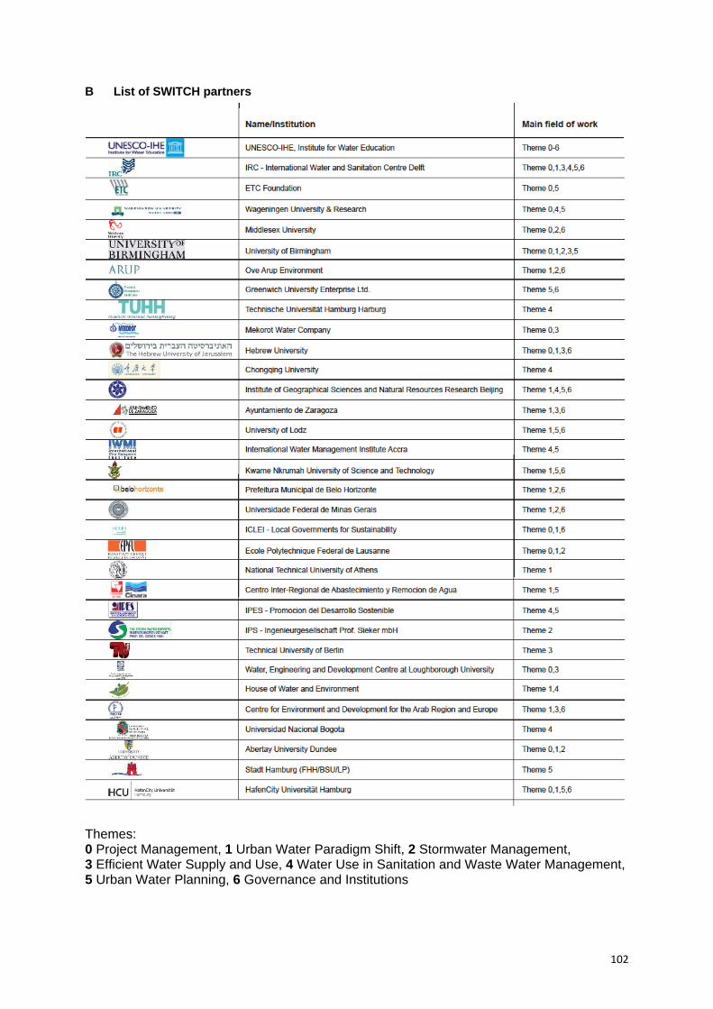
102
B List of SWITCH partners Themes: 0 Project Management, 1 Urban Water Paradigm Shift, 2 Stormwater Management, 3 Efficient Water Supply and Use, 4 Water Use in Sanitation and Waste Water Management, 5 Urban Water Planning, 6 Governance and Institutions
103
REFERENCES A Sources main text Artful rainwater design projects. http://www.artfulrainwaterdesign.net/projects/, accessed: July 20, 2010. Birmingham City Council. Major Developments: Eastside. http://www.birmingham.gov.uk/eastside, accessed: October 27, 2010. Bitting, Jennifer; Kloss, Christopher (2008). Green Infrastructure Retrofit Policies. In: U.S. Environmental Protection Agency. Managing Wet Weather with Green Infrastructure. Municipal Handbook. Olympia, WA. Buranen, Magaret (2009). Stormwater as Entertainment. Integrating stormwater management with the urban landscape. In: Stormwater, issue May 2009. City of New York (2010a). PlaNYC 2030 - A greener, greater New York. http://www.nyc.gov/html/planyc2030/html/home/home.shtml, accessed: July 06, 2010. City of New York (2010b). PlaNYC 2030 - A greener, greater New York. Sustainable Stormwater Management Plan 2008. http://www.nyc.gov/html/planyc2030/html/stormwater/stormwater.shtml, accessed: July 06, 2010. Dreiseitl, Herbert; Grau, Dieter (Eds., 2006). Wasserlandschaften – Planen, Bauen und Gestalten mit Wasser. Basel: Birkhäuser. Dreiseitl, Herbert; Grau, Dieter (Eds., 2009). Recent Waterscapes. Planning, Building and Designing with Water. Basel: Birkhäuser. Duffy, A.; Jefferies, C.; Waddell, G.; Shanks, G.; Blackwood, D.; Watkins, A. (2008). A cost comparison of traditional drainage and SUDS in Scotland. In: Water Science and Technology, issue 57 (9), 1451-1459. Echols, Stuart P. (2007). Artful Rainwater Design in the Urban Landscape. In: Journal of Green Building, volume 2, number 4. Echols, Stuart P.; Pennypacker, Eliza (2008). Learning from Artful Rainwater Design. In: Landscape Architecture, issue August 2008, 28-39. Ellis, J. B.; Scholes, L.; Revitt, D. M. (2006). Deliverable Task 2.2.3a: Evaluation of decision-making processes in urban stormwater management. SWITCH Project Deliverable (www.switchurbanwater.eu). Ellis, J. B.; Scholes, L.; Revitt, D.M. (Eds., 2007). Deliverable Task 2.2.1a: Evaluation of Current Stormwater Strategies. SWITCH Project Deliverable. Available: http://switchurbanwater.lboro.ac.uk/outputs/pdfs/W2-2_DEL_Evaluation_Stormwater_Strategies.pdf, accessed: November 25, 2010. Emscher Genossenschaft. Regen auf richtigen Wegen. http://www.emscher-regen.de/regenwasser/regenwasser.php, accessed: October 26, 2010. EPA/MAV (Environmental Protection Agency Victoria / Municipal Association of Victoria) (2001). Local Government and Environmental Management of Stormwater. Local Government. Case Studies in Environmental Management - Case Study Number 7. Melbourne. Available: http://www.mav.asn.au/CA256C320013CB4B/Lookup/CaseStudyNumber7/$file/Stormwater.pdf , accessed: November 03, 2010. Ganther, Kathrin (2002). Nachhaltigkeit urbaner Regenwasserbewirtschaftungsmethoden. In: Schriftenreihe des Fachgebietes Siedlungswasserwirtschaft der Technischen Universität Berlin. Berichte zur Siedlungswasserwirtschaft, issue 20. Berlin.
104
Geiger, Wolfgang F.; Dreiseitl, Herbert (2001). Neue Wege für das Regenwasser. Handbuch zum Rückhalt und zur Versickerung von Regenwasser in Baugebieten (2nd ed.). München. Heber, Bernd (1998). Naturnahe Regenwasserbewirtschaftung in Siedlungsgebieten. In: Institut für ökologische Raumentwicklung e.V. (Ed.): IÖR – Schriften, issue 25. Dresden. Interim Code of Practice for Sustainable Drainage Systems (2004). Published by National SUDS Working Group. Available: http://www.ciria.com/suds/pdf/nswg_icop_for_suds_0704.pdf, accessed: May 18, 2010. Jieying, Loh (2009). Water management: Learning from Singapore’s water success. Available: http://www.workingwithwater.net/view/934/water-management-learning-from-singapores-water-success-/, accessed: October 26, 2010. Landeshauptstadt Hannover (Ed., 2004). Hannover Kronsberg Handbook. Planning and Realisation. Hannover. Londong, Dieter; Nothnagel, Annette (Eds., 1999). Bauen mit Regenwasser: Aus der Praxis von Projekten. München: Oldenburg Verlag. Melbourne Water (2005). WSUD Engineering Procedures: Stormwater. Published by CSIRO Publishing, Australia. Melbourne Water. Water Sensitive Urban Design. http://www.wsud.melbournewater.com.au/, accessed: March 19, 2010. Oregon Chapter of the American Society of Landscape Architects (ASLA Oregon). Landscape Architectural Design. Merit Award Winners 2006. http://www.aslaoregon.org/events/2006/2006-design.html, accessed: July 19, 2010. Portland Bureau of Environmental Services (2004).Stormwater Management Manual. http://www.portlandonline.com/bes/index.cfm?c=35122, accessed: September 01, 2010. Portland Bureau of Environmental Services (2010a). Grey to Green. Working green for cleaner rivers. http://www.portlandonline.com/bes/index.cfm?c=47203, accessed: May 17, 2010. Portland Bureau of Environmental Services (2010b). Downspout Disconnection. http://www.portlandonline.com/bes/index.cfm?c=43081, accessed: May 17, 2010. Portland Bureau of Environmental Services (2010c).Sustainable stormwater management project tours. http://www.portlandonline.com/BES/index.cfm?c=34604&, accessed: May 18, 2010. Portland Bureau of Environmental Services (2010d). Stormwater Discount Program. http://www.portlandonline.com/bes/index.cfm?c=41976, accessed: May 18, 2010. Puget Sound Action Team (2005). Low Impact Development. Technical Guidance Manual for Puget Sound. Olympia, Tacoma, WA. Scholes, L.; Shutes, B. (2007). Deliverable Task 2.1.1a: Catalogue of options for the reuse of stormwater. SWITCH Project Deliverable (www.switchurbanwater.eu). Scholes, L.; Revitt, D.M. (Eds., 2008). Deliverable Task 2.1.2a: A design manual incorporating best practice guidelines for stormwater management options and treatment under extreme conditions. Part A: Review of design guidelines for stormwater management in selected countries. SWITCH Project Deliverable. Available: http://www.switchurbanwater.eu/outputs/pdfs/W2-1_DEL_Part_A_Review_of_design_guidelines.pdf, accessed: October 25, 2010. Schueler, Thomas R. (2000). The Importance of Imperviousness. Reprinted in The Practice of Watershed Protection. Center for Watershed Protection. Ellicott City, MD.
105
Shutes, B. (2008). Deliverable Task 2.1.2b: A design manual incorporating best practice guidelines for stormwater management options and treatment under extreme conditions. Part B: The potential of BMPs to integrate with existing infrastructure (i.e. retro-fit/hybrid systems) and to contribute to other sectors of the urban water cycle. SWITCH Project Deliverable (www.switchurbanwater.eu). Shutes, B.; Raggatt, L. (2010). Deliverable 2.2.5: Development of generic Best Management Practice (BMP) Principles for the management of stormwater as part of an integrated urban water resource management strategy. SWITCH Project Deliverable (www.switchurbanwater.eu). Sieker, H.; Jakobs, F.; Jin, Z.; Peters, C. (2008). Deliverable D 2.2.2: Life Cycle Cost Assessment Tool (LCCA-Tool). SWITCH Project deliverable (www.switchurbanwater.eu). Switch Birmingham Learning Alliance. http://switchbirmingham.wordpress.com/, accessed: October 27, 2010. The Urban Stormwater Best Practice Environmental Management Guidelines (BPEMG) (1999). Published by Commonwealth Scientific and Industrial Research Organisation (CSIRO). Available: http://www.publish.csiro.au/?act=view_file&file_id=SA0601i.pdf, accessed: July 20, 2010. Tortajada, Cecilia (2006): Water Management in Singapore. In: Water Resources Development, volume 22, number 2, 227-240. Available: http://www.adb.org/water/knowledge-center/awdo/br01.pdf, accessed: October 26, 2010. United Nations World Water Development Report 3 (2009). Published jointly by UNESCO and Earthscan. Available: http://www.unesco.org/water/wwap/wwdr/wwdr3/pdf/WWDR3_Water_in_a_Changing_World.pdf , accessed: August 12, 2010. U.S. Environmental Protection Agency (2008). Incorporating Green Infrastructure Concepts into Total Maximum Daily Loads (TMDLs). Washington. Available: www.epa.gov/owow/tmdl/stormwater/pdf/tmdl_lid_final.pdf, accessed: May 14, 2010. U.S. Environmental Protection Agency (2010). State Storm Water BMP Manuals. http://yosemite.epa.gov/R10/WATER.NSF/0/17090627a929f2a488256bdc007d8dee?OpenDocument, accessed: April 1, 2010. Wong, T.H.F. (2006). An Overview of Water Sensitive Urban Design Practices in Australia. Available: http://www.iwaponline.com/wpt/001/0018/0010018.pdf, accessed: February 10, 2010. Woods-Ballard, B.; Kellagher, R.; Martin, P.; Jefferies, C.; Bray, R.; Shaffer, P. (2007). The SUDS Manual (C697). London: CIRIA. World Water Council. Water Crisis. http://worldwatercouncil.org, accessed: March 19, 2010. WWF Deutschland. Wasserknappheit auf der blauen Kugel. http://www.wwf.de/themen/suesswasser/wasserknappheit/, accessed: March 23, 2010. Yudelson, Jerry (2009). GreenBuilding Trends: Europe. Washington: Island Press. Zhengyue, Jin (2005). Development for a Transport Knowledge-Based Spatial Decision Support System for Decentralised Stormwater Management Planning. Available: http://edok01.tib.uni-hannover.de/edoks/e01dh06/509345905.pdf, accessed: March 30, 2010. B Special sources chapter 2.5 (Stormwater in different climate zones) Forkel, Matthias. Klimazonen. http://klima-der-erde.de/klimazonen.html, accessed: September 23, 2010.
106
Hamburger Bildungsserver. Innertropische Konvergenzzone. http://wiki.bildungsserver.de/klimawandel/index.php/Innertropische_Konvergenzzone, accessed: September 23, 2010. Hupfer, Peter; Kuttler, Wilhelm (2006). Witterung und Klima: Einführung in die Meterologie und Klimatologie. Wiesbaden: B.G. Teubner Verlag/GWV Fachverlag GmbH. Mühr, Bernhard. Klimadiagramme. http://klimadiagramme.de/Asien/bombay.html, accessed: September 23, 2010. Peel, M.C.; Finlayson, B.L.; McMahon, T.A. (2007). Updated world map of the Köppen-Geiger climate classification, Hydrol. Earth Syst. Sci., 11, 1633-1644. Q.met GmbH. Länderinformation Singapur. http://www.wetter.net/laenderinformation/singapur.html, accessed: September 23, 2010. Schillings Dina. Niederschlagsverteilung; Maritimität und Kontinentalität, vertikale Gliederung. http://www.grin.com/e-book/1826/niederschlagsverteilung-maritimitaet-und-kontinentalitaet-vertikale-gliederung, accessed: September 23, 2010. Springer Verlag. Regen auf Weltreise - Globale Verteilung der Niederschläge. http://www.scinexx.de/dossier-detail-157-8.html, accessed: September 23, 2010. Interview Maren Derneden with Timothey E. Sutko from Clark County Regional Flood Control District, Las Vegas; July 19, 2010. Data sources climate charts Berlin, Hamburg, Nuremberg, Stuttgart: Precipitation Deutscher Wetterdienst (DWD). Monatsmittelwerte ausgewählter Stationen 1961-1990. Provided: September 2010. Temperature Deutscher Wetterdienst (DWD). Wetter und Klima – Klimadaten. http://www.dwd.de/bvbw/appmanager/bvbw/dwdwwwDesktop?_nfpb=true&_pageLabel=_dwdwww_klima_umwelt_klimadaten_deutschland&T82002gsbDocumentPath=Navigation%2FOeffentlichkeit%2FKlima__Umwelt%2FKlimadatenzentren%2FNKDZ%2Fkldaten__akt%2Fausgabe__mittelwerte__node.html%3F__nnn%3Dtrue, accessed: September 28, 2010. Highest rainfall events Deutscher Wetterdienst (DWD). Extremwerte des Niederschlags von ausgewählten Städten in Deutschland. Provided: October 2010. Lodz: Precipitation and temperature TuTiempo.net: Historical Weather: LODZ, Poland. http://www.tutiempo.net/en/Climate/LODZ/124650.htm, accessed: October 22, 2010. Highest rainfall events This data was not available to us when this publication went to press. Portland: Precipitation NOAA. Portland Precipitation - Precipitation Data - Annual Precipitation (inches) (1871-2008). http://www.wrh.noaa.gov/pqr/pdxclimate/pg67.pdf, accessed: October 15, 2010. Temperature NOAA. Daily Temperatures - Extremes and Normals (1940-August 2006). http://www.wrh.noaa.gov/pqr/pdxclimate/pg6.pdf, accessed: October, 15, 2010. Highest rainfall events Portland Bureau of Environmental Services. Provided: September 2010. Rotterdam: Precipitation Koninklijk Nederlands Meteorologisch Instituut (KNMI). Monthly and Yearly Amount of Precipitation. http://www.knmi.nl/klimatologie/maandgegevens/datafiles/mndgeg_344_rh24.txt, accessed: October 15, 2010. Temperature Koninklijk Nederlands Meteorologisch Instituut (KNMI). Monthly and Yearly Mean Temperatures. http://www.knmi.nl/klimatologie/maandgegevens/datafiles/mndgeg_344_tg.txt, accessed: October 15, 2010. Highest rainfall events This data was not available to us when this publication went to press.

107
Mumbai: Precipitation and temperature Mühr, Bernhard (2007) on basis of National Climatic Data Centre (NCDC). Klima in Bombay, Indien. http://klimadiagramme.de/Asien/bombay.html, accessed: October 19, 2010. Highest rainfall events Government of Maharashtra, Department of Relief and Rehabilitation. Maharashtra Floods 2005 - Relief and Rehabilitation Government of Maharashtra. http://mdmu.maharashtra.gov.in/pdf/Flood/statusreport.pdf, accessed: October 19, 2010. Las Vegas: Precipitation and temperature NOAA. Las Vegas Climate Book Page 1 – Monthly Normals: Las Vegas, Nevada. Period of Record: 1971-2000. http://www.wrh.noaa.gov/vef/climate/page1.php, accessed: October 19, 2010. Highest rainfall events Clark County Regional Flood Control District. Provided: October 2010. Singapore: Precipitation Atelier Dreiseitl (2010): Rain Data Singapore. Provided: October 2010. Temperature Mühr, Bernhard (2007) on basis of National Climatic Data Centre (NCDC). Das Klima in Singapur. http://klimadiagramme.de/Asien/singapurs.html, accessed: October 19, 2010. Highest rainfall events Singapore Government, National Environment Agency: Weather Statistics. http://app2.nea.gov.sg/weather_statistics.aspx, accessed: October 19, 2010. C Special sources chapter 3.3 (Drivers) Abwasserabgabengesetz (German Waste Water Levy Act): Gesetz über Abgaben für das Einleiten von Abwasser in Gewässer (AbwAG), as amended on July 31, 2009. Available: http://www.gesetze-im-internet.de/bundesrecht/abwag/gesamt.pdf, accessed: July 28, 2010. Approved Document H - Drainage and Waste Disposal (2006). London: NBS. Available: http://www.planningportal.gov.uk/uploads/br/BR_PDF_ADH_2002.pdf, accessed: July 30, 2010. Australian Environment Protection and Heritage Council. Australian Guidelines for Water Recycling. http://www.ephc.gov.au/taxonomy/term/39, accessed: July 30, 2010. Australian Government, National Water Commission. Implementing water reform. http://www.nwc.gov.au/www/html/143-implementation.asp, accessed: June 2, 2010. Clean Water Act of the USA (CWA): Federal Water Pollution Control Act, as amended on November 27, 1972. Handlungsempfehlungen zum Umgang mit Regenwasser (Recommendations for Rainwater Handling) - Merkblatt DWA-M 153 (2007). Deutsche Vereinigung für Wasserwirtschaft, Abwasser und Abfall e. V. Meckenheim: DCM. Hanlon, James A.; Dougherty, Cynthia C. (2009). American Recovery and Reinvestment Act, State Revolving Fund Capitalization Grants Memorandum. Published by U.S. Environmental Protection Agency (EPA), Department of Water. Intergovernmental Agreement on a National Water Initiative. Between the Commonwealth of Australia and the Governments of New South Wales, Victoria, Queensland, South Australia, the Australian Capital Territory, and the Northern Territory (2004). Available: http://www.nwc.gov.au/resources/documents/Intergovernmental-Agreement-on-a-national-water-initiative.pdf, accessed: July 30, 2010. Interim Code of Practice for Sustainable Drainage Systems (2004). Published by National SUDS Working Group. Available: http://www.ciria.com/suds/pdf/nswg_icop_for_suds_0704.pdf, accessed: May 18, 2010.

108
McManus, Richard (2009). Water Sensitive Urban Design Barriers and Opportunities in Darwin - Discussion Paper. Sydney: Department of Environment, Water, Heritage, and the Arts. Available: http://nt.gov.au/lands/planning/wsud/publications/documents/8005_Darwin%20WSUD%20Barriers%20Opportunities%20Discussion%20Paper%20FINAL%20_May09_.pdf, accessed: November 15, 2010. Melbourne Water. Water Sensitive Urban Design (WSUD). www.wsud.melbournewater.com.au, accessed: July 28, 2010. Philadelphia Water Department (2006). Philadelphia Code Section 600.0 Stormwater Management. Available: http://www.phillyriverinfo.org/WICLibrary/StormwaterRegulations.pdf, accessed: August 07, 2010. Planung, Bau, und Betrieb von Anlagen zur Versickerung von Niederschlagswasser (Planning, Construction, and Maintenance of Rainwater Infiltration Devices) - Arbeitsblatt DWA-A 138 (2005). Deutsche Vereinigung für Wasserwirtschaft, Abwasser und Abfall e. V. Meckenheim: DCM. Planning Policy Statement 25 (PPS25) (2006). London: TSO (The Stationary Office). Available: http://www.communities.gov.uk/documents/planningandbuilding/pdf/planningpolicystatement25.pdf, accessed: July 28, 2010. Portland Bureau of Environmental Services (2004). Stormwater Management Manual. http://www.portlandonline.com/bes/index.cfm?c=35122, accessed: September 01, 2010. Portland Bureau of Environmental Services (2010d). Stormwater Discount Program. http://www.portlandonline.com/bes/index.cfm?c=41976, accessed: May 18, 2010. State of California Construction Site BMP Manual (2003). Available: http://www.dot.ca.gov/hq/construc/stormwater/manuals.htm, accessed: May 18, 2010. Sustainable drainage systems - Hydraulic, structural and water quality advice (C609) (2004). London: CIRIA. Sustainable urban drainage systems - Best practice manual for England, Scotland, Wales and Northern Ireland, C523 (2001). London: CIRIA. Sustainable urban drainage systems - Design manual for England and Wales (C522) (2000). London: CIRIA. Sustainable urban drainage systems - Design manual for Scotland and Northern Ireland (C521) (2000). London: CIRIA. The Town and Country Planning Environmental Impact Assessment (England and Wales) Regulations (1999). London: Queen’s Press. Available: http://www.opsi.gov.uk/si/si1999/19990293.htm, accessed: July 30, 2010. The Urban Stormwater Best Practice Environmental Management Guidelines (BPEMG) (1999). Published by Commonwealth Scientific and Industrial Research Organisation (CSIRO). Available: http://www.publish.csiro.au/?act=view_file&file_id=SA0601i.pdf, accessed: July 20, 2010. U.S. Environmental Protection Agency (EPA) (2009a). Green Infrastructure Municipal Handbook. Available: http://cfpub.epa.gov/npdes/greeninfrastructure/munichandbook.cfm, accessed: May 18, 2010. U.S. Environmental Protection Agency (EPA) (2009b). National Pollutant Discharge Elimination System (NPDES). http://cfpub.epa.gov/npdes/, accessed June 2, 2010. U.S. Environment Protection Agency (EPA) (2009c). Water Quality Scorecard 1.Washington DC: EPA Office of Research and Development. U.S. Environmental Protection Agency (EPA) (2010). State Storm Water BMP Manuals. http://yosemite.epa.gov/R10/WATER.NSF/0/17090627a929f2a488256bdc007d8dee?OpenDocument, accessed: April 1, 2010.

109
Wasserhaushaltsgesetz (German Water Resources Act): Gesetz zur Ordnung des Wasserhaushaltes (WHG), as amended on July 31, 2009. Available: http://www.rechtliches.de/info_WHG.html, accessed: July 28, 2010. Water Framework Directive: Directive 2000/60/EC of the European Parliament and of the Council of 23 October 2000, as amended on June 5, 2009. Available: http://eurlex.europa.eu/LexUriServ/LexUriServ.do?uri=CONSLEG: 2000L0060:20090625:EN:PDF, accessed: June 16, 2010. D Special sources chapter 5.2 – 5.4 (Case studies) Types of sources for Principles Check:
a) Authors’ assessments based on research, literature, and project visits b) Authors’ assessments based on interviews/ personal information c) Assessment taken from source material (literature, project evaluations) d) Assessments and evaluations are supported by the project designers, experts involved in the
project e) Assessments and evaluations are rejected by the project designers, experts involved in the
project f) Assessments and evaluations are supported by other expert professionals g) Assessments and evaluations are rejected by other expert professionals
Portland, Oregon, USA: From Grey to Green Principles check 1) b (Chomowicz, 15 Apr 2010), d; 2) a, b (Chomowicz, 15 Apr 2010), d; 3) a, b (Chomowicz, 15 Apr 2010), e; 4) b (Chomowicz, 15 Apr 2010; Chomowicz, 09 Sep 2010), c (Portland Bureau of Environmental Services 2010c), d; 5) a, b (Chomowicz, 15 Apr 2010); 6) a, b (Chomowicz, 09 Sep 2010), d; 7) a, d; 8) b (Chomowicz, 15 Apr 2010; Chomowicz, 09 Sep 2010), d; 9) b (Chomowicz, 15 Apr 2010), d; 10)+11)+12) a, c (Buranen 2009), d. Review Amy Chomowicz from City of Portland, Bureau of Environmental Services, USA (expert involved in the project). Tom Liptan from City of Portland, Sustainable Stormwater Devision, USA (expert involved in the project). Sources Buranen, Magaret (2009). Stormwater as Entertainment. Integrating stormwater management with the urban landscape. In: Stormwater, issue May 2009. Portland Bureau of Environmental Services (2010a). Grey to Green. Working green for cleaner rivers. http://www.portlandonline.com/bes/index.cfm?c=47203, accessed: May 17, 2010. Portland Bureau of Environmental Services (2010b). Downspout Disconnection. http://www.portlandonline.com/bes/index.cfm?c=43081, accessed: May 17, 2010. Portland Bureau of Environmental Services (2010c).Sustainable stormwater management project tours. http://www.portlandonline.com/BES/index.cfm?c=34604&, accessed: May 18, 2010. Portland Bureau of Environmental Services (2010d). Landscapes for Rain – The Art of Stormwater. http://www.portlandonline.com/bes/index.cfm?c=45470, accessed: July 26, 2010. Portland, Oregon. From Wikipedia: http://en.wikipedia.org/wiki/Portland,_Oregon, accessed: July 08, 2010. Sustainlane. USA City Rankings. http://www.sustainlane.com/us-city-rankings/cities/portland, accessed: July 23, 2010. Working Green for Clean Rivers. https://workinggreenportland.com, accessed: September 02, 2010.

110
Interviews/Information Jacqueline Hoyer with Amy Chomowicz from City of Portland, Bureau of Environmental Services; April 15, 2010. Amy Chomowicz from City of Portland, Bureau of Environmental Services; Information via e-mail; September 09, 2010. Rotterdam, Netherlands: Waterplan 2 Principles check 1) a (Gemeente Rotterdam n.d.; Boer 2010), d, f; 2) a (Municipality of Rotterdam et al. 2007a), d, f; 3) a (Benden/Vallée 2010, Municipality of Rotterdam et al. 2007a), d, f; 4) a (Benden/Vallée 2010), d, f; 5) a, b (De Greef, 05 Aug 2010; Jacobs, 01 Sep 2010), d, f; 6) a, c (Municipality of Rotterdam et al. 2007a, 9), d, f; 7) a, d, f; 8) a (Boer 2010, 46), b (De Greef, 05 Aug 2010; Jacobs, 01 Sep 2010), d, f; 9) a, c (Boer 2007 cited in Benden/Vallée 2010, 9), d, f; 10) a (Benden/Vallée 2010), d, f; 11) c (Benden 2010), d, f; 12) a, c (Gemeente Rotterdam n.d., 13; De Greef/Zsiros 2008, 23, 25), d, f. Review John Jacobs from City of Rotterdam, BSD, Netherlands (expert involved in the project). Peter van der Steen from UNESCO-IHE, Delft, Netherlands (expert professional). Sources Benden, Jan; Vallée, Dirk (2010). Städtebauliche Anpassung an Starkregenereignisse durch multifunktionale Flächennutzung – Beispiele aus den Niederlanden. In: Pinnekamp, J.: Gewässerschutz – Wasser – Abwasser 220. Tagungsband zur 43. Essener Tagung für Wasser- und Abfallwirtschaft – Perspektiven und Risiken. Aachen. Boer, Florian (2010). Watersquares. The Elegant Way of Buffering Rainwater in Cities. In: TOPOS, issue 70, 42-47. De Greef, Pieter; Zsiros, Csaba (2008). Ein Wasserplan für Rotterdam. In: Garten + Landschaft, issue November 2008, 22-25. De Urbanisten. Portfolio. Available: http://www.urbanisten.nl/pdf/PortfolioWeb_Lo.pdf, accessed: September 27, 2010. Gemeente Rotterdam (n.d.). Rotterdam Climate Proof. The Rotterdam Challenge on Water and Climate Adaption. Rotterdam. Available: http://www.deltadialogues.com/en-us/stories/Documents/Text%20Rotterdam%20Climate%20proof.pdf, accessed: July 28, 2010. Jacobs, John (n.d.): Waterplan 2 Rotterdam. Presentation. Available: http://www.switchurbanwater.eu/outputs/pdfs/GEN_PRS_Rotterdam_Water_Plan.pdf, accessed: July 28, 2010. Municipality of Rotterdam et al. (2007a). Waterplan 2 Rotterdam. Working on Water for an Attractive City (English summary). Rotterdam. Available: http://www.waterplan.rotterdam.nl/Rotterdam/Openbaar/Overig/Waterplan/PDF/Algemeen/WP-samenvattingENGA5.pdf, accessed: April 28, 2010. Municipality of Rotterdam et al. (2007b). Waterplan 2 Rotterdam. Working on Water for an Attractive City (Full report). Rotterdam. Netherland’s National Climate Change Research Programme. http://www.climateresearchnetherlands.nl, accessed: September 15, 2010. Rotterdam. From Wikipedia: http://en.wikipedia.org/wiki/Rotterdam, accessed: July 29, 2010. Interviews/Information Pieter de Greef from City of Rotterdam, dS+V; Information via e-mail; August 06, 2010. Jacqueline Hoyer with John Jacobs from City of Rotterdam, BSD; Telephone interview; September 01, 2010.
111
Lodz, Poland: Blue-Green Network Principles check Text elaborated in cooperation with facilitators of the Learning Alliance in Lodz (experts involved in the project). 1) a, d; 2) a; 3) a, d; 4) a, d; 5) a, d; 6) a, d; 7) a, d; 8) a, d; 9) a, d; 10) a, d; 11) a, d; 12) a, d. Review Iwona Wagner from University of Lodz and the European Regional Centre for Ecohydrology under the auspices of UNESCO, Lodz, Poland (expert involved in the project). Sources Butterworth, John; Wagner, Iwona; Da Silva, Carmen; Dziegielewska-Geitz, Monika (2008). Influencing Urban Water Management through Learning Alliances: A mid-term reflection on an experiment in Lodz. Poland. SWITCH internal paper. Łódź. From Wikipedia: http://en.wikipedia.org/wiki/Lodz,_Poland, accessed: July 08, 2010. Wagner, Iwona; Zalewski, Maciej (2009). Ecohydrology as a basis for the sustainable city strategic planning: focus on Lodz, Poland. In: Rev Environ Sci Biotechnol 8, published online 09/2009. Available: http://switchurbanwater.lboro.ac.uk/outputs/pdfs/W5-3_CLOD_PJ_Ecohydrology_as_a_basis_for_sustainable_city_strategic_planning.pdf, accessed: September 28, 2010. Zalewski, Maciej et al. (n.d.). Blue-Green Network. New concept for the spatial development of Lodz. Leaflet. Zalewski, M.; Janauer, G.A.; Jolankai, G. (1997). Ecohydrology. A new paradigm for the sustainable use of aquatic resources. In: International Hydrological Programme. Technical Document in Hydrology 7. Paris: UNESCO. Zalewski, Maciej; Wagner, Iwona (2005). Ecohydrology - the use of water and ecosystem processes for healthy urban environments. In: Special issue: Aquatic Habitats in Integrated Urban Water Management. Ecohydrology&Hydrobiology, volume 5, number 4, 263-268. Zalewski, Maciej; Wagner, Iwona (2008). Ecohydrology of urban aquatic ecosystems for healthy cities. In: Wagner, I.; Marshalek, J.; Breil, P.(Eds). Aquatic habitats in sustainable urban water management: science, policy and practice. Leiden: Taylor and Francis/Balkema, 95-106. Tanner Springs Park (Portland, Oregon, USA) Principles check 1) a, b (Brucker, 16 Apr 2010), d, g; 2) c (Dreiseitl/Grau 2006, 12-16), d, f; 3) a, b (Chomowicz, 15 Apr 2010), d, f; 4) a (Dreiseitl/Grau 2006), b (Brucker, 16 Apr 2010), d, f; 5) a (Portland Parks and Recreation 2010), b (Hauber, 16 Aug 2010), d, f; 6) b (Brucker, 16 Apr 2010), d; 7) a, d, f; 8) c (Dreiseitl/Grau 2006, 16; Johns 2005/2009; Portland Parks and Recreation 2010), d, f; 9) a, b (Hauber, 16 August 2010), d, f; 10) a, c (Dreiseitl/Grau 2006), d, f ; 11) a, b (Hauber, 16 Aug 2010), d; 12) a, c (Dreiseitl / Grau 2006; Reviews for Tanner Springs Park 2010), d, f. Review Gerhard Hauber from Atelier Dreiseitl, Überlingen, Germany (project designer). Amy Chomowicz from City of Portland, Bureau of Environmental Services, USA (expert professional). Sources Atelier Dreiseitl. Tanner Springs Park Portland. http://www.dreiseitl.de/index.php?id=526&lang=en&choice=17, accessed: July 15, 2010. Dreiseitl, Herbert; Grau, Dieter (2006). Wasserlandschaften – Planen, Bauen und Gestalten mit Wasser. Basel: Birkhäuser. Johns, Anna (2005/2009). Amid condos, a spot to contemplate. New Pearl District park evokes wetlands that were there before. In: The Portland Tribune, Jul 29, 2005, updated Oct 30, 2009. From: http://www.portlandtribune.com/news/story.php?story_id=31049, accessed: July 15, 2010.

112
Oregon Chapter of the American Society of Landscape Architects (ASLA Oregon). Landscape Architectural Design. Merit Award Winners 2006. Tanner Springs Park. http://www.aslaoregon.org/events/2006/2006-design.html, accessed: July 19, 2010. Portland Parks and Recreation. Tanner Springs Park. http://www.portlandonline.com/parks/finder/index.cfm?PropertyID=1273&action=ViewPark, accessed: July 15, 2010. Reviews for Tanner Springs Park. From: http://www.yelp.com/biz/tanner-springs-park-portland, accessed: July 20, 2010. Tanner Springs Park. From Wikipedia: http://en.wikipedia.org/wiki/Tanner_Springs_Park, accessed: July 19, 2010. Interviews Jacqueline Hoyer with Amy Chomowicz from City of Portland, Bureau of Environmental Services; April 15, 2010. Jacqueline Hoyer with Charles Brucker from Atelier Dreiseitl, Office Portland, USA; April 16, 2010. Jacqueline Hoyer with Gerhard Hauber from Atelier Dreiseitl, Office Überlingen, Germany; August 16, 2010. Trabrennbahn Farmsen (Hamburg, Germany) Review Elke Krusé from HafenCity University Hamburg, Environmentally Compatible Urban and Infrastructure Planning, Hamburg, Germany (expert professional). Principles check 1) a, b (Tradowsky and Hilscher, 15 Jun 2010), f; 2) a, b (Tradowsky, 15 Jun 2010), f; 3) a, b (Tradowsky, 15 Jun 2010), f; 4) a, b (Tradowsky, 15 Jun 2010), f; 5) a, b (Tradowsky, 15 Jun 2010), f; 6) a, b (Tradowsky and Hilscher, 15 Jun 2010), c (Dickhaut/Kruse 2010), f; 7) a, b (Tradowsky, 15 Jun 2010), f; 8) a, b (Tradowsky, 15 Jun 2010), f; 9) a, b (Tradowsky, 15 Jun 2010); 10) a, b (Tradowsky, 15 Jun 2010), f; 11) a, b (Tradowsky, 15 Jun 2010), c (Schubert 2005), f; 12) a, b (Tradowsky, 15 Jun 2010), f. Sources Dickhaut, W.; Kruse, E. (2010). KLIMZUG-NORD Projekt des Monats August 2010. Klimaangepasste Siedlungsstrukturen in Hamburg: Ortstermin am Wohnpark Trabrennbahn in Farmsen. http://klimzug-nord.de/index.php/page/2009-05-25-Projekt-des-Monats, accessed: August 12, 2010. FHH (Freie und Hansestadt Hamburg) (2005): Familienfreundlicher Wohnort Hamburg. Trabrennbahn Farmsen. http://www.familienleben-hamburg.de/demos.php?view=detail&id_item=93&subsubmenucontext=93, accessed: August 12, 2010. FHH (Freie und Hansestadt Hamburg) (2006): Dezentrale naturnahe Regenwasserbewirtschaftung - Ein Leitfaden für Planer, Architekten, Ingenieure und Bauunternehmer. Hamburg. Leaflet. FHH (Freie und Hansestadt Hamburg) (2007): zukunftsfähig – nachhaltig – ökologisch Siedlungs- und Bauprojekte in Hamburg. Hamburg. Leaflet. GATOR (GATOR Beteiligungsgesellschaft mbH) (n. d.): Trabrennbahn Farmsen historisch – Im Renntrab zu Glanz und Glorie. http://www.trabrennbahn-farmsen.de/infos/geschichte.htm, accessed: August 13, 2010. Fibich, P.; Mertins, R. (2000). Freiraumgestaltung auf der ehemaligen Trabrennbahn Farmsen in Hamburg. Wohnen mit offenem Entwässerungssystem. In: Garten + Landschaft, issue February 2000, 17-19. Schubert, D. (2005). Hamburger Wohnquartiere. Ein Stadtführer durch 65 Siedlungen. Berlin: Reimer.
113
Interviews Björn Weber with Thomas Tradowsky from KFP - Kontor Freiraumplanung, Hamburg, Germany; June 15, 2010. Björn Weber with Peter Hilscher from Bezirk Wandsbek, Hamburg, Germany; June 15, 2010. Hohlgrabenäcker (Stuttgart, Germany) Principles check 1) a, d, f; 2) a, d, f; 3) a, d, f; 4) a (Diem/Ansel 2009, Minimal versiegeln 2009), d, f; 5) a, b (Diem, 22 Sep 2010), d, f; 6) a, b (Diem, 22 Sep 2010), d, f; 7) a, d, f; 8) b (Diem, 22 Sep 2010), d, f; 9) a (Diem/Ansel 2009), d, f; 10) a, d, f; 11) a, d, f; 12) a (Diem/Ansel 2009, 152), d, f. Review Alfred Diem from diem.baker GbR, Stuttgart, Germany (project designer). Uwe Schade from STEG Stadtentwicklung GmbH, Stuttgart, Germany (project designer). Wolfgang Ansel from DDV-Deutscher Dachgärtner Verband e.V. (German Green Roof Association), Nürthingen, Germany (expert professional). Sources Ansel, Wolfgang; Diem, Alfred (2010a). Integratives Regenwassermanagement mit Dachbegrünung. In: Garten + Landschaft, issue 4/2010, 32-34. Ansel, Wolfgang; Diem, Alfred (2010b). Sustainable Urbanism with Green Roofs – Natural Stormwater Management. In: Schrenk, Manfred; Popovich, Vasily V.; Zeile, Peter (Eds.). REAL CORP 2010. Proceedings of the REAL CORP conference in Vienna, 18-20 May 2010, 1291-1296. Ansel, Wolfgang; Diem, Alfred (2010c). Integratives Regenwassermanagement mit Dachbegrünung. In: fbr-Wasserspiegel, issue June 2010, 3-5. Diem, Alfred; Ansel, Wolfgang (2009). Integrated Rainwater Management with Green Roof – Building Site “Hohlgrabenäcker” in Suttgart-Zuffenhausen. In: Appl, Roland; Meier, Reimer; Ansel, Wolfgang (Eds.)(2009). Green Roofs – Bringing Nature Back to Town. Proceedings of the International Green Roof Congress 2009. Published by International Green Roof Association IGRA, 149-152. Diem, Alfred, Ansel, Wolfgang (n.d.). Integratives Regenwassermanagement am Beispiel des Baugebiets „Hohlgrabenäcker“ in Stuttgart-Zuffenhausen. Powerpoint presentation (unpublished). Landeshauptstadt Stuttgart, Tiefbauamt, Eigenbetrieb Stadtentwässerung (2006). Neubaugebiet Hohlgrabenäcker - Innere und Äußere Erschließung in Stuttgart-Zazenhausen. Entwurfs- und Genehmigungsplanung zur Entwässerung. Stuttgart. Minimal versiegeln (2009).In: bi_GaLaBau - Fachzeitschrift für Garten- und Landschaftsbau, issue 10+11/2009, 26-27. Municipality of Stuttgart (2006). Development plan „Hohlgrabenäcker“: Bebauungsplan mit Satzung über örtliche Bauvorschriften „Hohlgrabenäcker“ (Zaz 10). Stuttgart. Interviews Jacqueline Hoyer with Wolfgang Ansel, Head of DDV-Deutscher Dachgärtner Verband (German Green Roof Association), telephone interview; September 09, 2010. Jacqueline Hoyer with Alfred Diem from diem.baker GbR (water engineer); September 22, 2010. Potsdamer Platz (Berlin, Germany) Principles check 1) a (Atelier Dreiseitl 1996a; Dreiseitl/Grau 2006; Atelier Dreiseitl 1998; Dreiseitl 2010; Kardoff 1999), c (Dreiseitl 2010), d, f; 2) a (Atelier Dreiseitl 1996a; Dreiseitl/Grau 2006; Atelier Dreiseitl 1998; Dreiseitl 2010; Kardoff 1999), d, f; 3) a, d, f; 4) a (Atelier Dreiseitl 1996a; Atelier Dreiseitl 1998; Kardoff 1999), c (Atelier Dreiseitl 1996a), d, f; 5) a (Dreiseitl 2010; Kardoff 1999), c (Dreiseitl 2010), d, f; 6) a (Atelier Dreiseitl 1998; Dreiseitl/Grau 2006, 48; Atelier Dreiseitl 1996a), b (Hauber, 11 Oct 2010), d, f; 7) a, d,
114
f; 8) b (Hauber, 11 Oct 2010), d, f; 9) a (Dreiseitl 2010), d, f; 10) a (Dreiseitl 2010), d, f; 11) a, c (Dreiseitl 2010), d, f; 12) a, d, f. Review Gerhard Hauber from Atelier Dreiseitl, Überlingen, Germany (project designer). Heiko Sieker from Ingenieurgesellschaft Prof. Dr. Sieker mbH, Dahlwitz-Hoppegarten, Germany (expert professional). Sources Atelier Dreiseitl (1996a). Bemessung der Starkregenspeicher im Planungsgebiet Potsdamer Platz Berlin. Überlingen. Atelier Dreiseitl (1996b). Potsdamer Platz Berlin Urbanes Gewässer Ergebnis. Überlingen. Atelier Dreiseitl (1996c). Water Circulation Schematic (Wasserkreisläufe). Drawing No.: 1215-312. Atelier Dreiseitl (1996d). Technical Room Circulation Schematic (Funktionsschema Umwältztechnik Technikraum). Drawing No.: 1215-316. Atelier Dreiseitl (1996e). Urbanes Gewasser am Potsdamer Platz Berlin, Entwurfsbeschreibung. Überlingen. Atelier Dreiseitl (1998). Gestaltungselemente für (Regen-)Wasser. Das Urbane Gewässer am Potsdamer Platz. In: Fbr Wasserspiegel, issue April 1998. Dreiseitl, Herbert; Grau, Dieter (2006). Wasserlandschaften – Planen, Bauen und Gestalten mit Wasser. Basel: Birkhäuser. Dreiseitl, Herbert (2010). Atelier Dreiseitl Waterscapes. http://www.dreiseitl.de, accessed: August 20, 2010. Kardoff, Gabriele von (1999). Water as Ecological Contribution for City Planning and Technology (Wasser als ökologische Herausforderung für Stadtplanung und Technik). In: Deutsche Bauzeitschrift (DBZ), issue February 1999. Potsdamer Platz (2010). History and Ecology. From: http://www.potsdamerplatz.de/, accessed: August 10, 2010. Interviews Jacqueline Hoyer with Gerhard Hauber from Atelier Dreiseitl, Überlingen, Germany; October 11, 2010. 10th @ Hoyt Apartments (Portland, Oregon, USA) Principles check 1) c (Echols/Pennypacker 2006, 27-28); 2) a, d; 3) a, d; 4) a (Rodes 2007; Echols/Pennypacker 2006), d; 5) a, c (Rodes 2007, 22), d; 6) a, d; 7) a, d; 8) a, d; 9) a, c (Rodes 2007 and Echols, cited in Rodes 2007), d; 10) a, c (Echols/Pennypacker 2006), d; 11) a, c, d; 12) a, c (Rodes 2007; Portland Bureau of Environmental Services 2010d), d. Review Steven Koch from Koch Landscape Architecture, Portland, USA (project designer). Sources Artful rainwater design projects. http://www.artfulrainwaterdesign.net/projects/, accessed: July 20, 2010. ASLA Oregon. Merit Award Winners 2006. http://www.aslaoregon.org/events/2006/2006-design.html, accessed: July 27, 2010. Echols, Stuart P. (2007). Artful Rainwater Design in the Urban Landscape. In: Journal of Green Building, volume 2, number 4, 1-19.

115
Echols, Stuart P.; Pennypacker, Eliza (2006). Art for Rain’s Sake. Designers make rainwater a central part of two projects. In: Landscape Architecture, issue September 2006, 24-31. Koch Landscape Architecture. 10th @ Hoyt - Portland, OR. http://www.kochla.com/urbanDesign/10th@hoyt/, accessed: July 20, 2010. Landicho, Sarah (2006). Water Play. In: American Nurseryman, issue November 2006, 16-20. Portland Bureau of Environmental Services (2010d). Landscapes for Rain – The Art of Stormwater. http://www.portlandonline.com/bes/index.cfm?c=45470, accessed: July 26, 2010. Rodes, Benjamin N. (2007). 10th @ Hoyt Courtyard. Available: http://www.artfulrainwaterdesign.net/files/uploads/[email protected], accessed: July 20, 2010. Prisma Nürnberg (Nürnberg, Germany) Principles check 1) a (Dreiseitl/Grau 2006; Brückmann 2003), d; 2) a, c (Dreiseitl/Grau 2006; Ökosiedlungen.de; Dawson 1997), d; 3) a, c (Dawson 1997), d; 4) a (Dreiseitl/Grau 2006), d; 5) a, b (Hauber, 11 Oct 2010), d; 6) a (Dreiseitl/Grau 2009), b (Hauber, 11 Oct 2010), d; 7) a, d; 8) b (Hauber, 11 Oct 2010), d; 9) a (Dawson 1997; Brückmann 2003), c (Dawson 1997), d; 10) a (Keimfarben n.d., 4), d; 11) a, d; 12) a, d. Review Gerhard Hauber from Atelier Dreiseitl, Überlingen, Germany (project designer). Sources Atelier Dreiseitl. Prisma • Nürnberg • Deutschland. http://www.dreiseitl.net/index.php?id=auswahl&lang=de&choice=4, accessed: August 10, 2010. Brückmann, Stefan (2003). Neue Wege für das Regenwasser. Verwendung von Regenwasser im Siedlungsbereich. In: Naturgarten e.V. (Ed). Naturgartentage 2003 (conference proceeding). Heilbronn. Available: http://www.naturgarten.org/media/Broschuere_Naturgartentage_2003.pdf, accessed: August 05, 2010. Dawson, Layla (1997). Walled green city. In: The Architectural Review, issue July 1997. Dreiseitl, Herbert (1999). Kreative Lösungen für schwierige Standorte – Regenwasserabkopplung geht immer und überall. In: Longong, Dieter; Nothnagel, Annette (Eds., 1999). Bauen mit Regenwasser : Aus der Praxis von Projekten. München: Oldenburg Verlag. Dreiseitl, Herbert; Grau, Dieter (Eds., 2006). Wasserlandschaften – Planen, Bauen und Gestalten mit Wasser. Basel: Birkhäuser. Dreiseitl, Herbert; Grau, Dieter (Eds., 2009). Recent Waterscapes. Basel: Birkhäuser. Keimfarben (Ed., n.d.). Und der Mensch lebt auf – „Prisma in Nürnberg“. In: Keimfarben, issue 2, 3-7. Available: http://www.keimfarben.de/fileadmin/pdf/erleben_gestalten/eg_nr2.pdf, accessed: August 05, 2010. Ökosiedlungen.de. Gewerbehof “Prisma“ Nürnberg. http://www.oekosiedlungen.de/prisma/steckbrief.htm, accessed: August 05, 2010. Yudelson, Jerry (2009). Green Building Trends: Europe. Washington: Island Press. Interviews Jacqueline Hoyer with Gerhard Hauber from Atelier Dreiseitl, Überlingen, Germany; October 11, 2010.