of the sustainable city future committee meeting€¦ · · 2017-10-18sustainable city future...
TRANSCRIPT

507th Council Meeting 8 December 2008 1 Sustainable City Future Committee Meeting 2 December 2008 Agenda
507 Adopted Report (Part 2 – Items 4 – 9)
of the
Sustainable City Future Committee Meeting
held
Tuesday, 2 December 2008 at
02:00 pm
G6 Committee Room Nerang Administration Centre
Nerang Southport Road Nerang
Our positioning statement Working for our future - today Our vision Naturally, the world’s best place to be . . . because we will create a city that is recognised internationally for the quality, diversity and sustainability of its lifestyle, economy and environment. The Gold Coast’s future will be secure as Australia’s most desirable place to live and favourite place to visit.
Our mission To benefit our local community by sustainably managing the City’s resources and opportunities, and by delivering high-quality, affordable services, in partnership with the community, State and Federal Governments, educational institutions and the private sector.

507th Council Meeting 8 December 2008 Sustainable City Future Committee Meeting 2 December 2008 Adopted Report
Index
Adopted Report 507 Sustainable City Future Committee Meeting
Tuesday, 2 December 2008
Item Direct. File Page Subject
See Part 1 for Items 1 - 3
1 PET PD302/529/02/07(P25) 5 SEQ REGIONAL PLAN - COUNCIL RESPONSE TO COOMERA TOWN CENTRE STRUCTURE PLAN SECOND STATE INTEREST COMMENTS
2 PET PD98/837/20(P1)
PD113/541/-(P1)
PD302/591/-(P15)
109 COMMENCEMENT OF AMENDMENT PACKAGES 2 AND 3 - ADOPTION OF THE OXENFORD LOCAL AREA PLAN - MINOR AMENDMENT PACKAGE NO. 4
3 PET PD98/837/03/01(P2) 156 GOLD COAST PLANNING SCHEME 2003, AMENDMENT TO PUBLIC UTILITY DEFINITION, AMENDMENT PACKAGE NO. 5, RESPONSE TO STATE ADVICE
See Part 2 for Items 4 - 9
4 PET PD302/574/76/01(P4) 165 VARSITY STATION VILLAGE - ISSUES REGISTER FOR DRAFT MASTER PLAN
5 PET CE196/1097/05(P1) 173 NATIONAL RESERVE SYSTEM OPPORTUNITIES FOR COUNCIL
6 PET PD113/106/10/13(P1) 176 PRIORITY INFRASTRUCTURE PLAN REVIEW - COMMUNITY SURVEY FOR INPUT INTO THE POPULATION FORECAST MODEL
7 PET PD113/49/07(P12) 181 CURRUMBIN ECOVILLAGE - INNOVATION HOUSE 3 POST PROJECT REPORT
8 PET PD113/49/07(P12) 187 ENERGY EFFICIENCY OPPORTUNITIES ACT ASSESSMENT REPORT
9 CMS WFB600/259/03(P3) 204 MUDGEERABA AND WORONGARY CREEKS CATCHMENT MANAGEMENT STUDY
See Part 3 for Items 10 - 14
10 PET CE196/430/01(P4) 235 EAST COOMERA KOALA CONSERVATION PROJECT PMP

507th Council Meeting 8 December 2008 Sustainable City Future Committee Meeting 2 December 2008 Adopted Report
Item Direct. File Page Subject
11 PET PD302/534/01(P1) 334 TIPPLERS PASSAGE PRECINCT MASTER PLAN
General Business
12 PET PD113/49/07 398 COUNCILLOR YOUNG ICLEI EXECUTIVE NOMINATION
13 PET LG113/1091/03(P2) 402 PLANNING SCHEME REVIEW PROGRAM 2008-2012
14 PET ER129/288/05(P5) 415 ENERGEX 110KV POWERLINE FROM MUDGEERABGA TO TUGUN
KEY: CEO - Chief Executive Officer CG - City Governance CMS - Community Services EDMP - Economic Development & Major Projects ES - Engineering Services GCW - Gold Coast Water OS - Organisational Services PET - Planning Environment & Transport

507th Council Meeting 8 December 2008 165 Sustainable City Future Committee Meeting 2 December 2008 Adopted Report ITEM 4 PLANNING ENVIRONMENT & TRANSPORT VARSITY STATION VILLAGE - ISSUES REGISTER FOR DRAFT MASTER PLAN PD302/574/76/01(P4) Refer 2 page attachment 1 BASIS FOR CONFIDENTIALITY Not applicable. 2 EXECUTIVE SUMMARY Not applicable. 3 PURPOSE OF REPORT The purpose of this report is to inform Council that the draft Master Plan for Varsity Station Village prepared for Queensland Transport has been released for public comment. Council officers have reviewed the document and their comments are contained in an issues register (attachment 1). This report seeks Council’s approval to make a submission on the Varsity Station Village draft Master Plan incorporating the matters contained in the Issues Register. 4 PREVIOUS RESOLUTION There were no Council resolutions. Two presentations have been made during the project to the Sustainable City Future Committee.
The Master Plan Vision was presented to Committee on September 2 2007. The Committee noted the presentation.
The outline of the Master Plan was presented to the Sustainable City Future
Committee on 6 May 2008 by David Hood, Executive Coordinator City Plan Unit and Mark Nichol, Queensland Transport. The Committee noted the presentation.
5 DISCUSSION Background The site of the future Varsity Station Village covers an area of approximately 14 hectares of undeveloped land bounded by the Pacific Motorway, Scottsdale Drive and Coromandel Lane. The land is presently included in the Industry 1 (High Impact) Domain in the Gold Coast Planning Scheme and has previously been planned for an industrial estate. The land has been under the ownership of the Queensland State government since 2006. In November 2007, Queensland Transport released a Vision for the Varsity Station Village site The Village Vision provides a conceptual land use plan for the development of a Transit Oriented Development (TOD) adjacent to the proposed Varsity Lakes station (scheduled to open in 2010). The TOD will include residential, shopping, and employment facilities close to the station. Based on the Vision, Queensland Transport prepared a draft Master Plan for the site. The Varsity Station Village draft Master Plan is on display for public comment from 5 November to 5 December 2008, following which a final version will be produced.

507th Council Meeting 8 December 2008 166 Sustainable City Future Committee Meeting 2 December 2008 Adopted Report ITEM 4 (Continued) VARSITY STATION VILLAGE - ISSUES REGISTER FOR DRAFT MASTER PLAN PD302/574/76/01(P4) When endorsed, the Master Plan is intended to inform the preparation of a Local Area Plan for the Varsity Station Village, with the desired outcomes in the Master Plan expected to form the basis of overall and specific outcomes in the Local Area Plan. Consequently it is important to ensure that the Master Plan is consistent with Council’s planning intent not only for the Varsity Station Village site but also for the broader Varsity Lakes, Robina and Reedy Creek area in which the site is located. Queensland Transport will provide funding for a consultant to prepare the Local Area Plan under the direction of Council’s City Plan Unit. Main Features of the Draft Master Plan The draft Master Plan is a tool for community consultation to generate awareness of the Varsity Station Village project and to encourage community comment and feedback prior to the Master Plan being finalised. Under the draft Master Plan, development in the Village will include the following types of land uses:
Apartments and townhouses Office buildings Mixed use buildings (apartments and retail/offices in the same building) A supermarket and specialty shops Ancillary services (medical and child care facilities, cafes/restaurants, gyms, cinema Community purposes Commercial services (e.g. showrooms).
Building heights will generally be 2-6 storeys with some mixed use and office buildings up to 8 storeys in height. The Master Plan also flags the potential for a landmark building of up to 12 storeys. Design features will include water sensitive urban design, active street frontages, quality public spaces, pedestrian and cycle friendly environments and the application of sustainable design principles. Alignment with the SEQ Regional Plan The proposed Varsity Station Village will have the perquisites for transit oriented development sites indicated in the SEQ Regional Plan namely
serviced by quality and high frequency public transport the capacity for development intensity to support public transport a walkable catchment adjacent to the public transport node.
The Varsity Station Village proposal is therefore considered to be consistent with the Regional Plan’s intention to promote Transit Oriented Development.

507th Council Meeting 8 December 2008 167 Sustainable City Future Committee Meeting 2 December 2008 Adopted Report ITEM 4 (Continued) VARSITY STATION VILLAGE - ISSUES REGISTER FOR DRAFT MASTER PLAN PD302/574/76/01(P4) Alignment with the draft Local Growth Management Strategy The proposed Village is identified as a future Transit Oriented Development in Council’s draft Local Growth Management Strategy (LGMS). The desired outcomes for the Village in the LGMS are for
a compact medium and high density residential and mixed use development focussed on the future rail station, with activated street frontages and quality public spaces
a local centre function in the Activity Centre network a key bus and rail interchange with strategic connection to the future Rapid Transit
Corridor employment opportunities aligned with the Pacific Innovation Corridor.
The draft Master Plan supports the achievement of these desired outcomes. Consideration of Issues Register Following receipt of the draft Master Plan from Queensland Transport, the document was circulated to Council officers in the Planning Environment and Transport, Engineering Services, Community Services, Economic Development and Major Projects, and Gold Coast Water Directorates for review and comment. Comments have now been received and the issues raised are summarised in the attached Issues Register. A brief summary of the most significant issues raised by internal stakeholders is as follows:
Insufficient attention has been given to the relationship of the Village to the surrounding area, in particular
o the impact of proposed mixed use and commercial development near the Scottsdale Drive/Casua Drive edge of the Village on the existing detached housing area to the north-east
o the impact of the existing electricity sub-station at Coromandel Lane on proposed residential development in the Village near Coromandel Lane
More emphasis is needed on cycle and walking connections to/from the surrounding communities including a link across the Pacific Motorway giving direct access to the rail station
There needs to be more detail on the relationship of the Village to other activity centres (Robina and Varsity Lakes) and to Bond University, particularly how synergies with these other centres can be promoted
There should be more commitment to affordable housing in the Village and more detail on how this can be delivered
Concern about the visual impact of the Village when viewed from the adjacent Pacific Motorway
There should be a commitment to facilitating a new community centre in the Village The main square and activity area should be around the station There should be a more explicit commitment to the principles of
universal/equitable/inclusive access within the Village. Council will seek the satisfactory resolution of these issues in the finalization of the Master Plan by Queensland Transport. While the significance of these issues is acknowledged, the draft Master Plan will achieve a desirable form of development which will deliver positive benefits for the city.

507th Council Meeting 8 December 2008 168 Sustainable City Future Committee Meeting 2 December 2008 Adopted Report ITEM 4 (Continued) VARSITY STATION VILLAGE - ISSUES REGISTER FOR DRAFT MASTER PLAN PD302/574/76/01(P4) 6 STATUTORY MATTERS Not applicable. 7 CORPORATE/OPERATIONAL PLAN The draft Master Plan is linked to the achievement of the following Corporate Plan Strategic Priorities Priority 1 A Safe Community
1.1.3 A safer community through the design of the built environment. Priority 6 Health & Individual Well-being
6.1.1 An active community 6.1.2 A healthy community 6.1.3 Affordable and accessible housing.
Priority 8 City Transport Improvement 8.1.2 A safe, efficient and attractive pedestrian and bicycle network, and associated
facilities, resulting in increased use of pedestrian and bicycle networks 8.1.6 Effective integration of transport, land-use planning and growth management.
Priority 11 City Image 11.1.1 A clean, safe and welcoming city image 11.1.3 Enhanced presentation of the city for residents and visitors.
Priority 13 Land Use and Development Control 13.1.1 A robust framework for the management of new development 13.1.2 An effective Planning Scheme and Local Laws which encourage ecologically
sustainable development. 8 COUNCIL POLICIES Not applicable. 9 DELEGATIONS Not applicable. 10 BUDGET/FUNDING Not applicable. 11 COORDINATION & CONSULTATION Since the initial concept was proposed, Gold Coast City Council has played a major role as a key stakeholders in the project. A Project Review Group which comprised Council officers from various Directorates was established. Meetings between the Project Review Group and representatives from Queensland Transport were held on a regular basis. In addition Council officers and Queensland Transport staff have collaborated in various Planning and Enquiry by Design (EbD) Workshops. The Master Plan Vision was presented to the Sustainable City Future Committee on 2 September 2008. The outline of the Master Plan was presented to the Sustainable City Future Committee on 6 May 2008.
507th Council Meeting 8 December 2008 169 Sustainable City Future Committee Meeting 2 December 2008 Adopted Report ITEM 4 (Continued) VARSITY STATION VILLAGE - ISSUES REGISTER FOR DRAFT MASTER PLAN PD302/574/76/01(P4) 12 TIMING The draft Master Plan for Varsity Station Village is on public display until 5 December 2008. 13 STAKEHOLDER IMPACTS Internal stakeholders have contributed to the development of the issues register documenting outstanding concerns. 14 CONCLUSION The draft Master Plan has been reviewed by internal stakeholders and a number of issues identified as listed in the attached Issues Register. While there have been a number of issues identified, it is considered that the draft Master Plan promotes a desirable form of development consistent with Council’s expressed strategic planning intent for the site and should be broadly supported. Queensland Transport is inviting submissions until 5 December 2008 and it is recommended that the Issues Register be Council’s submission on the draft Master Plan. 15 RECOMMENDATION It is recommended that Council make a submission to Queensland Transport on the draft Master Plan incorporating the matters raised in Council’s Issues Register.
Author: Authorised by: Brian Feeney Warren Rowe Strategic Planner – City Plan Unit Director Planning Environment & Transport 19 November 2008 Marek Kozlowski Team Leader Urban Design Unit 19 November 2008
507th Council Meeting 8 December 2008 170 Sustainable City Future Committee Meeting 2 December 2008 Adopted Report ITEM 4 (Continued) VARSITY STATION VILLAGE - ISSUES REGISTER FOR DRAFT MASTER PLAN PD302/574/76/01(P4) Changed Recommendation COMMITTEE RECOMMENDATION SC08.1202.004 moved Cr Betts seconded Cr Pforr That Council make a submission to Queensland Transport on the draft Master Plan incorporating the matters raised in Council’s Issues Register and that it be amended to include the following additional issues including those raised by local residents:
a Height of buildings and the overall intensity of development. b Height of buildings fronting Scottsdale Drive/Casua Drive and the nature of
this development (mixed use, commercial and service industry rather than residential).
c A lack of open space within the Village and a lack of visitor car parking leading to overflow parking in nearby streets.
d Include “Treetops District Centre” under ‘Economic Development’. e Include under ‘Community Facilities’ that it is Council’s preference the
Local Community Centre be dedicated to Council.
CARRIED

507th Council Meeting 8 December 2008 171 Sustainable City Future Committee Meeting 2 December 2008 Adopted Report
AAttttaacchhmmeenntt 44..11
Issues Register PO Box 5042 Gold Coast MC Qld 9729
goldcoastcity.com.au
File Number : PD302/574/76/01(P4)
Project : Varsity Station Village draft Master Plan
Subject : Issues raised by internal stakeholders on draft Master Plan
Issue type
Issue
Infrastructure planning
While the Master Plan provides some indication of the likely development density and land use types within the Varsity Station Village, no information is included on the standards of service agreed to by the infrastructure networks owners (water, sewer, stormwater etc)
Economic development
The Master Plan does not sufficiently emphasise the possible synergies between Varsity Station Village, the Varsity Lakes small business area and Bond University and the complementary role of the Village to the Robina Principal Activity Centre. The Master Plan does not include targets for employment (job numbers or employment floorspace) or dwelling numbers
Housing While there is reference to affordable housing in Section 6 Development Brief of the Master Plan Report, the description of the
ultimate form of the Varsity Station Village (Section 8 of the Master Plan Report) does not address affordable housing
Community Facilities
The need for a Local Community Centre (indoor meeting space) in the Varsity Lakes/Reedy Creek area has been identified. The Master Plan should further consider how this facility might be incorporated in the overall plan of development.

507th Council Meeting 8 December 2008 172 Sustainable City Future Committee Meeting 2 December 2008 Adopted Report
AAttttaacchhmmeenntt 44..22
Issue type
Issue
Urban design More emphasis is needed on cycle and walking connections to/from the surrounding communities including links to the existing pedestrian and cycle ways in Varsity Lakes and Reedy Creek.
Concern is expressed about the lack of pedestrian/cycle connectivity across the Pacific Motorway (M1) for school students and residents. Without the pedestrian/cycle link across the M1, active transport movement between Reedy Creek and Varsity Station Village will be discouraged. Passive surveillance issues associated with such a link would also need to be addressed in the Master Plan.
The proposed location of residential uses in Coromandel Lane requires further investigation
There is concern regarding the visual impact of the proposed development when viewed from the Pacific Motorway
There is insufficient consideration of existing development in the surrounding area
Inclusive Access The Master Plan contains specific recommendations on the design of public spaces and should aim to achieve best practice through application of universal/equitable/inclusive access design principles.
The term ‘people with disabilities’ should replace the term ‘disabled people’ in the document
Issues for preparing a Local Area Plan based on the Master Plan
When finalised, the Master Plan will be implemented through a new Local Area Plan for the Village. This Local Area Plan will rely on the supporting information produced for the preparation of the Master Plan. In this regard, there is a concern that the Master Plan (Part 8) provides insufficient detail and supporting information to address the issues/requirements identified in the Project Brief to justify inclusion of specific elements of the Master Plan in a statutory Local Area Plan

507th Council Meeting 8 December 2008 173 Sustainable City Future Committee Meeting 2 December 2008 Adopted Report ITEM 5 PLANNING ENVIRONMENT & TRANSPORT NATIONAL RESERVE SYSTEM OPPORTUNITIES FOR COUNCIL CE196/1097/05(P1) 1 BASIS FOR CONFIDENTIALITY Not applicable. 2 EXECUTIVE SUMMARY Not applicable 3 PURPOSE OF REPORT The purpose of this report is to present an overview of the Federal Government National Reserve System Program and the opportunities available to Council under this Program. 4 PREVIOUS RESOLUTIONS Not applicable. 5 DISCUSSION Australia’s National Reserve System (NRS) was established in 1993 and represents the collective efforts of the States, Territories, Commonwealth, non-government organisations and Indigenous landholders to achieve a comprehensive, adequate and representative reserve system in Australia. Under the Caring for our Country Program the Australian Government have committed $180 Million in grants over the next five years for projects that accelerate development of the NRS, in particular increasing the area and representativeness of the NRS. The Australian Government provide up to two dollars for every dollar invested by a local council to add new property to the NRS. Council is currently participating in a Pilot Partnership with 11 Local Councils and the Environmental Protection Agency in South East Queensland to approach the NRS from a regional perspective. The partnership has completed a number of scoping studies and mapping analysis that identify a range of priority and focus areas within the SEQ bioregion and sub-bioregion. Currently the partnership proposes two approaches to participating in the NRS: 1) nominate existing Council reserves for inclusion with the NRS that meet the NRS criteria below, 2) apply for acquisition funding for joint acquisition of new sites for inclusion within the NRS. In order for a site to be included within the NRS it must meet a number of criteria including:
Containing environmental values that would contribute to the NRS;
Being adequately protected through a conservation covenant or other means; and
Entering into a management contract/agreement with the Commonwealth Department of the Environment, Heritage, Water and the Arts (DEWHA).
In regard to option one, covenanting existing Council reserves is not considered appropriate for GCCC at this time due to the following:
Placing covenants over existing sites may reduce any potential future revenue in exchange for offset values contained within these sites; and
The divesting of interest in land to another body, in particular land acquired with the OSPL requires significant and deliberate detailed and strategic consideration of the legal, land management and community expectation implications.

507th Council Meeting 8 December 2008 174 Sustainable City Future Committee Meeting 2 December 2008 Adopted Report ITEM 5 (Continued) NATIONAL RESERVE SYSTEM OPPORTUNITIES FOR COUNCIL CE196/1097/05(P1) Council officers have investigated sites in the city that may meet the criteria for acquisition under the NRS and Commonwealth funding and complement Council’s OSPL Acquisition Program. A small number of sites have been identified that are worthy of pursuing under this proposal. In the event that Council agree to proceed with a partnership acquisition with the Commonwealth as proposed by this report, a further report will be brought to Council for consideration in February 2009 with those specific sites proposed to be the subject of this arrangement. Given the benefits that may be derived by the submission being prepared having regard to its regional context, it is proposed that the submission would be prepared in consultation with the SEQ Pilot Partnership. 6 STATUTORY MATTERS Not applicable. 7 CORPORATE/OPERATIONAL PLAN STRATEGIC PRIORITY 12 Preserve and Enhance the Natural Environment 8 COUNCIL POLICIES Open Space Preservation Levy Acquisition Policy – Phase 2: CE196/696/01 9 DELEGATIONS Not applicable. 10 BUDGET/FUNDING Should application for National Reserve System land acquisition funding be successful, one third of the acquisition price will be required to be sourced from the OSPL Land Acquisition Budget. Funding available to Council to participate in this arrangement will be a component of the report to be considered in February 2009. 11 COORDINATION & CONSULTATION Not applicable. 12 TIMING Applications for the next round of National Reserve System funding are expected to close in February 2009. 13 STAKEHOLDER IMPACTS Not applicable.

507th Council Meeting 8 December 2008 175 Sustainable City Future Committee Meeting 2 December 2008 Adopted Report ITEM 5 (Continued) NATIONAL RESERVE SYSTEM OPPORTUNITIES FOR COUNCIL CE196/1097/05(P1) 14 CONCLUSION Commonwealth funding is available under the Caring for our Country Program for land acquisitions that add to the National Reserve System. It is proposed that given this program can complement Council’s OSPL Acquisition program that a submission be prepared for Council’s consideration in February 2009 to meet the grant application deadline. 15 RECOMMENDATION It is recommended that Council resolves as follows: 1 That Council agree in principal to proceed to prepare a funding application to the
Commonwealth Government’s Caring for our Country Program that complements Council’s Open Space Preservation Levy Acquisition Program.
2 That the submission, prepared in consultation with the SEQ Pilot Partnership, be brought back to Council for consideration by February 2009 in order to meet the grant application deadline.
Author: Authorised by: Nina Bishop Warren Rowe Senior Environmental Planner Director Planning Environment & Transport 20 November 2008 Changed Recommendation COMMITTEE RECOMMENDATION SC08.1202.005 moved Cr Shepherd seconded Cr Pforr 1 That Council agree in principal to proceed to prepare a funding application to the
Commonwealth Government’s Caring for our Country Program that complements Council’s Open Space Preservation Levy Acquisition Program.
2 That the submission, prepared in consultation with the SEQ Pilot Partnership, be brought back to Council for consideration by February 2009 in order to meet the grant application deadline.
3 That a list of the identified sites be distributed to Councillors on a confidential basis.
CARRIED

507th Council Meeting 8 December 2008 176 Sustainable City Future Committee Meeting 2 December 2008 Adopted Report ITEM 6 PLANNING ENVIRONMENT & TRANSPORT PRIORITY INFRASTRUCTURE PLAN REVIEW – COMMUNITY SURVEY FOR INPUT INTO THE POPULATION FORECAST MODEL PD113/106/10/13(P1) Refer 2 page attachment 1 BASIS FOR CONFIDENTIALITY Not applicable 2 EXECUTIVE SUMMARY Not applicable. 3 PURPOSE OF REPORT To inform Council of a proposed survey to be conducted for the Priority Infrastructure Plan Review in relation to population forecasting. 4 PREVIOUS RESOLUTIONS Ex Council Minute No. CD07.0618.009 “Councilors be informed prior to any future surveys being undertaken, with information being provided such as who is undertaking the survey, and what questions are being asked.” 5 DISCUSSION The Priority Infrastructure Plan (PIP) has been developed as a tool for Council to recover infrastructure charges from developers as a result of their demands placed on a range of infrastructure networks. The PIP defines the costs, charge rates, scale, type, timing and location of growth in the City in order to plan and fund trunk infrastructure in a timely fashion.
Gold Coast City Council commenced its PIP in January 2007, ahead of the implementation timeframe of June 2008, and it now forms Part 8: Infrastructure of Gold Coast Planning Scheme. The review of the PIP will update current infrastructure planning to satisfy legislative requirements imposed by IPA. As part of this review a population forecasting model is being developed, based on dwelling numbers to help better identify the timing of developments. In order to ascertain a better understanding of residents’ prefererences, a survey of the attractors (activities that are attractive to new residents) and detractors (activities that are less attractive to new residents) is required. Proposed survey It is proposed that this survey is conducted by phone on a general sample of approximately 500 residents over the entire local government area. The survey will ask questions in relation to predetermined key attractors and detractors which may be influential in determining where people prefer to live, and will ask the participant to score each attractor / detractor on a score from minus 5 to plus 5. Other questions will be asked to determine the demographic and geographical distribution of the participant on a general level, such as “Which age bracket do you fall into?”, “What is your postcode?” etc. The drafted questions for use in the survey are detailed in the attachment to this report.

507th Council Meeting 8 December 2008 177 Sustainable City Future Committee Meeting 2 December 2008 Adopted Report ITEM 6 (Continued) PRIORITY INFRASTRUCTURE PLAN REVIEW – COMMUNITY SURVEY FOR INPUT INTO THE POPULATION FORECAST MODEL PD113/106/10/13(P1) It is proposed to outsource the telephone survey and data analysis to a private consultancy. It is expected that work will commence in December 2008/ January 2009. 6 STATUTORY MATTERS Not applicable. 7 CORPORATE/OPERATIONAL PLAN Not applicable. 8 COUNCIL POLICIES The research consultancy will be engaged under Council’s Purchasing Policy. 9 DELEGATIONS Not applicable. 10 BUDGET/FUNDING A number of quotations for different research companies have been obtained to undertake the work with the highest quotation being in the order of $26,000. The preferred company to undertake the work is Market Facts (Qld.) Pty. Ltd. Market Research Consultants at a cost of $10,100.00 excluding GST. Funds are currently available within the Environment & Infrastructure budget. 11 COORDINATION & CONSULTATION Engineering Services, Gold Coast Water, Community Services, City Governance and Planning Environment & Transport have been consulted in relation to this matter. 12 TIMING It is expected that the survey will be conducted during December 2008 / January 2009. 13 STAKEHOLDER IMPACTS Not applicable. 14 CONCLUSION This report discusses the proposed survey process in accordance with Council resolution CD07.0618.009.
507th Council Meeting 8 December 2008 178 Sustainable City Future Committee Meeting 2 December 2008 Adopted Report ITEM 6 (Continued) PRIORITY INFRASTRUCTURE PLAN REVIEW – COMMUNITY SURVEY FOR INPUT INTO THE POPULATION FORECAST MODEL PD113/106/10/13(P1) 15 RECOMMENDATION It is recommended that Council note the market research will be undertaken for the Gold Coast Priority Infrastructure Plan review.
Author: Authorised by: Sarah Huitema Warren Rowe PIP Project Management Support Officer Director Planning Environment & Transport 19 November 2008 Peter Cramp Coordinator Infrastructure Planning Coordination
19 November 2008 Changed Recommendation COMMITTEE RECOMMENDATION SC08.1202.006 moved Cr Shepherd seconded Cr Robbins That Council take no further action in relation to the Gold Coast Priority Infrastructure Plan Review market research.
CARRIED
507th Council Meeting 8 December 2008 179 Sustainable City Future Committee Meeting 2 December 2008 Adopted Report
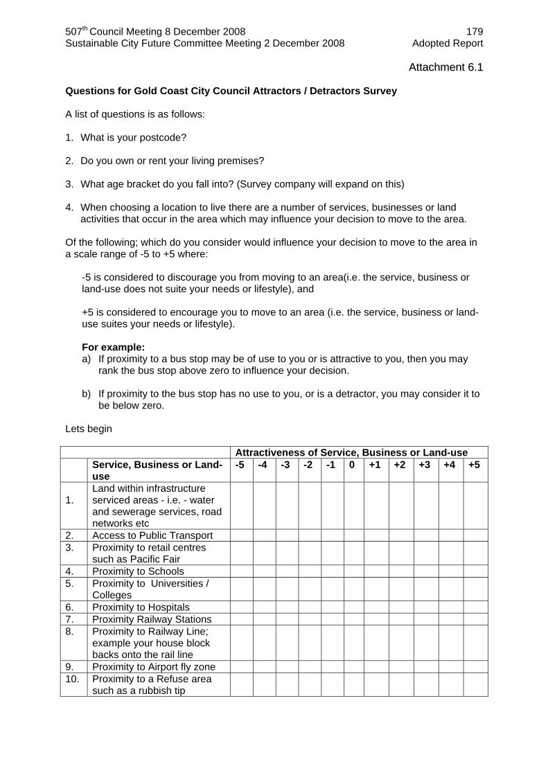
AAttttaacchhmmeenntt 66..11 Questions for Gold Coast City Council Attractors / Detractors Survey A list of questions is as follows: 1. What is your postcode? 2. Do you own or rent your living premises? 3. What age bracket do you fall into? (Survey company will expand on this) 4. When choosing a location to live there are a number of services, businesses or land
activities that occur in the area which may influence your decision to move to the area. Of the following; which do you consider would influence your decision to move to the area in a scale range of -5 to +5 where:
-5 is considered to discourage you from moving to an area(i.e. the service, business or land-use does not suite your needs or lifestyle), and +5 is considered to encourage you to move to an area (i.e. the service, business or land-use suites your needs or lifestyle).
For example: a) If proximity to a bus stop may be of use to you or is attractive to you, then you may
rank the bus stop above zero to influence your decision. b) If proximity to the bus stop has no use to you, or is a detractor, you may consider it to
be below zero. Lets begin Attractiveness of Service, Business or Land-use Service, Business or Land-
use -5 -4 -3 -2 -1 0 +1 +2 +3 +4 +5
1. Land within infrastructure serviced areas - i.e. - water and sewerage services, road networks etc
2. Access to Public Transport 3. Proximity to retail centres
such as Pacific Fair
4. Proximity to Schools 5. Proximity to Universities /
Colleges
6. Proximity to Hospitals 7. Proximity Railway Stations 8. Proximity to Railway Line;
example your house block backs onto the rail line
9. Proximity to Airport fly zone 10. Proximity to a Refuse area
such as a rubbish tip

507th Council Meeting 8 December 2008 180 Sustainable City Future Committee Meeting 2 December 2008 Adopted Report
AAttttaacchhmmeenntt 66..22 Attractiveness of Service, Business or Land-use Service, Business or Land-
use -5 -4 -3 -2 -1 0 +1 +2 +3 +4 +5
11. Proximity to Public Open Space
12. Proximity to an Industrial
area
13. Proximity to the Gold Coast coastal region, within 2.5km
14. Proximity to the Hinterland 15. Proximity to Greenheart (a
planned open green space and sports and recreation facility being developed in the Carrara region within the next 5-10 years.
6. Are there any other major Services, Businesses or Land-use activities that may influence
your decision to move to an area. 7. Are there any other major Services, Businesses or Land-use activities that may
discourage your decision to move to an area.
507th Council Meeting 8 December 2008 181 Sustainable City Future Committee Meeting 2 December 2008 Adopted Report ITEM 7 PLANNING ENVIRONMENT & TRANSPORT CURRUMBIN ECOVILLAGE – INNOVATION HOUSE 3 POST PROJECT REPORT PD113/49/07(P12) 1 BASIS FOR CONFIDENTIALITY Not applicable.
2 EXECUTIVE SUMMARY Not applicable. 3 PURPOSE OF REPORT The purpose of this report is to provide a final report to Council on the Innovation House 3 project. 4 PREVIOUS RESOLUTIONS Ex Council Minute Number G07.0430.008 That Committee Recommendation SG07.0417.005 be not adopted and in lieu thereof that Council resolve as follows:
1 That an amount of $30,000 be allocated from Division 14 unallocated funds for Option 2 of Innovation House 3 which will include promotion/staffing of the open house, and development of display material to showcase the key elements of the design that support Council policies and intent. This will include supporting the installation of state of the art household energy monitoring and control systems being trialled in the Ecovillage.
2 That a further report be brought back to Council following scoping of a longer term relationship between Council and Landmatters in relation to a potential “Innovation Estate”.
Ex Council Minute Number CD07.0604.006
1 That Council note the contribution of $15000 toward the project from Strategic and Environmental Planning and Performance.
2 That pursuant to section 486(2) (b) of the Local Government Act 1993 Landmatters Currumbin Ecovillage Pty Ltd be appointed as a sole supplier for the supply of specialist services to facilitate and manage innovation House 3 in conjunction with Council.
5 DISCUSSION 5.1 Innovation House 3 On the 30th of April 2007 Council resolved to fund Option 2 of the Council report presenting the opportunity of developing a stronger relationship between Council and the Ecovillage (refer Council Minute G07.0403.008). Option 2 built upon Option 1 - the partnership already established between Council and the Ecovillage. Option 2 focused on the opportunity that the nearly completed eco-house by Jaymac Constructions at the Ecovillage presented a potential candidate for Innovation House 3. Council’s involvement was justified because the design of the house demonstrated elements that are consistent with Policy 5 of the Planning Scheme: Code for Climate, and with the State Government’s Sustainable Housing Code 2006.
507th Council Meeting 8 December 2008 182 Sustainable City Future Committee Meeting 2 December 2008 Adopted Report ITEM 7 (Continued) CURRUMBIN ECOVILLAGE – INNOVATION HOUSE 3 POST PROJECT REPORT PD113/49/07(P12) Option 2 entailed the provision of signage from the Highway to the house, a promotional website, events and promotional displays within the house. This Option also required that the house display the Ecovision state-of-the-art household energy monitoring and control system and that a trained host attend the house from Thursday to Monday each week for a period of six months - July to December 2007. The owner/builder of the property, Jaymac Constructions, had already developed informal sponsorship relations with a number of suppliers and restricted the use of the property for IH3 – open house between July and December 2007. Final construction of the house was not completed till the end of June, a week prior to the launch. The resolution of Council in mid-April 2007 and the constraints from Jaymac Constructions created a very tight time-frame to develop and implement the project for a launch in July and completion by the end of December 2007.
The project entailed: Signage from Highway to IH3: Developing a logo and printing a brochure (2500 copies) about the house for
distribution to visitors and distribution Developing a specific website for IH3 Establishing a contract with Landmatters (Ecovillage developer) to manage the open
house and: Developing a series of promotional events and activities to launch IH3 and promote it
to different segments of the Gold Coast Market: Other Marketing:
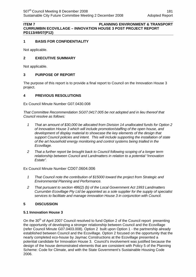
Figure 1: Mayor Ron Clarke speaking at the public opening of IH3 During the six months of the project IH3 was visited by a total of 5,432 people which was a greater visitation rate over the 6 months of the project than that achieved at Innovation House 2 over an equivalent period. Innovation House 2 had 10,000+ visitors but over a period of 12 months. The launch day of IH3 was attended by over 1300 people with a total for the first week of over 1500. In addition to being visited by general public considering building a new home or renovating an existing home, IH3 was used as a focal point for other environmental workshops such as a composting workshop run in conjunction with Waste Management. IH3 was visited by school and community groups. The then Federal Minister for the Environment (the Honorable Malcolm Turnbull MHR) visited the House in the week of 23 September 2007.

507th Council Meeting 8 December 2008 183 Sustainable City Future Committee Meeting 2 December 2008 Adopted Report ITEM 7 (Continued) CURRUMBIN ECOVILLAGE – INNOVATION HOUSE 3 POST PROJECT REPORT PD113/49/07(P12)
Weekly visitor numbers to Innovation House 3
0200400600800
10001200140016001800
15/0
7/20
07
22/0
7/20
07
29/0
7/20
07
5/08
/200
7
12/0
8/20
07
19/0
8/20
07
26/0
8/20
07
2/09
/200
7
9/09
/200
7
16/0
9/20
07
23/0
9/20
07
30/0
9/20
07
7/10
/200
7
14/1
0/20
07
21/1
0/20
07
28/1
0/20
07
4/11
/200
7
11/1
1/20
07
18/1
1/20
07
25/1
1/20
07
2/12
/200
7
Week
Vis
itors
Figure 2: Innovation House 3 visitation numbers and key events July to December 2007. Key positive feedback from visitors related to the incorporation and promotion of household products, particularly those with practical demonstrations such as: Energy efficient light bulbs Solar tubes and skylights Passive design elements in the house such as the shade structures on the front veranda
which allow winter sun to warm the polished concrete slab inside the home as a thermal mass to provide warmth through the day while shading it in summer to ensure a cooler home
Ecovision electricity and water monitoring system The Water Guardian system which conserves hot water
There was no substantive negative feedback. The direct cost of the project was within the allocated funding at $44,534 and included $ 15,082 to Landmatters for staffing/cleaning of the house four days per week for six
months (1 July – 20 December) $ 8,472 to Landmatters for internal display signage, printing 2500 brochures (including
acrylic signs, static displays, a sponsors board and display rack) and costs associated with the launch and other events
$ 980 to Landmatters for the formal opening and launch $ 10,000 to establish an interactive website with virtual tours of the home $ 10,000 to ensure the state-of-the-art Ecovision 5000 household monitoring system was
displayed and operational The short time frame to implement the project (2 months) highlighted the importance of a sufficient pre-planning phase, of at least six months, prior to construction of the house to enable Council to have a greater and more defined role in the development of the project, its objectives and any sponsor relationships. A longer pre-launch planning phase would allow for a properly integrated marketing plan that would include a frequently asked questions fact sheet ,in addition to a brochure and well designed survey instruments for visitors to both the website and the house.
Billboard established
Website Signage and launch
Trades and Professionals
Composting workshop
507th Council Meeting 8 December 2008 184 Sustainable City Future Committee Meeting 2 December 2008 Adopted Report ITEM 7 (Continued) CURRUMBIN ECOVILLAGE – INNOVATION HOUSE 3 POST PROJECT REPORT PD113/49/07(P12) The Waste Management Section of Council are considering retro-fitting an existing Council owned property at the Staplyton landfill using sustainable housing principles to be operated as an education, research and interpretive centre at the landfill site. This project may be able to be promoted as a further Innovation House with the focus on the retrofit market. 5.2 Innovation Estate proposal Also on the 30th of April 2007 Council called for a further report to be brought forward on scoping of a longer term relationship between Council and Landmatters in relation to a potential “Innovation Estate (refer Council Minute G07.0403.008). The concept of the Currumbin Ecovillage as an Innovation Estate was proposed by Mr Chris Walton of Landmatters in association with Innovation House 3. This concept seeks to build on the growing iconic and award winning status of the Ecovillage and involves Council partnering with Landmatters in the on-going opportunities the estate using its associated interpretive centre as a focal point to continue to promote sustainable development to developers, general public, regulators, and general visitors to the Gold Coast. The concept presents scope for accommodation for specialist advisory officers and visiting experts from CSIRO, the Department of Natural Resources and Water, and University of Queensland who are working with Council and Landmatters studying the on-going performance of the Ecovillage as a living laboratory. Discussions with Landmatters in relation to the Innovation Estate concept continue and a report on the proposal is proposed to be brought forward by the end of February 2009. 6 STATUTORY MATTERS Not applicable. 7 CORPORATE/OPERATIONAL PLAN Not applicable. 8 COUNCIL POLICIES Not applicable. 9 DELEGATIONS Not applicable.

507th Council Meeting 8 December 2008 185 Sustainable City Future Committee Meeting 2 December 2008 Adopted Report ITEM 7 (Continued) CURRUMBIN ECOVILLAGE – INNOVATION HOUSE 3 POST PROJECT REPORT PD113/49/07(P12) 10 BUDGET/FUNDING Allocated funding $44,534 in 2007 provided by previous resolutions of Council (G07.0430.008 and CD07.0604.006) $ 15,082 to Landmatters for staffing/cleaning of the house four days per week for six
months (1 July – 20 December) $ 8,472 to Landmatters for internal display signage, printing 2500 brochures (including
acrylic signs, static displays, a sponsors board and display rack) and costs associated with the launch and other events
$ 980 to Landmatters for the formal opening and launch $ 10,000 to establish an interactive website with virtual tours of the home $ 10,000 to ensure the state-of-the-art Ecovision 5000 household monitoring system was
displayed and operational 11 COORDINATION & CONSULTATION This report has been developed in consultation with Mr Chris Walton - Landmatters Ms Kerry Shepherd – Landmatters Evan Thomas, Team Leader – Sustainability Integration Team. Robin Earley – Project Integration Unit Alan Smith – 2020 Vision on Waste Project Officer Waste Management
12 TIMING Not applicable. 13 STAKEHOLDER IMPACTS Not applicable. 14 CONCLUSION The Innovation house 3 project was successful in displaying sustainable design principles and products including the Ecovision 5000 to over 5400 people from the Gold Coast and South East Queensland. A focus of the project was to promote innovation in design and construction to local professionals and tradesmen within the construction industry. This was done through special events at IH3. The potential of the Waste Management house at Stapylton being developed as Innovation House 4 should be investigated. The scoping of a longer-term relationship between Council and Landmatters on the concept of an innovation estate has yet to be completed. Discussions with Landmatters in relation to the Innovation Estate concept continue and a report on the proposal is proposed to be brought forward by the end of February 2009.
507th Council Meeting 8 December 2008 186 Sustainable City Future Committee Meeting 2 December 2008 Adopted Report ITEM 7 (Continued) CURRUMBIN ECOVILLAGE – INNOVATION HOUSE 3 POST PROJECT REPORT PD113/49/07(P12) 15 RECOMMENDATION It is recommended that the Council resolves as follows: 1 That Council note the success of the project and to thank Landmatters and Jaymac
Constructions for their collaboration in the development and operation of Innovation House 3.
2 That a further report be brought back to Council following discussions to establish a more detailed Innovation Estate proposal from Landmatters by the end of February 2009.
Author: Authorised by: Evan Thomas Warren Rowe Team Leader Sustainability Integration 19 November 2008
Director Planning, Environment & Transport
COMMITTEE RECOMMENDATION SC08.1202.007 moved Cr Betts seconded Cr Shepherd 1 That Council note the success of the project and to thank Landmatters and
Jaymac Constructions for their collaboration in the development and operation of Innovation House 3.
2 That a further report be brought back to Council following discussions to establish a more detailed Innovation Estate proposal from Landmatters by the end of February 2009.
CARRIED

507th Council Meeting 8 December 2008 187 Sustainable City Future Committee Meeting 2 December 2008 Adopted Report ITEM 8 PLANNING ENVIRONMENT & TRANSPORT ENERGY EFFICIENCY OPPORTUNITIES ACT ASSESSMENT REPORT PD113/49/07(P12) Refer 12 page attachment 1 BASIS FOR CONFIDENTIALITY Not applicable. 2 EXECUTIVE SUMMARY Not applicable. 3 PURPOSE OF REPORT The purpose of this report is to inform Council of the progress in response to the federal requirements of the Energy Efficiency Opportunities legislation. 4 PREVIOUS RESOLUTIONS Ex Minute No. CD07.0319.001 1 That Council acknowledges its obligations under the new federal Energy Efficiency
Opportunities Act 2006.
2 That the Chief Executive Officer writes to the Department of Industry, Tourism and Resources acknowledging and registering Council’s participation in the implementation of the Energy Efficiency Opportunities Act 2006 by 31 March 2007.
3 That an allocation of $60,000 to the Planning Environment & Transport Directorate budget be considered as part of the 2007-08 budget deliberations in order to undertake the required initial assessment by 30 June 2008.
4 That an investigation be undertaken to establish an assessment and reporting schedule by 31 December 2007 which will consider the cost to assess the assets responsible for 80 percent of the energy used by Council.
5 DISCUSSION The Energy Efficiency Opportunities (EEO) Act took effect on 01 July 2006. It is administered through the Department of Resources, Energy and Tourism. Participation in this program is mandatory for all corporations, which use more than 0.5 petajoules (1015 J equals 1 PJ) of energy per year. This Act requires an energy inventory to be submitted to the federal government on a annual basis and an energy auditing assessment be undertaken to identify potential energy efficiency opportunities. According to the Gold Coast City Council Energy Management Database, constructed and maintained by the Sustainability Integration Team within PET, Council used a total of 0.6305 PJ in 2005-2006 and is projected to increase consumption. In 2006-07 the total energy consumption was 0.6429 PJ and in 2007-08 (due to the boundary reform) the energy consumption dropped back to 0.6339 PJ.

507th Council Meeting 8 December 2008 188 Sustainable City Future Committee Meeting 2 December 2008 Adopted Report ITEM 8 (Continued) ENERGY EFFICIENCY OPPORTUNITIES ACT ASSESSMENT REPORT PD113/49/07(P12) The implementation of the EEO Act requires Council to follow five steps:
1. Determine participation; 2. Register; 3. Prepare and submit assessment and reporting schedule; 4. Conduct assessments; 5. Report on assessment outcomes and business response.
The central component of the Act is to conduct an assessment of energy use across the Council to identify cost effective energy savings and efficiency opportunities with up to a four year payback. The six key elements of the Assessment Framework are as follows:
1. Leadership support; 2. Involvement of people; 3. Data collection and analysis; 4. Identify energy efficiency opportunities and evaluate; 5. Decision making; 6. Communicating outcomes.
In June 2008 the first assessment was undertaken of the public lighting asset category. All assessments need to be conducted by June 2011 covering assets responsible for 80% of our energy use. These assessments and actions targeting energy reduction will also inform the Climate Change Strategy currently under development. A timeline for assessments is outlined in section 12 of this report. Energy use is central to all sections of a business and energy management is part of managing a business. In many large organisations energy management is strongly linked to facility and fleet management. Council spends over $17,000,000 on electricity and $6,000,000 on fuel per annum. These are the cost of Council operations and services provided by Gold Coast Water, Engineering Services, Community Services and Organisational Services. The public lighting asset category is unusual as Council does not have operational control of a majority of these assets. There are over 42,000 streetlights in the Gold Coast area which consume over 67 terajoule (1012 J equals 1 TJ) of energy. One opportunity currently under investigation is an energy efficient public lighting trial. This trial is looking for an energy efficient alternative lamp to the mercury vapour 50 watt lamp of which there are over 21,000 around the Gold Coast region. There is the potential to save 7 TJ of energy per annum if all of these lamps are converted to fluorescent lamps. The cost to install, maintain and service these newer technology lamps will be determined as part of the trial across South East Queensland. In order to satisfy the requirements of the Energy Efficiency Opportunities Act the Public Lighting Representative Assessment EEO report (attachment 1) will need to be published on the Gold Coast City Council website by 31 December 2008 and the First Government Report Template (attachment 2) will need to be signed by the Chief Executive Officer and sent to the Department of Resources, Energy and Tourism. These reports outline the progress to date of the Gold Coast City Council in meeting the requirements of the EEO Act. A summary is also been made available for inclusion in the 2007-08 Annual Report.
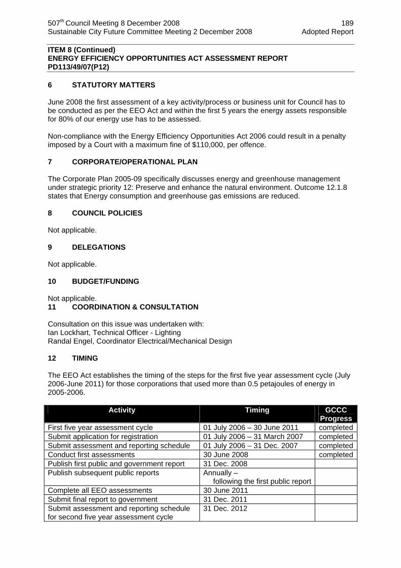
507th Council Meeting 8 December 2008 189 Sustainable City Future Committee Meeting 2 December 2008 Adopted Report ITEM 8 (Continued) ENERGY EFFICIENCY OPPORTUNITIES ACT ASSESSMENT REPORT PD113/49/07(P12) 6 STATUTORY MATTERS June 2008 the first assessment of a key activity/process or business unit for Council has to be conducted as per the EEO Act and within the first 5 years the energy assets responsible for 80% of our energy use has to be assessed. Non-compliance with the Energy Efficiency Opportunities Act 2006 could result in a penalty imposed by a Court with a maximum fine of $110,000, per offence. 7 CORPORATE/OPERATIONAL PLAN The Corporate Plan 2005-09 specifically discusses energy and greenhouse management under strategic priority 12: Preserve and enhance the natural environment. Outcome 12.1.8 states that Energy consumption and greenhouse gas emissions are reduced. 8 COUNCIL POLICIES Not applicable. 9 DELEGATIONS Not applicable. 10 BUDGET/FUNDING Not applicable. 11 COORDINATION & CONSULTATION Consultation on this issue was undertaken with: Ian Lockhart, Technical Officer - Lighting Randal Engel, Coordinator Electrical/Mechanical Design 12 TIMING The EEO Act establishes the timing of the steps for the first five year assessment cycle (July 2006-June 2011) for those corporations that used more than 0.5 petajoules of energy in 2005-2006.
Activity Timing GCCC Progress
First five year assessment cycle 01 July 2006 – 30 June 2011 completedSubmit application for registration 01 July 2006 – 31 March 2007 completedSubmit assessment and reporting schedule 01 July 2006 – 31 Dec. 2007 completedConduct first assessments 30 June 2008 completedPublish first public and government report 31 Dec. 2008 Publish subsequent public reports Annually –
following the first public report
Complete all EEO assessments 30 June 2011 Submit final report to government 31 Dec. 2011 Submit assessment and reporting schedule for second five year assessment cycle
31 Dec. 2012
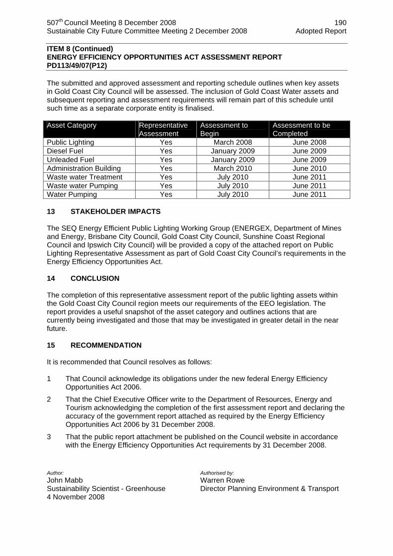
507th Council Meeting 8 December 2008 190 Sustainable City Future Committee Meeting 2 December 2008 Adopted Report ITEM 8 (Continued) ENERGY EFFICIENCY OPPORTUNITIES ACT ASSESSMENT REPORT PD113/49/07(P12) The submitted and approved assessment and reporting schedule outlines when key assets in Gold Coast City Council will be assessed. The inclusion of Gold Coast Water assets and subsequent reporting and assessment requirements will remain part of this schedule until such time as a separate corporate entity is finalised. Asset Category Representative
Assessment Assessment to Begin
Assessment to be Completed
Public Lighting Yes March 2008 June 2008 Diesel Fuel Yes January 2009 June 2009 Unleaded Fuel Yes January 2009 June 2009 Administration Building Yes March 2010 June 2010 Waste water Treatment Yes July 2010 June 2011 Waste water Pumping Yes July 2010 June 2011 Water Pumping Yes July 2010 June 2011 13 STAKEHOLDER IMPACTS The SEQ Energy Efficient Public Lighting Working Group (ENERGEX, Department of Mines and Energy, Brisbane City Council, Gold Coast City Council, Sunshine Coast Regional Council and Ipswich City Council) will be provided a copy of the attached report on Public Lighting Representative Assessment as part of Gold Coast City Council’s requirements in the Energy Efficiency Opportunities Act. 14 CONCLUSION The completion of this representative assessment report of the public lighting assets within the Gold Coast City Council region meets our requirements of the EEO legislation. The report provides a useful snapshot of the asset category and outlines actions that are currently being investigated and those that may be investigated in greater detail in the near future. 15 RECOMMENDATION It is recommended that Council resolves as follows: 1 That Council acknowledge its obligations under the new federal Energy Efficiency
Opportunities Act 2006.
2 That the Chief Executive Officer write to the Department of Resources, Energy and Tourism acknowledging the completion of the first assessment report and declaring the accuracy of the government report attached as required by the Energy Efficiency Opportunities Act 2006 by 31 December 2008.
3 That the public report attachment be published on the Council website in accordance with the Energy Efficiency Opportunities Act requirements by 31 December 2008.
Author: Authorised by: John Mabb Warren Rowe Sustainability Scientist - Greenhouse Director Planning Environment & Transport 4 November 2008
507th Council Meeting 8 December 2008 191 Sustainable City Future Committee Meeting 2 December 2008 Adopted Report
ITEM 8 (Continued) ENERGY EFFICIENCY OPPORTUNITIES ACT ASSESSMENT REPORT PD113/49/07(P12) COMMITTEE RECOMMENDATION SC08.1202.008 moved Cr Betts seconded Cr Shepherd 1 That Council acknowledge its obligations under the new federal Energy
Efficiency Opportunities Act 2006. 2 That the Chief Executive Officer write to the Department of Resources, Energy
and Tourism acknowledging the completion of the first assessment report and declaring the accuracy of the government report attached as required by the Energy Efficiency Opportunities Act 2006 by 31 December 2008.
3 That the public report attachment be published on the Council website in accordance with the Energy Efficiency Opportunities Act requirements by 31 December 2008.
CARRIED
507th Council Meeting 8 December 2008 192 Sustainable City Future Committee Meeting 2 December 2008 Adopted Report
AAttttaacchhmmeenntt 88..11
Energy Efficiency Opportunities Public lighting Representative Assessment Report
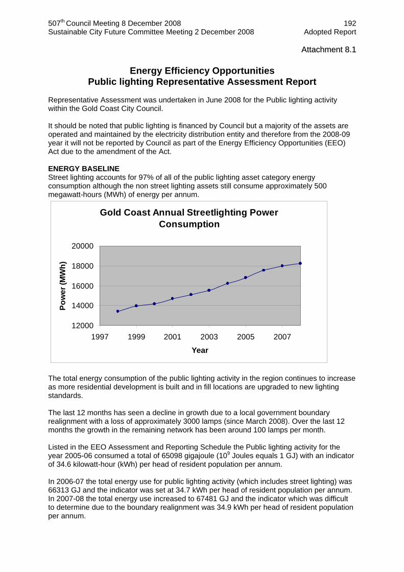
Representative Assessment was undertaken in June 2008 for the Public lighting activity within the Gold Coast City Council. It should be noted that public lighting is financed by Council but a majority of the assets are operated and maintained by the electricity distribution entity and therefore from the 2008-09 year it will not be reported by Council as part of the Energy Efficiency Opportunities (EEO) Act due to the amendment of the Act. ENERGY BASELINE Street lighting accounts for 97% of all of the public lighting asset category energy consumption although the non street lighting assets still consume approximately 500 megawatt-hours (MWh) of energy per annum.
Gold Coast Annual Streetlighting Power Consumption
12000
14000
16000
18000
20000
1997 1999 2001 2003 2005 2007
Year
Pow
er (M
Wh)
The total energy consumption of the public lighting activity in the region continues to increase as more residential development is built and in fill locations are upgraded to new lighting standards. The last 12 months has seen a decline in growth due to a local government boundary realignment with a loss of approximately 3000 lamps (since March 2008). Over the last 12 months the growth in the remaining network has been around 100 lamps per month. Listed in the EEO Assessment and Reporting Schedule the Public lighting activity for the year 2005-06 consumed a total of 65098 gigajoule (109 Joules equals 1 GJ) with an indicator of 34.6 kilowatt-hour (kWh) per head of resident population per annum. In 2006-07 the total energy use for public lighting activity (which includes street lighting) was 66313 GJ and the indicator was set at 34.7 kWh per head of resident population per annum. In 2007-08 the total energy use increased to 67481 GJ and the indicator which was difficult to determine due to the boundary realignment was 34.9 kWh per head of resident population per annum.
507th Council Meeting 8 December 2008 193 Sustainable City Future Committee Meeting 2 December 2008 Adopted Report
AAttttaacchhmmeenntt 88..22
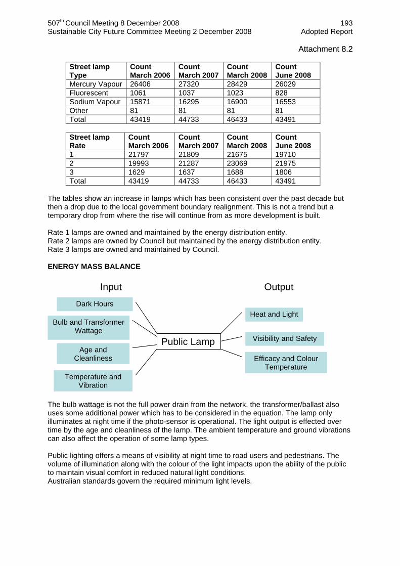
Street lamp Type
Count March 2006
Count March 2007
Count March 2008
Count June 2008
Mercury Vapour 26406 27320 28429 26029 Fluorescent 1061 1037 1023 828 Sodium Vapour 15871 16295 16900 16553 Other 81 81 81 81 Total 43419 44733 46433 43491
Street lamp Rate
Count March 2006
Count March 2007
Count March 2008
Count June 2008
1 21797 21809 21675 19710 2 19993 21287 23069 21975 3 1629 1637 1688 1806 Total 43419 44733 46433 43491
The tables show an increase in lamps which has been consistent over the past decade but then a drop due to the local government boundary realignment. This is not a trend but a temporary drop from where the rise will continue from as more development is built. Rate 1 lamps are owned and maintained by the energy distribution entity. Rate 2 lamps are owned by Council but maintained by the energy distribution entity. Rate 3 lamps are owned and maintained by Council. ENERGY MASS BALANCE
The bulb wattage is not the full power drain from the network, the transformer/ballast also uses some additional power which has to be considered in the equation. The lamp only illuminates at night time if the photo-sensor is operational. The light output is effected over time by the age and cleanliness of the lamp. The ambient temperature and ground vibrations can also affect the operation of some lamp types. Public lighting offers a means of visibility at night time to road users and pedestrians. The volume of illumination along with the colour of the light impacts upon the ability of the public to maintain visual comfort in reduced natural light conditions. Australian standards govern the required minimum light levels.
Public Lamp
Input Output Dark Hours
Temperature and Vibration
Bulb and Transformer Wattage
Age and Cleanliness
Heat and Light
Visibility and Safety
Efficacy and Colour Temperature

507th Council Meeting 8 December 2008 194 Sustainable City Future Committee Meeting 2 December 2008 Adopted Report
AAttttaacchhmmeenntt 88..33 DATA MEASUREMENT The public lighting network is an unmetered supply which means that no individual lights are directly monitored in regard to their energy consumption. With over 42,000 lights in the Gold Coast region alone, direct measurement would be a very expensive process. Monthly inventory adjustments are sent out with the electricity bill which details the rate, type and location of all new lamps. IDENTIFY OPPORTUNITIES A brainstorming session was undertaken on 05 June 2008 and a follow up session on 25 June 2008 which involved operational Council staff from the Engineering Services directorate. Some of the ideas include:
Utilise newer energy efficient bulb technology Reduce hours of operation Apply voltage reduction to some lamp types Advocate amendment to Australian standards Metering Utilise more efficient ballasts Upgrade photo-sensors – to reduce day burn Investigate dynamic lighting – adjustable levels of brightness Reduce volume of lights by making remainder more effective Develop lighting policy Regional trial of newer technology Review lighting design of new estate developments Implement new technology in off road lights (sportfields, carparks, paths, parks,
foreshores, decorative) The cost, ownership and maintenance of public lighting was considered as part of a Value for money action plan review. ESTIMATE SAVINGS (including accuracy) As of June 2008 Gold Coast City had 43,491 street lights of which 21,000 are the Mercury Vapour 50 Watt lamp type. These lamps could be replaced with either a 42 Watt compact fluorescent or a twin 14 Watt T5 linear fluorescent lamp. The calculations of the estimated energy savings in terajoules (1012 Joules equals 1 TJ) for 1 year (4200 hours) of the total volume of lamps is provided below:
4,200 hrs x (21,000 lamps x 50 Watts – 21,000 x (2 x 14 Watts)) = 1940 MWh 1940 MWh x 3.6 x 10^-3 = 6.985 TJ
Hence, the potential operational energy saving via direct bulb replacement of approximately 7 TJ per annum could occur if all bulbs were replaced. This has an accuracy of ±15% as it does not consider the rated life of the respective lamps or the ballast energy consumption associated with each lamp type. While this information is listed in the table below they are only theoretical values from manufacturers which will be investigated and verified during the trial period.

507th Council Meeting 8 December 2008 195 Sustainable City Future Committee Meeting 2 December 2008 Adopted Report
AAttttaacchhmmeenntt 88..44 EVALUATE OPPORTUNITIES The trial will enable the opportunity of upgrading the Mercury Vapour 50 Watt lamp, which represents 50% of the inventory, to newer technology to be evaluated by independent scientific consultant. The theoretical performance of the lamps are compared in table below (reproduced in larger font in online report).

507th Council Meeting 8 December 2008 196 Sustainable City Future Committee Meeting 2 December 2008 Adopted Report
AAttttaacchhmmeenntt 88..55 BUSINESS DECISIONS The capital cost of the newer energy efficient lamp technology is considerably more than the existing lamps. The installation and maintenance costs are also considerations as the newer lamps may not be easily replaceable and lamp life may be less then manufactures specifications due to environmental factors. Whole-of-life, ‘triple-bottom-line’ evaluation is being undertaken as part of regional trial of energy efficient lamps, this includes social aspects of pedestrian visibility. A successful trial will see lamps included on the approved installation list of the energy distribution entity. Deregulated street lighting electricity market became operational in July 2008 which resulted in a regional tender being established across several local government areas. The price to supply this street lighting service has increased 80% compared to previous year, however a government subsidy will offset some of this increase for the next 2 years. IMPLEMENT OPPORTUNITIES A regional energy efficient public lighting trial is underway with over 300 lamps in the field with measurement equipment attached. This trial was initiated between Council, the Department of Mines and Energy and ENERGEX. The endorsement of the SEQ Council of Mayors helped establish a Memorandum of Understanding between all stakeholders and the establishment of the Energy Efficient Public Lighting Working Group. This trial is evaluating several newer technology bulbs including T5, CFL, MH and LED. The trial began in July 2008 and will run for 2.5 years. The total cost of the trial is approximately $1,000,000 of which Gold Coast City Council has contributed $60,000. The Department of Climate Change has recently contributed funds from the Low Emission Technology Abatement grant. MEASURE Other energy efficient public lighting trials in Australia have not been supported by empirical data and documentation. What sets this trial apart from other trials is the use of Public Lighting Performance Data Collection (PLPDC) Units. These measurement units had to be designed from scratch as no existing unit was available. This has significantly increased the cost of the trial and the time to implement. In addition to the 300 lamps under trial there will be 180 PLPDC units monitoring their performance with 152 of them just measuring lumens and vibration and 18 units measuring lumens, vibration, electricity demand, voltage, temperature and humidity. MONITOR AND REPORT Reports are being received from the electricity network entity and the Queensland Department of Mines and Energy on a monthly basis as to the progress of the trial. More information can be obtained from the following website: www.dme.qld.gov.au/Energy/queensland_energy_efficient_street_lighting_trial.cfm
507th Council Meeting 8 December 2008 197 Sustainable City Future Committee Meeting 2 December 2008 Adopted Report
AAttttaacchhmmeenntt 88..66
507th Council Meeting 8 December 2008 198 Sustainable City Future Committee Meeting 2 December 2008 Adopted Report
AAttttaacchhmmeenntt 88..77

507th Council Meeting 8 December 2008 199 Sustainable City Future Committee Meeting 2 December 2008 Adopted Report
AAttttaacchhmmeenntt 88..88

507th Council Meeting 8 December 2008 200 Sustainable City Future Committee Meeting 2 December 2008 Adopted Report
AAttttaacchhmmeenntt 88..99
507th Council Meeting 8 December 2008 201 Sustainable City Future Committee Meeting 2 December 2008 Adopted Report
AAttttaacchhmmeenntt 88..1100
507th Council Meeting 8 December 2008 202 Sustainable City Future Committee Meeting 2 December 2008 Adopted Report
AAttttaacchhmmeenntt 88..1111

507th Council Meeting 8 December 2008 203 Sustainable City Future Committee Meeting 2 December 2008 Adopted Report
AAttttaacchhmmeenntt 88..1122

507th Council Meeting 8 December 2008 204 Sustainable City Future Committee Meeting 2 December 2008 Adopted Report
ITEM 9 COMMUNITY SERVICES MUDGEERABA AND WORONGARY CREEKS CATCHMENT MANAGEMENT STUDY WFB600/259/03(P3) Refer 19 page attachment 1 BASIS FOR CONFIDENTIALITY Not applicable. 2 EXECUTIVE SUMMARY The Mudgeeraba and Worongary Creeks Catchment Management Study (the Study) was undertaken by the Griffith Centre for Coastal Management, under the direction of Council’s Catchment Management Unit. The Study has identified various issues impacting on the ecological health of the creek systems and the surrounding catchments. Such issues relate to management practices on both private and public land. A major outcome of the Study is the Management Action Plan (see Attachment 1) that outlines management actions, priorities and responsibility for implementation. The following tasks were undertaken as part of the Study:
Geomorphic assessment; Riparian vegetation assessment; Ecological health assessment; Water quality and sediment analysis; Catchment modelling; Environmental Values and Water Quality Objectives; and Management Action Plan.
The Study area included Mudgeeraba Creek and its tributaries, Bonogin and Wyangan Creeks, and Worongary Creek. The Study has found that the creeks are under pressure from rapid urban and rural residential development, with over 30 % of the catchment having been cleared of vegetation. The short, steep nature of the catchments, and the fact that they are subject to occasional extremely high intensity rainfall and runoff, means that the catchments experience highly dynamic processes, including landslides and large debris flows. Streams show historical evidence of high debris flow activity and there is also evidence of relatively high sediment loads within the catchments. These geomorphic process should be considered in the design and maintenance of infrastructure. Riparian vegetation was generally found to be in very good condition within the upper catchments. These areas are generally well forested. Further downstream the condition ranged from fair to very poor. Vegetation has often been totally cleared or reduced to narrow strips through the clearing of surrounding forest. The condition rating of the riparian vegetation has been provided and recommendations made for conservation of good quality vegetation and restoration of degraded areas. Restoration and conservation of riparian vegetation will assist in achieving lower levels of sediment, nutrients and organic matter entering the creek systems. Stakeholder meetings, held as part of the Study, contributed to the development of environmental values and water quality objects. Aquatic ecosystems rated highly as a value the community desired to protect. From this input, water quality objectives were confirmed for the recommendation for inclusion to State legislation.

507th Council Meeting 8 December 2008 205 Sustainable City Future Committee Meeting 2 December 2008 Adopted Report
ITEM 9 (Continued) MUDGEERABA AND WORONGARY CREEKS CATCHMENT MANAGEMENT STUDY WFB600/259/03(P3) Overall, the Study found that water quality is not of a high standard in this catchment area. One of the major issues identified is the lack of appropriate sediment and erosion control on residential development sites. Enforcement of these controls would assist with reducing sediment input to the creeks. The elevated levels of sediment in the creeks are having a significant negative impact on aquatic ecosystem health. This poor level of water quality was also reflected in high levels of nutrients and faecal coliforms. This is likely to occur as a result of poorly managed onsite sewerage facilities, input from agricultural practices and also runoff from urban residential areas. Community training and education in relation to the management of onsite sewerage facilities and land management techniques have been recommended in the management action plan. Water quality modeling, with predictions of impacts of future land use changes, has indicated elevated levels of nutrients. Recommendations have been made to implement Water Sensitive Urban Design into new developments to protect downstream waterway health. The Study has indicated that the Mudgeeraba and Worongary Creeks catchments are under pressure from continuing urban expansion and associated infrastructure. Implementation of actions that address sediment and erosion control, high nutrient and faecal coliform levels, protection of riparian buffer zones (i.e. development setbacks), restoration and conservation of remnant vegetation will assist greatly with improving and protecting the health of these catchments. 3 PURPOSE OF REPORT The purpose of this report is to provide Council with an overview of the Study. It also seeks endorsement of the Environmental Values and Water Quality Objectives and the Management Action Plan contained in Attachment 1 of this agenda report. 4 PREVIOUS RESOLUTIONS Not applicable. 5 DISCUSSION 5.1 Introduction The Mudgeeraba Creek catchment lies in the southern part of the Gold Coast and is a major tributary of the Nerang River. Bonogin and Wyangan Creeks are sub-catchments of the Mudgeeraba catchment and were included in this Study. Worongary Creek, also part of this Study, is a separate catchment and lies to the north of Mudgeeraba catchment. The Study was undertaken from the headwaters of each catchment downstream to the M1 motorway. The aims of the Study were to develop Environmental Values (EVs), confirm Water Quality Objectives (WQOs), identify the current status of the catchments’ water quality, ecological health and riparian vegetation, and to address sediment and erosion issues.
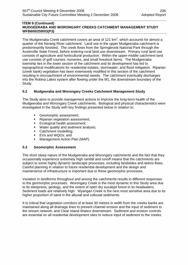
507th Council Meeting 8 December 2008 206 Sustainable City Future Committee Meeting 2 December 2008 Adopted Report
ITEM 9 (Continued) MUDGEERABA AND WORONGARY CREEKS CATCHMENT MANAGEMENT STUDY WFB600/259/03(P3) The Mudgeeraba Creek catchment covers an area of 121 km2, which accounts for almost a quarter of the Nerang River catchment. Land use in the upper Mudgeeraba catchment is predominantly forested. The creek flows from the Springbrook National Park through the Austinville State Forest, before entering rural land use downstream. Primary rural land use consists of agriculture and horticultural production. Within the upper-middle catchment land use consists of golf courses, nurseries, and small livestock farms. The Mudgeeraba township lies in the lower section of the catchment and its development has led to topographical modifications for residential estates, stormwater, and flood mitigation. Riparian (creek bank) vegetation has been extensively modified in this section of the catchment resulting in encroachment of environmental weeds. The catchment eventually discharges into the Robina Lakes system after flowing under the M1, the downstream boundary of the Study. 5.2 Mudgeeraba and Worongary Creeks Catchment Management Study The Study aims to provide management actions to improve the long-term health of the Mudgeeraba and Worongary Creek catchments. Biological and physical characteristics were investigated in the Study with key findings presented below in relation to:
Geomorphic assessment; Riparian vegetation assessment; Ecological health assessment; Water quality and sediment analysis; Catchment modelling; EVs and WQOs; and Management Action Plan (MAP).
5.3 Geomorphic Assessment The short steep nature of the Mudgeeraba and Worongary catchments and the fact that they occasionally experience extremely high rainfall and runoff means that the catchments are subject to some highly dynamic landscape processes, including landslides and debris flows. Careful planning in relation to future residential development and the design and maintenance of infrastructure is important due to these geomorphic processes. Variation in landforms throughout and among the catchments results in different responses to the geomorphic processes. Worongary Creek is the most dynamic in this Study area due to its steepness, geology, and the extent of open dry eucalypt forest in its headwaters. Sediment loads are relatively high. Wyangan Creek is the next most sensitive area due to its higher proportion of sand in the alluvial and colluvial sediments. It is critical that vegetation corridors of at least 30 metres in width from the creeks banks are maintained along all drainage lines to prevent channel erosion and the input of sediment to the stream network, and Clear Island Waters downstream. Sediment and erosion controls are essential on all residential development sites to reduce input of sediment to the creeks.

507th Council Meeting 8 December 2008 207 Sustainable City Future Committee Meeting 2 December 2008 Adopted Report
ITEM 9 (Continued) MUDGEERABA AND WORONGARY CREEKS CATCHMENT MANAGEMENT STUDY WFB600/259/03(P3) 5.4 Riparian Vegetation Assessment The upper sections of Mudgeeraba Creek are mostly well-forested, while the mid and lower reaches have been cleared or reduced to very narrow strips of vegetation. Worongary Creek has sections of riparian vegetation ranging from very good to very poor condition in its upper reaches. This is similar to the state of riparian vegetation in Bonogin Creek. Recommendations have been made for the removal of invasive vine and declared environmental weed species such as Madeira vine, Morning glory and Camphor laurel. Riparian vegetation in Wyangan Creek’s upper reaches was found to be in very good condition. The lower reaches are in poor condition with invasion of introduced grasses and clearing of vegetation for grazing. Development of a Riparian Vegetation Management Plan (RVMP) is recommended to include assessment of creek reaches for buffer widths. Riparian setback minimum limits also need to be reinforced and clarified for development approvals, with appropriate buffer widths defined as per the Waterways and Wetlands Code (Gold Coast Planning Scheme) by river/stream order for each sub-catchment. A vegetation management plan is recommended to protect and enhance scattered regrowth of species such as Melaleuca quinquinervia (paperbarks) and Eucalyptus tereticornis (Forest Red Gums). Aquatic weeds such as Cabomba caroliniana (Cabomba) and Salvinia molesta (Salvinia) should be effectively managed. Both species are a Class 2 declared plant species under Queensland legislation and a Weed of National Significance (WONS). 5.5 Ecological Health Assessment A waterways ecological health assessment was undertaken at various sites throughout the creek systems. The indicators measured were:
Freshwater fish communities – both native and exotic fish data were collected; Aquatic invertebrate communities – invertebrates such as snails, insects, worms
and crustaceans provide an indication that the stream is healthy enough to support water quality, food and habitat requirements;
Ecosystem processes and nutrient assimilation – Gross Primary Production (GPP) and respiration quantify the production/consumption of carbon and are direct measures of stream health. Healthy forest streams typically have low rates of GPP because the riparian vegetation shades the water so that algal/plant growth is light limited. This in turn results in low rates of respiration. Nutrient assimilation relates to the nitrogen isotope signature of plants. Changes in this occur if there are substantial inputs of nitrogen due to catchment disturbances. Algal bioassay assessment is undertaken as a measure of the growth response of algae to different nutrient treatments;
Water quality – temperature, pH, conductivity and dissolved oxygen concentrations provide a basis for classifying streams as healthy or otherwise.
The upstream site in Mudgeeraba Creek was found to be in very good ecological condition with good water quality and riparian vegetation resulting in natural rates of production and respiration and minimally disturbed aquatic invertebrate communities. The mid-reaches were in moderate to good condition with intact riparian vegetation also in good condition. Loss of riparian vegetation at some sites is likely to have resulted in elevated rates of GPP and invasion of aquatic weed species.

507th Council Meeting 8 December 2008 208 Sustainable City Future Committee Meeting 2 December 2008 Adopted Report
ITEM 9 (Continued) MUDGEERABA AND WORONGARY CREEKS CATCHMENT MANAGEMENT STUDY WFB600/259/03(P3) The Bonogin Creek site at Gunsynd Drive is in moderate to good ecological condition. The invertebrate communities reflected good condition while the fish communities reflected moderate condition. Dissolved oxygen levels were lower than those at sites in the upper Mudgeeraba catchment and could be attributed to dense beds of aquatic plants, such as the introduced Cabomba caroliniana (Cabomba) that occupies part of this reach. A significant portion of the fish population in Worongary Creek included the exotic species Gambusia (Gambusi holbrooki). There are concerns that the aquatic macroinvertebrates (aquatic bugs) sampled were dominated by those that are pollutant tolerant species. 5.6 Water Quality and Sediment Analysis Water quality parameters were measured during a series of snapshot surveys for low-flow conditions and immediately following a large rainfall event. Council’s monitoring data was also assessed for Mudgeeraba, Wyangan and Bonogin Creeks. Worongary Creek west of the M1 is not part of Council’s current City wide water quality monitoring program. As per recommendations within the Study, additional sites will be included into this program. Overall, water quality within these systems was not of a high standard. This was particularly evident during the high flow event. This could, however, be considered a worst-case scenario with the high intensity rainfall event being preceded by an extended dry period. The following conditions summarise the findings:
Total suspended solids and turbidity (water clarity) exceeded, or were close to exceeding, the Australian and New Zealand Guidelines for Fresh and Marine Water Quality 2000 (ANZECC) values in the lower reaches of all catchments. Turbidity reduces light penetration which can affect aquatic plant growth and production. Preconstruction clearing of building sites and excessive vegetation clearing during the construction phase of development, together with inadequate erosion and sediment controls contribute to high measures of total suspended solids and turbidity;
Chlorophyll-a was high at ‘hotspots’ within the creeks during high flow conditions. Chlorophyll-a can provide an indication of nutrient input that can lead to nuisance algal blooms;
Total nitrogen was high in the lower reaches of Mudgeeraba Creek. The most common sources of nitrogen contamination are from ammonium nitrate fertilisers, intensive agriculture and animal or human faeces;
Ammonia (a form of nitrogen) was moderate to high in all sites within the catchment; and
Occasional high total copper levels were recorded and further investigations are required to locate the source.
Total coliform counts often exceeded primary contact (e.g. swimming) at all sites, with particular concern at sites in Worongary and Mudgeeraba Creeks, where results exceeded secondary contact values (e.g. boating, fishing). Total coliform measurements are an indicator of faecal contamination from warm-blooded animals and/or sewage. These samples were undertaken as a ‘snapshot’ of the water quality and provide the basis for further investigations. Results from Council’s water quality monitoring program indicate that the low-flow total coliform median measurements fell below the WQO, although most sites exceeded primary usage guidelines. A more thorough investigation should be undertaken at sites that consistently exceed guideline values during low flow conditions. Part of these investigations should also involve the identification of the pathogens to determine if the faecal coliforms are Escherichia coli (E.coli), as this is the pathogen that may cause illness in humans.

507th Council Meeting 8 December 2008 209 Sustainable City Future Committee Meeting 2 December 2008 Adopted Report
ITEM 9 (Continued) MUDGEERABA AND WORONGARY CREEKS CATCHMENT MANAGEMENT STUDY WFB600/259/03(P3) The low dissolved oxygen, high nutrients, high faecal coliforms and high chlorophyll-a are all possibly related to a combination of local agricultural activities, runoff from urban areas (domestic animals) or the prevalence of on-site sewage facilities (OSSF) on acreage properties. Officers from relevant sections of Council are working together to address this issue. A recommendation has been made to undertake audits of OSSF in sites identified in the Study as having high faecal coliform counts. Random audits are also being undertaken throughout the City. Sediment was analysed for trace metals, with copper being the only element that approached the lower limit guideline. It is considered that copper concentrations at this level are not of concern for the majority of organisms, including humans. These sediment concentrations of copper did not reflect the high copper concentrations in the water column. Management actions have been included to further investigate these results. 5.7 Catchment Modelling The objectives of catchment computer modelling are to develop a representation of water quality for the existing landuse in the catchment and to provide a prediction of water quality for a future developed catchment according to Council’s planning documents. The model appears to consistently over-predict the concentrations of nutrients and suspended solids when compared to the water quality monitoring results. This may be as a result of several years of below-average rainfall. A sample collected during low flow conditions, for example, will typically have better results than one taken during a storm event. The model has been constructed around an ‘average’ rainfall year and it is possible that the monitored events have not been similar to the statistical average. Some variation could occur through the assumptions used to build the model. Future landuse scenarios were modelled, based on Council’s Emerging Communities Structure Plans. Two emerging community areas were identified from the Structure Plans. These are located within the Worongary and Bonogin Creeks catchments. Suspended solids concentrations for the future landuse scenario are not predicted to vary significantly except for the lower portion of Bonogin Creek. It is crucial to the health of the creek to reduce expected increases of nutrients and suspended solids. Recommendations include incorporation of Water Sensitive Urban Design (WSUD) principles and appropriate Stormwater Management Plans (SMPs) into all developments. Compliance monitoring should start at the preconstruction phase ensuring sedimentation and erosion controls are correctly installed prior to vegetation clearing. Enforcement measures should continue during and after construction works. Modelled results also indicate that Bonogin Creek is likely to receive the greatest increase in nitrogen. As nitrogen is difficult to treat due to its presence in predominantly dissolved forms, the WSUD measures will need to include such treatments as constructed wetlands, infiltration/bioretention systems, restoration of riparian buffers and porous pavements that have a long residence time for treatment.
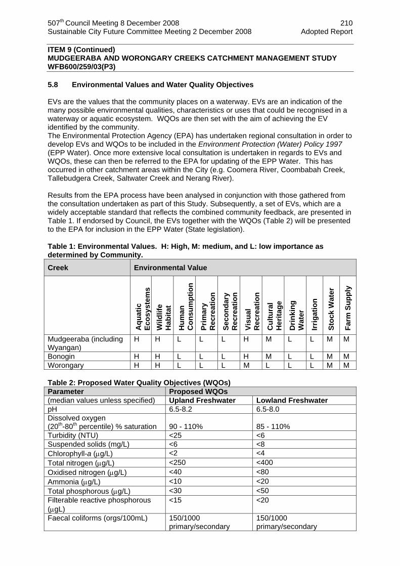
507th Council Meeting 8 December 2008 210 Sustainable City Future Committee Meeting 2 December 2008 Adopted Report
ITEM 9 (Continued) MUDGEERABA AND WORONGARY CREEKS CATCHMENT MANAGEMENT STUDY WFB600/259/03(P3) 5.8 Environmental Values and Water Quality Objectives EVs are the values that the community places on a waterway. EVs are an indication of the many possible environmental qualities, characteristics or uses that could be recognised in a waterway or aquatic ecosystem. WQOs are then set with the aim of achieving the EV identified by the community. The Environmental Protection Agency (EPA) has undertaken regional consultation in order to develop EVs and WQOs to be included in the Environment Protection (Water) Policy 1997 (EPP Water). Once more extensive local consultation is undertaken in regards to EVs and WQOs, these can then be referred to the EPA for updating of the EPP Water. This has occurred in other catchment areas within the City (e.g. Coomera River, Coombabah Creek, Tallebudgera Creek, Saltwater Creek and Nerang River). Results from the EPA process have been analysed in conjunction with those gathered from the consultation undertaken as part of this Study. Subsequently, a set of EVs, which are a widely acceptable standard that reflects the combined community feedback, are presented in Table 1. If endorsed by Council, the EVs together with the WQOs (Table 2) will be presented to the EPA for inclusion in the EPP Water (State legislation). Table 1: Environmental Values. H: High, M: medium, and L: low importance as determined by Community.
Creek Environmental Value
Aqu
atic
Ec
osys
tem
s W
ildlif
e H
abita
t
Hum
an
Con
sum
ptio
n
Prim
ary
Rec
reat
ion
Seco
ndar
y R
ecre
atio
n
Visu
al
Rec
reat
ion
Cul
tura
l H
erita
ge
Drin
king
W
ater
Irrig
atio
n
Stoc
k W
ater
Farm
Sup
ply
Mudgeeraba (including Wyangan)
H H L L L H M L L M M
Bonogin H H L L L H M L L M M Worongary H H L L L M L L L M M Table 2: Proposed Water Quality Objectives (WQOs) Parameter Proposed WQOs (median values unless specified) Upland Freshwater Lowland Freshwater pH 6.5-8.2 6.5-8.0 Dissolved oxygen (20th-80th percentile) % saturation
90 - 110%
85 - 110%
Turbidity (NTU) <25 <6 Suspended solids (mg/L) <6 <8 Chlorophyll-a (µg/L) <2 <4 Total nitrogen (µg/L) <250 <400 Oxidised nitrogen (µg/L) <40 <80 Ammonia (µg/L) <10 <20 Total phosphorous (µg/L) <30 <50 Filterable reactive phosphorous (µgL)
<15 <20
Faecal coliforms (orgs/100mL) 150/1000 primary/secondary
150/1000 primary/secondary
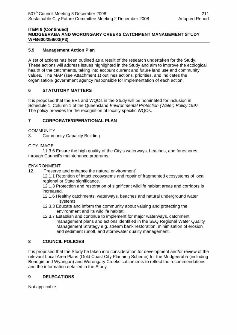
507th Council Meeting 8 December 2008 211 Sustainable City Future Committee Meeting 2 December 2008 Adopted Report
ITEM 9 (Continued) MUDGEERABA AND WORONGARY CREEKS CATCHMENT MANAGEMENT STUDY WFB600/259/03(P3) 5.9 Management Action Plan A set of actions has been outlined as a result of the research undertaken for the Study. These actions will address issues highlighted in the Study and aim to improve the ecological health of the catchments, taking into account current and future land use and community values. The MAP (see Attachment 1) outlines actions, priorities, and indicates the organisation/ government agency responsible for implementation of each action. 6 STATUTORY MATTERS It is proposed that the EVs and WQOs in the Study will be nominated for inclusion in Schedule 1, Column 1 of the Queensland Environmental Protection (Water) Policy 1997. The policy provides for the recognition of locally specific WQOs. 7 CORPORATE/OPERATIONAL PLAN COMMUNITY 3. Community Capacity Building
CITY IMAGE 11.3.6 Ensure the high quality of the City’s waterways, beaches, and foreshores through Council’s maintenance programs. ENVIRONMENT 12. ‘Preserve and enhance the natural environment’
12.1.1 Retention of intact ecosystems and repair of fragmented ecosystems of local, regional or State significance. 12.1.3 Protection and restoration of significant wildlife habitat areas and corridors is increased. 12.1.6 Healthy catchments, waterways, beaches and natural underground water
systems. 12.3.3 Educate and inform the community about valuing and protecting the
environment and its wildlife habitat. 12.3.7 Establish and continue to implement for major waterways, catchment
management plans and actions identified in the SEQ Regional Water Quality Management Strategy e.g. stream bank restoration, minimisation of erosion and sediment runoff, and stormwater quality management.
8 COUNCIL POLICIES It is proposed that the Study be taken into consideration for development and/or review of the relevant Local Area Plans (Gold Coast City Planning Scheme) for the Mudgeeraba (including Bonogin and Wyangan) and Worongary Creeks catchments to reflect the recommendations and the information detailed in the Study. 9 DELEGATIONS Not applicable.
507th Council Meeting 8 December 2008 212 Sustainable City Future Committee Meeting 2 December 2008 Adopted Report
ITEM 9 (Continued) MUDGEERABA AND WORONGARY CREEKS CATCHMENT MANAGEMENT STUDY WFB600/259/03(P3) 10 BUDGET/FUNDING The Study was completed at a cost of $146,000 (GST exclusive). A number of implementation strategies has been identified that will require funding and resources. Actions include further water quality investigations into high copper concentrations and faecal coliforms and the development and implementation of a RVMP. Funding requirements as indicated in the MAP (see Attachment 1) will be requested in line with Council’s budget approval process, or through external funding sources such as Australian Water Grants and SEQ Catchments. Some non-recurrent funding has been provided to Catchment Management Unit, Community Services in the 2008/09 OPEX budget to begin implementation of in-stream restoration works and environmental weed removal along Mudgeeraba, Bonogin and Wyangan Creeks between Springbrook Road to the M1 highway. 11 COORDINATION & CONSULTATION Stakeholders involved/consulted/invited in the development of the Study include: Gold Coast City Council
Catchment Management Unit Flood Strategies Implementation and Assessment Natural Areas Management Unit Engineering, Assets and Planning Divisional Councillor
State Government
Environmental Protection Agency - Queensland Parks and Wildlife Service
Department of Natural Resources and Water Community and Industry
Mudgeeraba Divisional Advisory Committee Gold Coast and Hinterland Environment Council Mudgeeraba Chamber of Commerce Urban Development Institute of Australia Nursery Association Springbrook Catchment Management Landcare Group Numinbah Valley Landcare Group
External Agency
SEQ Healthy Waterways Partnership
12 TIMING The Study will be implemented over a five (5) year period during which time the MAP will be reviewed. A progress report will be presented to Council following the implementation period.
507th Council Meeting 8 December 2008 213 Sustainable City Future Committee Meeting 2 December 2008 Adopted Report
ITEM 9 (Continued) MUDGEERABA AND WORONGARY CREEKS CATCHMENT MANAGEMENT STUDY WFB600/259/03(P3) 13 STAKEHOLDER IMPACTS The Study will provide a source of information for a variety of stakeholders. This information will provide the basis for various actions that will assist in improving the ecological health of the creek systems. Outcomes from these actions will benefit the community and the environment. Findings from the Study will also assist property developers, in partnership with Council, to work towards achieving the WQOs for the creeks. Stakeholders that will be able to use the information from the Study and be involved in the implementation of its actions include:
State Government agencies; Council directorates; Development industry; Community groups; Educational institutions; and Interested landholders and community members.
14 CONCLUSION The Study has highlighted issues of concern and areas for protection in the catchments of Mudgeeraba and Worongary Creeks. Actions outlined in the MAP need to be implemented to address the decline in waterway health and to provide an opportunity for protection and enhancement of the current values identified by the community. The Mudgeeraba and Worongary catchments are and will be subject to current and future extensive development pressures. Future land use scenarios simulated through the computer modelling of the catchments indicate an increase in pollutants entering the creek systems. The catchments are subject to occasional high intensity rainfall and runoff. Due to the short and steep nature of these catchments, highly dynamic landscape processes are experienced, in particular, landslides and debris flows. Overall, water quality within Mudgeeraba, Worongary, Bonogin and Wyangan Creeks is not of a high standard. Low dissolved oxygen, high nutrients, high coliforms and high chlorophyll-a are all possibly related to a combination of local agricultural activities, runoff from urban residential areas or the prevalence of OSSF on acreage properties. High total suspended solids and turbidity (water clarity) are probably due to ongoing residential development and poor sediment and erosion control on new and existing residential development sites. Much of the increased sediment delivery from these development sites is preventable with appropriate planning and regulation of the development process, including the preconstruction stage when erosion and sediment loss is highest. Enforcement of sediment control measures on development sites, from preconstruction through to post construction stage, will reduce inputs to the creeks. The key findings in the Study include:
Riparian vegetation in the upper catchment is generally in good condition with associated good ecological health;
Moderate to poor water quality exists in the lower reaches of the creeks in conjunction with fragmented or lack of riparian vegetation;
The Study highlights the need for a riparian vegetation setback policy to protect the ecological health of the creeks;

507th Council Meeting 8 December 2008 214 Sustainable City Future Committee Meeting 2 December 2008 Adopted Report
ITEM 9 (Continued) MUDGEERABA AND WORONGARY CREEKS CATCHMENT MANAGEMENT STUDY WFB600/259/03(P3)
Pollutant modelling has indicated a further decline in water quality under a unregulated future landuse scenario. This highlights the importance of water sensitive urban design for all future residential developments in the catchment; and
Confirmation of Environmental Values and Water Quality Objectives will assist government agencies in the management and protection of the health and water quality of the creeks.
The Study has presented a set of management actions with related priorities and has identified issues that need to be addressed through Council’s planning mechanisms and processes. Implementation of these actions will assist with improving the long-term ecological health of the systems. These actions include on-ground works such as riparian restoration projects, community education and awareness programs on management practices in relation to OSSF and enforcement of approved sediment and erosion controls being installed and maintained. 15 RECOMMENDATION It is recommended that Council resolves as follows: 1 That Council endorse the following outcomes from the Mudgeeraba and Worongary
Creeks Catchment Management Study:
a The Environmental Values as presented in Table 1,
b The Water Quality Objectives as contained in Table 2, and
c The Management Action Plan as presented in the Attachment to this report.
2 That a progress report be presented to Council within the five (5) year implementation period of the Management Action Plan.
3 That the Environmental Values and Water Quality Objectives contained in the Mudgeeraba and Worongary Creeks Catchment Management Study be forwarded to the Environmental Protection Agency for consideration and inclusion in Schedule 1, Column 1 of the Queensland Environmental Protection (Water) Policy 1997.
4 That the Director of Community Services communicates with relevant State Government Agencies identified in the Management Action Plan to seek commitment regarding fulfilling recommended actions and obligations.
5 That a copy of the Mudgeeraba and Worongary Creeks Catchment Management Study be provided for:
a Relevant State Government Agencies;
b The Gold Coast Catchment Association;
c Mudgeeraba Creek Catchment Management Group; and
d Public access through Council’s website and libraries.
Author: Authorised by: Dayna Blackmore Colette McCool Catchment Management Officer Director Community Services 17 November 2008

507th Council Meeting 8 December 2008 215 Sustainable City Future Committee Meeting 2 December 2008 Adopted Report
ITEM 9 (Continued) MUDGEERABA AND WORONGARY CREEKS CATCHMENT MANAGEMENT STUDY WFB600/259/03(P3) Changed Recommendation COMMITTEE RECOMMENDATION SC08.1202.009 moved Cr Shepherd seconded Cr Pforr That this matter be deferred until the first Sustainable City Future Committee meeting in 2009 to enable further discussions to take place between the Divisional Councillor and Council officers. CARRIED

507th Council Meeting 8 December 2008 216 Sustainable City Future Committee Meeting 2 December 2008 Adopted Report
AAttttaacchhmmeenntt 99..11 Mudgeeraba and Worongary Creeks Catchment Management Study – Management Action Plan iSPOT:#24505418 v2
STRATEGY ENVIRON-MENTAL VALUE
CREEK SYSTEM ACTIONS PRIORITY PERFORMANCE
INDICATORS RESPONSIBILITY
All
1.1 Review existing management of riparian vegetation. Develop Riparian Vegetation Management Plan including assessment of creek reaches for buffer widths. Process to reinforce riparian buffer zone limits (developers) and clarify limits for Council planning officers involved in determining development approvals. Enforce penalties (relative to development size) for non-compliance.
Short
No new development occurring within at least a 30m buffer to creek. No increase in fragmentation of existing riparian vegetation Compliance of developers towards buffer width policy
GCCC DNR
All
1.2 Categorise rivers/stream by order and define appropriate buffer as per the Waterways and Wetlands Code for each sub-catchment. Maintain minimum of 30m buffer width as identified on OM11 and OM20.
Short
A rigorous, defensible buffer width policy
GCCC
1.0 Protect riparian vegetation / buffer zone within overall system
Aquatic Ecosystems / Wildlife Habitats
All
1.3 Propose a study to define the aim/purpose of the buffer zone for each creek system (e.g. wildlife corridor, reduced runoff and sediment control, aquatic invertebrate habitat). Model with the nature of the catchment, stream order, riparian vegetation, topographic and geomorphological data to develop and validate buffer width specifications (e.g. lay geomorphologic data with riparian vegetation data). Sediment buffer and wildlife habitat (providing either primary habitat or ‘corridor’ function) to be considered throughout the determination of appropriate buffer widths.
Medium
Sufficient buffer zone for all creek systems
GCCC (Involve the Healthy Waterways Partnership)
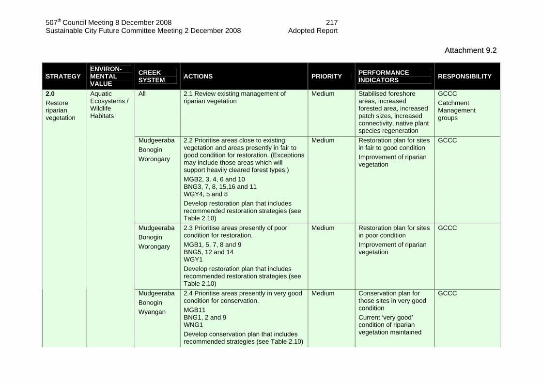
507th Council Meeting 8 December 2008 217 Sustainable City Future Committee Meeting 2 December 2008 Adopted Report
AAttttaacchhmmeenntt 99..22
STRATEGY ENVIRON-MENTAL VALUE
CREEK SYSTEM ACTIONS PRIORITY PERFORMANCE
INDICATORS RESPONSIBILITY
All
2.1 Review existing management of riparian vegetation
Medium
Stabilised foreshore areas, increased forested area, increased patch sizes, increased connectivity, native plant species regeneration
GCCC Catchment Management groups
Mudgeeraba Bonogin Worongary
2.2 Prioritise areas close to existing vegetation and areas presently in fair to good condition for restoration. (Exceptions may include those areas which will support heavily cleared forest types.) MGB2, 3, 4, 6 and 10 BNG3, 7, 8, 15,16 and 11 WGY4, 5 and 8 Develop restoration plan that includes recommended restoration strategies (see Table 2.10)
Medium
Restoration plan for sites in fair to good condition Improvement of riparian vegetation
GCCC
Mudgeeraba Bonogin Worongary
2.3 Prioritise areas presently of poor condition for restoration. MGB1, 5, 7, 8 and 9 BNG5, 12 and 14 WGY1 Develop restoration plan that includes recommended restoration strategies (see Table 2.10)
Medium Restoration plan for sites in poor condition Improvement of riparian vegetation
GCCC
2.0 Restore riparian vegetation
Aquatic Ecosystems / Wildlife Habitats
Mudgeeraba Bonogin Wyangan
2.4 Prioritise areas presently in very good condition for conservation. MGB11 BNG1, 2 and 9 WNG1 Develop conservation plan that includes recommended strategies (see Table 2.10)
Medium Conservation plan for those sites in very good condition Current ‘very good’ condition of riparian vegetation maintained
GCCC

507th Council Meeting 8 December 2008 218 Sustainable City Future Committee Meeting 2 December 2008 Adopted Report
AAttttaacchhmmeenntt 99..33
STRATEGY ENVIRON-MENTAL VALUE
CREEK SYSTEM ACTIONS PRIORITY PERFORMANCE
INDICATORS RESPONSIBILITY
Bonogin Wyangan Worongary
2.5 Prioritise areas presently in very poor condition for restoration. BNG4, 6, 10, and 13
WNG2 and 3 WGY 2, 3, 6 and 7
Develop restoration plan that includes recommended restoration strategies (see Table 2.10)
Initial consideration of the Wyangan sites is required to assist in the protection of the paperbark (Melaleuca quinquinervia) and remnant forest red gums (Eucalyptus tereticornis) which are currently present.
Medium Restoration plan in place Improvement of riparian vegetation currently in very poor condition
GCCC
2.6 Develop guidelines and a community handbook for private landowners to assist in the establishment of healthy riparian vegetation.
Medium Education material provided
GCCC Catchment Management groups
2.7 Facilitate community groups to assist in revegetation
Medium On-going community groups undertaking works and assessments
GCCC Catchment Management groups
All
2.8 Assess mowing practices and insist on those that allow natural regeneration of the riparian vegetation (in addition this will assist in the reduction of sediment and organic input, improving the water quality see Section 4.2)
Short Changed mowing practices in catchment Evidence of natural regeneration of the riparian zone
GCCC Parks and Gardens
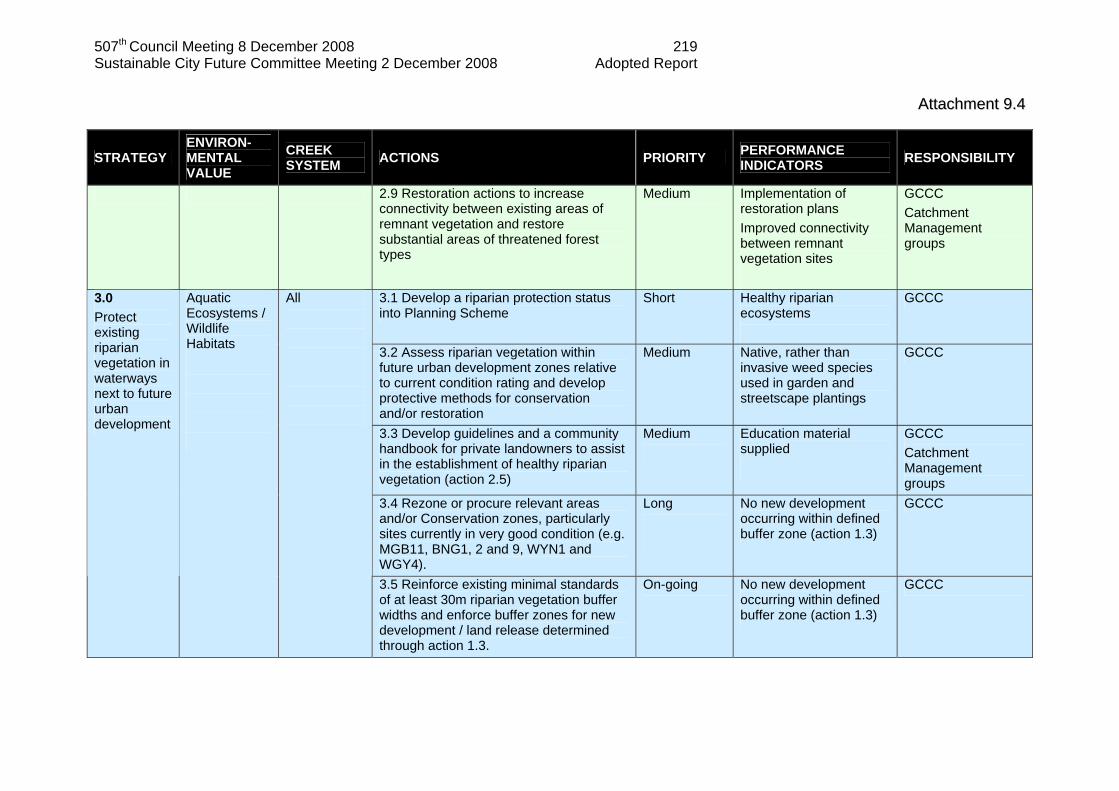
507th Council Meeting 8 December 2008 219 Sustainable City Future Committee Meeting 2 December 2008 Adopted Report
AAttttaacchhmmeenntt 99..44
STRATEGY ENVIRON-MENTAL VALUE
CREEK SYSTEM ACTIONS PRIORITY PERFORMANCE
INDICATORS RESPONSIBILITY
2.9 Restoration actions to increase connectivity between existing areas of remnant vegetation and restore substantial areas of threatened forest types
Medium Implementation of restoration plans Improved connectivity between remnant vegetation sites
GCCC Catchment Management groups
3.1 Develop a riparian protection status into Planning Scheme
Short Healthy riparian ecosystems
GCCC
3.2 Assess riparian vegetation within future urban development zones relative to current condition rating and develop protective methods for conservation and/or restoration
Medium Native, rather than invasive weed species used in garden and streetscape plantings
GCCC
3.3 Develop guidelines and a community handbook for private landowners to assist in the establishment of healthy riparian vegetation (action 2.5)
Medium
Education material supplied
GCCC Catchment Management groups
3.4 Rezone or procure relevant areas and/or Conservation zones, particularly sites currently in very good condition (e.g. MGB11, BNG1, 2 and 9, WYN1 and WGY4).
Long
No new development occurring within defined buffer zone (action 1.3)
GCCC
3.0 Protect existing riparian vegetation in waterways next to future urban development
Aquatic Ecosystems / Wildlife Habitats
All
3.5 Reinforce existing minimal standards of at least 30m riparian vegetation buffer widths and enforce buffer zones for new development / land release determined through action 1.3.
On-going No new development occurring within defined buffer zone (action 1.3)
GCCC

507th Council Meeting 8 December 2008 220 Sustainable City Future Committee Meeting 2 December 2008 Adopted Report
AAttttaacchhmmeenntt 99..55
STRATEGY ENVIRON-MENTAL VALUE
CREEK SYSTEM ACTIONS PRIORITY PERFORMANCE
INDICATORS RESPONSIBILITY
3.6 Enforce developers to adhere to buffer zone standards to preserve creek and adjacent developments from erosion. Reassess fines for non-compliance, ensuring penalties for breaches are sufficiently deterrent and in proportion to the relative value of the development.
On-going Stable, sustainable buffer zones, improved riparian vegetation Developer complying
GCCC
3.7 No further clearing of riparian vegetation from alluvial sections of the creeks (mid to lower reaches).
Short Protection in place for alluvial (mid to lower) section of the creek
GCCC
3.8 Further development should be located, where possible, on already cleared land, and where appropriate, be associated with restoration of degraded riparian vegetation
Medium Improved riparian vegetation in new developments on already cleared land
GCCC
All
4.1 Develop community groups based on weed management within public areas and in line with aforementioned recommended revegetation areas (Bush Care, facilitated by GCCC)
Short
Reduction of weed species within catchment (especially those considered priority species by DNRM and highlighted in Section 2.4.2)
GCCC Catchment Management groups
4.0 Weed management
Aquatic Ecosystems / Wildlife Habitats
All 4.2 Provide information to property owners, regarding weed removal and alternative native species for replacement.
Medium
Healthy riparian zones, minimal invasive weeds, native species regeneration
GCCC Catchment Management groups

507th Council Meeting 8 December 2008 221 Sustainable City Future Committee Meeting 2 December 2008 Adopted Report
AAttttaacchhmmeenntt 99..66
STRATEGY ENVIRON-MENTAL VALUE
CREEK SYSTEM ACTIONS PRIORITY PERFORMANCE
INDICATORS RESPONSIBILITY
4.3 Develop specialised management programs for each creek to address priority weed species. Weed control should be prioritised by initial management of invasive vines (Section 2.4.3 Priority weeds and Section 2.4.2 for locations) and those highlighted as priority weeds species in Section 2.4.2 (see section for specific location). Local experience should also be utilised in developing this management plan.
Medium Implementation of management plan addressing the removal of priority weed species Priority weed species removed
GCCC
All
4.4 Assess current mowing practices in catchments and alter to practices that limit weed invasion and encourage regeneration of natural vegetation.
Medium Changed mowing practices
GCCC
Mudgeeraba Bonogin Worongary
4.5 Assess full extent and presence of canopy smothering weeds (such as madeira vine, blue morning glory, siratro, white-passion flower and mile-a-minute). See Section 2.4.2 for sites of initial concern determined from this study. Provide management and control recommendations and assistance as required
Short Control of canopy smothering weeds in place Canopy smothering weeds removed
GCCC Catchment Management groups
Mudgeeraba Wyangan
4.6 Immediate removal of the Senegal tea (Gymnocoronis spilanthoides) infestations as recommended by the Federal Department of Environment and Heritage (see Section 2.4.2 for location).
Short Senegal tea infestation removed
GCCC

507th Council Meeting 8 December 2008 222 Sustainable City Future Committee Meeting 2 December 2008 Adopted Report
AAttttaacchhmmeenntt 99..77
STRATEGY ENVIRON-MENTAL VALUE
CREEK SYSTEM ACTIONS PRIORITY PERFORMANCE
INDICATORS RESPONSIBILITY
All 4.7 Removal of small / juvenile stands of weed species due to easier removal whilst still small. For example - small infestation of canna lily (Canna
indica) at MGB11 - camphor laurel (Cinnamomum
camphora) at BNG5, BNG10, WYN1 and WGY4 which are still seedlings / saplings
- umbrella tree (Schefflera actinophylla) regenerating at WGY4
Short Weeds removed at specific sites
GCCC
Bonogin
4.8 Develop eradication program for the removal of the aquatic weed Cabomba (Cabomba caroliniana) from pools upstream of Gunsynd Road using current techniques. Mechanical removal with an on-going intensive maintenance program is suggested, however use of herbicides and dense shading may also be required.
Short Program in place to remove infestations of Cabomba Cabomba removed with on-going maintenance program in place
GCCC
All 4.9 Assess Mudgeeraba Catchments for the aquatic weed Salvinia (Salvinia molesta) to determine where present and currently established. If found, develop eradication program using current techniques. Recommendations for removal include biological, chemical and mechanical control or a combination of these.
Short Assessment for presence of Salvinia and if required a program in place to remove infestations
GCCC
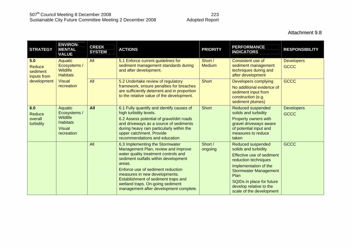
507th Council Meeting 8 December 2008 223 Sustainable City Future Committee Meeting 2 December 2008 Adopted Report
AAttttaacchhmmeenntt 99..88
STRATEGY ENVIRON-MENTAL VALUE
CREEK SYSTEM ACTIONS PRIORITY PERFORMANCE
INDICATORS RESPONSIBILITY
All
5.1 Enforce current guidelines for sediment management standards during and after development.
Short / Medium
Consistent use of sediment management techniques during and after development
Developers GCCC
5.0 Reduce sediment inputs from development
Aquatic Ecosystems / Wildlife Habitats Visual recreation
All
5.2 Undertake review of regulatory framework, ensure penalties for breaches are sufficiently deterrent and in proportion to the relative value of the development.
Short Developers complying No additional evidence of sediment input from construction (e.g. sediment plumes)
GCCC
6.0 Reduce overall turbidity
Aquatic Ecosystems / Wildlife Habitats Visual recreation
All
6.1 Fully quantify and identify causes of high turbidity levels. 6.2 Assess potential of gravel/dirt roads and driveways as a source of sediments during heavy rain particularly within the upper catchment. Provide recommendations and education
Short
Reduced suspended solids and turbidity Property owners with gravel driveways aware of potential input and measures to reduce taken
Developers GCCC
All
6.3 Implementing the Stormwater Management Plan, review and improve water quality treatment controls and sediment outfalls within development areas. Enforce use of sediment reduction measures in new developments. Establishment of sediment traps and wetland traps. On-going sediment management after development complete.
Short / ongoing
Reduced suspended solids and turbidity Effective use of sediment reduction techniques Implementation of the Stormwater Management Plan SQIDs in place for future develop relative to the scale of the development
GCCC
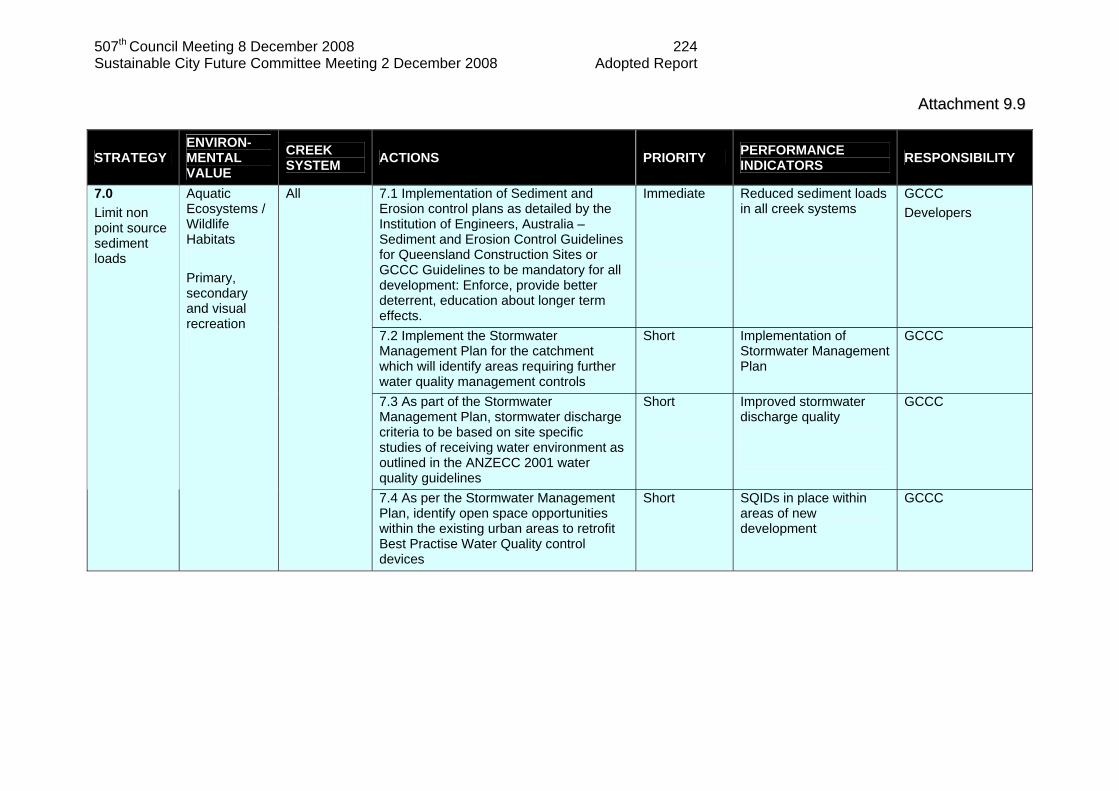
507th Council Meeting 8 December 2008 224 Sustainable City Future Committee Meeting 2 December 2008 Adopted Report
AAttttaacchhmmeenntt 99..99
STRATEGY ENVIRON-MENTAL VALUE
CREEK SYSTEM ACTIONS PRIORITY PERFORMANCE
INDICATORS RESPONSIBILITY
7.1 Implementation of Sediment and Erosion control plans as detailed by the Institution of Engineers, Australia – Sediment and Erosion Control Guidelines for Queensland Construction Sites or GCCC Guidelines to be mandatory for all development: Enforce, provide better deterrent, education about longer term effects.
Immediate
Reduced sediment loads in all creek systems
GCCC Developers
7.2 Implement the Stormwater Management Plan for the catchment which will identify areas requiring further water quality management controls
Short
Implementation of Stormwater Management Plan
GCCC
7.3 As part of the Stormwater Management Plan, stormwater discharge criteria to be based on site specific studies of receiving water environment as outlined in the ANZECC 2001 water quality guidelines
Short
Improved stormwater discharge quality
GCCC
7.0 Limit non point source sediment loads
Aquatic Ecosystems / Wildlife Habitats Primary, secondary and visual recreation
All
7.4 As per the Stormwater Management Plan, identify open space opportunities within the existing urban areas to retrofit Best Practise Water Quality control devices
Short SQIDs in place within areas of new development
GCCC

507th Council Meeting 8 December 2008 225 Sustainable City Future Committee Meeting 2 December 2008 Adopted Report
AAttttaacchhmmeenntt 99..1100
STRATEGY ENVIRON-MENTAL VALUE
CREEK SYSTEM ACTIONS PRIORITY PERFORMANCE
INDICATORS RESPONSIBILITY
All
8.1 Obtain current register of residents using on-site wastewater treatment systems (available from GCCC plumbing) and assess system usage and status within the catchment. Assess on-site systems for potential/current leakage into the creek systems and provide requirements and enforce upgrading of these systems and use of best management practices. Develop on-going program to monitor on-site systems
Short Medium
Long term reduction of storm event and background concentrations of E.coli and nutrients. Improved management of on-site treatment systems Program in place to monitor on-site treatment systems
GCCC
8.2 Determine if high nutrient levels are associated with poor management of on-site treatment plants.
Medium
Improved management of on-site treatment systems, resulting in reduction of non-point source pollution to all waterways within catchment
GCCC
8.0 Determine / minimise non-point source pollution
Aquatic Ecosystems / Wildlife Habitats Primary, secondary and visual recreation
8.3 Ensure residents have participated in the Community On-site Treatment Training Workshop provided by GCCC or have organised alternatives for the management of their on-site treatment system.
Short
All residents participated in GCCC training
GCCC

507th Council Meeting 8 December 2008 226 Sustainable City Future Committee Meeting 2 December 2008 Adopted Report
AAttttaacchhmmeenntt 99..1111
STRATEGY ENVIRON-MENTAL VALUE
CREEK SYSTEM ACTIONS PRIORITY PERFORMANCE
INDICATORS RESPONSIBILITY
Mudgeeraba Wyangan Bonogin Worongary
8.4 Undertake further study to determine the percentage of faecal coliforms that are E.coli in sites were baseline flows are persistently above primary usage guideline vales. (Section 4 sites MGB1, MGB3-8, BNG2-5, WYN2, WYN3, WOR1-5) Take remedial action for those sites were median values of E.coli are above primary usage guideline values such as erecting ‘no swimming’ signs during periods of likely contamination such as rainfall events.
Short Remedial action taken (if required) to deter primary contact with contaminated waters such as erecting signs during and after rainfall events.
GCCC
8.5 Continue current GCCC monitoring program to monitor water quality, include Worongary as part of this program (Section 4.2)
Ongoing Continuation of GCCC current monitoring program with the inclusion of Worongary
GCCC
8.6 Develop an event monitoring program for water quality (Section 4.2) to ensure an accurate measurement of pollutants being flushed from the system after periods of dry weather. Prioritise Gold Coast catchments for event sampling, due to extent of on-site wastewater treatment systems Mudgeeraba Catchment should be considered as high priority.
Ongoing Event monitoring program in place Improved knowledge of recovery time fore creek systems after rainfall events
GCCC
All
8.7 Undertake thorough study of sediment nutrient analysis to determine if sediments are contributing as a source or sink (e.g. elevated levels of nitrogen in Bonogin Creek)
Medium Improved knowledge of sediment nutrients
GCCC
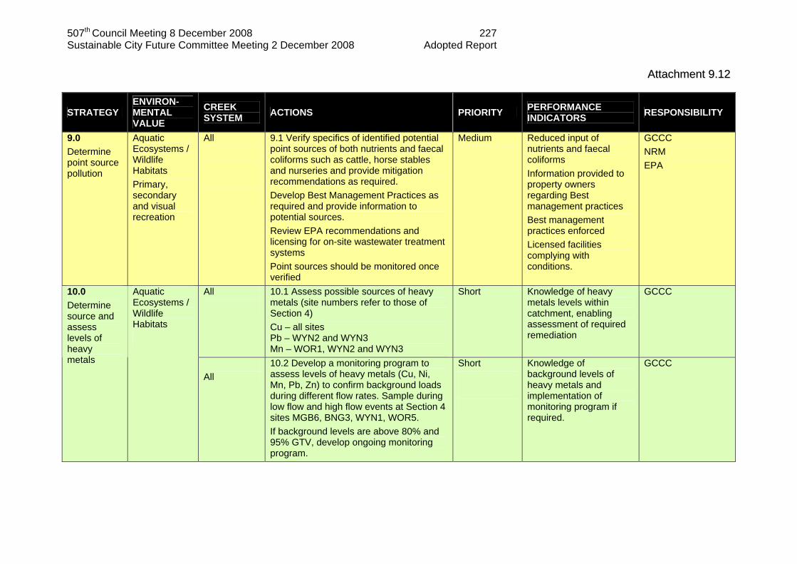
507th Council Meeting 8 December 2008 227 Sustainable City Future Committee Meeting 2 December 2008 Adopted Report
AAttttaacchhmmeenntt 99..1122
STRATEGY ENVIRON-MENTAL VALUE
CREEK SYSTEM ACTIONS PRIORITY PERFORMANCE
INDICATORS RESPONSIBILITY
9.0 Determine point source pollution
Aquatic Ecosystems / Wildlife Habitats Primary, secondary and visual recreation
All
9.1 Verify specifics of identified potential point sources of both nutrients and faecal coliforms such as cattle, horse stables and nurseries and provide mitigation recommendations as required. Develop Best Management Practices as required and provide information to potential sources. Review EPA recommendations and licensing for on-site wastewater treatment systems Point sources should be monitored once verified
Medium Reduced input of nutrients and faecal coliforms Information provided to property owners regarding Best management practices Best management practices enforced Licensed facilities complying with conditions.
GCCC NRM EPA
All
10.1 Assess possible sources of heavy metals (site numbers refer to those of Section 4) Cu – all sites Pb – WYN2 and WYN3 Mn – WOR1, WYN2 and WYN3
Short Knowledge of heavy metals levels within catchment, enabling assessment of required remediation
GCCC 10.0 Determine source and assess levels of heavy metals
Aquatic Ecosystems / Wildlife Habitats
All
10.2 Develop a monitoring program to assess levels of heavy metals (Cu, Ni, Mn, Pb, Zn) to confirm background loads during different flow rates. Sample during low flow and high flow events at Section 4 sites MGB6, BNG3, WYN1, WOR5. If background levels are above 80% and 95% GTV, develop ongoing monitoring program.
Short
Knowledge of background levels of heavy metals and implementation of monitoring program if required.
GCCC

507th Council Meeting 8 December 2008 228 Sustainable City Future Committee Meeting 2 December 2008 Adopted Report
AAttttaacchhmmeenntt 99..1133
STRATEGY ENVIRON-MENTAL VALUE
CREEK SYSTEM ACTIONS PRIORITY PERFORMANCE
INDICATORS RESPONSIBILITY
10.3 Undertake time average metal speciation analysis to estimate the bioavailable concentration of Cu. If results are above the 95% GTV then direct toxicity assessment should be undertaken at necessary sites. Water hardness should also be monitored within this proposed study.
Medium
GCCC
10.4 Develop an annual monitoring program to assess sediments for heavy metals (Cu, Ni, Mn, Pb Zn).
Medium / Ongoing
Program in place to assess heavy metal accumulation in sediments
GCCC
11.1 Monitor volume of water extraction especially during drought periods. Impose water pumping or diversion restrictions if required under the Water Act.
Medium Minimised impacts to water flow and volume
DNR&M 11.0 Assess hydraulic capacity of systems
Environmental goal: Flood conveyance
All
11.2 Provide education/information on use and management of creek water for irrigation and cattle.
Information provided Improved management of the creek for stock and irrigation
GCCC
12.0 Limit increased flood effects from future development
Environmental goal: Flood conveyance
All 12.1 Implement the Stormwater Management Plan to integrate flood management issues
No loss of flood storage volume
GCCC – Flood Strategies
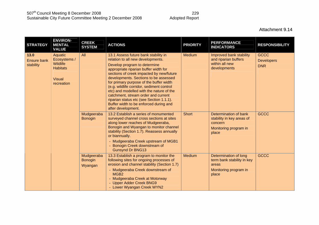
507th Council Meeting 8 December 2008 229 Sustainable City Future Committee Meeting 2 December 2008 Adopted Report
AAttttaacchhmmeenntt 99..1144
STRATEGY ENVIRON-MENTAL VALUE
CREEK SYSTEM ACTIONS PRIORITY PERFORMANCE
INDICATORS RESPONSIBILITY
All
13.1 Assess future bank stability in relation to all new developments. Develop program to determine appropriate riparian buffer width for sections of creek impacted by new/future developments. Sections to be assessed for primary purpose of the buffer width (e.g. wildlife corridor, sediment control etc) and modelled with the nature of the catchment, stream order and current riparian status etc (see Section 1.1.1). Buffer width to be enforced during and after development.
Medium
Improved bank stability and riparian buffers within all new developments
GCCC Developers DNR
Mudgeeraba Bonogin
13.2 Establish a series of monumented surveyed channel cross sections at sites along lower reaches of Mudgeeraba, Bonogin and Wyangan to monitor channel stability (Section 1.7). Reassess annually or biannually. - Mudgeeraba Creek upstream of MGB1 - Bonogin Creek downstream of
Gunsynd Dr BNG13
Short Determination of bank stability in key areas of concern Monitoring program in place
GCCC
13.0 Ensure bank stability
Aquatic Ecosystems / Wildlife Habitats Visual recreation
Mudgeeraba Bonogin Wyangan
13.3 Establish a program to monitor the following sites for ongoing processes of erosion and channel stability (Section 1.7) - Mudgeeraba Creek downstream of
MGB2 - Mudgeeraba Creek at Motorway - Upper Adder Creek BNG9 - Lower Wyangan Creek WYN2
Medium Determination of long term bank stability in key areas Monitoring program in place
GCCC
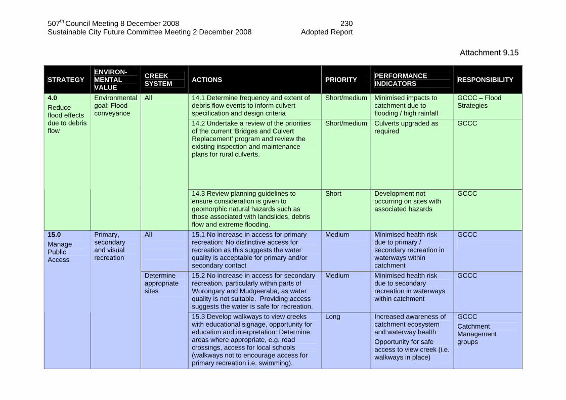
507th Council Meeting 8 December 2008 230 Sustainable City Future Committee Meeting 2 December 2008 Adopted Report
AAttttaacchhmmeenntt 99..1155
STRATEGY ENVIRON-MENTAL VALUE
CREEK SYSTEM ACTIONS PRIORITY PERFORMANCE
INDICATORS RESPONSIBILITY
14.1 Determine frequency and extent of debris flow events to inform culvert specification and design criteria
Short/medium
Minimised impacts to catchment due to flooding / high rainfall
GCCC – Flood Strategies
14.2 Undertake a review of the priorities of the current ‘Bridges and Culvert Replacement’ program and review the existing inspection and maintenance plans for rural culverts.
Short/medium Culverts upgraded as required
GCCC
4.0 Reduce flood effects due to debris flow
Environmental goal: Flood conveyance
All
14.3 Review planning guidelines to ensure consideration is given to geomorphic natural hazards such as those associated with landslides, debris flow and extreme flooding.
Short
Development not occurring on sites with associated hazards
GCCC
All
15.1 No increase in access for primary recreation: No distinctive access for recreation as this suggests the water quality is acceptable for primary and/or secondary contact
Medium
Minimised health risk due to primary / secondary recreation in waterways within catchment
GCCC
15.2 No increase in access for secondary recreation, particularly within parts of Worongary and Mudgeeraba, as water quality is not suitable. Providing access suggests the water is safe for recreation.
Medium Minimised health risk due to secondary recreation in waterways within catchment
GCCC
15.0 Manage Public Access
Primary, secondary and visual recreation
Determine appropriate sites
15.3 Develop walkways to view creeks with educational signage, opportunity for education and interpretation: Determine areas where appropriate, e.g. road crossings, access for local schools (walkways not to encourage access for primary recreation i.e. swimming).
Long Increased awareness of catchment ecosystem and waterway health Opportunity for safe access to view creek (i.e. walkways in place)
GCCC Catchment Management groups
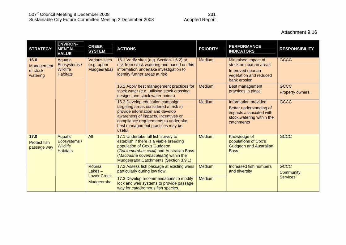
507th Council Meeting 8 December 2008 231 Sustainable City Future Committee Meeting 2 December 2008 Adopted Report
AAttttaacchhmmeenntt 99..1166
STRATEGY ENVIRON-MENTAL VALUE
CREEK SYSTEM ACTIONS PRIORITY PERFORMANCE
INDICATORS RESPONSIBILITY
16.1 Verify sites (e.g. Section 1.6.2) at risk from stock watering and based on this information undertake investigation to identify further areas at risk
Medium Minimised impact of stock on riparian areas Improved riparian vegetation and reduced bank erosion
GCCC
16.2 Apply best management practices for stock water (e.g. utilising stock crossing designs and stock water points).
Medium Best management practices in place
GCCC Property owners
16.0 Management of stock watering
Aquatic Ecosystems / Wildlife Habitats
Various sites (e.g. upper Mudgeeraba)
16.3 Develop education campaign targeting areas considered at risk to provide information and develop awareness of impacts. Incentives or compliance requirements to undertake best management practices may be useful.
Medium Information provided Better understanding of impacts associated with stock watering within the catchments
GCCC
All
17.1 Undertake full fish survey to establish if there is a viable breeding population of Cox’s Gudgeon (Gobiomorphus coxii) and Australian Bass (Macquaria novemaculeata) within the Mudgeeraba Catchments (Section 3.9.1).
Medium
Knowledge of populations of Cox’s Gudgeon and Australian Bass
GCCC
17.2 Assess fish passage at existing weirs particularly during low flow.
Medium
17.0 Protect fish passage way
Aquatic Ecosystems / Wildlife Habitats
Robina Lakes – Lower Creek Mudgeeraba
17.3 Develop recommendations to modify lock and weir systems to provide passage way for catadromous fish species.
Medium
Increased fish numbers and diversity
GCCC Community Services

507th Council Meeting 8 December 2008 232 Sustainable City Future Committee Meeting 2 December 2008 Adopted Report
AAttttaacchhmmeenntt 99..1177
STRATEGY ENVIRON-MENTAL VALUE
CREEK SYSTEM ACTIONS PRIORITY PERFORMANCE
INDICATORS RESPONSIBILITY
17.4 Assess road culverts as potential fish barriers. Develop recommendations to modify.
Long Increased fish numbers and diversity
GCCC Community Services
All 17.5 Establish likely effects of road
barriers on Cox’s Gudgeon (Gobiomorphus coxii) and Australian Bass (Macquaria novemaculeata) if determined to have a viable breeding population (action 17.1). Develop recommendations if required.
Long GCCC
18.1 Internal education program within GCCC Planning Department (relative to sediment control throughout development, sediment control after development, riparian buffer requirements and management)
Short / On-going
Improved coordination and understanding of catchment management requirements within GCCC
GCCC
18.2 Co-ordinate internal departments such as Bushland Management, Parks and Gardens and Catchment Management. Improved coordination will benefit management outcomes where GCCC Units overlap in the management of specific areas. This will provide an opportunity for sharing of information and management strategies for the overall management of the catchment.
Immediate
Implementation of cooperative management strategies
GCCC
18.0 Education Programs
All All
18.3 Implement education program for community benefit on issues related to appropriate management of the creek systems, based on all listed strategies.
Short
Improved awareness and activity within the community with regards to catchment management issues and strategies
GCCC
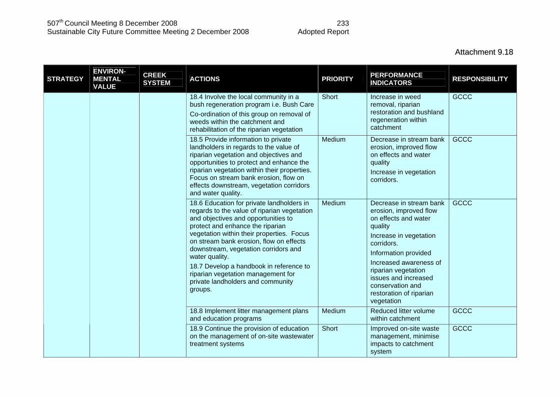
507th Council Meeting 8 December 2008 233 Sustainable City Future Committee Meeting 2 December 2008 Adopted Report
AAttttaacchhmmeenntt 99..1188
STRATEGY ENVIRON-MENTAL VALUE
CREEK SYSTEM ACTIONS PRIORITY PERFORMANCE
INDICATORS RESPONSIBILITY
18.4 Involve the local community in a bush regeneration program i.e. Bush Care Co-ordination of this group on removal of weeds within the catchment and rehabilitation of the riparian vegetation
Short
Increase in weed removal, riparian restoration and bushland regeneration within catchment
GCCC
18.5 Provide information to private landholders in regards to the value of riparian vegetation and objectives and opportunities to protect and enhance the riparian vegetation within their properties. Focus on stream bank erosion, flow on effects downstream, vegetation corridors and water quality.
Medium
Decrease in stream bank erosion, improved flow on effects and water quality Increase in vegetation corridors.
GCCC
18.6 Education for private landholders in regards to the value of riparian vegetation and objectives and opportunities to protect and enhance the riparian vegetation within their properties. Focus on stream bank erosion, flow on effects downstream, vegetation corridors and water quality. 18.7 Develop a handbook in reference to riparian vegetation management for private landholders and community groups.
Medium
Decrease in stream bank erosion, improved flow on effects and water quality Increase in vegetation corridors. Information provided Increased awareness of riparian vegetation issues and increased conservation and restoration of riparian vegetation
GCCC
18.8 Implement litter management plans and education programs
Medium Reduced litter volume within catchment
GCCC
18.9 Continue the provision of education on the management of on-site wastewater treatment systems
Short Improved on-site waste management, minimise impacts to catchment system
GCCC

507th Council Meeting 8 December 2008 234 Sustainable City Future Committee Meeting 2 December 2008 Adopted Report
AAttttaacchhmmeenntt 99..1199 Priorities: Immediate = within 1 year Short = between 1 and 2 years Medium = between 2 and 5 Years Long = between 5 and 20 years Ongoing = continuously from implementation Gold Coast City Council CMU - Catchment Management Unit ES – Engineering Services NAMU – Natural Areas Management Unit PE&T – Planning, Environment and Transport PMU – Pest Management Unit TS – Technical Services State Agencies DPI&F – Department of Primary Industry and Fisheries DNR&W – Department of Natural Resources and Water EPA – Environmental Protection Agency