sunshine west - planning · walking and cycling, as well as better and cheaper bus transport.”...
TRANSCRIPT

Sunshine WestOur 20‑Minute Neighbourhood
20‑Minute Neighbourhood Pilot Program
Creating a city of 20‑minute neighbourhoods
Neighbourhoods are the foundation of our city — they are the places where we live, connect and build communities.
Plan Melbourne 2017-2050 is a long-term plan
to accommodate Melbourne’s future growth in population.
The 20-minute neighbourhood concept is a key principle of the strategy. It is all about ‘living
locally’ — giving people the ability to meet most of
their everyday needs within a 20-minute walk from
home, with access to safe cycling and local public
transport options.
Research shows that 20 minutes is the maximum
time people are willing to walk to meet their daily
needs locally.1
These needs include local health facilities and
services, local schools and local shopping centres.
This represents an 800m walk from home to a service or destination, and back again.
This distance is a guide as there are many factors
that influence people’s ability or willingness to walk.
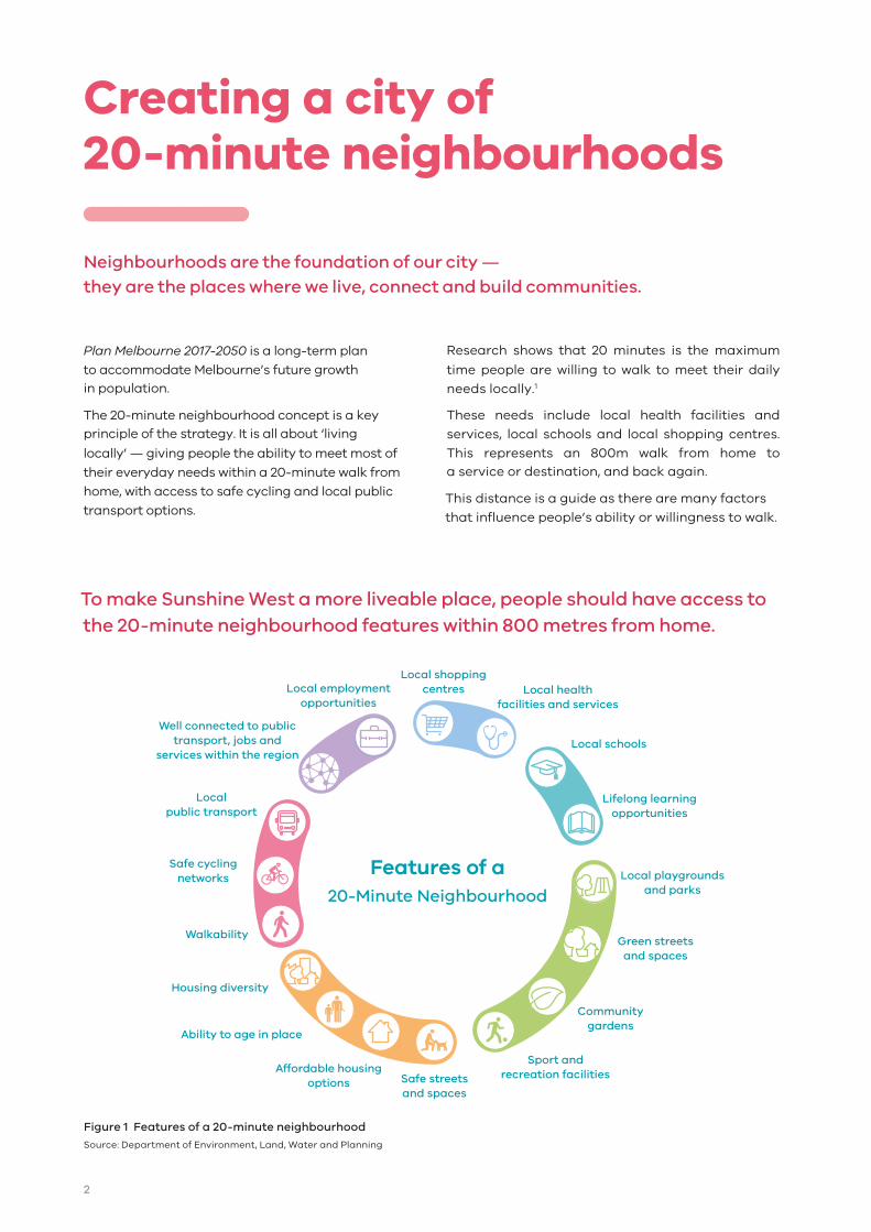
To make Sunshine West a more liveable place, people should have access to the 20-minute neighbourhood features within 800 metres from home.
Local healthfacilities and services
Local shoppingcentres
Well connected to public transport, jobs and
services within the regionLocal schools
Lifelong learningopportunities
Safe streetsand spaces
Local playgroundsand parks
Ability to age in place
Housing diversity
Walkability
Localpublic transport
Safe cyclingnetworks
Affordable housingoptions
Green streetsand spaces
Communitygardens
Sport andrecreation facilities
Local employmentopportunities
Features of a20-Minute Neighbourhood
Figure 1 Features of a 20-minute neighbourhood
Source: Department of Environment, Land, Water and Planning
2
20‑Minute NeighbourhoodPilot Program
The Victorian Government is working in partnership
with local government to test the implementation of 20-Minute Neighbourhoods in three Neighbourhood
Activity Centres in Melbourne.
This report outlines the approach taken in the
Sunshine West project, delivered in partnership with
Brimbank City Council, Victoria Walks and the Heart
Foundation (Victoria).
The purpose of the project was to identify opportunities to improve liveability and start the
process of creating a 20-minute neighbourhood in
Sunshine West.
The pilot program and this report are important in
developing local solutions to address global and
metropolitan sustainable development challenges.
20‑minute neighbourhood‘hallmarks’
Plan Melbourne outlines the ‘hallmarks’ of a 20-
minute neighbourhood.
The purpose of the Sunshine West project was to
identify opportunities to deliver on the hallmarks.
To deliver on the hallmarks, Sunshine West must:
• be safe, accessible and well connected
for pedestrians and cyclists to optimise
active transport
• offer high-quality public realm and open space
• provide services and destinations that support
local living
• facilitate access to quality public transport that
connects people to jobs and higher-order services
• deliver housing/population at densities that make
local services and transport viable
• facilitate thriving local economies.
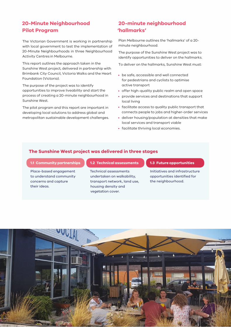
The Sunshine West project was delivered in three stages
1.1 Community partnerships
Place-based engagement
to understand community
concerns and capture their ideas.
1.2 Technical assessments
Technical assessments
undertaken on walkability,
transport network, land use,
housing density and vegetation cover.
1.3 Future opportunities
Initiatives and infrastructure
opportunities identified for the neighbourhood.
3
Sunshine West
Neighbourhood context
Sunshine West is located approximately 13km from Melbourne CBD and 2km from Sunshine in
Brimbank City Council. Serviced by bus route 420
(Sunshine-Watergardens), the neighbourhood is
characterised by low-density housing with
entrenched car-dependency. 66,000 cars passing
through Glengala Road daily.
Sunshine Metropolitan Activity Centre is outlined as
a place of state significance in Plan Melbourne. It
has been a focus for growth and investment. There
has been limited development in Sunshine West,
particularly in Glengala Village (the commercial centre and community anchor in Sunshine West).
While Glengala Village has a mix of businesses,
including a chemist, casual dining and fresh food
grocer, many residents drive to the Sunshine to meet their daily needs.
Sunshine West is a multicultural neighbourhood that has the capacity to provide the services and
destinations to support the community to shop
and live locally.
Glengala VillageImage Courtesy of Brimbank City Council
Melbourne CBD 13km
Sunshine West Brimbank City Council
N
4
The 20-minute neighbourhood concept is all about ‘living locally’
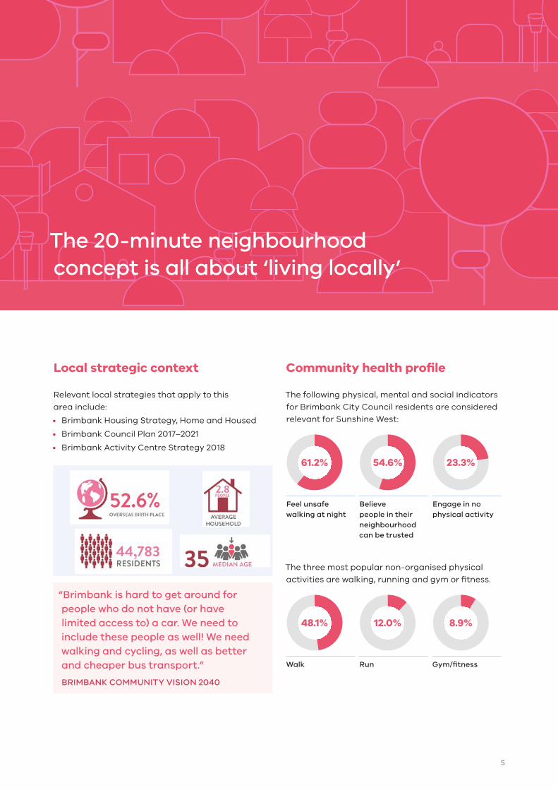
Local strategic context
Relevant local strategies that apply to this
area include:
• Brimbank Housing Strategy, Home and Housed
• Brimbank Council Plan 2017–2021
• Brimbank Activity Centre Strategy 2018
“Brimbank is hard to get around for people who do not have (or have limited access to) a car. We need to include these people as well! We need walking and cycling, as well as better and cheaper bus transport.”
BRIMBANK COMMUNITY VISION 2040
Community health profile
The following physical, mental and social indicators
for Brimbank City Council residents are considered
relevant for Sunshine West:
61.2% 54.6% 23.3%
Feel unsafe walking at night
Believe people in their neighbourhood can be trusted
Engage in no physical activity
The three most popular non-organised physical
activities are walking, running and gym or fitness.
48.1% 12.0% 8.9%
Walk Run Gym/fitness
5
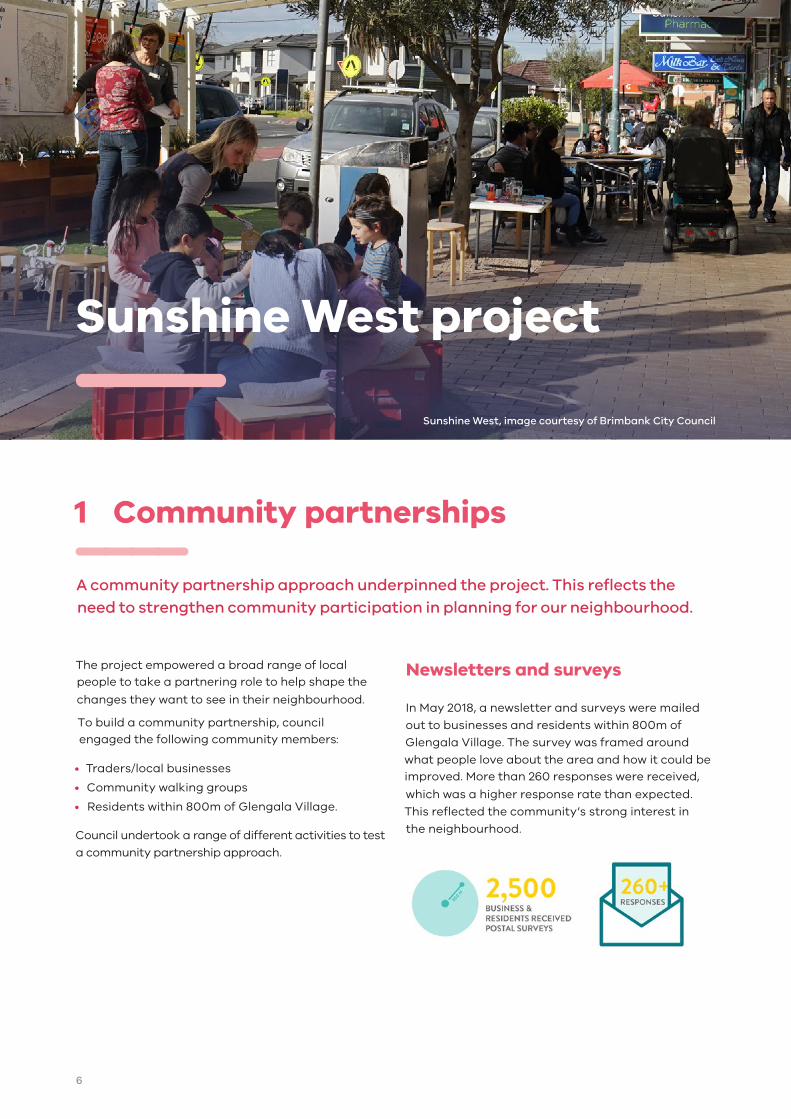
Sunshine West project
1 Community partnerships
A community partnership approach underpinned the project. This reflects the need to strengthen community participation in planning for our neighbourhood.
The project empowered a broad range of local people to take a partnering role to help shape the
changes they want to see in their neighbourhood.
To build a community partnership, council engaged the following community members:
• Traders/local businesses
• Community walking groups
• Residents within 800m of Glengala Village.
Council undertook a range of different activities to test
a community partnership approach.
Newsletters and surveys
In May 2018, a newsletter and surveys were mailed
out to businesses and residents within 800m of
Glengala Village. The survey was framed around
what people love about the area and how it could be improved. More than 260 responses were received,
which was a higher response rate than expected.
This reflected the community’s strong interest in
the neighbourhood.
Sunshine West, image courtesy of Brimbank City Council
6

Destination Yellow Business Strategy
A local business strategy was developed to
increase visitation and help establish an informal
traders group.
To support the strategy, Brimbank City Council
engaged local shop owners to better understand the
challenges and opportunities for Glengala Village.
A local business strategy was developed to support
a thriving local economy in Glengala Village. This
strategy involved infrastructure and streetscape
improvements as well as business development
focusing on:
• Customer service
• Marketing — social media/online
• Visual merchandising
• Business planning/fundamentals
• Mentoring
• Supporting business listings on Google
In addition to business needs, a number of other
immediate local issues were identified including
the need to:
• Clarify the name of Glengala Village — ensuring
brand consistency across all platforms including
Council, businesses, signage and online channels
• Develop an informal traders group — facilitated
and supported by Council
• Develop an online presence
• Investigate opportunities to transition to EFTPOS
card purchases (not just cash).
Feedback from the community throughout the
project highlighted a sense of community pride in
the village.
Meet local traders Guess Who Campaign
To support the retail community, Brimbank City
Council delivered a Guess Who Campaign.
The campaign showed the friendly faces of
Glengala Village and encouraged local residents
to meet their local traders. The campaign broke
down barriers and encourage interaction and
connection between traders and the community.
The campaign was fun, flexible and was rolled
out across a number of promotional platforms. It
was intended to encourage locals to shop,
connect with traders and promote Glengala
Village as a destination.
Your local fruit shop Your local social BBQ Your local hardware Your local cafe
Your local drycleaner Your local butcher Your local post office Your local hairdresser
7
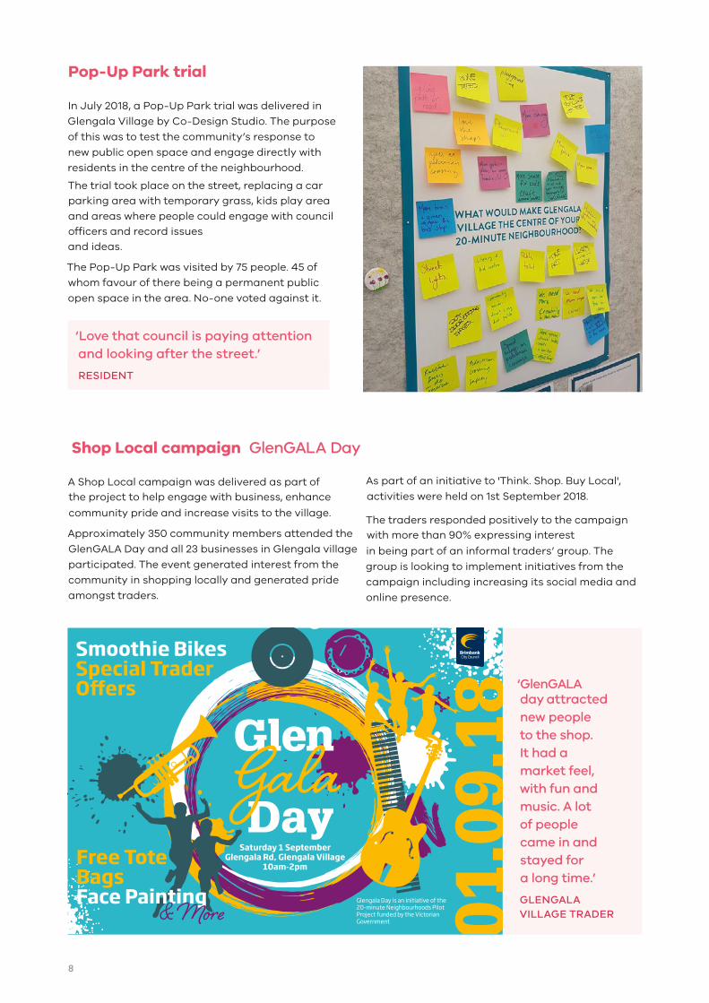
‘GlenGALA day attracted new people to the shop. It had a market feel, with fun and music. A lot of people came in and stayed for a long time.’
GLENGALA VILLAGE TRADER
Shop Local campaign GlenGALA Day
A Shop Local campaign was delivered as part of the project to help engage with business, enhance
community pride and increase visits to the village.
Approximately 350 community members attended the
GlenGALA Day and all 23 businesses in Glengala village
participated. The event generated interest from the
community in shopping locally and generated pride
amongst traders.
As part of an initiative to 'Think. Shop. Buy Local',
activities were held on 1st September 2018.
The traders responded positively to the campaign with more than 90% expressing interest
in being part of an informal traders’ group. The
group is looking to implement initiatives from the
campaign including increasing its social media and
online presence.
Pop‑Up Park trial
In July 2018, a Pop-Up Park trial was delivered in
Glengala Village by Co-Design Studio. The purpose
of this was to test the community’s response to
new public open space and engage directly with
residents in the centre of the neighbourhood.
The trial took place on the street, replacing a car parking area with temporary grass, kids play area
and areas where people could engage with council officers and record issues and ideas.
The Pop-Up Park was visited by 75 people. 45 of
whom favour of there being a permanent public
open space in the area. No-one voted against it.
‘Love that council is paying attention and looking after the street.’
RESIDENT
Saturday 1 SeptemberGlengala Rd, Glengala Village
10am-2pm
Glengala Day is an initiative of the 20-minute Neighbourhoods Pilot Project funded by the Victorian Government
Smoothie BikesSpecial Trader O�ers
8

Movement and Activity Glengala Village
Key movement and activity patterns were identified in Glengala Village at direct community engagement
events. The findings were tested during independent site audits by Co-Design Studio.
Key issues and improvements raised by the community
Public open spaceDeliver upgrades to local infrastructure including:
Playgrounds
Community gardens
Dog-friendly parks
Public toilets
Pedestrian safetyImprove safety by:
Installing traffic-control measures
Creating safe crossings near schools and intersections
StreetscapeStreetscape upgrades to create a ‘destination’ feeling, including:
Upgrading lighting
Installing public art
Street greening
More seats
More bins and rubbish collections
Local transportSupport local transport options by:
Upgrading bus services and stops
Installing on-street bike lanes
Designing accessible footpaths for prams and wheelchairs
Businesses Support a thriving local economy by:
Supporting a diversity of stores such as a bakery and cafe
Encouraging street trading racks that create an attractive aesthetic
Key pedestrian corridor during school peak hours
Visitors cross the road freely and do not use safe formal crossings
Bus stop is not safe, accessible or user-friendly
Speed of traffic along Glengala Road creates a safety hazard
Traffic travels in both directions along a one-way street
Sunshine Social is a key destination in Glengala Village
Car parking has a high rotation, however, visitors typically visit only one store
9
2 Technical assessments
To support a whole-of-government evidence-based approach to the Sunshine
West project, DELWP facilitated the preparation of technical assessments.
This included transport, housing, health and vegetation assessments.
Healthy Active by Design
The Heart Foundation was a project partner, they
work to improve heart disease prevention and care.
A key way to achieve this is through improved
physical activity by promoting walking, cycling and
other forms of physical activity.
Work undertaken by the Heart Foundation aligns
closely with 20-minute neighbourhoods, in particular
the Healthy Active by Design guidelines, which were
developed as practical guide to create healthy
neighbourhoods.
These guidelines were used to inform the delivery of the project and were adapted into a 20-Minute
Neighbourhood Scorecard, which was used to identify opportunities in Stage 3 Future
opportunities. This simplified scorecard will be
adapted into a useful tool for other councils.
For more information on the healthy active by
design guidelines visit here
Walkability assessment
Victoria Walks was a project partner that is an independent health organisation. Victoria Walks advocates for safe, accessible and connected environments that encourages walking.
In June 2018, Victoria Walks conducted a
neighbourhood walking assessment of Sunshine
West to identify pedestrian infrastructure
issues. The assessment provided preliminary
recommendations for Sunshine West including to:
• Create a safe, high-quality pedestrian route onGlengala Road between Links Road and MerndaStreet.
• Improve the streetscape around Glengala Village.• Improve pedestrian infrastructure to support safe
active travel to school and reduce congestion.
• Redesign intersections to reduce walking barrierson major roads including roundabouts.
To see the full walkability assessment visit here
Movement and Place assessment
Movement and Place is a new Department of
Transport road-management framework for Victoria.
It recognises the role streets play not only in moving
people and goods, but also in contributing to the
places where people live, work and play. It integrates
planning and transport and it will be used as a
framework to support transport decision-making.
An assessment was undertaken for Sunshine West,
which was one of the first times the new framework
was tested at a local level. Based on this assessment
the following design objectives were identified for
Sunshine West:
• Improve road safety around Glengala Village.
• Improve cycling infrastructure on Forrest Road.
• Support pedestrian and local cycling access
to Glengala Village in Sunshine West.
• Improve place amenity and comfort in
Glengala Village.
Place
Movement
P1
M1
M2
M3
M4
M5
P2 P3 P4 P5
City hubs
City places
City streets
Local streets
Connectors
Activity streets and boulevards
For information on the methodology, visit here
10
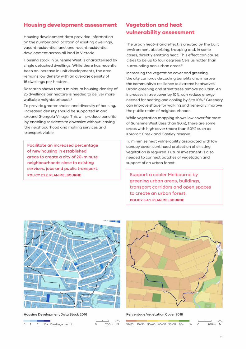
Housing development assessment
Housing development data provided information
on the number and location of existing dwellings,
vacant residential land, and recent residential
development across all land in Victoria.
Housing stock in Sunshine West is characterised by
single detached dwellings. While there has recently
been an increase in unit developments, the area
remains low density with an average density of
16 dwellings per hectare.
Research shows that a minimum housing density of
25 dwellings per hectare is needed to deliver more
walkable neighbourhoods.2
To provide greater choice and diversity of housing,
increased density should be supported in and
around Glengala Village. This will produce benefits
by enabling residents to downsize without leaving
the neighbourhood and making services and
transport viable.
Facilitate an increased percentage of new housing in established areas to create a city of 20-minute neighbourhoods close to existing services, jobs and public transport.
POLICY 2.1.2. PLAN MELBOURNE
Vegetation and heat vulnerability assessment
The urban heat-island effect is created by the built
environment absorbing, trapping and, in some
cases, directly emitting heat. This effect can cause cities to be up to four degrees Celsius hotter than
surrounding non-urban areas.3
Increasing the vegetation cover and greening
the city can provide cooling benefits and improve
the community’s resilience to extreme heatwaves. Urban greening and street trees remove pollution. An
increases in tree cover by 10%, can reduce energy
needed for heating and cooling by 5 to 10%.4 Greenery
can improve shade for walking and generally improve
the public realm of neighbourhoods.
While vegetation mapping shows low cover for most
of Sunshine West (less than 30%), there are some
areas with high cover (more than 50%) such as
Kororoit Creek and Castley reserve.
To minimise heat vulnerability associated with low
canopy cover, continued protection of existing
vegetation is required. Future investment is also
needed to connect patches of vegetation and
support of an urban forest.
Support a cooler Melbourne by greening urban areas, buildings, transport corridors and open spaces to create an urban forest.POLICY 6.4.1. PLAN MELBOURNE
Percentage Vegetation Cover 2018Housing Development Data Stock 2016
0 1 2 10+ Dwellings per lot 0 200m 0 200m10–20 20–30 30–40 40–60 50-60 60+ %
11
20-Minute (800m) walkto Activity Centre
Activity Centre
Public open space
Bike/walking track
Road
Waterway
Key
Scale
0m 400m
Glengala Road
Glengala Road
Oldfield Street
CastleyReserve
Krambruk StreetReserve
Kororoit Creek
Kororoit Creek
Wright Street
Glengala VillageNeighbourhoodActivity Centre
Sunshine Secondary College West Campus
SunshineHeightsPrimarySchool
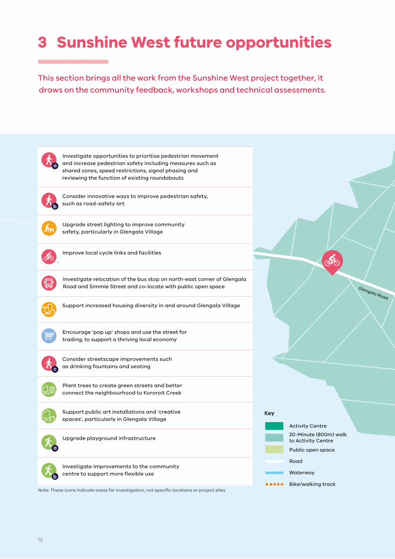
3 Sunshine West future opportunities
This section brings all the work from the Sunshine West project together, it
draws on the community feedback, workshops and technical assessments.
Investigate opportunities to prioritise pedestrian movement and increase pedestrian safety including measures such as shared zones, speed restrictions, signal phasing and reviewing the function of existing roundabouts
Consider innovative ways to improve pedestrian safety, such as road-safety art
Upgrade street lighting to improve community safety, particularly in Glengala Village
Improve local cycle links and facilities
Investigate relocation of the bus stop on north-east corner of Glengala Road and Simmie Street and co-locate with public open space
Support increased housing diversity in and around Glengala Village
Encourage ‘pop up’ shops and use the street for trading, to support a thriving local economy
Consider streetscape improvements such as drinking fountains and seating
Plant trees to create green streets and better connect the neighbourhood to Kororoit Creek
Support public art installations and ‘creative spaces’, particularly in Glengala Village
Upgrade playground infrastructure
Investigate improvements to the community centre to support more flexible use
Note: These icons indicate areas for investigation, not specific locations or project sites
12

20-Minute (800m) walkto Activity Centre
Activity Centre
Public open space
Bike/walking track
Road
Waterway
Key
Scale
0m 400m
Glengala Road
Glengala Road
Oldfield Street
CastleyReserve
Krambruk StreetReserve
Kororoit Creek
Kororoit Creek
Wright Street
Glengala VillageNeighbourhoodActivity Centre
Sunshine Secondary College West Campus
SunshineHeightsPrimarySchool
The 20-minute neighbourhood features (see figure 1)
have been used as the basis for a range of
opportunities to improve liveability and support
people to live locally in Sunshine West.
The following opportunities reflect community ideas
that will be a starting point in a local approach to
delivering a 20-minute neighbourhood in Sunshine
West. These opportunities reflect community
feedback and technical assessments. They are
not formal funding commitments.
13

References
1 Badland H, Whitzman C, Lowe M, Davern M, Aye L, Butterworth I, Hes, D and Giles-Corti B 2014, Urban liveability: Emerging lessons from Australia for exploring the potential for indicators to measure the social determinants of health, Social Science and Medicine, 111: 64–73.
2 Badland H, Whitzman C, Lowe M, Davern M, Aye L, Butterworth I, Hes, D and Giles-Corti B 2014, Urban liveability: Emerging lessons from Australia for exploring the potential for indicators to measure the social determinants of health, Social Science and Medicine, 111: 64–73.
3 Voogt, JA 2002, ‘Urban heat island’, in I Douglas (ed.), Encyclopedia of global environmental change, John Wiley and Sons, New York.
4 Ewing, R et al. 2008, Growing cooler: The evidence on urban development and climate change. Washington, DC: Urban Land Institute.
Creating a 20-minute neighbourhood in Sunshine West aligns with the following
United Nations Sustainable Development Goals
14
Accessibility
If you would like to receive this publication in an alternative format, please telephone the DELWP Customer Service Centre on 136 186, or email [email protected], or via the National Relay Service on 133 677, www.relayservice.com.au. This document is also available on the internet at www.delwp.vic.gov.au
ISBN 978-1-76077-697-8 (Print) ISBN 978-1-76077-698-5 (pdf/online/MS word)
© The State of Victoria Department of Environment, Land, Water and Planning 2019
This work is licensed under a Creative Commons Attribution 4.0 International licence. You are free to re-use the work under that licence, on the condition that you credit the
State of Victoria as author. The licence does not apply to any images, photographs or branding, including the Victorian Coat of Arms, the Victorian Government logo and the Department of Environment, Land, Water and Planning (DELWP) logo. To view a copy of this licence, visit creativecommons.org/licenses/by/4.0/
DisclaimerThis publication may be of assistance to you but the State of Victoria and its employees do not guarantee that the publication is without flaw of any kind or is wholly appropriate for your particular purposes and therefore disclaims all liability for any error, loss or other consequence which may arise from you relying on any information in this publication.

InclusiveVibrant Healthy