summit county planning commission (scpc) thursday june …
TRANSCRIPT

Summit County Planning Commission (SCPC)
Thursday June 24, 2021 - 3:00 p.m.
County of Summit, County Council Chambers
175 South Main Street, 7th Floor, Akron, Ohio
By Zoom Meeting
Meeting Agenda
A. Call to Order Chair Mavrides
B. Roll Call Tubbs
C. Approval of the May 27, 2021 SCPC Minutes Chair Mavrides
D. Business Items Knittel
Old Business
Item # 1 - Mill Run Phase III Preliminary Plan – Springfield Township – Proposing 33 lots as a continuation of the Mill Run Estates subdivision started in the early 2000s.
New Business
1. Item # 1 - Estates of Bath phase II Final Plat - Located in Bath Township at the terminus of Fox Hollow Ln. of West Bath Estates. Proposing three sublots 33, 34 and 35.
2. Item # 2 - Text Amendment Northfield Center – Food Truck Text – Proposing amendments to Chapter 130
“Definitions” and Chapter 310 “Residential District Regulations” to add definitions and regulations for Mobile Food Vehicles.
E. Report from Assistant Director Tubbs
F. Comments from Public Chair Mavrides
G. Comments from Commission Members Chair Mavrides
H. Other
1. Legal Update Matz
I. Adjournment Chair Mavrides

1
County of Summit Ilene Shapiro, County Executive
Summit County Planning Commission Thursday, May 27, 2021- 3:00 p.m.
County of Summit, County Council Chambers 175 South Main Street, 7th Floor, Akron, Ohio
By Zoom Meeting Minutes of May Meeting
Members Present: Jerry Feeman, Helen Humphrys, Allen Mavrides, Jason Segedy, Jeff Snell, Dennis Stoiber, Liz Walters Members Absent: George Beckham, Becky Corbett, Robert Terry Staff: Dennis Tubbs, Stephen Knittel, Deb Matz, Diane Miller Dawson Others: Joe Paradise – SCE, Bill Funk– Bath Twp, Pat Ryan – Springfield / Richfield Twps Item #4 & #5, Kevin Hoffman – Engineer for Item #1, Bradey Hickenbothom – Engineer for Item #2, Todd Fulton – KNL custom homes Item #3. I. Call to Order
Allen Mavrides called the meeting to order on Thursday, May 27, 2021 at 3:00 pm in the County of Summit Council Chambers, 175 South Main Street, 7th Floor, Akron Ohio 44308. A roll call was conducted by Dennis Tubbs the attending members constituted a quorum.
II. Approval of April 29, 2021, Meeting Minutes
SCPC Member Present Motion Second Yea Nay Abstain Beckham, George Corbett, Becky Feeman, Jerry X X Humphrys, Helen X X X Kline, David X X X Mavrides, Allen X X Segedy, Jason X X Snell, Jeff X X Stoiber, Dennis X X Terry, Robert Walters, Liz X X
Motion David Kline made a motion to approve the minutes of the April 29, 2021 meeting, and it was seconded by Helen Humphrys the motion passed with no abstentions.

2
IV. Business Items
A. New Business – (1) item
New Business Item # 1 Columbia Rd & Allega Way Final Plat – Richfield Township – Proposed roadways. The applicant proposes to add approximately 1755 LF of roadway, no longer ending in a Cul-de-sac but instead having Columbia Rd terminate at a proposed intersection with proposed Allega Way which would head west to connect to SR 21, Brecksville Rd.
Staff Recommendation: Staff recommends to the Summit County Planning Commission that the proposed preliminary plan be APPROVED. SCPC Action: Approval: Conditional Approval. Disapproval: Action:
SCPC Member Present Motion Second Yea Nay Abstain Beckham, George Corbett, Becky Feeman, Jerry X X Humphrys, Helen X X Kline, David X X X Mavrides, Allen X X Segedy, Jason X X Snell, Jeff X X Stoiber, Dennis X X X Terry, Robert Walters, Liz X X
Comments Pat Ryan – Asked about the lot splits and consolidations around Allega way, and any outstanding fees or application. Dennis Tubbs – Stated the plat has been recorded. Kevin Hoffman - spoke about the configuration of the lots along Allega Way and the BestBuys entrance. Joe Paradise – Spoke about the 6 to 7 comments from the County engineer. Pat Ryan – Stated the township is in favor of this project. No public comments.

3
Motion Item # 1 – Columbia Rd & Allega Way preliminary Plan – Richfield Township a motion was made by David Kline to approve this item, it was seconded by Dennis Stoiber the motion passed with no abstentions. Item # 2 - Meadow of Wintergreen Final Plat – Springfield Township – Proposed Final Plat for Meadows of Wintergreen Phase III, 26 lots, on 9.7544 Acres Staff Recommendation: Staff recommends to the Summit County Planning Commission that the proposed Final Plat be APPROVED. SCPC Action: Approval: Conditional Approval Disapproval: Action:
SCPC Member Present Motion Second Yea Nay Abstain Beckham, George Corbett, Becky Feeman, Jerry X X Humphrys, Helen X X Kline, David X X Mavrides, Allen X X Segedy, Jason X X X Snell, Jeff X X Stoiber, Dennis X X X Terry, Robert Walters, Liz X X
Comments Bradey Hickenbothom – Had no comment. Pat Ryan – Spoke about the township comments. Joe Paradise – Stated the submitted plan is acceptable with no further comment. No Public Comment. Motion Item # 2 - Meadow of Wintergreen Final Plat – Springfield Township a motion was made by Dennis Stoiber to approve this item, it was seconded by Jason Segedy the motion passed with no abstentions.

4
Item # 3 - Mill Run Phase III Preliminary Plan – Springfield Township – Proposing 33 lots as a continuation of the Mill Run Estates subdivision started in the early 2000s. Staff Recommendation: Staff recommends to the Summit County Planning Commission that the proposed preliminary plan be DISAPPROVED. SCPC Action: Approval: Disapproval: Action: Tabled by the applicant
SCPC Member Present Motion Second Yea Nay Abstain Beckham, George Corbett, Becky X X Feeman, Jerry X X Humphrys, Helen X X Kline, David X X X Mavrides, Allen X X Segedy, Jason X X Snell, Jeff X X Stoiber, Dennis X X X Terry, Robert Wilhite, Jeff X X
Comments Todd Fulton – Spoke about the project. Stephen Knittel – Spoke about the submitted documents in the meeting packet. Helen Humphrys – Questioned why the item was submitted to SCPC based on the comments. Stephen Knittel – Spoke about the submittal. Dennis Stoiber – Agreed with the comments from Helen Humphrys. Dennis Tubbs – Spoke about the option the applicant has to table this item. Jeff Snell – explained the tabling options. Todd Fulton – Stated he would like to table this item. Pat Ryan – Spoke about the comments from the township. Joe Paradise – Spoke about the documents submitted for the engineering review. No Public comment. Motion Mill Run Phase III Preliminary Plan – Springfield Township –a motion was made by David Kline to table item #3 at the applicant's request, it was seconded by Dennis Stoiber the motion passed with no abstentions.

5
Item # 4 - Definitions, Text Amendment – Richfield Township – Proposed amendments to Appendix C Definitions of the Richfield Township Zoning Code, adding a definition for Activity, Penalties, Prohibitions against violations, No viewable Activity. Staff Recommendation: Staff recommends to the Summit County Planning Commission that the proposed text amendment be APPROVED. SCPC Action: Approval: Approval Disapproval: Action:
SCPC Member Present Motion Second Yea Nay Abstain Beckham, George Corbett, Becky Feeman, Jerry X X Humphrys, Helen X X X Kline, David X X Mavrides, Allen X X Segedy, Jason X X Snell, Jeff X X Stoiber, Dennis X X X Terry, Robert Wilhite, Jeff X X
Comments Pat Ryan – Stated she has no comment. Joe Paradise – Spoke about the enforcement of the item. Motion Item # 4 Definitions, Text Amendment – Richfield Township –a motion was made by Dennis Stoiber to approve this item, it was seconded by Helen Humphrys the motion passed with no abstentions.

6
Item # 5 - Solar Panels, Text Amendment – Bath Township – Proposed Amendment to Bath Township Zoning Code for Section 701 and 1204, to amend text about setbacks of Solar Panels, and to increase minimum driveway or parking surface setback. Staff Recommendation: Staff recommends to the Summit County Planning Commission that the proposed text amendment be APPROVED. SCPC Action: Approval: Approval Disapproval: Action:
SCPC Member Present Motion Second Yea Nay Abstain Beckham, George Corbett, Becky Feeman, Jerry X X Humphrys, Helen X X X Kline, David X X X Mavrides, Allen X X Segedy, Jason X X Snell, Jeff X X Stoiber, Dennis X X Terry, Robert Wilhite, Jeff X X
Comments Bill Funk – Spoke about the two proposed changes. Dennis Stoiber – Asked if there was any grandfathering in this amendment. Helen Humphrys – Asked if the number of panels is limited. Bill Funk – Stated the limitation on panels is determined by square footage. Dennis Stoiber – Spoke about the square footage limitation. Bill Funk – Stated a change in the proposal needs to be made for clarification of the limitations. Jason Segedy – Asked about the limitations on panels attached to a structure. Bill Funk – Stated there is a section to address roof-mounted panels. Jeff Snell – Spoke about the language to clarify panel square footage and spoke about driveway setback. Joe Paradise – Had no comment No Public Comment. Motion Item # 5 - Solar Panels, Text Amendment – Bath Township – Proposed Amendment to Bath Township Zoning Code for Section 701 and 1204, to amend text about setbacks of Solar Panels, and to increase minimum driveway or parking surface setback a motion was made by Helen Humphrys to approve this item, it was seconded by David Kline the motion passed with no abstentions.

7
V. Report from Assistant Director VI. Comments from Public No public comments VII. Comments from Planning Commission Members VIII. Other IX. Next Meeting
The next Summit County Planning Commission meeting will be held on Thursday, June 24, 2021.
X. Adjournment
Being no further business to come before the Planning Commission, Dennis Stoiber made a motion to adjourn, and it was seconded by Liz Walters. The motion passed unanimously. The meeting adjourned at 3:43 pm.
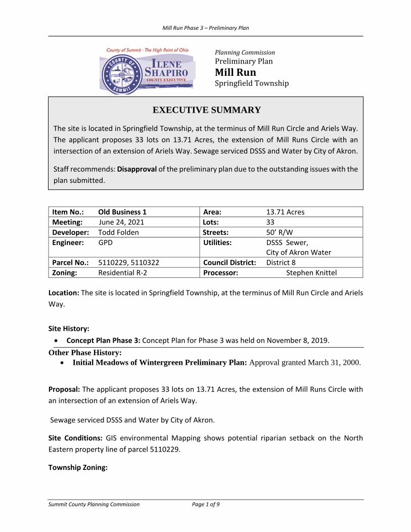
Mill Run Phase 3 – Preliminary Plan
Summit County Planning Commission Page 1 of 9
Planning Commission Preliminary Plan Mill Run Springfield Township
Item No.: Old Business 1 Area: 13.71 Acres Meeting: June 24, 2021 Lots: 33 Developer: Todd Folden Streets: 50’ R/W Engineer: GPD Utilities: DSSS Sewer,
City of Akron Water Parcel No.: 5110229, 5110322 Council District: District 8 Zoning: Residential R-2 Processor: Stephen Knittel
Location: The site is located in Springfield Township, at the terminus of Mill Run Circle and Ariels Way. Site History: • Concept Plan Phase 3: Concept Plan for Phase 3 was held on November 8, 2019.
Other Phase History: • Initial Meadows of Wintergreen Preliminary Plan: Approval granted March 31, 2000.
Proposal: The applicant proposes 33 lots on 13.71 Acres, the extension of Mill Runs Circle with an intersection of an extension of Ariels Way.
Sewage serviced DSSS and Water by City of Akron.
Site Conditions: GIS environmental Mapping shows potential riparian setback on the North Eastern property line of parcel 5110229.
Township Zoning:
EXECUTIVE SUMMARY
The site is located in Springfield Township, at the terminus of Mill Run Circle and Ariels Way. The applicant proposes 33 lots on 13.71 Acres, the extension of Mill Runs Circle with an intersection of an extension of Ariels Way. Sewage serviced DSSS and Water by City of Akron.
Staff recommends: Disapproval of the preliminary plan due to the outstanding issues with the plan submitted.
Mill Run Phase 3 – Preliminary Plan
Summit County Planning Commission Page 2 of 9
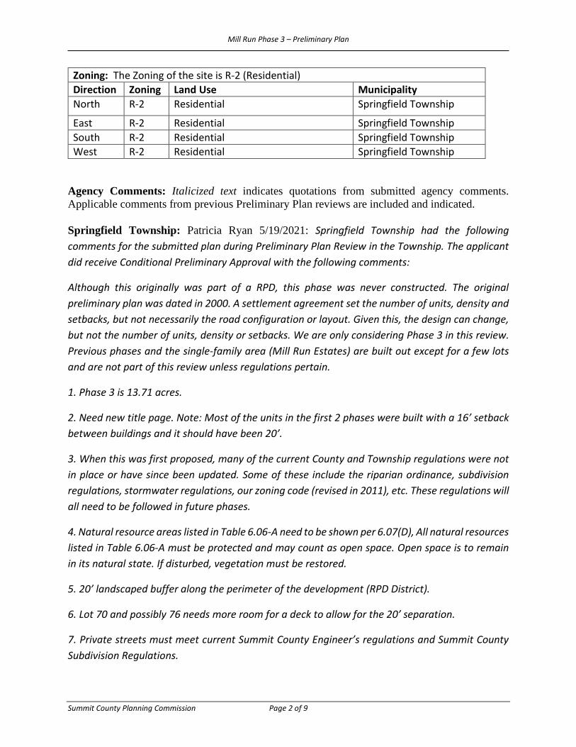
Zoning: The Zoning of the site is R-2 (Residential) Direction Zoning Land Use Municipality North R-2 Residential Springfield Township
East R-2 Residential Springfield Township South R-2 Residential Springfield Township West R-2 Residential Springfield Township
Agency Comments: Italicized text indicates quotations from submitted agency comments. Applicable comments from previous Preliminary Plan reviews are included and indicated. Springfield Township: Patricia Ryan 5/19/2021: Springfield Township had the following comments for the submitted plan during Preliminary Plan Review in the Township. The applicant did receive Conditional Preliminary Approval with the following comments:
Although this originally was part of a RPD, this phase was never constructed. The original preliminary plan was dated in 2000. A settlement agreement set the number of units, density and setbacks, but not necessarily the road configuration or layout. Given this, the design can change, but not the number of units, density or setbacks. We are only considering Phase 3 in this review. Previous phases and the single-family area (Mill Run Estates) are built out except for a few lots and are not part of this review unless regulations pertain.
1. Phase 3 is 13.71 acres.
2. Need new title page. Note: Most of the units in the first 2 phases were built with a 16’ setback between buildings and it should have been 20’.
3. When this was first proposed, many of the current County and Township regulations were not in place or have since been updated. Some of these include the riparian ordinance, subdivision regulations, stormwater regulations, our zoning code (revised in 2011), etc. These regulations will all need to be followed in future phases.
4. Natural resource areas listed in Table 6.06-A need to be shown per 6.07(D), All natural resources listed in Table 6.06-A must be protected and may count as open space. Open space is to remain in its natural state. If disturbed, vegetation must be restored.
5. 20’ landscaped buffer along the perimeter of the development (RPD District).
6. Lot 70 and possibly 76 needs more room for a deck to allow for the 20’ separation.
7. Private streets must meet current Summit County Engineer’s regulations and Summit County Subdivision Regulations.

Mill Run Phase 3 – Preliminary Plan
Summit County Planning Commission Page 3 of 9
8. This development was well underway when I came on board. The builder did not install sidewalks continuously through the previous phases and this needs to be completed and installed in Phase 3. Trails as shown on the original plans and in these plans. We were informed by the developer recently that the trails and sidewalks were abandoned by the HOA and that documentation exists showing this but it has not yet been provided. In any case our RPD, which was updated in 2011, states there must be pedestrian circulation throughout the development.
9. Existing roads should be inspected by an independent party to determine current condition and when construction is completed. The developer should be held responsible to repair any damage to the existing private roads.
10. All roads (new and existing) must be kept clean and dirt-free during construction.
11. Portable toilets must be installed and maintained within the new construction area. Inlet protection must be installed and maintained.
12. We need a copy of the HOA documents prior to approval.
This is a preliminary informal review only, the concept is acceptable, but the developer needs to return with complete current drawings for Phase 3 only.
Summit County Engineer’s Office: Andy Dunchuck, 06/18/2021: Our office has reviewed the attached plans (it appears they’re identical to the plans submitted for the May 27, 2021 SCPC meeting, therefore, our comments have not changed) for the June 24, 2021 SCPC meeting and has the following comments listed below. If you have any questions regarding this matter, please contact our office. Review Comments 1. To comply with Summit County Ordinance 943, our office requires a check in the amount of $1,563.90 for the application and review fees for this site. The non-refundable application fee is $250 and ½ the estimated review fee is $1,313.90. The check should be made payable to: Summit County Engineer, 538 East South Street, Akron, Ohio 44311. To date, payment from the owner has not been received. 2. Subdivision Regulation 1108.07 (f) requires each intersecting street have a minimum tangent distance of 100’. The plan indicates Ariels Way has a tangent distance of 61.77’. 3. The proposed cul-de-sacs (without an island) must have a minimum pavement and R/W radius of 45’ and 60’, respectively. 4. The SCE Traffic Impact Questionnaire must be completed to determine if any additional studies or improvements are warranted. 5. All Stormwater Management for the site must be in compliance with the SCE Stormwater Drainage Manual, Current Edition (Revised 1/1/20). 6. A 100-Year Overland Flow Path across the site to the SWM Basin is required. 7. Has a Wetland Delineation been required or performed? If so, please provide our office with a copy.

Mill Run Phase 3 – Preliminary Plan
Summit County Planning Commission Page 4 of 9
8. A 2.5’ wide ODOT Curb and Gutter section and ODOT No. 3 and 3A Catch Basins is required in the design of the proposed roadway. Summit SWCD: Julie Berbari, 5/19/2021: The Summit Soil and Water Conservation District reviewed the preliminary plan submitted for Mill Run located in Springfield Township with the following comments: Soils: The Summit County Soil Survey identifies several types of soils found on site: Chili Loam (CnB), Chili Gravelly Loam (CoD2), Wooster Silt Loam (WuC2) & Holly Silt Loam (Hy) with slopes ranging from 2-18%. The Holly Silt Loam is identified as a hydric soil which indicates possible wetlands. Wetlands: Wetlands are indicated on site. A wetland delineation will be required. The delineation must be submitted to the Army Corps of Engineers for a Jurisdictional Determination and to the OEPA for any 401 permits that may be required. Riparian Setback: This site must meet the requirements of the Summit County Riparian Setback Ordinance Chapter 937. Note that slope, wetlands, and flood plain can/will increase the setback and must be considered early in the design. Storm Water Pollution Prevention Plan and Post Construction Requirements: A Storm Water Pollution Prevention Plan (SWPPP) must be submitted for this site. This plan must meet the current requirements of the OEPA Construction General Permit and the Summit County Erosion Sediment Control Post Construction Storm Water Quality Ordinance Chapter 941. All stormwater exiting this site must be treated by a structural post-construction water quality practice and meet the current OEPA Phase II Construction General Permit & County requirements. Reference the Ohio Rainwater & Land Development Manual for design guidance. A Long-Term Maintenance Agreement between the Summit County Engineers Office and Homeowner’s Association will be required for the post construction practices designed for the site. OEPA Construction General Permit: The Owner/Operator of any site where more than one acre will be disturbed or less than one acre if part of a larger common plan of development, must file a Notice of Intent and obtain an NPDES Permit. For a multi-phase construction project, a separate NOI must be obtained when a separate SWP3 is submitted. Storm Water Management: The Summit County Engineer ‘s Office must review and approve storm water management for this site. Staff Comments: The street names on the Geometric Plan and Concept Plan documents submitted for the Preliminary Plan do not match each other nor what has been recorded in the existing phases of the development. The following should be corrected in an updated plan: 1104.04 PRELIMINARY PLAN. The Developer shall furnish the following:
(a) Preliminary Plan Application and Review Fee. (See Appendix B). (b) Vicinity Map. The map shall show the relationship of the proposed Subdivision to
existing community facilities which serve or influence it. The Vicinity Map may be on the same sheet as the Preliminary Plan drawing and shall be drawn at a scale of 1" = 3,000' at the minimum. The Vicinity Map shall show the following:

Mill Run Phase 3 – Preliminary Plan
Summit County Planning Commission Page 5 of 9
(1) Subdivision name, township, tract, and original lot or section number, and north arrow.
(2) Existing and proposed map of traffic arteries. (3) Any other significant community activity or features.
(c) Preliminary Plan Drawings. The Preliminary Plan shall be drawn on mylar or paper (not to exceed a sheet size 24” by 36”) and shall be at a scale of not more than one hundred (100) feet to one (1) inch (1” = 100’). Drawings shall also be submitted in digital format. The preferred digital formats are: (1) ESRI shapefile, (2) AutoCAD DXF. The preferred coordinate system in State Plane NAD 83 Ohio North. The applicant shall also submit an Adobe Acrobat PDF file version of the drawing for distribution purposes. The Preliminary Plan shall be prepared in accordance with these Subdivision Regulations by a registered professional engineer or registered professional surveyor licensed in the State of Ohio. The Plan shall be accurately and clearly drawn, signed, sealed and shall be based on a boundary determined by a registered professional surveyor. The drawing shall include the proposed plan of the Subdivision, and shall show the following (highlighted are sections that need to be updated on the plan however please double check that everything listed, highlighted or not, is included in your plan):
A. (1) Existing Data.
A. Deed description showing bearings and distances and acreage as determined by a registered professional surveyor.
B. Easements - blankets, location, width, and purpose. C. Streets on and adjacent to the improvements and Subdivision,
including but not limited to: names, location, right-of-way and roadway width; planned public improvements; highways; other major improvements planned by public authorities for future construction.
D. Location of proposed underground utilities on or near the subdivision, including journalized routes for highways.
E. Existing utilities on and adjacent to the Subdivision: location and size of sanitary and storm sewers; location and size of water mains; location of gas lines. If water mains, sewers, and/or culverts are not on or adjacent to the tract, indicate the direction and distance to and size of nearest one.
F. Existing ground elevations in the Subdivision: show contours with an interval of two (2) feet.
G. Subsurface conditions in the Subdivision - any conditions that are not typical such as abandoned mines, existing oil and gas wells.
H. Drainage information, including streams, and drainage ways in the proposed Subdivision shall be shown on the Plan. The applicant shall review drainage information, including streams and drainages within 200 feet upstream and downstream of the proposed Subdivision, for development design purposes. (This 200 foot limitation is not indicative of the size of the watershed that will be required to be studied prior to acceptance of the Final Plat.)

Mill Run Phase 3 – Preliminary Plan
Summit County Planning Commission Page 6 of 9
I. Other conditions in the Subdivision or on adjacent land within two hundred (200) feet: i. Ponds, and lakes. ii. Floodplains and areas subject to flooding. The base flood
elevation data and the boundary of the flood hazard area(s) shall be delineated on the Preliminary Plan. If there are no flood hazard areas in the Subdivision pursuant to the FEMA Flood Insurance Rate Map(s) then a statement shall be provided on the Preliminary Plan indicating same.
iii. Rock outcroppings. iv. Wooded area, and other environmentally sensitive areas. v. Any structures or other significant features. vi. Approximate direction and gradient of ground slope
including any embankments or retaining walls. vii. Location and type of building, tree lines, etc. viii. Railroad lines and/or rights-of-way. ix. Power lines, poles and towers. x. Land use and adjacent zoning district boundaries. xi. Owners of adjacent unplatted land (for adjacent platted land
refer to subdivision plat by name, plat book and pages). xii. Oil and/or gas wells, above ground and underground storage
tanks and separator units, and the associated utility and service lines if known.
xiii. Water wells. xiv. Septic Tanks and leach beds. xv. Known construction debris disposal sites. xvi. Existing fire ponds.
J. Soils in the Subdivision shall be identified as described in the Natural Resources Conservation Service Web Soil Survey for Summit County – ……………………………………………….. http://websoilsurvey.sc.egov.usda.gov/App/HomePage.htm Boundaries of the soils in the Subdivision shall be indicated on the Preliminary Plan. Also refer to Section 1105.02(a), Soils.
K. All wetlands will be delineated by a qualified professional under guidelines established by the USACE and the OEPA. (Refer to Section 1105.02(c) for wetlands boundary and delineation procedure)
L. If the proposed Subdivision is within an area of expected low groundwater yields (10 gallons per minute or less) pursuant to the map entitled “Ground Water Resources of Summit County, Ohio GWR 14” (Alfred C. Walker, revised by James Schmidt, Ohio Department of Natural Resources, 1994), the Developer shall submit groundwater availability data to the Planning Commission to ensure that an adequate water supply exists to serve the Subdivision. (Refer to Fact Sheet 94-35 ODNR Division of Soil and Water Resources, “Low Yield Wells: Water Supply Systems”).

Mill Run Phase 3 – Preliminary Plan
Summit County Planning Commission Page 7 of 9
M. If the proposed Subdivision is to be served by an existing public or private water system, the Developer shall obtain a letter stating that the water system has the capacity and will serve the proposed Subdivision.
N. Zoning requirements: (refer to Section 1103.07(c)(2)A.) i. District. ii. Lot size and yard requirements. iii. Proof of any variances or special exceptions which may have
been granted, which have a bearing on the subdivision. (2) Proposals.
A. Streets - show proposed streets (indicate each street by name), right-of-way widths, classification (arterials, collector, or local as designated by the County Engineer), and proposed improvements. The County Engineer may also require profiles of approximate street grades. Proposed road names shall not duplicate existing road names recorded in the County.
B. Other rights-of-way or easements - location, width, and purpose. C. Lots – numbers, dimensions, and the area shall be given for each lot.
Show boundaries of proposed phases of the Subdivision, if applicable.
D. Minimum building setback lines. E. Land parcels within the Subdivision not to be divided into lots shall
be shown as blocks and labeled by consecutive letters and proposed use, and any limitations of use.
F. Common areas reserved or dedicated for open space, parks, playgrounds, water and sewage treatment sites, storm water retention or detention sites, fire ponds or other public uses. For sites reserved for public use or common use of property owners, for parks, playgrounds, or other uses, a description of any proposed covenants, conditions and restrictions must be submitted with the Preliminary Plan. Said description shall be in preliminary draft format and include agreements and provisions for any community association membership and responsibility. Said description shall include a plan for administration, and maintenance of all proposed common property, but it need not include condominium property to be titled to individual owners. The required description shall include a description of the enabling declaration; the declaration of covenants, conditions and restrictions, the articles of incorporation; and the corporate by-laws as these apply to ownership of and maintenance of common open space and common facilities.
G. Sites for other uses - multi-family dwellings, shopping facilities, churches, industry, or other non-public uses exclusive of single- family dwellings.
H. Generalized Landscaping Plan shall include locations for the following proposed generalized landscape features: i. Trees, shrubbery and ground cover groupings.
Mill Run Phase 3 – Preliminary Plan
Summit County Planning Commission Page 8 of 9
ii. Buffers/ mounding. iii. Entry features. iv. Street medians (if applicable).
I. Street Lighting Plan including cut sheet of proposed fixtures (if applicable). Street lighting may be public lighting along the street right-of-way or at intersections and/or include outside lamps located on private property.
J. Special street signage (if proposed), such as signage with an historical or unique architectural style (to be reviewed for readability).
K. A tabulation of the total Subdivision data including: i. Area in lots (in acres). ii. Area in roads (in acres). iii. Areas in Open Spaces, Common Areas, recreation areas,
water and sewage treatment sites, and any other public or private sites (in acres).
iv. Total area in the Subdivision (in acres). v. Total length of roads (lineal feet). vi. Total number of lots. vii. If two family dwelling units or multiple family dwelling
units are proposed, a statement regarding the number of buildings and dwelling units contained therein for each proposed lot and the total number of buildings and dwelling units for the entire Subdivision.
L. The general proposed topography shall be indicated. M. Proposals for the control of erosion and stormwater as
recommended by Developer and the Developer’s Engineer shall be provided to the County Engineer or Summit Soil and Water for review and comment.
N. Type of water supply and wastewater disposal proposed. Location of all underground sanitary sewer, centralized water and stormwater facilities - immediate and future construction.
O. Show the location of Riparian Setbacks. P. Proposals for fire pond compliance, if applicable, per the township
fire department letter. Q. Draft of the Special Conditions Agreement.
(3) Other Information. The Planning Commission or Staff may require other additional information as deemed necessary to fulfill the requirements of these Subdivision Regulations. As part of the Preliminary Plan approval process, it may be determined that the Developer needs to submit a detailed geotechnical study to the County Engineer or to Summit Soil and Water or other County of Summit agencies, to determine the adequacy of the soils located within the proposed subdivision.

Mill Run Phase 3 – Preliminary Plan
Summit County Planning Commission Page 9 of 9
Recommendation: It is Staff’s recommendation that the SCPC Disapprove the preliminary plan due to the outstanding issues with the plan submitted.

0
20
40
80
1"=40'
Horizontal Scale in Feet
N

1
2
3
4
19
20
21
22
23
24
25
26
27
28
29
30
31
18 1716 15
14
13
12
11
10
9
8765
32 33
34
35
36
37
38
39
40
41
42
43
44
45
46
47
48
49
50
51
52
53
54
55
56
57
58
59
60
61
62
63
64
65
66
67
68
69
70
7172
73
75
76
77
78
74
79
RE
V.
DA
TE
DE
SC
RIP
TIO
N
Dra
win
g N
am
e:
G:\C
ivil\9
84
01
\0
3\_
Re
sto
re
d 2
01
9-1
0-0
1\2
01
9 F
ile
s\D
WG
\2
01
9 9
84
01
G
eo
me
tric P
la
n.d
wg
Octo
be
r 1
1, 2
01
9 3
:4
P
M - tw
rig
ht
DESIGNERPROJECT MANAGER
PR
ELIM
IN
AR
Y P
LA
NS
PR
OP
OS
ED
G
EO
ME
TR
IC
LA
YO
UT
LS AF
P-1
1 2 3 4 5
C
B
A
JOB NO.
ISSUED FOR:
PERMIT
RECORD
CONSTRUCTION
BID
520 South Main Street
Akron, OH 44311
330.572.2100 Fax 330.572.2102
98401.03
MILL R
UN
D
EV
ELO
PM
EN
T
SP
RIN
GF
IE
LD
T
OW
NS
HIP
LEGEND
= OPEN SPACE AREA
= PRD BOUNDARY LINE / PROPERTY LINE
= PHASE LINE
12,000 S.F.MINIMUM LOT AREA =
ACTUAL DWELLING UNITS PROVIDED = 171
3.23 (D.U./Ac.) x 56.02 (BUILDABLE AREA) + 3.23/2 x 11.87 = 200 DWELLING UNITS PERMITTED
MAXIMUM NUMBER OF DWELLING UNITS:
67.89 Acres
11.87 Acres
56.02 AcresBUILDABLE AREA =
AREA IN FLOOD PLAIN =
TOTAL DEVELOPMENT =
8 FEET
20 FEET
40 FEET
3 DWELLING UNITS PER ACRE PERMITTED
SIDE YARD =
READ YARD =
FRONT YARD =
DETACHED DWELLINGS =
SINGLE FAMILY
171 3.23100.00%
0.83420.81%36
ATTACHED DWELLINGS
TWO FAMILY CONDOMINIUM
1.41346.82%79
DETACHED CONDOMINIUMS
SINGLE FAMILY
0.90330.06%52SINGLE FAMILY
DETACHED DWELLINGS
0.09
AVG. DENSITYUNITS PER ACRE
42.31%
PECRENT OF TOTALAMOUNT
4
DETACHED DWELLINGS
ZERO LOT LINE
SINGLE FAMILY
UNIT TYPE
PROPOSED DWELLING UNIT MIX
171 TOTAL PROPOSED UNITS
MINIMUM LOT AREA = 10,800 S.F.
40 FEET
20 FEET
0 FEET MIN. ONE SIDE, 20 FEET BETWEEN ADJACENT STRUCTRES
30 FEETMINIMUM FRONTAGE =
SIDE YARD =
REAR YARD =
FRONT YARD =
ACTUAL DWELLING UNITS = 79 DWELLING UNITS IN SECTION B
20 FEET MIN. BETWEEN STRUCTURESSIDE YARD =
SECTION B:
DETACHED SINGLE FAMILY CONDOMINIUM
DWELLINGS WITH LIMITED COMMON AREA=
FRONT YARD = 40 FEET
3 DWELLING UNITS PER ACRE PERMITTED
62 DWELLING UNITS IN SECTION AACTUAL DWELLING UNITS =
4 DWELLING UNITS PER ACRE PERMITTEDDETACHED DWELLINGS =
SINGLE FAMILY ZERO SIDELINE
SECTION A:
67.89 Acres
20.0000 Acres
16.97 Acres (25%)
26.99 Acres (39.76%)TOTAL PRD =
ACTUAL OPEN SPACE FOR
FOR TOTAL PRD =
MINIMUM OPEN SPACE REQUIRED
MINIMUM AREA REQUIRED FOR PRD =
ACTUAL TOTAL AREA =
CODE ALLOWABLE DENSITY
AVERAGE LOT SIZE = 12,613 S.F.
13.5'40' BUILDING SETBACK
11.5'
25'
50' UTILITY EASEMENT
SECTION B
TYPICAL SECTION
NOT TO SCALE
PROPOSED ROADWAY
PROPOSED
CONDO
28.5'
RAPIDS WAY (50')
A
R
IE
L
S
RA
CE
WA
Y C
OU
RT
(50')
CANAWLER COURT (50')
M
E
A
N
D
R
IV
E
MILL R
UN
C
IR
CLE
TRIBUTARY LANE
R
I
V
E
R
NARROWS WAY
RIVERWASH COURT
W
A
Y
(5
0
')
D
E
R
(
5
0
')
TRITTS MILL ROAD (40')
40' MIN. BUILDING SETBACK
40' MIN. BUILDING SETBACK
40' MIN. BUILDING SETBACK
3
7
.
5
'
5
0
'
3
7
.
5
'
27'
27'
27'
(C.H. 70) PICKLE ROAD (60')25' BUFFER ZONE
40'
TITL
EIST
DRI
VE
(60'
)
40' MINIMUM SETBACK
4
0
' M
IN
IM
U
M
S
E
T
B
A
C
K
T
Y
P
.
T
Y
P
.
T
Y
P
.
374.88'
1327.11'
S 8
9°3
7'2
2" W
83
9.5
2'
N 0°22'38" W
100.10'
S 8
9°3
7'2
2" W
S
6
5
°
4
8
'2
9
"
W
5
4
9
.
2
6
'
N 89°21'47" W
711.00'
20
1.7
7'
N 8
9°3
7'2
2" E
S 8
9°4
4'2
6" W
4
05
.3
8'
20
0.0
0'(D
)
S 2°22'11" E
B
E
D
L
O
T
7
1
2
,3
0
4
s.f.
LO
T
8
12,0
86 s
.f.
LOT 9
15,501 s.f.
LOT 10
10,800 s.f.
LOT 11
10,800 s.f.
LOT 12
10,800 s.f.
LOT 13
10,800 s.f.
LO
T 1
4
15,066 s.f.
LO
T 1
5
12,295 s.f.
LO
T 1
6
12,367 s.f.
LO
T 1
7
12,222 s.f.
LOT 18
12,447 s.f.
LO
T 19
12,888 s.f.
LOT 20
12,250 s.f.
LO
T 2
1
12,218 s.f.
LO
T 22
12,150 s.f.
LO
T 2
3
12,150 s.f.
LO
T 2
4
14,986 s.f.
LO
T 25
15,258 s.f.
LO
T 2
6
12,368 s.f.
LO
T 27
12,368 s.f.
LO
T 28
12,401 s.f.
LOT 29
12,285 s.f.
LO
T 30
13,356 s.f.
LO
T 3
1
13,809 s.f.
LOT 32
12,258 s.f.
LO
T 3
3
12,266 s.f.
LO
T 3
4
12,204 s.f.
LO
T 3
5
12,186 s.f.
LO
T 3
6
12,168 s.f.
LO
T 3
7
12,150 s.f.
LO
T 3
8
12,207 s.f.
LO
T 4
2
LO
T 4
3
12,459 s.f.
LO
T 4
4
12,441 s.f.
LO
T 4
5
12,423 s.f.
LO
T 4
6
12,205 s.f.
LOT 47
13,023 s.f.
LOT 48
28,613 s.f.
LO
T 49
14,854 s.f.
LOT 50
13,042 s.f.
LO
T 5
1
12,077 s.f.
LO
T 5
2
12,093 s.f.
LO
T 5
3
12,077 s.f.
LO
T 5
4
12,060 s.f.
LOT 2
LOT 1
14,624 s.f.
12,978 s.f.
LOT 3
12,241 s.f.
LO
T 4
12,3
52 s
.f.
L
O
T
5
1
3
,0
4
0
s
.f.
LO
T 3
9
13,3
73 s
.f.
LOT 40
12,281 s.f.
LOT 41
LO
T 5
5
12,169 s.f.
LO
T 56
13,434 s.f.
12,748 s.f.
12,904 s.f.
2
7
'
DETENTION
50' WIDE UTILITY EASEMENT
50' W
ID
E U
TILIT
Y E
AS
EM
EN
T
27'
PRIVATE STREETS W/50'
UTILITY EASEMENT FOR
PUBLIC UTILITIES
F
U
T
U
R
E
P
H
A
S
E
4
PUBLIC STREETS
AND UTILITIES
S 00°07'47" W
DETENTION
N 00°38'13" E
768.55'
755.61'
1773.83'
250.50'
1020.00'
L
A
N
E
PROPOSED
DETENTION
0
50
100
200
1"=100'
Horizontal Scale in Feet
N
SECTION A
56 UNITS
SECTION B
79 UNITS
SECTION B
PHASE 3
32 UNITS
DE
TE
NT
IO
N

Estates of Bath Phase IIB – Final Plat
Summit County Planning Commission Page 1 of 6
Planning Commission Final Plat Estates of Bath Phase IIB Springfield Township
Item No.: 1 Area: 28.20 Meeting: June 24, 2021 Lots: 3 Developer: Anthony Umina Streets: 50’ R/W Engineer: Jason Brenner, Lewis Land Pro Utilities: Septic and Well Water Parcel No.: 0407329 & 0407377 Council District: District 5 Zoning: R-2 Processor: Stephen Knittel
Location: The site is located in Bath Township at the terminus of Fox Hollow Ln. of West Bath Estates. Site History: • Concept Plan Phase 3: Concept Plan was held on November 2, 2020 • Preliminary Plan and Variance: Approved by SCPC on January 28, 2021
Proposal: Proposing three sublots 33, 34 and 35.
Site Conditions: GIS environmental Mapping shows streams, and riparian setbacks from the northwest corner down the western edge and then along the southern edge.
Township Zoning:
Zoning: The Zoning of the site is R-2 (Residential) Direction Zoning Land Use Municipality North R-2 Residential Bath Township East R-2 Residential Bath Township South R-2 Residential Bath Township West R-2 Residential Bath Township
EXECUTIVE SUMMARY
Located in Bath Township at the terminus of Fox Hollow Ln. of West Bath Estates. Proposing three sublots 33, 34 and 35.
Staff recommends: Conditional Approval of the Final Plat with the conditions being the Summit County Engineers Office and SSWCD comments.

Estates of Bath Phase IIB – Final Plat
Summit County Planning Commission Page 2 of 6
Agency Comments: Italicized text indicates quotations from submitted agency comments. County of Summit Engineer: Andy Dunchuck: Our office has reviewed the above referenced and attached plat scheduled for the June 24th, 2021 SCPC meeting and has the following comments listed below. If you have any questions regarding this matter please contact our office.. Review Comments 1. Sheet 2 - Missing bearing and distance for small course in NW corner of Sublot 33 (see attached PDF). 2. Sheet 2 - Missing distance for course in SW corner of Sublot 35 (see attached PDF). 3. Subdivision Regulation 1104.06 b (5) requires the Final plat show ‘Required Building Setback Lines accurately with dimensions’ (Rear and Side Yard Setbacks have not been shown). 4. Add the following note to the Title Sheet: ‘Stormwater Easement Note: The Construction of Any Building, Landscaping, Fencing, etc… That Would Interfere With Any Maintenance Within A Stormwater Management, Storm Sewer or Drainage Easement is Prohibited.’ 5. Results of SCE’s SWM Review on 6/2/21 resulted in the following comments: Existing Basin On Pebblecreek Drive 1. Our office will accept the configuration of the Existing Basin for access as it currently is, however, a minimum setback of 20’ must be provided around the perimeter of the ‘Proposed Sewage Treatment Area’ to the SWM Easement. Our office wants to insure there is no damage done to the Septic area should maintenance be required on the SWM Facility. Existing Sublot 14 Subdivided into Proposed Sublots 30 & 31 1. NRCS Web Soil Survey indicates an HSG Designation of Type D Soils but the CN’s provided reflect Type C soils. Please update the calculations to reflect the correct HSG Designation. 2. Is additional WQ required for these 2 Sublots or is the WQ in the existing basin sufficient? Our office will require Summit SWCD approval prior to approving any SWM Calculations 3. Define the Category (SR, SR + CR, C, C + CR, C & T etc…) and Condition (Poor/Good) for the ‘Row Crops’ in the CN Calculations. 4. The assumed impervious area of 15,565 SF will be considered acceptable provided a restriction for the impervious area relative to the Sublots addressed in the calculations be placed on both the Final Plat and Deeds. Copies of the Deeds for each specific sublot must be provided to our office to verify this restriction has been met. Development of Sublots 33-35 and Fox Hollow Lane cul-de-sac Extension 1. How is the WQ being addressed for these Sublots? Our office will require Summit SWCD approval prior to approving any SWM Calculations. 2. Our office is requiring an independent SWM Easement over the existing drainage course which mirrors the Riparian Setback as previously discussed. This also applies to Sublots 30-31 in Phase IIA. 3. Define the Category (SR, C & C & T etc…) and Condition (Poor/Good) for the ‘Close Seeded or Broadcast Legumes or Rotation Meadow’ in the CN Calculations for the Type D Soils. 4. Sublots 33 & 34 will need to use an impervious area of 15,565 SF and fulfill the requirements of Comment #4 above.

Estates of Bath Phase IIB – Final Plat
Summit County Planning Commission Page 3 of 6
5. The impervious area of 30,000 SF for Sublot 35 is acceptable provided the requirements of Comment #4 above have been satisfied. Proposed Sublot 32 With Access off Hametown Road 1. How is the WQ being addressed for this Sublot? Our office will require Summit SWCD approval prior to approving any SWM Calculations. 2. The impervious area of 10,000 SF for Sublot 32 is acceptable provided the requirements of Comment #4 above have been satisfied. 3. Define the Category (SR, C & C & T etc…) and Condition (Poor/Good) for the ‘Close Seeded or Broadcast Legumes or Rotation Meadow’ in the CN Calculations for the Type D Soils. 4. The CN Values for the Pre and Post Conditions should be the same (Pre Woods = 79 & Post Woods = 73). Fox Hollow Lane Drainage Ditch Calculations 1. Place Type D Rock Channel Protection in the ‘Combined Ditch’ for the Shear Stress resulting from East & West Roadside Ditches. Summit SWCD: Stephanie Deibel: This project is still under SWPPP review. The site will need to address the comments but there is nothing unusual noted in my comments. Recommendation: It is Staff’s recommendation that the SCPC Conditionally Approval of the Final Plat with the conditions being the Summit County Engineers Office and SSWCD comments.

Estates of Bath Phase IIB – Final Plat
Summit County Planning Commission Page 4 of 6

Estates of Bath Phase IIB – Final Plat
Summit County Planning Commission Page 5 of 6

Estates of Bath Phase IIB – Final Plat
Summit County Planning Commission Page 6 of 6


Planning Commission Zoning Text Amendment Mobile Food Vehicle Northfield Center Township
Item No.: 2
Meeting: June 24, 2021
Applicant: Northfield Center Township Zoning Commission
Proposal: Mobile Food Vehicle. Processor: Stephen Knittel
Proposal: The applicant has proposed that the Northfield Center Township Zoning Resolution
revise Chapter 130, Definitions and Chapter 130, Residential District Regulations. The proposed
text revisions would add text defining and regulating mobile food vehicles and their operations.
Proposed Text Amendments: Only new text is being proposed.


Staff Comments: Springfield Township, of Hamilton County Ohio also has zoning regulations for Mobile Food Trucks (Section 10.117 of the Springfield Township, Hamilton County, Ohio zoning resolution). Springfield Townships code mentions a few things that Northfield Center may want to consider:
• The mobile food unit is not located so as to reduce the minimum required available parking spaces for the principal use or any additional uses on the site. – This probably isn’t as important in a Residential Zone as it would be for a Commercial or Office zone.
• The mobile food unit is not situated so as to block any fire hydrant, fire lane, or the lawful signage of another business. – The proposed text already mentions signage but staff would suggest including that fire hydrants and fire lines should also remain unobstructed.
Is the intent that all mobile food vehicle permits would fall under “Q. Temporary 24-hour Mobile
Food Vehicle Permit”? If so staff recommends moving the text to the beginning of the section
and clarifying that all Mobile Food Vehicle service would require the 24-hour permit. If not staff recommends adding limitations to how many times in a calendar year a property can be used to host a Mobile Food Vehicle.
Recommendation: Staff recommends to the Summit County Planning Commission that the proposed text amendments be APPROVAL with due consideration to staff comments.