sugar hollow pond forest v2...location sugar hollow pond forest is located in pittsford, vermont...
TRANSCRIPT

Price: $130,000
272.65 Grand List Acres Pittsford, Rutland County, Vermont
A recreational property in central Vermont with considerable acreage and pond frontage, where a conservation
easement allows for management of its maturing timber resource and development of an existing camp.
SUGAR HOLLOW POND FOREST
Fountains Land, an F&W company, 79 River Street, Suite 301, Montpelier, VT 05602 Contact: Thom Milke ~ [email protected] ~ 802-558-9730
www.fountainsland.com
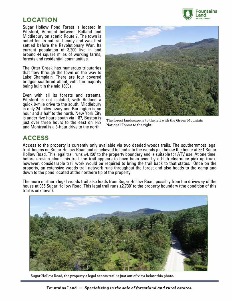
LOCATION Sugar Hollow Pond Forest is located in Pittsford, Vermont between Rutland and Middlebury on scenic Route 7. The town is noted for its natural beauty and was first settled before the Revolutionary War. Its current population of 3,200 live in and around 44 square miles of working farms, forests and residential communities. The Otter Creek has numerous tributaries that flow through the town on the way to Lake Champlain. There are four covered bridges scattered about, with the majority being built in the mid 1800s. Even with all its forests and streams, Pittsford is not isolated, with Rutland a quick 8-mile drive to the south. Middlebury is only 24 miles away and Burlington is an hour and a half to the north. New York City is under five hours south via I-87, Boston is just over three hours to the east on I-89 and Montreal is a 3-hour drive to the north. ACCESS Access to the property is currently only available via two deeded woods trails. The southernmost legal trail begins on Sugar Hollow Road and is believed to lead into the woods just below the home at 861 Sugar Hollow Road. This legal trail runs ±4,150’ to the property boundary and is suitable for ATV use. At one time, before erosion along this trail, the trail appears to have been used by a high clearance pick-up truck; however, considerable trail work would be required to bring the trail back to that status. Once on the property, an extensive woods trail network runs throughout the forest and also heads to the camp and down to the pond located at the northern tip of the property. The more northern legal woods trail also leads from Sugar Hollow Road, possibly from the driveway of the house at 935 Sugar Hollow Road. This legal trail runs ±2,730’ to the property boundary (the condition of this trail is unknown).
The forest landscape is to the left with the Green Mountain National Forest to the right.
Fountains Land — Specializing in the sale of forestland and rural estates.
Sugar Hollow Road, the property’s legal access trail is just out of view below this photo.

SITE DESCRIPTION The property is well suited to long-term forest management, recreation and hunting. Terrain is quite variable with modestly steep slopes in some areas, a level plateau on Cox Mountain, and gentle to moderate slopes throughout the forest. All aspects are present, with the highest elevation of 1,360’ above sea level (ASL), situated along the Cox Mountain Ridge in the center of the property and where the camp is located. From this point, the property slopes downward in all directions with the lowest points at the pond (760’ ASL), and a similar elevation at the western and southern boundaries. Given the land’s relatively high elevation and sloping terrain, soils are well drained. There are a couple of small streams running into the pond which is at the northern end of the property. Sugar Hollow Pond is a 25-acre scenic pond, suitable for paddling and fishing, with little to no human traffic due to its “middle of the forest” location. CAMP The camp is situated near the height of land along the internal access trail. Long views to the west are possible with tree clearing. The camp is of wood construction and has not been used in several years. The camp will need repairs to complete its construction and, when finished, will serve as a great get-a-way deep in the woods. TIMBER The forest timber resource is maturing and fully stocked with a mix of hardwood and softwood species. Variable age classes are present with the majority of overstory trees comprised of two age classes. The older age class is of sawlog size and ranges from 12” to 18” in diameter. The younger overstory age class is 8” to 10” and is mostly growing stock (pre-sawlog stems). The hardwoods are maple, birch, oak and beech. The softwoods are white pine, spruce and hemlock. The mast from oaks and beech provide a solid food source for white-tailed deer during the fall season. No timber data or management plan is available as the land is not enrolled in Vermont’s Use Value Appraisal Program (UVA). The standing timber value is likely ±$500/acre. This timber resource is well positioned for future asset appreciation.
Moderately sloping land is characteristic of the property. Here a fully stocked forest resource is also common throughout the land.
The property’s camp which is perched on the Cox Mountain ridge. Unfinished, the camp has good “bones” for future completion.
Fountains Land — Specializing in the sale of forestland and rural estates.

CONSERVATION EASEMENT The property will be sold subject to a conservation easement held by The Nature Conservancy (TNC), the current owner of the land. TNC is one of the most respected conservation organizations in the nation. A working forest “partnership” with TNC offers the new owner predictability and cooperation, given the long history and solid reputation this conservation organization has established regarding the easement lands under its jurisdiction. Easement highlights include:
Most sustainable forestry activities are permitted to support the long-term stewardship of the protected property;
The property can be posted against public access;
Silvicultural activities can occur under an approved forest management plan, excluding the 20-acre Ecological Protection Zone (EPZ) - No Touch, No Harvest Zone;
The right to maintain/build one primitive camp with total square footage not to exceed 800ft2 and height not to exceed 15’.
A copy of the proposed conservation easement is available upon request. TAX, TITLE and BOUNDARY INFORMATION Annual property taxes are $3,473. The property is NOT enrolled in the State of Vermont’s Use Value Appraisal (UVA) program, a program that can significantly reduce property taxes in exchange for good forest management and non-development uses. The property is owned by TNC. The deed for the property can found in the office of the Town of Pittsford in Book 160 Page 445.
Fountains Land is the exclusive broker representing the seller's interest in the marketing, negotiating and sale of this property. Fountains has an ethical and legal obligation to show honesty and fairness to the buyer. The buyer may retain brokers to represent their interests. All measurements are given as a guide, and no liability
can be accepted for any errors arising therefrom. No responsibility is taken for any other error, omission, or misstatement in these particulars, nor do they constitute an offer or a contract. We do not make or give, whether in these particulars, during negotiations or otherwise, any representation or warranty in relation to the property.
Fountains Land — Specializing in the sale of forestland and rural estates.
Oak and maple stand near the camp.
Sugar Hollow Pond frontage at the land’s northern end. While the frontage is marshy, it is scenic.

BRANDON
PITTSFORD
CHITTENDEN
GOSHEN
RUTLAND
HUBBARDTON
PROCTORCASTLETON
SUDBURY
MENDONWEST RUTLAND
ROCHESTERWHITING
RIVER
RD
MIDD
LE R
D
GAP RD
W CR
EEK
RD
GROVE ST
CARVER ST
MTN TO
P RD
FRANKLIN ST
UNIO
N ST
WHIPP
LE H
OLLO
W RD
ELM ST
WHEELER RD
HIGH POND RD
FOREST D
ALE RD
MCCONNELL RD
BIRCH HILL RD
HOLDEN RDFIR
E HILL
RD
S HILL RD
FURNACE RD
MONU
MENT
HILL
RD OXBOW RD
CHITT
ENDE
N RD
CASE
Y RD
WEST STBELGO RD
PLAINS RD
E PITT
SFORD
RD
CORN HILL RDN GROVE ST
HOLL
OW R
D
SANGAMON RD
FISK RD
FLOR
ENCE
RD
WEST RD
NORTH ST
ADAM
S RD
PARK ST
LEAD MINE RD
COUNTRY CLUB RD
DAM RD
PARKER RD
PARK LN
MEADOWLAKE DR
STEAM MILL BROOK RD EXT
BAKER BROOK TRL
LONG SWAMP RD
LABRAKE RD
KIMBALL RD
SYNDICATE RD
STEINBERG RD
MCKINLA
Y RD MTN SPRING RD
Copyright:(c) 2014 Esri
q
0 1 20.5 Miles
Canada
!
!
!
!
!
!
!
!
!
§̈¦90
§̈¦93
§̈¦88§̈¦91
§̈¦87
§̈¦89§̈¦91
§̈¦89
§̈¦87
§̈¦81 §̈¦95
§̈¦95
§̈¦80
§̈¦84
§̈¦90
ALBANY
PLATTSBURGBURLINGTON
MONTPELIER
BOSTONSPRINGFIELD
HARTFORD
NEW YORK
SYRACUSE
AdirondackPark
Catskill Park
Sugar Hollow Pond Forest_̂
Locus MapSugar Hollow Pond Forest
272.65 AcresPittsford, Rutland County, Vermont
LegendSugar Hollow Pond ForestInterstate HighwaysUS HighwaysState HighwaysTown RoadsTown LinesPublic LandConserved Land
¬«53
£¤7
¬«73
¬«3

×
SUGA
R HOL
LOW RD
CHAPEL HILL
WHISTLE STOP LNTAYLOR LN
q
LegendSugar Hollow Pond ForestUS HighwayTown RoadsTrail/ROWTrailsEPZ-No Touch Zone
× CampTown Line
660 0 660330Feet This is Not A Survey
Map produced from the best available information including town tax maps, hand held GPS data, aerial photography and reference information obtained from publicly available GIS sources, and the owner. Boundary lines portrayed on this map are approximate and could be different than the actual location of boundaries found in the field.
Sugar Hollow Pond Forest272.65 Acres
Pittsford, Rutland County, Vermont
BrandonPittsford
Also Available119.2 Acres
£¤7

×
SUGA
R HOL
LOW RD
CHAPEL HILL
WHISTLE STOP LNTAYLOR LN
VCGI
q
LegendSugar Hollow Pond ForestUS HighwayTown RoadsTrail/ROWTrailsEPZ-No Touch Zone
× CampTown Line
660 0 660330Feet This is Not A Survey
Map produced from the best available information including town tax maps, hand held GPS data, aerial photography and reference information obtained from publicly available GIS sources, and the owner. Boundary lines portrayed on this map are approximate and could be different than the actual location of boundaries found in the field.
Sugar Hollow Pond Forest272.65 Acres
Pittsford, Rutland County, Vermont
BrandonPittsford
Also Available119.2 Acres
£¤7