structure and emplacement of the eocene golden horn
TRANSCRIPT

San Jose State University San Jose State University
SJSU ScholarWorks SJSU ScholarWorks
Master's Theses Master's Theses and Graduate Research
Spring 2018
Structure and Emplacement of the Eocene Golden Horn Batholith, Structure and Emplacement of the Eocene Golden Horn Batholith,
North Cascades, Washington North Cascades, Washington
Christopher Scudder San Jose State University
Follow this and additional works at: https://scholarworks.sjsu.edu/etd_theses
Recommended Citation Recommended Citation Scudder, Christopher, "Structure and Emplacement of the Eocene Golden Horn Batholith, North Cascades, Washington" (2018). Master's Theses. 4919. DOI: https://doi.org/10.31979/etd.p6p4-am45 https://scholarworks.sjsu.edu/etd_theses/4919
This Thesis is brought to you for free and open access by the Master's Theses and Graduate Research at SJSU ScholarWorks. It has been accepted for inclusion in Master's Theses by an authorized administrator of SJSU ScholarWorks. For more information, please contact [email protected].

STRUCTURE AND EMPLACEMENT OF THE EOCENE GOLDEN HORN
BATHOLITH, NORTH CASCADES, WASHINGTON
A Thesis
Presented to
The Faculty of the Department of Geology
San José State University
In Partial Fulfillment
of the Requirement for the Degree
Master of Science
by
Christopher A. Scudder
May 2018

© 2018
Christopher A. Scudder
ALL RIGHTS RESERVED

The Designated Thesis Committee Approves the Thesis Titled
STRUCTURE AND EMPLACEMENT OF THE EOCENE GOLDEN HORN
BATHOLITH, NORTH CASCADES, WASHINGTON
by
Christopher A. Scudder
APPROVED FOR THE DEPARTMENT OF GEOLOGY
SAN JOSÉ STATE UNIVERSITY
May 2018
Dr. Robert Miller Department of Geology
Dr. Ellen Metzger Department of Geology
Dr. Jonathan Miller Department of Geology

ABSTRACT
STRUCTURE AND EMPLACEMENT OF THE EOCENE GOLDEN HORN
BATHOLITH, NORTH CASCADES, WASHINGTON
By Christopher A. Scudder
The 48 Ma Golden Horn batholith is a ~310 km2, shallow intrusion constructed of
sub-horizontal sheets in the crystalline core of the North Cascades of Washington. It is
the only large body of granite in an orogen dominated by 96-45 Ma tonalite, and probably
intruded during ridge subduction. The oldest and structurally highest unit of the batholith
is diorite, followed by alkaline granite, one feldspar-biotite granite, two feldspar-biotite
granite, and finally granodiorite, the youngest and structurally lowest unit. The batholith
displays a weak NE-striking foliation restricted to the center of the intrusion and a
stronger NW-striking foliation formed throughout the batholith with an associated weak,
NW-trending and shallowly plunging lineation. Foliation is coupled across the
northwestern and parts of the southern contact, and likely records a NE-SW shortening
component in an overall transtensional regime. Most Golden Horn dikes intruding host
rock are felsic, but there are some mafic dikes. These steeply dipping dikes tend to form
swarms and strike NE and E-W. The NE-striking dikes reflect regional NW-SE
extension. Parts of the southern contact are marked by xenolith-rich zones, which are
~100 m wide and several km long, and lend evidence to stoping as an emplacement
mechanism. The diking, stoped blocks, and lack of a ductile aureole are compatible with
shallow batholith emplacement models.

v
ACKNOWLEDGMENTS
This thesis is the culmination of several people’s hard work and kind charity. My
wife Susan Marie Scudder was my backbone, assisting me in the mountains of Northern
Washington, and for being my inspiration. A special thanks to Jeff Tepper from the
University Of Puget Sound for leading me safely there and back again to some very
remote locations. My committee members, Jonathan Miller and Ellen Metzger are
thanked for helping me to keep an open mind. Finally, I would like to thank my advisor
Robert Miller, who has helped to evolve my writing into one of academic integrity and
for having faith in me to finish this research project. This work was supported by
National Science Foundation grant EAR-1119358 to Robert Miller.

vi
TABLE OF CONTENTS
INTRODUCTION ........................................................................................................................... 1
GEOLOGIC SETTING ................................................................................................................... 3
METHODS ...................................................................................................................................... 8
ROCK UNITS .................................................................................................................................. 9 Host Rocks ................................................................................................................................ 9 Golden Horn Batholith ............................................................................................................ 10
Diorite ............................................................................................................................... 10 Alkaline Granite ................................................................................................................ 11 One Feldspar-Biotite Granite ........................................................................................... 13 Two Feldspar-Biotite Granite ........................................................................................... 15 Granodiorite ..................................................................................................................... 18
Fabrics ..................................................................................................................................... 19 Host Rock Foliations and Beds ............................................................................................... 22
Aplite Dikes ....................................................................................................................... 23 Porphyry Dikes ................................................................................................................. 23 Mafic Dikes ....................................................................................................................... 25
Faults ....................................................................................................................................... 30
CONTACTS WITH HOST ROCKS ............................................................................................. 33 Northwestern Contact .............................................................................................................. 33 Eastern Contact........................................................................................................................ 34 Southern Contact ..................................................................................................................... 34
DISCUSSION ................................................................................................................................ 36 Emplacement of the Golden Horn Batholith ........................................................................... 36
Ductile Flow ..................................................................................................................... 37 Stoping .............................................................................................................................. 37 Uplift and Floor Subsidence ............................................................................................. 38 Faulting ............................................................................................................................. 39
Tilting of the Golden Horn Batholith ...................................................................................... 41 Magmatic Structures ................................................................................................................ 42 Development of Foliation Patterns .......................................................................................... 43 Golden Horn Dikes .................................................................................................................. 44
CONCLUSIONS ........................................................................................................................... 47
REFERENCES CITED .................................................................................................................. 49

vii
LIST OF FIGURES
Figure 1. Simplified geologic map of the North Cascades of Washington ......................4
Figure 2. Geologic map of Golden Horn batholith and host rocks ..................................7
Figure 3. Thin section in cross polarization of alkaline granite ..................................... 12
Figure 4. Alkaline granite containing sodic amphiboles ................................................ 13
Figure 5. Thin section in cross polarization of one feldspar-granite showing biotite,
myrmekite, and perthite .................................................................................. 14
Figure 6. Mafic enclave in one feldspar-granite............................................................. 16
Figure 7. Thin section in cross polarization of two feldspar-granite showing rapikivi
texture and embayed quartz ............................................................................ 17
Figure 8. Mafic granodiorite talus near the northwest end of the batholith ................... 19
Figure 9. Poles to magmatic foliations within the Golden Horn batholith..................... 20
Figure 10. Map of the southern half of the Golden Horn batholith showing internal
foliation and host rock foliation and bedding ................................................. 21
Figure 11. Stereographic projection of poles to planes of aplite dikes ............................ 24
Figure 12. Poles to porphyry and mafic dikes .................................................................. 26
Figure 13. Outcrop of rapikivi porphyry dike .................................................................. 27
Figure 14. Simplified map showing Golden Horn dikes intruding host rock near the
southern and southwestern contact of the Golden Horn batholith .................. 28
Figure 15. Simplified map showing dikes between the Golden Horn batholith and the
Monument Peak pluton ................................................................................... 29
Figure 16. Photo facing west of two mafic Golden Horn dikes intruding the Black Peak
batholith at Silent Lakes.................................................................................. 31
Figure 17. Simplified map of faults to the north, east, and south of the Golden Horn
batholith .......................................................................................................... 32

viii
Figure 18. Xenoliths of metavolcanic rocks of the Midnight Peak Formation near
Washington Pass ............................................................................................. 36
Figure 19. Simplified map of regional dike orientations in the North Cascades ............. 46

1
INTRODUCTION
Plutons are topics of intense scientific research, but despite the vast amount of
literature, the construction and emplacement of these intrusive bodies is still
controversial. One reason for this is that clear evidence of emplacement is commonly
overprinted as the system evolves (e.g., Paterson et al., 1996; 1998; Petford, 2003). In
addition, plutons intrude a wide variety of host rocks, different crustal levels, and in
different tectonic settings, and range greatly in size and shape. These factors lead to
several major questions. For example, what are the sizes and numbers of intrusive
increments, and how large are the resultant magma chambers? What emplacement
mechanisms accommodate large plutons? How do plutons interact with and potentially
record regional strain?
Mechanisms for magma ascent include diapirism and diking. Large magma diapirs
rise through the crust by partially melting the surrounding host rock creating a ductile
flow layer (e.g., Marsh, 1982; Weinberg, 1994; Petford, 1996) or ascend through rocks
exhibiting visco-elastic behavior (Miller and Paterson, 1999). Given the rate of heat loss
through relatively cool host rock, and without recharge of heat from younger magma, it is
unlikely that diapirs can reach the upper crust before thermal arrest unless rates of ascent
are in the 10- to-100 m/yr range (Weinberg, 1994). A more widely accepted mechanism
for magma ascent is diking (e.g., Clemens and Mawer, 1992; Petford et al., 2000). This
model states that magma ascends rapidly, commonly along faults and fractures, building
plutons from numerous sheets through recharge of magma (Weinberg, 1999; Petford et
al., 2003).

2
Pluton emplacement fundamentally deals with making space or transferring material
in the crust, and the only ways to make space are by either displacing the Moho below the
intrusion or upwardly displacing the Earth’s surface. Roof uplift and shouldering aside of
the host rock are two material transfer processes that accommodate emplacement above
and around mid- to shallow-crustal plutons (e.g., Corry, 1988; Paterson et al., 1996; Benn
et al., 1999). In roof uplift, host rocks are domed, detached, or extended by faults.
Vertical and horizontal deflection of pre-emplacement markers such as beds, faults,
foliations, and dikes is also evidence of roof uplift or shouldering (e.g., McNulty et al.,
1996).
Other material transfer processes do not increase the volume of the crust. One
commonly cited process is ductile flow of wall rocks around a pluton (e.g., Buddington,
1959; Paterson and Fowler, 1993), which results in a ductile structural aureole. Stoping
of host rock is another material transfer process whereby blocks are detached from the
sidewalls and/or roof of a magma chamber and sink and/or melt, allowing the pluton to
expand laterally and vertically. Evidence of stoping includes xenoliths of host rock
within the pluton, and sharp, stepped contacts (e.g., Marsh, 1982; Clarke et al., 1998).
Lateral extension by dilational faulting is an additional material transfer process (e.g.,
Hutton, 1988; 1992), and faults can also provide anisotropic pathways for ascending
magma.
Foliation and lineation may provide important information on the mechanisms of
pluton construction and emplacement, and on regional strain (Paterson et al., 1998). In
magmatic systems that are decoupled from their host rocks, magmatic foliation and

3
lineation patterns may result from the final increments of strain induced by internal
processes during emplacement, but increased coupling of foliation between magma and
host rock may reflect regional deformation (Buddington, 1959; Paterson et al., 1998).
The crystalline core of the North Cascades of Washington contains numerous plutons
emplaced at varying depths (Miller et al., 2009a), making it an ideal place to compare
how emplacement mechanisms may change with depth, types of host rocks, and
composition. This thesis focuses on foliation patterns, dikes, and emplacement of the
shallow Golden Horn batholith, which was emplaced into a major fault zone and into
several different host rock units.
GEOLOGIC SETTING
The crystalline core of the Northern Cascades forms a ~1500-km-long plutonic and
metamorphic belt, and is part of the Coast Plutonic Complex, which represents a
Mesozoic and Paleogene magmatic arc (Fig. 1) (e.g., Misch, 1966; Tabor et al., 1989;
Gehrels et al., 2009; Miller et al., 2009a). It has been postulated that during the Eocene
(~50 Ma), subduction of an oceanic ridge occurred in the Pacific Northwest (e.g,
Thorkelson and Taylor, 1989; Cowan, 2003; Haeussler et al., 2003; Madsen et al., 2006;
Eddy et al., 2016b) creating a slab window. Ridge subduction commonly results in
anomalous magma compositions (e.g., Johnston and Thorkelson, 1997; Madsen et al.,
2006). The Eocene (~50-45 Ma) magmatism is characterized by granodiorite, granite,
and peralkaline rocks in the North Cascades, which contrasts with the dominantly
tonalite, ~96-60 Ma arc plutonism (Misch, 1966).

4
Figure 1. Simplified geologic map of the North Cascades of Washington (modified from
Miller et al., 2009b). BPB—Black Peak batholith; BR—Bearcat Ridge Orthogneiss;
CH—Chaval pluton; CS—Chiwaukum Schist; DF—Dirtyface pluton; GPTB—Gabriel
Peak tectonic belt; HP—High Pass pluton; MC—Marble Creek pluton; NCF—North
Creek fault; NQ—Napeequa unit; RRC—Railroad Creek pluton; RLF—Ross Lake fault;
RLFZ—Ross Lake fault zone; RP—Riddle Peaks pluton; SC—Sloan Creek plutons;
SM—Sulphur Mountain pluton; WPT—Windy Pass thrust; WRG—Wenatchee Ridge
Gneiss.
Figure 2

5
The Eocene magmatic episode is thus thought to represent slab window or slab breakoff
magmatism (Thorkelson and Taylor, 1989; Cowan, 2003; Haeussler et al., 2003; Madsen
et al., 2006; Eddy et al., 2016b).
The Cascades core is bound to the west by the Eocene dextral Straight Creek-Fraser
River fault, which separates it from Paleozoic and Mesozoic island arc and oceanic
terranes (Misch, 1966). To the east, the Paleogene Ross Lake fault zone separates the
core from the Mesozoic Methow basin (Misch, 1966; Miller and Bowring, 1990). The
major internal structure of the Cascades core is the high-angle Eocene Entiat fault, which
divides the core into the Wenatchee block to the southwest and the Chelan block to the
northeast (Tabor et al, 1989).
The Ross Lake fault zone is a ~10-km-wide fault system (Misch, 1966; Miller, 1994)
that is part of a 500-km-long zone of northwest-striking, high-angle Paleogene faults
(Monger et al., 1994; Umhoefer and Miller, 1996). The fault zone records dextral shear,
with components of early reverse slip and Eocene (~50-48 Ma) oblique dextral-normal
slip (Miller and Bowring, 1990).
During the Eocene (~55 Ma) there was a shift from regional transpression to
transtension in the North Cascades and southern British Columbia (Parrish et al., 1988;
Miller and Bowring, 1990). This transition has been interpreted as a response to a change
in the motion between the North America and Farallon plates. The Farallon plate
subducted below British Columbia, Washington, and Oregon from at least ~96-60 Ma
(Madsen, 2006), but subduction of an oceanic ridge between the Farallon and
Resurrection or Kula plate, which started at ~ 50 Ma, created a slab window beneath the

6
North American plate, and thus may explain the change from dominantly tonalite to
granodiorite (Misch, 1966; Miller et al., 2009a). All magmatism, ductile deformation,
and metamorphism ended by ~44 Ma (Engels et al., 1976; Wernicke and Getty, 1997;
Miller et al., 2016). This study focuses on the Eocene Golden Horn batholith, which
intruded at shallow levels along the eastern margin of the crystalline core of the North
Cascades (Fig. 2). The Golden Horn batholith was first described by Misch (1966) in a
synthesis of the tectonic evolution of the Northern Cascades. Subsequent studies focused
on the geochemical (Stull, 1969), mineralogical (Boggs, 1984), and geochronological
(Eddy et al., 2016a) aspects of the batholith. Apart from a brief description in a field
guide by Miller et al. (2009b), almost no structural data has been collected from the
Golden Horn batholith.
The Golden Horn batholith intruded the Ross Lake fault zone, which separates the
Methow basin to the east from the Skagit Gneiss Complex to the west. The Skagit
Gneiss Complex is one of the two regions of deep crust exhumed in the Eocene in the
North Cascade crystalline core (Misch, 1966; Miller et al., 2016). Along the western
contact of the Golden Horn batholith, there are metasandstones and metavolcanic rocks
interpreted as parts of the Cretaceous Virginian Ridge and Midnight Peak formations,
respectively, of the Methow basin (Misch, 1966; Miller et al., 1994; Haugerud and Tabor,
2009). The Methow basin is a fault-bounded block of Cretaceous and Jurassic
sedimentary and lesser volcanic strata, and lies between the crystalline core of the North
Cascades and the Okanogan Range batholith (Misch, 1966; Barksdale, 1975).

7
Figure 2. Geologic map of Golden Horn batholith and host rocks.

8
The Ross Lake fault zone is also intruded to the northwest of the Golden Horn batholith
by the Eocene Ruby Creek heterogeneous plutonic belt, and to the southeast by the
Eocene (48 Ma) Cooper Mountain batholith (Misch, 1966) (Fig. 1). The zone deforms
the Cretaceous (~90 Ma) Black Peak batholith to the SW of the Golden Horn batholith
(Fig. 1).
The Golden Horn batholith is unique for the North Cascades as parts of it have
alkaline composition in an orogen dominated by tonalite (Misch, 1966). Recent U-Pb
zircon dating of rocks of the Golden Horn batholith indicates emplacement from 48.468 ±
0.037 Ma to 47.729 ±0.026 Ma (Eddy et. al., 2016a). The emplacement of this
voluminous pluton is estimated to have taken only 739 ± 34 k.y., and much of it was
intruded over only 26 ± 25 k.y. at ca. 48.3 Ma (Eddy et. al., 2016a).
The Golden Horn batholith provides an excellent opportunity to study the
emplacement and construction mechanisms for shallow and rapidly emplaced intrusions.
It also has the potential to offer insight into the regional strain regime at the time of
intrusion.
METHODS
This study concentrates on the construction, emplacement, and structure of the
Golden Horn batholith. Field data were collected over six weeks during the summer of
2012. Given the size of the batholith (~310 km²), only select areas were mapped in
relative detail. These areas were mapped at 1:10,000 where possible, such as at the Silent
Lakes, Blue Lake, Cutthroat Trail, and Washington Pass areas (see Fig. 2 for locations),
and at 1:24,000 elsewhere. Foliations and lineations were measured to determine if they

9
dominantly record regional or internal magmatic patterns, and to help determine
emplacement mechanisms. Other features, including dikes, enclaves, schlieren, internal
contacts, and xenoliths, were studied in detail. Contacts and host rock structures were
examined to help evaluate emplacement processes. Twenty-one thin sections were
analyzed for modal mineralogy, grain orientation, and the degree of solid-state
deformation.
ROCK UNITS
Host Rocks
The host rock to the north and east of the Golden Horn batholith is the Methow basin.
The Golden Horn batholith intrudes the Cretaceous Virginian Ridge, Midnight Peak, and
Harts Pass Formations of the basin. Along the Cedar Creek Trail (Fig. 2), shales of the
Virginian Ridge Formation were mapped, and along the Methow River Trail (Fig. 2),
conglomerates of the Harts Pass Formation were observed. To the west, between the
Black Peak batholith and the Golden Horn batholith, there are screens of intermediate-
grade metaconglomerate and metavolcanic rock of the Virginian Ridge and Midnight
Peak Formations, respectively. To the southeast of the Golden Horn batholith and east of
the Black Peak batholith, the Virginian Ridge Formation and Midnight Peak Formation
are separated from their metamorphosed counterparts by the dextral, northwest-striking
North Creek fault (Fig. 1).
To the south and southwest is the Black Peak batholith, a ~90 Ma ellipsoidal-shaped
intrusion consisting dominantly of tonalite and granodiorite (Adams, 1961; Shea et al.,
2016). Diorite, gabbro, and hornblendite are exposed along the eastern margin, and the

10
tonalite and granodiorite change from hornblende-bearing in the north and west to
hornblende-absent in the south (Adams, 1964; Miller, 1987). The intrusion has been
deformed by Paleogene shear zones of the Ross Lake fault zone, and by Cretaceous to
Eocene regional deformation (Miller, 1994; Dragovich et al., 1997).
The Ruby Creek heterogeneous plutonic belt extends from the Golden Horn batholith
to the northwest (Misch, 1966). This belt is at least in part Eocene (Miller et al., 2016),
and includes numerous small (<100 m across) bodies that range from hornblende gabbro
to trondhjemite (Miller et al., 1994). It lies within an extensional stepover of the Ross
Lake fault zone.
Golden Horn Batholith
The southern portion of the Golden Horn batholith was mapped in detail for this
study, and the following descriptions and subsequent discussion are based mostly on
features observed in this part of the batholith. A smaller area next to the northwestern
contact of the batholith was also mapped in detail. The Golden Horn batholith consists of
five units. The oldest and structurally highest unit is diorite, followed by alkaline granite,
one feldspar-biotite granite, two feldspar-biotite granite, and finally granodiorite, the
youngest and structurally lowest unit (Eddy et al., 2016a).
Diorite
The 48.468 ± 0.030 Ma diorite is located in the southern margin of the batholith
where it is in contact with the Black Peak batholith and metasedimentary rocks of the
Virginian Ridge Formation (Fig. 2). The contact between the diorite and its host rocks is

11
steep and sharp. The unit is comprised of coarse-grained plagioclase, hornblende, and
biotite.
Alkaline Granite
The 48.35 ± 0.015 Ma (Eddy et al., 2016a) alkaline granite is a white, medium-
grained, structureless mass that is homogeneous across the map area. It forms an E-W-
trending band in map view in the southern part of the batholith that is ~8 km wide and 20
km long (Fig. 2). The alkaline granite is in contact with the two feldspar-biotite granite
to the north and northeast and the one feldspar-biotite granite to the northwest. This latter
contact is shallowly dipping (<20°) and was only observed for tens of meters north of
Washington Pass; the rest of the mapped contact was measured indirectly.
The alkaline granite is dominated by anhedral quartz and perthite, which exhibits
Carlsbad twinning (Fig. 3), and minor amounts of sodic amphibole. It lacks biotite, in
contrast to the one feldspar-biotite granite. The scarcity of mafic minerals in this granite
makes it difficult to find lineation and foliation.
This granite contains widespread miarolitic cavities, ranging from the millimeter to
meter scale. Quartz and perthite are euhedral in the miarolitic cavities. Over 60 minerals
have been found in the alkaline granite (Stull, 1969), many of them in the miarolitic
cavities (Boggs, 1984). Along the southern contact near Cedar Pass (Fig. 2), small
accumulations of mafic minerals were observed with sodic amphibole and myrmekite
(Fig. 4).

12
Figure 3. Thin section in cross polarization of alkaline granite. Note the Carlsbad
twinning in potassium feldspar and the varying quartz size.
Quartz grains

13
Figure 4. Alkaline granite containing sodic amphiboles. The dashes on the right side of
the ruler are millimeters.
One Feldspar-Biotite Granite
The 48.2 ± 0.030 Ma (Eddy et al., 2016a) one feldspar-biotite granite, or hypersolvus
granite, is located north of the alkaline granite. This granite is structurally between the
two feldspar-biotite granite and the alkaline granite (Fig. 2). It is heterogeneous
compositionally across the batholith. Grain size ranges from sub-millimeter up to several
centimeters, modes range having a majority of feldspar to even amounts of feldspar and
quartz, and color index ranges from 5 to 15. This granite is equigranular, coarse-grained,
and consists of quartz, perthite, biotite, and minor amounts of sodic amphibole (Fig. 5).
It is most easily distinguished from the alkaline granite by the presence of biotite. The
Tree sap Sodic amphiboles

14
quartz is anhedral, embayed, and commonly rounded. The perthite has Carlsbad
twinning and the biotite is chloritized in some places.
The gradational contact between the one feldspar-biotite granite and the two feldspar-
biotite granite occurs over a distance of ~3 m. Rare ~5-cm- to 50-cm-thick dikes of the
one feldspar-biotite granite intrude the alkaline granite, establishing the relative ages of
the units and in agreement with the U-Pb ages. These dikes have relatively sharp
boundaries, generally strike northwest, and have the largest variation in grain size in the
batholith, as grains range from one millimeter to two centimeters in length.
Figure 5. Thin section in cross polarization of one feldspar-granite showing biotite,
myrmekite, and perthite.
Anhedral quartz
15
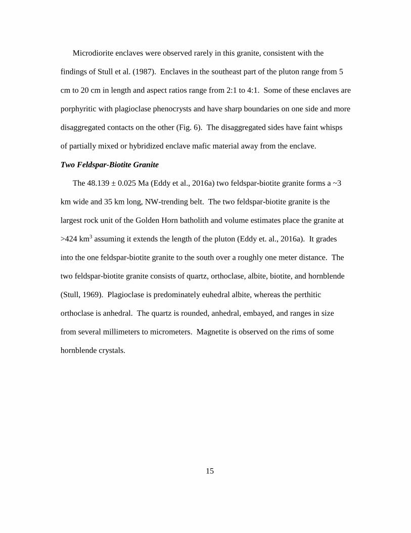
Microdiorite enclaves were observed rarely in this granite, consistent with the
findings of Stull et al. (1987). Enclaves in the southeast part of the pluton range from 5
cm to 20 cm in length and aspect ratios range from 2:1 to 4:1. Some of these enclaves are
porphyritic with plagioclase phenocrysts and have sharp boundaries on one side and more
disaggregated contacts on the other (Fig. 6). The disaggregated sides have faint whisps
of partially mixed or hybridized enclave mafic material away from the enclave.
Two Feldspar-Biotite Granite
The 48.139 ± 0.025 Ma (Eddy et al., 2016a) two feldspar-biotite granite forms a ~3
km wide and 35 km long, NW-trending belt. The two feldspar-biotite granite is the
largest rock unit of the Golden Horn batholith and volume estimates place the granite at
>424 km3 assuming it extends the length of the pluton (Eddy et. al., 2016a). It grades
into the one feldspar-biotite granite to the south over a roughly one meter distance. The
two feldspar-biotite granite consists of quartz, orthoclase, albite, biotite, and hornblende
(Stull, 1969). Plagioclase is predominately euhedral albite, whereas the perthitic
orthoclase is anhedral. The quartz is rounded, anhedral, embayed, and ranges in size
from several millimeters to micrometers. Magnetite is observed on the rims of some
hornblende crystals.

16
Figure 6. Mafic enclave in one feldspar-granite. Note the circled disaggregated enclave.
The scale card is 15 cm long and 8.5 cm wide.
The two feldspar-biotite granite is characterized by a rapikivi texture of pink
plagioclase-rimmed orthoclase. This texture is visible in hand sample, and micro-rapikivi
texture is evident under the microscope. The variation in rapikivi size is accompanied by
varying abundance of the texture, from tens of centimeter-sized crystals in thin section to
only one or two in thin section (Fig. 7). The feldspars with rapikivi texture range from
~1 cm to sub-millimeter. Several enclaves were observed in the two feldspar-biotite
granite along Highway 20 near Lone Fir campground (Fig. 2). These enclaves are
smaller than those in the one feldspar-biotite granite to the west, measuring from 2 cm to
8 cm in length and having aspect ratios from 1:1 to 3:1. Rare schlieren, defined by biotite
and hornblende, occur near enclaves and are ~1 cm wide and ~10 cm long.
Disaggregated enclave

17
Figure 7. Thin section in cross polarization of two feldspar-granite showing rapikivi
texture and embayed quartz.
Embayed quartz

18
Granodiorite
Granodiorite was observed along Highway 20 in the northwest part of the batholith.
These rocks are more mafic than most of the other units. The granodiorite is the
youngest and structurally lowest unit within the Golden Horn batholith, has a date at
48.045 Ma ± 0.034, and has an estimated volume of 197 km3 (Eddy et. al., 2016a). The
granodiorite is porphyritic, appears ‘splotchy”, and generally consists of a fine-grained
matrix of quartz, plagioclase, biotite, hornblende, and phenocrysts of plagioclase. The
biotite is tabular and chloritized, and plagioclase is sericitized. Rapikivi texture occurs
rarely.
Enclaves in granodiorite in the NW part of the batholith range from 1 cm to 10 cm in
length and have aspect ratios that vary from 6:1 to 1:1. They are generally fine-grained
and equigranular. Plagioclase phenocrysts, similar in size and shape to those in the host
granodiorite, are present within some of the enclaves and appear to be incorporated from
the surrounding coarser-grained host (Fig. 8). Schlieren defined by biotite and
hornblende are associated with groups of enclaves. These schlieren are from 8 cm to 2 m
in length and 3 to 10 cm in width.

19
Figure 8. Mafic granodiorite talus near the northwest end of the batholith. Note the
circled enclaves and their disaggregated edges. The “splotchy” appearance suggests
hybridization. The penny for scale is 2 cm wide.
Fabrics
The Golden Horn batholith contains two foliation orientations. The dominant
foliation is NW-striking and typically SW-dipping, and the weaker foliation is NE-
striking with both NW and SE dips (Fig. 9). Both foliations are defined by biotite and
hornblende in the one and two feldspar-biotite granites, and by sodic amphibole in the
alkaline granite. Both foliations are also considerably weaker in the alkaline granite and
are more difficult to detect due to the only minor amounts of mafic minerals. Dips of
both fabrics are moderate to steep, and are generally >60°.
The NW-striking foliation is observed throughout the batholith and cross-cuts the
sub-horizontal internal contacts between units of the batholith. Foliation observed at the
northwestern contact and part of the southern contact (North Creek Trail) appears
discordant to the batholith contact (Figs. 2 and 10). South and west of Washington Pass,

20
the foliation is concordant with the batholith contact (Figs. 2 and 10). Foliation does not
appear to steepen significantly in the granodiorite unit of the batholith toward the contact
with the Ruby Creek heterogeneous plutonic belt. Similarly, foliation dip does not
change significantly as the southern and southeastern contacts are approached.
Figure 9. Poles to magmatic foliations within the Golden Horn batholith. Poles projected
onto a lower-hemisphere stereograph. Contour interval is 2 sigma using the Kamb (1959)
method.
n=90

21
Figure 10. Map of the southern half of the Golden Horn batholith showing internal foliation and host rock foliation and
bedding. Some host rock measurements are based on mapping of McGroder et al. (1990).
Washington
Pass
Blue Lake

22
The weaker NE-striking foliation is centrally located within the batholith in the two
feldspar-biotite granite (see Geologic Setting, Fig. 2). There is also a weak NW-trending
lineation across the batholith that is defined by biotite and hornblende, and plunges <30°.
Minor grain boundary migration and recrystallization of quartz were observed in thin
sections from each rock type and from different parts of the batholith. This is compatible
with weak solid-state deformation and the lack of solid-state foliation.
Host Rock Foliations and Beds
Foliations were measured for several hundred meters into the host rock to the east,
south, and southeast of the batholith and supplemented by measurements of previous
workers (McGroder et al., 1990; Dragovich et al., 2002). Beds to the east in the
Virginian Ridge, Midnight Peak, and Harts Pass formations of the Methow basin are
predominantly north- and northwest-striking, and dip roughly 60° or more to the
northeast and southwest (Fig. 10). The metasedimentary and metavolcanic rocks to the
south and west of Washington Pass exhibit a NW-striking foliation with average dips of
72° to the NE and SW. To the south along the North Creek Trail, most foliations and
beds strike NW and have average dips of 70° SW in the Cretaceous metavolcanic and
metasedimentary and rocks of the Midnight Peak and Virginian Ridge Formations,
respectively. No deflection of foliation was observed as the contact with the Golden
Horn batholith was approached.
Dikes
Dikes associated with the Golden Horn batholith intrude the batholith and the host
rock near the batholith. These dikes have been described by previous workers (Misch,

23
1966; Tabor et al., 1968). Dikes have been grouped into three types: aplite dikes,
porphyritic dikes, and mafic dikes.
Aplite Dikes
Aplite dikes of the one and two feldspar-biotite granite are abundant in the Golden
Horn batholith, and mostly intrude the alkaline granite unit. Intermediate and mafic dikes
are less common. Aplite dikes are typically ~1 m in thickness, but range from ~10 cm to
~2 m in width, and strike W to NW with dips from 15 to 45° to the N and NE (Fig. 11).
Most aplite dikes were only traced for ~5 m due to limited outcrop exposure and dense
vegetation at the locations mapped. Marginal mafic concentrations of biotite, which are
~1 cm thick, and miarolitic cavities, which are 2 to 5 mm in diameter, are common
features of the aplite dikes.
Porphyry Dikes
Rapikivi porphyry dikes interpreted to be related to the batholith intrude the host
rocks in several locations, including near Silent Lakes to the west, the Cedar Creek Trail
to the south, the Methow River to the west, and along Highway 20 west of Washington
Pass (see Geologic Setting, Fig. 2). In addition, north of Cutthroat Pass along the Pacific
Crest Trail, two distinct rapikivi porphyry dikes intrude the one feldspar-biotite granite.
These two bodies are roughly 35 m wide, strike SW, dip 85° NW, and extend for at least
50 m.

24
Figure 11. Stereographic projection of poles to planes of aplite dikes.
n = 20

25
Phenocrysts in Golden Horn porphyry dikes are 1 cm in length and include embayed
quartz, plagioclase, and rapikivi feldspar. The phenocrysts are enclosed by a fine-grained
matrix of myrmekite and spherules of devitrified glass. The only mafic mineral is biotite
in trace amounts, and it is partially altered to chlorite. There is much scatter on a
stereographic projection, but the general strike of porphyry dikes is west-northwest, and
dips are generally >60° to both the north-northeast and south-southwest (Fig. 12).
Rapikivi porphyry dikes commonly have sharp, chilled boundaries with a ~3 cm- to 10
cm-wide, fine-grained margins (Fig. 13).
Mafic Dikes
Mafic dikes were observed in several locations next to the Golden Horn batholith and
are inferred to be related to the pluton. These mafic dikes intruded to the west and south
into the Black Peak batholith, and into metasedimentary and metavolcanic rocks of the
Virginian Ridge and Midnight Peak Formations, respectively.
Mafic dikes also intrude the sedimentary rocks of the Methow basin to the north
along the Methow River Trail and Harts Pass Road (Figs. 14 and 15). These mafic dikes
are fine-grained and consist of biotite, hornblende, plagioclase, orthoclase, and minor
quartz. Some are equigranular, whereas others contain plagioclase phenocrysts. Fine-
grained mafic dikes in a road cut along Highway 20 west of Blue Lake intrude the Black
Peak batholith and range in width from tens of cm to 8 m.

26
Figure 12. Poles to porphyry and mafic dikes. Poles projected onto a lower-hemisphere
projection. Contour interval is 2 sigma using the Kamb (1959) method.

27
Figure 13. Outcrop of rapikivi porphyry dike. Rapikivi porphyry (right side) intruded
one feldspar-biotite granite along the Pacific Crest Trail near Cutthroat Pass. Note the ~4
cm wide, chilled margin that lacks the larger orthoclase crystals in the dike interior. The
camera lens cap is 8 cm wide.

28
Figure 14. Simplified map showing Golden Horn dikes intruding host rock near the southern and southwestern contact of the
Golden Horn batholith.

29
Figure 15. Simplified map showing dikes between the Golden Horn batholith and the Monument Peak pluton. Contacts are
from Tabor et al., 1968.

30
The mafic dikes at Silent Lakes and west of Blue Lake intrude the Black Peak
batholith, and they extend for as long as 3 km (Fig. 16). The dikes range in width from
centimeters to 5 meters, and generally strike east-west and dip to the north. To the NE of
the batholith, mafic dikes intrude the Harts Pass Formation as far as 5 km from the
batholith (Fig. 15).
Golden Horn dikes intruding the Midnight Peak and Virginian Ridge Formations
were measured near Harts Pass Road, roughly 8 km north of the batholith, by Robert
Miller (written communication). These dikes have an average NE trend (024°), and all
have steep dips to the east and west (>75°). Tabor et al. (1968) mapped dikes near the
~48 Ma Monument Peak pluton, which is roughly 17 km NE of the Golden Horn
batholith (Fig. 15). The dikes mapped by Tabor et al. (1968) are quartz porphyries,
which occur in swarms and strike predominately NE.
Faults
The Golden Horn batholith intrudes the NW-striking Ross Lake fault zone. To the
north and southeast of the batholith there are NW-trending strike-slip faults (Dragovich et
al., 2002). The major northern fault is the Hozameen fault, which place prehnite-
pumpellyite-facies Hozameen Group against amphibolite-facies migmatites of the Skagit
Gneiss Complex (Misch, 1966; Haugerud, 1985). To the southeast, the North Creek fault
separates non-metamorphosed sedimentary and volcanic rocks of the Methow basin to
the northeast from low- to intermediate-grade metamorphic rocks of the same formations
to the southwest (McGroder et al., 1990) (Fig. 17). The Hozameen fault and the North
Creek fault are truncated by the batholith.

31
Figure 16. Photo facing west of two mafic Golden Horn dikes intruding the Black Peak
batholith at Silent Lakes. The dikes are ~4 m and 2 m wide on the left and right,
respectively. Note the person to the left in the photo for scale.

32
Figure 17. Simplified map of faults to the north, east, and south of the Golden Horn batholith. Map includes faults from
Dragovich et al. (2002) and McGroder et al. (1990).

33
The western and southwestern contacts of the batholith are cut by several E-W-
trending faults (Dragovich et al., 2002). Strike separation on these faults ranges from 0.5
km to 2.5 km and the sense of separation of the Golden Horn-host rock contact is
sinistral. These strike-slip faults range from 3 km to 9 km in length and step north and
west along the batholith contact towards a stepover within the Ross Lake fault zone
(Miller et al., 1994; Gordon et al., 2010).
CONTACTS WITH HOST ROCKS
The Golden Horn batholith intruded into sedimentary, metasedimentary,
metavolcanic, and igneous host rocks. This section describes contacts with the host
rocks.
Northwestern Contact
To the northwest, the Golden Horn batholith is in contact with a belt of igneous
intrusions that Misch (1966) called the Ruby Creek heterogeneous plutonic belt. The ca.
48 Ma Ruby Creek plutons (Miller et al., 2016), most of which are tonalite, intrude
phyllite and schist of the Little Jack unit. Some of the tonalite also resembles the
Cretaceous Black Peak batholith (Haugerud and Tabor, 2009).
A ~180-200 m transition zone was observed between the granodiorite of the Golden
Horn batholith and the main Ruby Creek outcrop. This transition zone is comprised of
tens-of-meters-wide zones of phyllite, schist, and Golden Horn dikes before entering
tonalite, which makes up much of the Ruby Creek heterogeneous plutonic belt. The
Golden Horn dikes are porphyritic, and a fine-grained matrix encloses quartz phenocrysts
ranging up to one centimeter in width. Hornblende in the Golden Horn granodiorite is

34
strongly aligned and defines a foliation that dips steeply to the west and southwest.
Foliation in the metasedimentary rocks strikes N to NW, dips greater than 75°, and is
coupled with the NW-striking foliation in the Golden Horn batholith (Figs. 2 and 10).
Eastern Contact
To the east and northeast, the Golden Horn batholith is in contact with Cretaceous
rocks of the Methow basin, including the Midnight Peak Formation, Virginian Ridge
Formation, and Harts Pass Formation. The two feldspar-biotite granite is chilled against
the host rock. To the southeast, the alkaline granite is in contact with metasandstones and
metavolcanic rocks of the Virginian Ridge and Midnight Peak Formations (Fig. 10). This
contact was not directly observed. Along the Cedar Creek Trail, bed dips range from 40°
to 80° to the SW and NE, and strikes are north-northwest, roughly parallel to the
batholith contact. Northeast of the batholith, beds strike predominantly NW, are locally
folded along NW-trending axes, and are overturned within 4 km of the batholith
(McGroder, 1989).
Southern Contact
To the south, the Golden Horn batholith is in contact with the Black Peak batholith
and the Midnight Peak and Virginian Ridge Formations. The Black Peak batholith is
~92-88 Ma tonalite, granodiorite, and diorite (Adams, 1964; Shea et al., 2016), and is
intruded by the alkaline granite of the Golden Horn batholith. South of Washington Pass,
the alkaline granite and xenoliths of the Midnight Peak Formation form an approximately
100-m-wide zone of intrusive breccia (Misch, 1966). Xenoliths in this zone range in size
from meters to decimeters, with an average of a few meters (Fig. 18). The xenoliths are

35
sharp and angular blocks that chilled the alkaline granite around them. Southeast of
Washington Pass along the North Creek trail, beds and foliation in the host rock are
discordant to the ENE-trending Golden Horn batholith contact.
Approximately 25 km to the northwest near Easy Pass, another xenolith-rich zone of
metasedimentary rocks occurs in the batholith at the southern contact with probable
metamorphosed Virginian Ridge Formation (see Geologic Setting, Fig. 2). In this ~200-
m-wide zone, xenoliths have an average length of 3 m, are angular, and are enclosed
within the two feldspar-biotite granite. These xenolith-rich zones occur near the E-W-
trending, sinistral strike-slip faults described in Dragovich et al. (2002). The southern
contact was not observed elsewhere and it is unclear whether xenoliths are ubiquitous
along this contact.

36
Figure 18. Xenoliths of metavolcanic rocks of the Midnight Peak Formation near
Washington Pass. Outcrop is ~ 200 m away, ~50 m high and 60 m wide.
DISCUSSION
Emplacement of the Golden Horn Batholith
As magma ascends through the crust, the volume of the crust does not increase except
where the Earth’s surface is uplifted or the base of the crust is depressed. Therefore,
magma emplacement is generally accomplished through material transfer processes.
These processes include ductile flow, stoping, floor subsidence, magma wedging, roof
uplift, and fault dilation (e.g., Hutton, 1992; Paterson et al., 1996).

37
Ductile Flow
Ductile flow is typically observed in the deeper crust, but has also been observed in
plutons emplaced in the shallow crust (e.g., Hutton, 1988; Morgan et al., 1998). Bedding
observed within ~300 m of the southeast contact of the batholith within the Cretaceous
sedimentary rocks of the Methow basin strikes roughly northwest and dips steeply, and
strikes do not rotate as the batholith contact is approached. Bedding east of the batholith
is overturned away from the batholith contact, but overturned beds were mapped up to 20
km away from the batholith contact within the Methow basin (McGroder, 1989;
McGroder et al., 1990), suggesting they probably represent Cretaceous regional folding.
Thus, there is no direct evidence for ductile flow.
The contact of the batholith with Cretaceous metavolcanic rocks of the Midnight Peak
Formation to the south and southwest is marked by meter- to decimeter-sized xenoliths of
the host rock. It is unlikely that an earlier ductile structural aureole was removed through
stoping, as the xenoliths do not show more strain than that of the intact host rock.
In the northwest, the host rock is devoid of a structural aureole. Foliation is parallel
and consistent across several rock types within the Ruby Creek heterogeneous plutonic
belt, and into the batholith. Thus, it appears that ductile flow was not an important
mechanism, although it cannot be ruled out that a structural aureole is present next to
parts of the batholith that were not studied.
Stoping
Stoping is one of several material transfer processes that may facilitate pluton
emplacement, but whether it represents a volumetrically significant process remains

38
controversial (Marsh, 1982; Yoshinobu et al., 2003; Glazner and Bartley, 2006). Stoping
by plutons of the North Cascades crystalline core has been described in multiple
Cretaceous plutons (Miller et al., 2009a).
Xenoliths were observed in two, 100-200-m-wide, 1-2-km-long zones along parts of
the southern and southwestern Golden Horn batholith contact, in the two-feldspar biotite
granite and the alkaline granite, where the batholith intruded the Midnight Peak
Formation (Figs. 2 and 18). These xenoliths had sharp boundaries and range in width
from centimeters to several meters. Some meter-sized xenoliths were fractured into
several smaller blocks. The sharp boundaries of the xenoliths may be attributed to the
melt cooling quickly against relatively cool host rock, fast injection rates, or both.
Stoping clearly contributed to emplacement; however, its restriction to the southern and
southwestern contacts makes it unclear how significant of a material transfer process it
was during the intrusion of the batholith.
Uplift and Floor Subsidence
Roof uplift has been documented for a number of shallowly emplaced plutons and
laccoliths (e.g., Corry, 1988; Paterson et al., 1996; Benn et al., 1998; Acocella, 2000;
Yoshinobu et al., 2003). It has been estimated that the Golden Horn batholith was
emplaced at a depth of ~8 km based on compositions of Golden Horn granites, which plot
near the water-saturated eutectic in the quartz-albite-orthoclase system (Eddy et al.,
2016a). This evidence for shallow emplacement indicates that roof uplift is a potentially
viable mechanism. No pluton roof was observed in the study areas. Features that could
support uplift are the tightly folded and overturned beds of the Cretaceous sedimentary
39
rocks of the Midnight Peak, and Virginian Ridge Formations to the east of the batholith
(McGroder, 1990) (Fig. 10). However, these folds and overturned beds extend up to 20
km from the contact; attributing them to roof uplift is questionable.
There are also several thrust faults, folds, and oblique dextral faults along the
southeastern margin of the batholith, but these structures are Cretaceous in age, pre-
dating the batholith (McGroder et al., 1990). Other possible evidence for piston-like
uplift would be steep dip-slip faults along the pluton sides (Paterson et al., 1996), but
such structures have not been recognized.
Floor subsidence is a ductile material transfer process associated with deeper-crustal
intrusions (e.g., Buddington, 1959; Cruden, 1998). Floor subsidence is most commonly
identified by ductile flow along pluton walls or sagging of the host rock (Cruden, 1998).
A ductile structural aureole was not observed in the host rocks next to the pluton walls,
nor was downward sagging of the host rock. Nowhere in the study areas is the pluton
floor exposed; thus, although floor subsidence cannot be ruled out, there is no evidence
that it contributed to emplacement.
Faulting
Another material transfer process for accommodating magma is through a zone of
lateral extension by dilational faulting (e.g., Hutton, 1988; Lacroix et al., 1998), although
it has been argued that the extension rates are too slow to allow a magma chamber to
form (Hansen and Glazner, 1995). Many of the plutons in the Cascade core are not
associated spatially with map-scale faults or shear zones (Miller et al., 2009a). However,
the Golden Horn batholith, Ruby Creek heterogeneous plutonic belt, Black Peak

40
batholith, and Oval Peak pluton lay within the Ross Lake fault zone, a 200-km-long, 15-
km-wide system of faults and fault zones that make up the eastern boundary of the
Cascade core (Misch, 1966; Miller and Bowring, 1990). The Ross Lake fault zone
experienced a diachronous history during the Late Cretaceous to Eocene dominated by
dextral strike-slip, but with components of reverse slip at ~65 Ma followed by normal
slip as young as 45 Ma (Miller and Bowring, 1990; Haugerud et al., 1991). Motion along
this fault zone in the region of the Golden Horn batholith reportedly ceased by ~49 Ma,
before intrusion of the batholith (Miller and Bowring, 1990).
The Golden Horn batholith is cut along its southwest contact by several E-W-striking,
sinistral strike-slip faults (Fig. 17). These faults postdate emplacement, as they offset the
batholith, and likely did not contribute to emplacement. Two major NW-striking, dextral
strike-slip faults of the Ross Lake fault zone occur to the north and south of the Golden
Horn batholith (Fig. 17). To the north is the Hozameen fault and to the southeast along
strike is the North Creek fault (Fig. 17). These faults are cut by the batholith and thus
were not active during emplacement. They may have indirectly affected magma ascent
by providing an anisotropic pathway.
In summary, no single emplacement mechanism can account for the volumes of
material transport needed for the Golden Horn batholith. The lack of a structural aureole
around the pluton, as well as the presence of xenolith-rich zones imply that ductile flow
was likely not a material transfer process. Stoping is observed along the southwestern
and southern boundaries of the batholith, but not in significant enough volumes to be the
only emplacement mechanism. Roof uplift is a possible mechanism given the shallow

41
emplacement (~8 km). Faulting did not act as a material transfer process during
emplacement, but may have provided an anisotropic pathway for magma.
Tilting of the Golden Horn Batholith
Stull (1987) first proposed that the Golden Horn batholith is tilted so that the
northwest end has been brought up. He came to this conclusion based on his
observations that Golden Horn rocks to the northwest are more mafic, contain enclaves,
and are more hybridized than the alkaline granites to the southeast. Stull (1987) further
postulated that the more mafic rocks were later-stage injections that underplated the
granites. Hopson and Mattinson (1994) suggested that the Ruby Creek heterogeneous
plutonic belt, which bounds the Golden Horn batholith on the NW, represents the roots of
the batholith, compatible with tilting.
The internal contact between the one feldspar-biotite granite and the alkaline granite
near Washington Pass is gently dipping (<20°) to the SE, but steepens to ~50° farther
north near Cutthroat Pass. Near Blue Lake, west of Washington Pass, the contact dips
~32° to the SE (Fig. 10). The steepening of the contact to the north may result from drag
as it approaches a map-scale normal fault (Fig. 17). This fault forms the northwest and
northern contact of the alkaline and one feldspar-biotite granites, and juxtaposes them
with the two feldspar-biotite granite. This fault brought the structurally higher one
feldspar-biotite granite and alkaline granite down against the one feldspar-biotite granite.
Eddy et al. (2016a) also noted that the internal units of the Golden Horn batholith are
roughly sub-horizontal and dip to the southeast. They also interpreted the alkaline granite

42
as the structurally highest unit, and the more mafic granodiorites to the northwest as the
structurally lowest unit.
Magmatic Structures
In the study area, magmatic structures such as foliation, lineation, aplite dikes, minor
schlieren, and enclaves were observed. However, ladder dikes, pipes, troughs, and tubes
were not observed; these structures ideally require injection into a permeable crystal
mush (Weinberg, 2001; Paterson, 2009). Their absence may reflect the very rapid
emplacement rate of 0.0125 km3/yr for the Golden Horn batholith (Eddy et al., 2016a).
Overlapping zircon dates from widely spaced samples within the two feldspar-biotite
granite indicate that melt was simultaneously present throughout that unit (Eddy et al.,
2016a).
Schlieren were observed locally in the granodiorite in the northwestern part of the
batholith and in the one- and two feldspar-biotite granites in the southeastern part of the
batholith. The schlieren ranged from meter-long bands to slight wisps of mafic minerals
only a few centimeters long. They are generally parallel to the regional foliation and
accompanied by enclaves. The interpreted leading edges of the enclaves are sharp,
whereas the tailing edges are more embayed, wavy, and have wispy tails. This pattern
may result from slight quenching along the inferred leading edge, and more interaction
with the resident magma along the back end. Schlieren typically form through mixing
and magma flow against internal or external contact (e.g., Weinberg, 2001), but were not
observed in greater abundance near internal contacts or host rock contacts. I interpret
that disaggregation of enclaves is likely the only source of schlieren in the Golden Horn

43
batholith, No enclave swarms were observed in the mapped areas or by previous workers.
This may be evidence that there was only a minor change to the magma source during
construction. Also, if a large magma chamber formed rapidly, a crystal mush would still
form, but with no late injections of younger magma, schlieren would not be widespread,
and tubes, ladder dikes, and pipes would not form.
Development of Foliation Patterns
The Golden Horn batholith in the study area contains two dominant fabrics. One is a
weak NE-striking, steeply dipping foliation defined mostly by biotite and to a lesser
extent hornblende, and is restricted to the center of the intrusion. This foliation is
interpreted as magmatic, recording early-stage, internal processes such as convection and
new magma injection (e.g., Tobisch et al., 1997; Paterson et al., 1998).
The second foliation orientation is a stronger, NW-striking, and typically steeply
(>60°) SW-dipping fabric that is consistent across the entire ~48 km length of the
batholith. Foliation is sub-parallel with parts of the southern contact (S and W of
Washington Pass) (Fig. 10). This foliation is also discordant with the NW contact along
Highway 20, and the SE contact near the North Creek trail (Fig. 2).
The NW-striking foliation has the least variation in strike in the northwestern part of
the batholith. This relationship supports the inference that this part of the batholith is
structurally deeper as it may have taken relatively longer to cool, allowing greater time
for more of the crystals in the mush to record regional strain.
Plutons constructed by sub-horizontal sheets, such as the Golden Horn batholith, may
have sub-horizontal foliations resulting from compaction due to repeated injections

44
(Wiebe and Collins, 1998). The steep foliations in the Golden Horn batholith are not
compatible with this interpretation and support the hypothesis that the foliations reflect
internal flow, not compaction, and regional strain. The NW-striking foliation likely
reflects the NE-SW shortening component during ridge-trench interaction off the coast at
~50-48 Ma (e.g., Engebretson et al., 1985; Madsen et al., 2006).
Golden Horn Dikes
Dikes typically help to show regional strain fields in the crust during emplacement.
In general, dikes form parallel to the greatest compressional stress and perpendicular to
the least compressional stress (Anderson, 1951; Gudmundsson, 1984). Multiple dikes of
Golden Horn and more mafic composition intrude the host rock in various locations next
to the batholith, notably along the Methow River and in the Silent Lakes area (Fig 19).
These dikes have two main strikes: NE and ~E-W.
Dikes intrude the Harts Pass Formation along the Methow River (Fig 15). These
mafic dikes strike approximately NE, dip steeply, range from 1 m to roughly 100 m
across, and extend for up to 3 km in map view. Farther northeast, dikes related to the
Eocene Monument Peak pluton, Golden horn batholith, or both, were mapped by Tabor et
al. (1968) (see Structure, Fig. 15). The majority of these dikes also strike NE. The
orientations of these dikes NE of the Golden Horn batholith are similar to many other
dikes measured in the North Cascades core and Swauk Formation (Fig. 19), and likely
record regional Eocene NW-SE extension.
Within a kilometer of the southwestern batholith contact, Golden Horn dikes intrude
metasedimentary rocks of the Methow basin and the Black Peak batholith (see Structure,

45
Fig. 14). These dikes are rapikivi porphyry, generally strike WNW, dip greater than 65°
north and south, are up to 30 m in width, and can be traced for up to 3 km on Google
Earth. Dikes south of the batholith intrude the Black Peak batholith along Highway 20
near Blue Lake, and near North Creek Trail (Fig. 14). These mafic dikes have E-W
(~075°-115°) strikes, both north and south dips, and have varying thicknesses.
Similar dike orientations have been observed ~25 km to the south in the central part
of the Skagit Gneiss Complex (Miller et al., 2016). I interpret that the WNW-striking
Golden Horn dikes followed an anisotropic pathway parallel to the E-W-trending strike-
slip faults that cut the batholith.

46
Figure 19. Simplified map of regional dike orientations in the North Cascades. Black
lines next to the Golden Horn batholith represent dike trends measured during this study,
and colored lines represent dike trends measured by others. BPB (Black Peak batholith);
BR (Bearcat Ridge orthogneiss); CH(Chaval pluton); CS (Chiwaukum Schist); DF
(Dirtyface pluton); MC (Marble Creek pluton); NQ (Napeequa complex); RLF (Ross
Lake fault); RP (Riddle Peaks pluton); RRC (Railroad Creek pluton); SC (Sloan Creek
pluton); SM (Sulphur Mountain pluton); WPT (Windy Pass thrust); WRG (Wenatchee
Ridge Gneiss). Modified from Miller et al. (2009b).

47
CONCLUSIONS
Through field mapping, structural analysis, and examination of thin sections, the
following conclusions have been drawn about the emplacement of the Golden Horn
batholith and the regional strain during emplacement.
1. The Golden Horn batholith was constructed very quickly (739 ± 34 k.y) in the
shallow crust, and no single emplacement mechanism can account for the volumes
of material transport needed for the Golden Horn batholith. The lack of a structural
aureole around the pluton, as well as the presence of xenolith-rich zones, imply that
ductile flow was likely not a material transfer process. There is evidence of stoping
along the southwestern and southern boundaries of the batholith, but not in
significant enough volumes to be the only emplacement mechanism. Roof uplift is
another possible emplacement mechanism, though no evidence for it was found.
Faults may have provided an anisotropic pathway for magma.
2. The pluton contains two magmatic foliation patterns, and one weak lineation. One
foliation is weak, strikes northeast, dips steeply, and is confined to the central part
of the batholith. This foliation probably records early magmatic processes. The
other foliation is stronger, strikes northwest, dips steeply, and probably records a
component of NE-SW shortening in an overall transtentional regime. The lineation
is weak and predominantly trends northwest across the pluton, plunges shallowly
(<30°), and probably records regional NW-SE extension.
3. Dikes interpreted to be related to the Golden Horn batholith intrude the host rocks
of the intrusion. The dikes south and west of the batholith strike approximately

48
E-W, and the dikes NE of the batholith strike NE. Some of the E-W-striking dikes
may be guided by a zone of E-W-trending sinistral strike-slip faults. The NE-
striking dikes support the interpretation of regional NW-SE extension during their
emplacement.

49
REFERENCES CITED
Acocella, V., 2000, Space accommodation by roof lifting during pluton emplacement at
Amiata (Italy): Terra Nova, v. 12, p. 149-155.
Adams, J.B., 1961, Petrology and structure of the Stehekin-Twisp Pass area, North
Cascades, Washington [Ph.D. thesis]: Seattle, University of Washington, 171 p.
Adams, J.B., 1964, Origin of the Black Peak Quartz Diorite, Northern Cascades,
Washington: American Journal of Science, v. 262, p. 290-306.
Anderson, E.M., 1951, The dynamics of faulting and dyke formation with applications to
Britain, 2nd edition: Hafner Publishing Company, 206 p.
Armstrong, R.L., 1988, Mesozoic and early Cenozoic magmatic evolution of the
Canadian Cordillera: Geological Society of America Special Paper 218, p. 55-91.
Benn, K., Odonne, F., and de Saint-Blanquat, M., 1998, Pluton emplacement during
transpression in brittle crust: new views from analog experiments: Geology, v. 26, p.
1079-1082.
Benn, K., Roest, W.R., Rochette, P., Evans, N.G., and Pignotta, G.S., 1999, Geophysical
and structural signatures of syntectonic batholith construction: the South Mountain
Batholith, Meguma Terrane, Nova Scotia: Geophysical Journal International, v. 136,
p. 144-158.
Boggs, R.C., 1984, Mineralogy and geochemistry of the Golden Horn batholith, Northern
Cascades, Washington [Ph.D. thesis]: Santa Barbara, University of California, 187 p.
Brown, E.H., and McClelland, W.C., 2000, Pluton emplacement by sheeting and vertical
ballooning in part of the southeast Coast Plutonic Complex, British Columbia:
Geological Society of America Bulletin, v. 112, p. 708-719, doi:10.1130/0016-
7606(2000)1122.3.CO;2.
Bryant, K.I., 2017, Structural analysis of Eocene dike swarms in and near the Duncan
Hill pluton, North Cascades, Washington [M.S. thesis]: San Jose, California, San Jose
State University, 71 p.
Buddington, A.F., 1959, Granite emplacement with special reference to North America:
Geological Society of America Bulletin, v. 70, p. 671-747.

50
Clarke, D.B., Henry, A.S., and White, M.A., 1998, Exploding xenoliths and the absence
of ‘elephants’ graveyards’ in granite batholiths: Journal of Structural Geology, v. 20,
p. 1325-1343.
Clemens, J.D., and Mawer, C.K., 1992, Granitic magma transport by fracture
propagation: Tectonophysics, v. 204, p. 339-360.
Corry, C.E., 1988, Laccoliths: mechanics of emplacement and growth: Geological
Society of America, v. 220, 110 p.
Cowan, D.S., 2003, Revisiting the Baranof–Leech River hypothesis for early Tertiary
coastwise transport of the Chugach–Prince William terrane: Earth and Planetary
Science Letters, v. 213, p. 463-475.
Cruden, A.R., 1998, On the emplacement of tabular granites: Journal of the Geological
Society, v. 155, p. 853-862.
Doran, B., 2009, Structure of the Swauk Formation and Teanaway dike swarm,
Washington Cascades [M.S. thesis]: San Jose, California, San Jose State University,
97 p.
Dragovich, J.D., Norman, D.K., Haugerud, R.A., and Miller, R.B., 1997, Geologic map
of the Gilbert 7.5' quadrangle, Chelan and Okanogan Counties, Washington:
Washington Division of Geology and Earth Resources Geologic Map GM-46, scale
1:24,000.
Dragovich, J.D., Logan, R.L., Schasse, H.W., Lingley, W.S. Jr, Norman, D.K., Gerstel,
W.J., Lapen, T.J., and Schuster, J.E., 2002, Geologic map of Washington-Northwest
quadrant: Washington Division of Geology and Earth Resources, Geologic Map GM-
50, 1 sheet, scale 1:250,000.
Eddy, M.P., Bowring, S.A., Miller, R.B., and Tepper, J.H., 2016a, Rapid assembly and
crystallization of a fossil large-volume silicic magma chamber: Geology, v. 44, p.
331-334.
Eddy, M.P., Bowring, S.A., Umhoefer, P.J., Miller, R.B., McLean, N.M., and Donaghy,
E.E., 2016b, High-resolution temporal and stratigraphic record of Siletzia’s accretion
and triple junction migration from nonmarine sedimentary basins in central and
western Washington: Geological Society of America Bulletin, v. 128, p. 425–441,
doi: 10.1130 /B31335.1.

51
Engebretson, D.C., Cox, A., and Gordon, R.G., 1985, Relative motions between oceanic
and continental plates in the Pacific Basin: Geological Society of America Special
Paper 209, 59 p.
Engels, J.C., Tabor, R.W., Miller, F.K., and Obradovich, J.D., 1976, Summary of K-Ar,
Rb-Sr, U-Pb, and fission track ages of rocks from Washington State prior to 1975
(exclusive of Columbia Plateau Basalts): U.S. Geological Survey Miscellaneous Field
Studies Map MF-710.
Gehrels, G., Rusmore, M., Woodsworth, G., Crawford, M., Andronicos, C., Hollister, L.,
Patchett, J., Ducea, M., Butler, R., Klepeis, K., and Davidson, C., 2009, U-Th-Pb
geochronology of the Coast Mountains batholith in north-coastal British Columbia:
Constraints on age and tectonic evolution: Geological Society of America Bulletin, v.
121, p. 1341-1361.
Glazner, A.F., and Bartley, J.M., 2006, Is stoping a volumetrically significant pluton
emplacement process?: Geological Society of America Bulletin, v. 118, p. 1185-
1195.
Gordon, S.M., Whitney, D.L., Miller, R.B., McLean, N., and Seaton, N.C.A., 2010,
Metamorphism and deformation at different structural levels in a strike-slip fault
zone, Ross Lake fault, North Cascades, USA: Journal of Metamorphic Geology, v.
28, p. 117-136, doi: 10.1111j.1525-1314.2009.00860.x.
Groome, W.G. and Thorkelson, D.J., 2009, The three-dimensional thermo-mechanical
signature of ridge subduction and slab window migration: Tectonophysics, v. 464,
p.70-83.
Gudmundsson, A., 1984, Formation of dykes, feeder-dykes, and the intrusion of dykes
from magma chambers: Bulletin Volcanologique, v. 47, p. 537-550.
Haeussler, P.J., Bradley, D.C., Wells, R.E., and Miller, M.L., 2003, Life and death of the
Resurrection plate: Evidence for its existence and subduction in the northeastern
Pacific in Paleocene–Eocene time: Geological Society of America Bulletin, v. 115, p.
867-880.
Hanson, R.B., and Glazner, A.F., 1995, Thermal requirements for extensional
emplacement of granitoids: Geology, v. 23, p. 213-216.
Haugerud, R.A., 1985, Geology of the Hozameen Group and the Ross Lake shear zone,
Maselpanik area, North Cascades, southwest British Columbia [Ph.D. thesis]: Seattle,
University of Washington, 263 p.

52
Haugerud, R.A., and Tabor, R.W., 2009, Geologic map of the North Cascade Range,
Washington: U.S. Geological Survey, Scientific Investigations Map 2940, 2 sheets,
scale 1:200,000; 2 pamphlets, 29 p. and 23 p.
Haugerud, R.A., Van der Heyden, P., Tabor, R.W., Stacey, J.S., and Zartman, R.E., 1991,
Late Cretaceous and early Tertiary plutonism and deformation in the Skagit gneiss
complex, North Cascade Range, Washington and British Columbia: Geological
Society of America Bulletin, v. 103, p. 1297-1307.
Hopson, C.A., and Mattinson, J.M., 1994, Chelan Migmatite Complex: Field evidence for
mafic magmatism, crustal anatexis, mixing and protodiapiric emplacement, in
Swanson, D.A., and Haugerud, R.A., eds., Geologic field trips in the Pacific
Northwest: Geological Society of America Annual Meeting, Seattle, University of
Washington Publication, p. 2K1-2K21.
Hutton, D.H., 1988, Granite emplacement mechanisms and tectonic controls: inferences
from deformation studies: Earth and Environmental Science Transactions of the
Royal Society of Edinburgh, v. 79, p. 245-255.
Hutton, D.H., 1992, Granite sheeted complexes: evidence for the dyking ascent
mechanism: Earth and Environmental Science Transactions of the Royal Society of
Edinburgh, v. 83, p. 377-382.
Ingram, G.M., and Hutton, D.H., 1994, The Great Tonalite Sill: Emplacement into a
contractional shear zone and implications for Late Cretaceous to early Eocene
tectonics in southeastern Alaska and British Columbia: Geological Society of
America Bulletin, v. 106, p. 715-728.
Johnston, S.T., and Thorkelson, D.J., 1997, Cocos-Nazca slab window beneath Central
America: Earth and Planetary Science Letters, v. 146, p. 465-474.
Kamb, W.B., 1959, Ice petrofabric observations from Blue Glacier, Washington, in
relation to theory and experiment: Journal of Geophysical Research, v. 64, p. 1891-
1909, doi: 10.1029/JZ064i011p01891.
Lacroix, S., Sawyer, E.W., and Chown, E.H., 1998, Pluton emplacement within an
extensional transfer zone during dextral strike-slip faulting: an example from the late
Archaean Abitibi Greenstone Belt: Journal of Structural Geology, v. 20, p. 43-59.
Madsen, J.K., Thorkelson, D.J., Friedman, R.M., and Marshall, D.D., 2006, Cenozoic to
Recent plate configurations in the Pacific Basin: Ridge subduction and slab window
magmatism in western North America: Geosphere, v. 2, p. 11-34.

53
Marsh, B.D., 1982, On the mechanics of igneous diapirism, stoping, and zone
melting: American Journal of Science, v. 282, p. 808-855.
Matzel, J.E., Bowring, S.A., and Miller, R.B., 2004, Protolith age of the Swakane Gneiss,
North Cascades, Washington: Evidence of rapid underthrusting of sediments beneath
an arc: Tectonics, v. 23, p. TC6009, doi: 10.1029/2003TC001577.
McNulty, B.A., Tong, W., and Tobisch, O.T., 1996, Assembly of a dike-fed magma
chamber: The Jackass Lakes pluton, central Sierra Nevada, California: Geological
Society of America Bulletin, v. 108, p. 926-940.
McGroder, M. F., 1988, Structural evolution of the eastern Cascades foldbelt:
Implications for late Mesozoic accretionary tectonics in the Pacific Northwest [Ph.D.
thesis]: Seattle, University of Washington, 140 p.
McGroder, M. F., 1989, Structural geometry and kinematic evolution of the eastern
Cascades foldbelt, Washington and British Columbia: Canadian Journal of Earth
Sciences, v. 26, p. 1586-1602.
McGroder, M. F., Garver, J.I., and Malloy, V.S., 1990, Bedrock geologic map,
biostratigraphy, and structure sections of the Methow Basin, Washington and British
Columbia: Washington Division of Geology and Earth Resources Open File Report
90-19, 32 p., 3 plates.
Michels, Z.D., 2008, Structure of the Central Skagit Gneiss Complex, North Cascades,
Washington [M.S. thesis]: San Jose, California, San Jose State University, 67 p.
Miller, R.B., 1987, Geology of the Twisp River–Chelan Divide region, North Cascades,
Washington: Washington Division of Geology and Earth Resources Open-File Report
87-17, 12 p.
Miller, R.B., 1994, A midcrustal contractional stepover zone in a major strike-slip
system, North Cascades, Washington: Journal of Structural Geology, v. 16, p. 47-60.
Miller, R.B., and Bowring, S.A., 1990, Structure and chronology of the Oval Peak
batholith and adjacent rocks: Implications for the Ross Lake fault zone, North
Cascades, Washington: Geological Society of America Bulletin, v. 102, p. 1361-
1377.
Miller, R.B., and Paterson, S.R., 1994, Transition from magmatic to high-temperature
solid-state deformation, Mount Stuart batholith, Washington: Journal of Structural
Geology, v. 16, p. 853-865.

54
Miller, R.B., and Paterson, S.R., 1999, In defense of magmatic diapirs: Journal of
Structural Geology, v. 21, p. 1161-1173.
Miller, R.B., and Paterson, S.R., 2001, Construction of mid-crustal sheeted plutons:
Examples from the North Cascades, Washington: Geological Society of America
Bulletin, v. 113, p. 1423-1442.
Miller, R.B., Bowring, S.A., and Hoppe, W.J., 1989, Paleocene plutonism and its tectonic
implications, North Cascades, Washington: Geology, v. 17, p. 846-849, doi: 10.1130
/0091-7613(1989)017<0846:PPAITI>2.3.CO;2.
Miller, R.B., Haugerud, R.H., Murphy, F., and Nicholson, L.S., 1994,
Tectonostratigraphic framework of the northeastern Cascades: Washington Division
of Geology and Earth Resources Bulletin, v. 80, p. 73-92.
Miller, R.B., Paterson, S.R., and Matzel, J.P., 2009a, Plutonism at different crustal levels:
Insights from the ~5–40 km (paleodepth) North Cascades crustal section,
Washington, in Miller, R.B., and Snoke, A.W, eds., Crustal cross sections from the
western North American Cordillera and elsewhere: Implications for tectonic and
petrologic processes: Geological Society of America Special Paper 456, p. 125–149,
doi: 10.1130/2009.2456(05).
Miller, R.B., Gordon, S.M., Bowring, S.A., Doran, B.A., McLean, N.M., Michels, Z.D.,
Shea, E.K., Whitney, D.L., Wintzer, N.E., and Mendoza, M.K., 2009b, Linking deep
and shallow crustal processes in an exhumed continental arc, North Cascades,
Washington, in O’Connor, J.E., Dorsey, R.J., and Maddin, I.P., eds., Volcanoes to
vineyards: Geologic field trips through the dynamic landscape of the Pacific
Northwest: Geological Society of America Field Guide 15, p. 373-406.
Miller, R.B., Gordon, S.M., Bowring, S., Doran, B., McLean, N., Michels, Z., Shea, E.,
and Whitney, D.L., 2016, Linking deep and shallow crustal processes during regional
transtension in an exhumed continental arc, North Cascades, northwestern Cordillera:
Geosphere, v. 12, p. 900-924, doi: 10.1130/GES01262.1.
Marsh, B.D., 1982, On the mechanics of diapirism, stoping and zone melting: American
Journal of Science, v. 282, p. 808-855.
Misch, P., 1966, Tectonic evolution of the Northern Cascades of Washington State: a
west-Cordilleran case history: Canadian Institute of Mining and Metallurgy, Special
Volume 8, p. 101-148.

55
Misch, P., 1977a, Bedrock geology of the North Cascades, in Brown, E.H., and Ellis,
R.C., eds., Geological excursions in the Pacific Northwest: Bellingham, Western
Washington University, p. 1–62.
Monger, J.W.H., 1986, Geology between Harrison Lake and Fraser River, Hope Map
area, southwestern British Columbia, in Current research, Part B: Geological Survey
of Canada Paper 86-1B, p. 699–706.
Monger, J.W.H., Van der Heyden, P., Journeay, J.M., Evenchick, C.A., and Mahoney,
J.B., 1994, Jurassic-Cretaceous basins along the Canadian Coast Belt: Their bearing
on pre-mid-Cretaceous sinistral displacements: Geology, v. 22, p. 175-178.
Morgan, S.S., Law, R.D., and Nyman, M.W., 1998, Laccolith-like emplacement model
for the Papoose Flat pluton based on porphyroblast-matrix analysis: Geological
Society of America Bulletin, v. 110, p. 96–110, doi: 10.1130/00167606(1998)
1102.3.CO;2.
Parrish, R.R., Carr, S.D., and Parkinson, D.L., 1988, Eocene extensional tectonics and
geochronology of the southern Omineca Belt, British Columbia and Washington:
Tectonics, v. 7, p. 181-212.
Paterson, S.R., 2009, Magmatic tubes, pipes, troughs, diapirs, and plumes: Late-stage
convective instabilities resulting in compositional diversity and permeable networks
in crystal-rich magmas of the Tuolumne batholith, Sierra Nevada, California:
Geosphere, v. 5, p. 496-527.
Paterson, S.R., and Fowler, T.K., Jr., 1993, Re-examining pluton emplacement processes:
Journal of Structural Geology, v. 15, p. 191-206.
Paterson, S.R., and Tobisch, O.T., 1992, Rates of processes in magmatic arcs:
implications for the timing and nature of pluton emplacement and wall rock
deformation: Journal of Structural Geology, v. 14, p. 291-300.
Paterson, S.R., and Miller, R.B., 1998, Mid-crustal magmatic sheets in the Cascades
Mountains, Washington: implications for magma ascent: Journal of Structural
Geology, v. 20, p. 1345-1363.
Paterson, S.R., Fowler, T.K., Jr., and Miller, R.B., 1996, Pluton emplacement in arcs: a
crustal-scale exchange process: Geological Society of America Special Papers,
v. 315, p. 115-123.

56
Paterson, S.R., Fowler, T.K., Jr., Schmidt, K.L., Yoshinobu, A.S., Yuan, E.S., and Miller,
R.B., 1998, Interpreting magmatic fabrics in plutons: Lithos, v. 44, p. 53–82, doi:
10.1016/S0024-4937(98)00022-X.
Petford, N., 1996, Dykes or diapirs?: Transactions of the Royal Society of Edinburgh:
Earth Sciences, v. 87, p. 105-114.
Petford, N., 2003, Rheology of granitic magmas during ascent and emplacement: Annual
Review of Earth and Planetary Sciences, v. 31, p. 399-427.
Petford, N., Cruden, A.R., McCaffrey, K.J.W., and Vigneresse, J.-L., 2000, Granite
magma formation, transport and emplacement in the Earth’s crust: Nature, v. 408, p.
669–673.
Raviola, F.P., 1988, Metamorphism, plutonism and deformation in the Pateros-Alta Lake
region, North-Central Washington [M.S. thesis]: San Jose, California, San Jose State
University, 181 p.
Shea, E.K.M., 2008, Structure of the southern Skagit Gneiss Complex, North Cascades,
Washington [M.S. thesis]: San Jose, California, San Jose State University, 90 p.
Shea, E.K., Miller, J.S., Miller, R.B., Bowring, S.A., and Sullivan, K.M., 2016, Growth
and maturation of a mid-to shallow-crustal intrusive complex, North Cascades,
Washington: Geosphere, v. 12, p. 1489–1516, doi: 10.1130/GES01290.1.
Sisson, V.B., Pavlis, T.L., Roeske, S.M., and Thorkelson, D.J., 2003, Introduction: An
overview of ridge-trench interaction in modern settings, in Sisson, V. B., Roeske,
S.M., and Pavlis, T.L., eds., Geology of a transpressional orogen developed during
ridge-trench interaction along the North Pacific margin: Geological Society of
America Special Paper 371, p. 1–18.
Stull, R.J., 1969, The geochemistry of the southeastern portion of the Golden Horn
batholith, Northern Cascades, Washington [Ph.D. thesis]: Seattle, University of
Washington, 127 p.
Stull, R.J., Misch, P., and Davis, T.E., 1987, Progressive partial melting and magma
mixing in the anorogenic Golden Horn batholith, Washington: Unpublished
manuscript, 47 p.
Sylva, N.L., 2014, Structure of Eocene dikes south of the Duncan Hill pluton, North
Cascades, Washington: Implications for regional strain during postulated ridge
subduction [B.S. Thesis]: San Jose, California, San Jose State University, 25 p.

57
Tabor, R.W., Engels, J.C., and Staatz, M.H., 1968, Quartz diorite-quartz monzonite and
granite plutons of the Pasayten River area, Washington – Petrology, age, and
emplacement: U.S. Geological Survey Professional Paper 600-C, p. C-45-52.
Tabor, R.W., Frizzell, V.A., Jr., Vance, J.A., and Naeser, C.W., 1984, Ages and
stratigraphy of lower and middle Tertiary sedimentary and volcanic rocks of the
central Cascades, Washington: Application to the tectonic history of the Straight
Creek fault: Geological Society of America Bulletin, v. 95, p. 26-44.
Tabor, R.W., Frizzell, V.A., Jr., Whetten, J.T., Waitt, R.B., Swanson, D.A., Byerly, G.R.,
Booth, D.B., Hetherington, M.J., and Zartman, R.E., 1987, Geologic map of the
Chelan 30-minute by 60-minute Quadrangle, Washington: U.S. Geological Survey
Map I-1661, scale 1:100,000.
Tabor, R.W., Haugerud, R.A., and Miller, R.B., 1989, Overview of the geology of the
North Cascades: International Geological Congress Trip T307: American
Geophysical Union, p. 1-62.
Tabor, R.W., Haugerud, R.A., Hildreth, W., and Brown, E.H., 2003, Geologic map of the
Mount Baker 30- x 60-minute quadrangle, Washington: U.S. Geological Survey
Geologic Investigations Series Map I–2660, scale 1:100,000, 73 p.
Thorkelson, D.J., and Taylor, R.P., 1989, Cordilleran slab windows: Geology, v. 17, p.
833-836.
Tobisch, O.T., McNulty, B.A., and Vernon, R.H., 1997, Microgranitoid enclave swarms
in granitic plutons, central Sierra Nevada, California: Lithos, v. 40, p. 321-339.
Yoshinobu, A.S., Fowler, T.K. Jr., Paterson, S.R., Llambias, E., Tickyj, H., and Sato,
A.M., 2003, A view from the roof: magmatic stoping in the shallow crust, Chita
pluton, Argentina: Journal of Structural Geology, v. 25, p. 1037–1048.
Weinberg, R.F., 1994, Re-examining pluton emplacement processes: discussion: Journal
of Structural Geology, v. 16, p. 743-760.
Weinberg, R.F., 1999, Mesoscale pervasive felsic magma migration: Alternatives to
dyking: Lithos, v. 46, p. 393–410.
Weinberg, R.F., Sial, A.N., and Pessoa, R.R., 2001, Magma flow within the Tavares
pluton, northeastern Brazil: Compositional and thermal convection: Geological
Society of America Bulletin, v. 113, p. 508-520.

58
Wernicke, B., and Getty, S.R., 1997, Intracrustal subduction and gravity currents in the
deep crust: Sm-Nd, Ar-Ar, and thermobarometric constraints from the Skagit Gneiss
Complex, Washington: Geological Society of America Bulletin, v. 109, p. 1149-1166.
Wiebe, R.A., and Collins, W.J., 1998, Depositional features and stratigraphic sections in
granitic plutons; implications for the emplacement and crystallization of granitic
magma: Journal of Structural Geology, v. 20, p. 1273–1289.