street performances, the role of visual analysis in the...
TRANSCRIPT

STREET PERFORMANCES, the ROLE of VISUAL ANALYSIS in the MICROZONING of PUBLIC SPACE in
VENICE, ITALY
FABIO CARRERA†, ANDREA NOVELLO‡ and ALBERTO GALLO‡
† Massachusetts Institute of Technology - Department of Urban Studies and Planning, Cambridge, Massachusetts, U.S.A / Worcester Polytechnic Institute - City Lab - Interdisciplinary
and Global Studies Division, Worcester, Massachusetts, U.S.A, [email protected] ‡ Forma Urbis s.a.s., Venice, Italy, {novello, gallo}@formaurbis.com
Keywords: Spatial analysis; Public space management; Performance zoning; Web-GIS; Spatial web-services; Urban planning; Pedestrian flows; Municipal information systems This paper illustrates a recent real-world experience in Venice, Italy that the authors collaborated on. This case-study details the process that unfolded in the course of a project promoted by the Venice City government to re-organize the so-called plateatici, i.e. the temporary occupations of public space on the part of businesses. The most common forms of plateatici are the outdoor public spaces occupied by the tables and chairs of restaurants, cafés and bars, but they also include merchandise displays, temporary signage and other business uses that also take up space in the streets and squares of the city. Since Venice is an exclusively pedestrian city devoid of cars, and since the ratio of inhabitants (65,000) to tourists (14,000,000) is more 1:200, the management of the use of the precious public space on the part of shops, stores and establishments is a top priority for city officials. The extant regulations on the matter are very permissive and there are escalating tensions developing between the business community and the local residents whose quality of life is being progressively eroded by the encroaching occupation of municipal areas, especially in some high-traffic locations. Our project involves the creation of an online web-GIS tool for the visualization of the allowable plateatici according to the current by-laws and then devising a defensible policy that would limit their negative impacts on noise and pedestrian traffic. The findings that emerged from this process confirmed the importance of visual analysis in the shaping of public policy and provided another example of the unforeseen, plan-demanding nature of the City Knowledge approach pioneered in Venice.

1 Introduction
Anyone who has ever been to Venice, Italy would have noticed how important public space is in this city of canals, where the front doors of homes open directly onto pedestrian streets and squares. It has been said that the alleys of Venice are but an extension of Venetian private homes. The tourist monoculture, that has progressively displaced other income-generating activities in the city, has upset the delicate balance between the private and public spheres that had been established in Venice for centuries. More and more, outdoor seating areas have begun to encroach onto the extended private spaces represented by the town’s calli and campi. The municipal government has traditionally leased out public space for use by a variety of businesses, so much so that some squares – such as Campo Ss. Filippo e Giacomo near St. Mark’s, and Campo S.Giacometto, where grocery stalls have historically been arrayed at the foot of the Rialto bridge – have been radically transformed by the permanent presence of supposedly “temporary” kiosks and souvenir stalls. The growing pressure for additional outdoor seating for pubs, restaurants and cafés, counteracted by an equally swelling reaction on the part of the local citizenry against such encroachments, has made the issue of plateatici front-page news in Venice in recent years. The city has therefore begun the process of rethinking its policies vis á vis the leasing of public space to private businesses. The consulting company Forma Urbis s.a.s. has been charged with the development of individualized plans (“pianini”) to regulate future assignments of public space for business use. The process has reaffirmed the importance of visualization using Geographic Information Systems and has engendered yet another example of the“plan-demanding” situation that Dr. Carrera first introduced in his doctoral dissertation entitled City Knowledge: an Emergent Information Infrastructure for Sustainable Urban Maintenance, Management and Planning (Carrera, 2004).
2 A Case Study of the Use and Abuse of Public Space: Campo S. Margherita The case presented herein refers to a very active square, called Campo Santa Margherita, where students from the nearby university campuses congregate at the end of each day. The square has an oblong shape, with the main access points in the northern and southern ends, as well as midway along the western side. The square was traditionally surrounded by shops selling food and wares to the local resident population. These shops have been gradually supplanted by restaurants, cafés and bars that cater mostly to the crowds of local resident students and young international visitors.
Figure 1. Campo San Giacometto in a painting by G.
Bella (“Il Bancogiro di Rialto”, 1779 (?), Querini Stampalia Venezia).
Figure 2. Locus of Campo Santa Margherita.
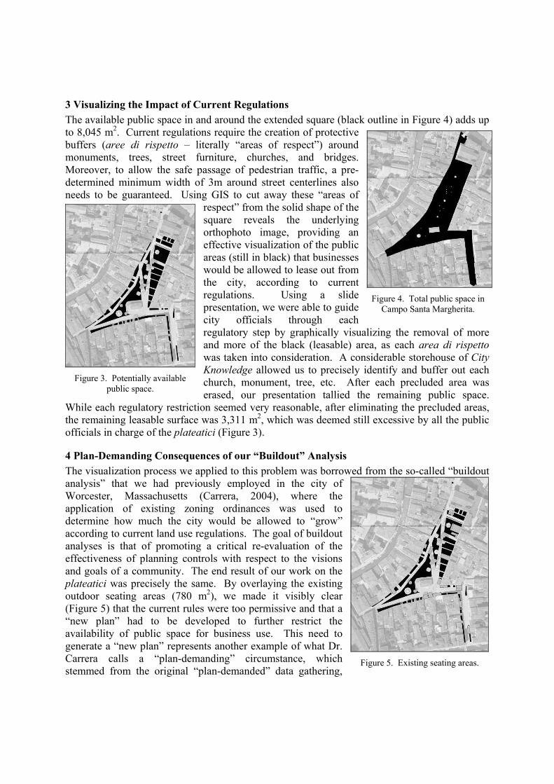
3 Visualizing the Impact of Current Regulations The available public space in and around the extended square (black outline in Figure 4) adds up to 8,045 m2. Current regulations require the creation of protective buffers (aree di rispetto – literally “areas of respect”) around monuments, trees, street furniture, churches, and bridges. Moreover, to allow the safe passage of pedestrian traffic, a pre-determined minimum width of 3m around street centerlines also needs to be guaranteed. Using GIS to cut away these “areas of
respect” from the solid shape of the square reveals the underlying orthophoto image, providing an effective visualization of the public areas (still in black) that businesses would be allowed to lease out from the city, according to current regulations. Using a slide presentation, we were able to guide city officials through each regulatory step by graphically visualizing the removal of more and more of the black (leasable) area, as each area di rispetto was taken into consideration. A considerable storehouse of City Knowledge allowed us to precisely identify and buffer out each church, monument, tree, etc. After each precluded area was erased, our presentation tallied the remaining public space.
While each regulatory restriction seemed very reasonable, after eliminating the precluded areas, the remaining leasable surface was 3,311 m2, which was deemed still excessive by all the public officials in charge of the plateatici (Figure 3).
4 Plan-Demanding Consequences of our “Buildout” Analysis The visualization process we applied to this problem was borrowed from the so-called “buildout analysis” that we had previously employed in the city of Worcester, Massachusetts (Carrera, 2004), where the application of existing zoning ordinances was used to determine how much the city would be allowed to “grow” according to current land use regulations. The goal of buildout analyses is that of promoting a critical re-evaluation of the effectiveness of planning controls with respect to the visions and goals of a community. The end result of our work on the plateatici was precisely the same. By overlaying the existing outdoor seating areas (780 m2), we made it visibly clear (Figure 5) that the current rules were too permissive and that a “new plan” had to be developed to further restrict the availability of public space for business use. This need to generate a “new plan” represents another example of what Dr. Carrera calls a “plan-demanding” circumstance, which stemmed from the original “plan-demanded” data gathering,
Figure 3. Potentially available
public space.
Figure 4. Total public space in
Campo Santa Margherita.
Figure 5. Existing seating areas.

coupled with a considerable amount of “plan-ready” information (Carrera, 2004).
5 Developing a Parametric Micro-Zoning Plan In order to be successful, the new plateatici plan would have to have strong rationales behind it, so that it could be publicly defended against the inevitable complaints that would be voiced by the business community once a more restrictive regime was instituted. To chip away at the black areas in the figures, we began by eliminating from the pool of available space, any part of the square in front of residential buildings. This was a logical first step that somehow had not been incorporated in the extant legislation, however this reasonable limitation, only slightly reduced the leaseable public space. Another possible move would have been to preclude businesses from occupying parts of the square not directly adjacent to their storefront. However, several existing precedents in Campo Santa Margherita itself made this restriction difficult to defend if legal challenges were raised against it. The tendency on the part of the politicians involved in this process would have been to arbitrarily designate certain zones off limits, based on the lower public reaction that such designation was presumed to generate – hardly a defensible approach. Instead, we proposed to reason out precisely what features of the space they wanted to maintain, so that we could arrive at the root causes of the gut reaction that told them that the current regulations were still too permissive. Exactly what public concern are we trying to balance against the demands of the store owners? We eventually came up with three criteria that would address the concern of the local residents: (1) maintaining ample pedestrian passage; (2) reserving a substantial part of the campo for public use (for children, people with dogs, etc.); and (3) reducing the incidence of noise generated by the outdoor establishments. The first criterion could be adapted to suit the specific space requirements of each path across the square, by simply regulating the dimensions of the buffer around each path based on actual pedestrian traffic counts recorded along that route. The more trafficked axes would have wider “areas of respect” around them, which could possibly vary with the seasons and even the time of day (or night) or the day of the week (weekday vs. weekend). Trial and error visualizations are playing a large role in the ongoing determination of what coefficients to use to transform traffic counts into buffer widths. The second criterion (public use) also has benefited substantially from repeated visualizations of alternative scenarios. Two main public uses have been identified: (i) general public/playground use and (ii) market use. After several visual iterations, we set aside 30% of the remaining (black) campo area for general/playground use. We
Figure 6. Revised leasable space plan.

also compacted several scattered kiosks, stalls and push cart vendors, plus a grocer and a fish seller, into a consolidated “market area” adjacent to the main pedestrian flows in a yet-unassigned (black) area of the square, reducing the available leasable space to 2,364 m2, still a far cry from the “desired” target of 800 m2, which would in essence “freeze” the leased public space to current levels. The last criterion (noise) represents a measurable characteristic that could be used to create the equivalent of what planners call “performance zoning”, which is discussed in the next section.
6 Performance Zoning Applied to the Use of Public Space “Noise Zoning” was recently instituted in Italy, so there are fairly strict and clear standards about the maximum number of decibels that are allowed in the various parts of Venice. Visualizing the noise zoning overlaid on the map of Campo Santa Margherita, helped us set the threshold of performance that the noise controls would have to abide by. Whereas typical “Euclidian” zoning generally controls variables that are perceived as the “cause” of undesirable spatial development, performance zoning instead regulates the “effect” of land use changes. In the specific case of the leasing of outdoor public space in Venice, the effect one wants to limit is the noise level. Euclidian zoning would indiscriminately restrict the size of the plateatici, regardless of the amount of noise that would be produced by them, blind to the fact that, for instance, the outdoor display of merchandise produces considerably less hubbub than do crowds hanging out at outdoor eating and drinking establishments. Performance zoning would thus target noise-producing uses and selectively restrict certain types of noisy activities, while being more lenient with quieter uses of public space. With careful field measurements and with a thorough review of the literature, one could attribute “noise units” to each square meter of incremental expansion of a plateatico, based on the specific activity taking place in it. We therefore foresee the utilization of an interactive, dynamic visualization of the noise levels produced by incremental increases in the public space dedicated to particular uses, though our research has not yet reached the point where such advanced visualization techniques would become practically useful. A web-based permit application is being designed to allow prospective lessees of public space to determine how much space they could rent out based on the noise-generating effects of their particular business activity. A prototype demonstration of this interactive system should be available by the time of the conference in Muenster. To effectively restrict the amount of noise produced by the combined effect of all businesses with an outdoor presence in the streets and squares of Venice, one ought to think beyond the mere “regulation” of the size of plateatici, which represents the natural knee-jerk reaction that typical policy-makers would have when attempting to limit an undesirable effect such as noise. In fact, there are many ways (six to be exact) in which the municipal government can achieve the desired noise containment, as detailed in the next section.
7 Implementing a Public Space Policy using the Six Tools of Government Action When it comes to implementing policies, cities are always limited to the tools they have at their disposal to affect change in the municipal realm. Schuster et al. (1997) and Carrera and Hewitt (2006) assert that governments only have exactly six choices to ensure that a certain policy or action is properly implemented (Schuster et al., 1997; Carrera and Hewitt, 2006): 1. to do it themselves (Ownership and Operation) 2. to make us do it (Regulation)

3. to entice us into doing it (Incentives and Disincentives) 4. to convince us to do it (Education and Information) 5. to negotiate with us to do it together (Rights) 6. to compensate us for the negative consequences of doing it (Mitigation and Compensation) A careful blend of the six tools can generate the desired outcome by establishing an effective balance between the desirability of fostering the spontaneity and vitality of public spaces, while respecting and safeguarding the rightful expectations of local residents to be able to enjoy peace and tranquility in their own home. The following sections discuss how these tools could be used in combination in our case study to create a powerful toolkit with which the city of Venice can strike such a delicate balance. 7.1 Ownership and Operation - whereby municipalities are free to do whatever they decide to do on structures and activities that they directly own and operate. This is the key tool in this situation, since the city owns the public streets and squares, thus has an undeniable right to dictate what activities are allowed to take place in them. Municipal ownership of public space gives the city the uncontested power to curb unwanted uses of its property, without having to restrict anybody else’s rights.
7.2 Regulation - whereby municipalities tell citizens what they must do and/or they cannot do. This tool has been the only one that the City of Venice has used to date to regulate outdoor use of public space. It will continue to play an important role in the future, but it will be combined with the other tools as well to improve the effectiveness of the new policy. Utilization of public space is being be regulated in accordance to the aforementioned criteria and all leasable space is being be pre-identified by the City. Business owners will be able to occupy only the space that will be set-aside by the pianini (“small plans”) produced by Forma Urbis in coordination with City officials. We are planning to do away with these localized plans, as explained in section 8. We are discussing a new fee structure for the leasing of public space which will allow every business
owner to lease a certain amount of space contiguous to their storefront at an affordable price. Additional space could be added, but at an increasing cost to the business owner, and only as long as the additional surface area does not cause the noise thresholds to be violated. To help business owners determine the cost/benefit of different outdoor seating configurations, we are developing an interactive online visualization tool, based on our LOUIS (Local Online Urban Information System), which will allow business owners to visualize the location of leasable public
space on a web-GIS system and will afford them the ability to select a variety of plateatici configurations with instant feedback concerning the costs associated with leasing the selected areas at different times of the day or night.
7.3 Incentives (and Disincentives) - whereby municipalities can induce citizens to do the right thing, while deterring them from doing the wrong thing.
Figure 7. Detail of visual display of available seating.

We plan to make use of disincentives to induce business owners to be very careful in selecting the amount of space they lease and for how long. As mentioned, a minimum surface area of public space, proportional to the floor space of the leasing business, will be leased at a very affordable price, to provide an incentive for businesses to add to the vitality of the place. Beyond that minimum area, the cost to lease each additional square meter will become gradually higher up to a maximum leasable amount, again proportional to the indoor size of the establishment. This will create a disincentive that ought to restrain business owners from leasing excessive amounts of space, unless they are convinced that it would be in their financial interest. To contain the noise produced by these establishments, the leasing fees will also be increased (for specific noise-producing types of businesses) on an hourly basis in the evening hours (after 8pm), so that renting a square meter of space will cost more and more as night progresses, and as the noise impact on the surrounding dwellings becomes more and more problematic. This disincentive will not prohibit businesses from still renting space in the nighttime (as long as all the other regulations are met), but it ought to put a damper on the excesses which have recently created a great deal of friction with the local community.
7.4 Education and Information - whereby municipalities can instill into its citizens knowledge about what they ought to do based on an informed and educated position, acquired over time. The Education and Information tool will again revolve around LOUIS, by providing not only business owners with an interactive visualization tool that will help them make the “right” decision for their business, while abiding by all the regulations, but it will also provide information for the local residents who will be able to know the exact extent of the plateatici leased out in their area, demonstrating to them that the City is being responsible in minimizing the noise and disruption created by these establishments. Moreover, code enforcement officials will also be able to use the tool to check on the abidance on the part of businesses to the “official” dimensions of the outdoor spaces that they are legally leasing. Citizen complaints could be logged directly to the enforcement officials through the tool, so that the whole system will be as transparent as possible and respectful of the regulations as well as of the concerns of local residents.
7.5 Rights - whereby municipalities can re-negotiate extensions of the rights of individuals and organizations in exchange for a desired outcome. Although this is a seldom-used tool, it may be possible to utilize its power by, for instance, allowing businesses to trade night-time space that they could lease as-of-right with additional allowances for daytime space above and beyond the set minima. This would achieve the aim of reducing noise in the wee hours and compensate the possible loss of income by adding revenue potential during the day. Once again, our interactive visualization tool could make such trades easier to envision and to implement.
7.6 Mitigation and Compensation - whereby municipalities can mitigate the consequences of municipal actions and compensate those affected by them. This sixth tool, proposed by Dr. Carrera (in Carrera and Hewitt, 2006), could be very useful in this context. As discussed above, the other tools try to limit the impact of plateatici on the local community without completely restricting the ability of businesses to lease public space, even at night, in an effort to balance the goal of maintaining a vibrant street life while respecting the needs of the nearby residents. Therefore, it is quite possible that some businesses, having used our visualization tool (LOUIS) to determine what amount of public space would make financial sense to them, might still decide to lease night-time space, despite its higher cost per square

meter, thus in a sense potentially voiding our efforts to reduce noise. This tool would then be utilized to mitigate these negative effects, by using the additional revenue generate by the nighttime fees to subsidize the installation of sound-proofed windows in the surrounding area. Using all six tools, in coordination with a balanced calibration of the fees, the objectives of the City would be met in a manner that should satisfy all of the stated criteria. An exciting nightlife will be allowed to continue in the streets and squares to maintain the urban vitality that has made some areas very inviting and enjoyable, especially for the younger crowds, though tempered somewhat by the progressively higher leasing fees. The peace and tranquility of the local residents will also be protected by making the leasing of public space more expensive when it would be more disruptive for the neighborhood, while also mitigating any remaining nuisance by re-investing the additional revenue into measures to mitigate and possibly eliminate the effects of noisy activities that will continue to take place in the calli and campi of Venice. Everyone will be able to monitor the situation through the on-line interactive visualization tool based on LOUIS (Local Online Urban Information System) thus the system will be totally transparent and hopefully acceptable to all parties involved.
8 An Interactive Visualization Tool for the Leasing of Public Space As mentioned, we are developing an interactive online tool based on LOUIS (the Local Online Urban Information System) to allow store owners to select outdoor seating configurations that suit their needs and are within their budget, bypassing the tedious back-and-forth that currently happens when a business owner turns in a proposal to the town and then has to negotiate every square meter of space without a clear notion of the costs and impacts that each configuration implies. Our prototype system takes into account two main impacts of the leasing of public space: (i) the obstruction created to pedestrian traffic and (ii) the noise caused by additional outdoor seating at restaurants and bars (Figure 8). Instead of relying on “fixed” pre-conceived plans dictating where and how seating can be allowed, as is currently done with the aforementioned pianini, we are developing a self-adjusting, dynamic system that will be constantly updated to reflect the impacts on pedestrians and noise caused by existing as well as planned outdoor seating arrangements, thus removing once and for all the need to periodically revisit and revise the “plans” for each square and street in Venice. The system we are developing is based on open-source web-GIS technology first developed by MassGIS, the Massachusetts State GIS agency, under the name of OLIVER (Online Data Viewer). Our system, called LOUIS (Local Online Urban Information System) leverages the
Figure 8. Noise profiles and pedestrian routes.

control that each municipality exerts at the local level and promises to capture chance at the source, by intercepting permits and other official documents that allow change to happen in the real world. Our goal with this online interactive visualization tool was to provide the opportunity for store owners to interactively select seating arrangements in increments of one square meter and instantly receive feedback on the cost of the selected configuration. The system will automatically set the yearly fees for each square meter depending on the existing underlying maximum noise profiles and on the maximum levels of pedestrian traffic on adjoining routes. Figure 9 shows the visualization that LOUIS will provide to the end-user who is selecting outdoor seating for his or her store (white arrow in figure) during nighttime hours. The prototype visualization includes the noise levels measured at that location by the appropriate authority (underlying gradients of green to red colors), plus the maximum evening pedestrian traffic around that location.
LOUIS – The CITY LAB “Local On-line Urban Information System”
Figure 9. The online store-owner’s interface provides immediate feedback on yearly fees.
The grids of boxes in front of each store represent the one-square-meter modules of public space that are available for leasing depending on the indoor area of the store. Grayed out boxes represent modules that are eliminated because of interference with buffers around sensitive areas, like corners, residential access pathways, pedestrian thoroughfares, historical buildings and the like. The colors of the remaining square modules in front of each store reflect the costs associated with leasing each one-square-meter increment of public space. Thus far, we have hypothesized a 6-tier hierarchy of fees, from the lowest guaranteed minimum (bright green) that
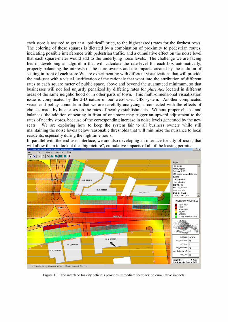
each store is assured to get at a “political” price, to the highest (red) rates for the farthest rows. The coloring of these squares is dictated by a combination of proximity to pedestrian routes, indicating possible interference with pedestrian traffic, and a cumulative effect on the noise level that each square-meter would add to the underlying noise levels. The challenge we are facing lies in developing an algorithm that will calculate the rate-level for each box automatically, properly balancing the interests of the store-owners and the impacts created by the addition of seating in front of each store.We are experimenting with different visualizations that will provide the end-user with a visual justification of the rationale that went into the attribution of different rates to each square meter of public space, above and beyond the guaranteed minimum, so that businesses will not feel unjustly penalized by differing rates for plateatici located in different areas of the same neighborhood or in other parts of town. This multi-dimensional visualization issue is complicated by the 2-D nature of our web-based GIS system. Another complicated visual and policy conundrum that we are carefully analyzing is connected with the effects of choices made by businesses on the rates of nearby establishments. Without proper checks and balances, the addition of seating in front of one store may trigger an upward adjustment to the rates of nearby stores, because of the corresponding increase in noise levels generated by the new seats. We are exploring how to keep the system fair to all business owners while still maintaining the noise levels below reasonable thresholds that will minimize the nuisance to local residents, especially during the nighttime hours. In parallel with the end-user interface, we are also developing an interface for city officials, that will allow them to look at the “big picture”, cumulative impacts of all of the leasing permits.
LOUIS – The CITY LAB “Local On-line Urban Information System”
Figure 10. The interface for city officials provides immediate feedback on cumulative impacts.
In addition to the aforementioned visualization and policy challenges, this interface is also undergoing revisions based on the needs of the officials who are in charge of managing the use of public space in Venice. We are planning to allow authorized public officials the ability to check on the impacts and fees connected with each individual establishment, as shown in Figure 10. By extension, we also plan to allow the same user to select a group of such establishments and generate the aggregate impact of all selected outdoor spaces. These internal users will also have access to windows where they can adjust the underlying datasets relative to pedestrian flows and actual noise measurements, which in turn will result in different pedestrian buffer dimensions and different underlying noise profiles, which will be reflected in different fee calculations for each meter of public space in the affected areas. Once again, one challenge will be in mitigating the potentially drastic effects of updated traffic and noise measurements on the rates of existing and future outdoor areas, by establishing fair and equitable ways to recalibrate the fee structures as the situation on the ground evolves over the years. We look forward to reporting on the actual full implementation of the system, which is still under development. We are confident that the final system will represent a very successful application of advanced visualization tools for the implementation of fair and progressive public policy. REFERENCES Carrera, Fabio. 2005. “Growing the Tree of Knowledge: extracting informational returns from the maintenance of trees in Cambridge, Massachusetts”. Proceedings of the 1st International Conference on Maintenance Management. Venice, Italy: April 14-15, 2005. F. Carrera and A. Hewitt, “The Premises Of ‘City Knowledge’: A Middle-Out Approach Toward Sustainable Municipal Data Management,” in proceedings of the 26th Urban Data Management Symposium, (Aalborg, Denmark, May 15-16, 2006). Carrera, Fabio. 2004. City Knowledge: An Emergent Information Infrastructure for Sustainable Urban Maintenance, Management and Planning. Ph.D. Dissertation, Cambridge, MA: Massachusetts Institute of Technology. Available from www.wpi.edu/~carrera/MIT/dissertation.html. Schuster, J. Mark, John De Monchaux, and Charles Riley II, eds.. 1997. Preserving the Built Heritage: Tools for Implementation, Hanover, New Hampshire: University Press of New England.