streamflow characteristics of mountain streams in … · streamflow characteristics of mountain...
TRANSCRIPT
Streamflow Characteristics of Mountain Streams in Western Montana

Streamflow Characteristics of Mountain Streams in Western Montana
By CHARLES PARRETT and J. A. HULL
Prepared in cooperation with the Montana Department of Natural Resources and Conservation
U.S. GEOLOGICAL SURVEY WATER-SUPPLY PAPER 2260
DEPARTMENT OF THE INTERIOR
WILLIAM P. CLARK, Secretary
U.S. GEOLOGICAL SURVEY
Dallas L. Peck, Director
UNITED STATES GOVERNMENT PRINTING OFFICE: 1985
For sale by Distribution Branch Text Products Section U.S. Geological Survey 604 South Pickett Street Alexandria, Virginia 22304
Library of Congress Cataloging in Publication Data
Parrett, Charles.Streamflow characteristics of mountain streams in western
Montana.
(U.S. Geological Survey water-supply paper ; 2260)Bibliography: p.Supt. of Docs, no.: I 19.13:22601. Stream measurements Montana. I. Hull, J. A. II. Montana.
Dept. of Natural Resources and Conservation. III. Title.IV. Series.
GB1225.M9P37 1985 551.48'3'09786 84-600222

CONTENTS
Abstract 1Introduction 1Description of the area 2Streamflow measuring sites and gaging data 2Methods of analysis 2
Estimating streamflow characteristics from discharge measurements 4Extending streamflow records to a common base period 4Estimating long-term streamflow characteristics 6
Appraisal of accuracy 9 Variations in mean annual runoff 10 Equations for estimating streamflow characteristics 14
Mean annual discharge 14Flows of various exceedance percentages 16Prediction accuracy and limitations 18
Summary 19 References cited 20 Metric conversion factors 58
FIGURES
1. Map showing location of streamflow-measurement sites and gagingstations 3
2-6. Graphs showing:2. Concurrent discharges on Camp Creek and Flower Creek 53. Estimated flow-duration curve for Soup Creek above Soup Creek
Campground 64. Regression equations relating long-term mean annual discharge
to one annual mean discharge 75. Relationship of regression coefficient to exceedance
percentage 86. Range of mean monthly discharges at gaging stations 9
7-9. Graphs showing estimated flow-duration curve for:7. Flower Creek near Libby 98. Bear Creek near Victor 109. Swan River near Condon 10
10-12. Maps showing mean annual runoff in the:10. Kootenai River area 1111. Bitterroot River area 1212. Swan River area 13
13. Map showing region boundaries 15 14, 15. Graphs showing dimensionless flow-duration curves for:
14. Region 1 1715. Region 2 18
Contents III

TABLES[Tables are at end of report]
1. Streamflow measurements and site descriptions 232. Annual mean discharge computation for Camp Creek (site 18) 383. Flow-duration curve computation for Soup Creek above Soup Creek Camp
ground (site 91) 384. Mean annual discharge adjustments for selected gaging stations 395. Basin characteristics and mean annual discharge for streamflow-measurement
sites (1938-82 base period) 406. Discharge for various exceedance percentages for streamflow-measurement sites
(1938-82 base period) 437. Mean monthly discharge for streamflow-measurement sites (1938-82 base
period) 458. Basin characteristics and mean annual discharge for streamflow-gaging sta
tions (1938-82 base period) 479. Discharge for varous exceedance percentages for streamflow-gaging stations
(1938-82 base period) 4810. Mean monthly discharge for streamflow-gaging stations (1938-82 base
period) 4911. Long-term mean annual discharge computaton for Flower Creek near Libby
(site 14) 5012. Long-term mean annual discharge computation for Bear Creek near Victor
(site 59) 5113. Long-term mean annual discharge computation for Swan River near Condon
(site 84) 5214. Estimated flow-duration curve error for Flower Creek near Libby (site 14) 5315. Estimated flow-duration curve error for Bear Creek near Victor (site 59) 5316. Estimated flow-duration curve error for Swan River near Condon (site 84) 5417. Estimated long-term mean monthly discharges and errors for Flower Creek
near Libby (site 14) 5418. Estimated long-term mean monthly discharges and errors for Bear Creek near
Victor (site 59) 5519. Estimated long-term mean monthly discharges and errors for Swan River near
Condon (site 84) 5520. Estimating equations for flow-duration curve streamflows in Region 1 5621. Estimating equations for flow-duration curve streamflows in Region 2 5622. Average prediction error for regression equations 5723. Average prediction error for regression equations determined from gaged data
only 5724. Range of independent variables 57
IV Contents

Streamflow Characteristics of Mountain Streams in Western Montana
By Charles Parrett and J. A. Hull
Abstract
Once-monthly streamflow measurements were used to estimate long-term mean annual flow, mean monthly flow, and various points on the flow-duration curve for 72 sites in the mountainous areas of western Montana. The estimated flow characteristics at 56 measurement sites, together with data from 22 gaging stations, were used to develop maps showing the variability of mean annual runoff, in inches, for three areas.
Data from all measurement sites plus data from 34 gag ing stations were used to develop regression equations relating mean annual flow to drainage area and precipitation, and equations relating flows of 10, 20, 30, 40, 50, 60, 70, 80, and 90 percent exceedance probability to mean annual flow. The study area was divided into two regions, with a different set of estimating equations applicable to each region. The estimating equations for mean annual flow had coefficients of determination (R 2) of 0.944 and 0.971 in the two regions, with corresponding standard errors of estimate of 33 and 17 per cent. The coefficients of determination for the estimating equations for flows of various exceedance percentages ranged from 0.849 to 0.981 in one region and from 0.889 to 0.971 in the other.
Average errors of prediction were also calculated using data withheld from the regression analyses. The estimated average error for predicting mean annual flow was -16 per cent in one region and -23 percent in the other. The estimated average prediction errors for flows of various ex ceedance percentages ranged from +2 percent to -38 per cent in one region and from +18 to -15 percent in the other.
INTRODUCTION
Recent energy shortages, coupled with the soaring costs of conventional energy sources, have spurred in terest in alternative and renewable forms of energy. In the mountainous regions of Montana this interest has focused on the development of small-scale hydroelectric power. Almost 50 applications for preliminary permits for western Montana, under the Federal Energy Regula tory Commission licensing procedures, had been granted or were pending as of November 1983.
The feasibility of small-scale hydropower develop ment depends on the amounts of streamflow available for diversion. Unfortunately, few continuous-record streamflow-gaging stations have been established on small (drainage areas less than about 100 mi2) mountain streams in Montana. This paucity of data has made it dif ficult to assess adequately the potential for small-scale hydropower development in Montana.
Previous studies by Boner and Buswell (1970), Fames (1978), and Potts (1983) provided techniques for estimating mean annual streamflow at ungaged siter in the mountainous areas of Montana. A recent study by Cunningham and Peterson (1983) also provided a pro cedure for estimating flow-duration curves at potential hydropower sites in Montana. In each instance, however, the estimating techniques were based on existing streamflow-gaging data and, thus, might not be reliable when applied to ungaged small mountain streams.
Accordingly, the present study was undertaken in cooperation with the Montana Department of Natural Resources and Conservation. The study was conducted to expand the data base for small, mountain streamflows and to refine previously developed estimation techniques.
Annual runoff generally follows the precipitation pattern, with greater amounts occurring in areas of higher elevation. Streamflows vary greatly, on a seasonal basis: snowmelt provides the bulk of annual runoff in May and June, and the smallest streamflows generally occur during fall and winter, when base flows are entirely the result of ground-water inflow.
A significant number of applications for permit" to develop hydropower on a small scale have been for the Yaak River drainage in the northwestern part of the study area and for the Swan River drainage in the e^st- central part. Both areas receive more than 40 in. of pre cipitation annually, are densely forested, and have numerous small streams with well-formed drainage pat terns and steep channels. Although few applications have been made for the Bitterroot River drainage, the west side of the Bitterroot River is similar in topography and climate to the Swan River drainage. This area also re-
introduction 1

ceives more than 40 in. of precipitation annually, is ex tremely rugged and densely forested, and may thus have as much hydrologic potential for small-scale hydropower development as the Swan River drainage.
DESCRIPTION OF THE AREA
The study area includes that part of Montana within the upper Columbia River basin, as shown in figure 1. This area, generally referred to as western Mon tana, is characterized largely by north- to northwest- trending mountain ranges separated by long-straight valleys. Except for the valley floor areas, the study area is generally rugged and densely forested. Almost all the potential sites for small-scale hydropower development are located in the rugged mountains of the study area.
Annual precipitation varies greatly in the study area, primarily because of the effects of the mountains. Annual precipitation tends to be greater in the mountains and generally is greater on the western slopes than on the eastern slopes. Most precipitation occurs as snow, al though significant amounts of rainfall commonly occur in May and June.
Most of the streamflow-measurement sites were located in the Kootenai River basin and in the Swan River basin, the two areas of current interest in hydropower development. Where possible, the sites were located near main-traveled roads to ensure year-round access. On sev eral streams in each area, more than one measurement site was used to determine streamflow variability within the same drainage; year-round access to most of the addi tional measuring sites on these streams was not possible. The rest of the 51 sites measured in 1982-83 were located on streams that, from a reconnaissance-level onsite in spection, appeared to have favorable flow characteristics and sufficient fall (slope) for hydropower development.
In addition to the measurements made in 1982-83, this study incorporates miscellaneous streamflow meas urements at 21 sites made during earlier investigations. Fifteen of these sites were located in the Bitterroot River drainage, where monthly streamflow measurements were made in 1958-59. Six sites were measured sporadically in 1974-75 as part of a lake tributary study. Because the data collected at these six sites are not complete monthly data, the accuracy of the estimated streamflow character istics may not be as good as at the other sites.
The locations of the streamflow-measuring sites are shown in figure 1. Descriptions of the measuring-site locations and the measured streamflow data are con tained in table 1 at the end of the report.
The method used for estimating streamflow char acteristics at the monthly measurement sites requires the use of concurrent and long-term streamflow data from nearby streamflow-gaging stations. In addition, stream-
flow-gaging station data from throughout the study area were required to develop a common base period of flow record at all sites used in the analysis. The locations of all the gaging stations used, either for comparison with the monthly measurement sites or for extension of the record, are also shown in figure 1.
STREAMFLOW MEASURING SITES AND GAGING DATA
To obtain additional data on stream flow character istics at potential hydropower sites, 51 streamflow- measurement sites were established and once-monthly streamflow measurements were made from March 1982 through February 1983. Of these sites, 10 were either ac tive or discontinued crest-stage gage sites. These sites were chosen partly because some data on stage versus streamflow were already available there and partly as a means of minimizing travel costs. Four of the 51 sites were located at discontinued streamflow-gaging stations on Fortine Creek, Big Creek near Rexford, the St. Regis River, and Bear Creek near Essex; measurements at these sites were used for correlation purposes only.
The purposes of this report are to present the streamflow data and to describe the refned techniques for estimating streamflow characteristics developed from these data. Streamflow was measured once mon thly at selected potential hydropower s :tes in western Montana. These data, together with miscellaneous streamflow data and gaging-station data previously col lected on mountain streams, were then u<^d to estimate long-term flow characteristics at ea~h site. The streamflow data and estimating techniques described herein will be useful to hydropower developers, land-use managers, water-rights administrators, and others who need to estimate streamflow characteristics in the moun tains of western Montana.
In addition to streamflow data co'lected by the U.S. Geological Survey, flow data were furnished by Bill Schultz of the Montana Division of Forestry, Wally Page of the Flathead National Forest, and La*ry Meshew of the Kootenai National Forest. The assistance and cooper ation of these individuals are greatly appreciated.
METHODS OF ANALYSIS
Expanding the small-stream data base by installing conventional continuous-recording gaging stations would have been prohibitively expensive. In addition, any new stream-gaging station would have to be operated at least several years to obtain enough data to determine long- term streamflow characteristics. Accordingly, an alter native method based on once-monthly discharge meas urements at selected sites was used.
2 Streamflow Characteristics of Mountain Streams in Western Montana

1 14'
EXPLANATION
SITE OF MONTHLY STREAM- FLOW MEASUREMENT
SITE OF GEOLOGICAL SURVEY CONTINUOUS-RECORD STREAM- J FLOW-GAGING STATION
AREA OF MEAN ANNUAL RUNOFF ANALYSIS-- Numeral it figure number
20 40 KILOMETERS
Figure 1. Location of streamflow-measurement sites and gaging stations.
Methods of Analysis 3

Estimating Streamflow Characteristics from Discharge Measurements
Riggs (1969) found that annual mean discharge could be determined from once-monthly discharge meas urements with an expected error of about ± 10 percent. In New York, Hunt (1963) also found that miscellaneous streamflow measurements made during base-flow periods could be used to estimate flow-duration curves with about the same accuracy. In both techniques, the streamflow measurement made at the ungaged site is compared with the daily mean discharge for the same day at a nearby gaging station. If the gaging station is in the same general hydrologic setting as the site in question, the relationship between the daily mean discharge and some streamflow characteristic at the gage can be assumed to be the same at the ungaged site. Thus, for example, if the daily mean discharge at the gaging station is one-half the monthly mean discharge, the measured discharge at the ungaged site is also assumed to be one-half its monthly mean discharge. Likewise, if the daily mean discharge at the gaging station is equal to the 50-percent exceedance discharge on the flow-duration curve, the measured discharge at the ungaged site is also assumed to be equal to the 50-percent exceedance discharge.
To obtain an estimate of the annual mean dis charge at an ungaged site, Riggs recommended that discharge measurements be made each month. The meas urements are made near the middle of the month on the assumption that a measured discharge at that time is closer to the mean discharge for the month than a measurement made near the beginning or the end of the month. The ratio of the monthly mean discharge to the daily mean discharge is determined for the nearby gaging site for each month. Each monthly ratio is then multi plied by the measured discharges at the ungaged site to estimate monthly mean discharge. The estimated month ly means are then averaged to obtain an estimate of the annual mean discharge for the year the measurements are made. In addition, a graphical plotting of each measured discharge versus the concurrent daily mean discharge at the gaging station can be made on log-log paper. In general, the closer the points plot to a 45°-line, the better the relationship between the ungaged and the gaged site, and the more reliable the estimates of monthly mean discharge. An application of the method is illustrated in table 2 (all tables are at the end of the report), and the plotting of concurrent discharges is shown in figure 2.
Concurrent discharges are also used to determine flow-duration curves for ungaged sites. From the period of record at the gaged site, the exceedance percentage is determined for each conrurrent daily mean discharge. The same exceedance percentage is assumed applicable to the concurrent streamflow measurement at the ungaged site, and the points are plotted on log-probability paper.
A smooth curve fitted through the points, as shown in figure 3, determines the final estimated flow-duration curve for the same period of record as the gaged site. The flow-measurement data used to construct figure 3 are listed in table 3.
Extending Streamflow Records to a Common Base Period
The techniques just described will provide for an ungaged site an annual mean discharge for the year in which the miscellaneous measurements were made and a flow-duration curve for the period of record at the con current gaging station. Because the length of record at the gaging stations used in this study for corroarisons varied from 5 to 45 years, all records were extended to a com mon base period. This extension wa^ intended to eliminate any bias in the estimated flow characteristics due to short, perhaps unrepresentative, streamflow records.
The method chosen to extend streamflow records was a statistical regression procedure developed by the U.S. Army Corps of Engineers (1971). The regression procedure (HEC-4) uses monthly flow d?ta from several streamflow gages in an area to estimate missing monthly flow values for each gage and for each year of record. The model also preserves the variance of the unadjusted short-term record by adding a random component to the estimated values. Starting with the first year of data, missing monthly streamflows are estimated at all stations for each month in sequence. Thus, when £ missing flow is being estimated, there is always a valid value for all sta tions already examined that month and for all remaining stations in either the current or the preceding month. The equation for estimating missing flows ha- the following general form:
(i)i + - +BnQi,n + VI - V
where
O, : is the monthly flow logarithm, expressed as a1>J
standard normal deviate, for nonth / and sta tion y,
Bj is the beta coefficient for station j computed from a correlation matrix of flows at all n stations,
Rj j is the multiple correlation coeffhrent for month / and station y, and
Zj j is a random number generated from a standard normal population.
4 Streamflow Characteristics of Mountain Streams in Western Montana

DIS
CH
AR
GE
F
OR
C
AM
P
CR
EE
K,
IN
CU
BIC
F
EE
T
PE
R
SE
CO
ND
roro
o
01
oo
o
ro
o
o
01
o
oo
o
o
a I
n
o o O n OJ 3 D n OJ
CL 1 05 n
ro
CO o o
m n
O mro
O
o
m
m O c GO o
5 n
o
m
m
H TJ
m CO m
o
O
ro
o
o 01
o
o
O
o
o
o

200
100
Q
O 50 oUJ CO
ocUJ Q.
I- ?O in fcw
10
O MEASUREDSTREAMFLOW
I 5 10 20 30 40 50 60 70 80 90 96 98
EXCEEDANCE PERCENTAGE
Figure 3. Estimated flow-duration curve for Soup Creek above Soup Creek Campground.
If any station being used to estimate a missing monthly flow is also missing a flow value for that month (/'), then the flow for the preceding month (/'-1) is used in the right side of equation 1. If, for example, the monthly flow at station 1 and month / were missing, the first term on the right side of equation 1 would be #,(),_,,.
The HEC-4 procedure was used to develop a com mon record from water year 1938 to water year 1982 at 38 gaging stations in western Montana. Of these 38 gaging stations, 20 were subsequently used as concurrent flow stations for determining annual mean discharges and flow-duration curves at ungaged sites. The 20 gaging sta tions and the results of the long-term mean annual discharge adjustments are listed in table 4.
Estimating Long-Term Streamflow Characteristics
To obtain an estimate of the long-term mean an nual discharge from an estimate of one annual mean, data from nearby gaging stations were used. In the north western part of the study area (Kootenai River drainage),
five gaging stations with active record from March 1982 to February 1983 (sites 6, 14, 32, 103, and 104) were used to develop a regression equation for estimating long-term mean annual discharge from the annual mean discharge for March 1982 to February 1983. The eauation thus de rived is:
(2)
where
Y is the long-term mean annual discharge andX is the annual mean discharge for March 1982 to
February 1983.In the Bitterroot drainage, seven gaging stations
with active record during the 1958 wate~ year (sites 36, 46, 55, 57, 59, 64, and 67) were used to develop a similar regression equation relating the long-te-m annual dis charge to the annual mean discharge for 1958. The result ing equation is:
(3)
where
Y is the long-term mean annual discharge and X is the annual mean discharge for the 1958 water
year.
For the rest of the study area (Clark Fork drainage), four gaging stations with active record for March 1982 to February 1983 (sites 39, 43, 70, and 84) were used to develop the following regression equation:
(4)
where the terms are the same as defined for equation 2. The plots of the three regression equations thus devel oped are shown in figure 4. The regression equations were used to calculate a long-term mean annual discharge at each flow-measurement site where th° annual mean discharge for the measurement year had previously been estimated.
As discussed earlier, flow-duration curves were pre pared for the ungaged flow-measurement sites using the period of record at the nearby gaging stations. To con vert the derived flow-duration curves to tl * 1938-82 base period, the following procedure was used. At 26 gaging stations with essentially natural flow, six Tnear regression equations were developed relating daily f ows of 10, 20, 30, 50, 70, and 90 percent exceedance percentages to mean annual discharge for the period of record. The six equations and their respective coefficients of determina tion (R2) are:
6 Streamflow Characteristks of Mountain Streams in Western Montana

UJo cc<IoCO
UJ22 cc01H
Ioz o
1000
100
10 I I I I I I I I
UJoo: IOOO
0 z2 oQ O
3 CCZ 01Z Q.< .
100
UJ
Z CDCC O01 O
- 10
10 100 1000 2000 10 100 1000
ANNUAL MEAN DISCHARGE FOR 1982-83
MEASUREMENT YEAR. IN CUBIC FEET PER
SECOND
A. Kootenai River drainage
ANNUAL MEAN DISCHARGE FOR 1958
WATER YEAR, IN CUBIC FEET PER SECOND
B. Bitterroot River drainage
UJocc<o °
2? O O O
< sD CCZ UJZ CL< .
2 O
2 5cc D
O
o
2000
IOOO
IOO
1010 IOO IOOO 2000 3000
ANNUAL MEAN DISCHARGE FOR 1982-83
MEASUREMENT YEAR, IN CUBIC FEET PER
SECOND
C. Clark Fork drainage
Figure 4. Regression equations relating long-term mean annual discharge to one annual mean discharge.
Methods of Analysis 7
0,0 =
020 =
030 =
050 =070 ~
090 =
-21.66 + 3.010^-24.46+1.490^
1.29 + 0.720^ 8.37 + 0.350,4 7.76 + 0.240,4 6.94 + 0.170,4
#2=1.00
#2=1.00
#2 = 0.95#2 = 0.94
(5)(6)(7)(8)(9)
(10)
where
Qj is the daily flow with an exceedance percentage of/, which ranges from 10 to 90, and
0,4 is the mean annual discharge for the period of record.
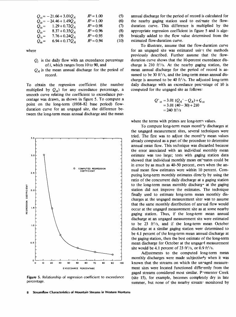
To obtain the regression coefficient (the number multiplied by QA ) for any exceedance percentage, a smooth curve relating the coefficient to exceedance per centage was drawn, as shown in figure 5. To compute a point on the long-term (1938-82 base period) flow- duration curve for an ungaged site, the difference be tween the long-term mean annual discharge and the mean
o 2.0C
O COMPUTED REGRESSION COEFFICIENT
0 10 20 30 40 60 60 70 80 90 100
EXCEEOANCE PERCENTA6E
Figure 5. Relationship of regression coefficient to exceedance percentage.
annual discharge for the period of record is calculated for the nearby gaging station used to estimate the flow- duration curve. This difference is multiplied by the appropriate regression coefficient in figure 5 and is alge braically added to the flow value determined from the estimated flow-duration curve.
To illustrate, assume that the flow-duration curve for an ungaged site was estimated usirq: the methods previously described. Further assume that the flow- duration curve shows that the 10-percent exceedance dis charge is 210 ftVs. At the nearby gaging station, the mean annual discharge for the period of record is as sumed to be 30 ftVs, and the long-term mean annual dis charge is assumed to be 40 ft Vs. The adjusted long-term daily discharge with an exceedance percentage of 10 is computed for the ungaged site as follows:
0' 10 = 3.01 (QA '~ QA ) + £ 10 = 3.01 (40-30)+ 210 = 240ftVs
where the terms with primes are long-tern values.To compute long-term mean month'y discharges at
the ungaged measurement sites, several techniques were tried. The first was to adjust the montb'y mean values already computed as a part of the procedure to determine annual mean flow. This technique was discarded because the error associated with an individual monthly mean estimate was too large; tests with gaging station data showed that individual monthly mean esf'mates could be in error by as much as 40-50 percent, even when the an nual mean flow estimates were within 10 percent. Com puting long-term monthly estimates directly by using the ratio of the concurrent daily discharge at a gaging station to the long-term mean monthly discharg^ at the gaging station did not improve the estimates. The technique finally used to estimate long-term mean monthly dis charges at the ungaged measurement site? was to assume that the same monthly distribution of anrual flow would occur at the ungaged measurement site as at some nearby gaging station. Thus, if the long-term mean annual discharge at an ungaged measurement site were estimated to be 23 ftVs, and if the long-term mean October discharge at a similar gaging station were determined to be 4.1 percent of the long-term mean annual discharge at the gaging station, then the best estimate of the long-term mean discharge for October at the ungagf d measurement site would be 4.1 percent of 23 ftVs, or 0.9 ftVs.
Adjustments to the computed long-term mean monthly discharges were made subjective'y when it was known that the streams on which the unpaged measure ment sites were located functioned differently from the gaged streams considered most similar. P^rmenter Creek (site 15), for example, becomes completely dry in late summer, but none of the nearby streanr monitored by
8 Streamflow Characteristics of Mountain Streams in Western Montana

gaging stations do so. Conversely, South Woodward Creek near its mouth (site 90) has a fairly even discharge, whereas the nearby gaged streams show a large seasonal variation in discharge. The general variation in monthly streamflow at gaging stations within the study area is il lustrated in figure 6. The final, long-term streamflow characteristics estimated for each ungaged measurement site and for selected streamflow-gaging stations are given in tables 5 through 10.
OV
2 0 40"* IE
Q <UJ Zto oto toUJ Qcc0. -JX <ui 1 30
1 <ocx <o !£to 2° o>- 20-I UJz oZ Ko -2."5. UJ_ 0Z (E< UJUJ 0.2 10
O
.
-"W"
T '''*.". '
MAXIMUM
MEAN
p-±ES 31*^
N. w.«
f .*W:«*
,., ; l^.''
Sfcl7oi.!, ^ ::'':"
t^1 '^--^
N|j : ?"
Ij:';^^:',;
PHII>
.
-
-
Sf 1 '!;-?'i-'il';' 1 :' I;::: 1 :
:; -!. :i ^
-
.
-
-
?:,;-
!i ;i :V ;-:
;|' :XJ ! Sfff
ONDJFMAMJJAS
Figure 6. Range of mean monthly discharges at gaging stations.
APPRAISAL OF ACCURACY
The accuracy of the streamflow estimates made at ungaged sites by using the monthly measurement tech nique cannot be determined directly. An indication of the accuracy can be obtained, however, by applying the tech nique to gaged sites for which long-term streamflow data are available. Accordingly, one gaged site in each of the three major areas of potential hydropower development was chosen as the site where streamflow estimates were required. A gaged site suitable for comparison purposes was selected, and the daily mean discharge on the 15th of each month was used to make the monthly and annual mean discharge estimates and the flow estimates for se lected points on the flow-duration curve. The sites for which flow estimates were made were Rower Creek near
Libby (site 14), Bear Creek near Victor (site 59), and Swan River near Condon (site 84). The sites used as near by concurrent-flow gaging stations were, respectively, Yaak River near Troy (site 32), Bitterroot River near Darby (site 46), and Monture Creek near Ovando (site 39). The results of the accuracy tests for determining an annual mean discharge and the long-term mean annual discharge are given in tables 11-13.
As indicated by tables 11-13, the estimates of a single annual mean discharge have an error range (per cent difference) of - 3 to - 11 percent. The estimate" for long-term mean annual discharge range in error from - 2 to - 15 percent. Because the three test streams are con sidered to be generally representative of the streams ac tually measured, it is concluded that the estimate^ of long-term mean annual discharge have an average error of about ± 10 percent.
The estimated flow-duration curves for the three test streams are plotted in figures 7-9. The plotted points are taken from tables 11-13, and final values from the smoothed curves and the associated errors are listed in tables 14-16. The average error for the estimated f iw- duration curves ranged from 6 to 17 percent. The dura tion curves estimated for the ungaged flow measurement sites are thus believed to have a comparable average error of 10-15 percent.
200
100
50
30
20
10
O DAILY MEAN DISCHARGE ON FIFTEENTH OF EACH MONTH DURING 1981 WATER YEAR
I Z 5 10 20 30 40 50 60 70 80 9") 95
EXCEEDANCE PERCENTAGE
Figure 7. Estimated flow-duration curve for Flower Creek near Libby.
Appraisal of Accuracy 9

1000
500
200
100
50
20
10
O DAILY MEAN DISCHARGE ON FIFTEENTH OF EACH MONTH DURING 1959 WATER YEAR
12 5 10 20 30 40 50 60 70 80 90 95
EXCEEDANCE PERCENTAGE
Figure 8. Estimated flow-duration curve for Bear Creek near Victor.
The estimated long-term mean monthly discharges and the associated errors for the three test sites are given in tables 17-19. As indicated by the tables, the errors associated with the estimates of mean monthly discharge are much more variable and generally larger than the errors for estimating the mean annual discharge or the flow-duration curve. For each of the three test streams, at least one mean monthly discharge estimate was in error by more than 40 percent. On two of the test streams, the largest error for a monthly mean estimate exceeded 50 percent. The mean monthly discharge estimates made for the measurement sites are believed to have comparably large errors. The accuracy of the mean monthly flow estimates could be significantly improved only if more than one flow measurement per month were used or if the once-monthly flow-measurement program were contin ued for several years.
1000
500
300
200
100
50
30
20
DAILY MEIN DISCHARGE ON FIFTr.ENTH OF EACH MONTH CURING 1981 WATER YEAR
I 2 5 10 20 30 40 50 60 70 80 90 95
EXCEEDANCE PERCENTAGE
Figure 9. Estimated flow-duration curve for Swan River near Condon.
VARIATIONS IN MEAN ANNUAL R'JNOFF
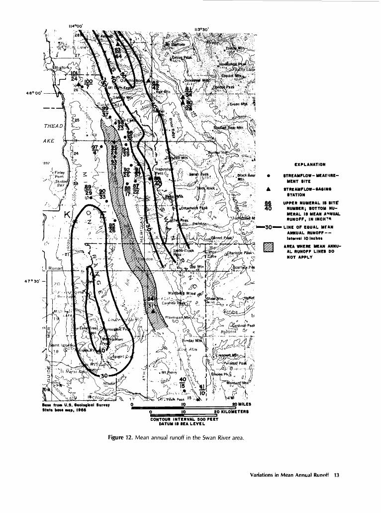
To more fully explore the variations in mean an nual runoff throughout the study area, the three areas with the greatest concentrations of strearrflow gages and flow-measurement sites are shown in detail in figures 10-12. Each figure shows the site number and location of each streamflow measurement site ard streamflow- gaging station in the area. Also shown r the long-term mean annual runoff at each site.
The first area is in the northwestern part of the study area and includes most of the Kootenai River drainage in Montana (fig. 10). As shown by the lines on the map, mean annual runoff generally increases from east to west in the Kootenai River area. The greatest an nual runoff occurs in the mountainous regions southwest of Libby and west of the Yaak River. The streams in the Yaak River drainage having multiple measuring sites in dicate that annual runoff generally increases with eleva tion. Lines of equal mean annual runoff were drawn in figure 10 by assuming that the computed values of mean annual runoff were effectively located at the centroids of the individual drainage basins. Elevation and maps show ing average annual precipitation (U.S. So;i Conservation Service, 1977) were used as a guide in draving lines where no runoff data were available. The lines of equal mean
10 Streamflow Characteristics of Mountain Streams in Western Montana

49°0tfII6°00'
CANADAII5°00'
4 8° 30*
i from U.8. Ocologfcol Survey Stot* boM mop, 1966
10 20 MILES
K> 20KILOMETENS
CONTOUR INTERVAL 800 FEET DATUM IS SEA LEVEL
EXPLANATION
STREAMPLOW- MEASUREMENT SITE l£ UPPER NUMERAL IS SITE NUMBER;15 BOTTOM NUMERAL IS MEAN ANNUAL
A STMEAMFLOW-6A0IN6 STATION RUNOPP, IN INCHES
30«» LINE OP EQUAL MEAN ANNUAL RUNOPP Interval 10 Ihckw
Figure 10. Mean annual runoff in the Kootenai River area.
Variations in Mean Annual Runoff 11

II4°00' II3°30'
46°30'
Boss from U.S. Otological Survey State bast map, 1968
MILES
20 KILOMt TER8
CONTOUR INTERVAL 500 FEET DATUM 18 SEA LEVEL
EXPLANATION
8TREAMFLOW-MEA8UREMENT SITE 3Q LINE OF EQUAL MEAN ANNUAL RUNO*F
8TREAMFLOW-6A6IN6 STATION ___
63 UPPER NUMERAL 18 SITE NUMBER; 37 BOTTOM NUMERAL IS MEAN
ANNUAL RUNOFF, IN INCHES
Interval, in Indies,Is variable
AREA WHERE MEAN ANNUAL RUNOFf LINES 00 NOT APPLY
Figure 11. Mean annual runoff in the Bitterroot River area.
12 Streamflow Characteristics of Mountain Streams in Western Montana
II4°00'II3°30'
4 8° 00'
47°30'
EXPLANATION
8TREAMPLOW- MEAfMRE- MENT SITE
A STREAMPLOW-eASINe STATION
86 UPPER NUMERAL 13 SITE!40 NUMBER; BOTTOM NU
MERAL IS MEAN ANNUAL RUNOFF, IN INCIT*
30 LINE OP EQUAL Ml AN ANNUAL RUNOFF-- Interval 10 lneh«t
PH AREA WHERE MEAN ANNU- SSSI AL RUNOPP LINES DO
NOT APPLY
BOM from U.S. Biological Survey State bat* map, 1966
80 MILES
10 20 KILOMETERS
CONTOUR INTERVAL BOO PEET DATUM IS SEA LEVEL
Figure 12. Mean annual runoff in the Swan River area.
Variations in Mean Annual Runoff 13

annual runoff can be used to estimate mean annual run off at any ungaged site in the area. It needs to be empha sized, however, that mean annual runoff is determined at the centroid of the drainage area upstream from the site and not at the site itself. Also, the locations of the lines are based on a limited number of flow-measurement sites, and considerable variation between the lines is possible.
The second area is composed largely of the Bitter- root River drainage (fig. 11). In this area, mean annual runoff varies markedly from the east side of the Bitter- root River, where computed values range from 4 to 14 in., to the west side of the Bitterroot River, where mean annual runoff ranges from 26 to 43 in. On the west side, the computed values of mean annual runoff are consist ent from south to north, except for the two northernmost streams, Bass Creek and Sweeney Creek (sites 65 and 66). Although multiple measuring sites were not used on streams in the Bitterroot area, mean annual runoff was assumed to increase with elevation, and the lines of equal mean annual runoff were drawn accordingly. A previous study by McMurtrey and others (1972) indicated that streams on the west side of the Bitterroot River generally lose a substantial amount of their flow when they leave the mountain canyons and flow over the porous alluvium of the valley floor. Consequently, the lines of equal mean annual flow shown in figure 11 will not provide accurate estimates of mean annual flow at locations on the valley floor.
The third area is drained by the Swan River and the South Fork Flathead River (fig. 12). Mean annual runoff tends to be greater on the east side of the Swan River than on the west side, although the east-west variation is not as pronounced as in the Bitterroot area. Mean annual runoff also generally increases from south to north on the east side of the Swan River. The multiple measuring sites in the Swan River area indicate a large increase in mean annual runoff from the valley floor to the moun tains. As in the Bitterroot area, substantial streamflow losses evidently occur as the mountain streams enter the alluvium of the valley floor. Consequently, the lines of equal mean annual runoff will not provide accurate estimates of mean annual flow in the valley-floor area.
Several anomalies in the general pattern of mean annual runoff variation also occur in the Swan River area. Porcupine Creek (site 97) and Johnson Creek (site 100) both have mean annual runoff values substantially smaller than those from any nearby measuring site. These streams may traverse sections of very permeable or frac tured bedrock that intercept a large percentage of the an nual streamflow. Also, the mean annual runoff of South Woodward Creek evidently is increased by springs be tween measuring sites 89 and 90. These anomalies serve to emphasize that generalized maps such as figures 10-12 can be used to accurately estimate mean annual runoff
only where local geology and ground-water/surface- water interactions remain fairly uniform.
EQUATIONS FOR ESTIMATING STREAMFLOW CHARACTERISTICS
Because maps of mean annual runoff could be developed for only three parts of the western Montana study area, prediction equations for estimating mean an nual discharge anywhere in the study area were derived using multiple regression techniques. Prediction equa tions relating streamflows for various points on the flow- duration curves to mean annual discharge were also developed using multiple regression.
Mean Annual Discharge
To estimate mean annual discharge, a multiple- regression equation of the following log-linear form was derived:
(11)
where
QA is mean annual discharge in cubic feet persecond,
A is drainage area, P is mean annual precipitation, a is the regression constant, and b and c are regression coefficients.
Drainage area is expressed in square mile^ and is deter mined for ungaged sites by planimetering the area out lined on the best-scale topographic map available. Mean annual precipitation is the basin average, in inches, deter mined from the maps of the U.S. Soil Conservation Serv ice (1977). No other basin characteristics such as basin elevation or channel slope were considered for inclusion in the regression equations because previous studies by Potts (1983) and Fames (1978) showed no other variables to be significant in estimating mean annual discharge. An equation for the entire study area was firs* derived using data from 92 streamflow-measuring sites and gaging sta tions. Examination of the residuals from the preliminary regression equation indicated that better results would be obtained if the study area were separated into two regions. Consequently, the study area was divided into the two regions shown in figure 13.
In Region 1, data from 47 sites we"e used to de velop the following regression equation:
(12)
14 Streamflow Characteristics of Mountain Streams in Western Montana

49°116° 114'
48° ^
20 40 MILES; ~ I r-H i' . ' '
Jf 0 20 40 KILOMETERS
Figure 13. Regional boundaries.
Equations for Estimating Streamflow Characteristics 15

where the terms are as previously defined. The coefficient of determination (R2) for this prediction equation was 0.944, and the standard error of estimate was 33 percent. The prediction equation developed by Potts for the same general area as Region 1 (Region 3 in the Potts report) is similar:
QA = 0.0292 (A-P) 1.003 (13)
Equation 13 yields estimates of mean annual dis charge that are slightly larger than those from equation 12. For a drainage area of 10 mi2 and a mean annual precipitation of 10 in., the result from equation 13 is about 32 percent larger than the result from equation 12. For a drainage area of 10 mi2 and a mean annual precipi tation of 40 in., the result from equation 13 is about 7 percent larger. Because equation 12 was developed spe cifically for mountainous areas and smaller streams (drainage areas smaller than 100 mi2) in western Mon tana, equation 12 is probably more reliable than equation 13 in those instances.
Region 2 includes the west side of the Bitterroot River drainage and the Swan River and Flathead River drainages. This region corresponds generally with Region 4 defined by Potts (1983). The regression equation for mean annual discharge derived for Region 2 was based on data from 24 sites and is:
(14)
The coefficient of determination was 0.971, and the standard error of estimate was 17 percent. The corre sponding prediction equation developed by Potts is:
QA = 0.041 \(A-P)°,0.995 (15)
Again, equations 14 and 15 are very similar. In this in stance, the Potts equation yields larger estimates of mean annual discharge for values of drainage area (A) times mean annual precipitation (P) to a maximum of about 200. For values of A-P greater than 200, equation 14 gives larger estimates of mean annual discharge. For a value of A-P of 50, the difference between equations 14 and 15 is about 8 percent, and for a value of A-P of 10,000, the difference is about 17 percent. As before, equation 14 is considered to be slightly more reliable than equation 15 when applied to smaller streams in moun tainous areas of Region 2.
Flows of Various Exceedance Percentages
Regression equations for estimating flows for various exceedance percentages were also developed for Regions 1 and 2. For these areas, the equations derived
were log-linear regression equations relating flows of various exceedance percentages to mean annual flow. The form of the estimating equations was:
(16)
where
Qn is the daily discharge, in cubic feet per second,for exceedance percentage of n,
a is the regression constant, b is the regression coefficient, and
QA is the mean annual discharge, in cubic feet per second.
The equations developed for Region 1 and their corre sponding coefficients of determination are listed in table20. Similarly, the estimating equations for flows of vari ous exceedance percentages in Region 2 are given in table21.
The coefficients of determination ir tables 20 and 21 are all close to 1.00, indicating very good correlation between mean annual discharge and flows of various ex ceedance percentages. In both regions, the coefficients of determination generally increase as the streamflows being estimated increase. Low flows (exceedance percentages greater than 50) thus are not as closely correlated with mean annual discharges as are the higher flows (exceed ance percentages less than 50).
The equations for estimating discharges of various exceedance percentages can be compared ^ith results ob tained by Cunningham and Peterson (1983) by first dividing each equation by Q10. Thus, in Region 1, the right side of each equation in table 20 mus* be divided by 2.866 QA°-m , and in Region 2 the right side of each equa tion in table 21 must be divided by 1.390 QA l - 170 . Solving the dimensionless equations for Region 1 for the smallest and largest values of QA (2.00 and 888 ftVs) produces two dimensionless flow-duration curves that are com pared in figure 14 with the dimensionless flow-duration curves developed by Cunningham and Peterson (1983). Similarly, the dimensionless equations for Region 2 were solved for the smallest and largest values c f QA in region 2 (6.20 and 210 ftVs), and the resulting flow-duration curves are compared in figure 15 with th? Cunningham and Peterson curves.
The two curves defined by Cunning! am and Peter- son were considered applicable in all mountainous regions of Montana and thus are the same curves in both figures 14 and 15. The upper curve define'! by Cunning- ham and Peterson represents the expected flow response of mountain streams having the most stab'e streamflows. According to Cunningham and Peterson, such streams are generally located in densely forested a-eas with deep soil cover and have relatively flat slopes. The lower curve defined by Cunningham and Peterson is representative of mountain streams having the greatest variation in stream-
16 Streamflow Characteristics of Mountain Streams in Western Montana

Band of curves defined by Cunningham and Peterson (1983)
QA = 2.00 cubic feet per second
Q. = 888 cubic feet per second
EXCEEDANCE PERCENTAGE
Figure 14. Dimensionless flow-duration curves for Region 1.
flow. Such sites, according to Cunningham and Peter- son, are generally characterized by steep, rocky terrain with thin soil cover.
In Region 1, the dimensionless flow-duration curve for the smallest mean annual discharge lies totally within the band of curves defined by Cunningham and Peterson (fig. 14). The curve for the largest mean annual discharge falls well within the band of curves for smaller exceed- ance percentages, but lies slightly above the band for ex- ceedance percentages greater than 70. The pronounced flattening of the curve indicates that base flows on streams having large mean annual discharges generally
tend to be more constant than those on streams having small mean annual flows.
In Region 2, the curve for the largest mean annual discharge lies totally within the band defined by Qmn- ingham and Peterson, but the curve for the smallest n>a:an annual discharge lies above the band for exceedance per centages between 20 and 80 (fig. 15). In this region, streamflows evidently fluctuate more on streams having large mean annual discharges than on streams having small mean annual discharges. This result may reflect the fact that many of the measuring sites on small streams (those having small mean annual discharges) in this re-
Equations for Estimating Streamflow Characteristics 17

o o ^.
o
Band of curves defined by Cunning ham an4 Peterson (1983)
. = 6.20 cubic feet per second
= 210 cubic feet per second
100
EXCEEDANCE PERCENTAGE
Figure 15. Dimensionless flow-duration curves for Region 2.
gion were located at higher elevations, where snowmelt is more gradual and takes place over a longer period of time than at lower elevations.
Because the curves developed in this study plot fair ly closely to the band of curves defined by Cunningham and Peterson, the results obtained from either method probably will not be significantly different in most in stances. The equations in tables 20 and 21 are considered to be more reliable for the study area than the dimension- less curves developed by Cunningham and Peterson, pri marily because of the additional small-stream data used.
Prediction Accuracy and Limitations
Using the equations in tables 20 and 21 to estimate flow for any exceedance percentage requires an estimate of mean annual discharge. The error associated with an estimate of a flow of any exceedance percentage is thus composed of the error associated with making the mean annual discharge estimate as well as the error associated with the estimating equations in tables 20 and 21. To ob tain an indication of the prediction accuracy of the equa tions in tables 20 and 21 as well as the prediction accuracy
18 Streamflow Characteristics of Mountain Streams in Western Montana

of the equations for mean annual flow (eq. 13, 15), 10 sites in Region 1 and 5 sites in Region 2 were randomly selected and withheld from the regression analysis. Applying the estimating equations to the 15 sites not used resulted in the average errors of prediction given in table22.
Somewhat surprisingly, perhaps, in both regions the average prediction error for flows of most exceedance percentages is less than the prediction error for mean an nual discharge. In each region, however, the calculated prediction error for mean annual discharge was largely affected by one poor estimate. If the single poor estimate is eliminated, the average prediction error for mean an nual discharge becomes -6 percent for Region 1 and - 11 percent for Region 2.
Because the long-term flow characteristics at the flow-measurement sites were determined by correlation with gage sites, and because the correlations reduced the actual site-to-site variability of streamflow, it might be argued that the computed prediction errors are artificially small. To test this assumption, the average errors of pre diction were recalculated using only the 6 gage sites from among the 15 sites withheld from the regression analyses. This recalculation reduced the number of sites for cal culating average prediction error to five in Region 1 and to only one in Region 2. The average prediction errors calculated using only the six gage sites are given in table23.
Because the prediction errors calculated from the gage data only are generally less than the prediction er rors calculated from all 15 randomly selected sites, the results in table 22 are considered to approximate the aver age error that can be expected from an estimate of streamflow at an ungaged site. As with any regression analysis, however, it needs to be emphasized that the equations are valid only within the range of values of the variables used to derive the equations and only for loca tions within the study region. For this study, the range of values of the independent variables is listed in table 24. Extrapolation beyond the range of values listed or appli cation to sites outside the study area may give unrealistic estimates of streamflow.
The regression equations are also not applicable to mountain streams that are spring-fed or that periodically go dry because of very permeable streambeds or other unique localized geologic features. The equations thus are not applicable to the valley-floor areas of the Bitter- root River and Swan River drainages. The equations also may not be applicable for sites where upstream storage in lakes and ponds is significant, or for sites that have upstream diversions. Some knowledge of the local hydrology and geology is a necessary prerequisite to the successful application of the regression equations. In some instances, a program of monthly streamflow meas urements may be required to ascertain whether flow
conditions in an area are unique. When very accurate flow estimates are required, the prediction equations can be supplemented and verified by miscellaneous stream- flow measurements.
SUMMARY
Miscellaneous measurements were used to estimate streamflow characteristics at 72 sites in the mountainous areas of western Montana. The characteristics incl ided mean annual discharge, mean monthly discharge, and points on the flow-duration curve. A streamflow- correlation program permitted synthesizing the missing record at 38 gaging stations in the study area to deve'op a common 1938-82 period of record at all streamflow- measurement sites. Tests of the accuracy obtained when miscellaneous measurements are used to estimate long- term streamflow characteristics indicated that mean an nual flow can be estimated at a measurement site with an expected error of about ± 10 percent. The flow-duration curve can be estimated at a streamflow-measurement site with an expected error of about 10-15 percent. Estimates of long-term mean monthly flow have the poorest ac curacy, with expected errors of as much as + 60 percent and -21 percent.
The estimates of long-term mean annual flow were used, together with applicable gaging data, to prepare maps showing the areal variability of mean annual runoff. The maps were prepared for the three areas in western Montana having the greatest concentration of flow-measurement sites and gaging stations.
Streamflow characteristics determined for the streamflow-measurement sites and gaging stations were also used to develop regression equations for estimating mean annual flow and flows of various exceedance per centages anywhere within western Montana. The be*:t re sults were obtained when the study area was divided into two regions, with separate equations for each region. The regression equations for mean annual discharge used drainage area and mean annual precipitation as inde pendent variables and had determination coefficients of 0.944 and 0.971 in the two regions, with corresponding standard errors of estimate of 33 and 17 percent. The mean annual flow equations were compared with similar equations developed in a previous study and were found to give differences of 7 to 32 percent.
The regression equations for flows of various ex ceedance percentages used mean annual discharge ?* the only dependent variable and had coefficients of deter mination ranging from 0.849 to 0.981. The equations were converted to a dimensionless form and were com pared graphically with results from a previous sfudy. Data from sites not used in the regression analyses were used to develop estimates of expected average errcrs of prediction when applying the equations to ungaged sites.
Summa-y 19

The estimated average error for mean annual discharge was -16 percent in one region and -23 percent in the other, but would have been reduced to - 6 percent and -11 percent had one poor estimate been excluded. The estimated errors for flows of various exceedance percent ages ranged from + 2 to - 38 percent in one region and from + 18 to - 15 percent in the other.
REFERENCES CITED
Boner, F. C., and Buswell, G. W., 1970, A proposed stream- flow data program for Montana: U.S. Geological Survey open-file report, 96 p.
Cunningham, A. B., and Peterson, D. A., 1983, A procedure for estimating flow-duration curves for ungaged mountain ous and high plains streams in Montana: Montana Uni versity Joint Water Resources Research Center, 43 p.
Fames, P. E., 1978, Hydrology of mountain watersheds: U.S. Soil Conservation Service, 8 p.
Hunt, O. P., 1963, Use of low-flow measurements to estimate flow-duration curves: U.S. Geological Survey Professional Paper 475-C, p. C196-C197.
McMurtrey, R. G., Konizeski, R. L., Johnson, M. V., and Bartells, J. H., 1972, Geology and water resources of the Bitterroot Valley, southwestern Montana: U.S. Geological Survey Water-Supply Paper 1889, 80 p.
Potts, D. F., 1983, Streamflow regionalization in western Montana: School of Forestry, University of Montana Re search Note 19, 5 p.
Riggs, H. C., 1969, Mean Streamflow from discharge meas urements: International Association of Scientific Hydrol ogy Bulletin 14, p. 95-110.
U.S. Army Corps of Engineers, 1971, HEC-4 monthly stream- flow simulation: Hydrologic Engineering Center, 113 p.
U.S. Soil Conservation Service, 1977, Averag? annual precipi tation, Montana, based on 1941-1970 bc^e period: Boze- man, Mont., 13 p.
20 Streamflow Characteristics of Mountain Streams in Western Montana

TABLES 1-24

Table 1. Streamflow measurements and site descriptions [ft, foot; ftVs, cubic foot per second; mi, mile]
Site Stream No. name
1 YoungCreekbelowSouthFork
2 YoungCreekatmouth
3 CayuseCreek(12300400)
4 FortineCreek(12300500)
5 DeepCreek(12300800)
7 SullivanCreek
Tribu tary to
KootenaiRiver
KootenaiRiver
SwampCreek
TobaccoRiver
FortineCreek
KootenaiRiver
Location
Kootenai River Basin
Lat 48°58'05", long 115°17 1 24", inSEJtNWJtSEJt sec. 18, T. 37 N. ,R. 28 W., Lincoln County, KootenaiNational Forest, at U.S. ForestService bridge, 1.9 mi downstreamfrom South Fork Young Creek, and7.4 mi northwest of Rexford, Mont.
Lat 49 0 57'44", long 113°ir26", inNEJtNW*tNWit sec. 24, T. 37 N. ,R. 28 W. , Lincoln County, on leftbank 600 ft upstream from LakeKoocanusa flow line, 0.3 mi downstream from culvert on countyroad, and 4.2 mi northwest ofpresent site of Rexford, Mont.
Lat 48°36'33", long 115°or42", inSWJtSWJtNEH; sec. 24, T. 33 N,R. 27 W., Lincoln County, at culvert on U.S. Forest Service road,9.8 mi southwest of Trego, Mont.,at site of crest-stage station.
Lat 48°38'41" > long 114°54'36", inNE*t sec. 11, T. 33 N. , R. 26 W. ,Lincoln County, 5.5 mi southwestof Trego, Mont., at site of crest-stage station.
Lat 48°45'41", long 114°52'32", inSVfy sec. 30, T. 35 N. , R. 25 W. ,Lincoln County, at culvert oncounty road, 1.2 mi east of Fortine, Mont., at site of crest-stagestation.
Lat 48°52'15 M , long 115°15'25", inSE*tSE*tNWV sec. 20, T. 36 N. ,R. 28 W. , Lincoln County, KootenaiNational Forest, at culvert oncounty road near Lake Koocanusaflow line 5.0 mi west of Rexford,Mont.
Date
04-15-8205-14-8206-15-8207-15-8208-16-8209-14-8210-15-8211-16-8212-15-8201-19-83
03-16-8204-15-8205-14-8206-15-8207-15-8208-16-8209-14-8210-15-8211-16-8212-15-8201-19-8302-16-83
03-15-8204-14-8205-13-8206-14-8207-16-8208-17-8209-15-8210-12-8211-16-8202-16-83
03-15-8204-14-8205-13-8206-14-8207-16-8208-17-8209-15-8210-12-8211-16-8212-16-8201-19-8302-16-83
03-15-8204-14-8205-13-8206-14-8206-15-8207-16-8208-17-8209-15-8210-12-8211-16-8212-16-8201-19-8302-16-83
03-16-8204-15-8205-14-8206-15-8207-15-8208-16-8209-14-8210-15-8211-15-8212-15-8201-18-8302-15-83
Dis charge (ftS/s)
7.7853.867.223.615.49.017.586.505.374.90
6.7010.144.978.223.511.36.366.346.117.736.235.74
1.8510.536.04.753.661.09.89.58.58.92
68.318237610858.713.09.489.8510.212.223.821.6
2.311.898.16
10199.739.410.85.636.063.083.462.392.19
7.1814.636.824.124.38.385.564.093.642.173.453.80 Tab'^s 23

Table 1. Streamflow measurements and site descriptions Continued
Site No.
8
9
10
15
16
17
Stream name
BoulderCreek
BigCreeknearRexford(12301810)
BristowCreek
ParmenterCreek
CedarCreek
QuartzCreek
Tribu tary to
KootenaiRiver
KootenaiRiver
KootenaiRiver
KootenaiRiver
KootenaiRiver
KootenaiRiver
Location
Kootenai River Basin Continued
Lat 48°49'18", long 115°17'30", inNV^tSWitSEH; sec. 1, T. 35 N. ,R. 29 W. , Lincoln County, KootenaiNational Forest, at culvert nearmouth on county road 8.0 mi southeast of Rexford, Mont.
Lat 48°44'53", long 115°2r09", inSEHSWiiSEH; sec. 33, T. 35 N. ,R. 29 W., Lincoln County, KootenaiNational Forest, on left bank500 ft downstream from highwaybridge, 0.3 mi upstream from LakeKoocanusa flow line, and 13.6 misouthwest of present site ofRexford, Mont., at site of formergaging station.
Lat 48°32'40", long 115°17 I 20", inS&i sec. 10, T. 32 N., R. 29 W.,Lincoln County, at bridge on countyroad west of Lake Koocanusa, 9.0 miupstream from the dam, and 12.0 minorthwest of Libby , Mont.
Lat 48°23'27", long 115°33'34", inSEHSEiiSWii sec. 33, T. 31 N. ,R. 31 W., Lincoln County, KootenaiNational Forest at bridge on U.S.Highway 2, 0.8 mi upstream fromKootenai River in Libby, Mont.
Lat 48°25'50", long IIS^'AI", inNW*iSE*iSEH; sec. 24, T. 31 N.,R. 32 W. , Lincoln County, KootenaiNational Forest, at bridge on U.S.Highway 2, 0.1 mi upstream fromKootenai River, and 5.0 mi northwestof Libby, Mont.
Lat 48°26'21", long 115°38'08", inSW*iNE*iNWii sec. 24, T. 31 N.,R. 32 W., Lincoln County, KootenaiNational Forest, at county roadbridge, 0.1 mi upstream from mouth,and 5.0 mi northwest of Libby, Mont.
Date
03-16-8204-15-8205-14-8206-14-8207-14-8208-16-8209-14-8210-15-8211-15-8212-15-8201-18-8302-15-83
03-16-8204-15-8205-13-8206-14-8207-14-8208-16-8209-14-8210-15-8211-15-8212-15-8201-18-8302-15-83
09-16-7405-15-7505-28-7506-04-7509-30-75
03-16-8204-15-8205-20-8206-15-8207-14-8208-19-8209-14-8210-13-8211-17-8212-13-8201-20-8302-17-83
03-16-8204-15-8205-20-8206-15-8207-14-8208-19-8209-13-8210-13-8211-17-8212-13-8201-20-8302-17-83
03-16-8204-14-8205-20-8206-15-8207-14-8208-19-8209-13-8210-13-8211-15-8212-13-8201-19-8302-15-83
Dis charge (ft 3/s)
9.4620.777.786.031.110.15.696.493.585.026.905.11
67.2162 15430.421.218.77.14
1035.038.4
.3522952.267.8
.32
25.243.310718746.81.821.22.31
1.3901.931.67
34.441.410513727.011.87.837.788.517.098.936.55
90.715633027861.031.132.821.218.731.944.438.1
24 Streamflow Characteristics of Mountain Streams in Western Montana

Table 1. Streamflow measurements and site descriptions Continued
Site No.
18
19
20
21
22
23
Stream name
CampCreek(12303440)
RubyCreek
PeteCreekbelowHens leyCreek
PeteCreekatmouth
White-tailCreek(12304250)
SpreadCreek
Tribu tary to Location
Kootenai River Basin Continued
Lake Creek Lat 48°18 I 46", long IIS-SO'SS", inSWH;SEV sec. 32, T. 30 N. , R. 33 W. ,Lincoln County, at bridge on U.S.Forest Service road, 0.8 mi eastof Highway 202, 12.6 mi south ofTroy, Mont., at site of crest-stage station.
Kootenai Lat 48°3L I 07", long 115°57'00",River NWl-tSE^SE^ sec. 21, T. 32 N. , R. 34
W., Lincoln County, KootenaiNational Forest, at bridge on countyroad, 0.3 mi upstream from KootenaiRiver, and 5.0 mi northwest ofTroy, Mont.
Yaak Lat 48°51 I 19", long 115°46'20", land-River line description unsurveyed, Lincoln
County, Kootenai National Forest, atU.S. Forest Service road culvert 100ft downstream from Hensley Creek,1.7 mi upstream of Yaak River, 1.9mi north of junction with FAS 508,and 3.5 mi west of Yaak, Mont.
Yaak Lat 48 0 49'53", long HS^S'SS",River landline description unsurveyed,
Lincoln County, Kootenai NationalForest, at county bridge on FAS508, 0.1 mi upstream from YaakRiver, and 2.0 mi west of Yaak,Mont.
Yaak Lat 48°49'42", long 115 0 48'45", inRiver NEV sec. 1, T. 35 N., R. 33 W.,
Lincoln County, 500 ft upstreamfrom mouth, 5.0 mi west of Yaak,Mont., at site of former crest-stage station.
Yaak River Lat 48°49 I 23", long 115 e 51'01",landline description unsurveyed,Lincoln County, Kootenai NationalForest, at bridge on FAS 508, 0.3mi upstream from Yaak River, and6.5 mi west of Yaak, Mont.
Date
03-15-8204-14-8205-19-8206-14-8207-12-8208-17-8209-13-8210-13-8211-17-8212-15-8201-19-8302-17-83
03-15-8204-14-8205-19-8206-14-8207-13-8208-18-8209-14-8210-13-8211-17-8212-15-8201-19-8302-17-83
03-15-8204-13-8205-20-8206-14-8207-13-8208-18-8209-14-8210-14-8211-16-8212-14-8201-18-8302-16-83
03-15-8204-13-8205-20-8206-14-8207-13-8208-18-8209-14-8210-14-8211-16-8212-14-8201-18-8302-16-83
03-15-8204-13-8205-20-8206-14-8207-13-8208-18-8209-14-8210-14-8211-16-8212-13-8201-18-8302-16-83
03-15-8204-13-8205-19-8206-14-8207-13-8208-18-8209-14-8210-14-8211-16-8212-14-8201-18-8302-16-83
Dis charge (ft 3/s)
15.120.082.014347.26.414.164.784.534.636.205.27
62.594.8
13571.014.86.654.634.265.026.68
23.623.6
52.312621983.127.24.844.132.975.10
11.829.723.0
64.117822283.626.06.293.943.166.9013.534.030.0
3.9210.99.592.43.61
000001.631.45
40.899.1
39859281.519.617.016.417.231.531.028.3 TabH 25
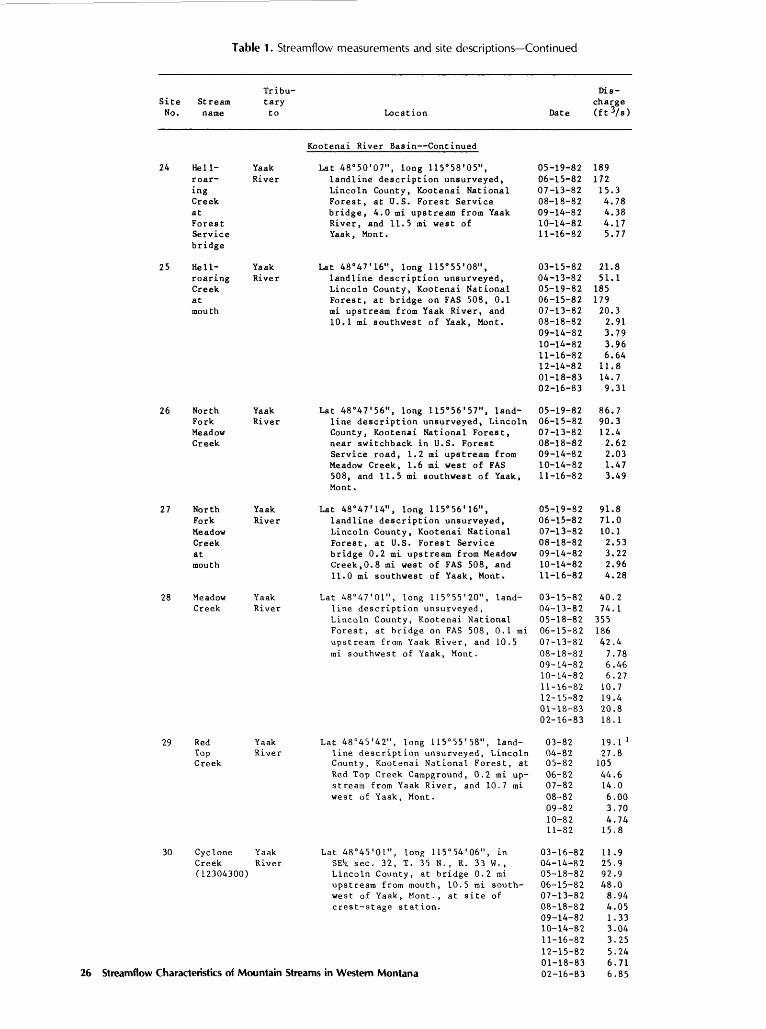
Table 1. Streamflow measurements and site descriptions Continued
26
Site No.
24
25
26
27
28
29
30
Charac
Stream name
Hell-roaringCreekatForestServicebridge
Hell-roaringCreekatmouth
NorthForkMeadowCreek
NorthForkMeadowCreekatmouth
MeadowCreek
RedTopCreek
CycloneCreek(12304300)
:teristks of M<
Tribu tary to Location
YaakRiver
YaakRiver
YaakRiver
YaakRiver
YaakRiver
YaakRiver
YaakRiver
Hjntain
Kootenai River Basin Continued
Lat 48°50'07", long 115°58'05",landline description unsurveyed,Lincoln County, Kootenai NationalForest, at U.S. Forest Servicebridge, 4,0 mi upstream from YaakRiver, and 11.5 mi west ofYaak, Mont.
Lat 48°47'16", long 115 0 55'08",landline description unsurveyed,Lincoln County, Kootenai NationalForest, at bridge on FAS 508, 0.1mi upstream from Yaak River, and10.1 mi southwest of Yaak, Mont.
Lat 48°47'56", long 115°56'57", land-line description unsurveyed, LincolnCounty, Kootenai National Forest,near switchback in U.S. ForestService road, 1.2 mi upstream fromMeadow Creek, 1.6 mi west of FAS508, and 11.5 mi southwest of Yaak,Mont.
Lat 48°47'14", long 115°56'16",landline description unsurveyed,Lincoln County, Kootenai NationalForest, at U.S. Forest Servicebridge 0.2 mi upstream from MeadowCreek, 0.8 mi west of FAS 508, and11.0 mi southwest of Yaak, Mont.
Lat 48°47'01", long 115°55'20", land-line description unsurveyed,Lincoln County, Kootenai NationalForest, at bridge on FAS 508, 0.1 miupstream from Yaak River, and 10.5mi southwest of Yaak, Mont.
Lat 48°45'42", long US'SS'SS", land-line description unsurveyed, LincolnCounty, Kootenai National Forest, atRed Top Creek Campground, 0.2 mi upstream from Yaak River, and 10.7 miwest of Yaak, Mont.
Lat 48°45'01", long 115°54 I 06", inSE*i sec. 32, T. 35 N., R. 33 W. ,Lincoln County, at bridge 0.2 miupstream from mouth, 10.5 mi southwest of Yaak, Mont., at site ofcrest-stage station.
Streams in Western Montana
Date
05-19-8206-15-8207-13-8208-18-8209-14-8210-14-8211-16-82
03-15-8204-13-8205-19-8206-15-8207-13-8208-18-8209-14-8210-14-8211-16-8212-14-8201-18-8302-16-83
05-19-8206-15-8207-13-8208-18-8209-14-8210-14-8211-16-82
05-19-8206-15-8207-13-8208-18-8209-14-8210-14-8211-16-82
03-15-8204-13-8205-18-8206-15-8207-13-8208-18-8209-14-8210-14-8211-16-8212-15-8201-18-8302-16-83
03-8204-8205-8206-8207-8208-8209-8210-8211-82
03-16-8204-14-8205-18-8206-15-8207-13-8208-18-8209-14-8210-14-8211-16-8212-15-8201-18-8302-16-83
Dis charge (ft 3/s)
18917215.34.784.384.175.77
21.851.1
18517920.32.913.793.966.6411.814.79.31
86.790.312.42.622.031.473.49
91.871.010.12.533.222.964.28
40.274.1
35518642.47.786.466.2710.719.420.818.1
19.1 127.810544.614.06.003.704.7415.8
11.925.992.948.08.944.051.333.043.255.246.716.85
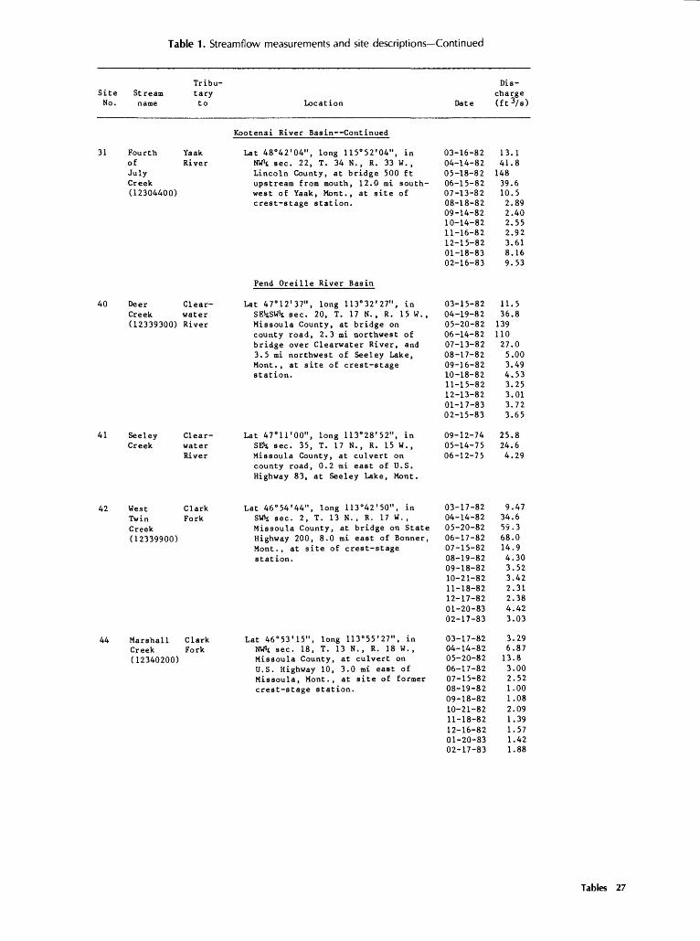
Table 1. Streamflow measurements and site descriptions Continued
Site No.
31
40
41
42
44
Tribu-
Stream tary name to
Fourth Yaakof RiverJulyCreek(12304400)
Deer Clear-Creek water(12339300) River
Seeley Clear-Creek water
River
West ClarkTwin ForkCreek(12339900)
Marshall ClarkCreek Fork(12340200)
Location
Kootenai River Basin Continued
Lat 48°42'04", long 115°52'04", inNW*t sec. 22, T. 34 N. , R. 33 W. ,Lincoln County, at bridge 500 ftupstream from mouth, 12.0 mi southwest of Yaak, Mont., at site ofcrest-stage station.
Pend Oreille River Basin
Lat 47°12'37", long 113°32'27", inSEStSWit sec. 20, T. 17 N. , R. 15 W.,Missoula County, at bridge oncounty road, 2.3 mi northwest ofbridge over Clearwater River, and3.5 mi northwest of Seeley Lake,Mont., at site of crest-stagestation.
Lat 47°irOO", long 113°28'52", inSE^; sec. 35, T. 17 N. , R. 15 W.,Missoula County, at culvert oncounty road, 0.2 mi east of U.S.Highway 83, at Seeley Lake, Mont.
Lat 46°54'44", long 113°42'50", inSW*t sec. 2, T. 13 N. , R. 17 W. ,Missoula County, at bridge on StateHighway 200, 8.0 mi east of Bonner,Mont., at site of crest-stagestation.
Lat 46°53'15", long 113°55'27", inNW-t sec. 18, T. 13 N. , R. 18 W. ,Missoula County, at culvert onU.S. Highway 10, 3.0 mi east ofMissoula, Mont., at site of formercrest-stage station.
Date
03-16-8204-14-8205-18-8206-15-8207-13-8208-18-8209-14-8210-14-8211-16-8212-15-8201-18-8302-16-83
03-15-8204-19-8205-20-8206-14-8207-13-8208-17-8209-16-8210-18-8211-15-8212-13-8201-17-8302-15-83
09-12-7405-14-7506-12-75
03-17-8204-14-8205-20-8206-17-8207-15-8208-19-8209-18-8210-21-8211-18-8212-17-8201-20-8302-17-83
03-17-8204-14-8205-20-8206-17-8207-15-8208-19-8209-18-8210-21-8211-18-8212-16-8201-20-8302-17-83
Dis
charge (ft 3/s)
13.141.8
14839.610.52.892.402.552.923.618.169.53
11.536.8
13911027.05.003.494.533.253.013.723.65
25.824.64.29
9.4734.659.368.014.94.303.523.422.312.384.423.03
3.296.8713.83.002.521.001.082.091.391.571.421.88
Tables 27

Table 1. Streamflow measurements and site descriptions Continued
Tribu-
Site Stream tary No. name to Location
Pend Oreille River Basin Continued
47 Tin Cup Bitter- Lat 46°00'50", long 114°13'20", inCreek root SEk sec. 17, T. 3 N. , R. 21 W. ,
River Ravalli County, 4.0 mi upstreamfrom mouth,and 2 mi southeast ofDarby, Mont.
48 Burke Bitter- Lat 46°01'28", long 114 0 08'45", inGulch root S4 sec. 12, T. 3 N. , R. 21 W. ,
River Ravalli County, 1.0 mi upstreamfrom mouth, and 1 . 5 mi east ofDarby, Mont.
49 Lost Bitter- Lat 46°06'08", long 114°15'50",Horse root in SVflt. sec. 18, T. 4 N., R. 21 W. ,Creek River Ravalli County, 5.0 mi upstream from
mouth, and 7.0 mi northwest ofDarby, Mont.
Date
04-16-5805-07-5805-14-5805-22-5806-12-5807-12-5808-08-5809-09-5810-10-5811-19-5812-31-5801-27-5902-27-5904-01-5904-30-5906-08-5907-07-5908-02-5909-01-5910-01-59
03-29-5804-16-5805-06-5805-12-5805-13-5807-11-5808-07-5809-09-5810-10-5811-19-5801-01-5901-27-5902-27-5904-01-5904-02-5904-28-5905-16-5906-08-5907-07-5908-01-5909-01-5910-01-59
03-31-5804-17-5805-02-5805-15-5805-22-5806-16-5807-11-5808-07-5809-10-5810-11-5811-19-5801-01-5901-28-5902-28-5904-02-5904-30-5906-09-5907-07-5908-02-5909-03-5910-01-59
Dis
charge (ft3/ s )
10329429351928979.951.414.624.259.732.232.812.924.2
15353018265.846.850.5
.902.409.0011.08.10.90.60.20.40.80.40.80.80
1.402.702.305.001.601.00.30.10.60
49.4179168703
1,31044013333.722.089.811771.278.531.0
25548597436684.325.4
104
28 Streamflow Characteristics of Mountain Streams in Western Montana

Table 1. Streamflow measurements and site descriptions Continued
Tribu- Site Stream tary No. name to Location
Pend Oreille River Basin Continued
50 Camas Bitter- Lat 46°08'42", long 114°12'58", inCreek root SW^t sec. 34, T. 5 N., R. 21 W. ,
River Ravalli County, 8.0 mi southwest ofHamilton, Mont.
51 Sleeping Bitter- Lat 46°08'34", long 114°05'02", inChild root SEk sec. 34, T. 5 N., R. 20 W. ,Creek River Ravalli County, 5.0 mi upstream
from mouth, and 8.5 mi southeastof Hamilton, Mont.
52 Little Bitter- Lat 46°06'25", long 114°06'08", inSleep- root SE*s sec. 8, T. 4 N. , R. 20 W. ,ing River Ravalli County, 3.5 mi upstreamChild from mouth, and 10.0 mi southeastCreek of Hamilton, Mont.
Date
03-31-5804-17-5805-07-5805-15-5805-20-5805-25-5806-12-5807-12-5808-08-5809-10-5810-11-5811-21-5801-01-5901-28-5902-28-5904-02-5904-30-5906-07-5906-09-5907-09-5908-02-5909-03-5910-02-59
03-30-5804-18-5805-02-5805-07-5805-13-5805-25-5806-14-5806-14-5806-19-5807-13-5808-09-5809-10-5810-11-5811-18-5801-01-5901-29-5903-01-5903-31-5905-01-5906-07-5907-06-5908-02-5909-03-5910-02-59
03-30-5804-18-5805-07-5805-13-5805-25-5806-14-5807-13-5808-09-5809-10-5810-11-5811-18-5801-01-5901-29-5903-01-5903-31-5905-01-5906-07-5907-06-5908-02-5909-03-5910-02-59
Dis charge (ft3/s)
1.706.4038.944.424010340.810.22.501.101.505.802.201.80.90
18.616.2
19056.620.0
3.90
14.234.244.015822239216115211145.120.512.415.211.19.40
13.414.015.470.3
33970.220.711.811.8
2.005.9023.7
22.112.86.602.10.70.60.80.90
1.001.201.501.807.407.901.40.70.60
1.00Tab'os 29
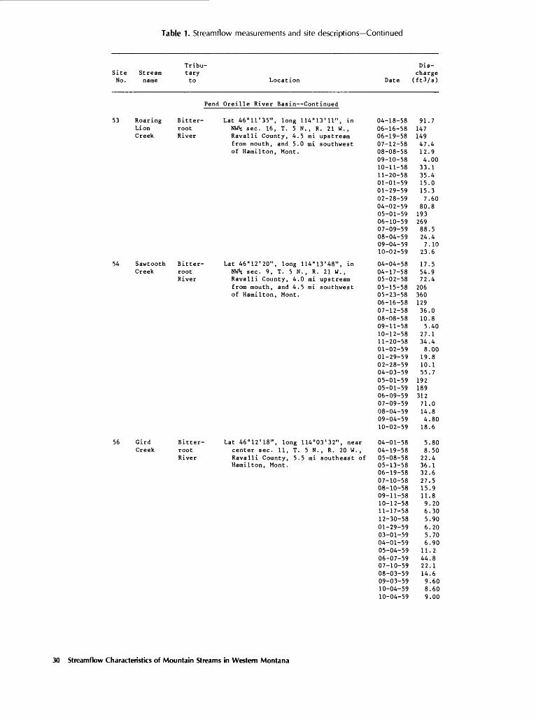
Table 1. Streamflow measurements and site descriptions Continued
Site Stream No. name
53 RoaringLionCreek
54 SawtoothCreek
56 GirdCreek
Tribu tary to Location
Pend Oreille River Basin Continued
Bitter- Lat 46 0 11'35", long 114°13 1 11", inroot NW»t sec. 16, T. 5 N., R. 21 W. ,River Ravalli County, 4.5 mi upstream
from mouth, and 5.0 mi southwestof Hamilton, Mont.
Bitter- Lat 46°12'20", long 114°13'48", inroot NW»t sec. 9, T. 5 N. , R. 21 W. ,River Ravalli County, 4.0 mi upstream
from mouth, and 4.5 mi southwestof Hamilton, Mont.
Bitter- Lat 46°12'18", long 114°03'32", nearroot center sec. 11, T. 5 N. , R. 20 W. ,River Ravalli County, 5 . 5 mi southeast of
Hamilton, Mont.
Date
04-18-5806-16-5806-19-5807-12-5808-08-5809-10-5810-11-5811-20-5801-01-5901-29-5902-28-5904-02-5905-01-5906-10-5907-09-5908-04-5909-04-5910-02-59
04-04-5804-17-5805-02-5805-15-5805-23-5806-16-5807-12-5808-08-5809-11-5810-12-5811-20-5801-02-5901-29-5902-28-5904-03-5905-01-5905-01-5906-09-5907-09-5908-04-5909-04-5910-02-59
04-01-5804-19-5805-08-58 05-13-5806-19-5807-10-5808-10-5809-11-5810-12-5811-17-5812-30-5801-29-5903-01-5904-01-5905-04-5906-07-5907-10-5908-03-5909-03-5910-04-5910-04-59
Dis charge (ft3/s)
91.714714947.412.94.0033.135.415.015.37.60
80.819326988.524.47.10
23.6
17.554.972.4
20636012936.010.85.40
27.134.48.0019.810.155.7
19218931271.014.84.8018.6
5.808.5022.4 36.132.627.515.911.89.206.305.906.205.706.9011.244.822.114.69.608.609.00
30 Streamflow Characteristics of Mountain Streams in Western Montana

Table 1. Streamflow measurements and site descriptions Continued
Site Stream No. name
58 MillCreek
60 SweatHouseCreek
61 GashCreek
Tribu tary to Location
Pend Oreille River Basin Continued
Bitter- Lat 46 0 18'41", long 114°13'36", inroot N4 sec. 4, T. 6 N. , R. 21 W. ,River Ravalli County, 6.5 mi upstream
from mouth, and 6.0 rai northwest of Hamilton, Mont.
Bitter- Lat 46°24'56", long 114 0 13'13", inroot SE^s sec. 28, T. 8 N. , R. 21 W. ,River Ravalli County, 2.0 mi upstream
from Gash Creek, and 3.5 mi westof Victor, Mont.
Bitter- Lat 46°24'20", long 114°15'21", inroot Wlj sec. 32, T. 8 N., R. 21 W. ,River Ravalli County, 0.5 mi upstream
from South Fork Gash Creek, and 5.0mi west of Victor, Mont.
Date
04-02-5804-21-5805-01-5805-14-5805-26-5806-17-5807-13-5808-09-5809-12-5810-13-5811-21-5801-03-5901-31-5903-04-5904-03-5905-02-5906-10-5907-08-5908-05-5909-04-5910-04-59
04-04-5804-21-5805-14-5805-25-5807-08-5808-06-5809-12-5810-13-5811-20-5801-02-5902-02-5903-03-5904-04-5904-29-5906-11-5907-08-5908-04-5909-02-5910-04-59
05-14-5805-21-5805-25-5806-17-5807-08-5808-06-5809-12-5810-13-5811-20-5801-02-5902-01-5904-02-5904-29-5906-05-5906-11-5907-08-5908-04-5909-02-5910-04-59
Dis charge (ft3/s)
10.172.739.2
14734211632.412.63.706.60
47.48.0016.411.248.715520674.819.010.728.6
4.6025.776.8
18923.46.202.10
10.616.04.504.906.20
27.130.778.036.69.806.0012.2
15.120099.414.010.03.801.602.803.702.301.505.508.10
16032.810.55.002.003.00
Tables 31

Table 1. Streamflow measurements and site descriptions Continued
Site Stream No . name
62 BigCreeknearVictor
65 BassCreek
66 SweeneyCreek
Tribu
tary to Location
Pend Oreille River Basin Continued
Bitter- Lat 46°27'50", long 114°12'25", nearroot center sec. 10, T. 8 N. , R. 21 W. ,River 5.0 mi upstream from mouth, and
4.0 mi northwest of Victor, Mont.
Bitter- Lat 46°34'27", long 114 0 08'56", inroot SW*t sec. 32, T. 10 N. , R. 20 W. ,River Ravalli County, 3.0 mi upstream
from mouth, and 5.0 mi southwestof Florence, Mont.
Bitter- Lat 46°36'30", long 114°07'46", nearroot east edge, sec. 20, T. 10 N. , R. 20River W., Ravalli County, 4.0 mi upstream
from mouth, and 2.5 mi southwestof Florence, Mont.
Date
04-04-5804-23-5805-15-5805-26-5806-18-5807-09-5808-06-5809-13-5810-14-5811-21-5801-03-5902-02-5903-04-5904-04-5905-02-5906-10-5907-08-5908-05-5909-05-5910-04-59
04-03-5804-23-5805-01-5805-15-5805-26-5806-18-5807-08-5808-05-5809-13-5810-15-5811-21-5801-04-5902-02-5903-05-5904-05-5905-03-5906-11-5907-10-5908-01-5909-11-5910-07-59
04-03-5804-23-5805-15-5805-26-5806-18-5807-09-5808-05-5809-13-5810-15-5811-23-5801-04-5902-02-5903-05-5904-05-5905-03-5907-10-5908-01-5909-11-5910-07-59
Dis
charge (ft3/s)
25.586.7
27665221996.251.217.839.596.713.622.524.378.8
26340918624.853.873.7
6.4020.216.281.213241.926.333.223.26.4028.33.507.605.70
24.561.482.353.841.923.627.2
5.8018.978.1
25394.539.29.202.2010.229.66.108.204.7023.863.881.329.121.728.7
32 Streamflow Characteristics of Mountain Streams in Western Montana

Table 1. Streamflow measurements and site descriptions Continued
Site No.
69
71
72
73
74
Tribu- Streara tary name to Location
Pend Oreille River Basin Continued
Butler Clark Lat 47 0 07'33", long 114°26'09", inCreek Fork SE^SW^SWH sec. 19, T. 16 N. , R. 22
W., Missoula County, Lolo NationalForest, at U.S. Forest Servicebridge, 2.6 mi upstream from Nine-mile Creek, 4.5 mi northwest ofNinemile Ranger Station, and 8.7 minorth of Alberton, Mont.
Twelve- St. Regis Lat 47°22'02", long IIS'IS^", inmile River SE^NE^NE^ sec. 34, T. 19 N., R. 29Creek W. , Mineral County, Lolo National
Forest, at bridge on old CamelsHump Road, 200 ft upstream from EastFork Twelvemile Creek, 1.6 minortheast of U.S. Interstate 90,1.8 mi upstream from St. RegisRiver, and 3.9 mi east of DeBorgia,Mont.
Ward St. Regis Lat 47 0 18'42", long 115 0 13'59", inCreek River NE^NEkNWis sec. 24, T. 18 N. , R. 29
W., Mineral County, Lolo NationalForest, at U.S. Forest Servicebridge just upstream from mouth, 6.4mi west of St. Regis, Mont.
Two- St. Regis Lat 47"17 I 42", long US'lO^O", inmile River NE^SW»tNE*t sec. 28, T. 18 N. , R. 28Creek W. , Mineral County, Lolo National
Forest, at U.S. Forest Servicebridge 0.2 mi upstream from St.Regis River, and 3.5 mi west of St.Regis, Mont.
St. Clark Lat 47"17 I 49", long 115 0 07'18", nearRegis Fork center of NWkNE^ sec. 26, T. 18 N.,River R. 28 W. , Mineral County, 70 ft(12354000) downstream from road bridge, 500 ft
upstream from Little Joe Creek, 1.7mi upstream from mouth, 1.2 miwest of St. Regis, and at site offormer gaging station.
Date
03-17-8204-14-8205-20-8206-17-8207-15-8208-19-8209-18-8210-21-8211-18-8212-16-8201-19-8302-16-83
03-16-8204-15-8205-19-8206-16-8207-14-8208-18-8209-17-8210-20-8211-17-8212-16-8201-19-8302-16-83
04-15-8205-19-8206-16-8207-14-8208-18-8209-17-8210-20-8211-17-8212-16-8201-19-8302-16-8303-16-83
03-16-8204-15-8205-19-8206-16-8207-14-8208-18-8209-17-8210-20-8211-17-8212-16-8201-19-8302-16-83
03-16-8204-15-8205-19-8206-16-8207-14-8208-18-8209-17-8210-20-8211-17-8212-16-8201-19-8302-16-8303-16-83
Dis charge (ft 3/s)
3.2620.732.7
12724.86.954.102.632.742.762.302.67
57.113631614943.018.810.613.214.79.18
14.512.9
93.621423248.115.010.510.59.74
13.513.212.951.6
35.359.813310223.99.857.236.296.426.708.687.32
9601,5802,5502,370
660185130123127149258188
1,050
Tables 33

Table 1. Streamflow measurements and site descriptions Continued
Tribu- Site Stream tary No. name to
Fend
75 Siegel ClarkCreek Fork
77 Bear MiddleCreek Fork(12356500) Flat-
headRiver
79 Fish McDonaldCreek Creek
Location
Oreille River Basin Continued
Lat 47°18'54", long 114 0 48'26", inNW'-tSWliSEit sec. 17, T. 18 N. , R. 25W., Sanders County, at culvert onFAS 461, 1.5 mi southwest of QuinnsHot Springs, and 5.0 mi south ofParadise, Mont.
Lat 48°16'50", long 113°25'30", inSE^NWls sec. 18, T. 29 N. , R. 14 W. ,Flathead County, on right bank 1.0mi downstream from Autumn Creek,8.5 mi east of Essex, Mont., andat site of former gaging station.
Lat 48 0 33'51", long 113°59'29", inT. 32 N., R. 19 W., Flathead County,50 ft upstream from Fish Creek
Date
04-14-8205-19-8206-16-8207-14-8208-18-8209-17-8210-20-8211-17-8212-15-8201-19-8302-16-8303-16-83
03-17-8204-13-8205-17-8206-16-8207-19-8208-19-8209-16-8210-18-8211-18-8212-16-8201-13-8302-14-83
09-18-7405-12-7506-05-75
Dis charge(ft3/8)
28.055.044.111.55.974.474.583.753.624.703.6212.8
7.6016.6
21232036.816.613.611.011.010.18.048.17
5.0510995.4
Campground loop road, 0.1 mi east of Fish Creek Ranger station, 0.5 mi east of Glacier Route Eight Highway, and 1.6 mi north of Apgar, Mont.
85 Piper Swan Lat 47°39'41", long 113°49'44", in Creek River NE^SE^SWi sec. 18, T. 22 N.,
R. 17 W., Lake County, Flathead National Forest, at Forest Service bridge, 1.2 mi upstream from Swan River, 1.5 mi west of Highway 83, and 8.0 mi northwest of Condon, Mont.
86 Goat Swan Lat 47°46'26", long 113 0 42'28", in Creek River NW^NVfyNWlj sec. 7, T. 23 N. , above R. 16 W., Lake County, Flathead Scout National Forest, 0.5 mi upstream Creek from Scout Creek, 0.6 mi downstream
from Bethal Creek, 5.5 mi east of Highway 83, and 12 mi southeast of Swan Lake, Mont.
03-15-8204-19-8205-17-8206-14-8207-13-8208-17-8209-16-8210-18-8211-15-8212-13-8201-17-8302-14-83
05-17-8206-14-8207-13-8208-17-8209-16-8210-19-8211-16-8212-14-82
7.9214.483.6
12850.315.78.05
21.39.15
10.75.573.48
69.713729.33.55
.16
.96
.07
.35
34 Streamflow Characteristics of Mountain Streams in Western Montana

Table 1. Streamflow measurements and site descriptions Continued
Site No.
87
88
89
90
91
92
Stream name
GoatCreekaboveSqueezerCreekRoad
GoatCreekatSqueezerCreekRoad
SouthWoodwardCreekaboveFattyCreekRoad
SouthWoodwardCreeknearmouth
SoupCreekaboveSoupCreekCampground
SoupCreekatSoupCreekCampground
Tribu
tary to
SwanRiver
SwanRiver
SwanLake
SwanRiver
SwanRiver
SwanRiver
Location
Pend Oreille River Basin Continued
Lat 47 0 45'57", long 113°45'48", inNE^NEStSWH; sec. 10, T. 23 N. ,R. 17 W. , Lake County, Swan RiverState Forest, 3.0 mi east ofHighway 83, and 12.0 mi southeastof Swan Lake, Mont.
Lat 47°45'19", long 113°47'23",in NWSjNWSiNWSJ; sec. 16, T. 23 N. ,R. 17 W. , Lake County, Swan RiverState Forest, at U.S. Forest Service bridge on Old Squeezer Creekroad, 1 . 5 mi east of Highway 83,and 12.0 mi southeast of Swan Lake,Mont.
Lat 47°43'31", long 113°55'25", inSE^SE^NWSi sec. 28, T. 23 N.,R. 18 W. , Lake County, Swan RiverState Forest, at culvert on StateForest Service road, 3.0 mi west ofthe Fatty Creek Road, and 13.5 minorthwest of Condon, Mont.
Lat 47°43 I 19", long 113 0 51'20", inNE^NWiSWH sec. 25, T. 23 N. , R. 18W. , Lake County, Flathead NationalForest, at bridge on U.S. ForestService road, 1.5 mi west of Highway 83, and 11.0 mi northwest ofCondon, Mont.
Lat 47°48'53", long 113 0 44'08", inSW^NE^NE^ sec. 26, T. 24 N., R. 17W. , Lake County, Swan River StateForest, at U.S. Forest Servicebridge, 1.7 mi east of Soup CreekCampground, 4.3 mi east of Highway83, and 9.0 mi southeast of SwanLake, Mont.
Lat 47°48'37", long 113°46 I 11", inNEJtNW^SWH sec. 27, T. 24 N. ,R. 17 W. , Lake County, Swan RiverState Forest, at State ForestService bridge, 2.6 mi east ofHighway 83, and 9.0 mi southeastof Swan Lake, Mont.
Date
03-15-8204-19-8205-17-8206-14-8207-13-8208-17-8209-16-8210-19-8211-16-8212-14-8201-17-8302-14-83
03-15-8204-19-8205-17-8206-14-8207-13-8208-17-8209-16-8210-19-8211-16-8212-14-8201-17-8302-16-83
05-17-8206-14-8207-13-8208-17-8209-16-8210-18-8211-15-82
03-15-8204-19-8205-17-8206-14-8207-13-8208-17-8209-16-8210-18-8211-15-8212-14-8201-17-8302-14-83
05-17-8206-14-8207-13-8208-17-8209-16-8210-19-8211-16-8212-14-8201-17-8302-14-83
03-12-8204-20-8205-17-8206-14-8207-13-8208-17-8209-16-8210-19-8211-16-8212-14-8201-17-8302-14-83
Dis
charge (ft3/ 8 )
9.659.18
93.215953.617.110.110.811.38.327.136.56
9.3715.689.015349.517.811.710.69.599.646.325.76
7.9314.512.111.07.577.595.84
21.921.146.440.342.441.742.035.132.023.021.020.0
42.210118.68.805.393.654.092.632.372.43
2.944.24
43.886.516.97.444.544.083.293.552.612.35 Table? 35

Table 1. Streamflow measurements and site descriptions Continued
Site No.
93
94
95
96
97
98
Zharac
Tribu- Stream tary name t o
Pend
Soup SwanCreek RiveratHigh-way83
South SwanFork RiverLostCreek
North SwanFork RiverLostCreek
Lost SwanCreek River
Porcupine SwanCreek River
Bond SwanCreek River
teristics of Mountain Stream
Location
Oreille River Basin Continued
Lat 47°50'55", long 113°49'43", inNWsSEisSWis sec. 18, T. 24 N., R. 17W. , Lake County, Swan River StateForest, at bridge on Highway 83,0.7 mi upstream from Swan River,and 6.0 mi south of Swan Lake,Mont.
Lat 47°52'04", long 113 0 47'36", inNW^NWljSW^ sec. 4, T. 24 N. , R. 17W. , Lake County, Flathead NationalForest, at U.S. Forest Servicebridge, 1.5 mi upstream from LostCreek, and 4.7 mi southeast of SwanLake, Mont.
Lat 47°53'06", long 113°47'53", inNE^NVfySEis sec. 31, T. 25 N., R. 17W. , Lake County, Flathead National Forest, at U.S. Forest Servicebridge on North Fork Lost Creekroad, 1.5 mi upstream from LostCreek, and 4.0 mi southeast of SwanLake, Mont.
Lat 47°52'26", long 113 0 50'00", inNE^NWHmft; sec. 6, T. 24 N., R. 17W., Lake County, Flathead NationalForest, at bridge on Highway 83,0.7 mi upstream from Swan River,and 3.5 mi south of Swan Lake,Mont.
Lat 47 0 5r41", long 113°52'46", inSWtSE^SE^s sec. 3, T. 24 N. , R. 18W., Lake County, Flathead NationalForest, at culvert on U.S. ForestService road, 2.0 mi upstream fromSwan River, and 5.0 mi southwestof Swan Lake, Mont.
Lat 47°55'21", long 113°50'25", inSElsSWtSElj sec. 14, T. 25 N. , R. 18W., Lake County, Flathead NationalForest, at bridge on Highway 83 intown of Swan Lake, Mont., 0.2 miupstream from Swan Lake, Mont.
s in Western Montana
Date
03-12-8204-20-8205-17-8206-14-8207-13-8208-17-8209-16-8210-19-8211-16-8212-14-8201-17-&302-14-83
10-19-8211-16-8212-14-8201-18-8302-15-83
03-12-8204-20-8205-18-8206-15-8207-14-8208-18-8209-17-8210-19-8211-16-8212-14-8201-18-8302-15-83
03-12-8204-20-8205-18-8206-15-8207-13-8208-18-8209-17-8210-19-8211-16-8212-15-8201-18-8302-15-83
03-15-8204-19-8205-18-8206-15-8207-14-8208-18-8209-17-8210-18-8211-16-8212-13-8201-18-8302-15-83
03-15-8204-20-8205-18-8206-15-8207-14-8208-18-8209-17-8210-19-8211-16-8212-15-8201-18-8302-14-83
Dis charge (ft3/ 8 )
10.614.252.187.021.29.345.896.275.773.645.603.70
13.19.379.888.397.14
13.028.9
19020360.416.37.298.037.617.298.746.16
26.346.1
40047593.222.411.513.112.111.813.57.95
3.534.1315.34.793.793.423.402.492.863.402.291.12
6.198.2276.5
11219.93.011.981.371.402.052.011.57

Table 1. Streamflow measurements and site descriptions Continued
Site Stream No . name
99 HallCreek
100 JohnsonCreek
102 StonerCreek
105 GravesCreek
106 DeepCreek
Tribu
tary to Location
Pend Oreille River Basin Continued
Swan Lat 47°56'17", long 113°50'25", inRiver NWH sec. 11, T. 25 N. , R. 18 W. ,
Lake County, at unimproved roadcrossing about 0.7 mi east of junction with Highway 83, at Swan Lake,Mont.
Swan River Lat 48°ori9", long 113°58'05", inNWls sec. 14, T. 26 N., R. 19 W. ,Lake County, at bridge on unpavedroad, 1.3 mi northwest of junctionwith Highway 83, 2.1 mi south ofFlathead-Lake County line, and 9.0mi northwest of Swan Lake, Mont.
Flat- Lat 48°01'00", long 114°13'25", inhead Ntft sec. 18, T. 26 N. , R. 20 W. ,River Flathead County, at bridge on U.S.
Highway 93, 0.3 mi north of junction with Stoner Creek road, 0.2mi south of Lakeside, Mont.
Clark Lat 47°4r09", long 115°24'13", inFork NWicNWiNE't sec. 11, T. 22 N., R. 30
W. , Sanders County, at culvert oncounty road, 0.3 mi upstream fromClark Fork, and 7.0 mi northwest ofThompson Falls, Mont.
Clark Lat 47 0 44'46", long 115°26'27", inFork SEltSElsSEli; sec. 16, T. 23 N., R. 30
W. , Sanders County, KootenaiNational Forest, at culvert oncounty road, 0.8 mi upstream fromClark Fork, 2.0 mi northeast ofWhite Pine, Mont., and 12.0 minortheast of Thompson Falls,Mont.
Dis charge
Date (ft3/s)
09-12-7405-15-7506-30-7509-10-75
09-12-7405-16-7506-30-7509-10-75
09-19-7405-09-7506-03-7509-08-75
03-16-8204-15-8205-18-8206-15-8207-12-8208-17-8209-13-8210-20-8211-17-8212-15-8201-19-8302-15-83
03-16-8204-15-8205-18-8206-15-8207-12-8208-17-8209-13-8210-20-8211-17-8212-15-8201-19-8302-15-83
4.7965.820.74.36
3.4627.314.13.97
3.5617.446.72.32
5.3115.3
26528085.525.613.87.745.103.184.361.79
15.539.493.583.024.28.304.793.002.913.736.944.07
1 Discharge at Red Top Creek site estimated from U.S. Forest Service records.
Tables 37
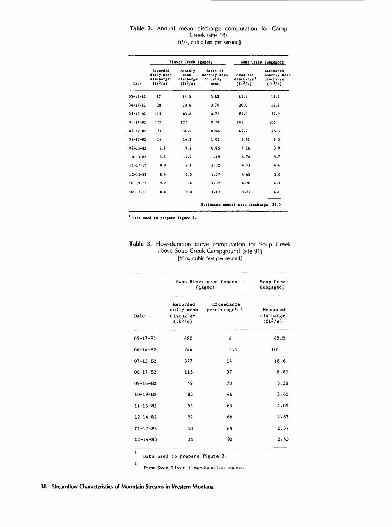
Table 2. Annual mean discharge computation for CampCreek (site 18)
[ftVs, cubic feet per second]
Dace
03-15-82
04-14-82
05-19-82
06-14-82
07-12-82
08-17-82
09-13-82
10-13-82
11-17-82
12-15-82
01-19-83
02-17-83
Flo
Recordeddally aean discharge 1 (fc3/s)
17
28
115
172
53
14
9.7
9.4
8.9
8.4
9.2
8.0
wer Creek
Monthlymean
discharge (ft3/s)
14.0
20.6
83.8
127
50.9
14.2
9.2
11.2
9.1
9.0
9.4
9.0
(gaged)
Ratio ofaonthly aean co daily
aean
0.82
0.74
0.73
0.74
0.96
1.01
0.95
1.19
1.02
1.07
1.02
Camp Creek (ungaged)
Measured discharge (ft3/s)
15.1
20.0
82.0
143
47.2
6.41
4.16
4.78
4.53
4.63
6.20
1.13 5.27
Estlaaced annual aean die
Esclaatedaonthly aean
1 discharge
12.4
14.7
59.9
106
45.3
6.5
3.9
5.7
4.6
5.0
6.3
6.0
icharge 23.0
Data used to prepare figure 2.
Table 3. Flow-duration curve computation for Soup Creekabove Soup Creek Campground (site 91)
[ftVs, cubic feet per second]
Swan River near Condon (gaged)
Date
05-17-82
06-14-82
07-13-82
08-17-82
09-16-82
10-19-82
11-16-82
12-14-82
01-17-83
02-14-83
Recorded Exceedance daily mean percentage^ 2 discharge (ftVs)
680
744
377
115
49
83
55
52
50
35
4
2.5
14
37
70
46
63
66
69
92
Soup Creek (ungaged)
Measured discharge 1 (ftVs)
42.2
101
18.6
8.80
5.39
3.65
4.09
2.63
2.37
2.43
Data used to prepare figure 3.
From Swan River flow-duration curve.
38 Streamflow Characteristics of Mountain Streams in Western Montana

Table 4. Mean annual discharge adjustments for selected gaging stations [ft'/s, cubic feet per second]
Site No.
4
6
9
14
32
36
39
43
46
55
57
59
64
67
70
74
77
84
103
104
Stream name and gaging station number
Fortine Creek (12300500)
Tobacco River (12301300)
Big Creek near Rexford (12301810)
Flower Creek (12303100)
Yaak River (12304500)
Middle Fork Rock Creek (12332000)
Monture Creek (12338690)
Blackfoot River (12340000)
Bitterroot River near Darby (12344000)
Skalkaho Creek (12346500)
Blodgett Creek (12347500)
Bear Creek near Victor (12350000)
Burnt Fork Bitterroot River (12351000)
Eightmile Creek (12351400)
Ninemile Creek (12353280)
St. Regis River (12354000)
Bear Creek near Essex (12356500)
Swan River near Condon (12369200)
Thompson River (12389500)
Prospect Creek (12390700)
Actual period
of flow
record
1948-53
1959-82
1973-81
1961-82
1957-82
1938-82
1974-82
1940-82
1938-82
1949-79
1948-69
1939-59
1939-62
1958-63
1974-82
1959-75
1947-52
1973-82
1957-82
1957-82
Mean annual discharge for period of record
(ft3/ 8 )
84.7
273
125
27.1
900
124
197
1,658
934
93.5
71.0
66.0
48.0
7.20
136
580
46.0
168
479
259
Mean annual
discharge for 1938-82
(ft3/ 8 )
82.0
268
149
27.0
888
124
184
1,629
934
91.0
68.0
70.0
50.0
8.00
124
541
43.0
160
480
258
Tabler 39

Table 5. Basin characteristics and mean annual discharge for streamflow-measurement sites(1938-82 base period)
[mi 2 , square miles; ft'/s, cubic feet per second]
SiteNo.
1
2
3
4
5
7
8
9
10
15
16
17
18
19
20
21
22
23
24
25
26
27
28
29
30
31
40
41
Stream name and gaging station number
Young Creek below South Fork
Young Creek at mouth
Cayuse Creek (12300400)
Fortine Creek (12300500)
Deep Creek
Sullivan Creek
Boulder Creek
Big Creek near
Rexford (12301810).
Bristow Creek
Parmenter Creek
Cedar Creek
Quartz Creek
Camp Creek (12303440)
Ruby Creek
Pete Creek below Hensley Creek
Pete Creek at mouth
Whitetail Creek (12304250)
Spread Creek
Hellroaring Creek at
Forest Service bridge.
Hellroaring Creek at mouth
North Fork Meadow Creek
North Fork Meadow Creek
at mouth.
Meadow Creek
Red Top Creek
Cyclone Creek (12304300)
Fourth of July Creek (12304400)
Deer Creek (12339300)
Seeley Creek
Drainage area (mi2)
19.0
36.0
5.29
112
18.9
14.1
18.1
139
25.8
17.7
12.9
35.4
11.3
15.8
29.8
33.8
2.48
37.3
9.65
16.9
6.33
7.04
20.4
9.96
5.71
7.84
19.8
5.11
Mean annual precip itation (inches)
31
29
28
28
50
33
34
37
34
57
61
47
63
64
35
34
35
50
70
66
72
69
68
69
67
64
39
30
Mean annual
discharge (ft3/s)
15.1
14.5
6.6
82.0
12.8
10.1
19.4
149
8.0
22.9
23.8
69.0
19.3
26.8
34.7
39.4
1.7
80.5
27.0
27.6
13.6
13.3
42.6
19.7
10.7
13.1
21.1
3.9
Mean annual runoff
(inches)
10.7
5.3
16.9
9.9
9.2
9.7
14.5
14.5
4.2
17.6
25.0
26.4
23.2
23.0
15.8
15.8
9.3
29.3
38.0
22.2
29.2
25.6
28.3
26.8
25.4
22.7
14.5
10.4
40 Streamflow Characteristics of Mountain Streams in Western Montana
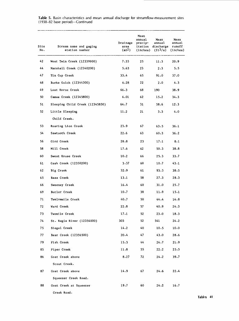
Table 5. Basin characteristics and mean annual discharge for streamflow-measurement sites (1938-82 base period) Continued
Site No.
42
44
47
48
49
50
51
52
53
54
56
58
60
61
62
65
66
69
71
72
73
74
75
77
79
85
86
87
88
Stream name and gaging station number
West Twin Creek (12339900)
Marshall Creek (12340200)
Tin Cup Creek
Burke Gulch (12344300)
Lost Horse Creek
Camas Creek (12345800)
Sleeping Child Creek (12345850)
Little Sleeping
Child Creek.
Roaring Lion Creek
Sawtooth Creek
Gird Creek
Mill Creek
Sweat House Creek
Gash Creek (12350200)
Big Creek
Bass Creek
Sweeney Creek
Butler Creek
Twelvemile Creek
Ward Creek
Twomile Creek
St. Regis River (12354000)
Siegel Creek
Bear Creek (12356500)
Fish Creek
Piper Creek
Goat Creek above
Scout Creek.
Goat Creek above
Squeezer Creek Road.
Goat Creek at Squeezer
Creek Road.
Drainage area (ml2 )
7.33
5.63
33.4
6.28
66.3
6.01
64.7
11.2
23.9
22.6
28.8
17.6
10.2
3.37
32.9
13.1
16.4
10.7
40.7
22.8
17.1
303
14.2
20.4
15.3
11.8
8.27
14.9
19.7
Mean annual precip itation (inches)
25
23
65
22
68
62
31
21
67
63
23
62
66
60
61
58
60
38
50
57
52
52
40
47
44
55
72
67
60
Mean annual
discharge (ft3/ s )
11.3
2.3
91.0
2.0
190
15.2
58.6
3.3
63.5
60.3
17.1
50.3
25.3
10.7
93.3
27.3
31.0
11.9
44.4
40.9
23.0
541
10.5
43.0
24.7
22.2
24.2
24.6
24.2
Mean annual runoff (inches)
20.9
5.5
37.0
4.3
38.9
34.3
12.3
4.0
36.1
36.2
8.1
38.8
33.7
43.1
38.5
28.3
25.7
15.1
14.8
24.3
18.3
24.2
10.0
28.6
21.9
25.5
39.7
22.4
16.7
Tabte 41

Table 5. Basin characteristics and mean annual discharge for streamflow-measurement sites (1938-82 base period) Continued
Site No.
89
90
91
92
93
94
95
96
97
98
99
100
102
105
106
Drainage Stream name and gaging area
station number (mi2)
South Woodward Creek above
Fatty Creek Road.
South Woodward Creek near mouth
Soup Creek above Soup Creek Campground
Soup Creek at Soup Creek Campground
Soup Creek at Highway 83
South Fork Lost Creek
North Fork Lost Creek
Lost Creek
Porcupine Creek
Bond Creek
Hall Creek
Johnson Creek
Stoner Creek
Graves Creek
Deep Creek
2.88
10.5
4.50
5.87
14.5
14.8
13.0
31.7
10.0
7.58
4.66
12.1
22.6
28.3
12.6
Mean annual precip itation (inches)
60
51
67
61
49
61
60
58
49
53
54
50
25
56
56
Mean annual
discharge (ft3/ 8 )
6.2
25.2
12.2
11.2
14.0
42.9
30.7
61.5
3.0
12.8
12.7
6.4
11.9
42.9
18.2
Mean annual runoff (inches)
29.2
32.6
36.8
25.9
13.1
39.3
32.0
26.3
4.1
22.9
37.0
7.2
7.1
20.6
19.6
42 Streamflow Characteristics of Mountain Streams in Western Montana

Table 6. Discharge for various exceedance percentages for streamflow-measurement sites (1938-82 base period)
SiteNo.
1
2345
789
1015
1617181920
21222324
25
2627
282930
31
40414244
4748495051
52
53545658
6061626566
6971727374
757779
Stream name and gaging station number
Young Creek below SouthFork.
Young Creek at mouthCayuse Creek (12300400)Fortine Creek (12300500)Deep Creek
Sullivan CreekBoulder CreekBig Creek near Rexford(12301810).
Bristow CreekParmenter Creek
Cedar CreekQuartz CreekCamp Creek (12303440)Ruby CreekPete Creek below HensleyCreek.
Pete Creek at mouthWhitetail Creek (12304250)Spread CreekHellroaring Creek atForest Service Bridge.
Hellroaring Creek at mouth
North Fork Meadow CreekNorth Fork Meadow Creekat mouth.
Meadow CreekRed Top CreekCyclone Creek (12304300)
Fourth of July Creek(12304400)
Deer Creek (12339300)Seeley CreekWest Twin Creek (12339900)Marshall Creek (12340200)
Tin Cup CreekBurke Gulch (12344300)Lost Horse CreekCamas Creek (12345800)Sleeping Child Creek(12345850).
Little Sleeping ChildCreek.
Roaring Lion CreekSawtooth CreekGird CreekMill Creek
Sweat House CreekGash Creek (12350200)Big CreekBass CreekSweeney Creek
Butler CreekTwelvemile CreekWard CreekTwomile CreekSt. Regis River(12354000).
Siegel CreekBear Creek (12356500)Fish Creek
Discharge, in cubic feet per second, for indicated exceedance percentage
10
40.
40.20.
240.97.
29.59.
458.
55.95.
87.200.66.96.
114.
148.7.
148.61.
73.
36.36.
109.65.32.
44.
61.7.
34.10.
255.3.
636.22.
129.
8.
195.186.36.
161.
74.21.
260.72.
103.
49.105.87.56.
1,500.
28.130.94.
0
0000
000
00
00000
0000
0
00
000
0
0405
05000
9
0000
00000
50000
000
20
28.0
29.07.3
82.552.0
21.039.0
169.0
27.045.0
41 .0110.033.062.059.0
79.02.8
60.022.0
31.0
15.015.0
55.027.016.0
18.0
29.05.4
20.07.2
140.01.9
340.08.7
60.0
5.0
107.083.023.071.0
37.09.6
125.044.063.0
23.047.052.535.5
823.0
14.051.056.0
30
21.0
21.02.9
45.030.0
15.026.083.0
14.018.0
21.065.016.039.033.0
44.01.3
38.012.0
16.0
8.28.2
32.013.08.9
8.9
14.04.012.55.2
84.01.0
164.05.1
35.5
3.0
60.038.516.033.0
23.05.6
68.029.040.0
11.527.033.020.0
465.0
8.829.031.0
40
16.0
16.01.6
32.519.0
11.018.551.0
7.16.6
14.045.09.8
21.019.0
24.0.7
27.07.8
10.0
5.65.6
20.08.15.9
5.7
8.23.27.83.8
54.0.6-
91.03.5
25.0
1.9
34.023.012.519.0
13.03.8
44.022.026.0
6.419.021.512.0
304.0
6.620.518.0
50
12.0
11.01.0
25.012.0
7.812.533.0
4.02.7
9.634.07.1
11.412.0
12.0.3
22.05.9
7.1
4.54.5
13.05.94.3
4.0
5.42.65.02.7
36.0.4
59.02.5
19.0
1.3
21.516.010.012.5
8.82.8
31.017.018.0
4.114.515.59.0
211.0
5.216.012.0
60
8.9
8.3.7
19.07.4
5.48.2
27.0
2.51.4
7.327.05.77.26.9
6.9.1
19.04.9
5.1
3.43.4
8.54.63.3
3.1
4.02.33.52.0
25.0.3
42.02.0
15.5
.9
14.012.08.68.7
6.32.2
24.013.013.0
2.912.012.07.2
163.0
4.313.010.0
70
6.6
7.0.5
13.04.8
3.95.7
23.0
1.8.7
5.822.04.95.14.6
4.6.0
17.04.4
3.9
2.72.7
6.13.82.6
2.6
3.02.02.51.4
18.5.2
31.01.5
13.0
.7
9.59.37.36.5
4.61.8
19.011.09.6
2.110.09.86.1
134.0
3.810.08.5
80
5.1
6.0.4
10.03.1
2.93.9
19.0
1.3.4
4.819.04.43.73.1
3.1.0
15.04.0
3.0
2.22.2
4.43.2 '2.2
2.2
2.51.91.91.1
13.6.1
25.01.3
12.0
.6
6.67.76.35.0
3.51.5
16.08.27.1
1.78.88.45.4
112.0
3.48.47.5
90
4.0
5.3.4
8.62.0
2.02.8
15.0
1.03
4.016.04.03.02.3
2.3.0
13.03.7
2.4
1.81.8
3.42.71.8
1.9
2.11.81.4.8
10.0.1
21.01.1
11.0
.5
4.66.45.74.0
2.61.4
14.06.35.2
1.58.07.24.7
9^.0
3.16.96.9
Tables 43

Table 6. Discharge for various exceedance percentages for streamflow-measurement sites (1938-82 base period) Continued
Site No.
Stream name and gaging station number 10
Discharge, in cubic feet per second, for indicated exceedance percentage
20 30 40 50 60 70 80 90
85 Piper Creek 50.0 29.0 20.0 14.0 12.0 8.0 6.1 4.7 3.586 Goat Creek above Scout 43.0 15.0 5.5 2.2 .8 .3 .1 .0 .0
Creek.
87 Goat Creek above Squeezer 64.0 36.0 22.0 15.0 11.0 8.5 6.7 5.4 4.7 Creek Road.
88 Goat Creek at Squeezer 58.0 31.0 20.0 13.5 10.0 7.7 6.3 5.2 4.5 Creek Road.
89 South Woodward Creek above 11.5 10.0 9.0 8.1 7.2 6.4 5.7 5.0 4.2 Fatty Creek Road.
90 South Woodward Creek near 38.0 36.0 34.0 31.0 29.5 27.5 25.5 24.0 21.0 mouth.
91 Soup Creek above Soup 24.0 14.5 10.0 7.3 5.4 4.1 3.3 2.6 2.0 Creek Campground.
92 Soup Creek at Soup Creek 20.0 9.2 6.1 4.4 3.5 2.8 2.4 2.0 1.7 Campground.
93 Soup Creek at Highway 83 33.0 19.0 13.0 9.3 7.0 5.4 4.2 3.4 2.794 South Fork Lost Creek 74.0 42.0 26.5 18.0 13.0 10.0 8.1 6.7 5.795 North Fork Lost Creek 71.0 40.0 24.0 15.0 11.0 8.3 6.5 5.3 4.496 Lost Creek 141.0 70.0 41.0 26.0 18.0 13.0 10.0 8.3 6.9
97 Porcupine Creek 7.6 5.7 4.5 3.6 2.9 2.5 2.0 1.6 1.298 Bond Creek 24.0 12.0 6.9 4.5 3.1 2.. 2 1.6 1.2 .999 Hall Creek 37.0 23.0 15.0 9.5 6.8 5.0 3.8 3.1 2.4
100 Johnson Creek 18.0 11.0 7.1 4.5 3.1 2.3 1.7 1.3 1.0102 Stoner Creek 43.0 13.0 8.0 6.0 4.7 3.7 2.9 2.3 1.6
105 Graves Creek 175.0 90.0 45.0 23.0 11.5 5.2 2.4 1.0 .4106 Deep Creek 43.0 23.0 13.0 8.5 6.0 4.5 3.5 2.8 2.3
44 Streamflow Characteristics of Mountain Streams in Western Montana

Table 7. Mean monthly discharge for streamflow-measurement sites (1938-82 base period)
Site No.
1
2
3
4
5
789
1015
161718
1920
21
22
2324
25
26
27
282930
31
40
4142
44
4748
4950
51
52
53
545658
Stream name and gaging
station number
Young Creek belowSouth Fork.
Young Creek atmouth.
Cayuse Creek(12300400).
Fortine Creek(12300500).
Deep Creek
Sullivan CreekBoulder CreekBig Creek nearRex ford(12301810).
Bristow CreekParraenter Creek
Cedar CreekQuartz CreekCamp Creek(12303440).
Ruby CreekPete Creek belowHensley Creek.
Pete Creek atmouth.
Whitetail Creek(12304250).
Spread CreekHellroaring Creekat ForestService Bridge.
Hellroaring Creekat mouth.
North Fork MeadowCreek.
North Fork MeadowCreek at mouth.
Meadow CreekRed Top CreekCyclone Creek(12304300).
Fourth of JulyCreek (12304400).
Deer Creek(12339300).
Seeley CreekWest Twin Creek(12339900).
Marshall Creek(12340200).
Tin Cup CreekBurke Gulch(12344300).
Lost Horse CreekCamas Creek(12345800).
Sleeping ChildCreek (12345850).
Little SleepingChild Creek.
Roaring LionCreek.Sawtooth CreekGird CreekMill Creek
Mean discharge, in
Oct.
6.7
6.6
1.4
17.0
1.5
4.58.6
18.0
4.0.3
8.725.23.9
4.76.1
7.0
.0
23.77.9
8.1
4.0
3.9
12.55.83.1
3.9
5.1
2.02.8
1.8
38.6.7
76.15.4
24.8
1.6
25.4
24.17.0
20.1
Nov.
6.6
6.4
1.5
19.0
1.7
4.48.4
20.0
4.51.2
9.627.73.5
4.96.3
7.2
.0
24.58.2
8.4
4.1
4.0
12.96.03.2
4.0
5.4
2.02.9
1.1
33.2.7
64.75.2
21.4
1.6
21.6
20.56.2
17.1
Dec.
6.4
6.1
1.6
20.0
2.9
4.38.2
34.0
2.0.3
10.630.95.4
6.313.1
14.8
.0
30.310.1
10.4
5.2
5.1
16.07.44.0
4.9
4.7
2.52.5
1.1
28.9.6
60.44.6
18.6
1.2
20.2
19.25.0
16.0
Jan .
5.3
5.2
1.4
17.0
2.3
3.46.8
27.0
1.01.8
7.822.78.0
6.310.6
12.0
.4
24.68.2
8.4
4.2
4.1
13.06.03.3
4.0
4.7
2.02.5
1.3
25.7.4
38.03.0
16.5
1.-2
12.7
12.14.210.1
Feb.
5.5
5.3
1.5
18.0
2.8
3.77.1
33.0
1.01.6
8.725.28.8
9.312.2
14.0
.5
28.39.6
9.7
4.8
4.7
15.06.93.8
4.6
4.7
2.02.5
1.6
26.1.4
32.23.2
16.8
1.3
10.8
10.24.98.5
cubic feet per
Mar.
7.1
6.8
2.6
33.0
4.1
4.89.1
47.0
2.019.4
7.822.711.4
41.026.1
29.7
2.9
41.814.0
14.3
7.0
6.9
22.010.25.5
6.8
5.7
2.53.1
2.4
34.3.5
47.03.9
22.1
1.7
15.7
14.94.812.4
Apr .
22.1
21.4
20.0
248.0
22.0
14.928.5
256.0
5.031.2
27.278.913.9
71.775.2
85.4
5.3
174.058.3
59.8
29.4
28.8
92.042.723.3
28.5
24.9
4.013.3
4.8
98.52.1
208.016.1
63.5
5.8
69.5
66.110.355.1
second ,
May
48.4
46.8
34.1
424.0
70.5
32.662.4
822.0
10.081.7
76.8223.061.4
97.8156.0
177.0
7.6
361.0121.0
125.0
61.0
59.7
191.088.448.0
58.8
75.5
18.040.6
8.7
305.07.0
682.053.0
197.0
10.1
228.0
216.046.8181.0
for indicated
June
41.7
40.3
9.9
123.0
37.5
28.053.6
437.0
45.096.4
80.2233.065.7
55.477.3
87.7
3.7
179.059.9
61.5
30.3
29.6
94.643.923.8
29.3
82.3
6.044.3
1.7
328.07.8
740.059.2
211.0
8.0
248.0
235.071.8
196.0
July
17.4
16.8
2.6
33.0
4.7
11.722.455.0
13.037.3
27.580.040.9
12.619.7
22.2
.5
45.515.2
15.6
7.7
7.5
24.111.16.0
7.4
24.4
2.013.0
1.4
104.02.7
253.020.9
66.9
2.9
84.5
80.225.866.9
month
Aug.
6.8
6.7
1.2
15.0
1.6
4.68.7
19.0
5.01.7
7.822.74.5
6.37.8
8.8
.0
18.06.0
6.2
3.1
3.0
9.64.42.4
2.9
9.0
2.04.8
.9
36.4.6
38.04.6
23.5
1.6
12.7
12.19.8
10.1
Sept.
6.4
6.2
0.9
11.0
1.2
4.38.2
14.0
4.01.0
6.920.13.5
4.96.7
7.7
.0
15.75.3
5.4
2.7
2.6
8.?3,f2.2
2.6
6.2
2.03.3
.7
33.2.4
27.73.3
21.4
1.6
9.3
8.87.27.3
Table? 45

Table 7. Mean monthly discharge for streamflow-measurement sites (1938-82 base period) Continued
Site No.
60
61
626566
6971
727374
7577
798586
87
88
89
90
91
92
93
94
95
96
979899
100102
105106
Stream name and gaging station number
Sweat HouseCreek.
Gash Creek(12350200).
Big CreekBass CreekSweeney Creek
Butler CreekTwelvemileCreek.
Ward CreekTwomile CreekSt. RegisRiver(12354000).
Siegel CreekBear Creek(12356500).
Fish CreekPiper CreekGoat Creekabove ScoutCreek.
Goat Creekabove SqueezerCreek Road.
Goat Creek atSqueezerCreek Road.South WoodwardCreek aboveFatty CreekRoad.South WoodwardCreek nearmouth.
Soup Creekabove SoupCreek Campground.
Soup Creek atSoup CreekCampground .
Soup Creek atHighway 83.South ForkLost Creek.
North ForkLost Creek.
Lost Creek
Porcupine CreekBond CreekHall CreekJohnson CreekStoner Creek
Graves CreekDeep Creek
Mean discharge,
Oct.
10.1
4.3
39.510.912.4
2.910.5
9.65.4
143.0
2.516.0
14.05.4.3
5.8
5.7
5.1
26.7
3.0
2.8
3.5
10.6
7.5
15.0
2.51.54.03.05.0
10.14.3
Nov.
8.6
3.6
34.011.012.4
3.212.9
11.96.7
191.0
3.114.0
15.05.7.3
6.0
5.9
5.3
24.5
3.1
2.9
3.6
11.0
7.8
15.6
2.21.63.52.55.0
5.25.3
Dec.
8.0
3.4
29.710.311.7
3.522.9
21.211.9
254.0
5.411.0
11.04.9.3
5.2
5.1
5.1
23.7
2.7
2.5
3.1
9.6
6.8
13.6
1.81.53.01.85.0
2.59.4
Jan .
5.1
2.2
26.49.3
10.6
3.620.0
18.310.3
213.0
4.710.0
11.04.9.2
4.9
4.8
3.7
20.8
2.7
2.5
3.1
9.6
6.8
13.6
1.41.53.01.04.0
2.58.2
in cubic feet per second, for indicated month
Feb.
4.3
1.8
26.89.3
10.5
4.324.4
22.412.6
245.0
5.88.0
9.04.9.2
5.1
5.0
4.4
19.7
2.7
2.5
3.1
9.5
6.8
13.6
1.21.73.0.8
4.0
2.810.0
Mar.
6.2
2.6
35.29.611.0
7.433.4
30.817.3
347.0 1
7.910.0
8.06.0.9
5.2
5.1
4.3
17.8
3.3
3.0
3.8
16.7
8.3
16.6
2.84.53.51.05.0
12.613.7
Apr.
27.7
11.7
101.021.324.1
27.190.0
83.046.7
,108.0
21.346.0
12.026.2
.9
20.9
20.6
6.4
18.4
14.4
13.2
16.5
57.4
36.2
72.5
3.78.6
15.010.010.0
20.936.9
May
91 .0
38.5
313.074.985.0
44.1160.0
147.082.6
2,099.0
37.7191.0
110.079.460.6
95.6
94.0
10.2
29.7
43.8
40.2
50.3
145.0
110.0
220.0
8.849.755.020.034.0
172.065.4
June
98.6
41.7
336.0104.0118.0
30.5104.0
96.054.0
1,278.0
24.6143.0
60.086.689.4
112.0
110.0
11.3
38.6
47.8
43.8
54.8
153.0
120.0
240.0
2.962.328.020.050.0
177.042.7
July
33.6
14.2
107.039.244.5
9.429.3
27.015.2
341.0
6.937.0
20.025.720.8
20.8
20.5
7.3
29.7
14.1
13.0
16.2
55.6
35.5
71.1
2.815.116.010.015.0
70.712.0
Aug.
5.1
2.2
37.417.419.7
3.515.6
14.48.1
152.0
3.717.0
15.09.51.7
7.2
7.1
5.8
29.7
5.2
4.7
5.9
22.7
13.1
26.2
2.83.0
12.04.04.0
25.36.4
Sept.
3.7
1.6
34.010.613.6
3.211.5
10.55.9
119.0
2.713.0
10.06.5.4
6.0
5.9
5.3
30.7
3.6
3.3
4.1
13.0
9.1
18.2
2.92.35.03.02.0
10.44.7
46 Streamflow Characteristks of Mountain Streams in Western Montana

Table 8. Basin characteristics and mean annual discharge for streamflow-gaging stations (1938-82 base period)[mi2 , square miles; ftVs, cubic feet per second]
Site No.
61112
1314
3233343536
37
38394345
4655575963
646768
7076
78
80
818283
84
101
103104
Number of
years Stream name and gaging of station number record
Tobacco River (12301300)Wolf Creek near Libby (12301999)Fisher River nearJennings (12302000).
Granite Creek (12302500)Flower Creek (12303100)
Yaak River (12304500)German Gulch (12323500)Racetrack Creek (12324100)Boulder Creek (12330000)Middle ForkRock Creek (12332000).
Blackfoot River nearHelmville (12335000).
Nevada Creek (12335500)Monture Creek (12338690)Blackfoot River (12340000)East Fork BitterrootRiver (1234300).
Bitterroot River (12344000)Skalkaho Creek (12346500)Blodgett Creek (12347500)Bear Creek (12350000)Kootenai Creek (12350500)
Burnt Fork Bitterroot (12351000)Eightmile Creek (12351400)Clark Fork belowMissoula (12353000).
Ninemile Creek (12353280)North Fork FlatheadRiver (12355500).
Middle Fork FlatheadRiver at Essex (12357000).South Fork FlatheadRiver above Twin Creek (12359800).
Twin Creek (12360000)Sullivan Creek (12361000)Graves Creek near
Hungry Horse (12361500).
Swan River nearCondon (12369200).
Swan River nearBig Fork (12370000).
Thompson River (12389500)Prospect Creek (12390700)
241018
1622
2614164345
13
439
4616
4526221810
242
53
953
22
17
112511
10
60
2626
Mean annual
Drainge precip- area itation (mi^) (inches)
440216780
23.611.1
76640.639.571.3
123
481
116140
2,290381
1,04987.826.426.828.9
74.020.6
9,003.0
170.01,548.0
510.0
1,160.0
47.071.327.0
69.1
671.0
642.0182.0
312732
6767
4318353135
15
23352932
2236646364
322117
3826
52
52
535367
54
46
4154
Mean annual Mean dis- annual
charge runoff (ft^/s) (inches)
26867.0
510
71.027.0
88821.059.048.0124
342
38.0184
1,629282
93491.068.070.078.0
50.08.0
5,800
1243,050
1,100
2,170
112210127
160
1,180
480258
8.34.28.9
40.833.0
15.77.0
20.39.1
13.6
9.6
4.417.89.7
10.0
12.114.135.035.436.6
9.25.38.7
9.926.7
29.3
25.4
32.340.063.8
31.4
23.9
10.119.2
Tables 47

Table 9. Discharge for various exceedance percentages for streamflow-gaging stations (1938-82 base period)
Site No.
6
11
12
13
14
32
33
34
35
36
37
38
39
43
45
46
55
57
59
63
64
67
68
70
76
78
80
8182
83
84
101
103
104
Stream nameand gaging station number
Tobacco River(12301300).
Wolf Creek nearLibby (12301999).Fisher River near 1Jennings (12302000).
Granite Creek(12302500).
Flower Creek(12303100).
Yaak River 2(12304500).
German Gulch(12323500).
Racetrack Creek(12324100).
Boulder Creek(12330000).
Middle Fork RockCreek (12332000).
Blackfoot River nearHelmville (12335000).Nevada Creek(12335500).
Monture Creek(12338690).
Blackfoot River 4(12340000).
East Fork BitterrootRiver (12343400).
Bitterroot River 2(12344000).
Skalkaho Creek(12346500).
Blodgett Creek(12347500).
Bear Creek(12350000).
Kootenai Creek(12350500).
Burnt Fork BitterrootRiver (12351000).Eightmile Creek(12351400).
Clark Fork below 15Missoula (12353000).Ninemile Creek(12353280).
North Fork Flathead 8River (12355500).
Middle Fork Flathead 3River at Essex(12357000).
South Fork Flathead 6River above TwinCreek (12359800).Twin Creek (12360000)Sullivan Creek(12361000).
Graves Creek nearHungry Horse (12361500)
Swan River nearCondon (12369200).Swan River near 2Big Fork (12370000).
Thompson River 1(12389500).
Prospect Creek(12390700).
Discharge, in cubic :
10
742.0
207.0
,400.0
205.0
82.0
,800.0
55.0
140.0
122.0
351.0
895.0
101.0
577.0
,430.0
830.0
,630.0
266.0
222.0
225.0
242.0
132.0
21.0
,000.0
384.0
,810.0
,420.0
,990.0
384.0650.0
398.0
444.0
,980.0
,240.0
735.0
20
425.0
68.0
765.0
112.0
36.0
1,260.0
25.0
87.0
54.0
159.0
400.0
48.0
262.0
2,180.0
321.0
1,250.0
110.0
104.0
107.0
125.0
62.0
12.0
7,700.0
187.0
4,580.0
1,470.0
3,210.0
155.0314.0
190.0
276.0
1,860.0
656.0
388.0
30
221
33
423
63
20
625
15
58
32
82
228
26
107
1,200
182
654
67
49
51
62
37
7
4,530
95
2,420
686
1,290
62159
97
150
1,120
398
224
feet per second, for indicated
.0
.0
.0
.0
.0
.0
.0
.0
.0
.0
.0
.0
.0
.0
.0
.0
.0
.0
.0
.0
.0
.3
.0
.0
.0
.0
.0
.0
.0
.0
.0
.0
.0
.0
40
153.0
19.0
301.0
40.0
14.0
392.0
11.0
39.0
26.0
59.0
181.0
19.0
72.0
899.0
137.0
456.0
49.0
30.0
28.0
38.0
28.0
5.6
3,470.0
57.5
1,580.0
448.0
843.0
39.0102.0
58.0
93.0
781.0
303.0
149.0
50
128.0
13.0
232.0
29.0
11.0
287.0
9.2
29.0
23.0
48.0
159.0
16.0
57.0
741.0
116.0
368.0
40.0
22.0
19.0
26.0
24.0
4.8
2,940.0
42.0
1,200.0
337.0
601.0
30.073.0
43.0
69.0
631.0
250.0
109.0
60
114.0
11.0
181.0
22.0
8.8
225.0
8.2
25.0
21.0
42.0
143.0
13.0
45.0
655.0
103.0
311.0
34.0
17.0
15.0
19.0
21.0
4.3
2,580.0
34.5
968.0
269.0
484.0
23.056.0
34.0
56.0
543.0
218.0
82.0
exceedance percentage
70
99.0
9.3
149.0
17.0
7.5
187.0
7.3
22.0
19.0/
37.0
129.0
11.0
39.0
589.0
91.0
272.0
29.0
13.0
12.0
15.0
18.0
3.9
2,310.0
30.0
821.0
223.0
394.0
18.042.0
26.0
47.0
474.0
196.0
68.0
80
86.0
8.2
127.0
14.0
6.5
158.0
6.4
20.0
17.0
33.0
115.0
8.8
35.0
528.0
83.0
239.0
26.0
9.2
8.5
12.0
17.0
3.5
2,040.0
27.0
698.0
188.0
336.0
14.034.0
20.0
41.0
417.0
176.0
57.0
90
73.0
6.7
105.0
9.9
5.5
131.0
5.6
18.0
14.0
27.0
101.0
6.3
31.0
458.0
72.0
201.0
23.0
6.3
5.8
8.8
14.0
3.1
1,690.0
22.0
571.0
148.0
278.0
10.026.0
16.0
35.0
362.0
153.0
47.0
48 Streamflow Characteristics of Mountain Streams in Western Montana

Table 10. Mean monthly discharge for streamflow-gaging stations (1938-82 base period)
Sice No.
6
11
12
13
14
323334
35
36
37
3839
43
45
46
55
57
5963
64
67
68
70
76
78
80
8182
83
84
101
103
104
Mean discharge, in cubic feet per second, for
Scream name and gaging scacion number OcC.
Tobacco 121.0River (12301300).Wolf Creek near 11.0Llbby (12301999).Fisher River near 145.0Jennings (12302000).
GraniCe 24.0Creek (12302500).
Flower Creek (12303100) 10.0
Yaak River (12304500) 259.0German Gulch (12323500) 9.2Racetrack 30.0Creek (12324100).Boulder 24.0Creek (12330000).
Middle Fork Rock 51.0Creek (12332000).
Blackfoot River near 164.0Helmvllle (12335000).
Nevada Creek (12335500) 14.0MonCure 46.0Creek (12338690).Blackfoot 648.0River (12340000).Ease Fork Bitterroot 112.0River (12343400).
Bitterroot 391.0River (12344000).
Skalkaho 40.0Creek (12346500).Blodgett 24.0Creek (12347500).
Bear Creek (12350000) 28.0Kootenal 31.0Creek (12350500).
Burnt Fork 20.0Bitterroot River(12351000).
Elghtmtle 4.0Creek (12351400).Clark Fork below 2,920.0Mlssoula (12353000).
Ninemile 30.0Creek (12353280).
North Fork Flathead 1,210.0River (12355500).
Middle Fork Flathead 326.0River atEssex (12357000).
South Fork Flathead 548.0River aboveTwin Creek (12359800).
Twin Creek (12360000) 29.0Sullivan 73.0Creek (12361000).
Graves Creek near 43.0Hungry Horse (12361500).
Swan River near 60.0Condon (12369200).
Swan River near 558.0Big Fork (12370000).
Thompson 193.0River (12389500).
Prospect 62.0Creek (12390700).
Nov.
117.0
11.0
194.0
33.0
11.0
271.08.0
23.0
24.0
44.0
148.0
15.047.0
637.0
104.0
337.0
34.0
23.0
24.027.0
20.0
4.0
2,870.0
34.0
1,080.0
341.0
581.0
28.082.0
50.0
61.0
570.0
198.0
74.0
Dec.
114.0
12.0
251.0
33.0
12.0
335.07.3
21.0
21.0
37.0
134.0
13.042.0
601.0
95.0
302.0
30.0
21.0
22.021.0
19.0
3.0
2,660.0
37.0
924.0
320.0
483.0
32.073.0
49.0
57.0
550.0
220.0
133.0
Jan.
97.0
20.0
223.0
21.0
9.0
272.06.3
20.0
19.0
31.0
121.0
11.042.0
548.0
83.0
263.0
26.0
14.0
14.013.0
17.0
3.0
2,350.0
38.0
753.0
237.0
419.0
22.058.0
26.0
48.0
501.0
205.0
115.0
Feb.
98.0
21.0
298.0
25.0
10.0
314.06.6
20.0
19.0
32.0
119.0
14.041.0
597.0
83.0
275.0
25.0
14.0
12.017.0
17.0
3.0
2,590.0
45.0
735.0
259.0
402.0
28.055.0
28.0
49.0
518.0
236.0
140.0
Mar.
125.0
47.0
369.0
34.0
10.0
456.08.1
20.0
19.0
35.0
123.0
33.049.0
727.0
104.0
351.0
26.0
18.0
17.019.0
18.0
4.0
3,110.0
78.0
800.0
261.0
461.0
35.067.0
33.0
52.0
594.0
311.0
194.0
Apr.
396.0
269.0
1,452.0
107.0
31.0
1,919.019.028.0
29.0
73.0
226.0
73.0217.0
1,957.0
257.0
1,010.0
50.0
72.0
77.082.0
39.0
14.0
6,370.0
282.0
3,140.0
1,215.0
2,220.0
205.0278.0
118.0
191.0
1,485.0
816.0
524.0
May
866.0
294.0
1,804.0
245.0
87.0
3,984.067.0
111.0
121.0
351.0
944.0
127.0661.0
5,146.0
907.0
3,139.0
230.0
237.0
251.0242.0
137.0
23.0
16,200.0
460.0
10,400.0
4,370.0
8,090.0
524.0846.0
424.0
448.0
2,860.0
1,515.0
926.0
indicated month
June
744.0
71.0
834.0
212.0
91.0
1,980.077.0
212.0
191.0
515.0
1,240.0
102.0720.0
5,256.0
1,050.0
3,366.0
370.0
265.0
273.0309.0
190.0
18.0
19,000.0
319.0
10,500.0
4,100.0
8,690.0
324.0718.0
519.0
523.0
3,480.0
1,160.0
607.0
July
309.0
27.0
288.0
71.0
31.0
502.026.0111.0
66.0
193.0
465.0
28.0212.0
1,920.0
335.0
1,065.0
150.0
94.0
93.0135.0
72.0
7.0
6,710.0
98.0
4,200.0
1,180.0
2,820.0
73.0170.0
166.0
274.0
1,740.0
438.0
171.0
Aug.
122.0
11.0
138.0
25.0
10.0
196.012.073.0
22.0
72.0
242.0
15.078.0
846.0
138.0
376.0
67.0
21.0
14.025.0
32.0
4.0
2,480.0
37.0
1,660.0
344.0
772.0
22.055.0
38.0
96.0
726.0
260.0
90.0
S<?pt .
113.0
9.3
123.0
21.0
8.0
172.09.6
44.0
19.0
52.0
175.0
11.053.0
6^7.0
116.0
339.0
46.0
15.0
10.018.0
22.0
4.0
2.A60.0
33.0
1,190.0
267.0
518.0
18.051.0
33.0
61.0
557.0
212.0
67.0
Tables 49

Table 11. Long-term mean annual discharge computation for Flower Creek near Libby (site 14)[ftVs, cubic feet per second]
Yaak River Flower Creek
Daily Exceed- Monthly Daily Estimated Actual PercentDate mean ance mean mean monthly monthly differ-
discharge percent- discharge discharge 2 mean mean ence(ft^/s) age 1 (ft^/s) (ft^/s) discharge discharge
(fc3/s) (ft3 /s)
10-15-80
11-15-80
12-15-80
01-15-81
02-15-81
03-15-81
04-15-81
05-15-81
06-15-81
07-15-81
08-15-81
09-15-81
Annual(1981
168
234
267
442
406
718
732
3,660
4,090
857
263
156
80
57
52
37
39
28
28
7.5
6.5
25
52
81
mean dischargewater year)
Long-terra mean annual
155
278
807
654
656
752
1,719
3,588
2,787
909
271
192
1,065
888
9.7
19
13
16
9.9
14
11
96
58
26
9.5
5.9
9
22
39
23
16
14
25
94
39
27
9
7
27
3 23
.0
.6
.4
.5
.0
.7
.6
.1
.5
.7
.8
.3
.6
.0
8
19
40
20
13
13
32
81
70
28
9
6
28
27
.1
.1
.7
.4
.6
.1
.4
.5
.3
.0
.7
.8
.7
.0
+11
+18
-3
+15
+18
+12
-21
+16
-44
-1
+1
+7
-4
-15
discharge (1938-82base period)
From Yaak River flow-duration curve.
2 Data used to prepare figure 7.
3 Determined from an average ratio of long-term mean annual discharge to annual
mean discharge for 1981 at three nearby gaging stations.
50 Streamflow Characteristics of Mountain Streams in Western Montana

Table 12. Long-term mean annual discharge computation for Bear Creek near Victor (site 59)
Bitterroot River
Daily Exceed- Date mean ance
discharge percent- (ftVs) age 1
10-15-58
11-15-58
12-15-58
01-15-59
02-15-59
03-15-59
04-15-59 1
05-15-59 3
06-15-59 5
07-15-59 1
08-15-59
320 58
410 45
450 41
290 65
301 63
238 80
,360 16
,730 7.0
,960 3.5
,020 20
320 58
09-15-59 405 45
Annual mean discharge (1959 water year)
Long-term mean annual discharge (1938-82 base period)
Monthly mean
discharge (ft3/s)
283
419
454
334
293
318
1,139
2,638
4,195
1,058
384
420
994
934
Bear Creek
Daily Estimated mean monthly
discharge 2 mean (ft^/s) discharge
(ftVs)
29
47
40
18
16
11
76
212
513
108
11
30
25
48
40
20
15
14
63
196
361
112
13
31
78
368
.6
.0
.4
.7
.6
.7
.6
.0
.1
.5
.3
Actual monthly mean
discharge (ftVs)
21
48
41
20
15
13
73
181
407
101
13
36
80
70
.6
.8
.7
.2
.4
.6
.5
.0
.4
.9
.0
Percent differ ence
+19
-2
-3
+3
+1
+8
-14
+8
-11
+11
0
-15
-3
-2
1 From Bitterroot River flow-duration curve.
2 Data used to prepare figure 8.
3 Determined from an average ratio of long-term mean annual discharge to annual
mean discharge for 1959 at three nearby gaging stations.
Table? 51

Table 13. Long-term mean annual discharge computation for Swan River near Condon (site 84)
Monture Creek Swan River
Daily Exceed- Monthly Daily Estimated Actual Percent Date mean ance mean mean monthly monthly differ-
discharge percent- discharge discharge^ mean mean ence (ft-Vs) age 1 (ft-Vs) (ft-Vs) discharge discharge
(ft3/s)
10-15-80
11-15-80
12-15-80
01-15-81
02-15-81
03-15-81
04-15-81
05-15-81
06-15-81
07-15-81
08-15-81
45 62
40 70
44 64
63 45
60 47
93 33
104 30
418 14
482 12
163 25
70 41
09-15-81 44 64
Annual mean discharge (1981 water year)
Long-term mean annual discharge (1938-82 base period)
43.6
42.1
54.5
68.2
62.4
92.0
221
773
592
178
71.2
46.8
188
184
51
74
42
62
72
63
84
265
373
295
96
36
49.4
77.9
52.0
67.1
74.9
62.3
179
490
458
322
97.6
38.3
165
3157
51.4
66.2
99.6
87.0
72.9
72.0
204
502
601
319
95.1
41.1
185
160
-4
4-18
-48
-23
4-3
-13
-12
-2
-24
4-1
4-3
-7
-11
-2
From Monture Creek flow-duration curve.
Data used to prepare figure 9.
Determined from an average ratio of annual mean discharge for 1981 to long-term
mean annual discharge at three nearby gaging stations.
52 Streamflow Characteristics of Mountain Streams in Western Montana

Table 14. Estimated flow-duration curve error for Flower Creek near Libby (site 14)
Exceedance percentage
90
80
70
60
50
40
30
20
10
Daily mean of Flower
cubic feet
Estimated
4.9
6.0
7.1
8.5
10
13
19
36
discharge Creek, inper second
Actual
5.5
6.5
7.5
8.8
11
14
20
36
75 82
Average error
Percent difference
-11
-8
-5
-3
-9
-7
-5
0
-9
-6
From figure 7.
Table 15. Estimated flow-duration curve error for Bear Creek near Victor (site 59)
Daily mean discharge of Bear Creek, in
cubic feet per secondExceedance percentage 1
90
80
70
60
50
40
30
20
10
Estimated Actual
8.5
11
14
18
25
35
54
94
200
5.8
8.5
12
15
19
28
51
107
225
Average error
Percent difference
+47
+29
.+17
+20
+32
+25
+6
-12
-11
+17
From figure 8.
Tables 53

Table 16. Estimated flow-duration curve error for Swan River near Condon (site 84)
Daily mean discharge of Swan River, in
cubic feet per secondExceedance percentage 1
90
80
70
60
50
40
30
20
10
Estimated
28
33
38
45
58
80
140
240
Actual
35
41
47
56
69
93
150
276
420 444
Average error
Percent difference
-20
-20
-19
-20
-16
-14
-7
-13
-5
-15
1 From figure 9.
Table 17. Estimated long-term mean monthly discharges and errors for Flower Creek near Libby (site 14)
Long-term mean monthly discharge of
Flower Creek, incubic feet per second
Month
October
November
December
January
February
March
April
May
June
July
August
September
Estimated 1
9.5
11
12
7.6
9.5
12
44
90
80
26
7.9
6.9
Actual
10
11
12
9.0
10
10
31
87
91
31
10
8.0
Percent difference
-5
0
0
-16
-5
+20
+42
+3
-12
-16
-21
-14
1 Estimated using monthly flow distribution of Granite
Creek near Libby.
54 Streamflow Characteristics of Mountain Streams in Western Montana
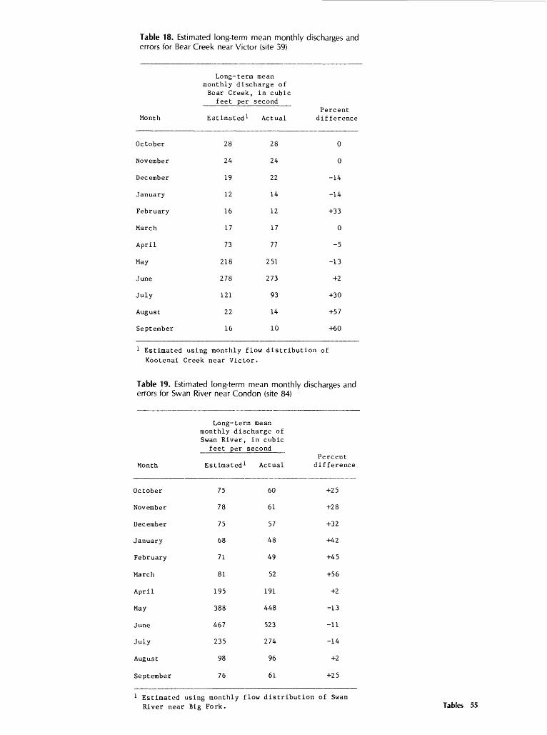
Table 18. Estimated long-term mean monthly discharges and errors for Bear Creek near Victor (site 59)
Month
October
November
December
January
February
March
April
May
June
July
August
September
1 Estimated Kootenai
Long-term mean monthly discharge of Bear Creek, in cubic
feet per second
Estimated 1 Actual
28 28
24 24
19 22
12 14
16 12
17 17
73 77
218 251
278 273
121 93
22 14
16 10
Percent difference
0
0
-14
-14
+33
0
-5
-13
+2
+30
+57
+60
using monthly flow distribution of
Creek near Victor.
Table 19. Estimated long-term mean monthly errors for Swan River near Condon (site 84)
Month
October
November
December
January
February
March
April
May
June
July
August
September
Long-term mean monthly discharge of Swan River, in cubic
feet per second
Estimated 1 Actual
75 60
78 61
75 57
68 48
71 49
81 52
195 191
388 448
467 523
235 274
98 96
76 61
discharges and
Percent difference
+25
+28
+32
+42
+45
+56
+2
-13
-11
-14
+2
+25
1 Estimated using monthly flow distribution of Swan River near Big Fork. Tables 55
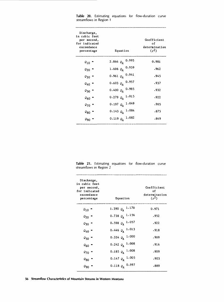
Table 20. Estimating equations for flow-duration curve streamflows in Region 1
Discharge, in cubic feet
per second, for indicated
exceedance percentage
0io =
020 =
030 =
040 =
050 =
060 =
070 =
080 =
090 =
Table 21. Estimating streamflows in Region
Discharge, in cubic feet
per second, for indicated
exceedancepercentage
0io =
020 =
030 =
040 =
050 =
060 =
070 =
080 =
090 =
Equation
2.866 QA O- 995
1.606 QA °' 959
0.961 QA °' 94L
0.603 QA O' 957
0.400 QA O- 985
0.279 QA L ' 015
0.197 QA 1-049
0.143 QA i' 084
0.119 QA L ' 082
equations for 2
Equation
1.390 QA ia70
0.738 QA 1 ' 1 56
0.598 QA i' 057
0.446 QA ^O13
0.334 QA 1-000
0.242 QA i- 008
0.185 QA i' 008
0.147 Qn 1-005 "A
0.118 QA O- 997
Coefficient of
determination (r2)
0.981
.962
.945
.937
.932
.922
.905
.875
.849
flow-duration curve
Coefficient of
determination(r2 )
0.971
.952
.922
.918
.909
.916
.909
.903
.889
56 Streamflow Characteristics of Mountain Streams in Western Montana

Table 22. Average prediction error for regression equations
Average trror of prediction, In percent, for flow charecterlstlc indlceted
Region QLO 020 030 040 Oso Qeo 070 Qao
1 -16 +2-8-9-6-6 -14 -19 -29 -38
2 -23 -15 -2 +2 +5 +5 +8 +12 +15 +18
Table 23. Average prediction error for regression equations deter mined from gaged data only
Average error of prediction, in percent, for flow characteristic indicated
Region 0* OlO 020 OjO 040 Oso 060 070 Ogo 090
1 -6 -6 -11 -11 -6 -3 -5 -9 -15 -18
2 1 -4+2 +5 -1 -1 -4 -7 -4 -2 -8
Not en average for Region 2; these are the results for one site.
Table 24. Range of independent variables
Region
Drainage area(A)
(square miles)
Mean annual precipitation
(P) (inches)
1
2
5.29 - 766
2.88 - 71.3
15 - 72
47 - 72
Tables 57

METRIC CONVERSION FACTORS
The following factors can be used to convert inch-pound units in this report to the International System of Units (SI).
Multiple inch-pound unit
ftVs (cubic foot per second)ft (foot)in. (inch)mi (mile)mi2 (square mile)
By
0.028320.3048
25.401.6092.590
To obtain SI unit
cubic meter per secondmetermillimeterkilometersquare kilometer
National Geodetic Vertical Datum of 1929 (NGVD of 1929): A geodetic datum derived from a general adjustment of the first- order levels nets of both the United States and Canada, formerly called mean sea level. NGVD of 1959 is referred to as sea level in this report.
58 Streamflow Characteristics of Mountain Streams in Western Montana