stream survey manual - maine. · pdf filed. determine the type of survey to conduct ......
TRANSCRIPT
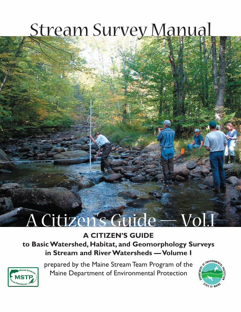
A CITIZEN’S GUIDE to Basic Watershed, Habitat, and Geomorphology Surveys
in Stream and River Watersheds — Volume I
prepared by the Maine Stream Team Program of theMaine Department of Environmental Protection
Stream Survey Manual
A Citizen’s Guide — Vol.I

A CITIZEN’S GUIDE to Basic Watershed, Habitat, and Geomorphology
Surveys in Stream and River Watersheds — Volume I
ACKNOWLEDGMENTSPrepared By: Maine Department of Environmental Protection Jeff Varricchione
Erin Crowley
Primary Contributors and Reviewers: Maine Department of Environmental Protection
Mary-Ellen Dennis
Wendy Garland
Additional Contributors Maine Department of Environmental Protection
Jeff Dennis
Kathy Hoppe
Don Kale
Norm Marcotte
Mark Whiting
Don Witherill
Barb Welch
Maine Department of Inland Fisheries & Wildlife
Merry Gallagher
Phillip Wick
Cumberland County Soil & Water Conservation District
Heather True
Betty Williams
Design/Production:Graphics Communications: Julie Motherwell
Photos Credits: Jeff Varricchione unless otherwise credited; section title pages: Helen McAlpin
February 2009

Table of Contents PAGE
Unit 1: Introduction 1
Unit 2: Stream, River, and Watershed Basics—An Overview ........................5 The Ups and Downs Along Water’s Path ................................................................. 6 • What is a Watershed? • The Hydrologic Cycle • Stormwater Runoff • Vegetated Riparian Buffers
Pollutants and Their Sources ..............................................................................9 • Polluted Runoff • Meet the Pollutants
Unit 3: Survey Basics: Purpose, Getting Started, and Organization A. Introduction to Different Types of Surveys in Stream Watersheds .....................14 B. Identifying Local Concerns, Issues, and Interests ................................................14 C. Gathering and Analyzing Existing Watershed Information ................................14 • Important Information: Topographic Mapping Watershed Mapping Land Use and Vegetative Cover Mapping Tax Maps
• Optional Information: Habitat Mapping Soils Mapping Other Information
D. Determine the Type of Survey to Conduct ..........................................................19 E. Determine Project Leadership and Personnel .....................................................27 F. Budget for Project and Secure Funding ................................................................ 31 G. Communicate with the Public .............................................................................33 Unit 4: Safety and Private Property ........................................................35 A, Accessing Private Property ....................................................................................36 B. Safety Issues ...........................................................................................................37 C. Insurance Considerations .....................................................................................39
Unit 5: Stream Corridor Survey (Level 1) ................................................ 41 A. Introduction to a Stream Corridor Survey ...........................................................42 B, Components of the Stream Corridor Survey .......................................................43 C. Planning a Stream Corridor Survey .....................................................................45 • Scheduling • Secure Funding • Communicate with the Public and Recruit Volunteers • Determining the Study Area and Stream Reach Locations
A CITIZEN’S GUIDE to Basic Watershed, Habitat, and Geomorphology
Surveys in Stream and River Watersheds — Volume I

• Gathering Materials • Choosing Reaches to Be Surveyed and Assigning Volunteers to Reaches • Training Volunteers • Conducting the Survey • Managing the Data
Reports .......................................................................................................................63
Next Steps ..................................................................................................................63
Unit 6: Stream Watershed Survey ........................................................... 65 A. Introduction .........................................................................................................66
B. Steps .......................................................................................................................67 • Plan the Project • Secure Funding • Communicate Plans with the Public and Recruit Volunteers • Hold Training Sessions for the Volunteers • Conduct the Survey • Arrange a Survey Follow-Up Field Work • Prepare and Distribute Final Report
C. Next Steps ..............................................................................................................83
Unit 7: Take Action ...............................................................................85 If You Conducted a Stream Corridor Survey (SCS) (Level1) ..................................86 If You Conducted a Watershed Survey .....................................................................86 Things to Consider after Completing either Survey ................................................88
Appendices A: Glossary ................................................................................................................. 91
B. Best Management Practices ................................................................................. 107
C. Contact Information ........................................................................................... 109
D. Watershed Delineation ....................................................................................... 113
E. Letters: to Landowners and Police; Vehicle ID Card ......................................... 119
F. Volunteer Waiver Form ........................................................................................125
G. Understanding GPS, Coordinate Systems, and Map Datums ..........................127
H. Flip Charts for Photo Identification .................................................................. 131
I. Flow and Discharge: a simple estimation technique .........................................169
J-1: Stream Corridor Survey (SCS) Field Sheets: Instructions ......................................175
J-2a: SCS datasheets: UTM ...........................................................................................199
J-2b: SCS datasheets: Longitude/Latitude .................................................................. 207
J-3: Rapid Geomorphic Assessment Picture Key ........................................................... 215
K: Site Forms ...................................................................................................................233
L: References ....................................................................................................................239
M: Overview: Survey Techniques and Efforts for: .........................................................245 • Maine Road-Stream Crossings • Dam and Natural Barriers
N: Classifications of Living Things ................................................................................ 251
O: Some Common Unit Conversions ...........................................................................253
PLEASE NOTE: It may be that some links will not connect properly, occurring usually if the URL appears in two lines rather than one. Additionally, certain illustrations may not appear clearly. We welcome your comments (Please mail to:
Jeff Varricchione, MDEP, 312 Canco Rd., Portland, ME 04103)

Index of Tables and Figures: Volume I PAGE
Table 3-1: Additional sources of survey background information 18, 19
Table 3-2: Comparison of Stream Corridor Survey (Level 1) and Stream Watershed Survey Techniques .....................................................20, 22
Figure 3-1: Recommended Survey Selection Decision Tree ..............................23, 24
Table 3-3: Use of various fi eld sheets, according to survey type ............................. 25
Table 3-4: Example of alternative stream and watershed survey methods ............ 26
Table 3-5: Common Responsibilities for Organizers and Participants of Stream Corridor and Watershed Surveys .....29, 30
Table 5-2: Simple Timeline for Stream Corridor Survey ......................................... 47
Figure 5-1: Example of Topographical Map ............................................................. 50
Figure 5-2: Example of Stream Reach Naming Procedure ...................................... 53
Table 5-3: Division of tasks and roles among three members of a survey group — an example ........................................................................... 57
Table 6-2: Simple Watershed Survey timeline ......................................................... 68
Worksheet 6-1: Setting a Schedule ........................................................................... 69
Table 6-3: Examples of volunteer time commitments .............................................71
Table 6-4: Simple Land Use Table ............................................................................ 77
Figure 6-1: Simple page from a Watershed Survey report ................................. 81, 82

Department of Environmental Protection • Stream Survey Manual 1
Unit 1:
Introduction
ooooo

UNIT 1: INTRODUCTION2
Unit 1: Introduction
There are roughly 45,000 miles of streams and rivers in Maine. These
streams and rivers serve as habitats and sources of food for many different types of
organisms during part or all of their lives.
Maine is home to the last remaining populations of wild Atlantic salmon
in the U.S., and those populations remain at critically low numbers. Maine is an
important habitat for Eastern brook trout populations in the U.S.
It is also home to a unique blend of certain aquatic insect, crustacean,
mollusk, and plant species; as well as home to many exciting and charismatic
reptiles, amphibians, birds, and mammals which rely on streams for sources of
water and food.
These stream and river ecosystems also provide much aesthetic beauty; they
carry water, nutrients, and food resources to downstream waterbodies such as
lakes and the ocean; and they provide important economic benefi ts (e.g., tourism,
fi shing, recreation, hydropower, industrial process water, etc.) to Maine and its
citizens.
The health of streams, rivers, and the organisms that live in them depends
on good water quality and aquatic habitat conditions. Humans, however, can
disturb and degrade these conditions through land-use and water-use activities
that are not done properly or carefully. Maine is no exception. While it has many
beautiful miles of pristine or near-pristine waterways, a signifi cant amount of its
stream and river miles has been damaged and impacted.
In order to maintain or improve water quality and habitat conditions, these resources need to be assessed, managed, and protected. Nearby human
activities must be done with care and according to the latest standards (sometimes
referred to as “best management practices” or BMPs).
Volunteers play an important role in assessment and protection activitiesbecause the budgets and staffs of state, federal, academic, private, and nonprofi t
agencies and organizations can only go so far.
■ Some examples of volunteer activities include: • forming and operating watershed groups, stream teams, and
land trusts;
• doing streamside tree buffer plantings, trash clean-ups, and
stormdrain stenciling projects; and
• educating the public about ways to reduce its contribution of
pollution to Maine’s waterways.
■ Surveys are another great activity in which volunteers can participate. • In general, a survey is an activity which gathers information about
a particular topic or place. (For the purposes of this manual, the term
“survey” refers to people [volunteers, watershed managers, scientists,
etc.] going out and collecting information about a stream [or river],
the land around that waterbody, or both.)
Maine is home to
the last remaining
populations
of wild Atlantic
salmon
in the U.S.,
and those
populations remain
at critically low
numbers.
Maine is an
important habitat
for Eastern
brook trout
populations
in the U.S.

Department of Environmental Protection • Stream Survey Manual 3
• Surveys are an excellent way for volunteers to help gather important
information about streams and rivers, their shoreland areas, and the land
surrounding them.
• The survey results can be used to educate the participants, their
neighbors, and municipal/state offi cials about the stream and
any potential high-value habitats it may have; and/or potential problems
that may threaten or exist in their stream watershed.
• Survey information can then be analyzed and used to make better in-
formed management and conservation decisions related to natural
resources.
This guide is designed to help volunteer group leaders and, to some extent, the
volunteers themselves learn:
• some basic watershed concepts,
• how to organize and carry out basic stream watershed surveys and stream
corridor surveys,
• how to use standardized methods so that the information collected in
various watersheds and streams around the state can be readily compared.
(Details about these activities are contained in other units later in this guide.)
For the sake of simplicity in this manual, the term stream is used to represent
brooks, creeks, and rivers in addition to streams.
For the sake
of simplicity
in this
manual,
the term
“STREAM”
is used to
represent
brooks, creeks,
and rivers in
addition to
streams.

UNIT 1: INTRODUCTION4
Let us begin by summarizing the types of information covered in the remaining units and appendices
of this guide:
■ Unit 2: Stream, River, and Watershed Basics — An Overview This unit explains the very basics about streams and watersheds needed before
conducting a survey.
For a more detailed discussion about these topics, the reader is referred to the Maine Stream
Team Program guide, Volume 2: A Citizen’s Primer on Stream Ecology, Water Quality, Hydrology, and
Fluvial Geomorphology. To download a copy, visit the Maine Stream Team Program website: http://
www.maine.gov/dep/blwq/docstream/team/streamteam.htm.
Alternatively, if an introductory level of information regarding streams is desired, the reader is
referred to the brief, but informative, booklet, STREAMS, a project of the Gulf of Maine Aquarium
(and funded by the MDEP). It is available online at: http://octopus.gma.org/streams/streams.html
or in paperback form from the Maine Stream Team Program (for contact info, visit the website
mentioned above).
■ Unit 3: Survey Basics — Purpose, Getting Started, and Organization
This unit discusses different types of surveys that can be done by volunteers, including stream
watershed surveys and stream corridor surveys (Level 1), and how to determine the best option for
your group (in some cases both are recommended). The remainder of this unit provides instructions
on certain organizational steps that are common to both stream watershed surveys and stream cor-
ridor surveys.
■ Unit 4: Safety and Private Property This unit discusses two very important considerations related to conducting stream surveys
— accessing private property and planning for safety.
■ Unit 5: Stream Corridor Survey (Level 1) This unit details the steps required for organizing and completing a volunteer survey that
examines the status of aquatic and shoreland/riparian habitat, water quality, and geomorphic
(channel shape) stability.
■ Unit 6: Stream Watershed Survey This unit details the steps required for organizing and completing a volunteer survey that
examines the lands in the watershed around a stream for potential or existing sources of pollution or
stress which could degrade water quality or habitat conditions in that particular stream. (The term
watershed is described in the beginning of Unit 2.)
■ Unit 7: Take Action
This unit lists suggested steps one can take after gathering and analyzing data collected during
stream surveys.
■ AppendicesThe appendices in the back of this guide contain important information and data sheets related
to various aspects of Units 2 through 7.

Department of Environmental Protection • Stream Survey Manual 5
Unit 2:
Stream, River,
and Watershed
Basics — An Overview
ooooo
CONTENTS
What is a Watershed 6
The Hydrologic Cycle 7
Stormwater Runoff 7
Vegetated Riparian Buffers 8
Pollutants and Their Sources 9
Polluted Runoff 9
Meet the Pollutants 10

6 UNIT 2: STREAM, RIVER, AND WATERSHED BASICS — AN OVERVIEW
Unit 2:Stream, River, and Watershed Basics – An Overview
This unit explains the very basics about streams and watersheds needed before conducting a survey.
Appendix A contains a glossary that may be helpful too.
The Ups and Downs Along Water’s Path…...all about stormwater runoff and its contents
Stormwater, which consists of rainwater and melted ice and snow, fl ows over the landscape
into streams and rivers, and eventually into lakes, ponds, or the coast. Along the way, it picks
up and carries with it contaminants largely produced by humans. Stormwater that carries
contaminants is called polluted runoff, or polluted runoff, or polluted runoff nonpoint source pollution (NPS); that is, not coming from
a single point source — such as a discharge pipe at a factory or industrial plant.
Polluted runoff is diffuse, and its sources are diverse and diffi cult to identify. Yet it’s every bit
as damaging as point source pollution. Contaminants found in polluted runoff include oil, trash,
sediment, metals, toxics, nutrients, and sewage.
To understand how polluted runoff affects stream water quality, it is important to understand
the concepts of watershed, the water cycle (hydrologic cycle), stormwater runoff, and vegetated
buffers, all of which are described in the remainder of this unit.
■ What Is a Watershed?A watershed is an area of land from which water drains downhill A watershed is an area of land from which water drains downhill
into a body of water at the low point in the landscape.into a body of water at the low point in the landscape.
Every river, stream, pond, wetland, lake, estuary, or coastal Every river, stream, pond, wetland, lake, estuary, or coastal
embayment has a watershed. Imagine a watershed embayment has a watershed. Imagine a watershed
as a bowl with a pool of water at the bottom. as a bowl with a pool of water at the bottom.
Water that falls onto the inside rim of the bowl Water that falls onto the inside rim of the bowl
fl ows down along the surface to the bottom of fl ows down along the surface to the bottom of
the bowl. Much like a bowl’s rim, high points the bowl. Much like a bowl’s rim, high points
in the landscape, such as ridges and hilltops, are in the landscape, such as ridges and hilltops, are
the boundaries that separate watersheds.the boundaries that separate watersheds.
The shape and size of watersheds
are determined by the topography of are determined by the topography of
the land. For example, a coastal
watershed may be comprised of
several smaller watersheds of
tributary streams and rivers.
Polluted Polluted
runoffrunoff
is diffuse,
and its
sources
are diverse
and diffi cult
to identify.
For a more detailed discussion about these topics, the reader is referred to the Maine Stream Team Program guide, Volume 2: A Citizen’s Primer on Stream Ecology, Water Quality, Hydrology, and Fluvial Geomorphology. To download a copy, visit the Maine Stream Team Program website : http://www.maine.gov/dep/blwq/docstream/team/streamteam.htm.
Alternatively, if an introductory level of information regarding streams is desired, the reader is referred to the brief, but informative booklet, Streams. This booklet is a project of the Maine DEP and Gulf of Maine Aquarium, and is available online at: http://octopus.gma.org/streams/streams.html.
(Source: USEPA)
Department of Environmental Protection • Stream Survey Manual 7
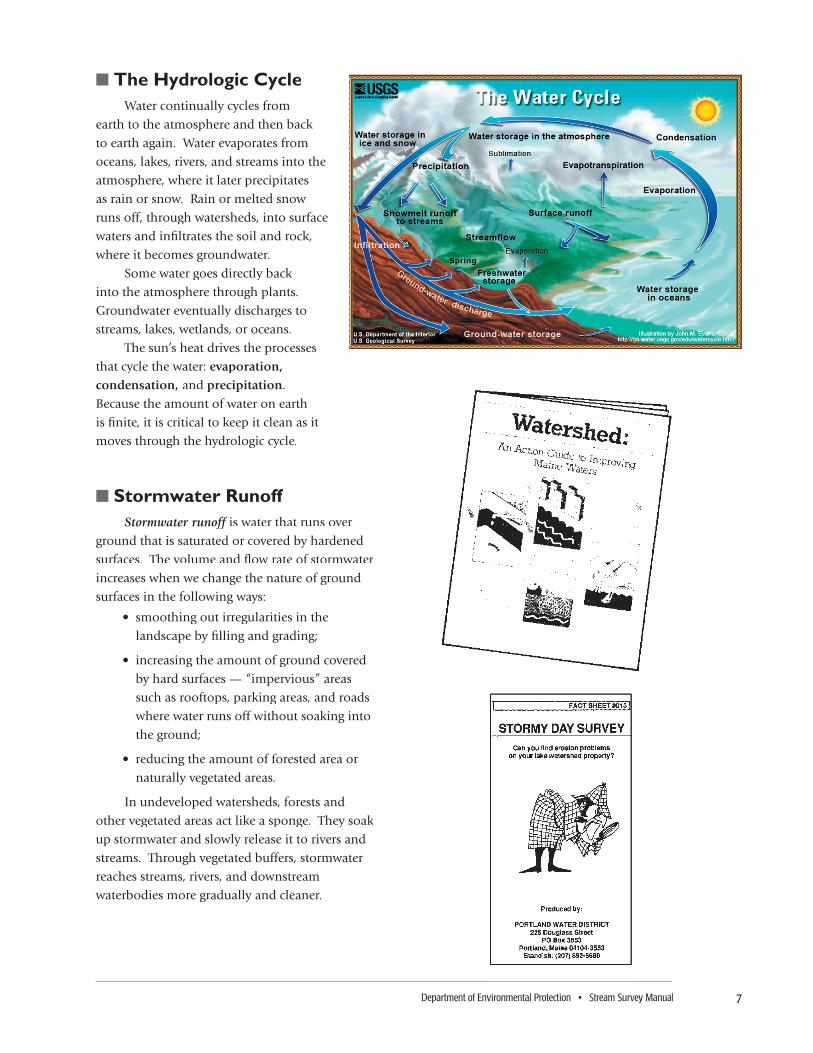
■ The Hydrologic CycleWater continually cycles from
earth to the atmosphere and then back
to earth again. Water evaporates from
oceans, lakes, rivers, and streams into the
atmosphere, where it later precipitates
as rain or snow. Rain or melted snow
runs off, through watersheds, into surface
waters and infi ltrates the soil and rock,
where it becomes groundwater.
Some water goes directly back
into the atmosphere through plants.
Groundwater eventually discharges to
streams, lakes, wetlands, or oceans.
The sun’s heat drives the processes
that cycle the water: evaporation, condensation, and precipitation.
Because the amount of water on earth
is fi nite, it is critical to keep it clean as it
moves through the hydrologic cycle.
■ Stormwater RunoffStormwater runoff is water that runs over Stormwater runoff is water that runs over Stormwater runoff
ground that is saturated or covered by hardened
surfaces. The volume and fl ow rate of stormwater
increases when we change the nature of ground
surfaces in the following ways:
• smoothing out irregularities in the
landscape by fi lling and grading;
• increasing the amount of ground covered
by hard surfaces — “impervious” areas
such as rooftops, parking areas, and roads
where water runs off without soaking into
the ground;
• reducing the amount of forested area or
naturally vegetated areas.
In undeveloped watersheds, forests and
other vegetated areas act like a sponge. They soak
up stormwater and slowly release it to rivers and
streams. Through vegetated buffers, stormwater
reaches streams, rivers, and downstream
waterbodies more gradually and cleaner.

8 UNIT 2: STREAM, RIVER, AND WATERSHED BASICS — AN OVERVIEW
■ Vegetated Riparian BuffersRiparian zones are areas adjacent streams, rivers, and other waterbodies, and include streambanks
and fl oodplains. They are areas of trees, shrubs, and other vegetation between an upland area, that
often is developed, and a water body. Vegetated riparian zones are important components of stream
(and other waterbody) ecosystems that are highly valuable towards keeping water clean.
Vegetated riparian “buffers” are tools that watershed managers and landowners manage or
restore in landscapes altered by humans, to protect streams and other waterbodies. These buffers can
include trees, shrubs, bushes, and ground cover plants.
The irregularities and depressions of the ground in natural buffers retain and treat polluted
runoff, because water is allowed to percolate into the ground. Forested areas are most effective in the
retention of stormwater because of the duff layer (thick, soft layer) of decomposing pine needles, bark,
leaves, and other organic material that has fallen on the ground. The duff layer in forests can be up to
several inches thick — an incredible natural sponge! Over time, planted buffers can be as effective as
natural ones.
Buffers prevent pollutants from reaching surface waters in several ways: they fi lter
pollutants out of stormwater, they slow the fl ow rate of stormwater runoff, and they reduce the
volume of stormwater runoff. Additionally, vegetated riparian zones (or managed “buffers”) along
rivers and streams also provide values such as shading, habitat, and food sources for wildlife and
aquatic organisms.
WATER BALANCE
STREAMFLOWSTREAMFLOW
Evapo-transpirationtranspiration
Surface RunoffRunoff
Interfl owInterfl ow Basefl ow
CanopyInterception
TIME
Higher and MoreRapid Peak Discharge
Large Storm
Higher Basefl owHigher Basefl ow
More Runoff Volume
Small Storm
STR
EAM
FLO
W R
ATE
PRE-DEVELOPMENT
POST-DEVELOPMENTPOST-DEVELOPMENT
Larger and LessLarger and LessRapid PeakRapid Peak
GradualRecession
Basefl owBasefl ow
Interfl owInterfl ow
TranspirationTranspiration
Surface Runoff
Urban/SurburbanNaturalNaturalNatural

Department of Environmental Protection • Stream Survey Manual 9
The Pollutants and Their Sources
■ Polluted Runoff and Its Threat to Streams, Rivers, and Receiving Waters
In the past, rivers, streams, and other waterbodies were disposal areas for untreated industrial
and manufacturing wastes and raw sewage discharged from point sources. People thought that these
waters had a limitless ability to dilute pollutants. However, years of discharging pollutants in some
areas of the country led to waters that were toxic to aquatic life and humans.
Point source pollution discharges were addressed when the Federal Clean Water Act was passed in
the early 1970s. Industrial and municipal wastewater discharges were regulated, pollutant loads were
reduced, and municipalities constructed sewage treatment plants with federal funds. State programs,
such as the Small Community Grants Program and the Overboard Discharge Program, have funded the
removal of untreated discharges and the elimination of overboard discharge pipes (and combined sewer
overfl ows [CSOs]). These changes have resulted in great improvements to the quality of Maine’s waters.
Today, it is nonpoint source pollution (NPS) (also known as polluted runoff or polluted runoff or polluted runoff polluted stormwater)
that poses the greatest threat to Maine’s waters, particularly as urban and suburban populations
increase.
• The driving forces of the hydrologic cycle and the topography of a watershed carry nonpoint
source pollution from the land into rivers, streams, wetlands, groundwater, and eventually into
receiving waters such as lakes and coastal waters.
• Human activities on land and water generate pollutants such as sediments, nutrients, toxics,
and pathogenic organisms (e.g., harmful types of bacteria). Human transformation of natural forest
land into impervious surfaces, such as roads, parking lots, and rooftops, can decrease the infi ltration of
precipitation into the ground and thus increase the speed and volume of runoff and any pollutants it
may carry.
• Many Maine towns are experiencing rapid growth. The potential cumulative impacts of many
small activities connected with this expansion can degrade water quality. Runoff from a single
fertilized lawn seems like a small problem; however, contaminated runoff from many lawns in the
watershed, year after year, may have a severe cumulative impact.
These pollutants
threaten the health of our
environment, our people
and our economy. The
investment we could make
to prevent pollution is
minimal compared to the
potential costs of losing
our water resources.
Some of these pollutants
can come from natural
sources: weathering of soils,
wildlife, and decomposing
vegetation. Most polluted runoff is caused by, and can be reduced by, humans.

10 UNIT 2: STREAM, RIVER, AND WATERSHED BASICS — AN OVERVIEW
■ Meet the Pollutants: Sediments, Nutrients, Toxics, Pathogenic Organisms
SEDIMENTSSediments (sand, silt, and other soil particles) suspended and transported in streams, rivers, and
other waterbodies are harmful in several ways:
• they fi ll in the spaces between gravel in stream bottoms, eliminating spawning areas of many
fi sh, suffocating any eggs present, and eliminating habitats for fi sh food such as aquatic insects
(e.g., stonefl ies, mayfl ies, etc.) and other invertebrates;
• they reduce visibility, which interferes with fi shes’ ability to feed;
• they raise water temperature, which reduces the amount of oxygen in the water;
• they clog the feeding apparatus of fi lter feeders;
• they damage fi sh and aquatic insect gills;
• they block sunlight, which impairs photosynthesis of aquatic plants;
• they carry nutrients• they carry nutrients• they carry (e.g., phosphorous) and toxins, which cling to settled or suspended
sediments, resulting in impaired ecosystems, public health risks, and negative consequences for
Maine’s economy.
Creating larger impervious areas (roads and parking lots) increases the volume and speed of
stormwater runoff, which erodes stream banks and deposits sediments downstream where they create
large sediment deltas in rivers, lakes, and ponds. Construction projects that leave soil exposed during
and after construction are another source of sediment in streams and other waterbodies. Logging or
farming too close to water bodies can expose soil, making it vulnerable to erosion.
Wide vegetated riparian buffers (and state-of-the art stormwater treatment systems in
urban areas) are encouraged in all these land-use types to help minimize erosion and
sedimentation problems.
NUTRIENTSMajor nutrients are carbon, hydrogen, oxygen, sulfur, silica,
nitrogen, and phosphorus. To grow and reproduce, plants and
animals need a certain portion of each type of nutrient. In most
cases, nutrients are a good/required thing to have in streams.
Some nutrients can be toxic to organisms. For example, the
nitrate (NO3) form of nitrogen generally helps plants grow;
while the ammonia (NH3) form of nitrogen can be toxic to fi sh
and other organisms in concentrated amounts.
A nutrient that is the least abundant relative to a plant’s
need for it is called the limiting
nutrient. Limiting nutrients limit the growth and reproduction of organisms. Phosphorus is usually the primary limiting nutrient for algae growth in freshwater, such as lakes, rivers, and streams. (Nitrogen is usually the primary limiting nutrient for growth of algae in marine waters,
which can be downstream of coastal streams and rivers. Nitrogen sources are often the same as
phosphorus sources.)

Department of Environmental Protection • Stream Survey Manual 11
When extra phosphorus enters freshwaters, it may, given the right conditions (e.g.,
adequate sunlight), promote excess growth of algae and other aquatic plants. Phosphorus
enters freshwaters as a result of human activities:
• agricultural sites (e.g., chemical fertilizer, manure, organic matter, soil);
• residential areas (e.g., lawn fertilizer, pet waste, soil);
• urban developments (e.g., runoff from roads, parking lots, automobiles); and
• point source discharges (e.g., treated wastewater and sewage).
Some presence of algae and other aquatic plants in stream ecosystems is a natural
condition, especially where sunlight is ample. When excess nutrients are introduced into
streams and other waterways, typically from human activities, there can be excessive growth
of algae and plants and associated negative impacts. (In heavily shaded headwater streams,
sunlight availability is minimal and, therefore, algae and plant growth is also minimal.
Still, be careful, the rocks in the stream can be pretty slippery when they’re coated with
fi lms of tea-colored diatom algae!)
During the daytime when conditions are sunny, algae and plants generate dissolved
oxygen via photosynthesis during sunny conditions, which is benefi cial to other aquatic
organisms. Also during the daytime, algae and other aquatic plants, plus bacteria and
animals, use up oxygen for processes such as respiration and decomposition.
At night and before dawn, sunlight is not present and plant photosynthesis is not
producing dissolved oxygen. In certain instances, stream reaches having excessive growth of
algae and other aquatic plants, large amounts of dead organic material, or large inputs
of organic waste such as sewage, can use up signifi cant amounts of oxygen via respiration
and decomposition, which occurs 24 hours a day. These night-time lows in dissolved
oxygen concentrations can stress sensitive species of fi sh, macroinvertebrates, and other
aquatic organisms.
TOXICS
Toxics are chemicals that can kill or limit the growth or reproduction of aquatic organisms. A harmless substance can become toxic if its chemical form, quantity, or availability is changed. For instance, a trace metal could be a nutritional requirement for
an organism in small amounts, yet toxic if consumed in higher concentrations.
Lead, mercury, arsenic, cadmium, silver, nickel, selenium, chromium, zinc, and
copper are heavy metals that can be toxic in fresh and marine waters. Metals can be
transported into water bodies from vehicle emissions, industrial processes, and improper
use or disposal of paints and pesticides. Metals also
occur naturally in rocks and minerals and can leach
into the environment over time. Soil disturbance
can accelerate the release of metals into the aquatic
environment.
Many petroleum products are toxic, particularly
the polycyclic aromatic hydrocarbons (PAHs) that
enter the water through oil spills and the burning
of fossil fuels. Polychlorinated biphenyls (PCBs)
formerly used in electrical transformers and other
products, chlorinated pesticides, and dioxin are other
major toxics found in Maine’s aquatic environments.

12 UNIT 2: STREAM, RIVER, AND WATERSHED BASICS — AN OVERVIEW
PCBs and many pesticides are now banned because of their toxic properties. Some of these toxins take
a long time to degrade, and their persistence in the environment means they will continue to cause
problems. Landfi lls and illegal disposal sites are primary sources of these contaminants.
Heavy metals and organic toxins inhibit the growth, reproduction, and immune systems of
aquatic organisms. These contaminants accumulate in sediments and are consumed by bottom-
feeding organisms. Fish and crustaceans eat the bottom-feeding organisms (e.g., aquatic insects and
mollusks), accumulating the contaminants. Birds, humans, and other organisms then eat the fi sh and
crustaceans and, with them, the accumulated contaminants.
PATHOGENIC ORGANISMSPathogenic organisms are certain bacteria or viruses, that can cause disease. Pathogens from
sewage and animal wastes, are responsible for the closure of swimming areas and shellfi sh areas
downstream of coastal streams that may be contaminated. Some gastro-intestinal illnesses can be
contracted by swimming in severely contaminated waters.
Sewage enters streams, rivers, and other waterbodies from malfunctioning septic systems
and publicly owned treatment works (POTWs), overboard discharge systems, combined
sewer overfl ows (CSOs), and discharges from boats. Pollution from animal wastes is primarily
generated from agricultural activities, such as spreading manure to fertilize fi elds, but is also generated
by pets and wildlife.
Learning More About Various Aspects of Stream Physical, Chemical, and Biological Properties and Processes
There are many topics about streams that we don’t get into much detail about in this manual (Volume 1). For more detailed information about topics such as stream organisms, habitats, hydrology, water quality, ecosystem processes, dynamics, geomorphology, etc., we refer you to the Maine Stream Team Program guide Volume 2: A Citizen’s Primer on Stream Ecology, Water Quality, Hydrology, and Fluvial Geomorphology,
To download a copy, visit the Maine Stream Team Program’s website: http://www.maine.gov/dep/blwq/docstream/team/streamteam.htm.
Alternatively, if an introductory level of information regarding streams is desired, the reader is referred to the brief, but informative booklet, STREAMS, a project of the Maine DEP and Gulf of Maine Aquarium. It is available online at: http://octopus.gma.org/streams/streams.html or in paperback from the Maine Stream Team Program (http://www.maine.gov/dep/blwq/docstream/team/streamteam.htm).

Department of Environmental Protection • Stream Survey Manual 13
Unit 3:
Survey Basics: Purpose,
Getting Started,and
Organization
ooooo
CONTENTS
Survey Basics 14
Introduction to Different Types 14
Identifying Local Concerns 15
Gathering Existing Information 15
Important Information 16
Determining Type of Survey 19
Leadership and Personnel 27
Steering Committee 27
Recruit Volunteers 28
Budget and Funding 31
Communicate with Public 33

UNIT 3: SURVEY BASICS: PURPOSE, GETTING STARTED, AND ORGANIZATION 14
Unit 3: Survey Basics — Purpose, Getting Started, and Organization
A. An Introduction to Different Types of Surveys in Stream Watersheds
Unit 1 described the importance of conducting surveys in order to help gather
information to help better manage Maine’s roughly 45,000 miles of streams and
rivers. The remainder of this guidance manual focuses on types of surveys related to
streams and their watersheds, which can be performed by volunteers, requiring only
a few hours of basic training by a professional. These surveys identify places on the
landscape or stream sections which appear to either be high-value habitats for aquatic
organisms, such as coldwater fish, or they identify places where significant pollution
or habitat-degradation or water quality problems may exist.
Many of these survey locations are places not yet studied or assessed by state,
federal, academic, or nonprofit agencies and organizations. The benefit of using
the methods described in this manual is that a lot of land area around Maine can
be surveyed by volunteers after only some basic training. These volunteer efforts
allow agencies, watershed organizations, and other groups to make more efficient use
of their staff and resources to gather additional, more detailed data where it is most
needed and then manage aquatic organism populations, habitats, and water quality
more wisely and effectively.
There are many types of surveys that can be done in streams and their watersheds
(e.g., stream corridor surveys [SCS], watershed surveys [WS], etc.) and they will be
explained and compared later in this chapter. The choice of which type of survey(s) to
do will be based upon: a) the information already existing about the resource and b)
the interests, concerns, and goals of those people organizing and participating in the
surveys. (The unique, specific planning considerations for the different survey types
will be discussed in greater detail in Units 5 and 6, and some appendices of
this manual.)
The benefit
of using
the methods
described in
this manual
is that
a lot of land area
around Maine
can be surveyed
by volunteers
after only some
basic training.
While some quantitative data (measurements) may be collected during these volunteer-
oriented surveys, it is generally recognized that a professional or experienced volunteer may
need to revisit important locations identified during the surveys in order to collect more
intensive, technical information and quantitative measurements. These types of intensive
analyses are beyond the scope of this manual, though references and links to some of those
resources and methods are mentioned later in this unit (section D; Table 3-4).
Even though some of the sites identified by volunters may need to be revisited, a great
deal of time will have been saved because the initial surveys first determined whether there
were any high priority extraordinary habitats or serious problems warranting follow-up. These
surveys identify any specific locations where important situations occur so the follow-up
technician does not have to walk the entire length of the stream to find them.

Department of Environmental Protection • Stream Survey Manual 15
The common, important considerations that apply to these surveys described in
this manual include:
• identifying local concerns, issues, and interests;
• gathering and analyzing existing watershed information;
• determining the type of survey to conduct;
• determining project leadership and personnel;
• budgeting for the project and obtaining funding; and
• communicating with the public.
B. Identifying Local Concerns, Issues, and InterestsWe’ve just discussed in general why volunteers might want to do a survey
from a statewide and national perspective. Now, specifically why do you (and your group) want to conduct a stream survey? Be prepared to
answer this question and record your reasons for later use.
• Is there a known specific problem with the stream that will be used
as justification for the further scrutiny?
• Is there little or no existing information regarding whether the stream and/or
its watershed has pollution or habitat problems or whether it may have
potentially high-value coldwater fisheries habitat?
• If there is little or no information, does the watershed community
recognize the value and sensitivity of this stream (or the waterbody
into which it flows) and want to protect, maintain, or improve that
value?
Before enlisting help from the public and agencies or organizations, the project
organizers should be able to define the local concerns and basic issues. There are
many ways to survey a stream and its watershed, and your objectives will help you
to determine which methods to use. This unit provides many sources of helpful
information. (If additional assistance is needed, contact the Maine Department of
Environmental Protection [MDEP] or the Maine Stream Team Program. [see Appendix C for
contact information])
C. Gathering and Analyzing Existing Watershed InformationYou will need to gather data that already exists about the stream and its watershed
from various municipal, state, and federal organizations. This information will be
critical to helping you design the project. Categories of existing information and the
resources where you can find them are defined below. (See Appendix C to find contact
information for the resource agencies that may have this information.)

UNIT 3: SURVEY BASICS: PURPOSE, GETTING STARTED, AND ORGANIZATION 16
IMPORTANT INFORMATION
■ Topographic Mapping Topography is the relief or surface configuration of a land area. Steeper ter-
rain may send stormwater through a watershed more forcefully, and wider vegetated
buffers may be needed to slow the flow and prevent pollutants from reaching surface
waters. Steeper watersheds may also have greater soil erosion problems. A topo-
graphic map can tell you the overall steepness of your watershed.
Topographic maps are important tools for planning both watershed and stream
corridor surveys. You will need a topographic map to determine stream reach
endpoints for a Stream Corridor Survey (SCS) or to delineate watershed boundaries
for a Watershed Survey(WS) (see Watershed Mapping below).
The most common version of maps used is the “7 1/2 minute topo map,” which
refers to the scale of the map. These maps are available from a variety of sources
(Table 3-1), including many sporting goods stores, the Maine Geological Survey
(http://www.maine.gov/doc/nrimc/mgs/mgs.htm), and online companies. (Note: Many of these maps have not been updated since the 1970s. Make sure to check the
revision date on the map in order to understand the context.)
A brief discussion on how to read topographic maps is included in Appendix
D. Additional information can be found at the U.S. Geological Survey’s website on
Topographic Map Symbols:
• http://erg.usgs.gov/isb/pubs/booklets/symbols/index.html -or-
• http://erg.usgs.gov/isb/pubs/booklets/symbols/topomapsymbols.pdf
■ Watershed MappingA watershed map shows the land area included in the watershed. For
watershed surveys, it is critical to know the boundaries of the watershed that
you will be surveying to identify the major land uses and potential impacts to
the stream.
While it is not necessary to have a watershed map to complete a SCS, it
may help you to interpret your findings. (See Appendix D, if a watershed map is
not readily available, for instructions on how to delineate a watershed.)
■ Water Quality Monitoring Data Documented water quality problems will help determine what pollutant
source(s) to survey. Gather data about the designated use and the level of
impairment of a water body from a variety of sources such as those mentioned in
Table 3-1.
■ Pollution Source DataKnowing the location of licensed point discharges and documented nonpoint
pollution sources is useful in understanding what pollutants are affecting water
quality. Documented pollution sources may not need to be surveyed or may only
need an update.
Data on point sources, such as licensed discharges, landfills, sludge sites, salt
storage, and underground tanks; and nonpoint pollution sources is increasingly
becoming available through websites such as those of the MDEP and U.S.
Environmental Protection Agency mentioned in Table 3-1. Contacting staff at those
agencies can lead to information as well.
NOTES

Department of Environmental Protection • Stream Survey Manual 17
■ Land Use and Vegetative Cover MappingLocating typical land uses (farms, single-family houses, gravel pits, disturbed
land, etc.) and vegetative cover types (hay fields, lawns, pine forests, etc.) will
help your group determine where to survey. Land use maps developed for town
comprehensive plans, as well as aerial photographs, are often available through local
municipal offices or county soil and water conservation districts.
■ Tax MapsWhen doing survey work on or around private property during a stream cor-
ridor or watershed survey, it is important to first obtain permission to access the land. Determining property ownership is the first step in developing a mailing list of
affected watershed landowners. This can be tricky, especially with seasonal residents
because they are not around as often, so it is often necessary to reference municipal
tax maps.
Some groups find it helpful to provide copies of relevant tax maps to volunteers
surveying a watershed sector or stream reach, including notes on which landowners
have requested that their property not be surveyed. Check with your local
municipal offices for more information on obtaining tax maps (Table 3-1). Tax map
information may not be critical at this point, but you probably will want it later on
when you are preparing to notify landowners about your survey project.
OPTIONAL INFORMATION
■ Habitat MappingKnowing the location of critical wildlife habitats and natural areas having
threatened or endangered species are is important in targeting areas that are sensitive
to pollution. Critical habitat locations and information may be available in fish
and wildlife surveys and on maps from the Maine Department of Inland Fisheries and Wildlife (MDIFW). Local town or city conservation commissions may have
Beginning with Habitat maps which identify some of these local resources —
www.beginningwithhabitat.org/the_maps/index.html (Beginning with Habitat is a
multi-agency effort led by MDIFW.)
■ Soils MappingThe soil types in the watershed affect how easily soil particles are eroded and
how easily pollutants are attached to those particles. Soils with a high content of
small particles, such as clay, adsorb pollutants more easily than larger soil particles,
such as sand.
Soils maps are available through your county soil and water conservation district, and through the USDA Natural Resources Conservation Service.
■ Other InformationOther information that might be useful in planning surveys is listed in Table 3-1.
You may also want to contact organizations such as MDEP, MDIFW, the Maine
Atlantic Salmon Commission, or any other local natural resource organization to see
if any special studies were done on your particular stream.
NOTES

UNIT 3: SURVEY BASICS: PURPOSE, GETTING STARTED, AND ORGANIZATION 18
Information Type Suggested Source Website or Location
Table 3-1. Additional sources of survey background information.
Mapping & GIS Basics
GIS Maps(Geographic Information System)
Topographic Maps and Aerial Photographs(in either paper & digital form)
Municipal Maps(e.g., tax maps, storm drain maps, comprehensive plan maps, etc.)
Geology and Groundwater Maps
Water Quality Information
Pollution Sources
• U.S. Geological Survey / Science Education Page
• Maine Office of GIS
• Local natural resource agencies and universities/colleges
• Local natural resource organizations/ agencies and universities/colleges
• Local sporting good stores
• Maine Office of GIS
• Companies found on the Internet
• Municipal offices
• Maine Geological Survey
• Maine DEP Data Page
• Maine DEP — Biomonitoring Maps & Data
• PEARL (University of Maine)
• Maine Watershed Web (Bowdoin College)
• Vital Signs Program (Gulf of Maine Research Institute)
• GLOBE (Global Learning and Observations to Benefit the Environment; geared towards teachers/students)
• U.S. Environmental Protection Agency —Watershed Programs —STORET / WQX
• U.S. Geological Survey (ME office)
• Local monitoring groups
• MDEP Data
• Other sites
• http://education.usgs.gov/
• http://apollo.ogis.state.me.us/ (see menu buttons for data, maps, aerial photos, etc.)
• Various locations
• Various locations
• Various locations
• http://apollo.ogis.state.me.us/ (see menu buttons for data, maps, aerial photos, etc. )
• Type “topographic maps” or “aerial photographs” into an Internet search engine
• Various locations
• http://www.maine.gov/doc/nrimc/mgs/mgs.htm
• http://www.maine.gov/dep/data.htm/
• http://www.maine.gov/dep/blwq/docmonitoring/ biomonitoring/data.htm
• http://www.pearl.maine.edu/
• http://learn.bowdoin.edu/apps/hydrology/watersheds/
• http://www.gma.org/vital_signs/
• http://www.globe.gov/
• http://www.epa.gov/owow/watershed/
• http://www.epa.gov/storet/
• http://me.water.usgs.gov/
• if you aren’t aware of groups in your area, contact the MSTP Pollution Sources
• USEPA Watershed Website• http://www.maine.gov/dep/data.htm
• http://www.epa.gov/owow/watershed/ (e.g., “Surf Your Watershed”, etc.

Department of Environmental Protection • Stream Survey Manual 19
D. Determining the Type of Survey to Conduct
There are a number of techniques and combinations of techniques, with varying
values, difficulties, and time commitments, from which people can gather information
about streams and their watersheds.
Two types of surveys are of particular note for their importance in assessing overall
stream and watershed health at a “volunteer-level” of difficulty and time-intensity, and
they are the focus of this manual.
• The first type is a stream-based investigation called the Level 1 Stream Corridor Survey (SCS). This technique is comprised of both a stream habitat survey and a
rapid geomorphic assessment (RGA).
• The second type is a land-based survey called the Stream Watershed Survey (WS). Within this manual we will shorten this name to Watershed Survey, recognizing
that watershed surveys can also be done in lake, coastal, and wetland watersheds.
Later in section D, we will also describe additional types of surveys that can be
done in streams and stream watersheds.
The SCS and the WS are both useful in a variety of types of watersheds, includ-
ing urban, high or low density residential development, commercial development,
agriculture and forested. (See Table 3-2 for a comparison and summary of the purpose,
function, utility, and requirements of these two survey types to help you determine which type of
survey is best for your needs.)
A question to answer is whether to do either a SCS, WS, or both types of surveys. Historically, many groups have opted to do just one type of survey or the
other. More recently, a number of groups have decided to do both types of surveys in
the same project. The reason for doing just one type of survey for a project is the desire
to keep things simpler and more manageable, and to keep costs and requirements of
volunteers to a minimum.
As time has passed, experience has shown that doing both types of surveys within
a given watershed for a particular project may not cost a great deal more than doing a
single type of survey, while the amount of information gained increases greatly. (See
Figure 3-1 for a suggested “decision-tree” flow chart for making decisions about which type(s)
of survey to do and in which order)
When a stream watershed survey project adds a SCS component, the information
about the types of serious problems the stream may actually be experiencing and where
they may be the most serious, is gained. When a SCS project adds a WS, information
about the location of nonpoint source pollution problems potentially reaching and
impacting the stream is gained.
While a group might be inclined to do just one type of survey for whatever reason,
it is worth considering doing both. Also, it is worth considering doing a SCS prior to a
WS of a given stream so that the highest priority stream reaches, and the types of prob-
lems they are experiencing, can be identified. This information can be used to design
the WS more effectively in order to make the best use of volunteer time and effort.
While
a group
might be
inclined to
do
just one
type of survey,
it is worth
considering
doing both.

UNIT 3: SURVEY BASICS: PURPOSE, GETTING STARTED, AND ORGANIZATION 20
ISSUE Stream Corridor Survey (SCS) Stream Watershed Survey (WS)
Table 3-2: Comparison of Stream Corridor Survey (Level 1) and Stream Watershed Survey Techniques
Whereand How Survey Takes Place
Purpose
ScaleofSurveyData
• IN-STREAM SURVEYSurvey is done by walking along and in the stream, assessing stream channel, bank, and riparian characteristics and conditions.
• To get to know a local stream or river.
•To educate the local community about the condition of a local stream or river and about topics such as stream ecology, nonpoint source pollution, habitats, geomorphology/stability issues, and then promote stewardship.
• To determine whether significant pollution, habitat, or geomorphology (assessment of channel dimensions, stability, and possible channelization by humans, etc.) problems exist in the stream reaches being examined.
• To determine whether extraordinarily good or sensitive coldwater fishery habitats exist in the stream reaches being examined and where habitat preservation efforts might need to be focused.
• This information helps identify where follow-up research, more intensive surveying, or management work should occur at specific locations. When this work is done by volunteers, it saves natural resource agencies, academic institutions, and watershed organizations time and money so that they can devote their time to the highest priority locations and issues.
• REACH: This survey provides information on the overall condition of a length of stream with a measured start point and end point. The information gathered is more generalized, but may be applied over the entire stream reach. In many cases, groups choose to assess multiple reaches of a stream and its tributaries.
• LAND-BASED SURVEYSurvey is done by walking or driving throughout the watershed looking for nonpoint source pollution sites connected to the stream through a road ditch, intermittent drainage, tributary, or directly connected to the stream being surveyed.
•To determine where sources of excess sediment, nutrients (e.g., phosphorous, nitrogen), toxins, and other pollutants exist and to prioritize the problems in the order of their severity so that follow-up correction work (“best management practices”) can be done in the most ecologically-effective and cost- and time-efficient manner.
• Some survey organizers also choose to assess riparian zone conditions (i.e., poor shading or pollutant filtering for the stream) in addition to the issues mentioned above.
• To educate the local community about the conditions of the watershed and issues such as water quality, nonpoint source pollution, and other basic stream topics; and then promote stewardship.
• SITE: This survey provides detailed information on many specific sites (each with one unique location point) within a watershed. Little to no information is collected for areas between or around the identified sites, but the site information itself is very specific.
— continued on the next page

Department of Environmental Protection • Stream Survey Manual 21
ISSUE Stream Corridor Survey (SCS) Stream Watershed Survey (WS) (Level 1)
Table 3-2 (continued): Comparison of Stream Corridor Survey (Level 1) and Stream Watershed Survey Techniques
WhatIs Assessed
WhentheSurveyShouldBeDone
TrainingRequired
• Stream channel and bank characteristics and conditions.
• Riparian buffer and floodplain conditions (e.g., issues such as poor shading or pollutant filtering for the stream).
• Nearby sources of nonpoint sources (NPS) and point sources of pollution.
• Land uses close to, and directly affecting, the stream.
• Historical effects on the stream from past land uses: forestry, agriculture, dams, channelization.
• Visual biological survey.
• Simple macroinvertebrate survey (optional).
• Stream instability problems (screening-level determination) via the Rapid Geomorphic Assessment (RGA)
• Any time except winter. If done after leaf-fall, make a note of it on the data sheets because riparian canopy assessments will be misleading.
• Avoid high flow periods in the spring and sometimes fall.
• Best times are summer and early fall.
INDOOR TRAINING:• Short indoor training (1-2 hours)
• For groups, the indoor training usually consists of a slideshow and discussion presented by a DEP or IF&W biologist.
OUTDOOR TRAINING: • Short outdoor training (1-2 hours).
• If enough technical advisors are available, volunteers usually separate into groups led by technical advisors and training consists of actual surveying and data gathering under the supervision of the advisor.
• Nonpoint source (NPS) pollution sites including:√Soil erosion and sediment (primarily)√Sources of nutrients, bacteria and/or toxics (e.g. manure piles, stormwater runoff)√Temperature effects or reduced treatment of NPS pollution (e.g. stormwater runoff, riparian degradation)
• Problems identified at stream crossings:√Typically the focus is on soil erosion and sources of excessive sedimentation to the stream in the vicinity of stream crossings or culvertsNote: More detailed assessments of stream crossings that assess them for fish passage and undersizing (channel constriction) problems, in addition to sedimentation issues, can be done using recently developed survey techniques that are described in Appendix M.
• Anytime except winter.
• Rainy weather can be beneficial (though by no means necessary) in assessing non-point source pollution issues.
• Best times are spring and early fall; the presence of shrub leaves and grasses is much reduced and the landscape and weather usually are more wet (stormy) periods of the year. These are the times when runoff events can be observed and observations about nonpoint sites and other problems can be most easily observed.
INDOOR TRAINING:• Short indoor training (~2 hours)
•The indoor training usually consists of a slideshow and discussion presented by a DEP or Soil & Water Conservation District staff person or an experienced consultant.
OUTDOOR TRAINING:• Outdoor training (1-2 hours), typically with a technical advisor present in each group. Additional time may be added if actual data gathering is added to the session.
— continued on the next page

UNIT 3: SURVEY BASICS: PURPOSE, GETTING STARTED, AND ORGANIZATION 22
• If not enough technical advisors are available, then outdoor training usually consists of completing and reviewing datasheets as a group at a “practice” reach in order to improve consistency among volunteers.
• Occasionally, an individual (usually a person who goes fishing a lot) may meet with MDIFW’s Fisheries Research staff for an individual training.
• For the Rapid Geomorphic Assessment (RGA) part of the survey technique it is useful to do have a technical advisor (an experienced team leader or member) within each group to help speed the assessment along and provide advice on what issues volunteers may be encountering in the field.
• Sometimes groups choose to do actual data gathering immediately after the training.
• Volunteers need to be in very good physical condition to do stream walks. In-stream walking can be treacherous with slippery, uneven surfaces and often involves scaling steep banks.
• Typically 1-4 hours per reach
• Total time will depend on the number of reaches existing in the stream system of interest.
• Reaches vary in length; an average stream reach is 600-1200’ long.
• For larger streams, you may want to select a subset of particular reaches or sections/tributaries of interest to survey.
• Depends on terrain, volunteer commitment, and technical support, etc.
• Typically 5-10 stream miles long; usually not more than 10 miles unless many volunteers are involved.
Unit 5 of this manual (related appendices are described in that unit)
• Outdoor training usually consists of completing and reviewing datasheets at a “practice” reach in order to improve consistency among volunteers. (This outdoor training may include some actual data gathering.)
• Volunteers can then complete the rest of the survey on their own time.
• Although not necessary, it is helpful for volunteers to be in good physical condition. Most walking will be on even surfaces (roads, etc.); however, there may be climbing down steep embankments.
• Typically 4-16 hours per sector depending on how densely developed the watershed is and how big the sectors are (see Unit 6 for more details).
• Total time will depend on the number of sectors in the watershed.
• Whole or significant portion of the watershed should be able to be surveyed.
• Depends on volunteer commitment and technical support, etc.
• Generally appropriate for watersheds ranging from 1-10 square miles.
Unit 6 of this manual (related appendices are described in that unit)
ISSUE Stream Corridor Survey (SCS) Stream Watershed Survey (WS) (Level 1)
Table 3-2 (continued):Comparison of Stream Corridor Survey (Level 1) and Stream Watershed Survey Techniques
TrainingRequired(cont.)
PhysicalDemands
Effort or Time Needed to Complete Survey
AppropriateScale
FMI

Department of Environmental Protection • Stream Survey Manual 23
Thinking Ahead to Stream and Watershed: Best Management Practices and Restoration
The second half of Figure 3-1 illustrates some management or restoration efforts that can be
explored and implemented after doing stream surveys. These kinds of efforts are basically beyond
the scope of this manual, though they are discussed briefly in Unit 7. In general, it is wise (and often
required) to involve natural resource experts, professional engineers, and/or stream restoration special-
ists in management and restoration activities. Also, permits from DEP or LURC (Land Use Regulatory
Committee) may be necessary.
Figure 3-1

UNIT 3: SURVEY BASICS: PURPOSE, GETTING STARTED, AND ORGANIZATION 24
Figure 3-1 (continued)

Department of Environmental Protection • Stream Survey Manual 25
The methods for doing a Maine Road-Stream Crossing Survey, as created by the U.S. Fish and Wildlife Service and numerous State of Maine (including MDEP and MDIFW), local, and national nonprofit agencies and organizations in 2007 are not contained in this manual. They are not contained here due to the technical training required for personnel (professionals or volunteers) to conduct these types of surveys and then submit data to a statewide database. Still, it is worth mentioning that they exist and that they can be used to gather information on how certain crossings may have a negative impact on aquatic and terrestrial organism passage (e.g., for fish, amphibians), channel habitat/stability conditions, and nonpoint source pollution issues in your stream of interest. In many watersheds, stream crossings may be one of the top sources of some problems. (See Appendix M for information about how and where folks can get trained for these protocols)
Other types of stream surveys, including ones with more rigorous methods or which emphasize certain topics more than those covered in SCS or Watershed Surveys, may be desirable to a watershed group. This manual does not detail these other methods. We do, however, provide a list in Table 3-4 of some other resources that can provide the type of guidance for survey techniques not covered by this manual. Feel free to contact the Maine Stream Team Program or another natural resource program for additional information and suggestions.
Table 3-3 describes various types of datasheets related to these types of stream surveys. The
Stream Corridor Survey (Level 1) and Site Form datasheets are the focus of this manual. Additional
datasheets may be added to the basic set of SCS or WS datasheets to enhance and increase the types
and amount of information obtained.
The Site Form is designed primarily to document sites encountered during WS. Some groups,
however, may choose to also include the of use of site forms during SCS to gather more site-specific
information since SCSs generally notes habitats conditions at the reach scale. This site-specific
information can also be integrated into a Watershed Survey project’s database.
SURVEY TYPE
Stream Maine Appendix Corridor Stream Road-Stream Containing Survey Watershed Crossing More Data Sheet Type (Level 1) Survey Survey** Information
Stream Corridor Survey YES J (Level 1) [including RGA]
Site Form Optional YES K
Maine Road-Stream Optional Optional YES** M Crossing Form**
Other Miscellaneous Forms** Optional Optional Optional (see Table 3-4)
Table 3-3: Use of various field sheets, according to survey type
**The Maine Road-Stream Crossing Survey and other miscellaneous surveys are described briefly in Table 3-4 and Appendix M, but actual guidance for conducting these typse of surveys is beyond the scope of this document.

UNIT 3: SURVEY BASICS: PURPOSE, GETTING STARTED, AND ORGANIZATION 26
ORGANIZATION NAME OF SURVEY TYPE WEBSITE
Table 3-4: Examples of alternative stream and watershed survey methods
Some examples of other stream survey and watershed survey methods not covered in this manual. Ad-
ditionally, many state, federal, tribal, and nonprofit agencies and organizations working in Maine have their
own stream survey and assessment protocols.
Centerfor
WatershedProtection
Multiple Maine Agenciesand
Organizations
U.S.Environmental
ProtectionAgency
(led by U.S. Fish & Wildlife’s Gulf of Maine
Program)
U.S. Forest Service — Stream Systems
Technology Center
VT Department of Environmental
Conservation
• Manual 10: Unified Stream Assessment (rapid techniques for locating and evaluating problems and restoration opportunities within urban stream corridors, including surveys of storm water outfalls, riparian buffer conditions, potential channel modification, reach level conditions, etc.)
• Manual 11: Unified Subwatershed and Site Reconnaissance (techniques for examining pollution sources and restoration potential within upland areas of urban subwatersheds; techniques include: Neighborhood Source Assessment, Hotspot Site Investigation, Pervious Area Assessment, and the analysis of Streets and Storm Drains)
[From Urban Subwatershed Restoration Manual publication series (2005)]
• Maine Road Stream Crossing Surveys
http://www.cwp.org/index.html(click on “Publications)
See APPENDIX M
http://www.epa.gov/owow/monitoring/wsa/materials.html
http://www.epa.gov/owow/monitoring/rbp/
http://www.stream.fs.fed.us/publications/documentsStream.html
http://www.vtwaterquality.org/rivers/htm/rv_geoassess.htm
• “Wadeable Streams Assessment Field Operations Manual” (2004)
• “Rapid Bioassessment Protocols for Use in Streams and Wadeable Rivers: Periphyton, Benthic, Macroinvertebrates, and Fish” (2nd edition) (1999)
• “Stream Channel Reference Sites: An Illustrated Guide to Field Technique”(by Cheryl C. Harrelson, C. L. Rawlins, and John P. Potyondy) (1994)
• “Vermont Stream Geomorphic Assessment Protocols”
▼▼
▼▼
▼

Department of Environmental Protection • Stream Survey Manual 27
E. Determine Project Leadership and PersonnelYour team should consist of two categories of volunteers: the steering committee and the
support volunteers. The STEERING COMMITTEE is a group of key stakeholders and interested parties responsible for
general leadership of the project, and carrying out tasks related to the project.
SUPPORT VOLUNTEERS are people who are interested in helping out on the project in specific
(often short-term) ways.
■ DESIGNATE A STEERING COMMITTEEThe steering committee is comprised mostly, or entirely, of volunteers and
leads, organizes, and coordinates the project. The responsibilities of steering
committee members include designing and organizing the survey project, finding
technical help, making decisions, providing leadership, and serving as a point of
contact for the public, the media, and public officials.
A suggested steering committee size would be 4 - 8 people, including (if
possible) representatives from the municipalities around the watershed, watershed
groups, landowners, relevant agencies, land trusts, etc.
The steering committee determines who will play key roles in a project,
including:
• Project Manager: Responsible for overall coordination of the project,
including overseeing the activities of the steering committee.
• Volunteer Coordinator: Responsible for coordinating activities of volunteers,
including distribution of materials and the collection and preliminary review
of data. This individual will communicate directly with the project manager,
technical team, and steering committee.
• Data Coordinator: Responsible for compiling and storing data, works
closely with the technical team on producing reports.
• Technical Team: One or more individuals responsible for advising the
steering committee on technical issues, training the volunteer surveyors,
conducting follow-up work as needed, and assisting with/writing the final
report. Some good technical team members could include:
• Local soil and water conservation district staff
• State/federal agency staff
• Private consultants
(NOTE: In some cases, a committee member may need to play more than one role. For small projects, this may be fine. For medium to large projects, it
is advised to try and seek another committee member whenever possible.)

UNIT 3: SURVEY BASICS: PURPOSE, GETTING STARTED, AND ORGANIZATION 28
■ RECRUIT SUPPORT VOLUNTEERSAsk anyone you know, or approach the following organizations to find people interested in
getting involved in your project:
• Stream teams
• Water quality monitoring groups
• Land trusts
• Watershed associations/councils
• Fishing community
• Schools
• Conservation Commissions
• Youth Conservation Corps
• Americorps volunteers
• Service organizations (Lions, Kiwanis, Rotary)
• Community volunteers
• Sporting groups
• Boy Scouts and Girl Scouts
• 4-H clubs
[NOTE: When working with students consider only involving teens older than 16 years since
they tend to have greater attention spans and patience, and be more responsible. Students ages 12
- 15 may also make good survey participants, but try to make sure ahead of time that they would be
interested in the event. Alternatives to involving students in stream surveys are to hold more hands-
on, education-oriented events alongside a stream or river. Investigating the macroinvertebrate (aquatic
insects, crustaceans, etc.) community or water quality can be very fun and informative, and may hold
the students’ attention very well.
Contact the Maine stream Team Program (MSTP) or visit its webpage (www.maine.gov/dep/blwq/
docstream/team/streamteam.htm) for more ideas. In any situation involving kids 18 or younger,
involve as many chaperones as possible — no less than (one) 1 adult per (three) 3 students.]
The anticipated time commitments and responsibilities for various project participants for both Stream Corridor Surveys (SCS) and Watershed Surveys (WS) are summarized in Table 3-5.

Department of Environmental Protection • Stream Survey Manual 29
— continued on the next page
TITLE # TIME RESPONSIBILITIES of COMMITMENT PEOPLE per PERSON (hrs.)
Table 3-5: Common Responsibilities for Organizers and Particpants of Stream Corridor and Watershed Surveys
This Table presents common responsibilities for organizers and participants of both Stream Corridor Surveys
(Level 1) (SCS) and Watershed Surveys (WS). *These recommendations for number of people and hours are
estimates and will vary according to the size of the watershed or stream/river of interest. Also, for smaller projects,
the project leader/steering committee may opt to take on roles of unfilled positions.
Steering Committee
Project Manager
VolunteerCoordinator(s)
• Determine scope of project: survey techniques to use, where to survey, and resources (money, materials, people-hours) necessary to complete the project.
• Gather existing data: including topographic, watershed, and tax maps.
• Generate the landowner mailing list, as necessary.
• Notify landowners about survey and when it will take place. Send a letter to each landowner, including a contact number for those who do not want the stream to be accessed from their property (SCS) or to have their property surveyed (WS). Ensure this information is passed on to volunteers.
• Make a list of properties to be excluded from the survey.
• Survey preparation (may collaborate with technical team): √ WS: divide watershed map into sectors√ SCS: Define and number stream reach end-points, and determine logistics of access points, number of groups, etc. √ Check conditions: Stream depth / flow and other hazards at representative locations. Address identified safety concerns.
• Secure funding as needed. (This may add some additional time not noted in the time column.)
• Set a schedule. Arrange training location, date and time.
• Provide snacks and beverages. While not necessary, it is often appreciated at the volunteer training.
• Participate in the survey alongside volunteers (optional, but recommended).
• Develop the format of the final report and distribution plan.
• Advertise the survey in local papers, cable access channels, posters, etc.
• Recruit volunteers to attend training and conduct the survey.
• Notify volunteers about training schedule and expectations.
• Plan ahead for safety issues. Make sure volunteers know what to expect, and come prepared for expected hazards with first-aid kits, emergency contact numbers, cell phones, appropriate attire, etc. (For more on safety, see Unit 4. )
• Coordinate with technical team after the survey if a volunteer needs to be contacted.
4 - 8
1 - 2
20 - 40 hrs.
8 - 20 hrs.

UNIT 3: SURVEY BASICS: PURPOSE, GETTING STARTED, AND ORGANIZATION 30
Table 3-5 (continued):Common Responsibilities for Organizers and Particpants of Stream Corridor and Watershed Survey
TITLE # TIME RESPONSIBILITIES of COMMITMENT PEOPLE per PERSON (hrs.)
DataCoordinator
SurveyVolunteers
TechnicalTeam
1
typically 6 - 20**
2 - 6 (1 per
reach team or sector team)
15 - 30 hrs.
6 - 24 hrs.
8 - 20 hrs.
• Compile survey data, collecting and organizing from the volunteers, and making sure forms are complete.
• Photo management: Develop film and label pictures (as needed), or for digital photos, rename and compile pictures.
• Data entry: Enter survey data into Excel spreadsheet (as needed).
• Submit survey data (watershed survey) to technical team or MDEP’s Maine Stream Team Program (if a stream corridor survey).
• Coordinate final report and printing.
• Attend full-day training, rain or shine. Bring bag lunch, bug spray, sunscreen, clipboard, pencils and tape measure.
• Complete assigned survey (series of reaches for SCS or sector for WS) before the deadline set by the steering committee.
• Submit full survey documentation to volunteer data coordinator.
(** For reasons of safety and data gathering needs, the minimum recommended number of people for “sector team” or “reach team” is 2. Generally, teams of 3-4 people are preferred. For these reasons, it is highly recommended that the steering committee examine watershed/stream maps and determine where the survey reaches/sectors will exist, so the appropriate number of volunteers and other positions may be recruited. Units 5 and 6 describe these considerations in more detail.)
• Deliver training presentation at classroom portion of training session.
• Lead small groups through field portion of training session and, sometimes, through the remainder of the survey efforts.
• Conduct follow-up surveys to check volunteer survey data (for WS)
• Technical team members are people who have experience conducting surveys (either SCS or WS). Some organizations that may be able to offer such staff include: local county Soil & Water Conservation Districts, community water districts, consultants, watershed organizations, state agencies
(e.g., MDEP, MDIFW).
• May include steering committee members.

Department of Environmental Protection • Stream Survey Manual 31
F. Budget for Project and Secure Funding The expense of coordinating and
administering a project, providing technical
oversight, training volunteers, and generating a
report can be substantial — depending on the
scope of the project and whether or not resource
agencies can provide this service.
Consider applying for grant funding at least a year before the survey takes place. An under-funded project creates
constraints that may compromise the objectives of the survey. In some instances
however, projects such as a small-scale SCS, may have fairly minimal costs and
may not need much funding; as long as volunteers and professionals can
provide the bulk of their time, labor, and equipment for free or as “in-kind”
match or support.*Funding can be monetary or, “in kind,” in the form of materials or labor.
Material expenses vary based on scope of the project and the type of survey being
conducted, but are minimal when compared to water quality monitoring.
Example expenses could include:
• Postage: Letters to be sent to every landowner in the watershed
• Photocopying: Landowner letter, training materials, survey datasheets,
maps, and printing final report
• Cameras: Buy or borrow digital cameras, or disposable cameras. Keep
in mind that with disposables you pay for developing film (and perhaps
scanning onto a CD)
• GPS (Global Positioning System) units: Purchase units, encourage
volunteers to bring their own, or borrow from other groups
• Volunteer expenses: telephone charges, mileage, etc.
• Binders for data sheets: One per team/group or sector
• Nametags for volunteers
• Optional equipment: SCS: armored thermometers, yard/meter sticks and
tapes, macroinvertebrate sampling supplies and identification keys, etc.
WS: yard/meter sticks and tapes
Funding FYI::• www.maine.gov/dep/blwq/grants.htm
• www.maine.gov/dep/blwq/docstream/team/streamteam.htm (see online newsletter)
• http://maineswcds.org/
*“In-kind” match/support: any contributions to an agency or organization that have value but are not monetary in nature. In-kind support can include the value of donated products or equipment, volunteer services, donated office space or staff time, and donated professional services, among others.

UNIT 3: SURVEY BASICS: PURPOSE, GETTING STARTED, AND ORGANIZATION 32
Try not to rely on only a single source of funding. The more sources you
have, the more secure your project will be.
Information concerning possible grants to fund surveys can be obtained
from websites such as:
• MDEP’s Bureau of Land and Water Quality grant page
www.maine.gov/dep/blwq/grants.htm
• MDEP’s Maine Stream Team Program newsletter
www.maine.gov/dep/blwq/docstream/team/streamteam.htm
• Local county soil and water conservation districts (SWCDs)
http://maineswcds.org/
• various resources on the Internet.
■ Here are connections whereby groups have funded surveys: • 319 Nonpoint Source Pollution Grants (administered by Maine DEP’s
Division of Watershed Management) — This is the most common source of
funding for watershed projects in Maine. A USEPA-based grant originating
from Section 319 of the Clean Water Act, it is used to conduct surveys and/or
implement “best management practices” (BMPs) for controlling nonpoint
pollution sources.
• Municipal Funding — If the survey process is planned well in advance,
a town may be able to include expenses for the project in its annual budget. A
town’s conservation commission may help with survey material costs.
• Local Youth Conservation Corps — Some watersheds organizations in
the state employ small teams of youth through the summer, implementing best
management practices (BMPs) throughout the watershed. These groups often
participate in watershed and stream corridor surveys — which helps to identify
sites for future BMP work.
• Local Businesses and Corporate Sponsors — Local sponsors sometimes
may contribute money, food, or equipment loans.
• Organizational Fundraising — This method has the added value of
gaining support and promoting education in the community you serve. Some
ideas include: river festivals, fundraising events. association dues, membership
drives, product sales, direct mail solicitation.
• Additional Grant resources — Search the Internet or read the latest
MDEPStream Team Program newsletter at: www.maine.gov/dep/blwq/docstream/team/streamteam.htm for ideas.
• Self-funded — It is possible to do a low-budget survey for small areas
involving just the cost of photocopying, printing of the final report, and mailing
expenses. This method involves a higher commitment of volunteer time and
makes use of technical assistance from state agencies.

Department of Environmental Protection • Stream Survey Manual 33
G. Communicate with the Public ■ Communicating with the public is critical to a successful
project. A stream survey, conducted by community volunteers, is
an opportunity to raise public awareness about the link between
behavior and water quality, provide education about best practices
for landowners, and share the relevance and positive impact of the
project.
• Seek Collaboration and Avoid Misunderstandings
Communicating with the public early in the process
educates and informs citizens about the project well in
advance of the field survey. Misunderstandings about the
purpose of a survey can ruin a project before it gets started!
Early public awareness raises citizens’ questions and concerns and affords
the steering committee time to address any issues, such as property owners
who do not want volunteers to check their land. Community members
may also point out problem areas in the watershed/stream before the field
surveyors do their work.
No effort should be spared in communicating with the watershed
community throughout the project.
• Offer Involvement Opportunities
A combination of active individual involvement working on the survey, or
passive involvement such as reading about the project in a local newspaper,
provides people a chance to comment on the project, offer any knowledge
they may have that is relevant to the project, and promotes behavior change.
• Offer Free Education/Technical Assistance
People are more likely to change their behaviors to minimize their impact
on water quality if they are aware of how their actions are linked to water
quality. Communicating with landowners is one way to inform them that
technical assistance is often available to help them address issues such as
nonpoint source problems.

UNIT 3: SURVEY BASICS: PURPOSE, GETTING STARTED, AND ORGANIZATION 34
■ Notify the public about the project in as many ways as possible. These are the most common methods:
• Send Letters to Landowners. Send notification letters to all landowners in
the survey area. The letter gives landowners advance notice about the survey
and a name and phone number to call if they have questions. Landowner
participation in the survey is optional — landowners might be more
inclined to allow surveyors on their properties if they know what to expect.
(See Unit 4 for more information see Unit 4, or find sample notification letters in
Appendix E.)
• Hold Public Information Meetings. Hold public information meetings to
explain the purpose and procedures of the project. Ideally, several public
meetings should be scheduled before, during, and after the project. The
meeting(s) should include the following components:
√ Education on polluted runoff and stream ecology
√ Information about known problems or sensitive habitats in the
watershed/stream
√ Summary of project goals
√ Description of survey process
√ Question and answer session.
• Work with the Media. Many people would prefer to learn about the project
through the media rather than attending meetings or actively participating.
Invite the press to all public meetings and volunteer training sessions. Send
press releases to the local newspaper with written progress summaries
throughout the life of the project.
• Alert the Police and/or Town Office in Advance of the Survey. The police
or town office might receive phone calls about suspicious people walking
around taking notes the day of your survey. Giving a heads-up to the police
can help reduce confusion and suspicion.
Send notification
letters to all
landowners in
the survey area.
The letter gives
landowners advance
notice about the
survey and a name and
phone number to call
if they have questions

Department of Environmental Protection • Stream Survey Manual 35
Unit 4:
Safetyand
Private Property
CONTENTS
Accessing Private Property 36
Safety Issues 37
Insurance Considerations 39
ooooo

36 UNIT 4: SAFETY AND PRIVATE PROPERTY
Unit 4: Safety and Private Property
Safety and access to private property are very important issues for the steering committee to deal
with before the actual survey takes place. First, we will discuss private property issues, then safety
issues, and finally insurance considerations for projects like volunteer Stream Corridor Surveys (SCS),
Watershed Surveys (WS), and water quality monitoring.
A. Accessing Private Property Before accessing or traveling on private property, it is important to have permission to access the
property. This can be done ahead of time by sending a letter to affected landowners. (See Appendix E
for sample landowner letters.) A list of landowner addresses can be created at municipal offices. Visit the
Assessor’s Office to view local tax maps. These maps also delineate cultural features, road names, and
natural features.
■ Here are some things to consider including in your letter:• Purpose of the survey
• Educational information needed to convey the purpose of the survey
• Goals of the survey
• How the information will be used
• Invitation to participate in survey
• Date(s) and time(s) of the survey
• Contact information in case the landowner has questions or wishes to
deny permission to access property
■ Here are some additional tips regarding interactions with landowners:• Identify landowners who have denied access to their property, and
communicate this to the volunteers surveying in those sectors or reaches.
• Do not attempt to access private property without landowner permission;
always honor the rights and wishes of property owners. If the property
owner does not wish to have his or her property surveyed, you must leave.
• Always honor “No Trespassing” signs.
• Avoid confrontations; they will not help to reach the overall goals of the
survey and could potentially jeopardize the project.
• Make sure all volunteers have nametags, ID cards to leave in vehicle
windshields, extra copies of landowner letters, etc., as forms of
identification for people they meet.
• These same procedures should be followed when surveying
commercial properties.
• Some businesses may require you to wear hard hats and steel-toed boots
while you are on the premises to comply with safety regulations, or may
have other restrictions.

Department of Environmental Protection • Stream Survey Manual 37
B. Safety IssuesIt is crucial for the steering committee and trainers to teach/remind volunteers
about taking safety precautions prior to and during their survey. Below are some
important tips to consider, share with volunteers, and implement. In planning for
a training event, make sure you bring the appropriate safety items. Be sure to let
volunteers know ahead of time what they need to bring.
■ WORK IN TEAMS • Work in teams of two (2) or more for safety and efficiency.
■ KEEP OTHERS IN THE KNOW • Be sure someone knows where you are.
• Bring a cell phone.
■ DRESS FOR THE EVENT / AVOID NATURAL PESTS and IRRITANTS • Dress appropriately for the field. (Long-sleeve shirts and pants
are recommended for areas which may require navigating through
brushy/shrubby/buggy areas. Bring sunscreen.)
• Make sure volunteers know how wet they’re going to get, and plan
accordingly (i.e., knee boots vs. hip boots, spare change of clothing,
raincoat, etc.).
• Be aware that poison ivy, oak, and sumac may be present in the
survey areas and try to avoid contact with it.
• Take precautions to deal with insects and other pests such as ticks
(e.g., wear insect repellent, wear long sleeves and pants, tuck pants
into socks, check one’s body for ticks at the end of the day).
• Wear hunter’s orange clothing (e.g., vests, hats) during hunting
season or when working near roads.
■ WATCH YOUR STEP / BEWARE OF DEEP WATER • Avoid working in stream/river waters that are deep or under high-
flow conditions.
• Walk on the streambanks or (dry) floodplain whenever possible.
• Use caution walking along shorelines, streambanks, and hillsides
that are slippery, rocky/wet/steep.
• When working around large streams with high velocities, consider
wearing a life jacket.
• Be careful when walking in streams since they often can be deeper
than they appear and often have stream bottom materials that are
very slippery (due to algae/rocks/bedrock/clay).
• Try to avoid walking in marshy, mucky soils or sediments — they are
tricky to navigate and you may lose your boots or get stuck!
• Wherever possible, check conditions in advance to give you a better
idea of the type of obstacles you will be likely to encounter, and how
that may impact time constraints.
• In any situation, safety is the top priority. Avoid walking any sections
that appear too deep or dangerous.
NOTES

38 UNIT 4: SAFETY AND PRIVATE PROPERTY
■ OTHER IMPORTANT CONSIDERATIONS • Have volunteers sign a waiver prior to the survey acknowledging
that they have been made aware of the risks and that they assume
responsibility for their own personal safety while participating in
the survey (see Appendix F for an example).
• Have a first-aid kit available in the car.
• Get team leaders and volunteers trained in first aid and CPR
whenever possible.
• Avoid dangerous weather conditions such lightning, severe winds,
etc., or at least seek appropriate shelter.
• Encourage volunteers to respect the space and/or territory of
wildlife and enjoy them from a safe distance.
• Plan ahead for bathroom breaks.
• Always use a map; a compass is handy too.
• Bring water and snacks.
• Wash hands before eating, especially if they have been in the water.
• Heed “beware of dog” and “no trespassing” signs.
■ HERE ARE SOME HELPFUL SAFETY-RELATED WEBSITES: • Lightning Safety http://www.lightningsafety.noaa.gov/be_prepared.htm
http://www.lightningsafety.noaa.gov/outdoors.htm
• Ticks http://www.nlm.nih.gov/medlineplus/tickbites.html
http://www.mmcri.org/lyme/meticks.html
• Poison Ivy http://www.nlm.nih.gov/medlineplus/poisonivyoakandsumac.html
http://www.nps.gov/public_health/inter/info/factsheets/fs_pivy.htm
(NOTE: When working with students, consider only involving teens older than 16 years
since they tend to have greater attention spans and patience, and be more responsible.
Students ages 12 - 15 may also make good survey participants, but try to make sure ahead
of time that they would be interested in the event.
Alternatives to involving students in stream surveys are to hold more hands-
on, education-oriented events alongside a stream or river. Investigating the
macroinvertebrate [aquatic insects, crustaceans, etc.] community or water quality can
be very fun and informative, and may hold the students’ attention very well. Contact
the MSTP or visit its webpage for more ideas. In any situation involving kids 18 or
younger, involve as many chaperones as possible — no less than one [1] adult per
three [3] students. [See Appendix F for sample waiver forms you might consider having your
volunteers sign])

Department of Environmental Protection • Stream Survey Manual 39
C. Insurance considerationsWhile not mandatory, groups should consider getting insurance
coverage for their volunteer event. Some possible types of coverage may
include “event insurance,” “accident/medical/injury insurance,” and “liability
insurance.” These types of insurance can be obtained through a private
insurance company. Alternatively, there are a few insurance programs that
are available to volunteers and volunteer groups at reduced costs or for free
through various conservation and nonprofit organizations. Contact the
Maine Stream Team Program for advice on possible insurance opportunities.
Insurance agents are another good source of information.
Since the Maine Stream Team Program is not an expert organization on
insurance and liability issues, we refer you to a variety of resources available
on the Internet that may answer your questions.
■ Nonprofit Risk Management Center
• Insurance for Volunteer Programs http://nonprofitrisk.org/library/articles/insurance052004.shtml
• Glossary of Risk Management and Insurance Terms http://nonprofitrisk.org/library/glossary.shtml
• Myths of Volunteer Risk Management — Part 1 http://nonprofitrisk.org/library/articles/volunteer050098.shtml
• Myths of Volunteer Risk Management — Part 2 http://nonprofitrisk.org/library/articles/volunteer09001998.shtml
• Myths of Volunteer Risk Management — Part 3 http://nonprofitrisk.org/library/articles/volunteer010299.shtml
■ Public Entity Risk Institute • Insuring Volunteers http://www.riskinstitute.org/peri/
• Myths About Nonprofit Liability and Risk Management http://www.riskinstitute.org/peri/
NOTES

40 UNIT 4: SAFETY AND PRIVATE PROPERTY

Department of Environmental Protection • Stream Survey Manual 41
Unit 5:
Stream Corridor
Survey(Level 1)
CONTENTS
Introduction 42
Components of the SCS 43
Planning a SCS 45 Scheduling 46 Funding 48 Communication with Public 48 Determining Study Area 48 Setting Scale for Project 48 Gathering Materials 54 Reaches to be Surveyed 56 Training Volunteers 60 Conducting Survey 61 Managing Data 62
Reports 63
Next Steps 63
ooooo

UNIT 5: STREAM CORRIDOR SURVEY (Level 1) 42
Unit 5: Stream Corridor Survey (Level 1)
A. Introduction to a Stream Corridor SurveyThe Level 1 Stream Corridor Survey (SCS) is a screening-level, in-stream
survey technique for wadable streams created by the Maine Department of
Environmental Protection (MDEP) in collaboration with the Maine Department of
Inland Fisheries and Wildlife (MDIFW).1 With more than 45,000 miles of streams
and rivers existing in Maine, volunteer participation in SCS efforts helps both
agencies target resources toward the streams that most need attention.
Although the purpose of individual surveys varies from group to group, SCS
projects typically fulfill the following functions:
• Identify streams, reaches, or sites: having high-quality habitat; having
moderately- or highly-degraded (impaired) habitat, or
significant pollution problems; that are in need of more detailed follow-up
survey or assessment work;
• Promote education and stewardship;
• Provide information useful for the management (protection,
rehabilitation, conservation, regulation, etc.) of stream water quality,
habitats, fisheries, and riparian lands.
Stream
Corridor Survey
(SCS) is a
screening-level,
in-stream
survey
technique
for wadable
streams.
SCSs can vary greatly in scope, depending on the topography, access, length
of the stream, number of reaches being surveyed, and the number of surveyors.
This manual is geared towards projects that incorporate the use of a group of volunteers as surveyors.
1 This technique may have limited use in deeper streams and rivers, since some of the questions (e.g., channel bottom substrate characteristics) will be more difficult to assess and safety concerns might be even greater than normal. Also note that since this is designed to be an in-stream survey, you either need an appropriate water craft or easy access to hike along the banks of the river.
It is worth noting that an individual, once trained by either MDEP’s Maine Stream Team Program (MSTP) or Maine
Department of Inland Fisheries & Wildlife (MDIFW)/Fisheries Research Section staff and comfortable with the survey
procedure, may complete stream surveys and submit the data to either the MSTP or MDIF&W Fisheries Research Section
independent of an organized stream survey event (see Appendix J for more information).
This is often done by people (such as anglers) who frequently spend time on streams and may incorporate the
survey into a particular outing. These people, once trained, may choose to bypass the rest of the information in this unit
and move right to the abbreviated instructions and datasheets in Appendix J. This unit is helpful as a refresher.
All other folks (including volunteer group efforts) interested in doing these surveys should continue reading this
unit, get trained, and then use Appendix J as a portable field manual.

Department of Environmental Protection • Stream Survey Manual 43
SCSs are reach-based surveys, rather than point- or site-
based surveys (e.g., watershed survey). A “reach” is a relatively
homogeneous length of a stream having a repetitious sequence of
physical characteristics and habitat types. This level of information is important screening-level information that identifies a section of a stream that may be experiencing pollution/habitat problems — or may have excellent habitat quality.
Some groups may also wish to document the location and type
of problems or exceptional habitats to a finer precision than at the
reach level. They wish to do this for a variety of reasons including the
fact that they might be also conducting a watershed survey of the area
and they would like to include detailed, site-specific information from
in-stream or riparian locations into their watershed survey report. In
this case, groups can bring along a set of additional datasheets called
Site Forms, which will be discussed later in this unit.
A reach is a
relatively
homogeneous
length of a
stream having
a repetitious
sequence
of physical
characteristics and
habitat types.
B. Components of the Stream Corridor SurveyThe SCS is a combination of two survey techniques: the Stream Habitat
Survey and the Rapid Geomorphic Assessment. Groups may also complete
optional Site Forms during their survey.
■ STREAM HABITAT SURVEY: This is an easy-to-use approach for identi-
fying and assessing the elements of a stream’s habitat. (It is based on a simple
protocol known as Streamwalk developed by EPA’s Regional Office in Seattle, WA
and modified by MDIFW’s Fisheries Research Section and MDEP’s Maine Stream
Team Program.)
The protocol consists primarily of visual observation of stream habitat
characteristics, basic water quality conditions and potential pollution sources,
aquatic life presence, and general physical attributes. A simple in-stream macro-invertebrate collection can also be performed, if desired. This approach requires
little equipment and only a couple hours of training. It is a useful screening tool
for making a preliminary assessment of a stream’s overall biological and physical
integrity.
A Stream Habitat Survey is most useful for:• Learning about local stream ecosystems and environmental stewardship
opportunities;
• Generating general information and data (descriptive and photographic)
about a section of stream;
• Identifying high-quality stream habitat and fisheries/wildlife populations
for potential preservation or management efforts;
• Identifying severely degraded habitats, nonpoint source pollution (NPS)
problems, or water quality issues, all of which can lead to potential
restoration planning and actions.
A Stream
Habitat Survey:
• encourages
learning about local
stream ecosystems
and environmental
stewardship
opportunities;
• generates general
information and
data about a stream;
• identifys high-quality
stream habitat and
fisheries/wildlife
populations;
• works as a
screening tool
to identify water
quality issues
or degraded habitats.

UNIT 5: STREAM CORRIDOR SURVEY (Level 1) 44
■ RAPID GEOMORPHIC ASSESSMENT (RGA): This part of the survey
gathers basic, screening-level information about the “fluvial geomorphological”
characteristics of the stream reach. Fluvial geomorphology, in simple terms, is
the study of the shape and stability of river and stream systems. It assesses
not only the form of these watercourses, but also the associated contributing
physical processes related to water and sediment transport through stream
systems. Advanced assessment techniques can help determine appropriate
restoration techniques to use, if necessary. (For more resources and information,
refer to Volume I, Table 3-4, as well as Volume II’s discussion of physical characteristics
of streams and rivers.)
RGA is most useful for:• Screening the general stability and overall condition of stream reaches;
• Identifying reaches having significant sediment sources (e.g., excessive
NPS pollution and runoff, bank erosion, or slumping), which may cause
channel instability;
• Identifying reaches receiving unusually large volumes of stormwater from
sources (e.g., large amounts of impervious surfaces [parking lots, rooftops,
roads, etc.]), which may cause channel instability;
• Identifying reaches exhibiting signs of possibly having been altered by
other human activities such as channelization, floodplain alteration,
riparian zone degradation, etc.;
• Targeting reaches for further assessment or restoration planning.
■ (Optional) SITE FORMS FOR DETAILED SITE DOCUMENTATION: The Site Form (Appendix K) is designed to document specific locations
where either NPS pollution, riparian zone degradation, or exceptional coldwater
stream habitat sites may occur. This form is designed so that it can be used as the
primary datasheet in Watershed Surveys, as well as be a supplemental form in
Stream Corridor Surveys.
For WS: these types of surveys (discussed in Unit 6) can use these Site Forms
both on the watershed landscape and near or in streams. (NOTE: WS do not
always direct volunteers to walk in or alongside stream reaches, as volunteers do
during SCS surveys.)
For SCS: These types of surveys, when using only SCS datasheets (Appendix J), assess general conditions at the reach scale, noting problems but
not specific locations and problem details. Site Forms are most useful in CS
projects for:
• Identifying and recording information about specific locations having
NPS pollution or riparian degradation issues or apparently “high-value”
habitats within a given stream reach;
• Reducing the number of volunteer hours needed to survey the watershed
by making use of SCS volunteers already walking the stream channel;
• Providing data that is comparable to that generated in a watershed
survey so that it can be easily used in prioritizing identified sites for
restoration projects, etc. (NOTE: Restoration projects should not be
attempted, especially in stream channels or on their banks, without
professional oversight.)
A Rapid Geomorphic
Assessment (RGA):
• screens general
stability and
overall condition of
stream reaches;
• identifys reaches
having significant
sediment sources;
• identifys reaches
receiving unusually large
volumes of stormwater;
• identifys reaches
exhibiting signs of
possible alteration by
human activities;
Target reaches for
further assessment or
restoration planning.

Department of Environmental Protection • Stream Survey Manual 45
C. Planning a Stream Corridor SurveyThe basic steps involved in developing and organizing a survey, including how to
determine project leadership and assign responsibilities and how to gather existing data, are
described in Unit 3.
The information in this unit is designed to supplement this information with
topics specific to SCS planning. These topics include:
• Scheduling • Securing Funding • Communicating with the public and recruit volunteers • Determining the Study Area and Stream Reach Locations • Gathering Materials (equipment, datasheets, etc.) • Choosing Reaches to Be Surveyed and Assigning Volunteers to Reaches • Training Volunteers • Conducting the Survey • Managing the Data The Importance of
Steering Committee Meetings
One or two people can usually complete most of the planning
tasks listed in section C. Still, it is very important to have at least one
or two steering committee meetings in order to keep other committee
members in the loop, gather any feedback they may have, iron out
any logistical probelms that may arise, etc.
The more that can be accomplished before the actual survey
field event, the smoother and more efficient the event will actually
be. For example, attempting to prioritize the reaches to be surveyed
and trying to assign volunteers and technical leaders to reaches in
advance of the survey day, as best as possible, will greatly reduce the
amount of organizational time needed before survey teams are sent
into the field. Survey training events can be chaotic in the beginning
as volunteers arrive, so any effort to be more organized can reduce the
amount of time volunteers may waste just standing around waiting
for assignments.

UNIT 5: STREAM CORRIDOR SURVEY (Level 1) 46
■ C1. SCHEDULING
The schedule for a SCS is driven by the time of year that you plan to complete
the survey. The best time for conducting these types of surveys is the summer up through the early fall (before leaf-fall). Keep in mind that aquatic life is most
vulnerable to stressful, warm-water temperatures and, thus, we want to know how
well the stream is being shaded during the warmest months of the year. Doing
surveys before mid-fall (October/November) also helps avoid the spawning season
of certain fish and hunting season.
It is also recommended to avoid periods of heavy rains and snowmelt because
of the dangerous high flows that commonly are associated with them. If surveys
happen to be done before tree and shrub “leaf-out” or after “leaf-fall”, make a note
of it on the data sheets because the riparian canopy assessments (i.e., shade) will be
misleading. It may also be difficult to assess channel bottom characteristics because
leaves have accumulated there.
You may need to schedule the survey to coincide with the needs of your anticipated volunteers.
The volunteer survey work consists of three parts:
• indoor classroom training,
• outdoor field training, and
• the actual survey.
You may opt to conduct the indoor training (typically about 1.5 - 2.0 hours)
prior to the field-work date, depending on the availability of volunteers and time
constraints of technical advisors, though most groups do this all on one day.
From start to finish, including designing the survey, recruiting and training
volunteers, conducting the survey, submitting the data, and designing a follow-up
action plan, a SCS project’s schedule can span at least four to five months, and
often at least a year if the action plan involves writing a final report. (See Table 3-5
[Unit 3] for estimates of time required to complete SCS projects. Sample timelines for
typical SCSs can be found in Table 5-2.)
Keep in mind
that aquatic life
is most vulnerable
to stressful,
warm-water
temperatures
and, thus,
we want to know
how well the
stream is being shaded
during the
warmest months
of the year.

Department of Environmental Protection • Stream Survey Manual 47
Table 5-2: Sample Timelines for Stream Corridor Surveys.
These timelines are not mandatory and are meant to be examples (for Watershed Survey timelines, see Unit 6). Local conditions and logistics will affect timelines. (Be aware that some grants, such as the Maine DEP “319” grants, may take over a year to submit, be reviewed, possibly awarded, and funded. Plan ac-cordingly. The earlier you can begin the organizing and fund search processes, the greater your chances for a successful and less stressful project.)
MARCH—APRIL
JUNE
JULY
AUGUST
FALL WINTER
MARCH—APRIL(Year 1)
JUNE-JULY
AUGUSTSEPTEMBER
OCTOBER
LATE FALLEARLY SPRING
(Year 2)
SPRING
MONTH TASKS
Example 1 Stream Corridor Survey (SCS) only
• Organize project leadership; assign responsibilities; gather existing data; set timeline; secure funding (see Unit 3).
• Send out letter to landowners on stream; do press release and/or volunteer recruitment.
• Train volunteers and conduct stream corridor survey (SCS); collect datasheets and pictures.
• Compile the SCS data; archive for organizational use; send copies to MSTP or MDIFW.
• Write and review report.
• Create an action plan for using survey data (may involve presenting data to municipal officials, applying for grants for water quality monitoring or best management practices to reduce pollution or improve riparian buffers, etc.).
• Organize project leadership; assign responsibilities; gather existing data; set timeline; secure funding (see Unit 3).
• Send out letter to landowners on stream; do press release and/or volunteer recruitment.
• Train volunteers and conduct SCS; collect datasheets and pictures.
• Compile the SCS data; archive for organizational use and send copies to MSTP or MDIFW.
• The technical team may need to conduct follow-up visits of specific sites documented with Site Forms in or alongside the stream during the course of the SCS in order to further analyze the situation, rank severity of the problem or extent of highly valuable habitat, and then determine future action.
• Write and review report and create an action plan for using survey data (may involve presenting data to municipal officials, applying for grants for water quality monitoring or best management practices to reduce pollution or improve riparian buffers, etc.).
• Use knowledge gained from SCS to help focus and prioritize watershed survey efforts. Use the SCS report to maintain project momentum and generate interest in future survey work.
• Conduct a WS (see Unit 6).
Example 2 Stream Corridor Survey (SCS) plus Watershed Survey (WS)

UNIT 5: STREAM CORRIDOR SURVEY (Level 1) 48
■ C2. Secure FundingYou most likely will have expenses associated with conducting a Stream
Corridor Survey, though some small projects can be completed with fairly minimal
costs. (See Unit 3 for more information about funding issues.)
■ C3. Communicate with the Public and Recruit VolunteersCommunicating with the public to make them more aware of your project
is a very important step in the survey process. • Communicating through letters and press releases can be a good way to
recruit volunteers.
• You may also consider soliciting help from other groups or organizations
(for more information, see Unit 3).
• You must send out letters to each of the landowners whose land you need to
access. (Instructions and sample letters are included in Unit 4 and Appendix E,
respectively.)
■ C4. Determining the Study Area and Stream Reach Locations This is an important part of the planning process and is comprised of
three key steps: • Set the appropriate scale for the project
• Divide selected stream sections into survey reaches
• Name the reaches
If surveying
your entire
stream system
is not feasible,
develop a plan
to prioritize sections
based on:
individual
goals of the project,
available resources,
safety constraints,
access concerns, and
existing information on
the stream.
TIPS on how to read topographic maps can be found at:
http://erg.usgs.gov/isb/pubs/booklets/symbols/ and other resources on the Internet.
■ C4a. Set the Appropriate Scale for the ProjectIdeally, we would like all streams in the State of Maine to have SCSs
performed along their entire lengths, including tributaries. Realistically, we all
have limited time and resources.
If surveying your entire stream system is unfeasible, develop a plan to
prioritize sections of the stream to survey based on the individual goals of your
project, available resources, safety constraints, access concerns, and existing
information on the stream.
Project leaders or steering committees may select survey locations
themselves or in collaboration with local or state water quality or biologist
personnel. Other projects allow their volunteers to choose the location(s)
based on their personal interests.
Groups choosing to survey the entire stream may do so in one large,
concentrated effort, or they may opt to do it in phases over time. If the
primary function of your survey is education, you may opt to survey only the
few reaches covered in training with the help of your technical advisors.
Once the scale of the survey is determined, and the survey area has been
chosen, it should be marked on a copy of the topographic map of
the watershed.

Department of Environmental Protection • Stream Survey Manual 49
■ C4b. Divide Selected Stream Sections into Survey ReachesThe SCS involves assessing the overall characteristics of not just a single
“point” on a stream, but rather a length of stream called a reach. As mentioned
earlier, a stream reach is a relatively homogeneous stretch of a stream having a
repetitious sequence of physical characteristics and habitat types. Reaches vary in
length, typically between 100 - 1000 yards.
Stream reaches may be delineated in one of two ways: the recommended method is to delineate stream reaches in advance of survey, while the Alternative Method is to allow volunteers the discretion to identify reach endpoints while
they survey.
■ C4b.1. Recommended Method — Delineating stream reaches in advance of the survey
The topography of the stream channel and banks is a major indicator of
how homogeneous a reach is.
• Using a topographic map, you can identify sections of stream that
have a certain slope to the stream or its banks/floodplain, or a certain
channel shape (Figure 5-1).
• Reaches identified and defined on topographic maps can be copied onto
smaller topographic maps (or copies of the map).
• GPS coordinates for the reach endpoints may be provided to the
appropriate volunteer groups. Since GPS coordinates can sometimes be
erroneous, it usually is worth providing volunteers with a map.
Experience has shown
that it is valuable for
the project organizer
to do a reconnaissance
visit to possible access
points in advance
of the actual survey,
whenever possible.
This reconnaissance
can identify sites the
do not allow good
access or which may be
extraordinarily difficult
to walk/survey.

UNIT 5: STREAM CORRIDOR SURVEY (Level 1) 50
The following features, as depicted on your topographic map, will help you to delineate reach endpoints. (Example reaches used in the text below are shown above in Figure 5-1.)
• STREAM GRADIENT: Follow the blue line of the stream. It will cross brown elevation contour lines as you follow it
downstream or upstream. How closely spaced are the brown elevation lines it crosses?
If the elevation lines are closer together (see Reaches 2 and 4 in Figure 5-1), the stream is
relatively steep. There may be more riffles and cascades in steeper sections.
If the elevation lines are further apart (see Reach 3), it is a relatively flat section of stream. There
may be more runs or deadwaters in flatter sections of stream.
Generally, noticeable changes in stream slope will designate most reach breaks.
• STREAM SINUOSITY:
Sinuosity is the degree to which a section of stream resembles an “S” shape. Is the stream
channel meandering (curving) a great deal (Reach 3), or is it more straight (Reach 4)?
Streams are not naturally perfectly straight, though they might be fairly straight in certain
situations (e.g., high mountain streams underlain by bedrock). Historically, some streams
in Maine were widened for flood control or log-drive purposes. Is there evidence that the
channel may have been straightened on the topographic map? (Look for this particularly
in areas with wide stream valleys, where streams would naturally meander.) Local residents,
officials, or historical records and maps may help provide further evidence about possible
stream modifications.
Figure 5-1:
TOPO MAP FEATURES:
Stream Gradient
Stream Sinuosity
Width of Stream Valley
Tributaries
Wetlands
Road Crossings
Refer to the the online version of this publication to view the features of Figure 5-1 more clearly in color. The publication can be found at http://www.maine.gov/dep/blwq/docstream/team/streamteam.htm

Department of Environmental Protection • Stream Survey Manual 51
• WIDTH OF STREAM VALLEY: Areas on maps where steep
elevation contour lines running parallel to the stream are located
far away from the line of the stream indicate wide valleys (Reach
3) as opposed to areas where these contour lines are located very
close to the stream line indicate narrow stream valleys (Reach 4).
• OTHER FEATURES: Look for other marked features on the
topographic map, such as tributaries entering the stream
(see the bottom of Reach 1), wetlands (Reach 3), or even land uses (transitions from rural to urban) or road crossings to
provide additional reach end points. If access on your stream
is difficult or limited, you may need to use railroad tracks and
road crossings as reach endpoints, particularly where one group
surveys reaches upstream of the access point and one group
surveys downstream of the access point.
• MARKING STREAM FEATURES ON THE TOPOGRAPHIC MAP: Once you have identified reach breaks (endpoints) based upon
major changes in the gradient, sinuosity, valley width, crossings,
and other features of the stream, mark them on your topographic
map. Check the length of the reaches to make sure that they
are an appropriate length. If one of your reaches appears to be
too long (more than a 1⁄2 mile), take a closer look at it and see
if you can subdivide it by doing a more sensitive analysis of the
topographic map.
FIELD WORK MODIFICATIONS:
No matter how thorough
a job you do defining reach
breaks using topographic maps,
volunteers may still need to make
minor modifications when they
get into the field.
These modifications could
include dividing a pre-defined
reach into two or more physically-
or biologically-distinctive “sub-
reaches.”
For each sub-reach, a
separate datasheet set will need
to be completed. Still, defining
reach breaks (particularly subtle
ones) in the field is sometimes
tricky and may require more
experience than your average
volunteer has.
For this reason, we
recommend wherever possible
that you carefully identify as
many reach breaks in advance of
the survey as you can.

UNIT 5: STREAM CORRIDOR SURVEY (Level 1) 52
■ C4b. 2. ALTERNATIVE METHOD —
Allow volunteers the discretion to identify reach endpoints while they survey
• This may be useful for one-day surveys covering a smaller section of stream, where the
primary purpose of the stream is education, and where the technical advisors are available
to advise volunteers on appropriate endpoints in the field.
• This option may also be useful in larger surveys where access points are a consideration. You
may opt to divide volunteers into groups assigned to survey a certain sections of the stream
(predetermined by road crossings, railroad crossings, or other prominent features), with the
understanding that the volunteers will divide their section into reaches while in the field, filling
out one datasheet for each reach. Having the volunteers bring maps of their assigned sections
into the field will aid them in determining reach breaks.
■ C4c. NAME THE STREAM REACHESFor consistency, we have devised a relatively easy way to name stream reaches which allows you
to know where you are on the stream and also to track reach numbers in all photographs taken within
that reach. Figure 5-2 illustrates an example of using this naming system.
The name of any given reach consists of three parts as follows:• CAPITAL LETTER: One capital letter represents the branch of the stream. Your primary stream
of interest is designated ‘A’. All branches off the main stem of the stream and all tributaries feeding
into the stream are designated by a different capital letter (e.g., B, C, D, etc.) in alphabetical order (see
Figure 5-2 ). (When selecting a letter, use any letter in the alphabet except ‘O’ and ‘Z’ because they also
can be easily confused with the numbers ‘0’ and ‘2’. Flipchart templates can be found in Appendix H.)
• NUMBER: Each reach within a stream branch receives its own number, starting with ‘1’
(from the most downstream section of the branch) and increasing upstream from there.
• LOWER-CASE LETTER (optional): If, in the course of the survey, the volunteers determine
in the field that the survey reach needs to be broken down into sub-reaches, add a lower case letter
(starting with ‘a’ for the most downstream sub-reach) to the end of the reach number. A reach may be
divided into up to 11 sub-reaches (from ‘a’ to ‘k’) as necessary.

Department of Environmental Protection • Stream Survey Manual 53
STEP 4: Name reaches for all trib-utaries entering tributary ‘B’ from the most downstream tributary (‘C’, etc.”) to the most upstream trib (‘D’, ‘E’, etc., if necessary; not shown in this particular example).
STEP 5: Working your way upstream on the main stem, repeat Step 4 on all additional tributaries, being careful to assign each tributary a unique letter of the alphabet (EXCLUDING the letters ‘O’ and ‘Z’).
STEP 6: Final reach designations —Volunteers may divide reaches into sub-reaches in the field, keeping the original reach name (e.g. ‘B1’) as the prefix, and adding ‘a’, ‘b’, etc., starting downstream, as shown.
D2
B1
A1
A2
A3
A4
B2C1
A5
A6
B1
B2C1
A1
A2
A3
A4
A5
A6
D1
A4
A3
A2
A1
B2C1
D1D2 A5
A6
B1c
B1a
B1b
A6
A6
A6
A6
A6
A6
A6
A6
A6
A6
A6
STEP 1: Mark all reach breaks on stream and its tributaries.
STEP 2: Starting with the down-stream end of the main stem (labeled ‘A’), name reaches ‘A1’, ‘A2’, etc., as illustrated above.
STEP 3: Name reaches for the most downstream tributary entering your stream ‘B1’, ‘B2’, etc., as illustrated above.
A1 A1
A2
A5 A5
A2
A3
A4 A4
A6 A6
A3
B1
B2
Figure 5-2: Example of Stream Reach Naming Procedure

UNIT 5: STREAM CORRIDOR SURVEY (Level 1) 54
■ C5. Gathering Materials (equipment, datasheets, etc.)Stream habitat surveys can be conducted fairly economically.
C5a. EXPENSES may be limited to:
• Postage for landowner letters, copying of datasheets and reports, and buying
disposable cameras/developing film. (Digital cameras, once purchased, provide
photos for free.)
• Other materials may often be borrowed from either the volunteers or your
technical advisors.
• Better-funded groups may opt to purchase some of the items.
• You may also want to provide some sort of refreshment (water/snacks),
particularly for full-day survey events with volunteers. When coffee or lunch is
provided, volunteer morale always rises!
C5b. TYPES of MATERIALSYou and/or your technical advisors will need to organize the following materials
prior to training and encourage volunteers to bring what items they can. The amount of
materials depends on the number of volunteers (and groups), you anticipate being part of
the project . You may ask volunteers and technical advisors to bring some of these items;
others you may have to obtain yourselves.
❏ SAFETY EQUIPMENT: • First-aid kits
• Cell phones
• Field gear (water, sunscreen, insect repellent, long sleeve shirts/pants
[optional, but recommended]; volunteers are encouraged to pack a
spare set of clothes in the unlikely event they fall in the water)
• Hand-cleaning wipes
• Blaze orange clothing (We recommend NOT conducting surveys during hunting season; however, if you must, blaze orange is an absolute necessity.) Blaze orange clothing is a worthwhile precaution
in high traffic areas. Make sure it is reflective clothing if working close
to dawn or dusk.
❏ PAPERWORK: (All SCS paperwork listed here, except topographic maps, is included and/or
referenced in Appendix J.)
• Topographic map: Copies of U.S. Geological Survey (USGS) 7 1⁄2 minute topo
maps, or other maps such as GIS maps, of the stream area with pre-assigned
reaches or segments marked on them. These can be supplemented or substituted
by regular street maps or an atlas/gazetteer if needed, though they tend to show
features at a larger, less-detailed scale. Some websites offer the ability to print
portions of topo maps; (contact the MSTP for more details).
• SCS Field Datasheets: Include several extra sets in case volunteers want to have
their own copy, or need to divide a reach into multiple sub-reaches (Appendix J).
(NOTE: The datasheet sets are available in two GPS-type formats: UTM Zone 19
and Latitude/Longitude. The UTM system is preferred because that is what most
Maine state agencies use [including MDEP and MDIFW], however Lat/Long is
still an option.)

Department of Environmental Protection • Stream Survey Manual 55
• SCS Instructions: This reference document contains detailed information about each
of the questions on the SCS datasheet (Appendix J).
• RGA Picture Key: This 15-page reference guide with color pictures is an invaluable
tool that helps translate complex Rapid Geomorphic Assessment jargon into useable
information (Appendix J).
• Site Form Datasheets: Any survey organization that will be identifying NPS
pollution sites as part of a larger subsequent watershed survey, or who simply want
to document very specific locations along the survey reach, will need to provide
volunteers groups with a set of site survey datasheets (Appendix K).
• Landowner letter: A copy of the letter sent to landowners prior to the survey may be
useful (optional) (Appendix E). A list of landowners requesting volunteers to stay off
their property can help volunteers avoid confrontation.
• Clipboards: Clipboards with covers are preferred to help keep papers dry; 1-3 per
group, depending on the division of group responsibilities.
• Pencils or other writing implements
• GPS unit and adequate batteries: A GPS unit is recommended, but not mandatory.
If you don’t have this equipment, try to at least submit a copy of a map indicating
where you surveyed, along with a detailed description.
• Camera: Digital cameras (and batteries) are preferred. If not using digital cameras,
include adequate film as needed. It is recommended when having film developed to
request a CD copy of the prints.
• Photograph ID “Flip Charts”: Useful for helping identify where each photo was
taken (Appendix H).
• Tape measure, string, or twine (at least 25 yards) for taking stream width
measurements (optional).
• Yard/Meter stick for taking stream depth measurements.
• Thermometer for measuring water temperature (optional, but recommended): A
number of companies on the Internet sell inexpensive armored thermometers that
are best suited for this purpose. Aquarium stores may have some too. Contact the
MSTP if you need additional information.
• Stopwatch or watch with a second hand for estimating flow rate (optional).
• Macroinvertebrate collection supplies (optional): small bucket, shallow white
pan/white plastic plate/bottom of a white plastic jug, tweezers/soft brush, ice cube
trays for sorting, magnifying glass, and macroinvertebrate identification keys. For
more rigorous macroinvertebrate surveys, a net (with handle) with fine mesh netting
(500 µm mesh) is recommended. [To locate macroinvertebrate identification keys
and field guides, search the Internet (including online distributors), check with
organizations such as the Izaak Walton League of America, River Network, Adopt-A-
Stream Foundation, etc., or contact the MDEP Maine Stream Team Program.]
(See Unit 3 for information on possible sources of funding and resources to help obtain materials
for a SCS survey.)

UNIT 5: STREAM CORRIDOR SURVEY (Level 1) 56
■ C6. Choosing Reaches to Be Surveyed/Assigning Volunteers to Reaches(This section continues the discussion about volunteer recruitment, choosing the reaches to be surveyed,
and the assigning of volunteers to reaches.)
■ C6a. Determine how many volunteers you need The number of volunteers you will need for a survey depends on two things: the number
of volunteers per “group” (a subset of your total number of volunteers) and the number
of reaches your project hopes to survey. It is important to try to plan for these numbers in
advance of the event as much as possible. Still, it is important to keep in mind that you must
flexible on the day of the event in case the actual number of volunteers, who show up to
participate, is less than what you had expected. Flexibility is a critical trait an organizer must
have for these types of projects.
■ C6b. Number of volunteers per group The recommended number of people per group is two - four (2-4), including one
experienced technical leader, if possible. An ideal number of people per group is usually three
(3), given the types of tasks associated with conducting a survey. This number helps ensure
there are enough people to complete the various tasks within a reasonable amount of time,
while avoiding having extra people becoming bored.
■ C6c. What kind of volunteers are needed? Because of the risks inherent in working in, and close to, streams, make sure your
volunteers are in excellent health and physically able to participate in the survey. Also, take
volunteer age into account. Teens may perform the survey with adult supervision, but these
surveys are not recommended for preteens or younger unless many adult supervisors are
involved. Whenever working with kids, carefully scout out and select safe (i.e., not steep,
slippery, deep-water, etc.) survey locations. (See Unit 4 for more information.)
■ C6d. Where do you find volunteers? See Unit 3 for ideas.
■ C6e. What do you tell volunteers? This is an in-stream technique. It is your responsibility as the volunteer recruiter to
make sure the volunteers understand what the survey entails, and to prepare them for the
conditions they are likely to encounter.
GENERAL LOGISTICS AND SAFETY ISSUES:
• Location and time
• Water depth (estimated): What kind of footwear do they need?
• Degree of difficulty: Some stream reaches are more physically challenging than others.
Will they be expected to hike through the forest, shrubby riparian lands, marshy wetlands,
or on very steep or uneven terrain?
• Special safety considerations: Be sure to scout these out well in advance of the survey,
and make volunteers aware of potential hazards (weather, wildlife, etc.). Always make sure
to state how slippery stream channels and banks can be. (See Unit 4 for more information.)
• Contingencies: Provide your phone number in case a volunteer must cancel, or to find
out plans in the case of foul weather.
• What to bring: See checklist in section C-5.

Department of Environmental Protection • Stream Survey Manual 57
■ C6f: Divide up the survey tasks/roles and assign them to volunteers The division of tasks and roles among various members of each reach-surveying team
will ultimately depend upon the number of volunteers who show up to the survey event
and the resulting size of these teams (groups). Table 5-3 presents an example of how survey
responsibilities might be divided within an example team made up of three (3) volunteers.
Keep in mind that this is an example; it may need to be modified according to team size and
individual interests.
YES X X X
YES X
YES X
YES X
Optional X
YES X
YES X
Recommended X
Recommended X
Optional X
Make observations of stream channel, bank, riparian zone, geomorphology, nearby land uses, pollution (if any), organisms, etc.
Fill out datasheets: Stream corridor habitat/ pollution conditions
Sketch of reach
Rapid geomorphic assessment (RGA)
Individual Site Forms
Take photographs
Make measurements of stream depths and widths (widths may be estimated)
Manage the Photograph flip chart (Appendix O)
Collect GPS coordinates
Make measurements or complete inventories of: temperature, water velocity of stream, quick macroinvertebrate inventory
Table 5-3:
Division of tasks and roles among survey team of 3 members — an example The decision of whether or not tasks are required depends on: (1) the goals of the survey
(e.g., did the project leaders choose to include the use of Site Forms to add that data to a related watershed survey?) and (2) the availability of certain equipment (e.g., GPS unit).
VOLUNTEER MEMBER ROLES
SURVEY TASKS Required Volunteer 1 Volunteer 2 Volunteer 3

UNIT 5: STREAM CORRIDOR SURVEY (Level 1) 58
■ C6g: Choose the reaches to be surveyed and then assign volunteers Once you have determined reach breaks and named all the reaches of interest, an
important step is to estimate how many volunteers and group leaders (technical staff)
will be available to actually conduct the survey. The recommended method is to first estimate the number of volunteers, based upon responses from your conversations and correspondences with people, and use the estimate for preliminary planning of the survey.
On the day of the event, count the number of volunteers and technical staff present. This
number will determine the actual number of reaches you and your volunteers are reasonably
able to survey.
■ There are a number of considerations to take into account when estimating the number of reaches to be surveyed during a project.
Indicate on a “master” copy of the project map which groups will cover which sections.
Keeping in mind the considerations and constraints, divide the survey reaches into sets for
each group (e.g., Group #2 will survey reaches B1, B2, and B3). You may not be able to survey
all the reaches you had hoped to, so make sure to prioritize reaches you are most interested in
surveying before the actual survey day.
• REACH LENGTH: Most of the time spent surveying a reach is spent walking the length
of it, observing conditions as you go along. Longer reaches, obviously, take more time
to survey. A “ballpark” estimate for the amount of time to walk and survey a 1⁄2 mile
reach, including the completion of datasheets, is about two hours. Circumstances that
can add time to this estimate include trekking through the stream and along its banks
(versus hiking along cleared paths); numerous meander bends (as opposed to walking
a roughly straight line); occasional deep water; and sometimes-dense riparian zone
shrubs. Also, when volunteers assess their first-ever reach using these techniques, it
generally takes longer. Overall, the speed of these assessments increases as one gains
more experience.
• ACCESS: Are there easy access points to get into and out of the stream? Where access
points are plentiful, volunteers can leave a second car near the end of their section.
This allows them to walk their section of the stream once rather than twice. This can
significantly reduce the amount of time needed to survey.
On the flip side, when access is limited to a single point, volunteers will have to trek
the length of the stream twice (once to get in and once to get out), reducing the amount
of stream they are able to cover in a day. Similarly, if there are no good access points,
and volunteers must hike a significant distance before reaching the stream, survey time
may be severely limited.
• STREAM CONDITIONS: How difficult is it to walk the stream channel? Deep or flat
sections, particularly wetland sections, can be difficult or impossible to walk through.
Try to avoid walking in marshy, mucky soils or sediments - they are tricky to navigate
and you may lose your boots or get stuck! Steep sections or sections with uneven or
slippery streambeds or streambanks can make for treacherous walking. Groups should
be advised to take their time navigating through these sections. Wherever possible,
check conditions in advance to give you a better idea of the type of obstacles you will be
likely to encounter, and how that may impact time constraints. In any situation, safety
is the top priority. Avoid walking any sections that appear too deep or dangerous.

Department of Environmental Protection • Stream Survey Manual 59
• VOLUNTEER EXPERIENCE LEVEL AND PHYSICAL REQUIREMENTS: With the
exception of the cover sheet, the photograph log, and the site sketch, the SCS datasheet
is filled out once volunteers have finished walking the length of the reach. For
volunteers experienced with the datasheets, it may take only 10 minutes (per reach)
to fill out the entire set of datasheets. Newer volunteers who are unfamiliar with the
terminology will need to rely more heavily on supplemental materials (RGA picture
key, datasheet instructions, etc.), and could take 20 - 30 minutes to fill out the datasheet
their first time. Also, volunteers who are not adequately prepared for the work, or
who are not strong or healthy enough to complete the work, can seriously impact the
efficiency of the survey process. Make sure volunteers know in advance what they
can expect, for safety purposes first and foremost, but also to make best use of group
surveying time.
• TRAINING SCHEDULE: If you are hoping to do all of your training (indoor and out)
and surveying on a single day, keep in mind that you are seldom able to begin surveying
before 11:00 AM unless the volunteers are fairly experienced.
• HOW MUCH TIME DO THE VOLUNTEERS WANT TO CONTRIBUTE TO THE SURVEY: It is suggested that volunteers be contacted in advance to determine how
much time they are willing to put into the survey efforts.
• EXPECT THE UNEXPECTED: Even the best-planned surveys usually do not cover as
much ground as hoped. There are many problems or situations that can be encountered
in the field, which can reduce the number of reaches that can be surveyed.

UNIT 5: STREAM CORRIDOR SURVEY (Level 1) 60
■ C7. Training Volunteers
Most of the training details are arranged by your technical team advisors. Below is some basic
information that should help you to know how the classroom and field training works.
■ CLASSROOM TRAINING
RESPONSIBILITIES:• Trainers: Classroom training should be conducted by a member of the technical team with
extensive experience with both streams and the SCS protocol (usually someone from MDEP
or MDIFW). The trainers usually provide their own computer laptops and projectors.
• Setup People for Training: Training organizers should consider the following when setting up a training room:
√ projector screen or blank wall
√ accessible outlets
√ extension cords
√ chairs
√ tables
√ restroom location
√ refreshments
TOPICS: The training includes background information on watersheds, stream ecology, nonpoint
source pollution, fluvial geomorphology, and an overview of how the survey is conducted.
Don’t forget safety topics!
DURATION: Classroom training typically is about 2 hours, including a 15 minute break
TIMING OF TRAINING: Some groups request to have classroom training on a day different from the “field day” to
allow for more time in the field.
■ FIELD TRAININGIdeally, each volunteer field group has one member of the technical team (selected by the
steering committee) to lead the group through the field portion of training. (Names of
qualified individuals can be obtained from the MDEP Maine Stream Team Program or the
Fisheries Research Section of the MDIFW.)
There are two primary methods of conducting field training:
OPTION A• The training is essentially done while the assigned technical leader points out features
along the course of the reach and then assists the group with filling out data sheets. Once
the volunteers are comfortable with the survey process, they may proceed with the survey
without direct supervision, though the technical leader typically stays with the group that
day.
• DURATION: The duration of this type of field training is essentially less than about 15 - 20
minutes of orientation (quickly reviewing the datasheets). The rest of the time is actually
spent walking, making observations, and recording actual (not practice) data.

Department of Environmental Protection • Stream Survey Manual 61
OPTION B• Field training can also be conducted as a larger group, with one (or a small group) of
technical leaders walking the large group through the steps of the field survey process. This
is useful where technical support is limited, for smaller groups of volunteers, for groups
that conduct training on a separate day from the survey, or for when the primary purpose
of the survey is to educate many people about the stream all at once. Special care will need
to be taken to ensure that each volunteer is comfortable with the process and each of the
questions on the datasheet.
• Conducting a practice survey of a reach (including the filling out of data sheets and
answering any questions) prior to an actual survey is strongly recommended. This assists
volunteers to be aware of the stream corridor features to which they are supposed to be
paying attention, as they walk along their reach.
• DURATION: Field training is about 1 - 1.5 hours.
■ C8. Conducting the Survey • Once volunteers are trained and comfortable with the process, they may conduct the SCS
without supervision from the technical team. Experience has shown that volunteers typically are
willing to commit to a one-day training and survey effort. Sometimes volunteers are willing to
complete surveys on additional reaches after the initial training/survey has taken place.
• If volunteers stumble across a question with something they see on the survey or with one of
the questions on the datasheet, they are encouraged to make a note of it (including location info),
take a picture (if applicable), and follow up with either the volunteer coordinator or the technical
team at the end of the survey.
• Remember to make sure volunteers are aware of safety issues, respect the wishes of landowners, and have fun. Don’t forget to arrange a way to collect all completed datasheets, cameras,
and any other borrowed materials.
(NOTE: One critical concept to remind volunteers of is to walk the entire length of the reach before filling out survey datasheets for that reach. Habitat/geomorphology and pollution
conditions may change substantially over the course of walking a reach! Also, stream conditions
immediately upstream or downstream (typically 50 -100 ft) of stream crossings/culverts can be very
different than remaining portions of reaches.
Care should be used when filling out datasheets to keep this situation in mind and recognize
that conditions around culverts and bridges may not be representative of the entire reach of interest.
Additional data sheets [e.g., the Site Forms in Appendix K] or methods and datasheets [e.g., the Maine
Road Stream Crossing Survey technique outlined, but not detailed, in Appendix M] may be useful for
highlighting the unique condition in and around these features, which often have significant impacts
on streams.)

UNIT 5: STREAM CORRIDOR SURVEY (Level 1) 62
■ C9. Managing the Data
The volunteer group’s (assigned) data manager is responsible for compiling the data at the end of
the survey. A list of general data manager responsibilities is provided below.
• Make sure that at least one datasheet set is submitted for each reach and quickly checked for
obvious errors.
• If groups have submitted multiple datasheets completed by different volunteers for a single
reach (as frequently occurs in the field portion of the training), the data manager should use his/
her discretion to compile the responses for that reach onto a single completed datasheet. The data
manager may need to contact the volunteer(s) as soon as possible to clarify their responses.
• If a single reach was broken into more than one reach in the field by volunteers, then it may be
necessary to amend the name of the reach so that this alteration is reflected in the name (e.g. Reach A3
becomes Reach A3a and Reach A3b, each having its own set of datasheets).
• The data manager should collect all the digital photo files or photographs and label them
with a sensible name (ideally including a code that identifies date and location). If possible, use a
computer photograph program to modify the photograph file size to 1 MB of memory or less (300 KB
is recommended).
• Finally, the data manager is encouraged to complete the SCS “Photolog Summary” file — a
Microsoft Excel template available from the Maine Stream Team Program (MDEP). This file catalogs
all pictures taken during the survey. The file records each photograph’s name (or number), reach
name, GPS location, and description of what is seen in the photograph. (This step reduces any
confusion the MSTP may encounter when reviewing and archiving the data.) Be sure to include
file extensions such as “jpg,” “tif,” or “bmp” in the name if you are providing electronic pictures. By
providing this information, your survey pictures will be able to be efficiently uploaded into the survey
database, which in turn will aid future users in data interpretation.
• When all of this is done, the data manager should submit the following information to the
MSTP (preferred) or MDIFW’s Fisheries Research Section (see Appendix C for contact information):
√ Hardcopies of the final datasheets: One completed datasheet set per reach. (Make sure
the copies are readable or send the originals.)
√ Survey photographs: in electronic (preferred) or hard-copy format.
√ Electronic copy of SCS Photolog Summary: One Microsoft Excel file per project, filled
in with information on all survey photographs you are submitting.
(NOTE: For surveys that have included use of the Site Form datasheets, the data manager will
also be responsible for managing this set of information and files separately from the SCS-
related survey data and photos. (Use file-naming-codes that distinguish these files and sheets
from the SCS files and sheets.) The management of that data is up to the discretion of the data
and project managers, but in general it is recommended to use your project’s predetermined
watershed survey data management techniques to catalog this data (if applicable). Contact the
MSTP if more advice is needed.)

Department of Environmental Protection • Stream Survey Manual 63
D. ReportsAnalyses and reports on SCSs are produced by the Maine Stream Team
Program as time permits. Projects that are given priority for report writing by the
Maine Stream Team Program are based upon such conditions as: Maine Stream
Team Program staff were involved in the project (including field work), multiple
reaches were surveyed for the project, or the stream is on MDEP’s list of impaired
waterbodies.
Regardless of whether reports are written, all data that is submitted to the
Maine Stream Team Program is entered into its statewide database.
Volunteer groups are also free to write their own reports.
E. Next StepsAfter you have completed the SCS and its report (if applicable), refer to Unit
7 for suggestions on how to take action.

UNIT 5: STREAM CORRIDOR SURVEY (Level 1) 64

Department of Environmental Protection • Stream Survey Manual 65
Unit 6:
StreamWatershed
Survey
CONTENTS
Watershed Survey Design 66
Steps 67
Plan the Project 67 Funding 72 Communication with Public 72 Training for Volunteers 72
Conduct the Survey 75
Survey Follow-up 76
Prepare Final Report 77
Sample Report 81
ooooo

66 UNIT 6: STREAM WATERSHED SURVEY
Unit 6:
Stream Watershed Survey
A. IntroductionA Stream Watershed Survey focuses on finding, describing, and prioritizing
specific sites throughout a watershed where nonpoint source pollution (NPS)
is potentially impacting a stream. Some surveys also include an assessment of
riparian buffer conditions as time permits. These assessments determine how
much shading they provide, whether they are wide enough to filter pollutants,
and whether they have a good mix of trees and shrubs versus being mostly lawn.
These surveys provide essential information for planning and implementing
future projects aimed at installing best management practices (BMPs) to address
NPS pollution (an NPS Watershed Project) or riparian buffer problems.
Watershed Survey Design Objective:
■ A Watershed Survey (WS) is designed to produce:• A Survey Report listing and describing NPS pollution source sites in the
watershed, along with relative importance (problem severity) ratings and
preliminary recommendations (suggested fixes) for each site.
• An increase in citizen awareness and action to adopt best management
practices (BMPs) at these sites in the watershed. Watershed surveys often
prompt landowners to take action to reduce sources of polluted runoff
contaminants such as eroded soil, excess fertilizer or pesticides, pet waste,
petroleum spills, various toxins, etc., or improve or protect their riparian
buffers. Survey results can be used to help attract local support for
developing and conducting a NPS Watershed or Buffer Project.
■ ACTIVITIES: WSs usually rely on trained volunteers from the community to identify
the sources of NPS pollution. Following up on volunteer efforts, professionals
evaluate the sites identified by the volunteers, prioritize them, and recommend
general solutions. Other watershed survey tasks often include: forming the
steering committee, publicizing the survey, training the volunteers, preparing
the survey report, and informing the public through outreach efforts about the
findings and recommendations of the survey.
A Watershed Survey
design objective
is to create:
a survey report listing
and describing NPS
pollution source “sites”
in the watershed, and
an increase in citizen
awareness and action to
adopt best management
practices (BMPs) at
these sites in the
watershed.

Department of Environmental Protection • Stream Survey Manual 67
B. StepsThe basic steps involved in developing and organizing a survey, including how to determine
project leadership, assign responsibilities, and gather existing data are described in Unit 3. The
information in this unit is designed to supplement this information with topics specific to Stream
Watershed Survey (WS) planning.
These topics include:
• Plan the project (scheduling, dividing watershed into sectors, etc.)
• Secure funding
• Recruit volunteers and communicate plans with the public
• Hold a training session for the volunteers
• Conduct the survey
• Arrange follow-up field work
• Prepare and distribute survey reports
■ B1. PLAN THE PROJECT (scheduling, dividing watershed into sectors, etc.)
B1a: SCHEDULING: It’s important to establish a time frame for each phase of the watershed survey. This
ensures that surveyors are in the field during the best time of the year for seeing runoff-related
NPS problems, and it provides volunteers with a deadline for returning field forms. Volunteer
help is the backbone of the project, and their interest and enthusiasm is critical to the project’s
success. Volunteer interest is more easily sustained by giving volunteers clearly defined goals to
accomplish within a reasonable time frame.
The best time to conduct the survey is in spring, soon after the snow has melted and the
ground is exposed (usually mid-April through mid-May). At this time, runoff and erosion
problems are usually most evident. Spring surveys are most effective because:
• The ground will probably be saturated with water from snowmelt. Under these
conditions runoff from rainstorms is at a maximum and problems are more visible.
• Eroded areas are more visible due to the absence of ground cover vegetation.
• Maintenance on town and private roads has not taken place, and problems are more
obvious than they would be after roads have been regraded and culverts reset.
• Eroded sediment in runoff flows is usually at its highest concentration and most visible
because the freeze-thaw cycles and high levels of runoff weaken unstable soils.
• Enough time remains to complete the project during the summer months if needed.
If a spring survey is not possible, the next best time is fall. Conditions, however, may
not be as favorable, and safety issues are greater because of fall’s hunting season. (It is
recommended to avoid hunting season, whenever possible, or at least to have volunteers
wearing blaze orange clothing.) Summer surveys can be conducted if volunteers are not
available in the spring or fall, although problems will be much less visible compared to spring
or fall conditions.
The amount of time to complete the field survey component of a watershed area (per
team) is typically 1⁄2 to 2 days, though it may take more. Variables affecting length of time
include: size of the watershed, complexity of pollution problems, and number of volunteers.
The amount of time needed for gathering data on the watershed, doing follow-up, and
preparing a report is variable.

68 UNIT 6: STREAM WATERSHED SURVEY
From start to finish (including designing the survey, public meetings, training volunteers,
conducting the survey, follow-up, and reporting), a watershed survey project generally will take at least
six months, and often closer to a year. For a timeline of a typical watershed survey held in the late
spring, see Table 6-2 below.
For help developing a timeline for your project, see Worksheet 6-1.
• Seek funding opportunities (see Unit 3 — F)
• Form steering committee, appoint a technical team to oversee survey, gather existing data, and design project
• Hold public information meeting, send out letter to landowners in watershed, press release, and/or volunteer recruitment
• Train volunteers and conduct survey
• Wrap-up volunteer field work
• Follow-up work by technical team
• Prepare and distribute report; meet with town officials and community members to develop action plan
Table 6-2: Sample watershed survey timeline
FEBRUARY-MARCH
MARCH—APRIL
APRIL
MAY
JUNE
JULY —SEPTEMBER
WINTER—SPRING
MONTH TASKS
YEAR 1
YEAR 2
ADJACENTWATERSHED
ADJACENTWATERSHED
RIPARIANZONE
RIPARIANZONE
STREAMSIDECOVER
FLOODPLAIN
SUBMERGEDVEGETATION
SUBSTRATE{Stream Bottom)
EMERGENTVEGETATION
CHANNEL
(Source: USEPA)

Department of Environmental Protection • Stream Survey Manual 69
Worksheet 6-1:
SETTING A SCHEDULE
o Gather information about the watershed.
o Investigate funding opportunities.
o Design project and project schedule, including volunteer training date and location.
o Meet with watershed stakeholders (e.g.: local residents, municipal officials, neighborhood businesses, local conservation organizations [e.g., watershed councils, stream teams, land trusts, fishing groups] county soil and water conservation district (SWCD) and DEP staff) to identify preliminary interests and concerns, discuss feasibility, and seek funding.
o Form steering committee.
o Secure funding.
o Recruit volunteers.
o Run article/notice in local newspapers.
o Hold public information meetings.
o Get permission from landowners whose property you will need to access.
o Advise local law enforcement about the survey
o Conduct training sessions for volunteers.
o Begin the survey.
o Volunteers complete and return survey forms to the volunteer coordinator.
o Volunteer coordinator checks with each team to be sure work has been completed
o Technical staff conduct follow-up field work.
o Technical advisors review volunteer data and report findings to steering committee.
o Prepare preliminary summary of findings and share with volunteers.
o Address any critical problems with the steering committee and consider contacting landowners.
o Hold public meetings to present findings.
o Prepare final report.
o Begin efforts to seek funding to address problems and develop
watershed protection strategies.
DATE EVENT

70 UNIT 6: STREAM WATERSHED SURVEY
B1b. DIVIDING THE WATERSHED INTO SECTORS: Another important aspect of planning, which may impact the schedule you create, is the
watershed itself.
• If you haven’t already, create a map of the watershed (see Appendix D for watershed
delineation instructions).
• Divide the watershed into clearly defined sectors, each small enough so that a few volunteers
can cover it in approximately a day or less.
• Take population density and development intensity into consideration. (Higher population
densities and/or development intensity will likely result in a greater number of NPS sites.)
• Establish sector boundaries along features that are easy to locate, like roads and streams.
As an example, the following watershed map has been divided into a few sectors with easily
recognized boundaries. Your technical team may assist with this process.

Department of Environmental Protection • Stream Survey Manual 71
The number and size of sectors in your watershed will impact:
• number of volunteers you need to recruit (2 to 3 volunteers per sector).
• time commitment per volunteer for the survey.
• number of technical advisors needed to help on the training day.
Table 6-3 provides some example watershed sector data and volunteer commitment required.
# Average Residences Size time per in watershed # # volunteer Watershed Type watershed (square miles) Sectors Volunteers (hours)
Urban ~ 250 1 4-5 15 8**
Rural ~ 250 5 5 20 6 - 10**
Table 6-3: Examples of volunteer time commitments in different watershed types
**When communicating the expected commitment to the volunteers, it is safer to call it 15 hours, including training. Also, factor in more time if your watershed is known to have many severe sites.
B1c. Conduct Preliminary “Windshield Survey” Reconnaissance of the Watershed (Optional):
Project organizers are encouraged to conduct a rapid, preliminary survey
by driving various parts of the watershed — in order to get a sense of what
types of pollutant or riparian buffer issues team leaders and volunteers may
encounter during the actual volunteer survey. Watershed areas which may
require more time and attention can be identified during this process. Also,
additional types of pollutants and/or other issues can be identified and added
to the datasheets, if necessary.
Project organizers
are encouraged to
conduct a rapid,
preliminary survey
— in order to get
a sense of what
issues team leaders
and volunteers
may encounter.
72 UNIT 6: STREAM WATERSHED SURVEY
■ B2. Secure Funding See Unit 3 for more information about funding issues.
■ B3. Communicate with the public and recruit volunteers Communicating with the public is a most important step in the survey
process. Communicating through letters, press releases, or websites can be
good ways to educate citizens about watershed issues. This also may result in
recruiting additional volunteers. Alternatively, you may solicit help from other
groups or organizations. (See Unit 3, for more information.)
At the very minimum, you must send out letters to each of the landowners
whose land you need to access. Instructions and sample letters are included in
Unit 4 and Appendix E, respectively.
■B4. Hold training sessions for the volunteers • What volunteers should bring to the training
Make volunteers aware of safety items to bring (e.g., water, snacks),
appropriate field clothing, and gear considerations described in Unit 4. Also, if
you don’t have enough cameras and GPS units to loan to each survey team, check
with volunteers to see if they can provide their own.
• Who should do the trainingTraining should be provided by technically-qualified individuals (i.e.,
technical team members) who have been selected by the steering committee.
Names of qualified individuals can be obtained from the Watershed Management
Division of the MDEP or your county soil and water conservation district.
• How the training is structuredTraining is generally broken into two sessions. The first is an indoor session
providing volunteers with background information on stream and watershed
ecology and an overview of how the survey is conducted. The volunteers then
break into their small groups (or pairs) by sector, and a member of the technical
team typically accompanies each small group into the field to conduct the
second session of training. Once the volunteers are comfortable identifying and
documenting sites, they will be allowed to continue the survey without direct
technical supervision.
• Fundamentals volunteers should learnVolunteers should understand there are three fundamental questions that
need to be answered in reporting each problem:
Where is the problem?
What is the problem?
How might this problem be fixed (as best as the volunteer can determine)?
Documentation that doesn’t at least answer these three questions can slow
the process and add considerable expense to the project. Ideally, problems
should be reported with the greatest detail possible.
Volunteers should also understand the definition of a site in your survey.

Department of Environmental Protection • Stream Survey Manual 73
Typically, a site is a single land use such as a town road, private road, driveway,
house lot, streambank, logging area, farm field, industrial facility, etc. that can be
marked on a map or with a GPS unit. Many groups choose to allow surveyors to
write-up more than one problem (e.g., eroded soil, poor buffer quality, pile of lawn
clippings near stream) per land use on a single Site Form (Appendix K). Note: it can
be helpful to go over an example of a completed Site Form and a photo illustrating
the example problem site during training.
�■ The following topics may be included in volunteer training:• What a watershed is and how it works.
• Tools for watershed management.
• How stormwater runoff, nonpoint source pollution (e.g., eroded soil,
excess fertilizers and pesticides, leaking petroleum), and degraded riparian
buffers affect stream water quality.
• Stream ecology and how changes to the stream’s ecology reduce
recreational enjoyment.
• How changes in water quality affect the local economy.
• The importance of — and methods for — keeping accurate and detailed
documentation.
• Examples of typical erosion and other pollution problems (photos and
slides as well as visits to actual sites).
• How to fill out a WS datasheet (Site Form: Appendix K).
• How to approach, and discuss the survey with, landowners.
• How to use GPS units, and the importance of recording every digit without
rounding off (see Appendix G).
• Survey-specific details: survey deadline, how and where to hand over their
completed survey materials.
• Next steps: how the survey data will be used.
�■ Establish teams of at least two for each sector Volunteers should work in teams of two for several reasons:
• Safety
• To share ideas about site evaluations
• To help each other consistently and accurately fill out datasheets
• To make the survey more fun (plus volunteers tend to motivate
each other).
74 UNIT 6: STREAM WATERSHED SURVEY
� ■ Distribute materials volunteers will need to complete the survey Make sure each survey team has each of the following:
• Binder (or clipboard) to protect field sheets, etc.
• Pencils (pen ink runs when wet)
• Tape measure for measuring area of sites
• Camera (digital, if available or disposable)
• Watershed map (with sectors marked)
• Tax maps for each sector
• Handheld GPS units
• WS datasheets (Site Forms: Appendix K)
• Name tags or volunteer identification badges to wear and to place in car
windshield
• Flip chart with numbers for site identification in photographs (See
Appendix H for instructions on how to easily make one.)
• Extra landowner letters to hand out as needed
• Blaze orange safety clothing (e.g., vests, hats) for groups working on roads
or during hunting season
■ Conduct field trainingIt’s important that volunteers be taken into the field during training to see
and learn about typical sources of sediment, phosphorus, and other pollutants.
If you have enough technical support available, divide the large group
into smaller sector groups and send each small group into the field with a
technical support person. These small groups may then start the survey, with
the technical support person providing direction on identifying and reporting
sites. Once the volunteers are comfortable with the survey process, they may
proceed with the survey without direct supervision. Note that if you choose
this option, the survey starts before training officially ends. (See section B5
below.)
Those groups lacking adequate technical support could do a large group
field training. Special care will need to be taken to ensure that each volunteer
has the opportunity to practice identifying a site, filling out the survey form,
and receiving feedback. You may wish to scout out examples of erosion or
other nonpoint pollution source (NPS) problems as well as examples of good
conservation practices (BMPs) in advance of the training. A good resource in
identifying appropriate sites for training could be your county soil and water
conservation district office.
In either case, the field training is designed to give the trainees practice.
In addition to seeing typical NPS problems, the survey teams should
participate in a problem-solving exercise. Ask the volunteers to locate as
many sites as possible within a specific area and to make recommendations
to eliminate or minimize the problems from those sites. This exercise points
out weak areas in the training process and allows volunteers to share ideas on
mitigation measures.

Department of Environmental Protection • Stream Survey Manual 75
■ B5. Conduct the survey
Some basic tips to keep in mind while conducting the survey:
■ Stay on ScheduleThe survey should be conducted within the time frame set by the steering
committee and technical advisors. Make sure the volunteers are aware of the
survey deadlines. The public will be expecting volunteers to be surveying
the watershed within the period of time discussed in newspaper articles and
landowner letters. Staying within the designated time frame also allows time
during the follow-up process for technical advisors to contact volunteers with
questions concerning their findings.
■ Provide additional support for volunteers in the fieldThe volunteers may need technical support beyond what they receive
in initial training sessions. If trainers and volunteers feel additional help is
needed, consider meeting with volunteers again during the survey. This allows
volunteers to check back with advisors during the day with questions, and
it allows advisors to review survey forms to insure that information is being
properly documented. This can save a lot of time for the technical team after
volunteers have finished and are less available.
■ Interacting with landownersVolunteers should be prepared to talk with watershed landowners. Their
presence in the community will generate interest. People may approach
them, questioning what they’re doing, and the project leader may need to
follow through on a problem they’ve identified by going onto private property.
Volunteers should be encouraged to be proactive, checking to see if landowners
are home and informing them about the survey and its goals.
The following is a list of things to help prepare volunteers. Everything on
the list should be covered in training.
❏ Be sure volunteers take along a handout provided by the steering
committee to give to landowners. The handout will explain the work
you’re doing (see Appendix E for examples).
❏ Be clear about the purpose of the survey:
√ You’re trying to identify problems that may be impacting the stream;
specifically, you’re determining the pathways in which storm water
carries eroded soil and other pollutants to streams and, in some
surveys, also noting where riparian buffers are in poor condition.
√ You’re developing solutions to the identified problems and creating
an action plan detailing these solutions.
√ You’re raising public awareness about the effects of polluted runoff
on the stream and building support in the community for local
watershed management.
√ You’re not using the information for enforcement purposes. (This is
usually the case, except in extreme situations.)
❏ Be prepared to discuss polluted runoff with landowners (refer to Unit 2
for basic information on streams and watersheds).
NOTES

76 UNIT 6: STREAM WATERSHED SURVEY
❏ Review how you might respond to difficult people.
❏ Always respect the property owner’s wishes, regardless of the situation!
Remember — enforcement is not the object of the survey. If you suspect a
serious problem exists on a non-accessible site, note it on the survey form
and a technical advisor can visit the site later if the landowner is agreeable.
If in doubt about what to do, get a second opinion from another field
volunteer.
Finally, and importantly, be sure to arrange a way to collect all equipment and forms once the survey is completed. A lot of groups arrange a
collection spot at the town office.
■ B6. Arrange a survey follow-up by technical advisors
�■ Give preliminary data to technical team for reviewImmediately after the survey is finished, all data should be reviewed
first by the volunteer coordinator (if there is one), and then by the technical
advisor(s) to be sure each team has properly completed the survey forms
and that all survey sectors have been completely covered.
If information is missing or incomplete, the volunteer coordinator
should contact the volunteers immediately — this is essential — to ask
them to provide the missing information or return to the field to get it.
Volunteers may be reluctant to return to the field several weeks after the
information has been collected. Contacting the volunteers shortly after
they have completed their work can save the time and expense of having
technical advisors spend hours in the field attempting to locate problems of
undetermined location and nature.
■ Send the technical team into the field for follow-up site visitsA technical team advisor should do follow up in areas that were visited
after the original training day (i.e., sites identified by volunteers without a
technical advisor present). The purpose of this step is to check the accuracy
of documented sites and to look for additional undocumented sites. This
process may take several weeks, depending on the number of problems
identified and the time availability of the technical team.
The technical advisor should expect to spend approximately the same
amount of time (or possibly more) following up on each sector as the
volunteers spent surveying that sector. If volunteers did a fairly thorough
and accurate job, the follow-up by the technical person will take less time.

Department of Environmental Protection • Stream Survey Manual 77
■ B7. Prepare and distribute final report
■ PRELIMINARY REPORTWork with the technical team to prepare a preliminary report. Creating a
preliminary report helps you to maintain momentum on a project, keeping it
in the public eye. The preliminary report does not have to be lengthy (about
two pages). Design it to give a brief overview of the extent of soil erosion,
other NPS pollution, (and in some cases) riparian buffer problems in the
stream watershed. Include information about the number of problems and
where they were found.
Use the report to:• Publicize the extent of nonpoint source problems in the watershed. This
information should be made available to the towns in the watershed
as soon as it is available. If a town official (planning board member,
selectman, or town manager) is not on the steering committee, one should
be contacted. The press may also be interested in preliminary findings.
Remember to keep communication open during the entire process to
maintain good public relations with the watershed community.
• Tally the number of sites identified and categorize them by land use (see
Table 6-4). Keep track of the most frequent problems found for each major
land use. You may even want to highlight some particularly significant
problems.
• Serve as the basis for a final report.
• Inform the SWCD and the DEP about problems in the watershed that
appear to be critical.
• Let volunteers know their data are being used, which will help keep them
motivated and interested.
Table 6-4: Simple Land Use
Land Use Number of SitesTown Roads ..........................................26Private Roads ........................................21State Road .............................................. 2Driveways .............................................18Residential ............................................18Shoreline ..............................................12Construction ............................................ 5Commercial ............................................. 3Gravel Pits ............................................... 3Logging .................................................... 1

78 UNIT 6: STREAM WATERSHED SURVEY
■ FINAL REPORT
The final report is more comprehensive than the preliminary report and should
serve to organize, analyze, and communicate the results. Either a technical advisor or
the steering committee can prepare the report. Ask members of the steering committee,
technical team, and volunteer surveyors to review the report and provide feedback so that
the report will be more thorough and balanced.
The final report may be used and referenced for many years in the future. If the stream
should experience a change in water quality, the report may be valuable for providing a
historical perspective on the types of problems that have existed in the watershed. The
documentation of watershed protection efforts by the community may also help to get
funding for mitigating future problems.
A Watershed Survey report should include the following information:• Watershed overview
• Survey description
• Survey results
• Site list
• Data analysis
• General recommendations for fixing each type of site
❏ Watershed overviewPrepare a report-sized (8 1/2” x 11”) watershed map and a general description of
the watershed summarizing the background information you gathered before doing
the survey.
❏ Survey descriptionDescribe the purpose of the survey and the method of performing the survey.
❏ Survey resultsInclude a description of the overall level of development in the watershed
relative to the number, type, and severity of problems found in the survey. Also
include a general discussion of the kinds of problems typically found for each type of
land use (agriculture, logging, industrial, residential, etc.).
If certain types of problems are recurrent throughout the watershed,
recommendations could be made for developing local ordinance standards to
prevent similar problems from occurring in the future. For example, if the road
ditches in residential subdivisions are consistently found to be unstable and eroding
into streams, a standard could be added to the local subdivision ordinance. Such a
standard might require developers to stabilize ditches with vegetation or stone and
to direct runoff from ditches to well-vegetated wooded areas, so that phosphorus and
sediment would be filtered out.
Survey information can help to identify areas of the watershed where existing
land uses have resulted in significant NPS problems due to poor soils, steep slopes, or
other natural limiting factors to development. This information may also highlight
the need for comprehensive stream water quality protection and serve as a basis for
recommending that a town adopt a phosphorus control policy, or measures that
control an assortment of stormwater/NPS pollution-related problems, which can be
used when reviewing new land use applications.

Department of Environmental Protection • Stream Survey Manual 79
❏ Site listPrepare a spreadsheet of the sites with potential pollution problems. For each site, be sure
to include the following:
• Site number*
• Tax map and lot*
• Location*
• Land use
• Type of problem/description
• Area affected
• Recommendations for fixing each site
• Impact (low/medium/high)
• Cost (low/medium/high)
• Technical level to install (low/medium/high)
*(This information is usually not listed in the report version, which is made available to the public,
for privacy reasons.)
The town tax map and lot numbers are a useful way to identify the sites in the report.
Provide precise information about the location of sites, but do not make specific reference to the
names of the landowners, particularly if the report will be made available to the public. This will
help prevent the perception that the survey’s purpose is for enforcement, which could alienate
landowners.
Site data should be stored in both paper and computer files. Storing data in a spreadsheet
program or database is useful because it consolidates the data, makes it easier to manipulate the
data for analysis and reporting, and allows you to share your information more easily. There
are a number of computer software programs for storing data, and these days most up-to-date
programs are easily compatible with other spreadsheet/database programs.
Create and include a map overlaying the site locations on the watershed. If GPS units
were used to document site locations, the points can easily be imported into GIS software to
create a map. A good backup step to collecting GPS data using handheld equipment is to record
the geographic coordinates on the (paper) site datasheets, in case the electronic data is lost or
misplaced. Ask a member of your technical team for assistance as needed.
Naturally occurring foam in a stream. Visit http://www.umaine.edu/waterresearch/fieldguide/ for more information. (photo: Helen McAlpin)

80 UNIT 6: STREAM WATERSHED SURVEY
� ❏ Data analysisAnalyzing survey data defines and prioritizes the problems in the watershed. It is often
tempting to draw conclusions and develop solutions before or during the survey. Your group
may find, however, that analysis of the data when the survey is finished reveals different causes of
pollution than were expected.
Work with members of your technical team to sort the problem sites listed in the
spreadsheet according to priority, based upon factors such as impact, cost, and technical level
to install. (Some additional follow-up visits may be necessary.) These factors need to take into
account characteristics such as:
• Size of the area affected by the problem
• Slope of the land where the problem occurs
• Type of landcover (e.g., asphalt, lawn, bare soil, or forest)
• Distance between the problem site and a ditch or the stream itself
• Natural treatment capacity by a buffer
Some pollutants carried by runoff may be naturally filtered or treated through a vegetative
area (buffer) if the runoff travels through a field or woodland and it flows as a thin,
uniform sheet of water and not traveling as channelized (stream-like), concentrated flow.
This ranking information will come in handy later when the data are used to prioritize
where best management practices (BMPs) should be put into place.
One common way to analyze and summarize the data is to do separate sections on the
most common land uses with their associated problems. Include the average cost and impact of
issues within the land use, pictures of typical problems, and a pie chart or figure demonstrating
the relationship between the total number of sites identified and the number of sites identified
within that land use. (See Figure 6-1 for an example of watershed survey data analysis and summary.)
❏ General recommendations for fixing each type of problem site
❏ Distributing the final survey report
For the benefit of the project, distribute the final report as soon as possible to:
• Ensure open communication about the project.
• Demonstrate that the team completed the survey.
• Maintain project momentum.
• Allow volunteers to know their data is being used.
Consider sending the final report to the following organizations:
• Town offices relevant to the project.
• Maine Department of Environmental Protection (MDEP).
• Maine Department of Marine Resources.
• University of Maine Cooperative Extension.
• Appropriate county soil and water conservation district.
• Local land trusts and other conservation organizations
• Local libraries.
• Local newspapers and television stations.

Department of Environmental Protection • Stream Survey Manual 81
Sediments Nutrients Toxics Bacteria Severe Impact High Impact0%
10%
20%
30%
40%
50%
60%
70% 67.8%
36.8%
8.0%4.6%
21.8%17.2%
Figure 3Frequency and Percentage of Polluted Runoff Sites by Source and Impact
POLLUTION SOURCE/TYPE
NU
MB
ER O
F O
CC
UR
ENC
ES
— continued on the next page
Figure 6-1: Sample page from a watershed report. Taken from Trout Brook Watershed Survey (Cape Elizabeth and South Portland, Maine):
Final Project Report; 2006; South Portland Land Trust (SPLT) and MDEP. (NOTE: The
appendices referred to below are in the original document and not this current DEP stream
survey guidance manual.)
WATERSHED SURVEY SUMMARY
The SPLT determined that it would implement this Trout Brook watershed survey through the auspices of a Steering Committee, whose diverse members are listed in the Acknowledgements section. The committee met several times in late 2002 and early 2003. It divided the watershed into 6 sections, devised a Survey Field Sheet and Site Sketch Sheet for use in the survey, and arranged for the field surveys, which took place on April 26 and May 6, 2003.
In addition, it devised a form specifically for habitat analysis and arranged for a habitat walk, which took place on June 28, 2003. It sent a letter on April 1, 2003, to all 151 landowners whose properties abut Trout Brook and its tributaries, explaining the survey and giving contact information.
Eighteen volunteers conducted the field surveys on April 26 and May 6. They split into 6 teams, one for each section of the watershed, and then went out and viewed their sections. They looked for sources of pollution and filled out the Survey Field Sheet and Sketch Sheet for each pollution source identified. The field surveys identified a total of
86 sources/types of pollution. Figure 3 and Table 1 depict a summary of these findings.

82 UNIT 6: STREAM WATERSHED SURVEY
The Field Survey Summary Table (Table 1) is derived from the Trout Brook
Watershed Survey spreadsheet found in that report as Appendix 5. The spreadsheet
gives greater detail and the location of each pollution source. Appendix 1 contains
maps detailing each specific pollutant site.
WATERSHED SURVEY SUMMARY EXAMPLE (continued):
Table 1: Breakdown of Pollution Sites by Type and Impact
Total # # toxic # nutrient # sediment # bacteria # severe # high pollution pollution pollution pollution pollution problems impact SECTOR sites sites sites sites sites on brook
1 14 14 1 6 4
2 23 3 10 12 2 6 5
3 2 2
3A 6 1 6 6 6
4 3 1 2
5 26 1 16 15 1 1
6 12 5 10
TOTALS 86 7 32 59 4 19 15
Some sites are sources for multiple types of pollution.
Land Use Breakdown and Common Pollution Sources
A total of six land use types were associated with the identified pollution sites.
The highest numbers of problems were linked to residential areas, followed by
dump sites, recreational areas, town roads, construction sites, and trails (Figure 4).
Town Roads (13%)
Construction (9%)
Dump Sites (23%)
Recreation (16%)
Trails (7%)
Residential (32%)
Figure 4

Department of Environmental Protection • Stream Survey Manual 83
C. Next Steps After you have completed the watershed survey and its report, refer to Unit 7 for suggestions
on how to take action.
Courtesy: Casco Bay Estuary Partnership

84 UNIT 6: STREAM WATERSHED SURVEY

Department of Environmental Protection • Stream Survey Manual 85
Unit 7:
TakeAction
CONTENTS
SCS Survey 86
Watershed Survey 86
After Completion 88 Land Use Planning 88 Best Management Practices 88 Goals of BMPs 88
ooooo

UNIT 7: TAKE ACTION86
Unit 7: Take Action
Having finished the Stream Corridor Survey (SCS) or Stream Watershed Survey (WS), your team
will have already worked significantly toward protecting the stream and will have produced a strong
tool toward continuing efforts.
■ If you conducted an SCS (Level 1):
• The State of Maine uses your survey data for habitat and pollution screening
purposes, but your data can be put to use in other ways as well. The SCS is a great
step to take before embarking on a water quality monitoring or land preservation
program. It provides a better idea of which regions of the stream are in trouble,
which in turn can help you to target likely monitoring sites. It also provides an idea
of where excellent habitats may be present, and where preservation or rehabilitation
efforts ought to be focused.
• The SCS is also a good way to get a general idea of the kinds of problems the
watershed may be experiencing, such as soil erosion (and sedimentation) and other
NPS pollution, urbanization, and riparian vegetation degradation. This can help
you (when coupled with a stream WS) to prioritize the problems in the watershed
having the greatest impact on the stream.
• As the buffers along your stream are examined, you may become aware that
development is encroaching on the delicate riparian zone. You may wish, with the
help of your technical advisors, to create a survey report, or other presentation, to
share with your town council, conservation commission, or local land trust. You
may be able to encourage your town to develop stream-friendly zoning in order to
protect local streams and rivers beyond minimum protections that exist through
local and state regulations such as Shoreland Zoning.
■ If you conducted a WS:
• The survey should have been designed primarily to identify and assess
sources of nonpoint source (NPS) pollutants, inform the watershed community
about the effects of NPS pollution on stream water quality, and recommend proce-
dures to correct NPS problems. By advancing public awareness about the effects of
NPS pollution and relying on voluntary action for mitigation, the survey can be an
extremely valuable component of local water quality protection. Watershed survey
information is generally needed in order to submit a competitive application for
319* grants aimed at watershed protection and restoration work. *(319 grants are
USEPA/DEP nonpoint source pollution funds.)

Department of Environmental Protection • Stream Survey Manual 87
SURVEY REINFORCEMENT MEASURES:
The following is a list of measures that can be incorporated into the Watershed or Stream Corridor Survey process to help reinforce the basic premises of the project. These actions can be taken before, during, or after the survey.
• Town-owned properties can set a good example for sound land use. Areas
of public access, such as boat launches and town beaches, should be stable,
and measures should be taken to limit and control stormwater runoff.
Towns should be encouraged to develop an annual work plan to address
areas of chronic erosion within the stream watershed.
• Ask watershed towns to attach a list of BMPs for erosion and sediment control (with emphasis on water quality protective measures) to building permits. When construction is proposed in a stream watershed, information
about the stream and the special measures that should be taken during
construction could also be attached (see Appendix B for resources). A
form could be included that would require a signature from the contractor
indicating that the attached information had been read and that appropriate
measures were taken to protect stream water quality.
• Encourage town code enforcement officers and road crew members to attend workshops on the basics of erosion and sediment control for water quality protection. The DEP, SWCDs, USDA Natural Resources Conservation
Service, and Maine Department of Transportation periodically offer training
seminars on this subject.
• Sponsor local watershed association or Conservation Commission workshops that cover the basics of erosion and sediment control and NPS
runoff control. These workshops should be open to anyone interested in
protecting water quality.
• Set a good example. Use shoreline lots, with good erosion control and
vegetated buffers, as demonstration sites for educational tours of the
watershed. Town or camp roads could be upgraded and maintained for both
demonstration and training purposes.
• Distribute educational materials that can be dispersed throughout the
watershed by watershed associations or other interested groups. (See Appendix
B for more details.)
• Encourage volunteers from the survey project (who have now become local
experts on erosion control and stream protection) to be involved in the town comprehensive planning process or the conservation commission.
• Encourage watershed towns to develop standards for erosion and sediment control. This information can be added to existing ordinances
(Land Use and Subdivision), or it can be used as a free-standing ordinance.
• If appropriate, send a letter to landowners with survey results for their
property, identifying problem sites and suggestions and resources for fixing
the problems. (If possible, you may want to offer technical assistance for
fixing problems.) Be diplomatic. This is not intended to be an enforcement
action, but rather an educational tool.

UNIT 7: TAKE ACTION88
Things to Consider after Completing either a Stream Corridor Survey or Stream Watershed Survey
■ COMPREHENSIVE LAND USE PLANNING
Education and awareness of the need to address NPS issues are vital
precursors to the development of effective water quality protection guidelines
and ordinances. Sponsors of the survey should get involved in the town planning
and implementation process using the results of the survey to justify a review of
educational measures and land use standards in the watershed. Comprehensive
plans should acknowledge that surveys and/or other watershed protection efforts
have been done or exist in particular watersheds, if applicable.
■ BMPS: BEST MANAGEMENT PRACTICES (conservation practices to protect water quality)
It is generally beyond the scope of most survey projects to attempt to fix all
of the problems identified in the survey. However, if funding and other resources
are available, keep the ball rolling while there is momentum! (See Unit 3 for a
discussion on funding fixes.)
Many measures have been developed to reduce or mitigate the harm
caused by NPS pollution. These BMPs range from simple preventive practices
that any property owner can undertake, to highly engineered systems designed
to remove specific pollutants from stormwater runoff. Mitigation is less costly
when it’s incorporated into long-range land use planning. Adding BMPs after
a problem exists may be difficult, or even impossible, due to site limitations.
But just as every NPS problem site in a watershed contributes to the cumulative
damage to stream water quality, even a limited amount of mitigation can lead to
improvements in water quality.
This section provides general information about how BMPs address
different types of NPS problems. (See Appendix B for a listing of publications
offering more specific information on the design of BMPs.)
■ BROAD GOALS OF BMPsBMPs are specific conservation practices designed to mitigate the
effects of nonpoint source pollution from development and other activities.
There are hundreds of specific measures that can be used to achieve this goal.
Many BMPs are simple to use and very inexpensive. Other BMPs in stream re-
habilitation projects are more complex and require involvement of professional
engineers and stream restoration specialists. Also, permits from DEP or LURC
may be necessary.
Education
and awareness
of the need
to address
NPS issues
are vital
precursors to
the development of
effective
water quality
protection
guidelines and
ordinances.

Department of Environmental Protection • Stream Survey Manual 89
Most of the BMPs that have been designed to protect streams and other sur-
face waters from phosphorus, sediment, and other NPS pollutants in stormwater
runoff from developed or disturbed areas share these common broad goals:
• Reducing the risk of soil erosion by stabilizing exposed soils. Soil
erosion is a major source of nutrients (e.g., phosphorus) and sediment to streams
(and lakes). Many erosion problems can be eliminated easily by seeding and
mulching exposed areas. Some problems have complex causes and may require
evaluation by professionals. By reducing the number of erosion problems in a
stream watershed, nutrient and sediment loading to the stream, and downstream
waters such as a lake, can be reduced significantly.
• Minimizing vegetation loss, or replacing vegetation that has already been removed. As the natural forest cover is removed, stormwater runoff
increases. In addition, the natural sediment and NPS pollutant filtering
(buffering) capability of the vegetation is lost. By minimizing vegetation loss,
erosion problems are also minimized. Generally, trees, shrubs, and ground cover
vegetation are preferable to lawns. Replacement vegetation should mimic natural
forest conditions in the area, if possible.
• Reducing stormwater runoff volumes and velocities by minimizing the amount of impervious area. Road and driveway lengths should be minimized,
where possible. Parking lots and building areas should also be minimized. Less
impervious area means less erosive runoff traveling through the watershed.
• Diverting runoff from developed or disturbed areas to vegetated buffers or areas where runoff can filter into the ground. This reduces the amount of
phosphorus, sediment, and other NPS pollutants in stormwater runoff. Runoff
from buildings, parking lots, driveways, roads, construction areas, farmlands, and
logging areas should not discharge directly into streams without first receiving
some level of treatment to reduce pollutants. Natural woodland buffers are very
effective at reducing most pollutants from stormwater runoff. Grassed areas,
while less effective than woodland areas, can provide some treatment.
(There are a number of great publications on simple best management practices
which landowners can implement themselves. See Appendix B for more publications on
simple BMPs.)

UNIT 7: TAKE ACTION90