stratigraphy and structure castleton area vermont
TRANSCRIPT
STRATIGRAPHY AND STRUCTURE
OF THE
CASTLETON AREA
VERMONT
I
By
PHILLIP FOWLER
VERMONT GEOLOGICAL SURVEY
CHARLES G. DOLL, State Geologist
- Published by
VERMONT DEVELOPMENT COMMISSION
MONTPELIER, VERMONT
BULLETIN NO. 2
SECOND PRINTING 1958
1950
CONTENTS PAGE
Abstract 5 Introduction 6
General ......................... 6 Acknowledgments . . . . . . . . . . . . . . . . . . . . . 8 Previous work ...................... 9 Regional physiography .................. 10 Drainage ........................ 11
Valley sequence . . . . . . . . . . . . . . . . . . . . . . . 13 General ......................... 13 Mendon series ...................... 14 Lower Cambrian series .................. 17
Cheshire quartzite ................... 17 Dunham dolomite . . . . . . . . . . . . . . . . . . . . 18 Monkton quartzite ................... 20 Winooski dolomite ................... 20
Lpper Cambrian series .................. 21 Danby formation .................... 22 Clarendon Springs dolomite ............... 23
Lower Ordovician series .................. 24 Boardman formation .................. 24 Bascom formation ................... 27
Ordovician—Chazy group ................. 28 Burchards limestone . . . . . . . . . . . . . . . . . . . 28 Beldens formation ................... 29 Middlebury limestone .................. 30
Ordovician—Trenton group ................ 31 Orwell limestone .................... 31 Whipple marble .................... 32 Hortonville slate .................... 34
Taconic sequence ...................... 37 General ......................... 37 Lower Cambrian series .................. 38
Nassau formation ................... 38 Bomoseen grit ..................... 46 Mettawee slate .................... 47 Eddy Hill grit ..................... 49
PAGE
Schodack formation .................. 50 Zion Hill quartzite ................... 53
Ordovician system .................... 55 Normanskill formation ................. 55 Pre-Ordovician unconformity . . . . . . . . . . . . . . . 57
Dikes ........................... 58 Structural geology ..................... 59
Major features ...................... 59 General setting .................... 59 Folds ......................... 61 Faults .......................... 2 Taconic overthrust ...................
Minor features ...................... Cleavage . . . . . . . . . . . . . . . . . . . . . . . . 69 Joints ......................... 71 Drag folds and flowage folds ............... 71
Time of deformation ................... 71 Metamorphism ....................... 72 Historical geology . . . . . . . . . . . . . . . . . . . . . . 74 Economic geology . . . . . . . . . . . . . . . . . . . . . . 78 References cited ...................... 80
Illustrations FIGURE
1. Geographic location of Castleton area . . . . . . . . . . . . 7 2. Columnar sections of strata ................12 3. Major structural features of Castleton
quadrangle and vicinity .................60
PLATE
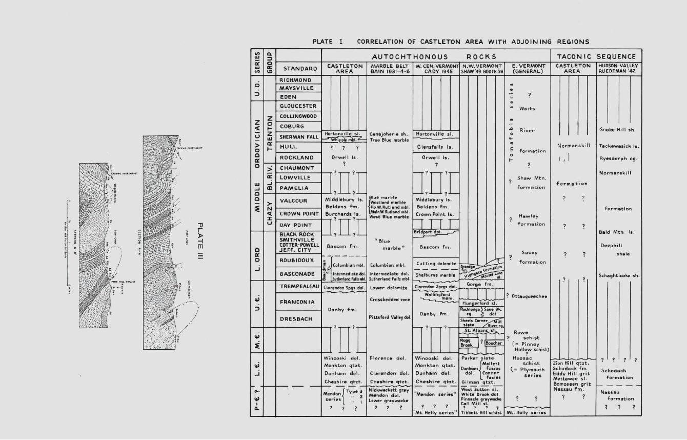
I. Correlation of Castleton area with ad- joining regions . . . . . . . . . . . . . . Following page 57
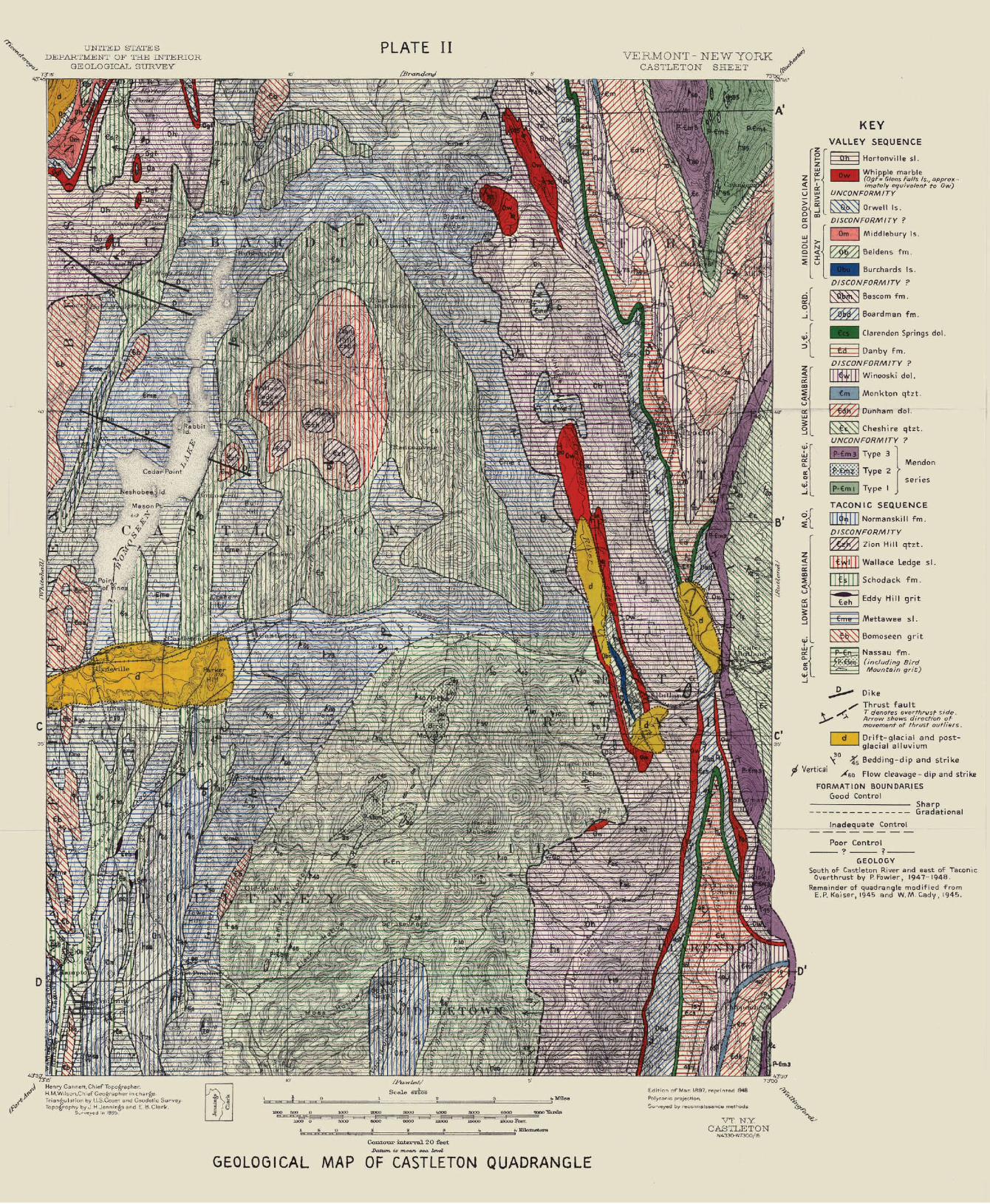
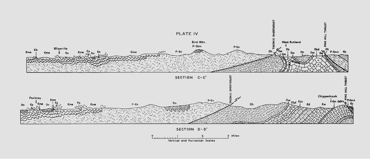
II. Geological map of Castleton quadrangle .......In pocket III. Structure sections A-A' and B-B' ..........In pocket IV. Structure sections C-C' and D-D'..........In pocket
STRATIGRAPHY AND STRUCTURE OF THE CASTLETON AREA, VERMONT
PHILLIP FOWLER
ABSTRACT
During this investigation approximately two-thirds of the Castleton quadrangle was mapped geologically. The sedimentary rocks of the Castleton area belong to two stratigraphic sequences, contrasting in lithology and more or less parallel in time.
The 10,000-foot Champlain Valley (Autochthonous, Valley) sequence includes Lower Cambrian or Pre-Cambrian clastics, Lower and Upper Cambrian dolomites and quartzites, Lower Ordovician and Chazyan marbles and dolomites, and Trenton marble, dolomite, and black slate. Although the widespread lithologic discordance between the Lower Cambrian Cheshire quartzite and the underlying Mendon series has been interpreted by some as an angular unconformity, it is here in-terpreted as due to facies changes within the Mendon series. Middle Cambrian is missing probably because of non-deposition. Erosional disconformities probably intervene between the Lower Ordovician and the Chazy and between the Chazy and the Black River-Trenton. Slight warping and subaerial erosion in middle Trenton time produced a significant unconformity.
The 30004000-foot Taconic sequence crops out in the Taconic Range and the slate belt. The thick phyllite, quartzite, and grit that underlies the Taconic Range was formerly considered to be Upper Ordovician and was called the Berkshire schist. Because of its relations to the Cambrian slates of the slate belt and its similarity to the Nassau formation of New York it is here mapped as the Nassau formation. Above the probably late Pre-Cambrian Nassau formation lie Lower Cambrian slate, lime-stone, quartzite and grit separated by an erosional disconformity from Lower(?) and Middle Ordovician slate, grit, chert, and quartzite. The rocks of the Valley sequence exhibit broad, deep folds and one small
break thmst. The Taconie sequence is a comparatively thin sheet super-ficially crumpled into isoclinal folds. The chief problem in this area is to account for the anomalous juxtaposition of the Cambro-Ordovician argillaceous Taconic sequence and the Cambro-Ordovician carbonate Valley sequence. The principal objective of this investigation was to ascertain the validity of Keith's concept of the Taconic overthrust, which is assumed to be a huge strip thrust that carried the Taconic sequence from the east westward to overlie the Valley sequence. Evidence for the fault in this area consists of lithologic discordance above and below the fault trace, large-scale structural discordance between the two sequences, the contrast between contemporaneous sequences of two dissimilar facies, the presence of klippen and fensters, and the exist-ence of the late Pre-Cambrian Nassau formation lying above Ordovician rocks of the Valley sequence. The Taconic overthrust is believed to be proved. The rocks of the Taconic sequence may have been laid down in the vicinity of the modem Connecticut Valley, and if so the minimun net slip on the Taconic overthrust must be about 50 miles.
The folding, faulting, jointing, cleavage, and metamorphism of the rocks of both sequences took place probably near the close of the Ordo-vician period. The earlier stages of the Taconic orogeny produced a flow cleavage oriented parallel to the axial planes of the folds. During the later stages of the orogenv the first cleavage was folded by forces applied in a direction slightly different from those that produced the first cleavage. These later forces developed an axial plane shear cleavage.
The northwestern third of the Castleton quadrangle was not investi-gated in detail, and data on that part of the quadrangle were obtained for the geological map from previous publications.
INTRODUCTION
General
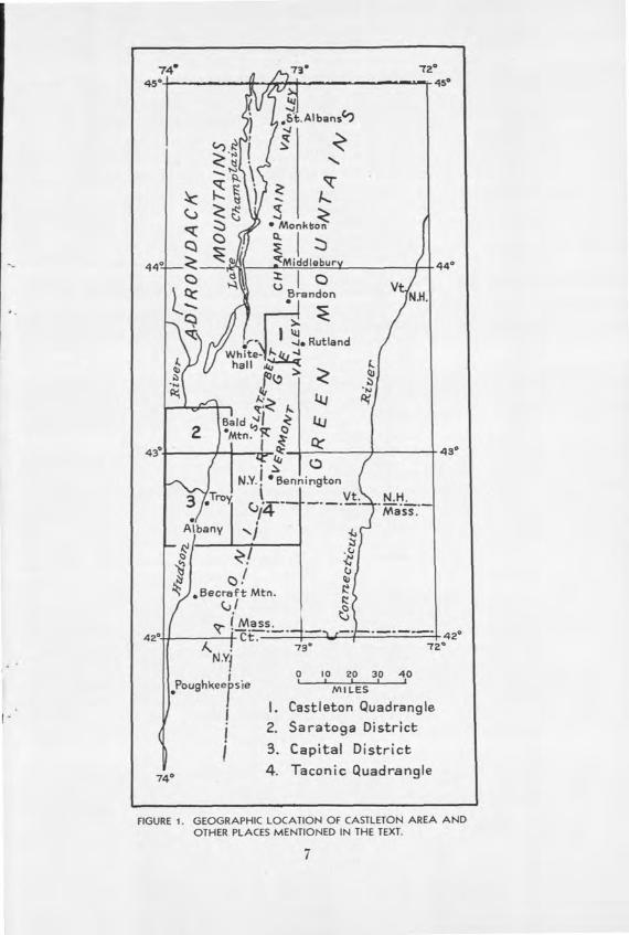
The Castleton area (Fig. 1) covers about 130 square miles in west-central Vermont and eastern New York. During this investigation all the rocks of the Castleton quadrangle that lie south of the Castleton River were mapped. In the northern part of the quadrangle only the rocks lying east of the Taconic Range were mapped. The remainder of the Castleton quadrangle has been mapped geologically in recent years by Kaiser (1945) and Cady (1945) . *
*Referenc are given at end of the paper.
6
74 73° 72°
45° ---- ---.- .45°
I I4
•St.Albans
•1 (_I
I -
xz-I_-I L () -J
Monkti
• c:
440 Q) ( Mddlbury 440
?
V I Brendon N.H.
.j.Rutland
)
e
Qj
Bald'I Co 2 l ________
L 43
I N.Y. Bennington
N.H.
Albany _l
Becreft Mtn.
(fJ. c_Il
ç lMass. 42° 42°
73° 72° N.Y
0 10 20 30 40
______________
' __ Poughkeeosie MILES
I i. Castleton Quadrangle
2. Saratoga District
3. Capital District
740 4. Taconic Quadrangle
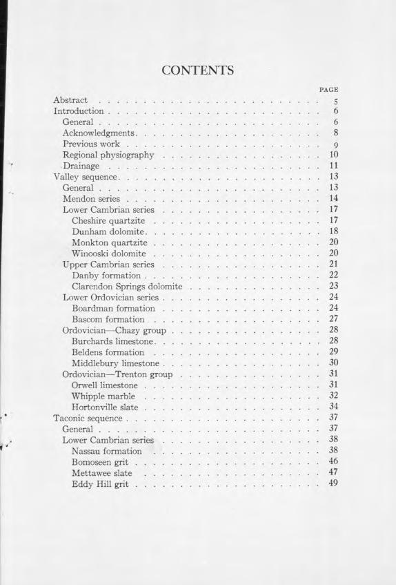
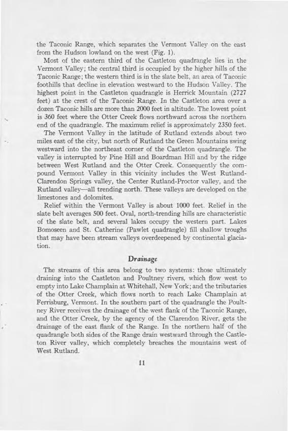
FIGURE 1. GEOGRAPHIC LOCATION OF CASTLETON AREA AND OTHER PLACES MENTIONED IN THE TEXT.
7
Much of the Castleton area is occupied by a small part of the Tacoruc Range, which lies in east-central New York and adjacent parts of Vermont and Massachusetts. Nearly forty years ago Arthur Keith concluded that the Cambro-Ordovician rocks of the Taconic Range in Vermont are a klippe or thrust outlier composed of an argillaceous facies that had been thrust westward over a carbonate facies of similar age. Although this concept has found general acceptance among geologists working in the area, the roots of the overthrust have not been found. Moreover, modern detailed stratigraphic and structural studies have not been made in much of the Taconic region. The Castleton area was chosen in order to ascertain the validity of the concept of a large Taconic overthrust.
Originally this study was confined to the rocks of the Taconic sequence, but it became evident that a clear picture of the relation between the Taconic sequence and the rocks of the marble belt bordering the Taconic Range on the east required remapping of the part of the marble belt that lies in the Castleton quadrangle. This investigation, therefore, has carried the mapping of the Champlain and Vermont Valleys (Cady, 1945) to the southern border of the Castleton quadrangle. Folding, faulting, and metamorphism of the rocks have made accurate strati-graphic work difficult. Identifiable fossils are rare, and the thickness of several formations is obscure.
The area was mapped by the pace-and-compass method aided by Paulin altimeter and aerial photographs. Data were plotted on photo-static copies of the Castleton and Proctor sheets of the United States Geological Survey enlarged to a scale of three inches to the mile. Twenty-seven weeks were spent in field work during the summers of 1947 and 1948.
Achnowledgments Professor Marland P. Billings directed this work and spent nearly
two weeks with me in the field. I acknowledge with gratitude his aid in solving many problems. Professors E. S. Larsen, Jr. and P. E. Ray -mond have both given advice. Dr. Wallace M. Cady helped me both on details and in understanding the areal picture. Professor Charles G. Doll, State Geologist of Vermont, arranged for financial aid during the field season of 1948.
Several geologists working in Vermont provided useful suggestions. Chief among these are: J. L. Rosenfeld, J. B. Thompson, P. H. Chang,
S. L. Stone, Philip Osberg, and Verne Booth. Especial thanks go to Alan B. Shaw for identifying such tattered organic fragments as were discovered.
Plates and figures were drafted by Edward A. Schmitz.
Previous Work The Taconic Question: The rocks of the Champlain Valley-Taconic
area, in which the Castleton quadrangle is located, were included by Emmons (1842) in his Taconic system under the assumption that they were all older than the Upper Cambrian Potsdam sandstone of the Adirondack border. The Taconic Question was debated ad nauseam for many years (Merrill, 1924). Dana (1887) wrote "R. I. P." over the grave of the Taconic system, and Walcott (1888) concluded that the system was "based on error and misconception originally, and used in an erroneous manner since." Emmons, of course, was partly right; some of the Taconic system is pre-Potsdam. Some, however, is of Potsdam age, and the rest is post-Potsdam. Although Schuchert (1919) attempted to revive the name Taconic as the designation for the Lower Cambrian epoch, this usage happily has not been followed. Only confusion will result from any attempt to use "Taconic" in a stratigraphic sense.
Present use of the name Taconic: Today the word "Taconic"is used in three legitimate senses. In the first place, it is the name of a range of low mountains extending from Brandon, Vermont in a direction slightly west of south to the latitude of Poughkeepsie, New York (Fig. 1). Another use of the name is to refer to a time of orogenic disturbance in northeastern North America, probably near the close of the Ordovician period. Thirdly, the name Taconic is applied to an inferred overthrust by which argillaceous rocks that originated to the east of their present location have been thrust over the carbonate sequence of the Champlain-Hudson lowland and the connecting valleys to the southward. The Taconic Allochthone is the mass of transported rocks above the over-thrust.
Other work: Rev. Augustus Wing correctly delineated the structure of the Middlebury synclinorium (Fig. 3) before 1860, and he extended his work southward into the Castleton area. Dana (1877) published Wing's discoveries and did considerable work in the Taconics. Logan (1863), aided by E. Billings, discovered the Champlain overthrust, which helped to resolve the Taconic Question. A forward stride was made when
Walcott (1888, p. 235) discovered Olenellus in the Cheshire (juartzite and showed that the Cheshire is Lower Cambrian. Wolff (1891) proved that Cambrian was thrust over Ordovician on Pine Hill in the Castleton area.
The first comprehensive geologic investigation of the Castleton quad-rangle was undertaken by T. Nelson Dale, who published reports on the slate belt of New York and Vermont (1899) and on Bird Mountain in Ira (1900). For many years Dale worked in the northern Taconic area and produced a series of reports of the highest excellence. He recognized that the slates of the slate belt are of Cambrian and Ordovician age and form a sequence of the same age as the Stockbridge limestone. He thought that the Berkshire schist of the Taconic Range is late Ordovician and that it lies stratigraphically above both the rocks of the slate belt on the west and the carbonate rocks of the Vermont Valley on the east. Dale's stratigraphic divisions were adopted and renamed in the Saratoga Springs area (Cushing and Ruedemann, 1914), and these units are used in the present study.
Keith noted the truncation of the limestone formations south of Brandon (fig. 1) by slates surrounding the Taconic mass and concluded (1913) that all the slate was overthrust on the carbonate rocks. Under Keith's direction Swinnerton (1922) mapped the northwestern part of the Castleton quadrangle. Keith's map of the north end of the Tacon Range (1933) was rejected in toto by Kaiser (1945), who reverted t Dale's stratigraphic divisions but accepted the Taconic overthrust an the Lower Cambrian age of the Berkshire schist. Larrabee (1939-1940 followed Dale in the southwestern part of the Castleton area. Bait (1931, 1934, 1938) made a careful study of the marble belt, although his map was not published. He rejected the Taconic overthrust hypoth-esis (1938, p. 14), stating that the Canajoharie slate lies unconformably beneath the Berkshire schist. Cadv (1945) mapped much of the Cham-plain Valley, and his stratigraphic succession in the carbonate rocks is followed in this report.
Regional Physiography
The Green Mountain Range extends in a northerly direction through central Vermont from the Massachusetts to the Canadian border. West of the Range is a parallel lowland, the Champlain Valley, which in the northern two-thirds of the state stretches westward to the Adirondack Mountains. The Champlain Valley is interrupted south of Brandon by
10
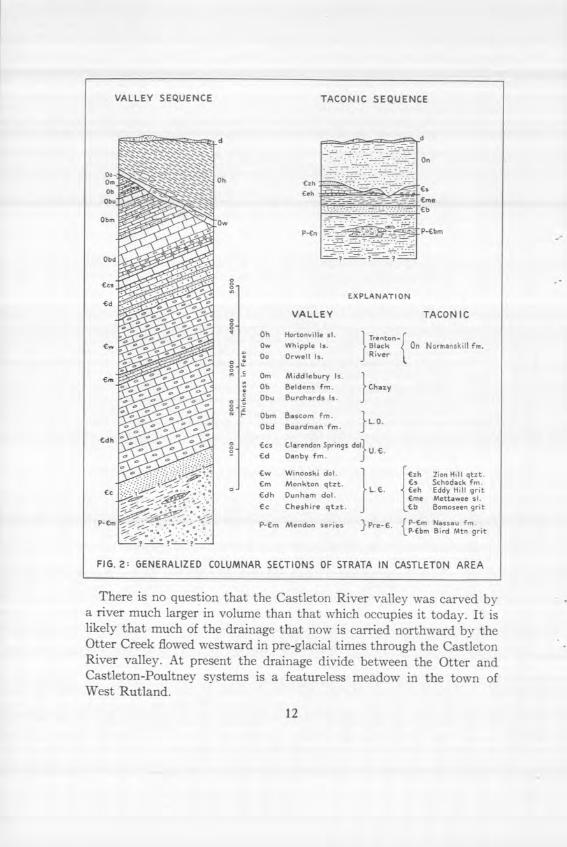
the Taconic Range, which separates the Vermont Valley on the east from the Hudson lowland on the west (Fig. 1).
Most of the eastern third of the Castleton quadrangle lies in the Vermont Valley; the central third is occupied by the higher hills of the Taconic Range; the western third is in the slate belt, an area of Taconic foothills that decline in elevation westward to the Hudson Valley. The highest point in the Castleton quadrangle is Herrick Mountain (2727 feet) at the crest of the Taconic Range. In the Castleton area over a dozen Taconic hills are more than 2000 feet in altitude. The lowest point is 360 feet where the Otter Creek flows northward across the northern end of the quadrangle. The maximum relief is approximately 2350 feet.
The Vermont Valley in the latitude of Rutland extends about two miles east of the city, but north of Rutland the Green Mountains swing westward into the northeast corner of the Castleton quadrangle. The valley is interrupted by Pine Hill and Boardman Hill and by the ridge between West Rutland and the Otter Creek. Consequently the com-pound Vermont Valley in this vicinity includes the West Rutland-Clarendon Springs valley, the Center Rutland-Proctor valley, and the Rutland valley—all trending north. These valleys are developed on the limestones and dolomites.
Relief within the Vermont Valley is about 1000 feet. Relief in the slate belt averages 500 feet. Oval, north-trending hills are characteristic of the slate belt, and several lakes occupy the western part. Lakes Bomoseen and St. Catherine (Pawlet quadrangle) fill shallow troughs that may have been stream valleys overdeepened by continental glacia-tion.
Drainage
The streams of this area belong to two systems: those ultimately draining into the Castleton and Poultney rivers, which flow west to empty into Lake Champlain at Whitehall, New York; and the tributaries of the Otter Creek, which flows north to reach Lake Champlain at Ferrisburg, Vermont. In the southern part of the quadrangle the Poult-ney River receives the drainage of the west flank of the Taconic Range, and the Otter Creek, by the agency of the Clarendon River, gets the drainage of the east flank of the Range. In the northern half of the quadrangle both sides of the Range drain westward through the Castle-ton River valley, which completely breaches the mountains west of West Rutland.
11
Ow Ob
VALLEY SEQUENCE TACONIC SEQUENCE
0.
:::
Los
Ld EXPLANATION
VALLEY lACONIC
Oh Hortonnille sI. 1 Trenton-( Ow Whipple Is. Black On Normanskill Fe.
o Oo Orwell Is. J River
- Ow Middlebary Is. 1 Oh Beldens Fm. Chazy
o Obo Barchards Is. J Ohm Bascorn Pro. 1 Obd Boardman Fm 3 L. 0.
Ccs Clarendon Springs dOIir U.
- Cd Denby Fm. J Lw Winooski dol. I-Coh Zion Hill qtot.
Lm Monkton qtzt. I Cs Schodack Fm. o I L.L. Leh Eddy Hill grit
€dh Danham dol. I Lee Mettawee SI.
Cc Cheshire qtot. L€b Bomnosnen grit
P-Ens Mendon series }Pre-C. f€f0 Nssafm.
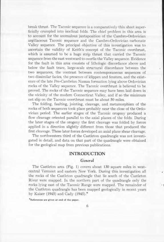
FIG. 2: GENERALIZED COLUMNAR SECTIONS OF STRATA IN CASTLETON AREA
There is no question that the Castleton River valley was carved by a river much larger in volume than that which occupies it today. It is likely that much of the drainage that now is carried northward by the Otter Creek flowed westward in pre-glacial times through the Castleton River valley. At present the drainage divide between the Otter and Castleton-Poultney systems is a featureless meadow in the town of West Rutland.
12
VALLEY SEQUENCE GENERAL
The rocks of the Castleton area are preponderantly of sedimentary origin, somewhat altered by later metamorphism. Two distinct sequences of sedimentary rocks are represented. The Champlain Valley (Autoch-thonous, "In-place") sequence includes basal clastics, carbonate rocks, and an upper shale. The Taconic (Allochthonous, "Transported") sequence is dominantly argillaceous. Each sequence spans roughly the same period of time. Figure 2 shows composite columnar sections of both sequences.
The rocks of the Champlain Valley or, more simply, the Valley se-quence are divided in the Castleton area into the units shown in Table 1.
TABLE 1
Correlation
Formation
Thickness (in feet)
Trenton Hortonville slate 1000+ Whipple marble 50-250
-- - - - - - - - U N C 0 N F 0 R M I T Y - - - - - - - - - - Trenton (& Black River ?) Orwell limestone 0-50+
DISCONFORMITY?
Middlebury limestone 0-60 Chazy Beldens formation 0-200
Burchards limestone 0-150 (?)
DISCONFORMITY? Bascom formation 0-500 (?)
Boardman formation Canadian Columbian marble member 450-600
Intermediate dolomite member 190-2 50 Sutherland Falls marble member 90-100
Upper Cambrian Clarendon Springs dolomite 130-175 Danby formation 700 ±
DISCONFORMITY?
Winooski dolomite 1050-1200 Lower Cambrian Monkton quartzite 0-250
Dunham dolomite 1500-3000 Cheshire quartzite 400+
UNCONFORMITY?
Lower Cambrian or Mendon series 2 000+ Pre-Cambrian
13
The composite thickness of the Valley sequence is approximately 10,000 feet in this quadrangle. These rocks were deposited in a north-south marine basin which has been called the Champlain trough. The Champlain trough had a western boundary in the vicinity of the present border of the Adirondack Mountains and an eastern boundary not far east of the Green Mountain Front. The rocks of the Champlain trough have been folded and faulted but lie today substantially where they were originally laid down.
MENDON SERIES Name: The oldest rocks in the autochthonous sequence of the Castle-
ton area belong to the provisional Mendon series (Whittle, 1894) and are typically exposed in the township of Mendon in the Rutland quad-rangle. Until the true relations of these rocks to those below and above are understood the name Mendon series should be retained.
Distribution: Rocks assigned to the Mendon series crop out in the northeast corner of the Castleton quadrangle on and east of Cox Moun-tain. A narrow band of Mendon extends along the eastern border of the quadrangle from Pittsford Mills southward to Chippenhook.
Description: The Mendon series in the Castleton area has been separ-ated rather roughly into the following three rock types:
Type 3: This type includes black, gray, green, and brown quartzose phyllite or phyllitic quartzite. Uncommon beds and lenses of fairly clean quartzite range in thickness from Y4 inch to many feet. These rocks show all gradations in composition from pure black phyllite to clean quartzite. Type 3 is limited upward by the massive Cheshire quartzite on Pine and Boardman hills and on the western flank of Cox Mountain.
Type 2: This division contains gray and brown, coarsely crystalline, impure dolomite in large lenses interstratified with chlorite schist and fine- to coarse-grained gray grit and arkose. Mica flakes in the dolomite give it a shimmering luster.
Type 1: This is a zone of gray- or white-weathering fine- to very coarse-grained grit and arkose irregularly interbedded with fine-grained green quartz-chlorite-sericite schist. The finer-textured massive grit and arkose has a characteristic weathering surface resembling crepe paper, and some of the medium-grained arkose is granitic in appearance.
14
The average grain size in the coarse clastic rocks is Y4 inch or less, but there are a few rounded quartz pebbles 3/ inch in diameter.
Relations: Rocks of the Mendon series on Pine and Boardman hills are assigned to Type 3, although large lenses of coarse-grained brown dolomite in argillaceous quartzite crop out stratigraphically just below the Cheshire quartzite on Boardman Hill. A section across Cox Mountain (Plate II) in an east-west direction shows Cheshire on the west ap-parently grading eastward down into the phyllite of Type 3. South-flowing Sugar Hollow Brook, east of Cox Mountain, parallels the out-crop of Type 2. The hills between the brook and the eastern boundary of the Castleton quadrangle are underlain by the beds assigned to Type 1.
The three types found in the northeastern corner of the Castleton area thus appear to bear some resemblance to the sequence at the type locality in Mendon. There (Whittle, 1894, p. 429) the 2000-foot succes-sion contains an upper dark chlorite schist, a lower highly metamor-phosed conglomerate, and several intermediate pebbly limestones and pebbly micaceous quartzite strata. Similarly Keith (1932, p. 394-395) distinguished, in descending order: Moosalamoo black phyllite, Forest-dale marble, and Nickwaket graywacke with basal Ripton conglomerate. Bain's divisions (1938, p. 12) of the Mendon series are, in the same order: Nickwacket graywacke, Mendon dolomite, and Lower graywacke. At least there seems to be a general agreement on a three-fold division.
An unsolved problem in the Cox Mountain area, however, is the relation between the three types of the Mendon series. The Mendon is inferred to be exposed in the core of a southward-plunging V-shaped anticline outlined in plan by Cheshire quartzite. The east limb of the fold is hypothetical because of inadequate exposures. If this interpreta-tion is correct, the western limb of the anticline is made of Type 3 beds, the central part of Type 2, and the eastern limb of Type 1. The Cheshire would, therefore, lie on each of the types successively within a compara-tively short distance. A longitudinal thrust fault between Zones 2 and 3 along Sugar Hollow road was considered and rejected because it en-tailed greater stratigraphic difficulties to the east than the simple anti-clinal hypothesis.
Clearly the sedimentary discordance beneath the Cheshire can be explained either by pre-Cheshire folding and erosion or by original rapid facies changes within the Mendon series. Just above the Falls of Lana
15
east of Lake Dunmore Foye (1917-1918, P. 85) noted that the Cheshire quartzite "was found to rest unconformably on the Mendon dolomite and to have an arkosic conglomerate at its base. The basal conglomerate of the Cambrian [Cheshire] quartzite is so unlike the Ripton conglomer -ate, exposed less than a mile to the east, that the two cannot be con-sidered of the same age. The Lana conglomerate has small pebbles of potash feldspar and includes dolomitic particles from the rock on which it rests. It is only a few feet in thickness and passes gradually into true Cambrian quartzite." Cady agrees that the contact at the Falls of Lana "is without doubt an angular unconformity" (1945, p. 528) but points out that regional relations in central and northern Vermont show no evidence of significant unconformity between Mendon equivalents and the Cheshire equivalent, the Gilman quartzite. Keith (1914, p. 39) has stated that the Cheshire "transgressed the entire lower series." At the Massachusetts border Cheshire quartzite lies unconformably on Stam-ford gneiss with no intervening clastics (Pumpelly et al., 1894, p. 98-102). Possibly pre-Cheshire folding increased in intensity toward southern Vermont. This might account for the apparently discordant relations beneath the Cambrian quartzite in the southern half of the state. On the other hand, rapid lateral facies changes between great lens-like sedi-mentary bodies in Mendon time, as stated above, could equally well explain the phenomena in the Castleton area. The adjacent parts of the Brandon, Rochester, and Rutland quadrangles must be remapped before a decision can be made between the alternative explanations.
Thickness: The thickness of the Mendon in the Castleton area is impossible to measure accurately because of structural and stratigraphic obscurity. The black phyllite of Type 3 may change in thickness from a feather edge near Pittsford to over 2000 feet thick on Cox Mountain. Type 2 may be as much as 500 feet thick at the north. Type 1 is probably somewhat thicker than Type 3, although obviously Type 1 and perhaps some of Type 2 would be equivalent in time to Type 3 under the facies hypothesis.
Age: The Mendon series is either Algonkian (Whittle, 1894) or Lower Cambrian. In the absence of fossils definite proof of conformity with the Cheshire would suggest a Lower Cambrian age. On the other hand, proof of widespread angular unconformity would suggest a Pre-Cambrian age for the Mendon series.
16
LOWER CAMBRIAN SERIES Lower Cambrian beds make up almost half of the total thickness of
the Valley sequence in this quadrangle. The four formations of this age extend far beyond the limits of the Castleton area to the north and to the south. Thrust faults to the west have concealed whatever Lower Cambrian equivalents that may have been deposited nearer the Adiron-dacks. The clastic rocks and dolomites of the Plymouth series in central Vermont may be easterly representatives of the Lower Cambrian in the Champlain and Vermont valleys. Uniformity of environment over a large region is evident throughout this epoch, more particularly in Cheshire and Dunham times. The difficulty in separating the three higher units of the Lower Cambrian in this area is exemplified by Keith's use (1923, p. 128-129) of the term Rutland dolomite to include all dolomitic beds between the Cheshire and the Danby.
Cheshire Quartzite Name: The basal Cambrian quartzite was first named from the town
of Cheshire in Massachusetts by Emerson in an unpublished report on the Hawley sheet. The approved definition of the unit is found in another paper (Emerson, 1917, p. 32-34). The Cheshire quartzite in Massachusetts is similar to the Cheshire in the Castleton area.
Distribution: The Cheshire crops out in a V-shaped band in the Cox Mountain area of Pittsford township. Cheshire underlies the eastern slopes of Pine Hill and Boardman Hill on the eastern edge of the Castle-ton quadrangle.
Description: The Cheshire quartzite is a pure, massive, white quartz-ite with occasional shades of blue, green, and brown. Although individual beds in the higher part of the Cheshire are in places a dozen feet thick, beds ranging from several inches to a few feet thick are common in the lower part of the formation. This rock is well jointed and character-istically breaks up into small and large fragments bounded by joint planes. Virtually 100 percent of the Cheshire consists of equidimensional, amoeba-shaped, interlocking grains of quartz. The Cheshire is the hard-est and most chemically resistant rock in the region, although in Massa-chusetts the feldspathic Cheshire weathers to pipe clay and glass sand.
As defined here the Cheshire contains only the massive pure quartzite, and the subjacent dark-gray quartzites and phyllites hitherto included
17
in the Cheshire (Keith, 1923-24, p. 126-128, 1932, P. 395-396; Cady, 1945, P. 526) are assigned to Type 3 of the Mendon series. The top of the Mendon is placed arbitrarily above the highest black phyllite or argillaceous quartzite. A 10-foot bed of conglomerate composed of 2-to 4-inch cobbles of blue quartzite separates the Cheshire from the black phyllite of the Mendon series at the northeastern end of Pine Hill. This conglomerate is probably local.
It is logical to separate the Mendon and the Cheshire above the phvllite; for the clean Cheshire is a strikingly clear map unit, and clean Cheshire alone is present above the alleged unconformity at the Falls of Lana. Limited reconnaissance suggests that clean Cheshire quartzite is everywhere a homogeneous unit overlying a diverse group of sedimentary rocks. The nature of the basal contact is discussed in connection with the Mendon series.
Regional relations: The Cheshire is widespread in a north-south direction, extending from Massachusetts far into west-central Vermont. The brown Gilman quartzite (Clark, 1931, p. 225-226, 1934, P. 9-10, 1936, p. 144-146) of the Oak Hill series appears in place of the Cheshire in northern Vermont and southern Quebec. In west-central Vermont the Gilman type of quartzite underlies clean Cheshire, apparently be-coming thinner southward, until in the Castleton area no Gilman is recognized.
Thickness and age: The Cheshire is about 400 feet thick on Cox Mountain and probably thicker on Pine Hill. Olenellus, Hyolithes, and
Nothozoe were found (Walcott, 1888, P. 285; Seely, 1910, p. 307) in the Cheshire at Bennington and at Lake Dunmore northeast of Brandon. The formation is Lower Cambrian.
Dunham Dolomite
Name: From Oak Hill in southern Quebec Clark (1934, p. 9) named the Dunham dolomite. Although a thrust fault separates the type Dun-ham from the lowest Cambrian dolomite in the Champlain Valley, both units occur in "comparable stratigraphic successions," and Cady (1945, p. 529) extended the name Dunham to include the beds lying between the Cheshire and Monkton quartzites. The Dunham dolomite was part of the "Red Sandrock" series in the last century and has since been known under several other aliases.
18
Distribution: Dunham dolomite in the northeastern part of the quad-rangle is exposed in the bed of the Furnace Brook at Pittsford Mills and northward. Exposures along the Otter Creek north of Proctor are uncommon. It is inferred that a broad band of Dunham crops out be-neath the Otter Creek meadows in this vicinity. Dunham is exposed in a northeast-trending band southeast of Chippenhook near the southern border of the Castleton area.
Description: The Dunham in the Castleton area is a gray- and buff-weathering, compact, siliceous, gray dolomite containing irregularly distributed quartz grains. Mottled patches of green, blue, and rarely pink are not uncommon. The massive lower two-thirds of the Dunham is so irregularly jointed that true bedding planes are hard to distinguish. The upper third, which is similar in appearance to the Winooski dolo-mite, is lighter gray, cream-colored, and generally less sandy. Thin shaly partings at intervals of 6 to 8 inches are reported (Cady, 1945, p. 528) in this upper zone from west-central Vermont but are not common in the Castleton area. The upper Dunham just below the Monkton quart-zite has a faint pink color and contains thin pink dolomitic quartzites. Because the Monkton decreases in thickness and may be absent in much of the Otter Creek Valley, the pink quartzites are utilized as the Dunham-Winooski boundary.
Thickness: The Dunham dolomite is the most poorly exposed strat-igraphic unit in the Valley sequence. Although this formation must crop out over a large area, exposures are few. North of Proctor both the Otter Creek lowlands and the northwestern slope of Pine Hill are cloaked with surficial debris that hides bedrock. East of Pittsford, in the absence of recognizable Monkton quartzite, it is difficult to separate any Winooski that may be present from the Dunham. At Chippenhook exposures of Dunham are also poor, and the Trenton erosion appears to have removed beds far down in the Cambrian. The best that can be said is that there are probably between 1500 and 3000 feet of Dunham in the Castleton area.
Age: The Dunham is clearly Lower Cambrian. During this study Hyolithes beds were observed in the Dunham east of Chippenhook. These were discovered by Dale and identified by Walcott (Dale, 1894, p. 535) as: H. americanus Billings, H. similis ?? Walcott, H. impar?
Ford, H. com,nunis? Billings, and Saltarella pukhella Billings. Such
19
genera as Olenellus, Nisusia, Kutorgina, Ptyclzoparella, and Bonnia have been found in the Dunham farther north by several geologists.
Monkton Quartzite
Name: Arthur Keith originally described this formation (1923, p. 107) from Monkton, Vermont, believing it to be contemporaneous with the Cheshire quartzite.
Description: In this area the Monkton contains fine- to coarse-grained pink, cream-colored, bone-white, and red ferruginous quartzite in beds from a few inches to a dozen feet thick separated by various thicknesses of gray dolomite. Quartzites in some places have dolomitic cement which, where exposed to weathering, dissolves and leaves behind punky sandstone. Some excellent ripple marks and mud cracks are evident on dip slopes.
Distribution and thickness: Inasmuch as only two exposures of un-doubted Monkton are found in the Castleton quadrangle, this discussion must be speculative. Near the northern border of the quadrangle about 250 feet of Monkton are exposed along the Rutland Railroad. The Monkton elsewhere in the vicinity of Pittsford is evidently concealed except for a few thin pink quartzites east of Furnace Brook, which may represent the Monkton. Monkton crops out at the southern border of the quadrangle, and thin pink quartzites appear under overthrust Mendon beds east of Chippenhook. It is likely, therefore, that the Monk-ton thins to a few feet or a feather edge eastward and southward in the Pittsford area. In the vicinity of Chippenhook, however, the Monkton may thin from about 200 feet in the south to 50 feet or so northward and eastward.
Age: Kindle and Tasch recently (1948) reported from the Monkton 60 miles north of the Castleton area 4 species of Olenellus and representa-tives of the following Lower Cambrian genera: Bonnia, Antagmus, Kutorgina, Nisusia, Paterincz, Acreteta, Helcionella, Hyolithes, and Scolithus. The Monkton is probably equivalent to the lower part of the Parker slate of northwestern Vermont.
Winoosbi Dolomite
Name: Cady (1945, p. 532) revised the term Winooski, as originally employed by Hitchcock (1861, p. 329), to apply to the "dolomitic beds
20
at Winooski Falls or Winooski village in Coichester." Following this usage, the name Winooski is applied in this area to the dolomite beds that lie between the Monkton quartzite and the Danby formation.
Distribution: The Winooski dolomite crops out in a band extending. from a point just west of the Otter Creek at the northern border of the map through Florence and Proctor to Pine Hill. The outcrop stretches northward again to pass out of the quadrangle east of Pittsford Mills. Another outcrop of Winooski in the southeastern corner of the quad-rangle strikes slightly east of north through the village of Chippenhook.
Description: Like the upper part of the Dunham, the lower part of the Winooski dolomite is pink and cream-colored on weathered surfaces. A 40-foot iron-gray dolomite lies about 400 feet stratigraphically above the base. The remainder of the Winooski is predominantly gray- and buff-weathering light colored dolomite. Throughout the formation beds range in thickness from 3 inches to about 1 foot and are separated by thin dark shaly partings.
Thickness: The base of the Winooski is fixed arbitrarily at the thick quartzites of the Monkton or, in its absence, at the few thin pink quart-zite beds of the probable Monkton zone at the top of the Dunham. The problem of the Winooski-Monkton-Dunham boundaries is largely academic, for in this area exposures are unhappily few. The upper limit of the Winooski is widely exposed, however, and is put at the lowest quartzites of the Danby formation. An average thickness for the Winoo-ski in the Castleton quadrangle is 1050 to 1200 feet. As Cady suggested, the Winooski may thicken as the Monkton becomes thinner.
Age: No fossils have been found in the Winooski, but it is reasonable to refer it to the Lower Cambrian because of its gradational relationship to the Monkton. The Winooski may be in part contemporaneous with the upper part of the Parker slate. The Rugg Brook formation (Howell, 1937-1938) of the St. Albans area is separated from the Parker by an unconformity, and A. B. Shaw (personal communication) suggests, as did Schuchert (1933), a Middle Cambrian age for the Rugg Brook. The entire Winooski, therefore, may be older than the Rugg Brook rather than contemporaneous with it as some have suggested.
UPPER CAMBRIAN SERIES The two Upper Cambrian formations in this area may evidently be
21
regarded as eastern facies of the Potsdam-Little Falls seciuence adjacent to the Adirondack Mountains. The three units of the standard Croixan section, Dresbach, Franconia, and Trempealeau, appear to be repre-sented in Vermont by the Danby and Clarendon Springs dolomites. There is no proof, however, that the oldest Potsdam and Danby beds may not be pre-Dresbach in age.
Upper Cambrian sandstones near the Adirondacks are represented eastward by sandy dolomites. Such progressive loss of sand with in-creasing distance from the ancient land mass has been noted in the Lower Cambrian and in some Ordovician beds. Cady (1945, passim) has built up a general picture of an Adirondack source for most or all of the sands in the strata of the Champlain Valley.
New light on the ages and correlations of post-Potsdam units in Vermont may be shed by work now in progress in New York State southeast of the Adirondacks.
Danby Formation
Name: From the towns of Danby and Wallingford, Vermont, Keith (1932, p. 396) named two dolomitic formations of supposedly Lower Cambrian age. Later (Cady, 1945, p. 535) the beds were reinterpreted as Upper Cambrian, and the Wallingford was given the status of an upper member of the expanded Danby formation.
Distribution: The Danby crops out in a narrow belt extending from the boundary of the Castleton and Brandon quadrangles southward through Florence and Proctor to the western slopes of Pine Hill. The southern exposures of Danby cover an area extending from the boundary of the quadrangle southwest of Chippenhook northward to the western slope of Boardman Hill.
Description: Approximately the lower half of the Danby consists of an alternation of white, medium- to coarse-grained quartzite in beds 10 to 15 inches thick and light-gray and cream-colored dolomite in beds several feet thick. Some thicker quartzite ledges contain thin dolomite seams. On weathered surfaces the quartzite beds stand out prominently against brown, gray, or deeply iron-stained dolomites. A 10-foot coarse intraformational conglomerate of dolomite and quartzite boulders is exposed north of the Chippenhook cemetery.
The Wallingford member, which is the upper part of the Danby forma-tion, includes sandy dolomites displaying abundant cross-bedding, many
22

2- or 3-inch quartzite layers interbedded with dolomite, and near the top at least one 5-foot quartzite. This upper member is not easily dis-tinguished from the lower Danby; on no basis was it possible to map the Wallingford separately in the field. The Danby formation is therefore treated as a unit.
Thickness: The Winooski-Danby boundary is placed at the first appearance of quartzite. In other respects no lithologic break is noted. The top of the Danby is placed at the lowermost uniform gray dolomite of the Clarendon Springs. Between these limits the Danby regularly has a thickness of approximately 700 feet in this area. Westward at White-
11, New York, probable Danby equivalents are approximately 350 feet ick, and "close to the Adirondacks the thickness may be considerably s" (Rodgers, 1937, p. 1575).
Age: The Theresa formation at Whitehall, New York, considered (Cady, 1945, p. 536) to represent the Wallingford member, is basal Franconian (Rodgers, 1937, p. 1575). The upper Danby is therefore Franconian, and the lower part, equivalent to the Potsdam sandstone.
is presumably Dreshach."
Clarendon Springs Dolomite Name: The gray dolomite lying between sandy dolomite and white
marble was named by Keith (1932, p. 397) from exposures at Clarendon Surings, Vermont.
Distribution: The Clarendon Springs dolomite crops out in two large V-shaped patterns, one opening northward and the other southward. The eastern limbs of the V's are incomplete because of faulting. The apex of the northern V is in the Otter Creek lowland 1.5 miles northwest of Center Rutland. From this point the Clarendon Springs dolomite extends northwestward through Proctor to the northern border of the quadrangle and northeastward toward the crest of Pine Hill. The southern V-shaped outcrop has its apex on the western slope of Boardman Hill. From there the rock crops out in a narrow band trending southward to the boundary of the Pawlet quadrangle and in another band trending southeastward and ending 3/ mile west of Flat Rock.
Description: The Clarendon Springs dolomite is a distinctive lithologic unit made up of uniform, massive, iron-gray dolomite that weathers light-gray or white. In thin section it is composed of a tough aggregate
23
of very small and very large dolomite grains with no recognizable im-purities. The quartz knots that are so characteristic of this formation further north (Cady, 1945, P. 536) are not common in this area. Nor has the black chert, reported (Rodgers, 1937, p. 1576; Cady, bc. ciL) near the top of the formation, been encountered in mapping here. In several places the base of the white Sutherland Falls marble can he seen lying on normal gray Clarendon Springs dolomite.
Thickness: This unit is between 130 and 175 feet thick in all sections measured in the Castleton area. Bain (1938, p. 10) suggested a maximum of 200 feet for the Lower dolomite (Plate I) in this vicinity. Bain's Lower dolomite is equivalent to the Clarendon Springs dolomite.
Age: Rodgers (1937, p. 1576) correlated most of the Clarendon Springs with all but the upper 35 feet of Division A of the Beekmantown of Brainerd and Seely (1890, P. 2) and with most of the Little Falls dolomite of the Mohawk Valley. A Trempealeau age is indicated. At Milton, Vermont, dolomite lithologically similar and probably equivalent (S. L. Stone, personal communication) to the Clarendon Springs contains a late Trempealeau fauna (Schuchert, 1937, p. 1046). The dolomitic Gorge formation at Highgate Falls, Vermont, has a very rich late Trempealeau assemblage (Raymond, 1924; Shaw, 1949).
LOWER ORDOVICIAN (CANADIAN) SERIES The formations here assigned to the Lower Ordovician are eastern
correlatives of the Beekmantown of the Adirondack border. In general the Boardman-Bascom succession corresponds to Divisions B, C, and D of Brainerd and Seely (1890) and to Cady's (1945) Shelburne, Cutting, and Bascom formations. The highest Canadian unit in the west limb of the Middlebury synclinorium, the Bridport dolomite (Fig. 3), is not recognized here. Correlations among the Champlain Valley, Adirondack border, and Ozark Mountains sections of Lower Ordovician age may be revised as a result of work now being done in New York State.
Boar Jman Formation
Name: The name Boardman formation is here proposed as a unit to include all rocks lying stratigraphically between the Clarendon Springs domomite and the Bascom formation. The type locality lies on the south-western slope of Boardman Hill in Clarendon about 1.25 miles S. 50 ° W. of the top of the hill. Other sections are exposed at the Florence quarries
24
in Pittsford and at the Pittsford Valley quarries at the northern terminus of the Clarendon and Pittsford Railroad. The Boardman is divided into three members, the Sutherland Falls marble, the Intermediate dolomite, and the Columbian marble. These divisions are used as defined by Bain (1931), and their names are retained because of their economic im-portance in the marble belt. Unfortunately suitable stratigraphic names remaining in this area are not many as a result of generations of pred-atory geologists. There can be no advantage in renaming these members according to convention, and there could be some confusion.
Distribution: The Boardman formation crops out in a band that ex-tends from the northern to the southern boundary of the Castleton quadrangle from Pittsford township through Proctor and Center Rut-land to Clarendon township.
Description: The three members of the Boardman are, in ascending order: -
Sutherland Falls marble member: The lowest member of the Board-man is a thin-bedded, green-streaked, white and cream-colored marble with contorted chains of dolomite crystals standing out on weathered surfaces. Dolomitization in the lower part is so complete that the rock has the appearance of an angular breccia of marble cemented by frothy white dolomite. A central siliceous band called the Hen Hawk layer is found in quarrying (Bain, 1939, p. 10). The name of this member is apparently taken from Sutherland Falls on the Otter Creek in Proctor, although the rocks exposed at the falls belong to the Winooski dolomite. The type locality is probably a quarry 2000 feet west of Sutherland Falls.
Intermediate dolomite member: The Intermediate dolomite is a thick-bedded, rather porous, light-gray dolomite generally containing some sandy beds and typical large quartz knots. Some patches of white marble are enclosed in the dolomite. Bedding is usually difficult to see, and the rather craggy exposures are in some contrast to the more rounded forms developed on the upper and lower marbles.
Columbian marble member: The Columbian marble member is a generally white-weathering white and blue-gray marble, the darker zones of which are striped with gray parallel to bedding. Beds are rarely less than 6 inches thick and are commonly thicker. Occasional threads of green silicates wind irregularly through the brilliant white marble.
25
The "lower 10 to 40 feet of the Columbian deposit have slightly discon-tinuous irregular dolomite veins" (Bain, 1934, p. 127) that "do not cross bedding planes but vary in orientation and position within a bed."
Correlation and relations: This formation has a stratigraphic position equivalent to that of the Shelburne marble plus the Cutting dolomite and perhaps some of "Zone 1" of the Bascom formation (Cady, 1945, p. 540-543). Cady has shown that the Cutting is unrecognizable south of the boundary of the Brandon and Castleton quadrangles. The Cutting equivalent, if any, in the Castleton quadrangle is marble that is in-distinguishable from the upper Shelburne as defined by Cady. Indeed, the upper Shelburne together with the Cutting equivalent and some of the Bascom forms an indivisible unit that is Bain's Columbian marble. The name Cutting clearly cannot be used in the Castleton quadrangle. Likewise the Shelburne is not a convenient unit because its top cannot be recognized here. If the name Shelburne were to be used in the Castle-ton area, its limits would have to be expanded considerably. Because this is undesirable, the name Boardman formation is suggested to include all strata between the uniform gray dolomite of the Clarendon Springs and the lowest distinguishable beds of the Bascom, i.e., the first rock other than calcite marble above the Columbian deposit, be it dolomitic, sandy, or argillaceous.
Cady has cited evidence (1945, p. 541-542) for believing that the variations in thickness of Beekmantown limestones and dolomites is a result of secondary dolomitization of limestone. In the east limb of the Middlebury synclinorium the Cutting appears to pass southward from a dolomite into a "blue limestone that has a 'closely curdled' surface formed by localized dolomitization." It may either pass south into the upper Columbian blue marble or may pinch out stratigraphically. There is no evidence of erosion in the Boardman-Bascom succession, and the disappearance of the Cutting may be explained more reasonably by lack of dolomitization to the south. Secondary dolomitization probably increases northward and westward toward the Adirondack mass, which probably was the locus of shallower seas during the Ordovician.
Thickness: The Sutherland Falls is regularly 90 to 100 feet thick, although east of the Pittsford Valley quarries only about half of this thickness is present because of tectonic thinning. The Intermediate dolomite is "190 feet thick at places between Middlebury and Man-chester" (Bain, 1931, p. 509), and at one place in the Castleton quad-
26
rangle a thickness of 230 feet was computed. The maximum thickness of the Columbian is 600 feet, but much of it has been removed in some places as a result of erosion during the Trenton epoch. The total thick-ness of the Boardman is approximately 900 feet.
Age: Cady has correlated the Shelburne marble with "Beekmantown Division B", which is probably of Gasconade age (Rodgers, 1937, p. 1376-1577) and therefore lowest Ordovician. Wheeler (1942, P. 523) placed this zone in the Upper Cambrian. The Cutting is the eastern facies of "Beekmantown Division C", and parts of it (Cady, 1945, p. 545) are in the Lecanospira zone. The Boardman is, therefore, equivalent to the Gasconade and most of the Roubidoux (Plate I).
Bascom Formation
Name: Cady (1945, p. 540) named this formation from a locality de-scribed by Wing as "Bascom's Ledge" in the eastern part of Shoreham township, Vermont.
Distribution: The Bascom formation thins markedly from the northern border of the quadrangle two miles west of the Otter Creek to a point one mile northwest of Proctor, where it disappears. It is not found else-where in the Castleton area.
Description: The Bascom is a blue-gray and white banded marble containing dolomite beds from a few inches to a few feet thick and beds of sandy phyllite, phyllite, and sandstone. The distinctive variety of lithologic types serves to set this formation apart from all other marbles. The dolomites weather white, cream-colored, gray, and buff. In the Hinesburg synclinorium in the northern Champlain Valley four zones have been discriminated (Cady, 1945, p. 543), but the complex crumpling and increased metamorphism of the Bascom in the present area has made the succession obscure. In mapping, the Bascom has been separated from the Columbian marble at the first appearance of dolomitic, sandy, or argillaceous rocks, for no widespread single key bed or zone could be found on which to base the Bascom. Whether the northern sandy beds of the lowest Bascom pass southward into the uppermost Columbian through loss of sand is unknown, but Cady's "Zone 1" seems to be miss-ing in the Castleton area. West of the Pittsford Valley quarries the buff-weathering dolomites mark the lowest Bascom. Yet to the south at Florence sandy and argillaceous beds accompany thin dolomites
27
directly above the Columbian marble. Wherever the Bascom-Boardman contact is seen, continuous deposition across the boundary appears to have taken place. The upper streaked marbles of the Boardman are identical in appearance to the lower marbles of the Bascom.
The highest beds in the Bascom are darker blue and more argillaceous, although sandy and dolomitic beds are not absent. The Trenton Whipple marble is similar to the underlying upper Bascom in the northern part of this area, and the only certain way of distinguishing the two, in the absence of fossils, is to observe the thick black phyllites commonly found in the lowest Whipple.
Thickness and age: The maximum thickness of this formation is im-possible to estimate with any accuracy. Located as it is on the over-turned limb of a great anticline whose core is composed of competent quartzites and dolomites, the incompetent Bascom has undergone ex-treme flowage. It may be repeated at least once by crumpling, but its greatest thickness can hardly be less than about 500 feet.
Cady (1945, p. 545) suggested that the lower part of the Bascom is in the Lecanospira zone and the upper part belongs to the Eurystoniites kelloggi zone and is equivalent to most of Cushing's "Cassin" formation. The Bascom is approximately equivalent to "Beekmantown Division D" and is correlated with the uppermost Roubidoux, Jefferson City, Cotter, Powell, and Smithville of the standard Canadian sequence in the Ozark Mountains (Plate I).
ORDOVICIAN—CHAZY GROUP Strata that belong to the Crown Point and Valcour divisions of the
standard Chazy section crop out in one small part of the Castleton quadrangle. Beds equivalent to the Day Point formation, of earliest Chazy age, are found in Vermont only in the north-central Champlain Valley (Cady, 1945, p. 553). The valuable West Rutland marbles are almost the only Chazy beds in the Vermont Valley that were spared by Trenton erosion. Three formations are recognized: Burchards limestone, Beldens formation, and Middlebury limestone.
Burchards Limestone
Name and distribution: The Burchards limestone (Kay and Cady, 1947) is typically exposed between Cornwall Village and The Ledges, Addison County, Vermont. Formerly (Cady, 1945, p. 548) the same
28
unit was called the Crown Point limestone, which at its type locality is the central unit of the standard Chazy group. Because the Burchards is separated from the typical Crown Point by an overthrust, a new name was proposed by Kay and Cady. The Burchards has been called the West Blue marble (Plate I) by Bain (1931, 1934), and it is exposed only at West Rutland.
Description: The rock referred to the Burchards is a dark-gray and white finely banded marble with a few brown-weathering dolomite beds 5 inches to 4 feet thick. The only surface exposure is on the eastern edge of the West Rutland athletic field. Bain (1938, map) indicated that this exposure is continuous with the West Blue deposit in the main quarry section.
Thickness: About 75 feet of Burchards is found at the surface, but the base is not exposed. In the quarries there may be 150 feet of Burchards, although thickening and thinning due to fiowage is the rule at West Rutland (Bain, 1931, p. 515-517). In adjacent areas the Burchards is 150 feet thick (Cady, 1945, p. 549).
Age: The Burchards limestone at West Rutland contains the large gastropod Maci urites magnus (Le Sueur). This fossil is diagnostic of the Crown Point stage of the Chazy throughout Vermont.
Beldens Formation
Name and distribution: The Beldens formation is exposed prominently in the fields southwest of Beldens, Vermont (Cady, 1945, p. 550). In the Castleton area the Beldens is found only in the area immediately surrounding the town of West Rutland. The Weybridge member of the Beldens (ibid.) may be present above the upper quarries on the eastern side of the West Rutland Valley. This rock is gray limestone with 3.-to 3/2-inch brown sandy laminae, some of which contain probable fossil fragments. As Plate I shows, the Main West Rutland marble, the Upper West Rutland marble, and the Westland marble deposits (Bain, 1931, p. 8; 1934, p. 126; 1938, map) are here correlated with the Beldens formation.
Description: The Beldens contains 1- to 3-foot beds of buff-weathering dolomite with surfaces like "thread-scored beeswax" separated by various thicknesses of cream-colored and white-weathering white and blue-gray marble streaked with green. The green-banded marbles from
29

West Rutland are among the most beautiful decorative stones in the nation. Secondary chlorite and sericite and occasional grains of primary quartz are found in the Beldens proper, and the Weybridge member (?)
contains sandstone beds and probably disseminated graphite. Bain (1934, p. 134) reported actinolite and orthoclase in the Beldens at West Rutland.
Thickness and age: The Beldens at West Rutland is about 200 feet thick (Bain, 1931, p. 516). It contains no guide fossils in the eastern Champlain Valley. Bryozoans (Dana, 1877, p. 345) and "abundant brachiopods" (Cady, 1945, p. 552) were found by Wing in the Wey -bridge member.
Middlehury Limestone Name: Cady (1945, p. 552) described the Middlebury limestone in its
type locality west of Otter Creek at Middlebury Village, Vermont and on the Middlebury College campus.
Description: The buff-streaked, dark blue-gray, thin-bedded, granular marble that is exposed at the base of the Taconic Range at West Rutland is correlated with the Middlebury limestone. Some of the 1- or 2-inch beds in the rock are crowded with small recrystallized gastropods. This unit grades downward into the upper Beldens "Westland" marble (Plate I) to the east.
Thickness: At least 60 feet of Middlebury is exposed, and its possible extension to the west is concealed by the surface mantle. The Middlebury is not present on the eastern side of the valley at West Rutland, where Whipple marble lies unconformably on the Beldens formation. Removal of less rock by erosion during the Trenton epoch probably accounts for the preservation of all the Beldens and some of the Middlebury on the western side of the valley. Cady estimated the Middlebury to be "not more than 600 feet thick" (1945, p. 553) north of the Castleton area.
Age: Wing (Dana, 1877, p. 338) sent fossils that he had collected at West Rutland to Elkanah Billings for identification. The latter (1872, p. 133) gave the fossil locality as "the marble quarries, West Rutland, not one hundred yards northwest of an abandoned marble quarry, the most northern one worked on the southwestern side of the valley, say 150 rods southwest from Barns' Hotel, West Rutland." The enclosing
30
rock was a gray fragile limestone with white crystalline seams, a descrip-tion that fits the Middlebury in this area. Billings found the gastropod Raphistoma (Pleurotomaria) staminea (Hall) and a single plate of Paleocystites tenuiradiatus (Hall), a "never-failing guide to the Chazy." The Middlebury limestone is, therefore, of upper Valcour age and (Cady, 1945, p. 553) may be in part of Black River age.
ORDOVICIAN—TRENTON GROUP With the exception of some possible Black River beds in the Orwell
limestone there appears to be a depositional hiatus in this area between the uppermost Middlebury strata and the Trenton. The Trenton units recognized (Cady, 1945, p. 555-561) in west-central Vermont continue southward into the Castleton quadrangle, although the Glens Falls limestone is not certainly identified. A blue marble that may be the Shoreham member of the Glens Falls is called the Whipple marble in the present area. It cannot be traced northward around the Taconic Range into the Glens Falls outcrop in Sudbury, Vermont, although certain patches of limestone southwest of Brandon, mapped by Cady as inliers of Crown Point limestone in Hortonville slate, may be Whipple marble.
Orwell Limestone
Name: This formation was described by W. M. Cady (1945, p. 556) from exposures in the southeastern part of Orwell township, Vermont.
Distribution: A small exposure of Orwell located 1.5 miles N. 450 W. of the village of Ira was formerly quarried for lime. Another ex-posure of Orwell lies in a stream channel about 1.25 miles N. 15° W. of the village of Ira. These two exposures lie both at and east of the trace of the Taconic overthrust. Limestone lithologically identical to the Orwell crops out in the bed of a small stream southwest of the Middle-bury exposures at West Rutland. This exposure may be either Orwell or a lens of Whipple marble in Hortonville slate.
Description: "Typically it is a massive, closely-knit, heavy ledged, light-dove-gray-weathering, rather fine-textured black limestone cut through by innumerable white calcite veins. It may stand out above associated rock types in gleaming, almost white ledges" (Cady, bc. cit.). Shallow channels parallel to bedding and containing comminuted fossils are occasionally found in the Orwell.
31

Thickness and age: The Orwell in Ira is not less than 30 feet thick and may be thicker. Probably the absence of Orwell elsewhere in the Castle-ton quadrangle is a result of erosion following the deposition of the Orwell. The exposures at Ira may be explained as anticlinal uplifts in the rocks of the Valley sequence that were truncated by the Taconic overthnist. As much as 100 feet of Orwell may be found north of the Castleton area (Cady, 1945, p. 556).
Many gastropods that appear to be Maclurites logani (Salter) are well displayed 20 feet east of the lime quarry in the Orwell limestone. This fossil is reported by Cady from the Orwell north of the Castleton area. Cady assigned most of the Orwell to the lowest Trenton Rockland stage, although it may contain beds of Lowville and Chaumont age, i.e., Black River.
Whpple Marble Name: The name Whipple marble is proposed to include the dark
blue-gray marble that is best exposed in a band about 2.5 miles long extending northward along the east side of the West Rutland valley from a point about 2 miles north of West Rutland. The northern part of the West Rutland valley is labeled "Whipple Hollow" on the new Proctor topographic sheet. Several inactive quarries in the type area testify to extensive exploitation of this marble. Bain's True Blue marble (1938, p. 10) is part of the Whipple but apparently does not include the entire Whipple (Plate I).
Distribution: In addition to the type area the Whipple marble crops out above the eastern West Rutland quarries and about 1 mile south of West Rutland. Probable Whipple is associated with Orwell limestone 1.25 miles N. 50 W. of Ira Village. A narrow band of Whipple extends from the southern boundary of the quadrangle 2 miles southwest of Chippenhook northward to the Otter Creek Valley near Center Rutland. A more or less parallel band of Whipple extends from a point slightly west of Center Rutland southward to pass out of the quadrangle 1 mile northeast of Chippenhook. A broad band of Whipple marble 3 miles long extends northwestward from a point about 1 mile west of Florence. On the eastern slope of Biddie Knob is a large kidney-shaped outcrop of Whipple.
Description: The Whipple marble is a generally thin-bedded, dark- blue-gray marble containing lenses of black slate and some buff-weather-
32
ing dark-gray dolomite beds. The dolomites effervesce somewhat with acid, but they have the craggy, scored weathering habit of other Ordo-vician dolomites. Indeed, except for their darker color they may be mistaken for dolomites in the Bascom or Beldens formations. The thin beds in the Whipple make it commercially useless in many places, but where it is greatly crumpled it becomes an attractive black-streaked marble. Brown sandy limestone in h-inch beds is found in the Whipple above the northern West Rutland quarries and 2 miles north of West Rutland. Cream-colored calcite bedding veins are common in the more deformed strata, and a down-dip lineation resembling slickensides characterizes the Whipple on Boardman Hill and at Clarendon Springs. The marble is particularly susceptible to weathering; gray lime sand surrounds many exposures.
Relations and thickness: Lenses of black slate are abundant in the Whipple marble, and lenses of Whipple are not uncommon in the over-lying black slate, the Hortonville. At the northern end of the map area the Whipple forms a great tongue extending far upward stratigraphically into the surrounding slate. The slate beneath the tongue can be seen in contact with Bascom below and Whipple above, and the intervening slate appears to be several hundred feet thick. Throughout the Castleton area the Whipple maintains a similar relation to the black slate. The conclusion must be that some of the Whipple is contemporaneous with some of the black slate; in short, the Whipple is in part a facies of the Hortonville slate.
Of the lenses of blue limestone in the Hortonville above the main body of the Whipple the large kidney-shaped outcrop 2 miles west of Florence is the most puzzling. It is called Whipple here, for the marble from its quarries seems no different from other Whipple marble. This rock may be either a lens high in the Hortonville or normal Whipple marble locally uplifted in an anticline.
In the valley between Florence and Boardman Hill no Whipple marble was observed. Whipple may be present though not exposed along the Otter Creek, but it is not impossible that in this area the black slate facies completely replaces the carbonate facies.
The main body of Whipple is generally about 50 feet thick, including lenses of slate. In the great tongue northwest of Florence, however, though thickening by crumpling has taken place, the original thickness of the marble must have been of the order of 250 feet. Black slate lenses in the Whipple have been mapped as Hortonville slate.
33
Age: Many crinoid columnals and other unidentifiable recrystallized organic debris are found in the Whipple. They have a "probable Ordo-vician" aspect (A. B. Shaw, personal communication). At West Rutland (Bain, 1938, p. 10) "abundant crinoid stems, orthocerids, Gonioceras, turritiform and other gastropods and colonial corals" are present above a disconformity. Foerste (1893, p. 441-442) described at th top of the Stockbridge limestone a 30-foot blue limestone "containing a Trenton fauna." Wolff (1891, p. 336-337) lists several fossil localities in this formation at which crinoids and bryozoa were found. On Mt. Anthony near Hoosic, N. Y. a Trenton limestone grades upward through inter-lamination into a slate (Walcott, 1888, p. 238). In the absence of diagnos-tic fossils, such as Cryptolithus tesselatus, in the Whipple marble, it is correlated tentatively with the upper or Shoreham member of the Glens Falls formation (Kay, 1937, p. 264). The underlying Larrabee member (p. 262) may be present along the Taconic overthrust in Ira. It is thought desirable to use the name Whipple until certain correlation with the Glens Falls can be established.
The transgressive relations of the Whipple-Hortonville unit will be discussed in connection with the Hortonville slate.
Hortonville Slate Name: Keith (1932, p. 269) named the Hortonville slate from the
town of Hortonville, Vermont, where it overlies the Trenton "Hyde Manor limestone" (Orwell and Glens Falls). He also used the name Ira slate for another black slate in the same stratigraphic position in Ira, Vermont (p. 398). Under the present interpretation all the autochthonous black slate and phyllite belongs to one formation, the Hortonville slate. Hence the term Ira slate should be abandoned as the name of a separate formation.
Distribution: A narrow north-south band of Hortonville slate is exposed from a point 2 miles north of Center Rutland to a point 1.5 miles north-east of Chippenhook. The hills on both sides of the valley of Ira Brook are underlain by Hortonville, and this outcrop extends northward to West Rutland. The prominent ridge between the West Rutland and Proctor valleys is held up by Hortonville. A large area in the township of Pittsford between the Taconic Range on the west and the marbles on the east is underlain by the Hortonville slate.
Description: A rusty-weathering, blue-black and gray, more or less
34
sandy phyllite, the Hortonville slate, outcrops over large parts of the Castleton area. The rock is a sericite phyllite containing a few percent graphite and up to 50 percent quartz in some places. The lower Horton-yule has more graphite and the upper Hortonville more quartz. Where the Hortonville is in contact with the Whipple marble, however, thin gray quartzite bands are found in the slate. Local greenish-gray phyllite is found in the Hortonville adjacent to the Whipple marble in two or three places. These rocks have a Taconic aspect, and it is possible that they are remnants of the overthrust sheet.
Bedding is rarely seen in the Hortonville; most of the rock is split by undulating cleavage planes. In the less siliceous exposures the Horton-yule consists of chips and cleavage fragments surrounded by black dust or mud. Pods and veins of coarse-grained quartz bearing pyrite have invaded the phyllite more or less parallel to the cleavage.
Thickness: The Hortonville in this area must be at least 1000 feet thick. The Taconic overthnist has removed all but a few score feet of the Hortonville at West Rutland, and throughout the area the younger Hortonville appears to be missing because of erosion or concealment beneath the Taconic allochthone.
Age: Keith (1932, p. 269) correlated the Hortonville with the Snake Hill formation of eastern New York, which itself is probably "an eastern, more sandy facies of the Canajoharie black shale" (Kay, 1937, p. 272). Cady (1945, p. 558) correlated the Hortonville with the lower Cana-joharie and suggested the former presence of 4000 to 5000 feet of Canajo-harie clastics in Vermont. He further proposed a correlation between the lower Hortonville and the lower Canajoharie Cumberland Head forma-tion as revised by Kay (1937, p. 274-275). Up to 150 feet of interbedded blue limestone and black shale is found in the Cumberland Head, the description of which resembles that of the Whipple-Hortonville sequence in the Castleton area.
The Trenton unconformity: The interbedded Whipple marble and Hortonville slate should be discussed as a unit. Throughout the Castleton area there is probably an erosional break beneath the Whipple. The base of the Whipple lies on the Bascom where the Bascom is present, on the Boardman in the Clarendon Springs-Boardnian Hill area, on the Beldens on the eastern side of the West Rutland Valley, and presumably on the Middlebury at the base of the Taconic Range in West Rutland. One mile
35
northeast of Chippenhook the Whipple appears in close proximity to the Monkton quartzite. At the trace of the Taconic overthrust 1.5 miles N. 15° W. of Ira Village probable Whipple gray granular limestone lies near probable Orwell. About 1 mile west of this locality, near the Taconic overthrust trace, fossiliferous Orwell lies near Hortonville slate with no intervening Whipple. From the latitude of Florence to that of Board-man Hill, Whipple is not exposed, and Hortonville lies near, though not in contact with, the Boardman formation.
To explain such relations we must assume a post-Orwell but pre-Whipple warping of the crust, followed by erosion and deposition of Whipple marble and Hortonville slate on the resulting surface of uncon-formity. Angular discordance between rocks below and above the uncon-formity has not been observed. Bain (1938, p. 10-11) recognized and mapped a disconformity between the Blue marble (Whipple) and the Upper West Rutland marble (Beldens) north of the Barnes and Sherman quarries in West Rutland. Another clear exposure of the surface of unconformity may be seen on the north face of the active quarry at Clarendon Springs along the Clarendon River, where 8 feet of black phyllite intervenes between white Columbian and blue Whipple marble.
Cady fully stated the significance of the areal discordance beneath the Hortonville at the northern end of the Taconic Range: "In south-western Brandon township, at the northeastern corner of the Taconic Range, . . . phyllites lie on Beekmantown limestone. Westward across the north end of the range they lie on successively younger limestone beds and at the meridian of Hyde Manor phyllite known to be the Cana-joharie equivalent is in the normal position above the Cry ptolithus tesselatus-bearing limestone" (1945. p. 559). It was this areal pattern that led Keith (1912, 1913) to infer the Taconic overthrust, which will be discussed later in greater detail. In the vicinity of Government Hill, Sudbury, indeed, Taconic type slates were interpreted by Kaiser (1945, p. 1088) as truncating the limestone beds. If the lower black slates at Government Hill are referred to the Hortonville (Cady), the limestone-slate contact becomes an unconformity; if the slates are called Schodack (Kaiser), the contact becomes the Taconic overthrust. Cady (1945, p. 560) concludes:
"The author has not observed nor does the literature report such a discordance between the limestone and the (Taconic) phyllite at any other locality in or bordering the Taconic Allochthone. Several authors (Agar, 1932, p. 36-38; Prindle and Knopf, 1932, p. 297; Knopf, 1935, p. 206-208; Balk, 1936, p. 765-767) indicated the lack of
36
such a discordance at various places in and bordering the central and southern Taconics. This would suggest that most of the Taconic Allochthone pseudo-con-formably overlies Canajoharie equivalents, making it somewhat doubtful that the discordance noted at the north end of the Taconic Range, although at a point where a thrust fault might be expected, is other than a conformable overlap of the Cana-joharie rocks on older truncated strata.
"A stratigraphic break beneath the Canajoharie is well established at several localities northwest of the Taconic Range. The Canajoharie lies on Beekmantown within a small area at the Orwell-Benson line near Lake Champlain and adjacent to the Adirondack border. Similar breaks have been noted near or at the base of the Canajoharie or its equivalents at several localities at (Clark and McGerrigle, 1936, p. 672-673; Kay, 1937, p. 264, 275-276) or east (Ruedemann, 1901, p. 546-549; 1930, p. 104-113; Kay, 1937, p. 276-277) of the meridian of the Adirondack Mountains. At the Adirondacks the Canajoharie shale gradationally overlaps northwestward upon the Denmark limestone member of the Sherman Fall formation—the non-clastic equivalent of the Canajoharie in northwestern New York (Kay, 1937, p. 267-268, P1. 4). This break may be present also to the east of the Green Mountains (Currier and Jahns, 1941, p. 1510)."
This investigation confirms Cady's conclusions. From the pattern of the unconformity it appears that folding increased in intensity south-ward and eastward. This mild episode of orogeny seems to have been connected genetically with the great flood of clastics that make up the Canajoharie and Martinsburg formations. Kay visualized the rising of a land mass Vermontia during the later Ordovician located in the vicinity of the present Connecticut Valley (1937, p. 291). Vermontia was the source of the muds that in the middle Trenton covered the limestones of the Castleton area. Probably the orogenic movements that culminated in the Vermontian Disturbance in Trenton time affected the rocks of the Champlain Valley with increasing strength eastward from the Adirondack land mass.
TACOMC SEQUENCE
GENERAL The rocks of the Taconic sequence are divided into the following
units in the Castleton area (Table 2). The argillaceous Taconic rocks have a composite thickness of 3000-
4000 feet. These strata are contrasted strongly in lithology with the adjacent rocks of the same age in the Champlain-Vermont Valley. Under the hypothesis adopted here they were deposited in a trough east of the carbonates of the Champlain Valley and were subsequently thrust
37
westward so as to overlie the strata of the Champlain Valley. A correla-tion of the Taconic formations with other rock units of this region is given in Plate I.
LOWER CAMBRIAN SERIES Two incompatible Lower Cambrian successions have been set up in
parts of the Castleton quadrangle. The sequence proposed by Dale (1899) and Ruedemann (Cushing and Ruedemann, 1914) was followed in recent years by Larrabee (1939-1940) and by Kaiser (1945). The
TABLE 2
Correlation Formation Thickness (in feet)
Black River-Trenton (?) Normanskill formation 1250 ± -- - - - - - U N C 0 N F 0 R M I T Y - - - - - - - - - - -
Zion Hill quartzite 0-70 Schodack formation 0-250
Eddy Hill grit 0-30 Lower Cambrian Mettawee slate 100-300
Bomoseen grit 200+ Nassau formation, including 1000-2000
Bird Mountain grit 0-500
succession followed by Keith (1932) and Swinnerton (1922) was applied only at the northern end of the Taconic Range. Kaiser rejected Keith's stratigraphic succession completely, and Kaiser's opinion is accepted in this report.
Nassau Formation
Name: Cushing and Ruedemann applied the name Nassau beds to a series of alternating red and green shales and quartzites that underlie the Bomoseen grit in the town of Nassau, New York. These rocks make up Divisions A-E of Dale's (1904a, p. 29) series in Rensselaer County, New York. In the Castleton area the rocks herein mapped as Nassau were referred by Dale (1899) to the Berkshire schist. A treatment of the problem of correlating these rocks requires a discussion of the Berkshire schist.
Dale (1891, p. 8) first named the Berkshire for its prevalence through-out Berkshire County, Massachusetts. Two years later (1893, p. 303-306) he further described the Berkshire in the Taconic Range and Rensselaer Plateau of New York. In his report on the slate belt of New
38
York and Vermont Dale (1899, P. 191-192) regarded the Berkshire schist of the Taconic Range in the Castleton area and adjacent quad-rangles as equivalent to the entire Ordovician argillaceous sequence as exposed in the slate belt. In 1912 Dale assigned the Berkshire to the Trenton and younger Ordovician. In mapping the western part of Massa-chusetts Emerson (1917, p. 39 and map) followed Dale's usage by show-ing the Berkshire as lying stratigraphically above the Cambro-Ordovician Stockbridge limestone. Later work in the Taconic quadrangle of Massa-chusetts, Vermont, and New York (Prindle and Knopf, 1932) made it clear that Dale's Berkshire schist includes rocks of Cambrian age in addition to Ordovician strata. Where correlations were possible in the Taconic quadrangle the Berkshire was subdivided into the several Cambrian and Ordovician formations described by Dale in the slate belt (1899) and in Rensselaer County, New York (1904a) and in part renamed in the Saratoga Springs report (Cushing and Ruedemann, 1914, p. 69-70); namely, Bomoseen, Mettawee, Schodack, etc. The remainder of the Berkshire schist in the Taconic quadrangle was re-garded partly as the metamorphosed equivalents of these same Cambrian and Ordovician formations, and the Cambrian parts thereof were directly correlated with the Hoosac-Rowe sequence typically exposed in the Hoosac Range of western Massachusetts. Some of Dale's Berkshire, however, lies stratigraphically above the Valley carbonates in the Taconic quadrangle, and such rocks were named the Walloomsac slate (Prindle and Knopf, 1932, p. 274-275). In this way the name Berkshire schist was entirely eliminated in the Taconic quadrangle.
It is the view of the United States Geological Survey (Wilmarth, 1938) that the name Berkshire schist is a valid general term to designate rocks of probable Cambrian and Ordovician age that are present in the Taconic Range. The Survey anticipates that with further work the Berkshire terrane will be subdivided into other named units, as was begun in the Taconic quadrangle. Pursuant to this, Larrabee(1939-1940) mapped the Berkshire schist of the Castleton area as Rowe schist, thereby implying a Cambrian age. Kaiser (1945) was able to subdivide the Berkshire at the northern end of the Taconic Range into the Cam-brian Mettawee and Schodack formations.
During the present investigation the Hortonville slate and some of the phyllites of the Mendon series were removed from the Berkshire schist, where Dale had placed them. The remainder of the Berkshire schist of Dale belongs to the Taconic Allochthone, and for reasons given
39
below under "Relations and correlation" it is mapped as the Nassau formation south of the Castleton River.
The Bird Mountain grit was described by Dale (1893, P. 337-340; 1900, p. 15-23) from the vicinity of Bird Mountain in Ira, Vermont. The Bird Mountain grit is here considered to be several lenses of coarse clastics interbedded with rocks of the Nassau formation. Although some parts of the rock may be called more accurately conglomerate, arkose, graywacke, and quartzite, on the whole the common angularity of frag-ments and the dominant proportion of quartz grains justify the term grit. The term Bird Mountain grit is used here only in a lithologic sense to designate a facies of the Nassau formation.
Distribution: The Nassau formation crops out throughout the Taconic Range south of the Castleton River. Some of the rock that Kaiser (1945) called Mettawee and Schodack in the Taconic Range north of the Castle-ton River may belong to the Nassau formation. The Bird Mountain grit crops out on the top of Bird Mountain and on the large hill two miles southwest. Small patches of the grit are exposed near these two large masses. Other lenses of grit are located in the southern part of Hampshire Hollow and on the southern slope of Clark Hill in the town-ship of West Rutland.
Description of the Nassau formation: The Nassau formation is dom-inantly a green phyllite containing white and greenish-white quartzite in beds ranging in thickness from 1 inch to 10 or 15 feet. Grayish-green and gray phyllite are distinctly subordinate. Lenses and patches of purple phyllite are common, especially at Ben Slide 1.25 miles north of the top of Herrick Mountain and interbedded with the coarse clastics of Bird Mountain and vicinity. The Bird Mountain grit will be discussed separately below; nevertheless it is obviously an integral part of the Nassau formation. Small lenses of grit, arkose, and graywacke, similar in composition to the Bird Mountain, are found at a few places in the Nassau. A finely banded impure gray quartzite is found at several places near the trace of the Taconic overthrust south of the Castleton River.
The phyllites of the Nassau have a shimmering luster that is due in large part to the development of pyrophyllite, the hydrous alu.rninous silicate that corresponds in crystal structure to the magnesian talc. No talc was identified. Pyrophyllite is saponaceous to the touch and is probably the mineral that gives to the "talcose schists" of this region their peculiar aspect. Pyrite cubes as large as three-eighths inches across
40
are occasionally found in the green phyllite. In thin section the Nassau is composed of fibrous chlorite, sericite, and pyrophyllite lying in the plane of the major cleavage and enclosing irregular elongated pods of quartz grains. The Nassau formation has two cleavages. The dominant flow cleavage dips eastward and is cut by a later transverse shear cleavage. Pyrite and probably magnetite are present as tiny crystals and as opaque masses that follow both cleavages. Crinkles on the flow cleavage planes are caused by minute shearing along the transverse cleavage planes. Such crinkles are by no means confined to the Nassau, but they are best displayed in it. Although the green color of the Nassau is traceable to chlorite, the purple phyllites appear to owe their hue to disseminated hematite (Dale, 1899, p. 191). Dale also reported finding tiny actinolite crystals with their long axes randomly oriented.
Another feature common to all argillaceous rocks in the area but best developed in the Nassau formation is the presence of coarse-grained quartz veins from 1 inch to several feet in width. Most of them are pod-shaped. Their origin is clearly not from deep-seated hydrothermal waters but rather is due to segregation of silica from the surrounding rock by moving solutions of local genesis. A honeycomb structure of quartz and an earthy iron oxide is noticeable in some veins. The tabulae separat-ing successive tiers of cells represent temporary walls of the periodically widening vein. The original iron mineral was probably siderite. Pyrite is found rarely in quartz veins.
Description of Bird Mountain grit: The Bird Mountain grit is a fine-to very coarse-grained rock containing dominant quartz, various amounts of potash and plagioclase feldspar, and occasional fragments of slate and brown-weathering limestone. Bedding is not readily seen except where changes in texture occur. Much of the rock is massive and strongly jointed. Typically the grit weathers dark-gray or green, the surface being spotted with quartz eyes in a finer matrix. Some of the rock con-tains enough fresh angular feldspar grains to be called an arkose. In other places it is a pure quartzite. The green and brown slate fragments, heterogeneously jumbled together, attain lengths of 10 cm. in graywacke zones, and Dale (1900) recorded 3- to 5-inch pieces of limestone at the summit of Bird Mountain. Grain size in the quartz ordinarily ranges from silt-sized particles to granules 5 mm. in diameter. One-inch cobbles of quartz are reported by Dale.
It was Wolff's opinion (Dale, 1893, p. 338) that some of the quartz
41
grains came from veins and some from granite or gneiss. The opalescent blue quartz found in the grit is identical to that found in some rocks of the Mendon series near Cox Mountain and in the widespread Pinnacle formation of the Green Mountains. The cause of the color is not known, but the ultimate source of Vermont blue quartz is undoubtedly the ancient gneisses that crop out beneath the oldest strafified rocks in the state. Some quartz appears under the microscope to be eroded fragments of previously indurated quartzite. The source of the slate and limestone fragments cannot be discussed until it is certain where the Taconic rocks were laid down.
The cement in this rock is chiefly quartz and chlorite. Minor detrital and secondary minerals include: pyrite, sericite, chlorite, magnetite, sphene, tourmaline, and calcite. Secondary siderite and quartz coat some joint faces.
Relations and correlation: The argument that follows seeks to prove that most of the rock that Dale (1899) called the Berkshire schist in the southern half of the Castleton quadrangle is to be correlated with the Nassau formation of eastern New York (Plate I). The name Berkshire schist is applied to this rock until the discussion is concluded.
As heretofore mentioned, Dale's position throughout his life was that the Berkshire schist of the Taconic Range is Ordovician. He held that it lies, probably unconformably, above both the Cambro-Ordovician slates of the slate belt at the west and the Cambro-Ordovician carbonates of the Vermont Valley at the east. He believed that sudden changes of facies were the rule during the deposition of the sediments of the entire Taconic region. Under this view the marbles and dolomites of the Valley sequence must change to the slates of the Taconic sequence over a lateral distance of a few miles. Dale concluded that the Berkshire schist must be later Ordovician, because it appears to overlie beds of Middle Ordovician age on both sides of the Taconic Range.
The consistency of Dale's hypothesis cannot be questioned, but it contains one assumption that is now believed to be unjustified: namely, that the Berkshire overlies the rocks of the slate belt. The Berkshire obviously overlies the Valley sequence along the Taconic Mountain Front; but, as will be shown below, it appears to be impossible to prove that the Berkshire overlies the rocks of the slate belt.
Inasmuch as no fossils other than worm trails have been found throughout the Berkshire, age determination must be made on the basis
42
of (A) stratigraphic position, (B) tracing from beds of known age, or (C) lithologic similarity to rocks of known age.
(A) Most of the isoclinal folds in the Taconic sequence are overturned to the west. Consequently most of the rocks dip eastward. Because both the limbs of the folds and the axial plane foliation are parallel in most cases, in order to tell whether a given sequence of beds is normal or inverted it is necessary to know the relative ages of the beds. These are known in the slate belt, and here there is no structural problem. No part of the Berkshire is dated, however; on the contrary, its date is what we seek. We are left with this dilemma: In order to date the Berkshire in relation to the slates by its stratigraphic position one must know whether it lies on the slates or whether the slates lie on the Berkshire. Yet in order to determine which lies above which one must first know the ages of both. The use of stratigraphic position as a dating method thus leads into a blind alley.
(B) In the present area the Cambrian Mettawee slate generally adjoins the Berkshire schist. It is possible to trace what appears to be Mettawee slate eastward from various places within the slate belt into Dale's Berkshire schist. The two formations are so similar in general appearance, both composed of purple and green slaty beds and quart-zites, that it is not until the eastward tracing has reached the area of the Bird Mountain grit that it is evident that true Mettawee slate has been left behind. Dale has said (1899, p. 126) that the boundary between the Cambrian slates and the Berkshire is "in very many places difficult to define." At the same time he implied that the contact between the Ordovician slate and the Berkshire schist is a clearer one. Such contacts are observed several miles south of the Castleton area in Rupert, Ver-mont. These curious facts will receive attention later.
From the present study I am unable on the one hand to draw a sharp contact between Berkshire and Mettawee and on the other to explain the much greater thickness of the apparent eastern Mettawee. Kaiser (1945, p. 1040) evidently found in the Berkshire schist north of the Castleton River abundant black phyllite in addition to purple and green phyllite. He was thus able to divide all of his Berkshire terrane into Mettawee and Schodack. He explained the enormous easterly thickening of these normally 200- or 300-foot formations by assuming initial sedimentary thickening coupled with tectonic crumpling. Only one small outcrop 2 miles south of Herrick Mountain in the present area could in good conscience be called Schodack. It is therefore necessary to
43
assume at least a ten-fold thickening of the Mettawee to the eastward if the entire Berkshire is to be called Mettawee. Keith, of course, invoked numberless thrusts (1933, Plate 8) to explain anomalies in the Taconic sequence. Such a course would be attractive if there existed in this area convincing evidence for it.
Tracing of the Mettawee into the Berkshire is, accordingly, not con-clusive. Some of the Berkshire is probably Mettawee, but the remainder is either younger or older than the Mettawee. If the bulk of the Berk-shire is younger than the Mettawee, where are the Schodack and Zion Hill formations and why is so little Normanskill present in the Berkshire terrane? If the bulk of the Berkshire is older than the Mettawee, what happens to the Bomoseen grit and what zone does this pseudo-Mettawee represent? To answer these questions it has been necessary to indulge in speculative long-range lithologic correlation.
(C) Dale's section in Rensselaer County, New York (1904a, p. 29) shows a maximum thickness of nearly 800 feet of beds lying stratigraph-ically beneath the discontinuous thin Olive grit (Bomoseen). Ruedemann (Cushing and Ruedemanri, 1914, p. 70) named these strata Nassau beds. They consist of reddish and greenish shales interbedded with quartzite and grit beds of various thicknesses. Qidhamia occidens is the only organic trace. In the Capital district the base of the Nassau is concealed (Ruede-mann, 1930, p. 78). Hence Dale's maximum of 800 feet 'may easily be exceeded." South of the Capital district the Nassau formation of the Coxsackie (Goldring, 1943) and Catskill (Ruedemann, 1942) quadrangles are strikingly similar lithologically to the Berkshire schist of the Castle-ton area. The massive quartzite ledges and the interbedded thin quart-zites and green shales described and figured by Goldring (1943, p. 56-64, and fig. 10 & 11) can be duplicated in the brooks east and west of Bird Mountain and in the stream bed south of the southern mass of the Bird Mountain grit.
In view of this similarity in appearance and, by inference, strati-graphic position, the bulk of the Berkshire schist in the southern half of the Castleton quadrangle is correlated with the Nassau formation. It is recognized that the Nassau formation of the Castleton area probably includes, in addition to rocks equivalent to the typical Nassau of eastern New York, strata not exposed but presumably underlying the typical Nassau. The clastics of the Bird Mountain area are interpreted as several lenses of grit, arkose, and graywacke interbedded with the Nassau formation. The lowest beds in the Nassau of the Castleton area are
probably those on the eastern flank of the Taconic Range. in general it is thought that successively younger beds crop out in a westerly direction until the Bomoseen and Mettawee are encountered. Obviously, however, all the rocks are intensely crumpled, and no simple sequence of older-to-younger from east to west is conceivable.
Thin Bomoseen grit was found in Fennel Hollow along the contact of the Mettawee slate and the Nassau formation. Elsewhere along this vague contact the Bomoseen is either concealed or absent, neither of which possibilities is in any manner unlikely or abnormal. The accordion-like isoclinal folding of all the strata of the Taconic sequence can explain adequately the obscurity of stratigraphic relations which, in regions of less deformation, metamorphism, and forest cover, are relatively clear.
It is probable that the Nassau formation as mapped here includes younger rocks that are not sufficiently well exposed to be recognizable in the field. In addition to a large mass of probable Normanskill forma-tion differentiated on the map in the township of Middletown, there may be other undifferentiated strata of Normanskill age in the Nassau. Because of the lithologic similarity of the Mettawee slate and the Bomo-seen grit to some beds in the Nassau, some Mettawee and Bomoseen probably have gone unrecognized in the Nassau terrane. It is not likely that the Nassau as here mapped includes Schodack, Eddy Hill, or Zion Hill strata.
Thickness: The Nassau formation in the Castleton quadrangle must be at least 1000 to 2000 feet thick. In addition to this the main body of Bird Mountain grit is probably 500 feet thick. To the south 200 or 300 feet of Bird Mountain grit may be present. The coarse elastics are prob-ably contemporaneous with some of the argillaceous rocks and may represent deltas in a sea whose dominant deposits were muds and fine sands.
Age: No fossils have been found in the Nassau or Bird Mountain in this area. The Oldhamia-bearing Nassau beds of eastern New York lie beneath rocks containing an Olenellus fauna. Ruedemann (1930, p. 83) suggested that the Nassau may be very late Pre-Cambrian or transitional from Pre-Cambrian to Cambrian.
Under the present interpretation the Bird Mountain grit is contem-poraneous with the Nassau formation. Although the Rensselaer grit or graywacke of eastern New York is somewhat different petrographically, enough similarity to the Bird Mountain exists to suggest contem-
45
poraneity. Vaughan and Wilson (1934) found what looked like Oldhamia in the Rensselaer, but Ruedemann (1942b) denied that the specimens were Oldhamia. Prindle and Knopf (1932, p. 248) tentatively assigned the Rensselaer to the Lower Cambrian.
Bomoseen Grit
Name: Dale's Olive grit (1899, p. 179) later became the Bomoseen grit (Cushing and Ruedemann, 1914, p. 69), named from its excellent exposures west of Lake Bomoseen, Vermont.
Distribution: The Bomoseen grit crops out along the western border of the Castleton quadrangle in irregular shaped patterns from Hampton, New York at the south to Point of Pines on the western shore of Lake Bomoseen. Kaiser (1945) has mapped Bomoseen grit in a large outcrop 1 mile west of West Castleton. This outcrop, which is the type locality of the Bomoseen grit, extends westward into the Whitehall quadrangle. Two smaller outcrops, one south of Half Moon Pond and the other east of Keeler Pond, lie in the northwestern part of the quadrangle.
Description: The Bomoseen grit is a light-brick-red-weathering, fine-grained, olive-green grit containing "spangles of hematite and graphite." The rock is very hard and uncleaved or poorly cleaved. Thin impure quartzite beds and lenses are common in the grit, and thick white quartzites occasionally found just below the Mettawee are included in the top of the Bomoseen. Green and occasionally faintly red quartzose slates near the top of the Bomoseen are hard to distinguish from the Mettawee slates.
Tiny quartz eyes showing dark against the matrix are characteristic of this rock. Dale reported a "considerable number of plagioclase grains, rarely one of microcline, in a cement of sericite with some calcite and small areas of secondary quartz." A mineral that resembles chlorite is found in the Bomoseen.
Thickness: Nowhere is the bottom of the Bomoseen exposed. Presum-ably the Nassau formation lies beneath the Bomoseen that outcrops in Fennel Hollow, although the actual contact was not seen. Toward the east the Bomoseen may become thinner or may be missing. A minimum of about 200 feet of Bomoseen is generally exposed in the Castleton area. Larrabee (1939-1940) indicated at least 500 feet of Bomoseen near Poultney. In the slate belt Dale (1899) found 50-200 feet and in Rens-selaer County (1904a) 18-50 feet.
46
Age: The Bomoseen of this vicinity contains only worm trails and algal impressions. In the Taconic quadrangle of southern Vermont, New York, and Massachusetts rocks approximately equivalent to the Bomoseen grit (Prindle and Knopf, 1932, p. 276) contain a numerous fauna, chiefly trilobites and brachiopods of Lower Cambrian age.
Mettawee Slate
Name: The Cambrian roofing slates, division B of Dale's slate belt rocks (1899, p. 178), renamed but otherwise unchanged by Cushing and Ruedemann (1914, p. 69), are called the Mettawee slate. The type area is the slate belt from Granville, New York to Fairhaven, Vermont, which is in part drained by the Mettawee River.
Distribution: The Mettawee slate is a widespread formation in the western part of the Castleton quadrangle. Several bands of Mettawee crop out in Poultney, Castleton, and Hubbardton townships. In the southern half of the quadrangle the Mettawee is confined to the slate belt and does not crop out in the Taconic Range. Kaiser (1945) has mapped large areas of Mettawee in the Taconic Range north of the Castleton River. It is probable that the rock here mapped as Nassau contains some undifferentiated Mettawee.
Description: Typically the Mettawee is a soft, light-apple-green and purple slate. The purple color seems generally to be confined to the central part of the formation. The colors of the slate have no particular relation to bedding or later fractures. In some places one color replaces the other within the same bed. Bedding is shown only by 2-inch to 2-foot green quartzites that are interbedded with the slate. Chlorite and some calcite fill interstices in the quartzites, and tiny limonite speckles are found. The tops of quartzite beds are usually covered with thin films of dark green chlorite in which are vague traces of algae or worm trails. The uppermost Mettawee slate is greenish-gray and may represent a sedimentary transition toward the black slate of the overlying Schodack. All slates with a green hue have been mapped with the Mettawee.
In a few places at the top of the Mettawee 10- to 15-foot thicknesses of limestone conglomerate crop out in the green slate. The boulders of blue-gray, compact limestone average 6 to 8 inches in their long dimen-sion and have been fractured, recrystallized in veins, and probably
47
flattened in the plane of the regional cleavage. The matrix of the con-glomerates is green slate. Fossil worm-burrows in the boulders are similar to those from boulders in the conglomerates at the base of the black Schodack slate. Where the Eddy Hill grit is missing the Mettawee and Schodack are separated on the basis of color. Consequently conglomerate lenses lie in both formations. Conglomerates of this sort suggest a shallow water environment in which bioherms or cliffs were exposed to wave action.
Petrography: The thin sections of Mettawee studied during this investigation brought forth no information that is not found in Dale's exhaustive report (1899, p. 232-265). Transverse sections show a con-spicuous mass extinction because of the parallel orientation of micas and quartz. Sericite and chlorite shreds, rhombs and irregular masses of carbonate (dolomite and siderite mostly), quartz grains, multitudinous rutile needles, and pyrite cubes or masses are the common constituents of all the slates. The green color is due to the chlorite content, and the shades of purple and red (rare in the Cambrian slates) are produced by tiny spots of hematite.
Certain varieties of slate are differentiated in the slate industry on the basis of shade and permanence of color. Dale could find no explanation of the distribution of these varieties within the Mettawee other than chance differences occurring during sedimentation. Using Hillebrand's chemical analyses Dale was able to show that the slates that fade on exposure to the atmosphere do so because of the gradual solution of abundant crystals of iron-bearing dolomite or siderite. Non-fading varie-ties have less carbonate. The green siliceous spots in some of the purple slates probably represent local reduction of iron to the ferrous state by organic material in the mud. The soluble ferrous iron could be removed by solutions or could go into pyrite. Excess silica in the green spots may be explained by infiltration. Cautiously Dale did not say that all green slate owes its color to reduction of iron compounds. Yet the evident absence of hematite spots in the green slates throughout the Castleton area suggests a general lack of oxidizing conditions at the time of their deposition.
Thickness: The top of the Mettawee is fixed either at the bottom of the Eddy Hill grit or at the lowest black slate or limestone of the Scho-dack formation. The base of the Mettawee rests on the Bomoseen grit,
48
but in many places a gradational contact between the two requires arbitrary definition. The Mettawee has been mapped where the siliceous, poorly cleaved slates of the upper Bomoseen give way to soft, light-green roofing slate. In a few localities along the Poultney River one or more 3- or 4-foot brilliant white quartzite beds are placed at the top of the Bomoseen. These may represent the zone of the Diamond Rock quartzite (Cushing and Ruedemann, 1914, p. 70), which is typically exposed near Troy, New York. Mettawee lies directly above these quartzite ledges.
In this area 100 to 300 feet of Mettawee are exposed. Dale found 200-240 feet generally throughout the slate belt. Larrabee reported a thickness of 90-200 feet in the vicinity of Poultney. The probable cor-relative of the Mettawee in the Albany area (Ruedemann, 1930), the Troy shale, is 25-100 feet thick.
Age: Some of the tube-like fossils in the limestone conglomerates suggest Hyolithellus. Dale (1899, opp. p. 78) listed the following fossils from the Cambrian roofing slates (Mettawee): Olenellus; Microdiscus lobatus; M. speciosus; M. connexus; Soleno pleura, possibly nana; Obolella; Ipijidea pannula; Hyolithes communis; Hyolithellus micans; trails of annelids. A Lower Cambrian age is clearly demonstrated.
Eddy Hill Grit
Name: This formation derives its name "from Eddy Hill, near Fair-haven, Vermont, where it rests on the Mettawee slate and carries frag-ments of the Olenellus fauna" (Cushing and Ruedemann, 1914, p. 69).
Distribution: Three small outcrops of Eddy Hill grit are located within an area of one square mile 2.5 miles northeast of the village of Hampton, New York.
Description: Dale (1899, opp. p. 178) defined his Black Patch grit, to which the Eddy Hill is identical, as "a dark gray grit or sandstone with black shaly patches and calcareous nodules." The grit strongly resembles some beds in the Normanskill formation. A few feet east of the main highway about 4 miles north of Poultney a white quartzite in beds up to 4 feet thick includes some siliceous conglomerate containing h-inch angular fragments of green shale. Beds of green shale are interbedded with quartzites. Under the microscope this rock contains fresh oligoclase-
49
andesine grains, slate fragments similar to the surrounding Cambrian formations, grains of carbonate, and secondary shreds of chlorite and sericite, in addition to dominant quartz grains of all sizes. This rock is more properly called a graywacke. It lies between Mettawee and Scho-dack, and, although not typical, it is without doubt Eddy Hill.
Thickness and age: This formation is discontinuous and lens-like with a maximum thickness of about 30 feet. Only a few exposures were encountered during mapping. No fossils other than those found by T. N. Dale and quoted above have been reported from the Eddy Hill, but, located as it is between two fossiliferous formations, its age is obviously Lower Cambrian.
Schodack Formation
Name: From the well-known fossiliferous exposures two miles south of Schodack Landing on the Hudson River and the belt of these rocks in the town of Schodack, New York, Cushing and Ruedemann (1914, p. 70) named the Schodack shales and limestones. This unit is Dale's Cambrian black shale. In accordance with modern usage the unit is here called the Schodack formation. Unfortunately more recently the term "Schodack formation" has been given a special meaning. In 1938 Resser and Howell (p. 204) stated: "The Bomoseen grades upward into calcareous beds to which Ruedemann assigned the name Schodack and which Dale called the 'Cambric black shale.' It is possible that Ruede-mann's Mettawee slate (Dale's 'Cambric roofing slate') which crops out about Greenwich, New York, and in a belt extending from Pawlet to Fairhaven, Vermont, is also Schodack." This is nonsense; the Mettawee was defined as equivalent to Dale's division B in the slate belt, and the Schodack was defined as equivalent to division D. Mettawee is Met-tawee, and Schodack is Schodack. Whether these units can be differ-entiated outside the slate belt is beside the point; in the slate belt the Mettawee and Schodack are entirely different in appearance.
In conference with Resser, Ruedemann (1942a, p. 64) "found that it would be more practicable to extend the term Schodack so as to include as members the beds that occur associated or even interbedded with it such as the Zion Hill quartzite and the Burden conglomerate, and also the Troy shale and limestone . . . ." Ruedemann said further (p. 65): "Doctor Resser would unite Ruedemann's Mettawee slate, Schodack
50
shale and limestone and the Eagle Bridge quartzite (Zion Hill quartzite) into the Schodack formation ...... Ruedemann appears not to have followed Resser's view, for in 1943 Goldring (p. 64) used the name Schodack formation "as extended by Ruedemann to include all members associated or even interbedded with it from the Bomoseen grit through the Zion Hill quartzite." Under this usage the Schodack formation includes as a member the Schodack shale and limestone. If this usage should be followed in the Castleton area, the Bomoseen, Mettawee, Eddy Hill, Schodack shale and limestone, and Zion Hill would make up the Schodack formation. But the Cambrian subcommittee (Howell et al., 1944, Chart) showed the Bomoseen formation as underlying the Schodack formation. There are, therefore, two current usages of the name Schodack formation. One includes the Bomoseen; the other does not.
All this is most confusing. Rules of nomenclature have been violated. Furthermore, these things have been done with a disregard for their possible repercussions in the slate belt. If it is desired to include all the Olenellus-bearing beds under one term, such term should be a new group name. No reason exists in the type area, the slate belt, for changing names, and I reject the revised Schodack formation. In this report the Schodack formation will be used as defined by Dale and renamed by Cushing and Ruedemann.
Distribution: The Schodack crops out in several narrow north-trending bands in the slate belt west of the Taconic Range and south of the Castle-ton River. North of the Castleton River Kaiser (1945) mapped large outcrops of Schodack both in and west of the Taconic Range in the town-ships of Castleton, Hubbardton, and Ira. Some of the Schodack mapped by Kaiser on the eastern flank of the Taconic Range in Pittsford is here called Hortonville slate, which lies beneath the Taconic overthrust.
Description: This rock is a rusty-weathering, thin-bedded, jet black, bluish black, blue-gray, and gray slate with many thin limestone beds. Tough, fine-grained, thick-bedded, black fossiliferous limestones bearing white calcite veins are found commonly in the slates near the bottom of the formation. Blue limestone conglomerates like those in the uppermost Mettawee occasionally occupy the base of the Schodack. Very thin white quartzite laminae and some calcareous sandstone beds were observed. Pyrite is very common in the slate; its decomposition causes the charac-
51
teristic rusty appearance of the weathered slate. In the absence of lime-stones or Eddy Hill grit in the basal Schodack, the Mettawee-Schodack boundary is fixed at the first appearance of black slate, the greenish hued slates being mapped as Mettawee.
The more deformed Schodack is identical in appearance to the auto-chthonous Hortonville slate, a circumstance that has led to confusion at the northern end of the Taconic Range. Moreover, some of the black Normanskill slates are difficult to separate from the Schodack. Norman-skill slates are less fissile, non-calcareous, in places cherty, and character-istically white-weathering, but it is probable that some Schodack in this area has been mapped as Normanskill and vice versa.
Thickness: The Schodack is missing entirely or in part in several places within this area, presumably as a consequence of pre-Ordovician erosion. As nearly as can be judged, a maximum of 250 feet of Schodack is ex-posed in the Castleton area. Dale's figure in the slate belt is 50-250 feet and in the Rensselaer County section 20-200 feet.
Age: The Schodack formation is by far the most fossiliferous Cambrian formation in the Taconic sequence. In this area fossils were found only in the limestones. It was in the Schodack of Washington County, New York, that the first Lower Cambrian fossils were found. From here Ebenezer Emmons (1844, p. 20-21) described Atops trilineatus and Elliptocephala asaphoides, correctly dating them as pre-Potsdam. To list all fossils found in this formation would consume too much space. A representative list is available in the Capital district report (Ruede-mann, 1930, p. 80-82). From a collection made during the present survey Alan B. Shaw (letter dated March 7, 1949) has identified the following:
'From a locality on the highway 1.25 miles southeast of Blissville: Linnarssonia taconica Walcott, 1887-18 valves Lingulella granvillensis Walcott, 1887-1 valve undescribed inarticulate-5 valves Pagetides connexa (Walcott), 1887-4 cranidia, 1 pygidium protaspid of Bonnie clavata? (Walcott), 1887 protaspid of Elliptocephala asaphoides Emmons, 1844 cranidium of undescribed trilobite pygidium of undescribed trilobite
The collection from Poultney River 3/2 mile northeast of Hampton, New York, yielded only two specimens:
Linnarssonia taconica
52
1 well-preserved valve protaspid, probably of Pagetides connexa These two collections are of early Cambrian age."
Swinnerton (1922) lists additional fossils probably from the Schodack north of the Castleton River, identified by Schuchert and Raymond, as: glabella of A tops Irilineatus, free cheeks of Olenoides fordi Walcott, Eodiscus, Obolella, Olenellus, and protospongia spicules. Fossil localities named by Swinnerton are as follows: Brown farm 1 mile northeast of Castleton Corners; Davis farm 1.25 miles northwest of Wallace Ledge; abandoned quarry on the western side of Lake Bomoseen in West Castleton; south end of Glen Lake on roadside near a vertical cliff of limestone; 3/ mile east of Fairhaven.
Zion Hill Quartzite
Name: Zion Hill in the northern part of the Castleton quadrangle is the type locality of the Zion Hill quartzite (Cushing and Ruedemann, 1914, p. 70). This unit is Dale's Ferruginous quartzite.
Description: "Quartzite usually with spots of limonite; in places, however, a bluish calcareous sandstone (grains of quartz with a calcare-ous and ferruginous cement)" (Dale, 1899, opp. p. 178). The single ex-posure of Zion Hill quartzite in the present area is at the road junction just north of Hampton, New York. Here the rock is a brown-weathering, limonite-speckled, gray quartzite containing a little slate. It is con-glomeratic in places, with phenoclasts and matrix both of brown quart-zite.
North of the Castleton River Kaiser (1945) found Zion Hill quartzite capping several hills in addition to Zion Hill. At one of these, Wallace Ledge, a specimen shows rounded quartz grains up to 3 mm. firmly cemented by quartz and chlorite. Limonite is in interstitial patches, and sericite veinlets cut across quartz grains. Swinnerton (1922) reported a basal coarse conglomerate in the Barker quartzite, which was his name for the Zion Hill quartzite.
Thickness and relations: The Zion Hill is 75 feet thick at Hampton. Larrabee reported 70 feet, Kaiser found 80 feet at Wallace Ledge, and Dale's overall figure for the slate belt is 25-100 feet. Throughout most of the present area the Zion Hill is missing.
53
Kaiser (1945, P. 1089) discovered about 100 feet of green and purple slate between the Schodack and the Zion Hill in some places. This he called the Wallace Ledge formation and suggested a correlation with division J of Dale's Rensselaer County section (1904a). No Wallace Ledge strata are recognized south of the Castleton River.
Age: No fossils have been found in the Zion Hill. Most geologists have regarded this formation as the top of the Lower Cambrian, but Larrabee (1939, p. 47) found an angular unconformity "exposed in the large roadcut at Hampton, New York, where at a near contact, the Cambrian Schodack shales dip 78 deg. east, and the Ordovician Zion Hill quart-zite dips 48 deg. east. The latter contains pebbles of what appears to be Schodack."
I interpret these relations as only an abrupt bend in the rocks and recognize no Schodack at the Hampton locality. Above the Zion Hill in this locality there are at least 10 feet of banded black slate, then 75 feet of limestone conglomerate, and finally a great mass of undoubted Or-dovician slate. I put the Cambro-Ordovician boundary between the Zion Hill quartzite and the overlying banded slate. Such procedure is arbi-trary, but in the absence of fossils it is reasonable to restrict the Zion Hill to a rock lithologically similar to the quartzite at the type locality. If the Zion Hill quartzite were basal Ordovician, it might be expected to crop out near the large masses of Normanskill at Poultney and East Poultney, and it does not. If it is Cambrian lying beneath an uncon-formity, its absence in the large synclines is more easily explained. The Zion Hill quartzite is accordingly considered to be pre-Ordovician and probably the uppermost formation of the Lower Cambrian series.
The banded black slate and the edgewise limestone conglomerate lying above the Zion Hill quartzite at Hampton may well be correlatives of the Schaghticoke-Deepkill sequence of the Hudson Valley. Until fossils are found we cannot be certain of the age. No justification exists for extending the name Zion Hill to include these strata; they are litho-logically distinct and deserve a separate name as soon as their age and extension to west and south can be determined.
Kaiser (1945, p. 1090) suggested that the Bird Mountain grit is a "thick phase of the Zion Hill quartzite." This was not unlikely as long as the Berkshire schist surrounding Bird Mountain was considered to be metamorphosed Mettawee and Schodack. Inasmuch as the bulk of the Berkshire is here assigned to the Nassau formation, the Bird Mountain grit cannot be a facies of the Zion Hill quartzite.
54
ORDOVICIAN SYSTEM
For many years the standard Ordovician succession in the Taconic sequence was considered to include the Bald Mountain limestone, Ryesdorph conglomerate, Tackawasick limestone, and Snake Hill shale (Ruedemann, 1942, P. 136). It is now the view of Kay (1937, P. 272-277) and others that these units belong rather to the Valley sequence, lying beneath the Taconic overthnist. The Ordovician Taconic sequence in the Hudson Valley now includes, in ascending order, the Schaghticoke shale, Deepkill shale, and Normanskill formation.
In the Castleton area Normanskill beds are certainly exposed, but the presence of Schaghticoke and Deepkill is problematical. Dale's division F of the slate belt section is probably equivalent to the Deepkill and includes 35 feet of "very thin-bedded limestone and gray or black shales. Possibly intermittent" (1899, opp. p. 178). The Schaghticoke and Deepkill are of Canadian age, although the Deepkill may extend upward into the Chazy. No fossils from the Ordovician of the present area have been found. Consequently, although some Canadian strata may crop out in this area, all rocks above the Cambrian are mapped as Normanskill.
NormansJU Formation Name: The famous graptolite shales exposed along the Normans Kill,
a tributary entering the Hudson River at Kenwood just south of Albany, were called the Normanskill shale by Ruedemann (1901, p. 568). These strata previously had been part of the Hudson River group. Because of the presence of grit and chert in addition to shale, the unit has since been called the Normanskill formation (Ruedemann, 1942, p. 88), and two members were recognized in the Hudson Valley.
Distribution: A narrow band of Normanskill south of Hampton, New York, crops out in the southwestern corner of the Castleton quadrangle. A 3.5-mile band of Normanskill passes northward through the town of Poultney, and a 6-mile parallel band passes through East Poultney. A narrow 3-mile belt of Normanskill two miles west of Lake Bomoseen and an oval outcrop slightly east of Beebe Pond are shown by Kaiser (1945, P1. 1) north of the Castleton River. At the southern border of the Castle-ton quadrangle in the township of Middletown a large mass of probable Normanskill is mapped.
Description: Heterogeneity is the distinguishing mark of the Norman-
55
skill in the Castleton area. Several rock types are recognized, and all are in lenticular bodies. In a few places one type grades into another. No stratigraphic succession can be established, for the lithologic varieties do not occupy a consistent stratigraphic position. The isoclinal folding of the Normanskill does not facilitate interpretation. Units that are stratigraphically the highest have been found lying directly on the Cambrian. In no place can the entire sequence be observed in one traverse. It is necessary to piece together the succession in the Norman-skill beds by statistical methods.
Dale's succession (1899, p. 185-190), although admittedly approx-imate, seems to fit the Normanskill in this area. Ordinarily the lowest strata are black-streaked, rusty-weathering, gray and black slates with a fine banding showing in cross-section. Above this unit lies a succession of black slates, in places cherty and feldspathic. These beds have a white weathered surface and superficially resemble limestone. The slates are interbedded with fine-grained, brown-weathering, dark-blue-gray grit containing glistening quartz eyes and fresh angular feldspar grains. Green, gray, and black slates with white quartzite beds Y4 to 1 inch thick are found in close association with grit beds. Ordinarily the highest strata are bright green and red slates that contain some chert and quart-zite beds. These colored slates are extensively quarried south and west of the Castleton area.
As stated above in connection with the Zion Hill quartzite, the banded slate and edgewise limestone conglomerate at Hampton is arbitrarily mapped as Normanskill. These rocks and possibly the lowest slates of the "Normanskill" at Poultney and East Poultney may be actually Schaghticoke-Deepkill equivalents.
Thickness and Age: Dale's figure (1899, opp. p. 178) for the thickness of the Normanskill, 1250 feet, is accepted here. Nearly half of this thickness is made up of grit in this area. The red and green slates are probably only about 100 feet thick. The remainder of the Normanskill is dark slate, chert, and quartzite with an aggregate thickness of 500 feet or more.
No fossils that are unquestionably graptolites were found during this study. Dale discovered Normanskill fossils in the cherts and grits south of the present area. The age of the Normanskill formation has been a perennial question since the first investigation of the rocks of New York State. As nearly as can be ascertained from the most recent report
56
(Ruedemann, 1947), the best opinion today is that the Norrnanskill is post-Chazy in age, that it probably ranges from the Black River into the Trenton epoch.
The Pre-Ordovician Unconformity The Schaghticoke ?-Deepkill ?-Normanskill strata in the Castleton
area lie in a few places on Mettawee, in many places on Schodack, in one place on Zion Hill, and in one area on the Nassau formation. "At a point IY4 miles north-northwest of Chamberlin Mills, Mr. Prindle finds Hudson graptolites in black shales within 15 feet of the Olive grit [Bomoseen] of the Lower Cambrian" (Dale, 1899, p. 189). Throughout the slate belt "the Calciferous [Schaghticoke-Deepkill] is not certainly everywhere present and the Ferruginous quartzite [Zion Hill] is inter-mittent, so that in many places but a few feet intervene between the Hudson graptolites (Normanskill fauna) and the Olenellus fossils. In other words, the Middle Cambrian (Paradoxides fauna) and the Upper Cambrian (Potsdam sandstone) are wanting and the section passes at once from Lower Cambrian to Ordovician, and that not at one excep-tional locality or along one line or plane of fracture, but at many ex-posures along intricate boundaries separating masses of complex folds. Another equally striking fact is that the Lower Cambrian and he Ordovician, wherever their contact is fairly well exposed, occur in ap-parent conformity ......(p. 291).
Erosion of some of the Cambrian before the deposition of the Lower Ordovician strata will explain these facts. There need not have been significant diastrophism before this erosion. No proof exists that Middle and Upper Cambrian beds were not deposited before this erosion; but no rocks of such ages have been discovered in the Taconic sequence, with the exception of limestone boulders in the Metis shale and other formations in Quebec (Rasetti, 1946, p. 703, 1945a, p. 62-63, 1945b).
Red and green Normanskill slate ; Normanskill grit, and Berkshire schist "all come together," according to Dale, on Rupert Mountain in Rupert, Vermont. Dale believed this to be additional evidence of an Ordovician age of the Berkshire. If most of the Berkshire schist is of Nassau age, as it is considered here, the finding of Normanskill near Nassau signifies that pre-Ordovician erosion cut down into the Nassau in some places. Judging from Dale's comments, the boundary between the Ordovician rocks and the Nassau formation is easier to map than the boundary between the Cambrian and the Nassau. This must be because
57
the former is an unconformity and the latter is only a gradational sedi-mentary boundary between the Bomoseen and Mettawee above and the Nassau below.
DIKES
General
A few mafic dikes are the only igneous rocks in this area. The classic papers on the dikes of this region are those of Kemp and Marsters (1889, 1893). A complete account of the dikes of the slate belt of New York and Vermont is found in Dale's report (1899, p. 222-226).
Twenty-one dikes lie within the Castleton quadrangle. The dikes are most prominent in the northwestern part of the quadrangle, an area that was examined only in reconnaissance during this investigation. The dikes range from a few inches to 40 feet in width and from about 20 feet to 3.25 miles in length. Most of the intrusives are only a few hundred feet long, but two great dikes 2.75 and 3.25 miles in length are prominent features east and west of Lake Bomoseen.
Each dike appears to follow the joint system that is locally best developed in the country rock. The trends of the dikes of the Castleton area have no noticeable system. All dikes have steep dips. Although Dale believed that a genetic relation exists between diagonal joints and dikes, he recorded strikes of the dikes in the slate belt in all directions. Bain (1938, p. 4-5) found a northeast strike predominating in the marble belt.
Petrography
The dikes of this area are chiefly camptonites, augite camptonites, and diabases. In the slate belt in general Florence Bascom, as quoted by Dale (1899), found 34 augite camptonites (some approaching dia-base), 14 camptonites, and 7 analcimites. From the marble belt east of the Taconic Range Bain (1938) listed minette, vogesite, and kersantite as additional types. Most of these dikes are referred to the lamprophyre family.
During the present survey 4 small dikes were found, in addition to the 17 previously described. Brief descriptions are as follows:
1. Augite camptonite in a dike 8 inches wide. Traced 30 feet; appears to peter out. Attitude: N
550 E, 800 S. Location: Bottom of northernmost "Westland"
marble quarry southwest of West Rutland athletic field. Country rock: Beldens formation. This rock is dark-blue-gray with 1-mm. white dolomite (?) amyg -
58
dules, and it weathers with a thin white crust. Its essential minerals are: barkeve-kite, titaniferous augite, and zoned plagioclase near labradorite. These minerals are partially altered to chlorite and probably sericite. Accessory magnetite and ilmenite and secondary dolomite (?) and analcite are present in small quantities.
2. Diabase in a dike 4 to 5 feet wide. Chilled for 4 or 5 inches from contacts and very coarse-grained in interior. Traced 110 feet. Attitude: N 55° W, 80° S. Location: 1000 feet northwest of B. M. 418 near Gorham Bridge, Proctor. Country rock: Danby formation. This rock is a fine- to coarse-grained gray-green rock bearing 3-mm. octahedra of magnetite and weathering with a light brown crust. Ophitic texture is well displayed. Besides primary and secondary magnetite it contains essential andesine-labradorite in laths and essential interstitial pyroxene. Both the plagioclase and the pyroxene are greatly altered, with the production of abundant sericite and chlorite.
3. Unidentified rock in a dike 15 feet wide with a 6-inch offshoot. Traced 30 feet.
Attitude: N 20 1 E, 80° W. Location: 200 feet west of bridge at Pittsford Mills in the bed of Furnace Brook. Country rock:Dunham dolomite.
4. Unidentified rock in a dike 3 feet wide. Attitude N 70 ° E. Location: 600 feet north of B. M. 661 on road near Butler Pond, Pittsford township. Country rock: a klippe of Taconic rocks lying on Hortonville slate.
Age and Origin None of the dikes were affected by orogeny, and all follow undeforrned
joints. The Post-Cambrian camptonites of the Champlain region, ac-cording to Hudson (1931), are the youngest of the dikes and were emplaced considerably later than the Taconic orogeny. Their alkalic affinities suggest a correlation with the Monteregian intrusives, which may be correlated with the White Mountain magma series. Billings (1945, p. 43) has stated that the White Mountain magma series is distinctly younger than the Acadian disturbance and is probably Mississippian. The country rocks of the dikes were relatively cool before the intrusion, for most of the dikes show chilled borders. Hence if any Acadian deformation or thermal metamorphism affected the rocks in the present area, it had run its course by Mississippian time.
STRUCTURAL GEOLOGY MAJOR FEATURES
Genera! Setting The Champlain-Vermont Valley is bounded on the east by the Green
Mountain anticlinorium, which in the latitude of Rutland trends north. In the northern part of Vermont the Green Mountain anticlinorium
59
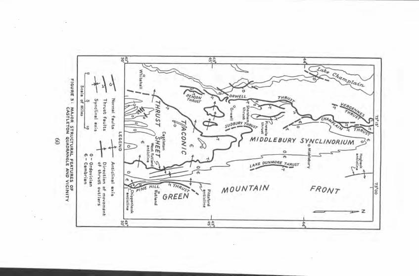
--
" rp
0RWE THI 7 Rusr
MIDOLEBURY SYNCL/NORIUM 0
C)
—I 'S
U,
p(E OUNMORE 0
LL r)
-°GREEN • U
] ,41 w MOUNTAIN FRONT c o
0
0 C
In
OCA
w
I0
Z:I JO C
2r
fm
a m < (n no
-I .(
30
a- S
c
ch 0 +
3. o- < .
-- C, C• -. w •- -
C X

veers northeastward and may diverge into two anticlinoria. In general the rocks east of the Green Mountain axis form an east-dipping homo-dine, interrupted by large domal uplifts. Several thrust faults are local-ized along the western border of the Green Mountains, and westward thrusting characterizes the Champlain Valley. In northwestern Vermont the Valley sediments are affected chiefly by imbricate thrusting, but southward in west-central Vermont deformation produced two great synclinoria separated from one another by an axis culmination in Monkton.
The major structural feature of the southern Champlain Valley is the southward-plunging Middlebury synclinorium (Cady, 1945, p. 562). The eastern third of the Castleton quadrangle is located on the southern prolongation of the east limb of this great compound fold. The Valley structure is concealed under Taconic strata in the remainder of the Castleton area. The argillaceous rocks of the Taconic sequence possess a structural pattern distinct from that of the underlying carbonate se-quence. Figure 3 shows some of the major features of this region.
Folás
Pittsford and Chippenhook anticlines: These two large folds form in plan a rude attenuated hourglass pattern that is broken on the east by a fault. The northern anticline plunges southward and the southern anticline plunges northward from Center Rutland, where their apices ccDincide.
The southern fold is named from Chippenhook. The axis of the Chip-penhook anticline lies a mile east of Chippenhook, trends northwest for about two miles, and then trends northward to the apex of the anticline a mile west of Center Rutland. Excepting a few subsidiary flexures, there is no overturning of beds in the Chippenhook anticline. Dips on the western limb are lower near the southern boundary of the area than farther north, but on the whole the western limb is more steeply inclined than the eastern limb.
The Cox Mountain area in Pittsford is interpreted as the core of the northern fold, the Pittsford anticline. Its axis strikes north. Extensive overturning is the rule on the western limb. A completely upsidedown sequence from the Otter Creek to the Taconic Range is shown in section A-A'. Most of the eastern limb is concealed under the Pine Hill thrust, but such beds as are exposed are inclined only moderately eastward.
61

West Rutland anticline and adjacent syncline: Wing (Dana, 1877) early recognized the anticlinal structure of the marbles at West Rutland. In plan the 6-mile-long fold is cigar-shaped, and its core is covered prin-cipally by swampy meadow. The rocks are strongly overturned toward the west. Judging from surface exposures, the axial plane of the anti-dine is regularly inclined at an angle of 40 degrees east. Underground data show an average dip on the eastern limb of 23Y2 degrees (Bain, 1931, p. 516). Flowage is extreme in the West Rutland marbles and will be discussed below.
Between this fold and the Otter Creek valley to the east is a major synclinal ridge underlain by Trenton phyllite. Although bedding in the phyllite is obscure, it is safe to assume that the syncline is overturned toward the west, for axial plane cleavage dips 30 or 40 degrees east. The syncline loses its identity in homogeneous masses of phyllite to the north near Proctor and to the south in the latitude of Clarendon Springs.
Folds in Taconic sequence: Where formations can be recognized, as for example in the slate belt, the rocks in the Taconic sequence are crumpled into long narrow folds that trend roughly north. The folds are seldom over a mile wide, and all are overturned toward the west. Inasmuch as the cleavage and minor structural features of the "Berkshire schist" terrane are very similar to those of the slate belt, it is evident that the folding of the entire Taconic thrust sheet is uniform. The repeated disappearance and reappearance of comparatively thin units in the slate belt suggests shallow folding. Indeed, looked at from a broad perspective, the rocks of the Taconic sequence are a sheet superficially crumpled but essentially flat-lying. With better evidence Kaiser (1945, p. 1093) reached a similar conclusion at the northern end of the Taconic Range. Little justification exists in this latitude for calling the structure of the Taconic thrust sheet a synclinorium.
Faults
Pine Hill thrust: Along the eastern boundary of the Castleton quad-rangle runs the trace of a reverse fault by which Lower Cambrian rocks have been brought westward so as to overlie strata as young as Middle Ordovician. The trace of the fault passes eastward into the Rutland quadrangle about 2 miles south of Pittsford Mills and southward into the Pawlet quadrangle south of Chippenhook. Measured along its trace the fault extends about 14 miles within the Castleton area. The thrust
62
was first recognized by Wolff (1891) at Pine Hill in Rutland and Proctor and is named from that locality. As Dale (1894) brought out, the con-spicuous ridge between the Green Mountain front and the Taconic Range from Pittsford to Danby is a consequence of this fault. The re-sistant Cheshire quartzite and Mendon series hold up a line of hills which in this quadrangle include Pine Hill and Boardman Hill and the hills between Chippenhook and the Otter Creek. The Rutland valley is developed in the Lower Cambrian dolomites that overlie the Cheshire in the Pine Hill thrust sheet. According to Dale, the total airline distance along which the fault extends does not exceed 18 miles.
Mapping of the thrust was not always easy because of the similarity of the Hortonville slate that generally underlies the fault to black phyllites of the upper part of the Mendon series that belong to the overthrust plate. The Cheshire quartzite is not generally found at the base of the thrust sheet. A reason for this may be that slippage between the two graphite-bearing phyllites was most easily accomplished.
The dip of the thrust plane is unknown, although Dale and Bain con-ceived of a fairly steep eastward inclination. Bain (1938, fig. 12) showed the thrust plane as repeatedly folded and in some places thrust on itself. Deformation at the base of the thrust plate is well exposed at the crest of Boardman Hill. Here the upper Mendon is a gneiss, greatly contorted and shattered and with a conspicuous development of boudinage. Quartz veins are abundant. The axial planes of drag folds in the gneiss dip at low angles to the east and may be roughly parallel to the fault plane here.
The stratigraphic throw is as great as 10,000 feet where the Mendon series lies on Hortonville slate and as small as a few hundred feet where Mendon rests on Cheshire. It is evident from a glance at the geologic map that the Pine Hill thrust truncates the east limbs of the Chippen-hook and Pittsford anticlines in a similar fashion. The fault is genetically a break thrust. Compressive stress formed fractures across the east limbs of the two folds and pushed the dislodged sheet westward. A probable klippe of Cheshire lying on Hortonville west of Center Rutland was first located by W. M. Cady. The minimum net-slip along this thrust is 2 or 3 miles, but without data on the true dip of the fault no maximum figure can be given.
Minor faulting: There can be little doubt that some small-scale thrusting has taken place within the Taconic sequence, but in no place can it be proved conclusively. Certainly no proof of the sort of thrusting
63
that Keith mapped at the northern end of the Taconic Range (1933, P1. 8) was forthcoming in the present area. In a homogeneous mass of phyllites that are doubly cleaved and complexly jointed minor thrusting is impossible to demonstrate.
The normal faults that are a feature of the Adirondack border region do not appear to have affected the rocks of the Castleton area. In the adjacent Whitehall quadrangle, however, Larrabee (1939, map) found Taconic folds that were displaced along northeast-trending steep gravity faults.
Taconic Overthrust
Original evidence: T. N. Dale's (1899, 1904b, 1912b, 1913) interpreta-tion of the relations between the rocks of the Taconic sequence and the Champlain Valley sequence involved rapid and rather improbable facies changes. Keith appears to have questioned the accuracy of Dale's view of the major structure of the region. Finding his suspicions apparently confirmed at the northern end of the Taconic Range, he announced (Keith, 1912) the Taconic overthrust. What Keith discovered, however, appears from his scanty account (Keith, 1913) to have been the Trenton unconformity. As mentioned above in connection with the Hortonville slate, at the northern end of the Range all the carbonate units from the Glens Falls down to the Bascom are truncated by erosion and overlain by the Hortonville. The Taconic overthrust seems seldom if ever to be located at the contact of marble and black slate but is rather concealed within the slate succession. If this is so, Keith's initial evidence for the Taconic overthrust is invalidated.
General statement: Despite the denial of Keith's most convincing evidence for the thrust, it is the thesis of this study that the entire Taconic sequence owes its present position to overthrusting, that the Taconic sequence is a huge klippe about 100 miles long and averaging 30 miles in width. To prove this it must first be shown that the rocks of the Taconic sequence lie with discordance upon the Valley sequence. This is demonstrated by lithologic evidence, stratigraphic evidence, facies evidence, and structural evidence. The discordance proved, it is necessary to show that such relations are due to thrusting rather than uncon-formity. The overthrust demonstrated, the source of the Taconic klippe is discussed.
No attempt is made here to present evidence from areas other than
64
those in the vicinity of the Castleton quadrangle. If an overthrust is established here, it is presumably present in other areas peripheral to the Taconic Range.
Evidence of discordance: The Valley sequence and the Taconic sequence are separated in the Castleton quadrangle by a sinuous contact extending from the southern border of the quadrangle in Ira township to the northern border of the quadrangle in Pittsford township. The Taconic sequence lies west of the contact, and the Valley sequence lies east of the contact. The contact runs along the eastern flank of the Taconic Range, and the Taconic sequence lies everywhere above the Valley sequence.
The highest unit in the Valley sequence, the Hortonville slate, gener-ally crops out beneath the Taconic sequence. In Ira, however, two small exposures of Orwell limestone and probable Whipple marble are exposed beneath the Taconic sequence. The limestone exposures may represent the crest of anticlinal uplifts truncated by the surface beneath the Taconic sequence.
Furthermore, a greatly variable thickness of Hortonville slate inter-venes between the underlying marbles of the Valley sequence and the overlying phyllites of the Taconic sequence. At the foot of the Taconic Range in West Rutland little or no Hortonville is exposed; a few miles southward in Ira a minimum of 1000 feet of Hortonville is present. Different thicknesses of Hortonville are found at several points along the contact north of West Rutland. These facts demonstrate lithologic dis-cordance beneath the contact between the two sequences.
The lowest rocks exposed in the Taconic sequence are of different lithology at various places along the contact. In Ira the lowest exposed rock of the Tacoriic sequence is commonly a tough, gray, banded, impure quartzite. Northward toward West Rutland the base of the Taconic sequence is usually a green phyllite. Just north of West Rutland white-weathering strata of the Taconic sequence crop out west of the meadow. West of Whipple Hollow green, greenish-gray, and purple phyllites are variously exposed above the Hortonville slate. These facts demonstrate lithologic discordance above the contact between the two sequences.
Discordance between the two sequences is shown also by the large-scale structural relations between the two terranes. The broad deep folds in the Valley sequence are in great contrast to the finely corrugated
65
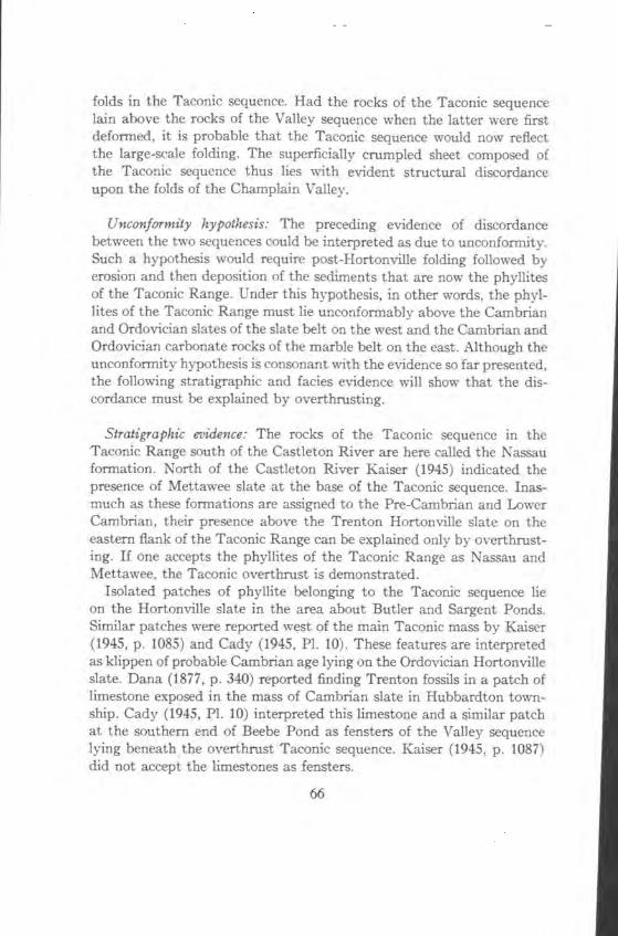
folds in the Taconic sequence. Had the rocks of the Taconic sequence lain above the rocks of the Valley sequence when the latter were first deformed, it is probable that the Taconic sequence would now reflect the large-scale folding. The superficially crumpled sheet composed of the Taconic sequence thus lies with evident structural discordance upon the folds of the Champlain Valley.
Unconformity hypothesis: The preceding evidence of discordance between the two sequences could be interpreted as due to unconformity. Such a hypothesis would require post-Hortonville folding followed by erosion and then deposition of the sediments that are now the phyllites of the Taconic Range. Under this hypothesis, in other words, the phyl-lites of the Taconic Range must lie unconformably above the Cambrian and Ordovician slates of the slate belt on the west and the Cambrian and Ordovician carbonate rocks of the marble belt on the east. Although the unconformity hypothesis is consonant with the evidence so far presented, the following stratigraphic and facies evidence will show that the dis-cordance must be explained by overthrusting.
Stratigraphic evidence: The rocks of the Taconic sequence in the Taconic Range south of the Castleton River are here called the Nassau formation. North of the Castleton River Kaiser (1945) indicated the presence of Mettawee slate at the base of the Taconic sequence. Inas-much as these formations are assigned to the Pre-Cambrian and Lower Cambrian, their presence above the Trenton Hortonville slate on the eastern flank of the Taconic Range can be explained only by overthrust-ing. If one accepts the phyllites of the Taconic Range as Nassau and Mettawee, the Taconic overthrust is demonstrated.
Isolated patches of phyllite belonging to the Taconic sequence lie on the Hortonville slate in the area about Butler and Sargent Ponds. Similar patches were reported west of the main Taconic mass by Kaiser (1945, p. 1085) and Cady (1945, P1. 10). These features are interpreted as klippen of probable Cambrian age lying on the Ordovician Hortonville slate. Dana (1877, p. 340) reported finding Trenton fossils in a patch of limestone exposed in the mass of Cambrian slate in Hubbardton town-ship. Cady (1945, P1. 10) interpreted this limestone and a similar patch at the southern end of Beebe Pond as fensters of the Valley sequence lying beneath the overthrust Taconic sequence. Kaiser (1945, p. 1087) did not accept the limestones as fensters.
66
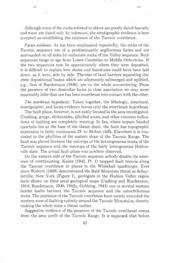
Although some of the rocks referred to above are poorly dated faunally and some are dated only by inference, the stratigraphic evidence is here accepted as establishing the existence of the Taconic overthrust.
Facies evidence: As has been emphasized repeatedly, the rocks of the Taconic sequence are of a predominantly argillaceous facies and are surrounded on all sides by carbonate rocks of the Valley sequence. Both sequences range in age from Lower Cambrian to Middle Ordovician. If the two sequences now lie approximately where they were deposited, it is difficult to explain how shales and limestones could have been laid down, as it were, side by side. Theories of land barriers separating dis-crete depositional basins which are alternately submerged and uplifted, e.g., that of Ruedemann (1930), are on the whole unconvincing. From the presence of two dissimilar facies in close association we may more reasonably infer that one has been overthrust into contact with the other.
The overthrust hypothesis: Taken together, the lithologic, structural, stratigraphic, and facies evidence favors only the overthrust hypothesis.
The fault plane, however, is not easily located in the area investigated. Crushing, gouge, slickensides, silicified zones, and other common indica-tions of faulting are completely wanting. In Ira, where impure banded quartzite lies at the base of the thrust sheet, the fault has topographic expression in fairly continuous 25- to 50-foot cliffs. Elsewhere it is con-cealed in the phyllites of the eastern slope of the Taconic Range. The fault was placed between the outcrops of the heterogeneous strata of the Taconic sequence and the outcrops of the fairly homogeneous Horton-yule slate. The actual fault plane was nowhere observed.
On the western side of the Taconic sequence nobody doubts the exist-ence of overthrusting. Kaiser (1945, P1. 1) mapped fault breccia along the Taconic overthrust at places in the Whitehall quadrangle. Ever since Walcott (1888) demonstrated the Bald Mountain thrust at Schuy-lerville, New York (Figure 1), geologists in the Hudson Valley region have shown on their areal geological maps (Cushing and Ruedemann, 1914; Ruedemann, 1930, 1942a; Goldring, 1943) one or several western border faults between the Taconic sequence and the autochthonous rocks. The partisans of the Taconic overthrust have merely extended the western zone of faulting entirely around the Taconic Mountains, thereby making the whole mass a thrust outlier.
Suggestive evidence of the presence of the Taconic overthrust comes from the area north of the Taconic Range. It is supposed that before
67
erosion the Taconic sequence overlay much of the Champlain Valley. The "comparable patterns" between the Sudbury nappe (Figure 3) and the Taconic overthrust led Cady (1945, p. 570) to infer a genetic rela-tionship. He stated: "The limestones on and east of the eastward-dipping upper limb of the nappe strike southwest rather than south-southeast as is characteristic of the east limb of the Middlebury synclinorium, suggesting drag produced by the once overriding Taconic Allochthone."
Source of the Taconic rocks: The purpose of the present investigation has been to prove or disprove the existence of the Taconic overthrust in the Castleton area. The source of the rocks, granting an overthrust, is quite another problem, and only a brief discussion is included here.
The Taconic overthrust is an enormous strip thrust that has trans-ported a thin plate of eastern rocks far to the west. Erosion has isolated the Taconic sequence of Vermont and New York from its inferred original eastern source. The search for the roots of the Taconic over-thrust has not been successful either because geologists have not looked in the right place or because the roots do not exist or have been buried under later rocks.
Keith (1932) suggested that the contact between the Pinney Hollow schist and the Plymouth series in east-central Vermont is the outcrop of the Taconic root zone, but Hawkes (1941) showed that the contact is a gradational sedimentary one. The Plymouth-Pinney Hollow sequence is now accepted (J. L. Rosenfeld, oral communication) as the lateral equivalent of the Hoosac-Rowe sequence in northwestern Massachusetts (Plate I). Knopf (Prindle and Knopf, 1932, p. 292-293) suggested that the Lower Cambrian Hoosac-Rowe sequence is partially equivalent to the Lower Cambrian Taconic sequence and is allochthonous on Hoosac and Greylock Mountains. It is, of course, not impossible that units that are in place in Vermont may be overthrust in Massachusetts. Current opinion in eastern Vermont, however, is that no evidence of significant discontinuities due to faulting can be found throughout the great homoclinal sequence that lies between the Green Mountain anticlinorium and the Connecticut River Valley. This question is by no means settled. The possibility that the roots of the Taconic overthrust may lie west of the Green Mountain anticlinorium (Hawkes, 1941) is no longer con-sidered likely. Moreover it is obvious that the short, discontinuous Green Mountain border faults, among which may be included the Pine Hill thrust, cannot be related to the Taconic fault.
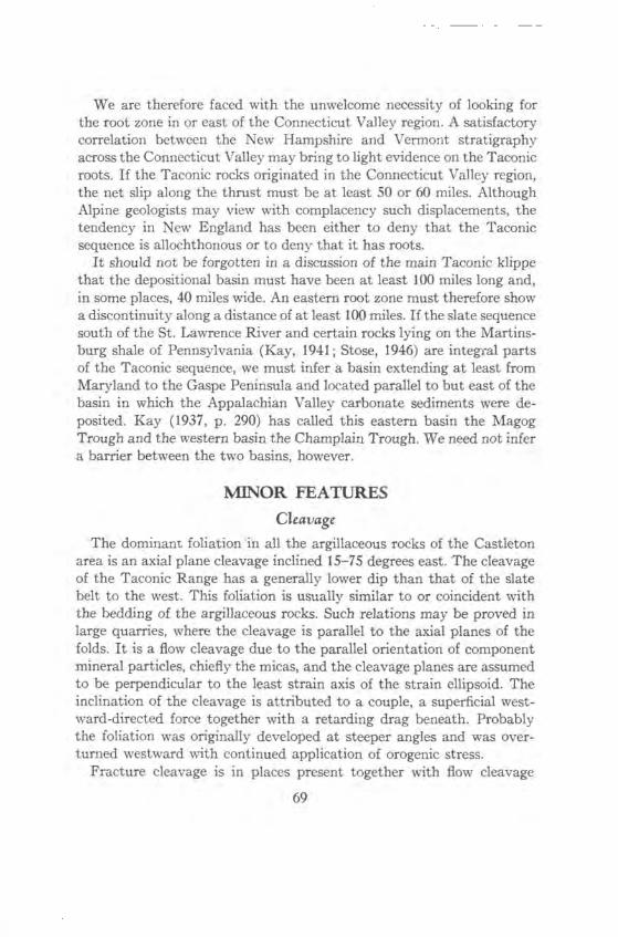
We are therefore faced with the unwelcome necessity of looking for the root zone in or east of the Connecticut Valley region. A satisfactory correlation between the New Hampshire and Vermont stratigraphy across the Connecticut Valley may bring to light evidence on the Taconic roots. If the Taconic rocks originated in the Connecticut Valley region, the net slip along the thrust must be at least 50 or 60 miles. Although Alpine geologists may view with complacency such displacements, the tendency in New England has been either to deny that the Taconic sequence is allochthonous or to deny that it has roots.
It should not be forgotten in a discussion of the main Taconic klippe that the depositional basin must have been at least 100 miles long and, in some places, 40 miles wide. An eastern root zone must therefore show a discontinuity along a distance of at least 100 miles. If the slate sequence south of the St. Lawrence River and certain rocks lying on the Martins-burg shale of Pennsylvania (Kay, 1941; Stose, 1946) are integral parts of the Taconic sequence, we must infer a basin extending at least from Maryland to the Gaspe Peninsula and located parallel to but east of the basin in which the Appalachian Valley carbonate sediments were de-posited. Kay (1937, p. 290) has called this eastern basin the Magog Trough and the western basin the Champlain Trough. We need not infer a barrier between the two basins, however.
MINOR FEATURES
Cleavage
The dominant foliation in all the argillaceous rocks of the Castleton area is an axial plane cleavage inclined 15-75 degrees east. The cleavage of the Taconic Range has a generally lower dip than that of the slate belt to the west. This foliation is usually similar to or coincident with the bedding of the argillaceous rocks. Such relations may be proved in large quarries, where the cleavage is parallel to the axial planes of the folds. It is a flow cleavage due to the parallel orientation of component mineral particles, chiefly the micas, and the cleavage planes are assumed to be perpendicular to the least strain axis of the strain ellipsoid. The inclination of the cleavage is attributed to a couple, a superficial west-ward-directed force together with a retarding drag beneath. Probably the foliation was originally developed at steeper angles and was over-turned westward with continued application of orogenic stress.
Fracture cleavage is in places present together with flow cleavage
69
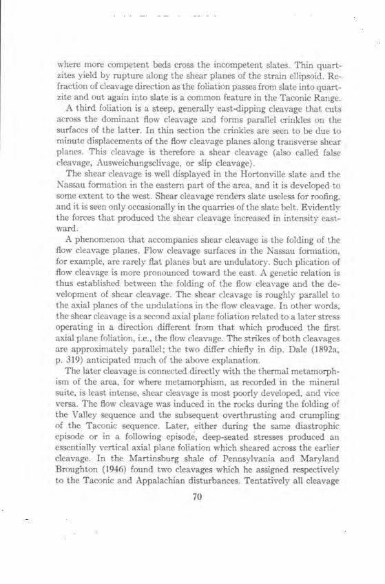
where more competent beds cross the incompetent slates. Thin quart-zites yield by rupture along the shear planes of the strain ellipsoid. Re-fraction of cleavage direction as the foliation passes from slate into quart-zite and out again into slate is a common feature in the Taconic Range.
A third foliation is a steep, generally east-dipping cleavage that cuts across the dominant flow cleavage and forms parallel crinkles on the surfaces of the latter. In thin section the crinkles are seen to be due to minute displacements of the flow cleavage planes along transverse shear planes. This cleavage is therefore a shear cleavage (also called false cleavage, Ausweichungsclivage, or slip cleavage).
The shear cleavage is well displayed in the Hortonville slate and the Nassau formation in the eastern part of the area, and it is developed to some extent to the west. Shear cleavage renders slate useless for roofing, and it is seen only occasionally in the quarries of the slate belt. Evidently the forces that produced the shear cleavage increased in intensity east-ward.
A phenomenon that accompanies shear cleavage is the folding of the flow cleavage planes. Flow cleavage surfaces in the Nassau formation, for example, are rarely flat planes but are undulatory. Such plication of flow cleavage is more pronounced toward the east. A genetic relation is thus established between the folding of the flow cleavage and the de-velopment of shear cleavage. The shear cleavage is roughly parallel to the axial planes of the undulations in the flow cleavage. In other words, the shear cleavage is a second axial plane foliation related to a later stress operating in a direction different from that which produced the first axial plane foliation, i.e., the flow cleavage. The strikes of both cleavages are approximately parallel; the two differ chiefly in dip. Dale (1892a,
p. 319) anticipated much of the above explanation. The later cleavage is connected directly with the thermal metamorph-
ism of the area, for where metamorphism, as recorded in the mineral suite, is least intense, shear cleavage is most poorly developed, and vice versa. The flow cleavage was induced in the rocks during the folding of the Valley sequence and the subsequent overthrusting and crumpling of the Taconic sequence. Later, either during the same diastrophic episode or in a following episode, deep-seated stresses produced an essentially vertical axial plane foliation which sheared across the earlier cleavage. In the Martinsburg shale of Pennsylvania and Maryland Broughton (1946) found two cleavages which he assigned respectively to the Taconic and Appalachian disturbances. Tentatively all cleavage
70
in the Castleton area will be considered to be related to the Taconic disturbance.
Joints Joints are conspicuous in all sedimentary rocks except the marbles,
but no systematic orientation was discerned. The strikes of the joints in this area box the compass, and the dips are predominantly steeper than 45 degrees. No classification of the joints was attempted in this study. Dale (1899, P. 210) and Larrabee (1940, p. 50) described joints in parts of the Castleton quadrangle and adjoining areas.
Drag Folds and Flowage Folds
In dolomites and clastic rocks of this area drag folds and minor folds on the flanks of the major folds are useful in determining the direction of anticlinal crests and therefore in distinguishing normal from inverted sequences. In drag folds the upper layers move upward toward anticlinal crests relative to the lower layers. In competent successions and in com-petent beds within incompetent marbles, drag folds have proved to be trustworthy in interpreting major structure.
In plastic marble beds, however, flowage under great stress has pro-duced plications that Bain (1931) in a thorough study has called flowage folds. In such folds the plastic marble has flowed toward the synclinal troughs. Bain likened the movement to that of tar on a hot day flowing away from the crown of a macadamized road. Flowage folds therefore have an orientation opposite to that of drag folds. Consequently minor folds in marble sequences must be interpreted with caution. Most of them are true flowage folds, but some simulate drag folds. Some small folds in the West Rutland marbles appear to be an indeterminate com-plex of both varieties. Stratigraphic and faunal evidence are ordinarily necessary in order to be certain of correct structural interpretation.
TIME OF DEFORMATION In the Catskill quadrangle of New York "the Manlius limestone rests
with distinct angular unconformity on the Normanskill shale on the western side of Becraft Mountain and on Schodack limestone on the three other sides" (Ruedemann, 1942a, p. 124-127). Becraft Mountain is a Siluro-Devonian outlier that unconformably overlies a thrust fault which brought Schodack above Normanskill. This exposure proves that the Taconic rocks of the Hudson Valley were deformed in pre-Upper
71
Silurian time. Under the present hypothesis the Taconic rocks reached their present position by overthrusting, and therefore the Taconic over-thrust is pre-Upper Silurian. Southwest of Rondout, New York the earliest Silurian Shawangunk formation unconformably overlies folded shales (Schuchert and Longwell, 1932). It is reasonable to assume that the Taconic disturbance ended in the Hudson Valley before earliest Silurian time, and it is not unreasonable to affix a pre-Silurian age to the Taconic overthrust. That the Taconic faults "are post-Richmond in age is evidenced by their cutting Queenston shales south of the St. Lawrence River in Quebec" (Kay, 1937, p. 287). Thus the folding and faulting of the rocks of western Vermont and eastern New York took place probably in post-Richmond and pre-Silurian time, i.e., near the end of the Ordovician period.
The folds and thrust of the Champlain-Vermont Valley were formed probably just prior to the development of the Taconic overthrust. Con-tinued stress folded and sliced the transported Taconic sheet and further deformed the underlying carbonate sequence. The shear cleavage has been referred to the latter part of the Taconic disturbance, but it is not impossible that this cleavage was produced during the Devonian Acadian disturbance that strongly affected central New England. To be sure, an Appalachian age cannot be excluded from consideration. It is by no means clear when the Green Mountain and eastern Vermont region was folded. At the present time we cannot determine whether most of eastern Vermont owes its deformation to the Taconic disturbance, the Acadian disturbance, or a combination of both. If the Taconic rocks were de-posited in or east of the Connecticut Valley, large-scale orogenic forces at the end of the Ordovician must have been at work throughout Ver-mont and possibly New Hampshire.
METAMORPHISM The term slate as used here refers to a well-foliated argillaceous rock
found only in the western part of the Castleton quadrangle. Its com-ponent minerals, chlorite and sericite particularly, are rigorously oriented parallel to the flow cleavage. Quartz particles also have been elongated by recrystallization in the foliation plane. Transverse sections show a rather perfect mass extinction. Although Harker (1939) called similar rocks "sericite-phyllites," the name slate is retained here because of its commercial uses.
East of the slate belt rocks of similar composition but higher meta-
72
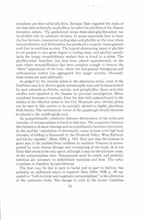
morphism are here called phyllites. Because Dale regarded the rocks of the slate belt technically as phyllites, he called the phyllites of the Nassau formation schists. The gradational series shale-slate-phyllite-schist can be divided only by arbitrary decision. It seems reasonable here to draw the line between commercial roofing slate and phyllite at the zone where recrystallization and deformation has produced a warped, coarse-grained rock that is worthless as slate. The typical shimmering luster of phyllite is not present to any great degree in roofing slate, and phyllite usually lacks the lumpy crystalloblastic surface that is found in a schist. The phyllite-schist boundary has here been placed approximately at the zone where recrystallization has been complete enough to remove the "dirty" appearance of the rock, where the fine-grained ferruginous and carbonaceous matter has aggregated into larger crystals. Obviously these terms are used arbitrarily.
As judged by the mineral suites in the aluminous rocks, most of the Castleton area is in the low-grade metamorphic zone and is characterized by such minerals as chlorite, sericite, and pyrophyllite. Some actinolite needles were reported in the Nassau by previous investigators. Meta-morphism increases in intensity from the slate belt eastward until in the schists of the Mendon series in the Cox Mountain area chlorite plates can be seen in thin section to be partially altered to highly pleochroic fresh biotite. The northeastern corner of the quadrangle should therefore be placed in the middle-grade zone.
An unquestionable correlation between deformation of the rocks and intensity of metamorphism is found in this area. The connection between the formation of shear cleavage and recrystallization has been mentioned. In the marbles "association of abnormally coarse texture with high local intensity of folding is illustrated by the Pittsford Valley, West Rutland, and Danby deposits" (Bain, 1934, p. 131). Bain saw that the increase in grain size of the marbles from northern to southern Vermont is accom-panied by more intense fiowage and overturning of the rocks. It is not likely that stress is the only agent, although it may be the ultimate cause, of the metamorphism here. Temperature must be raised, and probably solutions are necessary to redistribute materials and heat. The meta-morphism is therefore dynamothermal.
The heat may be due in part to burial and in part to friction, but probably an additional source is required. Bain (1934, 1938, p. 18) ap-pealed to "both tectonic and magmatic metamorphism" in the alteration of the carbonate rocks. The change in color in the Lower Cambrian
73
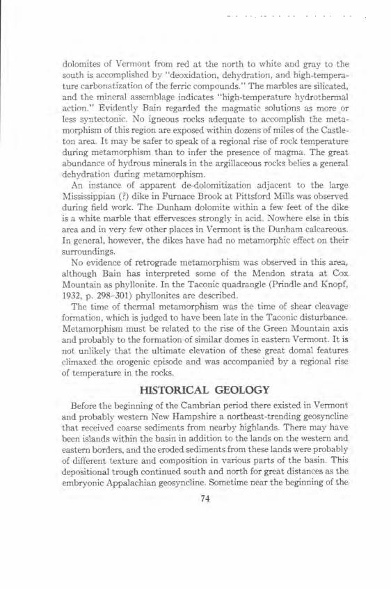
dolomites of \ermont from red at the north to white and gray to the south is accomplished by "deoxidation, dehydration, and high-tempera-ture carbonatization of the ferric compounds." The marbles are silicated, and the mineral assemblage indicates "high-temperature hydrothermal action." Evidently Bain regarded the magmatic solutions as more or less syntectonic. No igneous rocks adequate to accomplish the meta-morphism of this region are exposed within dozens of miles of the Castle-ton area. It may be safer to speak of a regional rise of rock temperature during metamorphism than to infer the presence of magma. The great abundance of hydrous minerals in the argillaceous rocks belies a general dehydration during metamorphism.
An instance of apparent de-dolomitization adjacent to the large Mississippian (?) dike in Furnace Brook at Pittsford Mills was observed during field work. The Dunham dolomite within a few feet of the dike is a white marble that effervesces strongly in acid. Nowhere else in this area and in very few other places in Vermont is the Dunham calcareous. In general, however, the dikes have had no metamorphic effect on their surroundings.
No evidence of retrograde metamorphism was observed in this area, although Bain has interpreted some of the Mendon strata at Cox Mountain as phyllonite. In the Taconic quadrangle (Prindle and Knopf, 1932, p. 298-301) phyllonites are described.
The time of thermal metamorphism was the time of shear cleavage formation, which is judged to have been late in the Taconic disturbance. Metamorphism must be related to the rise of the Green Mountain axis and probably to the formation of similar domes in eastern Vermont. It is not unlikely that the ultimate elevation of these great domal features climaxed the orogenic episode and was accompanied by a regional rise of temperature in the rocks.
HISTORICAL GEOLOGY Before the beginning of the Cambrian period there existed in Vermont
and probably western New Hampshire a northeast-trending geosyncline that received coarse sediments from nearby highlands. There may have been islands within the basin in addition to the lands on the western and eastern borders, and the eroded sediments from these lands were probably of different texture and composition in various parts of the basin. This depositional trough continued south and north for great distances as the embryonic Appalachian geosyncline. Sometime near the beginning of the
74
Cambrian period the Appalachian geosyncline in New England and eastern Canada is supposed to have been divided into a western trough, in which the sediments of the Castleton area were laid down, and an eastern trough along the present Atlantic coast, the Acadian trough.
Some infer that a land barrier, probably trending northeast through central and eastern New Hampshire, separated the two troughs. In any case, the eastern, or Acadian, trough does not concern us here. In general, throughout the Cambrian and Ordovician the eastern part of the western trough was the locus of deposition of muds, sands, and coarse elastics. Chiefly carbonate sediments were deposited in the western part of the western trough. The autochthonous rocks of the Champlain Valley sequence belong to the predominantly carbonate section of the trough, which for convenience will be called the Champlain basin. The al-lochthonous rocks of the Taconic sequence were laid down in the pre-dominantly clastic section of the trough, which will be called the Magog basin. No implication that the Champlain and Magog basins are other than the loci of deposition of two contrasting facies is intended; we have no evidence of a barrier that separated the two basins.
The Taconic sequence probably was deposited in frequently shallow seas, for we find coarse limestone conglomerates, edgewise conglomerates, and abundant coarse graywackes and grits among the rocks of the Taconic sequence. The small thickness of the Taconic sequence suggests that it may have been deposited near the eastern shore of the Magog basin. Here we have assumed that the Taconic sequence originated in the present Connecticut Valley region. The Valley sequence also was deposited under generally shallow water conditions. We do not know the depth of the sea in the part of the trough that stretched between the Champlain basin and the eastern part of the Magog basin, but this central area, now central and eastern Vermont, was the most rapidly subsiding part of the trough and received by far the thickest body of sediments.
The coarse sediments of the Mendon series were the earliest deposits in the trough. These were interbedded with and probably followed by muds, sands, and dolomites in later Mendon time. At approximately the same time the Connecticut Valley region was receiving the muds, sands, and coarse elastics of the Nassau formation. The southern and central parts of Vermont may have been folded after the Mendon series was laid down.
The Cambrian period in the Champlain basin began with the deposi-
75
tion of the Cheshire. Sands from a western source were washed clean, and muds were swept eastward. Thick widespread dolomite beds were deposited on the sandstone to form the Dunham. More sandstone and dolomite followed, constituting the Monkton and Winooski of the Champlain basin. In central Vermont the Plymouth series is probably partly equivalent to the Lower Cambrian of the Champlain basin, and here mud and sand were more prominent than dolomite. At approxi-matelv the same time further east the sand, mud, and limestone of the Bomoseen, Mettawee, Eddy Hill, Schodack, and Zion Hill were laid down. From the Lower Cambrian to the early Ordovician we have no record of the Taconic section. Whether it was above the level of the sea or submerged during the Middle and Upper Cambrian is not known. That some subaerial erosion did occur before the Lower Ordovician, however, is certain.
On the other hand, the most rapidly sinking part of the trough, the eastern Vermont area, is assumed to have received thick sediments throughout the remainder of the Cambrian. The Champlain basin was the locus of sand and dolomite deposition during the rest of the Cambrian except, possibly, during the Middle Cambrian. A muddy lagoon existed in the St. Albans area almost continuously from later Lower Cambrian through Lower Ordovician time. An uplift of the Adirondack area in Upper Cambrian time furnished vast quantities of sand to the east-bordering Champlain basin. Dolomites interfingered with sands away from the western source of sands. These sediments are the Danby and Potsdam formations, which were covered throughout Vermont during latest Cambrian time by clean dolomites that in the present area are called the Clarendon Springs dolomite.
Nowhere in this great trough is there a break that can be determined without question as the Cambrian-Ordovician boundary. Continuous sedimentation across this arbitrary boundary is probable. The Lower and Middle Ordovician sediments of the Champlain basin were mostly limestones. These include the Boardman, Bascom, Burchards, Beldens, Middlebury, and Orwell. The Castleton area may have been above sea level during the interval between the deposition of the Bascom and Burchards and between the Middlebury and Orwell. The rocks deposited in what is now central and eastern Vermont during the Lower and Middle Ordovician were principally muds. During the same interval the eastern part of the Magog basin received thick black shales, fine-grained grit, radiolarian chert, and sand, and all the rocks contain
76
graptolites. These sediments are now the Schaghticoke, Deepkill, and Normanskill formations. Whether such an assemblage of sediments indicates that the Ordovician Taconic sequence was deposited in very deep water is not yet clear. Between Deepkill and Normanskill times the entire geosyncline may have been brought above sea level.
Toward the middle of Trenton time the Magog basin was uplifted and probably folded. The resulting land mass, located in the vicinity of the modern Connecticut Valley, has been called Vermontia. Following the uplift of Vermontia, elevation and warping extended westward to the Adirondack region. The Castleton area was exposed to subaerial erosion for a comparatively brief time during the Middle Trenton. We find the record of this in the Trenton unconformity in the Castleton quadrangle. After the Champlain basin had again been submerged, the muds and limestones of the Whipple-Hortonville succession were laid down. The Hortonville shales are part of a great flood of dark muds and sands that issued from Vermontia during the later Trenton. These elastics gradually overlapped the Adirondack carbonates in a westerly direction.
During the Upper Ordovician Vermontia was extended, its western edge being a subaerial delta continuously advancing westward. The Taconic orogeny began in the eastern part of the former geosyncline before the end of the Ordovician and moved westward into western Vermont and eastern New York near the end of the Ordovician. During the Taconic orogeny the rocks of the entire geosyncline, reaching an aggregate thickness of perhaps 50,000 feet, were folded, faulted, and moved westward. At the catastrophe the gigantic Taconic overthrust carried strata that were deposited in the eastern Magog basin from the vicinity of the present Connecticut Valley as far west as the Catskill region. As uplift at the east continued, the Taconic Allochthone may have become detached from its roots and slid downward and westward, lubricated by the Hortonville slate. Eventual relaxation of the forces was followed by large-scale gravity faulting peripheral to the Adiron-dacks.
The orogeny created a new land mass, Taconica. Eastward onlap of elastic debris derived from the erosion of Taconica occurred throughout the Silurian. At the end of that period and throughout much of the ensuing Devonian period marine waters probably again covered Ver-mont, but the greatest deposition of sediments occurred in New York and New Hampshire. The mid-Devonian Acadian disturbance, accom-panied by extensive granitic intrusions in New Hampshire, deformed
77
much of the New England region. Piedmont alluvial plains probably covered Vermont and extended westward into deltaic deposits in western New York and nearby areas during the remainder of the Devonian. Erosion followed, and during the Mississippian period many dikes and plugs of alkaline magma were emplaced throughout the New England-Quebec region.
The remainder of Paleozoic and most of Mesozoic time is recorded not at all in western New England. Fluvial erosion must have continued throughout this interval. Perhaps in the Jurassic or early Cretaceous period a lowland was achieved at a level that is probably not preserved even on the highest peaks today. From the Cretaceous until the glacial epoch, periodic general uplifts of New England took place. Drainage of the region was by the Connecticut River toward the Atlantic Ocean and by streams in western Vermont that probably emptied into an arm of the sea that at times occupied the Hudson-Champlain-St. Lawrence Valleys. Erosion during the Cenozoic developed terraces along the streams, and these terraces were extended gradually upstream toward the mountain watersheds. By early Miocene the Champlain Valley may have attained substantially its modern aspect.
Mile-thick continental glaciers covered New England, probably more than once, in the Pleistocene epoch. Their weight so depressed the land that after their retreat marine waters again invaded the Champlain Valley. Step-like uplift of the northeastern part of North America during the last 15,000 years drained the Champlain sea and converted the Hudson and St. Lawrence again into rivers.
ECONOMIC GEOLOGY
The rocks of the Castleton quadrangle are among the most valuable natural resources of Vermont. In addition to abrasive sand and road metal, the deposits of roofing slate and particularly of marble have long been exploited.
The southwestern part of the quadrangle lies in the colored slate belt of New York and Vermont, which extends northward from Greenwich, New York to Lake Bomoseen in Castleton, Vermont. Several slate quarries are now active in Poultney, Castleton, and Fairhaven. The only formation being quarried at present is the Cambrian Mettawee slate, although in the past a few quarries were opened in the Normanskill formation. The purple and green Mettawee slate is divided into several
78
varieties for the market on the basis of shade and permanence of color. A modern discussion of commercial subdivision of the Mettawee slate is available by D. M. Larrabee (1939-1940). This slate is used for roofing, for ornamental paving, and in the manufacture of asphalt shingles. Problems in slate quarrying are fully discussed by Dale (1899) and
Larrabee. Roughly the eastern third of the Castleton quadrangle lies in the
Vermont marble belt, which stretches from Danby at the south to Brandon at the north. North of Brandon the grain-size of the calcareous rocks is smaller, and the rocks are more properly called limestones. Among the rock units discussed in this report the Boardman formation (Sutherland Falls marble and Columbian marble members), the Bascom formation, the Burchards limestone, the Beldens formation, the Orwell limestone, and the Whipple marble have all been quarried either for building stone, land lime, or calcined lime. At present most of the build-ing stone quarried here comes from the white and gray-streaked Colum-bian deposits and from the several green-streaked marbles of West Rutland that have been grouped here into the Beldens formation. Some Whipple marble is quarried along with the Columbian at Clarendon Springs. The Sutherland Fa'ils marble and some of the lower Bascom are at present quarried for lime at Florence. For a thorough treatment of the geological aspects of the marble industry the reader should consult one of the reports dealing particularly with the marbles of western Vermont. Among these are those of Bain (1931, 1933, 1934, 1938), Dale (1912), and several papers to be found in earlier Reports of the Vermont State Geologist.
79
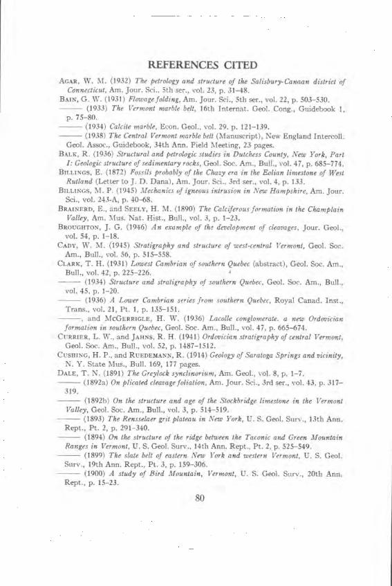
REFERENCES CITED AGAR, W. M. (1932) The petrology and structure of the Salisbury-Canaan district of
Connecticut, Am. Jour. Sci.. 5th ser., vol. 23, p. 31-48. BAlK, G. W. (1931) Flowage folding, Am. Jour. Sci., 5th ser., vol. 22, p. 503-530.
(1933) The Vermont marble belt, 16th Internat. Geol. Cong., Guidebook 1, p. 75-80.
(1934) Calcite marble, Econ. Geol., vol. 29. p. 121-139. (1938) The Central Vermont marble belt (Manuscript), New England Intercoll.
Geol. Assoc., Guidebook, 34th Ann. Field Meeting, 23 pages. BALK, R. (1936) Structural and petrologic studies in Dutchess County, New York, Part
I: Geologic structure of sedimentary rocks, Geol. Soc. Am., Bull., vol. 47, p. 685-774. BILLINGs, E. (1872) Fossils probably of the Chevy era in the Folian limestone of West
Rutland (Letter to J. D. Dana), Am. Jour. Sci., 3rd ser., vol. 4, p. 133. BILLINGS, M. P. (1945) Mechanics of igneous intrusion in New Hampshire, Am. Jour.
Sci., vol. 243-A, p. 40-68. BRAINERD, E., and SEELY, H. M. (1890) The Calciferous formation in the Champlain
Valley, Am. Mus. Nat. Hist., Bull., vol. 3, p. 1-23. BROUGHTON, J. G. (1946) An example of the development of cleavages, Jour. Geol.,
vol. 54, p. 1-18. CADY, W. M. (1945) Stratigraphy and structure of west-central Vermont, Geol. Soc.
Am., Bull., vol. 56, p. 515-558. CLARK, T. H. (1931) Lowest Cambrian of southern Quebec (abstract), Geol. Soc. Am.,
Bull., vol. 42, p. 225-226. (1934) Structure and stratigraphy of southern Quebec, Geol. Soc. Am., Bull.,
vol. 45, p. 1-20. (1936) A Lower Cambrian series from southern Quebec, Royal Canad. Inst.,
Trans., vol. 21, Pt. 1, p. 135-151. and MCGERRIGLE, H. W. (1936) Lacolle conglomerate, a new Ordovician
formation in southern Quebec, Geol. Soc. Am., Bull., vol. 47, p. 665-674. CURRIER, L. W., and JAHNS, R. H. (1941) Ordovician stratigraphy of central Vermont,
Geol. Soc. Am., Bull., vol. 52, p. 1487-1512. CUSHING, H. P., and RLTEDEMANN, R. (1914) Geology of Saratoga Springs and vicinity,
N. Y. State Mus., Bull. 169, 177 pages. DALE, T. N. (1891) The Greylock synclinorium, Am. Geol., vol. 8, p. 1-7.
(1892a) On plicated cleavage foliation, Am. Jour. Sci., 3rd ser., vol. 43, p. 317- 319.
(1892b) On the structure and age of the Stockbridge limestone in the Vermont Valley, Geol. Soc. Am., Bull., vol. 3, p. 514-519.
(1893) The Rensselaer grit plateau in New York, U. S. Geol. Surv., 13th Ann. Rept., Pt. 2, p. 291-340.
(1894) On the structure of the ridge between the Taconic and Green Mountain Ranges in Vermont, U. S. Geol. Surv., 14th Ann. Rept., Pt. 2, p. 525-549.
(1899) The slate belt of eastern New York and western Vermont, U. S. Geol. Surv., 19th Ann. Rept., Pt. 3, p. 159-306.
(1900) A study of Bird Mountain, Vermont, U. S. Geol. Surv., 20th Ann. Rept., p. 15-23.
80
(1904a) Geology of the Hudson Valley between the Hoosick and the Kinderhook, U. S. Geol. Surv., Bull. 242, 63 pages.
(1904b) The geology of the north end of the Taconic Range, Am. Jour. Sci., 4th ser., vol. 17, P. 185-190.
(1912a) The commercial marbles of western Vermont, U. S. Gaol. Surv., Bull. 521, 170 pages.
(1912b) The Ordovician outlier at Hyde Manor in Sudbury, Vermont, Am. Jour. Sci., 4th ser., vol. 33, p. 97-102.
(1913) The Ordovician outlier at Hyde Manor in Sudbury, Vermont, Am. Jour. Sci., 4th ser., vol. 36, p. 395-398.
DANA, J. D. (1877) An account of the discoveries in Vermont geology of the Rev. Augustus Wing, Am. Jour. Sci., 3rd ser., vol. 13, p. 332-347; 405-419; vol. 14, p. 36-37, map.
(1887) On Taconic rocks and stratigraphy with a geologic map of the Taconic region, Am. Jour. Sci., 3rd ser., vol. 33, p. 270-276, 393-419.
EMERSON, B. K. (1892) Hawley sheet, U. S. Gaol. Surv. Atlas of U. S., (unpublished proof sheets).
(1917) Geology of Massachusetts and Rhode Island, U. S. Geol. Surv., Bull. 597, p. 32-34, map.
EMMONS, E. (1842) Geology of New York, Part 2, comprising the survey of the second geological district, 437 pages.
(1844) The Taconic system, based on observations in New York, Massachusetts, Vermont, and Rhode Island, p. 20-21, Albany.
(1855) American geology, vol. 1, part 2, "The Taconic system," 251 pages. FOERSTE, A. F. (1893) New fossil localities in the early Paleozoics of Pennsylvania,
New Jersey, and Vermont, with remarks of the close similarity of the lit hologic features of these Paleozoics, Am. Jour. Sci., 3rd ser., vol. 46, p. 435-444.
F0YE, W. G. (1919) A report of the geologic work within the Rochester, Vermont quad-rangle, Vt. State Gaol., 11th Rept., p. 76-98.
GOLDRING, W. (1943) Geology of the Coxsackie quadrangle, New York, N. Y. State Mus., Bull. 332, 374 pages.
HARKER, A. (1939) Metamorphism, Methuen, London (2nd ed), p. 210-211. HAWKES, H. E. (1941) Roots of the Taconic fault in west-central Vermont, Gaol. Soc.
Am., Bull., vol. 52, p. 649-666. HITCHCOCK, E., et al. (1861) Report on the geology of Vermont, Claremont, N. H., 2
volumes. HOWELL, B. F. (1939) The Cambrian Rugg Brook formation of Franklin County, Vt.
State Gaol., 21st Rept., p. 97-101. et al. (1944) Correlation of the Cambrian formations of North A merica, Gaol.
Soc. Am., Bull., vol. 55, p. 993-1004. HUDSON, G. H. (1931) The dike invasions of the Champlain Valley, New York, N. Y.
State Mus., Bull. 286, p. 81-112. KAISER, E. P. (1945) Northern end of the Taconic thrust sheet in western Vermont,
Gaol. Soc. Am., Bull., vol. 56, p. 1079-1098. KAY, G. M. (1935) Taconic thrusting and paleogeographic maps, Science, vol. 82, p.
616-617. (1937) Stratigraphy of the Trenton group, Gaol. Soc. Am., Bull., vol. 48, p.
233-302.
81
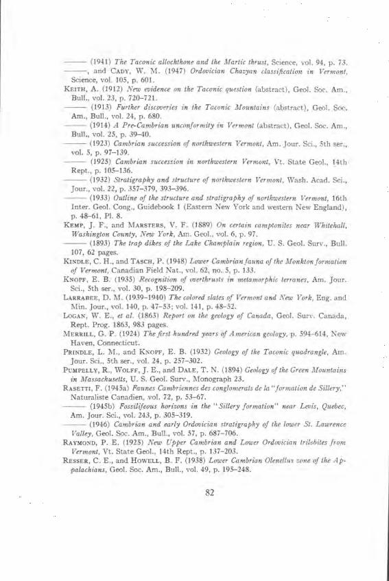
(1941) The Taconic allochihone and the Manic thrust, Science, vol. 94, p. 73. and CADY, W. M. (1947) Ordovician Chazyan classification in Vermont,
Science, vol. 105, p. 601. KEITH, A. (1912) New evidence on the Taconic question (abstract), Geol. Soc. Am.,
Bull., vol. 23, D. 720-721. (1913) Further discoveries in the Taconic Mountains (abstract), Geol. Soc.
Am., Bull., vol. 24, p. 680. (1914) A Pre-Cambrian unconformity in Vermont (abstract), Geol. Soc. Am.,
Bull., vol. 25, p. 39-40. (1923) Cambrian succession of northwestern Vermont, Am. Jour. Sci., 5th ser.,
vol. 5, p. 97-139. (1925) Cambrian succession in northwestern Vermont, Vt. State Geol., 14th
Rept., p. 105-136. (1932) Stratigraphy and structure of northwestern Vermont, Wash. Acad. Sci.,
Jour., vol. 22, p. 357-379, 393-396. (1933) Outline of the structure and stratigraphy of northwestern Vermont, 16th
Inter. Gaol. Cong., Guidebook I (Eastern New York and western New England), p. 48-61, P1. 8.
KEMP, J. F., and MARSTERS, V. F. (1889) On certain camptonites near Whitehall, Washington County, New York, Am. Geol., vol. 6, p. 97.
(1893) The trap dikes of the Lake Champlain region, U. S. Geol. Surv., Bull. 107, 62 pages.
KINDLE, C. H., and TASCH, P. (1948) Lower Cambrian fauna of the Monkton formation of Vermont, Canadian Field Nat., vol. 62, no. 5, p. 133.
KNOFF, E. B. (1935) Recognition of overthrusts in metamorphic terranes, Am. Jour. Sci., 5th ser., vol. 30, p. 198-209.
LARRABEE, D. M. (1939-1940) The colored slates of Vermont and New York, Eng. and Mm. Jour., vol. 140, p. 47-53; vol. 141, p. 48-52.
LOGAN, W. E., et at. (1863) Report on the geology of Canada, Geol. Surv. Canada, Rept. Prog. 1863, 983 pages.
MERRILL, G. P. (1924) The first hundred years of American geology, p. 594-614, New Haven, Connecticut.
PRINDLE, L. M., and KNOPF, E. B. (1932) Geology of the Taconic quadrangle, Am. Jour. Sci., 5th ser., vol. 24, p. 257-302.
PUMPELLY, R., WOLFF, J. E., and DALE, T. N. (1894) Geology of the Green Mountains in Massachusetts, U. S. Geol. Surv., Monograph 23.
RASETTI, F. (1945a) Faunes Cambriennes des conglomerats de la "formation de Sillery," Naturaliste Canadian, vol. 72, p. 53-67.
(1945b) Fossilifeous horizons in the "Sillery formation" near Levis, Quebec, Am. Jour. Sci., vol. 243, p. 305-319.
(1946) Cambrian and early Ordovician stratigraphy of the lower SI. Lawrence Valley, Gaol. Soc. Am., Bull., vol. 57, p. 687-706.
RAYMOND, P. E. (1925) New Upper Cambrian and Lower Ordovician trilobites from Vermont, Vt. State Geol., 14th Rept., p. 137-203.
RESSER, C. E., and HOWELL, B. F. (1938) Lower Cambrian Olenellus zone of the Ap-palachians, Gaol. Soc. Am., Bull., vol. 49, p. 195-248.
82
RODGERS, J. (1937) Stratigraphy and structure in the upper Champlain Valley, Geol. Soc. Am., Bull., vol. 48, p. 1573-1588.
RUEDEMANN, R. (1901) Hudson River beds near Albany and their taxonomic equivalents,
N. Y. State Mus., Bull., vol. 8, p. 485-596. (1930) Geology of the Capital district, N. Y. State Mus., Bull. 285, 218 pages.
(1942a) Geology of the Catskill and Kaaterskill quadrangles. Part I: Cambrian and Ordovician geology of the Catskill quadrangle, N. Y. State Mus., Bull. 331, p.
37-188. (1942b) Oldhamia and the Rensselaer grit problem, N. Y. State Mus., Bull.
327, p. 5-19. (1947) Graptolites of North America, Gaol. Soc. Am., Mem. 19, 652 pages.
SCHUCHERT, C. (1919) The Taconic system resurrected, Am. Jour. Sci., 5th ser., vol. 47, p. 113-116.
(1933) Cambrian and Ordovician stratigraphy of northwestern Vermont, Am. Jour. Sci., 5th ser., vol. 25, p. 353-381.
(1937) Cambrian and Ordovician of northwestern Vermont, Geol. Soc. Am.,
Bull., vol. 48, p. 1001-1078. and LONGWELL, C. R. (1932) Paleozoic deformations of the Hudson Valley
region, New York, Am. Jour. Sci., 5th ser., vol. 23, p. 305-321.
SEELY, H. M. (1910) Preliminary report of the geology of Addison County, Vt. State
Gaol., 7th Rept., p. 257-313. SHAW, A. B. (1949) Structure and stratigraphy of the St. A/bans area, Vermont, Un-
published PhD. Thesis, Harvard University. SrosE, G. W. (1946) The Taconic sequence in Pennsylvania, Am. Jour. Sci., vol. 244,
p. 665-696. SWINNERTON, A. C. (1922) Geology of a portion of the Castleton, Vt., quadrangle, Un-
published PhD. Thesis, Harvard University. VAUGHAN, H., and WILsON, T. Y. (1934) The age of the Rensselaer graywacke, Am.
Jour. Sci., 5th ser., vol. 27, p. 460-462. WALCOTT, C. D. (1888) The Taconic system of Emmons, Am. Jour. Sci., 3rd ser.,
vol. 35, p. 229-242, 307-327, 394-401, map opp. p. 326.
WHEELER, R. (1941) Cambro-Ordovician boundary in the Champlain Valley, Geol. Soc. Am., Bull., vol. 52, p. 2036.
(1942) Ca mbro- Ordovician boundary in the Adirondack border region, Am. Jour. Sci., vol. 240, p. 518-524.
WHITTLE, C. L. (1894) The occurrence of Algonkian rocks in Vermont and the evidence for their subdivision, Jour. Gaol., vol. 2, p. 396-429.
WILMARTH, M. G. (1938) Lexicon of geologic names of the United States (including Alaska), U. S. Gaol. Surv., Bull. 896, 2396 pages.
WOLFF, J. E. (1891) On the Lower Cambrian age of the Stockbridge limestone, Gaol. Soc. Am., Bull., vol. 2, p. 331-337.
83