strategy2000 - welcome to the san jose...
TRANSCRIPT


Executive Summary ivPurpose and Scope of the Strategy for Development viProcess viiiHow to Use this Document xiGuiding Principles xviii
1. VISION1.1 Beyond Prosperity – A Call to Action 21.2 San Jose 2010 61.3 Context and Issues 81.4 Top Priorities 14
2. KEY URBAN DESIGN CONCEPTS2.1 Fill and Tighten 192.2 Weave and Connect 212.3 Expand and Phase 222.4 Identify and Strengthen 232.5 Link and Respect 24
3. IMPLEMENTATION OF URBAN DESIGN CONCEPTS: STRATEGIES AND ACTIONS3.1 Recommendations By System 35
3.1.1 Public Realm 36A. Streets and SidewalksB. Paseo NetworkC. Parks, Plazas and TrailsD. Civic Spaces and Events
3.1.2 Urban Form and Buildings 54A. Skyline and Downtown FormB. Land Use C. Buildings and Context
3.1.3 Transportation and Access 70A. Transit ImprovementsB. Pedestrian and Bicycle AccessC. Parking Management

3.1.4 Historic Assets 873.1.5 Economic Projections 913.1.6 Human Services 96
3.2 Recommendations By Area 973.2.1 Plaza de Cesar Chavez 98 3.2.2 St. James Park 102 3.2.3 1st & 2nd Streets 106 3.2.4 Santa Clara Street 1113.2.5 San Pedro Square 1163.2.6 San Fernando Street 1213.2.7 SoFA/ Convention Center 126 3.2.8 Civic Center 131 3.2.9 San Carlos Street 135 3.2.10 Almaden Boulevard 1403.2.11 Diridon/Arena 1443.2.12 North Gateway 152
4. DESIGN GUIDELINES4.1 Public Realm 161
4.1.1 Urban Open Spaces4.1.2 Streets, Sidewalks and Paseos
4.2 Urban Form and Buildings 1624.2.1 Building Form4.2.2 Building Rehabilitation4.2.3 Building Uses4.2.4 Building Context4.2.5 Building Character
5. APPENDICESList of Illustrations 168Glossary 174Studies Noted in “Strategy 2000” 178Acknowledgements 180

“Strategy 2000: San Jose GreaterDowntown Strategy for Development” isan action guide for development andredevelopment of Greater Downtown SanJose through the year 2010. The “Strategy”is the result of a broad, multi-disciplinaryconsideration of the issues of economics,transportation, urban design, urbanlandscape, historic resources, culturalresources and events as they apply to theGreater Downtown. The RedevelopmentAgency Board will use the “Strategy” as aguide to make policy, planning, andbudgetary decisions concerningdevelopment for the next 10 years.

“Strategy 2000” was created for the Redevelopment Agency of San Joseunder the leadership of a 33-member Community Task Force composed ofresidents, the San Jose State University, the cultural community, andbusiness representatives from both Greater Downtown and throughout thecity of San Jose. A consultant team, headed by Field Paoli Architects andSMWM, helped formulate the “Strategy” with the Task Force through aseries of public work sessions. A technical advisory committee composed ofstaff representatives of the City and related agencies assisted throughout theprocess. The Task Force will submit the “Strategy” to the San JoseRedevelopment Agency Board for consideration.
The Task Force began by developing a set of Guiding Principles—broadgoals and objectives to guide their decisions throughout the process. TheseGuiding Principles formed the basis from which they developed acomprehensive vision for the future of San Jose’s Greater Downtown. Fromthe vision, recommended strategies and actions were identified andprioritized. Key first priority actions identified by the Task Force are asfollows:
a. Development of retail in the Greater Downtownb. Housing development, with an emphasis on high densities, 20
percent of which is affordablec. Completion of the Guadalupe River and Los Gatos Creek Park
systemd. Develop parking resources and alternativese. Provide streetscape improvements such as lighting, planting, paving
and street furniture to improve the public realmf. Expansion of San Jose Convention Center
An Annual Status Report will be prepared by Agency staff so that Task Forcemembers and other interested parties can stay abreast of changes anddevelopments within the Greater Downtown.

“Strategy 2000: The Greater Downtown San Jose Strategy forDevelopment” serves as the action guide for development activities in theGreater Downtown planned for 2000-2010. This document containsdescriptions of the economic, spatial, transportation, and political contextfor new development and includes prioritized recommendations for theGreater Downtown’s growth.
“Strategy 2000” is a broad, multi-disciplinary consideration of economics,transportation, urban design, urban landscape, historic resources, andhuman services as they apply to the Greater Downtown. This considerationis informed by a set of Guiding Principles created by the Task Force.
Recommendations incorporate the Task Force’s Guiding Principles forDevelopment in the form of “Strategies” and “Actions”, which range from

general policy directions to specific tasks. Many of the recommendations arestrategic principles that could be applied to the entire Greater Downtown.Other, more specific actions propose a concrete task for a particular parcelor area. The Redevelopment Agency Board of Directors will consider theserecommendations when making policy and budgetary decisions fordevelopment and redevelopment projects projected over the next 10 years.
The boundary of the Greater Downtown extends beyond San Jose'straditional downtown center to include the areas around Diridon Station,areas north to approximately Taylor street, areas on the east that include SanJose State University, as well as north and south of the campus, and areas onthe south to approximately Interstate 280. The darker outlined squarewithin Figure 0-4 is a representation of the Greater Downtown area, whichis the same as the total area of Figure 4-2 inside the back cover, titled:'Strategy 2000 Illustrative Plan'." The Specific Plans for the outlying areaswill be developed as part of the “Strong Neighborhoods Initiative” (SNI).
It is important to note that a Strategy for Development is by nature a generaldocument. A Strategy attempts to articulate a vision and recommendpolicies and actions toward achieving that vision. It is not a General Plan,a Specific Plan, or a Redevelopment Plan. It does not determine land uses,zoning requirements, or detailed policies, but it does make substantiverecommendations with important policy implications. “Strategy 2000” ismeant to serve as a guide for decision-makers as they consider policyaffecting change and growth in the Greater Downtown through 2010.

In May 2000 the Mayor of San Jose appointed a 33-member citizen TaskForce. In June, the Task Force for the Greater Downtown Strategy forDevelopment began working with the San Jose Redevelopment Agency, aCity Technical Advisory Committee and a team of consultants led by FieldPaoli and SMWM to produce “Strategy 2000: San Jose Greater DowntownStrategy for Development.” Over a 7-month period the Task Force heldmonthly public meetings. In a workshop setting, the consultant teamassisted the Task Force in studying the opportunities and challenges of theGreater Downtown. In January 2001, the meetings culminated in a finaldocument presented by the Task Force to the San Jose RedevelopmentAgency Board as recommendations for the development of the GreaterDowntown.
The series of Task Force meetings, and technical retreats, involved hands-onplanning work and substantive discussion related to economics,transportation, redevelopment practices, and urban design. The focus ofdiscussion and interactive workshops moved through the following sevenphases of Task Force work:
1. Perspectives and Principles: The Task Force began with the personalsharing of perspectives on the Greater Downtown and the collectiveconsideration of downtown’s strengths, weaknesses and potentials. Thisinitial expression of goals for downtown grew into the preparation ofGuiding Principles that give direction to this document and will servedowntown policy-makers for many years to come.
2. Information Gathering: Before proposing possibilities for GreaterDowntown San Jose, the Task Force studied San Jose and compared it withsix thriving downtown areas in the U.S. and Canada. While studying thesesuccessful city centers, the Task Force compared the populations, ages andincomes with Greater Downtown San Jose, and considered the planningstrategies pursued in each case. The Task Force formulated a vision forGreater Downtown and considered strategies to strengthen and support itsneighborhoods.
3. Conceptualizing: Task Force members used maps of the GreaterDowntown to consider areas for office, residential, and retail development,

including related parking and transportation needs. The consultant teamand the Technical Advisory Board helped the Task Force to arrive at conceptsby providing information and analysis of building height restrictions, watertables, pedestrian access, economic projections, parking and transportation.
4. Strategizing: The Task Force members discussed what systems wouldneed to be considered in order to make a comprehensive Strategy forDevelopment. They discussed possibilities for improvement of downtownareas by incorporating new residential and mixed-use development,expanding park space, and creating pedestrian corridors. They discussedfurther how these efforts translate to strategies and specific actions.
5. Implementing: In the course of creating several drafts, the Task Forcemembers reviewed, discussed and modified the “Greater DowntownStrategy for Development.” The Task Force presented the “Strategy” to theRedevelopment Agency Board and following its acceptance, it serves as theaction guide for development activities in the Greater Downtown.

6. Continuing: The “Strategy” should be tied to “Investing in Results”performance based budgetary system. An “Annual Status Report” will beprepared by Agency staff so that Task Force members and other interestedparties can stay abreast of changes and developments within the GreaterDowntown.
7. Outreach: To make the process inclusive, a comprehensive outreachprogram was adopted. Outreach efforts included:
6 newsletters (one per month) with a minimum distribution of 5,000 and a maximum of over 22, 000,Outreach information at every library and community center in San Jose updated for each meeting,Postage paid comment cards with direct responses from Agency staff (over 500 received),Nine several-day advertisements in the Mercury News, El Observador, Vietnam Liberty News, and La Oferta Review,Outreach presentations to the SJDA Board of Directors and several SJDA Subcommittees,Outreach presentations to several resident association groups and other community organizations and meetings,Presentations to the Chamber of Commerce and City organizations such as the Historic Landmarks Commission and theDowntown Parking Board,Creation of a “Strategy 2000” webpage linked to the Agency website including every presentation and meeting summary since May 2000,Distribution of “get involved” flyers,Exhibits and information at the Downtown Information Center at 118 E. Santa Clara Street, andSeveral Agency-initiated outreach articles in the Mercury news and Silicon Valley Business Journal

This section outlines the structure of this document, and then considers theways in which different types of users might take advantage of it, accordingto their specific needs.
“The Vision,” describes the unique current context within which criticaldecisions must be made and presents a narrative of what San Jose could looklike in the future given the objectives and goals described in the GuidingPrinciples. The text is imaginative and descriptive and asks the reader toconsider the possibilities of what might make a lively, vital downtown SanJose through the year 2010.
“Key Urban Design Concepts” describes the fundamental principles ofurban design needed to move in the direction of the Vision. Diagramsillustrate urban design directives on a scale of the entire Greater Downtownarea.
“Implementation of Key Urban Design Concepts: Strategies and Actions,”outlines general strategies and specific actions required to implement thedesign for each of six “systems”—or key general components of the GreaterDowntown—and each of twelve important areas within the GreaterDowntown. Systems such as the Public Realm, Urban Form and Buildings,and Transportation and Access are analyzed and recommended strategiesand actions are presented. The second part of the chapter looks in moredetail at the vision and supporting strategies in each of twelve areas withinthe Greater Downtown. Diagrams of these distinctive areas illustrate theirpotential and are followed by recommended strategies and actions.
“Design Guidelines,” contains specific standards for development inaccordance with the overall vision for the Greater Downtown.

A San Jose Resident…Wondering how San Jose will copewith increased demands for housingand office space – while holding onto its attractive spaces and citywideevents
Turn to the introductory Vision (Ch1) to get a quick summaryof where downtown is heading and what the priority actionsmight be.Follow up with a look at the Public Realm recommendations(Ch3, by system) to learn about new and improved publicparks, plazas and civic spaces.Finish with a check of plan intent for human services (Ch3, bysystem) that can assure downtown belongs to all residents ofSan Jose.
Thinking of moving downtown nowthat your family is grown
Begin with the Vision (Ch1)Move on to the discussion of urban form and buildings to seehow downtown will grow and where major new housing maybe realized (Ch3, systems)Consider some of the new urban living districts planned forareas such as St. James Park and 1st and 2nd Street.
Looking for the new “personality”sites for downtown
Check the recommendations by area (Ch3, by area) and seehow some old friends, such as San Pedro Square and SoFA willbe improved and what areas will see dramatic transformationinto distinctive new urban districts.Be ready to experience the full diversity of San Jose’scommunities and the newfound international role of the city.Check to see what is planned for your neighborhood orbusiness district (Ch3, by area).
Wondering where this “Strategy”came from and who worked on it
Review the Executive Summary and The Process to understandthe method used by the Task Force and the Guiding Principlesthat drove their recommendations. Then turn to the back ofthe book to see which of your neighbors worked on “Strategy2000” and who advised them from the City, RedevelopmentAgency and Consultant team.

A New Hire at a Valley Firm…Looking for a cool place to live Turn to the Recommendations by Area (Ch3, by area) and
consider the extraordinary life and vitality planned for placessuch as digital Broadway on Santa Clara Street, new food,shopping and entertainment on 1st and 2nd Streets and totaldevelopment plans for a new lively neighborhood around theDiridon train station.
Tired of the travel demands anddelays of suburban living
Review the full range of public transportation options you willget downtown (Ch 3, by system): from new rail and light railservice, to convenient downtown shuttles, and eventual BARTaccess to the region.
Searching for the heart of SiliconValley
Flip through “Strategy 2000” and stop in any chapter to getconfirmation of downtown San Jose as the heart of the Valley –the crossroads of the internet, the place to be for growinginternational businesses, the setting in which to live and growand work together.
A Public Official…Faced with a key decision on aproject in the Greater Downtown
Refer to Key Urban Design Concepts (Ch 2) to seekconsistency with overarching concepts of the plan.Review Urban Form and Buildings (Ch 3, by system) to seehow the project fits physically and programmatically.Consider special “Strategy” components such as historic assets,parks, streets and paseos as relevant to the project, along withspecific area recommendation (Ch3, systems and areas).
Setting your policy and fundingagenda for the next year
Check the Expand and Phase discussion within the UrbanDesign Concepts (Ch2) to coordinate timing.Review the detailed action items – and their recommendedtiming – which accompany each section of the “GreaterDowntown Strategy for Development” (Ch3).
Establishing priorities to supportlogical growth and expanded publicservices
Public agency leaders who advance design, assure services,support community, provide true leadership in long-termdecisions will find room for creativity and exploration of thosecommitments in this report.

On the staff of a City Agency…Charged with implementing“Strategy 2000”
Chapter 3 is tailored to this group – from Public Works toPlanning, and from Parks Recreation & Neighborhood Servicesto Convention Arts and Entertainment – all agencies will findactions of importance and varied priority as well as currentprojects that fit within the “Strategy”.
Responsible for extending orimproving city services todowntown
Specific actions required and the systems affected are noted fornear (2000-2003), mid (2004-2006) and long-term (2007-2010). Departments can therefore plan, in coordination withpreferred phasing of development for downtown.
Reviewing development proposals Development reviews will call for use of this “Strategy” to findconsistency with broad directions (Ch2), appropriatecoordination with systems and services (Ch3, by system) andspecific contribution to the realization of area plans (Ch3, byarea). In addition, specific development proposals will need toconsider the Design Guidelines in Chapter 4.
A Regional or National Funder ofPublic Infrastructure…Wanting to spend wisely in adramatically changing region
The logic of the “Strategy for Development”, from its plans toFill and Tighten the urban pattern while planning carefully forsignificant expansion (Ch2) should give comfort to funderslooking for long term benefits for their grants.The “Strategy” will support leaders in and outside governmentwho can see the true benefits of collaboration among cities,agencies and regions by providing a blueprint for such action.
Looking for prototype settings forsuburban to urban transformation
As the historic heart of a great agricultural valley and now thecrossroads for a vast suburban metropolis, strategies fordowntown San Jose will offer rich territory for experimentingwith the best in streetscape design, urban plazas, paseo systems,information infrastructure for urban living, and actions to buildthe vitality for a 24/7 lifestyle.

A National Writer on urbanissues…Looking to downtown San Jose as amodel of integrated transportationand public realm amenities
After the outstanding publicity for public improvements withdowntown light rail - demonstrating the best in landscape andstreet improvements with the maximum support tosurrounding development – the national spotlight will be onthe next generation of transportation and public realmimprovements (Ch3, by system).
Wondering what downtown SanJose style might offer as a nationalmodel
To envision the Greater Downtown of 2010, turn to theVision, review the area diagrams and sketches, consider thecommitments by the Task Force and be prepared to welcome adowntown with the cultural and ethnic diversity, significantand substantial new living and working areas and theextraordinary climate and public settings in which to enjoy SanJose living.
A Regional or National BusinessLeader…Ready to give up the business parkimage and move where the action is
Turn to the Vision for Greater Downtown and get a glimpse ofwhat can be.Then consider the Key Urban Design Concepts (Ch2) alongwith Urban Form and Buildings (Ch3, by system) to fill outthe image of a business setting with international prestige andcultural richness only available in a great city.
Wondering how to attract talentedminds with yearnings for theexcitement of urban living
Consider Chapter 3 recommendations by area to enjoy theprofile of a dozen distinctive neighborhoods that might wellmeet the demands of the next labor force generation – and keepthem living right in San Jose.

A Developer or Investor looking tomake a wise move into the GreaterDowntown…As a developer or owner of a retail orentertainment business
Area recommendations give the quick survey of futureopportunities that can inform retail and entertainmentdecisions – whether it is a food focus or a nighttimeentertainment/cultural mix or a workers and residents shoppingoasis along 1st and 2nd (Ch3, by area).Economic Conditions (Ch3, by system) provide thecompanion introduction to growth potentials to support retailimprovements.
As a developer who sees the benefitsof mixed-use development and canharness the funding to move ahead
If you fit this description, put this document under your armand go immediately to the Redevelopment Agency to be a partof the new Greater Downtown. All chapters of the report pointto policies and principles aimed at achieving a true mixed-usecharacter for downtown.
Ready to take San Jose at its wordand build housing at urban densities
Several dozen potential housing sites have been identified in theGreater Downtown area. Some are particularly fitting to high-density construction, and potential mid and high-riseresidential towers. Consider Chapter 3 (specifically the UrbanForm and Buildings section) review the illustrative plan forsites, and read carefully the area descriptions to determinewhich sites might be best for you.


Make the Greater Downtown a memorable urban place tolive, work, shop and play;
a. In a safe city, all during the day and night and every day of the week,
b. For the diverse population of residents, workers, students and visitors; children and families,
c. For people within the total spectrum of income, culture, and background,
d. With housing choices for all among many different kinds of dwellings,
e. With shopping and entertainment, including local and national businesses,
f. Attract national retail stores and entertainment, while nurturing small businesses with a local flavor, to serve the diverse needs and tastes of residents, workers and visitors,
g. With a multitude of historical events, places and buildings, and h. Within the Greater Downtown’s many districts and neighborhoods.
Promote the identity of downtown San Jose as the Capital of Silicon Valley, which:
a. Is world renown as the heart of a great and unique city,b. Combines the images of electronic technology and agricultural
heritage,c. Includes the cultural diversity of the population and
neighborhoods,d. Values the primacy and priority of education at all levels, e. Incorporates the terrific climate and beautiful natural setting, andf. Provides infrastructure to support established visual and performing
arts institutions, as well as embracing traditional and emergent fusion art forms unique to the region.

Create a walkable, pedestrian-friendly Greater Downtown,which:
a. Incorporates big ideas, bold plans, stunning places, and great buildings,
b. Captures the opportunity of our time with some urgency,c. Demands excellence in transportation, urban design, and
architecture,d. Improves safety, access and orientation for all the population,e. Provides excellent circulation with traffic and transit systems
connecting to regional hubs in San Jose,f. Pursues environmentally and economically sustainable
development,g. Integrates the downtown area with its natural setting, features and
strengths; including the river, creeks, existing and new parks, h. Celebrates diversity through cultural and artistic expression, andi. Preserves, strengthens, and capitalizes on the culturally distinct
identities and assets of neighborhoods in the Greater Downtown, linking them to the downtown center with convenient public transit systems.
Promote and prioritize development that serves the needs ofthe entire city and valley and which will:
a. Showcase the identities, strengths, and potentials of the districts andneighborhoods of the Greater Downtown,
b. Establish linkages among many the distinct places, areas, and assets,c. Be responsive to changing economic, political, and social
conditions,d. Require mixed-use developments with active street level uses,e. Be a destination for local, national and international visitors,f. Incorporate citizen education and planning processes into
implementation: foster timely planning and development, g. Demand the highest quality of design in public and private
development, andh. Solicit timely input from people whose neighborhoods and lives
will be significantly impacted by future downtown development.


s a n j o s e g r e a t e r d o w n t o w n s t r a t e g y f o r d e v e l o p m e n t s t r a t e g y 2 0 0 0
1Vision

VISION1.1 BEYOND PROSPERITY - A CALL TO ACTION
Greater Downtown is poised for take-off—making San Jose acenter of fast-paced business growth, new urban living and innovations intechnology and the arts.
Because of its unique position at the vanguard of the information economy,the Santa Clara Valley is experiencing a period of unprecedented prosperity.At its center stands San Jose, one-time capital of California and majoragricultural center, now the Capital of Silicon Valley, facing the newMillennium with a new awareness of its role in the region, the nation, andthe world.
This is a critical moment in the City’s history. Never has the prosperity ofthe Greater Downtown seemed more assured, and never has the need for aclear and conscious vision of the future been greater. Development isproceeding at a pace that would have been difficult to imagine a decade ago,and the consequences of haphazard growth—severe congestion, placelesssprawl, and eroding open space—have become apparent throughout theregion, channeling growth back to the urban core.
At these crossroads, San Jose can seize a rare opportunity to think beyondprosperity, to plan not merely for economic growth and success, but tocontemplate what kind of place its Greater Downtown ought to be. Thedowntown can take shape by happenstance, according to the whims of a
Vision2
s t r a t e g y 2 0 0 0 s a n j o s e g r e a t e r d o w n t o w n s t r a t e g y f o r d e v e l o p m e n t
Fig. 1-2: View looking north, with thedowntown in the foreground and San JoseInternational Airport in the distance.
Fig. 1-1: Collage of images: San Jose, anational and international tourist destination.
1. VISION

booming real estate market, or it can take shape according to the values,visions, and dreams of its people, harnessing the market’s potent forces tocreate a significant and memorable place.
This “Strategy for Development” is an articulation of those values, visions,and dreams, and has taken shape to ensure that economic vitality willnourish the realization of a great international city – unique in its diversityof cultures and business opportunities, remarkable for its hospitable climateand beautiful public spaces, and committed to supporting the best incontemporary city life.
By 2010, if leaders in public, civic, business, and community life areprepared to commit to this vision and the attendant strategic investments,the Greater Downtown San Jose will be the healthy heart of a major urbancenter. From the far reaches of the City to the strong and uniqueneighborhoods that frame the Greater Downtown, families and workers,old-timers and immigrants, civic and community associations, artists,students, Fortune 100s and new start-ups will all contribute to realizing adynamic and distinctive community.
To get there, San Jose must build on the investment in quality urban spacesand infrastructure realized in the last 20 years of redevelopment, whileinviting a new pace, a new community-rooted perspective, and a new spiritof innovation and experimentation to the table.
Committed to sustainable urban living, San Jose leaders must begin bydefining the range of expansion and preservation, investing in publictransportation and improving the public realm. They must insist on the
Vision 3
s a n j o s e g r e a t e r d o w n t o w n s t r a t e g y f o r d e v e l o p m e n t s t r a t e g y 2 0 0 0
Fig. 1-4: Historic buildings and light railtransit on First Street in downtown.
Fig. 1-3: Collage of images: San Jose, withits glorious Mediterranean climate.

best in design not only on the skyline but along every walking route in theDowntown, and hold to the vision of a 365-day vitality that will makeDowntown “home” to all of San Jose’s citizens, workers and visitors.
The area of Greater Downtown is relatively small—a little over 3 squaremiles for a 177 square mile City. This constraint can provide the intensity ofdevelopment to spark the lifeblood of a great urban center.
Greater Downtown will serve as a lively shopping and dining district withan authentic urban variety and energy unlike anything found in suburbanmalls. First and Second Streets, Santa Clara, San Pedro Square, and SoFAwill each offer a different personality, extending the life of the Downtowninto the famously warm evenings.
Memorable parks, riverwalks, pedestrian paseos, and the extraordinaryclimate in which to enjoy them, will form the backbone of a livablecommunity, inviting families, empty-nesters, youth and elderly to livedowntown while supporting office, housing, hotel, and culturaldevelopment. The Greater Downtown’s improved public realm will alsoform the setting for a renewed public life - of strolling, shopping, civiccelebration and civil protest, a place where the City’s diverse constituents aredrawn together in the tradition of all great cities, to live more of life in oneanother’s presence.
Cultural and educational institutions will play a leading role in the City’semerging international identity. The University, the new City/ Universitylibrary, and the world-class performing arts institutions can and will be
Vision4
s t r a t e g y 2 0 0 0 s a n j o s e g r e a t e r d o w n t o w n s t r a t e g y f o r d e v e l o p m e n t
Fig. 1-6: The Friday Farmers Market at SanPedro Square.
Fig. 1-5: Collage of images; San Jose, aregional transit hub.

Vision 5
s a n j o s e g r e a t e r d o w n t o w n s t r a t e g y f o r d e v e l o p m e n t s t r a t e g y 2 0 0 0
encouraged to reach beyond their walls and into the City and the world tomake San Jose’s cultural richness and economic opportunity accessible andmanifest.
A future San Jose is a City in which public transit has become thetransportation mode of choice, and in which growth enhances livability andefficiency. With an expanding bus and light rail system converging in itscenter, expanded commuter rail at Diridon Station, BART extension intoSan Jose, and the possibility of high-speed rail connections to SouthernCalifornia, Downtown San Jose enjoys an enviable competitive advantage interms of accessibility to the region and beyond.
And, of course, San Jose will continue to serve as a crossroads for digitalcommunication, building on its exceptional fiber optic network and strongposition in the technology sector. Downtown’s connectivity will not onlydraw business development, but also contribute to the City’s culture ofinnovation, drawing the creative talents of artists, designers, and thinkersentranced by the tools, audiences, and markets of San Jose.
Realizing the City imagined here will require extraordinary leadership andcooperation from all the Greater Downtown’s constituents. A great city doesnot emerge by accident. Blessings must be leveraged in the service of dreamsand visions, and few cities are so blessed as San Jose.
Fig. 1-8:Transportation access in downtown San Jose.
Fig. 1-7: Collage of images; San Jose, thephysical manifestation of Silicon Valley, itsinnovations revealed on the streets.

2
1
Vision6
s t r a t e g y 2 0 0 0 s a n j o s e g r e a t e r d o w n t o w n s t r a t e g y f o r d e v e l o p m e n t
SAN JOSE 2010
1.2 SAN JOSE 2010
In a series of interactive workshops,the Task Force imagined the futureof the Greater Downtown. TheCity's many textures, qualities, andvalues emerged in the differentvisions, which were distilled intothese four "Postcards of the Future."
“Past and future are linked by the freehistoric streetcar loop in the new-pedestrian friendly San Jose.
Just a short ride takes you fromDiridon Station to shopping, housing,offices, entertainment and theexpanded convention center.”
“San Jose is once again the Capital ofthe ‘Garden of the Heart’s Delight’.Street gardens and parks make spacefor people where once there were onlycars.”
SAN JOSE 2010: TASK FORCE VISIONS
Fig. 1-9: Post card #1 collage of images.
Fig. 1-10: Post card #2 collage of images.

4
3
Vision 7
s a n j o s e g r e a t e r d o w n t o w n s t r a t e g y f o r d e v e l o p m e n t s t r a t e g y 2 0 0 0
“Seen from the air, San Jose has a worldclass downtown. High-rise towers andhousing mark San Jose, the 11th largestcity in the U.S., as the capital of SiliconValley.”
“In San Jose, a wireless worker attends tobusiness while enjoying the sunshine inGuadalupe River Park. Behind her risethe gleaming towers of the capital ofSilicon Valley.”
Fig. 1-11: Post card #3 collage of images.
Fig. 1-12: Post card #4 collage of images.

1.3 CONTEXT & ISSUES 2000
“Context and issues” is a description of the current situation of theGreater Downtown and it serves as one basis for developing a strategy for thefuture. This description includes brief statements of the past and present, ofthe setting and major features of downtown, of the economy andtransportation, and of other aspects of today’s Greater Downtown San Jose.The “Strategy” uses this description as a baseline for the formulation ofconcepts, strategies and actions.
The Economy: Since 1995 employment in the region has been growingfaster than the population. In downtown, the market demand for office and
Vision8
s t r a t e g y 2 0 0 0 s a n j o s e g r e a t e r d o w n t o w n s t r a t e g y f o r d e v e l o p m e n t
CONTEXT & ISSUESCONTEXT & ISSUES
Fig. 1-14: View of the downtown; employment isgrowing faster than the population. Fig. 1-15: c. 1850’s, Image by John Reps showing the nature of the main street.
Fig. 1-13: Central Downtown, the traditional heart ofSan Jose, a mere 0.3 square miles in a 177square mile city. Circles indicate a quartermile radius, or a 5 minute walk.
Central Downtown
0.3 square miles
1 square mile
Circles denoting 5 minutewalking radius

housing is high and the hospitality sector has a very low vacancy rate. Landvalues in downtown are competitive with rising values in the region’ssuburban areas. San Jose today, the 11th largest US city in population andthe fifth largest in manufacturing, is supporting a healthy economy.
Small Downtown: The land area of the traditional downtown is relativelysmall compared to similar U.S. cities; a mere 0.3 square miles in a 177aquare mile city. In order to serve the City of San Jose and the region, thegeographic area for the future of the downtown would need to be morecomparable to other North American cities of similar size.
History of the City: San Jose is the oldest city in California that was notbuilt around a military installation or “presidio.” The Spanish founders laidout the City according to the “Law of the Indies” in the middle of thenineteenth century, including major streets, plazas and blocks, many ofwhich exist today. The open spaces now called Plaza de Cesar Chavez andSt. James Park date from the first plans of the City. The new town was sitedbetween the Guadalupe River and Coyote Creek, far enough from thewaterways and from San Francisco Bay to minimize flooding. When therailroads arrived and later the freeways, the area to the west of the GuadalupeRiver became an adjunct to the downtown.
History of Buildings & Districts: Since the mid 1900s urban buildingshave been built in the downtown and houses have been built inneighborhoods around the center. Many buildings have been preservedfrom several time periods and now contribute individually to the downtownand to designated historical districts. The adaptive reuse of buildings withhistorical significance can maintain the character of the contributingbuildings and can also allow the buildings to house uses that areeconomically successful in tomorrow’s economy.
Places and Linkages: Since the early 1980s the City and the RedevelopmentAgency have completed many successful projects in the Downtown. TheArena, the Tech and Children’s Museums, the Convention Center, hotels,residential and office buildings have been designed, built and occupied.
Vision 9
s a n j o s e g r e a t e r d o w n t o w n s t r a t e g y f o r d e v e l o p m e n t s t r a t e g y 2 0 0 0
Fig. 1-16: c. 1850’s, Image by John Reps showing San Jose’s location between GuadalupeRiver to the west and Coyote Creek to the east.

However, the pedestrian and visual linkages among these buildings andamong the waterways and parks of the City’s public realm are not assuccessfully developed.
Agricultural Heritage: The area of the current City of San Jose was anagriculture center until after World War II and the downtown was a centerfor the processing and shipping of agricultural products. Fruit orchards,crop lands and livestock were the dominant economy in the valley andsurrounding hills.
Technological Future: Today over forty percent of the workforce of the Cityis employed in technology related jobs. The buildings of the MetropolitanArea Exchange West and Pacific Bell equipment house significantcommunications equipment for the region and the western United States.San Jose is a hub for the internet industry; the demand for an expanded fiberoptic network and additional co-location facilities to serve the internet isstrong. The Tech Museum of Innovation is symbolically and functionallyimportant to the role of San Jose in today’s technological economy andculture in Silicon Valley.
Cultural Wealth: A rich variety of languages, cultures and ethnic groupsexist within the City and the Greater Downtown. The diversity ofpopulation and of neighborhoods create an identity for San Jose which isinternational. In addition, the visual and performing arts of the downtownreflect the cultural richness of the population. Performance groups andvenues include the symphony, opera, children’s theater, repertory theater andmany other groups. The visual arts are alive and vibrant. However, theartistic community is experiencing difficulty with the current economicprosperity, particularly trying to afford the housing, studio and rehearsalspace in a market that is seeing marked increases in rents and real estateprices.
Neighborhoods: The Greater Downtown includes central downtown andsurrounding neighborhoods. Historic, older, and diverse neighborhoods
Vision10
s t r a t e g y 2 0 0 0 s a n j o s e g r e a t e r d o w n t o w n s t r a t e g y f o r d e v e l o p m e n t
Fig. 1-17: 40% of the world’s internettraffic is routed through San Jose

with unique identities comprise the Greater Downtown. In the past twodecades newer residential and mixed-use projects have been built in existingneighborhoods and have been creating new neighborhoods within thecenter of downtown, particularly to the west of San Jose State University andnear St. James Park.
Setting: Greater Downtown San Jose sits in the middle of a large valley andat the head of a bay. Central downtown is similar in geological form to alarge hill or mesa in the middle of the valley. One can see hills looking tothe east, west and south from almost any vantage point within thedowntown.
The Climate: Although perhaps not perceived as significant by many long-term residents, the favorable climate of San Jose is an asset to the perceptionof the City by visitors, both national and international. With more than300 days of sunshine per year, mild temperatures that are warmer than SanFrancisco to the north, the weather is a valuable asset for tourism,conventions, hospitality, and visitors. In addition, the climate allows manypossibilities for the public realm for all who inhabit the downtown.
The River and the Creeks: Coyote Creek, flowing through neighborhoodsto the east of the Greater Downtown, has a string of parks and open spacesalong its length. The Guadalupe River has a plan for a park system throughthe downtown, which is partially completed. When finished, theGuadalupe River Plan would serve as a flood control project for downtownas well as a continuous series of parks. Los Gatos Creek flows into theGuadalupe River at the confluence at Santa Clara Street. The Los GatosCreek Trail is nearly completed, except near the downtown. It will connectthe downtown to neighborhoods and parks to the southwest. Together, thethree waterways comprise a significant part of the public realm of theGreater Downtown.
Vision 11
s a n j o s e g r e a t e r d o w n t o w n s t r a t e g y f o r d e v e l o p m e n t s t r a t e g y 2 0 0 0
Fig. 1-18: With 46 languages and diverse communities, San Jose boasts of a wealth ofcultures and international character.

Regional Transportation: San Jose and Santa Clara County have extensivebus and light rail systems with more in the planning stages. An expandedhighway system is under construction, particularly the extension ofHighway 87 to the north of downtown. At the downtown Diridon RailwayStation, these systems are planned to connect with a future BART (Bay AreaRapid Transit) line, future additional light rail lines, the ACE train,Caltrains trains, inter-city trains and possibly a high speed rail line. To thenorth of the Greater Downtown, the San Jose International Airport servesthe Bay Area and is planned to connect to the future BART line. San Josehas the potential to become the most important and well integrated transithub in Northern California.
Transit Systems: Regional traffic congestion has increased over the pastdecade. This probably had a significant impact on the November 2000passage of Measure A in Santa Clara County, authorizing approximately sixbillion dollars of bonds for transit and transportation improvements. Thesefunds ensure that BART will be extended from Fremont to downtown SanJose and new light rail lines will be built that connect the downtown to theeast and west. New bus routes and express bus services also are planned, inparticular routes that connect the downtown with areas to the south.
Housing: In the past few years prices that people are paying for dwellingsof all kinds, including both for rent and for sale housing, have beenincreasing at a rapid rate. A healthy economy, the influx of new population,and production of housing that cannot keep pace with demand are allcontributing to the housing situation. New housing has been built in theGreater Downtown, both for rent and for sale, and both in the center ofdowntown and in the neighborhoods surrounding the downtown. Severalhousing projects are currently in various stages of planning for the GreaterDowntown. The market today seems to be able to support housing inmixed-use projects and in mid to high-rise configurations. In addition, allprices of housing are needed in the Greater Downtown, including housingfor the Artist community.
Retail and Entertainment space: For the last few decades downtown SanJose has been competing for retail space with suburban shopping malls inSan Jose and surrounding cities. With the exception of restaurants and someentertainment venues, retail and entertainment has not been robusteconomically in the Greater Downtown. Areas of the downtown whichhave performed the best include San Pedro Square, Post Street and SoFA,which are predominantly food and entertainment oriented.
Vision12
s t r a t e g y 2 0 0 0 s a n j o s e g r e a t e r d o w n t o w n s t r a t e g y f o r d e v e l o p m e n t
Fig. 1-19: Measure A will provide a boost tothe existing light rail network.

Convention Center and Hospitality Space: The Convention Center isoperating at capacity. Plans for an addition to the downtown ConventionCenter are in the conceptual stages . In addition, two new hotels and a hoteladdition, in the center of downtown, are in the planning and constructionstage . If the Convention Center expansion proceeds, the demand for morehotel guestrooms, conference space, and banquet facilities will increase overtoday’s high level.
Sports and Large Event Venues: The San Jose Arena is the home of theNational Hockey League’s Sharks and is the site for numerous large concertsand events. The Events Center on the campus of San Jose State Universityhas many event days per year, including concerts and a variety ofperformances. The Convention Center can host large events and the Centerfor the Performing Arts has numerous large performances each year.
Office Space: Office space demand is high in today’s downtown San Josemarket. Two office buildings are under construction and several are invarious stages of planning. In the Greater Downtown, the demand for newspace includes corporate complexes, such as Adobe, speculative towers, suchas the Opus development on West Santa Clara Street, and lower rise co-location facilities, especially to the north and west of downtown. Theeconomic strength of San Jose seems to support office space in mixed-useconfigurations in the downtown.
Streets, Paseos, Parks and Plazas: The public realm of the GreaterDowntown, as experienced by the pedestrian, the transit rider and themotorist, is comprised predominantly of streets, parks and plazas, togetherwith the river, creeks and public indoor places. The public realm definesmuch of the experience and the image of the Greater Downtown for all wholive, visit and work there. The streets of downtown need to be morepedestrian friendly, including improvements in streetscape, sidewalks anduses at street level. The few smaller streets and paseos in the downtowncould be improved and supplemented, particularly in the east-westdirection, in order to lessen the rather long north-south dimensions ofdowntown city blocks. Existing parks and plazas are quite magnificent,specifically Plaza de Cesar Chavez, St. James Park, the central quadrangle ofSan Jose State University, and the Discovery Meadow. The addition ofplazas of different sizes and characters, and the improvement of existingplazas, could be an addition to the public realm of the Greater Downtown.
Vision 13
s a n j o s e g r e a t e r d o w n t o w n s t r a t e g y f o r d e v e l o p m e n t s t r a t e g y 2 0 0 0
Fig. 1-20: View of St. James Park

Vision14
s t r a t e g y 2 0 0 0 s a n j o s e g r e a t e r d o w n t o w n s t r a t e g y f o r d e v e l o p m e n t
TOP PRIORITIESTOP PRIORITIES
The following recommendations have been identified by the TaskForce as the Top Priorities for implementation of the “San Jose GreaterDowntown Strategy for Development.”
Develop retail in the Greater Downtown. Develop retail uses on a scaleconsistent with the city’s capacity to absorb it. Continue with theimplementation of the June 2000 Urban Land Institute recommendationsfor retail development in the central downtown area and proceed with theRFP process. Encourage a variety of retail uses at the ground floor ofdevelopments located in areas with a retail focus within the GreaterDowntown. (See Section 3.1.2, Urban Form and Buildings, Land Use)
Develop housing with an emphasis on high-density housing, overall 20%of which is affordable to low, very low, and moderate income households.Promote and facilitate the development of a mixture of housing types withparticular emphasis on high-density, mixed-income housing in the GreaterDowntown. Housing types should be varied to include rental and ownershiplofts, townhouses, flats, and single room occupancy residences. Residentialdevelopment should serve a variety of income groups such as seniors,families, artists, and low and very low-income people to ensure that theneeds of San Jose’s diverse community are served. (See Section 3.1.2, UrbanForm and Buildings, Land Use)
Complete the Guadalupe River Park and Los Gatos Creek Trail system.Proceed with the planning, design, and implementation of the GuadalupeRiver Park and Los Gatos Creek Trail system. Present the City Council /Redevelopment Agency Board with the history and status of the project.Strengthen the design guidelines for new developments along the Park andeast-west linkages to the Park. (See Section 3.1.1, Public Realm, Parks,Plazas and Trails)
1.4 TOP PRIORITIES

Vision 15
s a n j o s e g r e a t e r d o w n t o w n s t r a t e g y f o r d e v e l o p m e n t s t r a t e g y 2 0 0 0
Develop parking resources and alternatives. Develop a ParkingManagement Plan that inventories current parking assets, suggests anddevelops additional parking locations, and proposes alternative parkingmanagement strategies. In conjunction with the Parking Management Plan,the Redevelopment Agency, together with the Department of Streets andTraffic, should implement Demand Management programs. (See Section3.1.3, Transportation and Access, Parking Resources)
Invest in streetscape improvements. Provide streetscape improvementssuch as lighting, planting, paving and street furniture to improve thewalkability and comfort of streets in the Greater Downtown. Explorecoordinating efforts with CalTrans to improve freeway landscaping at majorinterchanges in the Greater Downtown. (See Section 3.1.1, Public Realm,Streets and Sidewalks)
Expand San Jose Convention Center. Proceed with the planning, design,and implementation of the Convention Center expansion, and a hotel at thesoutheast corner of the Convention Center. Integrate new development withthe Market Street streetscape. (See Section 3.2.7, SoFA / Convention CenterArea)
Update San Jose’s Zoning Code – The San Jose Redevelopment Agencyshould work with the Planning Department to review and update thecurrent Zoning Code to reflect the “Strategy for Development”recommendations. Code revisions should address mixed-use overlays,shared parking programs, density bonuses, adaptive use and preservationguidelines, parking ratios, ground floor use restrictions, and environmentalreview requirements. Neighborhood plans are being prepared as part of theStrong Neighborhoods Initiative (SNI) for adjacent and outlyingneighborhoods around Greater Downtown. These plans will developrecommended zoning changes and should be coordinated with the updateof the city’s zoning code. (See Introduction: Purpose and Scope of theStrategy for Development; Section 2.5, Link and Respect; and Section 3.1.2,Urban Form and Buildings, Land Use.)

s t r a t e g y 2 0 0 0 s a n j o s e g r e a t e r d o w n t o w n s t r a t e g y f o r d e v e l o p m e n t


The Urban Design Concepts presented here are derived from howthe goals and values of the Guiding Principles can best be realized throughurban form and public space. The Concepts explain some of the physicalactions needed to produce a lively and economically viable downtown.These actions largely address issues related to urban form such asdensification, connectivity between places, and the integration of variousurban infrastructures.
The urban design of the Greater Downtown should facilitate the integrationof new development with existing assets to create systems of buildings, openspace and transportation. The inter-linked systems should augment eachother’s efficiencies and amenities. These Concepts are meant to focusdevelopment in a way that strengthen existing assets in the GreaterDowntown and build on them to reinforce a perceptual continuity andurban organization. The goal of the Urban Design Concepts is for theGreater Downtown to become greater than the sum of its individual assets.
These urban design principles provide the conceptual framework withinwhich final recommendations presented later in this document have beenformulated and prioritized. As additional policy directives and action pointsare formulated, care should be taken to consider the intent of theseConcepts. Initial recommendations in the form of Strategies and Actionsare described in Chapter 3, “Implementing Urban Design Concepts:Strategies and Actions.”

Although San Jose has a small downtown and will need to expand,nothing is more important to its success than making the traditionaldowntown center work first. When the gaps are “filled” with newdevelopment, dysfunctional developments replaced, and the surroundingspace is “tightened” through higher density development and a more intenseland usage, the result will be a lively and active Greater Downtown. Publicresources should be used to “fill and tighten” first.
Filling in downtown’s many gaps with new buildings and development tomake more efficient use of the land, increase densities, and provide acontinuous urban fabric, is essential to bring downtown’s streets, parks, andshops to life. Buildings should face the street to create a continuous wall.Isolated buildings should be reoriented to engage and support adjacent

sidewalks and open spaces. Parks and plazas should take 3-dimensionalshape from the built edges that surround them. Focusing on infilldevelopment with increased densities will give form to the downtowncenter’s public spaces.
Increased densities will “tighten” intensity of land use by a critical mass ofactivity required for a vibrant public realm and a viable transit program. Bymaking more efficient use of available and underutilized parcels, the GreaterDowntown can support more development, at greater densities appropriateto a major urban center. Mixed-use development should be encouraged toassure a mixture of activity and “eyes on the street” throughout the day. Thehigher densities should eventually spread to the areas surrounding thetraditional downtown center to form a well-defined, contiguous, walkablenetwork with active streets and lively public spaces.

The Greater Downtown has many memorable public and privateplaces but would benefit from a strengthened network of physical andperceptual connections. Integrating streets, buildings and open space cancreate a more legible and imagable downtown, as well as allow existing andnew urban assets to operate in tandem with one another. New infilldevelopment, parks, paseos and streets should “weave” into existingbuildings to create a new comprehensive and imagable urban form. Existingassets should be “connected” to each other through street improvements andcontinuous development to create a well-defined organizing structure ofstreets, buildings and open spaces.
Stronger connections will link important places in the city and create a morecohesive downtown character. Assets in the Greater Downtown should bejoined together as an integrated whole by enhancing the pedestrian linkagesbetween activity centers and across physical and perceived barriers. Privatedevelopment should support and activate the pedestrian realm throughsensitive orientation of building frontages to streets and public spaces, andwell-designed pedestrian level details. The paseo network should beexpanded to provide a more intimate level of pedestrian connection.Through a combination of public and private investments, newdevelopment should weave throughout the Greater Downtown to create asense of connectedness.

San Jose is a big city with a small downtown, experiencing a periodof unprecedented prosperity and development pressure. Fortunately, it hassignificant unbuilt and underutilized parcels of land to the west and norththat can accommodate long-term expansion of the Greater Downtown.Expansion zones should be built at similar intensities as the downtowncenter to achieve a lively and active city.
Downtown San Jose should “expand” into the area as defined by the GreaterDowntown, after the center is “filled and tightened.” New developmentshould ”weave and connect” to the central downtown with particularattention to connections across freeway barriers. New districts should be“phased” and developed incrementally, contiguous with existingdevelopment, and urban in character, amenity, and density. This will helppromote an efficient, sustainable, and distinctive image, prevent sprawlingcampus-style development, conserve available land for future growth, andachieve transit goals.
Development should follow incrementally to the west in the DiridonStation area, and to the north, in the North Gateway area. Infrastructure,including transit, utilities, and street improvements, should be expandedearly to accommodate anticipated growth. This phasing is not meant topreclude projects in these areas that may be considered earlier, but simply toestablish development priorities. In the evaluation of future buildingprojects, the urban design implications of the project should be assessed todetermine that the building design does not adversely impact the futuredevelopment pattern of large areas of downtown. In short, reviewers shouldensure that expediency does not override decisions about urban growth.

Greater Downtown San Jose is comprised of many districts, eachwith its own conditions, characters, and qualities, each contributingsomething different to the totality. Unique characteristics and assets of eacharea should be “identified” and those qualities should be “strengthened”through sensitive new development. Though change is inherent to theStrategy for Development, changes to each of these areas can be rooted inconsideration of their distinctive historical, cultural, and spatial qualities.Development in and around each of these areas can respond to and enhancetheir unique qualities.

As Greater Downtown expands, adjacent neighborhoods will needto be incorporated into new development. The neighborhoods near to theGreater Downtown will be “linked” to the downtown center not only bystreets, trails, creeks, rail lines and view corridors, but also by a commondestiny; population, character, economic, and environmental. As theGreater Downtown develops, these connections, physical and otherwise,should be strengthened. The neighborhoods should thrive by theirproximity to a desirable center of commerce, culture and entertainment.Similarly the downtown should benefit by a more seamless integration withthe surrounding city, and by a population with easy access to its manyattractions.
New development in the Greater Downtown should “respect” the scale,character and goals of the surrounding neighborhoods. Centered on parks,creeks, community centers, and neighborhood commercial streets, theseneighborhoods have strong identities worthy of conservation andrevitalization. As the Greater Downtown develops, it should incorporate theneeds and assets of the many surrounding neighborhoods. The Strategyshould complement the City of San Jose’s “Strong NeighborhoodsInitiative” (SNI) to include the neighborhoods in and around the GreaterDowntown.


.
.
.
River and Creek
Parks and Green Open Space
Paseos and Plazas
Potential Development
Potential Development, higher density
Existing Structures

:
The recommendations presented in this chapter are based on theprinciples put forth in the Urban Design Concepts. They range from broadbased “strategies” to more specific “actions”. The recommendations aregrouped by “system” and by “area.”
“Systems” are key facets of the “Strategy for Development” that physicallyand functionally knit together the Greater Downtown. Organizing thestrategies and actions by system at a citywide level enables the reader toidentify, at a glance, all the strategies and actions proposed in the documentrelated to a particular functional scope. It also provides variousimplementing agencies a consolidated list of policies and actions.
“Areas” refer to twelve zones identified within the Greater Downtown thatspotlight zones of specific character, potential high activity, developmentintensity and opportunity.
Recommendations appear in the form of “strategies” and “actions.”“Strategies” are suggested approaches for policy level measures, programs ordevelopment principles. “Actions” are specific recommendations for actionpoints and tasks, which could refer to a particular block, parcel, area, or aspecific study.

The Recommendations by System section of the “Strategy 2000”document describes how the Urban Design Concepts apply to downtown asa whole. The Recommendations by System consider the downtowncomprehensively rather than as geographically distinct zones, as in theRecommendations by Area. The “Strategy for Development” considers 6main urban systems:
3.1.1 Public Realm3.1.2 Urban Form and Buildings3.1.3 Transportation and Access3.1.4 Historic Resources3.1.5 Economic Conditions 3.1.6 Human Services
Each system description consists of diagrams, illustrations, strategies,actions, and a broad description of system-wide assets and goals.


3.1.1 The Public Realm
Public space is the foundation of a great public city. In all its parts– streets and sidewalks, plazas and parks, and civic spaces– the public realmfacilitates functional movement and serves as the stage on which thecommon life of the city is played out and its particular character is definedfor all to see, experience, and enjoy. The public realm should, in its manyaspects, be efficient and engaging, legible and explorable, delightfullychaotic and calmly regenerative.
The public realm can be the icon of a city. The “Riverwalk” in San Antonio,Texas, and the “16th Street Mall” in Denver, Colorado, for example, areiconographic features of these western United States’ cities; they arememorable public spaces that people identify with those cities.
Over the past twenty years, downtown San Jose has shown a commitmentto high-quality public spaces. From the elegant treatment of First andSecond streets to the graceful design of Arena Green, these investments haveformed the foundation of a great public city. Downtown expansion in thenext ten years will put great pressure on existing public spaces and limit theavailability of land for new ones.
As development occurs and the city is “filled and tightened”, the need forwell-defined and useable public space will increase. A quality public realm iscrucial to the realization of many downtown priorities:
Housing: If the Greater Downtown is to attract and support significantnumbers of new residents, livability must remain a high priority. Urbandensities require an amenity-rich public realm, allowing families, elderly andyoung workers to make the city their front yard, an extension of theirhomes.
Transit: If transit is to become the mode of choice, workers, visitors, andresidents must feel comfortable spending the day downtown without a car.An excellent pedestrian environment facilitates transit use by allowing usersto make midday or evening trips—to work, shops, open spaces, andentertainment—on foot.
Retail: A successful retail district depends on more than the right stores. Thequality of the shopping experience also rests on a sense of visiting a

distinctive and authentic place, the continuity and ease of movement, andthe comforts and amenities provided by the streets and public spaces thatbind the district together.
Investment in the public realm can leverage the kind of private developmentthat will make the downtown thrive in the long term. Ongoing investmentin existing and additional public spaces should therefore be a high priorityin the Greater Downtown’s planning efforts.
In the coming decades, San Jose should build on its successful investmentsin scattered areas of downtown and connect them into a coherent,integrated, and useable system. In every area, at the front door of every newapartment building, in every surrounding neighborhood, and upon everyarrival point, the commitment to quality spaces for people should beimmediately apparent. The proposals outlined here seek to achieve this goalby considering each of the component parts and the coordinated actionsneeded to build a distinctive public realm for San Jose.
The major components of the public realm include:
A. Streets and SidewalksB. Paseo NetworkC. Parks, Plazas and TrailsD. Civic Spaces and Events
A. Streets and Sidewalks
Streets and sidewalks play a key role in organizing the movement, access andstructure of the city. Streets are the public spaces that residents, commutersand visitors come into contact with everyday. They accommodatecirculation, spaces for commerce and memorable places to gather, stroll andcelebrate. Streets must be efficiently laid out and planned not only for usessuch as transportation and utility access, but also for people traveling onfoot. Easy and pleasant pedestrian access to transit, shops, work and homewill encourage people to walk; a critical component to a successful publicrealm as well as a viable transit and transportation strategy. The manner inwhich streets are treated, both in their public elements—paving, lightingutilities, transportation lines, sidewalks, trees, seating and other amenities—and by adjacent buildings, will contribute to the city’s character and awillingness of residents to make short trips on foot, to linger, stroll, andshop. An excellent pedestrian environment should be a priority on all thestreets of the Greater Downtown.

The design of streets must also strike a careful balance between theirimportant practical functions—the movement of traffic, the integration oftransit, and the placement of essential utilities—and their function as publicspaces.
The treatment of each major street should respond to its particular functionand identity. Of particular importance are the major East-West Streets,including:
Santa Clara: Downtown’s major shopping street. A ‘Digital Broadway’ ofbright lights, big signs, and technology-themed public art. Santa Clara willreach across the freeway to form the public face of new development aroundthe Arena and Diridon Station. Frequent pedestrian crossings, a strongtransit presence and carefully located trees will support retail, show offdazzling facades, and frame views to the hills.
San Fernando: A green pedestrian-oriented thoroughfare, with a lush treecanopy, linking Diridon Station to downtown San Jose’s major civicdestinations. San Fernando will carry major transit lines served by well-appointed stops, and take on a more serene character.
San Carlos: Now a transition between adjacent strong districts, San CarlosStreet lacks a distinctive presence of its own. A series of sculptural kiosks willgive San Carlos a cohesive look, while responding to adjacent users: Foodand restrooms at the Discovery Meadow, Information and souvenirs at theConvention Center, and student-oriented vending at the Universityentrance, where new housing is set back slightly to provide generoussidewalks. Arcade frontages will be restored and upgraded to provide shadypassageways during San Jose’s hot summers.

B. Paseo Network
One of downtown San Jose’s most distinctive and memorableelements is the paseo network that punctuates blocks, creating anadditional layer of fine-grained, explorable public spaces. This exceptionalresource should be enhanced, improved, and extended to providecomfortable, intimate spaces in which to gather, stroll, and shopthroughout the downtown, including:

1st and 2nd Street: Existing pedestrian ways between 1st and 3rd Streets,including Fountain Alley and the Zanotto’s Parking lot walkway, should beimproved and should serve as centerpieces for development on adjacentparcels.
Paseo San Pedro: A new paseo would connect San Pedro Square, theadjacent garage, the Mitchell Block, and 1st Street, by removing a singlestructure south of the garage. A reoriented pedestrian entrance to the garageshould face the paseo and include small retail uses.
The Mitchell Block: Paseo San Pedro could continue across Market Streetand through the Mitchell Block, the site of a major new retail/mixed usedevelopment. A small central space inside the block, with pedestrian waysthrough to Market, Santa Clara, 1st, and St. John Streets, would help toensure that the new development is woven into the fabric of the surroundingdistricts.
SoFA Fox Alley: South of San Carlos, new housing and parkingdevelopment should include a pedestrian way between 1st and 2nd Streetsdirectly across from the rehabilitated Fox CaliforniaTheatre. This paseowould serve to highlight an exquisite historic building while continuing ahistoric urban pattern (the divided block) and strengthening the SoFAdistrict’s connection to San Jose State University, the source of many night-time patrons.
Diridon/Arena District: The historic pattern of divided long blocks shouldbe continued on the major block of the new Diridon/Arena district.Through-block connections should serve a combination of service andcirculation needs, should be coordinated with any rail tunnels that limitsurface development, and should result in parcels suitable for high-densitydevelopment.

C. Parks, Plazas and Trails
An important goal for the Public Realm is to enliven the excellentopen space resources that exist downtown, to frame, reveal, and activatethem, and to stitch them into the life of the city. Successful open spacecontributes to the value of nearby structures by increasing foot traffic andeasy access to high quality amenities. Similarly, appropriately designedbuildings near parks and plazas can increase the number of park users,provide the built edges that give three-dimensional shape and a sense ofcontext to open spaces, and increase the value of open spaces as amenitiesand focal points in the city.
As the Greater Downtown develops, new parks and open spaces will berequired to maintain and enhance its livability and provide gatheringplaces, access to nature, active and passive recreation, and respite from thebustle of the surrounding streets. Downtown expansion to the north andwest should be accompanied by concurrent open space development.
Plaza de Cesar Chavez, St James Park, and a network of major open spacesalong the Guadalupe River, all lie within a short walk and provide an

excellent foundation for the public realm. Both public and private actionshave an important role to play in bringing these open spaces to the forefrontof the city. Public improvements can enhance pedestrian access to andbetween these spaces, especially across busy adjacent streets, and provide ahigh level of amenity and maintenance within them. Private developmentcan support open spaces through project designs that orient toward them asdistrict centerpieces and activate them with foot traffic.
St. James Park, for example, is an excellent and underused resource. It canrealize its potential as the center of a new residential district through publicaction to restore and enhance the park, and through focused public andprivate development efforts in the immediate vicinity.
The success of Plaza de Cesar Chavez should be reinforced through thecalming of traffic and enhanced crossings on Market Street to easepedestrian access to and from surrounding districts. It should also be furtherdefined as San Jose’s ‘civic living room’ through the development ofdistinctive and supportive buildings on surrounding sites.
The Guadalupe River Park (GRP) system is in the process of becoming anexcellent series of green oases in the heart of San Jose. The completion of thissystem is a major priority of the Task Force, and should occur asexpeditiously as possible. In addition to construction of the parksthemselves, a series of parallel actions should be undertaken to make thesystem more usable, accessible and integrated into the life of the GreaterDowntown:
Enhance pedestrian access to the GRP from the East, particularly by addressing the wide, intimidating crossings of Almaden Boulevard on San Carlos, Park, San Fernando, and Santa Clara Streets.
Ensure that development on parcels adjacent to these open spaces orients toward them, provides them with consistent built edges, allowsthrough-block park access for pedestrians, and lines them with active, human-scale frontages and public destinations.
Complete trail connections both within the GRP system and to other greenways, most importantly to the Los Gatos Creek Trail.

D. Civic Spaces and Events
A great public realm is also a stage for special events that bringresidents and visitors together for celebrations, performances, parades,concerts, and festivals. Events held in public open spaces can contribute tohigh foot traffic with significant spillover effects to nearby businesses andinstitutions. Performances at Plaza de Cesar Chavez, for example, canincrease museum attendance and business at local retailers significantly.
Through the hard work of the Downtown Association, the Office ofCultural Affairs, the San Jose Redevelopment Agency and otherorganizations, downtown San Jose has a robust program of public eventsthroughout the year. The design of new public spaces and improvements to

existing ones should reflect the significance of special events to the life of thedowntown and facilitate them through design and policy. For example,public spaces should incorporate the necessary electrical and mechanicalinfrastructure to accommodate programs, performances, events andfestivals.
Additions to the public realm should be brought into use as sites for civicand artistic events and, where possible, should draw on nearby institutionsand indoor venues. The Repertory Plaza, for example, should be developed

as an intimate outdoor space for performances in the heart of the historiccenter of downtown. The new Civic Plaza should also be brought intoregular use as an events space, and a new, semi-enclosable venue should beconsidered on the site of the current Main Library when it is relocated.
Parade and procession routes should also grow with the city, particularlyas new development occurs in the Diridon/Arena area. These can help tosymbolically link new districts into the Greater Downtown.

General
a. Carefully coordinate existing and new open spaces with adjacentprivate development, to reinforce their position as crucial organizing elements in the city.
b. Develop a comprehensive Downtown Pedestrian Plan.Renew focus on pedestrian security, comfort, and amenity on every street in the Greater Downtown.
c. Orient new development to the pedestrian through appropriate site planning, well detailed street frontages, ground floor uses, and integration with adjacent transit stops to ensure walkability.
d. Develop distinctive streetscape and public art programs to enhance the varied identities and functions of different streets.
e. Protect Downtown Parks and Open Spaces. If below-grade parking is considered for Plaza de Cesar Chavez and St. James Park, it is essential that it proceed without hindering the pedestrian access to and usability of these important spaces. Also,care should be taken to insure that the removal of mature trees and other amenities is minimized.
f. Develop and institutionalize the highest standards for maintenance of the public realm.
Streets and Sidewalks
g. Respect and reinforce the historic fabric, scale and pedestrian feelof the Greater Downtown. Small blocks with many intersections,punctuated paseos form an especially congenial walking environment, and new districts should continue this pattern wherever applicable.
h. Particular attention should be paid to the major east-west Streets, including Santa Clara, San Fernando, Park, San Carlos, Julian and St. John streets. As downtown expands, thesetransportation and pedestrian links will be critical to its successful expansion.

i. Streetscape treatments, including landscaping and public art, should reflect and reinforce the distinct qualities of each area.
j. Pedestrian links, especially those along San Fernando Street to Diridon Station, and to the Arena on Santa Clara and St. John Streets, should be upgraded to accommodate increased east-west pedestrian traffic.
k. Enhance major pedestrian routes by minimizing curb cuts, which can present a hazard to pedestrians, disrupt the walkway, and prevent tree planting.
l. Avoid co-location facilities or other inactive uses, including officeswithout walk-in trade, on ground-floor frontages along major pedestrian routes.
Paseo Network
m. Reinforce existing paseo network with improvements such as paving treatments, feature lighting, and plantings.
n. Ensure that private development along paseos orient active uses andamenities toward them. Ensure that paseos remain public rights ofway.
o. Link existing paseos and provide new ones.p. Where pedestrians and vehicles share access to alleys, improve the
alleys as a pedestrian-oriented space, rather than maintaining small sidewalks. Traffic-calming elements like textured paving and bollards can make clear that vehicles must proceed with care and defer to pedestrians.
Parks, Plazas and Trails
q. Encourage compatible development around parks to provide the built edges that give open space three-dimensional form. Ensure that building designs orient toward open spaces.
r. Allow and encourage higher densities at park edges to accentuate the space, increase the number of users, and maximize the return onpublic investment in amenities.

s. Encourage active uses, such a cafes and restaurants, along open space edges to enliven the spaces with users and provide additionalamenities.
t. Expand the system of parks, plazas and riverwalks in a phased manner to parallel and support the expansion and densification ofdowntown. Consider a formalized minimum open space standard.
u. Improve and rehabilitate existing parks to ensure their ability to serve the expanding population of downtown users.
v. Continue the development of citywide bicycle and pedestrian trailnetworks, particularly along watercourses.
w. Require development on parcels adjacent to Guadalupe River openspaces to orient toward them, provide them with consistent built edges, allow through-block park access for pedestrians, and line them with active, human-scale frontages.
x. In the design and placement of buildings, consider their impact onsun, shade and wind in public open spaces.
Civic Spaces and Events
y. Look broadly and comprehensively at the current and potential useof public space in the Greater Downtown to assess priorities for a diverse program of events serving local, regional and international audiences and to demonstrate the remarkable resources of San Jose’sarts and technology population.
z. Improve existing event facilities and introduce new locations.aa. Make use of new and proposed spaces, including the Civic Plaza.bb. Pursue the involvement of San Jose’s major cultural institutions in
public events.cc. Schedule more evening and weekend events, to extend the
Downtown’s active hours and take advantage of the climate.dd. Encourage and permit informal performance and display.ee. Pursue the active involvement of local merchants in public events.ff. Consider moving the largest gated events to peripheral sites, such as
the Santa Clara County Fairgrounds, to relieve pressure on parks, and allow new events to flourish.

Actions by System Time Area
Public Realm
Cur
rent
/In
Pro
cess
Pro
ject
s
near
200
0-20
03m
id 2
004-
2006
long
200
7-20
10Pl
aza
de C
esar
Cha
vez
St. J
ames
Par
k
1st a
nd 2
nd S
tree
ts
Sant
a C
lara
Str
eet
San
Pedr
o Sq
uare
San
Fern
ando
Str
eet
SoFA
/Con
vent
ion
Cen
ter
Civ
ic C
ente
r
San
Car
los S
tree
t
Alm
aden
Bou
leva
rd
Dir
idon
/Are
na
Nor
th G
atew
ay
Surr
ound
ing
Nei
ghbo
rhoo
ds
Streets, Sidewalks and Walkability
1
The Revised Downtown Streetscape Plan being prepared by the Redevelopment Agency should form the basis of continued expansion of pedestrian amenities downtown. The revised Streetscape Plan should reinforce Santa Clara, San Fernando, San Carlos, and St. John streets as east-west landscape connections to Guadalupe River and beyond.
1a
Santa Clara: The major shopping street. A ‘Digital Broadway’ of bright lights, big signs, and digital-themed public art, with a consistent identity carried through to the new Arena/Diridon district.
1b
San Fernando: a major pedestrian thoroughfare, linking the Civic Center, Cesar Chavez Plaza and Diridon Station with a double row of trees and wide sidewalks wherever possible.
1c
San Carlos: a corridor between San Jose State, SoFA, the Convention Center and the river parks. Lined with distinctive sculptures, kiosks, and vending geared toward students, visitors, and kids, as appropriate.
2Adopt downtown design guidelines for new development that highlight pedestrian experience and the quality of the public realm.
3
An ongoing effort to revise engineering standards for downtown streets should allow factors such as pedestrian comfort and security to play a greater role in determining street design.
4Design and implement citywide signage program, emphasizing public realm and pedestrian movement, to clarify wayfinding.
5Create and implement Pedestrian Plan for the Greater Downtown, incorporating many of the above efforts.
6Allow on-street parking wherever possible, to serve as a buffer between moving traffic and pedestrians, as well as enhancing access for motorists.
7Improve east-west pedestrian crossings of Almaden Boulevard: remove slip-lanes, tighten curb radii, improve signalization for pedestrians.

Actions by System Time Area
Public Realm
Cur
rent
/In
Pro
cess
Pro
ject
s
near
200
0-20
03m
id 2
004-
2006
long
200
7-20
10Pl
aza
de C
esar
Cha
vez
St. J
ames
Par
k
1st a
nd 2
nd S
tree
ts
Sant
a C
lara
Str
eet
San
Pedr
o Sq
uare
San
Fern
ando
Str
eet
SoFA
/Con
vent
ion
Cen
ter
Civ
ic C
ente
r
San
Car
los S
tree
t
Alm
aden
Bou
leva
rd
Dir
idon
/Are
na
Nor
th G
atew
ay
Surr
ound
ing
Nei
ghbo
rhoo
ds
8Coordinate utilities and switchboxes and other practical needs with street design to prevent conflict.
9Develop Bicycle Plan including lanes, signed routes, and Downtown parking.
10Consider marking "gateway points" into the Greater Downtown with distinctive signage or other elements.
Paseo Network
11Create the following new paseos concurrent with new development:
11aThrough the Mitchell block from Santa Clara to both 1st and Market streets.
11bFrom Market Street to San Pedro Square immediately south of the garage, through removal of a single structure: "Paseo San Pedro".
11cThrough the major blocks in the new Diridon/Arena District.
11dThrough the improvement of Post Street and Lightson Alley.
11e
Through the block between 1st and 2nd, San Carlos and San Salvador, aligned directly with the Fox California Theater, strengthening the link from SJSU to SoFA: "Paseo San Carlos".
Parks, Plazas and Trails
12
Widen Plaza de Cesar Chavez, removing a lane of traffic in each direction from Market Street. Maintain on-street parking and provide improved crossings to allow a more fluid pedestrian connection to the surrounding area.
13Improve pedestrian amenities on Almaden Boulevard to bring the Guadalupe River parks within easier reach of the downtown center.
14
Plaza de Cesar Chavez should be lined with distinctive structures that clearly define it as the civic 'living room' of downtown. Older, lower density buildings that do not reinforce the space should be modified or replaced.

Actions by System Time Area
Public Realm
Cur
rent
/In
Pro
cess
Pro
ject
s
near
200
0-20
03m
id 2
004-
2006
long
200
7-20
10Pl
aza
de C
esar
Cha
vez
St. J
ames
Par
k
1st a
nd 2
nd S
tree
ts
Sant
a C
lara
Str
eet
San
Pedr
o Sq
uare
San
Fern
ando
Str
eet
SoFA
/Con
vent
ion
Cen
ter
Civ
ic C
ente
r
San
Car
los S
tree
t
Alm
aden
Bou
leva
rd
Dir
idon
/Are
na
Nor
th G
atew
ay
Surr
ound
ing
Nei
ghbo
rhoo
ds
15
St. James Park should become the center of a major new downtown residential district, with high-density housing developed on all available adjacent sites. Housing should include rental and ownership, mixed-income, non-profit, moderate, low, and very low income, and senior-oriented housing. New buildings will provide a distinct built edge, provide park users improved security. Relocate existing senior center to a high-quality facility in an adjacent development, and return its current site to park use.
16Continue and complete expansion of the Guadalupe River Park network.
17
Develop a new park along Los Gatos Creek, adjacent to the new district at Diridon Station, linking existing creek trails to Arena Green.
18Develop the Diridon area station green into a larger, more prominent public space.
19
Develop a new green in front of the Fallon House, providing a focus for new development around San Pedro Square, and featuring interpretive programming celebrating the site’s history.
20
Develop a new plaza in front of the San Jose Repertory Theater, "Rep Plaza," including built-in capacity for public performances.
21
Develop a new plaza on the west side of San Pedro Street, between Santa Clara and St. John, providing a gathering place and a forecourt to new housing /retail development.
22
Design the Civic Center Plaza to play a multi-faceted role in the network of city plazas, for flexible day and night use, as usable open space, and as a civic gathering point.

Actions by System Time Area
Public Realm
Cur
rent
/In
Pro
cess
Pro
ject
s
near
200
0-20
03m
id 2
004-
2006
long
200
7-20
10Pl
aza
de C
esar
Cha
vez
St. J
ames
Par
k
1st a
nd 2
nd S
tree
ts
Sant
a C
lara
Str
eet
San
Pedr
o Sq
uare
San
Fern
ando
Str
eet
SoFA
/Con
vent
ion
Cen
ter
Civ
ic C
ente
r
San
Car
los S
tree
t
Alm
aden
Bou
leva
rd
Dir
idon
/Are
na
Nor
th G
atew
ay
Surr
ound
ing
Nei
ghbo
rhoo
ds
Civic Spaces, Events & Cultural Institutions
23Program day and night celebrations that make effective use of both interior and exterior event venues.
24
Invest in event infrastructure for the Greater Downtown’s public spaces, including stages, lighting, and power, to make the public realm more ‘event ready’.
25Compile an inventory of event spaces and their capacities to help direct improvements to events programming.
26Develop public art programs and cultural trails that reinforce distinctive qualitites of various downtown areas.
Administrative Coordination
27Coordinate with "Revised Downtown Streetscape Master Plan."
28Coordinate with "VTA Downtown San Jose Transit Streets Network"
29Coordinate with "Downtown Signage Intensification Program."
30Coordinate with Public Works to implement streetscape plans.

.
.
.
.

3.1.2 Urban Form and Buildings
Situated at the heart of Silicon Valley, San Jose is experiencinggrowth and development on a scale unprecedented in the region’s history.Current market conditions are such that there is no question about whetheror not new development will change San Jose. It will. The question is whatform new development will take, and how to capitalize on this uniqueopportunity in the city’s history to create the best downtown possible.Successful development in the downtown will require that all new buildingsand projects are designed, prioritized, and coordinated to ensure that SanJose comes to physically embody its world-class status.
The following section considers three areas of constraint and opportunityaffecting San Jose’s urban form and buildings:
A. Skyline and Downtown Form B. Land Use C. Buildings and Context
A. Skyline and Downtown Form
San Jose’s history of dispersed investment and uneven economicconditions have left the city skyline looking loose and scattered, with littleperceptible center or strong urban fabric. Fortunately, however, individualbuildings, such as the Cathedral and the Tech Museum of Innovation, andopen spaces, such as Plaza de Cesar Chavez and the pedestrian paseos, forma strong foundation on which to build a striking, memorable city. As theurban design concepts described in Chapter 2 are implemented and theexisting individual buildings and public spaces are knitted together throughnew development and a strengthened network of linkages, the GreaterDowntown should begin to emerge as a distinctive skyline in the Santa ClaraValley.
Much of the Greater Downtown’s urban form is the result of two fixeddevelopment constraints: Federal Aviation Administration (FAA) buildingheight restrictions and the relatively high water table. Located in the flightpath of San Jose International Airport, buildings in the Greater Downtownmust remain within strict height restrictions ranging from 160-360 feet withallowable heights increasing to the south. As the FAA restrictions limitdowntown building heights, the high water table (5-15 feet below theground) limits development below grade. Consequently, building below

grade for underground parking or storage can be very expensive. These tworestrictions combine to make high-rise development infeasible in downtownSan Jose.
In addition to height and depth constraints, downtown development willneed to achieve the densities required to effectively support transit. InNovember 2000, Measure A, the transit initiative that will allocate over $6billion to BART, light rail and other transit improvements, was supportedby more than the required 2/3 majority voters of Santa Clara County. TheGreater Downtown will need to develop at higher densities than in the pastto take best advantage of current and future investments in public transit.
San Jose can capitalize on these apparent constraints to develop a unique cityform: a high-density mid-rise city composed of buildings of outstandingarchitectural design. Mid-rise cities are unusual in the United States. This“Strategy for Development” draws on this unique quality as the basis for animage that is distinctively San Jose.

Mid-rise development has some very clear advantages. Lower buildings as inGreenwich Village and SoHo districts of New York, for example, allow directsunlight to reach the ground without the building setbacks required for highrise structures. Washington D.C. has a height limit for most of the capitalarea, emphasizing the nation’s capital and framing the streets and publicspaces. As a result of fewer setbacks, buildings create well-defined streetedges and open spaces. The moderate heights of new structures in San Josecan allow for dramatic vistas of the hills as visitors approach by car or plane,and mid-rise towers can frame views to the surrounding geography.
In Summary, San Jose’s unique building constraints and developmentopportunities should be embraced to form a low, mesa-like structure thatwill be the center of Silicon Valley. Distinctive and excellent architecturethat frames public streetscapes and open spaces will bolster and enliven thepublic realm. The buildings and urban form of the City, and the publicrealm that it defines, will be the icon of Greater Downtown San Jose, theCity’s identity for the nation and the world.
Mid-rise development, built at a density that supports transit developmentthroughout the Greater Downtown, will help to relieve traffic congestionand promote pedestrian access. Moderate-scale buildings will define openspace and streetscapes while supporting the assets of a good climate. Anurban identity can be built by combining the city’s existing assets, such asadjacent neighborhoods, good climate, beautiful surrounding landscape, andpaseo network, with the benefits of mid-rise development. San Jose has therare opportunity to become a model of modern urban living incorporatinghigh-quality architecture, transit, and public life with a memorable skylineto match.

B. Land Use
Of the various land uses in Greater Downtown San Jose, technologyrelated businesses comprise the core of current market demand. Whiledemand in the business sector may be an enviable circumstance, single-usedevelopment will not result in a lively, diverse and healthy urban experience.A mixture of residential, commercial, and institutional land uses should bedeveloped in order to ensure lively and active streets, a diversity of urbanexperiences and an economically balanced, vibrant downtown.
Land uses should be mixed in the downtown both horizontally andvertically. Horizontally mixed land uses will lead to different building types

within the same neighborhood or area. For example, retail developments atthe ground level might be next to a cultural or institutional building, bothwith active uses at the street. Vertical land use layering will also contributeto a lively pedestrian experience by allowing active uses such as retail,entertainment, business services, or cultural uses at the street, while lessactive uses such as offices or residential units are located above the ground.
A mixed-use approach to the Greater Downtown will influence the formthat development takes in several ways. First, different mixtures of uses, willaffect the form of structures. Some of the larger buildings in the downtown,for example, will likely be developed along Almaden Boulevard wherebusinesses will be encouraged to locate. In contrast, buildings in the SoFAarea will be smaller-scaled to accommodate cultural and entertainment usesand residential lofts. Second, the different uses within a single developmentmay be expressed through the building form. The ground floor along SantaClara Street, for example, may be more transparent than the upper levels tohighlight active pedestrian uses.
The following six land use types are considered in the “Strategy forDevelopment” and can be brought together in various combinations tobuild distinct areas within the downtown:
Residential: Residential development in particular has been identified bythe Task Force as an essential component of the Downtown land useprogram, because of the critical housing shortage in the region and becauseof the positive impact of housing on Downtown activity and character. St.James Park, Civic Center and Diridon Station Area have been identified aspriority housing development areas.
Retail: The central Downtown area along Santa Clara, 1st, and 2nd Streetswas identified in June 2000 by a committee from the Urban Land Institute(ULI) as the most advantageous location to develop retail uses in a “mainstreet” setting. “Retail and Entertainment” could include communityserving stores, comparison, regional, value, food and entertainmentestablishments. Other areas which include concentrations of retail andentertainment venues are Diridon Station Area and SoFA. These arestructured to be unique in their niches and therefore not competitive withcentral downtown.

Institutional / Cultural: Many of the institutional facilities in the GreaterDowntown will be located near the Civic Center and San Jose StateUniversity area. The Civic Center, the San Jose Martin Luther King JointLibrary, Horace Mann School and the proposed Symphony Hall will bewithin a few short blocks of each other. Cultural uses, such as therehabilitated Fox California Theatre for the Opera San Jose and the TechMuseum of Innovation will be more dispersed throughout the downtownarea.
Cultural uses and the arts add diversity and identity to a community. It isimportant to implement strategies to retain and add space for practice andperformance, studios and exhibitions, and living for the visual andperforming arts. It is possible in the current economy that venues for artsand artists could be priced out of the Greater Downtown and surroundingneighborhoods.
Office: At present, Greater Downtown San Jose is experiencing effectivelylimitless demand for office development. As previously described, single-land-use development will not lead to the type of mixed-use city required fora successful downtown. The Redevelopment Agency should focus andcontrol office development in particular areas while nurturing other uses.
Equipment and Co-location Facilities: A relatively recent influence ondevelopment in the downtown area is the location of the fiber opticnetwork. Technology sectors of the development market desire proximity tothe network and view easy access to its connections as critical to facilitylocation. Though much of the network originates at the railroad rights-of-way, it continues to extend into the downtown streets as properties and

routes provide the demand for expansion. Real estate parcels near theMetropolitan Area Exchange (MAE) building at Market and Post Streets, ahub for roughly 70% of all internet traffic in the western United States, forexample, are some of the most desirable sites for co-location facilities (off-site computer servers) and other technology-intensive uses.
Though equipment facilities can be economically desirable, they generallydo not contribute much activity to adjacent streets. In general, roughly 70%of the floor space of co-location facility buildings is dedicated to computerservers and related equipment; very few people occupy these buildings.
Convention Center / Hotel: San Jose’s strong position as a hub fortechnology-related businesses could be a catalyst for promoting the city as aconvention destination. To do so, the Convention Center will need toexpand – one of the Task Force top priorities. Plans are currently beingstudied to expand the Center south to Balbach Street.
Such an expansion will need to be supported by adequate hospitalityfacilities. At present, most of the hotels are located along AlmadenBoulevard and around Plaza de Cesar Chavez. The Strategy proposesbuilding new hotels in these areas as well as to the west and north as theGreater Downtown expands into the Diridon and North Gateway areas.
C. Buildings and Context
In addition to scale and land-use, many aspects of building designhave a major impact on the character, walkability, and efficiency of theGreater Downtown. Building design and development should respond tothe multiple downtown contexts, with the public realm as the strongestorganizing element. Clear pedestrian entrances, well-delineated open spaces,and active ground-floor uses can give even very large buildings a congenialface on the street. While ground-floor retail is an excellent way to activatethe street frontage of a building, it is not appropriate in every case. Careshould be given to the design of friendly, urbane frontages for single-usebuildings as well as mixed-use developments. Other important contextsshaping buildings include climate, history and transportation and shouldalso be taken into account.
See Design Guidelines (Ch. 4) and Historic Assets (Sec. 3.1.4) for additionaldirection on building design.

General Strategies
a. Prioritize development of remaining unbuilt properties simultaneously with the redevelopment of underused parcels in theexisting traditional downtown center.
b. Public resources should first be used to “fill and tighten”, second tocoordinate infrastructure to the west (Diridon Area) and north (North Gateway Area), and finally to develop in these expansion areas.
c. Insist on the best possible architectural design.d. Ensure that the architecture responds to the multiple issues of
culture, climate, street life and technology.e. Design buildings with a distinctive form, keeping in mind that the
assemblage of buildings on the city skyline contributes to the overallimage of Downtown San Jose.
f. Design the exterior lighting and building signage with a consciouseffort to create the nighttime cityscape of downtown.
g. Update “Zoning Code” to reflect the recommendations in the Strategy for Development. Code revisions should address mixed-useoverlays, density bonuses, adoption of reuse and preservation guidelines, parking ratios and shared parking studies, ground flooruse restrictions and environmental review requirements.
h. The San Jose Redevelopment Agency role in development projectsshould emphasize public benefits including the provision of housing and public realm improvements.
i. In the evaluation of future building projects to the west and to thenorth, the urban design implications of the project should be assessed to determine that the building designs do not adversely impact the future development pattern of large areas of downtown.Expediency should not override decisions about urban growth.

Skyline and Urban Form
j. The form and orientation of mid-rise buildings can take cues fromexisting urban assets to create an image that is San Jose’s own.
k. Downtown buildings can step down in height as they approach thesurrounding residential neighborhoods to emphasize the downtownskyline and respect the scale of adjacent neighborhoods.
l. Taller buildings can be built at the short ends of blocks and at blockcorners to emphasize intersections, to maintain sun exposure at thestreet level, and to frame views to the surrounding foothills.
m. The tops of buildings can be designed to contribute to the overall city skyline and for views to and from each building.
n. Lower, background buildings, can be built along block lengths withpaseos punctuating the street edge to allow pedestrian cross-block access between intersections.
Land Use - Residential
o. The Redevelopment Agency should aggressively promote and facilitate the development of a mixture of housing types in the Greater Downtown, with particular emphasis on high-density, mixed-income housing.
p. Housing types should be varied to include rental and ownership lofts, townhouses, flats, and single room occupancy residences.
q. Housing should serve a variety of income groups including seniors,families, artists, and market, moderate, low and very low-income people to ensure that development serves the needs of San Jose’s diverse community.
r. Care should be taken in the design and execution of high-density housing when introducing this new building type into the GreaterDowntown. Designs should be carefully designed to contribute to a high-quality living environment integrated into a lively downtown center.

Land Use - Retail
s. The retail and mixed-use area should include Santa Clara and be bounded by Market, Saint John, and 3rd Streets and by the Paseo de San Antonio. New retail and mixed-use development in this areashould be integrated into the fabric of the historic buildings and pedestrian-friendly streetscape. Further south, retail should supportthe arts and entertainment SoFA area.
t. In addition to the ULI proposal, a variety of retail uses should be encouraged throughout the Greater Downtown to accommodate adiversity of visitors shopping in the downtown as well as local andregional residents.
u. Locally oriented retail uses should be built near residential developments with easy access to adjacent neighborhoods.
v. Larger retailers should build stores on an urban model appropriateto a downtown setting to be consistent with the pedestrian-orientedurban design goals presented in this document.
Land Use - Institutional / Cultural
w. As development proceeds, the San Jose Redevelopment Agency andthe City should study the increased need for institutional uses thatare critical to the success of a viable downtown.
x. Facilities for artists and other cultural uses should be accommodated and possibly set aside for culturally designated development.
y. Consider reserving older industrial areas, near Kelly Park and northeast of Japantown for example, for studio, rehearsal, and gallery space, as well as other areas and specific buildings within thecenter of the Greater Downtown.
Land Use - Office
z. Office development should have ground floor uses such as retail, cafes, lobbies and entrances that make a gesture toward the streets and open spaces.

aa. Office developers should be encouraged to build new building typessuch as office space that is built on floors above institutional or cultural uses.
bb. Locate new office development first in areas that already have officeuses, such as the Almaden Boulevard corridor, and as infill development along Santa Clara and San Fernando Streets.
cc. As the Greater Downtown expands west and north, office uses should be developed in the Diridon Station and North Gateway areas.
Land Use - Equipment and Co-location facilities
dd. Study and respond to the impact of the fiber optic network on development patterns.
ee. Suitable sites for co-location and equipment facilities should be carefully reviewed with attention to their effects on active districts in the Greater Downtown.
ff. New facilities should be concentrated near the railroad rights-of-way, away from the central Downtown, predominantly north and west of Julian Street and highway 87, in flexible facilities that can be reused as necessary.
gg. Some existing co-location facilities (the Metropolitan Area Exchange Building and the Pacific Bell Building) in the Downtowncenter should remain.
hh. Large mechanical and electrical equipment such as generators, which create significant sound and air pollution, should be locatedon building roofs away from the street.
Buildings and Context
ii. Buildings should present active, pedestrian-friendly facades to the street.
jj. Buildings should respond to San Jose’s mild, semi-arid and sunny climate.
kk. Structures should be oriented, for example, such that urban open spaces receive adequate direct sun and filtered daylight and are protected from building glare, excessive shade, and wind.

ll. Exterior building materials should be chosen with consideration oftheir glare-causing potential not only at the street level but also from the view of other neighboring structures.
mm.Developments near light rail and bus lines should incorporate arcades, colonnades, and shade structures wherever appropriate to enhance pedestrian connections between transit and destination.
nn. New developments in and around Historic Districts should be designed with consideration of nearby buildings and public spaces,without resorting to historic imitation or nostalgia.
oo. Respect historic buildings and districts in development and redevelopment projects, without resorting to stylistic imitation.
pp. Develop detailed design guidelines to clarify the relationship of private development to the public realm, including the major downtown parks.

Actions by System Time Area
Urban Form and Buildings
Cur
rent
/In
Pro
cess
Pro
ject
s
near
200
0-20
03m
id 2
004-
2006
long
200
7-20
10Pl
aza
de C
esar
Cha
vez
St. J
ames
Par
k
1st a
nd 2
nd S
tree
ts
Sant
a C
lara
Str
eet
San
Pedr
o Sq
uare
San
Fern
ando
Str
eet
SoFA
/Con
vent
ion
Cen
ter
Civ
ic C
ente
r
San
Car
los S
tree
t
Alm
aden
Bou
leva
rd
Dir
idon
/Are
na
Nor
th G
atew
ay
Surr
ound
ing
Nei
ghbo
rhoo
ds
Private Parcels
1Prepare plans for the Diridon/Arena district, which accommodate the proposed transportation systems, and solicit development proposals.
2Develop new designs for Pavilion building facades to enhance retail presence on the streets and Paseo San Antonio.
3Study Tech Museum of Innovation expansion alternatives on adjacent sites.
4Develop design for lower floors and building facades of 55 S. Market. Could incorporate public art or lighting installation.
5Study removing existing senior center in St. James Park and relocate facility in new development near to or in the Park.
6Continue studying requirements of co-location facilities and relationship to the Metropolitan Area Exchange. Develop design guidelines based on findings.
7Update San Jose's "Zoning Code" to reflect the "Strategy for Development" recommendations.
8Coordinate with the citywide "Sign Intensification Area" study.
9Consider redevelopment of Park Center Plaza, beginning with parcels adjacent to Plaza de Cesar Chavez.
Public Improvements
10Initiate planning studies for currently owned Water Company sites at the river confluence.
11Develop adaptive reuse guidelines to integrate historic buildings with new development.
12Begin conceptual plans for expansion of Diridon Station.
13Begin planning for long-term expansion of the North Gateway area of Downtown.
14 Perform a study for buildings adjacent to the GRP Area.
15Continue and maintain accurate map of fiber optic network as it expands.

Actions by System Time Area
Urban Form and Buildings
Cur
rent
/In
Pro
cess
Pro
ject
s
near
200
0-20
03m
id 2
004-
2006
long
200
7-20
10Pl
aza
de C
esar
Cha
vez
St. J
ames
Par
k
1st a
nd 2
nd S
tree
ts
Sant
a C
lara
Str
eet
San
Pedr
o Sq
uare
San
Fern
ando
Str
eet
SoFA
/Con
vent
ion
Cen
ter
Civ
ic C
ente
r
San
Car
los S
tree
t
Alm
aden
Bou
leva
rd
Dir
idon
/Are
na
Nor
th G
atew
ay
Surr
ound
ing
Nei
ghbo
rhoo
ds
Current Projects16 1 South Market - Continue planning
17 101 San Fernando - Finish construction
18 160 W. Santa Clara - Continue planning
19 4th Street Garage - Finish construction
20 Adobe Phases III and IV - Continue planning
21Autumn Street and Rail Road crossing - Complete plan for building and surrounding area
22Block 2 - Complete design and construction of office building with street level retail
23 Block 3 - Continue RFQ process 24 Block 8 - Beginning planning mixed use
25Confluence East Master Plan - Complete planning, approvals and construction
26Guadalupe River Park Convention Center Expansion -Continue conceptual planning for expansion to the south and implement.
27 Fairmont Hotel Annex - Complete construction.
28Federal Office - Continue conceptual planning for relocation to Almaden Boulevard and Post Street.
29Fountain Alley site - Continue RFQ process for retail development.
30Fox California Theatre - Complete design and construction.
31Horace Mann School - Complete approvals and construction.
32 Hotel at 87 & Santa Clara Street - Continue planning
33Legacy-College Park Residentail - Complete planning and approvals.
34Legacy-Museum Park Residential at Josefa Street and Park Avenue - Complete planning and approvals
35Legacy-N. Gateway Commercial development - Complete planning and approvals
36 Library - Finish construction
37Mission Villas development - Complete planning and approvals.
38 Mitchell properties - Continue RFQ process
39N. St. James Park site at 2nd and St. James Streets - Complete planning

Actions by System Time Area
Urban Form and Buildings
Cur
rent
/In
Pro
cess
near
200
0-20
03m
id 2
004-
2006
long
200
7-20
10Pl
aza
de C
esar
Cha
vez
St. J
ames
Par
k
1st a
nd 2
nd S
tree
ts
Sant
a C
lara
Str
eet
San
Pedr
o Sq
uare
San
Fern
ando
Str
eet
SoFA
/Con
vent
ion
Cen
ter
Civ
ic C
ente
r
San
Car
los S
tree
t
Alm
aden
Bou
leva
rd
Dir
idon
/Are
na
Nor
th G
atew
ay
Surr
ound
ing
Nei
ghbo
rhoo
d
40Notre Dame High School at Reed and 2nd Streets - Complete planning
41 Opus tower - Finish construction
42 Plaza de Almaden - Continue conceptual planning
43Sobrato North Campus - Phase 1 built. Continue planning next phases. Complete phase 2.
44 Sobrato Tower - Begin construction
45Zanotto Block - Continue RFQ process for retail development.
Parking
46Study potential of parking structure on the Arena parking lot.
47Study potential of parking beneath part of St. James Park, maintaining pedestrian connection to surrounding neighborhoods and mature trees.
48Study potential of parking beneath part of Cesar Chavez Park, maintaining pedestrian connection to surrounding districts and mature trees.
49 Initiate parking study at Greyhound bus Station block.
50 Initiate parking study at Mitchell Block.
51 Initiate parking study at Block 3.
52 Initiate parking study at SoFA.
53 Initiate parking study at North Gateway Area.
54Initiate parking study for potential sites at the downtown periphery near transit stations, beneath freeway, etc.
Administrative Coordination
55Coordinate with Planning to update Zoning Code and Specific Plan.
56Coordinate with neighborhood organizations and the "Strong Neighborhood Initiative" (SNI).
57
Aggressively promote and facilitate residential development, with an emphasis on high-density housing, develope on all available adjacent sites. Housing should include rental and ownership, mixed-income (including low and very low income, non-profit, and senior-oriented housing.


3.1.3 Transportation and Access
Downtown San Jose should take advantage of its position as a majorregional transit hub to develop and thrive in the coming decade. With anexpanded bus and light rail system centered on Downtown, expandedcommuter rail at Diridon Station, plans for a BART extension into San Jose,and the possibility of high-speed rail connections to Sacramento andSouthern California, Downtown San Jose enjoys an enviable competitiveadvantage in terms of accessibility.
If San Jose is to live up to its enormous potential as the capital of SiliconValley, some basic assumptions about transportation and parking will needto evolve. The development program envisioned by this strategy must beaccompanied by a significant change in transportation patterns, or seriouscongestion problems are likely. According to a model by the ParsonsTransportation Group, the development program proposed by this Strategywill, at current parking and mode-split assumptions, result in a 150%increase in peak-hour trips generated to downtown by 2010. Like most Bay

Area cities, San Jose is already experiencing considerable traffic congestion,and many downtown streets are nearing capacity.
San Jose is part of a vast, interconnected region extending from Healdsburgto Salinas, and from San Francisco to Stockton. Transportation decisionsshould reflect an awareness of this context. The prolonged economic boomthat has driven the region’s growth has also brought unintendedconsequences, including sprawling growth at the region’s urban fringe andsevere and worsening traffic congestion in many areas. These dynamics arebeyond the control of San Jose or any other single municipality. GreaterDowntown San Jose is, however, uniquely positioned to develop a flexible,resilient transportation system, building on its excellent mass transitresources to thrive in the coming decade.
Within the City of San Jose and the Santa Clara Valley, vehicular circulationwill remain a crucial part of the transportation system. The RedevelopmentAgency, along with the Department of Public Works, is currentlyundertaking a “Circulation and Access Study” to determine priorities forvehicular circulation in and around the Greater Downtown. This study isexpected to clarify circulation needs as downtown San Jose develops atransportation system that balances the needs of all users. San Jose shoulddevelop a Transportation Study which follows the “Access and CirculationStudy.” The study should analyze all forms of transportation within the

Greater Downtown and the region, their interrelationships, and inparticular, the effects of transit upon vehicular traffic.
To accommodate growth in a manner that enhances rather than detractsfrom livability and efficiency of the downtown, San Jose should pursue acomprehensive transportation strategy geared toward broadening choicesbeyond the private automobile. A transportation strategy that views transit,parking, and traffic as a single interconnected system, and is structured tosupport transit, walking and cycling, will ease pressure on Downtownparking and circulation as the city develops. Such a coordinated strategy canbegin to effect significant changes in the Greater Downtown San Jose’stransportation picture, with a goal of 25% transit commuting by 2010.
A coordinated strategy should be comprised of three components:
A. Transit ImprovementsB. Pedestrian and Bicycle Access C. Parking Management
A. Transit Improvements
Long-term improvement in transit service is essential if it is tobecome the mode of choice in downtown San Jose. San Jose should continueto work closely with the VTA to ensure that continued transit serviceimprovements and downtown development are mutually reinforcing.
1. Rider Amenities and Streetscape Enhancement
Providing amenities that enhance the comfort, convenience andaesthetic experience of transit riders is also important to increasing ridership.Downtown bus stops, for example, often create sidewalk congestion,contributing to a negative perception of bus transit. They can becomepositive components of the public realm. Investment in rider amenity is animportant and visible sign of public commitment to transit and transit ridersand enhances the character of the public realm. Private development alsoplays a role in encouraging ridership, by orienting buildings toward transitstops and providing amenities for transit users.
2. Marketing
Although much of the City is served by excellent and expandingtransit, many residents are unfamiliar with the systems, perceive transitnegatively, or lack convenient access to detailed information. Many endureharrowing auto commutes but are ill-informed about other options. Usingtransit is a skill that must be learned, and inter-agency marketing andoutreach programs should be developed to attract and retain new riders.
3. Transit-Supportive Land Use
Transit-supportive land use is essential to realizing the vision of the“Strategy for Development.” Maximizing density, for example, increases thenumber of workers, residents and merchants within easy reach of public

transit, and mixing retail, office, and residential development allows easyaccess to several different activities without the use of a car. Transit-supportive land use is further discussed in Buildings and Urban Form.
4. Coordination of Transit Improvements and Development
The expansion of the downtown to the west and north isfundamentally intertwined with the development of new transitinfrastructure. Decisions about new development and new transitinfrastructure must be carefully coordinated with a common vision in mind,or both will suffer. If transit alignments, stops and stations are planned tomaximize the development potential of adjacent land, transit ridership willbe maximized. Similarly, if development is transit-supportive, not only by itsdensity and proximity, but by making transit access a basic assumption ofproject design, then the high development costs, congestion, and parkingproblems associated with automobile commuting can be avoided, andleasable floor-area maximized. In addition, if transit infrastructure anddevelopment are coordinated, significant phasing difficulties can be avoided,and periods of disruption due to construction reduced.
As a result of the passage of Santa Clara County Measure A in November2000, a significant number of major transit projects will be implemented.Many of these are of critical importance to the development of GreaterDowntown San Jose. In particular, expanded rail service will require newalignments, which should be carefully coordinated with development plansto maximize their benefits. Several criteria should be used to determine theappropriateness of proposed transit projects:
Impact on Developable Land—Does the proposed project optimize thedevelopment potential of important parcels of downtown land? If parcels arebisected, are the remainders of a size and shape that can be built upon? Doesthe transportation project pose structural constraints on potential buildingsover it? Are alternatives available that allow more efficient use of availableland?
Walkability and Continuity—Does the proposed project interruptpedestrian circulation or create practical or aesthetic barriers in the city?Does it detract from the quality, livability, or attractiveness of the publicrealm? Are other alignments available that minimize disruption of thepedestrian experience while serving transit needs?
Vitality—Does the proposed project maximize the amount of activity onthe street? Do stops and stations contribute to the public realm? Will riders

arriving and waiting interact with merchants and street life? Are transitvehicles and amenities made visible and prominent?
Stations and Destinations—Do the proposed stops and stations serve majordestinations, developments and activity centers as directly as possible? Aremulti-modal connections facilitated comfortably and efficiently?
Operational Considerations—Are operational needs being met effectively?Does the proposed project serve the transit system as a whole?
Upcoming Issues for Light Rail Expansion: As shown in Fig. 3-25 above,the illustrated light rail lines are planned in part, and funded through therecent adoption of Measure A. Decisions have yet to be made, however, asto how and where the lines link and connect together. Final decisions forlight rail line locations should be made in the context of the following issues:
1. Completion of the existing Vasona Line from west of Diridon Station to the city of Campbell.
2. The light rail tunnel connecting the Vasona and Guadalupe lines under Diridon Station will affect both the development of the Diridon/Arena district and the alignment of future rail improvements, including BART. Care should be given to the integrity of the area as a district in light of the constraints posed by

this tunnel. Particular attention should be paid to the tunnel’s impact on potential building sites, streets and open spaces.
3. The connector from the Guadalupe line at San Carlos St. to the tunnel, currently proposed for Delmas Avenue, should be carefullyconsidered to minimize disruption of the adjacent intersections, pedestrian ways, and public spaces. The line should follow street rights-of-way as much as possible and retaining walls at Highway 87 and Delmas should be minimized.
4. An alignment needs to be selected for the proposed Santa Clara/Alum Rock line as it crosses the downtown from the East onSanta Clara. The selected alignment should follow Santa Clara Street at least as far west as Almaden Boulevard. In keeping with thegoals of the “Strategy for Development,” this route would supportthe vitality of primary streets, minimize disruption of pedestrian and vehicular circulation, help to integrate, organize, and clarify theDowntown, and serve major destinations and new development prominently and directly.
5. A new light rail alignment, west of the Diridon Station, should betaken into account the choice of light rail alignment through the downtown as well. These improvements should be carefully coordinated with Santa Clara Street LRT development and a Diridon/Arena area specific plan.
The extension of BART to downtown San Jose will mark a major stepforward in the city’s regional connectivity, and must be planned with greatcare if its benefits are to be maximized. BART should serve the GreaterDowntown as it does other dense urban areas: running underground,stopping frequently, and minimizing impacts on developable land. Carefulconsideration should be given to the alignment, and at least three stationsshould be built in the Greater Downtown: Diridon/Arena, Market St., andCivic Center/SJSU. BART should be carefully coordinated with aDiridon/Arena area specific plan.
Bus service should continue to expand, and a comprehensive plan for itsintegration with downtown development, circulation, and public realmimprovements should be undertaken. Bus service and rider amenities shouldbe enhanced to contribute to a new and more positive perception of bustransit. For example:

Enhanced Technology: Efficient, quiet, low-emission, and low-floorvehicles. Bus Rapid Transit (BRT) systems where appropriate. Real-timetracking information available at stops.
Rider Amenity: Featuring seating, shelter, information, and public art.Improved Downtown Shuttle Systems, based on the DASH system, servingmajor destinations and parking, and possibly including a free-fare zone.
Express Service: As appropriate serving commuter lines along highways andmajor boulevards, possibly using BRT technology.
B. Pedestrian and Bicycle Access
Everyone is a pedestrian sometimes, no matter what mode oftransportation they use for longer trips. The comfort, convenience, andaesthetic quality of the public realm—the sidewalks, plazas, parks, and trails- is an essential aspect of any city’s accessibility. These take on even moreimportance in the context of an overall transportation strategy in whichwalking makes the link from bus, train, garage, or bike rack to the finaldestination.
The quality of the pedestrian environment greatly affects the perception ofdistance, and in turn the willingness to make short trips on foot. Mostpeople will walk several blocks if they feel comfortable, see others doing thesame, and are visually engaged by human-scale detail in the streetscape andbuildings. Places to rest, linger and accomplish errands contribute to thisenvironment. An improved pedestrian experience will reinforce othertransportation and parking strategies. A good walking environment, forexample, allows midday trips to occur on foot, removing an importantimpediment to commuting by transit. In addition, it is an essentialprerequisite to offsite or peripheral parking, getting people who drivedowntown out of their cars and onto streets, where they can shop, dine, andcontribute life to the city. Improvements to the pedestrian environment arediscussed further in the “Streets and Sidewalks” section of the “PublicRealm” system.
San Jose’s wide, flat streets and mild climate are ideal for bicycling, whichthus far has played only a small role the downtown transportation picture.Bicycle parking, signed routes, on-street lanes, and off-street trails can make

important connections to nearby neighborhoods, easing downtowncongestion and parking problems, and providing a healthy, enjoyable meansof access. The Agency and the City should incorporate bicycle amenitiesinto transportation and streetscape planning.
C. Downtown Parking System
The provision and management of parking is an essential elementof any comprehensive urban transportation strategy. In downtown San Jose,where solo driving remains the predominant mode of commuting, thesuccess of redevelopment efforts has begun to utilize the surface parking lotsas development sites, thus putting pressure on the overall parking capacity.
The advantages of on-site parking might seem obvious: convenience andaccessibility for drivers, all paid for by the private market. However, on-siteparking solutions have tremendous costs as well. For example, parkingstructures located on otherwise leasable floor area carry high developmentcosts that are passed on to tenants. Large parking structures along streetfrontages detract from street activity and limit the vitality of the publicrealm. On-site structures allow workers to drive into the building in themorning and out in the evening, without venturing onto streets orinteracting with local merchants.
A “Parking Management Plan,” currently under development, will be partof the “San Jose Greater Downtown Strategy for Development.” Theelements of this plan are summarized below:
1. New Parking Supply
To account for the existing parking utilization patterns and the lossof existing parking due to redevelopment, new parking to serve thedowntown should be constructed in the near future. Approximately 3,000spaces are needed to address near-term projected shortages. If the “ParkingZoning Code” is modified as suggested below, another 1,500 spaces couldbe needed soon thereafter.

The recommended locations for the provision of this new parking supply areas follows:
Cesar Chavez Park (underground parking)St. James Park (underground parking)South of First Street (SoFA) AreaSan Jose ArenaExisting Greyhound Bus StationNorth Gateway District
To the extent practical, the Plaza de Cesar Chavez garage should be used toprovide short-term visitor parking. Similarly, market forces will likely dictatethat some visitor spaces will be needed in all the garages built withindowntown.
The provision of this new parking supply is key to the success of the overallparking strategy. While the implementation of the following sections of the“Parking Management Plan” can begin, substantial progress on the off-siteparking and the in-lieu fees, for example, cannot occur until progress ismade on the provision of this new parking supply.
2. Code Revision
The “San Jose Zoning Code” should be revised to require between2.5 and 3.0 spaces per 1,000 square feet of gross floor area for commercialland use. The lower end of the range would be approved based on theproject’s participation in a Transportation Demand Management Plan.
The current Code calls for the provision of a minimum of 1.5 spaces/1,000sf of gross floor area, even though the actual parking demand pattern inDowntown San Jose is between 2.5 and 3.0 spaces/ 1,000 sf.
Treated as a range from the minimum to a maximum supply allowed, therecommended code rate will require the provision of sufficient supply tomeet the full project demand while at the same time preventing suburban-style campus development.

3. On-site, Off-site Parking Split
In order to prevent some of the negative traffic congestion impactsof providing large concentrations of parking in one location and to ensure amore flexible parking supply in the future, the parking code revision shouldinclude the provision that a portion of the required supply be located in anoff-site facility.
This split should start with a minimum of 15-20% of the required supplylocated off-site. This off-site requirement could increase over time as thedowntown transit circulation system is enhanced and peripheral parkinglocations are built.
Participation in the off-site parking program could be through privateconstruction of parking spaces in locations subject to approval by the City,or through contributions of an in-lieu fee to the City to be used fordevelopment of new parking supply. Costs allocated for off-site parking,either for construction or as in-lieu fees, must be equivalent to costs for theprovision of parking on-site, allocated on a space by space basis. In this waythe costs of development would be equivalent for projects built with parkingprovided wholly on-site and for projects with parking provided partly off-site.
4. Parking Financing
One method of financing for off-site parking could be payment byproperty owners of a one-time in-lieu fee to the City. Contributed fees couldbe accumulated in a Downtown Parking Fund that could be earmarked forconstruction of new parking spaces in the study area. With this financingarrangement it is likely that the early parking garages built in the off-siteparking program would need to have monies advanced by the city’s parkingfund. In-lieu fees could pay back these advances and serve as a fundingsource to retire bonds.
Property owners of those buildings that do not presently meet parkingzoning code requirements could also contribute to the Downtown ParkingFund. An annual assessment could be levied against these commercialbuildings, based on a formula that considered current parking demand and

number of spaces short of code requirements. This and other financingmechanisms, such as assessments, and bonding, are to be studied andevaluated in greater detail in the forthcoming “Parking Management Plan.”
5. Parking Supply Reduction Over Time
The goal of the “Greater Downtown Strategy for Development” isto attain 25% transit commuting by the year 2010. This goal would beaccomplished through the provision of increased transit service to/fromdowntown, transportation demand management programs, and an increasein the number of people who live and work downtown.
As automobile commuting decreases, it will be possible to reduce theparking requirements. This reduction in parking would have severaladvantages including the reduction of traffic in downtown, the reduction indevelopment costs, increased flexibility in on-site design, and the ability touse more close-in parking for retail and visitor parking.
Reduction in parking requirements would only occur as the effects oftransit, demand management, and walk-in mode shifts were actuallyrealized. Early parking reductions could be triggered by the provision ofspecific transit service to downtown. Further reductions would be tied tomode split performance as measured by travel surveys of downtowncommuting patterns. The results of these travel surveys would be used todetermine the advisability of reducing the commercial parkingrequirements.
6. Parking Operations
The “Parking Management Plan” will include a parking operationsplan that will discuss the deployment of increased shuttle service to serveperipheral parking locations. This operations plan would also evaluateparking rates for short- and long-term parking, parking facility efficiencymeasures, a Parking Management District, increased use of valet parking,after-hours public access to private parking facilities, parking guidancesystem, and marketing strategies to maximize the use of the public parkingsupply.

7. Transportation Demand Management
Parking management is the most important element in anyTransportation Demand Management (TDM) Program. Therefore, it isimpossible to develop a TDM program without linking it closely with theparking strategies of the area. The “Parking Management Plan” will includea TDM program aimed at downtown employee commuting patterns. Suchstrategies as carpool/vanpool incentives, increased use of the Eco-Passprogram, and parking cash-out (employees are given a cash payment equalto the company’s monthly parking subsidy and allowed to make their ownmode choice decisions) will all be evaluated.
An annual or bi-annual survey of major downtown employers would assistin the evaluation of the effectiveness of the management measures, suggestmodifications to the plan, and serve as input to the evaluation of parkingcode rate adjustments.
8. Improvement Phasing
Downtown San Jose will undergo significant physical changes inthe next decade. It is important to project the ongoing parking supply anddemand patterns over time so that a sufficient parking supply can beprovided as the changes occur. The proposed retail project, for example, willtake a number of public parking lots out of service as the project isconstructed.
Improvement phasing analysis will investigate the impacts of losing existingparking supplies to construction projects, and recommend actions toalleviate the effects of new construction. These actions could include theprovision of temporary interim parking, adjustments to constructionschedules to avoid loss of existing public parking, and parking managementplans for construction workers’ parking.

General Strategies
a. Improve and expand transit services.b. Upgrade transit stops, particularly bus stops, providing rider
amenities that complement downtown streetscapes.c. Encourage private developments to integrate rider amenities like
shelters, signage seating, and public art into project design.d. Begin proactive marketing of transit resources to bring new riders
into the system.e. Higher densities and mixed land uses throughout the downtown to
promote access by proximity-commuting, mid-day errands, and evening entertainment all within a short, comfortable walk.
f. Develop a renewed focus on pedestrian security, comfort, and amenity on every street in the Greater Downtown.
g. Incorporate a pedestrian orientation in new development, including appropriate site planning, human-scale street frontages, ground floor uses, and integration with adjacent transit stops, to ensure walkability and integration with the existing downtown.
h. Encourage bicycle access to downtown by providing signed routes, lanes, and bike racks. Encourage commercial developments to servebicyclists with parking, showers, and lockers.
i. Pursue a variety of Transportation Demand Management programs, including parking cash-out, to reduce drive-alone commuting and increase carpooling and transit use.
j. Reduce on-site parking provision in commercial development, gradually reducing requirements and allowing off-site provision as modal split goals are achieved.
k. Shift the orientation and pricing structure of parking from office development to short-term visitors to support new retail development.

l. Coordinate with BART and light rail expansion in the downtown.Pay particular attention to the effects that rail alignments have on adjacent developable parcels, walkability and street vitality. The San Jose Redevelopment Agency should work closely with VTA toensure developable land and street function and character are notunnecessarily compromised.
m. Encourage bus ridership through the use of efficient, quiet, low-emission vehicles, improved bus shelters and other rider amenities,and an expanded DASH program.
n. The San Jose Redevelopment Agency should work with other city agencies to incorporate bicycle amenities into transportation and streetscape planning.
o. The Agency should continue to work to develop the “Parking Management Plan” as additional recommendations to the “Strategyfor Development.”
p. Develop a “Transportation Master Plan.”q. Keep LRT tracks general at street level, and work with cars that are
easily accessible. Maintain the walkability on the street with easilyaccessible LRT cars.

Actions by System Time Area
Transportation
Cur
rent
/In
Pro
cess
Pro
ject
s
near
200
0-20
03m
id 2
004-
2006
long
200
7-20
10Pl
aza
de C
esar
Cha
vez
St. J
ames
Par
k
1st a
nd 2
nd S
tree
ts
Sant
a C
lara
Str
eet
San
Pedr
o Sq
uare
San
Fern
ando
Str
eet
SoFA
/Con
vent
ion
Cen
ter
Civ
ic C
ente
r
San
Car
los S
tree
t
Alm
aden
Bou
leva
rd
Dir
idon
/Are
na
Nor
th G
atew
ay
Surr
ound
ing
Nei
ghbo
rhoo
ds
Private Parcels
1Provide incentives such as density bonuses or reduced parking requirements for employers to participate in expanded Transportation Demand Management programs.
2New development should incorporate transit amenities into street frontages wherever appropriate.
3Study requirement that parking be 'unbundled' as a line item in new commercial leases to facilitate parking cash-out.
4Encourage shared parking arrangements for adjoining day and evening uses in new development.
Public Improvements
5
Invest in comfortable, attractive BART, bus and light rail stops to welcome riders downtown. Designs should be integrated with and supportive of individual streetscape characters.
6Work with VTA to develop proactive marketing of downtown transit resources.
7
Coordinate revised "Downtown Streetscape Master Plan" with VTA Downtown San Jose Transit Streets Network. Target VTA "First-Level Transit Streets", including Santa Clara and San Fernando, for coordinated public improvements.
8Revise engineering standards for downtown streets to allow increased pedestrian and transit orientation.
9 Consider signal prioritization for transit vehicles.
10Complete Parking Management Plan specifying new policies, targets, and goals.
11Allow off-site parking provision and increase proportion permitted offsite over time.
12Establish commercial parking maximum, to be reduced over time as mode-split goals are achieved.
13Reduce total commercial parking requirements over time as mode-split goals are achieved.
14 Encourage day and evening uses to share parking.
15
Integrate light rail with the pedestrian streetscape environment. Use cars with easy pedestrian access without mechanical lifts and which do not require platforms that disrupt movement across the street.

Actions by System Time Area
Transportation
Cur
rent
/In
Pro
cess
Pro
ject
s
near
200
0-20
03m
id 2
004-
2006
long
200
7-20
10Pl
aza
de C
esar
Cha
vez
St. J
ames
Par
k
1st a
nd 2
nd S
tree
ts
Sant
a C
lara
Str
eet
San
Pedr
o Sq
uare
San
Fern
ando
Str
eet
SoFA
/Con
vent
ion
Cen
ter
Civ
ic C
ente
r
San
Car
los S
tree
t
Alm
aden
Bou
leva
rd
Dir
idon
/Are
na
Nor
th G
atew
ay
Surr
ound
ing
Nei
ghbo
rhoo
ds
16Design and construct expanded intermodal station at Diridon. Include BART, Caltrain, light rail, buses, and possible future high-speed rail.
17Study feasibility of below grade tracks for inter-city rail in Diridon Area.
18Institute Transportation Demand Management Programs, including parking cash-out to reduce drive-alone commuting.
19
Study feasibility of a transit loop ringing the Greater Downtown, connecting the Arena, Diridon Station, San Jose Convention Center, Plaza de Ceasar Chavez, First and Second Street, San Jose State University, Civic Center, St. James Park, and San Pedro Square.
20 Construct new parking to meet near-term shortfall.
21Emphasize bus transit on San Fernando Street with rider amenities and concentrated service.
Current Projects/Administrative Coordination
22Study feasibility of creating parking structures under St. James Park and Plaza de Ceasar Chavez.
23Coordinate "Revised Downtown Streetscape Master Plan" with VTA Downtown San Jose Transit Streets Network.
24Complete "Parking Management Plan" specifying new policies, targets, and goals.
25Remain involved in planning efforts of the California High Speed Rail Authority.
26Coordinate with BART studies of routes through downtown San Jose.
27Coordinate with the departments of Public Works and Streets and Traffic to implement streetscape plans.
28Coordinate with Caltrans to improve freeway interchange landscapes.
29Study expanding the Downtown Area Shuttle (DASH) for a transit free zone.
30Coordinate with multi-modal MIS study on all transit modes by VTA. Study includes BART, light rail, express lanes, etc.
31 Continue and complete "Access and Circulation Study".
32Develop "Transportation System Master Plan" building on the "Access and Circulation Study".

3.1.4 Historic Assets
Once the Capital of California and later the capital of a bountifulagricultural region, San Jose has emerged as the Capital of Silicon Valley.This change is represented both architecturally and geographicallythroughout the Greater Downtown. Many historic buildings and districtsrepresent this multi-faceted past and adds a unique scale and image that isdistinctly San Jose.

Just as new development must be prioritized and focused in the downtown,so must efforts to preserve San Jose’s historic resources. Currently, national,state and local designations identify historic districts and structures in thedowntown area. Historic designations range from highly significantbuildings on the “National Register of Historic Places” to less individuallysignificant Contributing Structures/Sites in Historic Districts. Withoutquestion, special attention should be given to the city’s historic landmarksand districts. Preservation of existing landmarks and districts must be madea priority as part of any development strategy. Contributing Structures inHistoric Districts, however, may not need to be preserved to the same highstandards required of a designated national or local landmark to maintainthe integrity of the district. Alterations to a building’s interior, for example,may be acceptable so long as the scale and character vital to the historicdistrict is maintained. The Redevelopment Agency should continue to workwith independent historic consultants to develop historic guidelines suitableto the needs of downtown San Jose.
The San Jose Redevelopment Agency is currently creating “adaptive use”guidelines with an independent consultant. The study area for theseguidelines is defined to north by the north side of East Santa Clara Streetrunning between the Market Street and South Fourth Street. The north sideof East San Fernando Street between Market Street and South Third Streetdelineates the southern boundary. The east side of Market Street betweenEast San Fernando and East Santa Clara Streets defines the westernboundary. The west side of South Fourth Street (excluding the recentlydeveloped San Fernando Apartment Complex) determines the easternboundary.
The purpose of formulating these guidelines for San Jose’s historicdowntown center is to provide practical guidance for the rehabilitation ofexisting historic urban fabric and compatible new development within theexisting urban core. These guidelines present a design framework that,through the rehabilitation of historic resources and retention of the urbanfabric, will revitalize San Jose’s historic commercial center. The “Design andAdaptive Use Guidelines” will outline how to treat historic buildings bothwith and without integrity and recommend actions based on the abovedefinitions. Included will be general design guidelines for appropriatetreatments and conformance with “The Secretary of the Interior’s Standards

for Rehabilitation” as well as a discussion of future building envelopeexpansion and actions that are appropriate for both types of buildings.Additionally, recommendations for stabilization and long-term measuresand maintenance will be included. Design guidelines for new buildings(Specific Development sites) will be addressed. The guidelines will provideguidance for specific development sites outlined in Request forQualifications (RFQ) for urban / mixed use projects in downtown San Jose.The document will also include a discussion of appropriate uses in the studyarea.
Definitions of various types of historic designations will be given and theireffects outlined. Also included will be a discussion of the State HistoricalBuilding code as well as other existing and potential new incentives that willensure that the existing historic buildings within study area will be reused inthe future.
The Agency should continue developing preservation and developmentguidelines that are sensitive to the requirements of historic preservationwhile accommodating provisions for leasable space. Careful stewardship ofhistoric resources ensures that a sense of place is maintained. Together withsensitive high quality new development, the city’s historic resources willenhance a lively and healthy downtown unique to Silicon Valley.

a. Enhance existing historic resources with complementary and progressive historic preservation and design guidelines;
b. Respect historic assets by ensuring preservation of established historic districts and, to the extent feasible, historic landmarks withregard to development and redevelopment projects;
c. Develop flexible, easy to use design and adaptive use guidelines forhistoric structures;
d. Create compatibility guidelines for new development in the areas with historic buildings;
e. Develop an incentive package that will aid building owners in cost-effective rehabilitation of historic resources;
f. Encourage use of the Federal Tax Credit program for rehabilitationof National Register-listed individual buildings and contributors toHistoric Districts.
Guideline Goals:
a. Identify the character-defining features that contribute to the scale,patterns, and rhythm of historic downtown San Jose to inform rehabilitation of historic buildings;
b. Illustrate appropriate means by which to rehabilitate historic resources both with and without a great deal of integrity;
c. Illustrate ways in which historic building additions can be designedto contribute, rather than detract, from the existing character of the area;
d. Recommend approaches for new development sites within the historic downtown area to achieve design solutions compatible within the historic context;
e. Maintain San Jose’s unique sense of place through adaptive-reuse ofits existing urban fabric.
f. Develop incentives that will encourage preservation.

3.1.5 Economic Projections
The “Strategy for Development” depends upon consideration ofeconomic trends and fundamental changes in the regional economy thatdefine the needs and opportunities for Greater Downtown San Jose’s diverseand growing population. The economic framework for development in thenext ten years in Greater Downtown San Jose is based upon three sources ofinformation:
Shared knowledge of people and companies within the local real estate industry.Observations and recommendations of the Urban Land Institute panel that visited San Jose and made recommendations in early June, 2000.Comparison of Greater Downtown San Jose with comparable urban economies and real estate development in western cities of North America.
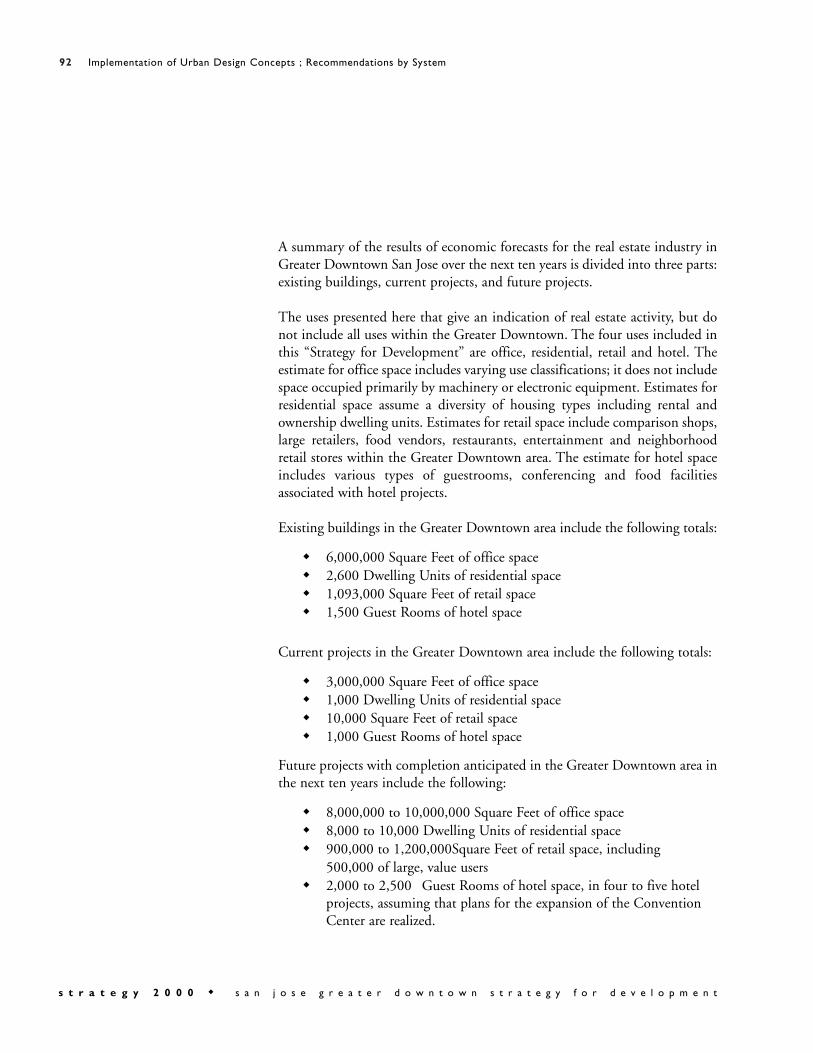
A summary of the results of economic forecasts for the real estate industry inGreater Downtown San Jose over the next ten years is divided into three parts:existing buildings, current projects, and future projects.
The uses presented here that give an indication of real estate activity, but donot include all uses within the Greater Downtown. The four uses included inthis “Strategy for Development” are office, residential, retail and hotel. Theestimate for office space includes varying use classifications; it does not includespace occupied primarily by machinery or electronic equipment. Estimates forresidential space assume a diversity of housing types including rental andownership dwelling units. Estimates for retail space include comparison shops,large retailers, food vendors, restaurants, entertainment and neighborhoodretail stores within the Greater Downtown area. The estimate for hotel spaceincludes various types of guestrooms, conferencing and food facilitiesassociated with hotel projects.
Existing buildings in the Greater Downtown area include the following totals:
6,000,000 Square Feet of office space2,600 Dwelling Units of residential space 1,093,000 Square Feet of retail space1,500 Guest Rooms of hotel space
Current projects in the Greater Downtown area include the following totals:
3,000,000 Square Feet of office space1,000 Dwelling Units of residential space 10,000 Square Feet of retail space1,000 Guest Rooms of hotel space
Future projects with completion anticipated in the Greater Downtown area inthe next ten years include the following:
8,000,000 to 10,000,000 Square Feet of office space8,000 to 10,000 Dwelling Units of residential space 900,000 to 1,200,000Square Feet of retail space, including 500,000 of large, value users2,000 to 2,500 Guest Rooms of hotel space, in four to five hotel projects, assuming that plans for the expansion of the Convention Center are realized.

Economic Analysis
A. Office SpaceProjections for future office space are based on a number of factors,including:
1. A Strong Economy: The Santa Clara Valley is the center of the high technology industry and downtown is the logical location as a major employment center for the industry.
2. A Low Vacancy Factor: The vacancy factor for office space is less than2% for the inventory of 40 million square feet in the South Bay. It should be roughly 5%.
3. Lack of Space for Expansion: New development is constrained by lack of space to build. Either existing low rise buildings will be replaced by towers, or new areas for office, not previously considered, will be pursued (new downtown locations fit this category).
4. Major Employers are Seeking Large Blocks of Space: Several large users are seeking space. Examples include: SUN Microsystems, 1 M sq. ft.; Apple, 750,000 sq. ft.; Palm, 1.6 M sq. ft.
5. The Downtown Environment is Attractive to High Tech Office Workers: Downtown office towers offer prestige and amenities; downtown offers a 24/7 environment that is attractive to employees, particularly to younger employees.
6. ULI Panel: In June, 2000 panel members indicated they learned fromtheir interviews that the amount of office space in downtown could be“doubled” (now it is 6 million sq. ft. of Class A office space plus 3 million in development) and not “to think too small.”
7. Physical Constraints: We presume that there are sites for the projected square footage that might be built, given the potential availability of sites and possible physical constraints.
8. “Strategy 2000”: We believe that the demand for downtown office space will be there if sites are provided, particularly in the context of the downtown environment that will be created with the implementation of the “Greater Downtown Strategy for Development - Strategy 2000.”

B. Residential DevelopmentProjections for future residential development are based on the followingfactors:
1. Demand is High: Simply stated, demand is high and supply is low inthe Greater Downtown. Therefore, the Greater Downtown is seen as having high demand for a new residential neighborhood.
2. Demographic Trends Support Downtown: Mature households without children are buying down (and traveling), single working women, young professionals.
3. Other Downtowns: San Diego and Oakland are town cities that are planning large new production goals for housing in their downtown.
4. Physical Constraints: Available sites and other physical constraints may limit how many new units ultimately will be produced.
C. Retail SpaceProjections for future retail space are based on the following analysis:
Based on the recent interviews of developers with national experience indowntown retail and mixed use projects, the consensus was that anadditional 300,000 to 500,000 leasable square feet of new retail should bedeveloped in the Greater Downtown. In their judgment the retail demandexists, provided that a downtown district is properly created.
D. Hotel SpaceProjections for future hotel space are based on a number of factors,including:
1. Employment Growth: Demand is created with future employment growth in the Greater Downtown.
2. Convention Center Expansion: Demand is created with the expansionof the Convention Center.
3. High Occupancy Levels and Room Rates: Currently, high occupancylevels and high room rates spur demand for new hotel development.
4. Boutique Hotels: Boutique hotels are a new opportunity that are found in other downtowns. An example is the Montgomery Hotel in downtown San Jose.

Greater Downtown San JoseProjected Development - 2000 to 2010
Office SFExisting 6,000,000Current 3,000,000Future 8,000,000 to 10,000,000
Total 17,000,000 to 19,000,000
Housing # of Dwelling Units SF/D.U. SFExisting 2,600 1,000 2,600,000Current 1,000 1,000 1,000,000Future 8,000 to 10,000 1,000 8,000,000 to 10,000,000
Total 11,600 to 13,600 11,600,000 to 13,600,000
Retail &Entertainment SF
Existing 557,000 – Shops & Services 536,000 –Restaurant/Entertainment
Total 1,093,000Future 500,000 – Large Value Stores
400,000 to 700,000 – Allother
Total 1,993,000 to 2,293,000
Hotel Guest Rooms SF/Room SFExisting 1,500 750 1,125,000Current 1,000 750 750,000Future 2,000 to 2,500 750 1,500,000 to 1,875,000
Total 4,500 to 5,000 3,375,000 to 3,750,000
Total SF 33,968,000 to 38,643,000
Source: Keyser Marston Associates, Inc.

3.1.6 Human Services
The future development anticipated in Greater Downtown San Joseis substantial and adequate services are an intrinsic component to successfuldevelopment. Service provisions should be determined on the basis of theprojected development proposed in this document.
Strategies
a. Study the impact of the proposed development on at least the following existing human services and incorporate findings into anintegrated future plan for service provision:
Educational services; schoolsHealth; hospitals, clinics, and emergency health servicesPublic safety; fire and policeCommunity centersReligious facilitiesChild and daycare facilitiesFacilities for non-profit service providers
b. Solidify existing partnerships between the city agencies and the school districts. Coordinate school facility planning concurrent with projected population needs.
c. Identify additional services that might need to be met and proposean approach for meeting them.
d. Coordinate with plans of the Strong Neighborhood Initiatives (SNI) that are being developed concurrently with this “Strategy forDevelopment.”

The Recommendations by Area section of the “Strategy 2000”document describes how the Urban Design Concepts are applied inparticular districts of the Greater Downtown. The Recommendations byArea apply to geographically specific zones of the Greater Downtown ratherthan to downtown as a whole, as in the Recommendations by System. Thearea boundaries are purposefully fluid to allow for a smooth transitionbetween neighborhoods and linkage to adjacent areas as well as not toprohibit development opportunities at the area edges.
Each area description consists of a narrative “Postcard from 2010,”diagrams, illustrations, strategies, and actions. The “postcard” sets forth apotential vision, building on each area’s strengths and distinctive qualitiesand expanding on existing potentials. The sections conclude with strategiesand actions by which each area’s future can be realized as a successful urbanplace.
.

Postcard from 2010“Plaza de Cesar Chavez is the living room of the city - a place of
welcome and comfort on a daily basis and a place of gathering incelebration. As the downtown has grown the Plaza’s role as a lively,accessible civic space for all has been retained and the park has become anoasis with mature trees and a popular fountain within a rich urban context.New development contributes to the Plaza’s vitality. Hotel, residential, officeand museum uses fill the blocks surrounding the Plaza and improve thesense of a great public room framed by distinguished buildings of substantialheights. Active ground floor uses with shops, restaurants, and culturalactivities stimulate use and enjoyment, and allow for interaction betweenindoor and outdoor spaces. New paseos and streets delineate smaller blocksopening onto the newly widened Plaza and encouraging pedestrian use.Plaza de Cesar Chavez is a true common ground in the city, an iconic spacewhere residents, visitors and workers meet and enjoy the delights of SanJose’s diverse culture and sublime climate.”

Strategies
a. Intensify the building envelope surrounding the Plaza, by promoting the development of distinctive office, cultural and hotelstructures on available Plaza frontages.

b. Ensure that ground floor uses of new buildings are accessible to thepublic and create a lively interface with activities in the Plaza.
c. Avoid parking on the exterior faces of ground floor buildings. d. Encourage east-west pedestrian connectivity through the Plaza by
articulating existing connections and by creating new ones.e. Use the Tech Museum of Innovation expansion as a symbol of San
Jose’s technology and as an element related to the Plaza. f. Study the possibility of placing parking under the Plaza minimizing
injury or removal of mature trees, fountain, and without hinderingpedestrian access to the Plaza. Access to any parking garage underthe Plaza should be through Park Avenue and not along Market Street.
g. Consider redeveloping some of the parcels in Park Center Plaza inorder to create smaller blocks that promote a pedestrian environment. Taller buildings should be encouraged in order to help frame and define Plaza de Cesar Chavez.
h. Enhance Plaza de Cesar Chavez’s role as a show case public space ofSan Jose with a comprehensive year-round schedule of public eventsand public art.
i. Study widening the Plaza to increase pedestrian access and to smooth pedestrian connections. Consider removing a lane of trafficon each side of the park.
.

Actions by Area Time System
Cesar Chavez
Cur
rent
/In
Pro
cess
Pro
ject
s
near
200
0-20
03
mid
200
4-20
06
long
200
7-20
10
Publ
ic R
ealm
Urb
an F
orm
and
Bui
ldin
gs
Tra
nspo
rtat
ion
& A
cces
s
His
tori
c A
sset
s
Eco
nom
ic C
ondi
tions
Development Related Actions
1
Develop available parcels around the Plaza, ensuring a mix of office, housing, hotel, visitor services, cultural and educational uses, with active ground floor uses facing the Plaza. Insist on high quality architectural design.
2 Study Tech Museum expansion alternatives on adjacent sites.
3Create new mid-block pedestrian passages on the west side of the Plaza and articulate and continue Paseo de San Antonio through Park Avenue.
4 Fairmont Hotel Annex - Complete construction.
Public Improvement Actions
5 Widen Plaza de Cesar Chavez by eliminating one traffic lane on each side of the Park, consistent with traffic lanes and capacities to the north and south.
6Articulate Paseo de San Antonio as an entrance to the Plaza, and from the Plaza to the downtown.
7
Improve facilities to support a year-round program of public gatherings and events – coordinating indoor and outdoor programs, easing set up and drop off, facilitating selective street closings for events and providing water, power and lighting.
8Study potential of parking beneath part of Plaza de Cesar Chavez, maintaining pedestrian connection to surrounding neighborhoods and minimizing impact to mature trees.
Administrative Coordination / Actions
9Coordinate with the "Historical Design and Adaptive Use Study and Guidelines" to integrate historic buildings with new development.
10 Coordinate with "Downtown Signage Intensification Program".
11 Coordinate with "Revised Downtown Streetscape Master Plan".
12 Coordinate with Public Works to implement streetscape plans.
13Adopt and coordinate with a new citywide design guidelines which highlight pedestrian experience and public realm.
14Implement a "Downtown Landscape Plan" with the goal of continuing the canopy of shade trees so essential in a hot city, as well as expanded greening in streets, medians, and planters.
15Coordinate with the Office of Cultural Affairs on Plaza de Cesar Chavez events and activities.

Postcard from 2010“St. James Park enjoys a new vitality as a safe, high-density, mixed-
income residential neighborhood conveniently located near downtownservices. Restored historic structures line the east and west sides of a restoredand revitalized St. James Park. Significant new residential structures of 10to 15 stories bring new life to the neighborhood and embrace the park as afront yard filled with families, children and a diversity of residents. Buildingswith continuous street edges, park-facing front doors and “eyes on thestreet” create a comfortable and pedestrian-friendly environment. Historicstructures are being revitalized through adaptive reuse to accommodatecommunity and cultural functions. The St. James new neighborhoodsurrounds the Park’s green oasis located within a pedestrian network linkedto the Greater Downtown districts.”

Strategies
a. Frame the park on available sites with tall, high-density, mixed-income residential development while respecting the existing historical buildings. The tallest buildings should surround the Parkand step down in height as they are developed away from the Parkto create a transition to the surrounding lower scaled neighborhoods. New development should be compatible with – while not directly imitating - the historic character of the district.At least 20% of new residential development shall be affordable overall.
b. Recognize that St. James Square is the heart of a historic district. Preserve the historic buildings that front the park. Revitalize underused or deteriorating historic assets with new functions through adaptive reuse.

c. Study potential uses for the 1st Church of Christ Scientist, building and how it fits into St. James Park environment.
d. Study the possibility of amending the “St. James Square Historic District Design Guidelines” (June 1989) to increase the 70 foot building height limit on parcels that front the Park.
e. Orient new development to create a strong pedestrian presence at the street: include primary entrances that face the Park, avoid blankwalls and minimize the size and number of vehicular entrances. Where appropriate, include some residential-serving retail or restaurant uses at the street level, with the south side of the Park asthe preferred location.
f. Preserve and restore Frederick Law Olmsted inspired historic Park.g. Explore relocating the existing Senior Center to a building adjacent
to the Park.h. Link St. James Park to the paseo network to create strong pedestrian
connections between St. James Park, 1st and 2nd streets, the Mitchell Block, and the San Pedro Square area.
i. Study the possibility of placing parking under the Park minimizinginjury and removal of designated historic and mature trees, and without hindering pedestrian access.

Actions by Area Time System
St. James Park
Cur
rent
/In
Pro
cess
Pro
ject
s
near
200
0-20
03
mid
200
4-20
06
long
200
7-20
10
Publ
ic R
ealm
Urb
an F
orm
and
Bui
ldin
gs
Tra
nspo
rtat
ion
& A
cces
s
His
tori
c A
sset
s
Eco
nom
ic C
ondi
tions
Development Related Actions1 Develop a new paseo through the Mitchell block development.
2
Aggressively promote, facilitate, and construct residential development, with an emphasis on high-density housing, developed on all available adjacent sites. Housing should include rental and ownership, mixed-income, low and very low income, non-profit, and senior-oriented housing.
3Replace the existing Senior Center with a high-quality facility in a development adjacent to St. James Park. Return the current Senior Center site to park use.
4Study potential uses for the 1st Church of Christ Scientist building and how it fits into the St. James Park environment.
5 Complete planning site north of St. James Park at 2nd and St. James Streets.
6Proceed with ULI recommended Mitchell Block development. Ensure that northeast edge orients to the St. James Park.
Public Improvement Actions
7Program day and night celebrations that make effective use of both interior and exterior event venues in and around St. James Park.
8Rehabilitate and renovate St. James Park. Ensure that infrastructure is provided to support events in the Park.
9Develop public art programs and cultural trails that reinforce distinctive qualitites of the St. James Area.
10Study potential of parking beneath part of St. James Park, maintaining pedestrian connection to surrounding neighborhoods and minimizing impact to mature trees.
Administrative Coordination / Actions
11Review City Council policy concerning St. James Square Historic District Design Guidelines. Update to be consistent with "Strategy for Development."
12Coordinate with the "Design and Adaptive Use Guidelines" to integrate historic buildings with new development.
13 Coordinate with "Downtown Signage Intensification Program."
14 Coordinate with "Revised Downtown Streetscape Master Plan."
15Coordinate with the departments of Public Works, and Streets and Traffic to implement streetscape plans.
16Adopt new citywide design guidelines which highlight pedestrian experience and public realm.

Postcard from 2010“The area surrounding 1st and 2nd Streets is one of the most
important components of historic San Jose’s shopping district, bustling withsmall shops and local businesses. Bounded by the Mitchell block complex tothe North, the new development at Repertory Plaza to the south, the PostStreet district to the west and the Fountain Alley Historic District to theeast, this downtown shopping corridor boasts some of the region’s mostdistinctive retailers. Downtown workers, convention goers and localresidents enliven the street during the day by shopping at specialty stores,eating lunch, and running errands. Residents, visitors and the after-workcrowd animate the area at night – window shopping, and dining at one ofthe area’s many fabulous restaurants before attending a show. Historicbuildings along 1st and 2nd, Post Street and in the Fountain Alley HistoricDistrict define the scale of the new development and maintain San Jose’swalkable historic fabric. Shade trees, building and street lighting, signageand other streetscape amenities contribute to the pedestrian scale andrichness of the urban experience.
The district is easily accessible by transit and is linked to the University, theConvention Center and Almaden Boulevard businesses by a network ofpaseos and pedestrian oriented streetscapes.”

Strategies
a. Attract new shoppers with major new retail investment on the Mitchell Block and the site at San Fernando St. between 2nd and 3rd streets.
b. Intensify ground floor retail use along 1st and 2nd Streets to continue the shopping experience from the development north of

Repertory Plaza to the Mitchell Block. Encourage residential and commercial uses above retail. Consider an entertainment/retail development that faces Repertory Plaza.
c. Continue streetscape improvements at streets and paseos with streetand building lighting, public art, street furniture, markers, banners,and water features.
d. Strengthen the pedestrian realm with new and improved connections to the paseo network in tandem with new development.
e. Develop flexible adaptive reuse guidelines for historic structures andcompatibility guidelines for new development in the areas with historic buildings.
f. Enhance the identity of the historic fabric with complementary adaptive reuse programs.
g. Link the 1st and 2nd Street area to the Greater Downtown via transit on Santa Clara and San Fernando streets..
h. Develop a new public plaza at Repertory Square equipped with infrastructure for public performances and events.
i. Keep light rail tracks, in general, at street level and work with cars that are easily accessible. Maintain walkability on street and easilyaccessible cars.
j. Develop paseos to provide easy access between 1st and 2nd streets.

Actions by Area Time System
1st and 2nd Streets
Cur
rent
/In
Pro
cess
Pro
ject
s
near
200
0-20
03
mid
200
4-20
06
long
200
7-20
10
Publ
ic R
ealm
Urb
an F
orm
and
Bui
ldin
gs
Tra
nspo
rtat
ion
& A
cces
s
His
tori
c A
sset
s
Eco
nom
ic C
ondi
tions
Development Related Actions
1Proceed with retail and mixed use development along 1st and 2nd streets, including:
1aMitchell Block with large destination retailers at street level and housing above. Development should have a presence on Santa Clara Street and pedestrian access to 1st and 2nd streets, and to St. James Park.
1bBlock bounded by San Fernando, 2nd and 3rd streets, and the Paseo San Antonio with entertainment/retail tenants.
1cInfill and rehabilitation with adaptive reuse of existing structures between St. John and San Fernando streets.
2Develop parcels on 2nd St., west side, next to Fountain Alley. Maintain Alley connection between 1st and 2nd streets.
3Continue developing parcel on 2nd St., east side, next to Fountain Alley. Maintain Alley connection between 2nd and 3rd streets.
4Redesign and upgrade façade of Pavilion building facing the Paseo San Antonio to accommodate retail uses. Coordinate with redesign of entire Paseo.
5Complete design and construction of office building with street level retail on site bounded by San Fernando Street, 1st and 2nd streets and Pavilion building.
6Site bounded by San Carlos St., Market St., 1st Street and the Fairmount Annex; begin planning mixed-use development.
7 Century Center project - Finish construction.
8 Fairmont Hotel Annex - Complete construction.
9 Fountain Alley site - Continue developer selection and agreement.
10 Mitchell properties - Continue developer selection and agreement.
11 Zanotto Block - Continue developer selection and agreement.
12Develop a new paseo through the improvement of Post Street and Lightstone Alley.

Actions by Area Time System
1st and 2nd Streets
Cur
rent
/In
Pro
cess
Pro
ject
s
near
200
0-20
03
mid
200
4-20
06
long
200
7-20
10
Publ
ic R
ealm
Urb
an F
orm
and
Bui
ldin
gs
Tra
nspo
rtat
ion
& A
cces
s
His
tori
c A
sset
s
Eco
nom
ic C
ondi
tions
Public Improvement Actions
13Provide a new paseo- "Paseo San Pedro"- that links 1st Street, Mitchell Block, and San Pedro Square.
14Develop Repertory Plaza as an outdoor venue with infrastructure (lighting, power, etc.) to support events.
15Design and develop Paseo San Antonio as a link between Plaza de Cesar Chavez, San Jose State campus and the downtown shopping areas. Incorporate public art, lighting, signage and seating in the design.
16Implement a "Downtown Landscape Plan" with the goal of continuing the canopy of shade trees so essential in a hot city, as well as expanded greening in streets, medians, and planters.
Administrative Coordination / Actions
17Coordinate with the "Design and Adaptive Use Guidelines" to integrate historic buildings with new development.
18 Coordinate with "Downtown Signage Intensification Program."
19 Coordinate with "Revised Downtown Streetscape Master Plan."
20Coordinate with the departments of Public Works, and Streets and Traffic to implement streetscape plans.
21 Study expanding the Downtown Area Shuttle (DASH) for a free transit zone.

Postcard from 2010“As downtown San Jose comes into its own as a vital, bustling, day
and night gathering point for a remarkable U.S city, Santa Clara Street iscentral to its success and lively new image. With a mix of new and historictall buildings and vistas to the hills in the east, Santa Clara is clearly SanJose’s “Main Street”. With the completion of new office buildings, the CivicPlaza, mixed-use retail projects on 1st and 2nd streets and the possibility ofLight Rail Transit, Santa Clara is the energetic urban hub of a reneweddowntown offering food, entertainment, shopping, and the best in urbanliving and working environments.
“A zone of high-density office and retail development along Santa Claralinks the Arena to the Civic Center Plaza. Fuelled by the activity at SanPedro Square, with its weekly Farmers Market and restaurant row, the 1stand 2nd Street Historic Commercial District and the food andentertainment area around Post Street, Santa Clara is the GreaterDowntown’s exciting public concourse. Streetscape improvements andtransit infrastructure help to extend this vitality beyond the GreaterDowntown to the east and west.”

Strategies
a. Strengthen the connections to San Pedro Square, Post Street, the 1st and 2nd Street Historic Commercial District, and the new Civic Center through streetscape improvements, transit and signage.
b. Intensify ground floor retail use between Market and 3rd streets to continue the shopping experience from the mixed-use project north of Repertory Plaza to the Mitchell Block.

c. Identify Santa Clara as the “Main Street” of San Jose that links theDiridon/Arena area, the Civic Center and the Greater Downtown to the neighborhoods beyond, including light rail and possibly BART.
d. Ensure that Santa Clara Street becomes an active, bustling, urban, transit boulevard by focusing development with active ground flooruses towards the street.
e. Link the active nodes around the Civic Center and the Arena, by continuous office and retail development.
f. Encourage the development of dining/entertainment uses at SantaClara and the Arena. This area should provide a lively, pedestrian oriented street experience that ties into the rest of the Diridon area.
g. Ensure that ground floor uses of new buildings are accessible to thepublic and create a lively interface with the street. Parking on the ground floor should be strongly discouraged and parking entrancesshould be minimized.
h. Design a smooth passage under the freeway with the help of streetscape elements and an art program to offer pleasant pedestrianand vehicular access under Guadalupe Freeway.
i. Develop light rail on Santa Clara Street that connects to the new east-west Santa Clara light rail line and goes at least as far west as Almaden Boulevard.

Actions by Area Time System
Santa Clara
Cur
rent
/In
Pro
cess
Pro
ject
s
near
200
0-20
03
mid
200
4-20
06
long
200
7-20
10
Publ
ic R
ealm
Urb
an F
orm
and
Bui
ldin
gs
Tra
nspo
rtat
ion
& A
cces
s
His
tori
c A
sset
s
Eco
nom
ic C
ondi
tions
Development Related Actions1 Pursue ULI – recommended retail/mixed-use development.
2Expand retail from San Pedro to Civic Center and give the Mitchell Block development a presence on Santa Clara.
3 Ensure retail use along the ground floor for all new development.
4Develop design for lower floors and building facades of 55 S. Market, which could incorporate public art or lighting installation.
5 Continue planning and finish construction of all current projects including:
6 1 South Market - Continue planning
7 160 W. Santa Clara - Continue planning
8 Hotel at 87 & Santa Clara Street - Continue planning
9 Mitchell properties - Continue RFQ process
10 Opus tower - Finish construction
Public Improvement Actions
11Develop a streetscape plan for Santa Clara that integrates all modes of transit and walkability.
12Coordinate transit -BART, LRT, and buses (design and implementation) with those on San Fernando Street.
13Create and implement "Pedestrian Plan" for the downtown, which include new citywide design guidelines that hightlight the public realm and pedestrian experience.
18Implement a "Downtown Landscape Plan" with the goal of continuing the canopy of shade trees so essential in a hot city, as well as expanded greening in streets, medians, and planters.
19Develop a new plaza on the west side of San Pedro st., between Santa Clara and St John streets, providing a gathering place and a forecourt to new housing /retail development.
20Develop a new paseo through the Mitchell block from Santa Clara St. to both 1st and Market streets.
21Develop a new paseo through the improvement of Post Street and Lightstone Alley.
22Develop public art programs and cultural trails that reinforce distinctive qualitites of various districts.

Actions by Area Time System
Santa Clara
Cur
rent
/In
Pro
cess
Pro
ject
s
near
200
0-20
03
mid
200
4-20
06
long
200
7-20
10
Publ
ic R
ealm
Urb
an F
orm
and
Bui
ldin
gs
Tra
nspo
rtat
ion
& A
cces
s
His
tori
c A
sset
s
Eco
nom
ic C
ondi
tions
Administrative Coordination / Actions
23Continue studying requirements of colocation facilities and relationship to the Metropolitan Area Exchange. Develop design guidelines based on findings.
24 Initiate parking study for Mitchell Block.
25 Coordinate with the citywide "Sign Intensification Area" study.
26 Coordinate with "Revised Downtown Streetscape Master Plan."
27Coordinate with streetscape program to reinforce Santa Clara, San Fernando, Park, San Carlos, and St. John streets as east-west landscape connections to Guadalupe River and beyond.
28Develop and implement an improvement plan for the Post Street area including a public art component.

Postcard from 2010“Known for its diverse restaurants and colorful farmers’ market, San
Pedro Square is a pedestrian oriented historic area. People stroll along widesidewalks beneath large shade trees stopping at restaurants for a meal beforea performance on the square. On market days, residents purchase fresh fruitfor a snack to enjoy in nearby St. James Park and at the Fallon-Peralta Adobehistoric sites. Situated off Santa Clara Street, San Pedro Square attracts anumber of people who take transit or park their cars in the adjacent garageto catch a game at the Arena, or shop in the retail district along 1st and 2ndstreets.”


Strategies
a. Promote San Pedro Square as a food and entertainment district linked to the Arena and 1st and 2nd Streets shopping district.
b. Create strong pedestrian links to Santa Clara St., the Mitchell block, St. James Square and the Peralta Adobe and Fallon House. Coordinate street festivals with Fallon House events. Develop a paseo that links to the Mitchell Block, and emphasize existing onesto Terraine Street.
c. Consider an interactive art installation along the garage facade on San Pedro Square.
d. Program arts and cultural events on San Pedro Square which aims to increase pedestrian traffic 7 days a week, through the day into theevening.
e. Consider programming food festivals and special events where restaurant activity spills out onto the whole street.

Actions by Area Time System
San Pedro Square
Cur
rent
/In
Pro
cess
Pro
ject
s
near
200
0-20
03
mid
200
4-20
06
long
200
7-20
10
Publ
ic R
ealm
Urb
an F
orm
and
Bui
ldin
gs
Tra
nspo
rtat
ion
& A
cces
s
His
tori
c A
sset
s
Eco
nom
ic C
ondi
tions
Development Related Actions
1Create a pedestrian alley -“Paseo San Pedro”- south of the garage to Market Street linking San Pedro Square, the garage, and new retail development on the Mitchell Block.
2Facilitate mixed-use development, including a small hotel, on both sides of San Pedro St. north of St. John; extend restaurant and market uses to this block over time.
3Manage garage entrances so that the San Pedro St. entrances can be closed down during busy hours.
4Create a continuous frontage of retail on the street by filling in the remaining parcels.
5Facilitate development of housing over complementary retail on surface parking lot west of San Pedro Square.
6 Opus tower - Finish construction .
7Investigate oportunities for linking and expanding the Peralta Adobe and Fallon House historic sites.
Public Infrastructure Actions
8
Create a square on the surface parking parcels opposite the garage using building setbacks. The square should be emphasized using landscape elements, lighting fixtures, paving patterns, public seating and active uses around it.
9Consider lightweight but permanent market stalls that fold attractively onto the garage facade.
10Install adequate lighting on the street and the facades to make the area safe, comfortable and attractive at night.
11 Build sidewalk along St. John Street, north of the garage.
12 Improve crossings of St. John and Market streets.
13 Consider additional market days.
14Implement a "Downtown Landscape Plan" with the goal of continuing the canopy of shade trees so essential in a hot city, as well as expanded greening in streets, medians, and planters.
15Develop a new green in front of the Fallon House, providing a focus for new development around San Pedro Square, and featuring interpretive programming celebrating the site’s history.
16Develop a new plaza on the west side of San Pedro street, between Santa Clara and St. John streets, providing a gathering place and a forecourt to new housing /retail development.
17Program day and night celebrations that make effective use of both interior and exterior event venues in the San Pedro Square area.

Actions by Area Time System
San Pedro Square
Cur
rent
/In
Pro
cess
Pro
ject
s
near
200
0-20
03
mid
200
4-20
06
long
200
7-20
10
Publ
ic R
ealm
Urb
an F
orm
and
Bui
ldin
gs
Tra
nspo
rtat
ion
& A
cces
s
His
tori
c A
sset
s
Eco
nom
ic C
ondi
tions
18Invest in event infrastructure for the San Pedro area's public spaces, including stages, lighting, and power, to make the public realm more ‘event ready’.
19Develop public art programs and cultural trails that reinforce distinctive qualitites of the San Pedro area.
20Construct new park and interpretive exhibits on the grounds of the Peralta Adobe and Fallon house.
Administrative Coordination / Actions21 Coordinate with the citywide "Sign Intensification Area Study."
22Coordinate with the "Design and Adaptive Use Guidelines" to integrate historic buildings with new development.
23Coordinate with "Revised Downtown Streetscape Master Plan," "Landscape Plan," and "Pedestrian Plan."
24Coordinate with the departments of Public Works, and Streets and Traffic to implement streetscape plans.
25Coordinate with the "Design and Adaptive Use Guidelines" to integrate historic buildings with new development.
26Coordinate with the Office of Cultural Affairs for public arts, events, and activities.

Postcard from 2010“San Fernando Street is the Civic Boulevard of San Jose which links
the public uses from Diridon Station to Civic Center Plaza and San JoseState University. San Fernando St. links the traditional downtown centerwith the exciting new development west of the Guadalupe River,encouraging a walk or a pleasant drive. Major transit stations, bus stops, and

BART stations bolster pedestrian activity along San Fernando Street creatinga vibrant street with successful shops and businesses. Wide sidewalks, acanopy of shade trees, light fixtures and other attractive streetscape elementsrepresent a commitment to the community through long-term investmentin public infrastructure.”

Strategies
a. Knit together the Diridon area, the river greenways, John McEneryPark, entrances to Almaden Blvd. and Plaza de Cesar Chavez, St. Joseph Cathedral, San Jose MOA, the Historic Fountain Alley District, the Civic Center and the University, with San Fernando Street as a green corridor with wide sidewalks and large canopy trees.
b. Complement Santa Clara Street’s emphasis on light rail by supporting pedestrians, bus and BART on San Fernando Street as amajor east-west connection across the Greater Downtown. Hubs ofactivity should be connected to the pedestrian network and transit.
c. Realign San Fernando to terminate at Diridon Station. The DiridonStation green will provide a 2-block linear park terminus to San Fernando Street and link the station to the Guadalupe River Park. The green will also act as a catalyst for surrounding development.
d. Design a smooth passage under the freeway with the help of streetscape elements and an art program to offer pleasant pedestrianand vehicular access under the Guadalupe Freeway.
e. Support retail on both sides of San Fernando Street between 1st and3rd streets including new development.
f. Design a strong link between the Civic Center and the University that also creates an imagable eastern gateway into the Greater Downtown.

Actions by Area Time System
San Fernando Street
Cur
rent
/In
Pro
cess
Pro
ject
s
near
200
0-20
03
mid
200
4-20
06
long
200
7-20
10
Publ
ic R
ealm
Urb
an F
orm
and
Bui
ldin
gs
Tra
nspo
rtat
ion
& A
cces
s
His
tori
c A
sset
s
Eco
nom
ic C
ondi
tions
Development Related Actions
1Develop blocks bounded by San Fernando, 1st, 2nd 3rd Streets, and Paseo San Antonio with a major retail presence on San Fernando Street and with housing/office on upper floors.
2Facilitate development of the water company property fronting both San Fernando Street and the river.
3 Develop infill retail between 1st and 3rd streets on the north side.
4 101 San Fernando - Finish construction
5Proceed with planning and implementation of the ULI-recommended retail/mixed use development.
Public Infrastructure Actions
6Design San Fernando Street as a green corridor with wide sidewalks, large canopy trees, benches and appropriate lighting.
7Realign San Fernando to the west of the Guadalupe River to focus on the Diridon Station (see option 1-3 - Diridon Station Area).
8Develop San Fernando, in conjunction with Santa Clara, as major east-west transit and pedestrian streets.
9Ensure a comfortable and pleasant pedestrian access under the freeway. Consider possibility of an arts program to achieve that in tandem with St. John, Santa Clara, Park streets and Almaden Blvd.
10Design a gateway signifying entry into downtown and linking the City Center to San Jose State University.
11 Install signage at transit nodes to direct people to major destinations.
12Develop and implement a streetscape program reinforcing Santa Clara, San Fernando, Park, San Carlos, and St. John streets as east-west landscape connections to Guadalupe River and beyond.
13Link San Fernando Street, a major pedestrian thoroughfare, to the Civic Plaza, Cesar Chavez Plaza and Diridon Station with a double row of trees and wide sidewalks wherever possible.
14Implement a "Downtown Landscape Plan" with the goal of continuing the canopy of shade trees so essential in a hot city, as well as expanded greening in streets, medians, and planters.
15Adopt new citywide design guidelines which highlight pedestrian experience and public realm.

Actions by Area Time System
San Fernando Street
Cur
rent
/In
Pro
cess
Pro
ject
s
near
200
0-20
03
mid
200
4-20
06
long
200
7-20
10
Publ
ic R
ealm
Urb
an F
orm
and
Bui
ldin
gs
Tra
nspo
rtat
ion
& A
cces
s
His
tori
c A
sset
s
Eco
nom
ic C
ondi
tions
16Develop public art programs and cultural trails that reinforce distinctive qualities of San Fernando Street area.
17Design a new expanded Diridon Green as the terminus of San Fernando Street (see option 1-3 - Diridon Station Area).
18Design comfortable bus shelters and prominent entries for BART, in accordance with the image (green/civic/public/pedestrian) of the street.
19Federal Office - Continue conceptual planning relocation to Almaden and Post Streets.
Administration Coordination / Actions20 Coordinate with the citywide "Sign Intensification Area" study.
21 Coordinate with "Revised Downtown Streetscape Master Plan."
22 Coordinate with VTA "Downtown San Jose Transit Streets Network"
23 Coordinate with Public Works to implement streetscape plans.24 Study expanding the Downtown Area Shuttle (DASH) for a free transit zone.


Postcard from 2010“Building on the synergies of the Convention Center and San Jose
State University, the SoFA area is a unique blend of arts, technology andentertainment retail. Stretching along the southern end of 1st Street, SoFAis bounded by Fox California Theater/Opera San Jose to the north, andGore Park/Plaza de Pobladores to the south. The area enjoys easy freewayaccess from I-280 to the south, and easy transit access from the downtownlight rail loop to the north. The easy connection to San Jose State Universityvia San Carlos St. allows for a steady stream of pedestrians venturing fromcampus at lunch and at the end of the day. Unique art installations alongMarket Street soften the facade of the Convention Center while adding tothe area’s funky charm. During the day, convention goers and touristsbrowse in art galleries, check their email at the cyber cafes and soak up thesun at Gore Park/Plaza de Pobladores. At night, SoFA becomes anconverging point for technophiles, music bands and Opera fans.”

Strategies
a. Develop an entertainment district stretching from 1st and San Carlos Streets to Gore Park/ Plaza de Pobladores.
b. Study and plan for expansion of the Convention Center to accommodate larger conferences and exhibits.
c. Design strong links to the University, Convention Center, Plaza deCesar Chavez and adjacent hotels through the use of effective site planning for new development projects, streetscape elements, and public art.
d. Design Gore Park/Plaza de Pobladores as the southern gateway intothe Greater Downtown surrounded by new high quality development.
e. Support and expand existing programs for arts, cultural and technology events along SoFA’s public spaces.
f. Encourage loft housing and live-work development to strengthen the SoFA neighborhood and provide “eyes on the street” throughout the day.
g. Cap store size and/or limit large floor-plate tenants to maintain small scale grain and a diversity of tenants.
h. Consider public art installations at key locations such as Market Street and at Gore Park/Plaza de Pobladores, to strengthen the unique characteristics of the area.
i. Build upon existing street improvements that give SoFA a unique character.
j. Create paseos between 1st and 2nd streets to link to paseos planned in the Fox California Theatre/Opera San Jose project.
k. Develop a Strategic Development Plan for the SoFA area which coordinates development on San Carlos including the Conventionexpansion and links from San Jose State University.

Actions by Area Time System
SoFA / Convention Center
Cur
rent
/In
Pro
cess
Pro
ject
s
near
200
0-20
03
mid
200
4-20
06
long
200
7-20
10
Publ
ic R
ealm
Urb
an F
orm
and
Bui
ldin
gs
Tra
nspo
rtat
ion
& A
cces
s
His
tori
c A
sset
s
Eco
nom
ic C
ondi
tions
Development Related Actions
1Improve Convention Center facades: orient expansion toward the street, minimize the effect of blank walls by creating wall openings, breaking down the scale and/ or enhancing with public art installations.
2
Consider replacing current library (when vacated), on San Carlos at Almaden, with a semi-enclosed events space covering the entire plaza. Aim for a design that maintains both an edge to San Carlos St. and a light transparent feel.
3 Study sharing Convention Center parking, especially in the evening.
4Utilize parcel southwest of 2nd and San Carlos St. and an extended San Carlos promenade in tandem to make the connection to the University. Articulate corner, with form and use, to define the end of the promenade.
5Orient restaurant, entertainment uses toward San Salvador St. between Market and 1st streets, to create a visible and engaging entry to SoFA from Convention Center expansion and new hotel.
6Proceed with Convention Center expansion and new hotel at Balbach and Market Streets.
7 Fox California Theatre - Complete design and construction.
8 Notre Dame High School at Reed and 2nd Streets - Complete planning.
9 Plaza de Almaden - Continue conceptual planning.
10 Sobrato Tower - Complete construction.
Public Improvement Actions
11Extend the planning boundary of SoFA, south to Gore Park/Plaza de Pobladores and Reed Street. Define the space with development along the street frontages surrounding it.
12Situate a paseo link between 1st and 2nd streets to align with the Fox California Theatre / Opera San Jose.
13Design and install prominent and attractive transit stops for the SoFA area incorporating public art relating to the area.
14Develop and implement a "Downtown Landscape Plan" with the goal of continuing the canopy of shade trees so essential in a hot city, as well as expanded greening in streets, medians, and planters.
15Continue developing "Design and Adaptive Use Guidelines" to integrate historic buildings with new development.
16Program day and night celebrations that make effective use of both interior and exterior event venues in the SoFA/Convention Center area.
17 Develop a Strategic Development Plan for the SoFA area.

Actions by Area Time System
SoFA / Convention Center
Cur
rent
/In
Pro
cess
Pro
ject
s
near
200
0-20
03
mid
200
4-20
06
long
200
7-20
10
Publ
ic R
ealm
Urb
an F
orm
and
Bui
ldin
gs
Tra
nspo
rtat
ion
& A
cces
s
His
tori
c A
sset
s
Eco
nom
ic C
ondi
tions
18Develop public art programs and cultural trails that reinforce distinctive qualitites of SoFA.
19 Initiate parking study at SoFA.
20Extend the SJSU San Carlos Promenade to 2nd Street by incorporating extended building setbacks, vehicular circulation, and wide sidewalks into the streetscape design. Coordinate with "SJSU Master Plan."
Administrative Coordination / Actions21 Coordinate with the citywide "Sign Intensification Area study."
22 Coordinate with "Revised Downtown Streetscape Master Plan."
23 Coordinate with VTA "Downtown San Jose Transit Streets Network."
24Coordinate with the departments of Public Works, and Streets and Traffic to implement streetscape plans.
25 Study expanding the Downtown Area Shuttle (DASH) for a free transit zone.
26 Coordinate public art program with the Office of Cultural Affairs.

Postcard from 2010“With the completion of several major new civic and institutional
developments, the Civic Center area is a clearly identified and actively useddistrict in the downtown. Critical to its success has been the concentrationof intensive mixed-use developments near the Center area easily accessed bytransit. Transit brings office workers and students to the area by day andsymphony goers by night. Strong links to the University campus allow easyaccess to the new jointly shared public library and other campus resources.With new light rail and bus connections in place, the Plaza area has becomeone of the most accessible transit nodes in the downtown. Once area usersarrive, they are invited to enjoy the fully accessible, attractive, lively publicrealm of pedestrian spaces and connections that make this a true civicgathering place in the Greater Downtown.”

Strategies
a. Coordinate with the “Civic Plaza Urban Framework Plan.”b. Develop and enhance Civic Center as the eastern entrance to the
Greater Downtown through public art and streetscape improvements coordinated with transit.
c. Integrate the Civic Center Plaza with surrounding areas such as theUniversity, 1st and 2nd streets and St. James Park through pedestrian, light rail and vehicular connections.

d. Plan for San Jose Symphony Hall across from Civic Center on Santa Clara Street.
e. Link Civic Center to San Jose State University and St. John Street with a pedestrian oriented axis.
f. Plan for mixed-use development near to future transit stops and busshelters.

Actions by Area Time System
Civic Center
Cur
rent
/In
Pro
cess
Pro
ject
s
near
200
0-20
03
mid
200
4-20
06
long
200
7-20
10
Publ
ic R
ealm
Urb
an F
orm
and
Bui
ldin
gs
Tra
nspo
rtat
ion
& A
cces
s
His
tori
c A
sset
s
Eco
nom
ic C
ondi
tions
Development Related Actions
1Continue planning and urban design of all projects that comprise the Civic Center Area.
2 Symphony Hall - Continue planning, design and construction.
3 Civic Center and Civic Center Plaza - Complete design and construction.
4 Horace Mann School - Complete approvals and construction.
5 Joint Library - Finish construction.
6 Century Center housing project - Finish construction.
7 4th Street Garage - Continue planning, complete design and construction.
Public Infrastructure Actions
8Connect the Civic Center to transit lines on San Fernando and Santa Clara Streets, including light rail, bus and future BART line.
9Create 5th Street as a pedestrian connection to the Horace Mann School and further north to the Japantown neighborhood.
10Design key intersections that are related to the Civic Center – Santa Clara and 4th, 5th, and 6th streets; and San Fernando and 4th, 5th, and 6th streets.
11Link the Civic Center Plaza to St. James Park by pedestrian streetscape, along 5th Street and St. John Street.
12 Program Plaza for day and night public events with the city hall as a backdrop.
13Implement a "Downtown Landscape Plan" with the goal of continuing the canopy of shade trees so essential in a hot city, as well as expanded greening in streets, medians, and planters.
14Develop public art programs and cultural trails that reinforce distinctive qualitites of the Civic Center area.
15Adopt new citywide design guidelines which highlight pedestrian experience and public realm.
Administrative Coordination / Actions16 Coordinate with the citywide "Sign Intensification Area study."
17 Coordinate with "Revised Downtown Streetscape Master Plan."
18 Coordinate with VTA "Downtown San Jose Transit Streets Network"
19Coordinate with the departments of Public Works, and Streets and Traffic to implement streetscape plans.
20 Study expanding the Downtown Area Shuttle (DASH) for a free transit zone.
21 Coordinate with the Office of Cultural Affairs for the public art program.

Postcard from 2010“San Carlos Street ties the east section of Greater Downtown,
anchored by the San Jose State University Campus, to the new developmentwest of the 87 freeway by facilitating a well scaled environment for peoplemoving between the Convention Center, SoFA, Plaza de Cesar Chavez andthe campus. The pedestrian friendly character of San Carlos Streetintegrates tree-lined sidewalks and light-rail stops, and providing spaces forgathering and street-life outside the Convention Center and the University.A rich concentration of outdoor public spaces adjacent to indoor eventvenues makes San Carlos an enticing junction for residents and visitorsduring events. At the eastern edge of San Carlos landscape improvements,large sidewalks for street vendors and street cafes form the ingredients for alively place that mark the entrance to SJSU. Outside the ConventionCenter, improvements to the plaza create a large congregating place foroutdoor public events and festivals. To the west, San Carlos Street connectsto the development around the Diridon Station area.”

Strategies
a. Plan for San Carlos to expand and connect to the west GuadalupeRiver Park and further to the west.
b. Create a distinct place between First and Fourth streets that marksan entrance to the University and connects it to surrounding neighborhoods.
c. Design streetscape treatments that are unique to San Carlos Street,such as kiosks for street vendors, newspaper stands, bus shelters, and public art installations along the street edge.

d. Maintain view corridors along San Carlos, through the University and to the eastern foothills.
e. Study the feasibility of a new outdoor events space on the site of therelocated public library. Consider a temporary or partial structurecovering the area, to allow for necessary electrical and mechanical infrastructure, and connections to the Convention Center and possibly to neighboring hotels.
f. Coordinate with San Jose State University Master Plan to develop successful linkages along San Carlos Street to the campus.
g. Provide pedestrian access to Guadalupe River Park from San CarlosSt. Develop University-oriented high density housing set back fromthe street to allow for wide sidewalks.
h. Design a smooth passage under the freeway with the help of streetscape elements and an art program to offer pleasant pedestrianand vehicular access under Guadalupe Freeway.

Actions by Area Time System
San Carlos
Cur
rent
/In
Pro
cess
Pro
ject
s
near
200
0-20
03
mid
200
4-20
06
long
200
7-20
10
Publ
ic R
ealm
Urb
an F
orm
and
Bui
ldin
gs
Tra
nspo
rtat
ion
& A
cces
s
His
tori
c A
sset
s
Eco
nom
ic C
ondi
tions
Development Related Actions
1Consider joint development RFP with SJSU for urban design concepts and student-oriented housing and retail on the south side of San Carlos St. between 2nd and 4th streets.
2Renovate San Carlos St. frontage of existing buildings so that they work to create a public place between 2nd and 4th streets. Study options for redesign.
3Move Federal Building functions to Post and Almaden and redevelop block, bounded by San Carlos, 1st and 2nd streets, and Paseo San Antonio, with active uses along San Carlos Street.
4Study the potential for rehabilitating existing structures and developing new structures for an arts district and studio facilities in the Auzerias Street area.
Public Infrastructure Actions
5Begin pedestrian improvements along Convention Center: shade trees, mitigate drop-off point, clarify and shorten crossings to rail stop and Plaza de Cesar Chavez.
6On the site of the present library, soon to be replaced by the Joint-Use Library, explore the possibility of the Convention Center forecourt as an outdoor venue for large public gatherings.
7Develop a streetscape program reinforcing Santa Clara, San Fernando, Park, San Carlos, and St. John streets as east-west landscape connections to the Guadalupe River and beyond.
8
Improve San Carlos Street as a corridor between San Jose State University, SoFA, the Convention Center and the river parks lined with distinctive sculptures, kiosks, and vending geared toward students, visitors, and kids, as appropriate.
9Implement a "Downtown Landscape Plan" with the goal of continuing the canopy of shade trees so essential in a hot city, as well as expanded greening in streets, medians, and planters.
10Compile an inventory of event spaces and their capacities to help direct improvements to events programming along San Carlos.
11Program day and night celebrations that make effective use of both interior and exterior event venues in the San Carlos area.
12Develop public art programs and cultural trails that reinforce distinctive qualitites of San Carlos Street area.

Actions by Area Time System
San Carlos
Cur
rent
/In
Pro
cess
Pro
ject
s
near
200
0-20
03
mid
200
4-20
06
long
200
7-20
10
Publ
ic R
ealm
Urb
an F
orm
and
Bui
ldin
gs
Tra
nspo
rtat
ion
& A
cces
s
His
tori
c A
sset
s
Eco
nom
ic C
ondi
tions
Administrative Coordination / Actions13 Coordinate with the citywide "Sign Intensification Area Study."
14 Coordinate with "Revised Downtown Streetscape Master Plan."
15 Coordinate with VTA "Downtown San Jose Transit Streets Network."
16Coordinate with the departments of Public Works, and Streets and Traffic to implement streetscape plans.
17Study expanding the Downtown Area Shuttle (DASH) for a transit free zone.
18Coordinate with San Jose State University on linkages and connections between downtown and San Jose State University, and on potential University oriented housing development.
19Coordinate with the Department of Conventions, Arts and Entertainment, and the Office of Culural Affairs on the potential expansion of the Convention Center, public art, events, and festivals.

Postcard from 2010“Stretching between Santa Clara and 280, Almaden Boulevard
functions as the premier business district of San Jose. With a generous rightof way, tall palm trees, wide sidewalks, freeway visibility and attractive officebuildings along the Guadalupe River Park, Almaden Boulevard is the soughtafter address for technology businesses in the Silicon Valley. The buildingsalong Almaden maintain a high level of architectural design and frame thesignature building that terminates the Boulevard near Santa Clara Street.Unused and underutilized parcels have been filled in with developmentaimed at the needs of Silicon Valley businesses. Easy pedestrian connectionsto the river from the downtown center allow office workers and residents toenjoy the riparian parkway throughout the day and night.”


Strategies
a. Promote the identity of Almaden as a premier business area.b. Fill in new development to create a built or landscaped edge to the
wide right of way on Almaden Boulevard.c. Consider redevelopment of unused and underutilized parcels for
appropriate density and relationships to the street and the river.d. Improve pedestrian connections from the river parkway to the
traditional downtown center.e. Improve public access to the rivers to allow pedestrian use
throughout the day and night.f. Support and expand public events along Almaden Boulevard during
the weekend. g. Explore opening the office parking structures to public use in the
evenings and weekends after peak office hours.h. Consider a distinctive building to terminate the vista north up
Almaden Boulevard ending near Santa Clara Street, and framing the historic DeAnza Hotel.
i. Assure that new development along Almaden Boulevard maintainsa high level of architectural and urban design.
j. Develop pedestrian crossings across Almaden Boulevard.

Actions by Area Time System
Almaden Boulevard
Cur
rent
/In
Pro
cess
Pro
ject
s
near
200
0-20
03
mid
200
4-20
06
long
200
7-20
10
Publ
ic R
ealm
Urb
an F
orm
and
Bui
ldin
gs
Tra
nspo
rtat
ion
& A
cces
s
His
tori
c A
sset
s
Eco
nom
ic C
ondi
tions
Development Related Actions
1Prioritize high-density office development, with active street frontage, on available sites including,
2 * Adobe expansion
3 * Plaza de Almaden
4 * Federal Building
5Develop parcel west of the DeAnza Hotel. Strengthen the culmination with landscape, streetscape and lighting elements.
Public Infrastructure Actions
6Improve east-west pedestrian crossings of Almaden Boulevard by introducing traffic calming devices and on-street parking.
7Require new development along the Guadalupe River Park to provide public pedestrian access from Almaden to the river including Plaza de Almaden.
8Require new developments along the river to architecturally respond to the parkway and the GRP edge. Design solutions that treat the Park as a "backyard" should not be approved.
9Implement a "Downtown Landscape Plan" with the goal of continuing the canopy of shade trees so essential in a hot city, as well as expanded greening in streets, medians, and planters.
10Bring the Guadalupe River Park within easier reach of the central downtown with pedestrian improvements to Almaden Boulevard.
11Develop public art programs and cultural trails that reinforce distinctive qualitites of Almaden Blvd.
12 Continue expansion of the Guadalupe River Park network.
Administrative Coordination / Actions12 Coordinate with the citywide "Sign Intensification Area" study.
13 Coordinate with "Revised Downtown Streetscape Master Plan."
14 Coordinate with VTA "Downtown San Jose Transit Streets Network"
15Coordinate with the departments of Public Works, and Streets and Traffic to implement streetscape plans.
16 Study expanding the Downtown Area Shuttle (DASH) for a transit free zone.
17Coordinate with the Office of Cultural Affairs on the public art program and the events and festivals along Almaden Boulevard.

Postcard from 2010
“As a regional transit hub, the new Diridon neighborhood has become amajor arrival point in the city for daily workers, visitors, sports enthusiastsand convention-goers. It also serves as a welcome link to the Bay Region forthe many residents of downtown who go elsewhere to work or play.
The streets of Diridon are alive with activity. People coming and going towork mingle with visitors and residents of the area. The newly expandedstation green connects to the restored Los Gatos Creek park, providing agreen amenity for the new development and connecting the newneighborhood to the city’s network of open spaces. A north-south spinealong Montgomery Street concentrates commercial activity with restaurants,retail and the services that support a vital neighborhood. Places to live andwork are distinctive in their variety, innovative design and commitment toliving at increased densities. The new street network connects efficientlyinto the downtown center and establishes a much needed access loop to linkand support multiple downtown areas. At night, the Diridon Area is anentertainment destination for concerts, hockey matches, and basketballgames at the San Jose Arena.”


San Fernando Street is realigned to meet Diridon Station on axis.BART runs under the new street north of the green, parallel to San Fernando.The station green is expanded to the north of San Fernando and the proposed light rail tunnel and to the east to meet Autumn Street and the new park along Los Gatos Creek.Montgomery Street connects the Arena to the Station area, lined with ground-floor retail.
The following three plan options for the future development of theDiridon Station area are based on the incorporation of the future BART lineextension and the light rail alignment of the Vasona Line, assuming the newtunnel at the station green as currently designed. The options are presentedhere are for consideration of future development within the station area. Formore information about transit configuration, successful developmentaround transit hubs, and suitable criteria for design evaluation, please seeSection 3.1.3 Transportation and Access, Transit Improvements.

San Fernando Street maintains its current alignment.BART runs directly below light rail.The station green is expanded north of San Fernando Street, southof the transit lines and extended east to meet Autumn Street and thenew park along Los Gatos Creek.Montgomery Street connects the Arena to the Station area.

San Fernando Street maintains its current alignment.BART runs under Santa Clara Street.The Station Green is extended to the north and enclosed by buildings on all four sides to form a station square. The station has dual access from both Santa Clara Street and San Fernando Street.A paseo bisects the block just east of the square, offering pedestrianaccess and visual connection to Autumn Street and the new Los Gatos Creek Park.Montgomery Street connects the Arena to the station area.

Strategies
a. Focus development around the Diridon Station and the Arena.b. Encourage high and mid-rise office and housing development.c. Coordinate and connect BART, lightrail, Caltrans, Caltrain, ACE,
Amtrak, high-speed rail and bus service to create a regional transithub.
d. Encourage ground floor commercial and entertainment related development along Montgomery Street and the area around the station green that serves both residents and regional users alike.
e. Incorporate the Station Green into the larger, citywide network of open spaces by extending it to the east and connecting to Los GatosCreek Park.
f. Connect to the surrounding neighborhoods and extend past the current barrier of railroad tracks to the west of Diridon Station, possibly by installing the inter-city rail tracks below grade and creating a second entrance to Diridon Station from the west.

Actions by Area Time System
Diridon Area
Cur
rent
/In
Pro
cess
Pro
ject
s
near
200
0-20
03
mid
200
4-20
06
long
200
7-20
10
Publ
ic R
ealm
Urb
an F
orm
and
Bui
ldin
gs
Tra
nspo
rtat
ion
& A
cces
s
His
tori
c A
sset
s
Eco
nom
ic C
ondi
tions
Development Related Actions1 Develop high and mid-rise mixed-use office, commercial, and housing.
2Develop commercial and entertainment related establishments along Montgomery Street and around Diridon Station Green.
3Develop the water company site with high-value mixed-use development to anchor the Diridon area.
4Prepare plans for the Diridon/Arena district and solicit development proposals.
Public Infrastructure Actions5 Develop a Strategic Development Plan for the Diridon Area.
6 Assemble parcels in Diridon area to facilitate future development.
7 Design and construct new east-west light rail, buses, and BART.
8
Construct new street and sewer infrastructure to accommodate future development. This includes re-aligning San Fernando, creating new east-west streets between Cahill and Autumn streets, and if possible extending these streets to the west.
9Assemble parcels to design and build new open spaces along Los Gatos Creek and along new Station Green.
10 Study feasibility of below grade tracks for inter-city rail.
11 Study feasibility of major new public parking garage near Arena.
12Initiate planning studies for sites at the river confluence currently owned by the Water Company.
13 Begin conceptual plans for expansion of Diridon Station.
14 Design and construct expanded intermodal station at Diridon.
15
Implement a "Downtown Landscape Plan" with the goal of continuing the canopy of shade trees so essential in a hot city, as well as expanded greening in streets, medians, and planters.
16Develop a new paseo through the major blocks in the new Diridon/Arena district.
17Develop a new park along Los Gatos Creek, adjacent to the new district at Diridon Station, linking existing creek trails to Confluence Point.
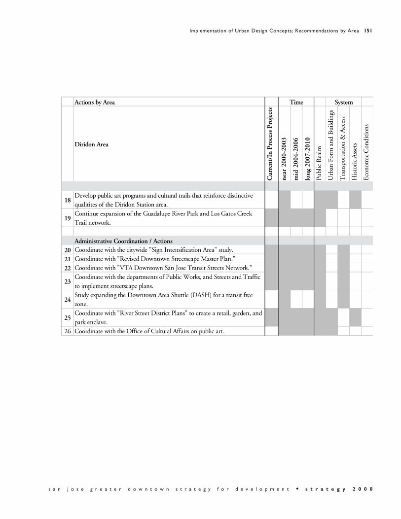
Actions by Area Time System
Diridon Area
Cur
rent
/In
Pro
cess
Pro
ject
s
near
200
0-20
03
mid
200
4-20
06
long
200
7-20
10
Publ
ic R
ealm
Urb
an F
orm
and
Bui
ldin
gs
Tra
nspo
rtat
ion
& A
cces
s
His
tori
c A
sset
s
Eco
nom
ic C
ondi
tions
18Develop public art programs and cultural trails that reinforce distinctive qualitites of the Diridon Station area.
19Continue expansion of the Guadalupe River Park and Los Gatos Creek Trail network.
Administrative Coordination / Actions20 Coordinate with the citywide "Sign Intensification Area" study.
21 Coordinate with "Revised Downtown Streetscape Master Plan."
22 Coordinate with "VTA Downtown San Jose Transit Streets Network."
23Coordinate with the departments of Public Works, and Streets and Traffic to implement streetscape plans.
24Study expanding the Downtown Area Shuttle (DASH) for a transit free zone.
25Coordinate with "River Street District Plans" to create a retail, garden, and park enclave.
26 Coordinate with the Office of Cultural Affairs on public art.

Postcard from 2010“The North Gateway area is the northern entrance to Greater
Downtown San Jose. Ryland Street connects the area to the completedGuadalupe River Park, which forms a vital open space resource for theNorth Gateway and other surrounding neighborhoods. An accessible, urbanscale pattern of blocks and streets extends from the existing block patternand incorporates St. James and Julian streets as important east-westconnections. Autumn Street meets Coleman Avenue to the west, creating anew access to the Arena and the new development northwest of downtown.”

Strategies
a. Encourage alternative housing solutions, such as lofts, in addition to office development.
b. Create a Strategic Development Plan for the North Gateway districtthat ties in the ongoing projects with broader ideas for the long-term development of the area.
c. Respond to current projects that are being proposed and ensure thatthey fit into the overall urban design considerations of the “Strategyfor Development.”
d. Design the North Gateway area to create a sense of arrival into theGreater Downtown from the north.
e. Introduce infrastructure of streets and other services in accordancewith the “Strategy for Development,” to support future growth of the area.
f. Coordinate with the “River Street District Plans” to create a retail,garden and park enclave in a historic setting.

Autumn Street is reoriented to meet Coleman Avenue at a right angle. The new street grid is extended from the course of the Guadalupe River. This option was generated by a specific project at the intersection of Autumn Street and the railroad right of way, which enabled a new tunnel to be built under the railroad tracks and a new alignment for Autumn St.
These options for future development in the North Gateway Area showtwo potential street patterns for extending the city grid.

Autumn Street is extended north along the existing grid to meet Coleman Avenue and form a direct link to the Diridon Station/Arena area.The city grid, drawn from the area west of Coleman Avenue is extended east to form the block pattern of the North Gateway area.New street grid allows for view corridors to the Arena and downtown.

Actions by Area Time System
North Gateway
Cur
rent
/In
Pro
cess
Pro
ject
s
near
200
0-20
03
mid
200
4-20
06
long
200
7-20
10
Publ
ic R
ealm
Urb
an F
orm
and
Bui
ldin
gs
Tra
nspo
rtat
ion
& A
cces
s
His
tori
c A
sset
s
Eco
nom
ic C
ondi
tions
Development Related Actions
1Develop mid -to high-density housing near Ryland Park and the Hensley neighborhood.
2 Develop office and housing to the northwest of Market and St. James
3Design and develop office and mixed-use projects along north Autumn Street to Coleman Ave.
4Autumn Street and Rail Road crossing - Complete plan for buildings and parcels in the surrounding area.
5Legacy-N. Gateway Commercial development - Complete planning and approvals.
6 Mission Villas development - Complete planning and approvals.
7Sobrato North Campus - Phases 1 and 2 built. Continue planning next phases.
8Autumn Street and Rail Road crossing - Complete plan for building and surrounding area.
Public Improvements
9Begin planning for long-term expansion of the North Gateway area of downtown.
10Establish east-west street connections via Julian and St. James Street and north-south street connections via Autumn Street and Coleman Ave.
11Introduce parkways along the Guadalupe River Park that serve as an open space resource for the entire area.
12Study the possibility of an underpass at Autumn Street for the existing grade-level railroad crossing and an underpass at Coleman Ave. east of St. Teresa Street to replace the existing overpass.
13Connect 1st Street and Ryland Park to the Guadalupe River Park via Ryland Street with generous pedestrian streetscape.
14Implement a "Downtown Landscape Plan" with the goal of continuing the canopy of shade trees so essential in a hot city, as well as expanded greening in streets, medians, and planters.
15 Continue expansion of the Guadalupe River Park network.
16Develop a new park along Los Gatos Creek, adjacent to the new district at Diridon Station, linking existing creek trails to Confluence Point.
17Develop public art programs and cultural trails that reinforce distinctive qualitites of various districts.
18 Initiate parking study at North Gateway Area.
19 Develop a Strategic Development Plan for the area.

Actions by Area Time System
North Gateway
Cur
rent
/In
Pro
cess
Pro
ject
s
near
200
0-20
03
mid
200
4-20
06
long
200
7-20
10
Publ
ic R
ealm
Urb
an F
orm
and
Bui
ldin
gs
Tra
nspo
rtat
ion
& A
cces
s
His
tori
c A
sset
s
Eco
nom
ic C
ondi
tions
Administrative Coordination / Actions21 Coordinate with the citywide "Sign Intensification Area Study."
22 Coordinate with "Revised Downtown Streetscape Master Plan."
23 Coordinate with VTA "Downtown San Jose Transit Streets Network."
24Coordinate with the departments of Public Works, and Streets and Traffic to implement streetscape plans.
25 Study expanding the Downtown Area Shuttle (DASH) for a transit free zone.
26Coordinate with "River Street District Plans" to create a retail, garden, and park enclave.
27 Coordinate with the Office of Cultural Affairs on public art.
28Coordinate with railroad companies on street plans and infrastructure improvements.


With the following design guidelines, developers and theirarchitect-led design teams are challenged to produce buildings and urbanprojects of the highest quality for Greater Downtown San Jose. Theseguidelines provide a set of ideas about design to ensure that buildings andpublic spaces will contribute to the coherence of the urban design of theGreater Downtown. The development teams of buildings and projects areguided toward responsiveness to the urban context and the unique characterof downtown San Jose.
The guidelines strengthen and carry out the goals of this Strategy in severalways. First, they provide specific principles which, when followed, reinforceand bolster the Key Urban Design Concepts in an earlier chapter. Second,the guidelines highlight the ways in which new development can contributeto the overall urban form and public realm.
Developers and their agents should review the design guidelines duringinitial phases of project conceptualization. These guidelines are notexhaustive design requirements for proposed projects within the GreaterDowntown, nor do they address particular details of construction orbuilding style. Additional, more specific, guidelines may apply as an“overlay” to these guidelines. Additional guidelines could addressrequirements of particular areas or uses, such as historic requirements,streetscape requirements and lighting requirements. The San JoseRedevelopment Agency, together with the Department of Planning,Building and Code Enforcement, shall advise prospective developers andtheir agents as to which design guidelines apply to a particular proposedproject. Design guidelines will be used in conjunction with the designreview process of the Redevelopment Agency, a five-stage process that beginswith conceptual design and ends with the completion of construction.
The City's Green Building Guidelines, as adopted and amended from timeto time by the City Council, are incorporated into these Design Guidelines.Developers are encouraged to apply green building practices, includingthose included in the City's Green Building Guidelines, in the planning,design, construction, renovation, operations, and demolition of buildingsand to work with the Redevelopment Agency and City Departments toensure that appropriate green building practices are considered andimplemented.

In addition to the design guidelines in this section, the San JoseRedevelopment Agency has committed to developing “Design and AdaptiveUse Guidelines” for San Jose’s historic center of downtown. The study is tobe completed in the first quarter of 2001. The area for these guidelines isdefined on the north by Santa Clara Street, on the south by San FernandoStreet, on the west by Market Street, and on the east by South Fourth Street.
“Design and Adaptive Reuse Guidelines” will provide practical guidance forthe rehabilitation of existing, historic urban fabric and compatible newdevelopment within the existing urban center. These guidelines will presenta design framework that will help to revitalize San Jose’s historic commercialcenter. General design guidelines for the historic center of downtown willbe included for appropriate treatments and conformance with “TheSecretary of the Interior’s Standards for Rehabilitation,” as well as adiscussion of future building envelope expansion and actions that areappropriate for many types of buildings. Additionally, recommendations forstabilization and long-term measures and maintenance will be included.Design guidelines for new buildings in historical areas will be addressed;definitions of various types of historic designations will be defined and theireffects outlined. Also included will be a discussion of the “State HistoricalBuilding Code” as well as other existing and potential new incentives thatwill ensure that the existing historic buildings within study area will bereused in the future.
4.1.1 Urban Open Spaces
Definition: Use buildings, colonnades, and landscaping to define edges andcreate a sense of three-dimensional containment to urban open spaces andplazas.
Size and Scale: Relate the size of open spaces to the scale of the city, to thewidth and scale of adjacent streets and buildings, to the activities and events,and to the intended users. For small to medium size plazas a ratio of one-to-one for the height of buildings to the width of a plaza produces acomfortable scale and definition.

Activity: Design urban open spaces to accommodate the necessaryinfrastructure to allow for programmed activities and events.
Edges: Program active uses at the ground and second floors of adjacentbuildings along the edges of urban open spaces to animate the space andcreate a sense of security.
Circulation: Encourage pedestrian circulation through and across urbanopen spaces, and along their edges.
Allow for vehicular circulation at urban open spaces which minimallydisrupts pedestrian traffic. Particular care should be taken to design safe, andaesthetically pleasing vehicle crossings at vehicular building entrances.
Identity: Public amenities such as street furniture, plantings, lighting,infrastructure and public art shall reinforce the identity of urban open spacesand facilitate the opportunity for lively activity through everyday use.
Orientation: Urban open spaces shall be oriented for the best solar exposureand wind protection possible. Open spaces should be protected fromexcessive glare, wind, and shade from adjacent structures.
4.1.2 Streets, Sidewalks and Paseos
Definition: Place the lower floors of buildings against the street edge, exceptfor designated open spaces.
Amenities: Pedestrian ways should be enhanced with lighting, plantings,paving and ornamental features or street furniture along street edges whereadjacent ground floor retail or cultural uses are inappropriate or not feasible.
Edges: Sidewalks and pedestrian paths shall be at least partially covered bya canopy of trees, awnings and/or colonnades and arcades, wheneverpossible.
Paseos, passages and arcades shall be designed with the highest level ofamenities, landscaping, and with active pedestrian uses along adjacentground level building frontages.

4.2.1 Building Form
Orientation: Orient structures such that urban open spaces receiveadequate direct sun and filtered daylight and are protected from excessivewind, building glare and shade.
Massing: Minimize the mass and apparent bulk of high buildings througharticulation of the building envelope with offsets, changes of plane, step-backs and other architectural devices.
Buildings that are over one hundred and fifty (150) feet tall, or more thannine (9) stories in height, should have a discernible treatment thatdistinguishes the base, middle and top of each building on all facades.
Height: Locate the tallest buildings on the short ends of city block and atblock corners.
Roofscapes: Design the tops of tall buildings to be distinctive day andnight. Tall buildings should add to the city skyline for views to and viewsfrom each building. Equipment on the tops of buildings should be enclosedand integrated into the building form. This, which includes mechanical,electrical, communications, emergency, and related typologies, should notbe seen from street and highway vantage points.
The tops of tall buildings should be designed to provide visual interest tothe form of the downtown skyline. While each building and complex ofbuildings should be designed for distinction, every building also should bedesigned within the context of the downtown skyline. The uppermostfloors and the penthouse levels of a building should be designed as part ofa building's top. The tops of buildings should be considered from severaldistances and in different conditions; notably, from near, middle and distantviews, and in the day and night. Near views should be from a block or twoaway, middle views from near the perimeter of downtown, and distant viewsfrom any vantage point that affords a view of buildings in the context of thedowntown as a whole.

Arcades and Colonnades: Enhance pedestrian areas and sidewalks bymaking use of building arcades, colonnades and shade structures whereverappropriate.
4.2.2 Building Rehabilitation
Rehabilitation/Reuse: Existing buildings and portions of blocks that aredesignated for rehabilitation or preservation shall not be demolished, butrather shall be rehabilitated, respecting their original character, materials anddesign intent.
Storefronts and signage in buildings undergoing rehabilitation shall followstandards to ensure their appropriate scale, character and continuity inrelation to other nearby buildings.
4.2.3 Building Uses
Ground Floor Uses: The ground level of buildings, including parkingstructures, should be occupied by retail, entertainment, service retail,cultural or other active, high intensity pedestrian uses. The ground levelincludes: a minimum of the first eighteen (18) to twenty (20) feet of thebuilding above street level, measured from the highest elevation of streetlevel to the first finished floor above the street. The clear height for theground floor uses should not be less that fifteen (15) feet. Ground floor retailshall have a minimum depth of fifty (50) feet.
Second Level Uses: In the urban, mixed-use area bounded by the Paseo deSan Antonio and by Market, St. John, and 3rd Streets, the second level ofbuildings, including parking structures, should be occupied by retail,entertainment, service retail, cultural or other active uses. The second levelmay also be occupied by office or residential as interim uses; however, thebuilding should be designed to allow for more active future uses. Theground floor and second level are defined as a minimum of the first thirty-six (36) to forty (40) feet of the building above street level, measured fromthe highest elevation of the street level to the second finished floor levelabove the street.
Parking Structures: Parking structures in the Greater Downtown should bebuilt as low as possible, especially where adjacent to the street. The narrower

dimension of parking structures should front streets and wherever possible,the longer side of a parking structure should not front a street.
Parking structures south of Julian Street in the Greater Downtown, that arebuilt on the same properties with the uses they serve, should be enclosedwith built space or with a continuous facade treatment.
Parking structures, which are built on properties separate from the uses theyserve should not be taller than sixty (60) feet above street level to the topparking level at its highest point. If a parking structure is enclosed at streetedges for at least its full height by built space with non-parking uses, so thatit is not visible from street level viewpoints, then the parking structure maybe higher than sixty (60) feet. Also, if the parking structure is enclosed andhas a continuous facade treatment with enclosure, so that the garage interioris not visible from street level viewpoints, then the parking structure may behigher than sixty (60) feet.
Equipment and Co-location Facilities: Buildings within the area of GreaterDowntown that is south of Julian Street and east of Highway 87 should beprimarily for the use of people, not primarily for machinery and co-locationequipment. Buildings south of Julian Street and east of Highway 87 shouldhave at a density of not less than one person per eight hundred (800) squarefeet for at least seventy-five (75) percent of the gross building area. Inaddition, within this area large mechanical and electrical equipment such aspower generators, which create significant noise and exhaust fumes, shall belocated on building roofs. Parking for these facilities should be providedaccording to the City’s requirements for office use, in order that thebuildings can be adopted for reuse in the future.
4.2.4 Building Context
Existing Buildings: New structures, built adjacent to or between existingbuildings, shall respond architecturally to the existing built surroundings.
Infill: New buildings, located within a block designated for rehabilitationor preservation, shall be designed in a character compatible with that ofexisting buildings.
Ground Level Services: Equipment for power, utilities, waste and otherbuilding services should be enclosed within the envelope of the building or

should be below the grade of surrounding sidewalks and streets. Loadingfacilities for buildings should be within the envelope of buildings and doorsat the street for access to loading areas should be open only for access. Ifservices and loading are not within the building envelope, they should bescreened from street level views and should have opaque, operable doors thatare open only for access.
4.2.5 Building Character
Identity: Paseos, passages and arcades shall be designed with the highestlevel of amenity, landscaping, and active pedestrian uses along their edges.Building ground and second floors shall be differentiated from upper floorsthrough design, exterior treatment, and transparency.
Materials: Use the highest quality exterior materials on facades and exteriorwalls of buildings to give a perception of permanence and civic pride
Parking structures shall be designed with exterior materials that areharmonious with surrounding buildings, and if part of a building complex,compatible with the exterior materials of buildings they serve.
Colors: Tall buildings that are viewed against the sky shall have an overallexterior color that is light to medium in value.
Lighting: Building exteriors shall be illuminated to highlight the facades atstreet level and to accent noteworthy architectural features. The tops of tallstructures shall be illuminated to emphasize building height and roof formwithin the context of the City’s downtown skyline.
Lighting of buildings, streets and parks need to consider the limitations andpossibilities of restrictions from institutions that are sensitive to nighttimelighting: The Federal Aviation Administration and the San JoseInternational Airport for aircraft, and The Lick Observatory for nighttimeviewing of the universe through the Observatory's telescopes.
Parking structure interior and roof deck lighting shall not be visible fromstreet level viewpoints.

Number Figure
Summary and Introduction0-1 Strategy 2000 Conceptual Sketchof Greater Downtown0-2 Task Force Plans0-3 San Jose and the world, the country, the state, the Bay Area0-4 Map of Greater Downtown0-5 View of the Greater Downtown area from the southwest0-6 Aerial view of the center of Greater Downtown San Jose0-7 San Jose and other world cities0-8 Streets, freeways and fiber optic network0-9 Sixteenth Street Mall in Denver0-10 Interactive workshops with the Task Force0-11 Diagrams of possible city structures and city form0-12 Aerial view across downtown
Vision1-1 Collage of images1-2 Aerial view looking north1-3 Collage of images1-4 Historic buildings and light rail transit on First Street1-5 Collage of images1-6 The Friday farmers’ market1-7 Collage of images1-8 Transportation access1-9 Postcard of the future #1 - collage of images1-10 Postcard of the future #2 - collage of images1-11 Postcard of the future #3 - collage of images1-12 Postcard of the future #4 - collage of images1-13 Greater Downtown is one square mile1-14 Aerial view of downtown1-15 Circa 1850s image by John Reps1-16 Circa 1850s image by John Reps1-17 40% of the world’s internet traffic1-18 46 languages and diverse communities1-19 Measure A

1-20 St. James Park
Key Urban Design Concepts2-1 Fill and Tighten2-2 Weave and Connect2-3 Expand and Phase2-4 Growth and expansion of the Greater Downtown2-5 Identify and Strengthen2-6 Link and Respect2-7 Map of the Greater Downtown showing neighborhoods2-8 Map of the “Strong Neighborhoods Initiative”
Implementation of Urban Design Concepts 3-1 Strategy 2000 Diagram3-2 Strategy 2000 Illustrative Plan
Recommendations by System3-3 The public realm3-4 The network of paseos in Greater Downtown3-5 A paseo environment3-6 A downtown paseo3-7 The parks, plazas, paseos and trails network3-8 A section of the Guadalupe River Park3-9 Map of possible indoor and outdoor venues3-10 Repertory Plaza3-11 A “figure-ground” map of the Greater Downtown3-12 Block sizes of a square mile in 3 U.S. cities 3-13 Plan and section diagrams of FAA height restrictions3-14 Greater Downtown, a mid-rise, high-density city3-15 Diagrams of comparative urban forms3-16 Land use diagram with different types of mixed-use3-17 Vertical layering of land use3-18 Land use options explored by the Task Force3-19 Saint James Park3-20 Map of the fiber optic network3-21 Map of freeway and street connections3-22 Regional transit lines with San Jose as a key transit hub3-23 The freeway network
Number Figure

3-24 Entry points into Greater Downtown3-25 Issues for light rail expansion3-26 Light rail on the transit mall3-27 A pedestrian friendly walkway under Caltrain3-28 Historic light rail car in the downtown3-29 Circa early 1950s, view looking north on First Street3-30 Circa late 1800s, light tower in San Jose3-31 Fountain Alley Historic District- Conceptual Sketch3-32 Interactive Task Force plan
Recommendations by Area3-33 Areas Diagram3-34 Plaza de Cesar Chavez – illustrative sketch3-35 Plaza de Cesar Chavez – locator map3-36 Plaza de Cesar Chavez – plaza section3-37 Plaza de Cesar Chavez – illustrative plan3-38 Plaza de Cesar Chavez – conceptual sketch3-39 Plaza de Cesar Chavez – urban design diagram3-40 Plaza de Cesar Chavez – aerial photograph3-41 St. James Park – illustrative sketch3-42 St. James Park – locator map3-43 St. James Park – park section3-44 St. James Park – illustrative plan3-45 St. James Park – looking north3-46 St. James Park – conceptual sketch3-47 St. James Park – urban design diagram3-48 1st and 2nd streets – illustrative sketch3-49 1st and 2nd streets – locator map3-50 1st and 2nd streets – street section3-51 1st and 2nd streets – looking south3-52 1st and 2nd streets – illustrative plan3-53 1st and 2nd streets – conceptual sketch of Rep. Plaza3-54 1st and 2nd streets – urban design diagram3-55 Santa Clara Street – illustrative sketch3-56 Santa Clara Street – locator map3-57 Santa Clara Street – street section3-58 Santa Clara Street – illustrative plan3-59 Santa Clara Street – looking east
Number Figure
3-60 Santa Clara Street – conceptual sketch3-61 Santa Clara Street – urban design diagram3-62 San Pedro Square – illustrative sketch3-63 San Pedro Square – locator map3-64 San Pedro Square – section3-65 San Pedro Square – looking north3-66 San Pedro Square – illustrative plan3-67 San Pedro Square – urban design diagram3-68 San Fernando Street – illustrative sketch3-69 San Fernando Street – locator map3-70 San Fernando Street – street section3-71 San Fernando Street – looking west3-72 San Fernando Street – illustrative plan3-73 San Fernando Street – conceptual sketch3-74 San Fernando Street – urban design diagram3-75 SoFA / Convention Center – illustrative sketch3-76 SoFA / Convention Center – locator map3-77 SoFA / Convention Center – street section3-78 SoFA / Convention Center – illustrative plan3-79 SoFA / Convention Center – looking north3-80 SoFA / Convention Center – conceptual sketch3-81 SoFA / Convention Center – urban design diagram3-82 Civic Center – illustrative sketch3-83 Civic Center – locator map3-84 Civic Center – illustrative plan3-85 Civic Center – conceptual sketch3-86 Civic Center – urban design diagram3-87 San Carlos Street – illustrative sketch3-88 San Carlos Street – locator map3-89 San Carlos Street – street section3-90 San Carlos Street – looking east3-91 San Carlos Street – illustrative plan3-92 San Carlos Street – conceptual sketch3-93 San Carlos Street – urban design diagram3-94 Almaden Boulevard – illustrative sketch3-95 Almaden Boulevard – locator map3-96 Almaden Boulevard – street section3-97 Almaden Boulevard – illustrative plan
Number Figure

3-98 Almaden Boulevard – looking north3-99 Almaden Boulevard – conceptual sketch3-100 Almaden Boulevard – urban design diagram3-101 Diridon / Arena – illustrative sketch3-102 Diridon / Arena – locator map3-103 Diridon / Arena – section3-104 Diridon / Arena – looking east3-105 Diridon / Arena – illustrative plan3-106 Diridon / Arena – option 13-107 Diridon / Arena – option 23-108 Diridon / Arena – option 33-109 Diridon / Arena – urban design diagram3-110 North Gateway – illustrative sketch3-111 North Gateway – locator map3-112 North Gateway – Autumn Street section3-113 North Gateway – urban design diagram3-114 North Gateway – looking south3-115 North Gateway – option 13-116 North Gateway – option 23-117 Greater Downtown conceptual sketch
Appendices4-1 Strategy 2000 Diagram4-2 Strategy 2000 Illustrative Plan
Number Figure


Access: The ability to make use of Downtown resources, whether by travel or byproximity. Enhancing access may involve increased mobility and transportation, orsimply the efficient location of resources (like housing or shopping near jobs) tominimize travel.
Action: A recommendation consisting of a specific task, usually by one or morepublic agencies. For example, “Create and implement a pedestrian plan for the city.”
Area: A distinct part or section of the Greater Downtown. For the purposes of thisdocument, areas with distinct qualities have been identified for more detailedconsideration without an attempt to draw sharp boundaries, for example, “Plaza deCesar Chavez.”
Building Envelope: The enclosing structure or cover surrounding and/or definingthe edges of outdoor space, created by surrounding buildings and structures.
Central Downtown: The traditional heart of downtown San Jose, consisting of thearea between Highway 87 and Fourth Street, Julian Street and Interstate 280.
Co-location facility: A facility that houses communications hardware andequipment related to the internet, such as servers and back-up power equipment.The term “co-location” refers to the fact that internet companies can locate theirservers in a dedicated facility, separate from their office or warehouse spaces. Otherterms that are used to describe a co-location facility include: “colo,” “server farm”and “telco hotel.” Co-location facilities house machinery and very few people,making them relatively inactive places in a downtown that are not pedestrianoriented. Back-up power sources for the equipment, particularly diesel generators,are of concern for the siting of a co-location facility due to noise and exhaust fumesproduced by generator operation.
Development/Land-Use Program: The amount and type of development that themarket could feasibly provide in the ten-year period envisioned by this document,and hence the amount and type of growth the Strategy attempts to accommodate.
Downtown Core and Frame: Terms used in previous plans to describe downtownareas.
Expand and Phase: “Key Urban Design Concepts” proposed for the GreaterDowntown. San Jose is a big city with a relatively small downtown and the

downtown will need to expand over time. While infilling the Central Downtown isthe first priority for development, planning and infrastructure improvements withinspecified expansion areas should commence now.
Fill and Tighten: “Key Urban Design Concepts” proposed for the GreaterDowntown. Filling in the many gaps in the central Downtown with new buildingsand development will make more efficient use of the land, increase densities, andprovide a continuous urban fabric.
General Plan: The legally binding document, required under State law, that definesthe City’s goals for land use, circulation, housing, conservation, open space, noise,and safety. All subsequent development decisions must either be consistent with acity’s General Plan or the General Plan must be revised.
Grain: The degree to which land is subdivided. Many structures on small lotsproduce a fine grain, while fewer structures on large lots produce a coarse grain. Thevisual and functional variety of fine-grained development is generally moreengaging to and compatible with pedestrians. Grain is independent of buildingscale, which may be the same in fine and coarse-grained development.
Greater Downtown: The physical scope of “Strategy 2000: San Jose GreaterDowntown Strategy for Development” the boundaries of which, with minorexceptions to the west, reflect the existing “downtown frame” as defined in the City’sGeneral Plan.
Guiding Principles: Statements of the values that underlie the Downtown Strategy,as articulated by the Development Strategy Task Force to inform Strategy proposalsand development priorities.
Historic Districts: Areas that have been designated as having significant historiccharacter and thus subject to certain limitations on new development andrehabilitation.
Identify and Strengthen: “Key Urban Design Concepts” proposed for the GreaterDowntown. Changes to each area of the Greater Downtown should emerge fromand respond to that area’s distinct qualities in order to build upon strengths and tomaintain the diversity of experiences in the Downtown.
In-Lieu Fees: A parking management strategy in which developers are permitted tomeet some parking requirements by paying into a fund that develops off-siteparking.

Link and Respect: “Key Urban Design Concepts” proposed for the treatment ofneighborhoods around the Greater Downtown: strengthening pedestrian, bicycle,transit, road, open space and visual links, while respecting each neighborhood’sdistinct qualities and resources.
Parking Cash-Out: A Transportation Demand Management program in whichemployees who receive subsidized parking as an employment benefit are given theoption of a cash payment of equal value. Pilot programs have shown that manyemployees will accept the payment option and forgo drive-alone commuting.
Public Realm: The system of parks, plazas, sidewalks, alleys, paseos, trails, rivers andcreeks—all public ways and public spaces—together constitute the Public Realmsystem.
RFP/RFQ: Request for Proposals/Request for Qualifications. A process by whichpublic agencies and private developers can actively solicit the interest of parties(architects, planners, developers etc.) for development projects.
Scale: The relative size of built structures and even city blocks, and the effect thatsize has on the character of the city. Some areas may benefit from buildings with agrand scale for a city skyline or a large open space, others from buildings with anintimate, human scale for active uses along a street or at the edges of a square. Asingle structure may respond to several different scales. A tower, for example, mayadd something grand to the skyline, but offer human scale details like awnings,doorways, or light fixtures at the street level.
Strategy (1): “The Strategy”: this document.
Strategy (2): strategy: A recommendation that states a general task that oftensuggests policy directions. For example, “Respect and reinforce the historic fabric,scale, and pedestrian orientation of the central downtown.”
Strong Neighborhoods Initiative: A citywide planning and implementation processcurrently being undertaken by various city departments such as Parks, Recreation,and Neighborhood Services (PRNS); Planning, Building, and code Enforcement(PBCE); and the San Jose Redevelopment Agency which seeks to strengthen andenhance neighborhoods throughout the City of San Jose. Many of theneighborhoods are partly or wholly within the Greater Downtown area. It is theintent of the initiative to develop a neighborhood plan for each of the areas.

System: A set of related elements found throughout the Greater Downtown. Forexample, parks, plazas, paseos, alleys, sidewalks, rivers, creeks and trails togethercomprise the Public Realm system.
Task Force: The Greater Downtown Strategy for Development Task Force,appointed by the Mayor and the City Council of San Jose, to represent the GreaterDowntown’s diverse interests and perspectives, to formulate the Strategy with Citydepartments and the consultant team, and to recommend the Strategy to the CityCouncil for consideration.
Transportation Demand Management (TDM): A set of policy and program toolsused to improve access, generally by shifting demand away from single occupancyvehicles toward other modes, including transit, carpooling, and walking. TDM caninclude transit subsidy, carpool/vanpool programs, parking management, and manyother tools.
Urban Design Diagram: Plan illustrations to clarify design intent and potentialdevelopment opportunities. Buildings shown in three dimensions may haveexaggerated height to emphasize urban design intent, not necessarily constructionreality.
Urban Form: The shape of the city, which emerges from the combination of itsbuildings, blocks, streets, railways, waterways, and open spaces. Urban Form is theresult of many individual and group decisions, and the purpose of urban design isto help shape those decisions in support of a larger vision.
Weave and Connect: “Key Urban Design Concepts” proposed for the GreaterDowntown. Improve connections among currently isolated areas of activity,including newly developing areas, in order to create a more cohesive GreaterDowntown.

Future Studies
Greater Downtown Comprehensive Transportation Study - Redevelopment Agency, Department of Streets and Traffic, Department of Public Works, ValleyTransportation Authority, CaltransPedestrian Plan - Redevelopment Agency, Department of Streets and Traffic, Department of Public WorksGreater Downtown Area Plans - Redevelopment AgencyParking Management Plan - Redevelopment Agency, Department of Streets and Traffic, Department of Public WorksZoning Ordinance Update - Redevelopment Agency, Department of PlanningBuilding and Code Enforcement General Plan update - Department of Planning Building and Code Enforcement, Redevelopment AgencyDASH Expansion Study - Valley Transportation AuthorityParking Feasibility Study beneath St. James Park and Plaza de Cesar Chavez - Redevelopment Agency, Department of Streets and Traffic, Department of Public Works, Department of Parks Recreation and Neighborhood ServicesDowntown Landscape Plan (coordinate with Revised Downtown Streetscape Plan) - Redevelopment Agency, Department of Public Works, Department ofStreets and Traffic General Review and Inventory of Downtown Events and Event Venues - Officeof Cultural Affairs, Redevelopment Agency, Department of Parks Recreation and Neighborhood Services, Department of Streets and TrafficCultural Trails Study - Redevelopment Agency, Office of Cultural AffairsBicycle Plan - Redevelopment Agency
Studies in Progress
Traffic Circulation and Access Study - Department of Public Works, Department of Streets and Traffic, Redevelopment AgencySouth Bay Transit Corridor MIS/EIS/EIR - Valley Transportation AuthorityLighting Master Plan - Redevelopment AgencyDesign and Adaptive Use Study - Redevelopment Agency, Office of Cultural Affairs, Department of Planning Building and Code Enforcement

Santa Clara / Alum Rock Light Rail Study - Valley Transportation AuthorityStrong Neighborhood Initiative (SNI) Plans and Studies including various areas such as Gardner/Atlanta and Spartan-Keyes - Redevelopment Agency, Department of Planning Building and Code Enforcement, Department of Parks Recreation adn Neighborhood ServicesFiber Optic Core Development Study - Redevelopment AgencyPost Street Improvement Plan - Redevelopment AgencyPaseo de San Antonio Improvement Plan - Redevelopment AgencyMoratorium on Non-Retail Ground Floor Uses - Redevelopment Agency, Department of Planning Building and Code EnforcementSaint James Senior Center Relocation Study - Redevelopment AgencyRevised Downtown Streetscape Plan - Redevelopment Agency, Department ofPublic Works
Completed Studies
San Jose State University Master Plan - San Jose State UniversityUrban Land Institute (ULI) Recommendations for Retail Development in Downtown San Jose - Urban Land Institute, Redevelopment AgencyGuadalupe River Park Plan Master Plan - Redevelopment Agency, Departmentof Parks Recreation and Neighborhood Services, Department of Public Works,Department of Convention Arts and Entertainment, San Jose AirportDowntown Signage Intensification Plan - Redevelopment AgencyDowntown LRT Alignment Study - Valley Transportation Authority, Redevelopment AgencyNorth Campus Area Plan - U.S. Department of Housing and Urban Development, San Jose State University Community Outreach Partnership CenterThe San Jose Civic Plaza Redevelopment Plan Urban Design Framework - Redevelopment AgencySt. James Square Historic District Design Guidelines -Department of City Planning, San Jose Historic Landmarks CommissionRiver Street District Plan - Redevelopment AgencyStrong Neighborhoods Initiative (SNI) Plans and Studies such as University Area and Washington/Guadalupe - Redevelopment Agency, Department of Planning Building and Code Enforcement, Department of Parks Recreation and Neighborhood Services

Task Force Co-Chairs
Leon BeauchmanMichael MulcahyLaura Winter
Task Force Members
Cory Barfield
Terry ChristensenSunny ClaggettJeff DavenportMike EllzeyDavid FadnessDania FagundoEnrique FernandezAlan FreemanJorge GonzalezDon GralnekAlison HartmanKarita HummerJim KellyJim Kenny
Joe HeadScott KniesMark LazzariniBill LeeMike LibertoreD.K. LuRay MorenoDan OrloffWilliam PasemanJane PrzybyzDayana SalazarGeorge SanchezGrant SedgwickJim Spence Phyllis Ward

Susan F. Shick, Executive DirectorHarry Mavrogenes, Deputy Executive Director
Downtown Strategy StaffLeslie Little, DirectorJim Schutz, CoordinatorKelly Kline, Senior Development OfficerEdith Ramirez, Development OfficerAlison Novak, Development TechnicianPeggy Flynn, Communications OfficerPaul Asper, Communications Specialist
Contributing StaffBill EkernPete Larko David NiehDennis Korabiak Martin FloresAbi Maghamfar
Mayor’s Budget and Policy OfficeJoe Guerra
Council District 3Jonathan Noble
AirportCary Greene
Conventions, Arts, & EntertainmentNancy JohnsonJim McBride
FireScott McMillanBob King

HousingLeslye CorsigliaTom Macrostie
LibraryJane Light
Sharon Russell
Office of Economic DevelopmentMarty Woodworth
Timothy Steele
Parks, Recreation, & Neighborhood ServicesJim Norman
Planning, Building, and Code EnforcementKent Edens
Laurel PrevettiSusan Queirolo
Police Dewey Hosmer
Public WorksHans LarsenHarry FreitasFred Moezzi
Streets & TrafficJim HelmerJim Ortbal
Office of Cultural AffairsHarriet Traurig
Mary Rubin
Jim LightbodyJulie Render
Lisa IvesGail Price

Field PaoliFrank L. Fuller, FAIAJohn L. Field, FAIABill Brigham, AIASameer ChadhaTanu SankaliaDenise Hall, AIAMaren MoegelCraig Kartisek
Simon, Martin-Vegue, Winkelstein, MorisKaren Alschuler, AICPEvan RoseBenjamin Grant Eric StatenNico Larco
Parsons Transportation GroupBob Scales
Kaku AssociatesPatrick Gibson
Keyser Marston Associates, Inc.Timothy C. Kelly
Apex StrategiesEileen Goodwin
Architectural Resources GroupBruce JuddEric RekdahlBridget Maley
Office of Cheryl BartonCheryl Barton
Karin Bacon Events, Inc.Karin Bacon
FilcoFil Maresca
AMS Planning & ResearchRobert Bailey
Architectural IllustrationAlexander (Sasha) Ortenberg


.
.
.
River and Creek
Parks and Green Open Space
Paseos and Plazas
Potential Development
Potential Development, higher density
Existing Structures