stonehenge estate - tourisminsights trust... · - reliable data on the future numbers of visitors...
TRANSCRIPT
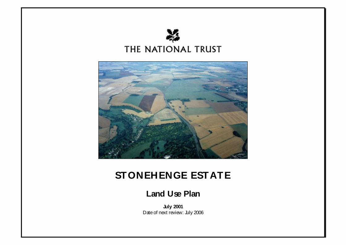
STONEHENGE ESTATE
Land Use Plan
July 2001Date of next review: July 2006
Stonehenge Land Use PlanThe National Trust
17 August 2001
2/56
CONTENTS
Preface
Introduction
Strategic Principles
Part I: Management Context
1.1 Management Partnerships
1.2 Historic Landscape & Archaeology
1.3 Agriculture
1.4 Wildlife
1.5 Access & Interpretation
1.6 Monitoring the Plan & Managing Change
Part II: Management Policies & Action
2.1 Historic Landscape & Archaeology- Principles- Objectives- Table of Policy, Action & Timing
2.2 Agriculture- Principles- Objectives- Table of Policy, Action & Timing
2.3 Wildlife- Principles- Objectives- Table of Policy, Action & Timing
2.4 Access & Interpretation- Principles- Objectives- Table of Policy, Action & Timing
Stonehenge Land Use PlanThe National Trust
17 August 2001
3/56
Preface
Plan CoverageThe Land Use Plan (LUP) covers land, for which the followingorganisations have a management responsibility:- The National Trust (NT)- English Heritage (EH)- The Highways Agency (HA)- The Highway Authority (Wiltshire County Council)
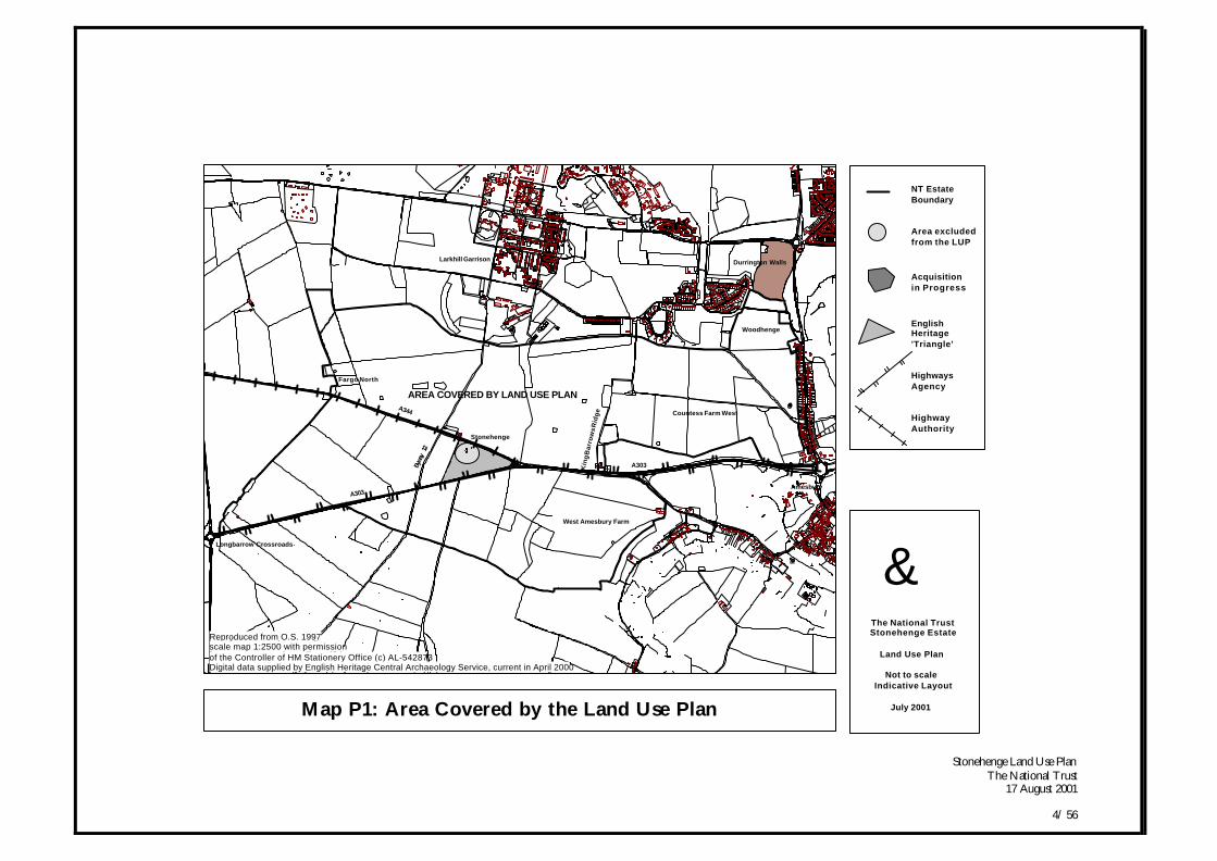
In particular, the Plan considers all of the land owned by theNational Trust at Stonehenge and the outer part of theStonehenge Triangle, which is in the care of English Heritage.Whilst the Land Use Plan excludes the Stone Circle and'immediate surroundings', it takes this area into account as this isthe focal point for the wider landscape. However, due to theintensive use the monument experiences, the Stone Circle andits immediate surroundings will require a more detailedmanagement plan. The boundary of this area has been taken asthe outer limit of the visitor paths circling the Stones, the pointat which management changes from extensive to intensivemethods. [Refer to Map P1: Area covered by the Land Use Plan]
At the time of writing the Land Use Plan, many details of thelarge scale changes in land use are still in their formative stages.- The Highways Agency is still developing options for the
construction of the A303 two kilometre tunnel pastStonehenge. Details such as the design and location ofthe portals, the effect on the landscape in StonehengeBottom and the final restoration across the former lineof the A303 are in the early stages of planning.
- The details of the treatment of the A344 and existingvisitor facilities have not been agreed.
- English Heritage is still in the early stages of designingand selecting the route of the visitor transport from theirproposed new Visitor Centre at Countess East to adrop-off point at King Barrows Ridge.
- Reliable data on the future numbers of visitors that maybe expected to cross the landscape is still being gathered.
- The final pattern of the proposed increase in permissiveaccess and additional rights of way is still underdiscussion.
Despite these current omissions, the Land Use Plan provides anessential conservation framework for the large-scale land usechanges proposed. It allows the Trust to continue itsmanagement of the landscape in a planned and agreed way. Areview of the Plan in 2006 will be essential to linking up thevarious omissions and will be key to ensuring that theconservation objectives of the World Heritage SiteManagement Plan are continuing to be implemented at theheart of the World Heritage Site (WHS).
Process of ConsultationStonehenge is a complex and unusual property with manydifferent organisations and individuals involved. During theprocess of developing the range of issues to be included in thePlan, it became apparent that if the Plan was to be effectivewide consultation was essential.
Stonehenge Land Use PlanThe National Trust
17 August 2001
4/ 56
Map P1: Area Covered by the Land Use Plan
Amesbury
Durrington Walls
Countess Farm West
Woodhenge
A303
Countess Road
AREA COVERED BY LAND USE PLAN
West Amesbury Farm
Larkhill Garrison
Stonehenge
Kin
g B
arr
ow
s R
idg
e
Byway
12
Longbarrow Crossroads
A303
A344
Fargo North
gThe National TrustStonehenge Estate
Land Use Plan
Not to scaleIndicative Layout
July 2001
NT Estate Boundary
Area excludedfrom the LUP
Acquisitionin Progress
EnglishHeritage'Triangle'
HighwaysAgency
HighwayAuthority
Reproduced from O.S. 1997scale map 1:2500 with permissionof the Controller of HM Stationery Office (c) AL-542873Digital data supplied by English Heritage Central Archaeology Service, current in April 2000
Stonehenge Land Use PlanThe National Trust
17 August 2001
5/ 56
In Autumn 1999 a working group was formed to oversee policyinput, to identify the range of different issues, and to set up sub-groups that would advise on detail and represent a wider rangeof organisations. The membership of these groups was asfollows:
Working Group 1 & Sub-GroupsThe National Trust - ChairAmesbury Town CouncilCountryside AgencyDefence Estates (MOD)English HeritageEnglish NatureFarming and Wildlife Advisory GroupHighways AgencyRoyal Society for the Protection of BirdsSalisbury District CouncilWiltshire Archaeological & Natural History SocietyWiltshire County Council (Highway Authority)Wiltshire Wildlife Trust
The Plan was written 'in-house' by the National Trust and drewon existing documentation and the experience and knowledgeof Trust advisers, regional and property staff. Specialistconsultant advice was only brought in for distinct areas, forexample, the design principles for the A344 & existing visitorfacilities (Buro Happold), the agricultural strategy (KernonCountryside) and the interim interpretation plan (WessexArchaeology). Due to the wide range of views held onStonehenge, the process of consultation sought agreementamongst interest groups at key stages of the evolving Plan.
In September 2000 there was a four week period ofconsultation on background information, main land use issues
and the range of management options available. A Draft LandUse Plan was sent out for comment to over one hundredindividuals and organisations during a five-week periodbetween March and April 2001. The following organisationsand committees were consulted during this period:
Wider ConsultationAvebury World Heritage Site Officer Ramblers AssociationBritish Horse Society Shrewton Parish CouncilCountess Road Residents Group Lake EstateCountry Landowners Association Archaeology & Interpretation W. G.Druids Lodge Estate Stonehenge Masterplan Executive G.Durrington Parish Council WHS Management Plan Impl. G.EH Ancient Mon. Ad. Committee. Tenant Farmers AssociationGovernment Office : South West Trail Riders FellowshipLARA West Field FarmLarkhill Garrison Wilsford cum Lake Parish MeetingLarkhill Residents Association Wiltshire Ambulance ServiceNational Farmers Union Wiltshire Bridleway AssociationNT Archaeological Panel Wiltshire ConstabularyNT Wessex Regional Committee Wiltshire Fire ServiceNT Tenant Farmers & Licensees Winterbourne Stoke Parish CouncilOpen Spaces Society
ImplementationImplementation of the Land Use Plan will start in September2001 and will involve the National Trust Property Managerdrawing up a programme of work for the following five years.During this period, Working Group 1 will oversee both theimplementation of the work programme and ensure that thedocument is kept up to date. In 2006 it will be reviewed in thelight of detailed proposals for the visitor centre and A303 RoadScheme. Medium to long term proposals will start 2006 (postpublication of Draft Orders for the A303 Road Scheme) andwill contain a programme of work for the following 30 years. A
Stonehenge Land Use PlanThe National Trust
17 August 2001
6/ 56
rolling programme will be set up whereby every three years thePlan is reviewed (2006 onwards).
ResourcesThe National Trust has been involved at Stonehenge since itacquired land around the Stones through a National Appeal in1927. In that year, the Trust purchased 158 hectares (ha) of landand a further 423 ha in 1929. The whole estate was declared'inalienable' in 1965, which is the National Trust's uniquestatutory power. This power ensures that such land cannot bevoluntarily sold, mortgaged or compulsorily purchased againstthe Trust's wishes, without a special parliamentary procedure.
The Trust has continued to acquire land around Stonehenge forthe conservation of monuments and the historic landscape. Itrecently purchased a further 172 ha in 1999 at Countess FarmWest and is in the process of completing the purchase of land atDurrington Walls.
Despite many constraints to the way it could manage the land,the Trust has been positively managing the landscape andimproving the setting of the monuments.
The Land Use Plan builds on previous work and resourcecommitments, by seeking to attract new funds and resources toincrease the conservation effort at a time of great change. Thefirst stage in this renewed commitment will be the appointmentof a Property Manager, dedicated property staff and amanagement budget in order to implement the Plan.
The next stage will be the development of the 'Actions' intodiscrete projects. These projects will be funded throughpartnership funding and will draw on funds such as the HeritageLottery, Countryside Stewardship, Rural Enterprise Scheme,Landfill Tax Scheme and any other grant schemes that may beavailable.
Further InformationFurther information or questions regarding the Stonehenge Land Use Planshould be addressed to:
The Wessex Region of the National TrustEastleigh CourtBishopstrowWarminsterWiltshireUnited Kingdom
Tel: (01985) 843 600Fax: (01985) 843 624
The Land Use Plan can be viewed on the environment and conservationsection at: http://www.stonehengemasterplan.org
It is also available on CD-Rom.
Keith RoweNT Stonehenge Project OfficerJuly 2001
Stonehenge Land Use PlanThe National Trust
17 August 2001
7/ 56
Introduction
Management ResponsibilitiesThe National Trust estate at Stonehenge totals 773 hectares andcompletely surrounds the Stone Circle, which is the focal pointfor most visitors. The Stone Circle and surrounding 5.3 hectaresof land are in the freehold ownership of the Secretary of Stateand have been managed by English Heritage since 1984. TheHighways Agency is responsible for the A303 Trunk Road andWiltshire County Council (Highway Authority) is responsiblefor the A344 County Road.
Management FrameworkIn April 2000 a World Heritage Site Management Plan (EH2000) was published following many months of consultation.The Management Plan has been adopted by the LocalAuthorities as Supplementary Planning Guidance and nowprovides an overarching framework for future decisions withinthe World Heritage Site. The Land Use Plan sits within thisframework and takes the Management Plan's strategic objectivesand turns them into projects on the ground.
In particular, the WHS Management Plan recommends that,
"The entire core zone should be managed as permanent grassland to create amore appropriate setting for the Stones, and the immediately related ceremonialmonuments. Around this core, a wider landscape setting of low-intensitymixed farming with a diverse mosaic of downland habitats, including cropping,arable and grass together with permanent pasture and woodlands, shouldcontinue as the principal land use, in which other more scattered archaeologicalsites and monuments should remain appropriately protected and managed."
Background to the Proposed Land Use ChangesIn 1998, prior to the publication of the WHS ManagementPlan, a range of organisations came together to form apartnership focused on delivering a project tackling some of themost pressing problems in the vicinity of Stonehenge. Atnational government level, the Department of Culture, Mediaand Sport and the Department of the Environment, Transportand the Regions demonstrated integrated government by askingtheir respective Agencies to deliver key components of a jointlyagreed Stonehenge Master Plan.
The Highways Agency is now providing the lead timetablewith the A303 Trunk Road Scheme design. English Heritagepurchased land at Countess East and are providing the designand planning application for the new visitor centre andtransport link. The National Trust owns the land surroundingStonehenge and adjacent to the A303 where the tunnel worksare planned. As this land has been designated 'inalienable', theTrust's support for the environmental improvements is vital tothe success of the scheme. The Trust is also key to deliveringland use change and visitor access.
Local Government is represented through Wiltshire CountyCouncil and Salisbury District Council who are providingsupport, technical and planning advice. The Master Plan alsodraws together a whole range of other organisations andinterests from English Nature (seeking to achieve biodiversitytargets) to the Ministry of Defence and Amesbury TownCouncil (reflecting neighbouring interests and communities).
Stonehenge Land Use PlanThe National Trust
17 August 2001
8/ 56
The objective is to restore the dignity and isolation of Britain'sgreatest prehistoric monument, enabling people to fully enjoyand appreciate the whole landscape. In essence the major landuse changes expected over the next decade will be:
• Removal of the visual impact and noise of roads and traffic from thevicinity of Stonehenge. The A303 Trunk Road will be placed into atunnel for the 2km stretch that passes Stonehenge and the A344 CountyRoad between Airman’s Corner and Stonehenge Bottom will be closed.This will reunite Stonehenge and its surrounding monuments in agrassland setting.
• Partial closure and removal of the existing Stonehenge visitor facilitiesand car park and possible retention of the underground staff base. A newworld-class visitor centre will be built at Countess East outside theWorld Heritage Site with visitor transport provided to a drop-off pointoverlooking Stonehenge.
• The reorganisation of land use and management across the NationalTrust estate. The grassland around Stonehenge will be extended toenhance the setting of the monument, conserve archaeology, improveaccessibility to the wider landscape and enhance nature conservation.[Refer to Map I1 Key Changes to the Stonehenge Landscape]
Document Type(& level ofimportance)
Coverage Time Scale forImplementation
1. WHS Management Plan.
Stonehenge WorldHeritage Site (WHS).
From April 2000onwards
2. Master Plan. Core area aroundStonehenge; A303 &A344 roads, visitor centreand land use changes.
Key changes to be inplace by 2008
3. Land Use Plan. All of National TrustEstate and part of land forwhich English Heritage,Highways Agency andHighways Authority havemanagementresponsibility.
2001 to 2006Reviewed in 2006Reviewed every 3yrsthereafter.

Stonehenge Land Use PlanThe National Trust
17 August 2001
9/ 56
Stonehenge Map I1: Key Changes to the Stonehenge Landscape
Countess EastProposed VisitorCentre
Woodhenge
Durrington Walls(acquisition in progress)
Countess RoundaboutImprovements
Possible visitortransportroute
Vespasian's Camp
King Barrows RidgeGroup of Barrows
Old King Barrows
Visitors view &walk to Stonehenge
Tunnel Portal
A303 Trunk Road
The Avenue
Visitors encouragedinto the widerlandscape
2km Tunnel for A303 as itpasses Stonehengeand landscape reinstated
Existing VisitorFacilities to beremoved. Possibly leaving only undergroundsite office.
Stonehenge
Cursus Barrow Group
Normanton DownBarrow Group
Tunnel Portal
A344 to be closedand returned to grass. Small access track to remain. Eastend to be completely reinstated.
The Cursus
A303 Trunk Roadto be dualled
Winterbourne StokeGroup of Barrows
Byway 12may have a Traffic RegulationOrder applied. g
The National TrustStonehenge Estate
Land Use Plan
Not to scaleIndicative Layout
July 2001
NT Estate Boundary
A303 TrunkRoad Scheme
Countess EastSite of NewVisitor Centre
CountessRoundaboutImprovement Work
Reinstatementof A344 Road
Reinstatementof existingvisitor faciities
Reproduced from O.S. 1997scale map 1:2500 with permissionof the Controller of HM Stationery Office (c) AL-542873Digital data supplied by English Heritage Central Archaeology Service, current in April 2000
Stonehenge Land Use PlanThe National Trust
17 August 2001
10/ 56
Strategic Principles
The National Trust in partnership with others will:
• Ensure that long-term archaeological conservation is theoverriding objective.
• Conserve the outstanding value of the cultural heritage assets ofStonehenge and enhance the character of its landscape setting.
• Enhance and maintain biological diversity.
• Adopt a sustainable approach to managing the area, whichbalances archaeology, biodiversity and landscape conservation,visitor access and farming.
• Work towards the integration of the management and use oflandscapes across land ownership boundaries.
• Involve people, recognising and respecting the diversity of viewsand perceptions that are associated with Stonehenge and itslandscape.
• Provide a framework in which change can be anticipated,monitored and reviewed.
• Gather information to increase understanding and to ensureobjectives are achieved and maintained.
• Encourage a better knowledge and awareness of conservationamong local people and visitors.
• Enhance visitor satisfaction, appreciation and enjoyment.
• Feed back revenue to the management of the area.
• Develop a programme of action that will conserve and enhancethe values identified for each resource.
Stonehenge Land Use PlanThe National Trust
17 August 2001
11/ 56
Part 1 Management Context
Stonehenge Land Use PlanThe National Trust
17 August 2001
12/ 56
Part 1: Management Context
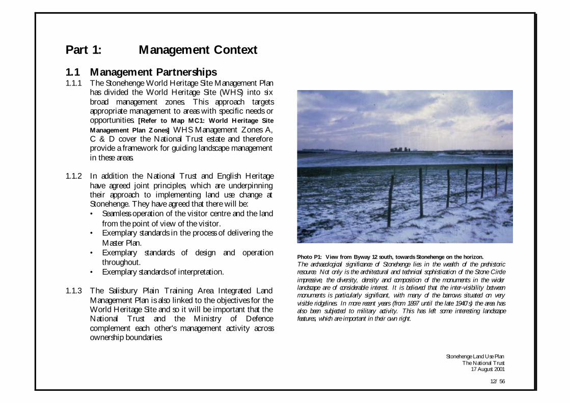
1.1 Management Partnerships1.1.1 The Stonehenge World Heritage Site Management Plan
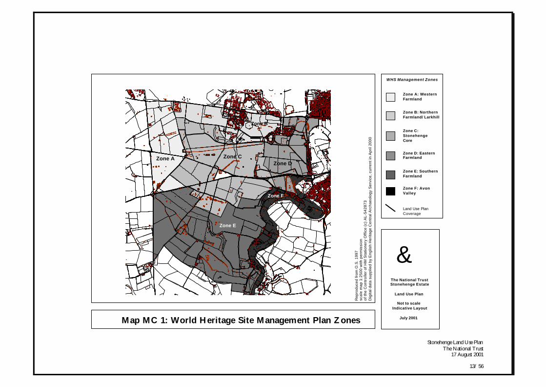
has divided the World Heritage Site (WHS) into sixbroad management zones. This approach targetsappropriate management to areas with specific needs oropportunities. [Refer to Map MC1: World Heritage Site
Management Plan Zones] WHS Management Zones A,C & D cover the National Trust estate and thereforeprovide a framework for guiding landscape managementin these areas.
1.1.2 In addition the National Trust and English Heritagehave agreed joint principles, which are underpinningtheir approach to implementing land use change atStonehenge. They have agreed that there will be:• Seamless operation of the visitor centre and the land
from the point of view of the visitor.• Exemplary standards in the process of delivering the
Master Plan.• Exemplary standards of design and operation
throughout.• Exemplary standards of interpretation.
1.1.3 The Salisbury Plain Training Area Integrated LandManagement Plan is also linked to the objectives for theWorld Heritage Site and so it will be important that theNational Trust and the Ministry of Defencecomplement each other's management activity acrossownership boundaries.
Photo P1: View from Byway 12 south, towards Stonehenge on the horizon.The archaeological significance of Stonehenge lies in the wealth of the prehistoricresource. Not only is the architectural and technical sophistication of the Stone Circleimpressive, the diversity, density and composition of the monuments in the widerlandscape are of considerable interest. It is believed that the inter-visibility betweenmonuments is particularly significant, with many of the barrows situated on veryvisible ridgelines. In more recent years (from 1897 until the late 1940’s) the area hasalso been subjected to military activity. This has left some interesting landscapefeatures, which are important in their own right.
Stonehenge Land Use PlanThe National Trust
17 August 2001
13/ 56
Map MC 1: World Heritage Site Management Plan Zones
Zone B
Zone D
Stonehenge
Zone C
Zone A
Zone E
Zone F
Zone E
Zone A Zone C
Zone D
Zone B
gThe National TrustStonehenge Estate
Land Use Plan
Not to scaleIndicative Layout
July 2001
WHS Management Zones
Zone A: WesternFarmland
Zone B: NorthernFarmland/ Larkhill
Zone C: StonehengeCore
Zone D: Eastern Farmland
Zone E: Southern Farmland
Zone F: Avon Valley
Rep
rodu
ced
from
O.S
. 199
7sc
ale
map
1:2
500
with
per
mis
sion
of th
e C
ontr
olle
r of
HM
Sta
tione
ry O
ffice
(c)
AL-
5428
73D
igita
l dat
a su
pplie
d by
Eng
lish
Her
itage
Cen
tral
Arc
haeo
logy
Ser
vice
, cur
rent
in A
pril
2000
Land Use PlanCoverage
Stonehenge Land Use PlanThe National Trust
17 August 2001
14/ 56
1.2 Historic Landscape & Archaeology
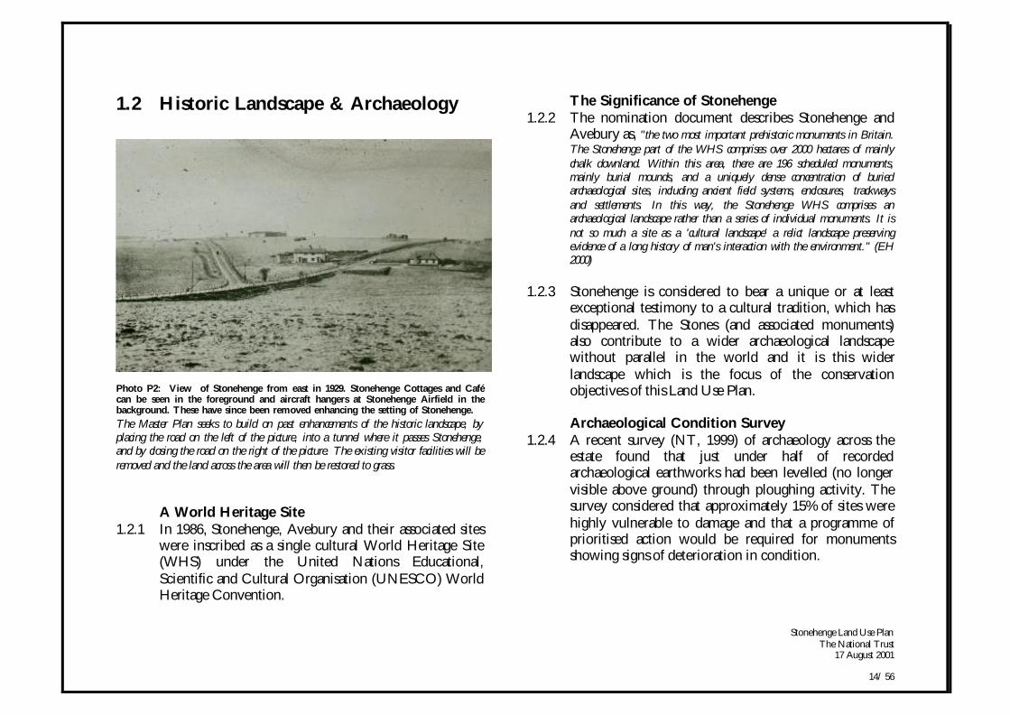
Photo P2: View of Stonehenge from east in 1929. Stonehenge Cottages and Cafécan be seen in the foreground and aircraft hangers at Stonehenge Airfield in thebackground. These have since been removed enhancing the setting of Stonehenge.
The Master Plan seeks to build on past enhancements of the historic landscape, byplacing the road on the left of the picture, into a tunnel where it passes Stonehenge,and by closing the road on the right of the picture. The existing visitor facilities will beremoved and the land across the area will then be restored to grass.
A World Heritage Site1.2.1 In 1986, Stonehenge, Avebury and their associated sites
were inscribed as a single cultural World Heritage Site(WHS) under the United Nations Educational,Scientific and Cultural Organisation (UNESCO) WorldHeritage Convention.
The Significance of Stonehenge1.2.2 The nomination document describes Stonehenge and
Avebury as, "the two most important prehistoric monuments in Britain.The Stonehenge part of the WHS comprises over 2000 hectares of mainlychalk downland. Within this area, there are 196 scheduled monuments,mainly burial mounds, and a uniquely dense concentration of buriedarchaeological sites, including ancient field systems, enclosures, trackwaysand settlements. In this way, the Stonehenge WHS comprises anarchaeological landscape rather than a series of individual monuments. It isnot so much a site as a 'cultural landscape' a relict landscape preservingevidence of a long history of man's interaction with the environment." (EH2000)
1.2.3 Stonehenge is considered to bear a unique or at leastexceptional testimony to a cultural tradition, which hasdisappeared. The Stones (and associated monuments)also contribute to a wider archaeological landscapewithout parallel in the world and it is this widerlandscape which is the focus of the conservationobjectives of this Land Use Plan.
Archaeological Condition Survey1.2.4 A recent survey (NT, 1999) of archaeology across the
estate found that just under half of recordedarchaeological earthworks had been levelled (no longervisible above ground) through ploughing activity. Thesurvey considered that approximately 15% of sites werehighly vulnerable to damage and that a programme ofprioritised action would be required for monumentsshowing signs of deterioration in condition.
Stonehenge Land Use PlanThe National Trust
17 August 2001
15/ 56
1.2.5 The survey attempted to identify the causes of damage.It was found that burrowing animals were one of themajor problems with approximately 35% of the damagebeing caused by badgers or rabbits. Human activity wasregarded as also having had a major effect, with 30% ofthe damage caused through ploughing, footpaths andbuildings. Vegetation, which was mostly scrub andyoung trees, was considered to be an increasingproblem. This has been confirmed by the StonehengeWHS Management Plan, which states that, "Agriculture hashad an overwhelming impact on the survival and condition of thearchaeological monuments and the greatest general threat to the physicalsurvival of the monuments is the continued cultivation of these monumentsin arable areas." [Additional information in the Monuments at RiskSurvey (MARS) published by English Heritage, 1998] The LandUse Plan seeks to deal with some of the issues revealedby the survey.
1.2.6 It should also be noted that since its acquisition of theland in 1927, the Trust has been positively managing theStonehenge landscape. It has improved the setting ofStonehenge and key monuments by removing fences,numerous buildings and rubbish tips. A great deal of theestate has been laid down to grass. Many of theearthworks have been fenced to reduce stock and rabbitdamage. Key barrow groups have been cleared of treesand scrub to prevent roots damaging buried archaeologyand to reinstate their visual relationship with the widerlandscape. These areas have then been mown and grazedon an annual basis to maintain a flower rich grasslandsward. {Refer to WHS Management Plan Objectives 9 & 10}
1.2.7 As a result, the overriding principle of the Land UsePlan will be the conservation of the archaeological
features (visible and non-visible) of the WHS. {Refer toWHS Management Plan Objective 6}
Conservation Proposals1.2.8 Managed grassland is a valuable land use for the
preservation of archaeological features. The Trust hastherefore already sought to protect monuments on thenorthern part of its estate by turning arable areas over topasture. In the southern part of the estate where theexisting farm tenancy agreements are a constraint on theTrust’s management of the area, arable farmingcontinues. The NT Archaeological Condition Survey(1999) found a large number (25%) of the sites in thearable areas had been taken out of cultivation to protectthem from ploughing; however, many remainsurrounded by arable cultivation.
1.2.9 Not all areas will however be turned over to grass. Infact the Stonehenge WHS Management Plan suggeststhat, “high priority areas be protected under permanent pasture andmanaged extensively …lower priority areas to be retained as mixed arable”.{Refer to WHS Management Plan Objective 15}. However, onthe NT estate only parts of Countess Farm will remainarable. Parts of WHS Management Plan Zones A & E,where they come within the NT estate boundary, willbe converted to grass [Refer to Maps LUC 1-6]. Wherearable fields are to be converted to grassland, theopportunity will be taken to carry out archaeologicalfieldwalk surveys before reversion begins.
1.2.10 The visibility of monuments will be maintained and,where appropriate, enhanced. Different groundmanagement techniques could be used to highlight
Stonehenge Land Use PlanThe National Trust
17 August 2001
16/ 56
archaeological features or alleviate pressure from stockor visitors. For example differential mowing, rolling orgrazing may help to enhance monuments. {Refer to WHSManagement Plan Objective 16}
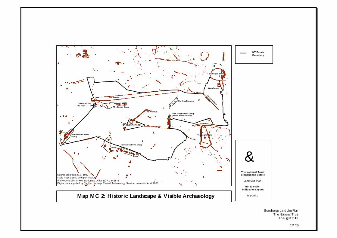
1.2.11 The inter-visibility of monuments will be reinstatedwhere possible through the clearance of trees and scrub.Grazing will then be introduced to these areas wherewoodland and scrub has been removed. {Refer to WHSManagement Plan Objective 10} Management of burrowinganimals will however need to be continued. Views ofmonuments, e.g. eastern end of the Cursus, andbarrows, e.g. Monarch of the Plain, will be opened upthrough felling of the trees immediately around them(subject to consent). [Refer to Map MC2: Historic
Landscape & Visible Archaeology] Woodland alsoperforms a useful screening function and an overall
WHS Woodland Strategy will help inform futurereviews of the Plan.
Recording and Monitoring1.2.12 Opportunities will be sought to monitor, record and
investigate the historic landscape and the archaeology,including the recording of 20th Century features of thearea. For example, a comprehensive and detailedphotographic survey of A303, A344, existing visitorfacilities and car park could be carried out in advance ofany major construction.
1.2.13 Bi-annual condition surveys of all the recordedarchaeology will be carried out. More regular andplanned monitoring will be carried out on targetedmonuments considered to be showing signs ofdeterioration in condition.
Stonehenge Land Use PlanThe National Trust
17 August 2001
17/ 56
Map MC 2: Historic Landscape & Visible Archaeology
Woodhenge
Durrington Walls
Vespasians Camp
Disused Military
Railway
New King Barrows Group(Seven Barrows Group)
Old King Barrows
The Avenue
The Cursus Group
Normanton Down Group
The Cursus
STONEHENGE
The Monarch of
the Plain
Winterbourne StokeGroup
gThe National TrustStonehenge Estate
Land Use Plan
Not to scaleIndicative Layout
July 2001
NT Estate Boundary
Reproduced from O.S. 1997scale map 1:2500 with permissionof the Controller of HM Stationery Office (c) AL-542873Digital data supplied by English Heritage Central Archaeology Service, current in April 2000
Stonehenge Land Use PlanThe National Trust
17 August 2001
18/ 56
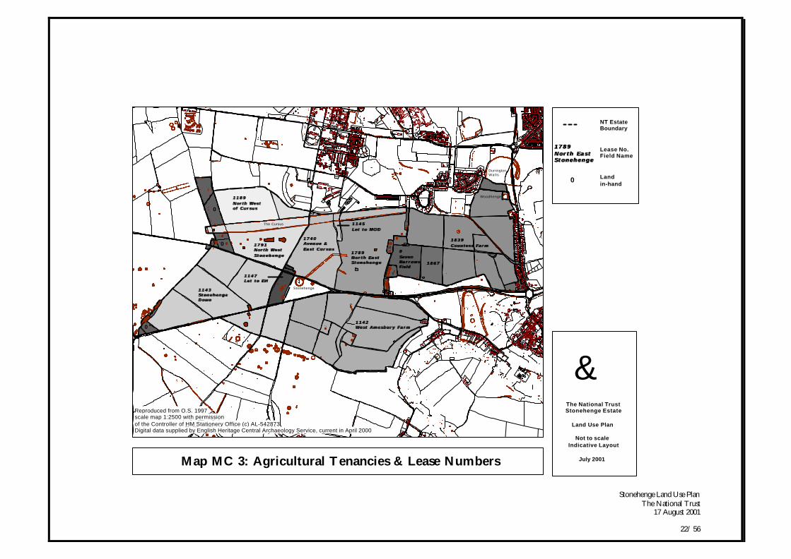
1.3 Agriculture
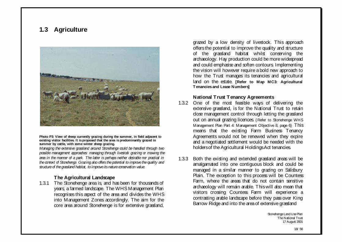
Photo P3: View of sheep currently grazing during the summer, in field adjacent toexisting visitor facilities. It is proposed that the area is predominantly grazed insummer by cattle, with some winter sheep grazing.Managing the extensive grassland around Stonehenge could be handled through twopossible management approaches: managing through livestock grazing or mowing thearea in the manner of a park. The latter is perhaps neither desirable nor practical inthe context of Stonehenge. Grazing also offers the potential to improve the quality andstructure of the grassland habitat, to improve its nature conservation value.
The Agricultural Landscape1.3.1 The Stonehenge area is, and has been for thousands of
years, a farmed landscape. The WHS Management Planrecognises this aspect of the area and divides the WHSinto Management Zones accordingly. The aim for thecore area around Stonehenge is for extensive grassland,
grazed by a low density of livestock. This approachoffers the potential to improve the quality and structureof the grassland habitat whilst conserving thearchaeology. Hay production could be more widespreadand could emphasise and soften contours. Implementingthe vision will however require a bold new approach tohow the Trust manages its tenancies and agriculturalland on the estate. [Refer to Map MC3: AgriculturalTenancies and Lease Numbers]
National Trust Tenancy Agreements1.3.2 One of the most feasible ways of delivering the
extensive grassland, is for the National Trust to retainclose management control through letting the grasslandout on annual grazing licences. {Refer to Stonehenge WHSManagement Plan Part 4: Management Objective 8, page 6} Thismeans that the existing Farm Business TenancyAgreements would not be renewed when they expireand a negotiated settlement would be needed with theholders of the Agricultural Holdings Act tenancies.
1.3.3 Both the existing and extended grassland areas will beamalgamated into one contiguous block and could bemanaged in a similar manner to grazing on SalisburyPlain. The exception to this process will be CountessFarm, where the areas that do not contain sensitivearchaeology will remain arable. This will also mean thatvisitors crossing Countess Farm will experience acontrasting arable landscape before they pass over KingBarrow Ridge and into the area of extensive grassland
Stonehenge Land Use PlanThe National Trust
17 August 2001
19/ 56
around Stonehenge. The whole process will be phasedover a number of years. Where possible the existingknowledge and skills in the local farming communitywill be retained and utilised.
Grassland Expansion1.3.5 In line with the WHS Management Plan, the existing
permanent grassland in the WHS will be maintained,enhanced and extended (WHS Management Plan Zone C).Adjacent to the existing grassland areas arable fields willbe reverted to grassland. Vigorous agricultural grassmixes will not be used in arable reversion (WHSManagement Plan Zone A & E). [Refer to Map MC1: WHS
Management Zones] Where arable systems are retained(WHS Management Plan Zone D), archaeological remainsunder the plough will be evaluated to ensure futurearable use does not damage surviving remains. Ifevaluation shows damage, an appropriate mitigationstrategy will be sought.
1.3.6 Buried archaeological remains will be conservedthrough reversion to grassland or, where they are lesssensitive, the use of minimal cultivation techniques.There will need to be archaeological surface collectionsurveys prior to reversion.
Grassland Management1.3.7 Within the existing grassland areas the aim will be to
seek the establishment of semi-natural type grassland. Aslivestock will be reduced to very low levels, grazingmanagement will be more flexible due to the reducedrisk of poaching. This will mean that the grassland willbe able to develop a coarser structure and flower during
the summer. The resulting long summer grass has theadded benefit that monument areas can be mowed toincrease their visibility and visitors can be encouragedalong defined routes.
1.3.8 Extensive grazing (and haymaking) will become a meansto providing a desirable pastoral setting rather than anend in itself. Both short, hard-grazed swards and longertussock type grassland will be encouraged. Grazing willbe rotational, varying between one grazing per year toevery three to four years in some areas.
Stock Management1.3.9 An appropriate method of stock grazing will be essential
to manage this extensive grassland. The aim will be toselect the right type of stock management to match thevision, rather than tuning the management to the needsof the stock. Consideration may be given to phasing theintroduction of different types of stock, so that asfertility drops, the more traditional and hardier breedsare introduced. Sheep will be valuable in a rotation withcattle in order to maintain the sward.
1.3.10 Stock management requires fencing, especially forrotational grazing. However, the overall managementapproach will start with a presumption of having nofences in the landscape and then install temporary fenceswhere the management needs dictate. The need for theexisting fences around monuments will be reviewed andmonitored in the light of the changes in stock grazingdensities and the potential for burrowing animaldamage.
Stonehenge Land Use PlanThe National Trust
17 August 2001
20/ 56
1.3.11 The location and type of water provision for stock willbe carefully considered due to possible landscape andarchaeological impacts. Exceptionally wet winters mayresult in pasture damage if stocking rates are too high.This could also damage archaeology and may result in aragwort problem in the following season. Stockinglevels will therefore require close supervision andflexibility of management will be important.
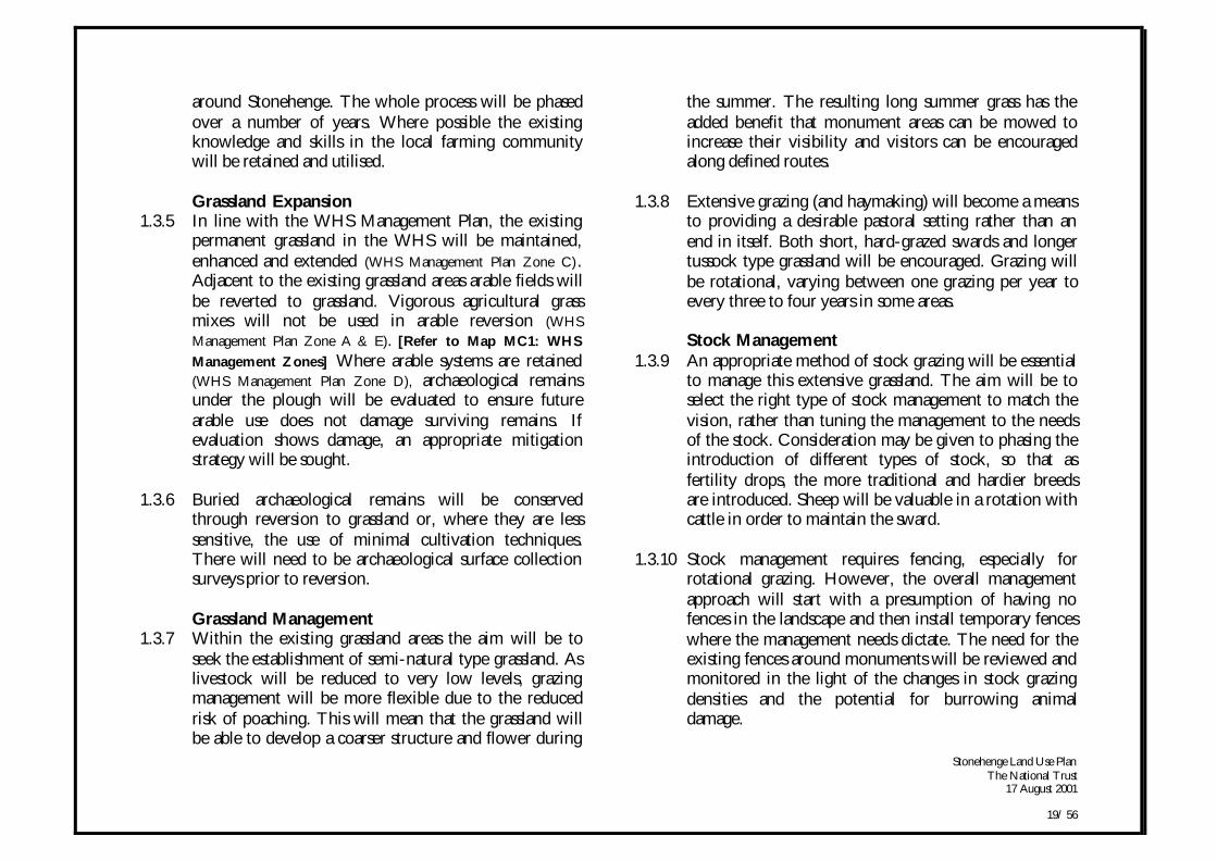
Photo P4: Combine harvester on Countess Farm.In the National Trust’s paper, "Nature Conservation in a Living Countryside"(1999) it states that, ‘The National Trust should investigate fully its potential role inmarketing local produce…the National Trust has many opportunities to link thelandscape which it manages to the product on the plate.’ This opportunity may beconsidered at Stonehenge where the association with the Stonehenge name is verystrong.
Agri-Environment Schemes1.3.12 The international and national status of Stonehenge and
Avebury provides an ideal opportunity to develop soundconservation of archaeological sites in arable dominantareas of the countryside. Innovative work is likely toattract considerable attention and could providestandards of excellence that can be piloted for useelsewhere. The National Trust's active role indeveloping a Countryside Stewardship WHS SpecialProject is a significant step forward in agri-environmentpolicy.
1.3.13 The overall aim for the estate and wider WHS will beto seek a higher take up of Countryside Stewardship toimprove the conservation of archaeology and wildlife. ASpecial Project for the World Heritage Site will be keyto the success of an arable reversion programme andtherefore the protection of vulnerable archaeology.Habitats associated with arable systems on CountessFarm could also be enhanced through the scheme,targeting field margins and annual flora.
1.3.14 Opportunities for organic production (especially onCountess Farm) will also be sought. Organic productionmay be valuable on part or all of the estate for a numberof reasons including marketability of meat,environmental benefit and public appreciation.However, it is recognised that the organic system can beintensive and may restrict the methods of weed controlon arable reversion fields and could contribute toincreased archaeological erosion rates. The farmarrangement must also be flexible enough to make
Stonehenge Land Use PlanThe National Trust
17 August 2001
21/ 56
organic certification feasible. Therefore an organicfeasibility study will need to be carried out as a first step.
1.3.15 Arable management will follow English NatureLandcare Principles where appropriate. Environmentalbenefits in arable areas include spring cropping in mixedrotation, avoidance of chemical inputs, and the potentialarable flower interest. If an organic system isappropriate, then collected farmyard manure will be
essential for recycling on arable fields. Continued arablecultivation on Countess Farm could also provide winterfeed for livestock produced on the farm.
1.3.16 The Stonehenge Land Use Plan will seek to implementwhere appropriate, the National Trust's 2020 vision forsustainable farming, 'Farming Forward'.
Stonehenge Land Use PlanThe National Trust
17 August 2001
22/ 56
Map MC 3: Agricultural Tenancies & Lease Numbers
DurringtonWal ls
Woodhenge
1 8 3 91 8 3 9Countess FarmCountess Farm
1 8 6 71 8 6 7
00Seven Seven BarrowsBarrowsFieldField
0
1 1 4 21 1 4 2West Amesbury FarmWest Amesbury Farm
0
0
1 7 8 91 7 8 9Nor th Eas tNor th Eas tS t o n e h e n g eS t o n e h e n g e
1 1 4 51 1 4 5Let to MODLet to MOD
The Avenue
Stonehenge
1 7 4 01 7 4 0Avenue &Avenue &Eas t CursusEas t Cursus
The Cursus
1 7 9 11 7 9 1North WestNorth WestS t o n e h e n g eS t o n e h e n g e
1 1 4 71 1 4 7Let to EHLet to EH
1 1 8 91 1 8 9North WestNorth Westof Cursusof Cursus0
0
11431 1 4 31 1 4 3Stonehenge S tonehenge DownDown
0
gThe National TrustStonehenge Estate
Land Use Plan
Not to scaleIndicative Layout
July 2001
NT Estate Boundary
Reproduced from O.S. 1997scale map 1:2500 with permissionof the Controller of HM Stationery Office (c) AL-542873Digital data supplied by English Heritage Central Archaeology Service, current in April 2000
17891789North EastNorth EastS tonehengeS tonehenge
0
Lease No.Field Name
Land in-hand
Stonehenge Land Use PlanThe National Trust
17 August 2001
23/ 56
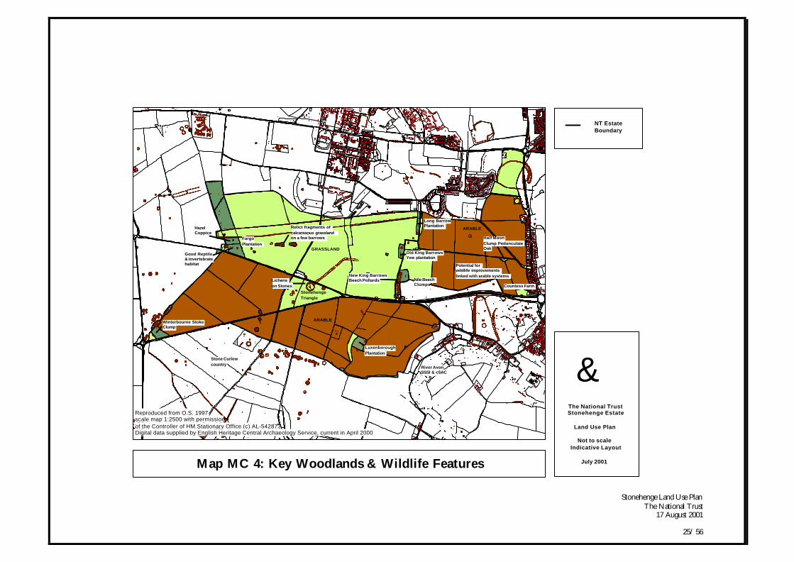
1.4 Wildlife
Existing Survey Data1.4.1 The existing biological survey is currently being
improved through the Highways Agency ExtendedPhase I habitat surveys for the whole of the A303corridor and, for some limited species, in the wider area.However, a good proportion of the estate lacks avaluable biological information base. Improving thissituation will be a key aspect of the Land Use Plan.
Regional Nature Conservation Objectives1.4.2 At a regional level the stated aim for the South Wessex
Downs (as identified in English Nature’s Natural AreaProfile) is to maintain and enhance key habitats andencourage self-sustaining populations of key specieswithin their natural range. The reduction of habitatfragmentation and the implementation of appropriatehabitat re-creation and restoration are also sought, alongwith encouraging public appreciation of natural featuresand key species. All these aspects will be integral to theland use changes proposed for Stonehenge.
World Heritage Site Objectives1.4.3 The World Heritage Site Management Plan seeks the
maintenance of a practical balance between increasedpermanent grassland and arable farmland. {Refer to WHSManagement Objective 7} The Plan suggests that theexisting permanent grassland in the World Heritage Siteshould be maintained, enhanced and extended. {Refer toWHS Management Objective 8} In conjunction with this,the overall nature conservation value and biodiversity ofthe WHS should be enhanced, in particular by
maintaining and improving the limited areas offloristically rich chalk downland turf and by creatinggreater diversity. {Refer to WHS Management Objective 12}In terms of woodlands, the WHS Plan suggests that theirmanagement for both long term survival andbiodiversity should be improved. {Refer to WHSManagement Objective 13}
Management Proposals for Grassland1.4.4 The nature conservation aim for the grassland area will
be for a semi-natural pasture, flowers (where possible)and a general increase in botanical interest on theexisting grassland. The introduction of very rare plants isnot favoured and so the emphasis will be on theestablishment of commonly found wildflowers andgrasses in keeping with the soil type. CountrysideStewardship options, if selected, may support lowernumbers of livestock, restrict herbicide and fertiliser use,and pay enhanced payments for arable reversion to grass.
1.4.5 Consideration will be given to the genetic origin of seedused in creating long-term grasslands and wherepossible, locally harvested seed will be used (e.g.Salisbury Plain or Parsonage Down). It will beimportant that vigorous pasture mixes, based onperennial ryegrass/clover are not used. These mixes,whilst being more productive, would smother anybotanical interest and appear artificial. Further fertiliserinputs will be avoided to gradually reduce fertility andtherefore competition from vigorous grasses.
Stonehenge Land Use PlanThe National Trust
17 August 2001
24/ 56
1.4.6 The results of a soil survey (2000) show that there is,with a few notable exceptions, a typical spread of plantnutrient indices. However, as the grassland areascurrently have low species diversity, enhancement of thenature conservation value of the habitat would need toconcentrate on further lowering the nutrient indices.
Management Proposal for Arable Systems1.4.7 On Countess Farm there will be mixed agriculture with
enhanced wildlife management. CountrysideStewardship options, if selected, may restrict herbicideand fertiliser use (i.e. conservation headlands) andprovide opportunities for rare arable plants, nectarfeeding insects and birds.
1.4.8 Where possible a range of crop types in a relativelysmall-scale mosaic will be sought (similar to the presentsituation on Countess Farm West). This mosaic ofdifferent crops and land use features is important forallowing a range of habitat structures and food sourcesto develop. There will be a continuing opportunity toobtain multiple archaeological and wildlife benefits asthey arise.
1.4.9 Open bare ground for stone curlew nesting andinvertebrate populations may also be sought in suitablelocations. The conservation of existing chalk grassland in
arable areas will be important, especially if this can belinked to larger areas of grassland.
Management Proposals for Woodland/ Scrub1.4.10 The first priority for the management of woodland will
be to conserve and enhance the historic landscape andarchaeology, taking into account the intervisibilitybetween monuments. The Land Use Plan takes the linethat increasing tree cover within the area covered by thePlan is inappropriate. Scrub can damage archaeology andonce it has a hold in an area, it is difficult and costly tocontrol. There are however, few areas in SouthernEngland free from scrub and Salisbury Plain hasconsiderable habitat coverage. As a result the Land UsePlan has therefore taken the line that there is probablylittle gain to ornithology from having patches of scrubon the Stonehenge grasslands.
1.4.11 There are also significant opportunities to enhance thenature conservation value of the existing woodlands.Scrub and coppice will be restricted to withinwoodlands and areas of long grass will be available assubstitute habitat. The fauna in woodlands, especiallybats, badgers and the effects of deer grazing, will besurveyed and taken into consideration in any woodlandmanagement proposals. Full nature conservationproposals for the estate will be drawn up after thebiological survey has been carried out.
Stonehenge Land Use PlanThe National Trust
17 August 2001
25/ 56
Map MC 4: Key Woodlands & Wildlife Features
Potential for wildlife improvements
linked with arable systems
Half Moon
Clump PedunculateOak
Countess Farm
ARABLE
River AvonSSSI & cSAC
Luxenborough
Plantation
Nile BeechClumps
Old King BarrowsYew plantation
Long BarrowPlantation
New King BarrowsBeech Pollards
Stonehenge
Triangle
Relict fragments of
calcareaous grasslandon a few barrows
ARABLE
GRASSLAND
Lichens
on Stones
Fargo
Plantation
HazelCoppice
Good Reptile& invertebratehabitat
Stone Curlew
country
Winterbourne StokeClump
gThe National TrustStonehenge Estate
Land Use Plan
Not to scaleIndicative Layout
July 2001
NT Estate Boundary
Reproduced from O.S. 1997scale map 1:2500 with permissionof the Controller of HM Stationary Office (c) AL-542873Digital data supplied by English Heritage Central Archaeology Service, current in April 2000
Stonehenge Land Use PlanThe National Trust
17 August 2001
26/ 56
1.5 Access & Interpretation
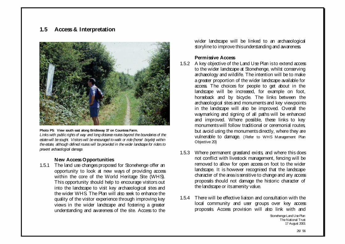
Photo P5: View south east along Bridleway 37 on Countess Farm.Links with public rights of way and long distance routes beyond the boundaries of theestate will be sought. Visitors will be encouraged to walk or ride (horse/ bicycle) withinthe estate, although defined routes will be provided in the wider landscape for riders toprevent archaeological damage.
New Access Opportunities1.5.1 The land use changes proposed for Stonehenge offer an
opportunity to look at new ways of providing accesswithin the core of the World Heritage Site (WHS).This opportunity should help to encourage visitors outinto the landscape to visit key archaeological sites andthe wider WHS. The Plan will also seek to enhance thequality of the visitor experience through improving keyviews in the wider landscape and fostering a greaterunderstanding and awareness of the site. Access to the
wider landscape will be linked to an archaeologicalstoryline to improve this understanding and awareness.
Permissive Access1.5.2 A key objective of the Land Use Plan is to extend access
to the wider landscape at Stonehenge, whilst conservingarchaeology and wildlife. The intention will be to makea greater proportion of the wider landscape available foraccess. The choices for people to get about in thelandscape will be increased, for example on foot,horseback and by bicycle. The links between thearchaeological sites and monuments and key viewpointsin the landscape will also be improved. Overall thewaymarking and signing of all paths will be enhancedand improved. Where possible, these links to keymonuments will follow traditional or ceremonial routes,but avoid using the monuments directly, where they arevulnerable to damage. {Refer to WHS Management PlanObjective 20}
1.5.3 Where permanent grassland exists, and where this doesnot conflict with livestock management, fencing will beremoved to allow for open access on foot to the widerlandscape. It is however recognised that the landscapecharacter of the area is sensitive to change and any accessproposals should not damage the historic character ofthe landscape or its amenity value.
1.5.4 There will be effective liaison and consultation with thelocal community and user groups over key accessproposals. Access provision will also link with and
Stonehenge Land Use PlanThe National Trust
17 August 2001
27/ 56
complement proposals and initiatives beyond theboundaries of the Plan area such as the SUSTRANS longdistance cycle route.
Rights of Way1.5.5 Some areas of 'grassland down' will be identified and
mapped as access areas under the Countryside & Rightsof Way Act. Although much of the permanent grasslandon Stonehenge Down is currently open to public access,the new laws mean that this may become a 'right ofaccess' for people to walk over the area. Expansion ofthe permanent grassland onto arable fields immediatelyaround Stonehenge could considerably increase the areaavailable to walkers, greatly enhancing the area forrecreational opportunities. Careful management willhowever be required in order to ensure thatarchaeological and historical landscape conservation isnot adversely affected. An important conservation taskwill be a short diversion of Bridleway 39 from the eastend of the Cursus and off the long barrow.
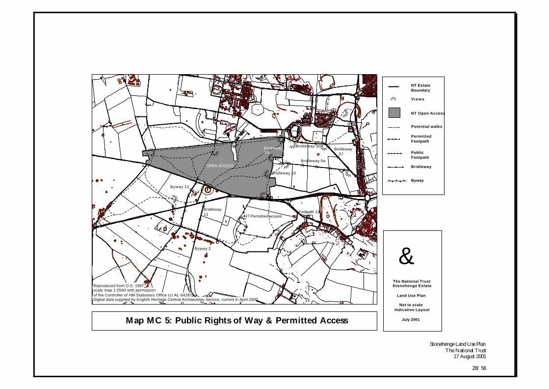
1.5.6 After the completion of the A303 Scheme, theopportunity will be taken to link Bridleway 10,Bridleway 11 and Byway 12. Consideration will begiven to dedicating this new bridleway, as a right ofway. [Refer to Map MC 5: Public Rights of Way &Permitted Access & Table GI 6 in Appendix 1]
Access by Motorised Vehicles1.5.7 Whilst the proposed land use changes seek to improve
the setting of Stonehenge through the removal of theroads (A303/ A344), the continued use of Byway 12 bymotorised vehicles retains the ability to access the Stones
along a rough trackway. Proposals have been putforward to downgrade the route to a bridleway anddivert the Byway to a route away from the immediatesetting of the Stones. The diversion would be requiredin order to retain the amenity value of the Byway as along distance north-south route. However, according tothe guidance of the WHS Management Plan, diversionof Byway 12 within the World Heritage Site could bepotentially damaging to sensitive archaeological remainswithin the core area. {Refer to WHS Management PlanObjective 23) It also would involve creating a new roadwithin the World Heritage Site on private land.
1.5.8 An alternative option has been investigated whichwould prohibit motorised vehicles on Byway 12. Theapproach would involve using Road Traffic RegulationAct 1984 (sec 22), which regulates traffic in special areasof countryside and includes inalienable National Trustland. The historic rights of the route are retained but thevehicular rights cannot be exercised. The Order canonly be made by the local Highway Authority with thesupport of the relevant landowners. The disadvantage ofusing a Traffic Regulation Order is that users of theByway would be unable to pass north-south across theWorld Heritage Site.
1.5.9 It is recognised that some of the access user groupsstrongly oppose the Traffic Regulation Order approach,especially if no alternative route is provided. The LandUse Plan recommends that an access user group beconvened to explore the issues. Any solutions wouldneed to be within the framework of the implementationof the World Heritage Site Management Plan.
Stonehenge Land Use PlanThe National Trust
17 August 2001
28/ 56
Map MC 5: Public Rights of Way & Permitted Access
«
««
«
«
«
««
««
««
«
«
«
«
«
«
Bridleway 37
NT Permitted access
Bridleway 10
Bridleway 9a
Bridleway 30
Footpath 13
Bridleway39
Byway 12
Bridleway11
Byway 2
OPEN ACCESS
gThe National TrustStonehenge Estate
Land Use Plan
Not to scaleIndicative Layout
July 2001
NT Estate Boundary
Reproduced from O.S. 1997scale map 1:2500 with permissionof the Controller of HM Stationery Office (c) AL-542873Digital data supplied by English Heritage Central Archaeology Service, current in April 2000
« Views
NT Open Access
Potential walks
PermittedFootpath
PublicFootpath
Bridleway
Byway

Stonehenge Land Use PlanThe National Trust
17 August 2001
29/ 56
Visitor Transport1.5.10 A transport link for visitors from a Countess East visitor
centre across Countess Farm West to King BarrowRidge is being investigated by English Heritage. Theactual form of transport, detail of routes and location ofdrop-off points on the estate are still underconsideration. However, any associated facilities andinfrastructure would be expected to be minimal, simple,flexible and reversible.
1.5.11 The National Trust, working in partnership withEnglish Heritage will be ensuring that the quality of thevisitor approach to the Stone Circle will be integral tothe visitor experience and considered in any proposedtransport route. The route should also consider the needfor an attractive and direct walking and riding routefrom the visitor centre to King Barrow Ridge, which isnot compromised by the mass transit approach.Agricultural operations will be continuing on CountessFarm and these requirements and those of the existingpublic rights of way, will need to also be taken intoconsideration.
Access For All1.5.12 The wider landscape currently has limited access for
people with impaired mobility. Simple improvementscan be made such as providing suitable gates (as opposedto stiles) and providing clear and accurate informationon the accessibility of various routes. Visitors should beable to match information against their own capabilities.An accessibility audit will highlight such difficulties andsupport proposed remedies.
1.5.13 It will be essential that any transport provided forvisitors is accessible to disabled visitors and able toaccommodate other members of their group. This willensure that groups are not separated during their visit toStonehenge.
Interpretation1.5.14 The World Heritage Site Management Plan states that
the current level of interpretation is limited in its impactand puts forward the suggestion that a detailed WHSInterpretation Strategy is developed. {Refer to WHSManagement Plan Objective 21} At present interpretation ofthe area beyond the immediate Stone Circle relies on aNational Trust walks leaflet called ‘Exploring theStonehenge Landscape’ and twelve information panelsin the wider landscape.
1.5.15 The proposed new visitor centre at Countess East willprovide the focus of a new approach to interpretationand education at Stonehenge. The landscapeinterpretation should however, provide an interpretativeexperience that stands in its own right for those visitorswho do not use the Visitor Centre. The Stonehengelandscape will be used to promote broad themes aboutchanging archaeological (and other) perceptions ofplace. It will also be used to explore themes such ashuman interaction with the environment creating majorlandscape change. In general, interpretation on the estatewill work from multiple access points. The Stonehengemonument will be interpreted as an integral part of the
Stonehenge Land Use PlanThe National Trust
17 August 2001
30/ 56
wider landscape and time lines will be used wherepossible in the interpretation to illustrate context.
1.5.16 The Land Use Plan includes an Interim InterpretationPlan for the National Trust estate, highlighting workthat will be carried out to immediately upgrade thecurrent interpretation media. It also sets the context fora longer term strategy and includes an audit of existinginterpretation, visitor research and development of anarchaeological storyline. This work will be incorporatedinto a WHS Interpretation Strategy and will bereviewed so that it complements the content of theproposed visitor centre.
1.6 Monitoring the Plan and ManagingChange
1.6.1 The Land Use Plan will be monitored on an annualbasis, with the National Trust Property Managerdrawing up an Action Plan to tackle issues raisedthrough annual assessment of the property.
1.6.2 An integral part of this Action Plan will be a workablemethod of optimising the management of the estate andensuring that the Trust provides ‘conservation withaccess’. {Refer to WHS Management Plan Objective 26} Such amethod will be developed in consultation with theWorld Heritage Site Management Plan Co-ordinationOfficer and the Trust’s Property Manager. A study willbe carried out over the next year in consultation withthe WHS Implementation Group to identify anappropriate monitoring and management model. Thismodel will help assess and inform decisions on theacceptability of key changes in the landscape.
1.6.3 If the approach is suitable and partners agree, it will bebrought into use in 2002. The approach will then bereviewed after a four year trial period (Land Use PlanReview in 2006). Recommendations will then be madefor optimising the long-term management of this areaafter the completion of the major land use changes.

Stonehenge Land Use PlanThe National Trust
17 August 2001
31/ 56
Part II: Management Policies & Action
Stonehenge Land Use PlanThe National Trust
17 August 2001
32/ 56
Part II: Management Policies & Action
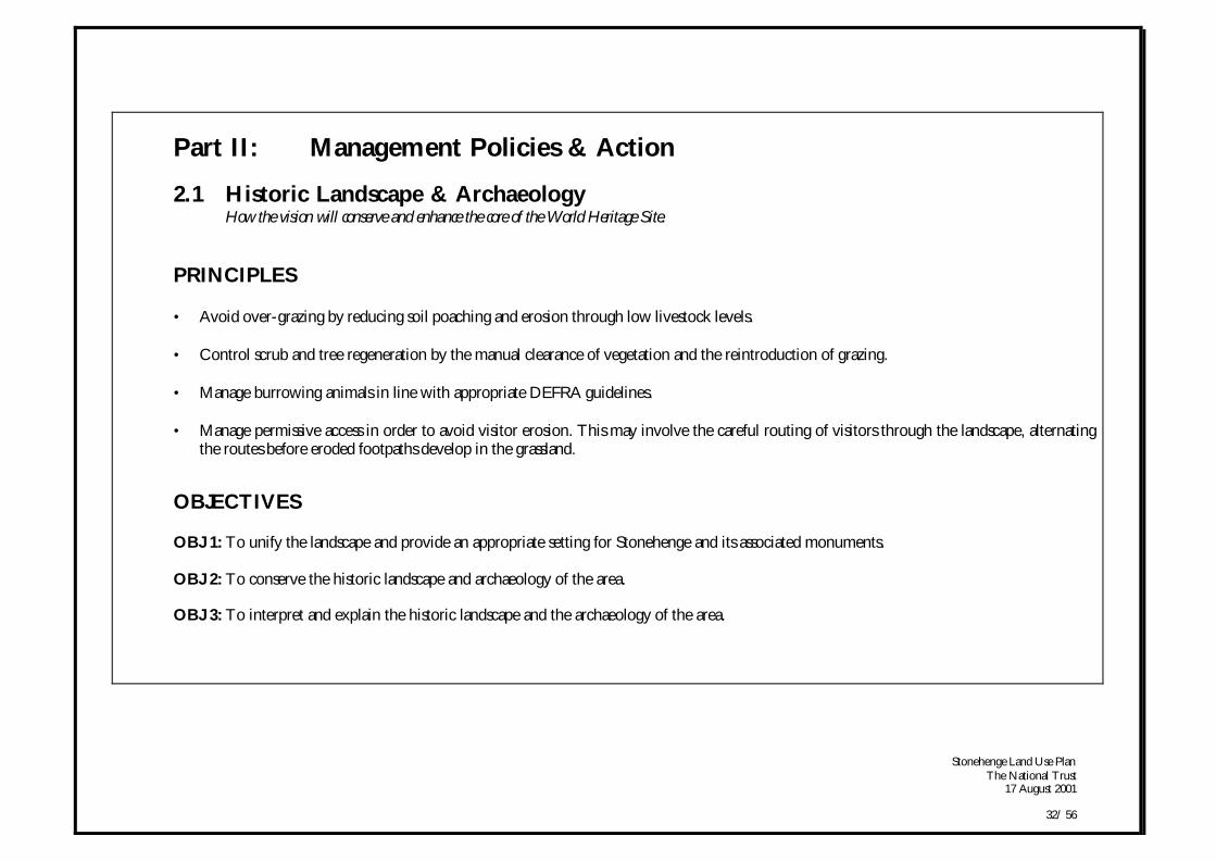
2.1 Historic Landscape & ArchaeologyHow the vision will conserve and enhance the core of the World Heritage Site.
PRINCIPLES
• Avoid over-grazing by reducing soil poaching and erosion through low livestock levels.
• Control scrub and tree regeneration by the manual clearance of vegetation and the reintroduction of grazing.
• Manage burrowing animals in line with appropriate DEFRA guidelines.
• Manage permissive access in order to avoid visitor erosion. This may involve the careful routing of visitors through the landscape, alternatingthe routes before eroded footpaths develop in the grassland.
OBJECTIVES
OBJ 1: To unify the landscape and provide an appropriate setting for Stonehenge and its associated monuments.
OBJ 2: To conserve the historic landscape and archaeology of the area.
OBJ 3: To interpret and explain the historic landscape and the archaeology of the area.
Stonehenge Land Use PlanThe National Trust
17 August 2001
33/ 56
Land Use CrossRef.
Land UseObjective
ManagementPolicy
Action Timing
(HLA) (P) (A)Historic
Landscape &Archaeology
WHSManagement
ZonesA/ C/ D
HLAP 2HLAP 3HLAP 8
AGP 5AGP 6
OBJ 1:To unify the
landscape andprovide anappropriatesetting for
Stonehenge andits associatedmonuments.
HLAP 1: Thelandscape setting forStonehenge shouldbe unified throughthe removal ofintrusive 20th / 21st
Century features andrestoring the land tograss.
HLAA 1.1: Following closure of the A344 linked tothe A303 draft Orders, help partners draw up plans forthe removal of the existing visitor facility structures.Consider the suitability of, and the need for, theconstruction of an unobtrusive site office in parallelwith the plans for the new visitor facilities.
HLAA 1.2: Work in partnership to integrate thereinstatement of the A303 and the A344 road corridorsand the existing visitor facilities/ car park with thesurrounding landscape.
HLAA 1.3: Remove fences around monuments in thewider landscape after an assessment of potential damageby stock and burrowing animals. Ensure theprogramme of boundary fence removal is linked withthe A303, A344 and new visitor centre constructionwork.
HLAA 1.4: In partnership with MOD, investigatecontamination issues, removal of structures and re-integration of sewage outfall site with wider landscape.
0-5yrs
5-30yrs
5-30yrs
0-5yrsHLAP 1
AGP 1AGP 2AGP 3AGP 5AGP 6
HLAP 2: Landmanagement shouldbe integrated acrossthe area to achieve anappropriate landscapesetting.
HLAA 2.1: Extend the grassland within WHSManagement Zone C to provide an appropriate settingfor Stonehenge. Revert arable fields south of thecurrent A303 and areas on the estate within WHSZones A & E, to grassland.
0-30yrs+
Stonehenge Land Use PlanThe National Trust
17 August 2001
34/ 56
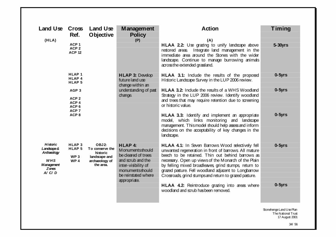
Land Use CrossRef.
Land UseObjective
ManagementPolicy
Action Timing
(HLA) (P) (A)ACP 1ACP 2ACP 12
HLAA 2.2: Use grazing to unify landscape aboverestored areas. Integrate land management in theimmediate area around the Stones with the widerlandscape. Continue to manage burrowing animalsacross the extended grassland.
5-30yrs
HLAP 1HLAP 4HLAP 5
AGP 3
ACP 2ACP 4ACP 6ACP 7ACP 8
HLAP 3: Developfuture land usechange within anunderstanding of pastchange.
HLAA 3.1: Include the results of the proposedHistoric Landscape Survey in the LUP 2006 review.
HLAA 3.2: Include the results of a WHS WoodlandStrategy in the LUP 2006 review. Identify woodlandand trees that may require retention due to screeningor historic value.
HLAA 3.3: Identify and implement an appropriatemodel, which links monitoring and landscapemanagement. This model should help assess and informdecisions on the acceptability of key changes in thelandscape.
0-5yrs
0-5yrs
0-5yrs
HistoricLandscape &Archaeology
WHSManagement
ZonesA/ C/ D
HLAP 3HLAP 5
WP 3WP 4
OBJ 2:To conserve the
historiclandscape andarchaeology of
the area.
HLAP 4:Monuments shouldbe cleared of treesand scrub and theinter-visibility ofmonuments shouldbe reinstated whereappropriate.
HLAA 4.1: In Seven Barrows Wood selectively fellunwanted regeneration in front of barrows. All maturebeech to be retained. Thin out behind barrows asnecessary. Open up views of the Monarch of the Plainby felling mixed broadleaves, grind stumps, return tograzed pasture. Fell woodland adjacent to LongbarrowCrossroads, grind stumps and return to grazed pasture.
HLAA 4.2: Reintroduce grazing into areas wherewoodland and scrub has been removed.
0-5yrs
0-5yrs
Stonehenge Land Use PlanThe National Trust
17 August 2001
35/ 56
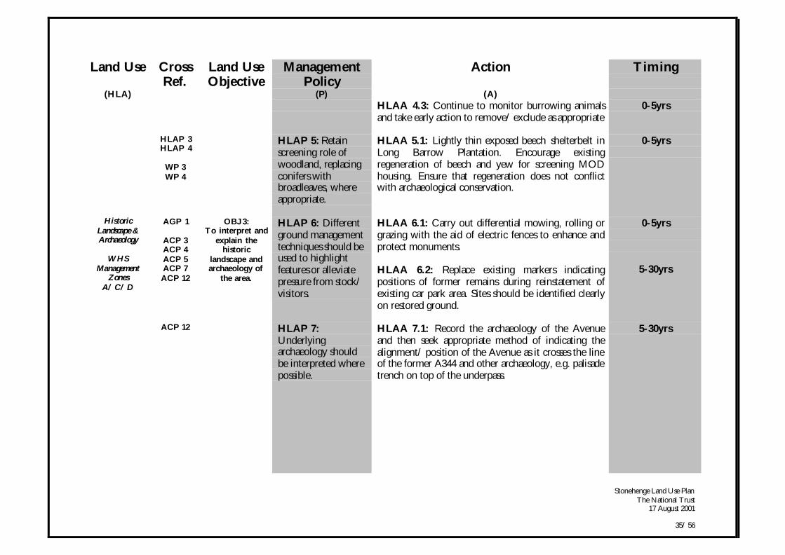
Land Use CrossRef.
Land UseObjective
ManagementPolicy
Action Timing
(HLA) (P) (A)HLAA 4.3: Continue to monitor burrowing animalsand take early action to remove/ exclude as appropriate
0-5yrs
HLAP 3HLAP 4
WP 3WP 4
HLAP 5: Retainscreening role ofwoodland, replacingconifers withbroadleaves, whereappropriate.
HLAA 5.1: Lightly thin exposed beech shelterbelt inLong Barrow Plantation. Encourage existingregeneration of beech and yew for screening MODhousing. Ensure that regeneration does not conflictwith archaeological conservation.
0-5yrs
HistoricLandscape &Archaeology
WHSManagement
ZonesA/ C/ D
AGP 1
ACP 3ACP 4ACP 5ACP 7ACP 12
OBJ 3:To interpret and
explain thehistoric
landscape andarchaeology of
the area.
HLAP 6: Differentground managementtechniques should beused to highlightfeatures or alleviatepressure from stock/visitors.
HLAA 6.1: Carry out differential mowing, rolling orgrazing with the aid of electric fences to enhance andprotect monuments.
HLAA 6.2: Replace existing markers indicatingpositions of former remains during reinstatement ofexisting car park area. Sites should be identified clearlyon restored ground.
0-5yrs
5-30yrs
ACP 12 HLAP 7:Underlyingarchaeology shouldbe interpreted wherepossible.
HLAA 7.1: Record the archaeology of the Avenueand then seek appropriate method of indicating thealignment/ position of the Avenue as it crosses the lineof the former A344 and other archaeology, e.g. palisadetrench on top of the underpass.
5-30yrs
Stonehenge Land Use PlanThe National Trust
17 August 2001
36/ 56
Land Use CrossRef.
Land UseObjective
ManagementPolicy
Action Timing
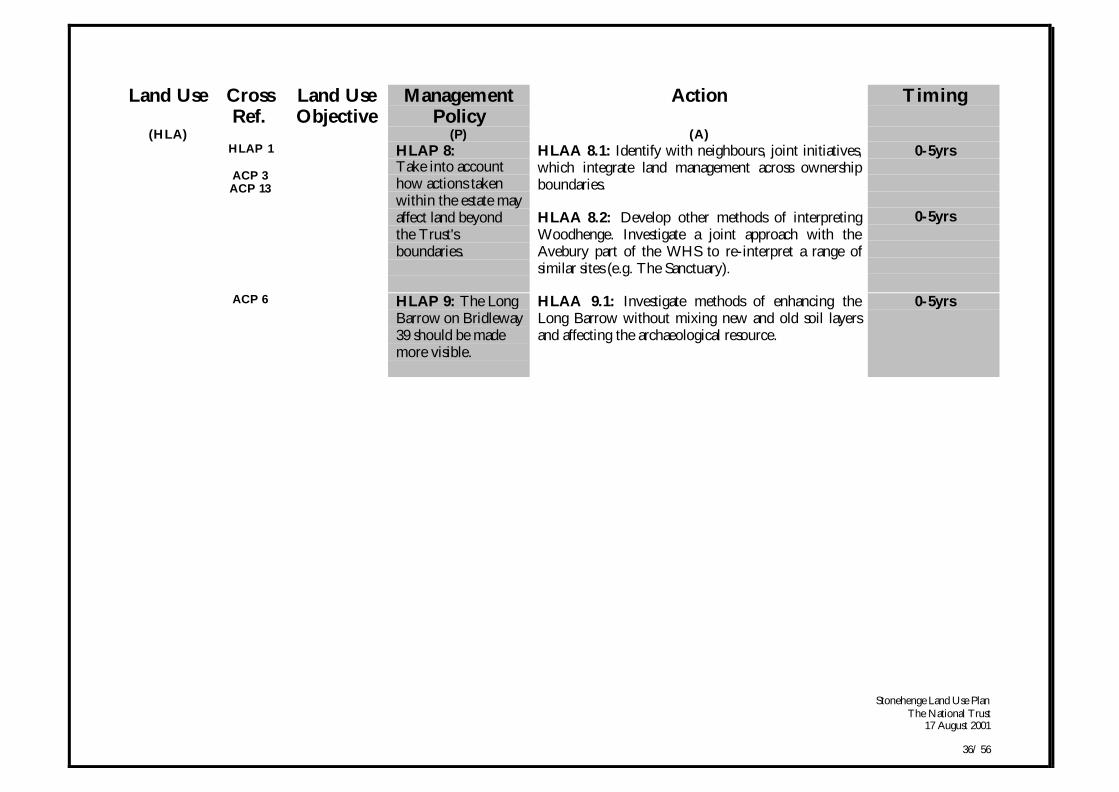
(HLA) (P) (A)HLAP 1
ACP 3ACP 13
HLAP 8:Take into accounthow actions takenwithin the estate mayaffect land beyondthe Trust'sboundaries.
HLAA 8.1: Identify with neighbours, joint initiatives,which integrate land management across ownershipboundaries.
HLAA 8.2: Develop other methods of interpretingWoodhenge. Investigate a joint approach with theAvebury part of the WHS to re-interpret a range ofsimilar sites (e.g. The Sanctuary).
0-5yrs
0-5yrs
ACP 6 HLAP 9: The LongBarrow on Bridleway39 should be mademore visible.
HLAA 9.1: Investigate methods of enhancing theLong Barrow without mixing new and old soil layersand affecting the archaeological resource.
0-5yrs

Stonehenge Land Use PlanThe National Trust
17 August 2001
37/ 56
2.2 AgricultureHow the area will be managed through the agricultural system.
PRINCIPLES
• Take a new approach to how the Trust manages its tenancies on the estate, establishing close management control of the agricultural land.
• Deliver extensive grassland in the core area around Stonehenge, amalgamating the existing and extended grassland areas into onecontiguous block and grazed by a low density of livestock.
• Seek environmental improvements in arable systems, including the modification of arable cultivation techniques in order to conserve buriedarchaeological remains and to conserve soils.
• Improve the quality and structure of the existing permanent grassland habitat, seeking a floristically rich grassland and creating greaterdiversity of species.
• Enhance arable habitat, such as field margins, annual flowers and associated fauna (farm birds).
• Seek a higher uptake of agri-environment options for arable reversion and grassland management across the area.
OBJECTIVES
OBJ 4: To conserve the historic landscape and archaeological resource, whilst retaining an agricultural working landscape.
OBJ 5: To reorganise the National Trust tenancies to enable the vision to be implemented.
OBJ 6: To achieve a high standard of environmental management.
Stonehenge Land Use PlanThe National Trust
17 August 2001
38/ 56
Land Use CrossRef.
Land UseObjective
ManagementPolicy
Action Timing
(A) (P) (A)Agriculture
AG
WHSManagement
ZonesA/ C/ D
HLAP 2HLAP 6
AGP 2AGP 5AGP 6
WP 1WP2
OBJ 4:To conserve the
historiclandscape andarchaeological
resource, whilstretaining anagricultural
workinglandscape.
AGP 1:Management ofexisting and futuregrassland areasshould ensure thatover-grazing isavoided.
AGA 1.1: Introduce very low livestock levels toreduce the risk of poaching and erosion ofarchaeology.
AGA 1.2: Introduce summer cattle grazing, followedby winter sheep grazing if required.
0-30yrs+
0-30yrs
HLAP 2AGP 1AGP 5
WP 1WP 2
AGP 2: Arablereversion tograssland above areasof vulnerablearchaeology will besought.
AGA 2.1: Map priority areas for arable reversionbased on archaeological vulnerability. Base reversionon the experience of the Seven Barrows Fieldreversion project and similar sites.
AGA 2.2: Apply for Countryside Stewardship WHSSpecial Project enhanced payments if available.
0-5yrs
0-5yrs
HLAP 2HLAP 3
AGP 3: Agriculturalsystems should notimpact upon thehistoric landscapesetting.
AGA 3.1: Investigate the potential archaeological andlandscape impact of new water supplies. Prepare a planof water provision.
AGA 3.2: Investigate and tackle areas suffering fromlocalised poaching, enrichment and erosion, especiallywithin the 'Bowl'. Prepare a list of priority tasks.
0-5yrs
0-5yrs
AGP 7 AGP 4: Minimumcultivationtechniques should beused where arablesystems continue.
AGA 4.1: Seek improved conservation clauses relatingto minimal cultivation techniques, for Farm BusinessTenancy (FBT) on Countess Farm.
0-5yrs

Stonehenge Land Use PlanThe National Trust
17 August 2001
39/ 56
Land Use CrossRef.
Land UseObjective
ManagementPolicy
Action Timing
(AG) (P) (A)Agriculture
WHSManagement
ZoneC
HLAP 1HLAP 2
AGP 1AGP 2AGP 6
WP 1WP 2
OBJ 5:To reorganisethe National
Trust tenanciesto enable thevision to be
implemented.
AGP 5: Grasslandcover should beexpandedthroughout WHSManagement ZoneC.
AGA 5.1: Seek negotiated settlement with the holdersof Agricultural Holdings Act (AHAT) tenancies: Seekarable reversion through WHS CountrysideStewardship Special Project and enter into extensivegrazing system.
0-30yrs
HLAP 1HLAP 2
AGP 1AGP 5
WP 1
AGP 6: Existingand newly revertedgrassland should beamalgamated into asingle area ofcontiguous grazing.
AGA 6.1: Do not renew the existing FBT agreements
AGA 6.2: Retain close management control of wholeestate (with the exception of the arable land onCountess Farm). Let the extensive areas of grassland onannual grazing licences.
AGA 6.3: Phase fence removal between tenancies andwithin tenancies. Install new stock and verminproofboundary fencing where required. Use electric fencingto manage stock.
AGA 6.4: Employ warden with stock care/management skills to oversee and liaise with grazierspromoting even grazing, to discourage erosion, and tomonitor the stock security & welfare.
0-5yrs
0-30yrs
0-30yrs
0-5yrs
Agriculture
WHSManagement
ZonesA/ C/ D
AGP 4
WP 1WP 2
OBJ 6:To achieve a
high standard ofenvironmentalmanagement.
AGP 7:Improvements inenvironmentalpractices should besought across theestate.
AGA 7.1: Investigate the feasibility of establishingorganic production.
AGA 7.2: Introduce the National Trust code ofpractice for the conservation of soils on arable land.
0-5yrs
0-5yrs
Stonehenge Land Use PlanThe National Trust
17 August 2001
40/ 56
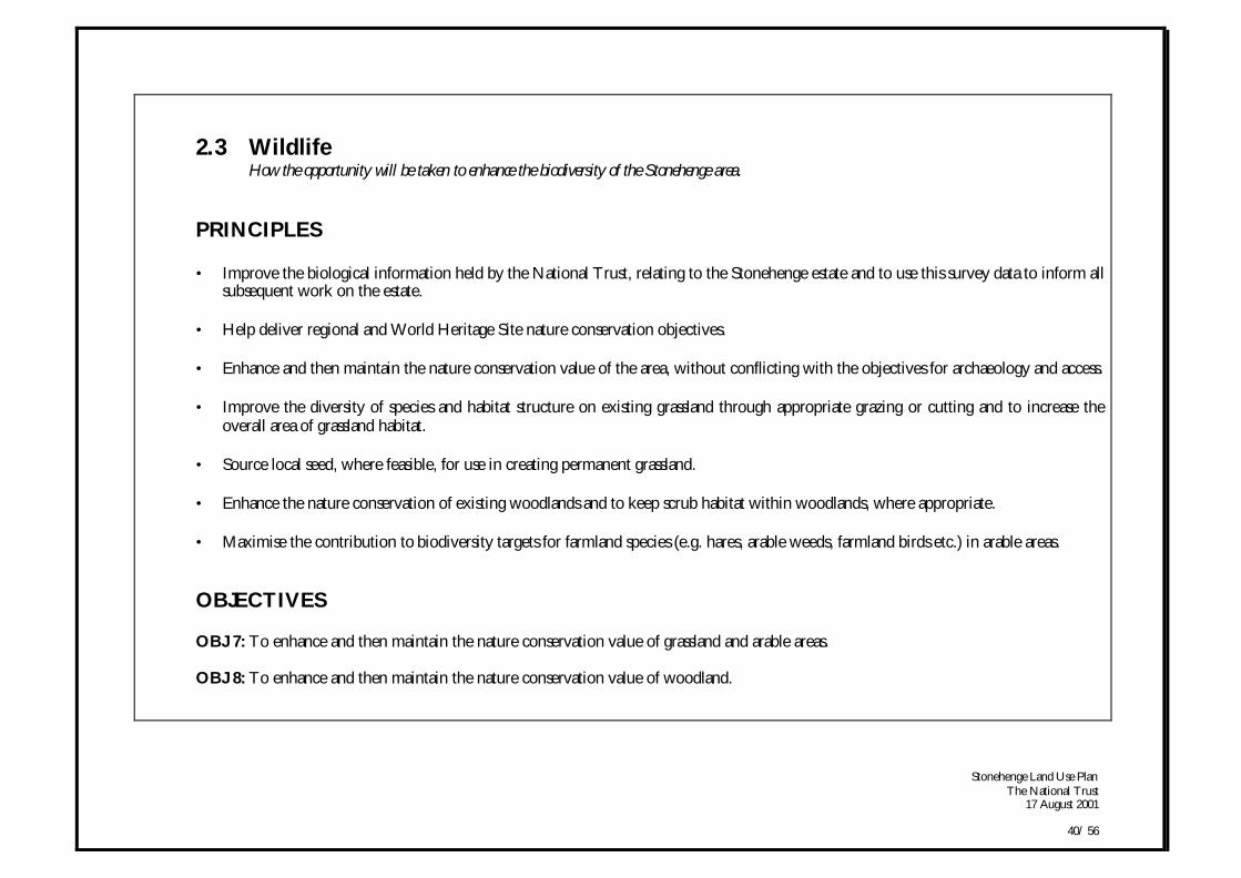
2.3 WildlifeHow the opportunity will be taken to enhance the biodiversity of the Stonehenge area.
PRINCIPLES
• Improve the biological information held by the National Trust, relating to the Stonehenge estate and to use this survey data to inform allsubsequent work on the estate.
• Help deliver regional and World Heritage Site nature conservation objectives.
• Enhance and then maintain the nature conservation value of the area, without conflicting with the objectives for archaeology and access.
• Improve the diversity of species and habitat structure on existing grassland through appropriate grazing or cutting and to increase theoverall area of grassland habitat.
• Source local seed, where feasible, for use in creating permanent grassland.
• Enhance the nature conservation of existing woodlands and to keep scrub habitat within woodlands, where appropriate.
• Maximise the contribution to biodiversity targets for farmland species (e.g. hares, arable weeds, farmland birds etc.) in arable areas.
OBJECTIVES
OBJ 7: To enhance and then maintain the nature conservation value of grassland and arable areas.
OBJ 8: To enhance and then maintain the nature conservation value of woodland.
Stonehenge Land Use PlanThe National Trust
17 August 2001
41/ 56
Land Use CrossRef.
Land UseObjective
ManagementPolicy
Action Timing
(W) (P) (A)Wildlife
WHSManagement
ZonesA/ C/ D
AGP 1AGP 2AGP 5AGP 6AGP 7
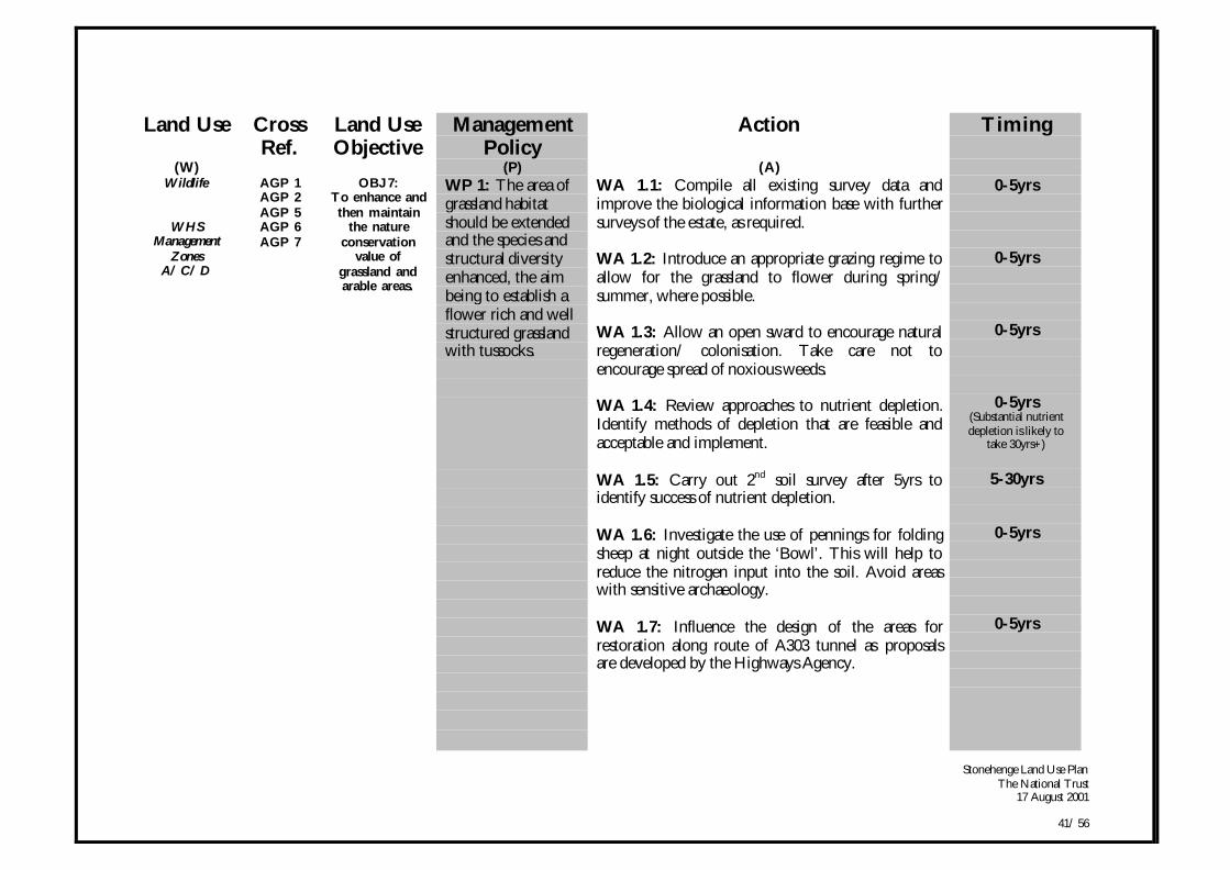
OBJ 7:To enhance andthen maintain
the natureconservation
value ofgrassland andarable areas.
WP 1: The area ofgrassland habitatshould be extendedand the species andstructural diversityenhanced, the aimbeing to establish aflower rich and wellstructured grasslandwith tussocks.
WA 1.1: Compile all existing survey data andimprove the biological information base with furthersurveys of the estate, as required.
WA 1.2: Introduce an appropriate grazing regime toallow for the grassland to flower during spring/summer, where possible.
WA 1.3: Allow an open sward to encourage naturalregeneration/ colonisation. Take care not toencourage spread of noxious weeds.
WA 1.4: Review approaches to nutrient depletion.Identify methods of depletion that are feasible andacceptable and implement.
WA 1.5: Carry out 2nd soil survey after 5yrs toidentify success of nutrient depletion.
WA 1.6: Investigate the use of pennings for foldingsheep at night outside the ‘Bowl’. This will help toreduce the nitrogen input into the soil. Avoid areaswith sensitive archaeology.
WA 1.7: Influence the design of the areas forrestoration along route of A303 tunnel as proposalsare developed by the Highways Agency.
0-5yrs
0-5yrs
0-5yrs
0-5yrs(Substantial nutrientdepletion is likely to
take 30yrs+)
5-30yrs
0-5yrs
0-5yrs

Stonehenge Land Use PlanThe National Trust
17 August 2001
42/ 56
Land Use CrossRef.
Land UseObjective
ManagementPolicy
Action Timing
(W) (P) (A)AGP 1AGP 2AGP 5AGP 7
WP 2: The use ofCountrysideStewardship optionsto deliverconservation gainson both arable andgrassland areasshould beencouraged.
WA 2.1: Use locally collected seed for arablereversion. Manage these fields with a grazing regimeflexible enough to respond to developing conditions.
WA 2.2: Seek the use of grassland leys withinrotations, spring cereals and wintering stubbles,features such as conservation headlands, beetle banksand suitably placed stone curlew habitat.
0-5yrs
0-5yrs
Wildlife
WHSManagement
ZonesA/ C/ D
HLAP 4HLAP 5
WP 4
OBJ 8:To enhance andthen maintain
the natureconservation
value ofremainingwoodland.
WP 3: Allwoodland workshould take intoaccount the potentialimpact onarchaeology andconsider appropriatetiming.
WA 3.1: Identify areas of archaeology withinwoodlands and take appropriate protection measuresbefore woodland work commences.
0-5yrs
HLAP 4HLAP 5
WP 3
WP 4: Thebiodiversity ofexisting woodlandswill be enhancedwhere possible.
WA 4.1: In Fargo Plantation fell Scots pine. FellCorsican pine. Coppice hazel and remove cankeredash. In Seven Barrows Wood coppice hazel, re-spaceregeneration and remove alder nurses. InLuxenborough Plantation, keep barrows clear ofencroaching woody vegetation. Improve habitatstructure in Half Moon Clump.
WA 4.2: Protect badger setts and bat roosts fromdamage, and create and retain deadwood habitats inall woodlands.
0-5yrs
0-5yrs
Stonehenge Land Use PlanThe National Trust
17 August 2001
43/ 56
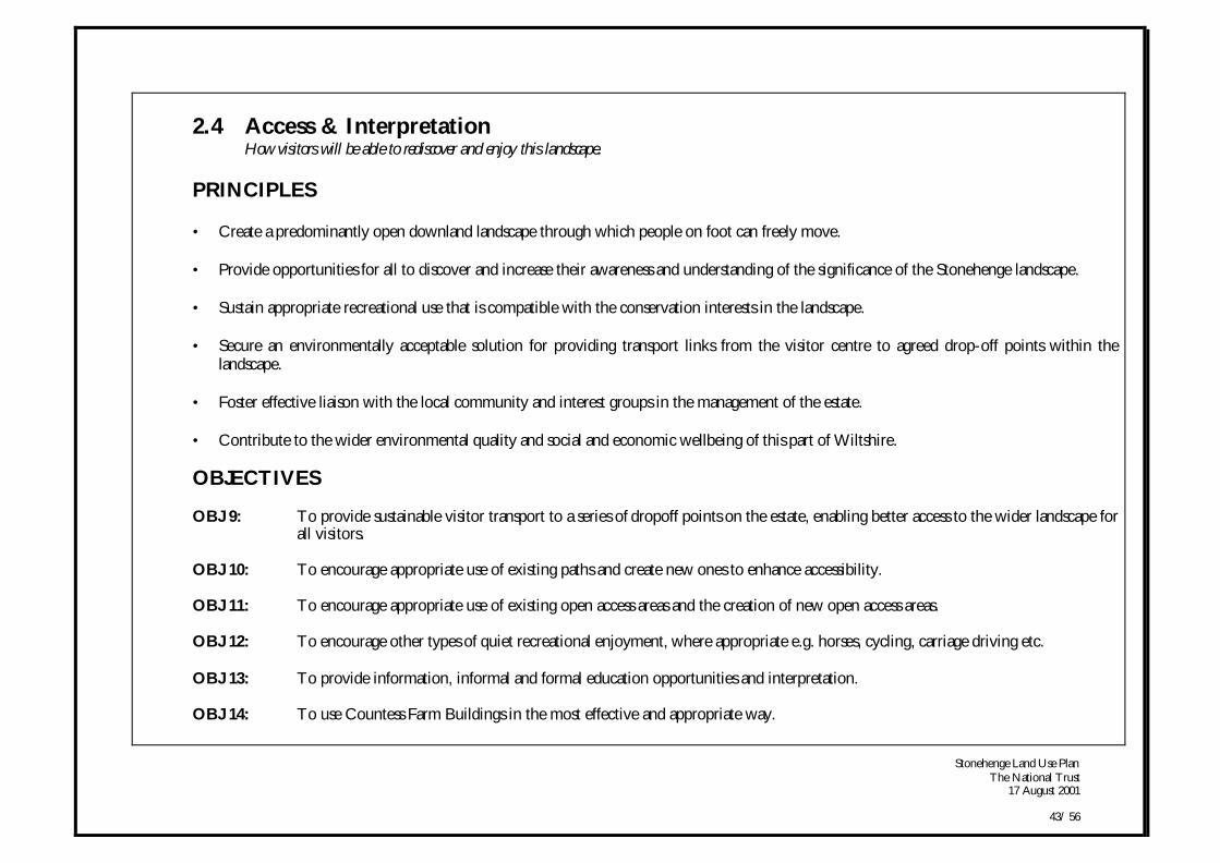
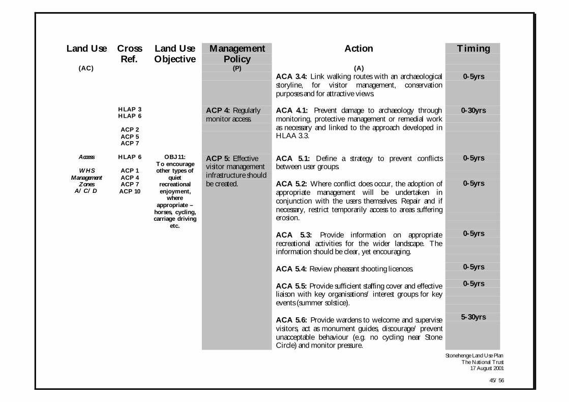
2.4 Access & InterpretationHow visitors will be able to rediscover and enjoy this landscape.
PRINCIPLES
• Create a predominantly open downland landscape through which people on foot can freely move.
• Provide opportunities for all to discover and increase their awareness and understanding of the significance of the Stonehenge landscape.
• Sustain appropriate recreational use that is compatible with the conservation interests in the landscape.
• Secure an environmentally acceptable solution for providing transport links from the visitor centre to agreed drop-off points within thelandscape.
• Foster effective liaison with the local community and interest groups in the management of the estate.
• Contribute to the wider environmental quality and social and economic wellbeing of this part of Wiltshire.
OBJECTIVES
OBJ 9: To provide sustainable visitor transport to a series of dropoff points on the estate, enabling better access to the wider landscape forall visitors.
OBJ 10: To encourage appropriate use of existing paths and create new ones to enhance accessibility.
OBJ 11: To encourage appropriate use of existing open access areas and the creation of new open access areas.
OBJ 12: To encourage other types of quiet recreational enjoyment, where appropriate e.g. horses, cycling, carriage driving etc.
OBJ 13: To provide information, informal and formal education opportunities and interpretation.
OBJ 14: To use Countess Farm Buildings in the most effective and appropriate way.

Stonehenge Land Use PlanThe National Trust
17 August 2001
44/ 56
Land Use CrossRef.
Land UseObjective
ManagementPolicy
Action Timing
(AC) (P) (A)Access
WHSManagement
ZonesA/ C/ D
HLAP 2
ACP 5ACP 9ACP 10
OBJ 9:To encourage
appropriate useof existing pathsand create newones to enhance
accessibility.
ACP 1: All Rightsof Ways into andover the estateshould be signed andmaintained to a highstandard.
ACA 1.1: Help the Highway Authority to fulfil theirobligations on the rights of way across the estate. Workwith the Countryside Agency to define areas of accessunder the CROW Act.
ACA 1.2: Support a WHS access user group toinvestigate the issues and find solutions on the Bywaysthroughout the World Heritage Site, especially Byway12.
ACA 1.3: Use the opportunity provided by the tunnelscheme to link up the Public Rights of Way andimprove the network.
0-5yrs
0-5yrs
5-30yrs
HLAP 2HLAP 3HLAP 9
ACP 4
ACP 2: Takeopportunities todivert paths thatcause damage toarchaeology, whereappropriate.
ACA 2.1: Seek to move Bridleway 39 off the LongBarrow.
0-5yrs
Access
WHSManagement
ZonesA/ C/ D
HLAP 6HLAP 8
OBJ 10:To encourage
appropriate useof existing openaccess areas andthe creation of
new open accessareas.
ACP 3: Existingand new paths willbe linked to pointsof interest in thelandscape.
ACA 3.1 Provide circular routes where possible toreduce double walking of paths. Shift grass routesregularly before they show signs of wear & tear.
ACA 3.2: Provide bicycle racks and horse tetheringpoints away from the Stone Circle on main accessroutes.
ACA 3.3: Link Woodhenge and Durrington Wallswith wider landscape.
0-5yrs
0-5yrs
0-5yrs
Stonehenge Land Use PlanThe National Trust
17 August 2001
45/ 56
Land Use CrossRef.
Land UseObjective
ManagementPolicy
Action Timing
(AC) (P) (A)ACA 3.4: Link walking routes with an archaeologicalstoryline, for visitor management, conservationpurposes and for attractive views.
0-5yrs
HLAP 3HLAP 6
ACP 2ACP 5ACP 7
ACP 4: Regularlymonitor access.
ACA 4.1: Prevent damage to archaeology throughmonitoring, protective management or remedial workas necessary and linked to the approach developed inHLAA 3.3.
0-30yrs
Access
WHSManagement
ZonesA/ C/ D
HLAP 6
ACP 1ACP 4ACP 7ACP 10
OBJ 11:To encourageother types of
quietrecreationalenjoyment,
whereappropriate –
horses, cycling,carriage driving
etc.
ACP 5: Effectivevisitor managementinfrastructure shouldbe created.
ACA 5.1: Define a strategy to prevent conflictsbetween user groups.
ACA 5.2: Where conflict does occur, the adoption ofappropriate management will be undertaken inconjunction with the users themselves. Repair and ifnecessary, restrict temporarily access to areas sufferingerosion.
ACA 5.3: Provide information on appropriaterecreational activities for the wider landscape. Theinformation should be clear, yet encouraging.
ACA 5.4: Review pheasant shooting licences.
ACA 5.5: Provide sufficient staffing cover and effectiveliaison with key organisations/ interest groups for keyevents (summer solstice).
ACA 5.6: Provide wardens to welcome and supervisevisitors, act as monument guides, discourage/ preventunacceptable behaviour (e.g. no cycling near StoneCircle) and monitor pressure.
0-5yrs
0-5yrs
0-5yrs
0-5yrs
0-5yrs
5-30yrs
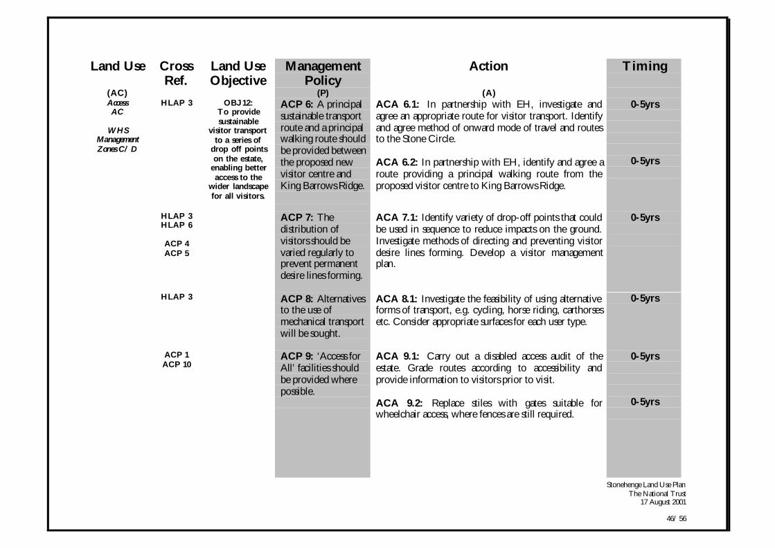
Stonehenge Land Use PlanThe National Trust
17 August 2001
46/ 56
Land Use CrossRef.
Land UseObjective
ManagementPolicy
Action Timing
(AC) (P) (A)AccessAC
WHSManagementZones C/ D
HLAP 3 OBJ 12:To providesustainable
visitor transportto a series of
drop off pointson the estate,
enabling betteraccess to the
wider landscapefor all visitors.
ACP 6: A principalsustainable transportroute and a principalwalking route shouldbe provided betweenthe proposed newvisitor centre andKing Barrows Ridge.
ACA 6.1: In partnership with EH, investigate andagree an appropriate route for visitor transport. Identifyand agree method of onward mode of travel and routesto the Stone Circle.
ACA 6.2: In partnership with EH, identify and agree aroute providing a principal walking route from theproposed visitor centre to King Barrows Ridge.
0-5yrs
0-5yrs
HLAP 3HLAP 6
ACP 4ACP 5
ACP 7: Thedistribution ofvisitors should bevaried regularly toprevent permanentdesire lines forming.
ACA 7.1: Identify variety of drop-off points that couldbe used in sequence to reduce impacts on the ground.Investigate methods of directing and preventing visitordesire lines forming. Develop a visitor managementplan.
0-5yrs
HLAP 3 ACP 8: Alternativesto the use ofmechanical transportwill be sought.
ACA 8.1: Investigate the feasibility of using alternativeforms of transport, e.g. cycling, horse riding, carthorsesetc. Consider appropriate surfaces for each user type.
0-5yrs
ACP 1ACP 10
ACP 9: ‘Access forAll’ facilities shouldbe provided wherepossible.
ACA 9.1: Carry out a disabled access audit of theestate. Grade routes according to accessibility andprovide information to visitors prior to visit.
ACA 9.2: Replace stiles with gates suitable forwheelchair access, where fences are still required.
0-5yrs
0-5yrs
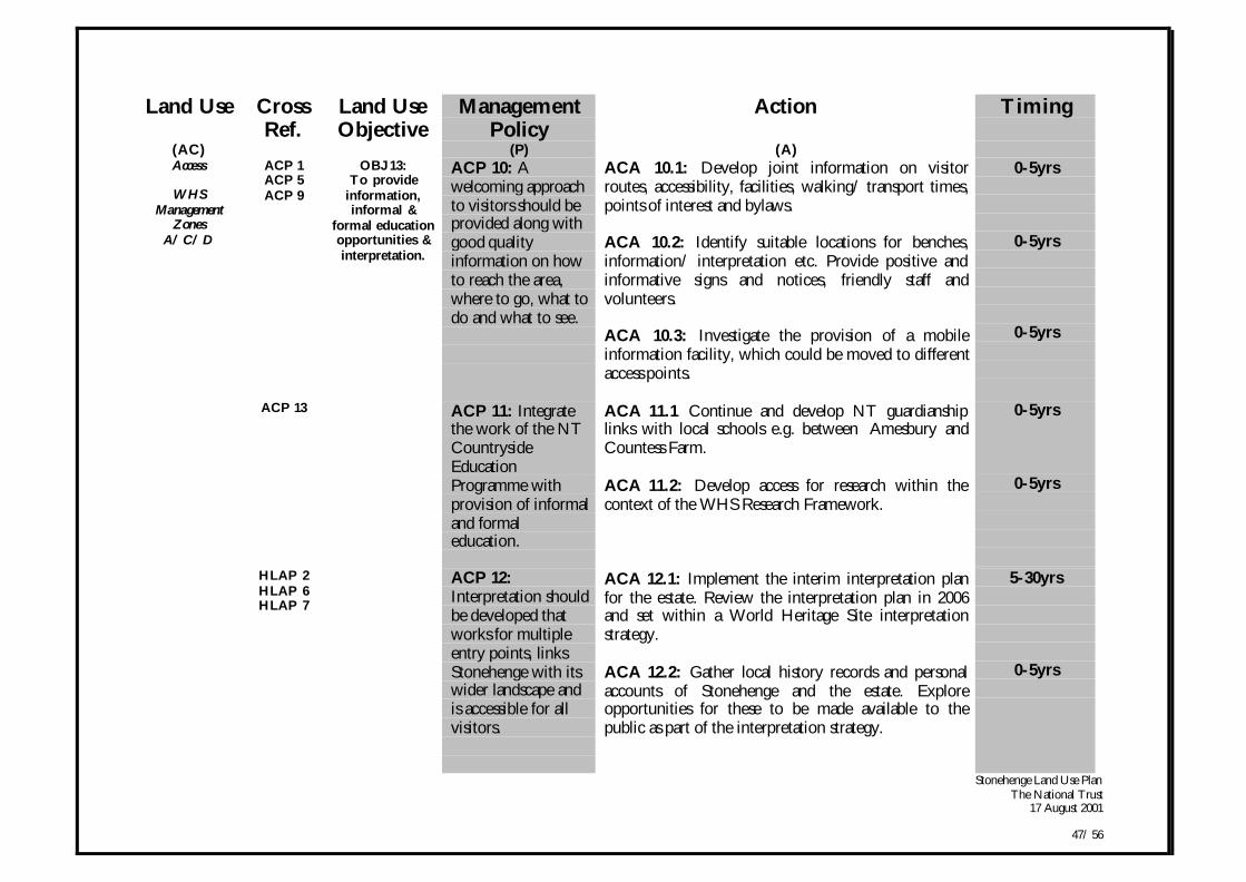
Stonehenge Land Use PlanThe National Trust
17 August 2001
47/ 56
Land Use CrossRef.
Land UseObjective
ManagementPolicy
Action Timing
(AC) (P) (A)Access
WHSManagement
ZonesA/ C/ D
ACP 1ACP 5ACP 9
OBJ 13:To provide
information,informal &
formal educationopportunities &interpretation.
ACP 10: Awelcoming approachto visitors should beprovided along withgood qualityinformation on howto reach the area,where to go, what todo and what to see.
ACA 10.1: Develop joint information on visitorroutes, accessibility, facilities, walking/ transport times,points of interest and bylaws.
ACA 10.2: Identify suitable locations for benches,information/ interpretation etc. Provide positive andinformative signs and notices, friendly staff andvolunteers.
ACA 10.3: Investigate the provision of a mobileinformation facility, which could be moved to differentaccess points.
0-5yrs
0-5yrs
0-5yrs
ACP 13 ACP 11: Integratethe work of the NTCountrysideEducationProgramme withprovision of informaland formaleducation.
ACA 11.1 Continue and develop NT guardianshiplinks with local schools e.g. between Amesbury andCountess Farm.
ACA 11.2: Develop access for research within thecontext of the WHS Research Framework.
0-5yrs
0-5yrs
HLAP 2HLAP 6HLAP 7
ACP 12:Interpretation shouldbe developed thatworks for multipleentry points, linksStonehenge with itswider landscape andis accessible for allvisitors.
ACA 12.1: Implement the interim interpretation planfor the estate. Review the interpretation plan in 2006and set within a World Heritage Site interpretationstrategy.
ACA 12.2: Gather local history records and personalaccounts of Stonehenge and the estate. Exploreopportunities for these to be made available to thepublic as part of the interpretation strategy.
5-30yrs
0-5yrs
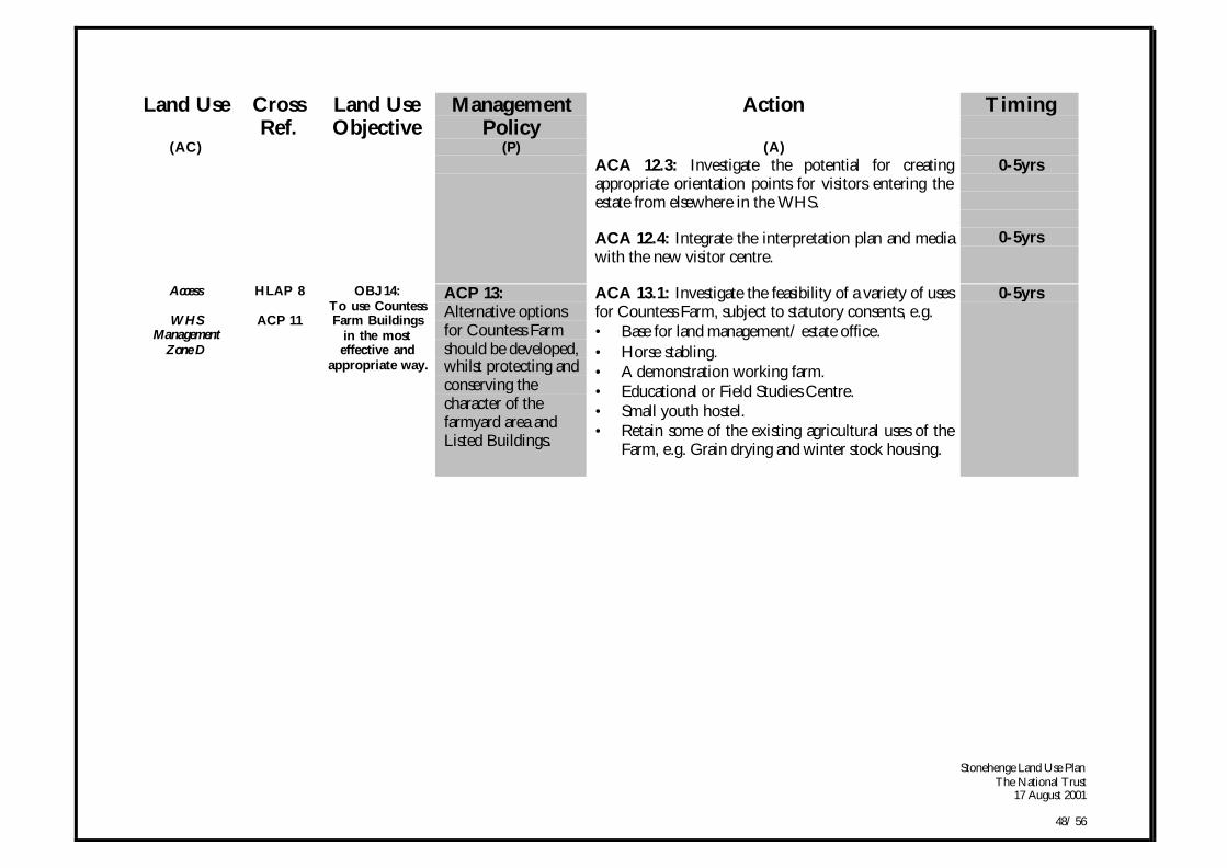
Stonehenge Land Use PlanThe National Trust
17 August 2001
48/ 56
Land Use CrossRef.
Land UseObjective
ManagementPolicy
Action Timing
(AC) (P) (A)ACA 12.3: Investigate the potential for creatingappropriate orientation points for visitors entering theestate from elsewhere in the WHS.
ACA 12.4: Integrate the interpretation plan and mediawith the new visitor centre.
0-5yrs
0-5yrs
Access
WHSManagement
Zone D
HLAP 8
ACP 11
OBJ 14:To use CountessFarm Buildings
in the mosteffective and
appropriate way.
ACP 13:Alternative optionsfor Countess Farmshould be developed,whilst protecting andconserving thecharacter of thefarmyard area andListed Buildings.
ACA 13.1: Investigate the feasibility of a variety of usesfor Countess Farm, subject to statutory consents, e.g.• Base for land management/ estate office.• Horse stabling.• A demonstration working farm.• Educational or Field Studies Centre.• Small youth hostel.• Retain some of the existing agricultural uses of the
Farm, e.g. Grain drying and winter stock housing.
0-5yrs
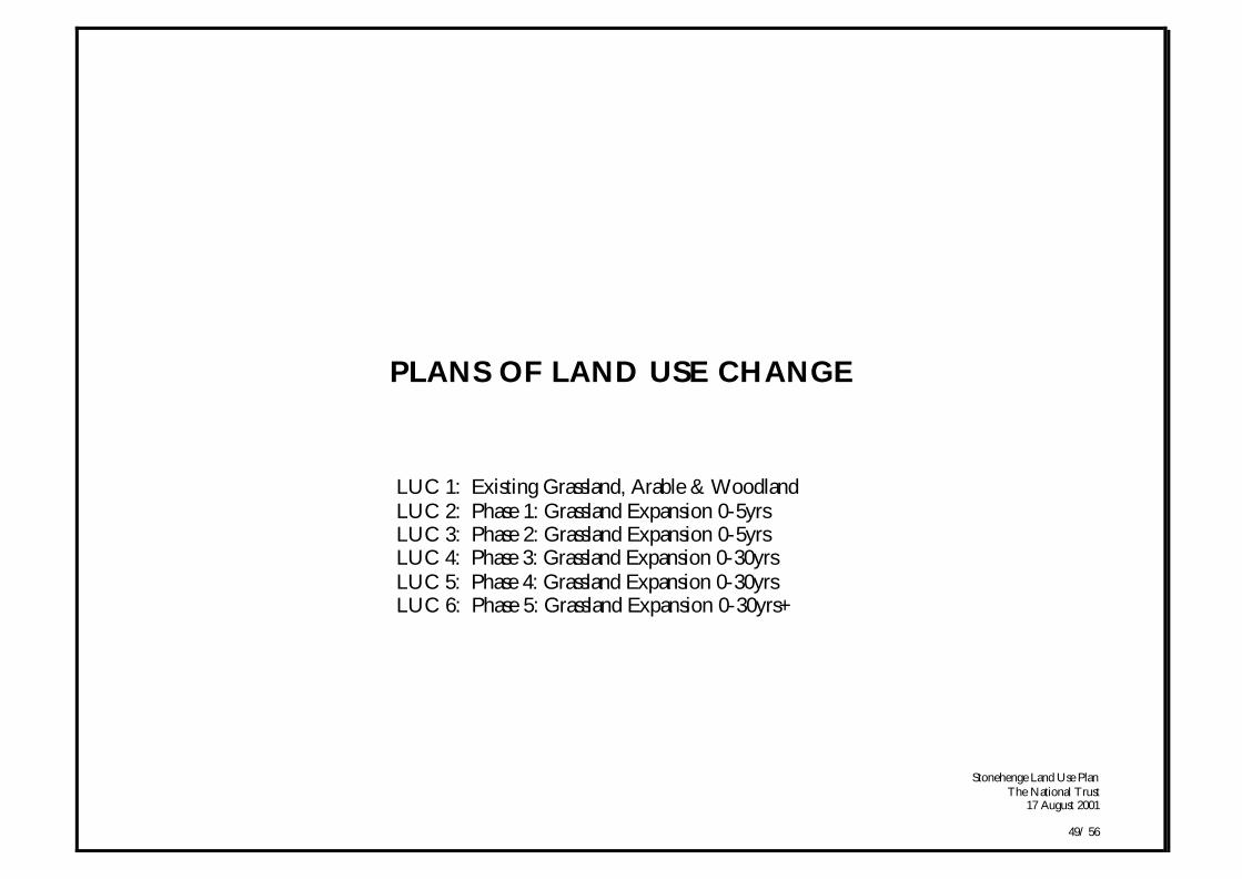
Stonehenge Land Use PlanThe National Trust
17 August 2001
49/ 56
PLANS OF LAND USE CHANGE
LUC 1: Existing Grassland, Arable & WoodlandLUC 2: Phase 1: Grassland Expansion 0-5yrsLUC 3: Phase 2: Grassland Expansion 0-5yrsLUC 4: Phase 3: Grassland Expansion 0-30yrsLUC 5: Phase 4: Grassland Expansion 0-30yrsLUC 6: Phase 5: Grassland Expansion 0-30yrs+
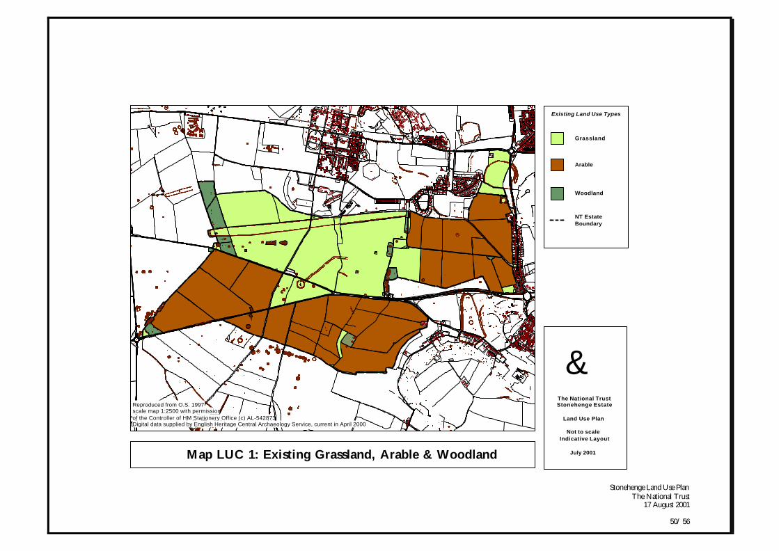
Stonehenge Land Use PlanThe National Trust
17 August 2001
50/ 56
Map LUC 1: Existing Grassland, Arable & Woodland
gThe National TrustStonehenge Estate
Land Use Plan
Not to scaleIndicative Layout
July 2001
NT Estate Boundary
Reproduced from O.S. 1997scale map 1:2500 with permissionof the Controller of HM Stationery Office (c) AL-542873Digital data supplied by English Heritage Central Archaeology Service, current in April 2000
Existing Land Use Types
Grassland
Arable
Woodland

Stonehenge Land Use PlanThe National Trust
17 August 2001
51/ 56
Map LUC 2: Phase 1 Grassland Expansion 0-5yrs
gThe National TrustStonehenge Estate
Land Use Plan
Not to scaleIndicative Layout
July 2001
NT Estate Boundary
Reproduced from O.S. 1997scale map 1:2500 with permissionof the Controller of HM Stationery Office (c) AL-542873Digital data supplied by English Heritage Central Archaeology Service, current in April 2000
Proposed Land Use Types
Grassland
Arable
Woodland
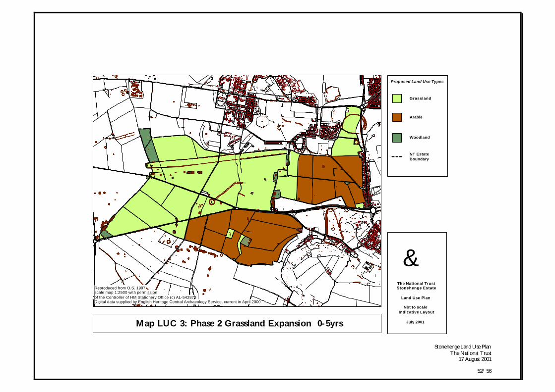
Stonehenge Land Use PlanThe National Trust
17 August 2001
52/ 56
Map LUC 3: Phase 2 Grassland Expansion 0-5yrs
gThe National TrustStonehenge Estate
Land Use Plan
Not to scaleIndicative Layout
July 2001
NT Estate Boundary
Reproduced from O.S. 1997scale map 1:2500 with permissionof the Controller of HM Stationery Office (c) AL-542873Digital data supplied by English Heritage Central Archaeology Service, current in April 2000
Proposed Land Use Types
Grassland
Arable
Woodland
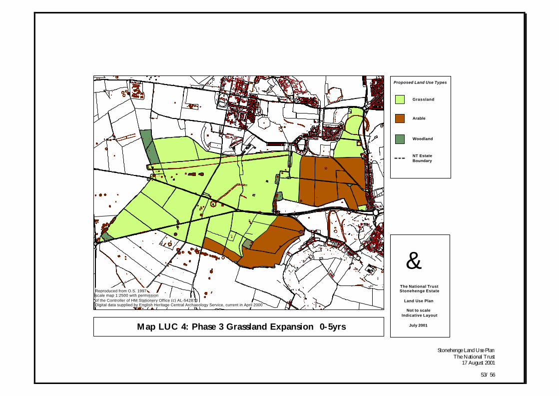
Stonehenge Land Use PlanThe National Trust
17 August 2001
53/ 56
Map LUC 4: Phase 3 Grassland Expansion 0-5yrs
gThe National TrustStonehenge Estate
Land Use Plan
Not to scaleIndicative Layout
July 2001
NT Estate Boundary
Reproduced from O.S. 1997scale map 1:2500 with permissionof the Controller of HM Stationery Office (c) AL-542873Digital data supplied by English Heritage Central Archaeology Service, current in April 2000
Proposed Land Use Types
Grassland
Arable
Woodland
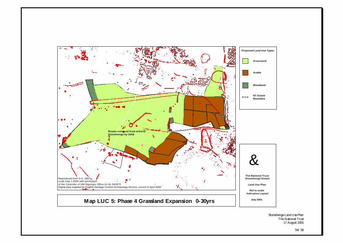
Stonehenge Land Use PlanThe National Trust
17 August 2001
54/ 56
Map LUC 5: Phase 4 Grassland Expansion 0-30yrs
Roads removed from aroundStonehenge by 2008
gThe National TrustStonehenge Estate
Land Use Plan
Not to scaleIndicative Layout
July 2001
NT Estate Boundary
Reproduced from O.S. 1997scale map 1:2500 with permissionof the Controller of HM Staionary Office (c) AL-542873Digital data supplied by English Heritage Central Archaeology Service, current in April 2000
Proposed Land Use Types
Grassland
Arable
Woodland
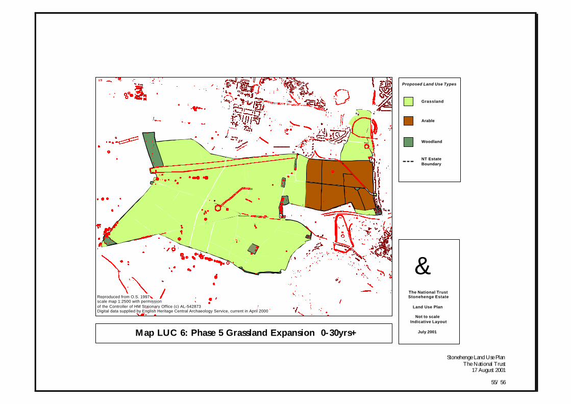
Stonehenge Land Use PlanThe National Trust
17 August 2001
55/ 56
Map LUC 6: Phase 5 Grassland Expansion 0-30yrs+
gThe National TrustStonehenge Estate
Land Use Plan
Not to scaleIndicative Layout
July 2001
NT Estate Boundary
Reproduced from O.S. 1997scale map 1:2500 with permissionof the Controller of HM Staionary Office (c) AL-542873Digital data supplied by English Heritage Central Archaeology Service, current in April 2000
Proposed Land Use Types
Grassland
Arable
Woodland

Stonehenge Land Use PlanThe National Trust
17 August 2001
56/ 56