stone feature types as observed at ceremonial site...
TRANSCRIPT
1
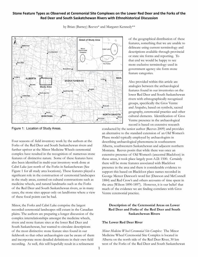
Four seasons of field inventory work by the authors at the Forks of the Red Deer and South Saskatchewan rivers and further upriver at the Minor Medicine Wheels ceremonial complex have resulted in the recognition of numerous stone features of distinctive nature. Some of these features have also been identified in multi-year inventory work done at Cabri Lake just north of the Forks in Saskatchewan (See Figure 1 for all study area locations). These features played a significant role in the construction of ceremonial landscapes in the study areas, centred on cultural constructions such as medicine wheels, and natural landmarks such as the Forks of the Red Deer and South Saskatchewan rivers, as in many cases, the stone sites appear only on landforms where a view of these focal points can be had. Minor, the Forks and Cabri Lake comprise the largest recorded ceremonial landscapes still extant in the Canadian plains. The authors are preparing a longer discussion of the complex interrelationships amongst the medicine wheels, rivers and stone feature sites at the lower Red Deer and South Saskatchewan, but wanted to circulate descriptions of the most distinctive stone feature sites found in our fieldwork so that other archaeologists can be aware of them and incorporate more detailed definitions in their own field recording. As well, this will hopefully result in a refinement
of the geographical distribution of these features, something that we are unable to delineate using current terminology and descriptions available through provincial or state site forms and reporting. To that end we would be happy to see more exclusive terminology used in government agency site form stone feature categories.
Also provided within this article are analogies between the archaeological features found in our inventories on the lower Red Deer and South Saskatchewan rivers with ethnographically recognized groups, specifically the Gros Ventre and Arapaho, based on symbols, sacred geography, ceremonial practice and other cultural elements. Identification of Gros Ventre presence in the archaeological record is based on extensive research
conducted by the senior author (Reeves 2009) and provides an alternative to the standard extension of an Old Women’s Phase model typically employed by archaeologists in describing archaeological phenomena in southeastern Alberta, southwestern Saskatchewan and adjacent northern Montana. Reeves posits that while there was once an extensive presence of Old Women’s (ancestral Blackfoot) in these areas, it took place largely post-A.D. 1500. Certainly there will be stone features associated with Blackfoot presence in the area and there is considerable evidence to support this based on Blackfoot place names recorded in George Mercer Dawson’s word list (Dawson and McConnell 1884) and Red Crow’s and others accounts of time spent in the area (Wilson 1890-1897). However, it is our belief that much of the evidence we are finding correlates with Gros Ventre ceremonial practice.
Description of the Ceremonial Areas on Lower Red Deer and Forks of the Red Deer and South
Saskatchewan Rivers
The Lower Red Deer River
Minor Medicine Wheel Ceremonial Site Complex: The Minor Medicine Wheel Ceremonial Site Complex is located in Alberta on the north side of the Red Deer River, 30 km west of the Forks of the Red Deer and South Saskatchewan
Stone Feature Types as Observed at Ceremonial Site Complexes on the Lower Red Deer and the Forks of the Red Deer and South Saskatchewan Rivers with Ethnohistorical Discussion
by Brian (Barney) Reeves* and Margaret Kennedy**
Figure 1: Location of Study Areas.

2
rivers. The complex is associated with the moraine-covered high bluff top of the Red Deer River, standing 132 m above a spectacular bedrock-incised horseshoe-shaped river bend (Figure 2).
The locale is notable for its orange lichen-encrusted red siderite sandstone which outcrops only in this reach of the river and which glows at sunrise and sunset. It is very likely the place identified as “Red Rock” “on the Red Deer River” in George Dawson’s Blackfoot place name list (Dawson and McConnell 1884:166) and known as maok-skoistch or the “Sacred Red Rock Place” in Blackfoot (personal communication [Reeves], Margaret Plain Eagle). The bend is a Provincially Environmentally Significant Area (PESA), containing many rare plant and animal species, the finest springs in the area and well-wooded draws full of saskatoon and other berry bushes. Dune Point, standing 60 m above the river on the southeast side of the horseshoe bend, is also a PESA and is a one-of-a-kind bedrock and till-cored, surface-duned terrace with rare plants and animals. A Narrow Leaf Cottonwood Forest ESA of National Significance extends downstream from these locales to below the Forks in Saskatchewan. The view out over the horseshoe bend both upriver and downriver is outstanding and was clearly linked to the ceremonial landscape constructed on the valley edge and ridges above.
The lands on which the Minor Medicine Wheel Ceremonial Site Complex are located are part of a century-old working cattle ranch now owed by the Hern family. The former owners were the Minor family (hence the name of the medicine wheels site proper, which has entered the archaeological literature incorrectly spelt as Miner until the authors corrected it). Surface disturbances on the ranch are minimal and those that are present are almost all linear in nature relating to district ranch roads
and oil and gas infrastructure development over the last 50 years. TransCanada’s Eastern Alberta Main Gas and Oil Transmission corridor runs north-south through the ceremonial complex 1.5 km west of the medicine wheels. A number of sites have been investigated as part of cultural resource management studies along this corridor over the past 35 years.
The Lower Red Deer River area was the focus of an extensive survey in 1975 and 1976 by Gary Adams and crew (Adams 1976; 1978). The authors visited the medicine wheels in 2012 and, in realizing that the scope and complexity of stone features present was even greater than reported by Adams, launched a new multiyear intensive site inventory in the medicine wheel locale and surrounding area. Over 2,000 stone feature sites have been identified in over a distance of 11 km along the northern rim of the horseshoe bend and in the surrounding moraine. The ceremonial stone features are found only in locales where the Minor I, II and/or III medicine wheels are in line of sight. Stone features do not occur in the base of the deep swales, or ice-walled channels within the moraine which obscure view of the medicine wheels. Some features may occur on the edges of adjacent lacustrine lands particularly along the high bluffs where suitable stones for construction can be obtained from outcropping glacial tills along their margins.
The focal point of this complex is the Minor Medicine Wheel Ceremonial Centre (EfOo-10, ca. 240 acres in size) whose focal landform is a glacial moraine, flat-topped linear ridge containing the Minor I and Minor II medicine wheels and various ceremonial stone features. Over 1,000 ceremonial stone features have been recorded in the central complex (Reeves and Kennedy nda) in the ceremonial centre. A third medicine wheel, Minor III, is located 4.5 km east on the northeast side of the high bluffs of the horseshoe bend. Our 2016 reconnaissance of the river valley identified a major foot and travois trail marked by multiple ruts, trail cairns, and bordered in some locales by ceremonial stone circles, running northwest across the river from Dune Point, and up the cliffs to and beyond the east side of the ceremonial centre.
Minor I and Minor II medicine wheels are paired rock-covered mounds (whose covers have been vandalized) situated 120 m apart along the NNE-SSW-oriented ridge on the northwest side of the horseshoe bend directly overlooking the Red Deer River valley (Figure 3). The two medicine wheels are oriented on a 25.5o North of East line of sighting. A processional way with a defined footpath connects the two rock mounds. It is bordered by a variety of ceremonial stone features including ceremonial circles, D-shaped circles, conjoined circles, erratics, rocked erratics, cairns and platform cairns (Reeves and Kennedy ndb; Quigg 1984: Figure 54). (See descriptions of these feature types below).
Figure 2: Bend of the lower Red Deer River at Minor Med-icine Wheels Ceremonial Complex. View south to Dune Point on south side of river.

3
Minor I at the SSW end of the processional way has a 5 m diameter central rock-covered mound surrounded by a 15 m diameter circle with two defined openings on the east and southeast. The latter has two stone lines radiating out. The northernmost, 30 m in length, terminates in a small cairn after bisecting a circle approximately halfway. The southern line is 9 m long, terminating in a small cairn. Seven other stone lines radiate out in lengths between 4.5 m and 9 m. Four end in large stones and one in a cairn. Two small cairns lie within the circle, and two very large platform cairns are situated 2.2 m and 9 m west of the circle (Figure 3), (Brumley 1988: Figure 3; Quigg 1984:96: Figure 55).
Minor II has a 5.5 m central rock-covered mound, surrounded by a 15.5 m diameter stone circle. Radiating stone lines are absent. Two rectangular platform cairns lie on the northern perimeter (Figure 3), (Brumley 1988: Figure 1; Quigg 1984: Figure 56). Detailed instrument surveys and descriptions were made of the site in 1976 (Walde 1976) (Figure 3). Adams recorded but did not describe the medicine wheels or associated stone features in his 1975 survey of the Lower Red Deer River (Adams 1976: Figure 8).
Minor III (EfOo-24) is situated on the high southwestern-facing bluffs of the Red Deer River at the southeastern end of the Minor Ceremonial Complex, 4.5 km due east across the northern rim of the Red Deer River valley from Minor I and II. The medicine wheel contains a 5.7 m central cairn (badly vandalized by collectors), exhibiting a 1 m deep snake infested central pit (Figure 4). The outer 18 m diameter circle
is oval in shape and characterized by tightly packed small sized cobbles (Brumley 1988: Figure 9; Quigg 1984: 102-104, Figures 58, 59). A horned rattlesnake stone effigy lies on the southwest side of the circle. Stone circles are adjacent and strung out along the bench to the southeast. Apron and rocked erratics, platform and piled cairns, and vision quests occur along the bench to the southeast overlooking the Red Deer River valley.
The Forks Stone Feature Archaeological Complex (Reeves and Kennedy ndc)
The Forks of the Red Deer and South Saskatchewan are located in Saskatchewan 8 km southeast of the border with Alberta and the town of Empress, AB. Empress Creek (known in Blackfoot as Mo-ni-ce-i-took-tey or Forehead River (Jean L’Heureux in Ronaghan 2011) joins the Red Deer River north of Empress. West of the creek lies a broad set of proglacial river and glacial lake terraces lacking ceremonial stone features. A dissected glacial hummocky moraine and lacustrine-till plain lies above Empress Creek extending 16 km eastward down the north side of the Red Deer River and South Saskatchewan River valley, to a 50 m high sand-duned terrace on the South Saskatchewan River below the Forks. These features define the eastern and western limits of the Forks Ceremonial Stone Feature Complex on the north side of the river valley. Most of the lacustrine and till plain and 12 quarter sections of the hummocky moraine which contains the stone features are cultivated back from the river valley edge. The north valley edge is dissected by coulees and ravines heading in springs and seeps. Episodic downcutting of the Red Deer River/South Saskatchewan River valleys in this reach has resulted in a series of stepped
Figure 3 (left): Minor I&II Medicine Wheels, surveyed by Keary Walde, 1976. Minor I at bottom.
Figure 4 (below): Minor III Medicine Wheel. Barney Reeves in central cairn; Red Deer River in background.

4
ridges and benches of Late Glacial age standing up to 50 m above and 2 km north of the Early Holocene-aged 10 m river terrace. Ceremonial stone features oriented to the Forks and or to the Forks’ Bull’s Forehead Medicine Wheel (locally known as Roy Rivers Medicine Wheel) (EfOl-2) (Figures 5, 6) occur on the benches and bluff tops and moraine grasslands that still extend up to 2.5 km north. Some 1,500 stone features have been recorded on the north side.We have recorded some 500 features on the south side of the Forks, on the Red Deer River above and the South
Saskatchewan River at and below the confluence. Although the prairie benchlands are almost all intensively cultivated, stone feature sites are generally absent on the unbroken edges or parcels reflecting the presence here of a 10 m thick glacial lacustrine unit overlying stony till. Stone feature sites occur on benches and ridges within the river valleys which have views to Bull’s Forehead Head Medicine Wheel and/or the Forks. Stone feature site distribution halts abruptly 8 km upstream on the Red Deer and 4 km downstream on the South Saskatchewan River when lacustrine sediments rather
than stony tills constitute the valley walls. In the few locales downstream where stony tills are present, the ravines and benches on which they are located face north-northeast and there is no view to the Forks and thus no stone feature sites.
Stone features were not found on the 5 km of the northwest bank of the South Saskatchewan River surveyed above the Forks. Unbroken high benches and ridges are common along this reach but there is no view to the Forks, as it is hidden by a western bend in the river. A similar principle applies to the southeast bank; ceremonial stone features were found along benches and ridges within the valley up to 3 km above the Forks to the westward bend of the river. Most were in the immediate vicinity of the Forks. As ridge and bench orientation shifted and views to the Forks were lost from within river benches and ridges, stone features dropped off rapidly and disappeared, except for the ubiquitous small cairns. One very large high terrace 7 km upstream provided a “perfect” location for a summer stone circle domestic site like ones found on the Little Bow and Oldman Rivers but was, except for the occasional cairn, devoid of sites. The Forks could not be seen from this locale. One ceremonial stone circle site (12+ circles) was found on an unplowed edge of the glacial lacustrine plain 5 km upstream. The constructors had climbed downslope at least 10 m to gather stones, some weighing over 20 lbs, and carried them up to construct the features at a locale where they could see the Forks.
Figure 5: View of Bull’s Forehead Medicine Wheel central cairn and Forks of Red Deer and South Saskatchewan rivers in background.
Figure 6: Bull’s Forehead Medicine Wheel. Photo by George Tosh. Note circle in bottom right of photo.

5
The primary variables that seem to explain the distribution of ceremonial stone features on the north and south sides of the Red Deer and South Saskatchewan rivers above and below the Forks and on the South Saskatchewan above its confluence with the Red Deer River are surficial geology and views to the Forks (Figure 5) and/or the Bull’s Forehead Medicine Wheel. River fork locations figure prominently in Ohio Hopewell Ceremonial Center locations, which may reflect a Native American belief that rivers and river forks were a place of entry into the Below World (Romain 2015).
Bull’s Forehead Medicine Wheel Ceremonial Stone Feature Complex (Reeves and Kennedy nda)
The Bull’s Forehead Medicine Wheel Complex is located on the north side of the Red Deer River at the western end of the overall Forks Ceremonial Stone Feature Complex. It is associated with Chapman Coulee, a long northwest/southeast-oriented spring-fed coulee that was formerly a proglacial channel that connected the middle and upper reaches of Empress Creek to the Red Deer River. Upwards of 500 ceremonial stone features, oriented to Bull’s Forehead Medicine Wheel and some also to the Forks, are located on benches and ridges on the east side and on a hill in the centre of Chapman Coulee. They occur over a distance of 3 km northwest from the Red Deer River valley above which the valley is plowed and cultivated from edge to edge.
The Bull’s Forehead Medicine Wheel Complex (EfOl-2) is associated with a visually prominent 2 km long ridged and benched landform standing 107 m above the Red Deer River valley. From the west, the upper ridge profile resembles the forehead of a buffalo bull. The medicine wheel (Figure 6) sits on the benched top of a 1.5 km long north-south knife-edge ridge containing a number of ceremonial stone features on lower benches and slopes, and an alignment extending south along the ridge to the Red Deer River Valley. Alignments and ceremonial stone features extend .9 km north along the ridge crest and down along flanking NW and SE ridges (each a kilometer long) to the Red Deer River floodplain on the west and a prominent hill on the east, crowded with ceremonial stone features in the middle of Chapman Coulee.
The medicine wheel’s central feature is a 5 m diameter, 1.5 m high disturbed central cairn which may be a hollow cairn (see below) encircled at a distance of 8 m by a 25-26 m diameter stone circle. An outlying 1.5 m diameter cairn is incorporated into the NW perimeter of the circle. It was constructed before the circle, as the line of rocks runs over the top. Thirteen to fourteen small platform cairns/stone features circle around the central cairn intermediate between the circle and central cairn. The circle itself is constructed of small-sized carefully selected tightly packed stones with
soil packed in on their back surfaces to create a level surface platform around the edges. Two parallel lines of stone forming a processional way or opening connect the central cairn on its south side to the outer circle.
The medicine wheel site has been part of local knowledge since homesteader days. It was first recorded and sketched by a Saskatchewan Township Inspector in 1915 (Begg 1915). Tom and Alice Kehoe studied the site in 1975 and determined that it may have been a summer solstice marker (Kehoe and Kehoe 1979). The Royal Saskatchewan Museum and others (Brace 2005) including Nathan Friesen, Senior Archaeologist from the Archaeological Resource Management office of Saskatchewan Parks, Culture and Sports have also recorded and photographed the site (including UAV flights by Friesen).
Cabri Lake
We do not focus on Cabri Lake directly1 but will make occasional references to this highly significant archaeological district in the feature descriptions below. Cabri Lake is an alkaline water body fed by springs emanating from dissected moraine hills on its west and east sides. The west side is the more prominent and is characterized by numerous complex ceremonial and other archaeological sites, including long rock alignments, circle camps, stone circles, complex cairns, a Napi effigy and a petroglyph boulder. Half of the area falls within the Palmer Ranch where most of the original grass cover remains to the benefit of archaeological sites. North of the ranch, the valley walls and tops are unbroken as well.
Cabri Lake is part of the ice-thrust hilly moraine country that characterizes the other study areas to the south and west. It is only 16 km east of the Alberta/Saskatchewan border and because of the Palmer Ranch, can be linked to the north side of the South Saskatchewan River valley with a corridor of unbroken grasslands on the east side. Unfortunately, recent land breaking on hills midway between the Forks and Cabri further west towards the Forks have largely eradicated any stone features that might have provided visual links between the two areas. However, there are directional clues provided by the orientation through such things as doorways and other features at both places to infer that connections between Cabri Lake and the Forks, whether directly visible or implied, were in place.
Some Distinctive Stone Feature Types
We describe below the more unusual stone features found in our inventory work, leaving out more ubiquitous examples that occur with regularity across the northern plains. We also do not discuss medicine wheels per se, other than to mention

6
their focal role in these ceremonial landscapes. The examples represent different kinds of circles, cairns, alignments, erratics and other less-easily categorized features.
Circles
A distinctive feature of the medicine wheel sites we have observed in the study areas is the relative lack of stone circles and associated refuse assumed to represent domestic lodges in the immediate vicinity of the ceremonial centres. Circles that are proximate (for example, within 50 m or less) to the medicine wheels are few in number, tend to be on their own or are conjoined and are often still well-built, suggesting continued maintenance and use rather than single ceremonial use episodes which most ceremonial lodge-sized circles in these sites appear to represent.
Often we find identically constructed circles next to each other, which we interpret as repeated revisits over time by relatively small groups utilizing the same ceremonial bundle and lodge organization, carrying out the same ritual activities and erecting the lodge next to the circle left from the previous visit. We find little or no evidence of removal of rocks from older ceremonial circles to construct newer circles or other stone features, indicative of the belief that these older constructions remain sacred and are to be left alone. This belief also applies to the other ceremonial stone features in the sites. There is no evidence of purposeful disassembly or recycling of the stones in these features.
Circles interpreted as camp-related are some distance from the ceremonial centres but again based on what we have observed within the limits of the preserved landscape we can work with, these camps are not sizeable but suggestive of smaller, repeated residential activities.
Most of the circles we have recorded are very well constructed with definite gaps or “doors” in otherwise continuous and solid walls, sometimes on both the ordinal and cardinal directions, but more often than not directionally oriented to specific medicine wheels (Bull’s Forehead Medicine Wheel at the Forks, Minor I and II and Minor III on the Lower Red Deer River 30 km west of the Forks) or focal landscape features (for example Cabri Lake, the Forks, or Dune Point (the oxbow bend of the Red Deer River at Minor). An important feature of the surrounding ceremonial stone circles at both the Forks, Bull’s Forehead and Minor is that the location of the doors facing these focal features depends on the position of the circle relative to the medicine wheel or landscape feature. For example, if the circle is situated to the southwest of the focal feature the door will be on the northeast; if the circle is southeast of the focal feature the door will be on the northwest. These focal structures or features may be close by or far distant. At the Forks, for example, we have recorded ceremonial circles on
the southeast side of the South Saskatchewan River valley bluffs, with doors facing Bull’s Forehead Medicine Wheel 10 km to the northwest. At the Minor Ceremonial Complex, some circles consistently have northerly facing doors oriented to the Acadia Valley Medicine Wheel (EgOo-4) 9 km north.
We assume that the presence of multiple doors relates to the nature and structure of the ceremonial activities within the lodge, and the movement in and out of the lodge of key ceremonialists, dancers, musicians, guests, and the holy objects, and presentations of these at doors facing the sacred sources of the holy bundle - medicine wheels and water features, in our case, and to other sacred directions (sunrise for example). Still today at the Piikani Medicine Pipe and Natoas ceremonies, the holy bundle is always opened in private inside the lodge by the bundle holders and ceremonialists and the ceremony observed by invited guests who have the rights to view such ceremonies. Once the private ceremonies are complete, the holy objects are brought out of the lodge by the principal ceremonialists and presented to the assembled throng. They may be installed on a tripod or elevated platform outside the lodge or carried to another lodge for the next phase of ceremonies, as is the case in the Okan. In that ceremony, the transfers of the Natoas and other sacred objects occurs over four days in a large lodge made of multiple lodge covers. Once complete, the Holy People exit the lodge by a different door than through which they entered, and move processionally to the Medicine (Dancing) Lodge with the holy objects, where they and the holy objects are accorded a special place (Reeves, personal observations; Wissler 1912b, 1918).
Ceremonial circles often have platform cairns (described below), either attached or very close by. Some circles have internal compartments and partitions and externally attached short rock alignments to one or both sides of a door. Bisected circles are rare. One circle has an internal ovate structure ending in a pink granite boulder on its north (river) side which we have identified as a Vision Quest structure (see that category below). Some others have small external circles/ovals or arcs attached to one side of a door facing a focal point, and may also be vision quests.
Many circles at a site to the east of Minor Medicine wheels have clearly placed single red or pink granites inside their south walls, or on the surface of the circle, as do a number of circles in sites below the Forks.
We have also noted the placement of individual black rock shards and cores on the surface and sometime black cobbles in the northern circle edge. The black rocks are of plutonic, igneous, metamorphic or volcanic origin and like the granites (plagioclase and biotite varieties, the former most common), are glacial erratics brought in by the glaciers from the

7
Canadian Shield to the northeast. They include andesite, basalt and other black volcanic, igneous, metamorphic and mafic rocks. The placement behaviour of black rocks has been observed at Cabri Lake as well. These shards probably come from lightning-struck erratics of the same rock type, as we have observed a number of lightning struck/split erratics which have good growths of lichen on the struck surfaces but have no shards around them, suggesting they were collected. We have also seen other recently struck rocks with numerous shards around them.
We also located an upright black basalt monolith shaped by lightning 2 km southwest of the Minor Ceremonial Complex on the east side of an ice-walled channel where there is a ceremonial outlier of circles, alignments and cairns. The monolith is 1.5 m high and tapers at the top. It presently stands in a 50 cm deep, 3 m diameter buffalo wallow or excavated pit. No shards are exposed in the heavily grassed base of the pit. A 4 m diameter stone circle encircles the monolith and pit. Some of the stones in it are set on edge. Stone lines some 3 to 4 m in length extend out from the pit to the east; south-southwest towards Alkali Creek and the Anderson Medicine Wheel (Brink 2013) 12 km distant; to the west; and to the north. A door facing the Minor Ceremonial Centre is situated on the northeast edge. While a direct view to Minor (el. 737 m) is obscured by the crest of a ridge (742 m) .9 km northeast of the monolith, Minor is visible in the mind’s eye, which is guided by a 1.5 m diameter cairn visible from the monolith located on the ridge crest on the direct line of site between these locales. Another notable example of this kind of lightning-struck erratic is a large split amphibolite boulder 120 m away from the Anderson I Medicine Wheel (Brink 2013).
Clearly colour is worthy of further study in circles associated with ceremonial sites as it is the selection of rocks for constructing vision quests in the Waterton-Glacier region (Dormaar and Reeves 1993) where green, red argillites, white and pink quartzites, diorites, basalts and buff-colored weathered dolomites are utilized. Sandstones, grey weathering limestones or dolomites are not used in the construction of vison quests. These same rock types (argillites, quartzites, diorites, basalts) are selected for use in sweats by Piikani and Kainai traditionalists today, and based on archaeological examples, for at least the last 3,000 years (Reeves 1987 and personal observations Piikani sweats). They are also the preferred types for constructing stone alignments and drive lane systems in that region. These colors match those of the Piikani primary Four Colour-directional-seasons-celestial body system: Red (East-Sun
Spring), Green (South-Summer), Black (West-Moon-Fall), White (North-Winter-Milky Way) (Reeves 1996). Red and Black are the two most important Piikani colors (Reeves 1996). Recently Jack Brink and Melissa Bowerman have been quantitatively studying the specific rocks used for building medicine wheels in terms of colour, size and rock type. They have found a clear size difference for these rocks; colour has not yet proved to be so clear a determinant (Brink and Bowerman 2016).
The selection of pink-red granites and black intrusives and volcanics for placement in stone features matches the dualistic primary colour system of the Gros Ventre and Arapaho, which is Red and Black. They are the primary sundance colours. This results in the duality of Red-South/Day/Sun/Summer; Black-North Night/Moon/Winter (Dorsey and Kroeber 1903:124-125; Kroeber 1908:414). Black also represents storm clouds and Bha’a, the Lord of the Storm, as does a black feather. Black paint or charcoal also represents the Above World and red paint also the earth. Sweat spits for the Flat Pipe and Feathered Pipe ceremonies were painted half red (west half) and half black (east half) as was the base of the sacred hearth (Flannery 1957)2.
Extremely large circles greater than 8 m and often in the 11 m range also occur (Figure 7). They can have both solid walls (i.e. not interrupted by gaps) and distinct doors. One very large circle brought to the attention of the authors by Leader veterinarian Bob Laing, and located just north of the South Saskatchewan River valley towards Cabri Lake, measured 24 x 21 m and contained an apron cairn (see below) in the middle. It was quite an impressive structure.These larger circles in the 11 m range probably represent
Figure 7: Large circle (11 m) on Knife-Edge Ridge at Forks.

8
ceremonial lodges constructed using more than one lodge cover, as is documented historically for both Gros Ventre/Arapaho Rabbit Lodge (Montana State University Library James Willard Schultz Collection #199 Standoff, 1927), Kainai Horn Society Lodge (Montana State University Library James Willard Schultz Collection #194 Standoff, 1927), Piikani Natoas Lodge (Okan Browning MT 1903 McClintock Photograph #359 4508 Beinecke Library, Yale University).
Alternatively, rather than being a lodge, the circles could represent the base of a constructed circular frame of vertical posts, lodge poles or travois frames covered by lodge covers and/or buffalo hides. This style of open-roofed lodge was put up by the Gros Ventre Crazy, Kit Fox, and Dog men’s age graded societies for their society dances (Flannery 1953; Kroeber 1908). Sometimes these societies erected conjoined lodges instead (Kroeber 1908).
The larger circles could also represent roofed vertical walled lodges using lodge poles or travois to construct the roof frame, then covered with skins or lodge covers, as is the case of the Kainai Matoki Society, who marked the location of their lodge with a stone circle. Matoki lodges have multiple doors (Glenbow Foundation Archives Photograph NA-936-31, Montana State University Library James Willard Schultz Collection #201 Standoff, 1927), Kainai and Piikani cottonwood framed and raftered Medicine Lodges were also marked by a stone circle (Wissler 1918). Dance circles could also be simply marked by a circle of stones as was done by the Piikani Bull’s and Brave Dog societies (McClintock 1938).
Conjoined Circles (Figure 8)
Circle walls that intersect, forming a wide-waisted figure 8, are evidence of the joining of two lodges to accommodate more people or an activity that demanded more space. These are found throughout the study areas. A conjoined circle feature can be found on the flat bench immediately below Bull’s Forehead Medicine Wheel. The joining of two or more tents is commonly done in camps during ceremonies such as bundle openings, society dances and other gatherings with large numbers of participants (Kroeber 1908:227 fol.) The Gros Ventre Soldiers society erected conjoined lodges as did the Gros Ventre and Arapaho Buffalo Women’s Society (Kroeber 1908). Illustrated ethnographic examples in the published literature include McClintock 1910: p.205 (Brave Dog Lodges, Browning, 1906) and Flannery 1957:Plate 1A. (Gros Ventre Flat Pipe ceremony 1948 Fort Belknap Reservation).
Oval-Elliptical Circles
Oval-Elliptical shaped circles also occur both at the Forks and Minor. They are not at all common. They range in size from 3 to 5 m in width to greater than 15 m by 5 m. Their long axes are oriented towards a focal point - the Forks, or in the case of Minor, one or the other of the Minor I or II medicine wheels. The Gros Ventre Star society, the oldest of the Gros Ventre societies, erected oval-elliptical lodges, as did the Warrior Society (Kroeber 1908:235-238). Two very large oval circles containing internal features were also observed at Minor. The larger ovals may represent linear extended,
framed and covered multilodges of the kind erected historically by the Nez Perce, Umatilla, and Sioux, which John Brumley (1993) thought was represented by an oval stone feature (20.3 m x 5.6 m) he mapped south of the Sweetgrass Hills.
D-Shaped Circles (Figures 9, 10)
A small number of these have been observed throughout the study areas including Cabri Lake. The wall on one half of the circle is straight as in the spine of a capital ‘D’. One excellent example can be found on the bench containing Minor I and II medicine wheels (Figures 9, 10). It measures 5 m across the straight wall (widest part of the feature), there is a small compartment on the north wall and overall the feature is in a very good state of preservation. Are these diagnostic of a specific kind of practice or might
Figure 8: Conjoined circles on bench below Bull’s Forehead Medicine Wheel, the Forks. Mapped by volunteers on Forks project.

9
they be useful for ethnic association of the people who built them? We have found no examples of similar looking lodges in the historic photographic records of Gros Ventre or Niitistapi lodges searched at the Glenbow and Montana State Historical Society or the McClintock collection at Yale University.
William Mulloy may be the first to have identifed D-shaped rings in his article on stone circles in 1966 in The Wyoming Archaeologist (Mulloy 1966:3).
Rectangular Structures
A small number of rectangular-shaped stone-outlined structures have been found at the Forks and Minor. The structures are generally small in size and lightly rocked. They
range in length from 3 to 4 m and width from 2 to 3 m. Doors occur in the corners at both ends and are usually on the same side, eg. NW, NE. They probably were a walled and possibly roofed structure. We have found no examples in the Gros Ventre, Arapaho, or Niitsitapi literature or archival photography.
Five rectangular structures conjoined to the west side of circles have also been found at two different sites downstream
of the Forks, suggesting that some played a specific ceremonial role in combination with ceremonial circles.
Examples from Outside the Study Area: Rectangles are a rare stone feature type in the Fresno Reservoir sites but do occur there (Deaver 1987). For example 24HL582, a 146 stone feature site with a subgroup 4 medicine wheel, contained two rectangular features bisected by a line of stones measuring 2 x 1.3 m and 2.5 m x 1.4 m (24HL582 Ethnoscience Site Form).
Platformed Structures
A distinctive but rare feature type involves the construction of flat-topped cobble-faced/edged circular earth platforms as bases for small diameter circles, vision quest ovals/circles and hollow cairns. These flat topped platforms are constructed by both removing dirt from the edges of the platform being constructed as well as building up the height of the platform with dirt and finally facing them with closely packed cobbles. Usually these sites are located on the edges of bluff tops or terraces which both facilitates the construction of the platform and provides a view to the focal point-medicine wheel and/or river feature. We have found three at the Forks and two in the Minor Ceremonial Area. One of the Forks’ structures is a platformed vision quest site facing west up the Red Deer River to Minor 30 km distant. The iron-enriched river valley cliffs at the Minor bend glow red at sunrise and are visible from Bull’s Forehead
Figure 9: D-Shaped circle (arrow) near Minor II Medicine Wheel (brush and rock at top right). Photography courtesy of Ventus Geospatial Services.
Figure 10: Artistic rendering of a D-shaped circle by Adam Hauer.

10
Medicine Wheel and this vision quest site. The Bull’s Forehead Medicine Wheel circle, which surrounds the central cairn as noted earlier, is also platformed and created by laying closely spaced facing rocks and filling in behind to bank the edge of the circle.
Some of the small circles and platformed small circles may relate to the Gros Ventre “sacrifice alone on the hills” ceremony (Flannery 1953: 393-398) in which individuals would go off and carry out an up to four-day long rite of self-torture, which involved being tied to a pole by a thong attached to skewers passed through the skin on his chest. The individual would dance from sunup to sundown until the skewers pulled out.
Cairns
Cairns are a ubiquitous part of stone feature sites across the plains. More typical piled cairns are certainly found in our study areas (Figure 11) but there are a number of more unusual types that are worth attention. These include individual cairn features including hollow cairns, platform cairns, bar cairns and also those that were built in combination with other elements such as glacial erratics (“erratic cairn”) or circles or semi-circles of rock (“apron cairns”) or where a number of cairns and sometimes erratics are used in association to construct circles and other shapes. Cairn and Cairn/Erratic and Erratic Circles
These features are uncommon but when observed at the Forks and Minor are 10 to 20 m and up in diameter. A few
are composed solely of well-constructed small cairns. Others include both cairns and erratics either in place or rolled into place. A few are erratic circles. Cairn and erratic placements around the perimeters are designed to create lines of site to focal medicine wheel and landscape features. An erratic circle (EfOo-115) in the river valley at Minor is constructed so that it has a paired set of pink granite erratics placed in such a way that they are in line of sight with a pink granite erratic on the opposite side of the circle and the Minor I/II Medicine Wheels 5 km to the northwest. Reeves has observed a cairn circle in the Inner Rainy Hills 50 km to the southwest up the Red Deer River, and one on an isolated butte on the Milk River Ridge .8 km north of the U.S. border east of Del Bonita, Alberta. A variety of stone features associate at both locales.
Hollow Cairns
These impressive stone constructions are circular and formally walled with a minimum two or more courses of rock. They can range in size from 1.5 m to around 3 m in diameter; the smaller sized ones would be difficult to sit in if vision quest activities were to be considered but this would be possible in the larger sized versions. Often the centre has the appearance of having been excavated. They are most commonly found on high ridge tops or hilltops. At Cabri Lake they are within view of each other which may suggest a connection in function. One prominent one is found on a hilltop just to the north of the Bull’s Forehead Medicine Wheel (Figure 12). It undoubtedly played a ceremonial role for participants in pilgrimages to the medicine wheel. Another hollow cairn at site EfOo-25 is located in the Minor
Medicine Wheels Ceremonial Complex on a high river bluff, with sight lines to all three medicine wheels (Figure 13).
Some piled cairns that have been potted by collectors can look similar to hollow cairns. However, the discard behaviour by collectors as they tried to expose whatever they suspected lay within the cairn resulted in an outer ‘toss’ zone of random rocks that does not occur at hollow cairns. At the latter, gravity has taken its toll on the formerly near vertical rock walls and the rocks do not roll that far away from the feature.
Bar Cairns (Figure 14)
This distinctive linear cairn feature type appears to have a role demarcating some aspect, perhaps a boundary, of the ceremonial complexes associated Figure 11: Piled cairns in alignment below the Forks of the Red Deer and South
Saskatchewan rivers, SK.

11
with the Minor and Bull’s Forehead Medicine Wheels and has been found at associated sites as well. At Minor Medicine Wheels complex, one bar cairn, 3 m in length is comprised of 7 rocks in a line oriented NW/SE. Two large rocks sit exactly above two rocks in the bar on its northwest end and form a backward facing “hook”. Similar hooks occur on some of the other bar cairns at both sites. The bar cairns are oriented at right angles to the medicine wheels. In Arapaho iconography horizontal bars can represent the sun and vertical bars sun rays as well as a sacred pathway (Kroeber 1902; Plate XXVIII, Fig. 156,159).
Transverse Cairns
Transverse cairns differ from bar cairns as they are multi-rowed and sometimes heaped cairns which are oriented transversly to the focal stone or landscape feature. Transverse cairns were first identified in the lower Red Deer by Adams (1975:95, Pl.6). He noted that “there were a few sites which had elongated cairns 5 to 50 m long and about 1 m wide”. Other examples include a transverse cairn located 5 m west of the Anderson No.1 Medicine Wheel circle (Brumley 1988: Fig.25) and two located 5 m and 8 m west of the Antelope Butte Medicine Wheel (ibid: Figure 24,25). Both are Subgroup 2 medicine wheels. Deaver (1987) recorded large numbers of cairns in stone circle sites with Subgroup 1 medicine wheels and/or ceremonial circles in the Fresno Reservoir, a very small number of
Figure 12 (top left): Hollow cairn/vision quest structure north of Bull’s Forehead Medicine wheel.
Figure 13 (centre left): Hollow cairn west of Minor III medicine wheel, lower Red Deer River.
Figure 14 (bottom left): Bar Cairn at Minor I and II Medicine Wheel site. Notice ‘hook’ on left above bar.

12
served as bases for placing offerings or bundles on a robe laid on top of the cairn. Rectangles, triangles and rhomboids are major symbols in Gros Ventre (Kroeber 1908:151-156) and Arapaho iconography (Kroeber 1900:78,103-107; 1902, Plate XVIII, Fig.237-240, 417-422) representing, depending on the designs and design context, a wide range of different beings, objects and places both secular and sacred including the Earth, Bison, and Hiiteni (life, prosperity, the prayer for plenty).
Outside of Study Area: Platform cairns visually identical to our rectangular forms have been noted at various sites in South Dakota as well as North Park in the Colorado Rockies (Brunswig 2016). The South Dakota features are generally classified as mosaics. For example, Sigstad and Biggs (1973-1974) reported the presence of a “rectangular mosaic, approximately three feet by four feet, contain[ing] 25 stones” at stone circle site 39SL91 (Sigstad and Biggs 1973-1974:17). Another site, 39SL158 (Sigstad and Biggs 1973-1974: Fig.6h; Sunderstrom 2006:115, Fig. 52) had a rectilinear “alignment” on top of a knoll comprised of a solidly filled rectangle with a more open rectangle attached to one side. Winham et al. (2001:310, Figure 153) illustrate an isolated flat, rectangular 1 x 2 m (long axis N-S) limestone rock platform cairn located on a ridge located at site 39CU2727.
Sundstrom (2006:58) lists 14 sites with rectangular/subrectangular mosaics. She illustrated a rectangular 2 x 2 m form (ibid: Fig.2) from 39BU204 with bilateral appendages at one end and another two mosaics from site 39MK 2 (ibid:Figure 40) 1.4 x 1.2 m and 1.5 x 1.2 m in size.
Platform cairns attached to ceremonial stone circles, like those in our study area, have also been recorded in North Dakota. Lewis (1891:20-21, Fig.2) described a 5.2 m ceremonial circle open to the northeast with a platform cairn on each side on the NW and SE positions, each “consisting of three rows of four boulders each, laid close together” (Lewis 1891:20-21).
Brunswig (2016) has identified a number of rectangular stone features in North Park, Colorado on East Owl Ridge that also match our platform cairns. One is attached to a stone circle (Brunswig 2016:48) which he described as a square rock foundation (sub-feature 6A. Feature 5, (ibid:50, Figure 29), a rectangular ca. .75 x 1 m form, described as “a single-tier cobble-paved platform suitable as a work table, also keeping tools and economic material off the
which from their measures as listed on individual site forms appear to be transverse cairns.
Platform Cairns (Figure 15)
These are flat cairns formed from a single layer of rock that are usually deeply buried. The result is a paved surface of rock. In our study area they can be found independently or in direct association with circles. At present we have not noted a bias in the directional placement of platform cairns when built inside or attached to the outside walls of circles. Brink and Giering (2012) discussed a site (EeOo-4) with two circles not too far from the big horseshoe bend of the lower Red Deer River that had platform cairns on the inside of the circles in the southwest quadrant.
Some can attain large sizes, such as 2 to 3 m in diameter. One very large one sits just west of Minor I medicine wheel. Rocks of uniform size and shape, primarily pink granites, are selected and generally carefully arranged, sometimes in rows, in the cairn. Small platform cairns are made of small fist-sized cobbles, larger ones of softball-sized cobbles and very large ones of football-sized rocks. On rare occasion, a triangular pink erratic will be incorporated. Some platform cairns are edged by vertical slabs.
They vary in shape. While circular or rectangular forms are most common, triangular (equilateral or isosceles, sometimes truncated), right angle triangles and rhomboid forms also occur. They are also directionally oriented. At Minor and Bull’s Forehead Medicine wheels, for example, the long axis of these forms points to the medicine wheel. They may have
Figure 15: Platform Cairn. Minor II medicine wheel in background.

13
ground.” Elsewhere on Pedersen Ridge, Brunswig (2004: 13-14, Figure 9a,b) has suggested some linear-rectangular shaped alignments with more piled surfaces may be covers for burials. The stone feature sites on these ridges also contain a variety of alignments/game drives and arcs thought to be vision quests. There are also circles considered to be “prayer circles” according to traditional Ute consultants. North Park was part of traditional Arapaho territory, and to our eyes these stone features and complexes are not dissimilar to those found in traditional Gros Ventre territory north of the Missouri River. Some of these stone features are a good thousand or more years in age. Those stone feature types and sites in South Dakota discussed above are probably of equivalent antiquity and associated with Algonkian-speaking peoples’ occupancy of that region prior to that of the Siouan speakers.
Detailed mapping and study of these platform cairns may well reveal internal patterning consistent with the Gros Ventre and Arapaho symbols.
Apron Cairns (Figure 16)
These are an intriguing construction found throughout the study area, almost always in locales where a focal point such as the Forks of the Red Deer and South Saskatchewan or a medicine wheel can be seen. They are comprised of a piled rock cairn, three or more courses of rock, to which a semi-circle (if the circle closes at the side of the cairn) or a full circle (if it encloses the cairn just within one wall) was attached. These circles typically range in size from 1 to 2 m although larger ones have been observed. One nice example on the north side of the South Saskatchewan River downstream from the Forks was comprised of a large cairn with ca. 50 large to medium-large rocks (Figure 16). In the centre was a large pink granite triangular rock (see next category). The cairn was encircled by a rock line approximately 1 m from the outer edge of the cairn.
The circle around the cairn creates an open area of unknown function, but could have held offerings or, if larger in size, a person. The cairn seems to act as a foresight to places of particular significance. For example, apron cairns are
oriented towards the confluence of the Red Deer and South Saskatchewan rivers at the Forks study area and at Minor to the medicine wheels (See “Apron Erratics” for a comparable construction).
Cairns with Triangular Erratic Boulders in Centre (Figure 17)
We have noted a repeated pattern of large (ca. 45 to 50 rocks) piled cobble cairns with a triangular boulder, usually of pink granite, placed prominently and upright in the centre. This is not random but rather a distinct cultural construction. These are usually found on high benches with open views to the river. Pink triangular or egg-shaped erratics can also be the centre of circles, erratic cairns and apron cairns.
Figure 16: Apron cairn. Drawn by Adam Hauer.
Figure 17: Apron cairn overlooking Forks of Red Deer and South Saskatchewan rivers. Note pink granite triangular rock in centre.

14
Erratic Cairns (Figures 18,19)
Glacial erratics are endemic throughout the ice thrust moraine hills and in outcropping tills on the river bluffs in which our study areas are located. It is clear, however, that native people were incorporating them into cultural constructions and in some instances moving very large heavy 200 lb. or so erratics to do so. In some instances, stone cairns have been constructed around the base of the erratic or at least on one side.
It is important that archaeologists check the downslope side of prominent erratics located at the valley edge of prairie level, spurs and ridges. Aproned erratics have been observed in such locales at both the Forks and Minor.
Piled Erratics (Figure 20)
These occur throughout the Minor, Forks and Cabri landscape and refer to large flat erratics, often dolomites3, on which are purposefully piled a number of medium to large cobbles forming a cairn.
Rocked Erratics
Rocked erratics are identified as large boulders with smaller sized rocks purposefully placed underneath or along an edge in situations that cannot be explained by natural processes alone. One variant uses large erratics with flat upper faces and piles rocks on the tops and edges. Flannery (1953:385) noted that the Gros Ventre would often leave offerings at certain sacred rocks. Food was the common offering; another was finger joints that had been removed in a sacrificial rite. Presumably, the rocks we find on and under the edges of the erratics were placed to prevent the offerings being scavenged by mammals, birds or reptiles. Rocked and piled erratics have been observed throughout all three of the study areas.
Apron Erratics (Figure 21)
These stone features are similar to apron cairns but instead of a cairn, the circle or semi-circle surrounds or is attached to an erratic, usually of some size. Like the cairns in apron cairns, the erratic forms the foresight for a direct line-of-sight focus on a significant cultural (i.e. medicine wheel) or natural (i.e. river, river forks) feature. A particularly good example of this linkage is an apron erratic on the northeast edge of a deep
Figure 18 (top): Erratic cairn. Drawn by Adam Hauer.
Figure 19 (centre): Erratic cairn, Forks.
Figure 20 (above): Piled erratic, Forks.

15
coulee trending southeast towards the South Saskatchewan River at the Forks. The higher south edge of the coulee blocked view of the river for most of the passage along the coulee. There were no cultural features to be seen on the north side until a slight gap in the south coulee edge allowed a rare view of the Forks. At that very location was located an apron erratic with the erratic boulder on the southwest side of the circle thus serving as a foresight to the Forks. There was also a cluster of significant stone features on the south side of the ridge at this gap midway in this line of sight between the apron erratic and the Forks.
The erratics in these features are more commonly of granite, frequently pink granite but can also include dolomite. They are often pyramidal in shape. The aprons can range up to 6 m in diameter.
Arcs (Figures 22, 23)
Partial rings, where a portion of the ring wall rocks have been removed to use in another ring or other construction, are common enough on stone feature sites. However, we noted a regularity to arcs in the study areas whereby only a quadrant was missing, the distance between the arms was often between 3.5 and 5 m, although two at the Forks have diameters approaching 10 m (both face the Cabri Hills). Many open to the east/southeast but typically they opened one’s view to significant locales. For example, at Minor Medicine Wheels the arcs might open to the medicine wheels themselves or face out to Dune Point on Red Deer River. At Minor, several were observed in the river valley and in all cases the arcs were back against the valley wall and open to the river. Sometimes a single rock would be placed in the middle of the open side of observed arcs. In one case at the Forks, there was a cairn (possibly hearth) in between the open arms of a large winged arc (Figure 23).
Arcs like the ones found at Minor were observed in the Fresno reservoir survey (Deaver 1987).
Native people could create sunshades by erecting half a lodge cover and this is one possible function of the arcs found in the study areas. These would have been part of ceremonial camps associated with the medicine wheel activities most likely, possibly for elders. Arc-shaped sun shades were constructed for ceremonialists and supplicants at Piikani Okans (eg. Grafe 2009: Plate 73; McClintock 1910:204).
Figure 21 (top): Apron erratic.
Figure 22 (centre): Arc.
Figure 23 (above): Arc with cairn between arms. Drawings by Adam Hauer.
16
been observed both at the Forks and at Minor Medicine Wheels and often are part of composite stone features. For example, at Bull’s Forehead an ovate structure is attached to the west side of a hollow platform cairn on a ridge to the north of Bull’s Forehead Medicine Wheel that likely also served as a vision quest or preparatory space. Also, a similar ovate form with a pink granite boulder at the pointed end was observed on one side of an impressively built double-walled circle on a spur leading out from an isolated hill on
Figure 24 (top): Vision Quest facing Bull’s Forehead Medicine Wheel.
Figure 25 (above): Vision quest composed of a flat-backed erratic and semi-circle facing the Forks of the Red Deer and South Saskatchewan rivers.
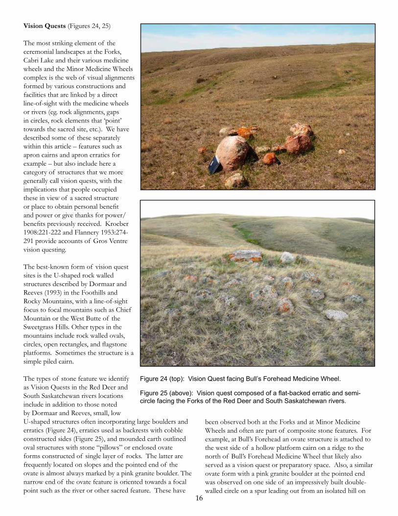
Vision Quests (Figures 24, 25)
The most striking element of the ceremonial landscapes at the Forks, Cabri Lake and their various medicine wheels and the Minor Medicine Wheels complex is the web of visual alignments formed by various constructions and facilities that are linked by a direct line-of-sight with the medicine wheels or rivers (eg. rock alignments, gaps in circles, rock elements that ‘point’ towards the sacred site, etc.). We have described some of these separately within this article – features such as apron cairns and apron erratics for example – but also include here a category of structures that we more generally call vision quests, with the implications that people occupied these in view of a sacred structure or place to obtain personal benefit and power or give thanks for power/benefits previously received. Kroeber 1908:221-222 and Flannery 1953:274-291 provide accounts of Gros Ventre vision questing.
The best-known form of vision quest sites is the U-shaped rock walled structures described by Dormaar and Reeves (1993) in the Foothills and Rocky Mountains, with a line-of-sight focus to focal mountains such as Chief Mountain or the West Butte of the Sweetgrass Hills. Other types in the mountains include rock walled ovals, circles, open rectangles, and flagstone platforms. Sometimes the structure is a simple piled cairn.
The types of stone feature we identify as Vision Quests in the Red Deer and South Saskatchewan rivers locations include in addition to those noted by Dormaar and Reeves, small, low U-shaped structures often incorporating large boulders and erratics (Figure 24), erratics used as backrests with cobble constructed sides (Figure 25), and mounded earth outlined oval structures with stone “pillows” or enclosed ovate forms constructed of single layer of rocks. The latter are frequently located on slopes and the pointed end of the ovate is almost always marked by a pink granite boulder. The narrow end of the ovate feature is oriented towards a focal point such as the river or other sacred feature. These have

17
and 39CU1737 (Sundstrom 2006:58,71). Site 39HE0325 includes a roughly square alignment of 27 cobbles and a cairn arranged in a L-shape and composed of ca. 40 cobbles (Alex 1976 SD ARC Site Form). Site 39CU1737 consists of three circles, a cairn, a diffuse artifact and FBR scatter and an L on the slopes and top of a finger ridge. The L (classified as an alignment in the Dakota system) “forms an obtuse angle, measuring 2.3 m on one side and 3.15 m on the other” (Sundstrom SD ARC Site Form 2006 update).
These as well as other ceremonial stone features found at these locales suggest a regional Northern Plains distribution pattern to this ceremonial stone feature assemblage.
Crosses (Figure 27)
One fine example of a stone cross comes from a large stone circle site (EfOo-27) on the north side of the big bend of the Red Deer River east of the Medicine Wheels. The cross sits within a 7 m dia. stone circle. Its upright line runs 2.25 m north-south and is comprised of eight medium-large rocks. The cross bar is closer to the north end than the south and it is also comprised of eight rocks although smaller than those in the long axis. A black biotite granite boulder marks the north end, white dolomite rocks sit on either end of the cross bar and a large red boulder was placed on the south end of the cross. Colour selection is clearly significant here. Red rocks were frequently observed in the south end of circles in this site although in this case it is part of the cross feature rather than an isolated example. The first impression was that this must be a historical addition – perhaps due to the tampering by an early homesteader. But the fact that the rocks of the cross are sodded to the same depth as the exterior circle, plus the addition of the large red rock on its south end support its contemporaneity with the outer circle.
the Red Deer River valley bottom below Minor III medicine wheel. The circle is 5.5 m in diameter; the ovate vision quest structure is approximately 2.5 m on its longest axis. There was another vision quest on top of the hill comprised of a single rock walled ovate outline.
The least common vision quest type in our study areas is a dished-out oval/circular structure with a rock pavement for the floor. Only one was found at the Forks. Its oval walls and base were constructed of cobbles. Structures with rock floors are known to the Gros Ventre as “thunderbird nests” and found in the Sweetgrass Hills, Little Rockies and Bearspaws usually on the talus field summits, built of weathered slabs of intrusive igneous rocks which form these hills (Reeves, personal observation). Interestingly this type is extremely rare in Waterton-Glacier, even though volcanic and argillite rock talus fields are common on the mountain tops.
As stated earlier, we assume that other stone feature types like apron cairns and apron erratics also served in a vision quest capacity.
L-shaped rock constructions (Figure 26)
We have observed at least three of these constructions around the Minor Medicine Wheels complex. The ratios of the lengths of the arms to the upright are similar to those of a carpenter’s square. The arms range from .5 m to 2 m in length and the longest arm points to the medicine wheel. The L symbol is also an Arapaho symbol for Hiiteni (“life”) (Kroeber 1900:78, Figure 108).
Two “L”s were found at ceremonial stone feature sites which are part of an extremely large ceremonial stone feature site with subgroup 1 & 2 medicine wheels, located in the Fresno Reservoir along the edges of the Milk River Valley northwest of Havre, Montana (Deaver 1983:31; Reeves and Kennedy 2017). In addition to Ls, Deaver also found many medicine wheels similar to those found in the Lower Red Deer and South Saskatchewan region. He also noted similar arcs to ours with cairns between the arms, rectangular structures, innumerable alignments, very small circles and the like, suggesting to us that the Fresno Reservoir sites he has found and others along the Milk River in Canada (Graspointer 1980) are the same and equally complex as those at Minor and the Forks.In addition to L-shaped features found in the Fresno Reservoir in Montana, we are aware of Ls from two sites in South Dakota: 39HE0325 (Alex and Zimmermann 1977) Figure 26: L-shaped stone feature. Drawn by Adam Hauer.

18
Figure 27 (above): Cross form found within stone circle at EfOo-27.
Figure 28 (below): Armoured earthen mound, Empress Creek.
Other examples found in northern plains sites give further support to this being a precontact construction and symbolic element.
We are aware of two reports of crosses, one from South Dakota (39HD5 [Todd 1866:41912:211; Sundstrom 2006:77]) and another from Utah (Monte’s Hollow Mound Site [Ogden n.d]). Description of the South Dakota example comes from Todd (1912) who was informed of a cross formed of two intersecting lines of boulders. The upright line measured 20 m in length and the cross bar 7.6 m. A cairn was located at one end of the longer lines of rocks. (Todd 1912:211 stated it was at the foot of the cross). The site has not been relocated (Abbott, Ranney and Whitten 1983:35), the landowner had no knowledge of it and either the location was wrong on the site form or the stone feature has been destroyed.
The Utah site is located in Northeastern Utah in the Green River drainage near Hayden, Utah. The ceremonial stone feature (Ogden n.d.: Figure 2) consists of a central cross with a 6 m long upright and a 4.5 m long cross bar all constructed of small stones. The cross is encircled by a 15 m x 27 m oval circle of 13 small cairns, .6 to .9 m in diameter, situated 6.6 m - 14.5 m from the cross. The stone feature is on a natural mound in the centre of a depression known as Monte’s Hollow.
Armoured Earthen Mounds (Figure 28)
These are rare but significant features. The one pictured here is on the east side of Empress Creek near the edge of a spur top overlooking the creek valley. It is flat-topped, ca. 3 m in diameter and the sides are armoured with rock.
We have also found linear rock-covered earth/gravel filled mounds (ca. 2 - 3 m long x <1 m - 1.5 m wide) at the Forks and Minor on flat benches and ridges in contexts where they are not residual erosional features (i.e. not on a steeply sloped river valley erosional ridge, backed up behind an erratic). Popular folklore often equates these with human burials which some might be, but as of yet we have seen only rodent bones in ones denned in by coyotes or foxes. We have noted the occasional large black volcanic shard or core in some which are eroding out, which suggests some may have been constructed for ceremonial activities.

19
Alignments
The fact that we have included this category of rock constructions in this discussion whereby stone features are viewed in their ceremonial function should quickly signal to the reader that we find most of the rock alignments to play a very different role from that of guiding animals into jumps or pounds. Rock alignments as viewed at Minor Medicine Wheels ceremonial complex and the Forks clearly do not behave in that way. There are impressive long lines at Cabri Lake (located and photographed some decades ago by Ted Douglas) which may be drive lanes but they seem also not to follow the standard rules for such. The rock alignments we have observed would instead act as connections, the circuitry across the landscape linking participants with the places of power and worship. They can occur on all landforms including ridge tops and slopes, can cut transversely across landforms (see Brink et al. 2003:233 where Wetzel proposes these ‘cut-off ’ lines acted as boundaries separating ceremonial, sacred space from more public, non-ceremonial space, an interpretation with which we would concur), and can point to medicine wheels and major geographic focal points. At Minor there are innumerable examples of rock alignments associated with cairns. The rock lines can be comprised of single rocks or small cairns of 2 to 3 rocks and vary in length from a few meters to a half kilometer or more, exhibit internal structural variability and may include other stone features.
At the Forks there are some exceptional examples of non-drive line rock alignments. For example, a 400 m line runs down a side ridge off the south side of a butte-like hill (Figure 29). It runs through a large circle about half-way
down. The north end, some 300 m in total length, cuts across the coulee head and connects across the flat top of the hill with an impressive site of cairns (including an apron cairn) and well-constructed circles (previously recorded site EfOl-4).
In another example, a prominent slump block hill isolate on the north side of the South Saskatchewan River valley wall is host to at least four lines with multiple branches running outwards and around the hill for considerable distance, some through circles and terminating in cairns. The southerly running lines, two of which measure between 280 and 300 m in length, point to the Forks of the Red Deer and South Saskatchewan River. An alignment 1.5 km in length connects the Bull’s Forehead Medicine Wheel southwards along a narrow “Knife Edge Ridge” (the Blackfoot and Gros Ventre name for narrow sharp ridges) to the Red Deer River bottoms. This alignment incorporates various sized cairns - including platform and bar cairns, single rocks, closely spaced cobble lines “garden borders”, circles, rocked and aproned erratics, vision quests and has a dacite boulder with a scratched circle on it at the alignment’s southern end.
Shorter alignments 20 - 40 m in length containing a variety of stone features oriented to the medicine wheels or the landscape focal points are common. The features along the alignment include, in addition to the use of single stones and small cairns to mark the line, circles and arcs bisected by the alignment, rectangular and triangular platform cairns and apron cairns/erratics and rocked erratics. Often the alignment is “bookended” by piled or apron erratics/cairns and or vision quests. The vision quest structure is usually at the alignment’s end proximate to the medicine wheel or
landscape feature. There may well be an order in the placement of the stone features. These alignments, like the doors in the ceremonial circles, are always oriented to the focal feature regardless of the compass position of the alignment, suggesting to us that these stone feature alignments represent repeated formalized rituals.
Outside the Study Area: Archaeologists working in North and South Dakota in particular have used a somewhat archaic stone feature classificatory system developed by Howard in the late 1940s, in which a wide and diverse structural/formal variety of stone features are classified as alignments. Detailed descriptions, drawings or photos are seldom provided on site forms and in reports. Alignments as defined include not only those
Figure 29: Rock alignment linking up with EfOl-4, the Forks. Arrows point to alignment segments. Drafted by Yvonne Mazza.
20
existence from the sacred light/path of the sun and sun’s companion moon.
The alignments connecting water bodies and ridge tops probably were symbolic connectors of the Above World through the Middle World (world of human beings) to the Below World, the common tripartite cosmological division of many North American First Nations including the Gros Ventre/Arapaho. More specifically, the Feathered Pipe, the principle pipe of the Gros Ventre, was given to the People by the Lord of the Storm Bha’a. Bha’a sometimes appears as a Thunderbird. Bha’a is also Lord of the Below World, where he sometimes appears as a Horned Serpent. Occasionally he appears in the Middle World, sometimes as a human being2.
The Feathered Pipe was given to the people in a violent thunderstorm somewhere out on the plains. The first keeper was Whistling Man. There have been 200 keepers since. They held the pipe for four or more years (Flannery 1957:446-460, Appendix 6. Origin of the Feathered Pipe e.Version by Garter Snake pp.451-454). It follows that the Feathered Pipe is at least 800 years old. The pipe’s main role is ensuring spring rains, and protecting against thunderstorms, lightning, and floods (Flannery 1957:138). It was opened in spring and summer.
The practice of partitioning and connecting significant ceremonial landscapes and features was probably once widespread in North America. For example, Ohio Hopewell people partitioned their ceremonial landscapes using earthen embankments to set aside ceremonial space on high river bluffs overlooking focal landscape features. They also used both linear embankments and trackways to connect ceremonial centres to each other and to rivers and other waterbodies (Romain 2015).
Given the above we would urge archaeologists to carefully consider the nature of rock alignments and their association with other features before applying the default classification “drive line”.
Complex Stone Feature Alignments
Abbot et al. 1982:38-48 (see also Sundstrom 2006:83, 85-86) describe complex stone feature alignments, often associated with or incorporating effigies which are generally comparable to our complex alignments at Minor and the Forks. Site 39HU66, located on a bluff top point of land between two draws above Medicine Knoll Creek in South Dakota, is a useful comparison. The site (Abbot et al. 1982: Figure 16) consists of a 90 m long single line of deeply embedded stones, oriented 55 degrees east of north. A 2 m diameter rock lined depression lies at the northeast end, 2 meters from the end of the alignment. The alignment turns 10 meters to the south at the southwest end terminating in a 5 m cairn with a central depression.
linear/curvilinear alignments of cairns, rocks and boulders which most workers in the Northwestern Plains classify as alignments and/or drive lanes, but a whole range of distinctive ceremonial stone features such as medicine wheels (for example, as at the Jennings site 39HD22 [Haug et al. 1983:340]). Sigstad and Biggs (1973-1974:18) describe features at site 39SL94 which include two stone circles, but also a stone feature they classify as an alignment. The latter is a circle with radiating lines that encircle a mosaic which may be a turtle effigy. Sigstad and Biggs describe another alignment at 29SL184 as a bird effigy (Sigstad and Biggs 1973-1974:33).
Abbot et al. (1982:4-6, Table 1) used the term petroform for the general class, restricting the use of the term alignment to “a line of stones…. rarely perfectly straight [which] may form geometric structures such as “surrounds”. Mosaics are “scatters of stones roughly describing circles and ovals… filled in with stones suggesting more of a floor of stones rather than a ring….. a cairn is mosaic with stones heaped upon the surface” Abbot et al. (1982:4-6, Table 1). Abbot et al.’s definition of mosaics corresponds to our use of the term platform cairns, which are usually not tiered but sometimes may have a second layer which is sometimes buried. These are common features in a number of sites inventoried by Abbott et al. 1982. For example, site 39JE10 above the James River has a serpent effigy which has 10 mosaics associated with it, the majority (seven) of which were 1 - 3 m in diameter (Abbott et al. 1982:16-18).
Ethnographic Comparison: Information Kroeber (1907:311-313, Plate LXIV) obtained from a middle-age Northern Arapaho medicine man sheds some light on these alignments’ meaning. The man had two painted pieces of buckskin with groups of symbols of various colours painted on them that he showed and described in part to Kroeber, who later made a sketch and wrote a description from memory, as he could not secure or reproduce them at the time he saw them. The pictographic designs relate to myths of creation and tribal ceremonies. One of the compositions is of particular interest:
“A straight line diagonal to the length of the buckskin represents the extent of the world and the course of the sun. On it are shown both the sun and the moon; the former by a small solid circle, the latter by the arc of a circle. Four blue dots, two on each side of the line, represent the “four old men”. Beyond the end of this line is a painted ovate figure drawn in blue outline, and representing a mountain-goat horn from which old men are fed” [Kroeber 1907:311].
We suggest there is a symbolic analogue between this drawing and our alignments. The alignment is the way, the path of life, bison, people, etc. who owe and draw their very

21
Thirty-nine stone features lie adjacent to this complex feature, most either distal up to 200 m or proximal up to 100 m of it but generally on line with the stone alignment. They consist of: a zoomorphic tailed effigy (Abbott et al. 1982:Figure 17) with an oblong, possibly eyed 2 x 3 m head and 8 m long tail of single stones situated adjacent to the southwest end of the line on the western slope of the bluff top; a cairn (3 m diameter), 5 circles (between 1 m and 7 m in diameter) and 32 mosaics, including three which, from illustrations (Abbott et al. 1982:Figures 18,19,20), are scattered stone features (3 x 5 m, 5 x 8.5 m (long axis E-W) and 9 m (N-S) x 1 m in size). The other mosaics range from 3 m - 5 m in diameter. Fifteen are 1 m in diameter. This suite of features fits very well within the complex stone feature alignments we have found at Minor and the Forks.
Miscellaneous Stone Figures
Effigies: Human effigies such as the so-called Napi figures (Brace 2005:65-70; Vickers 2003; Vickers and Peck 2009) are not represented at Minor or the Forks. The nearest recorded are the Cabri Lake Stone Man (EgOk-1) (Kehoe 1965) and a headless figure at the Ross Medicine Wheel (EfOq-87), located on the Red Deer River (Vickers 2003:245), some 20 km above the Minor Complex. Vickers and Peck (2009) consider Napi figures to be Nitsitapii constructions. We would generally agree, except to note that they were not all necessarily constructed in traditional Nitsitapii territory and some may well be copycats outside of it or functioned as symbols of temporary Nitsitapii territorial expansion after ca. A.D. 1500. Turtles: Two small isolated and scattered turtle effigies have been found at the Forks 2 km apart on morainal lands and benchlands, some 2.5 km north of the South Saskatchewan River. Both are small 2 to 2.5 x 1 to 1.5 m ovals, oriented west towards Bull’s Forehead Medicine Wheel which is visible as a low hump on the horizon. They are comprised of primarily fist-sized stone outlines and partially stone-filled bodies, with single rocks for heads and tails and one or two rocks for the front and rear flippers.
These figures are not unlike the Noble Point Effigy (DjPa-1) on Chin Coulee (Bubel et al. 2012) interpreted by these authors as a shield-bearing warrior, an interpretation with which we do not concur; it is a turtle in our opinion and that of the late Dr. John Dormaar. John was one of the party of people who revisited the site in 2008 (McMurchy 2009). (See also Brace 2005: Figs. 74, 75 for larger versions of this particular shape of turtle from southeast Manitoba). The carapace plates appear to have been depicted on the two Forks figures and Noble Point by smaller fist-sized rocks now scattered or buried. For the turtles’ bodies and appendages there was a color/rock type selection.
Another of these small turtles has been observed by Reeves in an isolated context on a lightly grazed bench at Landslide Butte on the Milk River Ridge on the Blackfeet Reservation 3.5 km south of the Milk River. Its carapace, covered by an ant hill, appears to be in much better condition.
Walde (1976: Minor I and II, sheets 1&3 of 4) identified a circular stone feature lying on the processional way between Minor Medicine Circles I and II as a turtle. We, as well as Hanna (in Vivian et al. 2008) have examined this circular stone feature and do not concur. Rather, we interpret it as a heavily rocked and maintained ceremonial stone circle with platform cairns attached and constructed into its wall.
Turtles are very significant in Arapaho ideology (Anderson 2001). Turtle or Duck as earth diver brought the mud from the bottom of the waters to First Man. Turtles were used in healing (Anderson 2001:256) and must not be harmed. Gros Ventre accounts recorded by Cooper and Flannery (Flannery 1953) discuss Turtle as earth diver and deliverer of the Flat Pipe to the Gros Ventre. The Pipe was also addressed as Turtle. A turtle shell in the bundle was ranked as second to the Flat Pipe in dignity (Flannery 1957:69, 71). The head mouthpiece of the Gros Ventre Flat Pipe is considered by Gros Ventre elders at the time of their studies to be a duck effigy (Flannery 1957:70, Figure 1).
Carter (1938:95, Figure 10) attended a Northern Arapaho Flat Pipe Ceremony and stated that the head (mouthpiece) of their Flat Pipe was considered by some Northern Arapaho to be a turtle, others a duck. A blessing ceremony (Carter 1938:83-84) involving the ritual manipulation of a red painted turtle shell effigy by the assembled group began the opening of the Northern Arapaho Flat Pipe bundle.
Kroeber (1907:427-429, Fig. 165) illustrated a painted cloth representing a dream experience recorded by an Arapaho ghost dancer after a seven day fast. Included on it is a small long tailed snapping turtle which the man told Kroeber was his real supernatural helper. Turtle appeared in his dream first as a stout man then morphed into Turtle who told the man he owned the rain: “When you want rain pray to me, for I am the fog…” (Kroeber 1907:428). Turtle tail amulets were important medicines. Kroeber (1907:431) described a turtle tail ornament worn as a headdress to prevent injury from clouds that appear dangerous. The illustrated specimens (Kroeber 1907:LXXXVII) are snapping turtle tails.
Turtle is absent from the Nitsitapii earth diver accounts, and turtles play no role in core Nitsitapii myths, religious ideology, activities, visionary experiences or medicines documented by Wissler (1910,1912a,b, 1918; Wissler and Duvall 1908), probably reflecting the fact that Nitsitapii traditional territory is largely outside the historic distribution

22
of painted, box and snapping turtles. Grinnell (1892:207) noted, “turtles, frogs, and lizards are considered creatures of evil, and are never eaten”. (See also Jones and Jones 2012:111-118 for a review of the ethnographic role of turtles in Northern Plains Cultures).
Horned Serpents: Three sinuous bodied, horned rattletailed stone serpents have been identified at the Minor Medicine Wheel Complex. One is located at the Minor III medicine circle and was first identified by Hanna (in Vivian et al. 2008). It is located adjacent to the northwest side of the circle surrounding the central cairn. It is ca. 10 m in length, facing south to the Red Deer River Valley and Dune Point. A second one, 9 m in length and similarly oriented, is located 250 m northwest of Minor III in the Daisy Cairn Ceremonial loci (EfOo-25). These two sites lie on the rim of the Red Deer River Valley some 3.5 km almost due east of Minor I/II medicine circles. The third horned serpent is a somewhat cattle-dispersed 15 m long serpent situated on the south edge of a small sandstone capped bench (el. 678 m) located on the west wall of the river valley 1 km south of Minor (el. 737 m). This feature is oriented northeasterly towards Minor Medicine Circle III 4 km to the northeast across the valley. The high valley walls obstruct the direct line of sight to Minor Medicine Circles I and II. Walde (1976 Minor Medicine Wheels Sheets 1&2 of 4) identified a linear stone figure lying on the processional way between MI and MII as a snake. We as well as Hanna (in Vivian et al. 2008) have examined this arc-like stone feature and do not concur. Rather we interpret it as the wall of a partially buried ceremonial stone circle.
Horned and rattletailed serpents in Gros Ventre ideology are one manifestation of Bha’a when he is in the Below World, of which there are numerous accounts (Nitsitapii horned serpent accounts are few in comparison to Gros Ventre, and relate primarily to the origin of their horned serpent sacred lodges.)
Place Signs and Way Finding Signs: The Gros Ventre and Nitsitapii have names and representational pictographic signs for particularly significant places. The two tribes share some places and place names in common, such as the traditional names for the Sweetgrass Hills and Chief Mountain and most probably the pictographic signs are shared as well. On Peter Fidler’s Chesterfield House maps (1803 Sketch map presumably of present-day southern Alberta originally drawn by an Indian and overdrawn by Peter Fidler. HBC Archives, P.A.M., B.39/a/2 fos. 85d-86. #165) the sign for the Sweetgrass Hills is three hills, and a slightly asymmetric inverted U for Chief Mountain (Chief leans slightly eastward when view from the east). Some of the Fidler maps as well as Nitsitapii convention (still practiced today in some Nitsitapii’s pictographic art) have these types of elevated landforms shown standing on a line.
Those maps that show Chesterfield House and the Forks of the Red Deer and South Saskatchewan do not show any signs for this locale or elsewhere along the Lower Red Deer or South Saskatchewan rivers.
Place signs may well have been laid out as stone markers for these significant locales. At Minor we have three small horseshoe-shaped structures ca. 1 x 1 m, which in our opinion represent the place sign for this place - the great horseshoe bend of the Red Deer River and Dune Point.
Two of the horseshoes are centrally located within two large diameter ca. 7 - 8 m stone circles. One lies at the southeast river valley trail entrance on to the Minor bluff top bench, 20 m west of the constructed trail. The open end of the horseshoe faces Minor II medicine circle 150 m to the NNW. A second circle 500 m west of the first horseshoe next to old trail scars in the western site area faces Minor I medicine circle 250 m to the ENE. The third horseshoe is on the northeast side of the site 125 m NNW of the first example. It faces Minor II 50 m to the SW and appears to be part of a stone feature alignment. At least eight stone circles in sites in the river valley below the Minor Complex which have views to Minor have horseshoes in them.
Some of the small alignments we found at the Forks (of which there are many), may be place markers.
Wayfinding markers: Small stone features may be present that combine the place signs of two places and act as symbolic wayfinding linkages between. Such have been recently found by Reeves between the West Butte of the Sweetgrass Hills and Chief Mountain some 145 km to the west. Here he has discovered a set of seven specifically located and structured ceremonial stone feature sites (ceremonial circles, vision quests, cairns, often “tied” together by a cairn alignment), that link the West Butte of the Sweetgrass Hills across the Milk River Ridge with a butte in the St. Mary River Valley in view of Chief Mountain. These sites are only located where there are push moraines (sources of stone) up the sides of the unglaciated flat-topped peneplain Milk River Ridge which have views to both sacred places. The sites are on both the moraine and the adjacent benchlands. Each locale has one or more small stone features ca. 2 x 1 m in size constructed mostly of fist-sized cobbles of the right rock types and colour, comprising an inverted U (Chief Mountain) on the west side joined to a transverse rock line. On the east side of the latter is a triangle (representing West Butte) joined by its base to the transverse bar.
We believe that similar wayfinding markers exist in our study areas. We have found two poorly preserved (cattle-trampled and badly scattered) small similar-sized stone features that are transversely partitioned on the northeast edge of the Forks Complex that may be waymarkers linking Cabri

23
and the Forks. Another one southwest of Minor might link Minor Ceremonial Complex with ceremonial stone features such as the Anderson Medicine Circles some 16 km further up the Red Deer River. All are on low morainal ridges, unfortunately a favoured place for wintering cattle to graze and congregate as the sun burns the snow off there first. Visibility is further obscured by copious quantities of accumulated cow pies.
Ethnographic and Archaeological Considerations
In the preceding discussion of the stone features we have drawn comparisons to the ethnographic record relative to both circles, cairns, and features such as the Ls, bar cairns, alignments, etc. for the Gros Ventre/Arapaho and in some cases the Nitsitapii (Blackfoot speaking tribes – Piikani, Kainai, Siksika). We expect ceremonial stone circles in their traditional areas to be similar in size range, basic construction, and presence of certain elaborations such as multiple doors, as both groups erected large lodges using multiple lodge covers, conjoined lodges and walled sometimes roofed constructions for ceremonial purposes.
It is in the details and structural elaborations of the circles and associated stone features such as platform cairns, as well as specific types of stone features that we find the differences. Searches of the ethnographic literature dealing with the decorative art and symbolism of the Gros Ventre/Arapaho and Nitsitapii indicate a major difference between the two groupings as noted by both Kroeber (1908) and Wissler (1904). Kroeber (1900, 1902) published studies of Arapaho designs and symbols and addressed their rich and complex symbology. He noted, “the number of symbols is considerable; several of them express abstract ideas; connection between symbols is usual, and they may tell a story” (Kroeber 1900:84).
Kroeber (1908:151 fol.) discussed and compared Gros Ventre decorative art noting that their art at that time “is not nearly as strongly developed as that of the Arapaho”. He attributed this difference, “perhaps in large measure to change of mode of life under the influence of civilization, yet it seems too there must have been a temperamental difference between the Arapaho and Gros Ventre, even in earlier times; for the Arapaho preserve at least distinguished wrecks of their symbolism, ceremonies, and religious life, while among the Gros Ventre, who are in much less intimate contact with the Americans, these things have vanished, leaving often scarcely a trace, and rarely more than a memory” (Kroeber 1908:151 fol).
To our mind the Gros Ventre’s cultural loss is clearly due to the impact of the Saskatchewan and later the Missouri River fur and robe trade, American expansion and settlement westward up river, and the recurrent small pox epidemics
and other European diseases on traditional Gros Ventre culture in the late 1700s and 1800s (see also Fowler 1987).
Wissler (1904) noted that Blackfoot decorative art was quite simple in comparison to other Plains tribes. Blackfoot parfleche decoration of diamond designs was usually referred to as “Gros Ventre painting”, suggesting to Wissler it was probably copied from that tribe. Among the Blackfoot, according to Wissler, there was an entire absence of symbolic motive in the decoration of a parfleche, which would after completion be given a thin coat of red paint which was symbolic of the sacred contents. Design was a matter of convention; it was the painting which was important. In comparison to the Arapaho, the Blackfoot had only a few conventional designs that were usually important religious symbols.
Do these fundamental differences between the two tribes in symbology also express themselves in ceremonial stone features? We have noted earlier the close comparisons between some of our smaller stone features - bar cairns, Ls and rectangular-triangular platform cairns - and Arapaho symbols which are or can be sacred in nature relating to prayer and petition.
We have not observed these particular stone features or those involving cultural manipulation of erratics in ceremonial stone feature sites in traditional Piikani lands we are familiar with on the western edge and foothills of southwestern Alberta and adjacent Montana, for example in the vicinity or within the Oldman River Valley Piikani Nation (Reeves 1982) and Oldman River Dam in and adjacent to the Oldman, Castle and Crowsnest rivers (Reeves 1987), or the Waterton River (Reeves 2006). The lands within these projects range from high glaciated benches, river bluff tops and high river valleys. Tills outcrop along the bluff tops exposing erratics there and downslope. We have also inventoried a number of windfarms in this region which contain large tracts of hummocky moraine and high bench lands with exposed erratics (Reeves 2006).
Large ceremonial circles with multiple doors do occur as do quartered and spoked circles (which are uniquely Nitsitapii in design); some circles are bisected, arcs occur, cairns are typically heaped or flat, erratics are present but are neither repositioned, rocked, piled nor aproned, nor are cairns. Alignments occur but they are not complex and usually part of a drive lane system ending in a jump or pound. Platformed structures and geometrics such as platform cairns, bar cairns and Ls are absent.
These regional differences in stone feature type and diversity between southwestern Alberta and the Lower Red Deer-Forks of the South Saskatchewan clearly reflect differences in ceremonial behaviors and symbolic icons of the Piikani

24
and Gros Ventre as expressed in stone features associated with ceremonial activities.
Archaeological Culture History Considerations
The archaeological sequence and cultural associations developed for southern Alberta’s western plains and foothills for the Late Period (ca. A.D. 200 - 1800) have been used by most archaeologists to model that for the eastern region of Alberta and adjacent Saskatchewan and Montana to the south. The primary occupants for the last thousand years in that latter area prior to the appearance of the Mortlach Phase representing the Assiniboine (Walde 2003) some 550 years ago are predominantly associated with the Old Women’s Phase, considered to represent Blackfoot speakers in most archaeological constructs (e.g. Peck 2011; Peck and Ives 2001; Walde, Meyer and Unfreed 1995).
We do not accept the Old Women’s model, as there is another coeval phase known as Saddle Butte proposed by archaeologists such as John Brumley, Barry Dau and Patrick Rennie (Brumley and Dau 1988; Brumley and Rennie 1995) to account for assemblages from the Milk River area of northeastern Montana that differ from Old Women’s in a number of material culture traits. Reeves (2009), in an extensive analysis of Late Period post-Avonlea Horizon collections and reports from Alberta and Montana, found that the Old Women’s Phase distribution is more or less coincident with traditional Piikani lands north of the Marias River and west from the Sweetgrass Hills, with Saddle Butte lying to the east and south in the Milk River and Upper Missouri, coeval in territory with that of the traditional Gros Ventre in Northern Montana and Arapahoan speakers in southern Montana, prior to the expansion of the Crow up the Yellowstone and the Crow and Assiniboine up the Missouri in the 1500s. Saddle Butte sites on the Milk lack trade goods, suggesting temporary depopulation of the area by the Gros Ventre during the 1700s as a result of the smallpox epidemic early in that century.
Reeves also examined but did not report on collections and reports/theses from southwestern Saskatchewan. Saddle Butte Phase diagnostics (pottery and chipped stone tool styles, tool stone use patterns, etc.) were identified at a number of sites including Hugo Dosch kill and processing site (EgO-l) on Empress Creek, the Estuary Bison Pound (EfOk-16) (Adams 1977) just downstream of the Forks, Miry and Antelope Creek (Novecosky 2003), deflated camps in Lake Diefenbaker further down the Saskatchewan, the Gull Lake Bison Jump (EaOd-1) (Kehoe 1974), and the Heron site, a stratified winter camp on Swift Current Creek upstream of Swift Current. Mortlach pottery was also found at Miry Creek and Antelope Creek sites and is indicative of the extension of the Assiniboine upriver in the 1500s. Late
Old Women’s pottery (post ca. A.D. 1550) was also found and is indicative of wintering Kainai bands. Trade goods found at both of the deflated sites may associate with the Assiniboine and Kainai occupations.
Trade goods were not found at Gull Lake or Heron sites, suggesting they were abandoned sometime before the mid-late 1700s, like the Saddle Butte sites on the Milk to the south, as a result of the small pox epidemic of the early 1700s. Gros Ventre traditions recorded by Curtis (2015) in the early 1900s say they contracted small pox at the same time they got horses and both came from the Snakes (Siouan speakers). This event occurred on the “Red Deer’s River” although that is also the traditional Gros Ventre and Nitsitapii name for today’s Yellowstone River. Since the Gros Ventre frequently made visits southward to visit their Arapaho cousins, and they frequently camped and wintered together, it is possible this proximity allowed for the northern transmission of small pox when the Gros Ventre returned to the Saskatchewan country.
An earlier small pox epidemic may have swept through Arapahoan speakers in the 1500s, as the southern tribes at that time were engaged in active hide trade with the Eastern Pueblos, who experienced their first epidemic brought to them by the Spanish from Mexico in that century. Frequent and regular visits of the Arapaho by the Gros Ventre would rapidly spread the infection among the Arapahoan tribes, decimating the population, allowing the movement of the Crow up the Yellowstone and Crow and Assiniboine up the Missouri and the Assiniboine up the South Saskatchewan in the 1500s into traditional Arapaho and Gros Ventre territory. These movements are well documented in the artifact assemblages dated to that time (Reeves 2009; see also Walde 2003).
Blackfoot-speaking peoples certainly were present in the Lower Red Deer-South Saskatchewan region in Precontact times and are represented by an Old Women’s Phase occupation at the Saamis site in Medicine Hat dating ca. A.D 1550 - 1800 (Milne-Brumley 1978) and the Ellis Medicine Wheel dated to A.D. 1450, considered to be a Blackfoot death lodge (Brumley 1984). Some Saddle Butte ceramics were recovered from Saamis and are considered by Reeves to be evidence of co-residence or marriage, as both were common between some co-adjacent Gros Ventre and Nitsitapii bands.
Lower Red Deer River-Forks Archaeological Sequence
Major archaeological excavations have yet to be undertaken at stratified camps in this area. This region contains the largest narrowleaf riverine cottonwood forest ecosystem in Canada and would have been an important wintering as well as summering area. Adams (1976) located and briefly

25
tested a number of sites, returning in 1976 to carry out more extensive excavations in stone circle camps on Alkali Creek (Adams 1978). EfOp-324 was a stratified circle site. The latest occupations contained trade goods that dated to the later part of the nineteenth century. Typical Old Women’s Phase projectile points and split pebble bipolar wedges and other tools typical of the bipolar stone tool technology that characterizes Old Women’s Phase were also found in association with more deeply buried hearths. Split pebble tools and technology were also identified at another stone circle site, EfOp-53, in 1976 and EfOp-109 in 1975 (Adams 1976). Mitigative studies in support of the Keystone and Keystone/XL pipelines (see Boland 2012 for summary) did not recover any readily identifiable Late Period artifacts from their excavations in this section of the proposed pipeline.
While definitive evidence of Saddle Butte occupation of the Lower Red Deer River remains to be recovered, excavations at Hugo Dosch did yield Saddle Butte style Plains and Prairie Side-Notched points and Saddle Butte Bull Hook Ware ceramics (Reeves personal observations), indicative with the other excavated and deflated surface finds of a once substantive long-term presence of Saddle Butte Gros Ventre peoples in the area. Saddle Butte Prairie Side-Notched style points are the most common arrow point type found by Adams (1976) in surface collections, as they are in local collections.
Ethnohistorical Considerations
During and after the years of the fur trade on the Upper Missouri, the Gros Ventre lost much of their traditional knowledge and culture in comparison to their upriver neighbors the Blackfeet (Kroeber 1908). Little of their history was remembered by Kroeber’s informants by the turn of the century and less so when records were collected by Cooper and Flannery in the late 1930s and 1940s (Flannery 1953), who relied primarily on the documentary record in interpreting Gros Ventre history and territory since the coming of the fur trade to the Upper Saskatchewan and Missouri (see also Fowler 1987). Only one place name was remembered (Taylor et al. 2013), which was their original tobacco garden said to be “a plot of ground in the forested area of Canada on which nothing grew and which the Gros Ventre called “Broken Grass”. They believed “this was the site where the original tobacco was planted under instruction from the Supreme Being” (Flannery 1957:85 footnote 4). Flannery noted that in Lame Bull’s time (mid 1800s) they used to leave offerings whenever they passed by this place.
The Gros Ventre tobacco garden would be a locale with sufficient heat and frost-free days for the tobacco to grow. This most certainly was in the long ago time, probably about the time the Nitsitapii received tobacco and pipes from
spiritual beings on the Bow River below today’s village of Cluny, according to oral Nitsitapii tradition. This would have occurred around one thousand years ago based on the recovery and relative dating of smoking pipes from excavations at the Majorville Medicine Wheel (Calder 1977; Reeves n.d.). The most likely place for the Gros Ventre tobacco garden is somewhere in southern Saskatchewan in the gallery forests of a river valley, perhaps the Forks region of Red Deer/South Saskatchewan, whose climate is even more suitable than that of the Bow below Cluny4.
The Gros Ventre’s ethnohistoric record, scanty as it is, does indicate that at times in the past they lived elsewhere than in their traditional homelands on the Saskatchewan and Milk. Kroeber (1908:280-81) tells of a time when they lived far north where there was nothing but forests, and they found a metallic object (meteorite) which the men could not move and made offerings to it. This is almost certainly the Iron Creek Meteorite which fell to earth sometime in the 1500s in today’s Battle River region of east central Alberta. A nineteenth century Gros Ventre chief named Ne-cot-ta also tells of a time when they all lived far north and a time when a big drought occurred, all the buffalo were gone and they had to move north, crossed a big river and came to a country with lots of caribou, the caribou eventually were gone and they moved south again (Bell n.d.). He also mentions that at another time they lived to the south of their traditional lands on the Milk.
We are also dealing at the Forks with a part of the plains that was seldom visited by EuroCanadians, barring the various fur traders who attempted the difficult trade with Nitsitapii, Gros Ventre and others at the forks of the Red Deer and South Saskatchewan rivers (Chesterfield houses) in the early 1800s. This simply is terra incognita in terms of historical travellers leaving accounts of the people who lived and/or travelled through this area. The lack of documentation should not lead us to assume it was not an important area as clearly archaeological research shows the opposite.
Conclusions
One of the primary objectives of this article was to disseminate details on a distinctive array of stone features found by the authors along the lower Red Deer River and the Forks of the Red Deer and South Saskatchewan rivers. Many of these can also be found in the Cabri Lake area to the northeast of the Forks. The hope would be that the archaeological community in other parts of the northern plains might recognize feature types described above and that ultimately we can achieve a much more refined geographical distribution for and understanding of them. We assert that this range will be distinct from archaeological phenomena traditionally associated with Old Women’s Phase/Blackfoot
26
distribution and that what we are recognizing in our study areas is for the most part the footprint in stone of Gros Ventre people before they left the Canadian plains in contact times.
While we describe these features individually for the purposes of potential recognition and placement by other archaeologists, we also wish to convey the interconnectedness of the features in these ceremonial landscapes. The advantage of our work is that it is research-driven and we have been able to conduct reconnaissance on any unbroken lands to which we have been granted access. This has allowed us to understand the larger context in which these stone features are situated; to observe the lines of sight that connects them with other ceremonial features and with the natural sacred features such as the Forks of the South Saskatchewan and Red Deer rivers. For CRM projects with limited rights-of-way, it can be difficult to understand the larger picture in which features are located. If features such as the ones described within this work are located in such restricted project boundaries, it should at least signal that they are part of a larger, integrated cultural landscape in which line of sight and ceremonial practice was a significant factor.
Request to readers: As the level of detail that is entered into provincial site or state inventories is fairly basic, it is difficult to identify the geographical distribution of these features. We invite readers who have observed similar features to contact us ([email protected] and [email protected]).
Acknowledgments
We are very appreciative of the grant support provided by the following agencies: the Saskatchewan Archaeological Society, the Saskatchewan Heritage Foundation, the Archaeological Society of Alberta and the Alberta Historical Resources Foundation. Thanks to Adam Hauer who drew the stone feature illustrations. Yvonne Mazza undertook computer drafting of two of the figures. Thanks to all landowners/leaseholders who allowed us access. We appreciate having had the excellent help of volunteers over the years including Helen Markussen, Julia Coutts, Terry Quinn, Cam Gardner, Stuart and Betty Ann Golly, Lorraine and Lyle Guckert, Alex Burchill, Kay and Stephen Jollymore as well as the contributions of 2015 field assistant Brandynn Leigh. Brandynn also sketched some of the rock features; one is included here. Thanks also to Ventus Geospatial Services of Lethbridge for the provision at their cost of drone photography of the Minor Complex flown in late May 2016. The preliminary results clearly demonstrate the importance of aerial photography for both recognition and interpretation of stone features in grassland landscapes.
End Notes
1. Ted Douglas grew up in the area and recognized the scale of the site complexes when taking aerial photographs from his plane during the 1960s and 1970s and it is because of him that archaeological inventories have been undertaken. The Saskatchewan Archaeological Society was responsible for some site recording field trips over the years. A survey by Eldon Johnson and Ted Douglas reported on some of the major site types in the area (Johnson and Douglas 1992). Nathan Friesen, Senior Archaeologist with Archaeological Resource Management, Saskatchewan has made frequent visits for site recordation purposes. Since 2011 Margaret Kennedy and Chris and Laura Foley, all of University of Saskatchewan, have undertaken a systematic survey of the archaeological sites along the west side of the lake (Kennedy 2012). This is an ongoing project and will be for years, considering the size of the area and frequency of sites.
2. The Gros Ventre have two principle pipes, the Feathered Pipe and the Flat Pipe (Carter 1938; Flannery 1957:33-139). The Flat Pipe, the senior pipe, is much older, more powerful, and is one also held by the Northern Arapaho. It was visioned before the Arapaho divided. The pipe is a one-piece elbow pipe of a yellow stone and the head of the pipe near the mouthpiece is carved to be the head of a turtle or duck (Carter 1938:94-95, Figure 10).
The Flat Pipe came from the Creator and is held in greater veneration than the sun. The Pipe plays the key role in the Arapho’s creation story (Carter 1938: 73-74). In the beginning the world was all water, and people and the Flat Pipe were floating on a raft. The Flat Pipe was instrumental in getting the animals to dive to the bottom; Turtle or Duck was successful and brought back the mud which the Creator used to create the land, then the plants and animals and the Arapaho to whom the Creator gave the Flat Pipe.
The Flat Pipe came from the Lower World. Perhaps the Forks was one of the places in traditional Gros Ventre territory where the transfers of the Gros Ventre Flat Pipe took place. Minor would also serve as such a locale given the outstanding vista to Dune Point at the horseshoe bend. Minor and Bull’s Forehead were probably two of the places where the Feathered Pipe was transferred.
There would be a number of special places within the Gros Ventre traditional territory where these transfers would occur as the People moved through their lands on a multiyear round. This territory would contain the focal landscape elements conditional for the access to and the transfer of sacred power between the bundle holders through the medium of the Feathered Pipe and Flat Pipe bundles.

27
3. Buff weathering dolomite erratics are a common erratic type in our study areas. They were pulled from dolomite bedrocks when the ice from the Canadian Shield overran the Manitoba Escarpment as it advanced westward and deposited dolomites with the other erratics in the hummocky moraine as the ice sheet wasted away. Aside from the use of piling rocks and boulders on flat dolomite erratics, they appear to have been culturally selected against in the rocking of erratics, construction of apron erratics, vision quests, etc. where igneous, metamorphic and volcanic erratics are utilized. Quartzite erratics are a favoured stone for stone feature construction as well as for petroglyph boulders in other areas but are very rare in our study areas’ tills. Perhaps in our study area the dolomite erratics were viewed in the same negative light as limestones and sandstones in Waterton-Glacier were for the construction of vision quest structures, as stone that did not have the ability to transmit sacred power from the Above or Below Worlds.
We have found a few exceptions to this rule in our study area, principally at the Forks. There, for example, is a north-south 500 m long discontinuous alignment on the north side of the South Saskatchewan River facing the Forks. This alignment begins on a high bench and runs southward down a series of benches. It includes in the middle a natural boulder erratic train (a melted-out glacial crevasse fill) which has Volkswagen-sized granites in it, circles, arcs, apron erratics, a split dolomite boulder which the rock/cairn alignment runs through, and, near the northern end on the top of the bench, a vertically oriented dolomite erratic. The exposed portion of this erratic is 1.5 m high, 1.5 m wide, 20-50 cm thick and shaped like a triangular sail. We call it “Shiprock”. A number of stone circles, short alignments, and small cairns lie adjacent to “Shiprock” and some stone features on distant benches orient to it as the north/south-oriented sail is visible for up to two km. It is a one-of-a-kind feature.
Another one-of-a-kind dolomite erratic stone feature on the north side of the Forks is a sleeping buffalo-shaped stone (Iniskim) on a side hill above a big spring, from which you can see the Forks through an erosional gulley between two benches. Alignments have been constructed and circles and cairns placed around this stone.
4. Mathew Cocking’s Gros Ventre Tobacco Garden. In the fall-winter of 1772-73 Mathew Cocking of the HBC during his travels inland southwest of the Forks of the North and South Saskatchewan rivers met a group of Gros Ventre out on the grassland plains in today’s west-central Saskatchewan, somewhere in the vicinity of the Eagle Hills and Eagle Creek. Before he met them his Cree guides showed him a Gros Ventre tobacco garden (Entry Oct. 16-19) which Cocking described as “about a 100 yards long and 5 wide sheltered from North winds by poplars and south by a
ridge” (Burpee 1908). The Gros Ventre probably had more than one tobacco garden as did the Nitsitapii, and the one observed by Cocking may or may not be the original garden. However, it is well out on the plains, not in the forest.
References Cited
Abbott, James, William Ranney and Richard Whitte1982 Report of the 1982 East River Petroform Survey,
Jerauld, Hand, Hyde, Sully, Campbell, Clark, Codington & Hughes Counties, South Dakota. Archaeology Lab, USD, Vermillion, SD. ARC archive no: ESD-0028.
Adams. Gary F.1976 Prehistoric Survey of the Lower Red Deer River, 1975.
Archaeological Survey of Alberta Occasional Paper No.3. Edmonton.
1977 The Estuary Bison Pound Site in Southwestern Saskatchewan.
National Museum of Man, Archaeological Survey of Canada, Mercury Series, Paper No.88, Ottawa.
1978 Tipi Rings in Southern Alberta: The Alkali Creek Sites. Archaeological Survey of Alberta, Occasional Paper No.9, Edmonton.
Alex, Lynn M. and Larry L. Zimmerman1977 A Cultural Resources Survey of Research of Reach I of
the Highmore Canal, Sully and Hyde Counties, South Dakota. Report BR-6-01-21-10180. Archaeology Lab, USD, Vermillion, SD ARC Archive No: ESD-0004.
Anderson, Jeffrey D.2001 The Four Hills of Life. Northern Arapaho Knowledge and
Life Movement. University of Nebraska Press, Lincoln.
Begg, W.A.1915 Personal letter of the Saskatchewan Township
Inspector, Surveys Branch, to the Deputy Minister of the Saskatchewan Department of Agriculture. Letter on file with the Aboriginal History Unit of the Royal Saskatchewan Museum in Regina.
Bell, John T.n.d. Life of Ne-cot-ta. The Last of the Great Warrior
Chiefs. Unpublished manuscript on file, Fort Belknap Indian Reservation, MT.
Boland, Dale E.2012 Historical Resources Impact Mitigation. TransCanada
Keystone Pipeline GP Limited. Final Report Permit 2011-048. Stantec Consulting Ltd. Copy on file. Archaeological Survey of Alberta, Edmonton.
28
Brace, Ian G.2005 Boulder Monuments of Saskatchewan. Saskatchewan
Archaeological Society, Saskatoon.
Brink, Jack2008 Lord of the Rings: The Acadia Valley Medicine Wheel
in Southern Alberta. Alberta Archaeological Review 49:3-8.
2009 Medicine Wheels in Alberta. Unpublished manuscript (Archaeological Society of Alberta annual meeting, Bodo AB, conference tour handout).
2013 A Sacred Stone at a Sacred Place? Alberta Archaeological Review 57:22-24.
Brink, Jack and Melissa Bowerman2016 Investigating the Rocks of Medicine Wheels
in Alberta. Talk given at 73rd Annual Plains Anthropological Conference, Iowa City.
Brink, Jack and Karen Giering2012 Tipi Rings with Platforms. Alberta Archaeological Review
54:21-24.
Brink, Jack, Kristine Wright-Fedyniak and Dean Wetzel2003 A Review of Certain Stone Features and Rock Cairns
in Alberta Archaeology. In Archaeology in Alberta, A View from the New Millenium, ed. by Jack W. Brink and John F. Dormaar, pp. 208-241. Archaeological Society of Alberta, Medicine Hat.
Brumley, John H.1984 The Ellis Site (EcOp-4): A Late Prehistoric Burial
Lodge/Medicine Wheel in Southeastern Alberta. Report on file, Archaeological Survey of Alberta, Edmonton.
1988 Medicine Wheels on the Northern Plains: A Summary and Appraisal. Archaeological Survey of Alberta Manuscript Series No. 12. Edmonton.
1993 A Description of the Benjamin Ranch Site (24TL214) in North Central Montana. Archaeology in Montana 34 (1):17-32.
Brumley, John H. and Barry J. Dau1988 Historical Resource Investigations within Forty Mile
Coulee Reservoir. Archaeological Survey of Alberta, Manuscript Series No.13, Edmonton
Brumley, John H. and Patrick J. Rennie1995 A Cultural History Model for the Plains of Northern
Montana and Surrounding Regions. Ethos Consultants Inc., Havre.
Brunswig, Robert H.2004 Report of a 2003 Archaeological Survey of 5JA1475
(Pederson Ridge), North Park (Jackson County), Colorado. Department of Anthropology, University of Northern Colorado, Greeley.
2016 Report on University of Northern Colorado 2016 Field Investigations at the North Springs and East Owl Ridge Research Areas, North Park, Colorado: Report to the Bureau of Land Management, Kremmling District. Department of Anthropology, University of Northern Colorado, Greeley.
Bubel, Shawn, Gabriel Yanicki and Jim McMurchy2012 The Noble Point Effigy (DjPa-1). Alberta
Archaeological Review 54:9-17.
Burpee, Lawrence J. (Editor)1908 An Adventurer from Hudson Bay: Journal of Mathew
Cocking from York Factory to the Blackfeet Country, 172-73. Transactions of the Royal Society of Canada 3rd Series, 2:89-121.
Calder, James1977 The Majorville Cairn and Medicine Wheel Site, Alberta.
National Museum of Canada Mercury Series, Archaeological Survey of Canada, Paper No.14, Ottawa.
Carter, John G.1938 The Northern Arapaho Flat Pipe and the Ceremony
of Covering the Pipe. Smithsonian Institution, Bureau of American Ethnology Anthropological Papers No.2, Bulletin 119, pp.73-102. Washington.
Curtis, Edward S.2015 The North American Indian. The Complete Portfolios.
Taschen.
Dawson, George M. and R.G. McConnell1884 Report on the Region in the Vicinity of the Bow and Belly
Rivers, Northwest Territory: Embracing the Country from the Base of the Rocky Mountains Eastward to Lon. 110o 45’, and from the 49th Parallel Northward to Latitude 51o 20’. Geological and Natural History Survey of Canada. Dawson Brothers, Montreal.
Deaver, Ken1983 Rings at the Johnson Bison Kill Site, 24PH8. Plains
Anthropologist Memoir 19, Volume 28 (102), Pt.2:59-70.
1987 Cultural Resource Inventory of Fresno Reservoir, Hill County, Montana. Report prepared by Ethnosciece for the Bureau of Reclamation, Upper Missouri Region, Billings.

29
Dormaar, John F. and Brian Reeves1993 Vision Quest Sites in Southern Alberta and Northern
Montana. In Kunaitupii. Coming Together on Native Sacred Sites, edited by Brian Reeves and Margaret Kennedy, pp. 162-178. Archaeological Society of Alberta, Calgary.
Dorsey, George A. and Alfred L. Kroeber1903 Traditions of the Arapaho. Field Columbian Museum
Publication 81, Anthropology Series 5. Chicago.
Flannery, Regina1953 The Gros Ventres of Montana: Part I Social Life. The
Catholic University of America Press, Washington, D.C.
1957 The Gros Ventres of Montana: Part II Religion and Ritual. The Catholic University of America Press, Washington, D.C.
Fowler, Loretta1987 Shared Symbols, Contested Meanings. Gros Ventre Culture
and History, 1778-1984. Cornell University Press, Ithica.
Friesen, Nathan2011 Recently Mapped Ceremonial Circles. Saskatchewan
Archaeological Society Newsletter 32(1):15-19.
Grafe, Steven L. Editor2009 Lanterns on the Prairie. The Blackfeet Photographs of
Walter McClintock. Edited by Steven L. Grafe, With Contributions by William E. Farr, Sherry L. Smith, and Darrell Robes Kipp. University of Oklahoma Press, Norman.
Graspointer, Andreas1980 Archaeology and Ethnology of the Milk River in Southern
Alberta. Western Publishers, Calgary.
Grinnell, George B.1892 Blackfoot Lodge Tales. The Story of a Prairie People. C.
Scribner’s Sons, New York.
Haug, James K., Ronald J. Rood, and Vicki Overholser Rood 1983 Report of the Class I and Class II Cultural Resources
Investigations of a Portion of the CENDAK Water Project Area, Eastern South Dakota, Volume I, Archaeological Sampling Survey of the East Half of the Proposed CENDAK Irrigation System, South Dakota Archaeological Research Center Contract Investigations Series 79.
Johnson, Eldon and E.A. Douglas1992 Cabri Lake Archaeological Survey 1991. Unpublished
report on file, Heritage Resources Branch, Ministry of
Parks, Culture and Sport, Regina.
Jones, Tim E.H. and S. Louise Jones2012 St. Victor Petroglyphs. The Place of the Living Stone. The
Friends of St. Victor Petroglyphs, Assiniboia.
Kehoe, Thomas F.1965 Indian Boulder Effigies. Saskatchewan Museum of
Natural History, Regina, Popular Series No.12
1974 The Gull Lake Site: A Prehistoric Bison Drive Site in Southwestern Saskatchewan. Publications in Anthropology and History 1, Milwaukee Public Museum, Milwaukee.
Kehoe, Alice. B. and Thomas F. Kehoe1979 Solstice-aligned Boulder Configurations in Saskatchewan.
National Museum of Man, Mercury Series, Canadian Ethnological Service, Paper No.48, Ottawa.
Kennedy, Margaret2012 The Cabri Lake Archaeological Project, Report on the
2011 and 2012 Field Seasons, Permits 2011-112 and 2012-108. Unpublished report on file, Archaeological Resource Management, Parks, Culture and Sport, Regina.
Kroeber, Alfred.L.1900 Symbols of the Arapaho Indians. Bulletin of the American
Museum of Natural History Vol. XIII pp69-86. New York.
1902 The Arapaho: I General Description; II Decorative Art and
Symbolism. Bulletin of the American Museum of Natural History XVIII:1-150. New York.
1904 The Arapaho: III Ceremonial Organization. Bulletin of the American Museum of Natural History XVIII:2:151-229. New York.
1907 The Arapaho: IV Religion. Bulletin of the American Museum of Natural History XVIII:4:279-454. New York.
1908 Ethnology of the Gros Ventre. American Museum of Natural History Anthropology Papers Vol.1, Part IV. Pp145-181.
Lewis, T.H.1891 Bowlder Outline Figures in the Dakotas, Surveyed in
the Summer of 1890. American Anthropologist 4:19-24.
McClintock, Walter1910 The Old North Trail: Life, Legends and Religion of the
Blackfeet Indians. MacMillan, London.

30
1938 Blackfoot Warrior Societies. Southwest Museum Leaflet No.8, Pasadena.
McMurchy, Jim2009 Search for an Effigy in Southern Alberta. Alberta
Archaeological Review 50:23.
Milne-Brumley, Laurie1978 The Saamis Site: A Late Prehistoric –Protohistoric Campsite
in Medicine Hat, Alberta. National Museum of Man, Archaeological Survey of Canada Mercury Series Paper. 79. Ottawa.
Mulloy, William1966 Late Prehistoric Stone Circles. The Wyoming
Archaeologist IX(4):2-3.
Novecosky, Aileen Anne2003 The Heron Collection: Antelope and Miry Creek Sites,
Southwest Saskatchewan. Master’s of Arts Thesis. Department of Archaeology, University of Saskatchewan, Saskatoon.
Peck, Trevor2011 Light from Ancient Campfires: Archaeological Evidence
for Native Lifeways on the Northern Plains. AU Press, Edmonton.
Peck, Trevor and Jack Ives2001 Late Side Notched Projectile Points in the Northern
Plains. Plains Anthropologist 46 (176):163-193.
Quigg, J. Michael1984 Medicine Wheel Descriptions for the Northwestern
Plains. Report for Archaeological Survey of Alberta, Edmonton.
Reeves, Brian1982 Historical Resources Inventory Weasel Valley Water Use Study
Area. Peigan Indian Reserve. Consultants (Lifeways of Canada) Report for Peigan Band Administration, Brocket.
1987 Historical Resources Impact Assessment Oldman River Dam, Vol.2. (Permit 84-47C) Consultants Report (Lifeways of Canada) to Alberta Environment, Copy on file, Archaeological Survey of Alberta, Edmonton.
1996 Waterton Lakes National Park Ethnoarchaeological Study. Native Stone Structures Associated with Vision Questing and Other Archaeological Sites. Report Prepared for Parks Canada, Waterton Lakes National Park.
2006 Historical Resources Impact Assessment Windrise Windpower Project. Consultants Report (Lifeways of Canada). Copy on file, Archaeological Survey of Alberta, Edmonton.
2009 The Old Women’s Phase. A Spatial Definition and Toolstone Utilization Patterning in Alberta and Montana. Final Report 2 Volumes. Kainaiwa Tribal Government and External Affairs, Standoff.
n.d. The Scarface Accounts. Ms in possession of the author.
Reeves, Brian and Margaret A. Kennedyn.d. Petroglyph Boulder Traditions of the Northern Plains.
Ms in preparation.
n.d.a The Bulls Forehead Medicine Wheel Ceremonial Site Complex. Ms. in preparation.
n.d.b The Minor Medicine Wheel Ceremonial Site Complex. Ms in preparation.
n.d.c The Forks of the Red Deer and South Saskatchewan Rivers Ceremonial Site Complex. Ms in preparation.
Romain, William F. 2015 An Archaeology of the Sacred. Adena-Hopewell Astronomy
and Landscape Archaeology. The Ancient Earthworks Project, Olmstead County, Ohio.
Ronaghan, Allen (ed)2011 Three-Persons and the Chokitapix. Jean L’Heureux’s Blackfoot
Geography of 1871. CAHS Press, Red Deer.
Rood, Ronald J. and Vicki Overholser Rood1983 Report of the Class I and II Cultural Resources
Investigations of a Portion of the Cendak Water Project Area. Eastern South Dakota. Volume II. Report on file South Dakota Archaeological Resource Center.
Sigstad, John S., and R.W. Biggs 1973-1974 An Archaeological Survey of the Proposed Blunt
Dam and Reservoir and Pierre Canal, South Dakota. Midewest Archaeological Center, Lincoln, Nebraska.
Sundstrom, Linea2006 Boulder Effigy Sites in South Dakota: History,
Description and Evaluation. Unpublished report, on file, South Dakota State Historical Society, Pierre.
Taylor, Allen, Terry Brockie, and Andrew Cowell2013 Gros Ventre/White Clay People Place Names. Second
Edition. Center for the Study of Indigenous Languages of the West (CSILW), University of Colorado, Boulder.

31
Todd, James E. Dr.1886 Boulder Mosaics in Dakota. American Naturalist
20(1):1-5.
1912 Boulder Mosaics in Dakota, Hughes, Hand, Brown and Jerauld Counties. South Dakota Historical Collections, Vol. VI, 1912. Compiled by State Historical Society.Will A. Beach Printing Company, Sioux Falls.
Vickers, J. Rod2003 Napi figures: Boulder Outline Effigies on the Plains. In
Archaeology in Alberta - A View from the New Millennium, edited by Jack W.Brink and John F. Dormaar, pp.242-255. The Archaeological Society of Alberta, Medicine Hat.
Vickers, J. Rod and Trevor R. Peck2009 Identifying the Prehistoric Blackfoot: Approaches
to Nitsitapii (Blackfoot) Culture History. In Painting the Past with a Broad Brush: Papers in Honour of James Valliere Wright, pp. 473-497. Canadian Museum of Civilization, Gatineau.
Vivian, Brian C., Janet Blakey, Brian O.K. Reeves, Claire Bourges and Don Hanna2008 The Evaluation of Significant Medicine Wheels,
Effigy, and Vision Quest Sites for Possible Designation as Provincial Historic Resources, Final Report (4 volumes), Permit 07-353. Consultants’ Report (Lifeways of Canada Ltd.) on file, Alberta Culture and Community Spirit, Alberta Historic Resources Management Branch, Edmonton.
Walde, Dale A.2003 The Mortlach Phase. Archaeological Society of Alberta
Occasional Paper No.2, Calgary.
Walde, Dale A., David A. Meyer and Wendy Unfreed1995 The Late Period on the Canadian and Adjacent Plains.
Journal of American Archaeology 9:7-66.
Walde, Keary1976 Medicine Wheel Survey Project 76-35. Unpublished
report on file, Archaeological Survey, Alberta Culture and Tourism, Edmonton.
Wilson, R.N. The R.N. Wilson Papers 1890-1897. 2 volumes. Glenbow Foundation Archives.
Winham, R. Peter, Edward Lueck, Linda Palmer and Frederick Sellet 2001 An Intensive (Class III) Cultural Resources Inventory Survey
of the Dacotah Cement Land Exchange Proposal with the
Bureau of Land Management in Southwestern Custer County, South Dakota. Six Volumes. Archeology Laboratory, Augustana College, Sioux Falls, SD. ARC Archive No: ACU-0477
Wissler, Clark1904 Decorative Art of the Blackfeet. American Museum of
Natural History Bulletin 18:231-237
1908 Mythology of the Blackfoot Indians. American Museum of Natural History Anthropological Papers Vol.2, Pt.1. New York.
1910 The Material Culture of the Blackfoot Indians. American Museum of Natural History Anthropology Papers, Vol.5, Pt.1. New York.
1912a The Social Life of the Blackfoot Indians. American
Museum of Natural History Anthropology Papers, Vol.7, Pt.1. New York.
1912b Ceremonial Bundle of the Blackfoot Indians. American Museum of Natural History Anthropological Papers Vol.7, Pt.2. New York.
1918 The Sun Dance of the Blackfoot Indians. American
Museum of Natural History, Anthropology Papers Vol.16, Pt.3, New York.
Wissler, Clark and David C. Duvall1908 Mythology of the Blackfoot Indians. American Museum of
Natural History Anthropology Papers, Vol.2, Part 1. New York.
*Brian (Barney) Reeves, the long suffering Mayor of Waterton, is a Professor Emeritus, Department of Archaeology, University of Calgary
**Margaret Kennedy is an Associate Professor, Dept. of Archaeology and Anthropology, University of Saskatchewan