staying despite riverbank erosion: evidence of coastal
TRANSCRIPT

Vol.:(0123456789)
SN Soc Sci (2021) 1:155https://doi.org/10.1007/s43545-021-00104-x
ORIGINAL PAPER
Staying despite riverbank erosion: evidence of coastal Bangladesh
Afroza Mallick1 · Bishawjit Mallick2,3
Received: 22 May 2020 / Accepted: 6 March 2021 / Published online: 7 April 2021 © The Author(s) 2021
AbstractRiverbank erosion often compels affected people to migrate from their respective communities. However, there are still many who do not leave the affected region. The research focuses on this particular group of non-migrant populations living in the erosion-prone Ramdaspur village of Bhola district in Bangladesh, to explore how erosion influences (non-)migration decision. We interviewed households from the study village. More than half the respondents reported that, even though they are continuously being hit by erosion, they are unwilling to move away because of the community support they receive from staying in the village. The rest of the respondents who choose to remain, do so because of financial reasons. Therefore, this study proposes a need for a holistic approach in future adaptation planning for the riverbank erosion-prone areas of Bangladesh to support the non-migrants in the communities.
Keywords Riverbank erosion · (Non-)migration · Migration decisions · Bangladesh
Introduction
Riverbank erosion is a natural slow-onset hazard that upsets the balance of many flu-vial and coastal environments of the world by wearing away the bank materials from a river’s banks. This geomorphic process results in the shorelines’ movement from
* Bishawjit Mallick [email protected]; [email protected]
Afroza Mallick [email protected]
1 International Master of Science in Fire Safety Engineering, Ghent University, EA14, St.-Pietersnieuwstraat 41, 9000 Ghent, Belgium
2 Chair of Environmental Development and Risk Management, Faculty of Environmental Sciences, Technische Universität Dresden, 01217 Dresden, Germany
3 Marie Skłodowska-Curie Fellow CU Population Center Institute of Behavioral Science, University of Colorado Boulder Campus, Boulder, CO 80309, USA

SN Soc Sci (2021) 1:155155 Page 2 of 19
its original position, affecting the lives of the people living nearby (Islam and Rashid 2011; Chatterjee and Mistri 2013; Das et al. 2007; Pati et al. 2008; Varouchakis et al. 2016; Bhuiyan et al. 2017). Erosion and accretion processes vary in a decade scale along the main rivers of Bangladesh, which can also be influenced by anthro-pogenic activities (Hasan et al. 2018). Storm surges, tidal ranges and wave action are the main reasons for erosion at the front of the Bay of Bengal in coastal Bang-ladesh. Erosion has significantly reduced many islands in Bangladesh over the past 100 years (Naus et al. 2017). Mainly, shrimp-farming and unplanned construction of dams and crossroads influence riverbank erosion in Bangladesh (Shamsuddoha and Chowdhury 2007). Because of an increasing trend in erosion related hazards, many people become landless and homeless. This hazard also affects their livelihoods and causes economic losses for the affected households by destroying their physical resources (Shamsuddoha et al. 2012; Islam et al. 2020). Changes in livelihoods and a fall in income are often reported after being landless (Nicholls et al. 2018). Becom-ing displaced, many people tend to move elsewhere for better livelihood opportuni-ties. So, the hazard is often linked to the affected populace’s continuous movement to an area with secured employment opportunities (Hasan et al. 2018; Shamsuddoha et al. 2012). People are considered as a migrant if they live more than three months outside of their original residence (Shamsuddoha et al. 2012). However, the concept of migration is not that simple, as multiple driving factors and the individual aspira-tion and capabilities influence whether they migrate or not to migrate from a specific place (Kolmannskog 2008; Mallick and Etzold 2015).
According to Black et. al. (Black et al. 2011), the drivers that influence this migration decision are social, political, economic, environmental and demographic origin, which do not act singly and relate to each other. Furthermore, various indi-vidual and household characteristics of the affected people by the drivers mentioned above also stimulate this decision (Black et al. 2011). Islam et. al. (2020) found that people affected with riverbank erosion become more vulnerable in the post-disaster situation because of losing their income source. They also added that people suffer from poor psychosocial conditions. The ongoing argument is about whether migra-tion is voluntary or forced, (Barnett and Webber 2009), as there exist many non-migrants in the areas at risk of different hazards. Bangladesh Bureau of Statistics (BBS) defines the non-migrant, who has been living in his place of residence for more than five years (BBS 2015; Population Monograph: Population Distribution and Internal Migration in Bangladesh.Dhaka 2015). Mallick and Etzold (2015) con-ceptualised the term "non-migration" as ’staying’ being either voluntary or forced. The non-migrants are the people who are most exposed to risk, but they tend to live in such vulnerable places (Mallick and Schanze 2020).
Considering this situation, this research attempts to explore how erosion influ-ences migration decisions (to stay or to migrate) of people living at risk of riverbank erosion. Although migration decision depends on individuals, to some extent, this influences the whole family to decide whether to move from a particular place. A field visit was conducted in a small village in Bhola Island in Bangladesh to sur-vey the households with some prepared, structured questions. This study examines the outlook of a community on deciding non-migration and the reasons behind it,

SN Soc Sci (2021) 1:155 Page 3 of 19 155
in a place that is being severely affected by gradual riverbank erosion but is often ignored in government planning and research.
Background of the study
Riverbank erosion in Ganges–Brahmaputra delta
The Ganges–Brahmaputra Delta, the world’s largest delta, is a tide-dominated trian-gular-shaped delta (Naus et al. 2017; Allison 1997; Fagherazzi 2008). So, sediment dispersal through numerous distributaries, and the shaping of this delta, also known as Bengal Delta, are controlled by tides (Akter et al. 2015). About 88% of Bangla-desh is part of the Ganges Delta, 6.7% of which consists of rivers and water bodies (Ahamed 2010; Islam et al. 2014). In the past 5000 years, the Ganges Delta, with its tidal network, has formed three different prograding deltaic systems, while migrat-ing to the east side (Allison et al. 2003). This delta plain’s total surface area exceeds a hundred thousand square kilometres (Naus et al. 2017; Akter et al. 2015), with a width of approximately 350 kms along the coastline (Naus et al. 2017). The delta in the west is the Gangetic Tidal plain, which is now abandoned and is rendered mori-bund (Akter et al. 2015; Sarwar and Woodroffe 2013). To the east of this area is the Meghna Delta plain (Sarwar and Woodroffe 2013), which is currently active (Akter et al. 2015). The districts under this dynamic part of the delta include Shariatpur, Chandpur, Bhola, Lakhsmipur, Noakhali and some parts of Barisal, Patuakhali, Feni (Ahmed et al. 2011). In contrast to the other deltas of the world, the Ganges–Brah-maputra Delta poses a moderate risk when considering coastal erosion, as the Sund-arbans in the west protects the delta from erosion (Shamsuddoha and Chowdhury (2007)).
According to Ahmed & Wilde (2011), coastlines move rapidly in this region, which cannot be found in any other parts of the world. Using satellite images col-lected from 1973 to 2000, Bangladesh Water Development Board (BWDB) con-ducted a study on Meghna Estuary in 2001 (BWDB. 2001; Hydro-morphological dynamics of the Meghna estuary, Meghna Estuary Survey-II 2001). The study con-cluded that the inlet had a net erosion of 863.66 square kilometres in this timeline. However, only 508.02 square kilometres of land area accreted in the period men-tioned above (BWDB 2001 Hydro-morphological dynamics of the Meghna estu-ary, Meghna Estuary Survey-II 2001; Hussain et al. 2013). Erosion is severe in the Meghna Estuary because of the shoreline’s movement to the south and the migration of the estuary to the west (Fortunato Carvajal et al. 2011).
The dynamic behaviour of the Meghna River has been affecting the surrounding areas for a long time. The presence of acute erosion along the east coast of Bhola, the north coast of Hatiya and the west coast of Sandwip islands has been reported in several studies (Fortunato Carvajal et al. 2011). The different physical factors that influence erosion and accretion processes in the estuary need to be identified for a sustainable development strategy in this region. However, such data collected from the estuary are quite scarce (Hussain et al. 2013).
SN Soc Sci (2021) 1:155155 Page 4 of 19
Riverbank erosion as a driver of human migration
The Intergovernmental Panel on Climate Change (IPCC) report stated in the 1990s that shoreline erosion, coastal flooding and severe drought resulting from the effects of climate change would displace millions of people throughout the world and increase the rate of migration (IPCC 1990 Policymakers’ summary of the potential impacts of climate change 1990). Much of the environmental-security literature also claim that disasters aggravated by climate change will significantly alter migration patterns throughout the developing world. However, Raleigh et. al. (2012) concluded that massive-scale migration in response to such chronic or sudden onset hazards is quite unlikely and that the presence of non-migrants in hazardous areas will be the most common. The IPCC modified the connection between climate change and migration patterns in 2007. At present, they focus on increasing the populations’ adaptive capacity rather than encouraging them to migrate (Raleigh et al. 2012; IPCC 2007; Climate change 2007, Synthesis report.Geneva 2007). However, envi-ronmental change and degradation’s adverse effects pose a risk to lives, livelihoods and ecosystems. According to the International Organization for Migration (IOM), these risks can be reduced by migrating to other places, enhancing households and communities’ overall capacity through income diversification (IOM 2010).
According to the report prepared by the United Nations Development Programme (UNDP) (UNDP 2009), the change in residence by an individual, a household, or a group of people is termed as migration. This change in residence can be of dif-ferent types—internal or international, short-distance or long-distance, voluntary or forced, temporary, seasonal or permanent types of migration. Thus, an individual or a household’s migration decision includes complex and multidimensional deci-sions, which is very hard to determine just by listing push and pull factors (Mal-lick and Etzold 2015). The causes and consequences of migration also depend on these contexts (Locke et al. 2000); for example, the social and ecological contexts of an area largely determine the types of migration undertaken. Lausgarten (Lustgarten 2020) claims, “around the world, as people run short of food and abandon farms, they gravitate toward cities, which quickly grow overcrowded”.
Again, migration decision primarily depends on the economic conditions, social networks, livelihood opportunities, resource availability of the populace, greatly affected by riverbank erosion (Islam et al. 2020). Families with adequate social and human capital usually chose the planned migration option. However, an inadequate response from government and other agencies in the post-disaster response and recovery phase result in the forced migration of the affected households. Whether migration would be long-distance or short-distance and if it would be temporary or permanent, depends mostly on the degree to which livelihoods of people are affected (Shamsuddoha et al. 2012).
Various reasons, including the frequent occurrence of a particular hazard in an area, have resulted in the continuous movement of many individuals and households of Bangladesh (Mallick and Etzold 2015). No long-term empirical data on migration in a country induced by environmental hazards is available (Raleigh et al. 2012). As a result, no detailed document on the number of people displaced due to riverbank erosion in Bangladesh exists. However, a report on the vulnerability and resilience
SN Soc Sci (2021) 1:155 Page 5 of 19 155
of deltas worldwide roughly calculated that about 60,000 people living along the main rivers of the Ganges–Brahmaputra Delta are being displaced each year due to erosion (Bucx et al. (2010)). Additionally, no policies or programmes specify the rehabilitation process of erosion-hit people in the country (Islam and Rashid 2011; Islam et al. 2020). Evidence shows that riverbank erosion in Bangladesh has led to large-scale migration of the affected populace (Mahmood 1995; Zaman 1989). The study by Shamsuddoha et al. (2012) provides insight that, even though migration creates opportunities for some peoples, it is also a source of more hardship and costs for many of the poorest and most susceptible people.
Some groups of people, including women, children, elderly, disabled and most impoverished, do not have many options to migrate to another place. These peo-ple are often trapped in unsafe conditions, either voluntarily or forcefully. Cultural and social factors including a sense of belongingness to one’s locality, investment in social capital, secureness in their social networks and bonding among local peo-ple drive people not to migrate even if they live in a risk zone. Additionally, fewer social networks and livelihood options force the poor and marginalised people not to migrate to other places (Shamsuddoha et al. 2012), resulting in many non-migrants in hazardous areas. According to Jónsson (2011), non-migration is not only about being left behind by the migrants; it is different from that. Thus, it is essential to consider migration and non-migration as dynamic processes, rather than exclusive categories. The absence of migration is difficult to perceive and analyse without acknowledging the presence of it simultaneously. However, this absence of migra-tion leading to immobility is often overlooked (Jónsson 2011). Thus, in this study, we tried to examine why many households living in the erosion-prone area do not migrate to other safer places.
Methodology
Study area
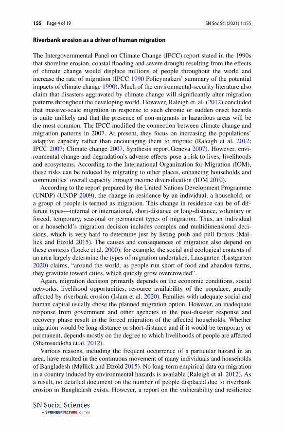
In Bangladesh, the Meghna Estuary carries a high amount of water during the rainy season, increasing erosion along its shorelines (GED 2015 Bangladesh Delta Plan 2100; Summary.Dhaka. 2015). The only island district of Bangladesh, Bhola, is located in this area. Consequently, this island is mostly affected by hazards such as floods and riverbank erosion, as reported by the Bangladesh Meteorological Depart-ment (BMD) (BBS 2013; District Statistics 2011; Bhola. Dhaka 2013). The selected village for this study falls under this district. The village, named Ramdaspur, is a part of Rajapur Union of Bhola Sadar Upazila, and it stands in the northernmost part of the district (Fig. 1) (BBS 2013; District Statistics 2011; Bhola Dhaka 2013).
The selected study area is mostly unnoticed by the authorities; thus, data about the locality and its people are scarce. According to the 2011 population census, 8575 peo-ple live in Ramdaspur village. There are 1760 households in total, with no floating population (BBS 2013; District Statistics 2011; Bhola. Dhaka 2013). According to the Disaster Prone Area Atlas, riverbank erosion occurs between August and November and is ranked 5th among the disasters that affect Bhola Sadar Upazila (Statistics and
SN Soc Sci (2021) 1:155155 Page 6 of 19
Information Division 2018). However, the selected study area is the most vulnerable to erosion because of its location. All the village roads are earthen, through which even a rickshaw or van cannot pass. The only means of transportation in the village are a motorcycle, which is not common at all. Most people walk to their destinations.
Data collection and analysis
The study required both primary and secondary data. We collected the data through household surveys and also through Landsat satellite images. Remote-sensing data using the images helped us selecting the study village, which has gone through rapid erosion in the last three decades. Thus, this study broadly contains two different parts. The first part employed Geographic Information System (GIS) tools to delineate the change in the village’s shoreline to see the rate of erosion and accretion in the study village from 1993 to 2018. We have conducted a household survey using a structured questionnaire.
Assessment of riverbank erosion
We have collected the Landsat satellite images from the Earth Explorer database of the United States Geological Survey (USGS) website. The study village covers a tiny area, so the images from Landsat path 137 and row 44 are enough to assess
Fig. 1 Study village ’Ramdaspur village’ at Rajapur union of Bhola Sadar Upazila. Source authors’ illus-tration

SN Soc Sci (2021) 1:155 Page 7 of 19 155
the area. We have chosen a timeline of 25 years from 1993 to 2018 to explore the shorelines’ changes. Six images of 30 m resolution with an interval of five years aided in this case. The first four images for 1993, 1998, 2004 and 2008 were captured by the Thematic Mapper (TM) sensor of Landsat 5. The latter two from 2014 and 2018 were taken by the Operational Land Imager (OLI) and Thermal Infrared Sensor (TIRS) of Landsat 8. We have taken the images at daytime dur-ing the winter season (November), thus, have shallow cloud cover. Moreover, we did not consider the tidal effects while selecting the images. The images are then processed to delineate the village area’s shorelines using ArcGIS (version 10.3) software.
As the water body surrounds the study area, the Modified Normalized Differ-ence Water Index (MNDWI) approach was used to differentiate the land from the water body. The MNDWI uses Green band and Mid Infrared (MIR) band of the satellite images to increase water bodies’ features while eradicating the noise from surrounding land areas (Xu 2006). As a result, the distinction between the regions is enhanced, making it easier to draw the shorelines for a particular year. In Landsat 5 images, Green and MIR bands are symbolised by band 2 and band 5, while in Landsat 8 images, these are represented by band 3 and band 6 (USGS 2014; What are the band designations for the Landsat satellites 2014). We cal-culated the MNDWI values for the selected Landsat images using ArcMap 10.3. The MNDWI values measured using the tool Raster Calculator provided a range from a negative one to a positive one, where the positive values characterise the water bodies (USGS 2014; What are the band designations for the Landsat sat-ellites 2014). The generated raster file with two different values (negative and positive) is used to draw the shorelines using ArcMap tool Spatial Analyst. Once the shorelines for the six different years have been produced, we used them to measure the changes, in particular, by selecting the year before it as the base year. To clarify the changes in the study village’s shoreline position in 1998, we used the shoreline position in 1993 as the base. As the village’s shoreline positions changed drastically during this timeline, it was not possible to take into account all six at once to measure the overall changes in the study village. We follow this procedure for simplification.
We used the Digital Shoreline Analysis System (DSAS) (version 4.3) extension in ArcGIS to analyse the changes in shorelines for the base year and the following year. A buffer area of 150 m was generated for the base year shoreline to serve as the baseline analysis. Then we employed the End Point Rate (EPR) to measure the shorelines’ changes about the base year. EPR is used for this study as this measures the shorelines’ movement by dividing it with the time elapsed (Thieler et al. 2009), which in this case is 5 years. For the measurement using DSAS, transects were cre-ated at 20 m’ interval. The changes were calculated at each of these transects, with an uncertainty of 5 m and a 95% confidence interval. The results, again, are repre-sented by positive and negative values. Assigning negative values to erosion and positive values to accretion (Sarwar and Woodroffe 2013), we produced five differ-ent maps to visualise the erosion and accretion processes in the village from 1993 to 2018.

SN Soc Sci (2021) 1:155155 Page 8 of 19
Household survey
We randomly selected 150 households for the survey. The first author conducted a field survey. We preferred to interview male respondents as they are the leading deci-sion makers in the family and tend to provide more information than their female counterparts. In case the male member of the household was absent, we interviewed the female member. The survey had 30 questions, which included demographics, and the factors influencing their decision about non-migration. We then analysed these quantitative data, along with some qualitative data coded and then converted to quantitative data for the ease of analysis. We have used SPSS Version 22 and Microsoft Excel for data entry and data analysis. Correspondence analysis helped in examining the relationship between different nominal variables collected from the surveys. The following section presents the results from these analyses.
Results
Socio‑economic profile of the respondents
Demographics
66% of respondents were male, with their ages between 16 and 94. The average size of a household is 6, ranging from 3 people to as many as 17. The majority of the respondents were between age 35 and 40. This distribution covers most of the age group and takes into account their outlooks on migration and non-migration. The people we surveyed are mostly illiterate (42%). Only 21% of the respondents can sign their names. 19% of the respondents went to primary school, while about 15% went to high school. Only one person reported being a postgraduate and is a teacher in the village high school.
Most of the responders have been living in this village since their birth. Only some female respondents mentioned that they came to the village after their mar-riage. Out of the 905 people who are part of these 150 households, eight people with some physical disabilities and ten live with chronic illness. Forty six of the surveyed households have one or two old family members.
Occupation
The dependency ratio is very high in the village. Most households (46%) had only one employed member. We interviewed only one family with six employed mem-bers. 75% of the household heads do not have a secondary or seasonal occupa-tion. Those who do have one are primarily share croppers and fishermen. 51% of the surveyed households are engaged in agricultural activities as their primary or secondary occupation. 34.7% of the household heads are primarily farmers. Only some men own agricultural land for cropping. Most of the surveyed people (approximately 29%) work as a share cropper in others’ lands. 46.7% of house-hold heads engaged in fishing as their primary or secondary occupation. Most

SN Soc Sci (2021) 1:155 Page 9 of 19 155
of them (36%) catch fish from the surrounding river. Only 3% reported them like a fish trader. Cumulatively, more household heads are engaged with activi-ties related to agriculture. Other occupations besides these include being a shop-keeper, teacher, van puller, trawler driver, salaried employee. Families with more than one earning member are mainly engaged in fishing activities, followed by being a businessman and share cropper.
Land ownership
Approximately 66% of the respondent households own homestead land in the vil-lage, and 32% live in rented houses. Only a few of the respondents are living in other people’s lands without paying any rent. 87% of the surveyed households, who possessed homestead land, moved to their present location from another part of the village due to riverbank erosion in the last 25 years. Most of these families were displaced during the rapid erosion in the last ten years.
Out of all the surveyed families, only 24% own land in an area outside the vil-lage. Owning a land outside, the village provides them with the chance to migrate if needed. However, most of the surveyed households do not have this opportu-nity. These families have been moving around in the same village after their pre-vious land of residence eroded. As they do not own land elsewhere, they are not able to leave this erosion-prone area. This study, thus, looks for the major driving factors that support the non-migration decision of the surveyed people.
Agricultural fields cover a large portion of the village. Most of these lands are owned by people living in the neighbouring Mehendiganj Upazila of Barisal. Of the surveyed households, only 11% own agricultural land and live permanently in the village. However, not all of them are engaged with cultivation. 70% of the families do not have agricultural land of their own and around a fifth of the total surveyed populace work in other people’s lands as share croppers.
Housing condition
Because of continuous erosion and monsoonal flooding, there are no pucca or semi-pucca houses (roof and walls made of brick and cement) in the village. Only two forms of housing found in the village. The village’s permanent houses are made of tin sheets and mud floors on the same level as the ground. These houses are rela-tively inland and far from the riverbank. The temporary houses are constructed a few feet above the ground, supported by betel nut trees, with a floor made of betel nut trees, bamboos, wood and straw. Most of these temporary houses are built alongside the riverbanks, where flooding is frequent during the monsoon season. 75% of the surveyed households live in permanent houses, while the rest live in the temporary houses. Of the residents living in permanent houses, 88% own the land on which they live. The rest of the surveyed families live in rented temporary or permanent houses, and only three are residing in rent-free temporary houses.
SN Soc Sci (2021) 1:155155 Page 10 of 19
Riverbank erosion in Ramdaspur village
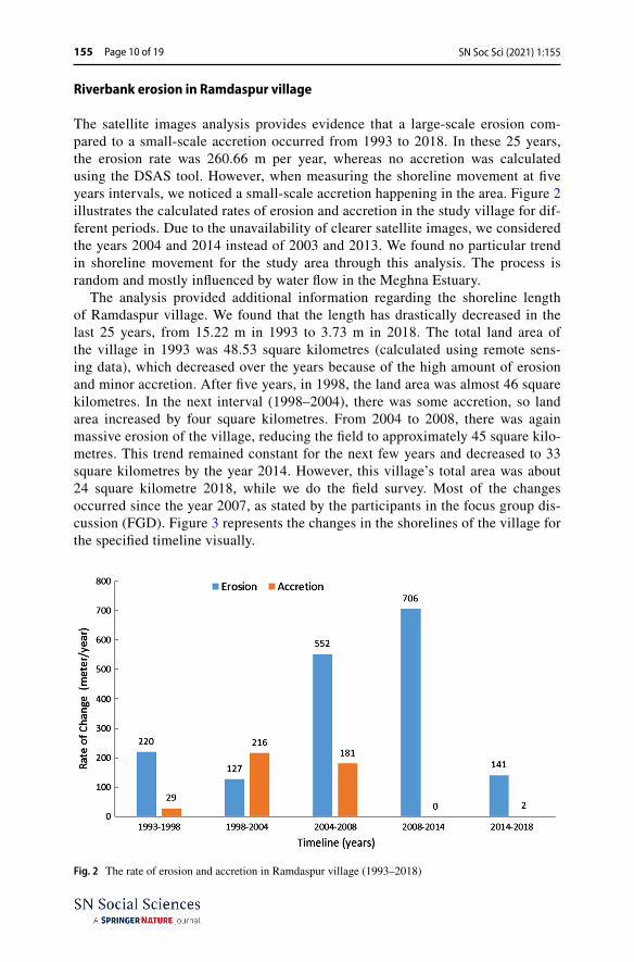
The satellite images analysis provides evidence that a large-scale erosion com-pared to a small-scale accretion occurred from 1993 to 2018. In these 25 years, the erosion rate was 260.66 m per year, whereas no accretion was calculated using the DSAS tool. However, when measuring the shoreline movement at five years intervals, we noticed a small-scale accretion happening in the area. Figure 2 illustrates the calculated rates of erosion and accretion in the study village for dif-ferent periods. Due to the unavailability of clearer satellite images, we considered the years 2004 and 2014 instead of 2003 and 2013. We found no particular trend in shoreline movement for the study area through this analysis. The process is random and mostly influenced by water flow in the Meghna Estuary.
The analysis provided additional information regarding the shoreline length of Ramdaspur village. We found that the length has drastically decreased in the last 25 years, from 15.22 m in 1993 to 3.73 m in 2018. The total land area of the village in 1993 was 48.53 square kilometres (calculated using remote sens-ing data), which decreased over the years because of the high amount of erosion and minor accretion. After five years, in 1998, the land area was almost 46 square kilometres. In the next interval (1998–2004), there was some accretion, so land area increased by four square kilometres. From 2004 to 2008, there was again massive erosion of the village, reducing the field to approximately 45 square kilo-metres. This trend remained constant for the next few years and decreased to 33 square kilometres by the year 2014. However, this village’s total area was about 24 square kilometre 2018, while we do the field survey. Most of the changes occurred since the year 2007, as stated by the participants in the focus group dis-cussion (FGD). Figure 3 represents the changes in the shorelines of the village for the specified timeline visually.
Fig. 2 The rate of erosion and accretion in Ramdaspur village (1993–2018)

SN Soc Sci (2021) 1:155 Page 11 of 19 155
According to the respondents, the first place that eroded during 2007 was named Bonger Char, the easternmost part. In the following year, a famous mar-ket of the village went underwater, named Majhir Hat. In the next four years till 2012, the place called Kaper Hat gradually eroded. The last drastic erosion which occurred in the village was in 2016. During this time, Saterdag Market and its inhabitants fell victim to erosion. The populace reported that no significant amount of land has eroded in the last year (2017). However, they fear another hit to their homeland shortly. All these incidents of erosion left hundreds of families living in these parts of the village landless and homeless, forcing them to move further inland or seek refuge in the temporary houses beside riverbanks.
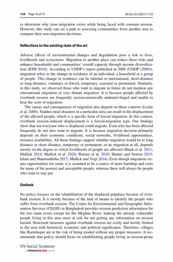
Before this continuous disaster took away most of the village’s lands, it had everything necessary to sustain life properly. The Rajapur Union Parishad Office was located in this village. The area eroded, and the new office was not con-structed in the village anymore. There were about eleven primary schools, one high school, one madrasa, one cyclone shelter, one community clinic, seven big markets and six prayer halls in the village. The only things existing at present out of these are the high school and one primary school. The community clinic in the village is now out of service and on the verge of being eroded (Fig. 4).
Fig. 3 Erosion and accretion scenario in Ramdaspur village for the years 1993 to 2018. Source: Authors illustration 2020
SN Soc Sci (2021) 1:155155 Page 12 of 19
Human mobility
Among the respondents, 95% reported being a victim of riverbank erosion at least once in their lifetime. The rest of the households (living inland) had never faced this hazard but fear being affected shortly. On average, the respondent households faced erosion about four times. According to the villagers, the village suffered the most erosion in the last 10–11 years. About 83% of the surveyed erosion-victim households displaced to their present location in the village during this timeline. In the last five years, about 47% of the households became the victim of erosion and moved to their present residences from their previous ones. About 24% of the sur-veyed families changed their house and moved to their current location between the last 5 to 9 years. Two of the households surveyed have not been victims of the haz-ard since the Liberation War in 1971. The rest of the households (28%) have moved at least once from 1971 to 2009 and came to their present location. 142 out of 150 surveyed households have lost everything they had to the river during these years.
The number of times being a victim to erosion is more significant for the house-holds living in the same place for less than five years compared to other categories. Usually, these families had been moving around inside the village. Most of them live near the river because their primary occupation is fishing; however, their residence place makes them vulnerable to constant riverbank erosion.
After being displaced due to frequent riverbank erosion, approximately 76% of the surveyed households moved to their current position from the village’s east side. Only a few of the surveyed households have migrant family members working and living outside the village. They are mostly in Dhaka. About 70% of the surveyed households have no migrant members in the family. Only two households out of the 150 reported planning to migrate from the village within one year to a safer place. One of these two families lives on the verge of erosion at the eastern side of the vil-lage. The east side has undergone rapid erosion since 2008, as can be seen in Fig. 2.
Fig. 4 The only community clinic of the village in the east side. Source: Field survey 2018
SN Soc Sci (2021) 1:155 Page 13 of 19 155
The south side has also been a victim of erosion. So, 19% of respondents were found to have moved from there to their current housing. Only two of the surveyed house-holds came from another village of Bhola, as for them, it was harder to maintain their families in those places and is more comfortable here. The same condition was faced by five more surveyed families, who moved to Ramdaspur village from Barisal district.
Because of recurrent riverbank erosion faced by the village residents, it was assumed that many had to change their occupation to adapt to the situation. How-ever, only 23% of the respondents mentioned a change in their occupation after being affected by continuous erosion. More than half of those household heads had agricultural land lost to the river, forcing them to change their occupation. There were also fish farmers, rickshaw pullers, businessmen and salaried employees who had to change their occupation to adapt to the village’s continuous riverbank ero-sion. 40% of these people are now fishermen.
Non‑migration as the adaptation
Despite continuous erosion in Ramdaspur, people continue to live in this village. We asked the respondents about their non-migration situation and whether they have plans to leave the village soon. Our analysis revealed that more than half of the respondents are living in this village voluntarily. They do not consider migration as a solution to alleviate their current situation. Furthermore, they are attached to their village as their ’homeland’ and, thus, want to continue living in any situation.
However, not everyone thinks this way and wants to live at risk for the rest of their lives. The rest of the respondents (45%) expressed their willingness to leave the village searching for better accommodation and employment opportunities. We consider these people as forced non-migrants, who want to leave the village but can-not for various reasons. So, we asked them which place they prefer for migration if they can. The respondents mentioned places near their village, considering it will be easier for the whole family to move together.
In addition, their choice of place to migrate is influenced by the availability of jobs to support the family. As such, most of these people prefer Noakhali district as their preferred place to relocate. The district is near the village beside the river, so people can still catch fish to support their lives. Next, some chose Dhaka, Bangla-desh’s capital, as they think they can get any job in the city. Only a few decided to stay in the Bhola district if they can migrate.
Only 24% of the surveyed households own land outside of Ramdaspur Village. So, these families have the chance to migrate to those places to save themselves from continuous erosion. Most of these households own property in Noakhali Dis-trict. About 38% of these households own land in another union in Bhola or Barisal. A small percentage of them own land in Dhaka. Results show that the willingness of migration is significantly associated with their ownership of land outside the village.
Results from correspondence analysis using SPSS show a significant relationship between the respondents’ willingness to migrate from the study village to a safer place and the number of years they have been living in the village. Respondents who
SN Soc Sci (2021) 1:155155 Page 14 of 19
live in their own houses for more than five years choose non-migration instead of the respondents living in rented homes for less than five years. The analysis shows that the latter group of people lives in more erosion-prone areas of the village and thus are affected more than the others. So, households who have stayed longer in one place have less aspiration of migrating from the village.
Reasons for non‑migration
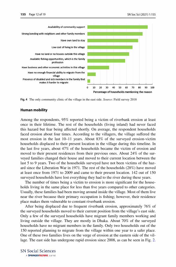
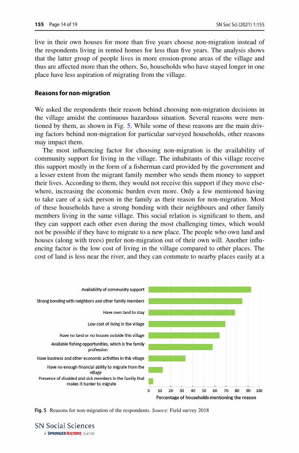
We asked the respondents their reason behind choosing non-migration decisions in the village amidst the continuous hazardous situation. Several reasons were men-tioned by them, as shown in Fig. 5. While some of these reasons are the main driv-ing factors behind non-migration for particular surveyed households, other reasons may impact them.
The most influencing factor for choosing non-migration is the availability of community support for living in the village. The inhabitants of this village receive this support mostly in the form of a fisherman card provided by the government and a lesser extent from the migrant family member who sends them money to support their lives. According to them, they would not receive this support if they move else-where, increasing the economic burden even more. Only a few mentioned having to take care of a sick person in the family as their reason for non-migration. Most of these households have a strong bonding with their neighbours and other family members living in the same village. This social relation is significant to them, and they can support each other even during the most challenging times, which would not be possible if they have to migrate to a new place. The people who own land and houses (along with trees) prefer non-migration out of their own will. Another influ-encing factor is the low cost of living in the village compared to other places. The cost of land is less near the river, and they can commute to nearby places easily at a
Fig. 5 Reasons for non-migration of the respondents. Source: Field survey 2018

SN Soc Sci (2021) 1:155 Page 15 of 19 155
low cost. Furthermore, education is also cheaper, encouraging the parents to educate their children at least the high school level.
Additionally, not having owned land elsewhere also influences their non-migra-tion decision, even though these families would prefer to migrate to a safer place. Their low income and failure to save money because of continuous displacement within the village make it harder to buy land anywhere else outside the village. In the case of the households whose main occupation is fishing, they willingly prefer to live in this village as they are fishermen for generations and catching fish is more comfortable near the village than the surrounding areas. It also relates that they can use the fisherman card to get support from the government. The rest of the driving factors are influencing only to a few households.
Discussion
Key findings and limitations
This research focussed on a community living in a riverbank erosion-prone area, mostly overlooked in the existing literature on this particular hazard. The studied community of Ramdaspur village in Bhola district on the bank of the Meghna River has been suffering from continuous erosion and displacement because of erosion for years. The south part of the village faced up to 100 m of erosion per year. Maximum erosion occurred during the 2008–2014 timeline with an erosion rate of 706.30 m per year. No accretion occurred during these years. The highest accretion rate of about 215.5 m per year was observed during 1998–2004. Erosion process also con-tinued during this period with 127 m per year, though the erosion rate has signifi-cantly decreased in recent years (2014–2018). However, these people are not leaving the village because of several underlying factors.
The paper explores such factors which influenced non-migration in the study area. Majority of the households of the village has faced riverbank erosion at least once in their life. However, more than half (55%) of these respondents were unwill-ing to migrate despite being continuously displaced because of erosion. The rest of the respondents are eager to move away but cannot because of various reasons. Analysis of the factors revealed that households prefer not to move for the com-munity’s support and social benefit from living in the village. This conclusion dif-fers from the claim drawn by Islam et al. (Islam et al. 2020) about the breakdown of social bonding and network among the riverbank erosion affected communities. To sum up, land ownership, low cost of living in the village and available fishing opportunities positively influence the villagers to choose non-migration and stay in the village even when faced with continuous erosion. On the other hand, the lack of land ownership outside the village combined with the low financial ability to move away from their village forces them to choose non-migration as the only solution; they are ’trapped-population’ (Barnett and Webber 2009).
The study’s limitation is that it will not reflect the general decision-making pro-cess of the community who are being threatened to similar hazards but living in different situations in other places. This study solely focuses on a particular village
SN Soc Sci (2021) 1:155155 Page 16 of 19
to determine why (non-)migration exists while being faced with constant erosion. However, this study can set a path to assessing communities from another area to compare their non-migration decisions.
Reflections to the existing state of the art
Adverse effects of environmental changes and degradation pose a risk to lives, livelihoods and ecosystems. Migration to another place can reduce these risks and enhance households and communities’ overall capacity through income diversifica-tion (IOM 2010). According to UNDP’s report published in 2009 (UNDP (2009)), migration refers to the change in residence of an individual, a household or a group of people. This change in residence can be internal or international, short-distance or long-distance, voluntary or forced, temporary, seasonal or permanent. Similarly, in this study, we observed those who want to migrate in future do not mention any international migration or very distant migration. It is because people affected by riverbank erosion are frequently socioeconomically underprivileged and unable to bear the costs of migration.
The causes and consequences of migration also depend on these contexts (Locke et al. 2000). Sudden onset disasters in a particular area can result in the displacement of the affected people, which is a specific form of forced migration. In this context, riverbank erosion-induced displacement is a forced-migration type. Our findings show that not everyone who is displaced could migrate. Even who has been affected frequently do not also want to migrate. It is because migration decision primarily depends on their economic conditions, social networks, livelihood opportunities, resource availability. All these findings support whether migration would be to long distance or short distance, temporary or permanent, or no migration at all, depends mostly on the degree to which livelihoods of people are affected (Black et al. 2011; Mallick 2019; Mallick et al. 2020; Warner et al. 2010; Hunter and Norton 2015; Islam and Shamsuddoha 2017; Mallick and Vogt 2014). Even though migration cre-ates opportunities for some, it is assumed to be a source of more hardship and costs for many of the poorest and susceptible people, whereas there will always be people who want to stay put.
Outlook
No policy focuses on the rehabilitation of the displaced populace because of river-bank erosion. It is mostly because of the lack of means to identify the people who suffer from riverbank erosion. The Centre for Environmental and Geographic Infor-mation Services (CEGIS) in Bangladesh provides erosion prediction information for the two main rivers except for the Meghna River, making the already vulnerable people living in this area more at risk for not getting any information on erosion hazard. Structural measures against riverbank erosion are costly and mostly limited to the area with historical, economic and political significance. Therefore, villages like Ramdaspur are at the risk of being eroded without any proper measures. It rec-ommends that policy should focus on rehabilitating people living in erosion-prone
SN Soc Sci (2021) 1:155 Page 17 of 19 155
areas. Such steps can make them less vulnerable to erosion disasters and can save the possible loss of public and private assets at those locations. Therefore, this study proposes a need for a holistic approach in future adaptation planning for the river-bank erosion-prone areas of Bangladesh to support the non-migrant communities.
Data availability The data will be readily shared upon request.
Declarations
Conflict of interest We declare that none of the authors have financial or non-financial interests.
Ethical approval In this study, the steps/procedures for data collection, treatment and analysis have been provided. Equally, the free prior informed consent of all participants was sought before data collection.
Open Access This article is licensed under a Creative Commons Attribution 4.0 International License, which permits use, sharing, adaptation, distribution and reproduction in any medium or format, as long as you give appropriate credit to the original author(s) and the source, provide a link to the Creative Com-mons licence, and indicate if changes were made. The images or other third party material in this article are included in the article’s Creative Commons licence, unless indicated otherwise in a credit line to the material. If material is not included in the article’s Creative Commons licence and your intended use is not permitted by statutory regulation or exceeds the permitted use, you will need to obtain permission directly from the copyright holder. To view a copy of this licence, visit http:// creat iveco mmons. org/ licen ses/ by/4. 0/.
References
Ahamed RU (2010) Impact of Bank Erosion of the Jamuna River on selected towns in the Northern Region of Bangladesh. J Sci Found 8:55–65
Ahmed S, de Wilde K (2011) Setting the Stage. In: de Wilde K (ed) Moving coastlines: emergence and use of land in the Ganges-Brahmaputra-Meghna estuary, 1st edn. The University Press Limited, Dhaka, pp 1–19
Akter J, Sarker MH, Popescu I, Roelvink D (2015) Evolution of the bengal delta and its prevailing pro-cesses. J Coast Res. https:// doi. org/ 10. 2112/ JCOAS TRES-D- 14- 00232.1
Allison MA (1997) Historical changes in the ganges-Brahmaputra delta front. J Coastal Res 14(4):1269–1275
Allison MA, Khan SR, Goodbred SL, Kuehl SA (2003) Stratigraphic evolution of the late Holocene Gan-ges-Brahmaputra lower delta plain. Sed Geol 155(3):317–342
BBS (2015) Population monograph: population distribution and internal migration in Bangladesh. DhakaBBS (2013) District statistics 2011: Bhola. Dhaka.BBS (2018) Disaster prone area atlas Bangladesh: Bhola Zila (A. B. M. A. Hossain, Ed.). Dhaka: Statis-
tics and Information Division.BWDB (2001) Hydro-morphological dynamics of the Meghna estuary, Meghna Estuary Survey-II.Barnett J, Webber M (2009) Accommodating migration to promote adaptation to climate change.
Stockholm.Bhuiyan MAH, Islam SMDU, Azam G (2017) Exploring impacts and livelihood vulnerability of river-
bank erosion hazard among rural household along the river Padma of Bangladesh. Environ Syst Res. https:// doi. org/ 10. 1186/ s40068- 017- 0102-9
Black R, Bennett SRG, Thomas SM, Beddington JR (2011) Migration as adaptation. Nature 478:447–449. https:// doi. org/ 10. 1038/ 47847 7a
Bucx T, Marchand M, Makaske B, Van de Guchte C (2010) Comparative assessment of the vulnerability and resilience of 10 deltas: synthesis report. Delta Allian Rep. https:// doi. org/ 10. 2307/ 15029 51

SN Soc Sci (2021) 1:155155 Page 18 of 19
Chatterjee S, Mistri B (2013) Impact of river bank erosion on human life: a case study in shantipur block, Nadia District, West Bengal. Int J Human Soc Sci Invent 2(8):108–111
Das JD, Dutta T, Saraf AK (2007) Remote sensing and GIS application in change detection of the Barak River Channel, NE India. J Indian Soc Remote Sens 35(4):301–312. https:// doi. org/ 10. 1007/ BF029 90786
Fagherazzi S (2008) Self-organisation of tidal deltas. Proc Natl Acad Sci 105(48):18692–18695. https:// doi. org/ 10. 1073/ pnas. 08066 68105
GED (2015) Bangladesh delta plan 2100-summary DhakaHasan M, Quamruzzaman C, Rahim A, Hasan I, Methela NJ, Imran SA (2018) Determination of river
bank erosion probability: vulnerability and risk in southern shoreline of Bangladesh. Int J Energy Sustain Dev 3(3):44–51
Hunter LM, Norton RM (2015) The environmental dimensions of migration. Ann Rev Sociol 41(5):377–397
Hussain MA, Tajima Y, Taguchi Y, Gunasekara K (2013) Tidal characteristics affected by dynamic mor-phology change in the meghna estuary. Proceedings of the 7th International Conference on Asian and Pacific Coasts, (September).
IOM (2010) Assessing the evidence: environment. Climate Change and Migration in Bangladesh, DhakaIPCC (1990) Policymakers’ summary of the potential impacts of climate change.IPCC (2007) Climate change 2007: Synthesis report. GenevaIr. Fortunato Carvajal M., Khan, Z. H., & Rahman, M. M. (2011) Land formation and erosion in the estu-
ary. In: de Wilde K (ed) Moving coastlines: emergence and use of land in the Ganges-Brahmaputra-Meghna estuary, 1st edn. The University Press Limited, Dhaka, pp 20–37
Islam MR, Khan NA, Reza MM, Rahman MM (2020) Vulnerabilities of river erosion—affected coastal communities in Bangladesh : a menu of alternative livelihood options. Global Social Welfare 7:353–366. https:// doi. org/ 10. 1007/ s40609- 020- 00185-1
Islam MDF, Rashid ANMB (2011) Riverbank erosion displacees in Bangladesh: need for institutional response and policy intervention. Banglad J Bioeth 2(2):4–19
Islam MR, Shamsuddoha M (2017) Socioeconomic consequences of climate induced human displace-ment and migration in Bangladesh. Int Sociol 32(3):277–298. https:// doi. org/ 10. 1177/ 02685 80917 693173
Islam MS, Sultana S, Miah MA (2014) Adaptation of char livelihood in flood and river erosion areas through indigenous practice: a study on Bhuapur Riverine area in Tangail. J Environ Sci Nat Resour 7(1):13–19
Jónsson G (2011) Non-migrant, sedentary, immobile, or ’left behind’? Reflections on the absence of migration. In IMI Working Papers Series (No. 39). Oxford
Kolmannskog VO (2008) Future Floods of refugees: a comment on climate change, conflict and forced migration. Retrieved from https:// www. nrc. no/ resou rces/ repor ts/ future- floods- of- refug ees/
Locke C, Adger WN, Kelly PM (2000) Changing places: migration’s social and environmental conse-quences. Environment 42(7):24–35. https:// doi. org/ 10. 1080/ 00139 15000 96057 48
Lustgarten A (2020) The great climate migration, in The New York Times, online https:// www. nytim es. com/ inter active/ 2020/ 07/ 23/ magaz ine/ clima te- migra tion. html
Mahmood RA (1995) Emigration dynamics in Bangladesh. Int Migr 33(3):699–726Mallick B, Etzold B (2015) Introduction and State-of-the-Art. In: Mallick B, Etzold B (eds) Environment,
migration and adaptation: evidence and politics of climate change in Bangladesh. International Cen-tre for Climate Change and Development (ICCCAD), Bangladesh, Dhaka, pp 1–23
Mallick B, Schanze J (2020) Trapped or voluntary ? Non-Migrat Despite Climate Risks Sustain 12(4718):1–6. https:// doi. org/ 10. 3390/ su121 14718
Mallick B, Vogt J (2014) Population displacement after cyclone and its consequences: empirical evidence from coastal Bangladesh. Nat Hazards 73(2):191–212. https:// doi. org/ 10. 1007/ s11069- 013- 0803-y
Mallick B (2019) The nexus between socio-ecological system, livelihood resilience, and migration deci-sions: empirical evidence from Bangladesh. 3332. Sustainability, 11(12), 3332. Retrieved from https:// doi. org/ 10. 3390/ su111 23332
Mallick B, Sultana Z, Benett CM (2020) How do sustainable livelihoods influence environmental (non-)migration? Appl Geogr 124. https:// doi. org/ 10. 1016/j. apgeog. 2020. 102328
Naus I, Broekhoven, F. van, Rahmasary AN, Roosjen J, Waij A (2017) Future development of ganges brahmaputra delta: challenges and adaptation strategy. Utrecht.

SN Soc Sci (2021) 1:155 Page 19 of 19 155
Nicholls RJ, Hutton CW, Adger WN, Hanson SE, Rahman MM, Salehin M (2018) Ecosystem services for well-being in deltas: integrated assessment for policy analysis. https://doi.org/https:// doi. org/ 10. 1007/ 978-3- 319- 71093-8
Pati JK, Lal J, Prakash K, Bhusan R (2008) Spatio-temporal Shift of Western Bank of the Ganga River, Allahabad City and its Implications. J Indian Soc Remote Sens 36(3):289–297. https:// doi. org/ 10. 1007/ s12524- 008- 0030-2
Raleigh C, Jordan L, Salehyan I (2012) Assessing the impact of climate change on migration and conflict. https://doi.org/https:// doi. org/ 10. 1007/ 978-3- 642- 22266-5_5
Sarwar MGM, Woodroffe CD (2013) Rates of shoreline change along the coast of Bangladesh. J Coast Conserv 17(3):515–526. https:// doi. org/ 10. 1007/ s11852- 013- 0251-6
Shamsuddoha M, Khan SMMH, Raihan S, Hossain T (2012) Displacement and migration from climate hot-spots in Bangladesh: causes and consequences. Dhaka.
Shamsuddoha M, & Chowdhury RK (2007) Climate change impact and disaster vulnerabilities in the coastal areas of Bangladesh. Dhaka
Thieler ER, Himmelstoss EA, Zichichi JL, Ergul A (2009) Digital Shoreline Analysis System (DSAS) version 40: an ArcGIS extension for calculating shoreline change: US Geological Survey Open-File Report 2008 (Vol. 3).
UNDP (2009) Human development report 2009. Overcoming barriers: Human mobility and develop-ment. New York
USGS (2014) What are the band designations for the Landsat satellites?Varouchakis EA, Giannakis GV, Lilli MA, Ioannidou E, Nikolaidis NP, Karatzas GP (2016) Development
of a statistical tool for the estimation of riverbank erosion probability. Soil 2:1–11. https:// doi. org/ 10. 5194/ soil-2- 1- 2016
Warner K, Hamza M, Oliver-Smith A, Renaud F, Julca A (2010) Climate change, environmental degrada-tion and migration. Nat Hazards 55(3):689–715. https:// doi. org/ 10. 1007/ s11069- 009- 9419-7
Xu H (2006) Modification of normalised difference water index (NDWI) to enhance open water features in remotely sensed imagery. Int J Remote Sens 27(14):3025–3033. https:// doi. org/ 10. 1080/ 01431 16060 05891 79
Zaman M (1989) The social and political context of adjustment to riverbank erosion hazard and popula-tion resettlement in Bangladesh. Hum Organ 48:196–205