status of geodetic infrastructure in fiji · • central scale factor 0.9998500000 ... technical...
TRANSCRIPT

STATUS OF GEODETIC
INFRASTRUCTURE IN FIJI
Ministry of Lands & Mineral Resources

� A new Fiji Geodetic Datum being proposed that Fiji to adopt a Geocentric Datum which is internationally recognized.
� Fiji would be moving from a geodetic datum based on the geocentric WGS 72 which is now non- recoverable and as a result completely obsolete, to a modern dynamic geocentric datum defined in terms of the International Terrestrial Reference Systems (ITRS).
INTRODUCTION

Con’t
�In doing so it would be introducing a datum which is totally compatible with what has been done in other countries such as Brunei, New Zealand, Australia, Japan and other countries.
�The proposed datum has a lot of benefits/opportunities to the wider communities in the utilization the real time GPS technology in this modern day and age.

�In 1979, RASVY (Royal Australia Survey Corps) carried out a Doppler survey of the Fiji group where 18 stations were established, 10 on existing primary stations.
�The establishment of Doppler on these stations enabled the whole network to be adjusted on an internationally accepted datum then FIJI GEODETIC DATUM 1986 –
�base on reference ellipsoidal - WGS 72 and Projection base on Transverse Mercator
FIJI GEODETIC DATUM 1986 - WGS72

VITI LEVU TRIANGULATION

VANUA LEVU TRIANGULATION

Map Projection
• When the adjustments were finalized a Transverse Mercatorprojection was adopted and a false origin was agreed upon and thus the map projection used today with the WGS 72 Datum is as follows:
• Hemisphere South
• Central Scale Factor 0.9998500000
• Central Meridian 178.45000000
• Zone Width 6.0
• False Latitude 17.000000000
• False Easting 2000000.00
• False Northing 4000000.00
• Minimum Latitude -22.00
• Maximum Latitude -13.00
• With the false easting and northing, mapping was able to cover the whole group of islands in Fiji.

The Current Height Datum of Fiji
� In September 1908, then Secretary of State of the Colony of Fiji issued a technical instruction regarding execution of a principal triangulation covering VitiLevu.
� Sections 5 & 6 of the technical instruction included specifications for a proposed height datum as follows:
"5. The heights of the stations should be determined trigonometrically by means of reciprocal vertical angles.
6. The heights are to be based on Mean Sea Level, which should be determined "(McCaw GT, 1916).
� In order to determine mean sea level, a simple form of tide gauge was placed at Naitonitoni Pier in October 1908, records being kept for a month.
� A similar tide gauge was placed at Lautoka Jetty from May 24'h to June 180', 19 10. During the Trigonometrical Survey of Vanua Levu and Taveuni, a simple tide gauge was placed at Malau Jetty near Labasa.
� The Mean Sea Level determined from these tide gauges were transferred to the Navua, Lautoka and Labasa base respectively, using a Cook 14" reversible level (McCaw, 1916). Heights of other survey beacons were determined using trigonometric reciprocal heighting.

Con’t
�Thus the Mean Sea Level height datum of Fiji was established and to this day it serves as the datum for the country's mapping and surveying applications.

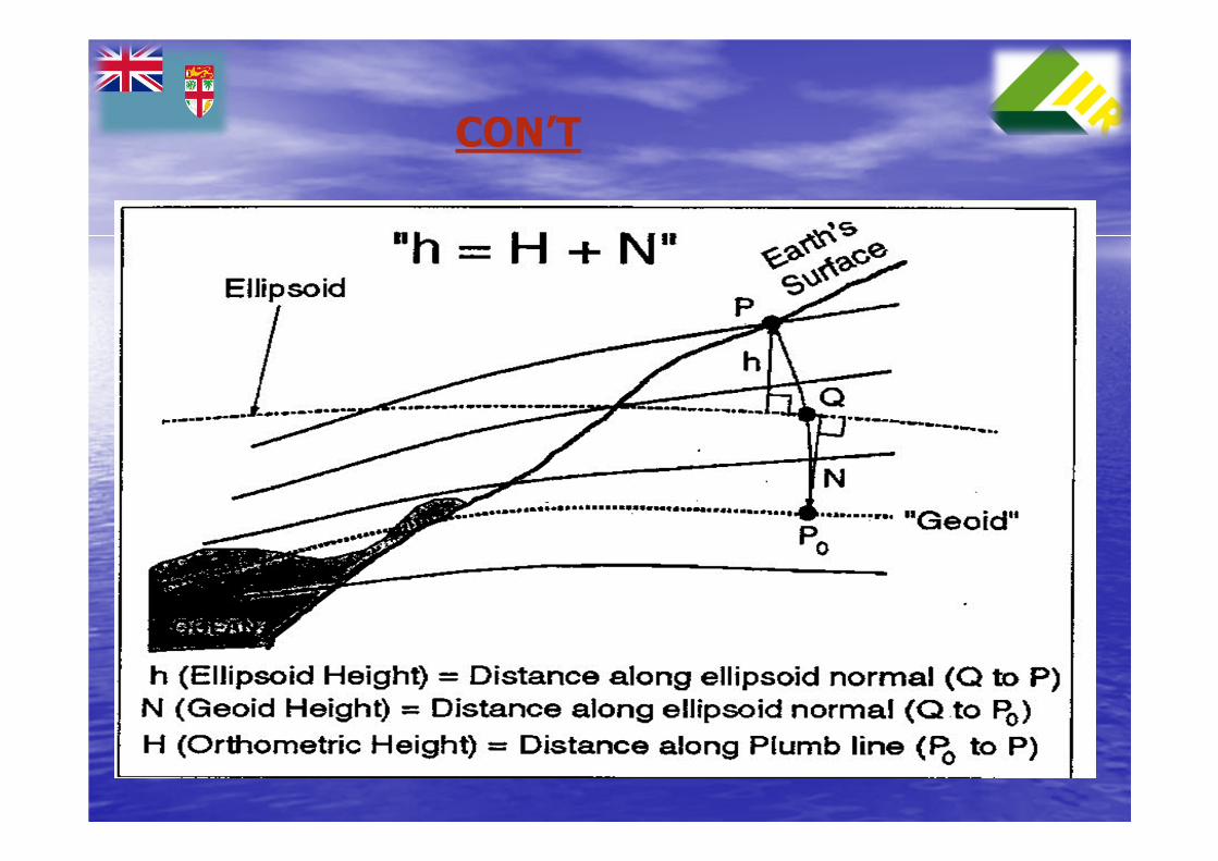
GPS Heighting
� GPS measurements provide heights in a completely different datum, which is based on an ellipsoid.
� An ellipsoid is a surface generated by rotating an ellipse around its minor axis. GPS heights are based on the World Geodetic System 1984 (WGS84) ellipsoid, which is a geocentric ellipsoid with its center coinciding with the earth's center of rotation.
� The difference between the WGS84 Ellipsoid and the Mean Sea Level is about 55 meters in Fiji.
� The GPS derived heights have to be transformed to Mean Sea Level heights by subtracting the Geoid Height or N-value.
� The N-value or geoid ellipsoid separation is simply the difference between the ellipsoidal height and the Mean Sea Level height along the plumbline.
� A geoid model is a grid of N-Values on a known reference system, such as the WGS84 datum.
� Determination of an accurate measure of N-values is a complicated task and requires extensive data, funding and human resources.
� N=h-H
CON’T

HOW TO ESTABLISHED NEW
GEOCENTRIC DATUM
FOR FIJI

CONSULTATION
�Consultation with stakeholders locally and experts from abroad will determine a better and a quicker way forward to the proposed implementation process.

CONSULTANT
�Fiji needs to search abroad for a consultant to be contracted for the whole period of implementation process.
�You may not be aware the change of datum from that of 1880 Clarke to the WGS72 datum which took place in the 1979s was a NZAID project.
� All expert personnel involved were from NZ and they were supported by the survey staff of the Lands Dept.
�SOPAC is the Pacific organization where Fiji needs technical advice/assistance to be part of the working group.

IDENTIFY AVAILABLE RESOURCES
�The foundation has been set for this proposed change of datum.
�There are geodetic stations across the Fiji islands including Rotuma, that have been occupied and adjustments have also been made by GA and are comply with the standards required for this proposal.
�However there may be other work that is required to further breakdown the later survey to 2nd, 3rd order and control traverses to accommodate our cadastral survey and mapping purposes Fiji wide.
�Fund is the most important resources to move this project forward.

FIRST ORDER STATION – ITRF2005
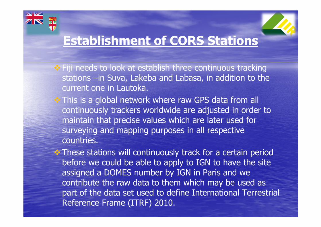
Establishment of CORS Stations
�Fiji needs to look at establish three continuous tracking stations –in Suva, Lakeba and Labasa, in addition to the current one in Lautoka.
�This is a global network where raw GPS data from all continuously trackers worldwide are adjusted in order to maintain that precise values which are later used for surveying and mapping purposes in all respective countries.
�These stations will continuously track for a certain period before we could be able to apply to IGN to have the site assigned a DOMES number by IGN in Paris and we contribute the raw data to them which may be used as part of the data set used to define International Terrestrial Reference Frame (ITRF) 2010.

LAUTOKA CORS STATION

CONCLUSION
�With the rapid change in modern technology it is crucial that Fiji adopt an international recognized datum.
�There are a lot of benefits Fiji will reap especially with a map datum that is recognized internationally.
�Obviously Fiji will be able to share such benefits with all our neighboring island countries including New Zealand and Australia.

…..THANK YOU…..