stated preferences for components of a personal …klatzkyfaculty/jvib04.pdfstated preferences for...
TRANSCRIPT

Stated Preferences for Componentsof a Personal Guidance Systemfor Nonvisual NavigationReginald G. Golledge, James R. Marston, Jack M. Loomis, andRoberta L. Klatzky
Abstract: This article reports on a survey of the preferences of visually impairedpersons for a possible personal navigation device. The results showed that themajority of participants preferred speech input and output interfaces, were will-ing to use such a product, thought that they would make more trips with such adevice, and had some concerns about the cosmetic acceptability of a device andthe use of a single or stereo headphone interface.
For almost two decades, collaborativemultidisciplinary research on the problemof navigating without sight has, been con-ducted by researchers at the University ofCalifornia-Santa Barbara (UCSB) andCarnegie Mellon University (CMU). Ledby psychologist Jack Loomis at UCSB,the group includes legally blind geogra-pher Reginald Golledge (UCSB); psy-chologist Roberta Klatzky (CMU); and anumber of graduate students, postdoc-toral fellows, and technicians who are as-sociated with the various departments. In2002, this group was joined by JamesMarston, a geography postdoctoral fel-low whose interests lie in the areas of ac-
Development of the Personal GuidanceSystem was supported by Grants 07022 and09740 from the National Eye Institute andby Grant SB020101 from the NationalInstitute on Disability and RehabilitationResearch, NIDRR (awarded to the SenderoGroup). The survey research reported herewas supported by the NIDRR grant.
cessing information without sight in cue-poor environments and in enabling navi-gation via remote infrared auditorysignage. The aim of this research hasbeen twofold: (1) to conduct basic re-search on spatial perception, spatial cog-nition, and wayfinding in both visual andnonvisual domains (for an overview ofthis research, see Loomis, Klatzky, &Golledge, 2000) and (2) to design and de-velop a personal guidance system fortravelers who are visually impaired (thatis, those who are blind or have low vi-sion) using the Global Positioning Sys-tem (GPS) (Golledge, Klatzky, Loomis,Speigle, & Tietz, 1998; Golledge, Loomis,Klatzky, Flury, & Yang, 1991; Loomis,1985; Loomis, Golledge, & Klatzky, 1998,2001; Loomis, Golledge, Klatzky, Speigle,& Tietz, 1994). More information on theproject is available at the project's web site,<wwwgeog.ucsb.edu/pgs/main.htm >.
The GPS was developed by the U.S.Department of Defense as a precisemeans of locating features of the terrain,
©2004 AFB, All Rights Reserved Journal of Visual Impairment & Blindness, March 2004 135
vehicles, people, and other entities. A re-ceiver on the ground, in the air, or on waterreceives signals from multiple satellites inspace that convey the precise locations ofthe satellites at every moment. Using thesepositions, the receiver is able to compute alocation with high precision. Sometimes,the technique of differential correction isused to enhance the precision of .localiza-tion, using signals from other receivers atfixed known locations. Differential correc-tion permits the localization of a mobilereceiver with an error that is often less than1 meter, a value that makes GPS suitableeven for travel by pedestrians.
The idea of using GPS to guide peoplewho are visually impaired was first pro-posed by Collins (1985) and Loomis(1985). Since then, many projects, in addi-tion to ours, have pursued the idea. Stud-ies by other groups have included those byBrusnighan, Strauss, Floyd, and Wheeler(1989), Helal, Moore, and Ramachandran(2001), LaPierre (1993, 1998), Makino,Ishii, and Nakashizuka (1996), Petrie et al.(1996), and Talkenberg (1996), and re-cently there has been a proliferation ofsuch projects reported on the web, in thepopular media, and in announcements ofproducts. Two commercial products arenow being sold. VisuAide sells Trekker, apersonal digital assistant (PDA) withvoice output. Sendero Group and PulseData have developed and are now market-ing the BrailleNote GPS, which uses aportable computer (PDA) with voiceand/or braille output to provide accessiblelocation information.
The practical result of our work hasbeen the development of a series of re-search prototypes, all variants of the orig-inal UCSB Personal Guidance System(PGS). An early model was developed in
1993 and has been the basis for much ofour experimental research since then. Pro-totype devices have included a laptopcomputer, GPS antenna and receiver,speech synthesizer, and assorted peripher-als (Loomis et al., 1994), elements that arecommon to most of the guidance devicesjust mentioned. One difference was thatwe obtained high levels of accuracy of lo-cation using a differential correction sig-nal that originated initially from a campusbase station and later from a commercialsupplier. Technological change in theGPS industry and the development of amore powerful wearable computer re-
13 6 Journal of Visual Impairment & Blindness, March. 2004 ©2004 AFB, All Rights Reserved
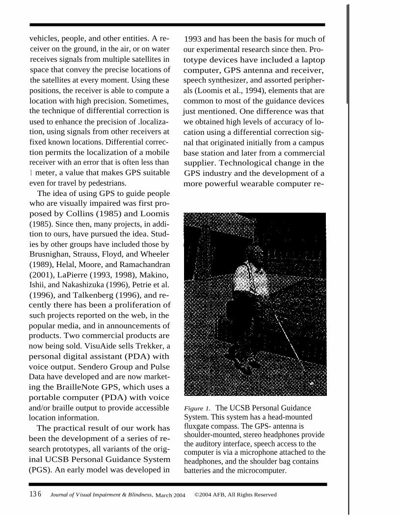
Figure 1. The UCSB Personal GuidanceSystem. This system has a head-mountedfluxgate compass. The GPS- antenna isshoulder-mounted, stereo headphones providethe auditory interface, speech access to thecomputer is via a microphone attached to theheadphones, and the shoulder bag containsbatteries and the microcomputer.

suited in considerable miniaturization sothat the product could be carried in ashoulder bag (see Figure 1).
The surveyDESIGN
To further the development of a PGS, atelephone survey of persons who are visu-ally impaired in the Santa Barbara com-munity and the San Francisco Bay Areawas designed to examine preferences fordifferent types of possible navigation aidsand for the components of a possibleguidance system. As background infor-mation and possible discriminatory vari-ables, some personal information wasgathered, including visual acuity, reportedpathologies, and the use of mobility orobstacle-avoiding devices. In addition,data were gathered on•
the frequency of learning new routes tofamiliar and new places
•
self-ratings of proficiency in varioustravel skills and types of independenttravel
•
self-ratings of the difficulty of perform-ing eight navigation tasks
•
the type of information required tomake a walking trip in an unfamiliararea and how that type of informationwas obtained
•
preferred methods to assist with pretripplanning.
After these preliminary data were ob-tained, the participants were read the fol-lowing description of a GPS-basedpersonal navigation system:
We are designing a navigational sys-tem for the blind and vision impairedthat will give informed guidance
throughout the environment. Per-haps you have heard of Global Posi-tioning Systems (GPS) used in carsand other vehicles to produce a mapor vocal output that tells peoplewhere they are and how to get towhere they want to go. We are devel-oping a system in which GPS is ourlocating and tracking component.This device uses the global system ofsatellites that circle the earth to pin-point the location of the user. Acomputer receives a signal, plotsyour location on a database to pin-point your location, and then com-putes a path to a selected destinationand tells you how to get to it andwhat features are encountered on theroute or near it. The device can tellyou when to turn, what is aroundyou, and how far it is to your desti-nation.
We want to develop this kind ofsystem for people without vision togive them greater independencewhen traveling. Because we can't usethe typical cartographic map display,we would like to get your opinion onthe best ways to present informationto a user, how best to input the nec-essary information to begin travel,and how best to give instructions orassistance while traveling.
Opinions were requested about variousways to input the destination and other in-formation that would be required to starta trip and how best to relay the instruc-tional information to the user. Finally,questions were asked about the perceivedfrequency with which users would travelin the future if this type of navigation de-vice were to become available.
©2004 AFB, All Rights Reserved Journal of Visual Impairment & Blindness, March 2004 137

PARTICIPANTS
The participants were 30 persons whowere legally blind, 24 men and 6 women(with a mean age of 48; SD = 16.2). Ofthe 30 participants, 21 had no useful vi-sion (no perception or only light percep-tion) and 9 could see some objects atarm's length and reported that they couldsee enough to avoid obstacles while travel-ing. Twenty-one could read braille, in-cluding 4 people with some vision. Theetiologies of the participants' visual im-pairments varied: 10 had retinitis pigmen-tosa; 4 had retinopathy of prematurity; 4had glaucoma; 3 had optic nerve damage;several had retinal blastomas; and othershad macular degeneration, burns, braintumors, and various other eye diseases. Toavoid obstacles, 21 used canes, 7 usedguide dogs, 1 used echolocation, and 1used no assistive device. Because we werelooking for reactions to possible inter-faces that were different from traditionalones, we contacted a variety of peoplewho had previous experience with a newdevice, the Talking Signs Remote InfraredAudible Signage (RIAS) system (Cran-dall, Brabyn, Bentzen, & Myers, 1999). Ofthe 30 participants, 24 had some experi-ence with the RIAS system.
ResultsPRELIMINARY MOBILITY, TRAVEL,
AND SKILLS ASSESSMENTS
The survey first asked the participantsto self-rate their mobility in several areasusing a 5-point scale (1 = well below aver-age, 2 = below average, 3 = average, 4 =above average, and 5 = well above aver-age). The scaling procedure was ex-plained and discussed with eachparticipant before the participant an-
swered any questions. The results areshown in Table 1.
The participants generally rated them-selves well above average or above aver-age on concepts, such as a sense ofdirection, independence of movement ormobility skill, knowledge of local streetsystems, and basic travel skills. Self-ratings dropped when they were askedabout various well-recognized problemsof traveling without sight, including theability to deal with street crossings or in-tersections, to deal with unknown obsta-cle hazards, to learn routes to new places,and to take shortcuts. What was neededto deal with each of these problems (withthe exception of street crossings) wasreal-time information about the travel en-vironment and the route-two types ofinformation that can be specifically in-corporated into a PGS. (A PGS couldprovide only the names of intersectingstreets and whether or not crossings werecontrolled by lights.)
Following up on the problem of rele-vant and timely access to information,the next phase of the survey focused onobtaining evaluations of how difficult itwas for the participants to get informa-tion about new environments, includingheading to a new destination, maintain-ing directional and orientation knowl-edge, and obtaining street names or placenames. Again, a 5-point self-assessmentscale was used. The results are presentedin Table 2.
The participants rated knowing thecurrent location, identifying nearby fea-tures, and obtaining guidance on turnsand stops as the most difficult - informa-tion to obtain. These results imply that aPGS system needs to be designed explic-itly to provide this information.
138 Journal of Visual Impairment & Blindness, March 2004 ©2004 AFB, All Rights Reserved

Table 1Participants' self-ratings of mobility.
Note: Entries are the number of participants who gave the rating value.
The next phase of the survey concen-trated on independent methods of pretripplanning. This aspect of travel is of fun-damental importance to visually impairedtravelers, for only the most confident andexperienced travelers are prone to takenovel walks, particularly in unfamiliar en-vironments. The options to be considered
Table 2Participants' self-ratings of difficulty in gaining access to information about new environments.
Note: Entries are the number of participants who gave the rating value.
included conventional tactile maps orspeech-based information. Again, a 5-pointself-assessment scale was used. The resultsare presented in Table 3.
The participants rated a pretrip virtualexperience with a speech-based informa-tion system that outlined the trip andgave instructions on the lengths and num-
©2004 AFB, All Rights Reserved Journal of Visual Impairment & Blindness, March 2004 139
Type of informationMeanrating
Verydifficult
(1)Difficult
(2)Neutral
(3)Easy
(4)Veryeasy(5)
Knowing which way to walkto the destination 3.2 1 12 3 9 5
Keeping track of the directionto the destination 3.2 1 8 9 8 4
Knowing which way youare facing 2.6 4 12 7 5 2
Knowing which street corneryou are at 2.5 6 12 4 6 2
Knowing when and whereto turn 2.4 2 19 5 3 1
Finding a new store oroffice destination 2.4 4 17 4 4 1
Learning about new bus-stopl ocations 2.0 8 15 5 2 0
Learning about new locationsyou are passing 2.0 7 18 4 1 0
Mobility taskMeanrating
Well belowaverage
(1)
Belowaverage
(2)Average
(3)Above
average(4)
Well aboveaverage
(5)General sense
of direction 4.1 0 0 9 8 13I ndependent travel 4.0 1 2 5 11 11Local streets 3.9 0 2 8 10 10Basic travel skills 3.8 0 1 11 11 7Street crossings 3.5 0 5 12 7 6Learning new
shortest paths 3.5 2 2 10 12 4Making detours around
unknown hazards 3.4 0 3 12 14 1New environment 3.3 0 4 13 12 1Shortcutting 3.0 1 8 11 10 0

Table 3Participants' ratings of methods to assist with pretrip planning.
Types of pretrip
Meanplanning i nput
ratingPretrip virtual experience
("talks" you throughthe route)
4.6Auditory-tactile
map (NOMAD)
4.0
0Tactile map
3.2
2
Note: Entries are the number of participants who gave the rating value.
ber of segments, the number of turn an-gles, and the direction and angles ofturns, as being very acceptable. They con-sidered auditory-tactile maps, such asNomad (Parkes & Dear, 1989), to bemore acceptable than others and ratedsimple tactile maps as much less accept-able, although they still regarded suchmaps as acceptable devices.
TYPES OF INFORMATION NEEDED
Before we mentioned the navigationsystem, we collected data to determinewhat types of information the partici-pants would need when making a walk-ing trip to an unfamiliar area. Theresponses were categorized as follows(the numbers refer to the number ofmentions of an item in the category, withmultiple responses combined by thesame subject):• Landmarks (35): landmarks, obstacles,
auditory and sensory cues, surface andtactile cues.
•
Street information (26): the names andnumber of streets to cross, traffic andcrossing information, side of street,and sidewalk information.
•
Route information (26): paths androutes, travel directions, cardinal direc-tions, how far and long.
Very
Veryunacceptable Unacceptable Indifferent Acceptable acceptable
(1)
(2)
(3)
(4)
(5)
0
0
3
6
21
3
4
14
99
5
9
5
•
Destination information (14): address,corner, and block information.
•
Building information (8): names and lay-out information on doors and entrances.
•
Transit information (7): transit infor-mation and stops and route informa-tion. (Note: The question focused on awalking trip, but some participantswanted transit information. This is im-portant information that a good navi-gation system could provide.)
When asked how they normally got thiskind of information, almost all the par-ticipants stated that they asked others forinformation, with only a few indicatingthey could search for and find relevantguidance information independently.PREFERRED TYPE OF INPUT FOR A PGS
The survey next asked the participantsto express their preferences for selectedinput interfaces to a navigation device,including speech, a QWERTY key-board, a telephone keypad and a braillekeypad. A 5-point scale was used. Theresults are presented in Table 4. Thequestion used to obtain reactions in thissection was, "How would you like to in-put your destination, such as `Go to1234 Main Street' or `Go to the closestbus stop for line 11?"'
140 Journalof Visual Impairment & Blindness, March 2004 ©2004 AFB, All Rights Reserved

Note: Entries are the number of participants who gave the rating value.
The preference for voice input wasstrong (all 30 participants rated it veryacceptable or acceptable). No one wasindifferent or negative about speech in-put. A surprising finding was that abraille keyboard for inputting was ratedindifferent or unacceptable by 18 partic-ipants. To clarify the impact of non-braille users on this count, we brokedown the participant group into brailleand nonbraille users. Of the 21 brailleusers, 11 rated a telephone keypad asvery acceptable or acceptable, 12 rated abraille keypad as very acceptable or ac-ceptable, and 8 rated a QWERTY key-board as very acceptable or acceptable(all other answers were indifferent or un-acceptable). Of the 9 nonbraille users, 7rated a QWERTY keyboard as very ac-ceptable or acceptable; 7 rated a tele-phone keypad as very acceptable oracceptable; and, as expected, all 9 non-braille users rated a braille keypad asunacceptable.PREFERRED TYPES OF OUTPUT
FOR A PGS
The defining question in this sectionwas, "How would you like to get yourtravel instructions?" Having obtainedsome reactions to different styles of in-putting destination information, the sur-
vey next examined how the participantswould like to receive their travel instruc-tions (i.e., output information). Becausethe list of alternatives included some thatthe participants might not have known orpreviously experienced, the participantswere asked to respond on the basis ofhow they thought they might like such aproduct to be. Specifically, the instructiongiven was this:
Some of these devices will give routeinformation, and others will alsogive directional cues to locations. Ifyou are not aware of some of thesedevices, try to respond by telling ushow you think you would like such aproduct to be.
The list of output alternatives for routeand spatial language information in-cluded options for locating the output de-vice (such as head-, shoulder-, neck-, orcollar-mounted devices that could hostspeech or sound or tactile displays orbraille) (see Table 5). The second part ofthis question offered more specific alter-natives for receiving guidance informa-tion (see Table 5). Again, a 5-point scalewas used.
The most acceptable output device wasa collar-or shoulder-mounted speech or
©2004 AFB, All Rights Reserved Journal of Visual Impairment & Blindness, March 2004 14 1
Table 4Participants' ratings of preferences for inputting a destination.
MeanVery
unacceptable Unacceptable IndifferentVery
Acceptable acceptableTypes of en-route input rating (1) (2) (3) (4) (5)Voice input 4.8 0 0 0 6 24Standard telephone keypad 3.7 2 4 6 8 10Miniaturized regular
QWERTY keyboard 3.4 0 7 8 10 5Portable braille keypad 3.1 2 12 4 6 6

Table 5Participants' preferences for output features.
Note: Entries are the number of participants who gave the rating value.
MeanTypes of output
ratingVery
unacceptable(1)
Unacceptable(2)
I ndifferent(3)
Acceptable(4)
VeryAcceptable
(5)Route and spatial language informationClip-on shoulder- or collar-mounted small
speaker to get directions via speech or sound 3.8 0 7 2 12 9Speech via headphones worn nearthe ears (bone phone) 3.7 0 6 4 13 7
Single headphone worn over one ear 3.4 1 10 2 10 7Tactile raised-dot display 2.8 4 10 6 9 1Speech via small tubelike headphones
worn in the ears 2.7 3 15 3 7 2Braille output 2.6 5 14 2 7 2Speech via headphones worn over the ears 2.1 7 17 3 3 0Guidance informationA small handheld device (the Talking Signs
product) that identifies objects by speech anduses speech to guide you to the locationsin the direction to which it is pointed 4.5 0 0 2 12 16
A small shoulder speaker for receivingrelevant travel information and informationabout nearby objects and a small handheldreceiver to scan for specific directional cues 4.0 0 3 3 15 9
Speaker on a collar with a wristwatch-typereceiver to scan for specific directional cues 3.7 0 7 3 11 9
Speaker worn on a neck strap (like the TalkingSigns product); you can also scan for specificdirectional cues 3.7 0 5 4 15 6
Speaker worn on eyeglasses; you can also scanfor specific directional cues by moving your head 3.1 2 10 5 8 5
Headphones with stereo directional cues thatproduces an audio-virtual reality, since the speechappears to come from different locations in thesurrounding space 2.7 2 16 5 4 3
An array of vibrating stimulators that are placedaround the torso to give directional information 2.4 5 14 6 5 0
An array of vibrating stimulators that are placedaround the neck to give directional information 2.3 5 15 6 4 0

sound device. Judged as least acceptablewere output via headphones worn overthe ears and braille output. Again, how-ever, this evaluation was partly the resultof scaling by nonbraille users. When thedata were split between braille and non-braille users, the overall results were simi-lar, except for the rating on brailleoutput. Braille users gave a mean ratingof 3.0 (indifferent) to a braille output in-terface, while nonbraille users gave amean rating of 1.7 (unacceptable). Of thebraille users, 9 out of 21 rated braille out-put as very acceptable or acceptable,while the rest were indifferent or rated itas unacceptable. All 9 nonbraille usersrated braille output as unacceptable.
Those who had no vision had muchstronger negative feelings about head-phones that blocked ambient soundsthan did those who had some useful vi-sion. The proliferation of cell phonesand wireless PDAs may change this per-ception in the future, but the value ofgood auditory environmental cues can-not be dismissed. Of the participantswho were regular braille users, however,only 12 out of 21 rated braille input asvery acceptable or acceptable, and only 9out of 21 rated it that way as a preferredoutput device.
For devices that included extra direc-tional cues, the participants rated speechor tonal sound output the most accept-able (Table 5). The top five preferred in-terfaces for gaining directional cues wereall some type of pointing device, handheld,wrist-mounted, or attached to eye-glasses. As was noted previously, someparticipants had prior exposure to aRIAS system (Talking Signs), which mayhave affected their responses. Alterna-tives that were the least preferred in-
cluded vibrating collars or bands on theneck or the torso that produced a local-ized vibratory cue to turn in a specific di-rection.
COSMETIC ACCEPTABILITY
The final question in the survey askedthe participants to indicate, on a 5-pointscale, their opinions about different typesof new mobility aids. Essentially, thisquestion focused on whether the partici-pants thought they would actually wearand use a navigation device of the type de-scribed in this survey if one was madeavailable to them. The results are pre-sented in Table 6.
All 30 participants strongly agreed oragreed that a wearable navigation aidwould be acceptable. There was consider-able variation when assessing the cosmeticacceptability of such a device-even if itworked well. But there was overwhelmingsupport for the idea of traveling more of-ten if such a device were to be available(27 out of 30 participants).
ACTUAL AND POTENTIAL LEARNING
OF NEW ROUTES
In this section, we report on the cur-rent exploratory habits of the partici-pants that were obtained before theparticipants completed the survey andtheir postsurvey estimations of the extentto which a PGS navigational devicewould affect their explorations. In thepreliminary stage of the interview, twoquestions were asked, one about explor-ing familiar destinations and anotherabout exploring paths to new areas. Afterthe participants had been exposed to theconcept of a PGS, the same two behav-iors were examined, but this time, theparticipants were asked to anticipate how
©2004 AFB, All Rights Reserved Journal of Visual Impairment & Blindness, March 2004 143

Note: Entries are the. number of participants who gave the rating value.
the use of a PGS system might affecttheir frequencies of exploration. Re-sponses to these before-and-after ques-tions are summarized in Table 7. The"Current" row summarizes the responsesto the question asked prior to the survey,and the "Anticipated" row summarizesthe responses to the questions askedagain after the survey had been com-pleted. Data on episodic frequencies ofexploratory travel to familiar destinationswere collected in categories that variedfrom less than once a month to daily. Theresults clearly show that most partici-pants believed they would increase theirexploratory behavior in familiar settingsif they were given access to a travel aid,such as a PGS.
With regard to traveling to a new place,the questions concerned how often theparticipants learned a route to a newplace and how often they thought theywould learn such a route if they used anavigational device, such as the one thatwas described to them (see Table 7).Again, the potential use of a guidancesystem produced a willingness to explorenew environments more frequently. Theparticipants' current exploration to new
places using existing mobility aids ap-peared to be limited.
The overall results of this preliminarysurvey provide some interesting perspec-tives that need to be explored further. Forexample, voice input was widely desired;progress in this area has been rapid, withsoftware, such as IBM Via Voice,Dragon, and Microsoft SAPI Speech En-gine, leading the way. Braille input andoutput was not highly desired by mostparticipants. Voice output was highly de-sired in various forms, and there was astrong indication that some type of hap-tic pointing device was desired for findingand providing directions to specific loca-tions. It appears that a hands-freespeaker, combined with a pointing device,may be the best way to deliver these data,and our current modifications and testingof the latest PGS prototype has incorpo-rated these features.
Future researchA guidance device relies heavily on get-
ting relevant information to people in aclear and acceptable way. Given thestated preferences for speech and sound,ongoing research needs to focus on what
144 Journal of Visual Impairment & Blindness, March 2004 ©2004 AFB, All Rights Reserved
Table 6Participants' opinions on equipment.
OpinionsMeanRating
StronglyDisagree
(1)Disagree
(2)Indifferent
(3)Agree
(4)
Stronglyagree
(5)I would use a wearable navigation
aid if one was available. 4.5 0 0 0 16 14Even if it worked well, I would be
concerned about my appearancewhile wearing it in public. 3.4 3 6 4 11 6
If this kind of system was available,and I could use it to find anydestination and independentlytravel to it, I would travelmore often. 4.5 0 3 9 18

Note. Entries are the number of participants who gave the rating value.
form of spatial input-language, soundvariations or another pointing or guidingdevice-should be used. Our ongoing re-search is, therefore, aimed at (1) designingtests and conducting field experiments todetermine the best kind of spatial lan-guage to use to deliver information onroutes and destinations and (2) designingand evaluating the use of body-mountedor handheld haptic pointing devices thataid wayfinding. We have begun experi-mental trials of a type of interface that ismodeled after the handheld receiver thatis used in conjunction with the TalkingSigns system of remote signage, as pro-posed in a previous article (Loomis et al.,2001). In the Talking Signs system, theuser holds a small device in the hand thatreceives infrared signals from transmit-ters that are placed in the environment.These signals consist of labeling and lo-cation information that is accessed bypointing the handheld device at a trans-mitter and intercepting the infraredtransmitted signal. The user can readilylocate the transmitter when the handheldreceiver is pointed toward it. TheUCSB/CMU group is developing andtesting a "haptic pointer interface"
(HPI) that functions in much the sameway. For this interface, the user holds alightweight pointer in the hand to whichan electronic compass is attached. Whenthe user's hand is pointing roughly in thedirection of a waypoint along a route or apoint of interest, the computer sends syn-thesized speech (or tones) to a loud-speaker that is mounted on the device orworn on the torso. The HPI creates theimpression of virtual Talking Signs trans-mitters in the environment without theneed for any such installation. The per-son can use this HPI to orient quickly to-ward the location of interest, just as auser can use the Talking Signs receiver toorient toward transmitters. However,since the HPI is tied to a location that isbased on GPS signals, its usefulness in in-door environments remains questionableuntil existing access problems are solved.
ConclusionCurrently the group's research and de-
velopment are oriented toward helping toproduce a marketable guidance systemand are being conducted in collaborationwith the Sendero Group, along with psy-
©2004 AFB, All Rights Reserved Journal of Visual Impairment & Blindness, March 2004 145
Table 7Participants' current and anticipated frequency of learning new routes.
Less than Several Severalonce a Once a times a times a
Type of. routeMeanrating
month(1)
month(2)
month(3)
Weekly(4)
week(5)
Daily(6)
New route toa familiardestination
Current 2.6 11 4 2 3 2Anticipated 4.1 0 10 9 8 3
Route to anew place
Current 2.4 6 13 7 2 2 0Anticipated 3.9 0 2 11 9 5 3

chologists at Western Michigan University(WMU), the University of Minnesota, andthe Smith Kettlewell Eye Research Insti-tute. More information about this projectcan be obtained from the Sendero Group'sweb site, <http://wwwwayfinding.org>. Inconjunction with the WMU researchers, anew, more comprehensive survey is beingdesigned that will extend the questionsasked in this preliminary and localized sur-vey to a nationwide sample. It is antici-pated that the results from this widersurvey will influence the choice of compo-nents that are used in future navigationalsystems for visually impaired travelers.
ReferencesBrusnighan, D. A., Strauss, M. G., Floyd, J.
M., & Wheeler, B. C. (1989). Orientationaid implementing the Global PositioningSystem. In S. Buus (Ed.), Proceedings ofthe Fifteenth Annual Northeast Bioengineer-ing Conference (pp. 33-34). Boston: IEEE.
Collins, C. C. (1985). On mobility aids forthe blind. In D. H. Warren & E. R.Strelow (Eds.), Electronic spatial sensing
for the blind (pp. 35-64). Boston: MartinusNijhoff.
Crandall, W, Brabyn, J., Bentzen, B., & My-ers, L. (1999). Remote infrared signageevaluation for transit stations and intersec-tions. Journal of Rehabilitation Researchand Development, 36, 341-355.
Golledge, R. G., Klatzky, R. L., Loomis, J. M.,Speigle, J., & Tietz, J. (1998). A geographicinformation system for a GPS-based per-sonal guidance system. International Journalof Geographical Information Science, 12,727-749.
Golledge, R. G., Loomis, J. M., Klatzky, R.L., Flury, A., & Yang, X. L. (1991). Design-ing a personal guidance system to aid navi-gation without sight: Progress on the GIScomponent. International Journal of Geo-graphical Information Systems, 5, 373-396.
Helal, A., Moore, S., & Ramachandran, B.(2001, October). Drishti: An integrated nav-igation system for visually impaired and dis-abled. Paper presented at the 5th
International Symposium on WearableComputers, Zurich.
LaPierre, C. (1993). Navigational system forthe visually impaired: Fourth-year project.Unpublished manuscript, Department ofElectronics, Carleton University, Ottawa,Canada.
LaPierre, C. (1998). Personal navigation sys-tem for the visually impaired. Unpublishedmaster's thesis, Department of Electronics,Carleton University, Ottawa, Canada.
Loomis, J. M. (1985). Digital map and navigationsystem for the visually impaired. Unpublishedmanuscript, Department of Psychology, Uni-versity of California-Santa Barbara.
Loomis, J. M., Golledge, R. G., & Klatzky, R.L. (1998). Navigation system for the blind:Auditory display modes and guidance.Presence: Teleoperators and Virtual Envi-ronments, 7, 193-203.
Loomis, J. M., Golledge, R. G., & Klatzky,R. L. (2001). GPS-based navigation sys-tems for the visually impaired. In W.Barfield & T. Caudell (Eds.), Fundamen-tals of wearable computers and augmentedreality (pp. 429-446). Mahway, NJ: LawrenceErlbaum.
Loomis, J. M., Golledge, R. G., Klatzky, R.L., Speigle, J. M., & Tietz, J. (1994). Per-sonal guidance system for the visually im-paired. Proceedings of the First AnnualInternational ACMISIGCAPH Conferenceon Assistive Technologies (Assets `94), Ma-rina Del Rey, CA, October 31-November 1(pp. 85-91). New York: Association forComputing Machinery.
Loomis, J M., Klatzky, R. L., & Golledge, R. G.(2000)..Navigating without vision: Basic andapplied research (Reprint). Santa Barbara:Department of Geography, Reprint Service,University of California-Santa Barbara.
Makino, H., Ishii, I., & Nakashizuka, M.(1996). Development of a navigation systemfor the blind using GPS and mobile phoneconnection. Proceedings of the 18th annualmeeting of the IEEE EMBS, Amsterdam, theNetherlands. Piscataway, NJ: IEEE EMBS.
Parkes, D., & Dear, R. (1989). Nomad: Anaudio-tactile interactive graphics processorfor the visually impaired and blind: Refer-ence manual (Nomad manual Version 1).Sydney: Quantum Technology.
Petrie, H., Johnson, V, Strothotte, T., Raab,A., Fritz, S., & Michel, R. (1996). MoBIC:
146 Journal of Visual Impairment & Blindness, March 2004 02004 AFB, All Rights Reserved

designing a travel aid for blind and elderlypeople. Journal of Navigation, 49, 45-52.
Talkenberg, H. (1996, March 25-28) Elec-tronic guide dog-A technical approach inin-town navigation. Paper presented at theRank Prize Funds Symposium on Technol-ogy to Assist the Blind and Visually Im-paired, Grasmere, Cumbria, England.
Reginald G Golledge, Ph.D., professor, Departmentof Geography, University of California-Santa
Barbara, Santa Barbara, CA 93106; e-mail:glledge@geog. ucsb. edu>. James R. Marston,Ph.D., postdoctoral researcher, Department ofGeography, University of California-SantaBarbara, Santa Barbara, CA 93106; e-mail:<mars tonj@geog. ucsb. edu>. Jack M. Loomis,Ph.D., professor, Department of Psychology,University of California-Santa Barbara, SantaBarbara, CA 93106; e-mail: < [email protected]>. Roberta L. Klatzky, Ph.D., professor,Department of Psychology, Carnegie MellonUniversity, Baker Hall 342C, Pittsburgh, PA15213; e-mail.- <[email protected] >.
©2004 AFB, All Rights Reserved Journal of Visual Impairment & Blindness, March 2004 147