state of oregon department of geology and … · the green peter basalts by the u.s. army corps of...
TRANSCRIPT
Volume 39, No . 6 June 1977
STATE OF OREGON
DEPARTMENT OF GEOLOGY AND MINERAL INDUSTRIES

The Ore Bin
Pub Iished Wonth Iy By
STATE OF OREGON DEPARTMENT OF GEOLOGY AND MINERAL INDUSTRIES
Head Office: 1069 State Office Bldg., Portland, Oregon 9n01 Telephone, [503] 229-5580
FIE LD OFFICES 2033 First Street Baker 97814
521 N.E. "E" Street Grants Pan 97526
Subscr~tion Rates I year, $3. ;3yeors, S8.00
Available back issues, $.2501 counter, S.35 moiled
Second class postage paid at Portland, Oregon
GOVERNING BOARD
R. W. deWeese, Portland, Chairman leeonne MocColI, Portland
RobertW. Doty, Talent
STATE GEOLOGIST
Rolph S. Mason
GEOLOGISTS IN CHARGE OF FIE LD OFFICES Howard C. Brooks, Baker Len Ramp, Grants Pass
Permis.sion is granled to reprint inlOl'"molion contained herein. Credit given the Stote of Oregon Department of Geology and Mineral Industries
for compiling this information will be opp-ecioted.

"". " ...... --" -... " -"'-'~ ......... .. ," "" ... " .... - ...., H, 0'[ lIN .. 1_ 39. 80. 6 ...... 1911
~ g:0l06!!'.AL fff,O III' " HI", fl(JO 1lII:[f >I(M;, ORlWO, TO THI ~Tl'llLr "loloG 01.,. ,<,
"''') J. ~".,. "'''_'< Goo I .. " , CIr<'fC<' Dopo, .... , of GoolO91 . .. " , .. ,..1 , ... ",1 ..
Lo<., 'oo ."~ .,." ••• ,

steep gradients. A series of terraces and alluvial fills extend from the mouth of Canal Creek to Dry Gulch, and bed rock is not exposed in the lower 2 miles of Dry Gulch. As the stream in Dry Gulch flows on the surface only during periods of excessive runoff, mining and prospecting operations have been generally curtailed throughout the summer months.
Geology
The bed rock qf the Quartzville mining district is composed primarily of basalt, andesite, and rhyolite flow rock with interbedded tuffs, volcanic breccias, and scattered dacite, diorite, and basaltic intrusives. Peck and others (1964) mapped most of the rocks in the area as Oligocene to early Miocene Little Butte Volcanic Series, middle Miocene Columbia River Basalt, and middle to late Miocene Sardine Formation. Many of the rocks mapped by Peck as Sardine Formation and Columbia River Basalt are classified by Beaulieu (1974) as part of the Little Butte Formation, which he considers the most extensive bedrock unit in the area. The youngest rocks are Recent volcanic flow rock and pyroclastic debris which are found at the confluence of Quartzville and Canal Creeks.
No formal names have been given to individual rock units exposed in the Quartzville area; therefore, modifiers of "lower," "middle," and "upper" are used in describing distinguishable units in the district. The lowest unit exposed in and near the abandoned Quartzvil1e town site consists of several pyroclastic flows, tuffs, 1apilli tuffs, andesite flows, and flow-banded tuffs. Resting conformably above the lowest unit is the middle unit, a 200-foot-thick rhyolite flow which thins to the west. The rhyolite is generally gray but in p1aces.has been altered to various shades of red,ye1-low, and orange. Above the rhyolite is the upper unit, which consists of interbedded flows of tuff, lapi1li tuff, and volcanic breccia, with a few intercanyon flows of dark-green porphyritic andesite. The Recent volcanic rocks (see Checkpoint 28) lie unconformably above the older units and are basaltic in composition.
Within this district are areas of propy1itic alteration surrounding small stocks, dikes, and plugs (Peck and others, 1964). Many veins follow faults and shear zones that are also present, and all of the ore mineral deposits that have been worked to date have occurred along these fissures and faults (Munts, 1976).
Mining History
The Quartzvil1e mining district has been the site of both hard-rock and placer mining for gold. Dr. E.O. Smith is credited with the original discovery of lode gold in the district. Jeremiah Driggs located the first claims, the White Bull and Red Bull claims, on September 5, 1863; and a mining district was organized in 1864. Several large stopes in the Lawler mine and a small stope in the Albanyminewere worked,and mills were installed in the early 1890 0's.
94
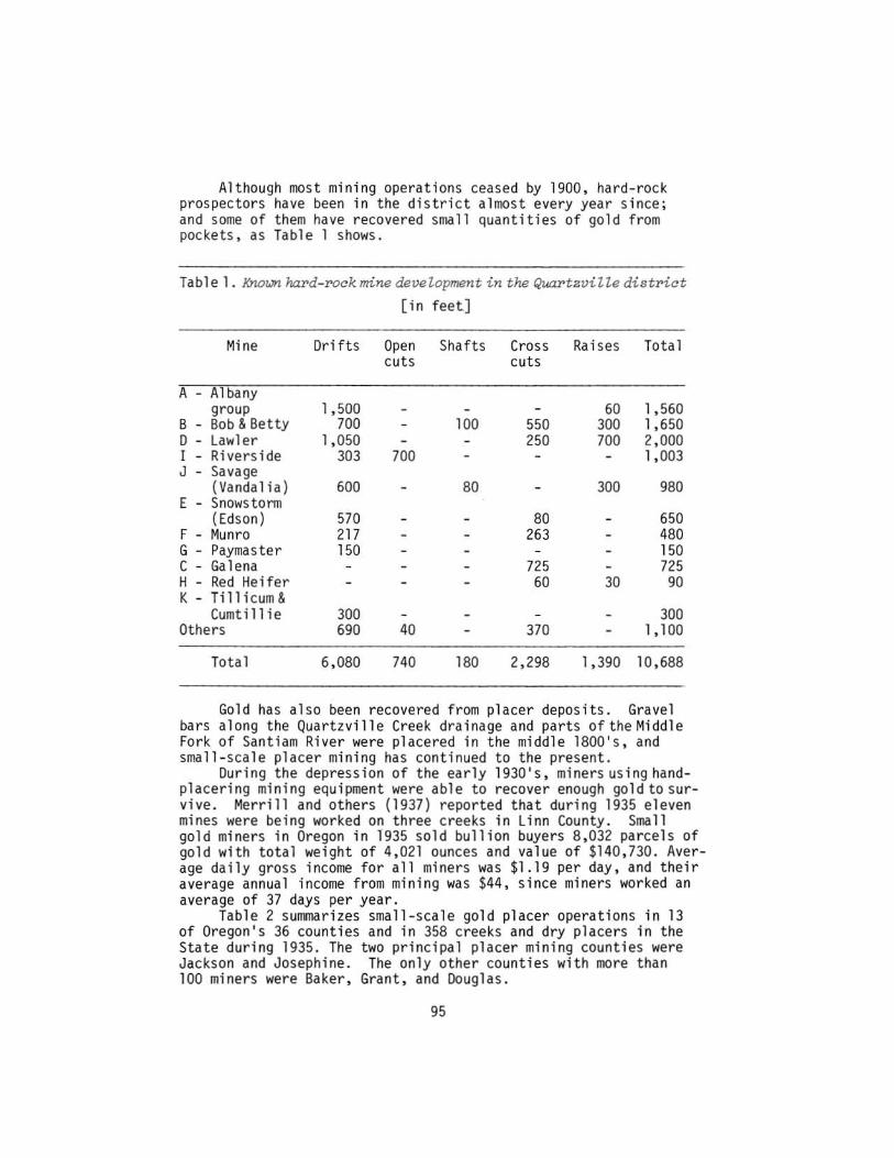
Although most min ing operations ceased by 1900, hard-rock prospectors have been in the di strict almost every year s ince; and some of them have recovered sma ll quantities of gold from pockets, as Table 1 shows.
Tab 1 e 1. Known hard-1'Ock mine devel.opment in the Quartzville district
[ i n feet]
Mine Drifts Open Sha fts Cross Rai ses Total cuts cuts
A A 1 bany group 1 , 500 60 1, 560
8 Bob & Betty 700 100 550 300 1,650 D lawler 1, 050 250 700 2 ,000 I Riverside 303 700 1, 003 J Savage
(Vandalia) 600 80 300 980 E Snowstonn
(Edson) 570 80 650 F Munro 217 263 480 G Paymaster 150 150 C Galena 725 725 H Red Hei fer 60 30 90 K - Ti 11 icum &
Cumtil l ie 300 300 Others 690 40 370 1 , 100
Total 6,080 740 180 2,298 1 ,390 10 ,688
Gol d has al so been recovered from placer deposits. Gravel bars along the Quartzvi ll e Creek drainage and parts of the Middle Fork of Santi am River were pl acered in the middle 1800' s , and small-scale placer mining has cont inued to the present.
During the depression of the early 1930's , miners us ing handplacer i ng mining equipment were able to recover enough gold to survive. Merril l and others (1937) reported that during 1935 eleven mines were being worked on three creeks in l inn County. Sma ll go l d miners in Oregon in 1935 so ld bu llion buye rs 8 ,032 parcel s of gold with total weight of 4,021 ounces and value of $140, 730. Ave rage daily gross income for all mi ners was $1 .19 per day , and their average an nual income from mining was $44 , s ince miners worked an average of 37 days per year .
Tabl e 2 summarizes sma l l-scale gold placer operations in 13 of Oregon's 36 counties and in 358 creeks and dry placers in the State during 1935. The two pri nc ipal placer mining coun ti es were Jackson and Josephine . The only other counties with more than 100 miners were Baker, Grant, and Douglas.
95

Table 2. smatt - scate gotd ptacer operations in Oregon in 1935 [Production and income of all placer miners, by counties]
County No. mi ners No. creeks Gold ~roduced Ave. gross working worked Fine Value ann . income
ounces per miner
Baker ...... 490 61 339 .23 $11,873 $27 Coos ....... 17 9 10.65 373 25 Curry ...... 75 15 110 . 28 3,860 57 Douglas ... . 145 26 169.06 5,917 46 Grant. ..... 313 37 235.99 8,260 29 Jackson .... I ,454 84 1,563.53 54,724 43 Josephine .. I ,039 110 1,496.56 52,380 56 Lane ....... I 1 .84 29 33 linn ....... II 3 12.96 454 46 Ma 1 heur .... 28 6 27.05 947 38 Mari on ..... 2 1 8.73 305 172 Umatilla .. . 10 2 14.16 495 56 Union ...... 21 3 10.96 383 20
Unallocated 25 20.86 730 33
Total 3,631 358 4,020.86 140,730 44
Present Status of Exploration Activity
Prospecting and hard-rock and placer mining in theQuartzville district are now undertaken only as hobb i es. The prospecting, claim work. and portable dredge operations take place during weekends and vacation time.
Production
According to U.S. Mint reports for the years 1884 through 1886. the Quartzville district has been credited with production of 8.359.33 ounces of gold valued at $172,786.35 based on gold value of $20 . 67 per ounce. Silver produced during this period was valued at $2,869.00. No production was recorded from 1897 through 1924.
U.S. Bureau of Mines data show that from 1925 through 1940 seven operations produced 281 tons of crude ore which yielded 112.53 ounces of gold and 56 ounces of si l ver. No production has been recorded for the Quartzville district since 1940 . Unofficial estimates put the production of the lawler mine alone at $1 million .
96

(1) (2) (3)*
OJ .0.0 0.0
[] 4.6 4.6
I]] 1.3 5.9
III 0.5 6.4
o 0.8 7.2
[IJ 0.5 7.7
Road Log
(Refer to map, p. 100-101.)
West city limits of Sweet Home, on Highway 20, 0.6 miles east of milepost 26. (At the time of publication, the city limits sign had been taken down because of road construction.) Dense, dark rocks with columnar jointing that are found on the south or right-hand side of the road are basalts that have been classified by various authors as Columbia River Basalt, Stayton Lava, or Little Butte Volcanics.
Drive east through town on Highway 20. On the left side is the Foster Reservoir
vi ewpoi nt.
In the roadcut on the right-hand side of the road at the traffic separator sign, just before the road curves to the right, note the irregular contact between underlying sedimentary beds of siltstone and shale and an overlying basalt flow (see Figure 1). Note also the baked zone along the edges of the sedimentary rocks, caused by the heat of the basalt. Slickensides (scratches or grooves) occur in this zone, indicating movement of the sediments, probably from the weight and flowing motion of the lava.
You are now at the junction of Highway 20 and the Green Peter Dam-Quartzville townsite road. Note the columnar jointed basalt to the right of the junction.
Turn left here and drive toward Quartzville. After you have crossed the bridge, you again see basalt overlying sediments, as at Checkpoint 3.
Before you cross the north arm of Foster Reservoir, note the paleoriver terraces in the roadcut to the left, indicating that theSantiam River was once at this level. Some of the old river terrace gravels contain gold and have been mined in the past.
In the roadcut on your left, below the schoolhouse, you can see graded stream gravels and alluvial fan deposits. This material was probably deposited by a fast-moving stream which flowed into a slower-moving body of water and
*(1) Checkpoints; (2) Milea~e intervals; (3) Cumulative mileage.
97
[I] 0.2
IT] 0.6
[I] 1.0
dropped its load of sand and gravel. Imbrication (shingling or overlapping) of the rocks can be used to determine stream-flow direction. Note also that some of the bedding is abruptly terminated or truncated.
7.9 The Sunnys i de Park entrance is to the ri ght. The park is located on an old river terrace known as the Green Horn Bar, which was placer mined for gold in the late 1850's and 1860's. The men working the bar were called "greenhorns" because of their lack of mining experience. In their hydraulic mining, they used Californiatype riffles in the sluice boxes, resulting in the loss of most of the gold.
8.5 Across the river to your right are a series of cliff-forming basalt flows, locally named the Green Peter Basalts by the U.S. Army Corps of Engineers. These basalts are faulted and cut in some places by dikes.
9.5 Note the zone of alteration in the roadcut to the left. Stop at the small turnout on the right, just before the road curves to the left. In this outcrop you are looking at the mineralization of the Quartzville mining district in miniature (see Figure 2). Notice the three types of alteration that occur here, ranging from propylitic (hydrothermal alteration that has produced epidote, chlorite, and pyrite) at the edges through argillic (alteration. producing clay minerals) to phyllic (alteration to quartz and sericite) at the center of the zone. The phyllic alteration occurs along a very narrow fracture which acted as a channel for ascending hydrothermal fluids through otherwise impermeable basalt. Dioritic and granodioritic intrusive rocks are exposed to the west (left) of this fracture. This intrusion and associated alteration are indicative of the type of hydrothermal fluid at depth that was the carrier for the mineralization in the Quartzville mining district. The zonation of alteration that you see here is present in most large mining districts, but it usually covers hundreds of feet, rather than inches, as here.
[@] 2.0 11.5 Green Peter Dam. To your right is a park-ing area and viewpoint. Work on the dam and its reservoir lasted from 1961 to 1967. The dam, which used 1,142,000 cubic yards of concrete, is 320 feet high, with deck elevation of 1 ,020 feet.
98

•
P'i-gure 1. and
Checkpoint J . I>'T'eglllap coniaei beiW<'en baaali edimentaT'Y pocks .
FigUT'e 2. Checkpoint 9. Altepation zone .
99

O RE . 228 ..... .I'.;;Ji~f'
QUARTZVILLE MINING DISTRICT FIELD TRIP ROUTE
[3 CD CAMPGROUNDS , PI CNI C AREAS & OTHER RECREATIONAL FACILITIE S
1. Dogwood (B.L. H.) . 14 sites. picnic . r.wtI'_1 2. Yellow Bottom (B.l.M . l . 12 s ites, picnic
22 sites , camp 3. Whitcomb Creek (li nn County) . 60 s i tes, picnic
34 sites , camp lOCAolION MAP 4. lewis Creek (U nn Coun ty), picnic
Figure 3.
5. Sunnyside (Linn County ) . 65 sites . camp 6. Sankey Park (City) . pic nicking . ballfield . playground equip. 7. Norths ide Park (City) . tenn is court . handball court . basketball
courl. so ftball field, s wi nming . picnicking . 18 sites
Checkpoint 12.
100
Figure 4 . Checkpoint 15 . SZickensides on fau Zt pZane .
LEGEND
e CHECKPOINT
® MINE S " PROSPECTS A. Albany G. Paymaster B. Bob and Betty II. Red lIeifc r (Silver SignllJ) C. Galena O. lawler E. luci lIe (Snowstorm) F. Munro (Hay flower)
I. Rivers ide J. Savage (Vandalia ) K. Tillicum & Cumtillie
(Golden Fleece)
Do not enter any mines except
'" - ~ J'" , .!:.~ , .::'-.f • . ,,; . .:.; ·1
Figupe 5. Checkpoint 18. (Photo courtesy AZbany Democrat- HeraZd. )
101
N
o i SoCAl( I ..... MItES
'& Qt,.IAIITZVILLf TO .... NSIT[
Figupe 6. Checkpoint 23 .

Figure ? Che kpoint 23 . Pyrite c"ystal found in alteration zone .
Figure 8 . Checkpoint 35 . Snowstorm tunnel . (Photo courtesy of Albany Democrat-Herald . )
102

[IT] 0.5 12.0
[l?J 3.3 15.3
IDJ 1.7 17.0
0] 0.8 17.8
[§J 1.7 19.5
[§J 1. 2 20.7
The reservoir holds 430,000 acre-feet of water and covers 3,720 acres of land. During construction of the dam, emery boulders were uncovered at the bottom of the river. The original emery outcrop was located by tracing emery "float" (loose boulders of emery) back to the source, 36 rivermiles up the Middle Fork of the Santiam River.
Park in the pulloff to your right and look to your left at the basaltic lava flow rock which is cut by several vertical basalt dikes. The dikes, which look very much like the flow rock because of similarities in composition, can be identified by their horizontal jointing which formed perpendicular to their cooling edges. At the west end of the roadcut are southeastwarddipping basalt flows which were deformed before being covered by the younger basalt flow you can see above them. The white blebs in the basalt are amygdules (secondary quartz, calcite, or zeolite minerals that filled small cavities left in cooling lava by escaping gas bubbles).
Just after crossing a small stream, the road curves to the right. In the roadcut to the left, note the orange and yellow alteration, which is due to hydrothermal processes that have altered the minerals to clay and deposited pyrite, which in turn weathered to various iron oxides (rust) (see Figure 3). Because the alteration has affected a 11 of the di fferent types of rock exposed here, you can see that it is younger than they are.
You are now crossing an arm of the Green Peter Reservoir.
On the right is the entrance to Whitcomb Creek Park.
At the curve just past milepost 12, note the slickensides in the rocks to your left (see Figure 4). Slickensides are polished and striated (scratched) surfaces resulting from rocks moving past one another along a fault plane. This particular fault plane has been exposed to weathering; therefore the striations and polish are not as distinct as those on a freshly exposed surface.
Note the alteration zone with abundant iron staining. This area and the associated riverbank (now under water) are known locally as the Donnaca Bar, the site of some large placer-mining operations in the late 1890's and again in the 1930's. Several thousand dollars in gold was removed from
103

Q2] 2.2 22.9
~ 1.8 24.7
[0J 0.7 25.4
~ 1.0 26.4
~ 0.2 26.6
lm 0.1 26.7
~ 1.6 28.3
these gravels. One possible source for the gold is the bright yellow and chocolate-brown alteration zone you see in the roadcut.
Upper end of the Green Peter Reservoir. On the south or opposite side of Quartzville Creek is a river terrace. Notice the gravel bar on the inside of the bend in the creek. Gravel is deposited here because the velocity of this side of the creek drops as the creek flows around the curve. To the left is a roadcut in which sandstone, siltstone, and volcanic material are exposed as bedded units. Note the eastward dip of the beds. At the east end of the roadcut the sedimentary sequence is overlain by a basalt flow. The black layer which separates the two units is a paleosoil horizon which was baked by the heat of the basalt flow. This soil zone contains some petrified wood fragments.
You are now at Dogwood Park, located on a gravel bar which was the site of placer-mining operations from the 1890's through the 1930's.
Duri ng the summer you can see weekend mi ners using small dredges~ sluice boxes, and gold rockers here and all along the creek. Figure 5 shows gold-panning and a gold rocker powered by a gasoline engine.
After you cross Four-bit Creek, the BLM road shops are on your right.
The rocks in the stone quarry on your left contain much pyrite and some tourmaline, indicating a highly mineralized area. At least one rock sample taken from here contained a trace of silver.
Just before the Yellowstone access road and Yellowstone Creek, notice the alteration in the rocks to your left. The iron staining is from the oxidation of pyrite and minor amounts of chalcopyrite. Some silicification has occurred, and tourmaline is also present.
To the right a bridge crosses Quartzville Creek. This is the Boulder Creek road. Cross bridge, turn left, and drive 1.6 miles.
Note the white-colored, 25-foot-wide alteration zone in the roadcut on your left (see Figure 6). Pyrite crystals up to 3/8-inches in diameter occur in this alteration zone (see Figure 7). Many of the crystals are in the form of pyritohedrons, which means they have 12 crys-
104

~ 5.2 33.5
~ O~l 33.6
~ 0.1 33.7
[Z] 1. 0 34.7
~ 0.2 34.9
tal faces, each of which has five sides. After collecting some choice samples, re
turn to the main road, turn right, and continue.
On the left is the entrance to the Yellow Bottom Creek Recreation Area.
The roadcut to the left exposes a coarsegrained buff-colored intrusive rock called diorite. The light minerals in it are primarily plagioclase feldspar; most of the dark minerals are hornblende. This diorite is part of the plutonic (intrusive) complex which is probably responsible for the mineral ization in the Quartzvill e area.
At the curve in the road, note the outcrop in the roadcut to the left. Part of the rock in this outcrop is the same diorite you saw at Checkpoint 25. The diorite formed from the cooling and crystallization of molten rock in an underground magma chamber. In addition, near the center of the roadcut is a section of lightcolored, fine-grained, and sugary-textured rock called aplite, which has a different chemical composition (more silica, less iron and magnesium) than the diorite. The aplite formed toward the end of the cooling history of the magma chamber, after most of the iron and magnesium minerals had already crystallized out of the melt. Note that the outcrop is cut by basalt dikes; therefore the basalt is younger than the diorite and the aplite.
In the roadcut to the left, just opposite the small building on the right, a basalt flow conformably overlies a lacustrine (lake) ash deposit which has thin layers called laminae. The laminae are interbedded with layers of airfall ash. Occasional rip-up clasts (fragments of partly consolidated sediments that have been ripped up and transported by strong currents) can be found in the sediments.
You are now at a road junction. The blacktop road (Road 1177) follows Quartzville Creek; the road to your left (Road 1162) follows Canal Creek; the center road (Road 1158) goes up the hill and leads to the Quartzville townsite. Note the columnar basalt in the roadcut. This vesicular basalt, which contains some olivine (the bottle-green minerals on a freshly broken surface), is classified as Recent in age because it is only a few hundred thousand years old.
105

~ 0.4 35.3
~ 0.7 36.0
@J 1.2 37.2
1m 0.9 38 .1
Follow Road 1162. the Canal Creek road, to your left.
Stop for a moment and look across the creek at the rock projecting like a wall f r om the creek and hi l lside on the other side. The country rock was orig inally solid; but when deep-seated forces within the earth caused the roel< to fracture, mol ten rock which was under great pressure moved up from great depths through the fractures to an environment where there was l ess pressure. As the magma passed through the fracture . some of it remained. cooled, and sol idif ied, forminga tabular body called a dike. The surroundi ng rock, softer than the dike, eroded away more quickly. leaving the diorite dike exposed, as you see it. in the shape of a wall .
To your right is a quarry of columnar basalt that was a smal l intracanyon lava flow. Note that the base of the flow ;s lower than the rocks on either s i de.
Now walk to the edge of the road and look down at Canal Creek. You should be able to see water running out of the ground below you into the creek. The sou rce of this water, which oldtimers ca l l Co ld Spring . i s in Dry Gulch. The grave l s of Dry Gulch and those covered by the intracanyon basalt flow act as a channel way for water. All year this spring carries water from the s l opes of Dry Gulch. The underground channelway can carrya ll of the summer runoff. so Dry Gulch remains dry during summer months. But the capacity of the underground channelway is insufficient during other seasons of the year, and then the excess water flows through Dry Gulch.
Return to the junction, turn left. and take the center road (Road 1158) toward the Quartzville townsite.
At the first switchback in the road, the cinders and basalt you see in the upper part of the roadcut at the right are part of the same sequence of Recent volcani cs you saw at the junction (Checkpoint 28). Below the volcan i c material is a layer of unconsolidated glacia l drift. This sequence of deposits can be used to give a rough maximum age for the la va . for the lava lies above the glacial drift and i s therefore younger.
To your right is a cinder pit. Few Recent volcanic cinder cones have been found this far west of the High Cascades . Note the dip of the
106

~ 0.3 38.4
IE] 0.9 39.3
~ 0. 6 39.9
layers of cinders ; n the pit wall. Normal ly al l the layers of a cinder cone dip away from the center of the cone; so the dip of these layers indicates that the cone itself should be ups l ope and to the south of this location, which it is. You will find scoria. cinders, a few lava bombs, and chunks of light-colored gran i tic rocks which were ripped from the magma conduit by the upward-flowing magma . These granitic fragments are indicative of at l east one type of rock present below this location. The extreme youthfulness of the Recent volcanic rocks seen in this part of the Quartzville district suggests that they occurred too recent ly to have been responsib l e for the mineralization of the district.
The bridge crosses Dry Gulch. This is the dra i nage that feeds Cold Springs (Checkpoint 30). Only during times of high water can flowing water be seen here.
To your right is a signboard identifying the Quartzville townsite . The district's largest producing mine. the Lawler, is located across the valley but is hard to see because of secondgrowth timber. IT IS UNSAFE TO ENTER THIS MINE!
On your l eft, 10 feet above the road, is the lower Snowstorm (Edson) tunnel, which was driven in a rhyolite breccia cemented with quartz. A second tunne l can be found by walking to the road switchback and entering the upstream side of the stream valley (staying to the left side of the stream valley). Shortly after l eaving the road, follow the trail which goes straight up the hillside to the left. Where the trail forks, follow the steeper trail.
Both of these tunnels are reasonably safe to enter if you carry a f la sh l ight. The second tunnel follows a fault gouge seam which you can see overhead in the tunnel . Figure 8 shows why these tunnels are safe to enter. The roof has a natural arch with no loose hanging rocks. The rock ;s hard and strong and wi l l not cave in. No shafts into which you might fall have been dug below the tunnel floor. No mine timber was l eft to rot and form bad air . Most other mines, tunnels, and shafts in the Quartzvil l e and other mining districts are NOT safe to enter.
The Snowstorm tunnels are owned by a private party; permission is not needed to enter these tunnels but may be required in the future.
Return to the fork in the road, turn left, 107

~ 3.6 43.5
lm 1.7 45.2
and follow the blacktop road (Road 1177) , the Quartzville Creek road.
Quartzvllle Creek -Galena Creek road junction. Take the right-hand road (Road '177-A). which crosses Quartzville Creek .
At this point the road crosses Galena Creek. The gravel in this creek contains specimens of tourmaline hornfe l s. fine-grained rocks which have been metamorphosed by contact with a hot intrusive body. These hornfels are indicative of a higher grade intrusive activity; and the original outcrop where the hornfels occurred. if cut by a vein. would be a good place to look for mineral values anu interesting mineral and rock specimens.
Turn around and retrace route to Sweet Home.
End of road 109.
Additional Reading
Beaulieu, J.D., 1974 . Environmental geology of western Linn County, Oregon: Oregon Dept. Geol . and Mineral Indus. Bull. 84. 117 p.
Brooks, H.C .• and Ramp. Len. 1968, Gold and silver in Oregon: Oregon Dept. Geo l . and Mineral Indus. Bull. 61, p. 292-298.
Callaghan. Eugene, and Buddington. A.F . • 1938, Metalliferous mineral deposits of the Cascade Range in Oregon: U.S. Geol . Survey Bull. 893. p. 99-113.
Merrill, C.W., Henderson, C.W . • and Kiessling, O.E., 1937, Small scale placer mines as a source of gold, employment, and livelihood: Minerals Technology and Output for Man Studies Rept. E-2. issued by Natl. Research Proj. and U.S. Bur. Mines for Works Prog . Adm . , Philadelphia. Pa., p. 22-26.
Munts . S.R., 1976. Geology and mineral deposits of the Quartzville mining district, central Western Cascades. Oregon: Univ . Oregon master's thesis. 150 p.
Peck, D.l.. Griggs, A.B . , Schlicker. H.G., Wells, F.G., and Dole. H.M . • 1964. Geology of the central and northern parts of the Western Cascade Range in Oregon: U.S. Geol . Survey Prof. Paper 449, 56 p.
* * * * *
CONDUCT YOUR OWN TOURS in Oregon. Order tour guides and descriptions of Oregon State Parks from the list you may receive free of charge by writing to the Department (address on page 93). Be sure to include the zip code in your return address.
* * * * *
108

AVAILABLE PUBLICATIONS
(Please Include N!IIIHtance with order, postage free. All sales are final - no returns. A complete list of Department publ1catlons, Including out-of-print. mailed on request.)
BULLETINS 26. soli: !tHrllln, destruction. and preservation. 1944: Twenhofel .... 33. Bibliography 1st suppl.) geology and IIlneral resources of Oregon, 1947: Allen 35. Geology of Dallas and Vahetz quadrangles, Or"9on, rev. 1964: Baldwin . 36. Papers on Tertiary forallinifera: CuShlMn, Ste"'lrtandStewart, 1949: v. 2,. 39. Geo!. and IIlneralizatlon of Naming mine region, 1948: Allen and TMyer . 44. Blbllog. (2nd suppl.) geology and mineraI resources of Oregon. 1953: Steere. 46. Ferruginous bauxite deposits. Sale.nHilh. 1956: Corcoran and llbbey 49. Lode mines, Granite IIIlnlng district, Grant County. Oregon, 1959: KoCh . 52. Chromlte in southwestern Oregon, 1961: Ramp . . .. .. • 53. Blbllog. (3rd suppl.) geology and IIlneral resources of 0 regon, 1962: Steere. !)wen 57. lunar Geological Field Conf. guidebook. 1965: Peterson and Groh. editors 60. Engineering geology of Tualatin Valley region. 1967: Schlicker and Deacon 61. Gold and silver In Or"90n. 1968: Brooks and RalnP • 62. Andesite Conference 9uldebook. 1968: Oole 63. Sixteenth biennial report of the Department. 1966-1968 64. MineraI and water resources of Oregon. 1969: USGS with Department. 65. Proceedlnqs of AndeSite Conference. 1969: (copies). . . • . . 67. Blbllog. (4th suppl.) geolOgy and mineraI resources of Oregon, 1970: Roberts 68 . Seventeenth biennial report of the Departlllent. 1968-1970 . 69. Geology of southwestern Oregon coast. 1971: Oott . • • • 71. Geology of selected lava tubes In Bend area, Or"90n. 1911: Greeley 72. Geology of Mitchell quadrangle. Wheeler County, 1971: Oles and Enlows 15. Geology and mineraI resources of Oouglas County. 1972: Rall\P 76. Eighteenth biennial report of the Departlnent. 1970-1972 . 77. Geologic field trips in northern Oregon and southern Washington. 1973 • 78. 8lbliog. (5th suppl.) geology and ralneral resources of Oregon. 1973: Roberts 79. EnVironmental geology Inland Tillamook and Clatsop Counties, 1913: Beaulieu. 80. Geology and IIlneral resources of Coos County, 1973: Baldwin end others 81. Envirolllllental geology of lincoln County, 1973: Schlicker alKi others. 82. Geo!. hazards of Bull Run Watershed. Mult .• Clackamas Counties, 1914: 8@auli@u 83. Eocene stratigraphY of southwestern Oregon, 1974: Baldwin . 84. EnvlrOl'fl\l!nUI geology of western Linn County, 1974: Beaulieu and others. 85. EnvirOl"llllental geology of coastal lane County. 1974: Schlicker and oth@rs 86. Nineteenth bl@nnlal report of the DepartJnent, 1972-1974. . 87. EnvirOrJlllenUI geol09Y of western Coos and Oouglas COllntles. 1975 • 88. Geology and minerai resources of upper Chetco River drainage, 1975: RalllP 89. Geology and Inlneral resources of Deschutes County. 1976 . 90. land use g@ology of western Curry County, 1976: Beaulieu
GEOLOGIC MAPS GeOlogic 1IIIIP of Galice quadrangl@. Oregon, 1953 Geologic map of Albany quadrangl@, Oregon, 1953 Reconnahsance geologlc IMP of lebanon quadrangle. 1956 . Geologic map of 8end quadran9le and portion of High Cascade Mtns .• 1951 .. Geologic 1IIIIP of Oregon west of 121st meridian, 1961 (Ov@r the counter]
(Hailed. fold@d) Geologic IIIIP of Oregon (9 x 12 Inch@s), 1969 GHS-2: Geologic IMP of Mitchell Butte quadran91e, Oregon, 1962 . GMS-3: Preliminary geologic map of Durkee quadrangl@, Oregon, 1961. . . . GMS~4: Oregon gravity NiPS, onshore alKi offshore, 1967 . [Over tM counter]
(Mailed. folded] GNS-S: G@ologic map of Powers quadrangle, Or"9on, 1911. . . . . GMS-6: Pr@llm. r@port on geology of part of Snake River Canyon, 1974 GMS-7: G@ology of the Or"9on part of the Baker quadrangle. Oregon. 1976
GEOTHERMAL REPORTS I. GeOthennal exploration studl@s In Or"9on, 1916: Bowen and others.
Price S---:1'l
1.00 3.00 1.25 1.00 '.00 1.25 1.00 5.00 3.00 3.50 7.50 '.00 3.50 1.00 3.00
10.00 3.00 1.00 4.00 '.50 3.00 3.00 1.00 5.00 3.00 7.00 6.00 9.00 6.50 4.00 9.00 9.00 1.00 9.00 4.00 6.50 9.00
1. 50 1.00 1.50 1. 50 '.00 2.50
.25 '.00 '.00 3.00 3.50 '.00 6.50
in press
In press

Th_ ORE BIN 1069 Shit_ Offiu Bldg., Por tlond, Or~ 97201
SlICond CI(I$!I Moth,!" POSTMASTER: Form 3S79 rttqU_lt.d
Available Publications, Continued:
THE ORE BIN Issued monthly - Subscription.
Single copies of current or back issues
OIL ANO GAS INVESTIGATIONS
Th. Or. Bin
. ... rAnnUalj [J-year
[Over the counter ("""lied]
PriCE' S J.OO
8.00 .2!i .J!>
-T. - -petr01i-lMIi" ge010gy;- western Snake River basin, 1963: Newton and Corcoran. 3.S(I 2. Subsurface geol09y.lowerCol\.mbia and Wlllamette basins. 1969: Newton 3.S0 3. Prelim. identifications of forllmlnlfera, General PetroleLln Lon9 Bell 'I well. 2.00 4. Prelil!l. Identifications of forilminifer" Eo"'. Warren Coos Co.I-7wel1, 1973 2.00 S. Pros~cts for naturlll glS prod. or underground storage of plpel inl! g;\5 5.00
SHORT PAPERS 18. Radioactive minerals prospectors should know, 1976: White , Schafer, Peterson. .75 19. Brick and tile Industry In Oregon, 1949: Allen and Mason .20 21. Li9htwelght aggregate Industry In Oregon. 1951: Mason .25 24. The Almeda mine, Josephine County, Oregon, 1967: Libbey 3.00 25. Petrography, type Rattlesnake Fm., central Oregon, 1976: Enlows 2.00
MISCELLANEOUS PAPERS I. A descrlp-tToliof SOllIe Oregon rocks and minerals, 1950: Dole, . . 1.00 2. Oregon mineraI deposits map (22 )l 34 Inches) and key (reprinted 1973): 1.00 4. Regulations for conservation of oil and natural gas (2nd rev., 1962): 1.00 S. Oregon's gold placers (reprints), 19S4 . .50 6. Oil and gas exploration in Oregon, rev. 1965: Stewart and Newton 3.00 7. Bibliography of theses on Oregon geology, 19S9: Schlicker .50
SuppJelllE!nt, 1959-1965: Roberts. .50 8. Aval1able we11 records of oll and gas exploration InOregon, rev. 1973: Newtoll 1.00
11. Collection of articles on meteorites, 1968 (reprints from The ORE BIN) 1.50 12. Index to published geologic mapping in Oregon, 1968: Corcoran .50 13. Index to The ORE Bin, 1950-1974 ........ ,. 1.50 14. Thennal springs and wells , 19l0: Bowen and PeterSOIl (with 1975 sUPPl.) 1.50 15. Quicksilver deposits in Oregon , 1971: Brooks. 1. SO 16. Mosaic of Oregon from ERTS-l Imagery, 1973 . 2.50 18. Proceedl1l9s of Citizens' Forum on potential future sources of energy, 1975 2.00
..... ,"''''''',quartl and placer claims) . . . .
region, Oregon-Washln9ton (pub. by AAPG) S","mand Gold Technical Session Proceedings, 1975 (""',d"', papers on gold deposits, exploration , history, and production
Color postcard, GEOLOGY OF OREGO" .[each)
~ ls ~
.50
.25
.50 2.50
5.00
.10
.25
.50 1.00