state of hawaii natural resources …files.hawaii.gov/dlnr/meeting/submittals/141114/k-3.pdf ·...
TRANSCRIPT
STATE OF HAWAI’IDEPARTMENT OF LAND AND NATURAL RESOURCES
OFFICE OF CONSERVATION AND COASTAL LANDSHONOLULU, HAWAII
November 14, 2014BOARD OF LAND AND
NATURAL RESOURCES
STATE OF HAWAII
HONOLULU, HAWAII
REGARDING: Conservation District Use Application (CDUA) KA-3714
APPLICANT: Kalihiwai Investors, LLC — Jim Fields
AGENT: Jim Fields
LOCATION: Kapaka Street, Hanalei District, Island of Kaua’i
TMKs: (4) 5-3-OO1.016
AREA OF PARCELS: 174 acres (146 ac. Conservation District; 28 ac. Agricultural District)
AREA OF USE: 2.5 acres
SUBZONE: Resource
DESCRIPTION OF AREA AND CURRENT USE:
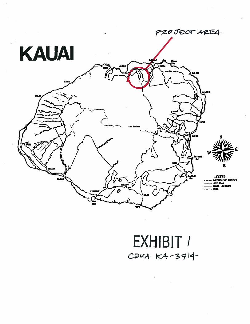
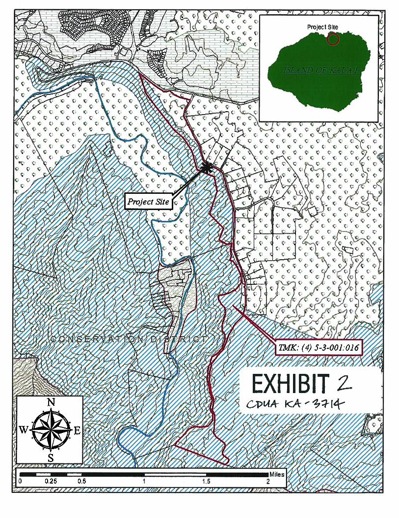
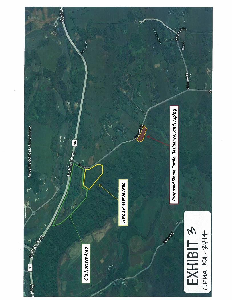
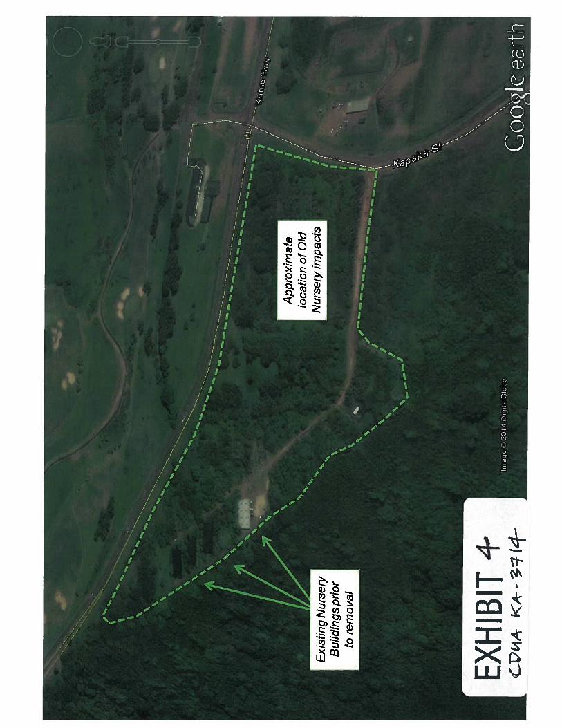
The project area is located within the northern portion of the Island of Kaua’i, south of Princevilleand east of Hanalei Town and Hanalei Bay (Exhibit 1). The subject parcel stretches almost three(3) miles along the eastern rim of the Hanalei Valley and is bordered to the north by KUhiöHighway, on the east by Kapaka Street (the access point for the parcel) and on the west byHanalei Valley. Approximately 28 acres of the parcel is zoned within the State Land Use (SLU)Agricultural District while the remainder, approximately 146 acres, is zone within the SLUConservation District Resource Subzone (Exhibit 2). Currently the parcel is undeveloped besidessome remnant buildings and structures left by previous uses and owners Over the last 50 years,portions of the parcel have been used for animal husbandry/pasturage and nursery operations.During the late 1980’s the northern portion of the parcel was developed as a commercial nursery(Exhibit 3); at the height of nursery operations the area was subjected to significant planting,plowing, cultivation and construction. Numerous structures had been built to support nurseryoperations on the parcel including a 4,000 square foot greenhouse which was destroyed byHurricane Iniki in 1992. Additional structures relating to the nursery operations include a 5,000square foot warehouse to be removed by Kalihiwai Investors, LLC (KI), and a 4,000 square footplant shade house that was removed by KI in 2013 (Exhibit 4). Additional non-residential usesincluded an AT&T cell tower facility (removed at the direction of KI in 2012), and a potablewater well and facility operated by Princeville Utilities (a private utility).
K-3
KI Single Family Residence Project CDUA KA-3714
Kauai Island Utility Cooperative (“KIUC”) owns and maintains above-ground power lines thatcross the subject parcel in various places, under a 1988 recorded right-of-entry. Three sets ofoverhead power lines cross the parcel (across land in the Conservation and Agricultural Districts).One set crosses the KUhiö highway at the northernmost end of the property and continues downinto the Hanalei Valley. The second set also runs across Kühiö Highway and into the parcelsupplying power to the 5,000 square foot warehouse (to be removed) in the old nursery area. Thethird set are large scale power lines at the landward (mauka) end of the parcel running up from theHanalei Valley to the “Powerline Trail”, an unpaved trail/road used to access electric transmissionlines for maintenance.
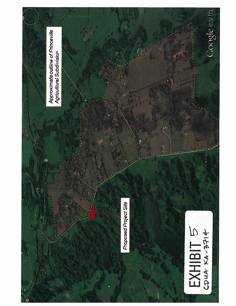
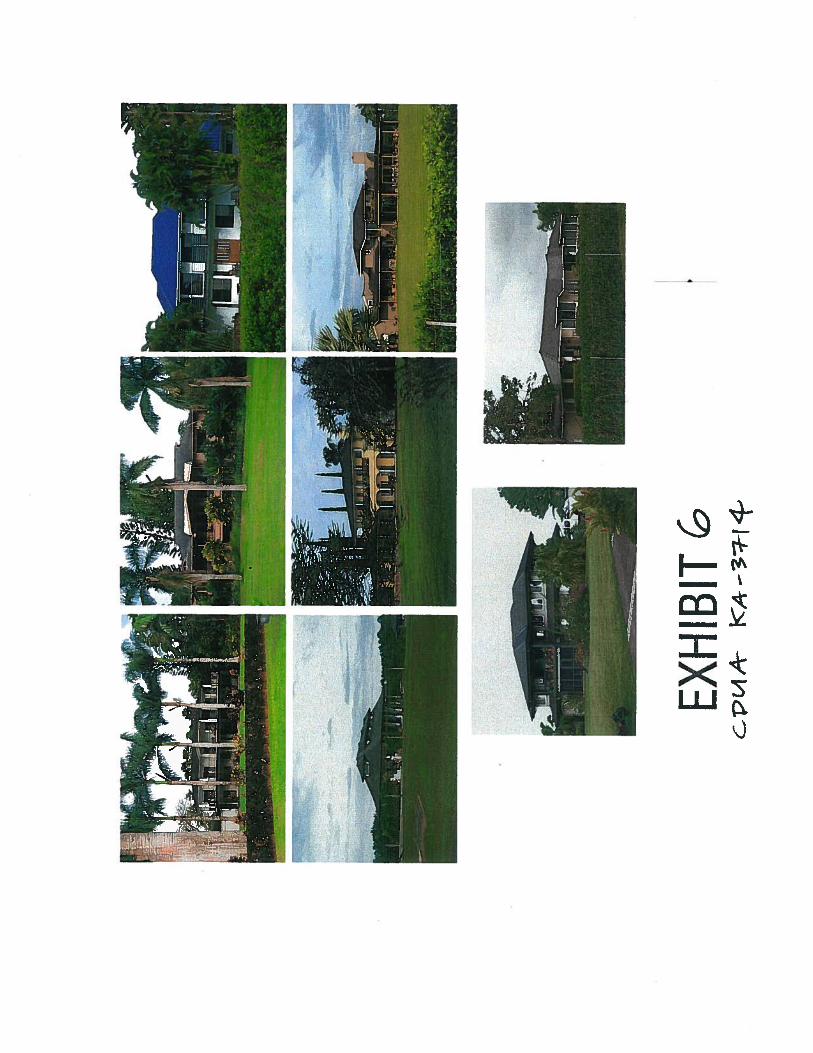
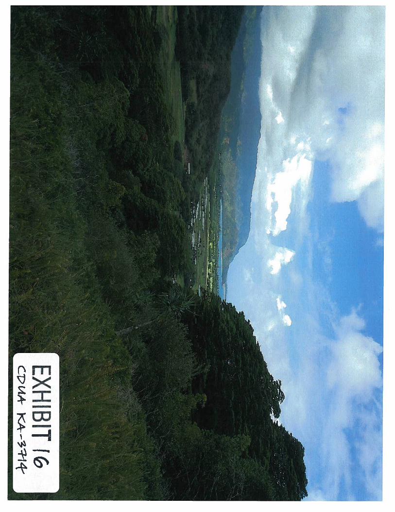
There is an existing subdivision called the Princeville Agricultural Subdivision (Exhibit 5) in thisarea which extends along the east side of Kapaka Street (adjacent to the subject parcel) forapproximately 1.5 miles. The original subdivision included 22 lots, but most have been furtherdivided into condominium units pursuant to Hawaii Revised Statutes (HRS) Chapters 514A and B(Hawaii ‘s condominium property acts), and there are now 84 CPR units on the east side ofKapaka Street. Currently, the subdivision includes 45 parcels with dwellings on them (and fourothers with structures of less than 1,000 square feet). 18 of the Princeville AgriculturalSubdivision dwellings are visible from Kapaka Street (Exhibit 6).
The project site is located about two (2) miles from the nearest coastline, and is approximately380-feet above sea level along the eastern rim of Hanalei Valley. The valley wall below the pall(cliff) and project site is steep, at about 50% grade or higher in some areas. The project site,however, is generally level from Kapaka Street to the pali, sloping slightly to the south.
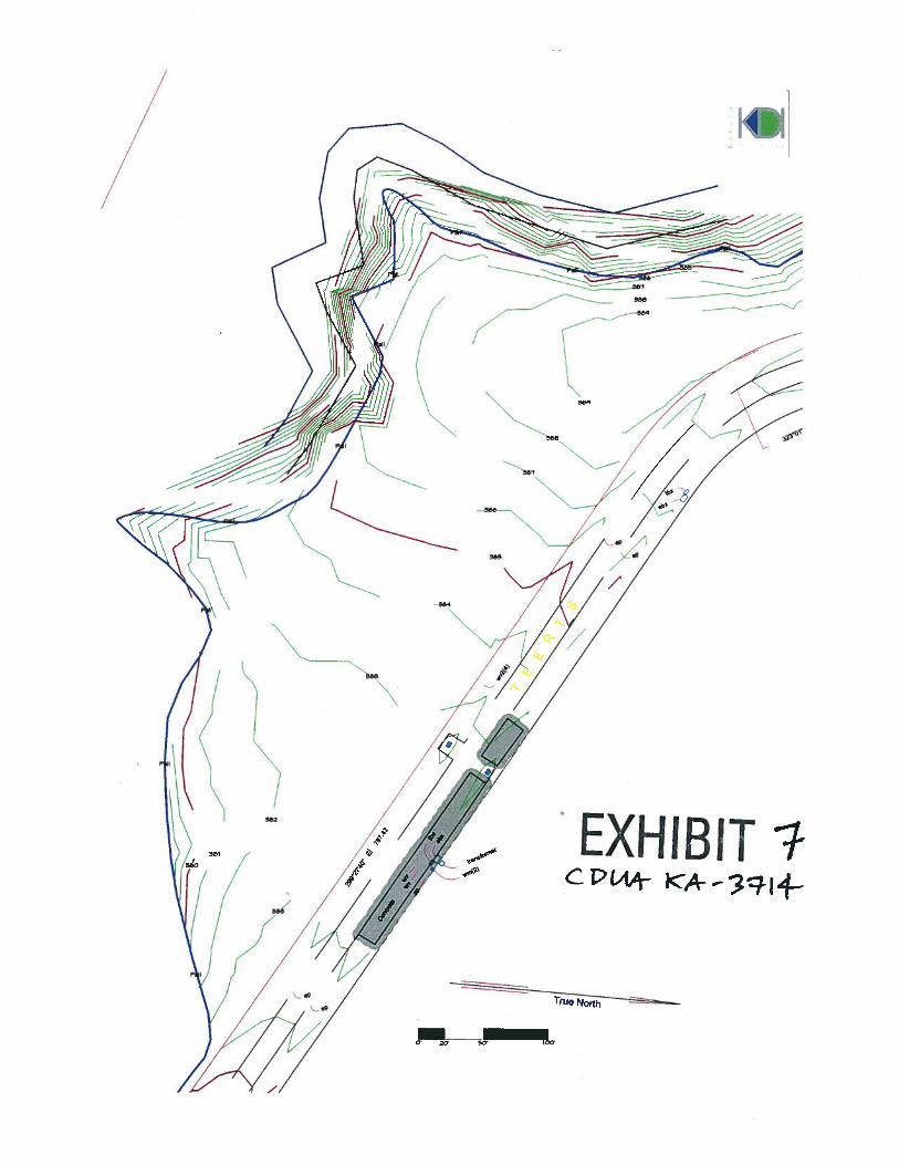
The project site does not contain any surface water bodies or wetlands, and there is no evidence ofany wetland vegetation in or around the project area. The surface water body nearest to the projectsite is the Hanalei River, which meanders along the valley floor, punctuated by lo’i terraces andresidential structures. The Hanalei River is approximately 1,000 feet from the project site at itsclosest point; the adjacent wetlands may extend a few hundred feet closer, but agriculture anddevelopment of the valley floor have obscured some of the non-tidal wetlands. Soil within theproject site is considered to be moderately permeable with slow to moderate runoff potential; thesoil erosion hazard is considered slight. As the parcel, and the Island of Kaua’ i is relatively wetcompared to other locales, the applicant decided to survey the project area for any potential runoffand/or soil erosion sites or indicators. Based on site observations the project area appears to drainuniformly (i.e., sheet flow) with no observable ravines, runnels, indentations or natural drainageswales. The majority of stormwater is absorbed on the property, although during heavy rainfallevents stormwater may flow parallel to Kapaka Street following the mild contours of the land(Exhibit 7). Discharge during these high rain events was observed to flow towards both theHanalei River and Kapaka Street, although Kapaka Street has storm drains at various points,including one at the southern end of the project site. The County of Kaua’i maintains an easementin that location for drainage purposes.
Previous Approvals/Permits:
A number of authorizations, approvals and correspondences from this office were provided to thelandowner to conduct land use activities in the preparation for development, to clean and removematerial from past land uses (i.e., nursery), and other land and resource management land uses
2
KI Single Family Residence Project CDUA KA-3714
throughout the parcel and at the project site. Previous work on the parcel by the current landownerincludes: conducting invasive species removal, minor landscaping of cleared areas, trash anddebris removal from previous development, and general land and resource management; permitsand approvals were granted by this office under Site Plan Approval (SPA) permit KA-13-30 andthrough our correspondence (COR) process under KA-12-50, KA-12-232, KA-13-02, and KA-13-69 for the aforementioned land uses. Additionally, staff from this office visited the site to observethe land and resource management activities, and to discuss proposed development and permittingwith the landowner. It should be noted that the pali area, and old nursery site, were filled withtrash (i.e., piping, plastic trash, metal, old landscape plants and materials) that was removed bythe applicant and disposed of off-site.
Existing Floral and Fauna! Resources
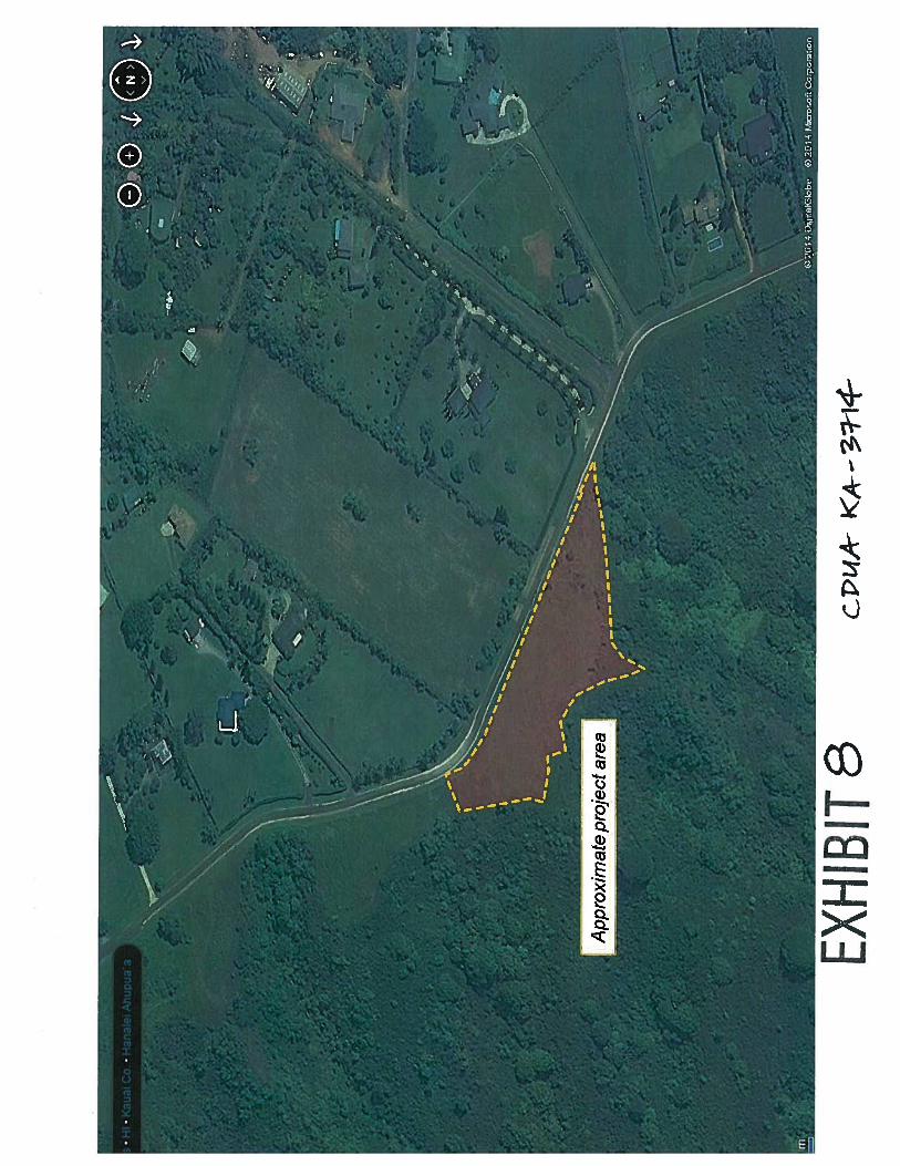
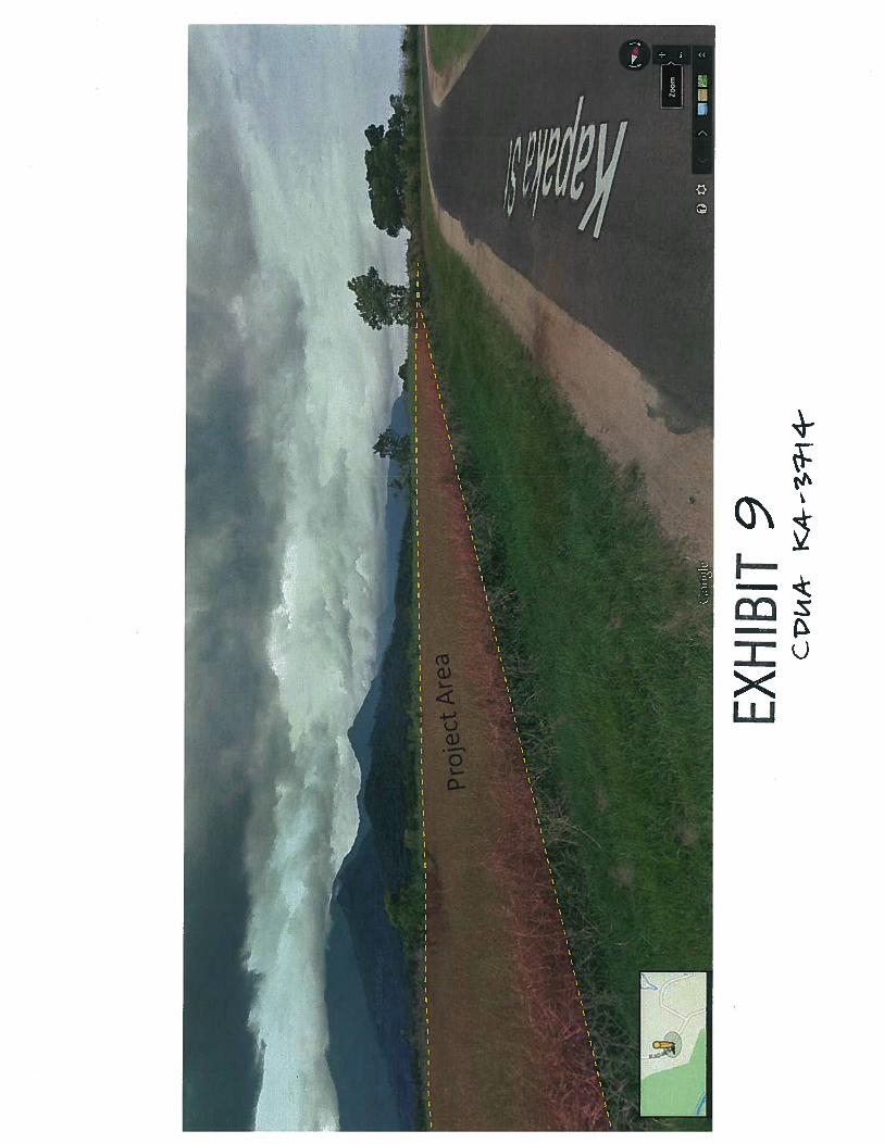
The proposed site is an abandoned pasture (Exhibit 8), primarily covered in grasses with invasiveshrubs and trees growing along the borders and slopes of the parcel (Exhibit 9). Invasive species,such as albizia, are starting to colonize the remainder of the site and surrounding area. Invasivespecies removal, which was previously approved through this office, has temporarily controlledthe growth and spread of some invasive vegetation; although more removal is warranted. AlongKapaka Street the vegetation is primarily thick stands of l-2m high grasses, typically BuffaloGrass, and shrubs, such as Guava and Java Plum. Along the rim of the Hanalei Valley StrawberryGuava dominates the landscape, along with Java Plum, Cats Claw and Albizia Trees. There areremnant ferns in small, scattered plots along with Lau Hala specimens, although these are situatedoutside the project site. The interior of the project site, and main development area, is covered inprimarily Buffalo Grass (80%) with other minor grasses (i.e., sleeping grass, Wedelia, andKikuyu); some minor shrubs and bushes are also present (e.g., Guava, Java Plum and Haole Koa)with no native species observed during the site survey.
The project site is primarily cleared land or a grassy field with limited areas of suitable nesting,resting, or foraging for faunal species. During a survey of the parcel and project site the followingspecies were observed and recorded: common Myna Bird, Chestnut Munia; Cattle Egret; and theZebra Dove. Additionally, evidence for the presence of feral pigs and feral chickens was alsoobserved, although no specific animals were sighted during the survey. There are native birdspecies that are assumed to seasonally fly over the property including the Nene, Golden Ploverand Pueo.
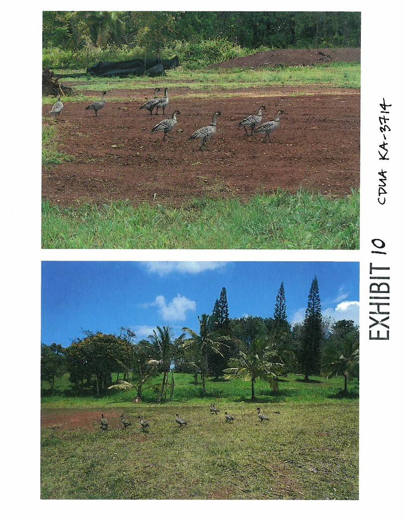
It should be noted that during a site visit, staff from this office observed at least 8 Nene walkingand foraging across the open fields located adjacent to the project area (Exhibit 10); most likelythese are transient foragers and do not utilize the area for nesting. The US Fish and WildlifeService (USFWS) indicate that various seabirds including “the federally threatened Newell’sShearwater, endangered Hawaiian Petrel, and a candidate for listing, the band-rumped storm-petrel” may fly over the project area when traversing between the ocean and mountainousbreeding colonies. Additionally, according to the USFWS the federally endangered HawaiianDuck or Koloa, and Hawaiian Hoary Bat may be present in the vicinity of the site. While variousspecies may be present in the vicinity of the project area or occasionally fly over the property, nothreatened or endangered species are known to permanently reside on the project site, and there isno proposed or designated critical habitat located on the parcel.
3
KI Single Family Residence Project CDUA KA-3714
Culture, Architecture and Archeology
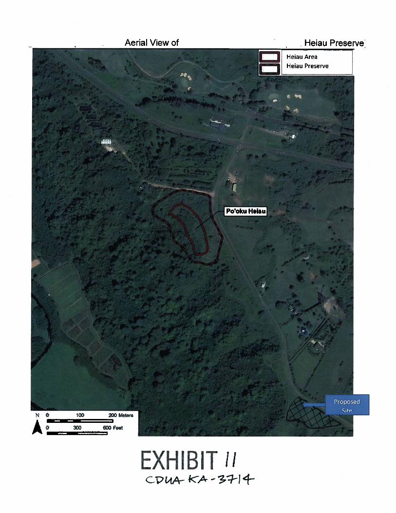
The subject parcel includes the Po’oku Heiau (State Historic Preservation Division (SHPD) Site#5-30-03-139), an important Hawaiian historic/cultural site located on the summit of a hilloverlooking Hanalei Valley. On July 24, 2012, the SHPD accepted the applicants FinalArcheological Inventory Survey (AIS) covering the majority of the parcel, including the area ofthe Po’oku Heiau and project site. On May 14, 2013 the SHPD accepted the applicants FinalPreservation Plan for the Heiau site and surrounding area (Exhibit 11).
During cultural and historical reconnaissance and site investigation, it was found that currentlythere are no cultural activities, gathering practices or other indigenous uses within the project site.As the parcel had been previously developed with the construction of a large scale commercialnursery at the northern end, commercial and public utilities at the southern end, and animalgrazing with minimal land management in between, evidence for additional uses or artifacts mostlikely has been removed or destroyed. No local Hawaiians provided any comments or concernswith regards to access or uses at the project site other than the heiau (which will be preserved inplace) and the lo’i farms and other agriculture uses located 1000-feet downslope on the floor ofHanalei Valley.
PROPOSED USE:
This Conservation District Use Application (CDUA) is for the proposed construction of a SingleFamily Residence (SFR), and landscaping/agriculture within a small portion (2.0 acres) of thelarger subject parcel (174 acres) (Exhibit 12).
Proposed Construction:
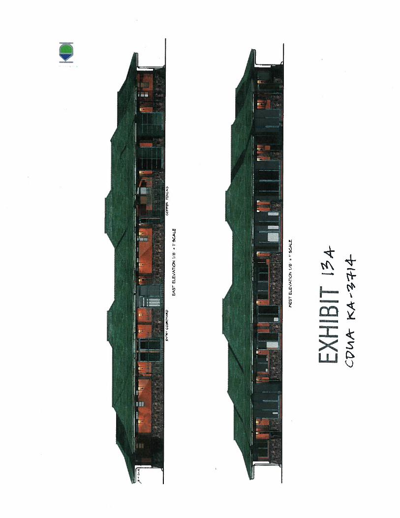
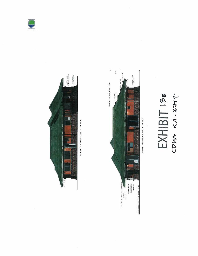
The proposed SFR has been sited to be constructed on a level, two-acre bluff approximately ‘/2
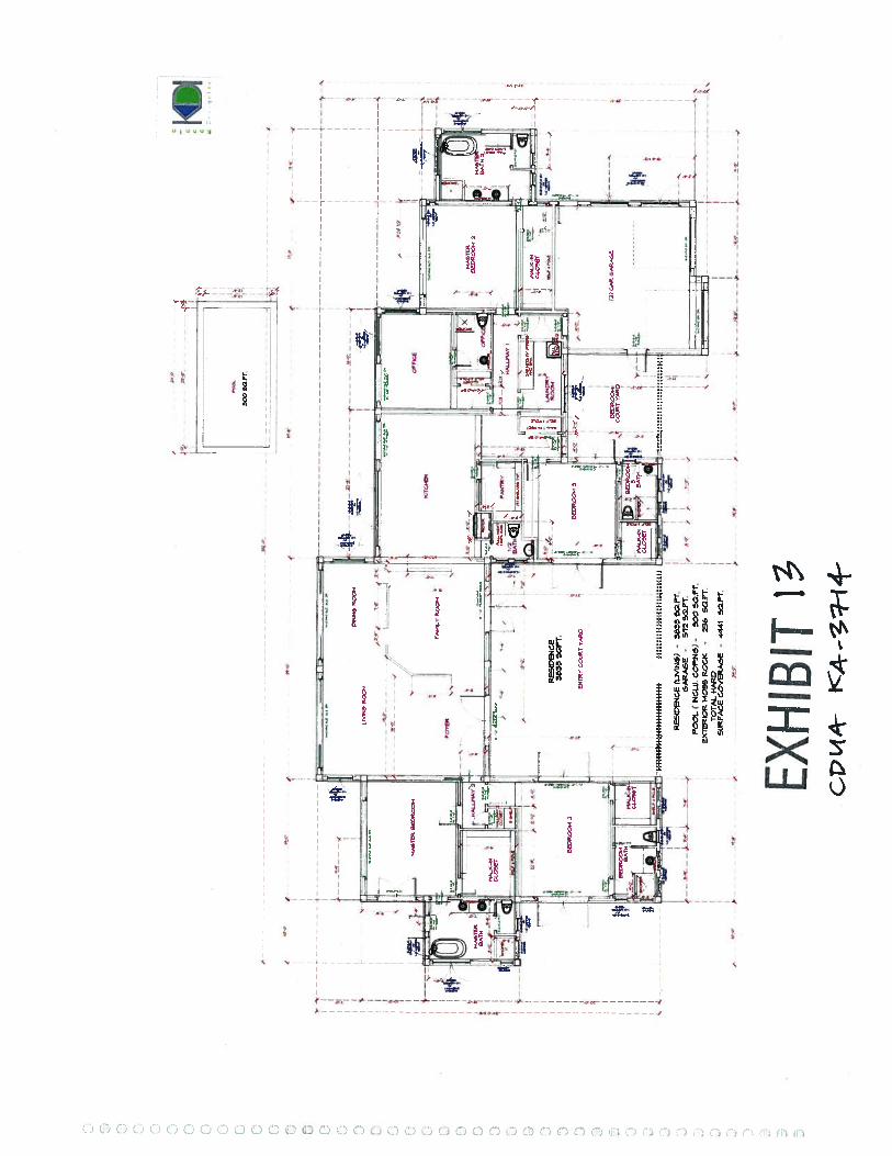
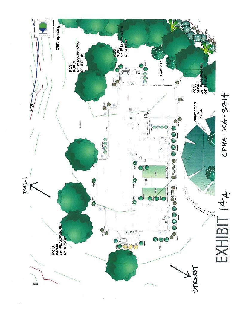
mile south of Kühiö Highway on Kapaka Street (see Exhibit 3). The proposed SFR has beendesigned as a one-story residence (Exhibit 13, 13a, 13b) to minimize view plane impactsassociated with typical development in this area. The designed maximum height of the SFR isapproximately 19’ above the current grade, with lower heights along the pali portion of theproject site. The SFR structure has been designed to include 3,833 sq. ft. of finished living space,a 572 sq. ft. garage; a 300 sq. ft. pool (with coping), and approximately 236 sq. ft. of “HawaiianRock” hardscaping applied to the exterior walls. The total “Maximum Developable Area” (MDA)is 4,491 sq. ft. which includes the total footprint of the home, pool, garage and hardscaping(which is typically not included in the MDA) (Exhibit 14, 14a); an access driveway will also beconstructed for ingress/egress to Kapaka Street. The SFR will be sited with the western face of thestructure to be approximately 60-80 feet from the edge of the pali overlooking Hanalei Valley.
Construction of a self-contained wastewater system which will process all wastewater in a belowground tank and convert it into water suitable for agriculturalllandscaping uses is also proposed.These systems eliminate the need for a leach filter or infiltration bed, and results in effluent waterquality that minimizes any adverse impacts to surface and ground waters and reduce the use ofpotable water for irrigation. All proposed septic and reclamation systems will be coordinated withthe State Department of health and the appropriate County of Kaua’i agency.
4
KI Single Family Residence Project CDUA KA-3714
Minor excavation of the proposed two-acre site will include, (1) excavation of the areaimmediately beneath the proposed dwelling to accommodate a post and pier foundation (requiringapproximately 406 cubic yards of earth to be removed), (2) excavation of the pool (requiringapproximately 55 cubic yards of earth to be removed), and (3) addition of a two-foot highplanting berm along portions of the boundary of the site with Kapaka Street using the excavatedsoil (Exhibit 15).
The only other excavation on the proposed site will be installation of a gravel leach bed forrainfall absorption and dispersal (requiring approximately 146 cubic yards of earth to be removed)and installation of the below-ground, self-contained septic system (requiring approximately 30cubic yards of earth to be removed). After installation of this rainfall leach bed and self-containedseptic system, the contours of the property will be returned to their pre-existing state. The productof this excavation will also be added to a proposed planting berm for landscaping purposes.
Proposed Landscaping:
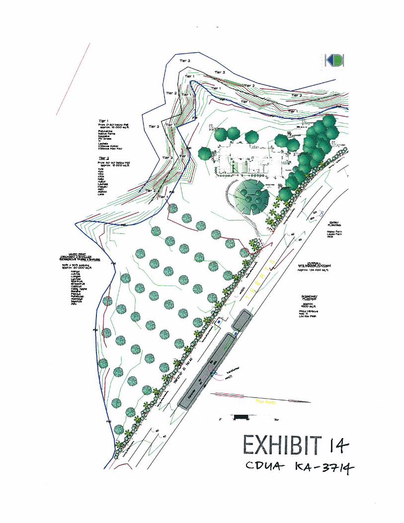
The landscaping and management plan proposes the removal of existing invasive speciesthroughout the project site and the replacement or planting using native or endemic species. Theproject site that borders Kapaka Street, approximately V2 acre, will be planted with nativehibiscus, Lou Lou Palms and Kou trees, along with Ti and naupaka. A low, two-foot highplanting berm will be emplaced along portions of the border with Kapaka Street to assist in theplanting, and for additional screening of the proposed SFR. An approximately 60-foot wide areabelow the pali and bordering the project site, totaling more than ¼ of an acre will be planted witha variety of native species which will transition from low-lying shrubs and ferns to larger treesdown the valley slope within the subject parcel (Exhibit 16).
The southern portion of the proposed site, approximately 1.25 acres, will be planted as an orchard,including approximately 75% fruit trees of varying varieties and 25% native or endemic trees.Orchard fruit trees will be grafted, semi-dwarf, tropical trees, of mixed varieties for personal useby the applicant. Each orchard tree will be pruned to be low spreading for ease of harvesting, andto minimize impacts to viewplanes.
SUMMARY OF COMMENTS:
The Office of Conservation and Coastal Lands (OCCL) referred the application to the followingstate agencies for review and comment: DLNR - Division of Forestry and Wildlife (DOFAW),Kaua’i Island Land Division (KDLO), DLNR — Division of Aquatic Resources (DAR), the StateHistoric Preservation Division (SHPD); the Office of Hawaiian Affairs (OHA); DLNR — StateParks and the County of Kaua’i — Planning Department and the County of Kaua’i — Departmentof Public Works. The application was also provided to the Princeville Public Library and to thePrinceville Community Association for review and comment.
Comments receivedfrom thefollowing agencies have been summarized by staffasfollows:
DLNR — Division of Forestry and Wildlife (DOFAWWhile no comments were provided initially by DOFAW on the proposed project, OCCL staff hadconcerns over multiple Nene that were observed during an initial site visit. Conversations
5
KI Single Family Residence Project CDUA KA-37 14
between the applicant, DOFAW and the OCCL determined that some coordination between theapplicant and DOFAW is warranted.
DOFAW stated: The nesting and brooding season for the Hawaiian goose (Nene) is from mid-September to mid-ApriL Please inform the property owner that prior to the start ofdevelopmentproject to contact DLNR-DOFAW-Kauai. We will provide technical assistance.
Applicant Response:The applicant will continue to work with DOFA W — Kaua ‘1 to determine ftechnical assistance isnecessary prior to the start ofconstruction.
DLNR — Kaua’i District Land Office (KDLO)Agency has no comments on the proposed project.
DLNR — Division of Aquatic Resources (DAR)The applicant must implement Best Management Practices (BMP) during all phases of grading,excavation, earth moving and construction activities associated with the proposed project toassure that there will be no or minimal negative impacts to the surrounding natural resources (e.g.,Hanalei River)
Applicant Response:As the Hanalei River is approximately 1000 feet from the project site, there are no anticipatedimpacts to that valuable resource. There is a heavily vegetated pali/ steep cliff area between theproposed structure and the Hanalei River which will further reduce and potential impacts due torunoffor soil erosion. Additionally, the slope of the project site is to the south and along KapakaStreet such that the majority ofstormwater and runoffwill be directed awayfrom the pali.
DLNR — State Historic Preservation Division (SHPD’)Applicant worked with the SHPD prior to submitting the application to complete anArcheological Inventory Survey (AIS) and preservation Plan for a previously located Heiau sitelocated on the property. The SHPD accepted and approved of the AIS on July 24, 2012 and thePreservation Plan for the heiau on May 14, 2013.
No written comments were received from this Division.
State of Hawaii — Office of Hawaiian AffairsNo comments were received by this office.
County of Kaua’i — Planning DepartmentNo comments were received by this office.
County of Kaua’i — Department of Public WorksAgency has no comments on proposed project; reviewed by DPW-Engineering Branch
Comments received duringpre-consultation only, applicant addressed in FEA:
6
KI Single Family Residence Project CDUA KA-3 714
Community members:It should be noted that the applicant, on his own accord, sent pre-consultation letters to eighty-four (84) Princeville Community Owners/Residents with only three responses being provided tothe applicant; none submitted official documentation to this office although the applicantaddressed the majority concern which regarded viewplanes from the large residential subdivisionlocated across the street from the proposed project.
US Fish and Wildlife Service:We have reviewed the information you provided and pertinent information in our files, includingdata compiled by the Hawaii Biodiversity and Mapping program. Our data indicates that thefederally endangered Hawaiian Duck and Hawaiian Hoary Bat may be present in the vicinity.Additionally, the federally threatened Newells Shearwater, Hawaiian Petrel, and the band-rumpedstorm petrel (i.e., seabirds) may fly over the area when traversing between the mountain andocean habitats. There is no proposed or designated critical habitat located in the area.
Although no mountain streams or wetlands are currently found within the proposed 2-acre parcel,Hawaiian ducks may fly over the area or stop for rest. To avoid impacts to this species, theapplicant should survey the area in the morning, before any ground clearing fo any portion of theproposed project begins.
To minimize impacts to the endangered Hawaiian Hoary Bat, woody plants greater than 15-feettall should not be disturbed, removed, or trimmed between June 1 and September 15 of anyproject year.
To reduce the potential impact to seabirds, we recommend that construction activities should onlyoccur during daylight houses and if housing development requires lighting at night for safety orsecurity then the lights should be positioned low to the ground, be motion triggered, and beshielded effectively.
ANAuvsIs:
Following review and acceptance for processing, the Applicant’s Agent was notified, by letterdated June 16, 2014 that:
1. The proposed construction of a Single Family Residence and associated development is anidentified land use in the Conservation District Resource Subzone pursuant to HawaiiAdministrative Rules (HAR) § 13-5-24, R-7 SINGLE FAMILY RESIDENCE (D-1) Asingle family residence that conforms to design standards as outlined in this chapter; and
2. The proposed development of -1 .25 acres of orchard agriculture is an identified land usein the Conservation District Resource Subzone pursuant to HAR §13-5-23, L-1AGRICULTURE (D-1) Agriculture, within an area ofmore than one acre, defined as theplanting, cultivating, and harvesting of horticultural crops, floricultural crops, or forestproducts, or animal husbandry. A management plan (pursuant to HAR §13-5, Exhibit 3)approved simultaneously with the permit, is also required. As always the decision toapprove or deny these proposed land uses will rest with the Board of Land and NaturalResources (BLNR);
7
KI Single Family Residence Project CDUA KA-3 714
3. In conformance with Chapter 343, Hawaii Revised Statutes (HRS), as amended, andChapter 11-200, HAR, an Environmental Assessment (EA) document will be required forthis proposed use; and
4. Pursuant to HAR § 13-5-40 Hearings, a public hearing is not required for this project.
A notice of the Conservation District Use Application (CDUA) and the Draft EnvironmentalAssessment (DEA) was published in the July 8, 2014 issue of the Office of EnvironmentalQuality Control (OEQC) publication the Environmental Notice; and
A notice of a Finding of No Significant Impact (FONSI) for the proposed Single FamilyResidence (SFR) Final Environmental Assessment (FEA) was published in the September 23,2014 issue of the OEQC publication the Environmental Notice.
13-5-3O CRITERIA:
The following discussion evaluates the merits of the proposed land use by applying the criteriaestablished in HAR §13-5-30.
1) The proposed use is consistent with the purpose ofthe Conservation District.The objective of the Conservation District is to conserve, protect, and preserve theimportant natural resources’ of the state through appropriate management and use topromote their long-term sustainability and the public health, safety and welfare.
The proposed construction of a Single Family Residence on the conservation districtportion of the subject parcel is in character with the existing residential developmentthroughout this area. There are a number of residential structures located along KapakaRoad, across from the proposed SFR parcel, some of which are very large, with multiplestories, outbuildings, and landscaping. According to HAR Ch. 13-5, only one (1) residenceis permitted to be built within the conservation district, therefore this parcel, whichstretches along the pali for approximately 3 miles, will not be developed with multiplehomes. Staff believes by allowing the home to be built on the parcel will actuallyminimize the development of the west side of Kapaka Street and protecting the ridgelineviewplanes.
Currently, the proposed site is a degraded pasture dominated by invasive species whichhave spread throughout the site and surrounding area. The proposed projects landscapeplan and invasive species removal efforts will aim to improve the natural condition of thesite thus improving the habitat potential and character of the parcel.
2) The proposed land use is consistent with the objectives of the Subzone of the land onwhich the use will occur.
The objective of the Resource Subzone “... is to develop, with proper management, areasto ensure sustained use of the natural resources of those areas”. The proposedconstruction of a SFR, which conforms to the designs standards and requirements of HAR
8
K! Single Family Residence Project CDUA KA-3714
Ch. 13-5, will ensure that the existing character of the surrounding area is not altered, andthat all proposed activities will be conducted in accordance with BMPs outlined and/orproposed in the CDUA.
3) The proposed land use complies with the provisions and guidelines contained in Chapter205A, HRS entitled “Coastal Zone Management”, where applicable.
The project site is not within the County of Kaua’i Special Management Area (SMA) andis therefore not subject to the regulatory authority of the Coastal Zone Management(CZM) Program; the CZM program is intended to promote the protection and preservationof fragile coastal resources through the state of Hawaii.
Specific BMPs related to mitigating soil loss and/or soil erosion during constructionactivities will be in place until project completion; additionally, any exposed soil areaswill be re-vegetated in accordance to the rules and regulations of the ConservationDistrict.
4) The proposed land use will not cause substantial adverse impact to existing naturalresources within the surrounding area, community or region.
The project site, and majority of the subject parcel, has been impacted by past agricultureand floricultural uses such as grazing, planting, grading, and construction of out-buildingsfor the defunct nursery once located on the parcel. Staff believes that the proposed projectwill not cause a substantial adverse impact to the existing physical environment and/ornatural resources of the area. In fact the proposed project will only improve the naturalcharacter, natural habitats, and aesthetics of the project site and the overall subject parcel.
The proposed SFR and Landscape Plan have been designed to conform to the existingcontours of the project site, and not to materially alter the existing topography. The onlypermanent alteration of the contours will be for the post-and-pier foundation of the SFR,the pool, and planting berm located along Kapaka Street. Since the existing contours willbe primarily maintained throughout the project site, rainfall and subsequent stormwaterrunoff flow will not be changed from the existing conditions. Stormwater will still flowfrom the property to the County storm drain located on Kapaka Street. Additionally,stormwater that falls directly on the SFR will be collected and dispersed through a drip-line within the orchard site and landscaped areas.
With the introduction of native ferns, shrubs and trees, particularly in the area directlybelow the pali, the area may once again provide harborage and forage for native birdspecies. The removal of the invasive vegetation species also will contribute to repairingthe natural character of the site and surrounding area.
The proposed project will not have any significant direct or indirect impacts to the HanaleiRiver, the adjacent valley wetlands, or the coastal waters (i.e., Hanalei Bay) due to thedistance between the proposed SFR and these water features, and the 1000 feet of densevegetation that exists buffering the site from the Hanalei River and wetlands.
9
KI Single Family Residence Project CDUA KA-3 714
5) The proposed land use, including buildings, structures andfacilities, shall be compatiblewith the locality and surrounding areas, appropriate to the physical conditions andcapabilities ofthe specflc parcel or parcels.
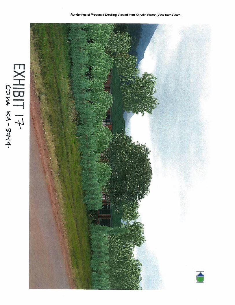
The Kapaka Street neighborhood surrounding the proposed site is a developed residentialand commercial area. Development on the eastside of the Kapaka Street (across from thesubject parcel) includes 45 residences of the Princeville Agricultural Subdivision, wherethe original 22 lots have been divided to allow for 84 CPR units to be constructed. Manyof the existing residences a large (i.e., multi-storied) and colorful such that they do notconform to the natural environment and are readily visible from Kapaka Street.Development in this area also includes, a Princeville Utilities water tank, the PrincevilleRanch Kids Adventure Center, and the Princeville Botanical Gardens. Additionally, theproposed SFR has been designed specifically to minimize any viewplane impacts it mayhave on both the Hanalei Valley and from the subdivision itself (Exhibit 17, 17a). Giventhe location of the project site along the Hanalei Valley rim, there are only 3-4 Hanaleifarmhouses at the southern end of the valley floor that could potentially see the proposeddwelling. By limiting the SFR to one (1) story, setting the SFR approximately 80-feetfrom the edge of the pali, and landscaping the area around the project site, staff believesthat the proposed SFR viewplane impacts have been mitigated.
Princeville Utilities has confirmed current availability of potable water service to theresidence. Additionally, the applicant will execute a “waiver and release” agreement withthe Kaua’i County Department of Water agreeing that water service is available fromthe Department of Water; the KIUC, however, has approved plans for electrical service tothe proposed SFR.
The current condition of the west side of. Kapaka Street is that it has been largelyovertaken by invasive vegetation. As a result, the proposed Landscape Plan will constitutea significant improvement in the natural character and condition of the project area by theelimination of invasive vegetation species and the re-introduction of native species
6) The existing physical and environmental aspects of the land, such as natural beauty andopen space characteristics, will be preserved or improved upon, whichever is applicable.
If development of the SFR is approved, the remainder of the subject parcel that stretchestwo (2) miles south of the project site will not be used for construction or development ofany structures, but will be left as open space. Potential future plans for the open space areainclude various public recreation areas for hiking and hunting. As the existing sitecharacteristics are that of an abandoned pasture area dominated by invasive vegetationspecies, staff believes that the implementation of the Landscape Plan will aim to improvethe natural character of the site by removing invasive species and re-planting with nativeand endemic species.
Although there has not been residential development on the west side of Kapaka Road,there has been commercial development (i.e., abandoned nursery) which severelyimpacted the parcel. Development on the east side of Kapaka Road includes over 40
10
KI Single Family Residence Project CDUA KA-37 14
residences such that the neighborhood is not a pristine natural area and the development ofone (1) SFR on the proposed site is consistent with surrounding land uses.
7) Subdivision of land will not be utilized to increase the intensity of land uses in theConservation District.
The proposed project does not involve subdivision of Conservation District land.
8) The proposed land use will not be materially detrimental to the public health, safety andwelfare.
The proposed construction of a SFR will not be out of character with the existingdevelopment of this area as the other residential development is significant along KapakaStreet. As the proposed project aims to reduce invasive species, build one low-profile SFRon the parcel (eliminating future development of the remaining Conservation Districtportion of the parcel), and utilizing landscaping with native or endemic species staffbelieves that this project will not impact the public in any way. Some minor nuisances(common to similar construction activities) may occur, but will be minimal and shortlived. Disposal of wastewater and municipal refuse will conform to the State Departmentof Health standards and regulations. No interference to any public utilities, public accessor public roadways is being proposed at this time.
CULTURAL AND HISTORICAL IMPACT REVIEW:
The project parcel includes the Po’oku Heiau, an important Hawaiian historic and cultural sitelocated on the summit of a hill overlooking the Hanalei Valley. On July 24, 2012 the StateHistoric Preservation Division (SHPD) accepted the applicants final Archeological InventorySurvey (AIS) which covered a majority of the 176 acre parcel, including the project site and thePo’oku Heiau. In order to protect and preserve this significant historic site, the applicant workedwith the SHPD to create a preservation plan for the Heiau site. SHPD believes that thePreservation Plan meets the standards of HAR § 13-277, and was accepted as an appropriatePreservation Plan by SHPD by letter dated May 14, 2014; the plan includes the entire ‘—13 acre“preservation” area.
It was noted in the AIS report that:
The precise location and size of the Po ‘oku Heiau on the summit of the pu ‘u overlooking theHanalei Valley is particularly subjective. This subjectivity results from the general absence ofstructural element remaining on the site and general understanding that the Heiau was notenclosed. Accordingly, prior determinations ofthe size and locations ofthe Heiau have been quitevariable.
To eliminate any uncertainty and minimize future controversy, the approved AIS and FinalPreservation Plan set the entire 1.8 acre summit of the pu’u overlooking the Hanalei Valley(including various heiau locations identified by previous research) as the sit boundary for theheiau, and defined the surrounding 5 acres of the hill as a “buffer zone”; the entire 7 acre site isidentified as the “Heiau Preserve”. In addition to the seven (7) acres approved as part of the AIS
11
KI Single Family Residence Project CDUA KA-3 714
and preservation plan, the applicant intends to make an additional 5.8 acres located on thepreserves western and southern boundaries as part of the “Heiau Preserve”, resulting in almost13+ acres of total protected area. The proposed project site is approximately 1,300 feet from thenearest edge of the 13 acre preservation preserve.
The applicant also intends to transfer title of the Po ‘oku Heiau Preserve to a non-profitcorporation (Ka Pua Hinalo 0 Po’oku) created to hold and administer the preserve. The board ofthe non-profit will be comprised of community members who will act as curators of thisimportant historic property. Transfer of the preserve property is awaiting filing of IRS documentsto qualify for a 501 (c)(3) entity, which is anticipated in the near future.
The buffer zone, along with other measures outlined in the Final Preservation Plan, safeguards theheiau from future adverse activities in the surrounding area. In setting the buffer zone, the AISand Final Preservation Plan expressly considered the proposed and future uses of the parcel,including the construction of the proposed Single Family Residence. The AIS also included apedestrian survey of the two-acre bluff that is the project site. The AIS found no evidence ofhistoric properties or structures on or immediately adjacent to the project site. It should be notedthat significant ground disturbance had occurred in conjunction with the development andoperation of the nursery that existed on the parcel during the 1980’s to 1990’s.
DISCUSSION:
The primary purpose of this proposed project is to develop a currently vacant project site with aSingle Family Residence (SFR), landscaping, pool, minor agricultural uses, and access driveway;all proposed activities fall within the guidelines of HAR § 13-5. The proposed use is in characterwith the surrounding region which includes other SFR structures, commercial uses and associateddevelopment, along with significant landscaping throughout the Princeville FarmlandsSubdivision located across the street from the project site.
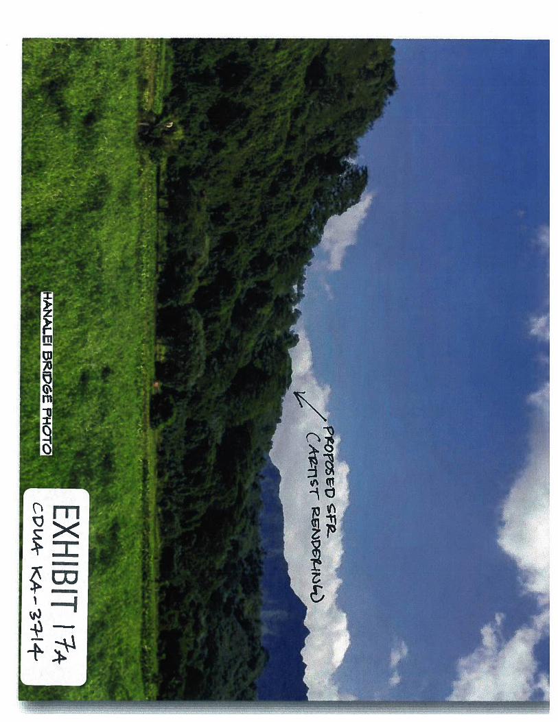
In addition to residential and commercial development along Kapaka Street, there has beensubstantial development along the Hanalei Valley rim closer to Hanalei Bay (north of the subjectparcel). This development includes numerous residential structures along Hanalei PlantationRoad, particularly in the Hanalei Garden Farms development (Exhibit 18) which includes 22home sites. Several of these dwellings are readily visible from Hanalei Town and the HanaleiValley floor. Based on the significant development all along the Hanalei Valley ridge, staffpurports that the proposed SFR, and all its design elements, will have negligible impacts onviewplanes from the Hanalei Valley and River. The applicant has also contacted the County ofKaua’i to determine if there is a potential for a scenic overlook on the northern portion of theparcel. This area would be available to the County if needed to replace the current overlook offKühiö Highway which can be crowded and difficult to access.
Staff believes that the applicant has made every effort to include the neighboring residents in theproposed designldevelopment of the property to solicit and mitigate any valid concerns.Additionally, every element of the proposed SFR, landscaping and agricultural area has beendesigned to mitigate potential viewplane impacts from the Hanalei Valley, the PrincevilleFarmlands Subdivision, and the Hanalei Valley public overlook off Kühiö Highway. Similarly,staff agrees that the development of one SFR within the Conservation District portion of the
12
KI Single Family Residence Project CDUA KA-3714
parcel will aid in maintaining the natural character and open space beauty of the remaining 2miles of the eastern Hanalei Valley rim of the project parcel.
It should be noted that the applicant, on their own accord, approached the State HistoricPreservation Division (SHPD) to design and implement the Po’oku Heiau preservation area toprotect the probable location of an historic heiau; the buffer zone around the area will never bedeveloped without strict coordination with the SHPD.
Based on the similar uses in the area, the minimal design of the proposed structure, the proposedlandscaping and agriculture uses, and the preservation measures being implemented to protect ahistoric site, staff believes that this proposed use is consistent with the objectives of theConservation District and is in character with the surrounding area.
RECOMMENDATION:
Based on the preceding analysis, Staff recommends that the Board of Land and Natural ResourcesAPPROVE this application for the Kalihiwai Investors Single Family Residence and AgricultureProject located in the Hanalei District, Island of Kaua’i, on Tax Map Key: (4) 5-3-OO1.016,subject to the following conditions pursuant to HAR § 13-5-42:
1. The permittee shall comply with all applicable statutes, ordinances, rules, and regulationsof the federal, state, and county governments, and applicable parts of this chapter;
2. The permittee, its successors and assigns, shall indemnify and hold the State of Hawaiiharmless from and against any loss, liability, claim, or demand for property damage,personal injury, and death arising out of any act or omission of the applicant, itssuccessors, assigns, officers, employees, contractors, and agents under this permit orrelating to or connected with the granting of this permit;
3. The permittee shall obtain appropriate authorization from the department for theoccupancy of state lands, if applicable;
4. The permittee shall comply with all applicable department of health administrative rules;\
5. The permittee shall provide documentation (e.g., book and page or document number) thatthe permit approval has been placed in recordable form as a part of the deed instrument,prior to submission for approval of subsequent construction plans;
6. The single family residence shall not be used for rental or any other commercialpurposes unless approved by the board. Transient rentals are prohibited, with theexception of wilderness camps approved by the board;
7. The applicant will implement the approved Preservation Plan for Po ‘oku Heiau asdescribed in this document and will record the Preservation Plan with the State ofHawaii Bureau of Conveyances;
8. Before proceeding with any work authorized by the department or the board, the permitteeshall submit four copies of the construction plans and specifications to the chairperson oran authorized representative for approval for consistency with the conditions of the pennitand the declarations set forth in the permit application. Three of the copies will be
13
KI Single Family Residence Project CDUA KA-3714
returned to the permittee. Plan approval by the chairperson does not constitute approvalrequired from other agencies;
9. Unless otherwise authorized, any work or construction to be done on the land shall beinitiated within one year of the approval of such use, in accordance with constructionplans that have been signed by the chairperson, and shall be completed within three yearsof the approval of such use. The permittee shall notify the department in writing whenconstruction activity is initiated and when it is completed;
10. All representations relative to mitigation set forth in the accepted environmentalassessment or impact statement for the proposed use are incorporated as conditions of thepermit;
11. The permittee understands and agrees that the permit does not convey any vested right(s)or exclusive privilege;
12. In issuing the permit, the department and board have relied on the information and datathat the permittee has provided in connection with the permit application. If, subsequentto the issuance of the permit such information and data prove to be false, incomplete, orinaccurate, this permit may be modified, suspended, or revoked, in whole or in part, andthe department may, in addition, institute appropriate legal proceedings;
13. When provided or required, potable water supply and sanitation facilities shall have theapproval of the department of health and the county department of water supply;
14. Provisions for access, parking, drainage, fire protection, safety, signs, lighting, andchanges on the landscape shall be provided;
15. Where any interference, nuisance, or harm may be caused, or hazard established by theuse, the permittee shall be required to take measures to minimize or eliminate theinterference, nuisance, harm, or hazard;
16. Obstruction of public roads, trails, lateral shoreline access, and pathways shall be avoidedor minimized. If obstruction is unavoidable, the permittee shall provide alternative roads,trails, lateral beach access, or pathways acceptable to the department;
17. Cleared areas shall be re-vegetated, in accordance with landscaping guidelines provided inthis chapter, within thirty days unless otherwise provided for in a plan on file with andapproved by the department;
18. Use of the area shall conform with the program of appropriate soil and water conservationdistrict or plan approved by and on file with the department, where applicable;
19. The permittee shall obtain a county building or grading permit or both for the use prior tofinal construction plan approval by the department;
20. For all landscaped areas, landscaping and irrigation shall be contained and maintainedwithin the property, and shall under no cfrcumstances extend seaward of the shoreline asdefined in section 205A-1, HRS;
21. Artificial light from exterior lighting fixtures, including but not limited to floodlights, uplights, or spotlights used for decorative or aesthetic purposes, shall be prohibited if the
14
KI Single Family Residence Project CDUA KA-3714
light directly illuminates or is directed to project across property boundaries toward theshoreline and ocean waters, except as may be permitted pursuant to section 205A-71,HRS. All exterior lighting shall be shielded to protect the night sky;
22. The permittee acknowledges that the approved work shall not hamper, impede, orotherwise limit the exercise of traditional, customary, or religious practices of nativeHawaiians in the immediate area, to the extent the practices are provided for by theConstitution of the State of Hawaii, and by Hawaii statutory and case law; and
23. Other terms and conditions as prescribed by the chairperson.
Failure to comply with any of these conditions shall render a permit void under the chapter, asdetermined by the chairperson or board
Respectfully submitted,
.Roy.Sc.,StufPlanerOffice ofConservation and Coastal Lands
Approved for submittal:
amJ.r.,hairpersonBoard ofLand and Natural Resources
15
=><uJ
I
I0)
II!
I!I
isI:
,,
-.-I
:E;-
r>
J)L)
ci)0ci
i(.
-V
\-c,
/t
-._-_J__-__—
...
•-‘—
.—
-.-,
.-.
-.—
4•
—,•-.---
..
.,.-
>__
Old
Nur
sery
Are
a
Hei
auP
rese
rve
Are
a
EXHI
BIT
3cP
L4
AK
A-7
-i’{
--A
Pro
pose
dSi
ngle
Fam
ilyR
esid
ence
, lan
dsca
ping
Exi
stin
gN
urse
iyB
uild
ings
prio
rto
rem
oval
EXHI
BIT
÷C
PC
.IA
-K
A3
H4
—
App
roxi
mat
elo
cati
onof
Old
Nur
sery
impa
cts
rn
LLic0
r) xJ
I
App
roxi
mat
epr
ojec
tare
a
EXH
IBiT
S
t
><—I
uJnci
k
rn0
=
nS
Aerial View of Heiau Preserve’Heiau Area
Heiau Preserve 1
NO 1o
300
_:_ Meters
600 Feet
EXHIBIT iiCPL4A- (4 - 31-i 4-
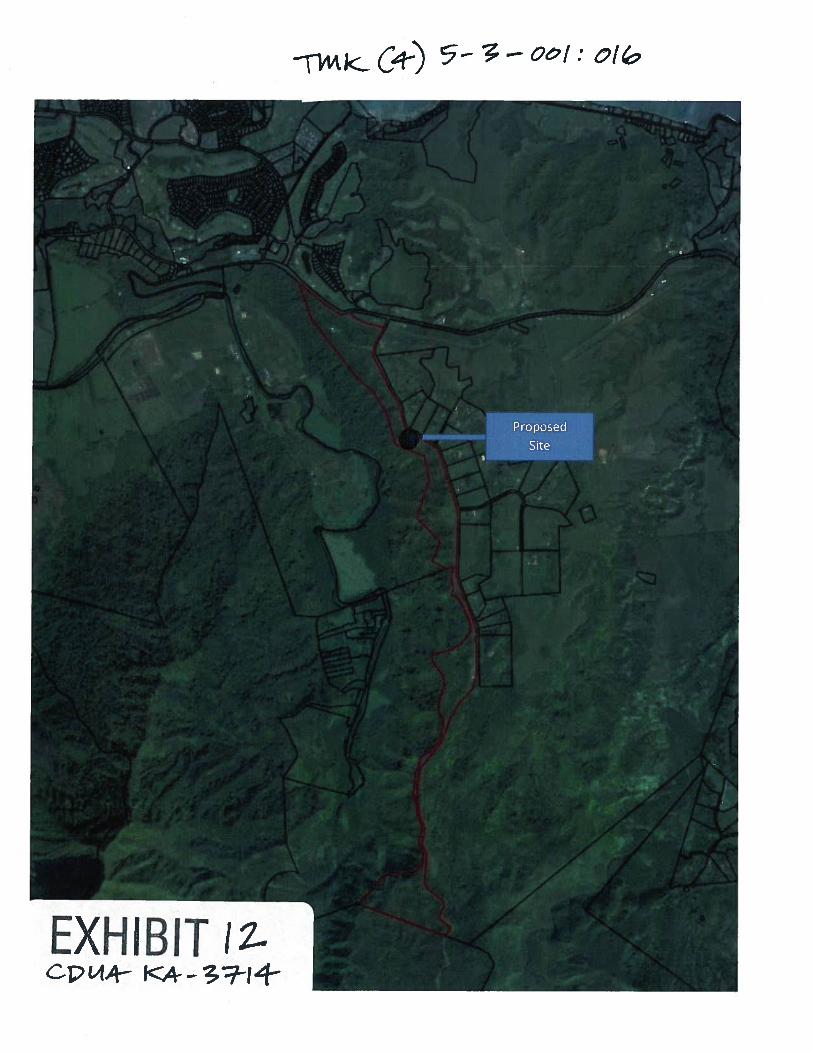
EXHIBIT 11cp1_w KA---37-14-
i<C) 5.-T-Oof:of&
rn
zr
1’
‘ItIt
4
j1
I
Li
0
z0
><sUJe
Li
z0I
I—I —
I—
><LU
Iiij
0‘5)
z0
‘U-jLii
II
5) U
GHRO 45510L1G5mve1neE0 ONHRUNS
00550 5055 spaOnqappron 00 000 eq.ft
May50cansLongan
rFrul5BreadfrUitOflisteI
PaoaRanBUtanAtemoyasapotessOlo
Tier 1From 0-90 belOw Pall
eppron. 1000051555
PollInalllnaNative FernsNaUpasaPill Grass5150109010HOISGUS 5.0510HIbISCUS Ken 5.00
Tier 2rrom ac-HO below Pall
oppron. 10000 sq.f5
so,SonMile0910SaleISUSIU150109010MaCaOl150111MoNeyLana
SNORTP109040150
eoa
*10
CITE C&I000EP000AGS
A4npron. 126 000 5515
ECLND15RYP000411N0
FOOte nibisGusRed TiLOU-IOU Palm
EXHIBIT 1Cp IcAr—3Hj--
/
dô Oic
It
e001
I ><-1
ccII
N(0
if
00lc7c ‘‘to
7c
°0/’O°
000
‘00
(N0
(a
/
//
*0
/
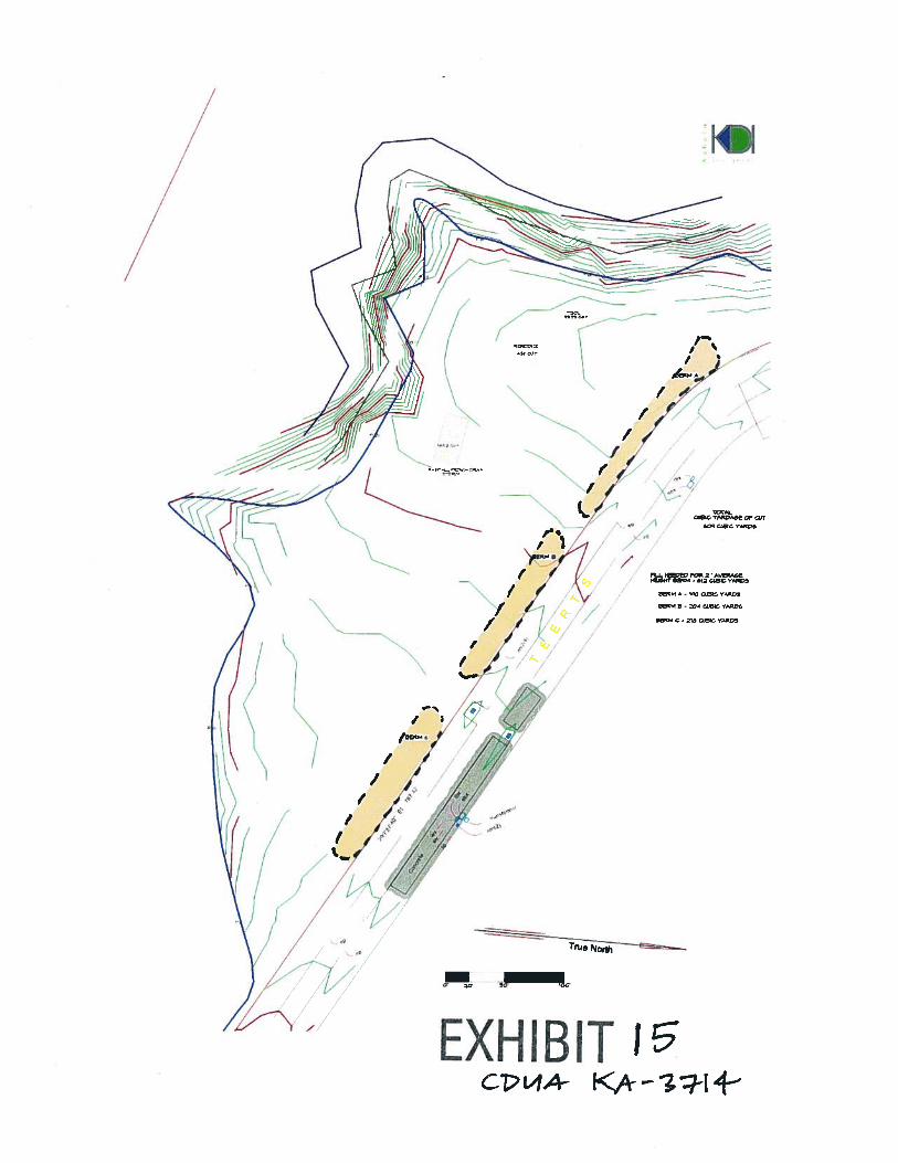
EXHIBIT I’
—-
//
/2
Ifl D- 612 GI.
26RM * - TV *1)81* Y4p5
33-21)4 C1231*1YMW33
585)4 *1 - 218 COSTS V1)IWS
Ct,L4A-
rn><ZL
I
Renderings of Proposed Dwelling Viewed from Kapaka Street (View from South)
Il-I
><
+
S
+
cI
0
F
I
><L1i
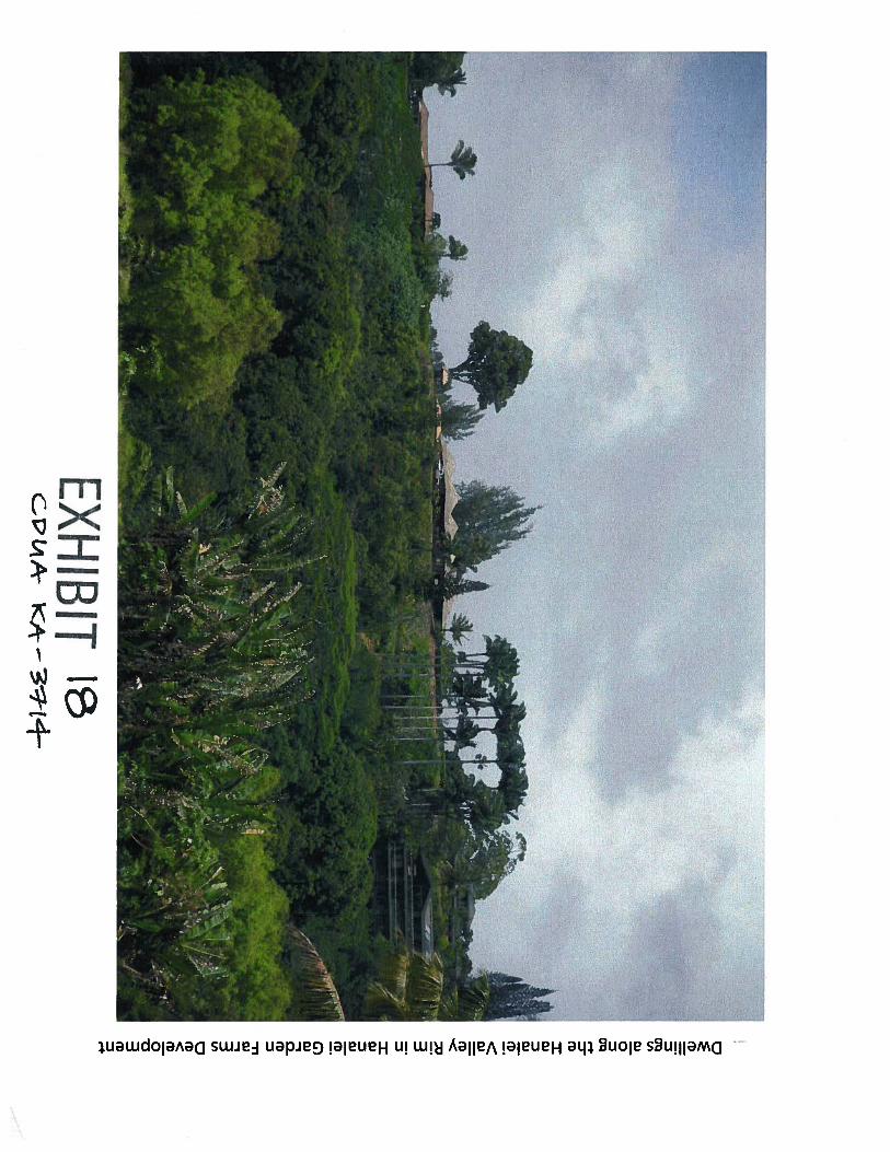
DwellingsalongtheHanaleiValleyRiminHanaleiGardenFarmsDevelopment
tflk
>LU
N
•
;••
N?