starkweather creek watershed - the nelson institute · ii | starkweather creek watershed a note...
TRANSCRIPT

Water Resources Management Practicum 2005Nelson Institute for Environmental StudiesUniversity of Wisconsin–Madison
Cover art by Water Resources Management Practicum 2005.
Stark
weath
er Creek
Watersh
ed U
W–W
ater Reso
urces M
an
agemen
t Practicu
m |
2006
Starkweather Creek Watershed:Current Conditions and Improvement Strategies in an Urban Context
2006


Water Resources Management Practicum 2005Nelson Institute for Environmental StudiesUniversity of Wisconsin–Madison
Starkweather Creek Watershed:
Current Conditions and Improvement Strategies in an Urban Context
2006

ii | Starkweather Creek Watershed
A note about Web sites
All URLs in this document were current at the time of publication.
An Equal Educational Opportunity Institution (Title VI, Title IX)
In conformance with applicable federal and state law and with university policy, the University of Wisconsin-Madison does not discriminate on the basis of age, race, color, religion, sex, national origin or ancestry, sexual orientation, arrest or conviction record, marital status, handicap, political affi liation, or veteran’s status with regard to treatment of employees and students in its educational programs or activities. Inquiries concerning this policy may be directed to appropriate campus admitting or employing units or to the Equity and Diversity Resource Center, 179A Bascom Hall, 608/263-2378. Disabled persons should contact the McBurney Disability Resource Center, 905 University Avenue, 608/263-2741 (voice/TDD), for information and referral.
The Water Resources Management Practicum is a regular part of the cur-riculum of the Water Resources Management (WRM) Graduate Program at the University of Wisconsin-Madison. The workshop involves an interdisci-plinary team of faculty members and graduate students in the analysis of a contemporary water resources problem.
The conclusions and recommendations are those of the graduate student authors and do not necessarily refl ect the offi cial views or policies of any of the cooperating agencies or organizations, nor does the mention of any trade names, commercial products, or companies constitute endorsement or recom-mendation for use.
For more information, contact:
Nelson Institute for Environmental Studies Public Information Offi ce 30A Science Hall 550 North Park Street Madison, Wisconsin 53706
✆ 608/263-5599 www.nelson.wisc.edu
This publication is available online at: www.nelson.wisc.edu/wrm/workshops/2005.

Water Resources Management Practicum 2005 | iii
PREFACE XI
EXECUTIVE SUMMARY 1
1: INTRODUCTION 7
The Yahara Chain of Lakes 7
Starkweather Creek Watershed 7Post-Settlement History 9
Causes of Degradation 9
The Impact of Urbanization 10
Current Conditions 11
Management of the Starkweather Creek Watershed 12
Management Plans 12
Stakeholders 13
Areas of Study 15
References 16
2: STREAM CORRIDOR 19
Stream Corridor Survey 19
Stormwater Runoff 24
Mitigating Excessive Runoff Volumes 27
Pervious Surfaces 27
Low Impact Design 28
Chemical Inputs 28
Nutrient Inputs 29
Mitigating Chemical and Nutrient Inputs 30
Riparian Buffers 30
Daylighting Stormsewers 31
Streambanks 32
Channelization 32
Hard Armoring 33
Riprap 35
Metal Armoring 35
Bioengineering 36
Terracing 36
Combination of Stabilization Techniques 37
Vegetation Survey of Riparian Areas 37

iv | Starkweather Creek Watershed
Riparian Vegetation Priority Sites 39
Future Approach to Riparian Vegetation 41
Eastmorland Park Case Study 41
Site Analysis 42
Site Inventory 42
Opportunities and Constraints 44
Stakeholders 45
Conceptual Design 46
Goal 1: Stormwater Management 46
Goal 2: Recreational Area 49
Goal 3: Management and Maintenance Plan 50
Goal 4: Stakeholder Inclusion 50
References 50
3: BASEFLOW 53
Decrease of Basefl ow 53
Basefl ow Conditions 53
Infi ltration Assessment and Opportunities 58
Locating Potential Recharge Areas 58
Siting Locations for Infi ltration Facilities 58
Infi ltration Modeling 61
Watershed Analysis 61
Small Watershed Analysis 65
Single Parcel Evaluation 67
Recommendations 68
Groundwater Assessment 69
Model Design 69
Recharge Simulations 70
Groundwater Pumping Simulations 71
Combined Recharge and Pumping Simulations 73
Treated Effl uent Discharge 75
Benefi ts of treated effl uent in Starkweather Creek 77
Treated effl uent and Badger Mill Creek 77
Potential Considerations 78
Lake Monona and Phosphorus Loading Limitations 79
Management and Recommendations 79
References 80

Water Resources Management Practicum 2005 | v
4: WETLANDS 83
Urban Wetlands: A Delicate Balance 83
Watershed Development from a Wetland Perspective 85
Historical Perspective and Current Issues 85
Challenges for Mitigation and Restoration of Urban Wetlands 86
Inventory of Existing Wetland Area 91
Distribution and Extent 91
Qualitative Description of Wetlands 91
Confl uence 91
West Branch 92
East Branch 92
Isolated 93
Restoration Strategy and Management Proposals for Priority Wetlands 94
Site Selection 94
Wal-Mart Wetlands 95
Acewood Pond 96
Lien Marsh 96
Physical Setting 97
Current Status of Lien Marsh 105
Restoration Recommendations 105
Integration of the Wetlands Study into the Watershed Perspective 109
References 109
5: EDUCATIONAL OUTREACH 113Importance of Public Awareness 113
Existing Education Plans and Outreach 113
Education Plans 113
Starkweather Creek Reports 113
Yahara-Monona Priority Watershed Plan 114
Joint Stormwater Permit Group Information and Education Plan 114
Outreach Programs 115
State 115
County 115
Madison Metropolitan Area 116
Citizen and Community Groups 116
The Need For An Education Plan 117
Action Points to Achieve Objectives 118
Infi ltration Campaign 118
Rain Barrels 119

vi | Starkweather Creek Watershed
Bringing Rain Barrels to Starkweather Creek Watershed 119
Rain Barrel Action Points 121
Rain Gardens 121
Rain Garden Action Plan 122
Infi ltration Campaign Funding 126
North Platte Campaign 127
Site Analysis 127
Physical Structures 129
Previously Studied Site Conditions 129
Environmental Conditions 129
Stakeholders 131Opportunities and Constraints 131Conceptual Plan 132
Vision and Conceptual Design Goals 132
Precedence 132
Features of the Conceptual Plan 132
Need for Funding and Fiscal Analysis 141
Stakeholder Involvement 141
Citizen Stewardship Campaign 142
Purpose 142
Product 142
Distribution 142
Potential Use and Extensions of Map and Text 143
References 143
APPENDIXES
A. Studies and Plans Relevant to Starkweather Creek 147
B. Water-Quality Testing Procedures 149
C. Geographic Information System for Starkweather Creek 155
D. Lien Marsh Data and MG&E Marsh Plant List 167
E. Local Schools and Funding Opportunites 171
F. North Platte Site Conditions 177
FIGURES
1-1. Map of Wisconsin watersheds; inset shows Starkweather Creek watershed and surrounding areas 8
1-2. Chart showing land use within the Starkweather Creek watershed 9
1-3. Algae growth in Starkweather Creek 11
2-1. Schematic showing the stream corridor defi nitions 19

Water Resources Management Practicum 2005 | vii
2-2. Stream corridor reaches and their lengths 21
2-3. Location of priority sites identifi ed in Starkweather Creek watershed 23
2-4. Priority site O-3, an example of an outlet with erosion problems due to high runoff vol-umes 26
2-5. Streambank materials in Starkweather Creek 34
2-6. Eight-foot deep scour hole by a culvert in reach 8 of the West Branch 35
2-7. Corrugated steel piling sheets serving as armor on the lower West Branch 35
2-8. Incisions in streambanks where bioengineering methods are recommended 37
2-9. Lawn touching the creek by a commercial lot 41
2-10. Current layout of Eastmorland Park 42
2-11. Eastmorland Park fl ooding after a large rain event 43
2-12. Proposed conceptual plan of Eastmorland Park 47
2-13. Cross section A–A‘, showing current channel and proposed fl oodplain 48
3-1. The hydrologic cycle and the effect of urbanization on a watershed 54
3-2. Historic and current springs within the Starkweather Creek watershed 56
3-3. Bioretention facility 57
3-4. Location of recharge areas within the Starkweather Creek watershed 59
3-5. Site evaluation for infi ltration facilities 61
3-6. Locations of publicly owned parcels in relation to recharge areas 62
3-7. Annual water budgets of current and predevelopment conditions 65
3-8. Rolling Meadows subwatershed 66
3-9. Land-use and runoff contributions for current conditions in RollingMeadows 67
3-10. Impacts of rain gardens to runoff and stay-on depths 67
3-11. Annual runoff reductions of an average single family house with rain gardens 68
3-12. Locations of high capacity municipal wells in Starkweather Creek watershed 70
3-13. Simulated current groundwater levels in Starkweather Creek watershed 72
3-14. Simulated groundwater levels in Starkweather Creek watershed 74
3-15. Yahara River system and the groundwater pumping wells in the Madison Metropolitan Sewerage District service area 76
4-1. Extent of wetlands loss within Starkweather Creek watershed 84
4-2. The open-water wetland of Acewood Pond 94
4-3. Wal-Mart complex wetland showing the four distinct management units 95
4-4. Overview map of the Lien Marsh Complex and environmental corridor 97
4-5. Overview of the Lien Marsh complex 99
4-6. A seepage outlet on the creek bank in early spring 100
4-7. Lien Marsh complex overlain with vegetation communities 103
4-8. Ecological units within the Lien Marsh wetland complex 104

viii | Starkweather Creek Watershed
5-1. Rain barrel 120
5-2. Residential rain garden displayed on the 2005 Better Lawns and Gutter Tour 122
5-3. Location of the North Platte in relation to Olbrich Botanical Gardens and Starkweather Creek 128
5-4. North Platte conceptual plan 130
5-5. North Platte context map 138
5-6. Perspective illustration of the North Platte 140
B-1. SPMD sampling sites 150
B-2. Results from the Microtox test showing relative toxicity between the sites, set 1 150
B-3. Results from the Microtox test showing relative toxicity between the sites, set 2 150
C-1. New layers generated as a result of this study 156
C-2. Modifi cations to land-use data 158
C-3. Subsoil texture 160
C-4. Substratum soil permeability 161
C-5. Bedrock depth and high permeability locations 162
C-6. Digital elevation model 163
C-7. Generation of depth to water-table layer 164
D-1 TO D-6. Water-table data for Lien Marsh 167
TABLES
2-1. Qualitative and quantitative analysis of the stream corridor of Starkweather Creek, by reaches 22
2-2. Priority sites: Streambanks and channel erosion 24
2-3. Priority sites: Outfalls, erosion, and scouring 25
2-4. Priority sites: Riparian vegetation 26
2-5. A few of the chemicals found in Starkweather Creek and some of their common uses 29
3-1. Wisconsin Department of Natural Resources standards for site evaluation for stormwater infi ltration 60
3-2. Modeled basefl ow in both branches of Starkweather Creek under current pumping rates and variable recharge scenarios 71
3-3. Basefl ow conditions generated by different pumping scenarios 75
B-1. Exact locations of SPMD deployment 151
B-2. Chemicals that were found in Starkweather Creek in higher concentrations relative to the concentrations found in the control sample 153
B-3. Organic compounds found in Starkweather Creek 154
C-1. Accepted fi les integrated into the Starkweather Creek geographic information system 157
C-2. List of GIS layers used in recharge areas analysis 159
C-3. Permeability classes 165

Water Resources Management Practicum 2005 | ix
C-4. Categories for water-table depth 165
C-5. Categories for recharge potential 165
C-6. Input data for watershed analysis 166
D-1. Plant species list in MG&E Marsh 168
D-2. Physical and chemical parameters tested in Lien Marsh 169
E-1. Schools located within Starkweather Creek watershed 171
E-2. State funding opportunities for infi ltration campaigns 172
E-3. Federal funding opportunities for infi ltration campaigns 173
E-4. Local funding opportunities for infi ltration campaigns 175


Water Resources Management Practicum 2005 | xi
PREFACE
The Water Resources Management (WRM) Practicum is a primary requirement for a WRM Master of Science degree in the Nelson Institute for Environmental Studies at
the University of Wisconsin–Madison. The practicum consists of a two-credit planning seminar during the spring semester and a fi ve-credit fi eld seminar during the summer semester. During the 2005 practicum, 15 students specializing in a variety of areas re-lated to water resources worked closely with university faculty, governmental organiza-tions, nonprofi t organizations, and citizen groups to identify watershed-enhancement opportunities in the Starkweather Creek watershed.
The WRM Practicum 2005 was funded by the Friends of Starkweather Creek, a nonprof-it organization based in Madison committed to rehabilitating the Starkweather Creek watershed. Funding was also provided by the City of Madison Engineering Division and the Town of Blooming Grove due to interest in improving the quality of the Stark-weather Creek watershed, a major urban watershed in Madison. This project was con-ducted under the direction of university faculty, the City of Madison, and the Friends of Starkweather Creek.
GOALS FOR THE WRM PRACTICUM 2005
The goals of the WRM Practicum for 2005 were to identify enhancement opportunities for the Starkweather Creek watershed in the following areas:
• riparian and streambank rehabilitation/stabilization and water quality,
• infi ltration and basefl ow,
• wetland restoration,
• community outreach/education, and
• Starkweather Creek watershed geographic information system.
PARTICIPANTS IN THE WRM PRACTICUM 2005Liz Albertson, Eva Chan, Jon Edmonson, Andrea Finch, Katharina Freydank, Steve Koska, Tanya Meyer, Heidi Moltz, Ben Montgomery, Crystal Najera, Laura Rozumalski, Sam Schultz, Sigurdur Sigmarsson, and Liz Woodcock.
Additional graduate student participant: Amanda Bell, UW-Stevens Point
Nelson Institute for Environmental Studies Faculty Advisor for the WRM Practicum 2005: Kenneth W. Potter

xii | Starkweather Creek Watershed
ACKNOWLEDGMENTS
The participants of WRM Practicum 2005 acknowledge the following for their contribu-tions:
The City of Madison and the Town of Blooming Grove for generously funding this work, and the Friends of Starkweather Creek for their efforts in gaining support for this practicum and for their dedication to the health of Starkweather Creek.
John Attig (Wisconsin Geological and Natural History Survey)
Jean Bahr (University of Wisconsin–Madison, Department of Geology and Geophysics)
Roger Bannerman (Wisconsin Department of Natural Resources)
Cheryl Bauer-Armstrong (University of Wisconsin–Madison, Arboretum)
David Benschawel (City of Madison, Engineering Division)
Genesis Bichanich (City of Madison, Engineering Division)
Quentin Carpenter (University of Wisconsin–Madison, Nelson Institute for Environmental Studies)
Lee Clayton (Wisconsin Geological and Natural History Survey)
Michael Czechanski (Wisconsin Geological and Natural History Survey)
Ann Dansart (Friends of Starkweather Creek)
Daniel DeGrush (University of Wisconsin–Madison, Landscape Architecture undergraduate student)
Linda Ferkey (University of Wisconsin–Madison, Engineering graduate student)
Greg Fries (City of Madison, Engineering Division)
Stephen Gaffi eld (Friends of Starkweather Creek)
Ken Genskow (University of Wisconsin–Extension, Wisconsin Basin Education Initiative)
Steven Goodbred (U.S. Geological Survey)
Bret Hagemeyer (Friends of Starkweather Creek)
Russ Hefty (City of Madison, Parks Division)
Judy Horwatich (U.S. Geological Survey)
Fred Iausly (Dane County, Land Information Offi ce)
Kara Jensen (University of Wisconsin–Madison, Water Resources Management graduate student)
Michael Kakuska (Dane County Community Analysis and Planning Division, formerly of Regional Planning Commission)
Jen Koehler (University of Wisconsin–Madison, former Water Resources Management graduate student)
Eve Komosa (Olbrich Botanical Gardens)
James Krohelski (U.S. Geological Survey)
James LaGro (University of Wisconsin–Madison, Department of Urban and Regional Planning)
Richard Lathrop (University of Wisconsin–Madison, Center for Limnology)

Water Resources Management Practicum 2005 | xiii
James Lorman (Friends of Lake Wingra and Edgewood College)
Larry Palm (Madison District 15 Alder)
Ryan Pieters (Wisconsin State Laboratory of Hygiene)
Nancy Ragland (Olbrich Botanical Gardens)
Michael Rothbart (Friends of Starkweather Creek)
Peter Schoephoester (Wisconsin Geological and Natural History Survey)
John Steines (Friends of Starkweather Creek)
Cindy Stiles (University of Wisconsin–Madison, Department of Soil Science)
David Taylor (Madison Metropolitan Sewerage District)
Scott Taylor (Friends of Starkweather Creek)
Stephen Ventura (University of Wisconsin–Madison, Department of Soil Science)
Joy Zedler (University of Wisconsin–Madison, Department of Botany)


EXECUTIVE SUMMARY
The Starkweather Creek watershed is a 24-square-mile basin in east-central Dane County it encompasses parts of the City of Madison and the Towns of Burke and
Blooming Grove. Starkweather Creek consists of two branches that total nearly 20 miles in length. The headwaters of the West Branch of the creek originate northeast of Inter-state 90–94 near Token Creek County Park; the East Branch originates east of Interstate 90–94 approximately four miles southwest of the City of Sun Prairie. The two branches of Starkweather Creek eventually converge near Olbrich Botanical Gardens in Madison and empty into the eastern end of Lake Monona. The basin is part of the Yahara River–Lake Monona Watershed, which is part of the larger Rock River Watershed that drains parts of eleven southeastern Wisconsin counties, including much of Dane County.
Prior to settlement of the area by European immigrants, the Starkweather Creek wa-tershed consisted of a mix of oak savannah, prairie, and nearly 4,000 acres of wetlands. During this time, the wetlands were more connected than they are today; the connec-tions helped maintain the discharge of the creek at what has been estimated at approx-imtely 5 cubic feet per second. Shortly after their arrival, settlers began channelizing the creek and constructing ditches to improve the drainage of the low-lying areas to increase their farmable acreage. As land development increased, much of the low-ly-ing areas within the watershed were fi lled to allow for proper building sites. Today, land use within the watershed is a mix of residential, commercial, industrial, and agri-cultural development that has signifi cantly affected the hydrology and ecology of the watershed. Current population growth in the Madison area is expected to continue at or above the current pace; as a result, there will likely be increasing pressure placed on the watershed’s ecosystems. Polluted runoff, fl ooding, erosion to the creek from stormwater discharge, and municipal groundwater pumping threaten the health of the various eco-systems that depend on the creek. Without a concerted effort to mitigate groundwater withdrawals and to increase infi ltration within the watershed, basefl ow in Starkweather Creek is expected to continue to fall, eventually dropping below 1 cubic foot per second and making stretches of the creek stagnant except during fl ood events.
Urban watersheds present unique restoration challenges because of the competing land uses and converging municipal boundaries that can exist within them. The goal of the Water Resources Management (WRM) Practicum 2005 was to identify enhancement op-portunities within the Starkweather Creek watershed for wetland restoration, infi ltra-tion, and basefl ow improvements to the creek, riparian and streambank rehabilitation or stabilization, water-quality enhancements for streams, and community outreach and education programs that increase awareness of the interconnectedness of the ecosystems within the watershed and between watersheds in the Madison area. Additionally, the WRM Practicum 2005 is providing data for a Starkweather Creek watershed geographic information system that can be used as a tool for future restoration work in the water-shed.

2 | Starkweather Creek Watershed
RUNOFF AND STREAM CORRIDOR
Urbanization within the watershed has increased stormwater runoff entering the creek. The creek has long periods of stagnation interspersed with short, high velocity fl ood events. These fl oods events create erosion problems throughout the creek and fl ush con-taminants, sediments, and trash into the creek. In an attempt to combat channel erosion in the lower reaches of the creek, the streambanks have been stabilized with materials such as riprap and steel piling, in many cases disassociating the channel from the ripar-ian zones and creating safety hazards for the community. Agricultural fi elds are near the upper reaches of the creek, and in most cases riparian buffers between the creek and the fi elds are inadequate.
In an attempt to improve the stream corridor, runoff and water-quality conditions with-in the creek, we focused on several watershed issues.
• Stormwater runoff control within the watershed must be a high priority. Low impact design in urban development and use of pervious surfaces are ways to reduce excess runoff volumes in the increasingly urban watershed.
• Different techniques for bank stabilization are currently in use or that could be put into practice. Also areas of special concern within the stream channel are identifi ed.
• To gain a quantitative understanding of Starkweather Creek’s water quality, we deployed semi-permeable membrane devices. We found areas of special concern within the creek.
• We conducted a vegetation survey and analyzed the results to determine how habitat within the creek corridor could be improved.
• Eastmorland Park was selected as a case study for a detailed analysis and con-cept design for riparian enhancement. The design contains a preliminary site analysis as well as opportunities and constraints based upon the site analysis.
• From the stream corridor and vegetation surveys, we identifi ed 19 sites as prior-ity sites—their conditions are highly problematic and in need of prompt atten-tion.
BASEFLOW
Springs have historically been a major contributor to the basefl ow of Starkweather Creek; however, many of the springs within the watershed have disappeared or are now discharging at reduced rates. Declining basefl ow in the creek is directly related to diminished recharge due to increased impervious surfaces in the watershed and groundwater pumping for municipal uses. In addition, water removed from the aquifer via groundwater pumping is not returned to the watershed after use and treatment, but is instead discharged to Badfi sh Creek south of Madison. Aquatic life and recreational

Water Resources Management Practicum 2005 | 3
qualities within the in the creek suffer as a result of low basefl ow and its associated con-ditions.
To determine ways to improve aquatic life, recreational opportunities, and ecosystem health within the watershed, we analyzed the watershed in regard to the following hy-drologic components:
• We used a geographic information system to determine locations for large-scale recharge operations to return stormwater to the aquifer. We used hydrologic simulation models to assess widescale implementation of infi ltration practices. The results showed that despite the potential improvements in runoff reduction and water quality, the application of conventional infi ltration practices in the wa-tershed will not have a signifi cant effect on recharge rates unless more extensive street infi ltration takes place. However, modeling did demonstrate that the im-pact on a smaller geographic scale can be quite signifi cant.
• Groundwater modeling was conducted to gain a greater understanding of the effects that groundwater pumping has on the watershed. Results indicated that groundwater pumping is the most signifi cant factor affecting basefl ow. Coupling modifi cations in groundwater pumping with increasing recharge opportunities within the watershed could provide the most realistic, natural mechanism to re-turn basefl ow to acceptable levels.
• Releasing treated effl uent to the creek may be the most feasible method to aid in enhancement of the watershed’s hydrologic regime.
WETLANDS
At present, the Starkweather Creek watershed contains 900 acres of wetlands, which is less than one-quarter of the presettlement wetland acreage. Wetlands serve multiple purposes in an urban landscape. They are important habitat for a diversity of plant and animal species; they act as breeding grounds, nurseries, feeding areas, and travel cor-ridors. Wetlands also have the potential to help mitigate urban runoff. They are able to slowly release stored water to rivers, lakes, and streams after storm events and are also able to absorb nutrients, pollutants, and sediments, fi ltering these materials from stormwater before it enters rivers and lakes. Urban wetlands also provide important op-portunities for recreation and education.
We selected ten major wetland complexes within the watershed for analysis: three along the West Branch, four along the East Branch, one at the confl uence of the two branches, and two isolated wetlands in the southern part of the watershed. The wetland located south of Lien Road, referred to as Lien Marsh, is one of the largest and most ecologi-cally diverse wetlands in the watershed and holds the greatest promise for restoration because of its size, diversity of plant life, and because much of the property is owned by the city of Madison. This complex is also home to a calcareous fen; such fens have been classifi ed by state statute as areas of special natural resource interest. Our restoration

4 | Starkweather Creek Watershed
plan for Lien Marsh includes subdividing the area into fi ve ecological units with indi-vidual management strategies: a fen area, a stormwater wetland, a wet prairie, the creek corridor, and the marsh area east of the creek.
EDUCATIONAL OUTREACH
Although a number of environmental education programs and plans exist for the greater Madison area, none of the plans were designed specifi cally with Starkweather Creek in mind and, as a result, do not include specifi c educational goals, objectives, or campaigns unique to this urban watershed. Therefore, it is important to develop an education plan specifi cally for the watershed based upon the objectives and goals generated from stake-holders residing within the Starkweather Creek watershed.
We offer the following campaign recommendations:
• Infi ltration campaign. Municipal groundwater pumping and reduced infi ltration are the two largest contributors to the low basefl ow and resulting poor water-quality conditions of Starkweather Creek. To address these impacts, an ideal education campaign would motivate the Starkweather Creek watershed com-munity to conserve water and reduce stormwater runoff using rain barrels and rain gardens. We recommend a rain-barrel campaign that focuses on encouraging homeowners to understand stormwater issues, conserve water, and gain a greater appreciation for the watershed. We also recommend rain-garden campaigns, which would extend beyond home owners to larger audiences: schools, busi-nesses, and places of worship.
• North Platte conceptual plan. As planning of the North Platte (next to Olbrich Bo-tanical Gardens and the Starkweather Creek confl uence) unfolds, a unique op-portunity for providing substantial watershed education about human impacts upon the landscape is presented. Therefore, we recommend developing the North Platte of Olbrich Botanical Gardens as an educational tool to promote watershed awareness, illustrate the historical pattern of watershed degradation in Madison, enhance the community value of the area, and to allow citizens to experience restoration efforts in their community. Our comprehensive conceptual plan can provide a framework for future dialogue on the development of the North Platte.
• Citizen stewardship map. We created a map of the Starkweather Creek watershed that illustrates some of the key attributes of the watershed as a tool to spearhead a citizen stewardship campaign. Accompanying text discusses highlights and problems facing the watershed, and gives ideas to citizens wishing to take action.
GEOGRAPHIC INFORMATION SYSTEM
We used a geographic information system (GIS) to enhance our ability to assess the cur-rent conditions of the Starkweather Creek watershed and provide a data resource for future analysis. We also collected and catalogued relevant GIS data for the Starkweather

Water Resources Management Practicum 2005 | 5
Creek watershed and organized the data with a simple to use and freely available GIS application, ArcReader. The individual data layers as well as the Starkweather GIS are available on CD-ROM. The CD-ROM can be found on the back jacket of the hard copy of this report or is available for download from the WRM Practicum 2005 section of the Nelson Institute for Environmental Studies Web site: www.nelson.wisc.edu/wrm/workshops/2005.


Water Resources Management Practicum 2005 | 7
INTRODUCTION
THE YAHARA CHAIN OF LAKES
Madison, Wisconsin, is home to aesthetically and recreationally pleasing diverse landscapes. One of the region’s most prominent natural features is the Yahara
chain of lakes, including the lakes of Mendota, Monona, Waubesa, Kegonsa, and Wingra. These interconnected lakes provide locals and visitors with an important and distinct sense of place within Madison. Many of the region’s trademarks, such as the Isthmus, Memorial Union Terrace, Monona Terrace, Picnic Point, and numerous city parks owe their existence and uniqueness to the lakes.
For well over a century, the residents of Wisconsin’s capital have embraced the Yahara Lakes as a means of industry, commerce, and recreation. As a result, the residents and institutions of the Madison area have taken active roles in the preservation of the lakes for future generations. These actions include legislation, citywide mandates and action programs, and a variety of citizen-based volunteer efforts. However, a stroll along any lakefront path or a leisurely paddle on Lake Monona or Mendota will quickly prove that despite a Herculean effort put forth by many parties, the lakes continue to be plagued by a variety of ecological problems. Years of limnological research by numerous dedicated professionals have helped make the Yahara chain of lakes one of the most studied sys-tems in the world. In spite of this vast knowledge base, eutrophication problems, such as algae blooms and high bacterial concentrations, continue to affl ict the lakes, negatively affecting aquatic life, causing odor issues, and leading to numerous beach closures.
The reasons for the ecological problems within the Yahara Lakes are many. To continue working toward healthier lakes, the sources of the problems must be identifi ed and at-tacked. Tackling the pollution and degradation problems of large water bodies can never be accomplished in isolation. Recently, much attention has been focused on the smaller, less prominent watersheds that feed the large, urban water bodies. In terms of Madison, such an approach would involve taking a step back from Lake Monona, the picturesque lake that dominates the city’s southern landscape, and refocusing attention on the Stark-weather Creek watershed, Madison’s largest watershed and a leading contributor to Lake Monona.
STARKWEATHER CREEK WATERSHED
The Starkweather Creek watershed encompasses most of Madison’s east side and also includes sections of the Towns of Burke and Blooming Grove (fi g. 1.1). The watershed covers an area of more than 24 square miles and drains into Starkweather Creek, which traverses the watershed and is 20 miles long. Starkweather Creek has two branches: The West Branch is 15 miles long, and the East Branch, nearly fi ve. The two branches con-
1

8 | Starkweather Creek Watershed
verge, and the creek fl ows south approxi-mately 0.5 mile be-fore discharging into Lake Monona.
Land use within the Starkweather Creek watershed is highly urbanized (fi g. 1-2). Agricultural land use dominates the northern reaches of the watershed, but industrial, commer-cial, and residential development become increasingly com-mon in the southerly direction. The West Branch transects the Dane County Region-al Airport and Inter-state 90–94 crosses the northern part of the watershed.
Dane County and the City of Madison con-tinue to experience rapid population growth. In 2003 Dane County’s population reached 445,253 and is expected to sur-pass 525,000 by 2020, an increase of almost
18 percent (Dane County Regional Planning Commission, 2004). Due to urban sprawl, much of the population growth is expected to occur in rural areas that are currently dominated by agriculture. As populations continue to grow, the Starkweather Creek watershed will continue losing its remaining rural landscapes in exchange for urban de-velopment. Without intervention, the future health of Starkweather Creek watershed is in severe jeopardy. It is imperative to act quickly and decisively to protect, enhance, and restore the watershed for present and future generations.
0 2 41Miles
Sources: DNR, ESRI, Dane County
StarkweatherCreek
Watershed
0 20 40 60 8010Miles
City of
Madison
Major WatershedsSub-Watersheds Dane County
W I S C O N S I N
MinnesotaIowa
Ill inois
Lake Michigan
Lake Superior
¯Figure 1-1. Map of Wisconsin watersheds; inset shows Starkweather Creek watershed and surrounding areas.

Water Resources Management Practicum 2005 | 9
POST-SETTLEMENT HISTORY
Some of the earliest inhabitants of the Starkweather Creek watershed were Native Americans of the Woodland Tradition. They lived in villages, practiced agriculture, and built effi gy mounds. In fact, the Madison area is home to more effi gy mounds than any-where else in the country (Mollenhoff, 2003). Recent researchers have concluded that these early Native Americans of the mound-building tradition are ancestors of the more modern Wisconsin tribes such as the Winnebago (Ho-Chunk). The Winnebago would eventually dominate the Madison area, with major settlements scattered along the banks of Lakes Mendota and Monona. There, the Winnebago were engaged in rice harvesting, fi shing, and the farming of watermelons, tobacco, potatoes, squash, and corn. This was the scene that European settlers and retreating Native American tribes from the eastern United States encountered as they moved west into present-day Madison (Mollenhoff, 2003).
Early European settlers referred to the area encompass-ing Starkweather Creek watershed as the Four Lakes. This colloquialism, still used today, demonstrates the importance that water has played in shaping the human development of Dane County. Although at present the watershed encompasses 25 City of Madison neighbor-hoods as well as land within the Towns of Burke and Blooming Grove, the watershed had rather modest be-ginnings. Public land survey records from 1834 represent minimal to no human alteration of Starkweather Creek (Lyon, 2005). However, in less than ten years, records of sawmill and dam construction on the creek were re-corded (Dane County Regional Planning Commission, 1983). Although wetlands and marshes dominated the
landscape, this rapidly changed with the infl uence of large-scale agricultural practices. The fi rst instance of wetland drainage in the watershed was recorded by 1858 (Dane County Regional Planning Commission, 1983). As farmers continued to settle, drainage increased. This shift to an agricultural land use with increased water demands prompted signifi cant change in the natural stream channel. Soon the stream channel was straight-ened, altering the hydrologic regime of the watershed (Mollenhoff, 2003). Development of the watershed continued with expansions in commercial, residential, and industrial development, helping lead to the current degraded state of the creek today.
CAUSES OF DEGRADATION
Starkweather Creek has been severely impacted by urbanization. The watershed, once dominated by wetlands, has been modifi ed by urbanization so that now 33.5 percent of the watershed is considered impervious cover. According to the impervious cover model developed by the Center for Watershed Protection (2004), Starkweather Creek is desig-nated as a non-supporting stream that can no longer sustain its designated uses. Accord-
Figure 1-2. Chart showing land use within the Starkweather Creek watershed (from Dane County Land Information Offi ce, 2000).

10 | Starkweather Creek Watershed
ing to the model, non-supporting streams with impervious cover of 25 to 40 percent are characterized by highly eroded stream channels and poor water quality. Such streams show promise for partial restoration, but are so altered that they cannot be restored to predevelopment conditions (Center for Watershed Protection, 2004).
Three main characteristics of urbanization have infl uenced Starkweather Creek’s deg-radation. First, pollution associated with urban development has caused water-qual-ity problems within the creek. Second, increased urban development in the watershed coupled with poor stormwater management causes severe fl ooding events and erosion within the creek. Third, continuous increases in groundwater pumping for municipal use have lowered the water table within the watershed, causing lower dry-weather fl ows in the creek. Taken together, these factors have impacted much of the original wet-land ecology, stream stability, water quality, and water quantity, resulting in the present conditions of the creek and its watershed.
THE IMPACT OF URBANIZATION
When the watershed was fi rst urbanized, the creek was used to convey polluted water from industrial as well as residential areas. Although discharge of sewage and industrial waste into Starkweather Creek is no longer taking place, organic contaminants can still be found in the creek. The Dane County Regional Airport, which composes 19 percent of the total watershed area, has impacted the quality of the creek as well. Pollution from extensive petroleum usage, deicing agents, and airplane maintenance throughout the twentieth century has severely increased degradation of the creek (Dane County Region-al Planning Commission, 1983). However, industry is not the only source of pollution within the creek. Trash and garbage litter the creek, providing the most visible indicator of the creek’s urbanization.
An increase in the amount of impervious surfaces is one of the main results of urbaniza-tion. Impervious surfaces are ground surfaces that do not allow precipitation to pene-trate. Unlike native landscapes—such as grasslands, woodlots, and wetlands—impervi-ous surfaces—such as concrete driveways, paved streets, and parking lots—do not allow rainwater to percolate through and reach the groundwater below. Decreased infi ltration of rainwater into the ground decreases recharge of groundwater aquifers. In addition, runoff following storm events increases considerably when water is unable to infi ltrate into the ground, resulting in fl ash fl oods.
Past stormwater-management practices in the watershed focused on conveying the water as fast as possible downstream. To move as much water as possible, natural me-anders within the creek were removed and the creek was straightened and dredged, a practice known as channelization.
Constant fl ow in the stream during dry periods, termed basefl ow, is derived from springs within the watershed. As the population within the watershed grew, so too did demands for water. Constant increases in groundwater pumping via high capacity wells in and around the watershed have caused the water table in the watershed to decrease

Water Resources Management Practicum 2005 | 11
signifi cantly. Because of that, springs in the watershed have disappeared or decreased in size, leading to less basefl ow in both branches of Starkweather Creek.
CURRENT CONDITIONS
Decreases in basefl ow have re-sulted in low fl ow rates and have had severe ecological impacts within the watershed. Because of low gradients in the creek, the
water in the creek can be stagnant, creating favorable conditions for algae growth. With the decay of algae and benthic macrophytes, oxygen can become depleted, making it dif-fi cult for diverse ecosystems to exist (fi g. 1-3). Low fl ows and gradients in the creek also cause the buildup of contaminants as they settle out into the sediments of the creek. This buildup further degrades aquatic habitats.
Development within the watershed has led to the destruction of most of the original wetlands. These wetlands, in many cases deemed “unnecessary” and “useless” have been replaced with residential, industrial, and commercial development and agricul-tural fi elds. The loss of wetlands causes a number of other problems. Because wetlands provide important habitat for a wide variety of fl ora and fauna, many native species have declined signifi cantly. In addition, wetlands function to clean many environmental systems. The loss of wetlands has compounded the water-quality problems within the watershed. Small, geographically isolated wetlands still exist within the watershed, al-though many have been severely degraded. Invasive species, such as reed canary grass (Phalaris arundinacea), have taken over large tracts of these wetlands. Channelization and riparian encroachment have further isolated these wetlands.
Riparian areas, the buffers between land and aquatic habitat, create important habitats for terrestrial and aquatic wildlife, stabilize streambanks, and improve stream water quality. The increase in fl ooding, due to impervious surfaces and associated stormwater runoff, creates the necessity of armoring streambanks to prevent erosion. Riprap and metal pilings have been used for bank stabilization in the lower reaches of the stream. Stream-bank armoring has caused discontinuity between the streambed, fl oodplains, and adjacent riparian areas. Armoring has also allowed development closer to the stream, thereby encroaching on the area available for riparian buffers. Erosion within the stream has been severe in the areas where no armoring has been implemented, most no-
Figure 1-3. Algae growth in Stark-weather Creek.

12 | Starkweather Creek Watershed
tably the upper reaches of both branches. Taken as a whole, the changes in the riparian areas within the watershed have caused habitat degradation, safety concerns, and loss of the natural beauty of the creek.
If action is not taken, continued degradation of the Starkweather Creek watershed will undoubtedly occur. The action must employ sound understanding of the principles governing the cause and effect relationship between urbanization and the environment. In addition, strong political will and the commitment of residents and property owners within the watershed will be paramount for any successful restoration and enhancement program. By implementing a watershed-management approach via a coordinated ef-fort of stakeholders—the interested parties—the potential exists for the emergence of a healthy urban stream.
MANAGEMENT OF THE STARKWEATHER CREEK WATERSHED
Some factors that initially sparked interest in the management of the Starkweather Creek watershed include the degraded conditions described above, the creek’s visibility as an urban stream, and efforts to revitalize neighborhoods within the watershed (Dane Coun-ty Regional Planning Commission, 1983). Over the years, several management plans have been written as a way to formalize the watershed’s management, and numerous
stakeholders have been instrumental in how the watershed is managed.
Management Plans
Management plans can be a valuable tool for establishing goals, identifying problems that impede those goals, and fi nding alternative solutions (Hoch and others, 2000). In ad-dition, plans can help “balance the protection of natural resources against the economic and social benefi ts of resource use” (Hoch and others, 2000).
The following three plans directly addressed the goals, problems, and solutions for the Starkweather Creek watershed:
• Starkweather Creek Water Quality Plan
The Starkweather Creek Water-Quality Plan provided a detailed inventory of the watershed. This inventory included water-quality conditions and causes for the poor water quality, such as channelization, urbanization, and groundwater with-drawal, among others. The plan outlined impacts of the poor water quality, such as limited stream uses for the public, degraded conditions for aquatic habitat, and nutrient loading of Lake Monona. The plan also provided management-program recommendations. After evaluating all the alternatives and obtaining public in-put, the fi nal management-program recommendations stressed improving water quality, public access, and stream aesthetics (Dane County Regional Planning Commission, 1983).
• Starkweather Action Program 1987–1991
The Starkweather Action Program 1987–1991 was a fi ve-year program designed

Water Resources Management Practicum 2005 | 13
to fulfi ll objectives from the 1983 plan. The action program focused on four areas: 1) stream improvements, 2) land acquisition, 3) bikeway construction, and 4) landscape amendments (Dane County Regional Planning Commission, 1987).
• Starkweather Creek Master Plan 2004 and 2005 Updates
In the 1990s, enthusiasm for the earlier plans waned. But in 2003, grassroots ef-forts and political infl uence resulted in a City of Madison resolution to “support initiatives to restore Starkweather Creek and promote recreational opportunities on surrounding lands” (City of Madison Engineering and Parks Division, 2004). The Starkweather Creek Master Plan is a result of this city resolution.
The 2005 Master Plan revised the goals set forth in the 1983 plan to refl ect current regulatory conditions, to include public input, and to include more current, viable restoration techniques (City of Madison Engineering and Parks Division, 2005). The Master Plan is updated annually and provides prioritized recommendations for bike paths, walking trails, and park amenities in the watershed. It also gives recommendations of water-resource projects, namely riparian corridor improve-ments, wetland improvements, infi ltration practices, stream basefl ow improve-ments, and wetlands improvements. The plan also presents goals for watershed education and outreach.
Numerous other management plans, with topics ranging from transportation to hydro-logic studies, indirectly address the watershed; a listing and summary of these plans are presented in appendix A.
Stakeholders
With respect to watershed management, stakeholders are individuals or groups that have a vested interest or impact on the resource. Having all the stakeholders identifi ed, or “at the table,” potentially allows for more thorough management of a natural resource environment. Described below are the primary stakeholders of the Starkweather Creek watershed. This list is not all inclusive, but gives an overview of the parties involved in the watershed. Some of the parties are involved in its management, and others have a signifi cant impact on the resource, whether through their actions or the policies and regulations they establish.
• City of Madison Engineering and Parks Divisions
The City of Madison is responsible for the annual updates of the Starkweather Creek Master Plan, with input from some of the other stakeholders. The city over-sees many of the improvement projects that take place within the watershed. In addition, the city is a principal source of economic resources for water-resource-management programs: $40,000 was allocated in 2004, $180,000 was approved for the 2005 budget, and the Engineering Department recommended $180,000 annually from 2005 to 2007 (City of Madison Engineering and Parks Divisions, 2005). Often, master plans are written without being acted upon due to a lack of political will and different priorities. However, it is likely that funding and implementation of the Starkweather Master Plan will continue because of public

14 | Starkweather Creek Watershed
pressure from the Friends of Starkweather Creek (Dave Benzchawel, verbal com-munication, 2005).
• Friends of Starkweather Creek
The Friends of Starkweather Creek was formally established in 2003 and has nearly 100 members. The group’s main goals are to work for a healthy urban stream and to benefi t the community through stewardship, advocacy, and educa-tion (Friends of Starkweather Creek, 2003). The group uses advocacy to tie water quality and shoreline enhancements to an improved quality of life in surrounding neighborhoods. The group’s watershed education focuses on clean water threats, infi ltration needs, and the nature and function of the water cycle. It also promotes stewardship by encouraging residents to put time and energy into watershed im-provements on private property and public spaces (J. Steines, verbal communica-tion, 2005).
Friends of Starkweather Creek has made several accomplishments since 2003. For example, it has been working with developers to implement stormwater-manage-ment solutions that benefi t the creek and newly constructed communities in the creek’s headwaters. As mentioned earlier, the group successfully lobbied City of Madison offi cials to allocate money for the Starkweather Creek Master Plan and its implementation. The group also participates in smaller improvement projects, such as streambank stabilization and regrading, and educational outreach activi-ties for many stakeholders in the watershed.
• Dane County Airport Commission
The Dane County Airport Commission is a primary stakeholder in the watershed, not only because of the airport’s physical size, but because of the commission’s authority over land-use activities. It controls zoning decisions within a 27-square-mile radius of the airport (Schenk-Atwood Starkweather Yahara Neighborhood Association, no date), and plans within the airport boundaries are subject to Fed-eral Aviation Administration regulations. For example, these regulations restrict any activities (for example, natural restoration) that would attract wildlife. As a result, there has been minimal public input with respect to watershed activities within the airport boundaries.
• Neighborhood Associations and Community Organizations
Neighborhood associations and community organizations can be important in the planning process for the City of Madison and other municipalities in the water-shed. These neighborhood associations lobby for programs that are priorities for residents, but might fall upon deaf ears of city offi cials otherwise. There are about 25 neighborhood associations located entirely or partially within the watershed boundaries. Eight of these associations have been actively communicating with the Friends of Starkweather Creek and have cooperated in various projects. The majority of the active partnerships are located in the near eastside neighborhoods; the neighborhoods farther east have showed less interest in dialoguing with the Friends of Starkweather Creek.

Water Resources Management Practicum 2005 | 15
• Olbrich Botanical Gardens
Olbrich Botanical Gardens is located in the watershed, near the mouth of Stark-weather Creek. The mission of Olbrich Gardens is to “enrich life by nourishing and sharing the beauty of gardens, the joy of gardening, the knowledge of plants, and the diversity of our world” (Olbrich Botanical Gardens, no date). Olbrich is owned and operated by City of Madison Parks Division in partnership with a nonprofi t organization, Olbrich Botanical Society (Olbrich Botanical Gardens, no date). In 1997, the City of Madison and the Olbrich Botanical Society acquired 22 acres of land adjacent to Olbrich Gardens and Starkweather Creek. These 22 acres, known as the North Platte, include a fi ve-acre parcel containing the Garver Feed Mill and are dedicated to future expansion and botanical garden develop-ment.
Olbrich Botanical Gardens is a primary stakeholder because it provides a public service and can potentially provide a high degree of visibility to Starkweather Creek. In addition, it is adjacent to a commonly used public access point to the creek and Lake Monona. Finally, the 2005 Master Plan presents Olbrich as a lead-er in environmental education about Starkweather Creek, raising the possibility of using the North Platte as a venue.
• Developers
Suburbanization is taking place east and north of Madison, in the headwaters of the Starkweather Creek watershed. This development typically takes place as a result of large real-estate developers who purchase and develop the land for resi-dential purposes. As a group, these developers are a primary stakeholder because stormwater-management practices in the headwaters are crucial to hydrology and fl ood risk downstream. As mentioned earlier, stormwater management is problematic in the watershed. The Friends of Starkweather Creek have worked with developers to address their stormwater-management practices and, to date, have maintained a fairly strong relationship with this group of stakeholders.
• Other Primary Stakeholders
In addition to the stakeholders mentioned above, others should also be recog-nized. The Dane County Lakes and Watershed Commission is very involved in policy matters and educational activities that protect and improve water quality in Dane County (Dane County Lakes and Watershed Commission, no date). Al-though local residents may not be actively involved in the watershed’s manage-ment, many do have an interest in what happens within their local surroundings. Frequently, residents have been approached to complete surveys and to attend public meetings in an effort to insure that their input shapes planning and man-agement of the watershed.
AREAS OF STUDY
The purpose of this study was not to gather baseline information on the conditions in the creek in detail, but rather to build upon past studies and plans because much of
16 | Starkweather Creek Watershed
the background information on this watershed has already been compiled either on a watershed, city, county, or regional basis. The objectives of this study were to address the known conditions within the watershed, research the causes of the conditions, and to prioritize areas most in need for enhancement, restoration, and/or public attention. Throughout our study, we attempted to fi ll in gaps of prior studies and develop new and innovative approaches on the basis of our research and fi ndings as well as the latest available watershed-management practices.
To focus efforts on the most necessary actions to improve conditions within the creek and watershed, our group selected and concentrated on several main areas of impor-tance. The following are the main areas:
• Stream corridor: Assessment of condition of the stream corridor, riparian areas, and water quality on the creek and identifi cation of priority areas for improve-ment.
• Basefl ow: Reviews of historic basefl ow data and simulation using models to aid in the recharge of groundwater supplies and subsequent basefl ow enhancements; application of water-quality-testing technology to monitor organic contaminants present within Starkweather Creek.
• Wetlands: Inventory and analysis of wetlands within the Starkweather Creek watershed and prioritization of areas for enhancement and proposing means by which the enhancements should occur.
• Educational outreach: Evaluation of educational opportunities within the water-shed and management practices to increase awareness in regard to issues facing Starkweather Creek and the entire watershed.
• Geographical information system: Inventories of existing information relevant to Starkweather Creek watershed and compilations of the information into a geo-graphic information system database for future reference.
REFERENCES Center for Watershed Protection, 2004, An integrated framework to restore small urban
watersheds: Urban subwatershed restoration manual No 1: Version 1.0, T. Schueler, ed., Ellicott City, MD.
City of Madison Engineering and Parks Divisions, 2004, Starkweather Creek master plan 2004: Madison, Wisconsin.
—— 2005, Starkweather Creek master plan 2005 updates: Madison, Wisconsin.
Dane County Lakes and Watershed Commission, no date, About the Dane County Lakes and Watershed Commission: Madison, WI. Retrieved July 2005, from http://www.danewaters.com/about/default.aspx.
Dane County Regional Planning Commission, 1983, Starkweather: A water quality plan for Starkweather Creek: Madison, WI.

Water Resources Management Practicum 2005 | 17
——1987, Starkweather action program 1987-1991: Madison, WI.
——2004, Regional trends: Dane County Community Analysis and Planning Division.
Friends of Starkweather Creek, 2003, Friends of Starkweather Creek Bylaws: Madison, WI. Retrieved May 2005, from http://starkweatherfriends.org/library/fi les/fsc_by-laws_03012003.doc.
Hoch, C.J., Dalton, Linda C., and So, Frank S., 2000, The Practice of Local Government Planning (3rd ed.): International City/County Management Association, Washing-ton D.C.
Lyon, O., 2005, Interior fi eld notes (May 1834–June 1834) plat map for T7N R10E: Wis-consin Public Land Survey Records.
Mollenhoff, D.V., 2003, A History of the Formative Years: University of Wisconsin Press, Madison, Wisconsin.
Olbrich Botanical Gardens, no date, Outreach letters and handouts.
—— no date, Vision, Mission, and Values of Olbrich Botanical Gardens: Madison, WI. Retrieved July 2005, from http://www.olbrich.org/Volunteering/Visitor_Informa-tion/vision.htm.
Schenk–Atwood Starkweather Yahara Neighborhood Association, no date, The Dane County Airport and SASYNA: Madison, Wisconsin. Retrieved May 2, 2005, from http://atwoodcc.com/sasyna/Airport/airport.html.


Water Resources Management Practicum 2005 | 19
STREAM CORRIDOR
STREAM CORRIDOR SURVEY
One of the fi rst places to explore environmental enhancement and restoration oppor-tunities is the stream corridor. We defi ne the stream corridor as the stream channel
and banks, fl oodplains, and the transitional upland fringe (fi g. 2-1). In urban landscapes, however, the stream corridor can be limited by the presence of structures, utilities, or impervious surfaces that restrict or prevent the natural use of the corridor. Under urban conditions, stormwater runoff also can have signifi cant impact on the stream corridor, producing fl ash fl oods and bank erosion. Because of this, physical alterations of the stream channel, such as channelization and bank stabilization, have been implemented.
Within the stream corridor are riparian zones, also called riparian buffers or riparian areas. They are the transitional zones between terrestrial and aquatic ecosystems and can generally be described as long strips of vegetation adjacent to streams, rivers, lakes, reservoirs, and other inland aquatic systems that af-fect or are affected by the presence of water (Fischer and others, 2000). The riparian areas are important for maintaining a healthy creek because they perform a range of functions with economic and social value, such as:
• Stabilizing streambanks by holding the soil together with extensive root systems, preventing banks from collapsing and eroding during periods of high water.
• Storing fl ood waters by obstructing runoff with vegetation and decreasing dam-age to property.
• Improving water quality by using plants to fi lter out sediments and excess nutri-ents and other pollutants before they enter the stream.
• Maintaining habitat for fi sh and other aquatic organisms by moderating water temperatures and providing woody debris as well as providing habitat for terres-trial organisms.
• Improving the aesthetics of stream corridors and offering recreational and educa-tional opportunities.
—from Wenger (1999) and Washington State Department of Ecology (no date)
Riparian areas in urban watersheds are in many cases degraded and are not capable of the full functionality of riparian zones in undeveloped areas with similar geological
Figure 2-1. Schematic showing the stream corridor defi nitions.
2
20 | Starkweather Creek Watershed
features. Impervious surfaces change the hydrologic regime in the watershed and the stormwater piping and channel, in many cases bypassing, the riparian zones, impair-ing their functions of fi ltering out sediments and nutrients and attenuating peak fl ows. Schuler (1995, p. 155) found that “as much as 90 percent of the surface runoff generated in an urban watershed concentrates before it reaches the buffer, and ultimately crosses it in an open fl ow channel or enclosed storm drain pipe.”
Starkweather Creek has been affected by channelization and urban encroachment, espe-cially in the lower reaches; much of the upper reaches of the creek has not been affected by urbanization and have signifi cant riparian zones. Approximately 45 percent of the creek (9 miles) is within an urbanized part of the watershed and 55 percent is in rural agricultural and natural areas. Most of the creek banks have some kind of vegetation, which can range from 10 to 50 feet wide; much of the lower reaches have streambanks stabilized by materials such as riprap and steel piling, which in many places separate the channel from the riparian zones. Although upper reaches have thick forested areas along the stream, streambank erosion is widespread and some parts have no transitional zones between agricultural areas and the stream channel. As a result, the stream’s ripar-ian areas do not perform the full range of functions associated with healthy riparian buf-fers.
As part of the effort to improve the environmental condition of Starkweather Creek, the stream corridor and the riparian zones are the best places to start. In the summer of 2005, we conducted a stream corridor survey for Starkweather Creek. The survey fol-lowed guidance from Kitchell and Schueler (2004), who provided a systematic approach to quickly and effectively document stream corridor conditions. We used this method to identify areas with potential for riparian area improvement.
The Dane County Regional Planning Commission (1983) included a summary of a 1980 survey in the Starkweather Creek Water Quality Plan. The survey divided both branches into reaches and assigned each reach a number or a number and letter combination (fi g. 2-2). We used the same reaches and identifi ers. In addition, we included an additional reach (7E) to provide additional detail about a signifi cant tributary to Starkweather Creek.
We conducted the survey on foot and by canoe on several occasions in June, July, and August 2005. Rainfall in Madison, Wisconsin, was below average for the summer. Again using guidance from Kitchell and Schueler (2004), we conducted an overall reach assess-ment to indicate bank, buffer, and vegetation conditions, among other characteristics. In addition, we collected data for unique problem sites on impact assessment forms. This survey focused on the following types of sites: problematic outfalls, severe bank erosion, impacted buffers, channel modifi cation, and trash and debris. Photographs and global positioning system (GPS) points were taken for the beginning and ending points of reaches as well as for problematic sites.
Although some parts of the riparian corridor are relatively healthy, our fi ndings con-fi rmed that Starkweather Creek suffers from bank erosion, reduced water clarity, dis-

Water Resources Management Practicum 2005 | 21
!
!
!
!
!
!
!
!
!
!
!
!
!
!
!
123E
4E
5E
6E
7E
8E
3W
4W
5W
6W
7W
8W
East B
ranc
h
Wes
t Bra
nch
0 10.5Mile Sources: City of Madison, Dane County
Stream ReachCreek
Intermittent
Perennial
Watershed
Stream Reach
Length (miles)
1 0.237 2 0.266
3E 0.194 3W 0.375 4E 0.659 4W 0.330 5E 0.355 5W 0.179 6E 0.45 6W 1.06 7E 0.617 7W 3.44 8E 0.69 8W >2
�Figure 2-2. Stream corridor reaches and their lengths. Reaches are identifi ed by number or let-ter/number combination.
22 | Starkweather Creek Watershed
turbed vegetation in the riparian buffer, algal blooms, and sediment deposition. Table 2-1 provides descriptions of the reaches’ conditions. We identifi ed 19 sites as “priority sites,” meaning their conditions are highly problematic and in need of prompt attention (fi g. 2-3). These are appropriate places to begin addressing the many complex problems facing the stream corridor and riparian areas of the Starkweather Creek watershed. Ta-bles 2-2 to 2-4 describe each site location, the problems identifi ed there, and the possible solutions or actions that can be taken to start the process of improving the environmen-tal condition of Starkweather Creek.
Our survey of the stream corridor allowed us to identify three main areas of concern: stormwater runoff control within the watershed; streambanks and the modifi cation and stabilization of the channel; and vegetation and habitat improvement in the riparian zones.
ReachGrade (%; 160
possible points) Description
1 55Habitat availability less than desirable; disturbed substrate; bare soil common; isolated areas of bank erosion; moderate fl oodplain encroachment
2 68Mix of stable habitat with potential for colonization; most streambanks covered with vegetation; stable banks; minor fl oodplain encroachment
3E 59Habitat less than desirable; disturbed substrate; patches of bare soil; stable banks; minor fl oodplain encroachment
4E 72Mix of stable habitat with potential for colonization; isolated areas of bank failure; high fl ows can enter fl oodplain; minor fl oodplain encroachment
5E 43Habitat availability less than desirable; patches of bare soil; past downcutting evident; active stream widening; signifi cant fl oodplain encroachment
6E 51Mix of stable habitat with potential for colonization; patches of bare soil; past downcutting evident; active stream widening; signifi cant fl oodplain encroachment
7E 49Lack of habitat obvious; unstable substrate; active downcutting; erosion contributing a signifi cant amount of sediment to stream; minor fl oodplain encroachment
8E 57Lack of habitat obvious; streambank and riparian corridor covered in vegetation; downcutting evident; no evidence of fl oodplain encroachment
3W 44Lack of habitat obvious; patches of bare soil; isolated areas of bank failure; high fl ows unable to enter fl oodplain; signifi cant fl oodplain encroachment
4W 34Lack of habitat obvious; very high disruption of streambank vegetation; stable banks; high fl ows unable to enter fl oodplain; signifi cant fl oodplain encroachment
5W 32Mix of stable habitat suitable for colonization; high disruption of streambank vegetation; active downcutting; signifi cant fl oodplain encroachment; high fl ows unable to enter fl oodplain
6W 57Mix of stable habitat suitable for colonization; downcutting evident; active stream widening; moderate fl oodplain encroachment
8W 78Mix of stable habitat suitable for colonization; isolated areas of bank failure; no evidence of fl oodplain encroachment
Table 2-1. Qualitative and quantitative analysis of the stream corridor of Starkweather Creek, based on the stream corridor assessment survey, by reaches.

Water Resources Management Practicum 2005 | 23
!(!(
!(
!(
!(
!(
!(
!(
!(!(
!(
!(
E. Wash
ington A
ve.
Stoughton Rd.
Pac ke rs A ve .
East B
ranc
h
Wes
t Bra
nch
O-8
O-6
O-3O-2
O-1
V-1
O-7
O-4V-3
E-4
E-3O-9
E-5 O-5
E-2
V-2
E-1V-5
0 10.5Miles Sources: City of Madison, Dane County¯
Creek
Watershed
!( Priority Sites
PerennialPriority Lengths Intermittent
V- 4
Figure 2-3. Location of priority sites identifi ed in Starkweather Creek watershed.
24 | Starkweather Creek Watershed
STORMWATER RUNOFF
Runoff is water that does not infi ltrate into the ground during a rain event. Consequent-ly, it fl ows overland into nearby rivers and lakes, or into urban storm drains, which then route the runoff to surrounding water bodies.
Runoff is problematic in urbanized settings because of the vast amount of impervious surfaces. The Starkweather Creek watershed is 33.5 percent impervious. Other studies have shown similar numbers and have projected 49-percent imperviousness by 2020 (Dane County Regional Planning Commission, 2005). Rain that falls on impervious surfaces is directed toward other impervious areas until it fi nally reaches the creek. The water seldom has a chance to infi ltrate into the ground and it is not treated to reduce the number of toxins. As a result, large volumes of contaminated water are discharged to the creek.
When this untreated water fl ow directly into the creek, two major problems result. First, sand, trash, and other material from streets, gutters and parking lots are fl ushed into the creek and build up in the stream corridor when the velocity of the waters subsides.
IDReach number Location and description Problem identifi ed Proposed solution
E-1 3W From Fair Oaks Avenue to the confl uence of East and West Branches.
Metal steel piling is slumping, rusted, aesthetically displeasing, and poses a hazard; disconnects channel and riparian areas.
Remove metal armoring; replace it with terracing stabilization that will make it aesthetically pleasing and connect riparian areas with channel (habitat and buffering).
E-2 4W Clyde Gallagher Street—between Milwaukee Street and East Washington Avenue.
Metal steel piling is slumping, rusted, aesthetically displeasing and poses a hazard; disconnects channel and riparian areas.
Remove metal armoring; replace it with terracing stabilization that will make it aesthetically pleasing and connect riparian areas with channel (habitat and buffering).
E-3 4E Both banks, downstream from three culverts in the stream adjacent to the railroad (by Jacobson and Webb Avenues).
Bank scouring and undercutting next to the wetlands above the Voit property.
Use bioengineering for bank stabilization; reduce runoff by using pervious and low impact design in the watershed upstream.
E-4 8W Culvert where intermittent tributary of Starkweather Creek crosses Portage Road.
Severe erosion and scouring by a concrete culvert; 10-foot-deep bowl formed by the base of the culvert; sedimentation, and structural integrity of the road could eventually be compromised.
Fill in the eroded bowl and secure culvert stability; stabilize banks and channel around the culvert using riprap; design for high velocities.
E-5 5E Stream corridor north of Highway 30.
Concrete slabs used as riprap stabilization on the left bank; steep banks with adjacent industrial and commercial land use, including a semi-truck parking lot. Aesthetically displeasing and erosion apparent.
Remove concrete and replace with more natural stabilization techniques, such as bioengineering; at the very least, replace with riprap.
Table 2-2. Priority sites: Streambanks and channel erosion.

Water Resources Management Practicum 2005 | 25
Table 2-3. Priority sites: Outfalls, erosion, and scouring.
IDReach number
Location and description Problem identifi ed Proposed solution
O-1 3W West Branch intersection with Fair Oaks Avenue.
Fair Oaks Avenue, 3 blocks of a busy, highly impervious street drains directly into the creek; oily sheen and fl oating particles in the creek.
Integrate a bioretention facility into a proposed terracing of the bank.
O-2 5W Outfall under a cul-de-sac on Hoard Street.
Outfall that drains approx. 128 acres, mostly single family residential area, perpendicularly into the creek’s channel; severe bank scouring, condemned property across from the outfall; undercutting a nearby bridge.
Little room to work with; adjust discharge angle into the stream; dissipate energy using riprap or other techniques; hard armor adjacent and opposite streambanks.
O-3 5W Outfall by Commercial Avenue.
Sediment accumulation in streambed from soil erosion on properties between Commercial, McCormick, Aberg, and East Washington Avenues.
Provide community education on soil conservation methods; install sand traps in outfall.
O-4 7E-Trib Tributary in reach 7E, between Sycamore Avenue, Lien Road, and Parkside Drive.
36-inch outfall with sand and gravel sedimentation downstream; pipe lies parallel to the stream.
Investigate potential for daylighting stormsewer; conduct sediment treatment using bioretention in daylighted channel and/or sediment traps; investigate subsewershed for further analysis.
O-5 6E Downstream from the East Branch crossing with Sycamore Avenue.
Commercial and residential trash in the stream corridor; plastic, paper, construction material, metal, and yard waste.
Promote cleanup and watershed education initiatives; improve riparian buffers with trash trapping and investigate for sources.
O-6 8E East Towne Mall stormwater outlet emptying into the stretch between Lien and Zeier Roads.
Runoff from large commercial impervious area with no water-quality treatment directly enters the stream; scouring, erosion, and water quality problems.
Daylight part of the storm sewer; use treatment option, such as detention or energy dissipation, or alternative runoff-management strategies such as rain barrels, green roofs, or pervious pavement.
O-7 7E-Trib Outfall by Lien and Thierer Road intersection west of Target shopping mall.
Severe erosion by an outfall for a subsewershed of 238 acres of commercial/industrial area (highly impervious); deep scouring by the outfall and sedimentation downstream.
Stabilize around outfall to prevent scouring. Install water-quality treatment, such as detention pond for energy dissipation and sediment removal.
O-8 1 Outfall by Olbrich Gardens on the left bank by the Thai pavilion.
Scouring, erosion, and sedimentation around the outfall.
Stabilize around the outfall and manage runoff in subsewershed.
O-9 4W Outfall by the intersection of Clyde Gallagher and Worthington Avenues.
Severe trash and litter problems in the stream channel downstream from the outfall.
Investigate sources of the trash and litter problem; conduct neighborhood outreach and education efforts; possibly improve riparian buffer for removal of the litter.
Second, the force of the water as it gushes out of the stormwater-collection systems can erode adjacent streambanks as well as well as create fl ood conditions and further bank erosion downstream. We have identifi ed several priority sites where direct input from outfalls has created notable erosion and sediment accumulation in the creek (table 2-3).
• Stormsewer outfall from Fair Oaks Avenue (priority site O-1).

26 | Starkweather Creek Watershed
Table 2-4. Priority sites: Riparian vegetation.
IDReach number Location and Description Problem identifi ed Proposed solution
V-1 1 Riparian areas in Olbrich Gardens. Riparian vegetation nonexistent and replaced with mulch down to the stream.
Initiate revegetation program at a high profi le location.
V-2 6E Downstream from Sycamore Avenue and a residential lot adjacent to the stream.
High, artifi cially amplifi ed streambanks and wholesale streambank erosion with no vegetation for stabilization.
Stabilize bank and revegetate; intiate gentle education program.
V-3 5E Grassy banks by commercial lots between Stoughton Road and Highway 30.
Grassy banks behind a commercial lot in attempt to beautify the area; no riparian vegetation; grass clippings enter stream and enhance nutrient loading. Lack of biological diversity.
Restore native vegetation and form a riparian buffer, which will result in increased plant and wildlife diversity; could be used as a restoration demonstration site.
V-4 8E Autumn Wood development area. Development company used heavy earthmoving equipment to spread topsoil beyond property borders onto riparian buffers; insuffi cient runoff-management practices on construction site.
Improve runoff management on site; strengthen municipal environmental policies and enforcement capacity; provide continuous environmental education for developers and construction managers.
V-5 4E Riparian vegetation lacking on private properties adjacent to the creek.
Residents mow down to the creek, eliminating riparian vegetation; Nutrient loading and possible erosion.
Conduct residential education and collaboration.
Figure 2-4. Priority site O-3, an example of an outlet with erosion problems due to high runoff volumes.

Water Resources Management Practicum 2005 | 27
• Stormsewer outfall underneath Hoard Street (priority site O-2).
• Sedimentation by outfall near Commercial Avenue on the West Branch (priority site O-3, fi g. 2-4).
• Outfall by Lien and Thierer Road intersection west of Target shopping mall (pri-ority site O-7).
• Outfall by Olbrich Gardens (priority site O-8).
As a result of urbanization in the lower reaches of the creek, little space is available for treatment and detention. It is imperative that stormwater-management methods of treatment and detention be applied if and when redevelopment takes place in the lower reaches of the watershed. Although the solutions proposed for each of the priority sites are intended to signifi cantly reduce the problems associated with these outfalls, they are only patches on a system in need of holistic stormwater management. With limited space, the fi rst and most important step in such an approach to stormwater manage-ment is simply to reduce the amount of runoff being drained into the creek.
Mitigating Excessive Runoff Volumes
Pervious Surfaces
Pervious pavement has been engineered to allow water to pass straight through as though it were soil. In some cases, pervious pavements are actually more pervious than the soils that were initially in place. Because of the variations of soil type and geology from site to site, installing pervious pavement requires careful planning and can be quite expensive. This cost is at least partially offset by reduced construction costs be-cause curbs and gutters are not required with pervious pavements.
Another option is to install pavers—concrete blocks that have small, equally spaced gaps between the blocks. Sand and fi ne gravel can be placed in these gaps to make the surface as level as possible, which maintains the capability of handling car traffi c, but also decreases the runoff volumes. To inhibit automotive oils and gasoline from entering the groundwater system, a few pretreatment facilities would be desirable in conjunction with the pervious systems. These treatment areas could be very simple sections of the parking lot or roadway where the water travels over a rough surface, such as gravel, so the hydrocarbons attach to the surface and volatilize, thereby protecting groundwater quality.
Parking lots and roadways make up a large percentage of impervious surfaces in a de-velopment, so they are of the highest priority when implementing alternative methods for increasing infi ltration and decreasing runoff. Porous pavements or pavers could be retrofi tted into areas with good infi ltration and expansive parking lots. The Woodman’s grocery store and the Olbrich Gardens parking lots, as seen in the Eastmorland and North Platte case studies, are candidates for this practice, as are large parking lots in the watershed.

28 | Starkweather Creek Watershed
Low Impact Design
Another effective way of preserving natural permeability and decreasing runoff is through Low Impact Design (LID), which is a means of maintaining predevelopment hydrologic function through innovative design techniques to create “a functionally equivalent hydrologic landscape” (Prince George’s County, 1999). It is an effective meth-od of controlling stormwater through on-site mitigation techniques. These techniques can include grassy swales, vegetative roof covers, bioretention ponds, and permeable surfaces. Furthermore, LID attempts to replicate the natural hydrologic functions of stor-age, infi ltration, and groundwater recharge. The U.S. Environmental Protection Agency also advocates LID for the preservation and protection of riparian buffers, wetlands, steep hills, mature trees, fl oodplains, woodlands, and highly permeable soils (Prince George’s County, 1999).
Low impact design practices would be suitable for locations that are being redeveloped or developed for the fi rst time. A few possible locations would be any commercial ex-pansion around East Towne Mall, the Autumn Wood development on the East Branch, or any future Dane County Regional Airport expansions.
Chemical Inputs
With the fl ow of untreated runoff into the creek, many unwanted chemicals enter the water and decrease the habitat quality. Urban runoff is a main source of chemicals and toxins that are harmful to the creek. Gasoline and oils from automobiles are typical sources, but many other sources can be overlooked. These can include unregulated and illegal waste dumpsites, but they also include contaminants people release unknow-ingly, such as using cleaning agents for washing the car in the driveway or dumping chemicals like paint thinner down the stormsewer.
To gain a quantitative understanding of Starkweather Creek’s water quality, we de-ployed semi-permeable membrane devices (SPMDs) at six sites twice during the sum-mer of 2005. These inexpensive testing devices mimic fi sh tissue by accumulating many hydrophobic organic compounds that diffuse from the water column (Huckins and oth-ers, 2002). A detailed description of the fi eld procedures and lab results can be seen in appendix B.
Test results showed that the site above the airport contained the best water quality of all the sampled points in the watershed; the sites within the watershed that showed the worst water quality were the golf course ditch and the site immediately downstream of the airport. The remaining three sites had toxicity values ranging between the relatively high quality seen above the airport and the very poor quality seen below the airport and in the golf ditch.
Water quality decreases as the creek fl ows from East Towne Mall past the Lien Marsh. This may illustrate that the wetland complex within the marsh area does not function to improve water quality or that additional contaminants are entering the creek in this section. Water quality improves farther downstream from the airport and golf ditch

Water Resources Management Practicum 2005 | 29
probably because of the dilution of the pollutants as they travel downstream and mix with more stormwater. The Milwaukee Street site is located farthest downstream of all the locations and is most rep-resentative of water leaving Stark-weather Creek and entering Lake Monona.
Gas chromatography mass spec-trometer tests were also performed
on the SPMD extracts. The purpose of this analysis was to gain a general understanding of the types of organic compounds in the creek. Table 2-5 lists a few compounds that we found in Starkweather Creek water samples and examples of some of their possible uses. A complete list of all the organic compounds that were found in the creek can be seen in appendix B.
A limitation to the type of gas chromatography mass spectrometer tests run on the SPMD samples is that the exact concentration of the compounds present is unknown. Without such data, it is not possible to say whether the compounds found were present at levels that exceed regulatory standards.
We therefore suggest that further sampling be done within the watershed at the sites where highest toxicity levels were found, below the airport and at the golf course ditch, to determine whether immediate action needs to be taken.
Nutrient Inputs
In addition to chemical toxins, runoff may also contain harmful loads of nutrients from fertilizers used in agricultural practices or in lawn applications. Excessive nutrient load-ing in aquatic ecosystems has many adverse effects. In small quantities nitrogen and phosphorus, the most important nutrients, are benefi cial because they facilitate the growth of aquatic plants. In excess, however, the nutrients cause eutrophic conditions facilitating massive growth of algae blooms and causing fl uctuations in the amount of dissolved oxygen in the water (fi g.1-3). As the algae continue to grow, sunlight is blocked from reaching lower levels of the water and the algae itself along with other organisms begin to die. As the decay of organisms progresses, the remaining oxygen in the water is consumed (Wisconsin Department of Natural Resources, 2005). In extreme levels, nitrogen can be highly toxic to animals that use the water body as a drinking source. These toxic levels of nutrients are often the result of poor agricultural practices such as excessive use of fertilizers and manure spills (Wisconsin Department of Natural Resources, 2005).
Agriculture is practiced in the upper reaches of Starkweather Creek watershed, and in most cases there are inadequate riparian buffers between the creek and the fi elds.
Table 2-5. A few of the chemicals found in Starkweather Creek and some of their common uses.
Chemicals found Commonly used in production of D-Limonene Solvents, pesticides, and insecticides
Hexadecanoic acid Greases, pharmaceuticals, and food additives
Oleic acid Synthetic butters and cheeses Propanetricarboxylic acid Softeners for plasticizersDiisooctyl adipate PVC plasticizers Pyrene Pigment production Anthracene Wood preservatives and coating materials

30 | Starkweather Creek Watershed
Algal blooms do take place in the creek, but it is unknown if the agricultural lands are the primary source of these nutrients. If it is found that the source of the nutrient loading is agriculture, best management practices such as reduced tilling and contour plowing along with riparian buffers can be implemented to stop nutrients and sediments, from reaching the creek.
Residential and commercial lawns are another like-ly source of nutrients in Starkweather Creek. Many homeowners douse their lawns with nutrients, in the form of fertilizer, in an effort to maximize plant growth even though vegetation has a limit of what it can absorb. Any excess nutrients that cannot be used may enter the creek during storm events or af-ter watering a lawn. To mitigate the effect of house-hold nutrients on a watershed, homeowners need to limit the amount of chemicals put on the lawn.
Mitigating Chemical and Nutrient Inputs
Riparian Buffers
One effective way to mitigate the harmful effects of runoff in agricultural setting is to install riparian buffers that can intercept chemicals, nutrients, and sediments before they reach the water body. Ripar-
ian buffers have many benefi ts, such as supporting a great diversity of plant and animal life, geologic and biogeochemical processes, soil production rates, fl ood regimes, and many other ecological functions (Naiman and Decamps, 1997). Research has shown that installing a grassy strip alone can reduce delivery of agricultural runoff nutrients by 20 to 80 percent and sediments by 60 to 90 percent (Daniels and Gilliam, 1996). Other re-search has shown that riparian zones can help improve surface-water quality as well as groundwater quality by reducing as much as 100 percent of leaching nitrates (Haycock and Piney, 1993).
In an urban setting, careful planning in the beginning phases of urbanization could be implemented so that riparian buffers are protected for ecological and recreational func-tions. Ideally, urban buffer strips contain three zones that are a minimum of 100 feet wide on each side. The streamside zone, about 25 feet wide, contains mature trees to provide shade, woody debris, and erosion protection. The middle zone, 50 feet wide, is composed of a mixture of mature trees, shrubs, forbs, and grasses. This area helps to further protect the stream’s ecosystem, but it can also be used for recreational purposes, such as for bike paths and walking trails. The third zone, nearest to the developed areas, is 20 to 25 feet wide. This section is ideally grass, such as someone’s backyard, and it
Ways homeowners can help reduce runoff
One of the fi rst steps homeowners can take to reduce runoff from their property is to avoid overwatering their lawn. This limits the amount of water that is available for carrying nutrients. Second, yard waste should be composted or mulched as opposed to swept into a storm drain. Finally, piles of dirt and mulch used in landscaping should be covered. This limits the amount of sediment that will be carried into the stream during the next rainfall (U.S. Environmental Protection Agency, 2003).
Besides nutrients from the lawn, other sources of urban runoff can be found on or near the home. Many of the cleaning agents used when washing a car at home fl ow directly into the stormsewer. Cars should be washed in a commercial car wash that treats and recycles used water. Otherwise, cars should be washed in the yard so water can infi ltrate back into the groundwater. Other easy ways to limit runoff from yards is to install permeable pavement on the driveway, allowing rain and snowmelt to percolate through the pavement. Rain barrels, rain gardens, and grassy swales can also be constructed (U.S. Environmental Protection Agency, 2003).
Water Resources Management Practicum 2005 | 31
functions as the main interceptor of sediments and nutrients, thus requiring some main-tenance to maximize functionality (Schuler, 1995).
In already developed areas, as in the case of much of Starkweather Creek watershed, much of the urban runoff is channeled through stormsewer piping and other conduits, bypassing riparian buffers and discharging directly into the creek. For the water-quality improvement aspect of riparian buffers to function properly, runoff needs to enter the buffer area as sheet fl ow and not as a point discharge from a pipe. Also, although ripar-ian buffers can be simple to build, challenges occur when dealing with limited space in an urban setting.
Most of the riparian areas along Starkweather Creek are non-functional or compro-mised. We identifi ed a few priority sites where the buffering effects of riparian vegeta-tion can be improved by replacing bare spots or non-native grasses with better function-ing native vegetation. These include an impacted buffer at the Autumn Wood develop-ment (priority site V-4) and at some private properties in reach 4E (priority site V-5). As a last resort, buffer strips can be helpful in stopping litter from reaching the stream. In Starkweather Creek a riparian buffer can help enormously in two areas with severe litter problems:
• Near the outfall by the intersections of Clyde Gallagher and Worthington Av-enues (priority site O-9).
• Downstream from the Sycamore Avenue (priority site O-5).
Daylighting Stormsewers
Daylighting stormsewers refers to the process of removing storm drains and culverts and replacing them with open channel fl ow, thereby bringing the drain, literally, into the daylight (U.S. Environmental Protection Agency, 2005). Daylighting provides for further stormwater infi ltration and for pretreatment before discharging to a water body.
Improving water quality is one of the benefi ts of daylighting. Bringing the water above ground and allowing the water to fl ow over a more natural channel allows runoff to be fi ltered before it enters the stream and allows for increased infi ltration into the ground-water. Daylighting also improves the hydrologic function of stream. By fl owing over a natural channel, water velocity slows down, reducing the amount of downstream fl ooding and channel erosion (U.S. Environmental Protection Agency, 2005). Daylight-ing storm drains do often require signifi cant land area, which can be limited in urban settings, and it is costly to bring the drains above ground. It is also important to periodi-cally remove sediment accumulated in the daylighted swale because it could be trans-ported downstream in large runoff events.
Daylighting could be implemented in many locations throughout the Starkweather Creek watershed. A storm drain behind East Towne Mall would benefi t from daylight-ing, and there is ample space for the above-ground channel area (priority site O-6). At present, a 36-inch pipe discharges directly into the creek and erodes the right bank with the high velocity of water that comes out of the outfall. This creates a large sediment

32 | Starkweather Creek Watershed
source for the creek, thereby reducing water quality.
The second prime location for daylighting a stormsewer is along the bank of the tribu-tary to reach 7E (priority site O-4). This outfall runs parallel to the creek for several hundred feet and contributes a signifi cant amount of fl ow to the creek between rainfalls. However, this outfall also delivers large amounts of sediment to the creek and is causing erosion during high discharge events. Again, introducing daylighting at this location can help trap sediment before entering the creek and reduce erosion.
STREAMBANKS
The banks of a stream are an integral part of the stream channel as well as the surround-ing riparian areas. The geomorphologic changes in the stream constantly modify the meandering channel, creating a dynamic system of physical and biological progression that sustains diverse and healthy life in the stream. When agricultural practices began in the watershed, this natural dynamic system was disrupted by channelization, which drained wetlands and quickly channeled runoff into the lake. As urbanization pro-gressed, high peak runoff into the creek increased, and the vulnerable streambanks suf-fered erosion and destabilization. This in turn increased sediment loading in the stream and into Lake Monona. As the stormwater-drainage system of the city was expanded, and new land use and construction near the creek prevented natural changes in the stream morphology, the stabilization of the streambanks was necessary and unavoid-able.
Stable streambanks are important to the health of wetlands, fl oodplains, waterways, and lakes. Bank material contributes as much as 80 percent of the total sediment eroded from incised channels (Simon and others, 2000). This percentage will vary from place to place, but is indicative of the importance of streambank stabilization. Moreover, studies sug-gest bank stabilization can not only lower suspended sediment concentrations, but also reduce lake-sediment accumulation by a signifi cant amount (Chen and others, 2004). However, some bank-stabilization techniques can also have adverse affects on fl ood-plain connectivity to the stream channel, in-stream aquatic habitat, and diverse riparian ecosystems.
Stabilization techniques most commonly used are hard-armoring techniques, such as metal piling, concrete channels and riprap, and softer techniques, such as bioengineering and terracing. Figure 2-5 shows the streambank materials used in Starkweather Creek as identifi ed in the stream corridor survey. Most of the lower reaches in the creek are stabilized using steel piling and low riprap, but much of the upper reaches has not been stabilized and has chronic erosion.
Channelization
The banks of a stream are an integral part of the stream channel as well as the surround-ing riparian areas. A natural meandering stream is a dynamic system of physical and

Water Resources Management Practicum 2005 | 33
biological processes that sustain diverse and healthy life in the stream. Starkweather Creek was channelized to drain the wetlands and enable agricultural development. Sub-sequent urbanization increased the peak rate and volume of storm runoff, causing bank erosion and greatly increasing the discharge of sediment into Lake Monona. Increased bank erosion led to the need for stabilization of the streambanks by the city.
Starkweather Creek is almost entirely channelized, and channelization is still taking place in the watershed today. The Dane County Regional Airport is currently relocating parts of the West Branch of the Creek using channelization methods to better suit the growing needs of the airport. In Starkweather Creek watershed, there are few opportu-nities for improvements of channelized stretches within the urban areas due to develop-ment close to the stream. However, removing the concrete lining in the side channel to the creek at Eastmorland Park and allowing for stream channel meandering and widen-ing of the fl oodplain are examples of stream-restoration opportunities in the watershed. As the future unfolds and redevelopment of industrial areas around the creek takes place, it is essential to keep in mind the benefi ts of naturally meandering stream channel to ecological health of the creek.
Hard Armoring
Hard armoring has been the preferred way to stabilize eroding streambanks for decades. These methods include stone riprap, concrete pavement, rock gabions, bulkheads made of steel, concrete or aluminum, and sack revetments. If done properly, these techniques provide good protection and will work in severe situations where bioengineering meth-ods will not (Tennessee Valley Authority, no date). These techniques are favored because high levels of precision and confi dence in design and construction have been developed from research and practical application.
Without proper maintenance, these hard armoring techniques can in fact exacerbate the conditions that they are intended to prevent. One such situation is the use of hard armoring around bridge abutments as well as the sections of streambanks around the bridge (Li and Eddleman, 2002). The formation of a scour hole around the concrete structure is a common occurrence in a stream. An accepted engineering method to deal with such scour problems is to place riprap material around the pier foundation. How-ever, in large rain events, riprap can be fl ushed downstream, leaving the site even more vulnerable to future scouring.
A severe example of this can be seen in the upper reaches of the West Branch of Stark-weather Creek (priority site E-4). In reach 8W, where an intermittent part of the creek crosses Portage Road, an extensive scour hole has formed downstream of the culvert, creating an 8-foot drop, eroding sediments downstream (fi g. 2-6). This problem could be addressed with riprap rock designed for energy dissipation and erosion prevention or another site-appropriate design determined through careful analysis of the discharge in the ravine. In addition, this location should be carefully monitored and maintained be-cause it is potentially a large source of sediment in the West Branch.

34 | Starkweather Creek Watershed
!
!
!
!
!
!
!
!
!
!
!
!
!
!
!
1
23E
4E
5E6E
7E
8E
3W
4W
5W
6W
7W*
8W
E. Was
hingto
n Ave
.
§¤ƒ90
£�51
£�30
0 10.5Mile
Sources: City of Madison, Dane County
*reach 7W was not accessable for surveying.
�
Stream BankErosionMetal
Natural Bank
Restoration
Riprap
! Reach Extent
Creek
Lakes
Streets
Watershed
IntermittentPerennial
Figure 2-5. Streambank materials in Starkweather Creek.

Water Resources Management Practicum 2005 | 35
Riprap
Riprap is mainly applied in the lowest reaches of Stark-weather Creek watershed, particularly near Lake Monona in reaches 1, 2, 3E, and 3W (fi g. 2-2). Although favored and ap-plied with comprehensive design recommendations, riprap stabilization is not necessarily guaranteed to succeed. Install-ing riprap requires clearance of natural vegetation and re-sults in the loss of existing vegetative cover, a natural means of stream erosion control. Concrete riprap with a smooth surface is prone to accelerate stream fl ow, which can cause erosion downstream (Li and Eddleman, 2002). However, this does not seem to be a problem in the lower reaches of Stark-
weather Creek. The integration of low-rise riprap with wetland vegetation and forested riparian areas is an example of successful implementation of riprap in Starkweather Creek.
No places in the stream corridor were identifi ed as being appropriate for new riprap. However, in the stream corridor north of Highway 30 (reach 5E), excessive amounts of concrete slabs seem to be used for the purpose of stabilizing the streambank next to an industrial parking lot (priority site E-5). This method for stabilization is not aestheti-cally pleasing and does not function properly. This would be an appropriate location to recommend alternative stabilization strategies, such as natural stabilization techniques, terracing, or more aesthetically pleasing riprap.
Metal Armoring
Metal armoring is probably the strongest way of stabilizing streambanks (along with concrete channels), and is usually applied under very severe conditions in watersheds with high percentages of impervious areas and where adjacent space is lacking. Metal armoring removes riparian vegetation that can cool water temperature and prevents natural connection between the streambanks and the stream, inhibiting formation of aquatic habitat in the stream. Moreover, these smooth materials reduce bank roughness and eliminate the ability of the natural stream to dissipate fl ow energy, resulting in more serious erosion downstream (Li and Eddleman, 2002). Techniques such as steel piling create potential hazards for children at play because the steep banks generated using steel piling make easy exit harder if one were to fall into the stream.
The use of metal for bank stabilization is common in Starkweather Creek. A large part of the lower West Branch is armored using corrugated steel sheet piling (fi g. 2-7). In addi-
Figure 2-6. Eight-foot deep scour hole by a culvert in reach 8 of the West Branch (priority site E-4)

36 | Starkweather Creek Watershed
tion to the ecological impact and safety issues, the sheet piling in the creek is failing due to erosion behind and under the structure, causing perpetuation of past erosion prob-lems and degradation of structural integrity. The sheet piling is severely rusted in many places and requires immediate maintenance or removal. Reaches 3 and 4 on the West Branch, from East Washington Avenue to the confl uence of the East and West Branch, were identifi ed by the stream corridor survey as priority sites in need of action (prior-ity sites E-1 and E-2). Because of disruptive localized and stream-wide effects, replacing the metal armoring with a terrace system would be benefi cial to these areas in particular and the stream as a whole (see Terracing section of this chapter).
Bioengineering
Naturalization, also called bioengineering, involves working with natural materials, such as vegetation and natural fl ow defl ectors (strategically placed rock or root wads from old trees that are placed along the bank) to create a self-repairing bank (Dakota County Soil and Water Conservation District, 2002). Living plants are used as the con-struction materials and are not employed to decorate civil engineering works (Lachat, 1998). A properly designed, naturalized streambank can offer immediate stabilization while also providing substantial wildlife habitat and water-quality benefi ts.
Li and Eddleman (2002) presented methods for bioengineering, including an assessment of how effective each method is for the cost required. Bioengineering methods include live stakes, brush layering, vegetated geogrids, log and rootwad revetment, and coconut fi ber rolls. It is standard practice to conduct a detailed analysis and design before imple-menting these bioengineering techniques.
The upper reaches of both branches have been neglected as far as stabilization of the streambanks is concerned. The stream corridor survey has identifi ed two locations (pri-
ority sites E-3 and E-5) where immediate attention is required to prevent further incisions in the streambanks (fi g. 2-8). In these places we recommend bioengi-neering practices for stabilizing the streambanks while maintain-ing the natural aesthetics of the sites.
Terracing
Terracing is a method used for streambank stabilization that
Figure 2-7. Corrugated steel piling sheets serving as armor on the lower West Branch.

Water Resources Management Practicum 2005 | 37
integrates features of bioengineering and hard armoring. The use of streambank terracing cre-ates more room for large volumes of water, gives fl ood waters more room to spread out while remaining within defi ned boundaries, and keeps fl oodwalls low. Terracing can also hold the soil necessary for plant growth (Napa County Flood Control and Water Conservation District, 2004). The geomorphic design of terraces can reconnect a waterway to its historic fl oodplain. Rather than using methods that may diminish the character of natural waterways, terracing can maintain natural channel depth and slope. When simple conservation practices are insuffi cient to stop erosion, particularly on slopes greater than 15 percent, terracing is a recommended manage-ment practice. Terracing can be implemented in
conjunction with bioengineering methods and hard and natural bank stabilization tech-niques.
Terracing techniques can be used in several areas within the Starkweather Creek wa-tershed. Terracing at reach 4E, adjacent to Clyde Gallagher Street (priority site E-2) is already under consideration by the City of Madison. We propose educational opportu-nities about terracing for the North Platte of Olbrich Gardens in chapter 5, Educational Outreach. Eastmorland Park is also an ideal location for terrace creation. By implement-ing a terrace system in the park, water that typically inundates the area during rain events can be controlled in a terraced fl oodplain. (See further discussion in the Eastmor-land Park Case Study section of this chapter.)
Combination of Stabilization Techniques
It is important not to solve a streambank problem by employing a single perspective. Strengths and weaknesses of different designs should complement each other to create the best solutions (Li and Eddleman, 2002). Abernathy and Rutherfurd (1998) recom-mended matching vegetation to channel scale to identify zones within a river system where the bank-stabilizing effects of vegetation can prevail over bank-destabilizing pro-cesses. By doing so, areas where bank naturalization will be most effective can be identi-fi ed. Depending on slope, soil type, and other physical and biological factors, armoring and bioengineering techniques should be chosen by site-specifi c conditions with consid-eration for upstream and downstream effects.
VEGETATION SURVEY OF RIPARIAN AREAS
Riparian areas within the stream corridor require specialized plant species that are note-worthy indicators of stream dynamics and riparian zone health. Using vegetative con-
Figure 2-8. Incisions in streambanks where bioengineering methods are recommended at priority site E-3.
38 | Starkweather Creek Watershed
stituents of the riparian ribbon as a parameter for watershed analysis is recommended because plants can serve as clues for inferences and as evidence for fi ndings regarding the watershed. A vegetation survey provides a useful databank of species that tolerate the severity of an irregular fl ux of environmental conditions within a corridor. It also provides a list of species that survive the ecotonal, or transitional, qualities demanded for growth and sustainability within the corridor between the aquatic system and the upland ecosystem.
Vegetation is dependent on the environmental conditions in the immediate vicinity. Even a small fl ow of rainwater eroding a bank has an impact on what grows there and how well. The size and shape of vegetated riparian areas are subject to the geologic and geographic determinants that dictate soil and hydric conditions. The vegetation layer changes in size, composition, and quality as it extends throughout the watershed. This pattern can be roughly predicted, easily observed, and employed as a variable to answer questions regarding the watershed basin. Therefore, riparian plants are the vegetation to concentrate on to facilitate a strong understanding and reliable diagnosis of the past, present, and future health of a watershed.
We conducted a vegetation survey of the riparian corridor in the summer of 2005. We found that many original functionalities of the riparian corridor, such as storing fl ood waters and fi ltering sediments, have been lost. Therefore, the primary vegetation-en-hancement opportunities include habitat and aesthetic restoration of the ecosystem. In a few locations, however, larger tracts of land also provide more signifi cant opportunities for riparian corridor functionality.
Historically, Starkweather Creek watershed was a diverse wilderness that simultaneous-ly relied upon and inherently managed its stream channel and tributaries. Moreover, this watershed had two distinct ecosystems. The fi rst accompanied the rapid fl ows draining the uplands, creating ideal conditions for the heavily wooded savanna. Downstream, in the second ecosystem, the waters spread across the lower reaches, moving through wet-lands. Together, these divergent ecosystems provided a vast composition of species and a fascinating interplay of vegetation types.
The dynamic relationship between these ecosystems is displayed in the following ex-ample. It is certain that the lowland forests alongside the lower reaches of the channels hosted mostly mature trees of valuable, late successional species (such as sugar maple, black ash, and elm). It is unusual, however, to have the juxtaposition of oak savanna ecosystems adjacent to several stable lowland forests. Because the savannas required an intermittent fi re regime to thrive, the lowland species are fi re intolerant and if burned, those areas would reinitiate their cycle with pioneering species until reaching the climax stage of secondary succession again—a process that takes several hundred years without major disturbance to recur. These ecosystems were able to thrive simultaneously in the Starkweather Creek watershed because the adjacent hills of fi re-prone savanna existed to the east of the lowland forests. This was downwind of the prevailing westerlies dur-ing the fi re season. Fires from any other direction were stopped by Lakes Mendota and Monona to the north and south, respectively, and by an extensive and very high water

Water Resources Management Practicum 2005 | 39
marsh as a fi re buffer to the west (T.J. Givnish, verbal communication, October 2005).
Aside from a few wetlands, today there are no exemplary settings of the riparian corri-dor that have been relatively unaffected by human activity. The impact from human ac-tivity primarily began when European Americans settled the region and made demands on the system. Soon after the initial settlement, growth to the east was diffi cult because of the pervasive marshes and lowland forests that lay along the wet stretch of the isth-mus, between the base of the Capitol and the beginning of Sun Prairie. At this early point, the citizens made drastic changes to the landscape by modifying the infl uence of water as a way to increase land area and spur development. At that time, the watershed ecosystem appeared to maintain a satisfactory supply and quality of water for early Madison.
As Madison became established, however, the development encroached on the riparian corridor. The added pressure to the ecosystem diminished species diversity and quanti-ty, and also lessened their functionality in stabilizing streambanks and storing fl ood wa-ters. The corridor was broader than what remains today, which explains the occasional presence of unlikely tree species at the outermost breadth of the present buffer zone; the trees would have been located within a riparian woodland rather than constituting the edge of a riparian buffer. Even present physical shapes of observed and recorded trees are evidence that they are remnants of former forests. Additionally, the increased water infi ltration and retention in the soil of the watershed’s upper reaches supported a com-paratively more signifi cant array of terrestrial and aquatic fl ora and fauna (Dane County Regional Planning Commission, 1983).
The present vegetation conditions within the riparian corridor have been challenged and compromised signifi cantly by urbanization. The lower reaches, which face greater urban pressures, have a larger proportion of nonnative vegetation as compared to the less urbanized upper reaches.
Riparian Vegetation Priority Sites
The entire watershed is in need of at least some attention, but our surveys provided a start toward qualifying current conditions regarding infi ltration, erosion control, and elimination of anthropogenic nutrient loading. This facilitated the creation of a list of potential priority sites; after further measurements and observations, we shortened the list to a few sites in need of rehabilitation. The locations most in need of remediation vary in terms of expense and who can provide the vegetation enhancement and mainte-nance.
The priority sites were drawn from a variety of areas within the watershed, including the following:
• both branches of Starkweather Creek,
• upper and lower reaches,
• new and established developments,

40 | Starkweather Creek Watershed
• residential and commercial,
• locations embedded among all natural features and locations affected by engi-neered structures, and
• locations in close proximity to the creek and relatively distant buffer zones.
At the base of the creek lies a problem stretch along Olbrich Gardens (priority site V-1), where mulched botanical specimens line the streambank. Mulch temporarily reduces erosion compared to the loss by runoff over bare soil, but it cannot compete with the thatch and growth of a fully vegetated buffer that stabilizes soil and potentially increas-es the amount of infi ltration of precipitation and nutrients. This is a high profi le location for garden visitors and recreational boaters on Lake Monona, who use the boat launch opposite the mulched bank. A revegetation scheme could add to Olbrich’s approach to environmental stewardship and encourage the community by demonstrating a success-ful method of bank stabilization with native riparian species.
Priority site V-2 on the East Branch is suffering extensive erosion, has no vegetation to reduce the forceful impact of precipitation, and has no capillary roots to hold the soil in place during runoff events. The heavy shade and artifi cially amplifi ed bank height make the long-term success of an exclusively vegetated cover highly improbable. It is better to combine a bank-enhancement strategy with vegetated pockets throughout, which would maintain the tall, steep bank and assure the adjacent homeowner of a reliable foundation. As the vegetated pockets thrive and mature, there will be continuous cover that will be consistent with the adjacent and opposite natural banks. The appropriate and conducive vegetation types to consider are woody shrubs native to streambanks, such as the highbush cranberry (Viburnum trilobum). Additional assets of this species are its ability to resprout when challenged with abusive conditions. Its dense foliage would be similar to that of the opposite streambank.
Priority site V-3 is a part of a commercial lot where a business maintains a lawn touch-ing the water (fi g. 2-9). Although a wide buffer of grass reduces erosion and achieves moderate infi ltration rates, the lack of plant diversity lost to a lawn is a biological desert for wildlife. In addition, the shallow roots of Kentucky bluegrass do not serve the ripari-an buffer nearly as well as native plants with deeper root systems. There are also several documented events of grass clippings mechanically broadcast over the creek, resulting in nutrients entering the stream. Because of the damaged riparian buffers and habitats in this watershed, it is preferable to replace grass with native riparian species to encour-age the wildlife that depends on this narrow habitat. This could also reduce the nutrient loading of the stream.
During the stream corridor survey, we noted a number of practices that are against current ordinances. One such example is a development project at priority site V-4. In this location, topsoil was deposited in the riparian corridor, which then shifted into the stream channel, despite the erosion control and stormwater-management practices typi-cally undertaken at construction sites. Unfortunately, these types of incidents cause a degradation of water clarity and quality and the physical makeup of the natural stream

Water Resources Management Practicum 2005 | 41
corridor. Recently, efforts have been made to im-prove the risks of runoff and riparian corridor deg-radation resulting from construction practices (J. Steines, verbal communica-tion, 2005); however, this priority site demonstrates that breakdowns still ex-ist. Therefore, continued efforts, such as project monitoring and a more thorough review of erosion
control and stormwater-management plans, could be emphasized (Midwest Environ-mental Advocates, 2006).
Future Approach to Riparian Vegetation
The results of the vegetation survey for Starkweather Creek watershed provide perti-nent data regarding vegetation conditions, but we recommend that more robust analysis of the data, and even additional data collection, be conducted. Successful recommenda-tions and strategies cannot be prepared or implemented without in-depth investigation. Environmental modeling and investigative work can support a recommended plan to reconstruct and tailor site-specifi c plant communities to the future needs of the Stark-weather Creek watershed and the City of Madison.
EASTMORLAND PARK CASE STUDY
We identifi ed Eastmorland Park (fi g. 2-10) as a site with the need and potential for stream corridor and riparian area improvements. The park contains a tributary to Starkweather Creek and has characteristics that contribute to the degraded condition of Starkweather Creek. The channel has been straightened, is made of concrete, and lacks a useful riparian buffer. In addition, it is a receptacle for stormwater runoff. Because of its open space, Eastmorland Park potentially has more opportunities than other developed areas in the watershed to make riparian area improvements. Currently, the park is used infrequently, but as a public space, it could serve as a functional, safe, and aesthetically pleasing site.
Figure 2-9. Lawn touching the creek by a commercial lot.

42 | Starkweather Creek Watershed
Site Analysis
Site Inventory
The park is near the intersection of Milwaukee Street and Stoughton Road–Highway 51. The 14-acre property is owned by the City of Madison (City of Madison Assessor’s Of-fi ce, 2005), and its shape resembles three perpendicular strips of land (fi g. 2-10). A land-use map from the year 2000 designates the parkland as open space (Dane County Land Information Offi ce, 2005), and it is zoned as a single-family residence district (City of Madison Assessor’s Offi ce, 2005). The Madison zoning code allows a residential district to include recreational facilities that serve residents in that district (City of Madison De-partment of Planning and Development, 2002).
Neighboring Land Uses. Eastmorland Park is bordered on the west and south by a neighborhood that is also zoned as a single-family residence district (City of Madison Assessor’s Offi ce, 2005). The north side of the park is bordered by the back of the Woodman’s grocery store and on the east by Head Start, a multi-family residential complex, and a Madison water utility building. Woodman’s grocery store is zoned as a general commercial district, and the properties to the east are zoned as general residence districts (City of Madison, Department of Planning and Development, 2002).
Transportation. There are no roads for vehicular traffi c in Eastmorland Park. The park
!?
!?!?!?
Woodman's
Milwaukee StreetS
chen
k S
treet
Dem
pseyRoad
Dawes Street0 250125
Feet
Starkweather Creek - East Branch
Source: Dane County
Creek!? Stormsewer Outlet
Parcel Boundary
¯
Eastmorland Park
Starkweather Creek
Watershed
Eastmorland
Figure 2-10. Current layout of Eastmorland Park.

Water Resources Management Practicum 2005 | 43
has a paved walking trail that parallels the north side of the channel and the parcel boundary. Although there is no offi cial bike trail through Eastmorland Park, bicycles traverse the pedestrian path. In addition, a small section of the pedestrian path is used as a connector for the offi cial bike trail from Dawes Street to Dempsey Road, which is interrupted by the stormwater channel.
Environmental Conditions. The Starkweather Creek tributary that runs through Eastmorland Park is channelized and has a continuous concrete bed from south end of the park to the west side of the park, where it then becomes natural bed. It is common for trash and debris to be seen in the channel. The channel primarily serves as stormwater drainage for approximately 790 acres of the watershed. Storm events drain into the park through fi ve outfalls. The fi rst outfall is located on the south side of the park and drains approximately 50-acre sewershed. A small outfall coming into the west side of the park drains approximately 10-acre sewershed, and fl ows into the fl oodplain on the west side of the park. An outfall on the east side of the park and two on the north (for example, the Woodman’s parking lot) drain the remaining 730 acres of sewershed (City of Madison Engineering Division, 1993). In addition, three small ditches have been cut in the main fl oodplain to facilitate drainage into the channel.
Eastmorland Park has a very fl at gradient and as a result, stormwater tends to fl ood the western part of the park during storm events (fi g. 2-11). A high water table, less than 10 feet from the surface, exacerbates the situation, as does poorly draining soil. Four soil cores were taken during the spring of 2005 in western parts of the park revealed considerable clay in the area.
Vegetation in the park is very limited in its diversity. The west section of the park, which has the wettest conditions, primarily contains reed canary grass and invasive cattails. The remainder of the park is mowed grass. No study was conducted with respect to wildlife and aquatic biodiversity, such as fi sh, insects, and
macroinvertebrates. However, during several visits in the summer of 2005, we saw a few dead fi sh in the creek. Ducks were often present, and on one occasion, three sandhill cranes that had been nesting in the vicinity were observed foraging.
Current Maintenance. At present, the City maintains the park by periodically dredging the lowland area on the west side. In addition, the City
Figure 2-11. Eastmorland Park fl ooding after a large rain event.

44 | Starkweather Creek Watershed
mows part of the park and maintains the trees adjacent to residential parcels on the south property line.
Park History. Sustained interest and commitment by the residents of Eastmorland neighborhood to provide nearby safe and suitable recreational facilities precipitated every major development of the local drainage ditch into the expanded and engineered Eastmorland Park that exists today. In the 1950s local children used the drainage ditch as a place for exploration and adventure activities. In short time, basic playground equipment was added along the high periphery of the deepening ditch. The popular area quickly became known as Schenk Playground, and local residents began a campaign of repeated requests of the City’s Parks Department to mow the grass surrounding the playground and later to replace deteriorating equipment.
The turning point for Schenk Playground was again driven by citizens, when they succeeded in gaining the city’s support and approval for a series of substantial resolutions and ordinances. The playground equipment improved and in addition, the city heeded the residents’ concerns over the worsening hazards associated with the open ditch. This drainage area within undeveloped city land was expected to accommodate increasing amounts and frequency of high water events, which posed immediate and inherent dangers by the quick onset of urban fl ooding. The residual dangers worsened each time the water subsided—the ditch was deepened and banks eroded, and increasing numbers of children sustained injuries near the outfalls and steep banks. As storm overfl ow of the banks became more common, water remained in the low areas of the mostly undeveloped greater Schenk Playground. The local population was quick to declare the site a “mosquito breeding area” and reported a “rat infestation” due to the unkempt nature of the ditch.
In response to these many concerns, the City raised the playground’s profi le to resemble a managed city park. Through mandated purchases of reapportioned properties, mostly privately owned, and a small area held by another city department, the drainage ditch became an enlarged system to move stormwater through covered culverts and a channelized streambed to north of Milwaukee Street, where the water was expelled. The neighborhood residents enjoyed the new layout that included increased acreage of mowed parkland, expanded recreational space, and an enhanced urban appearance.
This costly fi x satisfi ed the City and local residents for a few decades, until increased urbanization upstream challenged the park’s ability to shunt the water downstream. The result has been a cycle of sedimentation and nutrient loading in a poorly functioning marsh, which invites dense monocultures of vegetation to develop. The city’s current strategy is to dredge and scrape the wetland periodically to keep the invasive vegetation from clogging the channel.
Opportunities and Constraints
Ecological factors present signifi cant challenges to restoration of the tributary and its ri-parian area. Most important, the park is used to drain water; it provides no water-qual-ity treatment and offers little storage. The fl at topography and clay soils limit natural

Water Resources Management Practicum 2005 | 45
stormwater functions, such as fl ow conveyance and groundwater infi ltration. The chan-nelization and concrete lining of the channel are unattractive and alter many physical, chemical, and biological aspects of the creek’s function.
Features of the current park design have lessened the park’s popularity. For example, the park’s peculiar shape makes it seem disjointed. High volumes of cars enter and exit the adjacent commercial parking lot. As a result, noise, activity, and pollution detract from the serene, natural surroundings typically desired in a park setting. Although a walking path exists, it is not aesthetically pleasing because of its location adjacent to a fence at the property boundary. In addition, the walking path does not provide direct access from the adjacent neighborhoods to the grocery store. Bike trails are lacking; the one that does exist provides an indirect route through the park to get to the next section of the trail as well as an indirect route to the grocery store. Many complain the bike trail is not clearly marked (M. Rothbart, verbal communication, June 2005). Although some of the space is mowed, it is not conducive to sports activities.
The challenges may seem daunting. Nevertheless, opportunities for riparian restoration do exist. Pheasant Branch Creek in Middleton, Wisconsin, had a similar type of situ-ation: an area of land with a fl at gradient, receiving considerable runoff during storm events. In 2003, the City of Middleton and the Wisconsin Department of Natural Re-sources (WDNR), created a meander, developed a stormwater-detention pond, planted native vegetation in the area and provided walking trails. Several years later, the vegeta-tion is maintaining its diversity and streambanks are stable (K.W. Potter, verbal com-munication, July 2005). Changes in the Eastmorland Park design could also improve the park’s functionality and better serve the local residents. Because of the park’s relatively small size, the proposed project improvements are manageable.
Stakeholders
Park users are a primary stakeholder group. Surveys of park users have not been com-pleted; however, adjacent neighbors are likely park users, and many have communi-cated to the Eastmorland Neighborhood Association what they would like to see in the park. Several particular features that neighbors have requested include a safe park with regular tree maintenance, mowed grass, and low mosquito populations (M. Rothbart, verbal communication, June 2005). The City of Madison Parks and Engineering De-partments have been involved with Eastmorland Park: the Parks Department through maintenance activities, and Engineering through previous redesign plans. Both depart-ments have expressed interest in improving park conditions, as has the alderman for this district (L. Palm, verbal communication, June 2005). Because the tributary drains to the East Branch of Starkweather Creek, the Friends of Starkweather Creek would likely welcome any changes to the park that could improve the creek. However, they have not been actively involved in a park redesign. Woodman’s grocery store can be considered a primary stakeholder. Although Woodman’s has had little involvement with the park to date, their parking lot drains directly to the tributary, and its vehicular traffi c has a vis-ible and auditory impact on the park.

46 | Starkweather Creek Watershed
Conceptual Design
We created a conceptual design for Eastmorland Park (fi g. 2-12) to improve the Stark-weather Creek corridor and riparian area and demonstrate that innovative design can also provide a functional, aesthetically pleasing, educational, and safe park in the heart of Madison. We had four goals when we created this design: 1) to present an effective stormwater-management design, 2) to offer a variety of recreational opportunities for park users, 3) to suggest management and maintenance practices, and 4) to promote stakeholder inclusion.
Goal 1: Stormwater Management
Eastmorland Park has been designated for stormwater management by the City of Madison Engineering Department. The area is small compared to the drainage basin (14 acres receiving runoff from about 790 acres); therefore, conventional stormwater-man-agement practices cannot be used to maintain recommended stormwater-quality-treat-ment functionality. Instead, a series of unconventional options can be applied so that the maximum potential for managing the stormwater runoff in the park is used. Two main purposes for stormwater management need to be addressed in the park: providing a fl oodplain to detain storm events to prevent fl ash fl oods downstream in Starkweather Creek and providing optimal treatment of water quality before water enters the creek.
Floodplain. The designated “stormwater management” area of the park would consist of a natural-looking fl oodplain surrounding a meandering channel. Wetland vegetation would be planted where ponding would occur most frequently, and meadow-like brush vegetation planted on higher areas of the fl oodplain. The current concrete bed would be removed and a shallow meandering channel would be formed on the south side of the park. It would eventually enter into an evenly graded wider wet area on the west side of the park (fi g. 2-13). Soil removed for the wider fl oodplain adjacent to the tributary could be used to build a berm between the fl oodplain and the wooded areas on the west side of the park. The berm could either be a gradual slope or have a more engineered design, such as terracing. This fl oodplain would contain small fl ood events, but could possibly fl ood the recreational part of the park in high fl ood events. Ponding would not exceed 4 feet and the design of the vegetation and gradient of the area would be such that there are no stagnant water pools. Any ponding in the fl oodplain would drain within 5 days, so that mosquitoes cannot breed and vegetation will thrive.
Water-Quality Treatment. Given characteristics of the drainage basin, it is expected that the runoff would primarily contain leaves and debris, some municipal trash, and sand and sediment from roads and open areas. Not much nutrient loading is expected. We propose that the treatment of stormwater be divided into two parts: 1) engineered pretreatment facilities that trap trash and settle sand and sediment at three outfalls into the park, and 2) continued treatment within the fl oodplain, where smaller particles will partially be settled and trapped in the vegetation, and where nutrient uptake in wetland vegetation will take place.

Water Resources Management Practicum 2005 | 47
Figu
re 2
-12.
Pro
pose
d co
ncep
tual
pla
n of
Eas
tmor
land
Par
k.

48 | Starkweather Creek Watershed
Figure 2-13. Cross section A–A´ (see fi g. 2-12) showing cur-rent channel and proposed fl oodplain.
We recommend three pretreatment facilities that have different functions, depending on their location and the area it is draining:
• Full treatment in south outfall. Because the area draining into the current south concrete channel is approximately 50 acres, there is ample space within that chan-nel to fully treat the stormwater for sediment loading. Trash and debris could be trapped immediately when entering the channel. A series of smaller ponds could settle out sediment for all rain events. Another option would be to use more so-phisticated engineered solutions, such as sand fi lters or underground fi ltration systems.
• Partial treatment in east outfall. A stormwater pipe 72 inches in diameter enters the park from the east, draining an area of over 700 acres. Full treatment of the water is not possible due to space constraints, but water from some small rain events entering the park from this outfall could be treated in a small, relatively shallow detention pond. (A detailed site analysis and the preliminary design of the wet detention pond would be required.) Such a wet detention pond would remove sand and coarse sediment loading from small rain events, but large rain events would bypass the detention pond and enter the fl oodplain after removal of trash and debris. The location at the east part of the park would require modifi cation of the Head Start parking lot.
• Retrofi t of stormwater-management practices to the north. One of the more noticeable stormwater discharges into the park is from the adjacent commercial property of Woodman’s grocery store. The Woodman’s property is about 13 acres of impervi-ous parking lots and rooftops, of which an estimated 85 percent drains directly into the park through two outfalls. Because parking lots can be more polluted
than residential areas, and given the proximity to the park, Woodman’s could proactively engage in retrofi t-ting stormwater-management prac-tices at their property. This would be valuable for improving the water quality of the fl oodplain and for in-creasing community efforts to make this park an enjoyable recreational area. Such efforts could include treat-ment processes at the park outfalls, grassy swales or bioretention in the parking lot along with partial re-grading or installation of pervious pavement, and rain barrels.
These ideas are based on a prelimi-nary study of the park and its drain-age area, and are only conceptual.

Water Resources Management Practicum 2005 | 49
Further studies are needed to determine the feasibility of the conceptual framework dis-cussed here. Such studies include detailed site analysis, topography, soils and subsur-face geology. Hydraulic analysis is needed to address fl ood risk issues and water levels, especially when designing the pretreatment facilities. Because of the innovative nature of stormwater management proposed here as well as the nature and shape of the park, research efforts should follow the project to determine the functionality of stormwater quality treatment systems like this.
Goal 2: Recreational Area
Because the area is a public park that is very close to neighboring lots, special consider-ation needs to be given to a variety of recreational activities and aesthetics. This could be accomplished in three ways: an area shaded by tree plantings, a riparian area, and a mowed area.
• The area shaded by tree plantings would focus along the perimeter of the park. To accommodate requests from adjacent neighbors, trees along the south and west sides of the park would remain intact. In addition, parts of the existing trail would be removed and replaced with trees and shrubs. These shaded areas would reduce the visual and auditory impact of the urban surroundings and al-low for a more natural setting.
• A riparian corridor along the channel would parallel the channel into the wetland area, and would contain native vegetation. Not only could it be aesthetically pleasing, but it could also provide the benefi ts of bank naturalization. The foot-path would be relocated to the southern periphery of the corridor, would have a small circular section near the wetland area, and would continue on the berm be-tween the fl oodplain and wooded areas along the west side of the park. It is pre-dicted that increased riparian and wetland vegetation in the park will improve wildlife habitat and in turn improve recreational activities such as bird watching.
• A mowed area just south of the proposed walking trail and the walking trail itself could serve as the delineator between the mowed and riparian areas. Benches could be placed periodically in the mowed grass alongside the walking trail. It could be used as a dog exercise area or a small, open space for informal sports activities. Bikers could also potentially use the footpath. Parts of the existing walking trail could remain to provide easier pedestrian and bicycle access to the grocery store. However, of greater focus for bikes is the connectivity of the exist-ing bike trail. In this plan, a bridge would be constructed over the south channel, allowing for direct access from Dawes Street to Dempsey Street.
The stormwater design could serve as a demonstration site for how intermittent stormwater drainage can be enhanced by introducing riparian vegetation, thus creating a natural looking environment combined with engineered stormwater-management so-lutions. Likewise, the vegetation along the riparian corridor can serve as an educational tool about bank stabilization and plant identifi cation.

50 | Starkweather Creek Watershed
Finally, safety considerations need to be taken into account, particularly with the stormwater-management and streambank designs. Slopes would be gradual rather than extremely steep to avoid falls, and ponds would be relatively shallow. Other safety mea-sures typical to parks, such as lighting, are also recommended.
Goal 3: Management and Maintenance Plan
For any plan to be successful, continued management and maintenance are necessary; therefore, we suggest management and maintenance practices. Any planted vegetation in the riparian corridor will need to be maintained annually, primarily to weed out ag-gressive invasive species, such as reed canary grass. As seen in the stream corridor sur-vey, much of the vegetative buffer contains aggressive exotics and invasives. Volunteer efforts could be an excellent way to maintain healthy vegetation. Stormwater-treatment facilities will also need maintenance. The City of Madison Parks Department will need to dredge periodically, and they will also need to continue tree maintenance in the park. Maintaining the mowed areas at a level of upkeep suitable for recreational activities would also be helpful. We recommend that these management and maintenance prac-tices be fully considered before more detailed site design takes place.
Goal 4: Stakeholder Inclusion
This preliminary design has not been through a public participation process or had stakeholder input. Therefore, we recommend stakeholder inclusion in the design of Eastmorland Park. Current planning literature touts public participation, even to the degree of including stakeholders in a plan’s design phase. Without inclusion, public re-sistance may prevent implementation. If implementation does take place, there is a risk the park will not be used if it was not designed to meet the public’s needs.
Rather than presenting this conceptual plan in a public meeting, charrettes have been successful as an alternative scenario for stakeholder inclusion. A charrette is an open, group process involving all relevant parties. In it, the parties meet intensively for sev-eral consecutive days to create the plan (National Charrette Institute, no date). Because the parties involved in a charrette would create their own design, this conceptual plan could be included in the charrette as an example. It could also serve as a steppingstone for other design alternatives.
REFERENCES Abernathy, B., and Rutherfurd, I. D., 1998, Where along a river’s length will vegetation
most effectively stabilise streambanks?: Geomorphology, v. 23, no. 1, p. 55–75.
Chen, C.W., Weintraub, L., Olmsted L., and Goldstein, R. A., 2004, Decision framework for sediment control in Muddy Creek Watershed: Journal of the American Water Re-sources Association, v. 40, no. 6, p. 1553–1562.
City of Madison Assessor’s Offi ce, 2005, Property information query: Madison, WI. Re-trieved August 2005, from http://www.ci.madison.wi.us/assessor/property.html.

Water Resources Management Practicum 2005 | 51
City of Madison Department of Planning and Development, 2002, Chapter 28, Zoning code: Madison, WI. Retrieved August 2005, from http://www.cityofmadison.com/BI/Chapter28.pdf.
City of Madison Engineering Division, 1993, Woodman’s East detention project.
Dakota County Soil and Water Conservation District, 2002, Streambank and shoreline stabilization and naturalization fact sheet. Retrieved from http://www.dakotacoun-tyswcd.org/shore_fs.htm.
Dane County Land Information Offi ce, 2005, DCiMap: Dane County’s interactive, online mapping application: Madison, WI. Retrieved August 2005, from http://dcimap.co.dane.wi.us/dcimap/index.htm.
Dane County Regional Planning Commission, 1983, Starkweather: A water quality plan for Starkweather Creek: Madison, WI.
——, 2005, Dane County water body classifi cation study—Phase 1: Madison, WI.
Daniels, R.B., and Gilliam, J.W., 1996, Sediment and chemical load reduction by grass and riparian fi lters: Soil Science Society of America Journal, v. 60, p. 246–251.
Fischer, R.A., Martin, Chester O., and Fischenich, J. Craig., 2000, Improving riparian buf-fer strips and corridors for water quality and wildlife, in International Conference on Riparian Ecology and Management in Multi-Land Use Watersheds, American Water Resources Association.
Haycock, N.E., and Piney, G., 1993, Groundwater nitrate dynamics in grass and popular vegetated riparian buffer strips during winter: Journal of Environmental Quality v. 22, p. 273–278.
Huckins, J.N., and others, SPMD Technology Tutorial (3rd edition). Retrieved May 2005, from http://www.aux.cerc.cr.usgs.gov/spmd/SPMD-TechTutorial.htm.
Kitchell, A., and Schueler, T., 2004, Unifi ed stream assessment: A User’s Manual, Version 1.0, Manual 10: Urban Subwatershed Restoration Manual Series. Washington, D.C., U.S. Environmental Protection Agency, Offi ce of Water Management, Center for Wa-tershed Protection.
Lachat, B., 1998, Conservation, landscaping and restoration of watercourses with a natu-ral logic: Annales De Limnologie-International Journal of Limnology, v. 34, no. 2, p. 227–241.
Li, M.H., and Eddleman, K.E. , 2002, Biotechnical engineering as an alternative to tra-ditional engineering methods—A biotechnical streambank stabilization design ap-proach: Landscape and Urban Planning, v. 60, no. 4, p. 225–242.
Midwest Environmental Advocates, 2006, Stormwater tool-kit: A community guide to construction site runoff prevention. Retrieved February 2006, from http://www.midwestadvocates.org/advocacy/Sustaining%20Communities/toolkit.htm.
Naiman, R.J., and Decamps, H., 1997, The ecology of interfaces: Riparian zones: Annual Review of Ecology and Systematics, v. 28, p. 621–658.

52 | Starkweather Creek Watershed
Napa County Flood Control and Water Conservation District, 2004, The Napa River fl ood restoration project: Progress and plan summary 2004. Retrieved July 2005, from http://www.napafl ooddistrict.org/p&p%20summary%202004.pdf.
National Charrette Institute, no date, What is a Charrette?: Portland, OR. Retrieved Au-gust 2005, from http://www.charretteinstitute.org/charrette.html.
National Research Council, 2002, Riparian Areas: Functions and Strategies for Manage-ment: Washington, D.C., National Academy Press.
Prince George’s County, Maryland, Department of Environmental Resources, Programs and Planning Division, 1999, Low-Impact Development Design Strategies, An Inte-grated Design Approach. Retrieved March 2006, from http://www.epa.gov/owow/nps/lidnatl.pdf.
Schuler, T., 1995, The Architecture of Urban Stream Buffers: Watershed Protection Tech-niques, v. 1, no. 4, p. 155–163.
Simon, A., Curini, A., Darby, S.E., and Langendoen, E.J., 2000, Bank and near-bank pro-cesses in an incised channel: Geomorphology, v. 35, no. 3-4, p. 193–217.
Tennessee Valley Authority, no date, Using stabilization techniques to control ero-sion and protect property. Retrieved July 2005, from http://www.tva.com/river/landandshore/stabilization/pdf/stabilization.pdf.
U.S. Environmental Protection Agency, 2003, After the storm. Retrieved September 2005, from http://www.epa.gov/weatherchannel/stormwater.html.
——, 2005, National management measures to control nonpoint source pollution from urban areas: Management Measure 10: Existing development. Retrieved March 2006, from http://www.epa.gov/owow/nps/urbanmm/index.html.
Washington State Department of Ecology, no date, What are riparian areas?: Educational brochure.
Wenger, S., 1999, A review of the scientifi c literature on riparian buffer width, extent and vegetation: Offi ce of Public Service and Outreach, Institute of Ecology. University of Georgia.
Wisconsin Department of Natural Resources, 2005, Manure management and water quality. Retrieved August 2005, from http://www.dnr.state.wi.us/org/water/wm/nps/ag/waterquality.htm#q3.

Water Resources Management Practicum 2005 | 53
BASEFLOW
DECREASE OF BASEFLOW
One of the largest concerns facing Starkweather Creek is its overall decrease in basefl ow. Urbanization has caused increased groundwater pumping and decreased
recharge due to impervious areas; this has resulted in lowering of the water table and reduced basefl ow discharged to the creek. Basefl ow is a source of clean water at a con-stant temperature from groundwater discharge to the creek. Streams that rely solely on precipitation or stormwater as their primary water source can suffer from low or nonex-istent fl ows during dry times (Dingman, 2002).
The basefl ow reduction has caused many areas of the Starkweather Creek to become stagnant with water that no longer fl ows at a high enough volume and velocity to dilute pollutants, bring fresh oxygenated water into the system, and prevent rapid tempera-ture fl uctuations (Dane County Regional Planning Commission, 1983). The result is a creek that is unable to harbor diverse aquatic life and is much less appealing to the gen-eral public, aesthetically and recreationally.
Due to the ecological degradation associated with continuing loss in basefl ow, it is im-portant that attempts be made to slow and eventually halt basefl ow declines. We present four options that, if implemented, would help mitigate basefl ow loss within the creek:
• targeting high recharge locations to increase infi ltration and basefl ow,
• installation of stormwater-infi ltration practices to enhance water penetration in urban areas,
• modifi cation of groundwater-pumping practices to reduce water-table drawdown, and
• artifi cially increasing basefl ow through the addition of treated effl uent discharge in the headwaters of the creek.
BASEFLOW CONDITIONS
During many times of the year, streams carry water resulting from precipitation, includ-ing snowmelt and rainfall. However, during periods of little precipitation, many streams have additional sources of water called basefl ow. Basefl ow can be provided by ground-water discharge from an aquifer, from surface-water storage, as in the case of a river that fl ows from or through a lake or wetland, or from the melting of glacier ice or of snow that is present throughout most of the year (Dingman, 2002). In the case of Starkweather Creek, basefl ow is provided by groundwater discharge (Hunt and others, 2001) and urban sources, such as sump pumpage. Under natural conditions, groundwater is able
3

54 | Starkweather Creek Watershed
Figure 3-1. The hydrologic cycle and the effect of urbanization on a watershed.
to reach the stream when the water table intersects the streambed. As the water table rises, groundwater is released to the stream via a series of springs and seeps (Dane County Regional Planning Commission, 1999).
Groundwater discharge is continually replenished by precipitation (fi g. 3-1). Precipitation percolates into the ground through pervious surfaces, such as grass or other vegetation, and down through the soil until it
reaches the water table, where it recharges the groundwater system. The process of wa-ter moving from the soil surface and into the soil is termed infi ltration (Dingman, 2002). Infi ltration rates (along with evaporation, evapotranspiration, and precipitation) limit the water available for recharge. With all other conditions being equal, the area with the highest infi ltration rate is able to recharge the groundwater faster than the area with a lower infi ltration rate.
Starkweather Creek has become more urbanized and the surrounding areas have con-tinued to grow in population, causing basefl ow to decrease signifi cantly. Groundwater pumping for commercial, industrial, and residential use has lowered the water table (Hunt and others, 2001), and less water is discharged to the creek. The water that is pumped is not returned to the watershed; following treatment, wastewater is directed south of the city to Badfi sh Creek, where it eventually reaches the Rock River. Increas-ing urbanization has also decreased the amount of precipitation that is able to infi ltrate and replenish the groundwater supplies. Rooftops, pavement, and other urban surfaces are impervious and do not allow precipitation to penetrate and reach the aquifer. In-stead, precipitation that falls on impervious surfaces is carried away via storm drains and stormsewers. Much of the stormwater that would normally infi ltrate and replenish groundwater supplies is carried directly to Starkweather Creek and surrounding bodies of water (Dane County Regional Planning Commission, 1999). These stormwater fl ows can be very damaging to ecosystems because of erosion from high water volumes, high-er concentrations of contaminants, higher temperatures, low levels of dissolved oxygen, and decreased water clarity.
Historically, the creek was fed by many springs and seeps scattered throughout the wa-tershed. However, we observed that many of these springs and seeps have disappeared and those that remain are greatly diminished. Data collected from 1942 to 1943 at the Milwaukee Street bridge indicated a basefl ow of 5 cubic feet per second (cfs) in the East Branch of Starkweather Creek (Sawyer, 1942–44). By the time of Sawyer’s study, vast changes had already occurred within the watershed, including dredging of the creek

Water Resources Management Practicum 2005 | 55
and groundwater pumping (Dane County Regional Planning Commission, 1983). It is likely that original basefl ow conditions were higher. Data collected at both Milwau-kee Street bridges from 1976 to 1979 indicated that basefl ow in the creek had dropped to an average 2 cfs in both branches (Dane County Regional Planning Commission, 1983). According to the 2004 Dane County Regional Hydrologic Study’s projections, by 2030 basefl ow conditions within the East Branch are expected to drop to zero; the West Branch is expected to drop to 0.57 cfs (Dane County Regional Planning Commission, 1997).
We decided not to measure basefl ow in Starkweather Creek because of the diffi culties of measuring low fl ows in low-gradient streams. We focused on the springs that supply Starkweather Creek with its basefl ow. Although basefl ow is extremely low, there are still functioning springs within Starkweather Creek watershed.
Our spring survey focused on the East Branch of Starkweather Creek (fi g. 3-2). The East Branch begins northeast of Interstate 90–94; however, inputs from seeps and springs are not signifi cant until just west of the interstate. A large spring is located approximately 200 yards west of Interstate 90–94 near East Towne Mall; this spring is the largest on the East Branch. Several smaller springs exist on the Blatner property, just south of Highway 30.
One location, thought to be a spring, was actually discovered to be a discharge loca-tion for a drainage tile. This tile, in the Triangle Marsh just west of Lien Road, provides a constant source of cool water to the creek (even in the heat of August), and therefore acts very much like a spring, adding to basefl ow in the creek. Knowledge of the drain-age tiles would be benefi cial if wetland-restoration efforts take place on the parcel. (See chapter 4, Wetlands, for additional information.)
Several other areas within the Triangle Marsh, originally thought to be spring ponds, may in fact be drainage-tile related as well. However, because of the dense vegetation and overlying sediment, it was not possible make any clear determinations. Our at-tempts to acquire detailed drainage-tile maps of the area proved unsuccessful.
It is our contention that other springs are feeding the East Branch of Starkweather Creek; however, given the relatively short survey period and extremely dry condi-tions during the time of our study, our efforts to locate these springs proved futile. At the time of our spring survey, vegetation growth within the watershed likely shielded some springs from view, and drought conditions may have lowered and/or temporarily halted spring discharges. Figure 3-2 displays the locations of the springs we identifi ed, including the drainage-tile discharge area and other questionable sites. This is by no means a comprehensive listing of all springs on the East Branch; these are the springs that we were able to identify at the time of the survey. For further information on possi-ble locations of springs within the watershed, consult Spring Head Survey of Dane County (Fish Management Division, 1958–59).

56 | Starkweather Creek Watershed
Figure 3-2. Historic and current springs within the Starkweather Creek watershed.
Springs
Existing Spring
Springs ID'ed in 1950's
Drainage Tile OutletCreek
Intermittent
Perennial
Watershed
0 10.5Miles¯

Water Resources Management Practicum 2005 | 57
Infi ltration Practices Currently In Use
Infi ltration basinsInfi ltrations basins are a large-scale, “end-of-pipe” solution; they capture stormwater in a basin and temporarily store the water while it infi ltrates into the ground over a period of days. A typical basin will collect water from a few parcels. To maintain infi ltration capacity, basins will typically be planted with deeply rooted plants to keep the soil from clogging with fi ne sediment. This technique is probably the most common type of infi ltration mitigation (Barr Engineering Company, 2001).
Bioretention facilities and rain gardensBioretention facilities are shallow vegetated depression areas installed to capture and infi ltrate runoff from nearby impervious areas. Simple facilities, called rain gardens, consist of inundation-tolerant plants in a rooting zone that has an approximate depth of 2 feet and a ponding zone of approximately 2 feet (fi g. 3-3). In addition, enhanced facilities have a deeper storage zone consisting of sand or gravel, where water is stored to allow for increased infi ltration capacity and a perforated underdrain pipe joins the rooting zone and storage zone.
Infi ltration trenchesInfi ltration trenches are long, narrow trenches fi lled with gravel. Runoff is directed into the trench and infi ltrates through the gravel into the subsoil. Perforated piping can be installed in the gravel to help direct water from the surface into the infi ltration bed (Cahill Associates, 2004). Although gravel in the trench fi lters some pollutants and sediment from the water prior to infi ltration, it is also necessary to install a vegetated buffer adjacent to the trench to allow water to be pretreated, which limits potential clogging of the trench system from soil particles in the water and also facilitates pollution removal (California Stormwater Quality Association, 2003).
Vegetated swales with check damsVegetated swales can be installed in place of curb and gutter systems and are generally only used in residential areas that have less concentrated stormwater fl ow. The swale consists of a broad narrow channel covered with dense vegetation on the sides and bottom. Periodic check dams can be used to dampen the fl ow of water and enhance infi ltration (U.S. Environmental Protection Agency, 1999a).
Porous pavementPorous pavement is a hard surface that allows water to infi ltrate through pores in the material or spaces between sections of impermeable surface like square blocks. Ideal applications of porous pavement are generally installed as parking lots, sidewalks or low traffi c density streets (California Stormwater Quality Association, 2003).
Infi ltration drainfi eldsInfi ltration drainfi elds consist of a pretreatment structure, perforated pipe manifold, and a subsurface drainfi eld. Stormwater fl ows through the pretreatment structure and is cleaned of particulates and other pollution, conveyed into the manifold, and released into a drainfi eld. The drainfi eld consists of a large gravel pit and is commonly placed under large open areas, such as parking lots or athletic fi elds (U.S. Environmental Protection Agency, 1999b).
Figure 3-3. Bioretention facility (modifed from Atchison and oth-ers, 2005).

58 | Starkweather Creek Watershed
INFILTRATION ASSESSMENT AND OPPORTUNITIES
To understand the hydrologic conditions of the watershed for enhancing infi ltration, we conducted analyses using geographic information systems (GIS) and simulation mod-eling. The two methods provided us with an understanding of how infi ltration rates could be improved and a means to locate ideal areas for directed infi ltration within the watershed.
Our objectives were to
• determine the locations for recharge opportunities within the watershed,
• evaluate the benefi ts of enhanced infi ltration on different geographic scales, and
• discuss opportunities to increase recharge rates with infi ltration practices.
Locating Potential Recharge Areas
One way to attempt to increase basefl ow is by installing infi ltration facilities in areas that have the greatest potential for soil infi ltration and groundwater recharge. We con-ducted a GIS analysis to determine where these areas are located throughout the Stark-weather Creek watershed. The key factors that promote groundwater recharge are depth to bedrock, subsoil permeability and water-table depth (Dane County Regional Plan-ning Commission, 1997). Appendix C contains details of our GIS layers and analyses.
The map that we generated of recharge areas shows that a patchy amount of recharge potential within the watershed (fi g. 3-4). In general, the recharge areas tend to be con-centrated near the creek channel within a distance that allows for an acceptable depth to water table. Because of the signifi cant uncertainty of the soils and water-table data (see appendix C), we recommend that fi eld verifi cation of these two components is conduct-ed prior to any preliminary site assessment or facility planning.
Siting Locations for Infi ltration Facilities
We used the recharge-areas GIS layer to attempt to identify some specifi c locations where infi ltration facilities could be installed throughout the watershed. The WDNR has published standards for site evaluation for stormwater infi ltration that include subsur-face restrictions and other important considerations (table 3-1). As shown in fi gure 3-5, approximately one-third of the recharge area was impacted by WDNR evaluation crite-ria and could probably not be used for infi ltration facilities.
Many of the WDNR evaluation criteria can be diffi cult to assess, but are important. For example, step 10 (table 3-5) requires that a site be evaluated for its groundwater-con-tamination potential. Historically, groundwater fl ow has been diffi cult to predict, even for professional hydrogeologists (Schwartz and Zhang, 2003). But careful consideration of groundwater contamination potential should be taken where stormwater could in-fi ltrate aquifers used for municipal drinking water. Figure 3-5 shows that the zones of contribution for municipal high capacity wells encompass a large area of the watershed. These zones of contribution were the result of the modeling and management program

Water Resources Management Practicum 2005 | 59
Figure 3-4. Location of recharge areas within the Starkweather Creek watershed.

60 | Starkweather Creek Watershed
conducted by the Dane County Regional Planning Commission (2004). The fi gure shows 5-, 50-, and 100-year zones of contribution based on expected year 2030 pumping rates; these zones would be useful for planners to use when siting infi ltration facilities.
Another challenge of installing infi ltration facilities is that in the developed part of the watershed, most parcels are privately owned and have already been built upon, and so only small amounts of land are available for infi ltration facilities. Essentially, the only lands available are existing public lands, vacant lands, or lands with private owners who are willing to volunteer their property for public use.
Of the 368 public land parcels within the watershed, 77 overlap with potential recharge area (red parcels, fi g. 3-6). In addition, 153 parcels lie within 500 feet of the potential recharge areas (orange parcels, fi g. 3-6) and could also be used for infi ltration facilities. The most apparent area of overlap, located approximately in the center of the map and surrounded by development, is Sycamore Park. However, because Sycamore Park is a decommissioned and capped landfi ll, it could not be used. Possible locations are the southeast corner of Reindahl Park, the far north area of the watershed, the northwest corner of the watershed, Schenk Elementary School, and O.B. Sherry Park, and Olbrich Park.
Site Evaluation Step A: Initial Screening
1. Site topography and slopes greater than 20%.1
2. Site soil infi ltration capacity characteristics as defi ned in NRCS County soil surveys.
3. Soil parent material.2
4. Regional or local depth to groundwater and bedrock. Use seasonally high groundwater information where available.2
5. Distance to sites listed on the GIS Registry of Closed Remediation sites within 500 feet from the perimeter of the development site.1
6. Distance to sites listed on the Bureau of Remediation and Redevelopment Tracking System within 500 feet from the perimeter of the development site.
7. Presence of endangered species habitat.
8. Presence of fl oodplains and fl ood fringes.1
9. Location of hydric soils based on the USDA County Soil Survey and wetlands from the WDNR Wisconsin Wetland Inventory map.1
10. Sites where the installation of stormwater infi ltration devices is excluded, due to the potential for groundwater contamination, by chapter NR 151 Wis. Adm. Code.1
11. Sites exempted by chapter NR 151 Wis. Adm. Code from the requirement to install infi ltration devices.
12. Potential impact to adjacent property.
Taken from WDNR Conservation Practice Standard 1002 (Wisconsin Departmen of Natural Resources, 2004)1 assessed in GIS (see fi g. 3-5)2 assessed for recharge-area analysis
Table 3-1. Wisconsin Department of Natural Resources standards for site evaluation for stormwater infi ltration.

Water Resources Management Practicum 2005 | 61
WDNR Site Evaluation Steps500ft from Remediation Sites (5)
Wetlands (9)
100yr Floodplain (8)
Steep Slopes (1)
Potential Groundwater Contamination[Well’s Zones of Contribution] (10)
5 years50 years100 years
0 10.5Mile
GIS Site Evaluation for Infiltration Facilities
Possible Facility Locations
Potential Recharge Areas
CreekIntermittentPerennial
Watershed
*Numbers in parentheses correspond to steps in Table 5Sources: Dane County Land Information Office,City of Madison, WI Department of Natural Resources
Figure 3-5. Site evaluation for infi ltration facilities.
Infi ltration Modeling
To assess the benefi ts of implementing of infi ltration practices throughout the entire wa-tershed, we used hydrologic simulation models to assess current and predevelopment conditions and analyzed the effect of introduced infi ltration practices. We examined the watershed on various geographic scales. We modeled the entire Starkweather Creek watershed, a smaller subwatershed in the Rolling Meadows neighborhood, and an aver-age single family lot. On a broad scale, we attempted to understand the current water budget of the watershed as well as determine the extent that infi ltration practices can increase the current depth of recharge. On the subwatershed level, we examined more closely the impacts of different land uses on runoff and infi ltration increases with rain gardens. At the smallest scale, we evaluated the impact a rain garden can make for the average single family lot in the watershed.
Watershed Analysis
The objective of the watershed analysis was to estimate the current hydrologic condi-tions in the Starkweather Creek watershed and determine how infi ltration practices could increase recharge rates. Because of the link between recharge and basefl ow, in-creases in recharge can positively impact the health of the creek by increasing basefl ow.

62 | Starkweather Creek Watershed
Olbrich Park
O.B. Sherry Park
ReindahlPark
SchenkSchools
SycamorePark
0 10.5Mile
Public Parcels
Creek
Sources: City of Madison,Dane County Land Information Office
Watershed
Within 500ft
Greater than 500ft
Intersect
¯
Perennial
Potential Recharge Areas
Intermittent
Figure 3-6. Locations of publicly owned parcels in relation to recharge areas.

Water Resources Management Practicum 2005 | 63
In-depth evaluation of the entire watershed was impossible to achieve with the time and information available to us. Therefore, the results from this model should be seen as pre-liminary to a more detailed analysis.
To begin the watershed analysis, we assessed current soils and land-use data. Soils in the watershed were distributed into four hydrologic soil groups as classifi ed by the Natural Resources Conservation Service. This classifi cation system ranks soils from A to D, or from least to greatest runoff potential. Soil in the Starkweather Creek watershed is silty loam and predominantly B (78%); A, C, and D soils total less than 3 percent of the watershed, and dual groupings of A/D and B/D make up the remaining 20 percent (5% A/D and 15% B/D). Soils of these dual groups are wet soils that can be drained. The fi rst letter represents how the soil functions if drained properly, and the second if it is not. With the uncertainty for the extent to which soils in the watershed are drained, we acted conservatively by using a classifi cation of B for 90 percent of the watershed and D for the remaining 10 percent. Predevelopment conditions for the watershed were based on the Natural Resources Conservation Service values for good quality forested soil.
The land-use information is based on GIS land-use data from Dane County and the Source Land-Use and Management Model (SLAMM) calibrated for the state of Wiscon-sin (U.S. Geological Survey, 2005). The type and area of each land use were taken from the land-use data and grouped into fewer land-use types on the basis of the SLAMM land-use descriptions. These groups were closer to land-cover percentages (that is, per-centage of parking and roof) than land-use type (such as commercial, industrial, etc.). The SLAMM fi les provided percentages of land cover within each land use, such as rooftop, driveway, landscaped area, etc. In cases where there were no direct correlations of the GIS land-use fi les to SLAMM land-use fi les, estimations were made on the basis of rough calculations from orthophotographs.
Streets, roads, and highways were classifi ed in the land-use data as one group. Streets or rights of way constitute a separate land use within our GIS fi les, yet a part of other land-use types with the SLAMM fi les. Rights of way include streets, terraces, and sidewalks. To account for this discrepancy, street areas were split from the land-use information in the SLAMM fi les and run separately in the model. The remaining other percentages within the SLAMM fi les were adjusted accordingly. Additionally, an estimate of 80 per-cent impervious was made for street area and 20 percent pervious for terraces.
The model used for these analyses is Infi ltration Patch (IP), Version 3.7, a Microsoft Excel-based model that allows for the incorporation of infi ltration practices when mod-eling stormwater runoff. Infi ltration Patch is based on the Natural Resources Conserva-tion Service Technical Release 55 (TR-55) curve-number method using a 50-year warm weather rainfall record (April 15–October 15) for Madison, Wisconsin.
Rain gardens were the only infi ltration practices we modeled in these analyses. Rain gardens are small scale, vegetated infi ltration practices that can mitigate storm runoff and increase infi ltration. The rain garden size was 15 percent of the source area, as sup-

64 | Starkweather Creek Watershed
ported by previous modeling research for southern Wisconsin (Dussaillant, 2004). Rain gardens were only considered for B soils because they are not feasible at low infi ltration rates. Although rain gardens are most commonly used in residential areas to infi ltrate runoff from rooftops, rain gardens collecting street runoff are becoming a more common type of stormwater-management practice. Street rain gardens replace the curb, gutter, and terrace with a rain garden into which the runoff from the street is diverted. Our in-fi ltration analyses include both types of rain gardens.
Recharge calculations were also made using RECARGA, a model developed at the Uni-versity of Wisconsin and accepted by the WDNR for use in the design of infi ltration practices. The model used the MAD1981US rainfall fi le that includes rainfall from 1981, a year when the storm events best represent Madison’s precipitation conditions. RE-CARGA calculated the depth of recharge in B soils for a rain garden of 15 percent of the source (roof) area. With the results from RECARGA and the percentage of rooftops for all buildings within the watershed (as determined from the SLAMM fi les), we were able to determine the depth of recharge for the entire watershed.
Our watershed-wide modeling with the IP model provided an overview of the water budgets from current and predevelopment conditions. The water budgets represent runoff and stay-on values (values that include evapotranspiration and recharge) for an average year with 19.88 inches of precipitation (from April 15 to October 15). The difference in runoff is the best indication of how changes in the urban landscape im-pact hydrologic conditions. The runoff depth under current conditions is consider-ably greater than under predevelopment, forested conditions: from less than 1 inch in predevelopment (0.24 inches), or 1.2 percent of total precipitation, compared with 4.39 inches, or 22.1 percent of precipitation in present-day conditions of the watershed (fi g. 3-7).
To calculate recharge rates, evapotranspiration needs to be deducted from the total stay-on depths. Although our modeling allowed for the computation of stay-on depths, determining evapotranspiration without the assistance of a model was challenging under urban conditions. Calculating evapotranspiration for an urban environment has not been studied and is thought to be the “weakest point in the study of urban water balance” (Grimmond and Oke, 1991). Also, the results of our model were limited due to the shortened length of the model year, April to October. Recharge primarily occurs during the coldest months at times of minimal evapotranspiration, so this model greatly underestimates the potential for groundwater recharge. Therefore, recharge values were not calculated with the results from the IP model for current and predevelopment condi-tions.
However, with the assistance of the RECARGA model, we were able to calculate ad-ditional recharge depths from infi ltration practices. The model calculated the depth of recharge for a rain garden under B soil conditions to be 13.39 inches/year. Assuming all the rooftops in the watershed (roughly 9% of the total area) were directed to a rain gar-den that was 15 percent of each rooftop area, recharge rates distributed over the entire watershed would be 1.16 inches. A more realistic approach to this calculation would be

Water Resources Management Practicum 2005 | 65
Figure 3-7. Annual water budgets of current and predevelopment conditions.
0%
10%
20%
30%
40%
50%
60%
70%
80%
90%
100%
Perc
ent o
f Tot
al P
reci
patio
n D
epth
(in
ches
) Runoff
Stayon
Runoff 19.64Stayon 0.24
Predevelopment (inches) Current (inches)
15.494.39
an estimate of 10 or 20 percent of the wa-tershed’s rooftops, resulting in a depth of recharge of only 0.12 or 0.24 inches/year.
Another approach to increase infi ltration with rain gardens and other bioinfi ltration practices is to infi ltrate the runoff from street surfaces. Our estimate of land use in the watershed shows that approximately 12 percent of the watershed is roads and more than 13 percent consists of parking lots and
driveways. With such large areas of impervious surfaces, infi ltration practices located at the edge of streets to infi ltrate runoff could be an option for increasing infi ltration at more signifi cant rates. By infi ltrating all roads within the watershed, 3 inches of addi-tional recharge could occur annually.
We understand that installing a rain garden on every lot and on all curbsides is not practical, economically or logistically. But this analysis does illustrate the extensive ac-tions that would be required to meet the recommended increases to watershed-wide recharge. Additionally, further analysis should be done to identify local benefi ts of re-charge on a smaller scale. For example, recharging the groundwater in proximity to dor-mant springs may reestablish these springs or increase local basefl ow.
Small Watershed Analysis
On a smaller scale, detailed analysis of a subwatershed was conducted to determine the benefi ts that small-scale infi ltration practices can have on runoff and infi ltration vol-umes at a local level. The Rolling Meadows subwatershed (subwatershed ST11-0151), located in the southeast region of the watershed was selected for this analysis (fi g. 3-8). This 197-acre subwatershed is primarily residential, consists of hydrologic soil group B, and has a depth to water table ranging from 20 to 40 feet. There are no existing munici-pal infi ltration basins or other stormwater-management practices within the watershed, hence the need for alternative practices. Existing stormwater management conditions in the watershed consist of curb and gutter drainage except for three blocks in the south-western corner. The stormsewers within the watershed direct the water to the northwest corner off Diamond Drive and eventually enter Starkweather Creek.
Data collection for the subwatershed was conducted through direct measurements of land cover using an orthophoto to determine land-cover percentages. Roofs and drive-ways were measured manually from orthophotographs for all land uses and averages were made for the residential areas. Field observations were conducted to confi rm land

66 | Starkweather Creek Watershed
cover as well as to determine the downspout connectedness. Our survey indicated that 50 percent of the downspouts were disconnected (that is, they fl owed to lawns or other pervious area). Due to site constraints, fi eld observations also indicated that realistically most parcels would only have space for rain gardens that infi ltrated 50 percent of the total roof area. Therefore, only 50 percent of each roof is directed to a rain garden within the model. The Infi ltration Patch hydrologic model was used for this analysis with the data found in appendix C, table C-6.
By comparing land-use ratios in the watershed to the total runoff contribution (fi g. 3-9A and B), streets consist of 22.3 percent of the watershed area yet contribute 44.5 percent of the total runoff depth. This data shows that streets are a signifi cant source of runoff that could be infi ltrated.
Figure 3-10 displays the water budgets for the Rolling Meadows watershed over the model year with runoff and stay-on values. The scenarios B–E are a range of rooftop per-centages in the watershed that direct runoff to rain gardens. As shown from the results, if 10 percent of the rooftops direct runoff to a rain garden, only a 2.5 percent reduction of annual runoff depth would result. Considerable improvements to runoff reduction begin to occur after 50 percent of the roofs are directed to rain gardens, or when street runoff is infi ltrated with rain gardens.
McGinnis Park
St. Paul'sChurch
KennedySchool
EastMadisonBaptistChurch
Milwaukee Street
Retana DriveOnyx Lane
Violet Lane
Mea
dow
lark
Driv
e
Cry
stal
Lan
e
Hamlet Place
Sudbury Way
Mer
rytu
rn R
oad
Trafalger Place
Gar
net L
ane
Acew
ood
Bou
leva
rd
Coa
ch H
ouse
Driv
e
Flint Lane
Milo
Lan
e
Wal
ker D
rive
Agate Lane
Vicar Lane
Kurt
Driv
e
Cam
eo L
ane
Diamond Drive
Hackney Way
Jade Lane
Daffodil Lane
Belm
ont R
oad
Hum
min
gbird
Lan
e
St Albans Avenue
Swan
ton
Roa
d
Turquoise Lane
Pearl Lane
Cha
rleen
Lan
e
Boynton Place
Lam
plig
hter
Way
Portsmouth Way
Brookshire Lane
Stage House Trail
Andr
ew W
ay
N Thom
pson Drive
Lois Lane
Valle
y R
oad
Ralph Circle
Rub
y C
ourt
Jade Lane
StreetsBusinessEducationChurchesRecreation/VacantSingle FamilyMulti-FamilyNursing Home
0 500250Feet¯
Figure 3-8. Rolling Meadows subwatershed.

Water Resources Management Practicum 2005 | 67
Figure 3-9. Land-use (A) and runoff contributions (B) for current conditions in Rolling Meadows.
Single Family40.6%
Streets44.3%
Churches2.1%
Vacant/Recreation0.4%
Nursing Home2.3%
Multi Family5.7%
Schools3.2%
Commerical1.4%
Single FamilyMulti FamilyNursing HomeStreetsVacant/RecreationChurchesSchoolsCommerical
Multi Family6.8%
Nursing Home2.6%
Single Family54.5%
Streets22.2%
Vacant/Recreational3.3%
Commercial0.9%
Schools7.4%
Churches2.4%
A. B.
0%
20%
40%
60%
80%
100%
A B C D E F G HScenario
Dep
th o
f Rai
nfal
l (in
ch)
Stay-on
RunoffFigure 3-10. Impacts of rain gardens to runoff and stay-on depths. A: Current conditions with no infi ltration practices installed. B: 10% of the roofs directed to rain gardens. C: 20% of the roofs directed to rain gardens. D: 50% of the roofs directed to rain gardens. E: 100% of the roofs directed to rain gardens. F: 100% of the streets directed to rain gar-dens (no roof rain gardens). G: 100% of the streets and 100% of the roofs directed to rain gardens. H: Predevelopment conditions.
Single Parcel Evaluation
A closer look at an average single-family residential parcel in the Rolling Meadows watershed better illustrates the impact a rain garden can have on minimizing runoff. Figure 3-11 compares the runoff of a parcel without infi ltration practices to a parcel with a rain garden. The results conclude that a rain garden could reduce the surface runoff of a parcel by 54 percent. This reduction supports rain garden effectiveness at minimizing runoff on a single lot, yet due to the large contributions of street runoff, these reductions are diffi cult to observe on a watershed scale.

68 | Starkweather Creek Watershed
Recommendations
Our analyses focused strictly on the hydrologic conditions of the watershed, disregarding the wa-ter-quality implications that would be infl uenced by these infi ltration practices. Further analysis should examine the runoff’s contributions of nu-trients, sediment, and other major water-quality parameters with SLAMM or other water-quality models. Water-quality benefi ts could signifi cantly support the installation of bioinfi ltration practices where runoff reductions or recharge increases alone could not.
At the watershed and subwatershed scales, infi l-trating street runoff can make signifi cant reduc-tions in overall runoff volumes and increases in recharge depths. Although the feasibility of broad-scale construction of rain gardens is low, retrofi t-ting these practices on a small scale is the fi rst step. Installation would require a joint effort from the local government and residents for the responsibil-ity of the long-term maintenance. Monitoring data from the Seattle Edge Alternative Project, in which Seattle, Washington, neighborhoods have street rain gardens, have shown success by reducing run-off volume from a 2-year storm by 98 percent (Se-attle Public Utilities, 2005). In 2006 a similar project will be implemented in the Lake Wingra neighbor-hood of Madison to demonstrate the feasibility of street infi ltration in southern Wisconsin.
Additional infi ltration practices could also be con-sidered for watershed improvements. Models could be used to evaluate other practices, such as infi ltration trenches, porous pavement, and swales, that may be more feasible or economical under certain conditions. In addition, rain barrels are an alternative to rain gardens and can be located anywhere, regardless of infi ltration conditions, to capture runoff volume and delay peak fl ow. Simulation modeling of rain barrel effects is becom-ing more common (such as by SLAMM and RECARGA) and should be done in further analyses to compare to the benefi ts of rain gardens.
Infi ltration practices may not be the most realistic approach to increase basefl ow on the broad scale of Starkweather Creek, but small-scale infi ltration practices can be moder-ately effective, whether effectiveness is evaluated on the basis of improved water qual-ity, runoff reductions, or local recharge enhancement.
0.00
0.50
1.00
1.50
2.00
2.50
3.00
3.50
4.00
Dep
th o
f Run
off
Series1 3.75 1.72Current Conditons With Raingardens
Figure 3-11. Annual runoff reductions of an average single family house with rain gardens.
Rain gardens for a single-family home
The average single-family house in the Rolling Meadows subwatershed has approximately 2,200 square feet of roof area and 670 square feet of driveway and walkways. If one were to install a rain garden for an average house, at the effective size of 15 percent of the total roof runoff area (for half the roof), the rain garden would be 165 square feet. To install this rain garden would be approximately $495 to $825 (at $3 to $5/sq ft, which includes no costs for labor and additional support); professional installation would cost approximately $1,650 (at $10/sq ft) (Minnesota Lakes Association, 2005).

Water Resources Management Practicum 2005 | 69
GROUNDWATER ASSESSMENT
Another approach to improving basefl ow conditions in the watershed is to focus on groundwater pumping. All water used for municipal purposes in the Madison area comes from groundwater (Public Service Commission of Wisconsin, 2004). In the Stark-weather Creek watershed high capacity wells owned and operated by the city of Madi-son pump more than 4.5 million gallons per day (Krohelski and others, 2000); fi gure 3-12 shows the pumping rates and locations of these wells. The water table in the upper bedrock formations of the watershed has been drawn down by 10 to 30 feet; in the lower bedrock aquifer, as much as 40 to 60 feet of drawdown has occurred (Hunt and others, 2001). As a result of the drawdown, the water table no longer intersects with the surface, causing the creek to be disconnected from the water table and signifi cantly decreasing basefl ow. The obvious solution is to combat the causes of the water-table drawdown by decreasing pumping and/or increasing recharge within the watershed.
Model Design
To obtain a quantitative understanding of the groundwater levels in the Starkweather Creek watershed and to estimate what would be necessary to increase and potentially restore basefl ow to Starkweather Creek, we refi ned a Dane County groundwater model for the watershed. This model is the result of a Telescopic Mesh Refi nement (TMR) performed on the Dane County groundwater fl ow model. The fl ow modeling project started in 1992 and was constructed through collaboration between the Wisconsin Geo-logical and Natural History Survey, the Dane County Regional Planning Commission, and the U.S. Geological Survey (Krohelski and others, 2000). The Dane County ground-water model and the TMR were constructed with the U.S. Geological Survey ground-water fl ow model code MODFLOW and manipulated with the graphical user interface GroundWater Vistas.
The cells within the original grid that related to the Starkweather Creek watershed were effectively cut into quarters. After this grid refi nement, the river package within the model was further refi ned to more accurately follow the actual path of Starkweather Creek to obtain more realistic results from the model. The river package was only ap-plied to the East and West Branches of the creek and the confl uence area was modeled as if it were part of Lake Monona due to the hydrologic properties of that area of the creek. Through this process, the mass balance and leakance properties of the Dane County model were preserved with less than a 3 percent error.
These refi nements resulted in a more detailed model of the Starkweather Creek water-shed. This base model represents the current conditions within the watershed. Current pumping rates and physical hydrogeological properties were used. Three simulations were run in the Starkweather Creek model to illustrate how changes in pumping or re-charge rates could affect the groundwater levels.

70 | Starkweather Creek Watershed
Recharge Simulations
The fi rst simulation of the Starkweather Creek groundwater model was run to deter-mine how much of an increase in recharge would be needed to bring basefl ow back to the earliest recorded measurements in the creek. Studies conducted by Sawyer (1942–1944) indicated that basefl ow in the East Branch was around 5 cfs. Because no record of basefl ow in the West Branch existed at that time, we assumed it to be equal to that of the East Branch. The current conditions of recharge that were used in the model were previously set in the Dane County model and were based upon the research of Swanson (1996). Her study estimated theoretical recharge rates using parameters such as soil per-colation rates, soil moisture storage, temperature, precipitation, and evapotranspiration rates.
!H
!H
!H!H
!H!H!H
!H
!H!H
!H
!H
!H
MD3
OM5
OM4
OM3OM2
MD8
MD7
MD15
MD13
MD23
MD11
MD25
MD24
0 10.5Mile
Sources: City of Madison,Dane County Land Information Office,United States Geological Survey¯
!H Wells
Starkweather CreekIntermittentPerennial
Watershed
Figure 3-12. Locations of high capacity municipal wells in Starkweather Creek watershed.

Water Resources Management Practicum 2005 | 71
Table 3-2. Modeled basefl ow in both branches of Stark-weather Creek under current pumping rates and variable recharge scenarios.
Basefl ow (cfs)
Recharge (in/yr) West Branch East Branch
Current 6.5 0.8 2.2
+ 4.3 10.8 2.9 4.0
+9.7 16.2 5.0 6.0
+15.1 21.6 7.1 8.1
In the fi rst run of the model, existing pumping rates were maintained; the recharge rates of the water-shed were manipulated to determine how much recharge would be needed to increase basefl ow to 5 cfs in each branch of the creek. Current recharge rates are modeled to be 6.5 inches per year (in/yr) and give very limited basefl ow to the creek. The groundwater model also calculated the cur-rent basefl ow in the creek to be 0.8 cfs in the West Branch and 2.2 cfs in the East Branch. We ran nu-merous simulations until a condition close to that of the 1940s was reached. The results from the model
showed that a recharge rate of 16.2 in/yr is necessary to produce a basefl ow of 5.0 cfs in the West Branch and 6.0 cfs in the East Branch (table 3-2).
The necessary recharge rate of 16.2 in/yr is 9.7 in/yr greater than current recharge. The infi ltration analysis results presented in the Infi ltration Modeling section of this chapter showed that about 1.2 in/yr of recharge could be added to the watershed with homeowner bioinfi ltration systems. When comparing this value to the groundwater model’s recharge prediction, it becomes clear that enhancing recharge rates while main-taining present pumping rates will not return Starkweather Creek to 1940s conditions. On its own, the enhancement of recharge through infi ltration practices will not be the most effective way to bring basefl ow back to the creek. High pumping rates are the main cause of groundwater drawdown and the subsequent decrease in basefl ow for Stark-weather Creek. Thus, changes in pumping rates will likely provide the most benefi t when trying to increase basefl ow. However, bioinfi ltration facilities reduce stormwater runoff, which creates numerous surface-water benefi ts.
Groundwater Pumping Simulations
The second simulation performed within the Starkweather Creek groundwater model was run to determine the effects that changes in groundwater pumping rates will have on basefl ow in Starkweather Creek. The groundwater simulation was run using current recharge rates; pumping rates were varied (fi g. 3-13). Head levels (the elevation of the water table seen in the wells) vary throughout the watershed. Under current pumping rates, the average head level is approximately 866 feet. When the pumping rate of each high capacity well within the watershed is doubled, the model produced a decrease in head level to approximately 859 feet, 7 feet lower than current conditions. This simula-tion was run to determine what head levels are to be expected with increased pumping rates in the future as water demands increase.
In the second pumping simulation, current pumping rates were cut in half. This de-creased the drawdown to 870 feet of elevation. Head levels near Lake Monona did not change signifi cantly, but this is to be expected because the lake-water elevation main-tains the elevation of the nearby groundwater levels. Throughout the rest of the wa-tershed, head elevations showed a 4-foot increase. Basefl ow also increased within the

72 | Starkweather Creek Watershed
!H
!H
!H
!H !H
!H
!H
!H!H
!H
!H
885
877
892
870863
899
907
848
914
848
855
0 10.5Mil
Sources: City of Madison,Dane County Land Information Office,United States Geological Survey¯
Water Table
!H Wells
Starkweather Creekintermittentperennial
Watershed
Figure 3-13. Simulated current groundwater levels in Starkweather Creek watershed.

Water Resources Management Practicum 2005 | 73
watershed to 1.7 cfs in the West Branch and 2.6 cfs in the East Branch, a total respective increase of 0.9 cfs (112%) and 0.4 cfs (18%) per branch.
We ran a third simulation in which all the wells were turned off and no pumping was taking place within the watershed. We found head elevations to be 873 feet, approxi-mately a 7-foot increase when compared to current conditions. Basefl ow, however, in-creased much more than in the simulation in which pumping rates were halved. With no pumping, basefl ow was 2.6 cfs in the West Branch and 3.0 cfs in the East Branch, a respective increase of 1.8 cfs (225%) and 0.8 cfs (36%). This basefl ow is not equal to the levels from the 1940s because water wells pumping from outside the Starkweather Creek watershed intercept some of the groundwater that would otherwise discharge to the creek.
Comparing the results of the recharge investigation to that of the groundwater pump-ing, it is evident that only the most extreme in each case shows any signifi cant increase in basefl ow for the creek. It would take a signifi cant amount of time, effort, and plan-ning to reach either extreme. Decreased pumping with increased recharge would prob-ably result in the most benefi t with the least amount of effort.
Combined Recharge and Pumping Simulations
We ran two scenarios with the groundwater model to see what impact changing re-charge and pumping would have on the basefl ow in Starkweather Creek. In the fi rst sce-nario, groundwater pumping rates were cut in half, and recharge rates were increased 50 percent, to a total of 8.6 in/yr. This increased head levels to 878 feet, an average increase of 12 feet when compared to current conditions. Basefl ow also increased more than any of the prior simulations, to 2.9 cfs in the West Branch and 3.6 cfs in the East Branch, a total increase of 2.1 cfs and 1.5 cfs, respectively.
A slightly more realistic simulation was run where groundwater pumping was de-creased 25 percent and recharge was increased by 25 percent to 7.2 in/yr (fi g. 3-14). Head elevations in this case were 873 feet, an increase of 7 feet. As expected, basefl ow did not increase as much as it did with the 50-percent decrease in pumping and increase in recharge. In this case, basefl ow was 1.9 cfs in the West Branch and 2.9 cfs in the East Branch. The results of these different pumping simulations are tabulated in table 3-3.
While running these different pumping and recharge simulations, we observed that the most response in changing head levels occurred in the upper reaches of the watershed. When pumping increased, head levels showed the greatest decrease in this area; when pumping decreased, head levels showed the greatest increase in this area. A backward particle-tracking simulation done by the U.S. Geological Survey also showed that the upper reaches of Starkweather Creek are the source area for much of the water pumped from wells within the watershed (Hunt and others, 2001). In the case of the Starkweath-er Creek watershed, the water comes from the upper reaches. This area is also an area of potentially high infi ltration rates, according to the analysis discussed in the Locating

74 | Starkweather Creek Watershed
!
!
!
! !
!
!
!
!
!
!
855
885
863
877870
892
899
907
914
848
840
855863
848
855
87788
5
870
0 10.5Mile
Sources: City of Madison,Dane County Land Information Office¯
! Wells
Groundwater table
Starkweather CreekIntermittentPerennial
Watershed
Figure 3-14. Simulated groundwater levels in Starkweather Creek watershed, using a 25-percent increase in recharge and a 25-percent decrease in pumping.

Water Resources Management Practicum 2005 | 75
Potential Recharge Areas section of this chapter. The upper areas of the watershed appear to be a prime location to focus infi ltration efforts.
Although increasing recharge can have a major effect on increasing basefl ow to Stark-weather Creek, it is extremely diffi cult for it to mitigate the large effect that pumping millions of gallons of groundwater has on the watershed. Without decreases in pump-ing, it is not likely that basefl ow will signifi cantly increase in Starkweather Creek. Ide-ally, conservative and conscientious use of groundwater resources may reduce demands from the wells and allow pumping rates to decrease. Combined efforts of reducing pumping and increasing recharge might allow basefl ow to be naturally restored to Starkweather Creek.
TREATED EFFLUENT DISCHARGE
Increased impervious surfaces and groundwater pumping are not the only factors in-fl uencing basefl ow reductions. In the Yahara Lakes system, after pumped groundwater is used for municipal purposes, it is diverted out of the watershed for treatment and eventual discharge. This is primarily done to protect the quality of the Yahara Lakes. Treated effl uent contains a higher level of phosphorous than natural water. Introducing phosphorus could cause an increase in eutrophication within the lake system (Richard Lathrop, verbal communication). However, this major diversion of water from the Yaha-ra watershed causes a decrease in basefl ow and lake levels (fi g. 3-15). This water-quan-tity problem has been acknowledged by the Madison Metropolitan Sewerage District (MMSD) and other local agencies for more than 30 years (Dane County Regional Plan-ning Commission, 1997).
Several solutions to this problem have been proposed, including the discharge of treated wastewater effl uent back into the Yahara River above Lake Mendota. By introducing treated effl uent into a degraded urban stream such as Starkweather Creek, several ob-jectives can be achieved, for the health of Starkweather Creek as well as the overall im-provement of basefl ow conditions in the Yahara River.
Table 3-3. Basefl ow conditions generated by different pumping scenarios, including increases in recharge rates, decreases in groundwater pumping, and maintaining current conditions.
Basefl ow (cfs)
Pumping scenarioPumping rate
(mgd) Recharge scenarioRecharge rate
(in/yr)West
Branch East
Branch
Predevelopment 0.0 Predevelopment 5.0 5.0
Current rates 4.5 Current rates 6.5 0.8 2.2
Decrease pumping (50%) 2.3 Current rates 6.5 1.7 2.6
Current rates 4.5 Increase recharge (66%) 10.8 2.9 4.0
Decrease pumping (25%) 3.4 Increase recharge (25%) 8.1 1.9 2.9
Decrease pumping (50%) 2.3 Increase recharge (50%) 9.7 2.9 3.6

76 | Starkweather Creek Watershed
Figure 3-15. Yahara River system and the groundwater pumping wells in the Madison Metro-politan Sewerage District service area.
"
Nine Springs Wastewater Treatment Plant
!
Badfish Creek Effluent Outlet
Approximate location of possibleMMSD Satellite Treatment Plant
"
!
!
ProposedWest Branch Effluent Outlet
ProposedEast Branch
Effluent Outlet
Starkweather Creek
Watershed
Sugar RiverWatershed
Lower Rock RiverWatershed
Badg
er
!
Badger Mill Effluent Outlet
Creek
Mill
Yahara
Creek
Badfish
River
0 2 41Miles¯ Sources: City of Madison, Dane County,
Wisconsin Department of Natural Resources

Water Resources Management Practicum 2005 | 77
Benefi ts of Treated Effl uent in Starkweather Creek
The Starkweather Creek watershed has been identifi ed by several sources as one of the watersheds most affected by groundwater pumping and diversion (Dane County Re-gional Planning Commission, 1997). Introducing treated effl uent by direct discharge into Starkweather Creek could improve the ecological functions of the stream producing sev-eral positive benefi ts to the watershed.
Increased basefl ow improves the hydraulic dynamics in the creek by increasing veloci-ties and elevating water levels. Basefl ow was approximately 5 cfs in the East Branch in the early 1940s (Sawyer, 1942–1944). During that same time period, interviews with lo-cals have suggested rich fi sh life in the creek (Greg Schill, verbal communication, April 2005). By introducing 2 to 5 cfs of treated effl uent into each branch of Starkweather Creek (4–10 cfs total discharge), it is expected that aquatic habitat conditions could im-prove considerably, creating spawning potential and better living conditions for fi sh and other species.
Low basefl ow conditions also cause a buildup of contaminants from sources such as ur-ban runoff, landfi ll leaching, and industrial discharge. This increase in contaminant con-centrations in the water and sediments inhibits of natural ecological functions and the capacity of the stream to sustain life. Introducing treated effl uent under dry conditions would dilute and fl ush contaminants concentrations downstream more quickly.
Another consequence of low basefl ow and stream gradient is low fl ow velocities, which cause frequent stagnation of the water in the creek. Under eutrophic conditions, es-pecially in late summer, dissolved oxygen is depleted. This can result in fi sh kills and uninhabitable conditions for aerobic life. Dissolved oxygen concentrations have been detected as low as 1 mg/L in Starkweather Creek; the generally accepted threshold for sustaining life in a stream is 5 mg/L (Dane County Regional Planning Commission, 1983; section NR 102.02[3], Wisconsin Administrative Code). Effl uent treatment facilities may have aerators that can elevate dissolved oxygen concentrations. Effl uent discharge from the MMSD Nine Springs Treatment Facility passes through an aerator, increasing dissolved oxygen concentrations to around 5.5 mg/L (Montgomery Watson, 1995). Dur-ing late summer, when creek fl ow and dissolved oxygen are at their lowest, the intro-duction of treated effl uent can be the most benefi cial.
Treated Effl uent and Badger Mill Creek
Using treated wastewater effl uent to augment fl ow in streams and rivers is not un-common and is a very effi cient use of water resources. A local example is the return of treated effl uent from the Nine Springs treatment plant to Badger Mill Creek upstream of the Sugar River. Historically, the Sugar River watershed’s wastewater was treated at the Nine Springs treatment plant and released to Badfi sh Creek, which is outside the Sugar River watershed. However, after the MMSD annexed Verona, a decision was made to re-turn the treated effl uent to its original watershed. A pipe was laid from the Nine Springs treatment facility into Badger Mill Creek to return the amount of water taken from the

78 | Starkweather Creek Watershed
basin for treatment. Prior to diversion of the treated water back into the Sugar River wa-tershed, several considerations were raised, such as the impact on fi sheries in the Sugar River, temperature changes, and water-quality concerns. But after thorough study and monitoring, this project has demonstrated success by improving fi sh habitat in Badger Mill Creek with minimal negative impact (Dave Taylor, MMSD, verbal communication, 2005).
The concerns for Badger Mill Creek differ from the Yahara River and Starkweather Creek for two main reasons. Badger Mill Creek does not have to deal with the compli-cations resulting from phosphorus input into the Yahara Lakes. Badger Mill Creek and Sugar River were and remain in a better ecological condition than Starkweather Creek.
Potential Considerations
The treated effl uent discharged into Badger Mill Creek has proven to be a success, but much research was involved, providing the scientifi c evidence for such extensive and controversial modifi cations. Prior to discharging treated effl uent into Starkweather Creek, extensive analysis of the proposal will also need to be conducted. Several issues need to be taken into consideration when proposing, designing, and implementing new and innovative solutions.
State and federal laws mandate regulations that must be followed for a project of this magnitude to be approved. Many of these regulations are intended to protect the qual-ity of surface waters in the State of Wisconsin. Starkweather Creek is treated as surface water under the category of limited forage fi sh community in Chapter NR 102, Wiscon-sin Administrative Code. Because of its degraded state, Starkweather Creek is not con-sidered suitable for the protection and propagation of balanced fi sh and other aquatic life (section NR 102.04, Wisconsin Administrative Code). Because Starkweather Creek is highly degraded, the addition of treated effl uent could have signifi cant positive im-pacts.
Further studies are needed to understand the water-quality impacts of the introduced effl uent. Some questions to consider are: What infl uences will introduced effl uent have on the creek’s living conditions in seasons in which the natural dissolved oxygen is higher than the dissolved oxygen of the treated effl uent? What happens to the tempera-ture regime in the creek when effl uent of a constant warm temperature is discharged into the creek when it might freeze over? How will the physical characteristics of the water affect the recreational opportunities in the creek?
One of the major concerns with urban waterways is the risk of fl ooding. The longitudi-nal gradient of Starkweather Creek averages about 1.3 feet per mile, creating a rather fl at, fl ood-prone environment (Dane County Regional Planning Commission, 1983) If 5 cfs of treated effl uent is to be discharged into each branch, total basefl ow would be increased by a factor of three. However, due to the extent of urbanization in the Stark-weather Creek watershed, the increased basefl ow levels are minimal compared to fl ash fl oods during storm events. Therefore, it is not likely that increased basefl ow through

Water Resources Management Practicum 2005 | 79
treated effl uent discharge will affect fl ood conditions. However, we recommend that hy-drologic studies be conducted to ensure that fl ood risk is not elevated.
One of the more challenging aspects of introducing the treated effl uent into Stark-weather Creek will undoubtedly be the transportation of the water to the upper reaches of each branch. No infrastructure is currently available in the watershed to transport the effl uent. Therefore, extensive engineering design of pipelines and a pumping re-gime would be necessary for the project to be implemented. One way to minimize costs would be to use existing rights of way, such as current wastewater interceptors.
Lake Monona and Phosphorus Loading Limitations
Although it is important to address the above considerations, the requirements for dis-charge into Lake Monona will be the determining factor in the success of this alterna-tive. Currently, section 281.47, Wisconsin Statutes, places conditions on when such a dis-charge may occur into a lake: Generally, the conditions require advanced treatment (that is, beyond secondary treatment) that would “accomplish substantially the same results in eliminating nuisance conditions in the lakes as would be accomplished by diversion.” For wastewater to be discharged into Starkweather Creek, it would be necessary for the water to undergo tertiary treatment that reduces phosphorus to an acceptable level. Facilities can reduce the total phosphorus concentrations to 0.02mg/L (Heinzmann and Chorus, 1994).
The surrounding communities strongly support the protection of the Yahara Lakes from nutrient enrichment, specifi cally from phosphorus loading, which is the limiting nutri-ent in the eutrophication process. Decades of studies have shown algae, macrophytes, and more recently blue-green algae in the lakes as a result of nutrient runoff from fer-tilizers and other anthropogenic sources. Restricting the input of phosphorus into the lakes could improve the quality of the lakes for aquatic habitat as well as recreational use.
This lake-protection policy is not likely to be changed, although pressure to improve hydrologic conditions in the area is increasing. It is therefore important to reconcile the two seemingly opposing goals in a solution where wastewater is treated to the degree that will minimize nutrient loading and the management of discharge regimes to mini-mize impact on the seasonal variations of dissolved phosphorus. Such a solution could serve the purposes of both management goals, to minimize phosphorus loading in the Yahara Lakes and improve the hydrological cycle in the adjacent watersheds to improve water-quantity conditions.
Management and Recommendations
Although more studies are required to evaluate the different challenges facing a project of this magnitude, we have several recommendations on the basis of this preliminary analysis of the feasibility of introducing treated wastewater effl uent into Starkweather Creek. These recommendations are based on the assumption that a tertiary treatment

80 | Starkweather Creek Watershed
facility will be constructed by MMSD north of Lake Mendota and that policy makers for the Yahara Lakes will look at the management of the lakes from a watershed-manage-ment perspective. The following scenario is proposed as one alternative:
• Tertiary wastewater-treatment plant designed for ultra phosphorus removal constructed north of Lake Mendota delivers effl uent with total phosphorus (TP) concentrations reduced to 0.01 mg/L.
• Transmission lines to transport a maximum of 5 to 10 cfs of treated effl uent laid next to the current northeast sewer system interceptor. Discharge of 2 to 5 cfs into the West Branch at the airport, by County Road CV or by Highway 51. Continu-ation of the transmission line following the existing sewer system pipelines for a discharge of 3 to 5 cfs into the East Branch by the interstate 90/94.
• Each discharge point designed with a natural-looking aerator with capacity of 5 to 6 mg/L of dissolved oxygen.
• Management of the discharge regimes to be conducted in such a way that dis-charge be reduced or eliminated at times of the year when monitored TP con-centrations in Lake Monona are at a maximum. Total discharge to be managed so that TP loading in Lake Monona will not exceed required limits set by the WDNR.
Other alternatives need to be investigated so the best overall solution can be achieved for all concerned, including local citizens, resource agencies, and effected ecosystems. In the future, increased pressure could be placed on local and state authorities to integrate management of the Yahara Lakes and their tributaries. The option of using treated effl u-ent to improve the quality of Starkweather Creek can be implemented if enough politi-cal will is available.
REFERENCES Atchison, D., Potter, K., and Severson, L., 2005, Design guidelines for stormwater biore-
tention facilities: University of Wisconsin–Madison, Civil and Environmental Engi-neering.
Barr Engineering Company, 2001, Minnesota urban small sites best management prac-tice manual: Minnesota Metropolitan Council.
Cahill Associates, Inc., 2004, Draft Pennsylvania stormwater best management practices manual: Pennsylvania Department of Environmental Protection.
California Stormwater Quality Association, 2003, California stormwater BMP hand-book—Construction.
Dane County Regional Planning Commission, 1983, Starkweather: A water quality plan for Starkweather Creek: Madison, WI.
——, 1997, Evaluation of alternative management strategies, Dane County regional hy-drologic study: Madison, WI.

Water Resources Management Practicum 2005 | 81
——, 1999, Dane County groundwater protection plan: Madison, WI.
——, 2004, 2004 modeling and management program, Dane County regional hydrologic study: Madison, WI.
Dingman, S.L., 2002, Physical Hydrology (2nd ed.): Upper Saddle River, NJ, Prentice Hall.
Dussaillant, A.R., 2002, Stormwater infi ltration and focused groundwater recharge in a rain garden: numerical modeling and fi eld experiment: Civil and Environmental En-gineering, University of Wisconsin–Madison.
Fish Management Division, Southern Area District 16, 1958–1959, Spring head survey of Dane County.
Grimmond, C.S.B., and Oke, T.R., 1991, An evapotranspiration–interception model for urban areas: Water Resources Research, v. 27, no. 7, p. 1739–1755.
Heinzmann, B., and Chorus, I., 1994, Restoration concept for Lake Tegel, a major drink-ing and bathing water resource in a densely populated area: Environmental Science and Technology, v. 18, no. 8, p. 1410-1416.
Hunt, R.J., Bradbury, K.R., Krohelski, J.T., 2001, The effects of large-scale pumping and diversion on the water resources of Dane County, Wisconsin: U.S. Geological Survey Fact Sheet FS-127-01.
Krohelski, J.T., Bradbury, K.R., Hunt, R.J., and Swanson, S.K., 2000, Numerical simula-tion of groundwater fl ow in Dane County: Wisconsin Geological and Natural His-tory Survey Bulletin 98, 31 p.
Minnesota Lakes Association, 2005, Stormwater runoff from the driveway to the lake: Reporter, v. 9, no.2. Retrieved from http://mnlakes.org/main_dev/HotTopics/stormwater_runoff.pdf.
Montgomery Watson, 1995, Sugar River effl uent discharge study.
Public Service Commission of Wisconsin, 2004, Annual report of Madison Water Utility: Madison, WI. Retrieved March 2006, from http://psc.wi.gov.
Sawyer, C., 1942-1944, Data notebooks for the 1942-43 and 1943-44 reports of the Gov-ernor’s Committee on investigations of the odor nuisance occurring in the Madison lakes, particularly Lakes Monona, Waubesa and Kegonsa: State Laboratory of Hy-giene.
Schwartz, F.W., and Zhang, H., 2003, Fundamentals of Ground Water: New York, NY, John Wiley & Sons, Inc.
Seattle Public Utilities, 2005, Street Edge Alternatives (SEA Streets) Project. Retrieved March 2005, from http://www.ci.seattle.wa.us/util/About_SPU/Drainage_&_Sew-er_System/Natural_Drainage_Systems/Street_Edge_Alternatives/SPU_001805.asp.
Swanson, S.K., 1996, A comparison of two methods used to estimate groundwater re-charge in Dane County, Wisconsin: Department of Geology and Geophysics. M.S. thesis, University of Wisconsin–Madison.

82 | Starkweather Creek Watershed
U.S. Environmental Protection Agency, 1999a, Stormwater technology fact sheet: Veg-etated swales: 832-F-99-006.
——, 1999b, Stormwater technology fact sheet: Infi ltration drainfi elds: EPA 832-F-99-018.
U.S. Geological Survey, 2005, Source loading and management model (SLAMM): An urban area nonpoint source water quality model. Retrieved May 2005, from http://wi.water.usgs.gov/slamm/.
Wisconsin Department of Natural Resources, 2004, Site evaluation for stormwater infi ltration (1002). Retrieved from http://dnr.wi.gov/org/water/wm/nps/pdf/stormwater/techstds/post/dnr1002-Infi ltration.pdf.
11
444

Water Resources Management Practicum 2005 | 83
WETLANDS
URBAN WETLANDS: A DELICATE BALANCE
Wetlands within the Starkweather Creek watershed perform different ecosystem functions. One such function is the ability of these wetlands to serve as important
habitat for diverse plant and animal species. The wetlands act as breeding grounds, nurseries, feeding areas, and travel corridors for many species, including songbirds, wa-terfowl, reptiles, amphibians, small mammals, and white-tailed deer. In developed areas where habitat is becoming increasingly scarce, wetlands have increased in importance because they provide a refuge for many species existing on the fringe of urban develop-ment (Wisconsin Department of Natural Resources, no date).
Wetlands also have the potential to help mitigate urban runoff. Dense vegetation, cou-pled with their location within watersheds, allows wetlands connected to stream chan-nels and runoff sources to store large amounts of precipitation and fl oodwater, thereby reducing downstream effects (Wisconsin Department of Natural Resources, no date). Following storm events, wetlands are able to slowly release stored water to rivers, lakes, and streams. Wetlands are also able to absorb large amounts of nutrients, pollutants, and sediments, fi ltering these materials from the stormwater before it enters rivers and lakes. Although urban wetlands can trap and store harmful chemicals and nutrients and also transform them to less harmful states, wetlands can suffer from overexposure to contaminants, leading to a decrease in fi ltering capacities over time (Mitsch and Gos-selink, 2000).
Unfortunately, the ability to serve one of these functions can come at the cost of the other. Nutrient- and sediment-rich runoff that enters urban wetlands can result in monotypic stands of nuisance species; preservation of highly biodiverse wetland areas can require a more natural hydrologic regime free of the materials associated with urban runoff. By linking disconnected wetlands back to the stormwater-conveyance systems in an effort to mitigate storm fl ow, the biotic integrity of these systems is typically jeop-ardized. One of the greatest challenges is forging a balance between biodiversity and stormwater-runoff control by managing various wetlands within a watershed to serve both functions.
Urban wetlands also provide important opportunities for recreation and education. Hiking, fi shing, birding, hunting, canoeing, and exploring are some of the many recre-ational opportunities provided by wetlands. Additionally, in urban areas where limited exposure to the “outdoors” exists, wetlands are important areas for nature education to take place. Wetlands within the Starkweather Creek watershed play an increasingly im-portant role as recreational lands continue to be replaced by commercial, industrial, and residential uses.
4

84 | Starkweather Creek Watershed
0 10.5Miles
Sources: Wisconsin State Historical Society, Dane County,Wisconsin Department of N�
!( Existing Wetlands (< 2 acres)
Existing Wetlands (>2 acres)
Historic Wetlands
Watershed
atural Resources
Figure 4-1. Extent of wetlands loss within Starkweather Creek watershed.

Water Resources Management Practicum 2005 | 85
We sought to identify the most ecologically, logistically, and aesthetically important wet-lands within the watershed. Within this group of wetlands, we chose several to be stud-ied in greater detail. Because of the aggressive urbanization that has occurred within the watershed, most wetlands have been so altered that complete restoration is impossible. However, a comprehensive watershed wetlands plan could increase the functionality of many of these areas with respect to their stormwater-retention capabilities or their biotic integrity. By acting now to enhance these areas, present and future generations can en-joy them and reap the ecological benefi ts that the wetlands might provide.
WATERSHED DEVELOPMENT FROM A WETLAND PERSPECTIVE
Historical Perspective and Current Issues
Prior to development by European settlers, the Starkweather Creek watershed consisted of approximately 3,000 acres of wetlands (Mollenhoff, 2003). The original federal land survey of the area listed two primary types of wetlands present: “marsh land” and “swamp woods.” According to Mollenhoff (2003), the areas the surveyors described as marsh land are what botanists would today refer to as sedge meadow. Although the au-thor did not mention how the surveyors defi ned “swamp woods,” many of the original surveyor’s notations for swamp woods also mentioned standing water. We categorized these swamp woods as wetlands. The extent of wetlands within the Starkweather Creek watershed prior to European settlement is illustrated in fi gure 4-1.
The wetlands existed relatively unaffected by man until almost the middle of the nine-teenth century when settlers arrived in the area of what is now Madison. By 1845, Madi-son was a city of 4,500 residents, with most of the population centered along the isth-mus between Lakes Mendota and Monona. In the latter half of the nineteenth century, Madison city offi cials viewed wetlands as health hazards because the wet conditions provided breeding grounds for insects that carried disease. Many residents considered the marshes to be unattractive and contradictory to the image of Madison they wished to present to visitors (Mollenhoff, 2003). As the population of the Madison area grew so did the demand for land, creating a convenient excuse to eliminate wetlands.
During the 1880s and 1890s, draining was the most cost-effective method of wetland elimination along the Isthmus, but this required the lowering of Lake Monona, which triggered numerous lawsuits (Mollenhoff, 2003). Consequently, all subsequent wetland elimination on the Isthmus had to be accomplished by fi lling. It has been estimated that between 1836 and 1920, 3,800 acres of Madison area wetlands and more than 200 acres of former Lake Monona frontage were fi lled in, including a stretch of shoreline more than 0.5-mile long near the mouth of Starkweather Creek. Fill material ranged from dredged lake sediment to household refuse and construction materials. Developers even resorted to hauling in trainloads of sand to augment the limited supply of fi ll. By 1920, most of the wetlands within the Madison plat had been drained or fi lled (Mollenhoff, 2003).

86 | Starkweather Creek Watershed
Although wetland alteration within the Madison plat occurred throughout the period from 1836 to 1920, the draining and fi lling of wetlands within the Starkweather Creek watershed did not begin in earnest until nearly 1860. Around this time, H.P. Hall, who owned the land that is now the site of Truax Field, dug nearly 7 miles of drainage ditch-es on 340 acres of his property (Dane County Regional Planning Commission, 1983). The effectiveness of Hall’s drainage ditches in lowering the water table did not go unnoticed by his neighbors. In the years following his ditching project, Hall helped some of his neighbors install drainage ditches on their property, and by 1908 other farmers within the watershed sought, and were granted, a drainage district from the circuit court.
The drainage district carried on the work of Hall by continuing to improve drainage along the West Branch and channelizing nearly the entire East Branch (Dane County Re-gional Planning Commission, 1983). The success of the drainage district at lowering the water table gradually led to factories and homes displacing farms within the watershed. Today, land use within the watershed is largely a mixture of industrial, commercial, and residential development (Water Resource Management Program, 1990). Figure 4-1 illus-trates the extent of wetlands loss within the Starkweather Creek watershed by compar-ing wetlands distribution from the 1834 land survey to the current extent of wetlands within the watershed.
CHALLENGES FOR MITIGATION AND RESTORATION OF URBAN WETLANDS
In the last two decades, there has been an increasing focus on wetlands as important ecosystems, resulting in considerable research on wetlands and methods of restoration. However, urban wetlands still remain a relatively unstudied subject. Furthermore, most of the results from urban wetland studies are site specifi c and few fi ndings are suitable for generalization. This lack of information is especially signifi cant because wetlands in urban settings pose more restoration challenges than wetlands in rural areas. The suc-cess or failure of a particular restoration or management goal is directly related to how effectively these challenges are addressed.
Ecosystems, such as wetlands, tend to stabilize as a result of homeostatic mechanisms in the form of biological, chemical, and physical reactions that counter external impacts to the system (Beeby, 1995). These responses are dynamic adaptations to the controls to which a particular system evolved. The way a given ecosystem responds to external im-pacts is determined by its inherent resilience. Resilience can be understood as the ability of a system to persist in the presence of perturbations. Some ecologists also defi ne resil-ience as the rate at which an ecosystem community returns to its equilibrium level after being moved away from it (Pimm, 1991). Highly resilient ecosystems will almost always return to equilibrium; ecosystems that have little or no resilience will in many cases be fundamentally changed after perturbation, perhaps by losing species or by moving to a new equilibrium.
Resilience of a system depends on many parameters, such as ecosystem size, shape, con-

Water Resources Management Practicum 2005 | 87
nectivity, and edge characteristics. Urban wetlands are exposed to the most adversarial combination of these parameters. In contrast to their rural counterparts, urban wetlands tend to be small. The size of a wetland affects all its functions. Many small constructed stormwater-retention wetlands receive such a volume of residues that they require frequent maintenance and replacement. Furthermore, it is assumed that habitat value increases geometrically with area (Willard, 1988). The rationale for this relationship is based on the notion that increased area supports additional species and diversity. When planning a wetland restoration in an urban setting, one should therefore choose the larg-est site possible if multiple sites are potentially available. Also, one large site is prefer-able over multiple smaller sites.
Urban wetlands are isolated in many cases, which compromises or inhibits the ability of plants and animals to move during periods of increased ecosystem stress. This isolation also reduces the probability that re-colonization can occur once a species is lost from the system. If multiple small wetlands are anticipated within a restoration plan, the inclu-sion of environmental corridors can help to enhance connectivity, facilitating movement and exchange between wetland sites while providing a variety of benefi cial functions (Turner and others, 2003).
Furthermore, transitions between urban wetlands and surrounding land uses can be sharp. Many wetlands have steep sides from fi lled areas, removing the potential for adjustment and, therefore, forcing the loss of plant and animal species. Buffers can miti-gate some of these ecosystem stresses by allowing for expansion and contraction of the plant community in response to environmental variations (Turner and others, 2003).
External factors that can potentially change the ecology of a wetland are hydrologic re-gime, sedimentation, water quality, and invasive species—all of which are closely inter-related. Hydrology is the major driving force in a wetland ecosystem. Depth, duration, and frequency of inundation defi ne the wetland environment, and changes in these hy-drologic parameters are believed to be far more dramatic than any other impact (Mitsch and Gosselink, 2000). The hydrologic patterns in a wetland, however, are determined by characteristics of the surrounding watershed.
All the wetlands studied within the Starkweather Creek watershed receive stormwater runoff. A wetland’s ability to buffer stormwater aids the mitigation of adversarial ef-fects to adjacent water bodies; however, the wetland itself will degrade over time. Many native wetland species are unable to tolerate prolonged stress from ponding water and might eventually face local extinction, creating vegetative gaps that are then readily fi lled by more tolerant (possibly invasive) species. Soils can become permanently water-logged, resulting in changes to soil chemistry and bacterial metabolism due to oxygen depletion (Brady and Weil, 2002).
Stormwater infl ow into wetlands, either intentional or incidental, can result in the trap-ping of sediments. Soil particles from upland erosion and other particulate matter from urban processes are introduced into the wetland and settle out when water velocities decrease. This process plugs the pores of spongy wetland soils, obstructing infi ltration,

88 | Starkweather Creek Watershed
increasing soil bulk density, and reducing soil organic matter (Brady and Weil, 2002). It also levels out microtopography, reducing surface area. Microtopography is important for plant diversity because it provides plant species with varying abilities to tolerate fl ooding ecosystem niches (Werner and Zedler, 2002).
Wetlands also can retain pollutants. The positive and negative charges and extensive surface area of organic matter within a wetland makes them highly suited to pollutant adsorption. Studies have shown, however, that pollutant adsorption and, hence, reten-tion capacities attenuate over time. Continuous input of stormwater or other effl uents over prolonged periods of time will ultimately change ambient soil chemistry so that pollutants, especially heavy metals, can be released from storage, turning a sink area into a source area (Kadlec and Knight, 1996). The same concept applies to nutrient re-tention, especially with respect to phosphorus. Effi cient long-term pollutant removal will only be achieved in a system that is building up organic matter or whose plants are harvested, as in phytoremediation. In natural systems, continuous water-quality impair-ment will eventually threaten the habitat value and biodiversity of the wetland.
The sum of these adverse conditions usually results in a wetland being unable to bal-ance these impacts. Continuous ecosystem stress weakens and ultimately destroys its in-herent resilience, providing opportunities for other plant species that are more tolerant of such conditions. Such opportunistic plants tend to be invasive in character, changing a diverse native plant community into monotypic stands. The three most common of these species in Wisconsin wetlands are Phalaris arundinacea (reed canary grass), Lythrum salicaria L. (purple loosestrife), and species of the Typhaceae family (cattails). (See next page for more detailed information on reed canary grass.) Unless the effects of altered wetland hydrology are addressed in a restoration plan, the restoration has little chance of success.
Social factors need to be taken into account as well. Urban residents may regard wet-lands as nuisances, citing them as areas harboring vector-borne diseases or habitat for undesirable species, such as raccoons. In addition, urban wetlands may be used for ille-gal dumping. Fortunately, growing awareness of, and increased interest in, environmen-tal issues in recent years has somewhat changed the perception of wetlands. Manuel (2003) surveyed residents of Halifax, Nova Scotia, with regard to small urban wetlands within their metropolitan area. She found that most residents were aware of the sites, but were not especially observant of or knowledgeable about them; however, the major-ity of participants regarded the wetlands as assets and important wildlife habitat. None-theless, urban wetland-restoration projects require sensitive site selection coupled with public education and citizen involvement to gain people’s interest and support.
Even if all these criteria are given adequate consideration in a restoration plan, urban wetlands have built-in ecological defi ciencies preventing their restoration to pristine and self-sustaining systems. The restored site will not be in equilibrium with its highly arti-fi cial surroundings. Urban wetland managers are therefore facing the options of either continuously managing the system or accepting its reduced functions and degraded

Water Resources Management Practicum 2005 | 89
Latest research about reed canary grass and management implications
Reed canary grass, an extremely aggressive perennial grass that forms persistent, monotypic stands on disturbed sites, has invaded many wetlands in the southern Wisconsin. It has been bred and widely planted for erosion control along streambanks and as a forage plant. It is not clear whether it is a native grass, an exotic strain from Europe, or a hybrid strain. At present, more than 40,000 ha of wetlands in Wisconsin are dominated by reed canary grass (Bernthal and Willis, 2004).
Site disturbance has long been known to be the facilitator of invasion, but knowledge of the mechanisms involved is crucial for developing a management strategy. Through simulations, Kercher and Zedler (2004) found that fl ooding has the most intensive effect on the propagation of reed canary grass and the decrease of species richness. Flooding creates vegetative gaps, increasing light availability. Reed canary grass thrives best under high light conditions. Sediment addition has similar but less intensive effects than fl ooding. Nutrient additions had no effect on species richness, but did signifi cantly increase reed canary grass frequency and biomass along with resident species biomass. The various combination of treatment regimes resulted mostly in additive effects. However, an interaction of sediments and nutrients with fl ood conditions synergistically increased invasion in some cases, as did the addition of nutrients coupled with simulated grazing. A fi eld study by Carpenter and others (2004) about hydrologic disturbance confi rmed the results. Miller and Zedler (2001) demonstrated that reed canary grass responds to fl ooding by morphological adaptations expressed as reduced below-ground biomass and increased shoot length.
How can these research results be translated into management options?
• Reed canary grass invades sites that have canopy gaps (gaps in plant cover) that can either result from prolonged fl ooding or other processes, such as grazing. Hence, any such activities should be avoided if feasible. A continuous, dense canopy cover can hold reed canary grass in check. Planting or maintaining vegetation with early season rapid development can limit reed canary grass shoot growth.
• A loss of microtopography takes place when sediment input into wetlands is increased as a result of excess water infl ow. Creating or maintaining a hummocky microtopography promotes species richness and provides a more diverse environment in terms of soil moisture and light conditions. Nutrients alone are not a driving force, but they accelerate invasion if coupled with other disturbances. Therefore, less use of fertilizers in surrounding land uses will limit nutrient infl ux into wetlands. Vegetative buffers around wetland edges can also mitigate this effect.
• When reed canary grass occurs in small patches of otherwise high quality vegetation, herbicide application can be pursued. Successful long-term methods, however, have not been identifi ed to eradicate reed canary grass once it has converted a diverse wetland into a monotypic stand, and more research is needed. Short-term success has been achieved by a combination of herbicide application followed by burning, disc cultivation, and excavation. More detailed information on conventional reed canary grass treatment is provided in Thompson and Luthin (2000).
90 | Starkweather Creek Watershed
habitat values. A few strategic measures, however, are available that can help translate an urban restoration proposal into a viable long-term project.
The fi rst key element is the defi nition of a restoration goal. To ‘restore’ something in its literal sense means to reestablish a system to its original condition. Given the constraints of the urban setting, it would be unrealistic to expect to restore a wetland to presettle-ment conditions. For our purposes, however, restoration can be broken down into more differentiated meanings so that more realistic goals can be defi ned:
• Enhancement is a form of restoration that simply implies site improvement, such as by weeding.
• Minimization of an adverse impact can be pursued, such as by reducing stormwater surges into a wetland by installing or upgrading an upland detention area.
• Compensation implies the trade-off of an ecological loss for an ecological improve-ment, for example, by converting part of a wetland into a buffer between a wet-land and an upland to improve ecosystem resilience.
• Replacement—exchanging a particular resource for another—may be pursued in some situations, for example, mitigating the loss of one riparian area to develop-ment by restoring another riparian area into a functional corridor between two existing wetlands.
• Rehabilitation can be incorporated by redressing an impaired function, such as restoring a fl ood buffering capacity by removing accumulated sediment that ob-structs soil infi ltration.
Restoration or any of its differentiated meanings have to be related to a functional cat-egory. Any ecosystem can be looked at from various interrelated perspectives. A wet-land can be enhanced in terms of general biodiversity or only for one or several specifi c desired species, for hydrologic functions, for water-quality functions, or simply for aes-thetic values or recreational purposes, and so forth. The more concrete the defi nition of a restoration goal is, the easier it will be to develop a project plan and to choose appropri-ate criteria for monitoring project success.
Grayson and others (1999) and Ehrenfeld (2000) provided excellent guidance for how to assess restoration success and how to avoid pitfalls when dealing with urban wetlands. Potential diffi culties are associated with the long time commitment required to success-fully complete a restoration and minimize the unpredictability of restoration outcomes. An adaptive restoration approach allowing for intermittent project evaluations with feedback loops to incorporate new experiences and insights can help to prevent unfore-seen surprises. Zedler and Callaway (2003) gathered information from several years of an experimental adaptive restoration approach in California and arrived at the follow-ing recommendations:
Water Resources Management Practicum 2005 | 91
• Develop an adaptive management team that meets on a regular basis to review results and discuss future actions.
• Establish priorities for management concerns and information needs.
• Set site-specifi c goals with appropriate assessment criteria.
• Design the restoration site to facilitate alternative approaches.
• Phase the work so that information gained can be used in subsequent modules.
• Gather data for evaluation and statistical analysis.
• Include research teams of scientists and students and reward them for publishing peer-reviewed research or thesis work.
• Identify outside funding sources for research needs.
We considered the attributes and challenges posed by wetlands while studying those contained within the Starkweather Creek watershed. In many cases, especially with re-spect to the wetlands that we discuss in greater detail, we tried to identify and address how these processes and phenomena have affected the wetlands in the past and will be a factor in future restoration efforts.
INVENTORY OF EXISTING WETLAND AREAS
Distribution and Extent
The total area of wetlands in the Starkweather Creek watershed is approximately 905.5 acres, 67 percent of which lie on or adjacent to the East Branch, 27 percent associated with the West Branch, and the remaining 4 percent lying isolated from direct contact with the creek. Although many of these wetland areas remain as a seemingly disjointed network, it is logical to treat them as larger complexes that are connected by surface and groundwater fl ow. Studying these areas as “complexes” of smaller wetland fragments will also prove benefi cial when discussing future management plans for the watershed. Grouping wetlands together now will facilitate the protection and restoration of larger areas when future management plans are crafted for the watershed.
Qualitative Description of Major Wetland Complexes
Confl uence
North Platte/O.B. Sherry Park. Located on the city properties surrounding the confl uence of the East and West Branches of the creek, this group of wetlands is approximately 0.5 acre in size and is mostly overgrown by reed canary grass. Despite their current poor quality, these wetlands are an area of high interest because of the planning that is being undertaken for the North Platte, which will include a wetland-restoration project. However, because of the backfl ow of lake

92 | Starkweather Creek Watershed
water into the creek past this site, any restoration attempts will have to take into account the compounded effects of poor water quality.
West Branch
Madison Gas & Electric Marsh. Nestled between the East Branch of the Creek, the SOO railroad tracks and the Madison Gas & Electric (MG&E) substation, the MG&E Marsh is a thriving remnant of tussock sedge meadow in the middle of a highly urbanized area. This small yet high quality wetland apparently escaped attention and was not mapped in the Wisconsin wetland inventory. Water fl ow through the area is assumed to be from a high water table due to groundwater discharge promoted by a sandy subsurface layer that we identifi ed studying the soils in the wetland. The wetland also seems to receive localized runoff from the adjacent concrete pad housing the substation. More than 40 wetland species are located in this small wetland parcel (see table D-1, appendix D). However, Typha glauca and Phalaris arundinacea are encroaching at the side bordering the electric substation. We therefore hypothesized that surface runoff infl ow is disturbing the wetland hydrology, facilitating exotic invasion. To prevent further degradation, we recommend that Madison Gas & Electric initiate a more detailed investigation.
Bridges Golf Course/Carpenter Ridgeway Neigborhood. Bounded by Highway 151, Aberg Avenue, Anderson Street, and Packers Avenue, the Bridges Golf Course contains many small wetland areas. The Carpenter Ridgeway Neighborhood is bounded to the north by the West Branch of Starkweather Creek and a fl oodplain forest. The fl oodplain forest is currently undergoing restoration work by the Friends of Starkweather Creek. The wetland areas within the golf course consist mainly of small emergent wetlands associated with detention ponds. One of the major problems facing wetlands at this site is the fact that the area was once used as a landfi ll.
Dane County Regional Airport/Private Wetlands. Once home to the largest wetland complex in the Starkweather Creek watershed, the wetlands associated with the West Branch are now dominated by the airport and have been reduced to only 42.5 acres in size. The remaining wetlands in this area are mostly along the reconfi gured creek channel and in areas that have not been used for airport runways or parking. Many of the mapped wetlands in this area are not readily apparent and are adversely affected by Federal Aviation Administration (FAA) regulations that seek to deter waterfowl that might use open water for breeding and migration purposes. Wetlands that exist outside of the airport proper are affected by many of these regulations as well, which will limit any restoration work that might be planned.
East Branch
Voit Complex. One of the largest undeveloped areas in the city of Madison, the Voit and Blattner Properties lie between Milwaukee Street, Fair Oaks Avenue, and Highway 30. The wetland complex consists of detention ponds, quarry ponds, and natural springs. Although reed canary grass, thistle, and other weedy species dominate, this area is unique in that it remains undeveloped. However, recent

Water Resources Management Practicum 2005 | 93
discussion between the city and the landowner should raise concern for the wetland’s future. The wetlands themselves are protected from development, but surrounding land use might negatively affect the wetlands. Therefore, any future land-use plan concerning this plot should be made with the wetlands in mind.
Wal-Mart area wetlands. Stretching along the creek and the SOO rail line, the wetlands on and near the Highway 51 Wal-Mart location consist of wet meadows and emergent marshes around the detention ponds used to store stormwater runoff from impervious surfaces. The emergent marshes are home to turtles, frogs, waterfowl, deer, foxes, and other wildlife that use the Starkweather corridor for migration and breeding purposes.
Lien Marsh. A wetlands complex behind the East Towne Target store and the Triangle Marsh and wedged between the SOO rail line and the East Branch of Starkweather Creek is home to a peat mound and associated remnant fen, emergent marshes and wet meadows. The multiple water sources in the area and the low likelihood of development make the Lien Marsh an ideal case study in the Starkweather Creek watershed; see Lien Marsh section later in this chapter.
East Towne wetlands complex. Created to mitigate wetlands lost during the construction of the East Towne Mall shopping complex, the East Towne Mall Wetlands accepts runoff from the parking lots and rooftops on the East Towne property. The entire complex, which extends along East Springs Drive, is home to a number of springs as well as one of the more pristine stretches of the creek with a sandy gravel bottom and wooded corridor. The easternmost section of the wetland offers a quality transition from upland to shrub-carr to wet meadow to wooded wetland.
Isolated
Acewood Pond. A small kettle pond located at the southern edge of the watershed, Acewood Pond ranges from open water to shallow emergent marsh at the pond’s edge. Unlike other open-water wetlands in the watershed that are little more than ponds ringed by cattails, Acewood Pond has a healthy community of fl oating hydrophytes as well as other wetland species such as bulrushes, cattails and broad-leaf arrowheads. The pond is well protected by trees and has high scenic value (fi g. 4-2).
Atlas Avenue/Highway 51. Northeast of the Cottage Grove/Highway 51 Interchange, a number of small depression-type wetlands lie along Atlas Avenue and the cloverleafs created by highway ramps. These wetland areas are small and isolated because of the many roads that transect the area and most likely receive high volume of runoff from impervious road surfaces and rooftops. In addition, these fragmented wetlands are dominated by invasive species and will most likely offer little functional value outside of runoff storage and sediment retention during periods when the areas contain standing water after storm events.
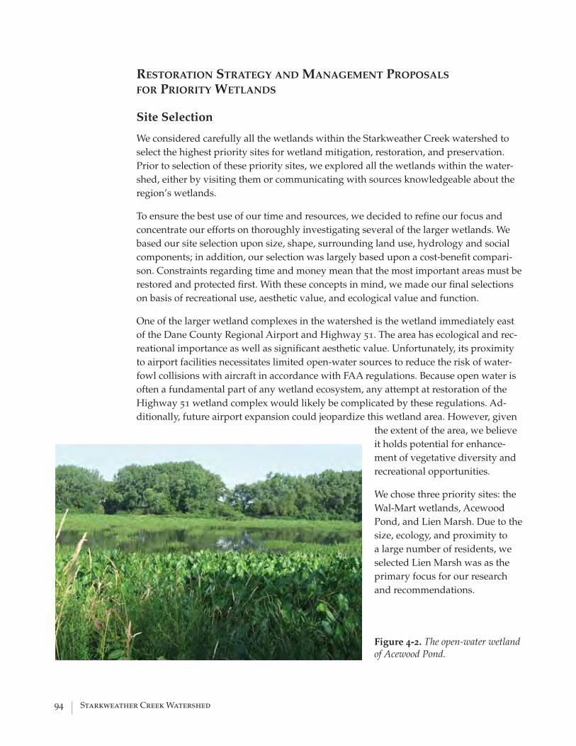
94 | Starkweather Creek Watershed
RESTORATION STRATEGY AND MANAGEMENT PROPOSALS FOR PRIORITY WETLANDS
Site Selection
We considered carefully all the wetlands within the Starkweather Creek watershed to select the highest priority sites for wetland mitigation, restoration, and preservation. Prior to selection of these priority sites, we explored all the wetlands within the water-shed, either by visiting them or communicating with sources knowledgeable about the region’s wetlands.
To ensure the best use of our time and resources, we decided to refi ne our focus and concentrate our efforts on thoroughly investigating several of the larger wetlands. We based our site selection upon size, shape, surrounding land use, hydrology and social components; in addition, our selection was largely based upon a cost-benefi t compari-son. Constraints regarding time and money mean that the most important areas must be restored and protected fi rst. With these concepts in mind, we made our fi nal selections on basis of recreational use, aesthetic value, and ecological value and function.
One of the larger wetland complexes in the watershed is the wetland immediately east of the Dane County Regional Airport and Highway 51. The area has ecological and rec-reational importance as well as signifi cant aesthetic value. Unfortunately, its proximity to airport facilities necessitates limited open-water sources to reduce the risk of water-fowl collisions with aircraft in accordance with FAA regulations. Because open water is often a fundamental part of any wetland ecosystem, any attempt at restoration of the Highway 51 wetland complex would likely be complicated by these regulations. Ad-ditionally, future airport expansion could jeopardize this wetland area. However, given
the extent of the area, we believe it holds potential for enhance-ment of vegetative diversity and recreational opportunities.
We chose three priority sites: the Wal-Mart wetlands, Acewood Pond, and Lien Marsh. Due to the size, ecology, and proximity to a large number of residents, we selected Lien Marsh was as the primary focus for our research and recommendations.
Figure 4-2. The open-water wetland of Acewood Pond.

Water Resources Management Practicum 2005 | 95
Wal-Mart Wetlands
The Wal-Mart wetlands are located adjacent to both sides of the East Branch of Stark-weather Creek just 0.5 mile south of Lien Marsh (fi g. 4-3).
The Wal-Mart side of the wetland receives stormwater draining the Wal-Mart complex via a stormwater detention basin; however, not all of the wetlands on this side are af-fected by stormwater input. A larger area nested between the creek and the stormwater-affected part of the wetlands is somewhat higher in elevation and is partly wooded. In fact, that area of the wetland is not mapped as such according to the Wisconsin Wet-land Inventory GIS data. However, the soils in this area consist of up to 3 feet of sapric peat overlying sandstone from the Tunnel City Formation (Wisconsin Geological and Natural History Survey, 2003), and we classifi ed this area as wet meadow/wooded wet-land. This area of the wetland has the greatest plant diversity, probably due to limited disturbance and better drainage. All other soils in the wetland are peat over silty clay, resulting in poor subsoil infi ltration and perched water tables. The stormwater-infl u-enced part of the wetland is mostly reed canary grass in the better drained parts and cattail along with willows in the wetter parts. The higher elevated part of the wetland has a good potential for enhancement of fl oral species diversity and wildlife habitat. It is spatially protected from developed sites and there is little evidence of hydrologic dis-
Figure 4-3. Wal-Mart complex wetland, showing the four distinct management units: 1=stormwater wetland north; 2=stormwater wetland south; 3=wet meadow; 4=wooded wetland.
1
1
1
3
4
0 250125Feet
Sources: Dane County, WRM Workshop 2005,Wisconsin Department of Natural Resources
Wet Meadow (WRM 2005)
Wooded Wetland (WRM 2005)
Wisconsin Wetlands Inventory
�
1
2
Wal-Mart

96 | Starkweather Creek Watershed
turbance. It is not suited for public access and should remain so. A more in-depth assess-ment of this area is recommended.
The wetland part west of the creek is separated from the Wal-Mart complex by a rail-way line. It has a basin-like morphology and receives stormwater from Highway 51 and Commercial Avenue on one side and from the Madison Gas & Electric power station on the other. Part of the wetland is an open-water body in spring and early summer, but dries out later in the season. Its vegetation is mostly reed canary grass in the better drained parts and cattail in the more poorly drained parts. This part of the wetland has limited faunal habitat value. We found evidence of wildlife, including white-tailed deer, raccoons, frogs, toads, and turtles. Any enhancement of this area is limited by the pres-ence of hydrologic alterations. The only option for this site would be conversion into a permanently submerged marsh to improve aesthetic values. To accomplish this, a more continuous water infl ux would have to be introduced to prevent complete drying in the summer months.
Acewood Pond
Acewood Pond is a kettle pond located in the southeast of the watershed. The pond and its surrounding wetlands have signifi cant habitat value for waterfowl. Even though the pond is in a residential neighborhood, there is limited access to the pond because of the great amount of emergent vegetation and wooded edges, resulting in relatively undisturbed waterfowl habitat. At the same time, the area has high aesthetic value for the neighborhood. To further enhance the pond for its wildlife function, waterfowl nest-ing areas could be introduced. Ducks need undisturbed grassy areas for nesting; it is possible to convert part of the woodlot east of the pond into a duck nesting area. If that plan is too controversial for local residents, the installation of nest boxes might partially accomplish the same objective. At the east side of the pond where the park borders the wetland, a wooden wildlife viewing stand could be built for observing waterfowl and learning about the ecological function of the wetland and the pond.
Lien Marsh
The Lien Marsh wetland complex holds much promise for aesthetic and recreational value and is of great ecological importance. The Lien Marsh is one of the largest remain-ing wetlands within the city of Madison. The wetland provides a source for recreational use and aesthetic pleasure amidst the otherwise stark, urban background. The wetland also provides habitat for a variety of fl ora and fauna; it is a refuge for many species within the city.
Lien Marsh is on the East Branch of Starkweather Creek, 1.8 miles upstream from the confl uence of the East and West Branches. It is bordered by a shopping complex on Lien Road to the north, the southwest–northeast running SOO railroad line adjacent to Syca-more Park, and a drainage ditch adjacent to a gravel pit to the west. The current wetland extent encompasses the historic R. Lien and F. Boschwitz properties.

Water Resources Management Practicum 2005 | 97
An aerial photograph from 1937 shows that the area surround-ing the marsh was once dominated by crop agriculture. An aerial photograph from 1995 shows the change in adjacent land use to commer-cial and light indus-trial, but also sug-gests that part of the R. Lien property was still being farmed at
that time. The F. Boschwitz property does not appear to have been farmed past 1980.
In the late 1990s, the northern part of the R. Lien property was purchased for commer-cial development. The City of Madison purchased the southern part of the R. Lien prop-erty along with the F. Boschwitz property. These properties now help to strengthen an important wildlife corridor within the city (fi g. 4-4).
Physical Setting
Topography. The topography of the Starkweather Creek watershed is characterized by minor differences in elevation. Lien Marsh, however, is adjacent to the highest point in the watershed, resulting in approximately 95 feet of relief between the wetland and nearby uplands. The upland area immediately east of the wetland includes an abandoned landfi ll, Sycamore Park, and single and multi-family residential units. The part of the wetland west of the creek gently grades into upland areas. The part of the wetland between the creek and the drainage ditch includes a local topographic high formed by a peat mound. Along the wetland edge, there are sharp transitions to human structures due to fi ll. The creek banks on either side are higher than the wetland interior from dredge spoil dumped when the creek was channelized, creating a bowl-like shape.
We surveyed the wetland with a high resolutions global positioning system (Leica Geosystems, Inc.) to gain better understanding of microtopography.
Geology and Soils. Lien Marsh developed on a glacial lacustrine plain formed by
Figure 4-4. Overview map of the Lien Marsh Complex and environ-mental corridor.
Lien Road
StormwaterDetention Pond
GroundwaterDischarge Pond
0 500250Feet
Sources: City of Madison, Dane County
Lien Marsh City Property
Samuel’s Recycling
CreekStarkweather CreekIrrigation Ditch
Target
�
98 | Starkweather Creek Watershed
offshore lake sediment. The sediments are highly variable, ranging from cross-bedded and plane-bedded sand, plane-bedded silt and clay, and nearshore gravel (Clayton and Attig, 1997). The eastern part of the wetland bordering the drainage ditch developed on marl, a lacustrine carbonate precipitate from a postglacial period. On its southeastern boundary, where the wetland grades into the steeper upland area, the surfi cial geology consists of a sandstone outcrop of the Tunnel City Formation (Wisconsin Geological and Natural History Survey, 2003).
According to Glocker and Patzer (1978), the two major soil units are Palms Muck and Dresden Silt Loam. However, on-site soil reconnaissance showed that soil characteristics are more heterogeneous than suggested by the soil survey data (fi g. 4-5). We extracted two soil cores using a vibracorer. The fi rst soil core was an organic soil (peat over sandy loam); the second soil core was a mineral soil that was buried by dredge material when the creek was channelized. We also measured soil permeability using a Guelph permeameter at both soil core locations. Permeability at location 1 was one order of magnitude greater than in location 2, which has signifi cance for site hydrology and subsequent ecosystem characteristics.
We also randomly sampled soil throughout the wetland with a hand probe and hand auger. Soils in the southwestern part of the wetland are peat over sandy gravel or marl. Soil reaction to hyperchloric acid indicated strongly alkaline conditions in that area. The soils adjacent in the south are silty clay. In the central part of the wetland, there is eroded silt over peat; the western part is composed of silty clay loam. The soil on the east side of the creek is also mainly silty clay loam accompanied by some silty clay.
Hydrologic Regime. Hydrologic parameters are the major driving force in a wetland ecosystem. The Lien Marsh is controlled by three different hydrologic regimes: groundwater discharge, surface-water infl ow and outfl ow, and fl uctuating creek water levels. Water movement through the wetland is controlled by soil characteristics, topography, and minor seasonal fl uctuations due to evapotranspiration. At least a part of the wetland east of the creek is tile drained. We found clay tiles discharging water into an open-water pool that directly drains into the creek (see chapter 3, Basefl ow). Two other small open-water pools in the wetland are not connected to the creek.
Groundwater discharge is visible near the peat mound in the fen and as a groundwater-fed, human-made pond. The fen is west of the creek and is recognizable by the remnants of a peat mound. We installed four piezometers to measure hydraulic gradients with screens at four depths. Throughout the entire monitoring period between April and August, the readings indicated a positive hydraulic gradient, which means groundwater is being discharged continuously. The fen formed due to a sandy gravel layer that may be part of a local or regional groundwater fl ow system.
Our comparison of aerial photographs from 1995 and 2000 showed that the pond was constructed during this time period. The purpose and functions of the pond are unclear. We measured groundwater seepage out of the pond with a seepage meter and calculated a discharge rate of 8 x 10⁻⁴ cm/s. This method is known to

Water Resources Management Practicum 2005 | 99
Figure 4-5. Overview of the Lien Marsh complex showing locations of soil-permeability measure-ments, water-table loggers, piezometer locations, and soil types.
yield highly variable results, so the actual value is insignifi cant. The purpose of this measurement was to confi rm that the water levels in the pond are sustained by groundwater discharge. No other means of infl ow into the pond could be identifi ed. During spring, when water levels are higher, the pond releases water through a small outlet to the south. The water then seeps through an area dominated by Scirpus fl uviatilis (river bulrush) and then discharges into the drainage ditch. In the summer, pond levels drop due to increased evaporation and the outlet dries up.
To better understand the groundwater signature in various locations in the wetland, we monitored the water table in three locations with digital water-table data loggers over a period of 24 days in July. The data loggers were set to record every 30 minutes. The locations of these data loggers are indicated in fi gure 4-5.
Our data showed that all three locations are groundwater infl uenced. Daytime hours were characterized by water-table drawdown from evapotranspiration, and nighttime, by water-table recovery from groundwater recharge. The amplitude of this daily cycle is more attenuated in the fen area and more pronounced in the mineral soil locations. The total drawdown over the fi ve days displayed in appendix D (fi gs. D-1 to D-6) was also greatest in the mineral soil (1.5 ft), with only 0.18 feet of drawdown in the fen. The area outside the fen, dominated by Scirpus fl uviatilis, is
!
!
! "#
0 500250Feet
Source: Dane County Land Information Office, Natural Resources Conservation Service
NRCS Soil Map Units
�
Palms Muck
Sable Silty Clay Loam
Dresden Silt Loam
Water Table Loggers
Core 2 - Piezometer
Core 1 - Piezometer Nest
Sampling Locations
#
"
!

100 | Starkweather Creek Watershed
intermediate in terms of drawdown and recovery.
The water-table response to rainstorm events plays an important role in the type of plant species that can thrive. The mineral soil is more likely to repeatedly develop reducing conditions characterized by oxygen depletion throughout the
growing season favoring more water-tolerant plants.
The middle part of the wetland west of the creek receives stormwater from the detention pond. This stormwater probably mixes with groundwater as it moves through that part of the wetland. Because of the basin-like topography within this area, the water becomes ponded and stagnant. However, as a result of the stormwater that the wetland has been receiving since about the year 2000, the hydrology of this area tends to experience fl uctuations. During high fl ows the water has cut a few small outlet channels through which water now discontinuously exits the wetland as surface fl ow. A number of small seepage outlets along the bank allow water to discharge to the creek (fi g. 4-6).
Finally, the creek is hydrologically connected to the wetland. Dredging and channelizing of the creek around the end of the nineteenth century greatly altered the watershed hydrology (Dane County Regional Planning Commission, 1983). The energy gradient became steeper because of a shortened fl ow path, so water velocities increased; this has resulted in lateral erosion, an increase in peak fl ows, and a decrease in basefl ow. This process has intensifi ed throughout the twentieth century as a result of rapid urbanization within the watershed. Watermarks from the July 20, 2005 rainstorm of 1.17 inches (National Oceanic and Atmospheric Administration, 2005) after a six-week drought period documented a nearly 3-foot difference between peak fl ow stage and basefl ow stage.
Soil probing showed very little evidence of frequent overbank fl ooding prior to channelization. Presettlement watershed characteristics, such as small elevation gradients, many wetlands, and meandering streams, suggest that the fl ow regime was characterized by constant high basefl ow coupled with an attenuated response to storm events. We therefore believe that the wetland experienced very infrequent overbank fl ooding prior to development and that fl oodplain dynamics played a subordinate role to groundwater discharge in presettlement wetland hydrology.
Figure 4-6. A seepage outlet on the creek bank in early spring. The rust color is iron that oxidizes when the water comes into contact with the at-mosphere.

Water Resources Management Practicum 2005 | 101
This conclusion is also supported by results from the regional groundwater model, which indicates upward fl ow along the entire East Branch of Starkweather Creek (Bradbury and others, 1999).
Geochemistry. As a consequence of their low position in a watershed, wetlands are landscape sinks that accumulate chemicals as well as sediment. Hence, wetland geochemical properties are not only controlled by in-situ conditions, but are also strongly infl uenced by upland processes. We were interested in whether knowledge of chemical parameters would allow conclusions to be drawn about ambient processes. We collected geochemical data using comparator-based colorimetric test kits from CHEMetrics, Inc., and a portable temperature/conductivity meter. The complete data set is listed in appendix D (table D-2).
We tested groundwater by sampling from piezometers in the fen. The groundwater was of intermediate conductivity, indicating moderate electrolyte concentration, probably mostly from dissolved carbonates that are relatively abundant in glacial sediments. Alkalinity was moderately high, indicating a well buffered system. Dissolved oxygen was low, but never completely exhausted, indicating that redox potentials are probably never very high, despite water-saturated conditions.
The soil core from the fen only showed gleyed colors (bluish gray), indicative of reducing conditions, from 5.00 to 5.40 feet in depth. The rest of the sediment core had yellowish-brown hues that would be more typical of an upland soil. The soil showed the most reduction in the top layer, indicated by the absence of nitrate and the presence of 1 ppm dissolved iron. Concentrations varied with increasing soil depth as indicated by a slight increase in nitrate and the absence of dissolved iron. The rate of reduction is higher in the upper part of the soil because of more organic matter, which is the energy source for reducing bacteria. No phosphate was detected in the groundwater.
We tested surface-water chemical characteristics in the groundwater-discharge pond, the stormwater-detention pond, at the wetland outlet, in the creek, and in the drainage ditch. The creek can be characterized as eutrophic. Nitrate levels varied between 2.5 and 4.5 ppm, with values closer to 4.5 ppm during drought conditions, probably due to less dilution. Dissolved or bioavailable phosphate varied between 0.1 ppm in spring, zero during the summer drought period, and 0.4 ppm after a major rainstorm. Nitrate levels in the stormwater-detention pond were negligible.
Phosphate levels varied between 0.1 and 0.2 ppm, which is surprising because the drainage area for the detention pond consists only of rooftops and a large parking lot. One possible source of dissolved phosphate could be fertilized fl ower beds, but there are no data to substantiate this hypothesis. In contrast to groundwater and stormwater, phosphate levels are higher at the wetland outlet, reaching an average value of 4 ppm. (For comparison, water-quality effl uent limitations for facilities permitted by the Wisconsin pollutant discharge elimination system is 1 ppm of total phosphorus as monthly average [Wisconsin Department of Natural Resources, 1997]). Because no signifi cant amounts of phosphate seem to enter the wetland under current conditions, the phosphate seems to be stored there and becomes mobilized by water seeping through it. This is a signifi cant fi nding because

102 | Starkweather Creek Watershed
wetlands are generally regarded as nutrient sinks, primarily due to the high amount of organic matter found within them, which has a large capacity for adsorbing nutrients.
To further understand the phosphorus levels within the wetland and surface water, we used the Bray-1 extraction process to quantify available phosphorus at six sites throughout the wetland. Following the extractions, we determined phosphorus levels by using the absorbic acid method. The results showed that available phosphorus levels ranged from 1 ppm to more than 120 ppm. The results indicated signifi cant variability with respect to sample location, which is not completely unexpected. Part of the Lien Marsh and the adjacent upland were actively farmed in the past. The phosphorus levels obtained from the sample sites were similar to levels found in many local agricultural fi elds. More than one hundred years of active farming and manure application most likely caused the current high phosphorus levels. In addition, the wetland interior has various depths of silt on peat (up to approximately 1 foot), which we interpreted as eroded topsoil from the immediately surrounding area. Many of these areas were also recently farmed.
The results from the phosphorus testing challenged the widespread belief that wetlands can be used for nutrient-treatment functions. Wetlands have only a limited storage capacity and once this storage capacity is reached, wetlands can instead become source areas of nutrients and pollutants, seriously affecting water quality and habitat in connected streams and lakes. Our fi ndings indicated that a clear understanding of site-specifi c conditions is essential prior to decision making in terms of constructing treatment wetlands.
Flora. Wetland fl ora are controlled by soil characteristics, hydrology, and land-use history in and around a particular wetland area. The entire wetland complex is infested by the invasive plant Phalaris arundinacea. The GIS data allowed a rough estimate of vegetative site conditions, but also revealed major weaknesses resulting from restrictions of resolution and generalization. On-site vegetation mapping revealed greater heterogeneity and ecosystem diversity (fi g. 4-7).
The most diverse vegetation is associated with the fen and the groundwater discharge pond. The soil is porous, provides a stable water table in relation to other locations in the wetland, and has a low nutrient content. The local topographic high elevation point also protects it from sediment accumulation. Conversely, fi ner textured mineral soils are more susceptible to greater water-table fl uctuations due to lower bulk densities and stormwater infl ux, accumulate more sediment, and have a high nutrient content. Overall, the fen seems to have escaped early settlement disturbance better than other parts of the wetland, as expressed by the higher species diversity there.
Nevertheless, the fen shows signs of serious ecosystem stress. The vegetation survey showed that upland plants and Cornus rademosa Lam. (gray dogwood) and Frangula alnus P. (glossy buckthorn) are mixing in with the native fen vegetation. This suggests that the native fen vegetation is experiencing stress from slow but continuous dessication. The reason may lie in declining water tables resulting from groundwater pumping, but may also be explained by the dredging of the pond.

Water Resources Management Practicum 2005 | 103
The pond draws water from its immediate surroundings, which is then lost to evaporation. A series of aerial photographs between 1980 and 1995 do not show any evidence of brushy vegetation on the fen. Currently, however, there is a large Frangula alnus P. (glossy buckthorn) located at the highest point of the fen as well as a few small individuals scattered around the general area. The coincidence of pond construction and buckthorn establishment suggests that the fen has become drier due to water loss to the pond. The vegetation along the pond edge is quite diverse and is mostly bulrushes, grasses, and a few pioneering sedges. The hybrid cattail (Typha glauca) has become established as well. We
Figure 4-7. Lien Marsh complex with vegetation communities.
Unit Plant Community 1 Reed canary grass (~90%), Jewel
weed, Water smartweed 2 Hybrid cattail (~100%) 3 Canada anemone, Angelica,
Canada goldenrod, Red top, Marsh milkweed, Gray dogwood, Wild yarrow, Bugleweed, Wooly sedge, Water smartweed, Buckthorn, Kentucky blue grass, Swamp aster, Curly dock, Joe pye weed, Wild mint, Geum, Canada thistle, Cotton grass, Nut sedge, Sterile sedge, Prairie loosestrife, Rag weed, Germander
4 Swamp nettle, Common goldenrod 5 River bulrush (~80%), Broad leaved
cattail 6 Cottonwood, Bush honeysuckle,
Garlic mustard 7 Green bulrush, Stalk-grain sedge,
Slender rush, Blue vervain, Rattlesnake mannagrass, Narrow leaf cattail, Hybrid cattail, Soft stem bulrush, Fox sedge, Tussock sedge, Blunt spikerush
8 Comfrey, Canada goldenrod 9 Blunt spikerush, Broadleaf
arrowhead 10 Sandbar willow

104 | Starkweather Creek Watershed
have no information as to whether or not these plants were seeded intentionally.
The largest part of the wetland is dominated by Phalaris arundinacea in mesic to wet areas and Typha glauca in areas with standing water. Soil testing around the fen also suggests that those areas with evidence of disturbance from soil compression, possibly from heavy equipment, coupled with accumulated sediments are also infested by Phalaris arundinacea. In contrast to that, the soil profi le on the peat mound in the center of the fen appears to be undisturbed (Quentin Carpenter, University of Wisconsin–Madison, verbal communication, 2005). Hence, the current vegetative condition of the wetland provides ample evidence of various types of disturbances that stretched the ecosystem resilience to a point where it has adjusted or is in the process of adjusting itself to a new equilibrium characterized by lower plant diversity.
Fauna. Although we did not conduct a systematic survey of the fauna inhabiting the wetlands, it was evident that despite its degraded status, the wetland provides habitat to a diversity of vertebrates and invertebrates. The more obvious animals observed were white-tailed deer, ground hogs, muskrats, great blue heron, breeding sandhill cranes, Canada geese, and mallards. Other smaller birds using the wetland
Figure 4-8. Ecological units within the Lien Marsh wetland complex.
1
2
4
5
3
0 500250Feet
Sources: WRM Practicum 2005, Dane County
Restoration AreasUnit 1: Fen Area
Unit 2: Stormwater Wetland
Unit 3: Wet Prairie
Unit 4: Creek Corridor
Unit 5: Triangle Marsh
¯

Water Resources Management Practicum 2005 | 105
are red-winged blackbirds, swallows, and yellow fi nches. Several red-tail hawks were observed in the upland transition to Sycamore Park. Among the small vertebrates observed were green frogs, chorus frogs, American toads, and a stocked population of bluegills and largemouth bass in the groundwater discharge pond (verbal communication with an angler). Wildfl owers in the fen area provide feeding ground for a variety of butterfl ies and bumblebees.
Current Status of Lien Marsh
Lien Marsh is a degraded wetland, but has potential for restoration. The wetland offers relatively diverse site conditions resulting from the surfi cial geology, soil types, micro-topography, and microhydrology. This diversity is expressed by various wetland types ranging from fen, shallow marsh, sedge/wet meadow, forested wetland, and small, more diverse plant communities surrounding the small open-water pools. Creek chan-nelization, tile drainage, farming, and urbanization have led to signifi cant changes in hydrology and soil characteristics, which favor conditions for invasive plants. It is espe-cially unfortunate that the fen, although having been preserved throughout the farming period, is now seriously threatened by the pond construction that occurred at a time when protective wetland regulation was in place. Overall, the site seems to represent the typical case for a wetland in an urban area.
Restoration Recommendations
As a result of the varying site conditions in the Lien Marsh, we propose subdividing the area into the following fi ve ecological units (fi g. 4-8):
• the fen including the groundwater pond,
• the area receiving stormwater from the detention pond, which we refer to as the stormwater wetland,
• the area bordered by Lien Road and the Target property, which we refer to as the wet prairie,
• the creek corridor, and
• the area east of the creek, which we refer to as the Triangle Marsh.
This will allow different management practices to be applied to each area, depending on its preexisting conditions.
Fen. A fen is the one of the rarest wetland types in Wisconsin because of the unique conditions that contribute to their development. The strongly alkaline reaction of the peat in the fen area suggests that the fen can be classifi ed as calcareous. Calcareous fens are listed as areas of special natural resource interest in section NR 103.04 of the Wisconsin Administrative Code. It therefore seems appropriate to assign the fen the highest priority.
Fens are mainly controlled by internal hydrologic conditions and are therefore less susceptible to disturbance from land-use changes in the surrounding watershed

106 | Starkweather Creek Watershed
(Mitsch and Gosselink, 2000). Peat mounds grow and are sustained by a water table that is higher in relation to their surroundings, driven by a high hydraulic conductivity layer that promotes up-welling of groundwater. The fen in the Lien Marsh has experienced water-table decreases from artifi cial groundwater drainage in the adjacent drainage ditch and the groundwater pond and from regional groundwater pumping. The lowered water table has led to drier soil conditions, and native fen species are now being replaced by upland plants, resulting in lower plant diversity. It is also likely that the actual peat mound has been shrinking because unsaturated peat is subject to oxidation and, hence, mineralization.
Comprehensive Approach to Restoration
• Restore the hydrologic integrity of the fen.
• Reverse reed canary grass and cattail dominance.
• Enhance plant diversity in the fen.
Functional restoration of the fen would require redressing the hydrologic regime alterations. Hydrologic conditions would have to be restored by fi lling the drainage ditch and the groundwater pond. Both measures are drastic, expensive, and can be disruptive themselves. Arguing for removal of the groundwater pond seems controversial because the plant community around the pond provides relatively good plant diversity compared to other parts of the wetland. The pond also provides habitat for fi sh, amphibians, waterfowl, and a variety of insect life. Filling the drainage ditch is also problematic because it receives stormwater from upland parcels, so its removal would have to be incorporated into a broader stormwater-mitigation plan. However, both measures—or alternatively only one of the two—are the only way to lessen further degradation of the peat mound or potentially restore the fen to its historic extent. The fen community can then be enhanced by treatment for invasive species, brush removal, prescribed burning, and targeted seeding of fen species if the local seed bank is insuffi cient.
Minimized Approach to Restoration
• Stop further spread of reed canary grass and cattail.
• Enhance plant diversity in the fen remnant.
Enhancing the diversity of the plant community may be achieved through brush removal, prescribed burning, and additional seeding. However, it will require long-term monitoring, and it is unknown whether these measures alone will suffi ce to preserve the remaining fen. We recommend continued monitoring of water levels at the installed piezometers to determine whether the average water-table elevation is changing.
Stormwater wetland. The large, artifi cial banks of Starkweather Creek, created during channelization and dredging of the creek, sometimes force the stormwater from the detention pond to pool within the wetland. The pooling creates an unfavorable environment for many native wetland species, but favors the establishment of reed canary grass and the hybrid cattail; extensive stands of these plants characterize

Water Resources Management Practicum 2005 | 107
the area. Water and soil samples from this area showed high levels of phosphorus. Fortunately, the stormwater has remained relatively isolated due to the peat mound, which acts like a berm, keeping the stormwater from reaching the fen area.
Comprehensive Approach to Restoration
• Mitigate altered wetland hydrology.
• Minimize nutrient fl ux.
• Control invasive species and enhance plant diversity.
To foster a more heterogeneous fl oral population, drainage must be improved within the wetland. However, increased drainage may also fl ush more phosphorus from the wetland. This phosphorus would then enter Starkweather Creek and eventually Lake Monona, thereby augmenting the present eutrophication problems.
To improve drainage of the wetland, the creek banks could be scraped, allowing the stormwater to reach the creek by non-turbulent fl ow along the entire wetland instead of becoming channelized, pooling up, and entering the creek at one concentrated point. Scraping the creek banks would also allow the wetland to drain, possibly allowing for conditions that foster increased sedge growth.
Regardless of the approach, care must be taken to ensure that the wetland does not become overloaded with sediments, nutrients, and chemicals, thereby disrupting the wetland ecology and function. Outputs from the detention ponds should be monitored to ensure the future health of the wetland.
The reed canary grass must be brought under control before any successful restoration of fl ora can be expected. Aggressive burning and herbicide application may be necessary; however, these methods have not been proven to be completely effective. Research is currently under way to discover more effective means of controlling and eradicating reed canary grass, and it is hoped that more effective methods will be discovered. Depending on the area’s seed bank, seeding of native species may be required to jump start the growth of native wetland species.
Minimized Approach to Restoration
• Control invasive species and enhance plant diversity.
This area should be burned and seeded to promote a greater species diversity of fl ora. However, the success of such efforts is not assured, given the continued stormwater inputs from the detention pond. As is the case in most wetlands within the watershed, the aggressive invasive reed canary grass has taken hold and can be extremely diffi cult to dislodge.
Wet prairie
Approach to Restoration
• Establish a native wet prairie plant community.
The wet prairie, at Lien Road by the Target store, provides a prime location for restoration. Burning and seeding could greatly increase species diversity within the

108 | Starkweather Creek Watershed
prairie. However, restoration efforts must be vigilant and may take several years or more to take hold.
Creek Corridor
Approach to Restoration
• Enhance fl ow conditions.
The banks of Starkweather Creek on the wet meadow site and the Triangle Marsh are heavily clogged with woody debris. The large amount of deadfall and rootwads within the creek greatly slows the velocity of the stream, which has led to increased water temperatures and large accumulations of sediment. Trees within the riparian area should be thinned signifi cantly, and debris should be removed from the creek. In addition, strategically placed erosion-control measures, such as boulders and rocks, should be employed along the banks. Some sediment could be removed from the creek bottoms to prevent this sediment from contributing to sedimentation problems downstream.
Triangle Marsh. The Triangle Marsh has the potential to be a wonderful wildlife area and wetland. The property is diverse in its topography and habitats. However, reed canary grass has aggressively taken over the wetland. During the summer months, thick stands of this plant, 7 to 8 feet tall, have become the dominant, and may be the only fl oral species present. During our work on the Triangle Marsh, we discovered that an area, previously described as a spring, was in fact drainage-tile discharge pipes (see chapter 3, Basefl ow). We believe that drainage tiles are extensive in this area, but were unable to determine their exact locations.
Due to the present condition of the wetland and its location, restoration of the Triangle Marsh must be undertaken in an aggressive and dedicated manner.
Comprehensive Approach to Restoration
• Remove hydrologic alterations.
• Suppress invasive species and improve native sedge meadow community.
• Purchase small wetland area connecting to Triangle Marsh.
The fi rst, most important restoration strategy is the removal of the drainage tiles from the wetland. This could be diffi cult; we were unable to locate their exact positions. Once these tiles are removed, the area will likely become wetter and might foster increased growth of sedge and other native wetland species. The reed canary grass must be brought under control before any restoration success can be expected. As previously mentioned, techniques for eradicating reed canary grass are not presently available; however, future research may yield important clues.
A relatively large amount of wooded area is present within the Triangle Marsh as compared to the other study sites. The wooded areas should be burned to remove the large amount of deadfall and thin the areas. It is possible that following removal of the drainage tiles, the area will become too wet to foster woody growth, and the areas may begin to decrease in size on their own accord. (The riparian area along
Water Resources Management Practicum 2005 | 109
Starkweather Creek should be thinned and woody debris removed using the same methods as on the adjacent wet meadow unit.)
The Samuels Recycling Center (SRC) currently owns a small triangle-shaped wetland on the southern end of the Triangle Marsh. This area is bordered by the creek on the western side and the SOO Line train tracks on the east. Much of this area has cattail marsh and sedge meadow. The SRC wetland area is a likely candidate for purchase by the city at some point in the future. The wetland connects to the Triangle Marsh and is adjacent to the fen and stormwater wetland. Furthermore, this property probably is of little signifi cance to SRC due to its location and wetland habitat. Purchasing this area would allow the entire wetland complex to be joined together into one cohesive, city-owned wetland complex.
INTEGRATION OF THE WETLANDS STUDY INTO THE WATERSHED PERSPECTIVE
The health and extent of wetlands within the Starkweather Creek watershed will not be determined solely by resource-management choices related to the wetlands. We have illustrated how watershed-related issues such as stormwater runoff, nonpoint-source pollution, fl ood control, and water supply can impact wetlands. For any wetland pres-ervation or restoration plan to be effective, it must consider the connection between wetlands and the management decisions affecting the surrounding land and water re-sources (U.S. Environmental Protection Agency, 2005).
In addition, wetland restoration and preservation plans must take into serious consider-ation the fact that it may be impossible to return these highly complex areas to their pre-settlement conditions. That is, it cannot be expected that these areas will be able to serve highly confl icting ecosystem functions, such as stormwater retention and habitat for biodiversity preservation. These wetlands need to be managed with the knowledge that urban pressures may necessitate tradeoffs, gaining one ecosystem function at the cost of another. However, by treating these wetlands as a larger watershed complex, more of these functions can be retained over a larger spatial gradient.
REFERENCES Beeby, A., 1995, Applying Ecology: London, Chapman and Hall.
Bernthal, T.W., and Willis, K.G., 2004, Using LANDSAT 7 imagery to map invasive reed canary grass (Phalaris arundinacea): A landscape level wetland monitoring methodol-ogy: Wisconsin Department of Natural Resources.
Bradbury, K.R., Swanson, S.K., Krohelski, J.T., and Fritz, A.K., 1999, Hydrogeology of Dane County, Wisconsin: Wisconsin Geological and Natural History Survey Open-File Report 1999-04.
Brady, C.N., and Weil, R.R., 2002, The Nature and Properties of Soils: Upper Saddle River, NJ, Prentice Hall.

110 | Starkweather Creek Watershed
Carpenter, Q.J., Kercher, S.M., and Zedler, J.B., 2004, Interrelationships of hydrologic dis-turbance, reed canary grass (Phalaris arundinacea L.), and native plants in Wisconsin wet meadows: Natural Areas Journal, v. 24, no. 4, p. 316–325.
Clayton, L., and Attig, J.W., 1997, Pleistocene geology of Dane County, Wisconsin: Wis-consin Geological and Natural History Survey Bulletin 95.
Dane County Regional Planning Commission, 1983, Starkweather: A Water Quality Plan for Starkweather Creek.
Ehrenfeld, J.G., 2000, Evaluating wetlands within an urban context: Ecological Engineer-ing, v. 15, p. 253–265.
Glocker, C., and Patzer, R.A., 1978, Soil Survey of Dane County, Wisconsin.
Grayson, J.E., Chapman, M.G., and Underwood, A.J., 1999, The assessment of restora-tion of habitat in urban wetlands: Landscape and Urban Planning, v. 43, p. 227–236.
Kadlec, R.H., and Knight, R.L., 1996, Treatment Wetlands: Boca Raton, FL, CRC Press LLC.
Kercher, S.M., and Zedler, J.B., 2004, Multiple disturbances accelerate invasion of reed canary grass (Phalaris arundinacea L.) in a mesocosm study: Oecologia, v. 138, p. 455–464.
Manuel, P.M., 2003, Cultural perception of small urban wetlands: Cases from Halifax Regional Municipality, Nova Scotia, Canada: Wetlands, v. 23, no. 4, p. 921–940.
Miller, R.C., and Zedler, J.B., 2003, Responses of native and invasive wetland plants to hydroperiod and water depth: Plant Ecology, v. 167, no. 1, p. 57–69.
Mitsch, W.J., and Gosselink, J.G., 2000, Wetlands (3rd ed.): New York, NY, John Wiley and Sons.
Mollenhoff, D.V., 2003, Madison, A History of the Formative Years: Madison, WI, Uni-versity of Wisconsin Press.
National Oceanic and Atmospheric Administration, 2005, Climate Archive Monthly Sta-tistics July 2005, Station: Madison Dane County Regional Airport. Retrieved August 2005, from http://www.crh.noaa.gov/mkx/climate/LCDJL2.
Pimm, S.L., 1991, The Balance of Nature? Ecological Issues in the Conservation of Spe-cies and Communities: The University of Chicago Press.
Thompson, A.L., and Luthin, C.S., 2000, Wetland restoration handbook for Wisconsin landowners, Wisconsin Wetland Association: Madison, WI, Bureau of Integrated Sci-ence Services, Wisconsin Department of Natural Resources.
Turner, M., and others, 2003, Landscape Ecology: Springer, New York.
U.S. Environmental Protection Agency, 2005, Wetlands. Retrieved March 2006, from http://www.epa.gov/owow/wetlands/watersheds/.

Water Resources Management Practicum 2005 | 111
Water Resource Management Program, 1990, Urban wetlands in the Yahara–Monona Watershed: Functional Classifi cation and Management Alternatives: University of Wisconsin–Madison, Institute for Environmental Studies.
Werner, K.J., and Zedler, J.B., 2002, How sedge meadow soils, microtopography, and vegetation respond to sedimentation: Wetlands, v. 22, no. 3, p. 451–466.
Willard, D.E., 1988, Persistence: The need for eternal care for urban wetlands and ripar-ian habitats, in Urban Wetlands: Proceedings of the National Wetland Symposium, Oakland, California.
Wisconsin Department of Natural Resources, no date, Wisconsin wetlands. Retrieved August 2005, from http://www.dnr.state.wi.us/org/water/fhp/wetlands/index.shtml.
Wisconsin Geological and Natural History Survey, 2003, wiscLith: A digital lithologic and stratigraphic database of Wisconsin geology: Wisconsin Geological and Natural History Survey Open-File Report 2003-05, version 2.0.
Zedler, J.B., and Callaway, J.C., 2003, Adaptive restoration: A strategic approach for inte-grating research into restoration projects, in D.J. Rapport, W.L.L., D.E. Rolston, N.O. Nielsen, C.O. Qualset, and A.B. Damania, eds., Managing for Healthy Ecosystems: Boca Raton, Florida, Lewis Publishers, p. 167–174.


Water Resources Management Practicum 2005 | 113
EDUCATIONAL OUTREACH
IMPORTANCE OF PUBLIC AWARENESS
A critical component for rehabilitating a degraded urban watershed is educational outreach. Educating the public is crucial for transforming this resource. Although
it has been widely suggested and accepted that a formal watershed education plan for Starkweather Creek is needed, a plan has yet to be formulated or implemented (City of Madison, Engineering and Parks Division, 2005; J. Steines, verbal communication, April 2005).
The Dane County Community Stormwater Awareness Assessment was completed in late 2003 by the Dane County Joint Stormwater Permit Group Information and Educa-tion Plan Subcommittee. This survey showed a mixed awareness of adverse watershed health in Dane County. Therefore, an educational outreach plan has the potential to promote further understanding and stewardship in this community. Such a program could generate support among residents and spur funding for watershed-enhancement projects; it could also increase motivation of residents to take local action to reduce the impacts of urbanization and stormwater runoff on their own property, in their schools and businesses, and at their places of worship.
As with any natural resource, many stakeholders are involved in use and management. The Friends of Starkweather Creek is one of the leading stakeholders in the watershed. It collaborates with other stakeholders such as the City of Madison, Olbrich Botanical Gar-dens, Olbrich Community Partnership, neighborhood associations, and other nonprofi ts as well as county and state agency groups.
EXISTING EDUCATION PLANS AND OUTREACH
In designing an educational outreach program for the Starkweather Creek watershed, it is fi rst important to recognize what measures have already been taken or are being taken by other agencies to educate and inform the public about watershed issues at the regional and local level. With respect to the Starkweather Creek watershed, it is appro-priate fi rst to look at educational outreach recommendations that have been presented in previous watershed reports and management plans.
Education Plans
Starkweather Creek Reports (1983 and 2005 Update)
The original 1983 management plan did not deal directly with educational outreach in the Starkweather Creek watershed. However, it did take an important fi rst step in the process that could lead to such a program by polling residents of the watershed about
5

114 | Starkweather Creek Watershed
their opinions and perceptions of the creek and its immediate corridor. The survey was structured to gauge in what manner and how frequently homeowners in the watershed used the creek, what problems they felt were occurring within the watershed, and what stream-corridor enhancement measures they would support in the future.
By 2005, the Starkweather Creek Master Plan Update had been amended to include an education and outreach section that recognized the efforts put forth by Olbrich Gardens to design a watershed-education program for Starkweather Creek. More specifi cally, the Olbrich Neighborhood Partnership Committee began to brainstorm methods by which watershed awareness could be fostered in Starkweather Creek communities; this list served as the basis for a number of our educational committee’s fi rst concepts (Dane County Regional Planning Commission, 1983; City of Madison, 2005).
Yahara–Monona Priority Watershed Plan (1992)
The Yahara–Monona Priority Watershed Plan was developed in 1992 as a means of ad-dressing worsening water-quality conditions in the watershed’s lakes, streams, and groundwater. In addition to management suggestions for the watershed itself, the plan also outlined a proposal called S.A.V.E the Lakes, an educational outreach plan designed to inform residents about nonpoint-source pollution and change the behaviors that con-tribute to this type of pollution. S.A.V.E. the Lakes broke the outreach process into four phases:
‘Sensibility Phase,’ wherein activities are designed to develop and promote cultural attitudes conducive to preservation of our water sources. During the ‘Awareness Phase,’ watershed residents will learn about the threats to watershed resources, the origins of these threats and what they, as citizens, can do to protect their water resource. The ‘Volition Phase’ is designed to increase feelings of involvement with water resources and to encourage residents to want to do something about water quality. The ‘Engagement Phase’ provides watershed residents with means and opportunities to actively participate in efforts to preserve and improve water quality.
— Dane County Regional Planning Commission (1992)
A unique attribute of S.A.V.E. the Lakes was that it sought to use existing networks of communication to reach watershed residents rather than creating new ones (Dane County Regional Planning Commission, 1992).
Joint Stormwater Permit Group Information and Education Plan (2003)
In accordance with Chapter NR 216, Wisconsin Administrative Code (Stormwater Discharge Permits), the City of Madison and 18 other municipalities in Dane County developed a stormwater-education plan “to improve the quality and reduce the quan-tity of urban runoff, resulting in area lakes and rivers meeting their designated use.” Because stormwater runoff in urban areas is unavoidable, Dane County set out to lessen its effects by educating various urban target audiences about practices that each could undertake. The information and education plan surveyed the watershed awareness
Water Resources Management Practicum 2005 | 115
of urban audiences, such as the general public, land/homeowners, business owners, developers, contractors, and municipalities, and create a set of objectives and timeline concerning what each would learn or achieve through the outreach plan. In addition, the information and education plan also outlined how the program will be funded and how the progress of the stormwater education will be evaluated.
Outreach Programs
It is important to identify educational outreach that is being employed at the state, coun-ty, city, and neighborhood level to gauge what gaps need to be fi lled in. Although our list in by no means exhaustive, we offer a spectrum of educational outreach examples.
State
The main agency responsible for watershed education at the state level is the Wisconsin Department of Natural Resources (WDNR). The WDNR maintains a Web site devoted to directing visitors to other sources pertaining to various watershed issues, such as hydrologic cycles, stormwater management, water quality, and riparian corridor protec-tion. In addition to giving defi nitions and descriptions of watershed components, the Web site also offers a “how to” section that instructs citizens about how they can prevent nonpoint pollution, decrease runoff, and start a local water-quality-monitoring program. The site also offers outreach programs geared specifi cally toward children, with tools that teachers might employ in the classroom to educate children about the importance of the watershed concept. The culmination of this school-oriented outreach is Project WET (Water Education for Teachers). Project WET depends on local facilitators to introduce interested teachers to the principles and materials necessary to implement the program. The major shortcoming is that programs are not aimed at dealing with problems of a specifi c watershed, such as that of Starkweather Creek (Wisconsin Department of Natu-ral Resources, 2005).
County
At the county level, the agency responsible for much of the watershed educational out-reach is the Dane County Lakes and Watershed Commission. A number of programs run by this agency help encourage Madisonians and Dane County residents to take an active stewardship role in protecting the lakes and watersheds that make up Madison’s unique landscape.
One such program is Yahara Lakes Week. Taking place in June every year, this event’s goal is “to focus public attention on our water resources, raising awareness of the importance of the lakes in our quality of life and the ways in which our lives affect the quality of the lakes.” Yahara Lakes Week includes a number of prominent events that tackle very specifi c problems at various levels in the watershed. At the lower end of the watershed, Take a Stake in the Lakes was organized as a means to connect residents directly to the lakes. Through cleanup efforts and stenciling campaigns, this program attempts to mobilize watershed residents to realize the environmental issues that are occurring within the lakes they enjoy.

116 | Starkweather Creek Watershed
However, effective watershed education must extend beyond just addressing problems within the prominent aquatic features of a landscape. Because many watershed prob-lems stem from land practices far inland, it is also important to educate citizens about how they can positively affect the watershed even if they are far removed from a creek or lake. This is the driving purpose behind the Better Lawns and Gutters Tour, which ex-hibits properties in Madison that are using rain gardens, native planting, and pesticide-free lawns to lessen urban impacts on watersheds, such as that of Starkweather Creek. The Better Lawns and Garden Tour also provides information about how property owners can construct a rain garden and where they can go to get further information.
Madison Metropolitan Area
The My Fair Lakes campaign has been used by the Madison Area Municipal Stormwater Partnership to create public awareness concerning the connection between stormwater and the quality of the lakes within the City of Madison. Armed with the knowledge that trash, sediments, grease, and fertilizer-based nutrients fi nd their way from streets and lawns into storm drains and creeks, the city has compiled a list of what citizens can do at home, for their lawns, with their cars, and in the community to ensure that only clean water enters Lakes Monona and Mendota. In addition to a Web site and printed materi-als, the campaign has also made extensive use of television and radio spots to promote the My Fair Lakes concept to the people of Madison.
Similar to the Better Lawns and Gutters Tour organized by the Dane County Lakes and Watershed Commission, the City of Madison Engineering Department has begun pre-liminary work on a 1,000 Rain Gardens campaign. The goal of this campaign is to encour-age interested citizens and businesses to undertake the construction of rain gardens by offering information, guidance, and cost sharing for their construction and maintenance.
Citizen and Community Groups
Educational outreach programs organized at a grassroots level are in many cases best suited to manage watershed issues that are specifi c to a certain watershed. Community and citizen groups are frequently better equipped than a state or federal agency to un-dertake educational outreach because they are aware of the particular issues that face their watershed and the circumstances that surround the community or neighborhood in which the issues are based. Such was the case when City of Madison Streets Division, Friends of Monona Bay, Friends of Starkweather Creek, and Friends of Lake Wingra partnered in the Love Your Lakes, Don’t Leaf Them campaign. To address the nutrient-load-ing problem that many of Madison’s lakes face, this partnership launched the movement to educate Madisonians about how leaves can contribute to the growth of unsightly and unhealthy algae and weeds. The program set about to inform residents how autumn leaves should be managed and leaf-disposal methods other than curbside pick-up (such as in-yard mulching and composting).
Educational outreach efforts most specifi c to the Starkweather Creek watershed have been undertaken by the Friends of Starkweather Creek. The Friends has been visiting different community groups and neighborhood associations and sharing slide presenta-

Water Resources Management Practicum 2005 | 117
tions concerning the creek and watershed since the group’s inception. The Friends has also been instrumental in keeping the Starkweather Creek watershed involved with some of the larger watershed efforts, such as the Better Lawns and Gutters Tour and Take a Stake in the Lakes. Additionally, the Friends has organized land and water-based tours of the watershed and maintained a presence at local festivals as a means of fostering edu-cation and stewardship.
THE NEED FOR AN EDUCATION PLAN
As illustrated in the previous section, a number of education programs and plans exist for the greater Madison area. However, none of the plans was designed specifi cally for Starkweather Creek and as a result, do not include educational goals, objectives, or cam-paigns unique to this particular urban watershed. If such a plan were developed, imple-menters would have a framework by which educational outreach could be approached and achieved. Although we could have simply designed and provided such a plan in this report, our goals and objectives might not align with those of the stakeholders. By having those who will execute the plan and its components take an active part in its de-sign, it is more likely that a sense of ownership will surround the process and the plan will be seen through to fruition.
A fi rst step in such a process would involve defi ning and gathering stakeholders of the watershed and forming a voluntary education-planning committee. The next step for these stakeholders would be to defi ne the overarching goals and objectives that cor-respond with the mission statements or purposes of the various parties they represent; the goals and objectives would serve as the framework by which the plan and its com-ponents would be designed and implemented. The fi nal step would include creating the education plan itself, which would involve developing targeted campaigns, priorities, timelines, and means of evaluating progress.
Numerous resources provide extensive detail about how to create an environmental education plan. The University of Wisconsin–Extension Environmental Resources Cen-ter (http://www.uwex.edu/erc/eypaw/) has a set of materials entitled Educating Young People about Water. In addition, the Earth Force (http://www.earthforce.org/green) book, Sourcebook for Watershed Education, by Sally Cole-Misch, Larry Price, and David Schmidt (1996), provides a structure for creating an education program as well as infor-mation about funding and suggested curricula. The Environmental Protection Agency (http://www.epa.gov/watertrain/) offers a publication, Getting in Step: A Guide to Ef-fective Outreach in Your Watershed. This publication references many other resources that provide information about topics ranging from curricula to marketing.
Although we believe it is important for the education plan to be developed by those who will see it through to implementation, it is also important for them to have some sort of framework from which to base their own efforts. Therefore, we have included three goal- and objective-specifi c campaigns that were developed on the basis of the mission statement of and discussions with the Friends of Starkweather Creek. We be-

118 | Starkweather Creek Watershed
lieve that these three campaigns will fi t within any education plan that is developed and highlight some of broader educational outreach needs of the watershed.
ACTION POINTS TO ACHIEVE OBJECTIVES
Many different campaigns could be developed to achieve the goals and objectives that stem from the mission statement of Friends of Starkweather Creek. The campaigns that we present here represent only a fraction of possible campaigns that we discussed and debated. We narrowed the possibilities to the following three campaigns:
• Infi ltration campaign—developed as a direct result of our fi ndings concerning poor basefl ow and water-quality conditions and the increased popularity of rain gardens and rain barrels.
• North Platte campaign—created in response to the city’s recent purchase of this unique, highly visible property and as a result of the Friends specifi c desires to see a plan developed for this area.
• Citizen stewardship campaign—devised to bring an understanding of the water-shed by means of a map and explanatory text.
INFILTRATION CAMPAIGN
As we discussed in the basefl ow chapter, municipal groundwater pumping and reduced infi ltration are the two largest contributors to the low basefl ow and resulting poor wa-ter-quality conditions of Starkweather Creek. To address these impacts, an ideal educa-tion campaign would motivate the Starkweather community to conserve water and reduce stormwater runoff using rain barrels and rain gardens.
Stormwater management is a broad term that addresses many different elements to managing runoff, pollutants, and infi ltration. This campaign addresses only stormwater management focused around these two specifi c infi ltration practices. This campaign can further the education plan proposed by the Madison Area Municipal Storm Water Partnership, yet specifi cally target the communities within the Starkweather Creek wa-tershed. To supplement this campaign, additional plans could be developed to address other aspects of stormwater management, such as reducing the use of pesticides and road salt, stenciling stormsewers, and encouraging leaf collection, among others. An in-fi ltration campaign would have the following objectives:
• to educate and bring awareness to citizens about stormwater management,
• to encourage hands-on stewardship activities through the installation of rain bar-rels and rain gardens, and
• to reduce runoff and increase infi ltration within the watershed.
There is a growing awareness of rain gardens and rain barrels throughout the country, including Madison, because communities are learning more about the impacts of urban

Water Resources Management Practicum 2005 | 119
nonpoint source pollution on local waterways. The Dane County Joint Stormwater Per-mit Group Information and Education Plan Subcommittee (2003) conducted a survey of 19 municipalities, including the municipalities within the Starkweather Creek watershed (City of Madison and Towns of Burke and Blooming Grove). Results from this survey concluded that 34 percent of Madison area citizens are not sure about how stormwater is treated or incorrectly believe that stormwater fl ows into a municipal sewage-treatment center. Yet only 23 percent declared that they are not willing to implement rain barrels and 77 percent already direct their downspouts to their lawns rather than driveways. These results indicate a general understanding and a willingness to implement these water conservation and infi ltration practices that can be built upon with a directed edu-cation plan.
This campaign is divided into two components on the basis of the different infi ltra-tion practices and audiences. The rain-barrel component is focused on encouraging homeowners to understand stormwater issues, conserve water, and install rain barrels. Installing a rain barrel can be the fi rst step to bringing watershed issues to the aver-age resident. The rain-garden component is not directed at homeowners, but instead at schools, places of worship, and businesses. From our research and discussions, most efforts at rain-garden education in Madison are focused on homeowners, with less emphasis placed on other audiences. Although much work still needs to be done with educating homeowners about rain gardens, our goal was to provide a different angle on rain-garden education and not overlap with current efforts. By focusing on schools, places of worship, and businesses, rain gardens can be demonstration sites for numer-ous community members, infi ltrate large impervious areas, and simultaneously educate homeowners and bring the rain-garden information back to their homes.
Rain Barrels
Installing a rain barrel is a simple fi rst step for homeowners to use to take action in their watershed by conserving water and reducing stormwater runoff. By collecting water from storm events, owners begin to understand the large volumes of water that run off their roofs and how easily this water can be used to irrigate their lawns and gardens. It is calculated that 32 percent of national water usage is from lawn care; reusing rainwater can decrease the demand from municipal water supplies as well as reduce water bills (U.S. Environmental Protection Agency, 1995). A rain barrel is relatively easy to maintain and does not require high quality soils.
Bringing Rain Barrels to Starkweather Creek Watershed
Current efforts in the Madison area to educate communities about rain barrels have been minimal, compounded by the lack of materials available for their installation. However, a few examples of residential rain barrels can be seen within the watershed (see next page). One of the largest challenges with bringing rain barrels to Madison is the lack of local rain-barrel distributors. A common way to distribute rain barrels is for individuals or small community groups to purchase a collection of rain barrels from a national dis-tributor and resell them to local residents because large hardware and gardening stores
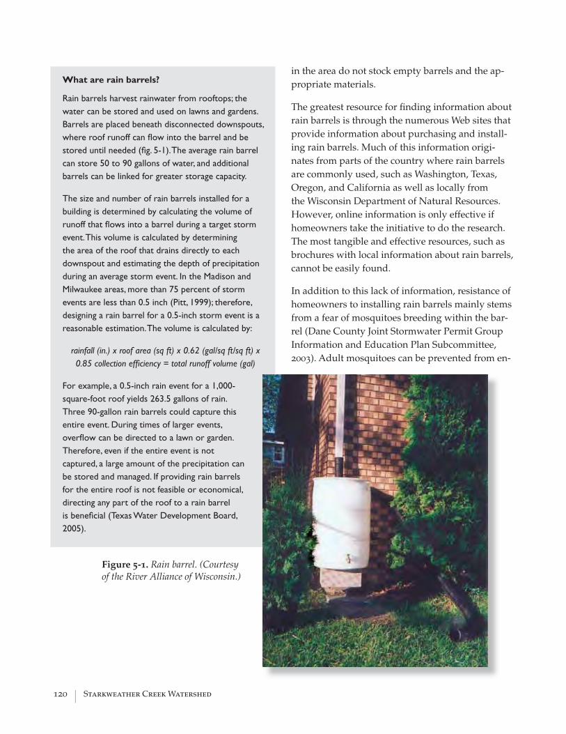
120 | Starkweather Creek Watershed
in the area do not stock empty barrels and the ap-propriate materials.
The greatest resource for fi nding information about rain barrels is through the numerous Web sites that provide information about purchasing and install-ing rain barrels. Much of this information origi-nates from parts of the country where rain barrels are commonly used, such as Washington, Texas, Oregon, and California as well as locally from the Wisconsin Department of Natural Resources. However, online information is only effective if homeowners take the initiative to do the research. The most tangible and effective resources, such as brochures with local information about rain barrels, cannot be easily found.
In addition to this lack of information, resistance of homeowners to installing rain barrels mainly stems from a fear of mosquitoes breeding within the bar-rel (Dane County Joint Stormwater Permit Group Information and Education Plan Subcommittee, 2003). Adult mosquitoes can be prevented from en-
What are rain barrels?
Rain barrels harvest rainwater from rooftops; the water can be stored and used on lawns and gardens. Barrels are placed beneath disconnected downspouts, where roof runoff can fl ow into the barrel and be stored until needed (fi g. 5-1). The average rain barrel can store 50 to 90 gallons of water, and additional barrels can be linked for greater storage capacity.
The size and number of rain barrels installed for a building is determined by calculating the volume of runoff that fl ows into a barrel during a target storm event. This volume is calculated by determining the area of the roof that drains directly to each downspout and estimating the depth of precipitation during an average storm event. In the Madison and Milwaukee areas, more than 75 percent of storm events are less than 0.5 inch (Pitt, 1999); therefore, designing a rain barrel for a 0.5-inch storm event is a reasonable estimation. The volume is calculated by:
rainfall (in.) x roof area (sq ft) x 0.62 (gal/sq ft/sq ft) x 0.85 collection effi ciency = total runoff volume (gal)
For example, a 0.5-inch rain event for a 1,000-square-foot roof yields 263.5 gallons of rain. Three 90-gallon rain barrels could capture this entire event. During times of larger events, overfl ow can be directed to a lawn or garden. Therefore, even if the entire event is not captured, a large amount of the precipitation can be stored and managed. If providing rain barrels for the entire roof is not feasible or economical, directing any part of the roof to a rain barrel is benefi cial (Texas Water Development Board, 2005).
Figure 5-1. Rain barrel. (Courtesy of the River Alliance of Wisconsin.)

Water Resources Management Practicum 2005 | 121
tering the barrel by a screen or fi lter where the water enters the barrel. Larvae that wash into the barrel can be controlled by regular cleaning of the barrel or the addition of a nontoxic larvacide.
Rain Barrel Action Points
Below is a prioritized list of action points that could be the framework for developing a rain barrel education plan.
Target the Madison audience. A brochure directed at the Madison community could be created with information about the benefi ts of rain barrels, how to install a rain barrel, where to obtain the needed supplies, and whom to contact locally with questions. By making a direct connection with the benefi ts of rain barrels to Madison’s water issues, the brochure will be more effective than general rain-barrel information. The brochure could be distributed at community events, public events, and at stores where rain-barrel supplies could be sold, such as hardware stores and nurseries.
Develop Distribution Plans. The Friends of Starkweather Creek and other community groups could organize workshops for the distribution and education of rain barrels. Rain barrels can be purchased in bulk through national distributors and distributed to residents at these workshops. Follow-up assistance with installation should also be offered by volunteers from these community groups.
Create Demonstration Sites. Encourage owners of large properties (such as schools, places of worship, businesses, local governments) to install rain barrels as demonstration sites for local communities.
Encourage Local Distribution. Large hardware and home-gardening stores should be encouraged to stock their stores with already-constructed rain barrels and the supplies necessary to build rain barrels. Public interest would encourage these local hardware stores to provide the necessary materials.
Partner with Gutter Services. Throughout the country, gutter services are profi ting from installing rain barrels at the request of clients. Gutter services could supply and install rain barrels for residents who need additional assistance.
Encourage Rain-Barrel Discounts. For homeowners to invest in rain barrels, incentives and discounts could be provided by the city or other agencies. (See Infi ltration Campaign Funding section.)
Rain Gardens
The purpose of the rain-garden campaign is to educate and encourage schools, places of worship, and businesses to build rain gardens as functioning infi ltration practices as well as educational demonstration sites for the surrounding communities. As men-tioned earlier, much of the current stormwater-management efforts focus on bringing rain gardens to homeowners (Wisconsin Department of Natural Resources, Madison Area Municipal Storm Water Partnership, Dane County Lakes and Watershed Commis-sion, Friends of Lake Wingra), with less focus on other audiences. The action plan pre-

122 | Starkweather Creek Watershed
sented here would supplement rain-garden campaigns already in existence and directly target the landowners within the Stark-weather Creek watershed who have signifi cant areas of imper-vious surfaces and potential for infl uencing large communities.
Rain gardens are becoming in-creasingly more common within
the watershed, as shown through the numerous rain gardens in the 2005 Better Lawns and Gutters Tour (fi g. 5-2). Yet some of the resistance to building rain gardens stems from concerns about costs and maintenance (R. Bannerman, June 30, 2005, verbal com-munication). One way to address these concerns is to construct rain-garden demonstra-tion sites, not simply for viewing, but to demonstrate the issues of building and main-taining a rain garden: the costs of the plants and soil, the types of plants that work best with or without sunlight or water, the demands of maintenance, and the changes the garden makes through seasons and time. Rain-garden demonstration sites can be built and maintained by the community, generating active stewards as well as performing a needed watershed function.
Rain Garden Action Plan
The following action plans provide a new approach to bringing rain gardens to the wa-tershed by addressing schools, places of worship, and businesses.
Schools. The introduction of rain gardens and their use in a formal school setting meets the goals of the infi ltration campaign in three ways. First, schools as physical entities generally have expansive areas with high percentages of impervious surfaces, which include roofs, parking lots and asphalt, and concrete play areas. The introduction of rain gardens in such a setting could mitigate the impacts of some of these impervious surfaces. Second, schools would have the opportunity to educate students about they can do to protect and enhance their watershed. This information might trickle back to the parents, who could take action on their own properties. With older, secondary students, a curriculum discussing rain gardens and their uses might infl uence these future homeowners to think more critically about what measures they can take on their own property to positively infl uence the watershed as a whole. Finally, schools are inherently community based and can serve as a focal
Figure 5-2. Residential rain garden displayed on the 2005 Better Lawns and Gutter Tour.

Water Resources Management Practicum 2005 | 123
point in a neighborhood. The construction of a rain garden in such an area might encourage other property owners in the community to make similar efforts at home.
Few public schools in Starkweather Creek watershed have any type of environmental restoration or natural areas on their grounds, with the notable exceptions of the Kennedy School Prairie Restoration and the LaFollette High School Native Plant Restoration. Within Starkweather Creek watershed are seven elementary schools, two middle schools, and one high school, but at present, no schools in Starkweather Creek watershed have rain gardens or rain barrels on school grounds. Such projects could be encouraged in an educational setting. For example, Schenk and Hawthorne Elementary Schools are in recharge areas; rain gardens at these schools could mitigate the impacts of their impervious surfaces and increase groundwater recharge. Correspondence with Schenk Elementary School indicated that plans are currently being discussed for a courtyard project that includes a rain garden (Shelia Briggs, Schenk Elementary School, September 2005, verbal communication).
Construction of a rain garden on school grounds could also introduce the watershed concept to students and their parents. Most schools in the Starkweather Creek watershed are far removed from the watershed’s prominent bodies of water, making watershed education somewhat diffi cult. By introducing a rain garden on school property, educators have a physical tool around which they can construct a watershed curriculum, connecting the students to the Starkweather Creek watershed. The rain garden could fi rst be used to teach students about runoff and recharge at the level of the school and could later be used as a jumping-off point to discuss broader watershed ideas, such as stream basefl ow, groundwater pumping, wetlands loss, and the health of our water bodies. The curriculum surrounding the rain garden could be correlated with the level of students at that particular school, with primary schools focusing on simple concepts such as the hydrologic cycle, and secondary students being taught higher-level watershed concepts, such as basefl ow and water quality.
Table E-1 in appendix E contains the names of the schools located in the watershed, their addresses, and contact information for the principals of each. Each of these schools could be contacted by mail to ascertain if there is interest among the school’s faculty in constructing a rain garden and developing a watershed curriculum around it. After it has been determined which schools and faculty might be interested in a rain-garden project, they could be provided with information about the University of Wisconsin–Madison Arboretum Earth Partnership Program and introduced to the curricula developed for the Arboretum as means of getting them started in developing their own watershed-based curriculum (University of Wisconsin–Madison Arboretum, no date).
Places of Worship. The number of faith-based environmental groups is increasing throughout the country, connecting religious faith with environmental stewardship. Religious leaders are speaking out in support of environmental causes (National Religious Partnership for the Environment, 2005). Within Madison, some congregations are involved with collaborations concerning energy and climate

124 | Starkweather Creek Watershed
change (such as the Wisconsin Interfaith Climate and Energy Campaign). Faith-based groups have been overlooked for environmental outreach, yet they can be very effective at bringing people together to discuss local issues and share information. In addition, places of worship contribute considerable amounts of runoff from their roofs and parking lots; therefore, they are important landowners to target for infi ltrating runoff.
We did not identify any faith-based environmental groups or outreach programs focused on watershed issues within the Starkweather Creek watershed. However, outside the watershed on the west side of Madison, Lake Edge Lutheran Church has an outreach program focused on caring for the Earth and plans to build a rain garden at the church in the spring of 2006 (Reverend Dick Blomker, September 13, 2005, verbal communication). This congregation could be a potential model for interested religious groups.
There are many ways to target religious groups. All places of worship could potentially be feasible for the installation of rain gardens, but a few churches are within the identifi ed areas of high infi ltration (as determined in the GIS map of recharge areas; see fi g. 3-4). These churches include Parkside Presbyterian Church, Moravian Church, Lakeview Christian Church, and St. Bernard’s Catholic Church. Infi ltration tests could be performed to confi rm reasonable infi ltration rates and evaluate the feasibility of constructing rain gardens.
Another approach is to identify active congregations, religious leaders, or community members who would be interested in bringing watershed ideas to their places of worship or build an environmental group for the broader religious community. At a single place of worship, leaders could encourage the development of an environmental outreach program that could focus on the health of the watershed. An initial activity for the program could be to evaluate the runoff of the land and install a rain garden to attract community interest and discuss environmental stewardship. Depending upon the desires and interests of the community, many different environmental issues could be addressed with this program.
Developing an environmental group or task force for many places of worship and potentially many faiths can initiate environmental interest with the broader community. This concept may have more success with smaller congregations that might not have the size to develop their own outreach program directed solely at environmental causes. An example of a faith-based environmental group is The Religious Partnership for the Anacostia River, with a mission to heal Washington, D.C.’s Anacostia River and surrounding communities. The partnership focuses on encouraging “restorative landscaping” with practices such as green roofs, rain barrels, and rain gardens to reduce the pollution of the river. The Anacostia suffers from similar stormwater problems as Starkweather Creek, and this organization is reaching out to people of all faiths to work toward improving the health of the ailing river (Religious Partnership for the Anacostia River, 2004). A similar group formed for Starkweather Creek could assist homeowners or places of worship within the watershed with building rain gardens, or simply be an avenue to communicate information to communities throughout the watershed.

Water Resources Management Practicum 2005 | 125
Businesses. Although ongoing stormwater-management efforts in the Madison area do target businesses, their use of rain gardens as an infi ltration technique seems minimal. Similar to schools and places of worship, a major contribution by businesses could be the installation of rain gardens on their properties. Businesses with smaller lots and rooftops could construct rain gardens having a design similar to ones typically installed by homeowners. Additionally, the rain-garden installation could be an excellent occasion to engage local residents in a community activity, further educating them on the purpose and function of rain gardens; Willy Street Coop is such an example.
Business owners may not be inclined to install rain gardens or other infi ltration techniques on their own, so developing an outreach program for business owners can be an effective way to educate them about the benefi ts of installing these systems. An outreach program could identify and provide support to those business owners who are interested in installation, either now or during future parking-lot resurfacing or reconstruction activities. Because businesses on larger lots are likely to have larger rooftops and parking lots, bioinfi ltration facilities, as described in the infi ltration chapter, would be better suited to these types of properties. Bioinfi ltration design is more complex than a rain garden; the outreach program could also provide resources about who can perform infi ltration tests and evaluate the feasibility of various infi ltration techniques.
As mentioned previously, businesses could supply rain-garden products and educational materials. Hardware stores, nurseries, and gardening stores would be effective places to distribute rain-garden resources, in particular plants and materials for rain-garden installation, and educational materials. Several gardening stores already sell native plants with an adjacent display describing rain gardens. An outreach program could focus on expanding the number of stores that promote rain gardens. In addition, the rain-garden displays could be enhanced with fl yers that include design principles as well as a listing of further resources and Web sites. This effort by businesses might target otherwise uninterested homeowners and inspire them to install rain gardens on their properties.
Many businesses take part in community service, either through participation in community activities or donations to projects. An environmental education program in Grand Rapids, Michigan, entitled “Rain Gardens of West Michigan” (Rain Gardens, 2000–2004) encourages businesses to partner with schools in developing rain gardens. They suggest businesses could not only donate money for materials, but could also join students in maintaining the gardens (http://www.rain gardens.org/Opportunities.php). This type of approach would complement the recommendation of introducing rain gardens into the schools. Given the rain-garden education efforts that have taken place in Madison to date, organizations such as Madison Area Municipal Storm Water Partnership, the Lakes and Watershed Commission, and the WDNR likely have numerous projects to which businesses could contribute or even actively participate.
Knowing their efforts would be acknowledged might further inspire businesses to become involved in rain garden efforts. One watershed group, The Anacostia River

126 | Starkweather Creek Watershed
Business Coalition in Rockville, Maryland, gave recognition to those businesses that have installed rain gardens (Anacostia River Business Coalition, no date.). Again, this is an approach that could be considered for the Starkweather Creek watershed.
Infi ltration Campaign Funding
A crucial component of promoting infi ltration practices among homeowners, schools, places of worship, and businesses is sustained funding. As efforts among some munici-palities have shown, encouraging the use of rain gardens and rain barrels can be contin-gent on formal programs, which include cost-shares, discounts, and even rainwater-har-vesting rebates to homeowners. The benefi ts for a homeowner may lie in reduced water bills. Water utilities may see reduced demand on stormwater systems, which may lower overall production costs for providing water (Gertson and others, 2002).
Cost-sharing and grants for rain-garden projects have gained in popularity across North America. However, only a few cities in the United States are beginning to offer rain bar-rels to its citizens at a reduced rate; many regions of Canada have been implementing such programs since 2000 (Regional Municipality of Waterloo, 2001).
A key aspect for successfully promoting the widespread use of infi ltration practices within a community is funding support administered by a local entity. Because the City of Madison is already making attempts to increase rain gardens through the 1000 Rain Gardens Project, identifying funding for rain-garden projects may not be as construc-tive as funding recommendations for increasing the usage of rain barrels. Another major local effort includes the Graham–Martin Prairie Foundation’s gift to Dane County and the City of Madison in 2005 to support the establishment of rain gardens and the use of native seeds and plants (Dane County Executive Offi ce, 2005). It may be more advanta-geous to pursue rain barrels because the City of Madison and Dane County are making serious efforts to promote community infi ltration, and the establishment of successful rain-barrel programs has already been demonstrated in some United States and Cana-dian cities. Many grants identifi ed to promote rain gardens may serve a dual purpose for promoting rain barrels, especially because much of the available grant money is to control nonpoint source pollution (appendix E, tables E-2 to E-4).
Rain barrels and rain gardens can vary in cost, depending on supplies and installation. Some estimates of the costs for implementing a rain garden range “from about three to fi ve dollars per square foot when designed and built by the landowner,” versus “about ten dollars per square foot if constructed by a professional landscaper” (Minnesota Lakes Association, 2005). The average cost of a rain barrel for a “low-density residential lot in a subdivision” is $120, excluding accessory components (Low-Impact Develop-ment Center, 2003). These accessories, which are generally required to capture rooftop runoff, can push the total cost to more than $200. However, as square footage of rooftops increase so too does the size and cost of the rain-barrel system.
Encouraging the use of rain barrels within a watershed or municipality may initially require the use of federal, state, and/or local funds. Outside of regional or municipal programs, no grants or cost-sharing programs are available to individual homeowners
Water Resources Management Practicum 2005 | 127
for rain barrels. However, many funds are available to states, cities, and nonprofi ts to reduce nonpoint source pollution. At present, the residents of the Starkweather Creek watershed are not offered subsidies for the installation of a rain-barrel system.
Some of the most successful infi ltration programs are Seattle’s RainCatchers Pilot pro-gram; the City of Austin, Texas, rain-barrel sales, rebate, and harvesting rebate pro-grams; the City of Olympia, Washington, rain-barrel sales program; and the Christina Basin rain-barrel survey in Pennsylvania and Delaware. These programs have had a very good response; most rain-barrel sales events run out of supplies. For example, the City of Olympia, Washington, had to turn away people who wanted rain barrels during one of their sales events due to limited supplies (City of Olympia, 2005). Homeowner experience using rain barrels has also been very good in most cases, with participants in the Christina Basin reporting 100-percent satisfaction (Kaufman and others, 2003). In Canada, rain barrels have gained popularity among residents, especially in towns like Waterloo, Ontario, which has a population of almost 80,000 residents. The Water Ser-vices Division of Waterloo planned to distribute 25,000 rain barrels from 2001 to 2005, as part of their long-term water strategy. In 2001, 6,000 rain barrels were distributed to Waterloo residents at the reduced rate of $30 per barrel; the city allocated $225,000 of the capital budget for cost-sharing in this effort (Regional Municipality of Waterloo, 2001). The cities of Edmonton, Vancouver, Thunder Bay, and Halton also similar programs.
Federal, state, local, and private funds are available to support a rain-barrel rebate or cost-sharing program. Some potential funding sources are described in appendix E (tables E-2 to E-4).
NORTH PLATTE CAMPAIGN
The North Platte, adjacent to Olbrich Botanical Gardens, is a relatively undeveloped plot of land within the Starkweather Creek watershed. In 1999, Olbrich Botanical Gar-dens completed their master plan, which included only a broad, conceptual plan for the North Platte. Olbrich is updating their master plan, and they intend to revamp the de-sign for North Platte (Hinkfuss, 2002). Planning efforts provide a unique opportunity for providing substantial watershed education about human impacts upon the landscape.
Site Analysis
The North Platte is within the Starkweather Creek watershed near the mouth of Stark-weather Creek (Olbrich Botanical Gardens, no date). The confl uence of Starkweather Creek forms its northern and eastern boundaries; Olbrich Botanical Gardens. its western and southern ones. It is close to two major arterials, Atwood Avenue and Fair Oaks Av-enue (fi g. 5-3). “Olbrich Botanical Gardens is actually owned and operated by the City of Madison Parks Division, in partnership with the nonprofi t Olbrich Botanical Society” (Olbrich Botanical Gardens, no date). Given its location, the North Platte has high vis-ibility and extremely good public access.
The North Platte has a rich and varied history. At one time, the North Platte was pre-

128 | Starkweather Creek Watershed
Figure 5-3. Location of the North Platte in relation to Olbrich Botanical Gardens and Starkweather Creek.
Sources: City of Madison, Dane County, Wisconsin Department of Natural Resources
NorthPlatte
OlbrichBotanicalGardens
StarkCreek
weather
Lake Monona
Atwood Avenue
Fair O
aks A
venu
e
�0 1 20.5Miles
dominantly wetlands. Given its proximity to the confl uence and the infl uence of sea-sonal fl ooding, the exact size of these wetlands is diffi cult to quantify. The wetlands were drained and subsequently fi lled for development, and today they are less than 0.5 acre in size. From 1906 to 1924, the site contained a factory used by U.S. Sugar Company to produce sugar from sugar beets. The factory was sold in 1926 and again in 1929, when it became a feed mill and warehouse under the ownership of the Wisconsin Sales and Storage Company. In 1975 the property changed hands and was renamed Garver Feed and Supply Company; it continued to operate until 1997 (Hasbrouck Peterson Zimoch Sirirattumrong, 2005).
In 1997, the Madison Community Development Authority sold two parcels totaling 17 acres to the Madison Parks Division. At the same time a nonprofi t organization, Olbrich Botanical Society, in partnership with the City of Madison, acquired a 5-acre parcel known as the Garver Property. Olbrich Botanical Society transferred this parcel to the City of Madison. The three parcels, totaling 22.9 acres, make up the North Platte, which is dedicated to future expansion of the botanical gardens and parks (Hinkfuss, 2002).

Water Resources Management Practicum 2005 | 129
Physical Structures
Two buildings are on the North Platte, the Garver Building and the Garver Cottage (Ol-brich Botanical Gardens, no date). As seen on fi gure 5-4, the Garver Building is on the southern part of the North Platte and faces the existing bike trail. The Garver Cottage is east of the Garver Building.
Although the Garver Building is somewhat dilapidated (a fi re in 2001 exacerbated the deteriorating conditions), numerous structural evaluations and feasibility studies show that the building was well constructed and still has some structural integrity. It has been designated as an historic landmark, and planning processes are underway to determine its reuse. Approximately 35,000 square feet will be available (Hinkfuss, 2002). The Garver Cottage was used as an offi ce building for the factory. In 2001, the Cottage was renovated in a way that preserved its historic design; it is used as offi ce space for the Olbrich Gar-dens horticultural staff (Madison Trust for Historic Preservation, no date).
Previously Studied Site Conditions
In 2004, a class in the Department of Urban and Regional Planning, University of Wis-consin–Madison, conducted a site analysis and prepared conceptual plans for the reno-vation of the Garver Feed Mill building. As part of their site analysis, they collected in-formation on many conditions at the North Platte, some of which include the following:
• deed restrictions,
• land uses,
• zoning regulations,
• utilities, including stormwater, sanitary sewer, and water lines,
• transportation, including roads, recreation trails, and rail corridors, and
• environmental corridors and open space.
Appendix F contains the part of their report that synthesizes these site conditions.
Environmental Conditions
Soil conditions throughout the North Platte are varied. Soil cores collected near the Garv-er Building revealed a shallow layer of topsoil over compact fi ll, as did the outer edges of the forested area on the west side of the North Platte. However, several soil cores taken toward the center of the forested area showed little evidence of gravel fi ll. The cores showed layers of peat, sand, silt, and clay, not necessarily in that order. Infi ltration studies demonstrated little to no infi ltration capacity (0.0 – 0.1 cm/hr) near the Garver Building; the outer edge of the forested area had signifi cantly greater infi ltration rates (8 cm/hr).
The forested area primarily contains stands of cottonwood. The downstreambank veg-etation consists of early successional woody species and some native forbs. Vegetation in the remaining areas tends to be heavily disturbed; the upstream part of the streambank

130 | Starkweather Creek Watershed
Figu
re 5
-4. N
orth
Pla
tte
conc
eptu
al p
lan.

Water Resources Management Practicum 2005 | 131
is a near monoculture of reed canary grass. The remaining open space throughout the North Platte is either void of vegetation or contains predominantly of reed canary grass. Wildlife observed at the North Platte was typical to an urban setting.
Stakeholders
Primary stakeholders for the North Platte design include the Olbrich Gardens board and staff and several departments of the City of Madison, including the Parks and Planning Divisions. Mayor Dave Cieslewicz provided the “impetus for moving forward with re-storing the Garver Building” (Urban and Regional Planning, 2004, p. 40) and therefore, is another key stakeholder. Friends of Starkweather Creek, adjacent neighborhood resi-dents, and current and potential users of the site (for example, local residents and visi-tors of Olbrich Gardens) are also stakeholders. Olbrich Gardens and the City have been leading current planning processes for the North Platte, and Friends of Starkweather Creek and local residents have been active in having their thoughts and ideas included in the process.
Opportunities and Constraints
The North Platte faces formidable obstacles for preservation and enhancement of natu-ral areas and for watershed education. Soil conditions are primarily compacted fi ll mate-rial, which makes native plant restoration and creation of formal botanical gardens diffi -cult and costly. The compacted fi ll also limits groundwater recharge; precipitation ponds on the North Platte or is discharged directly into Starkweather Creek through overland fl ow, contributing to its poor water quality. Vegetation species are less than ideal, with reed canary grass dominating parts of the area.
Because the site is quite large and relatively undeveloped, there are many possibilities for what the site should become. Reaching an agreement on a fi nal design will require an ample amount of time and effective collaboration. In addition, renovation of the his-toric Garver Building and any other ecological restoration could be costly.
Nevertheless, the North Platte has tremendous opportunities. Because of its rich his-tory—one that includes human infl uence and disturbance—the North Platte offers an excellent on-the-ground location to educate citizens about human impacts on the land-scape. It can be used as a laboratory to show how humans have caused degradation with previous land uses and how we can make positive changes in the future. In addi-tion, the North Platte is a rare plot of open, undeveloped land in the City of Madison. It is centrally located and could easily connect to Olbrich Botanical Gardens, Olbrich Park, and O.B. Sherry Park (Urban and Regional Planning, 2004). The North Platte also has a high community value. Many local residents use the space for walking and would like to see its accessibility for recreational activities maintained and even enhanced (J. Steines, verbal communication, April 2005).

132 | Starkweather Creek Watershed
Conceptual Plan
Vision and Conceptual Design Goals
Given the opportunities at the North Platte, this conceptual plan strives to achieve the following goals:
• to provide opportunities for watershed education throughout the site,
• to maintain and enhance community value of the area, and
• to restore wetland, prairie, and forested areas throughout the site to enhance aes-thetics and ecological functions, such as stormwater fi ltering and wildlife habitat.
By achieving these goals, the North Platte could become a model for fostering knowl-edge and appreciation of watersheds. It would demonstrate how an undeveloped parcel might look with watershed enhancement, protection, and restoration as a design prior-ity, while still providing revenue-generating activities.
Precedence
Existing educational exhibits can serve as a starting point for generating ideas applicable to the North Platte. Exhibits that educate the public about watersheds are beginning to have greater prominence across the United States. For example, the Academy of Natural Sciences Museum in Philadelphia (http://www.acnatsci.org/museum/) has an indoor exhibit entitled Living Downstream, created in 2001. It explores how human activities degrade water quality and what people can do to help watersheds and the aquatic envi-ronment. The Seattle Aquarium (no date) has a watershed activity center as part of their exhibits. Although the exhibit is impressive, all its components are replicas, not displays in a natural setting. The City of Boise, in partnership with corporate and citizen funding, is in the process of building an environmental education center, entitled Boise WaterShed (http://www.cityofboise.org/BoiseWaterShed/). It will be certifi ed as a Leadership in Energy and Environmental Design and will have exhibits that focus on issues affecting watersheds, ranging from water quality and wastewater treatment to stormwater recy-cling.
Many outdoor nature centers include human impacts upon the environment as a com-ponent in their educational programs. The University of Wisconsin–Madison Arboretum Earth Focus Day Camp (http://uwarboretum.org/education/efdc/) is such an example. Some nature centers have even been built around former industrial sites. For example, the Eden Mill Nature Center and Historic Grist Mill Museum (http://www.edenmill.org/) in Pylesville, Maryland, developed a nature center around a former grist mill. The educational exhibit proposed for the North Platte will build upon these and other water-shed-exhibit concepts.
Features of the Conceptual Plan
Building Recommendations. Currently, the Garver Building rehabilitation has been identifi ed as the fi rst step in the North Platte planning process, of which the city

Water Resources Management Practicum 2005 | 133
is taking the lead. This includes not only construction activities, but uses for the building. Once that has been established, the planning process would proceed to the remaining North Platte property (E. Komosa, verbal communication, July 26, 2005). Ideally, the Garver Feed Mill Building renovation would be addressed in conjunction with the entire North Platte design. Because this is not the case, we suggest looking at any building proposals with the following questions in mind, “What uses will help to improve the physical, chemical, and biological quality of the Starkweather Creek watershed? What uses can help educate and promote stewardship of the watershed?”
The Urban and Regional Planning (2004) conceptual plan for the Garver Feed Mill put forth many proposals for the building. Of these, we feel the following would best answer these two questions: an interactive nature museum and a green building demonstrating sustainability techniques (for example, solar energy and stormwater management through rain barrels and a vegetated rooftop, among others). We also support uses that generate income such as a café or facilities for weddings and other large events. Rooms could be available to the public for smaller meetings; this could help promote a sense of community.
Interpretive Displays of Watershed History. The North Platte has a history of development that is characteristic of much of the watershed. Therefore, this area and its landscape features could be used as a means of educating the public about this typical development pattern. Interpretive displays could be created and used to bring visitors through the years spanning from the fi rst settlement of the area for agricultural processes to current degraded watershed conditions. Specifi cally, these displays could highlight the following events:
• draining of wetlands by tiles for agricultural purposes,
• fi lling of wetlands for urban development,
• channelization of streams to quickly convey urban runoff once stored by lost wet-lands,
• armoring of streambanks to protect from erosion caused by runoff-dominated streams,
• decrease in water quality because of loss of wetlands and increased urban runoff, and
• establishment of invasive species in areas where habitat is degraded and poor quality runoff adversely affects native species.
These interpretive displays could be located on the North Platte, close to the features that they are describing. For example, a display discussing channelization could be located on the stream in a straightened area.
Because a sense of history can lead to residents developing a connection with an area of environmental interest, another set of interpretive signs should be developed in a similar fashion to describe the specifi c history of the North Platte. The displays could discuss the following features:

134 | Starkweather Creek Watershed
• U.S. Sugar Company and sugar beet production.
• Garver Grain Company.
• history of the railroad in relation to Madison, and
• history of Olbrich Gardens.
Other features of the North Platte could also be marked with interpretive displays as they relate to watershed issues or features of the watershed that are worth highlighting. To give visitors a synoptic view of the North Platte as well as the interpretive displays located throughout, a brochure, physical model, or map of the North Platte could be also be made available.
Rain-Barrel and Rain-Garden Educational Displays. Multiple demonstration sites located throughout the North Platte could educate visitors about the different infi ltration practices that homeowners can perform in their own backyards. These sites could display rain gardens and rain barrels with a self-guided tour of interpretive signs about how to install them and their benefi ts to the watershed. Demonstrating these practices would help educate the community about how people can reduce their own stormwater runoff as well as understand the hydrologic and water-quality benefi ts of these practices for managing runoff and enhancing infi ltration. These displays would be of interest to horticulturalists who visit Olbrich to learn more about native plant species and root function. Most important, these demonstration sites could encourage stewardship among community members to engage in activities that not only enhance the beauty of their backyards, but benefi t the health of the watershed.
Ideal locations for rain barrels in the North Platte are beneath a selected number of downspouts of the Garver Building (fi g. 5-4). Because we do not know what the gutter confi gurations of the building will be, we are unable to calculate rainwater volume and rain-barrel size. The roof area directed to each downspout is required for calculation of roof runoff volume. In addition to rain barrels, a cistern could be installed on the northwest corner of the Garver Building as a part of a green building design and used as a non-potable water source.
The design of rain gardens within the North Platte can allow for many variations. The size and shape of the gardens can be designed to best fi t the other elements of the landscape. The types of plants used in rain gardens could include grassy prairie species as well as colorful, fl owering plants that would attract birds and butterfl ies. The gardens can be noted for their design and aesthetics, but still have the functionality of deep root systems that stabilize soils and increase infi ltration.
The location of the rain gardens would best be found along the edge of the Garver Building for the directed water to enter the gardens. They should be at least 10 feet from the base of the building to prevent water damage to the structural foundation.
As a result of the industry in this area, the soil has been signifi cantly disturbed and the current soil conditions have low infi ltration rates that may not be ideal for a rain garden. An infi ltration test should be conducted to ensure a rain garden
Water Resources Management Practicum 2005 | 135
would function properly. It is likely that the soil conditions on the North Platte are not ideal. Nonetheless, we recommend the installation of rain gardens solely for educational purposes. For an enhanced educational exhibit, experiments could be conducted to demonstrate the infi ltration capabilities of various plant communities.
Wetlands Restoration. The wetland on the southwest corner of the East and West Branch convergence would benefi t from restoration. The main goal of the wetland restoration would be to remove the highly invasive reed canary grass that grows along the creek and promote the reestablishment of native wetland species. An additional goal in this effort is to promote awareness of the impacts that urban stormwater runoff has on wetland aquatic habitats. After most of the wetland restoration work has been done, a number of interpretive signs describing natural and degraded wetlands as well as the restoration process could be erected along the walking trail that skirts this wetland area. These interpretive signs could include a description of the ecosystem functions that wetlands serve in a watershed. Wetland areas directly across the stream could be used as a comparison to this newly restored area. Although a more powerful comparison could be made by leaving a part of the North Platte wetlands degraded, this might encourage the reestablishment of reed canary grass in the restored area by plants remaining in the degraded plot.
The wetland restoration at the North Platte could also make mention of the nearby MG&E Marsh located across Fair Oaks Avenue on the West Branch of the creek. This area is an excellent example of a wetland that has survived the urbanization of the watershed. The interpretive signs at the North Platte wetlands could direct visitors to the MG&E Marsh and describe some of the shortcomings of restored wetlands at the North Platte compared to their natural counterparts. Interpretive signs could also be placed at the MG&E Marsh to describe the type of wetland it is and some of the plant species found within it, and asking visitors to observe the wetland from the trail to help protect it from degradation. These components of the education campaign would educate the public about the processes, values, and issues facing wetlands on the North Platte as an illustration of the processes, values, and issues facing wetlands located in the watershed as a whole.
Riparian Corridor Improvements: Terracing and Buffer Zone. Terracing can be an effective method of streambank stabilization: It can improve the connectivity between the channel and the fl oodplain, thereby reducing erosion problems and promoting stable vegetation along the banks. We propose riverbank terracing along a part of the North Platte, beginning at the southeast corner, where the streambank intersects the railroad crossing, and extending upstream to the proposed wetland restoration.
Although this part of the stream corridor is not severely eroded, a terrace system on public lands would provide a readily accessible hands-on experience with terraces. Similar to the wetland-restoration project, interpretive signs placed along the walking trail where it passes the terraced banks would serve as a tool to communicate information. The displays could also encourage visitors to apply their knowledge and to watch for signs of erosion as well as streambank-stabilization techniques at other locations along the creek.

136 | Starkweather Creek Watershed
Also important to overall stream and corridor health is a riparian buffer zone. Because the North Platte is a relatively undeveloped public space, it provides a rare opportunity within the watershed to provide a substantial buffer between the creek and adjacent land uses. A specifi c width would need to be determined during the site-design phase because many factors are involved in determining such a width: suffi cient fl oodplains, stream-corridor regulations, trail design, and even streambank construction. However, in consideration of high fl ows passing by this location, and the fact that some streambank stabilizations extend 30 feet beyond the channel (Schueler and Brown, 2004), we recommend a buffer no less than 75 to 100 feet.
Forest Protection and Restoration. Given that few wooded areas are in the urban locality of the North Platte, we recommend preserving all forested sections in an effort to preserve this rare and unique resource. Preserving this forested area would provide a number of benefi ts to the local community. The area provides a reprieve from the urban environment and serves as an educational tool as well an environmental buffer for the creek. The soil conditions, infi ltration rates, and vegetation are the least disturbed of the entire site. Removing the cottonwood stands or otherwise altering this area would likely result in impervious surfaces, runoff, or lower infi ltration rates, thus degrading Starkweather Creek even further. Some forest-management techniques, including additional plantings, may be necessary to fully restore and preserve the site, and a detailed study could be conducted. However, this type of study would take lower precedence to other recommendations in this conceptual plan.
Prairie Restoration and Natural Interpretive Gardens. Prairie ecosystems are unique landscape features that were once dominant and now exist in small fragments scattered across the Midwest. Restoring an area of prairie ecosystem would expand upon the educational experience of visitors to the North Platte. Most of the North Platte is removed far enough from Starkweather Creek that soils are suffi ciently dry to facilitate a prairie restoration in non-forested areas. Removal of fi ll material in the southern part of this area could create conditions conducive to such an undertaking. A prairie restoration on the North Platte would serve as a complement to Madison’s west side prairie restoration at the Arboretum and would allow Olbrich Gardens to display another distinct botanical exhibit.
The undeveloped land east of the proposed prairie restoration could be used as natural interpretive gardens. These gardens could have a somewhat structured layout and be used for native plant information and identifi cation. The area could also include additional exhibits, such as historical interpretive displays and interactive watershed and soils exhibits.
Driveway and Parking Recommendations. Additional parking and vehicle access necessary for the development of the North Platte should be placed and installed only on an as-needed, low-impact basis. Prior to construction of additional paved areas, a proposed-use study could be conducted to determine the daily and special event parking and vehicle access needs of the North Platte and Olbrich Gardens. If additional parking is determined necessary, other parking lots located within walking distance could be considered prior to construction of any new parking facilities. Three parking lots, consisting of approximately 330 total parking spaces,

Water Resources Management Practicum 2005 | 137
are adjacent to Olbrich Park and the boat-launch facilities, all within approximately 1,000 to 2,500 feet from the existing main entrance of Olbrich Gardens. As noted on the North Platte conceptual plan (fi g. 5-4), existing parking for Olbrich Park and the Olbrich boat launches could be used during special events when additional parking is occasionally needed.
If future gardens are placed where proposed in fi gure 5-4, proposed parking locations will be very close to the new garden areas. If distance from the garden entrance is still a concern, a shuttle service could be established for special occasions. Using existing parking facilities would limit the impact of building additional parking as well as save limited construction funds for other garden projects.
Low-impact development criteria could be implemented when determining the appropriate size, location, and type of materials for constructing any new parking lot. To minimize impacts to existing natural areas, new parking facilities should be positioned outside of any established creek buffer area and away from other environmentally sensitive areas, such as wetlands, woodlands, or prairies (Schueler and Brown, 2004). A few possible appropriate locations for new parking have been noted on the North Platte site plan (fi g. 5-5).
Because parking facilities constitute such expansive areas, constructing additional parking using pervious pavement or porous concrete should be strongly considered. A number of studies have shown that pervious pavement signifi cantly reduces runoff volumes and pollutant loading when compared to traditional installations of impervious surfaces (Construction Industry Research and Information Association, 2002; California Stormwater Quality Association, 2003; Pratt, 1995; U.S. Environmental Agency, 2000; Brattebo and Booth, 2003). In Tampa, Florida, porous pavement was installed for a section of the parking lot built for the Florida Aquarium. A comparison of pervious sections to adjacent impervious sections of cement and asphalt showed that the porous pavement successfully reduced runoff fl ows from the parking lot as well as reduced concentrations of metals within the runoff (U.S. Environmental Agency, 2000).
Construction of a parking lot using porous material does cost somewhat more than traditional impervious applications (U.S. Environmental Agency, 2002); however, the net environmental benefi t received by adjacent waterways, in particular Starkweather Creek, and the reduced need for additional stormwater-control systems, could signifi cantly offset installation and annual maintenance costs (Daley, 2003; Pervious Pavement specialist, 2003). Construction design manuals should be used to determine whether the proposed site is suitable for porous pavement, how to properly install and maintain porous pavement, and what the estimated cost will be (California Stormwater Quality Association, 2003; U.S. Environmental Agency, 1999; New Jersey Department of Environmental Protection, 2004; City of Portland, 2004; King County, 1998). Interpretive signs discussing the benefi ts of pervious pavement and other low impact parking measures could be located adjacent to these areas in an effort to further educate the public.
Additional North Platte Vehicle Access. We understand that, in accordance with the Olbrich Gardens master plan, a drive connecting the Garver Building with Fair

138 | Starkweather Creek Watershed
Figu
re 5
-5. N
orth
Pla
tte
cont
ext m
ap.

Water Resources Management Practicum 2005 | 139
Oaks Avenue is desired (Urban and Regional Planning, 2004). If constructed, the drive would be approximately 900 feet long and add a minimum of 18,000 square feet of impervious space to the North Platte (fi g. 5-5). This estimate is based on the assumption that the road would have very low traffi c volume and no curbside parking, allowing a narrow street width of 20 feet to be suffi cient (Dane County Planning and Development and Better Urban Infi ll Development Program, 2004). As with the additional parking areas, installation of this impervious surface would have a signifi cant impact to the North Platte resources. However, it does make sense to have an additional access point to the Garver Building to allow vehicular access for emergency services and the physically disabled. As with the proposed parking areas, pervious pavement is a viable option for construction of the drive and would mitigate impacts to surface-water quality.
Walking Trails. In the Starkweather Creek Master Plan 2005 update, the City of Madison Parks Division outlined a concept for the Garver Area and North Platte that included a number of walking trails that would connect Olbrich Gardens, O.B. Sherry Park, and the Dixon Greenway and serve as a framework for native restoration. On the basis of that recommendation, we propose that a walking-trail system be developed to guide North Platte visitors through the educational interpretive displays that we propose in this report. These trails could also highlight the various natural vegetation communities present on the North Platte (wetlands, riparian corridors, and forest stands). The conceptual plan (fi g. 5-4) and perspective (fi g. 5-6) illustrate the recommended placement of these trails. The proposed trail system consists of three loops: 1) one that has interpretive stations dealing with the “typical” development patterns of a watershed (tiling, channelization, and dredging) 2) another that showcases the unique historical features of the North Platte (the U.S. Sugar Company Plant/Garver Building and railroad yards) and 3) one that contains descriptions of various restoration efforts undertaken in the area (streambank terracing and wetland restoration). (A more detailed description of these interpretive stations can be found in the previous section, Interpretive Displays of Watershed History.)
The three trails would begin at or near the Garver Building, interconnect in the North Platte, and be equipped with adequate signage. In addition, at least one of the trails should meet the American Disability Act’s recommendations for pedestrian paths. This will create a trail of required width, composed of a hard-packed material with ample area for turnarounds. The remaining trails will be more primitive and preserve one of the last undeveloped areas in an already highly urbanized Starkweather Creek watershed. The trail that extends into the wetland would connect to boardwalks within this area to facilitate access during the periods of high and low water that are characteristic of wetlands. Finally, the entire trail system would be accented with more secluded spots in accordance with the Starkweather Creek Master Plan 2005 update to offer visitors locales for “nature study and contemplation.” After the establishment of this trail system, the segment nearest Fair Oaks Avenue could be extended northwest to connect the North Platte to one of Starkweather Creek watershed’s best wetlands, the MG&E Marsh. This will require additional signage at the Fair Oaks crossing and at the marsh to ensure that visitors
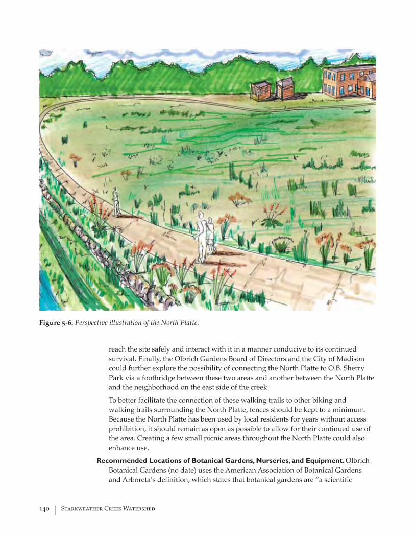
140 | Starkweather Creek Watershed
reach the site safely and interact with it in a manner conducive to its continued survival. Finally, the Olbrich Gardens Board of Directors and the City of Madison could further explore the possibility of connecting the North Platte to O.B. Sherry Park via a footbridge between these two areas and another between the North Platte and the neighborhood on the east side of the creek.
To better facilitate the connection of these walking trails to other biking and walking trails surrounding the North Platte, fences should be kept to a minimum. Because the North Platte has been used by local residents for years without access prohibition, it should remain as open as possible to allow for their continued use of the area. Creating a few small picnic areas throughout the North Platte could also enhance use.
Recommended Locations of Botanical Gardens, Nurseries, and Equipment. Olbrich Botanical Gardens (no date) uses the American Association of Botanical Gardens and Arboreta’s defi nition, which states that botanical gardens are “a scientifi c
Figure 5-6. Perspective illustration of the North Platte.

Water Resources Management Practicum 2005 | 141
and education institution, whose purpose is the advancement and diffusion of a knowledge and love of plants.” The exhibits and restoration sites proposed for the North Platte could serve as nontraditional botanical gardens where visitors can learn and appreciate native plants and the critical role they play in a watershed ecosystem.
Because many visitors appreciate and enjoy the specialty gardens that currently exist at Olbrich, an effort could be made to expand the specialty gardens. Several local residents have stated that the ballparks located east of Starkweather Creek are underutilized and have suggested converting them into specialty gardens (J. Steines, verbal communication, September 7, 2005). Expanding gardens in this location would allow for connectivity to the Thai Pavilion, and a fully accessible bridge could connect them to the other specialty gardens. A large parking lot in the vicinity could service the expanded gardens.
As seen on the conceptual plan (fi g. 5-4), the recommended location for nurseries and maintenance equipment is behind the Garver Cottage. This location would allow for vehicular access and would be close to the Garver Building, offi ces in the Garver Cottage, and the existing garden displays. In addition, it would be relatively easy to block public access to the nurseries and equipment and still allow open access to the remainder of the North Platte.
Need for Funding and Fiscal Analysis
Neither economic nor fi scal analyses have been included in this conceptual plan. How-ever, it is likely that any projects on the site would have economic and fi scal impacts on the City, given the property’s size, cost for improvements, and the potential uses. There-fore, these analyses would be necessary.
However, we have researched possible funding sources for preservation, natural re-source enhancement, and watershed education. Funding restoration projects and com-munity watershed education on the North Platte is largely contingent on the efforts of the City of Madison and the Olbrich Botanical Society. Some of the funding sources identifi ed in the Infi ltration Campaign Funding section of this chapter may be applicable to projects on the North Platte; this area is of signifi cant community value and would ben-efi t watershed awareness among Starkweather Creek residents. Many funds are avail-able for wetland restoration projects, so this type of project may be easily funded. A few grants of interest are the Five Star Restoration Matching Grants Program, National Cor-porate Wetlands Restoration Partnership, and Water Quality Cooperative Agreements of the U.S. Environmental Protection Agency Region 5 National Pollutant Discharge Elimi-nation System. Many of these grants stipulate a collaborative approach between multiple stakeholders in the watershed, including private businesses, municipal and state agen-cies, and nonprofi ts. Another major requirement of the grants is the ability of a project to increase community awareness of watershed protection through educational outreach.
Stakeholder Involvement
This conceptual plan has not been through a public participation process or had stake-holder input. Many parties, including local residents, care deeply about the North Platte and how its development will affect the adjacent neighborhoods, gardens, and the Stark-

142 | Starkweather Creek Watershed
weather Creek watershed. Having all the stakeholders come together, especially during the early planning and design phases, can help make the North Platte a story of success.
CITIZEN STEWARDSHIP CAMPAIGN
Purpose
The overarching purpose of the citizen stewardship campaign is twofold. First and fore-most, the campaign aims to increase the community’s awareness of watersheds and the problems that can face these features of our urban landscape. Because the Starkweather Creek watershed is the largest watershed in Madison, increasing its residents’ knowl-edge of the watershed concept would affect a large segment of Madison’s population. A second goal is to promote watershed stewardship by citizens who live within and out-side of the watershed’s boundaries. Increasing awareness of watershed issues is a fi rst step in encouraging citizens to take action and positively affect the state of Starkweather Creek watershed. A map and explanatory text have been designed to achieve these two goals.
Product
The map of the Starkweather Creek watershed (which measures 11 x 17 inches) illus-trates the creek, roads, walking trails, biking trails, and canoe trails as well as some of the major physical and cultural landmarks found in the watershed. The explanatory text describes many of these landmarks. It also presents some of the problems facing the wa-tershed, gives suggestions as to what citizens can do to help, and provides contact infor-mation for parties and agencies involved in the protection of the watershed.
Distribution
The distribution of the Starkweather Creek watershed map could be the responsibil-ity of three parties. Initially, we will take the lead in placing the map and brochure at appropriate locations. After the workshop dissolves, the primary responsibility could shift to the City of Madison and the Friends of Starkweather Creek. Because the City of Madison has been a major partner in this workshop and will probably be responsible for the implementation of many of the suggestions found in this report, it is logical that they become one of the principal distributor of the map, especially at municipal buildings that fall within the watershed. In addition, the City of Madison could also be responsible for placing the map in schools so that it can be used as a curriculum tool and primer for further watershed restoration programs. The Friends of Starkweather Creek could take responsibility for establishing distribution points in places of worship and institu-tions that are involved in community education and cleanup efforts. Supportive busi-ness, especially those that impose a large footprint on the watershed, such as the Dane County Regional Airport and East Towne Mall, could also be approached by the Friends as a means of increasing awareness in areas that affect the watershed most. Finally, the Friends could distribute the map to neighborhood associations, community gathering

Water Resources Management Practicum 2005 | 143
locations, and festivals/clean-up events that are located within and near the watershed. The Nelson Institute for Environmental Studies at the University of Wisconsin–Madison will serve as a permanent distribution point for the map.
An initial printing of the map and brochure will be funded by the 2005 Water Resources Management Practicum. An electronic copy will be housed at the Nelson Institute for Environmental Studies at the University of Wisconsin–Madison and will also be passed on to the Friends of Starkweather Creek, the City of Madison, and Olbrich Botanical Gardens. This electronic copy can then be taken to any printing company to be printed.
Potential Use and Extensions of Map and Text
One major use of the map and explanatory text could be its promotion as a guided tour of the watershed as a means of inducing stewardship. By guiding citizens and visitors through the watershed, the map and brochure will illustrate how the entire watershed is connected and how individuals can positively affect the whole watershed by their ac-tions.
The map could also be directly tied to the development and restoration that will be tak-ing place on the North Platte. Olbrich Botanical Gardens already serves as one of the fo-cal points of the watershed and the restoration of the North Platte will be underlain with educational components. Therefore, the map and text could be distributed to encourage Olbrich and North Platte visitors to travel farther into the watershed and explore its fea-tures and the problems that it faces.
Primary and secondary schools should also consider using the map and brochure as a component of curricula at different grade levels. For example, primary schools could use the map as a means of teaching map orientation skills to children on a local level. Secondary school curriculums could be developed to teach the watershed concept to sci-ence classes or could be used as a basis for developing a wetland or prairie restoration project within the watershed.
The map could be updated as an exercise in proactive watershed awareness. The City of Madison and the Friends of Starkweather Creek could review the map and text annually as a means of reevaluating the status of the watershed and prioritizing what should be done within it to continue in the direction of the improvements that have already been made.
REFERENCES Academy of Natural Sciences Museum, no date, Living Downstream: Philadelphia, PA.
Retrieved September 2005, from http://www.acnatsci.org/museum/.
Anacostia River Business Coalition, no date, Rain Gardens: Rockville, MD. Retrieved September 30, 2005, from http://www.potomacriver.org/arbc/rain gardens.htm.
Brattebo, B.O., and Booth, D.B. , 2003, Long-Term Stormwater Quantity and Quality

144 | Starkweather Creek Watershed
Performance of Permeable Pavement Systems: Water Research, v. 37, no. 18, p. 4369-4376.
California Stormwater Quality Association, 2003, Stormwater Best Management Practice Handbook—Construction.
City of Boise, no date, Boise Watershed: Boise, ID. Retrieved September 2005, from http://www.cityofboise.org/BoiseWatershed/.
City of Madison Engineering and Parks Division, 2005, Starkweather Creek Master Plan 2005 Updates: Madison, WI.
City of Olympia Public Works Department, 2005, City Government: Outdoor Conser-vation: Ways to Conserve: Description of Olympia, Washington’s rain barrel pro-gram, City of Olympia, Washington. Retrieved September 2005, from http://www.ci.olympia.wa.us/publicworks/waterresources/conservation/Rain%20Barrels.
City of Portland, Environmental Services Clean River Works, 2004, Stormwater Man-agement Manual. Retrieved from http://www.portlandonline.com/bes/index.cfm?c=35122.
Cole-Misch, S., Price, L., and Schmidt, D., 1996, Sourcebook for Watershed Education: Dubuque, IA, Kendall/Hunt.
Construction Industry Research and Information Association, 2002, Source control using constructed pervious surfaces, C582.
Daley, R.M., 2003, A Guide to Stormwater Best Management Practices: City of Chicago, p. 29.
Dane County Joint Stormwater Permit Group Information and Education Subcom-mittee, 2003, Joint Stormwater Permit Group Information and Education Plan: A Stormwater Information and Education Strategy for 19 Dane County Municipalities: Madison, WI.
Dane County Offi ce of the County Executive, 2005, County Executive Falk Announces Graham-Martin Prairie Foundation Gift and Grant Program: Madison, WI, Lesley Sillaman. Retrieved May 2005, from http://www.co.dane.wi.us/press/default.asp?frmPRID=483.
Dane County Planning and Development and Better Urban Infi ll Development (BUILD) Program, 2004, Dane County Wisconsin Model Traditional Neighborhood Develop-ment Ordinance version 1.0.
Dane County Regional Planning Commission, 1992, Yahara–Monona Priority Watershed Plan: Madison, WI.
Earth Force, no date, Earth Force Catalog: Alexandria, VA. Retrieved February 2006, from http://www.earthforce.org/green.
Eden Mill Nature Center and Historic Grist Mill Museum, no date: Pylesville, MD. Re-trieved September 2005, from http://www.edenmill.org/.

Water Resources Management Practicum 2005 | 145
Gertson, J., MacLeod, M., and Jones, C.A., 2002, Effi cient water use for Texas: Policies, tools and management strategies: College Station, TX, Environmental Defense and Texas Water Resources Institute, Texas A&M University. Retrieved September 2005, from http://twri.tamu.edu/reports/2002/tr200/tr200.pdf.
Hasbrouck Peterson Zimoch Sirirattumrong, 2005, Feasibility study for the rehabilitation and adaptive reuse of the Garver Feed Mill, p. 1-20.
Hinkfuss, B., 2002, The Sugar beet: An exploration of potential reuse and fi nancing strat-egies for the former U.S. Sugar/Garver Feed Building in Madison, Wisconsin, Uni-versity of Wisconsin-Madison.
Kaufman, G.J., Wonziak, S.L., and Vonck, K.J., 2003, A Watershed restoration action strat-egy (WRAS) for the Delaware portion of the Christina Basin: A clean water strategy to protect and restore the watersheds of the Brandywine, Red Clay and White Clay Creeks, and the Christina River in Delaware: Newark, DE, University of Delaware, v. 14, Appendix D.
King County Department of Natural Resources, 1998, Washington surface water design manual: Seattle, Washington.
Low-Impact Development Center, Inc., 2003, Cost of Rain Barrels and Cisterns, Low Impact Development Techniques: Low Impact Development (LID) Center, Beltsville, MD. Retrieved September 2005, from http://www.lid-stormwater.net/raincist/rain-cist_cost.htm.
Madison Trust for Historic Preservation, no date, 2004 Preservation Awards: Garver Cottage, 3300 Sugar Avenue. Retrieved May 2005, from http://www.madisontrust.org/awards/04_garver.html.
Minnesota Lakes Association, 2005, Stormwater runoff from the driveway to the lake: Reporter, v. 9, no. 2.
National Religious Partnership for the Environment, 2005, Caring for God’s Creation. Retrieved January 2006, from http://www.nrpe.org/.
New Jersey Department of Environmental Protection, 2004, Standard for Pervious Pav-ing Systems—New Jersey Stormwater Best Management Practices Manual, from http://www.state.nj.us/dep/stormwater/bmp_manual2.htm.
Olbrich Botanical Gardens, no date, Olbrich Botanical Gardens: A Brief History: Madi-son, WI. Retrieved May 2005, from http://www.olbrich.org/Volunteering/Visi-tor_Information/Garden%20History/history.html.
——, no date, Outreach letters and handouts.
Pervious Pavement Specialist-Environmentally Friendly Pervious Concrete Pavement, 2003, Why Pervious Concrete Pavement Is Better: Stuart, Florida, Pervious Pave-ment. Retrieved October 2005, from http://www.perviouspavement.com/why.html#contruction.

146 | Starkweather Creek Watershed
Pitt, R., 1999, Small storm hydrology and why it is important for the design of stormwater control practices, in James, W., ed., Advances in Modeling the Manage-ment of Stormwater Impacts, v. 7: Computational Hydraulics International, Guelph, Ontario and Lewis Publishers/CRC Press.
Pratt, C.J., Mantle, D.G., and Schofi eld, P.A., 1995, UK research into the performance of permeable pavement, reservoir structures in controlling stormwater discharge quan-tity and quality: Water Science Technology, v. 32, no. 1, p. 63-69.
Rain Gardens of West Michigan, 2000-2003, Opportunities: Grand Rapids, MI. Retrieved September 30, 2005, from http://www.rain gardens.org/Opportunities.php.
Regional Municipality of Waterloo, 2001, Transportation and Environmental Services departmental report: Rain barrel distribution report: Regional Municipality of Wa-terloo, Water Services Division E-01-035.
Religious Partnership for the Anacostia River, 2004, About the River. Retrieved August 2005, from http://www.religiouspartnership.org/.
Schueler, T., and Brown, K., 2004, Urban Stream Repair Practices, Version 1.0, Manual 4: U.S. Environmental Protection Agency, Offi ce of Water Management, Center for Wa-tershed Protection Version 1.0, Manual 4.
Seattle Aquarium, no date, Exhibit map: Seattle, WA. Retrieved September 2005, from http://www.seattleaquarium.org/exhibits/map/.
Texas Water Development Board, 2005, Texas manual on rainwater harvesting, 3rd Edi-tion. from http://www.twdb.state.tx.us/publications/reports/rainharv.pdf.
U.S. Environmental Protection Agency, 1995, Cleaner water through conservation, Chap-ter 3. Retrieved March 2006, from http://www.epa.gov/OW/you/chap3.html.
——, 1999, Porous pavement—Stormwater technology fact sheet: Washington, D.C.
——, 2000, Low impact development (LID) - A Literature Review. EPA-841-B-00-005: Washington, D.C. Retrieved January 2006, from http://www.epa.gov/owow/nps/lid/lid.pdf.
——, 2002, Green parking, post-construction stormwater management in new develop-ment and redevelopment. Retrieved September 2005, from http://cfpub.epa.gov/npdes/stormwater/menuofbmps/post_12.cfm.
University of Wisconsin–Extension Environmental Resources Center, no date, Educating young people about water: Madison, WI. Retrieved February 2006, from http://www.uwex.edu/erc/eypaw.

Water Resources Management Practicum 2005 | 147
APPENDIX ASTUDIES AND PLANS RELEVANT TO STARKWEATHER CREEK
Plans specifi cally addressing Starkweather Creek Watershed
• Starkweather Creek Master Plan 2005 Update (City of Madison—Engineering and Parks Divisions, 2005)
• Starkweather Creek Master Plan 2004 Update (City of Madison—Engineering and Parks Divisions, 2004)
• Starkweather Action Program (Dane County Regional Planning Commission, 1987)
• Starkweather Creek Water Quality Plan (Dane County Regional Planning Com-mission, 1983)
Additional plans relevant to Starkweather Creek Watershed
• City of Madison Comprehensive Plan Public Hearing Draft (City of Madison, DRAFT 2005)
• Dane County Comprehensive Draft Plan (Dane County Department of Planning and Development, DRAFT 2005)
• Dane County Water Body Classifi cation Study Phase I (Dane County Regional Planning Commission, 2005)
• Dane County Water Quality Plan Summary Plan 2004 (Dane County Regional Planning Commission, 2004)
• East Washington Avenue Gateway Revitalization Plan (City of Madison, 2003)
• Madison Urban Area and Dane County Bicycle Transportation Plan (Madison Area Metropolitan Planning Organization, 2000)
• Dane County Water Quality Plan Appendix G—Groundwater Protection Plan (Dane County Regional Planning Commission, 1999)
• Dane County Water Quality: Conditions and Problems (Dane County Regional Planning Commission, 1999)
• Dane County Regional Hydrologic Study: Evaluation of Alternative Management Strategies (Dane County Regional Planning Commission, 1997)
• Vision 2020 Dane County Land Use and Transportation Plan (Dane County Re-gional Planning Commission, 1997)
• Environmental Corridors (Dane County Regional Planning Commission, 1996)
A

148 | Starkweather Creek Watershed
• Dane County Water Quality Plan Appendix B—Surface Water Quality Conditions (Dane County Regional Planning Commission, 1990)
• Yahara-Monona Priority Watershed Plan (Dane County Regional Planning Com-mission, 1992)
• Urban Wetlands in the Yahara–Monona Watershed: Functional Classifi cation and Management Alternatives (Water Resource Management Program, 1990)
• Neighborhood Plans (http://www.ci.madison.wi.us/planning/ndp/index.html)
REFERENCES
City of Madison Engineering and Parks Divisions, 2004, Starkweather Creek master plan 2004: Madison, Wisconsin.
—— 2005, Starkweather Creek master plan 2005 updates: Madison, Wisconsin.
Dane County Regional Planning Commission, 1983, Starkweather: A water quality plan for Starkweather Creek: Madison, WI.
——1987, Starkweather action program 1987-1991: Madison, WI.
——1992, Yahara–Monona Priority Watershed Plan: Madison, WI.
——1990, Dane County water Quality Plan Appendix B—surface qater quality condi-tions: Madison, WI.
——1997, Evaluation of alternative management strategies, Dane County regional hy-drologic study: Madison, WI.
——1997, Land use and transportation plan. Vision 2020, Planning for our future. Re-trieved from www.co.dane.wi.us/vis2020/2020home.htm.
——1999, Dane County groundwater protection plan: Madison, WI.
Mdison area Metropolitan Planning Organization, 2000, Bicycle transportation plan for the Madison urban area and Dane County, Wisconsin. Retrieved from www.ci.madison, wi.us/transp/Bicycle/Sept2000/bikeplan00.pdf.
Water Resource Management Program, 1990, Urban wetlands in the Yahara–Monona Watershed: Functional Classifi cation and Management Alternatives: University of Wisconsin-Madison, Institute for Environmental Studies.
Water Resources Management Practicum 2005 | 149
APPENDIX B WATER-QUALITY TESTING PROCEDURES
Semi-permeable membrane devices (SPMDs) were developed by the U.S. Geological Survey to act as a passive sampling water-quality indicator. They can be deployed in air, water, or soil. The SPMDs are fl attened tubes of low-density polyethylene fi lled with a thin layer of the high molecular weight lipid triolein, a neutral lipid that is found in most aquatic organisms. Less expensive and easier to collect and analyze than biota, the SPMDs can be deployed for different lengths of time to determine possible biocon-centration rates. They are stationary, which allows contamination sources at different sections in the creek to be identifi ed. The SPMD results are highly reproducible, can be standardized over different seasons and sites, and can be compared to results from other river and stream studies using SPMDs (Huckins and others, 2002). Using SPMDs does not require the removal of already scarce biota, such as fi sh, for tissue analysis. Because they act like biological tissue, the SPMDs can be used to determine which compounds fi sh would bioconcentrate in their tissues as they pass contaminated water through their gills.
The SPMDs accumulate nonionic organic compound with a Kow value >1, meaning they absorb substances that prefer being in fat tissues rather than water. Such compounds include polycyclic aromatic hydrocarbons, polychlorinated biphenyls (PCBs), poly-chlorinated dioxins and furans, organochlorine pesticides, several “new generation” pesticides, pyrethroid insecticides, nonylphenols, some herbicides, several industrial chemicals, tributyltin, alkylated selenides, and others (Huckins and others, 2002). These contaminants are of concern due to their toxicity and carcinogenic tendencies. Some cause taste and odor problems in the water supply and others may cause health con-cerns, especially in humans.
We deployed the SPMDs in six sites throughout the Starkweather Creek watershed (table B-1; fi g. B-1). The “above airport” (the Dane County Regional Airport) and the “above East Towne Mall” sites were chosen because they were far upstream on their re-spective branches. In theory, these would be the sites with the best water quality because they are upstream of the most likely sources of contamination. The “below airport” and “golf course ditch” (Bridges Golf Course) sites were chosen as places of specifi c interest. Airports are commonly sources of organic pollutants, and the golf course ditch drains an abandoned dump. The “Milwaukee Street” site was chosen because the U.S. Geological Survey has performed previous water-quality investigations there and because this site is downstream in the watershed and would offer a comparison to the SPMDs deployed upstream. The “below Lien Marsh” site was chosen as a comparison to the site above East Towne Mall to determine whether or not water quality improved or decreased as the creek passed through the wetlands associated with this reach.
We deployed two sets of six SPMDs in the study locations over the spring and summer
B
150 | Starkweather Creek Watershed
Figure B-1. SPMD sampling sites.
!
!
! !
!
!
Above Airport
Below Airport
Golf Course Ditch
Milwaukee Street
Below Lien Marsh
Above East Towne
0 10.5Miles
CreekIntermittentPerennial
Watershed
SPMD Sites!
¯ Sources: City of Madison, Dane County, WRM Practicum 2005

Water Resources Management Practicum 2005 | 151
Site Name Location Latitude Longitude
Above airport Upstream end of reach 7W N 43° 08.792’ W 089° 19.387’
Below airport Downstream end of reach 7W N 43° 07.253’ W 089° 20.410’
Golf course ditch Near upstream end of reach 6W N 43° 06.810’ W 089° 20.421’
Milwaukee Street Upstream end of reach 4W N 43° 05.957’ W 089° 20.284’
Below Lien Marsh Downstream end of reach 7E N 43° 06.832’ W 089° 18.617’Above East Towne Mall Near downstream end of reach 8E N 43° 07.479’ W 089° 17.717’
Table B-1. Exact locations of SPMD deployment.
of 2005 to obtain an integrated sample of varying contaminant concentrations levels within the creek. The fi rst set was deployed for 30 days beginning April 20, 2005. Over this period, the Starkweather Creek watershed received 3.85 inches of rain (National Climatic Data Center, 2006). We deployed the second set of six SPMDs on June 22, 2005, again for 30 days. During this time, 2.97 inches of rain fell on the watershed (National Climatic Data Center, 2006). On the fi rst day of each deployment, a seventh SPMD was exposed to the atmosphere at each of the sites to account for airborne contaminants.
Upon removal from the creek, all the SPMDs were sent to EST, Inc., for dialysis to extract the lipid from the bag. Following dialysis, the liquid samples were concentrated down to approximately 0.5 mL using the Kuderna–Danish method. This volume was then fi ltered through a glass fi ber fi lter paper, with hexane as a transfer solvent, and blown down again with UHP nitrogen gas.
Half of the sample from each site was preserved in DMSO, and the other half was am-pulated in hexane. For the fi rst half, 0.5 mL of DMSO was placed in an amber vial and the dialysates were transferred through a series of 3 hexane rinses. These vials were then placed under the nitrogen blown down unit again until all the hexane evaporated. At this point, an additional 0.5 mL of DMSO was added to the vial.
For the other samples, 0.5 mL of the dialystate was placed in an ampule using hexane as the transfer solvent. The ampules were then chilled in an IPA/dry ice solution and sealed with an oxygen/acetylene torch. The fi nal sample volume was approximately 1 mL (Terry L. Spencer, verbal communications, July 29, 2005).
After the extraction process, the SPMD samples were sent to the Wisconsin State Labora-tory of Hygiene for further testing.
The DMSO samples underwent a Microtox test, a process that determines a value of general toxicity. In this test a beaker is fi lled with a known value of luminescent bacte-ria that produce light as a function of their cellular respiration. The strain Vibrio fi sheri NRRL B-11177 is typically used because it is highly sensitive to the toxicity of a wide range of chemicals. When exposed to toxins in water samples, some of these bacteria die, decreasing the total level of light emitted. As the toxicity of a water sample in-creases, more of these bioluminescent bacteria die, further decreasing the level of light

152 | Starkweather Creek Watershed
emitted (Azur Environmental, no date). Relative values of toxicity are determined by comparing the level of light emitted by the bacteria before and after the addition of the SPMD extracts. In this case, bioluminescence was measured from the bacteria at the start of the test and given the value of 100 percent light remaining. The SPMD extract in the DMSO was then added to the beaker. After 15 minutes, the amount of light was mea-sured again.
The results from this test for both sets of SPMDs are shown in fi gures B-2 and B-3. The relative toxicity between the sites can be determined by comparing the bioluminescence values. The trip blank or control sample, which was exposed only to the atmosphere over the course of SPMD deployment, displayed the least toxic rating. This rating served as the benchmark against which all other samples would be measured. The least toxic sample (highest relative amount of light remaining) and therefore the site with the best water quality within the creek was just upstream of the Dane County Regional Airport.
During the fi rst sampling period, results from the site above the airport showed a toxic-ity that reduced the total light emitted over a 15-minute period to 67 percent. However, the SPMD collected from the site above the airport during the second sampling period had only 1 percent light remaining; the site below the airport was about 61 percent, very similar to the fi rst reading above the airport. It is highly unlikely for the water quality to make such a drastic improvement over such a short distance downstream and without any active treatment. We hypothesized that at some point, the sample for the sites above and below the airport were switched with one another. After further specifi c contami-nant analysis, we believe this to be the case, because chemical compounds found in the
Figure B-2. Results from the Microtox test showing relative toxicity between the sites, set 1
Figure B-3. Results from the Microtox test showing relative toxicity between the sites, set 2.
67
2 0
3731
37
77
0
20
40
60
80
100
Above Airport Below Airport Golf Ditch Milwaukee St. Below Target East Towne
Mall
Trip Blank
%L
igh
tR
em
ain
ing
1
61
1
15
28
49
67
0
20
40
60
80
100
Above Airport Below Airport Golf Ditch Milwaukee St. Below Target East Towne
Mall
Trip Blank
%L
igh
tR
em
ain
ing

Water Resources Management Practicum 2005 | 153
site below the airport from the fi rst de-ployment and the site above the airport in the second deployment coincided. Consequently, we concluded that the site above the airport contained the best water quality of all the sampled points in the watershed.
The sites within the watershed that showed the worst water quality were the golf course ditch and the site immediately downstream of the airport. The samples from both sites killed nearly all the bacte-ria in the Microtox test after the 15-minute testing period.
The second SPMD at the Milwaukee Street site was the third most toxic loca-tion after the ditch and airport.
Gas chromatography mass spectrometer tests were performed on the SPMD extracts that were ampulated in hexane. The purpose of this analysis was to gain a general un-derstanding of the types of organic compounds in the creek. Certain compounds had a much higher relative concentration in the Starkweather Creek samples than were found in the control sample. Consequently, these compounds are more likely to be in the creek at higher concentrations than the other compounds that were found. These compounds are listed in table B-2. A complete list of all the organic compounds that were found in
the creek can be seen in table B-3 (next page).
REFERENCES
Azur Environmental, no date. Retrieved March 2006, from http://azurenv.com/mtox.htm.
Huckins, J.N., and others, SPMD Technology Tutorial (3rd edition). Retrieved May 2005, from http://www.aux.cerc.cr.usgs.gov/spmd/SPMD-TechTutorial.htm.
National Climatic Data Center, 2006, U.S. Department of Commerce. Retrieved March 2006 from http://www.ncdc.noaa.gov.
University of Wisconsin–Madison Arboretum, no date, Earth Focus Day Camp: Madi-son, WI. Retrieved September 2005, from http://uwarboretum.org/education/efdc.
Urban and Regional Planning, 2004, Course 601: Redevelopment of the Garver Feed Mill: Site analysis and conceptual plans, University of Wisconsin–Madison.
Wisconsin Department of Natural Resources, 2005, Project WET: Madison, WI. Retrieved July 2005, from http://dnr.wi.gov/org/caer/ce/pltwild/wet.htm_3.
Table B-2. Chemicals that were found in Starkweather Creek in higher concentrations relative to the concentrations found in the control sample.
9-Methylanthracene Methyl Fluorene +Phenanthrene OctylcyclohexaneFluorene DecylcyclohexaneFluoranthene cyclopenta(cd)pyrenePyrene Dibenzo(ae)pyreneBenz(a)anthracene Dehydroabietic acidchrysene/triphenylene Benzo (a)pyreneBenzo (b)fl uoranthene 1-methylchrysene +benzo(k)fl uoranthene benzo(GHI)fl uoranthenebenzo(a)pyrene retenebenzo(e)pyrene 9,10 AnthraquinoneStigmasterol Benz(a)anthracene-7,12-dionePerylene Phthalic acid(M)indeno(cd)pyrene Dodecanoic acid(M)benzo(ghi)perylene Tetradecanoic acid(M)1-phenyl-naphthalene

154 | Starkweather Creek Watershed
Table B-3. Organic compounds found in Starkweather Creek
Napthalene 22R, 17a(H),21b(H)-30-homohopane Tritriacontane
1-methyl naphthalene 22s,17a(H),21b(H)-30-bishomohopan Tetratriacontane
2-Methylnaphthalene 22r,17a(H),21b(H),30-bishomohopane Pentatriacontane
2,6-Dimethylnaphthalene 22s,17a(H),21b(H)-30,31,32-trishomoh Hexatriacontane
9-Methylanthracene 22r,17a(H),21b(H)-30,31,32-trishomoh Cyclopenta(cd)pyrene
Phenanthrene Methyl Fluorene Dibenzo(ae)pyrene
Fluorene Octylcyclohexane 22s,17a(H),21b(H)-30-homohopane
Fluoranthene Decylcyclohexane Benzo (a)pyrene
Pyrene Undecane n-c11 1-methylchrysene
Benz(a)anthracene Dodecane n-c12 Benzo(GHI)fl uoranthene
Chrysene/triphenylene Tridecane n-c13 Retene
Pristane Tetradecane n-c14 9,10 Anthraquinone
Benzo (b)fl uoranthene Pentadecane n-c15 Benz(a)anthracene-7,12-dione
Benzo(k)fl uoranthene Hexadecane n-c16 Squalene
Benzo(a)pyrene Heptadecane n-c17 1-octadecene
Benzo(e)pyrene Octadecane n-c18 Phthalic acid(M)
Pyrene Eicosane Dodecanoic acid(M)
Perylene Tetracosane Tetradecanoic acid(M)
Indeno(cd)pyrene Pentacosane Palmitic acid(M)
Benzo(ghi)perylene Hexacosane Oleic acid (M)
Bis(2-ethylhexyl)phthalate Heptacosane Cholesterol
Butyl benzyl phthalate Octacosane Stigmasterol
Diethyl Phthalate Nonacosane Monopalmitin
Dibutyl Phthalate Triacontane 1-phenyl-naphthalene
17b(H)-21a(h)-Norhopane Hentriacontane Dehydroabietic acid
17a(H)-21B(H)-hopane Dotriacontane Cholesta-3,5-diene

Water Resources Management Practicum 2005 | 155
APPENDIX C
GEOGRAPHIC INFORMATION SYSTEM FOR STARKWEATHER CREEK
Starkweather Creek Watershed Geographic Information System
We used a geographic information system (GIS) in this project to enhance our ability to assess the current conditions of the Starkweather Creek watershed and provide a data resource for future analysis. In addition to gathering data to study the creek in relation to various aspects of this project, we also thought that a thorough and complete collec-tion of data for the Starkweather Creek watershed would be of benefi t for others inter-ested in learning about or analyzing the watershed. The individual data layers as well as the Starkweather GIS are available on CD-ROM. The CD can be found on the back jacket of the hard copy of this report or is available for download from the Water Resources Management Practicum 2005 Web site, (www.nelson.wisc.edu/wrm/workshops/2005). Prior to using the data, a user license and disclaimers must be read and accepted.
The main intent of the GIS was to allow a simple way for those interested in the water-shed, including novice GIS users, to view the data. Environmental Systems Research Institute, Inc. (ESRI) ArcReader technology was chosen as the desired map-viewing soft-ware application. ArcReader allows the user to view previously created ArcGIS maps using a few straightforward tools. Detailed instructions for using the software can be found by clicking the “Help” menu once the GIS application is installed and open. The ArcReader application is provided on the CD accompanying this report or can be down-loaded free from the ESRI Web site (http://www.esri.com/software/arcgis/arcreader/download.html).
The CD also includes 1) a detailed list of all the included data layers, 2) a copy of the data disclaimer, 3) copies of each data layer and 4) PDF versions of each map generated for the report.
Data Acquisition and Organization
The fi rst step in developing a GIS for any study area is to evaluate the data needs of the project. Because the goal of this Starkweather Creek watershed study was to assess and propose enhancement opportunities to improve watershed functions, we emphasized the collection of data relating to water resources. Data layers such as creek network, wa-tershed boundary, wetland areas, springs, and fl oodplain delineation were determined to be the most critical. In addition, because the watershed is largely developed, land-use layers—such as parcels, land-use type, transportation network, park locations, and open-space areas—were also included.
We also obtained existing GIS data from a number of sources, such as the City of Madi-
C

156 | Starkweather Creek Watershed
son, Dane County, the Wisconsin Geological and Natural History Survey, and the Wis-consin Department of Natural Resources. Appropriate permissions were granted from each agency to either use the data for analysis and maps and/or to provide the data for presentation in the Starkweather Creek GIS. Some of the data we were searching for could not be found. In these few cases, we were able to generate the necessary data. In addition, some of our analyses resulted in new GIS data layers; they are illustrated in fi gure C-1.
Upon receipt of each fi le, we performed a thorough quality assessment. We did not ac-cept data for the GIS database unless its date, author, and projection were known and a metadata fi le was available. For each data fi le, we catalogued the following information: layer name, original location/name, owner/distributor, metadata fi le type, description of data, date, currency, permissions, and comments. Each accepted fi le was catalogued in a spreadsheet (table C-1) and organized into the Starkweather Creek GIS database. Most information collected in a GIS data layer is a static snapshot of what are actually dynamic data. Watershed attributes such as stream courses, parcel owners, and land-use types will change over time. For this reason, all GIS fi les received from local agencies were kept in their original format so that necessary future updates to the Starkweather
Figure C-1. New layers generated as a result of this study.

Water Resources Management Practicum 2005 | 157
Tab
le C
-1. A
ccep
ted
fi les
inte
grat
ed in
to th
e St
arkw
eath
er C
reek
geo
grap
hic
info
rmat
ion
syst
em
Laye
r Nam
eO
rigin
al N
ame
Ow
ner/D
istr
ibut
erD
escr
iptio
n/C
omm
ents
Con
tour
s.sh
pcn
tlbgd
9, c
ntlb
ud9,
cnt
lpw
d9
(cov
erag
es)
Dan
e C
ount
y La
nd In
form
atio
n O
ffice
10ft
ele
vation
con
tours
dev
elop
ed in 1
995
Cre
ek.s
hphyd
larc
.shp
WI D
epar
tmen
t of N
atur
al R
esou
rces
1995 h
ydro
logy
data
(2000 is
most
re
cent)
dane
_00.
sid
dane
__00
.sid
Dan
e C
ount
y La
nd In
form
atio
n O
ffice
1 m
eter
ort
hophot
os fro
m 2
000
EnvC
orr.s
hpee
clsa
dx (c
over
age)
Dan
e C
ount
y R
egio
nal P
lann
ing
Com
mis
ion
Env
ironm
enta
l Cor
ridor
sFl
oodp
lain
100y
r.shp
flood
dc.s
hpD
ane
Cou
nty
Reg
iona
l Pla
nnin
g C
omm
isio
n10
0 ye
ar fl
oodp
lain
laye
r
Land
use.
shp
lu2p
bgd9
, lu2
pbud
9, lu
2pw
pd9
(cov
erag
es)
Dan
e C
ount
y La
nd In
form
atio
n O
ffice
Mun
icip
al_B
ound
.shp
mcd
pdcd
9 (
cove
rage)
Dan
e C
ount
y La
nd In
form
atio
n O
ffice
City/
Tow
n b
oundari
es 1
999
road
srd
cldcd
9 (
cove
rages
)D
ane
Cou
nty
Land
Info
rmat
ion
Offi
ce2000 R
oads
laye
r (m
ost
curr
ent)
Sew
ersh
ed.s
hpS
ewer
shed
.shp
City
of M
adis
on E
ngin
eerin
gS
ewer
shed
of S
tark
wea
ther
Cre
ek
Soils
.shp
slsp
bgd9
, sls
pbud
9, s
lspp
wd9
(c
over
ages
)D
ane
Cou
nty
Land
Info
rmat
ion
Offi
ceD
ane
Cou
nty
soi
ls lay
er d
evel
oped
by
the
NRCS
Sprin
gs.s
hpsp
rings
.shp
WR
M P
ract
ucum
200
5
Wat
ersh
ed.s
hpw
ater
shed
s.sh
pD
ane
Cou
nty
Com
mun
ity A
naly
sis
and
Pla
nnin
g D
ivis
ion
Wat
erTa
bleE
lev.
shp
dn_w
tel8
9_ar
clp.
shp
Dan
e C
ount
y C
omm
unity
Ana
lysi
s an
d P
lann
ing
Div
isio
nW
ate
rtable
eve
lvat
ion for
Dane
County
.
No
met
adata
…
Wet
land
s_po
ly.s
hpw
etpw
924
(cov
erag
e)D
NR
Bur
eau
of F
ishe
ries
Man
agem
ent a
nd
Hab
itat P
rote
ctio
n W
isco
nsi
n W
etla
nds
Inve
nto
ry.
Poly
gons
are
wet
lands
2 a
cres
or
gre
ater
Wet
land
s_pt
.shp
wet
xw92
4 (c
over
age)
DN
R B
urea
u of
Fis
herie
s M
anag
emen
t and
H
abita
t Pro
tect
ion
Wis
consi
n W
etla
nds
Inve
nto
ry.
Poin
ts a
re
wet
lands
smalle
r th
an 2
acr
esw
ater
_bod
ies
hydp
dcd9
(cov
erag
e)D
ane
Cou
nty
Land
Info
rmat
ion
Offi
ceLa
kesa
nd p
onds
wt_
dept
hw
t_de
pth
(grid
)W
RM
Pra
ctuc
um 2
005
Dep
th t
o w
ate
rtab
le r
aste
r file
Nei
ghbo
rhoo
ds.s
hpN
eigh
borh
oods
.shp
WR
M P
ract
ucum
200
5 Adap
ted fro
m C
ity
of M
adis
on C
AD
dat
aSt
orm
sew
er.s
hpst
orm
sew
er.s
hpC
ity o
f Mad
ison
Eng
inee
ring
Sani
tary
sew
er.s
hpsa
nita
ryse
wer
.shp
City
of M
adis
on E
ngin
eerin
g

158 | Starkweather Creek Watershed
Creek GIS database could be as seamless as possible.
Most data were received in shapefi le format; however, some coverage and raster data formats also exist in the GIS database. Only three minor changes were made to each layer. First, if a data type was received as a number of adjacent layers, the layers were merged to form one layer. Second, each layer was clipped so that only the features with-in the watershed remained in the layer. Finally, the names of the layers were changed, as necessary, so that they were more descriptive of the data they contained. Figure C-2 shows an example of the modifi cations that were made of land-use data that were re-ceived from Dane County. Other than the clipping and merging processes, we performed no other data manipulation.
GIS Analysis Conducted for the Recharge Areas Map
In addition to collecting data for the Starkweather Creek GIS, we also made use of some of the acquired data when conducting analysis for this report. The following is an il-lustration of the geoprocessing that was done to create the recharge areas depicted in fi gure 3-4 in chapter 3. The key factors that promote groundwater recharge are depth to bedrock, subsoil permeability and water-table depth (Dane County Regional Planning Commission, 1997). Table C-2 lists the GIS layers we collected that capture this spatial information; fi gures C-3 through C-6 show these layers.
Figure C-2. Modifi cations to land-use data.

Water Resources Management Practicum 2005 | 159
Table C-2. GIS layers used in recharge areas analysis.
Necessary attributes Data fi le Source
Soil type, depth to bedrock soils.shp Natural Resource Conservation Service
Probable substratum permeability
subtab5.dbf Natural Resource Conservation Service
Water-table elevation dn_wtel89_arclp.shp Bradbury and others (1995)
Ground-surface elevationDEM (digital elevation model)
Dane County Land Information Offi ce
For this analysis, we made signifi cant efforts to acquire the highest quality data current-ly available at the time of our analysis. However, on the basis of the metadata and com-munications with a number of professors and GIS professionals working in Madison (Frederick W. Madison, Kenneth Potter, Mike Kakuska), we found that the soils layer was crudely derived on the basis of the historic soils mapping of the area. The polygons digitized for this layer should only be considered as suggestive boundaries between soil types rather than strictly identifi ed boundaries.
To derive the recharge-area locations from these data layers, some preprocessing of the original data needed to be completed. First, the substratum permeability table was joined to the soils layer so that the permeability data could be viewed and analyzed spa-tially. The data fi eld called “NEWNAME” in the substratum permeability defi nes per-meability as shown in table C-3.
On the basis of the Dane County Regional Hydrologic Study and discussions with Ken-neth Potter, professor of hydrology and civil engineering at UW–Madison, we deter-mined three classes of permeability for soil types that have the potential to infi ltrate at least 2 inches per hour: “very rapid,” “rapid,” and “moderately rapid” (table C-3).
The water-table layer used for this analysis was developed by the Dane County Re-gional Planning Commission in conjunction with the help of Roger Bannerman for the Dane County groundwater study. The layer depicts the water table as 10-foot contour lines. To compare this polyline layer with the soils polygon layer, the fi le was converted into a polygon coverage identifying approximate depth to the water table throughout the watershed. Using spatial analyst tools, our process to convert the contour lines into a surface layer was as follows (fi g. C-7):
1. Convert dn_wtel89_arclp.shp polyline fi le to a TIN (Triangulated Irregular Net-work)
2. Convert TIN to a raster (ESRI GRID fi le format)
3. Use Map Algebra calculator to subtract water-table GRID from the DEM to get rasterized “depth to water table” over the surface of the watershed
4. Reclassify depth to water table into categories (table C-4)
5. Convert reclassed GRID to a polygon shapefi le.

160 | Starkweather Creek Watershed
Figu
re C
-3. S
ubso
il te
xtur
e.
SAN
D
SAN
D/G
RA
VEL
SAN
DY
LOAM
SILT
CLA
Y
WAT
ER
no d
ata
Cre
ekin
term
itten
t
eren
nial
p Wat
ersh
ed B
ound
ary
01
0.5
Mile
s
Sour
ces:
S
oils
: Nat
ural
Res
ourc
e C
onse
rvat
ion
Serv
ice
C
reek
: City
of M
adis
on
Wat
ersh
ed B
ound
ary:
City
of M
adis
on
¯

Water Resources Management Practicum 2005 | 161
Figu
re C
-4. S
ubst
ratu
m s
oil p
erm
eabi
lity.

162 | Starkweather Creek Watershed
Figu
re C
-5. B
edro
ck d
epth
and
hig
h pe
rmea
bilit
y lo
cati
ons.
Bedr
ock
Dep
th (i
nche
s)>6
0
30 16 12 no d
ata
Sub-
Stra
tum
Soi
l Per
mea
bilit
yve
ry ra
pid
rapi
d
mod
erat
ely
rapi
d
Cre
ekin
term
itten
t
pere
nnia
l
Wat
ersh
ed
01
0.5
Mile
s
Sou
rces
:
Soi
l/Bed
rock
: Nat
ural
Res
ourc
e C
onse
rvat
ion
Serv
ice
C
reek
: City
of M
adis
on
Wat
ersh
ed B
ound
ary:
City
of M
adis
on
¯

Water Resources Management Practicum 2005 | 163
Figu
re C
-6. D
igit
al e
leva
tion
mod
el. (
Dat
a fo
r w
este
rn e
dge
of w
ater
shed
wer
e tr
unca
ted.
)

164 | Starkweather Creek Watershed
Orig
inal
Wat
erta
ble
Con
tour
Ele
vatio
nLa
yer (
shap
efile
)
conv
erte
d to
a T
IN
WT
Elev
GR
ID -
Sur
face
Ele
v G
RID
= W
ater
tabl
e D
epth
conv
erte
d to
a
GR
ID R
aste
r
recl
asse
d
01
20.
5M
iles
conv
erte
d to
a
po
lygo
n sh
apef
ile
¯
Figu
re C
-7. G
ener
atio
n of
dep
th to
wat
er-t
able
laye
r.

Water Resources Management Practicum 2005 | 165
Depth Infi ltration effectiveness
less than 0 ft Ponded water (poor infi ltration)
0-10 ft Shallow water table (poor infi ltration)
10-25 ft Suitable water-table depth
25 ft and greater Ideal water-table depth
Table C-4. Categories for water-table depth.
Category Infi ltration Water-table depth
A Very rapid 25-193 ft
B Very rapid 10-25 ft
C Rapid 25-193 ft
D Rapid 10-25 ft
E Moderately rapid 25-193 ft
F Moderately rapid 10-25 ft
Table C-5. Categories for recharge potential.
Permeability class Infi ltration rate (in/hr)
very rapid 20 – 100
rapid 6 – 20
moderately rapid 2 – 6
moderate 0.6 – 2
moderately slow 0.2 – 0.6
slow 0.06 – 0.2
very slow 0.0015 – 0.06
impermeable 0.00 – 0.0015
Table C-3. Permeability classes.
Once the data layers were transformed into the same format, the two polygon shapefi les, water ta-ble and permeable soils, were overlaid and clipped accordingly to derive the fi nal layer identifying potential recharge areas. The categories of potential recharge were determined on the basis of these two layers (table C-5).
Watershed analysis
To perform a detailed analysis of the Rolling Mead-ows subwatershed to determine the benefi ts that small-scale infi ltration practices can have on runoff and infi ltration volumes at a local level, we used the data in table C-6 (see next page). This analysis is de-scribed in chapter 3.
References Bradbury, K.R., Muldoon, M.A., Klein, A., Misky, D., and Stobel. M., 1995, Hydrogeology
of Dane County: Wisconsin Geological and Natural History Survey Open-File Report 1995-01.
Dane County Regional Planning Commission, 1997, Evaluation of alternative manage-ment strategies, Dane County regional hydrologic study: Madison, WI.
Longley, P.A., and others, 1999, Geographical Information Systems: New York, NY, John Wiley and Sons, Inc.

166 | Starkweather Creek Watershed
Tab
le C
-6. I
nput
dat
a fo
r w
ater
shed
ana
lysi
s.
Sta
rt at
Tes
t #1
Che
ck In
put f
or L
ogic
al E
rror
sO
KO
KO
KO
KO
KO
KO
KO
KO
KO
KO
KO
KO
KO
KO
KO
KEn
d at
Tes
t #(S
ee "E
rror
Che
ck" f
or D
etai
ls)
16Te
st #
12
34
56
78
910
1112
1314
1516
(16
Test
s)Ti
tle o
f Run
Sing
le_
fam
ilyM
ulti_
fam
ily
Nur
sin
g_H
ome
Tran
spor
tVa
cant
Rec
rea
tion
Chu
rch
esSc
hool
sC
omm
eric
al
Sing
le_
fam
ily_
10
Mul
ti_f
amily
_10
Nur
sin
g_H
ome_
10Tr
ansp
ort_
10C
hurc
hes
_10
Scho
ols_
10
Com
mer
ical
_10
Sto
rm In
form
atio
nPr
ecip
itatio
n (in
):2.
82.
82.
82.
82.
82.
82.
82.
82.
82.
82.
82.
82.
82.
82.
82.
8D
O N
OT
CH
ANG
ESt
orm
Dis
tribu
tion
Type
:2
22
22
22
22
22
22
22
2Ba
sic
Area
Info
rmat
ion
Tota
l Are
a (m
i2)
0.16
780.
0209
0.00
790.
0683
0.00
380.
0064
0.00
730.
0228
0.00
290.
1678
0.02
150.
0079
0.06
830.
0073
0.02
280.
0073
% R
oofto
p23
24.9
14.6
00
05.
65.
58.
623
24.9
14.6
05.
65.
58.
6%
Driv
eway
79
19.2
00
026
.98.
146
.77
919
.20
26.9
8.1
46.7
% S
treet
00
080
00
00
00
00
800
00
% L
awn
7066
.166
.220
010
067
.586
.444
.768
.275
64.2
3365
.105
067
.08
85.9
8844
.055
% E
nhan
ced
00
00
100
00
00
00
00
00
0%
Rai
ngar
den
00
00
00
00
01.
725
1.86
751.
095
200.
420.
4125
0.64
5Fl
ow In
form
atio
n%
Roo
ftop
to L
awn
5050
500
00
5050
2550
5050
050
5025
% R
oofto
p to
Enh
ance
d0
00
00
00
00
00
00
00
0%
Roo
ftop
to R
aing
arde
n0
00
00
00
050
5050
050
5050
% L
awn
Rec
eivi
ng R
oofto
p25
2525
00
025
2510
2525
250
2525
10%
Enh
ance
d R
ecei
ving
Roo
ftop
00
00
00
00
00
00
00
00
% D
rivew
ay to
Law
n0
00
00
00
00
00
00
00
0%
Driv
eway
to E
nhan
ced
00
00
00
00
00
00
00
00
% D
rivew
ay to
Rai
ngar
den
00
00
00
00
00
00
00
00
% L
awn
Rec
eivi
ng D
rivew
ay0
00
00
00
00
00
00
00
0%
Enh
ance
d R
ecei
ving
Driv
eway
00
00
00
00
00
00
00
00
% S
treet
to L
awn
00
00
00
00
00
00
00
00
% S
treet
to E
nhan
ced
00
00
00
00
00
00
00
00
% S
treet
to R
aing
arde
n0
00
00
00
00
00
010
00
00
% L
awn
Rec
eivi
ng S
treet
00
00
00
00
00
00
00
00
% E
nhan
ced
Rec
eivi
ng S
treet
00
00
00
00
00
00
00
00
% L
awn
to E
nhan
ced
00
00
00
00
00
00
00
00
% L
awn
to R
aing
arde
n0
00
00
00
00
2525
250
2525
25%
Enh
ance
d R
ecei
ving
Law
n0
00
00
00
00
00
00
00
0%
Enh
ance
d to
Rai
ngar
den
00
00
00
00
00
00
00
00
Rai
ngar
den
Info
rmat
ion
Dep
ress
ion
Dep
th (i
n)
66
66
66
66
66
66
66
66
Soil
Thic
knes
s (in
)
1818
1818
1818
1818
1818
1818
1818
1818
Soil
Infil
tratio
n C
apac
ity (i
n/hr
) 6
66
66
66
66
66
66
66
6Su
bsoi
l Inf
iltra
tion
Cap
acity
(in/
hr)
0.26
0.26
0.26
0.26
0.26
0.26
0.26
0.26
0.26
0.26
0.26
0.26
0.26
0.26
0.26
0.26
% S
oil P
oros
ity
5050
5050
5050
5050
5050
5050
5050
5050
% S
oil F
ield
Cap
acity
33
2020
3320
2020
2020
2020
2033
2020
20C
urve
Num
ber I
nfor
mat
ion
Roo
ftop
9898
9898
9898
9898
9898
9898
9898
9898
Driv
eway
9898
9898
9898
9898
9898
9898
9898
9898
Stre
et98
9898
9898
9898
9898
9898
9898
9898
98La
wn
6969
6969
6969
6969
6969
6969
6969
6969
Enha
nced
6161
6161
6161
6161
6161
6161
6161
6161
Rai
ngar
den
100
100
100
100
100
100
100
100
100
100
100
100
100
100
100
100

Water Resources Management Practicum 2005 | 167
APPENDIX DLIEN MARSH DATA AND MG&E MARSH PLANT LISTD
Figures D-1 to D-6. Water-table data for Lien Marsh.
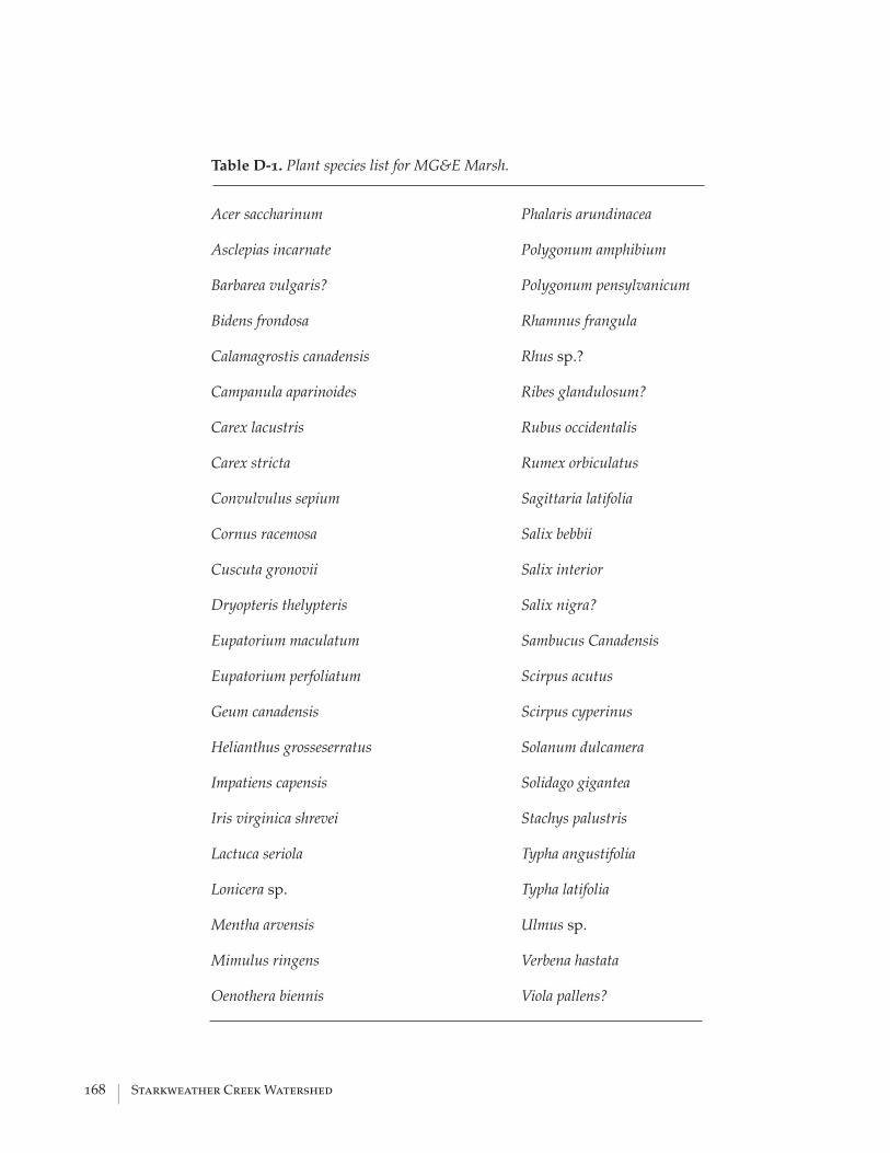
168 | Starkweather Creek Watershed
Table D-1. Plant species list for MG&E Marsh.
Acer saccharinum
Asclepias incarnate
Barbarea vulgaris?
Bidens frondosa
Calamagrostis canadensis
Campanula aparinoides
Carex lacustris
Carex stricta
Convulvulus sepium
Cornus racemosa
Cuscuta gronovii
Dryopteris thelypteris
Eupatorium maculatum
Eupatorium perfoliatum
Geum canadensis
Helianthus grosseserratus
Impatiens capensis
Iris virginica shrevei
Lactuca seriola
Lonicera sp.
Mentha arvensis
Mimulus ringens
Oenothera biennis
Phalaris arundinacea
Polygonum amphibium
Polygonum pensylvanicum
Rhamnus frangula
Rhus sp.?
Ribes glandulosum?
Rubus occidentalis
Rumex orbiculatus
Sagittaria latifolia
Salix bebbii
Salix interior
Salix nigra?
Sambucus Canadensis
Scirpus acutus
Scirpus cyperinus
Solanum dulcamera
Solidago gigantea
Stachys palustris
Typha angustifolia
Typha latifolia
Ulmus sp.
Verbena hastata
Viola pallens?
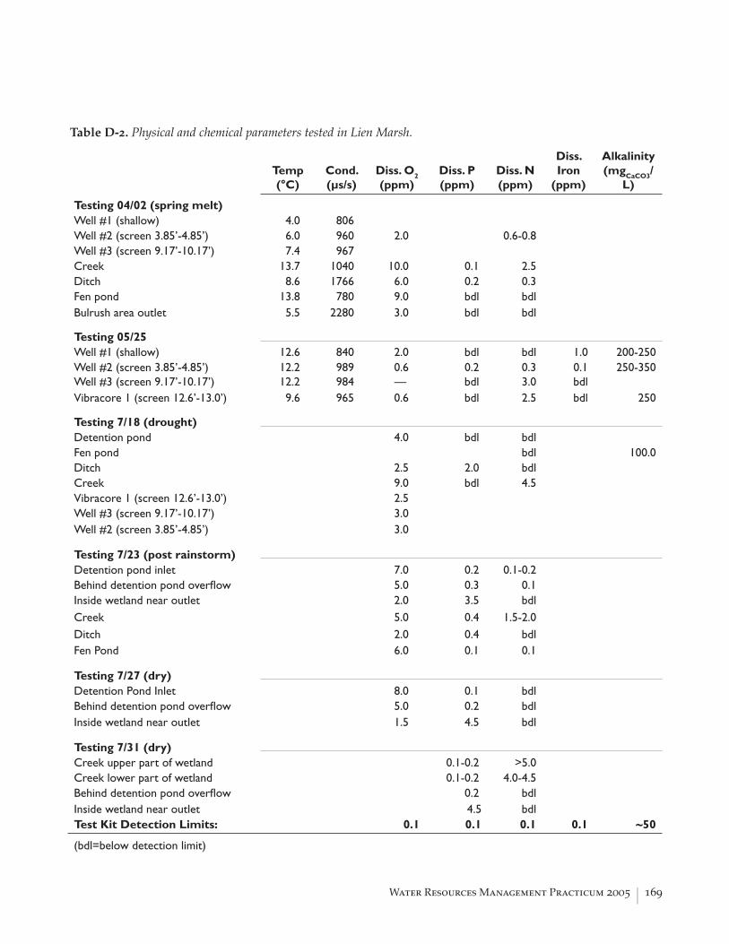
Water Resources Management Practicum 2005 | 169
Temp(°C)
Cond.(µs/s)
Diss. O2
(ppm)Diss. P(ppm)
Diss. N(ppm)
Diss. Iron
(ppm)
Alkalinity(mgCaCO3/
L)
Testing 04/02 (spring melt) Well #1 (shallow) 4.0 806 Well #2 (screen 3.85’-4.85’) 6.0 960 2.0 0.6-0.8 Well #3 (screen 9.17’-10.17’) 7.4 967 Creek 13.7 1040 10.0 0.1 2.5 Ditch 8.6 1766 6.0 0.2 0.3 Fen pond 13.8 780 9.0 bdl bdl Bulrush area outlet 5.5 2280 3.0 bdl bdl Testing 05/25 Well #1 (shallow) 12.6 840 2.0 bdl bdl 1.0 200-250Well #2 (screen 3.85’-4.85’) 12.2 989 0.6 0.2 0.3 0.1 250-350Well #3 (screen 9.17’-10.17’) 12.2 984 — bdl 3.0 bdlVibracore 1 (screen 12.6’-13.0’) 9.6 965 0.6 bdl 2.5 bdl 250 Testing 7/18 (drought) Detention pond 4.0 bdl bdl Fen pond bdl 100.0Ditch 2.5 2.0 bdl Creek 9.0 bdl 4.5 Vibracore 1 (screen 12.6’-13.0’) 2.5 Well #3 (screen 9.17’-10.17’) 3.0 Well #2 (screen 3.85’-4.85’) 3.0 Testing 7/23 (post rainstorm) Detention pond inlet 7.0 0.2 0.1-0.2 Behind detention pond overfl ow 5.0 0.3 0.1 Inside wetland near outlet 2.0 3.5 bdl Creek 5.0 0.4 1.5-2.0 Ditch 2.0 0.4 bdl Fen Pond 6.0 0.1 0.1 Testing 7/27 (dry) Detention Pond Inlet 8.0 0.1 bdl Behind detention pond overfl ow 5.0 0.2 bdl Inside wetland near outlet 1.5 4.5 bdl Testing 7/31 (dry) Creek upper part of wetland 0.1-0.2 >5.0 Creek lower part of wetland 0.1-0.2 4.0-4.5 Behind detention pond overfl ow 0.2 bdl Inside wetland near outlet 4.5 bdl Test Kit Detection Limits: 0.1 0.1 0.1 0.1 ~50
(bdl=below detection limit)
Table D-2. Physical and chemical parameters tested in Lien Marsh.


Water Resources Management Practicum 2005 | 171
APPENDIX E LOCAL SCHOOLS AND FUNDING OPPORTUNITIES
E School Address Principal
Elementary School Sandburg 4114 Donard Dr. Michael Deignan Elvehjem 5106 Academy Dr. lisa Knistad Kennedy 221 Meadowlark Dr. Craig Campbell Shenk 230 Shenk St. Sheila Briggs Lowell 401 Maple St. Beverly Cann Hawthorne 3344 Concord Av. Catherine McMillian Lake View 1802 Tennyson Ln. Linda SweeneyMiddle School Whitehorse 218 Shenk St. Anne Nolan Sherman 1610 Ruskin St. Ann Yehle O’Keefe 510 S. Thorton Av. Patrick Delmore Sennett 502 Pfl aum Rd. Colleen LodholzHigh School Shabazz 1601 N. Sherman Sally Schultz
LaFollette 702 Pfl aum Rd. Mike Meissen East 2222 E. Washington Alan Harris
Table E-1. Schools located within Starkweather Creek Watershed or who enroll students resid-ing within the watershed. Principal information was current as of 9/1/05.

172 | Starkweather Creek Watershed
Stat
e Fu
nds
Sour
cePu
rpos
eAv
aila
bilit
yAm
ount
Mor
e in
form
atio
n
Riv
er P
rote
ctio
n M
anag
emen
t Gra
nts
DN
R
Lan
d pu
rcha
se o
r con
serv
atio
n ea
sem
ents
D
evel
opm
ent o
f loc
al re
gula
tions
and
or
dina
nces
C
ontro
l of n
onpo
int s
ourc
e po
llutio
n R
esto
ratio
n pr
ojec
ts (i
nstre
am a
nd s
hore
land
ha
bita
t and
pro
tect
ion)
D
NR
app
rove
d ac
tiviti
es fo
r im
plem
enta
tion
of
plan
ning
reco
mm
enda
tions
E
duca
tion,
pla
nnin
g an
d de
sign
act
iviti
es
nece
ssar
y fo
r the
impl
emen
tatio
n of
a
man
agem
ent p
roje
ct
villa
ges,
tribe
san
dot
herl
ocal
orga
niza
tions
."
Rei
mbu
rsm
ent u
p to
75
% o
f $50
,000
http
://dn
r.wi.g
ov/o
rg/c
aer/c
fa/G
rant
s/F
orm
s/R
iver
Gui
delin
es04
Aqua
tic In
vasi
ve S
peci
es
Gra
ntD
NR
Info
rmat
ion
and
educ
atio
n on
the
type
s of
ex
istin
g an
d po
tent
ial a
quat
ic in
vasi
ve s
peci
es in
W
isco
nsin
Info
rmat
ion
on th
e th
reat
s th
ey p
ose
for t
he
stat
e’s
aqua
tic re
sour
ces
Info
rmat
ion
on th
e te
chni
ques
ava
ilabl
e fo
r the
ir co
ntro
l P
lann
ing
and
cond
uctin
g pr
ojec
ts th
at w
ill pr
even
t the
intro
duct
ion
of a
quat
ic in
vasi
ve
spec
ies
into
wat
ers
whe
re th
ey c
urre
ntly
are
not
pr
esen
t C
ontro
lling
and
redu
cing
the
risk
of s
prea
d fro
m
wat
ers
whe
re th
ey a
re p
rese
nt R
esto
ring
nativ
e aq
uatic
com
mun
ities
Publ
ic a
nd p
rivat
e en
titie
sC
ost-s
hare
up
to
50%
of $
75,0
00ht
tp://
ww
w.u
wsp
.edu
/cnr
/uw
exla
kes
/gra
nts/
AIS_
long
Res
tora
tion
Gra
nt
DN
R
Res
tora
tion
or e
nhan
cem
ent o
f a w
etla
nd o
r la
nds
drai
ning
to a
wet
land
whi
ch w
ill su
bsta
ntia
lly
cont
ribut
e to
the
prot
ectio
n or
impr
ovem
ent o
f a
lake
’s w
ater
qua
lity
or it
s na
tura
l eco
syst
emno
t elig
ible
.
100
% s
tate
fu
nded
up
to
$10,
000,
if th
e pr
ojec
t is
iden
tifie
d in
a c
ompr
ehen
sive
la
nd u
se p
lan
Wet
land
re
stor
atio
n pr
ojec
ts
are
elig
ible
to
rece
ive
75%
of u
p to
, but
not
ex
ceed
ing
$100
,000
pe
r gra
nt
http
://w
ww
.legi
s.st
ate.
wi.u
s/cr
_fin
al/
02-1
22.p
df
Cou
ntie
s, c
ities
, tow
ns,
gove
rnm
ent u
nits
, "qu
alifi
edriv
er m
anag
emen
t
nonp
rofit
con
serv
atio
nor
gani
zatio
ns, a
nd q
ualif
ied
All l
ake
man
agem
ent u
nits
.N
on-p
rofit
org
aniz
atio
ns a
reW
etla
nd a
nd S
hore
land
Tab
le E
-2. S
tate
fund
ing
oppo
rtun
itie
s fo
r in
fi ltr
atio
n ca
mpa
igns
.
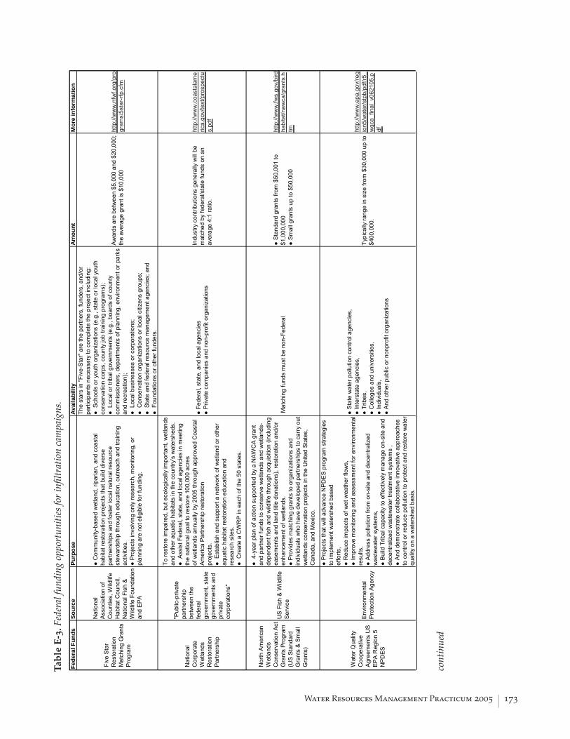
Water Resources Management Practicum 2005 | 173
Tab
le E
-3. F
eder
al fu
ndin
g op
port
unit
ies
for
infi l
trat
ion
cam
paig
ns.
Fede
ral F
unds
Sour
cePu
rpos
eAv
aila
bilit
yAm
ount
Mor
e in
form
atio
n
Five
Sta
r R
esto
ratio
n M
atch
ing
Gra
nts
Prog
ram
Nat
iona
l As
soci
atio
n of
C
ount
ies,
Wild
life
Hab
itat C
ounc
il,
Nat
iona
l Fis
h &
Wild
life
Foun
datio
n an
d EP
A
Com
mun
ity-b
ased
wet
land
, rip
aria
n, a
nd c
oast
al
habi
tat r
esto
ratio
n pr
ojec
ts th
at b
uild
div
erse
pa
rtner
ship
s an
d fo
ster
loca
l nat
ural
reso
urce
st
ewar
dshi
p th
roug
h ed
ucat
ion,
out
reac
h an
d tra
inin
g ac
tiviti
es.
Pro
ject
s in
volv
ing
only
rese
arch
, mon
itorin
g, o
r pl
anni
ng a
re n
ot e
ligib
le fo
r fun
ding
.
The
star
s in
"Fiv
e-St
ar" a
re th
e pa
rtner
s, fu
nder
s, a
nd/o
r pa
rtici
pant
s ne
cess
ary
to c
ompl
ete
the
proj
ect i
nclu
ding
: S
choo
ls o
r you
th o
rgan
izat
ions
(e.g
., st
ate
or lo
cal y
outh
co
nser
vatio
n co
rps,
cou
nty
job
train
ing
prog
ram
s);
Loc
al o
r trib
al g
over
nmen
ts (e
.g.,
boar
ds o
f cou
nty
com
mis
sion
ers,
dep
artm
ents
of p
lann
ing,
env
ironm
ent o
r par
ks
and
recr
eatio
n);
Loc
al b
usin
esse
s or
cor
pora
tions
; C
onse
rvat
ion
orga
niza
tions
or l
ocal
citi
zens
gro
ups;
Sta
te a
nd fe
dera
l res
ourc
e m
anag
emen
t age
ncie
s; a
nd F
ound
atio
ns o
r oth
er fu
nder
s.
Awar
ds a
re b
etw
een
$5,0
00 a
nd $
20,0
00;
the
aver
age
gran
t is
$10,
000
http
://w
ww
.nfw
f.org
/pro
gram
s/5s
tar-
rfp.c
fm
Nat
iona
l C
orpo
rate
W
etla
nds
Res
tora
tion
Partn
ersh
ip
"Pub
lic-p
rivat
e pa
rtner
ship
be
twee
n th
e fe
dera
l go
vern
men
t, st
ate
gove
rnm
ents
and
pr
ivat
e co
rpor
atio
ns"
To re
stor
e im
paire
d, b
ut e
colo
gica
lly im
porta
nt, w
etla
nds
and
othe
r aqu
atic
hab
itats
in th
e co
untry
’s w
ater
shed
s. A
ssis
t Fed
eral
, sta
te, a
nd lo
cal a
genc
ies
in m
eetin
g th
e na
tiona
l goa
l to
rest
ore
100,
000
acre
sof
wet
land
s an
nual
ly b
y 20
05 th
roug
h ap
prov
ed C
oast
al
Amer
ica
Partn
ersh
ip re
stor
atio
npr
ojec
ts.
Est
ablis
h an
d su
ppor
t a n
etw
ork
of w
etla
nd o
r oth
er
aqua
tic h
abita
t res
tora
tion
educ
atio
n an
dre
sear
ch s
ites.
Cre
ate
a C
WR
P in
eac
h of
the
50 s
tate
s.
Fed
eral
, sta
te, a
nd lo
cal a
genc
ies
Priv
ate
com
pani
es a
nd n
on-p
rofit
org
aniz
atio
ns
Indu
stry
con
tribu
tions
gen
eral
ly w
ill be
m
atch
ed b
y fe
dera
l/sta
te fu
nds
on a
n av
erag
e 4:
1 ra
tio.
http
://w
ww
.coa
stal
ame
rica.
gov/
text
/pro
spec
tus.
Nor
th A
mer
ican
W
etla
nds
Con
serv
atio
n Ac
t G
rant
s Pr
ogra
m
(US
Stan
dard
G
rant
s &
Smal
l G
rant
s)
US
Fish
& W
ildlif
e Se
rvic
e
4-y
ear p
lan
of a
ctio
n su
ppor
ted
by a
NAW
CA
gran
t an
d pa
rtner
fund
s to
con
serv
e w
etla
nds
and
wet
land
s-de
pend
ent f
ish
and
wild
life
thro
ugh
acqu
isiti
on (i
nclu
ding
ea
sem
ents
and
land
title
don
atio
ns),
rest
orat
ion
and/
or
enha
ncem
ent o
f wet
land
s. P
rovi
des
mat
chin
g gr
ants
to o
rgan
izat
ions
and
in
divi
dual
s w
ho h
ave
deve
lope
d pa
rtner
ship
s to
car
ry o
ut
wet
land
s co
nser
vatio
n pr
ojec
ts in
the
Uni
ted
Stat
es,
Can
ada,
and
Mex
ico.
Mat
chin
g fu
nds
mus
t be
non-
Fede
ral
Sta
ndar
d gr
ants
from
$50
,001
to
$1,0
00,0
00 S
mal
l gra
nts
up to
$50
,000
http
://w
ww
.fws.
gov/
bird
habi
tat/n
awca
/gra
nts.
htm
Wat
er Q
ualit
y C
oope
rativ
e Ag
reem
ents
US
EPA
Reg
ion
5 N
PDE
S
Envi
ronm
enta
l Pr
otec
tion
Agen
cy
Pro
ject
s th
at w
ill ad
vanc
e N
PDES
pro
gram
stra
tegi
es
to im
plem
ent w
ater
shed
bas
edef
forts
, R
educ
e im
pact
s of
wet
wea
ther
flow
s,
Impr
ove
mon
itorin
g an
d as
sess
men
t for
env
ironm
enta
l re
sults
, A
ddre
ss p
ollu
tion
from
on-
site
and
dec
entra
lized
w
aste
wat
er s
yste
ms,
B
uild
Trib
al c
apac
ity to
effe
ctiv
ely
man
age
on-s
ite a
nd
dece
ntra
lized
was
tew
ater
trea
tmen
t sys
tem
s ,
And
dem
onst
rate
col
labo
rativ
e in
nova
tive
appr
oach
es
to c
ontro
l or r
educ
e po
llutio
n to
pro
tect
and
rest
ore
wat
er
qual
ity o
n a
wat
ersh
ed b
asis
.
Sta
te w
ater
pol
lutio
n co
ntro
l age
ncie
s,
Inte
rsta
te a
genc
ies,
Trib
es,
Col
lege
s an
d un
iver
sitie
s,
Indi
vidu
als,
A
nd o
ther
pub
lic o
r non
prof
it or
gani
zatio
ns
Typi
cally
rang
e in
siz
e fro
m $
30,0
00 u
p to
$4
00,0
00.
http
://w
ww
.epa
.gov
/reg
ion5
/wat
er/s
tpb/
pdf/r
5_w
qca_
final
_v06
2105
co
ntin
ued

174 | Starkweather Creek Watershed
Tab
le E
-3. c
onti
nued
Gra
ssla
nd
Res
erve
Pro
gram
Nat
ural
Res
ourc
es
Con
serv
atio
n Se
rvic
e
Con
serv
e, re
stor
e an
d pr
otec
t tw
o m
illion
acr
es o
f gr
assl
and,
rang
elan
d, s
hrub
land
and
pas
ture
land
by
purc
hasi
ng e
asem
ents
,en
terin
g in
to lo
ng-te
rm re
ntal
agr
eem
ents
, and
pro
vidi
ng
tech
nica
l and
fina
ncia
l ass
ista
nce
to p
artic
ipan
ts fo
r re
stor
ing
the
func
tions
and
val
ues
of g
rass
land
s an
d sh
rubl
ands
. E
mph
asiz
es s
uppo
rt fo
r wor
king
gra
zing
ope
ratio
ns;
enha
ncem
ent o
f pla
nt a
nd a
nim
al b
iodi
vers
ity; a
nd
prot
ectio
n of
gra
ssla
nd a
nd la
nd c
onta
inin
g sh
rubs
and
fo
rbs
unde
r thr
eat o
f con
vers
ion
to c
ropp
ing,
urb
an
deve
lopm
ent,
and
othe
r act
iviti
es th
at th
reat
en g
rass
land
re
sour
ces.
Elig
ible
pro
duce
rs m
ust h
ave
40 c
ontig
uous
acr
es fo
r co
nsid
erat
ion
as a
GR
P B
oth
land
owne
rs a
nd o
pera
tors
may
par
ticip
ate
on re
ntal
and
re
stor
atio
n ag
reem
ents
. D
airy
and
live
stoc
k fa
rmer
s sh
ould
ser
ious
ly c
onsi
der t
he
Gra
ssla
nd R
eser
ve a
s a
way
to s
uppo
rt pe
rman
ent p
astu
re a
nd
hayl
and.
Per
man
ent E
asem
ents
. U
SDA
mak
es
a pa
ymen
t bas
ed o
n th
e fa
ir m
arke
t val
ue
of th
e pr
oper
ty le
ss th
e gr
azin
g va
lue.
30-
year
eas
emen
ts.
USD
A pa
ys 3
0 pe
rcen
t of t
he fa
ir m
arke
t val
ue –
less
the
graz
ing
valu
e. R
enta
l Agr
eem
ents
. 10
, 15,
20
or 3
0-ye
ar d
urat
ion.
USD
A pa
ys 7
5 pe
rcen
t of
the
graz
ing
valu
e in
ann
ual p
aym
ents
for
the
leng
th o
f the
agr
eem
ent.
GR
P R
enta
l R
ates
are
ava
ilabl
e fo
r eac
h W
isco
nsin
co
unty
. R
esto
ratio
n Ag
reem
ents
. USD
A pa
ys u
p to
90
perc
ent o
f the
rest
orat
ion
cost
s on
gr
assl
and
and
shru
blan
d th
at h
as n
ever
be
en c
ultiv
ated
and
not
mor
e th
an 7
5 pe
rcen
t on
rest
ored
gra
ssla
nd a
nd
shru
blan
d (la
nd th
at o
nce
was
cul
tivat
ed).
http
://w
ww
.wi.n
rcs.
usd
a.go
v/pr
ogra
ms/
grp.
htm
l
Wet
land
s R
eser
ve P
rogr
am
Nat
ural
Res
ourc
es
Con
serv
atio
n Se
rvic
e
A vo
lunt
ary
prog
ram
to re
stor
e an
d pr
otec
t wet
land
s on
pr
ivat
e pr
oper
ty.L
ando
wne
rs c
an re
ceiv
e fin
anci
al
ince
ntiv
es to
rest
ore
wet
land
s th
at h
ave
been
dra
ined
for
agric
ultu
re.
Lan
dow
ners
with
land
s th
at h
ave
been
pre
viou
sly
drai
ned
for
agric
ultu
ral p
urpo
ses,
but
onl
y be
fore
Dec
embe
r 23,
198
5.
Lan
dow
ners
who
cho
ose
to p
artic
ipat
e in
WR
P m
ay s
ell a
co
nser
vatio
n ea
sem
ent o
r ent
er in
to a
cos
t-sha
re re
stor
atio
n ag
reem
ent w
ith U
SDA
to re
stor
e an
d pr
otec
t wet
land
s.
The
land
owne
r vol
unta
rily
limits
futu
re u
se o
f the
land
, yet
re
tain
s pr
ivat
e ow
ners
hip.
The
land
owne
r and
NR
CS
deve
lop
a pl
an fo
r the
rest
orat
ion
and
mai
nten
ance
of t
he w
etla
nd.
The
prog
ram
offe
rs la
ndow
ners
thre
e op
tions
: per
man
ent e
asem
ents
, 30-
year
ea
sem
ents
, and
rest
orat
ion
cost
-sha
re
agre
emen
ts o
f a m
inim
um 1
0- y
ear
dura
tion.
http
://w
ww
.wi.n
rcs.
usd
a.go
v/pr
ogra
ms/
wrp
.ht
ml

Water Resources Management Practicum 2005 | 175
Loca
l Fun
dsSo
urce
Purp
ose
Avai
labi
lity
Am
ount
Mor
e in
form
atio
n
Gra
ham
-Mar
tin
Pra
irie
Foun
datio
n(m
ay n
ot b
e a
cont
inui
ng g
rant
pr
ogra
m)
Gra
ham
-M
artin
Pra
irie
Foun
datio
n-Ad
min
iste
red
by D
ane
Cou
nty,
Ad
min
iste
red
by th
e C
ity o
fM
adis
on
$20
0,00
0 gi
ft to
the
Cou
nty
of n
ativ
e gr
asse
s an
d w
ildflo
wer
s, p
art o
f whi
ch th
e C
ount
y is
usi
ng
to e
stab
lish
a gr
ant p
rogr
am fo
r hom
eow
ners
, sc
hool
s an
d no
npro
fit o
rgan
izat
ions
to p
rom
ote
rain
gar
dens
and
nat
ive
land
scap
es.
The
City
of M
adis
on w
as a
lso
gifte
d $1
00,0
00
from
the
Gra
ham
-Mar
tin F
ound
atio
n to
ass
ist i
n th
e de
velo
pmen
t of r
aing
arde
ns to
redu
ce p
ollu
ted
runo
ff in
to lo
cal l
akes
and
stre
ams.
Rai
n G
arde
ns h
elp
wat
er s
oak
into
the
grou
nd
and
prev
ent p
ollu
tant
s fro
m ru
nnin
g of
f int
o la
kes
and
stre
ams.
Dan
e C
ount
y ra
in g
arde
n fu
nds:
Hom
eow
ners
, mun
icip
aliti
es, s
choo
lsan
dno
npro
fitor
gani
zatio
nsw
ere
elig
ible
toap
ply
for
agr
anto
fpla
nts
orse
eds
to
Bus
ines
ses
wer
e no
t elig
ible
.
Dan
e C
ount
y:
Prov
ides
up
to
$10,
000
for
mun
icip
aliti
es,
scho
ols
and
nonp
rofit
or
gani
zatio
ns a
nd
up to
$20
0 pe
r ho
meo
wne
r.
http
://w
ww
.dan
ewat
ers.
com
/bu
sine
ss/P
lant
Dan
e.as
px
1,00
0 R
aing
arde
ns
Pro
ject
(fu
ndin
g fo
r thi
s pr
ojec
t is
not
solid
ified
)
EPA
Ad
min
iste
red
by th
e C
ity o
fM
adis
on-
Engi
neer
ing
Dep
artm
ent
To p
rom
ote
infil
tratio
n in
the
City
of M
adis
on
Hom
eow
ners
wou
ld b
e el
igib
le fo
r cos
tsh
arin
g an
y po
rtion
of t
he ra
in g
arde
n--
tech
nica
l ass
ista
nce,
pla
nts,
or
cons
truct
ion.
Busi
ness
es w
ould
als
o be
elig
ible
for c
ost s
harin
g if
they
are
not
inst
allin
ga
rain
gard
ento
mee
tape
rmit
requ
irem
ent.
To b
e de
term
ined
…
http
://w
ww
.city
ofm
adis
on.c
om
/eng
inee
ring/
stor
mw
ater
/10
00rg
.htm
esta
blis
h ra
in g
arde
ns o
r pra
iries
in 2
005.
Tab
le E
-4. L
ocal
fund
ing
oppo
rtun
itie
s fo
r in
fi ltr
atio
n ca
mpa
igns
.


Water Resources Management Practicum 2005 | 177
North Platte Site Conditions (URPL 601, 2004)
Deed Restrictions on Garver Property Deed restrictions were placed on the Garver property by Olbrich Botanical Gardens to ensure that the property be used in a manner consistent with the goals and mission of Olbrich. The Wisconsin Department of Natural Resources (DNR) also placed a restriction in return for funding received by Olbrich Botanical Gardens for the cleanup of the site. The third restriction was placed on the property by the City of Madison Landmark Commission to guarantee that the property would not be altered by construction or demolition without consultation. These restrictions may act as an impediment to certain redevelopment activities and require that the City of Madison, the Wisconsin DNR and the City of Madison Landmark Commission review all activities on the site. Warranty Deed This property is conveyed subject to the restriction, enforceable by Grantor, that the property be used, in perpetuity, as parklands devoted primarily to botanical gardens, except that the buildings currently on the property may be used for storage, offices, and other municipal uses on an interim basis. Following are the details on these deed restrictions. Wisconsin DNR Stewardship Grant and Management Contract The Stewardship Property shall be used in perpetuity as parklands devoted primarily to botanical gardens except that the buildings currently on the property may be used for storage, offices, and other municipal uses on an interim basis. City of Madison Landmarks Commission Name of the building or site: Garver Feed and Supply Company
1. That all building permits for the altering or constructing all buildings on said site shall be submitted to the Landmarks Commission of the City of Madison, Wisconsin for approval.
2. That all permits for demolition of any buildings on said site shall be submitted to
the Landmarks Commission of the City of Madison, Wisconsin, for approval.
Land Use According the most recent Dane County Land Use data, produced in 1998, the Garver Property is listed as an industrial property. This will need to be amended, as the property is now city-owned. Existing land uses are shown in Figure 3.
APPENDIX F F
Reprinted from Urban and Regional Planning, 2004, Course 601: Redevelopment of the Garver Feed Mill: Site analysis and conceptual plans, University of Wisconsin–Madison.

178 | Starkweather Creek Watershed
The parcel is part of a larger complex of parkland and open space, including the Olbrich Botanical Garden, Olbrich Park, and O.B. Sherry Park, as well as Starkweather Creek and nearby Lake Mendota. Adjacent land uses include commercial to the west and residential to the east.
Figure 3. Existing land uses near Garver property.
City of Madison Zoning Regulations Historically, the Garver property was part of a vital manufacturing corridor on the near east side of Madison. While manufacturing is no longer a staple of this community, the zoning regulations for the property still reflect its historical use. Redevelopment of the site may require zoning changes from a Limited Manufacturing District (M1) to something more applicable for the new use(s) of the building. Since the termination of manufacturing and warehousing uses in this area, the intent and purpose of this district are no longer applicable to the site. Rezoning this property would be dependent on the new use(s), but project managers should be aware of the need for possible rezoning.

Water Resources Management Practicum 2005 | 179
Limited Manufacturing District (M1) The Garver Building is currently zoned as a Limited Manufacturing District (M1) by the City of Madison. The purpose that the City of Madison sets forth in this district is to “accommodate existing non-nuisance type industrial uses presently located in relative proximity to residential areas” (Sec. 28.10(4)(a), City of Madison Zoning Code). Additionally, “Development in the M1 limited manufacturing district is limited primarily to certain commercial uses and certain industrial uses, such as the fabrication of materials and specialized manufacturing and research institutions, all of a non-nuisance type” (Sec. 28.10(4)(a), City of Madison Zoning Code). There are a variety of permitted uses under this zoning category, and some that may be relevant to the Garver redevelopment including amusement establishments; greenhouses; meeting, convention, or exhibition halls; offices; parks and playgrounds; restaurants (including catering services); restaurant/theatre; and farmers markets. Likewise, there is a large list of conditional uses for the M1 District. The one relevant conditional use is outdoor eating and recreation areas of restaurants and taverns. The City of Madison also regulates the floor area ratio in this District. In the Limited Manufacturing District (M1), “the floor area ratio shall not exceed 2.0” (Sec. 28.10(4)(e), City of Madison Zoning Code). There are also yard requirements for this District. The regulations are targeted towards the provision of a buffer between the Limited Manufacturing use and adjacent residential properties. Therefore, looking at the Garver property, the northern and the southwest third of the property line would be applicable to these regulations. Specifically, the southwestern part of the property (if this zoning district is maintained) would need to maintain a 25-foot yard. However, with the existence of the railroad right-of-way, this yard requirement may be trumped by the right-of-way distance. The northern, rear property line must have a yard of “10 feet in depth for buildings less than two stories in height, and 30 feet for buildings two stories or more in height” (Sec. 28.10(4)(f), City of Madison Zoning Code). Conservancy District (C) The current Olbrich Botanical Gardens (south of the Wisconsin and Southern railroad lines) is zoned Conservancy District (C). The purpose of the Conservancy Zoning District is to:
Preserve and perpetuate in an open state certain areas such as lakes and waterways, wetlands and marshes, floodplains and stream beds, certain agricultural lands, slopes and other areas of aesthetic value which, because of their unique physical features, are deemed desirable and functional as natural drainage ways and water retention areas, natural habitat for plant and animal life, greenbelts and other multiple purpose uses beneficial to the community (Sec. 28.07(2)(a), City of Madison Zoning Code).

180 | Starkweather Creek Watershed
The permitted uses in this district include land and water preserves, such as arboretums, public parks and playgrounds, and educational, recreational, and office uses for governmental, educational, and nonprofit agencies. A variety of conditional uses may be allowed in the Conservancy District. One such use is land and water preserves, (including restaurants or facilities “for outdoor recreation, including hotels, motels and other buildings containing dwelling units or lodging rooms for use by the transient public when accessory to such outdoor recreational use”) provided that the buildings and structures are not located less than 300 feet from any lot in a residence district. (Sec. 28.07(2)(c)11, City of Madison Zoning Code). Another conditional use is accessory uses such as “dwelling units and lodging rooms in detached buildings for persons regularly employed on the premises and their immediate families” (Sec. 28.07(2)(c)16, City of Madison Zoning Code). Additionally, “municipally owned recreational buildings and community centers” may be allowed, however, these buildings must be located at least 50 feet from any lot in a residential district (Sec. 28.07(2)(c)19, City of Madison Zoning Code). Other municipal uses that are city owned and operated may also be allowed. According to the lot area and lot width requirements of this District, the lot area must not be less than 10 acres, while the lot width and street frontage must not be less than 500 feet. The height regulations in the Conversancy District do not allow any buildings or structures, “other than a civic auditorium complex,” to exceed 2 stories or 35 feet in height. Additionally, there are yard requirements for all buildings and structures (those other than a civic auditorium complex). The minimum yard requirement is at least 60 feet, the minimum side yard requirements are each 80 feet, and the rear yard is at least 100 feet. Surrounding Districts Surrounding the Garver property are General Residence Districts (R4) to the north and south, and to the east, a Single and Two-Family Residence District. On the west side of the property, the Limited Manufacturing District (M1) continues. In addition, there are two small areas, to the north of the property, that are zoned as wetlands. Utilities Utilities serving Olbrich, the Garver property, and the surrounding area are shown in Figure 4.
Olbrich Botanical Gardens
Garver property

Water Resources Management Practicum 2005 | 181
Stormwater Because of the close proximity of Starkweather Creek and Lake Monona, stormwater runoff from the Garver property needs to be carefully considered in the redevelopment process. Stormwater runoff in and around Olbrich Botanical Gardens is primarily managed through conveyance. Conveyance is designed to move water using pipes and other impervious surfaces. As a management tool, it neither makes an allowance for infiltration nor does it prevent or mitigate stormwater pollution. The conveyance system on the northern section of the site allows for stormwater that has been collected in the surrounding neighborhoods to be drained into Starkweather Creek. The main stormwater pipe location around the northern section of the site uses pipes under the streets. Fair Oaks Avenue has a stormwater pipe that follows the road going north and south and drains into Starkweather Creek. The neighborhood north of Fair Oaks Avenue has several stormwater pipes leading either to Starkweather Creek or to the pipes under Fair Oaks Avenue.
Figure 5. Separate Sanitary Sewer system and Stormwater drainage system. (Source: http://www.ene.gov.on.ca/envision/gp/4224e) The stormwater pipes on the southern section of the site are designed in a similar fashion. However, the pipes from the southern neighborhoods are connected to underground pipes situated along the railroad tracks that stretch across the Olbrich property. The stormwater pipes follow the railroad east and drain into a lower section of Starkweather Creek. Two separate stormwater pipes are located on the current Olbrich Botanical Gardens site. The first is shaped like an upside-down “T” with the top connecting to the conveyance section that stretches along the railroad tracks and the lower section parallel to the east and west section along the railroad tracks. This section is under the current maintenance facility of Olbrich Botanical Gardens. These pipes all connect to areas around Sugar Avenue and drain into Starkweather Creek. Sanitary Sewer The Olbrich site has one sanitary sewer line that connects the current buildings on the Olbrich site, including the Garver building (Figure 4). The sewer line runs along Sugar Avenue. There are several locations around the site where additional sanitary sewer could be connected:
Figure 4. Public utilities.
182 | Starkweather Creek Watershed
The intersection of Fair Oaks Avenue and Gateway Place The intersection of Bryan and Fair Oaks Avenue Along the East to West Section of Starkweather Creek connecting the dead end section of Ivy and Fair Oaks Avenue Along the North and South Section of Starkweather Creek Drive Along Emmet Street connecting with Fair Oaks Avenue Along Garlson Street connecting with Emmet Along Sugar Avenue connecting the Olbrich Botanical Gardens and stretching to the Garver building Along Atwood Avenue Along Lakeland Avenue
Water Lines Olbrich has one water line that connects the current buildings and the Garver building (Figure 4). The water line runs along Sugar Avenue. There are several locations around the site where water lines could be connected:
Along Fair Oaks Avenue and Gateway Place Along Ivy Street going through O.B. Sherry Park and following Starkweather Creek Drive Along Emmet Street Along Garlson Street Along Sugar Avenue Along Atwood Avenue
Other Water System Facilities
Municipal well #8 is located across from Olbrich Botanical Gardens on the south side of Atwood Avenue A municipal reservoir is located at the end of Starkweather Creek near Atwood Avenue A municipal booster pump station is located near the entrance of Olbrich Botanical Gardens
Transportation
Roads The two primary roads providing access to the site are Atwood Avenue and Fair Oaks Avenue. The only road providing direct access to the site is Sugar Avenue, which is routed through the existing Olbrich Botanical Gardens’ parking lot. There are a high number of daily vehicular trips generated near and around the Garver property. Table 1 indicates the traffic volumes reported at key locations on Atwood

Water Resources Management Practicum 2005 | 183
Avenue as reported in the Wisconsin Highway Traffic Volume Data Book (Wisconsin Department of Transportation 2002).
Figure 6. Recreation trails.
Recreation Trails The Isthmus Bicycle Trail forms the southern boundary of the Garver parcel (Figure 6). This trail is part of the larger Capital City Trail network that ultimately connects in to the regional Ice Age Trail. Bicyclists and pedestrians use this trail for recreation and daily commutes. The City has proposed an additional recreation trail that would traverse the northern third of the parcel, linking it to the existing neighborhood recreational trails.
Location Number of Trips (2002)
Atwood/Fair Oaks 10,800
Atwood/Garrison 18,600
Atwood/Sugar (Oak Ridge) 17,200
Atwood/Starkweather Creek (east) 17,200
Rail The Wisconsin Southern Railroad corridor is located to the south of the Garver parcel. This rail line is still active and several trains run along the tracks each week.

184 | Starkweather Creek Watershed
Environment
Environmental Corridors The Dane County Regional Plan Commission has developed official environmental corridors for Dane County. These corridors delineate natural features, parks, and open space. On the Garver parcel, environmental corridors are located parallel to main and western branch of Starkweather Creek. If used as open space in the future, the Garver parcel will be included within the environmental corridor.
Open Space The Garver parcel is part of a large city green space and open space complex. This includes Olbrich Botanical Gardens, Olbrich Park, O.B. Sherry Park, the Isthmus Trail, Starkweather Creek, and Lake Monona (Figure 2).
Water Resources Starkweather Creek forms the eastern boundary of the project site. This creek has been channelized and drains into the Lake Monona basin.
Soils According to the Dane County Soil Survey, the soil type within the project area is Colwood silt loam. The Colwood series consists of deep, poorly drained, nearly level soils on low benches in old lake basins. This site was once part of a wetland complex and was drained to provide buildable land.
Figure 7. Environmental Inventory.

Water Resources Management Practicum 2005Nelson Institute for Environmental StudiesUniversity of Wisconsin–Madison
Cover art by Water Resources Management Practicum 2005.
Stark
weath
er Creek
Watersh
ed U
W–W
ater Reso
urces M
an
agemen
t Practicu
m |
2006
Starkweather Creek Watershed:Current Conditions and Improvement Strategies in an Urban Context
2006