staff report: appeal substantial issuedocuments.coastal.ca.gov/reports/1997/1/th12a-1-1997.pdf ·...
TRANSCRIPT
PETE
RNIA COASTAL COMMISSION CENTRAL COAST AREA OFFICE
ONT STREET, SUITE 300
CRUZ, CA 95060
27-4863 HEARING IMPAIREO: 14151 ~200
•
•
STAFF REPORT: APPEAL
SUBSTANTIAL ISSUE
LOCAL GOVERNMENT: San Luis Obispo County
LOCAL DECISION: Approved with conditions
APPEAL NUMBER: A-3-SL0-96-113
APPLICANT: VADNAIS/BOUD
Filed: 10/24/96 49th day: 12/12/96 180th day: 04/22/97 Staff: SG-SC Staff Report: 12/18/96 Hearing Date: 01/09/97
APPELLANT: Vern Kalshan for Cambria Legal Defense Fund and 300 Cambria Property Owners
PROJECT LOCATION: Southeast comer of Main Street and Pine Knolls Drive, Cambria, San Luis Obispo County
PROJECT DESCRIPTION: Tentative Tract Map and Development Plan for a 25 unit condominium project
SUBSTANTIVE FILE DOCUMENTS: Permit 09401320, 0940283V, Tract 2176, SLO County LCP (North Coast Area Plan, Coastal Zone Land Use Ordinance, Coastal Policies, Framework for Planning)
SUMMARY OF STAFF RECOMMENDATION
Staff recommends that the Commission, after public hearing, determine that a substantial issue exists with respect to the grounds on which the appeal has been filed for the reasons discussed below. If the Commission so finds, staff further recommends that the Commission defer a de novo public hearing on this project to allow the applicant to develop plans for the proposed drainage system and address other issues. Once the information is received and analyzed by staff, the proposal will be brought back to the Commission for a de novo hearing on its merits .
SL096113.00C, Central Coast Office

Page2 Vadnais/Boud A-3-SL0-96-113
SUMMARY OF APPELLANT'S CONTENTIONS (See Exhibit 1 for the full text)
Appellant contends that the proposal is inconsistent with:
1. Conditions of Coastal Development Permit 4-83-680, which permitted the subdivision of this and the adjoining lot into seven lots;
2. Environmentally Sensitive Habitat policies 2, 18, 19, and 23 which protect environmentally sensitive habitats in general and riparian areas in particular;
3. Public Works policy 1 relative to provision of adequate road capacity;
4. Coastal Watersheds policies 7, 10, and 13 which require drainage plans, limit removal of.vegetation, and limits development to slopes less than 20 percent;
5. Visual and Scenic Resources policies 1, 2. 5, 6, 7, and 8 regarding massing of structures on hillsides, amount of grading compatibility of the proposal with the community, preservation of trees, and visibility of utility lines;
6.
7.
Hazards policies 1, 2, and 3 concerning geological hazards such as stability of the site and erosion;
Lack of water, and;
8. Denial of due process because County approved the proposal without County or the public knowing I) how the issue of structures proposed in recorded open space easement would be resolved, iQ location and size of drainage to Santa Rosa Creek and its potential impacts to the creek, and iii) how fees from development will solve traffic hazards on Main Street at the site.
•
•
•

•
•
•
Vadnais/Baud Page3
SUMMARY EVALUATION OF SUBSTANTIAL ISSUE
• ,N tSSIJE •• ·t.:uPPOU'CfES • ZOMNGORDlNANCE SllBSTANTtALISStJEEVAtUATlON: • ; • SECTION ;:
·/ ~ ,. •• '$. . : ? -~
Environmentally ESH policies 2, 18, 19, i Sections 23.07.170-178 i Substantial Issue Exists. Approval of drainage to Sensitive Habitat (ESH) and 23 j l Santa Rosa Creek was made Without plans for
i ! discharge structure, hence no evaluation of j I alternatives or potential impacts to ESH. . :
~••••••n~uuu~••••UU••••,.u•n•n•*U•U•• •ouooon•ou•U•••U•••••••-••-••••u••"u••+uuu••••••••••••••••••-••• .. ••u•••••••••-••••o•U~•••+••••,.,.••••••••""'-.u•••••W_,.,._,.,.,. .... ,..,....,,.uo••••-•••-uo•••..-•••n"•n••••:•••••••n•O•••n••
Road capacity and lack Public Works policy 1, i Section 23.04.021 c i Substantial Issue Exists. LUP policy requ1res of water Availability of Service i i County to fllld that there are sufficient services to
Capacity ! i serve the proposed development and existing lots. i ! County made finding for road capacity, but not for i i water and sewer. Zoning ordinance section i i 23.07.021 c(1 )(i) requires findings that sufficient water ! i and sewage disposal capacities are available; no j j such findings were made by the County.
··Gra"diil9-c;-n·siop;;s·;:········· ··c-oaSiaiWaiersiiecii·········!··sectiOOSzr.04:oo1:T:ana·········t·sa:.bSiiinuirissue-EiistS:«Gradiii9·;;v;;:20%iS············ 30% policy 7, Siting New I Divisions and 23.05.034, j allolrled for access roads. Zoning ordinance section
Development i Grading i 23.07.021 c(7) requires that roads and building sites I l be on slopes < 2M!.; section 23.05.034 allows for a I I grading adjustment on slopes between 20% and I I 30%, does not address grading on slopes > 30%. i I County approval is for part of access road on > 30% ! I slopes, pursuant to a variance. However, reason for i ! grading on slopes > 30% is because of earth fill that l I previous owner placed on Site 11 years ago. If that fill i ! were removed, there would be no need for grading on I I s1opes > 30%. : '
··~f:~f~~~····················· ···~~~=-~~~~~~~-·-···r~===~==·····-·r:;:~~':!:u:~e:!:~i~~~a~:~tr:!~&ue.and·-Provisions. and 13, ! Control, and 23.05.040, i concerned. otherwise No Substantial Issue. Vegetation Removal ! Drainage I Policies provide that site design shaH not cause
I ! Increased erosion and that vegetation removal on ! ! slopes >30% In geologically unstable areas requires ! ! erosion and sedimentation plan. County required I ! these after approval of grading permit. See also ESH I I above.
•~•d"**"••••••••••••••••••"•••••••••.,••••••••• u•••••n••••~•-•••••u••••••••••••n••••••••,.+u•••-••••-••••••n•••-•••••••-•••••n•••o..•••••••••+u••~•u••••••-•••~••••••••.,.•••Un••••<>o. ... •••n .. ,..,......,.,..,.,., •• ,. ................ .,.,., ... ., •• .,.,.,,.,.,..,., • .,.,.,. .. .. Visual and Scenic Visual and Scenic j Sections 23.05.034, Grading; i No Substantial Issue Proposal is In developed Resources Resources policies 1, 2, i 23.11, Definitions (Small- ! urban area and, although visible form Highway One
5, 6, 7, and 8 ! Scale Neighborhoods); ! and other areas in cambria, required landscaping j 23.05.064, Tree Removal ! would sereen much of the development. Existing, i Standards,; and i very visible development lies adjacent to and above i 23.08.286d(4), Utility Unes l site. ! within public view oorrldors i
··Hazards······························ -fraziird"s.iiOiieieS·r;2:···· ... ! .. seciiOOS2i07~oeo:·GeO!OgiC····j·-NO"suii&taiiiiai"iSiue:···R";qiiii=e<roe<iechilkii .............. . and 3 i Study Area and 23.07.086 l reports have been completed.
! Geologic study Area Special i !Standards ! i i
··Muni:Familv··Resi"deiiiiar·· ··N·orn; .................................... !.·secriOO·zs.oa:162ti(2>:'iifiiiit ... ! .. NO.s·i.ib'Siailiiafissi.i4!: .. ;;;rsiiiiiil9.or<iiilince···-········· use in Retail i requirements for residential ! section requires findings that residential use will not Commercial land use j uses In commercial categories ! reduce Inventory of commercial properly available for designation ! 1 commercial needs and that it will not Impede
i ! development of commercial uses. From earliest ! ! stages of development on subject Site, It was ! ! envisioned thai It would contain both commercial and I i residential uses. LCP specifically calls for residential ! 1 use on the subject site.
uo••••••.,auu .. ,., •• ,. .......... ..,._.,., •• ,. .. ~uoo~• "'UMUnH•n•no••uuo••n•••un••"nuo.,,.uA••••""'-"""""""*""U~••••u~,..,.,.an••••••,....,..,,...,. • ..,.,.,..,,..-., • .,,.,.., .. ,..,.,.._.,.., .... ., ..... ., .... ...,,. .. ._.,..,.,-.., .... .,., • .,,.. .. ,....., .. .,.,.nH<>••.,•••••,.••u••••n~•••UU..,.,.,.. ... ..

Page4 Vadnais/Boud
STAFF NOTE: Appellant also contends that the County's approval is inconsistent with the conditions of Coastal Development Permit 4-83-680. The standard of review for the • determination of substantial issue is consistency with the LCP, not with previous permits. However, review of that permit is necessary for an understanding of the history of development on the subject site. Please refer to the background section of this report on page 6.
Table of Contents
I. Appeal Procedures ............................................................................................................. 4
II. Local Government Action ................................................................................................... 5
Ill. Recommendation on Substantial Issue and Motion ........................................................... 5
IV. Findings ............................................................................................. .-................................ 6
A. Project Description and Background ............................................................................... 6
B. Issue Discussion ............................................................................................................. 7
Exhibits ............................................................................................................ Following page 10
1. Appeal of Cambria Legal Defense Fund and 300 Cambria Residents
2. San Luis Obispo County Final Local Action Notice and Findings and Conditions
3. Location Map
4. Project Plans and Site Photos
6. Correspondence
I. APPEAL PROCEDURES
After certification of Local Coastal Programs (LCPs), the Coastal Act provides for limited appeals to the Coastal Commission of certain local government actions on coastal development permits. Developments approved by cities or counties may be appealed if they are located within the mapped appealable areas, such as those located between the sea and the first public road paralleling the sea. Furthermore, developments approved by counties may be appealed if they are not the designated "principal permitted use" under the certified LCP. Finally developments which constitute major public works or major energy facilities may be appealed, whether approved or denied by a city or county (Coastal Act Section 30603(a)).
For projects not located between the sea and the first public road paralleling the sea, the grounds for an appeal shall be limited to an allegation that the development does not conform to the certified LCP (Coastal Act Section 30603(b)(1)). Since this project does not lie between the sea and the first public road paralleling the sea, those are the appropriate grounds for appeal in this instance.
•
Section 30625(b) of the Coastal Act requires the Commission to hear an appeal unless the Commission determines that no substantial issue is raised by the appeal. If the staff • recommends "substantial issue,• and no Commissioner objects, the substantial issue question

A-3-SL0-96-113 Vadnais/Boud
•
•
•
will be considered moot, and the Commission will proceed directly to a de novo public hearing on the merits of the project.
If the staff recommends "no substantial issue" or the Commission decides to hear arguments and vote on the substantial issue question, proponents and opponents will have 3 minutes per side to address whether the appeal raises a substantial issue. It takes a majority of Commissioners present to find that no substantial issue is raised. If substantial issue is found, the Commission will proceed to a full public hearing on the merits of the project. If the Commission conducts a de novo hearing on the permit application, the applicable test for the Commission to consider is whether the proposed development is in conformity with the certified Local Coastal Program.
The only persons qualified to testify before the Commission on t.,e substantial issue question are the applicant, persons who made their views known before tho local government (or their representatives), and the local government. Testimony from other persons regarding substantial issue must be submitted in writing. Any person may testify during the de novo stage of an appeal.
II. LOCAL GOVERNMENT ACTION
On September 17, 1996, the County Board of Supervisors, on appeal from the decision of the Planning Commission, approved a vesting tentative tract map, development plan, and variance to allow the creation of 25 condominium units and open space areas on a 3.1 acre parcel, including grading on slopes over 30 percent. Among other things, the appellants contend that the County approved development in an existing open space easement required by the Coastal Commission in an earlier permit action (see discussion at Background, below) which would require an amendment of that earlier Coastal Commission permit.
Ill. STAFF RECOMMENDATION ON SUBSTANTIAL ISSUE
The staff recommends that the Commission determine that substantial issue exists with respect to the grounds on which the appeal has been filed, pursuant to PRC Section 30603.
MOTION Staff recommends a NO vote on the following motion:
I move that the Commission determine that Appeal No. A-3-SL0-96-113 raises NO substantial issue with respect to the grounds on which the appeal has been filed.
A majority of the Commissioners present is required to pass the motion .
Page 5
PageS Vadnais/Boud
IV. RECOMMENDED FINDINGS AND DECLARATIONS
A. Project Description and Background
1. Description: The site of the proposed development is on a hillside abutting the north side of Main Street in Cambria, in northem San Luis Obispo County. The Main Street area of Cambria lies in the lower Santa Rosa Creek valley. Prior to the relocation of Highway One to the southwest side of the valley approximately 250 yards, Main Street was Highway One.
The site is about 300 feet deep and about 450 feet long. The southwestern comer of the site at the intersection of Main Street and Pine Knolls Drive lies at approximately the same elevation as the streets, about 60 feet above sea level. To the east Main Street rises to about 78 feet above sea level at the southeast comer of the property. The southern edge of the property rises some 10 to 15 feet above the street, to an elevation of approximately 90 feet above sea level at the southeastern comer. The site also rises to the north away from Main Street to approximately 140 feet above sea level at the northem property line. The slope to the north away from Main Street is not a smooth incline. There are two human-made terraces consisting of earth that was placed there during the grading for the construction of the adjacent commercial development eleven years ago.
•
The proposed development would include ten two-story buildings containing a total of 25 condominium units. Access to the site would be by way of a new street running from Pine Knolls Drive near its intersection with Main Street to Knollwood Drive, an existing street in the adjacent commercial development. A gate at Knollwood Drive would prevent through vehicular access, excepting emergency vehicles, to Knollwood Drive. The approval would allow development in an existing open space easement required by the Coastal Commission in • permit 4-83-680 (see Background, below). One of the County conditions of approval is that the applicant must obtain approval from the Coastal Commission for development in the open space area. No request to amend permit 4-83-680 has yet been made.
2. Background: Permit 4-83-680, approved by the Coastal Commission on May 9, 1984, and issued on April29, 1985, was for the subdivision of two parcels into six lots encompassing the subject site and the now commercially developed area immediately adjacent to the east. That permit contained four special conditions, as follows (the first three conditions all required completion prior to transmittal of the permit): 1) submit revised map showing six rather than the requested seven lots, 2) record irrevocable offer to dedicate open space easement, 3) submit findings from the County regarding road access and, 4) by accepting permit, permittee agreed to utilize construction practices which minimize erosion. All conditions were met and the coastal development permit was issued. Although the subdivision map was never recorded, the permit was exercised to the extent that improvements (streets, water and sewer lines, etc.) on the now commercially developed site adjacent to the subject site were constructed and the irrevocable offer to dedicate an open space easement was recorded. The two most westerly lots of that subdivision, which would have occupied the area of the current subject site, were to be developed for residential purposes. No residential development ever took place on the subject site. However, some 10,000 cubic yards of earth from the commercial development were placed onto the subject site and remain there.
In 1985, the then permittee received another permit, 4-84-458, from the Commission which permitted the construction of the commercial development adjacent to the subject site. That • development has been constructed.
A-3-SL0-96-113 Vadnais/Boud
•
•
•
B. Substantial Issue Discussion and Analysis
NOTE: Because of the large number and volume of policies and zoning ordinance sections involved in this substantial issue determination, the policies and sections are not reproduced in the body of this report, but are found at the end of the exhibits.
1. Environmentally Sensitive Habitat (ESH): ESH policies and the zoning ordinance sections that implement them are clear that before approval of a permit for development in or near an ESH, the applicant must demonstrate that there will be no significant impact on the ESH. Here, the County has required the applicant to discharge drainage directly into Santa Rosa Creek rather than allowing the runoff to flow toward the West Village area of Cambria. Although this is likely a good thing since the West Village is prone to flooding, the County approval was made without any plans or details of how the drainage would be discharged into the creek and what impacts there may be. It is likely that there would have to be some sort of structure at the creek discharge point such as an energy dissipater and the drainage pipe itself. The County approval required the discharge point to be downstream of the Highway One bridge. Santa Rosa Creek is a steelhead spawning creek and its lower reaches, where the discharge point would be, are vegetated with willows and other riparian species. Yet the County approved development in the creek without any information about potential impacts to the riparian resources. Based on the foregoing, a substantial issue exists with respect to potential adverse impacts to an environmentally sensitive habitat, Santa Rosa Creek •
2. Road Capacity and Water Supply: Main Street is literally that, the main street in Cambria. It carries the bulk of traffic in the community. A traffic study was conducted that indicated that the proposed development would have negligible impacts on the volurne of traffic and the wait at the stop sign on Pine Knolls Drive at the intersection with Main Street. The County is currently in the process of widening Main Street by installing a mo-way left tum lane and adding bicycle lanes and sidewalks from just north of the subject site past it into the eastern part of Cambria (the East Village). According to the County, although this type of improvement will not actually increase capacity, as would the addition of travel lanes, it will remove turning vehicles from the traffic stream and allow the peak hour level of service (LOS) on summer weekdays to improve from LOS "E" to LOS "0" (LOS rankings range from the best, "A," where there are free flow conditions, to "F" where traffic is congested for long periods). The development would be required to pay a traffic fee of $679.00 per unit. Based on these factors the County found that there would be no adverse impacts to traffic from the proposal. No substantial issue exists with respect to road capacity.
The County did not make any specific finding that water supply and sewer disposal capacities were adequate. The files do show that the Cambria Community Services District (CCSD), in a letter dated April10, 1995, stated that the property • ... could be issued an 11/ntent to Serve" letter for water and sewer service when provisions have been made to incorporate the Countys waiting list into the District's connection permit program." According to the applicant, since October of 1990 • ... no new requests have been accepted on the list maintained by the CCSD. Requests are instead placed on the County's single family or multiple family lists. This project holds position #1 and #2 on the County's list and the applicant (Vadnais) has paid a $21,000 deposit to hold those positions. At last check, the CCSD list contained about 65 requests. When the CCSD's list is exhausted, then the County's multiple family list will be
Page7

PageS Vadnais/Baud A-3-SL0-96-11
used, provided that provisions are made to incorporate the County's waiting list into the • CCSD's connection permit program .... SLO County Planning staff, ate now working on a method to fold these two lists together." This indicates that, while there may be water and sewer capacity available, it cannot be used by the subject proposal until the County and CCSD determine a way to merge the lists. Without such a merger and with no finding that water and sewer are available, a substantial issue exists with respect to water and sewer availability for this proposal.
3. Grading on Slopes>. 30%: Typically, grading is restricted by the County's LCP to slopes of 20 percent or less, with some exceptions, including grading of an access road necessary to provide access to an area of less than 20 percent slope where development is to occur and if there is no less environmentally damaging alternative. In none of the policies or sections of the LCP is there any mention of grading on slopes over 30 percent, either allowing such grading or prohibiting it. However, zoning ordinance section 23.04.021c(7), Overriding Land Division Requirements, Location of Access Roads and Building Sites, states that "Proposed access roads and building sites shall be shown on tentative maps and shall be located on slopes less than 20 percent." That would seem to be an absolute bar to access roads on slopes over 20 percent, but there is the possibility of seeking a variance from any of the zoning ordinance sections.· That is what the applicant did here. The County found that a variance allowing grading on slopes over 30 percent could be approved. The findings state that the variance did not constitute a grant of special privileges inconsistent with other properties with similar slopes in the vicinity because adjacent lots with steep slopes are developed and the proposal could not reasonably be constructed without some grading on slopes in excess of 30 percent. The adjacent lots with steep slopes contain single family • dwellings, some of which were developed prior to the LCP and others which fall into the exception for existing lots of record in the Residential Single-Family land use category where a residence cannot be feasibly sited on a slope less than 20 percent. The County also found that there were special circumstances applicable to the property related to the topography that would preclude not grading on slopes over 30 percent. However, the reason that grading must occur on slopes over30 percent is that the original owner placed about 10,000 cubic yards of fill on the site when the commercial development adjacent to the south was constructed. If that fill were removed, there would be no need to grade on slopes over 30 percent Based on this discussion, a substantial issue exists with respect to grading on slopes over 30 percent.
4. Erosion and Sedimentation: The County has required an erosion and sedimentation plan for the site itself. Such a plan would be based on the proposed grading which the County has reviewed and about which there is something more than general knc:WAedge. The County's LCP allows erosion and sedimentation plans to be approved along with grading plans, which typically are approved by the County Engineer sometime after approval of the land use permit. Therefore, with respect to erosion and sedimentation plans for the site itself, no substantial issue exists.
Refer to ESH, number 1 above, for a discussion of substantial issue with respect to the issue of erosion and sedimentation in the ESH of Santa Rosa Creek. •
A-3-SL0-96-113 Vadnais/Boud
•
•
•
5. Visual and Scenic Resources: The site of the proposed development is visible from Main Street, from Highway One, and from other areas in Cambria, primarily from upslope and from the developed hillside and hilltop across the creek to the southwest. The site is in between the two commercial areas of Cambria, the East Village and the West Village. The site to the east is developed with commercial structures which are very visible, lots upslope have single family dwellings which are visible through trees. Across Main Street is a church and a bank, a vacant lot lies to the west across Pine Knoils Drive and to the southwest are community buildings. Clearly, the site lies in a devejoped urban area where one would expect to find new development concentrated. Still, development must be sited and landscaped such that it doesn't clash with its surroundings or degrade or block public views to and along the coast and scenic areas. The County approval is conditioned to require a great deal of landscaping to soften the appearance of the development and to partially screen it. The County conditions require that utility lines be installed underground, removing that potentially degrading feature.
Tree removal would be necessary for the proposal and would involve removing two Monterey pines and thinning of the stand of planted cypress tress on the east side of the site. The County conditions require tree replacement at a 2:1 ratio.
The County has identified Main Street in Cambria as a special community with unique, visually pleasing characteristics which are worthy of protection through such things as attention to architectural features, use of wood, and other design features compatible with the community . No specific findings are required for development in a special community.
Prior approvals from the Coastal Commission and the County envisioned development on this site. While it is a visible site, the County's approval is conditioned to ensure the compatibility of the development with its surroundings. Based of the foregoing discussion, no substantial issue exists with respect to degradation of scenic views.
6. Hazards: The file from the original Coastal Commission permit, 4-83-680, reveals that there was concern about grading on the site, specifically on slopes over 20 percent. Since the site lies on a hillside, and is in a mapped geological hazard area, geological and geotechnical (soils} reports are required. These have been completed and have concluded that the site is suitable, from a geological and geotechnical viewpoint, for the proposed development. The fill material that was placed on the site when the adjacent commercial development occurred is not engineered fill. It may require removal and recompaction before the proposed development can take place According to the geotechnical engineer, "The southern half of the site will need to be further addressed as noted in the referenced Geotechnical Report .... During the grading process the lower fill will be evaluated to determine it is suitable for supporting the proposed development. If the lower fill is found not to be suitable all of the fill will need to be removed and regraded." Based on the foregoing discussion, no substantial issue exists with respect to geological hazards •
Please refer to ESH, number 1, and Erosion and Sedimentation, number 2, above for a discussion of hazards froi'T' erosion and contribution of the site to flooding of the West Village.
Page9

Page 10 Vadnais/Baud A-3-SL0-96-113 _.
7. Multi-Family Residential Use in the Commercial Retail Land Use Category: Residential uses are pennitted in the Commercial Retail land use category. Typically, when • residential development is approved on commercially designated land, the County must find that the residential use will not reduce the inventory of commercial property available for the commercial needs of the community and that it will not impede development of necessary commercial uses. The County did not make such findings. However, it must be kept in mind that from the earliest stages of development proposals here, it was envisioned that the now developed commercial site would be just that and that this site would be for residential uses, even though it was zoned Commercial Retail. The North Coast Area Plan portion of the LCP specifies that the subject site is to be used for multi-family residential purposes. Therefore, even though the County did not make the findings for residential use on commercial retail land, no substantial issue exists with respect to residential use on commercial retail property •
•
•
' ·-TE OF CALIFORNIA-THE RESOURC!:S AGeNCY
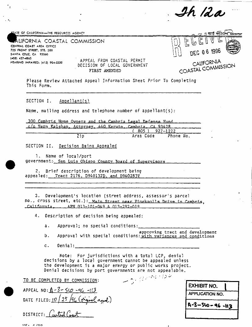
LIFORNIA COASTAl COMMISSION C!!NTRAt COAST AREA OFFIC!! 72S FRONT STREET, STE. :100 SANTA Cl!UZ. CA 9!060 (408) 427..1.863 HEARING IMPAIRED: (.tiS) 904-5200 APPEAL FROM COASTAL PERMIT
DECISION OF LOCAL GOVERNMENT FIRST AMENDED
DEC 0 S 1996
CAL\fO~SS\ON COASTAL CO
Please Review Attached Appeal Information Sheet Prior To Completing This Form.
SECTION I. Aooellant(s)
Na~e. mailing address and telephone number of appellant(s):
300 Cambria Home Owners and the Cambrj a I.egal Defense Fund c/o Vern Kalshan. Attorney, ~~0 Ke~i;D, Camhr;a, CA 934?8
( 805 ) 927-1222 Zip Area Code Phone No.
SECTION II. Decision Beina Aooealed
1. Name of local/port
• government:· San Luis Obisno ·Coyntv Board of Super1isors
2. Brief description of development being appealed: Tract 2176. D940132D, and D940283V
•
3. Development's location (street address. assessor•s parcel no .• cross street, etc.): Main StreQr near Pineknalls Drjye in Cambria, California, APN 013-101-049 & 013-?92-0JQ
4. Description of decision being appealed:
a.
b.
c.
Approval; no special conditions: _____________________ __ approving tract and development
Approval with special conditions: with variances and conditions
Denial: ___________________________________________ ___
Note: For jurisdictions with a total LtP, denial decisions by a loc~l government cannot be appealed unless the development is a major en·ergy or public works project. Denial decisions by port governments are not appealable .
... ·' .. : '""\ .;_,
TO BE COMPLETED BY COMMISSION: -.: ,i -· ':;. ·-:... • ~
APPEAL N0:A--s-Sl0 -9((, -f(J
DATE FILED: (0 [2'5 he, C¥~J EXHIBIT NO. t APPLICATION NO.
DISTRICT: Gwt:J (~ Ut::. A 100
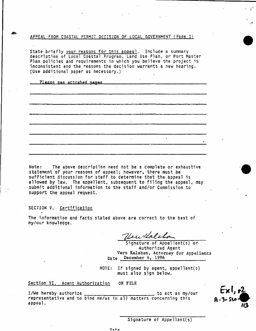
APPEAL FROM COASTAL PERMii DECISION OF LOCAL GOVERNMENT (Paae 31
State briefly vour reasons for this aooeal. Include a summary description of Local Coastal Program. Land Use Plan. or Port Master Plan po11cies and requirements in which you believe the project is inconsistent and the reasons the decision warrants a new hearing. (Use additional paper as necessary.)
Please see attcahed pages
Note: The above description need not be a complete or exhaustive statement of your reasons of appeal; however, there must be sufficient discussion for staff to determine that the appeal is allowed by law. The appellant., subsequent to filing the appeal, may submit additional information to the staff and/or Commission to support the appeal request.
SECTION V. Certification
The information and facts stated above are correct to the best of my/our knowledge.
Signature of Appellant{s) or Authorized Agent
Vern Kalshan, Attorney for Appellants Date December 4, 1996
NOTE: If signed by agent, appellant(s) must also sign below. ·
Section VI. Aoent Authorization ON FILE
I/We hereby authorize to act as my/our representative and to bind me/us in all matters concerning this appeal.
Signature of Appellant(s}
•
••

• Condominium Project by Vadnais & Keeler; SLO County, Tract Map 2176, 09401320, 0940283V
•
•
This project proposes to develop the western 3+ acres of commercial property on an elevated commercial site along Main Street near Pineknolls Drive in Cambria, California. This property was controlled by Coasta~ Deve~opment Permit No. 4-83-680 which provided for commercial development and open space easements. The eastern portion included in this permit has already been developed. The current owner wants to change the community plan and build 25 airspace condominiums.
The project is bounded on the West by Tract 112, which is a single family residential tract that is controlled by recorded covenants, conditions, and restrictions and is known in the community as "Pineknolls". The original developer, MartinMullholland promoted, to the community, that this elevated site would be a commercial subdivision.
PROJECT DOES NOT SHOW TRAT IT COMPLIES WITH THE SAN LUIS OBISPO COUNTY LOCAL COASTAL PLAN and COASTAL DEVELOPMENT PERMIT 4-83-680
1. Coastal Development Permit No. 4-83-680 at page 2 sets forth in part as follows: " ... and will not have any significant adverse impacts on the environment within the meaning of the California Environmental Quality Act." This project causes a significant effect on the environment as follows: (a} Conflicts with adopted environmental plans and goals of the
community where it is located; (b) Has a substantial, demonstrable negative aesthetic effect; (d) Interferes substantially with the movement of any resident or
migratory fish or wildlife .species; (k} Induces substantial growth or concentration ·of population; (1) Causes an increase in traffic which is substantial in relation
to the existing traffic load and capacity of the street system;
(p) Increases substantially the ambient noise levels for adjoining areas;
(q) Causes substantial flooding, erosion or siltation; (r) Exposes people or structures to major geologic hazards; (u) Disrupts or divides the physical arrangement of an established
community; {v) Creates a potential public health hazard or involve the use,
production or disposal of materials which pose a hazard to people or animal or plant populations in the area affected.
No environmental impact report was prepared. The County approved a negative declaration.
2. Chapter 6. Policies for Environmenta~ly Sensitive Habitats. Policy 2, Permit Requirement, requires the applicant to demonstrate that there will be no significant impact on
1 of 6 FIRST AMENDED
'-~I,, 3
A·l- SI.O .. '~' -113
Condominium Project by Vadnais & Keeler, SLO County, Tract Map 2176, 09401320, 0940283V
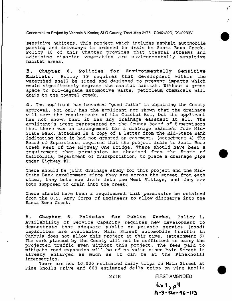
sensitive habitats. This project which includes asphalt automobile parking and driveways is ordered to drain to Santa Rosa Creek. Policy 18 of this Chapter provides that Coastal streams and adjoining riparian vegetation are environmentally sensitive habitat areas.
3. Chapter 6. Policies for Environmentally Sensitive Habitats. Policy 19 requires that development within the watershed shall be sited and designed to prevent impacts which would significantly degrade the coastal habitat. Without a green space to bio-degrade automotive waste, petroleum chemicals will drain to the coastal creek.
•
4. The applicant has breached "good faith" in ob~aining the County approval. Not only has the applicant not shown that the drainage will meet the requirements of the Coastal Act, but the applicant has not shown that it has any drainage easement at all. The applicant's agent represented to the County Board of Supervisors that there was an arrangement for a drainage easement from MidState Bank. Attached is a copy of a letter from the Mid-State Bank indicating that it had not granted an easement. (attachment 4) The Board of Supervisors required that the project drain to Santa Rosa Creek West of the Highway One Bridge. There should have been a requirement that permission be obtained from the State of • California, Department of Transportation, to place a drainage pipe under Highway ~1.
There should be joint drainage study for this project and the MidState Bank development since they are across the street from each other, they both now drain into the West Village, and they are both supposed to drain into the creek.
There should have been a requirement that permission be obtained from the U.S. Army Corps of Engineers to allow discharge into the Santa Rosa Creek.
5. Chapter 8. Policies for Public Works, Policy 1, Availability of Service Capacity requires new development to demonstrate that adequate public or private service (road) capacities are available. Main Street automobile traffic in Cambria does not allow this project at this time. (attachment 5) The work planned by the County will not be sufficient to carry the projected traffic even without this project. The fees paid to mitigate road expansion will be of no value since Main Street is already enlarged as much as it can be at the Pineknolls intersection.
There are now 10,000 estimated daily trips on Main Street at Pine Knolls Drive and 800 estimated daily trips on Pine Knolls
2of6 FIRST AMENDED
E. .. ,), .. A ·3 ... Slo-q,- tt'3
•

• Condominium Project by Vadnais & Keeler, SLO County, Tract Map 2176, 09401320, 0940283V
•
Drive between Main Street and Hartford.
Main Street at this intersection is as wide as it is going to be under the plan which only calls for remarking the pavement from two lanes to three lanes and adding a bicycle lane. (attachment 5)
6. The project 1 s proposed ingress and egress on the westside violates paragraph ~First" of the recorded covenants, conditions and restrictions of the Pineknolls Tract 112 which limit lot usage to single family residential. The project proposes to use lot 7 of Block 2 of Tract 112 as a roadway for the project to and from Pineknolls Drive. (attachment 6) This proposed road is a traffic safety hazard since it is only about SO feet from the right turn lane of Main street. Pineknolls Drive is supposed to have a right turn lane for this project from main street but this will not be long enough to be safe. Pineknolls Drive is a steep road from Main Street to Hartford.
-7. Chapter 9. Policies for Coastal Watersheds, Policy 10 1
Drainage Provisions. No drainage plan has been submitted for public inspection and comment to know whether or not there will be erosion from this project .
8. Chapter 9. Policies for Coastal Watersheds, Policy 13, Vegetation Removal. The County allowed grading on slopes greater than 30% without an erosion and sedimentation plan. The area of grading is in a "geologic study area". There are Monterey pines in the open space easement. There is a significant stand of Monterey
. cypress on the eastern line of the project which acts a scenic view hiding an existing house from view on Main Street and Highway #1.
9. Chapter 9. Policies for Coastal Watersheds, Policy 7, Siting of New Development limits grading for development to slopes of less than 20%. The County has allowed a variance for grading on slopes greater than 20% and even greater than 30%. Grading of slopes greater than 20% is in opposition to COASTAL DEVELOPMENT PERMIT 4-83-680.
Other property in the vicinity has to comply with the standard of the 20% slope limitation. _This is an unfair advantage to this project. Most of Cambria is greater than 20% slopes; and exceptions to this policy will destroy the aesthetic effect of Cambria and defeat the purposes of the Coastal Act. A Soils engineering report should be required before excavation for safety of the up-hill land owners.
• 10. Chapter 10. Visual and Scenic :Resources, Policy 1,
3 of6 FIRST AMENDED
bY.,, , ~ ~-l- StA· cu.- II~

Condominium Project by Vadnais & Keeler, SLO County, Tract Map 2176, 09401320, 0940283V
Protection of Visual and Scenic Resource, are not being protected because this hill is an attract! ve feature of the Cambria hillsides. This project is too massive, it removes existing pines and cypress from the view corridors, and it will strip vegetation from the hill along Main Street and impose a four foot retaining wall over 300 feet long.
11. Chapter 10. Visual and Scenic Resources, Policy 2, Site Selection is not being followed because this hill is in a view corridor from ''Scenic Highway One". The project's retaining wall will be in this view corridor. To comply with this policy and "Policy 1'" above the site should be what it was zoned for, namely, smaller scale commercial development.
12. Chapter 10. Visual and Scenic Resources, Policy 5, Landform Alterations is not being followed because the project allows for maximum grading within a public view corridor imposing retaining walls on Main Street and the upper portion of the hill, which is now protected by an open space scenic easement.
•
13. Chapter 10. Visual and Scenic Resources, Policy 6, Special Communities and Small-Scale Neighborhoods, is not being followed because the project is not designed and cited to • compliment and be visually compatible With .existing characteristics of the community. Page 7 of the findings for the Coastal Development Permit No. 4-83-680 included the following wording ... "and where the characteristics of Cambria as a special community are protected."
14. Chapter 10. Visual and Scenic Resources, Policy 7, Preservation of Trees and Native Vegetation are not protected by the project.
15. Chapter 10. Visual and Scenic Resources, Policy 8, Utility Lines within View Corridors are not addressed in the project.
16. Chapter 11. Policies for Hazards, Policy 1, New Development, is a consideration in this project which is not addressed but is needed because the project is in a "Geologic Study Area".
17. Chapter 11. Policies for Hazards, Policy 2, Erosion and Geologic Stability, are not adequately addressed because the project is in a "Geologic Study Area" and residents and the workman who filled the project site several years ago can testify that site was not compacted both times that the hill was filled in
4 of6 FIRST AMENDED
e:~ ,, , ' 1\ ... 3. St.o· Cf6- lilt
•

• Condominium Project by Vadnais & Keeler, SLO County, Tract Map 2176, 09401320, 0940283V
the last ten years. (attachment 17)
•
•
18. Chapter ll. Policies for Hazards, Policy 3, Developmert Review in Hazard Areas has not been accomplished. This project is in a •Geologic Study Arean and it naturally drains into as •Flood Hazard Arean. The rain water that would have been absorbed by this site will now drain into the West Village until a drain J.~ provided to Santa Rosa Creek. The drainage from the developed commercial areas under COASTAL DEVELOPMENT PERMIT 4-83-680 were not adequately studied. Ankle-deep water was flowing down Main Street at 3:00 a.m. on March 10, 1995 from the developed commercial areas and Pineknolls drive.
19. Grading for the project encroaches on the open space easement provided by COASTAL DEVELOPMENT PERMIT 4-83-680 (attachment 19) It is requested that the Commission take judicial notice of this permit and the recorded open space easement on file with the commission. The open space easement was recorded with ·the San Luis Obispo County Recorder on March 11, 1985 in Volume 2685 at Page 90.
20. Chapter 6. Policies for Environmentally Sensitive Habitats, Policy 23, Streambed Alterations, applies to this project and has not been accomolished. A quotation from letter dated August 9, 19 94 to the San Luis Obispo County Planning Commission from the California Coastal Commission, Executive Director David Loomis, advises as follows:
"The fact that the Environmental Impact Reports for this project have been undertaken to allow for the development of the Cambria Village Project has resulted· in an inadequate analysis of alternative methods for protecting existing structures in West Village, as required by Policy 23, these alternatives may not have been considered by the project's Environmental Impact Reports because they would not provide for the development of the proposed Cambria Village Center."
This project and its previous development should be drained to the Santa Rosa Creek through a green space to reduce flood risks to the West Village and to save the sensitive resources of Santa Rosa Creek.
21. The is no ~ater for th±s oroject for the foreseeable future. Although the site which is zoned for commercial use has an allocation of water for that use; it does not have an allocation of residential water from the Cambria Community Services DistricL. The reference to being on the "County list" is practically useless since the Services District residential list of over 700 must first be exhausted. Before these Service District houses can first
5of6 FIRST AMENDEu
1:~\) ~,.
A-J-SL.O- q,- 113

Condominium Project by Vadnais & Keeler, SLO County, Tract Map 2176, 09401320, 0940283V
be built, the voters will be asked whether or not they want the permitted desalination plant to do this. (attachment 21)
22. The community is being denied due process in the permitting of this development because it has not able to see or to comment upon what is actually going to be built. on the project site. This denial applies to at least the following: the location and number of the buildings which currently conflict with the open space easement; the location and size of the drainage to Santa Rosa Creek; and evidence as to how $679 per condominium unit will solve the traffic hazard problem on Main Street as set forth in the negative declaration.
Respectfully submitted,
Dated: December 4, 1996
6 of6
Vern Kalshan, Attorney for 300 Cambria Horne Owners and the Cambria Legal Defense Fund
FIRST AMENDED
e~', Pi A -1- SLo-"t.- II a
•
•
•

SAN LUIS OBISPO COUNTY
DE"PP\RTM ENT OFPLANNING ANoB'uiCoTNG ALEX HINDS
DIRECTOR
BRYCE TINCt£ ASSISTANT DIReCTOR
elLEN CARROlL E="\'!RO!'-:M£1'-;TAL COORDINATOR
ENVIRONMENTAL DIVISION BARNEY MCCAY CHIH BUilOINC OFFICIAl
•
""--\
•
January 3, 1996
Woody Elliott, Corresponding Secretary North Coast Advisory Council P.O. Box 533 Cambria, CA 93428
.--...... - ·. \
NORMA SAliSBURY AD~~t\:tSiRATI\'E SER\'IC£S OFFICER
RE: Vadnais/Stone Edge Townhouse project, Cambria (ED95-107, 108, 109, 110)
Dear Mr. Elliott:
I have reviewed a copy of the letter your Council sent ~o Terry Wahler, dated December H;, 1995. I also reviewed a letter Joe Boud sent to me dated December 21, 1995. Mr. Baud's letter was copied to your Council.
The Council has requested that an Environmental Impact R~port be prepared for the project focusing on drainage, soils, traffic and glare. Your Council will find the information in Mr. Scud's letter helpful in addressing members' concerns. Council members may find it helpful to review the enclosed proposed negative declaration. As the Environmental Specialist assigned to the project, I prepared the negative declaration.
In the following discussion I have elaborated slightly on the discussion found in the proposed negative declaration, and have hopefully addressed each of the Council's concerns. Because this is my official response to the Council's comments, your letter and this response will be included as exhibits to the project staff report. As such, your comments and my response will be considered by the Planning Commission and Subdivision Review Board.
The following is a discussion of the environmental impacts identified by the NCAC, and the mitigation measures which reduc~d the impacts to a less than significant level:
Quantity and auality of surface water runoff
The applicant has prepared an engineered grading and drainage plan. The plan provides for storm water runoff to flow to the internal streets and a storm drain system, which would carry the water off-site and into Santa Rosa Creek. These plans have been reviewed by the County Engineering Department. Engineerina recommends that a drainage easement be acquired to Santa Rosa Creek. Acquisition d :hrs easement will be a condition of aooroval.
~~) ,, A.r!-S-.o--. -U3

~1 MID·STATE BANK
ADMINISTRATIVE OFFICES
1026GAAHDAVIIHW, AUOYO GAAHDI!. C.U.IPOIUIIA 93420
August 12, 1996
Mr. Norman Fleming 952 Iva Court Cambria, CA 93428
SUBJECT: Condo Project- Main & Pine Knolls Your letter dated August 7, 1996
Dear Mr. Fleming:
805/473-7700 FAX 805/473-7752
Thanks for your letter alerting us of the subject project. To the best of my knowledge, Mid-State Bank has not granted any easement throuah its propertY, at this time, on the subject project.
Your concerns about Santa Rosa Creek and the potential increase in traffic will be of interest to us also. We will be looking more into this proposed development now that you have brought it. to our attention.
Thanks again!
Sincerely,
Harry Y asumoto Vice President Real Estate Services
hy/mw
•
•
•
.. : .. . . . .. ;·· , .. :· ....... • .. · ... :·:~..::4~ .... :.:: . • I ·~ "'"' .. ~ . .~ ., ,, ·. .. . . ' ' . . ·: : . . . ";··. .. . . . , .. · . • • • .. .• ·: ••• ; :· • ; ...... # • ':.. ·: ...... • ••••• !' •• ~ •• • • . . . . . . .. . .. ·
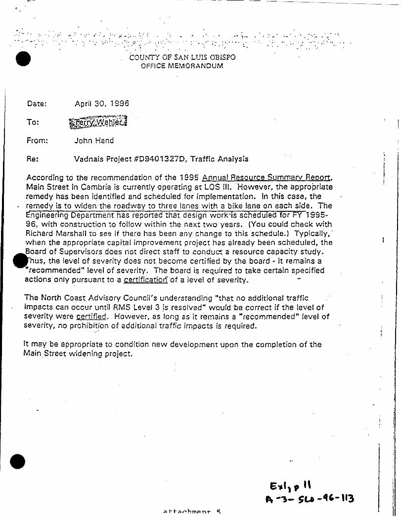
• COUNTY OF SAN LUIS OBISPO OFFICE MEMORANDUM
Date: April 30, 1996
To:
From: John Hand
Re: Vadnais Project #094013270, Traffic Analysis
According to the recommendation of the 1995 Annual Resource Summary Repo[t, Main Street in Cambria is currently operating at LOS Ill. However, the appropriate remedy has been identified and scheduled for implementation. In this case, the remedy is to widen·the roadway to three lanes with a bike lane on each side. The Engineering Department has reported that design work·is scheduled for FY 1995-96, with construction to follow within the next two years. {You could check with Richard Marshall to see if there has been any change to this schedule.) Typically,· when the appropriate capital improvement project has already been scheduled, the
•
Board of Superv. isors does not direct staff to conduct a resource capacity study. hus, the level of severity does not become certified by the board - it remains a
"recommended" level of severity. The board is required to take certain specified actions only pursuant to a certification of a level of severity.
The North Coast Advisory Council's understanding "that no additional traffic impacts can occur untfl RMS Level 3 )s resolved" would ·be correct if the level of severity were certified. However, as long as it remains a "recommended" level of severity, no prohibit!on of additional traffic impacts is required.
It may be appropriate to condition new development upon the completion of the Main. Street widening project .
• 6Y.I 1 , 1\
Pr -"1- SU _._,_ 113

I
I I J I
NORTH COAST CIRCULATION STUDY
Final Report
prepared for
SAN LUIS OBISPO COUNTY
by
COUNTY ENGINEERING DEPARTMENT
February 1992
6'~ t, ,,l. attachment 5 " ... 3 ... sc..o-1c,- ''"
•
•
•

I I' I
I
I I I I
-I I I I I I 1-, I
the two main commercial centers, West Village and East Village. T'ne configuration of this improvement would include four through lanes and a continuous two-way left turn lane, for access to adjacent commercial properties. This would more than double the capacity of the existing roadway, improving the projected peak hour level of service on summer weekdays from LOS ttE" to LOS "C" at buildout. Capital costs are estimated at $1.5 million for this project. Existing development, as well as steep terrain in some areas, may require the elimination of parking and the narrowing of the center turn lane in order to construct this level of improvement.
Widening of Main Street to three lanes. Burton Drive to Cambria Drive. Environmental costs and capital costs of widening Main Street could be reduced by widening to three rather than five lanes. This configuration would include two through lanes and a continuous two-way left tum lane, reducing the total width to as little as 42 feet. While a center tum lane does not improve the roadway capacity, it may be thought of as reducing the demand, by removing turning vehicles from the traffic stream. This would be sufficient to improve the · projected peak hour level of service on summer weekdays from LOS "E" to "D" at buildout. This would be equivalent to maintaining the existing level of service,
. but not improving it The road widening would occur on both sides of Main Street, adjusted as needed to minimize impacts on adjacent properties .. A portion of the alignment, from Cambria Drive to Tamson Way, is already three lanes, and would onlv require shoulder widening for bicycle travel. Capital costs for this project are estimated at $550,000 in current dollars.
Uograding of Burton Drive. Lodge Hill. This is the main connection between the residential areas of Lodge Hill and the commercial areas of downtown Cambria. Shoulder widening of this narrow two-lane roadway would increase the capacity and improve the projected peak hour level of service on summer weekdays from LOS "E" to LOS "D" at buildout. However, the critical location will become the intersection of Burton Drive with Main Street. Improvements to Burton Drive alone without a new parallel route will only exacerbate this situation. The capital costs of this project are estimated at $1.3 million.
New Roadwav Connections
As alternatives to upgrading existing roadways, the following new roadway connectioru. were assessed (see figures S-4 an~ S-4(a)):
Pinev Wav. This road would provide a connection between Lodge Hill in the · vicinity of the Cambria Pines Lodge, and downtown Cambria in the central portion of Main Street. The main objective of this alignment is to provide a parallel route to Burton Drive. Capital costs of this project are estimated at $1.5 million, including a bridge over Santa Rosa Creek.
~ I , p \6. s - 1s
~ -3-Sl.0-1t.-ll"!. attachment 5

Exhibit A
1996 Update North Coast Circulation Studv
On February 25, 1992 the Board of Supervisors approved the North Coast Circulation Study. The most recent update of that study was adopted by the Board of Supervisors on August 15, 1995. Also on February 25, 1992 the Board adopted a Resolution imposing road improvement fees on new development under the provisions of Ordinance 2379. The most recent update of the North Coast Road Improvement Fee Resolution was also adopted by the Board on August 15, 1995. This is the 1996 Update Report.
During 1995, building permits were issued for 68 single-family residences, one duplex, two mobile homes, 2,600 square feet of warehouse, 1,600 square feet of office, 2,1 00 square feet of retail use and tenant improvements, one small restaurant and one public restroom, within the North Coast study area. Since the 1995 Update Report, S 112,000 has been collected, and $69,193 interest ear.ned, in the North Coast Road Improvement Fund. The total balance as of October 3, 1996 is $953,852.60.
T r<1nsportation Improvements
The North Coast Circulation Studv (NCCS) contained a series of recommended transportation improvements. Progress bas been made in the following areas:
Roadwavs
Main Street. The segment of J\-1ain Street between Cambria Drive and Burton Drive has historically had the highest traffic volumes within the community. In recent years, there has been a tremendous increase in measured traffic. Between 1994 and 1995, a 40% increase was observed. 1996 traffic levels have held steady with the higher level measured in 1995. As a result, the 1995 Update of the North Coast Circulation Studv. as adopted by the Board of Supervisors, recommended that it was time to initiate a road-widening project to increase the traffic-carrying capacity of this critical segment of Main Street. The County Engineering Department is proposing to implement the project which was recommended in the Circulation Study. The main element of the street widening will be the provision of a continuous two-way left-turn lane, similar to that which has already been installed between Cambria Drive and Tamson Way. The Engineering Department is working with the North Coast Advisory Council to address some of the details of the design, such as parking, bikeways, sidewalks and streetscape design. Staff will be working with property owners and business owners to identify the time of year the construction would cause the least impact, and estimates.construction of the first phase during 199i, lasting approximately four to six weeks. The first phase will involve the easterly end of the street segment, from Burton Drive to approximately "the Goldsmith." This part is being done separately from the rest as it involves removal and reconstruction of existing sidewalk, which will be the more difficult construction process .
1
E,c I, pllf 1\ ·3- SLo -1'- It")
attachment 5
•
•
•

BOOX 94.0 PAGE: l ttl,------.. - ... 1
•
•
, f:::.CU.R,\!IO!: OF CO!~i:I'I'ICNS • n~TIHC':IuNS :.~Hl'!lE.!;EltV-'TIONS
;oa ~INE ~:OLLS ~~ATES
Tm: UNCI::i\SICN£i) O"tmcro and aubdividora of t.hat. eer..dn aubdLvieion in the County of SQn Lu1o Ob1epo 1 St.at.e of Calirorn1~, known and describe~ an ~1ne Xnoll~ ~atatoo and being off1c1slly known and deacribed aa tract No. 112 3nd coneisting o~ a por..io~ of Rancho Santa Roea and a po~ion of the Ri~don Tract in the Coun~y ot San Luis Obispo, Stato of Cul1forn1a, do hereby declare the followin~ condt~ionG, rcat.r1ctiona and rc~ervat1one to con~1tut~ a eeneral ~lan for the 1:proTement ot said Tract ~o. 112, also known aa Pine Knolla Estates, and which &hall run with the land, .and shall ooerate as eood1t.1ono auboequent. nn4 a!:.all o~rate not oaly tor t.ho bonof1t. ot t.ho ~rantor 'but. for the benetlt. of the owner or ownera of any of th~ lota hereby conveyed aa again&e the o"Wner or awnera or all t.he lot.s hereby conveyod as ag,ainst the owner or owners or the balance o! the lots in eaid Pine Knolls Estates and for the bene!1t ot ths owner or owners of all tbe 'lo~s her~~y conveyed aga!net the owner or owners of any par..ic:ular lot. or lots, :lnd whieh sl'lall be binding U?On I~rantor, his he ira, executors • administrator& and ~saigon, and upon all persona, hold1n~ under or thru him, and all ~~r=one, who may acquire any interoet in or to any ot said lot. or lo~6 by ope.rat.1on o.f law or by or in any ot.ht>r manner whatsoever na=ely:
Firat.: That. no bu1ld1n ... or et.ructurts Qt.hsr than one orivat.e one family residence shMll ~. placed or constructed upon any on! loti however, a ~aragw 1 guest. house or aer7ant.a' quarters without cooking rac1l1t1as =ay be erected, placed and ma1nea1ned thereon ae a~pertainlnr. to and for the sole u~a ot eh~ oeeu~nt. or 5uch resijence.
Second; t'o :such dwctllint: or appurt.ent.nt. buildings :shall be pe:":!!1t.t.ed to be placed, constructed or assembled upon oaid propojl! unl~~s ~nr. until the plano and epecificat.ions of such buildil'lga ehall have been preeentcd to and Approved 1n wr1t1n,t b:t t.he .eeller or hill A;::ent. and
a co~mit~~e appointed by thu.&eller or h18 agent, provided fu~her trat. no rlwelling ehall be permitted h.av1n!; a r.round floor area or the main structure of le~= than 1200 s~unro feet 1n Bloc~a 8 and 9, and 1000 .equare :eet in Blocko 5. band 7, exelu~.ve of open porches and
· garage •
Third: ~o dwell1nr,s or appurtenaQt bu1lo1nes other than one story, shall be placed or const.r,l<:ted on any lot except 1n Dloc:ks 1 - 2 - J and 4, where ll and 2 etor-!cs are per.:1t.ted provided t:IUlin floor hae lOOO square feet in aree, o1clu~ive of garage and open porc:he~ and patio, and only one a~ory 1~ above the hichc~t polnt or acid lot.
Fo~r..h: No tent or othor temporarr structure aha~l be placed on any ot t.he sa.1d prec1oea. Pro-.1.ded. however, that durlne; tho j:leriod or con~truc~ion of anT por=anen~ d~ollins. ~orago, or other i~provoment.
. <.:
s~ch portion thereof ao may bavo bean completed ~ar be o~cupied dur1ng the period or conotruet1on of tho ?orcanent improvements. but not in any event. to exceed tho period ~r eix months from the date o! co~ncneo=ent o~ 1uch const.ruct1on of por=anent. ~prov~ment.o. ~roYided .fUrt.her ~J that a trailer may be placed upon any of aa14 lote and occupied during ·~ the period or conatruc:tion of permanent improveaonta, but in no event to exceed the period of olx rnont.ba. .The roregof.og is not. 1ntondad to p~vent owno~a of said lota from keopin& or otoring trailers on ~aid prcmiaea, provided that tho oame 1a noe done for tbe purpoee of u~e and oc~upancy as a permanent dwelling.
6'~ \I 'P I 1---------------···· -- ·-· 1\-•·1- . "'-J IS
I I i
! j I i I I • I I
~ I
j I I ~ I
i -.....
l ~ I • . I
...
":;.
' . >:'c. 4./t ,......_
.(~:.'~~. . -
Sc:..tJ:.r -:z.
.~""'"--t t~T) . . . . . .
"
•

7
•
•
• e~t,,,l
A-l~~L.o- 'tt--nl
Mr. Terry Wahler Planner,
VERN D. MATTOX
4985 Grove Street
Cambria, California 93428
APN 13-101-069
Department of Planning and Building County Government Center San ~uis Obispo, California 93408
Dear Mr. Wahler:
January 20, 1996
I am writing in regards to the Hearing by Dean Vadnais/Joe Baud/North Coast Engineering for a Development Plan/Coastal Development Perrnit/Tentat;ive Tract Map to create twenty five residential condos on a 3.1 acre parcel and a variance for grading and also wants to do more grading which has already been
- done.
I am protesting the fill dirt that was moved to the parcel when his property along Main Street was excavated in order to build a sidewalk and retaining wall. The fill dirt has changed the natural.grade of the proposed condo site by about 15 to 20 feet.
Mr. Vadnais told me on the telephone that they were only going to store the dirt temporarily, and much of it would be returned to the sidewalk excavation site. As of today, all the fill remains on the proposed condo site.
I am very concerned about building height;s and ingress and egress of traffic plus the air and noise quality as stipulated by Code 21000.
We also have a recorded easement on this property for a sewer line.
When we built our home above the site, we followed the natural ·grade of I personally think the develo ers sl'iould
Thank you,
i.5! Vern D. Mattox
\
'
•
•
Ettl, p '<~ • A .. ) .. SU- "c.-Ill
attachment 17

•
Departme~~-of Planning and Building: ,......., ....::::'~I"'\' y 'iji""\ u I I .- ( (-< I ::':': i • I ;.. \ • •
1 LS~~=u ·\, ~.::::'ra11 Lu1s Ob1spo County . II I I
I . I l ,,
. '. 1\ \ . II IN . J ·; ii..:,··~..; •• II\;} \
VV1 (.. c... • "V I I I ' . ,. ,.J ...\ -
B::rm:v M<.:Cav, Chief Buildine Otllcial Norma Sa!ishurv, .A.dmini!'tr:uiw S~.·:viccs-Ofliccr
• (.Q
PROJECT REFER~~L
DATE: June 16, 1995
<:.J1 <:_ c::: r-
TO: Trac~ 2176/D9401320/D940283V~
Coastal Develoornent Pe~i~ Vadna is/Boud ,_.
0
FROM: Project Name and Number
Terrv Wahler, Senior Planner Development Review Section Phone: 781-5621
N c .. n
Project Description: A Tentative Tract Mao and develoornent clan recruest to subdivide a 3.13 acre site into 25 airsoace condominiums (Townhouses) . A variance is reauired to arade slooes in excess of 30%.. The oroiect site is located at the northeastern corner of Pine Knolls Drive and Main Street, in the cornmunitv of Cambria. The site is steeolv slooina. Geoloaic stabilitv. drainacre erosio~ and sedimentation concerns will need to be fullv addressed. Traffic aeneration as it relates to the cambria Circulation Studv will need to be evaluated. Water availabilitv and the uroiect•s place en the water list also needs to be documented. Visual imoacts rnav be a concern. Visual mitiaation is orooosed in the form of extensive landscaoina. Tree coveraae is limited and therefore removal is limited. Aon 013-101-049 & 13-292-019.
Please return this form with your comments within two weeks.
STEP I Is the attached information adequate for yo•.:tr ra•:ie't:?
If not, please call me as soon as possible to discuss what else you need.)
STEP II Are there significant ccncerns, problems or impacts in your area of review? (}.,£." • If so, please describe the impacts, along with recommended mitigation measures to reduce the impacts to less-than-si~nificant levels, and attach to this letter.
STEP III Please indicate your recommendation for final action. Please attach any conditions of approval you recommend to be incorporated into the project's approval, or state reasons for recommending denial. If you have "no
p~ease so indicate or call. ~
'-"~ ') ., ,,
,...
A ·3· S\.0-qf:.•'l'l
rATE OF O.UFORNIA-iHE ltESOURCSS AGENCf
:ALIFORNIA COASTAL COMMISSION !NTRAL COAST AREA OFFICE
l!l FRONT STREET, STE. :300 -'NTA CRUZ. 0. 9.5060 .08) A27..u363 URING IMPAIRED, (AIS) 90A-.5200
Terry Wahler Department of Planning and Building County Government Center San Luis Obispo, CA 93408
December 26, 1995
:
SUBJECT: Proposed Negative Declaration for Lot Line Adjustment/Coastal Development Permit COAL 94-124. Vadnais/Saud/North Coastal Engineering
Dear Mr. Wahler:
In July of this year I responded to a request from the County to review this proposal and commented that the plans showed development proposed for the open space area on the site. The plans accompanying thls latest document still show structures proposed to be develooed 1n the ooen space area. The appt1cant will have to relocate the proposed structures, apply to amend the
~ ~
open space easement to allow the structures, or show that the easement allows • for that development. If you have any questions please do not hesitate to contact me. Thank you.
Sincerely,
~~ Steve Guiney Coastal Planner
G~lJ p 1f) • "·l·S-.o-,~-u~
0435$
t •-- -t..---..1... , I"\
. .,.111,..•11 ' .. , __
a ·- ~' -- ·-·-- 05'96 15:24 No.013 P.01 1-1..1"11'11,41'1~/ CUl-UJ.J.,.I:S
••
••
. .•.. --~··· ...... ) SAN LUIS OBISPO COUNrf DEPARTMENT OF PLANNING AND BUILDING - ·- - ·-· -·
Ms. Linda Hall Sean.Raalty 784-B Mairt ·St. Cambria, Ca 9~428
. --~
Si:N'l' VIA J'AX
Re; ~••idantial allocations in Cambria
Oear M•. H~ll:
ALEX HINDS OIRECT.OR
UYC! TINC:U' ASSIS1'ANT DIIUCTOR
HUN CAIUlOLL tNVIRONMriNt'Al COOitOINATOR·
IAilNfY MCCAY t.:HIH OUili'>INC OfliCIAL
NOlMA SALIS&U.Y AOMIN!STlATIVf SERVICES OHIC:ER
A• We disouaaod •arlier·today, residential allocations in Cambria und•r tha county qrowth · :~anaqement ordinano• are basad on tha waitinq liat =aintaintd by the Cambria community servioea'oistriet (CCSO) • The county will issue residential allocations basad on the Vill-aerva letters isauad each year by tha ccso. The co~n~y has no leqcl role in thQ mdint•nance and opar~tion ot
·the CCSD list ainoa th•·district is an entity separate trom the county. Th•ra~ora, it 1~ up to the ccso to ~eoid• how to imp~ement ita list, inolu41ng i••ues associated with the araa ot your concern raq&rding •inc;le.-tam:il:y vs .. multi-family unit•.
The county growth manaqement ordinance also includes a proviaion that allows persons who ara not on the "trozan" ccso list as it •~dated as ot D•oamber 31, 1990, to apply for a dwellinq unit allocation on tha county's list. The county liat will,ba used at 1ome future date whon all partiea on the frozan ccso list hava been able to aacure water matara and county buil4ing permits. Onca tho trozan ccso list. is exhausted, all tutura allocation• in Cambria will com• frol\\ the co.unty' a list, thereby having only ona list tor tutura buil4inq in Cambria.
- I
Aa I noted whan we talked, the CCSD has raquaat•d various amandment• to tha county's growth management ordinance, inoluding a requ•at to •hirt varioua typas ot request• trom the ccso list to the countywide list, Th• Board of Sup•rviaorg conaiderad tho•• raquaata and did not authorize atat! to prepsra the am•ndmant• to ~he ordinanca a• requ•atad by the district.
t~() p~l. .• A-J-~t.o-t,-113
COVNTY co:;w;;w:;r QNTt" • ~ LUIS O&SPO • OLJJ·OIU'I\.4. 93408 • (805) 781·.SOOO • FAX (80S) 781·12 .. 2 ~ ~ ..

J--- --· Co-I!S7//(_
SAN LUIS OBISPO COUNTY
DEPARTMENT OF PLANNING AND BUI:~~~~ • DIRECTOR
BRYCE TINCtE ASSISTANT DIRECTOR
EllEN CARROll ENVIRONMENTAl COORDINATOR
NOTICE OF FINAL COUNTY ACTION BARNEY MCCAY
CHIEF BUilDINC OFFICIAl
HEARING DATE: September 17. 1996
NORMA SALISBURY ADMINISTRATIVE SERVICES OFFICER
SUBJECT: . Stone Edge/TRACT 21761P940132D/P940283V/Dean Vadnais/Joe Boud
LOCATED WITHIN COASTAL ZONE: .Y&,S NO
The above-referenced application was approved on the above-referenced cf~tP. hv thP. fnllnunna hearing body: -
EXHIBIT NO. ~ San Luis Obispo Planning Commission APPLICATION NO.
-L- San Luis Obispo Board of Supervisors
A copy of the findings and conditions is enclosed. The conditions or approvru must oe completed as set forth in this document. ·
If you are dissatisfied with any aspect of this approval, you have the right to appeal the decision to the Coastal Commission. The appeal must be filed within 10 days upon receipt of the notice of fmal action by the Coastal Commission. (Subject to a determination by the Coastal Commission that there are grounds for an appeal as set forth in Section 30603 of the Public Resources Code and pursuant to· the Coastal Zone Land Use Ordinance 23.01.043d). We strongly recommend that you contact the Coastal Commission concerning rights and procedures of appeal. You may also wish to contact the county Department of Planning and Building to obtain the appeal form and information handout explaining the rights of appeal. These regulations contain specific time limits to appeal, criteria, and procedures that must be followed to appeal this action.
FiNAL LOC.~L ACTION NOTICE
CAUFORNIA COASTAL COMMISSION
COUNTY GovERNMENT CENTER • SAN LUIS OBlSPO • CALifORNIA 93408 • (805) 781-5600 • FAX (805) 781-1242 OR 5624
•

•
•
•
'
IN TilE BOARD OF SUPERVISORS COUNTY OF SAN LUIS OBISPO, STATE OF CALIFORNIA
_...::T.::.ue;:..:s,__ __ day September 17 ' 19_2§_
PRESENT: Supervisors Harry L. Ovitt, Evelyn Delany, Ruth E. Brackett, David Blakely, and Chairperson Laurence Laurent
ABSENT: None
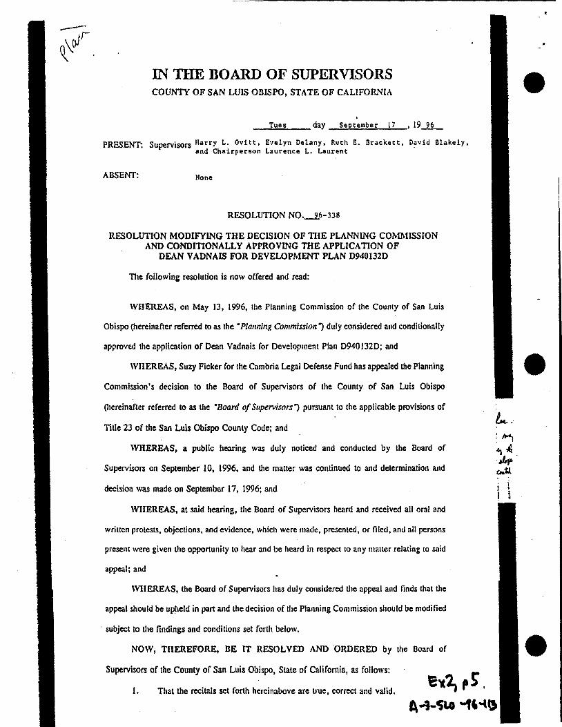
RESOLUTION N0._2!-337
RESOLUTION MODIFYING TilE DECISION OF THE PLANNING COMMISSION AND PARTIALLY APPROVING THE APPLICATION OF
DEAN VADNAIS FOR VARIANCE D940283V
The following resolution is now offered and read:
WHEREAS, on May 13, 1996, the Planning Commission of the County of San Luis
Obispo (hereinafter referred to as the • Planning Commission") duly considered and approved
the application of Dean Vadnais for Variance D940283V; and
WHEREAS, Suzy Ficker for the Cambria Legal Defense Fund has appealed the Planning
Commission's decision to the Board of Supervisors of the County of San Luis Obispo
(hereinafter referred to as the ·noard of Supervisors") pursuant to the applicable provisions of
Title 23 of the San Luis Obispo County Code; and
WHEREAS, a public bearing was duly noticed and conducted by the Board of
Supervisors on September 10, 1996, and the matter was continued to and determination and
decision was made on September 17, 1996; and
WHEREAS, at said hearing, the Board of Supervisors heard and received all oral and
written protests, objections, and evidence, which were made, presented, or filed, and all persons
present were given the opportunity to hear and be heard in respect to any matter relating to said
appeal; and
WHEREAS, the Board of Supervisors has duly considered the appeal and finds that the
appeal should be upheld in part and denied in part and the decision of the Planning Commission
should be modified subject to the findings set forth below.
NOW, THEREFORE, BE IT RESOLVED AND ORDERED by the Board of
Supervisors of the County of San Luis Obispo, State of California, as follows: E~l, p 1·. 1. That the recitals set forth hereinabove are true, correct and valid. A .. ,.4j&.a .. (f'6-.
2. That the Board of Supervisors makes all of the findings of fact and determinatiOI':o It "J I set forth in Exhibit A attached hereto and incorporated by reference herein as though set forth

3. That the negative declaration prepared for this project is hereby approved as
complete and adequate and as having been prepared in accordance with the provisions of the
California Environmental Quality Act.
4. · That the Board of Supervisors has reviewed and considered the information
contained in the negative declaration together with all comments received during the public
review process prior to approving the project.
S. That the appeal filed by Suzy Ficker for the Cambria Legal Defense Fund is
hereby upheld in part and denied in part and the decision of the Planning Commission is
modified and that the application of Dean Vadnais for Variance D940283V is hereby partially
approved.
Upon motion of Supervisor ...... o-.v.-1.-tt"------• seconded by Supervisor Brac:kett: ,
and on the following roll call vote, to wit:
AYES: Supervisors Ovitt, Brackett, Blakely, and Chairperson Laurent
-NOES: Supervisor Delany
ABSENT: None
ABSTAINING:None
the foregoing resolution is hereby adopted.
~JREMCE L LAURENT
Chairman of the Board of Supervisors
ATTEST:
Julie L. Rodewald
Clerk of the Board of Supervisors
BY =-----~?_·";..;.'~-~·:..;•:._· :._:_:·.;_;·_)_1 :~_·· __ Deputy Clerk
(SEAL)
APPROVED AS TO FORM AND LEGAL EFFECT:
JAMES B. LINDHOLM unty Counsel
f.lTATE OF CAUFORNIA ) COUNr/ OF SAN LUIS OBISPO ) ss
' I, JUUF. L r.o-:!r:!:\1..!:1, eoo:r.:o: r.:~r!t of the above 1 !l!l;tJaiJ Co:m1Y. r.r..:J a-c:lb r=-t:.t e. lhe ectrd of · ::~~i'-~$()ft:.!iCTOCf, t:P ~'\<~":)C~~':!'/1~~ fOl'a{!Oir.glO ' baa:~:~trua~~o:-1u~!'i',,: ··::<;.t. • ..l:~oi~li<l! •nt31'aa:nthe
miiiL1~~cl3aiti~l!~~:...;;!tl\'l!lOI'S,&ildllOWrllllllnln~ of raco~d o:1 r.:r ! :!l;;:s Wllnm. my 11a1111 ;mttaliil! o: r: .. "J Soard of SUptrvl
sors Ibis _..J.J__ •.lti ~ A4w= 19.2k.._,
.tm.m t.. r· ::.~'~,·~!!:H> C:u;;tr t.l.;:\ "::It ::. .... a .. ~ ... trk ro~u L ••.••• ·:r11
By <-.::;__ - OOIIUty (;l.tll
E-.2, pl A-'3- Sc.• ... "-~ -U!t
•
•
•
•
•
•
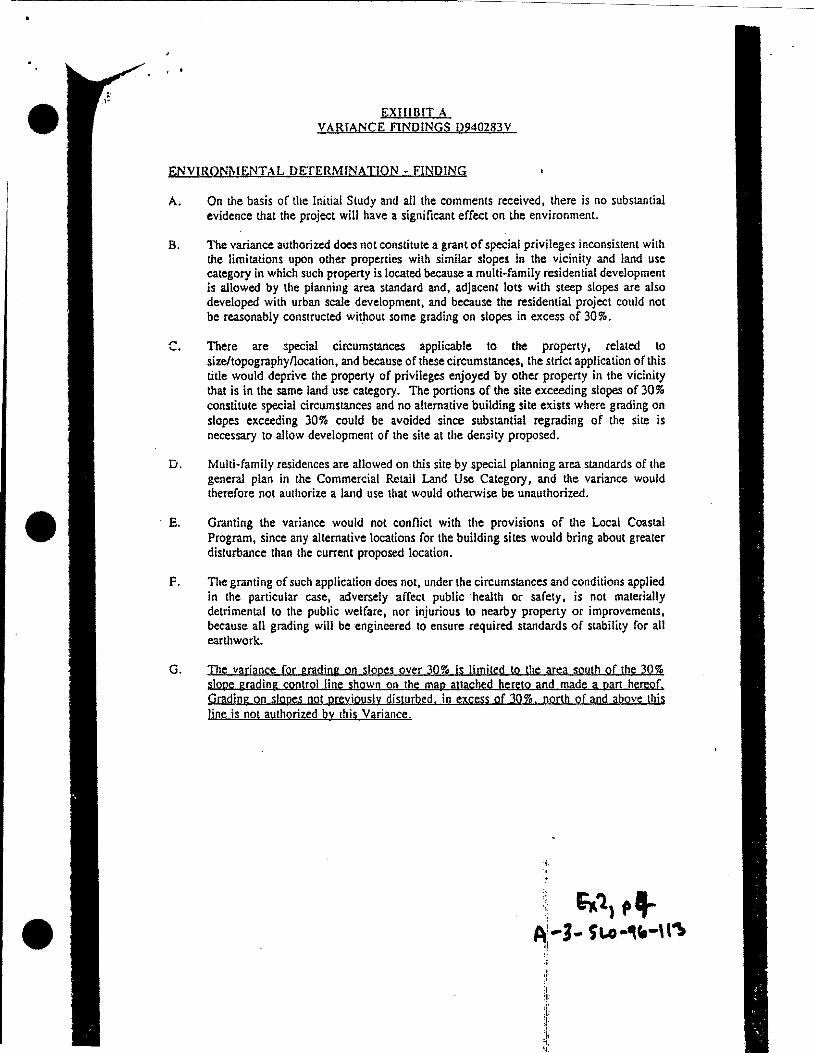
EXHIBIT A VARIANCE FINDINGS D940283V
ENVIRQI)'J\-lENTr\L DETERMINATION~ FINDING
A. On the basis of the Initial Study and all the comments received, there is no substantial evidence that the project will have a significant effect on the environment.
B, The variance authorized does not constitute a grant of special privileges inconsistent with the limitations upon other properties with similar slopes in the vicinity and land use category in which such property is located because a multi·family residential development is allowed by the planning area standard and, adjacent lots with steep slopes are also developed with urban scale development, and because the residential project could not be reasonably constructed without some grading on slopes in excess of 30%.
C. There are special circumstances applicable to . the property, related to size/topography/location, and because of these circumstances, the strict application of this title would deprive the property of privileges enjoyed by other property in the vicinity that is in the same land use category. The portions of the site exceeding slopes of 30% constitute special circumstances and no alternative building site exists where grading on slopes exceeding 30% could be avoided since substantial regrading of the site is necessary to allow development of the sile at the density proposed.
D. Multi·family residences are allowed on this site by speci:.l planning area standards of the general plan in the Commercial Retail Land Use Category, and the variance would therefore not authorize a land use that would otherwise be unauthorized .
E. Granting the variance would not conflict with the provisions of the Local Coastal Program, since any alternative locations for the building sites would bring about greater disturbance than the current proposed location.
F. The granting of such application does not, under the circumstances and conditions applied in the particular case, adversely affect public ·health or safety, is not materially detrimental to the public welfare, nor injurious to nearby property or improvements, because all grading will be engineered to ensure required standards of stability for all earthwork.
G. The variance for grading on slopes over 30% js limited to the area south of the 30% slope grading control line shown on the map attached hereto and made a part hereof. Grading on slopes not previously disturbed. in excess of 30%. north of and above this line js not authorized by this Variance.
;. i ·r
IN Tim DOARD OF SUPERVISORS COUNTY OF SAN LUIS OBISPO, STATE OF CALIFORNIA
Tues day September 17 , 19_1L
PRESENT: Supervisors llarry L. Ovitt, Enlyn Delany, Ruth E. Brackett, David Blakely, and Chairperson Laurence L. Laurent
ABSENT: None
RESOLUTION NO._i6-338
RESOLUTION MODIFYING THE DECISION OF THE PLANNING COMl\USSION AND CONDITIONALLY APPROVING THE APPLICATION OF
DEAN VADNAIS FOR DEVELOPMENT PLAN D940132D
The following resolution is now offered and read:
WHEREAS, on May 13, 1996, the Planning Commission of the County of San Luis
Obispo (hereinafter referred to as the • Planning Commission") duly considered and condilionally
approved the application of Dean Vadnais for Development Plan 09401320; and
WHEREAS, Suzy Ficker for the Cambria Legal Defense Fund has appealed the Planning
Commission's decision to the Board of Supervisors of the County of San Luis Obispo
Otereinafter referred to as the ·soard of SupeTVisors") pursuant to the applicable provisions of
Title 23 of the San Luis Obi'spo County Code; and
WHEREAS, a public hearing was duly noticed and conducted by the Board of
SupeJVisors on September 10, 1996, and the matter was continued to and determination and
decision was made on September 17, 1996; and
WIIEREAS, at said hearing, the Board of Supervisors heard and received all oral and
written protests, objections, and evidence, which were made, presented, or filed, and all persons
present were given the opportunity to hear and be heard in respect to any matter relating to said
appeal; and
WHEREAS, the Board of Supervisors has duly considered the appeal and finds that the
appeal should be upheld in part and the decision of the Planning Commission should be modified
subject to the findings and conditions set forth below.
NOW, THEREFORE, BE IT RESOLVED AND ORDERED by the Board of
Supervisors of the County of San Luis Obispo, Slate of California, as follows:
1. That the recilals set forth hereinabove are true, correct and valid.
!., .· :~
:'1~ . ..,. . ~
i i I i
•
•
•
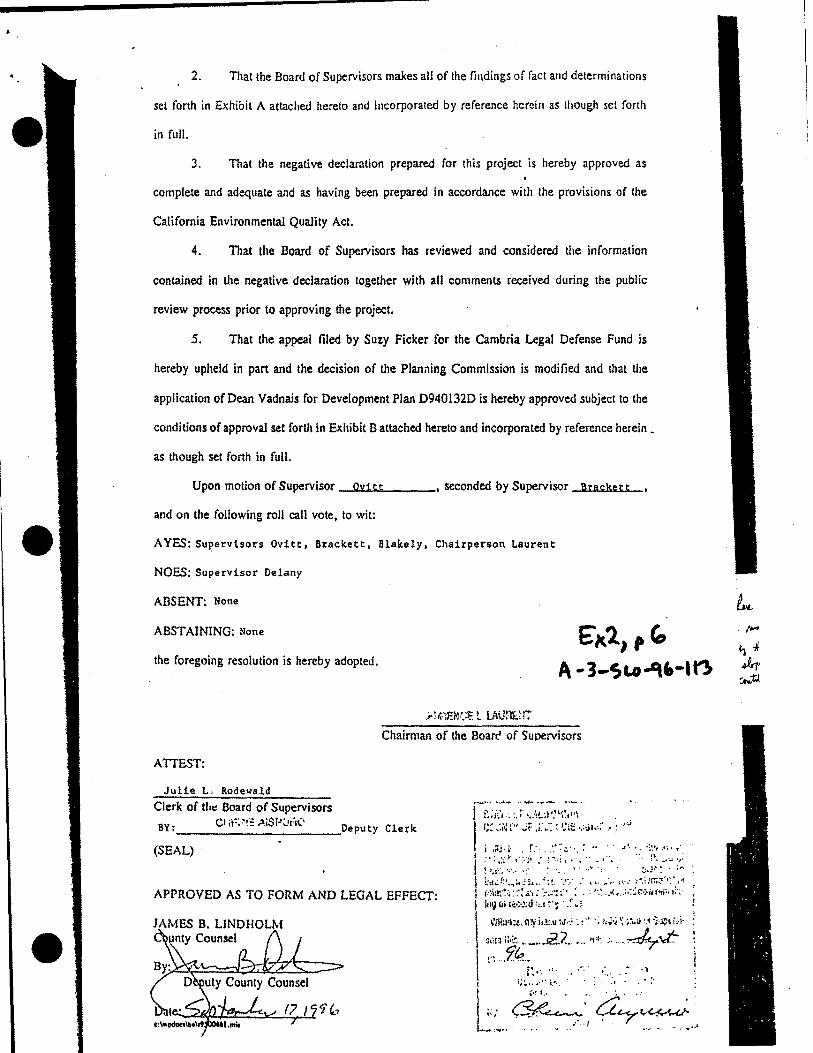
2. That the Board of Supervisors makes all of the findings of fact and determinations
set forth in Exhibit A attached hereto and incorporated by reference herein as though set forth
in full.
3. That the negative declaration prepared for this project is hereby approved as
complete and adequate and as having been prepared in accordance with the provisions of the
California Environmental Quality Act.
4. That the Board of Supervisors has reviewed and considered the information
contained in the negative declaration together with all comments received during the public
review process prior to approving the project.
5. That the appeal filed by Suzy Ficker for the Cambria Legal Defense Fund is
hereby upheld in part and the decision of the Planning Commission is modified and that the
application of Dean Vadnais for Development Plan 09401320 is hereby approved subject to the
conditions of approval set forth in Exhibit B attached hereto and incorporated by reference herein •
as though set forth in full.
Upon motion of Supervisor --:O~vui...a.t..._t ___ , seconded by Supervisor Brackett
and on the following roll call vote, to wit:
A YES: Sul'ervisors Ovitt, Brackett, Blakely, Chairperson Laurent
NOES: Supervisor Delany
ABSENT: None
ABSTAINING: None E'.xl,," the foregoing resolution is hereby adopted. A ... 3-sa.o...q-.-arl
Chairman of the Boarc' of Supervisors
ATTEST:
Julie L, Rodewald
Clerk of tl1~ Board of Supervisors ·-h· ............ u .............. ··--
1 :- :;.•: . ~- i. M ;,, .... ,, II\ \• I I'• I · • ., I ~~ '""'' • l.i I c;: ,;;~ :·" ,;;: ;;:;: ~ ~;~;; .. ,;; ... ; ... : ,,;
i i·.;>~:<}': ':·::!~:..·::-:-'·::•· .. ,,• .. ·~y:~·'<:: (SEAL)
• ht~J~:~.,;t:.'~ .... •:.!. ~.':.· _. ,,. ___ ,. .••... · ;-,;,;:rr..:t*~· I Mb~:~:..::·:.;.·,. ; ... .;"!·:.··. :· •. : :·.,; •.•• i\~ .• ;::·;r..; .• ,r.,;;, 1 11111 r.Hu·>~:d :,,t ~· ~ · .~. :.
APPROVED AS TO FORM AND LEGAL EFFECT:
I \'/l!a~:t,i'll'jio.I:.IIM··.• .•·' :; >.~.; ':~~.;i•:I"JJ!)Li.!• "'rll'•:• 2? "J ''''' ~...t:-1 ::;· . .9.~:~··· -·· .. . .. " . ' . - . _. t f: •.. Jl. • •••• •• • •• •
t ·~:.. •• •. •• i."'. . .. •,
JAMES B. LINDHOLM unty Counsel •
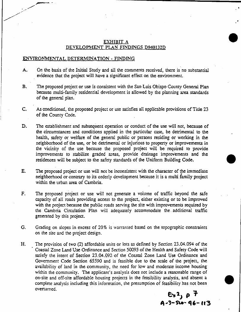
~ ........ - ..
/
EXHIBIT A DEVELOPMENT PLAN FINDINGS D940132D
ENVIRONMENTAL DETERMINATION- FINDING
A. On the basis of the Initial Study and all the comments received, there is no substantial evidence that the project will have a significant effect on the environmenc.
B. The proposed project or use is consistent with the San· Luis Obispo County General Plan because multi-family residential development is allowed by the planning area standards of the general plan.
C. As conditioned, the proposed project or use satisfies all applicable provisions of Title 23 of the County Code.
D. The establishmem and subsequent operation or conduct of the use will not, because of the circumstances and conditions applied in the panicuiar case, be detrimental to the health, safety or welfare of the general public or persons residing or working in the neighborhood of the use, or be detrimental or injurious to property or improvements in the vicinity of the use because the proposed project will be required to provide improvements to stabilize graded areas, provide drainage improvements and the residences will be subject to the safety standards of the Uniform Building Code.
E. The proposed project or use will not be inconsistent with the character of ~e immediate neighborhood or contrary to its orderly development because it is a multi family project within the urban area of Cambria.
F. The proposed project or use will not generate a volume of traffic beyond the safe capacity of all roads providing access to the project, either existing or to be improved with the project because the public roads serving the site with improvements required by the Cambria Circulation Plan will adequately accommodate the. additional traffic generated by this project.
G. Grading on slopes in excess of 20% is warranted based on the topographic constraints on the site and the project design.
H. The provision of two (2) affordable units or lots as defined by Section 23.04.094 of the Coastal Zone Land Use Ordinance and Section 50093 of the Health and Safety Code will satisfy the intent of Section 23.04.092· of the Coastal Zone Land Use Ordinance and Government Code Section 65590 and is feasible due to the scale of the project, the availability of land in the community, the need for low and moderate income housing within the community. The applicant's analysis does not include a reasonable range of on-site and off-site affordable housing projects in the feasibility analysis, and absent a complete analysis including this information, the presumption of feasibility has not been overturned.
e-,.tJ p 'T " .... l-S\o- 16- U3
•
•
•

• The following incentives are offered by the county:
•
•
1. Public Facilities fee exemption for the affordable housing units. Fees will be paid through the affordable housing in lieu fee fund in accordance with Ordinance Section 18.04.010a.
2. Staff technical assistance in identifying possible state and federal funding sources for affordable housing.
3. Exemption from the county Growth Management ordinance.
4. Affordable units receive a special priority on the CCSD list for water service.
5. A variance for grading on slopes over 30% allows for greater development than would otherwise be allowed on the site. ·
6. Residential Development of this type is not normally allowed in the Commercial Retail land use category. -The relaxation of normal zoning requirements constitutes an incentive by making residential development possible in the Commercial Retail land use category .
~}(2) ,i A ... J-5t..o -tf6- f 13
EXHIBIT B DEVELOPMENT PLAN· D940132D ·CONDITIONS OF APPROVAL
Approved Use
1. This approval authorizes:
a) a residential airspace condominium project consisting of 25 airspace units and an underlying common lot including openspace, parking and access areas to be held in common by the homeowner's association.
b) floor plans and elevations approving 25 attached residences in duplex and triplex configurations.
c) grading on slopes in excess of 20% for site improvements.
The development shall conform to the approved site plan (revised), floor plans and elevations as well as the preliminary grading plan except as· modified by these conditions of approval.
Revised Plans
2. Prior to issuance of a grading or building permit the applicant shall submit a revised site plan to the development review section of the Department of Planning and Building for review and approval. Plan to show:
a) maximum retaining wall height of the exposed face of retaining walls along the Main Street frontage shall not exceed 4 feet along the westerly portion, approximately 240 feet and shall not exceed 5 1/2 feet for the easterly portion, except for the back of the street tree wells and where necessary to match the height of the existing retaining wall. This wall shall include cut outs for street trees at 20 feet intervals along Main Street and shall be designed to accommodate extensive landscaping·tree cover along the southern and western slopes of the project.
b) The applicant shall submit a revised site plan showing that the proposed development will not involve grading on undisturbed slopes over 30% for anv proposed residences. Relocation of buildings reduction in unit sizes. or elimination of units. decks and garages mav be necessarv. Cfhe variance for grading on slopes· over 30% is limited to the area south of the 30% slope grading
· control line shown on map attached to the variance resolution. Grading on slopes not previously disturbed. in excess of 30%. above this line shall not be allowed.
These modifications shall be integrated into the grading plans and permit.
Grading Permit Ex21 p'l
A-. "3- t;a.o- crt.- 113
•
•
•
• 3. Prior to issuance of a building permit, or any grading activities, submit grading, sedimentation and erosion control, and drainage plans prepared in accordance with the requirements of Section 23.05.028, 23.05.036, and 23.05.044 of the County Land Use Ordinance to the Department of Planning and Building for review and approval. The plans shall be designed by a registered civil engineer, or other qualified professional.· Review of the plans shall be subject to an inspection and checking agreement with the Engineering Department. The grading permit shall also require approval by Cambria Community Fire Department for finish road grades and surfacing requirements, prior to issuance. Grading activities shall not be allowed during the rainy season (October to April). Haless S:f3pre\'ea hy the Direeter ef PlaaaiHg aHd BHilaing.
Geologv
4. All recommendations contained in the geotechnical engineering report prepared by Mid- . Coast Geotechnical, Inc. (dated April 19, 1995) and the Engineering Geology Investigation (dated Aprill9, 1995) prepared by Ken Maloney shall be adhered to during all phases of design, site preparation and construction. Updates by the respective
· engineer are subject to review and approval by the Director of planning and Building .
• 5. An encroachment permit shall be obtained from the County Engineering Department prior to any construction activities in the puhlic rigit-of- way.
•
6.
7.
A letter of clearance from the Cambria Community Fire Department sha!,l be required prior to issuance of any permits, indicating compliance with their standards and requirements, and indicating their approval of the proposed access drive grades anc:l
·surfacing.
Prior to issuance of any grading or building permits, the applicant shall provide written clearance from the Coastal Commission concerning the openspace easements on the northern periphery of the project. Amendment or relocation of the easements and amendment to previous Coastal Developmei'It Permits may be required~ The applicant shall submit the uroposed revised easement location map to the department of Planning and Building for review and aporoval prior to submitting to the Coastal Commission. The easement revision shall be egual to or greater in extent and gualitv that the existing easement and shall eaual 75.000 souare feet.
Effective Time Period
8. This development plan approval period will run with the tentative tract map approval period. Map time extension approvals granted with the map shall similarly extend the development plan approval period. Time extensions must be submitted in writing by the applicant and are subject to evaluation and action based on the circumstances prevailing at the time of the request.
f,: ~JP I 0 A-3-Su- 116·113

;; Low Cost Housing j
9. Prior to issuance of any grading or building permits or filing of the final map the applicant shall enter into an agreement with the county to provide two (2) residential units for low and moderate income families as defined by Section 23.04.094 of the Coastal Zone Land Use Ordinance and by Section 50093 of the Health and Safety Code as part of the proposed project or elsewhere in the community. The agreement with the county for the development will include acknowledgement that it is feasible to provide a level of affordable housing in conjunction with this project.
a. Prior to recording the Tract Map, the applicant shall pay an affordable housing in-lieu fee of 3.5 percent of the adopted public facility fee effective at the time of recording for each residential lot. This fee shall not be applicable to any officially recognized affordable housing included within the residential project.
EJ.WIRONMENTAL MITIGATION MEASURES
Mitieation Monitorin:
10. Prior to issuance of any permits and any physical disturbance of the site, the applicant shall contract with the county to engage an environmental monitor to monitor the implementation of the mitigation measures identified in the environmental document and required herein to comply with the California Environmental Quality Act.
11. Prior to issuance of any permits and any physical disturbance of the sire: the monitor shall prepare a mitigation plan including phasing (commencement and completion) of tree removal, grading, construction of utility lines, access and drainage improvements, completion of retaining walls and installation of landscaping. Phm to be submitted to the Department of Planning and Building, Environmental Division for review and approval.
Air Oualitv
12. Prior to approval of subdivision improvement plans or grading pennits, the developer shall prepare and submit for review and approval to the Department of Planning and Building and the Air Pollution Control District a dust conrrol plan. The plan shall include, but not be limited to the following:
a) the installation of wheel washers. if appropriate, where vehicles enter and exit unpaved areas onto paved streets;
b) Revegetation of all disturbed soil areas ~mmediately upon completion of grading;
c) Any disturbed soil areas not subject to revegetation shall be stabilized using approved chemical soil binders, jute netting, or other methods approved in advance by the SLO County Air PolJution Control District;
6'"2> p II A-1- SLP- 4" .. ,,
•
•
•

•
•
•
13.
d) No stockpiling of soil; rather, soil will be graded immediately after deposition;
e) Vehicle speed for all construction vehicles shall not exceed 15 mph on any unpaved surface at the construction site;
f) All trucks hauling soil, sand or other loose materials shall be covered or shall maintain at least two feet of freeboard (minimum venical distance between top ofload and top of trailer) in accordance with California Vehicle Code section No. 23114;
g) The use of water trucks or sprinkier systems in sufficient quantities to prevent airborne dust from leaving the site. Increased watering frequency will occur whenever wind speeds exceed 15 mph. Reclaimed (non-potable) water should be used whenever possible;
h) Sweep adjoining paved roads at the end of each day if visible soil material is carried onto the paved roads.
Prior to approval of subdivision improvement plans or grading· permits, the developer shall designate a person or persons to monitor the dust control program and to order increased watering, as necessary, to prevent transpon of dust off-site. The monitor's duties shall include accessibility during holidays and weekend periods when work may not be in progress. The name· 311d telephone number of the monitor(s) shall be provided to the Department of Planning & Building and Air Pollution Control Distnct prior to issuance of construction permits. During construction/grading ~ctivities, the developer agrees that the monitor will make site visits· as necessary to assure compliance with the air quality mitigations discussed here!n.
14. J:lrior to finaling the grading permit, the developer shall submit to the Department of Planning and Building for review and approval a copy of a written repon prepared by the monitor referenced in item #8 of this document. The repon shall describe: 1) the name and qualifications of the monitor; 2) the dates and times the monitor was present on the site; 3) the developer's degree of compliance with the air quality mitigations described herein, 4) any problems encountered during the project related to compliance with these mitigation measures; and 5) a description of corrective actions needed to meet these measures, whether the corrective actions were taken, and their timing.
15. During all construction activities, the developer shall cause the grading contractor to comply with the following NOx and ROG mitigation measures for all diesel powered equipment:
a) b) c)
Injection timing retard of 2 degrees, Installation of high pressure injectors, and Use of reformulated diesel fuel.
16. Prior to issuance of construction permits, the developer shall prepare and subrmt for
G'K21 ,12 ~ -1- c;'lll- .. ,_ lh

•
review and approval to the Department of Planning and Building and the Air Pollution • Control District an activity management plan. The approved plan shall be implemented and shall apply during all grading activities. The plan shall include, but not be limited to the following:
a) Development of a comprehensive construction activity management plan designed to minimize the amount of large construction equipment operating during any given time period.
b) Scheduling of construction truck trips during non-peak hours to reduce peak hour emissions.
c) Limiting the length of the construction work-day period, if necessary.
d) Phasing of construction activities, if appropriate.
Tree RemovaJ/Protection
17. Prior to issuance of a grading permit (in conjunction with a monitoring plan) and prior to any installation of subdivision improvements, the applicant shall clearly show on the project plans the type, size, and location of all native trees to be removed as part of the project and all remaining trees within 50 feet of construction activities. The project plans shall also show the type and location of tree protection measures to be employed. All trees to remain on-site that are within fifty feet of constructi9n or grading activities shall be marked for protection (e.g., with flagging) and their root zone fenced prior to anv grading. The outer edge of the tree root zone is 1-1/2 times the distance from the trunk to the dripline of the tree. Grading, utility trenching, compaction of soil, or placement of fill shall be avoided within these fenced areas. If grading in the root zone cannot be avoided, retaining walls shall be constructed to minimize cut and fill impacts. Care shall be taken to avoid surface roots within the top 18 inches of soil.
18. At the time of application for subdivision improvement plans or grading permits, the applicant shall submit a tree replacement plan to be reviewed and approved by the Environmental Coordinator. The plan shall provide for the replacement, in kind at a 2: 1 ratio, of all Monterey pine trees removed as a result of the development of the project. No more than 2 Monterey pine trees having a six inch diameter at four feet from the ground shall be removed as a result of the development of the project. ~ replacement plan shall be shown on the project landscaping plan).
These newly planted trees shall be maintained until successfully established. This shall include caging from animals (e.g., deer, rodents), periodic weeding and adequate watering (e.g., drip-irrigation system). If possible, planting during the warmest, driest
•
months (June through September) shall be avoided. In addition, standard planting • procedures (e.g., planting tablets, initial deep watering) shall be used.
6lt2, ,,., A-·'5 .. S"c..o-q' -1 B
•

•
•
•
19. Prior to finaling the building pennit (for the southern unit identified in Exhibit A), the applicant shall demonstrate that the following noise mitigation measures have l>ee!'l incorporated into the design of the unit:
a) A grouted masonry continuous noise barrier wall with a height of four feet above finished floor elevation constructed at the south boundary of the patio of the southernmost dwelling unit.
b) The layout of the floor plan shall be arranged in such a way as to use bathrooms, corridors, closets, storage <l.l1d orner non-habitable spaces as ••noise buffers."
c) The south elevation of the dwelling unit shall have wall, ceiling and roof construction with an S.T.C. (sound transmission class) rating of 30 or greater. Soffit or eave or dormer vents or doors or windows or skylights or other roof or ~:all penetrations adjacent to the noise source shall be acoustically rated and designed.
d) Common acoustic leaks, sut:h as electrical outlets, pipes, vents, ducts, flues :mti other breaks in the integrity of the wall, ceiling or roof construction on the eas:: and on the north sides shall receive special attention during construction. All construction openings and joints on the walls on the south side of the site shall be insulated, sealed and caulked with a resilient, non-hardening caulking material. All such openings and joints shall be airtight in order to maintain so~nd isolation.
e) South-facing windows shall be of double-glazed construction and installed in accordance with recommendations of the manufacturer. The windows shall be fully gasketed, with an S.'.i'.C. rating of 35 or better, as determined in testing by an accredited acoustiC<.ll laboratory.
f) Ventilation shall be avai1aole to all habitable spaces in accordance with Section 1205 of the Uniform BllilcHng Code.
Visual/ Aesthetic Impacts
20. Prior to issuance of building pennits, the applicant shall provide an exterior lighting plan showing the location and type of lighting proposed throughout the development. All exterior light sources shall ~e low-level and adjusted so that light is directed away from Main Street and Highway 1. Security lighting shall be shielded so as not to create glare when viewed from Main Street and Highway l.
21. At the time of application for building permits, the applicant shall submit architectural elevations of all proposed structures to the Department of Planning and Building for review and approval in consultation with the Environmental Coordinator. The elevations shall show exterior finish materials, colors, and height above the existing natural ground
s,.,2, ,as 1\ ... J -s-.o - ct6- u~
•
..
surface. Colors shall minimize the structure massing of new development by reducing • the contrast between the proposed development and the surrounding environment. Colors shall be compatible with the natural colors of the surrounding environment, including vegetation, rock outcrops, etc.. Darker, non-reflective, earth tone colors shall be selected for walls, chimneys etc. and darker green, grey, slate blue, or brown colors for the roof structures. ·
22. At the time or application for building pennits, the applicant shall submit landscape, irrigation, landscape maintenance plans and specifications to the Department of Planning and Building for review and approval in consultation with the Environmental Coordinator. The landscape plan shall be prepared as provided in Section 23.04.186 of the Land Use Ordinance and provide vegetation that will blend the new development, including driveways, access roads, etc., when viewed from Main Street and Highway 1 into the surrounding environment. Plans will propose an aggressive replanting plan including:
a) A plant container size mix that includes a sufficient number of larger trees and shrubs to provide initial screening of the south facing, graded hillsides.
b) Sufficient number of plants to be effective in providing initial screening.
c) Identify and include tree replacement within the landscaping plan.
d) Street Trees at 20 foot intetvals along Main Street.
The landscaping plan shall utilize only plant material consistent with Section 23.04.184 of the Land Use Ordinance.
23. Prior to application for building permits, a cost estimate for a planting plan, installation of landscaping, and maintenance of new landscaping for a period of three years shall be prepared by a qualified individual (e.g.; landscape contractor) and shall be reviewed and approved by the County Department of Planning and Building. Prior to issuance or construction permits, a performance bond, equal to the cost estimate, shall be posted by the applicant. The bond amount may be reduced with the completion of each area landscaped.
The landscape installation timing shall be as follows:
a) Prior to finaling the grading permit and prior to issuance of building permit for any unit, landscaping for the entire south facing slope from Main Street to top of finish slope shall be installed, except that an area of approximately 10 feet from foundation footings may remain unplanted around each unit until finaling the
b)
building permit. · ·
Prior to finaling the grading permit and prior to issuance of building permit for any unit, landscaping for the south facing slope from the primary access road to
e .. 2) ,,, A-3-Sc.e-,6- \I}
•
•
•
•
•
c)
d)
e)
top of finish slope shall also be installed, except that an area of approximately 10 feet from foundation footings may remain unplanted around each unit until finaling the building permit.
Prior to finaling the grading permit all slope revegetation shall be completed along the northern perimeter of the project.
Prior to finaling the building permit for each unit or group of units the related landscaping for .each unit shall be installed.
Upon completion of each phase of landscaping, the bond amount may be reduced a commensurate amount. Upon installation of all landscaping the bond amount may be reduced to 20% of the original amount and shall remain in effect for a period of one year to ensure successful establishment of all landscaping.
24. Retaining walls, sound walls, and understories that exceed three feet in height shaH be constructed in colors and tones compatible with the surrounding environment, and shall use textured materials and/ or construction methods which create a textured effect, when viewed from Main Street and Highway 1. Landscaping that will either screen from in front or grow over from above the wall shall be established prior to final inspection or issuance of a cenificate of occupancy, whichever occurs first.
~xl.,pf'r
~ -1-SLo-tfea ... u ~

I
\ :. ~·· . ,.
IN THE BOARD OF SUPERVISORS COUNTY OF SAN LUIS OBISPO, STATE OF CALIFORNIA
_ru_e_s ___ day September 17 , 19 ___!!_
PRESENT: Supervisors Harry L. Ovitt, Evelyn Delany, Ruth E. Brackett, David Blakely, and Chairperson Laurence L. Laurent
ABSENT: None
RESOLUTION MODIFYING TilE DECISION OF THE PLANNING COM1\1ISSION AND CONDITIONALLY APPROVING TilE APPLICATION OF
DEAN VADNAIS FOR VFSTING TENTATIVE TRACT 2176
The following resolution is now offered and read:
WHEREAS, on May 13, 1996, the Planning Commission of the County of San Luis
Obispo (hereinafter referred to as the ·Planning Commissim1 ")duly considered and conditionally
approved the application of Dean Vadnais for Vesting Tentative Tract 2176; and
WHEREAS, Suzy Ficker for the Cambria Legal Defense Fund has appealed the Planning
Commission's decision to the Board of Supervisors of the County of San Luis Obispo
(hereinafter referred to as the "Board of Supervisors") pursuant to the applicable provisions of
Title 23 of the San Luis Obispo County Code; and
WIIEREAS, a public hearing was duly noticed and c~nducted by the Board of I
Supervisors on September 10, 1996, and the matter was continued to and determination and
decision was made on September 17, 1996; and
WHEREAS, at said hearing, the Board of Supervisors heard and received ail oral and
written protests, objections, and evidence, which were made, presented, or filed, and all persons
present were given the opportunity to hear and be heard in respect to any matter relating to said
appeal; and
WHEREAS, the Board of Supervisors has duly considered the appeal and finds that the
appeal should be upheld in part and the decision of the Planning Commission should ~e modified
subject to the findings and conditions set forth below.
NOW, THEREFORE, BE IT RESOLVED AND ORDERED by the Board of
Supervisors or the Count~ of San Luis Obispo, Stale of California, as follows:
1. That the recitals set forth hereinabove are true, correct and .valid.
2. That the Board of Supervisors makes all of the findings of fact and determinations
set forth in Exhibit A attached hereto and incorporated by reference herein as though set forth
in full. e-. "1, .,. ' ' tt-1--st.o- ,C.-tG
•
•
•

J. That the negative declaration prepared for this project is hereby approved as
complete and adequate and as having been prepared in accordance with the provisions of the
California Environmental Quality Act
4. That the Board of Supervisors has reviewed and considered the information
contained in the negative declaration together with all comments received during the public
review process prior to approving the project.
5. That the appeal filed by Suzy Ficker for the Cambria Legal Defense Fund is
hereby upheld in part and the decision of the Planning Commission is modified and that the
application of Dean Vadnais for Vesting Tentative Tract 2176 is hereby approved subject to the
conditions of approval set forth in Exhibit B attached hereto and incorporated by reference herein
as though set forth in full.
Upon motion of Supervisor _o_v_i_t_e ____ , seconded by Supervisor Brackett
and on the following roll call vote, to wit:
A YES: Supervisors Ovitt, Brackett, Blakely, Chairperson Laurent
NOES: Supervisor Delany
ABSENT: None
ABSTAlNING: None
the foregoing resolution is hereby adopted.
Chairman of the Board of Supervisors
ATTEST:
Julie L. Rodewald
Clerk of the Board of Supervisors BY: CHEj~lE AISPURO Deputy Clerk
(SEAL)
APPROVED AS TO FORM AND t.EGAL EFFECT:
JAMES B. LINDHOLM
G.-c 1, .. ,~ ~ ... 'l- 'i'-•- c:u.- u 3

EXHIBIT A VESTING TENTATIVE TRACT FINDINGS 2176
The proposed map is consistent with applicable county general and specific plans.
B. The design and improvement of the proposed subdivision are consistent with the applicable county general and specific plans.
C. The site is physically suitable for the type of development proposed.
D. The site is physically suitable for the proposed density of the development proposed.
E. The design of the subdivision or the proposed improvements will not cause substantial environmental damage or substantially and avoidably injure fish or wildlife or their habitat.
F. The design of the subdivision or the type of improvement will not conflict with easements acquired by the public at large for access through or use of propeny within the proposed subdivision; or that substantially equivalent alternate easements are provided.
G. The proposed subdivision complies with Section 66474.6 of the State Subdivision Map Act, as to methods of handling and discharge of waste.
H. The proposed subdivision be found consistent with the county zoning and subdivision ordinance.
I. The provision of two (2) affordable units or lots as defined by Section 23.04.094 of th~ Coastal Zone Land Use Ordinance and Section 50093 of the Health and Safety Code will satisfy the intent of Section 23.04.092 of the Coastal Zone Land Use Ordinance and Government Code Section 65590 and is feasible due to the scale of the project, the availability of land in the community, the need for low and moderate income housing within the community. The applicant's analysis does not include a reasonable range of on-site and off-site and affordable housing projects in the feasibility analysis, and absent a complete analysis including this information, the presumption of feasibility has not been overturned.
The following incentives are offered by the county;
1. Public Facilities fee exemption for the affordable housing units. Fees will be paid through the affordable housing in lieu ·fee fund in accordance with. Ordinance Section 18.04.010a.
Staff technical assistance in identifying possible state and federal funding sources for affordable housing.
3. Exemption from the county Growth Management ordinance.
E'lt ~) , 1•
~.....,- ,-..._ ~· -ft3
•
•
•

•
•
4. . Affordable units receive a special priority on the CCSD list for water service.
5. A variance for grading on slopes over 30% allows for greater development than would otherwise be allowed on the site.
6. Residential Development of this type is not normally allowed in the Commercial Retail land use category. The relaxation of normal zoning requirements constitutes an incentive by making residential development possible in the Commercial Retail land use category.
J. On the basis of the Initial Study and all the comments received, there is no substantial evidence that the project will have a significant effect on the environment .
E~'l, p l.l ..... '3- ~l.o- ._,_,13

EXHIBIT B VESTING TENTATIVE TRACT 2176 CONDITIONS OF APPROVAL
Underlvine Parcel/Map Act Compliance
1. Prior to recordation of the final map, lot line adjustment Coal 94-124 shall be finaled and a deed reflecting the new parcel configuration shall be recorded.
Parks and Recreation Fees
2. Prior to final map recordation, the applicant shall pay"in lieu" fees that will be used for community park and recreational purposes, as required by Chapter 21.09 of the county code. (Quimby Ordinance)
Access and Improvements
3. Public road improvements shall not be installed until site grading has been completed.
4. Roads and/or streets to be constructed to the following standards:
a. Main Street and Pineknolls Drive widened to complete an A-2 (urban) section fronting the property. Main Street curb, gutter and sidewalk and road widening improvements shall tie back to existing improvements at Tamsen Lane.
b. At the Knoll wood Drive connection to the project roadway, the deyeloper shall install a key or card gate providing access only to the owners or occupants of the Stone Edge project, emergency vehicles and service vehicles.
c. On Pine Knolls Drive at the project entrance roadway, the developer shall construct a turn pocket with storage length 50 feet, for northbound vehicles turning right into the project entrance.
Site Gradin2
5. Prior to map recordation and installation of subdivision improvements, due to steep slopes, the grading permit required by associated development plan 09401320 shall be finaled (and all grading and related improvements completed).
6. .All grading shall be done in accordance with Chapter 70 of the Uniform Building Code.
6a.
All lot lines shall be considered as Site Area Boundaries with slopes setback accordingly.
Vehicle sight distance benches shall be incorporated into the grading plans for the project at the intersection of Pine Knolls Drive with the project entrance road, as recommended by the traffic study by WPH & Associates {March 1996), to the satisfaction of the County Engineer.
E~'2, p'22. f.\·~.-; 1.4>- ,, -113
•
•
•
•
•
•
Drainage
7. Submit complete drainage calculations to the County Engineer for review and approval. Storm water shall be conveyed directly to Santa Rosa Creek. The outlet shall be downstream {west of the bridge on Hi!!hwav 1) unless it can be determined to drainage calculations acceptable to County Engineer. A drainage easement to Santa Rosa Creek shall be obtained by the developer.
Utilities
8. Electric and telephone lines be installed underground.
9. Cable T.V. conduits be installed in the street.
10. Gas lines are to be installed.
11. Improvement plans shall be prepared in accordance with San Luis Obispo County Improvement Standards and Specifications by a Registered Civil Engineer and subrr:itted to the County Engineer and County Health Departments for approval. The pl~m to include:
a. Street plan and profile; b. Drainage ditches, culverts, and other structures (if drainage calculations require); c. Water plan (County Health); • d. Sewer plan (County Health); e. Grading and erosion control plan for subdivision related improvements locations; f. Public utility.
12. The applicant shall enter into an agreement with the county for inspection of said improvements.
13. The engineer, upon completion of the improvements, must certify to the County Engineer that the improvements are made in accordance with Subdivision Review Board requirements and the approved plans.
Covenants, Conditions and Restrictions
14. The developer shall submit proposed covenants, conditions, and restrictions for the subdivision to the county Department of Planning and Building for review and approval. The CC&R's shall provide at a minimum the following provisions:
a. Maintenance of ~ommon areas.
b. Maintenance of all access roads, drainage facilities, retaining walls.
t:~l) ft)) ~--3--;to ... ,,_ 113
The developer shall establish covenants, conditions, and restrictions for the regulation •. of land use, control of nuisances and architectural control of all buildings and facilities. An architectural review committee shall be included in the association. These CC&Rs shall be administered by the subdivision homeowner's association. These CC&Rs shall be submitted to the county Department of Planing and Building for review and approval.
16. The developer shall form a home owners' association for the area within the subdivision, so as to administer the CC&Rs as noted above, and it shall conform to the requirements of the State Department of Real Estate.
Low Cost Housina
17. Prior to filing of the final map the applicant shall enter into an agreement with the county to provide two (2) residential units for low and moderate income families as defined by Section 23.04. 094 of the Coastal Zone Land Use Ordinance and by Section 50093 of the Health and Safety Code as part of the proposed project or elsewhere in the community. The agreement with the county for the development will include acknowledgment that it is feas~ble to provide a level of affordable housing in conjunction with this project.
Vre Protection
18. A letter of clearance from the Cambria Community Fire Department shall be required prior to issuance of any permits, indicating compliance with their standards and • requirements, and indicating their approval of the proposed access drive grades and surfacing.
Stock Conditions
19. This subdivision is also subject to the standard conditions of approval for :ill subdivisions utilizing community water and sewer a copy. of which is attached hereto and incorporated by reference herein as though set forth in full.
Open Space Easement
20. Prior to recordation of the final map the applicant shall provide written clearance from the Coastal Commission concerning the openspace easements on the northern periphery of the project. Amendment or relocation of the easements and amendment to previous Coastal Development Permits may be required. The applicant shall Submit the proposed revised easement location map to the Deoartment of Planning and Building for review and approval prior to submitting tQ the Coastal Commission. The easement revision shall be equal to qr greater in extent and oualitv that the existing easement and shall approximately equal 75.QQQ square feet.
Effective Approval Period
21. All timeframes on approved tentative maps for filing of final parcel maps, tract maps or
e")C'"2) p2~ A ·3' St.e ·etc- 113
•

•
•
completion of lot line adjustments are measured from the date the hearing body approves the tentative map, not from any date of possible reconsideration action.
22. The final map/condominium plan shall reflect the limitation on grading over 30% as specified in the Variance, and shall be consistent with the staff approved revised site plan as required by the development plan .
t)Cl, t 2 5' A-; .. SLO- li'-113
~ ·. ;
;:_. ·.4 •. •
: .-.~~.·. ·~·
. :.:P:·.·. .... .. . : .. .,
·,.·. ·,L~ •":
. . : ··.·,: ... , ....
... ~ .. ~ · .. .... :, :..
··.:~~~j ;· ;. .-:·· ..... ......
··~· .: .· . .-~:. .
··.··
. ~ ... . ~ .
I ·····_s_ I • -~.;
I· :-.- ...
...
.·
I . . ,
l .··· .. ~l . ..
,.-... ... _•
. J . ,~·· .
... . ,
:.-•· ..... .- . ....
. ·.~···~_...__ . .. .
_. . · . .-. ~ ·. . .
': ·'
.- ··.z ··:··. ·. · .. ·
0
-~ .. •. t:">
·,
EXHIBIT NO . 3 APPLICATION NO •
A-3-St-o--1,·11.3 -
Luis Obispo·
... · .. . ·- .. "
·LOCATION MAP
c9u.nty .. of San Lt.;~ is Obispo .: . . ..~ .
' ...., .. ; · ... ·
. ·.
0 ea ea
~.
miles
'~.-. , . ...... <; ~··
·-·- )
I' 7 t i j
·-··· .·· . ~.... . .
•.· .·
. ____ . .;_ ___ .-.::....:. ..
-.
s '""

,icinity Map
;p \
':'m J\,c &'v.a ~"" r• t ,_.., -~
\
.I
'
•• \
.;'' ' · . ... ,... ""'t. ' wo· ,.
.. ) •
C;MOe"'" t-~f .............. -- _.) h···' ·\~\~j·~, . --···..... / . . .._,
,~~CAMBRIA VIUMI '~ -- .,
. ·-· I I I I .. · ...
Ill I
,._
•• c.ornp . . whic office
The r Street terrae conti Thes
Ocea
c
Tentative Parcel MaD COAL 94 - 124
3:' 10 ~ • "0 ., r-
' §i. m V\ =i
~ ::t 0 z z 0
..0 z . 4$' 0
' . I..C: --~
.. J'
..... ._ ............ ............................ _ .. _ . :.:..."""t.""'...r --~ ........ ....... .............. ..._..._. ... . . _..... ........... ::-=1\C'.::::w--· ====:-:-·-====-
Otn.\ 4JP"c.- EA~Ili.NT ! ,// ,_, UM'tJI\. e--.'sst..a
PARCEL 1 ··-Su.&l'I'C.T SITIF
' &: .... ~ .. ~"('+o,':P
"\ ,"' o''li
"' , .. ~ , ... • rl .. fill ...... _,
leN(:" ....
COMk&RCt
t.&V5 Lof """T
G.IO ,.,.,. 't- 81- ~
PARCEL 3 ··-
TENTATIVE PARCEL MAP COAL 94-124
IN I.HNCClAI'OAA'IEO 101111TCIRY 1tC COUN1Y llf' SAN LUIS 01119'0, SlAU: llf' CAUf'OIIHIA ................ _ ..... , .
....................... , ...... ..0 .... -·-·· ..... ·~- ... ~·---.:: :..r'a--=="':. ... .J.f ruaa.
~ ,. .......... -~ Vilklp .sq.- • rm Kllollwood Cln:::W. Suite mor • ~ ~ g:u.za • (IIOSJ 921..oa21 ~ lastlph Boud & A.lroc:laler • IDO:!I MonoSin!leC. Sulta206 • .»n Luis Ob&pq. G4 iUDr • (8ll5J S4J.0565
18

------------------------------------
Tentative Tract 2176 & Tentative Parcel Map COAL 94-124
VESTING TENTATIVE MAP : 1 _ ... ,: t. otE" t;ti'C'\\
TRACT 2176 BEING A SU801'11SIOH rOR CONDOMINIUM PURPOSES
OF PARCEl. I OF PARCEL MAP COAL 94-124 IN '!HE UNINCORPORATED TERRITORY or '!lit
COUNTY or SAN LUIS OBISPO ST A Tt or CALIFORNIA
lii'i'# JiiltiT/1-i:ii.ili~iiltliii~ ,..,.. ........ ,.~......, ----0.111 D. Vadnolo llld Gloria 1!. v-Fr..ti!.K.-1
12lla -- Clrelt C.......,. Ca. 13426
J.)~~ ... ~ "'"<;; ........ .... ~~ ........
.iTJ\ta .... '<·o.· ... '(.I.e"-'.... ~
b-9~--
..,;:• '!\ ~'l."l.;p
' ':',.,~~ -t~ ...
';#.\
__ _j
VICINIT ----.
•. riflli'4:rw-w
14
T
MAIN STREET
-------
... ~~ ~,..: "'"' "'

ra c ·-~ Q .a
~-------------------------~
Y> i

Site Plan ---~'\4' ·~~·
~h~,.r:. ~~-t! ~- .......
' ·!: .. i)...i. , ~(tt 'x "P..s: ,_ ®
~-" , .......
... ...., t;-..r.
.-
--Vol
\.
',
~lte Statistics
~re area 3.131 acres 1136.375 sf)
leSs tnan 20% slope 2. I I J .K f92.04S s~ ot uniu proposed 25 unitS
funbet ot garage patldng space$ 50 ~of guest spaces 7
E of ShOrt tenn pull in spaces l.ll mbet of parking spaces 75
nu Building Type A 13 buildlngsJ 7, 632 sf 12.544 ea bldgJ
~ootprints Building Type 8(5 bulldingsf9,500 sf 11,901) ea blclgl ootprints Buikling Type C 12 buildings) z 990 sf 13 925 ca Qldgl
11 otal Building Footprinu 25, 1 22 sf
\mpet'llious surface areafroad$. I footprints. walk.!. patioS. etc.f 34,335 sf pPen space Mea 1.7658 ac 176,918 sl) Percencare of site in open space 56. 4'16
.. ~
..
" "
J
-·--.............. .. _ -· ....... -........
• •
~!3 ... ,. i: =; ;;=;=!1
~-.~1 ·-·-""'-·:-...-..."-........
....._··-·-.......--......_ ............
-· = ............ ~·- .t u.J:~V•t-M•
---·v-~--. ~--~ 0 ••.• •.:·· ... - !· 0
' .............. /'·~ o,. ::.::::::-..... .. .
.. ~-,-~·~. \ . >/ ... \...._;;,.. 'f::-\-· ·/~' 0.,.... '
/ .. - ; ·" .~ ; I / liN..,_.•/ '\/I ,'., ~~ ;·
~..... . ... . \1:-~1 ! ·-,v~~·,/ 1 ~>-.: • ..., !
·,._.. I
... .. ___ "! /
. .; c .......... ...... .._ ... __
L---------------------------------------------------------------------------------------------~ Owr!BI!Rvrl':l~t Unlb•:• ''ill•;;:e Squimt • 12SJ KnollwOtYJ Circle, Suite 0101 • C,.mbri;;, C!'\ 9J428 • tBOSJ 9:tl-fJ821 Deslpl,..nnins }o5eph 8oud & Associates • IOC!.9 Morro Slteel, Suite 206 • 5.in Luis Obispo, C!'\ 93401 • 1805) 543-0565
3

Site Sections A & B
crt " ..s::. ......
.... r=r ,.....,.
~ . J( ____ i61·-:j;. !,~-O~i'(· ........ ... IJ-- ---:= ... L-------:-· . A --·-· --------- Orlv• ---- • 100
~-- c..;,g -- • -· ··--· PIL
•.,
_,..,•'t:. ExlallniJ Gradto
' . ' 1 . IC'-3 g l . I J~---~--- I Orlv•____ -~100
I'll.
Site Sections . .. .. ... Sc.la
Owm!r/On~lopll!r CiurllJm Yd. Squ11t~ • 1253 Knollwood Circle. Suil~ D10J • Umbri'- CJ\ 93428 • {8()5} 917·0821 ~~ Joseph Boud & Afs«iales • 1009 Morro Stteet. Suile 206 • San Luis Obispo. CA 93401 • (8051543-0565
6

•
•
•
•
rassetti .
nvi.ron.rnental
nsulting
California Coastal Commission . Central Coast Area Office 725 Front Street, Suite 300 Santa Cruz, CA 95060
December 5, 1996
Envu-orunenta.l .-'o.ssessment
· EIR/ES Review a.nd Critique
Project Management
Planning a.nd Permin::tng
Regulatory Process Consultlllg
Hydrologic/Geologic Analysis
. SUBJECT: APPEAL FROM COASTAL PERMIT APPROVAL OF SAN LUIS OBISPO COUNTY REGARDING TRACT 2176
Honorable Commissioners; .
Grassetti Environmental Consulting (GECo) has been retained by the Cambria Legal Defense Fund to review and provide professional-input on the approval by the San Luis Obispo County Board of Supervisors of the development Plan, Tract Map, and Variance for Tract 2176 in the unincorporated town of Cambria. As principal of the fum, I have undertaken this review perso~y. I have 15 years of private and public sector experience preparing and reviewing environmental and land use pJanning assessments . and have testified as an expert witness on environmental and land use planning issues in the California courts. The analysis presented herein is based on a review of numerous · ·documents provided by.the Cambria Legal Defense Fund (CLDF), a site reconnaissance,
· a review of Coastal Commission files regarding both this project and Tract 1036 (of which the site is a portion), review of tapes of the County Board of Supervisors' public· hearings on approval of the project, and discussions with Coastal Commission staff. l also attempted to contact County staff regarding this project, however my calls were not returned. ·
My comments on this permit approval center on two areas: 1) compliance with existing land use regulations, permits, and conditions; and 2) adequacy of CEQA environmental
· · analyses. My conclusions on legal issues are )lased on my experience interpreting environmental and planning regulations and statutes as required in the course of my · work, and are not intended as legal opinions.
. . COMPLIANCE WITH EXISTING LAND USE PLANS AND REGULATIONS
Lack of Required Zoning Ordinance Findings . . .
In order to approve the requested variance and development plan, the County was required to make a number of findings. ·First, findings are required to permit the development of Multi-Family Residential uses in the site's Retail Commercial land use designation, as specified in Section 23.08.162 d.(l) of the County's Coastal Land Use Zoning Ordinance. These are:· ·
EXHIBIT NO. 5 APPLICATION NO.
15 36 Scenic Avenue Berke~~Y, CA 94 708

California Coastal Commission Tract 2126 Comments December 5, 1996 Page2
11When a ... Development Plan is required by this title to authorize the proposed residential use, the applicable approval body shall, before granting such approval, find that the proposed residential uses will not:
(I) Significantly reduce the community inventory of office or commercial property available to satisfy the commercial needs of the population envisioned by the Land Use Element of the General Plan .
. (ii) Impede the continuing orderly development of community shopping and office areas and other commercial uses.
In light of my review, I have found no evidence that any such findings were made by the . County. No sU.ch findings occur in the approval resolutions Resolutions 96-337
(Variance), 96-338 (Development Plan), or 96-339 (Vesting Tentative Tract). This lack of findirigs is a substantial deficiency and significant non-compliance with applicable land use regulations ..
Violation of Existing Coastal Permit Conditions for the Site
As a part of the Coastal Permit for the.larger 11-acre site (CDP 4-83-680), of which the project site is a part, the Coastal Commission imposed a condition (Condition 3) that required that: · · · · . . -
· #Prior to the transmittal of the coastal permit the applicant shall submit to the Executiv~ Director for review and approval specific findings from the County
· that the extension of Knollwood Drive to Pine Knolls Drive is the only feasible ·, road access for the proposed project and must be provided in order to · .. · ·. .
·successfully· serve the development." ·
Although the applicant has claimed that access from the east on Knollwood Drive is not · feasible, these claims are based solely upon the applicant's contention that the owners . . of that road will not permit suCh primary access. However, records provided to me by the CLDF indicate that the applicants for the currently proposed condominium project own all or part interest in the adjacent parcel through which Knoll wood Road. runs. Therefore, the applicant is denying access to himself. This self-denial is a matter of · choice, and does not support a County finding that the extension of Knollwood Road to Pine Knolls Drive "is the only feasible road access for the proposed project". Therefore, this permit approval appears to conflict with Condition.3 of approval of the coastal permit for the original subdivision of ~ site .
.... ·. . . Further, a review of the County's ftndings for the project variailce, Development Plan,·
and Vesting Tentative Map indicates that the County never actually made the required findings that the subject road extension is the only feasible access .. The findings reviewed do not address ·this issues at all. ·
CDP 4-83-680 further stipulates that the subdivision map shall indicate, with certain . · · · exceptions not applicable to the portion of the site currently in question, "confinement of
•
•••
• Gc~, .Pl .
""'"-~ ......... , ... ~

•
•
•
California Coastal Commission Tract 2126 Comments December 5, 1996 Page3
all building, parking areas, and other development except fences, walls, drainage systems and landscaping to existing slopes of less than 20% in delineated development envelopes." The currently proposed plan includes substantial development of roads and ~tructures on slopes of over 20%, in apparent violation of this condition. The .County's variance (96-337) to permit grading of slopes greater than 30% appears to be in wholesale violation of this condition.
The applicant claims in his ".Responce (sic) to Coastal Commission Appeal No. A-3-SL0-96-113"that "Coastal Development Permit No. 4-83-680 relates to the approval of the now expires Tract 1036. All conditions associated with that tentative map approval and the Coastal Permit have also expired." This argument is entirely fallacious and indicates a lack of understanding of basic permit processes on the part of the applicant and his representatives. Permit 4-83-680 (page 2, #7)clearly states:
#Terms and Conditions Run with the Land. These rerms and conditions shall be perpetual, and it is the intention of the Commission and the permittee to bind all future owners and possessors of the subject property to the terms and conditions."
Thus, although the permit to develop may expire, all conditions of the permitted development are perpetual. Approximately two-thirds of the development permitted under 4-83-680 has been constructed, thus the perpetual conditions have been triggered. This analysis is supported by the Findings of subsequent permit 4-84-458 Guly 1985), which states:- -- - -· · · · ·
·'! ... the LUP requires the developer of this property to submit a master plan for · the entire site andr after approval of the master development plan, submit a . development plan for each phase of the overall project. The County has approved a master development plan for the entire site. Phase I of the project, the land division, was approved by coastal development permit 4-83-680. The
. present application is for the Phase II area development plan implementing the master development plan.". · ·
To alter such conditions would require an amendment to the coastal permit. ~ccording to your staff and my review of your project files, there is no evidence that the applicant has applied for any such amendment.
Development on the Site's Scenic Easement
Art open space easement was granted on the northwestern portion of the site as a condition of approval of permit 4-83-680. The purposes of that easement were to
. . provide "natural open space for habitat protection, private recreation, and resource . conservation uses." An offer to irrevocably dedicate the easement was required as a. condition of approval of the 1983 coastal permit, and such an offer was subsequently recorded with the County on March 11, 1985. The applicant has requested permission to develop on this open space easement, and the Countts approvals of the Tentative Parcel Map, and Development Plan allow development on the open space easement . . .
E.,c) I f 3 . 1\--l- 4)Lo-•u,- · H 3
California Coastal Corrunission Tract 2126 Comments December 5, 1996 Page4
subject to Coastal Commission approvaL Such approval would require an amendment to the existing coastal permit. The applicant has not applied for such an amendment, therefore, the proposed deve~opment would violate the existing condition requiring the . open space easement. ·
The issue of development on the open space easement arose tWice before and both times the Coastal Commission denied that request.· On June .15, 1994, in response to inquiries from the previous applicant, Commission staff info.rmed the applicantwishing to ·. develop on the open space easement on the site that '~The Commission's action in . approving this permit with conditions makes its intent clear .. As the condition states, the offer of dedication is to be irrevocable for a period of 21 years. The possibility of a future amendment was considered by the Commission. .. Nevertheless, the Commission voted to require to require the open space condition. For this reason we find it infeasible to approve granting the easement to the Homeowners' Association, and we cannot · approve any relinquishment of the Offer to Dedicate within the prescribed period."(emphasis added) Staff went on to conclude that "an amendment which would undue the intended effect of the Commission's action in approving the permit would probably not be considered as appropriate by the Commission." (Letter from Deborah Benrubi, c;cc to Steve Sylvester, North Coast Engineering, J~e 15, 1984)
The ComD:ussibn addressed this issue again on June 12, 1985, in its adoption of findings for Coastal Permit 4-84-458: In once again denying permission to develop in the open . space easeme~t, the Commission stated : ·
'1The· prior permit [4-83-680] required that the development be confined to . prescribed development envelopes (see Exhibit III). The development, as · · presently proposed {Exhibit Ill), would locate buildings and parking outside · . ·those development envelopes and within the areas required to be offered as open
. space easements. (Exhibit N) The Commission found that such easements were necessary to preserve the scenic and visual quality of the area. There has been no change in circumstances which would cause the Commission to .. · change that detennination."(emphasis added) · · . · ·
The applicant claims that the easement should be removed or relocated becau~e past · · disturbance of the site has rendered the easement meaningless. A visit to the site does indicate that much of the site has been covered with over 20 feet of fill. This fill was apparently "temporarily stored" on the site. Some of this "temporary storage" has · exceeded 10 years in duration, and is clearly disposal of material, not 11 temporary storage". In my review I have not encountered any permits to .dispose of th~ material on this site. 'The only portion of the site in an approximately natural condition is that .
. portion in the open-space easement. (A small portion of this easement has been used for debris disposal, in clear. violation of the existing coastal permit) .. The applicant is now asking the Commission to condone the destruction of the easement's remaining
· open space values on the basis that they and past applicants have already .... impermissibly destroyed some of these values.· This ':"ould reward the applicant and/or his predec~ssors for past transgressions, and set a troubling precedent that could
r:~~) f~ · A -1- ~c.o -ct• .. U3
•
•
•

•
•
•
California Coastal Commission Tract2126 Comments December 5, 1996 PageS
encourage other developers to destroy open space lands so that they may then be permitted to develop them (or sell them to others to develop). · ·
The County has conditioned the permit on your Commission either waiving the open space easement requirements or moving them elsewhere on the site. On the basis of
· statements made at the County's public hearing on the project, it appears that the applicant proposes to designate the landscaped areas of the site as open space easement in lieu of the existing easement. This offer is hollow in that the proposed open space does not provide any open space than would otherwise be preserved, it would be ornamentally landscaped thereby providing minimal habitat value (compared to the mature trees currently on the open space easement), and it would eliminate the buffer originally provided to the single·r~sidents directly north of the site.
It shoUld be noted that an ameri.dment to the ~onditions requiring the open space easement,lioiitations on access directly onto Pine Knolls Drive, or other permit ·conditions would have potential environmental implications. Any such considerations on the part of the County would constitute removal of mitigation measures required as part of the Negative Declaration issued for the previous subdivision and development approvals for the overall site addressed in the 1983 permit, and would require a new CEQA review of the overallll-acre project. Additional CEQA and environmental issues are addressed below.
CEQA AND E.tWIRONMENT AL ISSUES
Inadequacv of Project CEQA Review
The primary purposes of the California Environmental Quality Act (CEQA) are to inform the public and decision makers of the potential adverse environmental impacts of a project, and to identify mitigation measures to reduce or eliminate those impacts .
. Preparation of an Initial Study is the first step in identifying those environmental · · impacts and determining if any impacts could potentially be significant If any·
impacts could be potentially significant, the preparation of a full or focused . Environmental Impact Report is required to determine if those impacts would, in fact, be
significant. Therefore, the Initial Study must contain sufficient information tq make a determination of the possibility of a significant impact occurring as a result of a project. Failure to provide such information is both unlawful and counter to good planning and informed decision-making. . · · ·
The County claims to have assessed potential environmental effects of the proposed . project in an Initial Study and Negative Declaration dated November 10, 1995. A . review of that Initial Study indicates that it does not meet even the most minimal .. · standards established by the California Environmental Quality Act (CEQA) and its Guidelines. Deficiencies include lack of appropriate technical analyses, inadequate consideration of public controversy, and inadequate cumulative analyses. ·The County's failure to adequately address these issues has reo;ulted in the preparation of a wholly . ina iequate Initial Study /Negative Declaration.
E~~> P ~ A --l-S\.o-,Ca-\19

California Coastal Commission Tract 2126 Comments December 5, 1996 Page6
The Initial Study for this project identifies potentially significant project impacts on a number of important environmental issues but, on the basis of limited or inconclusive analysis, concludes inexplicably that many of these impacts would be mitigated by future studies. There is no evidence or assurance that these future studies and measures would, in fact, serve to mitigate these potential impacts below a level of significance. Additional studies must be included as part of the Initial Study for the public and the decision-makers to be sufficiently informed as to the project's actual impacts and mitigation measures, and whether or not an Environmental Impact Report (EIR). is required per CEQA statutes and Guidelines. _ . ·
.This failure to adequately"analyze potential project impacts in the Initial Study, and the practice of deferring any real analysis until after approval of the project has been rejected by the courts in Sundstrom v. County of Mendocino (202 Cal App.3d 33 (248 Cal. Rptr. 342]) and ~ the case of Oro Fino Gold Mining Corporation v. County of El Dorado (225 Cal App. 3d 872, 884-5 [Cal. Rptr. 720]. In the Sundstrom case, the Cowt ·of Appeal faulted the respondent County for assuming that various other agencies would be able to devise means of avoiding potentially significant impacts associated with soil stability, erosion, and flooding. Because there was no certainty that success could be achieved, the agency had no basis for determining that the project's impacts
•
would be insignificant. The Court also rejected a project condition that would have • required the applicant to conduct hydrological studies subject to approval by the ·
. County's planning department. The Courts made similar findings in the Oro Fino case. · · In that case the. Court disapproved of mitigation measures requiring post-approval formulation of the reclamation plan, erosion control plan, dust control plan, and fire control plan. In that case, the Court stated that "the CEQA process demands that mitigation measures be timely set forth, that environmental information be complete and relevant, and that environmental decisions be made in an accountable arena". In both of
. these cases, the courts found that relying on future studies for mitigation is not acceptable in an Initial Study. More recently, in Stanislaus Natural Heritage Project v. County of Stanislaus (August 1996), the Courts ruled that deferral of analysis of future
. project water su~p~es is. not permissible under CEQA. The proposed project's Init~l· Study follows this Identically flawed path. . . . . · ·
It is my professional opinion that the project Initial Study contains inadequate mitigations and/ or analyses in the following topic areas.
Geology and Soils
· Final grading plaris and geotechnical studies have been deferred to after project · . .. appr~val yet all geologic impacts are considered to have been fully mitigated. Without . inclusion of such studies in the Initial Study, it cannot be determined if these impacts · are, in fact, mitigated or even mitigable . .This is particularly critical in light of the M~rch 12, 1996 letter from Mid":'Coast Geotechnical, Inc. to the applicant stating: .. . . :
"The southern half of the site will need to be further addressed as noted in. the •. referenced Geotechnical Report. The old fill was placed in two different operations. The lower or deeper fill was tested by another company. The fill on
el's, "·' A-l· ~Lo•ct.,•ll3

•
•
•
California Coastal Commission Tract 2126 Comments December 5,1996 Page7
top was "stock piled" and is known to be unsuitable for supporting the development. During the gracting process, the lower fill will be evaluated to determine ifit is suitable for supporting the proposed development. If the lower fill is found not to be suitable all of the ffil will need to be removed and regraded.~~
Thus, the stability of the site remains uriknown, and tens of thousands of cubic yards of material may need to be removed from the site. This could result in a potential hazard, as well as significant secondary visual, traffic, and dust impacts. Evaluation of these impacts prior to project approval review is required for an adequate CEQA review, and to provide decision·makers and the public with sufficient information upon which to base an informed decision.
Hydrology and Water Qualit.y -
:rhe IS identifies potential impacts on hydrology and water quality from increased surface nmoff flows and contaminants. Contaminants from project site nmoff would be piped directly to Santa Rosa Creek, a sensitive waterway and habitat to a number of special status aquatic species. Yet no water quality studies have been included in or · referenced by the IS. In fact, the IS does not even mention water quality or its potential impacts on Santa Rosa Creek biota. This omission in itself violates CEQA disclosure and analysis requirements. · · · . . ·
. . Similarly, the IS provides no information on flooding downstream in Cambria, or the . project's contribution to that flooding. The project proposes no on·site retention, and would contribute to already cumulatively significant flooding in the town. The IS makes no mention of the project's contributions to ~e town's significant 100·yearflood hazards.
The applicant's engineers have prepared an on-site drainage and water quality study · (North Coast Engineering, March 12, 1996) which does not address cumulative_ flooding impacts from Santa Rosa Creek in the lOO·year flood. Similarly, this study provides no information on Water quality effects of the project, instead deferring mitigation of such impacts to future permits to be issued by the RWQCB and CDFG. Such omission of analysis and deferral of mitigation is impermissible under CEQA.
The project's drainage plan relies on an easement through the adjacent Mid-State Bank property. The potentially significant impacts of development of such a pipeline were . not addressed in the IS .. Further, although the IS asstnnes that all project runoff would be directed to this pipe, the drainage plan shows ·otherwise, with nmoff from the . . southeastern part of the side being discharged directly onto the slope. The impact of_
. this discharge on erosion and on flooding is not addressed in the IS. · . .
Water Supply . .
The IS provides no evidence that adequate water supplies for the project exist, or that the project water supplies would not adversely affect regional water supplies. In fact,
e..,s, ,T-A ... 3· ~Lo .q,-ltl

California Coastal Commission Tract 2126 Comments December 5, 1996 PageS
there is a chronic water shortage in Cambria, and a waiting list for water supplies. In addition, the applicant apparently has water permits for only two of the 25 units, leaving the opthers entirely without water service. The cumulative effects of proposed development on water supply have not been addressed at all. As noted above, recent court dedsions have affirmed that, because provision of water to the project and other developments on the waiting list may require development major new water supply infrastructure improvements (ie. a desalinization plant), which would have potentially significant impacts, potential water supplies must be evaluated in this project's CEQA documentation. Further, development of additional water supplies would induce growth in the area. These issues have not been evaluated, and this impact remains potentially significant, requiring review in an EIR. ·
Traffic a11d Circulation ..
The Draft North Coast Area Plan indicates that Main Street east of Pine Knolls Drive will fall to a level of service JIF" at buildout of the plan. Further, the reasonably foreseeable Mid-State Bank project and other cumulative development would add substantially to local traffic. The IS does not describe these projects and blithely states that contribution of project fees towards improvements identified in the North Coast Circulation Study would mitigate project and cumulative impacts. However, the IS
· includes no evidence that proposed restriping of the road and addition of bike lanes as called for in the North Coast study will reduce this significant cumulative.impact below the level of significance. Further, the applicant's traffic study concludes that while ·the 1995 update of the North Coast study reconunends a signal at Main Street and Pine Knolls Drive after 2025, cumulative development of the project and the Mid-State Bank · project.would require such a signal at the time of completion of the Mid-State project. The IS includes no tnitigation to require this signal, thus traffic remains significant.
. . .
Visual Quality
As correctly noted in the IS, ''The site and development would be clearly visible for .. travelers along Highway 1, Main Street, and other local roadways." The IS apparently relies upon renderings by the project architect to conclude that this impact would be mitigated to less than significant. However, a review of those renderings indicates that the project architect has just drawn in large foliage to obscure the massing of the project. There appears to be little relationship between the landscaping shown in the renderings and actual project landscapirig plans. Further, there is considerable controversy in the community over the significance of the project's visual impact. As noted in the Oro Fino dedsion, the public's perception of significance in subjective issues such as noise and, by inference~ visual quality, is suffident to trigger preparation of an EIR. Therefore, this · · impact must be considered potentially significant and must be addressed in an EIR.
La1td Use
•
•
As ~tussed above, the project does conform with grading restrictions and easements •. set forth in the LCP and existing coastal permit for the site. Such nonconformance is considered a significant environmental impact per CEQA Guidelines Appendix G, which
e._~~., t A ·J· f'-•- C\C· IIJ

•
••
•••
California Coastal Commission Tract 2126 Comments December 5,1996 Page9
states that "A project will normally have a significant effect on the environment if it will conflict with adopted plans and goals of the community where it is located."
Cumulative Impacts
As discussed above for runoff, water supply, water quality, and traffic, the IS fails to adequately address cumulative impacts. CEQA section 15130 requires that the . cumulative impacts of past, present, and reasonably antidpated projects be addressed in the CEQA analysis of the project. The Mid-State Bank project, the potential . deve~opment of the 1 + acre site a few hundred feet west of the project site, and possible other local cumulative development have not been evaluated in the IS. This omission renders the IS inadequate. ·
Public Controversy
CEQA Section 15064(h) states that "If there is serious public controversy over the environmental effects of a project, the Lead Agency shall consider the effect or effects subject to the controversy to be significant and prepare an EIR." Similarly the Guidelines state 11If there is disagreement among experts over the significance of an effect on the environment, the Lead Agency shall treat the effect as significant and shall prepare an EIR." Over 300 local citizens signed petitions questioniitg the project's environmental effects. Further, knowledgeable citizens repeatedly questioned the IS's conclusions with respect to traffic, hydrology, and visual quality. Therefore, these . impacts must be considered potentially significant and evaluated in an EIR. This conclusion is supported by a January 17, 1995letter from the County Planning Department to the applicant stating "Due to the potential significance of the · · environmental impacts and the potential for community controversy, this project is expected to require the preparation of an environmental impact report." Further, on December 15 1995, the North Coast Advisory Council requested that an EIR be prepared for the project. It is my professional opinion that such requests are sufficient to trigger preparation of an EIR. . . · ·
CONCLUSIONS
As described above, the County has failed to make necessary findings required for compliance with the LCP and failed to adequately fulfill the analytical and disclosure . requirements of CEQA. These failures raise substantial issues that, at this point, C(til
only be addressed through denial of the requested permits. Should the applicant seek to proceed with this project, it is my professional opinion that an EIR would be required. J am available to discuss any of the issues raised in this letter.
Sincerely
-%Y~ Richard Grassetti, REA
Principal Et r) ,, l\-3-~l..·-~t.-ll3

December 8, 1996
Steve Guiney California Coastal Commission Central Coast Area Office 725 Front Street, Suite 300 Santa Cruz, CA 95060
Re: Commission Appeal No. A-3-SL0-96-113 Vadnais Residential Project, Cambria, .CA
Dear Mr. Guiney,
CALIFORNIA COASTAL COMMISSION CENTRAL COAST AREA
On December 7, 1996, my office received a copy of an amendment to the appeal of the above project from the appellant's attorney, Ve-m Kalshan.
It is our understanding that the appeal time period related to this project has elapsed and subsequent appeals and/or amendments to an appeal already filed also has no
•
validity. Further, the two addional points of this "amended appeal" were not made at • the local appeal level and are not part of the public record. Regardless, this •amended appeal" provides little or no new information about the Vadnais project that has anything to do with Coastal Policy issues that was not already fully addressed in my point-by-point responce to the appellant's original submittal.
My remarks in my 11/26/96 responce adequately responds to this latest appeal version, however I would like to comment on their two new points for the record.
Appellant #21
Appe!!ant Reference to water allccaticn and availability
Responce Again, the appellant is dead wrong. The CCSD maintains two water allocation lists, one for multiple family projects, the other for single family projects. This is required by the LCP and SLO County's Growth Management Ordinance, since each year up to 125 residential units may be issued in Cambria and 30% of them are allocated solely for multiple family projects.
Following adoption of the Growth Management Ordinance by SLO County on 1 0/23/90, no new requests have been accepted on the Jist maintained by the CCSD. Requests are instead placed on the County's single family or multiple family lists. This project holds position #1 and #2 • on the County's list and the applicant {Vadnais) has paid a $21,000
1009 Herro S!ltfl. Suite 206 Su luis Obispo, CA 9}401
8051543·0565
e,cS) , 'o "·1·Sl•-'tC.·II3
• deposit to hold those positions. At last check, the CCSD list contained about 65 requests. When the CCSD's list is exhausted, then the County's multiple family list will be used, provided that provisions are made to incorporate the County's waiting list into the CCSD's connection permit program. Until the Vadnais project, there has been no urgency in incorporating the two agency's lists together, since there were no requests on the County's list. Bryce Tingle, with Pat Beck and Larry Kelly of the SLO County Planning staff, are now working on a method to fold these two lists together.
In 1995, all of the requests on the CCSD's list were either allocated or deferred, in which case the next name on the list comes up. If the Vadnais project had obtained its land use approvals in 1995 and the two agencies had completed their procedural relationship, water permits co:.:ld have been issued for this pmject. ·
References •Conditions of Approval: Tentative Tract Map 2176 - No. 19 - Stock Conditions
•Project Description Document, , pg 22 •Addendum #1; Water Allocation & Will Serve Verification
Appellant #22
• Appellant Comments about due process
•
Responce No comment necessary
Steve, I'm a little concerned about how to provide information to the new, yet unnamed Commissioners. As you know, I provided complete 'project description documents (at considerable expense) to each Commissioner and their alternates a couple of weeks ago. Are these typically returned to your office for redistribution or will they be forwarded to the new Commissioners. If neither, is there any way you know of to retrieve these documents and get them to the new people before the January meeting, or am I faced with reproducing ar: entire set for them? I wouid appreciate your suggestions on this matter.
As usual, please don't hesitate to contact me should you have any questions on any of this information or on any feature of the project. And thank you for your comments on the report distribution question.
Sincerely yours,
J oud E't5J pll
Joseph Baud & Associates "-l ... ~ _,.,_u ~
TRANSMITTAL
Date: November 25, 1996
To: Steve Guiney California Coastal Commission Central Coast Area Office 725 Front Street Santa Cruz, CA 95060
CALIFORNIA COASTAL COMMISSION CENTRAL COAST AREA
Copies also sent to all Commissioners and their alternates
From: Joe Boud ~ Joseph sc£,&'& Associates 1 009 Morro Street, Ste 206 San Luis Obispo, CA 93401
Re: Coastal Commisssion Appeal No. A-3-SL0-96-113 Scheduled for hearing December 1 0-13, 1996 in San Francisco
•
Attached you will find a written, point-by-point responce to the above appeal. Also • enclosed are the supplemental project description documents that Terry Wahler of the SLO County Planning Department indicated were not transmitted to your office in their complete booklet form.
This transmittal includes the following:
#copies 1 1 1 1 1 1 1
item Written Responce to Appellant's Appeal Information Sheet SLO County's Conditions of Approval for Development Plan SLO County's Conditions of Approval for Tentative Tract 2176 Project Description Document (11 x 17) Addendum #1 Document (responce to County request for add't info) Addendum #2 Document (8 112 x 11) Addendum #2 Document, Exhibit C (11 x 17)
I have also mailed copies of all of the attached information directly to each of the -Coastal Commission members and alternates that were listed on the roster you sent me on November 8, 1996. I hope you and the commissioners find this information helpful in assessing the merits of the project and its compliance with the Coastal Act Policies and Standards.
Please don't hesitate to contact me if you have any questions on any of the attached .
Page 1 of 15 1009 Horro Street. Suite 106 San luis Obispo. CA 93401
aosl543..om
E'ltSa t» \~ Itt-) .. SL• • 1Ct -113
•
•
•
•
CAUFORNIA COASTAL COMMISSION PROJECT APPEAL NO. A-3-SL0-96-113
I. INTRODUCTORY COMMENTS
Project Description
Stone Edge is a 25 unit residential development project on a 3.1 acre parcel located at the northeastern corner of Pine Knolls Drive and Main Street in the community of Cambria, San Luis Obispo County, California. The residential units are duplex and triplex units, clustered in varying configurations on a flat terrace, each with a two car garage, private yards and patio areas.
This. project was approved, with conditions, by the San Luis Obispo County Planning Commission on May 13, 1996. That approval was appealed to the County Board of Sup_ervisors, who denied the appeal and upheld the Planning Commission approval at their meeting on September 17, 1996. On October 25, 1996 the project was appealed by the same group to the California Coastal Commission.
Project Background
This 3.1 acre parcel was originally a portion of the 11 acre Cambria Village Square property. To understand the present project, a brief chronology of land use approvals must be presented.
• General Plan Amendment (G811228:1) was approved on September 22, 1982. This changed the land use designation on the entire 11 acre site from Residential Multiple Family to Commercial Retail and approved a Master Development Plan on the property which allowed a mixture of commercial, office and residential uses on the site. ·
• A second General Plan Amendment (G830117:1) was approved on April 18, 1983. This refined the above amendment and land use locations in responce to engineering studies which altered the internal road alignments.
These General Plan Amendments identified what typ~ of land uses would be permitted, where they would be located and defined development densities, square footage maximums and established certain development standards.
·Tentative Tract 1036, a proposal to subdivide the property into 7 parcels, was approved on March 21 , 1983.
·The California Coastal Commission issued a Coastal Permit (4-83-680) for Tract 1036 on May 9, 1984.
&)tS) _,\3 ~ -"J .. ~lo-'1,-lll
Page 2 of 15 Responce to Coastal Commission Appeal No. A-3-SL0-96-113

·A Development Plan (0830629:1) and a Variance (V830629:1) were approved • by the SLO County Planning Commission on October 22, 1985. The Development Plan approval was for the Phase I Commercial/Office shopping center development and the Variance was granted for exceptions to parking lot slopes, certain building heights and rear yard setbacks.
·A Coastal Permit (4-84-458) was issued for the Commercial/Office shopping center complex development on May 22, 1985.
Tentative Tract 1036 never recorded and the tentative map approval expired on March 21, 1988. When tentative tract maps expire, the conditions associated with the initial approval also expire. The Coastal Permit issued for the Tentative Map (#4-83-680) also expired at that time. However, since the actual development of the property did not rely on the subdivision map, construction of the shopping center/office complex and associated improvements proceeded under the approved county and coastal permits.
• A portion of the Phase I shopping center development was constructed and a Certificate of Occupancy permit was granted in October of 1989. The remainder of the Phase I Commercial I Office development was completed several years later and was granted a Certificate of Occupancy permit in July of 1994.
·Lot Line Adjustment COAL 94-124 was approved by the SLO County Subdivision Review Board on February 5, 1996. This approval adjusted the three underlying lots comprising the 11 acre Cambria Village Square property and segregated the 3.1 acre residential multi-family parcel from the shopping center • development as a "stand-alonen parcel.
land Use Designation
This 3.1 acre parcel, originally a portion of the larger 11 acre Cambria Village Square site, was designated Commercial Retail; with a Planning Area Standard that reguires it to be developed as a Residential Multi Family project. This is consistent with the 1983 General Plan Amendment and Master Plan Land Use Designations.
II. RESPONCE TO APPEAL (numbering sequence corresponds to appellant's}
Appellant's introductory statement
Appellant Appellant states that the property is controlled by Coastal Development permit No. 4-83-680 and alleges that this project is a proposal to change the community plan. -
Responce •Coastal Development Permit No. 4-83-680 relates to the approval of the now expired Tract 1 036. All conditions associated with that tentative map approval and the Coastal Permit have also expired.
Page 3 of 15 Responce to Coastal Commission Appeal No. A-3-SL0-96-1 13

•
•
•
·The property was never designated for commercial development, nor is there a proposal to change the community plan with this application. This project simply implements the Cambria Planning Area standard adopted in 1983 requiring that this property develop as a residential multiple family development project.
References ·Project Description document, pg 17 ·Addendum #1, Exhibit B, Historic Land Use Approvals
Appellant #1
Apoellant Again references the expired coastal permit and goes to state non compliance with a number of CEQA standards.
Responce ·The appellant doesn't identify or quantify how or why the project is not in compliance, so it is difficult to respond to this point.
References
Page 4 of 15
·The appellant is correct in stating that an environmental impact report was not prepared on the project, as the County issued a Negative-
· Declaration on November 24, 1995. When the Planning Commission approved this project on May 13, 1996, they also found the project to be consistent with all applicable Local Coastal Plan policies and CEQA.
·Background: The County has historically approved Negative Declarations on the property. Conditional Negative Declarations on the General Plan Amendments were issued on June 25, 1982 and March 4, 1983 (the General Plan Amendments were the 11blueprints" for all of the subsequent development on the property). A Negative Declaration was also issued for Tentative Tract Map 1036 on November 15, 1982. And, Negative Declarations were issued for the Phase I Commercial/Office Development Plan and Variance applications on September 23, 1983.
·The principal reason that Negative Declarations have consistently been issued on developments associated with this site is that a tremendous amount of supplemental information has been submitted, from the initial General Plan Amendment application, to the present application.
This includes traffic reports, engineering geological studies, soils reports, visual analysis, economic analysis, drainage analysis, engineered grading plans, landscape plans, architectural plans and elevations, archaeologist reports, etc. These documents are attached in this transmittal with pertinent page(s) and sections referenced.
~Project Description document ·Addendum #1 ·Addendum #2 (includes Exhibit C, the oversized document) •Conditions of Approval: Development Plan •Conditions of Approval: Tentative Tract Map 2176
elt'r) ''" ~ -1-~Lo-1,-113 Responce to Coastal Commission Appeal No. A·3·SL0·96-113
Appellant #2 •
Apoellant Discusses potential impact to environmentally sensitive habitats (Santa Rosa Creek}. .
Responce ·The Coastal Policy for Environmentally Sensitive Habitats defines such habitats and goes on to discuss measures to protection them. (ie. within these areas only resourca.dependent uses may occur and for adjacent development, the policy states that it must be sited to avoid impacts).
This site is on the north side of Main Street, on a flat terrace approximately 1 ,000-feet from Santa Rosa Creek. A Condition of Approval related to storm water drainage does require that area watershed drainage along with site drainage is discharged into the creek, downstream from the Highway 1 bridge. This requirement redirects water from the West Village area which provides a number of substantial community benefits and also will contain built-in environmental protections in the disposal of storm water that are not presently in place.
This site contains approxim(ltely 3. 1 acres with over 56% of the property in open space (no structures, building footprints or circulation improvements). The total watershed in the vicinity contains 29 acres, so this development contains about 6% of the total watershed. The existing storm water drainage system for this 29 acre watershed collects water from above and • directs it into a 12" stormdrain pipe that runs through the westerly portion
Page 5 of 15
of the site. This water is presently discharged into the ditch that runs . along Main Street, through the nearby West Village area and then into Santa Rosa Creek.
As conditioned, this project will convey all or a good portion of this storni water from the flood prone West Village by capturing and redirecting the storm water directly to the creek. It will also apply current water quality standards that presently do not exist.
Water Quality concerns will be regulated by the Regional Water Quality Control Board (RWQCB). A Water Quality Certification must be obtained from the RWQCB to construct the facilities who will review possible nonpoint sources of pollutants and require the design of the facilities to adhere to best management practices.
Discharge of water is also subject to the National Pollution Discharge Elimination System (NPDES). The general requirements of the NPDES permit will require that best management practices be utilized to limit pollutants to acceptable levels. Finally, a Streambed Alteration Agreement must be obtained from the California Department of Fish and Game for the drainpipe discharge. This type of permit typically attaches conditions which virtually guarantees the integrity of the stream and its habitat
61CS1 •'" • ~ .. ,.f~-o--.c.-113 Responce to Coastal Commission Appeal No. A·3-SL0-96-113

- --------------------------------
•
•
•
Referen~es ·Addendum #2, pg 30 •Conditions of Approval - Development Plan
- No. 3 - Grading Permit -No. 10, 11 -Mitigation Monitoring
·Conditions of Approval- Tentative Tract 2176 - No. 7 - Drainage - No. 1 1 - Plans
Appellant #3
Aooellant Again, discusses potential impact to environmentally sensitive habitats and contends that petroleum chemicals will drain to the creek.
Resoonce See above comments and references to various Conditions of Approval related to Water Quality discharge regulations.
References Refer to references cited above in Aesponce to Appellant #2
Appellant #4
Aggellant
Resoonc~
States that a drainage easement has not been obtained, nor has permission been obtained from Cal Trans to work within the Highway 1 right of way Appellant goes on to describe how a drainage study should be conductsd .
·Not a Coastal Policy issue.
·The project was conditioned with the requirement that a drainage easement be obtained, that a comprehensive drainage plan be submitted and that the water is discharged below the Highway 1 bridge. As Conditions of Approval they must be satisfied for the project to go forward. These types of off-site easements are rarely arranged before a project has received land use approvals.
References •Conditions of Approval -Tentative Tract 2176 - No. 7, Drainage - No. 1 1 , Plans
Appellant #5
Apgellant Comments related to traffic impacts
Resgonce ,.The project is within the North Coast Circulation Study area and the recommendations of the study constitute the mitigation measures for the impact of cumulative development, which include this project. The SLO County Engineering Department is presently in the design phase of the road widening improvements along Main Street which will be made next year. Road improvements required by this project will also implement a section of the community-wide tmprovements proposed along Main Street.
;~s- t ,.,. "•)· ~0-., G. .... .,3
Page 6 of 15 Responce to Coastal Commission Appeal No A-3-SL0-96-113
A Traffic Study was prepared for this project by WPH Traffic Engineers • and reviewed by the SLO County Engineer who concurs with the stueys conclusion that the project would produce no significant operational traffic impacts on Pineknolls Drive or on Main Street. Traffic and circulation improvements have been accounted for through the North Coast Circulation Plan and required traffic impact fees will be assessed when the project is constructed and physically contributes to traffic volumes.
References •Conditions of Approval, Tentative Tract 2176 - No. 4, Access and Improvements - No. Sa, Site Grading, visual benches - No. 1 1 , Plans
·Addendum #2, Traffic Impacts, pgs 35-90
Appellant IS
Aopellant Contends that point of access on Pineknolls violates CC&R's and would also present a safety hazard.
Responce •Not a Coastal Policy issue.
•CC&R's apply only to Tract 1 12, Pineknolls Estates. This parcel is Parcel 1 of COAL 94-124. For the record, the CC&R's for Tract 112 do not address • driveway improvements. ·
·The question of operational safety was thoroughly discussed in the WPH Traffic Study who found that with the incorporation of sight distance benches and a turn pocket into the project, concerns about safety would be mitigated. The SLO County Engineer concurred.with this and the Conditions of Approval also speak to this issue. · ·
References ·Addendum #2, Exhibit C (oversize), pg 10 •Refer also to references cited above in Responce to Appellant #6
Appellant #7
Appellant Again, comments about drainage plan
Responce •Conditions of approval for the project require that a comprehensive plan be submitted to the County Engineer for review and approval.
· References •Refer to references cited above in Responce to Appellant #2
Appellant #8
Apoellant Comments about vegetation removal and erosion control plan
;,cs, ,,s • A .,.1 ... fi\.o- 4'-113
Page 7 of 15 Responce to Coastal Commission Appeal No. A-3-SL0-96-113
...
•
•
•
Resoonce ·A detailed grading plan accompanied the application package submittal. Further, a grading and erosion control plan, prepared by a Registered Civil Engineer, is required by the Conditions of Approval. Conditions also require intensive landscaping treatments on areas of site disturbance.
·The Geotechnical Engineering Report and Engineering Geological Report both conclude that there are no soils or geological conditions on the site that would preclude the proposed development.
·Coastal Policies excluded access roads from slope restrictions if they are necessary to reach buildable areas of the site and where the route of the road would minimize grading and follow the natural land forms.
·This 3. 1 acre lot does not have any guarantee of access through the Cambria Village Square shopping center, the only feasible access is fr~m Pineknolls Drive. The proposed driveway closely follows the topography with road grades at 12% or less within minimum cutbank retention needs. Retaining wall maximum heights are 6 feet except along Main Street, where the maximum is 4 feet. Per Conditions, all areas of the site proposed for grading or site disturbance must be revegetated. ·
References •Conditions of Approval, Development Plan -No.3, Grading Plan
Appellant #9
- No. 4, Geology - No. 6, Agency Review - No. 10 & 11, Mitigation Monitoring -No. 22 & 23, Visual/Aesthetic Impacts
•Conditions of Approval, Tentative Tract 2176 -No.5 & 6, Site Grading - No. 11, Plans
·Addendum #2, Geotechnical Report & Geology Report, pgs 2-29. •Project Description document, pg 25 - 28
Appellant Discusses slope standards related to new development; refers to an expired permit; requests that a soils report be prepared.
· Responce ·The Coastal Policy cited provides for exceptions for road access to reach buildable portions of sites (refer to above comments, Appellant #8).
Page 8 of 15
·The Cambria Planning Area standards for this property restrict building envelopes to areas containing slopes of 20% or less, which has been followed.
·Coastal permit reference was for the Tentative Tract Map 1036 that has expired .
E"~t 'i, t \1 .. ·1- $1..0 -'IC, ·11.3
Responce to Coastal Commission Appeal No. A-3-SL0-96-113

• i
·This property had a Geological Report in 1981 (Chipping), a Soils Report • prepared in 1982 (Buena Engineering) and was throoughly soils tested by Buena Engineering during the course of the construction of the Cambria Village Square shopping center. Additionally, a Geotechnical Engineering report was prepared in i 995 (Mid Coast Geotechnical), an Engineering Geology Report in 1995 (Maloney) and a second geotechnical evaluation by Mid Coast Geotechnical in 1996. The reports all conclude that there are no geotechnical reasons that the project can't be constructed as proposed and make a number of recommendations related to soils and geology. Conditions of Approval require that all of the recommendations of the Mid Coast Geotechnical and Maloney reports be adhered to through design and construction.
References ·Project Description document, Slope map, pg 21 & Soils/Geology, pg 22 •Refer also to all references cited above in Appellant No. 8
Appellant #1 0
Apoellant Opinion about scale of project
Responce •Background: Most of this site has been graded during the development of the adjacent shopping center project 12 years ago. Original project plans proposed 64 units on this site. The CLUO and Cambria Planning Area standards would permit 31 units on this site, only 25 are proposed .
·The duplex and triplex residences are located in clusters on the 20% or less slope areas, away from the more visible, steeper sloped portions. Garages are not visible from public roadways, so the units appear to be single family homes that are designed within the maximum height of 25 feet. Over 56% of the site is in open space with intensive landscaping required throughout.
•Conditions of Approval require a tremendous amount of landscaping treatment to soften the project. The overall density of the project is similar to the present residential development .typically found in Cambria. Finally, this project is an infill project within the more intensively developed urbanized, commercial corridor of Cambria.
References ·Project Description document; Site Plan, Design Elements, Sections, Elevations & Floor Plans, Landscape & Irrigation Plans
Page 9 of 15
·Addendum #2, Exhibit C (oversized), Visual Impact Analysis, pg 1-8; Revised Landscape Plan, pg. 17. ·Conditions of Approval, Development Plan
- No. 17 & 18, Tree Removal/Protection - No. 21, 22, 23 & 24, Visual/Aesthetic Impacts
Responce to Coastal Commission Appeal No. A-3-SL0-96-113
•
- .
•
•
Appellant #11
Aooellant Discusses visual resources related to retaining walls. Also commer:ts about the site's zoning and land use.
Resoonce ·The County requires an A~2 road section along Main Street consisting of a travel lane, two way turn lane, bike lane, parking lane and curb, gutter and sidewallk. This improvement will implement the North Coast Circulation Plan improvements programmed for Main Street. It will also require excavation into the steep emba'1kment, thus requiring retention.
•Conditions of Approval require that the retaining walls are of decorative split-faced masonry bloc!< and restrict their height to no more than 4 feet along Main Street and 6 feet elsewhere on the site. Street tree cut outs are also required along Main Street at 20 foot intervals. Landscaping requirements are very intensive resulting in a right of way improvement consistent with the character of the community and its circulation needs.
·The Cambria Planning Area standards and the 1983 Master Plan for thi~ property require that the project be developed as a Multiple Family Residential project at a density of not more than 15 units per acre. This property has never been programmed or identified on any planning document for a small scale commercial development.
References ·Conditions of Approval, Development Plan -No.2, Revised Plans; No. 22, 23 & 24, Visual/Aesthetic Impacts
•Conditions of Approval, Tentative Tract 2176 - No. 4, Access and Improvements; No. 11, Plans
·Addendum #1, Exhibit B, Historic Land Use Approvals ·Addendum #2, Site Retaining Walls, pgs 91-94 ·Addendum #2, Exhibit C (oversized), Retaining Walls, pg 16
Appellant #12
Appellant Discusses grading within view corridor.
Resoonce This site has been previously disturbed. The grading proposed for this project follows the land forms that exist today very closely, with cut and fill nearly balancing. Retaining walls are conditioned to be low profile and heavily landscaped (see above comment, Appellant #11 ).
References ·Project Description document, Site Sections, pg 6 _ •Project Description document, Engineered Grading & Drainage Plan, pg 13 ·Addendum #2, Exhibit C (oversized), Road Profile section, pg 14 ·Refer also to references cited above in Appellant #11
Page 10 of 15 Responce to Coastal Commission Appeal No. A-3-SL0-96-113
Appellant #13
Apoellant Gives an opinion about the character of the community with a reference to an expired coastal permit.
Resoonce •The design of the residences are low profile, craftsman style homes, with a great deal of attention to architectural details (articulated building faces, heavy shingled roof w/clay tile ridge, multi paned windows, exposed rafter tails, heavy wood fascia, wood decks and railings, rough sawn lap siding, treated colored concrete, decorative masonry block. This architectural style is predominant along Main Street, as acknowledged in the Coastal Plan Policy document.
References •Refer to references cited above in Appellant #1 0
Appellant #14
Apoellant Tree preservation
Responce •Trees to be removed were identified in the material submitted for the project
< . -
•
·The site contains an old Monterey Cypress windbreak on the east and a few Cypress trees and Monterey Pines on the western portion, adjacent • to Pine Knolls Drive. Conditions of Approval also speak to this, requiring a revised landscape plan, a 2:1 tree replacement and construction protection for trees to remain. Tree removal is limited to two Monterey Pine and thinning and some removal of the badly maintained and overgrown stand of Cypress trees.
References ·Addendum #2, Exhibit C (oversized), Tree Removal, pg 16 •Conditions of Approval - Development Plan
Appellant #15
:. No. 17 & 18, Tree Removal/Protection - No. 22 & 23, Visual/Aesthetic Impacts
Appellant Comment about utility lines
Besponce ·Conditions of Approval require that all utility lines are to be installed Ul)derground.
References •Conditions of Approval, Tentative Tract 2176 - No. 8 & 9, Utilities
61C£J p)l. • A -l ... ~\.e-C\,·tiJ Page 11 of 15 Responce to Coastal Commission Appeal No. A-3-SL0-96-113
•
•
•
Appellant #16
Apoellant Comment about property in a geologic study area.
Responce ·Application submittal included geotechnical and engineering geologist reports. All recent and historical soils engineers and engineering geologists conclude that from a geotechnical perspective, the site can be developed with the proposed project. The Conditions of Approval require that recommendations contained within those documents must be followed.
References ·Conditions of Approval, Development.Pian -No.3, Grading Plan - No. 4, Geology
·Conditions of Approval, Tentative Tract 2176 -No.5 & 6, Site Grading - No. 11 , Plans
·Addendum #2, Geotechnical Report & Geology Report, pgs 2 - 29. ·Project Description document, pg 25 - 28
Appellant #17
Aopellant More comments about soils stability
Resoonce •Refer to earlier comments requiring the project to follow the recommendation of the geotechnical engineering report and engineering geology report.
References ·Refer to references cited above in Appellant #16
Appellant #1 8
Apoellant Again discusses the geological hazard issue and flooding conditions in the community.
Responce ·As previously noted, the Conditions of Approval require that the project follow the soils engineer and engineering geologist recommendations.
·Conditions of Approval also require that comprehensive drainage calculations and a drainage plan must be submitted and approved by the County Engineer.
References ·Refer to references cited above in Appellant #2 and #16
e)ts, tl.3 " .. ) .. St,o ... 4tt,- II)
Page 12 of 15 Responce to Coastal Commission Appeal No. A·3·SL0·96-1 13

Appellant #19
Aopellant Refers to an open space easement required by an expired coastal permit.
Responce ·The offer to dedicate an open space easement was a condition of the now expired Tentative Tract 1036, the 71ot subdivision for the 11 acre Cambria Village Square. For reasons unknown, this offer was recorded prior to the final map, which never recorded and is now expired. Technically, the offer still shows on title, even though it has no meaning or value.
·Background: As discussed in the staff report for the expired coastal permit, the intent of the easement was to place the steeper, more visible portions of the site, outside of delineated building footprints, into open space. The area of that easement was about 25,000 square feet and does not reflect most of the steeper areas of the site because of the historical grading activities.
This 3.1 acre area was graded and soil stockpiled during the development of the adjacent shopping center, consequently the present land forms have little relationship to the steeper, more visible areas. Further, no building footprints were ever delineated on this portion of the property.
•
·Conditions of Approval address this issue by requiring that the offer to dedicate the open space easement be amended so that all areas of the • site, outside of building footprints, be placed in the easement. Keep in mind that building footprints are limited to those areas of the site that contain slopes of 200.4 or less. The condition goes on to say that "the easement revision shall be equal to or greater in extent and quality than the existing easement and shall equal approximately 75,000 square feet'' (over three times the amount of the earlier one). ·
This is a Condition of Approval. For the project to proceed, the old easement. which does not implement or comply with its original intention, will be Quitclaimed back to the owner and a subsequent easement will be recorded concurrently. According to Conditions, the revised easement must be also be approved by the County and the Coastal Commission.
References •Conditions of Approval, Development Plan -No.7, Agency Review
•Conditions of Approval, Tentative Tract 2176 - No. 20, Open Space Easement
Appellant #20
Appellant Comments about environmentally sensitive habitats and streambed a!terations. Quotes from a letter related to a different project on a different •
~. . ~6.~· · A ... , -S1-•-1t. -113
Page 13 of 15 Responce to Coastal Commission Appeal No. A-3-SL0-96-1 13

•
•
•
Resoonce ·This project proposes no channels, dams or streambed alteration beyond a simple relocation of a storm drain discharge which is a condition imposed by SLO County to have this project help mitigate community flooding problems.
·As discussed in Responce #2, a number of mitigations and agency reviews are required that will insure environmental protection and water quality far beyond what is presently in place for the watershed area.
References ·Refer to references cited above in Appellant #2
Appellant#21
Appellant
Resoonce
Comment related to affordable housing
·The County evaluated the feasibility ·of providing as few as none or as many as four low and moderate housing units as discussed in Section 50093 of the Health and Safety Code and Section 23.04.092 of the Coastal Land Use Ordinance.
·The Government Code and County Ordinance allows discretion in the strict application of this statute by stat1ng that the level of housing units must be found to be feasible given the impact on the economic, environmental, social and technical factors associated with providing such housing in the proposed project.
·After consideration of the feasibility information provided, it was determined that the provision of four (4) units would not be feasible and the Conditions of Approval require the provision of two (2) residential units for low and moderate income families in association with the development of this project.
·Appendix #2, Affordable Housing/Development Incentives, pg 95-117 •Conditions of Approval, Development Plan
Page 14 of 15
- No.9, Low Cost Housing ·Conditions of Approval, Tentative Tract 2176
-No. 17, Low Cost Housing
&;)(~ p 2..5' ~ -l ... s ....... qc,-n)
Responce to Coastal Commission Appeal No. A·3-SL0·96-113

FROM lZ-19-96 12:~93~PH~T0~---~9:14:15=357~37~87~-~t'.·l-----
~2:
As a COIIditioo of permit approval, tbo applieant is requlRcl to demoutrate that 111ere will be no slpiftcaat impact CJG teftlltiw bahUats and tbat piOpOIOd devel.opmat.t or acdv1dea will be CDD11araat widlllle bJoloPal caatiDuaDce of 1be habilat. Thilllaall iacJ.udo Ill 8\1111 .... vi* lite paeparcd by a qualified pmfesdoaa1 which proYides: a) 1be ma.tmum leesible adtiption .... (where appropdate), and b). plOil'IDl f« IIIOililotJq and evah•liq lbe effecliveDea ol mitiptiao ....,... wlvn IJ.IPI'OPf.late (.1'BIS POUCY SHALL DB DIPI.SMENTED PURSUANT TO SECTIONS 23.07.1'J'0..178 OF TBB CZLUO.] ·
Polk.J 3:
1be c::ouaty or Coutal Comnriuioa should require the resaoratioD of daaaed babitats u a coadidoa ot approYal what feasible. DetaDed wetlands testmUon criteria 1110 discusled in Policy 11. (THIS POUCY. SHALL BB IMPLENENTBD PURSUANT TO SBCltON 23.07.170 OF TBB CZLUO.] .
~4: No I•Dd IJiflsloDs In Assodllfloa witla :r..nlroamWaUJ Seasitif'e llabitats
No divisions of paraU havinl envhonmentally sensitive babitab witbiD them lbaU be permitted -unless it can be found tbat the buildable area(s) aJe ellli.mly outside tbe minilllum ltiDdard ··• setback xquired. for tbat habitat (100 feet for wetlands, SO feet for 1U,ban lltielml1 100 feet for nm11 streams). "l1lcse bulkUns mu (building eavelopes) sball be ra:ordecJ on the lllbdivisloD or parcel map. (THIS POUCY SHAlL BB IMPLEMENJ."PJ) PURSUANT TO SBCnON 23.07.170 OF THE CZLUO.]
B. WETLANDS
Coutal wetlands, tidal marshes, mudflats. freshwater marshes and rehdal bodies of Wlf.et are a dynamic, frqile lillk betweea oceanic aad tem:atriaJ ecosystems. Wetlands help impro'fe tbe qaa1ity IIDd quantity of water, as well a providina imp:u:11Dt wildlife babJIItl. By s1owJac nmoft'water, wetJaad vept1ldion causes silt to settle out. imp!OViDa waaer quality. By ftlliaiq was. dudna dry periods and mldiD& it bact duriag flaodl, wet11Dds will bep abe water table hich ad ltladvely stablL By providlnc !lt'Jdina. ba:ediac ad f'rtdna ...-.. wetlands support dae diversity u well u beakb of wDdlife. Sewa1 me and/or IIICianatnd specie~ are found within local cou&al \¥Pdands, including the Califomia Brown Pa1icla IDCI the Calitbnlia last Tcra.
Tbc Cautal Act lctentifies wetlands and CSlllaries u envilomne4raJly ralltlvo habiJarl and requires tbat the bioJoaical productivity aad the quality of such areas be maintlined lad, wbant feasible, restDrl:d.. 'lbo special value of wetlands and estuaries Is fw:tblr recopized m. Sectioe
CoAITAL PLAN Pouc:I8S
A .. 3 .. ~l.O- 'U -It ?J
f· . . \ ..•. /
•

FROM
•
12-19-96 !2:83PM TO 914153573787 P.3
riparian vegetation. de-wateriq and impoundment, channelizadon aDd agriculturallw:ban developments. The loss of ri.parlan vegetation is tbe comrequcncc of cban.De1.ir.lli (Arroyo Grande Creek), urban intrusion (Santa Rosa, Arroyo Grande. and Manu Cleeks) and qricultural appropriation (aU streams).
Streams and Cft:eb am sensitive areas. Development activity wilbin and adjacellt to a watercoune bas profound effects on stream hydtoloJy and water quality. To ensure protccdon of the coastal stream environment, a variety of raouree manqemcnt tecbniques are availablcu Since fee simple a.:quisition would not be practical, cumm.t protection is affonled by permit requirements.
DeYelopdleat Penaits. Sections 1601 aDd 1603 of the California F'lSh and Game Code require tbat any party planning any slgn.ificant (for privato partia) streambed attention reach an apement with die California Department of F'ub and Game. ScctioD S~O of dw Code also mab:s it unlawfUl to place in o.r allow to pw into any stream any material deleterious to fisb, plaat Hfe or birdlife. Under Section 404 of the Federal Watm' Pollution Control Act, the Army Corps of Engineers has penn1t control over fillina In or modification of most of our coastal streams. Under Section 208 of this same act, the caJifomia R.egioDal WatJ:t Quality Control Board is given permit authority over most types of ctiscbarge into coastal stmams. A special study has been completed for the Dgional board 10 implement Section 208 in regud to aonpolnt pollution sources. Specifically, this study identified county water bodies wbcm sedimentation has become a problem •
Land Use.. The county•s major role in protecli.on of the stream envin.mment bas been conlrol over development of adjacent land uses and within the watershed.
The following policies provide proteCtion for coastal stream babitats:
Poliq 18: Coastal Streams and ltipariaa Vegetatloa
Coastal streams and adjoining riparian veaeaa.tiooare environmentally sensitive habitat areas and the natural bydrological system and ecological function of coastal streams sball be protected aDd preserved. rrm& POUCY ~ BE IMPLEMBNTED AS A STANDARD AND PURSUANT TO SECI'ION 23.07.174 OP '11m CZLUO.)
DeYelopmeat ia or Adjaam to a Coabd Stnam
Development adjacent to or within the watersbed {that portion within the coastal zone) shall be sited and desiped to prevent impacts which would significantly deJtade tbe coastal habitat and sball be compatible with the CIOJitin.uance or such babitat IIeBL This shall include evaluatioa of erosion and runoff concerns. fi1IIS POUCY SHALL BE IMPI..EMENTED AS A STANDARD AND PURSUANT TO SBCTION 23.07.174 OF THB CZLUO.]
COASTAL PLAN Poucms 6-17 ENvmOM.cBMTALLY SENSmva HAm'ATS GJNPLAN\1.920025l.PLN
A ·'3-'5tt·'\G.~ ~~~

FROH lZ-19-96 1Z:84PM TO 914153573787 P.4
Siplftcaat streambed. altcadonl ~ tbo issulnce of a C8llfomia DetJartmeDt of Filii ad Game 1601-1603 apeemaat. Tho Department sbould provide auida1b1a Oil wbat COILititufa li&Jdftcant streambed aJ.IIradoDI .. tblt tbe cowuy and appUcaata are awue of wllat is
.e •
·COIIIidaal a •sjpificaat• mambed alkn.tion. In ldditioa, atmambed alblati0111 may aiiD ' .. nqaim a pemdt from tba U.S. Army· Corp of BnJineen. (THIS POUCY $BAIL BB lMPLI3MBNTED AS A STANDARD AND PURSUANT TO SEC110N 23.07.174 OP TBB CZLUO.}
Tile State Water Raources Control Board and tbo couaty sball CltSU1'0 that tbe bCDeftcial Ule of coural Slrellll watas is prota:Cted, for projects over which it bas j1llild.iction. Por proj• which do not faJl under the mview of the State Water Resoun:a Control Boanl, the COUDt)' (Ia its review of public worb and stream allenlions) sball easme that the qanlity and quality surface water discbarp from streams aad rivers shall be .mintained at levels neceauy to sustain the luncdcmal capacity ol &trams, welland, estuaries and lakes. (TBJS POUCY SHALL BB D4Pl..EMBNTBD AS A STANDARD AND P"QRSUANT TO SECTION 23.f11.174 OP TBB CZLUO.]
Aa rec::ommended ia the coaclusioas of the stream survey study; the Califomia ~ of Pbh and 0amo caay instltuta a pilot program oa pubUdy owaat -.. utDtztna fendng 11111
. .wnent bui.ns to coatrol pzinc impacts on riparian wptatioD and costlllbiiDI. If the project is sua.zuful., the Department of Fish and Game sba11 institute a voluatlt)' PfOIJIIII providing funds 10 intetested local DRChers who wish to utUlr.e this prop.ul. [THIS POUCY SHALL BE 1MPLBMBNTBD AS A PROGRAM.]
Poley 23:
Channeliatloas, dams or other ll.lbs1antial altaati.ons of rivers aDd stre11n1 shall be limited to: a) nec:essuy water supply projects, b) flood coatrol projects when there am no other tea•le methods for protccd.n& sisting lllnK:bm:l in the flood plain and whea such protectioft is -·
taecessary for publlc safety or to protect exisdng developmellt., and c) deYelopmeat wllere the llorltJOSO is to improve fish and wildlife habitat. All projects must employ tbe best fead»Je
"liption measures. Maillte:nanoo and flood control tidUties Dill mqu1re a caslll IIIM::IOJXnmt permit. [THIS POUCY SHALL BB ~ PURSUANT TO
ON 23.07.174 OF THE CZLUO.]
6-11 COAsrAL PLAN Poi.ICIII
A ... ')-~c.o-1, .. U3
e •
e
•

FROM lZ-19-96 !2:04PM TO 914153573787 P.S
.• POUCII'8 FOR. PlJBLIC WORKS
•
•
Tbc fol1owina public works policies address and implement Coastal Act provisions concemina public rervic:es and capacities.
Policy 1:
:Ne'w deYelopmcDt (mcluding divisions ot land) shall demonstrate that adequate public or private service capacities are avallable to serve the proposed development. Priority sball be pven ro infilliq widlin exisfina subdivided areas. Prior to permitting all new developmellt, a fil1din& sball be made that there am sufficillll services to serve tbe proposed devdopmc:nt pvea the aheady OUbtaoding commitment to existing lots within the lltban serviee line for wbicb serv1ca will be ueeded consistent with the Resource Management System where applicable. Permitted devel.opmeut outside the USL sba1l be allowed only if it can be serviced by adequate private onsite water an<l waste disposal systems.
The applicant sball assume respaasibility in accordance with county ontinanccs or tbe rules aad n:plationi of the applicable service district or otber providers of services for costs of service extensions or improvements that are required as a result of the project. I...ack of proper arrangements for JUI1'8.ftteeing se."Vice is grounds for denial of the project or reduction of the density that could otherwise be approved consistent with available resources. LTBIS POilCY SHAlL BB IMPLEMENI'BD PURSUANT TO SEcnON 23.04.021c OF THE CZLUO.]
Policy 2: · New or Expanded Publie Works Fadlltles
New or expanded public works fadlities shall be desigtied ro accommodate but not exceed the needs generated by projected development within the <lesipted ud:tan reserve lines. Other special contractual agreements to serve public fadlities and public recreation areas beyond the urban n:scrve line may be found appropriate. [1HIS POLICY SHALL BE IMPLEM.ENTEO PURSUANf TO SECTION 23.04.430 OF Tim CZLUO.]
Policy 3: Special Districts
The fonnation or expansions of special districts shall not be pcrmitll:d whC:te they would eacouraae new development that is inconsistent with tbe Local Coastal Propam. In participatiOG on LAPCo actions, the county should encounae sphere-of-influence and annexation policies which reflect the Local Coastal Program. LTHlS POLICY SHALL BE IMPLEMENTED AS A STANDARD.]
Puauc WOltX3
GENPLAN\L920027l.PLN 8-6 CoASt' AL PLAN Pouc::ms
~ - l -5 lO • 'I b ... I 13
( ... , '.' . I
:._II

FROM 12-19-98 12:B4PH TO 914153573787 P.6
The :Resource Management System of the I.aDd Use Elelne.nt provides a flamework for imp1emefttiac tbis policy and an inlerim alert proceu for timely identification of poteAtial n=soun:e deficiencies, so dlat suffteient lead time is allowed for correctin& or avoidirJa a problenl. [THIS POUCY SHALL BE IMPLEMENTED AS A PllOORAM.]
A.gdcu.b:ure sbaJl be givea priority over other land uaes to CllSUte that edstlna aDd po&eDtial a.picultural viability is preserved, consisteat with protection of aquatic babltata. lTBJS POUCY SHAlL BB JMPLEMP.NI'ED AS A STANDAitD.]
Pelky 7: Sltina of New Development
GDdin& for the purpose of creatine a site for a stmcture or othe1' · developmellt sball be limited slopes of las than 20 ~nt except:
Existing lots of record in the Residential Single-Family category and where a msidcnce cannot be feua"bly sited on a slope less than 20 percent;
When xracling of an access road 0r driveway is necessary to provide access to an area of less than 20 percent slope where development is intended to occur, and where thc:rc is no Jess environmentally damaging alternative;
'Ibe couaty may approved grading and siting of development on slopes between 20 pen:ent and 30 pen:ent throuah NiDot Use Permit. or Development Plan approval, if otherwise required by the Coastal Zone Land Use Onlinance. Also in review of proposed land di.visians, each new parcel shall locate the building envelope lftd access road OD slopes of less thaD 20 pc:zceot. In lllo'Wins padina on slopes between 20 percent and 30 percent the COUDty sbi.ll consider the
• specific cbaraderistics of the site and SWTOunding area that include but are not limited to: the pl'OXimity of nearby st~ams or wetlandst the erosion potential ami stope 111bility of tbe site. the amount of aradin& necessuy, neighborhood c:lrainaae characteristics and measures proposed by the applicant to reduce potential erosion aDd sedimeataticxl. The COI.Ulty may also CXMlsidet appmvina gradiDg on slopes between 20 percent and 30 percent where it baa bea demonstrated lbat thele is no other feasible method of establishinJ an a.llowablc use ext the site without padilla. Oradin& and erosion amtml plans sba11 be prepued by a repterecl civil eaai.-r and
. ICCOIDJBIY any request to allow padina on slopes between 20 percent and 30 percent. n sbalt also be demonstrated that the proposed p.'ldlng is sensitive to the natual Jmdfonn of the sile IIKI surroundina area. ·
In all cases, siting of developmeat and sradin& shall not Occur within 100 feet of any eavironmentally ~sitive habitat. In u:rban areas as clefined by the Urban SerYlces IJoe, padi.DJ may enerocn within tho 100 fooc setback when locating or siting a principally pennittad
COASr AL W' ATEit.IHEDS
GENPI...AN\L920028J .PLN 9-8 CoASTAL PLAN PoLicll!l
A ... J ~>UJ .. ,, -113
0 ••
••
()
•

FROM
•
•
••• ••
12-19-96 !2:05PM TO 914153573787 P.?
development, if applica!ion of the 100 foot setback renders the parcel physically unusable for the principally permitted use.. Secondly, the 100 foot setback shall only be reduced to a point at wbich the principally permitted use, u modified as m.udt as pn.ct1cal from a design standpoin~ can be accomplished to no point less ~ the setback allowed by the planning area standard or ~0 feet whichever is the grater distance. [THIS POUCY SHAlL BB IMPLE.M:ENTED PURSUANT TO COASTALZONB LAND USB ORDINANCE SECTIONS: 23.05.034 (GllADING) AND 23.04.021 (LAND DIVISIONS).]
Poliq 1:
Land clearing and grading shall be avoided during the rainy season if there is a potential for serious erosion and sedimentation problems. All slope and erosion control measures should be in place before the start of the niny season. Soil exposwe should be kept ~ the smallest area and the shortest feasible period. [THIS POUCY SHALL BE IMPLEMENTED AS A STANDARD AND PURSUANT TO SECTION 23.05.036 OF THE CZLUO.]
Policy t: Temniques for Miaimiziq Sedbnentadoa
Appropriate control measures (such as sediment basins. terracing, hydro-mulching, etc.) shall be used to minimize erosion and sedimentation. Measures should be utilized from the start of site preparation. Selection of appropriate control measures shall be basecl on evaluatioft of the development's design, site conditions, predevelopment erosion rates. environmental sensitivity of the adjacent areas and also consider costs of on-going maintenance. A site speci& cmsi.on control plan shall be prepared by a qualified soil scientist or other qualified professional. To the extent feasible, non-structural erosion techniques, including the use of native species of plants, shall be preferred to contro11'UIH)ff and redu.ce increased sedimentation. [THIS POUCY SHALL BE IMPLB.MENTED AS A SI' ANDARD AND PURSUANT TO SBCTION 23.05.036 OF THE CZLUO.]
Policy tO:
Site design shall ensure rnA T drainage does not increase erosion. This may be achieved either through on*Si.te drainage mention, . or conveyance to stonn drains or suitable waterrourses. [rHIS POUCY SHALL BE IMPLEMENI":ED AS A STANDARD AND PURSUANT TO SECTION 23.05.034 OF THB CZLUO.]
COAStAL PI..AN PoLICIES CoASl'AL WATDSHEDS QENPJ.AN\L9200281..M..N"
A -3 -St...o ~q(,-1 13

FROM lZ-19-96 lZ:BSPM TO 9141535?3787 P.B
In suitable recbarge ·areai, site deslp and layout shall retain runoff on-sits to the extent feasible to madmi~ groundwater recharge and to maintain in-stream flows and riparian habitals. (THIS POUCY SHALL BE IMPLEMENTED AS A STANDAliD.] ·
Nql2:
Apic:ultural Pmctica shall minimize erosion and sedimentation t1mJu&h accepeed manqemeat pracdces that aid soil. COillei'Vation. 'Ihe Soil Conservatloll Servico sbotdd be encauraaect to COiltiD.uo education propams reprdins soils manap:ment.. [THIS POUCY' SBAU. BB IMPL'EMENT.ED AS A STANDARD.)
, Nley13: Veptatioa Removal
Veptadon clearance on slopes creater than 309L in pologically unstable areas or oa aoils J2tlld u baviq severe erosion hazards shall require an erosion and sedimentation CODIIOI plan. St~am vegdl.tion removal is discussed in peater detail in tbe Sensitive Habitat cbapter. [THIS POUCY SHALL BE IMPLEMENTED PURSUANT TO SEC110N 23.05.036 OP THE CZLUO.]
PolicJ 14:
PJoper aoil conservation techniques and sraina methods shaD to the maximum extent feasible be emp1oyc:d in acx:ordance with the208 water quality standards adopted by the C8lifomia Water Quality Control Board. [I'BIS POUCY SHALL BE IMPLEMBNTBD AS A STANDARD.}
Retafloaship to the Land Use ElemeDfJCOIIDI Zoae laad Use Ordlauce
The Land Usc Elemeot identifies the types and intensity of deYelopmeDt and the detailed atanclards by whicll proposed development will be n=riewed. 1.bc pat11ns of use aDd the senices necessary to sene the identified ara.s must addmss watershed JIIIIUIFIIlelll issues. In abe critical groundwater basins, manacement proarams must be comp1.ctDd. Ia the iDterim, specific measures are proposed to ensure that a full range of manapment options are availabJe.
Detailed pertormanee crlterla for lfldina and dminqe nquiranents in new development a fOUDd in the Coastal Zone Land Use Ol'dinancc. In critical areas, detailed sedimeatadon aDd dniDa&e plans must be submitted. It should be noted, however, that some upects of apicuituJa1 pactlce.s which am contribute to erosion sources am not addressed.
9-10 CoAsTAL PLAN PoLICIU
A -~-S'Lo-"\C.-113
···-~ .•
e •
e •

FROM ~~-------------~~-~---
914153573787 P.9 12-19-96 l2:85PH TO
.; POUCIES FOR VISUAL AND SCENIC RESOURCES ..
•
.)
Polic.J 1: Protect.1oD of VISII&l and Scenic :Resources
Uaique and atttactive t'e:atuns of the landscape, including but aot limited to unusual landforms, scenic v:1stas and sensitive habitats ue to be praetYed protected, and in visually degraded areas mtored where feasible. [THIS POUCY SHALL BE IMPLBMENT.ED AS A STANDARD.]
Poliq 2: Site Seledloa tor New DewlopmeDt
Permiltcd development shall be sited so as fo protect views to and along the oceaa and scenic eouta1 areas. Wherever possible, site selection for new development is to emphasize locations not visible from major public view cmrldors. In particular, new development should utilize slope created "pockets" to shield development and minimize visual intrusion. [TBIS POUCY SHAlL BE IMPLEMENTED AS A STANDARD.)
Poliey 3: StriagliDe Method f'or Siting New Developmeut
In a developed area where new construction is pam:ally infilling and is othawise consistont with Local Coastal Plan policies, no part of a proposed new structure, including decks, shall be built farthet onto a beachfront than a line drawn between the most seaward portions of the adjoining &tJ:uCtuteS; except whem the shoreline has substantial variations in landform between adjacent lots in which case the average aetbadc of the adjoinina lots shall be used. At all times, this setb~k must be adequate to eniure geologic stability in accordance with tbe policies of the Hazards chapter. rrms POUCY SlWL BE IMPLEMBN'I'a> PURSUANT TO SECTION 23.04.118 OF THE CZLUO.]
Poliq 4: New Developmeat in Rural Areas
New development shaD. be sited to minimize its visibility from publk view co.nidora. Stru.ctura sball be designed (height, bulk, style) to be subordinate to, and blend with, the rural character of 1he area. New development which cannot be sited outside of public view corridors fs to be SCI-.ed utilizing native vegetation; however, such vqetation, when mature, must also be selected and si1ed in such a manner as to not obstruct major public views. New laad divisions whole only building site would be on a highly visible slope or ridgetop shall be prohibited. [THIS POUCY SHALL BE IMPLBMENTED AS A STANDARD AND PURSUANT TO SECTION 23.04.021 OF THE CZLUO.]
10-11 VJSUAL AND SCENIC Rmouaca OENPt.AN\J.9200291.PLN
A -3 .-SlC-"1, • U.]
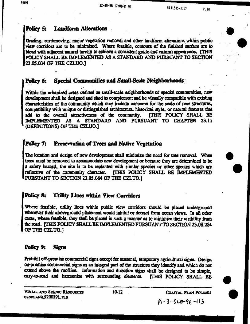
FROM JZ-Jg..ga ll:D&:PM~T0-:-----9-14-15-35-737.87--------·
P.l0
Poley 5: Ladlorm Alteratloas . , ,
GradinJ, earthmoving, major veaetmoa n:mova1 and other landform alu::adiona .within public view corddors arc to be minimizecl. Where feasible, eontours of the fini.shed surt'a:c am to bJeDd widl adjacclst natum1 tmain to achieve a CODiisttnt pado and Dll.bUil appemnce. (THIS . POLICY SHALL BE IMPI..!DdEN1'ED AS A STANDARD AND POBSUANTTO SEC'flON' 23.05.034 OF 11m CZLUO.]
. . Wi1biD U. urbanized areas defl.nec1 as small·scale ne1ghborhoods oi special communities, uw deve1opmeDt shall be designed aDd sited to complement and be visually compatible with existina cbmcteristics of the comiii'Wlily which may include eoncema for the scale of new stmcttm:a, compatibility with unique or disliDpiabod architectw:al bistorical style, or natural features. that ldd to the overall attractm:aess of the community. [l'BIS POUCY SHALL BE IMPLEMENT.ED AS A STANDARD AND PURSUANT TO CHA.P'rBR 23.11 (DB.FINITIONS) OF THE CZLUO.]
. PoDq 7: PresematioD ot Trees aact Nathe veptadoa
"l11a location and dedgn of new development sbaU minimize the need for tree remowl. Wben U.S must be removed to accommodate new dovelopm.ent or because tbey ue detetmined to be a sati:ty baz:ard, the site is to be replanted with similar species or othr.r species which are mflective of the community dlarader. [lliiS POUCY SHALL BE lMPLEMENTBD PtmSUANT TO SF..CTION 23.05.064 OP THE CZLUO.)
Poliq 8: UtmlJ Lilies within View Corridon
When! feasible, utility linos within public view corridors sbou1d. be placed underpvund whenever their abovqround placement wou1cl inbibit or detract from ocean views. In all other cases, where feasible, they shall be plued in such a maaner as to minimim their visibility from the road. [l"BIS POlleY SHALL BE I.MPLBMENT.ED PURSUANT TO SBCTION23.08.284 OF THE CZLUO.]
Pmhibit otT-premise commercial siansexcept for seasonal, lalpODry apicultut:al sips. Dcslin . o.o-premiao comm.e:rcial sips as an integral part of tbe aructam= they identifY and which do not
atc:ud abcwo the roofUne. lDformation and direction sips sbaD bo desiped to be simple, asy·tooread ud barmonb:e with surrounding dements. [THIS POUCY SHAU. BB
10-12
A .. 3 -SLt>-tfb -113
e ••••
e •
e
•

FROH lZ-19-96 !2:86PM TO 914153573787 P.ll
• Backgrouacl Report
•
•
&tensive studies bave been conducted which inventory and descn"be hazardous areas in the Q)UDty. A background report entitled Haprds summari.zed such studies aad discussed the mapped information in the coastal zone based on the adoptl:d Seismic Safety :Element. In addition, hUormadon concemina Geologic Study Areas for the cambria and cayucos areas was updated to mftect more recent geologic analysis.
Issues aod Coaceras
A Jw:an1 unique to coastal areas is the bluff erosion that ~ts from wave action, water currents and wind patcrms. nus caasW erosion is subject to seasonal fluctualions, especially durin& winter stonns which can acce1cratD bluff erosion. In contrast to these natural oceauic and Beoiogic conditions that affect erosion, human activity can increase or control erosion rates.
The importance of coastal bluffs Is fui1ber recopized in Section 30603 of the Coastal Act which requires the Coastal Commission to retain appeal authority after certificatkm of the Local Coas1al Proiram for any development approved by the county within 300 feet of the top of tbe seaward face of any coastal bluff.
In 1977 the Slate Department of Navigation and Oceanic Development prepared an atlas of · dloreline erosion along the California Coast. The atlas indicates areas where coastal erosion is
serious and development would be threatened. The atlas identified areas m Cayucos and portions of West l.Ddge Hill where present development is critical to coastal erosion. Other large porti0111 of the county's coastline, allboqhpresently undeveloped, ueidcntifiedas critic:al for future development.
The Land Use Element and Coastal Zone Land Use Ordinance have been amended to addRsa the issue of bluff erosion, by cbanges to the maps and text which idmtify bluff erosion areas wbich require review for all p.ropo.sed development.
POUCIES FOR HAZARDS
Based on the information summarized .in the draft background report, the following policies and standards will guide the kinds, locations and intensities of development in hazardous areas of tbe coastal zone.
Poliq 1: New DeftlopmeBt
All new development proposed within areas subject to natural bawds from geologic or f1ood conditions (including beach erosion) shall be .loca.ted and desiped to minimize risks to human life and property. Along the shoreline new development (with tbe exception of COB.Sial-dependent
HAZA.I.D.I GSMPLAN\1..9200301 .PLN
11-2 CoAsTAL Pl.AN Poucms
A- ~--SLO- q "-t13
0 '
'

FROM lZ-19-96 1Z:B6PH TO 914153573787 P.ll
uses or public recnation facilities) lhall be desiped so that shoreline pmcective cleYicea (such u seawalls, cliff retaiAina walls, revetment~, breakwaters, lfOins) tbat would aubstantiaUJ alaer laDdforms or natural shoreline proceasea, will not be aeedcd for the life of the strDCtUre. Codstruction of penDIIHIIt stl'UCtU1a on tbe beach ahaD. be prohibited except for facilities neceasaty for public healtb and safety such u lifeguanl towers. · (THIS POUCY SHAll.. BE IMPl.EMEN'l"ED AS A STANDARD.]
New development sba1l COSll1'a strud:ul'al stability whilo not creating or eonl:ribatin& to eiOilan or potop:al Instability. (THIS POUCY SHALL BB 1MPLBMBNTED AS A STANDARD AND PURSUANT TO SECTION 23.07.086 OF THB CZLUO.]
'l11e county sball mquhe a detailed review of development proposed within 1hc pdo&ic ..S.y area and flood haza:n:l combining designations as indicated on the Land Use Element maps for the coastal zone. Tba review shall be perfol'llll!d by a qualified reaisterecl and/or cc:rtified e:nainea:ing geoJ.oaist -and aha11 be adequately detailed to provido tiCOII'lmenclations and conclusions coasistent with this plan. Residential, c::oltll'llei'Cial and industrial deveJopment sbal1 be prolu."bited witbin the 100 year floodplain (l" chance of inundatioa in aay year) as delineated in the Plood Hazltd combiain1 desipation except for those areas wiehin au urban .re.sene lille .. lTHIS POUCY SHALL BB IMPLSMBNTBD PURSUANT TO SPLTIONS 23.07.012, 23.07 .084, 23.07.062 AND 23.07.066 OF THE CZLUO.]
Poliq 4: IJmltadoDs Oil the Coastrudloa of ShoreiiDe Structures
Construction of shoJ:eline structures that would substantially alter aistiag landforms sbal1 t. limited to projeets nc::ceaary for:
a. protection of existiag development (new development must enl\lle stability widlout depending upon. shoreline protection deviees);
lt. public beida and recreation areas in danpr or erosiOA;
e. coastal depelldent uses;
d. existing public roadway facilities to publlc beaches and :recteatioa uas whae BD
alternative routes are feasible.
11·3 HAZAIDS QENPLAN\L920030l.IVI
A- 3. -$LD- '\G,-)1:\
•
•
•

FROM lZ-19-96 12:07PM TO 914153573787 P.B
·~ 23.04.021
•
~ .... _,.
(3) These standan:ls do not determine the minimum site area for the: establishment of · a new use on an existing lot. unless specifically referred to elsewhere in this title.
Standards for the site design of new uses not involving land divisions begin with Secdon 23.04.040 (Minimum Site Area).
b.. Area .measured. For the purpose of determinina whether existing or proposed parcel& satisfy the standards of this chapter for tbe minimum parcel size, net site area (as dDti.ned in Chapter 23.11 as "Site Area, Net•) is to be used in all cases, except that:
(1) Lots one acre orlaqer after division may use gross site area (see Chapcer 23.11) where existing or proposed abutting rigbts-of·way are owned in fee, and the difference between net and gross site area of the proposed pared is less than 10 percent.
(Z) Witbin a domestic reservoir watershedt no Jand within a horizontal distance of 200 feet from the reservoir impoundment. u determined by the spilhvay elevation, shall qualify for computing parcel sbe or for the sipting of septic systems.
Ovenidinllaad di'fisioa requirements. All applications for land division within · the Coastal Zone (except condominium conversion) shall satisfy the following rt"A:IUirernmts, as applicable, in addition to all applicable provisions of Sections 23.04.024 through 23.04.036. In the event of any confliet between the provisions of this section and those of Seetions 23.04.024 through 23.04.036, this section shall prevail.
(1) Water aad sew.- eapadties ... ....,.. --..: In communities with limited water or sewage disposal service capacity as defined by Resource Management System alert level n or m:
(i) Within an urban services line, new land divisions shall not be approved unless the approval body first finds that sufficient water and sewage disp:JSal capacities are available to accommodate · botb existing development and development that would be allowed on presently vacant parcels.
(i) A proposed land division between an urban services line and urban reserve line shall not be approved unless the approval body first finds that sufficient water and sewage disposal service capacities are available to accommodate both existing developJTieftt within the urban services line and development tbat would be allowed on presently vacant parcels within the urban services line.
CoASTAL ZONE LAND UsE 0RDINANC::8
REvisED NOVEMBER 2, 1993 4-S SITE DESIGN STANDARDS
0RD\L9200lll,()aD
1\ - ~ ..-t;t.D-"1"- 113
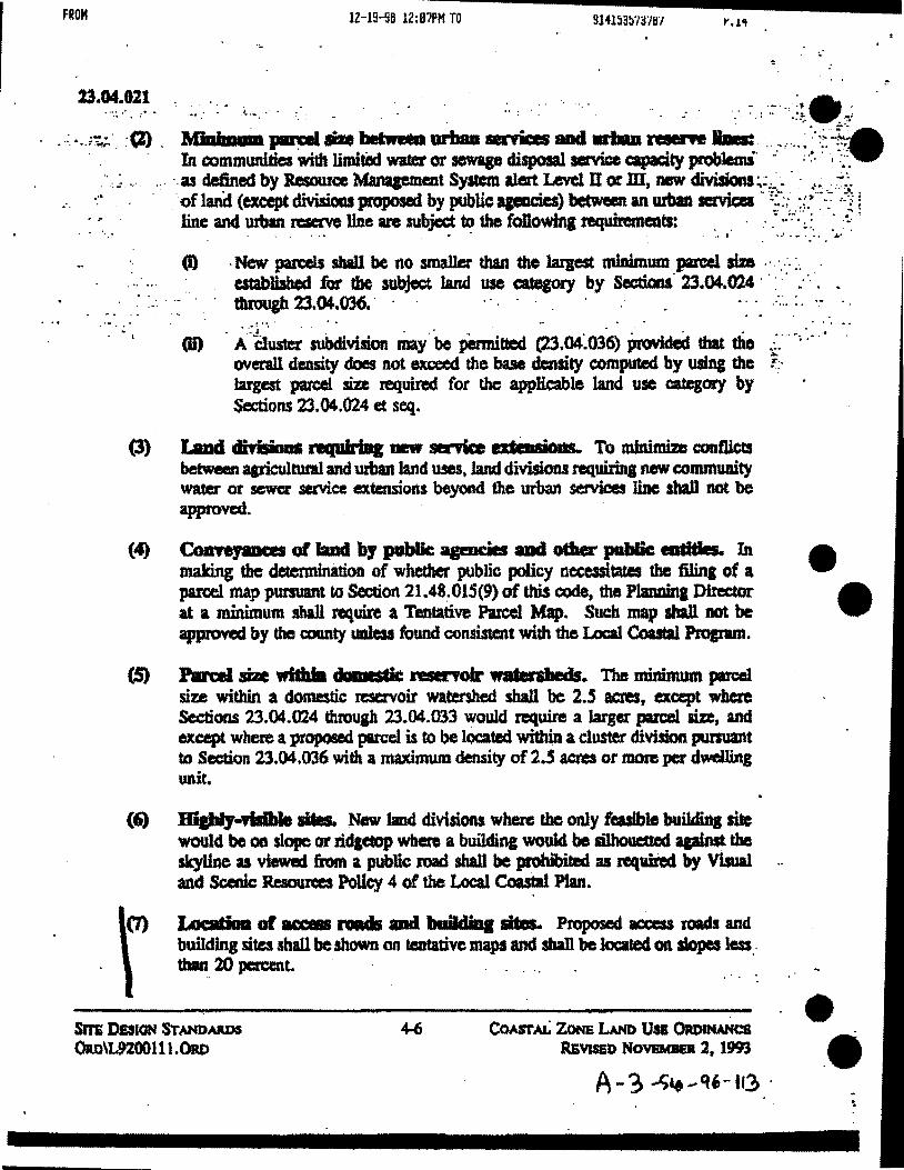
FROH lZ-19-56 1Z:B7PM TO 9l4l53:mr/lfl
23.~~~~~- -· .. :- i..... . ·.· . . . - .. ' . . ·. . . . . _. . .· :- : ·:·. -~~ ._;
_.: ....• ~·.:(2). Min .... ~-betw-urball•ticesaad ...... l-.wll..: .... ,. ... ~-.. ~~-~ In communities with limited water or sewage dilpola1 service capaci&y problemi. -· · ·~. · · ·:::~
. · . .: ... ·:· ·.as ~ed by Resource M'anqemeat System alert lAsve1 U or m, new divisions~::=-.··· -t•. -~-~ -·· of land (except divisions proposed by publicapmcies) between an urban servlca · ~~:.-.. :~--~-~-: ·=-1;
. · .. ::' line and 1ll'bln reserve line are subject ~ the foDowiq requiromeats: . . · .. 7 • . : · .-:.. ·
• • • • • ·-· *' ~ • ~ ~ "'"
(I) -New paRels sbaU be no smaller than the larpst tninimum pared size .· ·.-· :. . establisbed for the aubjer:t. land use category by Sections. 23.04.024 · · · · · : ·. . tbtoup 23.04.036. . . . . . . ... . .
-. .. . ~ ~ .. ~ . ~ . ' . .. . • • I
·Cil) . ~·.:-a~ subdivision may .. be pemntted (23.04~036) Provided that tho .:.· . ~. · .... ... ovemll density does not exceed the base density computal by usiq the r:· largest parcel size required for the applicable land use category by Sections 23.04.024 et seq.
(3) 1aDd clt..._l'llqtlirl1JI __. senke a..,.._, To Wnimim conflictl between qricultural and urban land U!e!~ land divisions requirlna new conunuaity water or sewa: service extensions beyond the urban services liDe sba1l not be approved.
(4) Colrteyaaces of laud by public agmdes ad oCiaer pahlie eadtits. In making the determination of whether public policy neceasitates the filin& of a parcel map pursuant to Section 21.48~015(9) of ttDs code, the Plam:Wta Dimctor at a minimum shall requite a Tentative Parcel Map. Suc:b map sba1l not be approved by the county uoless found consia1ent with the IAJCI1 Coastal Pl'apml.
(S) Patcel S. wilblll duwcsdc reservoir watenlleds. The minimum parcel size within a domestic reservoir watershed shall be 2.5 aaes, except where Sections 23.04.024 through 23.04.033 would n:quire a larger pa:rce1 me, and except where a proposed parcel is to be located within a cluster division pursuant to Section 23.04.006 with a maximum density of 2.5 acres or more per dwelling unit.
(6) BlpiJ-ridble sites. New land divisions where lbe only feasible buildmg site would be oa slope or ridptop where a buildin& woulc1 be si1houetled apiPSt tbe sk.yUne as viewed from a publie road shall be prohibited aa requh'ecl by Visual and Scenic Resources Policy 4 of the Local Coastal Plan.
0) LotaC'- of MCeSS .._. aad bniMinl lites. PtOpOSed acceu lOads and baRding sites shall be shown on teDtative maps and sba1l be located oa slopes less . tllm_ 20 percent. . . .
SITE DillON ST~ARDS ORD\L920011t.ORD
CoASTAL ZoNE LAND U• 0RDuw«::s RJiVISEO NOVBMIID l, 1993
e •
e ••

FROM
•
•·:· .-·
b.
12-19-96 12:07PH TO I'.J.J
23.05.034
Area ol cats and fills: Cuts and fills shaU be limited to the minimum amount necessary tD provide stable embankrnellts for required parking areas or street fiahts-of·way, structuml foundations, and adequate residential yard area or out4oor storage or sales area incidental to a non-residential use.
G ...... far tdtinR or aew ~ Grading for the purpose of creating a site for a stnlcture or other development shall be limited to slopes less than 20" except:
(1} Existing lots in the Residential Single-Family category • if a residence cannot feasibly be sited on a slope less than 20S: and
(2) When grading of an ~ road or driveway is necessary to provide access to building site with less than 20% slope, and where there is no less envitonmentally damaging alternative; and
(3) Gr:ldiD& acti•••eat. Grading on slopes between 2096 and 30,. may occur by Mmor Use Pennit or Development Plan approval subject to Che following:
(I) The applicable revieW body has considered the specific char'aderisrics of the site and surrounding area including: the proximity of nearby strams or wetlands, erosion potential, slope stability, amDUnt of grading necessary, neighborhood dminage c:bancteristics, and measures proposed by the applicant to reduce potential erosion and sedimentation.
(ii) Grading and erosion control plans have been prepared by a reaistered civil engineer and accompany the request to allow the grading adjustment.
fdi) It has been demonstratcc:l. that the proposed grading is sensitive to the natural landform of the site and surrounding area.
(iv) It has been found that there is no other feasible method of establishing an allowable use on the site without grading on slopes between 20~ and 30~.
Graclia& atQaamt to Ea:ril1llllllellt1dly SeuiliYe llabitafs.. Grading shan not occur within 100 feet of any Environmentally Sensitive Habitat as shown in tile Land Use Element except:
(1) Where a setback adjustment has been granted as set forth in Sections 23.07. t72d(2) (Wetlands) or 23.07 .174d(2) (Streams and Riparian Veget:alion) of this title: or
CoAstAL ZoNE LA.No UsE ORDINANCE REVISED NOVEMBER 9, 1993
S-Jl Sm 08\fELOPMVlf ST AHOAJU).!
orw\L9200 12l.oJtD
A-.) -)Lo ... 't~-10

•
I . . . .... ··
FROH lZ-19-96 12:88PH TO 914153573787 t'.lb
%3.05.00·0M
e. Applkatloll GJDfellt. Land use permit applications that propose tree removal are to • include all information specified by Section 23.02.030b (Plot Plan Coatent) OR 23.CD.033 (Minor use Permit) whete applicable, add the roUowma:
(1) The size, species and c:ondition (e.g., diseasedJ healthy, etc.) of cadi tn:e proposed tor removal.
(Z) 'The purpose of removal.
(3) Tbe size and species of any trees proposed to replace those intended for nmovat.
23.0S.M4 - Tree R.elatmll Standards.
Applications for tree removal in accordance with Section 23.0S.062 are to be approved only when the foDowing conditions arc satisfied:
a. T ..... requfred.. Trees proPosed for ranoval sball be identified for field inspecdoa by means of fla&lin&, staldn.c, paint spotting or otber means readily via"'blc but not detrimental to a halthy tree •
h. a...o'ftll a-lteria. A t:Me may be removed only when the tree is any of the • following:
(I) Dead, diseased beyond reclamation, or hazardous;
(2) Crowded, with good horticultural practices dictating thinning;
(3) Interfering with existin& utilities, structures or ri&ht-of-way improvemc:ats;
(4) Obstructing existing or proposed improvements thai camot be reasonably cles.\lned to avoicl the need for tree nsmoval;
(5) . Inla"'biting sunli&ht needed for either active or passive solar beating ar coolina, mad the buikliDB or solar collectOrS cannot be oriented to co11ect suflicialt IQDiipt without total removal of the tree;
(6) In conftic:t with an approved file safety plan when required by Section 23.05.080; '
COASTAL ZoNE LAND Us& ORDINMJCrl REvilED NOVEMBEil 9, 1993
5-21 SIT&. DBvm.oPMINT STANDARDS • oa.o\t920012l.ORD
' A ... j -S"'Y ...q' .. IJ.1

••
•
•
FROM 12-19-96 !2:88PM TO 914153573787 I' .1.1
.. 23.05.064 ...••• !· e
.. _ (7) · To be replaced by a tree that will provide equal or better shade, ~~. solar efficienCy or visual amenity within a 10-year period, as verified in writin& by a
. . registered landscape -architect, licensed landscaping c:onttactor or certified :·. • nnnii"!I"Vman .. . .... , . . .. : .. ,., . ;.,'~: ~-.., ~ . . ~ -· .. · ··~- -
.,_
c.. ... BepiMemeut.. Any tree rentOved to accammodate new development or ~use it is .. a safety bazard sball be replaa:d, in a location oa the site and with a species common to the community. as approved by the Planning Director. ·
•• •• • *'1 ' ·.\' ' ::""~ .... : • •• .!. ' -. ·. '. • . •
d.·: ;: TNe remOftlJ.rithlll. pulllic Yiew mnidon. Tree removal within public view :._. conidor$ (areas visible from collector or aneria1 roads) shall be minimized in accordance . , with Visual and Scenic Resources Policy S. .=~·
e. Preael"fttloa of trees and natural Yt:~etatioo. New development sball incorporate design techniques and methods that minimize the need for tree removal •
SrrE DEVELOPMENT STANDARDS 0RD\1..92001ll.OJU)
S-22
' .
CoASTAL ZONE LAND Usa OR.otNANC& ltEVJSED NOVEMII&R. 9. 1993
A - 3 -S w .. Ci " - 113
FROM lZ-19-96 12:88PH TO 914153573787 P.lll
23.0'7 ... - 012
23.87 •• • Geologic Study Area (GSA):
A GeoJosic Study Art/1. combininc designation is applied by lbe Official Maps (Part ID) of the Land Use Element, to areas where pologic and soil conditions could present new developnents and their usea with potential ha2ards to life and property. These slaftdards a applied when: tbc CoDowiq conditions tlltist:
a. SdrDik llaard: Alas of seismic (eartbquaie) hazard am idelltified throuch the app1icatlon of a special studies .zone. Special studies zones are established by the state poloaist as requin:d by SectitlllS 2621 et seq. of tbe Public~ Code (the Alqui.Jt-Priolo Special Studies Zones Act), and are identified in the Land Use Element (Pat1li);
b. 148dsUde luaard: Areas within urban and village n:=ve lines, identified by the SeisJnic Safety Element as heine subject to moderately high to high landslide risk, and rural areas subject to high 1andslide risk;
~ haard: Areas identifted. by the Seismic 'Safety Element as being subject to ~ liquefaction.
d. EmsloG aad stalaDit.f hnard .. ..at lalatrs. Areas along the coast with coastal bluffs and cliffs p:atcr than 10 feet in vertical relief that are identified in the Coastal Erosion Atlas, prepared by the California State Department of Naviptioft and Ocean Development (1977), in accordanc:e with Hazards PoHcy No. 7 of the Local Coastal Plan.
23.07.012 ·~of GSA SCaadards:
The standards of Sections 23.07.084 and 23.07.086 apply to all land uses for which a permit is mquired. except: ·
a. Aay agricultural use not lnvolvin& a buildina. and any agricultural acc:essory structure.
•· Alterations or additicms to any struct1.1re, the value of wbicb does not exceed SO~ of tbe ~MeSSed value of the structure in any 12-montb period, except where the site is a.ljacent to a coastal.bluff.
CoMiumNo DBSIONATION STANDARDS OlU)\L92001Sl.oao
7-12 Co.urAL ZoNE LAND USI 0RDINAMCB REvisED NoVE.-.. 9, 1993
A .-1-SLO-ttC.- U3
••
Q •

FROM
·~
• •• •••
i, ! ...
12-19-96 12:8BPM TO 914153573787
23.07.084
23.07.084 - Appkadoa Coatent - Geologic aDd Soils lteport RequirecJ:
All land use permit applications for projects located within a Geologic Study Area (except those exemJ*cl by Section 23.07 .082) shall be aecornpanied by a report prepand by a certified engineering geologist and/or ICJist.ered civil engineel' (as to soils engineering), as appropriate, which identifies, describes and Ulustra.tcs, wbcrc applicable, potemial hazard of surface fault ruptwe, seismic shaking, Uqudaction or landslide, as provided by this section •. Pro\1decl, however, that no report is required for an application located in an area for which the County Engineer determines tbat sufficient infonnation exists because of previous gmlogy or soils reports. Where required, a geology report shall include:
a. A review of the local and regional aeismic and other geological conditions that may significantly affect the proposed use.
b. An ~ment of conditions on or near the site that would contribute to the potential for . the damage of a proposed use from a seismic Of other geological event, or the potential
for a new WiC to create advene effects upon e.xistinc uses because of identified geological huants. The conditions assessed are to include, where applicable, rainfall, soils, slopes, water table, bedrock geology, and any other substrate conditions that may affect seismic response, landslide risk or liquefaction potential.
c. Condusions and recommendations reprding the potential for, where applicable:
(1) Surface rupture or other secondary ground effects of seismic activity at the site;
(2) Active landsliding or slope failure;
(3) Adverse groundwater conditions;
(4) Liquefaction hazards.
d. Recommended building techniques, site preparation measures, or setbacks nec:essary to reduce risks to life and ptoperty from seismic damage, landslide, groundwater and · 1
liquefaction to insignificant levels.
[Amended 1989, On!. 2383]
COASTAL ZoN8 LAND USE ORDINANCE REVISED NOVEMBER 9, 1993
7-13 COMIJINlNO DESIGNATION $TAND.UOS
" oaD\192001Sl.ORD ,. .... ~- Sto- 'lb-HJ
FROM lZ-19-96 1Z:B=9P~H T~0------91.415.35·73·797----·I'.tt!
. 23.07 .08! - 086 - - .
23.07.015 • Rmew of Geolou lleport. ~·- ~ .. •• : · . .,... . ·."" .. '!~ ..... _:' ~· . . • . . . -· . . .
As xequfred by California Code of Rep1ations ntle 14, Section 3603, lbe pology and eoils ·: :::report~ by Seetion23.07.084 sbaU be eva1uatl!d by a aeotoaist retained by a. county ..
· wbo is n:cistaal in the State of Cslltomia. W'Jtbin 30 daya of the acceptiDCe of sucb ~ the Plalining Director shall fDe one eopy with the State ~loJist. [Addecl1989, 0rcL 2383)
. . . ~· .. . .
. :
.e ,._.·.·--·
.. ~ .. • • •*
~. Z3.fJ7.0M ~··~ ~ ~ Sper.fal Stadards: . . ..... _ · .. _ ... . _,._·:.·:- .. ~' .. ~.' -.-~· ·-.·~~~ .. ~·.-.·.· .... ·~:?,:-'~~: .. : ... ~.. ' ·.·. . .. .. . ·., . ·.. . ... • .· .:;. . . . . . ' ..
All uses within a Geolopc Study Axea are to be establisbed and maintained in acco.rdallc:e with ·' · · tbe foJlowiaJ, as applicable:
L GndiDg: Any amcfin& not otberwise excmptad from the pamit requirements of · Sections 23.DS.020et seq. (Gradin&) is to be performed as engineered pdina under the
provisions of those sections.
b. Sei&wdc bazard areM: As required by catifomia Public Resoun:cl Code Seetions 2621 et seq. and California Adm.inistradve Code 1itle 14, Sections 3600 et seq., no saructure intended for human occupancy shall be located within SO feet of an active fault trace within a special studies zone..
Bnsioa aad poJop: 5fJibilitJ. New developmeat shall insure structural atlbility while not creatiDg or contn"buriq to erosion, sedimentation. or pologic instability •
COMIDCINO Dl!aiONATION STANDAADS Qm\L92001Sl.OitD
CoASTAL ZONa LNm USii. OllDINANCS RlwED NoVBMIISR 9, 1993
e •
• •

FROM
d.
12-19-96 12 :09PM TO 914153573787
23.01.166 • 170
Where au SRA is appHed because of prominent geological features visible from off-site (such as rock outcrops), those features are to be protected and remain undisturbed by grading or development activities.
Where an SRA is applied because of specified species of ~ plants or other vegetation, such species shall not be disturbed by ~n activities or subsequent operation of the use, except where authorized by Development Plan approval.
23.07.170- En'riromnelltall)' Seasitive Habitats:
The provisions of this section apply to development proposed within or adjacent to (within 100 feet of the boundary ot) an Environmentally Sensitive Habitat as defined by Chapter 23.11 of this title, and u mapped by the Land Use Element combining designation maps.
a. .Applicatioa eonteat. A land use permit application for a project on a site located wltbin or adjacent to an Environmentally Sensitive Habitat shall also include a report by a biologist approved by the Environmental Coordinator that:
(1) Evaluates the impact the development may have on the habitat, and whether the development will be consistent with the biological continuance of the habitat. The report shall identify the maximum feasible mitigation measures to protect the resource and a program for monitoring and evaluating the effectiveness of the mitigation measures.
(Z) Recommends conditions of approval for the restoration of damaged habitats, where feasible.
(3) Evaluates development proposed adjacent to environmentally sensitive habitats to identify significant negative impacts from noise, sediment and other potential disturbances that may become evident during project review.
(4) Verifies that applicable Sdback.s from the habitat area required by Sections 23.07.170 to 23.07.178 are adequate to protect the habitat or recommends greater. more appropriate setbacks.
COASTAL ZONE LAND Usa ORDINANCE REVISED NOYEMBEl9. 1993
COMBJNINO D£SIGNAT10N STANDARDS
ORD\L92001Sl.ORD
A '"""-3 -> ttJ - e( b--l i3

FROM lZ-19-96 12:99PM TO 914153573787 P.Z2
23.07.170 .. 172 ..
" " .. . :.. .. ~'
b. . Required ladi.ap: Approwi of a land use permit for a project. or adj~t · to an Envinmmentally Sensitive Habitat sball not occur unless the appJicabla review body · · first finds tbat: ., , • ,
••• • ,-., ·.: , .. ;.:.:~Jt_ ... :~·;_:,.~· .-- .... ~:· ....... (1) nere~~ be no si.t nePtrve impact on tbc identlfiCd sensitive bibi.t•.;t·" . .:.'':.':::~ ; . .
·· · the proposed use will be consistent with tile biologicd continuance of the llabitat. • '-! ~ .• - ••
(Z) . ~ PfOIXl'Cd use will not significantly disrupt tho habitat. . .. . ;, • • ••• ::....... '1. .... • • • ·:. :.~~
e. IAIIld dtriliOas: No di¥isicJn of a parcel containioi an EDvilomnentaJly. Sensidvo Habitat shall be Pennit.tecl unlea all p10p0sed buildiD& sites ue·locate4 eatimly outside : · · of the applicable minimum setback mqui.red by Sections 23 .(17 .172 tbftJu&h. 23.00 .178. ·; SUch buildinl sites sbal1 be desipated on the recorded subdivision map.
d. lleYelopmeat stalutards for ·eariroDIIIentaDy seusiti.a habitats:
(1) New development within or adjacent to the habitat shall not significantly disrupt the resource.
(2) New development within the habitat shall be limited to those u!cs that am dependent upon the resource.
(3) WhmB feasiblet damaged habicats shall be restored as a condition of development approval.
(4) Development shall be ~t wi~ the biological continua.nc:e of the habitat.
($) Grading adjacent to Environmentally Sensitive Habitats shall conform to tbe provisions of Section 23.0S.034c (Grading Standards.)
23.87.17J- WetJaads..
Dtwdopment PfOIXl'Cd witbin or adjacent to (within 100 feet of the upland extent of) a wetland ana showa on the Pnvironi1JOIIIally Sensitive Habitat Maps shall satisfy the requirements of Ibis sectloa to aaable issuanc:e of a land use or conSII'UCdon permit. These provision.s a:.:e inre.nded to maintain tbe rat:ural ecoloabl fuDCtioninc and productivity of wetlands and estUarles and where feasible, to support restoration of degraded wetlands.
CoMBINING DlsiONATJON S'r.ANDAIDS oao\IS2001S1.oRD
7-24 COASTAL ZoNa LAND Use. ORnDWICE Rl.vlsiD NoYEMBER 9. 19fl
e
•
•• ••

-• ... \ . I ' .. ..,...,;
FROM 12-lS-96 12:18PH TO 914153573787
23.8'7.172
LocaticMl af developmeot: Development shall be loca.ted as far away from the wetland as fslsible, provided that other habitat values on the site are not thereby more adversely affected.
b. PriDdple PermiUecl Uses iD wetllmds: Hunting, fishing. wlldlife manaaement edU<:ation and rese;arch projects.
e. J:')epartmaat ell1sll811d GaiDe retiew. The State Department ofFish and Game shall review all applications for development in or a.djacent to coutal wetlands and recommend appropriate mitigation mrasures where needed which should be ineorporated in the project design.
d. Wetlaad Jlfbacks: New development shall be located a minimum of 100 feet from the upland extent of all wetlands, el(ctpt as provided by subsection d(2). If the biological report requind by Section 23.fi7.l70 (Application Content) determines that such setback will provide an insufficient buffer from the wetland area, and the applicable approval body cannot make the finding required by Section 23.07.170bt then a Jfeat&r setback may be requited.
(1) Penaiaed uses witldD wedaad sedJarks: Wilhin the required setback buffer, permitted uses are limited to passive recreation, edueational, existing non-structural agricultural development in accordance with best manacement practices, utility Bnes, pipelines, drainaae and flood control of facilities, brldps and mad approaehes to bridges to cross a stream and roads when it can be demonstrated that: ·
(i) Alternative routes are infeasible or more environmentally damaging.
(i) Adverse environmental effects are mitigated to the maximum extent feasible.
0) Wet.I:IDd Sl!tiJarl adjustaBI: The minimum wetland setback may be adjusted through Minor Use Permit approval (but in no case shall be less tlum 25 feet), provided that the following findinas can be made:
(i)
ru1
The site would be physically unusable for the principal permitkd use unless the setback is reduced.
The reduction is the minimum that would enable a principal permitted use to be established oa the site after all practical design modific:ationa have been considered.
COASTAL ZoNE LAND Us& ORDINANCE
REvlaliD NOVEMBER 9. 1993 1-25 COMBINING 0ESIGNA.110N STANDARDS
ORD\L92001Sl.oam
Pr ... .3 - $'-0 -'(G. -113

'· ~ .. , '· "; ...
. ,..,·
FROH ----------------........... .
lZ-19-96 !2:18PM TO 914153573787 P.24
. . 23.07.1'72 - 174
(3) 0,. ...- 111__. l"eeppired: A land use or construction permit for a structu1e larget than 1000 rquare feet in floor area sba1l DOt be approved an a parcel of one acre or larger that contains a wetland, liDless the property owner first J1311ts the county or an approved .land trust an open space easement or fee title dedic:ation of all ponions of the site not proposed for development. II well as the entire wetland.
• Z3.17.174 - SU.•• ad Jlipariaa Veptatioa:
Coas1al streams and adjacent. riparian areas are environmentally sensitive habitats. The p:ov.iaions of lbis section are intended to preserve and proteCt the natural hydrological system and ecological functions of coastal streams.
L Deftlopmeat........., to a..._.. sbealll. Development adjacent to a COIIIIIl stn!am shall be sited and designed to protect the habitat and shall be compatible widl the conliDuance of such habitat.
b. IJ•ifatioll 011 ........... alteratioa: Channelization, dams or other substantial altaation of stream cbanoels are limited to:
(1) Water supply projects, pmvided that quantity and quality of water from streams • shall be maintained at levels necessary to sustain functional capacity of stnu1s, wetlands, estuaries and lakes.
Q) Flood control projects, whme sucb pmtection is necessary for public safety or to protect existing commercial or residential structures, when no feasible altematiw to stn!:ambed alteration is available:
(J) Construction ~f improvements to fish and wildlife habitat;
(4) Maintenance of existinc flood control cballnels.
Streambed alter&lions shall not be conducted unless all appJicable provisions of this title are met and if applicable, permit approval from the CaUfomia Department of Fish and Game, the U.S. Army Corps of EnJineers, and caBfornia State Wa~« Resounzs Con1ml Board. .
CoAI'I'AL ZoNE LAND Usa ORDINANCE RIMIIID NOVEMBER. 9, 1993
CoMBINING DuloNAnoN STAMDAIDI ORD\L9200l3l.OIID
A_.... 3- )l.O -lf'- 11_?,
•

•
•
•
FROM 12-19-96 12:1DPH TO 914153573797 P.25
23.07.114 .· ' .. ·~.:.:..; . ...... .
Stream. diveniGR structures: Structures that divert all or a portion of streamflow · for any purpose, except for agricultural stock ponds with a capacity less than. 10 ·
acre-feet, aba1l be designed and loca1r::d to not impede the movement of native fish or to reduce meimflow to a level that would significantly affect the production of fish and other stream organisms. · . . · ·
d. . Rlpariad idl"'lll'ks: New development shall be setback from tbe upland alae of riparian veaer;ation a minimum of 50 feet within wban areas (wide the USL) and 100 feet in :mra1 areas (outside tho USL}, except as provided in subsection b. of this scctioa,- · · and as follows: -:.1. · · · · · · · · · ·
(1) Palditted - witbia tile sethacir: Permitted uses are limited to those specified· in Section 23.07.172<1(1} (for wetland setbacks), provided that the filldings required by that sr:ction can be made. Additional permitted uses tbat are not required to satisfy those (mdings include pedestrian and CCJ.U8.Strian trails, and non-structural agricultural uses.
(2) JUt-ian habitat ...._. adjastmeat: The minimum riparian setback may be adjusted throu&h Minor Use Permit approval, but ip. no case shall structures be anowed closer than 10 feet from a stream bank. and provided the following findings can first be made:
(I) Altemative locations and routes are infeasible or more envlronmenbllly damaging; and
(ii) Adverse environmental effects arc mitipted to the maximum ex:tamt feasible; and
(iii) The adjustment is nerasary to allow a pri.ncipa1 pennitted use of the property and redesign of dae proposed development would not alloW the use with the standard selbacks; and
(iy) Tho adjustment is tho minimum that would allow for tbe establishment· of a principal permitted use. ·
e. Altendioa of riparilm ~tala: Cutting or alteration of natunal vecetation that protects a riparian habitat shall not be permitmd except:
(1) For streambed alterations allowed by subsections a and b above;
CoMaiNIHa D£sJCNA110N STANDARDS ORD\L92001Sl.OIU>
7-28 COASTAL ZONE LAND Us& ORDINANCE REVISED NOV6MBD 9. 1993

FROH
( '.
... ,
\ ·' .....
lZ-19-96 !2:18PM TO 914153573787 P.Z6
23.07.174 .. 176
Q) Where no feasible lltanative emu;
0) Where an issue of public safety exists;
(4) Where expanding vegetation is encroacbing on established agricultural uses;
(S) Minor public worb projeets, including but not limited to utility lines, pipelines, driveways and roadsJ wh= the P1anning Director determines no feasible alternative exists;
('> To incteue apicultural acreage provided tbat such vegetation cleara:nce wiD:
(i) Not impair the funct.ional capacity of the habitat;
(il) Not cause significant stn:ambank erosion;
(II) Not have a detrimeatal effect on water quality or quantity;
(ly) Be in accordance with applicable permits requirai by the Deplrtment of Fish and Oame.
(7) To locate a pridcipally permitted use on an existinJ lot of Jl!ICOI'd where no feasible alternative exists and the findings of Section 23.(]7.174b can be made.
The provisions of this section are intended to preserve and protect rare and endangered species ot tmestrial plants and animals by presavina thelr habitats. Emphasis for protection is on. the entire ccoJogical community rather than only the identified plant or animal.
a. Protedloa of .......-... Vegetation 1hat is rare or endanJered, or tbalsavcs as habitat for rare or endan&ered species shall be protected. :I>evdopment shall be sited to minimize disnapt.ian of habitat.
•· Ta•estriallaabitat ~ staadanls:
(1) ••• ta8iaa. Native plants shall be used where vegetation is removed •
COA.STAI.. ZoNE LAND UsE ORDINANCE
RIM!i&D NOVEMBER 9, 1993 7·29 CoM81NII'fO D&siONATJON STANDARDS
ORD\L920015l.DRD
~- A.-) -Se..o-Cf,-113
; ~
•
•
•
FROM ----------------......... 12-19-96 !2:11PM TO 914153573787 P.27
• 23.01.216
•
•
(II)
(II)
(f) After startup. use of the pipeline right-of-way shall be ratricted to operational maintenance, inspection. repair, and protection of the pi~.
s..rt.efJdllcs. To be determined through Development Plan approval
..... , _.. ( ..... blldl& Shall be designed to insure stability considering wave action and bluff erosion.
d. Eledric Tn•....._ IJaes.
Q) Penlit teqahaa e at.
(i) Emergency repair and gener.d permit requirements, Sections 23.08.286a and b., apply to electri.e power distribution lines (i.e., less tban 69ltv dcsip capacity).
(iQ Development plan approval is required for dectric power transmission lines (i.e., 69kV desip capacity and greater), whether to be established ·or upgraded •
(Z) .Appliratioa tollleats. In addition to all .information required by Olapter 23.02 of this Title. the applicant shall submit information on the proposed rights-of-way. including width, ownership. present land use, slope, soils and vegetation, types and sizes of towers to be utilized, estimates of noise generatal during various operating and weather conditions, and estimates of maximum electric and magnetic field sttmsths generatal uDder the line, at rights-of-way edges, and the extent that measurable fields extcad in all dhections from the facility.
llapdred fiadial. Electric powrz transmission line facilities shall be approved only where the Planning Commission can find that the development will be consistent with Energy aad Industrial Development Policies 16 througll20 of the Local Coutal Program Policies Document
Utility-widMa .... .,.. mnidorL Where feasible, utility lines sball be underground whc:ft their placement would limit or detnlct from views of die ocean from collector or arterial roads. In all other cases, they shall be sited to minimize their visibility from public roads. [AJ11ellded 1992, Ord. 2591]
SPEc:w. (S) Usss OllD\Jl9200081. ()Jm
8-142 COASTAL ZoNE LNm USE ORD. REVISED NOVEMJIER. 9, 1993
Pr-3 -SLO- ,"-Ll3
0
I . Yl
\_./.

-(' , l ··. ·'
<)
FROM 12-19-96 !2:11PM TO 914153573787 P.lti
23.11.030
Sol Tature. 1be classification of soil based on the percentage of sand, siU, and clay in tbe soil. [Amended 1993, Ord. 2649)
Salar Bflk:leoeJ. The extatt to whicb a building or ~ uses solar eneqy in winter or JCpC1s IOJar onergy in summer by natural or man-made clevices (trees and vegctadoft, or lldUtectura1 featma, rapectivdy).
Soand J..ent:Meter. Any iulrumeDt network~ for the measurement of aound kMllt whicla meets or exceeds the Americ:an NatiooaJ Standard Institute Sllndard 51.4-1971 for Type 1 ar Type 2 sound level meters, or an iDitrument and the associated reconting and analyzila equipmeat which will provide equivalalt data. [Amended 1992, Ord. 2S46]
l Special CowunuJdtles. Anu and communities with unique, visually pleashtg cbuaclaisdcs which smve as visitor destinatioa points and include:
a. Avila Beach- Commercial and Recreation catqories along Pront Street.
f b. Cambria - Commezdal and Recreation <:ategories along Main Street.
e. cambria • Commetc:ia1 and Rccteatioa categOries along Moonstone Beach Drive.
d. Cayucos- Commerdal and Recreation categoric& along Ocean Avmue.
e. South Bay - Baywood VDlage Commercial area .
. f. San Luis Bay/Port San Luis- Public Facili1ies Category.
I· San Simeon Acres - Residential Single-Family and Residential Multi-Famlly catecorieL
Ia. San Simeon Villap - Commercial category.
SpMial Dlltrkt. Any public agency formed pursuant to general Jaw or special act for tbe Jocal performance of pvemmealal or proprietary functions within Jimitt:d bouadaries otber tban a cbartaed or paenllaw city or any city and COUDty. Special districls iDchlde, but are DOt limited top a county service area, a maintaaanoe distri.et or area, u imprcMIIRellt district or improvement moe, or any otba' zone or area, formed for tbc purpoae of dcsipatiag • uea within whicla a property tax rate will be levied to pay for a service or im~ beoefitia& that u:ea. . '
•
. I
COASTAl. Z0NB l.J.ND Usa QaniNANCB
RIMIIID APlUL 26.. 1994 OIF1NmONs .I
08D\L920019l.OID
A- 3-sL~_.41j~~o-h~