sp sur of nine cl - ontario
TRANSCRIPT

R e p o r
Self-Potential survey of nine
Thunder Bay Mining Division.
52I01NE9161 63.2727 BOWSER LAKE 010
Location; The Zmudzinski, nickel-copper property is located approximately 7 miles East of Ombabika Bay on Nipigon Lake and 10 miles South- West of Auden, on the C.N.R. main line.
See: Map # 21O2 "Tashota-Geraldton" sheet (1965) Plan # M-1846 "Bowser Lake". Aero-magnetic Map #2130 G. "Ombabika Bay" Map-Key.
Access; Net of bush roads, graveled, connects North with the railway at Auden, 10 mis., and south 55 mis. to highway #11. In winter, last 15 miles north, are not attended.By air can be reached by ski or float equipped aircraft.
"Babika Lake". Air transport comp. are in Nakina, Armstrong, Geraldton and Jellicoe. Landing on Babika Lake is about 2 mis. long and 1-| mis. wide. Pilot must pay attention for drifting waterlogged wood. To property from Babika Lake is approximately if mis. by road. Landing has ramp. Near Poperty are two clearings for helicopter.
Owner; JAN ZMUDZINSKI, JELLICOE, Ont.Claims covered by survey; #204216, 204217, 204220, 204221.The covering dates during the survey; attached.Geological data (general):
Area on which claims are located, is underlain by Precambrian formation. Locally prominent gabbro, invaded by massive granite-gneiss and small pegmatite dykes. Boundaries of contact are well defined. Between intrusive rocks, stretches a SE-NW belt of basic rocks over 2200 feet long (open) and 300 to 1000 feet wide (open). It is arfnalous zone, gneiss is folded, indications of drag, boulders of basic rocks displaced to the North. Two faults were observed, running NNW-SSE. Rocks in trenches do not show "strike", "dip" approximately vertical. Outcrops 40?6 overburden not heavy. Origin of mineralization, primary, d^ssiminated. Some advantageous changes have been observed near contact zone (metamorphism). Structure of rocks and density, gives impression, the anomalous zone with digested part by instrusion, is "stock" type, with eroded anticline.

-2-
There are no official reports covering this part ofthe country. Geological maps show this area, as granite. Existance of more "stocks" of basic rocks were observed, (gabbro).
Summary of exploration and development;
Work on the group of claims started April 29, 1969 and continued to October 12, 1969. Area of four.claims has been surveyed. Eight trenches were blasted and mucked to a depth of 5-6 feet, besides 18 check holes. Outlined self-potential anomaly is 1300 feet long, open. Width from 150 feet up, open. Work on claims is on a very early stage, impeded by difficult terain and lack of financial support.
Results and conclusions;
Outlined anomaly. All trenches show mineralization, mostly disseminated chalcopyrite and pyrrhotite-pentlandite. Ratio 1:2,(Cu:Ni^, Average assay of 12 sampled trenches and check holes
showed G.4% to D.8%.Real picture can be obtained by drilling, only. Minor values of gold, silver, cobalt, chromium, vanadium, titanium and platinoids. Surface of outcrops do not show mineralization (gossan). Leached capping must be blasted. Location of trenches and holes determined by geophysical instruments reading.
Instrument; McPhar, serial No. 11-6705 S.P.Base and Stations; "O" base by B.L. on grid, "O+OO" .18 stations.Line: Base Line 1800 feet, 43ON. true, cross lines 100 feet interval,
cross line reading every 50 feet. Total base and cross linesl mile 4/5.
Names and addresses, man day work and covering datas, attached. Line cutting dates included in form of "Manual Labour".
February 2i|.,1970.
dzinski , prospector.
TH1.NDEF-! RAYMINING DIVIE:IC:4
AM r' ;A
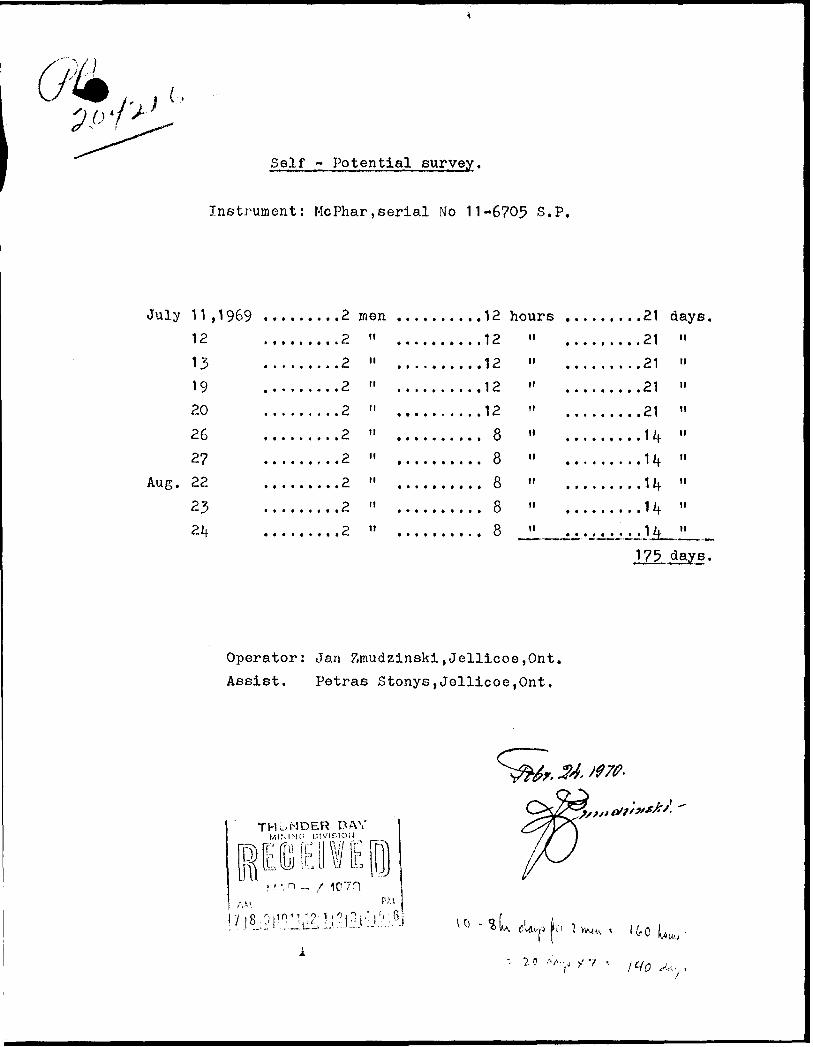
Self - Potential survey.
Instrument: McPhar,serial No 11-6705 S.P,
July 11,1969 .........2 men ..........12 hours .........21 days,12
131920
262?
Aug. 22
232*f
,... ....2
. .. ....2
, . . . ... .2
. . . . . ..2
,. .. . .. .2
, .. . ., ..2
. . .. ...2
. . .. . . .2
. ... ...2
M
n
it
ti
ti
n
M
It
tt
......12
......12
.. ....12
......12
...... 8
...... 8
...... 8
...... 8
. ..... 8
M
II
It
tl
II
II
tl
II
II
.. ....21
, . . . . .21
..... .21
......21
......14
......1lf
......H
......u^ ^^JL.
II
tt
tt
II
It
tt
tt
II
II
Operator: Jan Zmudzinski,Jellicoe,Ont. Assist. Petras Stonys,Jellicoe,0nt.
days.
TH.-NDEvR BAYMINING DIVir.lOlJ
ps o VIE [B1C70
25 "y f ' l in

fStU^S'.v^
Rpf'hv^.vO ' iK^-m^,:^ j,
spi-ic -- . i - -*. . - - -1. ^^^^ -l '* -1^ " *p. -"a ik-^
y.rrt-^i:Ay{jy^^-
THUNDER BAYWININO
BeardmoiNe ; ,

R e p o r
Magnetic survey of nine clai
Thunder Bay Mining Division.
52I01NE9161 63.2727 BOWSER LAKE020
Location: xhe Zmudzinski, nickel-copper property is located approximately 7 miles east of Ombabika Bay of Nipigon Lake, and 10 miles south-west of Auden, on the C.N.R. main line.
See: Map #2102 "Tashota-Geraldton" sheet (1965.) Plan # M-1846 "Bowser Lake". Aero-magnetic Map #2130 G. "Ombabika Bay". Map-key.
Access: Net of bush roads, graveled, connects North with the railway at Auden 10 miles, and south (55 miles) to highway #11. In winter, last 15 mis. north are not attended. By air can be reached by ski or float equipped aircraft, "Babika Lake". Air transport comp. are in Nakina, Armstrong, Geraldton and Jellicoe. Landing on Babika Lake is about 2 mis. long and if mis. wide. Pilot must pay attention for drifting waterlogged wood. To property from Babika Lake is approximately 1^ mis. by road. Landing has ramp. Near property are two clearings for helicopter.
Owner: JAN ZMUDZINSKI, JELLICOE, Ont.
Claims covered by survey; # 204216, 204217, 204218, 204219, 204220, 204221.
The covering dates during the survey; attached.
Geological data, (general):
Area on which claims are located, is underlain by Precambrian formation. Locally prominent gabbro, invaded by massive granite- gneiss, and small pegmatite dykes. Boundaries of contact are well defined. Between intrusive rocks, stretches a SE-NW,, belt of basic rocks over 2200 feet long (open) and 300 to 1000 feet wide (open). It is anomalous zone, gneiss is folded, indications of drag, boulders of basic rocks displaced to the North. Two faults were observed, running NNW - SSE. Rock in trenches does not show "strike" "dip" approximately, vertical. Outcrops 40?5 overburden not heavy. Origin of mineralization, primary, disseminated. Some advantageous changes have been observed near the contact zone, (metamorphism). Structure of rocks and density gives impression, the anomalous zone with digested part by intrusion is "stock" type with eroded anticline.

-2-
There are no official reports covering this part of the country. Geological maps show this area, as granite. Existence of more "stocks" of basic rocks (gabbro) were observed.
Summary of exploration and development:
Work on the group of claims started April 29, 1969, and continued to October 12, 1969. Area of six claims has been surveyed. Eight trenches were blasted and mucked, to a depth of 5-6 feet, besides 18 check holes. Outlined magnetic anomaly is 300 feet wide (open) and 2200 feet long (open). Work on claims is in a very early stage, impeded by difficult terain and lack of financial support.
TResults and conclusions;
Outlined anomaly. All trenches show mineralization, mostlydisseminated chalcopyrite and pyrrhotite-pentlandite.Ratio: 2-2, (Cu:Ni) Average assay of 12 sampled trenchesand blast-holes showed Q.4% to Q .8%. Real picture can beobtained by drilling, only.Minor values of: gold, silver, cobalt, chromium, vanadium,titanium and platinoids.Surface of outcrops do not show mineralization (gossan).Leached capping must be blasted 2-4 feet deep. Location oftrenches and holes determined by magnetometer and S. P. Survey.
Instrument; Magnetometer, Sharpe, Model: MF-1.V-- '
Base and check point; by camp, see plan. Base station reading 1500 gammas,
Lines: Base Line 1800 feet, 43O N. true. Cross lines 100 feet inter vals, cross line stations established every 50 feet. Total base.and cross lines: 4 and \ miles.
Names and addresses, man day work, and covering datas,attached.Line cutting time, included see: "Manual Labour" form.
Jan Zmudzinski prosp.
February 2^,1970.
THUNDER BAYMINING DIVISION
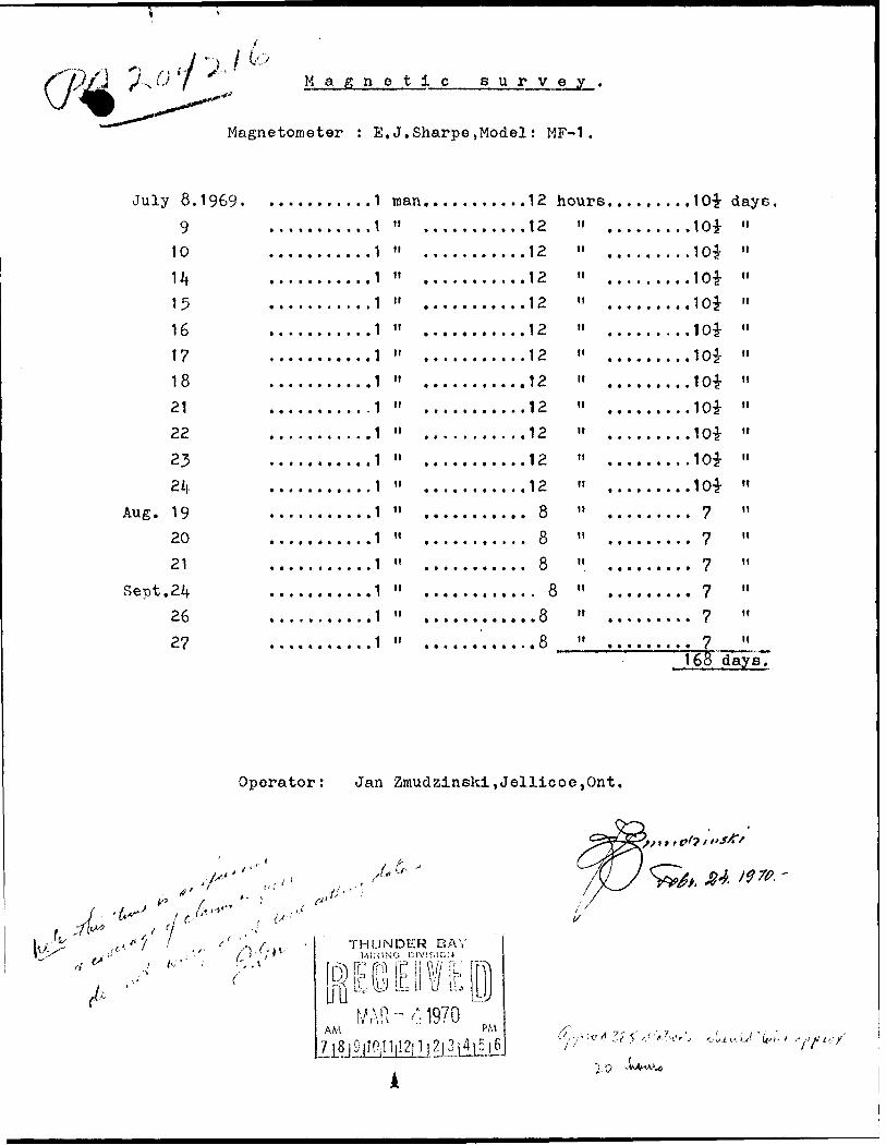
M a g n e t i c s u r y e y
Magnetometer : E,J.Sharpe,Model: MF-1
July
Aug.
Sept,
8.1969. ....
9 ....,10 ....,
14 ..-.15 ....
16 ....17 ,...,
18 ....
21 ....,
22
23 ....,24
19 ....
20
21 ....
24
26
27 . . . .
..., . ..1
.......1
,... ...1
.......1
.......1
.......1
.......1
.......1
.......1
.... . ..1
.......1
...... .1
.......1
,.. ....1
.......1
.......1
.......1
.... ...1
man.H
n
tt
u
ti
tt
n
n
n
tt
n
tt
tt
n
ti
n
n
......1
......1
......1
......1
......1
,.....1
,..,..1
......1
......1
, .. . ..1
......1
,.....1
2 "
2 "
2 "
2 "
2 "
2 "
2 "
2 "
2 " ....
2 "
2 "
8 "8 "8 "
8 "8 "8 " ....
.....10*
. . . . . 10*
. . . . . 10*
.....10*
.....10*
.....10*
.....10*
.....10*
.....10*
.....10*
.....10*
.....10*
..... 7
..... 7
..... 7
..... 7
..... 7
..... 7
daysn
"
n
tt
"
n
n
tt
ti
n
tt
n
n
it
n
it
nIbo days.
Operator: Jan Zraudzinskl,Jellicoe,0nt.
r. 6-
THUNDER BAY
AMWAR-'1- 1970
Z?}'

•S" -N,
5"0;t1/
v-. —
rl ,
,-\S
-~—
—-~
^'-i--"—
-——
:' ^
;i
"S
S
' A
*2
*':j
.5"V
-
^1•i•A' *\slo['d Si
^
*3
|"^
v'
'---1!'^
— x^X
.
7̂ ^
\./ ^
•l \.
\i
-—
—
Ss
.--ii
i r- ^ \ r -v-
V"^
^^
fe S
''-T
i. J
r 4 ..., ,
o ?
,-^-
J
'H
? ,
^Y
~,. -~-
gN*\
•1^
K-*
rfk-*
I 3
v, Tl
\ 0
* 0
\iJ?"''
^*-" - ^ ^.. ^
^—•*'
^Vt
-. /'
r.\ f
''•^7
t
V
xy-•N,
\.
^
f ^
l^ G
;A
V-1
^
1\^\13* M
. l-o
,^-jrf ?-
[;
\'
i\ .
r.- \
0
'•3 \
2r-
\ n
•^ \
'V•vo\
^v~* V
-"f•^V
o
v \ ̂^'-^C
——
____ —
,
;Si
"l1
;-
- -
n
——
. —
;
^S, I 3
li yx,
'o lo?'
-o
LJ a . ,"
, c-^'j
^^ l' 3
"5
^3
) 5?
e]
X^r
-ji'f
'':::^Lco|


52ieiNE91B1 63.2727 BOWSER LAKE 900

Return Lake Area - M. 276588 0 15
goS
ic o'o.
izo o
l
ZJ COc'ccu
Q.
500 07'30" —'
Nipigon
ABITIfll POWEF] AND PftPER CO.PULP wcoo OflivE CAMPL.o ^c 6U9, FILE ne, nce-vcL.9
PO O ST
ia
cuD-J
Ca
500 Q7'30'
13' to 1880 00'
52191NE9161 63.2727 BOWSER LAKE 200
k. k. 5O28SI
DISTRICT OFTHUNDER BAY
THUNDER BAY MINING DIVISION
SCALE: l-INCH 3=40 CHAINS
LEGEND
PATENTED LAND
CROWN LAND SALE
LEASES
LOCATED LAND
LICENSE OF OCCUPATION
MINING RIGHTS ONLY
SURFACE RIGHTS ONLY
ROADS
IMPROVED ROADS
KING'S HIGHWAYS
RAILWAYS
POWER LINES
MARSH OR MUSKEG
MINES
CANCELLED
C.&
NOTES
THIS AREA LIES WITHIN THE NIPIGON' PROVINCIAL FOREST-
400 Reserve around all Lakes and Rivers to Dept. of Lands S Forests.
66' Reserve around the shore of Lake Nipigon, from contour elevation 855'-
Flooding Rights to contour elevation 855 reserved to H.E.P C. of Ontario. - File No. 12198. vol. 2.
PLANNO.M-I846
DEPARTMENT OF MINES
- ONTARIO -

' ; f
x\
\ \f i
i fi i
i i
!\\
\ - i i
Q-** '~ \ l ty (
'' ' v V N ^\ N
C ; ,. ^beetle: I.
7* ft?
6+fff
.6+C6
f+SP
,5+Oe
0+50
7 ** c * 0 ST A"lo.
A AbtVQ
A7*oa v*-(d 9-.A A A
"-P(l 1OWQ \Sff-OO
k A A
\
/fWo
J970.
52iaiNE9161 63.2727 BOWSER LAKE\210

3fe