southern tasmania regional land use strategy -...
TRANSCRIPT

Southern Tasmania
Regional Land Use Strategy
Preliminary Consultation Report
18 February 2011
Following completion of the revision work on the Regional Land Use Strategy for Southern Tasmania and associated documents
including Background Reports and the new Implementation Report, this Preliminary Consultation Report will be finalised and reissued in recognition of
the exact changes that have been made to the Strategy.

Contents
1. Introduction 1
2. The Consultation Process 2
2.1 Overview 2
2.2 Providing Access to the Draft Strategy 2
2.3 Media Launch & Media Coverage 3
2.4 Public Notification 3
2.5 Project Sponsors 3
2.6 Infrastructure Providers 4
2.7 Stakeholders 4
2.8 Information Displays 6
2.9 Public Information Sessions 6
2.10 Website 8
2.11 Asking Questions 8
2.12 Making a Submission 8
3. The Submissions 9
3.1 Overview of Submissions 9
3.2 Origin of Public Submissions 9
3.3 Process for reviewing comments and making changes. 9
4. Key Findings 12
4.1 Support for the Strategy 12
4.2 Rezoning or other planning scheme requests 12
4.3 Misinterpretation between Policies and Zoning Framework 13
4.4 Too Strong Metropolitan Focus 14
4.5 Greenfield v Infill Scenarios for Greater Hobart 14
4.6 Adequacy of Cultural Values Policies 14
4.7 Relationship to Capital Cities Plan 15
4.8 Sustainability as the overarching principle 15
4.9 Natural Environment Concerns 15
4.10 Industrial Activity 16
4.11 Environmental Living densities 16
4.12 Proposed Development Control mechanisms in Rural Zones 16

4.13 Responsibility for Implementation, Monitoring & Review 17
4.14 Other Minor Issues 17
4.15 Out of Scope Recommendations 17
5. Changes stemming from consultation process 18
5.1 Creation of two documents 18
5.2 Increased recognition of the Suite of Documents 18
5.3 Changes to the Background Reports 19
5.4 New Background Report 20
5.5 Changes to the Part A: Context 21
5.6 Changes to Part B: Vision and Strategic Directions. 21
5.7 Changes to Part C: Regional Policies 21
5.8 New Implementation document 22
Table Index Table 1: Public Information Sessions 7
Table 2: Summary of Submission by Type 9
Figure Index Figure 1: Origin of Public Submissions by Local Government Area 10
Figure 2: Summary of Comments by Chapter 11
Figure 3: The Regional Land Use Framework for Southern Tasmania 19
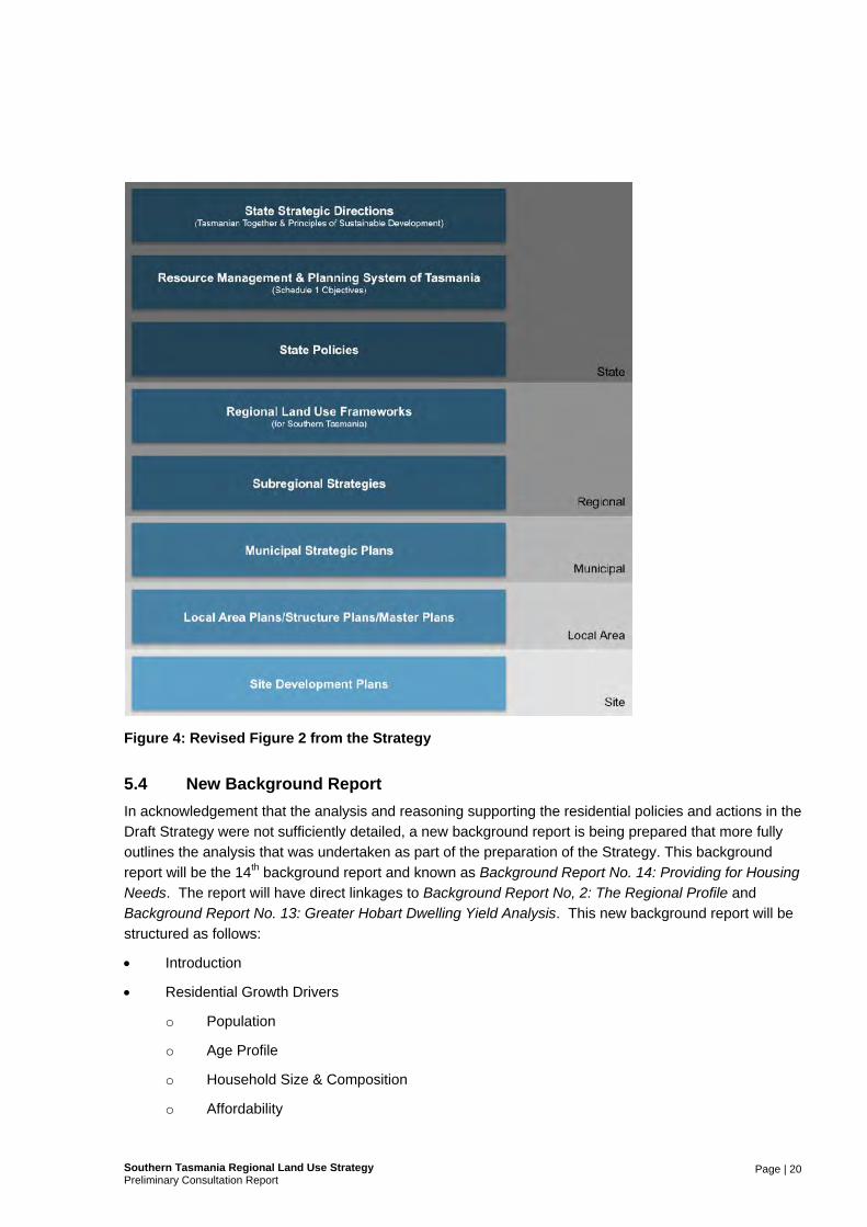
Figure 4: Revised Figure 2 from the Strategy 20
Appendices A Public Notices
B Reminder Advertisements
C Letter to State Agencies
D Letter to Infrastructure Providers
E Letter to Key Stakeholders
F A2 Information Panels
G A5 Information Sheet
H Comment Form
I Powerpoint Presentation from Clarification Session
J Letter of Acknowledgement
K Responses to Public Submissions
L Responses to Stakeholder Submissions

Page | 1 Southern Tasmania Regional Land Use StrategyPreliminary Consultation Report
1. Introduction
The Southern Tasmania Regional Land Use Strategy 2010-2035, Draft for Public Consultation, 25 October 2010 was released for public comment from 27 October to 6 December 2010.
This report summarises and analyses the issues raised in the submissions received, and the proposed responses in terms of subsequent changes to the Strategy.
The Southern Tasmania Regional Land Use Strategy is a broad policy document that will facilitate and
manage change, growth, and development within Southern Tasmania over the next 25 years.
The Strategy represents the culmination of a substantial body of analysis encapsulated within a suite of background reports and the first major public output of the Southern Tasmania Regional Planning
Project. The project being a joint initiative between State and Local Government (under the Regional Planning Initiative). It will form the foundation of a suite of consistent and contemporary planning schemes for all thirteen Planning Authorities in the region.
A range of amendments to the Strategy are herein recommended as a result of consideration of issues raised through the public consultation process.
A final draft of the Strategy will subsequently be produced which will be forwarded to each local Council
within the region seeking their endorsement. It is intended that it will then be forwarded to the Minister for Planning for consideration for declaration as a statutory instrument under the section 30C(3) of the Land Use Planning and Approvals Act 1993. Once this has occurred, the new planning schemes, (or
any future amendments thereto) will be required to accord with the Strategy.
The Strategy is comprised of both written and spatial policies addressing a range of issues. Whist these naturally focus on matters that are relevant to the drafting of planning schemes, they also include some
matters that will need to be addressed through actions outside of the statutory planning system.
A key change to the structure of the document from that which was subject to public consultation is the separation of ‘strategy’ from ‘implementation’ in recognition that it would be inappropriate for the various
proposed implementations actions to be included within a statutory document.
A total of 113 submissions were received from members of the public, stakeholder organisations, Councils and State Government agencies. The points made within each submission have been
summarised and tabulated, with each submission being allocated a code number. Copies of individual submissions have not been made public.

Page | 2 Southern Tasmania Regional Land Use StrategyPreliminary Consultation Report
2. The Consultation Process
2.1 Overview
The public consultation period for the Draft Southern Tasmania Regional Land Use Strategy ran for forty
days from 27 October to 6 December 2010.
Engaging the general community in strategic land use planning processes is traditionally challenging, due in part to the broad nature of the subject matter. In contrast, the public exhibition of draft planning
schemes engenders much more interest, particularly from property owners who are able to identify their own properties and their intended new zoning.
The Southern Tasmania Regional Planning Project, therefore, went to lengths to publicise the process,
make the draft document accessible, and engage with the community and key stakeholder groups, as detailed below.
In addition to all of the above, the development of the Draft Strategy involved a significant level of
consultation with the project sponsors, being local Councils and State Agencies, as well as key stakeholder groups. In particular this included two rounds of presentations/workshops with local government elected members, and various meetings with State Agencies and infrastructure providers.
It should also be noted that a significant input into the Draft Strategy were existing local and subregional strategies developed in recent times, all of which had been subject to their own public consultation processes. Much of the content had therefore, been previously subject to a degree of consultation.
2.2 Providing Access to the Draft Strategy
During the public consultation process the information made available to the public was:
The Southern Tasmania Regional Land Use Strategy 2010-2035, Draft for Public Consultation, 25 October 2010.
o 200 hard copies printed and provided to project sponsors, stakeholders, and members of
the public upon request.
o Viewable or downloadable from the project website: stca.tas.gov.au/rpp.
o Hard copies, for perusal, provided at each of the fourteen information displays set up around
the region (see below).
The thirteen (13) Background Reports were provided as viewable or downloadable documents from the project website:
o Background Report No.1 – The Project Background;
o Background Report No. 2 – The Regional Profile;
o Background Report No. 3 – A Changing Climate;
o Background Report No. 4 – Social Infrastructure and Interactions
o Background Report No. 5 – Natural Value;
o Background Report No. 6 – Land Hazards;
o Background Report No. 7 – Productive Resources;

Page | 3 Southern Tasmania Regional Land Use StrategyPreliminary Consultation Report
o Background Report No. 8 – The Regional Transport System;
o Background Report No. 9 – Physical Infrastructure;
o Background Report No. 10 – Tourism & Land Use Planning;
o Background Report No. 11 – Industrial Activity;
o Background Report No. 12 – Activity Centre Analysis;
o Background Report No. 13 – Dwelling Yield Analysis for Greater Hobart.
2.3 Media Launch & Media Coverage
The public consultation period commenced with a media launch held in the public foyer of the Hobart City Council customer service centre on Wednesday 27 October 2010. The Lord Mayor of Hobart, as Chair of the Project Steering Committee and representative of the region’s Mayors for the purposes of the
project, performed the launch. It was attended by many of the region’s local elected members, members of the planning fraternity and a range of media organisations. This resulted in two of the television channels running news stories that night and articles in ‘The Mercury’ the following day.
This was followed by a number of radio and television (ABC news, Win News and Southern Cross TV news) interviews by the Lord Mayor, and other interviews where the topic was discussed with industry and professional representatives (for example, the President of the Planning Institute of Australia
Tasmanian Division).
In subsequent weeks the Draft Strategy was the subject of the following in newsprint:
An article on ‘Blueprint to halt sprawl’, ‘The Mercury’ Thursday 28 October 2010;
An editorial in ‘The Mercury’ Friday 29 October 2010;
A 2 page article in ‘The Sunday Tasmanian’ 31 October 2010; and
An opinion piece by the Project Managers in ‘The Mercury’ Thursday 4 November 2010;
2.4 Public Notification
Two large-scale public notifications were placed in ‘The Mercury’ and ‘The Saturday Mercury’ on Wednesday 27 October and Saturday 30 October respectively (see Appendix A).
A ‘reminder’ advertisement (a footer banner) was placed in ‘The Mercury’ on 18 and 25 November 2010
and ‘The Saturday Mercury’ on 20 and 27 November 2010 (see Appendix B).
Some Councils also included information items in their local newsletters.
2.5 Project Sponsors
2.5.1 Councils
As project sponsors, Councils and their elected members were engaged at various stages across the
development of the Draft Strategy including:
Involvement by Council planners in the Technical Reference Group (Land Use Planning);
Reporting to the STCA Board of Mayors and General Managers;

Page | 4 Southern Tasmania Regional Land Use StrategyPreliminary Consultation Report
Elected member presentations; and
Obtaining local government consent to release the Draft Strategy for public consultation.
The Councils were also afforded the opportunity to provide further comment on the Draft Strategy during the public consultation period. The General Managers were advised of this opportunity via email.
2.5.2 State Agencies
As project sponsors, State Agencies have been engaged throughout the development of the Draft
Strategy through a range of means including:
One-on-one contact with agency representatives;
Presentations to agencies by the Project Managers;
Involvement with the Technical Reference Group (Infrastructure) by the Department of Infrastructure, Energy & Resources, Department of Health and Human Services and Department of Education; and
Opportunity to provide final comments on Draft Strategy prior to release for public comment.
State Agencies were also afforded the opportunity to provide further comment on the Draft Strategy during the public consultation period. Department secretaries were advised via written correspondence
(see Appendix C).
2.6 Infrastructure Providers
Early in 2010 a Technical Reference Group (Infrastructure) was initiated (as per the Project Plan) to assist the Project Team in the development of the Strategy. While Infrastructure Providers (both physical
and social infrastructure) were represented on this group, those non-agency/Council organisations were advised in advance of the public consultation period of the opportunity to provide comment until 6 December 2010 (see Appendix D).
Infrastructure providers advised are as follows:
Southern Water
Hydro Tasmania
Transend Networks Pty Ltd
Aurora Energy Pty Ltd
Metro Tasmania
2.7 Stakeholders
Letters to key stakeholders requesting their feedback including a written invitation to two information
sessions were sent to stakeholders on the 18 October 2010 (see Appendix E). These information sessions occurred during the afternoon and the evening of 11 November 2010. These stakeholders are outlined as follows:

Page | 5 Southern Tasmania Regional Land Use StrategyPreliminary Consultation Report
Centacare Tasmania
Environmental Defenders Office (Tas)
Environmental Protection Authority
Forest Industry Association of Tasmania
Forest Practices Authority
Forestry Tasmania
Housing Industry Association (Tasmania Division)
Hobart International Airport Pty Ltd
Local Government Association of Tasmania
Master Builders Association
NRM South
Planning Institute of Australia (Tasmanian Division)
Private Forests Tasmania
Property Council of Australia (Tasmanian Division)
Real Estate Institute of Tasmania
Shelter Tasmania Inc.
Steps - Community Solutions
Tasmanian Conservation Trust
Tasmanian Development Board
Tasmania Together Progress Board
Tasmanian Heritage Council
Tasmanian Aboriginal Land and Sea Council
Tasmanian Council of Social Services
Tasmanian Land Conservancy
Tasmanian Landcare Association Inc.
Tasmanian Farmers and Graziers Association
Tasmanian Ports Corporation Pty Ltd
Tasmanian Seafood Industry Council

Page | 6 Southern Tasmania Regional Land Use StrategyPreliminary Consultation Report
Tasmanian Small Business Council
Tasmanian Chamber of Commerce and Industry
Tourism Industry Council of Tasmania
Sustainable Living Tasmania
Manufacturing Industry Council
University of Tasmania
Telstra Countrywide
Powerco
Mt Wellington Park Trust
Regional Development Australia - Tasmania
The Project Managers also provided stakeholders with the opportunity of requesting one-on-one meetings or presentations.
Presentations were provided to the Master Builders Association and the Hobart City Council’s
Community Sector Reference Group. A significant number of private planning consultants and their clients also arranged one-on-one meetings.
2.8 Information Displays
Fourteen (14) information displays were set up around the region for the duration of the public consultation period. Each municipal area was provided with one display, which was generally set up in
the public foyer of their main customer service area, and displays were also established at the public offices of the Sullivans Cove Waterfront Authority and the Tasmanian Planning Commission.
The displays consisted of a hard copy of the Draft Strategy, separate A3 hard copies of the draft strategy
maps, six (6) laminated colour information panels (see Appendix F), a pad of A5 tear-off information sheets (see Appendix G), a pad of A4 tear-off comments forms (see Appendix H) and a comments submissions box.
2.9 Public Information Sessions
Specific information sessions for the general public were scheduled across the region as detailed below.
Members of the public were advised that anyone would be welcome to attend any session, whether or not it was within an individual’s local area. The Project Managers attended the sessions for questions and discussion.

Page | 7 Southern Tasmania Regional Land Use StrategyPreliminary Consultation Report
Table 1: Public Information Sessions
Date Time Location No of
Attendees
2 November 5pm – 7pm Glenorchy City Council, 374 Main Road, Glenorchy 1
3 November 3pm – 6pm Brighton Council, 1 Tivoli Road, Gagebrook 9
3 November 3pm – 6pm Huon Valley Council, 40 Main Road, Huonville 12
8 November 12noon-3pm Clarence City Council, 38 Bligh Street, Rosny Park 11
10 November 11.30am to 2.30pm
Hobart City Council Customer Service Centre, 16 Elizabeth Street, Hobart
3
10 November 3pm to 6pm Derwent Valley Council, Circle Street, New Norfolk 2
15 November 11am – 2pm Central Highlands Council, Alexander Street, Bothwell 0
16 November 4pm to 7pm Kingborough Civic Centre, 1 Channel Hwy, Kingston 15
17 November 11am to 2pm Tasman Council, 1713 Main Road, Nubeena 3
17 November 3.00pm to
6.00pm Sorell Council, 12 Sommerville Street, Sorell
1
19 November 12noon to
2pm Sullivans Cove Waterfront Authority, Franklin Wharf, Hobart
2
22 November 4pm to 7pm Southern Midlands Council, Main Road, Oatlands 2
24 November 11am to 2pm Glamorgan Spring Bay Council, Cnr Vicary and Henry Street, Triabunna
0
A second public information session was held at Huon Valley Council on 14 December 2010. Whilst this was outside the stated period, it was considered necessary due to the very large number of submissions from Huon Valley, a significant proportion of which exhibited similar misunderstandings. It was
considered necessary to ‘set the record straight’ and to allow final written comments to be submitted at the close of the session.
Submitters from both the Huon Valley and Kingborough areas were invited via email to this session. A
total of 35 persons attended this additional clarification session. The powerpoint presentation from this session shown at Appendix I.

Page | 8 Southern Tasmania Regional Land Use StrategyPreliminary Consultation Report
2.10 Website
Throughout the course of the public consultation period copies of the Draft Strategy, the Background
Reports, A2 Information Panels and Project Plan were available for download from the STCA website (www.stca.tas.gov.au/rpp).
An online comment option was also made available.
2.11 Asking Questions
During the public consultation period members of the public were provided with the opportunity to ask
questions at any of the public information sessions, or via phone or email to the Project Managers at other times. A large number of people took up this opportunity.
One-on-one meetings were also arranged, where requested.
2.12 Making a Submission
Submissions were invited to be lodged prior to 12 Noon, Monday 6 December 2010. Where requested
additional time to make a submission outside of this period was granted.
Submitters could use a form provided on tear-off pads at any of the information displays, write a letter, detailed submission, or simply send an email. It was made clear that supporting information or
explanatory material, such as maps, would be welcome.
Submissions could be posted or emailed to the Project Managers, the majority of which arrived by one of these methods. Only a handful of submissions were received via the comments boxes / comments
forms that were provided at each information display.
The Project Managers also took notes at the various information sessions; however potential submitters were advised to provide their comments in writing to ensure their views would be taken into account.

Page | 9 Southern Tasmania Regional Land Use StrategyPreliminary Consultation Report
3. The Submissions
3.1 Overview of Submissions
The 113 submissions were received in total, and are categorised as follows:
Table 2: Summary of Submission by Type
Type Number
General Public 82
Key Stakeholders 15
State Agencies 5
Councils 7
Infrastructure Authorities (other than State Agencies and Local Government) 4
TOTAL 113
As expected, the majority of submissions came from the general public. This included small community interest groups, planning consultancies (on behalf of private clients) and other members of the public with particular land area concerns.
Though there were 85 public submissions, it was primarily stakeholder, state agency and council submissions that went into lengthy Strategy assessment details.
3.2 Origin of Public Submissions
As shown in Figure 1 (over page) submissions were received from most municipal areas, with the majority coming from the Huon Valley (28 submissions), followed by Clarence (11 submissions) and
Kingborough (10 submissions). There were no submissions received from the Tasman area.
3.3 Process for reviewing comments and making changes.
As submissions were received over the public consultation period, they were recorded into a table and assigned a specific code: so they would appear anonymous in the final draft, but still allow for internal reference. This record also facilitated the process of responding to submissions by letter of
acknowledgement (see Appendix J) and to chase up further details if needed.
All submissions were individually reviewed and summarised into the tables irrespective of their source or type. A response was then made to each specific comment within the submissions from which has been
prepared and attached at Appendix I and Appendix K.
Comments taken from the submissions were grouped a heading in under the ‘Generic Concerns or Chapter Referenced’ column. They were then broken down into a ‘Specific Reference’ (i.e. dot point
number) and then into a column with the actual ‘Comment or Recommendation’.

Page | 10 Southern Tasmania Regional Land Use StrategyPreliminary Consultation Report
Figure 1: Origin of Public Submissions by Local Government Area
The ‘Comment or Recommendation’ column therefore contained groups of comments pertaining to their relevant section. Some submissions did not directly state exactly what they were referring to in the Strategy, and therefore had to be labelled as an open ‘Generic Concern or Chapter Referenced’.
Figure 2 (over page) details the summary of comments by chapter, and the number of times submissions focused on a particular section of the strategy (i.e. chapter 7; section 7.1; section 7.2 etc). This graph illustrates how many times a series of comments were attributed to a particular chapter and/or section of
that chapter.
Figure 2 demonstrates that most comments within the Strategy related to Chapter 19 ‘Providing for Housing Needs’. This was followed by a significant number of ‘General Comments’ and focus on
Chapter 23 ‘The Zoning Framework’.. The ‘General Comments’ were sometimes comments that encompassed more than one chapter or section at a time, and could not be broken up accordingly.
A summary of the key findings arising from the submissions are outlined in Section 4 below.

Page | 11 Southern Tasmania Regional Land Use StrategyPreliminary Consultation Report
Figure 2: Summary of Comments by Chapter

Page | 12 Southern Tasmania Regional Land Use StrategyPreliminary Consultation Report
4. Key Findings
4.1 Support for the Strategy
Many respondents indicated support for the Draft Strategy. Specifically, submissions expressed support
for its direction and necessity, and for particular interest related components. Some recurring supportive comments were on matters such as:
Limiting urban sprawl
The protection of agricultural land
Support for a settlement strategy
Some of the direct comments included:
‘Applaud’ and ‘Congratulations’ to the Southern Council Authority and the STRLUS team for the initiative in formulating and addressing a regional strategic approach to land use planning that has long required attention.
Satisfaction with the readability and innovative format of the document; ‘… a well considered piece of strategic work’.
There was no opposition to the Strategic Directions underpinning the policies, beyond some suggested
rewording.
4.2 Rezoning or other planning scheme requests
There were approximately 30 specific rezoning type requests. These types of queries and requests were mostly concerned with the desire to subdivide areas where the current planning scheme does not allow it.
Submissions from the public requesting the ability to subdivide their own land provided some argument for why planning schemes should make ‘case by case’ allowances. Some argued in accordance with new Draft Strategy policy, whilst others had concerns that were essentially ‘local’ in nature and therefore
in the realm of their local council, or were at a level of detail that can only be determined during the drafting process for the planning schemes later in 2011.
Public submissions that argued against the Strategy in regard to the provision for opportunity to
subdivide land had focussed on chapter 23 ‘The Zoning Framework’ and in particular ‘Table 8’ and the proposed zones regarding rural land. There was significant misinterpretation regarding lot sizes and some criticism of local government’s ability to assess agricultural land in regard to subdividing for
agricultural purposes. Although the submission points have been noted, it is intended that Table 8 be replaced by the ‘Regional Model Planning Scheme’ which, by necessity, will provide the clarification that many of the public submissions requested. This, along with the remainder of Part D of the Draft
Strategy, will be removed from the Strategy document itself and placed into a new and more detailed ‘Implementation’ document.
Some criticism also stemmed from ‘Notes on Development Control Outcomes’ under the ‘Significant
Agriculture’ Zone heading in Table 8. The issue was ‘Subdivision restricted to that which supports agricultural use an development.’ and ‘Minimum lot size for subdivision to be consistent with the optimum

Page | 13 Southern Tasmania Regional Land Use StrategyPreliminary Consultation Report
size for a viable agricultural use for the dominating form of agricultural production in the respective agricultural district’. The arguments against such control measures included:
Concerns that ‘niche market’ agricultural practices are likely not uniform with neighbouring farming operations;
Minimum lot size not specified;
Council does not have the resources or experience to assess such applications;
Similar provisions in some existing planning schemes have been abused as ‘loopholes’, with
applicants not proceeding with mooted agricultural enterprises and instead selling off the land for residential purposes.
The other common subdivision-related requests came from planning consultants, on behalf of
landowners, bringing to the Project’s attention subdivision proposals that have been subject to considerable discussions and negotiations with the relevant local Council and infrastructure providers for several years, but had not yet reached the formal application for rezoning stage. A number of these
were outside the proposed Urban Growth Boundary (UGB).
There were also concerns from members of the public and potential developers that argued, there are large tracts of rural land that should be reassessed and included in the ‘Residential Expansion and
Release Areas’ in Maps 9 and 10 of Chapter 19 ‘Providing for Housing Needs’.
Some developers or their representatives also argued contrary to the housing density control measures of the Draft Strategy.
4.3 Misinterpretation between Policies and Zoning Framework
A consistent issue amongst submissions occurred as a result of misinterpretation of the Strategy and the
implementation component. Particular issues included:
Reading the ‘typical lot size’ under Table 3: Housing Density Guidelines’ as a minimum and maximum lot size, that would then directly translate into the residential type zones;
Reading the Rural Residential densities under Table 3 as applying to the Rural Resource Zone;
Some submitters believing that some current Rural zones would translate to the Rural Living Zone rather than Rural Resource zone (this subsequently either caused concern at increased
subdivision in their area or the support from some landowners believing that they would be able to subdivide their land);
Lack of clarity that the zone types were derived from the Common Key Elements Template, with
some submitters thinking that the zone types were chosen by the Project Team in the drafting of the Strategy. This then lead to the belief that the Zoning Framework did not sit well with the remainder of the Strategy; and
Lack of clarity of indicative or conceptual nature of Map 5: Key Agricultural Production Areas (this was not helped by its mislabelling in the Draft Strategy but correct labelling on the separate A3 version available at information displays and on the website).

Page | 14 Southern Tasmania Regional Land Use StrategyPreliminary Consultation Report
4.4 Too Strong Metropolitan Focus
One of the key criticisms of the Strategy was its noticeable focus on Greater Hobart with concerns that
this was at the expense of a focus on other parts of the region. For example one comment stated:
Too much focus on metropolitan Hobart and neglect of East Coast as a booming tourism area. Would like to
see some more focus on regional townships.
The Strategy is clear in that it does focus on Greater Hobart. This is warranted by the fact that more than 80% of the region’s population reside there, yet it has been around three decades since it has been the subject to strategic land use planning as a single settlement. The Draft Strategy also recognises that in
recent time significant detailed land use strategies for area outside of Greater Hobart had been prepared: Vision East, the Joint Land Use Planning Initiative (for Brighton, Central Highlands, Derwent Valley & Southern Midlands); Huon Valley Land Use & Development Strategy. The Draft Strategy has recognised
the existence of these documents and most of the more specific localised detail in new planning scheme will be based upon these documents.
4.5 Greenfield v Infill Scenarios for Greater Hobart
A considerable number of comments relating to Chapter 19 ‘Providing for Housing Needs’ focussed on the different greenfield and infill scenarios underpinning the spatial residential settlement strategy for
Greater Hobart. Very few comments raised concern with the overall regional settlement strategy.
The comments, particularly those from key stakeholders represented both sides of the spectrum. Some were seeking less or even no restrictions on green field growth while others supported nearly all dwelling
growth being achieved through infill with no further residential land releases in Greater Hobart in the foreseeable future.
Nearly all submissions outlining these different arguments discussed various impacts that different land
use planning strategies could have on housing affordability, which is obviously a very significant issue.
4.6 Adequacy of Cultural Values Policies
Nearly 30 comments were recorded that directly related to the Cultural Values chapter in the Draft Strategy.
Aside from relatively minor recommended wording changes, some recurring issues were:
Tasmanian heritage management and planning is significantly under resourced;
The review of the Historic Cultural Heritage Act needs to be concluded as soon as possible;
Planning Schemes should include provisions requiring the assessment of landscape values;
The priorities in Chapter 21 ‘The Action Plan’ for Cultural Values should all be set to high and re-assess who is to be the responsible agent;
Due consideration has been given to the comments and recommendations received regarding ‘Cultural
Values’, and as a result the entire chapter will be revised.

Page | 15 Southern Tasmania Regional Land Use StrategyPreliminary Consultation Report
4.7 Relationship to Capital Cities Plan
Several of the submissions from key stakeholders raised concerns with the relationship of the Draft
Strategy and the subsequent development of new planning schemes with the Capital Cities Plan Project. These concerns largely represent risk management issues for State Government in progressing the Capital Cities Plan while the Regional Planning Project is continuing.
Due to existing commitments by State Government the timing constraints of the regional planning project are relatively restrictive and therefore cannot be extended to take into account work on the Capital Cities Plan which is not likely to be completed until January 2012.
Nonetheless, the concerns raised in submissions regarding this point have been conveyed directly to the Chairman of the Capital Cities Plan Steering Commission, Mr Greg Alomes (Executive Commissioner of the Tasmanian Planning Commission).
4.8 Sustainability as the overarching principle
It was suggested in some submissions that the policies and strategic directions in the Draft Strategy
need to be more strongly linked by a guiding principle which should be the concept of sustainability, which would then bind and give a hierarchy to the individual components of the Draft Strategy. While it could be better articulated, the guiding principles for the Draft Strategy are intended to be the Objectives
of the Resource Management and Planning System (as the Draft Strategy will become a strategic document under this legislative system). The fundamental principle underpinning the objectives of the RMPS is the concept of ‘Sustainable Development’.
4.9 Natural Environment Concerns
Many submissions raised concerns about environmental protection and management. These concerns
were not contained to just the key chapters such as ‘Biodiversity and Native Vegetation’, ‘The Coast’, ‘Water’ etc, as arguably environmental sustainability and sustainable development is an essential consideration in many facets of land use planning.
Most of the submissions that focused on the environment included recommended technical changes to ‘Regional Polices’ and ‘Actions’. For instance; many of these submissions requested certain terminology to be explained, for example, in reference to Coastal Action 7.5 C-A5 and C-A8 a submission asked ‘Is
“Coastal Area” as defined by the State Coastal Policy?’ Another one asked to clarify ‘public infrastructure’ in relation to development within conservation areas. These are mostly technical issues, and there was very little explicit disagreement with a policy or action.
Some recurring environmental considerations include:
Chemical Spills and Contaminated Land;
Rising Sea Levels as a result of climate change – with suggestions regarding the creation of a
foreshore buffer type zone or overlay and allow for ‘retreat type areas’ to support ecosystems. Though, this is evident in background reports and in action, C-A4 Identify and protects areas that provide for landward retreat of coastal habitats and species at risk from predicted sea level rise.
Concerns regarding coastal policy, in that it may hinder tourism and aquaculture developments; this was in regard to assessing development in coastal areas subject to ‘…detailed assessment of environmental and cultural impacts and where broader economic or social benefits are

Page | 16 Southern Tasmania Regional Land Use StrategyPreliminary Consultation Report
demonstrated.’ And in reference to policy, C-P4 Prevent all development on mobile landforms,
conservation areas and coastal mudflats unless related to provision of public infrastructure.
Unanimous support for Coastal Policy 7.5 C-P9 ‘Prohibit the construction of canal estate developments’, (in regard to those submissions that addressed the issue of canal estates).
Disagreement with Manage Risks & Hazards Action 7.5 MRH-A7 on ‘Bushfire Management Plans by way of Part 5 Agreements’ – many submissions believed this was unnecessary, inappropriate and/or would be an increased burden on local government.
4.10 Industrial Activity
A number of public submissions from the Brighton and Southern Midlands municipality expressed deep
concern over the Industrial ‘Potential Expansion Area’ to the East of Brighton located on Map 6 in Chapter 17 ‘Industrial Activity’. The investigation area raised concerns regarding:
Impact on at least three heritage listed properties and a further 30 residential properties.
Claims that, regardless of the draft status of the document, such mapping has compromised the capital value of the properties in the area.
The possible need for road requires upgrading
The area would draw people out of the Greater Hobart Area
Impact upon agricultural land
Impact on local biodiversity
Map 6 will be revised pending a more specific and detailed regional industrial land study.
4.11 Environmental Living densities
The Zoning Framework in the Draft Strategy indicated that the minimum lot size for the Environmental Living Zone (which is intended as one of a suite of zoning mechanisms to protect natural values and in particular native vegetation) would align with the densities for ‘rural residential’ under Table 3. A key
concern in submissions was that this density was too high (typical minimum lot size between 0.5 to 4 ha) to allow for adequate protection of biodiversity and ecological values.
4.12 Proposed Development Control mechanisms in Rural Zones
The Zoning Framework in the Draft Strategy included various potential development control mechanisms that were intended to be a guide on how the Strategy could be achieved through new planning schemes.
One of the proposed development control standards related to the requirements for a whole of farm management plan to assist in determining whether a subdivision in both the Rural Resource and Significant Agricultural Zones was acceptable.
This caused significant concern from many respondents including some Councils.

Page | 17 Southern Tasmania Regional Land Use StrategyPreliminary Consultation Report
4.13 Responsibility for Implementation, Monitoring & Review
Amongst the general comments received in the submissions a general theme appeared to be concern
over the long-term success of the Strategy in light of uncertainties regarding ongoing implementation, monitoring and review. Some specific comments included:
Some inadequacies in the detail on how the Strategy will be translated into planning schemes;
The prioritisation of supposedly competing policies within the Strategy;
Clarification of which policies are specifically relevant to planning scheme amendment processes;
Some of the proposed actions are outside the planning system and therefore not something which
a planning authority can either achieve or dictate.
Lack of key performance indicators against the strategies or policies to determined review needs and or the success or otherwise.
Inclusions of non-statutory ‘actions’ in what is intended to become a statutory document.
While the regional planning governance model into the future is still to be determined by State Government, the expansion and restructuring of the implementation components of the Strategy into a
new document (see Section 5 below) should provide some greater clarity and certainty in regards to these concerns.
4.14 Other Minor Issues
The bulk of the submissions were dominated by comments suggesting minor changes, rewording and additional policy considerations. Where possible these changes have been made to the document.
Some submissions recommended the ‘conceptual nature’ of the mapping be more spatially explicit.
Some submissions made recommendations for ‘Immediate Residential Land Release’ areas
outside those indicated in Map 9.
More definitions and explanation of certain terms. (Although some of these concerns have been addressed in the Background Reports.)
Misinterpretation of the document.
4.15 Out of Scope Recommendations
Many of the suggestions reviewed and recorded were considered outside the scope Regional Planning Project and dealt with issues best taken up with:
State Authorities; regarding matters such as
o Environmental management of parks and reserves
o Upgrades and passenger use of the rail network
Local Council maintenance and local-level planning issues

Page | 18 Southern Tasmania Regional Land Use StrategyPreliminary Consultation Report
5. Changes stemming from consultation process
The main changes which are to be included in the final Strategy are summarised in this section.
5.1 Creation of two documents
In light of concerns with the implementation component of the Draft Strategy and specifically the
inclusion of implementation actions in what is intended to become a statutory policy document (under Section 30C of the Land Use Planning and Approvals Act 1993), the Draft Strategy as publicly exhibited, will be split into two separate documents.
Parts A, B & C of the Draft Strategy will remain (albeit with some rewriting, policy revisions and minor changes). Part D will be taken out and a new ‘Implementation’ document created. The actions outlined under each policy chapter in the Draft Strategy (Part C) will be reviewed. Those actions, which are in
fact statements of policy, will be converted into ‘regional policies’ and assigned an appropriate reference number. Other actions in Part C will be removed and incorporated into the new Implementation document.
The result will be a pure policy document in a form more suited to declaration as a statutory instrument.
5.2 Increased recognition of the Suite of Documents
With some confusion in submissions over the relationship between the Background Reports and the Draft Strategy along with the release for public comment of the Draft Cradle Coast Regional Land Use Framework, Part A of the Strategy provides for greater recognition, that the suite of documents prepared
under the Southern Tasmania Regional Planning Project comprises, a holistic land use planning framework as demonstrated in Figure 3 over page.
The strategy document is intended to be one of three elements within the Southern Tasmania Regional
Land Use Planning Framework. The Strategy is supported by a series of Background Reports providing detailed analysis and discussion on a range of topics and should be read in conjunction with these documents.
The Strategy will also be supported by an implementation and monitoring document which will be constituted by ‘The Process Forward: Implementing and Monitoring the Regional Land Use Strategy for Southern Tasmania 2010 – 2035’. Implementation of the Strategy either through statutory land use
planning process or other processes will be guided by this document.
With this in mind, Figure 2 from the Draft Strategy will also be amended to better reflect the concept of a ‘Regional Land Use Framework’ within the Resource Management and Planning System (see Figure 4
on page 20).

Page | 19 Southern Tasmania Regional Land Use StrategyPreliminary Consultation Report
Figure 3: The Regional Land Use Framework for Southern Tasmania
5.3 Changes to the Background Reports
A number of changes to the Background Reports will be undertaken. Beyond proof reading and general editing the proposed changes include:
An expanded Background Report No. 2: The Regional Profile. Taking a 25 year analysis of
changes in population, household type and composition and employment along with greater analysis of projections relating to changing demographics. The purpose of this increased analysis is to support an entirely new Background Report; Providing for Housing Needs (see Section 5.4
below) and the Activity Centres policies;
Reviewing economic data supporting analysis of various industries to ensure it is consistent with the recently released data forming part of the State Government’s Economic Development Plan;
Increased background analysis on Significant Agricultural Land in Southern Tasmania; and
Specific changes in various background reports as recommended in various key stakeholder submissions.
Page | 20 Southern Tasmania Regional Land Use StrategyPreliminary Consultation Report
Figure 4: Revised Figure 2 from the Strategy
5.4 New Background Report
In acknowledgement that the analysis and reasoning supporting the residential policies and actions in the Draft Strategy were not sufficiently detailed, a new background report is being prepared that more fully outlines the analysis that was undertaken as part of the preparation of the Strategy. This background
report will be the 14th background report and known as Background Report No. 14: Providing for Housing Needs. The report will have direct linkages to Background Report No, 2: The Regional Profile and Background Report No. 13: Greater Hobart Dwelling Yield Analysis. This new background report will be
structured as follows:
Introduction
Residential Growth Drivers
o Population
o Age Profile
o Household Size & Composition
o Affordability
Page | 21 Southern Tasmania Regional Land Use StrategyPreliminary Consultation Report
o Lifestyle
The Future of Residential Development (scenario based discussion)
o Southern Tasmania Region
o Greater Hobart Region
- Continuation of Current Trends
- Infill Development
- 60/40 Balance of Infill/Greenfield Development
This new background report will also include the reworded discussions on Affordable Housing currently in Background Report No. 4 – Social Infrastructure and Interactions.
5.5 Changes to the Part A: Context
Part A of the Strategy is being amended to take into account the creation of a new Implementation document and the concept of the Regional Land Use Framework for Southern Tasmania.
5.6 Changes to Part B: Vision and Strategic Directions.
Beyond minor editing and wording changes, Part B of the Draft Strategy will remain as is.
5.7 Changes to Part C: Regional Policies
There will some notable changes to Part C arising from the public consultation process including:
Reviewing all actions: those that are in fact, statements of policy are to be reworded and reassigned as Regional Policies, otherwise the remainder are to be removed and included in the appropriate section in the new Implementation document;
A rewritten Cultural Values section including new policies taking into account the recommended approach in some submissions;
Additional transport infrastructure maps under Chapter 13: Land Use and Transport Integration.
Specifically these maps identify the regional transport corridors and Greater Hobart transport routes that will need to be protected within new planning schemes;
A new map for Chapter 15: Strategic Economic Opportunities that recognises spatial links (i.e.
value of Huon Estuary and Channel for aquaculture) and linkages with key tourism related opportunities (i.e. the East Coast), will also be included.
Inclusion of some indicative minimum lot sizes for rural resource areas (excluding Significant
Agricultural Land) across the five different subregions.
Removal of the policy that suggests farm management plans and ‘viable’ lot size as indicative measures for determining acceptability of subdivisions in rural areas.
Replacement of Map 4 with a new more detailed and technically accurate map on significant agricultural land (currently being developed by ARM Consultants Pty Ltd);

Page | 22 Southern Tasmania Regional Land Use StrategyPreliminary Consultation Report
Amendment of Map 6: Industrial Areas in Greater Hobart, in light of further study of industrial land
prior to identification of any expansion areas;
A new map after Map 7 that shows all Activity Centres in Greater Hobart across the entire network (not just higher order centres). This will support greater understanding of the interactions across
infrastructure and residential settlement considerations in the metropolitan context;
A revised Chapter 19: Providing for Housing Needs in light of additional background report. Greater Hobart maps will also be revised to provide for greater spatial detail accompanied by
specific dwelling targets for infill and greenfield as well as a lot release program to ensure sufficient greenfield release (in order to avoid affordability issues). There will also be refocussed infill policies so that reliance upon achieving infill targets is more strongly linked to incentives
rather than disincentives.
Revision of Table 3: Housing Density Guidelines to add in additional density guidelines for Environmental Living as typical density for Environmental Living should be lower than rural
residential in order to manage environmental values. This will then provide a direct link to the proposed densities in the Environmental Living Zone in the Regional Model Planning Scheme. Change ‘typical lot size’ to ‘typical minimum lot size’.
5.8 New Implementation document
As indicated above, Part D in the Draft Strategy is being taken out of the Strategy document and a new
Implementation document created. This document will be known as “The Process Forward: Implementing the Southern Tasmania Regional Land Use Strategy.”
This document will comprise of 4 main sections:
Introduction – explaining that whilst implementation of the Strategy is focussed on the Resource Management and Planning System, other recommendations have also been included given that other actions outside of the planning system can influence land use planning and indeed assist in
achieving the desired land use outcomes.
Part A: Delivery the Strategy through the RMPS – this section will include the Regional Model Planning Scheme and its implementation guide (replacing the Zoning Framework), the outline of
relevant policy considerations for assessing future planning scheme amendments arising from the Strategy as well as actions specific to the Capital Cities Plan.
Part B: Other Recommendations – This will comprise of recommendations from the project that
relate to functions outside the planning system. These recommendations will be grouped as per the four (4) implementation mechanisms already identified in the Draft Strategy:
Infrastructure Provision (in the form of the Infrastructure Investment Plan)
Financial Incentives and Disincentives
Promotion, Facilitation and Capacity Building
Non RMPS legislation and regulation.
There will also be improved understanding of competing interests and prioritisation.

Page | 23 Southern Tasmania Regional Land Use StrategyPreliminary Consultation Report
Part C: Monitoring and Review – these are the monitoring and review considerations for the future.
It will include a recommendation for a specific housekeeping review on the Strategy once the 2011 Census data is released in the second half of 2012.
Appendices Southern Tasmania Regional Land Use StrategyPreliminary Consultation Report
Appendix A
Public Notices

Appendices Southern Tasmania Regional Land Use StrategyPreliminary Consultation Report

Appendices Southern Tasmania Regional Land Use StrategyPreliminary Consultation Report
Appendix B
Reminder Advertisements

Appendices Southern Tasmania Regional Land Use StrategyPreliminary Consultation Report

Appendices Southern Tasmania Regional Land Use StrategyPreliminary Consultation Report
Appendix C
Letter to State Agencies

Appendices Southern Tasmania Regional Land Use StrategyPreliminary Consultation Report

Appendices Southern Tasmania Regional Land Use StrategyPreliminary Consultation Report
Appendix D
Letter to Infrastructure Providers

Appendices Southern Tasmania Regional Land Use StrategyPreliminary Consultation Report

Appendices Southern Tasmania Regional Land Use StrategyPreliminary Consultation Report
Appendix E
Letter to Key Stakeholders

Appendices Southern Tasmania Regional Land Use StrategyPreliminary Consultation Report

Appendices Southern Tasmania Regional Land Use StrategyPreliminary Consultation Report
Appendix F
A2 Information Panels

Appendices Southern Tasmania Regional Land Use StrategyPreliminary Consultation Report

Appendices Southern Tasmania Regional Land Use StrategyPreliminary Consultation Report

Appendices Southern Tasmania Regional Land Use StrategyPreliminary Consultation Report

Appendices Southern Tasmania Regional Land Use StrategyPreliminary Consultation Report

Appendices Southern Tasmania Regional Land Use StrategyPreliminary Consultation Report

Appendices Southern Tasmania Regional Land Use StrategyPreliminary Consultation Report

Appendices Southern Tasmania Regional Land Use StrategyPreliminary Consultation Report
Appendix G
A5 Information Sheet

Appendices Southern Tasmania Regional Land Use StrategyPreliminary Consultation Report

Appendices Southern Tasmania Regional Land Use StrategyPreliminary Consultation Report

Appendices Southern Tasmania Regional Land Use StrategyPreliminary Consultation Report
Appendix H
Comment Form

Appendices Southern Tasmania Regional Land Use StrategyPreliminary Consultation Report

Appendices Southern Tasmania Regional Land Use StrategyPreliminary Consultation Report
Appendix I
Powerpoint Presentation from Clarification Session

Appendices Southern Tasmania Regional Land Use StrategyPreliminary Consultation Report

Appendices Southern Tasmania Regional Land Use StrategyPreliminary Consultation Report

Appendices Southern Tasmania Regional Land Use StrategyPreliminary Consultation Report

Appendices Southern Tasmania Regional Land Use StrategyPreliminary Consultation Report

Appendices Southern Tasmania Regional Land Use StrategyPreliminary Consultation Report

Appendices Southern Tasmania Regional Land Use StrategyPreliminary Consultation Report

Appendices Southern Tasmania Regional Land Use StrategyPreliminary Consultation Report
Appendix J
Letter of Acknowledgement

Appendices Southern Tasmania Regional Land Use StrategyPreliminary Consultation Report
Appendices Southern Tasmania Regional Land Use StrategyPreliminary Consultation Report
Appendix I
Responses to Public Submissions

Appendices Southern Tasmania Regional Land Use StrategyPreliminary Consultation Report
PUBLIC SUBMISSIONS
Ref. No. Section
Referenced Specific
Reference Comment or Recommendation Response
P1
23 Table 8 Cygnet area: concerns over possible rezoning:
Concerns with proposed block sizes for Environmental Living, Rural Living and Rural Resource Zone, in contrast to current larger block sizes in Rural A and B.
Believes that proposed block sizes are unrealistic for largely agricultural and native forest terrain in area.
Has a neighbour that is waiting on new scheme so he can theoretically subdivide his farm into 5 acre blocks and retire on the proceeds. He has ‘pulled out’ his orchard.
Concerns agricultural land will be turned into low-density suburbs and lead to degradation of agricultural land.
The submission misinterprets the strategy to a degree as the lot sizes indicated in Table 3 should be read as the range of minimum lot sizes envisaged over the various areas that would have the zones applied to them, not range of lot sizes in an area.
The Strategy recommends a moratorium on the expansion of the overall footprint of rural living (rural residential) land. Most current rural-zoned land will therefore remain so in the new planning schemes, and there will not be a substantial increase in the opportunities for rural residential subdivision.
The submission also does not recognise that zone types are determined at the State level through the Common Key Elements template for Planning Schemes, not the Regional Planning Project.
1. Concerns smaller blocks and housing in these areas will ‘adversely’ effect native bushland and forests. Rural Resources and Significant Agriculture zones do not specify a minimum lot size:
2. Will planning authorities be responsible for making sure that people conduct the business that say they will in farm management plans in regard to having land subdivided for such purposes.
3. Are councils the right authority to determine what agricultural land is? I.e. determining the right block size for a particular agricultural use; might create a problem of mono-culture across the district subject to common pest and disease. Councils are not necessarily skilled in this.
4. Comment regarding a contradiction in conservation values and rural values – see ‘Response Row in this Table’.
5. The rural zoning specifications don’t demonstrate a long-term vision for managing the region in a balanced way. How are wildlife corridors and threatened or vulnerable species to be protected and conserved? How are Tasmanian Coastal Policies achieved within the
These misunderstandings should, however, be addressed by the revision of the Strategy and specifically:
Amend ‘typical lot size’ in Table 3 as ‘typical minimum lot size’.
Eliminate of use of farm management plans as a development control tool.
Articulate more clearly the origin of the standard zone types.
The Strategy includes measures to manage environmental values. Use of the Environmental Management Zone in relevant areas is the most direct method, however a range of other polices and actions are proposed that don’t necessarily translate into zone purpose statements. Many will translate into other zone provisions, which will be developed in the drafting process for the new planning schemes during 2011.

Appendices Southern Tasmania Regional Land Use StrategyPreliminary Consultation Report
PUBLIC SUBMISSIONS
Ref. No. Section
Referenced Specific
Reference Comment or Recommendation Response
Strategy?
P2 Rezoning Type Request
Sorell area: request for rezoning:
Residents have met with a town planner to discuss the possibility of rezoning from Rural to Rural Residential B (1 Ha min lot size)
Believes 8 landholders are committed to submitting a formal application with the following 6 issues in favour of rezoning:
1. Land is on a Rural Residential B Boundary.
2. Most blocks in this area are 10 Ha or less in size and not agriculturally viable.
3. Residents have conflict with current orchard spray practices.
4. Infrastructure is available.
5. Sorell Council should encourage subdivision for more rates.
6. The Penna point area already has a ‘residential ambience’ to it.
The intent of the Strategy is to provide overarching direction for the region. Except for regionally significant zoning issues, it will not specify intended future zoning of individual properties although it will provide the general principles under which such zoning decisions will be made during the drafting of the new planning schemes.
Property-specific zoning issues such as this will therefore be determined during the planning scheme drafting process.
The submitter is therefore advised to participate in the consultation process for the draft planning schemes, which will occur during the second half of 2011 and which will include draft zoning maps in which individual properties will be discernable.
In regard to the issue raised, however, it is noted that the Strategy recommends a moratorium on the expansion of the overall footprint of rural living (rural residential) land. Most current rural-zoned land will therefore remain so in the new planning schemes, and there will not be a substantial increase in the opportunities for rural residential subdivision.
P3 General Comment
Transport on Derwent River and redevelopment of the foreshore:
Storm Bay to the Tasman Bridge:
Sullivans Cove should be developed further, with better visitor facilities and as a commercial working port, perhaps incorporating a large cruise ship terminal.
Tasman Bridge to Bowen Bridge:
Area north of Cornelian Bay should be re-evaluated. The oil berths, tanks etc should be removed to a less hazardous area such as Margate. With better infill housing, similar to Battery Point, due to its good transport links, and potential for River Transport (building more jetties).
The Strategy recognises the principles that public transport by ferry on the Derwent River should remain an option for the future, and that densities in certain areas should be increased to, in part, provide more favourable conditions for viable public transport systems.
The submitter has provided a significant amount of detail in terms of specific suggestions for particular areas. The majority of this is too detailed for the Regional Strategy and would be more relevant to the pending Capital Cities Plan being prepared by the Tasmanian Planning Commission.

Appendices Southern Tasmania Regional Land Use StrategyPreliminary Consultation Report
PUBLIC SUBMISSIONS
Ref. No. Section
Referenced Specific
Reference Comment or Recommendation Response
Bowen Bridge to Cadbury:
More private jetties should be encouraged along Eastern Shore.
More housing with water frontage and private jetty access on Western Shore from the Bowen Bridge onwards.
Close to Glenorchy transport links, also high-density housing will encourage ferry services.
Government land in area is under-utilised. Shallow water areas should be used for housing.
Cadbury to Bridgewater:
Low density housing to the water’s edge and more jetties for public transport.
Bridge Water to New Norfolk:
Little or no development on water’s edge as this should be kept for recreational use.
P4 General Comment
“What about local area demands tying into regional plans?”
“Rural areas may have different needs to big city needs. They may need centres of development to avoid costly transport and logistical difficulties”
The Strategy is intended to be only one element within the planning system and will provide overarching direction to the region. Local strategic planning undertaken in local communities, generally by Councils, is still an essential element. Detailed local planning will need to be consistent with the general principles provided by the Regional Strategy.
The Strategy recognises the very different situations between Greater Hobart and the remainder of the region, hence the greater level of direction provided for Greater Hobart and the acknowledgement that local communities are better placed to determine their own detailed structure planning.
P5 Rezoning Type Request
Mangalore and Southport areas: request for rezoning:
Submitter wishes to subdivide rural residential lots, but cannot under current planning scheme. Believes land is too small for agricultural purposes e.g. livestock or intensive horticulture without good irrigation.
The intent of the Strategy is to provide overarching direction for the region. Except for regionally significant zoning issues, it will not specify intended future zoning of individual properties although it will provide the general principles under which such zoning decisions will be made during the drafting of the new planning schemes.

Appendices Southern Tasmania Regional Land Use StrategyPreliminary Consultation Report
PUBLIC SUBMISSIONS
Ref. No. Section
Referenced Specific
Reference Comment or Recommendation Response
Owners are elderly and cannot maintain property.
Suggests planning schemes should factor in the age of landowners and the length of time they have owned the land. Pensioners should be allowed to subdivide to generate income.
Property-specific zoning issues such as this will therefore be determined during the planning scheme drafting process.
The submitter is therefore advised to participate in the consultation process for the draft planning schemes, which will occur during the second half of 2011 and which will include draft zoning maps in which individual properties will be discernable.
In regard to the issue raised, however, it is noted that the Strategy recommends a moratorium on the expansion of the overall footprint of rural living (rural residential) land. Most current rural-zoned land will therefore remain so in the new planning schemes, and there will not be a substantial increase in the opportunities for rural residential subdivision.
Land use planning is about managing the land as a resource over the long term regardless of the individual circumstances of people who may own properties at a given point in time. It is not prudent for the planning system to take account of matters such as the age profile of particular landowners.
The Strategy provides that new subdivision and residential development opportunities should be driven by the attainment of the desired settlement strategy. The fact that a parcel of land may be considered by some to be unviable as an agricultural unit is not, in itself, justification for allowing that land to be subdivided.
A systematic pattern of settlement expansion will minimise infrastructure costs, ensure communities have access to the services that the need, reduce greenhouse gas emissions, prepare for a future of much higher fuel costs, minimise fettering of agricultural land as well as generally minimise environmental impacts.
P6 General Comment
Township planning for Snug:
The submission provides a significant amount of detail in terms of suggested improvements to the township of Snug, e.g.; better street lighting, walkways, solar power for homes, footpaths, beautifying streets, etc.
A range of overarching principles within the Strategy are relevant, at a high level, to much of the detail provided in the submission. They are either supportive of the points made in the submission, or at least not inconsistent with them.
However, the detail provided is more appropriately addressed at a local structure planning level for the township, which would

Appendices Southern Tasmania Regional Land Use StrategyPreliminary Consultation Report
PUBLIC SUBMISSIONS
Ref. No. Section
Referenced Specific
Reference Comment or Recommendation Response
The material related to the strategy is:
Encourage housing density around the business precinct; reduce minimum lot sizes
More convenient and accessible public transport around the township
Greater control by Council over subdivision design
Retaining bushland
Better use of reserves and recreational areas, through better walking tracks etc
need to be an initiative of the local Council.
Some points would also be relevant to raise during the forthcoming public consultation period on the new draft planning scheme and the submitters are therefore advised to participate in the consultation process, which will occur during the second half of 2011.
P7 Rezoning Type Request
Sorell area: request for rezoning:
The submitters own land which they consider to be ‘unsuitable for farming’. It is currently zoned Rural and they would like to see it zoned to Rural Residential or Environmental Living to enable subdivision.
The intent of the Strategy is to provide overarching direction for the region. Except for regionally significant zoning issues, it will not specify intended future zoning of individual properties although it will provide the general principles under which such zoning decisions will be made during the drafting of the new planning schemes.
Property-specific zoning issues such as this will therefore be determined during the planning scheme drafting process.
The submitter is therefore advised to participate in the consultation process for the draft planning schemes, which will occur during the second half of 2011 and which will include draft zoning maps in which individual properties will be discernable.
In regard to the issue raised, however, it is noted that the Strategy recommends a moratorium on the expansion of the overall footprint of rural living (rural residential) land. Most current rural-zoned land will therefore remain so in the new planning schemes, and there will not be a substantial increase in the opportunities for rural residential subdivision.
P8 19 19 Retention of green spaces; balancing densification with retention of space.
The submitter suggests it should be possible to provide for densification of our urban areas and retain green spaces, which
The Strategy is in agreement with the sentiments expressed. Whilst it recommends a general increase in the density of our settled footprint for economic, social and environmental sustainability reasons, it does not recommend that public urban green spaces be converted to housing. In fact it recognises that

Appendices Southern Tasmania Regional Land Use StrategyPreliminary Consultation Report
PUBLIC SUBMISSIONS
Ref. No. Section
Referenced Specific
Reference Comment or Recommendation Response
are necessary to enable healthy interactions between people. such spaces will become increasingly important in the future and should be retained and enhanced.
The Strategy does recommend that excess land owned by State agencies be assessed for suitability as housing land, particularly as such land may constitute the few opportunities to provide affordable housing in inner urban areas in close proximity to public transport, health & education services and employment opportunities.
P9 General Comment
Creation of employment opportunities outside the city;
The submission suggests that the Strategy should incorporate a better focus on creating employment opportunities in regional areas through improved transport and broadband infrastructure that would also encourage those who work from home.
Regional planning should also aim to reduce ‘waste’.
It is agreed the Strategy should encourage more employment opportunities outside metropolitan centres. The Strategy does promote greater ‘self sufficiency’ of the major regional centres, and the major subregions of Greater Hobart in order to reduce the need for cross-region and cross-metropolitan commuter travel.
P10 General Comment
“Why are we even looking at this report when it clearly goes against everything that the Clarence Council regulates in its current planning scheme”
It is not agreed the Strategy “goes against everything in the current Clarence Planning Scheme”, in fact the great majority of the regional direction within the Strategy is considered to be very much in alignment Clarence’s.
The omission of specific detail or examples within the submission makes it impossible to provide a specific response.
P11 23 23 Facilitation of ‘crofting’, subdivision and new dwellings in rural areas:
The submitters are concerned that the Strategy is anti ‘crofting’, which appears to be defined as part-time agriculture on small rural holdings supplemented by some other source of income.
They consider that there is no zone that would provide for this and are also concerned over the proposed requirement for farm management plans to support applications for subdivision and new dwellings in the Significant Agriculture Zone.
Quote: ‘To get approval to build a house on land in this zone, an owner would need to submit a business plan to demonstrate that
The submission also does not recognise that the zone types are determined at the State level through the Common Key Elements template for Planning Schemes, not the Regional Planning Project.
Nevertheless, the Rural Living Zone is considered entirely consistent with ‘crofting’, as is the Rural Resource zone in relation to small existing titles within it.
It is proposed to eliminate of use of farm management plans as a development control tool. However this is mainly due of the ease with which such mechanisms can be used as a loophole to effectively create rural residential lots within productive farming areas.

Appendices Southern Tasmania Regional Land Use StrategyPreliminary Consultation Report
PUBLIC SUBMISSIONS
Ref. No. Section
Referenced Specific
Reference Comment or Recommendation Response
they plan a viable agricultural business.’
The Strategy will continue to strongly protect significant agricultural land from conversion to other uses and from fettering by encroaching residential uses.
P12 13 13 Provision of a North-South passenger train.
The submitter is concerned there is no zone to allow for ‘bush block subdivision’ where the land contains non-high conservation value bush and is not suitable for farming.
The submitter is also pleased with transport proposals in the Strategy, but would like to see a passenger train that runs from North to South Tasmania, to minimise road usage and better tourist facilities.
The provision of a North-South passenger train is considered outside the scope of the Southern Regional Land Use Strategy; however it does recognise that future commuter light rail within metropolitan Hobart should be kept open as a future option. This would also facilitate any future greater passenger train proposal.
P12 23 23 Huon area: request for rezoning to allow subdivision.
The submitter owns rural land in the Huon Valley and wishes to be able to subdivide.
The intent of the Strategy is to provide overarching direction for the region. Except for regionally significant zoning issues, it will not specify intended future zoning of individual properties although it will provide the general principles under which such zoning decisions will be made during the drafting of the new planning schemes.
Property-specific zoning issues such as this will therefore be determined during the planning scheme drafting process.
The submitter is therefore advised to participate in the consultation process for the draft planning schemes, which will occur during the second half of 2011 and which will include draft zoning maps in which individual properties will be discernable.
In regard to the issue raised, however, it is noted that the Strategy recommends a moratorium on the expansion of the overall footprint of rural living (rural residential) land. Most current rural-zoned land will therefore remain so in the new planning schemes, and there will not be a substantial increase in the opportunities for rural residential subdivision.
P12 General Comment
Provision for ‘bush block subdivision’
What about the rural bush block? Not good enough for agriculture or worthy of conservation. Should be allowed to subdivide into 4 Ha lots, so other people can have a sustainable
It is considered that the Environmental Living Zone will provide the opportunity for bushland areas (with low conservation values) to be subdivided to allow residential living opportunities in a bushland setting. Such areas would need to appropriate

Appendices Southern Tasmania Regional Land Use StrategyPreliminary Consultation Report
PUBLIC SUBMISSIONS
Ref. No. Section
Referenced Specific
Reference Comment or Recommendation Response
eco friendly lifestyle. located for a range of other considerations, as a key premise of the Strategy is that it is economically, socially and environmentally unsustainable to continue to allow low-density sprawl. The minimum lot size would also need to be reasonably large in order to provide for adequate bushfire risk minimisation clearing around dwellings whilst not impacting on the generally forested nature of the landscape.
P13 Rezoning Type Request
Rezoning request, Austins Ferry area
Currently seeking to rezone land from Industrial to residential & local business.
The intent of the Strategy is to provide overarching direction for the region. Except for regionally significant zoning issues, it will not specify intended future zoning of individual properties although it will provide the general principles under which such zoning decisions will be made during the drafting of the new planning schemes.
Property-specific zoning issues such as this will therefore be determined during the planning scheme drafting process.
The submitter is therefore advised to participate in the consultation process for the draft planning schemes, which will occur during the second half of 2011 and which will include draft zoning maps in which individual properties will be discernable.
In regard to the particular issue raised, however, it is noted the Strategy does not necessarily rule out what is requested.
P13 17 17 Action IA-A8: suggested amendment:
The submitter suggests Action IA-A8 should include an assessment of the appropriateness of existing industrial land prior to rezoning.
The Actions will be reviewed as part of restructuring of Strategy. More pertinently, a regional industrial land study will be undertaken in 2011 thereby providing a framework in which the relative merits of existing and possible future industrial land will be assessed.
P13 18 18 Action AS-A16: supported:
Strongly in favour of Action AS-A16 as it would also complement the recommendations and findings of the Background Report No13: Dwelling Yield Analysis.
The submitter’s support for this Action is noted.
P14 Rezoning Type
Request to amend the Urban Growth Boundary: Sugar Loaf Road area:
The Urban Growth Boundary is being reviewed along with the creation of a new Background Report: Providing for Housing Needs. The information provided with the submission will be

Appendices Southern Tasmania Regional Land Use StrategyPreliminary Consultation Report
PUBLIC SUBMISSIONS
Ref. No. Section
Referenced Specific
Reference Comment or Recommendation Response
Request The submitter advised that an application for the rezoning of this land is well advanced, with a range of technical assessments, including an agricultural capability assessment, having been undertaken. A significant case has been prepared to justify the rezoning. It is requested that .the Urban Growth Boundary be amended to include the subject land.
given due regard.
P15 General Comment
Protection of natural area reserves, particularly Poimena Reserve:
A detailed submission regarding the uses and issues in the Reserve followed by their implications with respect to the Strategy.
It is suggested that such reserves be subject to mandatory Management Plans for all natural areas reserves, dealing specifically with issues such as the control of domestic animals; off road vehicles; weeds; buffer zones around native areas; increased refuge for wildlife; tracks; control stormwater; no livestock; no firewood collection.
Canal Estates
The Submitter supports the proposed ban canal estates in Southern Tasmania.
The Cambridge Shopping Precinct
The submitter points out that development such as this encourage and exacerbate the use of private transport.
The provision of statutory management plans for all reserved areas is an ideal to aspire to. Resourcing of the creation of such plans would appear to continue to be very challenging into the future, with controlling authorities necessarily having to prioritise those Reserves for which Plans should be written as resources become available.
The support for the ban on canal estates is noted.
It is agreed that Cambridge type shopping precincts, when isolated from Activity Centres exacerbate private vehicle usage. The Strategy recommends that no further isolated car-based shopping precincts be established.
P16 23 23 Minimum lot sizes in the agricultural zones:
The submitter suggests there needs to be a minimum lot size set for the Significant Agriculture and Rural Resource Zone. Allowing any lot size based on a business case for a particular agricultural enterprise may allow our productive agricultural land to be subdivided into very small blocks (e.g. for saffron). If circumstances change many such blocks may become unviable, therein leaving a legacy of fractured farmland. Even organic farmers need to operate with very large buffers to conventionally farmed land.
The points raised are considered valid.
It is proposed to eliminate of use of farm management plans as a development control tool.
The Strategy will continue to strongly protect significant agricultural land from conversion to other uses and from fettering by encroaching residential uses.

Appendices Southern Tasmania Regional Land Use StrategyPreliminary Consultation Report
PUBLIC SUBMISSIONS
Ref. No. Section
Referenced Specific
Reference Comment or Recommendation Response
Good agricultural soils should be reserved for food production and a minimum lot size should be set accordingly.
P17 Rezoning Type Request
Rezoning request: Huon area:
The submitter requests rezoning of land to enable rural residential subdivision.
The intent of the Strategy is to provide overarching direction for the region. Except for regionally significant zoning issues, it will not specify intended future zoning of individual properties although it will provide the general principles under which such zoning decisions will be made during the drafting of the new planning schemes.
Property-specific zoning issues such as this will therefore be determined during the planning scheme drafting process.
The submitter is therefore advised to participate in the consultation process for the draft planning schemes, which will occur during the second half of 2011 and which will include draft zoning maps in which individual properties will be discernable.
In regard to the issue raised, however, it is noted that the Strategy recommends a moratorium on the expansion of the overall footprint of rural living (rural residential) land. Most current rural-zoned land will therefore remain so in the new planning schemes, and there will not be a substantial increase in the opportunities for rural residential subdivision.
P18 9 9 Improvements to the Cultural Values section:
The submitter makes a number of suggestions to improve the Cultural Values section, including a recommendation for a complete review of the Historic Cultural Heritage Act 1995.
The assessment, recognition and protection of cultural landscapes across the region should be undertaken as soon as possible, before they are destroyed (particularly through urban sprawl).
It is agreed the Cultural Values section should be substantially reviewed and expanded. The Strategy should support the review of the Heritage Act by the State as soon as possible.
The assessment of cultural landscapes, however, will not be able to be undertaken as part of this project due to resourcing and timing constraints. Such work would require substantial resourcing, which would likely be dependent upon funding from the higher levels of government.
Nevertheless, the Strategy will continue to recommend that such work be undertaken.
P19 19 Map 9 Request to amend the Urban Growth Boundary: Kingston and Droughty Point area:
Disagreement with immediate residential land release of the land
The Urban Growth Boundary is being reviewed along with the creation of a new Background Report: Providing for Housing Needs. The information provided with the submission will be

Appendices Southern Tasmania Regional Land Use StrategyPreliminary Consultation Report
PUBLIC SUBMISSIONS
Ref. No. Section
Referenced Specific
Reference Comment or Recommendation Response
west of the Channel Highway (Kingston) and at the southern end of Droughty Point (Clarence); it incorporates native forest vegetation and would create false expectations for developers.
The area at Kingston contains a high concentration of ‘High Priority for Protection’ communities under Schedule 10 of the Kingborough planning scheme.
given due regard.
P19 17 17.5 IA-P2 needs additional detail:
IA-P2 is deficient in not including reference to all the desired requirements for ideal land, including flat topography and high speed internet services.
IA-P2 is not intended to provide an exhaustive list of requirements for industrial land.
It is noted these policies are nevertheless being reviewed.
P19 17 17.6 IA-A2 too specific: potential for a technopark at Kingston:
IA-A2 too specific in emphasising incompatibility of industrial and residential land.
The area identified as Immediate Urban Land Release on Map 9 would be suitable for a combination of light industry and residential use (other parts of this land for forest reservation).
The area could be used for world class electronics/techno park given its proximity to Antarctic Division and potential for land conservation parks and housing.
Industrial and residential land is generally considered to be incompatible.
Existing technoparks in Greater Hobart are struggling to find tech business to locate there. The creation of more would see existing centres further struggle and is not recommended at this stage.
P19 General Comment
Convert Marine Industrial Land at Margate to Residential & Recreational Use:
Land identified around the Margate ship yard would be prime for residential and recreational use
Residential development around the Margate shipyard has the potential to impact upon its long term potential for maritime related industrial activity, which is this area’s strategic advantage in terms of future employment and wealth generation capacity. The Margate marine industrial area should be protected from fettering from further residential encroachment.
P19 5 5 Insufficient focus of value of water:
Should make mention of the importance of water to maintain natural environment in ‘desired outcome’.
The importance of water in maintaining the natural environment is recognised through the chapters on water resources and natural values.
P19 1 Map 2 Richmond:- part of Greater Hobart: Richmond has a strong relationship to its surrounding agricultural area and therefore is better considered as a

Appendices Southern Tasmania Regional Land Use StrategyPreliminary Consultation Report
PUBLIC SUBMISSIONS
Ref. No. Section
Referenced Specific
Reference Comment or Recommendation Response
Richmond should be included as Greater Hobart and Rd form Risdon Vale to Richmond to Sorrel.
separate settlement to Greater Hobart. This is supported by Clarence Council.
P19 3 3.3 Employment statistics – Kingborough:
The Strategy should mention job percentage in Kingborough.
Agreed: include in revised Strategy.
P19 6 6.5 Reference to environmental flows:
WR-P5 Has no reference to ‘environmental flows’ to protect environmental biodiversity.
This section does include reference to environmental flows.
P19 7 7.5 Coastal issues:
Supports no canal estates
Vegetation should be protected 30m from high water mark and public access maintained.
Heavy penalty for alteration/removal of coastal vegetation.
Places of heritage value should be acquisitioned from private land holders
Support for the proposed ban on canal estates is noted.
Agreed the protection of coastal vegetation is an important issue that needs to be addressed in a standard way across the region in planning schemes.
The imposition of penalties and the acquisition of heritage properties are considered beyond the scope of the project.
P19 9 9 New ways of funding heritage conservation needed:
Include (given the uniqueness of Tas Heritage), innovative models to assist in maintaining heritage resources.
Agreed that Tasmania, as a whole, is challenged in this regard due to having a large amount of built heritage with only the smallest population base to support it. The Cultural Values chapter of the Strategy is to be substantially reviewed.
P19 10 10.6 Multi-use trails:
Include multi use trails and horse users
Considered appropriate to be addressed at the municipal level through local recreation planning.
P19 11 11.6 Retain aged people in their own homes longer:
Help aged people to live in their own homes with community services.
Build better designed homes for disabled.
It is the intention of the Strategy to facilitate such outcomes where it is possible for land use planning to do so. Many initiatives in this regard are, however, outside the scope of the project.

Appendices Southern Tasmania Regional Land Use StrategyPreliminary Consultation Report
PUBLIC SUBMISSIONS
Ref. No. Section
Referenced Specific
Reference Comment or Recommendation Response
P19 12 12.6 Incentives for water tanks, etc:
Provide better incentives for land/home owners to install water tanks and solar energy
It is the intention of the Strategy to facilitate such outcomes where it is possible for land use planning to do so. The provision of financial incentives is, however, outside the scope of the project.
P19 13 13.6 Public and other transport issues:
Should mention: Shipping; Horse Usage; Better residential zone design for public transport; Review Car-Parking fees; Removing the exclusive usage rights of children to use buses in rural areas to allow adults to use these services.
The comments are noted. The fundamental problem preventing better public transport is the low density nature of our suburbs. This means that the vast majority of public transport services must be highly subsidised by the public purse. For this and a range of other sustainability reasons, the Strategy promotes an increase in the density of our settled areas.
P19 21 21 Better articulate priority definitions:
Requires definition of High, Medium, and Low in terms of time frames. Concern that the low priority actions will never get done. Also what is the rationale behind setting these priorities? Biodiversity Actions should be the highest priority.
This should largely be addressed by a significant revision of Implementation section in final document.
P19 General Comment
Opposed to the Kingston Bypass:
Kingborough doesn’t have the employment opportunities
Isolating areas
Greater bottleneck problems into Davey St
The views are noted. A range of state and regional level transport planning documents support the bypass.
P19 22 22 Upgrade rail infrastructure:
Supportive of upgrading rail infrastructure, but with investment over 100 years not 10 years. With plans to double the rail speed and zero chance of derailment.
The 10 year timeframe for upgrading rail infrastructure was provided by the Department of Infrastructure Energy & Resources.
The Strategy is supportive of rail into the long term.
P20 General Comment
The status of the Strategy into the future:
Concerned how the Tasmanian Planning Commission will use the strategy:
Adopt as a de-facto strategy document
It is intended that the Strategy will become a statutory document through S30C of the Land Use Planning & Approvals Act 1993. It will then be mandatory for local Councils and the Tasmanian Planning Commission to draft planning schemes and planning scheme amendments in accordance with it.
Alterations to the Strategy will be possible in future reviews. It is

Appendices Southern Tasmania Regional Land Use StrategyPreliminary Consultation Report
PUBLIC SUBMISSIONS
Ref. No. Section
Referenced Specific
Reference Comment or Recommendation Response
Should be more emphasis on performance based planning
Changes to infrastructure would alter socio-economic circumstances; the strategy should allow for these changes; TPC should remain open to changing circumstances and values.
Concern how Councils will use the strategy:
Councils may use the strategy as sole reason to reject proposals.
Councils should be allowed to present new strategic argument that may alter the strategy
recognised by both State and Local Government that this document must be viewed as just the first iteration, and that a permanent system should be put in place to revise and update the strategy into the future.
It is envisaged the new planning schemes developed pursuant to the Strategy will strike a balance between the performance-based measures and more definitive acceptable solutions.
P20 General Comment
The ‘indicative’ nature of the mapping requires more explanation:
Give greater emphasis to the ‘indicative’ nature of the intended zoning is suggested.
Bellerive Bluff (reserve) and Rosny Hill Park (recreational resource) are mapped for infill development; potential for further infill in other areas.
Should include areas ‘for further investigation’ given that council often does not have the resources to conduct exact or comprehensive studies (and are often tainted by community input/information from property developers);
Some areas in Rokeby, Bridgewater and Risdon Vale have (arguably) some negative environmental features that might count against future residential development. These areas should be excluded from having development potential.
The Urban Growth Boundary maps are intended to be broad-brush only. It is incorrect to conclude that all land within the UGB is ‘mapped for development’, as the UGB merely defines the outer limit of growth and is cognisant of the fact that not all land within it is suitable or appropriate for development. The Strategy emphasis the importance of retaining and enhancing urban green spaces into the future.
However, the UGB is being reviewed with a view to increasing its spatial definition in the final document.
The information provided with the submission with respect to specific areas will be given due regard.
P21 General Comment
More support for NBN, garaging of vehicles and solar access:
Due to climate change and the NBN, people will come to Tasmania as a more attractive place to live and visit.
NBN:
will allow more people to work from home and free up
The comments are noted. The Strategy is supportive of the NBN roll-out. The Strategy does not inhibit more secure garaging of vehicles. Improved solar access in building design is addressed through the initial subdivision design, but also through the Building Code of Australia.

Appendices Southern Tasmania Regional Land Use StrategyPreliminary Consultation Report
PUBLIC SUBMISSIONS
Ref. No. Section
Referenced Specific
Reference Comment or Recommendation Response
traffic congestion
growth of small business
More room to garage vehicles to prevent the theft of fuel (given its price rises)
Better orientation of buildings to allow for solar access (for energy)
P21 18 Table 1 Potential for Sorell and New Norfolk
Sorell and New Norfolk have the potential to be a Major Activity Centre, through increasing employment opportunities brought about by NBN.
Because of their relationship to surrounding rural areas these towns should remain as Rural Service Centres as this promotes greater self-sufficiency over the Major Activity Centres which are considered part of the metropolitan context.
P21 19 19 Affordable, suitable housing:
Baby Boomers are often left with unnecessarily large houses and blocks (better suited to younger families and in close proximity to services such as schools etc), but smaller ‘town houses’ or units are too expensive.
Look at ways to curb the profiteering (and reduce costs) of developers and builders in constructing smaller denser housing.
The Strategy is cognisant of the fact that our current housing stock will not match our needs into the future, when smaller dwellings in closer proximity to services and facilities will be demanded.
Curbing so-called ‘profiteering’ in a free market system where risks must be taken is challenging and is considered outside the scope of the project.
P21 22 22.4.2 Education Infrastructure:
Merit should be given to school teachers for their contribution to policy making
Noted, but outside the scope of the project.
P22 General Comment
Coordination with other strategic planning documents:
Unclear how the Vision East strategic land use plan fits with STRPP
Agreement that Bicheno sits well as a District Town with Moderate Growth and in conjunction with the BCDA
The Regional Strategy has taken account of existing sub-regional and local level strategic planning exercises. It is intended to focus on issues of genuine regional importance or where standard approach across the region is considered worthwhile. It will not address local issues. Subregional and local strategic plans provide increasingly levels of detail for local areas, which must be consistent with the broad regional directions provided in the Strategy.

Appendices Southern Tasmania Regional Land Use StrategyPreliminary Consultation Report
PUBLIC SUBMISSIONS
Ref. No. Section
Referenced Specific
Reference Comment or Recommendation Response
P22 21 Table 6 More direct action in tourist towns:
The Strategy should provide protection of ‘scenic beauty’ and ‘village feel’ in tourist reliant towns on the East Coast; penalty rates should be imposed on those that taint that image with closed down shops or maintaining vacant lots (e.g. in Bicheno). Penalty rates should also apply to nudge ‘anti-social landowners’ away from business precincts and allow a better tourist-friendly image; tighter zone provisions and intent for village zone. Land holders in tourist reliant towns shouldn’t wait for property market upswings to make the most profit (Bicheno).
The comments are noted.
The recognition and protection of local character and/or heritage streetscapes is a matter for the local community in conjunction with their local Council to consider in the drafting of the new planning schemes. Local character or heritage precincts can be created within the new planning schemes to appropriately control new development.
Planning schemes are reactionary instruments, however, and cannot proactively force a landowner to develop or change use (or impose penalties for not doing so). Other powers outside the land use planning system, (and outside the scope of this project) would be need to be used,
P23 Rezoning Type Request
Rezone and amendment to Urban Growth Boundary request: Droughty Point area:
The submitter advised that an application for the rezoning of this land is well advanced, with a range of technical assessments having been undertaken. A significant case has been prepared to justify the rezoning. It is requested that .the Urban Growth Boundary be amended to include the subject land.
The Urban Growth Boundary is being reviewed along with the creation of a new Background Report: Providing for Housing Needs. The information provided with the submission will be given due regard
P24 General Comment
Footway in West Moonah:
The submitters are against footways between properties, particularly one at West Moonah, (vandalism, anti-social behaviour etc.
The particular concern has been past onto Glenorchy City Council.
In general it is now recognised that narrow pathways that have no passive surveillance from public streets are problematic and should no longer be included in subdivision design.
P26 23 Table 8 Subdivision in rural zones:
There should be no maximum size stipulated for rural zones
The Rural Resource Zone and the Significant Agriculture Zones should include a minimum lot size; as minimum lot size according to agricultural practices can’t be regulated; what happens when land is sold to a third party
Council decision makers are not necessarily qualified to
The points raised with respect to subdivision in the rural zones are considered valid.
It is proposed to eliminate of use of farm management plans as a development control tool. These have been used as ‘loophole clauses’ in existing planning schemes, as the submitter alludes to.
The Strategy will continue to strongly protect significant agricultural land from conversion to other uses and from fettering

Appendices Southern Tasmania Regional Land Use StrategyPreliminary Consultation Report
PUBLIC SUBMISSIONS
Ref. No. Section
Referenced Specific
Reference Comment or Recommendation Response
assess agricultural land values
Risk of inconsistencies in subdivision sizes across the state
The min lot size for the Environmental and Rural Living zones are far too small and won’t protect bushland.
There should be another rural zone that allows mixed uses and has a minimum 12 Ha lot size, and still protect bushland.
Prevent strata titles in rural zones
Better clarification of a boundary adjustment
Strongly support a moratorium on subdivisions.
Significant bushland/vegetation and prime agricultural land often go hand in hand in the Huon valley (zoning should reflect this mixed land use)
Developers should be required to include green spaces
by encroaching residential uses.
It is agreed there is a risk of inconsistent subdivision provisions across the state as the new planning schemes are being developed regionally.
The submission misinterprets the strategy to a degree as the lot sizes indicated in Table 3 should be read as the range of minimum lot sizes envisaged over the various areas that would have the zones applied to them, not the range of lot sizes in an area.
It is agreed that strata titles in rural zones are generally inappropriate.
The Strategy will continue to recommend a moratorium on the expansion of the overall footprint of rural living (rural residential) land.
It is considered that the Environmental Living Zone will provide the opportunity for bushland areas (with low conservation values) to be subdivided to allow residential living opportunities in a bushland setting.
P27 23 Table 8 Subdivision and residential development in rural zones:
How can council hold those that want to fragment land for agricultural purposes to such a plan.
What about those that want land for special agricultural purposes not found in the immediate vicinity.
Currently guest houses can be sold on separate titles (this is a loop hole for developers); strata titling is abused
Better definition of boundary adjustments
The smaller proposed lot sizes in the Environmental Living Zone would not allow for vegetation or land conservation. Why have an upper limit on lot sizes?
Better definition of ‘townships’ and associated language
The points raised with respect to subdivision in the rural zones are considered valid.
It is proposed to eliminate of use of farm management plans as a development control tool. These have been used as ‘loophole clauses’ in existing planning schemes, as the submitter alludes to.
The Strategy will continue to strongly protect significant agricultural land from conversion to other uses and from fettering by encroaching residential uses.
The submission misinterprets the strategy to a degree as the lot sizes indicated in Table 3 should be read as the range of minimum lot sizes envisaged over the various areas that would have the zones applied to them, not the range of lot sizes in an area.
It is agreed that strata titles in rural zones are generally

Appendices Southern Tasmania Regional Land Use StrategyPreliminary Consultation Report
PUBLIC SUBMISSIONS
Ref. No. Section
Referenced Specific
Reference Comment or Recommendation Response
inappropriate.
The Strategy will continue to recommend a moratorium on the expansion of the overall footprint of rural living (rural residential) land.
The Strategy does not seek to define nomenclature with respect to ‘town’, township, ‘village’, etc. as this is outside its scope.
P27 General
Comment
Canal estates,
As well as the ban on canal estates, all marinas should be banned in rural areas.
The support for the ban on canal estates is noted. A similar blanket ban on marinas is not supported in the Strategy, however.
P28 General
Comment
Rural issues; generally:
The document is confusing. “…there is much that is good in the first half… but not supported when the document descends into specifics.”
The forested area centred on Black Jack Ridge and Mt Windsor should be preserved as a natural and historical heritage resource
Retain current land use of Cygnet Coast Rd area, with minimal increase in population density.
Limit strata titles in Cygnet area
The maximum lot sizes specified in the rural zones is confusing.
The crown should relinquish all rights to reserve roads except where an actual plan for usage exists.
The document is vague as to how the Cygnet Coast area will be protected.
The submission misinterprets the strategy to a degree as the lot sizes indicated in Table 3 should be read as the range of minimum lot sizes envisaged over the various areas that would have the zones applied to them, not the range of lot sizes in an area.
The intent of the Strategy is to provide overarching direction for the region. Except for regionally significant zoning issues, it will not specify intended future zoning of individual properties although it will provide the general principles under which such zoning decisions
Local zoning issues such as those raised will therefore be determined during the planning scheme drafting process.
The submitter is therefore advised to participate in the consultation process for the draft planning schemes, which will occur during the second half of 2011 and which will include draft zoning maps in which individual properties will be discernable.
It is agreed that strata titles in rural zones are generally inappropriate.
The tenure of Crown Reserved Roads is a matter for the Crown and is outside the scope of the project.
P28 23 Table 8 Rural and environmental zones: The comments are noted. As indicated above, the allocation of zones to specific areas will occur during the planning scheme

Appendices Southern Tasmania Regional Land Use StrategyPreliminary Consultation Report
PUBLIC SUBMISSIONS
Ref. No. Section
Referenced Specific
Reference Comment or Recommendation Response
Conversion of Rural A/Rural B to Environmental Living or Rural Living Zones will reduce the mixed use amenity of the Cygnet area. There will be very little vegetation retained on smaller lot sizes.
It should also be noted that there is currently no shortage of small blocks in the area due to historical subdivisions.
The Rural Resource and Significant Agriculture zones are problematic for Cygnet/Huon area as there are mostly mixed farm practices.
A minimum lot size based on a ‘business plan’ is problematic; there should just be a min lot size of 40 Ha (as current in Rural B zone)
drafting process.
It is noted that areas zoned Environmental Living will be required to retain native vegetation cover.
The points raised with respect to subdivision in the rural zones are considered valid. It is proposed to eliminate of use of farm management plans as a development control tool. These have been used as ‘loophole clauses’ in existing planning schemes, as the submitter alludes to.
It is agreed that in much of our rural areas many small vacant titles already exist due to historical subdivisions. The Strategy recommends a moratorium on the expansion of the overall footprint of rural living (rural residential) land. Most current rural-zoned land will therefore remain so in the new planning schemes, and there will not be a substantial increase in the opportunities for rural residential subdivision.
P29 23 Table 8 Rural subdivision: marine farming:
Supportive of supposed reduced lot sizes in Cygnet Coast Rd area: Better for aged, small scale ventures.
Marine farming on Huon River should be kept to a minimum.
The Strategy does not specifically state that the Cygnet Coast Road area will be provided with smaller minimum lot sizes. This is a misinterpretation. The Strategy recommends a moratorium on the expansion of the overall footprint of rural living (rural residential) land. Most current rural-zoned land will therefore remain so in the new planning schemes, and there will not be a substantial increase in the opportunities for rural residential subdivision.
It is noted that marine farming on the Huon River will not expand as it has reached the maximum threshold set by the State’s marine farm planning system.
P30 General Comment
Lots sizes; Cradoc area
Concerned that reduced lot sizes in the area will lead to further subdivision increased density of existing subdivision. This would have a negative impact on lifestyle.
The Strategy does not specifically state that the Cradoc area will be provided with smaller minimum lot sizes. This is a misinterpretation. The Strategy recommends a moratorium on the expansion of the overall footprint of rural living (rural residential) land. Most current rural-zoned land will therefore remain so in the new planning schemes, and there will not be a substantial increase in the opportunities for rural residential subdivision.

Appendices Southern Tasmania Regional Land Use StrategyPreliminary Consultation Report
PUBLIC SUBMISSIONS
Ref. No. Section
Referenced Specific
Reference Comment or Recommendation Response
P31 General Comment
Subdivision and residential development in rural zones: Huon area: There needs to be a minimum lot size for rural zones
There needs to be a similar zone to the current Rural A/B as it supports mixed land uses and agricultural ventures. This allows some financial return from agricultural activities for landholders.
There would be a risk to bushland by subdivision by further reducing lot sizes.
Whilst standard zone types are determined at the State level through the Common Key Elements Template for Planning Schemes, the suite of zones provided should be able to accommodate the mixed land use activities referred to. The State’s Template only provides the zone name and general-purpose statement, with the regional project and individual Councils able to further particularise the zone provisions.
Most bushland areas will not be in zones that facilitate further subdivision. Of those that are, most will be in the Environmental Living Zone which places a strong emphasis on retaining the generally bush landscape.
P32 Rezoning Type Request
Request to rezone and amend the Urban Growth Boundary: Midway Point area:
The submitter advised that an application for the rezoning of this land is well advanced, with a range of technical assessments having been undertaken. A significant case has been prepared to justify the rezoning. It is requested that the Urban Growth Boundary be amended to include the subject land.
The Urban Growth Boundary is being reviewed along with the creation of a new Background Report: Providing for Housing Needs. The information provided with the submission will be given due regard
P33 General
Comment
Employment of urban infill development officers by Councils:
Councils should employ officers to identify and promote opportunities for infill development and assist land owners through the planning process.
The Strategy supports urban infill development. The employment of Council officers to work with developers to facilitate this is outside the scope of the project. It is noted, however, that many Councils employ Economic Development Officers within whose ambit this would likely fall.
P34 17 Map 6 Potential industrial area at Tea Tree Road, south of Pontville:
Area identified as potential industrial area is rich in biodiversity and Commonwealth listed threatened species. Also Rifle Range is listed with the National Estate.
Industrial activity in this area would lead to significant heritage losses.
The areas marked on Map 6 as ‘potential’ industrial area are explicitly not definitive and are “potential” only.
Greater Hobart is in danger of running out of useable industrial land in the coming years if not planned for now. Until this important regional issue is determined possible areas should be protected from being lost to some other form of development (such as rural-residential).
The Strategy is to be modified to reflect the fact that a specific Southern Tasmania Regional Industrial Land Study is now to be undertaken in 2011, (as per several of the Actions listed in 17.6).

Appendices Southern Tasmania Regional Land Use StrategyPreliminary Consultation Report
PUBLIC SUBMISSIONS
Ref. No. Section
Referenced Specific
Reference Comment or Recommendation Response
This study will identify and provide a comparative analysis of all potential industrial land areas in Southern Tasmania and enable a rational decision in terms of balancing the relative positives and negatives of each area. It is to be expected that no area will be without ‘negatives’. In this way the study will address the concerns raised and confirm where new industrial land is to be found in Southern Tasmania over the next 30 years. The maps in the Strategy will not include potential areas; however the Study will be completed in time for confirmed areas to be appropriately zoned in the new planning schemes. It is noted that the draft planning schemes will be subject to a further public consultation process.
P35 5 5.5 Native vegetation, biodiversity & coastal issues:
Supportive of many of the proposed policies relating to these issues. Suggest that BNV-P1 could include reference to action relating to vegetation climate change refugia/movement corridors, some of these areas may be in cleared or disturbed areas, zoned for development.
This would appear to be covered in a number of Actions. The Policy section will nevertheless be reviewed. This should cover the issues raised.
P35 7 7.5 Native vegetation, biodiversity & coastal issues:
The submitted agrees with Action C-A4 in that it deals with the policies of C-P2 and C-P5; Satisfied that this deals with climate change refugia (submission may also send a paper on this particular subject)
The points are noted.
P36 23 Table 8 Request for rezoning: Dysart area:
The submitter suggests that rezoning the Eastern side of the new Highway/Bagdad Bypass into “Rural A” (in old classification) would be detrimental to the intent of the Strategy. It is suggested the old Rural Residential B would be more applicable.
PHN-RA5 provides for no increase in the overall footprint of land zoned for rural residential densities.
It is understood that local structure-planning work undertaken by the local Council concludes that the future Bagdad highway bypass alignment should generally mark the boundary between rural and non-rural land use zones, therefore rural-residential type zoning in the area suggested would likely be considered inappropriate.
P36 21 Table 6 Settlement strategy as the key driver for new residential zones:
The submitter suggests that PR-A3 (provided its adhered to PR-
PR-A8 provides that the settlement strategy is the primary determinant in terms of considering rezoning from rural to

Appendices Southern Tasmania Regional Land Use StrategyPreliminary Consultation Report
PUBLIC SUBMISSIONS
Ref. No. Section
Referenced Specific
Reference Comment or Recommendation Response
A5) conflicts with PR-A8
Agricultural land should be judged on its individual merits for potential subdivision not through blanket type zoning.
residential. This does not conflict with PR-A5 which pertains to the issue of new dwellings in rural zones, or PR-A3 which describes the five key agricultural sub-regions. It is recognised that the issues within PR-A5 & A3 are secondary considerations, however.
This section is to be revised in order to take account of recently available more accurate spatial information and to make the intent clearer.
Furthering the dispersal of residential use into rural areas has significant negative implications that run beyond the property boundary, and for this reason the Strategy proposes a moratorium on the enlargement of the footprint of this type of land use. Rural land is used for more than just agriculture, hence the term “Rural Resource Zone” that the State has provided for use as the standard rural zone. Sprinkling this zone with dwellings creates significant potential for rural-verses-residential land use conflict, (e.g. quarries), and increases the costs of the provision of various public services per household (e.g., road maintenance).
P36 General Comment
The Strategy should require Harbachs Road to be sealed for better access to Woodfield Lodge, as its current gravel state restricts access for buses and hire car tourists.
Bagdad, given the proposed Bypass, will experience major growth; therefore the school needs to be expanded in the near future.
Questions for a Response:
1. Will the new zoning limit the potential for better land use?
2. What guarantees will be given to ensure that viable farm land will be kept in tact?
3. What guarantees that unviable land will become suitable for smaller land holdings?
4. What impact will changed zoning have on Woodfield property?
Harbachs Road is not of State or regional significance and its sealing is a matter for the local Council to determine.
It is agreed the expansion of the local primary school at Bagdad following the building of the Bagdad Bypass (and subsequent potential for expansion of the village) should be taken into account in the local structure planning for the area. This ought to be undertaken in the lead-up to the opening of the bypass.
Response to Questions:
1. The new zoning will seek to facilitate desirable development and limit undesirable development of land.
2. Viable farm land and potentially viable farmland must be kept intact by virtue of the State Policy on the Protection of Agricultural Land.
3. The apparent current ‘un-viability’ of some rural land holdings is not the principle consideration in determining whether such land should be re-zoned to allow

Appendices Southern Tasmania Regional Land Use StrategyPreliminary Consultation Report
PUBLIC SUBMISSIONS
Ref. No. Section
Referenced Specific
Reference Comment or Recommendation Response
5. Will Harbachs road be upgraded?
6. Adequate planning for Bagdad?
7. How can large lots of farm land owned by the aged be used for the common good?
8. How can land holders be encouraged to use good agricultural land?
Harbachs Rd should be zoned as a similar Rural Residential B?
subdivision. The settlement strategy should drive rezoning from rural to residential use. For reasons articulated in the strategy, such subdivision is generally unsustainable and destroys long-term agricultural options.
4. The Dysart area (including “Woodfield”) is likely to be zoned Rural Resource in which tourism development will continue to be a discretionary use. In any case Woodfield Lodge, being an existing use, would be protected by its existing use rights.
5. The upgrading of Harbachs Road is a matter for the local Council, being a local-level road.
6. Detailed planning for Bagdad is a matter for the local Council, not the Region. It is only necessary that any such planning accords with the broader directions contained within the Regional Strategy.
7. The individual circumstance of each property owner is not a matter to be taken into account in strategic land use planning exercises, nor within the operation of planning schemes. Viable and potential viable agricultural land should generally be preserved for this use into the long term.
8. Planning schemes are reactionary documents only - in the sense that they only come into play when someone proposes a new use or development. They cannot force a landowner to commence a use or development.
9. The draft allocation of the new zones for each property will be undertaken later in 2011 through the simultaneous development of the new Southern Tasmanian planning schemes. Members of the public will subsequently be provided with opportunities to comment on the proposed zoning of their property. In regard to Harbachs Rd, however, it is unlikely to be zoned the equivalent of Rural Residential B, for reasons outlined above.

Appendices Southern Tasmania Regional Land Use StrategyPreliminary Consultation Report
PUBLIC SUBMISSIONS
Ref. No. Section
Referenced Specific
Reference Comment or Recommendation Response
P37 General Comment
Supports most of the Strategy, and details similar goals including:
Better intergovernmental co-operation
Protect good agricultural land from subdivision
Restoration of agricultural land
Agrees with higher density living close to CBD
The points raised in the submission are noted. The Strategy is in accordance with the majority.
P38 17 Map 5 The Potential Industrial Expansion Area at Tea Tree Road:
Strongly opposed to the ‘Potential Industrial Expansion Area’ in the Brighton/Tea tree area; primarily due to potential impact on heritage listed buildings in the area
Concern that regardless of the draft status of document, the potential zone mapping has compromised the value of properties in the area and discouraged future development and potential residents of new rural-residential subdivision that may be approved in the area in the future..
Concern that the Draft Strategy has presented the “Potential Industrial Area” as a fait accompli, suppressing the role of the local Council.
Concern that public consultation over the draft strategy is not “reducing adversarial public debate and angst’ in regard to major land use planning decision making processes”.
Requests the removal and deletion of any reference to Potential Expansion Areas in the final published version of the Strategy.
The areas marked on Map 6 as ‘potential’ industrial area are explicitly not definitive and are “potential” only.
Greater Hobart is in danger of running out of useable industrial land in the coming years if not planned for now. Until this important regional issue is determined possible areas should be protected from being lost to some other form of development (such as rural-residential).
The Strategy is to be modified to reflect the fact that a specific Southern Tasmania Regional Industrial Land Study is now to be undertaken in 2011, (as per several of the Actions listed in 17.6). This study will identify and provide a comparative analysis of all potential industrial land areas in Southern Tasmania and enable a rational decision in terms of balancing the relative positives and negatives of each area. It is to be expected that no area will be without ‘negatives’. In this way the study will address the concerns raised and confirm where new industrial land is to be found in Southern Tasmania over the next 30 years. The maps in the Strategy will not include potential areas; however the Study will be completed in time for confirmed areas to be appropriately zoned in the new planning schemes. It is noted that the draft planning schemes will be subject to a further public consultation process.
It is not agreed that the public consultation over the draft strategy is not “reducing adversarial public debate and angst’ in regard to major land use planning decision making processes”. The alternative would be to proceed straight to formal applications for developments, rezoning or entire new schemes.
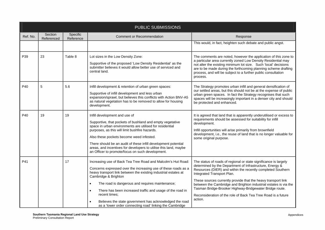
Appendices Southern Tasmania Regional Land Use StrategyPreliminary Consultation Report
PUBLIC SUBMISSIONS
Ref. No. Section
Referenced Specific
Reference Comment or Recommendation Response
This would, in fact, heighten such debate and public angst.
P39 23 Table 8 Lot sizes in the Low Density Zone:
Supportive of the proposed ‘Low Density Residential’ as the submitter believes it would allow better use of serviced and central land.
The comments are noted, however the application of this zone to a particular area currently zoned Low Density Residential may not alter the existing minimum lot size. Such ‘local’ decisions are to be made during the forthcoming planning scheme drafting process, and will be subject to a further public consultation process.
P40 5 5.6 Infill development & retention of urban green spaces:
Supportive of infill development and less urban expansion/sprawl, but believes this conflicts with Action BNV-A5 as natural vegetation has to be removed to allow for housing development.
The Strategy promotes urban infill and general densification of our settled areas, but this should not be at the expense of public urban green spaces. In fact the Strategy recognises that such spaces will be increasingly important in a denser city and should be protected and enhanced.
P40 19 19 Infill development and use of
Supportive, that pockets of bushland and empty vegetative space in urban environments are utilised for residential purposes, as this will limit bushfire hazards.
Also these pockets become weed infested.
There should be an audit of these infill development potential areas, and incentives for developers to utilise this land, maybe an Officer to promote/focus on such development.
It is agreed that land that is apparently underutilised or excess to requirements should be assessed for suitability for infill development.
Infill opportunities will arise primarily from brownfield development, i.e., the reuse of land that is no longer valuable for some original purpose.
P41 17 Increasing use of Back Tea Tree Road and Malcolm’s Hut Road:
Concerns expressed over the increasing use of these roads as a heavy transport link between the existing industrial estates at Cambridge & Brighton
The road is dangerous and requires maintenance;
There has been increased traffic and usage of the road in recent times;
Believes the state government has acknowledged the road as a ‘lower order connecting road’ linking the Cambridge
The status of roads of regional or state significance is largely determined by the Department of Infrastructure, Energy & Resources (DIER) and within the recently completed Southern Integrated Transport Plan.
These sources currently provide that the heavy transport link between the Cambridge and Brighton industrial estates is via the Tasman Bridge-Brooker Highway-Bridgewater Bridge route.
Reconsideration of the role of Back Tea Tree Road is a future action.

Appendices Southern Tasmania Regional Land Use StrategyPreliminary Consultation Report
PUBLIC SUBMISSIONS
Ref. No. Section
Referenced Specific
Reference Comment or Recommendation Response
Brighton areas and is to be upgraded into a major arterial road, forming part of the freight network.
The potential new/expanded industrial hub should not be considered until this road has been upgraded;
Also, an industrial hub would draw people out of the greater Hobart area.
Agreed that any consideration of a possible future industrial area at Tea Tree Road would need to consider Back Tea Tree Road.
P42 7 7 Supportive of coastal policies in general.
P42 18 Table 1 Classification of East Coast towns
Concerned that Bicheno and Swansea should each be elevated in the Activity Centres Hierarchy.
Neglects the Northern reaches of the Southern Area. The closest Rural Service Centre for Bicheno Residents is Sorell (2 hrs drive). Should consider Swansea.
Bicheno would be classed as ‘Neighbourhood or Town Centre’ under the strategy. Comparing ‘employment description’ with ‘Minor Centre’, a GP is not mentioned. Concerned that this may be taken away from Bicheno.
The comments are noted and will be given due regard in the redrafting of the Strategy. It is noted that the hierarchy must also correlate with the subregional strategy Vision East.
Appears to be some misunderstanding of general description in Activity Centre table as ‘Minor Centre’ includes GP services.
P43 Rezoning Type Request
Rezoning request: Snug area:
The submitters request a change in zoning for their land in the Snug area to make it possible to subdivide.
The intent of the Strategy is to provide overarching direction for the region. Except for regionally significant zoning issues, it will not specify intended future zoning of individual properties although it will provide the general principles under which such zoning decisions will be made during the drafting of the new planning schemes.
Property-specific zoning issues such as this will therefore be determined during the planning scheme drafting process.
The submitter is therefore advised to participate in the consultation process for the draft planning schemes, which will occur during the second half of 2011 and which will include draft zoning maps in which individual properties will be discernable.
In regard to the issue raised, however, it is noted that the Strategy recommends a moratorium on the expansion of the

Appendices Southern Tasmania Regional Land Use StrategyPreliminary Consultation Report
PUBLIC SUBMISSIONS
Ref. No. Section
Referenced Specific
Reference Comment or Recommendation Response
overall footprint of rural living (rural residential) land. Most current rural-zoned land will therefore remain so in the new planning schemes, and there will not be a substantial increase in the opportunities for rural residential subdivision.
P44 19 Map 9 Three requests for rezoning / amendments to the Urban Growth Boundary; Clarence area
Tollard Drive area.
Droughty Point and Clarendon Heights area
Area North of Ralphs Bay
The submitter advised that applications for the rezoning of three areas of land are well advanced, with a range of technical assessments having been undertaken. A significant case has been prepared to justify the rezoning. It is requested that the Urban Growth Boundary be amended to include the subject land areas.
The Urban Growth Boundary is being reviewed along with the creation of a new Background Report: Providing for Housing Needs. The information provided with the submission will be given due regard.
P45 General Comment
Upgrade of Cultural Values section:
Strongly supportive of the Strategy in general.
Would like to see further input from leading national professionals into the Strategy, especially in expert areas such as Heritage and Cultural Landscapes
General support noted.
Cultural Values section is being revised and expanded for the final document.
P45 19 19 Supportive of restriction of expanding rural residential land use.
Against further Rural Living Areas; as it is not sustainable (does not want to see mainland city type sprawl in Tas.)
The Strategy accords with this view.
P45 17 17 The Potential Industrial Expansion Area for Tea Tree:
Would encourage further urban sprawl
Damage to cultural and iconic landscape; effect on tourism attraction
Affect the Heritage properties in the area (Maiden Erleigh,
The areas marked on Map 6 as ‘potential’ industrial areas are explicitly not definitive and are “potential” only.
Greater Hobart is in danger of running out of useable industrial land in the coming years if not planned for now. Until this important regional issue is determined possible areas should be protected from being lost to some other form of development

Appendices Southern Tasmania Regional Land Use StrategyPreliminary Consultation Report
PUBLIC SUBMISSIONS
Ref. No. Section
Referenced Specific
Reference Comment or Recommendation Response
Stathallan, Woodlands)
Impact on threatened species known to area (see Heritage Management Plan for the Pontville Small Arms Range); 5 species listed nationally;
Aboriginal heritage/artefacts and relationships with plant life
Historic significance of the Pontville small arms Range
(such as rural-residential).
The Strategy is to be modified to reflect the fact that a specific Southern Tasmania Regional Industrial Land Study is now to be undertaken in 2011, (as per several of the Actions listed in 17.6). This study will identify and provide a comparative analysis of all potential industrial land areas in Southern Tasmania and enable a rational decision in terms of balancing the relative positives and negatives of each area. It is to be expected that no area will be without ‘negatives’. In this way the study will address the concerns raised and confirm where new industrial land is to be found in Southern Tasmania over the next 30 years. The maps in the Strategy will not include potential areas; however the Study will be completed in time for confirmed areas to be appropriately zoned in the new planning schemes. It is noted that the draft planning schemes will be subject to a further public consultation process.
P45 14 14 Heritage & tourism:
Should be better incorporation of Cultural Heritage Values into tourism
Would like to see a financial comparison between the forest industry and the tourism industry
Better international marketing of Tasmanian tourism attractions
Cultural Values section is being revised which should address many of the points raised. However it is noted that some points are considered outside scope of project, such as tourism marketing.
P45 21 21 Priority Actions:
MRH-A11: Change priority to High
MRH-A12: Make High. Better monitoring of ground water irrigation to prevent brackish water
CV-A1: Make High. Also reference in Planning Scheme
CV-A5: Make High. Implement THC recommendations
The suggested changes to the Action priorities will be considered. It is noted that, for the final document, implementation will be separated from the policy / strategy section as it is considered inappropriate for an action plan to go forward into a statutory regional strategy document.
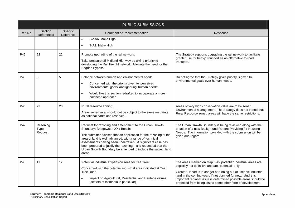
Appendices Southern Tasmania Regional Land Use StrategyPreliminary Consultation Report
PUBLIC SUBMISSIONS
Ref. No. Section
Referenced Specific
Reference Comment or Recommendation Response
CV-A6: Make High.
T-A1: Make High
P45 22 22 Promote upgrading of the rail network:
Take pressure off Midland Highway by giving priority to developing the Rail Freight network. Alleviate the need for the Bagdad Bypass.
The Strategy supports upgrading the rail network to facilitate greater use for heavy transport as an alternative to road transport.
P46 5 5 Balance between human and environmental needs.
Concerned with the priority given to ‘perceived environmental goals’ and ignoring ‘human needs’.
Would like this section redrafted to incorporate a more balanced approach
Do not agree that the Strategy gives priority is given to environmental goals over human needs.
P46 23 23 Rural resource zoning:
Areas zoned rural should not be subject to the same restraints as national parks and reserves.
Areas of very high conservation value are to be zoned Environmental Management. The Strategy does not intend that Rural Resource zoned areas will have the same restrictions.
P47 Rezoning Type Request
Request for rezoning and amendment to the Urban Growth Boundary; Bridgewater /Old Beach:
The submitter advised that an application for the rezoning of the area of land is well advanced, with a range of technical assessments having been undertaken. A significant case has been prepared to justify the rezoning. It is requested that the Urban Growth Boundary be amended to include the subject land areas.
The Urban Growth Boundary is being reviewed along with the creation of a new Background Report: Providing for Housing Needs. The information provided with the submission will be given due regard.
P48 17 17 Potential Industrial Expansion Area for Tea Tree:
Concerned with the potential industrial area indicated at Tea Tree Road.
Impact on Agricultural, Residential and Heritage values (settlers of tasmania in particular)
The areas marked on Map 6 as ‘potential’ industrial areas are explicitly not definitive and are “potential” only.
Greater Hobart is in danger of running out of useable industrial land in the coming years if not planned for now. Until this important regional issue is determined possible areas should be protected from being lost to some other form of development

Appendices Southern Tasmania Regional Land Use StrategyPreliminary Consultation Report
PUBLIC SUBMISSIONS
Ref. No. Section
Referenced Specific
Reference Comment or Recommendation Response
Will support the Strategy if it respects the long-time users and residents of the land
Contravenes the existing planning arrangement of the area
Would also encourage urban sprawl
Withdraw the proposal from the plan
(such as rural-residential).
The Strategy is to be modified to reflect the fact that a specific Southern Tasmania Regional Industrial Land Study is now to be undertaken in 2011, (as per several of the Actions listed in 17.6). This study will identify and provide a comparative analysis of all potential industrial land areas in Southern Tasmania and enable a rational decision in terms of balancing the relative positives and negatives of each area. It is to be expected that no area will be without ‘negatives’. In this way the study will address the concerns raised and confirm where new industrial land is to be found in Southern Tasmania over the next 30 years. The maps in the Strategy will not include potential areas; however the Study will be completed in time for confirmed areas to be appropriately zoned in the new planning schemes. It is noted that the draft planning schemes will be subject to a further public consultation process.
P49 19 19 Request for rezoning and amendment to the Urban Growth Boundary; Howrah area:
The submitter advised that an application for the rezoning of the area of land is well advanced, with a range of technical assessments having been undertaken. A significant case has been prepared to justify the rezoning. It is requested that the Urban Growth Boundary be amended to include the subject land areas:
The Urban Growth Boundary is being reviewed along with the creation of a new Background Report: Providing for Housing Needs. The information provided with the submission will be given due regard.
P50 General Comment
Loss of viable farms in the Kingborough area:
The submission details the loss of dairy farms in the Kingston area over the last 40 years to residential sprawl and highlights the importance of retaining agricultural land. It considers that the Strategy will allow this to continue and that much of the valuable farming land in the South will be consumed under urban development.
Forestry: outside the Resource Management & Planning System
Concerned that most forestry remains outside the Resource
The submission constitutes a significant misinterpretation of the Strategy.
The Strategy strongly protects significant agricultural land from conversion to other uses and from fettering by encroaching residential uses, in accordance with the Protection of Agricultural Land State Policy. The final Strategy document will also benefit from more accurate spatial land capability information that has only recently become available to the project.
The Strategy also encourages better use of our existing settled areas through densification over their expansion through urban

Appendices Southern Tasmania Regional Land Use StrategyPreliminary Consultation Report
PUBLIC SUBMISSIONS
Ref. No. Section
Referenced Specific
Reference Comment or Recommendation Response
Management & Planning System
sprawl, for a large range of sustainability reasons.
It is not within the Project’s scope to alter the separation of forestry from the land use planning system in Tasmania. This is a matter for State Parliament.
P51 General Comment
Rezoning request: Huon area:
The submitter requests rezoning of land to enable rural residential subdivision.
The submitter also raises the problem of farmers becoming restricted in their activities by encroaching residential land use.
The intent of the Strategy is to provide overarching direction for the region. Except for regionally significant zoning issues, it will not specify intended future zoning of individual properties although it will provide the general principles under which such zoning decisions will be made during the drafting of the new planning schemes.
Property-specific zoning issues such as this will therefore be determined during the planning scheme drafting process.
The submitter is therefore advised to participate in the consultation process for the draft planning schemes, which will occur during the second half of 2011 and which will include draft zoning maps in which individual properties will be discernable.
In regard to the issue raised, however, it is noted that the Strategy recommends a moratorium on the expansion of the overall footprint of rural living (rural residential) land. Most current rural-zoned land will therefore remain so in the new planning schemes, and there will not be a substantial increase in the opportunities for rural residential subdivision.
The Strategy strongly protects significant agricultural land from conversion to other uses and from fettering by encroaching residential uses
P52 Howden Community
Further subdivision concerns: Howden area
The submitters express concern over the possibility of further subdivision and development (housing) in for the Howden area:
Lack of infrastructure
Want to retain natural values on bigger lots
Good conservation area around Kingston and Blackmans
The concerns are noted.
The Strategy recommends a moratorium on the expansion of the overall footprint of rural living (rural residential) land. Most current rural-zoned land will therefore remain so in the new planning schemes, and there will not be a substantial increase in the opportunities for rural residential subdivision.

Appendices Southern Tasmania Regional Land Use StrategyPreliminary Consultation Report
PUBLIC SUBMISSIONS
Ref. No. Section
Referenced Specific
Reference Comment or Recommendation Response
Bay
Further development would be incompatible with the Review of the Kingborough Planning Scheme 2000 ‘Howden natural area not to be like Kingston etc.’
P53 5 5.6 Biodiversity & natural values:
BNV-A10 ‘Finance: Where is money coming from?’
BNV-A1 ‘no account of small holdings being cleared for a single dwelling. Issue with conversion of native forest to plantation ‘private forestry’
The Strategy cannot identify the source of all funds for all proposed Actions.
It is not within the Project’s scope to alter the separation of forestry from the land use planning system in Tasmania. This is a matter for State Parliament.
P53 5 5.5 BNV-P3 Not good enough Noted.
P53 6 6.5 Wr-P5 should take into account ‘ground water base flows’ to river systems
WR-P9 requires research on ground water resources
Comments noted. Strategy to be reviewed.
P53 6 6.6 WR-A10 better manage storm water on forestry plantations The majority of forestry activity is outside the scope of the project.
P53 16 16 Less subdivision of agricultural land. Problem with conversion of agricultural land to plantations. Irrigation schemes ‘can be disastrous in semi-arid areas’
‘Sustainable Forestry Industry is an oxymoron if it is plantation based.’
The Strategy strongly protects significant agricultural land from conversion to other uses and from fettering by encroaching residential uses, in accordance with the Protection of Agricultural Land State Policy. The final Strategy document will also benefit from more accurate spatial land capability information that has only recently become available to the project.
It is noted that proposals for irrigation schemes must now demonstrate that salinity issues have been adequately addressed.
Not agreed that plantation forestry cannot be undertaken in a sustainable way.

Appendices Southern Tasmania Regional Land Use StrategyPreliminary Consultation Report
PUBLIC SUBMISSIONS
Ref. No. Section
Referenced Specific
Reference Comment or Recommendation Response
P53 General Comment
Marine farming:
Better control of nutrients from fish farms on native fish.
Marine farming is outside the jurisdiction of the planning system and therefore outside the project scope.
P54 General Comment
Rural landscapes:
Building materials and design in rural areas and high vegetation or natural areas is impacting on the overall landscape amenity of the region or area. Would like to see stricter regulations in regard to buildings blending into their surroundings.
Comments noted. Appropriate provisions can be included in the new planning schemes where considered necessary.
P55 19 19 Development issues in the Channel area:
Strongly in support of no ‘ribbon development’ between the townships along the D’Entrecasteaux and keeping residential development in close to existing townships.
In favour of Kettering as ‘low growth’ scenario.
Maximise the tourist and natural attractions of the D’Entrecasteaux
The Strategy would appear to support the views expressed.
P56 Rezoning Type Request
Rezoning request: Geeveston area:
Would like to subdivide land and requests water and sewerage infrastructure for the property.)
The intent of the Strategy is to provide overarching direction for the region. Except for regionally significant zoning issues, it will not specify intended future zoning of individual properties although it will provide the general principles under which such zoning decisions will be made during the drafting of the new planning schemes.
Property-specific zoning issues such as this will therefore be determined during the planning scheme drafting process.
The submitter is therefore advised to participate in the consultation process for the draft planning schemes, which will occur during the second half of 2011 and which will include draft zoning maps in which individual properties will be discernable.
P57 16 16 Rural issues / Rezoning request: Channel Area. The intent of the Strategy is to provide overarching direction for the region. Except for regionally significant zoning issues, it will

Appendices Southern Tasmania Regional Land Use StrategyPreliminary Consultation Report
PUBLIC SUBMISSIONS
Ref. No. Section
Referenced Specific
Reference Comment or Recommendation Response
Agriculture is becoming less mono-crop based, and therefore ‘primary production’ is not sustainable.
Better attenuation zones around agricultural operations.
In favour of ‘lifestyle rural zones.
Request ability to subdivide land for rural residential purposes.
not specify intended future zoning of individual properties although it will provide the general principles under which such zoning decisions will be made during the drafting of the new planning schemes.
Property-specific zoning issues such as this will therefore be determined during the planning scheme drafting process.
The submitter is therefore advised to participate in the consultation process for the draft planning schemes, which will occur during the second half of 2011 and which will include draft zoning maps in which individual properties will be discernable.
In regard to the issue raised, however, it is noted that the Strategy recommends a moratorium on the expansion of the overall footprint of rural living (rural residential) land. Most current rural-zoned land will therefore remain so in the new planning schemes, and there will not be a substantial increase in the opportunities for rural residential subdivision.
P58 23 23 Rural subdivision issues: Huon area:
Supports majority of document.
Would like to see greater detail how these decisions will impact on our lives in the future.
What’s the minimum lot size for significant agriculture?
What about mixed land uses, lifestyle, income supplement type thing?
The Strategy aims to protect and retain significant agricultural land for agricultural purposes.
The intent of the Strategy is to provide overarching direction for the region. Except for regionally significant zoning issues, it will not specify intended future zoning of individual properties although it will provide the general principles under which such zoning decisions will be made during the drafting of the new planning schemes.
The submitter is therefore advised to participate in the consultation process for the draft planning schemes, which will occur during the second half of 2011 and which will include draft zoning maps in which individual properties will be discernable.
The Rural Living zone and the Rural Resource zone will both support mixed land uses.

Appendices Southern Tasmania Regional Land Use StrategyPreliminary Consultation Report
PUBLIC SUBMISSIONS
Ref. No. Section
Referenced Specific
Reference Comment or Recommendation Response
P59 23 23 Rural subdivision issues: Huon area:
Concerns that a reduction in minimum lot sizes will negatively impact on exiting lifestyle.
The Strategy recommends a moratorium on the expansion of the overall footprint of rural living (rural residential) land. Most current rural-zoned land will therefore remain so in the new planning schemes, and there will not be a substantial increase in the opportunities for rural residential subdivision.
P60 7 7.5 Canal estates:
In favour of no canal estates
The support for the proposed ban on canal estates within the Strategy is noted.
P60 19 19 Urban infill development concerns:
Infill housing and higher density living will result in less urban landscaping and greenery (less trees etc. in favour of fashionable low maintenance pebble and grass gardens). Spoils the created amenity of larger blocks and suburbs.
Concern that developers will buy up blocks containing vegetation for subdivision as they can no longer subdivide rural type land.
Why is the Strategy preventing the subdivision of land that is never going to be agriculturally viable; these areas allow for a healthy urban family lifestyle?
The Strategy promotes urban infill and general densification of our settled areas, but this should not be at the expense of public urban green spaces. In fact the Strategy recognises that such spaces will be increasingly important in a denser city and should be protected and enhanced.
The strategy protects significant agricultural land and promotes an ordered expansion of the urban area through the establishment of an Urban Growth Boundary.
P60 18 18 Activity Centres – Public Transport:
Is it realistic that the activity centres will contain all the needs of families and be conveniently accessible through public transport?
The purpose of the proposed Activity Centre network is to ensure that the largest proportion of the community possible has reasonable access to the services they need.
P61 19 19 In strong support of low growth for Franklin Support for this action is noted.
P61 16 16.6 In strong support of PR-A8.
Concerned that a draft planning scheme for the Huon Valley is conflicting with the Strategy; in that some rural land could be zoned into residential. Does the STCA have the authority to
As the Strategy will be declared a Statutory instrument under Section 30C of the Land Use Planning and Approvals Act 1993 any new planning scheme will need to be consistent with the Strategy. This said, the project is aware of the contents of the draft Huon Valley Planning Scheme and is satisfied that it is

Appendices Southern Tasmania Regional Land Use StrategyPreliminary Consultation Report
PUBLIC SUBMISSIONS
Ref. No. Section
Referenced Specific
Reference Comment or Recommendation Response
guide HVC to follow the principles of the Strategy?
There is also potential conflict with the creation of a Heritage Precinct for Franklin; how does the Strategy protect the character of the township and others?
generally consistent with the draft Regional Land Use Strategy
With regards to character and heritage protection, the Cultural Values section is being revised in the Strategy; however the identification of heritage areas will still be done at a local level and incorporated into the new planning schemes as local provisions.
P62 19 19 Land at Granton
Family subdivided land into 20 2.5-acre blocks, which are not selling, and cannot reduce lot size further to satisfy market demands. Believe the currently divided minimum lots are too big for the market; concerned that so many people are moving to Brighton instead of Glenorchy (and its services). [submission has map attached]
The land at Granton has been identified as a residential growth corridor. This is however longer term as some water and sewerage constraints for the broader area need to be addressed first. Notwithstanding this some existing areas around Black Snake Lane are serviced and the timing of densification around this area is being examined in the revision of the residential strategy maps in conjunction with Glenorchy Council.
P63 23 23 Would like to see the shooting range included in the ‘Recreation Zone’ rather than the current ‘Landscape and Conservation’ zone.
This request has been noted.
Property-specific zoning issues such as this will therefore be determined during the planning scheme drafting process.
The submitter is therefore advised to participate in the consultation process for the draft planning schemes, which will occur during the second half of 2011 and which will include draft zoning maps in which individual properties will be discernable.
P64 Rezoning Type Request
19 Land holdings in Lauderdale
Rezoning request for high density subdivision and commercial zone for a supermarket [see submission for argument and mapping]
As this land is within the Greater Hobart area and affected by the Urban Growth Boundary the request is being evaluated as part of the revision of the residential strategy maps.
P65 Rezoning Type Request
18 Brighton area. Proposal for a Highway services precinct & large floor area retailing adjacent to bypass
STCA should favour Brighton and Bridgewater area for a commercial precinct for ‘Commercial Projects of Regional Significance’.
Would also be satisfied if such development were made
The scale of the proposal suggests that it is larger than just a local shopping centre and therefore affected by the Activity Centre hierarchy. The hierarchy identifies Cambridge Park as the regional location for that form of specialised activity centre and specifically suggests that further activity centres of this nature should be avoided.
Following consideration of the evidence submitted with the

Appendices Southern Tasmania Regional Land Use StrategyPreliminary Consultation Report
PUBLIC SUBMISSIONS
Ref. No. Section
Referenced Specific
Reference Comment or Recommendation Response
‘Discretionary’ rather than complete rezoning. [see submission for argument and mapping]
submissions it is suggested that such a proposal is more appropriately evaluated as a site specific proposal (potentially as a project of regional significance) following more detailed considerations of access, heritage, infrastructure to name a few. The site itself is in a sensitive location.
The proposal for a highway services precinct is more local scale and should be primarily guided by the Brighton Structure Plan.
P66 Rezoning Type Request
18 Land at Southern Entrance to Oatlands:
Proposal for high-density 55-lot subdivision in 5 stages. Confidential
[See submission for further argument and mapping]
This matter is for local determination by Southern Midlands Councils guided by the growth scenario for Oatlands in the Regional Land Use Strategy.
P67 Rezoning Type Request
19 Dylan St Brighton:
Signed petition from 17 residents that would like to see the follow through of the Brighton Aurecon Structure plan (to immediately change zoning to residential)
Currently Rural Residential.
Is being considered as part of revision of Greater Hobart settlement strategy map
P68 19 19 Concern that the proposed land release areas are not supported by adequate analysis and research in regard to spatial values and overall landscape topography and landscape characteristics. ‘The Droughty point land release proposal is a case in point’.
The cultural values section of the Strategy is being revised and will include greater discussion on landscape values. The maps have been informed by currently landscape values around Southern Tasmania which is strongly defined preservation of skylines, hilltops and prominent landscape features (such as points). However Droughty Point is a unique point. The expectation of opening up the land along Droughty Point is well established and is already recognised by the current Clarence Planning Scheme and other strategic documents including the Southern Integrated Transport Plan. To take away established rights would create a procedural unfairness. The revised Strategy will however be discouraging the development of key areas of landscape importance into the future.
P69 2 2 Changes to transport and affordable housing are essential, but the gains should be equitably spread throughout the community.
Noted.

Appendices Southern Tasmania Regional Land Use StrategyPreliminary Consultation Report
PUBLIC SUBMISSIONS
Ref. No. Section
Referenced Specific
Reference Comment or Recommendation Response
Population growth at 0.9% pa is low. With an ageing population it might even slow further. The projected 80,000 people by 2035 stretched the bounds of credibility. Where will they all come from? But for the sake of these comments, those figures are accepted. Fewer people per household looks set to continue, but it is an inefficient use of land, housing and energy. It should not be encouraged. Greater Hobart is already one of the least densely settled cities in Australia.
The population growth figures are from the moderate growth scenarios prepared by the ABS. The Strategy acknowledged that population projections are subject to significant variables and as a result need to be constantly monitored.
In terms of decreasing household size, it is important that this is recognised as different from dwelling density. There is little than anyone can do to force more people to live in a single household. Households are determined by family structures and this is what is changing.
Trying to promote greater density is different and can be achieved by promoting smaller dwelling sizes and in closer proximity to each other.
P69 12 12 “A number of funding and charging mechanisms are used to finance infrastructure”….and are applied in an ad hoc manner. Taxes on water and development charges are offered as solutions. No, they are the problem! Infrastructure adds value to land. Lands owners benefit, while tenants and other non-owners are left behind. That is clearly inequitable. We should capture some of the value we create in land to pay for the services that make it. That is equitable…please rethink this section
This section provides a discussion of the current situation at the moment and specifically says that the current arrangements are problematic. In terms of land use planning the key policy is that there is coordination across the two. The actual setting of charges and taxes is something outside the scope of the project. There are a range of other reviews or processes that evaluated this issue, including review of Local Government rating systems, taxation review and the setting of guidelines by the Economic Regulator, all of which are through the State Government.
P69 13 13 The proposed ways of moving commuters are quaint…bicycles, trams and ferries have all been tried and discarded in favour of personal mobility. That’s what people want, yet planner still insist on some romantic dream of past glories. But they don’t travel on public transport…it is a horrible experience….trams and ferries, shared with drunks and nutters, then alighting at scary interchanges is not the way to go. Forget it.
The Strategy recognises that public transport is not going to suit all people, but nearly 100% reliance upon private car travel for everyone’s transport needs is not sustainable in the long term. Public transport does not need to be an unpleasant experience and there are lots of cities in the world where public transport is used on a day to day basis. This comment is not supported.
P69 13 13.6 Alterations to land zoning in proximity to public transport/transport corridors need to be equitable to the community. Those fortunate enough to own land in these locations are set to make a lot of money.
The planning system in Tasmania is specifically designed to avoid issues of betterment and/or compensation unlike other planning systems in Australia.

Appendices Southern Tasmania Regional Land Use StrategyPreliminary Consultation Report
PUBLIC SUBMISSIONS
Ref. No. Section
Referenced Specific
Reference Comment or Recommendation Response
P69 15 15 The waterfront gets the most visitors in Tasmania. That is hardly surprising. It has natural beauty, interesting streetscape and a cultural mix all provided at the public expense. The people are entitled to a return on their investment. Charge a proper rent for the use of all public space there.
This concern is noted but is considered outside the scope of the project. Notwithstanding this it is important to recognise that increased economic development and investment by individual business does actually return to the whole community in Tasmania. The wealth from these businesses does directly and indirectly contribute to the State’s budget which in term finances many other social and community services.
P69 18 18.7 Supportive of Activity Centres as more than just retail precincts. In open spaces and meeting areas
Noted.
P69 19 19 Concern that only 2nd and 3rd home owners can afford to buy city dwellings and land; first home buyers often have no choice but to buy rural land for housing.
The concern is acknowledged and the revision of the residential section is aimed at ensuring that a sufficient supply of affordable housing will be provided for.
P69 19 19 Tax and Rates raised from land usage in certain areas should be used to better services to these areas and that would plateau land and housing prices.
Noted, but is considered outside the scope of the project.
P69 20 20 The provision of infrastructure is a community activity. We have allowed developers to take it over, by default, but the incentive is for a developer to provide the bare minimum, and to reduce costs as much as possible. The results are plain to see. Developments are ordinary, if not awful. But it is possible to have the best. If we collect land rent, then we will have plenty of money to install the services we want. Landlords would rent their house on the basis of their amenity and presentation. No slum landlords would last a minute. Rent could not rise, due to competition.
The provision and cost of infrastructure is an exceptionally complex matter outside of the scope of this project. It is recognised that it is a matter worthy of detailed consideration.
P69 22 22 “The role of government in providing for infrastructure is to ensure strategic direction for infrastructure provisions and the program of prioritisation.”…this is not enough. Governments have no other role than to guarantee the rights of the people. The primary right is to the right to natural resources – air, water, land. Infrastructure is a nice add-on as is health, education etc…while we price land out of the reach of some people, we
This section in the Strategy is not intended to imply that Government does have other responsibilities. It is specifically related to the provision of infrastructure.

Appendices Southern Tasmania Regional Land Use StrategyPreliminary Consultation Report
PUBLIC SUBMISSIONS
Ref. No. Section
Referenced Specific
Reference Comment or Recommendation Response
cannot have a fair society – one of equal rights.
P69 22 22 Housing initiatives abound, but there is no will to try something new…there are 3170 people on Housing Tasmania wait list; that number is testament to an inability of the existing ideas to fulfil their charter.
There is a significant task ahead in terms of providing social housing, however beyond its relationship to the land use planning system, the way that this need is addressed is considered outside the scope of the planning system.
P69 General Comment
‘Greatest compliment I can make is that you have produced a readable document’
Noted and thank you!
P70 19 19 One of the key outcomes of the Strategy is the need to encourage densification in appropriate locations where there is ready access to services and transport. It is agreed that this course in necessary to ensure the sustainability of Greater Hobart and the economic delivery of transport and services and that in order to encourage densification in urban residential areas there will be some need to control fringe expansion at very low densities which would provide the market with low cost residential land in comparison to the development or redevelopment of appropriate urban land.
The Strategy appears aligned with these comments; although in the revised Strategy there will be greater emphasis on achieving densification through incentives rather than strict control of greenfield land as a supply of Affordable Housing needs to be assured.
P70 19 19 The aim to provide greater housing choice to match population needs into the future should also recognise the need to provide for lifestyle choice by providing a reasonable degree of rural residential living alternatives which will not supply become a default destination for people looking for affordable residential land. Providing some rural residential expansion should also avoid development pressure moving to rural and agricultural properties from buyers who want rural residential style living but would not be interest in or capable of maintaining active production on larger parcels.
The Strategy maintains the positive that there is adequate supply of rural residential land for the short terms (i.e. this iteration). A review of this is recommended as part of the ‘Housekeeping Review’ recommended in the new Implementation document.
This restriction on further expansion of the rural residential footprint also needs to be balanced by the inclusions of the new ‘Environmental Living’ areas that will meet the demand for those seeking a tree-change but in a manner that reduces environmental impacts. Many of these opportunities will be in commuter distance to main employment areas.
P70 19 19 It would seem logical that lots which are created at densities of 200 square metres to 1 hectare particularly if they are provided with services, are much more likely to become disincentives for urban residential densification than true rural residential style
The ‘very low density’ category in Table 3 is actually not carried through to any specific zoning. The revised version of the Strategy will remove this category and maintain that rural residential lots are generally between 0.5 to 2 hectares in area.

Appendices Southern Tasmania Regional Land Use StrategyPreliminary Consultation Report
PUBLIC SUBMISSIONS
Ref. No. Section
Referenced Specific
Reference Comment or Recommendation Response
lots where average lot sizes are more likely to be 1-2 ha and where service provision is not available or limited...It therefore seem important to provide a clear separation between serviced residential development at various densities and rural residential living where there should be significantly less expectation of service provision and if it can be made clear through strategies and planning schemes that rural living is a different style of life aimed at being more self-sufficient it would appear likely that rural residential land would receive less development pressure as cheap residential land but rather be seen as the alternate lifestyle choice it should be.
This is then reflected in the model scheme provisions in the new Implementation document.
Notwithstanding the arguments in these comments, rural residential subdivision also creates issues in terms of inefficient land use, environmental impacts and fettering of agricultural potential than need to be managed.
P70 19 19 The Draft Strategy rightly prioritising the need for proper environmental evaluation to form part of the assessment of areas proposed to be subdivided or development and these criteria should be embedded within planning schemes so that adequate assessment can be made at the appropriate time.
It would, of course, be most appropriate if detailed investigation of land constraints were done prior to areas being zoned by planning schemes or flagged by land use strategies in being the appropriate location for future development. However, while individual, developer drive scheme amendments are sometimes viewed negatively as being beyond or outside broader strategies, they are required to be based on detailed site analysis and assessment which can go beyond the level of detail usually achieved by other broader strategies which can sometimes earmark areas as being suitable for future growth with no detailed site assessment.
The areas identified in the revised Strategy growth in the immediate to short term all have had some level of investigation undertaken which supports is release.
Nonetheless, the revised Strategy will clearly outline in the new Implementation document, that when new information or conditions come to light in advance of Strategy review processes then these can be evaluated through a planning scheme amendment process.
P70 Rezoning Type Request
19 Mt Rumney/Mangalore, Honeywood area:
Rezoning requests…applications submitted to relevant Councils.
These are all lower density/rural residential type areas. As such this level of detail is considered too localised for the Regional Strategy to directly address in the spatial strategies, but rather should be considered by individual Councils in the preparation of draft planning schemes in accordance with the general policies of the Strategy.
P71 Rezoning Type
19 Old Beach area
Quarry in area is reaching the end of its life and residents of
To be taken into account in revision of Greater Hobart Residential Strategy.

Appendices Southern Tasmania Regional Land Use StrategyPreliminary Consultation Report
PUBLIC SUBMISSIONS
Ref. No. Section
Referenced Specific
Reference Comment or Recommendation Response
Request area are looking to rezone according (to rehabilitate site and then subdivide). Development of this land would be consistent with Brighton Structure plan. [see submission for mapping and further detail]
P72 Rezoning Type Request
19 Tranmere area
Have submitted a 43A to Council for a 142 lot subdivision.
Believes map 3 has zoned this area as ‘potential agricultural land’, but it conflicts with current settlement strategy and planning scheme, and that land is low quality.
No potential agricultural land for this area on map 3
Zoned for immediate residential land release
Expand the urban growth boundary
Is being considered as part of revision of Greater Hobart settlement strategy map
P73 General Comment
Separate legislation that controls water quality and aquaculture is an issue for the Strategy to address. Fish farms also affect land use
The Strategy as part of a State and Local Government initiative has to work with current legislative context in regarding to marine farming (and forestry).
P74 Rezoning Type Request
Rokeby area.
43A application for a large subdivision submitted to Clarence Council.
Will inject 500 million dollars into the local economy
English language school for uni students and professionals etc.
Lengthy arguments as to why this development fits in with Strategy direction.
Area falls into the ‘medium to long term’ investigation area.
(Much more detail in submission, plans, argument, analysis etc.)
Is being considered as part of revision of Greater Hobart settlement strategy map
P76 General Poor timing for report over the busy nov/dec. period. The public consultation period was timed so that it finished 3 ½ weeks in advance of Christmas. The only other option was

Appendices Southern Tasmania Regional Land Use StrategyPreliminary Consultation Report
PUBLIC SUBMISSIONS
Ref. No. Section
Referenced Specific
Reference Comment or Recommendation Response
Comment Concerned that values are sometimes referred to as constraints
Strategy is too fixated on urban development
delaying the consultation period until a February commencement which would have resulted in significant issues in terms of the project’s timeframe and budget. In ideal circumstances different timing may have occurred.
The Strategy refers to at times ‘values and constraints’ but without greater detail not sure as to when a value is considered a constraint.
In terms of the Strategy’s fixation on urban development, this is because it is one of the most intense forms of land use and the Greater Hobart area has a significant impact upon the whole region.
P76 1 1 Regional Vision statement too long and over emphasises development opportunities; should read ‘Southern Tasmania; a vibrant and attractive region providing sustainable lifestyles’.
Figure 1 and 2 need expanding with better explanation of the role and rigour of the processes (in that they can be quite slow).
No other submissions raised concern with the vision statement. It is based upon existing vision statements prepared by Local Councils and other organisation through a consultative process.
Figures 1 and 2 are intended to set the context. Explaining the role and rigour of the processes is not considered to be something that will value add to the Strategy document. Notwithstanding this it should be noted that figures 1 and 2 in the revised Strategy have been changed.
P76 4 4 Too much rhetoric in the language, e.g. ‘Increasing responsiveness’ in regard to natural values and resources.
SD1 – ‘more integrated’ should include a five year time frame
SD7 – Better consideration of assessing biodiversity and natural resource assets at a local level (not just state and federal legislation)
Disputes that there isn’t plenty of spatial information in regard to natural value planning.
Specific biodiversity values should be depicted to support SD7. The reference to “avoidance will not always be possible” may be so in specific instances but it is not matched with any equally firm comments about there being areas that are not negotiable for change to urban development…and how does the rhetoric demonstrate the sustainable future that is mooted in the vision.
Five year timeframe included
SD7 does not exclude ‘local’ as it is currently worded.
While there is plenty of spatial information it was not designed to be used as a decision making tool and therefore there are some inherent issues with its quality. However it proposed to use what currently exists in the meantime with planning schemes also utilising alternatives ways to protect natural values.
In the revised Strategy the areas identified for urban expansions have avoided high priority vegetation as far as the knowledge exists. Agree that there needs to be firm instances about when urban development is not suitable. The starting point for this is threatened vegetation communities.
Disagree that SD 2, 3 & 4 are the same.
Agree with SD8 changes as this is specifically about those parts

Appendices Southern Tasmania Regional Land Use StrategyPreliminary Consultation Report
PUBLIC SUBMISSIONS
Ref. No. Section
Referenced Specific
Reference Comment or Recommendation Response
Believes that SD 2,3 and 4 be merged as they are basically the same and overemphasise this dimension
SD8 should incorporate a ‘whole of water cycle’ management approach – this includes all cycles of water and water usage and re-use.
of the water management processes which either interact with the planning system or can be impacted upon by land use and development.
P76 5 5.5 BNV-A1 “to refer to both spatial data and expert input derived Regional Biodiversity Values rather than the much more limited scope of ‘vegetation communities and threatened species’. Also remove the term ‘as far as practical’; this statement of deliberate inequity is unacceptable and inconsistent with vision SD7 and the Biodiversity DRO”
BNV-A2 – to change to refer to the protection of key regional biodiversity values (derived prior to the finalisation of this Strategy). In addition, that any values so identified are to be protected through the development process and that protection demonstrated through formal approved biodiversity protection and rehabilitation plans and obligatory bonding arrangements with the developer.
BNV-A10 needs to state what exactly are natural biodiversity values and should not delay action in regard to protecting them.
BNV-A12 Weed management needs to be dealt with at point of sale, to ensure land holders are taking action. Not to wait until a DA is enacted
A standard local approach needs to be developed for assessing local natural resource issues
For BNV1 term ‘as far as practicable’ recognises that we will not be available to avoid residential growth in some areas which contain native vegetation. Notwithstanding this the policy has been re-worded in the revised Strategy.
For BNV-A2 it is unfortunately not possible to analyse those values now due to budget and timing constraints for the project. The project clearly recognises that this Strategy if a first iteration only. However the policies (taking into account that actions have now been removed to the Implementation document) will be reworded to try and address these concerns.
Unsure of concern with BNV-10 since this actually takes about a review of legislation.
Do not disagree with comments on BNV12 however this is considered outside the scope of the project and more appropriately addressed through other projects such as the Southern Tasmania Weed Management Strategy.
Agree with last dot point and this is the intention of the Strategy. Will better articulate in the relevant policies.
P76 6 6 Rename this section the ‘Water Cycle’ and include direct reference to flooding and risk management. Also make mention of climatic changes to storm water.
The water resources section is specifically taking about water as a resource not whole of water cycle management which is largely a natural resource management issues outside the planning system. Issues of flooding and risk management are dealt with under risks and hazard as our risks arising from climate change.
P76 20 20.2.1 The view that regulatory mechanisms have limited ability to deliver real change is of concern. On what basis then can the
Misunderstanding of Section 20.2.1. The Draft Strategy was just highlighting the limitations of planning schemes in achieving real

Appendices Southern Tasmania Regional Land Use StrategyPreliminary Consultation Report
PUBLIC SUBMISSIONS
Ref. No. Section
Referenced Specific
Reference Comment or Recommendation Response
Regional visions, policies and actions anticipated be achieved? on ground change. The new implementation document will however provide better linkages about how the Strategy will be achieved and competing interests balanced.
P76 20 20.3.1 Comprehensive detail needed on the monitoring, reporting and improvement processes.
Some additional detail on this is being included in the new Implementation document, however in the absence of an ongoing governance model (to be determined by State Government) only such much detail can be provided.
P76 21 21 Tie in the time frame for high, medium and low priorities.
Not to separate infrastructure actions as they should be integrated and consistent with SD 1
Prioritisation of implementation actions will be improved. Separation of infrastructure actions into the Infrastructure Investment Plan is required by the Memorandum of Understanding establishing the project.
P76 22 22 This section should be integrated into section 21 and include maps and supporting text evidence to demonstrate the integration that has occurred.
As per above. Should also recognised that the Infrastructure Investment Plan is embryonic only.
P76 23 23 The minimum lot size for rural living should better reflect the modern view of living area needed to produce the majority of own food and lives sustainably and not further fragment agricultural land.
Better and broader range of permitted uses in the rural lifestyle zone to allow for mixed development and tourism ventures.
Also traditional ideas of the rural residence and its inefficiency have been applied, when modern views and practices in regard to water use and self-sustainability are becoming more common practice.
While it is understandable than many people seek low density areas for lifestyle reasons, the use of land for residential purposes at these densities for a greater % of the population is considered unsustainable not only for environmental reasons but other economic and social reasons.
If everyone in Tasmania lived at lower density and were self-sustainable, we would not be generating any economic wealth for the broader community that assist that less advantaged or in need for other reasons.
It should also be recognised that the new planning schemes as highlighted in The Zoning Framework in the draft Strategy will include a new Environmental Living zone. The existence of this type of ‘living’ opportunity at the lower densities (around the 8ha) mark that the submitter is suggesting will be better articulated in the revised Strategy and in particular Table 3: Density guidelines.
It will also be evident in the new Implementation document that a range of small scale uses complementary to rural residential

Appendices Southern Tasmania Regional Land Use StrategyPreliminary Consultation Report
PUBLIC SUBMISSIONS
Ref. No. Section
Referenced Specific
Reference Comment or Recommendation Response
living will be able to be considered.
P77 23 23 Concerned that limiting future agricultural land could increase future rates as road and infrastructure maintenance costs are spread across less people.
Proving that there is a viable farm may be hard. One of our neighbours informed us that a similar situation is occurring in Holland and as a result on the rich can live on rural land.
Rating concerns are considered outside scope of the project.
It is however proposed to eliminate of use of farm management plans as a development control tool. However this is mainly due of the ease with which such mechanisms can be used as a loophole to effectively create rural residential lots within productive farming areas.
The Strategy will continue to strongly protect agricultural land from conversion to other uses and from fettering by encroaching residential uses and this is important to the long term health of the economic health of the region.
P78 General Comment
Transport critical issue; Strategy should be more forward thinking over next 100 years, not just 20 years; this will determine the success of infill housing and denser concentrations of people.
Strategy feels written in a hurry and does not give the public enough time to absorb the document and make comment.
Strategy has not included enough evidence of ground work, and the authors are not very familiar with behavioural spatial analysis; and the complex nature of people.
Strategy neglects the significance of Climate Change.
Too intent on economic development
Should have factored in more of LUPAA
As foreshadowed in the Memorandum of Understanding between State and Local Government that established the Project, it is intended that a regional planning structure be put in place to monitor and update the Strategy into the future. Future iterations of the Strategy may well extend out the time horizon.
The development of the Strategy has necessarily been subject to time and monetary constraints. The public consultation period (40 days) is considered reasonable.
Sufficient background work has been undertaken, given the time and monetary constraints of the project. Future iterations of the Strategy provide the opportunity for more in depth research on key issues.
In terms of behavioural spatial analysis, the travel / transport patterns of the regional have been extensively analysed by the Department of Infrastructure, Energy & Resources, as detailed in various DIER reference documents. Journey-to-Work patterns, for example, are well understood.
The Strategy does not neglect the significance of climate change. As per section 2.3, the issue of Climate Change is enmeshed throughout the document.
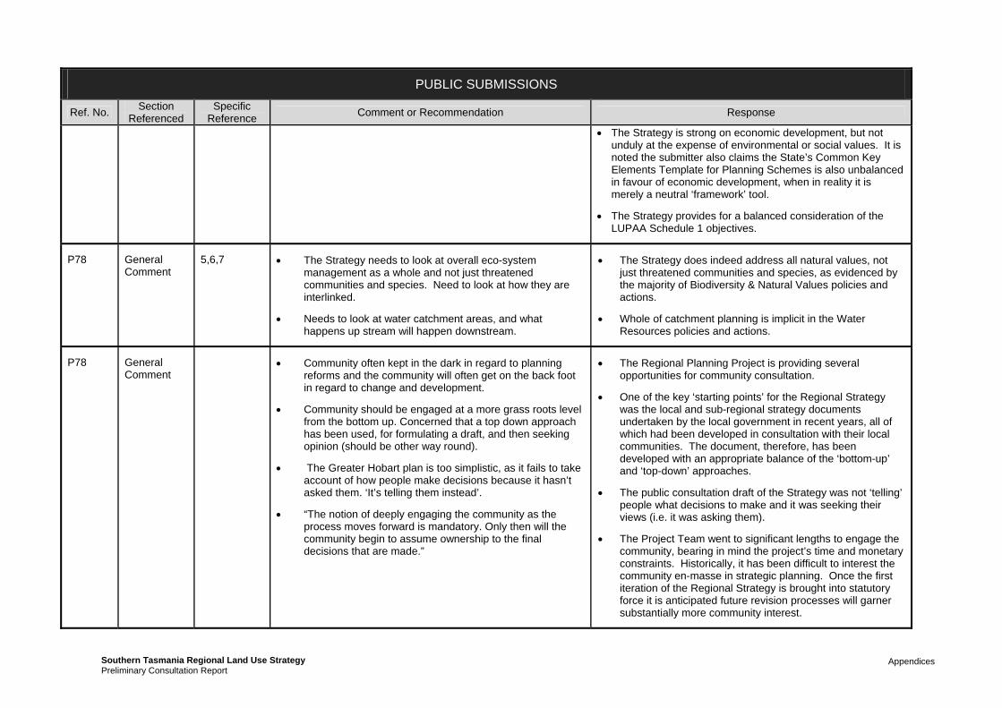
Appendices Southern Tasmania Regional Land Use StrategyPreliminary Consultation Report
PUBLIC SUBMISSIONS
Ref. No. Section
Referenced Specific
Reference Comment or Recommendation Response
The Strategy is strong on economic development, but not unduly at the expense of environmental or social values. It is noted the submitter also claims the State’s Common Key Elements Template for Planning Schemes is also unbalanced in favour of economic development, when in reality it is merely a neutral ‘framework’ tool.
The Strategy provides for a balanced consideration of the LUPAA Schedule 1 objectives.
P78 General Comment
5,6,7 The Strategy needs to look at overall eco-system management as a whole and not just threatened communities and species. Need to look at how they are interlinked.
Needs to look at water catchment areas, and what happens up stream will happen downstream.
The Strategy does indeed address all natural values, not just threatened communities and species, as evidenced by the majority of Biodiversity & Natural Values policies and actions.
Whole of catchment planning is implicit in the Water Resources policies and actions.
P78 General Comment
Community often kept in the dark in regard to planning reforms and the community will often get on the back foot in regard to change and development.
Community should be engaged at a more grass roots level from the bottom up. Concerned that a top down approach has been used, for formulating a draft, and then seeking opinion (should be other way round).
The Greater Hobart plan is too simplistic, as it fails to take account of how people make decisions because it hasn’t asked them. ‘It’s telling them instead’.
“The notion of deeply engaging the community as the process moves forward is mandatory. Only then will the community begin to assume ownership to the final decisions that are made.”
The Regional Planning Project is providing several opportunities for community consultation.
One of the key ‘starting points’ for the Regional Strategy was the local and sub-regional strategy documents undertaken by the local government in recent years, all of which had been developed in consultation with their local communities. The document, therefore, has been developed with an appropriate balance of the ‘bottom-up’ and ‘top-down’ approaches.
The public consultation draft of the Strategy was not ‘telling’ people what decisions to make and it was seeking their views (i.e. it was asking them).
The Project Team went to significant lengths to engage the community, bearing in mind the project’s time and monetary constraints. Historically, it has been difficult to interest the community en-masse in strategic planning. Once the first iteration of the Regional Strategy is brought into statutory force it is anticipated future revision processes will garner substantially more community interest.

Appendices Southern Tasmania Regional Land Use StrategyPreliminary Consultation Report
PUBLIC SUBMISSIONS
Ref. No. Section
Referenced Specific
Reference Comment or Recommendation Response
P78 General Comment
Needs to be critical analysis of the reasons behind the population/housing growth in Kingborough; (submission has included speculative detail as to why there has been a recent population and housing growth in the area).
The major factors that will determine future growth levels at Kingborough are not those that have influenced it in the past.
For example, the era of very high growth in Kingborough is at an end due, in large part, to the presence of threatened vegetation communities surrounding much of the urban area that cannot be further cleared.
P78 18 18 Chapters 3 and 19 need to be matched with a chapter on job growth and job creation (professional career type employment).
Jobs created need to be career, educated, trained type long term employment.
Studies need to be conducted into the patterns of people’s movements in relation to places of work in the Kingborough and Huon area
Studies into what jobs are available, what can be created, nature of small business employment etc.?
Where can manufacturing be held, as there is little in Kingborough.
Chapter 3 is descriptive only, summarising the region as it exists today.
In terms of the patterns of people’s movements, the travel / transport patterns of the regional have been extensively analysed by the Department of Infrastructure, Energy & Resources, as detailed in various DIER reference documents. Journey-to-Work patterns, for example, are well understood, not just for Kingborough and Huon Valley, but for the entire region.
The Department of Economic Development, Tourism & the Arts is currently preparing an Economic Development Plan for Tasmania. This will provide significant input into future iterations of the Regional Strategy.
Nevertheless, the Strategy does provide direction in regards to education and employment (refer chapters on Social Infrastructure, Tourism, Strategic Economic Opportunities, Productive Resources and Industrial Activity)
P78 19 19 Higher density housing is leading to drab and dull suburbs that lack colour and greenery. Houses have sameness to them, and a lack of diversity in building design.
Risk to destroying the unique character of existing suburbs, by way of infill and current housing design and living trends.
Table 3 is a too simplistic approach in the 21st century
Concern larger urban blocks conducting very high density
Better use of our existing settlement footprint is essential in limiting urban sprawl, increasing the viability of public transport, reducing the need to convert agricultural land or naturally vegetated land for housing and reducing carbon emissions. This means we need to generally increase densities.
Increasing densities does not automatically translate to poor urban design. For example, the Strategy does not rule out the creation of local heritage precincts, or local character

Appendices Southern Tasmania Regional Land Use StrategyPreliminary Consultation Report
PUBLIC SUBMISSIONS
Ref. No. Section
Referenced Specific
Reference Comment or Recommendation Response
strata unit developments; and creating an environment with no green life
The submission further advocates a certain equally weighted percentage between garden, buildings, street and pedestrian zones in neighbourhoods
Strata developments especially, use a large amount of hard surfaces which raises the temperature and drains away rain water (when we should be saving water). [Offers solutions on pp14-15]. Directions like this need to be picked up by the Strategy as local government will not.
precincts, within planning schemes by local planning authorities where it is desirous to retain particular local character values.
The purpose of Table 3 is to standardise terminology. It does not allocate any particular ‘density’ to any particular location. Table 3 is to be revised to bring it into conformity with national terminology pertaining to ‘density’.
The Strategy advocates for the adoption of Water Sensitive Urban Design, which is the currently accepted best practice system to increase the permeability of our urban environments in order to return more water to the ground water systems.
P78 10 10 This chapter doesn’t talk about green open space The chapter does indeed include green open spaces.
P78 16 16 Concerned that this chapter summarises a 60 pg. background paper, and believes that forestry and agriculture need separate chapters.
This chapter needs more detail and explanation
Should state where the Southern Region has a comparative advantage over the remainder of Tasmania.
Need to define ‘prime agricultural land’ (p64)
Concern that non-prime agricultural land is not recognised as valuable nevertheless.
Forestry on Crown Land and within Private Timber Reserves is outside the jurisdiction of the RMPS, by virtue of an act of parliament. It is not within the ambit or powers of the Regional Planning Project to change this.
Agreed that the Chapter should mention those agricultural sectors where the Southern Region has an advantage over other regions.
Prime Agricultural Land is indeed used as the term is defined in the relevant State Planning Policy. Agreed that this needs to be stated.
The Strategy makes it very clear that non-Prime Agricultural Land may nevertheless be very significant. Indeed it is very clear that the key task of the Strategy with respect to agricultural land is to identify and protect significant agricultural land, (very little of which is technically “Prime”).
P78 19 19 Concern there is still land being dedicated to residential development on agricultural land; such as land at Kingston on the opposite side of the Channel Highway; concern this is prime class 3 and 4 land being used for affordable
The land in question is a very small area of Prime Agricultural Land. However, its small size, its isolation from other reasonable agricultural land, its isolation from significant agricultural sub-regions, the extent of fettering due to its closeness to sensitive uses (dwellings) and its proximity to the

Appendices Southern Tasmania Regional Land Use StrategyPreliminary Consultation Report
PUBLIC SUBMISSIONS
Ref. No. Section
Referenced Specific
Reference Comment or Recommendation Response
housing. Kingston Activity Centre lead to the conclusion that it is better used for urban development.
P78 16 16 Figures in background report, p51 are misleading and need urgent updating in regard to plantation sizes in Tasmania (now that we are at the end of 2010).
Forestry and especially private timber reserves should not be self-regulated and put back in the hands of the state’s planning system.
The figures in background report, p51 are not misleading as they clearly state they pertain to the amount of private plantations.
It is not within the power of the Regional Planning Project to bring Private Timber Reserves under the jurisdiction of the State’s planning system.
P78 9 9 This chapter needs urgent attention: Especially in regard to p41 second paragraph down ‘While most known European values…’ in that that these values ‘.ARE NOT MANAGED ADEQUATELY’ [capitals] and that this statement is nonsense and misleading. Heritage management and planning in Tasmania is under resourced.
Strategy needs a specific chapter on heritage; Tas should adopt a similar across the board to the UK’s ‘Landscape Character Assessment’.
Local government is not given a lead as to where it will head in the twenty years in regard to heritage planning.
Modern development settlement patterns should respect historic 19th C patterns.
It is agreed that Chapter 9 should be significantly reviewed, particularly as the State’s review of Aboriginal and Cultural Heritage Acts is yet to be completed.
The Strategy does not rule out the ability of local Councils to continue to identify and protect local heritage precincts (including landscape areas) within their planning schemes.
The adoption of the UK’s Landscape Character Assessment system may be an ideal to aim at; however such a system would be very resource-hungry and is likely to simply be unaffordable in the short-to-medium term in Tasmania, with its very small population base of 500,000 people. The democratic process to date has not demonstrated sufficient public interest in this issue to justify the removal of the necessary funding from other priorities. Nevertheless, the Strategy (CV-A6) calls for a regional landscape assessment process of some form.
P78 13 Better use of the Derwent for ferrying people.
Need a 100 year transport vision. Transport infrastructure should be at the forefront of the Strategy; to avoid Sydney type congestion problems.
Improve pricing of public transport and more user friendly for aged and disabled etc.
Hobart’s weather is not practical to ride or walk all the
Ferries
Neither the Regional Strategy nor the Southern Integrated Transport Plan extends out to 100 years. However, it is intended that a regional planning structure be put in place to monitor and update the Strategy into the future. Future iterations of the Strategy may well extend out the time horizon.
Facilitating walking and riding options for transport remains one important strategy for the future regardless of Hobart’s

Appendices Southern Tasmania Regional Land Use StrategyPreliminary Consultation Report
PUBLIC SUBMISSIONS
Ref. No. Section
Referenced Specific
Reference Comment or Recommendation Response
time
There is going to be an increase in the carrying capacity of suburban roads with development of infill housing, considering they were planned and developed some 100 years ago.
Infill housing will result in too much parking congested streets and difficult to manoeuvre around.
weather.
Better use of our existing settlement footprint is essential in limiting urban sprawl, increasing the viability of public transport, reducing the need to convert agricultural land or naturally vegetated land for housing and reducing carbon emissions. This means we need to generally increase densities. Southern Tasmanian urban settlement is extremely ‘thin’ in comparison to other comparative urban areas and is quite capable of accommodating a relatively minor increase in density.
Continued unabated low density urban sprawl at the fringe is environmentally, economically and socially unsustainable.
P78 21 Table 6 CV-A5 – not high enough priority and needs a time frame and It is seen by the STCA that local council (not adequately resourced) has to get its heritage up to date, assessed and into their planning schemes; this is a form of buck passing. Small rural councils don’t have the expertise.
CV-A5 should be split between ‘complete review of the Act’ and ‘implement recommendations’. It is agreed that the review of the Act ought to be prioritised as ‘high.
The principle of splitting heritage between that of State and local significance is supported, (noting that this principle has been agreed nationally), with local planning authorities being responsible for recognising and protecting those places of ‘local significance’. The adequate resourcing of local government to meet subsequent increased responsibilities is recognised as an issue that needs to be addressed.
P78 19 19 Urban sprawl is contained by the topography of the Hobart landscape (mountain and coast).
The proposed new Common Key Elements Template (CKET): Concern about lot sizes for land zoned on the periphery of townships and villages as Low Density Residential or Rural Living, these areas can be quite messy.
There seems to be two types of zones proposed for the semi-rural urban environment ‘two zones of residential low density’:
o These zones distant people from their place of work
Agreed: Greater Hobart is constrained by topography.
The existence of various rural residential type zones in CKET does not mean Councils will be free to apply these zones anywhere. Indeed, it is the Regional Land Use Strategy which will provide significant limits on the spatial area where these zones can be allocated. The provision of a zone mechanism should not be confused with spatial strategy.
The Southern Tasmanian Regional Land Use Strategy proposed a moratorium on the overall expansion of the rural residential footprint in Southern Tasmania.

Appendices Southern Tasmania Regional Land Use StrategyPreliminary Consultation Report
PUBLIC SUBMISSIONS
Ref. No. Section
Referenced Specific
Reference Comment or Recommendation Response
in townships; increasing fuel and car usage;
o Gobbles up farm land;
o Changes the rural landscape forever
Concern that local government is going to latch onto the idea of infill housing and ignore many others matters, such as the natural environment
P78 19 19 Concerned local structure planning at Bagdad will allow the valley floor to be subject to rural residential subdivision.
It is understood the Bagdad-Mangalore Structure Plan preserves the valley floor at Bagdad as rural land and, in fact proposed ‘back-zoning’ of current un-subdivided rural-residential zoned land to rural.
P79 9 9 Built heritage is neglected in the strategy. The Heritage Council has 50 year backlog; there also needs to be stronger guidelines to maintain values. Midlands is doing a good job, but has less faith in Huon Valley Council.
The Cultural Values section in the Strategy is being rewritten; however protecting built heritage will still involve a significant effort at the local level.
P80 General Comment
Particularly encourage improvement to environmental and aesthetic values in Cygnet area for tourism benefits; and fresh quality produce farming.
This matter is primarily a local issue for Huon Valley Council to address. However the Strategy does provide guidance on some environmental and agricultural issues which will affect how the Cygnet area is affected under the new planning scheme.
P81 23 23 Would like to see zoning that encourages eco-neutral approach to land use
“Inclusion of cover/jurisdiction for both marine and forestry usage –at the very least in [something] farm – with provision for review and adaption in the future as circumstances change.”
The State Government through Planning Directive No. 1 determines Land use categories and zone types and is therefore largely outside the scope of the project.
The Strategy has to work with current legislative context in regarding to marine farming and forestry.
P82 Rezoning type request
Land in between Kingston and Margate
Plans for ‘eco-style’ low density housing villages in conjunction with usage of larger open spaces for recreational type use.
Detailed in submission
The redevelopment of this land for the proposed purpose could be seen as inconsistent with the draft Strategy.
While in the long term the land between Huntingfield and Kingston may need to be developed for residential purposes, given the extent of residential land across Greater Hobart to meeting needs across the next 10 to 15 years the development of what is currently an areas seen as a green belt is seen as

Appendices Southern Tasmania Regional Land Use StrategyPreliminary Consultation Report
PUBLIC SUBMISSIONS
Ref. No. Section
Referenced Specific
Reference Comment or Recommendation Response
premature.
If the submitter believes that there is sufficient evidence to warrant the early release of this land, then this can be dealt with through a Section 43A process, as the Strategy will provide scope for the TPC to allow such developments if new evidence or conditions exist (prior to its 5 year review).
P83 19 19 Need to include transitional provisions that still allow for development applications that have been submitted to Councils under existing planning schemes will still be allowed to proceed accordingly. An application should not be prejudiced by the imminent moratorium.
P83 19 19.10.1 PHN-RA5 – Policy is too broad, blunt, inconsistent with Strategy:
- some existing rural residential zones are not appropriate for development
- Whilst there are other rural areas that should be zoned for such residential usage; especially those that adjoin existing Low Density Residential and are currently strategically located for such use.
- Some areas that are zoned Low Density Residential (LDR) should be back zoned to Rural Ag, pending further land capability type assessment to make way for more suitable sites for LDR.
- Some areas in the Southern Beaches area aren’t suitable for LDR as they are low lying and have waste water management issues.
This Action should be amended to ‘except where there is infill or completion of existing (recognised) Rural Residential settlement. Also allowances should be made in accordance with the Protection of Agricultural Land Policy 2009.
Rural Residential blocks in the Sorell municipality at 2000m2 pose a significant environmental risk in trying to manage and treat wastewater. Land that adjoins serviced blocks should also be serviced.
This is being examined as part of the revision of Chapter 19. However the following is noted:
The lot size range for rural residential densities ranges from 0.5 ha to 2 ha. What is actually allowed under each individual planning scheme will be dependent upon the capacity of the land to manage onsite wastewater disposal without environmental impacts. This table is only meant to be a guide.
Specific back zoning is not identified under the Regional Strategy. If individual Councils feel that land currently zoned for a particular purpose does not meet the policies of the Strategy for that zone, and then there may be back zonings, however this will be subject to all the consultation and test under the planning scheme approval processes.
The Strategy will include revised statements about residential development to provide greater clarity.

Appendices Southern Tasmania Regional Land Use StrategyPreliminary Consultation Report
PUBLIC SUBMISSIONS
Ref. No. Section
Referenced Specific
Reference Comment or Recommendation Response
P83 Rezoning Type Request
Particular low density rezoning request near Sorell. The intent of the Strategy is to provide overarching direction for region. Except for regionally significant zoning issues, it will not specify intended future zoning of individual properties although it will provide the general principles under which such zoning decisions will be made during the drafting of the new planning schemes.
Property-specific zoning issues such as this will therefore be determined during the planning scheme drafting process.
The submitter is therefore advised to participate in the consultation process for the draft planning schemes, which will occur during the second half of 2011 and which will include draft zoning maps in which individual properties will be discernable.
P84 General Comment
The Minister’s vision sets the tone for what is to follow… The common factor in all of the above is simply climate change and our response to it…wants the planning system to be evidence based and rational and response to future changes and challenges…inherent difficulty here:
What we are facing is a unique experience – global warming of this type and scale has not happened before.
Rationality works well within known and bound conditions but adaptive creativity is of greater value in wholly novel situations.
Living, responsive instrument cannot function as such when imprisoned within uniformly inflexible legal structure and processes.
Planning scheme and land use strategy cannot successfully tackle this problem in isolation from other policies.
It is agreed that a common factor is Climate Change and there are inherent challenges in addressing it through a regulatory system. The revised Strategy more clearly articulates that the land use planning system is only one element in addressing the challenge of a changing climate.
P84 General Comment
“Ald Valentine puts his finger on the real issue here; the reduction of “…adversarial public debate and angst that currently occurs in the planning system…”
Such public reactions are merely the working out of democracy as citizens exercise their rights and are no problem in a mature society. They do, however, cause a good deal of inconvenience, and sometimes political upset, to those authorities that believe
The Lord Mayor’s comments are not intended to imply that there never should be debate in the planning system. Rather it is indicated that instead of at the Development Assessment stage, good public debate should be had prior to this about what are appropriate development opportunities and not. Indeed the Ralph’s Bay development is a case in point. If there had been a discussion on whether we should even have Canal Estates in

Appendices Southern Tasmania Regional Land Use StrategyPreliminary Consultation Report
PUBLIC SUBMISSIONS
Ref. No. Section
Referenced Specific
Reference Comment or Recommendation Response
they know what is best for us citizens…nothing in the report will stop the kind of public reaction that we have seen over the Ralph’s Bay development. “
Tasmania given their inherent impacts, then it would not have been the public reaction because as envisaged by the Strategy no such proposal could even be considered.
P84 General Comment
“The zoning perspective as outlined in the report imposes a hierarchically more powerful grid over municipalities just as we have seen the development of superior structures with local government that are beyond the democratic control of local ratepayers. Indeed any implementation of part or whole of this report is ultimately dependent upon the whim of the minister of the state…the immediate effect of the MOU is to draw local government into doing the work for the state government that the decimated public service would otherwise do.”
The MOU was signed by both State and Local Government in a cooperative manner. Local Government endorsement of the Strategy is factored into the Project Plan.
It should also be noted that in other States, the State Government plays a far more direct and powerful role in the planning system than in Tasmania.
P84 General Comment
“Throughout the report there is an unexamined claim that planning on a whole of region or zone basis is more effective than individual councils working in isolation and that consistency and uniformity is advantageous.”
The Strategy does not indicate it is more effective, but rather regional level planning has been missing from the planning system and at this level some issues are better resolved. In reverse the Strategy recognises that local level planning still has an important role to play in the planning system.
P84 General Comment
…”one is advised to read the back up documents but, not being professionally involved, I have not been able to access all of these reports nor do I have time to carefully read them all within the consultation period. I wish that the whole things had been better advertised earlier because it is very important and I should have liked to do a more rounded job of responding.”
As indicated in the main section of this consultation report the project undertook various advertising methods to attract attention to the public consultation period.
P84 General Comment
“I did go through everything in the report. I annotated it, collated the annotations and began to write a brief but detailed response. Then I noticed the acknowledgement section and realised that I had wasted my time. The main point of the report is obviously a grab for extended power by planners and at the same time a degree of removal from public scrutiny and responsibility. I cannot express just how angry I felt…Nevertheless there is some good thinking in the report. “
The purpose of the Strategy has not been defined by planners nor is it about more power grab for planners. Indeed the focus of the project is about simplified planning schemes, where there are fewer restrictions over day to day activities and more focus on the land use and development issues that do require more evaluation.
The project is governed by a Steering Committee comprising a range of professionals and representatives.
P84 General “Heavy reliance has been placed on projections from ABS statistics and Federal Government policies…like all such
These are indeed in the report on Page 11 (3rd dot point) and under Section 19.5.1. There is also considerable discussion on

Appendices Southern Tasmania Regional Land Use StrategyPreliminary Consultation Report
PUBLIC SUBMISSIONS
Ref. No. Section
Referenced Specific
Reference Comment or Recommendation Response
Comment projections, are hedged about qualification and conditions as they must reasonably be…I see no evidence of such qualifications on the use of these projections…in the report.”
the shortcomings of projections in Background Report No. 2: The Regional Profile.
P84 General Comment
“The greatest weakness of the report is that the opportunity was there to have a much wider skills and experience base providing input to the report. The problem is that it is in reality no more than the head in the sand power grab noted. Throw out this nonsense and initiate a genuine consultation drawn from a much wider skills and knowledge based and a serious cross section of the whole population.”
The starting point for the development of the Strategy was the many existing strategies and policies (particularly those at the local government level) that had gone through extensive public consultation. This is explained in far greater detail in Background Report No. 1.
It should also be evident from the background reports that a wide range of supporting material from non-planners has been used in the background analysis.
The Strategy acknowledges is it a first iteration only and more work and consultation needs to happen into the future.
Lastly as evident from this consultation report there will be many changes made to the Strategy as a result of the consultation process. Suggestions and changes which are not only from planners.

Appendices Southern Tasmania Regional Land Use StrategyPreliminary Consultation Report
Appendix K
Responses to Stakeholder Submissions

Appendices Southern Tasmania Regional Land Use StrategyPreliminary Consultation Report
STAKEHOLDER SUBMISSIONS
Ref. No.
Section Reference
Specific Reference
Comment or Recommendation Response
SH1
General Comment
That the Strategy be reviewed every 5 years
The boundary of the southern region is not explicit; assets such as power schemes and water catchment areas don’t all fall neatly into the boundaries of the three Tas regions. There is potential for conflicting strategies.
Waterways should be zoned on a case by case basis to reflect their varied and mixed uses, for example the utilities zone would clash somewhat with a recreation zone.
Would like a formal dialogue be entered into before the finalization of Hydro owned or managed land.
Comments are noted. It is likely over further iterations of the regional strategy (once the ongoing governance model is established) that there will be greater consistency amongst each strategy, although the regional boundaries are unlikely to change given their well established nature.
The current project is defined by the southern region administrative boundaries.
Will take into account the zoning of waterways in the drafting of the Regional Model Planning Scheme.
Will ensure that there are further discussions with Hydro as part of the development of planning schemes.
SH1
5 5.6 BNV-A9 this should be at a state level, and in consultation with the regional level. As natural assets cross the boundaries of these regions
BNV-A10 broad support. But concerns over additional permitting processes for the clearance of vegetation under the Nature Conservation Act 2002. Alternative would be to give local government tools to assist in making such decisions or forward onto the FPA or devolve back to FPA.
This would enable Local Government undertake assessment of biodiversity values based upon the potential impacts of individual projects, and would satisfy a large proportion of the actions
BNV-A9 refers to an existing project of the STCA’s and funded by specific Councils in the South. The project involves input from relevant State agencies and is intended to be a pilot project.
With regard to BNV-A10 it is not intended to pre-empt the outcomes of such a review. Additional permitting processes have been a matter considered by DPIPWE but yet unresolved.
The suggestion that keeping assessment of biodiversity impact with Councils still does not resolve fundamental limitations of Planning Authorities in being able to take into account impacts across bioregions or cumulative impacts.
Hence the recommendation for an overall review.
SH1
6 6 Supportive of the Water Resources Policies and Actions; and welcomes the proposal to implement setback requirements for developments opposite waterways.
Noted
SH1 10 10 Recreation and Open Space: Fully Supportive; especially in identifying recreation areas and potential areas for growth.
Noted.
SH1 12 12 Particular support for policy PI8, PI9 and streamlined planning processes for infrastructure development.
Would like to see an additional action in regard to mapping renewable energy resources and identify future sites.
Additional action will be included.
SH1 14 14 Supportive of improved usage of recreational activities on lakes and waterways.
Noted.

Appendices Southern Tasmania Regional Land Use StrategyPreliminary Consultation Report
STAKEHOLDER SUBMISSIONS
Ref. No.
Section Reference
Specific Reference
Comment or Recommendation Response
SH2 General Comment
Would like to see an Integrated Transport Assessment (ITA) required for all structure plans, proposed Plan Change or for a major trip generating activity.
The benefits of ITAs are acknowledged. Have included additional actions relevant to Local Government when they are preparing structure plan and local area plans. An additional similar action relevant to major planning scheme amendment has also been included.
SH2 11 11.5 SI-P3 – use the word ‘passenger [transport]’ instead of ‘public [transport]’
SI-P6 – Support
SI-A3 – supportive with an ITA
SI-A8 – use word ‘passenger’
Have kept the word 'public’. Passenger transport also includes private travel and these policies and actions specifically relate to improved access to public transport, not all forms of passenger transport.
SH2
13 13 All Supported, and some with additional comments
LUTI-P1 – Use word ‘passenger’
LUTI – P2 – Support
LUTI – P3 – Support
LUTI- P4 – Support
LUTI-P5 – Support. Any development should be accessible by passenger transport.
LUTI-P6 – support. Integrate with passenger transport
LUTI – P8 – Support
LUTI-A3 – Specify the relevant actions
LUTI – A4 Support. With some guidance on the criteria for identifying corridors.
LUTI_A5 – With ITA
LUTI-A6 – ITA
LUTI-A10 – transit oriented development replaced with the top three layers of the activity zones.
LUTI-A12 – replaces ‘transit’ with ‘passenger transport’ and remove the 400 m reference.
See comment above, otherwise some changes will be made to the actions.
SH2 18 Table 1 Link to high frequency passenger transport services on the provision of high quality interchanges and bus priority measures to support the service provision which appears to be missing from table.
With exception of changing ‘public’ to ‘passenger’ (see comment above), other changes will be made.

Appendices Southern Tasmania Regional Land Use StrategyPreliminary Consultation Report
STAKEHOLDER SUBMISSIONS
Ref. No.
Section Reference
Specific Reference
Comment or Recommendation Response
Primary Activity Centre – change access to key interchange location for passenger transport and central node for radial road network.
Principal Activity Centre – reword to access to better reflect the hierarchy as using major activity centres is confusing with the third level of the hierarchy.
Major Activity Centre – reword to access to better reflect the hierarchy as using major activity centres is confusing with the other levels of the hierarchy.
May need to review of the terms such “near public transport corridor”, “good bus service” as very subjective.
SH2 18 18.6 Supportive of all policies with additional comments:
change the word ‘public’ to ‘passenger’
with ITA in identifying specific areas
See above.
SH3 General Comment
1. Concern regarding funding and ongoing maintenance of the Strategy; funding crucial for data collection and analysis of land release areas.
- Concern of the negative implications of this on the property market/private sector.
2. Vital need to implement a Capital Cities Plan; need for further data collection and analysis despite TPC’s assessment that 80% has been complete through the Strategy. Need for separate and dedicated funding for CC plan.
3. The submission is not supportive of an interim planning scheme for each council once the strategy is endorsed. The TPC doesn’t understand the complexities of performance driven nature of a CC plan.
Funding concern is noted.
Concerns regarding the Capital Cities Plan will be communicated to the Tasmanian Planning Commission through the Chairman of the Capital Cities Plan Steering Committee.
With regards to economic analysis of demand for residential land this will be included as part of considerations for further work.
SH3 17 17 Concern that the release of new Industrial land will lower the value of existing land; the capital cities plan should undertake economic analysis in regard to the land supply actions and analysis into where people live in proximity to work.
Industrial Land component of the Strategy is being revised to address these concerns.
SH3 19 19 Include brown field sites as a primary source of future residential development.
Revised strategy includes greater acknowledgement of value of brownfield development in achieving infill targets. Although targeting of specific brownfields will need to be undertaken as part of the Capital

Appendices Southern Tasmania Regional Land Use StrategyPreliminary Consultation Report
STAKEHOLDER SUBMISSIONS
Ref. No.
Section Reference
Specific Reference
Comment or Recommendation Response
Cities Plan.
SH3 18 18 Too much focus on metropolitan Hobart and neglect of East Coast as a booming tourism area. Would like to see some more focus on regional townships.
Revised strategy will attempt to address this concern.
SH3 19 19 The submission does not support a moratorium on rezoning of rural to rural residential. Giving the example of Acton.
Should be tougher provisions regarding residential development in rural areas such as:
rural residential lots only occur where there is a boundary to a residential zone
that lots be a maximum of 2Ha
Infrastructure costs such as roads, water and sewerage are fully borne by the consumer.
Create the feeling that subdivision is only allowed in exceptional circumstances
While theoretically a pure user pay system might be an appropriate avenue to control certain types of land use, such a system does not consider long term impacts and ensuring the use of land as a resource for future generations taking into account changing economic, social and environmental considerations.
The moratorium will still allow for the further subdivision of existing areas. It relates to no increased footprint only. Taking into account the considerable amount of rural residential land already zoned or subdivided across the region, this should be sufficient for the life of this iteration of the Strategy.
Moreover it is undesirable to see potential residential land being converted to rural residential first, as once subdivided into these lower densities it is much harder to convert into urban/suburban densities.
Also need to take into account the availability of the Environmental Living Zone under the Regional Model Planning Scheme.
SH4 19 19 Concern with implementing an urban growth boundary (UGB) and the implications that such would raise the cost of affordable land and housing: The Submission recommends that the government confirm the intention of the draft Strategy is not to limit the existing footprint or the further growth of Hobart, Greater Hobart or regional towns.
It is contended that in other Capital Cities where UGBs have been employed to manage urban growth, the use of those has increasingly resulted in higher land prices due to the withholding or controlling of supply by key land holders. Furthermore that this is evident in Tasmania where the cost of land as a component of residential development has risen by 33% in the last 8 years.
However Tasmania does not have any UGB strategies in place at the moment and yet still affordability is decreasing.
In reality the affordability and supply of residential land and supply is influenced by more complex considerations rather than just planning regulation, although land supply is a relevant factor.
The submission suggests that a decision to adopt the principle of urban consolidation should be done through a more detailed and public debate on how Tasmanians believe their cities should be managed rather than by the Steering Committee. The Strategy was however, a draft and the policies were intended to be tested by the public. In most part there has

Appendices Southern Tasmania Regional Land Use StrategyPreliminary Consultation Report
STAKEHOLDER SUBMISSIONS
Ref. No.
Section Reference
Specific Reference
Comment or Recommendation Response
not been fierce opposition to the proposed residential policies, however there will be some changes to the residential strategies maps to ensure an adequate supply of greenfield land.
Furthermore sometimes this type of debate is driven by the ‘self-interest’ of the here and now. Strategic planning is less about what we want now than what we need (to do) for long term benefit.
A new background report providing greater explanation of the proposed residential policies is being prepared. This report analysis the different greenfield/consolidation scenarios.
SH4 12 12 Passing the costs of upgrading and installing new infrastructure onto developers has raised the price of new housing and lots. Opposition to upfront infrastructure costs.
How will the Strategy be consistent with the infrastructure investment strategy for the region?
Need for a 25 year infrastructure plan that will support the housing objectives of the Strategy.
The Strategy does not specify the actual methods for infrastructure charging. It recommends that there are uniform developer charges across the region that are consistent with achieving the desired growth management strategies. The Strategy is aimed at ensuring further residential growth is provided with the level of infrastructure and services required to support the population. The submitter also seemed concerned regarding developer charges for community and social infrastructure; however this was not suggested in the draft Strategy.
It is also deduced that part of the reasoning for these comments, is an understanding by this submitter that the strategy did not include the Infrastructure Investment Strategy as required by the MoU. This is within the Implementation section of the Strategy. It would also appear from the submitter’s comments that they have high expectations of the Infrastructure Investment Strategy arising from the project. Unfortunately, due to several constraints, what is contained within the Strategy will not meet these expectations. It is acknowledged as a first iteration and will require greater detail and resolution in the future.
The issue is the elimination of hidden subsidies, not all subsidies. We would continue with some subsidisation, but these should be open, transparent and targeted at where they do the most good for the needy and disadvantaged.
SH4 General Comment
The ongoing administration and governance of the strategy should be an opportunity to reduce planning red tape and costs.
Local government bodies and stakeholders need to develop a sense of ownership of the strategy in order to better articulate and communicate matters and how the shape and appearance of Greater Hobart will change.
The project needs to be recognised as only one element in the planning system and while there will be some simplification achieved with regulatory instruments through the project, it will not achieve all that this submitter hopes for.
For example Planning Directive No. 4 is aimed at addressing some of these concerns, but is actually not part of the ‘Regional Planning
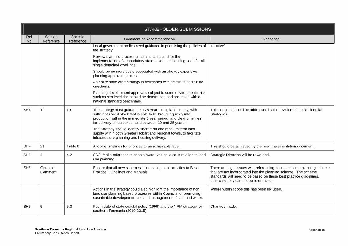
Appendices Southern Tasmania Regional Land Use StrategyPreliminary Consultation Report
STAKEHOLDER SUBMISSIONS
Ref. No.
Section Reference
Specific Reference
Comment or Recommendation Response
Local government bodies need guidance in prioritising the policies of the strategy.
Review planning process times and costs and for the implementation of a mandatory state residential housing code for all single detached dwellings.
Should be no more costs associated with an already expensive planning approvals process.
An entire state wide strategy is developed with timelines and future directions.
Planning development approvals subject to some environmental risk such as sea level rise should be determined and assessed with a national standard benchmark.
Initiative’.
SH4 19 19 The strategy must guarantee a 25-year rolling land supply, with sufficient zoned stock that is able to be brought quickly into production within the immediate 5 year period, and clear timelines for delivery of residential land between 10 and 25 years.
The Strategy should identify short term and medium term land supply within both Greater Hobart and regional towns, to facilitate infrastructure planning and housing delivery.
This concern should be addressed by the revision of the Residential Strategies.
SH4 21 Table 6 Allocate timelines for priorities to an achievable level. This should be achieved by the new Implementation document.
SH5 4 4.2 SD3- Make reference to coastal water values, also in relation to land use planning.
Strategic Direction will be reworded.
SH5 General Comment
Ensure that all new schemes link development activities to Best Practice Guidelines and Manuals.
There are legal issues with referencing documents in a planning scheme that are not incorporated into the planning scheme. The scheme standards will need to be based on these best practice guidelines, otherwise they can not be referenced.
Actions in the strategy could also highlight the importance of non land use planning based processes within Councils for promoting sustainable development, use and management of land and water.
Where within scope this has been included.
SH5 5 5.3 Put in date of state coastal policy (1996) and the NRM strategy for southern Tasmania (2010-2015)
Changed made.

Appendices Southern Tasmania Regional Land Use StrategyPreliminary Consultation Report
STAKEHOLDER SUBMISSIONS
Ref. No.
Section Reference
Specific Reference
Comment or Recommendation Response
SH5 5 5.5 Councils only have the authority to make land use/development decisions for land within their municipal boundaries. In order to consider regional landscape values, such as biodiversity values Councils will need to take matters outside of their municipal area into account. For many of the Biodiversity and Native Vegetation Policies, Councils will need to have strong relationships with other key stakeholders and comply with mechanism in pace to ensure that decisions made within their local boundaries are in fact delivering on the policies which have a regional context.
The involvement of regulatory and strategic planning bodies in collaboration with Councils is critical to develop and implement the processes necessary to implement these regional policies (which include data collations and development of monitoring/reporting methodologies and thresholds) to protect biodiversity values. Notes: additional resources will need to be allocated to develop these processes and thresholds
The policies are focussed on what Councils can do with their current legislative and regulatory powers. These have limitations. No matter how strong a relationship a Council has with other stakeholders, it simply can not do what it is not allowed to do. Hence the recommendation for a holistic review of approvals.
SH5 5 5.6 BNV-A1 include ‘… threatened species sites and habitats ensure as far as…’
BNV-A5 after ‘management plans’ include ‘(and best practice guidelines including ‘Soil and Water Management on Building and Construction Sites’ (DEP 2009) ‘and after ‘natural value,’ include ‘exacerbation of risks (e.g. soil erosion)’
BNV-A6 after ‘species’ include ‘and habitats’
BNV-A7 after ‘biodiversity’ include ‘vegetation (in general) and riparian.’
BNV-A10 – it is recommended that the Strategy doesn’t place a relative value on vegetation, as all vegetation is under threat, and a value will be used to justify clearance.
BNV-A11 after ‘weed’ put ‘and weed hygiene’
Additional Actions:
- Ensure that development processes assess the presence of weeds
- Develop concept plans at the development planning stage to identify key land assets and hazards
- Develop an urban/peri-urban tree management strategy to
Changes will be made in response to this submission, except for last suggested action which is considered beyond scope as it is not a land use planning issue.

Appendices Southern Tasmania Regional Land Use StrategyPreliminary Consultation Report
STAKEHOLDER SUBMISSIONS
Ref. No.
Section Reference
Specific Reference
Comment or Recommendation Response
protect habitat provided by significant trees in the landscape.
SH5 6 6.1 Include after ‘providing:’ put water supply for a range of industries including agriculture, forestry, mining, processing, and aquaculture.
Changes made
SH5 6 6.3 Include date of NRM strategy Changes made
SH5 6 6.6 WR-A6 after thus put ‘reducing the threat of’ and after ‘areas.’ Put ‘Setback requirements to include different setback widths associated with distinct types of development (e.g. mixed urban, general residential, rural living, agriculture, forestry, industrial, etc)
WR-A7 after ‘quality.’ Put ‘Support cross agency and tenure collaboration and management to facilitate protection.’
WR-A9 after ‘irrigated’ put ‘and general’ and after ‘education’ put ‘incentives. Responsibility – add councils.’
WR-A10 after ‘wastewater.’ Put ‘Provide incentives for developers to deliver best practice developments.’
Changes will be made although noting that many of these actions are now policies and the others have been moved to the new Implementation document.
SH5 7 7.1 Also mention coastal erosion and recession as another prominent impact of climate change.
Changes will be made.
SH5 7 7.3 Change to coastal policy 1996 not 2000
Also NRM 2010-2015
Changes will be made.
SH5 8 8.1 In dot points include:
Coastal erosion and recession
Water availability; biodiversity loss; loss of landscape function
Coastal erosion and recession will be added. The others are not considered a ‘Risk or Hazard’.
SH5 8 8.4 MRH-P3 include the word ‘soil’ before ‘erosion’ and also include after ‘sulphate soils.’ ‘May be useful to distinguish this from coastal erosion.’
Changes will be made.
SH5 8 8.5 MRH-A3 include a final after’;’ ‘in areas with high risk of, or mapped acid sulphate soils.’
Additional action:
- In consultation with fire management experts develop appropriate
Changes will be made to MRH-A3 but additional action is considered outside of scope.

Appendices Southern Tasmania Regional Land Use StrategyPreliminary Consultation Report
STAKEHOLDER SUBMISSIONS
Ref. No.
Section Reference
Specific Reference
Comment or Recommendation Response
fire management plans for Council managed land and reserves.
SH5 23 Table 8 Give a definition of ‘significant’ in regard to environmental values as it is open to interpretation. Similarly ‘high environmental value’
Table 8 is the Zoning Framework and will be replaced by the Regional Model Planning Scheme which by necessity provides the clarification requested.
SH5 6 6 Additional Actions for Water Resources:
Use best available data to identify high conservation value waterways and wetlands for integration into Council Planning Scheme zoning to ensure protection of key freshwater values.
Ensure wetlands listed under Nature Conservation Act are integrated into Council data and information processes that inform planning and development assessment.
Design and manage, in collaboration with relevant agencies, waste management systems for domestic and industrial contaminants.
Education initiatives and management agreements be adopted to ensure the appropriate maintenance of all on-site wastewater management systems.
Support the development and implementation of a code of practice for inland aquaculture and a sustainability study to guide future development of inland fish farms. Responsibility - IFS, EPA & Councils.
Development activities within or adjacent to waterways and wetlands adopt hygiene standards outlined in the “Keeping It Clean: a Tasmanian field hygiene manual to prevent the spread of freshwater pests and pathogens” manual produced by NRM South.
Contract conditions specify integration of weed and freshwater hygiene procedures for Council contractors undertaking field research, construction and maintenance activities (particularly gravel road that are a major for weeds and freshwater diseases).
Noting the changes to the structure of the Strategy in terms of policies and actions, those points that are relevant to the planning system and within scope will be included: dot points 1, 2, 6, 9.
Ensure road and construction activities maintain fish and eel passage and the protection of fish habitat. Structures (e.g. culverts) which often impact on fish passage be referred to IFS

Appendices Southern Tasmania Regional Land Use StrategyPreliminary Consultation Report
STAKEHOLDER SUBMISSIONS
Ref. No.
Section Reference
Specific Reference
Comment or Recommendation Response
under the Inland Fisheries Act 1995.
Planning and development in waterways and wetlands (or activities that have potential to significantly impact (such as construction, excavation, agricultural drainage channels, stream crossings) incorporate the best practice environmental approaches and principles outlined in the Wetlands and Waterways Works Manual (DPIPWE).
Land planners and developers to be aware of the location and risks to existing drinking water catchments. To assist with this process, a register of drinking water catchment management plans and all public drinking water source areas in each local government authority be developed. Where appropriate, drinking water source protection assessments (associated with development applications) are undertaken. Responsibility: Water Authorities, DHHS, DPIPWE, Sport and Recreation Tasmania (DEDTA).
SH6 18 18 At present the different characters of the constituent localities in Greater Hobart contribute to the city’s diversity and interest. This character value of constituent parts could be threatened by infill if not indentified as an asset in the settlement strategy. Supports infill primarily around identified activity centres, but with respect to character and heritage
Character and heritage has greater acknowledgement in the revised strategy. However urban form policies within the metropolitan context will need to be further developed through the Capital Cities Plan due to the constraints of this project.
The Strategy also recognises that local character/heritage areas can be identified in new planning schemes at the local level.
SH6 18 18 Currently smaller local centres of a scale with the traditional bus-stop or tram stop centres, have been recognised in activity network Table 1 but not Table 4.
Table 4 is the settlement hierarchy for the region. Many of the lower order activity centres identified in Table 1 actually occur within the one settlement of Greater Hobart. These tables have different purposes.
SH6 General Comment
Urban character and heritage if developed and explicit can be an attractor for settlement and tourism, an economic catalyst or diver. This should be noted in the economic strategy.
This strategy will be amended to reflect the social and economic benefits of retaining character and heritage.
SH6 19 19 Consideration for identifying amenity, attractiveness and heritage quality of urban streets, including mixed industrial and suburban areas as an asset and encouraging upgrade of lower quality areas
Consideration of minimising ‘urban heat’ through shading and building design (Councils requiring low UHI development and assessing any applications).
Recognition of amenity, attractiveness and heritage will be further emphasised in revised strategy, but again should be something explored in greater detail in the Capital Cities Plan.
While acknowledging urban heat issues and how this can be improved through better building design and use of open space, this needs to be balanced by achieving a more streamline and simplified planning approval process.

Appendices Southern Tasmania Regional Land Use StrategyPreliminary Consultation Report
STAKEHOLDER SUBMISSIONS
Ref. No.
Section Reference
Specific Reference
Comment or Recommendation Response
SH6 19 19 Urban growth boundary may not reflect demand and best use of existing infrastructure; also mapping is not clear how definitive it is intended to be.
Greater explanation for urban growth boundary location will be provided in the additional background report (No. 14) and the revised residential strategies.
SH6 General Comment
Urban fringe and bushland development:
Better bushfire hazard management with a clear defensible edge. This should be an explicit objective.
Conserve significant vegetation
Emergency access trails
The location of the urban growth boundary and residential growth opportunities has taken into account landscapes, bushland interface and land management issues, although this isn’t explicit as there is limited spatial representation of these values.
SH6 5 5 Supports commitment to building a better information base in this area. Consideration could be given to more ambitious objectives additional and better information, I.e.:
Building the resilience or overall heath of the system, as an objective and policy;
Enlarging on the intent of ‘protect’ in BNV – P2 including putting emphasis on active conservation management in areas where active degradation processes exist
Look for opportunities for linkages in subsequence iterations of STRLUS and (if practical) in sub-regional policies and lower order planning instruments.
The policies in the biodiversity and native vegetation section are focussed on what the planning system can do. While these suggestions may be worthy they are considered beyond the scope of the planning project.
SH6 9 9 Support the policy and action pointing towards an assessment of cultural landscape values. Would like to see a similar commitment to establishing scenic values or alternatively defining cultural values in a way that includes scenic values. Would like to discuss cultural landscape values further with project managers and actively explore options for resourcing such an assessment (as already discussed with N W Regional Plan).
This concern will be partially addressed through the revision of the cultural values section, although acknowledging the limitations of resources and time on the project; it will not be possible to undertake such an assessment prior to the completion of the Strategy.
SH6 Concerned that the whole mosaic of cultural values is not being considered and that lower order scenic or cultural values not identified at state level will be protected or at least considered in the operation of any planning scheme consistent with the Heritage Tasmania direction.
This concern should be addressed through the revision of the cultural values section as far as they are considered regional issues. It should also be noted however that cultural landscapes are changing landscapes not static.
SH6 23 23 Strong support for the environmental, rural and mixed urban living Noted.

Appendices Southern Tasmania Regional Land Use StrategyPreliminary Consultation Report
STAKEHOLDER SUBMISSIONS
Ref. No.
Section Reference
Specific Reference
Comment or Recommendation Response
zones; as it allows conservation values to be managed privately.
SH7 General Comment
Supportive of the language and jargon used and its accessibility for the laymen.
Noted
Background Paper No. 3
Some concerns with suggestions, concepts and language in background report relating to social housing. Have suggested specific rewording
These changes will be incorporated into the Background Report and Strategy.
19 19 The Strategy needs to ensure that the proposed settlement strategy does not simply result in increased house prices and that affordable housing is still available in all areas of Southern Tasmania (while acknowledging the benefits of action that promotes better-located housing and increases density to support better infrastructure development.
The residential strategies are being further refined to ensure that the affordability of the market is not adversely affect by the planning policies and actions.
19 19 Needs to provide greater priority and direction in relation to urban design in residential areas, particularly in relation to
Disability access
Design, privacy and security in higher-density developments
Access to basic shopping facilities within easy walking distance
Encouraging better population health outcomes by creating environments that encourage and support physical activity
Access to open space.
The residential policies will be augmented with some additional urban design focussed policies, however given the limitations of the current project, urban design considerations, particularly in relation to infill development will need to be further refined through the Capital Cities Plan.
SH7 11 11 A clear policy that prohibits the unreasonable restriction of any residential property for utilisation as public or social or group housing; and prevent such development from being blocked by ignorance, prejudice or private self-interest.
This will be included in the revised Strategy
SH7 11 11.6 SI-A6 – Concern that this action might only be partially implemented by divesting of stock but because of lack of additional funding that there will not be an active program of acquisition developed.
Public housing needs to be broader and more inclusive and not just for those (multiple member households) in crisis or with very complex needs; there is huge waiting list for such housing, with many not even bothering to apply as their needs aren’t as great as
This concern is acknowledged and the supporting discussion in the strategy and background report will be revised.

Appendices Southern Tasmania Regional Land Use StrategyPreliminary Consultation Report
STAKEHOLDER SUBMISSIONS
Ref. No.
Section Reference
Specific Reference
Comment or Recommendation Response
others.
Also while this action fits with the Commonwealth’s agenda of ‘urban renewal’, our research has raised a number of serious concerns with urban renewal as a focus for providing for social housing.
SH7 11 11.6 SI-A7 – agree that social housing should be located close to services and jobs. However the recommendation could be interpreted to mean that unless a location already has good public transport, plentiful employment opportunities and services…social housing should not be built there.
The recommendation should ensure that an obligation is placed on government to ensure that well serviced locations are available. In other words, if social housing is needed and the only location available, for example, is one where there is inadequate public transport, then there is an obligation on Government, in the interests of good planning outcomes, to ensure that services are improved in such areas
This concern is acknowledged and the supporting discussion in the strategy and background report will be revised.
SH7 11 11.6 SI-A8 – including social housing as a component of any residential housing development would be a welcome strategy for increasing the overall supply of social housing, however the reason governments must provide public housing themselves is because the market, on its own, does not produce accommodation that is affordable enough for people on very low incomes and inclusive of people with complex needs. Expectations of public-private approaches need to be modest and do not replace the need for significant government investment.
This concern is acknowledged and the supporting discussion in the strategy and background report will be revised.
SH8 General Comment
Draft Strategy strays from traditional land use planning parameters focused on development controls and balanced between land use zoning and rightly so…it considers issues such as infrastructure planning; future needs of agricultural industrial sector...and to some extent social inclusion. But in out opinion the social policy aspects of this document require greater attention.
Recognise lack of priority given and attention paid to social policy issues may be due to lack of currently developed and funded policies within federal, state and local government, nonetheless feel that the Strategy could do more to address this issues.
Comments are noted and revised Strategy has attempted to pay greater attention to social inclusion issues.

Appendices Southern Tasmania Regional Land Use StrategyPreliminary Consultation Report
STAKEHOLDER SUBMISSIONS
Ref. No.
Section Reference
Specific Reference
Comment or Recommendation Response
SH8 19 19 Failure of Strategy to address the issue of affordable housing; given the mechanisms available to land use planning.
Concern implementing residential strategy is set to increase housing costs (in relation to urban growth boundary and changes to infrastructure charges). With no actions set to counteract this factor.
Recommends the strategy takes into account the ‘Affordable Housing National Leading Practice Guide and Tool Kit’.
This concern is acknowledged and the supporting discussion in the strategy and background report will be revised.
Recognised nationally that aside from not having accurate data on housing need, affordability and supply, Tasmania, ‘lacks any state level planning policy related to Housing and this may have represented a barrier to actively incorporating affordable housing considerations in plan making and development assessment at the local level…given that we are already lagging behind other jurisdictions, imperative that this is addressed now. Call on State Government to produce a State Policy on Affordable Housing as soon as possible and if necessary amend LUPAA to provide head of power to direct and enable mechanisms to increase supply of affordable housing (i.e. South Australia model).
Need to consider following further consultation with State Government.
SH8 17 17 Industrial Land in Moonah and Glenorchy:
This takes up land that would be prime for medium density affordable residential development…concerned that in the background report there are threats identified to these areas, however challenging need to protect this industrial area.
The Strategy does recognise the long term opportunities for conversion of industrial land in Moonah/Glenorchy area, however finding replacement land is also important. The Strategy also recognises that some parts of the Derwent Park area will always continue to be ‘industrial’.
SH8 13 13 Note lack of directive or action identified in the Draft Strategy for ensuring good quality urban design in residential areas. Given that the strategy aims to increase housing density and improve low amenity find this surprising…could be an assessment schedule for all developments to ensure good urban design…include principles for ‘Healthy by Design guidelines and ‘Residential Development Strategy’ being prepared by the State Architect’s office.
Comments are noted and revised Strategy will provide greater attention to urban design issues.
SH8 11 11.6 SI-A11 – strongly support; but would also like an explicit policy that prevents unfair discrimination and objections to residential property used for social purposes.
Noted and will be included.
SH8 11 11 Re-consider the language used in relation to public housing and Background report and Strategy will be revised in terms of ‘language’

Appendices Southern Tasmania Regional Land Use StrategyPreliminary Consultation Report
STAKEHOLDER SUBMISSIONS
Ref. No.
Section Reference
Specific Reference
Comment or Recommendation Response
broad acre estates and stigmatisation. concerns.
SH8 Consultation Process
Development of strategy has been a clear case of top down policy development. While recognising that given the time and funding constraints, the process was perhaps too complex to initially engage the wider community, do believe that project would have benefitted from an initial separate and inclusive visioning and goal setting process specific to the Strategy to identify what people in the community would like to see change about their built environment. Hope that the community is truly engage in future iterations.
The concern is noted and it is acknowledged the consultation process would have been different if ideal funding and time was providing. Notwithstanding this it should also be recognised that ensuring planning meets the objectives of the RMPS is often not about what the community wants now, but what we need to do for future generations. The ‘self-interests’ of the current community can often be the antithesis of ‘sustainability’.
It should also be acknowledged that the starting point for strategy development was the many existing local strategic and policies plus the high level Tasmanian Together and RMPS principles all of which have been through extensive consultation.
SH9 General Comment
Who will have ultimate responsibility for the success or failure of the Strategy in its implementation and how will it be measured with what criteria. Who will be moving it forward (recognised that it’s included in section 30C of LUPAA).
Should be a section on sustainability, especially in relation to climate change.
Also more explicit and expanded details on implementation of Strategy.
Expansion on how ‘sub regional’ strategies and plans will be addressed and interacted with, detailing such inconsistencies etc.
There is a new expanded implementation document being prepared as part of the revisions. Concerns regarding responsibility for implementation is noted but however is dependent upon Government decision on ongoing model.
SH9 19 19 Expect an influx of migrants to Tasmania within the next thirty years due to climate change. Applauds steps for higher density living, but would like to be even tighter on peripheral developments; and more overt encouragement of the benefits of denser living.
Would like to see facilitation of the potential for inner city commercial buildings to be utilised for residential development (mixed use).
More housing along transport routes around existing service zones and centres.
This is potentially at odds with other submissions raising the need for more greenfield development to ensure a supply of affordable housing. The issue will be explored through the new Background Report on providing for housing needs.
SH9 6 6 Better incentives for water re-use recycling and storm water run off to assist in mitigating urban hydrological problems.
Noted.
SH9 12 12 More on solar power and wind generated electricity for residents; Noted.

Appendices Southern Tasmania Regional Land Use StrategyPreliminary Consultation Report
STAKEHOLDER SUBMISSIONS
Ref. No.
Section Reference
Specific Reference
Comment or Recommendation Response
and better building design and aspect location.
Moves to improve energy efficiency of existing dwellings and not just new ones; sustainable home retrofitting.
SH9 19 19 Smaller houses better reflect demographic changes, single people and elderly, don’t need as much space.
The urban growth boundary should be more visionary, and not just reflect current housing expansion trends and developments; in that it facilitates projected development.
These concerns are acknowledged and are being considered in the new Background Report on providing for housing needs, which will provide a basis for the revision of the Residential strategies.
SH9 19 Map 9 Should be tighter on future land release, as it seems at odds with the 6000 additional infill houses action PHN-MA2.
These concerns are acknowledged and are being considered in the new Background Report on providing for housing needs, which will provide a basis for the revision of the Residential strategies.
SH9 19 Map 10 Concern about the release of investigation land release and expansion areas, as they are evenly spread across the greater Hobart area. Does this mean that they contain all the transport, infrastructure, services, schools etc to support such residential development? It seems the scattered development would exacerbate existing problems with transport and services (Rokeby, Tranmere, Sorell and Old Beach)
These concerns are acknowledged and are being considered in the new Background Report on providing for housing needs, which will provide a basis for the revision of the Residential strategies.
SH9 17 17 Encouragement of activities such as urban agriculture and composting could be easily recognised in the Strategy.
While it could easily be added, there is a fundamental concern regarding the scope and relevance of this to land use planning.
SH9 7 7.5 C-P3 – definition and expansion of ‘existing disturbed environments’.
Changes will be made to address concern.
SH9 23 23 Include greater emphasis on section 7 Coast in the Zoning Framework
The Zoning Framework is being replaced by the Regional Model Planning Scheme in the revised documentation. This will demonstrate how coastal values are being protected through a range of planning scheme mechanisms: Environmental Management Zoning and Codes.
SH9 22 22 Water and sewerage provision for Southern Beaches area? The Infrastructure Investment Plan was limited in this regards on the advice of Southern Water. This will however be further discussed in upcoming meetings with Southern Water.
SH9 11 11 Long term vision for how the needs of affordable and social housing will be met and inclusion of how this type of housing can be incorporated into the proposed infill and densification of urban
This is largely outside the scope of the Strategy. There are some relevant recommendations to DHHS that can be included in the revised implementation document.
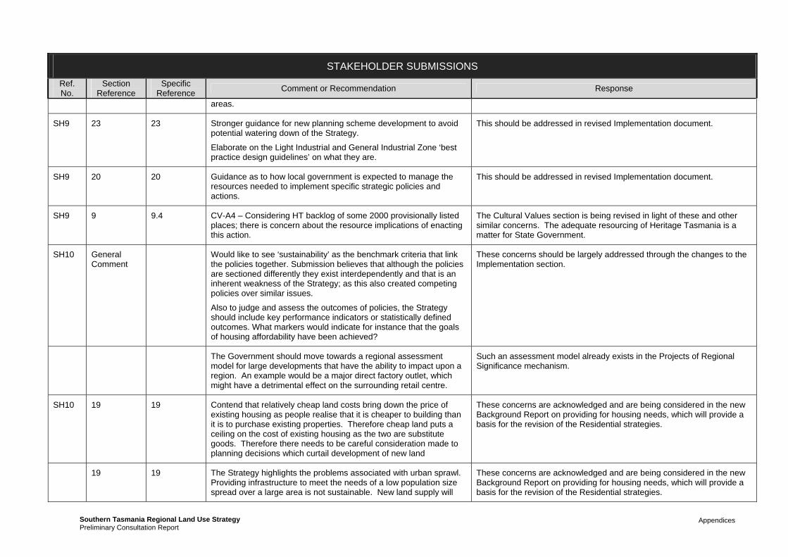
Appendices Southern Tasmania Regional Land Use StrategyPreliminary Consultation Report
STAKEHOLDER SUBMISSIONS
Ref. No.
Section Reference
Specific Reference
Comment or Recommendation Response
areas.
SH9 23 23 Stronger guidance for new planning scheme development to avoid potential watering down of the Strategy.
Elaborate on the Light Industrial and General Industrial Zone ‘best practice design guidelines’ on what they are.
This should be addressed in revised Implementation document.
SH9 20 20 Guidance as to how local government is expected to manage the resources needed to implement specific strategic policies and actions.
This should be addressed in revised Implementation document.
SH9 9 9.4 CV-A4 – Considering HT backlog of some 2000 provisionally listed places; there is concern about the resource implications of enacting this action.
The Cultural Values section is being revised in light of these and other similar concerns. The adequate resourcing of Heritage Tasmania is a matter for State Government.
SH10 General Comment
Would like to see ‘sustainability’ as the benchmark criteria that link the policies together. Submission believes that although the policies are sectioned differently they exist interdependently and that is an inherent weakness of the Strategy; as this also created competing policies over similar issues.
Also to judge and assess the outcomes of policies, the Strategy should include key performance indicators or statistically defined outcomes. What markers would indicate for instance that the goals of housing affordability have been achieved?
These concerns should be largely addressed through the changes to the Implementation section.
The Government should move towards a regional assessment model for large developments that have the ability to impact upon a region. An example would be a major direct factory outlet, which might have a detrimental effect on the surrounding retail centre.
Such an assessment model already exists in the Projects of Regional Significance mechanism.
SH10 19 19 Contend that relatively cheap land costs bring down the price of existing housing as people realise that it is cheaper to building than it is to purchase existing properties. Therefore cheap land puts a ceiling on the cost of existing housing as the two are substitute goods. Therefore there needs to be careful consideration made to planning decisions which curtail development of new land
These concerns are acknowledged and are being considered in the new Background Report on providing for housing needs, which will provide a basis for the revision of the Residential strategies.
19 19 The Strategy highlights the problems associated with urban sprawl. Providing infrastructure to meet the needs of a low population size spread over a large area is not sustainable. New land supply will
These concerns are acknowledged and are being considered in the new Background Report on providing for housing needs, which will provide a basis for the revision of the Residential strategies.

Appendices Southern Tasmania Regional Land Use StrategyPreliminary Consultation Report
STAKEHOLDER SUBMISSIONS
Ref. No.
Section Reference
Specific Reference
Comment or Recommendation Response
always be required, so the government needs to keep working on the creation of a quicker and more efficient approval process (especially where re-zoning is required). The development of new land supply should be seen as a relief valve for the market and it should be able to ensure that demand and supply are kept in check. Total reliance on in-fill strategies, no matter how well developed or intentioned, will not work.
The strategy does not advocate “total reliance” on infill and provides for some greenfield development.
One way that this can be achieved is to consider the creation of developer initiatives to target those areas where development is actively encouraged…The TPC and planning authorities could then allow ‘preferential’ planning treatment of developments in precincts where higher densities are preferred. Similar examples of developer initiatives include zoning inner city areas so that multiple units and apartments are permitted uses (provided they meeting certain basic criteria) and are therefore not subject to third party rights of appeal. Similarly, if all utility providers charged a standard connection fee in these zones, market signals would be sent to the developers which would encourage development in these areas over other areas where developer fees are set on a ‘user pay’ system.
These concerns are acknowledged and are being considered in the new Background Report on providing for housing needs, which will provide a basis for the revision of the Residential strategies.
19 19 A subdivision application should encompass all aspects (especially environmental issues and hazards) of planning assessment given their intended residential use. This should then be presented as guidelines for future housing developers and applicants for that subdivision.
These concerns are acknowledged and are being considered in the new Background Report on providing for housing needs, which will provide a basis for the revision of the Residential strategies.
SH10 19 19 Concern that potential land release areas may be bought up by developers and held onto until more favourable Market conditions.
These concerns are acknowledged and are being considered in the new Background Report on providing for housing needs, which will provide a basis for the revision of the Residential strategies.
SH11 General Comment
Better incorporation of Gehl recommendations, by way of explicit mention of urban design and non-motorised transport options.
Similarly adopting the principles of the Urban Passenger Transport Framework.
The Land Use and Transport Integration section is being revised in consultation with DIER. This should address the concerns of the submitter relevant to this section as far as possible.
SH11 5 5 Developers to provide a financial contribution to offset biodiversity impacts to compensate for small environmental losses; consistent with the Victorian Native Vegetation Framework and its ‘net gain’ objective.
The potential for financial contributions is currently being examined through the STCA Biodiversity Offsets Project. In particular the project is currently seeking legal advice on the matter given current legislative abilities of Planning Authorities under LUPAA. Will consider changes to

Appendices Southern Tasmania Regional Land Use StrategyPreliminary Consultation Report
STAKEHOLDER SUBMISSIONS
Ref. No.
Section Reference
Specific Reference
Comment or Recommendation Response
Strategy following receipt of legal advice.
SH11 5 5.5 BNV-P5 This should aim for a net gain rather than aim for ‘no net loss’. In line with Strategy coastal policies.
BNV-P8 Should stipulate emphasis on pre-permit assessment of environmental values in collaboration with non-land use planning organisations and conservation groups.
Changes will be made
SH11 5 5.6 BNV-A4, A5 A6 & A7 – strong support
BNV-A9 &10 – supportive with action to be taken at a state government level to ensure a consistent and rigorous approach to vegetation mgmt.
BNV-A11 – A building envelope be established on new subdivisions to prevent further uncontrolled impact of vegetation and fauna species.
BNV-A9 relates to an existing STCA project that does include involvement from State agencies. BNV-A10 is intended to be a recommendation to the State Government.
In regards to BNV-A11 the approach that the Strategy takes is that where subdivision is being allowed for residential purposes it should be acknowledged and assessed at that stage that the subdivision is likely to result in all or nearly all of the vegetation on the subdivided land (hence the other actions to avoid zoning land for residential purposes that contains high priority vegetation).
Use of building envelopes can be difficult to manage and enforce by Councils particularly in perpetuity and therefore is not considered to be an ideal management method and therefore their potential use is being advocated for only in the Environmental Living Zone.
SH11 6 6.6 WR-A8 – in our experience a number of planning authorities’ are resistant to innovative grey-water reused schemes. Recommend some guidance be provided to encourage greater acceptance.
Will address in revised Strategy.
SH11 7 7.5 C-P2, P4 full support
C-P8 support with amendments that will incorporate the regulation of jetties that extend beyond low water marks (s.7 LUPAA).
C-P9 strong support; would like this to be state legislation.
The concern regarding C-P8 can only be addressed through the Common Key Elements Template.
SH11 7 7.6 C-A4 support with zoning restrictions that recognise these planned retreat areas.
C-A7 support
C-A4 is likely to be achieved through a Code not zoning restrictions.
SH11 8 8.5 MRH-A5 In addition schemes should require applicants to demonstrate that any risk will be managed at an acceptable level.
MRH-A11strong support; a property on such a register should be
Noted.

Appendices Southern Tasmania Regional Land Use StrategyPreliminary Consultation Report
STAKEHOLDER SUBMISSIONS
Ref. No.
Section Reference
Specific Reference
Comment or Recommendation Response
included in the information provided under the s.337 of the Local Government Act 1993.
SH11 9 9.4 CV-A6 Look at WA model as a guide; also schemes should include provisions requiring the assessment of landscape values where development will be visible from significant public viewing locations, e.g. national parks.
The Cultural Values section is being revised and will take into account the WA model for landscape assessment. There are some concerns however with the suggested planning scheme standard relating to assessment of landscape values. Particularly given that an assessment of landscape values will not be undertaken at the time that the planning schemes are prepared. It is considered that such an idea would be more appropriately considered as part of any recommendation arising from a landscape assessment within the region.
SH11 19 19 High density urban living development should be subject to a ‘liveability test’ and mandatory minimum sustainability standards for retrofitting existing buildings in planning schemes.
There will be an increased focus on liveability in the revised Strategy as requested by DEDTA. Mandatory sustainability standards for retrofitting existing buildings in planning schemes will need to be examined closely in the scheme development to ensure that not causing over-regulation.
SH11 13 13 No mention of airports; better tourist and visitor experiences; tourist and major events transit studies; tourist transit movements, although these are discussed in the Transport Infrastructure Plan.
The Land Use and Transport Integration section is being revised in consultation with DIER. This should address the concerns of the submitter relevant to this section as far as possible.
SH11 13 13.5 LUTI-P6 supportive with due consideration of Hobart topographical constraints
The Land Use and Transport Integration section is being revised in consultation with DIER. This should address the concerns of the submitter relevant to this section as far as possible.
SH11 13 13.6 LUTI-A6 should be extended to all key transport routes, not just the major routes
Future subdivisions to comply with strategic transport policy objectives.
The Land Use and Transport Integration section is being revised in consultation with DIER. This should address the concerns of the submitter relevant to this section as far as possible.
While the Tasmanian Urban Passenger Transport Framework notes that the Metro bus network is flexible, the draft Strategy explicitly seeks to limit development that is not serviced by an existing route (LUTI – A5 & LUTI-A12)
The submitter has misunderstood these two actions, which relate to location of high intensity and major trip generating activities being located on existing major transport corridors. The Tasmanian Urban Passenger Transport Framework acknowledges that the existing major transport corridors are unlikely to change.
SH11 16 16 Strong support for the retention of agricultural land, even that which is currently being under utilised (as it does have potential for future niche market crops etc)
Noted.

Appendices Southern Tasmania Regional Land Use StrategyPreliminary Consultation Report
STAKEHOLDER SUBMISSIONS
Ref. No.
Section Reference
Specific Reference
Comment or Recommendation Response
SH12 General Comment
South East Region (agricultural area):
Relatively undeveloped region, but climate change is likely to improve this area in time for food production.
Also has significant potential to expand with additional water resources obtained from sustainable resources such as the Derwent river.
Also good location to city and associated benefits.
Noted. As part of the significant agricultural mapping that ARM have been retained to undertake, they have included the data from the TIDB that is based upon this potential.
SH12 6 6.6 WR-P8 and A9- in support and in conjunction with current processes Noted
SH12 16 16.5 PR-P1,2 and 6 support Noted
SH12 16 16.6 PR-A1 needs to consider that future developments may bring irrigation to such areas and thereby changing there classification. The two classifications should be:
A – ‘Irrigated and potentially irrigated farmland’ and
B- ‘non-irrigable farmland’
PR-A2 Ensure protection of potentially irrigable land.
PR-A3, A4 – Highly supportive.
PR-A5, A7 – supportive as it will assist farmers fund agricultural operations.
PR-A6 – Does not support; on the premises that agricultural trends are quite variable and current trends are not good indications.
PR-A8, A9, A10 – supports
Changes will be made to Strategy as a result of this submission noting that many of these actions will be now converted into policies. The two classifications are ‘Significant Agricultural Land’ and ‘Other Rural Land’. This change should however address their underlying concern. PR-A6 no longer reflects viable lot size.
SH13 General Fish Farms in Huon River: Will include additional map under Productive Resources. This will provide additional spatial recognition of importance of certain geographic

Appendices Southern Tasmania Regional Land Use StrategyPreliminary Consultation Report
STAKEHOLDER SUBMISSIONS
Ref. No.
Section Reference
Specific Reference
Comment or Recommendation Response
Comment Better mechanisms to ensure developers and new residents alike are aware of fish farm operation; Should be an attenuation zone around these farms to minimise conflict.
areas to productive resources other than agriculture.
Will also discuss with Huon Valley and Kingborough Councils how they would like to deal with these issues through their respective planning schemes.
SH14 General Comment
Satisfied that the Strategy has adequately addressed urban sprawl issues and the preservation of agricultural land.
Noted.
SH15 5 5 -Control of existing weeds declared under the weed Management Act 1999 present on land to be controlled before development.
-Implement hygiene measures during the construction and development phase.
Utilise the Natural Values Atlas in regard to weed management in development assessment process.
Would like to be involved in the development of a weeds schedule or its inclusion on the Native Vegetation Schedule.
Will include additional policy under Biodiversity and Native Vegetation section.

The Southern Tasmania Regional Planning Project
is a joint initiative of the State of Tasmania, the Southern Tasmanian Councils Authority,
the 12 Southern Councils and the Sullivans Cove Waterfront Authority