south west peninsula route strategy evidence...
TRANSCRIPT
Safe roads, reliable journeys, informed travellers
An executive agency of the Department for Transport
South West Peninsula Route Strategy
Evidence Report
April 2014

South West Peninsula route-based strategy evidence report
Document History
South West Peninsula route-based strategy evidence report
Highways Agency
This document has been issued and amended as follows:
Version Date Description Author Approved by
1 17/11/13 Draft of Chapters 1 & 3 Ian Parsons Andrew Page-Dove
2 26/11/13 Revised Draft Chapters 1 - 3 Ian Parsons Andrew Page-Dove
3 03/12/13 First draft issue to Highways Agency
Chapters 1 -4
Ian Parsons Andrew Page-Dove
4 09/01/14 New Template Ian Parsons Andrew Page-Dove
5 16/01/14 Final draft for publication Agency SW RBS Team
Andrew Page-Dove
6 30/01/14 Final draft for stakeholder comments
Agency SW RBS Team
Annabelle Dexter
7 04/04/14 Final for publication Agency SW RBS Team
Annabelle Dexter
i

South West Peninsula route-based strategy evidence report
Table of Contents
Tables ........................................................................................................................iii
1 Introduction .........................................................................................................1
1.1 Background........................................................................................................1
1.2 The scope of the stage 1 RBS evidence report..................................................2
1.3 Route description ...............................................................................................2
2 Route capability, condition and constraints.....................................................6
2.1 Route performance ............................................................................................6
2.2 Road safety......................................................................................................17
2.3 Asset condition.................................................................................................25
2.4 Route Operation...............................................................................................28
2.5 Technology ......................................................................................................31
2.6 Vulnerable road users......................................................................................31
2.7 Environment.....................................................................................................34
3 Future considerations.......................................................................................40
3.1 Overview..........................................................................................................40
3.2 Economic development and surrounding environment ....................................45
3.3 Network improvements and operational changes ............................................49
3.4 Wider transport networks .................................................................................51
4 Key challenges and opportunities ...................................................................56
4.1 Introduction ......................................................................................................56
4.2 Operational challenges and opportunities ........................................................57
4.3 Asset condition challenges and opportunities ..................................................59
4.4 Capacity challenges and opportunities ............................................................59
4.5 Safety challenges and opportunities ................................................................61
4.6 Social and environmental challenges and opportunities ..................................62
4.7 Conclusion .......................................................................................................80
Appendix A Route map .....................................................................................89
Appendix B Glossary ........................................................................................90
Appendix C Stakeholder involvement .............................................................91
ii

South West Peninsula route-based strategy evidence report
iii
Tables
Table 2.1 Ten busiest sections on the route (1 April 2012 to 31 March 2013) 6
Table 2.2 Ten least reliable journey-time locations on the route (1 April to 31 March 2013) 7
Table 3.1 Key housing and economic growth proposals 45
Table 3.2 Committed SRN enhancement schemes 50
Table 4.1 Schedule of challenges and opportunities 64
South West Peninsula route-based strategy evidence report
1
1 Introduction
1.1 Background
1.1.1 The Highways Agency is responsible for planning the long term future and development of the strategic road network.
1.1.2 Route-based strategies (RBSs) represent a fresh approach to identifying investment needs on the strategic road network. Through adopting the RBS approach, we aim to identify network needs relating to operations, maintenance and where appropriate, improvements to proactively facilitate economic growth.
1.1.3 The development of RBSs is based on one of the recommendations included in Alan Cook’s report A Fresh Start for the Strategic Road Network, published in November 2011. He recommended that the Highways Agency, working with local authorities (LA) and local enterprise partnerships (LEPs), should initiate and develop route-based strategies for the strategic road network.
1.1.4 The then Secretary of State accepted the recommendation in the Government’s response (May 2012), stating that it would enable a smarter approach to investment planning and support greater participation in planning for the strategic road network from local and regional stakeholders.
1.1.5 The Highways Agency completed the following three pilot strategies which have been published on the Agency website:
A1 West of Newcastle
A12 from the M25 to Harwich (including the A120 to Harwich)
M62 between Leeds and Manchester.
1.1.6 Building on the learning from those pilot strategies, we have divided the strategic road network into 18 routes. A map illustrating the routes is provided in Appendix A. The South West Peninsula (SWP) route is one of that number.
1.1.7 RBS are being delivered in two stages. Stage 1 establishes the necessary evidence base to help identify performance issues on routes and anticipated future challenges, takes account of asset condition and operational requirements, whilst gaining a better understanding of the local growth priorities.
1.1.8 In the second stage we will use the evidence to take forward a programme of work to identify possible solutions for a prioritised set of challenges and opportunities. It is only then that potential interventions are likely to come forward, covering operation, maintenance and if appropriate, road improvement schemes.
1.1.9 The RBS process will be used to bring together national and local priorities to inform what is needed for a route, while delivering the outcomes in the performance specification.
South West Peninsula route-based strategy evidence report
1.1.10 Using the evidence base and solutions identification studies, we will establish outline operational and investment priorities for all routes in the strategic road network for the period April 2015 – March 2021. This will in turn feed into the Roads Investment Strategy, announced by the Department for Transport in Action for Roads.
1.2 The scope of the stage 1 RBS evidence report
1.2.1 During the first stage of RBS, information from both within the Agency and from our partners and stakeholders outside the Agency has been collected to gain an understanding of the key operational, maintenance and capacity challenges for the route. These challenges take account of the possible changes that likely local growth aspirations, or wider transport network alterations will have on the routes.
1.2.2 The evidence reports:
Describe the capability, condition and constraints along the route;
Identify local growth aspirations
Identify planned network improvements and operational changes
Describe the key challenges and opportunities facing the route over the five year period
Give a forward view to challenges and opportunities that might arise beyond the five year period.
1.2.3 The 18 evidence reports across the strategic road network will be used to
Inform the selection of priority challenges and opportunities for further investigation during stage 2 of route-based strategies
Inform the development of future performance specifications for the Highways Agency.
1.2.4 A selection of the issues and opportunities identified across the route are contained within this report, with a more comprehensive list provided within the technical annex. This is for presentational reasons and is not intended to suggest a weighting or view on the priority of the issues.
1.2.5 The evidence reports do not suggest or promote solutions, or guarantee further investigation or future investment.
1.3 Route description
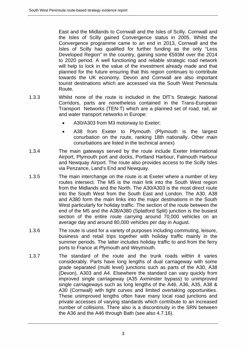
1.3.1 The SWP route includes the A30, A35, A36, A38, A303, A4 and A46 trunk roads. These roads connect the counties of Cornwall, Devon, Dorset, Hampshire, Somerset and Wiltshire. The easterly limit of the route is the point at which the A303 joins the M3 to the South West of Basingstoke. A map illustrating the route is shown at Figure 1.
1.3.2 As well as serving the areas through which the route passes, the SWP route forms a vital link from the rest of the country, particularly the South
2
South West Peninsula route-based strategy evidence report
East and the Midlands to Cornwall and the Isles of Scilly. Cornwall and the Isles of Scilly gained Convergence status in 2005. Whilst the Convergence programme came to an end in 2013, Cornwall and the Isles of Scilly has qualified for further funding as the only “Less Developed Region” in the country, gaining some €593M over the 2014 to 2020 period. A well functioning and reliable strategic road network will help to lock in the value of the investment already made and that planned for the future ensuring that this region continues to contribute towards the UK economy. Devon and Cornwall are also important tourist destinations which are accessed via the South West Peninsula Route.
1.3.3 Whilst none of the route is included in the DfT’s Strategic National Corridors, parts are nonetheless contained in the Trans-European Transport Networks (TEN-T) which are a planned set of road, rail, air and water transport networks in Europe:
A30/A303 from M3 motorway to Exeter;
A38 from Exeter to Plymouth (Plymouth is the largest conurbation on the route, ranking 18th nationally. Other main conurbations are listed in the technical annex)
1.3.4 The main gateways served by the route include Exeter International Airport, Plymouth port and docks, Portland Harbour, Falmouth Harbour and Newquay Airport. The route also provides access to the Scilly Isles via Penzance, Land’s End and Newquay.
1.3.5 The main interchange on the route is at Exeter where a number of key routes intersect. The M5 is the main link into the South West region from the Midlands and the North. The A30/A303 is the most direct route into the South West from the South East and London. The A30, A38 and A380 form the main links into the major destinations in the South West particularly for holiday traffic. The section of the route between the end of the M5 and the A38/A380 (Splatford Split) junction is the busiest section of the entire route carrying around 70,000 vehicles on an average day and around 80,000 vehicles per day in August.
1.3.6 The route is used for a variety of purposes including commuting, leisure, business and retail trips together with holiday traffic mainly in the summer periods. The latter includes holiday traffic to and from the ferry ports to France at Plymouth and Weymouth.
1.3.7 The standard of the route and the trunk roads within it varies considerably. Parts have long lengths of dual carriageway with some grade separated (multi level) junctions such as parts of the A30, A38 (Devon), A303 and A4. Elsewhere the standard can vary quickly from improved single carriageway (A35 Axminster bypass) to unimproved single carriageways such as long lengths of the A46, A36, A35, A38 & A30 (Cornwall) with tight curves and limited overtaking opportunities. These unimproved lengths often have many local road junctions and private accesses of varying standards which contribute to an increased number of collisions. There also is a discontinuity in the SRN between the A36 and the A46 through Bath (see also 4.7.16).
3

South West Peninsula route-based strategy evidence report
1.3.8 The A36 runs through the city of Salisbury and has high pedestrian usage including frequent bus stop locations, driveway accesses and a variety of surface treatments.
1.3.9 The A38 south of the M5 carries up to 80,000 vehicles per day in summer periods, whilst some sections of the A35, for example near Axminster, carry fewer than 10,000 vehicles per day. More detail on traffic flows are given in section 2.1.
1.3.10 Goods traffic (vehicles over 5.2m long) represents between 8% and 28% of the total annual traffic flow. The highest proportions are on the A30 in Cornwall between Highgate Hill and Summercourt Junction and between Launceston and Bodmin.
1.3.11 The management of the route is split into four parts. Area 1, covering Cornwall and Devon wets of the M5 is managed by EM Highways as Managing Agent Contractor. The management of Area 1 is expected to move to a new style Asset Support Contract (ASC) by 2015 in line with all other regions.
1.3.12 The A30 Trunk Road from Exeter to Honiton, and the A35 Trunk Road from Honiton to Bere Regis, is a privately run road set up under a contract between the Secretary of State for Transport and Connect A30/A35 Limited.
1.3.13 The remainder of the South West forms Area 2 and is managed by Skanska through an existing ASC except for a section of the A303 east of Parkhouse Cross Junction on the Hampshire/Wiltshire border which forms part of Area 3 and is managed by EM Highways. Key features of the new style of contracts are given in the technical annex.
1.3.14 The route connects with a number of other routes for which RBS are also being developed. These are:
The Birmingham to Exeter route at Exeter at M5 J31
The Solent to Midlands route at A35 Bere Regis, the A36 with M27 J2 and at the A34/A303 junction
The M25 to Solent (A3 and M3) route to the South West of Basingstoke at M3 J8
The London to Wales route north of Bath at M4 J18.
4

Truro Truro
NewquayAirport
NewquayAirport
PenzanceAirport
PenzanceAirport
PoolePoole
AirportAirport
BristolPort
BristolPort
AirportAirport
Figure 1South West PeninsulaRoute-based strategyoverview map
LondonLondon
BirminghamBirmingham
ManchesterManchesterLiverpoolLiverpool
Newcastle upon TyneNewcastle upon Tyne
NorwichNorwich
ExeterExeter
South West Peninsula route
Port
Airport
Junction number
© Crown copyright and database rights 2013 Ordnance Survey 100030649 – N130328
see map
above
see
map
bel
ow

South West Peninsula route-based strategy evidence report
6
2 Route capability, condition and constraints
2.1 Route performance
2.1.1 The strategic road network comprises only three per cent of England’s road network, but it carries one-third of all traffic. Around 80 per cent of all goods travel by road, with two-thirds of large goods vehicle traffic transported on our network.
2.1.2 The ten busiest sections of this route are presented in Table 2.1. This is for the reporting period 1 April 2012 to 31 March 2013.
Table 2.1 Ten busiest sections on the route (1 April 2012 to 31 March 2013)
Rank SRN section Annual Average
Daily Traffic flows (AADT)
One directional flows
National Rank
1 A38 between A379 and A380 (AL1867) 35,706 723
2 A38 between A380 and A379 (AL1866) 35,200 739
3 A38 between M5 J31 and A379 (AL1870) 29,321 934
4 A38 between A374 and A386 (AL2206) 28,850 957
5 A38 between A386 and A374 (AL1900) 28,131 986
6 A38 between A379 and M5 J31 (AL1869) 27,010 1,034
7 A303 between A3093 and A34 (AL2441) 24,745 1,144
8 A303 between A34 and A3093 (AL19) 24,641 1,153
9 A38 between A374 and A3121 (AL1896) 24,322 1,172
10 A38 between A3121 and A374 (AL1898) 24,195 1,180
Table Note – National Rank based on 2,475 links.
2.1.3 The above table includes sections of the Strategic Road Network (SRN) by direction, i.e. eastbound and westbound traffic on a single link will appear as two separate sections. In terms of the ten busiest sections within the SWP RBS, these can be described as :-
A38 M5 to the Splatford Split - both directions (ranked 1, 2, 3 and 6)
A38 between Wrangaton Junction and Manadon Junction - both directions (ranked 4, 5, 9 and 10)
A303 between Andover and the A34 – both directions (ranked 7 and 8)
2.1.4 However, busy roads in themselves don’t necessarily represent an issue – our customers’ experience of driving on the network is important to us. The Strategic road network performance specification 2013-15, sets us high level performance outcomes and outputs under the banner of an efficiently and effectively operated strategic road network. We
South West Peninsula route-based strategy evidence report
currently measure how reliable the network is based on whether the ‘journey’ time taken to travel between adjacent junctions is within a set reference time for that period, i.e. ‘on time’.
2.1.5 These sections within the SWP RBS are summarised as; A30 - Honiton to M5 (ranked 5 and 8)
A30 - Launceston (ranked 7)
A35 - Puddletown to Poundbury (ranked 2)
A35 - Dorchester (ranked 10)
A38 - Marsh Mills to Weston Mill (ranked 1 and 4)
A303 - Sparkford (ranked 3 and 6)
A303 - Andover (ranked 9)
2.1.6 Comparing tables 2.1 and 2.2 it can be seen that the A38 between Marsh Mills (A374) and Manadon Junction (A386) is the least reliable journey time location and the fourth busiest section of the SRN on the route.
Table 2.2 Ten least reliable journey-time locations on the route (1 April to 31 March 2013)
Rank Location On-time reliability measure
National Rank
1 A38 between A374 and A386 (AL2206) 61.0% 102
2 A35 between A354 and A37 (AL3098) 61.5% 118
3 A303 between A359 and A359 (AL4) 62.3% 138
4 A38 between A386 and A3064 (AL2204) 64.9% 259
5 A30 between A35 and M5 J29 (AL481) 66.1% 335
6 A303 between A359 and A359 (AL2406) 66.1% 338
7 A30 between A388 and A395 (AL488) 66.5% 359
8 A30 between A35 and A375 (AL1865C) 66.7% 374
9 A303 between A343 and A342 (AL15) 67.1% 415
10 A35 between A354 and A352 (AL3103) 67.3% 428
Table Note – National Rank based on 2,497 links. Rank 1 has the lowest on-time reliability measure (high score is better).
2.1.7 The sections of the SRN with the lowest average speeds are;
A30 - Newtown Roundabout to St Erth
A38 - Carkeel to Weston Mill
A35 – Charmouth to Bridport
7

South West Peninsula route-based strategy evidence report
8
A36 – A303 to Salisbury
2.1.8 These sections have average speeds in peak hours in the range of 31 to 40mph. It should be noted however that the A30 between Newtown Roundabout and St Erth has sections of 40 mph speed limit.
2.1.9 Lengths of the A30 from the Exeter area running into Cornwall have average speeds in peak hours in the range of 61-70mph and are some of the best performing links in the SWP.
2.1.10 The most problematic links in terms of delay are;
A38 - Carkeel to Weston Mill – both directions
A38 – Marsh Mills to Manadon – westbound
A35 – Charmouth to Bere Regis
2.1.11 Figure 2.1 illustrates the average speeds during weekday peak periods between 1 April 2012 and 31 March 2013. The peak periods are generally the busiest periods on the network and help us to understand the impact of the worst congestion on customers’ journey times. Figure 2.1 also shows any known performance or capacity issues where the local road network interfaces with the route.
2.1.12 From the information presented in these tables, the A38 around Plymouth performs particularly badly in terms of journey time reliability, average speed and delay. The section between Marsh Mills and Manadon junction is the second busiest on the route and also the least reliable in terms of journey time in the westbound direction. In terms of average speed and delay however, the problems occur to the west of Manadon junction, between Weston Mill and Carkeel, over the Tamar Bridge.
2.1.13 The A35 around Dorchester also performs badly. Two sections, between the A354 and A37 westbound and the A354 and A352 eastbound are amongst the top ten most unreliable sections in terms of journey time on this RBS route. The A35 in this vicinity also suffers from low average speeds in the peak periods and delay in the eastbound direction.
2.1.14 The A303 at Sparkford is also amongst the top ten most unreliable sections in terms of journey time reliability in both directions. This section and the others listed amongst the top ten most unreliable sections perform satisfactorily in terms of average speed and delay however.
2.1.15 Figure 2.2 shows the delay on our network compared with a theoretical free-flowing network.
2.1.16 The strategic road network is key in promoting growth of the UK economy, and alleviating congestion can realise economic benefits.
A30
A30
A30
A30
A38
A38
M5
PlymouthPlymouth
HayleHayle
Chiverton
Cross
Chiverton
Cross
Carland
Cross
Carland
Cross
AlphingtonAlphington
Turks
Head
Turks
Head
Innis Downs renewal
and upgrading
of highway drainage
Innis Downs renewal
and upgrading
of highway drainage
ExeterExeter
TruroTruro
Newquay
Penzance
HA media services, M130523 South West Peninsula
ChybuccaChybucca
29
31
Less than 20mph
21 – 30mph
31 – 40mph
41 – 50mph
51 – 60mph
61 – 70mph
No data available
Key junction capacity issue
Average speed at peak times (mph)(April 2012 – March 2013)Peak times are Monday to Friday 7–10am and 4 –7pm
Figure 2.1Network performance 2012/13Peak period speeds
South West Peninsula – Route-based strategy – Map 1 of 4
Illustrative
Exeter
International

ExeterExeter
PlymouthPlymouth
Penzance
TruroTruro
NewquayCarkeelCarkeel
Deep LaneDeep Lane
DrumbridgesDrumbridges
KenfordKenford
Many rural local road
junctions experiencing
various issues
Many rural local road
junctions experiencing
various issues
A30
A30
A30
A30
A38
A38
M5
HA media services, M130523 South West Peninsula
29
31
Less than 20mph
21 – 30mph
31 – 40mph
41 – 50mph
51 – 60mph
61 – 70mph
No data available
Key junction capacity issue
Average speed at peak times (mph)(April 2012 – March 2013)Peak times are Monday to Friday 7–10am and 4 –7pm
Figure 2.1Network performance 2012/13Peak period speeds
South West Peninsula – Route-based strategy – Map 2 of 4
Illustrative
Exeter
International
ExeterExeter
BristolBristol
BathBathBristol
International
Bournemouth
International
Southampton
International
29
31
A30
A303
A303
A303
A35
M5
M5
M4
A46
A419
A34
M3
A34
A36
A36
A31
Miles
Cross
Miles
Cross
CartgateCartgate
Dorchester
Junctions
Dorchester
Junctions
Max
Gate
Max
Gate Isle of WightIsle of Wight
SouthamptonSouthamptonSouthampton
SwindonSwindon
BournemouthBournemouth
Bristol
Poole
HA media services, M130523 South West Peninsula
East Road Roundabout
and Crown Roundabout
Bridport
East Road Roundabout
and Crown Roundabout
Bridport
Southfields
Roundabout
Southfields
Roundabout
A34AA3434
AAA34AAAA3434
Less than 20mph
21 – 30mph
31 – 40mph
41 – 50mph
51 – 60mph
61 – 70mph
No data available
Key junction capacity issue
Average speed at peak times (mph)(April 2012 – March 2013)Peak times are Monday to Friday 7–10am and 4 –7pm
M55M5
Figure 2.1Network performance 2012/13Peak period speeds
South West Peninsula – Route-based strategy – Map 3 of 4
Illustrative
Many rural local road
junctions experiencing
various issues
Many rural local road
junctions experiencing
various issues
Exeter
International
A36
A36
BristolBristol
BathBath
Bournemouth
International
A303
A303
A303
A35
M5
M4
A419
A419M5
A34
M3
A34
A31
Bath JunctionsBath Junctions
Salisbury
Junctions
Salisbury
Junctions
Isle of WightIsle of Wight
SouthamptonSouthamptonSouthampton
SwindonSwindon
BournemouthBournemouth
Bristol
International
A46
Poole
Bristol
HA media services, M130523 South West Peninsula
Many rural local road
junctions experiencing
various issues
Many rural local road
junctions experiencing
various issues Southampton
International
A303
A35
M5
M4
M27
Less than 20mph
21 – 30mph
31 – 40mph
41 – 50mph
51 – 60mph
61 – 70mph
No data available
Key junction capacity issue
Average speed at peak times (mph)(April 2012 – March 2013)Peak times are Monday to Friday 7–10am and 4 –7pm
A41A4A41419 A34AA3434
Figure 2.1Network performance 2012/13Peak period speeds
South West Peninsula – Route-based strategy – Map 4 of 4
Illustrative
A30
A30
A30
A30
A38
A38
M5
PlymouthPlymouth
ExeterExeter
TruroTruro
Newquay
Penzance
29
31
HA media services, M130523 South West Peninsula
Illustrative
Top 10%
Next 10%
Next 20%
Next 20%
Next 20%
Bottom 20%
No data available
Vehicle Hours Delay(April 2012 – March 2013)Vehicle Hours Delay is an estimate of the total travel
time experienced by all road users over and above the
expected theoretical free-flow travel time.
Explanation of data can be found in the Technical
Annex.
Exeter
International
Figure 2.2Network performance 2012/13Delay
South West Peninsula – Route-based strategy – Map 1 of 4

ExeterExeter
PlymouthPlymouth
Penzance
29
31
TruroTruro
Newquay
A30
A30
A30
A30
A38
A38
M5
HA media services, M130523 South West Peninsula
Illustrative
Top 10%
Next 10%
Next 20%
Next 20%
Next 20%
Bottom 20%
No data available
Vehicle Hours Delay(April 2012 – March 2013)Vehicle Hours Delay is an estimate of the total travel
time experienced by all road users over and above the
expected theoretical free-flow travel time.
Explanation of data can be found in the Technical
Annex.
Figure 2.2Network performance 2012/13Delay
South West Peninsula – Route-based strategy – Map 2 of 4
Exeter
International

ExeterExeter
BristolBristol
BathBathBristol
International
Bournemouth
International
Southampton
International
29
31
A30
A303
A303
A303
A35
M5
M5
M4
A46
A419
A34
M3
A34
A36
A36
A31
Isle of WightIsle of Wight
SouthamptonSouthamptonSouthampton
SwindonSwindon
BournemouthBournemouth
Bristol
Poole
HA media services, M130523 South West Peninsula
Illustrative
A3AA303
A34AA3434
A34AA3434
Top 10%
Next 10%
Next 20%
Next 20%
Next 20%
Bottom 20%
No data available
Vehicle Hours Delay(April 2012 – March 2013)Vehicle Hours Delay is an estimate of the total travel
time experienced by all road users over and above the
expected theoretical free-flow travel time.
Explanation of data can be found in the Technical
Annex.
M5M5
Figure 2.2Network performance 2012/13Delay
South West Peninsula – Route-based strategy – Map 3 of 4
Exeter
International
BristolBristol
BathBath
Bournemouth
International
A303
A303
A303
A35
M5
M4
A419
A419M5
A34
M3
A34
A36
A31
Isle of WightIsle of Wight
SouthamptonSouthamptonSouthampton
SwindonSwindon
BournemouthBournemouth
Bristol
International
A46
A36
Poole
Bristol
A36
HA media services, M130523 South West Peninsula
Illustrative
Top 10%
Next 10%
Next 20%
Next 20%
Next 20%
Bottom 20%
No data available
Vehicle Hours Delay(April 2012 – March 2013)Vehicle Hours Delay is an estimate of the total travel
time experienced by all road users over and above the
expected theoretical free-flow travel time.
Explanation of data can be found in the Technical
Annex.
Southampton
International
A303
A35
M5
M4
M27
A41A4A41419 A34AA3434
Figure 2.2Network performance 2012/13Delay
South West Peninsula – Route-based strategy – Map 4 of 4

South West Peninsula route-based strategy evidence report
2.1.17 The South West region experiences a high degree of seasonal variation in the traffic flows that the road network has to accommodate. Evidence submitted by “Visit Cornwall” showed that the regions outside the South West that generate the most tourism journeys to Cornwall are the south east (19%) and the West Midlands (14%).
2.1.18 The ten most trafficked sections of this route for seasonal conditions are presented in Table A2.2a in the technical annex. Generally, the busiest sections reflect those that are busy all year round but with traffic flows that are 3% to 25% higher than the yearly average. Elsewhere on the route traffic flows increase by up to 47%. Most of the additional traffic flow is concentrated into Fridays and Saturdays which are the traditional change over days for holiday accommodation. Table A2.2 in the technical annex shows the ten locations which have the highest August traffic flow increases for the route.
2.1.19 The seasonal increase in traffic flow has a marked effect on journey time reliability. Table A2.3 in the technical annex shows the ten worst performing sections of the route in terms of journey time reliability during the August 2013 period. The effect of seasonal traffic is demonstrated by the A303 at Stonehenge for example, where an increase in traffic of 23-26% reduces on time reliability from around 78% to 20-28%. However, it is probably due to the closure of the A344 that flow is higher, as the traffic is unable to turn off there now so has to continue. It could take a few years to collect sufficient data to determine the true nature of delay and flow at this location.
2.1.20 Much of the feedback gained from the stakeholder events related to parts of the SRN acting as a constraint to current economic activity and economic growth through congestion, journey time unreliability and delay preventing the SRN from fulfilling its strategic function effectively. Particular issues raised included Portland Harbour where the poor performance of the SRN westwards to the M5 was considered to be preventing the port from unlocking its full economic potential.
2.2 Road safety
2.2.1 As a responsible network operator and through the Strategic road network performance specification 2013-15, the Highways Agency works to ensure the safe operation of the network.
2.2.2 By 2020, The strategic framework for road safety 2011 forecasts the potential for a 40% reduction of the numbers killed or seriously injured on the roads compared with 2005-2009. We are working toward this aspirational goal.
2.2.3 Figure 2.3 illustrates the rates of injury casualties and the top 250 casualty locations on the strategic road network between 2009 and 2011. Injury accidents are recorded collisions where people were injured and their injuries were slight, serious or fatal. Damage only incidents have not been included. The top 250 casualty locations have been calculated nationally, and are based on the number of casualties
17

South West Peninsula route-based strategy evidence report
which occurred within a distance of 100m. Locations with the same number of casualties have been given a “joint” ranking and therefore, there may be some locations with the same rank number.
2.2.4 Between 2010 and 2012 there were 1,807 collisions on the route. The number per year has ranged from 540 to 639 in this three year period. Further information on collision occurrence trend for the route and the ten highest casualty locations are given in tables A2.6 and A2.7 of the technical annex.
2.2.5 Of the 1,807 collisions recorded, 50 (2.8%) included fatalities, 271 (15.0%) were classified as resulting in serious injuries and the remaining 1,486 (82.2%) included slight injuries.
2.2.6 Within the 1,807 collisions recorded there were 2,905 casualties at a rate of 1.6 casualties per collision.
2.2.7 In terms of vehicles/road users involved in the collisions;
73.1 % involved more than one vehicle
4.1% of vehicles involved were HGVs (>7.5 tonnes)
1.64% of vehicles were cycles
Where the age of the drivers was known, 5.1% were young drivers (aged 16 – 19 years)
and 17.2% were older drivers (aged 60 or over where the age was known).
3.27% of collisions involved a cyclist
2.2.8 The causation factors for accidents indicate that in the main, driver error or behaviour were the main contributory causes. A summary of the main factors are as follows:
14.7 occurred where the driver ‘failed to look properly’;
12.1% occurred where the driver ‘failed to judge other person’s path or speed’;
10.2% involved loss of control
6.4% involved a poor turn or manoeuvre
5.3% were travelling too close
5.2% involved sudden braking
4.6% cited ‘careless, reckless or in an hurry’
4.4% cited ‘slippery road’
4.4% were travelling too fast for the conditions
3.8% swerved.
18

South West Peninsula route-based strategy evidence report
NB: 6.8% of collisions on this route had no contributory factors assigned.
2.2.9 While we aim to reduce the numbers killed or seriously injured using and working on the SRN, we will always identify more safety interventions than our budget allows us to implement. We use a prioritisation process to help us and to ensure we are targeting the locations with the greatest opportunity to save lives and reduce the severity of injury.
2.2.10 Considering the A303 in more detail, the large majority of accidents were in the daytime (78%), with 68% of collisions taking place in dry conditions. Over half of all collisions involved 2 vehicles with the majority of accidents involving cars only. 51% of accidents involved vehicles travelling straight ahead on the route.
2.2.11 The locations of cluster sites on this route have been examined. A cluster site is categorised when 6 or more accidents have happened at either a single junction or, within 100 metres of each other within a five year period.
2.2.12 A total of 23 cluster sites have been recorded. Considering these cluster sites it can be seen that;
On the A30 and A38, the majority of accidents occur at junctions, with shunt type collisions. Of the 16 sites identified, 3 sites have recently been improved (in the period of 2009 – 2011) and 3 are currently being considered for improvements, which includes a recently approved pinch point scheme (see section 3.3.1).
On the A303 and A36 the large majority of collisions involve vehicles waiting to turn right into side roads. Of the 7 sites identified, 2 have recently been improved.
2.2.13 Feedback from the RBS workshops was mainly concerned with the potential for the worsening of collision statistics due to traffic flow increases arising from new development. This was raised by West Dorset District Council and Bridport Town Council amongst others.
2.2.14 Evidence presented by Cornwall Council highlighted the stretch of the A38 through the Glynn Valley, between Plymouth and Bodmin, as being of concern to the local community in terms of road safety. Similar concerns were raised by others regarding many other similar lengths of the route, especially the unimproved single carriageway lengths.
2.2.15 Reference was also made in the submitted evidence to a report by the European Road Assessment Programme which ranks sections of the SRN in terms of road safety risk. The report highlights several sections of the route which have a high accident risk. (See Figure 2.3).
19

South West Peninsula route-based strategy evidence report
20
2.2.16 Another example of the type of issue raised as a result of the stakeholder events is road safety in Wilmington which was raised as a particular concern by Widworthy Parish Council. The A35 passes through the centre of the village and several road accidents were described which have resulted in lengthy road closures.
2.2.17 The Agency is an integral member of the various Road Safety Partnerships with Police and Local Authorities. Recent safety initiatives have included seasonal deer warning signs and the Shiny Side Up Motorcycle Campaign. In addition the Agency has been involved in an initiative entitled Valley Parishes Alliance which has facilitated closer working relationships with communities affected by safety issues along the A36.

A30A30
A30A30
A30A30
A30A30
A38A38
A38A38
M5M5
PlymouthPlymouthPlymouth
ExeterExeterExeter
TruroTruroTruro
NewquayNewquay
PenzancePenzance
29
31
HA media services, M130523 South West Peninsula
Illustrative
41
41
Top 10%
Next 15%
Next 20%
Next 25%
Bottom 30%
No data available
Top 250 collision location(with national ranking)
Note: Collisions shown include all fatal,serious and slight injuries.
Total casualties per billionvehicle miles (2009 – 2011)
186
Figure 2.3Safety on the network
South West Peninsula – Route-based strategy – Map 1 of 4
123
123
ExeterInternationalExeterInternational

ExeterExeterExeter
PlymouthPlymouthPlymouth
PenzancePenzance
29
31
TruroTruroTruro
NewquayNewquay
A30A30
A30A30
A30A30
A30A30
A38A38
A38A38
M5M5
HA media services, M130523 South West Peninsula
Illustrative
Figure 2.3Safety on the network
South West Peninsula – Route-based strategy – Map 2 of 4
Top 10%
Next 15%
Next 20%
Next 25%
Bottom 30%
No data available
Top 250 collision location(with national ranking)
Note: Collisions shown include all fatal,serious and slight injuries.
Total casualties per billionvehicle miles (2009 – 2011)
186
202
ExeterInternationalExeterInternational

ExeterExeterExeter
BristolBristolBristol
BathBathBathBristolInternationalBristolInternational
BournemouthInternationalBournemouthInternational
SouthamptonInternationalSouthamptonInternational
29
31
A30A30
A303
A303
A303
A303
A303A303
A35A35
M5M5
M5M5
M4M4
A46A46
A419A419
A34
M3M3
A34
A36A36
A36A36
A31A31
ExeterInternationalExeterInternational
Isle of WightIsle of WightIsle of Wight
SouthamptonSouthamptonSouthamptonSouthamptonSouthampton
SwindonSwindonSwindon
BournemouthBournemouthBournemouth
PoolePoole
HA media services, M130523 South West Peninsula
Illustrative
A34A34
AAA34AAA34
Top 10%
Next 15%
Next 20%
Next 25%
Bottom 30%
No data available
Top 250 collision location(with national ranking)
Note: Collisions shown include all fatal,serious and slight injuries.
Total casualties per billionvehicle miles (2009 – 2011)
186
81
202
202
Figure 2.3Safety on the network
South West Peninsula – Route-based strategy – Map 3 of 4

BristolBristolBristol
BathBathBath
BournemouthInternationalBournemouthInternational
A303
A303
A303
A303
A303A303
A35A35
M5M5
M4M4
A419A419
A419M5M5
A34A34
M3M3
A34
A36A36
A31A31
Isle of WightIsle of WightIsle of Wight
SouthamptonSouthamptonSouthamptonSouthamptonSouthampton
SwindonSwindonSwindon
BournemouthBournemouthBournemouth
BristolInternationalBristolInternational
A46A46
A36A36
PoolePoole
BristolBristol
A36A36
HA media services, M130523 South West Peninsula
Illustrative
SouthamptonInternationalSouthamptonInternational
A303A303
A35A35
M5M5
M4M4
M27M27
Top 10%
Next 15%
Next 20%
Next 25%
Bottom 30%
No data available
Top 250 collision location(with national ranking)
Note: Collisions shown include all fatal,serious and slight injuries.
Total casualties per billionvehicle miles (2009 – 2011)
186
A419A419 A34A34
Figure 2.3Safety on the network
South West Peninsula – Route-based strategy – Map 4 of 4

South West Peninsula route-based strategy evidence report
2.3 Asset condition
2.3.1 We carry out routine maintenance and renewal of roads, structures and technology to keep the network safe, serviceable and reliable. We also ensure that our contractors deliver a high level of service on the strategic road network to support operational performance and the long-term integrity of the asset.
2.3.2 From new, assets have an operational ‘life’ within which, under normal conditions and maintenance, the risk of failure is expected to be low. Beyond this period, the risk of asset failure is expected to increase, although for many types of asset the risk of failure remains low and we do not routinely replace assets solely on the basis that they are older than their expected operational life. We use a combination of more regular maintenance and inspection along with a risk-based approach to ensure that assets remain safe.
2.3.3 We maintain a National Asset Management Plan as an annual summary of the Agency’s network asset inventory and condition. It is aimed at ensuring there is sight of future issues affecting the asset and enabling strategic decision making.
Carriageway Surface
2.3.4 The road surface on the strategic road network is primarily surfaced with two types of flexible bituminous materials, namely Hot Rolled Asphalt (HRA) which has an approximate design life of 25 years and Thin Surface Course System (TSCS) with a lower construction cost and shorter design life of 10-15 years. Large tranches of HRA were laid in the 1990s and TSCS tranches laid in the 2000s resulting in a significant proportion of the network reaching the end of its design life by 2020.
2.3.5 It should be noted that, although carriageway surfacing may be identified as reaching or exceeding its design life, the surfacing will not necessarily require treatment at this point. Carriageway surfacing that is beyond its design life is at a higher risk of failure, with such risk increasing the further that the surfacing exceeds its design life. The increasing age of the surfacing could manifest in an increased frequency of maintenance interventions which, if a renewals scheme is not funded, may result in a higher cost both financially and in terms of disruption to road users to maintain the asset in a safe and serviceable condition.
2.3.6 We also have concrete road surface material but this is only a very small proportion when compared to the length of flexible road surfaces. The amount of concrete road surface is also reducing as it is replaced by flexible material at the end of its serviceable life. Concrete is not a material we now use in new carriageway construction on any of the motorway and trunk road network.
25

South West Peninsula route-based strategy evidence report
2.3.7 Locations where carriageway surfacing may reach the end of its design life by 2020 are as follows;
A30 south of Bodmin - This is the main route south to Falmouth,
Redruth and Penzance for HGVs and towing vehicles
A30 north of Bodmin and South of Launceston - Part of this section between Temple and Higher Carblake Lake is single carriageway whilst the rest of the section is dual carriageway. There are plans to upgrade this section to dual carriageway standard. Work is due to start in 2014/2015 with completion planned in 2016/17
A38 Plymouth Parkway
Parts of the A38 between Plymouth and Exeter
The A303 along the majority of its length
2.3.8 Locations where carriageway surfacing are already approaching the end of their design life include;
A303 East of Bullington Cross
A36 Stapleford Village, Steeple Langford, Cotley Hill to Fisherton
A303 Wincanton to Snag Farm
A30 Sourton to Lifton
A30 Goss Moor to Innis Downs
2.3.9 The Agency has a robust ongoing maintenance programme which could see many of these sites being resurfaced prior to 2015.
Structures
2.3.10 With the exception of Saltash Tunnel, the structures in the South West area are predominately small span structures and retaining walls, some of which are in excess of 60 years old. A significant number of structures were constructed before 1950 and more than 50% of the structures were constructed in the 1970s and early 80s and are suffering from the material issues inherent with structures of this age.
2.3.11 The Saltash Tunnel is a 410m long road tunnel with three lanes of which the central lane is operated as a reversible lane to cope with peak time traffic. It is subject to a 30 mph speed limit and a robust maintenance regime to maintain its integrity.
2.3.12 The reversible lane and speed limit extend to the Tamar Bridge which is a 335m long suspension bridge carrying the A38 over the River Tamar, linking Devon and Cornwall. The bridge is owned and operated by the Tamar Bridge and Torpoint Ferry Joint Committee which is solely responsible for its maintenance. However, it should be noted that given
26
South West Peninsula route-based strategy evidence report
the lack of suitable diversion routes, any unplanned closures of the bridge or tunnel have the potential to create very challenging operational conditions.
2.3.13 Five steel composite structures commissioned in 2006 as part of the Bodmin to Indian Queens scheme have very recently been found to be adversely affected by a breakdown of the protective paint system, leading to significant surface corrosion of the steelwork. The same protective system has also been used on the two steel composite structures at Dobwalls (A38 Cornwall) and at Merrymeet (A30 Whiddon Down). The Agency is actively working to resolve this issue.
2.3.14 The Agency has an ongoing structures maintenance programme which is programmed to include the replacement of two structures along the A38 between Exeter and Plymouth at Merafield and Drybridge. This work is due to be completed before the RBS period, providing evidence of the Agency’s structures maintenance programme.
Other key asset issues for routes
2.3.15 The South West area has the following geotechnical challenges:
A section of the route running through the Glynn Valley in Cornwall is bounded on either side by unique oversteep geological formations which are unstable in places requiring an enhanced maintenance regime to maintain route integrity
A geological formation present along the A30 in Devon where there is an extremely high proportion of geological observations
Numerous earthworks classed as at-grade even though there are significant earthworks (i.e. >2.5m high) due to trunk road crossing sidelong ground. Normally an at-grade earthwork is not classed as being of significant risk due to its low height but there are numerous at grade earthworks in Area 1 which have observed defects
Sections of the network are constructed in areas that are considered geologically unstable where ongoing large scale movement is prevalent. This is particularly apparent along the A36 from Bathampton to Limpley Stoke and at A303 Rawridge Hill, both located on sidelong ground
2.3.16 Trunk roads are generally built along historic alignments and were in use long before being upgraded to their current standard. Therefore they were not constructed to withstand today’s greatly increased traffic flows. As a result, enhanced maintenance regimes are employed to retain the integrity of structures for example those located at: A303 Newcott, A303 Sparkford, A36 Monkton Combe to Limpley Stoke and A38 Glynn Valley.
27

South West Peninsula route-based strategy evidence report
2.3.17 Almost all highway assets are supported by drainage and earthworks. Both asset groups are challenging to manage due to the frequent need for intrusive (subterranean) inspection and maintenance.
2.3.18 Large amounts of the drainage asset are older than 30-40 years. Large amounts of the drainage asset would therefore have exceeded its serviceable life. The South West has a larger than average amount of filter drain which is nearing the end of its serviceable design life. Filter drains are designed to provide effective removal of surface water from the carriageway.
2.3.19 The lighting assets are planned to be upgraded / converted to electronic control gear in Area 1. These works are being programmed in conjunction with routine maintenance and electrical testing to reduce road occupancy. In addition, there is a rolling programme of Non Destructive Testing (NDT) of lighting columns, to ensure that the lighting stock is fit for purpose. More than 50% of the lighting asset is considered beyond its expected life in Area 2.
2.4 Route Operation
Incident Management
2.4.1 We work hard to deliver a reliable service to customers and to reduce the number and impacts of incidents on road users.
2.4.2 Across the whole network, the Highways Agency Traffic Officer Service responds to around 20,000 incidents each month. We measure how effective we are at managing incidents by looking at the time incidents affect the running lanes.
2.4.3 There are 7 Regional Control Centres (RCC) across England, these co-ordinate incident management and control on road technology, such as variable message signs and CCTV. There is one National Traffic Control Centre which provides a strategic overview of the network. This centre co-ordinates the information services and events which may affect more than one region.
2.4.4 In the South West only the motorways and the A38 between Exeter and Plymouth (Tamar Bridge) have a dedicated Traffic Officer Service (TOS). The other trunk roads within the SWP are subject to a limited level of service.
2.4.5 We have a good understanding of the types of incidents which are quick to clear up and those which take longer. In general, there are far more incidents which don’t affect the running lanes for very long. These are mostly caused by breakdowns, debris or damage only collisions. The longest duration incidents are mostly caused by infrastructure issues, such as damaged road surface, bridge strikes, barrier collisions and spillages.
28
South West Peninsula route-based strategy evidence report
2.4.6 We continue to work with our partners in the emergency services to reduce the impacts on our network arising from serious collisions and long-duration incidents.
Flooding
2.4.7 We have a responsibility to reduce flooding on the SRN. Flooding of the Agency’s network impacts upon network performance and the safety of road users. Flooding off the network has an impact on third parties living adjacent to the network.
2.4.8 Using the Environment Agency flood risk data, those parts of the network that are at risk of repeated flooding have been identified and these are described in the technical annex. The majority of these are locations where the route is in close proximity to water courses; such as to the east of Launceston (where the A30 crosses the River Tamar), the A303 through Podimore and West Camel (where the road runs next to Park Brook) and the various streams which feed into the River Yeo. In July 2012, prior to the Olympic Games, the A35 was closed at Winterbourne Abbas for several days due to flooding resulting from extreme rainfall and a high water table level.
2.4.9 The Devon and Cornwall area has experienced 60 flooding events over the last year. This figure is likely to remain the same for the following year based on the existence of known flooding problems. Flood risk may become a bigger issue due to climate change impact on the deteriorating condition of our assets.
Severe Weather
2.4.10 The Highways Agency aims to minimise the impacts of severe weather, i.e. strong winds and snow, on network performance and the safety of road users.
2.4.11 The diverse topography of the route leads to a varied severe weather pattern, the impact of which can be very challenging for the operation of the route. Snow events on higher sections have been particularly challenging, including the A30 running over Bodmin Moor and the A38 at Haldon Hill outside Exeter. The Agency has been working in partnership with others to agree dedicated plans designed to keep the traffic moving through such events. Recently unpredicted heavy hail storms have created severe operational challenges at various locations throughout the route.
2.4.12 Other snow events have blocked one lane of the A30 Honiton Road eastbound, between the junctions with the B3184 and the A35 and caused one lane to close at Okehampton. Snow has caused road closures on all roads in Devon and on sections of the A35 near Dorchester.
29

South West Peninsula route-based strategy evidence report
2.4.13 Much of the route along the south coast is susceptible to storm weather. Most of the issues during these times are caused by flooding as opposed to the strong winds. However there have been a few incidents, such as fallen trees blocking the A30 between Yeovil and Crewkerne and the A38 at Notter Bridge to the west of Plymouth.
30

South West Peninsula route-based strategy evidence report
2.5 Technology
2.5.1 The Highways Agency works hard to deliver a reliable service to customers through effective traffic management and the provision of accurate and timely information. We provide information to our customers before and during their journeys.
2.5.2 We monitor key parts of our network using CCTV and sensors in the road to monitor traffic conditions. These are used by our National Traffic Operations Centre and seven Regional Control Centres to provide information to customers before their journeys, eg on the Traffic England website or through the hands-free traffic app for smart phones. Whilst on the network, we also inform our customers using variable message signs (VMS).
2.5.3 Technologies such as overhead gantries, lane specific signals and driver information signs also form part of how we operate our network efficiently. In some locations we have controlled motorways, which is where we can use variable mandatory speed limits to help keep traffic moving. Smart motorways use both variable mandatory speed limits and the hard shoulder as an additional live traffic lane during periods of congestion. Ramp metering manages traffic accessing the network via slip roads during busy periods to help avoid merging and mainline traffic from bunching together and disrupting mainline traffic flow.
2.5.4 In general, the South West region has very good provision of technology, although much of this is concentrated on the M5 which does not form part of the route. Away from the motorway network, the route has technology in the form of CCTV for monitoring traffic conditions at key locations (such as Chiverton Cross and the Splatford Split) and VMS for informing road users (mainly along the A38). A full list of the technology provision for Area 1 is included in the technical annex. The two provisions where the South West has significantly less technology provision than the national average are with ramp metering and meteorology.
2.5.5 On the A30 there is a large seasonal variation in traffic volumes due to “holiday” traffic in the summer months. This results in a number of congestion “hot spots”, particularly where dual carriageway changes to single carriageway. In order to minimise the effect of these, a number of schemes have been installed which include queue detection technology at the most critical locations. In addition, mobile VMS are deployed to advise of queues ahead and to provide driver information.
2.6 Vulnerable road users
2.6.1 The South West area has numerous public rights of way and other designated routes due to the nature of the area, with numerous Areas of Outstanding Natural Beauty. The popularity of the area as a holiday location means that larger numbers of leisure walkers and cyclists use these routes.
31

South West Peninsula route-based strategy evidence report
2.6.2 There are a number of long distance walking paths in the area that cross or are crossed by the trunk road network. The majority of these are listed below;
St Michael’s Way;
Saints Way;
Exe Valley Way;
Clarenden Way;
Avon Valley Path;
Cotswold Way
Stour Valley Way; and
River Parrett trail
2.6.3 There are numerous National Cycle Network (NCN) Routes that cross or interact with the trunk roads in the South West. These are;
Route 2 A long distance cycle route linking Dover in Kent with St.
Austell in Cornwall;
Route 3 Land’s End to Bristol;
Route 24 Bath to Eastleigh;
Route 26 Portishead in Somerset to Portland Bill in Dorset;
Route 27 Ilfracombe to Plymouth;
Route 32 Bodmin to Truro; and
Route 33 Bristol to Seaton.
Route 45 Chester to Salisbury
2.6.4 Specific safety concerns across the route are mainly related to the use of the SRN by cyclists. Part of the A30 is often used for the Lands End to John O’Groats cycle route although many advertised routes advise using alternative roads. It was felt by stakeholders that not enough consideration was given to cyclists when highway improvement schemes were developed. Specific examples given included Stadium Roundabout and Monkeys Jump Roundabout in Dorset.
2.6.5 The All Party Parliamentary Cycling Group Report ‘Get Britain Cycling’ recommended that “The Highways Agency should draw up a programme to remove the barriers to cycle journeys parallel to or across trunk roads and motorway corridors, starting with the places where the potential for increased cycle use is greatest”.
2.6.6 Infrastructure improvements are not the only area which needs to be considered. Maintenance is also important. Carriageway defects can have serious consequences for cyclists, either if a cyclists fails to avoid
32

South West Peninsula route-based strategy evidence report
such a defect, or if they have to take avoiding action and swerve into traffic. Similarly, where cyclists use trunk roads they may keep to the extreme left of the road, perhaps to the left of an edge line if there is one, and it is helpful if this area is kept clear of debris through regular sweeping.
2.6.7 From available evidence the A303 is a major safety concern, both for cyclists who may choose to cycle along the carriageway and for those who wish to cross the road.
2.6.8 In the South Wiltshire area, the major tourist attraction is Stonehenge. Cycling groups are concerned that, despite commitments in the Stonehenge Master Plan to improve access for walkers and cyclists, the new visitor centre is significantly lacking in terms of provision for these travel modes. This is due to the absence of adequate crossing facilities on the A303.
2.6.9 Stakeholders in Dorset also raised concerns about the safety of cyclists, especially along the unimproved sections of the A35 west of Dorchester with various issues at junctions highlighted.
2.6.10 In Cornwall the St Erth railway station is being promoted as a replacement park and ride site to provide additional capacity for non-car trips to St Ives. The proposals may lead to an increase in pedestrian and cyclist traffic at this location.
2.6.11 The Cornwall Ramblers Association would like to see a crossing installed on the A30 where St Michael’s Way crosses the road north of Longrock. Improvements were also requested at the A30 Chiverton roundabout to rectify the issues facing commuter cyclists between some of the larger settlements on the north Cornish coast, for example Perranporth and Newquay.
2.6.12 Stakeholders also felt that the lack of facilities for cyclists and pedestrians had the effect of deterring walk and cycle trips. In certain locations, the SRN lies across walk and cycle desire lines and improved facilities for these modes could encourage greater use leading to a reduction in car use, hereby freeing up capacity on the highway network.
33

South West Peninsula route-based strategy evidence report
2.7 Environment
2.7.1 As a responsible network operator and through the Strategic road network performance specification 2013-15, the Highways Agency works to enhance the road user experience whilst minimising the impacts of the strategic road network on local communities and both the natural and built environment.
Air quality
2.7.2 We recognise that vehicles using our road network are a source of air pollution which can have an effect on human health and the environment. We also appreciate that construction activities on our road network can lead to short-term air quality effects which we also need to manage.
2.7.3 The Highways Agency is committed to delivering the most effective solutions to minimise the air quality impacts resulting from traffic using our network. We will operate and develop our network in a way that works toward compliance with statutory air quality limits as part of our broader Environmental Strategy.
2.7.4 The Bath Air Quality Management Area (AQMA) covers all the major roads in Bath, which includes the section of the A36 which runs through the city.
2.7.5 The Salisbury AQMA encompasses the whole of the city centre within the A36 Churchill Way ring road. To the east of this is the Wilton Road AQMA which encompasses the A36 between the St. Paul’s roundabout and Hawthorne Close.
2.7.6 The Westbury AQMA is not directly on the trunk road network, but it is close enough to the A36 to still be potentially be affected by it. This encompasses Haynes Road and Warminster Road on the A350.
2.7.7 The Yeovil AQMA encompasses the entire built up area of Yeovil in South Somerset, the nearby airfield, and several potential development areas identified in the emerging local plan. The A303 runs just to the north of the town and two smaller roads feed directly off of it and into the Yeovil town centre.
2.7.8 In West Dorset, the towns of Dorchester and Chideock both lie along the route of the A35. The Dorchester AQMA runs along the B3150 High East Street and the Chideock AQMA comprises of the stretch of the A35 running through the village and 15m to either side.
2.7.9 Honiton in East Devon marks the point where the A30 and A35 meet. Several roads in the vicinity of the town such as the A30 Exeter Road, A35 Monkton Road an A35 Kings Road make up the area of the East Devon AQMA.
34

South West Peninsula route-based strategy evidence report
2.7.10 The A30 and A38 (and the M5 which is included in a different RBS) converge in the vicinity of the city of Exeter. The Exeter AQMA consists of the network of other major roads running across the city.
2.7.11 The A38 runs south through Teignbridge from Exeter. However, none of the District’s AQMAs include areas in the vicinity of this road.
2.7.12 The A38 continues to run from the north to the west of the South Hams District. The A38 AQMA consists of the stretch of road running through the Dean Prior to the south of the town of Buckfastleigh. The Ivybridge AQMA only includes Western Road, which feeds directly onto the A38.
2.7.13 There are two separate AQMAs within the Plymouth city limits, both to the south of the A38. The first is focused on the junction of Mannamead Road and Mutley Plain, and the second is the area encompassing the A374 Exeter Street and Embankment Road.
2.7.14 The Tideford AQMA covers the entirety of the Cornish village of Tideford, which lies on the path of the A38. The A38 meets the A30 outside of the town of Bodmin, the town centre of which is encompassed by the Bodmin AQMA. The largest AQMA in Cornwall is the Kerrier AQMA which includes the Camborne, Redruth and Pool regeneration area along the A30.
2.7.15 Defra identifies exceedences of European air quality limits for annual average levels of nitrogen dioxide (NO2) in all of these AQMAs.
Cultural heritage
2.7.16 Wherever possible, Agency schemes are designed to avoid impacts on cultural heritage assets.
2.7.17 On the A30 between Penzance and Launceston, places of significant cultural heritage include the towns of Camborne and Redruth, Lanhydrock House and its grounds, the River Lynher as it runs through Upton Wood and Launceston Castle.
2.7.18 There are only a couple of sites of cultural significance along the route of the A38, both of which are towards the eastern end of the road by Exeter. The first is Stover Country Park, which is located opposite Heathfield. The second is Ugbrooke Park, to the south of Chudleigh.
2.7.19 The section of the A35 between Charmouth and Bridport runs very close to the south coast, which forms part of the Jurassic Coast.
2.7.20 The main cultural area on the route of the A303 is Stonehenge, which is located between Amesbury and Winterbourne Stoke. Other areas along the A303 include King Alfred’s Tower and its associated woodland between Wincanton and Mere, and Amport House in the village of Amport to the west of Andover which currently contains the Museum of Army Chaplaincy.
35

South West Peninsula route-based strategy evidence report
2.7.21 The A36 starts in the city of Bath, which is well known for its rich cultural heritage. Other places of significant cultural heritage along the A36 include the village of Lullington, the Orchardleigh Estate, Longleat House and its extensive grounds, the village of Wilton which has a rich Anglo-Saxon heritage and Salisbury
2.7.22 To the north of Bath on the A46, is Dyrham Park which is part of the National Trust.
Ecology
2.7.23 The Agency’s activities, including road construction projects and maintenance schemes, have the potential to impact on protected sites, habitats and species. We aim to minimise the impact of our activities on the surrounding ecology and wherever possible contribute to the creation of coherent and resilient ecological networks by maximising opportunities for protecting, promoting, conserving and enhancing our diverse natural environment.
2.7.24 To the east of the junction with the A39 (east of Newquay) the A30 passes along the northern boundary of Goss Moor and slightly further on passes to the south of Fox Park near Bodmin. Both of these areas contain numerous small streams which flow into the River Fal and the River Camel respectively. There are several areas to the north of the A30 between Bodmin and Launceston that are ecologically sensitive, such as the streams feeding into the River Camel and De Lank River. The A30 also forms the northern boundary of Dartmoor National Park, which contains many sensitive areas. One particular area extends very close to the route of the A30 as it passes by Okehampton.
2.7.25 The A38 passes over the River Tamar as it widens and passes to the west of the city of Plymouth. Further to the east, the A38 borders the Dartmoor National Park. Haldon Forest, which is to the east of the park and near to the junction with the A380, is situated directly next to the A38 and is under the protection of the Forestry Commission.
2.7.26 On the A35 the only ecological sensitive area is at the point the River Frome passes to the north of Dorchester and underneath the A35.
2.7.27 On the A303, there is a small ecologically sensitive area at Parsonage Down, to the west of Winterbourne Stoke. To the east of Andover is another ecological site, at the location where the River Test crosses underneath the A303. The A303 also crosses the River Avon SAC at three locations, near Amesbury, Winterbourne Stoke and Wylye.
2.7.28 As the A36 goes south out of Bath, it follows the route of the River Avon, as well as passing near Warleigh Wood and Conkwell Wood on the other side of the river. From Warminster through to eastern edge of Salisbury the A36 borders the River Avon (and its tributaries) SAC. To the north west of Salisbury, the road runs very close to Grovely Wood.
36
South West Peninsula route-based strategy evidence report
The A36 also runs along the boundary of the New Forest National Park, which contains ecologically sensitive areas close to the road.
2.7.29 Special Areas of Conservation (SACs) are areas that under the EU’s Habitats Directive, have been given special protection to a variety of wild animals, plants and habitats.
2.7.30 On the A46 heading north out of Bath towards the M4, there are two small areas of ecological sensitivity. The first is Burmead Wood, to the south of Cold Ashton by the junction with the A420. The second is Dyrham Wood, which is to the south of the National Trust Dyrham Park.
Landscape
2.7.31 Roads and other transport routes have been an integral part of the English landscape for centuries. However, due to large increases in traffic, combined with modern highway requirements, they can be in conflict with their surroundings. We are committed, wherever possible, to minimise the effect of our road network on the landscape.
2.7.32 The A303 passes through the The Stonehenge, Avebury and Associated Sites World Heritage Site
2.7.33 Bodmin Moor is a key area of landscape sensitivity on the A30. A notable area in particular is Colliford Lake. The A30 and A38 also run along the boundary of the Dartmoor National Park.
2.7.34 East of Honiton, the A303 and A35 pass through the Blackdown Hills AONB. The A36 near Bath and the A46 run through the Cotswolds AONB.
2.7.35 A303 and A36 both pass through the Cranbourne Chase and West Wilsthire AONB.
2.7.36 The A36 also passes through and borders the New Forest National park in Hampshire.
2.7.37 Exmoor National Park is the only area within the South West region designated as an international Dark Sky Reserve.
Noise
2.7.38 Traffic noise arising from the Highways Agency’s network has been recognised as a major source of noise pollution.
2.7.39 We take practical steps to minimise noise and disturbance arising from the road network. This includes providing appropriate highway designs and making more use of noise reducing technologies.
2.7.40 In 2012, Defra completed the first round of noise mapping and action planning which identified the top one per cent of noisiest locations
37

South West Peninsula route-based strategy evidence report
adjacent to major roads. These were based on the conditions in 2006. The locations in this top one per cent are known as Important Areas.
2.7.41 The noise important areas on the route are listed below :- On the A30;
between Tolvaddon and Pool, to the west of Redruth, Cornwall.
near to the Bodmin Moor Wildlife Park and Colliford Tavern, by Colliford Lake between Bodmin and Launceston, Cornwall
to the west of Launceston near to the Tolpetherwin Farm, Cornwall
at Launceston, Cornwall
at Exeter, Devon
at Honiton, near the junction with the A35, Devon
On the A38
at Dobwalls, Cornwall
to the east of Liskeard, Cornwall
at Saltash, Cornwall
along the Plymouth Parkway, Devon
at Plympton, Ivybridge, Bittaford, Wrangaton and Buckfastleigh, Devon
On the A35
Bothenhampton on the eastern side of Bridport, Dorset
Winterbourne, to the west of Dorchester, Dorset
On the A303
near to Yeovil, Somerset
Stoke-Sub-Hamdon and Tintinhull, Somerset
Wincanton, Somerset
Mere, Somerset
Chicklade, Somerset
Andover, Hampshire, including to the west of the town as it passes through Thruxton and four further areas as it loops around the city
On the A36
Salisbury, Wiltshire
On the A4
between Batheaston and Bathford, Somerset.
38

South West Peninsula route-based strategy evidence report
On the A46
Bath, near to the junction with the A4. Somerset.
Swainswick,
Nimlet, south of the junction with the A420.
Water pollution risk
2.7.42 We have a duty not to pollute water courses and ground water. We have identified highway discharge locations across our network where there is an existing potential water pollution risk.
2.7.43 There are numerous areas of existing water pollution risk along all the roads that make up the route. The majority of these are concentrated into a small number of areas as follows;
A30 between Highgate Hill and Victoria
A30 across Bodmin Moor.
A30 between Okehampton and Exeter.
A38 through the Glynn Valley
A38 across the River Bovey and River Teign
2.7.44 Further details of the water pollution sites are given in the technical annex.
39
South West Peninsula route-based strategy evidence report
40
3 Future considerations
3.1 Overview
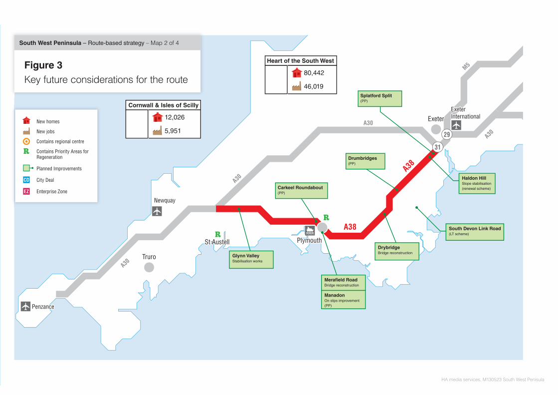
3.1.1 There is already a lot known about the planned changes to and around the route. Local authorities and the development community are already pushing forward the delivery of their housing and economic growth aspirations, as set out in their local plans. The Highways Agency has a large programme of schemes to deliver, plus an even larger programme of pipeline measures that could come forward after the general election. Local authorities, together with port and airport operators, are progressing measures to improve the operation and performance of their transport networks and facilities.
3.1.2 All of these issues have the potential to directly influence the ongoing performance and operation of the route. Figure 3 summarises the anticipated key future issues and the following sections summarise those issues in more detail.

A30A30
A30A30
A30A30
A30A30
A38A38
A38A38
M5M5
PlymouthPlymouthPlymouth
ExeterExeterExeter
TruroTruroTruro
NewquayNewquay
PenzancePenzance
ExeterInternationalExeterInternational
29
31
Newquay AerohubEnterprise Zone
Newquay AerohubEnterprise Zone
Newquay AerohubEnterprise Zone
HA media services, M130523 South West Penisula
Figure 3Key future considerations for the route
South West Peninsula – Route-based strategy – Map 1 of 4
80,442
46,019
Heart of the South West
12,026
5,951
Cornwall & Isles of Scilly
Roseworthy to TolvaddonProposed resurfacing £1.9m
A30 Temple to Higher Carblake(MP)
Camborne, Poole, RedruthTransport package
Loggans Moor Roundabout(PP)
Newtown Roundabout(PP)
West CornwallTransport InterchangeSt Erth
Sourton to Lifton WestboundProposed resurfacing £2.5m Tithebarn Link Road
Local transport scheme
Goss Moor to Innis DownsProposed resurfacing both directionsand drainage £3.3m
New homes
New jobs
Contains regional centre
Contains Priority Areas forRegeneration
Planned Improvements
City Deal
Enterprise Zone
ExeterExeterExeter
PlymouthPlymouthPlymouth
PenzancePenzance
29
31
TruroTruroTruro
St AustellSt AustellSt Austell
NewquayNewquay
A30A30
A30A30
A30A30
A30A30
A38A38
A38A38
M5M5
ExeterInternationalExeterInternational
HA media services, M130523 South West Penisula
Figure 3Key future considerations for the route
South West Peninsula – Route-based strategy – Map 2 of 4
80,442
46,019
Heart of the South West
12,026
5,951
Cornwall & Isles of Scilly
Splatford Split(PP)
Haldon HillSlope stabilisation (renewal scheme)
South Devon Link Road(LT scheme)
DrybridgeBridge reconstruction
Glynn ValleyStabilisation works
Merafield RoadBridge reconstruction
ManadonOn slips improvement(PP)
Drumbridges(PP)
Carkeel Roundabout(PP)
New homes
New jobs
Contains regional centre
Contains Priority Areas forRegeneration
Planned Improvements
City Deal
Enterprise Zone

ExeterExeterExeter
BristolBristolBristol
BathBathBathBristolInternationalBristolInternational
BournemouthInternationalBournemouthInternational
SouthamptonInternationalSouthamptonInternational
29
31
A30A30
A303
A303
A303
A303
A303A303
A35A35
M5M5
M5M5
M4M4
A46A46
A419A419
A34A34
M3M3
A34A34
A36A36
A36A36
A31A31
ExeterInternationalExeterInternational
Isle of WightIsle of WightIsle of Wight
SouthamptonSouthamptonSouthamptonSouthamptonSouthampton
SwindonSwindonSwindon
BournemouthBournemouthBournemouth
BristolBristol
PoolePoole
HA media services, M130523 South West Penisula
Figure 3Key future considerations for the route
South West Peninsula – Route-based strategy – Map 3 of 4
80,442
46,019
Heart of the South West
A303Feasibility study
Design Build Finance OperateRoute
Wincanton to Snag’s FarmResurfacing £5.2m
Cartgate(PP)
29,747
14,798
Swindon & Wiltshire
25,822
29,833
West of England
21,820
22,803
Dorset
New homes
New jobs
Contains regional centre
Contains Priority Areas forRegeneration
Planned Improvements
City Deal
Enterprise Zone
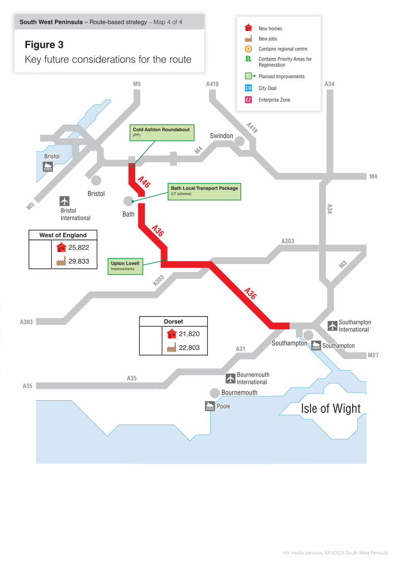
BristolBristolBristol
BathBathBath
BournemouthInternationalBournemouthInternational
A303
A303
A303
A303
A303A303
A35A35
M5M5
M4M4
A419A419
A419A419M5M5
A34A34
M3M3
A34
A36A36
A31A31
Isle of WightIsle of WightIsle of Wight
SouthamptonSouthamptonSouthamptonSouthamptonSouthampton
SwindonSwindonSwindon
BournemouthBournemouthBournemouth
BristolInternationalBristolInternational
A46A46
A36A36
PoolePoole
BristolBristol
A36A36
HA media services, M130523 South West Penisula
SouthamptonInternationalSouthamptonInternational
A303A303
A35A35
M5M5
M4M4
M27M27
Figure 3Key future considerations for the route
South West Peninsula – Route-based strategy – Map 4 of 4
Cold Ashton Roundabout(PP)
Upton LovellImprovements
Bath Local Transport Package(LT scheme)
25,822
29,833
West of England
21,820
22,803
Dorset
AA
New homes
New jobs
Contains regional centre
Contains Priority Areas forRegeneration
Planned Improvements
City Deal
Enterprise Zone

South West Peninsula route-based strategy evidence report
3.2 Economic development and surrounding environment
3.2.1 A key aspect of managing the route effectively will be ensuring that it is capable of supporting future local housing and economic growth aspirations. This will involve preparing the route through effective management and public investment to be in the best possible position to cater for the planned demands placed upon it, whilst ensuring that the developments themselves effectively mitigate their local impacts.
3.2.2 Figure 3 summarises the known key housing and economic growth aspirations that would impact on the route, with Table 3.1 below providing more context about some of those key developments the nature, scale and timing of the proposals.
3.2.3 Table 3.1 summarises key housing and economic growth proposals by Local Planning Authority Area. It then outlines specific proposals which are likely to have an effect on the SRN (due to both their size and proximity to the SRN). In order to source this information, use has been made of the most recent Development Plan Document [DPD] available for the authority.
Table 3.1 Key housing and economic growth proposals
Location of Development
Development Type
Scale by 2015
Scale by 2021
Scale by 2031
Anticipated Location of
Impact on Route
Cornwall Council (total)
Residential
Commercial
5,466 units
2,705 jobs
12,026 units
5,951 jobs
22,716 units
11,241 jobs
A30 between Penzance and Launceston
A38 between Bodmin and Plymouth
Key development areas within Cornwall: Camborne and Redruth Bodmin
Residential Commercial Residential Commercial
339 units 399 jobs 630 units 112 jobs
747 units 878 jobs 1,387 units 247 jobs
1,411 units 1,660 jobs 2,621 units 467 jobs
A30 around Camborne and Redruth A30 and A38 around Bodmin
Exeter City Council (total)
Residential
Commercial
4,834 units
1,182 jobs
9,389 units
4,137 jobs
15,049 units
10,047 jobs
A30 and A38 around Exeter
Key development areas within Exeter: - Matford, Exeter - Hill Barton, Exeter - Newcourt
Commercial Commercial Commercial
492 jobs 164 jobs 526 jobs
1,724 jobs 575 jobs 1, 838 jobs
Exeter city advised unable to disaggregate figures between these sites .
A38 and A30 around Exeter
45
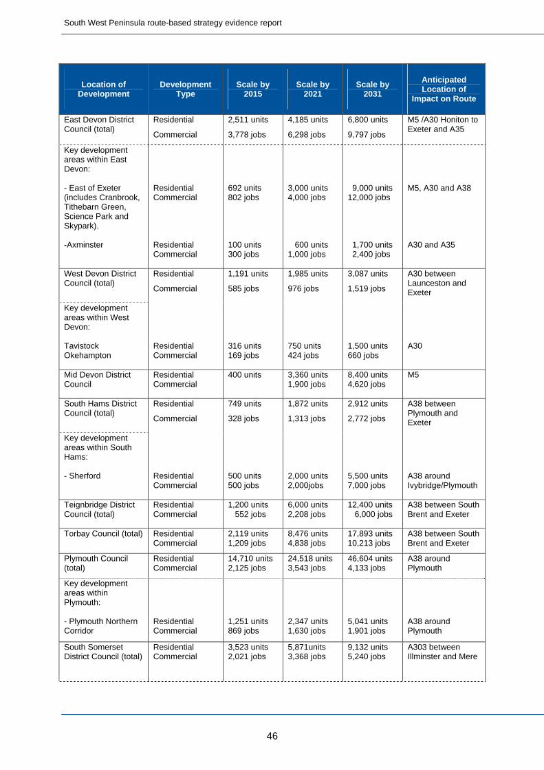
South West Peninsula route-based strategy evidence report
46
Location of Development
Development Type
Scale by 2015
Scale by 2021
Scale by 2031
Anticipated Location of
Impact on Route
East Devon District Council (total)
Residential
Commercial
2,511 units
3,778 jobs
4,185 units
6,298 jobs
6,800 units
9,797 jobs
M5 /A30 Honiton to Exeter and A35
Key development areas within East Devon: - East of Exeter (includes Cranbrook, Tithebarn Green, Science Park and Skypark). -Axminster
Residential Commercial Residential Commercial
692 units 802 jobs 100 units 300 jobs
3,000 units 4,000 jobs 600 units 1,000 jobs
9,000 units 12,000 jobs 1,700 units 2,400 jobs
M5, A30 and A38 A30 and A35
West Devon District Council (total)
Residential
Commercial
1,191 units
585 jobs
1,985 units
976 jobs
3,087 units
1,519 jobs
A30 between Launceston and Exeter
Key development areas within West Devon: Tavistock Okehampton
Residential Commercial
316 units 169 jobs
750 units 424 jobs
1,500 units 660 jobs
A30
Mid Devon District Council
Residential Commercial
400 units
3,360 units 1,900 jobs
8,400 units 4,620 jobs
M5
South Hams District Council (total)
Residential
Commercial
749 units
328 jobs
1,872 units
1,313 jobs
2,912 units
2,772 jobs
A38 between Plymouth and Exeter
Key development areas within South Hams: - Sherford
Residential Commercial
500 units 500 jobs
2,000 units 2,000jobs
5,500 units 7,000 jobs
A38 around Ivybridge/Plymouth
Teignbridge District Council (total)
Residential Commercial
1,200 units 552 jobs
6,000 units 2,208 jobs
12,400 units 6,000 jobs
A38 between South Brent and Exeter
Torbay Council (total) Residential Commercial
2,119 units 1,209 jobs
8,476 units 4,838 jobs
17,893 units 10,213 jobs
A38 between South Brent and Exeter
Plymouth Council (total)
Residential Commercial
14,710 units 2,125 jobs
24,518 units 3,543 jobs
46,604 units 4,133 jobs
A38 around Plymouth
Key development areas within Plymouth: - Plymouth Northern Corridor
Residential Commercial
1,251 units 869 jobs
2,347 units 1,630 jobs
5,041 units 1,901 jobs
A38 around Plymouth
South Somerset District Council (total)
Residential Commercial
3,523 units 2,021 jobs
5,871units 3,368 jobs
9,132 units 5,240 jobs
A303 between Illminster and Mere

South West Peninsula route-based strategy evidence report
47
Location of Development
Development Type
Scale by 2015
Scale by 2021
Scale by 2031
Anticipated Location of
Impact on Route
Key development areas within South Somerset: Yeovil
Residential Commercial
868 units 501 jobs
3,473 units 2,004 jobs
7,815 units 4,508 jobs
A303 around Yeovil
Taunton Deane District Council (total)
Residential
Commercial
3,282 units
2,138 jobs
8,206 units
5,346 jobs
14,588 units
9,711 jobs
A303 at junction with A358
Mendip District Council (total)
Residential
Commercial
2,360 units
2,295 jobs
3,934 units
3,825 jobs
6,120 units
6,375 jobs
A36 between Warminster and Bath
Key development areas within Mendip: Frome
Residential Commercial
591 units 662 jobs
985 units 1,104 jobs
1,533 units 1,840 jobs
A36 around Frome
West Dorset District Council and Weymouth & Portland Borough Council (total)
Residential
Commercial
1,227 units
3,068 units
2,275 jobs
6,476 units
4,804 jobs
A35 between Axminster and Puddletown
Key development areas within West Dorset: Dorchester
Residential Commercial
344 units 197 jobs
861 units 492 jobs
1,818 units 1,039 jobs
A35 around Dorchester
North Dorset District Council (total)
Residential
Commercial
1,809 units
976 jobs
3,015 units
1,626 jobs
4,690 units
2,259 jobs
A35 between Puddletown and Poole
Purbeck District Council (total)
Residential
Commercial
648 units
852 jobs
1,080 units
1,421 jobs
1,680 units
2,211 jobs
A35 between Puddletown and Poole
Christchurch and East Dorset District Council (total)
Residential
Commercial
1,093 units
1,006 jobs
4,371 units
4,025 jobs
7,102 units
6,541 jobs
A35 around Poole and Bournemouth
Poole Borough Council (total)
Residential
Commercial
2,700 units
3,753 jobs
4,500 units
6,255 jobs
7,000 units
9,730 jobs
A35 around Poole
Bournemouth Borough Council (total)
Residential
Commercial
2,315 units
2,880 jobs
5,787 units
7,200 jobs
9,002 units
11,200 jobs
A35 around Bournemouth
Bath and North East Somerset Council (total)
Residential
Commercial
1,541 units
1,187 jobs
6,165 units
4,750 jobs
12,330 units
9,500 jobs
A36 and A46 between the M4 and Beckington
Key development areas within BANES: Bath
Residential Commercial
840 units 875 jobs
3,360 units 3,500 jobs
6,720 units 7,000 jobs
A36, A46 and A4 around Bath particularly at junction with A4 London Road
South Gloucestershire Council (total)
Residential
Commercial
8,508 units
9,250 jobs
21,607 units
18,500 jobs
29,716 units
28,300 jobs
A46 between the M4 and Bath

South West Peninsula route-based strategy evidence report
48
Location of Development
Development Type
Scale by 2015
Scale by 2021
Scale by 2031
Anticipated Location of
Impact on Route
Wiltshire Council (total)
Residential
Commercial
9,936 units
4,541 jobs
16,560 units
7,569 jobs
25,760 units
11,775 jobs
A303 between Mere and Andover, A36 and A46 between Beckington and Southampton
Key development areas within Wiltshire: Salisbury
Residential Commercial
1,636 units 738 jobs
2,727 units 1,231 jobs
4,242 units 1,915 jobs
A36 around Salisbury
New Forest District Council (total)
Residential
Commercial
Unknown 1,470 units
3,245 jobs
2,940 units
6,490 jobs
A36 around Southampton
Southampton Council (total)
Residential
Commercial
Unknown 2,250 units
3,500 jobs
4,500 units
7,000 jobs
A36 around Southampton
Test Valley Council (total)
Residential Unknown 1,300 units 2,600 units A303 between Amesbury and the A3
3.2.4 Newquay Aerohub Enterprise Zone is located approximately 7 miles from the A30. It aims to facilitate private sector investment within the aerospace sector by creating a new aviation/aerospace hub that will deliver (by 2015) up to 724 high value, highly skilled permanent jobs underpinned by the development of an aviation skills academy.
3.2.5 The Bournemouth and Poole City Region Deal was agreed in February 2013. This will identify major employment opportunities at Bournemouth Airport and the Port of Poole. The local authorities of Bournemouth, Poole and Christchurch, along with key partners are currently in negotiations with government to look at the Bournemouth and Poole City Region Deal in further detail. It should be noted that the Poole/Bournemouth conurbation is the second largest urban area in the South West (SW) region after Bristol.
3.2.6 The investment of £20m in the Bath City Riverside Enterprise Area, which is located one mile to the west of the A46/A4, will deliver 9,000 new jobs, with a focus on the media and publishing sectors.
3.2.7 During the stakeholder workshops, comments were made about how important economic growth and jobs are and how transport and infrastructure are key to facilitating this growth. The focus of new jobs and housing is felt to be around existing towns and centres.
3.2.8 During the stakeholder engagement, particular mention was made of the following developments:

South West Peninsula route-based strategy evidence report
Growth is planned in relation to the Enterprise Zone at Newquay
Growth is planned at Hayle, Cornwall and nearby West Cornwall Retail park
The population of Plymouth is expected to increase by 50,000 over the next 20 years. Key areas:
o Derriford o City Centre o Sherford
Considerable growth concentrated around the Exeter area.
The impact of the new Stonehenge visitor centre is not known yet. Solstice Park site also not yet fully developed
At Crossways, near Dorchester, a proposal for 1,000 holiday homes has come forward
At Portland, there is a proposal for a major visitor attraction
At Miles Cross junction, Bridport, there is a proposal for 700 homes
Maintaining good access to Poole and Bournemouth is essential to the economic wellbeing of Dorset
3,000 new homes are planned at Yate and Thornbury
Development at Bournemouth Airport will lead to congestion issues. Up to 10,000 jobs proposed
Port of Poole provides access to 25 hectares of employment (accessed from Merley)
Andover is one of the fastest growing towns in the Solent region
3.2.9 The route serves Exeter, Newquay and Bournemouth Airports as well as the ports at Falmouth, St Ives, Penzance, Fowey, Plymouth, Weymouth, Portland and Poole. This information is covered under the Wider Transport Networks in Section 3.4.
3.3 Network improvements and operational changes
3.3.1 The Agency is already delivering a large capital programme of enhancement schemes nationally. This includes Major Schemes greater than £10m in value, plus smaller enhancement schemes including the current pinch point programme.
3.3.2 Table 3.2 summarises the current committed enhancement schemes proposed along the route, which are also represented on Figure 3.
49

South West Peninsula route-based strategy evidence report
3.3.3 Throughout the SWP there are many known maintenance issues that will need addressing over the next five years such as:
Deterioration of carriageway condition and structures
Ability of existing drainage infrastructure to cope with increased demands
Table 3.2 Committed SRN enhancement schemes
Location Scheme Type Completion
Year Anticipated Benefits
A30 Temple to Higher Carblake Improvement
Part-funded local management scheme. Dualling of single carriageway.
2017 Dualling this section of the A30 will improve opportunities for economic growth in Cornwall by removing a constraint to the capacity of the A30 route, which will improve safety and relieve congestion and delay.
A30 Loggans Moor Roundabout
Pinch point scheme.Increased junction capacity.
2014 Improved flow through the junction by increasing its traffic capacity and reduce waiting times, especially during peak tourist times. The proposals achieve wider benefits in supporting growth in the surrounding area, such as development at Hayle.
A38 Manadon On-Slips Improvement, Plymouth
Pinch point scheme.Extending slip roads.
2014 Improved flow through the junction and reduced conflicts between merging traffic streams. The proposals achieve wider benefits in supporting growth in the surrounding area, such as major development at Plymstock Quarry.
A38 / A380 Splatford Split Additional Lane
Pinch point scheme. Extending the two lanes of the A380 through to the junction with the A38 trunk road.
2015 Improved flow of traffic through this area and reduced conflicts between merging traffic streams. The proposals achieve wider benefits in supporting growth in the surrounding area.
A38 Drumbridges Roundabout Improvement, Newton Abbot
Pinch point scheme. Installation traffic signals on the roundabout at the top of the slip roads and allow more traffic to move around the roundabout.
2015 Improved flow through the junction by increasing its traffic capacity and reduce waiting times by the installation of traffic signals that react to approaching and waiting traffic to maximise green light timings. It will provide a safe means of access for pedestrians and cyclists. The proposals achieve wider benefits in supporting growth in the surrounding area of Newton Abbot.
A38 Carkeel Roundabout
Pinch point scheme. Improvements to the roundabout westbound approach and westbound exit to Carkeel roundabout and installing a pedestrian footbridge on the A38 eastern arm.
2015 Improvements will result in improved flow through the junction and reduced conflicts between merging traffic streams. The proposals achieve wider benefits in supporting growth in the surrounding area, such as development at Carkeel and Saltash.
A303 Cartgate Roundabout Improvement, Yeovil
Pinch point scheme. Provision of dedicated left turn lanes from the A303 into Yeovil and from Yeovil on to
2015 Improved flow through the junction for traffic leaving and joining the A303 from the A3088. The proposals achieve wider benefits in supporting growth in the
50
South West Peninsula route-based strategy evidence report
the A303 surrounding area, such as at Yeovil.
A36 Upton Lovell Safety Improvement 2014 Provision of traffic signals to improve road safety for all road users.
A46 Cold Ashton Roundabout
Pinch point scheme. 2015 The scheme involves widening the A46 and A420 approaches to Cold Ashton roundabout and providing an additional lane so that two lanes circulate the roundabout.
3.3.4 Some of the known key issues are:
The replacement of the A38 Merafield Road Bridge due to
material issues inherent with structures of this age. Estimated cost £5M
Given the age and characteristics of the asset running through the A38 Glynn Valley various maintenance works are planned to maintain network integrity. Estimated cost £3M
3.3.5 The 2013 Spending Review and subsequent report from HM Treasury Investing in Britain’s Future referenced a series of potential new pipeline schemes for the strategic road network. There are however no pipeline schemes for the strategic road network on the route.
3.3.6 The HM Treasury report Investing in Britain’s Future also promoted undertaking a number of feasibility studies that the government will undertake to inform potential future investment in highway improvements. The study relating to this route is:
A303/A30/A358 Corridor
3.3.7 This location is well known to the Agency and does not need to await conclusion of these evidence reports. This study in effect expedites elements of the stage 2 phase of the RBS through the early investigation of specific interventions on this section of the route. At stage 2, any results available from the feasibility study work will be considered in the context of the emerging strategy recommendations for the entire route, including maintenance, operations and any other enhancements deemed necessary along the route, together with the timing of those needs.
3.4 Wider transport networks
3.4.1 The June 2013 report from HM Treasury Investing in Britain’s Future also listed the local transport schemes either completed, under construction or due to start before May 2015. Table 3.3 below lists the schemes from that report that will influence the ongoing operation of this route, plus any other funded local network commitments that will be delivered before 2021.
51

South West Peninsula route-based strategy evidence report
Table 3.3 Committed local transport network enhancement schemes
Project Scheme Type Completion
Year Anticipated Impacts on the Route
South Devon Link Road Road Scheme 2016 The South Devon Link Road is a 5.5km dual carriageway, which will bypass the existing A380 between Newton Abbot and Torbay. It is predicted that the new road will remove 95% of traffic away from Kingskerswell.
Camborne-Pool-Redruth Transport Package
Road Scheme 2015 Creation of a new East to West route from Camborne to Redruth through Pool, and included an upgraded link to the A30 Trunk Road.
West Cornwall Transport Interchange
Mixed Scheme 2014 To help resolve the traffic congestion problems and ‘kick start’ investment in the area, Cornwall Council is proposing to establish a major transport interchange at St Erth station. Aims to ‘free up’ capacity on the main roads.
Newquay Strategic Route Road Scheme The Newquay Growth Area has been identified as an area for new homes, jobs and associated services. The strategic route will allow movements in and out of the Growth Area to the surrounding route network.
Trafalgar Roundabout roadworks Road Scheme 2013 Scheme will improve traffic flow and access for pedestrians and cyclists, upgrade the road surface, support public transport and re-route vital utility pipes.
Carluddon A391 Road Improvements
Road Scheme A proposal to build a new section of the A391 road at Carluddon, and create a new Technology Park next to it. Could increase traffic levels on the adjoining A30.
Bridge Road widening, Exeter Road Scheme 2016 By providing two lanes outbound the scheme will reduce queuing and exit blocking at Countess Wear, improving conditions for traffic exiting the city and in particular on the outer bypass. In addition by addressing the sole single lane section on the outer bypass, additional capacity will be provided to encourage more local trips to use the route instead of the Strategic Road Network.
Alphington Park and Ride
(Supersedes Exeter Principal Urban Area scheme)
Reserve Local Transport scheme
2017 Construction of bus lanes where feasible and a new Park and Ride facility, close to M5 J30.
A35/A351 Bakers Arms Roundabout
Road Scheme 2013 Lane widening to improve capacity together with the construction of a foot / cycleway at the Bakers Arms Roundabout.
A351 - Route Management and Improved Cycle Facilities
Road Scheme 2013 Reduced traffic congestion along the A351 from Wareham to the Bakers Arms roundabout by giving people
52

South West Peninsula route-based strategy evidence report
alternative travel choices.
Dorchester Transport and Environment Plan
Road Scheme 2018 Aims to protect the historic heart of the town by reducing through traffic and improving air quality. It does not seek to increase the capacity of the road network.
Extension of NCN2 from Druids Walk to Maiden Castle Road, Weymouth Avenue, Dorchester
Cycle Scheme 2013 Improvements to cycling could remove local traffic from the network (A35).
Improving travel (Weymouth - Dorchester corridor)
Mixed Scheme 2015 Scheme includes improving public transport with a south Dorchester interchange.
Bath Transportation Package Public Transport Scheme
2015 Increasing Park and Ride capacity, better bus routes and improving transport flows could remove local traffic from the network.
Bullington Cross Road Scheme Unknown Improvement of access from A34/A30 on slip road A303 West at Bullington Cross to reduce dangerous back-up of traffic, particularly at peak time.
East Anton Developer Contribution
Unknown A303/A3093 interchange at East Anton - Improved merge arrangements at the on-slip to increase capacity.
Andover rail station Public Transport Scheme
Unknown Objective is to provide additional car parking capacity at northern side of station and infrastructure/waiting and information improvements to the platform.
3.4.2 The “Connecting Cornwall: 2030 Strategy” states that they will work with partners to look for the following improvements which may affect the route:
Extending the electrification of the Great Western mainline from Exeter to Plymouth and Cornwall.
Delivery of a second strategic route to the South West to reduce reliance on the M4/ M5 strategic link.
Improving the performance of the A38 around Plymouth.
Dualling of the A30 between Temple and Higher Carblake.
Dualling of the A30 between Carland Cross and Chiverton Cross.
Capacity improvements to key junctions on the A30 and A38.
Traffic management and junction improvements along the A38.
3.4.3 Devon’s third Local Transport Plan (LTP3) outlines some schemes which, if implemented could have an effect on the route. Devon Metro is the name given to an extensive plan to expand the role of railways serving Devon and Torbay over the next fifteen years. Some of the train
53
South West Peninsula route-based strategy evidence report
services including those on the Avocet rail line (connecting Exeter with Exmouth and Paignton) and the Tarka line (from Barnstaple) suffer from overcrowding during peak periods.
3.4.4 In the longer term it is felt that there will be a need for a new link road in Exeter providing improved facilities for both private cars and buses and relieving the trunk road network. In the future, it is noted that possible measures to make best use of the existing network could include ‘smart motorway’ techniques.
3.4.5 The Devon LTP3 outlines that completion of the South Devon Link road (which will link Torbay to the wider economy in Devon and beyond), is critical to connect Torbay and to support economic growth in the Torbay and Exeter sub region. The council will support improved road connections to Cornwall and safety improvements to the A30, and support modest enhancements to A303 to improve resilience and journey time reliability.
3.4.6 Somerset and Wiltshire councils aspire for the A303 to act as a 'second strategic route’. Business leaders in the region have aspirations for the A303 to be upgraded to dual carriageway standard, with a local paper running a campaign entitled “A303 Dual it!”
3.4.7 The route serves Exeter, Newquay and Bournemouth Airports as well as the ports at Falmouth, St Ives, Penzance, Fowey, Plymouth, Weymouth, Portland and Poole.
3.4.8 Exeter Airport is located in Devon, close to the M5 J29. The airport offers both scheduled and holiday charter flights within the United Kingdom and Europe. The master plan for Exeter Airport predicts an average annual growth of 6.2% per annum between 2000 and 2030.
3.4.9 Newquay Airport is the main commercial airport for Cornwall, located to the northeast of Newquay. The new terminal extension has increased the terminal size by 20%, and was opened in 2006. This means the airport can handle as many as 450,000 passengers a year. From 2006 onwards, many carriers have pulled commercial flights from the airport, leaving Newquay with year-round flights to just the Isles of Scilly and Manchester.
3.4.10 Bournemouth Airport recently received a £32 million investment which created car parking spaces in two separate car parks and built a new International Arrivals terminal. Scheduled flights from this airport now frequently serve Western Europe and the Mediterranean area, with charter and seasonal services serving North Africa, North America, and the Caribbean.
3.4.11 A number of activities are undertaken at the Port of Falmouth, including ship repair, cargo handling, cruise ships and recreational boating. A master plan for the Port of Falmouth was published in 2011 which outlines an option for growth which would deliver £1,503m additional
54

South West Peninsula route-based strategy evidence report
55
GVA (852 additional full time equivalent (FTE) jobs by 2015) through additional port operations, super yacht facilities, fuelling and ship repair. £2m has been allocated to a sustainable transport package, to allow improved access to the Port.
3.4.12 St Ives Port is predominantly used for leisure and tourism purposes whereas ferry services operate from Penzance to the Isles of Scilly. Fowey is a deep water harbour that is the largest exporter in tonnage terms on the route. It is also in the top twelve ports for non-oil product exports in the United Kingdom. Fowey accommodates over 7,000 visiting craft through the summer season and has up to 1,500 resident craft.
3.4.13 Plymouth is the largest city on the southwest peninsula and is home to the largest naval base in Western Europe. The primary harbour authority is the MoD who operates the port, which includes Her Majesty's Naval Base Devonport. The Royal Navy Dockyard consists of 14 dry docks, four miles of waterfront, 25 tidal berths, five basins and an area of 650 acres. The Navy estimates that the Dockyard generates about 10% of Plymouth's income1.
3.4.14 The Port of Weymouth handles both freight and passengers travelling to the Channel Islands and French mainland. At nearby Portland, commercial activities on the water include specialist diving services for vessels and repairs & maintenance as well as a bunkering (fuelling) station. The port is used by all nature of vessels from commercial ships such as bulkers, tankers, container carriers, car carriers, survey and Reefers etc. to British and foreign naval vessels. Commercial activities on the land of the dock estate include fuel storage, natural gas storage, several engineering facilities and a shell fish specialist.
3.4.15 The Portland Harbour Revision Order 2010 provides for the creation of new berths and hardstand areas at the port in order to allow increased commercial activities over the next 50 years. These new facilities have been identified as part of a master plan and business strategy developed by Portland Port. The development is designed to increase berthing opportunities and provide more operational land.
1 http://www.royalnavy.mod.uk/The-Fleet/Naval-Bases/Devonport

South West Peninsula route-based strategy evidence report
56
4 Key challenges and opportunities
4.1 Introduction
4.1.1 It is not possible to show all the challenges and opportunities identified in this evidence report. This chapter shows a selection based on those where our internal and external stakeholders viewed these as a priority and these are supported by evidence. A full list of all the identified challenges and opportunities are provided in the Technical Annex.
4.1.2 Figure 4 summarises some of the key issues and challenges that the route will experience during the 5 years from 2015, with the following sections and Table 4.1 explaining these issues and challenges in more detail.
Timescales
4.1.3 To understand the timescales of when the key challenges identified become critical and when opportunities on the route could be realised, the following definitions have been made in Table 4.1:
Short Term: current
Medium Term: before March 2021
Long Term: not before 2021
4.1.4 The timescale categories provide a guide for informing when a future intervention may be required to meet the anticipated future operational performance needs, or when interventions may be needed to help facilitate local housing and economic growth aspirations.
4.1.5 The route is a focal point for future local economic growth generally, with 242,000 residential units and 150,000 new jobs planned by 2031. The main concentrations are at Plymouth, Yeovil, Bath, Exeter, Salisbury, Bodmin, Dorchester and Frome.
4.1.6 The already committed programme of enhancement schemes and pipeline schemes will go some way to tackling capacity problems in the short term. However, further enhancement is likely to be required before 2021 to treat remaining capacity issues.
4.1.7 Detailed assessment of the growth programmes of Local Authorities and the ability of the SRN to accommodate the traffic flows arising from economic growth will predict where future capacity problems are likely to arise or worsen.
4.1.8 The enhancement of road safety is an existing priority for the Agency and will continue to be a key challenge.

South West Peninsula route-based strategy evidence report
4.1.9 There are opportunities to improve route operation through the expansion of TOS coverage and improved road user information systems.
4.1.10 There will be key maintenance challenges and opportunities on the route during the 5 year period covered by the Stage 1 RBS Evidence Report.
Local Stakeholder Priorities
4.1.11 Input from stakeholder and road user groups linked to the route have been used to inform the development of this evidence report. This included getting their views on what they deemed to be the priorities within their area and identifying their “top priorities” locally. This has been collated according to the road to which those views related.
4.1.12 Table 4.1 presents a summary of whether the challenges and opportunities identified were a priority for our stakeholders in their particular area. This exercise does not seek to prioritise the challenges and opportunities along the length of the route by trying to compare one issue against another, but reports the feedback from local discussions.
4.1.13 This picture of stakeholder priorities is subjective, and has been informed by discussions at the stakeholder events, and in conversations with stakeholders who couldn’t attend the events.
4.1.14 We recognise that the picture we build through this categorisation will be influenced by the representatives and organisations we have engaged with, and that consequently we may not have achieved a statistically balanced view. We will be conscious of the limitations of the reporting of stakeholder priorities as we move into the second stage of RBS.
4.2 Operational challenges and opportunities
4.2.1 There is currently only limited TOS coverage for the roads that make up the route. Route resilience is however the main operational priority reported by stakeholders as something that needs to improve. The limited TOS coverage is seen by stakeholders as a possible contributory factor to this.
4.2.2 While sections of the route were singled out as having particularly poor resilience, these being A35 and A38, route resilience was considered to be an issue across the route not only for the convenience of the travelling public but also for supporting businesses and economic growth. Other contributory factors were considered to be a lack of suitable alternative/diversion routes and a lack of roadside information for road users.
4.2.3 The seasonal variation of traffic flow means that different sections of the route suffer from resilience issues at different times of the year. Some of these locations only suffer from resilience issues for short periods and
57

South West Peninsula route-based strategy evidence report
concern was expressed that it may prove difficult to build economic cases for improvements at such locations. It was felt that locations with only seasonal resilience issues may be less likely to attract improvement schemes than other locations with year round resilience problems.
4.2.4 In particular locations it was pointed out that changes to the local road networks and major economic development could require changes to the signing strategy of routes to and from the SRN. One particular example was the Newquay Enterprise Zone for which it was considered the signing strategy may no longer be relevant to the optimum routes.
4.2.5 The availability and location of roadside service areas (RSAs) was considered to lack strategic planning. Distances between and facilities at RSAs can vary significantly and some may have access issues. The provision and location of RSAs is led by the planning system and driven by economic viability. The Agency’s policies in relation to RSAs only determine which RSAs are signed from the SRN. Stakeholders questioned if this was the right approach and if more strategic identification of need would be beneficial.
4.2.6 Speed limits need to vary along a route to reflect road conditions and the needs of all users of the highway. It was considered by stakeholders however that there are some areas of inconsistency where a more co-ordinated approach to speed limit setting may present benefits in terms of improving driver expectation and speed limit awareness. The A35 was highlighted as a particular case.
4.2.7 As well as the areas gateways and holiday destinations, Stonehenge is a particular attraction on the A303 which causes local congestion issues. The A303 passes within 500m of the historic stones.
4.2.8 As well as holiday traffic, there are a significant number of festivals held in the South West region including Glastonbury festival, many of which create operational challenges for the route.
4.2.9 There are many towns and villages in places along the route and especially on the unimproved sections, where through vehicles including HGVs (heavy goods vehicles) pass through the heart of the community and present a real barrier to village life creating multiple issues, including severe environmental and severance concerns.
4.2.10 Within the SWP, flood risk and extreme weather events are likely to become a bigger issue and will lead to deterioration of assets. Area 1 experienced 60 flooding events in 2012 and this figure is likely to remain the same for future years based on the existence of known flooding problems.
4.2.11 Severe winter weather in the area has also accelerated thin surfacing end of life issues. For example, 36% of the thin surfacing on the Area 1
58

South West Peninsula route-based strategy evidence report
network is already nearing end of life with a further 50% in a satisfactory condition.
4.2.12 Large amounts of the Area 1 drainage asset are older than 30-40 years. Areas within the Glynn Valley, Cornwall are older. Large amounts of the asset would therefore have exceeded its serviceable life.
4.2.13 Trunks roads generally follow historic alignments constructed prior to the motorway network. Increased volumes of traffic are putting additional stress on some parts of the network. Due to the age of the A303, there are particular areas prone to geotechnical failure. For example, the A30 Rawridge Hill is geologically unstable as it is located on sidelong ground. The A303 has evolved in places from single to dual carriageway resulting in differential rates of deterioration across carriageways due to different construction materials and total thicknesses.
4.3 Asset condition challenges and opportunities
4.3.1 The renewal of carriageway surfacing is an ongoing challenge and a number of key locations are listed in previous chapters where road surfacing is coming to the end of its design life prior to 2020. Some of these sections are already identified in maintenance programmes or capital schemes for renewal. The monitoring and planning of this essential maintenance requirement will remain a key activity of the Agency.
4.3.2 In terms of the standard of maintenance of the route, it was felt by stakeholders that there may be a disparity in maintenance standards between single carriageway and dual carriageway sections. The A38 through the Glynn Valley and the single carriageway sections of the A35 were highlighted as particular areas of poor maintenance standard, including road markings, drainage, road sweeping, etc. Such issues can have knock on effects for the environment, vulnerable road users, etc. Cyclists for example keep to the nearside and depend on debris free channels to enable them to keep clear of traffic streams.
4.3.3 The standard of the roads and junctions that make up the route was also seen as an Asset Condition issue by stakeholders where certain sections may no longer be in compliance with the latest design standard, or standards appear to vary along a route.
4.4 Capacity challenges and opportunities
4.4.1 The evidence presented in Chapter 2 describes the following sections as poor performing links within the SWP in terms of the on time reliability measure:
A38 - Plymouth Parkway
A35 – Charmouth to Bere Regis
59
South West Peninsula route-based strategy evidence report
A30 – Honiton to M5
A30 – Launceston
A303 – Sparkford
A303 – Andover
4.4.2 Of these, the Plymouth Parkway has a pinch point scheme already identified at Manadon Junction. The A303, as previously mentioned, is the subject of a Government led feasibility study.
4.4.3 It can be seen from Table 3.1 that housing and economic growth is planned throughout the South West region and along the entire route. This pattern of development has the potential to affect many junctions and links. While the effects of the growth are not yet known, the Agency already has a strategic traffic model covering most of the route which can be used to identify future areas of network stress. Strategic models such as this are valuable tools in targeting future investment decisions.
4.4.4 The main housing and economic growth aspirations and the sections of the route they will principally affect are also set out in Table 3.1. The main developments and their areas of impact are as follows:-
A30 – Camborne, Poole and Redruth,
A30/A38 - at Exeter and Bodmin
A38 – Plymouth
A36 – at Frome, Salisbury and Bath
A35 – at Dorchester
4.4.5 Committed local transport network enhancement schemes are listed is Table 3.3. Some of these have the potential to impact on the operation of the SRN, some positively, some negatively. The Camborne-Pool-Redruth Transport Package is an example of a scheme which has the potential to reduce traffic on the A30 by creating an alternative east-west route.
4.4.6 The Newquay strategic route has the potential to alter the movement of traffic flow to and from the SRN and may require the reconsideration of signing strategies as referred to elsewhere. The Bath Transportation Package includes an increase in Park and Ride capacity, better bus routes and improving transport flows which could remove some local traffic from the SRN and reduce the effects of growth.
4.4.7 Improving the capacity and reliability of the SRN to support economic growth was by far the highest priority of stakeholders. The A303 in its entirety was the main priority overall and supports the inclusion of the route as a Government led feasibility study. The feasibility study will
60

South West Peninsula route-based strategy evidence report
consider solutions to long-standing problems in specific locations and will work alongside the RBS process. The A303 at Stonehenge was raised as a particular concern in summer periods when passers by slow down to take a look at the historic stones. Table 2.5 in the technical annex shows that this section of road is the worst performing of the route during the August period.
4.4.8 The A35 around Dorchester was raised as the second highest priority where significant growth is planned in an area of existing congestion.
4.4.9 The single carriageway section of the A30 between Carland Cross and Chiverton, to the north of Truro was the third highest priority and identified as being likely to become under increasing risk of congestion in the near future when the A30 between Temple and Higher Carblake has been changed to dual carriageway standard. There is concern that the extensive summer time queues on the approach to Higher Carblake will simply move westwards to Carland Cross when the dualling scheme is complete. The capacity of the existing junction between Carland Cross and Chiverton (Chybucca) was also raised as an existing all-year concern.
4.4.10 Other locations where it was felt by stakeholders that the SRN had the potential to restrict economic growth due to restricted capacity, delay and unreliability included the A30 at Hayle, A38 Plymouth Parkway the A38 Splatford Split junction and the A35 at Bridport.
4.4.11 Particular capacity issues were highlighted where dual carriageways convert to single carriageway such as on the A303 in a number of locations and on the A30 at Roseworthy Dip on the approach to Hayle.
4.5 Safety challenges and opportunities
4.5.1 The sites with the ten highest number of casualties per 100 million vehicle miles are listed in Table A2.7 in the technical annex. These SWP RBS sections are described and locally ranked below;
A30 between Honiton and Exeter (ranked 1)
A303 between the A34 and the M3 (ranked 2 and 6)
A303 between the A338 and Andover (ranked 3, 4, 5, 7 and 10)
A30 between Summercourt and Mitchell (ranked 8)
A35 at Dorchester (ranked 9)
4.5.2 The stakeholders gave a number of other locations of high priority sites at which safety records needed improvement, these included;
A38 Glynn Valley
A303 single carriageway sections
61
South West Peninsula route-based strategy evidence report
A30 Blue Anchor Junction
4.5.3 The use of the A30 as part of the Land’s End to John O’Groats cycle route has created many safety issues despite alternative routes avoiding the SRN being available.
4.5.4 The lack of facilities for cyclists and pedestrians has the effect of deterring walk and cycle trips. Focussed improvements in facilities for Vulnerable Road Users could result in a reduction of the use of SRN for short journeys.
4.6 Social and environmental challenges and opportunities
4.6.1 The main priority of stakeholders in terms of social and environmental issues is the community severance caused by the SRN effectively dividing communities into two. The villages on the A30 between St Erth and Newtown Roundabout and Wilmington on the A35 were given as specific examples but similar issues were also considered to exist throughout the route.
4.6.2 In terms of the environment, the improvement of air quality in those areas already designated as Air Quality Management Areas (AQMAs) is a key ongoing issue for the Agency. Previous sections list those AQMAs which are directly affected by the SRN. The air quality effects that will arise as a result of development lead traffic growth will need to be carefully monitored, managed and mitigated where appropriate.
4.6.3 Noise Important areas are also listed in section 2. The concrete surface of the A30 between Honiton and Exeter was given as an example of a long standing noise issue by stakeholders. Parts of this route are noise important areas. Another issue raised by stakeholders was the A38 Plymouth Parkway where pruning of vegetation had been reported as having the effect of increasing traffic noise in the vicinity of Marsh Mills junction. Plymouth Parkway is also a noise important area.
4.6.4 Areas known to be prone to flooding are listed in the technical annex. Flooding is usually caused by blocked drainage or rising river levels and can cause significant disruption to traffic flow and affect road safety along the SRN. In some cases it can also cause third party damage. In some locations, such as the A38 through the Glynn Valley, flood water discharge from land adjacent to the SRN can occur which can overwhelm even well functioning road drainage systems.
4.6.5 After periods of dry whether, the flood water on or discharging from the SRN can be quite polluted due to it washing away material built up on the carriageway. This can affect ecology and was reported by stakeholders as a particular issue at Highgate Hill, Whiddon Down and many others.
4.6.6 Flooding at Winterbourne Abbas was raised as a particular issue by stakeholders. In July last year, prior to the Olympics, the A35 was
62

South West Peninsula route-based strategy evidence report
63
closed at Winterbourne Abbas for several days due to extreme rain fall and high water table level.
4.6.7 Flooding due to long term sea level rises was also raised by stakeholders particularly in relation to Hayle. In the long term, sea level rises are expected to result in the closure of the Causeway which is one of the two links into Hayle from the A30. Discussions between Cornwall Council and the Agency are already being held with a view to forming a new junction on the A30 at Tolroy in the event that the Causeway has to close permanently.
4.6.8 Any scheme to improve the route will have to be designed such that its effect on areas of cultural, ecological and landscape importance is carefully managed. Previous sections of the report list these areas.

South West Peninsula route-based strategy evidence report
Table 4.1 Schedule of challenges and opportunities
Timescales Stakeholder
Priorities
Location Description
Is there
supporting evidence?
Sh
ort
-ter
m
Med
ium
-ter
m
Lo
ng
-ter
m
Was this Identified through
stakeholder engagement? L
ow
Med
ium
Hig
h
A30 Newquay, Cornwall
Much growth is planned in the Newquay enterprise zone. The challenge is to consider which junctions traffic should be directed along as it leaves the A30.
A37 north of Dorchester, Dorset
Although this is not part of the SRN, most people see it as a trunk road, as it provides the main north-south link through the county. The Agency needs to work hand in hand with the County Council to ensure improvement works are co-ordinated and drivers are kept informed of hold-ups on both the A37 and A35. The Dorset LEP has raised the issue of trunking the A37 as a suggested improvement to the north/south link.
Throughout Cornwall
The trunk roads in Cornwall are relatively unique. Strategic vs. Local traffic. There is not as much through-traffic as other areas, and there has been talk about detrunking.
Network Operation
A35 generally
Speed limits on this road appear to have been set for individual villages rather than for the road as a whole, leading to a piecemeal approach. Would it be possible to have one speed limit for the whole stretch, or at least a more co-ordinated approach?
64

South West Peninsula route-based strategy evidence report
65
Timescales Stakeholder
Priorities
Location Description
Is there
supporting evidence?
Sh
ort
-ter
m
Med
ium
-ter
m
Lo
ng
-ter
m
Was this Identified through
stakeholder engagement? L
ow
Med
ium
Hig
h
A303, M5, Heart of the South West
There needs to be a better system in place for diverting traffic from the south east between the M4/M5 and A303 when one or the other has problems. There is also the matter of which local roads to use when stretches of either road are shut.
Throughout Dorset
There is a challenge across the county of how to keep traffic moving on the A31 and A35 with all the growth planned in southern Dorset. The Agency needs to think about how to keep the road flowing rather than clogging it up with more traffic lights.
Throughout South West
Road closures and incidents are an issue. Diversion routes not always suitable.
Route resilience an issue. The A38 is regularly closed, and the diversion routes are convoluted. Unpredictable journey times have knock on effects in the region.
Throughout South West
Areas particularly vulnerable to snow and ice.
Some incidents haven’t been known about in Area 1 as there are no Incident Support Units.
Lessons learnt after an incident is important and should be distributed.
Throughout South West
Can the Agency come up with a better way of letting drivers know when there are hold-ups ahead? At present, information received on smart phones and satnavs usually arrives too late for the driver to find another road.
South West Peninsula route-based strategy evidence report
66
Timescales Stakeholder
Priorities
Location Description
Is there
supporting evidence?
Sh
ort
-ter
m
Med
ium
-ter
m
Lo
ng
-ter
m
Was this Identified through
stakeholder engagement? L
ow
Med
ium
Hig
h
Throughout South West
Limited road-side information and use of technology. Challenge of how to let drivers know when roads ahead are closed. Could the Agency make better use of social media, satnavs etc.
There is also a need to rationalise control rooms. The Glynn Valley was mentioned as being a particular problem.
A30, A38 (See 2.3.13)
Five structures on Bodmin to Indian Queens scheme have recently been found to be adversely affected by corrosion of the steelwork. The same protective system has also been used on the two steel composite structures at Dobwalls (A38 Cornwall) and at Merrymeet (A30 Whiddon Down).
A303, A30 and A38 generally
Suggestion that the single carriageway sections are not being managed as strategic roads in the same way as the dualled sections. There are issues with upkeep as well as side turnings.
A38 Plymouth, Heart of the South West
Questions as to whether the trunk road should end at Marsh Mills/Deep Lane.
Asset Condition
A38 Glynn Valley, A35 and other single section of carriageways.
Poor SRN standard. Where carriageways are single section, specific issues arise:
- Difficult to manage
- Peculiarities
- Drainage
- Agricultural vehicles/ agri-business/ caravans/ trailers etc

South West Peninsula route-based strategy evidence report
67
Timescales Stakeholder
Priorities
Location Description
Is there
supporting evidence?
Sh
ort
-ter
m
Med
ium
-ter
m
Lo
ng
-ter
m
Was this Identified through
stakeholder engagement? L
ow
Med
ium
Hig
h
A30 St. Erth, Cornwall Rising sea level is causing erosion on the causeway which could lead to the loss of the western access into Hayle.
A30 Longrock bypass, Cornwall
Rising sea level could cause a future resilience issue for this stretch of road.
A303, Countess Way and others
More people visiting historical sites of ancient stones throughout Wiltshire. The ability of the A303 to accommodate this additional traffic if route not improved would become a real issue.
A303 Rawridge Hill Unstable geology. Subsidence.
A35 East Devon
This is just one example of an unimproved highway which causes big problems for the communities it bisects. Need a strategy for removing as many of these as possible; and/or a programme of safety improvements prioritised in order of need.
A35 generally The road markings are worn in some locations.
A38 generally, Heart of the South West
Two accidents on the A38 on the day of engagement. A variable standard, with some accesses taken directly from the SRN. Doesn’t currently comply with standards as there are sub-standard sections.
When it is working, it is fine but there are resilience issues, especially due to accidents.

South West Peninsula route-based strategy evidence report
68
Timescales Stakeholder
Priorities
Location Description
Is there
supporting evidence?
Sh
ort
-ter
m
Med
ium
-ter
m
Lo
ng
-ter
m
Was this Identified through
stakeholder engagement? L
ow
Med
ium
Hig
h
A30 Carland Cross to Chiverton
When the A30 is dualled at Temple, there is a risk that the congestion which currently affects this stretch will simply move westwards, affecting the stretch from Carland Cross to Chiverton.
A30 Temple to Higher Carblake
Capacity of short single carriageway section on Bodmin Moor.
A30 west of Camborne, Cornwall
There is congestion westbound where the dual carriageway funnels from two lanes into one (known as Roseworthy Dip).
A30 Crowlas to Penzance, Cornwall
Currently congested, will get worse as new development comes forward.
A30 St Erth, Cornwall Currently congested, will get worse as new development comes forward.
A30 Loggans Moor, Cornwall
Traffic congestion due to the West Cornwall Retail park. Will get worse with the future retail expansion.
A30 Newtown Roundabout, Cornwall
Restricted capacity. No gaps in traffic to pull out into.
A30 St Michael’s Way, Cornwall
Poor facilities for pedestrians crossing the A30 on the ancient Pilgrim Route between Southern Ireland and Spain.
Capacity
A30 Chybucca, Cornwall Conflict between through movement and crossing movement. Only works on the basis of goodwill by drivers allowing side road traffic to pull out.
South West Peninsula route-based strategy evidence report
69
Timescales Stakeholder
Priorities
Location Description
Is there
supporting evidence?
Sh
ort
-ter
m
Med
ium
-ter
m
Lo
ng
-ter
m
Was this Identified through
stakeholder engagement? L
ow
Med
ium
Hig
h
A350 North of Warminster, Swindon and Wiltshire
This is a key route serving north-south. It is significant also due to the number of towns along the route.
It is a local corridor, but should be seen in relation to the A46. Is the A46 fulfilling its role as a strategic road?
For the A350 to work, it needs to be a dual route. Has the potential to take on the role of the A36/A46.
A38 through Saltash
The stretch through Saltash is heavily congested and there are capacity issues with the tunnel and several junctions. Given the growth planned in this area, this stretch of road needs to be improved. There is a particular problem where the A38 funnels from two lanes coming out of Plymouth.
A38 Tamar Bridge, Heart of the South West
Difficult to ascertain level of development in this area and traffic growth in future years. Potential queuing at bridge tolls.
A38, Plymouth, Heart of the South West
Need to allow the city to grow. 50,000 increase in the population of Plymouth expected over the next 20 years. Potential capacity issues and growth is felt to be held back by the Agency and not getting permissions.
A38 St Budeaux Junction, Heart of the South West
Congestion in peak hours. Blocking back between SRN junctions. Queues on local roads to junction.

South West Peninsula route-based strategy evidence report
70
Timescales Stakeholder
Priorities
Location Description
Is there
supporting evidence?
Sh
ort
-ter
m
Med
ium
-ter
m
Lo
ng
-ter
m
Was this Identified through
stakeholder engagement? L
ow
Med
ium
Hig
h
A38 Sherford and Deep Lane, Heart of the South West
Significant growth and capacity issues on A38. For example, development at Sherford and Deep Lane. Developments must be brought forward in staged process.
A38 Forder Valley Link Road, Heart of the South West
Forder Valley Link Road links growth locations which means the A38 acts as local distributor road. Pressures on A38.
A38 Manadon, Heart of the South West
Manadon junction is biggest challenge. Committed and future development. Capacity is already taken up.
A38/A380 at junction at end of M5
Capacity issues need addressing.
A38 Saltash to Trerulefoot
Saltash to Trerulefoot link is constraining business growth. Journey times are affected (a windy route with slow journey times) and the link is over capacity.
A38 generally, Heart of the South West
Congestion issues at junctions on SRN exacerbated in summer period.
A35 Miles Cross Junction, Dorset
Miles Cross junction is already busy and will become busier as new development is built. This junction creates big tailbacks all the way round Bridport, which hold up local commuters trying to get to work.
Development is coming soon, with a waste transfer station already on the cards. Any improvements need to be up and running in time for this planned growth.

South West Peninsula route-based strategy evidence report
71
Timescales Stakeholder
Priorities
Location Description
Is there
supporting evidence?
Sh
ort
-ter
m
Med
ium
-ter
m
Lo
ng
-ter
m
Was this Identified through
stakeholder engagement? L
ow
Med
ium
Hig
h
A35 Axminster, Poundbury and Bridport, Dorset
New traffic from major development.
A35 Dorchester, Dorset The junctions around Dorchester are already busy. Planned growth around the town will worsen congestion.
A30 Turk’s Head, Heart of the South West
Capacity issues limit the ability of Honiton to expand.
A35, Bridport, Dorset The A35 is a constraint to development due to the low/variable standard of the route.
A35 generally, Dorset Potential for mineral extraction. Potential for significant HGV traffic.
A36
Cleveland Bridge, Bath
Capacity issues on this local connection as the strategic traffic is effectively routed onto the local road network for a section. BANES have worked to close the section to heavy goods vehicles but the Agency and others are opposed. BANES and the West of England LEP are keen to find a remedy to this recognised problem.
A36 generally, Swindon and Wiltshire
An issue/challenge on some junctions. Carries both local and other traffic and therefore there are some capacity issues (particularly Salisbury and Bath).
Severance impact on communities located close to the route is an issue.

South West Peninsula route-based strategy evidence report
72
Timescales Stakeholder
Priorities
Location Description
Is there
supporting evidence?
Sh
ort
-ter
m
Med
ium
-ter
m
Lo
ng
-ter
m
Was this Identified through
stakeholder engagement? L
ow
Med
ium
Hig
h
A303 Stonehenge
Stonehenge a bottle neck on the A303. Safety issues caused by cars slowing to take photographs. Can cause queues and accidents.
The impact of the new Stonehenge visitor centre is not known yet.
A303 Gillingham, Dorset The A303 is a constraint to development. 2,500 jobs proposed.
A303 Lark Hill MoD site, Swindon and Wiltshire
Will become a significant base for army returning back from Germany.
A303 generally
This road has a big impact on the economy of Somerset, Swindon and Wiltshire, and Devon. This is a challenge for the whole road, not individual junctions, and is a year-round issue, not just a summer one.
Dual carriageway to single carriageway leads to safety and capacity issues.
If there is an incident on the M4/M5 route, the A303 is used. When the A303 reaches capacity, vehicles can’t transfer to the M4/M5 as this is already at capacity.
Safety Route wide
Central reservation gaps on dual carriageways which permit crossing movements such as Fingle Glen and Plusha junctions on the A30 present potential serious road safety problems.

South West Peninsula route-based strategy evidence report
73
Timescales Stakeholder
Priorities
Location Description
Is there
supporting evidence?
Sh
ort
-ter
m
Med
ium
-ter
m
Lo
ng
-ter
m
Was this Identified through
stakeholder engagement? L
ow
Med
ium
Hig
h
A30 Blue Anchor/Kingsley Village, Cornwall
Poor slip road provision. Merges are too short, tends to get used as a “Give Way” junction. Results in slow moving traffic pulling out onto main carriageway including caravans. Mix of tourism and local traffic which tend to use the junction in a different way.
A30 generally, Cornwall and Heart of the South West
The A30 is used as part of the Lands End to John O’ Groats cycle route. The A30 is not suitable for this use. What guidance is given by the HA to cyclists who want to use it?
Where there are opportunities to dual, cyclists should be considered.
It was noted that there were two fatalities in July 2013.
Throughout Cornwall There are far too many farm accesses and flat crossings on the A30 and A38. These can confuse drivers and cause accidents.
A38 Haldon Hill, Heart of the South West
A38 is too narrow at this location.
A38 Glynn Valley, Cornwall
There are several unimproved junctions on this stretch of road, some with poor accident records. Improvements are needed on safety grounds and to allow for growth in this part of the county.
A38 Bodmin Parkway Access, Cornwall
Low standard, poor visibility.
A38 Polmarkyn Bridge, Cornwall
Three lane section into two lanes at the bridge causes a road safety issue.
South West Peninsula route-based strategy evidence report
74
Timescales Stakeholder
Priorities
Location Description
Is there
supporting evidence?
Sh
ort
-ter
m
Med
ium
-ter
m
Lo
ng
-ter
m
Was this Identified through
stakeholder engagement? L
ow
Med
ium
Hig
h
A38 Glynn Valley, Cornwall Water coming off the land onto the highway causes a danger.
A38 Splatford Split Queuing at Haldon Hill. Safety issues for traffic on mainline.
A303 junction with A358, Heart of the South West
Vehicles from service station conflict with other traffic on roundabout.
A303/A30 generally, especially the unimproved single carriageway lengths
Unique area in terms of the frequency (not severity) of accidents.
There is an issue around journey reliability and delay caused by incidents. There is a lack of passing points available on the network. KSIs doesn’t show this.
A35 Stadium Junction, Dorset
Junction improvements have made it difficult for cyclists to the cross the junction. Severance issues for cyclists at this junction.
A35 Monkeys Jump roundabout, Dorset
Lots of children use this junction (from Poundbury) to get to McDonald’s. Potential safety issue.
A35 General, Dorset Not enough service areas. Trucks are making use of local car parks instead.
A35 Miles Cross Junction, Dorset
Lots of accidents, road closures and diversions. Drivers are frustrated by the countryside and speed up when they are able to.
A35 Bridport, Dorset Signage often obscured by fog.
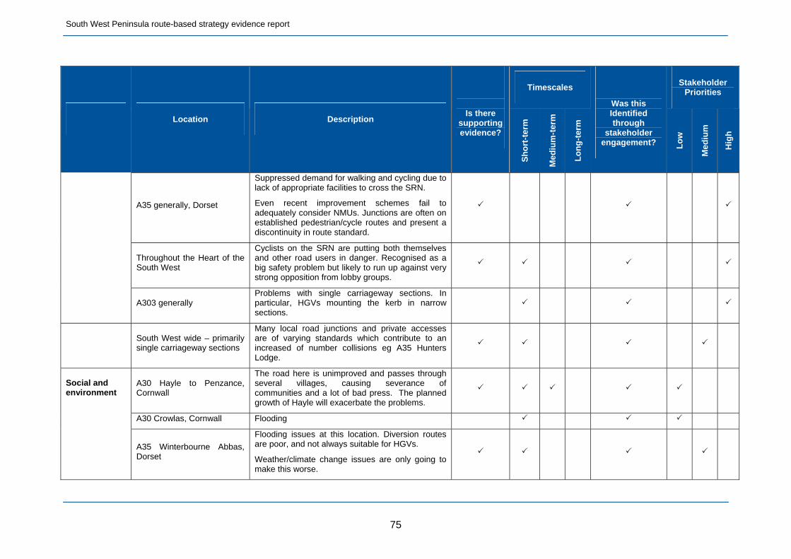
South West Peninsula route-based strategy evidence report
75
Timescales Stakeholder
Priorities
Location Description
Is there
supporting evidence?
Sh
ort
-ter
m
Med
ium
-ter
m
Lo
ng
-ter
m
Was this Identified through
stakeholder engagement? L
ow
Med
ium
Hig
h
A35 generally, Dorset
Suppressed demand for walking and cycling due to lack of appropriate facilities to cross the SRN.
Even recent improvement schemes fail to adequately consider NMUs. Junctions are often on established pedestrian/cycle routes and present a discontinuity in route standard.
Throughout the Heart of the South West
Cyclists on the SRN are putting both themselves and other road users in danger. Recognised as a big safety problem but likely to run up against very strong opposition from lobby groups.
A303 generally Problems with single carriageway sections. In particular, HGVs mounting the kerb in narrow sections.
South West wide – primarily single carriageway sections
Many local road junctions and private accesses are of varying standards which contribute to an increased of number collisions eg A35 Hunters Lodge.
A30 Hayle to Penzance, Cornwall
The road here is unimproved and passes through several villages, causing severance of communities and a lot of bad press. The planned growth of Hayle will exacerbate the problems.
A30 Crowlas, Cornwall Flooding
Social and environment
A35 Winterbourne Abbas, Dorset
Flooding issues at this location. Diversion routes are poor, and not always suitable for HGVs.
Weather/climate change issues are only going to make this worse.
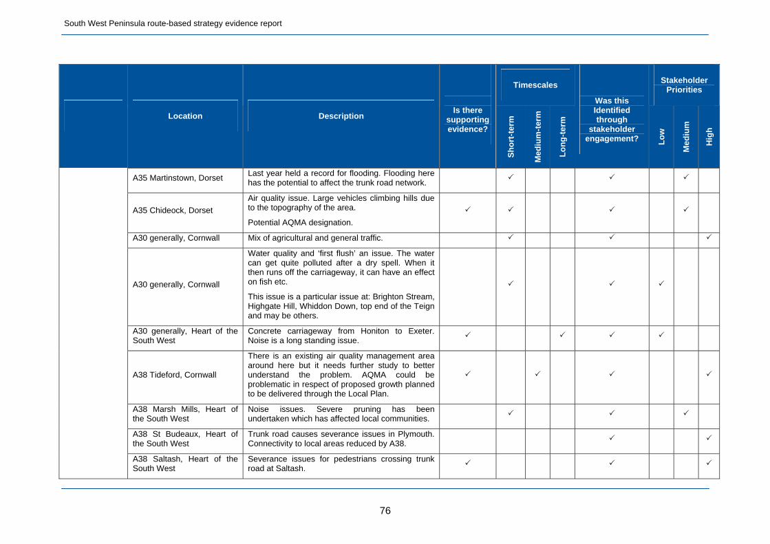
South West Peninsula route-based strategy evidence report
76
Timescales Stakeholder
Priorities
Location Description
Is there
supporting evidence?
Sh
ort
-ter
m
Med
ium
-ter
m
Lo
ng
-ter
m
Was this Identified through
stakeholder engagement? L
ow
Med
ium
Hig
h
A35 Martinstown, Dorset Last year held a record for flooding. Flooding here has the potential to affect the trunk road network.
A35 Chideock, Dorset
Air quality issue. Large vehicles climbing hills due to the topography of the area.
Potential AQMA designation.
A30 generally, Cornwall Mix of agricultural and general traffic.
A30 generally, Cornwall
Water quality and ‘first flush’ an issue. The water can get quite polluted after a dry spell. When it then runs off the carriageway, it can have an effect on fish etc.
This issue is a particular issue at: Brighton Stream, Highgate Hill, Whiddon Down, top end of the Teign and may be others.
A30 generally, Heart of the South West
Concrete carriageway from Honiton to Exeter. Noise is a long standing issue.
A38 Tideford, Cornwall
There is an existing air quality management area around here but it needs further study to better understand the problem. AQMA could be problematic in respect of proposed growth planned to be delivered through the Local Plan.
A38 Marsh Mills, Heart of the South West
Noise issues. Severe pruning has been undertaken which has affected local communities.
A38 St Budeaux, Heart of the South West
Trunk road causes severance issues in Plymouth. Connectivity to local areas reduced by A38.
A38 Saltash, Heart of the South West
Severance issues for pedestrians crossing trunk road at Saltash.
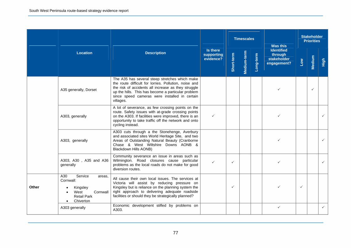
South West Peninsula route-based strategy evidence report
77
Timescales Stakeholder
Priorities
Location Description
Is there
supporting evidence?
Sh
ort
-ter
m
Med
ium
-ter
m
Lo
ng
-ter
m
Was this Identified through
stakeholder engagement? L
ow
Med
ium
Hig
h
A35 generally, Dorset
The A35 has several steep stretches which make the route difficult for lorries. Pollution, noise and the risk of accidents all increase as they struggle up the hills. This has become a particular problem since speed cameras were installed in certain villages.
A303, generally
A lot of severance, as few crossing points on the route. Safety issues with at-grade crossing points on the A303. If facilities were improved, there is an opportunity to take traffic off the network and onto cycling instead.
A303, generally
A303 cuts through a the Stonehenge, Averbury and associated sites World Heritage Site, and two Areas of Outstanding Natural Beauty (Cranborne Chase & West Wiltshire Downs AONB & Blackdown Hills AONB)
A303, A30 , A35 and A36 generally
Community severance an issue in areas such as Wilmington. Road closures cause particular problems as the local roads do not make for good diversion routes.
A30 Service areas, Cornwall:
Kingsley West Cornwall
Retail Park Chiverton
All cause their own local issues. The services at Victoria will assist by reducing pressure on Kingsley but is reliance on the planning system the right approach to delivering adequate roadside facilities or should they be strategically planned?
Other
A303 generally Economic development stifled by problems on A303.

South West Peninsula route-based strategy evidence report
78
Timescales Stakeholder
Priorities
Location Description
Is there
supporting evidence?
Sh
ort
-ter
m
Med
ium
-ter
m
Lo
ng
-ter
m
Was this Identified through
stakeholder engagement? L
ow
Med
ium
Hig
h
Throughout Cornwall Issues in Cornwall tend to be concentrated into three months over the summer period. How will this affect the economics of identified solutions?
Throughout South West Sensitivities with diversions. Some areas don’t have an agreed diversion route. Particularly an issue in areas such as the Jurassic Coast.
Throughout South West
Effect of seasonal peaks and tourists.
Traffic flows in the region are much higher in summer than in winter. Is there a business case for spending large sums of money on improving roads which are only congested for six weeks of the year?
Linked to many other issues on the network, e.g. capacity at junctions, communicating issues to customers (technology), safety, unique nature of vehicles using the network (caravans etc).
Throughout South West
There are a number of narrow stretches of road around the county which cause congestion and potential issues with safety. Is it better to keep these and have people drive slowly or remove them and have more free-flowing traffic? May come down to a question of community wishes versus economic development.

South West Peninsula route-based strategy evidence report
79
Timescales Stakeholder
Priorities
Location Description
Is there
supporting evidence?
Sh
ort
-ter
m
Med
ium
-ter
m
Lo
ng
-ter
m
Was this Identified through
stakeholder engagement? L
ow
Med
ium
Hig
h
Throughout South West
Lack of service facilities off the motorway. Don’t have the facilities to support HGVs in particular off the motorway.
Important to liaise with MSAs and break out areas.
In particular, if HGVs get stuck in traffic and need a break, there is a lack of facilities to cater for this.

South West Peninsula route-based strategy evidence report
4.7 Conclusion
4.7.1 The evidence compiled about the route has shown that;
The SWP route is a focal point for future local economic growth generally, with 242,000 residential units and 150,000 new jobs planned by 2031. The main concentrations are at Plymouth, Yeovil, Bath, Exeter, Salisbury, Bodmin, Dorchester and Frome
The already committed programme of enhancement schemes and pipeline schemes will go some way to tackling capacity problems in the short term but the need for further enhancement is highly probable before 2021
Detailed assessment of the growth programmes of Local Authorities and the ability of the SRN to accommodate the traffic flows arising from economic growth will predict where future capacity problems are likely to arise
The enhancement of road safety is an existing priority for the Agency and will continue to be a key challenge
There are opportunities to improve route operation through the expansion of TOS coverage and improved road user information systems
There will be key maintenance challenges and opportunities on the route during the 5 year RBS period (April 2015 to March 2020)
4.7.2 The sections of the route with the least reliable journey times are identified in table 2.2. Of these, three sections of the route currently fall within the worst 10% nationally. These are;
A38 between Marsh Mills and Manadon Junctions, Plymouth
A35 between Puddletown and Poundbury around Dorchester
A303 between A359(N) and A359(S) at Sparkford, Somerset
4.7.3 In terms of congestion, the sections of the route with the lowest average speeds are identified in section 2.1.8. These are;
A38 between Carkeel Roundabout, Saltash and Weston Mill Junction, Plymouth
A35 between Charmouth and Bridport
A36 between the A303 and Salisbury
4.7.4 The A30 between Newtown Roundabout and St Erth is not included in this summary as the average speed on this link is affected by a speed limit.
80
South West Peninsula route-based strategy evidence report
4.7.5 Significant growth is expected within Plymouth itself (24,518 residential units by the end of the RBS period) and within adjacent areas, including development in South Hams and East Cornwall, particularly Saltash. This scale of development will have significant transport implications for the A38 Plymouth Parkway.
4.7.6 Growth is also expected in Dorchester and the wider Dorset area which will increase travel demand on the A35 including the section between Puddletown and Poundbury.
4.7.7 The A303 at Sparkford will be affected by the expected growth in South Somerset which includes 5,871 residential units and 3,368 jobs by the end of the RBS period which could exacerbate the already poor journey times recorded at 4.7.2.
4.7.8 Although most of the growth likely to impact directly on the A35 is to the east of the route, traffic growth due to overall level of development expected along the SWP route will impact on the A35, particularly in the already congested areas. The same development and the expected growth of Salisbury itself will also affect the congested section of the A36 identified above.
4.7.9 While the development highlighted above will clearly have local implications for the SRN, all development contributes to background increases in traffic flow which also has to be considered.
4.7.10 While some parts of the route perform well on an average yearly basis, from the available data, it is often these routes that attract the highest seasonal traffic flow uplifts due to holiday traffic. Parts of the dual carriageway section of the A30 west of Exeter are among the best performing sections of the SRN when considered on an annual average basis. These sections however attract traffic flow uplifts of more than 40% in the summer months which has a marked effect on route performance.
4.7.11 Parts of the A303 also perform well on average through the year but perform badly through the summer months. Either side of Stonehenge the A303 sections are among the best performing 15% of the SRN nationally when considered on an annual average basis. In the summer months, the A303 at Stonehenge is the worst performing section of the entire route performing as badly as the 2nd worst section nationally when considered on an annual basis. (See 2.1.19).
81

South West Peninsula route-based strategy evidence report
4.7.12 Improving the capacity and reliability of the SRN to support economic growth was by far the highest priority of stakeholders. The A303 in its entirety was the main priority overall and supports the inclusion of the route as a Government led feasibility study. At stage 2, any results available from the feasibility study will be considered in the context of the emerging strategy recommendations for the entire route, including maintenance, operations and any other enhancements deemed necessary along the route, together with the timing of those needs.
4.7.13 In terms of parts of the route which have capacity to support growth, these are extremely limited by the variable nature of the roads that make up the route and by the range of traffic flows that use the route. The ability of the route to accommodate growth is also as much if not more constrained by junction capacity as it is link capacity. With a few exceptions, limited evidence is available on the performance of individual junctions particularly in terms of their forecast performance under the traffic flow conditions likely to arise as a result of expected development.
4.7.14 One of the main issues highlighted during the RBS workshops was the potential for the worsening of collision statistics due to traffic flow increases arising from new development. While there are a number of existing accident cluster sites on the SWP route the effect on these due to traffic growth and speeds is difficult to predict.
4.7.15 A common theme raised by many was the severance issues created when the SRN runs through communities located on the route, particularly the A35, A36 and A38. This is particularly relevant to the unimproved single carriageway lengths where through traffic and inadequate crossing points can create a number of severe problems for residents, exacerbated by increasing numbers of vehicles. It is a challenge for routes with such characteristics to act as viable strategic diversions when serious incidents occur elsewhere on the SRN.
4.7.16 The gap between the A36 and the A46 was identified as a potential issue where the SRN is discontinuous in the Bath area. A link was considered during the construction of the Batheaston bypass but was withdrawn on environmental grounds. Any proposals will have to address environmental and landscape issues and the potential impact on a World Heritage site. The West of England LEP has an aspiration to investigate a A36/A46 transport link in its Joint Local Transport Plan 3 (page 132).
4.7.17 Traffic flow increase has implications for environmentally sensitive locations, eg AQMAs, and noise sensitive areas. 16 AQMAs within the area of the SWP route are highlighted in Section 2 of this report. Of these the Bath, Chideock, East Devon, the A38, Ivybridge and Tideford AQMAs are either directly on or immediately adjacent to the SRN. All will be affected by background traffic growth but the Bath, East Devon and Tideford AQMAs will be particularly affected by expected growth.
82

South West Peninsula route-based strategy evidence report
4.7.18 Again, most existing noise sensitive areas will be affected by expected growth but those at Camborne/Pool, Launceston, Plymouth, Bath, Saltash, Yeovil and Andover will be particularly affected.
4.7.19 Key locations where carriageway surfacing may reach the end of its design life by 2020 are identified in paragraphs 2.3.7 and 2.3.8. A number of these sections already carry high traffic volumes, particularly the A38 Plymouth Parkway. The roadworks necessary to renew carriageway surfacing in these strategic locations will affect a high volume of SRN customers.
4.7.20 Other sections of the route, such as the A30 north and south of Bodmin, carry high seasonal traffic volumes and the Agency recognises the need to plan roadworks to avoid the predictably busy periods. North of Bodmin, some of the carriageway surfacing reaching the end of its design life will be replaced as part of the planned Temple to Higher Carblake dualling scheme.
4.7.21 The risk of flooding events, such as those recently experienced on the A303 and A35, impacting both on the safe operation of the route and those living adjacent, are likely to become more frequent due to climate change. The Agency recognises the importance of maintaining an aging SRN drainage infrastructure so as not to exacerbate the impact of such events.
4.7.22 Details of committed SRN enhancement schemes are given in table 3.2. The majority of these, with the exception of the Temple to Higher Carblake dualling scheme, are “pinch point” schemes designed to release planned development over the short term. The ability of these schemes to accommodate additional expected growth through the RBS period will be examined as part of the post opening performance evaluation (POPE) process. From ongoing involvement in the planning system, it is already known that some of these schemes, such as Loggans Moor roundabout and Carkeel roundabout, will require further improvement in order to accommodate the development aspirations already coming forward since the schemes were identified.
4.7.23 The Highways Agency is working closely with Cornwall Council to deliver the A30 Temple to Higher Carblake dualling scheme which Cornwall Council is part funding and delivering on behalf of the Secretary of State, with works expected to start early in 2015. There is concern that the extensive summertime queues on the approach to Higher Carblake will move westwards to the unimproved section of the A30 between Carland Cross and Chiverton Cross when the dualling scheme is completed. The capacity of the existing junction between Carland Cross and Chiverton (Chybucca) was also raised as an existing concern at one of the stakeholder events.
4.7.24 One of the common themes running through the RBS workshops was a perception that not enough consideration was given to vulnerable road users in either the provision of existing facilities nor facilities included as
83

South West Peninsula route-based strategy evidence report
part of network improvement schemes. As well as passing through the middle of a number of towns and villages, the SRN interfaces with public rights of way, long distance footpaths, the National Cycle Network and other designated routes. It was felt by some stakeholders that there is a suppressed demand for walking and cycling movements on certain routes that interface with the SRN due to the lack of safe crossing facilities. They suggested that providing suitable alternatives for these modes would encourage greater use, leading to a reduction in car use and therefore freeing up highway capacity to support economic growth. More detail is given in section 2.6.
4.7.25 The SWP route has limited TOS coverage and it was felt by stakeholders that this contributed to a lack of route resilience which in turn restricted economic activity. Linked to this is the perceived unreliability of the information available from the Agency on incidents and live route performance, through VMS signage, etc. The improvement of route resilience was seen as a key aspect of enabling existing business to maximise potential and to accommodate further growth.
4.7.26 Section 4 of this report describes a selection of the key priorities raised by internal and external stakeholders. The evidence available to support these priorities mainly consists of the recorded network performance data referred to in this report, locations and scale of expected development and collision statistics.
4.7.27 The main issue relates to the ability of the route to accommodate and support growth. Where problems already exist, it is likely that those problems will worsen. This is not only in terms of congestion and delay but also environmental factors such as air quality and noise. Firm evidence is lacking in terms of where new operational and environmental issues are likely to arise as a result of growth. Due to the scale of growth proposed in some locations, some of these future problems may be significant and could outweigh known existing problems.
4.7.28 The key future challenge for the SWP route is the need to support sustainable economic growth. This is vital for areas through which the route passes and particularly important for the Cornwall and the Isles of Scilly region to support its economic prosperity.
4.7.29 Overall, the stakeholder events were generally well received and were taken as a sign by stakeholders of a new collaborative approach to the identification of future transport solutions.
84

A30A30
A30A30
A30A30
A30A30
A38A38
A38A38
M5M5
PlymouthPlymouthPlymouth
ExeterExeterExeter
TruroTruroTruro
NewquayNewquay
PenzancePenzance
31
29
HA media services, M130525 South West Penisula
ExeterInternationalExeterInternational
Figure 4Key opportunities andchallenges for the route
South West Peninsula – Route-based strategy – Map 1 of 4
Operation
Safety
Asset condition
Capacity
Social and environment
Limited TOS coverage - whole routeLack of diversion routes - whole route
Lack of appropriate RSA’s - whole route
Launcestoncapacity issues
Bodminexpected growthfrom development
Single carriageway section congestionrisk
Expected growth fromNewquay Enterprise Zone
Chiverton to Carland Crosscapacity issues
High casualty rateSummercourt - Mitchelland Blue Anchor junction
Exeter AQMA
Water pollution risk
Crowlas flooding
Water pollution risk
Water pollution risk
East Devon AQMA
Noise issues
High Casualty rate
Capacity issuesSigning strategy
Kerrier AQMA
Camborne, Poole and Redruthexpected growth from development
Hayle floodingissues due to sea level increase
St Erth junctionrestricted capacity
Community severanceissues
St Erth to Newtownroundaboutcapacity issues
Greater maintenance challenges for all asset types, due to unimproved sections of single carriageway
Turks Head junctionrestricted capacity
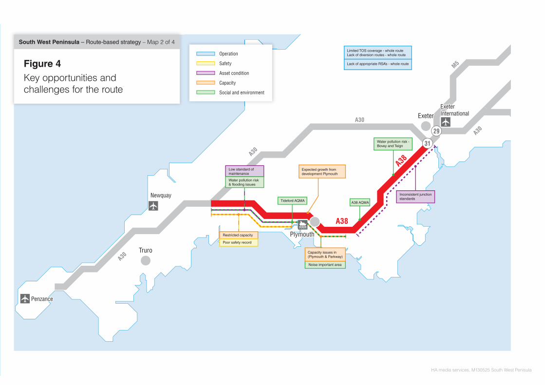
ExeterExeterExeter
PlymouthPlymouthPlymouth
PenzancePenzance
29
31
TruroTruroTruro
NewquayNewquay
A30A30
A30A30
A30A30
A30A30
A38A38
A38A38
M5M5
HA media services, M130525 South West Penisula
Figure 4Key opportunities andchallenges for the route
South West Peninsula – Route-based strategy – Map 2 of 4
Operation
Safety
Asset condition
Capacity
Social and environment
ExeterInternationalExeterInternational
Limited TOS coverage - whole routeLack of diversion routes - whole route
Lack of appropriate RSA’s - whole route
Water pollution risk - Bovey and Teign
Inconsistent junctionstandards
Water pollution risk& flooding issues
Low standard ofmaintenance
Poor safety record
Restricted capacity
A38 AQMATideford AQMA
Noise important area
Capacity issues in(Plymouth & Parkway)
Expected growth fromdevelopment Plymouth

ExeterExeterExeter
BristolBristolBristol
BathBathBathBristolInternationalBristolInternational
BournemouthInternationalBournemouthInternational
SouthamptonInternationalSouthamptonInternational
29
31
A30A30
A303
A303
A303
A303
A303A303
A35A35
M5M5
M5M5
M4M4
A46A46
A419A419
A34A34
M3M3
A34A34
A36A36
A36A36
A31A31
ExeterInternationalExeterInternational
Isle of WightIsle of WightIsle of Wight
SouthamptonSouthamptonSouthamptonSouthamptonSouthampton
SwindonSwindonSwindon
BournemouthBournemouthBournemouth
BristolBristol
PoolePoole
HA media services, M130525 South West Penisula
Limited TOS coverage - whole routeLack of diversion routes - whole route
Lack of appropriate RSA’s - whole route
Operation
Safety
Asset condition
Capacity
Social and environment
Figure 4Key opportunities andchallenges for the route
South West Peninsula – Route-based strategy – Map 3 of 4
Chideock air quality issue
Winterbourne areasfloodline issues
Bransbury floodling issues
Bridport Junctionrestricted capacity
A303 Single carriageway sections poor safety records
Expected growth fromdevelopment in Dorchester
High casualty rate
Charmouth Bere Regiscapacity issues
Sparkfordcapacity issues
Andovercapacity issues
Stonehengeperformance issues
A303 Dual carriageway to single carriagewaytransitions restrict route capacity
Greater maintenance challenges for all asset types, due to unimproved sections of single carriageway
Inconsistent speed limits
DorchesterAQMA
High casualty rate
High casualty rateHoniton to illminster
High casualty rate

BristolBristolBristol
BathBathBath
BournemouthInternationalBournemouthInternational
A303
A303
A303
A303
A303A303
A35A35
M5M5
M4M4
A419A419
A419A419M5
A34A34
M3M3
A34A34
A36A36
A31A31
Isle of WightIsle of WightIsle of Wight
SouthamptonSouthamptonSouthamptonSouthamptonSouthampton
SwindonSwindonSwindon
BournemouthBournemouthBournemouth
BristolInternationalBristolInternational
A46A46
A36A36
PoolePoole
BristolBristol
A36A36
HA media services, M130525 South West Penisula
SouthamptonInternationalSouthamptonInternational
A303A303
A35A35
M5M5
M4M4
M27M27
Limited TOS coverage - whole routeLack of diversion routes - whole route
Lack of appropriate RSA’s - whole route
M5M5
Figure 4Key opportunities andchallenges for the route
South West Peninsula – Route-based strategy – Map 4 of 4 Operation
Safety
Asset condition
Capacity
Social and environment
Expected growth fromdevelopment Bath
Expected growth fromdevelopment Frome
Expected growth fromdevelopment Sailsbury
AQMA
AQMA
Greater maintenance challenges for all asset types, due to unimproved sections of single carriageway

Irish Sea
North Sea
English Channel
Irish Sea
North Sea
Englishh Channel
© Crown copyright and database rights 2013 Ordnance Survey 100030649
0 kilometres 60
0 miles 40
Highways Agency media services MCR N130206
London to Scotland East
London Orbital and M23 to Gatwick
London to Scotland West
London to Wales
Felixstowe to Midlands
Solent to Midlands
M25 to Solent (A3 and M3)
Kent Corridor to M25 (M2 and M20)
South Coast Central
Birmingham to Exeter
South West Peninsula
London to Leeds (East)
East of England
South Pennines
North Pennines
Midlands to Wales and Gloucestershire
North and East Midlands
South Midlands
Information correct at19 March 2014
Route-basedstrategiesThe division of routes for the programmeof route-based strategies on theStrategic Road Network
M60
M62
M62
M62
M18
M61
M65
M58
M57
M55
M56M53
M54
M50
M48
M32
M42
M42M69
M11M25
M25
M27
M20M23
M26
M40
M40
M45
M606 M621
M6
M6
M6
M6M6
M5
M5
M5
M1
M1
M1
M1
M2
M3
M4
M4M4M4
M1
A585
A556
A500
A483
A458
A453
M6 Toll
A628A616
A180
A590
A174
A595
A66
A66
A64
A63A56
A55
A49
A40
A40
A46
A46
A47 A47
A12
A11
A11
A12
A12
A13
A21
A23A36
A31
A35A30A30
A30A38
A36
A46
A27
A27
A20
A14A14A45
A43
A34
A34
A14
A14
A46
A50
A52
A38
A38
A42
A69A19
A19
A1
A1
A1
A1
A1
A1
A1
A2
A5
A5
A5
A5
A5
A3
A421
A120A120
A249
A404
A303
A303
A419
A417
A259
A259
A428
A1(M)
A1(M)
A1(M)
A1(M)
A3(M)
M180
LondonLondon
BirminghamBirminghamBirmingham
ManchesterManchesterManchesterLiverpoolLiverpool
BristolBristol
PrestonPrestonPreston
CarlisleCarlisleCarlisle
Newcastle upon TyneNewcastle upon TyneNewcastle upon Tyne
SunderlandSunderland
MiddlesbroughMiddlesbroughMiddlesbrough
SheffieldSheffieldSheffield
Stoke-on-TrentStoke-on-TrentStoke-on-Trent
LeicesterLeicesterLeicester
DerbyDerbyDerby
NottinghamNottinghamNottingham
PeterboroughPeterboroughPeterborough
Southend-on-SeaSouthend-on-SeaSouthend-on-Sea
FolkestoneFolkestoneFolkestone
BrightonBrightonPortsmouthPortsmouthPortsmouth
YeovilYeovilYeovil
TorquayTorquay
PlymouthPlymouthPlymouth
ExeterExeter
CrawleyCrawley
CambridgeCambridgeCambridge
MiltonKeynesMilton
KeynesMilton
Keynes
CoventryCoventryCoventry
GloucesterGloucesterGloucester
WorcesterWorcesterWorcester
OxfordOxfordOxford
SwindonSwindon
ReadingReadingReading
LincolnLincolnLincoln
NorwichNorwichNorwich
IpswichIpswich
LeedsLeedsLeeds
YorkYork
Kingston upon HullKingston upon HullKingston upon Hull
GrimsbyGrimsbyGrimsby

South West Peninsula route-based strategy evidence report
Appendix B Glossary
Abbreviation Description
AADT Annual Average Daily Traffic
ANPR Automatic Number Plate Recognition
AONB Area of Outstanding Natural Beauty
AQMA Air Quality Management Area
CCTV Closed circuit television
Defra Department for Environment, Food and Rural Affairs
DfT Department for Transport
HAWIS Highways Agency Weather Information System
HRA Hot Rolled Asphalt
LAs Local Authorities
LEPs Local Enterprise Partnerships
MIDAS
MP
Motorway Incident Detection and Automatic Signalling
Major Project
NO2 Nitrogen Dioxide
NTOC National Traffic Operations Centre
NVRS
PP
National Vehicle Recovery Service
Pinch Point
RBSs Route-based strategies
RCC Regional Control Centre
SACs Special Areas of Conservation
SPA Special Protection Area
SRN Strategic road network
SSSI Sites of Specific Scientific Interest
STO Strategic Traffic Operations
SWP South West Peninsula
TEN-T Trans European Transport Network
TOS Traffic Officer Service
TSCS Thin Surface Course Treatment
VMS Variable Message Signs
90

South West Peninsula route-based strategy evidence report
Appendix C Stakeholder involvement
Organisation Contact Name
Provided Input
A35 Stakeholders Group Gillian Summers Yes
Bristol Port Company John Chaplin Yes
Dorset County Council Andy Shaw Yes
Dorset County Council Paul Willis Yes
Caravan Club Janet Moore Yes
Caravan Club Walter Girven Yes
Christchurch Borough Council Cllr Ray Nottage Yes
Cornwall and Isles of Scilly LEP Chris Pomfret Yes
Cornwall Council Tim Wood Yes
Cornwall Council Vicky Fraser Yes
Cornwall Council Steve Foster Yes
Cornwall Council Steve Havers Yes
Cornwall Council Andy England Yes
Cornwall Ramblers Association Graham Ronan Yes
CTC – the national cycling charity Margaret Willmot Yes
CTC – the national cycling charity Roy Russell Yes
Devon & Cornwall Constabulary PC Dave Trout Yes
Devon and Cornwall Business Council Ben Rhodes Yes
Devon County Council Mark Dauncey Yes
Dorset Police Heidi Moxam Yes
East Devon District Council Matt Dickens Yes
Environment Agency Dan Hambrook Yes
Environment Agency Hugh Davey Yes
Exeter City Council Karime Hassan Yes
Falmouth Port Colin Jarvis Yes
Forward Swindon LEP Paul Johnson (LEP Chairman)
Yes
HA Asset Manager Nigel Dyson Yes
Highways Agency Philip Sheppard Yes
Highways Agency Andy Roberts Yes
Highways Agency Richard Ormerod Yes
Highways Agency Dave Stock Yes
91
South West Peninsula route-based strategy evidence report
92
LEP Transport Special Interest Group Ian Harrison Yes
Heart of the SW LEP LTB Dave Black Yes
Heart of the SW LEP LTB Liz Waugh Yes
Mendip District Council Stuart Brown Yes
Mid Devon District Council Jonathan Guscott Yes
MP representative Bernie Ellis Yes
Neighbouring HA area route lead Surinder Bhangu Yes
North Dorset District Council Councillor David Walsh Yes
Plymouth City Council Philip Heseltine Yes
Plymouth City Council Sunita Mills Yes
Poole Borough Council Helen Jackson Yes
Poole Port/Ferry terminal Andy Ramsbottom Yes
Purbeck District Council Richard Wilson Yes
Sedgemoor Council Claire Pearce Yes
Somerset County Council Mike O'Dowd‐Jones Yes
South West Ambulance Service Trust (SWAST) Richard King Yes
South West Ambulance Service Trust (SWAST) Michael Thomson Yes
Stagecoach Robert Williams Yes
Sustrans Kevin Humphreys Yes
Sustrans Alistair Millington Yes
Sustrans Paul Hawkins Yes
Sustrans (Cornwall) Simon Murray Yes
Swindon Borough Council Gwilliam Lloyd (Head of Highways and Transport )
Yes
Taunton Deane Council Brendan Cleere Yes
West Devon Borough Council Rebecca Black Yes
West Dorset District Council Hilary Jordan Yes
Weymouth and Portland Borough Council Andrew Galpin Yes
Wiltshire County Council
Fleur de Rhé‐Philipe (Cabinet Member for Economic Development, Skills and Strategic Transport)
Yes
Wiltshire County Council Peter Binley Yes
Wiltshire County Council John Smale Yes

© Crown copyright 2014. You may re-use this information (not including logos) free of charge in any format ormedium, under the terms of the Open Government Licence. To view this licence:visit http://www.nationalarchives.gov.uk/doc/open-government-licence/write to the Information Policy Team, The National Archives, Kew, London TW9 4DU,or email [email protected].
This document is also available on our website at www.highways.gov.uk
If you have any enquiries about this document [email protected] or call 0300 123 5000*.Please quote the Highways Agency publications code PR193/13
* Calls to 03 num bers cost no more than a national rate call to an 01 or 02 num ber and must count towards any inclu sive min utes in the same way as 01 and 02 calls. These rules apply to calls from any type of line includ ing mobile, BT, other fixed line or payphone. Calls may be recorded or monitored.
Highways Agency media services Bristol Job number M130523
If you need help using this or any other Highways Agency information, please call 0300 123 5000* and we will assist you.