south staffordshire partial green belt review method … staffordshire... · south staffordshire...
TRANSCRIPT

South Staffordshire Partial Green Belt Review Method Statement
Prepared for South Staffordshire District Council by LUC
January 2014

Project Title: South Staffordshire Partial Green Belt Review
Client: South Staffordshire District Council
Version Date Version Details Prepared by Checked by Approved by Principal
V0.1 10/07/2013 Draft Josh Allen Helen Kent
V0.2 16/10/2013 Draft 2 Josh Allen Helen Kent and Philip Smith
V0.3 23/10/2013 Draft 3 Josh Allen Philip Smith Philip Smith
V1.0 24/10/213 Draft 4 Josh Allen Philip Smith and Helen Kent
Philip Smith
V1.1 07/11/2013 Final Report Draft Josh Allen Helen Kent Philip Smith
V1.2 02/12/2013 Final Report Tracked Changes
Josh Allen Helen Kent Philip Smith
V2.0 12/12/2013 Final Report Tracked Changes
Josh Allen Helen Kent and Philip Smith
V3.0 15/01/2014 Final Report Josh Allen Helen Kent and Philip Smith
S:\5700\5782 South Staffordshire Green Belt Review\B Project Working\South Staffordshire Green Belt Review_FinalReport_V3.docx

South Staffordshire Partial Green Belt Review Method Statement
Prepared for South Staffordshire District Council by LUC
January 2014
Planning & EIA Design Landscape Planning Landscape Management Ecology Mapping & Visualisation
LUC LONDON 43 Chalton Street London NW1 1JD T 020 7383 5784 F 020 7383 4798 [email protected]
Offices also in: Bristol Glasgow Edinburgh
FS 566056
EMS 566057
Land Use Consultants Ltd Registered in England Registered number: 2549296 Registered Office: 43 Chalton Street London NW1 1JD LUC uses 100% recycled paper

Contents
1 Introduction 1 Background 1 Purpose of this Report 1 Report Structure 2
2 Context 3 Planning Policy Context 3 West Midlands Metropolitan Green Belt 5 South Staffordshire’s Green Belt 5 Green Belt Review Methodologies 6
3 Method 7 Task 1: Method Statement Consultation under Duty to Cooperate 7 Task 2: Constraints Mapping and Green Belt Parcel Identification 7 Task 3: Assessing Green Belt Parcels – Defining Proposed Criteria 9 Task 4: Judgements for each Parcel 10
4 Results 12 Overall Findings 12 Findings for each Settlement 13 Findings for each Strategic Employment Site 18

South Staffordshire Partial Green Belt Review 1 January 2014
1 Introduction
Background
1.1 South Staffordshire is located on the north western edge of the West Midlands conurbation. It is a rural district covering an area of 40,400 hectares and housing a population of approximately 108,000. There are 27 parishes with a collection of diverse settlements, ranging from small hamlets to large villages. Each has its own distinctive character set in attractive countryside. There is no single dominant settlement in South Staffordshire, rather it is a ‘community of communities’.
1.2 South Staffordshire District Council formally adopted its Core Strategy1 on December 11th 2012. The Core Strategy sets out the vision and spatial strategy for the District up to 2028. Core Policy 6 outlines the District’s minimum housing delivery over the plan period up to 2028 (3,850 between 2006 – 2028), ensuring a sufficient supply of deliverable/developable land is available to deliver 175 new homes each year. In addition to housing development, Core Policy 7 allows for ‘modest extensions’ to the four free standing strategic employment sites in South Staffordshire (i54, Hilton Cross, ROF Featherstone and Four Ashes) where supported by robust evidence and a reasoned justification is provided to support their expansion.
1.3 Core Policy 1 outlines the Spatial Strategy for South Staffordshire. The policy earmarks the Main Service Villages of Bilbrook, Brewood, Cheslyn Hay, Codsall, Great Wyrley, Kinver, Penkridge, Perton and Wombourne as the main centres for housing growth, employment development and service provision. The smaller Local Service Villages of Coven, Essington2, Featherstone, Huntington, Pattingham, Swindon and Wheaton Aston are also earmarked for more limited development. In addition to the planned housing provision within the plan period (up to 2028), an additional 10 years of safeguarded land figures have been prepared for each Main and Local Service Village to ensure that Green Belt boundaries will not need to be altered at the end of the plan period. The policy acknowledges that ‘some land will need to be released from the Green Belt and Open Countryside in some locations at the Main and Local Service Villages to deliver the proposed development strategy and enable the sustainable growth of these villages’. This acknowledgement has been made due to the lack of potential development sites within or around villages allocated for growth, that fall under the first three categories of the Council’s sequential approach (See Core Strategy Para. 6.20), these being:
Firstly, within the current development boundaries of the Main and Local Service Villages;
Secondly, within land outside the Green Belt but designated as Safeguarded Land or land located in the Open Countryside; and
Thirdly, previously developed land (brownfield land) outside but adjacent to the current development boundaries of the Main and Local Service Villages.
Purpose of this Report
1.4 LUC was commissioned to carry out a partial Green Belt review of 15 of the 16 Main and Local Service Villages and the four free standing Strategic Employment Sites. The review assesses parcels of land against the five purposes of the Green Belt set out in the National Planning Policy Framework (NPPF). Parcels of land that contain SSSI, ancient woodland, scheduled monuments, registered parks and gardens or where a significant proportion of the parcel falls within flood zone
1 Core Strategy Development Planning Document, South Staffordshire Council, December 2012. 2 Essington has not been included in this Green Belt Review due to the fact that the village contains a considerable amount of land safeguarded in Core Strategy policy GB2 that could more than accommodate both Essington’s allocation and its 10 year safeguarded land requirement (2028-2038).

South Staffordshire Partial Green Belt Review 2 January 2014
3b were not considered, as they are separate and important constraints on development. The review will form part of the evidence base that underpins the Local Plan and informs the decision making and appraisal process of potential development sites within the Green Belt. Other, non-Green Belt issues will also inform the allocation of development sites. These include landscape character and wider sustainability issues. Development sites allocated by the Council will be consulted on in the Site Allocations DPD Issues and Options consultation, scheduled for the beginning of 2014.
1.5 The Core Strategy stipulates that new settlement boundaries should be clearly defined using ‘readily recognisable features such as roads, streams, belts of trees or wood edges where possible’. Such recognisable features were used to define appropriate parcels of Green Belt land on the edge of the built environment for review in this study.
1.6 This partial review of the Green Belt in South Staffordshire was a strategic study. It was not the purpose of the review to define new site allocations or new settlement boundaries. Potential site allocations can only be defined following consideration of other planning factors.
Report Structure
1.7 The Report comprises three further sections:
1. Context – including a planning policy context, the history and geography of South Staffordshire’s Green Belt and a summary of the findings of a study into other Green Belt Review methodologies.
2. Method – clearly describing the process undertaken to collect, analyse and report the review’s findings.
3. Results – summary descriptions of the reasoning behind each parcel’s judgements around each settlement. The results are accompanied by colour-coded GIS maps in Appendix 2.
1.8 The appendices contain the review criteria and maps.

South Staffordshire Partial Green Belt Review 3 January 2014
2 Context
2.1 This section considers the key planning policy documents and the role of the West Midlands Green Belt. It also summarises the findings of a review of good practice in existing Green Belt Review methodologies. This information was used to define the method outlined in Section 4.
Planning Policy Context
National Planning Policy Framework
2.2 Government policy is clear on the importance of securing the long term permanence and openness of Green Belts. The National Planning Policy Framework (NPPF) takes forward the previous national Green Belt policy set out in PPG2, stating that the Green Belt should serve the following five purposes (paragraph 80):
to check the unrestricted sprawl of large built-up areas;
to prevent neighbouring towns merging into one another;
to assist in safeguarding the countryside from encroachment;
to preserve the setting and special character of historic towns; and
to assist in urban regeneration, by encouraging the recycling of derelict and other urban land.
2.3 It states that existing Green Belt boundaries should only be altered in exceptional circumstances and as part of the preparation or review of a Local Plan. New boundaries must have regard for the permanence of the designation by redefining boundaries which endure beyond the Local Plan period.
2.4 Similarly, paragraph 82 states that new Green Belt should only be established in exceptional circumstances where there is a clear need for the Green Belt, the normal planning and development management policies would not be adequate, the implications for the sustainable development would be acceptable meeting the other strategic objectives of the NPPF and the new Belt is consistent with neighbouring authorities.
2.5 When defining new boundaries, the Framework requires local planning authorities to identify areas of ‘safeguarded land’ between the urban area and the Green Belt to accommodate long-term development needs well beyond the plan period. New boundaries should be defined clearly, using readily recognisable, permanent physical features.
2.6 Paragraphs 89 and 90 outline a number of exceptions to restricting new development in the Green Belt, a number of which are relevant to this partial review:
limited infilling in villages and affordable housing for local community needs;
limited infilling or the partial or complete redevelopment of brownfield land; and
development brought forward under a Community Right to Build Order.
Duty to Cooperate
2.7 The Localism Act received Royal Assent on 15 November 2011. Section 110 of the Localism Act inserts a new section 33A into the Planning and Compulsory Purchase Act 2004. The Act introduced a ‘Duty to Cooperate’ that requires Local Authorities to work with neighbouring authorities and other prescribed bodies – Environment Agency, English Heritage, Natural England, Civil Aviation Authority, Highways Authority etc. – in preparing their development plan documents. In addition, authorities should also have regard to Local Enterprise Partnerships and Local Nature Partnerships in their area.

South Staffordshire Partial Green Belt Review 4 January 2014
2.8 Relevant planning policy issues to be considered under the ‘Duty to Cooperate’ are also explained in National Planning Policy Framework (paragraphs 178-181 and 156). Cooperation should be a continuous process of engagement from initial thinking through to implementation and should consider cross boundary issues such as:
homes and jobs needed in a geographical area;
infrastructure projects;
retail, leisure and other commercial developments;
social infrastructure; and
landscape and the natural and historic environment.
2.9 All are linked to Green Belt. Therefore, the Council has a duty to cooperate with neighbouring authorities in the review of its Green Belt.
South Staffordshire District Council Core Strategy
2.10 South Staffordshire’s Core Strategy supports the national approach to Green Belt. Its overall vision seeks to maintain and enhance the character and local distinctiveness of the District, including the natural and historic environment and the character of the wider rural landscape. Achieving sustainable development through the allocation of additional housing and employment development (where justified) is a key challenge for the District. Protecting the Green Belt and Open Countryside, maintaining local distinctiveness, character and quality of countryside and villages, retaining and reinforcing the current pattern of villages across South Staffordshire, in particular the protection and retention of important strategic gaps between existing settlements are strategic priorities in the District.
2.11 Such priorities are further developed in the Visions for Localities in the Core Strategy, all of which state a wish to see “development in the Green Belt and Open Countryside managed to maintain the separation and distinctiveness of villages, with protection for the environment…”
2.12 Other key issues that apply to all localities within the District include: the need to maintain local services; rural accessibility; the ageing population; affordable housing; and the local impacts of climate change. These illustrate the need to address all aspects of sustainable development through the identification of sites for development, and will come in to play when interpreting the findings of the Green Belt Review as part of the appraisal and decision-making work on the forthcoming Site Allocations Document.
2.13 South Staffordshire is a predominantly rural district and an attractive area to live, with significant pressure for housing development and in-migration from areas outside the District boundary, from areas in which many residents work. Coupled with the requirement to meet the local housing needs, including for affordable housing, within the District, and insufficient sites within existing built up areas or settlement boundaries, this leads to inevitable pressure to identify land for release from the Green Belt. While this can result in significant local opposition, partly as a result of the success of Green Belt policy over the years, a review can offer opportunities to accommodate development which will help to support local services, provide affordable homes for local people, and potentially improve accessibility; key issues which are identified in the Core Strategy as being important to the District.
2.14 This technical study will assist in ensuring the best sites are identified for future development and that options for a revised Green Belt boundary are identified which will be defensible and long lasting (at least up to 2038); one of the characteristics of Green Belts being their relative permanence. While the study identifies the relative performance of parcels against Green Belt purposes, it does not recommend which parcels should be released from the Green Belt. Furthermore, where sites have been identified as playing an important Green Belt function, this is not necessarily an indication that the land is not suitable for development, and such areas may be subject to further consideration.

South Staffordshire Partial Green Belt Review 5 January 2014
West Midlands Metropolitan Green Belt
2.15 Local authorities in the West Midlands first put forward proposals for a West Midlands Metropolitan Green Belt in 19553. The Green Belt was not formally approved by the Secretary of State until 1975. Today the Green Belt covers over 900 square miles, surrounding the Black Country, Coventry, Birmingham and Solihull.
2.16 The Green Belt has remained relatively successful in checking the sprawl of Birmingham, Wolverhampton and Coventry, preventing the merging of settlements and encroachment into the surrounding countryside, helping to preserve the setting and special character of the constellation of satellite settlements that inhabit it. At a strategic level, the Green Belt, tightly drawn around settlements, has helped to encourage regeneration by directing development to brownfield sites within the major urban areas. However, some pockets at the urban fringe have been compromised and degraded by infrastructure projects such as roads and power lines, and other urban intrusions4.
2.17 A study by David Tyldesley and Associates in 20095 categorised areas of Green Belt as ‘Urban Spaces’, ‘Rural Fringe’ and ‘Outer Green Belt’ defined for their consistent blends of environmental, amenity and land use characteristics.
2.18 The study developed a vision for the West Midlands Green Belt, which states:
South Staffordshire’s Green Belt
2.19 With around 80% of the District designated as Green Belt, South Staffordshire has been relatively successful at preventing the outward spread of the larger urban conurbations. The District’s larger settlements, such as Codsall and Wombourne, as well as the smaller villages that pre-date the Green Belt, such as Pattingham, Featherstone and Coven, are generally compact and separate, which is a testament to the success of the Green Belt in the District.
2.20 With 20% of the District’s land not designated as Green Belt, the District is at risk from development ‘leapfrogging’ to sites immediately beyond the Green Belt boundary. This can result in unsustainable patterns of housing, public services or employment land. Parts of the settlements of Penkridge and Wheaton Aston lie just outside the northern boundary of the Green Belt, which makes them vulnerable to development pressures.
3 What Price West Midlands Green belt, Campaign to protect Rural England: west Midlands, June 2007. 4 What Price West Midlands Green belt, Campaign to protect Rural England: west Midlands, June 2007. 5 Examination of Positive Uses of the West Midlands Green Belts. David Tyldesley and Associates, 2009.
‘By 2030 the West Midlands Green Belts will be positive contributors to quality of life and economic performance within the region. By providing accessible and high quality, multifunctional spaces which offer improved opportunity for informal recreation and sports activities within a setting of distinctive landscape character supporting a robust biodiversity resource, the Green Belts will become a positive environmental and recreational regional asset. The open character of the Green Belts will be maintained and managed so as to allow natural processes to occur unhindered and deliver ecosystem goods and services, helping combat the causes and consequences of climate change. Agriculture and forestry will remain predominant land uses, supplying high quality and healthy produce close to major populations. Where openness can be maintained, renewable energy generation will be a sustainable product of the Green Belts. The Green Belts will present attractive and distinctive settings for the major urban areas, reinforcing regional identity whilst maintaining their primary functions.’

South Staffordshire Partial Green Belt Review 6 January 2014
Green Belt Review Methodologies
2.21 Elements of good practice were identified in a study of Green Belt Reviews in England. This desk-based study considered the methods of Green Belt Reviews in Kirklees6, Harlow7, Mole Valley8 and Tewksbury, Gloucester and Cheltenham9. All the methods assessed land parcels against the five purposes of Green Belt outlined in national planning policy.
2.22 In general, we found that simpler methodologies that avoid complex matrices make the necessary value judgements on Green Belt more understandable. They also afford a degree of flexibility that is useful when assessing more complex Green Belt parcels influenced by multiple factors.
2.23 One review discounted the assessment of the purpose relating to the setting and special character of historic towns on the grounds that there were no areas of historic significance in the study area. The historic setting and special character of South Staffordshire’s settlements will dictate the relevance of this purpose to the review. Two reviews discounted purpose ‘to assist in urban regeneration’, based on the very need for a review. Again, the abundance or lack of brownfield land will influence the importance of this purpose in influencing the relative contribution of different parcels of Green Belt.
2.24 Some methods go beyond assessing the five purposes of Green Belt and consider the relative value of parcels of land as ecological and landscape assets. Whilst it is important to consider the lasting legacy of Green Belt as countryside providing such ecosystem services they should not be determining factors in evaluating the relative value of such land as Green Belt. Green Belt is not a designation designed to protect nature and landscape character or the benefits they provide. Considering these factors in combination with the five purposes of Green Belt adds a degree of complexity to the review that can confuse judgements on the relative importance of individual purposes. No purpose is considered more important in the NPPF; a parcel performing just one of the five purposes well, fully justifies its designation as Green Belt. The same method should be used to assess the value of additions to the Green Belt.
2.25 One review quotes the NPPF requirement for local planning authorities to plan positively to enhance the beneficial use of Green Belt land following designation. Landscape character and other ecosystem services should be considered after the Green Belt review, combining its conclusions with other planning issues both to justify its redefinition and make it sustainable.
2.26 One review considered the development potential of the parcels found to perform the Green Belt purposes the least well. Like other methods, the consideration of the development potential of Green Belt land incorporates elements of decision-making that go beyond the remit of the review and require the interpretation of other planning considerations, such as landscape character and ecological value.
6 Kirklees Green Belt Review, Planning Policy Group, Kirklees Metropolitan Council, November 2011 7 Chapter 7: ‘Criteria for Green Belt Review’ of ‘Generating and Appraising Spatial Options for the Harlow Area’, Scott Wilson, January 2010 8 Green Belt Boundary Review Consultation Document, Mole Valley District Council, February 2013 9 Tewksbury Borough Council, Gloucester City Council and Cheltenham Borough Council Joint Core Strategy Green Belt Assessment, AMEC Ltd, September 2011.

South Staffordshire Partial Green Belt Review 7 January 2014
3 Method
3.1 The partial Green Belt review method is outlined below. The method was informed by the context outlined in section 2, including the Green Belt Review methodology study, and the outcomes of a consultation with the District’s neighbouring Local Authorities, as part of the Council’s ‘Duty to Cooperate’ on strategic issues such as the Green Belt.
Task 1: Method Statement Consultation under Duty to Cooperate
3.2 A draft method statement for the partial Green Belt Review in South Staffordshire was sent to the following adjoining County Councils, Unitary Authorities and District and Borough Councils:
Staffordshire County Council
Worcestershire County Council
Shropshire Council
Telford and Wrekin Council
Wolverhampton City Council
Walsall Metropolitan Borough Council
Dudley Metropolitan Borough Council
Stafford Borough Council
Wyre Forest District Council
Bromsgrove District Council
Cannock Chase District Council
3.3 The method statement contained the proposed method for carrying out the Partial Green Belt Review and an outline of the proposed structure and content of project outputs.
3.4 Responses were received from two Councils and incorporated into the final methodology.
Task 2: Constraints Mapping and Green Belt Parcel Identification
3.5 In order to examine Green Belt land adjacent to the settlements identified for development in the Core Strategy (Core Policy 6), we conducted a constraints mapping exercise to define parcels of Green Belt for detailed assessment against the five Green Belt purposes.
3.6 Early identification of these constraints reduced the area of search within the Green Belt. For the purposes of this study these constraints included:
Sites of Special Scientific Interest
Scheduled Monuments
Registered Parks and Gardens
Areas at high risk of flooding (Flood Zone 3b)
3.7 Following the constraints mapping, parcels of Green Belt land were defined using OS maps and aerial images to identify clear, robust boundaries, such as roads, railways, watercourses, hedges and tree-lines surrounding areas of the same or similar land use or character. Major roads, such as motorways and A-roads were considered defensible boundaries beyond which any development would be isolated from existing settlements. Parcels were not therefore defined beyond major

South Staffordshire Partial Green Belt Review 8 January 2014
roads bordering settlements. Woodland was considered a robust boundary not a defensible boundary, i.e. woodland has been used to help define the edge of parcels but woodland adjoining the existing settlement edge has not been considered so defensible as to not be assessed against the Green Belt purposes.
3.8 The area of the parcels around settlements was guided by the housing requirement of each settlement up to 2028 as set out in Core Policy 6, plus possible safeguarded land requirements, as provided by SSDC. The overall extent of the area of search was also guided by an appropriate housing density consistent with the District’s Strategic Housing Land Availability Assessment (SHLAA), which assumes an average density of 25 dwellings per hectare. A blue box representing the approximate total area of allocated and safeguarded land required around each settlement is located in the top left hand corner of each settlement map.
3.9 With the exception of Essington, the land around all of the Main and Local Service Villages in South Staffordshire was assessed. Essington was not included due to the fact that the village contains a considerable amount of land first identified as safeguarded from the 1996 Local Plan that could more than accommodate both Essington’s allocation and its 10 year safeguarded land requirement (2028-2038).
Table 3.1 – Estimate of area of land required for each settlement
Village
Housing numbers required up to 2028 in CP6
Possible Safeguarded Land requirements
Est. area of land required for each settlement (Ha)
Bilbrook 105 122 9.08
Brewood 65 70 5.4
Cheslyn Hay 107 122 9.16
Codsall 222 245 18.68
Coven 32 28 2.4
Featherstone 40 34 2.96
Great Wyrley 56 61 4.68
Huntington 0 29 1.16
Kinver 91 96 7.48
Pattingham 22 19 1.64
Penkridge 370 403 30.92
Perton 166 175 13.64
Swindon 23 19 1.68
Wheaton Aston 24 28 2.08
Wombourne 256 280 21.44
3.10 The area of parcels around the strategic employment sites was defined based on the area of the current strategic employment site, i.e. appropriate parcels thought to be ‘modest extensions’ of each site were defined. Larger (rather than smaller) parcels were generally sought for efficiency.

South Staffordshire Partial Green Belt Review 9 January 2014
3.11 The local circumstances around each parcel and settlement – land use, form and character – are considered. The assessment commentaries in the appendices and the summaries below provide a more detailed account of the contributory factors influencing the overall judgements.
3.12 The review considered all the Green Belt land adjacent to the village boundaries, in every direction, with the exception of land affected by the constraints outlined above. Villages not surrounded by Green Belt, namely Penkridge and Wheaton Aston, were also considered. In the case of Wheaton Aston, a full review of individual Green Belt parcels was deemed to be unnecessary due to the presence of significant amounts of non-Green Belt land around the settlement and the presence of a major river and floodplain to the south of the settlement acting as a defensible boundary for the existing Green Belt. Furthermore, an assessment of the non-Green Belt land around the settlement was found not to be required due to the presence of a major waterway to the north and east, and a SSSI to the north and west, both of which act as a suitable defensible boundary to the village, protecting the wider countryside from encroachment. In the case of Penkridge, a full review of parcels within and outside the Green Belt was carried out. The two non-Green Belt parcels to the north of the village were assessed in the same way as all those within the Green Belt to determine how they would perform against the Green Belt purposes compared with those parcels already in the Green Belt.
Task 3: Assessing Green Belt Parcels – Defining Proposed Criteria
Approach
3.13 Once the parcels of land had been identified, they were tested against the five purposes of Green Belts outlined in the National Planning Policy Framework (NPPF) paragraph 80:
1. to check the unrestricted sprawl of large built-up areas;
2. to prevent neighbouring towns merging into one another;
3. to assist in safeguarding the countryside from encroachment;
4. to preserve the setting and special character of historic towns; and
5. to assist in urban regeneration, by encouraging the recycling of derelict and other urban land.
3.14 The review did not take account of landscape quality or the sensitivity of landscapes around settlements to accommodate development because these issues are not relevant to a Green Belt review. This is not to say that they may not be part of a separate study in the future. However, ‘the countryside’ is explicitly referenced in Purpose 3 of the Green Belt and we were also mindful of the Government’s desire for the ‘positive use of land in the Green Belt’. It is clear that the West Midlands Green Belt is widely regarded as playing a role in countryside protection for the benefit of the West Midlands population. We therefore considered the existing positive uses of the Green Belt, such as formal and informal recreation facilities like footpaths and bridleways, in relation to Purpose 3.
Assessment Criteria
3.15 Appendix 1 outlines the criteria used in assessing the performance of each parcel of land against the purposes of Green Belt.
Non-Green Belt areas
3.16 The same criteria were used to assess two parcels north of Penkridge which lie outside the Green Belt for comparative purposes. This approach ensures compliance with Paragraph 84 of the NPPF, which requires local planning authorities to take into account the need to promote sustainable patterns of development when reviewing Green Belt boundaries.
South Staffordshire Partial Green Belt Review 10 January 2014
Testing and Validation
3.17 Each parcel was assessed remotely in the first instance using the constraints and asset maps in the appendices, OS maps and aerial images to determine how the parcel performed against the five purposes, both individually and collectively. An interim report containing all the overall judgements was prepared for the Council to review. Parcel judgements deemed to be complex and in need of more detailed review were earmarked for site visits. The judgements were then tested on site before the final judgements were made.
Task 4: Judgements for each Parcel
3.18 A judgement was made as to how each parcel scores against each criterion in relation to the purposes and relative to other parcels. We have tested an approach whereby if a parcel scores three (+++) against any single criterion it was deemed to make a considerable contribution to the Green Belt.
3.19 The results are presented graphically in the maps in the appendices (using three shades of green), indicating for each parcel whether it:
Makes a considerable contribution to Green Belt Purposes
Makes a contribution to Green Belt Purposes
Makes a more limited contribution to Green Belt Purposes
3.20 In making the overall judgement, we took account of the individual scores against each purpose. If a parcel scores highly against a single purpose, it automatically falls into the dark green category, making a considerable contribution to the Green Belt purposes. However, for parcels where this is not the case, we have taken account of parcel performance against the full range of purposes.
Judgement Exceptions
3.21 During the assessment, a number of specific scenarios required more complex judgements. This resulted in the creation of two exceptions to the general rules employed in the wider open countryside where the judgements are more clear-cut, i.e. where there are fewer contributory factors compromising the purposes of Green Belt.
1. Encroachment of the countryside, e.g. significant ‘urbanising influences’, such as large concentrations of buildings and other forms of urbanised land, like brownfield land, can have a ‘sprawling’ and or ‘merging’ effect on a ‘settlement’ or ‘settlements’ compromising a parcel’s value as a inhibiting or separating feature that prevents sprawl and or merging. Where significant encroachment has already taken place within a parcel separating close (<500m) settlements, less value shall be placed on their close proximity (+++ to ++).
2. Where a significant boundary, such as a raised motorway or railway line inhibits merging and restricts views from neighbouring settlements, the significance of a neighbouring settlement’s close proximity (i.e. <500m away) to a parcel, and thus the parcel’s value in preventing merging, will be diminished from +++ to ++.
Parcel Ranking
3.22 In addition to giving each parcel an overall judgement on its contribution to the Green Belt purposes, we ranked parcels around the same settlement/strategic employment site based on their relative suitability for release from the Green Belt. This secondary ranking considers the performance of each parcel against all of the purposes of Green Belt to give a finer indication of their value. The ranking is particularly useful around those settlements judged to be surrounded by parcels making a considerable contribution to the Green Belt purposes, because whilst the parcels may meet the purposes sufficiently enough to make a considerable contribution to the Green Belt, the number of contributions per parcel could vary significantly. Parcels which perform the purposes of Green Belt less well are ranked (A). The remaining parcels are ranked in descending order with the last letters of the alphabet saved for the parcel(s) which perform the

South Staffordshire Partial Green Belt Review 11 January 2014
purposes of Green Belt the best, i.e. make a considerable contribution to the greatest number of Green Belt purposes.
Definitions
3.23 The following definitions were used alongside the assessment criteria to assess the parcels against the purposes of Green Belts:
Ribbon development – linear development along route ways, such roads, canals and railways.
Settlement – a village or strategic employment site as defined in Core Policy 1 of the South Staffordshire Local Plan, including Main Service Villages, Local Service Villages, Small Service Villages and Other Villages and Hamlets.
Sprawl - the irregular or straggling expansion of an urban or industrial area, spreading out over a large area in an untidy and irregular way.
Separation – open countryside between two detached settlements.
Merging – the joining or blurring of boundaries between two settlements.
Encroachment from urbanising influences – intrusion, gradual advance of buildings and urbanised land beyond an acceptable or established limit.
Features of historic significance – Conservation Areas, Registered Parks and Gardens, Listed Buildings and Historic Landscape Areas.
3.24 The following physical boundaries were considered to be relatively permanent and recognisable as robust Green Belt parcel boundaries:
Significant natural features – watercourses, waterbodies and floodplains, high ground, woodland and tree belts. Hedgerows and tree lines are considered to be recognisable and robust but less permanent boundaries; streams and ditches are considered to be both recognisable and permanent but less significant boundaries than those above.
Significant man-made features – motorways, A and B roads and railway lines, established infrastructure and utilities, such as sewage treatment works and electricity pylons.
3.25 The first judgements were conducted remotely using a suite of OS maps, South Staffordshire’s own policy and proposal maps, GIS digital mapping software, and aerial imagery. Detailed notes on the judgements for each parcel were recorded in assessment sheets. Due to the large number of parcels an interim report was prepared summarising all the judgements for each parcel in each settlement. The interim report was accompanied by maps illustrating the defined parcels, the key environmental and cultural assets and considerations around each settlement and the overall assessed value of each parcel based on their individual performance against the five purposes of Green Belt.
3.26 A teleconference was then held with the Council to discuss the contents of the report and lay the ground work for isolating specific parcels, settlements and strategic employment sites that required further review and site visits.

South Staffordshire Partial Green Belt Review 12 January 2014
4 Results
4.1 This section sets out the overall findings. It summarises for each settlement and strategic employment site the principal factors influencing the overall judgements on the performance of each parcel. The results are accompanied by maps for each settlement showing the defined parcels and their overall contribution to the Green Belt purposes. The maps contain the constraints, defensible boundaries and robust boundaries used to define the parcels and other key designations used to assess the parcels against the five purposes of Green Belt. The numbers and letters contained within each parcel correspond to their parcel number and ranking, respectively.
Overall Findings
4.2 In summary, 89 parcels were assessed around 1410 settlements and four strategic employment sites. Of the 89 parcels assessed, 58% were deemed to make a considerable contribution to the purposes of Green Belt, i.e. they fully performed one or more of the five purposes of Green Belt. 33% of the parcels were deemed to make a contribution to the purposes of Green Belt, i.e. they contributed to more than one of the Green Belt purposes. 9% of the parcels were deemed to make a more limited contribution to the purpose of Green Belt, i.e. these parcels’ value in delivering the Green Belt purposes is deemed to have been compromised or limited by localised factors.
Figure 4-1 Summary of Overall Judgements
10 Wheaton Aston was reviewed at the environmental constraints and parcel identification stage but it was decided that a full Green belt Review was not required. Therefore, only 14 of the originally planned 15 settlements were assessed.
0%
10%
20%
30%
40%
50%
60%
70%
80%
90%
100%
Considerable Contribution
Contribution
More Limited Contribution
South Staffordshire Partial Green Belt Review 13 January 2014
4.3 Two settlements, Perton and Pattingham, are surrounded by parcels of Green Belt which all make a considerable contribution to the purposes of Green Belt. Over 80% of Brewood and Codsall’s parcels make a considerable contribution. 65% of Swindon, Great Wyrley, Bilbrook and Hilton Cross’ parcels make a considerable contribution. Four settlements/strategic employment sites have no parcels which make a significant contribution to the purposes of Green Belt – ROF Featherstone ES, i54 ES, Coven and Cheslyn Hay. Only six settlements/strategic employment sites have parcels which make a more limited contribution to the purposes of Green Belt – ROF Featherstone (67%), Coven, Cheslyn Hay and Great Wyrley (33%), Four Ashes ES (25%) and Kinver (14%).
Findings for each Settlement
Bilbrook
4.4 Three parcels were identified to the east of Bilbrook. Parcels 1 and 3 were deemed to make a considerable contribution to the purposes of Green Belt. Parcel 1 is very open with no encroachment. Furthermore, it is raised with views towards Wolverhampton in the east. Parcel 3 is less than 500m from Wolverhampton boundary at its southern edge, thereby providing an important separating function. However, the presence of a waterway and some significant pockets of woodland between the settlements inhibit the encroachment of much of the countryside between the two settlements. The fields bordering the settlement edge make less of a contribution, being over 500m from the Wolverhampton and less open having been compromised by a number of residential dwellings. Parcel 2 was deemed to make a contribution to the Green Belt. The sewage works at the parcel’s eastern edge provides a significant barrier to eastern encroachment of the countryside towards Wolverhampton. It is also important to note that the majority of the parcel is designated public open space.
Brewood
4.5 Seven parcels were identified around the settlement of Brewood. Six parcels were found to make a considerable contribution to the Green Belt. Parcels 4, 5 and 6 border the village’s Conservation Area which contains dozens of listed buildings. Parcels 2 and 3 both sit on slopes which overlook the village and its Conservation Area. Together they perform the fourth purpose of Green Belt which is to preserve the setting and special character of historic towns. In addition, with the exceptions of 2 and 4 there are no significant boundaries protecting the countryside from encroachment. Parcel 2 to the north of the village does have a significant boundary, a flood plain to the east, which provides some protection from encroachment. Parcel 4 to the south is bordered by a canal and the floodplain of a small waterway.
4.6 Parcel 1 to the north of the village sits within a large open field with no significant boundaries immediately to the north preventing further sprawl of the settlement and thus the encroachment of the countryside. Its neighbour, parcel 7 to the west, is the only parcel adjoining the village which was not deemed to make a considerable contribution to the purposes of Green Belt. Parcel 7 was deemed to make a contribution to the purposes of Green Belt due to the encroaching effect of a farm diminishing the parcel’s relative openness.
Cheslyn Hay
4.7 Three parcels were identified to the west of Cheslyn Hay. None of the parcels were deemed to make a considerable contribution to the purposes of Green Belt. Parcels 1 and 3 were deemed to make a contribution to the purposes of Green Belt.
4.8 Parcel 1 is enclosed by urban development to the south, east and north. Furthermore, whilst being within 500m of the neighbouring settlement of Cannock, it was deemed to be an exception to the general criteria in that the M6 Toll and the woodland to the north of the parcel provide a sufficient boundary to prevent coalescence. The significant distance and boundaries between parcel 3 to the west and the settlement of Shareshill and the existing encroachment within the parcel were found to reduce its value as Green Belt.
4.9 Parcel 2 was deemed to make a more limited contribution to the purposes of Green Belt. The parcel has been encroached upon by development associated with clay extraction. It is

South Staffordshire Partial Green Belt Review 14 January 2014
surrounded on three sides by industrial and residential development and is over 2km away from the closest neighbouring settlement.
Codsall
4.10 Six parcels were identified around Codsall. Only one of the six parcels was deemed to make less than a considerable contribution to the Green Belt.
4.11 Parcel 1 to the north borders a Conservation Area containing listed buildings. Parcel 2 does not adjoin the Conservation Area; however it extends beyond the limits of the floodplain bordering parcel 1, making it more open. There are also no significant boundaries between the parcel and the neighbouring settlement of Codsall Wood less than 1km to the north. Around half of parcel 3 sits within a Conservation Area between Codsall and the village of Oaken less than 500m to the south west. The Conservation Area between Codsall and Oaken also borders parcel 4’s northern edge. The centre of parcel 4 contains a couple of listed buildings. Therefore, parcels 1, 3 and 4 perform the fourth purpose of Green Belt, which is to preserve the setting and special character of historic towns.
4.12 Parcel 6 to the south of the settlement is very open due to a slope exposing the parcel to south and east with excellent views to Wolverhampton and the surrounding countryside. Scattered pockets of tree and small floodplain separate settlement from Wolverhampton <500m to east and <1km to south.
4.13 Parcel 5 to the south of the settlement is the only parcel around Codsall deemed to make less than a considerable contribution to the purposes of Green Belt. The parcel was deemed to make a contribution to the purposes of Green Belt due to the presence of some agricultural and commercial buildings on its southern border and the fact that it is somewhat more sheltered from the open countryside by a slope which faces towards the settlement. Furthermore, a number of pockets of trees restrict views to the south and west.
Coven
4.14 Three parcels were identified around the village of Coven. The land to the west of the settlement was not considered because of the natural boundary provided by the river and floodplain; and the land to the east was not considered due to the man-made boundary provided by the A449.
4.15 Parcel 2 to the east and parcel 3 to the south of the village were deemed to make a contribution to the purposes of Green Belt. Parcel 2 contains open fields with a number of footpaths and bridleways. Furthermore, a number of listed buildings are in close proximity to the edge of parcel. However, encroachment of the wider countryside is inhibited by the presence of the A449 to the east and the settlement to the north, south and west. Parcel 3 contains small patchwork fields but is partially encroached by a small pocket of farm buildings. In addition, further sprawl is curbed by the floodplain to the west and south of the parcel and the A449 to the east.
4.16 Parcel 1 to the north of the village was deemed to make a more limited contribution the purposes of Green Belt due to the significant boundaries to the north – a waterway with flood plain and large bands of woodland containing a SSSI and Historic Landscape Area – preventing encroachment and merging to the north with Four Ashes Strategic Employment Site. Further to this, the parcel has been somewhat encroached upon by the farm to west and the school and static home park within the easternmost part of the parcel.
Featherstone
4.17 Seven parcels were identified around the settlement of Featherstone. Parcels 1, 3, 6 and 7 were deemed to make a contribution to the purposes of Green Belt. Parcel 7 to the south of the settlement was deemed to be an exception to the general criteria in so far as the M54 borders the southern boundary of the parcel acting as a significant boundary between Featherstone and Hilton Cross ES and diminishing the significance of the two settlements’ close proximity, i.e. there are limited views to and from Hilton Cross from parcel 7 and Featherstone due to the raised M54 separating the two. However, the parcel is free from encroachment. Parcel 6, although less than 500m away from the strategic employment site of ROF Featherstone to the west was also deemed to be an exception to the general criteria due to the fact that the land between the two ‘settlements’ had been sufficiently encroached by existing and former buildings as to reduce

South Staffordshire Partial Green Belt Review 15 January 2014
significantly the openness of the Green Belt. Parcel 3 was considered not to make a considerable contribution because of the woodland and waterbody to the north east, which would prevent further encroachment of the countryside and merging with Shareshill to the north. Parcel 1 is an open field with the M54 close to its southern boundary, a farm at its south eastern corner and woodland at its north eastern corner. All these features act as barriers to the encroachment of the outlying countryside. South of the woodland, the parcel is relatively exposed to the east.
4.18 Parcels 2, 4 and 5 to the north of the settlement were deemed to make a considerable contribution to the purposes of Green Belt, playing important separating roles. Parcel 4 protects the countryside between Featherstone and the village of Shareshill to the north and parcel 5 protects the countryside between Featherstone and ROF Featherstone, the small hamlet of Brinsford and the prison to the west. Parcel 2 is in close proximity to the settlement of Shareshill to the north.
Great Wyrley
4.19 Three parcels were identified – two to the east and one to the south of Great Wyrley. Parcels 2 and 3 were deemed to make a considerable contribution to the purpose of Green Belt due to the fact that they protect open land to the south and east from encroachment. There are no significant boundaries between the settlement and the village of Newtown and Walsall beyond.
4.20 Parcel 1 to the east was deemed to make a more limited contribution to the Green Belt. Parcel 1 enjoys over 2km of space between it and the neighbouring settlement of Norton Canes to the east. In addition the wooded floodplain of Wash Brook, the Hatherton Canal and the M6 Toll all contribute to preventing the settlements from merging and protecting the countryside from encroachment.
Huntington
4.21 Six parcels were identified around the settlement of Huntington. Parcels 1 to the east, 2 to the north and 6 to the south east were deemed to make a considerable contribution to the purposes of Green Belt due to the fact they provide separation from Cannock to the east. In addition, parcels 1 and 2 contain open fields crisscrossed with footpaths, and parcel 6 is entirely designated as an Area of Outstanding Natural Beauty.
4.22 Parcel 3 to the west was deemed to make a contribution to the purposes of Green Belt due to it being largely made up of large back gardens and open playing fields, and the presence of the golf course to the north and woodland to the south and west protect the wider countryside from significant encroachment.
4.23 Parcels 4 and 5 were both deemed to make a contribution to the purposes of Green Belt; parcel 4 largely for being enclosed by woodland and the urban fringe of the existing village but being within close proximity to a listed building; and parcel 5 for being relatively enclosed by woodland but being largely within an Area of Outstanding Natural Beauty.
Kinver
4.24 Seven parcels were identified around the settlement of Kinver. Four parcels - parcels 1 to the north, 3 and 6 to the south and 7 to the east were deemed to make a considerable contribution to the Green Belt. Parcel 1 to the north contains regular open fields and plays an important role in protecting the outlying countryside from encroachment. Parcel 3 is adjacent to a SSSI protected by a thick band of woodland. Parcel 3 sits within the village’s Conservation Area and contains the village’s listed church, thereby helping to preserve the village’s setting and special character. Furthermore the parcel is in an elevated position over the village with extensive views. Parcel 6 borders the village’s Conservation Area. Furthermore, there are few significant boundaries to the south which would prevent the unchecked sprawling of the settlement and thus the encroachment of the surrounding countryside. Similarly, parcel 7 contains regular open fields with no significant boundaries to the east and south of the parcel that would prevent further sprawling and encroachment.
4.25 Parcel 4 to the north west of the settlement was deemed to make a contribution the purposes of Green Belt. Woodland borders the parcel’s southern edge; however the parcel is relatively

South Staffordshire Partial Green Belt Review 16 January 2014
exposed to the west making the countryside beyond vulnerable to encroachment. The woodland within parcel 4 protects the parcel’s southern edge.
4.26 Parcels 2 and 5 were deemed to make a more limited contribution to the purposes of Green Belt. Parcel 2, which is largely the site of a school, is enclosed by significant boundaries that prevent the encroachment of the countryside and the long term sprawling of Kinver. Parcel 5 is largely surrounded by woodland which acts as a barrier to encroachment of the countryside. Furthermore, there are no settlements nearby.
Pattingham
4.27 Six parcels were identified around the settlement of Pattingham. All of the parcels were deemed to make a considerable contribution the purposes of Green Belt. Parcels 1 and 2 to the north and 6 to the west all border the village’s Conservation Area which contains a number of listed buildings, thereby helping to preserve the setting and special character of the village. Furthermore, they comprise open countryside, with very limited encroachment.
4.28 Parcel 3 to the east and parcels 4 and 5 to the south also contain large, open fields. Parcels 4 and 5 to the south are the further away from the village’s Conservation Area and contain some buildings which may constitute marginal encroachment and therefore perform the purposes of Green Belt the least. Despite this, they make a considerable contribution to the purposes of Green Belt.
Penkridge
4.29 Seven parcels were identified around the fringe of Penkridge. Five of the parcels (1-5) are within the Green Belt and two (6 and 7) outside. Green Belt parcel 5 to the south west of the settlement was deemed to make a considerable contribution the purposes of Green Belt, largely due to its openness. Parcel 5 contains open fields and is exposed to the south, putting the countryside to the south and south west at risk from encroachment.
4.30 Parcels 1 to the north, 2 and 3 to the south and 4 to the west were deemed to make a contribution to the Green Belt. Parcels 1, 2 and 3 contain relatively open fields but are somewhat encroached upon, parcel 1 by school buildings, and parcels 2 and 3 by residential and agricultural development. Parcel 1 is also retained by the canal and the M6 to the west and the River Penk to the west. In parcel 2 the channel and flood plain of a tributary of the River Penk skirt the western and southern boundaries of the parcel and the M6 to the east protect the outlying countryside and the neighbouring settlements over 2km to the south. A Scheduled Monument abuts Parcel 3’s southern boundary; however, the monument’s contribution to the setting of the historic town is minimal given the fact that it is obscured from view by woodland. Parcel 4 is quite close to the village’s Conservation Area and a number of its listed buildings. However, it contains some residential and agricultural development north of Bungham Lane. In addition, there are no nearby neighbouring settlements and the woodland and the River Penk to the west prevent significant sprawling and encroachment of the countryside.
4.31 Due to the fact that the settlement lies at the edge of South Staffordshire’s Green Belt, the land outside the Green Belt was assessed against the purposes to determine how it would perform as Green Belt, relative to the assessed parcels within the Green Belt for comparison purposes. Parcel 6 would be deemed to make a considerable contribution to the purposes of Green Belt, principally due to the railway acting as a robust boundary between the existing settlement and the parcel. In addition, the parcel contains an open patchwork of fields and no significant boundaries preventing encroachment of the wider countryside in the long term. Finally, the parcel is also in reasonably close proximity to the Penkridge Conservation Area. Parcel 7 would be considered to make a contribution to the Green Belt. The parcel is somewhat enclosed to the west by the railway line and some wooded field boundaries. However, there are no significant boundaries preventing encroachment of the countryside to the north and the parcel is still relatively open with limited encroachment from buildings.
Perton
4.32 Six parcels were identified around the settlement of Perton. All the parcels were deemed to make a considerable contribution the purposes of Green Belt. Parcels 1 and 2 to the east and the eastern half of parcel 5 to the south were considered to be the parcels that best perform the

South Staffordshire Partial Green Belt Review 17 January 2014
purposes of Green Belts. All three parcels are open and border Wolverhampton, playing an important role in separating the two settlements.
4.33 Parcel 6 to the north west was deemed to make a considerable contribution to the purposes of Green Belt due to the presence of woodland along the settlement edge within the parcel having an isolating effect on the countryside within it, which contributes to its openness.
4.34 Parcels 3 and 4 to the west of Perton, despite making a considerable contribution to the Green Belt purposes, were considered to perform the purposes of Green Belt slightly less well. Both parcels are very open and free from encroachment. However, the golf course to the south and the woodland to the north provide potential barriers to urban sprawl.
Swindon
4.35 Six parcels were identified around the settlement of Swindon. Parcels 3, 4 and 5 and 6 were deemed to make a considerable contribution to the purposes of Green Belt.
4.36 Parcel 3 to the east is largely open, with no significant boundaries preventing further encroachment of the band of countryside to the east between the hamlet of Himley and Swindon and the countryside to the north between Wombourne and Swindon. Similarly parcel 4 to the north of the settlement contains no encroaching features and is largely open with no significant boundaries between Swindon and Wombourne 500m to north. Parcel 5 to the north west of the settlement is less than 500m to the south of Wombourne and is preventing further ribbon development along the canal towards Wombourne. The land is also relatively open with some residential development along Church Road. Parcel 6 to the west contains a patchwork of very open fields with a Scheduled Monument (albeit a submerged one) very close to the parcel’s western border.
4.37 Parcels 1 and 2 were deemed to make a contribution to the purposes of Green Belt. Both are less than 1km away from the edge of Dudley. However, there are a number of significant boundaries between the two settlements that would prevent long term merging – the canal, flood plain and woodland. In addition, sprawl to the east of parcel 2 is also inhibited by the presence of a small water way and three water bodies close to its border.
Wheaton Aston
4.38 Wheaton Aston was not named in the original brief for the partial Green Belt review. However, like Penkridge, its location on the edge of the Green Belt was thought to be enough to merit a closer inspection of the Green Belt and non-Green Belt land around it.
4.39 The presence of significant amounts of non-Green Belt land around the settlement and the presence of a major river and floodplain to the south of the settlement acting as a defensible boundary for the existing Green Belt meant that a full review of the Green Belt parcels within close proximity to the settlement was not required.
4.40 The assessment of the non-Green Belt within the immediate vicinity of the site was found not to be required due to the presence of a major waterway to the north and east of the settlement, and a SSSI to the north and west, acting as a suitable defensible boundary to sprawl from the village as it expands, protecting the wider countryside from encroachment.
Wombourne
4.41 Seven parcels were identified around the settlement of Wombourne. Six of the parcels were deemed to make a considerable contribution to the Green Belt purposes. One parcel, Parcel 3, was deemed to make a contribution to the purposes of Green Belt. Parcel 3 to the east is sandwiched between the village’s Conservation Area to the west and a Registered Park and Garden, Conservation Area and Historic Landscape Area to the east. However, the parcel sits on raised ground which slopes away from the settlement towards the RPG and HLA, shielding views from the Conservation Area. The parcel is relatively modest in size, with limited opportunity for expansion and therefore the encroachment of the countryside.
4.42 To the north, parcel 1’s north eastern edge is in close proximity to the southern edge of the village of Lower Penn to the north. Furthermore, it retains its historic field patterns and connects to three footpaths. The presence of significant and constraining boundaries preventing

South Staffordshire Partial Green Belt Review 18 January 2014
encroachment to the east and west make modest release of Green Belt to the south of the parcel more feasible. However, there are no significant boundaries to the north protecting the countryside from encroachment and in the long term merging with the settlement of Lower Penn and Wolverhampton to the north. Parcel 2 to the north east plays an important role in that it prevents ribbon development along the A449 towards Wolverhampton, preventing coalescence. Furthermore, the parcel borders the village’s Conservation Area at its south eastern corner with views down the river valley towards a HLA to the east.
4.43 Parcels 4 and 5 to the south play important roles in preventing the encroachment of the countryside and therefore coalescence between Wombourne and the neighbouring villages of Himley and Swindon, both of which are less than 500m to the south.
4.44 Parcel 6 to the west is very open with exceptional views to the west, north and south. The floodplain to the west prevents merging with the neighbouring village of Trysull less than 1km to the north, and the adjacent village’s Conservation Area increases the value of the parcel in protecting the views to and from the adjacent village. Parcel 7 to the north west is a relatively small parcel enclosed by the topography of a small valley. However, it is in close proximity to the historic Staffordshire and Worcestershire canal and easily visible from the higher ground which surrounds it. Two listed buildings sit on the edge of the southern boundary of the parcel.
Findings for each Strategic Employment Site
Four Ashes
4.45 Four parcels were identified around Four Ashes Strategic Employment Site. Parcel 4 was deemed to make a considerable contribution to the Green Belt due to its openness maintaining the views of the landscape to the west.
4.46 Parcels 3 to the north and 2 to the east were deemed to make a contribution to Green Belt. Parcel 3 is very open; however it is relatively self-contained with a large wood to the south and waterway bordering its northern edge, both of which would prevent further sprawl and encroachment of the countryside. Parcel 2 is also somewhat enclosed by the large wood to the north and the employment site to the south. It is exposed to the east with no significant boundaries protecting the countryside from encroachment and the potential for coalescence with the village of Calf Heath less than 1km away to the east.
4.47 Parcel 1 to the south east was deemed to make a more limited contribution to the Green Belt due to the significant boundaries on all sides of the parcel preventing long term encroachment and merging – the canal to the north, the sewage works to the east and a flood plain to the south.
Hilton Cross
4.48 Three parcels were identified around Hilton Cross Strategic Employment Site. Parcels 1 and 2 to the west and south respectively were deemed to make a considerable contribution to the Green Belt due to their close proximity to the edge of Wolverhampton and the openness of the land within and around them. Parcel 3, although not directly adjacent to the employment site boundary, does border developed land adjoining the strategic employment site and was therefore assessed. Parcel 3 was deemed to make a contribution to Green Belt. It is a relatively enclosed and protected parcel which is already encroached upon by the gravel and sand extraction operations within it.
i54
4.49 Two parcels were identified to the west of I54 Strategic Employment Site. The land to the south and east sit within urban Wolverhampton; the northern boundary of the site is lined by the significant man-made boundary of the M54.
4.50 Both parcels 1 and 2 were deemed to make a contribution to Green Belt due to their role of the parcels in preventing the urban sprawl of Wolverhampton; however, the significant boundaries at their borders reduce their value.
South Staffordshire Partial Green Belt Review 19 January 2014
ROF Featherstone
4.51 Three parcels were identified around the ROF Featherstone Strategic Employment Site. Parcel 2 to the east was deemed to be an exception to the general criteria used in the assessment in that the significance of the short distance between the parcel and the neighbouring settlement of Featherstone was deemed to have been compromised by the existing merging effects of the industrial and brownfield encroachment between Featherstone and ROF Featherstone. The parcel was deemed to make a contribution to the purposes of Green Belt.
4.52 Parcels 1 and 3 to the west were found to make a more limited contribution to Green Belt. Parcel 1 is surrounded by significant boundaries: the railway line to the west is raised; also the waterway to west; and the major roads to north west. Furthermore, it provides a more limited role in maintaining separation between the Strategic Employment Site and the village of Coven to the north due to the presence of urbanising development to the west and north, namely the prison and a hamlet. Parcel 4 to the south west is also bordered by the raised railway line and, in addition, the M54. It was deemed to be an exception to the general criteria used in the assessment in that the M54 was deemed to be such a significant separating boundary as to reduce the significance of the distance between Wolverhampton and the Strategic Employment Site.11
11 See the Judgement exceptions outlined above.

Sou
th S
taff
ordsh
ire
Part
ial G
reen
Bel
t Rev
iew
1
Januar
y 2014
Ap
pen
dix
1 -
Revie
w C
rite
ria
NP
PF G
reen
Belt
Pu
rpose
s Is
sues
for
con
sid
era
tion
C
rite
ria
Valu
e
To c
hec
k th
e unre
stri
cted
sp
raw
l of la
rge
built
- up a
reas
.
Loca
tion in r
elation t
o t
he
Wes
t M
idla
nds
urb
an a
rea
(Wolv
erham
pto
n,
Dudle
y,
Wal
sall
and C
annock
).
Is t
he
parc
el a
butt
ing t
he
boundary
of W
olv
erham
pto
n,
Dudle
y, W
alsa
ll or
Can
nock
?
If y
es,
++
+
If n
o,
+
Rib
bon d
evel
opm
ent.
D
oes
the
parc
el p
lay
a r
ole
in
pre
venting r
ibbon d
evel
opm
ent?
If s
trong r
ole
(i.e.
it
lies
eith
er s
ide
of
a ro
ad c
orr
idor)
, +
+
If n
o r
ole
, +
To p
reve
nt
nei
ghbouri
ng
tow
ns
mer
gin
g into
one
anoth
er.
Dis
tance
bet
wee
n p
arce
l an
d t
he
nea
rest
nei
ghbouri
ng s
ettlem
ent(
s).
What
is
the
dis
tance
to t
he
nea
rest
nei
ghbouri
ng s
ettlem
ent?
If a
buts
boundar
y or
<500m
, +
++
If b
etw
een 1
km a
nd 2
km f
rom
boundar
y, +
+
If m
ore
than
2km
, +
Loca
tion o
f th
e parc
el.
Does
the
par
cel pla
y a
maj
or
role
in
mai
nta
inin
g s
epar
atio
n?
(This
will
par
tly
be
a fu
nct
ion o
f th
e si
ze o
f th
e parc
el).
Maj
or,
++
Min
or
+
Typ
e and loca
tion o
f phys
ical
boundar
ies
bord
erin
g/s
epar
atin
g p
arce
ls:
moto
rway
s,
railw
ays,
riv
ers
or
woods.
Are
ther
e nat
ura
l or
man
-mad
e fe
atu
res
that
could
pre
vent
sett
lem
ents
fro
m m
ergin
g w
ith o
ne
anoth
er?
(Thes
e co
uld
be
outs
ide
the
parc
el its
elf)
.
If t
her
e is
no s
ignific
ant
boundary
bet
wee
n t
he
parc
el a
nd t
he
nei
ghbouri
ng s
ettlem
ent,
++
+
If t
her
e is
a les
s si
gnific
ant
boundary
, +
+
If t
her
e is
a si
gnific
ant
boundary
(s)
bet
wee
n t
he
parc
el a
nd t
he
nei
ghbouri
ng se
ttle
men
t, +

Sou
th S
taff
ordsh
ire
Part
ial G
reen
Bel
t Rev
iew
2
Januar
y 2014
NP
PF G
reen
Belt
Pu
rpose
s Is
sues
for
con
sid
era
tion
C
rite
ria
Valu
e
To a
ssis
t in
saf
eguar
din
g t
he
countr
ysid
e fr
om
en
croac
hm
ent.
Sig
nific
ance
of ex
isting u
rban
isin
g
influen
ces.
12
Open
nes
s.
Has
the
par
cel al
read
y bee
n a
ffec
ted
by
encr
oac
hm
ent
of built
dev
elop
men
t w
ithin
the
parc
el?
If n
o e
ncr
oac
hm
ent,
++
+
If lim
ited
encr
oac
hm
ent,
++
If a
lrea
dy
encr
oac
hed
upon,
+
Sig
nific
ance
and p
erm
anen
ce o
f boundar
ies
/ fe
ature
s to
conta
in d
evel
opm
ent
and
pre
vent
encr
oach
men
t.
Are
ther
e ex
isting n
atura
l or
man-
mad
e fe
ature
s /
boundar
ies
that
w
ould
pre
vent
encr
oach
men
t in
the
long t
erm
? (T
hes
e co
uld
be
outs
ide
the
parc
el its
elf)
.
If n
o s
ignific
ant/
less
sig
nific
ant
boundary
bet
wee
n t
he
parc
el a
nd t
he
nei
ghbouri
ng se
ttle
men
t, +
+
If s
ignific
ant
boundary
(s)
bet
wee
n t
he
par
cel an
d t
he
nei
ghbouri
ng
sett
lem
ent,
+
Countr
ysid
e ac
cess
/ r
ecre
atio
n.
Is t
her
e ev
iden
ce o
f posi
tive
use
of
the
countr
ysid
e in
this
loca
tion (
e.g.
footp
aths,
bri
dle
way
s, form
al o
r in
form
al s
port
and r
ecre
atio
n)?
(A
cces
sible
countr
ysid
e on t
he
doors
tep.)
If y
es a
nd a
butt
ing t
he
sett
lem
ent,
+
+
If y
es b
ut
not
abutt
ing t
he
sett
lem
ent,
or
no +
To p
rese
rve
the
sett
ing a
nd
spec
ial ch
arac
ter
of his
toric
tow
ns.
Contr
ibution o
f parc
el t
o s
etting a
nd
spec
ial ch
arac
ter
of se
ttle
men
t.
Are
ther
e fe
atu
res
of his
tori
c si
gnific
ance
in t
he
parc
el o
r vi
sible
fr
om
the
par
cel?
If y
es a
nd in/a
butt
ing t
he
parc
el,
++
+
If y
es a
nd n
ot
abutt
ing t
he
par
cel, +
+
If n
o,
+
To a
ssis
t in
urb
an
regen
eration,
by
enco
ura
gin
g
the
recy
clin
g o
f der
elic
t and
oth
er u
rban
lan
d.
The
nee
d t
o ince
ntivi
se d
evel
opm
ent
within
se
ttle
men
ts.
Does
the
sett
lem
ent
conta
in
signific
ant
area
s of bro
wnfiel
d lan
d?
(Only
applie
s to
one
sett
lem
ent)
If y
es,
++
If n
o,
+
12 T
he
signific
ance
of exi
stin
g u
rbanis
ing influen
ces
has
a d
irec
t in
fluen
ce o
ver
the
rela
tive
open
nes
s of
gre
en b
elt
parc
els
. W
e have
ther
efor
e use
d t
he
pre
sence
of
urb
anis
ing influen
ces
as a
pro
xy for
as
sess
ing t
he
deg
ree
of
open
nes
s w
ithin
the
par
cel.

South Staffordshire Partial Green Belt Review 1 January 2014
Appendix 2 - Maps

1 (C)
3 (B)
2 (A)
Rep
roduce
d fr
om
Ord
nance
Surv
ey d
igital m
ap d
ata ©
Cro
wn c
opy
right
2013.
All
right
s re
serv
ed. Li
cence
num
bers
100047514,
0100031
673.
00.5
50.2
75
km
LUC L
DN
578
2-0
1_003_A3_Col
our_
Map
s_B
ilbro
ok 14/1
1/2
013
Map
Sca
le @
A3
:1:1
7,0
00
²Sou
rce:
OS,
Eng
lish H
eritag
e, N
atura
l Engl
and,
Sou
th S
taff
ordsh
ire
Dis
tric
t C
ounci
l
South
Sta
fford
shir
e G
reen
Belt
Revie
w
1KM
Buffer
Sett
lem
ent
Boundary
South
Sta
fford
shire D
istr
ict
Boundary
Tota
l are
a o
f housi
ng,
both
in p
olic
y C
P6 a
nd t
he
safe
guard
ed land r
equir
em
ent
Gre
en B
elt
Par
cels
Makes
a c
onsi
dera
ble
contr
ibution t
o G
reen
Belt P
urp
ose
s
Make
s a c
ontr
ibution t
o G
reen
Belt P
urp
ose
sM
akes
a m
ore
lim
ited
contr
ibution t
o G
reen
Belt P
urp
ose
s
Footp
ath
Bri
dle
way
BO
AT
Railw
ays
Roads
Riv
ers
/Canals
and L
ake
s
AO
NB
Conse
rvation A
reas
Ram
sar
Speci
al Are
as
of Conse
rvation
Speci
al Pro
tect
ion A
reas
National N
atu
re R
ese
rves
Loca
l N
atu
re R
ese
rves
Sch
edule
d M
onum
ents
SSSIs
Anci
ent
Woodla
nd
Flood Z
one 3
b
Regis
tere
d P
ark
s and G
ard
ens
List
ed B
uild
ings
Hath
ert
on C
anal Pro
tect
ion L
ine
GB2 -
Safe
guard
ing L
and
EQ
4 -
His
toric
Landsc
ape A
reas
__
__
HW
B1 -
Open S
pace
s, S
port
and R
ecr
eation
OC1 -
Open C
ountr
ysid
e
National In
vento
ry o
f W
oodla
nd
and T
rees
2012
Gre
en B
elt
Bil
bro
ok
Rela
tive
Rankin
gs
A-E
’ –‘P
arc
els
ranked
‘A’ m
ake
the least
contr
ibution t
o t
he
Gre
en
Belt a
nd ‘E’ th
e m
ost
, fo
r th
is s
ett
lem
ent

2 (B)
1 (B)
6 (C)
5 (C)
7 (A)
3 (C)
4 (C)
Rep
roduce
d fr
om O
rdnance
Surv
ey d
igital m
ap d
ata ©
Cro
wn c
opyr
ight
2013.
All
right
s re
serv
ed.
Lice
nce
num
ber
s 100047514,
0100031
673.
00.4
0.2
km
LUC L
DN
5782-0
1_003_
A3_
Col
our_
Maps
15/1
1/2
013
Map
Sca
le @
A3
:1:1
2,0
00
²
Bre
woo
d
Sourc
e: O
S,
Engl
ish H
eritag
e, N
atura
l Engl
and,
Sou
th S
taff
ords
hir
e D
istr
ict
Counc
il
South
Sta
fford
shir
e G
reen
Belt
Revie
w
1KM
Buffer
Sett
lem
ent
Boundary
South
Sta
fford
shir
e D
istr
ict
Boundary
Tota
l are
a o
f housi
ng,
both
in p
olic
y C
P6 a
nd t
he
safe
guard
ed land r
equir
em
ent
Gre
en B
elt
Pa
rce
lsM
akes
a c
onsi
der
able
contr
ibution t
o G
reen
Belt P
urp
ose
s
Makes
a c
ontr
ibution t
o G
reen
Belt P
urp
ose
sM
akes
a m
ore
lim
ited
contr
ibution t
o G
reen
Belt P
urp
ose
s
Footp
ath
Bri
dle
way
BO
AT
Railw
ays
Roads
Riv
ers
/Canals
and L
akes
AO
NB
Conse
rvation A
reas
Ram
sar
Speci
al Are
as
of
Conse
rvation
Speci
al Pro
tect
ion A
reas
National N
atu
re R
ese
rves
Loca
l N
atu
re R
ese
rves
Sch
edule
d M
onum
ents
SSSIs
Anci
ent
Woodla
nd
Flood Z
one 3
b
Regis
tere
d P
ark
s and G
ard
ens
List
ed B
uild
ings
Hath
ert
on C
anal Pro
tect
ion L
ine
GB2 -
Safe
guard
ing L
and
EQ
4 -
His
toric
Landsc
ape A
reas
__
__
HW
B1 -
Open
Space
s, S
port
and R
ecr
eation
OC1 -
Open C
ountr
ysi
de
National In
vento
ry o
f W
oodla
nd
and T
rees
2012
Gre
en B
elt
Rela
tive R
ankin
gs
A-E
’ –‘P
arc
els
ranke
d‘A
’ make
the least
contr
ibution t
o t
he G
reen
Belt a
nd ‘E’ th
e m
ost
, fo
r th
is s
ett
lem
ent

3 (B)
2 (A)
1 (B)
Rep
roduce
d fr
om
Ord
nance
Surv
ey d
igital m
ap d
ata ©
Cro
wn c
opy
right
2013.
All
right
s re
serv
ed. Li
cence
num
bers
100047514,
0100031
673.
00.6
0.3
km
LUC L
DN
578
2-0
1_003_A3_Col
our_
Map
s_C
hes
lyn_H
ay
14/1
1/2
013
Map
Sca
le @
A3
:1:1
9,0
00
²Sou
rce:
OS,
Eng
lish H
eritag
e, N
atura
l Engl
and,
Sou
th S
taff
ordsh
ire
Dis
tric
t C
ounci
l
South
Sta
fford
shir
e G
reen
Belt
Revie
w
1KM
Buffer
Sett
lem
ent
Boundary
South
Sta
fford
shire D
istr
ict
Boundary
Tota
l are
a o
f housi
ng,
both
in p
olic
y C
P6 a
nd t
he
safe
guard
ed land r
equir
em
ent
Gre
en B
elt
Par
cels
Makes
a c
onsi
dera
ble
contr
ibution t
o G
reen
Belt P
urp
ose
s
Make
s a c
ontr
ibution t
o G
reen
Belt P
urp
ose
sM
akes
a m
ore
lim
ited
contr
ibution t
o G
reen
Belt P
urp
ose
s
Footp
ath
Bri
dle
way
BO
AT
Railw
ays
Roads
Riv
ers
/Canals
and L
ake
s
AO
NB
Conse
rvation A
reas
Ram
sar
Speci
al Are
as
of Conse
rvation
Speci
al Pro
tect
ion A
reas
National N
atu
re R
ese
rves
Loca
l N
atu
re R
ese
rves
Sch
edule
d M
onum
ents
SSSIs
Anci
ent
Woodla
nd
Flood Z
one 3
b
Regis
tere
d P
ark
s and G
ard
ens
List
ed B
uild
ings
Hath
ert
on C
anal Pro
tect
ion L
ine
GB2 -
Safe
guard
ing L
and
EQ
4 -
His
toric
Landsc
ape A
reas
__
__
HW
B1 -
Open S
pace
s, S
port
and R
ecr
eation
OC1 -
Open C
ountr
ysid
e
National In
vento
ry o
f W
oodla
nd
and T
rees
2012
Gre
en B
elt
Ch
esly
n H
ay
Rela
tive
Rankin
gs
A-E
’ –‘P
arc
els
ranked
‘A’ m
ake
the least
contr
ibution t
o t
he
Gre
en
Belt a
nd ‘E’ th
e m
ost
, fo
r th
is s
ett
lem
ent

1 (B)
3 (D)
2 (B)
6 (C)
4 (C)
5 (A)
Rep
roduce
d fr
om
Ord
nance
Surv
ey d
igital m
ap d
ata ©
Cro
wn c
opy
right
2013.
All
right
s re
serv
ed. Li
cence
num
bers
100047514,
0100031
673.
00.5
50.2
75
km
LUC L
DN
578
2-0
1_003_A3_Col
our_
Map
s_C
odsa
ll 1
4/1
1/2
013
Map
Sca
le @
A3
:1:1
7,0
00
²Sou
rce:
OS,
Eng
lish H
eritag
e, N
atura
l Engl
and,
Sou
th S
taff
ordsh
ire
Dis
tric
t C
ounci
l
South
Sta
fford
shir
e G
reen
Belt
Revie
w
1KM
Buffer
Sett
lem
ent
Boundary
South
Sta
fford
shire D
istr
ict
Boundary
Tota
l are
a o
f housi
ng,
both
in p
olic
y C
P6 a
nd t
he
safe
guard
ed land r
equir
em
ent
Gre
en B
elt
Par
cels
Makes
a c
onsi
dera
ble
contr
ibution t
o G
reen
Belt P
urp
ose
s
Make
s a c
ontr
ibution t
o G
reen
Belt P
urp
ose
sM
akes
a m
ore
lim
ited
contr
ibution t
o G
reen
Belt P
urp
ose
s
Footp
ath
Bri
dle
way
BO
AT
Railw
ays
Roads
Riv
ers
/Canals
and L
ake
s
AO
NB
Conse
rvation A
reas
Ram
sar
Speci
al Are
as
of Conse
rvation
Speci
al Pro
tect
ion A
reas
National N
atu
re R
ese
rves
Loca
l N
atu
re R
ese
rves
Sch
edule
d M
onum
ents
SSSIs
Anci
ent
Woodla
nd
Flood Z
one 3
b
Regis
tere
d P
ark
s and G
ard
ens
List
ed B
uild
ings
Hath
ert
on C
anal Pro
tect
ion L
ine
GB2 -
Safe
guard
ing L
and
EQ
4 -
His
toric
Landsc
ape A
reas
__
__
HW
B1 -
Open S
pace
s, S
port
and R
ecr
eation
OC1 -
Open C
ountr
ysid
e
National In
vento
ry o
f W
oodla
nd
and T
rees
2012
Gre
en B
elt
Cod
sall
Rela
tive
Rankin
gs
A-E
’ –‘P
arc
els
ranked
‘A’ m
ake
the least
contr
ibution t
o t
he
Gre
en
Belt a
nd ‘E’ th
e m
ost
, fo
r th
is s
ett
lem
ent
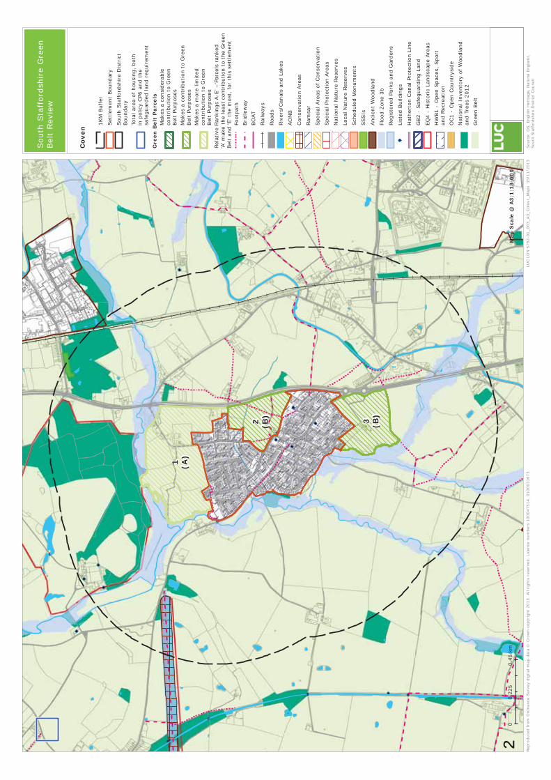
1 (A)
3 (B)
2 (B)
Rep
roduce
d fr
om O
rdnance
Surv
ey d
igital m
ap d
ata ©
Cro
wn c
opyr
ight
2013.
All
right
s re
serv
ed.
Lice
nce
num
ber
s 100047514,
0100031
673.
00.4
50.2
25
km
LUC L
DN
5782-0
1_003_
A3_
Col
our_
Maps
15/1
1/2
013
Map
Sca
le @
A3
:1:1
3,0
00
²
Cov
en
Sourc
e: O
S,
Engl
ish H
eritag
e, N
atura
l Engl
and,
Sou
th S
taff
ords
hir
e D
istr
ict
Counc
il
South
Sta
fford
shir
e G
reen
Belt
Revie
w
1KM
Buffer
Sett
lem
ent
Boundary
South
Sta
fford
shir
e D
istr
ict
Boundary
Tota
l are
a o
f housi
ng,
both
in p
olic
y C
P6 a
nd t
he
safe
guard
ed land r
equir
em
ent
Gre
en B
elt
Pa
rce
lsM
akes
a c
onsi
der
able
contr
ibution t
o G
reen
Belt P
urp
ose
s
Makes
a c
ontr
ibution t
o G
reen
Belt P
urp
ose
sM
akes
a m
ore
lim
ited
contr
ibution t
o G
reen
Belt P
urp
ose
s
Footp
ath
Bri
dle
way
BO
AT
Railw
ays
Roads
Riv
ers
/Canals
and L
akes
AO
NB
Conse
rvation A
reas
Ram
sar
Speci
al Are
as
of
Conse
rvation
Speci
al Pro
tect
ion A
reas
National N
atu
re R
ese
rves
Loca
l N
atu
re R
ese
rves
Sch
edule
d M
onum
ents
SSSIs
Anci
ent
Woodla
nd
Flood Z
one 3
b
Regis
tere
d P
ark
s and G
ard
ens
List
ed B
uild
ings
Hath
ert
on C
anal Pro
tect
ion L
ine
GB2 -
Safe
guard
ing L
and
EQ
4 -
His
toric
Landsc
ape A
reas
__
__
HW
B1 -
Open
Space
s, S
port
and R
ecr
eation
OC1 -
Open C
ountr
ysi
de
National In
vento
ry o
f W
oodla
nd
and T
rees
2012
Gre
en B
elt
Rela
tive R
ankin
gs
A-E
’ –‘P
arc
els
ranke
d‘A
’ make
the least
contr
ibution t
o t
he G
reen
Belt a
nd ‘E’ th
e m
ost
, fo
r th
is s
ett
lem
ent

1 (B)
7 (A)
6 (A)
4 (C)
5 (C)
2 (C)
3 (B)
Rep
roduce
d fr
om
Ord
nance
Surv
ey d
igital m
ap d
ata ©
Cro
wn c
opy
right
2013.
All
right
s re
serv
ed. Li
cence
num
bers
100047514,
0100031
673.
00.4
0.2
km
LUC L
DN
578
2-0
1_003_A3_Col
our_
Map
s 0
4/1
2/2
013
Map
Sca
le @
A3
:1:1
2,0
00
²
Feat
her
sto
ne
Sou
rce:
OS,
Eng
lish H
eritag
e, N
atura
l Engl
and,
Sou
th S
taff
ordsh
ire
Dis
tric
t C
ounci
l
South
Sta
fford
shir
e G
reen
Belt
Revie
w
1KM
Buffer
Sett
lem
ent
Boundary
South
Sta
fford
shire D
istr
ict
Boundary
Tota
l are
a o
f housi
ng,
both
in p
olic
y C
P6 a
nd t
he
safe
guard
ed land r
equir
em
ent
Gre
en B
elt
Par
cels
Makes
a c
onsi
dera
ble
contr
ibution t
o G
reen
Belt P
urp
ose
s
Make
s a c
ontr
ibution t
o G
reen
Belt P
urp
ose
sM
akes
a m
ore
lim
ited
contr
ibution t
o G
reen
Belt P
urp
ose
s
Footp
ath
Bri
dle
way
BO
AT
Railw
ays
Roads
Riv
ers
/Canals
and L
ake
s
AO
NB
Conse
rvation A
reas
Ram
sar
Speci
al Are
as
of Conse
rvation
Speci
al Pro
tect
ion A
reas
National N
atu
re R
ese
rves
Loca
l N
atu
re R
ese
rves
Sch
edule
d M
onum
ents
SSSIs
Anci
ent
Woodla
nd
Flood Z
one 3
b
Regis
tere
d P
ark
s and G
ard
ens
List
ed B
uild
ings
Hath
ert
on C
anal Pro
tect
ion L
ine
GB2 -
Safe
guard
ing L
and
EQ
4 -
His
toric
Landsc
ape A
reas
__
__
HW
B1 -
Open S
pace
s, S
port
and R
ecr
eation
OC1 -
Open C
ountr
ysid
e
National In
vento
ry o
f W
oodla
nd
and T
rees
2012
Gre
en B
elt
Rela
tive
Rankin
gs
A-E
’ –‘P
arc
els
ranked
‘A’ m
ake
the least
contr
ibution t
o t
he
Gre
en
Belt a
nd ‘E’ th
e m
ost
, fo
r th
is s
ett
lem
ent

3 (B)
2 (B)
1 (A)
Rep
roduce
d fr
om
Ord
nance
Surv
ey d
igital m
ap d
ata ©
Cro
wn c
opy
right
2013.
All
right
s re
serv
ed. Li
cence
num
bers
100047514,
0100031
673.
00.6
0.3
km
LUC L
DN
578
2-0
1_003_A3_Col
our_
Map
s_G
reat_
Wry
ley
14/1
1/2
013
Map
Sca
le @
A3
:1:1
9,0
00
²Sou
rce:
OS,
Eng
lish H
eritag
e, N
atura
l Engl
and,
Sou
th S
taff
ordsh
ire
Dis
tric
t C
ounci
l
South
Sta
fford
shir
e G
reen
Belt
Revie
w
1KM
Buffer
Sett
lem
ent
Boundary
South
Sta
fford
shire D
istr
ict
Boundary
Tota
l are
a o
f housi
ng,
both
in p
olic
y C
P6 a
nd t
he
safe
guard
ed land r
equir
em
ent
Gre
en B
elt
Par
cels
Makes
a c
onsi
dera
ble
contr
ibution t
o G
reen
Belt P
urp
ose
s
Make
s a c
ontr
ibution t
o G
reen
Belt P
urp
ose
sM
akes
a m
ore
lim
ited
contr
ibution t
o G
reen
Belt P
urp
ose
s
Footp
ath
Bri
dle
way
BO
AT
Railw
ays
Roads
Riv
ers
/Canals
and L
ake
s
AO
NB
Conse
rvation A
reas
Ram
sar
Speci
al Are
as
of Conse
rvation
Speci
al Pro
tect
ion A
reas
National N
atu
re R
ese
rves
Loca
l N
atu
re R
ese
rves
Sch
edule
d M
onum
ents
SSSIs
Anci
ent
Woodla
nd
Flood Z
one 3
b
Regis
tere
d P
ark
s and G
ard
ens
List
ed B
uild
ings
Hath
ert
on C
anal Pro
tect
ion L
ine
GB2 -
Safe
guard
ing L
and
EQ
4 -
His
toric
Landsc
ape A
reas
__
__
HW
B1 -
Open S
pace
s, S
port
and R
ecr
eation
OC1 -
Open C
ountr
ysid
e
National In
vento
ry o
f W
oodla
nd
and T
rees
2012
Gre
en B
elt
Gre
at W
ryle
y
Rela
tive
Rankin
gs
A-E
’ –‘P
arc
els
ranked
‘A’ m
ake
the least
contr
ibution t
o t
he
Gre
en
Belt a
nd ‘E’ th
e m
ost
, fo
r th
is s
ett
lem
ent

5 (B)
1 (D)
3 (C)
2 (D) 6 (D
)
4 (A)
Rep
roduce
d fr
om O
rdnance
Surv
ey d
igital m
ap d
ata ©
Cro
wn c
opyr
ight
2013.
All
right
s re
serv
ed.
Lice
nce
num
ber
s 100047514,
0100031
673.
00.5
50.2
75
km
LUC L
DN
5782-0
1_003_
A3_
Col
our_
Maps
15/1
1/2
013
Map
Sca
le @
A3
:1:1
8,0
00
²
Hu
nti
ng
ton
Sourc
e: O
S,
Engl
ish H
eritag
e, N
atura
l Engl
and,
Sou
th S
taff
ords
hir
e D
istr
ict
Counc
il
South
Sta
fford
shir
e G
reen
Belt
Revie
w
1KM
Buffer
Sett
lem
ent
Boundary
South
Sta
fford
shir
e D
istr
ict
Boundary
Tota
l are
a o
f housi
ng,
both
in p
olic
y C
P6 a
nd t
he
safe
guard
ed land r
equir
em
ent
Gre
en B
elt
Pa
rce
lsM
akes
a c
onsi
der
able
contr
ibution t
o G
reen
Belt P
urp
ose
s
Makes
a c
ontr
ibution t
o G
reen
Belt P
urp
ose
sM
akes
a m
ore
lim
ited
contr
ibution t
o G
reen
Belt P
urp
ose
s
Footp
ath
Bri
dle
way
BO
AT
Railw
ays
Roads
Riv
ers
/Canals
and L
akes
AO
NB
Conse
rvation A
reas
Ram
sar
Speci
al Are
as
of
Conse
rvation
Speci
al Pro
tect
ion A
reas
National N
atu
re R
ese
rves
Loca
l N
atu
re R
ese
rves
Sch
edule
d M
onum
ents
SSSIs
Anci
ent
Woodla
nd
Flood Z
one 3
b
Regis
tere
d P
ark
s and G
ard
ens
List
ed B
uild
ings
Hath
ert
on C
anal Pro
tect
ion L
ine
GB2 -
Safe
guard
ing L
and
EQ
4 -
His
toric
Landsc
ape A
reas
__
__
HW
B1 -
Open
Space
s, S
port
and R
ecr
eation
OC1 -
Open C
ountr
ysi
de
National In
vento
ry o
f W
oodla
nd
and T
rees
2012
Gre
en B
elt
Rela
tive R
ankin
gs
A-E
’ –‘P
arc
els
ranke
d‘A
’ make
the least
contr
ibution t
o t
he G
reen
Belt a
nd ‘E’ th
e m
ost
, fo
r th
is s
ett
lem
ent
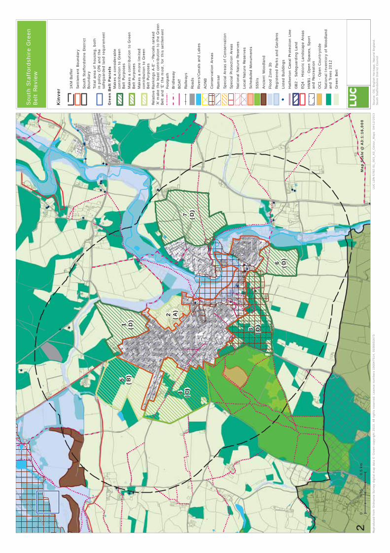
7 (D)
4 (C)
5 (B)
3 (D)1 (D
)
6 (D)
2 (A)
Rep
roduce
d fr
om
Ord
nance
Surv
ey d
igital m
ap d
ata ©
Cro
wn c
opy
right
2013.
All
right
s re
serv
ed. Li
cence
num
bers
100047514,
0100031
673.
00.5
0.2
5km
LUC L
DN
578
2-0
1_003_A3_Col
our_
Map
s 0
4/1
2/2
013
Map
Sca
le @
A3
:1:1
6,0
00
²
Kin
ver
Sou
rce:
OS,
Eng
lish H
eritag
e, N
atura
l Engl
and,
Sou
th S
taff
ordsh
ire
Dis
tric
t C
ounci
l
South
Sta
fford
shir
e G
reen
Belt
Revie
w
1KM
Buffer
Sett
lem
ent
Boundary
South
Sta
fford
shire D
istr
ict
Boundary
Tota
l are
a o
f housi
ng,
both
in p
olic
y C
P6 a
nd t
he
safe
guard
ed land r
equir
em
ent
Gre
en B
elt
Par
cels
Makes
a c
onsi
dera
ble
contr
ibution t
o G
reen
Belt P
urp
ose
s
Make
s a c
ontr
ibution t
o G
reen
Belt P
urp
ose
sM
akes
a m
ore
lim
ited
contr
ibution t
o G
reen
Belt P
urp
ose
s
Footp
ath
Bri
dle
way
BO
AT
Railw
ays
Roads
Riv
ers
/Canals
and L
ake
s
AO
NB
Conse
rvation A
reas
Ram
sar
Speci
al Are
as
of Conse
rvation
Speci
al Pro
tect
ion A
reas
National N
atu
re R
ese
rves
Loca
l N
atu
re R
ese
rves
Sch
edule
d M
onum
ents
SSSIs
Anci
ent
Woodla
nd
Flood Z
one 3
b
Regis
tere
d P
ark
s and G
ard
ens
List
ed B
uild
ings
Hath
ert
on C
anal Pro
tect
ion L
ine
GB2 -
Safe
guard
ing L
and
EQ
4 -
His
toric
Landsc
ape A
reas
__
__
HW
B1 -
Open S
pace
s, S
port
and R
ecr
eation
OC1 -
Open C
ountr
ysid
e
National In
vento
ry o
f W
oodla
nd
and T
rees
2012
Gre
en B
elt
Rela
tive
Rankin
gs
A-E
’ –‘P
arc
els
ranked
‘A’ m
ake
the least
contr
ibution t
o t
he
Gre
en
Belt a
nd ‘E’ th
e m
ost
, fo
r th
is s
ett
lem
ent

1 (C)
5 (A)
6 (C)
3 (B)
2 (C)
4 (A)
Rep
roduce
d fr
om O
rdnance
Surv
ey d
igital m
ap d
ata ©
Cro
wn c
opyr
ight
2013.
All
right
s re
serv
ed.
Lice
nce
num
ber
s 100047514,
0100031
673.
00.4
0.2
km
LUC L
DN
5782-0
1_003_
A3_
Col
our_
Maps
15/1
1/2
013
Map
Sca
le @
A3
:1:1
2,0
00
²
Pat
tin
gh
am
Sourc
e: O
S,
Engl
ish H
eritag
e, N
atura
l Engl
and,
Sou
th S
taff
ords
hir
e D
istr
ict
Counc
il
South
Sta
fford
shir
e G
reen
Belt
Revie
w
1KM
Buffer
Sett
lem
ent
Boundary
South
Sta
fford
shir
e D
istr
ict
Boundary
Tota
l are
a o
f housi
ng,
both
in p
olic
y C
P6 a
nd t
he
safe
guard
ed land r
equir
em
ent
Gre
en B
elt
Pa
rce
lsM
akes
a c
onsi
der
able
contr
ibution t
o G
reen
Belt P
urp
ose
s
Makes
a c
ontr
ibution t
o G
reen
Belt P
urp
ose
sM
akes
a m
ore
lim
ited
contr
ibution t
o G
reen
Belt P
urp
ose
s
Footp
ath
Bri
dle
way
BO
AT
Railw
ays
Roads
Riv
ers
/Canals
and L
akes
AO
NB
Conse
rvation A
reas
Ram
sar
Speci
al Are
as
of
Conse
rvation
Speci
al Pro
tect
ion A
reas
National N
atu
re R
ese
rves
Loca
l N
atu
re R
ese
rves
Sch
edule
d M
onum
ents
SSSIs
Anci
ent
Woodla
nd
Flood Z
one 3
b
Regis
tere
d P
ark
s and G
ard
ens
List
ed B
uild
ings
Hath
ert
on C
anal Pro
tect
ion L
ine
GB2 -
Safe
guard
ing L
and
EQ
4 -
His
toric
Landsc
ape A
reas
__
__
HW
B1 -
Open
Space
s, S
port
and R
ecr
eation
OC1 -
Open C
ountr
ysi
de
National In
vento
ry o
f W
oodla
nd
and T
rees
2012
Gre
en B
elt
Rela
tive R
ankin
gs
A-E
’ –‘P
arc
els
ranke
d‘A
’ make
the least
contr
ibution t
o t
he G
reen
Belt a
nd ‘E’ th
e m
ost
, fo
r th
is s
ett
lem
ent

!!
!!
!!
!!
!!
!
!!
!!
!!
!!
!!
!
!!
!!
!!
!!
!!
!
!!
!!
!!
!!
!!
!
!!
!!
!!
!!
!!
!
!!
!!
!!
!!
!!
!
!!
!!
!!
!!
!!
!
!!
!!
!!
!!
!!
!
!!
!!
!!
!!
!!
!
!!
!!
!!
!!
!!
!
!!
!!
!!
!!
!!
!
!!
!!
!!
!!
!!
!
!!
!!
!!
!!
!!
!
!!
!!
!!
!!
!!
!
!!
!!
!!
!!
!!
!
!!
!!
!!
!!
!!
!
!!
!!
!!
!!
!!
!
!!
!!
!!
!!
!!
!
!!
!!
!!
!!
!!
!
!!
!!
!!
!!
!!
!
!!
!!
!!
!!
!!
!
!!
!!
!!
!!
!!
!
!!
!!
!!
!!
!!
!
!!
!!
!!
!!
!!
!
6
7
5 (C)
2 (B)
3 (A)
4 (B)
1 (B)
Rep
roduce
d fr
om O
rdnance
Surv
ey d
igital m
ap d
ata ©
Cro
wn c
opyr
ight
2013.
All
right
s re
serv
ed.
Lice
nce
num
ber
s 100047514,
0100031
673.
00.5
50.2
75
km
LUC L
DN
5782-0
1_003_
A3_
Col
our_
Map
s_Pe
nkr
idge
15/1
1/2
013
Map
Sca
le @
A3
:1:1
7,0
00
²Sourc
e: O
S,
Engl
ish H
eritag
e, N
atura
l Engl
and,
Sou
th S
taff
ords
hir
e D
istr
ict
Counc
il
South
Sta
fford
shir
e G
reen
Belt
Revie
w
1KM
Buffer
Sett
lem
ent
Boundary
South
Sta
fford
shir
e D
istr
ict
Boundary
Tota
l are
a o
f housi
ng,
both
in p
olic
y C
P6 a
nd t
he
safe
guard
ed land r
equir
em
ent
Gre
en B
elt
Pa
rce
lsM
akes
a c
onsi
der
able
contr
ibution t
o G
reen
Belt P
urp
ose
s
Makes
a c
ontr
ibution t
o G
reen
Belt P
urp
ose
sM
akes
a m
ore
lim
ited
contr
ibution t
o G
reen
Belt P
urp
ose
s
!!
!!
!!
Parc
els
in ‘O
pen C
ountr
ysi
de’
outs
ide G
reen B
elt
Footp
ath
Bri
dle
way
BO
AT
Railw
ays
Roads
Riv
ers
/Canals
and L
akes
AO
NB
Conse
rvation A
reas
Ram
sar
Speci
al Are
as
of
Conse
rvation
Speci
al Pro
tect
ion A
reas
National N
atu
re R
ese
rves
Loca
l N
atu
re R
ese
rves
Sch
edule
d M
onum
ents
SSSIs
Anci
ent
Woodla
nd
Flood Z
one 3
b
Regis
tere
d P
ark
s and G
ard
ens
List
ed B
uild
ings
Hath
ert
on C
anal Pro
tect
ion L
ine
GB2 -
Safe
guard
ing L
and
EQ
4 -
His
toric
Landsc
ape A
reas
__
__
HW
B1 -
Open
Space
s, S
port
and R
ecr
eation
OC1 -
Open C
ountr
ysi
de
National In
vento
ry o
f W
oodla
nd
and T
rees
2012
Gre
en B
elt
Pen
krid
ge
Rela
tive R
ankin
gs
A-E
’ –‘P
arc
els
ranke
d‘A
’ make
the least
contr
ibution t
o t
he G
reen
Belt a
nd ‘E’ th
e m
ost
, fo
r th
is s
ett
lem
ent

3 (A)
2 (C)
6 (D)
5 (C)
1 (D)
4 (B)
Rep
roduce
d fr
om O
rdnance
Surv
ey d
igital m
ap d
ata ©
Cro
wn c
opyr
ight
2013.
All
right
s re
serv
ed.
Lice
nce
num
ber
s 100047514,
0100031
673.
00.5
0.2
5km
LUC L
DN
5782-0
1_003_
A3_
Col
our_
Maps
15/1
1/2
013
Map
Sca
le @
A3
:1:1
5,0
00
²
Per
ton
Sourc
e: O
S,
Engl
ish H
eritag
e, N
atura
l Engl
and,
Sou
th S
taff
ords
hir
e D
istr
ict
Counc
il
South
Sta
fford
shir
e G
reen
Belt
Revie
w
1KM
Buffer
Sett
lem
ent
Boundary
South
Sta
fford
shir
e D
istr
ict
Boundary
Tota
l are
a o
f housi
ng,
both
in p
olic
y C
P6 a
nd t
he
safe
guard
ed land r
equir
em
ent
Gre
en B
elt
Pa
rce
lsM
akes
a c
onsi
der
able
contr
ibution t
o G
reen
Belt P
urp
ose
s
Makes
a c
ontr
ibution t
o G
reen
Belt P
urp
ose
sM
akes
a m
ore
lim
ited
contr
ibution t
o G
reen
Belt P
urp
ose
s
Footp
ath
Bri
dle
way
BO
AT
Railw
ays
Roads
Riv
ers
/Canals
and L
akes
AO
NB
Conse
rvation A
reas
Ram
sar
Speci
al Are
as
of
Conse
rvation
Speci
al Pro
tect
ion A
reas
National N
atu
re R
ese
rves
Loca
l N
atu
re R
ese
rves
Sch
edule
d M
onum
ents
SSSIs
Anci
ent
Woodla
nd
Flood Z
one 3
b
Regis
tere
d P
ark
s and G
ard
ens
List
ed B
uild
ings
Hath
ert
on C
anal Pro
tect
ion L
ine
GB2 -
Safe
guard
ing L
and
EQ
4 -
His
toric
Landsc
ape A
reas
__
__
HW
B1 -
Open
Space
s, S
port
and R
ecr
eation
OC1 -
Open C
ountr
ysi
de
National In
vento
ry o
f W
oodla
nd
and T
rees
2012
Gre
en B
elt
Rela
tive R
ankin
gs
A-E
’ –‘P
arc
els
ranke
d‘A
’ make
the least
contr
ibution t
o t
he G
reen
Belt a
nd ‘E’ th
e m
ost
, fo
r th
is s
ett
lem
ent

2 (B)
3 (C)
4 (C)
1 (A)
6 (C)
5 (D)
Rep
roduce
d fr
om O
rdnance
Surv
ey d
igital m
ap d
ata ©
Cro
wn c
opyr
ight
2013.
All
right
s re
serv
ed.
Lice
nce
num
ber
s 100047514,
0100031
673.
00.3
50.1
75
km
LUC L
DN
5782-0
1_003_
A3_
Col
our_
Maps
15/1
1/2
013
Map
Sca
le @
A3
:1:1
1,0
00
²
Sw
ind
on
Sourc
e: O
S,
Engl
ish H
eritag
e, N
atura
l Engl
and,
Sou
th S
taff
ords
hir
e D
istr
ict
Counc
il
South
Sta
fford
shir
e G
reen
Belt
Revie
w
1KM
Buffer
Sett
lem
ent
Boundary
South
Sta
fford
shir
e D
istr
ict
Boundary
Tota
l are
a o
f housi
ng,
both
in p
olic
y C
P6 a
nd t
he
safe
guard
ed land r
equir
em
ent
Gre
en B
elt
Pa
rce
lsM
akes
a c
onsi
der
able
contr
ibution t
o G
reen
Belt P
urp
ose
s
Makes
a c
ontr
ibution t
o G
reen
Belt P
urp
ose
sM
akes
a m
ore
lim
ited
contr
ibution t
o G
reen
Belt P
urp
ose
s
Footp
ath
Bri
dle
way
BO
AT
Railw
ays
Roads
Riv
ers
/Canals
and L
akes
AO
NB
Conse
rvation A
reas
Ram
sar
Speci
al Are
as
of
Conse
rvation
Speci
al Pro
tect
ion A
reas
National N
atu
re R
ese
rves
Loca
l N
atu
re R
ese
rves
Sch
edule
d M
onum
ents
SSSIs
Anci
ent
Woodla
nd
Flood Z
one 3
b
Regis
tere
d P
ark
s and G
ard
ens
List
ed B
uild
ings
Hath
ert
on C
anal Pro
tect
ion L
ine
GB2 -
Safe
guard
ing L
and
EQ
4 -
His
toric
Landsc
ape A
reas
__
__
HW
B1 -
Open
Space
s, S
port
and R
ecr
eation
OC1 -
Open C
ountr
ysi
de
National In
vento
ry o
f W
oodla
nd
and T
rees
2012
Gre
en B
elt
Rela
tive R
ankin
gs
A-E
’ –‘P
arc
els
ranke
d‘A
’ make
the least
contr
ibution t
o t
he G
reen
Belt a
nd ‘E’ th
e m
ost
, fo
r th
is s
ett
lem
ent
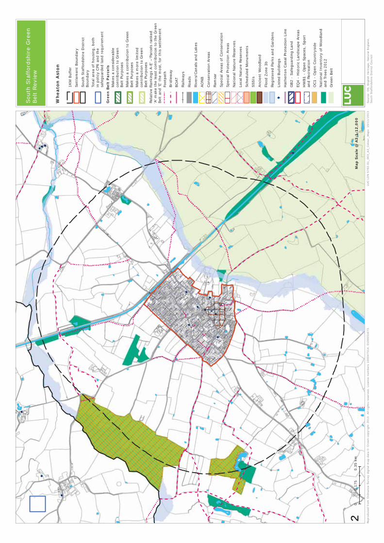
Rep
roduce
d fr
om O
rdnance
Surv
ey d
igital m
ap d
ata ©
Cro
wn c
opyr
ight
2013.
All
right
s re
serv
ed.
Lice
nce
num
ber
s 100047514,
0100031
673.
00.3
50.1
75
km
LUC L
DN
5782-0
1_003_
A3_
Col
our_
Maps
15/1
1/2
013
Map
Sca
le @
A3
:1:1
2,0
00
²
Wh
eato
n A
sto
n
Sourc
e: O
S,
Engl
ish H
eritag
e, N
atura
l Engl
and,
Sou
th S
taff
ords
hir
e D
istr
ict
Counc
il
South
Sta
fford
shir
e G
reen
Belt
Revie
w
1KM
Buffer
Sett
lem
ent
Boundary
South
Sta
fford
shir
e D
istr
ict
Boundary
Tota
l are
a o
f housi
ng,
both
in p
olic
y C
P6 a
nd t
he
safe
guard
ed land r
equir
em
ent
Gre
en B
elt
Pa
rce
lsM
akes
a c
onsi
der
able
contr
ibution t
o G
reen
Belt P
urp
ose
s
Makes
a c
ontr
ibution t
o G
reen
Belt P
urp
ose
sM
akes
a m
ore
lim
ited
contr
ibution t
o G
reen
Belt P
urp
ose
s
Footp
ath
Bri
dle
way
BO
AT
Railw
ays
Roads
Riv
ers
/Canals
and L
akes
AO
NB
Conse
rvation A
reas
Ram
sar
Speci
al Are
as
of
Conse
rvation
Speci
al Pro
tect
ion A
reas
National N
atu
re R
ese
rves
Loca
l N
atu
re R
ese
rves
Sch
edule
d M
onum
ents
SSSIs
Anci
ent
Woodla
nd
Flood Z
one 3
b
Regis
tere
d P
ark
s and G
ard
ens
List
ed B
uild
ings
Hath
ert
on C
anal Pro
tect
ion L
ine
GB2 -
Safe
guard
ing L
and
EQ
4 -
His
toric
Landsc
ape A
reas
__
__
HW
B1 -
Open
Space
s, S
port
and R
ecr
eation
OC1 -
Open C
ountr
ysi
de
National In
vento
ry o
f W
oodla
nd
and T
rees
2012
Gre
en B
elt
Rela
tive R
ankin
gs
A-E
’ –‘P
arc
els
ranke
d‘A
’ make
the least
contr
ibution t
o t
he G
reen
Belt a
nd ‘E’ th
e m
ost
, fo
r th
is s
ett
lem
ent

5 (D)
6 (D)
2 (D)
4 (C)
1 (B)
7 (D)
3 (A)
Rep
roduce
d fr
om
Ord
nance
Surv
ey d
igital m
ap d
ata ©
Cro
wn c
opy
right
2013.
All
right
s re
serv
ed. Li
cence
num
bers
100047514,
0100031
673.
00.6
50.3
25
km
LUC L
DN
578
2-0
1_003_A3_Col
our_
Map
s 0
4/1
2/2
013
Map
Sca
le @
A3
:1:2
0,0
00
²
Wom
bo
urn
e
Sou
rce:
OS,
Eng
lish H
eritag
e, N
atura
l Engl
and,
Sou
th S
taff
ordsh
ire
Dis
tric
t C
ounci
l
South
Sta
fford
shir
e G
reen
Belt
Revie
w
1KM
Buffer
Sett
lem
ent
Boundary
South
Sta
fford
shire D
istr
ict
Boundary
Tota
l are
a o
f housi
ng,
both
in p
olic
y C
P6 a
nd t
he
safe
guard
ed land r
equir
em
ent
Gre
en B
elt
Par
cels
Makes
a c
onsi
dera
ble
contr
ibution t
o G
reen
Belt P
urp
ose
s
Make
s a c
ontr
ibution t
o G
reen
Belt P
urp
ose
sM
akes
a m
ore
lim
ited
contr
ibution t
o G
reen
Belt P
urp
ose
s
Footp
ath
Bri
dle
way
BO
AT
Railw
ays
Roads
Riv
ers
/Canals
and L
ake
s
AO
NB
Conse
rvation A
reas
Ram
sar
Speci
al Are
as
of Conse
rvation
Speci
al Pro
tect
ion A
reas
National N
atu
re R
ese
rves
Loca
l N
atu
re R
ese
rves
Sch
edule
d M
onum
ents
SSSIs
Anci
ent
Woodla
nd
Flood Z
one 3
b
Regis
tere
d P
ark
s and G
ard
ens
List
ed B
uild
ings
Hath
ert
on C
anal Pro
tect
ion L
ine
GB2 -
Safe
guard
ing L
and
EQ
4 -
His
toric
Landsc
ape A
reas
__
__
HW
B1 -
Open S
pace
s, S
port
and R
ecr
eation
OC1 -
Open C
ountr
ysid
e
National In
vento
ry o
f W
oodla
nd
and T
rees
2012
Gre
en B
elt
Rela
tive
Rankin
gs
A-E
’ –‘P
arc
els
ranked
‘A’ m
ake
the least
contr
ibution t
o t
he
Gre
en
Belt a
nd ‘E’ th
e m
ost
, fo
r th
is s
ett
lem
ent

2 (B)
1 (A) 3 (A)
Rep
roduce
d fr
om
Ord
nance
Surv
ey d
igital m
ap d
ata ©
Cro
wn c
opy
right
2013.
All
right
s re
serv
ed. Li
cence
num
bers
100047514,
0100031
673.
00.3
50.1
75
km
LUC L
DN
578
2-0
1_003_A3_Col
our_
Map
s_R
OF_
Feath
erst
one
14/1
1/2013
Map
Sca
le @
A3
:1:1
2,0
00
²Sou
rce:
OS,
Eng
lish H
eritag
e, N
atura
l Engl
and,
Sou
th S
taff
ordsh
ire
Dis
tric
t C
ounci
l
South
Sta
fford
shir
e G
reen
Belt
Revie
w
1KM
Buffer
Sett
lem
ent
Boundary
South
Sta
fford
shire D
istr
ict
Boundary
Tota
l are
a o
f housi
ng,
both
in p
olic
y C
P6 a
nd t
he
safe
guard
ed land r
equir
em
ent
Gre
en B
elt
Par
cels
Makes
a c
onsi
dera
ble
contr
ibution t
o G
reen
Belt P
urp
ose
s
Make
s a c
ontr
ibution t
o G
reen
Belt P
urp
ose
sM
akes
a m
ore
lim
ited
contr
ibution t
o G
reen
Belt P
urp
ose
s
Footp
ath
Bri
dle
way
BO
AT
Railw
ays
Roads
Riv
ers
/Canals
and L
ake
s
AO
NB
Conse
rvation A
reas
Ram
sar
Speci
al Are
as
of Conse
rvation
Speci
al Pro
tect
ion A
reas
National N
atu
re R
ese
rves
Loca
l N
atu
re R
ese
rves
Sch
edule
d M
onum
ents
SSSIs
Anci
ent
Woodla
nd
Flood Z
one 3
b
Regis
tere
d P
ark
s and G
ard
ens
List
ed B
uild
ings
Hath
ert
on C
anal Pro
tect
ion L
ine
GB2 -
Safe
guard
ing L
and
EQ
4 -
His
toric
Landsc
ape A
reas
__
HW
B1 -
Open S
pace
s, S
port
and R
ecr
eation
OC1 -
Open C
ountr
ysid
e
National In
vento
ry o
f W
oodla
nd
and T
rees
2012
Gre
en B
elt
Emp
loym
ent
Sit
e -
RO
FFe
ath
erst
on
e
Rela
tive
Rankin
gs
A-E
’ –‘P
arc
els
ranked
‘A’ m
ake
the least
contr
ibution t
o t
he
Gre
en
Belt a
nd ‘E’ th
e m
ost
, fo
r th
is s
ett
lem
ent

4 (D)
1 (A)
2 (B)
3 (C)
Rep
roduce
d fr
om O
rdnance
Surv
ey d
igital m
ap d
ata ©
Cro
wn c
opyr
ight
2013.
All
right
s re
serv
ed.
Lice
nce
num
ber
s 100047514,
0100031
673.
00.4
50.2
25
km
LUC L
DN
5782-0
1_003_
A3_
Col
our_
Maps
15/1
1/2
013
Map
Sca
le @
A3
:1:1
4,0
00
²
Emp
loym
ent
Sit
e -
Fou
r A
shes
Sourc
e: O
S,
Engl
ish H
eritag
e, N
atura
l Engl
and,
Sou
th S
taff
ords
hir
e D
istr
ict
Counc
il
South
Sta
fford
shir
e G
reen
Belt
Revie
w
1KM
Buffer
Sett
lem
ent
Boundary
South
Sta
fford
shir
e D
istr
ict
Boundary
Tota
l are
a o
f housi
ng,
both
in p
olic
y C
P6 a
nd t
he
safe
guard
ed land r
equir
em
ent
Gre
en B
elt
Pa
rce
lsM
akes
a c
onsi
der
able
contr
ibution t
o G
reen
Belt P
urp
ose
s
Makes
a c
ontr
ibution t
o G
reen
Belt P
urp
ose
sM
akes
a m
ore
lim
ited
contr
ibution t
o G
reen
Belt P
urp
ose
s
Footp
ath
Bri
dle
way
BO
AT
Railw
ays
Roads
Riv
ers
/Canals
and L
akes
AO
NB
Conse
rvation A
reas
Ram
sar
Speci
al Are
as
of
Conse
rvation
Speci
al Pro
tect
ion A
reas
National N
atu
re R
ese
rves
Loca
l N
atu
re R
ese
rves
Sch
edule
d M
onum
ents
SSSIs
Anci
ent
Woodla
nd
Flood Z
one 3
b
Regis
tere
d P
ark
s and G
ard
ens
List
ed B
uild
ings
Hath
ert
on C
anal Pro
tect
ion L
ine
GB2 -
Safe
guard
ing L
and
EQ
4 -
His
toric
Landsc
ape A
reas
__
__
HW
B1 -
Open
Space
s, S
port
and R
ecr
eation
OC1 -
Open C
ountr
ysi
de
National In
vento
ry o
f W
oodla
nd
and T
rees
2012
Gre
en B
elt
Rela
tive R
ankin
gs
A-E
’ –‘P
arc
els
ranke
d‘A
’ make
the least
contr
ibution t
o t
he G
reen
Belt a
nd ‘E’ th
e m
ost
, fo
r th
is s
ett
lem
ent

3 (A)
1 (B)
2 (B)
Rep
roduce
d fr
om O
rdnance
Surv
ey d
igital m
ap d
ata ©
Cro
wn c
opyr
ight
2013.
All
right
s re
serv
ed.
Lice
nce
num
ber
s 100047514,
0100031
673.
00.3
50.1
75
km
LUC L
DN
5782-0
1_003_
A3_
Col
our_
Maps
15/1
1/2
013
Map
Sca
le @
A3
:1:1
1,0
00
²
Emp
loym
ent
Sit
e -
Hilt
on
Cro
ss
Sourc
e: O
S,
Engl
ish H
eritag
e, N
atura
l Engl
and,
Sou
th S
taff
ords
hir
e D
istr
ict
Counc
il
South
Sta
fford
shir
e G
reen
Belt
Revie
w
1KM
Buffer
Sett
lem
ent
Boundary
South
Sta
fford
shir
e D
istr
ict
Boundary
Tota
l are
a o
f housi
ng,
both
in p
olic
y C
P6 a
nd t
he
safe
guard
ed land r
equir
em
ent
Gre
en B
elt
Pa
rce
lsM
akes
a c
onsi
der
able
contr
ibution t
o G
reen
Belt P
urp
ose
s
Makes
a c
ontr
ibution t
o G
reen
Belt P
urp
ose
sM
akes
a m
ore
lim
ited
contr
ibution t
o G
reen
Belt P
urp
ose
s
Footp
ath
Bri
dle
way
BO
AT
Railw
ays
Roads
Riv
ers
/Canals
and L
akes
AO
NB
Conse
rvation A
reas
Ram
sar
Speci
al Are
as
of
Conse
rvation
Speci
al Pro
tect
ion A
reas
National N
atu
re R
ese
rves
Loca
l N
atu
re R
ese
rves
Sch
edule
d M
onum
ents
SSSIs
Anci
ent
Woodla
nd
Flood Z
one 3
b
Regis
tere
d P
ark
s and G
ard
ens
List
ed B
uild
ings
Hath
ert
on C
anal Pro
tect
ion L
ine
GB2 -
Safe
guard
ing L
and
EQ
4 -
His
toric
Landsc
ape A
reas
__
__
HW
B1 -
Open
Space
s, S
port
and R
ecr
eation
OC1 -
Open C
ountr
ysi
de
National In
vento
ry o
f W
oodla
nd
and T
rees
2012
Gre
en B
elt
Rela
tive R
ankin
gs
A-E
’ –‘P
arc
els
ranke
d‘A
’ make
the least
contr
ibution t
o t
he G
reen
Belt a
nd ‘E’ th
e m
ost
, fo
r th
is s
ett
lem
ent

2 (B)
1 (A)
Rep
roduce
d fr
om
Ord
nance
Surv
ey d
igital m
ap d
ata ©
Cro
wn c
opy
right
2013.
All
right
s re
serv
ed. Li
cence
num
bers
100047514,
0100031
673.
00.3
50.1
75
km
LUC L
DN
578
2-0
1_003_A3_Col
our_
Maps
_i5
4
14/1
1/2
013
Map
Sca
le @
A3
:1:1
2,0
00
²Sou
rce:
OS,
Eng
lish H
eritag
e, N
atura
l Engl
and,
Sou
th S
taff
ordsh
ire
Dis
tric
t C
ounci
l
South
Sta
fford
shir
e G
reen
Belt
Revie
w
1KM
Buffer
Sett
lem
ent
Boundary
South
Sta
fford
shire D
istr
ict
Boundary
Tota
l are
a o
f housi
ng,
both
in p
olic
y C
P6 a
nd t
he
safe
guard
ed land r
equir
em
ent
Gre
en B
elt
Par
cels
Makes
a c
onsi
dera
ble
contr
ibution t
o G
reen
Belt P
urp
ose
s
Make
s a c
ontr
ibution t
o G
reen
Belt P
urp
ose
sM
akes
a m
ore
lim
ited
contr
ibution t
o G
reen
Belt P
urp
ose
s
Footp
ath
Bri
dle
way
BO
AT
Railw
ays
Roads
Riv
ers
/Canals
and L
ake
s
AO
NB
Conse
rvation A
reas
Ram
sar
Speci
al Are
as
of Conse
rvation
Speci
al Pro
tect
ion A
reas
National N
atu
re R
ese
rves
Loca
l N
atu
re R
ese
rves
Sch
edule
d M
onum
ents
SSSIs
Anci
ent
Woodla
nd
Flood Z
one 3
b
Regis
tere
d P
ark
s and G
ard
ens
List
ed B
uild
ings
Hath
ert
on C
anal Pro
tect
ion L
ine
GB2 -
Safe
guard
ing L
and
EQ
4 -
His
toric
Landsc
ape A
reas
__
__
HW
B1 -
Open S
pace
s, S
port
and R
ecr
eation
OC1 -
Open C
ountr
ysid
e
National In
vento
ry o
f W
oodla
nd
and T
rees
2012
Gre
en B
elt
Emp
loym
ent
Sit
e -
i54
Rela
tive
Rankin
gs
A-E
’ –‘P
arc
els
ranked
‘A’ m
ake
the least
contr
ibution t
o t
he
Gre
en
Belt a
nd ‘E’ th
e m
ost
, fo
r th
is s
ett
lem
ent


