soil survey of henry county, virginia - usda...united states department of agriculture natural...
TRANSCRIPT
United StatesDepartment ofAgriculture
NaturalResourcesConservationService
Soil Survey ofHenry County,Virginia
In cooperation withVirginia PolytechnicInstitute and StateUniversity

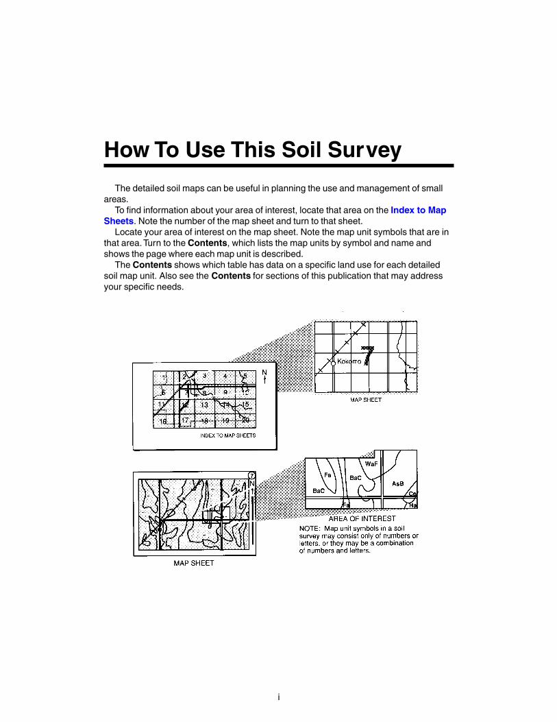
The detailed soil maps can be useful in planning the use and management of smallareas.
To find information about your area of interest, locate that area on the Index to MapSheets. Note the number of the map sheet and turn to that sheet.
Locate your area of interest on the map sheet. Note the map unit symbols that are inthat area. Turn to the Contents, which lists the map units by symbol and name andshows the page where each map unit is described.
The Contents shows which table has data on a specific land use for each detailedsoil map unit. Also see the Contents for sections of this publication that may addressyour specific needs.
How To Use This Soil Survey
i
Additional information about the Nation’s natural resources is available onlinefrom the Natural Resources Conservation Service at http://www.nrcs.usda.gov.
ii
National Cooperative Soil Survey
This soil survey is a publication of the National Cooperative Soil Survey, a joint effortof the United States Department of Agriculture and other Federal agencies, Stateagencies including the Agricultural Experiment Stations, and local agencies. The NaturalResources Conservation Service (formerly the Soil Conservation Service) hasleadership for the Federal part of the National Cooperative Soil Survey. This survey wasmade cooperatively by the Natural Resources Conservation Service and VirginiaPolytechnic Institute and State University. The survey is part of the technical assistancefurnished to the Blue Ridge Soil and Water Conservation District. The Henry CountyBoard of Supervisors provided financial assistance for the survey.
Major fieldwork for this soil survey was completed in 1994. Soil names anddescriptions were approved in 1995. Unless otherwise indicated, statements in thispublication refer to conditions in the survey area in 1995. The most current official dataare available at http://websoilsurvey.nrcs.usda.gov/app/. Taxonomic classifications ofsoil series have been updated to the 10th edition of Soil Taxonomy.
Soil maps in this survey may be copied without permission. Enlargement of thesemaps, however, could cause misunderstanding of the detail of mapping. If enlarged,maps do not show the small areas of contrasting soils that could have been shown at alarger scale. The information contained in this soil survey is not site specific and doesnot eliminate the need for onsite investigation.
Nondiscrimination Statement
The United States Department of Agriculture (USDA) prohibits discrimination in all itsprograms and activities on the basis of race, color, national origin, sex, religion, age,disability, political beliefs, sexual orientation, or marital or family status. (Not allprohibited bases apply to all programs.) Persons with disabilities who require alternativemeans for communication of program information (Braille, large print, audiotape, etc.)should contact the USDA’s TARGET Center at (202) 720-2600 (voice and TDD).
To file a complaint of discrimination, write USDA, Director, Office of Civil Rights,Room 326-W, Whitten Building, 1400 Independence Avenue, SW, Washington, D.C.20250-9410, or call (202) 720-5964 (voice and TDD). USDA is an equal opportunityprovider and employer.
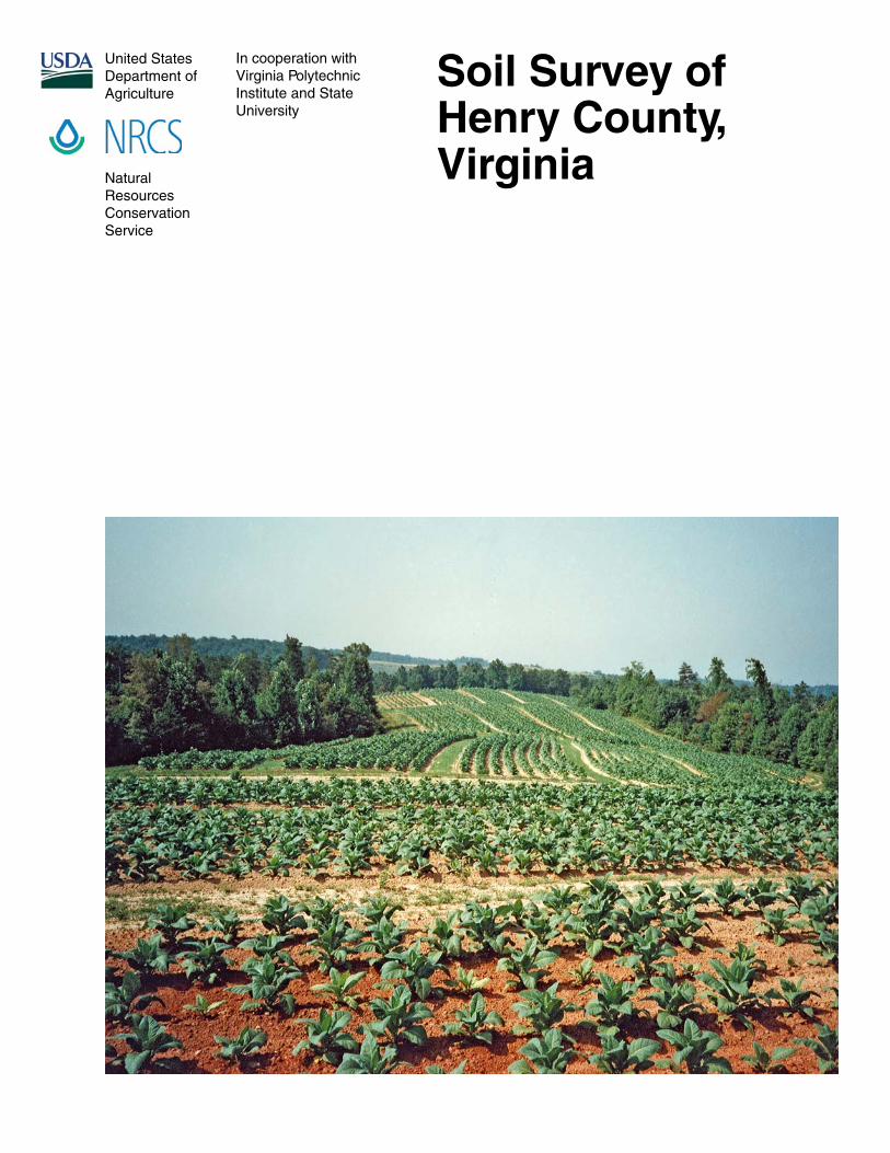
Cover Caption: Planted tobacco field in Henry County, Virginia.
iii
Contents
How To Use This Soil Survey ....................................................................................... iForeword .................................................................................................................... viiGeneral Nature of the Survey Area ............................................................................. 1How This Survey Was Made ........................................................................................ 3Detailed Soil Map Units ............................................................................................. 5
1B—Ayersville gravelly loam, 2 to 7 percent slopes ................................................ 61C—Ayersville gravelly loam, 7 to 15 percent slopes .............................................. 82B—Buckhall sandy loam, 2 to 7 percent slopes .................................................. 102C—Buckhall sandy loam, 7 to 15 percent slopes ................................................ 113E—Buffstat-Bugley complex, 25 to 60 percent slopes ........................................ 134B—Clifford sandy loam, 2 to 7 percent slopes .................................................... 154C—Clifford sandy loam, 7 to 15 percent slopes .................................................. 174D—Clifford sandy loam, 15 to 25 percent slopes ................................................ 194E—Clifford sandy loam, 25 to 45 percent slopes ................................................ 215A—Codorus loam, 0 to 2 percent slopes, frequently flooded .............................. 236A—Colvard fine sandy loam, 0 to 2 percent slopes, occasionally flooded .......... 257B—Creedmoor fine sandy loam, 1 to 4 percent slopes ....................................... 268A—Delanco loam, 0 to 4 percent slopes, rarely flooded ..................................... 289B—Dyke loam, 2 to 7 percent slopes .................................................................. 309C—Dyke loam, 7 to 15 percent slopes ................................................................ 3210A—Elsinboro fine sandy loam, 0 to 4 percent slopes, rarely flooded ................ 3411A—Leaksville silt loam, 0 to 4 percent slopes ................................................... 3512C—Littlejoe silt loam, 7 to 15 percent slopes .................................................... 3712D—Littlejoe silt loam, 15 to 25 percent slopes .................................................. 3913B—Mayodan fine sandy loam, 2 to 7 percent slopes ........................................ 4113C—Mayodan fine sandy loam, 7 to 15 percent slopes ...................................... 4314B—Minnieville loam, 2 to 7 percent slopes ........................................................ 4514C—Minnieville loam, 7 to 15 percent slopes ..................................................... 4614D—Minnieville loam, 15 to 25 percent slopes ................................................... 4815C—Minnieville-Urban land complex, 7 to 15 percent slopes ............................. 5016B—Orenda sandy loam, 2 to 7 percent slopes .................................................. 5117C—Orenda-Spriggs complex, 7 to 15 percent slopes ....................................... 5317D—Orenda-Spriggs complex, 15 to 25 percent slopes ..................................... 5517E—Orenda-Spriggs complex, 25 to 45 percent slopes ..................................... 5818B—Stoneville loam, 2 to 7 percent slopes ......................................................... 6019—Udorthents-Urban land complex, 2 to 15 percent slopes .............................. 6220—Udorthents, loamy .......................................................................................... 6321B—Woolwine-Clifford complex, 2 to 7 percent slopes ....................................... 6321C—Woolwine-Clifford complex, 7 to 15 percent slopes .................................... 6621D—Woolwine-Clifford complex, 15 to 25 percent slopes .................................. 6821E—Woolwine-Clifford complex, 25 to 45 percent slopes ................................... 7022C—Woolwine-Urban land complex, 7 to 15 percent slopes .............................. 73DAM—Dam ............................................................................................................ 74W—Water .............................................................................................................. 74
Soil Survey of Henry County, Virginia
iv
Use and Management of the Soils .......................................................................... 75Interpretive Ratings ............................................................................................... 75
Rating Class Terms ........................................................................................... 75Numerical Ratings ............................................................................................. 75
Crops and Pasture ................................................................................................. 76Yields per Acre .................................................................................................. 76Agriculture of Henry County .............................................................................. 77Land Capability Classification ........................................................................... 80Virginia Soil Management Groups .................................................................... 80
Prime Farmland ..................................................................................................... 82Hydric Soils ............................................................................................................ 83Agricultural Waste Management ............................................................................ 84Forestland Productivity and Management ............................................................. 87
Forestland Productivity ...................................................................................... 87Forestland Management ................................................................................... 87Silviculture of Henry County .............................................................................. 89
Recreational Development .................................................................................... 91Engineering ........................................................................................................... 92
Building Site Development ................................................................................ 93Sanitary Facilities .............................................................................................. 95Construction Materials ...................................................................................... 97Water Management ........................................................................................... 98
Soil Properties ........................................................................................................ 101Engineering Soil Properties ................................................................................. 101Physical Soil Properties ....................................................................................... 102Chemical Soil Properties ..................................................................................... 104Water Features .................................................................................................... 104Soil Features ........................................................................................................ 106
Classification of the Soils ..................................................................................... 107Soil Series and Their Morphology ............................................................................ 107
Ayersville Series .................................................................................................. 108Buckhall Series .................................................................................................... 109Buffstat Series ..................................................................................................... 111Bugley Series ....................................................................................................... 112Clifford Series ...................................................................................................... 113Codorus Series .................................................................................................... 115Colvard Series ..................................................................................................... 117Creedmoor Series ............................................................................................... 118Delanco Series .................................................................................................... 119Dyke Series ......................................................................................................... 121Elsinboro Series .................................................................................................. 122Leaksville Series .................................................................................................. 124Littlejoe Series ..................................................................................................... 125Mayodan Series ................................................................................................... 127Minnieville Series ................................................................................................. 128Orenda Series ..................................................................................................... 130Spriggs Series ..................................................................................................... 131Stoneville Series .................................................................................................. 133Udorthents ........................................................................................................... 134Woolwine Series .................................................................................................. 135
Formation of the Soils ........................................................................................... 137Factors of Soil Formation ..................................................................................... 137Morphology of the Soils ....................................................................................... 140Processes of Horizon Differentiation ................................................................... 141
Soil Survey of Henry County, Virginia
v
References .............................................................................................................. 143Glossary .................................................................................................................. 145Tables ...................................................................................................................... 165
Table 1.—Temperature and Precipitation ............................................................ 166Table 2.—Freeze Dates in Spring and Fall .......................................................... 167Table 3.—Growing Season .................................................................................. 167Table 4.—Acreage and Proportionate Extent of the Soils ................................... 168Table 5.—Land Capability Class, Virginia Soil Management Group,
and Non-Irrigated Yields ................................................................................ 169Table 6.—Prime Farmland ................................................................................... 172Table 7.—Agricultural Waste Management, Part I ............................................... 173Table 7.—Agricultural Waste Management, Part II .............................................. 178Table 7.—Agricultural Waste Management, Part III ............................................. 185Table 8.—Forestland Productivity ........................................................................ 193Table 9.—Forestland Management, Part I ........................................................... 198Table 9.—Forestland Management, Part II .......................................................... 202Table 9.—Forestland Management, Part III ......................................................... 206Table 9.—Forestland Management, Part IV ......................................................... 211Table 9.—Forestland Management, Part V .......................................................... 214Table 10.—Recreational Development, Part I ...................................................... 219Table 10.—Recreational Development, Part II ..................................................... 224Table 11.—Building Site Development, Part I ...................................................... 228Table 11.—Building Site Development, Part II ..................................................... 233Table 12.—Sanitary Facilities, Part I .................................................................... 239Table 12.—Sanitary Facilities, Part II ................................................................... 245Table 13.—Construction Materials, Part I ............................................................ 250Table 13.—Construction Materials, Part II ........................................................... 254Table 14.—Water Management ........................................................................... 260Table 15.—Engineering Properties ...................................................................... 265Table 16.—Physical Soil Properties ..................................................................... 275Table 17.—Chemical Soil Properties ................................................................... 281Table 18.—Water Features .................................................................................. 286Table 19.—Soil Features ..................................................................................... 290Table 20.—Taxonomic Classification of the Soils ................................................ 294Table 21.—Relationship of Geologic Systems, Formations, and
Rock Types to Soil Series .............................................................................. 295
Issued 2010

vii
Soil surveys contain information that affects land use planning in survey areas.They include predictions of soil behavior for selected land uses. The surveys highlightsoil limitations, improvements needed to overcome the limitations, and the impact ofselected land uses on the environment.
This soil surveys are designed for many different users. Farmers, ranchers,foresters, and agronomists can use the surveys to evaluate the potential of the soiland the management needed for maximum food and fiber production. Planners,community officials, engineers, developers, builders, and home buyers can use thesurveys to plan land use, select sites for construction, and identify special practicesneeded to ensure proper performance. Conservationists, teachers, students, andspecialists in recreation, wildlife management, waste disposal, and pollution controlcan use the surveys to help them understand, protect, and enhance the environment.
Various land use regulations of Federal, State, and local governments may imposespecial restrictions on land use or land treatment. The information in this report isintended to identify soil properties that are used in making various land use or landtreatment decisions. Statements made in this report are intended to help the landusers identify and reduce the effects of soil limitations on various land uses. Thelandowner or user is responsible for identifying and complying with existing laws andregulations.
Great differences in soil properties can occur within short distances. Some soilsare seasonally wet or subject to flooding. Some are too unstable to be used as afoundation for buildings or roads. Clayey or wet soils are poorly suited to use asseptic tank absorption fields. A high water table makes a soil poorly suited tobasements or underground installations.
These and many other soil properties that affect land use are described in this soilsurvey. The location of each soil is shown on the detailed soil maps. Each soil in thesurvey area is described, and information on specific uses is given. Help in using thispublication and additional information are available at the local office of the NaturalResources Conservation Service or the Cooperative Extension Service.
John A. BrickerState ConservationistNatural Resources Conservation Service
Foreword

1
By Dabney H. Eastham and Mark A. Van Lear, Natural Resources ConservationService
Fieldwork by Dabney H. Eastham and Jerry C. McDaniel, Natural ResourcesConservation Service
United States Department of Agriculture, Natural Resources Conservation Service, incooperation withVirginia Polytechnic Institute and State University, Henry County Board ofSupervisors, and Blue Ridge Soil and Water Conservation District Board of Directors
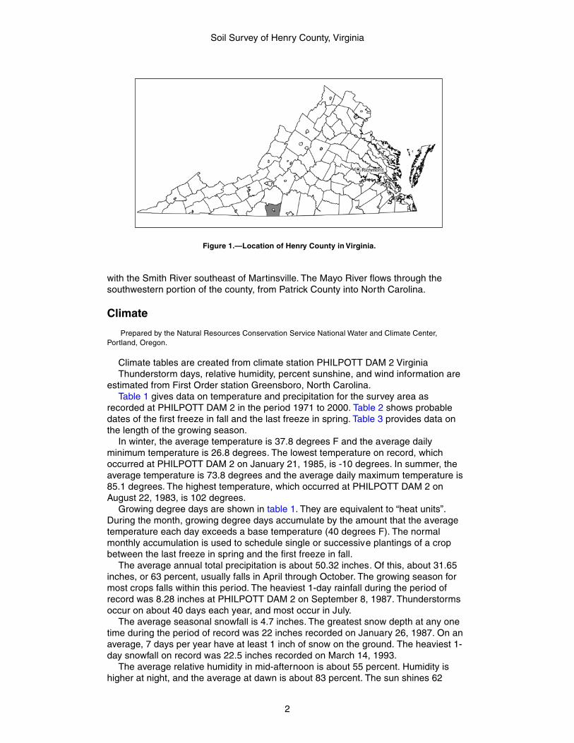
The survey area encompasses all of HENRY COUNTY and is located in the southernpart of Virginia (fig. 1) in the Piedmont Physiographic Province. It has an area of252,700 acres, or 394.8 square miles. Henry County is bordered on the nor th byFranklin County, on the south by Stokes and Rockingham counties, North Carolina,on the east by Pittsylvania County, and on the west by Patrick County. U.S. Route 220runs north-south through the county, and U.S. 58 runs east-west. Both roads passthrough the city of Martinsville.
According to the Bureau of the Census, in 2000, the population of the county was57,930 (19).
General Nature of the Survey AreaThis section provides general information about the survey area. It discusses
physiography, relief, and drainage, and climate.
Physiography, Relief, and Drainage
The survey area is completely within the Piedmont Physiographic Province. Itincludes a few scattered foothills of the Blue Ridge Mountains. The geologic featuresof the area are very old, except for the Triassic Basin in the extreme southeasterncorner of Henry County.
The survey area is well dissected by streams. It has wide to narrow, undulating torolling interstream divides. Areas near the larger streams are steep. The foothillmountains are rolling to very steep.
Elevation generally ranges from 700 to 1,350 feet above sea level. The TriassicBasin in the southeastern corner of the county ranges from 620 to 740 feet. Thehighest point in the county is 1,850 feet and is located on Turkeycock Mountain on theHenry-Franklin County line. The lowest point is 540 feet and is located along theSmith River at the North Carolina State line.
The Smith River is the major drainage system in the county. It runs northwest tosoutheast, from Philpott Reservoir through Martinsville and into North Carolina.Leatherwood Creek drains a large portion of the northern part of the county and joins
Soil Survey of
Henry County, Virginia
Soil Survey of Henry County, Virginia
2
with the Smith River southeast of Martinsville. The Mayo River flows through thesouthwestern portion of the county, from Patrick County into North Carolina.
Climate
Prepared by the Natural Resources Conservation Service National Water and Climate Center,Portland, Oregon.
Climate tables are created from climate station PHILPOTT DAM 2 VirginiaThunderstorm days, relative humidity, percent sunshine, and wind information are
estimated from First Order station Greensboro, North Carolina.Table 1 gives data on temperature and precipitation for the survey area as
recorded at PHILPOTT DAM 2 in the period 1971 to 2000. Table 2 shows probabledates of the first freeze in fall and the last freeze in spring. Table 3 provides data onthe length of the growing season.
In winter, the average temperature is 37.8 degrees F and the average dailyminimum temperature is 26.8 degrees. The lowest temperature on record, whichoccurred at PHILPOTT DAM 2 on January 21, 1985, is -10 degrees. In summer, theaverage temperature is 73.8 degrees and the average daily maximum temperature is85.1 degrees. The highest temperature, which occurred at PHILPOTT DAM 2 onAugust 22, 1983, is 102 degrees.
Growing degree days are shown in table 1. They are equivalent to “heat units”.During the month, growing degree days accumulate by the amount that the averagetemperature each day exceeds a base temperature (40 degrees F). The normalmonthly accumulation is used to schedule single or successive plantings of a cropbetween the last freeze in spring and the first freeze in fall.
The average annual total precipitation is about 50.32 inches. Of this, about 31.65inches, or 63 percent, usually falls in April through October. The growing season formost crops falls within this period. The heaviest 1-day rainfall during the period ofrecord was 8.28 inches at PHILPOTT DAM 2 on September 8, 1987. Thunderstormsoccur on about 40 days each year, and most occur in July.
The average seasonal snowfall is 4.7 inches. The greatest snow depth at any onetime during the period of record was 22 inches recorded on January 26, 1987. On anaverage, 7 days per year have at least 1 inch of snow on the ground. The heaviest 1-day snowfall on record was 22.5 inches recorded on March 14, 1993.
The average relative humidity in mid-afternoon is about 55 percent. Humidity ishigher at night, and the average at dawn is about 83 percent. The sun shines 62
Figure 1.—Location of Henry County in Virginia.
Soil Survey of Henry County, Virginia
3
percent of the time in summer and 53 percent in winter. The prevailing wind is fromthe southwest. Average wind speed is highest, 8.6 miles per hour, in March and April.
How This Survey Was MadeThis survey was made to provide information about the soils and miscellaneous
areas in the survey area. The information includes a description of the soils andmiscellaneous areas and their location and a discussion of their suitability, limitations,and management for specified uses. Soil scientists observed the steepness, length,and shape of the slopes; the general pattern of drainage; the kinds of crops andnative plants; and the kinds of bedrock. They dug many holes to study the soil profile,which is the sequence of natural layers, or horizons, in a soil. The profile extends fromthe surface down into the unconsolidated material in which the soil formed. Theunconsolidated material is devoid of roots and other living organisms and has notbeen changed by other biological activity.
The soils and miscellaneous areas in the survey area are in an orderly pattern thatis related to the geology, landforms, relief, climate, and natural vegetation of the area.Each kind of soil and miscellaneous area is associated with a par ticular kind oflandform or with a segment of the landform. By observing the soils and miscellaneousareas in the survey area and relating their position to specific segments of thelandform, a soil scientist develops a concept, or model, of how they were formed.Thus, during mapping, this model enables the soil scientist to predict with aconsiderable degree of accuracy the kind of soil or miscellaneous area at a specificlocation on the landscape.
Commonly, individual soils on the landscape merge into one another as theircharacteristics gradually change. To construct an accurate soil map, however, soilscientists must determine the boundaries between the soils. They can observe only alimited number of soil profiles. Nevertheless, these observations, supplemented by anunderstanding of the soil-vegetation-landscape relationship, are sufficient to verifypredictions of the kinds of soil in an area and to determine the boundaries.
Soil scientists recorded the characteristics of the soil profiles that they studied.They noted soil color, texture, size and shape of soil aggregates, kind and amount ofrock fragments, distribution of plant roots, reaction, and other features that enablethem to identify soils. After describing the soils in the survey area and determiningtheir properties, the soil scientists assigned the soils to taxonomic classes (units).Taxonomic classes are concepts. Each taxonomic class has a set of soilcharacteristics with precisely defined limits. The classes are used as a basis forcomparison to classify soils systematically. Soil taxonomy, the system of taxonomicclassification used in the United States, is based mainly on the kind and character ofsoil properties and the arrangement of horizons within the profile. After the soilscientists classified and named the soils in the survey area, they compared theindividual soils with similar soils in the same taxonomic class in other areas so thatthey could confirm data and assemble additional data based on experience andresearch.
While a soil survey is in progress, samples of some of the soils in the areagenerally are collected for laboratory analyses and for engineering tests. Soilscientists interpret the data from these analyses and tests as well as the field-observed characteristics and the soil proper ties to determine the expected behaviorof the soils under different uses. Interpretations for all of the soils are field testedthrough observation of the soils in different uses and under different levels ofmanagement. Some interpretations are modified to fit local conditions, and some newinterpretations are developed to meet local needs. Data are assembled from othersources, such as research information, production records, and field experience of
Soil Survey of Henry County, Virginia
4
specialists. For example, data on crop yields under defined levels of management areassembled from farm records and from field or plot experiments on the same kinds ofsoil.
Predictions about soil behavior are based not only on soil proper ties but also onsuch variables as climate and biological activity. Soil conditions are predictable overlong periods of time, but they are not predictable from year to year. For example, soilscientists can predict with a fairly high degree of accuracy that a given soil will have ahigh water table within certain depths in most years, but they cannot predict that ahigh water table will always be at a specific level in the soil on a specific date.
After soil scientists located and identified the significant natural bodies of soil in thesurvey area, they drew the boundaries of these bodies on aerial photographs andidentified each as a specific map unit. Aerial photographs show trees, buildings,fields, roads, and rivers, all of which help in locating boundar ies accurately.
The descriptions, names, and delineations of the soils in this survey area do notfully agree with those of the soils in adjacent survey areas. Differences are the resultof a different knowledge of soils, modifications in series concepts, or variations in theintensity of mapping or in the extent of the soils in the survey areas.
5
The map units delineated on the detailed soil maps in this survey represent thesoils or miscellaneous areas in the survey area. The map unit descriptions in thissection, along with the maps, can be used to determine the suitability and potential ofa unit for specific uses. They also can be used to plan the management needed forthose uses.
A map unit delineation on a soil map represents an area dominated by one ormore major kinds of soil or miscellaneous areas. A map unit is identified and namedaccording to the taxonomic classification of the dominant soils. Within a taxonomicclass there are precisely defined limits for the properties of the soils. On thelandscape, however, the soils are natural phenomena, and they have thecharacteristic variability of all natural phenomena. Thus, the range of some observedproperties may extend beyond the limits defined for a taxonomic class. Areas of soilsof a single taxonomic class rarely, if ever, can be mapped without including areas ofother taxonomic classes. Consequently, every map unit is made up of the soils ormiscellaneous areas for which it is named and some minor components that belongto taxonomic classes other than those of the major soils.
Most minor soils have properties similar to those of the dominant soil or soils in themap unit, and thus they do not affect use and management. These are callednoncontrasting, or similar, components. They may or may not be mentioned in aparticular map unit description. Other minor components, however, have propertiesand behavioral characteristics divergent enough to affect use or to require differentmanagement. These are called contrasting, or dissimilar, components. They generallyare in small areas and could not be mapped separately because of the scale used.Some small areas of strongly contrasting soils or miscellaneous areas are identifiedby a special symbol on the maps. The contrasting components are mentioned in themap unit descriptions. A few areas of minor components may not have beenobserved, and consequently they are not mentioned in the descr iptions, especiallywhere the pattern was so complex that it was impractical to make enoughobservations to identify all the soils and miscellaneous areas on the landscape .
The presence of minor components in a map unit in no way diminishes theusefulness or accuracy of the data. The objective of mapping is not to delineate puretaxonomic classes but rather to separate the landscape into landforms or landformsegments that have similar use and management requirements. The delineation ofsuch segments on the map provides sufficient information for the development ofresource plans. If intensive use of small areas is planned, however, onsiteinvestigation is needed to define and locate the soils and miscellaneous areas .
An identifying symbol precedes the map unit name in the map unit descriptions.Each description includes general facts about the unit and gives the principal hazardsand limitations to be considered in planning for specific uses.
Soils that have profiles that are almost alike make up a soil series. Except fordifferences in texture of the surface layer, all the soils of a series have major horizonsthat are similar in composition, thickness, and arrangement.
Soils of one series can differ in texture of the surface layer, slope, stoniness,salinity, degree of erosion, and other characteristics that affect their use. On the basisof such differences, a soil series is divided into soil phases. Most of the areas shown
Detailed Soil Map Units
Soil Survey of Henry County, Virginia
6
on the detailed soil maps are phases of soil series. The name of a soil phasecommonly indicates a feature that affects use or management. For example,Minnieville loam, 7 to 15 percent slopes is a phase of the Minnieville series.
Some map units are made up of two or more major soils or miscellaneous areas.These map units are complexes.
A complex consists of two or more soils or miscellaneous areas in such an intr icatepattern or in such small areas that they cannot be shown separately on the maps.The pattern and proportion of the soils or miscellaneous areas are somewhat similarin all areas. Orenda-Spriggs complex, 15 to 25 percent slopes is an example.
Table 4 lists the map units in this survey area. Other tables give properties of thesoils and the limitations, capabilities, and potentials for many uses. The Glossarydefines many of the terms used in describing the soils.
1B—Ayersville gravelly loam, 2 to 7 percent slopes
Setting
Major land resource area: Southern Piedmont (MLRA 136)Landform: Uplands on Triassic basinPosition on the landform: Broad concave summits and shouldersElevation: 620 to 738 feetSize of areas: 55 acres (one delineation for join purposes)
Map Unit Composition
Ayersville and similar soils: Typically 85 percent, ranging from about 80 to 90 percent
Typical Profile
Ayersville
Surface layer:0 to 8 inches—dark reddish brown gravelly loam
Subsoil:8 to 22 inches—dark reddish brown gravelly loam with iron-manganese concretions
Substratum:22 to 26 inches—reddish brown very gravelly silt loam
Soft bedrock:26 to 30 inches—siltstone bedrock
Hard bedrock:30 inches—siltstone bedrock
Minor Components
Dissimilar components:• Mayodan soils, very deep to bedrock, on smoother slightly convex upland summits,
shoulders, and backslopes• Creedmoor soils, very deep to bedrock, moderately well drained, on smoother
portions of the same landscape• Leaksville soils, moderately deep to bedrock, poorly drained, on adjacent to
intermittent drainageways
Similar components:• Stoneville soils, deep to bedrock, on similar landscape positions• Other soils, shallow to bedrock, on similar landscape positions
Soil Survey of Henry County, Virginia
7
Soil Properties and Qualities
Available water capacity: Very low (about 2.6 inches)Slowest saturated hydraulic conductivity: Moderately high (about 0.57 in/hr)Depth class: Moderately deep (20 to 40 inches)Depth to root-restrictive feature: 20 to 40 inches to bedrock (paralithic)Drainage class: Well drainedDepth to seasonal water saturation: More than 6 feetFlooding hazard: NonePonding hazard: NoneShrink-swell potential: LowRunoff class: HighSurface fragments: NoneParent material: Triassic residuum weathered from shale, siltstone, and mudstone
Use and Management Considerations
CroplandSuitability: Moderately suited to wheat and grass-legume hay; poorly suited to corn
and soybeans; not suited to alfalfa hay• The rate of surface runoff, the erosion hazard, and the amount of nutrient loss are
increased because of the slope.• The limited available water capacity may cause plants to suffer from moisture
stress.
PasturelandSuitability: Moderately suited to pasture• The hazard of erosion, the rate of surface runoff, and the amount of nutrient loss
are increased because of the slope.• The limited available water capacity may cause plants to suffer from moisture stress
during the drier summer months.
WoodlandSuitability: Moderately suited to chestnut oak• Proper planning for timber harvesting is essential in order to minimize the potential
negative impact to soil and water quality. A timber harvest plan should includegeneral adherence to all applicable best management practices.
• The slope may restrict the use of some mechanical planting equipment.• Bedrock may interfere with the construction of haul roads and log landings.• The low strength interferes with the construction of haul roads and log landings.• The low strength may create unsafe conditions for log trucks.
Building sites• Because of the nature and depth of the soft bedrock, the ease of excavation is
reduced and the difficulty of constructing foundations and installing utilities isincreased.
Septic tank absorption fields• The restricted permeability limits the absorption and proper treatment of the effluent
from conventional septic systems.• Because of the limited depth to bedrock, the filtering capacity of the soil is reduced
and the difficulty of proper installation of the effluent distr ibution lines is increased.
Local roads and streets• These soils are well suited to local roads and streets.
Interpretive Groups
Prime farmland: Not prime farmland
Soil Survey of Henry County, Virginia
8
Land capability class: 2eVirginia soil management group: FFHydric soil: No
1C—Ayersville gravelly loam, 7 to 15 percent slopes
Setting
Major land resource area: Southern Piedmont (MLRA 136)Landform: Uplands on Triassic basinPosition on the landform: Broad concave summits, shoulders, and backslopesElevation: 620 to 738 feetSize of areas: 190 acres (one delineation for join purposes)
Map Unit Composition
Ayersville and similar soils: Typically 85 percent, ranging from about 80 to 90 percent
Typical Profile
Ayersville
Surface layer:0 to 8 inches—dark reddish brown gravelly loam
Subsoil:8 to 22 inches—dark reddish brown gravelly loam with iron-manganese concretions
Substratum:22 to 26 inches—reddish brown very gravelly silt loam
Soft bedrock:26 to 30 inches—siltstone bedrock
Hard bedrock:30 inches—siltstone bedrock
Minor Components
Dissimilar components:• Mayodan soils, very deep to bedrock, on smoother slightly convex upland summits,
shoulders, and backslopes• Creedmoor soils, very deep to bedrock, moderately well drained, on smoother
portions of the same landscape• Leaksville soils, moderately deep to bedrock, poorly drained, on adjacent to
intermittent drainageways
Similar components:• Stoneville soils, deep to bedrock, on similar landscape positions• Other soils, shallow to bedrock, on similar landscape positions
Soil Properties and Qualities
Available water capacity: Very low (about 2.6 inches)Slowest saturated hydraulic conductivity: Moderately high (about 0.57 in/hr)Depth class: Moderately deep (20 to 40 inches)Depth to root-restrictive feature: 20 to 40 inches to bedrock (paralithic)Drainage class: Well drainedDepth to seasonal water saturation: More than 6 feetFlooding hazard: NonePonding hazard: None
Soil Survey of Henry County, Virginia
9
Shrink-swell potential: LowRunoff class: HighSurface fragments: NoneParent material: Triassic residuum weathered from shale, siltstone, and mudstone
Use and Management Considerations
CroplandSuitability: Moderately suited to wheat and grass-legume hay; poorly suited to corn
and soybeans; not suited to alfalfa hay• The rate of surface runoff, the erosion hazard, and the amount of nutrient loss are
increased because of the slope.• The limited available water capacity may cause plants to suffer from moisture
stress.
PasturelandSuitability: Moderately suited to pasture• The hazard of erosion, the rate of surface runoff, and the amount of nutrient loss
are increased because of the slope.• The limited available water capacity may cause plants to suffer from moisture stress
during the drier summer months.
WoodlandSuitability: Moderately suited to chestnut oak• Proper planning for timber harvesting is essential in order to minimize the potential
negative impact to soil and water quality. A timber harvest plan should includegeneral adherence to all applicable best management practices.
• The slope creates unsafe operating conditions and reduces the operating efficiencyof log trucks.
• The slope may restrict the use of some mechanical planting equipment.• Bedrock may interfere with the construction of haul roads and log landings.• The low strength interferes with the construction of haul roads and log landings.• The low strength may create unsafe conditions for log trucks.
Building sites• The slope influences the use of machinery and the amount of excavation required.• Because of the nature and depth of the soft bedrock, the ease of excavation is
reduced and the difficulty of constructing foundations and installing utilities isincreased.
Septic tank absorption fields• The restricted permeability limits the absorption and proper treatment of the effluent
from conventional septic systems.• Because of the limited depth to bedrock, the filtering capacity of the soil is reduced
and the difficulty of proper installation of the effluent distr ibution lines is increased.• The slope limits the proper treatment of effluent from conventional septic systems.
Local roads and streets• Because of the slope, designing local roads and streets is difficult.
Interpretive Groups
Prime farmland: Not prime farmlandLand capability class: 3eVirginia soil management group: FFHydric soil: No
Soil Survey of Henry County, Virginia
10
2B—Buckhall sandy loam, 2 to 7 percent slopes
Setting
Major land resource area: Southern Piedmont (MLRA 136)Landform: UplandsPosition on the landform: Narrow to broad convex summits, shoulders, and
backslopesElevation: 699 to 1,351 feetSize of areas: 3 to 35 acres
Map Unit Composition
Buckhall and similar soils: Typically 95 percent, ranging from about 90 to 100 percent
Typical Profile
Buckhall
Surface layer:0 to 9 inches—yellowish brown sandy loam
Subsoil:9 to 12 inches—reddish yellow sandy clay loam12 to 19 inches—reddish yellow clay loam19 to 35 inches—strong brown clay35 to 42 inches—strong brown clay loam42 to 46 inches—reddish yellow clay loam
Substratum:46 to 65 inches—yellow, red, and reddish yellow sandy clay loam
Minor ComponentsDissimilar components:• None identified
Similar components:• Clifford soils, with redder subsoils, on similar landscape positions• Areas with slopes outside the defined map unit range• Areas with gravelly surfaces
Soil Properties and Qualities
Available water capacity: Moderate (about 6.5 inches)Slowest saturated hydraulic conductivity: Moderately high (about 0.57 in/hr)Depth class: Very deep (more than 60 inches)Depth to root-restrictive feature: More than 60 inchesDrainage class: Well drainedDepth to seasonal water saturation: More than 6 feetFlooding hazard: NonePonding hazard: NoneShrink-swell potential: ModerateRunoff class: MediumSurface fragments: NoneParent material: Residuum weathered from granite and gneiss
Use and Management Considerations
CroplandSuitability: Well suited to wheat and grass-legume hay; moderately suited to corn,
soybeans, and alfalfa hay
Soil Survey of Henry County, Virginia
11
• The rate of surface runoff, the erosion hazard, and the amount of nutrient loss areincreased because of the slope.
PasturelandSuitability: Well suited to pasture• The hazard of erosion, the rate of surface runoff, and the amount of nutrient loss
are increased because of the slope.
WoodlandSuitability: Moderately suited to loblolly pine, northern red oak, and yellow-poplar• Proper planning for timber harvesting is essential in order to minimize the potential
negative impact to soil and water quality. A timber harvest plan should includegeneral adherence to all applicable best management practices.
• The slope may restrict the use of some mechanical planting equipment.• These soils are well suited to haul roads and log landings.• These soils are well suited to equipment operations.
Building sites• The high content of clay in the subsurface layer increases the difficulty of digging,
filling, and compacting the soil material in shallow excavations.
Septic tank absorption fields• These soils are well suited to septic tank absorption fields.
Local roads and streets• Because of shrinking and swelling, the use of these soils as base material for local
roads and streets is restricted.
Interpretive Groups
Prime farmland: All areas are prime farmlandLand capability class: 2eVirginia soil management group: VHydric soil: No
2C—Buckhall sandy loam, 7 to 15 percent slopes
Setting
Major land resource area: Southern Piedmont (MLRA 136)Landform: UplandsPosition on the landform: Narrow to broad convex summits, shoulders, and
backslopesElevation: 699 to 1,351 feetSize of areas: 5 to 20 acres
Map Unit Composition
Buckhall and similar soils: Typically 95 percent, ranging from about 90 to 100 percent
Typical Profile
Buckhall
Surface layer:0 to 9 inches—yellowish brown sandy loam
Subsoil:9 to 12 inches—reddish yellow sandy clay loam12 to 19 inches—reddish yellow clay loam
Soil Survey of Henry County, Virginia
12
19 to 35 inches—strong brown clay35 to 42 inches—strong brown clay loam42 to 46 inches—reddish yellow clay loam
Substratum:46 to 65 inches—yellow, red, and reddish yellow sandy clay loam
Minor Components
Dissimilar components:• None identified
Similar components:• Clifford soils, with redder subsoils, on similar landscape positions• Areas with slopes outside the defined map unit range• Areas with gravelly surfaces
Soil Properties and Qualities
Available water capacity: Moderate (about 6.5 inches)Slowest saturated hydraulic conductivity: Moderately high (about 0.57 in/hr)Depth class: Very deep (more than 60 inches)Depth to root-restrictive feature: More than 60 inchesDrainage class: Well drainedDepth to seasonal water saturation: More than 6 feetFlooding hazard: NonePonding hazard: NoneShrink-swell potential: ModerateRunoff class: MediumSurface fragments: NoneParent material: Residuum weathered from granite and gneiss
Use and Management Considerations
CroplandSuitability: Moderately suited to corn, soybeans, wheat, grass-legume hay, and alfalfa
hay• The rate of surface runoff, the erosion hazard, and the amount of nutrient loss are
increased because of the slope.
PasturelandSuitability: Well suited to pasture• The hazard of erosion, the rate of surface runoff, and the amount of nutrient loss
are increased because of the slope.
WoodlandSuitability: Moderately suited to loblolly pine, northern red oak, and yellow-poplar• Proper planning for timber harvesting is essential in order to minimize the potential
negative impact to soil and water quality. A timber harvest plan should includegeneral adherence to all applicable best management practices.
• The slope creates unsafe operating conditions and reduces the operating efficiencyof log trucks.
• The slope may restrict the use of some mechanical planting equipment.• These soils are well suited to haul roads and log landings.
Building sites• The slope influences the use of machinery and the amount of excavation required.• The high content of clay in the subsurface layer increases the difficulty of digging,
filling, and compacting the soil material in shallow excavations.

Soil Survey of Henry County, Virginia
13
Septic tank absorption fields• The slope limits the proper treatment of effluent from conventional septic systems.
Local roads and streets• Because of shrinking and swelling, the use of these soils as base material for local
roads and streets is restricted.• Because of the slope, designing local roads and streets is difficult.
Interpretive Groups
Prime farmland: Not prime farmlandLand capability class: 3eVirginia soil management group: VHydric soil: No
3E—Buffstat-Bugley complex, 25 to 60 percent slopes
Setting
Major land resource area: Southern Piedmont (MLRA 136)Landform: UplandsPosition on the landform: Convex to linear backslopesElevation: 699 to 1,351 feetSize of areas: 3 to 1045 acresNote: These two soils occur as areas so closely intermingled that they could not be
separated at the scale selected for mapping
Map Unit Composition
Buffstat and similar soils: Typically 55 percent, ranging from about 50 to 60 percentBugley and similar soils: Typically 40 percent, ranging from about 35 to 45 percent
Typical Profile
Buffstat
Surface layer:0 to 3 inches—brown channery silt loam
Subsurface layer:3 to 5 inches—strong brown silt loam
Subsoil:5 to 41 inches—yellowish red silty clay loam
Soft bedrock:41 to 66 inches—graphitic schist bedrock
Bugley
Surface layer:0 to 3 inches—dark yellowish brown channery silt loam
Subsoil:3 to 11 inches—strong brown very channery silt loam
Hard bedrock:11 inches—graphitic schist bedrock
Soil Survey of Henry County, Virginia
14
Minor Components
Dissimilar components:• Areas of rock outcrop on similar landscape positions
Similar components:• Littlejoe soils, deep to bedrock, with redder subsoils, on similar landscape positions• Clifford soils, very deep to bedrock, in granite gneiss material, on similar landscape
positions• Other soils, less clay in the subsoil, on similar landscape positions
Soil Properties and Qualities
Available water capacity: Buffstat—Low (about 4.6 inches); Bugley—Very low (about1.2 inches)
Slowest saturated hydraulic conductivity: Buffstat—Moderately high (about 0.57 in/hr);Bugley—High (about 1.98 in/hr)
Depth class: Buffstat—Deep (40 to 60 inches); Bugley—Shallow (10 to 20 inches)Depth to root-restrictive feature: Buffstat—40 to 60 inches to bedrock (paralithic);
Bugley—10 to 20 inches to bedrock (lithic)Drainage class: Buffstat—Well drained; Bugley—Somewhat excessively drainedDepth to seasonal water saturation: More than 6 feetFlooding hazard: NonePonding hazard: NoneShrink-swell potential: Buffstat—Moderate; Bugley—LowRunoff class: Buffstat—High; Bugley—Very highSurface fragments: NoneParent material: Residuum weathered from graphitic and sericitic schist, and phyllite
Use and Management Considerations
Cropland• These soils are unsuited to cropland.
Pastureland• These soils are unsuited to pastureland.
WoodlandSuitability: Moderately suited to loblolly pine and northern red oak• Proper planning for timber harvesting is essential in order to minimize the potential
negative impact to soil and water quality, especially in areas on steeper slopes. Atimber harvest plan should focus on the proper location of haul road and skid trails,and careful attention should be given to all applicable best management practices.
• The slope poses safety hazards and creates a potential for erosion during theconstruction of haul roads and log landings.
• The slope creates unsafe operating conditions and reduces the operating efficiencyof log trucks and harvesting equipment.
• Because of the slope, the use of equipment for planting and seeding is impractical.• The slope makes the use of mechanical planting equipment impractical.• The low strength interferes with the construction of haul roads and log landings.
Building sites• The slope influences the use of machinery and the amount of excavation required.
Septic tank absorption fields• The restricted permeability limits the absorption and proper treatment of the effluent
from conventional septic systems.• The slope limits the proper treatment of effluent from conventional septic systems.
Soil Survey of Henry County, Virginia
15
Local roads and streets• Because of shrinking and swelling, the use of these soils as base material for local
roads and streets is restricted.• The low strength is unfavorable for supporting heavy loads.• Because of the slope, designing local roads and streets is difficult.
Interpretive Groups
Prime farmland: Not prime farmlandLand capability class: 7eVirginia soil management group: Buffstat—CC; Bugley—AHydric soil: No
4B—Clifford sandy loam, 2 to 7 percent slopes
Setting
Major land resource area: Southern Piedmont (MLRA 136)Landform: UplandsPosition on the landform: Narrow to broad convex summits and shouldersElevation: 699 to 1,351 feetSize of areas: 3 to 600 acres
Map Unit Composition
Clifford and similar soils: Typically 90 percent, ranging from about 85 to 95 percent
Typical Profile
Clifford
Surface layer:0 to 7 inches—brown sandy loam
Subsoil:7 to 11 inches—yellowish red clay loam11 to 54 inches—red clay54 to 62 inches—red clay loam
Substratum:62 to 82 inches—strong brown, dark red, and red fine sandy loam
Minor Components
Dissimilar components:• None identified
Similar components:• Minnieville soils, in mafic material, on similar landscape positions• Dyke soils, in alluvium, on high stream terrace landscapes• Delanco soils, moderately well drained, adjacent to streams• Other soils, very deep to bedrock, with thinner sola, on similar landscape positions• Other soils with severely eroded surfaces having sandy clay loam textures, on
similar landscape positions• Other soils, moderately well drained, in alluvium, adjacent to intermittent streams
and drainageways• Areas of soils with slopes outside the defined map unit range• Areas of soils with gravelly surface horizons, on similar landscape positions
Soil Survey of Henry County, Virginia
16
Soil Properties and Qualities
Available water capacity: Moderate (about 7.4 inches)Slowest saturated hydraulic conductivity: Moderately high (about 0.57 in/hr)Depth class: Very deep (more than 60 inches)Depth to root-restrictive feature: More than 60 inchesDrainage class: Well drainedDepth to seasonal water saturation: More than 6 feetFlooding hazard: NonePonding hazard: NoneShrink-swell potential: LowRunoff class: MediumSurface fragments: NoneParent material: Residuum weathered from granite and gneiss, and mica schist
Use and Management Considerations
CroplandSuitability: Well suited to wheat, tobacco, and grass-legume hay; moderately suited to
corn and soybeans• The rate of surface runoff, the erosion hazard, and the amount of nutrient loss are
increased because of the slope.
PasturelandSuitability: Moderately suited to pasture• The hazard of erosion, the rate of surface runoff, and the amount of nutrient loss
are increased because of the slope.
WoodlandSuitability: Well suited to northern red oak; moderately suited to yellow-poplar• Proper planning for timber harvesting is essential in order to minimize the potential
negative impact to soil and water quality. A timber harvest plan should includegeneral adherence to all applicable best management practices.
• The slope may restrict the use of some mechanical planting equipment.• These soils are well suited to haul roads and log landings.• These soils are well suited to equipment operations.
Building sites• The high content of clay in the subsurface layer increases the difficulty of digging,
filling, and compacting the soil material in shallow excavations.
Septic tank absorption fields• The excessive permeability limits the proper treatment of the effluent from
conventional septic systems and may pollute the water table.• These soils are well suited to septic tank absorption fields.
Local roads and streets• The low strength is unfavorable for supporting heavy loads.
Interpretive Groups
Prime farmland: All areas are prime farmlandLand capability class: 2eVirginia soil management group: XHydric soil: No
Soil Survey of Henry County, Virginia
17
4C—Clifford sandy loam, 7 to 15 percent slopes
Setting
Major land resource area: Southern Piedmont (MLRA 136)Landform: UplandsPosition on the landform: Narrow to broad convex summits, shoulders, backslopes,
and footslopesElevation: 699 to 1,351 feetSize of areas: 3 to 7,125 acres
Map Unit Composition
Clifford and similar soils: Typically 90 percent, ranging from about 85 to 95 percent
Typical Profile
Clifford
Surface layer:0 to 7 inches—brown sandy loam
Subsoil:7 to 11 inches—yellowish red clay loam11 to 54 inches—red clay54 to 62 inches—red clay loam
Substratum:62 to 82 inches—strong brown, dark red, and red fine sandy loam
Minor Components
Dissimilar components:• Delanco soils, moderately well drained, adjacent to streams• Other soils, moderately well drained, in alluvium, adjacent to intermittent streams
and drainageways
Similar components:• Minnieville soils, in mafic material, on similar landscape positions• Dyke soils, in alluvium, on high stream terrace landscapes• Other soils, very deep to bedrock, with thinner sola, on similar landscape positions• Other soils with severely eroded surfaces having sandy clay loam textures, on
similar landscape positions• Areas of soils with slopes outside the defined map unit range• Areas of soils with gravelly surface horizons, on similar landscape positions
Soil Properties and Qualities
Available water capacity: Moderate (about 7.4 inches)Slowest saturated hydraulic conductivity: Moderately high (about 0.57 in/hr)Depth class: Very deep (more than 60 inches)Depth to root-restrictive feature: More than 60 inchesDrainage class: Well drainedDepth to seasonal water saturation: More than 6 feetFlooding hazard: NonePonding hazard: NoneShrink-swell potential: LowRunoff class: MediumSurface fragments: NoneParent material: Residuum weathered from granite and gneiss, and mica schist
Soil Survey of Henry County, Virginia
18
Use and Management Considerations
CroplandSuitability: Well suited to tobacco; moderately suited to corn, soybeans, and wheat• The rate of surface runoff, the erosion hazard, and the amount of nutrient loss are
increased because of the slope.
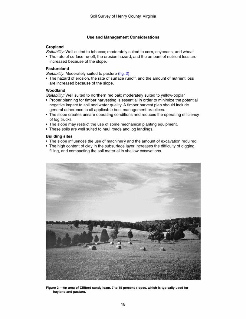
PasturelandSuitability: Moderately suited to pasture (fig. 2)• The hazard of erosion, the rate of surface runoff, and the amount of nutrient loss
are increased because of the slope.
WoodlandSuitability: Well suited to northern red oak; moderately suited to yellow-poplar• Proper planning for timber harvesting is essential in order to minimize the potential
negative impact to soil and water quality. A timber harvest plan should includegeneral adherence to all applicable best management practices.
• The slope creates unsafe operating conditions and reduces the operating efficiencyof log trucks.
• The slope may restrict the use of some mechanical planting equipment.• These soils are well suited to haul roads and log landings.
Building sites• The slope influences the use of machinery and the amount of excavation required.• The high content of clay in the subsurface layer increases the difficulty of digging,
filling, and compacting the soil material in shallow excavations.
Figure 2.—An area of Clifford sandy loam, 7 to 15 percent slopes, which is typically used forhayland and pasture.
Soil Survey of Henry County, Virginia
19
Septic tank absorption fields• The slope limits the proper treatment of effluent from conventional septic systems.
Local roads and streets• The low strength is unfavorable for supporting heavy loads.• Because of the slope, designing local roads and streets is difficult.
Interpretive Groups
Prime farmland: Not prime farmlandLand capability class: 3eVirginia soil management group: XHydric soil: No
4D—Clifford sandy loam, 15 to 25 percent slopes
Setting
Major land resource area: Southern Piedmont (MLRA 136)Landform: UplandsPosition on the landform: Convex to concave shoulders and backslopes and areas
adjacent to intermittent drainagewaysElevation: 699 to 1,351 feetSize of areas: 3 to 865 acres
Map Unit Composition
Clifford and similar soils: Typically 90 percent, ranging from about 85 to 95 percent
Typical Profile
Clifford
Surface layer:0 to 7 inches—brown sandy loam
Subsoil:7 to 11 inches—yellowish red clay loam11 to 54 inches—red clay54 to 62 inches—red clay loam
Substratum:62 to 82 inches—strong brown, dark red, and red fine sandy loam
Minor Components
Dissimilar components:• Spriggs soils, shallow to bedrock, in mafic or felsic material with slower
permeability, on narrow, strongly convex shoulder and backslopes• Orenda soils, in mafic or felsic material with slower permeability, on similar
landscape positions• Woolwine soils, moderately deep to bedrock, on similar landscape positions• Delanco soils, moderately well drained, adjacent to streams• Other soils, moderately well drained, in alluvium, adjacent to intermittent streams
and drainageways• Areas of soils with gravel, cobbles or large stones on the soil surface, on similar
landscape positions• Areas of rock outcrop, on similar landscape positions
Soil Survey of Henry County, Virginia
20
Similar components:• Minnieville soils, in mafic material, on similar landscape positions• Dyke soils, in alluvium, on high stream terrace landscapes• Other soils, very deep to bedrock, with thinner sola, on similar landscape positions• Other soils with severely eroded surfaces having sandy clay loam textures, on
similar landscape positions• Areas of soils with slopes outside the defined map unit range• Areas of soils with gravelly surface horizons, on similar landscape positions• Areas of soils, severely eroded or gullied, on similar landscape positions
Soil Properties and Qualities
Available water capacity: Moderate (about 7.4 inches)Slowest saturated hydraulic conductivity: Moderately high (about 0.57 in/hr)Depth class: Very deep (more than 60 inches)Depth to root-restrictive feature: More than 60 inchesDrainage class: Well drainedDepth to seasonal water saturation: More than 6 feetFlooding hazard: NonePonding hazard: NoneShrink-swell potential: LowRunoff class: HighSurface fragments: NoneParent material: Residuum weathered from granite and gneiss, and mica schist
Use and Management Considerations
CroplandSuitability: Moderately suited to wheat, grass-legume hay, and alfalfa hay; poorly
suited to corn and soybeans• The rate of surface runoff, the erosion hazard, and the amount of nutrient loss are
increased because of the slope.
PasturelandSuitability: Moderately suited to pasture• The hazard of erosion, the rate of surface runoff, and the amount of nutrient loss
are increased because of the slope.
WoodlandSuitability: Well suited to northern red oak; moderately suited to yellow-poplar and
eastern white pine• Proper planning for timber harvesting is essential in order to minimize the potential
negative impact to soil and water quality. A timber harvest plan should includegeneral adherence to all applicable best management practices.
• The slope poses safety hazards and creates a potential for erosion during theconstruction of haul roads and log landings.
• The slope creates unsafe operating conditions and reduces the operating efficiencyof log trucks and harvesting equipment.
• Because of the slope, the use of equipment for preparing sites for planting andseeding is restricted.
• The slope may restrict the use of some mechanical planting equipment.• The low strength interferes with the construction of haul roads and log landings.
Building sites• The slope influences the use of machinery and the amount of excavation required.• The high content of clay in the subsurface layer increases the difficulty of digging,
filling, and compacting the soil material in shallow excavations.
Soil Survey of Henry County, Virginia
21
Septic tank absorption fields• The slope limits the proper treatment of effluent from conventional septic systems.
Local roads and streets• The low strength is unfavorable for supporting heavy loads.• Because of the slope, designing local roads and streets is difficult.
Interpretive Groups
Prime farmland: Not prime farmlandLand capability class: 4eVirginia soil management group: XHydric soil: No
4E—Clifford sandy loam, 25 to 45 percent slopes
Setting
Major land resource area: Southern Piedmont (MLRA 136)Landform: UplandsPosition on the landform: Convex to concave shoulders and backslopes and areas
adjacent to intermittent drainagewaysElevation: 699 to 1,351 feetSize of areas: 3 to 1,080 acres
Map Unit Composition
Clifford and similar soils: Typically 90 percent, ranging from about 85 to 95 percent
Typical Profile
Clifford
Surface layer:0 to 7 inches—brown sandy loam
Subsoil:7 to 11 inches—yellowish red clay loam11 to 54 inches—red clay54 to 62 inches—red clay loam
Substratum:62 to 82 inches—strong brown, dark red, and red fine sandy loam
Minor Components
Dissimilar components:• Spriggs soils, shallow to bedrock, in mafic or felsic material with slower
permeability, on narrow, strongly convex shoulder and backslopes• Orenda soils, in mafic or felsic material with slower permeability, on similar
landscape positions• Woolwine soils, moderately deep to bedrock, on similar landscape positions• Delanco soils, moderately well drained, adjacent to streams• Other soils, moderately well drained, in alluvium, adjacent to intermittent streams
and drainageways• Areas of soils with gravel, cobbles or large stones on the soil surface, on similar
landscape positions• Areas of rock outcrop, on similar landscape positions
Soil Survey of Henry County, Virginia
22
Similar components:• Minnieville soils, in mafic material, on similar landscape positions• Dyke soils, in alluvium, on high stream terrace landscapes• Other soils, very deep to bedrock, with thinner sola, on similar landscape positions• Other soils with severely eroded surfaces having sandy clay loam textures, on
similar landscape positions• Areas of soils with slopes outside the defined map unit range• Areas of soils with gravelly surface horizons, on similar landscape positions• Areas of soils, severely eroded or gullied, on similar landscape positions
Soil Properties and Qualities
Available water capacity: Moderate (about 7.4 inches)Slowest saturated hydraulic conductivity: Moderately high (about 0.57 in/hr)Depth class: Very deep (more than 60 inches)Depth to root-restrictive feature: More than 60 inchesDrainage class: Well drainedDepth to seasonal water saturation: More than 6 feetFlooding hazard: NonePonding hazard: NoneShrink-swell potential: LowRunoff class: HighSurface fragments: NoneParent material: Residuum weathered from granite and gneiss, and mica schist
Use and Management Considerations
Cropland• These soils are unsuited to cropland.
Pastureland• These soils are unsuited to pastureland.
WoodlandSuitability: Well suited to northern red oak; moderately suited to yellow-poplar and
eastern white pine• Proper planning for timber harvesting is essential in order to minimize the potential
negative impact to soil and water quality, especially in areas on steeper slopes. Atimber harvest plan should focus on the proper location of haul road and skid trails,and careful attention should be given to all applicable best management practices.
• The slope poses safety hazards and creates a potential for erosion during theconstruction of haul roads and log landings.
• The slope creates unsafe operating conditions and reduces the operating efficiencyof log trucks and harvesting equipment.
• Because of the slope, the use of equipment for planting and seeding is impractical.• The slope makes the use of mechanical planting equipment impractical.• The low strength interferes with the construction of haul roads and log landings.
Building sites• The slope influences the use of machinery and the amount of excavation required.• The high content of clay in the subsurface layer increases the difficulty of digging,
filling, and compacting the soil material in shallow excavations.
Septic tank absorption fields• The slope limits the proper treatment of effluent from conventional septic systems.
Local roads and streets• The low strength is unfavorable for supporting heavy loads.• Because of the slope, designing local roads and streets is difficult.
Soil Survey of Henry County, Virginia
23
Interpretive Groups
Prime farmland: Not prime farmlandLand capability class: 7eVirginia soil management group: XHydric soil: No
5A—Codorus loam, 0 to 2 percent slopes, frequentlyflooded
Setting
Major land resource area: Southern Piedmont (MLRA 136)Landform: Flood plainsPosition on the landform: Smooth to concave toeslopesElevation: 699 to 1,351 feetSize of areas: 3 to 205 acres
Map Unit Composition
Codorus and similar soils: Typically 85 percent, ranging from about 80 to 90 percent
Typical Profile
Codorus
Surface layer:0 to 8 inches—brown loam
Subsoil:8 to 12 inches—brown loam12 to 22 inches—strong brown loam with brownish yellow iron depletions22 to 36 inches—strong brown loam with brownish yellow clay depletions36 to 47 inches—grayish brown loam with strong brown and yellowish red masses of
oxidized iron
Substratum:47 to 62 inches—grayish brown loam with yellowish red and strong brown masses of
oxidized iron
Minor Components
Dissimilar components:• Delanco soils, moderately well drained, on stream terrace treads• Elsinboro soils, well drained, on stream terrace treads• Colvard soils, well drained, on smooth, nearly level to slightly convex positions on
the flood plain• Other soils, very poorly drained, on lower depressional areas
Similar components:• Other soils, poorly drained, on lower depressional areas• Other soils, higher percentage of clay, on similar positions
Soil Properties and Qualities
Available water capacity: High (about 9.1 inches)Slowest saturated hydraulic conductivity: Moderately high (about 0.57 in/hr)Depth class: Very deep (more than 60 inches)Depth to root-restrictive feature: More than 60 inchesDrainage class: Moderately well drained
Soil Survey of Henry County, Virginia
24
Depth to seasonal water saturation: About 12 to 24 inchesWater table kind: ApparentFlooding hazard: FrequentPonding hazard: NoneShrink-swell potential: LowRunoff class: LowSurface fragments: NoneParent material: Alluvium
Use and Management Considerations
CroplandSuitability: Well suited to corn, soybeans, wheat, grass-legume hay, and alfalfa hay• Frost action may damage the root system of winter grain crops.• Frequent flooding restricts the use of winter grain crops.• Flooding may damage crops.• The seasonal high water table restricts equipment operation, decreases the viability
of crops, and interferes with the planting and harvesting of crops.
PasturelandSuitability: Well suited to pasture• Flooding may damage pastures.• Frost action may damage the root systems of plants.
WoodlandSuitability: Well suited to northern red oak, yellow-poplar, and eastern white pine• Proper planning for timber harvesting is essential in order to minimize the potential
negative impact to soil and water quality. A timber harvest plan should focus onstreamside management zones and stream crossings and should include generaladherence to all applicable best management practices.
• Flooding may damage haul roads.• Flooding restricts the safe use of roads by log trucks.• Soil wetness may limit the use of log trucks.• The low strength interferes with the construction of haul roads and log landings.• The low strength may create unsafe conditions for log trucks.
Building sites• Flooding limits these soils for building site development.• The seasonal high water table may restrict the period when excavations can be
made.
Septic tank absorption fields• Flooding limits these soils for septic tank absorption fields.• The seasonal high water table greatly limits the absorption and proper treatment of
the effluent from conventional septic systems.
Local roads and streets• Flooding may damage local roads and streets.• The seasonal high water table affects the ease of excavation and grading and
reduces the bearing capacity of the soil.• The low strength may cause structural damage to local roads and streets.
Interpretive Groups
Prime farmland: Not prime farmlandLand capability class: 2wVirginia soil management group: AHydric soil: No
Soil Survey of Henry County, Virginia
25
6A—Colvard fine sandy loam, 0 to 2 percent slopes,occasionally flooded
Setting
Major land resource area: Southern Piedmont (MLRA 136)Landform: Flood plainsPosition on the landform: Smooth to convex toeslopesElevation: 699 to 1,351 feetSize of areas: 3 to 1,200 acres
Map Unit Composition
Colvard and similar soils: Typically 85 percent, ranging from about 80 to 90 percent
Typical Profile
Colvard
Surface layer:0 to 12 inches—brown fine sandy loam
Substratum:12 to 43 inches—brown fine sandy loam43 to 62 inches—dark yellowish brown fine sandy loam
Minor Components
Dissimilar components:• Delanco soils, moderately well drained, on stream terrace treads• Elsinboro soils, well drained, with more clay, on stream terrace treads• Codorus soils, somewhat poorly drained, on slightly concave to smooth segments
of the flood plain• Other soils, very poorly drained to poorly drained, on lower depressional areas of
the flood plain
Similar components:• None identified
Soil Properties and Qualities
Available water capacity: Low (about 5.4 inches)Slowest saturated hydraulic conductivity: High (about 1.98 in/hr)Depth class: Very deep (more than 60 inches)Depth to root-restrictive feature: More than 60 inchesDrainage class: Well drainedDepth to seasonal water saturation: About 48 to 79 inchesWater table kind: ApparentFlooding hazard: OccasionalPonding hazard: NoneShrink-swell potential: LowRunoff class: NegligibleSurface fragments: NoneParent material: Alluvium
Use and Management Considerations
CroplandSuitability: Moderately suited to wheat; poorly suited to corn and soybeans; not suited
to grass-legume hay and alfalfa hay• Flooding may damage crops.
Soil Survey of Henry County, Virginia
26
PasturelandSuitability: Poorly suited to pasture• Flooding may damage pastures.
WoodlandSuitability: Well suited to yellow-poplar; moderately suited to eastern white pine• Proper planning for timber harvesting is essential in order to minimize the potential
negative impact to soil and water quality. A timber harvest plan should focus onstreamside management zones and stream crossings and should include generaladherence to all applicable best management practices.
• Flooding may damage haul roads.• Flooding restricts the safe use of roads by log trucks.
Building sites• Flooding limits these soils for building site development.• The seasonal high water table may restrict the period when excavations can be
made.
Septic tank absorption fields• Flooding limits these soils for septic tank absorption fields.
Local roads and streets• Flooding may damage local roads and streets.• These soils are well suited to local roads and streets.
Interpretive Groups
Prime farmland: Not prime farmlandLand capability class: 2sVirginia soil management group: IIHydric soil: No
7B—Creedmoor fine sandy loam, 1 to 4 percent slopes
Setting
Major land resource area: Southern Piedmont (MLRA 136)Landform: Uplands on Triassic basinPosition on the landform: Broad concave summits and adjacent to drainagewaysElevation: 620 to 738 feetSize of areas: 3 to 7 acres
Map Unit Composition
Creedmoor and similar soils: Typically 85 percent, ranging from about 80 to 90percent
Typical Profile
Creedmoor
Surface layer:0 to 7 inches—brown fine sandy loam
Subsurface layer:7 to 11 inches—light yellowish brown fine sandy loam
Subsoil:11 to 32 inches—strong brown clay with pinkish gray clay depletions
Soil Survey of Henry County, Virginia
27
32 to 47 inches—brown clay with yellowish red masses of oxidized iron and pinkishgray clay depletions
Substratum:47 to 67 inches—dark reddish brown, pinkish gray, and yellowish red clay loam
Soft bedrock:67 to 77 inches—sandstone bedrock
Minor Components
Dissimilar components:• Mayodan soils, well drained, on smoother slightly convex upland summits,
shoulders, and backslopes• Ayersville soils, moderately deep to bedrock, well drained, on shoulders,
backslopes, and footslopes• Leaksville soils, moderately deep to bedrock, poorly drained, on adjacent to
intermittent drainageways• Stoneville soils, deep to bedrock, well drained, on smoother slightly convex upland
summits, shoulders, and backslopes
Similar components:• None identified
Soil Properties and Qualities
Available water capacity: Moderate (about 6.3 inches)Slowest saturated hydraulic conductivity: Low (about 0.00 in/hr)Depth class: Very deep (more than 60 inches)Depth to root-restrictive feature: 60 to 120 inches to bedrock (paralithic)Drainage class: Moderately well drainedDepth to seasonal water saturation: About 12 to 30 inchesWater table kind: PerchedFlooding hazard: NonePonding hazard: NoneShrink-swell potential: HighRunoff class: Very highSurface fragments: NoneParent material: Triassic residuum weathered from siltstone, mudstone, fine-grained
sandstone, and shale
Use and Management Considerations
CroplandSuitability: Well suited to tobacco; moderately suited to grass-legume hay; poorly
suited to corn, soybeans, and wheat; not suited to alfalfa hay• The rate of surface runoff, the erosion hazard, and the amount of nutrient loss are
increased because of the slope.• The high clay content restricts the rooting depth of crops.• The seasonal high water table restricts equipment operation, decreases the viability
of crops, and interferes with the planting and harvesting of crops.
PasturelandSuitability: Moderately suited to pasture• The hazard of erosion, the rate of surface runoff, and the amount of nutrient loss
are increased because of the slope.
WoodlandSuitability: Well suited to loblolly pine; moderately suited to yellow-poplar• Proper planning for timber harvesting is essential in order to minimize the potential
Soil Survey of Henry County, Virginia
28
negative impact to soil and water quality. A timber harvest plan should includegeneral adherence to all applicable best management practices.
• Soil wetness may limit the use of log trucks.• The stickiness of the soil reduces the efficiency of mechanical planting equipment.
Building sites• The seasonal high water table may restrict the period when excavations can be
made.• Shrinking and swelling of the soil may crack foundations and basement walls.• The high content of clay in the subsurface layer increases the difficulty of digging,
filling, and compacting the soil material in shallow excavations.
Septic tank absorption fields• The seasonal high water table greatly limits the absorption and proper treatment of
the effluent from conventional septic systems.• The restricted permeability limits the absorption and proper treatment of the effluent
from conventional septic systems.
Local roads and streets• The seasonal high water table affects the ease of excavation and grading and
reduces the bearing capacity of the soil.• Because of shrinking and swelling, the use of these soils as base mater ial for local
roads and streets is restricted.• The low strength is unfavorable for supporting heavy loads.
Interpretive Groups
Prime farmland: Not prime farmlandLand capability class: 2eVirginia soil management group: KKHydric soil: No
8A—Delanco loam, 0 to 4 percent slopes, rarely flooded
Setting
Major land resource area: Southern Piedmont (MLRA 136)Landform: Stream terracesPosition on the landform: Smooth to concave toeslopesElevation: 699 to 1,351 feetSize of areas: 4 to 110 acres
Map Unit Composition
Delanco and similar soils: Typically 85 percent, ranging from about 80 to 90 percent
Typical Profile
Delanco
Surface layer:0 to 10 inches—brown loam
Subsoil:10 to 26 inches—light olive brown clay loam with yellowish brown masses of oxidized
iron and light brownish gray iron depletions26 to 37 inches—light brownish gray clay with yellowish brown masses of oxidized
iron
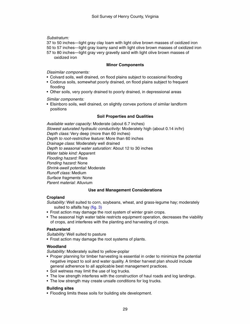
Soil Survey of Henry County, Virginia
29
Substratum:37 to 50 inches—light gray clay loam with light olive brown masses of oxidized iron50 to 57 inches—light gray loamy sand with light olive brown masses of oxidized iron57 to 80 inches—light gray very gravelly sand with light olive brown masses of
oxidized iron
Minor Components
Dissimilar components:• Colvard soils, well drained, on flood plains subject to occasional flooding• Codorus soils, somewhat poorly drained, on flood plains subject to frequent
flooding• Other soils, very poorly drained to poorly drained, in depressional areas
Similar components:• Elsinboro soils, well drained, on slightly convex portions of similar landform
positions
Soil Properties and Qualities
Available water capacity: Moderate (about 6.7 inches)Slowest saturated hydraulic conductivity: Moderately high (about 0.14 in/hr)Depth class: Very deep (more than 60 inches)Depth to root-restrictive feature: More than 60 inchesDrainage class: Moderately well drainedDepth to seasonal water saturation: About 12 to 30 inchesWater table kind: ApparentFlooding hazard: RarePonding hazard: NoneShrink-swell potential: ModerateRunoff class: MediumSurface fragments: NoneParent material: Alluvium
Use and Management Considerations
CroplandSuitability: Well suited to corn, soybeans, wheat, and grass-legume hay; moderately
suited to alfalfa hay (fig. 3)• Frost action may damage the root system of winter grain crops.• The seasonal high water table restricts equipment operation, decreases the viability
of crops, and interferes with the planting and harvesting of crops.
PasturelandSuitability: Well suited to pasture• Frost action may damage the root systems of plants.
WoodlandSuitability: Moderately suited to yellow-poplar• Proper planning for timber harvesting is essential in order to minimize the potential
negative impact to soil and water quality. A timber harvest plan should includegeneral adherence to all applicable best management practices.
• Soil wetness may limit the use of log trucks.• The low strength interferes with the construction of haul roads and log landings.• The low strength may create unsafe conditions for log trucks.
Building sites• Flooding limits these soils for building site development.
Soil Survey of Henry County, Virginia
30
• The seasonal high water table may restrict the period when excavations can bemade.
Septic tank absorption fields• The seasonal high water table greatly limits the absorption and proper treatment of
the effluent from conventional septic systems.• The restricted permeability limits the absorption and proper treatment of the effluent
from conventional septic systems.
Local roads and streets• The seasonal high water table affects the ease of excavation and grading and
reduces the bearing capacity of the soil.• Because of shrinking and swelling, the use of these soils as base mater ial for local
roads and streets is restricted.• The low strength may cause structural damage to local roads and streets.
Interpretive Groups
Prime farmland: All areas are prime farmlandLand capability class: 2wVirginia soil management group: BHydric soil: No
9B—Dyke loam, 2 to 7 percent slopes
Setting
Major land resource area: Southern Piedmont (MLRA 136)Landform: High stream terracesPosition on the landform: Broad convex toeslopesElevation: 699 to 1,351 feetSize of areas: 3 to 45 acres
Figure 3.—Cropland in an area of Delanco loam, 0 to 4 percent slopes, rarely flooded is in the lowerlandscape position in the foreground. An area of Elsinboro fine sandy loam, 0 to 4 percentslopes, rarely flooded is in the higher landscape position in the background.
Soil Survey of Henry County, Virginia
31
Map Unit Composition
Dyke and similar soils: Typically 95 percent, ranging from about 90 to 100 percent
Typical Profile
Dyke
Surface layer:0 to 6 inches—dark reddish brown loam
Subsoil:6 to 9 inches—dusky red clay loam9 to 65 inches—dusky red clay
Minor Components
Dissimilar components:• Areas of soils with cobbles and/or stones on the surface, on similar landscape
positions
Similar components:• Clifford soils on adjacent upland backslopes and footslopes• Minnieville soils on adjacent upland backslopes and footslopes• Areas of soils with slopes outside the defined range
Soil Properties and Qualities
Available water capacity: Moderate (about 6.3 inches)Slowest saturated hydraulic conductivity: Moderately high (about 0.57 in/hr)Depth class: Very deep (more than 60 inches)Depth to root-restrictive feature: More than 60 inchesDrainage class: Well drainedDepth to seasonal water saturation: More than 6 feetFlooding hazard: NonePonding hazard: NoneShrink-swell potential: ModerateRunoff class: MediumSurface fragments: NoneParent material: Old alluvium
Use and Management Considerations
CroplandSuitability: Well suited to corn, soybeans, wheat, and grass-legume hay; moderately
suited to alfalfa hay• The rate of surface runoff, the erosion hazard, and the amount of nutrient loss are
increased because of the slope.• The high clay content restricts the rooting depth of crops.
PasturelandSuitability: Well suited to pasture• The hazard of erosion, the rate of surface runoff, and the amount of nutrient loss
are increased because of the slope.
WoodlandSuitability: Well suited to northern red oak; moderately suited to yellow-poplar• Proper planning for timber harvesting is essential in order to minimize the potential
negative impact to soil and water quality. A timber harvest plan should includegeneral adherence to all applicable best management practices.
• The slope may restrict the use of some mechanical planting equipment.
Soil Survey of Henry County, Virginia
32
• The low strength interferes with the construction of haul roads and log landings.• The stickiness of the soil reduces the efficiency of mechanical planting equipment.
Building sites• The high content of clay in the subsurface layer increases the difficulty of digging,
filling, and compacting the soil material in shallow excavations.
Septic tank absorption fields• These soils are well suited to septic tank absorption fields.
Local roads and streets• Because of shrinking and swelling, the use of these soils as base mater ial for local
roads and streets is restricted.• The low strength is unfavorable for supporting heavy loads.
Interpretive Groups
Prime farmland: All areas are prime farmlandLand capability class: 2eVirginia soil management group: OHydric soil: No
9C—Dyke loam, 7 to 15 percent slopes
Setting
Major land resource area: Southern Piedmont (MLRA 136)Landform: High stream terracesPosition on the landform: Broad convex toeslopesElevation: 699 to 1,351 feetSize of areas: 3 to 75 acres
Map Unit Composition
Dyke and similar soils: Typically 95 percent, ranging from about 90 to 100 percent
Typical Profile
Dyke
Surface layer:0 to 6 inches—dark reddish brown loam
Subsoil:6 to 9 inches—dusky red clay loam9 to 65 inches—dusky red clay
Minor Components
Dissimilar components:• Areas of soils with cobbles and/or stones on the surface, on similar landscape
positions
Similar components:• Clifford soils on adjacent upland backslopes and footslopes• Minnieville soils on adjacent upland backslopes and footslopes• Areas of soils with slopes outside the defined range
Soil Properties and Qualities
Available water capacity: Moderate (about 6.3 inches)Slowest saturated hydraulic conductivity: Moderately high (about 0.57 in/hr)
Soil Survey of Henry County, Virginia
33
Depth class: Very deep (more than 60 inches)Depth to root-restrictive feature: More than 60 inchesDrainage class: Well drainedDepth to seasonal water saturation: More than 6 feetFlooding hazard: NonePonding hazard: NoneShrink-swell potential: ModerateRunoff class: MediumSurface fragments: NoneParent material: Old alluvium
Use and Management Considerations
CroplandSuitability: Well suited to wheat and grass-legume hay; moderately suited to corn and
soybeans• The rate of surface runoff, the erosion hazard, and the amount of nutrient loss are
increased because of the slope.• The high clay content restricts the rooting depth of crops.
PasturelandSuitability: Well suited to pasture• The hazard of erosion, the rate of surface runoff, and the amount of nutrient loss
are increased because of the slope.
WoodlandSuitability: Well suited to northern red oak; moderately suited to yellow-poplar• Proper planning for timber harvesting is essential in order to minimize the potential
negative impact to soil and water quality. A timber harvest plan should includegeneral adherence to all applicable best management practices.
• The slope creates unsafe operating conditions and reduces the operating efficiencyof log trucks.
• The slope may restrict the use of some mechanical planting equipment.• The low strength interferes with the construction of haul roads and log landings.• The low strength may create unsafe conditions for log trucks.• The stickiness of the soil reduces the efficiency of mechanical planting equipment.
Building sites• The slope influences the use of machinery and the amount of excavation required.• The high content of clay in the subsurface layer increases the difficulty of digging,
filling, and compacting the soil material in shallow excavations.
Septic tank absorption fields• The slope limits the proper treatment of effluent from conventional septic systems.
Local roads and streets• Because of shrinking and swelling, the use of these soils as base material for local
roads and streets is restricted.• The low strength is unfavorable for supporting heavy loads.• Because of the slope, designing local roads and streets is difficult.
Interpretive Groups
Prime farmland: Not prime farmlandLand capability class: 3eVirginia soil management group: OHydric soil: No

Soil Survey of Henry County, Virginia
34
10A—Elsinboro fine sandy loam, 0 to 4 percent slopes,rarely flooded
Setting
Major land resource area: Southern Piedmont (MLRA 136)Landform: Stream terracesPosition on the landform: Smooth to convex toeslopesElevation: 699 to 1,351 feetSize of areas: 3 to 65 acres
Map Unit Composition
Elsinboro and similar soils: Typically 85 percent, ranging from about 80 to 90 percent
Typical Profile
Elsinboro
Surface layer:0 to 11 inches—brown fine sandy loam
Subsoil:11 to 25 inches—strong brown clay loam25 to 38 inches—strong brown sandy clay loam
Substratum:38 to 60 inches—brown sandy loam
Minor Components
Dissimilar components:• Colvard soils, with less clay, on flood plains subject to occasional flooding• Codorus soils, somewhat poorly drained, on flood plains subject to frequent
flooding• Other soils, very poorly drained to poorly drained, in depressions on similar
landscape positions
Similar components:• Delanco soils, moderately well drained, on linear to concave areas of the same
landscape
Soil Properties and Qualities
Available water capacity: Moderate (about 7.1 inches)Slowest saturated hydraulic conductivity: Moderately high (about 0.57 in/hr)Depth class: Very deep (more than 60 inches)Depth to root-restrictive feature: More than 60 inchesDrainage class: Well drainedDepth to seasonal water saturation: More than 60 inchesWater table kind: ApparentFlooding hazard: RarePonding hazard: NoneShrink-swell potential: LowRunoff class: LowSurface fragments: NoneParent material: Alluvium
Soil Survey of Henry County, Virginia
35
Use and Management Considerations
CroplandSuitability: Well suited to corn, soybeans, wheat, and grass-legume hay; moderately
suited to alfalfa hay
PasturelandSuitability: Well suited to pasture• These soils are well suited to pastureland.
WoodlandSuitability: Moderately suited to yellow-poplar• Proper planning for timber harvesting is essential in order to minimize the potential
negative impact to soil and water quality. A timber harvest plan should includegeneral adherence to all applicable best management practices.
• These soils are well suited to haul roads and log landings.• These soils are well suited to equipment operations.
Building sites• Flooding limits these soils for building site development.• The seasonal high water table may restrict the period when excavations can be
made.
Septic tank absorption fields• The seasonal high water table greatly limits the absorption and proper treatment of
the effluent from conventional septic systems.• The excessive permeability limits the proper treatment of the effluent from
conventional septic systems and may pollute the water table.
Local roads and streets• The low strength may cause structural damage to local roads and streets.
Interpretive Groups
Prime farmland: All areas are prime farmlandLand capability class: 2sVirginia soil management group: LHydric soil: No
11A—Leaksville silt loam, 0 to 4 percent slopes
Setting
Major land resource area: Southern Piedmont (MLRA 136)Landform: Upland on Triassic basinPosition on the landform: Shoulders adjacent to intermittent drainagewaysElevation: 620 to 738 feetSize of areas: 3 to 15 acres
Map Unit Composition
Leaksville and similar soils: Typically 85 percent, ranging from about 80 to 90 percent
Typical Profile
Leaksville
Surface layer:0 to 6 inches—dark grayish brown silt loam with iron-manganese concretions
Soil Survey of Henry County, Virginia
36
Subsurface layer:6 to 9 inches—light brownish gray channery silt loam with iron-manganese
concretions, light yellowish brown masses of oxidized iron, and yellowish brownmasses of oxidized iron
Subsoil:9 to 18 inches—grayish brown clay with iron-manganese concretions and yellowish
brown masses of oxidized iron
Substratum:18 to 24 inches—dark grayish brown very channery silty clay loam with iron-
manganese concretions, grayish brown masses of oxidized iron, and yellowishbrown masses of oxidized iron
Soft bedrock:24 to 30 inches—shale bedrock
Hard bedrock:30 inches—shale bedrock
Minor Components
Dissimilar components:• Ayersville soils, well drained, on slightly higher convex parts of the landscape• Stoneville soils, deep to bedrock, well drained, on slightly higher convex parts of the
landscape• Mayodan soils, very deep to bedrock, well drained, on slightly higher convex parts
of the landscape• Creedmoor soils, very deep to bedrock, moderately well drained, on similar linear to
concave parts of the landscape
Similar components:• None identified
Soil Properties and Qualities
Available water capacity: Very low (about 2.6 inches)Slowest saturated hydraulic conductivity: Low (about 0.00 in/hr)Depth class: Moderately deep (20 to 40 inches)Depth to root-restrictive feature: 20 to 40 inches to bedrock (paralithic)Drainage class: Poorly drainedDepth to seasonal water saturation: About 0 to 12 inchesWater table kind: PerchedFlooding hazard: NonePonding hazard: NoneShrink-swell potential: HighRunoff class: HighSurface fragments: NoneParent material: Triassic residuum weathered from shale
Use and Management Considerations
CroplandSuitability: Moderately suited to grass-legume hay; poorly suited to corn, soybeans,
and wheat; not suited to alfalfa hay• The high clay content restricts the rooting depth of crops.• The limited available water capacity may cause plants to suffer from moisture
stress.• The risk of compaction increases when the soil is wet.
Soil Survey of Henry County, Virginia
37
• Soil crusting results in a decrease in water infiltration and hinders the emergence ofseedlings.
• The seasonal high water table restricts equipment operation, decreases the viabilityof crops, and interferes with the planting and harvesting of crops.
PasturelandSuitability: Moderately suited to pasture• The limited available water capacity may cause plants to suffer from moisture stress
during the drier summer months.• The seasonal high water table can affect equipment use, grazing patterns, and
viability of grass and legume species.• Compaction may occur when soils are wet.
Woodland• Proper planning for timber harvesting is essential in order to minimize the potential
negative impact to soil and water quality. A timber harvest plan should includegeneral adherence to all applicable best management practices.
• Soil wetness may limit the use of log trucks.• Bedrock may interfere with the construction of haul roads and log landings.• The low strength interferes with the construction of haul roads and log landings.• The low strength may create unsafe conditions for log trucks.• The stickiness of the soil reduces the efficiency of mechanical planting equipment.• The stickiness of the soil restricts the use of equipment for site preparation to the
drier periods.
Building sites• The seasonal high water table may restrict the period when excavations can be
made.• Shrinking and swelling of the soil may crack foundations and basement walls.• Because of the nature and depth of the soft bedrock, the ease of excavation is
reduced and the difficulty of constructing foundations and installing utilities isincreased.
Septic tank absorption fields• The seasonal high water table greatly limits the absorption and proper treatment of
the effluent from conventional septic systems.
Local roads and streets• The seasonal high water table affects the ease of excavation and grading and
reduces the bearing capacity of the soil.• Because of shrinking and swelling, the use of these soils as base material for local
roads and streets is restricted.• The low strength is unfavorable for supporting heavy loads.
Interpretive Groups
Prime farmland: Not prime farmlandLand capability class: 4wVirginia soil management group: KKHydric soil: Yes
12C—Littlejoe silt loam, 7 to 15 percent slopes
Setting
Major land resource area: Southern Piedmont (MLRA 136)Landform: Uplands
Soil Survey of Henry County, Virginia
38
Position on the landform: Convex summits, shoulders, and backslopesElevation: 699 to 1,351 feetSize of areas: 3 to 320 acres
Map Unit Composition
Littlejoe and similar soils: Typically 95 percent, ranging from about 90 to 100 percent
Typical Profile
Littlejoe
Surface layer:0 to 8 inches—dark yellowish brown silt loam
Subsoil:8 to 20 inches—strong brown clay loam20 to 45 inches—red clay
Soft bedrock:45 to 59 inches—phyllite bedrock
Hard bedrock:59 inches—phyllite bedrock
Minor Components
Dissimilar components:• Bugley soils, shallow to bedrock, on similar landscape positions• Areas of rock outcrop on similar landscape positions
Similar components:• Buffstat soils, reddish brown subsoils, on similar landscape positions• Other soils, deep to bedrock, less clay in the subsoil, on similar landscape positions
Soil Properties and Qualities
Available water capacity: Low (about 4.5 inches)Slowest saturated hydraulic conductivity: Moderately high (about 0.57 in/hr)Depth class: Deep (40 to 60 inches)Depth to root-restrictive feature: 40 to 60 inches to bedrock (paralithic)Drainage class: Well drainedDepth to seasonal water saturation: More than 6 feetFlooding hazard: NonePonding hazard: NoneShrink-swell potential: ModerateRunoff class: MediumSurface fragments: NoneParent material: Residuum weathered from graphitic and sericitic schist, and phyllite
Use and Management Considerations
CroplandSuitability: Moderately suited to corn, soybeans, wheat, grass-legume hay, and alfalfa
hay• The rate of surface runoff, the erosion hazard, and the amount of nutrient loss are
increased because of the slope.• The high clay content restricts the rooting depth of crops.• The risk of compaction increases when the soil is wet.• Soil crusting results in a decrease in water infiltration and hinders the emergence of
seedlings.
Soil Survey of Henry County, Virginia
39
PasturelandSuitability: Well suited to pasture• The hazard of erosion, the rate of surface runoff, and the amount of nutrient loss
are increased because of the slope.
WoodlandSuitability: Moderately suited to loblolly pine, northern red oak, and yellow-poplar• Proper planning for timber harvesting is essential in order to minimize the potential
negative impact to soil and water quality. A timber harvest plan should includegeneral adherence to all applicable best management practices.
• The slope creates unsafe operating conditions and reduces the operating efficiencyof log trucks.
• The slope may restrict the use of some mechanical planting equipment.• The low strength interferes with the construction of haul roads and log landings.• The low strength may create unsafe conditions for log trucks.
Building sites• The slope influences the use of machinery and the amount of excavation required.• The high content of clay in the subsurface layer increases the difficulty of digging,
filling, and compacting the soil material in shallow excavations.
Septic tank absorption fields• The restricted permeability limits the absorption and proper treatment of the effluent
from conventional septic systems.• The slope limits the proper treatment of effluent from conventional septic systems.
Local roads and streets• Because of shrinking and swelling, the use of these soils as base material for local
roads and streets is restricted.• The low strength is unfavorable for supporting heavy loads.• Because of the slope, designing local roads and streets is difficult.
Interpretive Groups
Prime farmland: Not prime farmlandLand capability class: 3eVirginia soil management group: VHydric soil: No
12D—Littlejoe silt loam, 15 to 25 percent slopes
Setting
Major land resource area: Southern Piedmont (MLRA 136)Landform: UplandsPosition on the landform: Convex shoulders and backslopesElevation: 699 to 1,351 feetSize of areas: 3 to 140 acres
Map Unit Composition
Littlejoe and similar soils: Typically 95 percent, ranging from about 90 to 100 percent
Typical Profile
Littlejoe
Surface layer:0 to 8 inches—dark yellowish brown silt loam
Soil Survey of Henry County, Virginia
40
Subsoil:8 to 20 inches—strong brown clay loam20 to 45 inches—red clay
Soft bedrock:45 to 59 inches—phyllite bedrock
Hard bedrock:59 inches—phyllite bedrock
Minor Components
Dissimilar components:• Bugley soils, shallow to bedrock, on similar landscape positions• Areas of rock outcrop on similar landscape positions
Similar components:• Buffstat soils, reddish brown subsoils, on similar landscape positions• Other soils, deep to bedrock, less clay in the subsoil, on similar landscape positions
Soil Properties and Qualities
Available water capacity: Low (about 4.5 inches)Slowest saturated hydraulic conductivity: Moderately high (about 0.57 in/hr)Depth class: Deep (40 to 60 inches)Depth to root-restrictive feature: 40 to 60 inches to bedrock (paralithic)Drainage class: Well drainedDepth to seasonal water saturation: More than 6 feetFlooding hazard: NonePonding hazard: NoneShrink-swell potential: ModerateRunoff class: HighSurface fragments: NoneParent material: Residuum weathered from graphitic and sericitic schist, and phyllite
Use and Management Considerations
CroplandSuitability: Moderately suited to wheat, grass-legume hay, and alfalfa hay; poorly
suited to corn and soybeans• The rate of surface runoff, the erosion hazard, and the amount of nutrient loss are
increased because of the slope.• The high clay content restricts the rooting depth of crops.• The risk of compaction increases when the soil is wet.• Soil crusting results in a decrease in water infiltration and hinders the emergence of
seedlings.
PasturelandSuitability: Well suited to pasture• The hazard of erosion, the rate of surface runoff, and the amount of nutrient loss
are increased because of the slope.
WoodlandSuitability: Moderately suited to loblolly pine, northern red oak, and yellow-poplar• Proper planning for timber harvesting is essential in order to minimize the potential
negative impact to soil and water quality. A timber harvest plan should includegeneral adherence to all applicable best management practices.
• The slope poses safety hazards and creates a potential for erosion during theconstruction of haul roads and log landings.
Soil Survey of Henry County, Virginia
41
• The slope creates unsafe operating conditions and reduces the operating efficiencyof log trucks and harvesting equipment.
• Because of the slope, the use of equipment for preparing sites for planting andseeding is restricted.
• The slope may restrict the use of some mechanical planting equipment.• Bedrock may interfere with the construction of haul roads and log landings.• The low strength interferes with the construction of haul roads and log landings.• The low strength may create unsafe conditions for log trucks.
Building sites• The slope influences the use of machinery and the amount of excavation required.• The high content of clay in the subsurface layer increases the difficulty of digging,
filling, and compacting the soil material in shallow excavations.
Septic tank absorption fields• The restricted permeability limits the absorption and proper treatment of the effluent
from conventional septic systems.• The slope limits the proper treatment of effluent from conventional septic systems.
Local roads and streets• Because of shrinking and swelling, the use of these soils as base material for local
roads and streets is restricted.• The low strength is unfavorable for supporting heavy loads.• Because of the slope, designing local roads and streets is difficult.
Interpretive Groups
Prime farmland: Not prime farmlandLand capability class: 4eVirginia soil management group: VHydric soil: No
13B—Mayodan fine sandy loam, 2 to 7 percent slopes
Setting
Major land resource area: Southern Piedmont (MLRA 136)Landform: Uplands on Triassic basinPosition on the landform: Broad convex summits and shouldersElevation: 620 to 738 feetSize of areas: 4 to 270 acres
Map Unit Composition
Mayodan and similar soils: Typically 85 percent, ranging from about 80 to 90 percent
Typical Profile
Mayodan
Surface layer:0 to 6 inches—brown fine sandy loam
Subsoil:6 to 10 inches—yellowish red sandy clay loam10 to 38 inches—reddish brown clay38 to 48 inches—reddish brown clay loam
Substratum:48 to 63 inches—reddish brown loam
Soil Survey of Henry County, Virginia
42
Minor Components
Dissimilar components:• Creedmoor soils, very deep to bedrock, moderately well drained, on smoother
portions of the same landscape• Ayersville soils, moderately deep to bedrock, well drained, on similar landscape
positions• Leaksville soils, moderately deep to bedrock, poorly drained, in concave landscape
positions• Other soils, shallow to bedrock, well drained, on the same landscape• Other soils, deep to bedrock, moderately well drained, on similar landscape
positions
Similar components:• Stoneville soils, deep to bedrock, well drained, on smoother portions of the same
landscape
Soil Properties and Qualities
Available water capacity: Moderate (about 6.8 inches)Slowest saturated hydraulic conductivity: Moderately high (about 0.57 in/hr)Depth class: Very deep (more than 60 inches)Depth to root-restrictive feature: More than 60 inchesDrainage class: Well drainedDepth to seasonal water saturation: More than 6 feetFlooding hazard: NonePonding hazard: NoneShrink-swell potential: ModerateRunoff class: MediumSurface fragments: NoneParent material: Triassic residuum weathered from sandstone and siltstone
Use and Management Considerations
CroplandSuitability: Well suited to wheat, tobacco, and grass-legume hay; moderately suited to
corn and soybeans• The rate of surface runoff, the erosion hazard, and the amount of nutrient loss are
increased because of the slope.• The high clay content restricts the rooting depth of crops.
PasturelandSuitability: Well suited to pasture• The hazard of erosion, the rate of surface runoff, and the amount of nutrient loss
are increased because of the slope.
WoodlandSuitability: Well suited to loblolly pine• Proper planning for timber harvesting is essential in order to minimize the potential
negative impact to soil and water quality. A timber harvest plan should includegeneral adherence to all applicable best management practices.
• The slope may restrict the use of some mechanical planting equipment.• The stickiness of the soil reduces the efficiency of mechanical planting equipment.• These soils are well suited to haul roads and log landings.
Building sites• The high content of clay in the subsurface layer increases the difficulty of digging,
filling, and compacting the soil material in shallow excavations.
Soil Survey of Henry County, Virginia
43
Septic tank absorption fields• These soils are well suited to septic tank absorption fields.
Local roads and streets• Because of shrinking and swelling, the use of these soils as base material for local
roads and streets is restricted.• The low strength is unfavorable for supporting heavy loads.
Interpretive Groups
Prime farmland: All areas are prime farmlandLand capability class: 2eVirginia soil management group: VHydric soil: No
13C—Mayodan fine sandy loam, 7 to 15 percent slopes
Setting
Major land resource area: Southern Piedmont (MLRA 136)Landform: Uplands on Triassic basinPosition on the landform: Broad convex summits, shoulders, and backslopesElevation: 620 to 738 feetSize of areas: 3 to 75 acres
Map Unit Composition
Mayodan and similar soils: Typically 85 percent, ranging from about 80 to 90 percent
Typical Profile
Mayodan
Surface layer:0 to 6 inches—brown fine sandy loam
Subsoil:6 to 10 inches—yellowish red sandy clay loam10 to 38 inches—reddish brown clay38 to 48 inches—reddish brown clay loam
Substratum:48 to 63 inches—reddish brown loam
Minor Components
Dissimilar components:• Creedmoor soils, very deep to bedrock, moderately well drained, on smoother
portions of the same landscape• Ayersville soils, moderately deep to bedrock, well drained, on similar landscape
positions• Leaksville soils, moderately deep to bedrock, poorly drained, in concave landscape
positions• Other soils, shallow to bedrock, well drained, on the same landscape• Other soils, deep to bedrock, moderately well drained, on similar landscape
positions
Similar components:• Stoneville soils, deep to bedrock, well drained, on smoother portions of the same
landscape
Soil Survey of Henry County, Virginia
44
Soil Properties and Qualities
Available water capacity: Moderate (about 6.8 inches)Slowest saturated hydraulic conductivity: Moderately high (about 0.57 in/hr)Depth class: Very deep (more than 60 inches)Depth to root-restrictive feature: More than 60 inchesDrainage class: Well drainedDepth to seasonal water saturation: More than 6 feetFlooding hazard: NonePonding hazard: NoneShrink-swell potential: ModerateRunoff class: MediumSurface fragments: NoneParent material: Triassic residuum weathered from sandstone and siltstone
Use and Management Considerations
CroplandSuitability: Moderately suited to corn, soybeans, wheat, tobacco, grass-legume hay,
and alfalfa hay• The rate of surface runoff, the erosion hazard, and the amount of nutrient loss are
increased because of the slope.• The high clay content restricts the rooting depth of crops.
PasturelandSuitability: Well suited to pasture• The hazard of erosion, the rate of surface runoff, and the amount of nutrient loss
are increased because of the slope.
WoodlandSuitability: Well suited to loblolly pine• Proper planning for timber harvesting is essential in order to minimize the potential
negative impact to soil and water quality. A timber harvest plan should includegeneral adherence to all applicable best management practices.
• The slope creates unsafe operating conditions and reduces the operating efficiencyof log trucks.
• The slope may restrict the use of some mechanical planting equipment.• The stickiness of the soil reduces the efficiency of mechanical planting equipment.• These soils are well suited to haul roads and log landings.
Building sites• The slope influences the use of machinery and the amount of excavation required.• The high content of clay in the subsurface layer increases the difficulty of digging,
filling, and compacting the soil material in shallow excavations.
Septic tank absorption fields• The slope limits the proper treatment of effluent from conventional septic systems.
Local roads and streets• Because of shrinking and swelling, the use of these soils as base mater ial for local
roads and streets is restricted.• The low strength is unfavorable for supporting heavy loads.• Because of the slope, designing local roads and streets is difficult.
Interpretive Groups
Prime farmland: Not prime farmlandLand capability class: 3eVirginia soil management group: V

Soil Survey of Henry County, Virginia
45
Hydric soil: No
14B—Minnieville loam, 2 to 7 percent slopes
Setting
Major land resource area: Southern Piedmont (MLRA 136)Landform: UplandsPosition on the landform: Convex summits and shouldersElevation: 699 to 1,351 feetSize of areas: 3 to 120 acres
Map Unit Composition
Minnieville and similar soils: Typically 90 percent, ranging from about 85 to 95 percent
Typical Profile
Minnieville
Surface layer:0 to 4 inches—reddish brown loam
Subsoil:4 to 8 inches—dark red clay loam8 to 53 inches—red clay53 to 81 inches—red clay loam
Minor Components
Dissimilar components:• Spriggs soils, moderately deep to bedrock, on very narrow, strongly convex upland
summits
Similar components:• Clifford soils, in felsic material, on similar positions• Orenda soils, with slower permeability, on similar positions• Dyke soils, on high stream terrace treads and r isers• Other soils with thinner sola, on similar positions
Soil Properties and Qualities
Available water capacity: Moderate (about 7.9 inches)Slowest saturated hydraulic conductivity: Moderately high (about 0.57 in/hr)Depth class: Very deep (more than 60 inches)Depth to root-restrictive feature: More than 60 inchesDrainage class: Well drainedDepth to seasonal water saturation: More than 6 feetFlooding hazard: NonePonding hazard: NoneShrink-swell potential: ModerateRunoff class: MediumSurface fragments: NoneParent material: Mixed mafic residuum
Use and Management Considerations
CroplandSuitability: Well suited to corn, soybeans, wheat, and grass-legume hay; moderately
suited to alfalfa hay
Soil Survey of Henry County, Virginia
46
• The rate of surface runoff, the erosion hazard, and the amount of nutrient loss areincreased because of the slope.
• The high clay content restricts the rooting depth of crops.
PasturelandSuitability: Well suited to pasture• The hazard of erosion, the rate of surface runoff, and the amount of nutrient loss
are increased because of the slope.
WoodlandSuitability: Moderately suited to northern red oak; poorly suited to yellow-poplar• Proper planning for timber harvesting is essential in order to minimize the potential
negative impact to soil and water quality. A timber harvest plan should includegeneral adherence to all applicable best management practices.
• The slope may restrict the use of some mechanical planting equipment.• The low strength interferes with the construction of haul roads and log landings.• The low strength may create unsafe conditions for log trucks.
Building sites• The high content of clay in the subsurface layer increases the difficulty of digging,
filling, and compacting the soil material in shallow excavations.
Septic tank absorption fields• These soils are well suited to septic tank absorption fields.
Local roads and streets• Because of shrinking and swelling, the use of these soils as base mater ial for local
roads and streets is restricted.• The low strength is unfavorable for supporting heavy loads.
Interpretive Groups
Prime farmland: All areas are prime farmlandLand capability class: 2eVirginia soil management group: NHydric soil: No
14C—Minnieville loam, 7 to 15 percent slopes
Setting
Major land resource area: Southern Piedmont (MLRA 136)Landform: UplandsPosition on the landform: Convex summits, shoulders, backslopes, and footslopesElevation: 699 to 1,351 feetSize of areas: 3 to 465 acres
Map Unit Composition
Minnieville and similar soils: Typically 90 percent, ranging from about 85 to 95 percent
Typical Profile
Minnieville
Surface layer:0 to 4 inches—reddish brown loam
Subsoil:4 to 8 inches—dark red clay loam
Soil Survey of Henry County, Virginia
47
8 to 53 inches—red clay53 to 81 inches—red clay loam
Minor Components
Dissimilar components:• Spriggs soils, moderately deep to bedrock, on very narrow, strongly convex upland
summits
Similar components:• Clifford soils, in felsic material, on similar positions• Orenda soils, with slower permeability, on similar positions• Dyke soils, on high stream terrace treads and r isers• Other soils with thinner sola, on similar positions
Soil Properties and Qualities
Available water capacity: Moderate (about 7.9 inches)Slowest saturated hydraulic conductivity: Moderately high (about 0.57 in/hr)Depth class: Very deep (more than 60 inches)Depth to root-restrictive feature: More than 60 inchesDrainage class: Well drainedDepth to seasonal water saturation: More than 6 feetFlooding hazard: NonePonding hazard: NoneShrink-swell potential: ModerateRunoff class: MediumSurface fragments: NoneParent material: Mixed mafic residuum
Use and Management Considerations
CroplandSuitability: Well suited to wheat and grass-legume hay; moderately suited to corn and
soybeans• The rate of surface runoff, the erosion hazard, and the amount of nutrient loss are
increased because of the slope.• The high clay content restricts the rooting depth of crops.
PasturelandSuitability: Well suited to pasture• The hazard of erosion, the rate of surface runoff, and the amount of nutrient loss
are increased because of the slope.
WoodlandSuitability: Moderately suited to northern red oak; poorly suited to yellow-poplar• Proper planning for timber harvesting is essential in order to minimize the potential
negative impact to soil and water quality. A timber harvest plan should includegeneral adherence to all applicable best management practices.
• The slope creates unsafe operating conditions and reduces the operating efficiencyof log trucks.
• The slope may restrict the use of some mechanical planting equipment.• The low strength interferes with the construction of haul roads and log landings.• The low strength may create unsafe conditions for log trucks.
Building sites• The slope influences the use of machinery and the amount of excavation required.• The high content of clay in the subsurface layer increases the difficulty of digging,
filling, and compacting the soil material in shallow excavations.
Soil Survey of Henry County, Virginia
48
Septic tank absorption fields• The slope limits the proper treatment of effluent from conventional septic systems.
Local roads and streets• Because of shrinking and swelling, the use of these soils as base mater ial for local
roads and streets is restricted.• The low strength is unfavorable for supporting heavy loads.• Because of the slope, designing local roads and streets is difficult.
Interpretive Groups
Prime farmland: Not prime farmlandLand capability class: 3eVirginia soil management group: NHydric soil: No
14D—Minnieville loam, 15 to 25 percent slopes
Setting
Major land resource area: Southern Piedmont (MLRA 136)Landform: UplandsPosition on the landform: Slightly convex shoulders and backslopesElevation: 699 to 1,351 feetSize of areas: 3 to 120 acres
Map Unit Composition
Minnieville and similar soils: Typically 90 percent, ranging from about 85 to 95 percent
Typical Profile
Minnieville
Surface layer:0 to 4 inches—reddish brown loam
Subsoil:4 to 8 inches—dark red clay loam8 to 53 inches—red clay53 to 81 inches—red clay loam
Minor Components
Dissimilar components:• Spriggs soils, moderately deep to bedrock, on very narrow, strongly convex upland
summits
Similar components:• Clifford soils, in felsic material, on similar positions• Orenda soils, with slower permeability, on similar positions• Dyke soils, on high stream terrace treads and risers• Other soils with thinner sola, on similar positions
Soil Properties and Qualities
Available water capacity: Moderate (about 7.9 inches)Slowest saturated hydraulic conductivity: Moderately high (about 0.57 in/hr)Depth class: Very deep (more than 60 inches)Depth to root-restrictive feature: More than 60 inchesDrainage class: Well drained
Soil Survey of Henry County, Virginia
49
Depth to seasonal water saturation: More than 6 feetFlooding hazard: NonePonding hazard: NoneShrink-swell potential: ModerateRunoff class: HighSurface fragments: NoneParent material: Mixed mafic residuum
Use and Management Considerations
CroplandSuitability: Moderately suited to corn, soybeans, wheat, grass-legume hay, and alfalfa
hay• The rate of surface runoff, the erosion hazard, and the amount of nutrient loss are
increased because of the slope.• The high clay content restricts the rooting depth of crops.
PasturelandSuitability: Well suited to pasture• The hazard of erosion, the rate of surface runoff, and the amount of nutrient loss
are increased because of the slope.
WoodlandSuitability: Moderately suited to northern red oak; poorly suited to yellow-poplar• Proper planning for timber harvesting is essential in order to minimize the potential
negative impact to soil and water quality. A timber harvest plan should includegeneral adherence to all applicable best management practices.
• The slope poses safety hazards and creates a potential for erosion during theconstruction of haul roads and log landings.
• The slope creates unsafe operating conditions and reduces the operating efficiencyof log trucks and harvesting equipment.
• Because of the slope, the use of equipment for preparing sites for planting andseeding is restricted.
• The slope may restrict the use of some mechanical planting equipment.• The low strength interferes with the construction of haul roads and log landings.• The low strength may create unsafe conditions for log trucks.
Building sites• The slope influences the use of machinery and the amount of excavation required.• The high content of clay in the subsurface layer increases the difficulty of digging,
filling, and compacting the soil material in shallow excavations.
Septic tank absorption fields• The slope limits the proper treatment of effluent from conventional septic systems.
Local roads and streets• Because of shrinking and swelling, the use of these soils as base material for local
roads and streets is restricted.• The low strength is unfavorable for supporting heavy loads.• Because of the slope, designing local roads and streets is difficult.
Interpretive Groups
Prime farmland: Not prime farmlandLand capability class: 4eVirginia soil management group: NHydric soil: No
Soil Survey of Henry County, Virginia
50
15C—Minnieville-Urban land complex, 7 to 15 percentslopes
Setting
Major land resource area: Southern Piedmont (MLRA 136)Landform: UplandsPosition on the landform: Convex summits, shoulders, backslopes, and footslopesElevation: 699 to 1,351 feetSize of areas: 13 to 265 acresNote: This soil and miscellaneous land type occur as areas so closely intermingled
that they could not be separated at the scale selected for mapping.
Map Unit Composition
Minnieville and similar soils: Typically 55 percent, ranging from about 50 to 60 percentUrban land: Typically 35 percent, ranging from about 30 to 40 percent
Typical Profile
Minnieville
Surface layer:0 to 4 inches—reddish brown loam
Subsoil:4 to 8 inches—dark red clay loam8 to 53 inches—red clay53 to 81 inches—red clay loam
Urban LandThis part of the map unit consist of areas covered by asphalt or concrete, such as
roadways, or parking lots. Also included are structures, buildings, and otherimpervious surfaces.
Minor Components
Dissimilar components:• Spriggs soils, moderately deep to bedrock, on very narrow, strongly convex upland
summits
Similar components:• Clifford soils, in felsic material, on similar positions• Orenda soils, with slower permeability, on similar positions• Dyke soils, on high stream terrace treads and risers• Other soils with thinner sola, on similar positions• Areas of soils with slopes outside the defined map unit range
Soil Properties and Qualities of the Minnieville series
Available water capacity: Moderate (about 7.9 inches)Slowest saturated hydraulic conductivity: Moderately high (about 0.57 in/hr)Depth class: Very deep (more than 60 inches)Depth to root-restrictive feature: More than 60 inchesDrainage class: Well drainedDepth to seasonal water saturation: More than 6 feetFlooding hazard: NonePonding hazard: NoneShrink-swell potential: ModerateRunoff class: Medium
Soil Survey of Henry County, Virginia
51
Surface fragments: NoneParent material: Mixed mafic residuum
Use and Management Considerations
Cropland, pastureland, and woodland• Because of their proximity to urban development, onsite investigation is necessary
to determine the suitability of these areas for cropland, pastureland, or woodlanduses.
Building sites• The slope influences the use of machinery and the amount of excavation required.• The high content of clay in the subsurface layer increases the difficulty of digging,
filling, and compacting the soil material in shallow excavations.
Septic tank absorption fields• The slope limits the proper treatment of effluent from conventional septic systems.
Local roads and streets• Because of shrinking and swelling, the use of these soils as base material for local
roads and streets is restricted.• The low strength is unfavorable for supporting heavy loads.• Because of the slope, designing local roads and streets is difficult.
Interpretive Groups
Prime farmland: Not prime farmlandLand capability class: Minnieville—3e; Urban Land—8sVirginia soil management group: Minnieville—N; Urban Land—None assignedHydric soil: Minnieville—No; Urban Land—Unranked
16B—Orenda sandy loam, 2 to 7 percent slopes
Setting
Major land resource area: Southern Piedmont (MLRA 136)Landform: UplandsPosition on the landform: Smooth to slightly convex summitsElevation: 699 to 1,351 feetSize of areas: 3 to 35 acres
Map Unit Composition
Orenda and similar soils: Typically 85 percent, ranging from about 80 to 90 percent
Typical Profile
Orenda
Surface layer:0 to 6 inches—brown sandy loam with black iron-manganese concretions
Subsoil:6 to 25 inches—yellowish red clay with black iron-manganese concretions
Substratum:25 to 62 inches—strong brown, black, yellowish brown, and grayish brown loam
Minor Components
Dissimilar components:• Spriggs soils, moderately deep to bedrock, on strongly convex summits
Soil Survey of Henry County, Virginia
52
• Minnieville soils, moderate permeability, on slightly convex lower portions of thesame landscape
• Other clayey soils, moderately well drained, on similar landscape positions• Areas of soils with stony surfaces on similar landscape positions
Similar components:• Areas of soils with slopes outside the defined map unit range• Areas of soils with gravelly surface horizons on similar landscape positions
Soil Properties and Qualities
Available water capacity: Moderate (about 8.1 inches)Slowest saturated hydraulic conductivity: Moderately high (about 0.20 in/hr)Depth class: Very deep (more than 60 inches)Depth to root-restrictive feature: More than 60 inchesDrainage class: Well drainedDepth to seasonal water saturation: More than 6 feetFlooding hazard: NonePonding hazard: NoneShrink-swell potential: ModerateRunoff class: HighSurface fragments: NoneParent material: Mixed mafic or felsic residuum weathered from igneous and
metamorphic rock
Use and Management Considerations
CroplandSuitability: Moderately suited to grass-legume hay; poorly suited to corn, soybeans,
and wheat; not suited to alfalfa hay• The rate of surface runoff, the erosion hazard, and the amount of nutrient loss are
increased because of the slope.• The high clay content restricts the rooting depth of crops.
PasturelandSuitability: Moderately suited to pasture• The hazard of erosion, the rate of surface runoff, and the amount of nutrient loss
are increased because of the slope.
WoodlandSuitability: Moderately suited to northern red oak• Proper planning for timber harvesting is essential in order to minimize the potential
negative impact to soil and water quality. A timber harvest plan should includegeneral adherence to all applicable best management practices.
• The slope may restrict the use of some mechanical planting equipment.• Coarse textured soil layers may slough, thus reducing the efficiency of mechanical
planting equipment.• The coarseness of the soil material may reduce the traction of wheeled harvest
equipment and log trucks.• Coarse textured soil layers increase the maintenance of haul roads and log
landings.• The low strength interferes with the construction of haul roads and log landings.• The stickiness of the soil reduces the efficiency of mechanical planting equipment.
Building sites• The high content of clay in the subsurface layer increases the difficulty of digging,
filling, and compacting the soil material in shallow excavations.
Soil Survey of Henry County, Virginia
53
Septic tank absorption fields• The restricted permeability limits the absorption and proper treatment of the effluent
from conventional septic systems.
Local roads and streets• Because of shrinking and swelling, the use of these soils as base material for local
roads and streets is restricted.• The low strength is unfavorable for supporting heavy loads.
Interpretive Groups
Prime farmland: All areas are prime farmlandLand capability class: 2eVirginia soil management group: KKHydric soil: No
17C—Orenda-Spriggs complex, 7 to 15 percent slopes
Setting
Major land resource area: Southern Piedmont (MLRA 136)Landform: UplandsPosition on the landform: Slightly convex narrow to broad summits and in saddles
(Orenda), and strongly convex shoulders and backslopes (Spriggs)Elevation: 699 to 1,351 feetSize of areas: 3 to 335 acresNote: These two soils occur as areas so closely intermingled that they could not be
separated at the scale selected for mapping.
Map Unit Composition
Orenda and similar soils: Typically 75 percent, ranging from about 70 to 80 percentSpriggs and similar soils: Typically 15 percent, ranging from about 10 to 20 percent
Typical Profile
Orenda
Surface layer:0 to 6 inches—brown sandy loam with black iron-manganese concretions
Subsoil:6 to 25 inches—yellowish red clay with black iron-manganese concretions
Substratum:25 to 62 inches—strong brown, black, yellowish brown, and grayish brown loam
Spriggs
Surface layer:0 to 6 inches—dark yellowish brown sandy loam
Subsoil:6 to 38 inches—strong brown gravelly clay loam
Soft bedrock:38 to 52 inches—hornblende gneiss bedrock
Hard bedrock:52 inches—hornblende gneiss bedrock
Soil Survey of Henry County, Virginia
54
Minor Components
Dissimilar components:• Other soils, very deep to bedrock, moderately well drained, on gently sloping areas
that are smooth to slightly concave• Areas of soils that have stony surfaces on similar landscape positions
Similar components:• Minnieville soils, very deep to bedrock, moderate permeability, on broader slightly
convex areas• Other soils, shallow to bedrock, on similar landscape positions• Areas of soils with slopes outside the defined map unit range
Soil Properties and Qualities
Available water capacity: Orenda—Moderate (about 8.1 inches); Spriggs—Low (about4.1 inches)
Slowest saturated hydraulic conductivity: Orenda—Moderately high (about 0.20 in/hr);Spriggs—Moderately high (about 0.57 in/hr)
Depth class: Orenda—Very deep (more than 60 inches); Spriggs—Moderately deep(20 to 40 inches)
Depth to root-restrictive feature: Orenda—More than 60 inches; Spriggs—20 to 40inches to bedrock (paralithic)
Drainage class: Well drainedDepth to seasonal water saturation: More than 6 feetFlooding hazard: NonePonding hazard: NoneShrink-swell potential: Orenda—Moderate; Spriggs—LowRunoff class: HighSurface fragments: NoneParent material: Mixed mafic or felsic residuum weathered from igneous and
metamorphic rock
Use and Management Considerations
CroplandSuitability: Moderately suited to grass-legume hay; poorly suited to corn, soybeans,
and wheat; not suited to alfalfa hay• The rate of surface runoff, the erosion hazard, and the amount of nutrient loss are
increased because of the slope.• The high clay content restricts the rooting depth of crops.
PasturelandSuitability: Moderately suited to pasture• The hazard of erosion, the rate of surface runoff, and the amount of nutrient loss
are increased because of the slope.
WoodlandSuitability: Moderately suited to northern red oak• Proper planning for timber harvesting is essential in order to minimize the potential
negative impact to soil and water quality. A timber harvest plan should includegeneral adherence to all applicable best management practices.
• The slope creates unsafe operating conditions and reduces the operating efficiencyof log trucks.
• The slope may restrict the use of some mechanical planting equipment.• Bedrock may interfere with the construction of haul roads and log landings.• Rock fragments restrict the use of equipment during site preparation for planting or
seeding.
Soil Survey of Henry County, Virginia
55
• Coarse textured soil layers may slough, thus reducing the efficiency of mechanicalplanting equipment.
• The coarseness of the soil material may reduce the traction of wheeled harvestequipment and log trucks.
• Coarse textured soil layers increase the maintenance of haul roads and loglandings.
• The low strength interferes with the construction of haul roads and log landings.• The stickiness of the soil reduces the efficiency of mechanical planting equipment.
Building sites• The slope influences the use of machinery and the amount of excavation required.• Because of the nature and depth of the soft bedrock, the ease of excavation is
reduced and the difficulty of constructing foundations and installing utilities isincreased.
• The high content of clay in the subsurface layer increases the difficulty of digging,filling, and compacting the soil material in shallow excavations.
Septic tank absorption fields• The restricted permeability limits the absorption and proper treatment of the effluent
from conventional septic systems.• Because of the limited depth to bedrock, the filtering capacity of the soil is reduced
and the difficulty of proper installation of the effluent distr ibution lines is increased.• The slope limits the proper treatment of effluent from conventional septic systems.
Local roads and streets• Because of shrinking and swelling, the use of these soils as base material for local
roads and streets is restricted.• The low strength is unfavorable for supporting heavy loads.• Because of the slope, designing local roads and streets is difficult.
Interpretive Groups
Prime farmland: Not prime farmlandLand capability class: 3eVirginia soil management group: Orenda—KK; Spriggs—JJHydric soil: No
17D—Orenda-Spriggs complex, 15 to 25 percent slopes
Setting
Major land resource area: Southern Piedmont (MLRA 136)Landform: UplandsPosition on the landform: Broadly convex shoulders and backslopes (Orenda) and
short strongly convex shoulders and backslopes (Spriggs)Elevation: 699 to 1,351 feetSize of areas: 3 to 165 acresNote: These two soils occur as areas so closely intermingled that they could not be
separated at the scale selected for mapping.
Map Unit Composition
Orenda and similar soils: Typically 55 percent, ranging from about 50 to 60 percentSpriggs and similar soils: Typically 35 percent, ranging from about 30 to 40 percent
Soil Survey of Henry County, Virginia
56
Typical Profile
Orenda
Surface layer:0 to 6 inches—brown sandy loam with black iron-manganese concretions
Subsoil:6 to 25 inches—yellowish red clay with black iron-manganese concretions
Substratum:25 to 62 inches—strong brown, black, yellowish brown, and grayish brown loam
Spriggs
Surface layer:0 to 6 inches—dark yellowish brown sandy loam
Subsoil:6 to 38 inches—strong brown gravelly clay loam
Soft bedrock:38 to 52 inches—hornblende gneiss bedrock
Hard bedrock:52 inches—hornblende gneiss bedrock
Minor Components
Dissimilar components:• Areas of soils that have stony surfaces on similar landscape positions
Similar components:• Minnieville soils, very deep to bedrock, moderate permeability, on broader slightly
convex areas• Other soils, shallow to bedrock, on similar landscape positions• Areas of soils with slopes outside the defined map unit range
Soil Properties and Qualities
Available water capacity: Orenda—Moderate (about 8.1 inches); Spriggs—Low (about4.1 inches)
Slowest saturated hydraulic conductivity: Orenda—Moderately high (about 0.20 in/hr);Spriggs—Moderately high (about 0.57 in/hr)
Depth class: Orenda—Very deep (more than 60 inches); Spriggs—Moderately deep(20 to 40 inches)
Depth to root-restrictive feature: Orenda—More than 60 inches; Spriggs—20 to 40inches to bedrock (paralithic)
Drainage class: Well drainedDepth to seasonal water saturation: More than 6 feetFlooding hazard: NonePonding hazard: NoneShrink-swell potential: Orenda—Moderate; Spriggs—LowRunoff class: Very highSurface fragments: NoneParent material: Mixed mafic or felsic residuum weathered from igneous and
metamorphic rock
Use and Management Considerations
CroplandSuitability: Poorly suited to corn, soybeans, wheat, and grass-legume hay; not suited
to alfalfa hay
Soil Survey of Henry County, Virginia
57
• The rate of surface runoff, the erosion hazard, and the amount of nutrient loss areincreased because of the slope.
• The high clay content restricts the rooting depth of crops.
PasturelandSuitability: Moderately suited to pasture• The hazard of erosion, the rate of surface runoff, and the amount of nutrient loss
are increased because of the slope.
WoodlandSuitability: Moderately suited to northern red oak• Proper planning for timber harvesting is essential in order to minimize the potential
negative impact to soil and water quality. A timber harvest plan should includegeneral adherence to all applicable best management practices.
• The slope poses safety hazards and creates a potential for erosion during theconstruction of haul roads and log landings.
• The slope creates unsafe operating conditions and reduces the operating efficiencyof log trucks and harvesting equipment.
• Because of the slope, the use of equipment for preparing sites for planting andseeding is restricted.
• The slope may restrict the use of some mechanical planting equipment.• Bedrock may interfere with the construction of haul roads and log landings.• Rock fragments restrict the use of equipment during site preparation for planting or
seeding.• Coarse-textured soil layers may slough, thus reducing the efficiency of mechanical
planting equipment.• The coarseness of the soil material may reduce the traction of wheeled harvest
equipment and log trucks.• Coarse-textured soil layers increase the maintenance of haul roads and log
landings.• The low strength interferes with the construction of haul roads and log landings.• The stickiness of the soil reduces the efficiency of mechanical planting equipment.
Building sites• The slope influences the use of machinery and the amount of excavation required.• Because of the nature and depth of the soft bedrock, the ease of excavation is
reduced and the difficulty of constructing foundations and installing utilities isincreased.
• The high content of clay in the subsurface layer increases the difficulty of digging,filling, and compacting the soil material in shallow excavations.
Septic tank absorption fields• The restricted permeability limits the absorption and proper treatment of the effluent
from conventional septic systems.• Because of the limited depth to bedrock, the filtering capacity of the soil is reduced
and the difficulty of proper installation of the effluent distr ibution lines is increased.• The slope limits the proper treatment of effluent from conventional septic systems.
Local roads and streets• Because of shrinking and swelling, the use of these soils as base material for local
roads and streets is restricted.• The low strength is unfavorable for supporting heavy loads.• Because of the slope, designing local roads and streets is difficult.
Interpretive Groups
Prime farmland: Not prime farmlandLand capability class: 4e
Soil Survey of Henry County, Virginia
58
Virginia soil management group: Orenda—KK; Spriggs—JJHydric soil: No
17E—Orenda-Spriggs complex, 25 to 45 percent slopes
Setting
Major land resource area: Southern Piedmont (MLRA 136)Landform: UplandsPosition on the landform: Broadly convex shoulders and backslopes (Orenda) and
short strongly convex shoulders and backslopes (Spriggs)Elevation: 699 to 1,351 feetSize of areas: 3 to 550 acresNote: These two soils occur as areas so closely intermingled that they could not be
separated at the scale selected for mapping.
Map Unit Composition
Orenda and similar soils: Typically 55 percent, ranging from about 50 to 60 percentSpriggs and similar soils: Typically 35 percent, ranging from about 30 to 40 percent
Typical Profile
Orenda
Surface layer:0 to 6 inches—brown sandy loam with black iron-manganese concretions
Subsoil:6 to 25 inches—yellowish red clay with black iron-manganese concretions
Substratum:25 to 62 inches—strong brown, black, yellowish brown, and grayish brown loam
Spriggs
Surface layer:0 to 6 inches—dark yellowish brown sandy loam
Subsoil:6 to 38 inches—strong brown gravelly clay loam
Soft bedrock:38 to 52 inches—hornblende gneiss bedrock
Hard bedrock:52 inches—hornblende gneiss bedrock
Minor Components
Dissimilar components:• Other soils, very deep to bedrock, moderately well drained, on gently sloping areas
that are smooth to slightly concave• Areas of soils that have stony surfaces on similar landscape positions
Similar components:• Minnieville soils, very deep to bedrock, moderate permeability, on broader slightly
convex areas• Other soils, shallow to bedrock, on similar landscape positions• Areas of soils with slopes outside the defined map unit range
Soil Survey of Henry County, Virginia
59
Soil Properties and Qualities
Available water capacity: Orenda—Moderate (about 8.1 inches); Spriggs—Low (about4.1 inches)
Slowest saturated hydraulic conductivity: Orenda—Moderately high (about 0.20 in/hr);Spriggs—Moderately high (about 0.57 in/hr)
Depth class: Orenda—Very deep (more than 60 inches); Spriggs—Moderately deep(20 to 40 inches)
Depth to root-restrictive feature: Orenda—More than 60 inches; Spriggs—20 to 40inches to bedrock (paralithic)
Drainage class: Well drainedDepth to seasonal water saturation: More than 6 feetFlooding hazard: NonePonding hazard: NoneShrink-swell potential: Orenda—Moderate; Spriggs—LowRunoff class: Very highSurface fragments: NoneParent material: Mixed mafic or felsic residuum weathered from igneous and
metamorphic rock
Use and Management Considerations
Cropland• These soils are unsuited to cropland.
Pastureland• These soils are unsuited to pastureland.
WoodlandSuitability: Moderately suited to northern red oak• Proper planning for timber harvesting is essential in order to minimize the potential
negative impact to soil and water quality, especially in areas on steeper slopes. Atimber harvest plan should focus on the proper location of haul road and skid trails,and careful attention should be given to all applicable best management practices.
• The slope poses safety hazards and creates a potential for erosion during theconstruction of haul roads and log landings.
• The slope creates unsafe operating conditions and reduces the operating efficiencyof log trucks and harvesting equipment.
• Because of the slope, the use of equipment for planting and seeding is impractical.• The slope makes the use of mechanical planting equipment impractical.• Rock fragments restrict the use of equipment during site preparation for planting or
seeding.• Coarse-textured soil layers may slough, thus reducing the efficiency of mechanical
planting equipment.• The coarseness of the soil material may reduce the traction of wheeled harvest
equipment and log trucks.• Coarse-textured soil layers increase the maintenance of haul roads and log
landings.• The low strength interferes with the construction of haul roads and log landings.• The stickiness of the soil reduces the efficiency of mechanical planting equipment.
Building sites• The slope influences the use of machinery and the amount of excavation required.• Because of the nature and depth of the soft bedrock, the ease of excavation is
reduced and the difficulty of constructing foundations and installing utilities isincreased.
Soil Survey of Henry County, Virginia
60
• The high content of clay in the subsurface layer increases the difficulty of digging,filling, and compacting the soil material in shallow excavations.
Septic tank absorption fields• The restricted permeability limits the absorption and proper treatment of the effluent
from conventional septic systems.• Because of the limited depth to bedrock, the filtering capacity of the soil is reduced
and the difficulty of proper installation of the effluent distr ibution lines is increased.• The slope limits the proper treatment of effluent from conventional septic systems.
Local roads and streets• Because of shrinking and swelling, the use of these soils as base mater ial for local
roads and streets is restricted.• The low strength is unfavorable for supporting heavy loads.• Because of the slope, designing local roads and streets is difficult.
Interpretive Groups
Prime farmland: Not prime farmlandLand capability class: 7eVirginia soil management group: Orenda—KK; Spriggs—JJHydric soil: No
18B—Stoneville loam, 2 to 7 percent slopes
Setting
Major land resource area: Southern Piedmont (MLRA 136)Landform: Uplands on Triassic basinPosition on the landform: Broad slightly convex summits, shoulders, and backslopesElevation: 620 to 738 feetSize of areas: 2 acres (one delineation for join purposes)
Map Unit Composition
Stoneville and similar soils: Typically 85 percent, ranging from about 80 to 90 percent
Typical Profile
Stoneville
Surface layer:0 to 5 inches—dark reddish brown loam
Subsoil:5 to 13 inches—dark reddish brown loam13 to 32 inches—dark reddish brown clay32 to 38 inches—dark reddish brown clay loam
Substratum:38 to 48 inches—dark reddish brown loam
Soft bedrock:48 to 72 inches—siltstone bedrock
Minor Components
Dissimilar components:• Creedmoor soils, very deep to bedrock, moderately well drained, adjacent to
intermittent drainageways
Soil Survey of Henry County, Virginia
61
• Leaksville soils, moderately deep to bedrock, poorly drained, adjacent tointermittent drainageways
Similar components:• Ayersville soils, moderately deep to bedrock, on narrow to broadly convex upland
summits, shoulders, and backslopes• Mayodan soils, very deep on to bedrock, on narrow to broadly convex upland
summits, shoulders, and backslopes
Soil Properties and Qualities
Available water capacity: Moderate (about 7.0 inches)Slowest saturated hydraulic conductivity: Moderately high (about 0.57 in/hr)Depth class: Deep (40 to 60 inches)Depth to root-restrictive feature: 40 to 60 inches to bedrock (paralithic)Drainage class: Well drainedDepth to seasonal water saturation: More than 6 feetFlooding hazard: NonePonding hazard: NoneShrink-swell potential: ModerateRunoff class: MediumSurface fragments: NoneParent material: Triassic residuum weathered from siltstone, mudstone, fine-grained
sandstone, and shale
Use and Management Considerations
CroplandSuitability: Well suited to wheat; moderately suited to corn and soybeans• The rate of surface runoff, the erosion hazard, and the amount of nutrient loss are
increased because of the slope.• The high clay content restricts the rooting depth of crops.
PasturelandSuitability: Well suited to pasture• The hazard of erosion, the rate of surface runoff, and the amount of nutrient loss
are increased because of the slope.
WoodlandSuitability: Well suited to chestnut oak• Proper planning for timber harvesting is essential in order to minimize the potential
negative impact to soil and water quality. A timber harvest plan should includegeneral adherence to all applicable best management practices.
• The slope may restrict the use of some mechanical planting equipment.• The low strength interferes with the construction of haul roads and log landings.• The low strength may create unsafe conditions for log trucks.
Building sites• The high content of clay in the subsurface layer increases the difficulty of digging,
filling, and compacting the soil material in shallow excavations.
Septic tank absorption fields• The restricted permeability limits the absorption and proper treatment of the effluent
from conventional septic systems.
Local roads and streets• Because of shrinking and swelling, the use of these soils as base material for local
roads and streets is restricted.• The low strength is unfavorable for supporting heavy loads.
Soil Survey of Henry County, Virginia
62
Interpretive Groups
Prime farmland: All areas are prime farmlandLand capability class: 2eVirginia soil management group: XHydric soil: No
19—Udorthents-Urban land complex, 2 to 15 percentslopes
Setting
Major land resource area: Southern Piedmont (MLRA 136)Landform: UplandsPosition on the landform: Summits, shoulders, and backslopes of the city of
Martinsville, Virginia adjacent to Business U.S. 220 Highway and other industrialand commercial business locations
Elevation: 699 to 1,351 feetSize of areas: 3 to 800 acresNote: These two components occur as areas so closely intermingled that they could
not be separated at the scale selected for mapping
Map Unit Composition
Udorthents and similar soils: Typically 55 percent, ranging from about 50 to 60percent
Urban land: Typically 30 percent, ranging from about 25 to 35 percent
Typical Profile
UdorthentsDisturbed soil and rock material—The disturbance generally results from surface
excavations and subsequent deposits of soil and rock material for constructionprojects. Udorthents are a variable mixture of soil textures, soil colors, rock fragmentcontent, depth to bedrock, density, and drainage. Differential subsidence can occur inUdorthents.
Urban LandThis part of the map unit consist of areas covered by asphalt or concrete, such as
roadways, or parking lots. Also included are structures, buildings, and otherimpervious surfaces.
Minor Components
Dissimilar components:• Spriggs soils, shallow to bedrock, on undisturbed adjacent landscape positions• Orenda soils, very deep to bedrock, on undisturbed adjacent landscape positions• Clifford soils, very deep to bedrock, on undisturbed adjacent landscape positions• Woolwine soils, moderately deep to bedrock, on undisturbed adjacent landscape
positions• Minnieville soils, very deep to bedrock, on undisturbed adjacent landscape
positions
Similar components:• None identified
Soil Survey of Henry County, Virginia
63
Use and Management Considerations
Onsite investigation is needed to determine the suitability for specific uses.
Interpretive Groups
Prime farmland: Not prime farmland
20—Udorthents, loamy
Setting
Major land resource area: Southern Piedmont (MLRA 136)Landform: UplandsPosition on the landform: Summits, shoulders, and backslopesElevation: 699 to 1,351 feetSize of areas: 5 to 180 acres
Map Unit Composition
Udorthents and similar soils: Typically 85 percent, ranging from about 80 to 90percent
Typical Profile
UdorthentsDisturbed soil and rock material—The disturbance generally results from surface
excavations and subsequent deposits of soil and rock material for constructionprojects. Udorthents are a variable mixture of soil textures, soil colors, rock fragmentcontent, depth to bedrock, density, and drainage. Differential subsidence can occur inUdorthents.
Minor Components
Dissimilar components:• Spriggs soils, shallow to bedrock, on undisturbed adjacent landscape positions• Orenda soils, very deep to bedrock, on undisturbed adjacent landscape positions• Clifford soils, very deep to bedrock, on undisturbed adjacent landscape positions• Woolwine soils, moderately deep to bedrock, on undisturbed adjacent landscape
positions• Minnieville soils, very deep to bedrock, on undisturbed adjacent landscape
positions
Similar components:• Highway interchanges consisting of graded cut-and-fill slopes• Sanitary landfill areas, trench type
Use and Management Considerations
Onsite investigation is needed to determine the suitability for specific uses.
Interpretive Groups
Prime farmland: Not prime farmland
21B—Woolwine-Clifford complex, 2 to 7 percent slopes
Setting
Major land resource area: Southern Piedmont (MLRA 136)
Soil Survey of Henry County, Virginia
64
Landform: UplandsPosition on the landform: Strongly convex summits and shoulders (Woolwine) and
slightly convex summits, shoulders, and saddles (Clifford)Elevation: 699 to 1,351 feetSize of areas: 3 to 40 acresNote: These two soils occur as areas so closely intermingled that they could not be
separated at the scale selected for mapping.
Map Unit Composition
Woolwine and similar soils: Typically 55 percent, ranging from about 50 to 60 percentClifford and similar soils: Typically 40 percent, ranging from about 35 to 45 percent
Typical Profile
Woolwine
Surface layer:0 to 2 inches—brown sandy loam
Subsoil:2 to 7 inches—yellowish red clay loam7 to 13 inches—yellowish red clay13 to 28 inches—red clay
Soft bedrock:28 to 42 inches—gneiss bedrock
Hard bedrock:42 inches—gneiss bedrock
Clifford
Surface layer:0 to 7 inches—brown sandy loam
Subsoil:7 to 11 inches—yellowish red clay loam11 to 54 inches—red clay54 to 62 inches—red clay loam
Substratum:62 to 82 inches—strong brown, dark red, and red fine sandy loam
Minor Components
Dissimilar components:• Areas of Rock outcrop on similar landscape positions
Similar components:• Minnieville soils, very deep to bedrock, on narrow to broad slightly convex summits• Clifford soils, very deep to bedrock, on shoulders and back slopes• Other soils similar to Woolwine, deep to bedrock, on similar positions• Other soils, very deep to bedrock, with thinner sola, on similar positions• Areas of soils with slopes outside the defined map unit range• Areas of soils with gravelly surfaces and/or stony spots on similar landscape
positions
Soil Properties and Qualities
Available water capacity: Woolwine—Low (about 3.5 inches); Clifford—Moderate(about 7.4 inches)
Slowest saturated hydraulic conductivity: Moderately high (about 0.57 in/hr)
Soil Survey of Henry County, Virginia
65
Depth class: Woolwine—Moderately deep (20 to 40 inches); Clifford—Very deep(more than 60 inches)
Depth to root-restrictive feature: Woolwine—20 to 40 inches to bedrock (paralithic);Clifford—More than 60 inches
Drainage class: Well drainedDepth to seasonal water saturation: More than 6 feetFlooding hazard: NonePonding hazard: NoneShrink-swell potential: LowRunoff class: Woolwine—High; Clifford—MediumSurface fragments: NoneParent material: Woolwine—Residuum weathered from granite and gneiss, and
hornblende gneiss; Clifford—Residuum weathered from granite and gneiss, andmica schist
Use and Management Considerations
CroplandSuitability: Well suited to wheat, tobacco, and grass-legume hay; moderately suited to
corn and soybeans• The rate of surface runoff, the erosion hazard, and the amount of nutrient loss are
increased because of the slope.
PasturelandSuitability: Moderately suited to pasture• The hazard of erosion, the rate of surface runoff, and the amount of nutrient loss
are increased because of the slope.
WoodlandSuitability: Well suited to chestnut oak; moderately suited to northern red oak• Proper planning for timber harvesting is essential in order to minimize the potential
negative impact to soil and water quality. A timber harvest plan should includegeneral adherence to all applicable best management practices.
• The slope may restrict the use of some mechanical planting equipment.• Bedrock may interfere with the construction of haul roads and log landings.• Rock fragments restrict the use of equipment during site preparation for planting or
seeding.• The low strength interferes with the construction of haul roads and log landings.• The low strength may create unsafe conditions for log trucks.• The stickiness of the soil reduces the efficiency of mechanical planting equipment.
Building sites• Because of the nature and depth of the soft bedrock, the ease of excavation is
reduced and the difficulty of constructing foundations and installing utilities isincreased.
• The high content of clay in the subsurface layer increases the difficulty of digging,filling, and compacting the soil material in shallow excavations.
Septic tank absorption fields• The restricted permeability limits the absorption and proper treatment of the effluent
from conventional septic systems.• Because of the limited depth to bedrock, the filtering capacity of the soil is reduced
and the difficulty of proper installation of the effluent distr ibution lines is increased.
Local roads and streets• The low strength is unfavorable for supporting heavy loads.
Soil Survey of Henry County, Virginia
66
Interpretive Groups
Prime farmland: All areas are prime farmlandLand capability class: 2eVirginia soil management group: Woolwine—V; Clifford—XHydric soil: No
21C—Woolwine-Clifford complex, 7 to 15 percent slopes
Setting
Major land resource area: Southern Piedmont (MLRA 136)Landform: UplandsPosition on the landform: Strongly convex summits, shoulders, and backslopes
(Woolwine) and slightly convex summits, shoulders, backslopes, and saddles(Clifford)
Elevation: 699 to 1,351 feetSize of areas: 3 to 1,620 acresNote: These two soils occur as areas so closely intermingled that they could not be
separated at the scale selected for mapping.
Map Unit Composition
Woolwine and similar soils: Typically 55 percent, ranging from about 50 to 60 percentClifford and similar soils: Typically 40 percent, ranging from about 35 to 45 percent
Typical Profile
Woolwine
Surface layer:0 to 2 inches—brown sandy loam
Subsoil:2 to 7 inches—yellowish red clay loam7 to 13 inches—yellowish red clay13 to 28 inches—red clay
Soft bedrock:28 to 42 inches—gneiss bedrock
Hard bedrock:42 inches—gneiss bedrock
Clifford
Surface layer:0 to 7 inches—brown sandy loam
Subsoil:7 to 11 inches—yellowish red clay loam11 to 54 inches—red clay54 to 62 inches—red clay loam
Substratum:62 to 82 inches—strong brown, dark red, and red fine sandy loam
Minor Components
Dissimilar components:• Areas of Rock outcrop on similar landscape positions
Soil Survey of Henry County, Virginia
67
Similar components:• Minnieville soils, very deep to bedrock, on narrow to broad slightly convex summits• Clifford soils, very deep to bedrock, on shoulders and backslopes• Other soils similar to Woolwine, deep to bedrock, on similar positions• Other soils, very deep to bedrock, with thinner sola, on similar positions• Areas of soils with slopes outside the defined map unit range• Areas of soils with gravelly surfaces and/or stony spots on similar landscape positions
Soil Properties and Qualities
Available water capacity: Woolwine—Low (about 3.5 inches); Clifford—Moderate(about 7.4 inches)
Slowest saturated hydraulic conductivity: Moderately high (about 0.57 in/hr)Depth class: Woolwine—Moderately deep (20 to 40 inches); Clifford—Very deep
(more than 60 inches)Depth to root-restrictive feature: Woolwine—20 to 40 inches to bedrock (paralithic);
Clifford—More than 60 inchesDrainage class: Well drainedDepth to seasonal water saturation: More than 6 feetFlooding hazard: NonePonding hazard: NoneShrink-swell potential: LowRunoff class: Woolwine—High; Clifford—MediumSurface fragments: NoneParent material: Woolwine—Residuum weathered from granite and gneiss, and
hornblende gneiss; Clifford—Residuum weathered from granite and gneiss, andmica schist
Use and Management Considerations
CroplandSuitability: Well suited to tobacco; moderately suited to corn, soybeans, and wheat• The rate of surface runoff, the erosion hazard, and the amount of nutrient loss are
increased because of the slope.
PasturelandSuitability: Moderately suited to pasture• The hazard of erosion, the rate of surface runoff, and the amount of nutrient loss
are increased because of the slope.
WoodlandSuitability: Well suited to chestnut oak; moderately suited to northern red oak• Proper planning for timber harvesting is essential in order to minimize the potential
negative impact to soil and water quality. A timber harvest plan should includegeneral adherence to all applicable best management practices.
• The slope creates unsafe operating conditions and reduces the operating efficiencyof log trucks.
• The slope may restrict the use of some mechanical planting equipment.• Bedrock may interfere with the construction of haul roads and log landings.• Rock fragments restrict the use of equipment during site preparation for planting or
seeding.• The low strength interferes with the construction of haul roads and log landings.• The low strength may create unsafe conditions for log trucks.• The stickiness of the soil reduces the efficiency of mechanical planting equipment.
Building sites• The slope influences the use of machinery and the amount of excavation required.• Because of the nature and depth of the soft bedrock, the ease of excavation is
Soil Survey of Henry County, Virginia
68
reduced and the difficulty of constructing foundations and installing utilities isincreased.
• The high content of clay in the subsurface layer increases the difficulty of digging,filling, and compacting the soil material in shallow excavations.
Septic tank absorption fields• The restricted permeability limits the absorption and proper treatment of the effluent
from conventional septic systems.• Because of the limited depth to bedrock, the filtering capacity of the soil is reduced
and the difficulty of proper installation of the effluent distr ibution lines is increased.• The slope limits the proper treatment of effluent from conventional septic systems.
Local roads and streets• The low strength is unfavorable for supporting heavy loads.• Because of the slope, designing local roads and streets is difficult.
Interpretive Groups
Prime farmland: Not prime farmlandLand capability class: 3eVirginia soil management group: Woolwine—V; Clifford—XHydric soil: No
21D—Woolwine-Clifford complex, 15 to 25 percent slopes
Setting
Major land resource area: Southern Piedmont (MLRA 136)Landform: UplandsPosition on the landform: Strongly convex shoulders and backslopes (Woolwine) and
slightly convex to slightly concave shoulders and backslopes (Clifford), andadjacent to intermittent drainageways
Elevation: 699 to 1,351 feetSize of areas: 3 to 350 acresNote: These two soils occur as areas so closely intermingled that they could not be
separated at the scale selected for mapping.
Map Unit Composition
Woolwine and similar soils: Typically 55 percent, ranging from about 50 to 60 percentClifford and similar soils: Typically 40 percent, ranging from about 35 to 45 percent
Typical Profile
Woolwine
Surface layer:0 to 2 inches—brown sandy loam
Subsoil:2 to 7 inches—yellowish red clay loam7 to 13 inches—yellowish red clay13 to 28 inches—red clay
Soft bedrock:28 to 42 inches—gneiss bedrock
Hard bedrock:42 inches—gneiss bedrock
Soil Survey of Henry County, Virginia
69
Clifford
Surface layer:0 to 7 inches—brown sandy loam
Subsoil:7 to 11 inches—yellowish red clay loam11 to 54 inches—red clay54 to 62 inches—red clay loam
Substratum:62 to 82 inches—strong brown, dark red, and red fine sandy loam
Minor Components
Dissimilar components:• Areas of Rock outcrop on similar landscape positions
Similar components:• Minnieville soils, very deep to bedrock, on narrow to broad slightly convex summits• Other soils similar to Woolwine, deep to bedrock, on similar positions• Areas of soils with slopes outside the defined map unit range• Areas of soils with gravelly surfaces and/or stony spots on similar landscape
positions
Soil Properties and Qualities
Available water capacity: Woolwine—Low (about 3.5 inches); Clifford—Moderate(about 7.4 inches)
Slowest saturated hydraulic conductivity: Moderately high (about 0.57 in/hr)Depth class: Woolwine—Moderately deep (20 to 40 inches); Clifford—Very deep
(more than 60 inches)Depth to root-restrictive feature: Woolwine—20 to 40 inches to bedrock (paralithic);
Clifford—More than 60 inchesDrainage class: Well drainedDepth to seasonal water saturation: More than 6 feetFlooding hazard: NonePonding hazard: NoneShrink-swell potential: LowRunoff class: HighSurface fragments: NoneParent material: Woolwine—Residuum weathered from granite and gneiss, and
hornblende gneiss; Clifford—Residuum weathered from granite and gneiss, andmica schist
Use and Management Considerations
CroplandSuitability: Moderately suited to wheat, grass-legume hay, and alfalfa hay; poorly
suited to corn and soybeans• The rate of surface runoff, the erosion hazard, and the amount of nutrient loss are
increased because of the slope.
PasturelandSuitability: Moderately suited to pasture• The hazard of erosion, the rate of surface runoff, and the amount of nutrient loss
are increased because of the slope.
WoodlandSuitability: Well suited to chestnut oak; moderately suited to northern red oak
Soil Survey of Henry County, Virginia
70
• Proper planning for timber harvesting is essential in order to minimize the potentialnegative impact to soil and water quality. A timber harvest plan should includegeneral adherence to all applicable best management practices.
• The slope poses safety hazards and creates a potential for erosion during theconstruction of haul roads and log landings.
• The slope creates unsafe operating conditions and reduces the operating efficiencyof log trucks and harvesting equipment.
• Because of the slope, the use of equipment for preparing sites for planting andseeding is restricted.
• The slope may restrict the use of some mechanical planting equipment.• Bedrock may interfere with the construction of haul roads and log landings.• Rock fragments restrict the use of equipment during site preparation for planting or
seeding.• The low strength interferes with the construction of haul roads and log landings.• The low strength may create unsafe conditions for log trucks.• The stickiness of the soil reduces the efficiency of mechanical planting equipment.
Building sites• The slope influences the use of machinery and the amount of excavation required.• Because of the nature and depth of the soft bedrock, the ease of excavation is
reduced and the difficulty of constructing foundations and installing utilities isincreased.
• The high content of clay in the subsurface layer increases the difficulty of digging,filling, and compacting the soil material in shallow excavations.
Septic tank absorption fields• The restricted permeability limits the absorption and proper treatment of the effluent
from conventional septic systems.• Because of the limited depth to bedrock, the filtering capacity of the soil is reduced
and the difficulty of proper installation of the effluent distr ibution lines is increased.• The slope limits the proper treatment of effluent from conventional septic systems.
Local roads and streets• The low strength is unfavorable for supporting heavy loads.• Because of the slope, designing local roads and streets is difficult.
Interpretive Groups
Prime farmland: Not prime farmlandLand capability class: 4eVirginia soil management group: Woolwine—V; Clifford—XHydric soil: No
21E—Woolwine-Clifford complex, 25 to 45 percent slopes
Setting
Major land resource area: Southern Piedmont (MLRA 136)Landform: UplandsPosition on the landform: Strongly convex backslopes (Woolwine) and slightly convex
to slightly concave backslopes (Clifford), and adjacent to intermittentdrainageways
Elevation: 699 to 1,351 feetSize of areas: 3 to 2,900 acresNote: These two soils occur as areas so closely intermingled that they could not be
separated at the scale selected for mapping.
Soil Survey of Henry County, Virginia
71
Map Unit Composition
Woolwine and similar soils: Typically 55 percent, ranging from about 50 to 60 percentClifford and similar soils: Typically 40 percent, ranging from about 35 to 45 percent
Typical Profile
Woolwine
Surface layer:0 to 2 inches—brown sandy loam
Subsoil:2 to 7 inches—yellowish red clay loam7 to 13 inches—yellowish red clay13 to 28 inches—red clay
Soft bedrock:28 to 42 inches—gneiss bedrock
Hard bedrock:42 inches—gneiss bedrock
Clifford
Surface layer:0 to 7 inches—brown sandy loam
Subsoil:7 to 11 inches—yellowish red clay loam11 to 54 inches—red clay54 to 62 inches—red clay loam
Substratum:62 to 82 inches—strong brown, dark red, and red fine sandy loam
Minor Components
Dissimilar components:• Areas of Rock outcrop on similar landscape positions
Similar components:• Minnieville soils, very deep to bedrock, on narrow to broad slightly convex summits• Other soils similar to Woolwine, deep to bedrock, on similar positions• Areas of soils with slopes outside the defined map unit range• Areas of soils with gravelly surfaces and/or stony spots on similar landscape
positions
Soil Properties and Qualities
Available water capacity: Woolwine—Low (about 3.5 inches); Clifford—Moderate(about 7.4 inches)
Slowest saturated hydraulic conductivity: Moderately high (about 0.57 in/hr)Depth class: Woolwine—Moderately deep (20 to 40 inches); Clifford—Very deep
(more than 60 inches)Depth to root-restrictive feature: Woolwine—20 to 40 inches to bedrock (paralithic);
Clifford—More than 60 inchesDrainage class: Well drainedDepth to seasonal water saturation: More than 6 feetFlooding hazard: NonePonding hazard: NoneShrink-swell potential: Low
Soil Survey of Henry County, Virginia
72
Runoff class: HighSurface fragments: NoneParent material: Woolwine—Residuum weathered from granite and gneiss, and
hornblende gneiss; Clifford—Residuum weathered from granite and gneiss, andmica schist
Use and Management Considerations
Cropland• These soils are unsuited to cropland.
Pastureland• These soils are unsuited to pastureland.
WoodlandSuitability: Well suited to chestnut oak; moderately suited to northern red oak• Proper planning for timber harvesting is essential in order to minimize the potential
negative impact to soil and water quality, especially in areas on steeper slopes. Atimber harvest plan should focus on the proper location of haul road and skid trails,and careful attention should be given to all applicable best management practices.
• The slope poses safety hazards and creates a potential for erosion during theconstruction of haul roads and log landings.
• The slope creates unsafe operating conditions and reduces the operating efficiencyof log trucks and harvesting equipment.
• Because of the slope, the use of equipment for planting and seeding is impractical.• The slope makes the use of mechanical planting equipment impractical.• Rock fragments restrict the use of equipment during site preparation for planting or
seeding.• The low strength interferes with the construction of haul roads and log landings.• The low strength may create unsafe conditions for log trucks.• The stickiness of the soil reduces the efficiency of mechanical planting equipment.
Building sites• The slope influences the use of machinery and the amount of excavation required.• Because of the nature and depth of the soft bedrock, the ease of excavation is
reduced and the difficulty of constructing foundations and installing utilities isincreased.
• The high content of clay in the subsurface layer increases the difficulty of digging,filling, and compacting the soil material in shallow excavations.
Septic tank absorption fields• The restricted permeability limits the absorption and proper treatment of the effluent
from conventional septic systems.• Because of the limited depth to bedrock, the filtering capacity of the soil is reduced
and the difficulty of proper installation of the effluent distr ibution lines is increased.• The slope limits the proper treatment of effluent from conventional septic systems.
Local roads and streets• The low strength is unfavorable for supporting heavy loads.• Because of the slope, designing local roads and streets is difficult.
Interpretive Groups
Prime farmland: Not prime farmlandLand capability class: 7eVirginia soil management group: Woolwine—V; Clifford—XHydric soil: No
Soil Survey of Henry County, Virginia
73
22C—Woolwine-Urban land complex, 7 to 15 percentslopes
Setting
Major land resource area: Southern Piedmont (MLRA 136)Landform: UplandsPosition on the landform: Convex summits, shoulders, and backslopesElevation: 699 to 1,351 feetSize of areas: 5 to 145 acresNote: This soil and miscellaneous land type occur as areas so closely intermingled
that they could not be separated at the scale selected for mapping.
Map Unit Composition
Woolwine and similar soils: Typically 50 percent, ranging from about 45 to 55 percentUrban land: Typically 40 percent, ranging from about 35 to 45 percent
Typical Profile
Woolwine
Surface layer:0 to 2 inches—brown sandy loam
Subsoil:2 to 7 inches—yellowish red clay loam7 to 13 inches—yellowish red clay13 to 28 inches—red clay
Soft bedrock:28 to 42 inches—gneiss bedrock
Hard bedrock:42 inches—gneiss bedrock
Urban LandThis part of the map unit consist of areas covered by asphalt or concrete, such as
roadways, or parking lots. Also included are structures, buildings, and otherimpervious surfaces.
Minor Components
Dissimilar components:• Clifford soils, on summits and backslopes• Minnieville soils, on broader slightly convex summits and backslopes• Areas of Rock outcrop on similar landscape positions
Similar components:• Areas of slope outside the defined map unit range
Soil Properties and Qualities of the Woolwine series
Available water capacity: Low (about 3.5 inches)Slowest saturated hydraulic conductivity: Moderately high (about 0.57 in/hr)Depth class: Moderately deep (20 to 40 inches)Depth to root-restrictive feature: 20 to 40 inches to bedrock (paralithic)Drainage class: Well drainedDepth to seasonal water saturation: More than 6 feetFlooding hazard: NonePonding hazard: None
Soil Survey of Henry County, Virginia
74
Shrink-swell potential: LowRunoff class: HighSurface fragments: NoneParent material: Residuum weathered from granite and gneiss, and hornblende
gneiss
Use and Management Considerations
Cropland, pastureland, and woodland• Because of their proximity to urban development, onsite investigation is necessary
to determine the suitability of these areas for cropland, pastureland, or woodlanduses.
Building sites• The slope influences the use of machinery and the amount of excavation required.• Because of the nature and depth of the soft bedrock, the ease of excavation is
reduced and the difficulty of constructing foundations and installing utilities isincreased.
• The high content of clay in the subsurface layer increases the difficulty of digging,filling, and compacting the soil material in shallow excavations.
Septic tank absorption fields• The restricted permeability limits the absorption and proper treatment of the effluent
from conventional septic systems.• Because of the limited depth to bedrock, the filtering capacity of the soil is reduced
and the difficulty of proper installation of the effluent distr ibution lines is increased.• The slope limits the proper treatment of effluent from conventional septic systems.
Local roads and streets• The low strength is unfavorable for supporting heavy loads.• Because of the slope, designing local roads and streets is difficult.
Interpretive Groups
Prime farmland: Not prime farmlandLand capability class: Woolwine—3e; Urban Land—8sVirginia soil management group: Woolwine—V; Urban Land—None assignedHydric soil: Woolwine—No; Urban Land—Unranked
DAM—Dam
Setting
This map unit is in the Southern Piedmont major land resource area. It consists ofbarriers of concrete or earth built across rivers or streams to obstruct and control theflow of water.
This map unit is not assigned any interpretive groups.
W—Water
Setting
This map unit is in the Southern Piedmont major land resource area. It includesponds, lakes, creeks, rivers, and reservoirs.
This map unit is not assigned any interpretive groups.
75
This soil survey is an inventory and evaluation of the soils in the survey area. It canbe used to adjust land uses to the limitations and potentials of natural resources andthe environment. Also, it can help to prevent soil-related failures in land uses.
In preparing a soil survey, soil scientists, conservationists, engineers, and otherscollect extensive field data about the nature and behavioral characteristics of thesoils. They collect data on erosion, droughtiness, flooding, and other factors thataffect various soil uses and management. Field experience and collected data on soilproperties and performance are used as a basis in predicting soil behavior.
Information in this section can be used to plan the use and management of soilsfor crops and pasture; as rangeland and forestland; as sites for buildings, sanitaryfacilities, highways and other transportation systems, and parks and otherrecreational facilities; and for agricultural waste management. It can be used toidentify the potentials and limitations of each soil for specific land uses and to helpprevent construction failures caused by unfavorable soil properties.
Planners and others using soil survey information can evaluate the effect ofspecific land uses on productivity and on the environment in all or part of the surveyarea. The survey can help planners to maintain or create a land use pattern inharmony with the natural soil.
Contractors can use this survey to locate sources of gravel, sand, reclamationmaterial, roadfill, and topsoil. They can use it to identify areas where bedrock,wetness, or very firm soil layers can cause difficulty in excavation.
Health officials, highway officials, engineers, and others may also find this surveyuseful. The survey can help them plan the safe disposal of wastes and locate sites forpavements, sidewalks, campgrounds, playgrounds, lawns, and trees and shrubs.
Interpretive RatingsThe interpretive tables in this survey rate the soils in the survey area for various
uses. Many of the tables identify the limitations that affect specified uses and indicatethe severity of those limitations. The ratings in these tables are both verbal andnumerical.
Rating Class Terms
Rating classes are expressed in the tables in terms that indicate the extent towhich the soils are limited by all of the soil features that affect a specified use or interms that indicate the suitability of the soils for the use. Thus, the tables may showlimitation classes or suitability classes. Terms for the limitation classes are not limited,somewhat limited, and very limited. The suitability ratings are expressed as wellsuited, moderately suited, poorly suited, and unsuited or as good, fair, and poor.
Numerical Ratings
Numerical ratings in the tables indicate the relative severity of individual limitations.The ratings are shown as decimal fractions ranging from 0.00 to 1.00. They indicate
Use and Management of the Soils
Soil Survey of Henry County, Virginia
76
gradations between the point at which a soil feature has the greatest negative impacton the use and the point at which the soil feature is not a limitation. The limitationsappear in order from the most limiting to the least limiting. Thus, if more than onelimitation is identified, the most severe limitation is listed first and the least severe oneis listed last.
Crops and PastureGeneral management needed for crops and pasture is suggested in this section.
The estimated yields of the main crops and pasture plants are listed, and the systemof land capability classification used by the Natural Resources Conservation Serviceis explained.
Effective pasture management practices include maintaining a mixture of grassesand legumes, rotating pasture, deferring grazing, controlling undesirable vegetation,and using proper stocking rates.
Planners of management systems for individual fields or farms should consider thedetailed information given in the description of each soil under the heading “DetailedSoil Map Units.” Specific information can be obtained from the local office of theNatural Resources Conservation Service or the Cooperative Extension Service.
Yields per Acre
The average yields per acre that can be expected of the principal crops under ahigh level of management are shown in table 5. In any given year, yields may behigher or lower than those indicated in the tables because of variations in rainfall andother climatic factors. The land capability classification and the Virginia SoilManagement Group of map units in the survey area are also shown in the tables.
The yields are based on VALUES (Virginia Agronomic Land Use EvaluationSystem) (20). Available yield data from nearby counties and results of field trials anddemonstrations also are considered.
The management needed to obtain the indicated yields of the various cropsdepends on the kind of soil and the crop. Management can include drainage, erosioncontrol, and protection from flooding; the proper planting and seeding rates; suitablehigh-yielding crop varieties; appropriate and timely tillage; control of weeds, plantdiseases, and harmful insects; favorable soil reaction and optimum levels of nitrogen,phosphorus, potassium, and trace elements for each crop; effective use of cropresidue, barnyard manure, and green manure crops; and harvesting that ensures thesmallest possible loss.
Realistic yield goals can be maintained over a long-term basis through propernutrient management and other soil amendments such as lime. Applications ofnitrogen and phosphorus from organic and inorganic forms should be done accordingto approved nutrient management practices and regulations.
Pasture yields are expressed in terms of animal unit months. An animal unit month(AUM) is the amount of forage required by one mature cow of approximately 1,000pounds weight, with or without a calf, for 1 month.
The estimated yields reflect the productive capacity of each soil for each of theprincipal crops. Yields are likely to increase as new production technology isdeveloped. The productivity of a given soil compared with that of other soils, however,is not likely to change.
Crops other than those shown in table 5 are grown in the survey area, butestimated yields are not listed because the acreage of such crops is small. The localoffice of the Natural Resources Conservation Service or of the Cooperative ExtensionService can provide information about the management and productivity of the soilsfor those crops.

Soil Survey of Henry County, Virginia
77
Agriculture of Henry County
According to the Census of Agriculture, about 9,670 acres of cropland wereharvested in the survey area in 2002 (11). A small acreage is used for orchards,mainly apples and peaches, or for specialty crops such as strawberries andvegetables. The major row crops are flue-cured tobacco and corn (fig. 4). The majorityof acreage in the survey area is in hay.
The climate and many of the soils in the soil survey area are suited to the cropscommonly grown. Some of the soils, especially those on the sides of hills and r idges,are not suited to the crops because of the slope.
Very deep, well drained, nearly level and gently sloping soils, such as Clifford,Minnieville, and Elsinboro soils, are some of the most productive soils for cultivatedcrops and pasture and hay crops. These soils are also well suited to orchards,vegetables, small fruits, and nursery plants.
Most areas of less sloping soils in the survey area are well suited to pasture andhay. The dominant plants in the well managed pastures are tall fescue andorchardgrass. In some pastures, legumes, mainly white clover and ladino clover, aregrown with the grasses.
The dominant hay crops are orchardgrass, alfalfa, tall fescue, red clover, andlespedeza. Orchardgrass is the major grass hay crop because it produces betterquality hay than tall fescue.
The latest information and suggestions for growing crops, hay, and pasture plantscan be obtained from the local offices of the Virginia Cooperative Extension Serviceor the Natural resources Conservation Service.
Most of the soils in Henry County are highly leached. Consequently, they arestrongly acid and generally low in essential plant nutrients. On most of the soils, cropsand pasture plants respond well to applications of lime and fertilizer. The amount of
Figure 4.—Planted field of corn in an area of Minnieville loam, 2 to 7 percent slopes.
Soil Survey of Henry County, Virginia
78
lime and fertilizer to be applied to any individual area depends on the croppinghistory, the type of soil, the crops to be grown, and on the desired yield.
Excessive tillage tends to destroy soil structure. This generally results in a lowerrate of water infiltration and a seedbed with less favorable tilth. Restricting essentialtillage to the period of optimum soil moisture content helps to prevent the formation ofclods or of conditions that lead to crusting. Cropping systems that include close-growing crops or grasses and legumes in rotation with row crops help to prevent thedeterioration of soil structure by excessive tillage.
Soil compaction and the deterioration of soil structure result if wet soils aretrampled by livestock. Soil compaction causes an increase in the rate of surfacerunoff and a less favorable root zone for pasture plants.
Erosion is the major hazard on about 85 percent of the cropland in the sur veyarea. It reduces soil productivity and contributes to the sedimentation of ponds andstreams. Erosion reduces the thickness of the topsoil, or surface layer, which containsmost of the organic matter, available water, and nutrients. On soils that have a clayeysubsoil, such as Clifford, Minnieville, Woolwine, and Dyke soils, controlling erosion isespecially important. Where the original, friable surface layer has been lost througherosion, preparing a good seedbed, tillage, and growing a good stand of some cropsare difficult in the remaining clayey spots. These eroded areas are mapped asinclusions in delineations of Clifford and Minnieville soils.
Most of the cultivated soils in the county have a low content of naturally occurringorganic matter and generally have weak structure. Organic matter is an importantsource of nitrogen for crops. It also improves soil structure, the rate of waterinfiltration, available water capacity, and tilth. Leaving crop residue on the surface orplanting green manure crops helps to increase the content of organic matter.
High-intensity rains can cause the formation of a crust on the surface. The crustedsurface is hard when dry and somewhat impervious to water, especially in areaswhere plowing has incorporated some of the clayey subsoil into the surface layer.When the surface is hard and crusted, the rate of surface runoff is increased. Regularadditions of livestock manure and other organic material help to improve soil structureand reduce the hazard of surface crusting.
In many areas, soil erosion on farmland causes the pollution of streams bysediments, nutrients, and pesticides. Controlling erosion minimizes this pollution andimproves the quality of water for municipal use and for fish and wildlife.
Erosion-control practices provide a protective surface cover, minimize runoff, andincrease the rate of water infiltration. A cropping system that keeps a plant cover onthe soil for extended periods helps to control erosion and maintain soil productivity.Including forage crops of legumes and grasses in the cropping system helps tocontrol erosion in sloping areas, provides nitrogen for plants, and improves tilth for thenext crop in rotation.
Structural practices, such as installing terraces, diversions (fig. 5), or grassedwaterways, help to reduce the hazard of erosion by controlling runoff. Croppingsystems that rotate grasses or close-growing crops with row crops also help tominimize erosion on cropland.
On soils that have short, irregular slopes, a cropping system that providesabundant plant cover helps to control erosion. Leaving crop residue on the surface,either by minimizing tillage or by stubble-mulching, helps to increase the rate of waterinfiltration, minimize runoff, and control erosion during seeding and the early growingperiod of the new crop.
On soils that have smooth, uniform slopes, contour tillage is effective in minimizingsurface runoff and can significantly increase the amount of water that soaks into thesoil. Soil moisture is commonly a critical factor at certain times during the growingseason. Contour tillage is also very effective in controlling erosion.
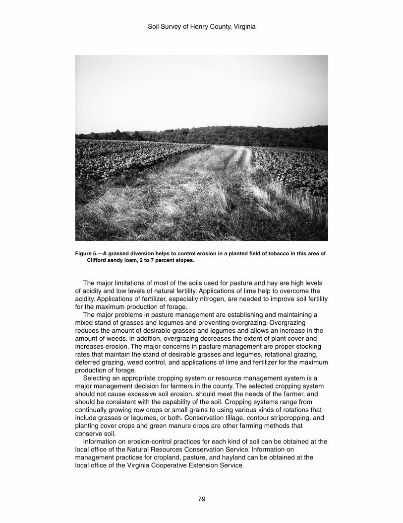
Soil Survey of Henry County, Virginia
79
The major limitations of most of the soils used for pasture and hay are high levelsof acidity and low levels of natural fertility. Applications of lime help to overcome theacidity. Applications of fertilizer, especially nitrogen, are needed to improve soil fertilityfor the maximum production of forage.
The major problems in pasture management are establishing and maintaining amixed stand of grasses and legumes and preventing overgrazing. Overgrazingreduces the amount of desirable grasses and legumes and allows an increase in theamount of weeds. In addition, overgrazing decreases the extent of plant cover andincreases erosion. The major concerns in pasture management are proper stockingrates that maintain the stand of desirable grasses and legumes, rotational grazing,deferred grazing, weed control, and applications of lime and fertilizer for the maximumproduction of forage.
Selecting an appropriate cropping system or resource management system is amajor management decision for farmers in the county. The selected cropping systemshould not cause excessive soil erosion, should meet the needs of the farmer, andshould be consistent with the capability of the soil. Cropping systems range fromcontinually growing row crops or small grains to using various kinds of rotations thatinclude grasses or legumes, or both. Conservation tillage, contour stripcropping, andplanting cover crops and green manure crops are other farming methods thatconserve soil.
Information on erosion-control practices for each kind of soil can be obtained at thelocal office of the Natural Resources Conservation Service. Information onmanagement practices for cropland, pasture, and hayland can be obtained at thelocal office of the Virginia Cooperative Extension Service.
Figure 5.—A grassed diversion helps to control erosion in a planted field of tobacco in this area ofClifford sandy loam, 2 to 7 percent slopes.
Soil Survey of Henry County, Virginia
80
Land Capability Classification
Land capability classification shows, in a general way, the suitability of soils formost kinds of field crops. Crops that require special management are excluded. Thesoils are grouped according to their limitations for field crops, the risk of damage ifthey are used for crops, and the way they respond to management. The criteria usedin grouping the soils do not include major and generally expensive landforming thatwould change slope, depth, or other characteristics of the soils, nor do they includepossible but unlikely major reclamation projects. Capability classification is not asubstitute for interpretations designed to show suitability and limitations of groups ofsoils for rangeland, for forestland, or for engineering purposes.
In the capability system, soils are generally grouped at two levels—capability classand subclass (17).
Capability classes, the broadest groups, are designated by the numbers 1 through8. The numbers indicate progressively greater limitations and narrower choices forpractical use. The classes are defined as follows:
Class 1 soils have slight limitations that restrict their use.Class 2 soils have moderate limitations that restrict the choice of plants or that
require moderate conservation practices.Class 3 soils have severe limitations that restrict the choice of plants or that require
special conservation practices, or both.Class 4 soils have very severe limitations that restrict the choice of plants or that
require very careful management, or both.Class 5 soils are subject to little or no erosion but have other limitations,
impractical to remove, that restrict their use mainly to pasture, rangeland, forestland,or wildlife habitat.
Class 6 soils have severe limitations that make them generally unsuitable forcultivation and that restrict their use mainly to pasture, rangeland, forestland, orwildlife habitat.
Class 7 soils have very severe limitations that make them unsuitable for cultivationand that restrict their use mainly to grazing, forestland, or wildlife habitat.
Class 8 soils and miscellaneous areas have limitations that preclude commercialplant production and that restrict their use to recreational purposes, wildlife habitat,watershed, or esthetic purposes.
Capability subclasses are soil groups within one class. They are designated byadding a small letter, e, w, s, or c, to the class numeral, for example, 2e. The letter eshows that the main hazard is the r isk of erosion unless close-growing plant cover ismaintained; w shows that water in or on the soil interferes with plant growth orcultivation (in some soils the wetness can be par tly corrected by artificial drainage); sshows that the soil is limited mainly because it is shallow, droughty, or stony; and c,used in only some parts of the United States, shows that the chief limitation is climatethat is very cold or very dry.
In class 1 there are no subclasses because the soils of this class have fewlimitations. Class 5 contains only the subclasses indicated by w, s, or c because thesoils in class 5 are subject to little or no erosion. They have other limitations thatrestrict their use to pasture, rangeland, forestland, wildlife habitat, or recreation.
The capability classification of the soils in this survey area is given in the section“Detailed Soil Map Units” and in table 5.
Virginia Soil Management Groups
The Virginia Agronomic Land Use Evaluation System (VALUES) is a system torank soils for management and productivity (20). VALUES places each soil series inVirginia into one of 43 management groups. The format of the management groups, A
Soil Survey of Henry County, Virginia
81
through QQ, include the following soil characteristics—regional occurrence; parentmaterial; landscape position or influence; solum thickness; dominant profile features,such as texture; available water capacity for plants; and internal soil drainage. Yieldsthat are both economically and environmentally feasible were assigned to eachmanagement group, based on yields of field tr ial crop data and research. Thefollowing paragraphs describe the soil management groups in Henry County.
Group A. The soils of this group formed in alluvium on gently sloping landscapesof flood plains or stream terraces. They are soils with deep sola, medium texturesthroughout, high water supplying capacities, and are well drained.
Group B. The soils of this group formed in alluvium associated with streamterraces. They are soils with deep sola, loamy textures throughout, high watersupplying capacity, and are well drained to moderately well drained.
Group L. The soils of this group formed in old, transported deposits of alluvium orcolluvium. They are common on stream terraces, foot slopes, and older, elevated,upland landscapes that were once stream terraces. They are soils with deep sola,medium-textured surfaces, more clayey subsurfaces, and commonly with gravels androunded stones. They are soils with moderate to high water supplying capacity, andusually are well drained.
Group N. The soils of this group formed in residuum of weathered mafic rockslocated on dissected uplands in the Piedmont region. They are soils with deep tomoderately deep sola, medium-textured surfaces, reddish brown clayey subsurfaces,moderate water supplying capacity, and are well drained.
Group O. The soils of this group formed in transported materials ranging frommountain colluvium to old alluvium on dissected uplands of the Piedmont andmountainous regions, and as old elevated river terrace deposits. They are soils withdeep to shallow sola, very dark red clayey subsurface horizons, and some may havesignificant coarse fragments. They are soils with moderate water supplying capacityand are well drained.
Group V. The soils of this group formed in saprolite derived from a variety ofparent materials ranging from slates, to granites, gneisses, schists, and more basicgranitic rocks. They are soils found on upland landscapes in the Piedmont and havemoderately deep sola. They are soils with clayey subsurface horizons, moderatewater supplying capacity, and are well drained.
Group X. The soils of this group formed in a variety of residual materialsincluding slates, granites, gneisses, and schists located on upland landscapes in thePiedmont region. They are soils with moderately deep sola, clayey subsurfacehorizons, sometimes with coarse fragments or gravels, moderate water supplyingcapacity, and are well drained to moderately well drained.
Group FF. The soils of this group formed in residual parent materials rangingfrom sandstone, shales, and slates, to loamy granitic saprolite, and mountaincolluvium. They are on steeply dissected uplands and mountain side slopes andextend across the Piedmont to the mountainous regions. They are soils withmoderately shallow sola and mostly with loamy-skeletal subsurface horizons that maycontain 80 percent, or more, coarse fragments. As a result, the water supplyingcapacity of the soils is low to very low. These soils are well drained to moderately welldrained.
Group II. The soils of this group formed in sandy parent materials within theCoastal Plain, or from local alluvium or colluvium of sandy origin. They range fromsoils with deep sola in the Coastal Plain from alluvial mater ials, to soils with shallowsola in upland positions in the mountainous and Piedmont regions. They are sandy-textured throughout, with little horizonation, have low to very low water supplyingcapacity, and are well drained to moderately well drained.
Group JJ. The soils of this group formed in a wide variety of residual parentmaterials ranging from sandstones, shales, and limestones, to triassic materials,

Soil Survey of Henry County, Virginia
82
phillites, and granite saprolite or schists. The soils in this group are from either thePiedmont or mountainous regions. They are soils with shallow sola, predominantlyloamy-skeletal textures throughout, and ranging from 30 to 70 percent coarsefragments. They have very low water supplying capacity and are well drained.
Group KK. The soils of this group formed in a variety of residual materialsincluding triassic sediments, residuum from basic rocks, and other clayey sediments.Soils in this group are located predominantly in the Piedmont region. They are soilswith moderately deep sola, clayey-textured subsurface horizons, and commonly withlarge components of high shrink-swell clays. They have moderate water supplyingcapacity and range from moderately well drained to somewhat poorly drained.
The management groups for the map units in the survey area are given in thesection “Detailed Soil Map Units” and in table 5.
Prime FarmlandTable 6 lists the map units in the survey area that are considered prime farmland.
This list does not constitute a recommendation for a particular land use.In an effort to identify the extent and location of important farmlands, the Natural
Resources Conservation Service, in cooperation with other interested Federal, State,and local government organizations, has inventoried land that can be used for theproduction of the Nation’s food supply.
Prime farmland is of major importance in meeting the Nation’s short- and long-range needs for food and fiber. Because the supply of high-quality farmland is limited,the U.S. Department of Agriculture recognizes that responsible levels of government,as well as individuals, should encourage and facilitate the wise use of our Nation’sprime farmland.
Prime farmland, as defined by the U.S. Department of Agriculture, is land that hasthe best combination of physical and chemical characteristics for producing food,feed, forage, fiber, and oilseed crops and is available for these uses. It could becultivated land, pastureland, forestland, or other land, but it is not urban or built-upland or water areas. The soil quality, growing season, and moisture supply are thoseneeded for the soil to economically produce sustained high yields of crops whenproper management, including water management, and acceptable farming methodsare applied. In general, prime farmland has an adequate and dependable supply ofmoisture from precipitation or irrigation, a favorable temperature and growing season,acceptable acidity or alkalinity, an acceptable salt and sodium content, and few or norocks. The water supply is dependable and of adequate quality. Prime farmland ispermeable to water and air. It is not excessively erodible or saturated with water forlong periods, and it either is not frequently flooded during the growing season or isprotected from flooding. Slope ranges mainly from 0 to 6 percent. More detailedinformation about the criteria for prime farmland is available at the local office of theNatural Resources Conservation Service.
About 7,947 acres in the survey area, or just over 3 percent of the total acreage,meets the requirement for prime farmland. This land is mainly on broad, upland ridgetops and along stream terraces of creeks and rivers.
A recent trend in land use in some areas has been the loss of some pr imefarmland to industrial and urban uses. The loss of prime farmland to other uses putspressure on marginal lands, which generally are more erodible, droughty, and lessproductive and cannot be easily cultivated.
For some soils identified in table 6 as prime farmland, measures that overcome ahazard or limitation, such as flooding, wetness, and droughtiness, are needed. Onsiteevaluation is needed to determine whether or not the hazard or limitation has beenovercome by corrective measures.
Soil Survey of Henry County, Virginia
83
Hydric SoilsThis section lists the map unit components that are rated as hydric soils in the
survey area. This list can help in planning land uses; however, onsite investigation isrecommended to determine the hydric soils on a specific site (6, 8).
The three essential characteristics of wetlands are hydrophytic vegetation, hydricsoils, and wetland hydrology (3, 8, 9, 10). Criteria for all of the characteristics must bemet for areas to be identified as wetlands. Undrained hydric soils that have naturalvegetation should support a dominant population of ecological wetland plant species.Hydric soils that have been converted to other uses should be capable of beingrestored to wetlands.
Hydric soils are defined by the National Technical Committee for Hydric Soils(NTCHS) as soils that formed under conditions of saturation, flooding, or pondinglong enough during the growing season to develop anaerobic conditions in the upperpart (4). These soils, under natural conditions, are either saturated or inundated longenough during the growing season to support the growth and reproduction ofhydrophytic vegetation.
The NTCHS definition identifies general soil properties that are associated withwetness. In order to determine whether a specific soil is a hydric soil or nonhydricsoil, however, more specific information, such as information about the depth andduration of the water table, is needed. Thus, criteria that identify those estimated soilproperties unique to hydric soils have been established (5). These criteria are used toidentify map unit components that normally are associated with wetlands. The criteriaused are selected estimated soil properties that are described in “Soil Taxonomy” (15)and “Keys to Soil Taxonomy” (14) and in the “Soil Survey Manual” (18).
If soils are wet enough for a long enough period of time to be considered hydric,they should exhibit certain properties that can be easily observed in the field. Thesevisible properties are indicators of hydric soils. The indicators used to make onsitedeterminations of hydric soils are specified in the “Field Indicators of Hydric Soils inthe United States” (6).
Hydric soils are identified by examining and describing the soil to a depth of about20 inches. This depth may be greater if determination of an appropriate indicator sorequires. It is always recommended that soils be excavated and described to thedepth necessary for an understanding of the redoximorphic processes. Then, usingthe completed soil descriptions, soil scientists can compare the soil features requiredby each indicator and specify which indicators have been matched with the conditionsobserved in the soil. The soil can be identified as a hydric soil if at least one of theapproved indicators is present.
The following map unit meets the definition of hydric soils and, in addition, has atleast one of the hydric soil indicators. This information can help in planning land uses;however, onsite investigation is recommended to determine the hydric soils on aspecific site (6, 8).
11A Leaksville silt loam, 0 to 4 percent slopes
Map units that are dominantly made up of hydric soils may have small areas, orinclusions, of nonhydric soils in the higher positions on the landform, and map unitsdominantly made up of nonhydric soils may have inclusions of hydric soils in thelower positions on the landform.
The following map units, in general, do not meet the definition of hydric soilsbecause they do not have one of the hydric soil indicators. A portion of these mapunits, however, may include hydric soils. Onsite investigation is recommended todetermine whether hydric soils occur and the location of the included hyric soils.
Soil Survey of Henry County, Virginia
84
1B Ayersville gravelly loam, 2 to 7 percent slopes1C Ayersville gravelly loam, 7 to 15 percent slopes5A Codorus loam, 0 to 2 percent slopes, frequently flooded6A Colvard fine sandy loam, 0 to 2 percent slopes, occasionally flooded7B Creedmoor fine sandy loam, 1 to 4 percent slopes8A Delanco loam, 0 to 4 percent slopes, rarely flooded10A Elsinboro fine sandy loam, 0 to 4 percent slopes, rarely flooded13B Mayodan fine sandy loam, 2 to 7 percent slopes13C Mayodan fine sandy loam, 7 to 15 percent slopes18B Stoneville loam, 2 to 7 percent slopes
Agricultural Waste ManagementSoil properties are important considerations in areas where soils are used as sites
for the treatment and disposal of organic waste and wastewater. Selection of soilswith properties that favor waste management can help to prevent environmentaldamage.
Table 7, parts I, II, and III, show the degree and kind of soil limitations affecting thetreatment of agricultural waste, including municipal and food-processing wastewaterand effluent from lagoons or storage ponds. Municipal wastewater is the wastestream from a municipality. It contains domestic waste and may contain industrialwaste. It may have received primary or secondary treatment. It is rarely untreatedsewage. Food-processing wastewater results from the preparation of fruits,vegetables, milk, cheese, and meats for public consumption. In places it is high incontent of sodium and chloride. In the context of these tables, the effluent in lagoonsand storage ponds is from facilities used to treat or store food-processing wastewateror domestic or animal waste. Domestic and food-processing wastewater is very dilute,and the effluent from the facilities that treat or store it commonly is very low in contentof carbonaceous and nitrogenous material; the content of nitrogen commonly rangesfrom 10 to 30 milligrams per liter. The wastewater from animal waste treatmentlagoons or storage ponds, however, has much higher concentrations of thesematerials, mainly because the manure has not been diluted as much as the domesticwaste. The content of nitrogen in this wastewater generally ranges from 50 to 2,000milligrams per liter. When wastewater is applied, checks should be made to ensurethat nitrogen, heavy metals, and salts are not added in excessive amounts.
The ratings in the tables are for waste management systems that not only disposeof and treat organic waste or wastewater, but also are beneficial to crops (applicationof manure and food-processing waste, application of sewage sludge, and disposal ofwastewater by irrigation) and for waste management systems that are designed onlyfor the purpose of wastewater disposal and treatment (overland flow of wastewater,rapid infiltration of wastewater, and slow rate treatment of wastewater).
The ratings are both verbal and numerical. Rating class terms indicate the extentto which the soils are limited by all of the soil features that affect agricultural wastemanagement. Not limited indicates that the soil has features that are very favorablefor the specified use. Good performance and very low maintenance can be expected.Somewhat limited indicates that the soil has features that are moderately favorable forthe specified use. The limitations can be overcome or minimized by special planning,design, or installation. Fair performance and moderate maintenance can be expected.Very limited indicates that the soil has one or more features that are unfavorable forthe specified use. The limitations generally cannot be overcome without major soilreclamation, special design, or expensive installation procedures. Poor performanceand high maintenance can be expected.
Soil Survey of Henry County, Virginia
85
Numerical ratings in the tables indicate the severity of individual limitations. Theratings are shown as decimal fractions ranging from 0.01 to 1.00. They indicategradations between the point at which a soil feature has the greatest negative impacton the use (1.00) and the point at which the soil feature is not a limitation (0.00).
Application of manure and food-processing waste not only disposes of wastematerial but also can improve crop production by increasing the supply of nutrients inthe soils where the material is applied. Manure is the excrement of livestock andpoultry, and food-processing waste is damaged fruit and vegetables and the peelings,stems, leaves, pits, and soil particles removed in food preparation. The manure andfood-processing waste are either solid, slurry, or liquid. Their nitrogen content varies.A high content of nitrogen limits the application rate. Toxic or otherwise dangerouswastes, such as those mixed with the lye used in food processing, are not consideredin the ratings.
The ratings are based on the soil properties that affect absorption, plant growth,microbial activity, erodibility, the rate at which the waste is applied, and the method bywhich the waste is applied. The properties that affect absorption include permeability,depth to a water table, ponding, the sodium adsorption ratio, depth to bedrock or acemented pan, and available water capacity. The properties that affect plant growthand microbial activity include reaction, the sodium adsorption ratio, salinity, and bulkdensity. The wind erodibility group, the soil erodibility factor K, and slope areconsidered in estimating the likelihood that wind erosion or water erosion willtransport the waste material from the application site. Stones, cobbles, a water table,ponding, and flooding can hinder the application of waste. Permanently frozen soilsare unsuitable for waste treatment.
Application of sewage sludge not only disposes of waste material but also canimprove crop production by increasing the supply of nutrients in the soils where thematerial is applied. In the context of this table, sewage sludge is the residual productof the treatment of municipal sewage. The solid component consists mainly of cellmass, primarily bacteria cells that developed during secondary treatment and haveincorporated soluble organics into their own bodies. The sludge has small amounts ofsand, silt, and other solid debris. The content of nitrogen varies. Some sludge hasconstituents that are toxic to plants or hazardous to the food chain, such as heavymetals and exotic organic compounds, and should be analyzed chemically prior touse.
The content of water in the sludge ranges from about 98 percent to less than 40percent. The sludge is considered liquid if it is more than about 90 percent water,slurry if it is about 50 to 90 percent water, and solid if it is less than about 50 percentwater.
The ratings in the table are based on the soil properties that affect absorption,plant growth, microbial activity, erodibility, the rate at which the sludge is applied, andthe method by which the sludge is applied. The properties that affect absorption, plantgrowth, and microbial activity include permeability, depth to a water table, ponding,the sodium adsorption ratio, depth to bedrock or a cemented pan, available watercapacity, reaction, salinity, and bulk density. The wind erodibility group, the soilerodibility factor K, and slope are considered in estimating the likelihood that winderosion or water erosion will transport the waste material from the application site.Stones, cobbles, a water table, ponding, and flooding can hinder the application ofsludge. Permanently frozen soils are unsuitable for waste treatment.
Disposal of wastewater by irrigation not only disposes of municipal wastewater andwastewater from food-processing plants, lagoons, and storage ponds but also canimprove crop production by increasing the amount of water available to crops. Theratings in the table are based on the soil properties that affect the design,construction, management, and performance of the irrigation system. The propertiesthat affect design and management include the sodium adsorption ratio, depth to a
Soil Survey of Henry County, Virginia
86
water table, ponding, available water capacity, permeability, slope, and flooding. Theproperties that affect construction include stones, cobbles, depth to bedrock or acemented pan, depth to a water table, and ponding. The properties that affectperformance include depth to bedrock or a cemented pan, bulk density, the sodiumadsorption ratio, salinity, reaction, and the cation-exchange capacity, which is used toestimate the capacity of a soil to adsorb heavy metals. Permanently frozen soils arenot suitable for disposal of wastewater by irrigation.
Overland flow of wastewater is a process in which wastewater is applied to theupper reaches of sloped land and allowed to flow across vegetated surfaces,sometimes called terraces, to runoff-collection ditches. The length of the run generallyis 150 to 300 feet. The application rate ranges from 2.5 to 16.0 inches per week. Itcommonly exceeds the rate needed for irrigation of cropland. The wastewater leavessolids and nutrients on the vegetated surfaces as it flows downslope in a thin film.Most of the water reaches the collection ditch, some is lost throughevapotranspiration, and a small amount may percolate to the ground water.
The ratings in the table are based on the soil properties that affect absorption,plant growth, microbial activity, and the design and construction of the system.Reaction and the cation-exchange capacity affect absorption. Reaction, salinity, andthe sodium adsorption ratio affect plant growth and microbial activity. Slope,permeability, depth to a water table, ponding, flooding, depth to bedrock or acemented pan, stones, and cobbles affect design and construction. Permanentlyfrozen soils are unsuitable for waste treatment.
Rapid infiltration of wastewater is a process in which wastewater applied in a levelbasin at a rate of 4 to 120 inches per week percolates through the soil. Thewastewater may eventually reach the ground water. The application rate commonlyexceeds the rate needed for irrigation of cropland. Vegetation is not a necessary partof the treatment; hence, the basins may or may not be vegetated. The thickness of thesoil material needed for proper treatment of the wastewater is more than 72 inches.As a result, geologic and hydrologic investigation is needed to ensure proper designand performance and to determine the risk of ground-water pollution.
The ratings in the table are based on the soil properties that affect the risk ofpollution and the design, construction, and performance of the system. Depth to awater table, ponding, flooding, and depth to bedrock or a cemented pan affect the riskof pollution and the design and construction of the system. Slope, stones, andcobbles also affect design and construction. Permeability and reaction affectperformance. Permanently frozen soils are unsuitable for waste treatment.
Slow rate treatment of wastewater is a process in which wastewater is applied toland at a rate normally between 0.5 inch and 4.0 inches per week. The applicationrate commonly exceeds the rate needed for irrigation of cropland. The appliedwastewater is treated as it moves through the soil. Much of the treated water maypercolate to the ground water, and some enters the atmosphere throughevapotranspiration. The applied water generally is not allowed to run off the surface.Waterlogging is prevented either through control of the application rate or through theuse of tile drains, or both.
The ratings in the table are based on the soil properties that affect absorption,plant growth, microbial activity, erodibility, and the application of waste. The propertiesthat affect absorption include the sodium adsorption ratio, depth to a water table,ponding, available water capacity, permeability, depth to bedrock or a cemented pan,reaction, the cation-exchange capacity, and slope. Reaction, the sodium adsorptionratio, salinity, and bulk density affect plant growth and microbial activity. The winderodibility group, the soil erodibility factor K, and slope are considered in estimatingthe likelihood of wind erosion or water erosion. Stones, cobbles, a water table,ponding, and flooding can hinder the application of waste. Permanently frozen soilsare unsuitable for waste treatment.
Soil Survey of Henry County, Virginia
87
Forestland Productivity and ManagementThe tables described in this section can help forest owners or managers plan the
use of soils for wood crops. They show the potential productivity of the soils for woodcrops and rate the soils according to the limitations that affect various aspects offorestland management.
Forestland Productivity
In table 8, the potential productivity of merchantable or common trees on a soil isexpressed as a site index and as a volume number. The site index is the averageheight, in feet, that dominant and codominant trees of a given species attain in aspecified number of years. The site index applies to fully stocked, even-aged,unmanaged stands. Commonly grown trees are those that forest managers generallyfavor in intermediate or improvement cuttings. They are selected on the basis ofgrowth rate, quality, value, and marketability. More detailed information regarding siteindex is available in the “National Forestry Manual” (12), which is available in localoffices of the Natural Resources Conservation Service or on the Internet.
The volume of wood fiber, a number, is the yield likely to be produced by the mostimportant tree species. This number, expressed as cubic feet per acre per year andcalculated at the age of culmination of the mean annual increment (CMAI), indicatesthe amount of fiber produced in a fully stocked, even-aged, unmanaged stand.
Trees to manage are those that are preferred for planting, seeding, or naturalregeneration and those that remain in the stand after thinning or par tial harvest.
Forestland Management
In table 9, parts I through V, interpretive ratings are given for various aspects offorestland management. The ratings are both verbal and numerical.
Some rating class terms indicate the degree to which the soils are suited to aspecified aspect of forestland management. Well suited indicates that the soil hasfeatures that are favorable for the specified management aspect and has nolimitations. Good performance can be expected, and little or no maintenance isneeded. Moderately suited indicates that the soil has features that are moderatelyfavorable for the specified management aspect. One or more soil properties are lessthan desirable, and fair performance can be expected. Some maintenance is needed.Poorly suited indicates that the soil has one or more proper ties that are unfavorablefor the specified management aspect. Overcoming the unfavorable propertiesrequires special design, extra maintenance, and costly alteration. Unsuited indicatesthat the expected performance of the soil is unacceptable for the specifiedmanagement aspect or that extreme measures are needed to overcome theundesirable soil properties.
Proper planning for timber harvesting is essential to minimize the potential impactto soil and water quality. A harvest plan should include logging roads, log decks,streamside management zones, stream crossings, skid trails, schedule of activities,and Best Management Practices (BMP’s) for each activity. Forests should bemanaged to increase economic and environmental benefits. A forest stewardship planshould be developed to guide management and utilization of the woodlands.
Numerical ratings in the tables indicate the severity of individual limitations. Theratings are shown as decimal fractions ranging from 0.01 to 1.00. They indicategradations between the point at which a soil feature has the greatest negative impacton the specified aspect of forestland management (1.00) and the point at which thesoil feature is not a limitation (0.00).
Soil Survey of Henry County, Virginia
88
Rating class terms for fire damage and seedling mortality are expressed as low,moderate, and high. Where these terms are used, the numerical ratings indicategradations between the point at which the potential for fire damage or seedlingmortality is highest (1.00) and the point at which the potential is lowest (0.00).
The paragraphs that follow indicate the soil properties considered in rating thesoils. More detailed information about the criteria used in the ratings is available in the“National Forestry Manual” (12), which is available in local offices of the NaturalResources Conservation Service or on the Internet.
For limitations affecting construction of haul roads and log landings, the ratings arebased on slope, flooding, permafrost, plasticity index, the hazard of soil slippage,content of sand, the Unified classification, rock fragments on or below the surface,depth to a restrictive layer that is indurated, depth to a water table, and ponding. Thelimitations are described as slight, moderate, or severe. A rating of slight indicatesthat no significant limitations affect construction activities, moderate indicates thatone or more limitations can cause some difficulty in construction, and severeindicates that one or more limitations can make construction very difficult or verycostly.
The ratings of suitability for log landings are based on slope, rock fragments on thesurface, plasticity index, content of sand, the Unified classification, depth to a watertable, ponding, flooding, and the hazard of soil slippage. The soils are described aswell suited, moderately suited, or poorly suited to use as log landings.
Ratings in the column soil rutting hazard are based on depth to a water table, rockfragments on or below the surface, the Unified classification, depth to a restrictivelayer, and slope. Ruts form as a result of the operation of forest equipment. Thehazard is described as slight, moderate, or severe. A rating of slight indicates that thesoil is subject to little or no rutting, moderate indicates that rutting is likely, and severeindicates that ruts form readily.
Ratings in the column hazard of off-road or off-trail erosion are based on slope andon soil erodibility factor K. The soil loss is caused by sheet or rill erosion in off-road oroff-trail areas where 50 to 75 percent of the surface has been exposed by logging,grazing, mining, or other kinds of disturbance. The hazard is described as slight,moderate, severe, or very severe. A rating of slight indicates that erosion is unlikelyunder ordinary climatic conditions; moderate indicates that some erosion is likely andthat erosion-control measures may be needed; severe indicates that erosion is verylikely and that erosion-control measures, including revegetation of bare areas, areadvised; and very severe indicates that significant erosion is expected, loss of soilproductivity and off-site damage are likely, and erosion-control measures are costlyand generally impractical.
Ratings in the column hazard of erosion on roads and trails are based on the soilerodibility factor K, slope, and content of rock fragments. The ratings apply tounsurfaced roads and trails. The hazard is described as slight, moderate, or severe. Arating of slight indicates that little or no erosion is likely; moderate indicates that someerosion is likely, that the roads or trails may require occasional maintenance, and thatsimple erosion-control measures are needed; and severe indicates that significanterosion is expected, that the roads or trails require frequent maintenance, and thatcostly erosion-control measures are needed.
Ratings in the column suitability for roads (natural surface) are based on slope,rock fragments on the surface, plasticity index, content of sand, the Unifiedclassification, depth to a water table, ponding, flooding, and the hazard of soilslippage. The ratings indicate the suitability for using the natural surface of the soil forroads. The soils are described as well suited, moderately suited, or poorly suited tothis use.
Ratings in the columns suitability for hand planting and suitability for mechanicalplanting are based on slope, depth to a restrictive layer, content of sand, plasticity
Soil Survey of Henry County, Virginia
89
index, rock fragments on or below the surface, depth to a water table, and ponding.The soils are described as well suited, moderately suited, poorly suited, or unsuitedto these methods of planting. It is assumed that necessary site preparation iscompleted before seedlings are planted.
Ratings in the column suitability for use of harvesting equipment are based onslope, rock fragments on the surface, plasticity index, content of sand, the Unifiedclassification, depth to a water table, and ponding. The soils are described as wellsuited, moderately suited, or poorly suited to this use.
Ratings in the column suitability for mechanical site preparation (surface) arebased on slope, depth to a restrictive layer, plasticity index, rock fragments on orbelow the surface, depth to a water table, and ponding. The soils are described aswell suited, poorly suited, or unsuited to this management activity. The part of the soilfrom the surface to a depth of about 1 foot is considered in the ratings.
Ratings in the column suitability for mechanical site preparation (deep) are basedon slope, depth to a restrictive layer, rock fragments on or below the surface, depth toa water table, and ponding. The soils are described as well suited, poorly suited, orunsuited to this management activity. The part of the soil from the surface to a depthof about 3 feet is considered in the ratings.
Ratings in the column potential for damage to soil by fire are based on texture ofthe surface layer, content of rock fragments and organic matter in the surface layer,thickness of the surface layer, and slope. The soils are described as having a low,moderate, or high potential for this kind of damage. The ratings indicate an evaluationof the potential impact of prescribed fires or wildfires that are intense enough toremove the duff layer and consume organic matter in the surface layer.
Ratings in the column potential for seedling mortality are based on flooding,ponding, depth to a water table, content of lime, reaction, salinity, available watercapacity, soil moisture regime, soil temperature regime, aspect, and slope. The soilsare described as having a low, moderate, or high potential for seedling mortality.
Silviculture of Henry County
About 178,000 acres in Henry County, or about 71 percent of the survey area iswoodland. This acreage includes portions of Fairy Stone State Park in thenorthwestern part of Henry County and Turkeycock Wildlife Management Area on topof Turkeycock Mountain in the northeastern part, each of which consists of about1,700 acres. In addition, there are several hundred acres of woodland on Federallands surrounding Philpott Lake near Fairy Stone State Park. The rest of thewoodland in the county is privately owned.
On upland sites, the most common trees are chestnut oak, white oak, hickory,maple, yellow-poplar, and Virginia pine. On bottom lands along streams, the main treespecies are maple, yellow-poplar, and sycamore. Most of the stands are composed ofhardwoods or mixed hardwoods and pine. Tracts of lands scattered throughout thecounty have been planted or replanted to loblolly pine (fig. 6).
The forests products industry is an important part of the local economy. Accordingto the Virginia Department of Forestry, more than 8,000 people are employed byindustries that rely on forest products, primarily by the several major furnituremanufacturers. Several portable sawmills operate in the county.
Most of the existing commercial woodland can be improved by thinning out matureor diseased trees, trees with poor growth form, or undesirable tree species so thatpotential timber production is increased.
Woodland management practices and related activities include thinning,clearcutting, prescribed burning, reforestation, preventing wildfires restricting grazingby livestock, and controlling diseases and insects. The Virginia Department ofForestry provides a variety of services to private landowners, including forest

Soil Survey of Henry County, Virginia
90
management plans. It also provides literature describing the best managementpractices, which can help landowners and loggers in planning and implementingtimber harvesting techniques. These practices are designed to reduce potential soilerosion and to protect water quality and wildlife habitat.
The potential for soil erosion in association with logging activities is greatest inareas of access roads and skid trails. These areas concentrate the overland flow andsurface runoff that result from precipitation which does not enter the soil surface.Planning and installing access roads and skid trails on the contour help to reduce thepotential for soil erosion by reducing the velocity of the surface runoff and thus itspower to erode. Road grades should be less than 10 percent, and side drainageditches and adequate culverts should be provided to control surface runoff andoverland flow. Installing water bars in logging roads and skid trails helps to controlerosion by diverting runoff to vegetated areas.
After the completion of logging operations, any unneeded trails and roads shouldbe seeded or planted to a permanent plant cover. This helps to control water runoffand minimize erosion and the sedimentation of streams. Wildlife habitat can be
Figure 6.—A stand of loblolly pine on Clifford sandy loam, 7 to 15 percent slopes.
Soil Survey of Henry County, Virginia
91
improved by selecting plant species that are preferred wildlife foods for the plantcover used in soil conservation.
Leaving a buffer zone of trees and shrubs in areas adjacent to intermittent andperennial waterways helps improve water quality. These zones help to reduce thesedimentation of streams by intercepting overland flow from the higher slopes.
The Virginia Department of Forestry, the Natural Resources Conservation Service,and the Virginia Cooperative Extension Service can assist woodland owners andmanagers in determining specific needs in managing woodlands.
Recreational DevelopmentIn table 10, parts I and II, the soils of the survey area are rated according to
limitations that affect their suitability for recreational development. The ratings areboth verbal and numerical. Rating class terms indicate the extent to which the soilsare limited by all of the soil features that affect the recreational uses. Not limitedindicates that the soil has features that are very favorable for the specified use. Goodperformance and very low maintenance can be expected. Somewhat limited indicatesthat the soil has features that are moderately favorable for the specified use. Thelimitations can be overcome or minimized by special planning, design, or installation.Fair performance and moderate maintenance can be expected. Very limited indicatesthat the soil has one or more features that are unfavorable for the specified use. Thelimitations generally cannot be overcome without major soil reclamation, specialdesign, or expensive installation procedures. Poor performance and highmaintenance can be expected.
Numerical ratings in the tables indicate the severity of individual limitations. Theratings are shown as decimal fractions ranging from 0.01 to 1.00. They indicategradations between the point at which a soil feature has the greatest negative impacton the use (1.00) and the point at which the soil feature is not a limitation (0.00).
The ratings in the tables are based on restrictive soil features, such as wetness,slope, and texture of the surface layer. Susceptibility to flooding is considered. Notconsidered in the ratings, but important in evaluating a site, are the location andaccessibility of the area, the size and shape of the area and its scenic quality,vegetation, access to water, potential water impoundment sites, and access to publicsewer lines. The capacity of the soil to absorb septic tank effluent and the ability ofthe soil to support vegetation also are important. Soils that are subject to flooding arelimited for recreational uses by the duration and intensity of flooding and the seasonwhen flooding occurs. In planning recreational facilities, onsite assessment of theheight, duration, intensity, and frequency of flooding is essential.
The information in these tables can be supplemented by other information in thissurvey, for example, interpretations for dwellings without basements, for local roadsand streets, and for septic tank absorption fields.
Camp areas require site preparation, such as shaping and leveling the tent andparking areas, stabilizing roads and intensively used areas, and installing sanitaryfacilities and utility lines. Camp areas are subject to heavy foot traffic and somevehicular traffic. The ratings are based on the soil properties that affect the ease ofdeveloping camp areas and the performance of the areas after development. Slope,stoniness, and depth to bedrock or a cemented pan are the main concerns affectingthe development of camp areas. The soil properties that affect the performance of theareas after development are those that influence trafficability and promote the growthof vegetation, especially in heavily used areas. For good trafficability, the surface ofcamp areas should absorb rainfall readily, remain firm under heavy foot traffic, andnot be dusty when dry. The soil properties that influence trafficability are texture of thesurface layer, depth to a water table, ponding, flooding, permeability, and large
Soil Survey of Henry County, Virginia
92
stones. The soil properties that affect the growth of plants are depth to bedrock or acemented pan, permeability, and toxic substances in the soil.
Picnic areas are subject to heavy foot traffic. Most vehicular traffic is confined toaccess roads and parking areas. The ratings are based on the soil proper ties thataffect the ease of developing picnic areas and that influence trafficability and thegrowth of vegetation after development. Slope and stoniness are the main concernsaffecting the development of picnic areas. For good trafficability, the surface of picnicareas should absorb rainfall readily, remain firm under heavy foot traffic, and not bedusty when dry. The soil properties that influence trafficability are texture of thesurface layer, depth to a water table, ponding, flooding, permeability, and largestones. The soil properties that affect the growth of plants are depth to bedrock or acemented pan, permeability, and toxic substances in the soil.
Playgrounds require soils that are nearly level, are free of stones, and canwithstand intensive foot traffic. The ratings are based on the soil properties that affectthe ease of developing playgrounds and that influence trafficability and the growth ofvegetation after development. Slope and stoniness are the main concerns affectingthe development of playgrounds. For good trafficability, the surface of the playgroundsshould absorb rainfall readily, remain firm under heavy foot traffic, and not be dustywhen dry. The soil properties that influence trafficability are texture of the surfacelayer, depth to a water table, ponding, flooding, permeability, and large stones. Thesoil properties that affect the growth of plants are depth to bedrock or a cementedpan, permeability, and toxic substances in the soil.
Paths and trails for hiking and horseback riding should require little or no slopemodification through cutting and filling. The ratings are based on the soil propertiesthat affect trafficability and erodibility. These properties are stoniness, depth to awater table, ponding, flooding, slope, and texture of the surface layer.
Off-road motorcycle trails require little or no site preparation. They are not coveredwith surfacing material or vegetation. Considerable compaction of the soil material islikely. The ratings are based on the soil properties that influence erodibility,trafficability, dustiness, and the ease of revegetation. These properties are stoniness,slope, depth to a water table, ponding, flooding, and texture of the surface layer.
Golf fairways are subject to heavy foot traffic and some light vehicular traffic.Cutting or filling may be required. Irrigation is not considered in the ratings. Theratings are based on the soil properties that affect plant growth and trafficability aftervegetation is established. The properties that affect plant growth are reaction; depthto a water table; ponding; depth to bedrock or a cemented pan; the available watercapacity in the upper 40 inches; the content of salts, sodium, or calcium carbonate;and sulfidic materials. The properties that affect trafficability are flooding, depth to awater table, ponding, slope, stoniness, and the amount of sand, clay, or organicmatter in the surface layer. The suitability of the soil for traps, tees, roughs, andgreens is not considered in the ratings.
EngineeringThis section provides information for planning land uses related to urban
development and to water management. Soils are rated for various uses, and themost limiting features are identified. Ratings are given for building site development,sanitary facilities, construction materials, and water management. The ratings arebased on observed performance of the soils and on the data in the tables describedunder the heading “Soil Properties.”
Information in this section is intended for land use planning, for evaluating land usealternatives, and for planning site investigations prior to design and construction. Theinformation, however, has limitations. For example, estimates and other datagenerally apply only to that part of the soil between the surface and a depth of 5 to 7
Soil Survey of Henry County, Virginia
93
feet. Because of the map scale, small areas of different soils may be included withinthe mapped areas of a specific soil.
The information is not site specific and does not eliminate the need for onsiteinvestigation of the soils or for testing and analysis by personnel experienced in thedesign and construction of engineering works.
Government ordinances and regulations that restrict certain land uses or imposespecific design criteria were not considered in preparing the information in thissection. Local ordinances and regulations should be considered in planning, in siteselection, and in design.
Soil properties, site features, and observed performance were considered indetermining the ratings in this section. During the fieldwork for this soil survey,determinations were made about particle-size distribution, liquid limit, plasticity index,soil reaction, depth to bedrock, hardness of bedrock within 5 to 7 feet of the surface,soil wetness, depth to a water table, ponding, slope, likelihood of flooding, natural soilstructure aggregation, and soil density. Data were collected about kinds of clayminerals, mineralogy of the sand and silt fractions, and the kinds of adsorbed cations.Estimates were made for erodibility, permeability, corrosivity, shrink-swell potential,available water capacity, and other behavioral characteristics affecting engineeringuses.
This information can be used to evaluate the potential of areas for residential,commercial, industrial, and recreational uses; make preliminary estimates of
construction conditions; evaluate alternative routes for roads, streets, highways,pipelines, and underground cables; evaluate alternative sites for sanitary landfills,septic tank absorption fields, and sewage lagoons; plan detailed onsite investigationsof soils and geology; locate potential sources of gravel, sand, reclamation material,roadfill, and topsoil; plan structures for water management; and predict performanceof proposed small structures and pavements by comparing the performance ofexisting similar structures on the same or similar soils.
The information in the tables, along with the soil maps, the soil descriptions, andother data provided in this survey, can be used to make additional interpretations.
Some of the terms used in this soil survey have a special meaning in soil scienceand are defined in the Glossary.
Building Site Development
Soil properties influence the development of building sites, including the selectionof the site, the design of the structure, construction, performance after construction,and maintenance. Table 11, parts I and II, show the degree and kind of soil limitationsthat affect dwellings with and without basements, small commercial buildings, localroads and streets, shallow excavations, and lawns and landscaping.
The ratings in the tables are both verbal and numerical. Rating class terms indicatethe extent to which the soils are limited by all of the soil features that affect buildingsite development. Not limited indicates that the soil has features that are veryfavorable for the specified use. Good performance and very low maintenance can beexpected. Somewhat limited indicates that the soil has features that are moderatelyfavorable for the specified use. The limitations can be overcome or minimized byspecial planning, design, or installation. Fair performance and moderate maintenancecan be expected. Very limited indicates that the soil has one or more features that areunfavorable for the specified use. The limitations generally cannot be overcomewithout major soil reclamation, special design, or expensive installation procedures.Poor performance and high maintenance can be expected.
Numerical ratings in the tables indicate the severity of individual limitations. Theratings are shown as decimal fractions ranging from 0.01 to 1.00. They indicate
Soil Survey of Henry County, Virginia
94
gradations between the point at which a soil feature has the greatest negative impacton the use (1.00) and the point at which the soil feature is not a limitation (0.00).
Dwellings are single-family houses of three stories or less. For dwellings withoutbasements, the foundation is assumed to consist of spread footings of reinforcedconcrete built on undisturbed soil at a depth of 2 feet or at the depth of maximum frostpenetration, whichever is deeper. For dwellings with basements, the foundation isassumed to consist of spread footings of reinforced concrete built on undisturbed soilat a depth of about 7 feet. The ratings for dwellings are based on the soil propertiesthat affect the capacity of the soil to support a load without movement and on theproperties that affect excavation and construction costs. The properties that affect theload-supporting capacity include depth to a water table, ponding, flooding,subsidence, linear extensibility (shrink-swell potential), and compressibility.Compressibility is inferred from the Unified classification. The properties that affectthe ease and amount of excavation include depth to a water table, ponding, flooding,slope, depth to bedrock or a cemented pan, hardness of bedrock or a cemented pan,and the amount and size of rock fragments.
Small commercial buildings are structures that are less than three stories high anddo not have basements. The foundation is assumed to consist of spread footings ofreinforced concrete built on undisturbed soil at a depth of 2 feet or at the depth ofmaximum frost penetration, whichever is deeper. The ratings are based on the soilproperties that affect the capacity of the soil to support a load without movement andon the properties that affect excavation and construction costs. The properties thataffect the load-supporting capacity include depth to a water table, ponding, flooding,subsidence, linear extensibility (shrink-swell potential), and compressibility (which isinferred from the Unified classification). The properties that affect the ease andamount of excavation include flooding, depth to a water table, ponding, slope, depthto bedrock or a cemented pan, hardness of bedrock or a cemented pan, and theamount and size of rock fragments.
Local roads and streets have an all-weather surface and carry automobile and lighttruck traffic all year. They have a subgrade of cut or fill soil material; a base of gravel,crushed rock, or soil material stabilized by lime or cement; and a surface of flexiblematerial (asphalt), rigid material (concrete), or gravel with a binder. The ratings arebased on the soil properties that affect the ease of excavation and grading and thetraffic-supporting capacity. The properties that affect the ease of excavation andgrading are depth to bedrock or a cemented pan, hardness of bedrock or a cementedpan, depth to a water table, ponding, flooding, the amount of large stones, and slope.The properties that affect the traffic-supporting capacity are soil strength (as inferredfrom the AASHTO group index number), subsidence, linear extensibility (shrink-swellpotential), the potential for frost action, depth to a water table, and ponding.
Shallow excavations are trenches or holes dug to a maximum depth of 5 or 6 feetfor graves, utility lines, open ditches, or other purposes. The ratings are based on thesoil properties that influence the ease of digging and the resistance to sloughing.Depth to bedrock or a cemented pan, hardness of bedrock or a cemented pan, theamount of large stones, and dense layers influence the ease of digging, filling, andcompacting. Depth to the seasonal high water table, flooding, and ponding mayrestrict the period when excavations can be made. Slope influences the ease of usingmachinery. Soil texture, depth to the water table, and linear extensibility (shrink-swellpotential) influence the resistance to sloughing.
Lawns and landscaping require soils on which turf and ornamental trees andshrubs can be established and maintained. Irrigation is not considered in the ratings.The ratings are based on the soil properties that affect plant growth and trafficabilityafter vegetation is established. The properties that affect plant growth are reaction;depth to a water table; ponding; depth to bedrock or a cemented pan; the availablewater capacity in the upper 40 inches; the content of salts, sodium, or calcium
Soil Survey of Henry County, Virginia
95
carbonate; and sulfidic materials. The properties that affect trafficability are flooding,depth to a water table, ponding, slope, stoniness, and the amount of sand, clay, ororganic matter in the surface layer.
Sanitary Facilities
Table 12, parts I and II, show the degree and kind of soil limitations that affectseptic tank absorption fields, sewage lagoons, sanitary landfills, and daily cover forlandfill. The ratings are both verbal and numerical. Rating class terms indicate theextent to which the soils are limited by all of the soil features that affect these uses.Not limited indicates that the soil has features that are very favorable for the specifieduse. Good performance and very low maintenance can be expected. Somewhatlimited indicates that the soil has features that are moderately favorable for thespecified use. The limitations can be overcome or minimized by special planning,design, or installation. Fair performance and moderate maintenance can be expected.Very limited indicates that the soil has one or more features that are unfavorable forthe specified use. The limitations generally cannot be overcome without major soilreclamation, special design, or expensive installation procedures. Poor performanceand high maintenance can be expected.
Numerical ratings in the tables indicate the severity of individual limitations. Theratings are shown as decimal fractions ranging from 0.01 to 1.00. They indicategradations between the point at which a soil feature has the greatest negative impacton the use (1.00) and the point at which the soil feature is not a limitation (0.00).
Septic tank absorption fields are areas in which effluent from a septic tank isdistributed into the soil through subsurface tiles or perforated pipe. Only that part ofthe soil between depths of 24 and 60 inches is evaluated. The ratings are based onthe soil properties that affect absorption of the effluent, construction and maintenanceof the system, and public health. Permeability, depth to a water table, ponding, depthto bedrock or a cemented pan, and flooding affect absorption of the effluent. Stonesand boulders, ice, and bedrock or a cemented pan interfere with installation.Subsidence interferes with installation and maintenance. Excessive slope may causelateral seepage and surfacing of the effluent in downslope areas.
Some soils are underlain by loose sand and gravel or fractured bedrock at a depthof less than 4 feet below the distribution lines. In these soils the absorption field maynot adequately filter the effluent, particularly when the system is new. As a result, theground water may become contaminated.
Sewage lagoons are shallow ponds constructed to hold sewage while aerobicbacteria decompose the solid and liquid wastes. Lagoons should have a nearly levelfloor surrounded by cut slopes or embankments of compacted soil. Nearly impervioussoil material for the lagoon floor and sides is required to minimize seepage andcontamination of ground water. Considered in the ratings are slope, permeability,depth to a water table, ponding, depth to bedrock or a cemented pan, flooding, largestones, and content of organic matter.
Soil permeability is a critical property affecting the suitability for sewage lagoons.Most porous soils eventually become sealed when they are used as sites for sewagelagoons. Until sealing occurs, however, the hazard of pollution is severe. Soils thathave a permeability rate of more than 2 inches per hour are too porous for the properfunctioning of sewage lagoons. In these soils, seepage of the effluent can result incontamination of the ground water. Ground-water contamination is also a hazard iffractured bedrock is within a depth of 40 inches, if the water table is high enough toraise the level of sewage in the lagoon, or if floodwater overtops the lagoon.
A high content of organic matter is detrimental to proper functioning of the lagoonbecause it inhibits aerobic activity. Slope, bedrock, and cemented pans can causeconstruction problems, and large stones can hinder compaction of the lagoon floor. If
Soil Survey of Henry County, Virginia
96
the lagoon is to be uniformly deep throughout, the slope must be gentle enough andthe soil material must be thick enough over bedrock or a cemented pan to make landsmoothing practical.
A trench sanitary landfill is an area where solid waste is placed in successivelayers in an excavated trench. The waste is spread, compacted, and covered dailywith a thin layer of soil excavated at the site. When the trench is full, a final cover ofsoil material at least 2 feet thick is placed over the landfill. The ratings in the table arebased on the soil properties that affect the risk of pollution, the ease of excavation,trafficability, and revegetation. These properties include permeability, depth tobedrock or a cemented pan, depth to a water table, ponding, slope, flooding, texture,stones and boulders, highly organic layers, soil reaction, and content of salts andsodium. Unless otherwise stated, the ratings apply only to that part of the soil within adepth of about 6 feet. For deeper trenches, onsite investigation may be needed.
Hard, nonrippable bedrock, creviced bedrock, or highly permeable strata in ordirectly below the proposed trench bottom can affect the ease of excavation and thehazard of ground-water pollution. Slope affects construction of the trenches and themovement of surface water around the landfill. It also affects the construction andperformance of roads in areas of the landfill.
Soil texture and consistence affect the ease with which the trench is dug and theease with which the soil can be used as daily or final cover. They determine theworkability of the soil when dry and when wet. Soils that are plastic and sticky whenwet are difficult to excavate, grade, or compact and are difficult to place as auniformly thick cover over a layer of refuse.
The soil material used as the final cover for a trench landfill should be suitable forplants. It should not have excess sodium or salts and should not be too acid. Thesurface layer generally has the best workability, the highest content of organic matter,and the best potential for plants. Material from the surface layer should be stockpiledfor use as the final cover.
In an area sanitary landfill, solid waste is placed in successive layers on thesurface of the soil. The waste is spread, compacted, and covered daily with a thinlayer of soil from a source away from the site. A final cover of soil material at least 2feet thick is placed over the completed landfill. The ratings in the table are based onthe soil properties that affect trafficability and the risk of pollution. These propertiesinclude flooding, permeability, depth to a water table, ponding, slope, and depth tobedrock or a cemented pan.
Flooding is a serious problem because it can result in pollution in areasdownstream from the landfill. If permeability is too rapid or if fractured bedrock, afractured cemented pan, or the water table is close to the surface, the leachate cancontaminate the water supply. Slope is a consideration because of the extra gradingrequired to maintain roads in the steeper areas of the landfill. Also, leachate may flowalong the surface of the soils in the steeper areas and cause difficult seepageproblems.
Daily cover for landfill is the soil material that is used to cover compacted solidwaste in an area sanitary landfill. The soil material is obtained offsite, transported tothe landfill, and spread over the waste. The ratings in the table also apply to the finalcover for a landfill. They are based on the soil properties that affect workability, theease of digging, and the ease of moving and spreading the material over the refusedaily during wet and dry periods. These properties include soil texture, depth to awater table, ponding, rock fragments, slope, depth to bedrock or a cemented pan,reaction, and content of salts, sodium, or lime.
Loamy or silty soils that are free of large stones and excess gravel are the bestcover for a landfill. Clayey soils may be sticky and difficult to spread; sandy soils aresubject to wind erosion.

Soil Survey of Henry County, Virginia
97
Slope affects the ease of excavation and of moving the cover material. Also, it caninfluence runoff, erosion, and reclamation of the borrow area.
After soil material has been removed, the soil material remaining in the borrowarea must be thick enough over bedrock, a cemented pan, or the water table topermit revegetation. The soil material used as the final cover for a landfill should besuitable for plants. It should not have excess sodium, salts, or lime and should not betoo acid.
Construction Materials
Table 13, parts I and II, give information about the soils as potential sources ofgravel, sand, reclamation material, roadfill, and topsoil. Normal compaction, minorprocessing, and other standard construction practices are assumed.
Gravel and sand are natural aggregates suitable for commercial use with aminimum of processing. They are used in many kinds of construction. Specificationsfor each use vary widely. In table 13, part I, only the likelihood of finding material insuitable quantity is evaluated. The suitability of the material for specific purposes isnot evaluated, nor are factors that affect excavation of the material. The propertiesused to evaluate the soil as a source of sand or gravel are gradation of grain sizes (asindicated by the Unified classification of the soil), the thickness of suitable material,and the content of rock fragments. If the bottom layer of the soil contains sand orgravel, the soil is considered a likely source regardless of thickness. The assumptionis that the sand or gravel layer below the depth of observation exceeds the minimumthickness.
The soils are rated good, fair, or poor as potential sources of sand and gravel. Arating of good or fair means that the source material is likely to be in or below the soil.The bottom layer and the thickest layer of the soils are assigned numerical ratings.These ratings indicate the likelihood that the layer is a source of sand or gravel. Thenumber 0.00 indicates that the layer is a poor source. The number 1.00 indicates thatthe layer is a good source. A number between 0.00 and 1.00 indicates the degree towhich the layer is a likely source.
In table 13, part II, the rating class terms are good, fair, and poor. The features thatlimit the soils as sources of these materials are specified in the tables. The numericalratings given after the specified features indicate the degree to which the featureslimit the soils as sources of reclamation material, roadfill, and topsoil. The lower thenumber, the greater the limitation.
Reclamation material is used in areas that have been drastically disturbed bysurface mining or similar activities. When these areas are reclaimed, layers of soilmaterial or unconsolidated geological material, or both, are replaced in a verticalsequence. The reconstructed soil favors plant growth. The ratings in the table do notapply to quarries and other mined areas that require an offsite source ofreconstruction material. The ratings are based on the soil properties that affecterosion and stability of the surface and the productive potential of the reconstructedsoil. These properties include the content of sodium, salts, and calcium carbonate;reaction; available water capacity; erodibility; texture; content of rock fragments; andcontent of organic matter and other features that affect fertility.
Roadfill is soil material that is excavated in one place and used in roadembankments in another place. In this table, the soils are rated as a source of roadfillfor low embankments, generally less than 6 feet high and less exacting in design thanhigher embankments.
The ratings are for the whole soil, from the surface to a depth of about 5 feet. It isassumed that soil layers will be mixed when the soil material is excavated andspread.
Soil Survey of Henry County, Virginia
98
The ratings are based on the amount of suitable material and on soil propertiesthat affect the ease of excavation and the performance of the material after it is inplace. The thickness of the suitable material is a major consideration. The ease ofexcavation is affected by large stones, depth to a water table, and slope. How well thesoil performs in place after it has been compacted and drained is determined by itsstrength (as inferred from the AASHTO classification of the soil) and linearextensibility (shrink-swell potential).
Topsoil is used to cover an area so that vegetation can be established andmaintained. The upper 40 inches of a soil is evaluated for use as topsoil. Alsoevaluated is the reclamation potential of the borrow area. The ratings are based onthe soil properties that affect plant growth; the ease of excavating, loading, andspreading the material; and reclamation of the borrow area. Toxic substances, soilreaction, and the properties that are inferred from soil texture, such as available watercapacity and fertility, affect plant growth. The ease of excavating, loading, andspreading is affected by rock fragments, slope, depth to a water table, soil texture,and thickness of suitable material. Reclamation of the borrow area is affected byslope, depth to a water table, rock fragments, depth to bedrock or a cemented pan,and toxic material.
The surface layer of most soils is generally preferred for topsoil because of itsorganic matter content. Organic matter greatly increases the absorption and retentionof moisture and nutrients for plant growth.
Water Management
Table 14 gives information on the soil properties and site features that affect watermanagement. The degree and kind of soil limitations are given for pond reservoirareas; embankments, dikes, and levees; and aquifer-fed excavated ponds. The ratingsare both verbal and numerical. Rating class terms indicate the extent to which thesoils are limited by all of the soil features that affect these uses. Not limited indicatesthat the soil has features that are very favorable for the specified use. Goodperformance and very low maintenance can be expected. Somewhat limited indicatesthat the soil has features that are moderately favorable for the specified use. Thelimitations can be overcome or minimized by special planning, design, or installation.Fair performance and moderate maintenance can be expected. Very limited indicatesthat the soil has one or more features that are unfavorable for the specified use. Thelimitations generally cannot be overcome without major soil reclamation, specialdesign, or expensive installation procedures. Poor performance and highmaintenance can be expected.
Numerical ratings in the table indicate the severity of individual limitations. Theratings are shown as decimal fractions ranging from 0.01 to 1.00. They indicategradations between the point at which a soil feature has the greatest negative impacton the use (1.00) and the point at which the soil feature is not a limitation (0.00).
Pond reservoir areas hold water behind a dam or embankment. Soils best suited tothis use have low seepage potential in the upper 60 inches. The seepage potential isdetermined by the permeability of the soil and the depth to fractured bedrock or otherpermeable material. Excessive slope can affect the storage capacity of the reservoirarea.
Embankments, dikes, and levees are raised structures of soil material, generallyless than 20 feet high, constructed to impound water or to protect land againstoverflow. Embankments that have zoned construction (core and shell) are notconsidered. In this table, the soils are rated as a source of material for embankmentfill. The ratings apply to the soil material below the surface layer to a depth of about 5feet. It is assumed that soil layers will be uniformly mixed and compacted duringconstruction.
Soil Survey of Henry County, Virginia
99
The ratings do not indicate the ability of the natural soil to support an embankment.Soil properties to a depth even greater than the height of the embankment can affectperformance and safety of the embankment. Generally, deeper onsite investigation isneeded to determine these properties.
Soil material in embankments must be resistant to seepage, piping, and erosionand have favorable compaction characteristics. Unfavorable features include less than5 feet of suitable material and a high content of stones or boulders, organic matter, orsalts or sodium. A high water table affects the amount of usable material. It alsoaffects trafficability.
Aquifer-fed excavated ponds are pits or dugouts that extend to a ground-wateraquifer or to a depth below a permanent water table. Excluded are ponds that are fedonly by surface runoff and embankment ponds that impound water 3 feet or moreabove the original surface. Excavated ponds are affected by depth to a permanentwater table, permeability of the aquifer, and quality of the water as inferred from thesalinity of the soil. Depth to bedrock and the content of large stones affect the ease ofexcavation.

101
Data relating to soil properties are collected during the course of the soil survey.Soil properties are determined by field examination of the soils and by laboratory
index testing of some benchmark soils. Established standard procedures arefollowed. During the survey, many shallow borings are made and examined to identifyand classify the soils and to delineate them on the soil maps. Samples are taken fromsome typical profiles and tested in the laboratory to determine particle-sizedistribution, plasticity, and compaction characteristics.
Estimates of soil properties are based on field examinations, on laboratory tests ofsamples from the survey area, and on laboratory tests of samples of similar soils innearby areas. Tests verify field observations, verify properties that cannot beestimated accurately by field observation, and help to characterize key soils.
The estimates of soil properties are shown in tables. They include engineeringindex properties, physical and chemical properties, and pertinent soil and waterfeatures.
Engineering Soil PropertiesTable 15 gives the engineering classifications and the range of engineer ing
properties for the layers of each soil in the survey area.Depth to the upper and lower boundaries of each layer is indicated.Texture is given in the standard terms used by the U.S. Department of Agriculture.
These terms are defined according to percentages of sand, silt, and clay in thefraction of the soil that is less than 2 millimeters in diameter. “Loam,” for example, issoil that is 7 to 27 percent clay, 28 to 50 percent silt, and less than 52 percent sand. Ifthe content of particles coarser than sand is 15 percent or more, an appropriatemodifier is added, for example, “gravelly.” Textural terms are defined in the Glossary.
Classification of the soils is determined according to the Unified soil classificationsystem (2) and the system adopted by the American Association of State Highwayand Transportation Officials (1).
The Unified system classifies soils according to proper ties that affect their use asconstruction material. Soils are classified according to par ticle-size distribution of thefraction less than 3 inches in diameter and according to plasticity index, liquid limit,and organic matter content. Sandy and gravelly soils are identified as GW, GP, GM,GC, SW, SP, SM, and SC; silty and clayey soils as ML, CL, OL, MH, CH, and OH; andhighly organic soils as PT. Soils exhibiting engineering properties of two groups canhave a dual classification, for example, CL-ML.
The AASHTO system classifies soils according to those proper ties that affectroadway construction and maintenance. In this system, the fraction of a mineral soilthat is less than 3 inches in diameter is classified in one of seven groups from A-1through A-7 on the basis of particle-size distribution, liquid limit, and plasticity index.Soils in group A-1 are coarse grained and low in content of fines (silt and clay). At theother extreme, soils in group A-7 are fine grained. Highly organic soils are classifiedin group A-8 on the basis of visual inspection.
If laboratory data are available, the A-1, A-2, and A-7 groups are fur ther classifiedas A-1-a, A-1-b, A-2-4, A-2-5, A-2-6, A-2-7, A-7-5, or A-7-6. As an additional
Soil Properties
Soil Survey of Henry County, Virginia
102
refinement, the suitability of a soil as subgrade material can be indicated by a groupindex number. Group index numbers range from 0 for the best subgrade material to20 or higher for the poorest.
Rock fragments larger than 10 inches in diameter and 3 to 10 inches in diameterare indicated as a percentage of the total soil on a dr y-weight basis. The percentagesare estimates determined mainly by converting volume percentage in the field toweight percentage.
Percentage (of soil particles) passing designated sieves is the percentage of thesoil fraction less than 3 inches in diameter based on an ovendry weight. The sieves,numbers 4, 10, 40, and 200 (USA Standard Series), have openings of 4.76, 2.00,0.420, and 0.074 millimeters, respectively. Estimates are based on laboratory tests ofsoils sampled in the survey area and in nearby areas and on estimates made in thefield.
Liquid limit and plasticity index (Atterberg limits) indicate the plasticitycharacteristics of a soil. The estimates are based on test data from the survey area orfrom nearby areas and on field examination.
Physical Soil PropertiesTable 16 shows estimates of some physical characteristics and features that affect
soil behavior. These estimates are given for the layers of each soil in the survey area.The estimates are based on field observations and on test data for these and similarsoils.
Depth to the upper and lower boundaries of each layer is indicated.Particle size is the effective diameter of a soil particle as measured by
sedimentation, sieving, or micrometric methods. Particle sizes are expressed asclasses with specific effective diameter class limits. The broad classes are sand, silt,and clay, ranging from the larger to the smaller.
Sand as a soil separate consists of mineral soil particles that are 0.05 millimeter to2 millimeters in diameter. In the table, the estimated sand content of each soil layer isgiven as a percentage, by weight, of the soil material that is less than 2 millimeters indiameter.
Silt as a soil separate consists of mineral soil particles that are 0.002 to 0.05millimeter in diameter. In the table, the estimated silt content of each soil layer is givenas a percentage, by weight, of the soil material that is less than 2 millimeters indiameter.
Clay as a soil separate consists of mineral soil particles that are less than 0.002millimeter in diameter. In the table, the estimated clay content of each soil layer isgiven as a percentage, by weight, of the soil material that is less than 2 millimeters indiameter.
The content of sand, silt, and clay affects the physical behavior of a soil. Particlesize is important for engineering and agronomic interpretations, for determination ofsoil hydrologic qualities, and for soil classification.
The amount and kind of clay affect the fertility and physical condition of the soil andthe ability of the soil to adsorb cations and to retain moisture. They influence shrink-swell potential, permeability, plasticity, the ease of soil dispersion, and other soilproperties. The amount and kind of clay in a soil also affect tillage and earthmovingoperations.
Moist bulk density is the weight of soil (ovendry) per unit volume. Volume ismeasured when the soil is at field moisture capacity, that is, the moisture content at 1/3- or 1/10-bar (33kPa or 10kPa) moisture tension. Weight is determined after the soil isdried at 105 degrees C. In the table, the estimated moist bulk density of each soilhorizon is expressed in grams per cubic centimeter of soil material that is less than 2millimeters in diameter. Bulk density data are used to compute linear extensibility,
Soil Survey of Henry County, Virginia
103
shrink-swell potential, available water capacity, total pore space, and other soilproperties. The moist bulk density of a soil indicates the pore space available forwater and roots. Depending on soil texture, a bulk density of more than 1.4 canrestrict water storage and root penetration. Moist bulk density is influenced by texture,kind of clay, content of organic matter, and soil structure.
Saturated hydraulic conductivity refers to the ability of a soil to transmit water or air.The term “permeability,” as used in soil surveys, indicates saturated hydraulicconductivity (K
sat ). The estimates in the table indicate the rate of water movement, in
micrometers per second, when the soil is saturated. They are based on soilcharacteristics observed in the field, particularly structure, porosity, and texture.Permeability is considered in the design of soil drainage systems and septic tankabsorption fields.
Available water capacity refers to the quantity of water that the soil is capable ofstoring for use by plants. The capacity for water storage is given in inches of water perinch of soil for each soil layer. The capacity varies, depending on soil properties thataffect retention of water. The most important properties are the content of organicmatter, soil texture, bulk density, and soil structure. Available water capacity is animportant factor in the choice of plants or crops to be grown and in the design andmanagement of irrigation systems. Available water capacity is not an estimate of thequantity of water actually available to plants at any given time.
Linear extensibility refers to the change in length of an unconfined clod as moisturecontent is decreased from a moist to a dry state. It is an expression of the volumechange between the water content of the clod at 1/3- or 1/10-bar tension (33kPa or10kPa tension) and oven dryness. The volume change is reported in the table aspercent change for the whole soil. Volume change is influenced by the amount andtype of clay minerals in the soil.
Linear extensibility is used to determine the shrink-swell potential of soils. Theshrink-swell potential is low if the soil has a linear extensibility of less than 3 percent;moderate if 3 to 6 percent; high if 6 to 9 percent; and very high if more than 9 percent.If the linear extensibility is more than 3, shrinking and swelling can cause damage tobuildings, roads, and other structures and to plant roots. Special design commonly isneeded.
Organic matter is the plant and animal residue in the soil at various stages ofdecomposition. In the table, the estimated content of organic matter is expressed as apercentage, by weight, of the soil material that is less than 2 millimeters in diameter.
The content of organic matter in a soil can be maintained by returning crop residueto the soil. Organic matter has a positive effect on available water capacity, waterinfiltration, soil organism activity, and tilth. It is a source of nitrogen and other nutrientsfor crops and soil organisms.
Erosion factors are shown in the table as the K factor (Kw and Kf) and the T factor.Erosion factor K indicates the susceptibility of a soil to sheet and rill erosion by water.Factor K is one of six factors used in the Universal Soil Loss Equation (USLE) and theRevised Universal Soil Loss Equation (RUSLE) to predict the average annual rate ofsoil loss by sheet and rill erosion in tons per acre per year. The estimates are basedprimarily on percentage of silt, sand, and organic matter and on soil structure andpermeability. Values of K range from 0.02 to 0.69. Other factors being equal, thehigher the value, the more susceptible the soil is to sheet and rill erosion by water.
Erosion factor Kw indicates the erodibility of the whole soil. The estimates aremodified by the presence of rock fragments.
Erosion factor Kf indicates the erodibility of the fine-earth fraction, or the materialless than 2 millimeters in size.
Erosion factor T is an estimate of the maximum average annual rate of soil erosionby wind or water that can occur without affecting crop productivity over a sustainedperiod. The rate is in tons per acre per year.
Soil Survey of Henry County, Virginia
104
Wind erodibility groups are made up of soils that have similar properties affectingtheir susceptibility to wind erosion in cultivated areas. The soils assigned to group 1are the most susceptible to wind erosion, and those assigned to group 8 are the leastsusceptible. The groups are described in the “National Soil Survey Handbook” (13)which is available in local offices of the Natural Resources Conservation Service oron the Internet.
Wind erodibility index is a numerical value indicating the susceptibility of soil towind erosion, or the tons per acre per year that can be expected to be lost to winderosion. There is a close correlation between wind erosion and the texture of thesurface layer, the size and durability of surface clods, rock fragments, organic matter,and a calcareous reaction. Soil moisture and frozen soil layers also influence winderosion.
Chemical Soil PropertiesTable 17 shows estimates of some chemical characteristics and features that affect
soil behavior. These estimates are given for the layers of each soil in the survey area.The estimates are based on field observations and on test data for these and similarsoils.
Depth to the upper and lower boundaries of each layer is indicated.Cation-exchange capacity is the total amount of extractable bases that can be held
by the soil, expressed in terms of milliequivalents per 100 grams of soil at neutrality(pH 7.0) or at some other stated pH value. Soils having a low cation-exchangecapacity hold fewer cations and may require more frequent applications of fertilizerthan soils having a high cation-exchange capacity. The ability to retain cationsreduces the hazard of ground-water pollution.
Effective cation-exchange capacity refers to the sum of extractable bases plusaluminum expressed in terms of milliequivalents per 100 grams of soil. It isdetermined for soils that have pH of less than 5.5.
Soil reaction is a measure of acidity or alkalinity. The pH of each soil horizon isbased on many field tests. For many soils, values have been verified by laboratoryanalyses. Soil reaction is important in selecting crops and other plants, in evaluatingsoil amendments for fertility and stabilization, and in determining the risk of corrosion.
Water FeaturesTable 18 gives estimates of various water features. The estimates are used in land
use planning that involves engineering considerations.Hydrologic soil groups are based on estimates of runoff potential. Soils are
assigned to one of four groups according to the rate of water infiltration when the soilsare not protected by vegetation, are thoroughly wet, and receive precipitation fromlong-duration storms.
The four hydrologic soil groups are:Group A. Soils having a high infiltration rate (low runoff potential) when
thoroughly wet. These consist mainly of deep, well drained to excessively drainedsands or gravelly sands. These soils have a high rate of water transmission.
Group B. Soils having a moderate infiltration rate when thoroughly wet. Theseconsist chiefly of moderately deep or deep, moderately well drained or well drainedsoils that have moderately fine texture to moderately coarse texture. These soils havea moderate rate of water transmission.
Group C. Soils having a slow infiltration rate when thoroughly wet. These consistchiefly of soils having a layer that impedes the downward movement of water or soilsof moderately fine texture or fine texture. These soils have a slow rate of watertransmission.
Soil Survey of Henry County, Virginia
105
Group D. Soils having a very slow infiltration rate (high runoff potential) whenthoroughly wet. These consist chiefly of clays that have a high shrink-swell potential,soils that have a high water table, soils that have a claypan or clay layer at or near thesurface, and soils that are shallow over nearly impervious material. These soils havea very slow rate of water transmission.
Surface runoff refers to the loss of water from an area by flow over the landsurface. Surface runoff classes are based on slope, climate, and vegetative cover. It isassumed that the surface of the soil is bare and that the retention of surface waterresulting from irregularities in the ground surface is minimal. The classes arenegligible, very low, low, medium, high, and very high.
The months in the table indicate the portion of the year in which the feature is mostlikely to be a concern.
Water table refers to a saturated zone in the soil. The table indicates, by month,depth to the top (upper limit) and base (lower limit) of the saturated zone in mostyears. Estimates of the upper and lower limits are based mainly on observations ofthe water table at selected sites and on evidence of a saturated zone, namely grayishcolors or mottles (redoximorphic features) in the soil. A saturated zone that lasts forless than a month is not considered a water table.
Ponding is standing water in a closed depression. Unless a drainage system isinstalled, the water is removed only by percolation, transpiration, or evaporation. Thetable indicates surface water depth and the duration and frequency of ponding.Duration is expressed as very brief if less than 2 days, brief if 2 to 7 days, long if 7 to30 days, and very long if more than 30 days. Frequency is expressed as none, rare,occasional, and frequent. None means that ponding is not probable; rare that it isunlikely but possible under unusual weather conditions (the chance of ponding isnearly 0 percent to 5 percent in any year); occasional that it occurs, on the average,once or less in 2 years (the chance of ponding is 5 to 50 percent in any year); andfrequent that it occurs, on the average, more than once in 2 years (the chance ofponding is more than 50 percent in any year).
Flooding is the temporary inundation of an area caused by overflowing streams, byrunoff from adjacent slopes, or by tides. Water standing for short periods after rainfallor snowmelt is not considered flooding, and water standing in swamps and marshesis considered ponding rather than flooding.
Duration and frequency are estimated. Duration is expressed as extremely brief if0.1 hour to 4 hours, very brief if 4 hours to 2 days, brief if 2 to 7 days, long if 7 to 30days, and very long if more than 30 days. Frequency is expressed as none, very rare,rare, occasional, frequent, and very frequent. None means that flooding is notprobable; very rare that it is very unlikely but possible under extremely unusualweather conditions (the chance of flooding is less than 1 percent in any year); rarethat it is unlikely but possible under unusual weather conditions (the chance offlooding is 1 to 5 percent in any year); occasional that it occurs infrequently undernormal weather conditions (the chance of flooding is 5 to 50 percent in any year);frequent that it is likely to occur often under normal weather conditions (the chance offlooding is more than 50 percent in any year but is less than 50 percent in all monthsin any year); and very frequent that it is likely to occur very often under normalweather conditions (the chance of flooding is more than 50 percent in all months ofany year).
The information is based on evidence in the soil profile, namely thin strata ofgravel, sand, silt, or clay deposited by floodwater; irregular decrease in organic mattercontent with increasing depth; and little or no horizon development.
Also considered are local information about the extent and levels of flooding andthe relation of each soil on the landscape to historic floods. Information on the extentof flooding based on soil data is less specific than that provided by detailedengineering surveys that delineate flood-prone areas at specific flood frequency levels.
Soil Survey of Henry County, Virginia
106
Soil FeaturesTable 19 gives estimates of various soil features. The estimates are used in land
use planning that involves engineering considerations.A restrictive layer is a nearly continuous layer that has one or more physical,
chemical, or thermal properties that significantly impede the movement of water andair through the soil or that restrict roots or otherwise provide an unfavorable rootenvironment. Examples are bedrock, cemented layers, dense layers, and frozenlayers. The table indicates the hardness of the restrictive layer, which significantlyaffects the ease of excavation.
Depth to top is the vertical distance from the soil surface to the upper boundary ofthe restrictive layer.
Potential for frost action is the likelihood of upward or lateral expansion of the soilcaused by the formation of segregated ice lenses (frost heave) and the subsequentcollapse of the soil and loss of strength on thawing. Frost action occurs whenmoisture moves into the freezing zone of the soil. Temperature, texture, density,permeability, content of organic matter, and depth to the water table are the mostimportant factors considered in evaluating the potential for frost action. It is assumedthat the soil is not insulated by vegetation or snow and is not artificially drained. Siltyand highly structured, clayey soils that have a high water table in winter are the mostsusceptible to frost action. Well drained, very gravelly, or very sandy soils are theleast susceptible. Frost heave and low soil strength during thawing cause damage topavements and other rigid structures.
Risk of corrosion pertains to potential soil-induced electrochemical or chemicalaction that corrodes or weakens uncoated steel or concrete. The rate of corrosion ofuncoated steel is related to such factors as soil moisture, particle-size distribution,acidity, and electrical conductivity of the soil. The rate of corrosion of concrete isbased mainly on the sulfate and sodium content, texture, moisture content, andacidity of the soil. Special site examination and design may be needed if thecombination of factors results in a severe hazard of corrosion. The steel or concrete ininstallations that intersect soil boundaries or soil layers is more susceptible tocorrosion than the steel or concrete in installations that are entirely within one kind ofsoil or within one soil layer.
For uncoated steel, the risk of corrosion, expressed as low, moderate, or high, isbased on soil drainage class, total acidity, electrical resistivity near field capacity, andelectrical conductivity of the saturation extract.
For concrete, the risk of corrosion also is expressed as low, moderate, or high. It isbased on soil texture, acidity, and amount of sulfates in the saturation extract.
107
The system of soil classification used by the National Cooperative Soil Survey hassix categories (14, 15). Beginning with the broadest, these categories are the order,suborder, great group, subgroup, family, and series. Classification is based on soilproperties observed in the field or inferred from those observations or from laboratorymeasurements. Table 20 shows the classification of the soils in the survey area. Thecategories are defined in the following paragraphs.
ORDER. Twelve soil orders are recognized. The differences among orders reflectthe dominant soil-forming processes and the degree of soil formation. Each order isidentified by a word ending in sol. An example is Ultisol.
SUBORDER. Each order is divided into suborders primarily on the basis ofproperties that influence soil genesis and are impor tant to plant growth or propertiesthat reflect the most important variables within the orders. The last syllable in thename of a suborder indicates the order. An example is Udult (Ud, meaning humid,plus ult, from Ultisol).
GREAT GROUP. Each suborder is divided into great groups on the basis of closesimilarities in kind, arrangement, and degree of development of pedogenic horizons;soil moisture and temperature regimes; type of saturation; and base status. Eachgreat group is identified by the name of a suborder and by a prefix that indicates aproperty of the soil. An example is Hapludults (Hapl, meaning minimal horizonation,plus udult, the suborder of the Ultisols that has a udic moisture regime).
SUBGROUP. Each great group has a typic subgroup. Other subgroups areintergrades or extragrades. The typic subgroup is the central concept of the greatgroup; it is not necessarily the most extensive. Intergrades are transitions to otherorders, suborders, or great groups. Extragrades have some properties that are notrepresentative of the great group but do not indicate transitions to any othertaxonomic class. Each subgroup is identified by one or more adjectives preceding thename of the great group. The adjective Typic identifies the subgroup that typifies thegreat group. An example is Typic Hapludults.
FAMILY. Families are established within a subgroup on the basis of physical andchemical properties and other characteristics that affect management. Generally, theproperties are those of horizons below plow depth where there is much biologicalactivity. Among the properties and characteristics considered are particle-size class,mineralogy class, cation-exchange activity class, soil temperature regime, soil depth,and reaction class. A family name consists of the name of a subgroup preceded byterms that indicate soil properties. An example is fine, mixed, subactive, mesic TypicHapludults.
SERIES. The series consists of soils within a family that have horizons similar incolor, texture, structure, reaction, consistence, mineral and chemical composition,and arrangement in the profile. The Littlejoe series is an example of fine, mixed,subactive, mesic Typic Hapludults.
Soil Series and Their MorphologyIn this section, each soil series recognized in the survey area is described.
Characteristics of the soil and the material in which it formed are identified for each
Classification of the Soils
Soil Survey of Henry County, Virginia
108
series. A pedon, a small three-dimensional area of soil, that is typical of the ser ies inthe survey area is described. The detailed description of each soil horizon followsstandards in the “Soil Survey Manual” (18) and in the “Field Book for Describing andSampling Soils” (16). Many of the technical terms used in the descriptions are definedin “Soil Taxonomy” (15) and in “Keys to Soil Taxonomy” (14). Unless otherwiseindicated, colors in the descriptions are for moist soil. Following the pedon descriptionis the range of important characteristics of the soils in the series.
Ayersville SeriesPhysiographic province: PiedmontLandform: Uplands on Triassic basinParent material: Residuum from Triassic siltstone, mudstone, and shaleDrainage class: Well drainedSlowest saturated hydraulic conductivity: Moderately highDepth class: Moderately deepSlope range: 2 to 15 percent
Associated Soils
• Creedmoor soils, very deep to bedrock, moderately well drained• Leaksville soils, moderately deep to bedrock, poorly drained• Mayodan soils, very deep to bedrock, well drained• Stoneville soils, deep to bedrock, well drained
Taxonomic Classification
Fine-loamy, mixed, semiactive, mesic Typic Dystrudepts
Typical Pedon
Ayersville gravelly loam; located north of Eden, North Carolina on Secondary Road1715, about 1,450 feet east of the intersection of Secondary Roads 1797 and 1715,and 30 feet south of Secondary Road 1715 in Virginia pine in Rockingham County,North Carolina; Northeast Eden, Virginia USGS 7.5 Minute Quadrangles, NAD27; lat.36 degrees 32 minutes 2 seconds N. and long. 79 degrees 43 minutes 30 seconds W.
A—0 to 8 inches; dark reddish brown (5YR 3/2) gravelly loam; weak fine granularstructure; very friable, nonsticky, nonplastic; common fine, medium, and coarseroots; 20 percent subangular siltstone and mudstone parachanners; very stronglyacid; clear smooth boundary.
Bw—8 to 22 inches; dark reddish brown (2.5YR 3/4) gravelly loam; weak mediumsubangular blocky structure; friable, slightly sticky, slightly plastic; few fine roots;few fine iron-manganese concretions; 30 percent subangular siltstone andmudstone parachanners; strongly acid; gradual wavy boundary.
C—22 to 26 inches; reddish brown (2.5YR 4/4) very gravelly silt loam; massive;friable, nonsticky, nonplastic; few fine roots; 60 percent subangular siltstone andmudstone parachanners; strongly acid; clear irregular boundary.
Cr—26 to 30 inches; moderately cemented siltstone bedrock.R—30 inches; indurated siltstone bedrock.
Range in Characteristics
Solum thickness: 20 to 40 inchesDepth to soft bedrock: 20 to 40 inchesDepth to hard bedrock: 20 to 40 inches
Soil Survey of Henry County, Virginia
109
Rock fragments: 15 to 35 percent in A, 10 to 35 percent in the Bw horizon, and 35 to85 percent in the C horizon. Fragments are weathered and disintegrate uponsieving
Reaction: Very strongly acid or strongly acid
A or Ap horizon:Hue—10R to 5YRValue—3 or lessChroma—2 to 6Texture (fine-earth fraction)—loam or silt loam
Bw horizon:Hue—10R to 5YRValue—3 or lessChroma—2 to 6Texture (fine-earth fraction)—loam, silt loam, clay loam, or silty clay loam
C horizon:Hue—10R to 5YRValue—4 or lessChroma—2 to 4Texture (fine-earth fraction)—silt loam or loam
Buckhall SeriesPhysiographic province: PiedmontLandform: UplandsParent material: Residuum from granite and gneissDrainage class: Well drainedSlowest saturated hydraulic conductivity: Moderately highDepth class: Very deepSlope range: 2 to 15 percent
Associated Soils
• Clifford soils, very deep to bedrock, with redder subsoils
Taxonomic Classification
Fine, mixed, semiactive, mesic Typic Hapludults
Typical Pedon
Buckhall sandy loam; located l3 miles southwest of Monroeton North Carolina on U.S.Highway 158, about 1,350 feet north of Midway on Secondary Road 1001, and 300feet west of Secondary Road 1001 in a tobacco field in Rockingham County, NorthCarolina; Bethany, North Carolina USGS 7.5 Minute Quadrangles, NAD27; lat. 36degrees 16 minutes 35 seconds N. and long. 79 degrees 47 minutes 23 seconds W.
Ap—0 to 9 inches; yellowish brown (10YR 5/4) sandy loam; weak fine granularstructure; very friable, nonsticky, nonplastic; common fine and medium roots; 1percent subrounded quartz gravel; strongly acid; clear smooth boundary.
Bt1—9 to 12 inches; reddish yellow (7.5YR 6/8) sandy clay loam; weak mediumsubangular blocky structure; friable, slightly sticky, nonplastic; common fine roots;common fine and medium pores; few faint clay films on all faces of peds; 1percent subrounded quartz gravel; strongly acid; clear smooth boundary.
Bt2—12 to 19 inches; reddish yellow (7.5YR 6/8) clay loam; moderate mediumsubangular blocky structure; firm, moderately sticky, moderately plastic; few fineroots; common fine and medium pores; common distinct clay films on all faces of
Soil Survey of Henry County, Virginia
110
peds; few fine mica flakes; 10 percent subrounded gneiss gravel; strongly acid;gradual smooth boundary.
Bt3—19 to 35 inches; strong brown (7.5YR 5/8) clay; moderate medium subangularblocky structure; firm, moderately sticky, moderately plastic; few fine roots;common fine and medium pores; many distinct clay films on all faces of peds;common fine mica flakes; 10 percent subrounded gneiss gravel; strongly acid;gradual wavy boundary.
BCt—35 to 42 inches; strong brown (7.5YR 5/6) clay loam; weak medium subangularblocky structure; firm, moderately sticky, moderately plastic; few fine pores; fewdistinct clay films on all faces of peds; common fine mica flakes; 10 percentsubrounded gneiss gravel; very strongly acid; gradual wavy boundary.
BC—42 to 46 inches; reddish yellow (5YR 6/8) clay loam; weak medium subangularblocky structure; friable, slightly sticky, nonplastic; common fine mica flakes; 10percent subrounded gneiss gravel; very strongly acid; gradual wavy boundary.
C—46 to 65 inches; yellow (10YR 8/6), red (2.5YR 5/8), and reddish yellow (7.5YR7/6) sandy clay loam; massive; friable, nonsticky, nonplastic; common fine micaflakes; very strongly acid.
Range in Characteristics
Solum thickness: 25 to 50 or more inchesDepth to bedrock: Greater than 60 inchesRock fragments: 0 to 15 percent throughoutMica content: Few to many in Bt and C horizonsReaction: Very strongly acid or strongly acid, unless limed
Ap horizon:Hue—10YR or 2.5YValue—5 to 7Chroma—4 to 6Texture (fine-earth fraction)—sandy loam or loam
E horizon (where present):Hue—10YR or 2.5YValue—5 or 7Chroma—3 to 6Texture (fine-earth fraction)—sandy loam
BE horizon (where present):Hue—10YR or 2.5YValue—5 or 6Chroma—4 to 8Texture (fine-earth fraction)—loam or sandy clay loam
Bt horizon:Hue—7.5YR or 10YRValue—5 or 6Chroma—4 to 8Texture (fine-earth fraction)—clay loam, sandy clay loam, or clay
BC or BCt horizon:Hue—5YR to 10YRValue—5 or 6Chroma—4 to 8Texture (fine-earth fraction)—sandy clay loam or clay loam
Soil Survey of Henry County, Virginia
111
C horizon:Hue—multicolored, 2.5YR to 2.5YValue—4 to 8Chroma—1 to 8Texture (fine-earth fraction)—sandy loam, loam, or sandy clay loam
Buffstat SeriesPhysiographic province: PiedmontLandform: UplandsParent material: Residuum from graphitic and sericitic schistDrainage class: Well drainedSlowest saturated hydraulic conductivity: Moderately highDepth class: DeepSlope range: 25 to 60 percent
Associated Soils
• Bugley soils, shallow to bedrock• Littlejoe soils, deep to bedrock, with redder subsoils
Taxonomic Classification
Fine, mixed, semiactive, mesic Typic Hapludults
Typical Pedon
Buffstat channery silt loam; located 1.8 miles off Virginia State Route 57 going easton Virginia State Route 822, in Fairy Stone Elsinboro Park west of Bassett, Virginia ina deciduous woodland area in Henry County, Virginia; Philpott Reservoir, VirginiaUSGS 7.5 Minute Quadrangles, NAD27; lat. 36 degrees 46 minutes 47 seconds N.and long. 80 degrees 5 minutes 17 seconds W.
A—0 to 3 inches; brown (7.5YR 5/4) channery silt loam; weak fine granular structure;friable, nonsticky, nonplastic; common fine and many very fine roots; 20 percentsubangular graphitic schist channers; very strongly acid; abrupt smoothboundary.
E—3 to 5 inches; strong brown (7.5YR 5/6) silt loam; weak fine subangular blockystructure; friable, nonsticky, nonplastic; many fine and few coarse roots; 10percent subangular graphitic schist channers; very strongly acid; clear smoothboundary.
Bt1—5 to 22 inches; yellowish red (5YR 5/6) silty clay loam; moderate mediumsubangular blocky structure; firm, slightly sticky, slightly plastic; common fineroots; common faint clay films on all faces of peds; 10 percent subangulargraphitic schist channers; very strongly acid; gradual smooth boundary.
Bt2—22 to 41 inches; yellowish red (5YR 5/6) silty clay loam; moderate mediumsubangular blocky structure; firm, slightly sticky, slightly plastic; few fine roots;common faint clay films on all faces of peds; 10 percent subangular graphiticschist channers; very strongly acid; gradual wavy boundary.
Cr—41 to 66 inches; weakly cemented graphitic schist bedrock.
Range in Characteristics
Solum thickness: 25 to 50 inchesDepth to soft bedrock: 40 to 60 inchesDepth to hard bedrock: Greater than 40 inches
Soil Survey of Henry County, Virginia
112
Rock fragments: 15 to 35 percent in the A horizon, 0 to 35 percent in the E and Bthorizons, 15 to 35 in the BC and C horizons
Reaction: Very strongly acid or strongly acid
A horizon:Hue—7.5YR or 10YRValue—4 or 5Chroma—2 or 4Texture (fine-earth fraction)—silt loam, loam, or fine sandy loam
E horizon:Hue—7.5YR or 10YRValue—4 to 6Chroma—4 to 6Texture (fine-earth fraction)—silt loam, loam, or fine sandy loam
Bt horizon:Hue—5YR to 10YRValue—4 to 6Chroma—4 to 8Texture (fine-earth fraction)—silty clay loam, silty clay or clay
BC horizon (where present):Hue—5YR or 7.5YRValue—4 to 6Chroma—4 to 8Texture (fine-earth fraction)—silt loam or silty clay loam
C horizon (where present):Hue—5YR to 10YRValue—3 or 4Chroma—4 to 6Texture (fine-earth fraction)—silt loam
Bugley SeriesPhysiographic province: PiedmontLandform: UplandsParent material: Residuum from graphitic and sericitic schistDrainage class: Somewhat excessively drainedSlowest saturated hydraulic conductivity: HighDepth class: ShallowSlope range: 25 to 60 percent
Associated Soils
• Buffstat soils, deep to bedrock• Littlejoe soils, deep to bedrock, with redder subsoils
Taxonomic Classification
Loamy-skeletal, mixed, semiactive, mesic Lithic Dystrudepts
Typical Pedon
Bugley channery silt loam; located 1.8 miles northeast from the intersection ofVirginia State Routes 57 and 822, 2,500 feet southeast off Virginia State Route 822 inFairy Stone Elsinboro Park in a mixed woodland area in the northwest part of Henry
Soil Survey of Henry County, Virginia
113
County, Virginia; Philpott Reservoir, Virginia USGS 7.5 Minute Quadrangles, NAD27;lat. 36 degrees 46 minutes 30 seconds N. and long. 80 degrees 5 minutes 2 secondsW.
A—0 to 3 inches; dark yellowish brown (10YR 4/4) channery silt loam; weak finegranular structure; friable, nonsticky, nonplastic; many fine and common mediumroots; 18 percent subangular graphitic schist channers; very strongly acid; clearsmooth boundary.
Bw—3 to 11 inches; strong brown (7.5YR 4/6) very channery silt loam; weak finesubangular blocky structure; friable, nonsticky, nonplastic; common medium andcoarse roots; 40 percent subangular graphitic schist channers; very strongly acid;clear wavy boundary.
R—11 inches; indurated graphitic schist bedrock.
Range in Characteristics
Solum thickness: 10 to 20 inchesDepth to hard bedrock: 10 to 20 inchesRock fragments: 15 to 35 percent in A horizon and 30 to 75 percent in the Bw and C
horizonReaction: Extremely acid to strongly acid
A horizon:Hue—10YR or 2.5YValue—3 or 4Chroma—2 to 4Texture (fine-earth fraction)—silt loam or loam
Bw horizon:Hue—5YR to 10YRValue—4 to 6Chroma—4 to 8Texture (fine-earth fraction)—silt loam
C horizon (where present):Hue—5YR to 10YRValue—4 to 6Chroma—1 to 8Texture (fine-earth fraction)—silt loam
Clifford SeriesPhysiographic province: PiedmontLandform: UplandsParent material: Residuum from granite, granite gneiss, gneiss, and mica schistDrainage class: Well drainedSlowest saturated hydraulic conductivity: Moderately highDepth class: Very deepSlope range: 2 to 45 percent
Associated Soils
• Buckhall soils, very deep to bedrock, with strong brown subsoils• Dyke soils, very deep to bedrock, in old alluvium material• Minnieville soils, very deep to bedrock, in mafic parent material• Woolwine soils, moderately deep to bedrock
Soil Survey of Henry County, Virginia
114
Taxonomic Classification
Fine, kaolinitic, mesic Typic Kanhapludults
Typical Pedon
Clifford sandy loam; located 2,150 feet south 50 degrees east of the intersection ofVirginia State Routes 606 and 607 in the south central par t of Franklin County,Virginia; Rocky Mount, Virginia USGS 7.5 Minute Quadrangles, NAD27; lat. 36degrees 55 minutes 10.70 seconds N. and long. 79 degrees 57 minutes 1.50 secondsW.
A—0 to 7 inches; brown (7.5YR 4/4) sandy loam; weak fine granular structure; veryfriable, slightly sticky, slightly plastic; common very fine through coarse roots; fewfine mica flakes; 10 percent subrounded quartz gravel; very strongly acid; clearsmooth boundary.
Bt1—7 to 11 inches; yellowish red (5YR 4/6) clay loam; weak fine subangular blockystructure; friable, slightly sticky, slightly plastic; common very fine and fine andfew medium and coarse roots; few faint clay films on all faces of peds; few finemica flakes; 5 percent subrounded quartz gravel; very strongly acid; clear wavyboundary.
Bt2—11 to 33 inches; red (2.5YR 4/6) clay; moderate fine subangular blockystructure; friable, moderately sticky, slightly plastic; common very fine and fineand few medium and coarse roots; many distinct clay films on all faces of peds;common fine mica flakes; 5 percent subrounded quartz gravel; very strongly acid;gradual wavy boundary.
Bt3—33 to 54 inches; red (2.5YR 4/6) clay; moderate medium subangular blockystructure; friable, moderately sticky, moderately plastic; common very fine andfine roots; many distinct clay films on all faces of peds; many fine mica flakes; 5percent subrounded quartz gravel; very strongly acid; gradual wavy boundary.
BCt—54 to 62 inches; red (2.5YR 4/6) clay loam; weak medium subangular blockystructure; friable, slightly sticky, slightly plastic; common distinct clay films on allfaces of peds; many fine mica flakes; 5 percent subrounded quartz gravel; verystrongly acid; gradual wavy boundary.
C—62 to 82 inches; strong brown (7.5YR 4/6), dark red (2.5YR 3/6), and red (2.5YR4/6) fine sandy loam; massive; very friable, slightly sticky, slightly plastic; manyfine mica flakes; very strongly acid.
Range in Characteristics
Solum thickness: 30 to 60 or more inchesDepth to bedrock: Greater than 60 inchesRock fragments: 0 to 15 percent throughoutMica content: Few to many throughoutReaction: Very strongly acid to moderately acid
A or Ap horizon:Hue—2.5YR to 10YRValue—3 or 4Chroma—2 to 4Texture (fine-earth fraction)—sandy loam, fine sandy loam, or loam
E horizon (where present):Hue—7.5YR or 10YRValue—4 to 6Chroma—3 to 8Texture (fine-earth fraction)—sandy loam, fine sandy loam, or loam
Soil Survey of Henry County, Virginia
115
BE horizon (where present):Hue—5YR to 10YRValue—4 to 6Chroma—4 to 8Texture (fine-earth fraction)—loam, sandy clay loam, clay loam
Bt horizon:Hue—10R or 2.5YRValue—3 to 5Chroma—6 or 8Texture (fine-earth fraction)—clay loam or clay
BC or BCt horizon:Hue—10R to 5YRValue—4 to 6Chroma—4 to 8Texture (fine-earth fraction)—loam, sandy clay loam, clay loam
C horizon:Hue—10R to 7.5YRValue—4 or 6Chroma—4 to 8, often multicoloredTexture (fine-earth fraction)—sandy loam or loam
Codorus SeriesPhysiographic province: PiedmontLandform: Flood plainsParent material: Alluvium from metamorphic and igneous materialsDrainage class: Somewhat poorly drainedSlowest saturated hydraulic conductivity: Moderately highDepth class: Very deepSlope range: 0 to 2 percent
Associated Soils
• Colvard soils, well drained, in coarse-loamy material• Delanco soils, moderately well drained, on adjacent stream terraces• Elsinboro soils, well drained, on adjacent stream terraces
Taxonomic Classification
Fine-loamy, mixed, active, mesic Fluvaquentic Dystrudepts
Typical Pedon
Codorus loam; located 1,250 feet west and 1,625 feet south of the intersection ofVirginia State Routes 648 and 967 on the south side of Dyke Creek in an abandonedfield in the eastern part of Henry County, Virginia; Martinsville East, Virginia USGS7.5 Minute Quadrangles, NAD27; lat. 36 degrees 41 minutes 30 seconds N. and long.79 degrees 45 minutes 47 seconds W.
Ap—0 to 8 inches; brown (7.5YR 4/3) loam; weak fine granular structure; friable,nonsticky, nonplastic; few fine and common very fine roots; few fine tubular pores;common fine and medium mica flakes; slightly acid; abrupt smooth boundary.
Bw1—8 to 12 inches; brown (7.5YR 5/4) loam; weak fine subangular blocky structure;friable, nonsticky, nonplastic; few very fine and fine roots; few fine tubular pores;few organic stains on all faces of peds; common fine mica flakes; slightly acid;abrupt smooth boundary.
Soil Survey of Henry County, Virginia
116
Bw2—12 to 22 inches; strong brown (7.5YR 4/6) loam; weak medium subangularblocky structure; friable, nonsticky, nonplastic; few very fine and fine roots; fewcoarse tubular pores; common fine faint brownish yellow (10YR 6/6) irondepletions; many fine mica flakes; strongly acid; gradual smooth boundary.
Bw3—22 to 36 inches; strong brown (7.5YR 4/6) loam; weak medium subangularblocky structure; friable, nonsticky, nonplastic; few coarse tubular pores; manyfine distinct brownish yellow (10YR 6/6) clay depletions; many fine mica flakes;slightly acid; gradual smooth boundary.
Bg—36 to 47 inches; grayish brown (10YR 5/2) loam; weak medium subangularblocky structure; friable, nonsticky, nonplastic; common prominent strong brown(7.5YR 4/6) and yellowish red (5YR 4/6) masses of oxidized iron; many fine micaflakes; slightly acid; clear smooth boundary.
Cg—47 to 62 inches; grayish brown (10YR 5/2) loam; massive; very friable, nonsticky,nonplastic; common prominent yellowish red (5YR 4/6) and strong brown (7.5YR4/6) masses of oxidized iron; many fine mica flakes; slightly acid.
Range in Characteristics
Solum thickness: 30 to 60 inchesDepth to bedrock: Greater than 60 inchesRock fragments: 0 to 15 percent throughoutMica content: Common to many throughoutReaction: Very strongly acid to moderately acid in the upper solum, strongly acid to
slightly acid in lower solum and C horizonRedoximorphic features: Shades of red, brown, yellow, or gray in the Bw, Bg, C, or Cg
horizons
Ap horizon:Hue—7.5YR to 10YRValue—3 to 5Chroma—2 or 3Texture (fine-earth fraction)—loam or silt loam
Bw horizon:Hue—7.5YR to 10YRValue—4 or 5Chroma—3 to 6Texture (fine-earth fraction)— loam, silt loam, clay loam, or sity clay loam
Bg horizon:Hue—7.5YR or 10YRValue—4 or 5Chroma—1 or 2Texture (fine-earth fraction)— loam, silt loam, clay loam, or silty clay loam
C horizon (where present):Hue—7.5YR to 2.5YValue—3 to 6Chroma—3 or 4Texture (fine-earth fraction)—loam or silt loam with thin strata of sand, loamysand, or sandy loam below 40 inches
Cg horizon:Hue—7.5YR to 2.5YValue—3 to 6Chroma—1 or 2Texture (fine-earth fraction)—loam or silt loam with thin strata of sand, loamysand, or sandy loam below 40 inches
Soil Survey of Henry County, Virginia
117
Colvard SeriesPhysiographic province: PiedmontLandform: Flood plainsParent material: Alluvium from metamorphic and igneous materialsDrainage class: Well drainedSlowest saturated hydraulic conductivity: HighDepth class: Very deepSlope range: 0 to 2 percent
Associated Soils
• Codorus soils, somewhat poorly drained, in fine-loamy material• Delanco soils, moderately well drained, on adjacent stream terraces• Elsinboro soils, well drained, on adjacent stream terraces
Taxonomic Classification
Coarse-loamy, mixed, active, nonacid, mesic Typic Udifluvents
Typical Pedon
Colvard fine sandy loam; located 5,125 feet north and 2,500 feet east of theintersection of Virginia State Routes 622 and the Smyth River on the west side of theriver in a hayfield in Henry County, Virginia; Northeast Eden, Virginia USGS 7.5Minute Quadrangles, NAD27; lat. 36 degrees 34 minutes 24 seconds N. and long. 79degrees 44 minutes 15 seconds W.
Ap—0 to 12 inches; brown (7.5YR 4/3) fine sandy loam; weak fine granular structure;very friable, nonsticky, nonplastic; common very fine roots; common fine micaflakes; moderately acid; abrupt smooth boundary.
C1—12 to 25 inches; brown (7.5YR 4/4) fine sandy loam; massive; friable, nonsticky,nonplastic; few very fine roots; common fine mica flakes; strongly acid; clearsmooth boundary.
C2—25 to 35 inches; brown (7.5YR 4/3) fine sandy loam; massive; very friable,nonsticky, nonplastic; few very fine roots; common fine mica flakes; 5 percentrounded quartz gravel; moderately acid; clear smooth boundary.
C3—35 to 43 inches; brown (10YR 4/3) fine sandy loam; massive; friable, nonsticky,nonplastic; common fine mica flakes; strongly acid; gradual smooth boundary.
C4—43 to 62 inches; dark yellowish brown (10YR 4/4) fine sandy loam; massive;friable, nonsticky, nonplastic; common fine mica flakes; strongly acid.
Range in Characteristics
Thickness of loamy sediments: 40 to 60 or more inchesDepth to bedrock: Greater than 60 inchesRock fragments: 0 to 15 percent throughoutMica content: Few to common throughoutReaction: Strongly acid to slightly alkaline
Ap horizon:Hue—7.5YR or 10YRValue—3 or 4 (if value is 3, the horizon is less than 6 inches thick)Chroma—2 to 6Texture (fine-earth fraction)—sandy loam, fine sandy loam, or loam
C horizon:Hue—7.5YR or 10YRValue—4 to 6
Soil Survey of Henry County, Virginia
118
Chroma—3 to 6Texture (fine-earth fraction)— sandy loam, fine sandy loam, or loam with thinstrata of sand or loamy sand below 40 inches
Comments: Gravelly or very gravelly strata occur in some pedons below a depth of 40inches. Some pedons have gray iron depletions below a depth of 40 inches
Creedmoor SeriesPhysiographic province: PiedmontLandform: Uplands on Triassic basinParent material: Residuum from Triassic siltstone, mudstone, fine-grained sandstone,
and shaleDrainage class: Moderately well drainedSlowest saturated hydraulic conductivity: LowDepth class: Very deepSlope range: 1 to 4 percent
Associated Soils
• Ayersville soils, moderately deep to bedrock, well drained• Leaksville soils, moderately deep to bedrock, poorly drained• Mayodan soils, very deep to bedrock, well drained• Stoneville soils, deep to bedrock, well drained
Taxonomic Classification
Fine, mixed, semiactive, thermic Aquic Hapludults
Typical Pedon
Creedmoor fine sandy loam; located about 6.8 miles southwest of Eden, Nor thCarolina at the intersection of North Carolina State Route 135 and Secondary Road2145, about 0.8 mile southeast on Secondary Road 2145 to entrance of ShilohAirport, 1,900 feet southeast from entrance of Shiloh Airport on Secondary Road2145, and 200 feet southwest of Secondary Road 2145 in an idle field in RockinghamCounty, North Carolina; Southwest Eden, North Carolina USGS 7.5 MinuteQuadrangles, NAD27; lat. 36 degrees 26 minutes 2 seconds N. and long. 79 degrees51 minutes 7 seconds W.
Ap—0 to 7 inches; brown (10YR 4/3) fine sandy loam; weak fine granular structure;friable, nonsticky, nonplastic; many fine roots; strongly acid; abrupt smoothboundary.
E—7 to 11 inches; light yellowish brown (10YR 6/4) fine sandy loam; weak coarseplaty parting to moderate medium granular structure; friable, nonsticky,nonplastic; common fine roots; very strongly acid; clear smooth boundary.
Bt1—11 to 32 inches; strong brown (7.5YR 5/6) clay; moderate medium prismaticparting to moderate medium angular blocky structure; very firm, very sticky, veryplastic; common fine roots; many distinct continuous clay films on all faces ofpeds; common medium distinct pinkish gray (7.5YR 6/2) clay depletions;extremely acid; clear wavy boundary.
Bt2—32 to 47 inches; brown (7.5YR 4/4) clay; moderate coarse angular blockystructure; very firm, very sticky, very plastic; few fine roots; many distinctcontinuous clay films on all faces of peds; few fine distinct yellowish red (5YR 4/6)masses of oxidized iron and common medium distinct pinkish gray (7.5YR 7/2)clay depletions; extremely acid; gradual wavy boundary.
Soil Survey of Henry County, Virginia
119
C—47 to 67 inches; yellowish red (5YR 5/6), dark reddish brown (2.5YR 3/4), andpinkish gray (7.5YR 7/2) clay loam; massive; firm, moderately sticky, moderatelyplastic; few fine roots; extremely acid; gradual wavy boundary.
Cr—67 to 77 inches; moderately cemented sandstone bedrock.
Range in Characteristics
Solum thickness: 25 to 60 inchesDepth to bedrock: Greater than 60 inchesRock fragments: 0 to 5 percent throughoutReaction: Extremely acid to strongly acidRedoximorphic features: Shades of red, brown, yellow, or gray in the Bt or C horizons
Ap horizon:Hue—7.5YR to 2.5YValue—3 to 6Chroma—1 to 6Texture (fine-earth fraction)—sandy loam, fine sandy loam, or loam
E horizon:Hue—7.5YR to 2.5YValue—5 or 6Chroma—2 to 4Texture (fine-earth fraction)— sandy loam, fine sandy loam, or loam
Bt horizon:Hue—7.5YR or 10YRValue—5 to 7Chroma—3 to 8Texture (fine-earth fraction)—clay or silty clay loam
C horizon:Hue— 2.5YR to 2.5YValue—3 to 7Chroma—3 to 8 (includes 1 or 2 if in a multicolored horizon)Texture (fine-earth fraction)—sandy loam, loam, sandy clay loam, or clay loamsaprolite
Delanco SeriesPhysiographic province: PiedmontLandform: Low stream terraces on river valleysParent material: Alluvium from metamorphic and igneous materialsDrainage class: Somewhat poorly drainedSlowest saturated hydraulic conductivity: Moderately highDepth class: Very deepSlope range: 2 to 8 percent
Associated Soils
• Codorus soils, somewhat poorly drained, on adjacent flood plains• Colvard soils, well drained, on adjacent flood plains• Elsinboro soils, well drained, on similar and linear low stream terrace positions
Taxonomic Classification
Fine-loamy, mixed, semiactive, mesic Aquic Hapludults
Soil Survey of Henry County, Virginia
120
Typical Pedon
Delanco loam; located 8,825 feet east of the intersection of Virginia State Routes 220and 718 in the southern part of Franklin County, Virginia; Gladehill, Virginia USGS 7.5Minute Quadrangles, NAD27; lat. 36 degrees 52 minutes 55.80 seconds N. and long.79 degrees 50 minutes 21.80 seconds W.
Ap—0 to 10 inches; brown (10YR 4/3) loam; weak fine granular structure; friable,nonsticky, nonplastic; many very fine and fine roots; common fine mica flakes;strongly acid; clear smooth boundary.
Bt—10 to 26 inches; light olive brown (2.5Y 5/3) clay loam; moderate fine and mediumsubangular blocky structure; firm, slightly sticky, slightly plastic; few very fine andfine roots; common distinct clay films on all faces of peds; common mediumprominent irregular yellowish brown (10YR 5/8) masses of oxidized iron andcommon medium faint irregular light brownish gray (10YR 6/2) iron depletions;many fine mica flakes; moderately acid; clear smooth boundary.
Btg—26 to 37 inches; light brownish gray (2.5Y 6/2) clay; moderate fine and mediumsubangular blocky structure; firm, moderately sticky, moderately plastic; commonfaint clay films on all faces of peds; many medium and coarse prominent irregularyellowish brown (10YR 5/6) masses of oxidized iron; many fine mica flakes;moderately acid; clear smooth boundary.
Cg1—37 to 50 inches; light gray (2.5Y 7/1) clay loam; massive; firm, slightly sticky,slightly plastic; common medium and coarse prominent irregular light olive brown(2.5Y 5/6) masses of oxidized iron; many fine mica flakes; moderately acid; clearsmooth boundary.
Cg2—50 to 57 inches; light gray (5Y 7/1) loamy sand; single grain; very friable,nonsticky, nonplastic; common medium and coarse prominent irregular light olivebrown (2.5Y 5/6) masses of oxidized iron; many fine mica flakes; 5 percentsubrounded quartz gravel; moderately acid; clear smooth boundary.
2Cg3—57 to 80 inches; light gray (5Y 7/1) very gravelly sand; single grain; veryfriable, nonsticky, nonplastic; common medium and coarse prominent irregularlight olive brown (2.5Y 5/6) masses of oxidized iron; many fine mica flakes; 15percent subrounded quartz cobbles and 35 percent subrounded quar tz gravel;moderately acid.
Range in Characteristics
Solum thickness: 26 to 56 inchesDepth to bedrock: Greater than 60 inchesRock fragments: 0 to 15 percent in the A, B, and C horizons, and 0 to 50 percent in
the 2C horizonMica content: Few in the Ap and upper Bt horizons, common in lower Bt and Cg
horizonsReaction: Extremely acid to strongly acidRedoximorphic features: Shades of red, brown, yellow, or gray in the Bt, Btg, C, Cg or
2Cg horizons
Ap horizon:Hue—7.5YR or 10YRValue—4 or 5Chroma—2 to 4Texture (fine-earth fraction)—loam or fine sandy loam
Bt horizon:Hue—7.5YR to 2.5YValue—4 to 7
Soil Survey of Henry County, Virginia
121
Chroma—4 to 8Texture (fine-earth fraction)—loam, clay loam or sandy clay loam
Btg horizon:Hue—7.5YR to 2.5YValue—4 to 7Chroma—1 or 2Texture (fine-earth fraction)—clay loam, sandy clay loam, or clay
C horizon (where present):Hue—7.5YR to 2.5YValue—4 to 7Chroma—3 to 6Texture (fine-earth fraction)—loam, sandy clay loam, clay loam
Cg horizon:Hue—7.5YR to 5YValue—4 to 7Chroma—1 or 2Texture (fine-earth fraction)—loamy sand, loam, sandy clay loam, clay loam
2Cg horizon:Hue—7.5YR to 5YValue—4 to 7Chroma—1 or 2Texture (fine-earth fraction)—sand, loamy sand, loam, sandy clay loam, clay loam
Dyke SeriesPhysiographic province: PiedmontLandform: High stream terraces on river valleysParent material: Alluvium from metamorphic and igneous materialsDrainage class: Well drainedSlowest saturated hydraulic conductivity: Moderately highDepth class: Very deepSlope range: 2 to 15 percent
Associated Soils
• Clifford soils, very deep to bedrock, in felsic residuum• Minnieville soils, very deep to bedrock, in mafic residuum
Taxonomic Classification
Fine, mixed, semiactive, mesic Typic Rhodudults
Typical Pedon
Dyke loam; located 4,250 feet south and 1,250 feet east of the intersection of VirginiaState Routes 650 and 620, about 50 feet west of Virginia State Route 650 in pinewoodland in the central portion of Henry County, Virginia; Martinsville East, VirginiaUSGS 7.5 Minute Quadrangles, NAD27; lat. 36 degrees 38 minutes 36 seconds N.and long. 79 degrees 49 minutes 10 seconds W.
Ap—0 to 6 inches; dark reddish brown (2.5YR 3/4) loam; weak fine granular structure;friable, slightly sticky, slightly plastic; few very fine through coarse roots; verystrongly acid; abrupt smooth boundary.
Bt1—6 to 9 inches; dusky red (10R 3/4) clay loam; weak fine subangular blockystructure; friable, moderately sticky, slightly plastic; few very fine through coarse
Soil Survey of Henry County, Virginia
122
roots; many distinct clay films on all faces of peds; strongly acid; clear smoothboundary.
Bt2—9 to 48 inches; dusky red (10R 3/4) clay; moderate medium subangular blockystructure; friable, very sticky, very plastic; few very fine and fine roots; manydistinct clay films on all faces of peds; strongly acid; clear smooth boundary.
Bt3—48 to 65 inches; dusky red (10R 3/4) clay; moderate fine subangular blockystructure; friable, very sticky, very plastic; common very fine and fine roots; fewblack (10YR 2/1) organic stains and common faint clay films on all faces of peds;5 percent rounded quartz gravel; strongly acid; gradual wavy boundary.
Range in Characteristics
Solum thickness: 30 to 60 or more inchesDepth to bedrock: Greater than 60 inchesRock fragments: 0 to 15 percent throughout the solum, 15 to 35 percent in C
horizons, if presentReaction: Very strongly acid or strongly acid throughout
Ap horizon:Hue—2.5YR to 7.5YRValue—2 to 4Chroma—2 to 6Texture (fine-earth fraction)—loam or silt loam
Bt horizon:Hue—10R to 5YRValue—3 or 4Chroma—4 to 8Texture (fine-earth fraction)—clay loam or clay
C horizon (where present):Hue—multicolored 10R to 10YRValue—3 to 5Chroma—4 to 8Texture (fine-earth fraction)—loam or clay loam saprolite
Elsinboro SeriesPhysiographic province: PiedmontLandform: Low stream terraces on river valleysParent material: Alluvium from metamorphic and igneous materialsDrainage class: Well drainedSlowest saturated hydraulic conductivity: Moderately highDepth class: Very deepSlope range: 0 to 4 percent
Associated Soils
• Colvard soils, well drained, on adjacent flood plains• Codorus soils, somewhat poorly drained, on adjacent flood plains• Delanco soils, moderately well drained
Taxonomic Classification
Fine-loamy, mixed, semiactive, mesic Typic Hapludults
Soil Survey of Henry County, Virginia
123
Typical Pedon
Elsinboro fine sandy loam; located 9,850 feet south 75 degrees west of theintersection of Virginia State Route 646 and the Pigg River (Fralin Bridge) in thesoutheastern part of Franklin County, Virginia; Penhook, Virginia USGS 7.5 MinuteQuadrangles, NAD27; lat. 36 degrees 55 minutes 36.10 seconds N. and long. 79degrees 44 minutes 57.50 seconds W.
Ap—0 to 11 inches; brown (10YR 4/3) fine sandy loam; weak fine granular structure;very friable, slightly sticky, slightly plastic; few fine and common very fine roots;strongly acid; abrupt smooth boundary.
Bt1—11 to 25 inches; strong brown (7.5YR 5/6) clay loam; weak medium subangularblocky structure; friable, slightly sticky, slightly plastic; few very fine roots; few faintclay films on all faces of peds; common fine mica flakes; strongly acid; gradualsmooth boundary.
Bt2—25 to 38 inches; strong brown (7.5YR 5/6) sandy clay loam; weak finesubangular blocky structure; friable, slightly sticky, slightly plastic; few very fineroots; few faint clay films on all faces of peds; common fine mica flakes; stronglyacid; gradual smooth boundary.
C—38 to 60 inches; brown (7.5YR 5/4) sandy loam; massive; very friable, slightlysticky, nonplastic; common fine mica flakes; strongly acid.
Range in Characteristics
Solum thickness: 28 to 50 inchesDepth to bedrock: Greater than 60 inchesRock fragments: 0 to 15 percent throughoutReaction: Very strongly acid to strongly acid
Ap horizon:Hue—7.5YR or 10YRValue—3 or 4Chroma—2 to 4Texture (fine-earth fraction)—sandy loam, fine sandy loam, or loam
Bt Horizon (upper):Hue—7.5YR or 10YRValue—4 or 5Chroma—4 to 8Texture (fine-earth fraction)—loam, sandy clay loam or clay loam
Bt Horizon (lower):Hue—2.5YR to 7.5YRValue—4 or 5Chroma—4 to 8Texture (fine-earth fraction)—loam, sandy clay loam or clay loam
BC horizon (where present):Hue—7.5YR or 10YRValue—4 or 5Chroma—4 to 8Texture (fine-earth fraction)—sandy loam, loam or sandy clay loam
C horizon:Hue—7.5YR or 10YRValue—4 to 6Chroma—4 to 8Texture (fine-earth fraction)—sandy loam, fine sandy loam, or loam
Soil Survey of Henry County, Virginia
124
Leaksville SeriesPhysiographic province: PiedmontLandform: Uplands on Triassic basinParent material: Residuum from Triassic shaleDrainage class: Poorly drainedSlowest saturated hydraulic conductivity: LowDepth class: Moderately deepSlope range: 0 to 4 percent
Associated Soils
• Ayersville soils, moderately deep to bedrock, well drained• Creedmoor soils, very deep to bedrock, moderately well drained• Mayodan soils, very deep to bedrock, well drained• Stoneville soils, deep to bedrock, well drained
Taxonomic Classification
Fine, smectitic, mesic Typic Albaqualfs
Typical Pedon
Leaksville silt loam; located about 1/4 mile east of Eden, North Carolina, 1,000 feeteast of Secondary Road 1741, 900 feet north of North Carolina State Route 770 inpasture in Rockingham County, North Carolina; Northeast Eden, Virginia USGS 7.5Minute Quadrangles, NAD27; lat. 36 degrees 31 minutes 28 seconds N. and long. 79degrees 41 minutes 18 seconds W.
Ap—0 to 6 inches; dark grayish brown (10YR 4/2) silt loam; weak fine granularstructure; friable, nonsticky, nonplastic; many fine and medium roots; few fine iron-manganese concretions; 10 percent subangular shale channers; slightly acid;clear smooth boundary.
Eg—6 to 9 inches; light brownish gray (2.5Y 6/2) channery silt loam; weak mediumgranular structure; friable, nonsticky, nonplastic; few medium roots; few fine andmedium iron-manganese concretions and common medium distinct irregular lightyellowish brown (2.5Y 6/4) masses of oxidized iron and common fine distinctirregular yellowish brown (10YR 5/8) masses of oxidized iron; 30 percentsubangular shale channers; moderately acid; abrupt wavy boundary.
Btg—9 to 18 inches; grayish brown (2.5Y 5/2) clay; weak prismatic structure; veryfirm, very sticky, very plastic; few fine and medium roots; few faint clay films on allfaces of peds and common slickensides (pedogenic); few fine iron-manganeseconcretions and common fine distinct irregular yellowish brown (10YR 5/8)masses of oxidized iron; 10 percent subangular shale channers; slightly acid;clear wavy boundary.
CBg—18 to 24 inches; dark grayish brown (2.5Y 4/2) very channery silty clay loam;weak medium platy structure; firm, moderately sticky, moderately plastic; few fineroots; few patchy clay films on rock fragments; few fine iron-manganeseconcretions and few fine faint irregular grayish brown (2.5Y 5/2) masses ofoxidized iron and common medium distinct irregular yellowish brown (10YR 5/8)masses of oxidized iron; few medium irregular carbonate masses; few mediumthreadlike carbonate masses; 60 percent subangular shale channers; neutral;abrupt irregular boundary.
Cr—24 to 30 inches; strongly cemented shale bedrock.R—30 inches; indurated shale bedrock.
Soil Survey of Henry County, Virginia
125
Range in Characteristics
Solum thickness: 20 to 40 inchesDepth to soft bedrock: 20 to 40 inchesDepth to hard bedrock: 24 to 60 inchesRock fragments: 0 to 35 in the Ap and Eg horizon, 0 to 15 in the Btg horizon, and 35
to 85 percent in the CB horizonReaction: Strongly acid to slightly acid in the A horizon, moderately acid to
moderately alkaline in the Eg, Btg, and CBgRedoximorphic features: Shades of red, brown, yellow, or gray in the Eg, Btg or CBg
horizons
Ap horizon:Hue—10YR to 5YValue—4 to 6Chroma—1 to 4Texture (fine-earth fraction)—loam or silt loam
Eg horizon:Hue—10YR to 5YValue—5 to 7Chroma—2 to 4Texture (fine-earth fraction)—loam, silt loam, or silty clay loam
Btg horizon:Hue—10YR to 5YValue—4 to 6Chroma—1 or 2Texture (fine-earth fraction)—clay, silty clay, or clay loam
CBg horizon:Hue—10YR to 5YValue—4 to 6Chroma—1 or 2Texture (fine-earth fraction)—loam, clay loam or silty clay loam
Littlejoe SeriesPhysiographic province: PiedmontLandform: UplandsParent material: Residuum from graphitic and sericitic schistDrainage class: Well drainedSlowest saturated hydraulic conductivity: Moderately highDepth class: DeepSlope range: 7 to 25 percent
Associated Soils
• Bugley soils, shallow to bedrock• Buffstat soils, deep to bedrock, with yellowish red subsoils
Taxonomic Classification
Fine, mixed, subactive, mesic Typic Hapludults
Typical Pedon
Littlejoe silt loam; located 2,300 feet south 76 degrees east of the intersection ofVirginia State Routes 40 and 890 in the eastern part of Franklin County, Virginia;
Soil Survey of Henry County, Virginia
126
Sandy Level, Virginia USGS 7.5 Minute Quadrangles, NAD27; lat. 36 degrees 58minutes 39 seconds N. and long. 79 degrees 36 minutes 52.10 seconds W.
Ap—0 to 8 inches; dark yellowish brown (10YR 4/4) silt loam; moderate fine granularstructure; friable, nonsticky, nonplastic; common very fine, fine, and mediumroots; few very fine mica flakes; 2 percent subangular phyllite channers; verystrongly acid; clear smooth boundary.
Bt1—8 to 20 inches; strong brown (7.5YR 5/8) clay loam; moderate fine subangularblocky structure; friable, slightly sticky, slightly plastic; few very fine, fine, andmedium roots; common faint clay films on all faces of peds; few very fine micaflakes; 2 percent subangular phyllite channers; very strongly acid; clear smoothboundary.
Bt2—20 to 28 inches; red (2.5YR 4/6) clay; moderate fine subangular blockystructure; firm, slightly sticky, slightly plastic; common distinct clay films on allfaces of peds; few very fine mica flakes; 2 percent subangular phyllite channers;very strongly acid; gradual smooth boundary.
Bt3—28 to 45 inches; red (10R 4/6) clay; moderate fine subangular blocky structure;firm, slightly sticky, slightly plastic; common distinct clay films on all faces of peds;few very fine mica flakes; 11 percent subangular phyllite channers; very stronglyacid; abrupt smooth boundary.
Cr—45 to 59 inches; moderately cemented phyllite bedrock.R—59 inches; indurated phyllite bedrock.
Range in Characteristics
Solum thickness: 25 to 50 inchesDepth to soft bedrock: 40 to 60 inchesDepth to hard bedrock: Greater than 60 inchesRock fragments: 0 to 15 percent throughoutReaction: Very strongly acid or strongly acid
A or Ap horizon:Hue—7.5YR or 10YRValue—4 or 5Chroma—3 to 6Texture (fine-earth fraction)—loam or silt loam
BE horizon (where present):Hue—7.5YR or 10YRValue—4 to 6Chroma—5 to 8Texture (fine-earth fraction)—loam, silt loam, silty clay loam
Bt horizon:Hue—10R to 5YRValue—4 or 5Chroma—6 or 8Texture (fine-earth fraction)—clay loam, clay, or silty clay
BC horizon (where present):Hue—2.5YR to 10YRValue—4 to 6Chroma—6 or 8Texture (fine-earth fraction)—clay loam
C horizon (where present):Hue—2.5YR to 10YRValue—4 to 6
Soil Survey of Henry County, Virginia
127
Chroma—3 to 8Texture (fine-earth fraction)—loam
Comments: The Littlejoe series does not allow 7.5YR hues in the Bt horizon. Thispedon, which is representative of the survey area, has browner hues in individualsubsoil horizons.
Mayodan SeriesPhysiographic province: PiedmontLandform: Uplands on Triassic basinParent material: Residuum from Triassic siltstone and sandstoneDrainage class: Well drainedSlowest saturated hydraulic conductivity: Moderately highDepth class: Very deepSlope range: 2 to 15 percent
Associated Soils
• Ayersville soils, moderately deep to bedrock, well drained• Leaksville soils, moderately deep to bedrock, poorly drained• Creedmoor soils, very deep to bedrock, moderately well drained• Stoneville soils, deep to bedrock, well drained
Taxonomic Classification
Fine, mixed, semiactive, thermic Typic Hapludults
Typical Pedon
Mayodan fine sandy loam; located 125 feet west and 375 feet north of the intersectionof Virginia State Routes 610 and 711 in mixed woods in the southeastern part ofHenry County, Virginia; Northeast Eden, Virginia USGS 7.5 Minute Quadrangles,NAD27; lat. 36 degrees 32 minutes 58 seconds N. and long. 79 degrees 43 minutes54 seconds W.
A—0 to 6 inches; brown (7.5YR 5/4) fine sandy loam; weak fine granular structure;very friable, nonsticky, nonplastic; few very fine through coarse roots; 10 percentsubrounded quartz gravel; very strongly acid; abrupt smooth boundary.
BE—6 to 10 inches; yellowish red (5YR 5/6) sandy clay loam; weak fine subangularblocky structure; friable, nonsticky, nonplastic; few very fine and fine and commonmedium and coarse roots; few fine mica flakes; 5 percent subrounded quartzgravel; very strongly acid; abrupt smooth boundary.
Bt1—10 to 23 inches; reddish brown (2.5YR 4/4) clay; moderate medium subangularblocky structure; firm, moderately sticky, moderately plastic; few very fine and fineand common medium and coarse roots; many distinct clay films on all faces ofpeds; few fine mica flakes; 5 percent subrounded quartz gravel; very stronglyacid; gradual wavy boundary.
Bt2—23 to 38 inches; reddish brown (2.5YR 4/4) clay; moderate medium subangularblocky structure; firm, moderately sticky, moderately plastic; few very fine and fineroots; common distinct clay films on all faces of peds; common fine and mediummica flakes; 5 percent subrounded quar tz gravel and 15 percent subroundedsiltstone channers; very strongly acid; gradual wavy boundary.
Bt3—38 to 48 inches; reddish brown (2.5YR 4/4) clay loam; weak medium subangularblocky structure; friable, slightly sticky, slightly plastic; few distinct clay films on allfaces of peds; common fine and medium mica flakes; 5 percent subroundedquartz gravel and 30 percent subrounded siltstone channers; very strongly acid;gradual wavy boundary.
Soil Survey of Henry County, Virginia
128
C—48 to 63 inches; reddish brown (2.5YR 4/4) loam; massive; friable, nonsticky,nonplastic; few distinct clay films on rock fragments; common fine and mediummica flakes; 5 percent subrounded quartz gravel; very strongly acid.
Range in Characteristics
Solum thickness: 30 to 60 inchesDepth to bedrock: Greater than 60 inchesRock fragments: 0 to 15 percent in the A, and 0 to 5 percent in the BE, Bt, and C
horizonsMica content: Few to common in the BE, Bt and C horizonsReaction: Very strongly acid to moderately acid in the A and BE horizons and very
strongly acid to strongly acid in the Bt, BC and C horizons
A horizon:Hue—5YR to 2.5YValue—2 to 6Chroma—2 to 8Texture (fine-earth fraction)—sandy loam, fine sandy loam, or loam
BE horizon:Hue—5YR to 10YRValue—3 to 6Chroma—2 to 8Texture (fine-earth fraction)—fine sandy loam, sandy clay loam, clay loam
Bt horizon:Hue—2.5YR to 7.5YRValue—4 to 6Chroma—3 to 8Texture (fine-earth fraction)—clay loam or clay
BC horizon (where present):Hue—2.5YR to 10YRValue—3 to 6Chroma—2 to 8, may be multicoloredTexture (fine-earth fraction)—loam, sandy clay loam, clay loam
C horizon:Hue—10R to 10YRValue—3 to 6Chroma—2 to 8Texture (fine-earth fraction)—sandy loam, loam, sandy clay loam, clay loam
Minnieville SeriesPhysiographic province: PiedmontLandform: UplandsParent material: Residuum from mafic crystalline materialsDrainage class: Well drainedSlowest saturated hydraulic conductivity: Moderately highDepth class: Very deepSlope range: 2 to 25 percent
Associated Soils
• Clifford soils, very deep to bedrock, in felsic residuum• Dyke soils, very deep to bedrock, in old alluvium
Soil Survey of Henry County, Virginia
129
• Orenda soils, very deep to bedrock, in mixed mafic and felsic residuum• Spriggs soils, shallow to bedrock• Woolwine soils, moderately deep to bedrock
Taxonomic Classification
Fine, kaolinitic, mesic Typic Hapludults
Typical Pedon
Minnieville loam; located 10,100 feet north 21 degrees west of the intersection ofVirginia State Routes 618 and 632 in the southern part of Franklin County, Virginia;Snow Creek, Virginia USGS 7.5 Minute Quadrangles, NAD27; lat. 36 degrees 50minutes 0.60 seconds N. and long. 79 degrees 51 minutes 23.10 seconds W.
A—0 to 4 inches; reddish brown (5YR 4/4) loam; moderate fine granular structure;very friable, nonsticky, nonplastic; many very fine, fine, and medium roots; 5percent subrounded quartz gravel; strongly acid; clear smooth boundary.
BA—4 to 8 inches; dark red (2.5YR 3/6) clay loam; moderate very fine and finesubangular blocky structure; firm, nonsticky, slightly plastic; many very fine andfine and few very coarse roots; 2 percent subrounded quartz gravel; strongly acid;abrupt smooth boundary.
Bt1—8 to 17 inches; red (10R 4/6) clay; strong fine and medium angular blockystructure; very firm, very sticky, moderately plastic; common very fine, fine, andmedium roots; many distinct clay films on all faces of peds; strongly acid; clearsmooth boundary.
Bt2—17 to 32 inches; red (10R 4/6) clay; strong fine and medium angular blockystructure; very firm, moderately sticky, moderately plastic; few very fine roots;many distinct clay films on all faces of peds; strongly acid; gradual smoothboundary.
Bt3—32 to 53 inches; red (10R 4/6) clay; moderate fine and medium subangularblocky structure; very firm, moderately sticky, moderately plastic; many distinctclay films on all faces of peds; strongly acid; gradual smooth boundary.
BCt—53 to 64 inches; red (2.5YR 5/6) clay loam; weak fine and medium subangularblocky structure; firm, nonsticky, slightly plastic; common distinct clay films on allfaces of peds; few very fine mica flakes; 10 percent subrounded hornblendegneiss gravel; strongly acid; gradual smooth boundary.
BC—64 to 81 inches; red (2.5YR 5/6) clay loam; weak fine subangular blockystructure; firm, nonsticky, slightly plastic; few very fine mica flakes; 10 percentsubrounded hornblende gneiss gravel; strongly acid.
Range in Characteristics
Solum thickness: 30 to 60 inches or moreDepth to bedrock: Greater than 60 inchesRock fragments: 0 to 10 percent throughoutMica content: None to common in the Bt and C horizons
A or Ap horizon:Hue—5YR or 7.5YRValue—3 or 4Chroma—3 to 6Texture (fine-earth fraction)—loam or clay loam
AB or BA horizon:Hue—2.5YR to 7.5YRValue: 3 or 4Chroma: 4 or 6Texture (fine-earth fraction)—loam or clay loam
Soil Survey of Henry County, Virginia
130
Bt horizon:Hue—10R to 5YR, 5YR colors are restr icted to individual subhorizonsValue—3 or 4Chroma—6 or 8Texture (fine-earth fraction)—clay loam or clay
BC or BCt horizon:Hue—2.5YR or 5YRValue—3 to 5Chroma—6 or 8Texture (fine-earth fraction)—clay loam
C horizon (where present):Hue—2.5YR to 7.5YRValue—4 or 5Chroma—6 or 8Texture (fine-earth fraction)—loam or clay loam
Orenda SeriesPhysiographic province: PiedmontLandform: UplandsParent material: Residuum from mafic and felsic igneous and high-grade
metamorphic materialsDrainage class: Well drainedSlowest saturated hydraulic conductivity: Moderately highDepth class: Very deepSlope range: 2 to 45 percent
Associated Soils
• Minnieville soils, very deep to bedrock, in mafic material• Spriggs soils, shallow to bedrock
Taxonomic Classification
Fine, mixed, active, mesic Ultic Hapludalfs
Typical Pedon
Orenda sandy loam; located 2,325 feet north 33 degrees east of the intersection ofVirginia State Routes 903 and 760 in an apple orchard in the southwestern part ofFranklin County, Virginia; Philpott Reservoir, Virginia USGS 7.5 Minute Quadrangles,NAD27; lat. 36 degrees 50 minutes 54.80 seconds N. and long. 80 degrees 2 minutes39 seconds W.
Ap—0 to 6 inches; brown (7.5YR 4/4) sandy loam; weak fine granular structure; veryfriable, slightly sticky, slightly plastic; common fine and few very fine roots;common fine and medium black (10YR 2/1) iron-manganese concretions; 12percent subrounded quartz and hornblende gneiss gravel; strongly acid; abruptsmooth boundary.
Bt1—6 to 11 inches; yellowish red (5YR 5/6) clay; moderate medium subangularblocky structure; friable, moderately sticky, slightly plastic; few very fine roots;many distinct clay films on all faces of peds; few fine and medium black (10YR2/1) iron-manganese concretions; 5 percent subrounded quar tz and hornblendegneiss gravel; moderately acid; clear wavy boundary.
Bt2—11 to 25 inches; yellowish red (5YR 4/6) clay; moderate fine subangular blockystructure; firm, moderately sticky, moderately plastic; few very fine roots; common
Soil Survey of Henry County, Virginia
131
distinct clay films on all faces of peds; few fine and medium black (10YR 2/1) iron-manganese concretions; 4 percent subrounded quar tz and hornblende gneissgravel and 10 percent subrounded hor nblende gneiss paragravel; moderatelyacid; clear wavy boundary.
C—25 to 62 inches; strong brown (7.5YR 5/6), black (10YR 2/1,) yellowish brown(10YR 5/6), and grayish brown (2.5Y 5/2) loam; massive; friable, slightly sticky,slightly plastic; few very fine roots; few fine mica flakes; moderately acid.
Range in Characteristics
Solum thickness: 25 to 50 inchesDepth to hard rock: Greater than 60 inchesRock fragments: 0 to 15 percent throughoutReaction: Strongly acid to slightly acid
A or Ap horizon:Hue—10YR to 5YValue—3 to 5Chroma—2 to 6Texture (fine-earth fraction)—sandy loam, fine sandy loam or loam
AB or BA horizon (where present):Hue—5YR to 10YRValue—3 to 5Chroma—3 to 6Texture (fine-earth fraction)—loam or clay loam
Bt horizon:Hue—5YR to 10YRValue—4 or 5Chroma—6 or 8Texture (fine-earth fraction)—clay loam or clay
BC or BCt horizon (where present):Hue—5YR to 10YR or multicoloredValue—4 to 6Chroma—4 to 8Texture (fine-earth fraction)—clay loam
C horizon:Hue—5YR to 10YR or multicoloredValue—4 or 5Chroma—1 to 8Texture (fine-earth fraction)—fine sandy loam, loam, or sandy clay loam
Spriggs SeriesPhysiographic province: PiedmontLandform: UplandsParent material: Residuum from mafic and felsic crystalline materialsDrainage class: Well drainedSlowest saturated hydraulic conductivity: Moderately highDepth class: Moderately deepSlope range: 7 to 45 percent
Soil Survey of Henry County, Virginia
132
Associated Soils
• Orenda soils, very deep to bedrock• Minnieville soils, very deep to bedrock
Taxonomic Classification
Fine-loamy, mixed, active, mesic Ultic Hapludalfs
Typical Pedon
Spriggs sandy loam; located 7,400 feet north 41 degrees east of the intersection ofVirginia State Routes 616 and 654 in woodland in the nor theastern part of FranklinCounty, Virginia; Moneta SW, Virginia USGS 7.5 Minute Quadrangles, NAD27; lat. 37degrees 5 minutes 48.80 seconds N. and long. 79 degrees 40 minutes 20.10 secondsW.
A—0 to 6 inches; dark yellowish brown (10YR 4/4) sandy loam; weak fine granularstructure; very friable, slightly sticky, nonplastic; common very fine through coarseroots; 10 percent subangular hornblende gneiss gravel; strongly acid; clearsmooth boundary.
Bt—6 to 38 inches; strong brown (7.5YR 4/6) gravelly clay loam; weak mediumsubangular blocky structure; friable, slightly sticky, slightly plastic; common veryfine and fine and few medium and coarse roots; common faint clay films on allfaces of peds; 25 percent subangular hornblende gneiss gravel; strongly acid;gradual wavy boundary.
Cr—38 to 52 inches; moderately cemented hornblende gneiss bedrock.R—52 inches; indurated hornblende gneiss bedrock.
Range in Characteristics
Solum thickness: 12 to 38 inchesDepth to soft bedrock: 20 to 40 inchesDepth to hard bedrock: 40 to 60 inchesRock fragments: 0 to 15 percent in the A and BE horizons, 0 to 35 percent in the Bt,
BC, and C horizonsReaction: Very strongly acid to moderately acid throughout
A horizon:Hue—7.5YR to 2.5YValue—3 to 5Chroma—2 to 4Texture (fine-earth fraction)— sandy loam, fine sandy loam or loam
AB or BA horizon (where present):Hue—10YR or 2.5YValue—4 to 6Chroma—3 to 8Texture (fine-earth fraction)—fine sandy loam or loam
Bt horizon:Hue—5YR to 10YRValue—4 or 5Chroma—4 or 6Texture (fine-earth fraction)—loam or clay loam
C horizon (where present):Hue—7.5YR or 10YRValue—4 or 5
Soil Survey of Henry County, Virginia
133
Chroma—6Texture (fine-earth fraction)—fine sandy loam or loam
Stoneville SeriesPhysiographic province: PiedmontLandform: Uplands on Triassic basinParent material: Residuum from Triassic siltstone, mudstone, fine-grained sandstone,
and shaleDrainage class: Well drainedSlowest saturated hydraulic conductivity: Moderately highDepth class: DeepSlope range: 2 to 7 percent
Associated Soils
• Ayersville soils, moderately deep to bedrock, well drained• Creedmoor soils, very deep to bedrock, moderately well drained• Mayodan soils, very deep to bedrock, well drained• Leaksville soils, moderately deep to bedrock, poorly drained
Taxonomic Classification
Fine, mixed, semiactive, mesic Typic Rhodudults
Typical Pedon
Stoneville loam; located about 0.75 mile south of intersection of U.S. Highway 220Business and U.S. Highway 220 Bypass and the Stoneville city limits, 600 feet west ofU.S. Highway 220 Bypass in woodland in Rockingham County, North Carolina;Mayodan, North Carolina USGS 7.5 Minute Quadrangles, NAD27; lat. 36 degrees 29minutes 29 seconds N. and long. 79 degrees 55 minutes 37 seconds W.
A—0 to 5 inches; dark reddish brown (5YR 3/3) loam, reddish brown (5YR 4/3), dry;moderate fine granular structure; friable, moderately sticky, slightly plastic;common fine, medium, and coarse roots; 3 percent subangular siltstonechanners; strongly acid; clear smooth boundary.
BA—5 to 13 inches; dark reddish brown (5YR 3/3) loam, reddish brown (5YR 4/3),dry; weak fine subangular blocky structure; friable, moderately sticky, slightlyplastic; few fine and medium roots; strongly acid; gradual wavy boundary.
Bt1—13 to 32 inches; dark reddish brown (2.5YR 3/4) clay, reddish brown (2.5YR4/4), dry; moderate medium subangular blocky structure; firm, moderately sticky,moderately plastic; few fine and medium roots; few faint continuous clay films onall faces of peds; few fine mica flakes; very strongly acid; gradual wavy boundary.
Bt2—32 to 38 inches; dark reddish brown (2.5YR 3/4) clay loam, reddish brown(2.5YR 4/4), dry; weak fine subangular blocky structure; friable, moderately sticky,slightly plastic; few fine roots; few faint continuous clay films on all faces of peds;common fine mica flakes; very strongly acid; gradual wavy boundary.
C—38 to 48 inches; dark reddish brown (5YR 3/4) loam; massive; friable, nonsticky,nonplastic; common fine mica flakes; very strongly acid; gradual wavy boundary.
Cr—48 to 72 inches; strongly cemented siltstone bedrock.
Range in Characteristics
Solum thickness: 30 to 60 inchesDepth to soft bedrock: 40 to 60 inchesDepth to hard bedrock: 40 to 60 or more inches
Soil Survey of Henry County, Virginia
134
Rock fragments: 0 to 10 percent throughoutReaction: Very strongly acid to moderately acid
A horizon:Hue—10R to 7.5YRValue—3 or lessChroma—2 to 4Texture (fine-earth fraction)—loam or silt loam
BA horizon:Hue—10R to 5YRValue—3 or lessChroma—2 to 6Texture (fine-earth fraction)—loam or silt loam
Bt horizon:Hue—10R or 2.5YRValue—3 or lessChroma—3 to 6Texture (fine-earth fraction)—clay, silty clay, clay loam or silty clay loam
BC horizon (where present):Hue—10R or 2.5YRValue—3 or lessChroma—3 to 6Texture (fine-earth fraction)—clay loam or silty clay loam
C horizon:Hue—10R to 5YRValue—2 to 4Chroma—2 to 6Texture (fine-earth fraction)—silt loam or loam saprolite
Comments: Some pedons contain yellowish, brownish, gray, or dark red mottles in theB and C horizons.
UdorthentsPhysiographic province: PiedmontLandform: Cut and fill areas on uplandsParent material: Soil and non-soil fill materialDrainage class: VariableSlowest saturated hydraulic conductivity: VariableDepth class: VariableSlope range: 2 to 15 percent
Associated Soils
• Udorthents are associated with many soils. Included are any soils that are adjacentto the areas excavated or filled. Associated soils generally have not been coveredby more than 20 inches of fill material or have not been deeply mixed by earthmoving equipment.
Taxonomic ClassificationUdorthents
Typical PedonBecause of the variability of Udorthents, a typical pedon is not given. Udorthents
formed when soils were disturbed by land-leveling, excavation, or filling. They consist
Soil Survey of Henry County, Virginia
135
of loamy and clayey soil material and varying amounts of rock fragments. Depth tohard bedrock varies from a few inches to more than five feet. Areas range fromslightly compacted to severely compacted. Unvegetated areas are susceptible tosevere erosion. Generally, they are along highways, rail yards and tracks, and otherareas that have been excavated or filled.
Woolwine SeriesPhysiographic province: PiedmontLandform: UplandsParent material: Residuum from granite, granite gneiss, or
hornblende gneissDrainage class: Well drainedSlowest saturated hydraulic conductivity: Moderately highDepth class: Moderately deepSlope range: 2 to 45 percent
Associated Soils
• Clifford soils, very deep to bedrock• Minnieville soils, very deep to bedrock
Taxonomic Classification
Fine, kaolinitic, mesic Typic Kanhapludults
Typical Pedon
Woolwine sandy loam; located 8,000 feet south 45 degrees east of the intersection ofVirginia State Routes 890 and 652 in woodland in the southern part of FranklinCounty, Virginia; Mountain Valley, Virginia USGS 7.5 Minute Quadrangles, NAD27; lat.36 degrees 49 minutes 39.40 seconds N. and long. 79 degrees 42 minutes 56.50seconds W.
A—0 to 2 inches; brown (10YR 4/3) sandy loam; weak fine granular structure; veryfriable, nonsticky, nonplastic; common very fine through very coarse roots; fewfine mica flakes; 13 percent subrounded mica gneiss gravel; very strongly acid;abrupt smooth boundary.
Bt1—2 to 7 inches; yellowish red (5YR 4/6) clay loam; weak fine subangular blockystructure; friable, slightly sticky, slightly plastic; common through very coarseroots; few faint clay films on all faces of peds; few fine mica flakes; 10 percentsubrounded mica gneiss gravel; very strongly acid; clear smooth boundary.
Bt2—7 to 13 inches; yellowish red (5YR 4/6) clay; moderate fine subangular blockystructure; firm, slightly sticky, slightly plastic; common very fine through verycoarse roots; common distinct clay films on all faces of peds; few fine mica flakes;10 percent subrounded mica gneiss gravel; very strongly acid; clear smoothboundary.
Bt3—13 to 28 inches; red (2.5YR 4/8) clay; moderate fine subangular blocky structure;firm, moderately sticky, moderately plastic; few very fine through coarse roots;common distinct clay films on all faces of peds; few fine mica flakes; 13 percentsubrounded mica gneiss gravel; very strongly acid; gradual smooth boundary.
Cr—28 to 42 inches; moderately cemented gneiss bedrock.R—42 inches; indurated gneiss bedrock.
Range in Characteristics
Solum thickness: 20 to 40 inchesDepth to soft bedrock: 20 to 40 inches
Soil Survey of Henry County, Virginia
136
Depth to hard bedrock: 40 to 60 inchesRock fragments: 0 to 15 percent in the A, BA, and Bt, 0 to 35 in the BC and CMica content: Few to common in the Bt and BC horizonsReaction: Extremely acid to moderately acid
A or Ap horizon:Hue—5YR to 10YRValue—3 to 5Chroma—3 to 6Texture (fine-earth fraction)—sandy loam, fine sandy loam, or loam
BA horizon (where present):Hue—5YR to 10YRValue—4 or 5Chroma—4 or 6Texture (fine-earth fraction): fine sandy loam, loam, or clay loam
Bt horizon:Hue—2.5YR to 7.5YRValue—4 or 5Chroma—6 or 8Texture (fine-earth fraction)—clay loam or clay
BC horizon (where present):Hue—2.5YR or 5YRValue—4 or 5Chroma—6 or 8Texture (fine-earth fraction)—clay loam or sandy clay loam
C horizon (where present):Hue—2.5YR to 10YRValue—4 to 6Chroma—4 to 8Texture (fine-earth fraction)—sandy loam, fine sandy loam, or loam
137
In this section, the factors and processes that have affected the formation andmorphology of the soils in Henry County are described.
Factors of Soil FormationSoils are intimate mixtures of broken and partly or completely weathered rock,
minerals, organic matter, living plants and animals, water, and air. They occur as partof the natural landscape and differ from place to place. Some of the ways in whichthey differ are in occurrence and degree of development of various horizons, inmineral content, in depth over bedrock, and in texture, color, and slope. Thecharacteristics of the soils at any given area depend on the interaction of five soil-forming factors—parent material, climate, living organisms, topography, and time.Over time, topography modifies the effect of climate and living organisms on parentmaterial (7).
In this section, the five major factors of soil formation are identified and theirinfluence on the soils is described. Also described, are the morphology of the soils asrelated to horizon development.
In theory, if all of the soil-forming factors were identical at different sites, the soils atthese sites would be identical. These factors influence the genesis of every soil, buttheir relative importance varies from place to place. One factor may outweigh othersin the formation of a soil and may determine most of its properties. For example, avery young flood plain soil may have only faint soil horizonation because of the shorttime the soil-forming factors have had to work. In contrast, a soil formed in residuumfrom bedrock on a stable landscape may have distinct horizons. The horizons of thissoil are distinct because the soil material has remained largely in place and all soil-forming factors have been active for a long time. In general, however, the combinedaction of the five factors determines the character of each soil. The interaction of thefive factors of soil formation is more complex for some soils than for others.
Parent Material
Parent material is the unconsolidated mass in which a soil forms. It is a product ofweathering, or decomposition, of underlying bedrock or transported materials. Parentmaterial influences the chemical, mineral, and textural composition of the soil. In theearly stages of soil formation, a soil has properties similar to those of the parentmaterial. As weathering takes place, the soil properties are modified and each soildevelops its own characteristics. In Clifford and Littlejoe soils, parent materialdetermines their mineral and textural composition. Clifford soils formed in materialsweathered mainly from granite and gneiss. Littlejoe soils formed in materialweathered mainly from schist. Although both Clifford and Littlejoe soils are fine-textured, Clifford soils have kaolinitic mineralogy and a higher percentage of sand-sized particles. Littlejoe soils have a higher percentage of silt-sized particles andmixed mineralogy. These differences are the result of having different parentmaterials.
Formation of the Soils
Soil Survey of Henry County, Virginia
138
The two general types of parent materials in Henry County are residuum andalluvium. Residual materials weathered in place from the under lying bedrock. Alluvialmaterials were deposited on flood plains and terraces by streams. The table at theend of this section shows the relationship of geologic systems, formations, and rocktypes to soil series.
Residual material
Most of the soils in the county have formed in residual material weathered fromfelsic rocks such as granite, gneiss, and schist. Clifford, Woolwine, and Littlejoe soilsare examples. Other soils, such as Orenda and Spriggs, formed in residual materialweathered from mafic rocks such as amphibolite or diorite. Felsic and mafic rocktypes are subdivided based on the nature and amount of specific minerals that arepresent. Mafic rocks are generally richer in calcium and magnesium than felsic rocks.Both felsic and mafic rock types formed from igneous and metamorphic materials thathave undergone varying degrees of transformation due to heat and pressure. Graniteand other igneous rocks form deep within the earth’s crust from cooling magma.Metamorphic rocks, such as gneiss and schist, have undergone a lesser degree oftransformation than igneous rocks.
Some of the soils in the county formed in residual material weathered fromsedimentary rocks. The Triassic Basin, located in the extreme southeastern corner ofthe county, consists of interbedded sandstone, siltstone, and shale. These rocksformed by sediments deposited during the Triassic Period. Residual soils that haveformed in these materials include the Ayersville, Creedmoor, Leaksville, Mayodan,and Stoneville series.
Alluvial material
The alluvial materials on terraces and flood plains have been washed from soilsthat formed in residual material. Although small in acreage, these soils are significantagriculturally. The soils on the terraces, such as those of the Elsinboro and Dykeseries, are older than the soils on the flood plains and have a moderately to stronglydeveloped profile. The soils on the flood plains, such as those of the Codorus andColvard series, are the youngest soils in the county and exhibit a weakly developedprofile.
Climate
Climate affects the physical, chemical, and biological relationships in soils, mainlythrough the influence of precipitation and temperature. Water dissolves minerals,supports biological activity, and transports minerals and organic residue through thesoil. Temperature determines the type and rate of physical, chemical, and biologicalactivities occurring in the soil. Weathering is more rapid in a warm, humid climatethan in a cold or dry climate.
Because precipitation in Henry County exceeds evapotranspiration, the soils havebeen intensively leached. Much of the soluble materials that originally were present orwere released through weathering have been removed, except in alluvial areas,which were recharged with eroded sediments from surrounding uplands. Most of thesoils in the survey area are acid.
Precipitation is the main factor in the formation of the subsoil that characterizesmost of the soils in Henry County. In addition to leaching soluble materials, water thatpercolates through the soil moved clay from the surface layer to the subsoil. Exceptfor soils that formed in recent alluvium, all the soils in the county typically are moreclayey in the subsoil than in the surface layer.
The formation of blocky structure in the subsoil of well developed soils, such asClifford or Woolwine soils, is also influenced by climate. The development of peds, or
Soil Survey of Henry County, Virginia
139
aggregates, in the subsoil is caused par tly by changes in volume of the soil massresulting mainly from alternating periods of wetting and drying. Plentiful moisture alsosupports a productive forest. A moderate content of humus in the surface layerdevelops after large amounts of organic material have been returned to the soil.
Climate varies locally with differences in the degree and direction of slope andelevation. Generally, soils on steep uplands facing south are drier than soils on similarlandscapes facing north. Soils that form in these areas may differ even if they bothhave the same parent material. At the higher elevations in more rugged areas, theclimate may be cooler; the precipitation, particularly snowfall, is greater, and fogs aremore common. In these higher, cooler areas, soils may be slightly darker and containslightly more organic matter than soils at the lower elevations. In the higher areas, theweathering of parent materials is slower and the soils generally are thinner than soilsat the lower elevations.
Precipitation and temperature are relatively uniform throughout most of the county.However, small areas located at the highest elevations, such as along TurkeycockMountain, in the northeastern part of the survey areas, have a lower meantemperature than the rest of the county. Mesic soils, or those that have a meanannual soil temperature of 47 to 58 degrees F, are mapped throughout the majority ofthe county. Thermic soils, or those that have a mean annual soil temperature of 59 to72 degrees F, are mapped in the Triassic Basin area in the southeastern part of thecounty. A detailed description of the climate is given in the section “General Nature ofthe County”.
Living Organisms
Biologic forces are important in the formation of soils in Henry County. Trees,shrubs, grasses, and other herbaceous plants, as well as microorganisms,earthworms, and other plant and animal life, are active agents in the soil-formingprocess. Climate, parent material, relief, age of the soil, and other environmentalfactors determine the kinds of plants and animals that live on and in the soil. Whereclimate or vegetation varies significantly, the soils vary accordingly.
Plants supply organic matter and transfer moisture and plant nutrients from thelower horizons to the upper horizons. Organic matter decomposes and is mixed intothe soil by microorganisms and earthworms or by chemical reactions. In HenryCounty, the rate of decomposition is fairly rapid because of favorable temperatures,the generally abundant soil moisture, and the kinds of microorganisms in the soil.Organic matter content in the soil is low or moderate and generally ranges from 1 to 3percent, by volume, in the surface layer.
Originally, the vegetation in Henry County was dense forest of hardwoods or mixedhardwoods and pine. The density of the stands, the proportion of different species,and the kinds of ground cover varied to some extent. The forests are not likely thereason for all differences in soil properties throughout the county. The leaves of deep-rooted deciduous trees vary in content of plant nutrients, but they generally returnmore bases and phosphorus to the soils than coniferous trees. The litter of conifers,rhododendron, and mountain laurel produces more organic acids than that of mapleand oak. Soils that form under layers of acid-forming leaf litter tend to be more highlyleached than other soils, and they commonly have a very low base saturation. Thelayer of leaf litter also helps to recycle nutrients, reduces the depth of frostpenetration, increases moisture retention, and reduces the hazard of erosion onsteep slopes.
As agriculture developed in Henry County, human activities, such as the clearing offorests and the introduction of new kinds of plants, influenced soil formation.Cultivation, artificial drainage, and liming and fertilizing changed some soilcharacteristics. Human activities have also caused accelerated erosion. Because of
Soil Survey of Henry County, Virginia
140
this erosion, the soil in many areas is thinner and vegetation is difficult to establish.Some soil material has been washed from sloping areas down to depressions andflood plains. Young, or immature, soils, such as Codorus or Colvard soils, formed inthis washed material.
Topography
Topography, or lay of the land, affects the formation of soils by causing differencesin internal drainage, surface runoff, soil temperature, and geologic erosion.Topography also affects the rate at which the soils absorb radiant energy. Thisabsorption rate, in turn, affects native vegetation. Topography alters the effect ofparent material on soil formation; thus, several different kinds of soils can form fromthe same kind of parent material.
Slopes in Henry County range from nearly level to very steep. In the steeper areas,runoff is more rapid, less water percolates through the soil, the movement of clay andthe translocation of bases are less, and some soil material erodes. Aspect variesgreatly in these areas, affecting vegetation and soil formation. South-facing slopes aregenerally drier than north-facing slopes, and soils on these slopes retain lessmoisture.
In the gently sloping and strongly sloping areas, the soils are generally welldrained and only slightly eroded. The soils in such areas are mature, having welldefined horizons. Minnieville and Orenda soils are examples. Low-lying, flat areas ordepressions are wetter and often ponded because of restr icted drainage. Soils onless steep slopes or within drainageways often receive runoff from nearby uplands.Lateral underground seepage from the higher areas is fairly common. The soils onconvex slopes are generally better drained. The soils on concave slopes tend toaccumulate both runoff and water from internal drainage.
Time
The length of time that the parent material has been exposed to soil-formingprocesses influences the kind of soil that forms. The youngest soils in Henry County,such as Colvard soils, formed in recent alluvium on flood plains. These soils may bestratified and have weakly expressed horizons because the soil-forming processesare interrupted by each new deposition during flooding.
Old, strongly developed soils show well defined genetic horizons. Young, lessdeveloped soils show only faint or weakly developed horizons. The soils of HenryCounty range from young soils on flood plains to old soils on smooth uplands.
In steep and very steep areas, either creep and washing move soil material orsolifluction mixes soil material before it has had sufficient time to develop a deep soilprofile. As a result, shallow and weakly developed soils, such as Bugley soils, arecommon on steeper slopes.
Morphology of the SoilsThe interaction of soil-forming factors results in distinguishable layers, or horizons,
in a soil profile. The soil profile extends from the surface of the soil down to materialsthat are little altered by the soil-forming processes. The five major horizons that occurin the soil in the survey area are the O, A, E, B, and C horizons.
The O horizon is a very dark, organic horizon that forms above the mineral soil. InHenry County, O horizons are almost found exclusively on forested soils. They resultmainly from the decomposition of hardwood and pine leaf litter and are quicklydestroyed by activities such as land clear ing and plowing.
Soil Survey of Henry County, Virginia
141
The A horizon is a mineral surface layer which has been darkened by theaccumulation of organic matter. Codorus soils have thick, dark A horizons.
The E horizon is an eluvial horizon which has been leached of clay, iron, andaluminum. Typically, it is a light-colored layer composed of resistant materials such assand- and silt-sized quartz. While not present in all soils, they are more distinct insandy or silty forest soils.
The B horizon is an illuvial horizon which has an accumulation of clay, iron,aluminum, and other compounds leached from the A and E hor izons. In HenryCounty, soils with layers of clay accumulation, or Bt horizons, are common. Soils ofthe Clifford and Littlejoe series have well developed Bt horizons. On younger floodplains, less developed layers, or Bw horizons, usually form. These horizons generallyhave weak blocky structure and are brighter in color than the overlying horizons. Soilsof the Codorus series have Bw horizons.
The C horizon is the parent material of the soil. It consists of material that hasbeen modified by weathering but has been only slightly altered by the soil-formingprocesses. It generally lacks structure and contains few, if any, roots.
Many processes have been involved in the formation of soil horizons in the surveyarea. These include the accumulation of organic matter, the leaching of soluble salts,the reduction and transfer of iron, the formation and translocation of clay minerals,and the formation of soil structure. In most soils, these processes have been takingplace for thousands of years.
Most of the well drained and moderately well drained soils on uplands have ayellowish brown to red B horizon. These colors are mainly caused by the presence ofiron oxides. Zones of gray colors where iron has been reduced and transferred arepresent in the B horizons of moderately well drained soils. Reoxidized iron will formred, yellowish red, strong brown, or yellowish brown colors in areas that areoxygenated. Creedmoor soils exhibit this mottled pattern of color.
Somewhat poorly drained to very poorly drained soils commonly have layers ofgray colors. These colors are the result of gleying, a process of intense reduction ofiron during soil formation. Leaksville soils exhibit these colors.
The weathering of primary minerals to form silicate clay minerals, largely throughhydrolysis, commonly occurs in the soils of Henry County. Through this process,different clay minerals such as kaolinite, vermiculite and, to a lesser extent, smectiteform. These clay minerals are translocated through the soil profile, often resulting inheavy, clayey subsoils. In the most extensively mapped soils of the survey area,kaolinitic minerals dominate. The soils, Clifford, Woolwine, and Minnieville havekaolinitic mineralogy and make up approximately 84 percent of the survey area. Othersoils in the survey area contain a mixture of clay minerals with no one type beingdominant.
Processes of Horizon DifferentiationSoils are formed as the result of the physical and chemical weathering of parent
rocks and organic material, the transfer of materials, the transformation of materials,and the gains and losses of organic matter and minerals.
Soil formation begins with physical weathering of rocks. Frost action, expansion,contraction, and other forces break large pieces of rock into smaller pieces. The rocksand rock fragments are further reduced to sand-, silt-, and clay-sized particles. Theseparticles form the unconsolidated material in which plants can grow. When plants andanimals die, organic matter is added to the mineral material.
It is common for materials to transfer from one part of the soil to another. Organicmatter in suspension moves from the surface layer to the subsoil. Calcium and otherelements are leached from the surface layer. To some extent, the clay in the subsoil orin the substratum hold these elements, but percolating ground water also leaches
Soil Survey of Henry County, Virginia
142
some elements from the soil. Also, percolating water transfers clay from the upperhorizons to the lower horizons.
The roots of plants absorb bases and store them in stems, leaves, and twigs.When plants die and decay, they return to the soil the elements they had absorbedfrom it. In most soils in the county, the translocation and development in place of clayminerals have strongly influenced the development of soil horizons. As the soildevelops, horizons gradually develop recognizable characteristics that make onehorizon distinguishable from another.
The accumulation and incorporation of organic matter takes place with thedecomposition of plant residue. Organic matter darkens the surface layer and helps toform the A horizon. In many places much of the surface layer has been eroded awayor has been mixed with materials from underlying layers through cultivation.Replacing lost organic matter normally takes a long time. In Henry County, theorganic matter content of the surface layer is low in Dyke soils, medium in Cliffordsoils, and high in Codurus soils.
Some lime and soluble salts must be leached from soils before both thetranslocation of clay minerals and the formation of a distinct subsoil can occur.Factors that affect leaching include the kind of original salts present in the soils, thedepth to which the soil solution percolates, and the texture of the soils.
One transformation is the reduction and solubilization of ferrous iron. This changetakes place under wet, saturated conditions in which water replaces molecularoxygen. It mainly occurs in soils that are not well drained. Gleying, or the reduction ofiron, is evident in Leaksville soils, which have a dominantly gray subsoil. The graycolor indicates the transformation of iron to the ferrous form and implies wetness.Reduced iron, which is soluble and mobile, commonly has been moved shortdistances in the soils in Henry County. It has stopped either in the horizon where itoriginated or in an underlying horizon. It can be partly reoxidized and segregated inthe form of stains, concretions, or bright yellow and red redoxiomorphic features.
143
(1) American Association of State Highway and Transportation Officials(AASHTO). 2004. Standard specifications for transportation materials andmethods of sampling and testing. 24th edition.
(2) American Society for Testing and Materials (ASTM). 2005. Standardclassification of soils for engineering purposes. ASTM Standard D2487-00.
(3) Cowardin, L.M., V. Carter, F.C. Golet, and E.T. LaRoe. 1979. Classification ofwetlands and deep-water habitats of the United States. U.S. Fish and WildlifeService FWS/OBS-79/31.
(4) Federal Register. July 13, 1994. Changes in hydric soils of the United States.
(5) Federal Register. September 18. 2002. Hydric soils of the United States.
(6) Hurt, G.W., P.M. Whited, and R.F. Pringle, editors. Version 5.0, 2002. Fieldindicators of hydric soils in the United States.
(7) Jenny, Hans. 1941. Factors of soil formation.
(8) National Research Council. 1995. Wetlands: Characteristics and boundaries.
(9) Tiner, R.W., Jr. 1985. Wetlands of Delaware. U.S. Fish and Wildlife Service andDelaware Department of Natural Resources and Environmental Control,Wetlands Section.
(10) United States Army Corps of Engineers, Environmental Laboratory. 1987.Corps of Engineers wetlands delineation manual. Waterways ExperimentStation Technical Report Y-87-1.
(11) United States Department of Agriculture, National Agricultural StatisticsService. 2002. County summary highlights. (Available at http://www.nass.usda.gov/ Census_of_Agr iculture/)
(12) United States Department of Agriculture, Natural Resources ConservationService. National forestry manual. (Available at http://soils.usda.gov/technical/)
(13) United States Department of Agriculture, Natural Resources ConservationService. National soil survey handbook, title 430-VI. (Available at http://soils.usda.gov/technical/)
(14) United States Department of Agriculture, Natural Resources ConservationService. 2006. Keys to soil taxonomy. Soil Surv. Staff. 10th ed.
References
Soil Survey of Henry County, Virginia
144
(15) United States Department of Agriculture, Natural Resources ConservationService. 1999. Soil taxonomy: A basic system of soil classification for makingand interpreting soil surveys. Soil Surv. Staff. 2nd ed. U.S. Dep. Agric. Handb.436.
(16) United States Department of Agriculture, Natural Resources ConservationService. 2002. Field book for describing and sampling soils. P.J.Schoeneberger, D.A. Wysocki, E.C. Benham, and W.D. Broderson, eds. Ver.2.0.
(17) United States Department of Agriculture, Soil Conservation Service. 1961.Land capability classification. U.S. Department of Agriculture Handbook 210.
(18) United States Department of Agriculture, Soil Conservation Service. 1993. Soilsurvey manual. Soil Survey Staff. U.S. Dep. Agric. Handb. 18. (Available at http://soils.usda.gov/technical/)
(19) United States Department of Commerce, Census Bureau. 2000. Census 2000Fact Sheet. (Available at http://factfinder.census.gov)
(20) Virginia Polytechnic Institute and State University. 1994. VALUES—VirginiaAgronomic Land Use Evaluation System. In Soil Test Recommendations forVirginia (S.D. Donohue, ed.). Va. Coop. Ext.
145
Many of the terms relating to landforms, geology, and geomorphology are definedin more detail in the “National Soil Survey Handbook” (available in local offices of theNatural Resources Conservation Service or on the Internet).
ABC soil. A soil having an A, a B, and a C horizon.AC soil. A soil having only an A and a C horizon. Commonly, such soil formed in
recent alluvium or on steep, rocky slopes.Aeration, soil. The exchange of air in soil with air from the atmosphere. The air in a
well aerated soil is similar to that in the atmosphere; the air in a poorly aeratedsoil is considerably higher in carbon dioxide and lower in oxygen.
Aggregate, soil. Many fine particles held in a single mass or cluster. Natural soilaggregates, such as granules, blocks, or prisms, are called peds. Clods areaggregates produced by tillage or logging.
Alluvial fan. A low, outspread mass of loose materials and/or rock material,commonly with gentle slopes. It is shaped like an open fan or a segment of acone. The material was deposited by a stream at the place where it issues from anarrow mountain valley or upland valley or where a tributary stream is near or atits junction with the main stream. The fan is steepest near its apex, which pointsupstream, and slopes gently and convexly outward (downstream) with a gradualdecrease in gradient.
Alluvium. Unconsolidated material, such as gravel, sand, silt, clay, and variousmixtures of these, deposited on land by running water.
Alpha,alpha-dipyridyl. A compound that when dissolved in ammonium acetate isused to detect the presence of reduced iron (Fe II) in the soil. A positive reactionimplies reducing conditions and the likely presence of redoximorphic features.
Animal unit month (AUM). The amount of forage required by one mature cow ofapproximately 1,000 pounds weight, with or without a calf, for 1 month.
Aquic conditions. Current soil wetness characterized by saturation, reduction, andredoximorphic features.
Argillic horizon. A subsoil horizon characterized by an accumulation of illuvial clay.Aspect. The direction toward which a slope faces. Also called slope aspect.Association, soil. A group of soils or miscellaneous areas geographically associated
in a characteristic repeating pattern and defined and delineated as a single mapunit.
Available water capacity (available moisture capacity). The capacity of soils tohold water available for use by most plants. It is commonly defined as thedifference between the amount of soil water at field moisture capacity and theamount at wilting point. It is commonly expressed as inches of water per inch ofsoil. The capacity, in inches, in a 60-inch profile or to a limiting layer is expressedas:
Very low .............................................................. 0 to 3
Low ...................................................................... 3 to 6
Moderate ............................................................. 6 to 9
High ................................................................... 9 to 12
Very high ................................................ more than 12
Glossary
Soil Survey of Henry County, Virginia
146
Backslope. The position that forms the steepest and generally linear, middle portionof a hillslope. In profile, backslopes are commonly bounded by a convex shoulderabove and a concave footslope below.
Backswamp. A flood-plain landform. Extensive, marshy or swampy, depressed areasof floodplains between natural levees and valley sides or terraces.
Basal area. The area of a cross section of a tree, generally referring to the section atbreast height and measured outside the bark. It is a measure of stand density,commonly expressed in square feet.
Base saturation. The degree to which material having cation-exchange properties issaturated with exchangeable bases (sum of Ca, Mg, Na, and K), expressed as apercentage of the total cation-exchange capacity.
Base slope (geomorphology). A geomorphic component of hills consisting of theconcave to linear (perpendicular to the contour) slope that, regardless of thelateral shape, forms an apron or wedge at the bottom of a hillside dominated bycolluvium and slope-wash sediments (for example, slope alluvium).
Bedding plane. A planar or nearly planar bedding surface that visibly separates eachsuccessive layer of stratified sediment or rock (of the same or different lithology)from the preceding or following layer; a plane of deposition. It commonly marks achange in the circumstances of deposition and may show a parting, a colordifference, a change in particle size, or various combinations of these. The term iscommonly applied to any bedding surface, even one that is conspicuously bent ordeformed by folding.
Bedding system. A drainage system made by plowing, grading, or otherwiseshaping the surface of a flat field. It consists of a series of low ridges separatedby shallow, parallel dead furrows.
Bedrock. The solid rock that underlies the soil and other unconsolidated material orthat is exposed at the surface.
Bedrock-controlled topography. A landscape where the configuration and relief ofthe landforms are determined or strongly influenced by the underlying bedrock.
Bench terrace. A raised, level or nearly level strip of earth constructed on or nearlyon a contour, supported by a barrier of rocks or similar material, and designed tomake the soil suitable for tillage and to prevent accelerated erosion.
Bisequum. Two sequences of soil horizons, each of which consists of an illuvialhorizon and the overlying eluvial horizons.
Bottom land. An informal term loosely applied to various portions of a floodplain.Boulders. Rock fragments larger than 2 feet (60 centimeters) in diameter.Breaks. A landscape or tract of steep, rough or broken land dissected by ravines and
gullies and marking a sudden change in topography.Breast height. An average height of 4.5 feet above the ground surface; the point on a
tree where diameter measurements are ordinar ily taken.Brush management. Use of mechanical, chemical, or biological methods to make
conditions favorable for reseeding or to reduce or eliminate competition fromwoody vegetation and thus allow understory grasses and forbs to recover. Brushmanagement increases forage production and thus reduces the hazard oferosion. It can improve the habitat for some species of wildlife.
Cable yarding. A method of moving felled trees to a nearby central area for transportto a processing facility. Most cable yarding systems involve use of a drum, a pole,and wire cables in an arrangement similar to that of a rod and reel used forfishing. To reduce friction and soil disturbance, felled trees generally are reeled inwhile one end is lifted or the entire log is suspended.
Canopy. The leafy crown of trees or shrubs. (See Crown.)Capillary water. Water held as a film around soil particles and in tiny spaces between
particles. Surface tension is the adhesive force that holds capillary water in thesoil.
Soil Survey of Henry County, Virginia
147
Catena. A sequence, or “chain,” of soils on a landscape that formed in similar kinds ofparent material and under similar climatic conditions but that have differentcharacteristics as a result of differences in relief and drainage.
Cation. An ion carrying a positive charge of electricity. The common soil cations arecalcium, potassium, magnesium, sodium, and hydrogen.
Cation-exchange capacity. The total amount of exchangeable cations that can beheld by the soil, expressed in terms of milliequivalents per 100 grams of soil atneutrality (pH 7.0) or at some other stated pH value. The term, as applied to soils,is synonymous with base-exchange capacity but is more precise in meaning.
Cement rock. Shaly limestone used in the manufacture of cement.Channery soil material. Soil material that has, by volume, 15 to 35 percent thin, flat
fragments of sandstone, shale, slate, limestone, or schist as much as 6 inches(15 centimeters) along the longest axis. A single piece is called a channer.
Chemical treatment. Control of unwanted vegetation through the use of chemicals.Chiseling. Tillage with an implement having one or more soil-penetrating points that
shatter or loosen hard, compacted layers to a depth below normal plow depth.Clay. As a soil separate, the mineral soil particles less than 0.002 millimeter in
diameter. As a soil textural class, soil material that is 40 percent or more clay, lessthan 45 percent sand, and less than 40 percent silt.
Clay depletions. See Redoximorphic features.Clay film. A thin coating of oriented clay on the surface of a soil aggregate or lining
pores or root channels. Synonyms: clay coating, clay skin.Claypan. A dense, compact, slowly permeable subsoil layer that contains much more
clay than the overlying materials, from which it is separated by a sharply definedboundary. A claypan is commonly hard when dry and plastic and sticky when wet.
Climax plant community. The stabilized plant community on a particular site. Theplant cover reproduces itself and does not change so long as the environmentremains the same.
Concretions. See Redoximorphic features.Coarse textured soil. Sand or loamy sand.Cobble (or cobblestone). A rounded or partly rounded fragment of rock 3 to 10
inches (7.6 to 25 centimeters) in diameter.Cobbly soil material. Material that has 15 to 35 percent, by volume, rounded or
partially rounded rock fragments 3 to 10 inches (7.6 to 25 centimeters) indiameter. Very cobbly soil material has 35 to 60 percent of these rock fragments,and extremely cobbly soil material has more than 60 percent.
COLE (coefficient of linear extensibility). See Linear extensibility.Colluvium. Unconsolidated, unsorted earth material being transported or deposited
on side slopes and/or at the base of slopes by mass movement (e.g., directgravitational action) and by local, unconcentrated runoff.
Complex slope. Irregular or variable slope. Planning or establishing terraces,diversions, and other water-control structures on a complex slope is difficult.
Complex, soil. A map unit of two or more kinds of soil or miscellaneous areas insuch an intricate pattern or so small in area that it is not practical to map themseparately at the selected scale of mapping. The pattern and proportion of thesoils or miscellaneous areas are somewhat similar in all areas.
Concretions. Cemented bodies with crude internal symmetry organized around apoint, a line, or a plane. They typically take the form of concentric layers visible tothe naked eye. Calcium carbonate, iron oxide, and manganese oxide are commoncompounds making up concretions. If formed in place, concretions of iron oxideor manganese oxide are generally considered a type of redoximorphicconcentration.
Conglomerate. A coarse grained, clastic sedimentary rock composed of rounded orsubangular rock fragments more than 2 millimeters in diameter. It commonly has
Soil Survey of Henry County, Virginia
148
a matrix of sand and finer textured material. Conglomerate is the consolidatedequivalent of gravel.
Conservation cropping system. Growing crops in combination with needed culturaland management practices. In a good conservation cropping system, the soil-improving crops and practices more than offset the effects of the soil-depletingcrops and practices. Cropping systems are needed on all tilled soils. Soil-improving practices in a conservation cropping system include the use ofrotations that contain grasses and legumes and the return of crop residue to thesoil. Other practices include the use of green manure crops of grasses andlegumes, proper tillage, adequate fertilization, and weed and pest control.
Conservation tillage. A tillage system that does not invert the soil and that leaves aprotective amount of crop residue on the surface throughout the year.
Consistence, soil. Refers to the degree of cohesion and adhesion of soil mater ialand its resistance to deformation when ruptured. Consistence includes resistanceof soil material to rupture and to penetration; plasticity, toughness, and stickinessof puddled soil material; and the manner in which the soil material behaves whensubject to compression. Terms describing consistence are defined in the “SoilSurvey Manual.”
Contour stripcropping. Growing crops in strips that follow the contour. Strips ofgrass or close-growing crops are alternated with strips of clean-tilled crops orsummer fallow.
Control section. The part of the soil on which classification is based. The thicknessvaries among different kinds of soil, but for many it is that part of the soil profilebetween depths of 10 inches and 40 or 80 inches.
Corrosion (geomorphology). A process of erosion whereby rocks and soil areremoved or worn away by natural chemical processes, especially by the solventaction of running water, but also by other reactions, such as hydrolysis, hydration,carbonation, and oxidation.
Corrosion (soil survey interpretations). Soil-induced electrochemical or chemicalaction that dissolves or weakens concrete or uncoated steel.
Cover crop. A close-growing crop grown primarily to improve and protect the soilbetween periods of regular crop production, or a crop grown between trees andvines in orchards and vineyards.
Crop residue management. Returning crop residue to the soil, which helps tomaintain soil structure, organic matter content, and fertility and helps to controlerosion.
Cropping system. Growing crops according to a planned system of rotation andmanagement practices.
Cross-slope farming. Deliberately conducting farming operations on slopingfarmland in such a way that tillage is across the general slope.
Crown. The upper part of a tree or shrub, including the living branches and theirfoliage.
Crusts, soil. Relatively thin, somewhat continuous layers of the soil surface that oftenrestrict water movement, air entry, and seedling emergence from the soil. Theygenerally are less than 2 inches thick and are massive.
Culmination of the mean annual increment (CMAI). The average annual increaseper acre in the volume of a stand. Computed by dividing the total volume of thestand by its age. As the stand increases in age, the mean annual incrementcontinues to increase until mortality begins to reduce the rate of increase. Thepoint where the stand reaches its maximum annual rate of growth is called theculmination of the mean annual increment.
Cutbanks cave. The walls of excavations tend to cave in or slough.Decreasers. The most heavily grazed climax range plants. Because they are the
most palatable, they are the first to be destroyed by overgrazing.
Soil Survey of Henry County, Virginia
149
Deferred grazing. Postponing grazing or resting grazing land for a prescribed period.Dense layer. A very firm, massive layer that has a bulk density of more than 1.8
grams per cubic centimeter. Such a layer affects the ease of digging and canaffect filling and compacting.
Depth, soil. Generally, the thickness of the soil over bedrock. Very deep soils aremore than 60 inches deep over bedrock; deep soils, 40 to 60 inches; moderatelydeep, 20 to 40 inches; shallow, 10 to 20 inches; and very shallow, less than 10inches.
Dip slope. A slope of the land surface, roughly determined by and approximatelyconforming to the dip of the underlying bedrock.
Diversion (or diversion terrace). A ridge of earth, generally a terrace, built to protectdownslope areas by diverting runoff from its natural course.
Divided-slope farming. A form of field stripcropping in which crops are grown in asystematic arrangement of two strips, or bands, across the slope to reduce thehazard of water erosion. One strip is in a close-growing crop that providesprotection from erosion, and the other strip is in a crop that provides lessprotection from erosion. This practice is used where slopes are not long enoughto permit a full stripcropping pattern to be used.
Drainage class (natural). Refers to the frequency and duration of wet periods underconditions similar to those under which the soil formed. Alterations of the waterregime by human activities, either through drainage or irrigation, are not aconsideration unless they have significantly changed the morphology of the soil.Seven classes of natural soil drainage are recognized— excessively drained,somewhat excessively drained, well drained, moderately well drained, somewhatpoorly drained, poorly drained, and very poorly drained. These classes aredefined in the “Soil Survey Manual.”
Drainage, surface. Runoff, or surface flow of water, from an area.Drainageway. A general term for a course or channel along which water moves in
draining an area. A term restricted to relatively small, linear depressions that atsome time move concentrated water and either do not have a defined channel orhave only a small defined channel.
Draw. A small stream valley that generally is shallower and more open than a ravineor gulch and that has a broader bottom. The present stream channel may appearinadequate to have cut the drainageway that it occupies.
Duff. A generally firm organic layer on the surface of mineral soils. It consists of fallenplant material that is in the process of decomposition and includes everythingfrom the litter on the surface to underlying pure humus.
Earthy fill. See Mine spoil.Ecological site. An area where climate, soil, and relief are sufficiently uniform to
produce a distinct natural plant community. An ecological site is the product of allthe environmental factors responsible for its development. It is typified by anassociation of species that differ from those on other ecological sites in kind and/or proportion of species or in total production.
Eluviation. The movement of material in true solution or colloidal suspension fromone place to another within the soil. Soil horizons that have lost material througheluviation are eluvial; those that have received material are illuvial.
Endosaturation. A type of saturation of the soil in which all horizons between theupper boundary of saturation and a depth of 2 meters are saturated.
Ephemeral stream. A stream, or reach of a stream, that flows only in direct responseto precipitation. It receives no long-continued supply from melting snow or othersource, and its channel is above the water table at all times.
Episaturation. A type of saturation indicating a perched water table in a soil in whichsaturated layers are underlain by one or more unsaturated layers within 2 metersof the surface.
Soil Survey of Henry County, Virginia
150
Erosion. The wearing away of the land surface by water, wind, ice, or other geologicagents and by such processes as gravitational creep.Erosion (geologic). Erosion caused by geologic processes acting over longgeologic periods and resulting in the wearing away of mountains and the buildingup of such landscape features as floodplains and coastal plains. Synonym:natural erosion.Erosion (accelerated). Erosion much more rapid than geologic erosion, mainly asa result of human or animal activities or of a catastrophe in nature, such as a fire,that exposes the surface.
Erosion pavement. A surficial lag concentration or layer of gravel and other rockfragments that remains on the soil surface after sheet or rill erosion or wind hasremoved the finer soil particles and that tends to protect the underlying soil fromfurther erosion.
Erosion surface. A land surface shaped by the action of erosion, especially byrunning water.
Escarpment. A relatively continuous and steep slope or cliff breaking the generalcontinuity of more gently sloping land surfaces and resulting from erosion orfaulting. Most commonly applied to cliffs produced by differential erosion.Synonym: scarp.
Fallow. Cropland left idle in order to restore productivity through accumulation ofmoisture. Summer fallow is common in regions of limited rainfall where cerealgrain is grown. The soil is tilled for at least one growing season for weed controland decomposition of plant residue.
Fan (alluvial). A generic term for constructional landforms that are built of stratifiedalluvium with or without debris-flow deposits and that occur on the pedimentslope, downslope from their source of alluvium.
Fan remnant. A general term for landforms that are the remaining parts of older fanlandforms, such as alluvial fans, that have been either dissected or partiallyburied.
Fertility, soil. The quality that enables a soil to provide plant nutrients, in adequateamounts and in proper balance, for the growth of specified plants when light,moisture, temperature, tilth, and other growth factors are favorable.
Fibric soil material (peat). The least decomposed of all organic soil material. Peatcontains a large amount of well preserved fiber that is readily identifiableaccording to botanical origin. Peat has the lowest bulk density and the highestwater content at saturation of all organic soil material.
Field moisture capacity. The moisture content of a soil, expressed as a percentageof the ovendry weight, after the gravitational, or free, water has drained away; thefield moisture content 2 or 3 days after a soaking rain; also called normal fieldcapacity, normal moisture capacity, or capillary capacity.
Fill slope. A sloping surface consisting of excavated soil material from a road cut. Itcommonly is on the downhill side of the road.
Fine textured soil. Sandy clay, silty clay, or clay.Firebreak. An area cleared of flammable material to stop or help control creeping or
running fires. It also serves as a line from which to work and to facilitate themovement of firefighters and equipment. Designated roads also serve asfirebreaks.
First bottom. An obsolete, informal term loosely applied to the lowest flood-plainsteps that are subject to regular flooding.
Flaggy soil material. Material that has, by volume, 15 to 35 percent flagstones. Veryflaggy soil material has 35 to 60 percent flagstones, and extremely flaggy soilmaterial has more than 60 percent flagstones.
Flagstone. A thin fragment of sandstone, limestone, slate, shale, or (rarely) schist 6to 15 inches (15 to 38 centimeters) long.
Soil Survey of Henry County, Virginia
151
Flooding frequency class. Flooding frequency class is the number of times floodingoccurs over a period of time and expressed as a class. The classes of floodingare defined as follows:None. No reasonable possibility of flooding; near 0 percent chance of flooding inany year or less than 1 time in 500 years.Very Rare. Flooding is very unlikely but possible under extremely unusualweather conditions; less than 1 percent chance of flooding in any year or lessthan 1 time in 100 years but at least 1 time in 500 years.Rare. Flooding unlikely but possible under unusual weather conditions; 1 to 5percent chance of flooding in any year or nearly 1 to 5 times in 100 years.Occasional. Flooding is expected infrequently under usual weather conditions; 5to 50 percent chance of flooding in any year or >5 to 50 times in 100 years.Frequent. Flooding is likely to occur often under usual weather conditions; morethan a 50 percent chance of flooding in any year or more than 50 times in 100years, but less than a 50 percent chance of flooding in all months in any year.Very Frequent. Flooding is likely to occur very often under usual weatherconditions; more than a 50 percent chance of flooding in all months of any year.
Flood plain. The nearly level plain that borders a stream and is subject to floodingunless protected artificially.Low level flood plains. A flood plain that is susceptible to frequent floodingLow to intermediate level flood plains. A flood plain that is susceptible tooccasional floodingHigh level flood plains. A flood plain that is susceptible to rare flooding
Flood-plain landforms. A variety of constructional and erosional features producedby stream channel migration and flooding. Examples include backswamps, flood-plain splays, meanders, meander belts, meander scrolls, oxbow lakes, andnatural levees.
Flood-plain splay. A fan-shaped deposit or other outspread deposit formed where anoverloaded stream breaks through a levee (natural or artificial) and deposits itsmaterial (commonly coarse grained) on the floodplain.
Flood-plain step. An essentially flat, terrace-like alluvial surface within a valley that isfrequently covered by floodwater from the present stream; any approximatelyhorizontal surface still actively modified by fluvial scour and/or deposition. Mayoccur individually or as a series of steps.
Fluvial. Of or pertaining to rivers or streams; produced by stream or river action.Foothills. A region of steeply sloping hills that fringes a mountain range or high-
plateau escarpment. The hills have relief of as much as 1,000 feet (300 meters).Footslope. The concave surface at the base of a hillslope. A footslope is a transition
zone between upslope sites of erosion and transpor t (shoulders and backslopes)and downslope sites of deposition (toeslopes).
Forb. Any herbaceous plant not a grass or a sedge.Forest cover. All trees and other woody plants (underbrush) covering the ground in a
forest.Forest type. A stand of trees similar in composition and development because of
given physical and biological factors by which it may be differentiated from otherstands.
Fragipan. A loamy, brittle subsurface horizon low in porosity and content of organicmatter and low or moderate in clay but high in silt or very fine sand. A fragipanappears cemented and restricts roots. When dry, it is hard or very hard and has ahigher bulk density than the horizon or horizons above. When moist, it tends torupture suddenly under pressure rather than to deform slowly.
Genesis, soil. The mode of origin of the soil. Refers especially to the processes orsoil-forming factors responsible for the formation of the solum, or true soil, fromthe unconsolidated parent material.
Soil Survey of Henry County, Virginia
152
Gleyed soil. Soil that formed under poor drainage, resulting in the reduction of ironand other elements in the profile and in gray colors.
Graded stripcropping. Growing crops in strips that grade toward a protectedwaterway.
Grassed waterway. A natural or constructed waterway, typically broad and shallow,seeded to grass as protection against erosion. Conducts surface water away fromcropland.
Gravel. Rounded or angular fragments of rock as much as 3 inches (2 millimeters to7.6 centimeters) in diameter. An individual piece is a pebble.
Gravelly soil material. Material that has 15 to 35 percent, by volume, rounded orangular rock fragments, not prominently flattened, as much as 3 inches (7.6centimeters) in diameter.
Green manure crop (agronomy). A soil-improving crop grown to be plowed under inan early stage of maturity or soon after maturity.
Ground water. Water filling all the unblocked pores of the material below the watertable.
Gully. A small channel with steep sides caused by erosion and cut in unconsolidatedmaterials by concentrated but intermittent flow of water. The distinction between agully and a rill is one of depth. A gully generally is an obstacle to farm machineryand is too deep to be obliterated by ordinary tillage; a rill is of lesser depth andcan be smoothed over by ordinary tillage.
Hard bedrock. Bedrock that cannot be excavated except by blasting or by the use ofspecial equipment that is not commonly used in construction.
Hard to reclaim (in tables). Reclamation is difficult after the removal of soil forconstruction and other uses. Revegetation and erosion control are extremelydifficult.
Hardpan. A hardened or cemented soil horizon, or layer. The soil material is sandy,loamy, or clayey and is cemented by iron oxide, silica, calcium carbonate, or othersubstance.
Head slope (geomorphology). A geomorphic component of hills consisting of alaterally concave area of a hillside, especially at the head of a drainageway. Theoverland waterflow is converging.
Hemic soil material (mucky peat). Organic soil material intermediate in degree ofdecomposition between the less decomposed fibr ic material and the moredecomposed sapric material.
High-residue crops. Such crops as small grain and corn used for grain. If properlymanaged, residue from these crops can be used to control erosion until the nextcrop in the rotation is established. These crops return large amounts of organicmatter to the soil.
Hill. A generic term for an elevated area of the land surface, rising as much as 1,000feet above surrounding lowlands, commonly of limited summit area and having awell defined outline. Slopes are generally more than 15 percent. The distinctionbetween a hill and a mountain is arbitrary and may depend on local usage.
Hillslope. A generic term for the steeper part of a hill between its summit and thedrainage line, valley flat, or depression floor at the base of a hill.
Horizon, soil. A layer of soil, approximately parallel to the surface, having distinctcharacteristics produced by soil-forming processes. In the identification of soilhorizons, an uppercase letter represents the major hor izons. Numbers orlowercase letters that follow represent subdivisions of the major horizons. Anexplanation of the subdivisions is given in the “Soil Survey Manual.” The majorhorizons of mineral soil are as follows:O horizon.—An organic layer of fresh and decaying plant residue.A horizon.—The mineral horizon at or near the surface in which an accumulation
Soil Survey of Henry County, Virginia
153
of humified organic matter is mixed with the mineral material. Also, a plowedsurface horizon, most of which was originally part of a B horizon.E horizon.—The mineral horizon in which the main feature is loss of silicate clay,iron, aluminum, or some combination of these.B horizon.—The mineral horizon below an A horizon. The B horizon is in part alayer of transition from the overlying A to the underlying C horizon. The B horizonalso has distinctive characteristics, such as (1) accumulation of clay,sesquioxides, humus, or a combination of these; (2) prismatic or blocky structure;(3) redder or browner colors than those in the A horizon; or (4) a combination ofthese.C horizon.—The mineral horizon or layer, excluding indurated bedrock, that islittle affected by soil-forming processes and does not have the properties typicalof the overlying soil material. The material of a C horizon may be either like orunlike that in which the solum formed. If the material is known to differ from that inthe solum, an Arabic numeral, commonly a 2, precedes the letter C.Cr horizon.—Soft, consolidated bedrock beneath the soil.R layer.—Consolidated bedrock beneath the soil. The bedrock commonlyunderlies a C horizon, but it can be directly below an A or a B horizon.
Humus. The well decomposed, more or less stable part of the organic matter inmineral soils.
Hydrologic soil groups. Refers to soils grouped according to their runoff potential.The soil properties that influence this potential are those that affect the minimumrate of water infiltration on a bare soil during periods after prolonged wettingwhen the soil is not frozen. These properties are depth to a seasonal high watertable, the infiltration rate and permeability after prolonged wetting, and depth to avery slowly permeable layer. The slope and the kind of plant cover are notconsidered but are separate factors in predicting runoff.
Igneous rock. Rock that was formed by cooling and solidification of magma and thathas not been changed appreciably by weathering since its formation. Majorvarieties include plutonic and volcanic rock (e.g., andesite, basalt, and granite).
Illuviation. The movement of soil material from one horizon to another in the soilprofile. Generally, material is removed from an upper horizon and deposited in alower horizon.
Impervious soil. A soil through which water, air, or roots penetrate slowly or not atall. No soil is absolutely impervious to air and water all the time.
Increasers. Species in the climax vegetation that increase in amount as the moredesirable plants are reduced by close grazing. Increasers commonly are theshorter plants and the less palatable to livestock.
Infiltration. The downward entry of water into the immediate surface of soil or othermaterial, as contrasted with percolation, which is movement of water through soillayers or material.
Infiltration capacity. The maximum rate at which water can infiltrate into a soil undera given set of conditions.
Infiltration rate. The rate at which water penetrates the surface of the soil at anygiven instant, usually expressed in inches per hour. The rate can be limited by theinfiltration capacity of the soil or the rate at which water is applied at the surface.
Intake rate. The average rate of water entering the soil under irrigation. Most soilshave a fast initial rate; the rate decreases with application time. Therefore, intakerate for design purposes is not a constant but is a variable depending on the netirrigation application. The rate of water intake, in inches per hour, is expressed asfollows:
Less than 0.2 ................................................. very low
0.2 to 0.4 ................................................................ low
0.4 to 0.75 ........................................... moderately low
Soil Survey of Henry County, Virginia
154
0.75 to 1.25 .................................................. moderate
1.25 to 1.75 ........................................ moderately high
1.75 to 2.5 ............................................................. high
More than 2.5 ................................................ very high
Interfluve. A landform composed of the relatively undissected upland or ridgebetween two adjacent valleys containing streams flowing in the same generaldirection. An elevated area between two drainageways that sheds water to thosedrainageways.
Interfluve (geomorphology). A geomorphic component of hills consisting of theuppermost, comparatively level or gently sloping area of a hill; shoulders ofbackwearing hillslopes can narrow the upland or can merge, resulting in astrongly convex shape.
Intermittent stream. A stream, or reach of a stream, that does not flow year-roundbut that is commonly dry for 3 or more months out of 12 and whose channel isgenerally below the local water table. It flows only during wet periods or when itreceives ground-water discharge or long, continued contr ibutions from meltingsnow or other surface and shallow subsurface sources.
Invaders. On range, plants that encroach into an area and grow after the climaxvegetation has been reduced by grazing. Generally, plants invade followingdisturbance of the surface.
Iron depletions. See Redoximorphic features.Irrigation. Application of water to soils to assist in production of crops. Methods of
irrigation are:Basin.—Water is applied rapidly to nearly level plains surrounded by levees ordikes.Border.—Water is applied at the upper end of a strip in which the lateral flow ofwater is controlled by small earth ridges called border dikes, or borders.Controlled flooding.—Water is released at intervals from closely spaced fieldditches and distributed uniformly over the field.Corrugation.—Water is applied to small, closely spaced furrows or ditches infields of close-growing crops or in orchards so that it flows in only one direction.Drip (or trickle).—Water is applied slowly and under low pressure to the surfaceof the soil or into the soil through such applicators as emitters, porous tubing, orperforated pipe.Furrow.—Water is applied in small ditches made by cultivation implements.Furrows are used for tree and row crops.Sprinkler.—Water is sprayed over the soil surface through pipes or nozzles from apressure system.Subirrigation.—Water is applied in open ditches or tile lines until the water table israised enough to wet the soil.Wild flooding.—Water, released at high points, is allowed to flow onto an areawithout controlled distribution.
Karst (topography). A kind of topography that formed in limestone, gypsum, or othersoluble rocks by dissolution and that is character ized by closed depressions,sinkholes, caves, and underground drainage.
Knoll. A small, low, rounded hill rising above adjacent landforms.Ksat. Saturated hydraulic conductivity. (See Permeability.)Landslide. A general, encompassing term for most types of mass movement
landforms and processes involving the downslope transport and outwarddeposition of soil and rock materials caused by gravitational forces; themovement may or may not involve saturated materials. The speed and distance ofmovement, as well as the amount of soil and rock material, vary greatly.
Large stones (in tables). Rock fragments 3 inches (7.6 centimeters) or more across.Large stones adversely affect the specified use of the soil.
Soil Survey of Henry County, Virginia
155
Leaching. The removal of soluble material from soil or other material by percolatingwater.
Linear extensibility. Refers to the change in length of an unconfined clod asmoisture content is decreased from a moist to a dry state. Linear extensibility isused to determine the shrink-swell potential of soils. It is an expression of thevolume change between the water content of the clod at 1/3- or 1/10-bar tension(33kPa or 10kPa tension) and oven dryness. Volume change is influenced by theamount and type of clay minerals in the soil. The volume change is the percentchange for the whole soil. If it is expressed as a fraction, the resulting value isCOLE, coefficient of linear extensibility.
Liquid limit. The moisture content at which the soil passes from a plastic to a liquidstate.
Loam. Soil material that is 7 to 27 percent clay particles, 28 to 50 percent siltparticles, and less than 52 percent sand par ticles.
Low strength. The soil is not strong enough to support loads.Low-residue crops. Such crops as corn used for silage, peas, beans, and potatoes.
Residue from these crops is not adequate to control erosion until the next crop inthe rotation is established. These crops return little organic matter to the soil.
Mass movement. A generic term for the dislodgment and downslope transport of soiland rock material as a unit under direct gravitational stress.
Masses. See Redoximorphic features.Meander belt. The zone within which migration of a meandering channel occurs; the
flood-plain area included between two imaginary lines drawn tangential to theouter bends of active channel loops.
Meander scar. A crescent-shaped, concave or linear mark on the face of a bluff orvalley wall, produced by the lateral erosion of a meandering stream that impingedupon and undercut the bluff.
Meander scroll. One of a series of long, parallel, close-fitting, crescent-shapedridges and troughs formed along the inner bank of a stream meander as thechannel migrated laterally down-valley and toward the outer bank.
Mechanical treatment. Use of mechanical equipment for seeding, brushmanagement, and other management practices.
Medium textured soil. Very fine sandy loam, loam, silt loam, or silt.Metamorphic rock. Rock of any origin altered in mineralogical composition, chemical
composition, or structure by heat, pressure, and movement at depth in the earth’scrust. Nearly all such rocks are crystalline.
Mine spoil. An accumulation of displaced earthy material, rock, or other wastematerial removed during mining or excavation. Also called earthy fill.
Mineral soil. Soil that is mainly mineral material and low in organic material. Its bulkdensity is more than that of organic soil.
Minimum tillage. Only the tillage essential to crop production and prevention of soildamage.
Miscellaneous area. A kind of map unit that has little or no natural soil and supportslittle or no vegetation.
Moderately coarse textured soil. Coarse sandy loam, sandy loam, or fine sandyloam.
Moderately fine textured soil. Clay loam, sandy clay loam, or silty clay loam.Mollic epipedon. A thick, dark, humus-rich surface horizon (or horizons) that has
high base saturation and pedogenic soil structure. It may include the upper partof the subsoil.
Morphology, soil. The physical makeup of the soil, including the texture, structure,porosity, consistence, color, and other physical, mineral, and biological proper tiesof the various horizons, and the thickness and arrangement of those horizons inthe soil profile.
Soil Survey of Henry County, Virginia
156
Mottling, soil. Irregular spots of different colors that vary in number and size.Descriptive terms are as follows: abundance—few, common, and many; size—fine, medium, and coarse; and contrast—faint, distinct, and prominent. The sizemeasurements are of the diameter along the greatest dimension. Fine indicatesless than 5 millimeters (about 0.2 inch); medium, from 5 to 15 millimeters (about0.2 to 0.6 inch); and coarse, more than 15 millimeters (about 0.6 inch).
Mountain. A generic term for an elevated area of the land surface, rising more than1,000 feet (300 meters) above surrounding lowlands, commonly of restrictedsummit area (relative to a plateau) and generally having steep sides. A mountaincan occur as a single, isolated mass or in a group forming a chain or range.Mountains are formed primarily by tectonic activity and/or volcanic action but canalso be formed by differential erosion.
Mudstone. A blocky or massive, fine grained sedimentary rock in which theproportions of clay and silt are approximately equal. Also, a general term for suchmaterial as clay, silt, claystone, siltstone, shale, and argillite and that should beused only when the amounts of clay and silt are not known or cannot be preciselyidentified.
Munsell notation. A designation of color by degrees of three simple variables—hue,value, and chroma. For example, a notation of 10YR 6/4 is a color with hue of10YR, value of 6, and chroma of 4.
Neutral soil. A soil having a pH value of 6.6 to 7.3. (See Reaction, soil.)Nodules. See Redoximorphic features.Nose slope (geomorphology). A geomorphic component of hills consisting of the
projecting end (laterally convex area) of a hillside. The overland waterflow ispredominantly divergent. Nose slopes consist dominantly of colluvium and slope-wash sediments (for example, slope alluvium).
Nutrient, plant. Any element taken in by a plant essential to its growth. Plantnutrients are mainly nitrogen, phosphorus, potassium, calcium, magnesium,sulfur, iron, manganese, copper, boron, and zinc obtained from the soil andcarbon, hydrogen, and oxygen obtained from the air and water.
Organic matter. Plant and animal residue in the soil in various stages ofdecomposition. The content of organic matter in the surface layer is described asfollows:
Very low ..................................... less than 0.5 percent
Low .................................................. 0.5 to 1.0 percent
Moderately low ................................ 1.0 to 2.0 percent
Moderate ......................................... 2.0 to 4.0 percent
High ................................................. 4.0 to 8.0 percent
Very high .................................. more than 8.0 percent
Paleoterrace. An erosional remnant of a terrace that retains the surface form andalluvial deposits of its origin but was not emplaced by, and commonly does notgrade to, a present-day stream or drainage network.
Pan. A compact, dense layer in a soil that impedes the movement of water and thegrowth of roots. For example, hardpan, fragipan, claypan, plowpan, and trafficpan.
Parent material. The unconsolidated organic and mineral material in which soilforms.
Peat. Unconsolidated material, largely undecomposed organic matter, that hasaccumulated under excess moisture. (See Fibric soil material.)
Ped. An individual natural soil aggregate, such as a granule, a prism, or a block.Pedisediment. A layer of sediment, eroded from the shoulder and backslope of an
erosional slope, that lies on and is being (or was) transported across a gentlysloping erosional surface at the foot of a receding hill or mountain slope.
Soil Survey of Henry County, Virginia
157
Pedon. The smallest volume that can be called “a soil.” A pedon is three dimensionaland large enough to permit study of all horizons. Its area ranges from about 10 to100 square feet (1 square meter to 10 square meters), depending on thevariability of the soil.
Percolation. The movement of water through the soil.Permeability. The quality of the soil that enables water or air to move downward
through the profile. The rate at which a saturated soil transmits water is acceptedas a measure of this quality. In soil physics, the rate is referred to as “saturatedhydraulic conductivity,” which is defined in the “Soil Survey Manual.” In line withconventional usage in the engineering profession and with traditional usage inpublished soil surveys, this rate of flow continues to be expressed as“permeability.” Terms describing permeability, measured in inches per hour, are asfollows:
Impermeable ............................. less than 0.0015 inch
Very slow ...................................... 0.0015 to 0.06 inch
Slow .................................................... 0.06 to 0.2 inch
Moderately slow .................................... 0.2 to 0.6 inch
Moderate ................................... 0.6 inch to 2.0 inches
Moderately rapid ............................... 2.0 to 6.0 inches
Rapid .................................................. 6.0 to 20 inches
Very rapid ................................... more than 20 inches
pH value. A numerical designation of acidity and alkalinity in soil. (See Reaction,soil.)
Phase, soil. A subdivision of a soil series based on features that affect its use andmanagement, such as slope, stoniness, and flooding.
Piping (in tables). Formation of subsurface tunnels or pipelike cavities by watermoving through the soil.
Pitting (in tables). Pits caused by melting around ice. They form on the soil after plantcover is removed.
Plastic limit. The moisture content at which a soil changes from semisolid to plastic.Plasticity index. The numerical difference between the liquid limit and the plastic
limit; the range of moisture content within which the soil remains plastic.Plateau (geomorphology). A comparatively flat area of great extent and elevation;
specifically, an extensive land region that is considerably elevated (more than 100meters) above the adjacent lower lying terrain, is commonly limited on at leastone side by an abrupt descent, and has a flat or nearly level surface. Acomparatively large part of a plateau surface is near summit level.
Plowpan. A compacted layer formed in the soil directly below the plowed layer.Ponding. Standing water on soils in closed depressions. Unless the soils are
artificially drained, the water can be removed only by percolation orevapotranspiration.
Poorly graded. Refers to a coarse grained soil or soil material consisting mainly ofparticles of nearly the same size. Because there is little difference in size of theparticles, density can be increased only slightly by compaction.
Pore linings. See Redoximorphic features.Potential native plant community. See Climax plant community.Potential rooting depth (effective rooting depth). Depth to which roots could
penetrate if the content of moisture in the soil were adequate. The soil has noproperties restricting the penetration of roots to this depth.
Prescribed burning. Deliberately burning an area for specific managementpurposes, under the appropriate conditions of weather and soil moisture and atthe proper time of day.
Soil Survey of Henry County, Virginia
158
Productivity, soil. The capability of a soil for producing a specified plant or sequenceof plants under specific management.
Profile, soil. A vertical section of the soil extending through all its horizons and intothe parent material.
Proper grazing use. Grazing at an intensity that maintains enough cover to protectthe soil and maintain or improve the quantity and quality of the desirablevegetation. This practice increases the vigor and reproduction capacity of the keyplants and promotes the accumulation of litter and mulch necessary to conservesoil and water.
Rangeland. Land on which the potential natural vegetation is predominantly grasses,grasslike plants, forbs, or shrubs suitable for grazing or browsing. It includesnatural grasslands, savannas, many wetlands, some deserts, tundras, and areasthat support certain forb and shrub communities.
Reaction, soil. A measure of acidity or alkalinity of a soil, expressed as pH values. Asoil that tests to pH 7.0 is described as precisely neutral in reaction because it isneither acid nor alkaline. The degrees of acidity or alkalinity, expressed as pHvalues, are:
Ultra acid ................................................. less than 3.5
Extremely acid .............................................. 3.5 to 4.4
Very strongly acid .........................................4.5 to 5.0
Strongly acid ................................................. 5.1 to 5.5
Moderately acid ............................................5.6 to 6.0
Slightly acid ................................................... 6.1 to 6.5
Neutral ...........................................................6.6 to 7.3
Slightly alkaline ............................................. 7.4 to 7.8
Moderately alkaline ......................................7.9 to 8.4
Strongly alkaline ........................................... 8.5 to 9.0
Very strongly alkaline .......................... 9.1 and higher
Red beds. Sedimentary strata that are mainly red and are made up largely ofsandstone and shale.
Redoximorphic concentrations. See Redoximorphic features.Redoximorphic depletions. See Redoximorphic features.Redoximorphic features. Redoximorphic features are associated with wetness and
result from alternating periods of reduction and oxidation of iron and manganesecompounds in the soil. Reduction occurs during saturation with water, andoxidation occurs when the soil is not saturated. Characteristic color patterns arecreated by these processes. The reduced iron and manganese ions may beremoved from a soil if vertical or lateral fluxes of water occur, in which case thereis no iron or manganese precipitation in that soil. Wherever the iron andmanganese are oxidized and precipitated, they form either soft masses or hardconcretions or nodules. Movement of iron and manganese as a result ofredoximorphic processes in a soil may result in redoximorphic features that aredefined as follows:1. Redoximorphic concentrations.—These are zones of apparent accumulation of
iron-manganese oxides, including:A. Nodules and concretions, which are cemented bodies that can be
removed from the soil intact. Concretions are distinguished from nodules onthe basis of internal organization. A concretion typically has concentric layersthat are visible to the naked eye. Nodules do not have visible organizedinternal structure; and
B. Masses, which are noncemented concentrations of substances within thesoil matrix; and
C. Pore linings, i.e., zones of accumulation along pores that may be either
Soil Survey of Henry County, Virginia
159
coatings on pore surfaces or impregnations from the matrix adjacent to thepores.
2. Redoximorphic depletions.—These are zones of low chroma (chromas lessthan those in the matrix) where either iron-manganese oxides alone or bothiron-manganese oxides and clay have been stripped out, including:
A. Iron depletions, i.e., zones that contain low amounts of iron andmanganese oxides but have a clay content similar to that of the adjacentmatrix; and
B. Clay depletions, i.e., zones that contain low amounts of iron, manganese,and clay (often referred to as silt coatings or skeletans).
3. Reduced matrix.—This is a soil matrix that has low chroma in situ butundergoes a change in hue or chroma within 30 minutes after the soil materialhas been exposed to air.
Reduced matrix. See Redoximorphic features.Regolith. All unconsolidated earth materials above the solid bedrock. It includes
material weathered in place from all kinds of bedrock and alluvial, glacial, eolian,lacustrine, and pyroclastic deposits.
Relief. The relative difference in elevation between the upland summits and thelowlands or valleys of a given region.
Residuum (residual soil material). Unconsolidated, weathered or partly weatheredmineral material that accumulated as bedrock disintegrated in place.
Rill. A very small, steep-sided channel resulting from erosion and cut inunconsolidated materials by concentrated but intermittent flow of water. A rillgenerally is not an obstacle to wheeled vehicles and is shallow enough to besmoothed over by ordinary tillage.
Riser. The vertical or steep side slope (e.g., escarpment) of terraces, flood-plainsteps, or other stepped landforms; commonly a recurring part of a series ofnatural, steplike landforms, such as successive stream terraces.
Road cut. A sloping surface produced by mechanical means during roadconstruction. It is commonly on the uphill side of the road.
Rock fragments. Rock or mineral fragments having a diameter of 2 millimeters ormore; for example, pebbles, cobbles, stones, and boulders.
Root zone. The part of the soil that can be penetrated by plant roots.Runoff. The precipitation discharged into stream channels from an area. The water
that flows off the surface of the land without sinking into the soil is called surfacerunoff. Water that enters the soil before reaching surface streams is calledground-water runoff or seepage flow from ground water.
Sand. As a soil separate, individual rock or mineral fragments from 0.05 millimeter to2.0 millimeters in diameter. Most sand grains consist of quartz. As a soil texturalclass, a soil that is 85 percent or more sand and not more than 10 percent clay.
Sandstone. Sedimentary rock containing dominantly sand-sized particles.Saturated hydraulic conductivity (Ksat). The amount of water that would move
vertically through a unit area of saturated soil in unit time under unit hydraulicgradient. Terms describing saturated hydraulic conductivity, measured in inchesper hour (micrometers per second), are as follows:
Very low ........................ 0.0 to 0.001417 (0.0 to 0.01)Low ........................ 0.001417 to 0.01417 (0.01 to 0.1)Moderately low ............ 0.01417 to 0.1417 (0.1 to 1.0)Moderately high ............... 0.1417 to 1.417 (1.0 to 10)High ..................................... 1.417 to 14.7 (10 to 100)Very high .................. more than 14.7 (more than 100)
Saturation. Wetness characterized by zero or positive pressure of the soil water.Under conditions of saturation, the water will flow from the soil matrix into anunlined auger hole.
Soil Survey of Henry County, Virginia
160
Scarification. The act of abrading, scratching, loosening, crushing, or modifying thesurface to increase water absorption or to provide a more tillable soil.
Sedimentary rock. A consolidated deposit of clastic par ticles, chemical precipitates,or organic remains accumulated at or near the surface of the earth under normallow temperature and pressure conditions. Sedimentary rocks includeconsolidated equivalents of alluvium, colluvium, drift, and eolian, lacustrine, andmarine deposits. Examples are sandstone, siltstone, mudstone, claystone, shale,conglomerate, limestone, dolomite, and coal.
Sequum. A sequence consisting of an illuvial hor izon and the overlying eluvialhorizon. (See Eluviation.)
Series, soil. A group of soils that have profiles that are almost alike, except fordifferences in texture of the surface layer. All the soils of a series have horizonsthat are similar in composition, thickness, and arrangement.
Shale. Sedimentary rock that formed by the hardening of a deposit of clay, silty clay,or silty clay loam and that has a tendency to split into thin layers.
Sheet erosion. The removal of a fairly uniform layer of soil material from the landsurface by the action of rainfall and surface runoff.
Shoulder. The convex, erosional surface near the top of a hillslope. A shoulder is atransition from summit to backslope.
Shrink-swell (in tables). The shrinking of soil when dry and the swelling when wet.Shrinking and swelling can damage roads, dams, building foundations, and otherstructures. It can also damage plant roots.
Side slope (geomorphology). A geomorphic component of hills consisting of alaterally planar area of a hillside. The overland waterflow is predominantly parallel.Side slopes are dominantly colluvium and slope-wash sediments.
Silica. A combination of silicon and oxygen. The mineral form is called quartz.Silica-sesquioxide ratio. The ratio of the number of molecules of silica to the
number of molecules of alumina and iron oxide. The more highly weathered soilsor their clay fractions in warm-temperate, humid regions, and especially those inthe tropics, generally have a low ratio.
Silt. As a soil separate, individual mineral particles that range in diameter from theupper limit of clay (0.002 millimeter) to the lower limit of very fine sand (0.05millimeter). As a soil textural class, soil that is 80 percent or more silt and lessthan 12 percent clay.
Siltstone. An indurated silt having the texture and composition of shale but lacking itsfine lamination or fissility; a massive mudstone in which silt predominates overclay.
Similar soils. Soils that share limits of diagnostic criteria, behave and perform in asimilar manner, and have similar conservation needs or managementrequirements for the major land uses in the survey area.
Sinkhole. A closed, circular or elliptical depression, commonly funnel shaped,characterized by subsurface drainage and formed either by dissolution of thesurface of underlying bedrock (e.g., limestone, gypsum, or salt) or by collapse ofunderlying caves within bedrock. Complexes of sinkholes in carbonate-rockterrain are the main components of karst topography.
Site index. A designation of the quality of a forest site based on the height of thedominant stand at an arbitrarily chosen age. For example, if the average heightattained by dominant and codominant trees in a fully stocked stand at the age of50 years is 75 feet, the site index is 75.
Slickensides (pedogenic). Grooved, striated, and/or glossy (shiny) slip faces onstructural peds, such as wedges; produced by shrink-swell processes, mostcommonly in soils that have a high content of expansive clays.
Slope. The inclination of the land surface from the horizontal. Percentage of slope isthe vertical distance divided by horizontal distance, then multiplied by 100. Thus,
Soil Survey of Henry County, Virginia
161
a slope of 20 percent is a drop of 20 feet in 100 feet of horizontal distance. In thissurvey, classes for slopes are as follows:
Nearly level ........................................... 0 to 2 percent
Gently sloping ....................................... 2 to 7 percent
Strongly sloping .................................. 7 to 15 percent
Moderately steep .............................. 15 to 25 percent
Steep ................................................. 25 to 45 percent
Very steep ................................ 45 percent and higher
Slope alluvium. Sediment gradually transported down the slopes of mountains orhills primarily by nonchannel alluvial processes (i.e., slope-wash processes) andcharacterized by particle sorting. Lateral particle sorting is evident on long slopes.In a profile sequence, sediments may be distinguished by differences in size and/or specific gravity of rock fragments and may be separated by stone lines.Burnished peds and sorting of rounded or subrounded pebbles or cobblesdistinguish these materials from unsorted colluvial deposits.
Slow refill (in tables). The slow filling of ponds, resulting from restricted permeabilityin the soil.
Soft bedrock. Bedrock that can be excavated with trenching machines, backhoes,small rippers, and other equipment commonly used in construction.
Soil. A natural, three-dimensional body at the earth’s surface. It is capable ofsupporting plants and has properties resulting from the integrated effect ofclimate and living matter acting on earthy parent material, as conditioned by reliefand by the passage of time.
Soil crusts. Relatively thin, somewhat continuous layers of the soil surface that oftenrestrict water movement, air entry, and seedling emergence from the soil. Theygenerally are less than 2 inches thick and are massive.
Soil separates. Mineral particles less than 2 millimeters in equivalent diameter andranging between specified size limits. The names and sizes, in millimeters, ofseparates recognized in the United States are as follows:
Very coarse sand .......................................... 2.0 to 1.0
Coarse sand ................................................. 1.0 to 0.5
Medium sand ............................................. 0.5 to 0.25
Fine sand ................................................. 0.25 to 0.10
Very fine sand .......................................... 0.10 to 0.05
Silt .......................................................... 0.05 to 0.002
Clay ..................................................... less than 0.002
Solum (plural, sola). The upper part of a soil profile, above the C horizon, in whichthe processes of soil formation are active. The solum in soil consists of the A, E,and B horizons. Generally, the characteristics of the material in these horizonsare unlike those of the material below the solum. The living roots and plant andanimal activities are largely confined to the solum.
Stone line. In a vertical cross section, a line formed by scattered fragments or adiscrete layer of angular and subangular rock fragments (commonly a gravel- orcobble-sized lag concentration) that formerly was draped across a topographicsurface and was later buried by additional sediments. A stone line generally capsmaterial that was subject to weathering, soil formation, and erosion before burial.Many stone lines seem to be buried erosion pavements, originally formed bysheet and rill erosion across the land surface.
Stones. Rock fragments 10 to 24 inches (25 to 60 centimeters) in diameter if roundedor 15 to 24 inches (38 to 60 centimeters) in length if flat.
Stony. Refers to a soil containing stones in numbers that interfere with or preventtillage.
Soil Survey of Henry County, Virginia
162
Strath terrace. A type of stream terrace; formed as an erosional surface cut onbedrock and thinly mantled with stream deposits (alluvium).
Stream terrace. One of a series of platforms in a stream valley, flanking and more orless parallel to the stream channel, originally formed near the level of the stream;represents the remnants of an abandoned floodplain, stream bed, or valley floorproduced during a former state of fluvial erosion or deposition.
Stripcropping. Growing crops in a systematic arrangement of strips or bands thatprovide vegetative barriers to wind erosion and water erosion.
Structure, soil. The arrangement of primary soil particles into compound particles oraggregates. The principal forms of soil structure are—platy (laminated), prismatic(vertical axis of aggregates longer than horizontal), columnar (prisms withrounded tops), blocky (angular or subangular), and granular. Structureless soilsare either single grained (each grain by itself, as in dune sand) or massive (theparticles adhering without any regular cleavage, as in many hardpans).
Stubble mulch. Stubble or other crop residue left on the soil or partly worked into thesoil. It protects the soil from wind erosion and water erosion after harvest, duringpreparation of a seedbed for the next crop, and during the early growing period ofthe new crop.
Subsoil. Technically, the B horizon; roughly, the part of the solum below plow depth.Subsoiling. Tilling a soil below normal plow depth, ordinarily to shatter a hardpan or
claypan.Substratum. The part of the soil below the solum.Subsurface layer. Any surface soil horizon (A, E, AB, or EB) below the surface layer.Summer fallow. The tillage of uncropped land during the summer to control weeds
and allow storage of moisture in the soil for the growth of a later crop. A practicecommon in semiarid regions, where annual precipitation is not enough to producea crop every year. Summer fallow is frequently practiced before planting wintergrain.
Summit. The topographically highest position of a hillslope. It has a nearly level(planar or only slightly convex) surface.
Surface layer. The soil ordinarily moved in tillage, or its equivalent in uncultivatedsoil, ranging in depth from 4 to 10 inches (10 to 25 centimeters). Frequentlydesignated as the “plow layer,” or the “Ap horizon.”
Surface soil. The A, E, AB, and EB horizons, considered collectively. It includes allsubdivisions of these horizons.
Talus. Rock fragments of any size or shape (commonly coarse and angular) der ivedfrom and lying at the base of a cliff or very steep rock slope. The accumulatedmass of such loose broken rock formed chiefly by falling, rolling, or sliding.
Taxadjuncts. Soils that cannot be classified in a series recognized in theclassification system. Such soils are named for a series they strongly resembleand are designated as taxadjuncts to that series because they differ in ways toosmall to be of consequence in interpreting their use and behavior. Soils arerecognized as taxadjuncts only when one or more of their characteristics areslightly outside the range defined for the family of the series for which the soilsare named.
Terrace (conservation). An embankment, or r idge, constructed across sloping soilson the contour or at a slight angle to the contour. The terrace intercepts surfacerunoff so that water soaks into the soil or flows slowly to a prepared outlet. Aterrace in a field generally is built so that the field can be farmed. A terraceintended mainly for drainage has a deep channel that is maintained in per manentsod.
Terrace (geomorphology). A steplike surface, bordering a valley floor or shoreline,that represents the former position of a floodplain, lake, or seashore. The term isusually applied both to the relatively flat summit surface (tread) that was cut or
Soil Survey of Henry County, Virginia
163
built by stream or wave action and to the steeper descending slope (scarp orriser) that has graded to a lower base level of erosion. Terrace susceptible toflooding is subdivided as follows:Low stream terrace.—A terrace that is susceptible to flooding.High stream terrace.—A terrace that is not susceptible to flooding.
Terracettes. Small, irregular steplike forms on steep hillslopes, especially in pasture,formed by creep or erosion of surficial materials that may be induced orenhanced by trampling of livestock, such as sheep or cattle.
Texture, soil. The relative proportions of sand, silt, and clay particles in a mass ofsoil. The basic textural classes, in order of increasing proportion of fine particles,are sand, loamy sand, sandy loam, loam, silt loam, silt, sandy clay loam, clayloam, silty clay loam, sandy clay, silty clay, and clay. The sand, loamy sand, andsandy loam classes may be further divided by specifying “coarse,” “fine,” or “veryfine.”
Thin layer (in tables). Otherwise suitable soil material that is too thin for the specifieduse.
Tilth, soil. The physical condition of the soil as related to tillage, seedbedpreparation, seedling emergence, and root penetration.
Toeslope. The gently inclined surface at the base of a hillslope. Toeslopes in profileare commonly gentle and linear and are constructional surfaces forming the lowerpart of a hillslope continuum that grades to valley or closed-depression floors.
Topsoil. The upper part of the soil, which is the most favorable material for plantgrowth. It is ordinarily rich in organic matter and is used to topdress roadbanks,lawns, and land affected by mining.
Trace elements. Chemical elements, for example, zinc, cobalt, manganese, copper,and iron, in soils in extremely small amounts. They are essential to plant growth.
Tread. The flat to gently sloping, topmost, laterally extensive slope of terraces, flood-plain steps, or other stepped landforms; commonly a recurring part of a series ofnatural steplike landforms, such as successive stream terraces.
Upland. An informal, general term for the higher ground of a region, in contrast with alow-lying adjacent area, such as a valley or plain, or for land at a higher elevationthan the floodplain or low stream terrace; land above the footslope zone of thehillslope continuum.
Valley fill. The unconsolidated sediment deposited by any agent (water, wind, ice, ormass wasting) so as to fill or partly fill a valley.
Variegation. Refers to patterns of contrasting colors assumed to be inherited fromthe parent material rather than to be the result of poor drainage.
Water bars. Smooth, shallow ditches or depressional areas that are excavated at anangle across a sloping road. They are used to reduce the downward velocity ofwater and divert it off and away from the road surface. Water bars can easily bedriven over if constructed properly.
Weathering. All physical disintegration, chemical decomposition, and biologicallyinduced changes in rocks or other deposits at or near the ear th’s surface byatmospheric or biologic agents or by circulating surface waters but involvingessentially no transport of the altered material.
Well graded. Refers to soil material consisting of coarse grained particles that arewell distributed over a wide range in size or diameter. Such soil normally can beeasily increased in density and bearing properties by compaction. Contrasts withpoorly graded soil.
Wilting point (or permanent wilting point). The moisture content of soil, on anovendry basis, at which a plant (specifically a sunflower) wilts so much that itdoes not recover when placed in a humid, dark chamber.
Windthrow. The uprooting and tipping over of trees by the wind.


165
Tables
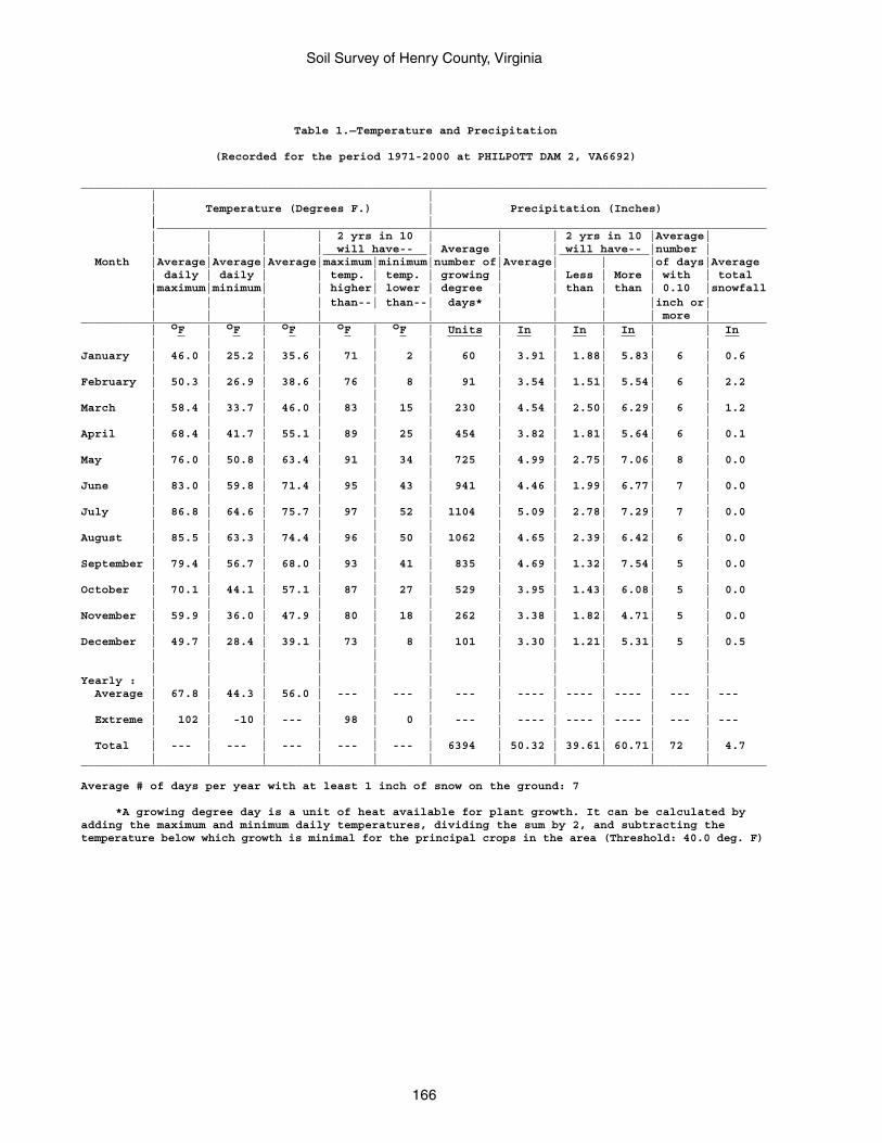
Soil Survey of Henry County, Virginia
166
Table 1.—Temperature and Precipitation
(Recorded for the period 1971-2000 at PHILPOTT DAM 2, VA6692)
___________________________________________________________________________________________________ | | | Temperature (Degrees F.) | Precipitation (Inches) | | |________________________________________________________________________________________ | | | | 2 yrs in 10 | | | 2 yrs in 10 |Average| | | | | will have-- | Average | | will have-- |number | Month |Average|Average|Average|maximum|minimum|number of|Average| | |of days|Average | daily | daily | | temp. | temp. | growing | | Less | More | with | total |maximum|minimum| | higher| lower | degree | | than | than | 0.10 |snowfall | | | | | than--| than--| days* | | | |inch or| | | | | | | | | | more |___________________________________________________________________________________________________ | oF | oF | oF | oF | oF | Units | In | In | In | | In | | | | | | | | | | |January | 46.0 | 25.2 | 35.6 | 71 | 2 | 60 | 3.91 | 1.88| 5.83| 6 | 0.6 | | | | | | | | | | |February | 50.3 | 26.9 | 38.6 | 76 | 8 | 91 | 3.54 | 1.51| 5.54| 6 | 2.2 | | | | | | | | | | |March | 58.4 | 33.7 | 46.0 | 83 | 15 | 230 | 4.54 | 2.50| 6.29| 6 | 1.2 | | | | | | | | | | |April | 68.4 | 41.7 | 55.1 | 89 | 25 | 454 | 3.82 | 1.81| 5.64| 6 | 0.1 | | | | | | | | | | |May | 76.0 | 50.8 | 63.4 | 91 | 34 | 725 | 4.99 | 2.75| 7.06| 8 | 0.0 | | | | | | | | | | |June | 83.0 | 59.8 | 71.4 | 95 | 43 | 941 | 4.46 | 1.99| 6.77| 7 | 0.0 | | | | | | | | | | |July | 86.8 | 64.6 | 75.7 | 97 | 52 | 1104 | 5.09 | 2.78| 7.29| 7 | 0.0 | | | | | | | | | | |August | 85.5 | 63.3 | 74.4 | 96 | 50 | 1062 | 4.65 | 2.39| 6.42| 6 | 0.0 | | | | | | | | | | |September | 79.4 | 56.7 | 68.0 | 93 | 41 | 835 | 4.69 | 1.32| 7.54| 5 | 0.0 | | | | | | | | | | |October | 70.1 | 44.1 | 57.1 | 87 | 27 | 529 | 3.95 | 1.43| 6.08| 5 | 0.0 | | | | | | | | | | |November | 59.9 | 36.0 | 47.9 | 80 | 18 | 262 | 3.38 | 1.82| 4.71| 5 | 0.0 | | | | | | | | | | |December | 49.7 | 28.4 | 39.1 | 73 | 8 | 101 | 3.30 | 1.21| 5.31| 5 | 0.5 | | | | | | | | | | | | | | | | | | | | | |Yearly : | | | | | | | | | | | Average | 67.8 | 44.3 | 56.0 | --- | --- | --- | ---- | ---- | ---- | --- | --- | | | | | | | | | | | Extreme | 102 | -10 | --- | 98 | 0 | --- | ---- | ---- | ---- | --- | --- | | | | | | | | | | | Total | --- | --- | --- | --- | --- | 6394 | 50.32 | 39.61| 60.71| 72 | 4.7 | | | | | | | | | | |___________________________________________________________________________________________________
Average # of days per year with at least 1 inch of snow on the ground: 7
*A growing degree day is a unit of heat available for plant growth. It can be calculated byadding the maximum and minimum daily temperatures, dividing the sum by 2, and subtracting thetemperature below which growth is minimal for the principal crops in the area (Threshold: 40.0 deg. F)
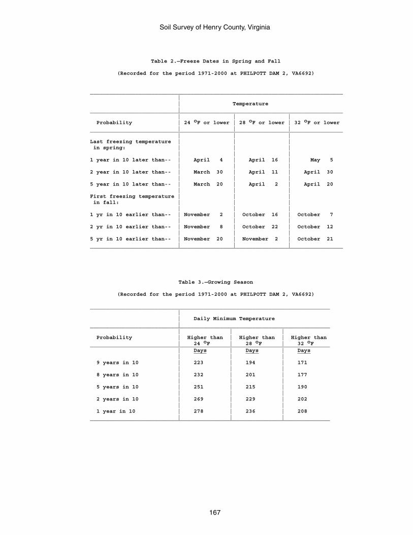
Soil Survey of Henry County, Virginia
167
Table 2.—Freeze Dates in Spring and Fall
(Recorded for the period 1971-2000 at PHILPOTT DAM 2, VA6692)
______________________________________________________________________________ | | Temperature | ______________________________________________________________________________ | | | Probability | 24 oF or lower | 28 oF or lower | 32 oF or lower | | | ______________________________________________________________________________ | | | Last freezing temperature | | | in spring: | | | | | | 1 year in 10 later than-- | April 4 | April 16 | May 5 | | | 2 year in 10 later than-- | March 30 | April 11 | April 30 | | | 5 year in 10 later than-- | March 20 | April 2 | April 20 | | | First freezing temperature | | | in fall: | | | | | | 1 yr in 10 earlier than-- | November 2 | October 16 | October 7 | | | 2 yr in 10 earlier than-- | November 8 | October 22 | October 12 | | | 5 yr in 10 earlier than-- | November 20 | November 2 | October 21 | | | ______________________________________________________________________________
Table 3.—Growing Season
(Recorded for the period 1971-2000 at PHILPOTT DAM 2, VA6692)
__________________________________________________________________________ | | Daily Minimum Temperature | __________________________________________________________________________ | | | Probability | Higher than | Higher than | Higher than | 24 oF | 28 oF | 32 oF __________________________________________________________________________ | Days | Days | Days | | | 9 years in 10 | 223 | 194 | 171 | | | 8 years in 10 | 232 | 201 | 177 | | | 5 years in 10 | 251 | 215 | 190 | | | 2 years in 10 | 269 | 229 | 202 | | | 1 year in 10 | 278 | 236 | 208 | | | __________________________________________________________________________
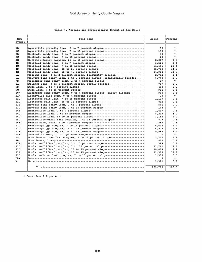
Soil Survey of Henry County, Virginia
168
Table 4.—Acreage and Proportionate Extent of the Soils_______________________________________________________________________________________________________ | | | Map | Soil name | Acres |Percentsymbol | | |_______|_________________________________________________________________________|____________|________ | | |1B |Ayersville gravelly loam, 2 to 7 percent slopes--------------------------| 55 | *1C |Ayersville gravelly loam, 7 to 15 percent slopes-------------------------| 190 | *2B |Buckhall sandy loam, 2 to 7 percent slopes-------------------------------| 43 | *2C |Buckhall sandy loam, 7 to 15 percent slopes------------------------------| 23 | *3E |Buffstat-Bugley complex, 25 to 60 percent slopes-------------------------| 2,307 | 0.94B |Clifford sandy loam, 2 to 7 percent slopes-------------------------------| 3,521 | 1.44C |Clifford sandy loam, 7 to 15 percent slopes------------------------------| 51,655 | 20.44D |Clifford sandy loam, 15 to 25 percent slopes-----------------------------| 35,783 | 14.24E |Clifford sandy loam, 25 to 45 percent slopes-----------------------------| 34,914 | 13.85A |Codorus loam, 0 to 2 percent slopes, frequently flooded------------------| 2,792 | 1.16A |Colvard fine sandy loam, 0 to 2 percent slopes, occasionally flooded-----| 6,740 | 2.77B |Creedmoor fine sandy loam, 1 to 4 percent slopes-------------------------| 17 | *8A |Delanco loam, 0 to 4 percent slopes, rarely flooded----------------------| 707 | 0.39B |Dyke loam, 2 to 7 percent slopes-----------------------------------------| 408 | 0.29C |Dyke loam, 7 to 15 percent slopes----------------------------------------| 911 | 0.410A |Elsinboro fine sandy loam, 0 to 4 percent slopes, rarely flooded---------| 900 | 0.411A |Leaksville silt loam, 0 to 4 percent slopes------------------------------| 23 | *12C |Littlejoe silt loam, 7 to 15 percent slopes------------------------------| 1,139 | 0.512D |Littlejoe silt loam, 15 to 25 percent slopes-----------------------------| 812 | 0.313B |Mayodan fine sandy loam, 2 to 7 percent slopes---------------------------| 541 | 0.213C |Mayodan fine sandy loam, 7 to 15 percent slopes--------------------------| 148 | *14B |Minnieville loam, 2 to 7 percent slopes----------------------------------| 1,437 | 0.614C |Minnieville loam, 7 to 15 percent slopes---------------------------------| 8,209 | 3.214D |Minnieville loam, 15 to 25 percent slopes--------------------------------| 3,152 | 1.215C |Minnieville-Urban land complex, 7 to 15 percent slopes-------------------| 879 | 0.316B |Orenda sandy loam, 2 to 7 percent slopes---------------------------------| 283 | 0.117C |Orenda-Spriggs complex, 7 to 15 percent slopes---------------------------| 4,404 | 1.717D |Orenda-Spriggs complex, 15 to 25 percent slopes--------------------------| 4,925 | 1.917E |Orenda-Spriggs complex, 25 to 45 percent slopes--------------------------| 5,583 | 2.218B |Stoneville loam, 2 to 7 percent slopes-----------------------------------| 1 | *19 |Udorthents-Urban land complex, 2 to 15 percent slopes--------------------| 3,217 | 1.320 |Udorthents, loamy--------------------------------------------------------| 832 | 0.321B |Woolwine-Clifford complex, 2 to 7 percent slopes-------------------------| 389 | 0.221C |Woolwine-Clifford complex, 7 to 15 percent slopes------------------------| 21,761 | 8.621D |Woolwine-Clifford complex, 15 to 25 percent slopes-----------------------| 18,019 | 7.121E |Woolwine-Clifford complex, 25 to 45 percent slopes-----------------------| 32,318 | 12.822C |Woolwine-Urban land complex, 7 to 15 percent slopes----------------------| 1,338 | 0.5DAM |Dam----------------------------------------------------------------------| 3 | *W |Water--------------------------------------------------------------------| 2,321 | 0.9 | |____________|________ | Total---------------------------------------------------------------| 252,700 | 100.0_______|_________________________________________________________________________|____________|________
* Less than 0.1 percent.
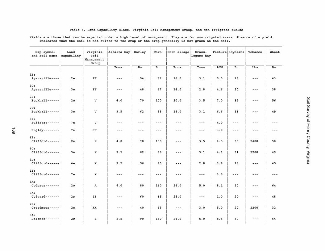
Soil S
urvey of Henry C
ounty, Virginia
169
Table 5.—Land Capability Class, Virginia Soil Management Group, and Non-Irrigated Yields
Yields are those that can be expected under a high level of management. They are for nonirrigated areas. Absence of a yield indicates that the soil is not suited to the crop or the crop generally is not grown on the soil.________________________________________________________________________________________________________________________________ | | | | | | | | | | | Map symbol | Land | Virginia |Alfalfa hay| Barley | Corn |Corn silage| Grass- |Pasture|Soybeans| Tobacco | Wheat and soil name |capability | Soil | | | | |legume hay| | | | | |Management | | | | | | | | | | | Group | | | | | | | | |_______________|___________|___________|___________|_________|_______|___________|__________|_______|________|_________|________ | | | Tons | Bu | Bu | Tons | Tons | AUM | Bu | Lbs | Bu | | | | | | | | | | |1B: | | | | | | | | | | | Ayersville----| 2e | FF | --- | 54 | 77 | 16.0 | 3.1 | 5.0 | 23 | --- | 43 | | | | | | | | | | |1C: | | | | | | | | | | | Ayersville----| 3e | FF | --- | 48 | 67 | 14.0 | 2.8 | 4.6 | 20 | --- | 38 | | | | | | | | | | |2B: | | | | | | | | | | | Buckhall------| 2e | V | 4.0 | 70 | 100 | 20.0 | 3.5 | 7.0 | 35 | --- | 56 | | | | | | | | | | |2C: | | | | | | | | | | | Buckhall------| 3e | V | 3.5 | 62 | 88 | 18.0 | 3.1 | 6.6 | 31 | --- | 49 | | | | | | | | | | |3E: | | | | | | | | | | | Buffstat------| 7e | V | --- | --- | --- | --- | --- | 4.0 | --- | --- | --- | | | | | | | | | | | Bugley--------| 7e | JJ | --- | --- | --- | --- | --- | 3.0 | --- | --- | --- | | | | | | | | | | |4B: | | | | | | | | | | | Clifford------| 2e | X | 4.0 | 70 | 100 | --- | 3.5 | 4.5 | 35 | 2400 | 56 | | | | | | | | | | |4C: | | | | | | | | | | | Clifford------| 3e | X | 3.5 | 62 | 88 | --- | 3.1 | 4.1 | 31 | 2200 | 49 | | | | | | | | | | |4D: | | | | | | | | | | | Clifford------| 4e | X | 3.2 | 56 | 80 | --- | 2.8 | 3.8 | 28 | --- | 45 | | | | | | | | | | |4E: | | | | | | | | | | | Clifford------| 7e | X | --- | --- | --- | --- | --- | 3.5 | --- | --- | --- | | | | | | | | | | |5A: | | | | | | | | | | | Codorus-------| 2w | A | 6.0 | 80 | 160 | 26.0 | 5.0 | 8.1 | 50 | --- | 64 | | | | | | | | | | |6A: | | | | | | | | | | | Colvard-------| 2s | II | --- | 60 | 65 | 25.0 | --- | 1.0 | 20 | --- | 48 | | | | | | | | | | |7B: | | | | | | | | | | | Creedmoor-----| 2e | KK | --- | 40 | 65 | --- | 3.0 | 5.0 | 20 | 2200 | 32 | | | | | | | | | | |8A: | | | | | | | | | | | Delanco-------| 2w | B | 5.5 | 90 | 160 | 24.0 | 5.0 | 8.5 | 50 | --- | 64 | | | | | | | | | | |
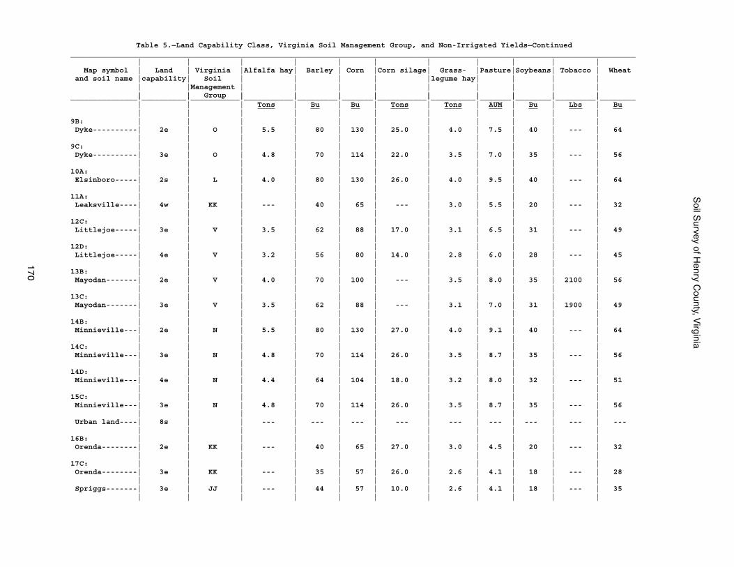
Soil S
urvey of Henry C
ounty, Virginia
170
Table 5.—Land Capability Class, Virginia Soil Management Group, and Non-Irrigated Yields—Continued_______________________________________________________________________________________________________________________________ | | | | | | | | | | | Map symbol | Land | Virginia |Alfalfa hay| Barley | Corn |Corn silage| Grass- |Pasture|Soybeans| Tobacco | Wheat and soil name |capability| Soil | | | | |legume hay| | | | | |Management | | | | | | | | | | | Group | | | | | | | | |_______________|__________|___________|___________|_________|_______|___________|__________|_______|________|_________|________ | | | Tons | Bu | Bu | Tons | Tons | AUM | Bu | Lbs | Bu | | | | | | | | | | |9B: | | | | | | | | | | | Dyke----------| 2e | O | 5.5 | 80 | 130 | 25.0 | 4.0 | 7.5 | 40 | --- | 64 | | | | | | | | | | |9C: | | | | | | | | | | | Dyke----------| 3e | O | 4.8 | 70 | 114 | 22.0 | 3.5 | 7.0 | 35 | --- | 56 | | | | | | | | | | |10A: | | | | | | | | | | | Elsinboro-----| 2s | L | 4.0 | 80 | 130 | 26.0 | 4.0 | 9.5 | 40 | --- | 64 | | | | | | | | | | |11A: | | | | | | | | | | | Leaksville----| 4w | KK | --- | 40 | 65 | --- | 3.0 | 5.5 | 20 | --- | 32 | | | | | | | | | | |12C: | | | | | | | | | | | Littlejoe-----| 3e | V | 3.5 | 62 | 88 | 17.0 | 3.1 | 6.5 | 31 | --- | 49 | | | | | | | | | | |12D: | | | | | | | | | | | Littlejoe-----| 4e | V | 3.2 | 56 | 80 | 14.0 | 2.8 | 6.0 | 28 | --- | 45 | | | | | | | | | | |13B: | | | | | | | | | | | Mayodan-------| 2e | V | 4.0 | 70 | 100 | --- | 3.5 | 8.0 | 35 | 2100 | 56 | | | | | | | | | | |13C: | | | | | | | | | | | Mayodan-------| 3e | V | 3.5 | 62 | 88 | --- | 3.1 | 7.0 | 31 | 1900 | 49 | | | | | | | | | | |14B: | | | | | | | | | | | Minnieville---| 2e | N | 5.5 | 80 | 130 | 27.0 | 4.0 | 9.1 | 40 | --- | 64 | | | | | | | | | | |14C: | | | | | | | | | | | Minnieville---| 3e | N | 4.8 | 70 | 114 | 26.0 | 3.5 | 8.7 | 35 | --- | 56 | | | | | | | | | | |14D: | | | | | | | | | | | Minnieville---| 4e | N | 4.4 | 64 | 104 | 18.0 | 3.2 | 8.0 | 32 | --- | 51 | | | | | | | | | | |15C: | | | | | | | | | | | Minnieville---| 3e | N | 4.8 | 70 | 114 | 26.0 | 3.5 | 8.7 | 35 | --- | 56 | | | | | | | | | | | Urban land----| 8s | | --- | --- | --- | --- | --- | --- | --- | --- | --- | | | | | | | | | | |16B: | | | | | | | | | | | Orenda--------| 2e | KK | --- | 40 | 65 | 27.0 | 3.0 | 4.5 | 20 | --- | 32 | | | | | | | | | | |17C: | | | | | | | | | | | Orenda--------| 3e | KK | --- | 35 | 57 | 26.0 | 2.6 | 4.1 | 18 | --- | 28 | | | | | | | | | | | Spriggs-------| 3e | JJ | --- | 44 | 57 | 10.0 | 2.6 | 4.1 | 18 | --- | 35 | | | | | | | | | | |
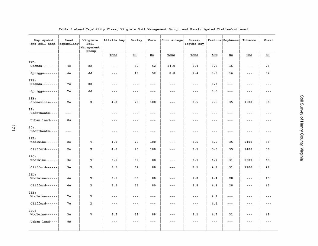
Soil S
urvey of Henry C
ounty, Virginia
171
Table 5.—Land Capability Class, Virginia Soil Management Group, and Non-Irrigated Yields—Continued________________________________________________________________________________________________________________________________ | | | | | | | | | | | Map symbol | Land | Virginia |Alfalfa hay| Barley | Corn |Corn silage| Grass- |Pasture|Soybeans| Tobacco | Wheat and soil name |capability| Soil | | | | |legume hay | | | | | |Management | | | | | | | | | | | Group | | | | | | | | |_______________|__________|___________|___________|_________|_______|___________|___________|_______|________|_________|________ | | | Tons | Bu | Bu | Tons | Tons | AUM | Bu | Lbs | Bu | | | | | | | | | | |17D: | | | | | | | | | | | Orenda--------| 4e | KK | --- | 32 | 52 | 24.0 | 2.4 | 3.8 | 16 | --- | 26 | | | | | | | | | | | Spriggs-------| 4e | JJ | --- | 40 | 52 | 8.0 | 2.4 | 3.8 | 16 | --- | 32 | | | | | | | | | | |17E: | | | | | | | | | | | Orenda--------| 7e | KK | --- | --- | --- | --- | --- | 3.6 | --- | --- | --- | | | | | | | | | | | Spriggs-------| 7e | JJ | --- | --- | --- | --- | --- | 3.5 | --- | --- | --- | | | | | | | | | | |18B: | | | | | | | | | | | Stoneville----| 2e | X | 4.0 | 70 | 100 | --- | 3.5 | 7.5 | 35 | 1600 | 56 | | | | | | | | | | |19: | | | | | | | | | | | Udorthents----| --- | | --- | --- | --- | --- | --- | --- | --- | --- | --- | | | | | | | | | | | Urban land----| 8s | | --- | --- | --- | --- | --- | --- | --- | --- | --- | | | | | | | | | | |20: | | | | | | | | | | | Udorthents----| --- | | --- | --- | --- | --- | --- | --- | --- | --- | --- | | | | | | | | | | |21B: | | | | | | | | | | | Woolwine------| 2e | V | 4.0 | 70 | 100 | --- | 3.5 | 5.0 | 35 | 2400 | 56 | | | | | | | | | | | Clifford------| 2e | X | 4.0 | 70 | 100 | --- | 3.5 | 5.0 | 35 | 2400 | 56 | | | | | | | | | | |21C: | | | | | | | | | | | Woolwine------| 3e | V | 3.5 | 62 | 88 | --- | 3.1 | 4.7 | 31 | 2200 | 49 | | | | | | | | | | | Clifford------| 3e | X | 3.5 | 62 | 88 | --- | 3.1 | 4.7 | 31 | 2200 | 49 | | | | | | | | | | |21D: | | | | | | | | | | | Woolwine------| 4e | V | 3.5 | 56 | 80 | --- | 2.8 | 4.4 | 28 | --- | 45 | | | | | | | | | | | Clifford------| 4e | X | 3.5 | 56 | 80 | --- | 2.8 | 4.4 | 28 | --- | 45 | | | | | | | | | | |21E: | | | | | | | | | | | Woolwine------| 7e | V | --- | --- | --- | --- | --- | 4.1 | --- | --- | --- | | | | | | | | | | | Clifford------| 7e | X | --- | --- | --- | --- | --- | 4.1 | --- | --- | --- | | | | | | | | | | |22C: | | | | | | | | | | | Woolwine------| 3e | V | 3.5 | 62 | 88 | --- | 3.1 | 4.7 | 31 | --- | 49 | | | | | | | | | | | Urban land----| 8s | | --- | --- | --- | --- | --- | --- | --- | --- | --- | | | | | | | | | | | | | | | | | | | | | |____________________________________________________________________________________________________________________________________
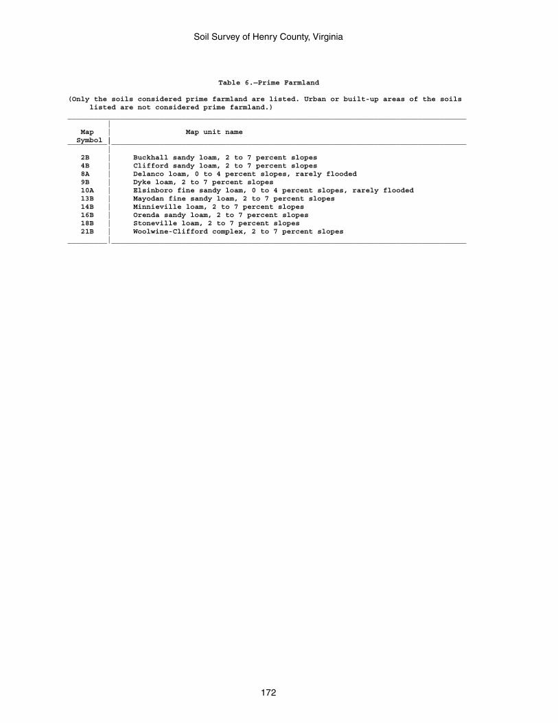
Soil Survey of Henry County, Virginia
172
Table 6.—Prime Farmland
(Only the soils considered prime farmland are listed. Urban or built-up areas of the soils listed are not considered prime farmland.)___________________________________________________________________________________________ | Map | Map unit name Symbol |_________|_________________________________________________________________________________ | 2B | Buckhall sandy loam, 2 to 7 percent slopes 4B | Clifford sandy loam, 2 to 7 percent slopes 8A | Delanco loam, 0 to 4 percent slopes, rarely flooded 9B | Dyke loam, 2 to 7 percent slopes 10A | Elsinboro fine sandy loam, 0 to 4 percent slopes, rarely flooded 13B | Mayodan fine sandy loam, 2 to 7 percent slopes 14B | Minnieville loam, 2 to 7 percent slopes 16B | Orenda sandy loam, 2 to 7 percent slopes 18B | Stoneville loam, 2 to 7 percent slopes 21B | Woolwine-Clifford complex, 2 to 7 percent slopes_________|_________________________________________________________________________________
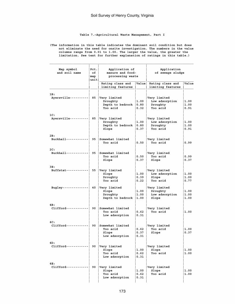
Soil Survey of Henry County, Virginia
173
Table 7.—Agricultural Waste Management, Part I
(The information in this table indicates the dominant soil condition but does not eliminate the need for onsite investigation. The numbers in the value columns range from 0.01 to 1.00. The larger the value, the greater the limitation. See text for further explanation of ratings in this table.)
______________________________________________________________________________ | | | Map symbol |Pct.| Application of | Application and soil name | of | manure and food- | of sewage sludge |map | processing waste | |unit| | | |_________________________|_________________________ | | Rating class and |Value| Rating class and |Value | | limiting features | | limiting features |_____________________|____|___________________|_____|___________________|_____ | | | | |1B: | | | | | Ayersville----------| 85 |Very limited | |Very limited | | | Droughty |1.00 | Low adsorption |1.00 | | Depth to bedrock |0.80 | Droughty |1.00 | | Too acid |0.32 | Too acid |0.91 | | | | |1C: | | | | | Ayersville----------| 85 |Very limited | |Very limited | | | Droughty |1.00 | Low adsorption |1.00 | | Depth to bedrock |0.80 | Droughty |1.00 | | Slope |0.37 | Too acid |0.91 | | | | |2B: | | | | | Buckhall------------| 95 |Somewhat limited | |Very limited | | | Too acid |0.50 | Too acid |0.99 | | | | |2C: | | | | | Buckhall------------| 95 |Somewhat limited | |Very limited | | | Too acid |0.50 | Too acid |0.99 | | Slope |0.37 | Slope |0.37 | | | | |3E: | | | | | Buffstat------------| 55 |Very limited | |Very limited | | | Slope |1.00 | Low adsorption |1.00 | | Droughty |0.39 | Slope |1.00 | | Too acid |0.22 | Too acid |0.77 | | | | | Bugley--------------| 40 |Very limited | |Very limited | | | Slope |1.00 | Droughty |1.00 | | Droughty |1.00 | Low adsorption |1.00 | | Depth to bedrock |1.00 | Slope |1.00 | | | | |4B: | | | | | Clifford------------| 90 |Somewhat limited | |Very limited | | | Too acid |0.62 | Too acid |1.00 | | Low adsorption |0.31 | | | | | | |4C: | | | | | Clifford------------| 90 |Somewhat limited | |Very limited | | | Too acid |0.62 | Too acid |1.00 | | Slope |0.37 | Slope |0.37 | | Low adsorption |0.31 | | | | | | |4D: | | | | | Clifford------------| 90 |Very limited | |Very limited | | | Slope |1.00 | Slope |1.00 | | Too acid |0.62 | Too acid |1.00 | | Low adsorption |0.31 | | | | | | |4E: | | | | | Clifford------------| 90 |Very limited | |Very limited | | | Slope |1.00 | Slope |1.00 | | Too acid |0.62 | Too acid |1.00 | | Low adsorption |0.31 | | | | | | |
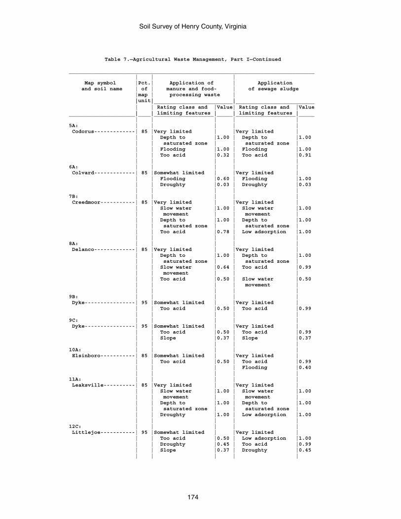
Soil Survey of Henry County, Virginia
174
Table 7.—Agricultural Waste Management, Part I—Continued
______________________________________________________________________________ | | | Map symbol |Pct.| Application of | Application and soil name | of | manure and food- | of sewage sludge |map | processing waste | |unit| | | |_________________________|_________________________ | | Rating class and |Value| Rating class and |Value | | limiting features | | limiting features |_____________________|____|___________________|_____|___________________|_____ | | | | |5A: | | | | | Codorus-------------| 85 |Very limited | |Very limited | | | Depth to |1.00 | Depth to |1.00 | | saturated zone | | saturated zone | | | Flooding |1.00 | Flooding |1.00 | | Too acid |0.32 | Too acid |0.91 | | | | |6A: | | | | | Colvard-------------| 85 |Somewhat limited | |Very limited | | | Flooding |0.60 | Flooding |1.00 | | Droughty |0.03 | Droughty |0.03 | | | | |7B: | | | | | Creedmoor-----------| 85 |Very limited | |Very limited | | | Slow water |1.00 | Slow water |1.00 | | movement | | movement | | | Depth to |1.00 | Depth to |1.00 | | saturated zone | | saturated zone | | | Too acid |0.78 | Low adsorption |1.00 | | | | |8A: | | | | | Delanco-------------| 85 |Very limited | |Very limited | | | Depth to |1.00 | Depth to |1.00 | | saturated zone | | saturated zone | | | Slow water |0.64 | Too acid |0.99 | | movement | | | | | Too acid |0.50 | Slow water |0.50 | | | | movement | | | | | |9B: | | | | | Dyke----------------| 95 |Somewhat limited | |Very limited | | | Too acid |0.50 | Too acid |0.99 | | | | |9C: | | | | | Dyke----------------| 95 |Somewhat limited | |Very limited | | | Too acid |0.50 | Too acid |0.99 | | Slope |0.37 | Slope |0.37 | | | | |10A: | | | | | Elsinboro-----------| 85 |Somewhat limited | |Very limited | | | Too acid |0.50 | Too acid |0.99 | | | | Flooding |0.40 | | | | |11A: | | | | | Leaksville----------| 85 |Very limited | |Very limited | | | Slow water |1.00 | Slow water |1.00 | | movement | | movement | | | Depth to |1.00 | Depth to |1.00 | | saturated zone | | saturated zone | | | Droughty |1.00 | Low adsorption |1.00 | | | | |12C: | | | | | Littlejoe-----------| 95 |Somewhat limited | |Very limited | | | Too acid |0.50 | Low adsorption |1.00 | | Droughty |0.45 | Too acid |0.99 | | Slope |0.37 | Droughty |0.45 | | | | |
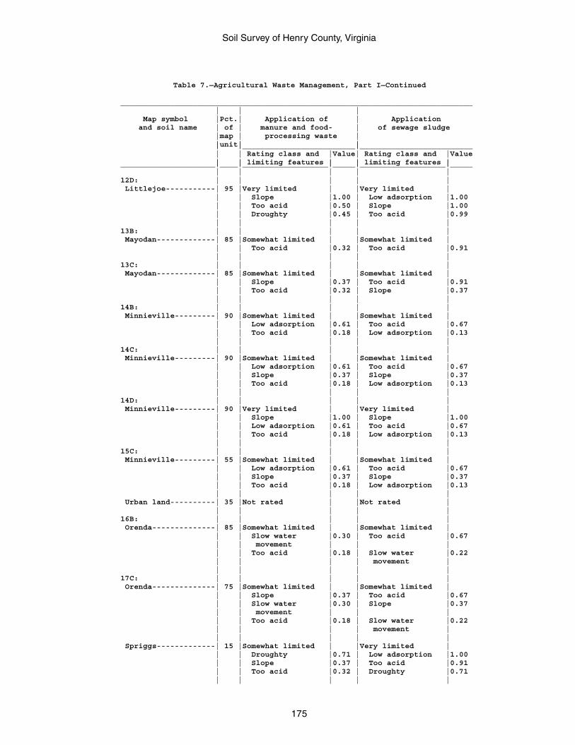
Soil Survey of Henry County, Virginia
175
Table 7.—Agricultural Waste Management, Part I—Continued
______________________________________________________________________________ | | | Map symbol |Pct.| Application of | Application and soil name | of | manure and food- | of sewage sludge |map | processing waste | |unit| | | |_________________________|_________________________ | | Rating class and |Value| Rating class and |Value | | limiting features | | limiting features |_____________________|____|___________________|_____|___________________|_____ | | | | |12D: | | | | | Littlejoe-----------| 95 |Very limited | |Very limited | | | Slope |1.00 | Low adsorption |1.00 | | Too acid |0.50 | Slope |1.00 | | Droughty |0.45 | Too acid |0.99 | | | | |13B: | | | | | Mayodan-------------| 85 |Somewhat limited | |Somewhat limited | | | Too acid |0.32 | Too acid |0.91 | | | | |13C: | | | | | Mayodan-------------| 85 |Somewhat limited | |Somewhat limited | | | Slope |0.37 | Too acid |0.91 | | Too acid |0.32 | Slope |0.37 | | | | |14B: | | | | | Minnieville---------| 90 |Somewhat limited | |Somewhat limited | | | Low adsorption |0.61 | Too acid |0.67 | | Too acid |0.18 | Low adsorption |0.13 | | | | |14C: | | | | | Minnieville---------| 90 |Somewhat limited | |Somewhat limited | | | Low adsorption |0.61 | Too acid |0.67 | | Slope |0.37 | Slope |0.37 | | Too acid |0.18 | Low adsorption |0.13 | | | | |14D: | | | | | Minnieville---------| 90 |Very limited | |Very limited | | | Slope |1.00 | Slope |1.00 | | Low adsorption |0.61 | Too acid |0.67 | | Too acid |0.18 | Low adsorption |0.13 | | | | |15C: | | | | | Minnieville---------| 55 |Somewhat limited | |Somewhat limited | | | Low adsorption |0.61 | Too acid |0.67 | | Slope |0.37 | Slope |0.37 | | Too acid |0.18 | Low adsorption |0.13 | | | | | Urban land----------| 35 |Not rated | |Not rated | | | | | |16B: | | | | | Orenda--------------| 85 |Somewhat limited | |Somewhat limited | | | Slow water |0.30 | Too acid |0.67 | | movement | | | | | Too acid |0.18 | Slow water |0.22 | | | | movement | | | | | |17C: | | | | | Orenda--------------| 75 |Somewhat limited | |Somewhat limited | | | Slope |0.37 | Too acid |0.67 | | Slow water |0.30 | Slope |0.37 | | movement | | | | | Too acid |0.18 | Slow water |0.22 | | | | movement | | | | | | Spriggs-------------| 15 |Somewhat limited | |Very limited | | | Droughty |0.71 | Low adsorption |1.00 | | Slope |0.37 | Too acid |0.91 | | Too acid |0.32 | Droughty |0.71 | | | | |
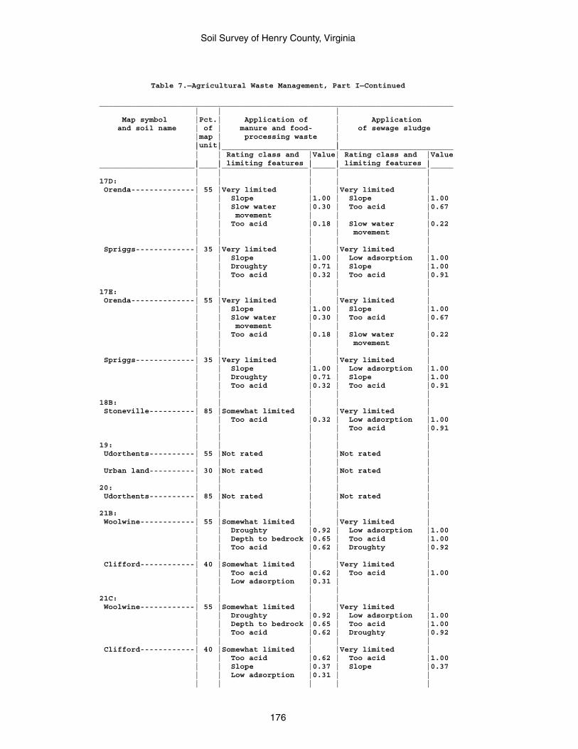
Soil Survey of Henry County, Virginia
176
Table 7.—Agricultural Waste Management, Part I—Continued
______________________________________________________________________________ | | | Map symbol |Pct.| Application of | Application and soil name | of | manure and food- | of sewage sludge |map | processing waste | |unit| | | |_________________________|_________________________ | | Rating class and |Value| Rating class and |Value | | limiting features | | limiting features |_____________________|____|___________________|_____|___________________|_____ | | | | |17D: | | | | | Orenda--------------| 55 |Very limited | |Very limited | | | Slope |1.00 | Slope |1.00 | | Slow water |0.30 | Too acid |0.67 | | movement | | | | | Too acid |0.18 | Slow water |0.22 | | | | movement | | | | | | Spriggs-------------| 35 |Very limited | |Very limited | | | Slope |1.00 | Low adsorption |1.00 | | Droughty |0.71 | Slope |1.00 | | Too acid |0.32 | Too acid |0.91 | | | | |17E: | | | | | Orenda--------------| 55 |Very limited | |Very limited | | | Slope |1.00 | Slope |1.00 | | Slow water |0.30 | Too acid |0.67 | | movement | | | | | Too acid |0.18 | Slow water |0.22 | | | | movement | | | | | | Spriggs-------------| 35 |Very limited | |Very limited | | | Slope |1.00 | Low adsorption |1.00 | | Droughty |0.71 | Slope |1.00 | | Too acid |0.32 | Too acid |0.91 | | | | |18B: | | | | | Stoneville----------| 85 |Somewhat limited | |Very limited | | | Too acid |0.32 | Low adsorption |1.00 | | | | Too acid |0.91 | | | | |19: | | | | | Udorthents----------| 55 |Not rated | |Not rated | | | | | | Urban land----------| 30 |Not rated | |Not rated | | | | | |20: | | | | | Udorthents----------| 85 |Not rated | |Not rated | | | | | |21B: | | | | | Woolwine------------| 55 |Somewhat limited | |Very limited | | | Droughty |0.92 | Low adsorption |1.00 | | Depth to bedrock |0.65 | Too acid |1.00 | | Too acid |0.62 | Droughty |0.92 | | | | | Clifford------------| 40 |Somewhat limited | |Very limited | | | Too acid |0.62 | Too acid |1.00 | | Low adsorption |0.31 | | | | | | |21C: | | | | | Woolwine------------| 55 |Somewhat limited | |Very limited | | | Droughty |0.92 | Low adsorption |1.00 | | Depth to bedrock |0.65 | Too acid |1.00 | | Too acid |0.62 | Droughty |0.92 | | | | | Clifford------------| 40 |Somewhat limited | |Very limited | | | Too acid |0.62 | Too acid |1.00 | | Slope |0.37 | Slope |0.37 | | Low adsorption |0.31 | | | | | | |
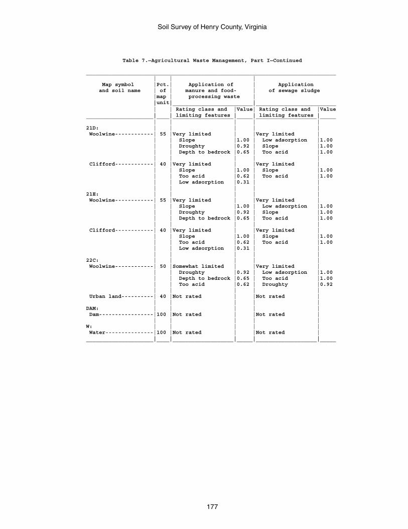
Soil Survey of Henry County, Virginia
177
Table 7.—Agricultural Waste Management, Part I—Continued
______________________________________________________________________________ | | | Map symbol |Pct.| Application of | Application and soil name | of | manure and food- | of sewage sludge |map | processing waste | |unit| | | |_________________________|_________________________ | | Rating class and |Value| Rating class and |Value | | limiting features | | limiting features |_____________________|____|___________________|_____|___________________|_____ | | | | |21D: | | | | | Woolwine------------| 55 |Very limited | |Very limited | | | Slope |1.00 | Low adsorption |1.00 | | Droughty |0.92 | Slope |1.00 | | Depth to bedrock |0.65 | Too acid |1.00 | | | | | Clifford------------| 40 |Very limited | |Very limited | | | Slope |1.00 | Slope |1.00 | | Too acid |0.62 | Too acid |1.00 | | Low adsorption |0.31 | | | | | | |21E: | | | | | Woolwine------------| 55 |Very limited | |Very limited | | | Slope |1.00 | Low adsorption |1.00 | | Droughty |0.92 | Slope |1.00 | | Depth to bedrock |0.65 | Too acid |1.00 | | | | | Clifford------------| 40 |Very limited | |Very limited | | | Slope |1.00 | Slope |1.00 | | Too acid |0.62 | Too acid |1.00 | | Low adsorption |0.31 | | | | | | |22C: | | | | | Woolwine------------| 50 |Somewhat limited | |Very limited | | | Droughty |0.92 | Low adsorption |1.00 | | Depth to bedrock |0.65 | Too acid |1.00 | | Too acid |0.62 | Droughty |0.92 | | | | | Urban land----------| 40 |Not rated | |Not rated | | | | | |DAM: | | | | | Dam-----------------|100 |Not rated | |Not rated | | | | | |W: | | | | | Water---------------|100 |Not rated | |Not rated | | | | | |_____________________|____|___________________|_____|___________________|_____
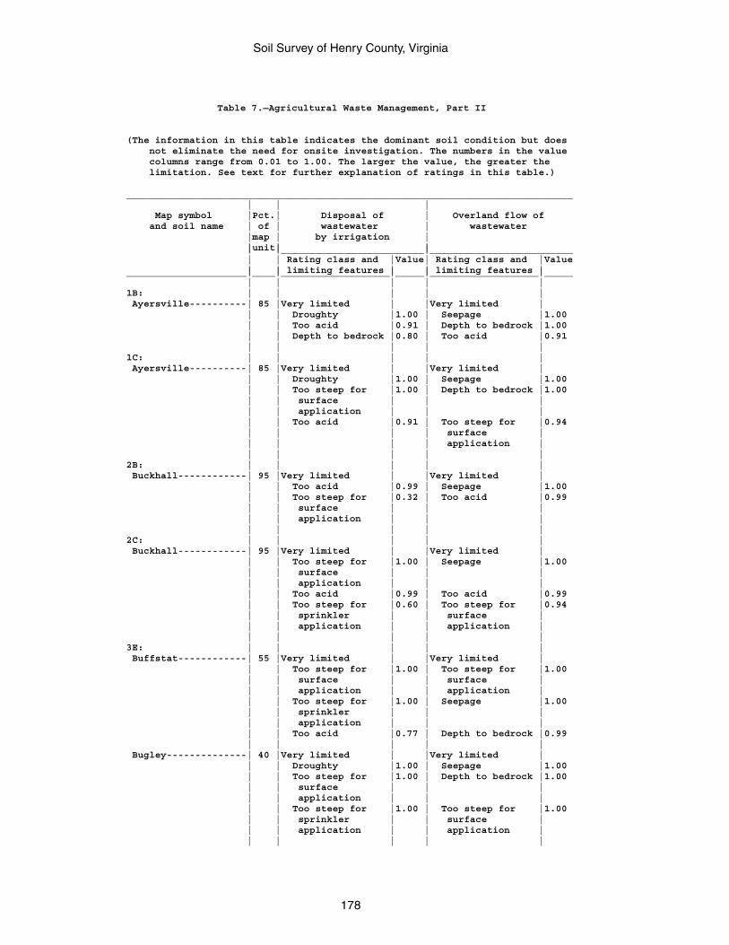
Soil Survey of Henry County, Virginia
178
Table 7.—Agricultural Waste Management, Part II
(The information in this table indicates the dominant soil condition but does not eliminate the need for onsite investigation. The numbers in the value columns range from 0.01 to 1.00. The larger the value, the greater the limitation. See text for further explanation of ratings in this table.)
______________________________________________________________________________ | | | Map symbol |Pct.| Disposal of | Overland flow of and soil name | of | wastewater | wastewater |map | by irrigation | |unit| | | |_________________________|_________________________ | | Rating class and |Value| Rating class and |Value | | limiting features | | limiting features |_____________________|____|___________________|_____|___________________|_____ | | | | |1B: | | | | | Ayersville----------| 85 |Very limited | |Very limited | | | Droughty |1.00 | Seepage |1.00 | | Too acid |0.91 | Depth to bedrock |1.00 | | Depth to bedrock |0.80 | Too acid |0.91 | | | | |1C: | | | | | Ayersville----------| 85 |Very limited | |Very limited | | | Droughty |1.00 | Seepage |1.00 | | Too steep for |1.00 | Depth to bedrock |1.00 | | surface | | | | | application | | | | | Too acid |0.91 | Too steep for |0.94 | | | | surface | | | | | application | | | | | |2B: | | | | | Buckhall------------| 95 |Very limited | |Very limited | | | Too acid |0.99 | Seepage |1.00 | | Too steep for |0.32 | Too acid |0.99 | | surface | | | | | application | | | | | | | |2C: | | | | | Buckhall------------| 95 |Very limited | |Very limited | | | Too steep for |1.00 | Seepage |1.00 | | surface | | | | | application | | | | | Too acid |0.99 | Too acid |0.99 | | Too steep for |0.60 | Too steep for |0.94 | | sprinkler | | surface | | | application | | application | | | | | |3E: | | | | | Buffstat------------| 55 |Very limited | |Very limited | | | Too steep for |1.00 | Too steep for |1.00 | | surface | | surface | | | application | | application | | | Too steep for |1.00 | Seepage |1.00 | | sprinkler | | | | | application | | | | | Too acid |0.77 | Depth to bedrock |0.99 | | | | | Bugley--------------| 40 |Very limited | |Very limited | | | Droughty |1.00 | Seepage |1.00 | | Too steep for |1.00 | Depth to bedrock |1.00 | | surface | | | | | application | | | | | Too steep for |1.00 | Too steep for |1.00 | | sprinkler | | surface | | | application | | application | | | | | |
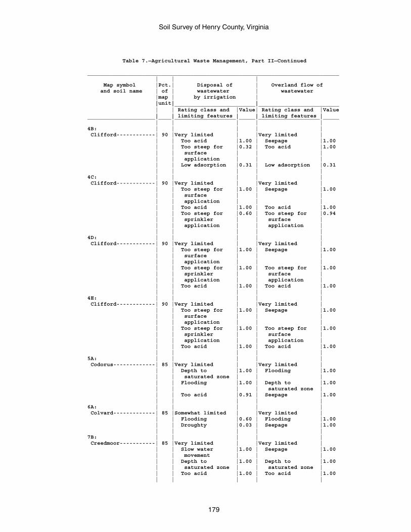
Soil Survey of Henry County, Virginia
179
Table 7.—Agricultural Waste Management, Part II—Continued
______________________________________________________________________________ | | | Map symbol |Pct.| Disposal of | Overland flow of and soil name | of | wastewater | wastewater |map | by irrigation | |unit| | | |_________________________|_________________________ | | Rating class and |Value| Rating class and |Value | | limiting features | | limiting features |_____________________|____|___________________|_____|___________________|_____ | | | | |4B: | | | | | Clifford------------| 90 |Very limited | |Very limited | | | Too acid |1.00 | Seepage |1.00 | | Too steep for |0.32 | Too acid |1.00 | | surface | | | | | application | | | | | Low adsorption |0.31 | Low adsorption |0.31 | | | | |4C: | | | | | Clifford------------| 90 |Very limited | |Very limited | | | Too steep for |1.00 | Seepage |1.00 | | surface | | | | | application | | | | | Too acid |1.00 | Too acid |1.00 | | Too steep for |0.60 | Too steep for |0.94 | | sprinkler | | surface | | | application | | application | | | | | |4D: | | | | | Clifford------------| 90 |Very limited | |Very limited | | | Too steep for |1.00 | Seepage |1.00 | | surface | | | | | application | | | | | Too steep for |1.00 | Too steep for |1.00 | | sprinkler | | surface | | | application | | application | | | Too acid |1.00 | Too acid |1.00 | | | | |4E: | | | | | Clifford------------| 90 |Very limited | |Very limited | | | Too steep for |1.00 | Seepage |1.00 | | surface | | | | | application | | | | | Too steep for |1.00 | Too steep for |1.00 | | sprinkler | | surface | | | application | | application | | | Too acid |1.00 | Too acid |1.00 | | | | |5A: | | | | | Codorus-------------| 85 |Very limited | |Very limited | | | Depth to |1.00 | Flooding |1.00 | | saturated zone | | | | | Flooding |1.00 | Depth to |1.00 | | | | saturated zone | | | Too acid |0.91 | Seepage |1.00 | | | | |6A: | | | | | Colvard-------------| 85 |Somewhat limited | |Very limited | | | Flooding |0.60 | Flooding |1.00 | | Droughty |0.03 | Seepage |1.00 | | | | |7B: | | | | | Creedmoor-----------| 85 |Very limited | |Very limited | | | Slow water |1.00 | Seepage |1.00 | | movement | | | | | Depth to |1.00 | Depth to |1.00 | | saturated zone | | saturated zone | | | Too acid |1.00 | Too acid |1.00 | | | | |
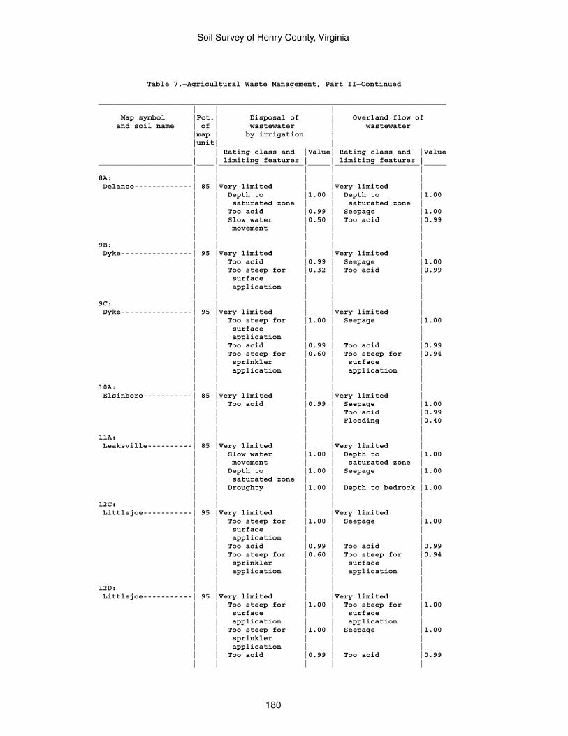
Soil Survey of Henry County, Virginia
180
Table 7.—Agricultural Waste Management, Part II—Continued
______________________________________________________________________________ | | | Map symbol |Pct.| Disposal of | Overland flow of and soil name | of | wastewater | wastewater |map | by irrigation | |unit| | | |_________________________|_________________________ | | Rating class and |Value| Rating class and |Value | | limiting features | | limiting features |_____________________|____|___________________|_____|___________________|_____ | | | | |8A: | | | | | Delanco-------------| 85 |Very limited | |Very limited | | | Depth to |1.00 | Depth to |1.00 | | saturated zone | | saturated zone | | | Too acid |0.99 | Seepage |1.00 | | Slow water |0.50 | Too acid |0.99 | | movement | | | | | | | |9B: | | | | | Dyke----------------| 95 |Very limited | |Very limited | | | Too acid |0.99 | Seepage |1.00 | | Too steep for |0.32 | Too acid |0.99 | | surface | | | | | application | | | | | | | |9C: | | | | | Dyke----------------| 95 |Very limited | |Very limited | | | Too steep for |1.00 | Seepage |1.00 | | surface | | | | | application | | | | | Too acid |0.99 | Too acid |0.99 | | Too steep for |0.60 | Too steep for |0.94 | | sprinkler | | surface | | | application | | application | | | | | |10A: | | | | | Elsinboro-----------| 85 |Very limited | |Very limited | | | Too acid |0.99 | Seepage |1.00 | | | | Too acid |0.99 | | | | Flooding |0.40 | | | | |11A: | | | | | Leaksville----------| 85 |Very limited | |Very limited | | | Slow water |1.00 | Depth to |1.00 | | movement | | saturated zone | | | Depth to |1.00 | Seepage |1.00 | | saturated zone | | | | | Droughty |1.00 | Depth to bedrock |1.00 | | | | |12C: | | | | | Littlejoe-----------| 95 |Very limited | |Very limited | | | Too steep for |1.00 | Seepage |1.00 | | surface | | | | | application | | | | | Too acid |0.99 | Too acid |0.99 | | Too steep for |0.60 | Too steep for |0.94 | | sprinkler | | surface | | | application | | application | | | | | |12D: | | | | | Littlejoe-----------| 95 |Very limited | |Very limited | | | Too steep for |1.00 | Too steep for |1.00 | | surface | | surface | | | application | | application | | | Too steep for |1.00 | Seepage |1.00 | | sprinkler | | | | | application | | | | | Too acid |0.99 | Too acid |0.99 | | | | |
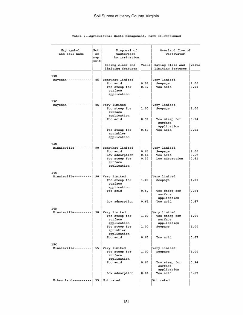
Soil Survey of Henry County, Virginia
181
Table 7.—Agricultural Waste Management, Part II—Continued
______________________________________________________________________________ | | | Map symbol |Pct.| Disposal of | Overland flow of and soil name | of | wastewater | wastewater |map | by irrigation | |unit| | | |_________________________|_________________________ | | Rating class and |Value| Rating class and |Value | | limiting features | | limiting features |_____________________|____|___________________|_____|___________________|_____ | | | | |13B: | | | | | Mayodan-------------| 85 |Somewhat limited | |Very limited | | | Too acid |0.91 | Seepage |1.00 | | Too steep for |0.32 | Too acid |0.91 | | surface | | | | | application | | | | | | | |13C: | | | | | Mayodan-------------| 85 |Very limited | |Very limited | | | Too steep for |1.00 | Seepage |1.00 | | surface | | | | | application | | | | | Too acid |0.91 | Too steep for |0.94 | | | | surface | | | | | application | | | Too steep for |0.60 | Too acid |0.91 | | sprinkler | | | | | application | | | | | | | |14B: | | | | | Minnieville---------| 90 |Somewhat limited | |Very limited | | | Too acid |0.67 | Seepage |1.00 | | Low adsorption |0.61 | Too acid |0.67 | | Too steep for |0.32 | Low adsorption |0.61 | | surface | | | | | application | | | | | | | |14C: | | | | | Minnieville---------| 90 |Very limited | |Very limited | | | Too steep for |1.00 | Seepage |1.00 | | surface | | | | | application | | | | | Too acid |0.67 | Too steep for |0.94 | | | | surface | | | | | application | | | Low adsorption |0.61 | Too acid |0.67 | | | | |14D: | | | | | Minnieville---------| 90 |Very limited | |Very limited | | | Too steep for |1.00 | Too steep for |1.00 | | surface | | surface | | | application | | application | | | Too steep for |1.00 | Seepage |1.00 | | sprinkler | | | | | application | | | | | Too acid |0.67 | Too acid |0.67 | | | | |15C: | | | | | Minnieville---------| 55 |Very limited | |Very limited | | | Too steep for |1.00 | Seepage |1.00 | | surface | | | | | application | | | | | Too acid |0.67 | Too steep for |0.94 | | | | surface | | | | | application | | | Low adsorption |0.61 | Too acid |0.67 | | | | | Urban land----------| 35 |Not rated | |Not rated | | | | | |
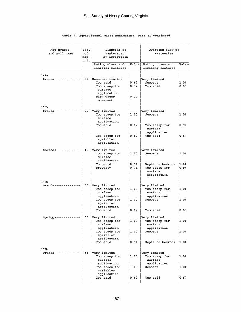
Soil Survey of Henry County, Virginia
182
Table 7.—Agricultural Waste Management, Part II—Continued
______________________________________________________________________________ | | | Map symbol |Pct.| Disposal of | Overland flow of and soil name | of | wastewater | wastewater |map | by irrigation | |unit| | | |_________________________|_________________________ | | Rating class and |Value| Rating class and |Value | | limiting features | | limiting features |_____________________|____|___________________|_____|___________________|_____ | | | | |16B: | | | | | Orenda--------------| 85 |Somewhat limited | |Very limited | | | Too acid |0.67 | Seepage |1.00 | | Too steep for |0.32 | Too acid |0.67 | | surface | | | | | application | | | | | Slow water |0.22 | | | | movement | | | | | | | |17C: | | | | | Orenda--------------| 75 |Very limited | |Very limited | | | Too steep for |1.00 | Seepage |1.00 | | surface | | | | | application | | | | | Too acid |0.67 | Too steep for |0.94 | | | | surface | | | | | application | | | Too steep for |0.60 | Too acid |0.67 | | sprinkler | | | | | application | | | | | | | | Spriggs-------------| 15 |Very limited | |Very limited | | | Too steep for |1.00 | Seepage |1.00 | | surface | | | | | application | | | | | Too acid |0.91 | Depth to bedrock |1.00 | | Droughty |0.71 | Too steep for |0.94 | | | | surface | | | | | application | | | | | |17D: | | | | | Orenda--------------| 55 |Very limited | |Very limited | | | Too steep for |1.00 | Too steep for |1.00 | | surface | | surface | | | application | | application | | | Too steep for |1.00 | Seepage |1.00 | | sprinkler | | | | | application | | | | | Too acid |0.67 | Too acid |0.67 | | | | | Spriggs-------------| 35 |Very limited | |Very limited | | | Too steep for |1.00 | Too steep for |1.00 | | surface | | surface | | | application | | application | | | Too steep for |1.00 | Seepage |1.00 | | sprinkler | | | | | application | | | | | Too acid |0.91 | Depth to bedrock |1.00 | | | | |17E: | | | | | Orenda--------------| 55 |Very limited | |Very limited | | | Too steep for |1.00 | Too steep for |1.00 | | surface | | surface | | | application | | application | | | Too steep for |1.00 | Seepage |1.00 | | sprinkler | | | | | application | | | | | Too acid |0.67 | Too acid |0.67 | | | | |
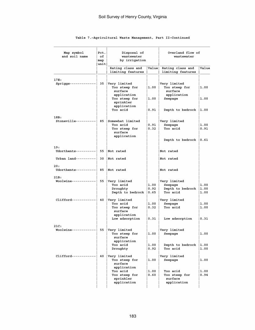
Soil Survey of Henry County, Virginia
183
Table 7.—Agricultural Waste Management, Part II—Continued
______________________________________________________________________________ | | | Map symbol |Pct.| Disposal of | Overland flow of and soil name | of | wastewater | wastewater |map | by irrigation | |unit| | | |_________________________|_________________________ | | Rating class and |Value| Rating class and |Value | | limiting features | | limiting features |_____________________|____|___________________|_____|___________________|_____ | | | | |17E: | | | | | Spriggs-------------| 35 |Very limited | |Very limited | | | Too steep for |1.00 | Too steep for |1.00 | | surface | | surface | | | application | | application | | | Too steep for |1.00 | Seepage |1.00 | | sprinkler | | | | | application | | | | | Too acid |0.91 | Depth to bedrock |1.00 | | | | |18B: | | | | | Stoneville----------| 85 |Somewhat limited | |Very limited | | | Too acid |0.91 | Seepage |1.00 | | Too steep for |0.32 | Too acid |0.91 | | surface | | | | | application | | | | | | | Depth to bedrock |0.61 | | | | |19: | | | | | Udorthents----------| 55 |Not rated | |Not rated | | | | | | Urban land----------| 30 |Not rated | |Not rated | | | | | |20: | | | | | Udorthents----------| 85 |Not rated | |Not rated | | | | | |21B: | | | | | Woolwine------------| 55 |Very limited | |Very limited | | | Too acid |1.00 | Seepage |1.00 | | Droughty |0.92 | Depth to bedrock |1.00 | | Depth to bedrock |0.65 | Too acid |1.00 | | | | | Clifford------------| 40 |Very limited | |Very limited | | | Too acid |1.00 | Seepage |1.00 | | Too steep for |0.32 | Too acid |1.00 | | surface | | | | | application | | | | | Low adsorption |0.31 | Low adsorption |0.31 | | | | |21C: | | | | | Woolwine------------| 55 |Very limited | |Very limited | | | Too steep for |1.00 | Seepage |1.00 | | surface | | | | | application | | | | | Too acid |1.00 | Depth to bedrock |1.00 | | Droughty |0.92 | Too acid |1.00 | | | | | Clifford------------| 40 |Very limited | |Very limited | | | Too steep for |1.00 | Seepage |1.00 | | surface | | | | | application | | | | | Too acid |1.00 | Too acid |1.00 | | Too steep for |0.60 | Too steep for |0.94 | | sprinkler | | surface | | | application | | application | | | | | |
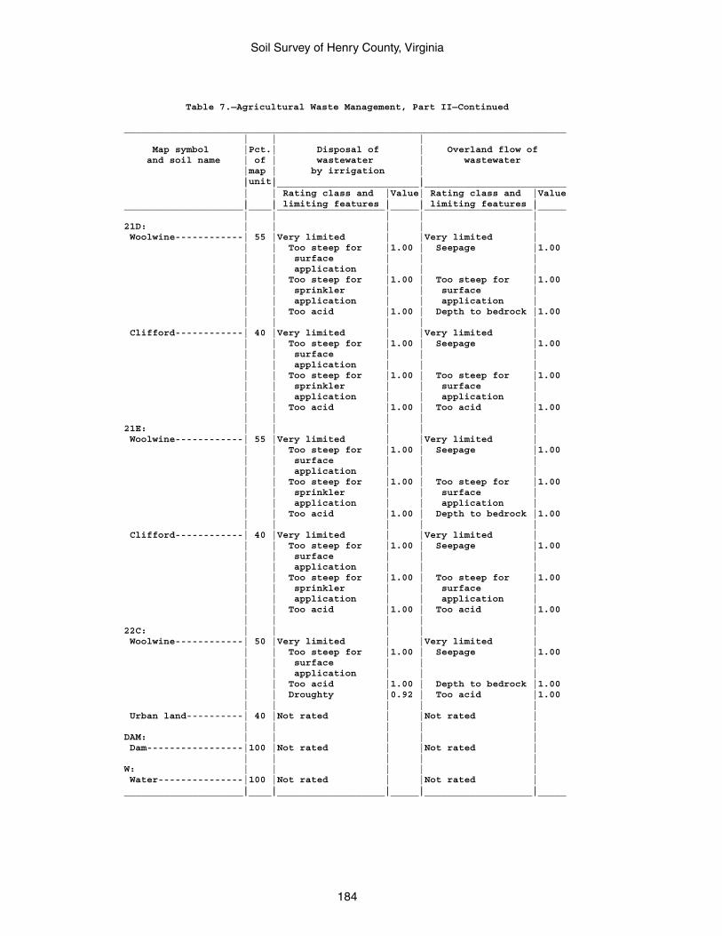
Soil Survey of Henry County, Virginia
184
Table 7.—Agricultural Waste Management, Part II—Continued
______________________________________________________________________________ | | | Map symbol |Pct.| Disposal of | Overland flow of and soil name | of | wastewater | wastewater |map | by irrigation | |unit| | | |_________________________|_________________________ | | Rating class and |Value| Rating class and |Value | | limiting features | | limiting features |_____________________|____|___________________|_____|___________________|_____ | | | | |21D: | | | | | Woolwine------------| 55 |Very limited | |Very limited | | | Too steep for |1.00 | Seepage |1.00 | | surface | | | | | application | | | | | Too steep for |1.00 | Too steep for |1.00 | | sprinkler | | surface | | | application | | application | | | Too acid |1.00 | Depth to bedrock |1.00 | | | | | Clifford------------| 40 |Very limited | |Very limited | | | Too steep for |1.00 | Seepage |1.00 | | surface | | | | | application | | | | | Too steep for |1.00 | Too steep for |1.00 | | sprinkler | | surface | | | application | | application | | | Too acid |1.00 | Too acid |1.00 | | | | |21E: | | | | | Woolwine------------| 55 |Very limited | |Very limited | | | Too steep for |1.00 | Seepage |1.00 | | surface | | | | | application | | | | | Too steep for |1.00 | Too steep for |1.00 | | sprinkler | | surface | | | application | | application | | | Too acid |1.00 | Depth to bedrock |1.00 | | | | | Clifford------------| 40 |Very limited | |Very limited | | | Too steep for |1.00 | Seepage |1.00 | | surface | | | | | application | | | | | Too steep for |1.00 | Too steep for |1.00 | | sprinkler | | surface | | | application | | application | | | Too acid |1.00 | Too acid |1.00 | | | | |22C: | | | | | Woolwine------------| 50 |Very limited | |Very limited | | | Too steep for |1.00 | Seepage |1.00 | | surface | | | | | application | | | | | Too acid |1.00 | Depth to bedrock |1.00 | | Droughty |0.92 | Too acid |1.00 | | | | | Urban land----------| 40 |Not rated | |Not rated | | | | | |DAM: | | | | | Dam-----------------|100 |Not rated | |Not rated | | | | | |W: | | | | | Water---------------|100 |Not rated | |Not rated | | | | | |_____________________|____|___________________|_____|___________________|_____
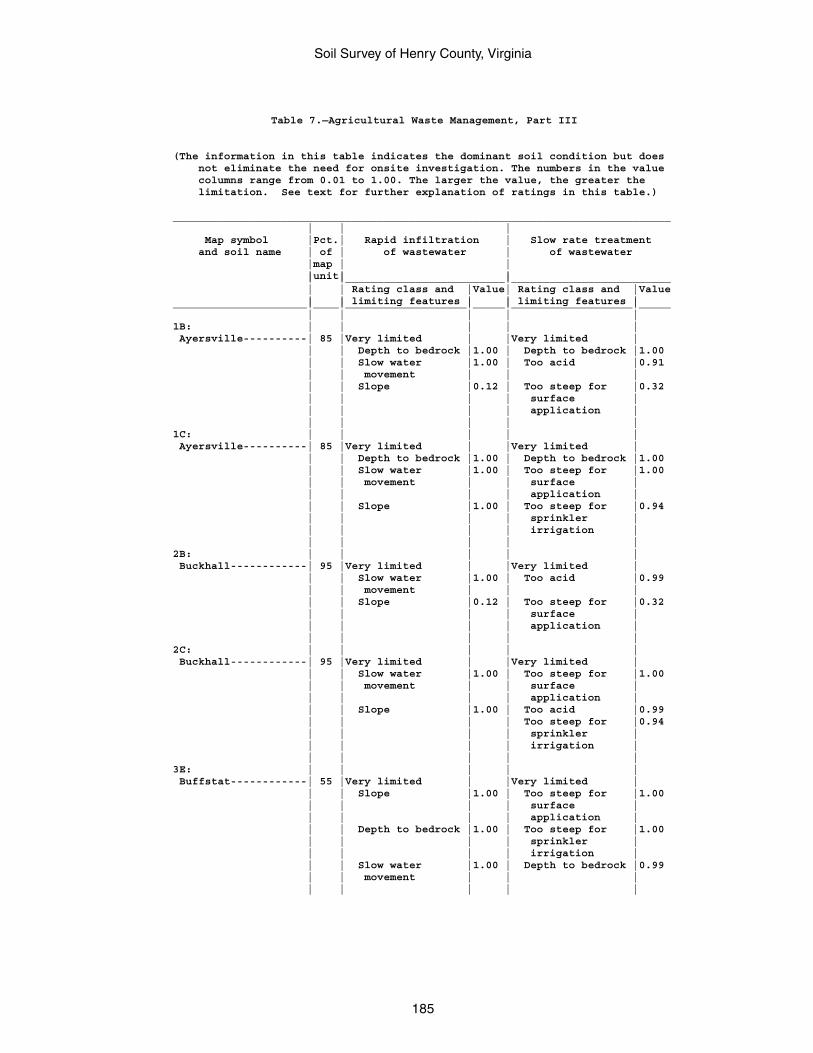
Soil Survey of Henry County, Virginia
185
Table 7.—Agricultural Waste Management, Part III
(The information in this table indicates the dominant soil condition but does not eliminate the need for onsite investigation. The numbers in the value columns range from 0.01 to 1.00. The larger the value, the greater the limitation. See text for further explanation of ratings in this table.)
______________________________________________________________________________ | | | Map symbol |Pct.| Rapid infiltration | Slow rate treatment and soil name | of | of wastewater | of wastewater |map | | |unit| | | |_________________________|_________________________ | | Rating class and |Value| Rating class and |Value | | limiting features | | limiting features |_____________________|____|___________________|_____|___________________|_____ | | | | |1B: | | | | | Ayersville----------| 85 |Very limited | |Very limited | | | Depth to bedrock |1.00 | Depth to bedrock |1.00 | | Slow water |1.00 | Too acid |0.91 | | movement | | | | | Slope |0.12 | Too steep for |0.32 | | | | surface | | | | | application | | | | | |1C: | | | | | Ayersville----------| 85 |Very limited | |Very limited | | | Depth to bedrock |1.00 | Depth to bedrock |1.00 | | Slow water |1.00 | Too steep for |1.00 | | movement | | surface | | | | | application | | | Slope |1.00 | Too steep for |0.94 | | | | sprinkler | | | | | irrigation | | | | | |2B: | | | | | Buckhall------------| 95 |Very limited | |Very limited | | | Slow water |1.00 | Too acid |0.99 | | movement | | | | | Slope |0.12 | Too steep for |0.32 | | | | surface | | | | | application | | | | | |2C: | | | | | Buckhall------------| 95 |Very limited | |Very limited | | | Slow water |1.00 | Too steep for |1.00 | | movement | | surface | | | | | application | | | Slope |1.00 | Too acid |0.99 | | | | Too steep for |0.94 | | | | sprinkler | | | | | irrigation | | | | | |3E: | | | | | Buffstat------------| 55 |Very limited | |Very limited | | | Slope |1.00 | Too steep for |1.00 | | | | surface | | | | | application | | | Depth to bedrock |1.00 | Too steep for |1.00 | | | | sprinkler | | | | | irrigation | | | Slow water |1.00 | Depth to bedrock |0.99 | | movement | | | | | | | |
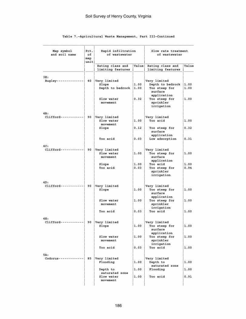
Soil Survey of Henry County, Virginia
186
Table 7.—Agricultural Waste Management, Part III—Continued
______________________________________________________________________________ | | | Map symbol |Pct.| Rapid infiltration | Slow rate treatment and soil name | of | of wastewater | of wastewater |map | | |unit| | | |_________________________|_________________________ | | Rating class and |Value| Rating class and |Value | | limiting features | | limiting features |_____________________|____|___________________|_____|___________________|_____ | | | | |3E: | | | | | Bugley--------------| 40 |Very limited | |Very limited | | | Slope |1.00 | Depth to bedrock |1.00 | | Depth to bedrock |1.00 | Too steep for |1.00 | | | | surface | | | | | application | | | Slow water |0.32 | Too steep for |1.00 | | movement | | sprinkler | | | | | irrigation | | | | | |4B: | | | | | Clifford------------| 90 |Very limited | |Very limited | | | Slow water |1.00 | Too acid |1.00 | | movement | | | | | Slope |0.12 | Too steep for |0.32 | | | | surface | | | | | application | | | Too acid |0.03 | Low adsorption |0.31 | | | | |4C: | | | | | Clifford------------| 90 |Very limited | |Very limited | | | Slow water |1.00 | Too steep for |1.00 | | movement | | surface | | | | | application | | | Slope |1.00 | Too acid |1.00 | | Too acid |0.03 | Too steep for |0.94 | | | | sprinkler | | | | | irrigation | | | | | |4D: | | | | | Clifford------------| 90 |Very limited | |Very limited | | | Slope |1.00 | Too steep for |1.00 | | | | surface | | | | | application | | | Slow water |1.00 | Too steep for |1.00 | | movement | | sprinkler | | | | | irrigation | | | Too acid |0.03 | Too acid |1.00 | | | | |4E: | | | | | Clifford------------| 90 |Very limited | |Very limited | | | Slope |1.00 | Too steep for |1.00 | | | | surface | | | | | application | | | Slow water |1.00 | Too steep for |1.00 | | movement | | sprinkler | | | | | irrigation | | | Too acid |0.03 | Too acid |1.00 | | | | |5A: | | | | | Codorus-------------| 85 |Very limited | |Very limited | | | Flooding |1.00 | Depth to |1.00 | | | | saturated zone | | | Depth to |1.00 | Flooding |1.00 | | saturated zone | | | | | Slow water |1.00 | Too acid |0.91 | | movement | | | | | | | |
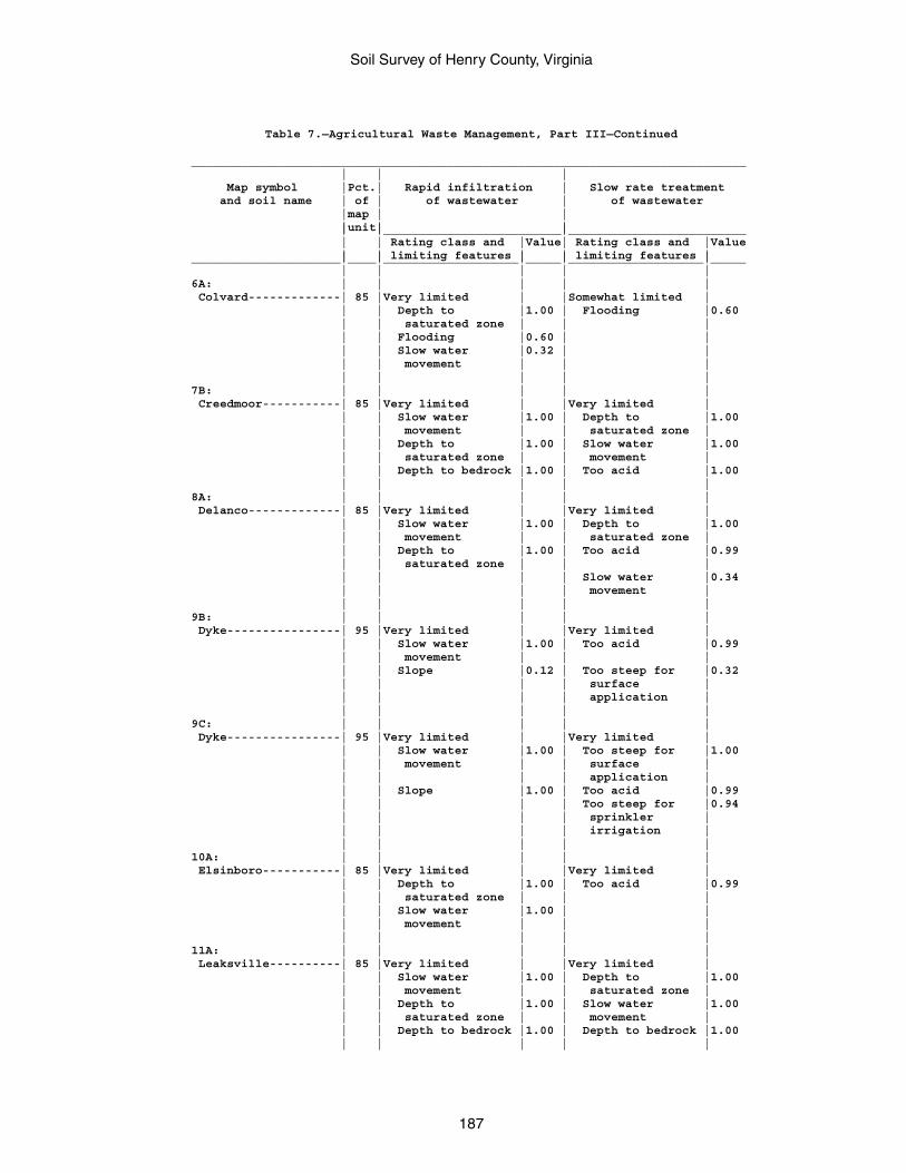
Soil Survey of Henry County, Virginia
187
Table 7.—Agricultural Waste Management, Part III—Continued
______________________________________________________________________________ | | | Map symbol |Pct.| Rapid infiltration | Slow rate treatment and soil name | of | of wastewater | of wastewater |map | | |unit| | | |_________________________|_________________________ | | Rating class and |Value| Rating class and |Value | | limiting features | | limiting features |_____________________|____|___________________|_____|___________________|_____ | | | | |6A: | | | | | Colvard-------------| 85 |Very limited | |Somewhat limited | | | Depth to |1.00 | Flooding |0.60 | | saturated zone | | | | | Flooding |0.60 | | | | Slow water |0.32 | | | | movement | | | | | | | |7B: | | | | | Creedmoor-----------| 85 |Very limited | |Very limited | | | Slow water |1.00 | Depth to |1.00 | | movement | | saturated zone | | | Depth to |1.00 | Slow water |1.00 | | saturated zone | | movement | | | Depth to bedrock |1.00 | Too acid |1.00 | | | | |8A: | | | | | Delanco-------------| 85 |Very limited | |Very limited | | | Slow water |1.00 | Depth to |1.00 | | movement | | saturated zone | | | Depth to |1.00 | Too acid |0.99 | | saturated zone | | | | | | | Slow water |0.34 | | | | movement | | | | | |9B: | | | | | Dyke----------------| 95 |Very limited | |Very limited | | | Slow water |1.00 | Too acid |0.99 | | movement | | | | | Slope |0.12 | Too steep for |0.32 | | | | surface | | | | | application | | | | | |9C: | | | | | Dyke----------------| 95 |Very limited | |Very limited | | | Slow water |1.00 | Too steep for |1.00 | | movement | | surface | | | | | application | | | Slope |1.00 | Too acid |0.99 | | | | Too steep for |0.94 | | | | sprinkler | | | | | irrigation | | | | | |10A: | | | | | Elsinboro-----------| 85 |Very limited | |Very limited | | | Depth to |1.00 | Too acid |0.99 | | saturated zone | | | | | Slow water |1.00 | | | | movement | | | | | | | |11A: | | | | | Leaksville----------| 85 |Very limited | |Very limited | | | Slow water |1.00 | Depth to |1.00 | | movement | | saturated zone | | | Depth to |1.00 | Slow water |1.00 | | saturated zone | | movement | | | Depth to bedrock |1.00 | Depth to bedrock |1.00 | | | | |
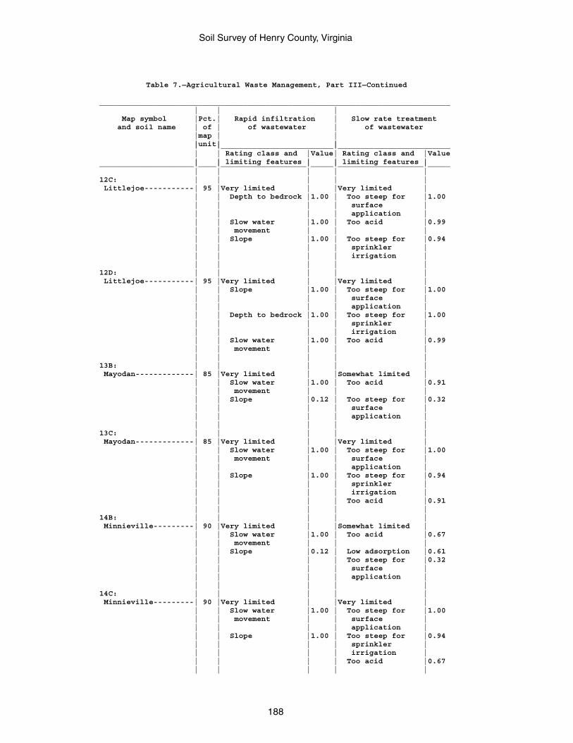
Soil Survey of Henry County, Virginia
188
Table 7.—Agricultural Waste Management, Part III—Continued
______________________________________________________________________________ | | | Map symbol |Pct.| Rapid infiltration | Slow rate treatment and soil name | of | of wastewater | of wastewater |map | | |unit| | | |_________________________|_________________________ | | Rating class and |Value| Rating class and |Value | | limiting features | | limiting features |_____________________|____|___________________|_____|___________________|_____ | | | | |12C: | | | | | Littlejoe-----------| 95 |Very limited | |Very limited | | | Depth to bedrock |1.00 | Too steep for |1.00 | | | | surface | | | | | application | | | Slow water |1.00 | Too acid |0.99 | | movement | | | | | Slope |1.00 | Too steep for |0.94 | | | | sprinkler | | | | | irrigation | | | | | |12D: | | | | | Littlejoe-----------| 95 |Very limited | |Very limited | | | Slope |1.00 | Too steep for |1.00 | | | | surface | | | | | application | | | Depth to bedrock |1.00 | Too steep for |1.00 | | | | sprinkler | | | | | irrigation | | | Slow water |1.00 | Too acid |0.99 | | movement | | | | | | | |13B: | | | | | Mayodan-------------| 85 |Very limited | |Somewhat limited | | | Slow water |1.00 | Too acid |0.91 | | movement | | | | | Slope |0.12 | Too steep for |0.32 | | | | surface | | | | | application | | | | | |13C: | | | | | Mayodan-------------| 85 |Very limited | |Very limited | | | Slow water |1.00 | Too steep for |1.00 | | movement | | surface | | | | | application | | | Slope |1.00 | Too steep for |0.94 | | | | sprinkler | | | | | irrigation | | | | | Too acid |0.91 | | | | |14B: | | | | | Minnieville---------| 90 |Very limited | |Somewhat limited | | | Slow water |1.00 | Too acid |0.67 | | movement | | | | | Slope |0.12 | Low adsorption |0.61 | | | | Too steep for |0.32 | | | | surface | | | | | application | | | | | |14C: | | | | | Minnieville---------| 90 |Very limited | |Very limited | | | Slow water |1.00 | Too steep for |1.00 | | movement | | surface | | | | | application | | | Slope |1.00 | Too steep for |0.94 | | | | sprinkler | | | | | irrigation | | | | | Too acid |0.67 | | | | |
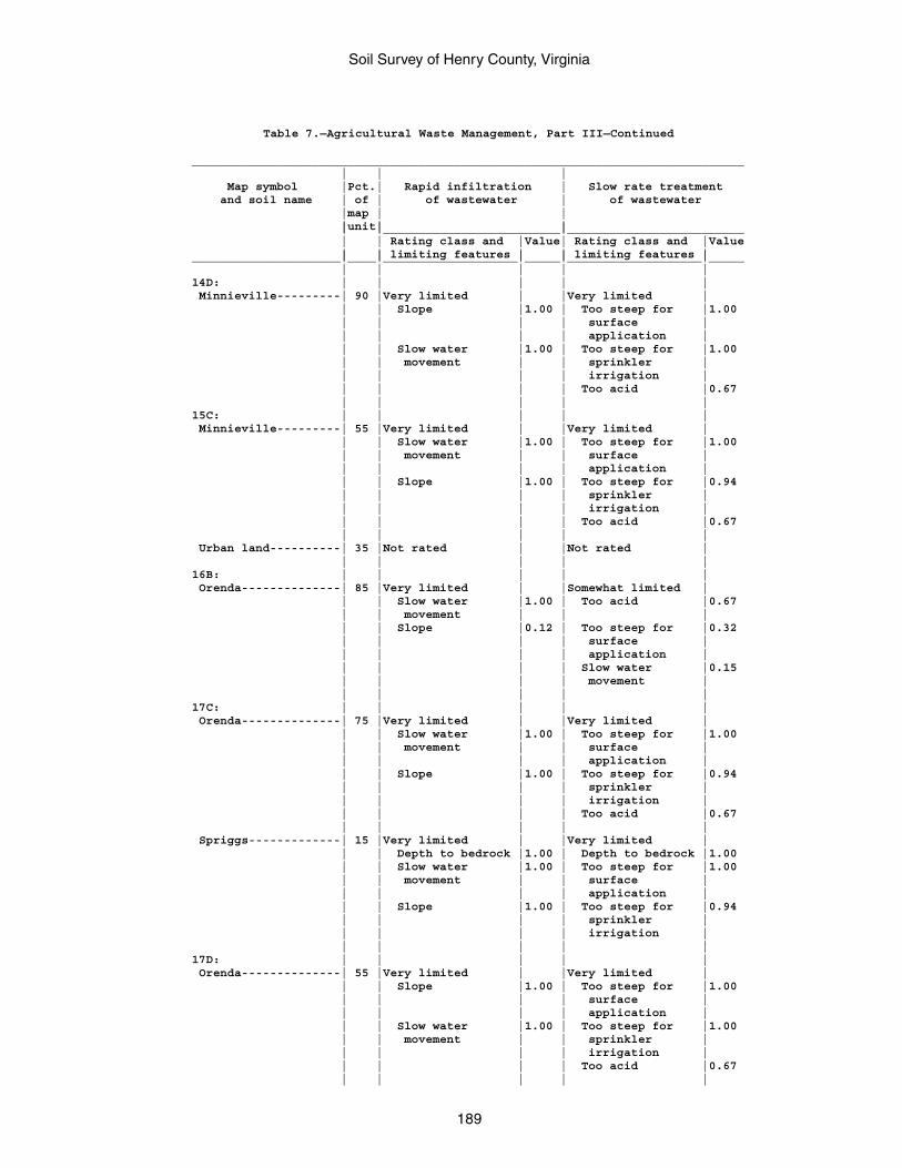
Soil Survey of Henry County, Virginia
189
Table 7.—Agricultural Waste Management, Part III—Continued
______________________________________________________________________________ | | | Map symbol |Pct.| Rapid infiltration | Slow rate treatment and soil name | of | of wastewater | of wastewater |map | | |unit| | | |_________________________|_________________________ | | Rating class and |Value| Rating class and |Value | | limiting features | | limiting features |_____________________|____|___________________|_____|___________________|_____ | | | | |14D: | | | | | Minnieville---------| 90 |Very limited | |Very limited | | | Slope |1.00 | Too steep for |1.00 | | | | surface | | | | | application | | | Slow water |1.00 | Too steep for |1.00 | | movement | | sprinkler | | | | | irrigation | | | | | Too acid |0.67 | | | | |15C: | | | | | Minnieville---------| 55 |Very limited | |Very limited | | | Slow water |1.00 | Too steep for |1.00 | | movement | | surface | | | | | application | | | Slope |1.00 | Too steep for |0.94 | | | | sprinkler | | | | | irrigation | | | | | Too acid |0.67 | | | | | Urban land----------| 35 |Not rated | |Not rated | | | | | |16B: | | | | | Orenda--------------| 85 |Very limited | |Somewhat limited | | | Slow water |1.00 | Too acid |0.67 | | movement | | | | | Slope |0.12 | Too steep for |0.32 | | | | surface | | | | | application | | | | | Slow water |0.15 | | | | movement | | | | | |17C: | | | | | Orenda--------------| 75 |Very limited | |Very limited | | | Slow water |1.00 | Too steep for |1.00 | | movement | | surface | | | | | application | | | Slope |1.00 | Too steep for |0.94 | | | | sprinkler | | | | | irrigation | | | | | Too acid |0.67 | | | | | Spriggs-------------| 15 |Very limited | |Very limited | | | Depth to bedrock |1.00 | Depth to bedrock |1.00 | | Slow water |1.00 | Too steep for |1.00 | | movement | | surface | | | | | application | | | Slope |1.00 | Too steep for |0.94 | | | | sprinkler | | | | | irrigation | | | | | |17D: | | | | | Orenda--------------| 55 |Very limited | |Very limited | | | Slope |1.00 | Too steep for |1.00 | | | | surface | | | | | application | | | Slow water |1.00 | Too steep for |1.00 | | movement | | sprinkler | | | | | irrigation | | | | | Too acid |0.67 | | | | |
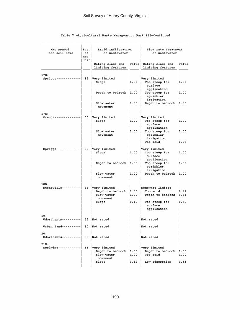
Soil Survey of Henry County, Virginia
190
Table 7.—Agricultural Waste Management, Part III—Continued
______________________________________________________________________________ | | | Map symbol |Pct.| Rapid infiltration | Slow rate treatment and soil name | of | of wastewater | of wastewater |map | | |unit| | | |_________________________|_________________________ | | Rating class and |Value| Rating class and |Value | | limiting features | | limiting features |_____________________|____|___________________|_____|___________________|_____ | | | | |17D: | | | | | Spriggs-------------| 35 |Very limited | |Very limited | | | Slope |1.00 | Too steep for |1.00 | | | | surface | | | | | application | | | Depth to bedrock |1.00 | Too steep for |1.00 | | | | sprinkler | | | | | irrigation | | | Slow water |1.00 | Depth to bedrock |1.00 | | movement | | | | | | | |17E: | | | | | Orenda--------------| 55 |Very limited | |Very limited | | | Slope |1.00 | Too steep for |1.00 | | | | surface | | | | | application | | | Slow water |1.00 | Too steep for |1.00 | | movement | | sprinkler | | | | | irrigation | | | | | Too acid |0.67 | | | | | Spriggs-------------| 35 |Very limited | |Very limited | | | Slope |1.00 | Too steep for |1.00 | | | | surface | | | | | application | | | Depth to bedrock |1.00 | Too steep for |1.00 | | | | sprinkler | | | | | irrigation | | | Slow water |1.00 | Depth to bedrock |1.00 | | movement | | | | | | | |18B: | | | | | Stoneville----------| 85 |Very limited | |Somewhat limited | | | Depth to bedrock |1.00 | Too acid |0.91 | | Slow water |1.00 | Depth to bedrock |0.61 | | movement | | | | | Slope |0.12 | Too steep for |0.32 | | | | surface | | | | | application | | | | | |19: | | | | | Udorthents----------| 55 |Not rated | |Not rated | | | | | | Urban land----------| 30 |Not rated | |Not rated | | | | | |20: | | | | | Udorthents----------| 85 |Not rated | |Not rated | | | | | |21B: | | | | | Woolwine------------| 55 |Very limited | |Very limited | | | Depth to bedrock |1.00 | Depth to bedrock |1.00 | | Slow water |1.00 | Too acid |1.00 | | movement | | | | | Slope |0.12 | Low adsorption |0.53 | | | | |
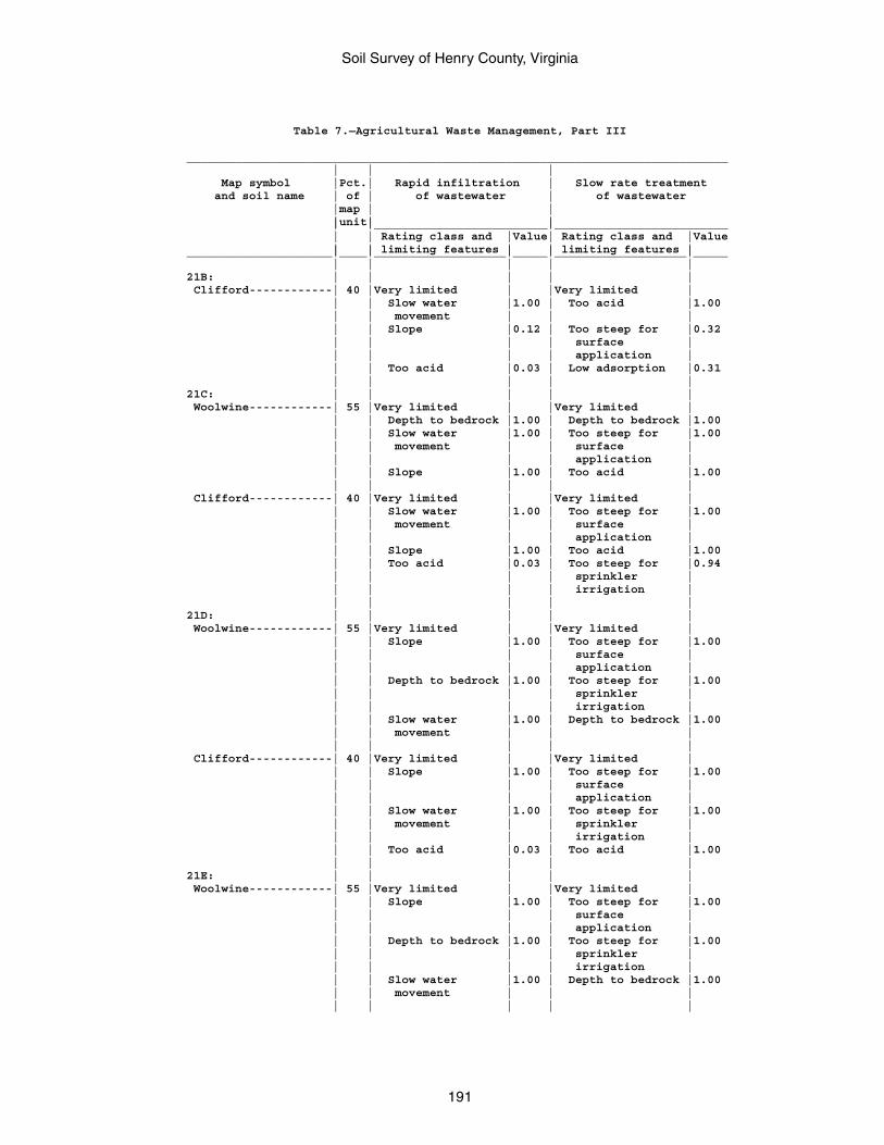
Soil Survey of Henry County, Virginia
191
Table 7.—Agricultural Waste Management, Part III
______________________________________________________________________________ | | | Map symbol |Pct.| Rapid infiltration | Slow rate treatment and soil name | of | of wastewater | of wastewater |map | | |unit| | | |_________________________|_________________________ | | Rating class and |Value| Rating class and |Value | | limiting features | | limiting features |_____________________|____|___________________|_____|___________________|_____ | | | | |21B: | | | | | Clifford------------| 40 |Very limited | |Very limited | | | Slow water |1.00 | Too acid |1.00 | | movement | | | | | Slope |0.12 | Too steep for |0.32 | | | | surface | | | | | application | | | Too acid |0.03 | Low adsorption |0.31 | | | | |21C: | | | | | Woolwine------------| 55 |Very limited | |Very limited | | | Depth to bedrock |1.00 | Depth to bedrock |1.00 | | Slow water |1.00 | Too steep for |1.00 | | movement | | surface | | | | | application | | | Slope |1.00 | Too acid |1.00 | | | | | Clifford------------| 40 |Very limited | |Very limited | | | Slow water |1.00 | Too steep for |1.00 | | movement | | surface | | | | | application | | | Slope |1.00 | Too acid |1.00 | | Too acid |0.03 | Too steep for |0.94 | | | | sprinkler | | | | | irrigation | | | | | |21D: | | | | | Woolwine------------| 55 |Very limited | |Very limited | | | Slope |1.00 | Too steep for |1.00 | | | | surface | | | | | application | | | Depth to bedrock |1.00 | Too steep for |1.00 | | | | sprinkler | | | | | irrigation | | | Slow water |1.00 | Depth to bedrock |1.00 | | movement | | | | | | | | Clifford------------| 40 |Very limited | |Very limited | | | Slope |1.00 | Too steep for |1.00 | | | | surface | | | | | application | | | Slow water |1.00 | Too steep for |1.00 | | movement | | sprinkler | | | | | irrigation | | | Too acid |0.03 | Too acid |1.00 | | | | |21E: | | | | | Woolwine------------| 55 |Very limited | |Very limited | | | Slope |1.00 | Too steep for |1.00 | | | | surface | | | | | application | | | Depth to bedrock |1.00 | Too steep for |1.00 | | | | sprinkler | | | | | irrigation | | | Slow water |1.00 | Depth to bedrock |1.00 | | movement | | | | | | | |
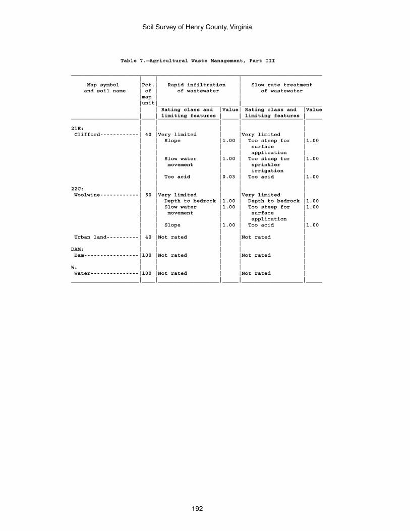
Soil Survey of Henry County, Virginia
192
Table 7.—Agricultural Waste Management, Part III
______________________________________________________________________________ | | | Map symbol |Pct.| Rapid infiltration | Slow rate treatment and soil name | of | of wastewater | of wastewater |map | | |unit| | | |_________________________|_________________________ | | Rating class and |Value| Rating class and |Value | | limiting features | | limiting features |_____________________|____|___________________|_____|___________________|_____ | | | | |21E: | | | | | Clifford------------| 40 |Very limited | |Very limited | | | Slope |1.00 | Too steep for |1.00 | | | | surface | | | | | application | | | Slow water |1.00 | Too steep for |1.00 | | movement | | sprinkler | | | | | irrigation | | | Too acid |0.03 | Too acid |1.00 | | | | |22C: | | | | | Woolwine------------| 50 |Very limited | |Very limited | | | Depth to bedrock |1.00 | Depth to bedrock |1.00 | | Slow water |1.00 | Too steep for |1.00 | | movement | | surface | | | | | application | | | Slope |1.00 | Too acid |1.00 | | | | | Urban land----------| 40 |Not rated | |Not rated | | | | | |DAM: | | | | | Dam-----------------|100 |Not rated | |Not rated | | | | | |W: | | | | | Water---------------|100 |Not rated | |Not rated | | | | | |_____________________|____|___________________|_____|___________________|_____
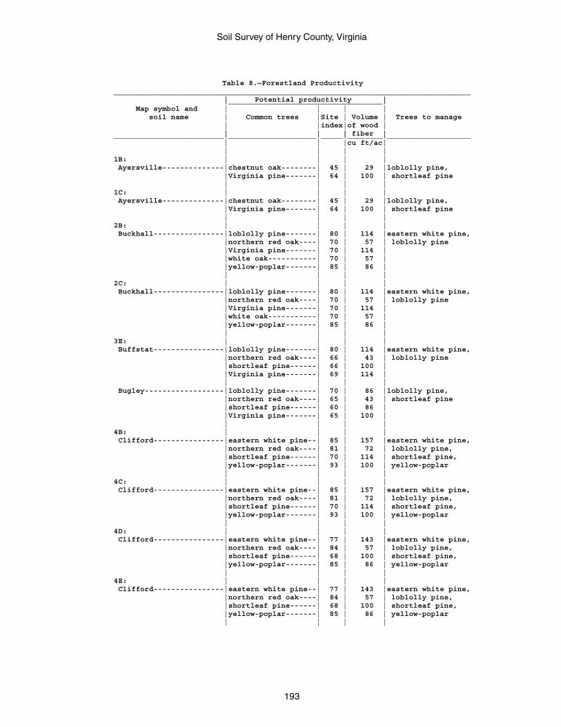
Soil Survey of Henry County, Virginia
193
Table 8.—Forestland Productivity_________________________________________________________________________________ | Potential productivity | |___________________________________| Map symbol and | | | | soil name | Common trees |Site | Volume | Trees to manage | |index|of wood | | | | fiber |_________________________|____________________|_____|________|___________________ | | |cu ft/ac| | | | |1B: | | | | Ayersville--------------|chestnut oak--------| 45 | 29 |loblolly pine, |Virginia pine-------| 64 | 100 | shortleaf pine | | | |1C: | | | | Ayersville--------------|chestnut oak--------| 45 | 29 |loblolly pine, |Virginia pine-------| 64 | 100 | shortleaf pine | | | |2B: | | | | Buckhall----------------|loblolly pine-------| 80 | 114 |eastern white pine, |northern red oak----| 70 | 57 | loblolly pine |Virginia pine-------| 70 | 114 | |white oak-----------| 70 | 57 | |yellow-poplar-------| 85 | 86 | | | | |2C: | | | | Buckhall----------------|loblolly pine-------| 80 | 114 |eastern white pine, |northern red oak----| 70 | 57 | loblolly pine |Virginia pine-------| 70 | 114 | |white oak-----------| 70 | 57 | |yellow-poplar-------| 85 | 86 | | | | |3E: | | | | Buffstat----------------|loblolly pine-------| 80 | 114 |eastern white pine, |northern red oak----| 66 | 43 | loblolly pine |shortleaf pine------| 66 | 100 | |Virginia pine-------| 69 | 114 | | | | | Bugley------------------|loblolly pine-------| 70 | 86 |loblolly pine, |northern red oak----| 65 | 43 | shortleaf pine |shortleaf pine------| 60 | 86 | |Virginia pine-------| 65 | 100 | | | | |4B: | | | | Clifford----------------|eastern white pine--| 85 | 157 |eastern white pine, |northern red oak----| 81 | 72 | loblolly pine, |shortleaf pine------| 70 | 114 | shortleaf pine, |yellow-poplar-------| 93 | 100 | yellow-poplar | | | |4C: | | | | Clifford----------------|eastern white pine--| 85 | 157 |eastern white pine, |northern red oak----| 81 | 72 | loblolly pine, |shortleaf pine------| 70 | 114 | shortleaf pine, |yellow-poplar-------| 93 | 100 | yellow-poplar | | | |4D: | | | | Clifford----------------|eastern white pine--| 77 | 143 |eastern white pine, |northern red oak----| 84 | 57 | loblolly pine, |shortleaf pine------| 68 | 100 | shortleaf pine, |yellow-poplar-------| 85 | 86 | yellow-poplar | | | |4E: | | | | Clifford----------------|eastern white pine--| 77 | 143 |eastern white pine, |northern red oak----| 84 | 57 | loblolly pine, |shortleaf pine------| 68 | 100 | shortleaf pine, |yellow-poplar-------| 85 | 86 | yellow-poplar | | | |
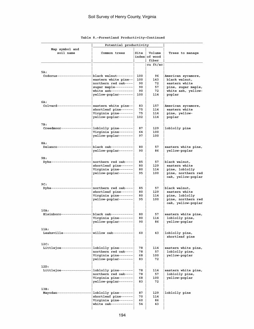
Soil Survey of Henry County, Virginia
194
Table 8.—Forestland Productivity—Continued_________________________________________________________________________________ | Potential productivity | |___________________________________| Map symbol and | | | | soil name | Common trees |Site | Volume | Trees to manage | |index|of wood | | | | fiber |_________________________|____________________|_____|________|___________________ | | |cu ft/ac| | | | |5A: | | | | Codorus-----------------|black walnut--------| 100 | 96 |American sycamore, |eastern white pine--| 100 | 143 | black walnut, |northern red oak----| 90 | 72 | eastern white |sugar maple---------| 90 | 57 | pine, sugar maple, |white ash-----------| 90 | 72 | white ash, yellow- |yellow-poplar-------| 100 | 114 | poplar | | | |6A: | | | | Colvard-----------------|eastern white pine--| 83 | 157 |American sycamore, |shortleaf pine------| 75 | 114 | eastern white |Virginia pine-------| 75 | 114 | pine, yellow- |yellow-poplar-------| 102 | 114 | poplar | | | |7B: | | | | Creedmoor---------------|loblolly pine-------| 87 | 129 |loblolly pine |Virginia pine-------| 64 | 100 | |yellow-poplar-------| 97 | 100 | | | | |8A: | | | | Delanco-----------------|black oak-----------| 80 | 57 |eastern white pine, |yellow-poplar-------| 90 | 86 | yellow-poplar | | | |9B: | | | | Dyke--------------------|northern red oak----| 85 | 57 |black walnut, |shortleaf pine------| 80 | 129 | eastern white |Virginia pine-------| 80 | 114 | pine, loblolly |yellow-poplar-------| 95 | 100 | pine, northern red | | | | oak, yellow-poplar | | | |9C: | | | | Dyke--------------------|northern red oak----| 85 | 57 |black walnut, |shortleaf pine------| 80 | 129 | eastern white |Virginia pine-------| 80 | 114 | pine, loblolly |yellow-poplar-------| 95 | 100 | pine, northern red | | | | oak, yellow-poplar | | | |10A: | | | | Elsinboro---------------|black oak-----------| 80 | 57 |eastern white pine, |Virginia pine-------| 80 | 114 | loblolly pine, |yellow-poplar-------| 90 | 86 | yellow-poplar | | | |11A: | | | | Leaksville--------------|willow oak----------| 60 | 43 |loblolly pine, | | | | shortleaf pine | | | |12C: | | | | Littlejoe---------------|loblolly pine-------| 78 | 114 |eastern white pine, |northern red oak----| 78 | 57 | loblolly pine, |Virginia pine-------| 68 | 100 | yellow-poplar |yellow-poplar-------| 83 | 72 | | | | |12D: | | | | Littlejoe---------------|loblolly pine-------| 78 | 114 |eastern white pine, |northern red oak----| 78 | 57 | loblolly pine, |Virginia pine-------| 68 | 100 | yellow-poplar |yellow-poplar-------| 83 | 72 | | | | |13B: | | | | Mayodan-----------------|loblolly pine-------| 87 | 129 |loblolly pine |shortleaf pine------| 70 | 114 | |Virginia pine-------| 60 | 86 | |white oak-----------| 54 | 43 | | | | |
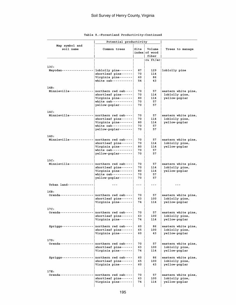
Soil Survey of Henry County, Virginia
195
Table 8.—Forestland Productivity—Continued_________________________________________________________________________________ | Potential productivity | |___________________________________| Map symbol and | | | | soil name | Common trees |Site | Volume | Trees to manage | |index|of wood | | | | fiber |_________________________|____________________|_____|________|___________________ | | |cu ft/ac| | | | |13C: | | | | Mayodan-----------------|loblolly pine-------| 87 | 129 |loblolly pine |shortleaf pine------| 70 | 114 | |Virginia pine-------| 60 | 86 | |white oak-----------| 54 | 43 | | | | |14B: | | | | Minnieville-------------|northern red oak----| 70 | 57 |eastern white pine, |shortleaf pine------| 70 | 114 | loblolly pine, |Virginia pine-------| 80 | 114 | yellow-poplar |white oak-----------| 70 | 57 | |yellow-poplar-------| 70 | 57 | | | | |14C: | | | | Minnieville-------------|northern red oak----| 70 | 57 |eastern white pine, |shortleaf pine------| 70 | 114 | loblolly pine, |Virginia pine-------| 80 | 114 | yellow-poplar |white oak-----------| 70 | 57 | |yellow-poplar-------| 70 | 57 | | | | |14D: | | | | Minnieville-------------|northern red oak----| 70 | 57 |eastern white pine, |shortleaf pine------| 70 | 114 | loblolly pine, |Virginia pine-------| 80 | 114 | yellow-poplar |white oak-----------| 70 | 57 | |yellow-poplar-------| 70 | 57 | | | | |15C: | | | | Minnieville-------------|northern red oak----| 70 | 57 |eastern white pine, |shortleaf pine------| 70 | 114 | loblolly pine, |Virginia pine-------| 80 | 114 | yellow-poplar |white oak-----------| 70 | 57 | |yellow-poplar-------| 70 | 57 | | | | | Urban land--------------| --- | --- | --- | --- | | | |16B: | | | | Orenda------------------|northern red oak----| 70 | 57 |eastern white pine, |shortleaf pine------| 63 | 100 | loblolly pine, |Virginia pine-------| 74 | 114 | yellow-poplar | | | |17C: | | | | Orenda------------------|northern red oak----| 70 | 57 |eastern white pine, |shortleaf pine------| 63 | 100 | loblolly pine, |Virginia pine-------| 74 | 114 | yellow-poplar | | | | Spriggs-----------------|northern red oak----| 60 | 86 |eastern white pine, |shortleaf pine------| 65 | 100 | loblolly pine, |Virginia pine-------| 60 | 43 | yellow-poplar | | | |17D: | | | | Orenda------------------|northern red oak----| 70 | 57 |eastern white pine, |shortleaf pine------| 63 | 100 | loblolly pine, |Virginia pine-------| 74 | 114 | yellow-poplar | | | | Spriggs-----------------|northern red oak----| 60 | 86 |eastern white pine, |shortleaf pine------| 65 | 100 | loblolly pine, |Virginia pine-------| 60 | 43 | yellow-poplar | | | |17E: | | | | Orenda------------------|northern red oak----| 70 | 57 |eastern white pine, |shortleaf pine------| 63 | 100 | loblolly pine, |Virginia pine-------| 74 | 114 | yellow-poplar | | | |
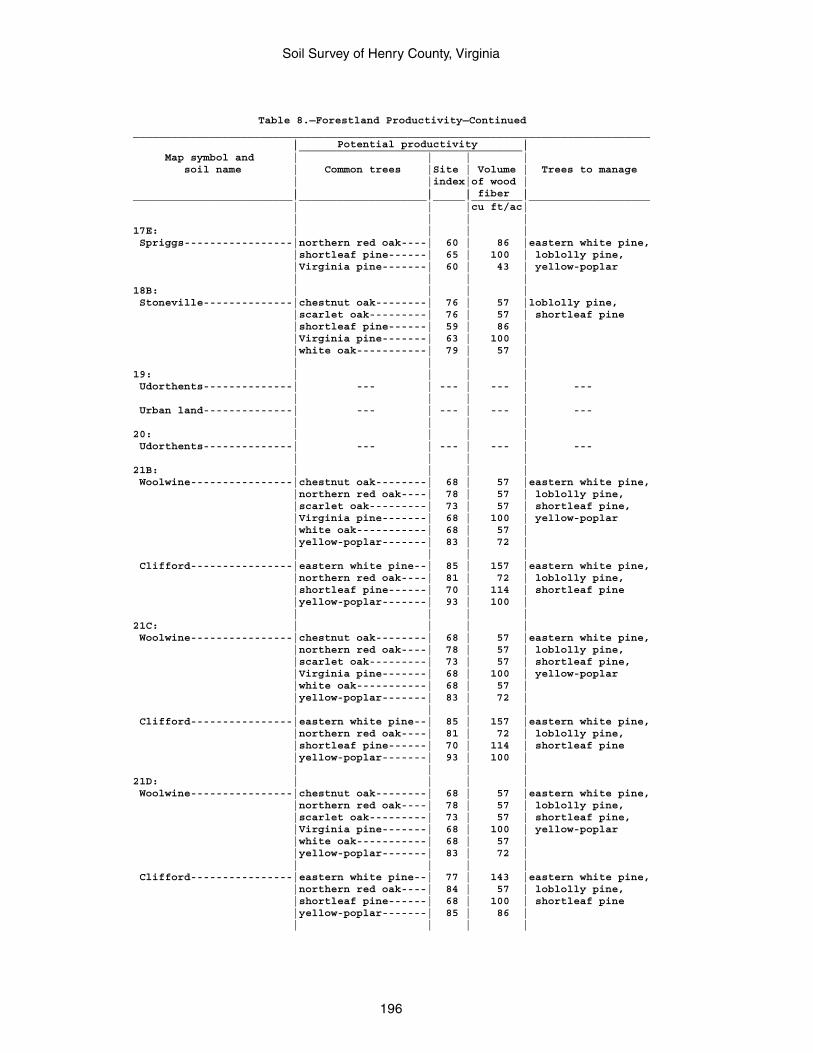
Soil Survey of Henry County, Virginia
196
Table 8.—Forestland Productivity—Continued_________________________________________________________________________________ | Potential productivity | |___________________________________| Map symbol and | | | | soil name | Common trees |Site | Volume | Trees to manage | |index|of wood | | | | fiber |_________________________|____________________|_____|________|___________________ | | |cu ft/ac| | | | |17E: | | | | Spriggs-----------------|northern red oak----| 60 | 86 |eastern white pine, |shortleaf pine------| 65 | 100 | loblolly pine, |Virginia pine-------| 60 | 43 | yellow-poplar | | | |18B: | | | | Stoneville--------------|chestnut oak--------| 76 | 57 |loblolly pine, |scarlet oak---------| 76 | 57 | shortleaf pine |shortleaf pine------| 59 | 86 | |Virginia pine-------| 63 | 100 | |white oak-----------| 79 | 57 | | | | |19: | | | | Udorthents--------------| --- | --- | --- | --- | | | | Urban land--------------| --- | --- | --- | --- | | | |20: | | | | Udorthents--------------| --- | --- | --- | --- | | | |21B: | | | | Woolwine----------------|chestnut oak--------| 68 | 57 |eastern white pine, |northern red oak----| 78 | 57 | loblolly pine, |scarlet oak---------| 73 | 57 | shortleaf pine, |Virginia pine-------| 68 | 100 | yellow-poplar |white oak-----------| 68 | 57 | |yellow-poplar-------| 83 | 72 | | | | | Clifford----------------|eastern white pine--| 85 | 157 |eastern white pine, |northern red oak----| 81 | 72 | loblolly pine, |shortleaf pine------| 70 | 114 | shortleaf pine |yellow-poplar-------| 93 | 100 | | | | |21C: | | | | Woolwine----------------|chestnut oak--------| 68 | 57 |eastern white pine, |northern red oak----| 78 | 57 | loblolly pine, |scarlet oak---------| 73 | 57 | shortleaf pine, |Virginia pine-------| 68 | 100 | yellow-poplar |white oak-----------| 68 | 57 | |yellow-poplar-------| 83 | 72 | | | | | Clifford----------------|eastern white pine--| 85 | 157 |eastern white pine, |northern red oak----| 81 | 72 | loblolly pine, |shortleaf pine------| 70 | 114 | shortleaf pine |yellow-poplar-------| 93 | 100 | | | | |21D: | | | | Woolwine----------------|chestnut oak--------| 68 | 57 |eastern white pine, |northern red oak----| 78 | 57 | loblolly pine, |scarlet oak---------| 73 | 57 | shortleaf pine, |Virginia pine-------| 68 | 100 | yellow-poplar |white oak-----------| 68 | 57 | |yellow-poplar-------| 83 | 72 | | | | | Clifford----------------|eastern white pine--| 77 | 143 |eastern white pine, |northern red oak----| 84 | 57 | loblolly pine, |shortleaf pine------| 68 | 100 | shortleaf pine |yellow-poplar-------| 85 | 86 | | | | |
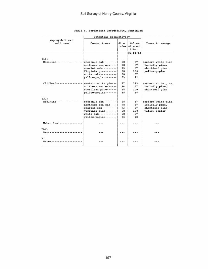
Soil Survey of Henry County, Virginia
197
Table 8.—Forestland Productivity—Continued_________________________________________________________________________________ | Potential productivity | |___________________________________| Map symbol and | | | | soil name | Common trees |Site | Volume | Trees to manage | |index|of wood | | | | fiber |_________________________|____________________|_____|________|___________________ | | |cu ft/ac| | | | |21E: | | | | Woolwine----------------|chestnut oak--------| 68 | 57 |eastern white pine, |northern red oak----| 78 | 57 | loblolly pine, |scarlet oak---------| 73 | 57 | shortleaf pine, |Virginia pine-------| 68 | 100 | yellow-poplar |white oak-----------| 68 | 57 | |yellow-poplar-------| 83 | 72 | | | | | Clifford----------------|eastern white pine--| 77 | 143 |eastern white pine, |northern red oak----| 84 | 57 | loblolly pine, |shortleaf pine------| 68 | 100 | shortleaf pine |yellow-poplar-------| 85 | 86 | | | | |22C: | | | | Woolwine----------------|chestnut oak--------| 68 | 57 |eastern white pine, |northern red oak----| 78 | 57 | loblolly pine, |scarlet oak---------| 73 | 57 | shortleaf pine, |Virginia pine-------| 68 | 100 | yellow-poplar |white oak-----------| 68 | 57 | |yellow-poplar-------| 83 | 72 | | | | | Urban land--------------| --- | --- | --- | --- | | | |DAM: | | | | Dam---------------------| --- | --- | --- | --- | | | |W: | | | | Water-------------------| --- | --- | --- | --- | | | |_________________________|____________________|_____|________|___________________
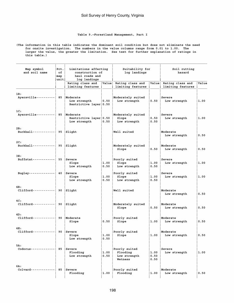
Soil Survey of Henry County, Virginia
198
Table 9.—Forestland Management, Part I
(The information in this table indicates the dominant soil condition but does not eliminate the need for onsite investigation. The numbers in the value columns range from 0.01 to 1.00. The larger the value, the greater the limitation. See text for further explanation of ratings in this table.)
________________________________________________________________________________________________________ | | | | Map symbol |Pct.| Limitations affecting | Suitability for | Soil rutting and soil name | of | construction of | log landings | hazard |map | haul roads and | | |unit| log landings | | | |_________________________|_________________________|_________________________ | | Rating class and |Value| Rating class and |Value| Rating class and |Value | | limiting features | | limiting features | | limiting features |_____________________|____|___________________|_____|___________________|_____|___________________|_____ | | | | | | |1B: | | | | | | | Ayersville----------| 85 |Moderate | |Moderately suited | |Severe | | | Low strength |0.50 | Low strength |0.50 | Low strength |1.00 | | Restrictive layer|0.50 | | | | | | | | | | |1C: | | | | | | | Ayersville----------| 85 |Moderate | |Moderately suited | |Severe | | | Restrictive layer|0.50 | Slope |0.50 | Low strength |1.00 | | Low strength |0.50 | Low strength |0.50 | | | | | | | | |2B: | | | | | | | Buckhall------------| 95 |Slight | |Well suited | |Moderate | | | | | | | Low strength |0.50 | | | | | | |2C: | | | | | | | Buckhall------------| 95 |Slight | |Moderately suited | |Moderate | | | | | Slope |0.50 | Low strength |0.50 | | | | | | |3E: | | | | | | | Buffstat------------| 55 |Severe | |Poorly suited | |Severe | | | Slope |1.00 | Slope |1.00 | Low strength |1.00 | | Low strength |0.50 | Low strength |0.50 | | | | | | | | | Bugley--------------| 40 |Severe | |Poorly suited | |Severe | | | Slope |1.00 | Slope |1.00 | Low strength |1.00 | | Low strength |0.50 | Low strength |0.50 | | | | | | | | |4B: | | | | | | | Clifford------------| 90 |Slight | |Well suited | |Moderate | | | | | | | Low strength |0.50 | | | | | | |4C: | | | | | | | Clifford------------| 90 |Slight | |Moderately suited | |Moderate | | | | | Slope |0.50 | Low strength |0.50 | | | | | | |4D: | | | | | | | Clifford------------| 90 |Moderate | |Poorly suited | |Moderate | | | Slope |0.50 | Slope |1.00 | Low strength |0.50 | | | | | | |4E: | | | | | | | Clifford------------| 90 |Severe | |Poorly suited | |Moderate | | | Slope |1.00 | Slope |1.00 | Low strength |0.50 | | Low strength |0.50 | | | | | | | | | | |5A: | | | | | | | Codorus-------------| 85 |Severe | |Poorly suited | |Severe | | | Flooding |1.00 | Flooding |1.00 | Low strength |1.00 | | Low strength |0.50 | Low strength |0.50 | | | | | | Wetness |0.50 | | | | | | | | |6A: | | | | | | | Colvard-------------| 85 |Severe | |Poorly suited | |Moderate | | | Flooding |1.00 | Flooding |1.00 | Low strength |0.50 | | | | | | |
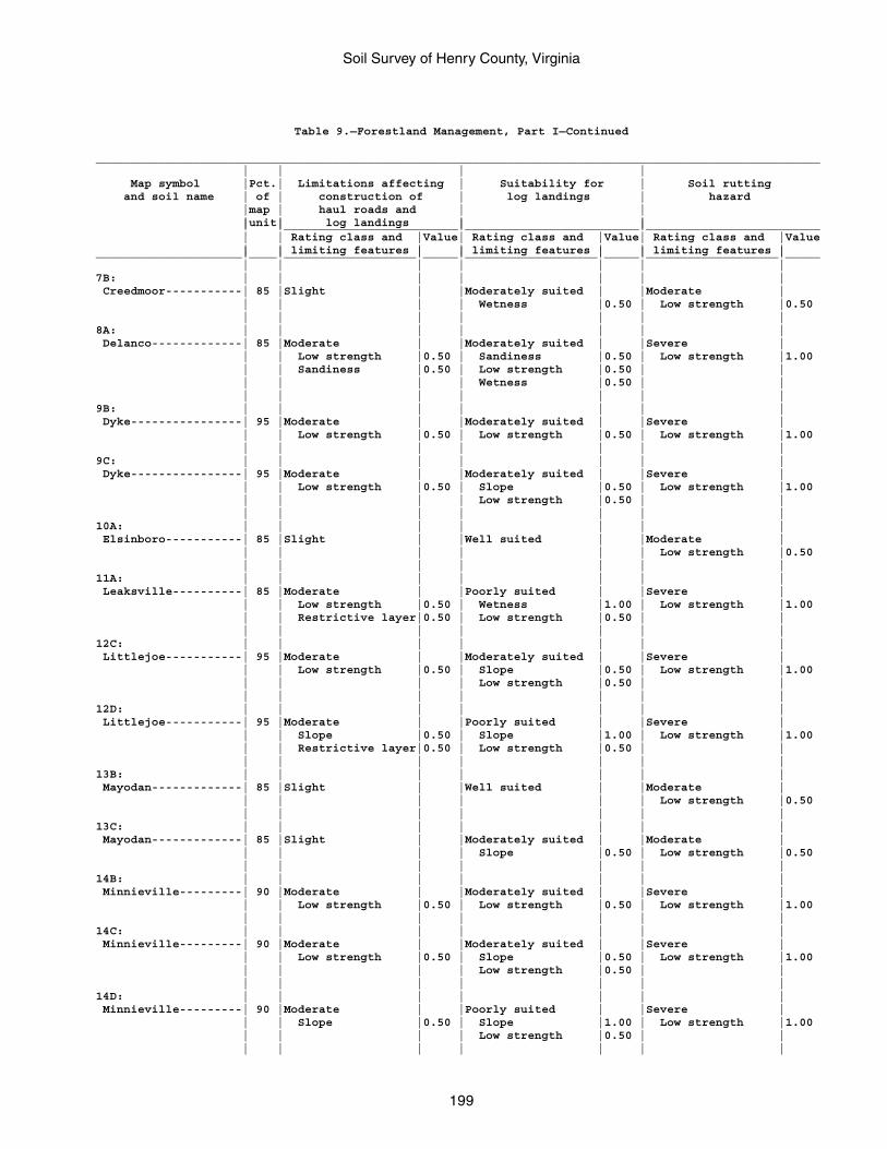
Soil Survey of Henry County, Virginia
199
Table 9.—Forestland Management, Part I—Continued
________________________________________________________________________________________________________ | | | | Map symbol |Pct.| Limitations affecting | Suitability for | Soil rutting and soil name | of | construction of | log landings | hazard |map | haul roads and | | |unit| log landings | | | |_________________________|_________________________|_________________________ | | Rating class and |Value| Rating class and |Value| Rating class and |Value | | limiting features | | limiting features | | limiting features |_____________________|____|___________________|_____|___________________|_____|___________________|_____ | | | | | | |7B: | | | | | | | Creedmoor-----------| 85 |Slight | |Moderately suited | |Moderate | | | | | Wetness |0.50 | Low strength |0.50 | | | | | | |8A: | | | | | | | Delanco-------------| 85 |Moderate | |Moderately suited | |Severe | | | Low strength |0.50 | Sandiness |0.50 | Low strength |1.00 | | Sandiness |0.50 | Low strength |0.50 | | | | | | Wetness |0.50 | | | | | | | | |9B: | | | | | | | Dyke----------------| 95 |Moderate | |Moderately suited | |Severe | | | Low strength |0.50 | Low strength |0.50 | Low strength |1.00 | | | | | | |9C: | | | | | | | Dyke----------------| 95 |Moderate | |Moderately suited | |Severe | | | Low strength |0.50 | Slope |0.50 | Low strength |1.00 | | | | Low strength |0.50 | | | | | | | | |10A: | | | | | | | Elsinboro-----------| 85 |Slight | |Well suited | |Moderate | | | | | | | Low strength |0.50 | | | | | | |11A: | | | | | | | Leaksville----------| 85 |Moderate | |Poorly suited | |Severe | | | Low strength |0.50 | Wetness |1.00 | Low strength |1.00 | | Restrictive layer|0.50 | Low strength |0.50 | | | | | | | | |12C: | | | | | | | Littlejoe-----------| 95 |Moderate | |Moderately suited | |Severe | | | Low strength |0.50 | Slope |0.50 | Low strength |1.00 | | | | Low strength |0.50 | | | | | | | | |12D: | | | | | | | Littlejoe-----------| 95 |Moderate | |Poorly suited | |Severe | | | Slope |0.50 | Slope |1.00 | Low strength |1.00 | | Restrictive layer|0.50 | Low strength |0.50 | | | | | | | | |13B: | | | | | | | Mayodan-------------| 85 |Slight | |Well suited | |Moderate | | | | | | | Low strength |0.50 | | | | | | |13C: | | | | | | | Mayodan-------------| 85 |Slight | |Moderately suited | |Moderate | | | | | Slope |0.50 | Low strength |0.50 | | | | | | |14B: | | | | | | | Minnieville---------| 90 |Moderate | |Moderately suited | |Severe | | | Low strength |0.50 | Low strength |0.50 | Low strength |1.00 | | | | | | |14C: | | | | | | | Minnieville---------| 90 |Moderate | |Moderately suited | |Severe | | | Low strength |0.50 | Slope |0.50 | Low strength |1.00 | | | | Low strength |0.50 | | | | | | | | |14D: | | | | | | | Minnieville---------| 90 |Moderate | |Poorly suited | |Severe | | | Slope |0.50 | Slope |1.00 | Low strength |1.00 | | | | Low strength |0.50 | | | | | | | | |
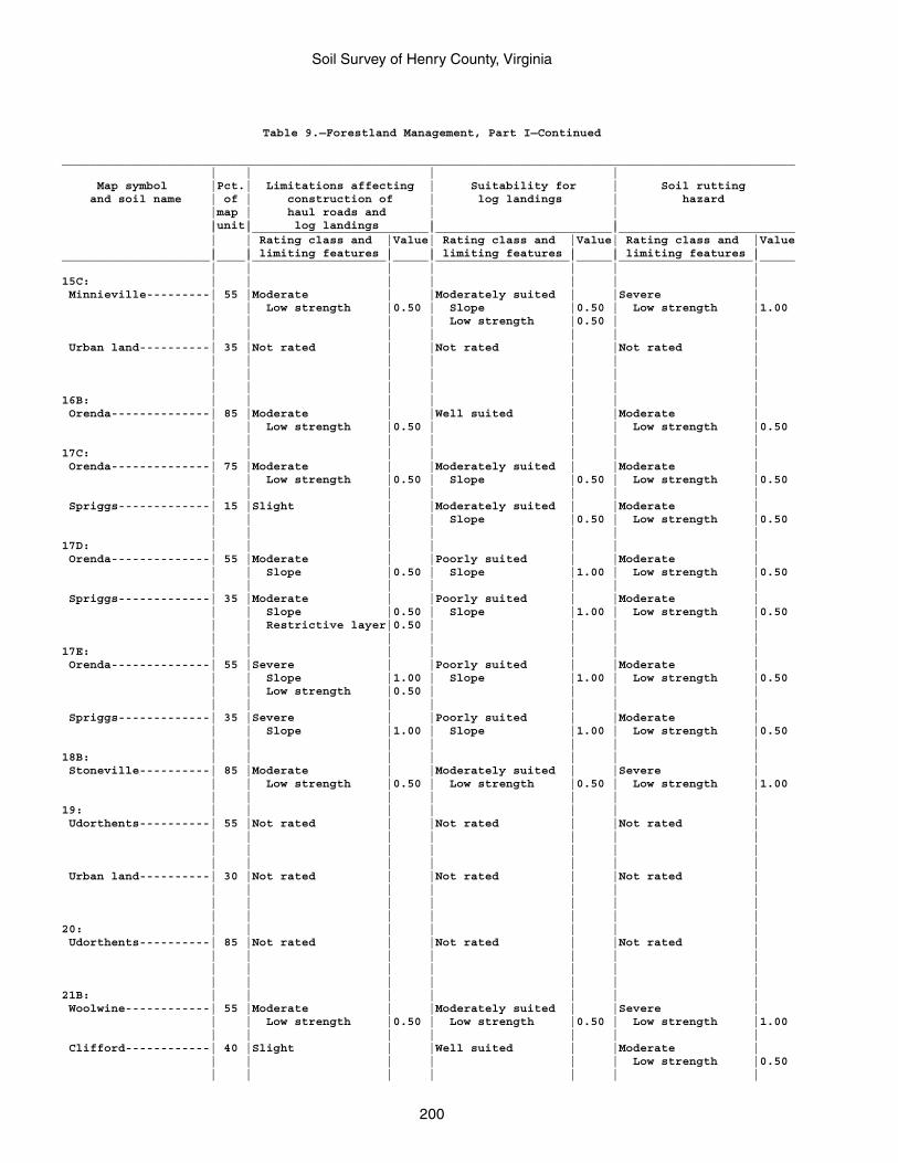
Soil Survey of Henry County, Virginia
200
Table 9.—Forestland Management, Part I—Continued
________________________________________________________________________________________________________ | | | | Map symbol |Pct.| Limitations affecting | Suitability for | Soil rutting and soil name | of | construction of | log landings | hazard |map | haul roads and | | |unit| log landings | | | |_________________________|_________________________|_________________________ | | Rating class and |Value| Rating class and |Value| Rating class and |Value | | limiting features | | limiting features | | limiting features |_____________________|____|___________________|_____|___________________|_____|___________________|_____ | | | | | | |15C: | | | | | | | Minnieville---------| 55 |Moderate | |Moderately suited | |Severe | | | Low strength |0.50 | Slope |0.50 | Low strength |1.00 | | | | Low strength |0.50 | | | | | | | | | Urban land----------| 35 |Not rated | |Not rated | |Not rated | | | | | | | | | | | | | | | | | | | | | |16B: | | | | | | | Orenda--------------| 85 |Moderate | |Well suited | |Moderate | | | Low strength |0.50 | | | Low strength |0.50 | | | | | | |17C: | | | | | | | Orenda--------------| 75 |Moderate | |Moderately suited | |Moderate | | | Low strength |0.50 | Slope |0.50 | Low strength |0.50 | | | | | | | Spriggs-------------| 15 |Slight | |Moderately suited | |Moderate | | | | | Slope |0.50 | Low strength |0.50 | | | | | | |17D: | | | | | | | Orenda--------------| 55 |Moderate | |Poorly suited | |Moderate | | | Slope |0.50 | Slope |1.00 | Low strength |0.50 | | | | | | | Spriggs-------------| 35 |Moderate | |Poorly suited | |Moderate | | | Slope |0.50 | Slope |1.00 | Low strength |0.50 | | Restrictive layer|0.50 | | | | | | | | | | |17E: | | | | | | | Orenda--------------| 55 |Severe | |Poorly suited | |Moderate | | | Slope |1.00 | Slope |1.00 | Low strength |0.50 | | Low strength |0.50 | | | | | | | | | | | Spriggs-------------| 35 |Severe | |Poorly suited | |Moderate | | | Slope |1.00 | Slope |1.00 | Low strength |0.50 | | | | | | |18B: | | | | | | | Stoneville----------| 85 |Moderate | |Moderately suited | |Severe | | | Low strength |0.50 | Low strength |0.50 | Low strength |1.00 | | | | | | |19: | | | | | | | Udorthents----------| 55 |Not rated | |Not rated | |Not rated | | | | | | | | | | | | | | | | | | | | | | Urban land----------| 30 |Not rated | |Not rated | |Not rated | | | | | | | | | | | | | | | | | | | | | |20: | | | | | | | Udorthents----------| 85 |Not rated | |Not rated | |Not rated | | | | | | | | | | | | | | | | | | | | | |21B: | | | | | | | Woolwine------------| 55 |Moderate | |Moderately suited | |Severe | | | Low strength |0.50 | Low strength |0.50 | Low strength |1.00 | | | | | | | Clifford------------| 40 |Slight | |Well suited | |Moderate | | | | | | | Low strength |0.50 | | | | | | |
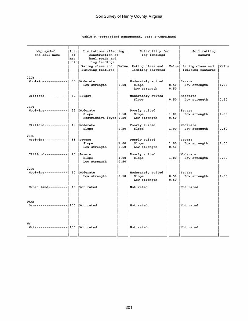
Soil Survey of Henry County, Virginia
201
Table 9.—Forestland Management, Part I—Continued
________________________________________________________________________________________________________ | | | | Map symbol |Pct.| Limitations affecting | Suitability for | Soil rutting and soil name | of | construction of | log landings | hazard |map | haul roads and | | |unit| log landings | | | |_________________________|_________________________|_________________________ | | Rating class and |Value| Rating class and |Value| Rating class and |Value | | limiting features | | limiting features | | limiting features |_____________________|____|___________________|_____|___________________|_____|___________________|_____ | | | | | | |21C: | | | | | | | Woolwine------------| 55 |Moderate | |Moderately suited | |Severe | | | Low strength |0.50 | Slope |0.50 | Low strength |1.00 | | | | Low strength |0.50 | | | | | | | | | Clifford------------| 40 |Slight | |Moderately suited | |Moderate | | | | | Slope |0.50 | Low strength |0.50 | | | | | | |21D: | | | | | | | Woolwine------------| 55 |Moderate | |Poorly suited | |Severe | | | Slope |0.50 | Slope |1.00 | Low strength |1.00 | | Restrictive layer|0.50 | Low strength |0.50 | | | | | | | | | Clifford------------| 40 |Moderate | |Poorly suited | |Moderate | | | Slope |0.50 | Slope |1.00 | Low strength |0.50 | | | | | | |21E: | | | | | | | Woolwine------------| 55 |Severe | |Poorly suited | |Severe | | | Slope |1.00 | Slope |1.00 | Low strength |1.00 | | Low strength |0.50 | Low strength |0.50 | | | | | | | | | Clifford------------| 40 |Severe | |Poorly suited | |Moderate | | | Slope |1.00 | Slope |1.00 | Low strength |0.50 | | Low strength |0.50 | | | | | | | | | | |22C: | | | | | | | Woolwine------------| 50 |Moderate | |Moderately suited | |Severe | | | Low strength |0.50 | Slope |0.50 | Low strength |1.00 | | | | Low strength |0.50 | | | | | | | | | Urban land----------| 40 |Not rated | |Not rated | |Not rated | | | | | | | | | | | | | | | | | | | | | |DAM: | | | | | | | Dam-----------------|100 |Not rated | |Not rated | |Not rated | | | | | | | | | | | | | | | | | | | | | | | | | | | | |W: | | | | | | | Water---------------|100 |Not rated | |Not rated | |Not rated | | | | | | | | | | | | | | |_____________________|____|___________________|_____|___________________|_____|___________________|_____
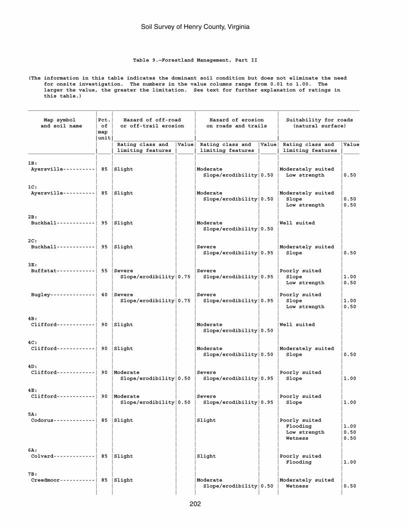
Soil Survey of Henry County, Virginia
202
Table 9.—Forestland Management, Part II
(The information in this table indicates the dominant soil condition but does not eliminate the need for onsite investigation. The numbers in the value columns range from 0.01 to 1.00. The larger the value, the greater the limitation. See text for further explanation of ratings in this table.)
________________________________________________________________________________________________________ | | | | Map symbol |Pct.| Hazard of off-road | Hazard of erosion | Suitability for roads and soil name | of | or off-trail erosion | on roads and trails | (natural surface) |map | | | |unit| | | | |_________________________|_________________________|_________________________ | | Rating class and |Value| Rating class and |Value| Rating class and |Value | | limiting features | | limiting features | | limiting features |_____________________|____|___________________|_____|___________________|_____|___________________|_____ | | | | | | |1B: | | | | | | | Ayersville----------| 85 |Slight | |Moderate | |Moderately suited | | | | | Slope/erodibility|0.50 | Low strength |0.50 | | | | | | |1C: | | | | | | | Ayersville----------| 85 |Slight | |Moderate | |Moderately suited | | | | | Slope/erodibility|0.50 | Slope |0.50 | | | | | | Low strength |0.50 | | | | | | |2B: | | | | | | | Buckhall------------| 95 |Slight | |Moderate | |Well suited | | | | | Slope/erodibility|0.50 | | | | | | | | |2C: | | | | | | | Buckhall------------| 95 |Slight | |Severe | |Moderately suited | | | | | Slope/erodibility|0.95 | Slope |0.50 | | | | | | |3E: | | | | | | | Buffstat------------| 55 |Severe | |Severe | |Poorly suited | | | Slope/erodibility|0.75 | Slope/erodibility|0.95 | Slope |1.00 | | | | | | Low strength |0.50 | | | | | | | Bugley--------------| 40 |Severe | |Severe | |Poorly suited | | | Slope/erodibility|0.75 | Slope/erodibility|0.95 | Slope |1.00 | | | | | | Low strength |0.50 | | | | | | |4B: | | | | | | | Clifford------------| 90 |Slight | |Moderate | |Well suited | | | | | Slope/erodibility|0.50 | | | | | | | | |4C: | | | | | | | Clifford------------| 90 |Slight | |Moderate | |Moderately suited | | | | | Slope/erodibility|0.50 | Slope |0.50 | | | | | | |4D: | | | | | | | Clifford------------| 90 |Moderate | |Severe | |Poorly suited | | | Slope/erodibility|0.50 | Slope/erodibility|0.95 | Slope |1.00 | | | | | | |4E: | | | | | | | Clifford------------| 90 |Moderate | |Severe | |Poorly suited | | | Slope/erodibility|0.50 | Slope/erodibility|0.95 | Slope |1.00 | | | | | | |5A: | | | | | | | Codorus-------------| 85 |Slight | |Slight | |Poorly suited | | | | | | | Flooding |1.00 | | | | | | Low strength |0.50 | | | | | | Wetness |0.50 | | | | | | |6A: | | | | | | | Colvard-------------| 85 |Slight | |Slight | |Poorly suited | | | | | | | Flooding |1.00 | | | | | | |7B: | | | | | | | Creedmoor-----------| 85 |Slight | |Moderate | |Moderately suited | | | | | Slope/erodibility|0.50 | Wetness |0.50 | | | | | | |
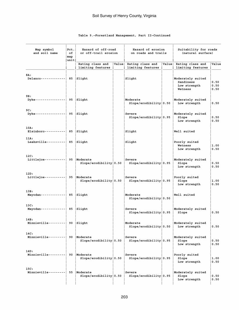
Soil Survey of Henry County, Virginia
203
Table 9.—Forestland Management, Part II—Continued
________________________________________________________________________________________________________ | | | | Map symbol |Pct.| Hazard of off-road | Hazard of erosion | Suitability for roads and soil name | of | or off-trail erosion | on roads and trails | (natural surface) |map | | | |unit| | | | |_________________________|_________________________|_________________________ | | Rating class and |Value| Rating class and |Value| Rating class and |Value | | limiting features | | limiting features | | limiting features |_____________________|____|___________________|_____|___________________|_____|___________________|_____ | | | | | | |8A: | | | | | | | Delanco-------------| 85 |Slight | |Slight | |Moderately suited | | | | | | | Sandiness |0.50 | | | | | | Low strength |0.50 | | | | | | Wetness |0.50 | | | | | | |9B: | | | | | | | Dyke----------------| 95 |Slight | |Moderate | |Moderately suited | | | | | Slope/erodibility|0.50 | Low strength |0.50 | | | | | | |9C: | | | | | | | Dyke----------------| 95 |Slight | |Severe | |Moderately suited | | | | | Slope/erodibility|0.95 | Slope |0.50 | | | | | | Low strength |0.50 | | | | | | |10A: | | | | | | | Elsinboro-----------| 85 |Slight | |Slight | |Well suited | | | | | | | |11A: | | | | | | | Leaksville----------| 85 |Slight | |Slight | |Poorly suited | | | | | | | Wetness |1.00 | | | | | | Low strength |0.50 | | | | | | |12C: | | | | | | | Littlejoe-----------| 95 |Moderate | |Severe | |Moderately suited | | | Slope/erodibility|0.50 | Slope/erodibility|0.95 | Slope |0.50 | | | | | | Low strength |0.50 | | | | | | |12D: | | | | | | | Littlejoe-----------| 95 |Moderate | |Severe | |Poorly suited | | | Slope/erodibility|0.50 | Slope/erodibility|0.95 | Slope |1.00 | | | | | | Low strength |0.50 | | | | | | |13B: | | | | | | | Mayodan-------------| 85 |Slight | |Moderate | |Well suited | | | | | Slope/erodibility|0.50 | | | | | | | | |13C: | | | | | | | Mayodan-------------| 85 |Slight | |Severe | |Moderately suited | | | | | Slope/erodibility|0.95 | Slope |0.50 | | | | | | |14B: | | | | | | | Minnieville---------| 90 |Slight | |Moderate | |Moderately suited | | | | | Slope/erodibility|0.50 | Low strength |0.50 | | | | | | |14C: | | | | | | | Minnieville---------| 90 |Moderate | |Severe | |Moderately suited | | | Slope/erodibility|0.50 | Slope/erodibility|0.95 | Slope |0.50 | | | | | | Low strength |0.50 | | | | | | |14D: | | | | | | | Minnieville---------| 90 |Moderate | |Severe | |Poorly suited | | | Slope/erodibility|0.50 | Slope/erodibility|0.95 | Slope |1.00 | | | | | | Low strength |0.50 | | | | | | |15C: | | | | | | | Minnieville---------| 55 |Moderate | |Severe | |Moderately suited | | | Slope/erodibility|0.50 | Slope/erodibility|0.95 | Slope |0.50 | | | | | | Low strength |0.50 | | | | | | |
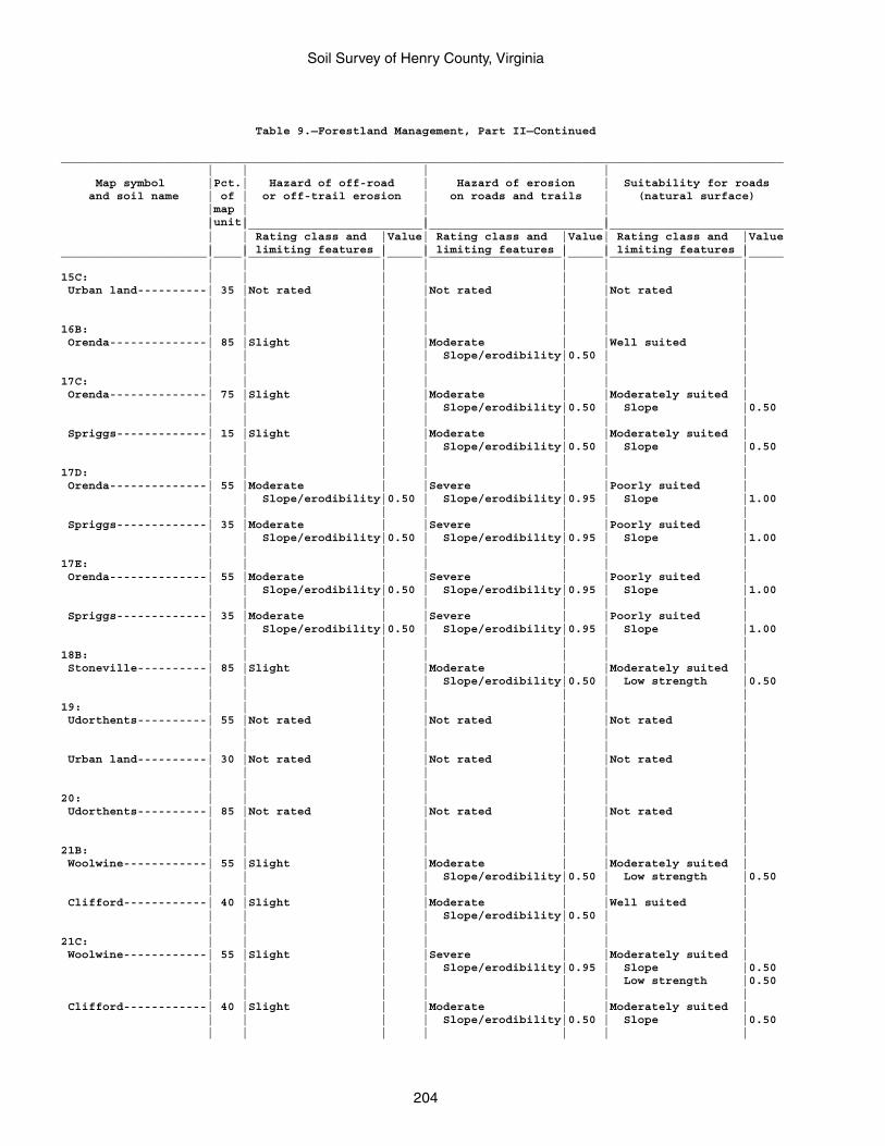
Soil Survey of Henry County, Virginia
204
Table 9.—Forestland Management, Part II—Continued
________________________________________________________________________________________________________ | | | | Map symbol |Pct.| Hazard of off-road | Hazard of erosion | Suitability for roads and soil name | of | or off-trail erosion | on roads and trails | (natural surface) |map | | | |unit| | | | |_________________________|_________________________|_________________________ | | Rating class and |Value| Rating class and |Value| Rating class and |Value | | limiting features | | limiting features | | limiting features |_____________________|____|___________________|_____|___________________|_____|___________________|_____ | | | | | | |15C: | | | | | | | Urban land----------| 35 |Not rated | |Not rated | |Not rated | | | | | | | | | | | | | | |16B: | | | | | | | Orenda--------------| 85 |Slight | |Moderate | |Well suited | | | | | Slope/erodibility|0.50 | | | | | | | | |17C: | | | | | | | Orenda--------------| 75 |Slight | |Moderate | |Moderately suited | | | | | Slope/erodibility|0.50 | Slope |0.50 | | | | | | | Spriggs-------------| 15 |Slight | |Moderate | |Moderately suited | | | | | Slope/erodibility|0.50 | Slope |0.50 | | | | | | |17D: | | | | | | | Orenda--------------| 55 |Moderate | |Severe | |Poorly suited | | | Slope/erodibility|0.50 | Slope/erodibility|0.95 | Slope |1.00 | | | | | | | Spriggs-------------| 35 |Moderate | |Severe | |Poorly suited | | | Slope/erodibility|0.50 | Slope/erodibility|0.95 | Slope |1.00 | | | | | | |17E: | | | | | | | Orenda--------------| 55 |Moderate | |Severe | |Poorly suited | | | Slope/erodibility|0.50 | Slope/erodibility|0.95 | Slope |1.00 | | | | | | | Spriggs-------------| 35 |Moderate | |Severe | |Poorly suited | | | Slope/erodibility|0.50 | Slope/erodibility|0.95 | Slope |1.00 | | | | | | |18B: | | | | | | | Stoneville----------| 85 |Slight | |Moderate | |Moderately suited | | | | | Slope/erodibility|0.50 | Low strength |0.50 | | | | | | |19: | | | | | | | Udorthents----------| 55 |Not rated | |Not rated | |Not rated | | | | | | | | | | | | | | | Urban land----------| 30 |Not rated | |Not rated | |Not rated | | | | | | | | | | | | | | |20: | | | | | | | Udorthents----------| 85 |Not rated | |Not rated | |Not rated | | | | | | | | | | | | | | |21B: | | | | | | | Woolwine------------| 55 |Slight | |Moderate | |Moderately suited | | | | | Slope/erodibility|0.50 | Low strength |0.50 | | | | | | | Clifford------------| 40 |Slight | |Moderate | |Well suited | | | | | Slope/erodibility|0.50 | | | | | | | | |21C: | | | | | | | Woolwine------------| 55 |Slight | |Severe | |Moderately suited | | | | | Slope/erodibility|0.95 | Slope |0.50 | | | | | | Low strength |0.50 | | | | | | | Clifford------------| 40 |Slight | |Moderate | |Moderately suited | | | | | Slope/erodibility|0.50 | Slope |0.50 | | | | | | |
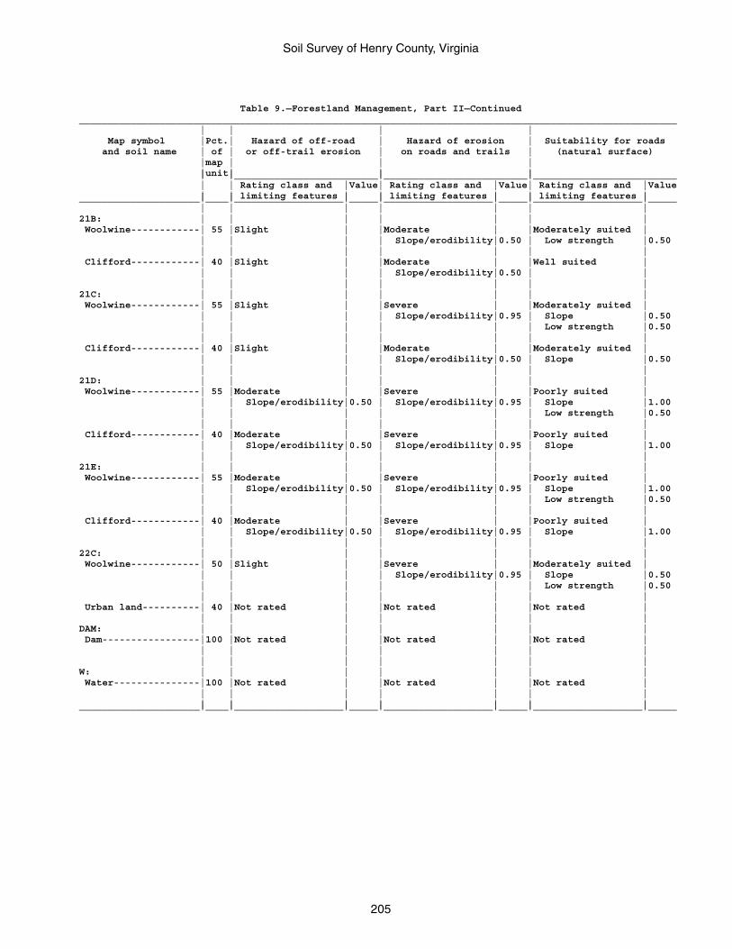
Soil Survey of Henry County, Virginia
205
Table 9.—Forestland Management, Part II—Continued________________________________________________________________________________________________________ | | | | Map symbol |Pct.| Hazard of off-road | Hazard of erosion | Suitability for roads and soil name | of | or off-trail erosion | on roads and trails | (natural surface) |map | | | |unit| | | | |_________________________|_________________________|_________________________ | | Rating class and |Value| Rating class and |Value| Rating class and |Value | | limiting features | | limiting features | | limiting features |_____________________|____|___________________|_____|___________________|_____|___________________|_____ | | | | | | |21B: | | | | | | | Woolwine------------| 55 |Slight | |Moderate | |Moderately suited | | | | | Slope/erodibility|0.50 | Low strength |0.50 | | | | | | | Clifford------------| 40 |Slight | |Moderate | |Well suited | | | | | Slope/erodibility|0.50 | | | | | | | | |21C: | | | | | | | Woolwine------------| 55 |Slight | |Severe | |Moderately suited | | | | | Slope/erodibility|0.95 | Slope |0.50 | | | | | | Low strength |0.50 | | | | | | | Clifford------------| 40 |Slight | |Moderate | |Moderately suited | | | | | Slope/erodibility|0.50 | Slope |0.50 | | | | | | |21D: | | | | | | | Woolwine------------| 55 |Moderate | |Severe | |Poorly suited | | | Slope/erodibility|0.50 | Slope/erodibility|0.95 | Slope |1.00 | | | | | | Low strength |0.50 | | | | | | | Clifford------------| 40 |Moderate | |Severe | |Poorly suited | | | Slope/erodibility|0.50 | Slope/erodibility|0.95 | Slope |1.00 | | | | | | |21E: | | | | | | | Woolwine------------| 55 |Moderate | |Severe | |Poorly suited | | | Slope/erodibility|0.50 | Slope/erodibility|0.95 | Slope |1.00 | | | | | | Low strength |0.50 | | | | | | | Clifford------------| 40 |Moderate | |Severe | |Poorly suited | | | Slope/erodibility|0.50 | Slope/erodibility|0.95 | Slope |1.00 | | | | | | |22C: | | | | | | | Woolwine------------| 50 |Slight | |Severe | |Moderately suited | | | | | Slope/erodibility|0.95 | Slope |0.50 | | | | | | Low strength |0.50 | | | | | | | Urban land----------| 40 |Not rated | |Not rated | |Not rated | | | | | | | |DAM: | | | | | | | Dam-----------------|100 |Not rated | |Not rated | |Not rated | | | | | | | | | | | | | | |W: | | | | | | | Water---------------|100 |Not rated | |Not rated | |Not rated | | | | | | | | | | | | | | |_____________________|____|___________________|_____|___________________|_____|___________________|_____
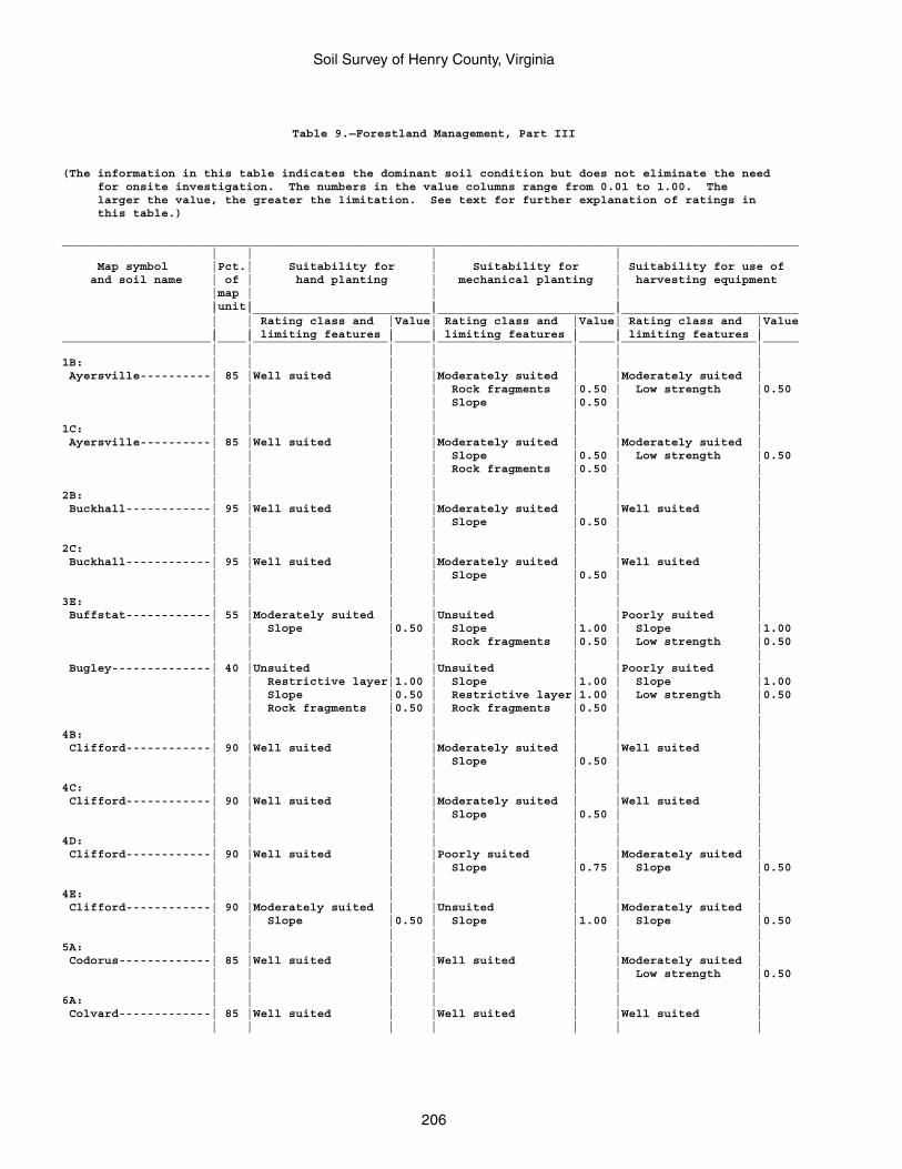
Soil Survey of Henry County, Virginia
206
Table 9.—Forestland Management, Part III
(The information in this table indicates the dominant soil condition but does not eliminate the need for onsite investigation. The numbers in the value columns range from 0.01 to 1.00. The larger the value, the greater the limitation. See text for further explanation of ratings in this table.)
________________________________________________________________________________________________________ | | | | Map symbol |Pct.| Suitability for | Suitability for | Suitability for use of and soil name | of | hand planting | mechanical planting | harvesting equipment |map | | | |unit| | | | |_________________________|_________________________|_________________________ | | Rating class and |Value| Rating class and |Value| Rating class and |Value | | limiting features | | limiting features | | limiting features |_____________________|____|___________________|_____|___________________|_____|___________________|_____ | | | | | | |1B: | | | | | | | Ayersville----------| 85 |Well suited | |Moderately suited | |Moderately suited | | | | | Rock fragments |0.50 | Low strength |0.50 | | | | Slope |0.50 | | | | | | | | |1C: | | | | | | | Ayersville----------| 85 |Well suited | |Moderately suited | |Moderately suited | | | | | Slope |0.50 | Low strength |0.50 | | | | Rock fragments |0.50 | | | | | | | | |2B: | | | | | | | Buckhall------------| 95 |Well suited | |Moderately suited | |Well suited | | | | | Slope |0.50 | | | | | | | | |2C: | | | | | | | Buckhall------------| 95 |Well suited | |Moderately suited | |Well suited | | | | | Slope |0.50 | | | | | | | | |3E: | | | | | | | Buffstat------------| 55 |Moderately suited | |Unsuited | |Poorly suited | | | Slope |0.50 | Slope |1.00 | Slope |1.00 | | | | Rock fragments |0.50 | Low strength |0.50 | | | | | | | Bugley--------------| 40 |Unsuited | |Unsuited | |Poorly suited | | | Restrictive layer|1.00 | Slope |1.00 | Slope |1.00 | | Slope |0.50 | Restrictive layer|1.00 | Low strength |0.50 | | Rock fragments |0.50 | Rock fragments |0.50 | | | | | | | | |4B: | | | | | | | Clifford------------| 90 |Well suited | |Moderately suited | |Well suited | | | | | Slope |0.50 | | | | | | | | |4C: | | | | | | | Clifford------------| 90 |Well suited | |Moderately suited | |Well suited | | | | | Slope |0.50 | | | | | | | | |4D: | | | | | | | Clifford------------| 90 |Well suited | |Poorly suited | |Moderately suited | | | | | Slope |0.75 | Slope |0.50 | | | | | | |4E: | | | | | | | Clifford------------| 90 |Moderately suited | |Unsuited | |Moderately suited | | | Slope |0.50 | Slope |1.00 | Slope |0.50 | | | | | | |5A: | | | | | | | Codorus-------------| 85 |Well suited | |Well suited | |Moderately suited | | | | | | | Low strength |0.50 | | | | | | |6A: | | | | | | | Colvard-------------| 85 |Well suited | |Well suited | |Well suited | | | | | | | |
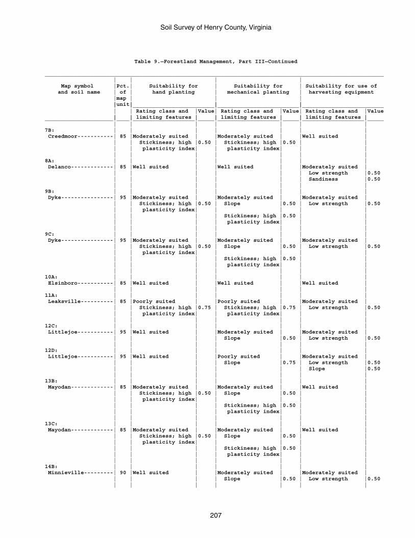
Soil Survey of Henry County, Virginia
207
Table 9.—Forestland Management, Part III—Continued
________________________________________________________________________________________________________ | | | | Map symbol |Pct.| Suitability for | Suitability for | Suitability for use of and soil name | of | hand planting | mechanical planting | harvesting equipment |map | | | |unit| | | | |_________________________|_________________________|_________________________ | | Rating class and |Value| Rating class and |Value| Rating class and |Value | | limiting features | | limiting features | | limiting features |_____________________|____|___________________|_____|___________________|_____|___________________|_____ | | | | | | |7B: | | | | | | | Creedmoor-----------| 85 |Moderately suited | |Moderately suited | |Well suited | | | Stickiness; high |0.50 | Stickiness; high |0.50 | | | | plasticity index| | plasticity index| | | | | | | | | |8A: | | | | | | | Delanco-------------| 85 |Well suited | |Well suited | |Moderately suited | | | | | | | Low strength |0.50 | | | | | | Sandiness |0.50 | | | | | | |9B: | | | | | | | Dyke----------------| 95 |Moderately suited | |Moderately suited | |Moderately suited | | | Stickiness; high |0.50 | Slope |0.50 | Low strength |0.50 | | plasticity index| | | | | | | | | Stickiness; high |0.50 | | | | | | plasticity index| | | | | | | | | |9C: | | | | | | | Dyke----------------| 95 |Moderately suited | |Moderately suited | |Moderately suited | | | Stickiness; high |0.50 | Slope |0.50 | Low strength |0.50 | | plasticity index| | | | | | | | | Stickiness; high |0.50 | | | | | | plasticity index| | | | | | | | | |10A: | | | | | | | Elsinboro-----------| 85 |Well suited | |Well suited | |Well suited | | | | | | | |11A: | | | | | | | Leaksville----------| 85 |Poorly suited | |Poorly suited | |Moderately suited | | | Stickiness; high |0.75 | Stickiness; high |0.75 | Low strength |0.50 | | plasticity index| | plasticity index| | | | | | | | | |12C: | | | | | | | Littlejoe-----------| 95 |Well suited | |Moderately suited | |Moderately suited | | | | | Slope |0.50 | Low strength |0.50 | | | | | | |12D: | | | | | | | Littlejoe-----------| 95 |Well suited | |Poorly suited | |Moderately suited | | | | | Slope |0.75 | Low strength |0.50 | | | | | | Slope |0.50 | | | | | | |13B: | | | | | | | Mayodan-------------| 85 |Moderately suited | |Moderately suited | |Well suited | | | Stickiness; high |0.50 | Slope |0.50 | | | | plasticity index| | | | | | | | | Stickiness; high |0.50 | | | | | | plasticity index| | | | | | | | | |13C: | | | | | | | Mayodan-------------| 85 |Moderately suited | |Moderately suited | |Well suited | | | Stickiness; high |0.50 | Slope |0.50 | | | | plasticity index| | | | | | | | | Stickiness; high |0.50 | | | | | | plasticity index| | | | | | | | | |14B: | | | | | | | Minnieville---------| 90 |Well suited | |Moderately suited | |Moderately suited | | | | | Slope |0.50 | Low strength |0.50 | | | | | | |
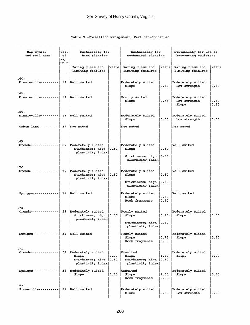
Soil Survey of Henry County, Virginia
208
Table 9.—Forestland Management, Part III—Continued
________________________________________________________________________________________________________ | | | | Map symbol |Pct.| Suitability for | Suitability for | Suitability for use of and soil name | of | hand planting | mechanical planting | harvesting equipment |map | | | |unit| | | | |_________________________|_________________________|_________________________ | | Rating class and |Value| Rating class and |Value| Rating class and |Value | | limiting features | | limiting features | | limiting features |_____________________|____|___________________|_____|___________________|_____|___________________|_____ | | | | | | |14C: | | | | | | | Minnieville---------| 90 |Well suited | |Moderately suited | |Moderately suited | | | | | Slope |0.50 | Low strength |0.50 | | | | | | |14D: | | | | | | | Minnieville---------| 90 |Well suited | |Poorly suited | |Moderately suited | | | | | Slope |0.75 | Low strength |0.50 | | | | | | Slope |0.50 | | | | | | |15C: | | | | | | | Minnieville---------| 55 |Well suited | |Moderately suited | |Moderately suited | | | | | Slope |0.50 | Low strength |0.50 | | | | | | | Urban land----------| 35 |Not rated | |Not rated | |Not rated | | | | | | | | | | | | | | | | | | | | | |16B: | | | | | | | Orenda--------------| 85 |Moderately suited | |Moderately suited | |Well suited | | | Stickiness; high |0.50 | Slope |0.50 | | | | plasticity index| | | | | | | | | Stickiness; high |0.50 | | | | | | plasticity index| | | | | | | | | |17C: | | | | | | | Orenda--------------| 75 |Moderately suited | |Moderately suited | |Well suited | | | Stickiness; high |0.50 | Slope |0.50 | | | | plasticity index| | | | | | | | | Stickiness; high |0.50 | | | | | | plasticity index| | | | | | | | | | Spriggs-------------| 15 |Well suited | |Moderately suited | |Well suited | | | | | Slope |0.50 | | | | | | Rock fragments |0.50 | | | | | | | | |17D: | | | | | | | Orenda--------------| 55 |Moderately suited | |Poorly suited | |Moderately suited | | | Stickiness; high |0.50 | Slope |0.75 | Slope |0.50 | | plasticity index| | | | | | | | | Stickiness; high |0.50 | | | | | | plasticity index| | | | | | | | | | Spriggs-------------| 35 |Well suited | |Poorly suited | |Moderately suited | | | | | Slope |0.75 | Slope |0.50 | | | | Rock fragments |0.50 | | | | | | | | |17E: | | | | | | | Orenda--------------| 55 |Moderately suited | |Unsuited | |Moderately suited | | | Slope |0.50 | Slope |1.00 | Slope |0.50 | | Stickiness; high |0.50 | Stickiness; high |0.50 | | | | plasticity index| | plasticity index| | | | | | | | | | Spriggs-------------| 35 |Moderately suited | |Unsuited | |Moderately suited | | | Slope |0.50 | Slope |1.00 | Slope |0.50 | | | | Rock fragments |0.50 | | | | | | | | |18B: | | | | | | | Stoneville----------| 85 |Well suited | |Moderately suited | |Moderately suited | | | | | Slope |0.50 | Low strength |0.50 | | | | | | |
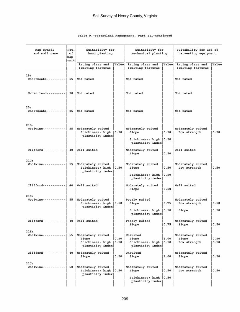
Soil Survey of Henry County, Virginia
209
Table 9.—Forestland Management, Part III—Continued
________________________________________________________________________________________________________ | | | | Map symbol |Pct.| Suitability for | Suitability for | Suitability for use of and soil name | of | hand planting | mechanical planting | harvesting equipment |map | | | |unit| | | | |_________________________|_________________________|_________________________ | | Rating class and |Value| Rating class and |Value| Rating class and |Value | | limiting features | | limiting features | | limiting features |_____________________|____|___________________|_____|___________________|_____|___________________|_____ | | | | | | |19: | | | | | | | Udorthents----------| 55 |Not rated | |Not rated | |Not rated | | | | | | | | | | | | | | | | | | | | | | Urban land----------| 30 |Not rated | |Not rated | |Not rated | | | | | | | | | | | | | | | | | | | | | |20: | | | | | | | Udorthents----------| 85 |Not rated | |Not rated | |Not rated | | | | | | | | | | | | | | | | | | | | | |21B: | | | | | | | Woolwine------------| 55 |Moderately suited | |Moderately suited | |Moderately suited | | | Stickiness; high |0.50 | Slope |0.50 | Low strength |0.50 | | plasticity index| | | | | | | | | Stickiness; high |0.50 | | | | | | plasticity index| | | | | | | | | | Clifford------------| 40 |Well suited | |Moderately suited | |Well suited | | | | | Slope |0.50 | | | | | | | | |21C: | | | | | | | Woolwine------------| 55 |Moderately suited | |Moderately suited | |Moderately suited | | | Stickiness; high |0.50 | Slope |0.50 | Low strength |0.50 | | plasticity index| | | | | | | | | Stickiness; high |0.50 | | | | | | plasticity index| | | | | | | | | | Clifford------------| 40 |Well suited | |Moderately suited | |Well suited | | | | | Slope |0.50 | | | | | | | | |21D: | | | | | | | Woolwine------------| 55 |Moderately suited | |Poorly suited | |Moderately suited | | | Stickiness; high |0.50 | Slope |0.75 | Low strength |0.50 | | plasticity index| | | | | | | | | Stickiness; high |0.50 | Slope |0.50 | | | | plasticity index| | | | | | | | | | Clifford------------| 40 |Well suited | |Poorly suited | |Moderately suited | | | | | Slope |0.75 | Slope |0.50 | | | | | | |21E: | | | | | | | Woolwine------------| 55 |Moderately suited | |Unsuited | |Moderately suited | | | Slope |0.50 | Slope |1.00 | Slope |0.50 | | Stickiness; high |0.50 | Stickiness; high |0.50 | Low strength |0.50 | | plasticity index| | plasticity index| | | | | | | | | | Clifford------------| 40 |Moderately suited | |Unsuited | |Moderately suited | | | Slope |0.50 | Slope |1.00 | Slope |0.50 | | | | | | |22C: | | | | | | | Woolwine------------| 50 |Moderately suited | |Moderately suited | |Moderately suited | | | Stickiness; high |0.50 | Slope |0.50 | Low strength |0.50 | | plasticity index| | | | | | | | | Stickiness; high |0.50 | | | | | | plasticity index| | | | | | | | | |
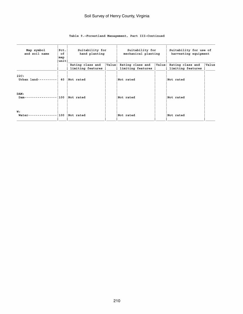
Soil Survey of Henry County, Virginia
210
Table 9.—Forestland Management, Part III—Continued
________________________________________________________________________________________________________ | | | | Map symbol |Pct.| Suitability for | Suitability for | Suitability for use of and soil name | of | hand planting | mechanical planting | harvesting equipment |map | | | |unit| | | | |_________________________|_________________________|_________________________ | | Rating class and |Value| Rating class and |Value| Rating class and |Value | | limiting features | | limiting features | | limiting features |_____________________|____|___________________|_____|___________________|_____|___________________|_____ | | | | | | |22C: | | | | | | | Urban land----------| 40 |Not rated | |Not rated | |Not rated | | | | | | | | | | | | | | | | | | | | | |DAM: | | | | | | | Dam-----------------|100 |Not rated | |Not rated | |Not rated | | | | | | | | | | | | | | | | | | | | | |W: | | | | | | | Water---------------|100 |Not rated | |Not rated | |Not rated | | | | | | | |_____________________|____|___________________|_____|___________________|_____|___________________|_____
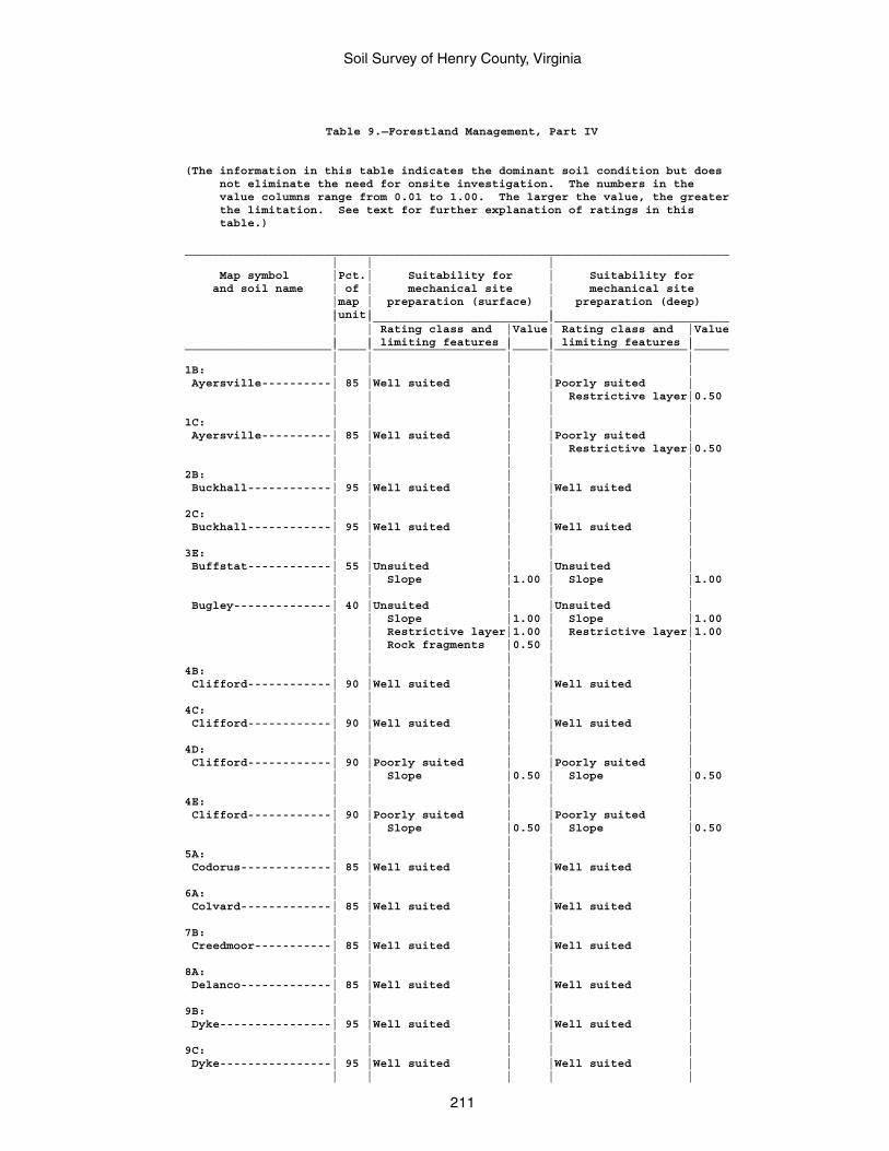
Soil Survey of Henry County, Virginia
211
Table 9.—Forestland Management, Part IV
(The information in this table indicates the dominant soil condition but does not eliminate the need for onsite investigation. The numbers in the value columns range from 0.01 to 1.00. The larger the value, the greater the limitation. See text for further explanation of ratings in this table.)
______________________________________________________________________________ | | | Map symbol |Pct.| Suitability for | Suitability for and soil name | of | mechanical site | mechanical site |map | preparation (surface) | preparation (deep) |unit| | | |_________________________|_________________________ | | Rating class and |Value| Rating class and |Value | | limiting features | | limiting features |_____________________|____|___________________|_____|___________________|_____ | | | | |1B: | | | | | Ayersville----------| 85 |Well suited | |Poorly suited | | | | | Restrictive layer|0.50 | | | | |1C: | | | | | Ayersville----------| 85 |Well suited | |Poorly suited | | | | | Restrictive layer|0.50 | | | | |2B: | | | | | Buckhall------------| 95 |Well suited | |Well suited | | | | | |2C: | | | | | Buckhall------------| 95 |Well suited | |Well suited | | | | | |3E: | | | | | Buffstat------------| 55 |Unsuited | |Unsuited | | | Slope |1.00 | Slope |1.00 | | | | | Bugley--------------| 40 |Unsuited | |Unsuited | | | Slope |1.00 | Slope |1.00 | | Restrictive layer|1.00 | Restrictive layer|1.00 | | Rock fragments |0.50 | | | | | | |4B: | | | | | Clifford------------| 90 |Well suited | |Well suited | | | | | |4C: | | | | | Clifford------------| 90 |Well suited | |Well suited | | | | | |4D: | | | | | Clifford------------| 90 |Poorly suited | |Poorly suited | | | Slope |0.50 | Slope |0.50 | | | | |4E: | | | | | Clifford------------| 90 |Poorly suited | |Poorly suited | | | Slope |0.50 | Slope |0.50 | | | | |5A: | | | | | Codorus-------------| 85 |Well suited | |Well suited | | | | | |6A: | | | | | Colvard-------------| 85 |Well suited | |Well suited | | | | | |7B: | | | | | Creedmoor-----------| 85 |Well suited | |Well suited | | | | | |8A: | | | | | Delanco-------------| 85 |Well suited | |Well suited | | | | | |9B: | | | | | Dyke----------------| 95 |Well suited | |Well suited | | | | | |9C: | | | | | Dyke----------------| 95 |Well suited | |Well suited | | | | | |
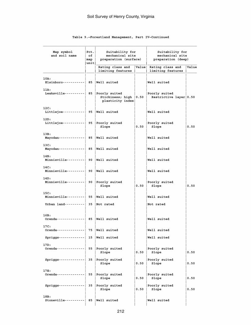
Soil Survey of Henry County, Virginia
212
Table 9.—Forestland Management, Part IV—Continued
______________________________________________________________________________ | | | Map symbol |Pct.| Suitability for | Suitability for and soil name | of | mechanical site | mechanical site |map | preparation (surface) | preparation (deep) |unit| | | |_________________________|_________________________ | | Rating class and |Value| Rating class and |Value | | limiting features | | limiting features |_____________________|____|___________________|_____|___________________|_____ | | | | |10A: | | | | | Elsinboro-----------| 85 |Well suited | |Well suited | | | | | |11A: | | | | | Leaksville----------| 85 |Poorly suited | |Poorly suited | | | Stickiness; high |0.50 | Restrictive layer|0.50 | | plasticity index| | | | | | | |12C: | | | | | Littlejoe-----------| 95 |Well suited | |Well suited | | | | | |12D: | | | | | Littlejoe-----------| 95 |Poorly suited | |Poorly suited | | | Slope |0.50 | Slope |0.50 | | | | |13B: | | | | | Mayodan-------------| 85 |Well suited | |Well suited | | | | | |13C: | | | | | Mayodan-------------| 85 |Well suited | |Well suited | | | | | |14B: | | | | | Minnieville---------| 90 |Well suited | |Well suited | | | | | |14C: | | | | | Minnieville---------| 90 |Well suited | |Well suited | | | | | |14D: | | | | | Minnieville---------| 90 |Poorly suited | |Poorly suited | | | Slope |0.50 | Slope |0.50 | | | | |15C: | | | | | Minnieville---------| 55 |Well suited | |Well suited | | | | | | Urban land----------| 35 |Not rated | |Not rated | | | | | | | | | | |16B: | | | | | Orenda--------------| 85 |Well suited | |Well suited | | | | | |17C: | | | | | Orenda--------------| 75 |Well suited | |Well suited | | | | | | Spriggs-------------| 15 |Well suited | |Well suited | | | | | |17D: | | | | | Orenda--------------| 55 |Poorly suited | |Poorly suited | | | Slope |0.50 | Slope |0.50 | | | | | Spriggs-------------| 35 |Poorly suited | |Poorly suited | | | Slope |0.50 | Slope |0.50 | | | | |17E: | | | | | Orenda--------------| 55 |Poorly suited | |Poorly suited | | | Slope |0.50 | Slope |0.50 | | | | | Spriggs-------------| 35 |Poorly suited | |Poorly suited | | | Slope |0.50 | Slope |0.50 | | | | |18B: | | | | | Stoneville----------| 85 |Well suited | |Well suited | | | | | |
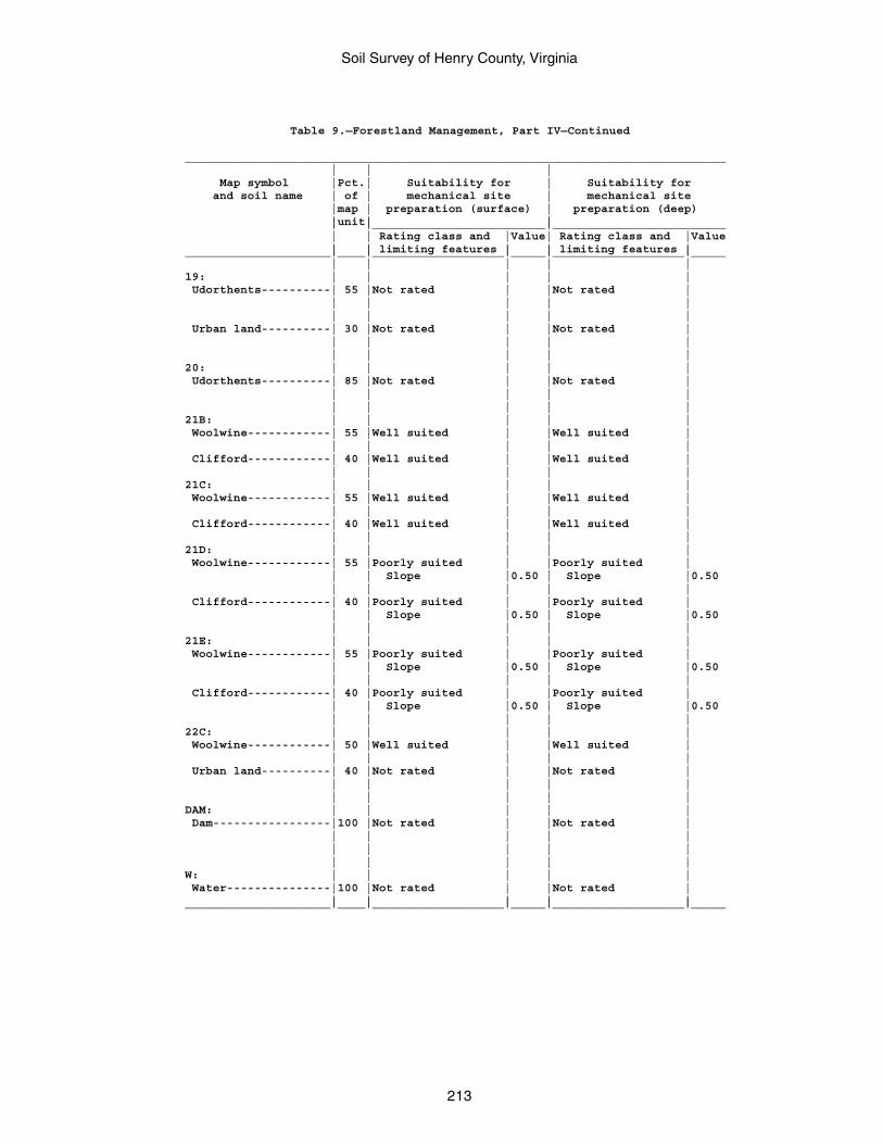
Soil Survey of Henry County, Virginia
213
Table 9.—Forestland Management, Part IV—Continued
______________________________________________________________________________ | | | Map symbol |Pct.| Suitability for | Suitability for and soil name | of | mechanical site | mechanical site |map | preparation (surface) | preparation (deep) |unit| | | |_________________________|_________________________ | | Rating class and |Value| Rating class and |Value | | limiting features | | limiting features |_____________________|____|___________________|_____|___________________|_____ | | | | |19: | | | | | Udorthents----------| 55 |Not rated | |Not rated | | | | | | | | | | | Urban land----------| 30 |Not rated | |Not rated | | | | | | | | | | |20: | | | | | Udorthents----------| 85 |Not rated | |Not rated | | | | | | | | | | |21B: | | | | | Woolwine------------| 55 |Well suited | |Well suited | | | | | | Clifford------------| 40 |Well suited | |Well suited | | | | | |21C: | | | | | Woolwine------------| 55 |Well suited | |Well suited | | | | | | Clifford------------| 40 |Well suited | |Well suited | | | | | |21D: | | | | | Woolwine------------| 55 |Poorly suited | |Poorly suited | | | Slope |0.50 | Slope |0.50 | | | | | Clifford------------| 40 |Poorly suited | |Poorly suited | | | Slope |0.50 | Slope |0.50 | | | | |21E: | | | | | Woolwine------------| 55 |Poorly suited | |Poorly suited | | | Slope |0.50 | Slope |0.50 | | | | | Clifford------------| 40 |Poorly suited | |Poorly suited | | | Slope |0.50 | Slope |0.50 | | | | |22C: | | | | | Woolwine------------| 50 |Well suited | |Well suited | | | | | | Urban land----------| 40 |Not rated | |Not rated | | | | | | | | | | |DAM: | | | | | Dam-----------------|100 |Not rated | |Not rated | | | | | | | | | | | | | | | |W: | | | | | Water---------------|100 |Not rated | |Not rated | | | | | |_____________________|____|___________________|_____|___________________|_____
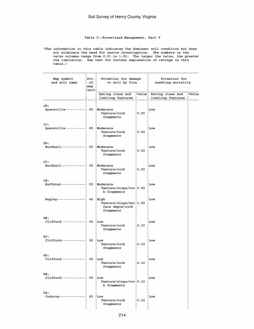
Soil Survey of Henry County, Virginia
214
Table 9.—Forestland Management, Part V
(The information in this table indicates the dominant soil condition but does not eliminate the need for onsite investigation. The numbers in the value columns range from 0.01 to 1.00. The larger the value, the greater the limitation. See text for further explanation of ratings in this table.)
______________________________________________________________________________ | | | Map symbol |Pct.| Potential for damage | Potential for and soil name | of | to soil by fire | seedling mortality |map | | |unit| | | |_________________________|_________________________ | | Rating class and |Value| Rating class and |Value | | limiting features | | limiting features |_____________________|____|___________________|_____|___________________|_____ | | | | |1B: | | | | | Ayersville----------| 85 |Moderate | |Low | | | Texture/rock |0.50 | | | | fragments | | | | | | | |1C: | | | | | Ayersville----------| 85 |Moderate | |Low | | | Texture/rock |0.50 | | | | fragments | | | | | | | |2B: | | | | | Buckhall------------| 95 |Moderate | |Low | | | Texture/rock |0.50 | | | | fragments | | | | | | | |2C: | | | | | Buckhall------------| 95 |Moderate | |Low | | | Texture/rock |0.50 | | | | fragments | | | | | | | |3E: | | | | | Buffstat------------| 55 |Moderate | |Low | | | Texture/slope/roc|0.50 | | | | k fragments | | | | | | | | Bugley--------------| 40 |High | |Low | | | Texture/slope/sur|1.00 | | | | face depth/rock | | | | | fragments | | | | | | | |4B: | | | | | Clifford------------| 90 |Low | |Low | | | Texture/rock |0.10 | | | | fragments | | | | | | | |4C: | | | | | Clifford------------| 90 |Low | |Low | | | Texture/rock |0.10 | | | | fragments | | | | | | | |4D: | | | | | Clifford------------| 90 |Low | |Low | | | Texture/rock |0.10 | | | | fragments | | | | | | | |4E: | | | | | Clifford------------| 90 |Low | |Low | | | Texture/slope/roc|0.10 | | | | k fragments | | | | | | | |5A: | | | | | Codorus-------------| 85 |Low | |Low | | | Texture/rock |0.10 | | | | fragments | | | | | | | |
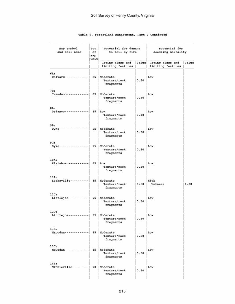
Soil Survey of Henry County, Virginia
215
Table 9.—Forestland Management, Part V—Continued
______________________________________________________________________________ | | | Map symbol |Pct.| Potential for damage | Potential for and soil name | of | to soil by fire | seedling mortality |map | | |unit| | | |_________________________|_________________________ | | Rating class and |Value| Rating class and |Value | | limiting features | | limiting features |_____________________|____|___________________|_____|___________________|_____ | | | | |6A: | | | | | Colvard-------------| 85 |Moderate | |Low | | | Texture/rock |0.50 | | | | fragments | | | | | | | |7B: | | | | | Creedmoor-----------| 85 |Moderate | |Low | | | Texture/rock |0.50 | | | | fragments | | | | | | | |8A: | | | | | Delanco-------------| 85 |Low | |Low | | | Texture/rock |0.10 | | | | fragments | | | | | | | |9B: | | | | | Dyke----------------| 95 |Moderate | |Low | | | Texture/rock |0.50 | | | | fragments | | | | | | | |9C: | | | | | Dyke----------------| 95 |Moderate | |Low | | | Texture/rock |0.50 | | | | fragments | | | | | | | |10A: | | | | | Elsinboro-----------| 85 |Low | |Low | | | Texture/rock |0.10 | | | | fragments | | | | | | | |11A: | | | | | Leaksville----------| 85 |Moderate | |High | | | Texture/rock |0.50 | Wetness |1.00 | | fragments | | | | | | | |12C: | | | | | Littlejoe-----------| 95 |Moderate | |Low | | | Texture/rock |0.50 | | | | fragments | | | | | | | |12D: | | | | | Littlejoe-----------| 95 |Moderate | |Low | | | Texture/rock |0.50 | | | | fragments | | | | | | | |13B: | | | | | Mayodan-------------| 85 |Moderate | |Low | | | Texture/rock |0.50 | | | | fragments | | | | | | | |13C: | | | | | Mayodan-------------| 85 |Moderate | |Low | | | Texture/rock |0.50 | | | | fragments | | | | | | | |14B: | | | | | Minnieville---------| 90 |Moderate | |Low | | | Texture/rock |0.50 | | | | fragments | | | | | | | |
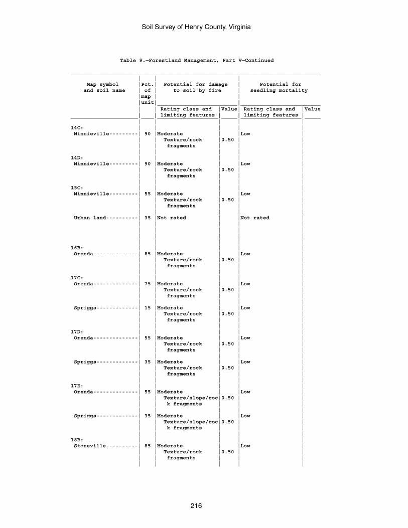
Soil Survey of Henry County, Virginia
216
Table 9.—Forestland Management, Part V—Continued
______________________________________________________________________________ | | | Map symbol |Pct.| Potential for damage | Potential for and soil name | of | to soil by fire | seedling mortality |map | | |unit| | | |_________________________|_________________________ | | Rating class and |Value| Rating class and |Value | | limiting features | | limiting features |_____________________|____|___________________|_____|___________________|_____ | | | | |14C: | | | | | Minnieville---------| 90 |Moderate | |Low | | | Texture/rock |0.50 | | | | fragments | | | | | | | |14D: | | | | | Minnieville---------| 90 |Moderate | |Low | | | Texture/rock |0.50 | | | | fragments | | | | | | | |15C: | | | | | Minnieville---------| 55 |Moderate | |Low | | | Texture/rock |0.50 | | | | fragments | | | | | | | | Urban land----------| 35 |Not rated | |Not rated | | | | | | | | | | | | | | | | | | | | |16B: | | | | | Orenda--------------| 85 |Moderate | |Low | | | Texture/rock |0.50 | | | | fragments | | | | | | | |17C: | | | | | Orenda--------------| 75 |Moderate | |Low | | | Texture/rock |0.50 | | | | fragments | | | | | | | | Spriggs-------------| 15 |Moderate | |Low | | | Texture/rock |0.50 | | | | fragments | | | | | | | |17D: | | | | | Orenda--------------| 55 |Moderate | |Low | | | Texture/rock |0.50 | | | | fragments | | | | | | | | Spriggs-------------| 35 |Moderate | |Low | | | Texture/rock |0.50 | | | | fragments | | | | | | | |17E: | | | | | Orenda--------------| 55 |Moderate | |Low | | | Texture/slope/roc|0.50 | | | | k fragments | | | | | | | | Spriggs-------------| 35 |Moderate | |Low | | | Texture/slope/roc|0.50 | | | | k fragments | | | | | | | |18B: | | | | | Stoneville----------| 85 |Moderate | |Low | | | Texture/rock |0.50 | | | | fragments | | | | | | | |
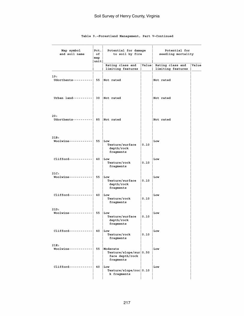
Soil Survey of Henry County, Virginia
217
Table 9.—Forestland Management, Part V—Continued
______________________________________________________________________________ | | | Map symbol |Pct.| Potential for damage | Potential for and soil name | of | to soil by fire | seedling mortality |map | | |unit| | | |_________________________|_________________________ | | Rating class and |Value| Rating class and |Value | | limiting features | | limiting features |_____________________|____|___________________|_____|___________________|_____ | | | | |19: | | | | | Udorthents----------| 55 |Not rated | |Not rated | | | | | | | | | | | | | | | | | | | | | Urban land----------| 30 |Not rated | |Not rated | | | | | | | | | | | | | | | | | | | | |20: | | | | | Udorthents----------| 85 |Not rated | |Not rated | | | | | | | | | | | | | | | | | | | | |21B: | | | | | Woolwine------------| 55 |Low | |Low | | | Texture/surface |0.10 | | | | depth/rock | | | | | fragments | | | | | | | | Clifford------------| 40 |Low | |Low | | | Texture/rock |0.10 | | | | fragments | | | | | | | |21C: | | | | | Woolwine------------| 55 |Low | |Low | | | Texture/surface |0.10 | | | | depth/rock | | | | | fragments | | | | | | | | Clifford------------| 40 |Low | |Low | | | Texture/rock |0.10 | | | | fragments | | | | | | | |21D: | | | | | Woolwine------------| 55 |Low | |Low | | | Texture/surface |0.10 | | | | depth/rock | | | | | fragments | | | | | | | | Clifford------------| 40 |Low | |Low | | | Texture/rock |0.10 | | | | fragments | | | | | | | |21E: | | | | | Woolwine------------| 55 |Moderate | |Low | | | Texture/slope/sur|0.50 | | | | face depth/rock | | | | | fragments | | | | | | | | Clifford------------| 40 |Low | |Low | | | Texture/slope/roc|0.10 | | | | k fragments | | | | | | | |
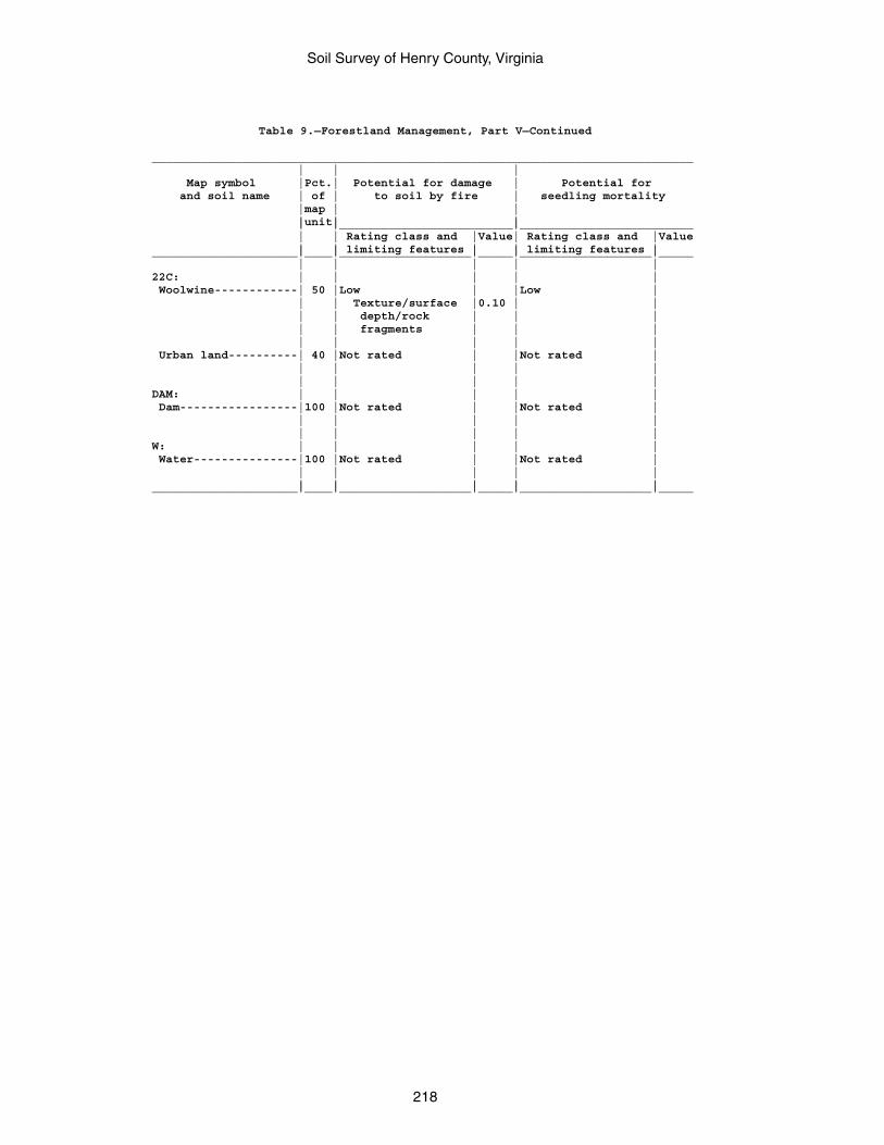
Soil Survey of Henry County, Virginia
218
Table 9.—Forestland Management, Part V—Continued
______________________________________________________________________________ | | | Map symbol |Pct.| Potential for damage | Potential for and soil name | of | to soil by fire | seedling mortality |map | | |unit| | | |_________________________|_________________________ | | Rating class and |Value| Rating class and |Value | | limiting features | | limiting features |_____________________|____|___________________|_____|___________________|_____ | | | | |22C: | | | | | Woolwine------------| 50 |Low | |Low | | | Texture/surface |0.10 | | | | depth/rock | | | | | fragments | | | | | | | | Urban land----------| 40 |Not rated | |Not rated | | | | | | | | | | |DAM: | | | | | Dam-----------------|100 |Not rated | |Not rated | | | | | | | | | | |W: | | | | | Water---------------|100 |Not rated | |Not rated | | | | | | | | | | |_____________________|____|___________________|_____|___________________|_____
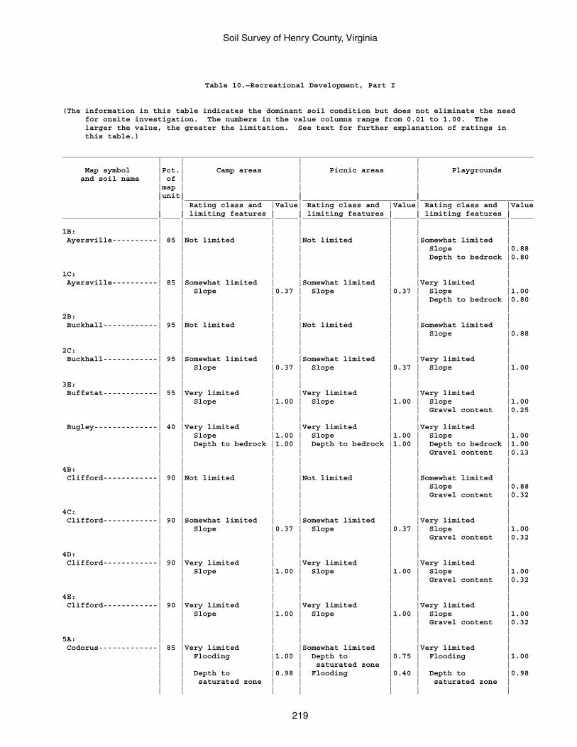
Soil Survey of Henry County, Virginia
219
Table 10.—Recreational Development, Part I
(The information in this table indicates the dominant soil condition but does not eliminate the need for onsite investigation. The numbers in the value columns range from 0.01 to 1.00. The larger the value, the greater the limitation. See text for further explanation of ratings in this table.)
________________________________________________________________________________________________________ | | | | Map symbol |Pct.| Camp areas | Picnic areas | Playgrounds and soil name | of | | | |map | | | |unit| | | | |_________________________|_________________________|_________________________ | | Rating class and |Value| Rating class and |Value| Rating class and |Value | | limiting features | | limiting features | | limiting features |_____________________|____|___________________|_____|___________________|_____|___________________|_____ | | | | | | |1B: | | | | | | | Ayersville----------| 85 |Not limited | |Not limited | |Somewhat limited | | | | | | | Slope |0.88 | | | | | | Depth to bedrock |0.80 | | | | | | |1C: | | | | | | | Ayersville----------| 85 |Somewhat limited | |Somewhat limited | |Very limited | | | Slope |0.37 | Slope |0.37 | Slope |1.00 | | | | | | Depth to bedrock |0.80 | | | | | | |2B: | | | | | | | Buckhall------------| 95 |Not limited | |Not limited | |Somewhat limited | | | | | | | Slope |0.88 | | | | | | |2C: | | | | | | | Buckhall------------| 95 |Somewhat limited | |Somewhat limited | |Very limited | | | Slope |0.37 | Slope |0.37 | Slope |1.00 | | | | | | |3E: | | | | | | | Buffstat------------| 55 |Very limited | |Very limited | |Very limited | | | Slope |1.00 | Slope |1.00 | Slope |1.00 | | | | | | Gravel content |0.25 | | | | | | | Bugley--------------| 40 |Very limited | |Very limited | |Very limited | | | Slope |1.00 | Slope |1.00 | Slope |1.00 | | Depth to bedrock |1.00 | Depth to bedrock |1.00 | Depth to bedrock |1.00 | | | | | | Gravel content |0.13 | | | | | | |4B: | | | | | | | Clifford------------| 90 |Not limited | |Not limited | |Somewhat limited | | | | | | | Slope |0.88 | | | | | | Gravel content |0.32 | | | | | | |4C: | | | | | | | Clifford------------| 90 |Somewhat limited | |Somewhat limited | |Very limited | | | Slope |0.37 | Slope |0.37 | Slope |1.00 | | | | | | Gravel content |0.32 | | | | | | |4D: | | | | | | | Clifford------------| 90 |Very limited | |Very limited | |Very limited | | | Slope |1.00 | Slope |1.00 | Slope |1.00 | | | | | | Gravel content |0.32 | | | | | | |4E: | | | | | | | Clifford------------| 90 |Very limited | |Very limited | |Very limited | | | Slope |1.00 | Slope |1.00 | Slope |1.00 | | | | | | Gravel content |0.32 | | | | | | |5A: | | | | | | | Codorus-------------| 85 |Very limited | |Somewhat limited | |Very limited | | | Flooding |1.00 | Depth to |0.75 | Flooding |1.00 | | | | saturated zone | | | | | Depth to |0.98 | Flooding |0.40 | Depth to |0.98 | | saturated zone | | | | saturated zone | | | | | | | |
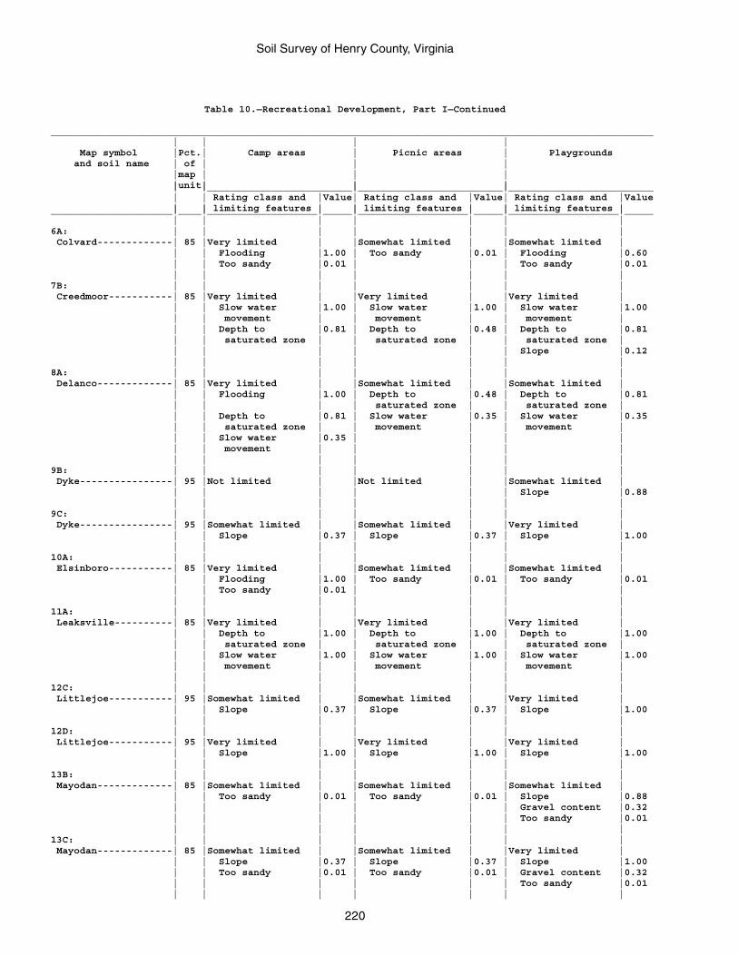
Soil Survey of Henry County, Virginia
220
Table 10.—Recreational Development, Part I—Continued
________________________________________________________________________________________________________ | | | | Map symbol |Pct.| Camp areas | Picnic areas | Playgrounds and soil name | of | | | |map | | | |unit| | | | |_________________________|_________________________|_________________________ | | Rating class and |Value| Rating class and |Value| Rating class and |Value | | limiting features | | limiting features | | limiting features |_____________________|____|___________________|_____|___________________|_____|___________________|_____ | | | | | | |6A: | | | | | | | Colvard-------------| 85 |Very limited | |Somewhat limited | |Somewhat limited | | | Flooding |1.00 | Too sandy |0.01 | Flooding |0.60 | | Too sandy |0.01 | | | Too sandy |0.01 | | | | | | |7B: | | | | | | | Creedmoor-----------| 85 |Very limited | |Very limited | |Very limited | | | Slow water |1.00 | Slow water |1.00 | Slow water |1.00 | | movement | | movement | | movement | | | Depth to |0.81 | Depth to |0.48 | Depth to |0.81 | | saturated zone | | saturated zone | | saturated zone | | | | | | | Slope |0.12 | | | | | | |8A: | | | | | | | Delanco-------------| 85 |Very limited | |Somewhat limited | |Somewhat limited | | | Flooding |1.00 | Depth to |0.48 | Depth to |0.81 | | | | saturated zone | | saturated zone | | | Depth to |0.81 | Slow water |0.35 | Slow water |0.35 | | saturated zone | | movement | | movement | | | Slow water |0.35 | | | | | | movement | | | | | | | | | | | |9B: | | | | | | | Dyke----------------| 95 |Not limited | |Not limited | |Somewhat limited | | | | | | | Slope |0.88 | | | | | | |9C: | | | | | | | Dyke----------------| 95 |Somewhat limited | |Somewhat limited | |Very limited | | | Slope |0.37 | Slope |0.37 | Slope |1.00 | | | | | | |10A: | | | | | | | Elsinboro-----------| 85 |Very limited | |Somewhat limited | |Somewhat limited | | | Flooding |1.00 | Too sandy |0.01 | Too sandy |0.01 | | Too sandy |0.01 | | | | | | | | | | |11A: | | | | | | | Leaksville----------| 85 |Very limited | |Very limited | |Very limited | | | Depth to |1.00 | Depth to |1.00 | Depth to |1.00 | | saturated zone | | saturated zone | | saturated zone | | | Slow water |1.00 | Slow water |1.00 | Slow water |1.00 | | movement | | movement | | movement | | | | | | | |12C: | | | | | | | Littlejoe-----------| 95 |Somewhat limited | |Somewhat limited | |Very limited | | | Slope |0.37 | Slope |0.37 | Slope |1.00 | | | | | | |12D: | | | | | | | Littlejoe-----------| 95 |Very limited | |Very limited | |Very limited | | | Slope |1.00 | Slope |1.00 | Slope |1.00 | | | | | | |13B: | | | | | | | Mayodan-------------| 85 |Somewhat limited | |Somewhat limited | |Somewhat limited | | | Too sandy |0.01 | Too sandy |0.01 | Slope |0.88 | | | | | | Gravel content |0.32 | | | | | | Too sandy |0.01 | | | | | | |13C: | | | | | | | Mayodan-------------| 85 |Somewhat limited | |Somewhat limited | |Very limited | | | Slope |0.37 | Slope |0.37 | Slope |1.00 | | Too sandy |0.01 | Too sandy |0.01 | Gravel content |0.32 | | | | | | Too sandy |0.01 | | | | | | |
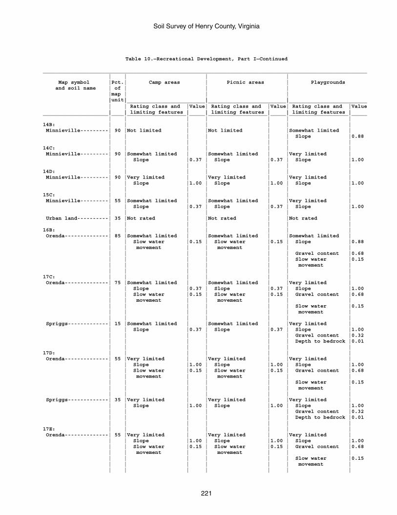
Soil Survey of Henry County, Virginia
221
Table 10.—Recreational Development, Part I—Continued
________________________________________________________________________________________________________ | | | | Map symbol |Pct.| Camp areas | Picnic areas | Playgrounds and soil name | of | | | |map | | | |unit| | | | |_________________________|_________________________|_________________________ | | Rating class and |Value| Rating class and |Value| Rating class and |Value | | limiting features | | limiting features | | limiting features |_____________________|____|___________________|_____|___________________|_____|___________________|_____ | | | | | | |14B: | | | | | | | Minnieville---------| 90 |Not limited | |Not limited | |Somewhat limited | | | | | | | Slope |0.88 | | | | | | |14C: | | | | | | | Minnieville---------| 90 |Somewhat limited | |Somewhat limited | |Very limited | | | Slope |0.37 | Slope |0.37 | Slope |1.00 | | | | | | |14D: | | | | | | | Minnieville---------| 90 |Very limited | |Very limited | |Very limited | | | Slope |1.00 | Slope |1.00 | Slope |1.00 | | | | | | |15C: | | | | | | | Minnieville---------| 55 |Somewhat limited | |Somewhat limited | |Very limited | | | Slope |0.37 | Slope |0.37 | Slope |1.00 | | | | | | | Urban land----------| 35 |Not rated | |Not rated | |Not rated | | | | | | | |16B: | | | | | | | Orenda--------------| 85 |Somewhat limited | |Somewhat limited | |Somewhat limited | | | Slow water |0.15 | Slow water |0.15 | Slope |0.88 | | movement | | movement | | | | | | | | | Gravel content |0.68 | | | | | | Slow water |0.15 | | | | | | movement | | | | | | | |17C: | | | | | | | Orenda--------------| 75 |Somewhat limited | |Somewhat limited | |Very limited | | | Slope |0.37 | Slope |0.37 | Slope |1.00 | | Slow water |0.15 | Slow water |0.15 | Gravel content |0.68 | | movement | | movement | | | | | | | | | Slow water |0.15 | | | | | | movement | | | | | | | | Spriggs-------------| 15 |Somewhat limited | |Somewhat limited | |Very limited | | | Slope |0.37 | Slope |0.37 | Slope |1.00 | | | | | | Gravel content |0.32 | | | | | | Depth to bedrock |0.01 | | | | | | |17D: | | | | | | | Orenda--------------| 55 |Very limited | |Very limited | |Very limited | | | Slope |1.00 | Slope |1.00 | Slope |1.00 | | Slow water |0.15 | Slow water |0.15 | Gravel content |0.68 | | movement | | movement | | | | | | | | | Slow water |0.15 | | | | | | movement | | | | | | | | Spriggs-------------| 35 |Very limited | |Very limited | |Very limited | | | Slope |1.00 | Slope |1.00 | Slope |1.00 | | | | | | Gravel content |0.32 | | | | | | Depth to bedrock |0.01 | | | | | | |17E: | | | | | | | Orenda--------------| 55 |Very limited | |Very limited | |Very limited | | | Slope |1.00 | Slope |1.00 | Slope |1.00 | | Slow water |0.15 | Slow water |0.15 | Gravel content |0.68 | | movement | | movement | | | | | | | | | Slow water |0.15 | | | | | | movement | | | | | | | |
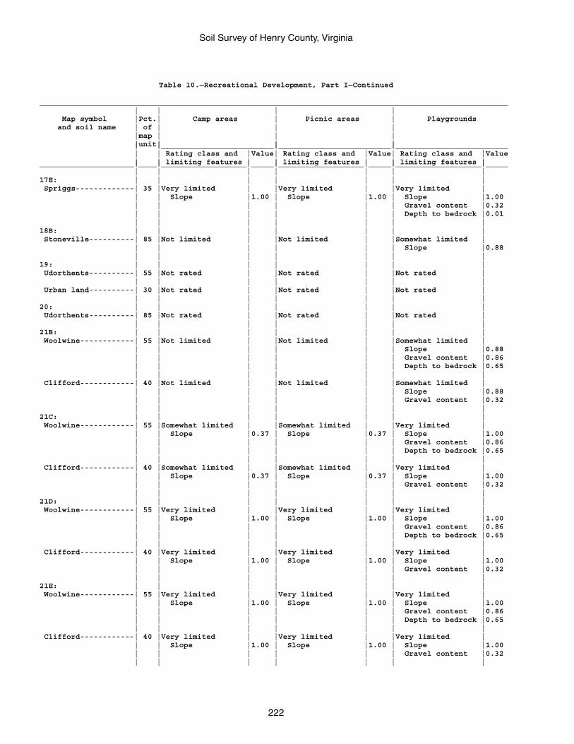
Soil Survey of Henry County, Virginia
222
Table 10.—Recreational Development, Part I—Continued
________________________________________________________________________________________________________ | | | | Map symbol |Pct.| Camp areas | Picnic areas | Playgrounds and soil name | of | | | |map | | | |unit| | | | |_________________________|_________________________|_________________________ | | Rating class and |Value| Rating class and |Value| Rating class and |Value | | limiting features | | limiting features | | limiting features |_____________________|____|___________________|_____|___________________|_____|___________________|_____ | | | | | | |17E: | | | | | | | Spriggs-------------| 35 |Very limited | |Very limited | |Very limited | | | Slope |1.00 | Slope |1.00 | Slope |1.00 | | | | | | Gravel content |0.32 | | | | | | Depth to bedrock |0.01 | | | | | | |18B: | | | | | | | Stoneville----------| 85 |Not limited | |Not limited | |Somewhat limited | | | | | | | Slope |0.88 | | | | | | |19: | | | | | | | Udorthents----------| 55 |Not rated | |Not rated | |Not rated | | | | | | | | Urban land----------| 30 |Not rated | |Not rated | |Not rated | | | | | | | |20: | | | | | | | Udorthents----------| 85 |Not rated | |Not rated | |Not rated | | | | | | | |21B: | | | | | | | Woolwine------------| 55 |Not limited | |Not limited | |Somewhat limited | | | | | | | Slope |0.88 | | | | | | Gravel content |0.86 | | | | | | Depth to bedrock |0.65 | | | | | | | Clifford------------| 40 |Not limited | |Not limited | |Somewhat limited | | | | | | | Slope |0.88 | | | | | | Gravel content |0.32 | | | | | | |21C: | | | | | | | Woolwine------------| 55 |Somewhat limited | |Somewhat limited | |Very limited | | | Slope |0.37 | Slope |0.37 | Slope |1.00 | | | | | | Gravel content |0.86 | | | | | | Depth to bedrock |0.65 | | | | | | | Clifford------------| 40 |Somewhat limited | |Somewhat limited | |Very limited | | | Slope |0.37 | Slope |0.37 | Slope |1.00 | | | | | | Gravel content |0.32 | | | | | | |21D: | | | | | | | Woolwine------------| 55 |Very limited | |Very limited | |Very limited | | | Slope |1.00 | Slope |1.00 | Slope |1.00 | | | | | | Gravel content |0.86 | | | | | | Depth to bedrock |0.65 | | | | | | | Clifford------------| 40 |Very limited | |Very limited | |Very limited | | | Slope |1.00 | Slope |1.00 | Slope |1.00 | | | | | | Gravel content |0.32 | | | | | | |21E: | | | | | | | Woolwine------------| 55 |Very limited | |Very limited | |Very limited | | | Slope |1.00 | Slope |1.00 | Slope |1.00 | | | | | | Gravel content |0.86 | | | | | | Depth to bedrock |0.65 | | | | | | | Clifford------------| 40 |Very limited | |Very limited | |Very limited | | | Slope |1.00 | Slope |1.00 | Slope |1.00 | | | | | | Gravel content |0.32 | | | | | | |
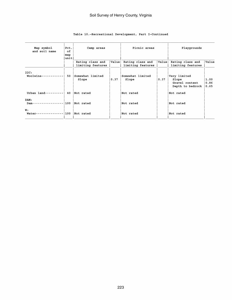
Soil Survey of Henry County, Virginia
223
Table 10.—Recreational Development, Part I—Continued
________________________________________________________________________________________________________ | | | | Map symbol |Pct.| Camp areas | Picnic areas | Playgrounds and soil name | of | | | |map | | | |unit| | | | |_________________________|_________________________|_________________________ | | Rating class and |Value| Rating class and |Value| Rating class and |Value | | limiting features | | limiting features | | limiting features |_____________________|____|___________________|_____|___________________|_____|___________________|_____ | | | | | | |22C: | | | | | | | Woolwine------------| 50 |Somewhat limited | |Somewhat limited | |Very limited | | | Slope |0.37 | Slope |0.37 | Slope |1.00 | | | | | | Gravel content |0.86 | | | | | | Depth to bedrock |0.65 | | | | | | | Urban land----------| 40 |Not rated | |Not rated | |Not rated | | | | | | | |DAM: | | | | | | | Dam-----------------|100 |Not rated | |Not rated | |Not rated | | | | | | | |W: | | | | | | | Water---------------|100 |Not rated | |Not rated | |Not rated | | | | | | | |_____________________|____|___________________|_____|___________________|_____|___________________|_____
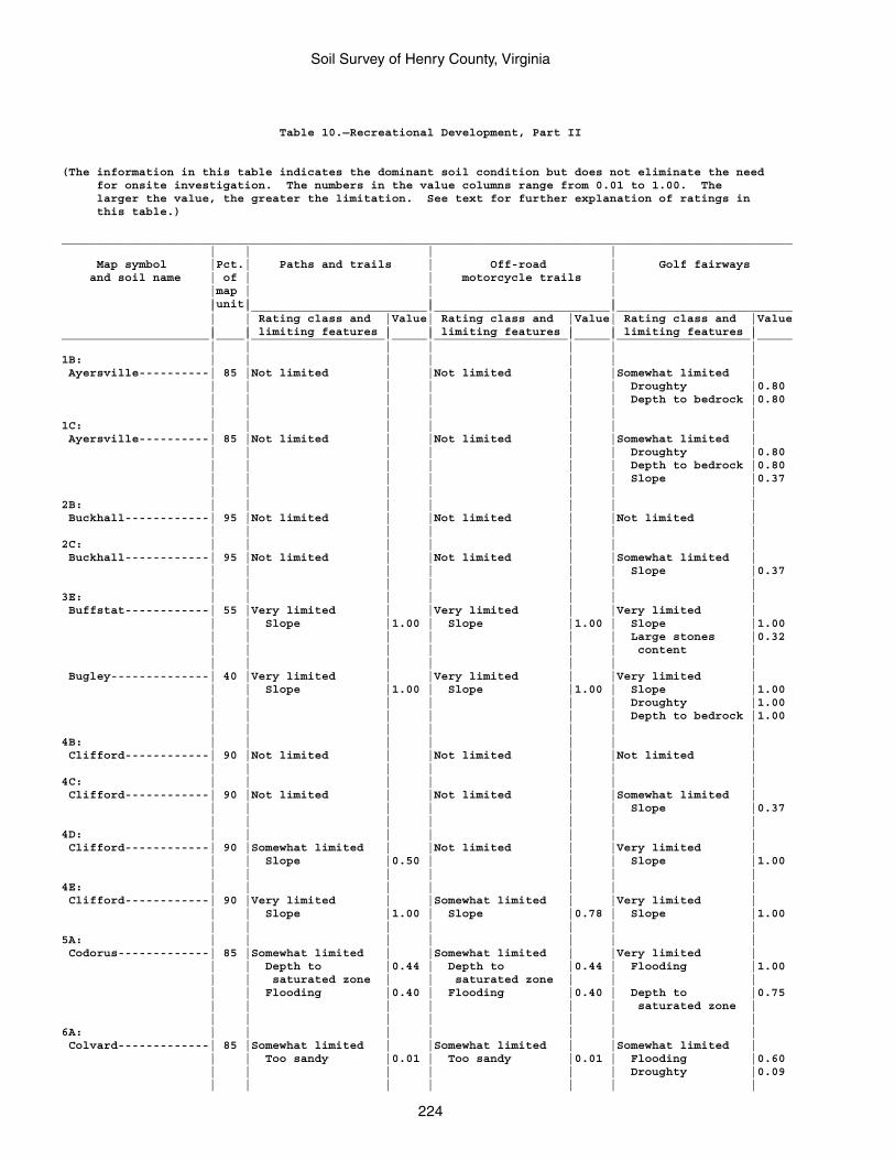
Soil Survey of Henry County, Virginia
224
Table 10.—Recreational Development, Part II
(The information in this table indicates the dominant soil condition but does not eliminate the need for onsite investigation. The numbers in the value columns range from 0.01 to 1.00. The larger the value, the greater the limitation. See text for further explanation of ratings in this table.)
________________________________________________________________________________________________________ | | | | Map symbol |Pct.| Paths and trails | Off-road | Golf fairways and soil name | of | | motorcycle trails | |map | | | |unit| | | | |_________________________|_________________________|_________________________ | | Rating class and |Value| Rating class and |Value| Rating class and |Value | | limiting features | | limiting features | | limiting features |_____________________|____|___________________|_____|___________________|_____|___________________|_____ | | | | | | |1B: | | | | | | | Ayersville----------| 85 |Not limited | |Not limited | |Somewhat limited | | | | | | | Droughty |0.80 | | | | | | Depth to bedrock |0.80 | | | | | | |1C: | | | | | | | Ayersville----------| 85 |Not limited | |Not limited | |Somewhat limited | | | | | | | Droughty |0.80 | | | | | | Depth to bedrock |0.80 | | | | | | Slope |0.37 | | | | | | |2B: | | | | | | | Buckhall------------| 95 |Not limited | |Not limited | |Not limited | | | | | | | |2C: | | | | | | | Buckhall------------| 95 |Not limited | |Not limited | |Somewhat limited | | | | | | | Slope |0.37 | | | | | | |3E: | | | | | | | Buffstat------------| 55 |Very limited | |Very limited | |Very limited | | | Slope |1.00 | Slope |1.00 | Slope |1.00 | | | | | | Large stones |0.32 | | | | | | content | | | | | | | | Bugley--------------| 40 |Very limited | |Very limited | |Very limited | | | Slope |1.00 | Slope |1.00 | Slope |1.00 | | | | | | Droughty |1.00 | | | | | | Depth to bedrock |1.00 | | | | | | |4B: | | | | | | | Clifford------------| 90 |Not limited | |Not limited | |Not limited | | | | | | | |4C: | | | | | | | Clifford------------| 90 |Not limited | |Not limited | |Somewhat limited | | | | | | | Slope |0.37 | | | | | | |4D: | | | | | | | Clifford------------| 90 |Somewhat limited | |Not limited | |Very limited | | | Slope |0.50 | | | Slope |1.00 | | | | | | |4E: | | | | | | | Clifford------------| 90 |Very limited | |Somewhat limited | |Very limited | | | Slope |1.00 | Slope |0.78 | Slope |1.00 | | | | | | |5A: | | | | | | | Codorus-------------| 85 |Somewhat limited | |Somewhat limited | |Very limited | | | Depth to |0.44 | Depth to |0.44 | Flooding |1.00 | | saturated zone | | saturated zone | | | | | Flooding |0.40 | Flooding |0.40 | Depth to |0.75 | | | | | | saturated zone | | | | | | | |6A: | | | | | | | Colvard-------------| 85 |Somewhat limited | |Somewhat limited | |Somewhat limited | | | Too sandy |0.01 | Too sandy |0.01 | Flooding |0.60 | | | | | | Droughty |0.09 | | | | | | |
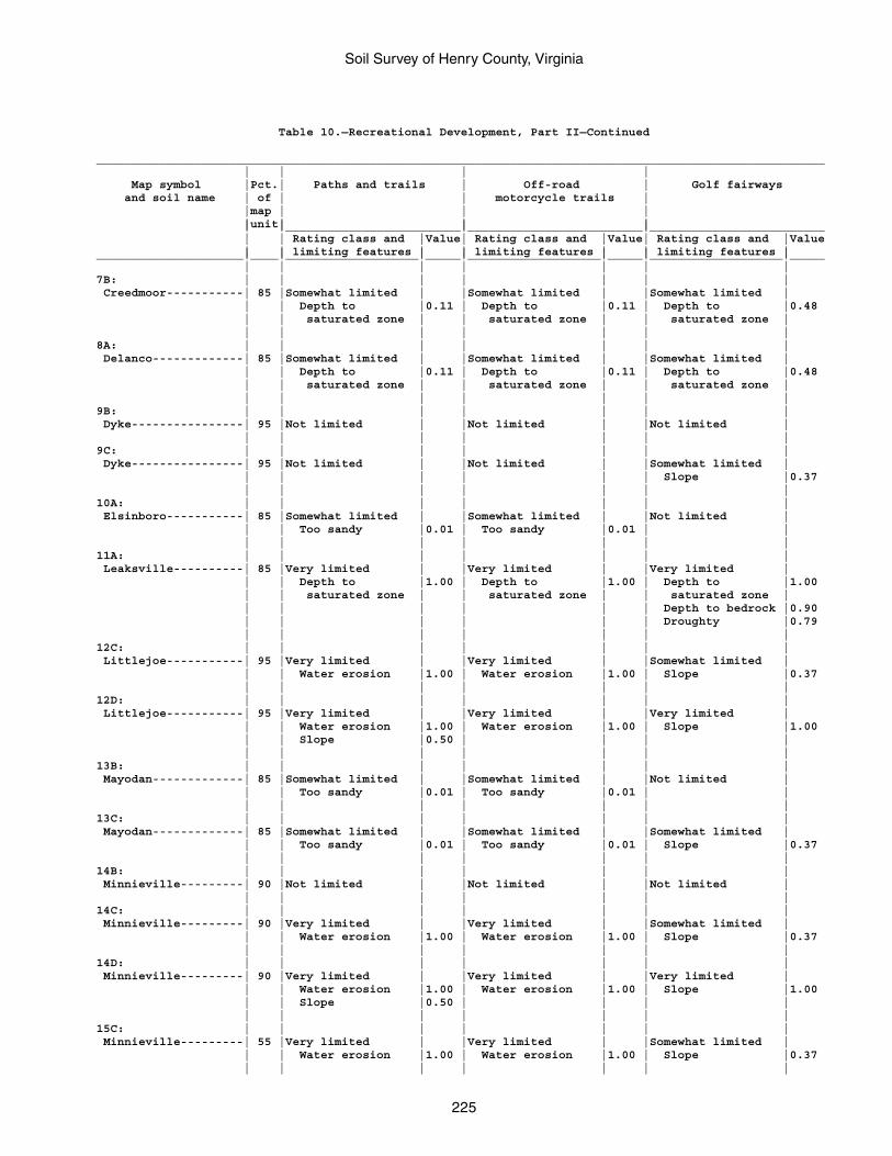
Soil Survey of Henry County, Virginia
225
Table 10.—Recreational Development, Part II—Continued
________________________________________________________________________________________________________ | | | | Map symbol |Pct.| Paths and trails | Off-road | Golf fairways and soil name | of | | motorcycle trails | |map | | | |unit| | | | |_________________________|_________________________|_________________________ | | Rating class and |Value| Rating class and |Value| Rating class and |Value | | limiting features | | limiting features | | limiting features |_____________________|____|___________________|_____|___________________|_____|___________________|_____ | | | | | | |7B: | | | | | | | Creedmoor-----------| 85 |Somewhat limited | |Somewhat limited | |Somewhat limited | | | Depth to |0.11 | Depth to |0.11 | Depth to |0.48 | | saturated zone | | saturated zone | | saturated zone | | | | | | | |8A: | | | | | | | Delanco-------------| 85 |Somewhat limited | |Somewhat limited | |Somewhat limited | | | Depth to |0.11 | Depth to |0.11 | Depth to |0.48 | | saturated zone | | saturated zone | | saturated zone | | | | | | | |9B: | | | | | | | Dyke----------------| 95 |Not limited | |Not limited | |Not limited | | | | | | | |9C: | | | | | | | Dyke----------------| 95 |Not limited | |Not limited | |Somewhat limited | | | | | | | Slope |0.37 | | | | | | |10A: | | | | | | | Elsinboro-----------| 85 |Somewhat limited | |Somewhat limited | |Not limited | | | Too sandy |0.01 | Too sandy |0.01 | | | | | | | | |11A: | | | | | | | Leaksville----------| 85 |Very limited | |Very limited | |Very limited | | | Depth to |1.00 | Depth to |1.00 | Depth to |1.00 | | saturated zone | | saturated zone | | saturated zone | | | | | | | Depth to bedrock |0.90 | | | | | | Droughty |0.79 | | | | | | |12C: | | | | | | | Littlejoe-----------| 95 |Very limited | |Very limited | |Somewhat limited | | | Water erosion |1.00 | Water erosion |1.00 | Slope |0.37 | | | | | | |12D: | | | | | | | Littlejoe-----------| 95 |Very limited | |Very limited | |Very limited | | | Water erosion |1.00 | Water erosion |1.00 | Slope |1.00 | | Slope |0.50 | | | | | | | | | | |13B: | | | | | | | Mayodan-------------| 85 |Somewhat limited | |Somewhat limited | |Not limited | | | Too sandy |0.01 | Too sandy |0.01 | | | | | | | | |13C: | | | | | | | Mayodan-------------| 85 |Somewhat limited | |Somewhat limited | |Somewhat limited | | | Too sandy |0.01 | Too sandy |0.01 | Slope |0.37 | | | | | | |14B: | | | | | | | Minnieville---------| 90 |Not limited | |Not limited | |Not limited | | | | | | | |14C: | | | | | | | Minnieville---------| 90 |Very limited | |Very limited | |Somewhat limited | | | Water erosion |1.00 | Water erosion |1.00 | Slope |0.37 | | | | | | |14D: | | | | | | | Minnieville---------| 90 |Very limited | |Very limited | |Very limited | | | Water erosion |1.00 | Water erosion |1.00 | Slope |1.00 | | Slope |0.50 | | | | | | | | | | |15C: | | | | | | | Minnieville---------| 55 |Very limited | |Very limited | |Somewhat limited | | | Water erosion |1.00 | Water erosion |1.00 | Slope |0.37 | | | | | | |
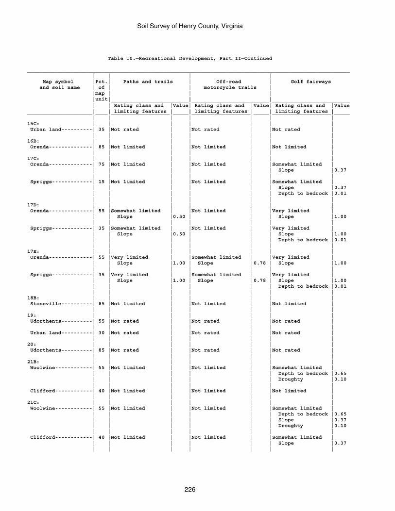
Soil Survey of Henry County, Virginia
226
Table 10.—Recreational Development, Part II—Continued
________________________________________________________________________________________________________ | | | | Map symbol |Pct.| Paths and trails | Off-road | Golf fairways and soil name | of | | motorcycle trails | |map | | | |unit| | | | |_________________________|_________________________|_________________________ | | Rating class and |Value| Rating class and |Value| Rating class and |Value | | limiting features | | limiting features | | limiting features |_____________________|____|___________________|_____|___________________|_____|___________________|_____ | | | | | | |15C: | | | | | | | Urban land----------| 35 |Not rated | |Not rated | |Not rated | | | | | | | |16B: | | | | | | | Orenda--------------| 85 |Not limited | |Not limited | |Not limited | | | | | | | |17C: | | | | | | | Orenda--------------| 75 |Not limited | |Not limited | |Somewhat limited | | | | | | | Slope |0.37 | | | | | | | Spriggs-------------| 15 |Not limited | |Not limited | |Somewhat limited | | | | | | | Slope |0.37 | | | | | | Depth to bedrock |0.01 | | | | | | |17D: | | | | | | | Orenda--------------| 55 |Somewhat limited | |Not limited | |Very limited | | | Slope |0.50 | | | Slope |1.00 | | | | | | | Spriggs-------------| 35 |Somewhat limited | |Not limited | |Very limited | | | Slope |0.50 | | | Slope |1.00 | | | | | | Depth to bedrock |0.01 | | | | | | |17E: | | | | | | | Orenda--------------| 55 |Very limited | |Somewhat limited | |Very limited | | | Slope |1.00 | Slope |0.78 | Slope |1.00 | | | | | | | Spriggs-------------| 35 |Very limited | |Somewhat limited | |Very limited | | | Slope |1.00 | Slope |0.78 | Slope |1.00 | | | | | | Depth to bedrock |0.01 | | | | | | |18B: | | | | | | | Stoneville----------| 85 |Not limited | |Not limited | |Not limited | | | | | | | |19: | | | | | | | Udorthents----------| 55 |Not rated | |Not rated | |Not rated | | | | | | | | Urban land----------| 30 |Not rated | |Not rated | |Not rated | | | | | | | |20: | | | | | | | Udorthents----------| 85 |Not rated | |Not rated | |Not rated | | | | | | | |21B: | | | | | | | Woolwine------------| 55 |Not limited | |Not limited | |Somewhat limited | | | | | | | Depth to bedrock |0.65 | | | | | | Droughty |0.10 | | | | | | | Clifford------------| 40 |Not limited | |Not limited | |Not limited | | | | | | | |21C: | | | | | | | Woolwine------------| 55 |Not limited | |Not limited | |Somewhat limited | | | | | | | Depth to bedrock |0.65 | | | | | | Slope |0.37 | | | | | | Droughty |0.10 | | | | | | | Clifford------------| 40 |Not limited | |Not limited | |Somewhat limited | | | | | | | Slope |0.37 | | | | | | |
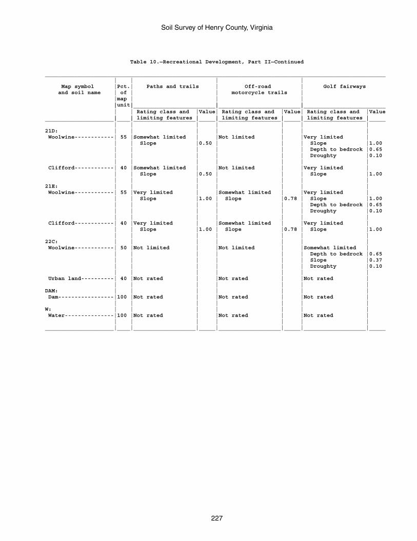
Soil Survey of Henry County, Virginia
227
Table 10.—Recreational Development, Part II—Continued
________________________________________________________________________________________________________ | | | | Map symbol |Pct.| Paths and trails | Off-road | Golf fairways and soil name | of | | motorcycle trails | |map | | | |unit| | | | |_________________________|_________________________|_________________________ | | Rating class and |Value| Rating class and |Value| Rating class and |Value | | limiting features | | limiting features | | limiting features |_____________________|____|___________________|_____|___________________|_____|___________________|_____ | | | | | | |21D: | | | | | | | Woolwine------------| 55 |Somewhat limited | |Not limited | |Very limited | | | Slope |0.50 | | | Slope |1.00 | | | | | | Depth to bedrock |0.65 | | | | | | Droughty |0.10 | | | | | | | Clifford------------| 40 |Somewhat limited | |Not limited | |Very limited | | | Slope |0.50 | | | Slope |1.00 | | | | | | |21E: | | | | | | | Woolwine------------| 55 |Very limited | |Somewhat limited | |Very limited | | | Slope |1.00 | Slope |0.78 | Slope |1.00 | | | | | | Depth to bedrock |0.65 | | | | | | Droughty |0.10 | | | | | | | Clifford------------| 40 |Very limited | |Somewhat limited | |Very limited | | | Slope |1.00 | Slope |0.78 | Slope |1.00 | | | | | | |22C: | | | | | | | Woolwine------------| 50 |Not limited | |Not limited | |Somewhat limited | | | | | | | Depth to bedrock |0.65 | | | | | | Slope |0.37 | | | | | | Droughty |0.10 | | | | | | | Urban land----------| 40 |Not rated | |Not rated | |Not rated | | | | | | | |DAM: | | | | | | | Dam-----------------|100 |Not rated | |Not rated | |Not rated | | | | | | | |W: | | | | | | | Water---------------|100 |Not rated | |Not rated | |Not rated | | | | | | | |_____________________|____|___________________|_____|___________________|_____|___________________|_____
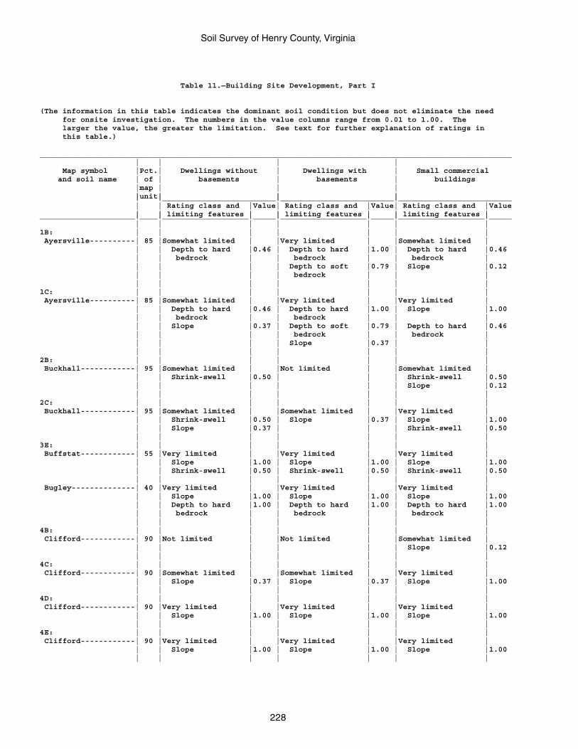
Soil Survey of Henry County, Virginia
228
Table 11.—Building Site Development, Part I
(The information in this table indicates the dominant soil condition but does not eliminate the need for onsite investigation. The numbers in the value columns range from 0.01 to 1.00. The larger the value, the greater the limitation. See text for further explanation of ratings in this table.)
________________________________________________________________________________________________________ | | | | Map symbol |Pct.| Dwellings without | Dwellings with | Small commercial and soil name | of | basements | basements | buildings |map | | | |unit| | | | |_________________________|_________________________|_________________________ | | Rating class and |Value| Rating class and |Value| Rating class and |Value | | limiting features | | limiting features | | limiting features |_____________________|____|___________________|_____|___________________|_____|___________________|_____ | | | | | | |1B: | | | | | | | Ayersville----------| 85 |Somewhat limited | |Very limited | |Somewhat limited | | | Depth to hard |0.46 | Depth to hard |1.00 | Depth to hard |0.46 | | bedrock | | bedrock | | bedrock | | | | | Depth to soft |0.79 | Slope |0.12 | | | | bedrock | | | | | | | | | |1C: | | | | | | | Ayersville----------| 85 |Somewhat limited | |Very limited | |Very limited | | | Depth to hard |0.46 | Depth to hard |1.00 | Slope |1.00 | | bedrock | | bedrock | | | | | Slope |0.37 | Depth to soft |0.79 | Depth to hard |0.46 | | | | bedrock | | bedrock | | | | | Slope |0.37 | | | | | | | | |2B: | | | | | | | Buckhall------------| 95 |Somewhat limited | |Not limited | |Somewhat limited | | | Shrink-swell |0.50 | | | Shrink-swell |0.50 | | | | | | Slope |0.12 | | | | | | |2C: | | | | | | | Buckhall------------| 95 |Somewhat limited | |Somewhat limited | |Very limited | | | Shrink-swell |0.50 | Slope |0.37 | Slope |1.00 | | Slope |0.37 | | | Shrink-swell |0.50 | | | | | | |3E: | | | | | | | Buffstat------------| 55 |Very limited | |Very limited | |Very limited | | | Slope |1.00 | Slope |1.00 | Slope |1.00 | | Shrink-swell |0.50 | Shrink-swell |0.50 | Shrink-swell |0.50 | | | | | | | Bugley--------------| 40 |Very limited | |Very limited | |Very limited | | | Slope |1.00 | Slope |1.00 | Slope |1.00 | | Depth to hard |1.00 | Depth to hard |1.00 | Depth to hard |1.00 | | bedrock | | bedrock | | bedrock | | | | | | | |4B: | | | | | | | Clifford------------| 90 |Not limited | |Not limited | |Somewhat limited | | | | | | | Slope |0.12 | | | | | | |4C: | | | | | | | Clifford------------| 90 |Somewhat limited | |Somewhat limited | |Very limited | | | Slope |0.37 | Slope |0.37 | Slope |1.00 | | | | | | |4D: | | | | | | | Clifford------------| 90 |Very limited | |Very limited | |Very limited | | | Slope |1.00 | Slope |1.00 | Slope |1.00 | | | | | | |4E: | | | | | | | Clifford------------| 90 |Very limited | |Very limited | |Very limited | | | Slope |1.00 | Slope |1.00 | Slope |1.00 | | | | | | |
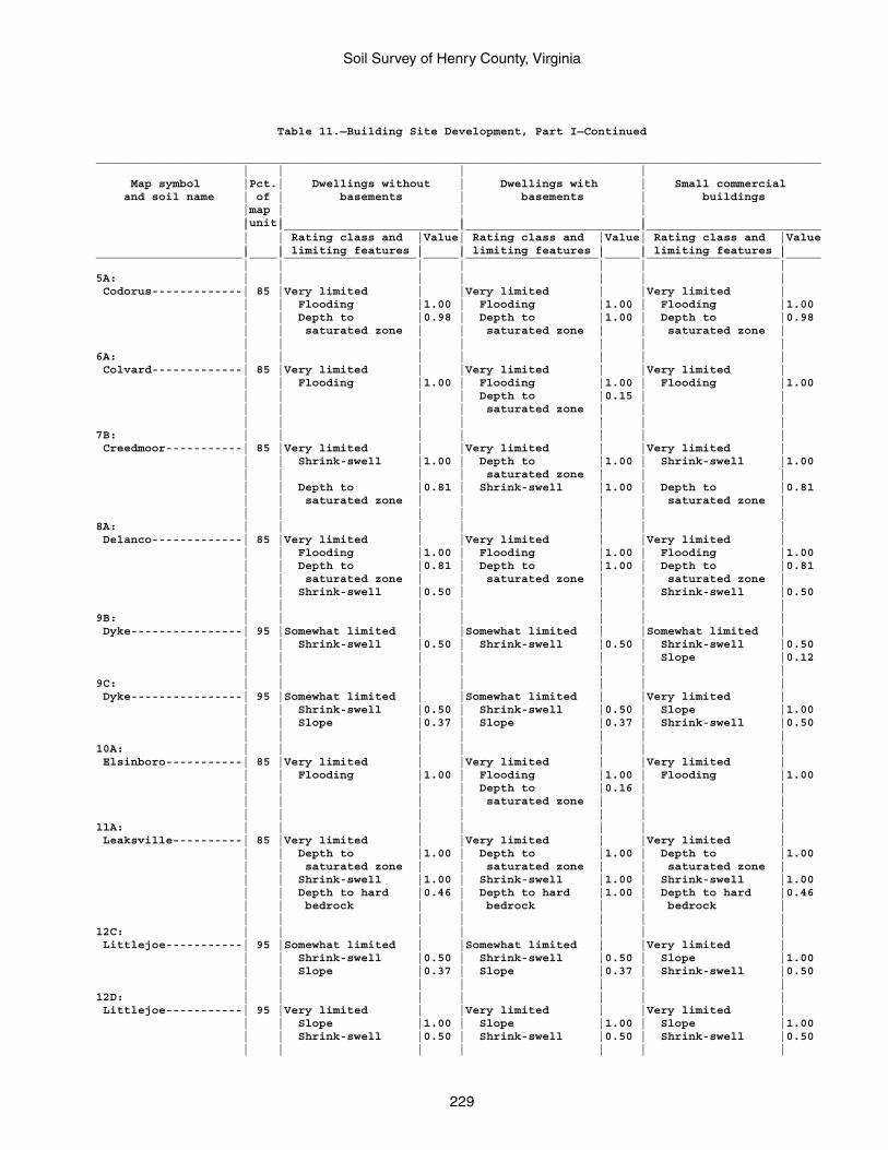
Soil Survey of Henry County, Virginia
229
Table 11.—Building Site Development, Part I—Continued
________________________________________________________________________________________________________ | | | | Map symbol |Pct.| Dwellings without | Dwellings with | Small commercial and soil name | of | basements | basements | buildings |map | | | |unit| | | | |_________________________|_________________________|_________________________ | | Rating class and |Value| Rating class and |Value| Rating class and |Value | | limiting features | | limiting features | | limiting features |_____________________|____|___________________|_____|___________________|_____|___________________|_____ | | | | | | |5A: | | | | | | | Codorus-------------| 85 |Very limited | |Very limited | |Very limited | | | Flooding |1.00 | Flooding |1.00 | Flooding |1.00 | | Depth to |0.98 | Depth to |1.00 | Depth to |0.98 | | saturated zone | | saturated zone | | saturated zone | | | | | | | |6A: | | | | | | | Colvard-------------| 85 |Very limited | |Very limited | |Very limited | | | Flooding |1.00 | Flooding |1.00 | Flooding |1.00 | | | | Depth to |0.15 | | | | | | saturated zone | | | | | | | | | |7B: | | | | | | | Creedmoor-----------| 85 |Very limited | |Very limited | |Very limited | | | Shrink-swell |1.00 | Depth to |1.00 | Shrink-swell |1.00 | | | | saturated zone | | | | | Depth to |0.81 | Shrink-swell |1.00 | Depth to |0.81 | | saturated zone | | | | saturated zone | | | | | | | |8A: | | | | | | | Delanco-------------| 85 |Very limited | |Very limited | |Very limited | | | Flooding |1.00 | Flooding |1.00 | Flooding |1.00 | | Depth to |0.81 | Depth to |1.00 | Depth to |0.81 | | saturated zone | | saturated zone | | saturated zone | | | Shrink-swell |0.50 | | | Shrink-swell |0.50 | | | | | | |9B: | | | | | | | Dyke----------------| 95 |Somewhat limited | |Somewhat limited | |Somewhat limited | | | Shrink-swell |0.50 | Shrink-swell |0.50 | Shrink-swell |0.50 | | | | | | Slope |0.12 | | | | | | |9C: | | | | | | | Dyke----------------| 95 |Somewhat limited | |Somewhat limited | |Very limited | | | Shrink-swell |0.50 | Shrink-swell |0.50 | Slope |1.00 | | Slope |0.37 | Slope |0.37 | Shrink-swell |0.50 | | | | | | |10A: | | | | | | | Elsinboro-----------| 85 |Very limited | |Very limited | |Very limited | | | Flooding |1.00 | Flooding |1.00 | Flooding |1.00 | | | | Depth to |0.16 | | | | | | saturated zone | | | | | | | | | |11A: | | | | | | | Leaksville----------| 85 |Very limited | |Very limited | |Very limited | | | Depth to |1.00 | Depth to |1.00 | Depth to |1.00 | | saturated zone | | saturated zone | | saturated zone | | | Shrink-swell |1.00 | Shrink-swell |1.00 | Shrink-swell |1.00 | | Depth to hard |0.46 | Depth to hard |1.00 | Depth to hard |0.46 | | bedrock | | bedrock | | bedrock | | | | | | | |12C: | | | | | | | Littlejoe-----------| 95 |Somewhat limited | |Somewhat limited | |Very limited | | | Shrink-swell |0.50 | Shrink-swell |0.50 | Slope |1.00 | | Slope |0.37 | Slope |0.37 | Shrink-swell |0.50 | | | | | | |12D: | | | | | | | Littlejoe-----------| 95 |Very limited | |Very limited | |Very limited | | | Slope |1.00 | Slope |1.00 | Slope |1.00 | | Shrink-swell |0.50 | Shrink-swell |0.50 | Shrink-swell |0.50 | | | | | | |
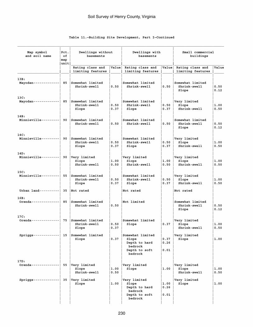
Soil Survey of Henry County, Virginia
230
Table 11.—Building Site Development, Part I—Continued
________________________________________________________________________________________________________ | | | | Map symbol |Pct.| Dwellings without | Dwellings with | Small commercial and soil name | of | basements | basements | buildings |map | | | |unit| | | | |_________________________|_________________________|_________________________ | | Rating class and |Value| Rating class and |Value| Rating class and |Value | | limiting features | | limiting features | | limiting features |_____________________|____|___________________|_____|___________________|_____|___________________|_____ | | | | | | |13B: | | | | | | | Mayodan-------------| 85 |Somewhat limited | |Somewhat limited | |Somewhat limited | | | Shrink-swell |0.50 | Shrink-swell |0.50 | Shrink-swell |0.50 | | | | | | Slope |0.12 | | | | | | |13C: | | | | | | | Mayodan-------------| 85 |Somewhat limited | |Somewhat limited | |Very limited | | | Shrink-swell |0.50 | Shrink-swell |0.50 | Slope |1.00 | | Slope |0.37 | Slope |0.37 | Shrink-swell |0.50 | | | | | | |14B: | | | | | | | Minnieville---------| 90 |Somewhat limited | |Somewhat limited | |Somewhat limited | | | Shrink-swell |0.50 | Shrink-swell |0.50 | Shrink-swell |0.50 | | | | | | Slope |0.12 | | | | | | |14C: | | | | | | | Minnieville---------| 90 |Somewhat limited | |Somewhat limited | |Very limited | | | Shrink-swell |0.50 | Shrink-swell |0.50 | Slope |1.00 | | Slope |0.37 | Slope |0.37 | Shrink-swell |0.50 | | | | | | |14D: | | | | | | | Minnieville---------| 90 |Very limited | |Very limited | |Very limited | | | Slope |1.00 | Slope |1.00 | Slope |1.00 | | Shrink-swell |0.50 | Shrink-swell |0.50 | Shrink-swell |0.50 | | | | | | |15C: | | | | | | | Minnieville---------| 55 |Somewhat limited | |Somewhat limited | |Very limited | | | Shrink-swell |0.50 | Shrink-swell |0.50 | Slope |1.00 | | Slope |0.37 | Slope |0.37 | Shrink-swell |0.50 | | | | | | | Urban land----------| 35 |Not rated | |Not rated | |Not rated | | | | | | | |16B: | | | | | | | Orenda--------------| 85 |Somewhat limited | |Not limited | |Somewhat limited | | | Shrink-swell |0.50 | | | Shrink-swell |0.50 | | | | | | Slope |0.12 | | | | | | |17C: | | | | | | | Orenda--------------| 75 |Somewhat limited | |Somewhat limited | |Very limited | | | Shrink-swell |0.50 | Slope |0.37 | Slope |1.00 | | Slope |0.37 | | | Shrink-swell |0.50 | | | | | | | Spriggs-------------| 15 |Somewhat limited | |Somewhat limited | |Very limited | | | Slope |0.37 | Slope |0.37 | Slope |1.00 | | | | Depth to hard |0.26 | | | | | | bedrock | | | | | | | Depth to soft |0.01 | | | | | | bedrock | | | | | | | | | |17D: | | | | | | | Orenda--------------| 55 |Very limited | |Very limited | |Very limited | | | Slope |1.00 | Slope |1.00 | Slope |1.00 | | Shrink-swell |0.50 | | | Shrink-swell |0.50 | | | | | | | Spriggs-------------| 35 |Very limited | |Very limited | |Very limited | | | Slope |1.00 | Slope |1.00 | Slope |1.00 | | | | Depth to hard |0.26 | | | | | | bedrock | | | | | | | Depth to soft |0.01 | | | | | | bedrock | | | | | | | | | |
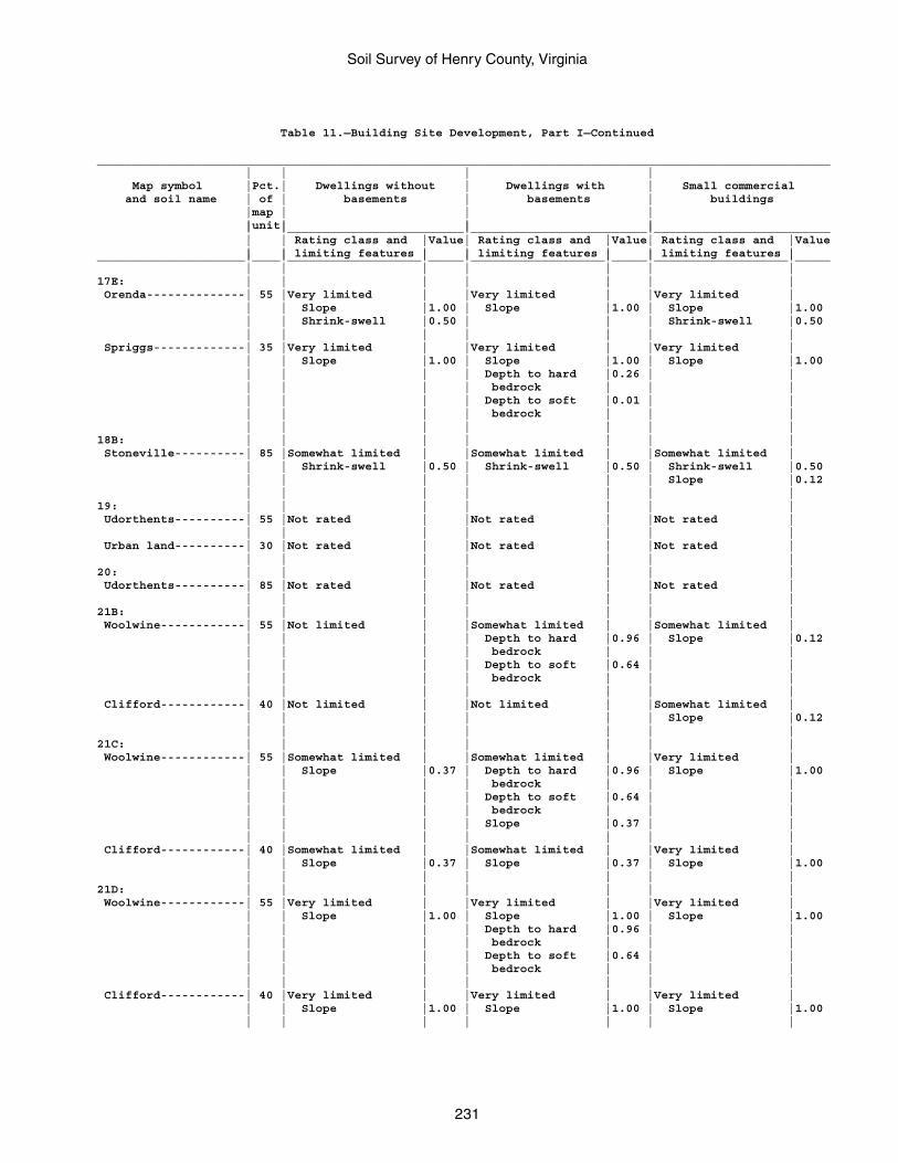
Soil Survey of Henry County, Virginia
231
Table 11.—Building Site Development, Part I—Continued
________________________________________________________________________________________________________ | | | | Map symbol |Pct.| Dwellings without | Dwellings with | Small commercial and soil name | of | basements | basements | buildings |map | | | |unit| | | | |_________________________|_________________________|_________________________ | | Rating class and |Value| Rating class and |Value| Rating class and |Value | | limiting features | | limiting features | | limiting features |_____________________|____|___________________|_____|___________________|_____|___________________|_____ | | | | | | |17E: | | | | | | | Orenda--------------| 55 |Very limited | |Very limited | |Very limited | | | Slope |1.00 | Slope |1.00 | Slope |1.00 | | Shrink-swell |0.50 | | | Shrink-swell |0.50 | | | | | | | Spriggs-------------| 35 |Very limited | |Very limited | |Very limited | | | Slope |1.00 | Slope |1.00 | Slope |1.00 | | | | Depth to hard |0.26 | | | | | | bedrock | | | | | | | Depth to soft |0.01 | | | | | | bedrock | | | | | | | | | |18B: | | | | | | | Stoneville----------| 85 |Somewhat limited | |Somewhat limited | |Somewhat limited | | | Shrink-swell |0.50 | Shrink-swell |0.50 | Shrink-swell |0.50 | | | | | | Slope |0.12 | | | | | | |19: | | | | | | | Udorthents----------| 55 |Not rated | |Not rated | |Not rated | | | | | | | | Urban land----------| 30 |Not rated | |Not rated | |Not rated | | | | | | | |20: | | | | | | | Udorthents----------| 85 |Not rated | |Not rated | |Not rated | | | | | | | |21B: | | | | | | | Woolwine------------| 55 |Not limited | |Somewhat limited | |Somewhat limited | | | | | Depth to hard |0.96 | Slope |0.12 | | | | bedrock | | | | | | | Depth to soft |0.64 | | | | | | bedrock | | | | | | | | | | Clifford------------| 40 |Not limited | |Not limited | |Somewhat limited | | | | | | | Slope |0.12 | | | | | | |21C: | | | | | | | Woolwine------------| 55 |Somewhat limited | |Somewhat limited | |Very limited | | | Slope |0.37 | Depth to hard |0.96 | Slope |1.00 | | | | bedrock | | | | | | | Depth to soft |0.64 | | | | | | bedrock | | | | | | | Slope |0.37 | | | | | | | | | Clifford------------| 40 |Somewhat limited | |Somewhat limited | |Very limited | | | Slope |0.37 | Slope |0.37 | Slope |1.00 | | | | | | |21D: | | | | | | | Woolwine------------| 55 |Very limited | |Very limited | |Very limited | | | Slope |1.00 | Slope |1.00 | Slope |1.00 | | | | Depth to hard |0.96 | | | | | | bedrock | | | | | | | Depth to soft |0.64 | | | | | | bedrock | | | | | | | | | | Clifford------------| 40 |Very limited | |Very limited | |Very limited | | | Slope |1.00 | Slope |1.00 | Slope |1.00 | | | | | | |
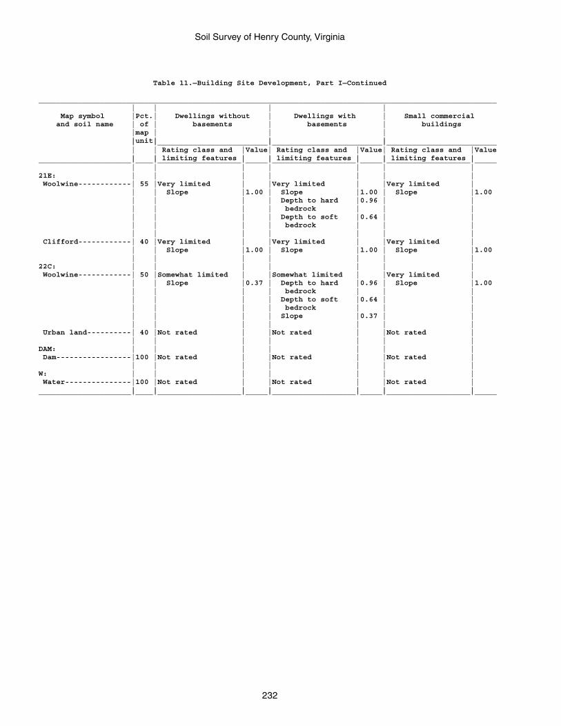
Soil Survey of Henry County, Virginia
232
Table 11.—Building Site Development, Part I—Continued
________________________________________________________________________________________________________ | | | | Map symbol |Pct.| Dwellings without | Dwellings with | Small commercial and soil name | of | basements | basements | buildings |map | | | |unit| | | | |_________________________|_________________________|_________________________ | | Rating class and |Value| Rating class and |Value| Rating class and |Value | | limiting features | | limiting features | | limiting features |_____________________|____|___________________|_____|___________________|_____|___________________|_____ | | | | | | |21E: | | | | | | | Woolwine------------| 55 |Very limited | |Very limited | |Very limited | | | Slope |1.00 | Slope |1.00 | Slope |1.00 | | | | Depth to hard |0.96 | | | | | | bedrock | | | | | | | Depth to soft |0.64 | | | | | | bedrock | | | | | | | | | | Clifford------------| 40 |Very limited | |Very limited | |Very limited | | | Slope |1.00 | Slope |1.00 | Slope |1.00 | | | | | | |22C: | | | | | | | Woolwine------------| 50 |Somewhat limited | |Somewhat limited | |Very limited | | | Slope |0.37 | Depth to hard |0.96 | Slope |1.00 | | | | bedrock | | | | | | | Depth to soft |0.64 | | | | | | bedrock | | | | | | | Slope |0.37 | | | | | | | | | Urban land----------| 40 |Not rated | |Not rated | |Not rated | | | | | | | |DAM: | | | | | | | Dam-----------------|100 |Not rated | |Not rated | |Not rated | | | | | | | |W: | | | | | | | Water---------------|100 |Not rated | |Not rated | |Not rated | | | | | | | |_____________________|____|___________________|_____|___________________|_____|___________________|_____
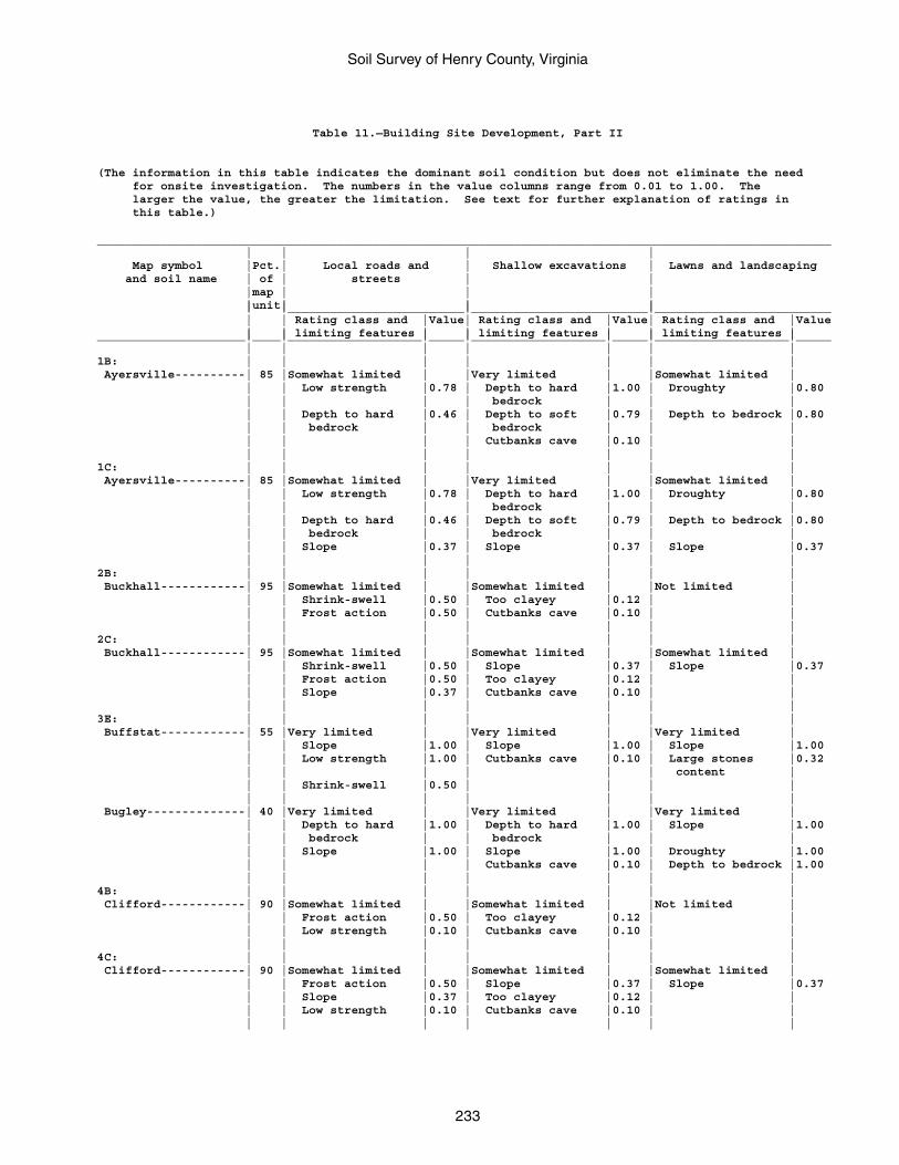
Soil Survey of Henry County, Virginia
233
Table 11.—Building Site Development, Part II
(The information in this table indicates the dominant soil condition but does not eliminate the need for onsite investigation. The numbers in the value columns range from 0.01 to 1.00. The larger the value, the greater the limitation. See text for further explanation of ratings in this table.)
________________________________________________________________________________________________________ | | | | Map symbol |Pct.| Local roads and | Shallow excavations | Lawns and landscaping and soil name | of | streets | | |map | | | |unit| | | | |_________________________|_________________________|_________________________ | | Rating class and |Value| Rating class and |Value| Rating class and |Value | | limiting features | | limiting features | | limiting features |_____________________|____|___________________|_____|___________________|_____|___________________|_____ | | | | | | |1B: | | | | | | | Ayersville----------| 85 |Somewhat limited | |Very limited | |Somewhat limited | | | Low strength |0.78 | Depth to hard |1.00 | Droughty |0.80 | | | | bedrock | | | | | Depth to hard |0.46 | Depth to soft |0.79 | Depth to bedrock |0.80 | | bedrock | | bedrock | | | | | | | Cutbanks cave |0.10 | | | | | | | | |1C: | | | | | | | Ayersville----------| 85 |Somewhat limited | |Very limited | |Somewhat limited | | | Low strength |0.78 | Depth to hard |1.00 | Droughty |0.80 | | | | bedrock | | | | | Depth to hard |0.46 | Depth to soft |0.79 | Depth to bedrock |0.80 | | bedrock | | bedrock | | | | | Slope |0.37 | Slope |0.37 | Slope |0.37 | | | | | | |2B: | | | | | | | Buckhall------------| 95 |Somewhat limited | |Somewhat limited | |Not limited | | | Shrink-swell |0.50 | Too clayey |0.12 | | | | Frost action |0.50 | Cutbanks cave |0.10 | | | | | | | | |2C: | | | | | | | Buckhall------------| 95 |Somewhat limited | |Somewhat limited | |Somewhat limited | | | Shrink-swell |0.50 | Slope |0.37 | Slope |0.37 | | Frost action |0.50 | Too clayey |0.12 | | | | Slope |0.37 | Cutbanks cave |0.10 | | | | | | | | |3E: | | | | | | | Buffstat------------| 55 |Very limited | |Very limited | |Very limited | | | Slope |1.00 | Slope |1.00 | Slope |1.00 | | Low strength |1.00 | Cutbanks cave |0.10 | Large stones |0.32 | | | | | | content | | | Shrink-swell |0.50 | | | | | | | | | | | Bugley--------------| 40 |Very limited | |Very limited | |Very limited | | | Depth to hard |1.00 | Depth to hard |1.00 | Slope |1.00 | | bedrock | | bedrock | | | | | Slope |1.00 | Slope |1.00 | Droughty |1.00 | | | | Cutbanks cave |0.10 | Depth to bedrock |1.00 | | | | | | |4B: | | | | | | | Clifford------------| 90 |Somewhat limited | |Somewhat limited | |Not limited | | | Frost action |0.50 | Too clayey |0.12 | | | | Low strength |0.10 | Cutbanks cave |0.10 | | | | | | | | |4C: | | | | | | | Clifford------------| 90 |Somewhat limited | |Somewhat limited | |Somewhat limited | | | Frost action |0.50 | Slope |0.37 | Slope |0.37 | | Slope |0.37 | Too clayey |0.12 | | | | Low strength |0.10 | Cutbanks cave |0.10 | | | | | | | | |
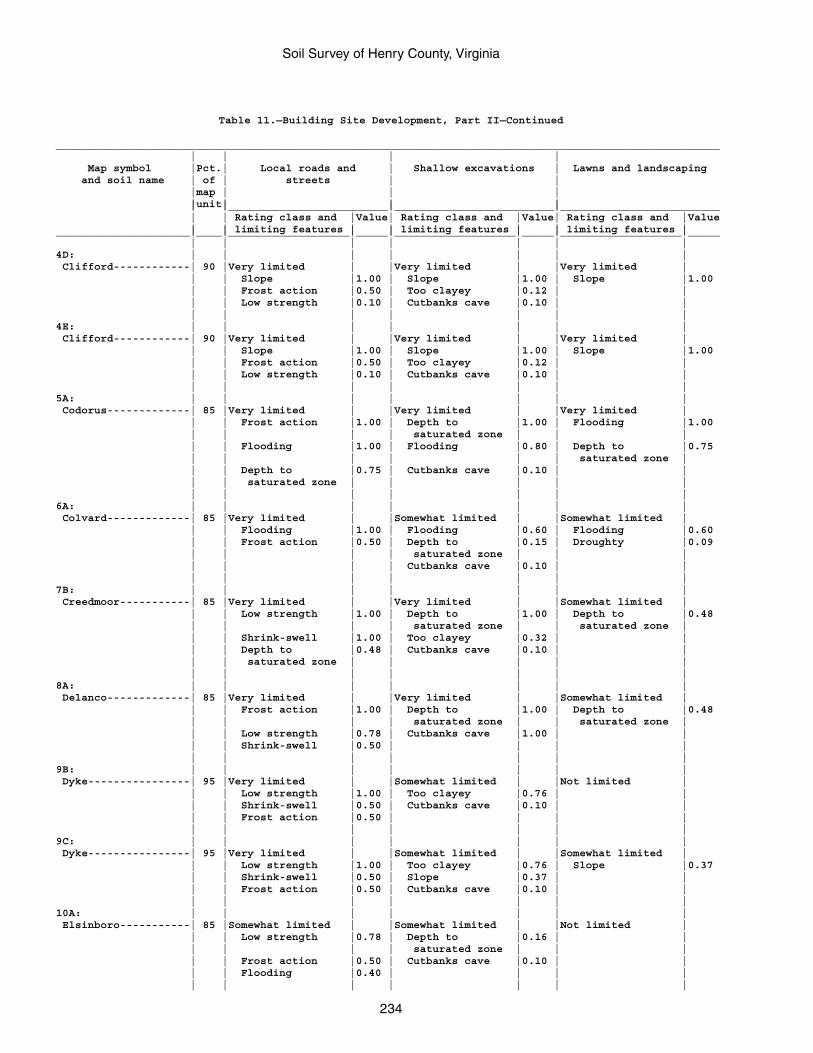
Soil Survey of Henry County, Virginia
234
Table 11.—Building Site Development, Part II—Continued
________________________________________________________________________________________________________ | | | | Map symbol |Pct.| Local roads and | Shallow excavations | Lawns and landscaping and soil name | of | streets | | |map | | | |unit| | | | |_________________________|_________________________|_________________________ | | Rating class and |Value| Rating class and |Value| Rating class and |Value | | limiting features | | limiting features | | limiting features |_____________________|____|___________________|_____|___________________|_____|___________________|_____ | | | | | | |4D: | | | | | | | Clifford------------| 90 |Very limited | |Very limited | |Very limited | | | Slope |1.00 | Slope |1.00 | Slope |1.00 | | Frost action |0.50 | Too clayey |0.12 | | | | Low strength |0.10 | Cutbanks cave |0.10 | | | | | | | | |4E: | | | | | | | Clifford------------| 90 |Very limited | |Very limited | |Very limited | | | Slope |1.00 | Slope |1.00 | Slope |1.00 | | Frost action |0.50 | Too clayey |0.12 | | | | Low strength |0.10 | Cutbanks cave |0.10 | | | | | | | | |5A: | | | | | | | Codorus-------------| 85 |Very limited | |Very limited | |Very limited | | | Frost action |1.00 | Depth to |1.00 | Flooding |1.00 | | | | saturated zone | | | | | Flooding |1.00 | Flooding |0.80 | Depth to |0.75 | | | | | | saturated zone | | | Depth to |0.75 | Cutbanks cave |0.10 | | | | saturated zone | | | | | | | | | | | |6A: | | | | | | | Colvard-------------| 85 |Very limited | |Somewhat limited | |Somewhat limited | | | Flooding |1.00 | Flooding |0.60 | Flooding |0.60 | | Frost action |0.50 | Depth to |0.15 | Droughty |0.09 | | | | saturated zone | | | | | | | Cutbanks cave |0.10 | | | | | | | | |7B: | | | | | | | Creedmoor-----------| 85 |Very limited | |Very limited | |Somewhat limited | | | Low strength |1.00 | Depth to |1.00 | Depth to |0.48 | | | | saturated zone | | saturated zone | | | Shrink-swell |1.00 | Too clayey |0.32 | | | | Depth to |0.48 | Cutbanks cave |0.10 | | | | saturated zone | | | | | | | | | | | |8A: | | | | | | | Delanco-------------| 85 |Very limited | |Very limited | |Somewhat limited | | | Frost action |1.00 | Depth to |1.00 | Depth to |0.48 | | | | saturated zone | | saturated zone | | | Low strength |0.78 | Cutbanks cave |1.00 | | | | Shrink-swell |0.50 | | | | | | | | | | |9B: | | | | | | | Dyke----------------| 95 |Very limited | |Somewhat limited | |Not limited | | | Low strength |1.00 | Too clayey |0.76 | | | | Shrink-swell |0.50 | Cutbanks cave |0.10 | | | | Frost action |0.50 | | | | | | | | | | |9C: | | | | | | | Dyke----------------| 95 |Very limited | |Somewhat limited | |Somewhat limited | | | Low strength |1.00 | Too clayey |0.76 | Slope |0.37 | | Shrink-swell |0.50 | Slope |0.37 | | | | Frost action |0.50 | Cutbanks cave |0.10 | | | | | | | | |10A: | | | | | | | Elsinboro-----------| 85 |Somewhat limited | |Somewhat limited | |Not limited | | | Low strength |0.78 | Depth to |0.16 | | | | | | saturated zone | | | | | Frost action |0.50 | Cutbanks cave |0.10 | | | | Flooding |0.40 | | | | | | | | | | |
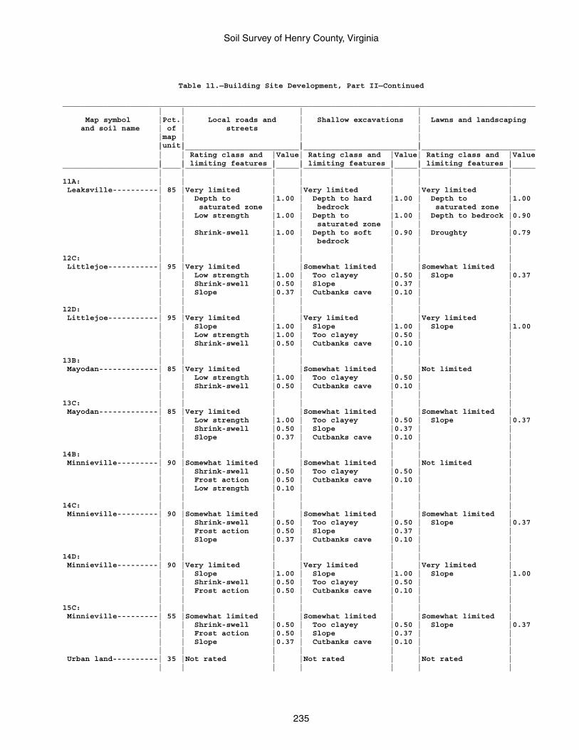
Soil Survey of Henry County, Virginia
235
Table 11.—Building Site Development, Part II—Continued
________________________________________________________________________________________________________ | | | | Map symbol |Pct.| Local roads and | Shallow excavations | Lawns and landscaping and soil name | of | streets | | |map | | | |unit| | | | |_________________________|_________________________|_________________________ | | Rating class and |Value| Rating class and |Value| Rating class and |Value | | limiting features | | limiting features | | limiting features |_____________________|____|___________________|_____|___________________|_____|___________________|_____ | | | | | | |11A: | | | | | | | Leaksville----------| 85 |Very limited | |Very limited | |Very limited | | | Depth to |1.00 | Depth to hard |1.00 | Depth to |1.00 | | saturated zone | | bedrock | | saturated zone | | | Low strength |1.00 | Depth to |1.00 | Depth to bedrock |0.90 | | | | saturated zone | | | | | Shrink-swell |1.00 | Depth to soft |0.90 | Droughty |0.79 | | | | bedrock | | | | | | | | | |12C: | | | | | | | Littlejoe-----------| 95 |Very limited | |Somewhat limited | |Somewhat limited | | | Low strength |1.00 | Too clayey |0.50 | Slope |0.37 | | Shrink-swell |0.50 | Slope |0.37 | | | | Slope |0.37 | Cutbanks cave |0.10 | | | | | | | | |12D: | | | | | | | Littlejoe-----------| 95 |Very limited | |Very limited | |Very limited | | | Slope |1.00 | Slope |1.00 | Slope |1.00 | | Low strength |1.00 | Too clayey |0.50 | | | | Shrink-swell |0.50 | Cutbanks cave |0.10 | | | | | | | | |13B: | | | | | | | Mayodan-------------| 85 |Very limited | |Somewhat limited | |Not limited | | | Low strength |1.00 | Too clayey |0.50 | | | | Shrink-swell |0.50 | Cutbanks cave |0.10 | | | | | | | | |13C: | | | | | | | Mayodan-------------| 85 |Very limited | |Somewhat limited | |Somewhat limited | | | Low strength |1.00 | Too clayey |0.50 | Slope |0.37 | | Shrink-swell |0.50 | Slope |0.37 | | | | Slope |0.37 | Cutbanks cave |0.10 | | | | | | | | |14B: | | | | | | | Minnieville---------| 90 |Somewhat limited | |Somewhat limited | |Not limited | | | Shrink-swell |0.50 | Too clayey |0.50 | | | | Frost action |0.50 | Cutbanks cave |0.10 | | | | Low strength |0.10 | | | | | | | | | | |14C: | | | | | | | Minnieville---------| 90 |Somewhat limited | |Somewhat limited | |Somewhat limited | | | Shrink-swell |0.50 | Too clayey |0.50 | Slope |0.37 | | Frost action |0.50 | Slope |0.37 | | | | Slope |0.37 | Cutbanks cave |0.10 | | | | | | | | |14D: | | | | | | | Minnieville---------| 90 |Very limited | |Very limited | |Very limited | | | Slope |1.00 | Slope |1.00 | Slope |1.00 | | Shrink-swell |0.50 | Too clayey |0.50 | | | | Frost action |0.50 | Cutbanks cave |0.10 | | | | | | | | |15C: | | | | | | | Minnieville---------| 55 |Somewhat limited | |Somewhat limited | |Somewhat limited | | | Shrink-swell |0.50 | Too clayey |0.50 | Slope |0.37 | | Frost action |0.50 | Slope |0.37 | | | | Slope |0.37 | Cutbanks cave |0.10 | | | | | | | | | Urban land----------| 35 |Not rated | |Not rated | |Not rated | | | | | | | |
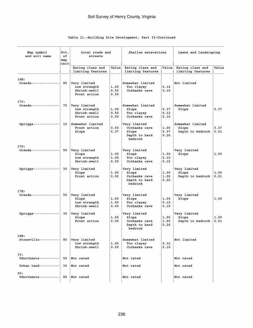
Soil Survey of Henry County, Virginia
236
Table 11.—Building Site Development, Part II—Continued
________________________________________________________________________________________________________ | | | | Map symbol |Pct.| Local roads and | Shallow excavations | Lawns and landscaping and soil name | of | streets | | |map | | | |unit| | | | |_________________________|_________________________|_________________________ | | Rating class and |Value| Rating class and |Value| Rating class and |Value | | limiting features | | limiting features | | limiting features |_____________________|____|___________________|_____|___________________|_____|___________________|_____ | | | | | | |16B: | | | | | | | Orenda--------------| 85 |Very limited | |Somewhat limited | |Not limited | | | Low strength |1.00 | Too clayey |0.12 | | | | Shrink-swell |0.50 | Cutbanks cave |0.10 | | | | Frost action |0.50 | | | | | | | | | | |17C: | | | | | | | Orenda--------------| 75 |Very limited | |Somewhat limited | |Somewhat limited | | | Low strength |1.00 | Slope |0.37 | Slope |0.37 | | Shrink-swell |0.50 | Too clayey |0.12 | | | | Frost action |0.50 | Cutbanks cave |0.10 | | | | | | | | | Spriggs-------------| 15 |Somewhat limited | |Very limited | |Somewhat limited | | | Frost action |0.50 | Cutbanks cave |1.00 | Slope |0.37 | | Slope |0.37 | Slope |0.37 | Depth to bedrock |0.01 | | | | Depth to hard |0.26 | | | | | | bedrock | | | | | | | | | |17D: | | | | | | | Orenda--------------| 55 |Very limited | |Very limited | |Very limited | | | Slope |1.00 | Slope |1.00 | Slope |1.00 | | Low strength |1.00 | Too clayey |0.12 | | | | Shrink-swell |0.50 | Cutbanks cave |0.10 | | | | | | | | | Spriggs-------------| 35 |Very limited | |Very limited | |Very limited | | | Slope |1.00 | Slope |1.00 | Slope |1.00 | | Frost action |0.50 | Cutbanks cave |1.00 | Depth to bedrock |0.01 | | | | Depth to hard |0.26 | | | | | | bedrock | | | | | | | | | |17E: | | | | | | | Orenda--------------| 55 |Very limited | |Very limited | |Very limited | | | Slope |1.00 | Slope |1.00 | Slope |1.00 | | Low strength |1.00 | Too clayey |0.12 | | | | Shrink-swell |0.50 | Cutbanks cave |0.10 | | | | | | | | | Spriggs-------------| 35 |Very limited | |Very limited | |Very limited | | | Slope |1.00 | Slope |1.00 | Slope |1.00 | | Frost action |0.50 | Cutbanks cave |1.00 | Depth to bedrock |0.01 | | | | Depth to hard |0.26 | | | | | | bedrock | | | | | | | | | |18B: | | | | | | | Stoneville----------| 85 |Very limited | |Somewhat limited | |Not limited | | | Low strength |1.00 | Too clayey |0.32 | | | | Shrink-swell |0.50 | Cutbanks cave |0.10 | | | | | | | | |19: | | | | | | | Udorthents----------| 55 |Not rated | |Not rated | |Not rated | | | | | | | | Urban land----------| 30 |Not rated | |Not rated | |Not rated | | | | | | | |20: | | | | | | | Udorthents----------| 85 |Not rated | |Not rated | |Not rated | | | | | | | |
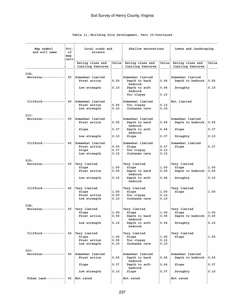
Soil Survey of Henry County, Virginia
237
Table 11.—Building Site Development, Part II—Continued
________________________________________________________________________________________________________ | | | | Map symbol |Pct.| Local roads and | Shallow excavations | Lawns and landscaping and soil name | of | streets | | |map | | | |unit| | | | |_________________________|_________________________|_________________________ | | Rating class and |Value| Rating class and |Value| Rating class and |Value | | limiting features | | limiting features | | limiting features |_____________________|____|___________________|_____|___________________|_____|___________________|_____ | | | | | | |21B: | | | | | | | Woolwine------------| 55 |Somewhat limited | |Somewhat limited | |Somewhat limited | | | Frost action |0.50 | Depth to hard |0.96 | Depth to bedrock |0.65 | | | | bedrock | | | | | Low strength |0.10 | Depth to soft |0.64 | Droughty |0.10 | | | | bedrock | | | | | | | Too clayey |0.12 | | | | | | | | | Clifford------------| 40 |Somewhat limited | |Somewhat limited | |Not limited | | | Frost action |0.50 | Too clayey |0.12 | | | | Low strength |0.10 | Cutbanks cave |0.10 | | | | | | | | |21C: | | | | | | | Woolwine------------| 55 |Somewhat limited | |Somewhat limited | |Somewhat limited | | | Frost action |0.50 | Depth to hard |0.96 | Depth to bedrock |0.65 | | | | bedrock | | | | | Slope |0.37 | Depth to soft |0.64 | Slope |0.37 | | | | bedrock | | | | | Low strength |0.10 | Slope |0.37 | Droughty |0.10 | | | | | | | Clifford------------| 40 |Somewhat limited | |Somewhat limited | |Somewhat limited | | | Frost action |0.50 | Slope |0.37 | Slope |0.37 | | Slope |0.37 | Too clayey |0.12 | | | | Low strength |0.10 | Cutbanks cave |0.10 | | | | | | | | |21D: | | | | | | | Woolwine------------| 55 |Very limited | |Very limited | |Very limited | | | Slope |1.00 | Slope |1.00 | Slope |1.00 | | Frost action |0.50 | Depth to hard |0.96 | Depth to bedrock |0.65 | | | | bedrock | | | | | Low strength |0.10 | Depth to soft |0.64 | Droughty |0.10 | | | | bedrock | | | | | | | | | | Clifford------------| 40 |Very limited | |Very limited | |Very limited | | | Slope |1.00 | Slope |1.00 | Slope |1.00 | | Frost action |0.50 | Too clayey |0.12 | | | | Low strength |0.10 | Cutbanks cave |0.10 | | | | | | | | |21E: | | | | | | | Woolwine------------| 55 |Very limited | |Very limited | |Very limited | | | Slope |1.00 | Slope |1.00 | Slope |1.00 | | Frost action |0.50 | Depth to hard |0.96 | Depth to bedrock |0.65 | | | | bedrock | | | | | Low strength |0.10 | Depth to soft |0.64 | Droughty |0.10 | | | | bedrock | | | | | | | | | | Clifford------------| 40 |Very limited | |Very limited | |Very limited | | | Slope |1.00 | Slope |1.00 | Slope |1.00 | | Frost action |0.50 | Too clayey |0.12 | | | | Low strength |0.10 | Cutbanks cave |0.10 | | | | | | | | |22C: | | | | | | | Woolwine------------| 50 |Somewhat limited | |Somewhat limited | |Somewhat limited | | | Frost action |0.50 | Depth to hard |0.96 | Depth to bedrock |0.65 | | | | bedrock | | | | | Slope |0.37 | Depth to soft |0.64 | Slope |0.37 | | | | bedrock | | | | | Low strength |0.10 | Slope |0.37 | Droughty |0.10 | | | | | | | Urban land----------| 40 |Not rated | |Not rated | |Not rated | | | | | | | |
Soil Survey of Henry County, Virginia
238
Table 11.—Building Site Development, Part II—Continued
________________________________________________________________________________________________________ | | | | Map symbol |Pct.| Local roads and | Shallow excavations | Lawns and landscaping and soil name | of | streets | | |map | | | |unit| | | | |_________________________|_________________________|_________________________ | | Rating class and |Value| Rating class and |Value| Rating class and |Value | | limiting features | | limiting features | | limiting features |_____________________|____|___________________|_____|___________________|_____|___________________|_____ | | | | | | |DAM: | | | | | | | Dam-----------------|100 |Not rated | |Not rated | |Not rated | | | | | | | |W: | | | | | | | Water---------------|100 |Not rated | |Not rated | |Not rated | | | | | | | |_____________________|____|___________________|_____|___________________|_____|___________________|_____
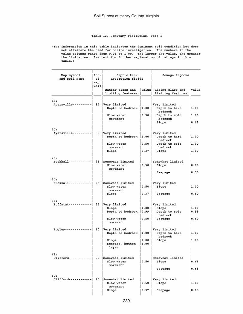
Soil Survey of Henry County, Virginia
239
Table 12.—Sanitary Facilities, Part I
(The information in this table indicates the dominant soil condition but does not eliminate the need for onsite investigation. The numbers in the value columns range from 0.01 to 1.00. The larger the value, the greater the limitation. See text for further explanation of ratings in this table.)
______________________________________________________________________________ | | | Map symbol |Pct.| Septic tank | Sewage lagoons and soil name | of | absorption fields | |map | | |unit| | | |_________________________|_________________________ | | Rating class and |Value| Rating class and |Value | | limiting features | | limiting features |_____________________|____|___________________|_____|___________________|_____ | | | | |1B: | | | | | Ayersville----------| 85 |Very limited | |Very limited | | | Depth to bedrock |1.00 | Depth to hard |1.00 | | | | bedrock | | | Slow water |0.50 | Depth to soft |1.00 | | movement | | bedrock | | | | | Slope |0.68 | | | | |1C: | | | | | Ayersville----------| 85 |Very limited | |Very limited | | | Depth to bedrock |1.00 | Depth to hard |1.00 | | | | bedrock | | | Slow water |0.50 | Depth to soft |1.00 | | movement | | bedrock | | | Slope |0.37 | Slope |1.00 | | | | |2B: | | | | | Buckhall------------| 95 |Somewhat limited | |Somewhat limited | | | Slow water |0.50 | Slope |0.68 | | movement | | | | | | | Seepage |0.50 | | | | |2C: | | | | | Buckhall------------| 95 |Somewhat limited | |Very limited | | | Slow water |0.50 | Slope |1.00 | | movement | | | | | Slope |0.37 | Seepage |0.50 | | | | |3E: | | | | | Buffstat------------| 55 |Very limited | |Very limited | | | Slope |1.00 | Slope |1.00 | | Depth to bedrock |0.99 | Depth to soft |0.99 | | | | bedrock | | | Slow water |0.50 | Seepage |0.50 | | movement | | | | | | | | Bugley--------------| 40 |Very limited | |Very limited | | | Depth to bedrock |1.00 | Depth to hard |1.00 | | | | bedrock | | | Slope |1.00 | Slope |1.00 | | Seepage, bottom |1.00 | | | | layer | | | | | | | |4B: | | | | | Clifford------------| 90 |Somewhat limited | |Somewhat limited | | | Slow water |0.50 | Slope |0.68 | | movement | | | | | | | Seepage |0.68 | | | | |4C: | | | | | Clifford------------| 90 |Somewhat limited | |Very limited | | | Slow water |0.50 | Slope |1.00 | | movement | | | | | Slope |0.37 | Seepage |0.68 | | | | |
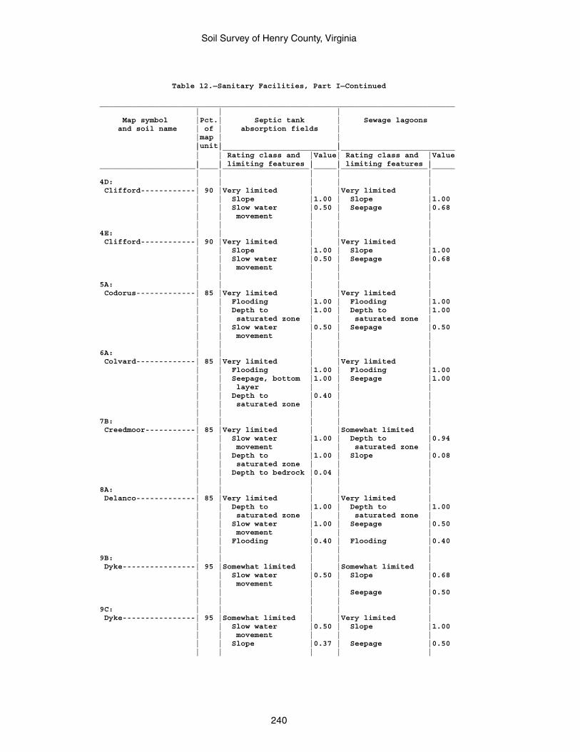
Soil Survey of Henry County, Virginia
240
Table 12.—Sanitary Facilities, Part I—Continued
______________________________________________________________________________ | | | Map symbol |Pct.| Septic tank | Sewage lagoons and soil name | of | absorption fields | |map | | |unit| | | |_________________________|_________________________ | | Rating class and |Value| Rating class and |Value | | limiting features | | limiting features |_____________________|____|___________________|_____|___________________|_____ | | | | |4D: | | | | | Clifford------------| 90 |Very limited | |Very limited | | | Slope |1.00 | Slope |1.00 | | Slow water |0.50 | Seepage |0.68 | | movement | | | | | | | |4E: | | | | | Clifford------------| 90 |Very limited | |Very limited | | | Slope |1.00 | Slope |1.00 | | Slow water |0.50 | Seepage |0.68 | | movement | | | | | | | |5A: | | | | | Codorus-------------| 85 |Very limited | |Very limited | | | Flooding |1.00 | Flooding |1.00 | | Depth to |1.00 | Depth to |1.00 | | saturated zone | | saturated zone | | | Slow water |0.50 | Seepage |0.50 | | movement | | | | | | | |6A: | | | | | Colvard-------------| 85 |Very limited | |Very limited | | | Flooding |1.00 | Flooding |1.00 | | Seepage, bottom |1.00 | Seepage |1.00 | | layer | | | | | Depth to |0.40 | | | | saturated zone | | | | | | | |7B: | | | | | Creedmoor-----------| 85 |Very limited | |Somewhat limited | | | Slow water |1.00 | Depth to |0.94 | | movement | | saturated zone | | | Depth to |1.00 | Slope |0.08 | | saturated zone | | | | | Depth to bedrock |0.04 | | | | | | |8A: | | | | | Delanco-------------| 85 |Very limited | |Very limited | | | Depth to |1.00 | Depth to |1.00 | | saturated zone | | saturated zone | | | Slow water |1.00 | Seepage |0.50 | | movement | | | | | Flooding |0.40 | Flooding |0.40 | | | | |9B: | | | | | Dyke----------------| 95 |Somewhat limited | |Somewhat limited | | | Slow water |0.50 | Slope |0.68 | | movement | | | | | | | Seepage |0.50 | | | | |9C: | | | | | Dyke----------------| 95 |Somewhat limited | |Very limited | | | Slow water |0.50 | Slope |1.00 | | movement | | | | | Slope |0.37 | Seepage |0.50 | | | | |
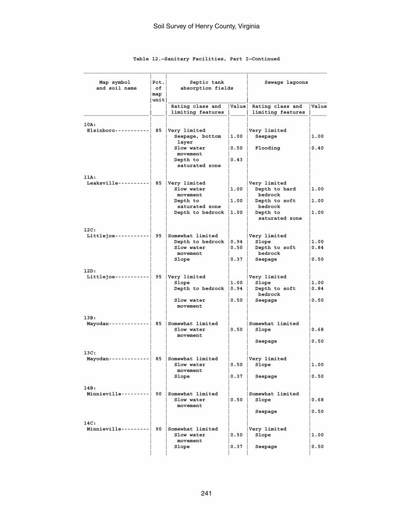
Soil Survey of Henry County, Virginia
241
Table 12.—Sanitary Facilities, Part I—Continued
______________________________________________________________________________ | | | Map symbol |Pct.| Septic tank | Sewage lagoons and soil name | of | absorption fields | |map | | |unit| | | |_________________________|_________________________ | | Rating class and |Value| Rating class and |Value | | limiting features | | limiting features |_____________________|____|___________________|_____|___________________|_____ | | | | |10A: | | | | | Elsinboro-----------| 85 |Very limited | |Very limited | | | Seepage, bottom |1.00 | Seepage |1.00 | | layer | | | | | Slow water |0.50 | Flooding |0.40 | | movement | | | | | Depth to |0.43 | | | | saturated zone | | | | | | | |11A: | | | | | Leaksville----------| 85 |Very limited | |Very limited | | | Slow water |1.00 | Depth to hard |1.00 | | movement | | bedrock | | | Depth to |1.00 | Depth to soft |1.00 | | saturated zone | | bedrock | | | Depth to bedrock |1.00 | Depth to |1.00 | | | | saturated zone | | | | | |12C: | | | | | Littlejoe-----------| 95 |Somewhat limited | |Very limited | | | Depth to bedrock |0.94 | Slope |1.00 | | Slow water |0.50 | Depth to soft |0.84 | | movement | | bedrock | | | Slope |0.37 | Seepage |0.50 | | | | |12D: | | | | | Littlejoe-----------| 95 |Very limited | |Very limited | | | Slope |1.00 | Slope |1.00 | | Depth to bedrock |0.94 | Depth to soft |0.84 | | | | bedrock | | | Slow water |0.50 | Seepage |0.50 | | movement | | | | | | | |13B: | | | | | Mayodan-------------| 85 |Somewhat limited | |Somewhat limited | | | Slow water |0.50 | Slope |0.68 | | movement | | | | | | | Seepage |0.50 | | | | |13C: | | | | | Mayodan-------------| 85 |Somewhat limited | |Very limited | | | Slow water |0.50 | Slope |1.00 | | movement | | | | | Slope |0.37 | Seepage |0.50 | | | | |14B: | | | | | Minnieville---------| 90 |Somewhat limited | |Somewhat limited | | | Slow water |0.50 | Slope |0.68 | | movement | | | | | | | Seepage |0.50 | | | | |14C: | | | | | Minnieville---------| 90 |Somewhat limited | |Very limited | | | Slow water |0.50 | Slope |1.00 | | movement | | | | | Slope |0.37 | Seepage |0.50 | | | | |
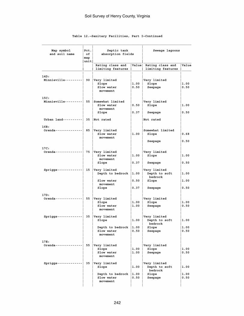
Soil Survey of Henry County, Virginia
242
Table 12.—Sanitary Facilities, Part I—Continued
______________________________________________________________________________ | | | Map symbol |Pct.| Septic tank | Sewage lagoons and soil name | of | absorption fields | |map | | |unit| | | |_________________________|_________________________ | | Rating class and |Value| Rating class and |Value | | limiting features | | limiting features |_____________________|____|___________________|_____|___________________|_____ | | | | |14D: | | | | | Minnieville---------| 90 |Very limited | |Very limited | | | Slope |1.00 | Slope |1.00 | | Slow water |0.50 | Seepage |0.50 | | movement | | | | | | | |15C: | | | | | Minnieville---------| 55 |Somewhat limited | |Very limited | | | Slow water |0.50 | Slope |1.00 | | movement | | | | | Slope |0.37 | Seepage |0.50 | | | | | Urban land----------| 35 |Not rated | |Not rated | | | | | |16B: | | | | | Orenda--------------| 85 |Very limited | |Somewhat limited | | | Slow water |1.00 | Slope |0.68 | | movement | | | | | | | Seepage |0.50 | | | | |17C: | | | | | Orenda--------------| 75 |Very limited | |Very limited | | | Slow water |1.00 | Slope |1.00 | | movement | | | | | Slope |0.37 | Seepage |0.50 | | | | | Spriggs-------------| 15 |Very limited | |Very limited | | | Depth to bedrock |1.00 | Depth to soft |1.00 | | | | bedrock | | | Slow water |0.50 | Slope |1.00 | | movement | | | | | Slope |0.37 | Seepage |0.50 | | | | |17D: | | | | | Orenda--------------| 55 |Very limited | |Very limited | | | Slope |1.00 | Slope |1.00 | | Slow water |1.00 | Seepage |0.50 | | movement | | | | | | | | Spriggs-------------| 35 |Very limited | |Very limited | | | Slope |1.00 | Depth to soft |1.00 | | | | bedrock | | | Depth to bedrock |1.00 | Slope |1.00 | | Slow water |0.50 | Seepage |0.50 | | movement | | | | | | | |17E: | | | | | Orenda--------------| 55 |Very limited | |Very limited | | | Slope |1.00 | Slope |1.00 | | Slow water |1.00 | Seepage |0.50 | | movement | | | | | | | | Spriggs-------------| 35 |Very limited | |Very limited | | | Slope |1.00 | Depth to soft |1.00 | | | | bedrock | | | Depth to bedrock |1.00 | Slope |1.00 | | Slow water |0.50 | Seepage |0.50 | | movement | | | | | | | |
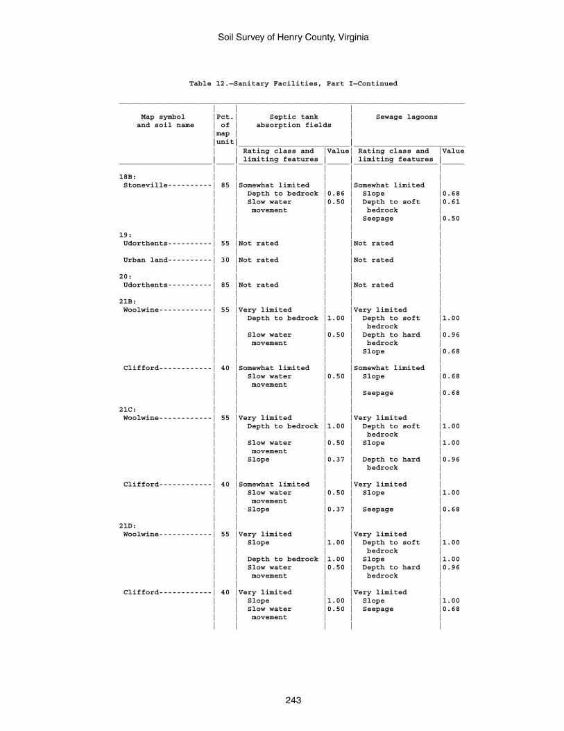
Soil Survey of Henry County, Virginia
243
Table 12.—Sanitary Facilities, Part I—Continued
______________________________________________________________________________ | | | Map symbol |Pct.| Septic tank | Sewage lagoons and soil name | of | absorption fields | |map | | |unit| | | |_________________________|_________________________ | | Rating class and |Value| Rating class and |Value | | limiting features | | limiting features |_____________________|____|___________________|_____|___________________|_____ | | | | |18B: | | | | | Stoneville----------| 85 |Somewhat limited | |Somewhat limited | | | Depth to bedrock |0.86 | Slope |0.68 | | Slow water |0.50 | Depth to soft |0.61 | | movement | | bedrock | | | | | Seepage |0.50 | | | | |19: | | | | | Udorthents----------| 55 |Not rated | |Not rated | | | | | | Urban land----------| 30 |Not rated | |Not rated | | | | | |20: | | | | | Udorthents----------| 85 |Not rated | |Not rated | | | | | |21B: | | | | | Woolwine------------| 55 |Very limited | |Very limited | | | Depth to bedrock |1.00 | Depth to soft |1.00 | | | | bedrock | | | Slow water |0.50 | Depth to hard |0.96 | | movement | | bedrock | | | | | Slope |0.68 | | | | | Clifford------------| 40 |Somewhat limited | |Somewhat limited | | | Slow water |0.50 | Slope |0.68 | | movement | | | | | | | Seepage |0.68 | | | | |21C: | | | | | Woolwine------------| 55 |Very limited | |Very limited | | | Depth to bedrock |1.00 | Depth to soft |1.00 | | | | bedrock | | | Slow water |0.50 | Slope |1.00 | | movement | | | | | Slope |0.37 | Depth to hard |0.96 | | | | bedrock | | | | | | Clifford------------| 40 |Somewhat limited | |Very limited | | | Slow water |0.50 | Slope |1.00 | | movement | | | | | Slope |0.37 | Seepage |0.68 | | | | |21D: | | | | | Woolwine------------| 55 |Very limited | |Very limited | | | Slope |1.00 | Depth to soft |1.00 | | | | bedrock | | | Depth to bedrock |1.00 | Slope |1.00 | | Slow water |0.50 | Depth to hard |0.96 | | movement | | bedrock | | | | | | Clifford------------| 40 |Very limited | |Very limited | | | Slope |1.00 | Slope |1.00 | | Slow water |0.50 | Seepage |0.68 | | movement | | | | | | | |
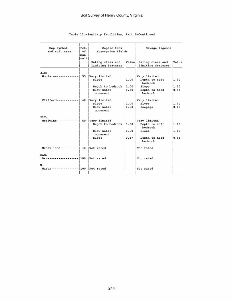
Soil Survey of Henry County, Virginia
244
Table 12.—Sanitary Facilities, Part I—Continued
______________________________________________________________________________ | | | Map symbol |Pct.| Septic tank | Sewage lagoons and soil name | of | absorption fields | |map | | |unit| | | |_________________________|_________________________ | | Rating class and |Value| Rating class and |Value | | limiting features | | limiting features |_____________________|____|___________________|_____|___________________|_____ | | | | |21E: | | | | | Woolwine------------| 55 |Very limited | |Very limited | | | Slope |1.00 | Depth to soft |1.00 | | | | bedrock | | | Depth to bedrock |1.00 | Slope |1.00 | | Slow water |0.50 | Depth to hard |0.96 | | movement | | bedrock | | | | | | Clifford------------| 40 |Very limited | |Very limited | | | Slope |1.00 | Slope |1.00 | | Slow water |0.50 | Seepage |0.68 | | movement | | | | | | | |22C: | | | | | Woolwine------------| 50 |Very limited | |Very limited | | | Depth to bedrock |1.00 | Depth to soft |1.00 | | | | bedrock | | | Slow water |0.50 | Slope |1.00 | | movement | | | | | Slope |0.37 | Depth to hard |0.96 | | | | bedrock | | | | | | Urban land----------| 40 |Not rated | |Not rated | | | | | |DAM: | | | | | Dam-----------------|100 |Not rated | |Not rated | | | | | |W: | | | | | Water---------------|100 |Not rated | |Not rated | | | | | |_____________________|____|___________________|_____|___________________|_____

Soil Survey of Henry County, Virginia
245
Table 12.—Sanitary Facilities, Part II
(The information in this table indicates the dominant soil condition but does not eliminate the need for onsite investigation. The numbers in the value columns range from 0.01 to 1.00. The larger the value, the greater the limitation. See text for further explanation of ratings in this table.)
________________________________________________________________________________________________________ | | | | Map symbol |Pct.| Trench sanitary | Area sanitary | Daily cover for and soil name | of | landfill | landfill | landfill |map | | | |unit| | | | |_________________________|_________________________|_________________________ | | Rating class and |Value| Rating class and |Value| Rating class and |Value | | limiting features | | limiting features | | limiting features |_____________________|____|___________________|_____|___________________|_____|___________________|_____ | | | | | | |1B: | | | | | | | Ayersville----------| 85 |Very limited | |Very limited | |Very limited | | | Depth to bedrock |1.00 | Depth to bedrock |1.00 | Depth to bedrock |1.00 | | | | | | |1C: | | | | | | | Ayersville----------| 85 |Very limited | |Very limited | |Very limited | | | Depth to bedrock |1.00 | Depth to bedrock |1.00 | Depth to bedrock |1.00 | | Slope |0.37 | Slope |0.37 | Slope |0.37 | | | | | | |2B: | | | | | | | Buckhall------------| 95 |Not limited | |Not limited | |Very limited | | | | | | | Too clayey |1.00 | | | | | | |2C: | | | | | | | Buckhall------------| 95 |Somewhat limited | |Somewhat limited | |Very limited | | | Slope |0.37 | Slope |0.37 | Too clayey |1.00 | | | | | | Slope |0.373E: | | | | | | | Buffstat------------| 55 |Very limited | |Very limited | |Very limited | | | Slope |1.00 | Slope |1.00 | Slope |1.00 | | Depth to bedrock |1.00 | Depth to bedrock |0.99 | Depth to bedrock |0.99 | | Too clayey |0.50 | | | Too clayey |0.50 | | | | | | | Bugley--------------| 40 |Very limited | |Very limited | |Very limited | | | Slope |1.00 | Slope |1.00 | Depth to bedrock |1.00 | | Depth to bedrock |1.00 | Depth to bedrock |1.00 | Slope |1.00 | | Seepage, bottom |1.00 | | | Seepage |0.50 | | layer | | | | | | | | | | | |4B: | | | | | | | Clifford------------| 90 |Somewhat limited | |Not limited | |Somewhat limited | | | Too clayey |0.50 | | | Too clayey |0.50 | | | | | | |4C: | | | | | | | Clifford------------| 90 |Somewhat limited | |Somewhat limited | |Somewhat limited | | | Too clayey |0.50 | Slope |0.37 | Too clayey |0.50 | | Slope |0.37 | | | Slope |0.37 | | | | | | |4D: | | | | | | | Clifford------------| 90 |Very limited | |Very limited | |Very limited | | | Slope |1.00 | Slope |1.00 | Slope |1.00 | | Too clayey |0.50 | | | Too clayey |0.50 | | | | | | |4E: | | | | | | | Clifford------------| 90 |Very limited | |Very limited | |Very limited | | | Slope |1.00 | Slope |1.00 | Slope |1.00 | | Too clayey |0.50 | | | Too clayey |0.50 | | | | | | |5A: | | | | | | | Codorus-------------| 85 |Very limited | |Very limited | |Very limited | | | Flooding |1.00 | Flooding |1.00 | Depth to |0.99 | | | | | | saturated zone | | | Depth to |1.00 | Depth to |1.00 | | | | saturated zone | | saturated zone | | | | | | | | | |
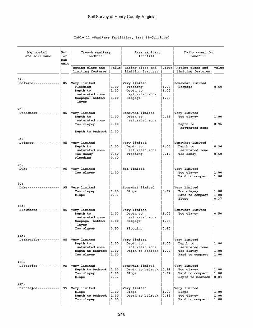
Soil Survey of Henry County, Virginia
246
Table 12.—Sanitary Facilities, Part II—Continued
________________________________________________________________________________________________________ | | | | Map symbol |Pct.| Trench sanitary | Area sanitary | Daily cover for and soil name | of | landfill | landfill | landfill |map | | | |unit| | | | |_________________________|_________________________|_________________________ | | Rating class and |Value| Rating class and |Value| Rating class and |Value | | limiting features | | limiting features | | limiting features |_____________________|____|___________________|_____|___________________|_____|___________________|_____ | | | | | | |6A: | | | | | | | Colvard-------------| 85 |Very limited | |Very limited | |Somewhat limited | | | Flooding |1.00 | Flooding |1.00 | Seepage |0.50 | | Depth to |1.00 | Depth to |1.00 | | | | saturated zone | | saturated zone | | | | | Seepage, bottom |1.00 | Seepage |1.00 | | | | layer | | | | | | | | | | | |7B: | | | | | | | Creedmoor-----------| 85 |Very limited | |Somewhat limited | |Very limited | | | Depth to |1.00 | Depth to |0.94 | Too clayey |1.00 | | saturated zone | | saturated zone | | | | | Too clayey |1.00 | | | Depth to |0.96 | | | | | | saturated zone | | | Depth to bedrock |1.00 | | | | | | | | | | |8A: | | | | | | | Delanco-------------| 85 |Very limited | |Very limited | |Somewhat limited | | | Depth to |1.00 | Depth to |1.00 | Depth to |0.96 | | saturated zone | | saturated zone | | saturated zone | | | Too sandy |0.50 | Flooding |0.40 | Too sandy |0.50 | | Flooding |0.40 | | | | | | | | | | |9B: | | | | | | | Dyke----------------| 95 |Very limited | |Not limited | |Very limited | | | Too clayey |1.00 | | | Too clayey |1.00 | | | | | | Hard to compact |1.00 | | | | | | |9C: | | | | | | | Dyke----------------| 95 |Very limited | |Somewhat limited | |Very limited | | | Too clayey |1.00 | Slope |0.37 | Too clayey |1.00 | | Slope |0.37 | | | Hard to compact |1.00 | | | | | | Slope |0.37 | | | | | | |10A: | | | | | | | Elsinboro-----------| 85 |Very limited | |Very limited | |Somewhat limited | | | Depth to |1.00 | Depth to |1.00 | Too clayey |0.50 | | saturated zone | | saturated zone | | | | | Seepage, bottom |1.00 | Seepage |1.00 | | | | layer | | | | | | | Too clayey |0.50 | Flooding |0.40 | | | | | | | | |11A: | | | | | | | Leaksville----------| 85 |Very limited | |Very limited | |Very limited | | | Depth to |1.00 | Depth to |1.00 | Depth to |1.00 | | saturated zone | | saturated zone | | saturated zone | | | Depth to bedrock |1.00 | Depth to bedrock |1.00 | Too clayey |1.00 | | Too clayey |1.00 | | | Hard to compact |1.00 | | | | | | |12C: | | | | | | | Littlejoe-----------| 95 |Very limited | |Somewhat limited | |Very limited | | | Depth to bedrock |1.00 | Depth to bedrock |0.84 | Too clayey |1.00 | | Too clayey |1.00 | Slope |0.37 | Hard to compact |1.00 | | Slope |0.37 | | | Depth to bedrock |0.84 | | | | | | |12D: | | | | | | | Littlejoe-----------| 95 |Very limited | |Very limited | |Very limited | | | Slope |1.00 | Slope |1.00 | Slope |1.00 | | Depth to bedrock |1.00 | Depth to bedrock |0.84 | Too clayey |1.00 | | Too clayey |1.00 | | | Hard to compact |1.00 | | | | | | |
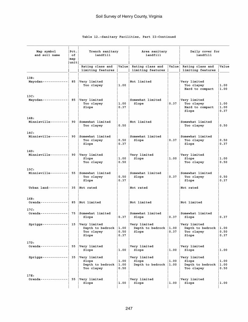
Soil Survey of Henry County, Virginia
247
Table 12.—Sanitary Facilities, Part II—Continued
________________________________________________________________________________________________________ | | | | Map symbol |Pct.| Trench sanitary | Area sanitary | Daily cover for and soil name | of | landfill | landfill | landfill |map | | | |unit| | | | |_________________________|_________________________|_________________________ | | Rating class and |Value| Rating class and |Value| Rating class and |Value | | limiting features | | limiting features | | limiting features |_____________________|____|___________________|_____|___________________|_____|___________________|_____ | | | | | | |13B: | | | | | | | Mayodan-------------| 85 |Very limited | |Not limited | |Very limited | | | Too clayey |1.00 | | | Too clayey |1.00 | | | | | | Hard to compact |1.00 | | | | | | |13C: | | | | | | | Mayodan-------------| 85 |Very limited | |Somewhat limited | |Very limited | | | Too clayey |1.00 | Slope |0.37 | Too clayey |1.00 | | Slope |0.37 | | | Hard to compact |1.00 | | | | | | Slope |0.37 | | | | | | |14B: | | | | | | | Minnieville---------| 90 |Somewhat limited | |Not limited | |Somewhat limited | | | Too clayey |0.50 | | | Too clayey |0.50 | | | | | | |14C: | | | | | | | Minnieville---------| 90 |Somewhat limited | |Somewhat limited | |Somewhat limited | | | Too clayey |0.50 | Slope |0.37 | Too clayey |0.50 | | Slope |0.37 | | | Slope |0.37 | | | | | | |14D: | | | | | | | Minnieville---------| 90 |Very limited | |Very limited | |Very limited | | | Slope |1.00 | Slope |1.00 | Slope |1.00 | | Too clayey |0.50 | | | Too clayey |0.50 | | | | | | |15C: | | | | | | | Minnieville---------| 55 |Somewhat limited | |Somewhat limited | |Somewhat limited | | | Too clayey |0.50 | Slope |0.37 | Too clayey |0.50 | | Slope |0.37 | | | Slope |0.37 | | | | | | | Urban land----------| 35 |Not rated | |Not rated | |Not rated | | | | | | | | | | | | | | |16B: | | | | | | | Orenda--------------| 85 |Not limited | |Not limited | |Not limited | | | | | | | |17C: | | | | | | | Orenda--------------| 75 |Somewhat limited | |Somewhat limited | |Somewhat limited | | | Slope |0.37 | Slope |0.37 | Slope |0.37 | | | | | | | Spriggs-------------| 15 |Very limited | |Very limited | |Very limited | | | Depth to bedrock |1.00 | Depth to bedrock |1.00 | Depth to bedrock |1.00 | | Too clayey |0.50 | Slope |0.37 | Too clayey |0.50 | | Slope |0.37 | | | Slope |0.37 | | | | | | |17D: | | | | | | | Orenda--------------| 55 |Very limited | |Very limited | |Very limited | | | Slope |1.00 | Slope |1.00 | Slope |1.00 | | | | | | | Spriggs-------------| 35 |Very limited | |Very limited | |Very limited | | | Slope |1.00 | Slope |1.00 | Slope |1.00 | | Depth to bedrock |1.00 | Depth to bedrock |1.00 | Depth to bedrock |1.00 | | Too clayey |0.50 | | | Too clayey |0.50 | | | | | | |17E: | | | | | | | Orenda--------------| 55 |Very limited | |Very limited | |Very limited | | | Slope |1.00 | Slope |1.00 | Slope |1.00 | | | | | | |
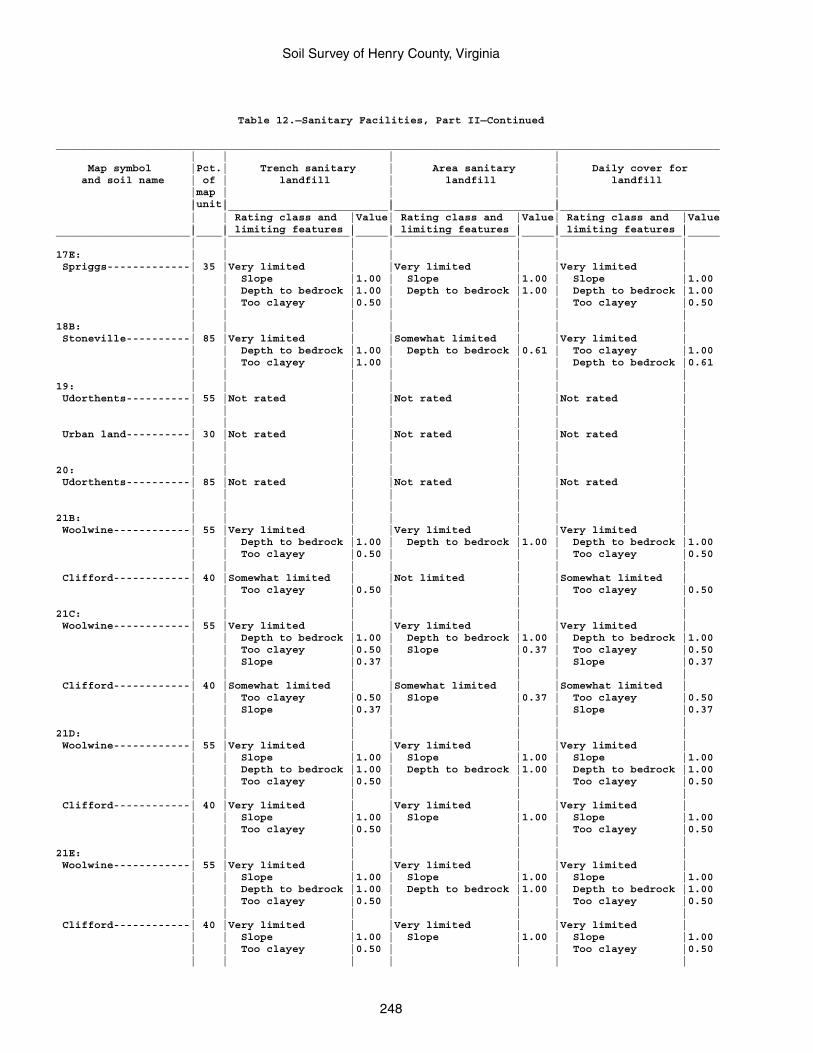
Soil Survey of Henry County, Virginia
248
Table 12.—Sanitary Facilities, Part II—Continued
________________________________________________________________________________________________________ | | | | Map symbol |Pct.| Trench sanitary | Area sanitary | Daily cover for and soil name | of | landfill | landfill | landfill |map | | | |unit| | | | |_________________________|_________________________|_________________________ | | Rating class and |Value| Rating class and |Value| Rating class and |Value | | limiting features | | limiting features | | limiting features |_____________________|____|___________________|_____|___________________|_____|___________________|_____ | | | | | | |17E: | | | | | | | Spriggs-------------| 35 |Very limited | |Very limited | |Very limited | | | Slope |1.00 | Slope |1.00 | Slope |1.00 | | Depth to bedrock |1.00 | Depth to bedrock |1.00 | Depth to bedrock |1.00 | | Too clayey |0.50 | | | Too clayey |0.50 | | | | | | |18B: | | | | | | | Stoneville----------| 85 |Very limited | |Somewhat limited | |Very limited | | | Depth to bedrock |1.00 | Depth to bedrock |0.61 | Too clayey |1.00 | | Too clayey |1.00 | | | Depth to bedrock |0.61 | | | | | | |19: | | | | | | | Udorthents----------| 55 |Not rated | |Not rated | |Not rated | | | | | | | | | | | | | | | Urban land----------| 30 |Not rated | |Not rated | |Not rated | | | | | | | | | | | | | | |20: | | | | | | | Udorthents----------| 85 |Not rated | |Not rated | |Not rated | | | | | | | | | | | | | | |21B: | | | | | | | Woolwine------------| 55 |Very limited | |Very limited | |Very limited | | | Depth to bedrock |1.00 | Depth to bedrock |1.00 | Depth to bedrock |1.00 | | Too clayey |0.50 | | | Too clayey |0.50 | | | | | | | Clifford------------| 40 |Somewhat limited | |Not limited | |Somewhat limited | | | Too clayey |0.50 | | | Too clayey |0.50 | | | | | | |21C: | | | | | | | Woolwine------------| 55 |Very limited | |Very limited | |Very limited | | | Depth to bedrock |1.00 | Depth to bedrock |1.00 | Depth to bedrock |1.00 | | Too clayey |0.50 | Slope |0.37 | Too clayey |0.50 | | Slope |0.37 | | | Slope |0.37 | | | | | | | Clifford------------| 40 |Somewhat limited | |Somewhat limited | |Somewhat limited | | | Too clayey |0.50 | Slope |0.37 | Too clayey |0.50 | | Slope |0.37 | | | Slope |0.37 | | | | | | |21D: | | | | | | | Woolwine------------| 55 |Very limited | |Very limited | |Very limited | | | Slope |1.00 | Slope |1.00 | Slope |1.00 | | Depth to bedrock |1.00 | Depth to bedrock |1.00 | Depth to bedrock |1.00 | | Too clayey |0.50 | | | Too clayey |0.50 | | | | | | | Clifford------------| 40 |Very limited | |Very limited | |Very limited | | | Slope |1.00 | Slope |1.00 | Slope |1.00 | | Too clayey |0.50 | | | Too clayey |0.50 | | | | | | |21E: | | | | | | | Woolwine------------| 55 |Very limited | |Very limited | |Very limited | | | Slope |1.00 | Slope |1.00 | Slope |1.00 | | Depth to bedrock |1.00 | Depth to bedrock |1.00 | Depth to bedrock |1.00 | | Too clayey |0.50 | | | Too clayey |0.50 | | | | | | | Clifford------------| 40 |Very limited | |Very limited | |Very limited | | | Slope |1.00 | Slope |1.00 | Slope |1.00 | | Too clayey |0.50 | | | Too clayey |0.50 | | | | | | |
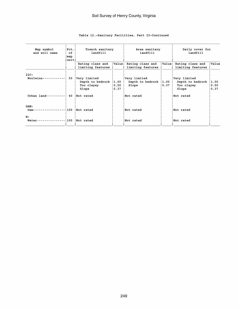
Soil Survey of Henry County, Virginia
249
Table 12.—Sanitary Facilities, Part II—Continued
________________________________________________________________________________________________________ | | | | Map symbol |Pct.| Trench sanitary | Area sanitary | Daily cover for and soil name | of | landfill | landfill | landfill |map | | | |unit| | | | |_________________________|_________________________|_________________________ | | Rating class and |Value| Rating class and |Value| Rating class and |Value | | limiting features | | limiting features | | limiting features |_____________________|____|___________________|_____|___________________|_____|___________________|_____ | | | | | | |22C: | | | | | | | Woolwine------------| 50 |Very limited | |Very limited | |Very limited | | | Depth to bedrock |1.00 | Depth to bedrock |1.00 | Depth to bedrock |1.00 | | Too clayey |0.50 | Slope |0.37 | Too clayey |0.50 | | Slope |0.37 | | | Slope |0.37 | | | | | | | Urban land----------| 40 |Not rated | |Not rated | |Not rated | | | | | | | | | | | | | | |DAM: | | | | | | | Dam-----------------|100 |Not rated | |Not rated | |Not rated | | | | | | | |W: | | | | | | | Water---------------|100 |Not rated | |Not rated | |Not rated | | | | | | | |_____________________|____|___________________|_____|___________________|_____|___________________|_____
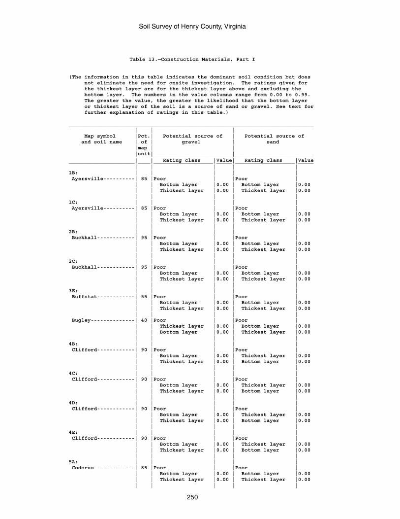
Soil Survey of Henry County, Virginia
250
Table 13.—Construction Materials, Part I
(The information in this table indicates the dominant soil condition but does not eliminate the need for onsite investigation. The ratings given for the thickest layer are for the thickest layer above and excluding the bottom layer. The numbers in the value columns range from 0.00 to 0.99. The greater the value, the greater the likelihood that the bottom layer or thickest layer of the soil is a source of sand or gravel. See text for further explanation of ratings in this table.)
______________________________________________________________________________ | | | Map symbol |Pct.| Potential source of | Potential source of and soil name | of | gravel | sand |map | | |unit| | | |_________________________|_________________________ | | Rating class |Value| Rating class |Value_____________________|____|___________________|_____|___________________|_____ | | | | |1B: | | | | | Ayersville----------| 85 |Poor | |Poor | | | Bottom layer |0.00 | Bottom layer |0.00 | | Thickest layer |0.00 | Thickest layer |0.00 | | | | |1C: | | | | | Ayersville----------| 85 |Poor | |Poor | | | Bottom layer |0.00 | Bottom layer |0.00 | | Thickest layer |0.00 | Thickest layer |0.00 | | | | |2B: | | | | | Buckhall------------| 95 |Poor | |Poor | | | Bottom layer |0.00 | Bottom layer |0.00 | | Thickest layer |0.00 | Thickest layer |0.00 | | | | |2C: | | | | | Buckhall------------| 95 |Poor | |Poor | | | Bottom layer |0.00 | Bottom layer |0.00 | | Thickest layer |0.00 | Thickest layer |0.00 | | | | |3E: | | | | | Buffstat------------| 55 |Poor | |Poor | | | Bottom layer |0.00 | Bottom layer |0.00 | | Thickest layer |0.00 | Thickest layer |0.00 | | | | | Bugley--------------| 40 |Poor | |Poor | | | Thickest layer |0.00 | Bottom layer |0.00 | | Bottom layer |0.00 | Thickest layer |0.00 | | | | |4B: | | | | | Clifford------------| 90 |Poor | |Poor | | | Bottom layer |0.00 | Thickest layer |0.00 | | Thickest layer |0.00 | Bottom layer |0.00 | | | | |4C: | | | | | Clifford------------| 90 |Poor | |Poor | | | Bottom layer |0.00 | Thickest layer |0.00 | | Thickest layer |0.00 | Bottom layer |0.00 | | | | |4D: | | | | | Clifford------------| 90 |Poor | |Poor | | | Bottom layer |0.00 | Thickest layer |0.00 | | Thickest layer |0.00 | Bottom layer |0.00 | | | | |4E: | | | | | Clifford------------| 90 |Poor | |Poor | | | Bottom layer |0.00 | Thickest layer |0.00 | | Thickest layer |0.00 | Bottom layer |0.00 | | | | |5A: | | | | | Codorus-------------| 85 |Poor | |Poor | | | Bottom layer |0.00 | Bottom layer |0.00 | | Thickest layer |0.00 | Thickest layer |0.00 | | | | |
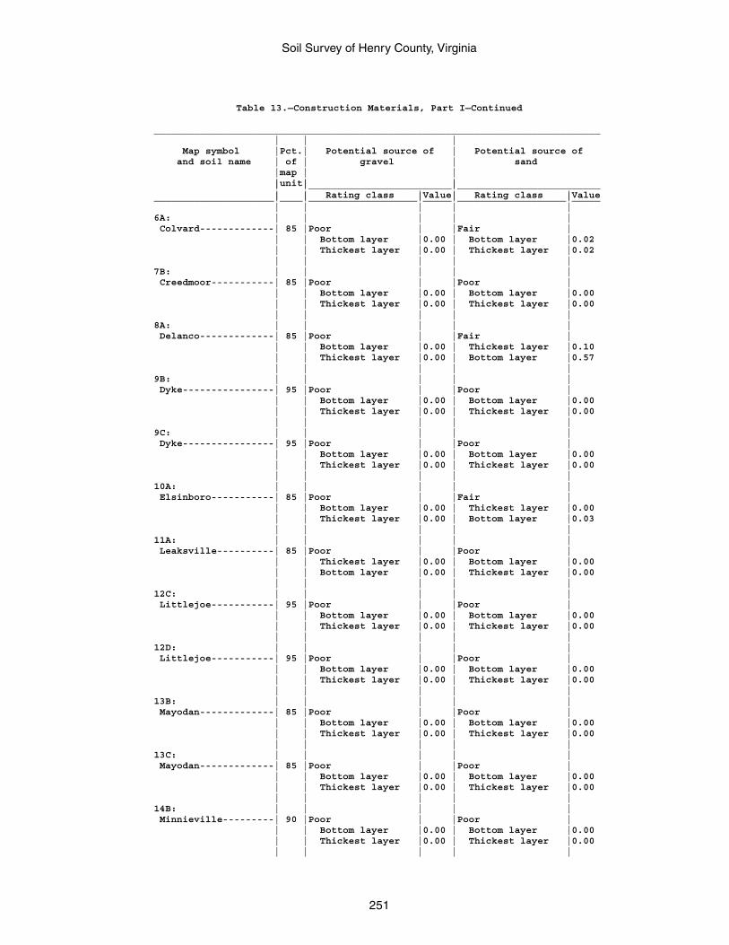
Soil Survey of Henry County, Virginia
251
Table 13.—Construction Materials, Part I—Continued
______________________________________________________________________________ | | | Map symbol |Pct.| Potential source of | Potential source of and soil name | of | gravel | sand |map | | |unit| | | |_________________________|_________________________ | | Rating class |Value| Rating class |Value_____________________|____|___________________|_____|___________________|_____ | | | | |6A: | | | | | Colvard-------------| 85 |Poor | |Fair | | | Bottom layer |0.00 | Bottom layer |0.02 | | Thickest layer |0.00 | Thickest layer |0.02 | | | | |7B: | | | | | Creedmoor-----------| 85 |Poor | |Poor | | | Bottom layer |0.00 | Bottom layer |0.00 | | Thickest layer |0.00 | Thickest layer |0.00 | | | | |8A: | | | | | Delanco-------------| 85 |Poor | |Fair | | | Bottom layer |0.00 | Thickest layer |0.10 | | Thickest layer |0.00 | Bottom layer |0.57 | | | | |9B: | | | | | Dyke----------------| 95 |Poor | |Poor | | | Bottom layer |0.00 | Bottom layer |0.00 | | Thickest layer |0.00 | Thickest layer |0.00 | | | | |9C: | | | | | Dyke----------------| 95 |Poor | |Poor | | | Bottom layer |0.00 | Bottom layer |0.00 | | Thickest layer |0.00 | Thickest layer |0.00 | | | | |10A: | | | | | Elsinboro-----------| 85 |Poor | |Fair | | | Bottom layer |0.00 | Thickest layer |0.00 | | Thickest layer |0.00 | Bottom layer |0.03 | | | | |11A: | | | | | Leaksville----------| 85 |Poor | |Poor | | | Thickest layer |0.00 | Bottom layer |0.00 | | Bottom layer |0.00 | Thickest layer |0.00 | | | | |12C: | | | | | Littlejoe-----------| 95 |Poor | |Poor | | | Bottom layer |0.00 | Bottom layer |0.00 | | Thickest layer |0.00 | Thickest layer |0.00 | | | | |12D: | | | | | Littlejoe-----------| 95 |Poor | |Poor | | | Bottom layer |0.00 | Bottom layer |0.00 | | Thickest layer |0.00 | Thickest layer |0.00 | | | | |13B: | | | | | Mayodan-------------| 85 |Poor | |Poor | | | Bottom layer |0.00 | Bottom layer |0.00 | | Thickest layer |0.00 | Thickest layer |0.00 | | | | |13C: | | | | | Mayodan-------------| 85 |Poor | |Poor | | | Bottom layer |0.00 | Bottom layer |0.00 | | Thickest layer |0.00 | Thickest layer |0.00 | | | | |14B: | | | | | Minnieville---------| 90 |Poor | |Poor | | | Bottom layer |0.00 | Bottom layer |0.00 | | Thickest layer |0.00 | Thickest layer |0.00 | | | | |
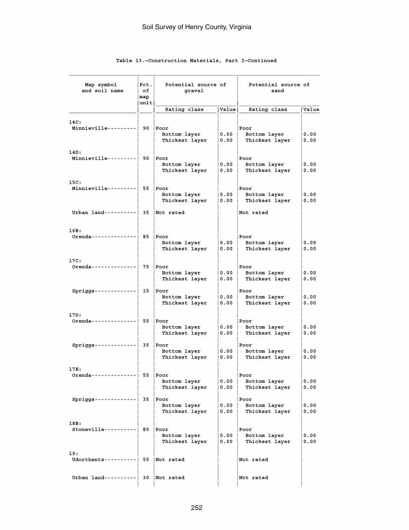
Soil Survey of Henry County, Virginia
252
Table 13.—Construction Materials, Part I—Continued
______________________________________________________________________________ | | | Map symbol |Pct.| Potential source of | Potential source of and soil name | of | gravel | sand |map | | |unit| | | |_________________________|_________________________ | | Rating class |Value| Rating class |Value_____________________|____|___________________|_____|___________________|_____ | | | | |14C: | | | | | Minnieville---------| 90 |Poor | |Poor | | | Bottom layer |0.00 | Bottom layer |0.00 | | Thickest layer |0.00 | Thickest layer |0.00 | | | | |14D: | | | | | Minnieville---------| 90 |Poor | |Poor | | | Bottom layer |0.00 | Bottom layer |0.00 | | Thickest layer |0.00 | Thickest layer |0.00 | | | | |15C: | | | | | Minnieville---------| 55 |Poor | |Poor | | | Bottom layer |0.00 | Bottom layer |0.00 | | Thickest layer |0.00 | Thickest layer |0.00 | | | | | Urban land----------| 35 |Not rated | |Not rated | | | | | | | | | | |16B: | | | | | Orenda--------------| 85 |Poor | |Poor | | | Bottom layer |0.00 | Bottom layer |0.00 | | Thickest layer |0.00 | Thickest layer |0.00 | | | | |17C: | | | | | Orenda--------------| 75 |Poor | |Poor | | | Bottom layer |0.00 | Bottom layer |0.00 | | Thickest layer |0.00 | Thickest layer |0.00 | | | | | Spriggs-------------| 15 |Poor | |Poor | | | Bottom layer |0.00 | Bottom layer |0.00 | | Thickest layer |0.00 | Thickest layer |0.00 | | | | |17D: | | | | | Orenda--------------| 55 |Poor | |Poor | | | Bottom layer |0.00 | Bottom layer |0.00 | | Thickest layer |0.00 | Thickest layer |0.00 | | | | | Spriggs-------------| 35 |Poor | |Poor | | | Bottom layer |0.00 | Bottom layer |0.00 | | Thickest layer |0.00 | Thickest layer |0.00 | | | | |17E: | | | | | Orenda--------------| 55 |Poor | |Poor | | | Bottom layer |0.00 | Bottom layer |0.00 | | Thickest layer |0.00 | Thickest layer |0.00 | | | | | Spriggs-------------| 35 |Poor | |Poor | | | Bottom layer |0.00 | Bottom layer |0.00 | | Thickest layer |0.00 | Thickest layer |0.00 | | | | |18B: | | | | | Stoneville----------| 85 |Poor | |Poor | | | Bottom layer |0.00 | Bottom layer |0.00 | | Thickest layer |0.00 | Thickest layer |0.00 | | | | |19: | | | | | Udorthents----------| 55 |Not rated | |Not rated | | | | | | | | | | | Urban land----------| 30 |Not rated | |Not rated | | | | | |
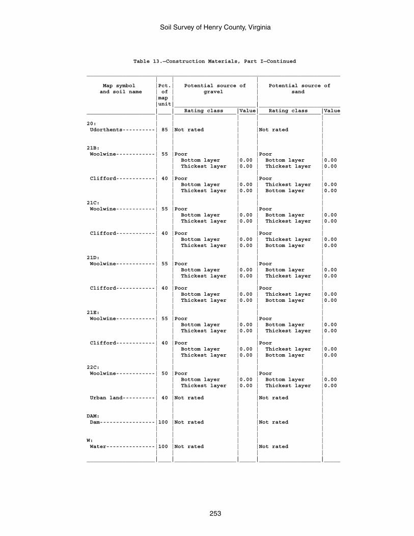
Soil Survey of Henry County, Virginia
253
Table 13.—Construction Materials, Part I—Continued
______________________________________________________________________________ | | | Map symbol |Pct.| Potential source of | Potential source of and soil name | of | gravel | sand |map | | |unit| | | |_________________________|_________________________ | | Rating class |Value| Rating class |Value_____________________|____|___________________|_____|___________________|_____ | | | | |20: | | | | | Udorthents----------| 85 |Not rated | |Not rated | | | | | | | | | | |21B: | | | | | Woolwine------------| 55 |Poor | |Poor | | | Bottom layer |0.00 | Bottom layer |0.00 | | Thickest layer |0.00 | Thickest layer |0.00 | | | | | Clifford------------| 40 |Poor | |Poor | | | Bottom layer |0.00 | Thickest layer |0.00 | | Thickest layer |0.00 | Bottom layer |0.00 | | | | |21C: | | | | | Woolwine------------| 55 |Poor | |Poor | | | Bottom layer |0.00 | Bottom layer |0.00 | | Thickest layer |0.00 | Thickest layer |0.00 | | | | | Clifford------------| 40 |Poor | |Poor | | | Bottom layer |0.00 | Thickest layer |0.00 | | Thickest layer |0.00 | Bottom layer |0.00 | | | | |21D: | | | | | Woolwine------------| 55 |Poor | |Poor | | | Bottom layer |0.00 | Bottom layer |0.00 | | Thickest layer |0.00 | Thickest layer |0.00 | | | | | Clifford------------| 40 |Poor | |Poor | | | Bottom layer |0.00 | Thickest layer |0.00 | | Thickest layer |0.00 | Bottom layer |0.00 | | | | |21E: | | | | | Woolwine------------| 55 |Poor | |Poor | | | Bottom layer |0.00 | Bottom layer |0.00 | | Thickest layer |0.00 | Thickest layer |0.00 | | | | | Clifford------------| 40 |Poor | |Poor | | | Bottom layer |0.00 | Thickest layer |0.00 | | Thickest layer |0.00 | Bottom layer |0.00 | | | | |22C: | | | | | Woolwine------------| 50 |Poor | |Poor | | | Bottom layer |0.00 | Bottom layer |0.00 | | Thickest layer |0.00 | Thickest layer |0.00 | | | | | Urban land----------| 40 |Not rated | |Not rated | | | | | | | | | | |DAM: | | | | | Dam-----------------|100 |Not rated | |Not rated | | | | | | | | | | |W: | | | | | Water---------------|100 |Not rated | |Not rated | | | | | | | | | | |_____________________|____|___________________|_____|___________________|_____
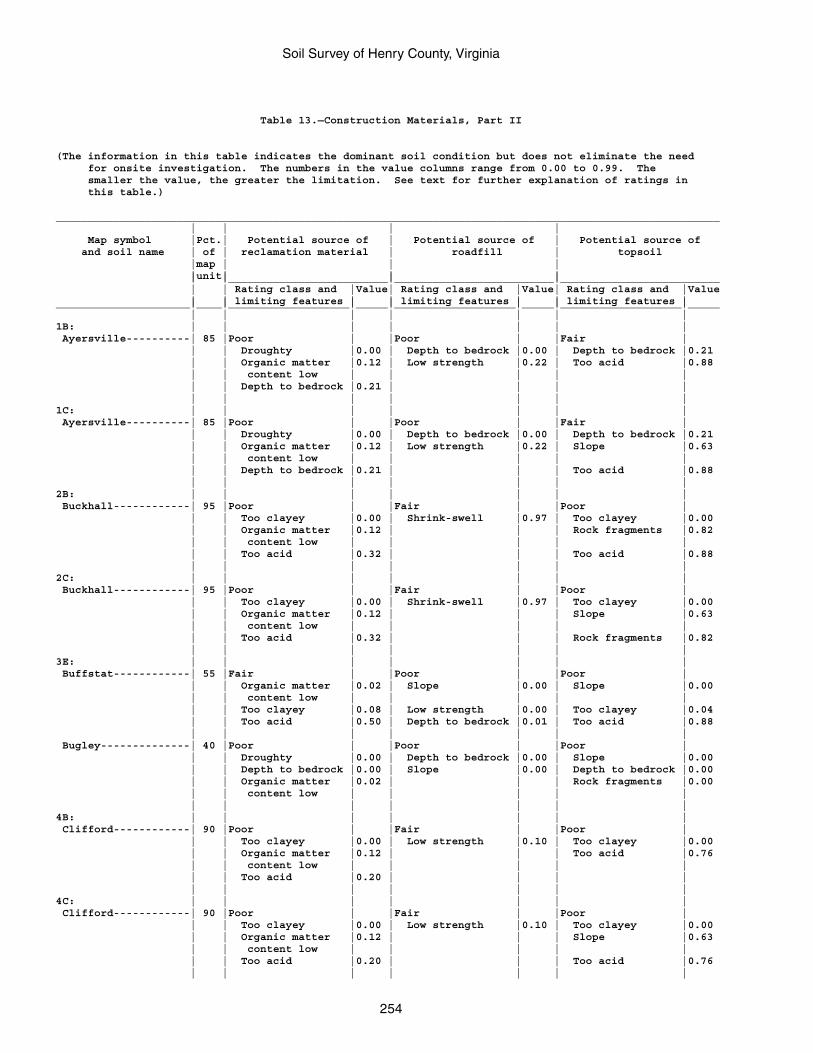
Soil Survey of Henry County, Virginia
254
Table 13.—Construction Materials, Part II
(The information in this table indicates the dominant soil condition but does not eliminate the need for onsite investigation. The numbers in the value columns range from 0.00 to 0.99. The smaller the value, the greater the limitation. See text for further explanation of ratings in this table.)
________________________________________________________________________________________________________ | | | | Map symbol |Pct.| Potential source of | Potential source of | Potential source of and soil name | of | reclamation material | roadfill | topsoil |map | | | |unit| | | | |_________________________|_________________________|_________________________ | | Rating class and |Value| Rating class and |Value| Rating class and |Value | | limiting features | | limiting features | | limiting features |_____________________|____|___________________|_____|___________________|_____|___________________|_____ | | | | | | |1B: | | | | | | | Ayersville----------| 85 |Poor | |Poor | |Fair | | | Droughty |0.00 | Depth to bedrock |0.00 | Depth to bedrock |0.21 | | Organic matter |0.12 | Low strength |0.22 | Too acid |0.88 | | content low | | | | | | | Depth to bedrock |0.21 | | | | | | | | | | |1C: | | | | | | | Ayersville----------| 85 |Poor | |Poor | |Fair | | | Droughty |0.00 | Depth to bedrock |0.00 | Depth to bedrock |0.21 | | Organic matter |0.12 | Low strength |0.22 | Slope |0.63 | | content low | | | | | | | Depth to bedrock |0.21 | | | Too acid |0.88 | | | | | | |2B: | | | | | | | Buckhall------------| 95 |Poor | |Fair | |Poor | | | Too clayey |0.00 | Shrink-swell |0.97 | Too clayey |0.00 | | Organic matter |0.12 | | | Rock fragments |0.82 | | content low | | | | | | | Too acid |0.32 | | | Too acid |0.88 | | | | | | |2C: | | | | | | | Buckhall------------| 95 |Poor | |Fair | |Poor | | | Too clayey |0.00 | Shrink-swell |0.97 | Too clayey |0.00 | | Organic matter |0.12 | | | Slope |0.63 | | content low | | | | | | | Too acid |0.32 | | | Rock fragments |0.82 | | | | | | |3E: | | | | | | | Buffstat------------| 55 |Fair | |Poor | |Poor | | | Organic matter |0.02 | Slope |0.00 | Slope |0.00 | | content low | | | | | | | Too clayey |0.08 | Low strength |0.00 | Too clayey |0.04 | | Too acid |0.50 | Depth to bedrock |0.01 | Too acid |0.88 | | | | | | | Bugley--------------| 40 |Poor | |Poor | |Poor | | | Droughty |0.00 | Depth to bedrock |0.00 | Slope |0.00 | | Depth to bedrock |0.00 | Slope |0.00 | Depth to bedrock |0.00 | | Organic matter |0.02 | | | Rock fragments |0.00 | | content low | | | | | | | | | | | |4B: | | | | | | | Clifford------------| 90 |Poor | |Fair | |Poor | | | Too clayey |0.00 | Low strength |0.10 | Too clayey |0.00 | | Organic matter |0.12 | | | Too acid |0.76 | | content low | | | | | | | Too acid |0.20 | | | | | | | | | | |4C: | | | | | | | Clifford------------| 90 |Poor | |Fair | |Poor | | | Too clayey |0.00 | Low strength |0.10 | Too clayey |0.00 | | Organic matter |0.12 | | | Slope |0.63 | | content low | | | | | | | Too acid |0.20 | | | Too acid |0.76 | | | | | | |
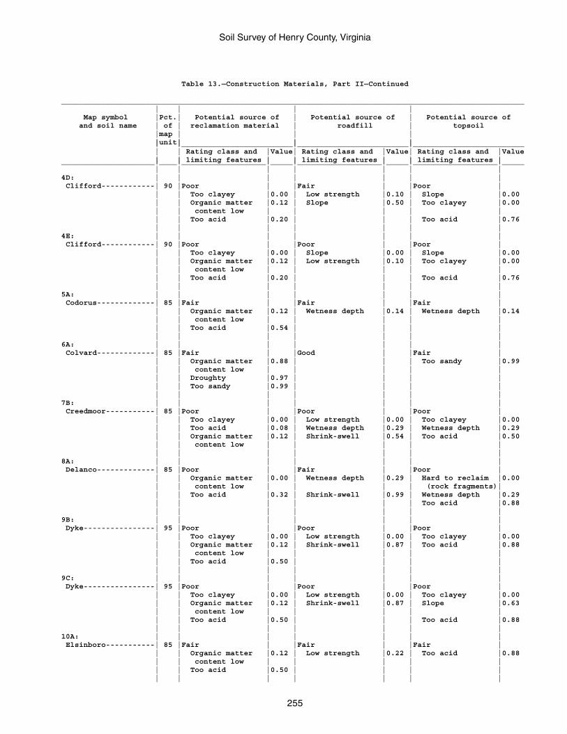
Soil Survey of Henry County, Virginia
255
Table 13.—Construction Materials, Part II—Continued
________________________________________________________________________________________________________ | | | | Map symbol |Pct.| Potential source of | Potential source of | Potential source of and soil name | of | reclamation material | roadfill | topsoil |map | | | |unit| | | | |_________________________|_________________________|_________________________ | | Rating class and |Value| Rating class and |Value| Rating class and |Value | | limiting features | | limiting features | | limiting features |_____________________|____|___________________|_____|___________________|_____|___________________|_____ | | | | | | |4D: | | | | | | | Clifford------------| 90 |Poor | |Fair | |Poor | | | Too clayey |0.00 | Low strength |0.10 | Slope |0.00 | | Organic matter |0.12 | Slope |0.50 | Too clayey |0.00 | | content low | | | | | | | Too acid |0.20 | | | Too acid |0.76 | | | | | | |4E: | | | | | | | Clifford------------| 90 |Poor | |Poor | |Poor | | | Too clayey |0.00 | Slope |0.00 | Slope |0.00 | | Organic matter |0.12 | Low strength |0.10 | Too clayey |0.00 | | content low | | | | | | | Too acid |0.20 | | | Too acid |0.76 | | | | | | |5A: | | | | | | | Codorus-------------| 85 |Fair | |Fair | |Fair | | | Organic matter |0.12 | Wetness depth |0.14 | Wetness depth |0.14 | | content low | | | | | | | Too acid |0.54 | | | | | | | | | | |6A: | | | | | | | Colvard-------------| 85 |Fair | |Good | |Fair | | | Organic matter |0.88 | | | Too sandy |0.99 | | content low | | | | | | | Droughty |0.97 | | | | | | Too sandy |0.99 | | | | | | | | | | |7B: | | | | | | | Creedmoor-----------| 85 |Poor | |Poor | |Poor | | | Too clayey |0.00 | Low strength |0.00 | Too clayey |0.00 | | Too acid |0.08 | Wetness depth |0.29 | Wetness depth |0.29 | | Organic matter |0.12 | Shrink-swell |0.54 | Too acid |0.50 | | content low | | | | | | | | | | | |8A: | | | | | | | Delanco-------------| 85 |Poor | |Fair | |Poor | | | Organic matter |0.00 | Wetness depth |0.29 | Hard to reclaim |0.00 | | content low | | | | (rock fragments)| | | Too acid |0.32 | Shrink-swell |0.99 | Wetness depth |0.29 | | | | | | Too acid |0.88 | | | | | | |9B: | | | | | | | Dyke----------------| 95 |Poor | |Poor | |Poor | | | Too clayey |0.00 | Low strength |0.00 | Too clayey |0.00 | | Organic matter |0.12 | Shrink-swell |0.87 | Too acid |0.88 | | content low | | | | | | | Too acid |0.50 | | | | | | | | | | |9C: | | | | | | | Dyke----------------| 95 |Poor | |Poor | |Poor | | | Too clayey |0.00 | Low strength |0.00 | Too clayey |0.00 | | Organic matter |0.12 | Shrink-swell |0.87 | Slope |0.63 | | content low | | | | | | | Too acid |0.50 | | | Too acid |0.88 | | | | | | |10A: | | | | | | | Elsinboro-----------| 85 |Fair | |Fair | |Fair | | | Organic matter |0.12 | Low strength |0.22 | Too acid |0.88 | | content low | | | | | | | Too acid |0.50 | | | | | | | | | | |
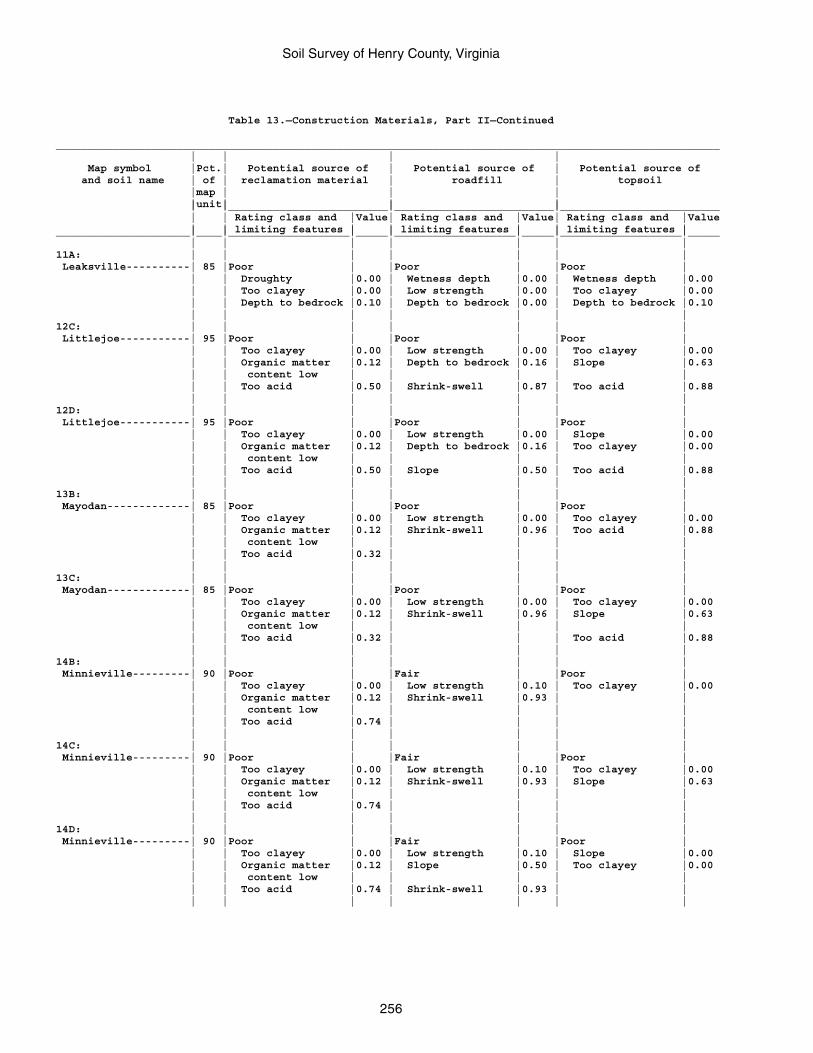
Soil Survey of Henry County, Virginia
256
Table 13.—Construction Materials, Part II—Continued
________________________________________________________________________________________________________ | | | | Map symbol |Pct.| Potential source of | Potential source of | Potential source of and soil name | of | reclamation material | roadfill | topsoil |map | | | |unit| | | | |_________________________|_________________________|_________________________ | | Rating class and |Value| Rating class and |Value| Rating class and |Value | | limiting features | | limiting features | | limiting features |_____________________|____|___________________|_____|___________________|_____|___________________|_____ | | | | | | |11A: | | | | | | | Leaksville----------| 85 |Poor | |Poor | |Poor | | | Droughty |0.00 | Wetness depth |0.00 | Wetness depth |0.00 | | Too clayey |0.00 | Low strength |0.00 | Too clayey |0.00 | | Depth to bedrock |0.10 | Depth to bedrock |0.00 | Depth to bedrock |0.10 | | | | | | |12C: | | | | | | | Littlejoe-----------| 95 |Poor | |Poor | |Poor | | | Too clayey |0.00 | Low strength |0.00 | Too clayey |0.00 | | Organic matter |0.12 | Depth to bedrock |0.16 | Slope |0.63 | | content low | | | | | | | Too acid |0.50 | Shrink-swell |0.87 | Too acid |0.88 | | | | | | |12D: | | | | | | | Littlejoe-----------| 95 |Poor | |Poor | |Poor | | | Too clayey |0.00 | Low strength |0.00 | Slope |0.00 | | Organic matter |0.12 | Depth to bedrock |0.16 | Too clayey |0.00 | | content low | | | | | | | Too acid |0.50 | Slope |0.50 | Too acid |0.88 | | | | | | |13B: | | | | | | | Mayodan-------------| 85 |Poor | |Poor | |Poor | | | Too clayey |0.00 | Low strength |0.00 | Too clayey |0.00 | | Organic matter |0.12 | Shrink-swell |0.96 | Too acid |0.88 | | content low | | | | | | | Too acid |0.32 | | | | | | | | | | |13C: | | | | | | | Mayodan-------------| 85 |Poor | |Poor | |Poor | | | Too clayey |0.00 | Low strength |0.00 | Too clayey |0.00 | | Organic matter |0.12 | Shrink-swell |0.96 | Slope |0.63 | | content low | | | | | | | Too acid |0.32 | | | Too acid |0.88 | | | | | | |14B: | | | | | | | Minnieville---------| 90 |Poor | |Fair | |Poor | | | Too clayey |0.00 | Low strength |0.10 | Too clayey |0.00 | | Organic matter |0.12 | Shrink-swell |0.93 | | | | content low | | | | | | | Too acid |0.74 | | | | | | | | | | |14C: | | | | | | | Minnieville---------| 90 |Poor | |Fair | |Poor | | | Too clayey |0.00 | Low strength |0.10 | Too clayey |0.00 | | Organic matter |0.12 | Shrink-swell |0.93 | Slope |0.63 | | content low | | | | | | | Too acid |0.74 | | | | | | | | | | |14D: | | | | | | | Minnieville---------| 90 |Poor | |Fair | |Poor | | | Too clayey |0.00 | Low strength |0.10 | Slope |0.00 | | Organic matter |0.12 | Slope |0.50 | Too clayey |0.00 | | content low | | | | | | | Too acid |0.74 | Shrink-swell |0.93 | | | | | | | | |
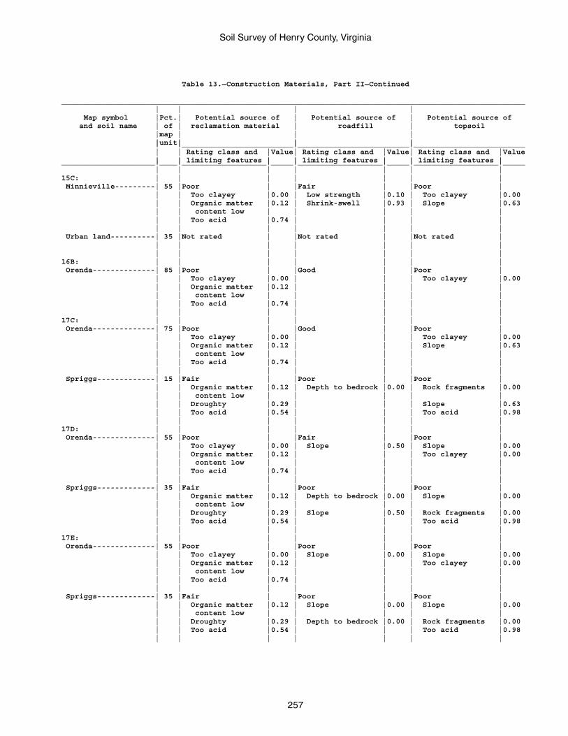
Soil Survey of Henry County, Virginia
257
Table 13.—Construction Materials, Part II—Continued
________________________________________________________________________________________________________ | | | | Map symbol |Pct.| Potential source of | Potential source of | Potential source of and soil name | of | reclamation material | roadfill | topsoil |map | | | |unit| | | | |_________________________|_________________________|_________________________ | | Rating class and |Value| Rating class and |Value| Rating class and |Value | | limiting features | | limiting features | | limiting features |_____________________|____|___________________|_____|___________________|_____|___________________|_____ | | | | | | |15C: | | | | | | | Minnieville---------| 55 |Poor | |Fair | |Poor | | | Too clayey |0.00 | Low strength |0.10 | Too clayey |0.00 | | Organic matter |0.12 | Shrink-swell |0.93 | Slope |0.63 | | content low | | | | | | | Too acid |0.74 | | | | | | | | | | | Urban land----------| 35 |Not rated | |Not rated | |Not rated | | | | | | | | | | | | | | |16B: | | | | | | | Orenda--------------| 85 |Poor | |Good | |Poor | | | Too clayey |0.00 | | | Too clayey |0.00 | | Organic matter |0.12 | | | | | | content low | | | | | | | Too acid |0.74 | | | | | | | | | | |17C: | | | | | | | Orenda--------------| 75 |Poor | |Good | |Poor | | | Too clayey |0.00 | | | Too clayey |0.00 | | Organic matter |0.12 | | | Slope |0.63 | | content low | | | | | | | Too acid |0.74 | | | | | | | | | | | Spriggs-------------| 15 |Fair | |Poor | |Poor | | | Organic matter |0.12 | Depth to bedrock |0.00 | Rock fragments |0.00 | | content low | | | | | | | Droughty |0.29 | | | Slope |0.63 | | Too acid |0.54 | | | Too acid |0.98 | | | | | | |17D: | | | | | | | Orenda--------------| 55 |Poor | |Fair | |Poor | | | Too clayey |0.00 | Slope |0.50 | Slope |0.00 | | Organic matter |0.12 | | | Too clayey |0.00 | | content low | | | | | | | Too acid |0.74 | | | | | | | | | | | Spriggs-------------| 35 |Fair | |Poor | |Poor | | | Organic matter |0.12 | Depth to bedrock |0.00 | Slope |0.00 | | content low | | | | | | | Droughty |0.29 | Slope |0.50 | Rock fragments |0.00 | | Too acid |0.54 | | | Too acid |0.98 | | | | | | |17E: | | | | | | | Orenda--------------| 55 |Poor | |Poor | |Poor | | | Too clayey |0.00 | Slope |0.00 | Slope |0.00 | | Organic matter |0.12 | | | Too clayey |0.00 | | content low | | | | | | | Too acid |0.74 | | | | | | | | | | | Spriggs-------------| 35 |Fair | |Poor | |Poor | | | Organic matter |0.12 | Slope |0.00 | Slope |0.00 | | content low | | | | | | | Droughty |0.29 | Depth to bedrock |0.00 | Rock fragments |0.00 | | Too acid |0.54 | | | Too acid |0.98 | | | | | | |
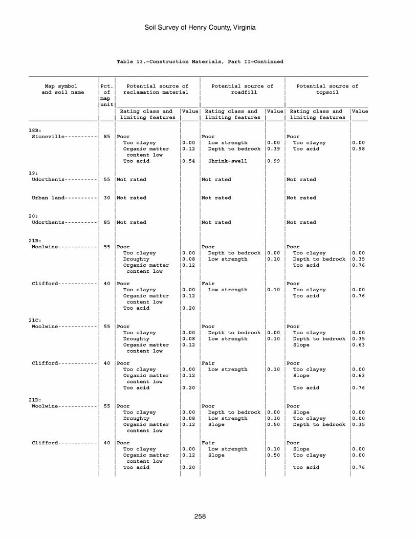
Soil Survey of Henry County, Virginia
258
Table 13.—Construction Materials, Part II—Continued
________________________________________________________________________________________________________ | | | | Map symbol |Pct.| Potential source of | Potential source of | Potential source of and soil name | of | reclamation material | roadfill | topsoil |map | | | |unit| | | | |_________________________|_________________________|_________________________ | | Rating class and |Value| Rating class and |Value| Rating class and |Value | | limiting features | | limiting features | | limiting features |_____________________|____|___________________|_____|___________________|_____|___________________|_____ | | | | | | |18B: | | | | | | | Stoneville----------| 85 |Poor | |Poor | |Poor | | | Too clayey |0.00 | Low strength |0.00 | Too clayey |0.00 | | Organic matter |0.12 | Depth to bedrock |0.39 | Too acid |0.98 | | content low | | | | | | | Too acid |0.54 | Shrink-swell |0.99 | | | | | | | | |19: | | | | | | | Udorthents----------| 55 |Not rated | |Not rated | |Not rated | | | | | | | | | | | | | | | Urban land----------| 30 |Not rated | |Not rated | |Not rated | | | | | | | | | | | | | | |20: | | | | | | | Udorthents----------| 85 |Not rated | |Not rated | |Not rated | | | | | | | | | | | | | | |21B: | | | | | | | Woolwine------------| 55 |Poor | |Poor | |Poor | | | Too clayey |0.00 | Depth to bedrock |0.00 | Too clayey |0.00 | | Droughty |0.08 | Low strength |0.10 | Depth to bedrock |0.35 | | Organic matter |0.12 | | | Too acid |0.76 | | content low | | | | | | | | | | | | Clifford------------| 40 |Poor | |Fair | |Poor | | | Too clayey |0.00 | Low strength |0.10 | Too clayey |0.00 | | Organic matter |0.12 | | | Too acid |0.76 | | content low | | | | | | | Too acid |0.20 | | | | | | | | | | |21C: | | | | | | | Woolwine------------| 55 |Poor | |Poor | |Poor | | | Too clayey |0.00 | Depth to bedrock |0.00 | Too clayey |0.00 | | Droughty |0.08 | Low strength |0.10 | Depth to bedrock |0.35 | | Organic matter |0.12 | | | Slope |0.63 | | content low | | | | | | | | | | | | Clifford------------| 40 |Poor | |Fair | |Poor | | | Too clayey |0.00 | Low strength |0.10 | Too clayey |0.00 | | Organic matter |0.12 | | | Slope |0.63 | | content low | | | | | | | Too acid |0.20 | | | Too acid |0.76 | | | | | | |21D: | | | | | | | Woolwine------------| 55 |Poor | |Poor | |Poor | | | Too clayey |0.00 | Depth to bedrock |0.00 | Slope |0.00 | | Droughty |0.08 | Low strength |0.10 | Too clayey |0.00 | | Organic matter |0.12 | Slope |0.50 | Depth to bedrock |0.35 | | content low | | | | | | | | | | | | Clifford------------| 40 |Poor | |Fair | |Poor | | | Too clayey |0.00 | Low strength |0.10 | Slope |0.00 | | Organic matter |0.12 | Slope |0.50 | Too clayey |0.00 | | content low | | | | | | | Too acid |0.20 | | | Too acid |0.76 | | | | | | |
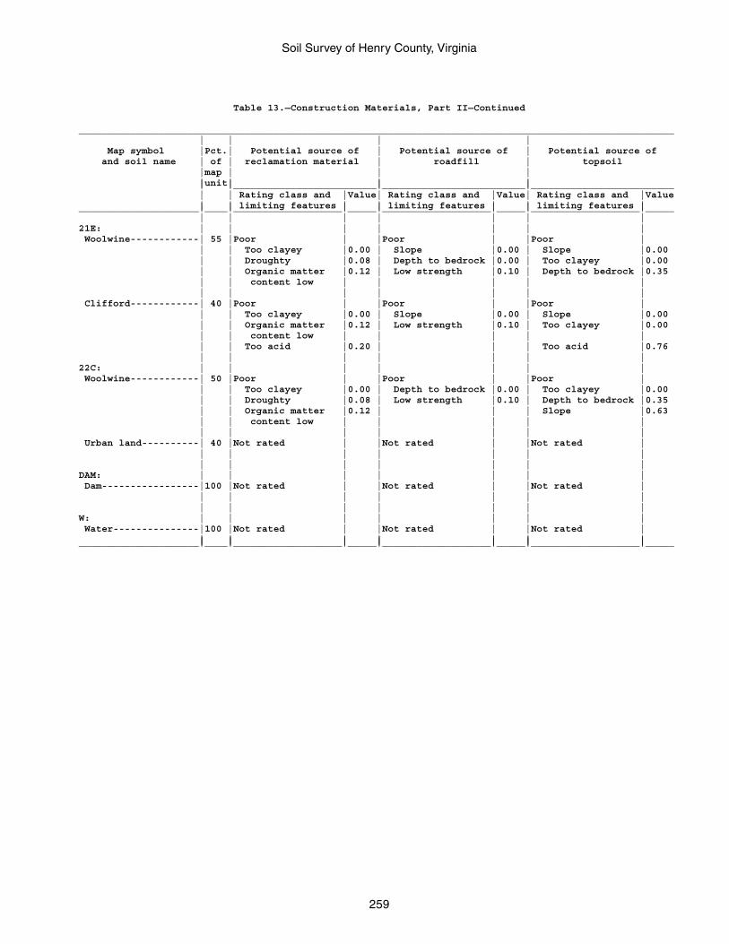
Soil Survey of Henry County, Virginia
259
Table 13.—Construction Materials, Part II—Continued
________________________________________________________________________________________________________ | | | | Map symbol |Pct.| Potential source of | Potential source of | Potential source of and soil name | of | reclamation material | roadfill | topsoil |map | | | |unit| | | | |_________________________|_________________________|_________________________ | | Rating class and |Value| Rating class and |Value| Rating class and |Value | | limiting features | | limiting features | | limiting features |_____________________|____|___________________|_____|___________________|_____|___________________|_____ | | | | | | |21E: | | | | | | | Woolwine------------| 55 |Poor | |Poor | |Poor | | | Too clayey |0.00 | Slope |0.00 | Slope |0.00 | | Droughty |0.08 | Depth to bedrock |0.00 | Too clayey |0.00 | | Organic matter |0.12 | Low strength |0.10 | Depth to bedrock |0.35 | | content low | | | | | | | | | | | | Clifford------------| 40 |Poor | |Poor | |Poor | | | Too clayey |0.00 | Slope |0.00 | Slope |0.00 | | Organic matter |0.12 | Low strength |0.10 | Too clayey |0.00 | | content low | | | | | | | Too acid |0.20 | | | Too acid |0.76 | | | | | | |22C: | | | | | | | Woolwine------------| 50 |Poor | |Poor | |Poor | | | Too clayey |0.00 | Depth to bedrock |0.00 | Too clayey |0.00 | | Droughty |0.08 | Low strength |0.10 | Depth to bedrock |0.35 | | Organic matter |0.12 | | | Slope |0.63 | | content low | | | | | | | | | | | | Urban land----------| 40 |Not rated | |Not rated | |Not rated | | | | | | | | | | | | | | |DAM: | | | | | | | Dam-----------------|100 |Not rated | |Not rated | |Not rated | | | | | | | | | | | | | | |W: | | | | | | | Water---------------|100 |Not rated | |Not rated | |Not rated | | | | | | | | | | | | | | |_____________________|____|___________________|_____|___________________|_____|___________________|_____
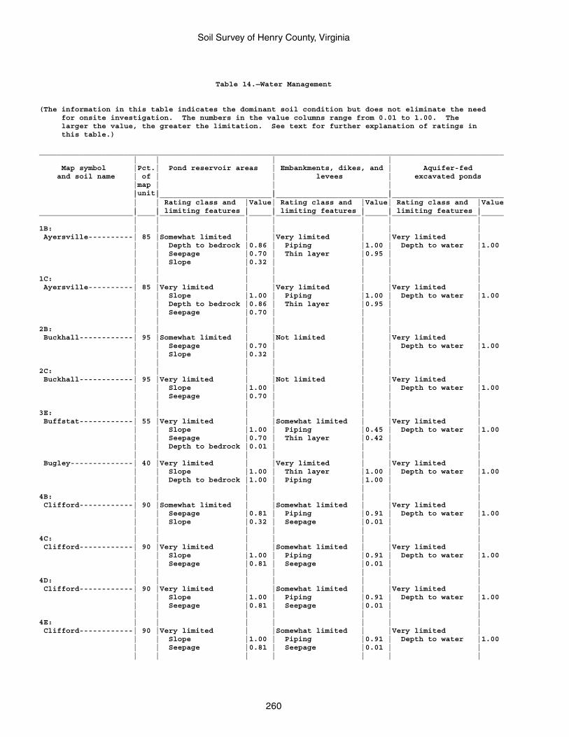
Soil Survey of Henry County, Virginia
260
Table 14.—Water Management
(The information in this table indicates the dominant soil condition but does not eliminate the need for onsite investigation. The numbers in the value columns range from 0.01 to 1.00. The larger the value, the greater the limitation. See text for further explanation of ratings in this table.)
________________________________________________________________________________________________________ | | | | Map symbol |Pct.| Pond reservoir areas | Embankments, dikes, and | Aquifer-fed and soil name | of | | levees | excavated ponds |map | | | |unit| | | | |_________________________|_________________________|_________________________ | | Rating class and |Value| Rating class and |Value| Rating class and |Value | | limiting features | | limiting features | | limiting features |_____________________|____|___________________|_____|___________________|_____|___________________|_____ | | | | | | |1B: | | | | | | | Ayersville----------| 85 |Somewhat limited | |Very limited | |Very limited | | | Depth to bedrock |0.86 | Piping |1.00 | Depth to water |1.00 | | Seepage |0.70 | Thin layer |0.95 | | | | Slope |0.32 | | | | | | | | | | |1C: | | | | | | | Ayersville----------| 85 |Very limited | |Very limited | |Very limited | | | Slope |1.00 | Piping |1.00 | Depth to water |1.00 | | Depth to bedrock |0.86 | Thin layer |0.95 | | | | Seepage |0.70 | | | | | | | | | | |2B: | | | | | | | Buckhall------------| 95 |Somewhat limited | |Not limited | |Very limited | | | Seepage |0.70 | | | Depth to water |1.00 | | Slope |0.32 | | | | | | | | | | |2C: | | | | | | | Buckhall------------| 95 |Very limited | |Not limited | |Very limited | | | Slope |1.00 | | | Depth to water |1.00 | | Seepage |0.70 | | | | | | | | | | |3E: | | | | | | | Buffstat------------| 55 |Very limited | |Somewhat limited | |Very limited | | | Slope |1.00 | Piping |0.45 | Depth to water |1.00 | | Seepage |0.70 | Thin layer |0.42 | | | | Depth to bedrock |0.01 | | | | | | | | | | | Bugley--------------| 40 |Very limited | |Very limited | |Very limited | | | Slope |1.00 | Thin layer |1.00 | Depth to water |1.00 | | Depth to bedrock |1.00 | Piping |1.00 | | | | | | | | |4B: | | | | | | | Clifford------------| 90 |Somewhat limited | |Somewhat limited | |Very limited | | | Seepage |0.81 | Piping |0.91 | Depth to water |1.00 | | Slope |0.32 | Seepage |0.01 | | | | | | | | |4C: | | | | | | | Clifford------------| 90 |Very limited | |Somewhat limited | |Very limited | | | Slope |1.00 | Piping |0.91 | Depth to water |1.00 | | Seepage |0.81 | Seepage |0.01 | | | | | | | | |4D: | | | | | | | Clifford------------| 90 |Very limited | |Somewhat limited | |Very limited | | | Slope |1.00 | Piping |0.91 | Depth to water |1.00 | | Seepage |0.81 | Seepage |0.01 | | | | | | | | |4E: | | | | | | | Clifford------------| 90 |Very limited | |Somewhat limited | |Very limited | | | Slope |1.00 | Piping |0.91 | Depth to water |1.00 | | Seepage |0.81 | Seepage |0.01 | | | | | | | | |
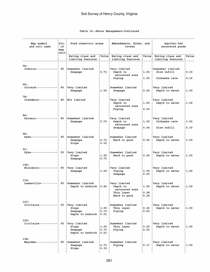
Soil Survey of Henry County, Virginia
261
Table 14.—Water Management—Continued
________________________________________________________________________________________________________ | | | | Map symbol |Pct.| Pond reservoir areas | Embankments, dikes, and | Aquifer-fed and soil name | of | | levees | excavated ponds |map | | | |unit| | | | |_________________________|_________________________|_________________________ | | Rating class and |Value| Rating class and |Value| Rating class and |Value | | limiting features | | limiting features | | limiting features |_____________________|____|___________________|_____|___________________|_____|___________________|_____ | | | | | | |5A: | | | | | | | Codorus-------------| 85 |Somewhat limited | |Very limited | |Somewhat limited | | | Seepage |0.70 | Depth to |1.00 | Slow refill |0.30 | | | | saturated zone | | | | | | | Piping |1.00 | Cutbanks cave |0.10 | | | | | | |6A: | | | | | | | Colvard-------------| 85 |Very limited | |Somewhat limited | |Very limited | | | Seepage |1.00 | Seepage |0.02 | Depth to water |1.00 | | | | | | |7B: | | | | | | | Creedmoor-----------| 85 |Not limited | |Very limited | |Very limited | | | | | Depth to |1.00 | Depth to water |1.00 | | | | saturated zone | | | | | | | Piping |0.29 | | | | | | | | |8A: | | | | | | | Delanco-------------| 85 |Somewhat limited | |Very limited | |Very limited | | | Seepage |0.70 | Depth to |1.00 | Cutbanks cave |1.00 | | | | saturated zone | | | | | | | Seepage |0.64 | Slow refill |0.30 | | | | | | |9B: | | | | | | | Dyke----------------| 95 |Somewhat limited | |Somewhat limited | |Very limited | | | Seepage |0.70 | Hard to pack |0.06 | Depth to water |1.00 | | Slope |0.32 | | | | | | | | | | |9C: | | | | | | | Dyke----------------| 95 |Very limited | |Somewhat limited | |Very limited | | | Slope |1.00 | Hard to pack |0.06 | Depth to water |1.00 | | Seepage |0.70 | | | | | | | | | | |10A: | | | | | | | Elsinboro-----------| 85 |Very limited | |Very limited | |Very limited | | | Seepage |1.00 | Piping |1.00 | Depth to water |1.00 | | | | Seepage |0.03 | | | | | | | | |11A: | | | | | | | Leaksville----------| 85 |Somewhat limited | |Very limited | |Very limited | | | Depth to bedrock |0.86 | Depth to |1.00 | Depth to water |1.00 | | | | saturated zone | | | | | | | Thin layer |0.98 | | | | | | Hard to pack |0.28 | | | | | | | | |12C: | | | | | | | Littlejoe-----------| 95 |Very limited | |Somewhat limited | |Very limited | | | Slope |1.00 | Thin layer |0.26 | Depth to water |1.00 | | Seepage |0.70 | Piping |0.02 | | | | Depth to bedrock |0.01 | | | | | | | | | | |12D: | | | | | | | Littlejoe-----------| 95 |Very limited | |Somewhat limited | |Very limited | | | Slope |1.00 | Thin layer |0.26 | Depth to water |1.00 | | Seepage |0.70 | Piping |0.02 | | | | Depth to bedrock |0.01 | | | | | | | | | | |13B: | | | | | | | Mayodan-------------| 85 |Somewhat limited | |Somewhat limited | |Very limited | | | Seepage |0.70 | Piping |0.17 | Depth to water |1.00 | | Slope |0.32 | | | | | | | | | | |
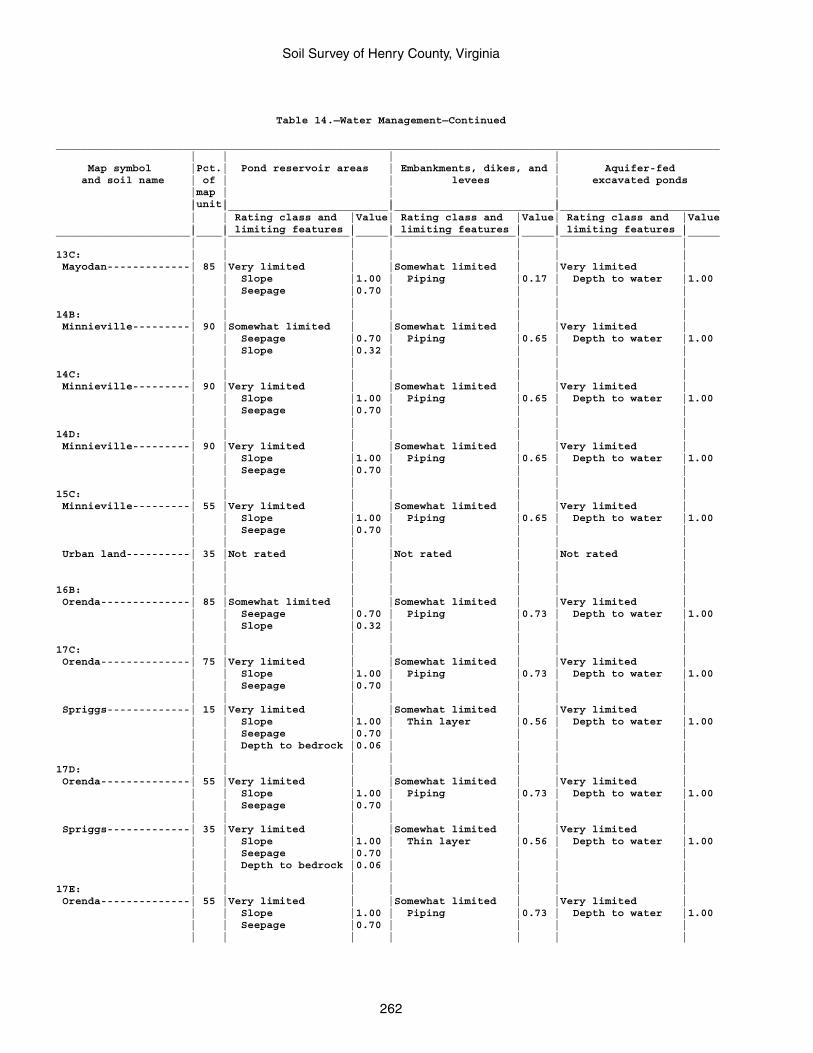
Soil Survey of Henry County, Virginia
262
Table 14.—Water Management—Continued
________________________________________________________________________________________________________ | | | | Map symbol |Pct.| Pond reservoir areas | Embankments, dikes, and | Aquifer-fed and soil name | of | | levees | excavated ponds |map | | | |unit| | | | |_________________________|_________________________|_________________________ | | Rating class and |Value| Rating class and |Value| Rating class and |Value | | limiting features | | limiting features | | limiting features |_____________________|____|___________________|_____|___________________|_____|___________________|_____ | | | | | | |13C: | | | | | | | Mayodan-------------| 85 |Very limited | |Somewhat limited | |Very limited | | | Slope |1.00 | Piping |0.17 | Depth to water |1.00 | | Seepage |0.70 | | | | | | | | | | |14B: | | | | | | | Minnieville---------| 90 |Somewhat limited | |Somewhat limited | |Very limited | | | Seepage |0.70 | Piping |0.65 | Depth to water |1.00 | | Slope |0.32 | | | | | | | | | | |14C: | | | | | | | Minnieville---------| 90 |Very limited | |Somewhat limited | |Very limited | | | Slope |1.00 | Piping |0.65 | Depth to water |1.00 | | Seepage |0.70 | | | | | | | | | | |14D: | | | | | | | Minnieville---------| 90 |Very limited | |Somewhat limited | |Very limited | | | Slope |1.00 | Piping |0.65 | Depth to water |1.00 | | Seepage |0.70 | | | | | | | | | | |15C: | | | | | | | Minnieville---------| 55 |Very limited | |Somewhat limited | |Very limited | | | Slope |1.00 | Piping |0.65 | Depth to water |1.00 | | Seepage |0.70 | | | | | | | | | | | Urban land----------| 35 |Not rated | |Not rated | |Not rated | | | | | | | | | | | | | | |16B: | | | | | | | Orenda--------------| 85 |Somewhat limited | |Somewhat limited | |Very limited | | | Seepage |0.70 | Piping |0.73 | Depth to water |1.00 | | Slope |0.32 | | | | | | | | | | |17C: | | | | | | | Orenda--------------| 75 |Very limited | |Somewhat limited | |Very limited | | | Slope |1.00 | Piping |0.73 | Depth to water |1.00 | | Seepage |0.70 | | | | | | | | | | | Spriggs-------------| 15 |Very limited | |Somewhat limited | |Very limited | | | Slope |1.00 | Thin layer |0.56 | Depth to water |1.00 | | Seepage |0.70 | | | | | | Depth to bedrock |0.06 | | | | | | | | | | |17D: | | | | | | | Orenda--------------| 55 |Very limited | |Somewhat limited | |Very limited | | | Slope |1.00 | Piping |0.73 | Depth to water |1.00 | | Seepage |0.70 | | | | | | | | | | | Spriggs-------------| 35 |Very limited | |Somewhat limited | |Very limited | | | Slope |1.00 | Thin layer |0.56 | Depth to water |1.00 | | Seepage |0.70 | | | | | | Depth to bedrock |0.06 | | | | | | | | | | |17E: | | | | | | | Orenda--------------| 55 |Very limited | |Somewhat limited | |Very limited | | | Slope |1.00 | Piping |0.73 | Depth to water |1.00 | | Seepage |0.70 | | | | | | | | | | |
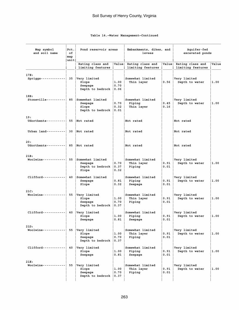
Soil Survey of Henry County, Virginia
263
Table 14.—Water Management—Continued
________________________________________________________________________________________________________ | | | | Map symbol |Pct.| Pond reservoir areas | Embankments, dikes, and | Aquifer-fed and soil name | of | | levees | excavated ponds |map | | | |unit| | | | |_________________________|_________________________|_________________________ | | Rating class and |Value| Rating class and |Value| Rating class and |Value | | limiting features | | limiting features | | limiting features |_____________________|____|___________________|_____|___________________|_____|___________________|_____ | | | | | | |17E: | | | | | | | Spriggs-------------| 35 |Very limited | |Somewhat limited | |Very limited | | | Slope |1.00 | Thin layer |0.56 | Depth to water |1.00 | | Seepage |0.70 | | | | | | Depth to bedrock |0.06 | | | | | | | | | | |18B: | | | | | | | Stoneville----------| 85 |Somewhat limited | |Somewhat limited | |Very limited | | | Seepage |0.70 | Piping |0.45 | Depth to water |1.00 | | Slope |0.32 | Thin layer |0.16 | | | | Depth to bedrock |0.01 | | | | | | | | | | |19: | | | | | | | Udorthents----------| 55 |Not rated | |Not rated | |Not rated | | | | | | | | | | | | | | | Urban land----------| 30 |Not rated | |Not rated | |Not rated | | | | | | | | | | | | | | |20: | | | | | | | Udorthents----------| 85 |Not rated | |Not rated | |Not rated | | | | | | | | | | | | | | |21B: | | | | | | | Woolwine------------| 55 |Somewhat limited | |Somewhat limited | |Very limited | | | Seepage |0.70 | Thin layer |0.91 | Depth to water |1.00 | | Depth to bedrock |0.37 | Piping |0.01 | | | | Slope |0.32 | | | | | | | | | | | Clifford------------| 40 |Somewhat limited | |Somewhat limited | |Very limited | | | Seepage |0.81 | Piping |0.91 | Depth to water |1.00 | | Slope |0.32 | Seepage |0.01 | | | | | | | | |21C: | | | | | | | Woolwine------------| 55 |Very limited | |Somewhat limited | |Very limited | | | Slope |1.00 | Thin layer |0.91 | Depth to water |1.00 | | Seepage |0.70 | Piping |0.01 | | | | Depth to bedrock |0.37 | | | | | | | | | | | Clifford------------| 40 |Very limited | |Somewhat limited | |Very limited | | | Slope |1.00 | Piping |0.91 | Depth to water |1.00 | | Seepage |0.81 | Seepage |0.01 | | | | | | | | |21D: | | | | | | | Woolwine------------| 55 |Very limited | |Somewhat limited | |Very limited | | | Slope |1.00 | Thin layer |0.91 | Depth to water |1.00 | | Seepage |0.70 | Piping |0.01 | | | | Depth to bedrock |0.37 | | | | | | | | | | | Clifford------------| 40 |Very limited | |Somewhat limited | |Very limited | | | Slope |1.00 | Piping |0.91 | Depth to water |1.00 | | Seepage |0.81 | Seepage |0.01 | | | | | | | | |21E: | | | | | | | Woolwine------------| 55 |Very limited | |Somewhat limited | |Very limited | | | Slope |1.00 | Thin layer |0.91 | Depth to water |1.00 | | Seepage |0.70 | Piping |0.01 | | | | Depth to bedrock |0.37 | | | | | | | | | | |
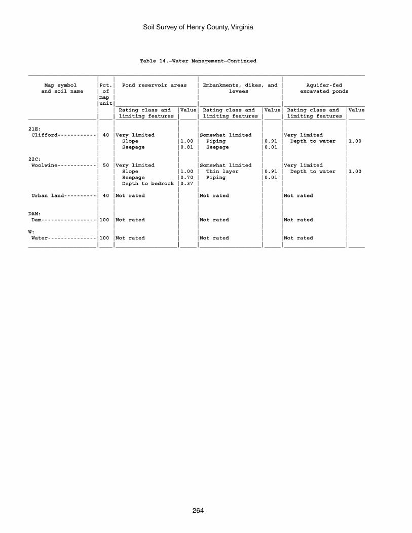
Soil Survey of Henry County, Virginia
264
Table 14.—Water Management—Continued
________________________________________________________________________________________________________ | | | | Map symbol |Pct.| Pond reservoir areas | Embankments, dikes, and | Aquifer-fed and soil name | of | | levees | excavated ponds |map | | | |unit| | | | |_________________________|_________________________|_________________________ | | Rating class and |Value| Rating class and |Value| Rating class and |Value | | limiting features | | limiting features | | limiting features |_____________________|____|___________________|_____|___________________|_____|___________________|_____ | | | | | | |21E: | | | | | | | Clifford------------| 40 |Very limited | |Somewhat limited | |Very limited | | | Slope |1.00 | Piping |0.91 | Depth to water |1.00 | | Seepage |0.81 | Seepage |0.01 | | | | | | | | |22C: | | | | | | | Woolwine------------| 50 |Very limited | |Somewhat limited | |Very limited | | | Slope |1.00 | Thin layer |0.91 | Depth to water |1.00 | | Seepage |0.70 | Piping |0.01 | | | | Depth to bedrock |0.37 | | | | | | | | | | | Urban land----------| 40 |Not rated | |Not rated | |Not rated | | | | | | | | | | | | | | |DAM: | | | | | | | Dam-----------------|100 |Not rated | |Not rated | |Not rated | | | | | | | |W: | | | | | | | Water---------------|100 |Not rated | |Not rated | |Not rated | | | | | | | |_____________________|____|___________________|_____|___________________|_____|___________________|_____
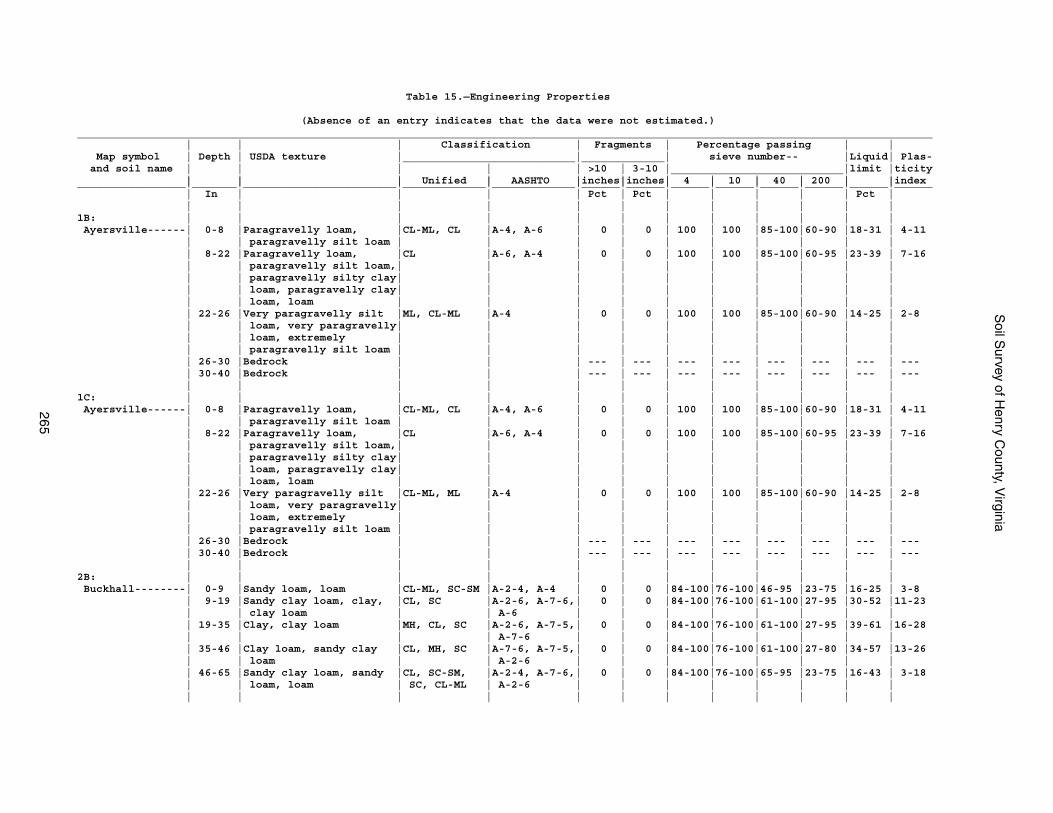
Soil S
urvey of Henry C
ounty, Virginia
265
Table 15.—Engineering Properties
(Absence of an entry indicates that the data were not estimated.)______________________________________________________________________________________________________________________________________ | | | Classification | Fragments | Percentage passing | | Map symbol | Depth | USDA texture |___________________________|_____________| sieve number-- |Liquid| Plas- and soil name | | | | | >10 | 3-10 |___________________________|limit |ticity | | | Unified | AASHTO |inches|inches| 4 | 10 | 40 | 200 | |index_________________|_______|________________________|_____________|_____________|______|______|______|______|______|______|______|______ | In | | | | Pct | Pct | | | | | Pct | | | | | | | | | | | | |1B: | | | | | | | | | | | | Ayersville------| 0-8 |Paragravelly loam, |CL-ML, CL |A-4, A-6 | 0 | 0 | 100 | 100 |85-100|60-90 |18-31 | 4-11 | | paragravelly silt loam | | | | | | | | | | | 8-22 |Paragravelly loam, |CL |A-6, A-4 | 0 | 0 | 100 | 100 |85-100|60-95 |23-39 | 7-16 | | paragravelly silt loam,| | | | | | | | | | | | paragravelly silty clay| | | | | | | | | | | | loam, paragravelly clay| | | | | | | | | | | | loam, loam | | | | | | | | | | | 22-26 |Very paragravelly silt |ML, CL-ML |A-4 | 0 | 0 | 100 | 100 |85-100|60-90 |14-25 | 2-8 | | loam, very paragravelly| | | | | | | | | | | | loam, extremely | | | | | | | | | | | | paragravelly silt loam | | | | | | | | | | | 26-30 |Bedrock | | | --- | --- | --- | --- | --- | --- | --- | --- | 30-40 |Bedrock | | | --- | --- | --- | --- | --- | --- | --- | --- | | | | | | | | | | | |1C: | | | | | | | | | | | | Ayersville------| 0-8 |Paragravelly loam, |CL-ML, CL |A-4, A-6 | 0 | 0 | 100 | 100 |85-100|60-90 |18-31 | 4-11 | | paragravelly silt loam | | | | | | | | | | | 8-22 |Paragravelly loam, |CL |A-6, A-4 | 0 | 0 | 100 | 100 |85-100|60-95 |23-39 | 7-16 | | paragravelly silt loam,| | | | | | | | | | | | paragravelly silty clay| | | | | | | | | | | | loam, paragravelly clay| | | | | | | | | | | | loam, loam | | | | | | | | | | | 22-26 |Very paragravelly silt |CL-ML, ML |A-4 | 0 | 0 | 100 | 100 |85-100|60-90 |14-25 | 2-8 | | loam, very paragravelly| | | | | | | | | | | | loam, extremely | | | | | | | | | | | | paragravelly silt loam | | | | | | | | | | | 26-30 |Bedrock | | | --- | --- | --- | --- | --- | --- | --- | --- | 30-40 |Bedrock | | | --- | --- | --- | --- | --- | --- | --- | --- | | | | | | | | | | | |2B: | | | | | | | | | | | | Buckhall--------| 0-9 |Sandy loam, loam |CL-ML, SC-SM |A-2-4, A-4 | 0 | 0 |84-100|76-100|46-95 |23-75 |16-25 | 3-8 | 9-19 |Sandy clay loam, clay, |CL, SC |A-2-6, A-7-6,| 0 | 0 |84-100|76-100|61-100|27-95 |30-52 |11-23 | | clay loam | | A-6 | | | | | | | | | 19-35 |Clay, clay loam |MH, CL, SC |A-2-6, A-7-5,| 0 | 0 |84-100|76-100|61-100|27-95 |39-61 |16-28 | | | | A-7-6 | | | | | | | | | 35-46 |Clay loam, sandy clay |CL, MH, SC |A-7-6, A-7-5,| 0 | 0 |84-100|76-100|61-100|27-80 |34-57 |13-26 | | loam | | A-2-6 | | | | | | | | | 46-65 |Sandy clay loam, sandy |CL, SC-SM, |A-2-4, A-7-6,| 0 | 0 |84-100|76-100|65-95 |23-75 |16-43 | 3-18 | | loam, loam | SC, CL-ML | A-2-6 | | | | | | | | | | | | | | | | | | | |
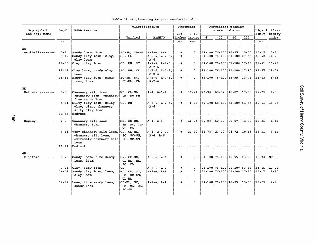
Soil S
urvey of Henry C
ounty, Virginia
266
Table 15.—Engineering Properties—Continued______________________________________________________________________________________________________________________________________ | | | Classification | Fragments | Percentage passing | | Map symbol | Depth | USDA texture |___________________________|_____________| sieve number-- |Liquid| Plas- and soil name | | | | | >10 | 3-10 |___________________________|limit |ticity | | | Unified | AASHTO |inches|inches| 4 | 10 | 40 | 200 | |index_________________|_______|________________________|_____________|_____________|______|______|______|______|______|______|______|______ | In | | | | Pct | Pct | | | | | Pct | | | | | | | | | | | | |2C: | | | | | | | | | | | | Buckhall--------| 0-9 |Sandy loam, loam |SC-SM, CL-ML |A-2-4, A-4 | 0 | 0 |84-100|76-100|46-95 |23-75 |16-25 | 3-8 | 9-19 |Sandy clay loam, clay, |SC, CL |A-2-6, A-7-6,| 0 | 0 |84-100|76-100|61-100|27-95 |30-52 |11-23 | | clay loam | | A-6 | | | | | | | | | 19-35 |Clay, clay loam |CL, MH, SC |A-2-6, A-7-5,| 0 | 0 |84-100|76-100|61-100|27-95 |39-61 |16-28 | | | | A-7-6 | | | | | | | | | 35-46 |Clay loam, sandy clay |SC, MH, CL |A-7-6, A-7-5,| 0 | 0 |84-100|76-100|61-100|27-80 |34-57 |13-26 | | loam | | A-2-6 | | | | | | | | | 46-65 |Sandy clay loam, sandy |SC-SM, SC, |A-2-4, A-7-6,| 0 | 0 |84-100|76-100|65-95 |23-75 |16-43 | 3-18 | | loam, loam | CL-ML, CL | A-2-6 | | | | | | | | | | | | | | | | | | | |3E: | | | | | | | | | | | | Buffstat--------| 0-5 |Channery silt loam, |ML, CL-ML, |A-4, A-2-4 | 0 |12-24 |77-90 |68-87 |48-87 |27-78 |12-25 | 1-8 | | channery loam, channery| SM, SC-SM | | | | | | | | | | | fine sandy loam | | | | | | | | | | | 5-41 |Silty clay loam, silty |CL, MH |A-7-6, A-7-5,| 0 | 0-24 |76-100|68-100|61-100|51-95 |39-61 |16-28 | | clay, clay, channery | | A-6 | | | | | | | | | | silty clay loam | | | | | | | | | | | 41-66 |Bedrock | | | --- | --- | --- | --- | --- | --- | --- | --- | | | | | | | | | | | | Bugley----------| 0-3 |Channery silt loam, |ML, SC-SM, |A-4, A-6 | 0 |12-24 |76-90 |68-87 |58-87 |41-78 |13-31 | 1-11 | | channery loam | SM, SC, CL- | | | | | | | | | | | | ML, CL | | | | | | | | | | 3-11 |Very channery silt loam,|CL, CL-ML, |A-1, A-2-4, | 0 |22-42 |44-78 |27-72 |24-72 |19-65 |16-31 | 3-11 | | channery silt loam, | SC, GC-GM, | A-4, A-6 | | | | | | | | | | extremely channery silt| GC, SC-SM | | | | | | | | | | | loam | | | | | | | | | | | 11-21 |Bedrock | | | --- | --- | --- | --- | --- | --- | --- | --- | | | | | | | | | | | |4B: | | | | | | | | | | | | Clifford--------| 0-7 |Sandy loam, fine sandy |SM, SC-SM, |A-2-4, A-4 | 0 | 0 |84-100|76-100|46-95 |23-75 |10-24 |NP-9 | | loam, loam | CL-ML, ML, | | | | | | | | | | | | SC, CL | | | | | | | | | | 7-54 |Clay, clay loam |CL |A-7-6, A-6 | 0 | 0 |82-100|76-100|68-100|53-95 |31-45 |13-21 | 54-62 |Sandy clay loam, loam, |ML, CL, SC, |A-2-4, A-4 | 0 | 0 |82-100|76-100|61-100|27-80 |13-27 | 2-10 | | clay loam | SM, SC-SM, | | | | | | | | | | | | CL-ML | | | | | | | | | | 62-82 |Loam, fine sandy loam, |CL-ML, SC, |A-2-4, A-4 | 0 | 0 |84-100|76-100|46-95 |23-75 |13-25 | 2-9 | | sandy loam | SM, ML, CL, | | | | | | | | | | | | SC-SM | | | | | | | | | | | | | | | | | | | | |
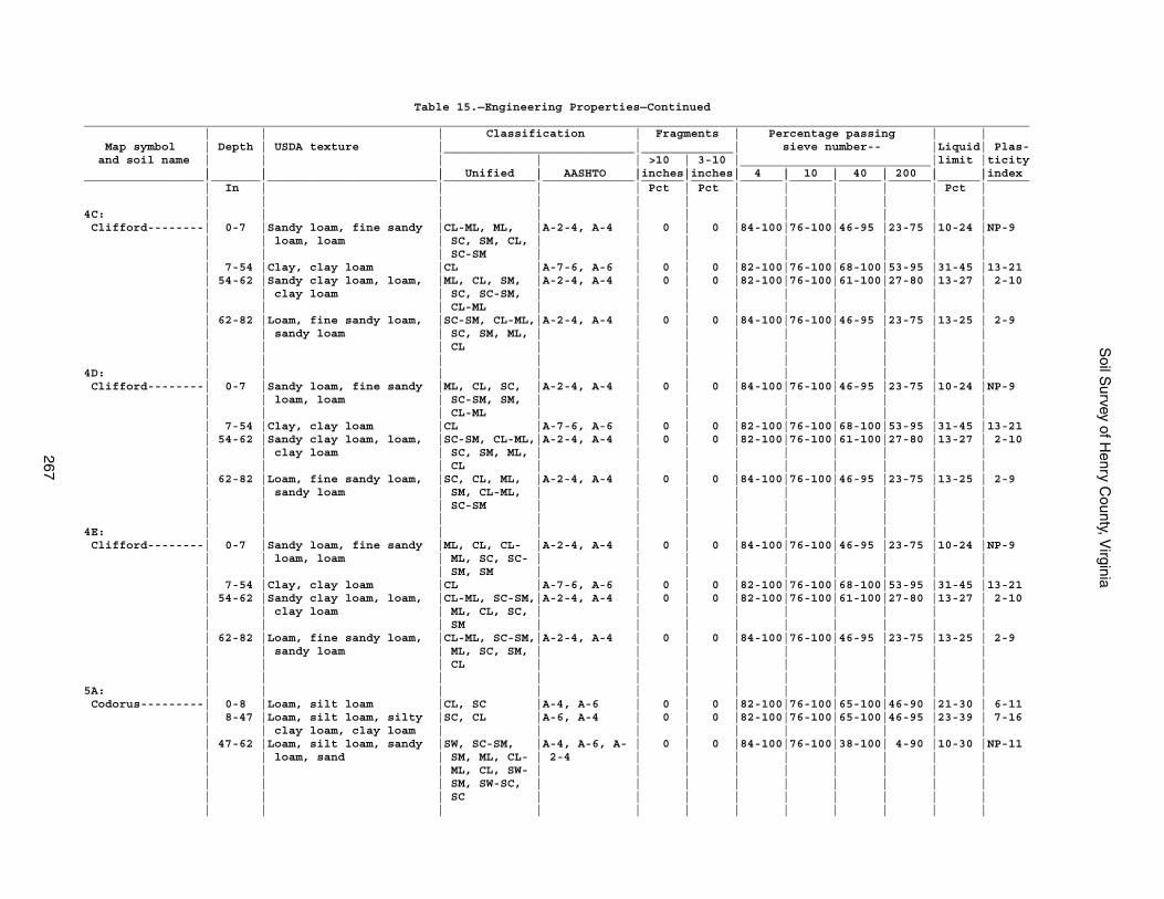
Soil S
urvey of Henry C
ounty, Virginia
267
Table 15.—Engineering Properties—Continued______________________________________________________________________________________________________________________________________ | | | Classification | Fragments | Percentage passing | | Map symbol | Depth | USDA texture |___________________________|_____________| sieve number-- |Liquid| Plas- and soil name | | | | | >10 | 3-10 |___________________________|limit |ticity | | | Unified | AASHTO |inches|inches| 4 | 10 | 40 | 200 | |index_________________|_______|________________________|_____________|_____________|______|______|______|______|______|______|______|______ | In | | | | Pct | Pct | | | | | Pct | | | | | | | | | | | | |4C: | | | | | | | | | | | | Clifford--------| 0-7 |Sandy loam, fine sandy |CL-ML, ML, |A-2-4, A-4 | 0 | 0 |84-100|76-100|46-95 |23-75 |10-24 |NP-9 | | loam, loam | SC, SM, CL, | | | | | | | | | | | | SC-SM | | | | | | | | | | 7-54 |Clay, clay loam |CL |A-7-6, A-6 | 0 | 0 |82-100|76-100|68-100|53-95 |31-45 |13-21 | 54-62 |Sandy clay loam, loam, |ML, CL, SM, |A-2-4, A-4 | 0 | 0 |82-100|76-100|61-100|27-80 |13-27 | 2-10 | | clay loam | SC, SC-SM, | | | | | | | | | | | | CL-ML | | | | | | | | | | 62-82 |Loam, fine sandy loam, |SC-SM, CL-ML,|A-2-4, A-4 | 0 | 0 |84-100|76-100|46-95 |23-75 |13-25 | 2-9 | | sandy loam | SC, SM, ML, | | | | | | | | | | | | CL | | | | | | | | | | | | | | | | | | | | |4D: | | | | | | | | | | | | Clifford--------| 0-7 |Sandy loam, fine sandy |ML, CL, SC, |A-2-4, A-4 | 0 | 0 |84-100|76-100|46-95 |23-75 |10-24 |NP-9 | | loam, loam | SC-SM, SM, | | | | | | | | | | | | CL-ML | | | | | | | | | | 7-54 |Clay, clay loam |CL |A-7-6, A-6 | 0 | 0 |82-100|76-100|68-100|53-95 |31-45 |13-21 | 54-62 |Sandy clay loam, loam, |SC-SM, CL-ML,|A-2-4, A-4 | 0 | 0 |82-100|76-100|61-100|27-80 |13-27 | 2-10 | | clay loam | SC, SM, ML, | | | | | | | | | | | | CL | | | | | | | | | | 62-82 |Loam, fine sandy loam, |SC, CL, ML, |A-2-4, A-4 | 0 | 0 |84-100|76-100|46-95 |23-75 |13-25 | 2-9 | | sandy loam | SM, CL-ML, | | | | | | | | | | | | SC-SM | | | | | | | | | | | | | | | | | | | | |4E: | | | | | | | | | | | | Clifford--------| 0-7 |Sandy loam, fine sandy |ML, CL, CL- |A-2-4, A-4 | 0 | 0 |84-100|76-100|46-95 |23-75 |10-24 |NP-9 | | loam, loam | ML, SC, SC- | | | | | | | | | | | | SM, SM | | | | | | | | | | 7-54 |Clay, clay loam |CL |A-7-6, A-6 | 0 | 0 |82-100|76-100|68-100|53-95 |31-45 |13-21 | 54-62 |Sandy clay loam, loam, |CL-ML, SC-SM,|A-2-4, A-4 | 0 | 0 |82-100|76-100|61-100|27-80 |13-27 | 2-10 | | clay loam | ML, CL, SC, | | | | | | | | | | | | SM | | | | | | | | | | 62-82 |Loam, fine sandy loam, |CL-ML, SC-SM,|A-2-4, A-4 | 0 | 0 |84-100|76-100|46-95 |23-75 |13-25 | 2-9 | | sandy loam | ML, SC, SM, | | | | | | | | | | | | CL | | | | | | | | | | | | | | | | | | | | |5A: | | | | | | | | | | | | Codorus---------| 0-8 |Loam, silt loam |CL, SC |A-4, A-6 | 0 | 0 |82-100|76-100|65-100|46-90 |21-30 | 6-11 | 8-47 |Loam, silt loam, silty |SC, CL |A-6, A-4 | 0 | 0 |82-100|76-100|65-100|46-95 |23-39 | 7-16 | | clay loam, clay loam | | | | | | | | | | | 47-62 |Loam, silt loam, sandy |SW, SC-SM, |A-4, A-6, A- | 0 | 0 |84-100|76-100|38-100| 4-90 |10-30 |NP-11 | | loam, sand | SM, ML, CL- | 2-4 | | | | | | | | | | | ML, CL, SW- | | | | | | | | | | | | SM, SW-SC, | | | | | | | | | | | | SC | | | | | | | | | | | | | | | | | | | | |
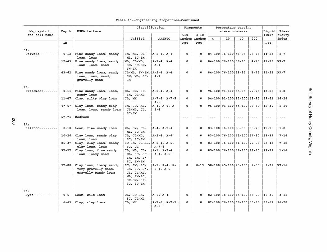
Soil S
urvey of Henry C
ounty, Virginia
268
Table 15.—Engineering Properties—Continued______________________________________________________________________________________________________________________________________ | | | Classification | Fragments | Percentage passing | | Map symbol | Depth | USDA texture |___________________________|_____________| sieve number-- |Liquid| Plas- and soil name | | | | | >10 | 3-10 |___________________________|limit |ticity | | | Unified | AASHTO |inches|inches| 4 | 10 | 40 | 200 | |index_________________|_______|________________________|_____________|_____________|______|______|______|______|______|______|______|______ | In | | | | Pct | Pct | | | | | Pct | | | | | | | | | | | | |6A: | | | | | | | | | | | | Colvard---------| 0-12 |Fine sandy loam, sandy |SM, ML, CL- |A-2-4, A-4 | 0 | 0 |84-100|76-100|46-95 |23-75 |14-23 | 2-7 | | loam, loam | ML, SC-SM | | | | | | | | | | 12-43 |Fine sandy loam, sandy |ML, CL-ML, |A-2-4, A-4, | 0 | 0 |84-100|76-100|38-95 | 4-75 |11-23 |NP-7 | | loam, loam, sand | SM, SC-SM, | A-1 | | | | | | | | | | | SW-SM | | | | | | | | | | 43-62 |Fine sandy loam, sandy |CL-ML, SW-SM,|A-2-4, A-4, | 0 | 0 |84-100|76-100|38-95 | 4-75 |11-23 |NP-7 | | loam, loam, sand, | SM, ML, SC- | A-1 | | | | | | | | | | gravelly sand | SM | | | | | | | | | | | | | | | | | | | | |7B: | | | | | | | | | | | | Creedmoor-------| 0-11 |Fine sandy loam, loam, |ML, SM, SC- |A-2-4, A-4 | 0 | 0 |96-100|91-100|55-95 |27-75 |13-25 | 1-8 | | sandy loam | SM, CL-ML | | | | | | | | | | 11-47 |Clay, silty clay loam |CL, MH |A-7-6, A-7-5,| 0 | 0 |94-100|91-100|82-100|68-95 |39-61 |16-28 | | | | A-6 | | | | | | | | | 47-67 |Clay loam, sandy clay |SM, SC, ML, |A-4, A-6, A- | 0 | 0 |96-100|91-100|55-100|27-80 |12-39 | 1-16 | | loam, loam, sandy loam | CL-ML, CL, | 2-4 | | | | | | | | | | | SC-SM | | | | | | | | | | 67-71 |Bedrock | | | --- | --- | --- | --- | --- | --- | --- | --- | | | | | | | | | | | |8A: | | | | | | | | | | | | Delanco---------| 0-10 |Loam, fine sandy loam |ML, SM, CL- |A-4, A-2-4 | 0 | 0 |83-100|76-100|53-95 |30-75 |12-25 | 1-8 | | | ML, SC-SM | | | | | | | | | | 10-26 |Clay loam, sandy clay |CL, CL-ML, |A-2-4, A-6 | 0 | 0 |83-100|76-100|61-100|27-80 |23-39 | 7-16 | | loam, loam | SC, SC-SM | | | | | | | | | | 26-37 |Clay, clay loam, sandy |SC-SM, CL-ML,|A-2-4, A-6, | 0 | 0 |83-100|76-100|61-100|27-95 |23-43 | 7-18 | | clay loam, loam | SC, CL | A-7-6 | | | | | | | | | 37-57 |Clay loam, fine sandy |CL, ML, CL- |A-1, A-2-4, | 0 | 0 |85-100|76-100|38-100|11-80 |12-39 | 1-16 | | loam, loamy sand | ML, SC, SC- | A-4, A-6 | | | | | | | | | | | SM, SM, SW- | | | | | | | | | | | | SC, SW-SM | | | | | | | | | | 57-80 |Clay loam, loamy sand, |SC, SM, SC- |A-1, A-4, A- | 0 | 0-19 |58-100|45-100|23-100| 2-80 | 9-39 |NP-16 | | very gravelly sand, | SM, SP, SW, | 2-4, A-6 | | | | | | | | | | gravelly sandy loam | CL, CL-ML, | | | | | | | | | | | | ML, SW-SC, | | | | | | | | | | | | SW-SM, SP- | | | | | | | | | | | | SC, SP-SM | | | | | | | | | | | | | | | | | | | | |9B: | | | | | | | | | | | | Dyke------------| 0-6 |Loam, silt loam |CL, SC-SM, |A-6, A-4 | 0 | 0 |82-100|76-100|65-100|46-90 |16-30 | 3-11 | | | SC, CL-ML | | | | | | | | | | 6-65 |Clay, clay loam |CL, MH |A-7-6, A-7-5,| 0 | 0 |82-100|76-100|68-100|53-95 |39-61 |16-28 | | | | A-6 | | | | | | | | | | | | | | | | | | | |
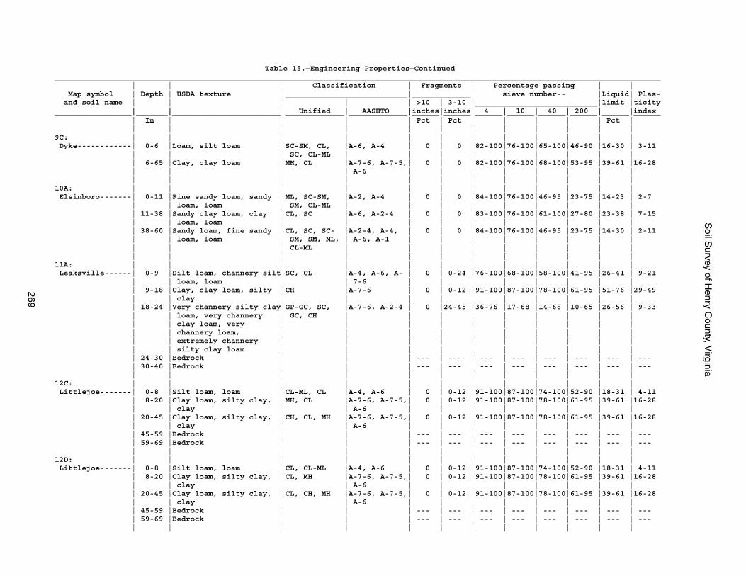
Soil S
urvey of Henry C
ounty, Virginia
269
Table 15.—Engineering Properties—Continued______________________________________________________________________________________________________________________________________ | | | Classification | Fragments | Percentage passing | | Map symbol | Depth | USDA texture |___________________________|_____________| sieve number-- |Liquid| Plas- and soil name | | | | | >10 | 3-10 |___________________________|limit |ticity | | | Unified | AASHTO |inches|inches| 4 | 10 | 40 | 200 | |index_________________|_______|________________________|_____________|_____________|______|______|______|______|______|______|______|______ | In | | | | Pct | Pct | | | | | Pct | | | | | | | | | | | | |9C: | | | | | | | | | | | | Dyke------------| 0-6 |Loam, silt loam |SC-SM, CL, |A-6, A-4 | 0 | 0 |82-100|76-100|65-100|46-90 |16-30 | 3-11 | | | SC, CL-ML | | | | | | | | | | 6-65 |Clay, clay loam |MH, CL |A-7-6, A-7-5,| 0 | 0 |82-100|76-100|68-100|53-95 |39-61 |16-28 | | | | A-6 | | | | | | | | | | | | | | | | | | | |10A: | | | | | | | | | | | | Elsinboro-------| 0-11 |Fine sandy loam, sandy |ML, SC-SM, |A-2, A-4 | 0 | 0 |84-100|76-100|46-95 |23-75 |14-23 | 2-7 | | loam, loam | SM, CL-ML | | | | | | | | | | 11-38 |Sandy clay loam, clay |CL, SC |A-6, A-2-4 | 0 | 0 |83-100|76-100|61-100|27-80 |23-38 | 7-15 | | loam, loam | | | | | | | | | | | 38-60 |Sandy loam, fine sandy |CL, SC, SC- |A-2-4, A-4, | 0 | 0 |84-100|76-100|46-95 |23-75 |14-30 | 2-11 | | loam, loam | SM, SM, ML, | A-6, A-1 | | | | | | | | | | | CL-ML | | | | | | | | | | | | | | | | | | | | |11A: | | | | | | | | | | | | Leaksville------| 0-9 |Silt loam, channery silt|SC, CL |A-4, A-6, A- | 0 | 0-24 |76-100|68-100|58-100|41-95 |26-41 | 9-21 | | loam, loam | | 7-6 | | | | | | | | | 9-18 |Clay, clay loam, silty |CH |A-7-6 | 0 | 0-12 |91-100|87-100|78-100|61-95 |51-76 |29-49 | | clay | | | | | | | | | | | 18-24 |Very channery silty clay|GP-GC, SC, |A-7-6, A-2-4 | 0 |24-45 |36-76 |17-68 |14-68 |10-65 |26-56 | 9-33 | | loam, very channery | GC, CH | | | | | | | | | | | clay loam, very | | | | | | | | | | | | channery loam, | | | | | | | | | | | | extremely channery | | | | | | | | | | | | silty clay loam | | | | | | | | | | | 24-30 |Bedrock | | | --- | --- | --- | --- | --- | --- | --- | --- | 30-40 |Bedrock | | | --- | --- | --- | --- | --- | --- | --- | --- | | | | | | | | | | | |12C: | | | | | | | | | | | | Littlejoe-------| 0-8 |Silt loam, loam |CL-ML, CL |A-4, A-6 | 0 | 0-12 |91-100|87-100|74-100|52-90 |18-31 | 4-11 | 8-20 |Clay loam, silty clay, |MH, CL |A-7-6, A-7-5,| 0 | 0-12 |91-100|87-100|78-100|61-95 |39-61 |16-28 | | clay | | A-6 | | | | | | | | | 20-45 |Clay loam, silty clay, |CH, CL, MH |A-7-6, A-7-5,| 0 | 0-12 |91-100|87-100|78-100|61-95 |39-61 |16-28 | | clay | | A-6 | | | | | | | | | 45-59 |Bedrock | | | --- | --- | --- | --- | --- | --- | --- | --- | 59-69 |Bedrock | | | --- | --- | --- | --- | --- | --- | --- | --- | | | | | | | | | | | |12D: | | | | | | | | | | | | Littlejoe-------| 0-8 |Silt loam, loam |CL, CL-ML |A-4, A-6 | 0 | 0-12 |91-100|87-100|74-100|52-90 |18-31 | 4-11 | 8-20 |Clay loam, silty clay, |CL, MH |A-7-6, A-7-5,| 0 | 0-12 |91-100|87-100|78-100|61-95 |39-61 |16-28 | | clay | | A-6 | | | | | | | | | 20-45 |Clay loam, silty clay, |CL, CH, MH |A-7-6, A-7-5,| 0 | 0-12 |91-100|87-100|78-100|61-95 |39-61 |16-28 | | clay | | A-6 | | | | | | | | | 45-59 |Bedrock | | | --- | --- | --- | --- | --- | --- | --- | --- | 59-69 |Bedrock | | | --- | --- | --- | --- | --- | --- | --- | --- | | | | | | | | | | | |
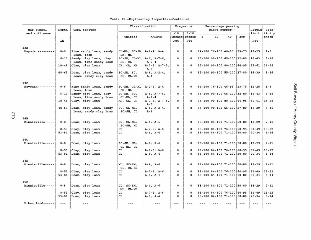
Soil S
urvey of Henry C
ounty, Virginia
270
Table 15.—Engineering Properties—Continued______________________________________________________________________________________________________________________________________ | | | Classification | Fragments | Percentage passing | | Map symbol | Depth | USDA texture |___________________________|_____________| sieve number-- |Liquid| Plas- and soil name | | | | | >10 | 3-10 |___________________________|limit |ticity | | | Unified | AASHTO |inches|inches| 4 | 10 | 40 | 200 | |index_________________|_______|________________________|_____________|_____________|______|______|______|______|______|______|______|______ | In | | | | Pct | Pct | | | | | Pct | | | | | | | | | | | | |13B: | | | | | | | | | | | | Mayodan---------| 0-6 |Fine sandy loam, sandy |CL-ML, SC-SM,|A-2-4, A-4 | 0 | 0 |84-100|76-100|46-95 |23-75 |12-25 | 1-8 | | loam, loam | SM, ML | | | | | | | | | | 6-10 |Sandy clay loam, clay |SC-SM, CL-ML,|A-6, A-7-6, | 0 | 0 |95-100|90-100|65-100|32-80 |16-43 | 3-18 | | loam, fine sandy loam | SC, CL | A-2-4 | | | | | | | | | 10-48 |Clay, clay loam |CH, CL, MH |A-7-6, A-7-5,| 0 | 0 |95-100|90-100|80-100|64-95 |39-61 |16-28 | | | | A-6 | | | | | | | | | 48-63 |Loam, clay loam, sandy |SC-SM, SC, |A-6, A-2-4, | 0 | 0 |95-100|90-100|55-100|27-80 |16-39 | 3-16 | | loam, sandy clay loam | CL, CL-ML | A-4 | | | | | | | | | | | | | | | | | | | |13C: | | | | | | | | | | | | Mayodan---------| 0-6 |Fine sandy loam, sandy |SC-SM, CL-ML,|A-2-4, A-4 | 0 | 0 |84-100|76-100|46-95 |23-75 |12-25 | 1-8 | | loam, loam | SM, ML | | | | | | | | | | 6-10 |Sandy clay loam, clay |SC-SM, SC, |A-6, A-7-6, | 0 | 0 |95-100|90-100|65-100|32-80 |16-43 | 3-18 | | loam, fine sandy loam | CL-ML, CL | A-2-4 | | | | | | | | | 10-48 |Clay, clay loam |MH, CL, CH |A-7-6, A-7-5,| 0 | 0 |95-100|90-100|80-100|64-95 |39-61 |16-28 | | | | A-6 | | | | | | | | | 48-63 |Loam, clay loam, sandy |SC, CL-ML, |A-6, A-2-4, | 0 | 0 |95-100|90-100|55-100|27-80 |16-39 | 3-16 | | loam, sandy clay loam | SC-SM, CL | A-4 | | | | | | | | | | | | | | | | | | | |14B: | | | | | | | | | | | | Minnieville-----| 0-8 |Loam, clay loam |CL, CL-ML, |A-4, A-6 | 0 | 0 |88-100|84-100|71-100|50-80 |13-29 | 2-11 | | | SC-SM, ML | | | | | | | | | | 8-53 |Clay, clay loam |CL |A-7-6, A-6 | 0 | 0 |88-100|84-100|76-100|60-95 |31-49 |13-22 | 53-81 |Loam, clay loam |CL |A-6, A-4 | 0 | 0 |88-100|84-100|71-100|50-80 |20-34 | 6-14 | | | | | | | | | | | |14C: | | | | | | | | | | | | Minnieville-----| 0-8 |Loam, clay loam |SC-SM, ML, |A-4, A-6 | 0 | 0 |88-100|84-100|71-100|50-80 |13-29 | 2-11 | | | CL-ML, CL | | | | | | | | | | 8-53 |Clay, clay loam |CL |A-7-6, A-6 | 0 | 0 |88-100|84-100|76-100|60-95 |31-49 |13-22 | 53-81 |Loam, clay loam |CL |A-6, A-4 | 0 | 0 |88-100|84-100|71-100|50-80 |20-34 | 6-14 | | | | | | | | | | | |14D: | | | | | | | | | | | | Minnieville-----| 0-8 |Loam, clay loam |ML, SC-SM, |A-4, A-6 | 0 | 0 |88-100|84-100|71-100|50-80 |13-29 | 2-11 | | | CL, CL-ML | | | | | | | | | | 8-53 |Clay, clay loam |CL |A-7-6, A-6 | 0 | 0 |88-100|84-100|76-100|60-95 |31-49 |13-22 | 53-81 |Loam, clay loam |CL |A-6, A-4 | 0 | 0 |88-100|84-100|71-100|50-80 |20-34 | 6-14 | | | | | | | | | | | |15C: | | | | | | | | | | | | Minnieville-----| 0-8 |Loam, clay loam |CL, SC-SM, |A-4, A-6 | 0 | 0 |88-100|84-100|71-100|50-80 |13-29 | 2-11 | | | ML, CL-ML | | | | | | | | | | 8-53 |Clay, clay loam |CL |A-7-6, A-6 | 0 | 0 |88-100|84-100|76-100|60-95 |31-49 |13-22 | 53-81 |Loam, clay loam |CL |A-6, A-4 | 0 | 0 |88-100|84-100|71-100|50-80 |20-34 | 6-14 | | | | | | | | | | | | Urban land------| --- | --- | --- | --- | --- | --- | --- | --- | --- | --- | --- | --- | | | | | | | | | | | |
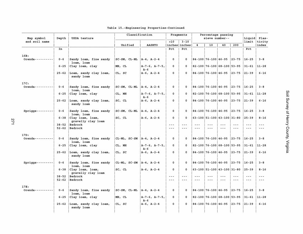
Soil S
urvey of Henry C
ounty, Virginia
271
Table 15.—Engineering Properties—Continued______________________________________________________________________________________________________________________________________ | | | Classification | Fragments | Percentage passing | | Map symbol | Depth | USDA texture |___________________________|_____________| sieve number-- |Liquid| Plas- and soil name | | | | | >10 | 3-10 |___________________________|limit |ticity | | | Unified | AASHTO |inches|inches| 4 | 10 | 40 | 200 | |index_________________|_______|________________________|_____________|_____________|______|______|______|______|______|______|______|______ | In | | | | Pct | Pct | | | | | Pct | | | | | | | | | | | | |16B: | | | | | | | | | | | | Orenda----------| 0-6 |Sandy loam, fine sandy |SC-SM, CL-ML |A-4, A-2-4 | 0 | 0 |84-100|76-100|46-95 |23-75 |16-25 | 3-8 | | loam, loam | | | | | | | | | | | 6-25 |Clay loam, clay |MH, CL |A-7-6, A-7-5,| 0 | 0 |82-100|76-100|68-100|53-95 |31-61 |11-28 | | | | A-6 | | | | | | | | | 25-62 |Loam, sandy clay loam, |CL, SC |A-6, A-2-4 | 0 | 0 |84-100|76-100|46-95 |23-75 |21-39 | 6-16 | | sandy loam | | | | | | | | | | | | | | | | | | | | | |17C: | | | | | | | | | | | | Orenda----------| 0-6 |Sandy loam, fine sandy |SC-SM, CL-ML |A-4, A-2-4 | 0 | 0 |84-100|76-100|46-95 |23-75 |16-25 | 3-8 | | loam, loam | | | | | | | | | | | 6-25 |Clay loam, clay |CL, MH |A-7-6, A-7-5,| 0 | 0 |82-100|76-100|68-100|53-95 |31-61 |11-28 | | | | A-6 | | | | | | | | | 25-62 |Loam, sandy clay loam, |SC, CL |A-6, A-2-4 | 0 | 0 |84-100|76-100|46-95 |23-75 |21-39 | 6-16 | | sandy loam | | | | | | | | | | | | | | | | | | | | | | Spriggs---------| 0-6 |Sandy loam, fine sandy |SC-SM, CL-ML |A-4, A-2-4 | 0 | 0 |84-100|76-100|46-95 |23-75 |16-25 | 3-8 | | loam, loam | | | | | | | | | | | 6-38 |Clay loam, loam, |SC, CL |A-6, A-2-4 | 0 | 0 |63-100|51-100|43-100|31-80 |25-39 | 8-16 | | gravelly clay loam | | | | | | | | | | | 38-52 |Bedrock | | | --- | --- | --- | --- | --- | --- | --- | --- | 52-62 |Bedrock | | | --- | --- | --- | --- | --- | --- | --- | --- | | | | | | | | | | | |17D: | | | | | | | | | | | | Orenda----------| 0-6 |Sandy loam, fine sandy |CL-ML, SC-SM |A-4, A-2-4 | 0 | 0 |84-100|76-100|46-95 |23-75 |16-25 | 3-8 | | loam, loam | | | | | | | | | | | 6-25 |Clay loam, clay |CL, MH |A-7-6, A-7-5,| 0 | 0 |82-100|76-100|68-100|53-95 |31-61 |11-28 | | | | A-6 | | | | | | | | | 25-62 |Loam, sandy clay loam, |CL, SC |A-6, A-2-4 | 0 | 0 |84-100|76-100|46-95 |23-75 |21-39 | 6-16 | | sandy loam | | | | | | | | | | | | | | | | | | | | | | Spriggs---------| 0-6 |Sandy loam, fine sandy |CL-ML, SC-SM |A-4, A-2-4 | 0 | 0 |84-100|76-100|46-95 |23-75 |16-25 | 3-8 | | loam, loam | | | | | | | | | | | 6-38 |Clay loam, loam, |SC, CL |A-6, A-2-4 | 0 | 0 |63-100|51-100|43-100|31-80 |25-39 | 8-16 | | gravelly clay loam | | | | | | | | | | | 38-52 |Bedrock | | | --- | --- | --- | --- | --- | --- | --- | --- | 52-62 |Bedrock | | | --- | --- | --- | --- | --- | --- | --- | --- | | | | | | | | | | | |17E: | | | | | | | | | | | | Orenda----------| 0-6 |Sandy loam, fine sandy |SC-SM, CL-ML |A-4, A-2-4 | 0 | 0 |84-100|76-100|46-95 |23-75 |16-25 | 3-8 | | loam, loam | | | | | | | | | | | 6-25 |Clay loam, clay |MH, CL |A-7-6, A-7-5,| 0 | 0 |82-100|76-100|68-100|53-95 |31-61 |11-28 | | | | A-6 | | | | | | | | | 25-62 |Loam, sandy clay loam, |CL, SC |A-6, A-2-4 | 0 | 0 |84-100|76-100|46-95 |23-75 |21-39 | 6-16 | | sandy loam | | | | | | | | | | | | | | | | | | | | | |
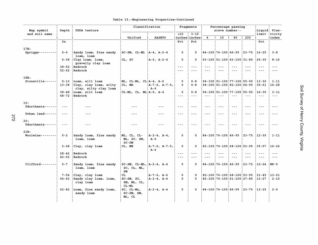
Soil S
urvey of Henry C
ounty, Virginia
272
Table 15.—Engineering Properties—Continued______________________________________________________________________________________________________________________________________ | | | Classification | Fragments | Percentage passing | | Map symbol | Depth | USDA texture |___________________________|_____________| sieve number-- |Liquid| Plas- and soil name | | | | | >10 | 3-10 |___________________________|limit |ticity | | | Unified | AASHTO |inches|inches| 4 | 10 | 40 | 200 | |index_________________|_______|________________________|_____________|_____________|______|______|______|______|______|______|______|______ | In | | | | Pct | Pct | | | | | Pct | | | | | | | | | | | | |17E: | | | | | | | | | | | | Spriggs---------| 0-6 |Sandy loam, fine sandy |SC-SM, CL-ML |A-4, A-2-4 | 0 | 0 |84-100|76-100|46-95 |23-75 |16-25 | 3-8 | | loam, loam | | | | | | | | | | | 6-38 |Clay loam, loam, |CL, SC |A-6, A-2-4 | 0 | 0 |63-100|51-100|43-100|31-80 |25-39 | 8-16 | | gravelly clay loam | | | | | | | | | | | 38-52 |Bedrock | | | --- | --- | --- | --- | --- | --- | --- | --- | 52-62 |Bedrock | | | --- | --- | --- | --- | --- | --- | --- | --- | | | | | | | | | | | |18B: | | | | | | | | | | | | Stoneville------| 0-13 |Loam, silt loam |ML, CL-ML, CL|A-4, A-6 | 0 | 0-8 |94-100|91-100|77-100|55-90 |13-30 | 1-11 | 13-38 |Clay, clay loam, silty |CL, MH |A-7-6, A-7-5,| 0 | 0-8 |94-100|91-100|82-100|64-95 |39-61 |16-28 | | clay, silty clay loam | | A-6 | | | | | | | | | 38-48 |Loam, silt loam |CL-ML, CL, ML|A-6, A-4 | 0 | 0-8 |94-100|91-100|77-100|55-90 |16-30 | 3-11 | 48-72 |Bedrock | | | --- | --- | --- | --- | --- | --- | --- | --- | | | | | | | | | | | |19: | | | | | | | | | | | | Udorthents------| --- | --- | --- | --- | --- | --- | --- | --- | --- | --- | --- | --- | | | | | | | | | | | | Urban land------| --- | --- | --- | --- | --- | --- | --- | --- | --- | --- | --- | --- | | | | | | | | | | | |20: | | | | | | | | | | | | Udorthents------| --- | --- | --- | --- | --- | --- | --- | --- | --- | --- | --- | --- | | | | | | | | | | | |21B: | | | | | | | | | | | | Woolwine--------| 0-2 |Sandy loam, fine sandy |ML, CL, CL- |A-2-4, A-4, | 0 | 0 |84-100|76-100|46-95 |23-75 |12-30 | 1-11 | | loam, loam | ML, SC, SM, | A-6 | | | | | | | | | | | SC-SM | | | | | | | | | | 2-28 |Clay, clay loam |CL, MH |A-7-6, A-7-5,| 0 | 0 |82-100|76-100|68-100|53-95 |39-57 |16-26 | | | | A-6 | | | | | | | | | 28-42 |Bedrock | | | --- | --- | --- | --- | --- | --- | --- | --- | 42-52 |Bedrock | | | --- | --- | --- | --- | --- | --- | --- | --- | | | | | | | | | | | | Clifford--------| 0-7 |Sandy loam, fine sandy |SC-SM, CL-ML,|A-2-4, A-4 | 0 | 0 |84-100|76-100|46-95 |23-75 |10-24 |NP-9 | | loam, loam | SC, CL, ML, | | | | | | | | | | | | SM | | | | | | | | | | 7-54 |Clay, clay loam |CL |A-7-6, A-6 | 0 | 0 |82-100|76-100|68-100|53-95 |31-45 |13-21 | 54-62 |Sandy clay loam, loam, |SC-SM, SC, |A-2-4, A-4 | 0 | 0 |82-100|76-100|61-100|27-80 |13-27 | 2-10 | | clay loam | SM, ML, CL, | | | | | | | | | | | | CL-ML | | | | | | | | | | 62-82 |Loam, fine sandy loam, |SC, CL-ML, |A-2-4, A-4 | 0 | 0 |84-100|76-100|46-95 |23-75 |13-25 | 2-9 | | sandy loam | SC-SM, SM, | | | | | | | | | | | | ML, CL | | | | | | | | | | | | | | | | | | | | |
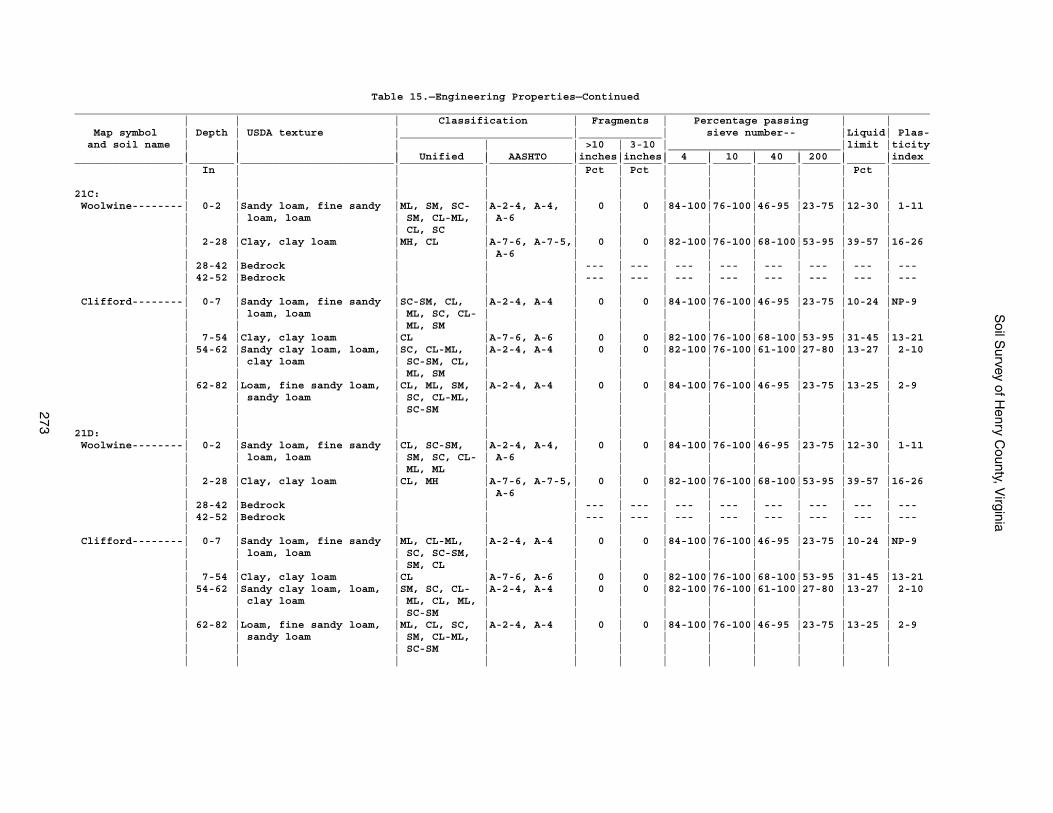
Soil S
urvey of Henry C
ounty, Virginia
273
Table 15.—Engineering Properties—Continued______________________________________________________________________________________________________________________________________ | | | Classification | Fragments | Percentage passing | | Map symbol | Depth | USDA texture |___________________________|_____________| sieve number-- |Liquid| Plas- and soil name | | | | | >10 | 3-10 |___________________________|limit |ticity | | | Unified | AASHTO |inches|inches| 4 | 10 | 40 | 200 | |index_________________|_______|________________________|_____________|_____________|______|______|______|______|______|______|______|______ | In | | | | Pct | Pct | | | | | Pct | | | | | | | | | | | | |21C: | | | | | | | | | | | | Woolwine--------| 0-2 |Sandy loam, fine sandy |ML, SM, SC- |A-2-4, A-4, | 0 | 0 |84-100|76-100|46-95 |23-75 |12-30 | 1-11 | | loam, loam | SM, CL-ML, | A-6 | | | | | | | | | | | CL, SC | | | | | | | | | | 2-28 |Clay, clay loam |MH, CL |A-7-6, A-7-5,| 0 | 0 |82-100|76-100|68-100|53-95 |39-57 |16-26 | | | | A-6 | | | | | | | | | 28-42 |Bedrock | | | --- | --- | --- | --- | --- | --- | --- | --- | 42-52 |Bedrock | | | --- | --- | --- | --- | --- | --- | --- | --- | | | | | | | | | | | | Clifford--------| 0-7 |Sandy loam, fine sandy |SC-SM, CL, |A-2-4, A-4 | 0 | 0 |84-100|76-100|46-95 |23-75 |10-24 |NP-9 | | loam, loam | ML, SC, CL- | | | | | | | | | | | | ML, SM | | | | | | | | | | 7-54 |Clay, clay loam |CL |A-7-6, A-6 | 0 | 0 |82-100|76-100|68-100|53-95 |31-45 |13-21 | 54-62 |Sandy clay loam, loam, |SC, CL-ML, |A-2-4, A-4 | 0 | 0 |82-100|76-100|61-100|27-80 |13-27 | 2-10 | | clay loam | SC-SM, CL, | | | | | | | | | | | | ML, SM | | | | | | | | | | 62-82 |Loam, fine sandy loam, |CL, ML, SM, |A-2-4, A-4 | 0 | 0 |84-100|76-100|46-95 |23-75 |13-25 | 2-9 | | sandy loam | SC, CL-ML, | | | | | | | | | | | | SC-SM | | | | | | | | | | | | | | | | | | | | |21D: | | | | | | | | | | | | Woolwine--------| 0-2 |Sandy loam, fine sandy |CL, SC-SM, |A-2-4, A-4, | 0 | 0 |84-100|76-100|46-95 |23-75 |12-30 | 1-11 | | loam, loam | SM, SC, CL- | A-6 | | | | | | | | | | | ML, ML | | | | | | | | | | 2-28 |Clay, clay loam |CL, MH |A-7-6, A-7-5,| 0 | 0 |82-100|76-100|68-100|53-95 |39-57 |16-26 | | | | A-6 | | | | | | | | | 28-42 |Bedrock | | | --- | --- | --- | --- | --- | --- | --- | --- | 42-52 |Bedrock | | | --- | --- | --- | --- | --- | --- | --- | --- | | | | | | | | | | | | Clifford--------| 0-7 |Sandy loam, fine sandy |ML, CL-ML, |A-2-4, A-4 | 0 | 0 |84-100|76-100|46-95 |23-75 |10-24 |NP-9 | | loam, loam | SC, SC-SM, | | | | | | | | | | | | SM, CL | | | | | | | | | | 7-54 |Clay, clay loam |CL |A-7-6, A-6 | 0 | 0 |82-100|76-100|68-100|53-95 |31-45 |13-21 | 54-62 |Sandy clay loam, loam, |SM, SC, CL- |A-2-4, A-4 | 0 | 0 |82-100|76-100|61-100|27-80 |13-27 | 2-10 | | clay loam | ML, CL, ML, | | | | | | | | | | | | SC-SM | | | | | | | | | | 62-82 |Loam, fine sandy loam, |ML, CL, SC, |A-2-4, A-4 | 0 | 0 |84-100|76-100|46-95 |23-75 |13-25 | 2-9 | | sandy loam | SM, CL-ML, | | | | | | | | | | | | SC-SM | | | | | | | | | | | | | | | | | | | | |
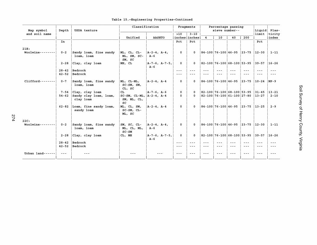
Soil S
urvey of Henry C
ounty, Virginia
274
Table 15.—Engineering Properties—Continued______________________________________________________________________________________________________________________________________ | | | Classification | Fragments | Percentage passing | | Map symbol | Depth | USDA texture |___________________________|_____________| sieve number-- |Liquid| Plas- and soil name | | | | | >10 | 3-10 |___________________________|limit |ticity | | | Unified | AASHTO |inches|inches| 4 | 10 | 40 | 200 | |index_________________|_______|________________________|_____________|_____________|______|______|______|______|______|______|______|______ | In | | | | Pct | Pct | | | | | Pct | | | | | | | | | | | | |21E: | | | | | | | | | | | | Woolwine--------| 0-2 |Sandy loam, fine sandy |ML, CL, CL- |A-2-4, A-4, | 0 | 0 |84-100|76-100|46-95 |23-75 |12-30 | 1-11 | | loam, loam | ML, SM, SC- | A-6 | | | | | | | | | | | SM, SC | | | | | | | | | | 2-28 |Clay, clay loam |MH, CL |A-7-6, A-7-5,| 0 | 0 |82-100|76-100|68-100|53-95 |39-57 |16-26 | | | | A-6 | | | | | | | | | 28-42 |Bedrock | | | --- | --- | --- | --- | --- | --- | --- | --- | 42-52 |Bedrock | | | --- | --- | --- | --- | --- | --- | --- | --- | | | | | | | | | | | | Clifford--------| 0-7 |Sandy loam, fine sandy |ML, CL-ML, |A-2-4, A-4 | 0 | 0 |84-100|76-100|46-95 |23-75 |10-24 |NP-9 | | loam, loam | SC-SM, SM, | | | | | | | | | | | | CL, SC | | | | | | | | | | 7-54 |Clay, clay loam |CL |A-7-6, A-6 | 0 | 0 |82-100|76-100|68-100|53-95 |31-45 |13-21 | 54-62 |Sandy clay loam, loam, |SC-SM, CL-ML,|A-2-4, A-4 | 0 | 0 |82-100|76-100|61-100|27-80 |13-27 | 2-10 | | clay loam | SM, ML, CL, | | | | | | | | | | | | SC | | | | | | | | | | 62-82 |Loam, fine sandy loam, |ML, CL, SM, |A-2-4, A-4 | 0 | 0 |84-100|76-100|46-95 |23-75 |13-25 | 2-9 | | sandy loam | SC-SM, CL- | | | | | | | | | | | | ML, SC | | | | | | | | | | | | | | | | | | | | |22C: | | | | | | | | | | | | Woolwine--------| 0-2 |Sandy loam, fine sandy |SM, SC, CL- |A-2-4, A-4, | 0 | 0 |84-100|76-100|46-95 |23-75 |12-30 | 1-11 | | loam, loam | ML, CL, ML, | A-6 | | | | | | | | | | | SC-SM | | | | | | | | | | 2-28 |Clay, clay loam |CL, MH |A-7-6, A-7-5,| 0 | 0 |82-100|76-100|68-100|53-95 |39-57 |16-26 | | | | A-6 | | | | | | | | | 28-42 |Bedrock | | | --- | --- | --- | --- | --- | --- | --- | --- | 42-52 |Bedrock | | | --- | --- | --- | --- | --- | --- | --- | --- | | | | | | | | | | | | Urban land------| --- | --- | --- | --- | --- | --- | --- | --- | --- | --- | --- | --- | | | | | | | | | | | |_________________|_______|________________________|_____________|_____________|______|______|______|______|______|______|______|______
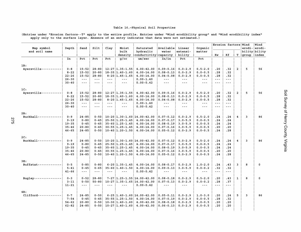
Soil S
urvey of Henry C
ounty, Virginia
275
Table 16.—Physical Soil Properties
(Entries under "Erosion factors--T" apply to the entire profile. Entries under "Wind erodibility group" and "Wind erodibility index" apply only to the surface layer. Absence of an entry indicates that data were not estimated.)______________________________________________________________________________________________________________________________________ | | | | | | | | | |Erosion factors|Wind |Wind Map symbol | Depth | Sand | Silt | Clay | Moist | Saturated |Available| Linear | Organic |_______________|erodi-|erodi- and soil name | | | | | bulk | hydraulic | water |extensi- | matter | | | |bility|bility | | | | | density |conductivity|capacity | bility | | Kw | Kf | T |group |index______________________|_______|______|______|______|_________|____________|_________|_________|_________|_____|_____|___|______|______ | In | Pct | Pct | Pct | g/cc | um/sec | In/in | Pct | Pct | | | | | | | | | | | | | | | | | | |1B: | | | | | | | | | | | | | | Ayersville-----------| 0-8 | 15-52| 28-80| 12-27|1.35-1.55| 4.00-42.00 |0.09-0.16| 0.0-2.9 | 0.5-2.0 | .20 | .32 | 2 | 5 | 56 | 8-22 | 15-52| 20-80| 18-35|1.40-1.60| 4.00-14.00 |0.08-0.13| 0.0-2.9 | 0.0-0.5 | .28 | .32 | | | | 22-26 | 15-52| 28-80| 8-20|1.45-1.65| 4.00-14.00 |0.04-0.08| 0.0-2.9 | 0.0-0.5 | .28 | .32 | | | | 26-30 | --- | --- | --- | --- | 0.00-1.40 | --- | --- | --- | --- | --- | | | | 30-40 | --- | --- | --- | --- | 0.00-0.42 | --- | --- | --- | --- | --- | | | | | | | | | | | | | | | | |1C: | | | | | | | | | | | | | | Ayersville-----------| 0-8 | 15-52| 28-80| 12-27|1.35-1.55| 4.00-42.00 |0.09-0.16| 0.0-2.9 | 0.5-2.0 | .20 | .32 | 2 | 5 | 56 | 8-22 | 15-52| 20-80| 18-35|1.40-1.60| 4.00-14.00 |0.08-0.13| 0.0-2.9 | 0.0-0.5 | .28 | .32 | | | | 22-26 | 15-52| 28-80| 8-20|1.45-1.65| 4.00-14.00 |0.04-0.08| 0.0-2.9 | 0.0-0.5 | .28 | .32 | | | | 26-30 | --- | --- | --- | --- | 0.00-1.40 | --- | --- | --- | --- | --- | | | | 30-40 | --- | --- | --- | --- | 0.00-0.42 | --- | --- | --- | --- | --- | | | | | | | | | | | | | | | | |2B: | | | | | | | | | | | | | | Buckhall-------------| 0-9 | 24-85| 0-50| 10-20|1.30-1.60|14.00-42.00 |0.07-0.12| 0.0-2.9 | 0.5-2.0 | .24 | .24 | 4 | 3 | 86 | 9-19 | 0-80| 0-45| 25-50|1.25-1.45| 4.00-14.00 |0.07-0.17| 3.0-5.9 | 0.0-0.5 | .24 | .24 | | | | 19-35 | 0-45| 0-45| 35-60|1.25-1.45| 4.00-14.00 |0.08-0.19| 3.0-5.9 | 0.0-0.5 | .24 | .24 | | | | 35-46 | 20-80| 0-45| 30-55|1.25-1.45| 4.00-14.00 |0.07-0.16| 3.0-5.9 | 0.0-0.5 | .20 | .20 | | | | 46-65 | 24-85| 0-50| 10-40|1.20-1.50| 4.00-14.00 |0.05-0.12| 0.0-2.9 | 0.0-0.5 | .24 | .28 | | | | | | | | | | | | | | | | |2C: | | | | | | | | | | | | | | Buckhall-------------| 0-9 | 24-85| 0-50| 10-20|1.30-1.60|14.00-42.00 |0.07-0.12| 0.0-2.9 | 0.5-2.0 | .24 | .24 | 4 | 3 | 86 | 9-19 | 0-80| 0-45| 25-50|1.25-1.45| 4.00-14.00 |0.07-0.17| 3.0-5.9 | 0.0-0.5 | .24 | .24 | | | | 19-35 | 0-45| 0-45| 35-60|1.25-1.45| 4.00-14.00 |0.08-0.19| 3.0-5.9 | 0.0-0.5 | .24 | .24 | | | | 35-46 | 20-80| 0-45| 30-55|1.25-1.45| 4.00-14.00 |0.07-0.16| 3.0-5.9 | 0.0-0.5 | .20 | .20 | | | | 46-65 | 24-85| 0-50| 10-40|1.20-1.50| 4.00-14.00 |0.05-0.12| 0.0-2.9 | 0.0-0.5 | .24 | .28 | | | | | | | | | | | | | | | | |3E: | | | | | | | | | | | | | | Buffstat-------------| 0-5 | 0-85| 0-80| 6-20|1.35-1.45| 4.00-14.00 |0.08-0.17| 0.0-2.9 | 1.0-2.0 | .24 | .43 | 3 | 8 | 0 | 5-41 | 0-45| 0-65| 35-60|1.40-1.50| 4.00-14.00 |0.09-0.13| 3.0-5.9 | 0.0-0.2 | .32 | .32 | | | | 41-66 | --- | --- | --- | --- | 0.00-0.42 | --- | --- | --- | --- | --- | | | | | | | | | | | | | | | | | Bugley---------------| 0-3 | 0-52| 28-80| 7-27|1.25-1.55|14.00-42.00 |0.08-0.18| 0.0-2.9 | 0.5-2.0 | .20 | .43 | 1 | 8 | 0 | 3-11 | 0-50| 50-80| 10-27|1.35-1.65|14.00-42.00 |0.07-0.13| 0.0-2.9 | 0.0-0.2 | .28 | .37 | | | | 11-21 | --- | --- | --- | --- | 0.00-0.42 | --- | --- | --- | --- | --- | | | | | | | | | | | | | | | | |4B: | | | | | | | | | | | | | | Clifford-------------| 0-7 | 24-85| 0-50| 6-25|1.40-1.60|14.00-42.00 |0.05-0.11| 0.0-2.9 | 1.0-3.0 | .20 | .24 | 5 | 3 | 86 | 7-54 | 0-45| 0-45| 35-55|1.25-1.50| 4.00-14.00 |0.07-0.19| 0.0-2.9 | 0.0-0.5 | .28 | .32 | | | | 54-62 | 20-80| 0-50| 10-30|1.40-1.60| 4.00-42.00 |0.08-0.18| 0.0-2.9 | 0.0-0.5 | .20 | .20 | | | | 62-82 | 24-85| 0-50| 10-27|1.40-1.60| 4.00-42.00 |0.06-0.13| 0.0-2.9 | 0.0-0.5 | .20 | .20 | | | | | | | | | | | | | | | | |
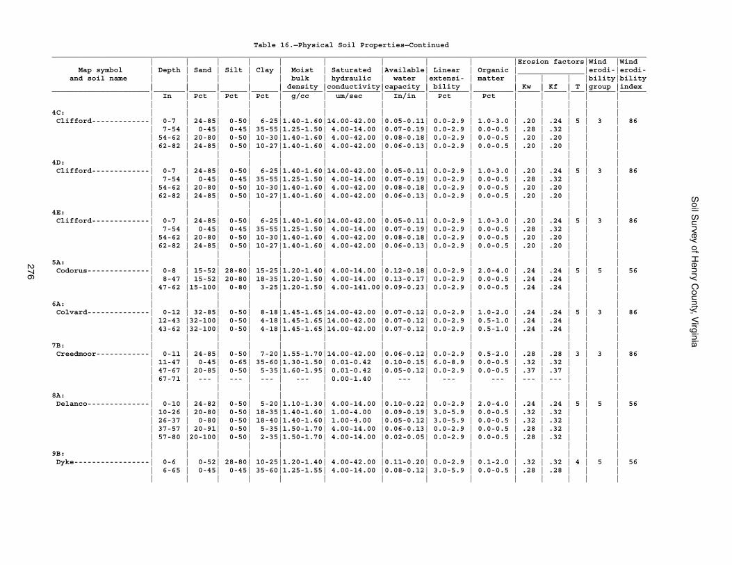
Soil S
urvey of Henry C
ounty, Virginia
276
Table 16.—Physical Soil Properties—Continued______________________________________________________________________________________________________________________________________ | | | | | | | | | |Erosion factors|Wind |Wind Map symbol | Depth | Sand | Silt | Clay | Moist | Saturated |Available| Linear | Organic |_______________|erodi-|erodi- and soil name | | | | | bulk | hydraulic | water |extensi- | matter | | | |bility|bility | | | | | density |conductivity|capacity | bility | | Kw | Kf | T |group |index______________________|_______|______|______|______|_________|____________|_________|_________|_________|_____|_____|___|______|______ | In | Pct | Pct | Pct | g/cc | um/sec | In/in | Pct | Pct | | | | | | | | | | | | | | | | | | |4C: | | | | | | | | | | | | | | Clifford-------------| 0-7 | 24-85| 0-50| 6-25|1.40-1.60|14.00-42.00 |0.05-0.11| 0.0-2.9 | 1.0-3.0 | .20 | .24 | 5 | 3 | 86 | 7-54 | 0-45| 0-45| 35-55|1.25-1.50| 4.00-14.00 |0.07-0.19| 0.0-2.9 | 0.0-0.5 | .28 | .32 | | | | 54-62 | 20-80| 0-50| 10-30|1.40-1.60| 4.00-42.00 |0.08-0.18| 0.0-2.9 | 0.0-0.5 | .20 | .20 | | | | 62-82 | 24-85| 0-50| 10-27|1.40-1.60| 4.00-42.00 |0.06-0.13| 0.0-2.9 | 0.0-0.5 | .20 | .20 | | | | | | | | | | | | | | | | |4D: | | | | | | | | | | | | | | Clifford-------------| 0-7 | 24-85| 0-50| 6-25|1.40-1.60|14.00-42.00 |0.05-0.11| 0.0-2.9 | 1.0-3.0 | .20 | .24 | 5 | 3 | 86 | 7-54 | 0-45| 0-45| 35-55|1.25-1.50| 4.00-14.00 |0.07-0.19| 0.0-2.9 | 0.0-0.5 | .28 | .32 | | | | 54-62 | 20-80| 0-50| 10-30|1.40-1.60| 4.00-42.00 |0.08-0.18| 0.0-2.9 | 0.0-0.5 | .20 | .20 | | | | 62-82 | 24-85| 0-50| 10-27|1.40-1.60| 4.00-42.00 |0.06-0.13| 0.0-2.9 | 0.0-0.5 | .20 | .20 | | | | | | | | | | | | | | | | |4E: | | | | | | | | | | | | | | Clifford-------------| 0-7 | 24-85| 0-50| 6-25|1.40-1.60|14.00-42.00 |0.05-0.11| 0.0-2.9 | 1.0-3.0 | .20 | .24 | 5 | 3 | 86 | 7-54 | 0-45| 0-45| 35-55|1.25-1.50| 4.00-14.00 |0.07-0.19| 0.0-2.9 | 0.0-0.5 | .28 | .32 | | | | 54-62 | 20-80| 0-50| 10-30|1.40-1.60| 4.00-42.00 |0.08-0.18| 0.0-2.9 | 0.0-0.5 | .20 | .20 | | | | 62-82 | 24-85| 0-50| 10-27|1.40-1.60| 4.00-42.00 |0.06-0.13| 0.0-2.9 | 0.0-0.5 | .20 | .20 | | | | | | | | | | | | | | | | |5A: | | | | | | | | | | | | | | Codorus--------------| 0-8 | 15-52| 28-80| 15-25|1.20-1.40| 4.00-14.00 |0.12-0.18| 0.0-2.9 | 2.0-4.0 | .24 | .24 | 5 | 5 | 56 | 8-47 | 15-52| 20-80| 18-35|1.20-1.50| 4.00-14.00 |0.13-0.17| 0.0-2.9 | 0.0-0.5 | .24 | .24 | | | | 47-62 |15-100| 0-80| 3-25|1.20-1.50| 4.00-141.00|0.09-0.23| 0.0-2.9 | 0.0-0.5 | .24 | .24 | | | | | | | | | | | | | | | | |6A: | | | | | | | | | | | | | | Colvard--------------| 0-12 | 32-85| 0-50| 8-18|1.45-1.65|14.00-42.00 |0.07-0.12| 0.0-2.9 | 1.0-2.0 | .24 | .24 | 5 | 3 | 86 | 12-43 |32-100| 0-50| 4-18|1.45-1.65|14.00-42.00 |0.07-0.12| 0.0-2.9 | 0.5-1.0 | .24 | .24 | | | | 43-62 |32-100| 0-50| 4-18|1.45-1.65|14.00-42.00 |0.07-0.12| 0.0-2.9 | 0.5-1.0 | .24 | .24 | | | | | | | | | | | | | | | | |7B: | | | | | | | | | | | | | | Creedmoor------------| 0-11 | 24-85| 0-50| 7-20|1.55-1.70|14.00-42.00 |0.06-0.12| 0.0-2.9 | 0.5-2.0 | .28 | .28 | 3 | 3 | 86 | 11-47 | 0-45| 0-65| 35-60|1.30-1.50| 0.01-0.42 |0.10-0.15| 6.0-8.9 | 0.0-0.5 | .32 | .32 | | | | 47-67 | 20-85| 0-50| 5-35|1.60-1.95| 0.01-0.42 |0.05-0.12| 0.0-2.9 | 0.0-0.5 | .37 | .37 | | | | 67-71 | --- | --- | --- | --- | 0.00-1.40 | --- | --- | --- | --- | --- | | | | | | | | | | | | | | | | |8A: | | | | | | | | | | | | | | Delanco--------------| 0-10 | 24-82| 0-50| 5-20|1.10-1.30| 4.00-14.00 |0.10-0.22| 0.0-2.9 | 2.0-4.0 | .24 | .24 | 5 | 5 | 56 | 10-26 | 20-80| 0-50| 18-35|1.40-1.60| 1.00-4.00 |0.09-0.19| 3.0-5.9 | 0.0-0.5 | .32 | .32 | | | | 26-37 | 0-80| 0-50| 18-40|1.40-1.60| 1.00-4.00 |0.05-0.12| 3.0-5.9 | 0.0-0.5 | .32 | .32 | | | | 37-57 | 20-91| 0-50| 5-35|1.50-1.70| 4.00-14.00 |0.06-0.13| 0.0-2.9 | 0.0-0.5 | .28 | .32 | | | | 57-80 |20-100| 0-50| 2-35|1.50-1.70| 4.00-14.00 |0.02-0.05| 0.0-2.9 | 0.0-0.5 | .28 | .32 | | | | | | | | | | | | | | | | |9B: | | | | | | | | | | | | | | Dyke-----------------| 0-6 | 0-52| 28-80| 10-25|1.20-1.40| 4.00-42.00 |0.11-0.20| 0.0-2.9 | 0.1-2.0 | .32 | .32 | 4 | 5 | 56 | 6-65 | 0-45| 0-45| 35-60|1.25-1.55| 4.00-14.00 |0.08-0.12| 3.0-5.9 | 0.0-0.5 | .28 | .28 | | | | | | | | | | | | | | | | |
Soil S
urvey of Henry C
ounty, Virginia
277
Table 16.—Physical Soil Properties—Continued______________________________________________________________________________________________________________________________________ | | | | | | | | | |Erosion factors|Wind |Wind Map symbol | Depth | Sand | Silt | Clay | Moist | Saturated |Available| Linear | Organic |_______________|erodi-|erodi- and soil name | | | | | bulk | hydraulic | water |extensi- | matter | | | |bility|bility | | | | | density |conductivity|capacity | bility | | Kw | Kf | T |group |index______________________|_______|______|______|______|_________|____________|_________|_________|_________|_____|_____|___|______|______ | In | Pct | Pct | Pct | g/cc | um/sec | In/in | Pct | Pct | | | | | | | | | | | | | | | | | | |9C: | | | | | | | | | | | | | | Dyke-----------------| 0-6 | 0-52| 28-80| 10-25|1.20-1.40| 4.00-42.00 |0.11-0.20| 0.0-2.9 | 0.1-2.0 | .32 | .32 | 4 | 5 | 56 | 6-65 | 0-45| 0-45| 35-60|1.25-1.55| 4.00-14.00 |0.08-0.12| 3.0-5.9 | 0.0-0.5 | .28 | .28 | | | | | | | | | | | | | | | | |10A: | | | | | | | | | | | | | | Elsinboro------------| 0-11 | 24-82| 0-50| 8-18|1.25-1.40| 4.00-14.00 |0.07-0.12| 0.0-2.9 | 1.0-3.0 | .28 | .28 | 5 | 5 | 56 | 11-38 | 20-80| 0-50| 18-34|1.30-1.50| 4.00-14.00 |0.09-0.20| 0.0-2.9 | 0.0-0.5 | .28 | .28 | | | | 38-60 | 24-82| 0-50| 8-25|1.35-1.55| 4.00-42.00 |0.06-0.13| 0.0-2.9 | 0.0-0.5 | .17 | .20 | | | | | | | | | | | | | | | | |11A: | | | | | | | | | | | | | | Leaksville-----------| 0-9 | 0-52| 28-80| 10-25|1.35-1.50| 4.00-14.00 |0.10-0.18| 0.0-2.9 | 0.5-2.0 | .32 | .43 | 3 | 6 | 48 | 9-18 | 0-45| 0-60| 35-60|1.30-1.45| 0.01-0.42 |0.06-0.15| 6.0-8.9 | 0.5-1.0 | .24 | .24 | | | | 18-24 | 0-52| 15-65| 10-40|1.35-1.50| 0.42-1.40 |0.04-0.08| 3.0-5.9 | 0.0-0.5 | .24 | .28 | | | | 24-30 | --- | --- | --- | --- | 0.00-1.40 | --- | --- | --- | --- | --- | | | | 30-40 | --- | --- | --- | --- | 0.00-0.42 | --- | --- | --- | --- | --- | | | | | | | | | | | | | | | | |12C: | | | | | | | | | | | | | | Littlejoe------------| 0-8 | 0-52| 28-80| 12-27|1.10-1.40| 4.00-42.00 |0.11-0.20| 0.0-2.9 | 0.5-2.0 | .37 | .37 | 4 | 8 | 0 | 8-20 | 0-45| 0-60| 30-60|1.40-1.60| 4.00-14.00 |0.11-0.12| 3.0-5.9 | 0.0-0.5 | .28 | .28 | | | | 20-45 | 0-45| 0-60| 35-60|1.40-1.60| 4.00-14.00 |0.07-0.11| 3.0-5.9 | 0.0-0.5 | .28 | .28 | | | | 45-59 | --- | --- | --- | --- | 0.00-1.40 | --- | --- | --- | --- | --- | | | | 59-69 | --- | --- | --- | --- | 0.00-0.42 | --- | --- | --- | --- | --- | | | | | | | | | | | | | | | | |12D: | | | | | | | | | | | | | | Littlejoe------------| 0-8 | 0-52| 28-80| 12-27|1.10-1.40| 4.00-42.00 |0.11-0.20| 0.0-2.9 | 0.5-2.0 | .37 | .37 | 4 | 8 | 0 | 8-20 | 0-45| 0-60| 30-60|1.40-1.60| 4.00-14.00 |0.11-0.12| 3.0-5.9 | 0.0-0.5 | .28 | .28 | | | | 20-45 | 0-45| 0-60| 35-60|1.40-1.60| 4.00-14.00 |0.07-0.11| 3.0-5.9 | 0.0-0.5 | .28 | .28 | | | | 45-59 | --- | --- | --- | --- | 0.00-1.40 | --- | --- | --- | --- | --- | | | | 59-69 | --- | --- | --- | --- | 0.00-0.42 | --- | --- | --- | --- | --- | | | | | | | | | | | | | | | | |13B: | | | | | | | | | | | | | | Mayodan--------------| 0-6 | 24-85| 0-50| 5-20|1.40-1.65|14.00-42.00 |0.05-0.12| 0.0-2.9 | 0.5-2.0 | .24 | .24 | 4 | 3 | 86 | 6-10 | 20-85| 0-49| 10-40|1.30-1.40| 4.00-14.00 |0.04-0.10| 0.0-2.9 | 0.5-1.0 | .32 | .32 | | | | 10-48 | 0-45| 0-45| 35-60|1.25-1.55| 4.00-14.00 |0.06-0.16| 3.0-5.9 | 0.0-0.5 | .28 | .28 | | | | 48-63 | 20-85| 0-50| 10-35|1.30-1.60| 4.00-14.00 |0.08-0.21| 0.0-2.9 | 0.0-0.2 | .28 | .28 | | | | | | | | | | | | | | | | |13C: | | | | | | | | | | | | | | Mayodan--------------| 0-6 | 24-85| 0-50| 5-20|1.40-1.65|14.00-42.00 |0.05-0.12| 0.0-2.9 | 0.5-2.0 | .24 | .24 | 4 | 3 | 86 | 6-10 | 20-85| 0-49| 10-40|1.30-1.40| 4.00-14.00 |0.04-0.10| 0.0-2.9 | 0.5-1.0 | .32 | .32 | | | | 10-48 | 0-45| 0-45| 35-60|1.25-1.55| 4.00-14.00 |0.06-0.16| 3.0-5.9 | 0.0-0.5 | .28 | .28 | | | | 48-63 | 20-85| 0-50| 10-35|1.30-1.60| 4.00-14.00 |0.08-0.21| 0.0-2.9 | 0.0-0.2 | .28 | .28 | | | | | | | | | | | | | | | | |14B: | | | | | | | | | | | | | | Minnieville----------| 0-8 | 20-52| 15-50| 10-32|1.25-1.35| 4.00-14.00 |0.10-0.20| 0.0-2.9 | 1.0-2.0 | .37 | .37 | 5 | 6 | 48 | 8-53 | 0-45| 0-45| 35-60|1.25-1.45| 4.00-14.00 |0.10-0.16| 3.0-5.9 | 0.0-0.5 | .24 | .24 | | | | 53-81 | 20-52| 15-50| 20-40|1.25-1.45| 4.00-14.00 |0.10-0.16| 0.0-2.9 | 0.0-0.5 | .24 | .24 | | | | | | | | | | | | | | | | |
Soil S
urvey of Henry C
ounty, Virginia
278
Table 16.—Physical Soil Properties—Continued______________________________________________________________________________________________________________________________________ | | | | | | | | | |Erosion factors|Wind |Wind Map symbol | Depth | Sand | Silt | Clay | Moist | Saturated |Available| Linear | Organic |_______________|erodi-|erodi- and soil name | | | | | bulk | hydraulic | water |extensi- | matter | | | |bility|bility | | | | | density |conductivity|capacity | bility | | Kw | Kf | T |group |index______________________|_______|______|______|______|_________|____________|_________|_________|_________|_____|_____|___|______|______ | In | Pct | Pct | Pct | g/cc | um/sec | In/in | Pct | Pct | | | | | | | | | | | | | | | | | | |14C: | | | | | | | | | | | | | | Minnieville----------| 0-8 | 20-52| 15-50| 10-32|1.25-1.35| 4.00-14.00 |0.10-0.20| 0.0-2.9 | 1.0-2.0 | .37 | .37 | 5 | 6 | 48 | 8-53 | 0-45| 0-45| 35-60|1.25-1.45| 4.00-14.00 |0.10-0.16| 3.0-5.9 | 0.0-0.5 | .24 | .24 | | | | 53-81 | 20-52| 15-50| 20-40|1.25-1.45| 4.00-14.00 |0.10-0.16| 0.0-2.9 | 0.0-0.5 | .24 | .24 | | | | | | | | | | | | | | | | |14D: | | | | | | | | | | | | | | Minnieville----------| 0-8 | 20-52| 15-50| 10-32|1.25-1.35| 4.00-14.00 |0.10-0.20| 0.0-2.9 | 1.0-2.0 | .37 | .37 | 5 | 6 | 48 | 8-53 | 0-45| 0-45| 35-60|1.25-1.45| 4.00-14.00 |0.10-0.16| 3.0-5.9 | 0.0-0.5 | .24 | .24 | | | | 53-81 | 20-52| 15-50| 20-40|1.25-1.45| 4.00-14.00 |0.10-0.16| 0.0-2.9 | 0.0-0.5 | .24 | .24 | | | | | | | | | | | | | | | | |15C: | | | | | | | | | | | | | | Minnieville----------| 0-8 | 20-52| 15-50| 10-32|1.25-1.35| 4.00-14.00 |0.10-0.20| 0.0-2.9 | 1.0-2.0 | .37 | .37 | 5 | 6 | 48 | 8-53 | 0-45| 0-45| 35-60|1.25-1.45| 4.00-14.00 |0.10-0.16| 3.0-5.9 | 0.0-0.5 | .24 | .24 | | | | 53-81 | 20-52| 15-50| 20-40|1.25-1.45| 4.00-14.00 |0.10-0.16| 0.0-2.9 | 0.0-0.5 | .24 | .24 | | | | | | | | | | | | | | | | | Urban land-----------| --- | --- | --- | --- | --- | --- | --- | --- | --- | --- | --- | --| --- | --- | | | | | | | | | | | | | |16B: | | | | | | | | | | | | | | Orenda---------------| 0-6 | 24-85| 0-50| 10-20|1.25-1.35| 4.00-14.00 |0.06-0.11| 0.0-2.9 | 1.0-2.0 | .20 | .20 | 5 | 3 | 86 | 6-25 | 0-45| 0-45| 27-60|1.25-1.45| 1.40-4.00 |0.10-0.18| 3.0-5.9 | 0.0-0.5 | .24 | .28 | | | | 25-62 | 24-85| 0-50| 15-35|1.45-1.65| 4.00-14.00 |0.10-0.19| 0.0-2.9 | 0.0-0.5 | .32 | .37 | | | | | | | | | | | | | | | | |17C: | | | | | | | | | | | | | | Orenda---------------| 0-6 | 24-85| 0-50| 10-20|1.25-1.35| 4.00-14.00 |0.06-0.11| 0.0-2.9 | 1.0-2.0 | .20 | .20 | 5 | 3 | 86 | 6-25 | 0-45| 0-45| 27-60|1.25-1.45| 1.40-4.00 |0.10-0.18| 3.0-5.9 | 0.0-0.5 | .24 | .28 | | | | 25-62 | 24-85| 0-50| 15-35|1.45-1.65| 4.00-14.00 |0.10-0.19| 0.0-2.9 | 0.0-0.5 | .32 | .37 | | | | | | | | | | | | | | | | | Spriggs--------------| 0-6 | 24-85| 0-50| 10-20|1.30-1.40| 4.00-42.00 |0.07-0.11| 0.0-2.9 | 0.5-2.0 | .20 | .20 | 3 | 3 | 86 | 6-38 | 20-52| 15-50| 20-35|1.33-1.40| 4.00-14.00 |0.09-0.13| 0.0-2.9 | 0.0-0.5 | .37 | .43 | | | | 38-52 | --- | --- | --- | --- | 0.00-1.40 | --- | --- | --- | --- | --- | | | | 52-62 | --- | --- | --- | --- | 0.00-0.42 | --- | --- | --- | --- | --- | | | | | | | | | | | | | | | | |17D: | | | | | | | | | | | | | | Orenda---------------| 0-6 | 24-85| 0-50| 10-20|1.25-1.35| 4.00-14.00 |0.06-0.11| 0.0-2.9 | 1.0-2.0 | .20 | .20 | 5 | 3 | 86 | 6-25 | 0-45| 0-45| 27-60|1.25-1.45| 1.40-4.00 |0.10-0.18| 3.0-5.9 | 0.0-0.5 | .24 | .28 | | | | 25-62 | 24-85| 0-50| 15-35|1.45-1.65| 4.00-14.00 |0.10-0.19| 0.0-2.9 | 0.0-0.5 | .32 | .37 | | | | | | | | | | | | | | | | | Spriggs--------------| 0-6 | 24-85| 0-50| 10-20|1.30-1.40| 4.00-42.00 |0.07-0.11| 0.0-2.9 | 0.5-2.0 | .20 | .20 | 3 | 3 | 86 | 6-38 | 20-52| 15-50| 20-35|1.33-1.40| 4.00-14.00 |0.09-0.13| 0.0-2.9 | 0.0-0.5 | .37 | .43 | | | | 38-52 | --- | --- | --- | --- | 0.00-1.40 | --- | --- | --- | --- | --- | | | | 52-62 | --- | --- | --- | --- | 0.00-0.42 | --- | --- | --- | --- | --- | | | | | | | | | | | | | | | | |17E: | | | | | | | | | | | | | | Orenda---------------| 0-6 | 24-85| 0-50| 10-20|1.25-1.35| 4.00-14.00 |0.06-0.11| 0.0-2.9 | 1.0-2.0 | .20 | .20 | 5 | 3 | 86 | 6-25 | 0-45| 0-45| 27-60|1.25-1.45| 1.40-4.00 |0.10-0.18| 3.0-5.9 | 0.0-0.5 | .24 | .28 | | | | 25-62 | 24-85| 0-50| 15-35|1.45-1.65| 4.00-14.00 |0.10-0.19| 0.0-2.9 | 0.0-0.5 | .32 | .37 | | | | | | | | | | | | | | | | |
Soil S
urvey of Henry C
ounty, Virginia
279
Table 16.—Physical Soil Properties—Continued______________________________________________________________________________________________________________________________________ | | | | | | | | | |Erosion factors|Wind |Wind Map symbol | Depth | Sand | Silt | Clay | Moist | Saturated |Available| Linear | Organic |_______________|erodi-|erodi- and soil name | | | | | bulk | hydraulic | water |extensi- | matter | | | |bility|bility | | | | | density |conductivity|capacity | bility | | Kw | Kf | T |group |index______________________|_______|______|______|______|_________|____________|_________|_________|_________|_____|_____|___|______|______ | In | Pct | Pct | Pct | g/cc | um/sec | In/in | Pct | Pct | | | | | | | | | | | | | | | | | | |17E: | | | | | | | | | | | | | | Spriggs--------------| 0-6 | 24-85| 0-50| 10-20|1.30-1.40| 4.00-42.00 |0.07-0.11| 0.0-2.9 | 0.5-2.0 | .20 | .20 | 3 | 3 | 86 | 6-38 | 20-52| 15-50| 20-35|1.33-1.40| 4.00-14.00 |0.09-0.13| 0.0-2.9 | 0.0-0.5 | .37 | .43 | | | | 38-52 | --- | --- | --- | --- | 0.00-1.40 | --- | --- | --- | --- | --- | | | | 52-62 | --- | --- | --- | --- | 0.00-0.42 | --- | --- | --- | --- | --- | | | | | | | | | | | | | | | | |18B: | | | | | | | | | | | | | | Stoneville-----------| 0-13 | 0-52| 28-80| 7-26|1.35-1.55| 4.00-14.00 |0.09-0.20| 0.0-2.9 | 0.5-2.0 | .32 | .32 | 4 | 5 | 56 | 13-38 | 0-45| 0-65| 35-60|1.25-1.40| 4.00-14.00 |0.12-0.17| 3.0-5.9 | 0.0-0.5 | .28 | .28 | | | | 38-48 | 0-52| 28-80| 10-26|1.30-1.45| 4.00-14.00 |0.11-0.20| 0.0-2.9 | 0.0-0.5 | .24 | .24 | | | | 48-72 | --- | --- | --- | --- | 0.00-1.40 | --- | --- | --- | --- | --- | | | | | | | | | | | | | | | | |19: | | | | | | | | | | | | | | Udorthents-----------| --- | --- | --- | --- | --- | --- | --- | --- | --- | --- | --- | --| --- | --- | | | | | | | | | | | | | | Urban land-----------| --- | --- | --- | --- | --- | --- | --- | --- | --- | --- | --- | --| --- | --- | | | | | | | | | | | | | |20: | | | | | | | | | | | | | | Udorthents-----------| --- | --- | --- | --- | --- | --- | --- | --- | --- | --- | --- | --| --- | --- | | | | | | | | | | | | | |21B: | | | | | | | | | | | | | | Woolwine-------------| 0-2 | 24-85| 0-50| 6-25|1.40-1.60|14.00-42.00 |0.05-0.11| 0.0-2.9 | 1.0-3.0 | .15 | .20 | 2 | 3 | 86 | 2-28 | 0-45| 0-45| 35-55|1.25-1.50| 4.00-14.00 |0.10-0.15| 0.0-2.9 | 0.0-0.5 | .28 | .32 | | | | 28-42 | --- | --- | --- | --- | 0.00-1.40 | --- | --- | --- | --- | --- | | | | 42-52 | --- | --- | --- | --- | 0.00-0.42 | --- | --- | --- | --- | --- | | | | | | | | | | | | | | | | | Clifford-------------| 0-7 | 24-85| 0-50| 6-25|1.40-1.60|14.00-42.00 |0.05-0.11| 0.0-2.9 | 1.0-3.0 | .20 | .24 | 5 | 3 | 86 | 7-54 | 0-45| 0-45| 35-55|1.25-1.50| 4.00-14.00 |0.07-0.19| 0.0-2.9 | 0.0-0.5 | .28 | .32 | | | | 54-62 | 20-80| 0-50| 10-30|1.40-1.60| 4.00-42.00 |0.08-0.18| 0.0-2.9 | 0.0-0.5 | .20 | .20 | | | | 62-82 | 24-85| 0-50| 10-27|1.40-1.60| 4.00-42.00 |0.06-0.13| 0.0-2.9 | 0.0-0.5 | .20 | .20 | | | | | | | | | | | | | | | | |21C: | | | | | | | | | | | | | | Woolwine-------------| 0-2 | 24-85| 0-50| 6-25|1.40-1.60|14.00-42.00 |0.05-0.11| 0.0-2.9 | 1.0-3.0 | .15 | .20 | 2 | 3 | 86 | 2-28 | 0-45| 0-45| 35-55|1.25-1.50| 4.00-14.00 |0.10-0.15| 0.0-2.9 | 0.0-0.5 | .28 | .32 | | | | 28-42 | --- | --- | --- | --- | 0.00-1.40 | --- | --- | --- | --- | --- | | | | 42-52 | --- | --- | --- | --- | 0.00-0.42 | --- | --- | --- | --- | --- | | | | | | | | | | | | | | | | | Clifford-------------| 0-7 | 24-85| 0-50| 6-25|1.40-1.60|14.00-42.00 |0.05-0.11| 0.0-2.9 | 1.0-3.0 | .20 | .24 | 5 | 3 | 86 | 7-54 | 0-45| 0-45| 35-55|1.25-1.50| 4.00-14.00 |0.07-0.19| 0.0-2.9 | 0.0-0.5 | .28 | .32 | | | | 54-62 | 20-80| 0-50| 10-30|1.40-1.60| 4.00-42.00 |0.08-0.18| 0.0-2.9 | 0.0-0.5 | .20 | .20 | | | | 62-82 | 24-85| 0-50| 10-27|1.40-1.60| 4.00-42.00 |0.06-0.13| 0.0-2.9 | 0.0-0.5 | .20 | .20 | | | | | | | | | | | | | | | | |21D: | | | | | | | | | | | | | | Woolwine-------------| 0-2 | 24-85| 0-50| 6-25|1.40-1.60|14.00-42.00 |0.05-0.11| 0.0-2.9 | 1.0-3.0 | .15 | .20 | 2 | 3 | 86 | 2-28 | 0-45| 0-45| 35-55|1.25-1.50| 4.00-14.00 |0.10-0.15| 0.0-2.9 | 0.0-0.5 | .28 | .32 | | | | 28-42 | --- | --- | --- | --- | 0.00-1.40 | --- | --- | --- | --- | --- | | | | 42-52 | --- | --- | --- | --- | 0.00-0.42 | --- | --- | --- | --- | --- | | | | | | | | | | | | | | | | |
Soil S
urvey of Henry C
ounty, Virginia
280
Table 16.—Physical Soil Properties—Continued______________________________________________________________________________________________________________________________________ | | | | | | | | | |Erosion factors|Wind |Wind Map symbol | Depth | Sand | Silt | Clay | Moist | Saturated |Available| Linear | Organic |_______________|erodi-|erodi- and soil name | | | | | bulk | hydraulic | water |extensi- | matter | | | |bility|bility | | | | | density |conductivity|capacity | bility | | Kw | Kf | T |group |index______________________|_______|______|______|______|_________|____________|_________|_________|_________|_____|_____|___|______|______ | In | Pct | Pct | Pct | g/cc | um/sec | In/in | Pct | Pct | | | | | | | | | | | | | | | | | | |21D: | | | | | | | | | | | | | | Clifford-------------| 0-7 | 24-85| 0-50| 6-25|1.40-1.60|14.00-42.00 |0.05-0.11| 0.0-2.9 | 1.0-3.0 | .20 | .24 | 5 | 3 | 86 | 7-54 | 0-45| 0-45| 35-55|1.25-1.50| 4.00-14.00 |0.07-0.19| 0.0-2.9 | 0.0-0.5 | .28 | .32 | | | | 54-62 | 20-80| 0-50| 10-30|1.40-1.60| 4.00-42.00 |0.08-0.18| 0.0-2.9 | 0.0-0.5 | .20 | .20 | | | | 62-82 | 24-85| 0-50| 10-27|1.40-1.60| 4.00-42.00 |0.06-0.13| 0.0-2.9 | 0.0-0.5 | .20 | .20 | | | | | | | | | | | | | | | | |21E: | | | | | | | | | | | | | | Woolwine-------------| 0-2 | 24-85| 0-50| 6-25|1.40-1.60|14.00-42.00 |0.05-0.11| 0.0-2.9 | 1.0-3.0 | .15 | .20 | 2 | 3 | 86 | 2-28 | 0-45| 0-45| 35-55|1.25-1.50| 4.00-14.00 |0.10-0.15| 0.0-2.9 | 0.0-0.5 | .28 | .32 | | | | 28-42 | --- | --- | --- | --- | 0.00-1.40 | --- | --- | --- | --- | --- | | | | 42-52 | --- | --- | --- | --- | 0.00-0.42 | --- | --- | --- | --- | --- | | | | | | | | | | | | | | | | | Clifford-------------| 0-7 | 24-85| 0-50| 6-25|1.40-1.60|14.00-42.00 |0.05-0.11| 0.0-2.9 | 1.0-3.0 | .20 | .24 | 5 | 3 | 86 | 7-54 | 0-45| 0-45| 35-55|1.25-1.50| 4.00-14.00 |0.07-0.19| 0.0-2.9 | 0.0-0.5 | .28 | .32 | | | | 54-62 | 20-80| 0-50| 10-30|1.40-1.60| 4.00-42.00 |0.08-0.18| 0.0-2.9 | 0.0-0.5 | .20 | .20 | | | | 62-82 | 24-85| 0-50| 10-27|1.40-1.60| 4.00-42.00 |0.06-0.13| 0.0-2.9 | 0.0-0.5 | .20 | .20 | | | | | | | | | | | | | | | | |22C: | | | | | | | | | | | | | | Woolwine-------------| 0-2 | 24-85| 0-50| 6-25|1.40-1.60|14.00-42.00 |0.05-0.11| 0.0-2.9 | 1.0-3.0 | .15 | .20 | 2 | 3 | 86 | 2-28 | 0-45| 0-45| 35-55|1.25-1.50| 4.00-14.00 |0.10-0.15| 0.0-2.9 | 0.0-0.5 | .28 | .32 | | | | 28-42 | --- | --- | --- | --- | 0.00-1.40 | --- | --- | --- | --- | --- | | | | 42-52 | --- | --- | --- | --- | 0.00-0.42 | --- | --- | --- | --- | --- | | | | | | | | | | | | | | | | | Urban land-----------| --- | --- | --- | --- | --- | --- | --- | --- | --- | --- | --- | --| --- | --- | | | | | | | | | | | | | |DAM: | | | | | | | | | | | | | | Dam------------------| --- | --- | --- | --- | --- | --- | --- | --- | --- | --- | --- | --| --- | --- | | | | | | | | | | | | | |W: | | | | | | | | | | | | | | Water----------------| --- | --- | --- | --- | --- | --- | --- | --- | --- | --- | --- | --| --- | --- | | | | | | | | | | | | | |______________________|_______|______|______|______|_________|____________|_________|_________|_________|_____|_____|___|______|______
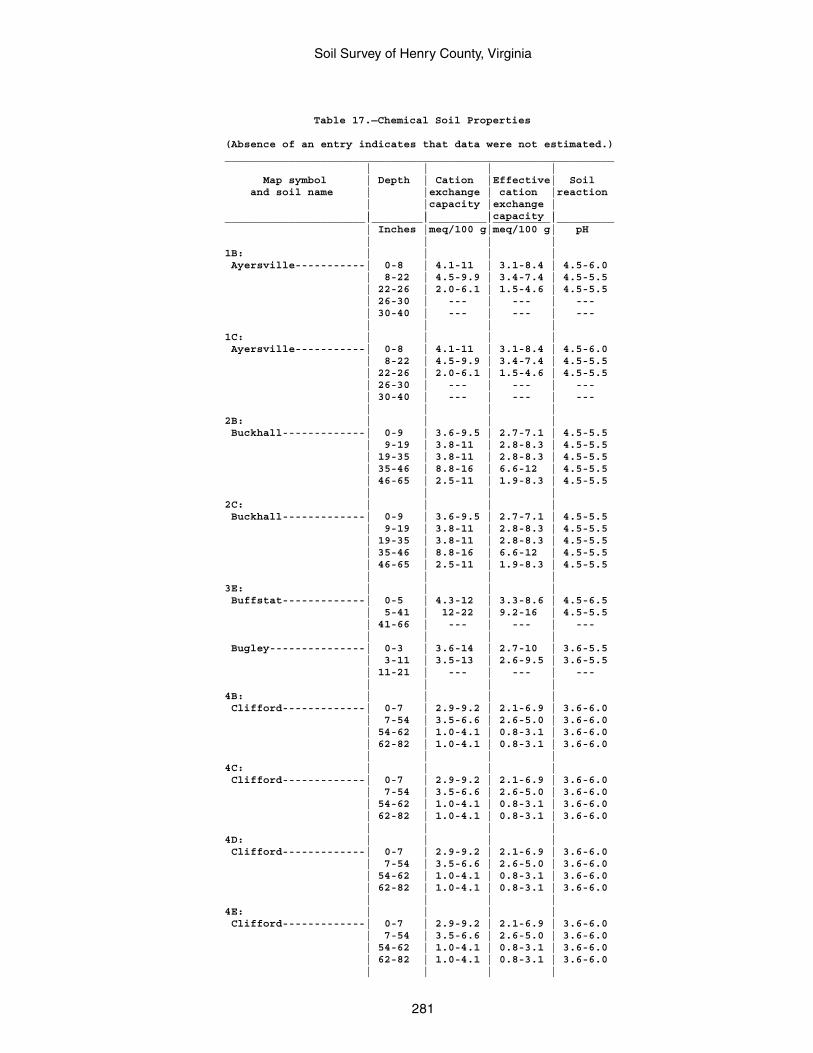
Soil Survey of Henry County, Virginia
281
Table 17.—Chemical Soil Properties
(Absence of an entry indicates that data were not estimated.)_____________________________________________________________ | | | | Map symbol | Depth | Cation |Effective| Soil and soil name | |exchange | cation |reaction | |capacity |exchange | | | |capacity |______________________|________|_________|_________|_________ | Inches |meq/100 g|meq/100 g| pH | | | |1B: | | | | Ayersville-----------| 0-8 | 4.1-11 | 3.1-8.4 | 4.5-6.0 | 8-22 | 4.5-9.9 | 3.4-7.4 | 4.5-5.5 | 22-26 | 2.0-6.1 | 1.5-4.6 | 4.5-5.5 | 26-30 | --- | --- | --- | 30-40 | --- | --- | --- | | | |1C: | | | | Ayersville-----------| 0-8 | 4.1-11 | 3.1-8.4 | 4.5-6.0 | 8-22 | 4.5-9.9 | 3.4-7.4 | 4.5-5.5 | 22-26 | 2.0-6.1 | 1.5-4.6 | 4.5-5.5 | 26-30 | --- | --- | --- | 30-40 | --- | --- | --- | | | |2B: | | | | Buckhall-------------| 0-9 | 3.6-9.5 | 2.7-7.1 | 4.5-5.5 | 9-19 | 3.8-11 | 2.8-8.3 | 4.5-5.5 | 19-35 | 3.8-11 | 2.8-8.3 | 4.5-5.5 | 35-46 | 8.8-16 | 6.6-12 | 4.5-5.5 | 46-65 | 2.5-11 | 1.9-8.3 | 4.5-5.5 | | | |2C: | | | | Buckhall-------------| 0-9 | 3.6-9.5 | 2.7-7.1 | 4.5-5.5 | 9-19 | 3.8-11 | 2.8-8.3 | 4.5-5.5 | 19-35 | 3.8-11 | 2.8-8.3 | 4.5-5.5 | 35-46 | 8.8-16 | 6.6-12 | 4.5-5.5 | 46-65 | 2.5-11 | 1.9-8.3 | 4.5-5.5 | | | |3E: | | | | Buffstat-------------| 0-5 | 4.3-12 | 3.3-8.6 | 4.5-6.5 | 5-41 | 12-22 | 9.2-16 | 4.5-5.5 | 41-66 | --- | --- | --- | | | | Bugley---------------| 0-3 | 3.6-14 | 2.7-10 | 3.6-5.5 | 3-11 | 3.5-13 | 2.6-9.5 | 3.6-5.5 | 11-21 | --- | --- | --- | | | |4B: | | | | Clifford-------------| 0-7 | 2.9-9.2 | 2.1-6.9 | 3.6-6.0 | 7-54 | 3.5-6.6 | 2.6-5.0 | 3.6-6.0 | 54-62 | 1.0-4.1 | 0.8-3.1 | 3.6-6.0 | 62-82 | 1.0-4.1 | 0.8-3.1 | 3.6-6.0 | | | |4C: | | | | Clifford-------------| 0-7 | 2.9-9.2 | 2.1-6.9 | 3.6-6.0 | 7-54 | 3.5-6.6 | 2.6-5.0 | 3.6-6.0 | 54-62 | 1.0-4.1 | 0.8-3.1 | 3.6-6.0 | 62-82 | 1.0-4.1 | 0.8-3.1 | 3.6-6.0 | | | |4D: | | | | Clifford-------------| 0-7 | 2.9-9.2 | 2.1-6.9 | 3.6-6.0 | 7-54 | 3.5-6.6 | 2.6-5.0 | 3.6-6.0 | 54-62 | 1.0-4.1 | 0.8-3.1 | 3.6-6.0 | 62-82 | 1.0-4.1 | 0.8-3.1 | 3.6-6.0 | | | |4E: | | | | Clifford-------------| 0-7 | 2.9-9.2 | 2.1-6.9 | 3.6-6.0 | 7-54 | 3.5-6.6 | 2.6-5.0 | 3.6-6.0 | 54-62 | 1.0-4.1 | 0.8-3.1 | 3.6-6.0 | 62-82 | 1.0-4.1 | 0.8-3.1 | 3.6-6.0 | | | |
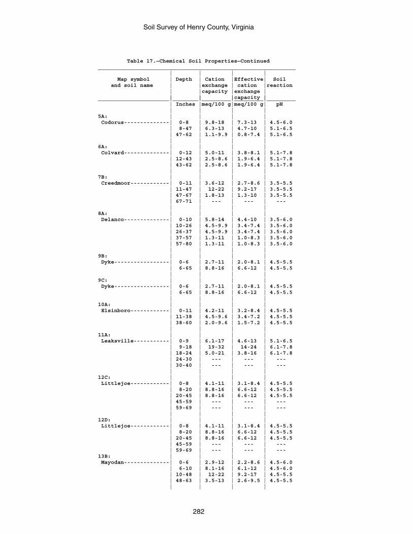
Soil Survey of Henry County, Virginia
282
Table 17.—Chemical Soil Properties—Continued_____________________________________________________________ | | | | Map symbol | Depth | Cation |Effective| Soil and soil name | |exchange | cation |reaction | |capacity |exchange | | | |capacity |______________________|________|_________|_________|_________ | Inches |meq/100 g|meq/100 g| pH | | | |5A: | | | | Codorus--------------| 0-8 | 9.8-18 | 7.3-13 | 4.5-6.0 | 8-47 | 6.3-13 | 4.7-10 | 5.1-6.5 | 47-62 | 1.1-9.9 | 0.8-7.4 | 5.1-6.5 | | | |6A: | | | | Colvard--------------| 0-12 | 5.0-11 | 3.8-8.1 | 5.1-7.8 | 12-43 | 2.5-8.6 | 1.9-6.4 | 5.1-7.8 | 43-62 | 2.5-8.6 | 1.9-6.4 | 5.1-7.8 | | | |7B: | | | | Creedmoor------------| 0-11 | 3.6-12 | 2.7-8.6 | 3.5-5.5 | 11-47 | 12-22 | 9.2-17 | 3.5-5.5 | 47-67 | 1.8-13 | 1.3-10 | 3.5-5.5 | 67-71 | --- | --- | --- | | | |8A: | | | | Delanco--------------| 0-10 | 5.8-14 | 4.4-10 | 3.5-6.0 | 10-26 | 4.5-9.9 | 3.4-7.4 | 3.5-6.0 | 26-37 | 4.5-9.9 | 3.4-7.4 | 3.5-6.0 | 37-57 | 1.3-11 | 1.0-8.3 | 3.5-6.0 | 57-80 | 1.3-11 | 1.0-8.3 | 3.5-6.0 | | | |9B: | | | | Dyke-----------------| 0-6 | 2.7-11 | 2.0-8.1 | 4.5-5.5 | 6-65 | 8.8-16 | 6.6-12 | 4.5-5.5 | | | |9C: | | | | Dyke-----------------| 0-6 | 2.7-11 | 2.0-8.1 | 4.5-5.5 | 6-65 | 8.8-16 | 6.6-12 | 4.5-5.5 | | | |10A: | | | | Elsinboro------------| 0-11 | 4.2-11 | 3.2-8.4 | 4.5-5.5 | 11-38 | 4.5-9.6 | 3.4-7.2 | 4.5-5.5 | 38-60 | 2.0-9.6 | 1.5-7.2 | 4.5-5.5 | | | |11A: | | | | Leaksville-----------| 0-9 | 6.1-17 | 4.6-13 | 5.1-6.5 | 9-18 | 19-32 | 14-24 | 6.1-7.8 | 18-24 | 5.0-21 | 3.8-16 | 6.1-7.8 | 24-30 | --- | --- | --- | 30-40 | --- | --- | --- | | | |12C: | | | | Littlejoe------------| 0-8 | 4.1-11 | 3.1-8.4 | 4.5-5.5 | 8-20 | 8.8-16 | 6.6-12 | 4.5-5.5 | 20-45 | 8.8-16 | 6.6-12 | 4.5-5.5 | 45-59 | --- | --- | --- | 59-69 | --- | --- | --- | | | |12D: | | | | Littlejoe------------| 0-8 | 4.1-11 | 3.1-8.4 | 4.5-5.5 | 8-20 | 8.8-16 | 6.6-12 | 4.5-5.5 | 20-45 | 8.8-16 | 6.6-12 | 4.5-5.5 | 45-59 | --- | --- | --- | 59-69 | --- | --- | ---13B: | | | | Mayodan--------------| 0-6 | 2.9-12 | 2.2-8.6 | 4.5-6.0 | 6-10 | 8.1-16 | 6.1-12 | 4.5-6.0 | 10-48 | 12-22 | 9.2-17 | 4.5-5.5 | 48-63 | 3.5-13 | 2.6-9.5 | 4.5-5.5 | | | |
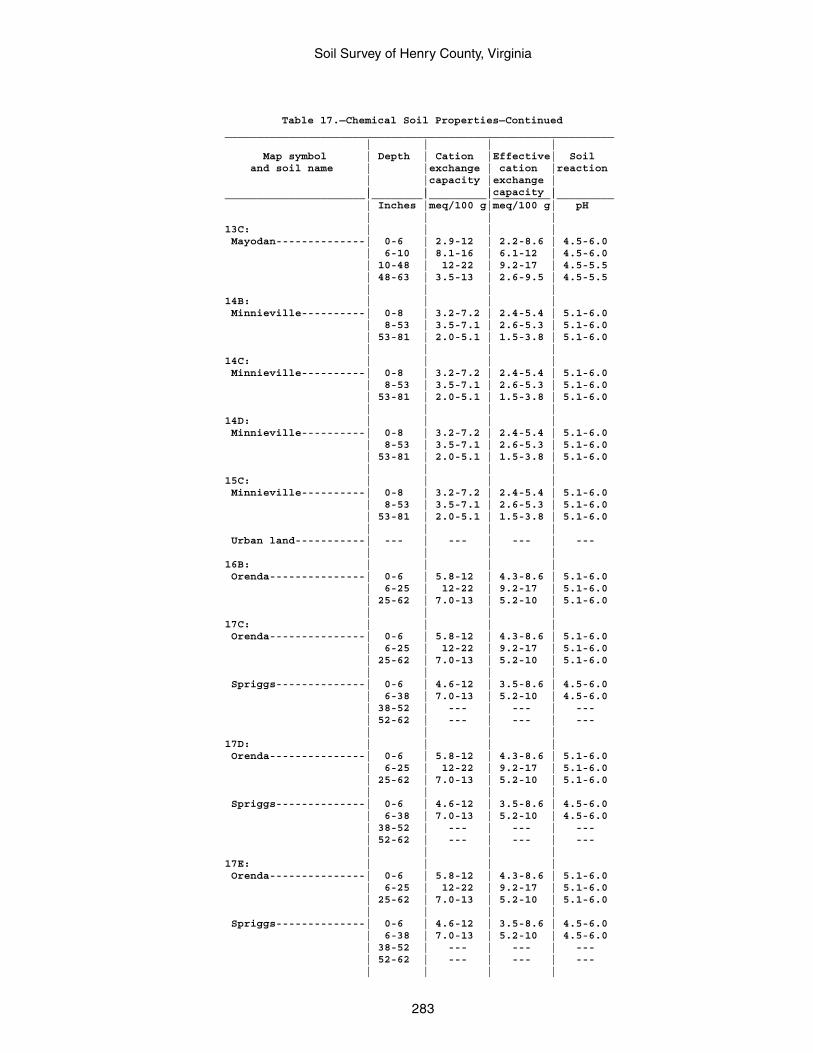
Soil Survey of Henry County, Virginia
283
Table 17.—Chemical Soil Properties—Continued_____________________________________________________________ | | | | Map symbol | Depth | Cation |Effective| Soil and soil name | |exchange | cation |reaction | |capacity |exchange | | | |capacity |______________________|________|_________|_________|_________ | Inches |meq/100 g|meq/100 g| pH | | | |13C: | | | | Mayodan--------------| 0-6 | 2.9-12 | 2.2-8.6 | 4.5-6.0 | 6-10 | 8.1-16 | 6.1-12 | 4.5-6.0 | 10-48 | 12-22 | 9.2-17 | 4.5-5.5 | 48-63 | 3.5-13 | 2.6-9.5 | 4.5-5.5 | | | |14B: | | | | Minnieville----------| 0-8 | 3.2-7.2 | 2.4-5.4 | 5.1-6.0 | 8-53 | 3.5-7.1 | 2.6-5.3 | 5.1-6.0 | 53-81 | 2.0-5.1 | 1.5-3.8 | 5.1-6.0 | | | |14C: | | | | Minnieville----------| 0-8 | 3.2-7.2 | 2.4-5.4 | 5.1-6.0 | 8-53 | 3.5-7.1 | 2.6-5.3 | 5.1-6.0 | 53-81 | 2.0-5.1 | 1.5-3.8 | 5.1-6.0 | | | |14D: | | | | Minnieville----------| 0-8 | 3.2-7.2 | 2.4-5.4 | 5.1-6.0 | 8-53 | 3.5-7.1 | 2.6-5.3 | 5.1-6.0 | 53-81 | 2.0-5.1 | 1.5-3.8 | 5.1-6.0 | | | |15C: | | | | Minnieville----------| 0-8 | 3.2-7.2 | 2.4-5.4 | 5.1-6.0 | 8-53 | 3.5-7.1 | 2.6-5.3 | 5.1-6.0 | 53-81 | 2.0-5.1 | 1.5-3.8 | 5.1-6.0 | | | | Urban land-----------| --- | --- | --- | --- | | | |16B: | | | | Orenda---------------| 0-6 | 5.8-12 | 4.3-8.6 | 5.1-6.0 | 6-25 | 12-22 | 9.2-17 | 5.1-6.0 | 25-62 | 7.0-13 | 5.2-10 | 5.1-6.0 | | | |17C: | | | | Orenda---------------| 0-6 | 5.8-12 | 4.3-8.6 | 5.1-6.0 | 6-25 | 12-22 | 9.2-17 | 5.1-6.0 | 25-62 | 7.0-13 | 5.2-10 | 5.1-6.0 | | | | Spriggs--------------| 0-6 | 4.6-12 | 3.5-8.6 | 4.5-6.0 | 6-38 | 7.0-13 | 5.2-10 | 4.5-6.0 | 38-52 | --- | --- | --- | 52-62 | --- | --- | --- | | | |17D: | | | | Orenda---------------| 0-6 | 5.8-12 | 4.3-8.6 | 5.1-6.0 | 6-25 | 12-22 | 9.2-17 | 5.1-6.0 | 25-62 | 7.0-13 | 5.2-10 | 5.1-6.0 | | | | Spriggs--------------| 0-6 | 4.6-12 | 3.5-8.6 | 4.5-6.0 | 6-38 | 7.0-13 | 5.2-10 | 4.5-6.0 | 38-52 | --- | --- | --- | 52-62 | --- | --- | --- | | | |17E: | | | | Orenda---------------| 0-6 | 5.8-12 | 4.3-8.6 | 5.1-6.0 | 6-25 | 12-22 | 9.2-17 | 5.1-6.0 | 25-62 | 7.0-13 | 5.2-10 | 5.1-6.0 | | | | Spriggs--------------| 0-6 | 4.6-12 | 3.5-8.6 | 4.5-6.0 | 6-38 | 7.0-13 | 5.2-10 | 4.5-6.0 | 38-52 | --- | --- | --- | 52-62 | --- | --- | --- | | | |
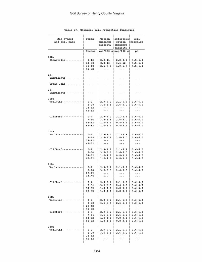
Soil Survey of Henry County, Virginia
284
Table 17.—Chemical Soil Properties—Continued_____________________________________________________________ | | | | Map symbol | Depth | Cation |Effective| Soil and soil name | |exchange | cation |reaction | |capacity |exchange | | | |capacity |______________________|________|_________|_________|_________ | Inches |meq/100 g|meq/100 g| pH | | | |18B: | | | | Stoneville-----------| 0-13 | 2.9-11 | 2.2-8.2 | 4.5-6.0 | 13-38 | 8.8-16 | 6.6-12 | 4.5-6.0 | 38-48 | 2.5-7.6 | 1.9-5.7 | 4.5-6.0 | 48-72 | --- | --- | --- | | | |19: | | | | Udorthents-----------| --- | --- | --- | --- | | | | Urban land-----------| --- | --- | --- | --- | | | |20: | | | | Udorthents-----------| --- | --- | --- | --- | | | |21B: | | | | Woolwine-------------| 0-2 | 2.9-9.2 | 2.1-6.9 | 3.6-6.0 | 2-28 | 3.5-6.6 | 2.6-5.0 | 3.6-6.0 | 28-42 | --- | --- | --- | 42-52 | --- | --- | --- | | | | Clifford-------------| 0-7 | 2.9-9.2 | 2.1-6.9 | 3.6-6.0 | 7-54 | 3.5-6.6 | 2.6-5.0 | 3.6-6.0 | 54-62 | 1.0-4.1 | 0.8-3.1 | 3.6-6.0 | 62-82 | 1.0-4.1 | 0.8-3.1 | 3.6-6.0 | | | |21C: | | | | Woolwine-------------| 0-2 | 2.9-9.2 | 2.1-6.9 | 3.6-6.0 | 2-28 | 3.5-6.6 | 2.6-5.0 | 3.6-6.0 | 28-42 | --- | --- | --- | 42-52 | --- | --- | --- | | | | Clifford-------------| 0-7 | 2.9-9.2 | 2.1-6.9 | 3.6-6.0 | 7-54 | 3.5-6.6 | 2.6-5.0 | 3.6-6.0 | 54-62 | 1.0-4.1 | 0.8-3.1 | 3.6-6.0 | 62-82 | 1.0-4.1 | 0.8-3.1 | 3.6-6.0 | | | |21D: | | | | Woolwine-------------| 0-2 | 2.9-9.2 | 2.1-6.9 | 3.6-6.0 | 2-28 | 3.5-6.6 | 2.6-5.0 | 3.6-6.0 | 28-42 | --- | --- | --- | 42-52 | --- | --- | --- | | | | Clifford-------------| 0-7 | 2.9-9.2 | 2.1-6.9 | 3.6-6.0 | 7-54 | 3.5-6.6 | 2.6-5.0 | 3.6-6.0 | 54-62 | 1.0-4.1 | 0.8-3.1 | 3.6-6.0 | 62-82 | 1.0-4.1 | 0.8-3.1 | 3.6-6.0 | | | |21E: | | | | Woolwine-------------| 0-2 | 2.9-9.2 | 2.1-6.9 | 3.6-6.0 | 2-28 | 3.5-6.6 | 2.6-5.0 | 3.6-6.0 | 28-42 | --- | --- | --- | 42-52 | --- | --- | --- Clifford-------------| 0-7 | 2.9-9.2 | 2.1-6.9 | 3.6-6.0 | 7-54 | 3.5-6.6 | 2.6-5.0 | 3.6-6.0 | 54-62 | 1.0-4.1 | 0.8-3.1 | 3.6-6.0 | 62-82 | 1.0-4.1 | 0.8-3.1 | 3.6-6.0 | | | |22C: | | | | Woolwine-------------| 0-2 | 2.9-9.2 | 2.1-6.9 | 3.6-6.0 | 2-28 | 3.5-6.6 | 2.6-5.0 | 3.6-6.0 | 28-42 | --- | --- | --- | 42-52 | --- | --- | --- | | | |
Soil Survey of Henry County, Virginia
285
Table 17.—Chemical Soil Properties—Continued_____________________________________________________________ | | | | Map symbol | Depth | Cation |Effective| Soil and soil name | |exchange | cation |reaction | |capacity |exchange | | | |capacity |______________________|________|_________|_________|_________ | Inches |meq/100 g|meq/100 g| pH | | | |22C: | | | | Urban land-----------| --- | --- | --- | --- | | | |DAM: | | | | Dam------------------| --- | --- | --- | --- | | | |W: | | | | Water----------------| --- | --- | --- | --- | | | |______________________|________|_________|_________|_________
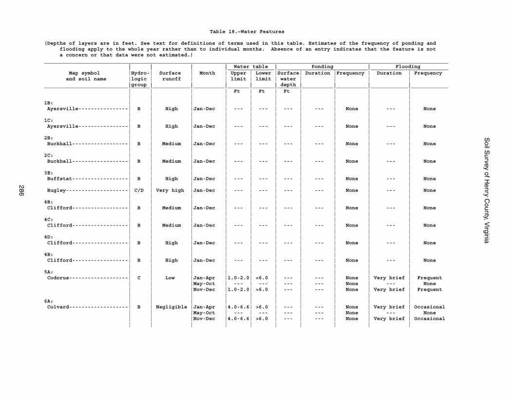
Soil S
urvey of Henry C
ounty, Virginia
286
Table 18.—Water Features
(Depths of layers are in feet. See text for definitions of terms used in this table. Estimates of the frequency of ponding and flooding apply to the whole year rather than to individual months. Absence of an entry indicates that the feature is not a concern or that data were not estimated.)__________________________________________________________________________________________________________________________________ | | | | Water table | Ponding | Flooding | | | |_______________|_____________________________|_________________________ Map symbol |Hydro-| Surface | Month | Upper | Lower |Surface| Duration |Frequency | Duration | Frequency and soil name |logic | runoff | | limit | limit | water | | | | |group | | | | | depth | | | |___________________________|______|____________|__________|_______|_______|_______|__________|__________|____________|____________ | | | | Ft | Ft | Ft | | | | | | | | | | | | | |1B: | | | | | | | | | | Ayersville----------------| B | High |Jan-Dec | --- | --- | --- | --- | None | --- | None | | | | | | | | | |1C: | | | | | | | | | | Ayersville----------------| B | High |Jan-Dec | --- | --- | --- | --- | None | --- | None | | | | | | | | | |2B: | | | | | | | | | | Buckhall------------------| B | Medium |Jan-Dec | --- | --- | --- | --- | None | --- | None | | | | | | | | | |2C: | | | | | | | | | | Buckhall------------------| B | Medium |Jan-Dec | --- | --- | --- | --- | None | --- | None | | | | | | | | | |3E: | | | | | | | | | | Buffstat------------------| B | High |Jan-Dec | --- | --- | --- | --- | None | --- | None | | | | | | | | | | Bugley--------------------| C/D | Very high |Jan-Dec | --- | --- | --- | --- | None | --- | None | | | | | | | | | |4B: | | | | | | | | | | Clifford------------------| B | Medium |Jan-Dec | --- | --- | --- | --- | None | --- | None | | | | | | | | | |4C: | | | | | | | | | | Clifford------------------| B | Medium |Jan-Dec | --- | --- | --- | --- | None | --- | None | | | | | | | | | |4D: | | | | | | | | | | Clifford------------------| B | High |Jan-Dec | --- | --- | --- | --- | None | --- | None | | | | | | | | | |4E: | | | | | | | | | | Clifford------------------| B | High |Jan-Dec | --- | --- | --- | --- | None | --- | None | | | | | | | | | |5A: | | | | | | | | | | Codorus-------------------| C | Low |Jan-Apr |1.0-2.0| >6.0 | --- | --- | None | Very brief | Frequent | | |May-Oct | --- | --- | --- | --- | None | --- | None | | |Nov-Dec |1.0-2.0| >6.0 | --- | --- | None | Very brief | Frequent | | | | | | | | | |6A: | | | | | | | | | | Colvard-------------------| B | Negligible |Jan-Apr |4.0-6.6| >6.0 | --- | --- | None | Very brief | Occasional | | |May-Oct | --- | --- | --- | --- | None | --- | None | | |Nov-Dec |4.0-6.6| >6.0 | --- | --- | None | Very brief | Occasional | | | | | | | | | |
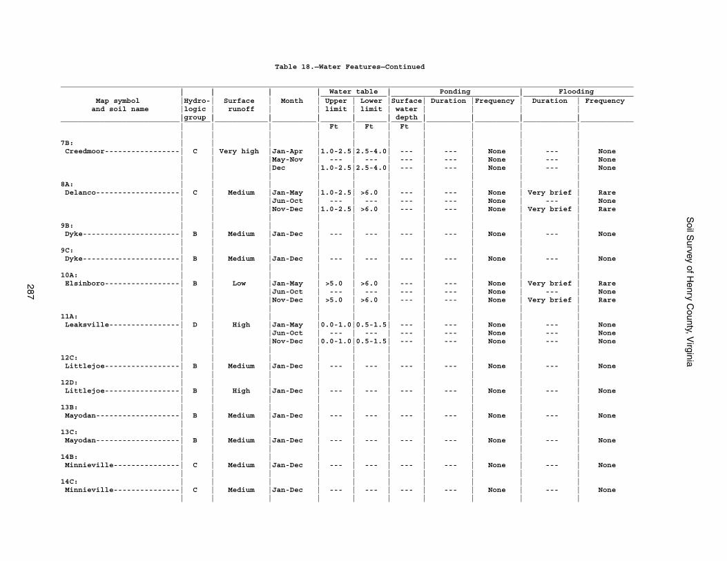
Soil S
urvey of Henry C
ounty, Virginia
287
Table 18.—Water Features—Continued
__________________________________________________________________________________________________________________________________ | | | | Water table | Ponding | Flooding | | | |_______________|_____________________________|_________________________ Map symbol |Hydro-| Surface | Month | Upper | Lower |Surface| Duration |Frequency | Duration | Frequency and soil name |logic | runoff | | limit | limit | water | | | | |group | | | | | depth | | | |___________________________|______|____________|__________|_______|_______|_______|__________|__________|____________|____________ | | | | Ft | Ft | Ft | | | | | | | | | | | | | |7B: | | | | | | | | | | Creedmoor-----------------| C | Very high |Jan-Apr |1.0-2.5|2.5-4.0| --- | --- | None | --- | None | | |May-Nov | --- | --- | --- | --- | None | --- | None | | |Dec |1.0-2.5|2.5-4.0| --- | --- | None | --- | None | | | | | | | | | |8A: | | | | | | | | | | Delanco-------------------| C | Medium |Jan-May |1.0-2.5| >6.0 | --- | --- | None | Very brief | Rare | | |Jun-Oct | --- | --- | --- | --- | None | --- | None | | |Nov-Dec |1.0-2.5| >6.0 | --- | --- | None | Very brief | Rare | | | | | | | | | |9B: | | | | | | | | | | Dyke----------------------| B | Medium |Jan-Dec | --- | --- | --- | --- | None | --- | None | | | | | | | | | |9C: | | | | | | | | | | Dyke----------------------| B | Medium |Jan-Dec | --- | --- | --- | --- | None | --- | None | | | | | | | | | |10A: | | | | | | | | | | Elsinboro-----------------| B | Low |Jan-May | >5.0 | >6.0 | --- | --- | None | Very brief | Rare | | |Jun-Oct | --- | --- | --- | --- | None | --- | None | | |Nov-Dec | >5.0 | >6.0 | --- | --- | None | Very brief | Rare | | | | | | | | | |11A: | | | | | | | | | | Leaksville----------------| D | High |Jan-May |0.0-1.0|0.5-1.5| --- | --- | None | --- | None | | |Jun-Oct | --- | --- | --- | --- | None | --- | None | | |Nov-Dec |0.0-1.0|0.5-1.5| --- | --- | None | --- | None | | | | | | | | | |12C: | | | | | | | | | | Littlejoe-----------------| B | Medium |Jan-Dec | --- | --- | --- | --- | None | --- | None | | | | | | | | | |12D: | | | | | | | | | | Littlejoe-----------------| B | High |Jan-Dec | --- | --- | --- | --- | None | --- | None | | | | | | | | | |13B: | | | | | | | | | | Mayodan-------------------| B | Medium |Jan-Dec | --- | --- | --- | --- | None | --- | None | | | | | | | | | |13C: | | | | | | | | | | Mayodan-------------------| B | Medium |Jan-Dec | --- | --- | --- | --- | None | --- | None | | | | | | | | | |14B: | | | | | | | | | | Minnieville---------------| C | Medium |Jan-Dec | --- | --- | --- | --- | None | --- | None | | | | | | | | | |14C: | | | | | | | | | | Minnieville---------------| C | Medium |Jan-Dec | --- | --- | --- | --- | None | --- | None | | | | | | | | | |
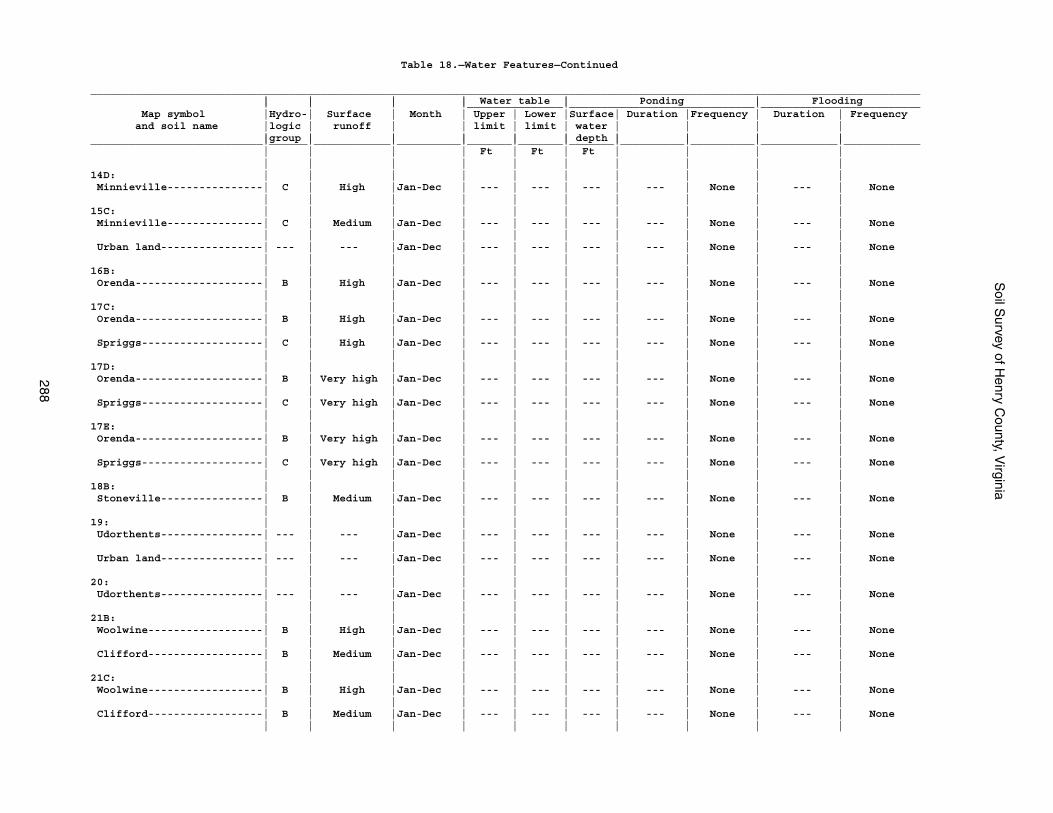
Soil S
urvey of Henry C
ounty, Virginia
288
Table 18.—Water Features—Continued
__________________________________________________________________________________________________________________________________ | | | | Water table | Ponding | Flooding | | | |_______________|_____________________________|_________________________ Map symbol |Hydro-| Surface | Month | Upper | Lower |Surface| Duration |Frequency | Duration | Frequency and soil name |logic | runoff | | limit | limit | water | | | | |group | | | | | depth | | | |___________________________|______|____________|__________|_______|_______|_______|__________|__________|____________|____________ | | | | Ft | Ft | Ft | | | | | | | | | | | | | |14D: | | | | | | | | | | Minnieville---------------| C | High |Jan-Dec | --- | --- | --- | --- | None | --- | None | | | | | | | | | |15C: | | | | | | | | | | Minnieville---------------| C | Medium |Jan-Dec | --- | --- | --- | --- | None | --- | None | | | | | | | | | | Urban land----------------| --- | --- |Jan-Dec | --- | --- | --- | --- | None | --- | None | | | | | | | | | |16B: | | | | | | | | | | Orenda--------------------| B | High |Jan-Dec | --- | --- | --- | --- | None | --- | None | | | | | | | | | |17C: | | | | | | | | | | Orenda--------------------| B | High |Jan-Dec | --- | --- | --- | --- | None | --- | None | | | | | | | | | | Spriggs-------------------| C | High |Jan-Dec | --- | --- | --- | --- | None | --- | None | | | | | | | | | |17D: | | | | | | | | | | Orenda--------------------| B | Very high |Jan-Dec | --- | --- | --- | --- | None | --- | None | | | | | | | | | | Spriggs-------------------| C | Very high |Jan-Dec | --- | --- | --- | --- | None | --- | None | | | | | | | | | |17E: | | | | | | | | | | Orenda--------------------| B | Very high |Jan-Dec | --- | --- | --- | --- | None | --- | None | | | | | | | | | | Spriggs-------------------| C | Very high |Jan-Dec | --- | --- | --- | --- | None | --- | None | | | | | | | | | |18B: | | | | | | | | | | Stoneville----------------| B | Medium |Jan-Dec | --- | --- | --- | --- | None | --- | None | | | | | | | | | |19: | | | | | | | | | | Udorthents----------------| --- | --- |Jan-Dec | --- | --- | --- | --- | None | --- | None | | | | | | | | | | Urban land----------------| --- | --- |Jan-Dec | --- | --- | --- | --- | None | --- | None | | | | | | | | | |20: | | | | | | | | | | Udorthents----------------| --- | --- |Jan-Dec | --- | --- | --- | --- | None | --- | None | | | | | | | | | |21B: | | | | | | | | | | Woolwine------------------| B | High |Jan-Dec | --- | --- | --- | --- | None | --- | None | | | | | | | | | | Clifford------------------| B | Medium |Jan-Dec | --- | --- | --- | --- | None | --- | None | | | | | | | | | |21C: | | | | | | | | | | Woolwine------------------| B | High |Jan-Dec | --- | --- | --- | --- | None | --- | None | | | | | | | | | | Clifford------------------| B | Medium |Jan-Dec | --- | --- | --- | --- | None | --- | None | | | | | | | | | |
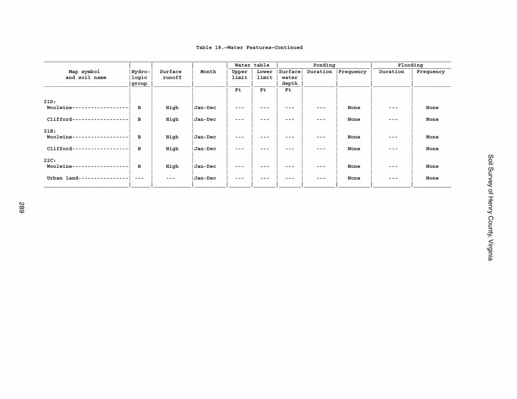
Soil S
urvey of Henry C
ounty, Virginia
289
Table 18.—Water Features—Continued
__________________________________________________________________________________________________________________________________ | | | | Water table | Ponding | Flooding | | | |_______________|_____________________________|_________________________ Map symbol |Hydro-| Surface | Month | Upper | Lower |Surface| Duration |Frequency | Duration | Frequency and soil name |logic | runoff | | limit | limit | water | | | | |group | | | | | depth | | | |___________________________|______|____________|__________|_______|_______|_______|__________|__________|____________|____________ | | | | Ft | Ft | Ft | | | | | | | | | | | | | |21D: | | | | | | | | | | Woolwine------------------| B | High |Jan-Dec | --- | --- | --- | --- | None | --- | None | | | | | | | | | | Clifford------------------| B | High |Jan-Dec | --- | --- | --- | --- | None | --- | None | | | | | | | | | |21E: | | | | | | | | | | Woolwine------------------| B | High |Jan-Dec | --- | --- | --- | --- | None | --- | None | | | | | | | | | | Clifford------------------| B | High |Jan-Dec | --- | --- | --- | --- | None | --- | None | | | | | | | | | |22C: | | | | | | | | | | Woolwine------------------| B | High |Jan-Dec | --- | --- | --- | --- | None | --- | None | | | | | | | | | | Urban land----------------| --- | --- |Jan-Dec | --- | --- | --- | --- | None | --- | None | | | | | | | | | |___________________________|______|____________|__________|_______|_______|_______|__________|__________|____________|____________
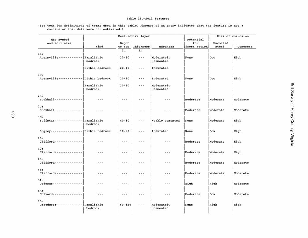
Soil S
urvey of Henry C
ounty, Virginia
290
Table 19.—Soil Features
(See text for definitions of terms used in this table. Absence of an entry indicates that the feature is not a concern or that data were not estimated.)_____________________________________________________________________________________________________________________ | Restrictive layer | | Risk of corrosion Map symbol |_____________________________________________________| Potential |_________________________ and soil name | | Depth | | | for | Uncoated | | Kind |to top |Thickness| Hardness |frost action| steel | Concrete________________________|_________________|_______|_________|_________________|____________|____________|____________ | | In | In | | | |1B: | | | | | | | Ayersville-------------|Paralithic | 20-40 | --- |Moderately |None |Low |High | bedrock | | | cemented | | | | | | | | | | |Lithic bedrock | 20-40 | --- |Indurated | | | | | | | | | |1C: | | | | | | | Ayersville-------------|Lithic bedrock | 20-40 | --- |Indurated |None |Low |High | | | | | | | |Paralithic | 20-40 | --- |Moderately | | | | bedrock | | | cemented | | | | | | | | | |2B: | | | | | | | Buckhall---------------| --- | --- | --- | --- |Moderate |Moderate |Moderate | | | | | | |2C: | | | | | | | Buckhall---------------| --- | --- | --- | --- |Moderate |Moderate |Moderate | | | | | | |3E: | | | | | | | Buffstat---------------|Paralithic | 40-60 | --- |Weakly cemented |None |Moderate |High | bedrock | | | | | | | | | | | | | Bugley-----------------|Lithic bedrock | 10-20 | --- |Indurated |None |Low |High | | | | | | |4B: | | | | | | | Clifford---------------| --- | --- | --- | --- |Moderate |Moderate |High | | | | | | |4C: | | | | | | | Clifford---------------| --- | --- | --- | --- |Moderate |Moderate |High | | | | | | |4D: | | | | | | | Clifford---------------| --- | --- | --- | --- |Moderate |Moderate |Moderate | | | | | | |4E: | | | | | | | Clifford---------------| --- | --- | --- | --- |Moderate |Moderate |Moderate | | | | | | |5A: | | | | | | | Codorus----------------| --- | --- | --- | --- |High |High |Moderate | | | | | | |6A: | | | | | | | Colvard----------------| --- | --- | --- | --- |Moderate |Low |Moderate | | | | | | |7B: | | | | | | | Creedmoor--------------|Paralithic | 60-120| --- |Moderately |None |High |High | bedrock | | | cemented | | | | | | | | | |
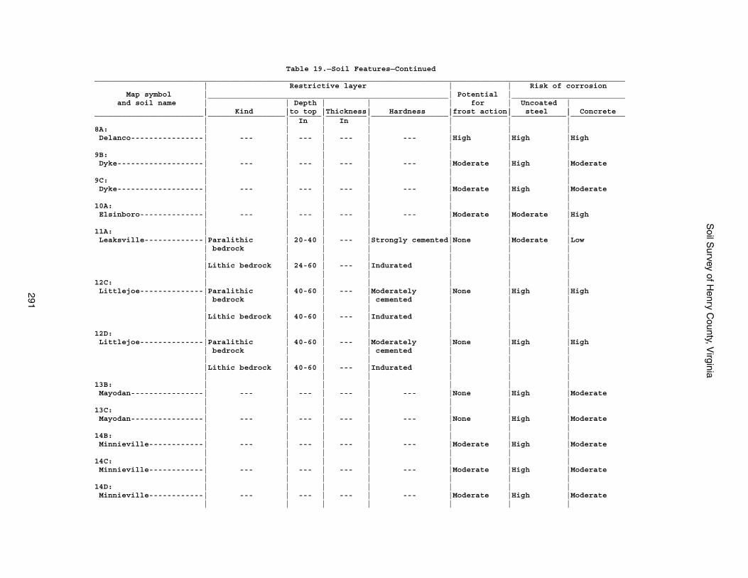
Soil S
urvey of Henry C
ounty, Virginia
291
Table 19.—Soil Features—Continued_____________________________________________________________________________________________________________________ | Restrictive layer | | Risk of corrosion Map symbol |_____________________________________________________| Potential |_________________________ and soil name | | Depth | | | for | Uncoated | | Kind |to top |Thickness| Hardness |frost action| steel | Concrete________________________|_________________|_______|_________|_________________|____________|____________|____________ | | In | In | | | |8A: | | | | | | | Delanco----------------| --- | --- | --- | --- |High |High |High | | | | | | |9B: | | | | | | | Dyke-------------------| --- | --- | --- | --- |Moderate |High |Moderate | | | | | | |9C: | | | | | | | Dyke-------------------| --- | --- | --- | --- |Moderate |High |Moderate | | | | | | |10A: | | | | | | | Elsinboro--------------| --- | --- | --- | --- |Moderate |Moderate |High | | | | | | |11A: | | | | | | | Leaksville-------------|Paralithic | 20-40 | --- |Strongly cemented|None |Moderate |Low | bedrock | | | | | | | | | | | | | |Lithic bedrock | 24-60 | --- |Indurated | | | | | | | | | |12C: | | | | | | | Littlejoe--------------|Paralithic | 40-60 | --- |Moderately |None |High |High | bedrock | | | cemented | | | | | | | | | | |Lithic bedrock | 40-60 | --- |Indurated | | | | | | | | | |12D: | | | | | | | Littlejoe--------------|Paralithic | 40-60 | --- |Moderately |None |High |High | bedrock | | | cemented | | | | | | | | | | |Lithic bedrock | 40-60 | --- |Indurated | | | | | | | | | |13B: | | | | | | | Mayodan----------------| --- | --- | --- | --- |None |High |Moderate | | | | | | |13C: | | | | | | | Mayodan----------------| --- | --- | --- | --- |None |High |Moderate | | | | | | |14B: | | | | | | | Minnieville------------| --- | --- | --- | --- |Moderate |High |Moderate | | | | | | |14C: | | | | | | | Minnieville------------| --- | --- | --- | --- |Moderate |High |Moderate | | | | | | |14D: | | | | | | | Minnieville------------| --- | --- | --- | --- |Moderate |High |Moderate | | | | | | |
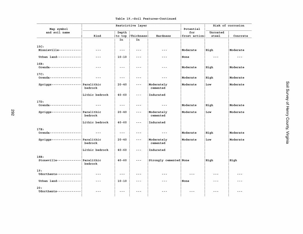
Soil S
urvey of Henry C
ounty, Virginia
292
Table 19.—Soil Features—Continued_____________________________________________________________________________________________________________________ | Restrictive layer | | Risk of corrosion Map symbol |_____________________________________________________| Potential |_________________________ and soil name | | Depth | | | for | Uncoated | | Kind |to top |Thickness| Hardness |frost action| steel | Concrete________________________|_________________|_______|_________|_________________|____________|____________|____________ | | In | In | | | | | | | | | | |15C: | | | | | | | Minnieville------------| --- | --- | --- | --- |Moderate |High |Moderate | | | | | | | Urban land-------------| --- | 10-10 | --- | --- |None | --- | --- | | | | | | |16B: | | | | | | | Orenda-----------------| --- | --- | --- | --- |Moderate |High |Moderate | | | | | | |17C: | | | | | | | Orenda-----------------| --- | --- | --- | --- |Moderate |High |Moderate | | | | | | | Spriggs----------------|Paralithic | 20-40 | --- |Moderately |Moderate |Low |Moderate | bedrock | | | cemented | | | | | | | | | | |Lithic bedrock | 40-60 | --- |Indurated | | | | | | | | | |17D: | | | | | | | Orenda-----------------| --- | --- | --- | --- |Moderate |High |Moderate | | | | | | | Spriggs----------------|Paralithic | 20-40 | --- |Moderately |Moderate |Low |Moderate | bedrock | | | cemented | | | | | | | | | | |Lithic bedrock | 40-60 | --- |Indurated | | | | | | | | | |17E: | | | | | | | Orenda-----------------| --- | --- | --- | --- |Moderate |High |Moderate | | | | | | | Spriggs----------------|Paralithic | 20-40 | --- |Moderately |Moderate |Low |Moderate | bedrock | | | cemented | | | | | | | | | | |Lithic bedrock | 40-60 | --- |Indurated | | | | | | | | | |18B: | | | | | | | Stoneville-------------|Paralithic | 40-60 | --- |Strongly cemented|None |High |High | bedrock | | | | | | | | | | | | |19: | | | | | | | Udorthents-------------| --- | --- | --- | --- | --- | --- | --- | | | | | | | Urban land-------------| --- | 10-10 | --- | --- |None | --- | --- | | | | | | |20: | | | | | | | Udorthents-------------| --- | --- | --- | --- | --- | --- | --- | | | | | | |
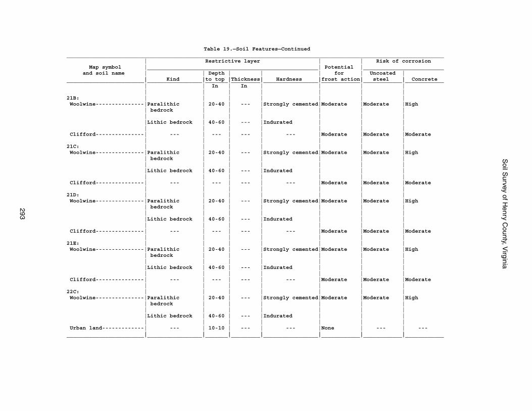
Soil S
urvey of Henry C
ounty, Virginia
293
Table 19.—Soil Features—Continued_____________________________________________________________________________________________________________________ | Restrictive layer | | Risk of corrosion Map symbol |_____________________________________________________| Potential |_________________________ and soil name | | Depth | | | for | Uncoated | | Kind |to top |Thickness| Hardness |frost action| steel | Concrete________________________|_________________|_______|_________|_________________|____________|____________|____________ | | In | In | | | | | | | | | | |21B: | | | | | | | Woolwine---------------|Paralithic | 20-40 | --- |Strongly cemented|Moderate |Moderate |High | bedrock | | | | | | | | | | | | | |Lithic bedrock | 40-60 | --- |Indurated | | | | | | | | | | Clifford---------------| --- | --- | --- | --- |Moderate |Moderate |Moderate | | | | | | |21C: | | | | | | | Woolwine---------------|Paralithic | 20-40 | --- |Strongly cemented|Moderate |Moderate |High | bedrock | | | | | | | | | | | | | |Lithic bedrock | 40-60 | --- |Indurated | | | | | | | | | | Clifford---------------| --- | --- | --- | --- |Moderate |Moderate |Moderate | | | | | | |21D: | | | | | | | Woolwine---------------|Paralithic | 20-40 | --- |Strongly cemented|Moderate |Moderate |High | bedrock | | | | | | | | | | | | | |Lithic bedrock | 40-60 | --- |Indurated | | | | | | | | | | Clifford---------------| --- | --- | --- | --- |Moderate |Moderate |Moderate | | | | | | |21E: | | | | | | | Woolwine---------------|Paralithic | 20-40 | --- |Strongly cemented|Moderate |Moderate |High | bedrock | | | | | | | | | | | | | |Lithic bedrock | 40-60 | --- |Indurated | | | | | | | | | | Clifford---------------| --- | --- | --- | --- |Moderate |Moderate |Moderate | | | | | | |22C: | | | | | | | Woolwine---------------|Paralithic | 20-40 | --- |Strongly cemented|Moderate |Moderate |High | bedrock | | | | | | | | | | | | | |Lithic bedrock | 40-60 | --- |Indurated | | | | | | | | | | Urban land-------------| --- | 10-10 | --- | --- |None | --- | --- | | | | | | |________________________|_________________|_______|_________|_________________|____________|____________|____________
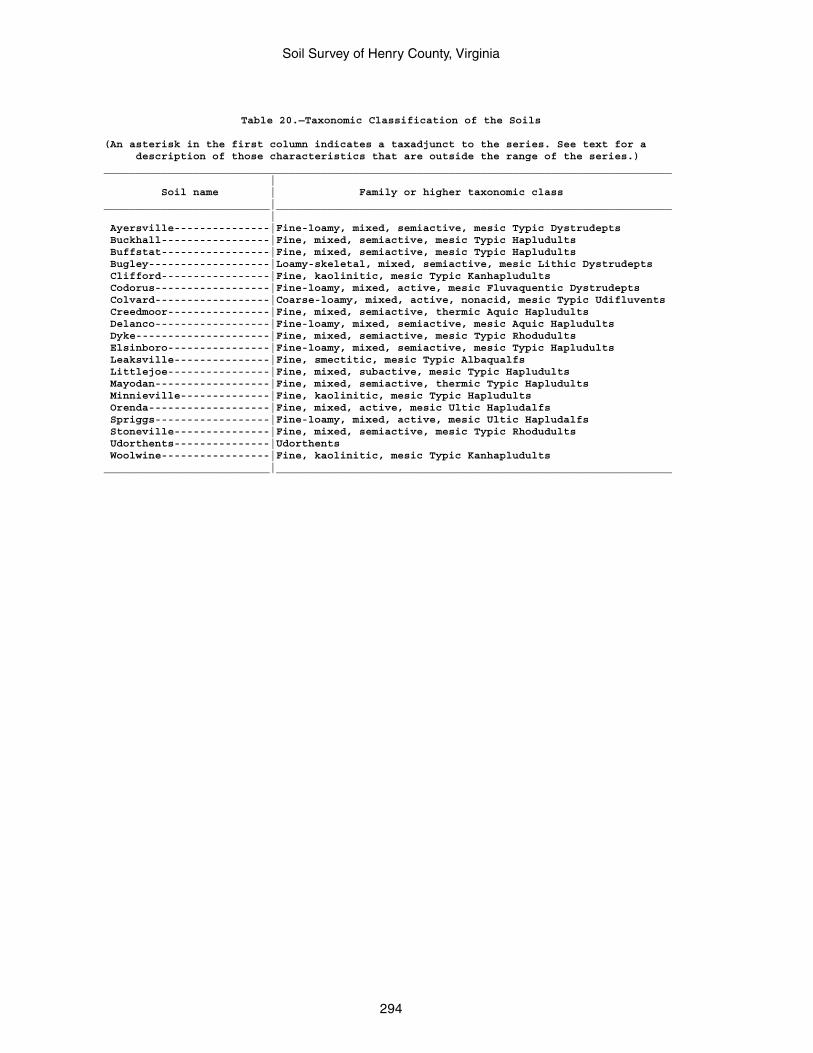
Soil Survey of Henry County, Virginia
294
Table 20.—Taxonomic Classification of the Soils
(An asterisk in the first column indicates a taxadjunct to the series. See text for a description of those characteristics that are outside the range of the series.)_________________________________________________________________________________________ | Soil name | Family or higher taxonomic class__________________________|______________________________________________________________ | Ayersville---------------|Fine-loamy, mixed, semiactive, mesic Typic Dystrudepts Buckhall-----------------|Fine, mixed, semiactive, mesic Typic Hapludults Buffstat-----------------|Fine, mixed, semiactive, mesic Typic Hapludults Bugley-------------------|Loamy-skeletal, mixed, semiactive, mesic Lithic Dystrudepts Clifford-----------------|Fine, kaolinitic, mesic Typic Kanhapludults Codorus------------------|Fine-loamy, mixed, active, mesic Fluvaquentic Dystrudepts Colvard------------------|Coarse-loamy, mixed, active, nonacid, mesic Typic Udifluvents Creedmoor----------------|Fine, mixed, semiactive, thermic Aquic Hapludults Delanco------------------|Fine-loamy, mixed, semiactive, mesic Aquic Hapludults Dyke---------------------|Fine, mixed, semiactive, mesic Typic Rhodudults Elsinboro----------------|Fine-loamy, mixed, semiactive, mesic Typic Hapludults Leaksville---------------|Fine, smectitic, mesic Typic Albaqualfs Littlejoe----------------|Fine, mixed, subactive, mesic Typic Hapludults Mayodan------------------|Fine, mixed, semiactive, thermic Typic Hapludults Minnieville--------------|Fine, kaolinitic, mesic Typic Hapludults Orenda-------------------|Fine, mixed, active, mesic Ultic Hapludalfs Spriggs------------------|Fine-loamy, mixed, active, mesic Ultic Hapludalfs Stoneville---------------|Fine, mixed, semiactive, mesic Typic Rhodudults Udorthents---------------|Udorthents Woolwine-----------------|Fine, kaolinitic, mesic Typic Kanhapludults__________________________|______________________________________________________________
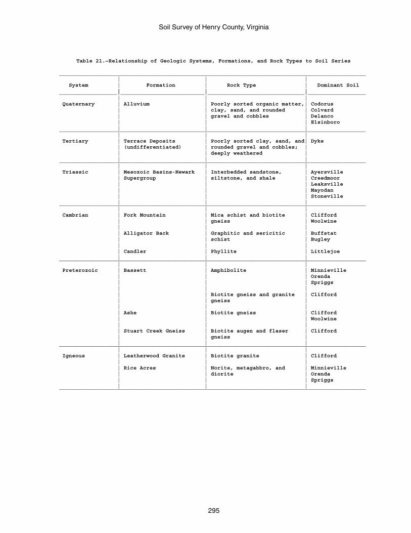
Soil Survey of Henry County, Virginia
295
Table 21.—Relationship of Geologic Systems, Formations, and Rock Types to Soil Series
_______________________________________________________________________________________________ | | | System | Formation | Rock Type | Dominant Soil | | |__________________|__________________________|______________________________|__________________ | | | Quaternary | Alluvium | Poorly sorted organic matter,| Codorus | | clay, sand, and rounded | Colvard | | gravel and cobbles | Delanco | | | Elsinboro | | |_______________________________________________________________________________________________ | | | Tertiary | Terrace Deposits | Poorly sorted clay, sand, and| Dyke | (undifferentiated) | rounded gravel and cobbles; | | | deeply weathered | | | |_______________________________________________________________________________________________ | | | Triassic | Mesozoic Basins-Newark | Interbedded sandstone, | Ayersville | Supergroup | siltstone, and shale | Creedmoor | | | Leaksville | | | Mayodan | | | Stoneville | | |_______________________________________________________________________________________________ | | | Cambrian | Fork Mountain | Mica schist and biotite | Clifford | | gneiss | Woolwine | | | | Alligator Back | Graphitic and sericitic | Buffstat | | schist | Bugley | | | | Candler | Phyllite | Littlejoe | | |_______________________________________________________________________________________________ | | | Preterozoic | Bassett | Amphibolite | Minnieville | | | Orenda | | | Spriggs | | | | | Biotite gneiss and granite | Clifford | | gneiss | | | | | Ashe | Biotite gneiss | Clifford | | | Woolwine | | | | Stuart Creek Gneiss | Biotite augen and flaser | Clifford | | gneiss | | | |_______________________________________________________________________________________________ | | | Igneous | Leatherwood Granite | Biotite granite | Clifford | | | | Rice Acres | Norite, metagabbro, and | Minnieville | | diorite | Orenda | | | Spriggs | | |_______________________________________________________________________________________________

The Natural Resources Conservation Service (NRCS) is committed to making itsinformation accessible to all of its customers and employees. If you are experiencingaccessibility issues and need assistance, please contact our Helpdesk by phone at1-800-457-3642 or by e-mail at [email protected]. For assistance withpublications that include maps, graphs, or similar forms of information, you may alsowish to contact our State or local office. You can locate the correct office and phonenumber at http://offices.sc.egov.usda.gov/locator/app.
NRCS Accessibility Statement