soil survey of coles county, illinois - usda survey of coles county, illinois. ... historic site....
TRANSCRIPT

In cooperation with IllinoisAgricultural ExperimentStation
United StatesDepartment ofAgriculture
NaturalResourcesConservationService
Soil Survey ofColes County,Illinois


This publication consists of a manuscript and a set of soil maps. The informationprovided can be useful in planning the use and management of small areas.
To find information about your area of interest, locate that area on the Index to MapSheets. Note the number of the map sheet and turn to that sheet.
Locate your area of interest on the map sheet. Note the map unit symbols that are inthat area. Turn to the Contents, which lists the map units by symbol and name andshows the page where each map unit is described.
The Contents shows which table has data on a specific land use for each detailedsoil map unit. Also see the Contents for sections of this publication that may addressyour specific needs.
i
How To Use This Soil Survey

Additional information about the Nation’s natural resources is available onlinefrom the Natural Resources Conservation Service at http://www.nrcs.usda.gov.
ii
National Cooperative Soil Survey
This soil survey is a publication of the National Cooperative Soil Survey, a joint effortof the United States Department of Agriculture and other Federal agencies, Stateagencies including the Agricultural Experiment Stations, and local agencies. The NaturalResources Conservation Service (formerly the Soil Conservation Service) hasleadership for the Federal part of the National Cooperative Soil Survey. This survey wasmade cooperatively by the Natural Resources Conservation Service and the IllinoisAgricultural Experiment Station. It is part of the technical assistance furnished to theColes County Soil and Water Conservation District.
Major fieldwork for this soil survey was completed in 2005. Soil names anddescriptions were approved in 2006. Unless otherwise indicated, statements in thispublication refer to conditions in the survey area in 2005. The most current official dataare available on the Internet.
Soil maps in this survey may be copied without permission. Enlargement of thesemaps, however, could cause misunderstanding of the detail of mapping. If enlarged,maps do not show the small areas of contrasting soils that could have been shown at alarger scale.
Nondiscrimination Statement
The U.S. Department of Agriculture (USDA) prohibits discrimination in all its programsand activities on the basis of race, color, national origin, age, disability, and whereapplicable, sex, marital status, familial status, parental status, religion, sexualorientation, genetic information, political beliefs, reprisal, or because all or a part of anindividual’s income is derived from any public assistance program. (Not all prohibitedbases apply to all programs.) Persons with disabilities who require alternative means forcommunication of program information (Braille, large print, audiotape, etc.) shouldcontact USDA’s TARGET Center at (202) 720-2600 (voice and TDD). To file a complaintof discrimination, write to USDA, Director, Office of Civil Rights, 1400 IndependenceAvenue, S.W., Washington, D.C. 20250-9410 or call (800) 795-3272 (voice) or (202) 720-6382 (TDD). USDA is an equal opportunity provider and employer.
Cover Photo Caption
The 1840s home of Thomas and Sarah Bush Lincoln, father and stepmother of the16th President of the United States, Abraham Lincoln, at the Lincoln Log Cabin StateHistoric Site. The two-room replica of the Lincoln cabin is in an area of Xenia silt loam, 2to 5 percent slopes.

iii
Contents
How To Use This Soil Survey ....................................................................................... iNumerical Index to Map Units .................................................................................. viiForeword ..................................................................................................................... ixGeneral Nature of the County ...................................................................................... 1
History and Development ......................................................................................... 1Physiography, Relief, and Drainage ......................................................................... 3Natural Resources ................................................................................................... 6Climate ..................................................................................................................... 8
How This Survey Was Made ........................................................................................ 9Formation and Classification of the Soils .............................................................. 13
Formation of the Soils ............................................................................................ 13Parent Material .................................................................................................. 13Climate .............................................................................................................. 15Plant and Animal Life ......................................................................................... 15Relief ................................................................................................................. 16Time ................................................................................................................... 17
Classification of the Soils ....................................................................................... 17Soil Series and Detailed Soil Map Units ................................................................. 19
Bluford Series ........................................................................................................ 2013A—Bluford silt loam, 0 to 2 percent slopes ........................................................ 2213B—Bluford silt loam, 2 to 5 percent slopes ........................................................ 23Brenton Series ....................................................................................................... 24149A—Brenton silt loam, 0 to 2 percent slopes ..................................................... 26Brooklyn Series ...................................................................................................... 27136A—Brooklyn silt loam, 0 to 2 percent slopes .................................................... 29Brouillett Series ...................................................................................................... 303450A—Brouillett silt loam, 0 to 2 percent slopes, frequently flooded ................... 31Camden Series ...................................................................................................... 327373B—Camden silt loam, sandy substratum, 2 to 5 percent slopes, rarely
flooded ............................................................................................................. 34Cisne Series .......................................................................................................... 342A—Cisne silt loam, 0 to 2 percent slopes ............................................................ 36Dana Series ........................................................................................................... 3756B—Dana silt loam, 2 to 5 percent slopes ........................................................... 4056B2—Dana silt loam, 2 to 5 percent slopes, eroded ............................................ 40Drummer Series ..................................................................................................... 41152A—Drummer silty clay loam, 0 to 2 percent slopes ......................................... 43722A—Drummer-Milford silty clay loams, 0 to 2 percent slopes ............................ 44Ebbert Series ......................................................................................................... 4548A—Ebbert silt loam, 0 to 2 percent slopes ......................................................... 46Fincastle Series ..................................................................................................... 47496A—Fincastle silt loam, 0 to 2 percent slopes ................................................... 49Flanagan Series ..................................................................................................... 50154A—Flanagan silt loam, 0 to 2 percent slopes ................................................... 52Hartsburg Series .................................................................................................... 52

iv
244A—Hartsburg silty clay loam, 0 to 2 percent slopes ......................................... 54Hoyleton Series ...................................................................................................... 553A—Hoyleton silt loam, 0 to 2 percent slopes........................................................ 57Landes Series ........................................................................................................ 583304A—Landes fine sandy loam, 0 to 2 percent slopes, frequently flooded.......... 59830—Landfill .......................................................................................................... 60Lawson Series ....................................................................................................... 603451A—Lawson silt loam, 0 to 2 percent slopes, frequently flooded ..................... 61Lenzburg Series ..................................................................................................... 62871B—Lenzburg gravelly loam, 1 to 5 percent slopes ........................................... 63871D—Lenzburg loam, 7 to 20 percent slopes ...................................................... 63M-W—Miscellaneous water ................................................................................... 64Martinsville Series .................................................................................................. 64570B—Martinsville silt loam, 2 to 5 percent slopes ............................................... 66570C2—Martinsville loam, 5 to 12 percent slopes, eroded .................................... 677570B—Martinsville silt loam, 2 to 5 percent slopes, rarely flooded ...................... 68Milford Series ......................................................................................................... 68722A—Drummer-Milford silty clay loams, 0 to 2 percent slopes ............................ 70Millbrook Series ..................................................................................................... 71219A—Millbrook silt loam, 0 to 2 percent slopes ................................................... 73Peotone Series ....................................................................................................... 74330A—Peotone silty clay loam, 0 to 2 percent slopes ........................................... 75864—Pits, quarry ................................................................................................... 76865—Pits, gravel .................................................................................................... 76Proctor Series ........................................................................................................ 76148B—Proctor silt loam, 2 to 5 percent slopes ...................................................... 78Raub Series ........................................................................................................... 78481A—Raub silt loam, 0 to 2 percent slopes ......................................................... 80Ross Series ........................................................................................................... 813073A—Ross silt loam, 0 to 2 percent slopes, frequently flooded ......................... 82Russell Series ........................................................................................................ 83322B—Russell silt loam, 2 to 5 percent slopes ...................................................... 85322C2—Russell silt loam, 5 to 10 percent slopes, eroded..................................... 85Sawmill Series ....................................................................................................... 863107A—Sawmill silty clay loam, 0 to 2 percent slopes, frequently flooded ............ 88Senachwine Series ................................................................................................ 89618C2—Senachwine silt loam, 5 to 10 percent slopes, eroded ............................. 90618C3—Senachwine clay loam, 5 to 10 percent slopes, severely eroded ............. 91618D2—Senachwine silt loam, 10 to 18 percent slopes, eroded ........................... 92618D3—Senachwine clay loam, 10 to 18 percent slopes, severely eroded ........... 93618F—Senachwine silt loam, 18 to 35 percent slopes .......................................... 94618G—Senachwine silt loam, 35 to 60 percent slopes .......................................... 95Shiloh Series .......................................................................................................... 96138A—Shiloh silty clay loam, 0 to 2 percent slopes............................................... 97Shoals Series ......................................................................................................... 983424A—Shoals silt loam, 0 to 2 percent slopes, frequently flooded ...................... 99Somonauk Series ................................................................................................. 100668B2—Somonauk silt loam, 2 to 5 percent slopes, eroded ............................... 102Starks Series ....................................................................................................... 103132A—Starks silt loam, 0 to 2 percent slopes ..................................................... 1057132A—Starks silt loam, 0 to 2 percent slopes, rarely flooded ............................ 106Thorp Series ........................................................................................................ 106206A—Thorp silt loam, 0 to 2 percent slopes ...................................................... 108Tice Series ........................................................................................................... 109

v
3284A—Tice silty clay loam, 0 to 2 percent slopes, frequently flooded ............... 110Toronto Series ...................................................................................................... 111353A—Toronto silt loam, 0 to 2 percent slopes .................................................... 113533—Urban land .................................................................................................. 114W—Water ............................................................................................................. 114Wingate Series ..................................................................................................... 114348B—Wingate silt loam, 2 to 5 percent slopes .................................................. 116Wirt Series ........................................................................................................... 1173226A—Wirt silt loam, 0 to 2 percent slopes, frequently flooded ......................... 118Xenia Series......................................................................................................... 119291B—Xenia silt loam, 2 to 5 percent slopes ...................................................... 120
Use and Management of the Soils ........................................................................ 123Interpretive Ratings .............................................................................................. 123
Rating Class Terms.......................................................................................... 123Numerical Ratings ........................................................................................... 123
Crops and Pasture ............................................................................................... 124Limitations Affecting Cropland and Pastureland .............................................. 124Erosion Control ................................................................................................ 131Conservation Tillage ........................................................................................ 133Drainage Systems ........................................................................................... 133Yields per Acre ................................................................................................ 134Land Capability Classification .......................................................................... 135Prime Farmland ............................................................................................... 136
Hydric Soils .......................................................................................................... 137Windbreaks and Environmental Plantings............................................................ 138Forestland ............................................................................................................ 139Recreation............................................................................................................ 140Wildlife Habitat ..................................................................................................... 142Engineering .......................................................................................................... 146
Building Site Development ............................................................................... 147Sanitary Facilities ............................................................................................. 149Construction Materials ..................................................................................... 151Water Management ......................................................................................... 152
Soil Properties ........................................................................................................ 155Engineering Index Properties ............................................................................... 155Physical Properties .............................................................................................. 156Chemical Properties ............................................................................................ 158Water Features .................................................................................................... 159Soil Features ........................................................................................................ 161Engineering Index Test Data ................................................................................ 162
References .............................................................................................................. 163Glossary .................................................................................................................. 167Tables ...................................................................................................................... 189
Table 1.—Temperature and Precipitation ............................................................. 190Table 2.—Freeze Dates in Spring and Fall ........................................................... 191Table 3.—Growing Season .................................................................................. 191Table 4.—Classification of the Soils ..................................................................... 192Table 5.—Acreage and Proportionate Extent of the Soils .................................... 193Table 6.—Limitations and Hazards Affecting Cropland and Pastureland ............. 194Table 7.—Land Capability and Yields per Acre of Crops and Pasture .................. 197Table 8.—Prime Farmland ................................................................................... 200Table 9.—Hydric Soils .......................................................................................... 201Table 10.—Windbreaks and Environmental Plantings .......................................... 205Table 11.—Forestland Productivity ....................................................................... 219

vi
Issued 2008
Table 12a.—Recreational Development ............................................................... 223Table 12b.—Recreational Development ............................................................... 229Table 13.—Wildlife Habitat ................................................................................... 234Table 14a.—Building Site Development ............................................................... 238Table 14b.—Building Site Development ............................................................... 243Table 15a.—Sanitary Facilities ............................................................................. 250Table 15b.—Sanitary Facilities ............................................................................. 257Table 16a.—Construction Materials ..................................................................... 263Table 16b.—Construction Materials ..................................................................... 268Table 17a.—Water Management .......................................................................... 275Table 17b.—Water Management .......................................................................... 281Table 18.—Engineering Index Properties ............................................................. 288Table 19.—Physical Properties of the Soils ......................................................... 298Table 20.—Chemical Properties of the Soils ........................................................ 306Table 21.—Water Features .................................................................................. 312Table 22.—Soil Features ...................................................................................... 316Table 23.—Engineering Index Test Data .............................................................. 319

vii
2A—Cisne silt loam, 0 to 2 percent slopes ................................................................. 363A—Hoyleton silt loam, 0 to 2 percent slopes ............................................................ 5713A—Bluford silt loam, 0 to 2 percent slopes ............................................................. 2213B—Bluford silt loam, 2 to 5 percent slopes ............................................................. 2348A—Ebbert silt loam, 0 to 2 percent slopes ............................................................. 4656B—Dana silt loam, 2 to 5 percent slopes ............................................................... 4056B2—Dana silt loam, 2 to 5 percent slopes, eroded ................................................ 40132A—Starks silt loam, 0 to 2 percent slopes .......................................................... 105136A—Brooklyn silt loam, 0 to 2 percent slopes ........................................................ 29138A—Shiloh silty clay loam, 0 to 2 percent slopes ................................................... 97148B—Proctor silt loam, 2 to 5 percent slopes .......................................................... 78149A—Brenton silt loam, 0 to 2 percent slopes ......................................................... 26152A—Drummer silty clay loam, 0 to 2 percent slopes .............................................. 43154A—Flanagan silt loam, 0 to 2 percent slopes ....................................................... 52206A—Thorp silt loam, 0 to 2 percent slopes .......................................................... 108219A—Millbrook silt loam, 0 to 2 percent slopes........................................................ 73244A—Hartsburg silty clay loam, 0 to 2 percent slopes ............................................. 54291B—Xenia silt loam, 2 to 5 percent slopes ........................................................... 120322B—Russell silt loam, 2 to 5 percent slopes .......................................................... 85322C2—Russell silt loam, 5 to 10 percent slopes, eroded ......................................... 85330A—Peotone silty clay loam, 0 to 2 percent slopes ................................................ 75348B—Wingate silt loam, 2 to 5 percent slopes ....................................................... 116353A—Toronto silt loam, 0 to 2 percent slopes ........................................................ 113481A—Raub silt loam, 0 to 2 percent slopes ............................................................. 80496A—Fincastle silt loam, 0 to 2 percent slopes ....................................................... 49533—Urban land ...................................................................................................... 114570B—Martinsville silt loam, 2 to 5 percent slopes .................................................... 66570C2—Martinsville loam, 5 to 12 percent slopes, eroded ........................................ 67618C2—Senachwine silt loam, 5 to 10 percent slopes, eroded ................................. 90618C3—Senachwine clay loam, 5 to 10 percent slopes, severely eroded ................. 91618D2—Senachwine silt loam, 10 to 18 percent slopes, eroded ............................... 92618D3—Senachwine clay loam, 10 to 18 percent slopes, severely eroded ............... 93618F—Senachwine silt loam, 18 to 35 percent slopes ............................................... 94618G—Senachwine silt loam, 35 to 60 percent slopes .............................................. 95668B2—Somonauk silt loam, 2 to 5 percent slopes, eroded .................................... 102722A—Drummer-Milford silty clay loams, 0 to 2 percent slopes .......................... 44, 70830—Landfill .............................................................................................................. 60864—Pits, quarry ....................................................................................................... 76865—Pits, gravel ........................................................................................................ 76871B—Lenzburg gravelly loam, 1 to 5 percent slopes ............................................... 63871D—Lenzburg loam, 7 to 20 percent slopes .......................................................... 633073A—Ross silt loam, 0 to 2 percent slopes, frequently flooded ............................. 823107A—Sawmill silty clay loam, 0 to 2 percent slopes, frequently flooded ................ 883226A—Wirt silt loam, 0 to 2 percent slopes, frequently flooded ............................. 1183284A—Tice silty clay loam, 0 to 2 percent slopes, frequently flooded .................... 110
Numerical Index to Map Units

viii
3304A—Landes fine sandy loam, 0 to 2 percent slopes, frequently flooded .............. 593424A—Shoals silt loam, 0 to 2 percent slopes, frequently flooded........................... 993450A—Brouillett silt loam, 0 to 2 percent slopes, frequently flooded........................ 313451A—Lawson silt loam, 0 to 2 percent slopes, frequently flooded ......................... 617132A—Starks silt loam, 0 to 2 percent slopes, rarely flooded ................................ 1067373B—Camden silt loam, sandy substratum, 2 to 5 percent slopes, rarely
flooded ................................................................................................................... 347570B—Martinsville silt loam, 2 to 5 percent slopes, rarely flooded .......................... 68M-W—Miscellaneous water ........................................................................................ 64W—Water ................................................................................................................. 114

ix
Soil surveys contain information that affects land use planning in survey areas. Theyinclude predictions of soil behavior for selected land uses. The surveys highlight soillimitations, improvements needed to overcome the limitations, and the impact ofselected land uses on the environment.
Soil surveys are designed for many different users. Farmers, foresters, andagronomists can use the surveys to evaluate the potential of the soil and themanagement needed for maximum food and fiber production. Planners, communityofficials, engineers, developers, builders, and home buyers can use the surveys toplan land use, select sites for construction, and identify special practices needed toensure proper performance. Conservationists, teachers, students, and specialists inrecreation, wildlife management, waste disposal, and pollution control can use thesurveys to help them understand, protect, and enhance the environment.
Various land use regulations of Federal, State, and local governments may imposespecial restrictions on land use or land treatment. The information in this report isintended to identify soil properties that are used in making various land use or landtreatment decisions. Statements made in this report are intended to help the landusers identify and reduce the effects of soil limitations on various land uses. Thelandowner or user is responsible for identifying and complying with existing laws andregulations.
Great differences in soil properties can occur within short distances. Some soils areseasonally wet or subject to flooding. Some are too unstable to be used as afoundation for buildings or roads. Clayey or wet soils are poorly suited to use as septictank absorption fields. A high water table makes a soil poorly suited to basements orunderground installations.
These and many other soil properties that affect land use are described in this soilsurvey. The location of each map unit is shown on the detailed soil maps. Each soil inthe survey area is described, and information on specific uses is given. Help in usingthis publication and additional information are available at the local office of the NaturalResources Conservation Service or the Cooperative Extension Service.
William J. GradleState ConservationistNatural Resources Conservation Service
Foreword


1
COLES COUNTY is in east-central Illinois (fig. 1). It has an area of 326,445 acres, orabout 509 square miles. The county is bordered on the north by Douglas County, onthe west by Moultrie and Shelby Counties, on the south by Cumberland County, andon the east by Edgar and Clark Counties. In 2004, the population of Coles County wasestimated at 51,460. This estimate represents a decrease in population of about 3.3percent from 2000 to 2004. Charleston, the county seat and largest city in the county,had an estimated population of 20,201 in 2005 (U.S. Department of Commerce, 2006).
The survey area is a subset of Major Land Resource Areas (MLRAs) 108A, Illinoisand Iowa Deep Loess and Drift, Eastern Part, and 113, Central Claypan Areas(USDA/NRCS, 2006).
This soil survey updates the previous surveys of Coles County published in 1993and 1929 (Hamilton, 1993; Smith and others, 1929). It provides additional informationand has larger maps, which show the soils in greater detail.
General Nature of the CountyThis section provides general information about Coles County. It describes history
and development; physiography, relief, and drainage; natural resources; and climate.
History and Development
Illinois Indian tribes, such as the Kaskaskia and Cahokia, were among the firstpeople to inhabit the survey area. Their numbers were depleted following wars withneighboring Iroquois Indians in the 1680s. Northern tribes, such as the Sauk, Fox,Kickapoo, and Potawatomi, waged wars against the Illinois in the late 1700s and killedor drove all but a remnant from most of the state. Several Indian battles werepurportedly fought in present-day Coles County in 1815 and again in 1818. The last ofthe surviving Illinois Indians settled near Kaskaskia, Illinois. The Indian Removal Act of
Soil Survey of
Coles County, IllinoisBy Christopher C. Cochran, Natural Resources Conservation Service
Geographic information assistance provided by Jon Bonjean, NaturalResources Conservation Service
Original fieldwork by Gary Hamilton, Soil Conservation Service, andAl Pasteris and Bruce Houghtby, Coles County
Updated fieldwork by Christopher Cochran, Troy Fehrenbacher,Zach Weber, and Ron Collman, Natural Resources Conservation Service
United States Department of Agriculture, Natural Resources ConservationService, in cooperation with the Illinois Agricultural Experiment Station

2 Soil Survey of
1830 provided funds for President Andrew Jackson to conduct land-exchange treatieswith Indian tribes. In 1832, following the Black Hawk War, the remaining Indian tribes inthe state participated in the land exchange and moved to what are now the states ofKansas and Oklahoma (Access Genealogy, 2006).
LEGEND
95B—Southern Wisconsin and Northern Illinois Drift Plain
97—Southwestern Michigan Fruit and Truck Crop Belt
98—Southern Michigan and Northern Indiana Drift Plain
105—Northern Mississippi Valley Loess Hills
108A and 108B—Illinois and Iowa Deep Loess and Drift
110—Northern Illinois and Indiana Heavy Till Plain
113—Central Claypan Areas
114B—Southern Illinois and Indiana Thin Loess and Till Plain, Western Part
115A, 115B, and 115C—Central Mississippi Valley Wooded Slopes
120A—Kentucky and Indiana Sandstone and Shale Hills and Valleys, Southern Part
131A—Southern Mississippi River Alluvium
134—Southern Mississippi Valley Loess
Figure 1.—Location of Coles County and the major land resource areas (MLRAs) in Illinois.
Coles County, Illinois 3
In 1824, the first settlers arrived in the survey area and settled along the easternbank of the Embarras River. Coles County was set off from Clark County andestablished on December 25, 1830. At that time, Coles County included the areas thatare now Cumberland and Douglas Counties. On February 8, 1859, Coles Countyassumed its current shape when Douglas County separated from it. The county wasnamed after Edward Coles, the second Governor of the State of Illinois (IllinoisGenWeb Project, 2005).
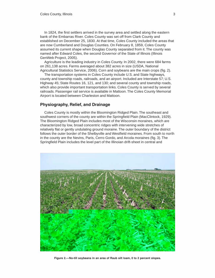
Agriculture is the leading industry in Coles County. In 2002, there were 684 farmson 261,138 acres. Farms averaged about 382 acres in size (USDA, NationalAgricultural Statistics Service, 2006). Corn and soybeans are the main crops (fig. 2).
The transportation systems in Coles County include U.S. and State highways,county and township roads, railroads, and an airport. Included are Interstate 57; U.S.Highway 45; State Routes 16, 121, and 130; and several county and township roads,which also provide important transportation links. Coles County is served by severalrailroads. Passenger rail service is available in Mattoon. The Coles County MemorialAirport is located between Charleston and Mattoon.
Physiography, Relief, and Drainage
Coles County is mostly within the Bloomington Ridged Plain. The southeast andsouthwest corners of the county are within the Springfield Plain (MacClintock, 1929).The Bloomington Ridged Plain includes most of the Wisconsin moraines, which arecharacterized by low, broad concentric ridges with intervening wide stretches ofrelatively flat or gently undulating ground moraine. The outer boundary of the districtfollows the outer border of the Shelbyville and Westfield moraines. From south to northin the county are the Nevins, Paris, Cerro Gordo, and Arcola moraines (fig. 3). TheSpringfield Plain includes the level part of the Illinoian drift-sheet in central and
Figure 2.—No-till soybeans in an area of Raub silt loam, 0 to 2 percent slopes.


Coles County, Illinois 5
The Tiskilwa Formation is the oldest and lowermost diamicton unit of theWisconsinan Episode. The formation is divided into the Delavan and Piatt Members.The Delavan Member, formerly classified as Fairgrange Till, consists of calcareous,brown gray loam diamicton that contains lenses of gravel, sand, silt, or clay. Theaverage thickness in Coles County is 40 to 60 feet. The Delavan Member wasdeposited between 26,000 and 18,500 years ago. The Piatt Member consists of grayloam diamicton containing lenses of sorted sediment. It is sandier, grayer, and moreillitic than the underlying Delavan Member. The average thickness of this member inColes County is similar to that of the Delavan Member. The Piatt Member wasdeposited 19,000 to 18,500 years ago (Hansel and Johnson, 1996).
The Lemont Formation overlies the Tiskilwa Formation. The till in the LemontFormation, although quite varied over its entire extent, tends to be grayer, more silty,and more illitic than the till of the Tiskilwa Formation. This formation is not as thick asthe Tiskilwa Formation and contains fewer far-traveled erratics. The Lemont Formationis divided into three members: the Batestown, Yorkville, and Haeger Members. Onlythe Batestown Member is represented in Coles County. The Batestown Memberconsists of calcareous gray loam diamicton. The thickness of the Batestown Memberin Coles County is about the same as that of the Delavan and Piatt Members. TheBatestown Member was deposited about 18,500 to 17,700 years ago (Hansel andJohnson, 1996).
The Henry Formation is defined as glacial outwash, predominantly sand and gravel,that occurs above the Sangamon Geosol and is either at or near the surface oroverlain by loess (Willman and Frye, 1970). A broad, coarse textured terrace system,known as the Mackinaw facies of the Henry Formation, extends south out of thecounty parallel to the present-day Little Wabash River (Hansel and Johnson, 1996).These sand and gravel valley train sediments were deposited predominantly during thelate Wisconsinan Episode meltout. As the Wisconsinan glaciers were retreating fromnorthern Illinois, a large volume of sediment-laden water moved down the preglacialWabash River valley and deposited sand and gravel across the former flood plain formany miles. These present-day terraces provide a very good mineral resource forsand and gravel. An ice-contact deposit of sand and gravel in the form of a kame oresker, known as the Wasco facies of the Henry Formation, is located just northeast ofCharleston. This area is pockmarked with small played-out gravel pits, whichundoubtedly served as a source of sand and gravel for building Charleston and thesurrounding roads and railroads. The Batavia facies of the Henry Formation ischaracterized by upland outwash plains that form a skirt, 1 to 3 miles wide, all alongthe leading edge of the terminal moraine of the Wisconsinan Episode (Hansel andJohnson, 1996). The outwash is typically stratified sand, silt, and gravel.
Peoria Silt, also known as windblown silt or Richland loess, covers most of theuplands in the county. This material overlies both till and outwash and is as much as 5feet thick. The surface of this formation typically coincides with the surface of themodern soil. It was deposited over an 8,000-year period, 20,000 to 12,000 years ago.
The Cahokia Formation consists mainly of poorly sorted silt, clay, and silty sand. Itsthickness varies greatly but generally does not exceed 50 feet. It typically occurs onmodern flood plains. The surface of the formation commonly is the surface of the floodplain and the modern soil. In places it is overlain by windblown sand, loess, orcolluvium from side slopes (Willman and others, 1975).
Bedrock outcrops occur along the Embarras River and Polecat Creek northeast ofCharleston (fig. 4). Pennsylvanian limestone is currently being quarried near this area.
The relief in Coles County is low in the nearly level and gently sloping uplands. Thegreatest change in relief is in areas along major drainageways and terminal moraines,where a drop in elevation of more than 75 feet from the adjacent uplands can occur.

6 Soil Survey of
The highest elevation in the county, slightly more than 780 feet above sea level, isabout 2 miles south-southeast of the city of Mattoon on the Shelbyville Moraine. Thelowest elevation is approximately 550 feet above sea level at the point where theEmbarras River drains into Cumberland County. The elevation cross-section in figure 5depicts topographic changes along a straight line across the county from thenorthwest corner to the southeast corner. The geological materials and theirthicknesses are drawn in for illustrative purposes and do not represent actualmeasurements taken along this transect.
The Kaskaskia, Embarras, and Little Wabash Rivers drain most of the county(fig. 6). The Kaskaskia River flows west-southwest and empties into Lake Shelbyville.The Embarras River ultimately drains into the Wabash River in Lawrence County. TheLittle Wabash River drains into the Wabash River in Gallatin County.
The flood plains along these rivers and their tributaries generally are floodedannually, and most of the soils in these areas have a seasonal high water table.
Most areas are sufficiently drained for the crops commonly grown in the county.Subsurface tile drains have been installed in fields across the county.
Natural Resources
Oil, sand and gravel, and limestone are the primary mineral resources beingextracted in Coles County. At present, coal is not commercially produced in ColesCounty. Oil production began in 1906, and oil continues to be a valuable mineralresource in the county (fig. 7). In 2004, 44,500 barrels of oil valued at more than$1,500,000 were extracted from five proven fields. The total production over a 100-year span has been 26,500,000 barrels (Illinois State Geological Survey, 2006).
Figure 4.—An outcrop of shale and sandstone along Polecat Creek.

Coles County, Illinois 7
Soil is a major natural resource in Coles County. Natural fertility in the soils rangesfrom low to high. With the additions of fertilizers and lime, most of the soils are wellsuited to the cultivation of crops, particularly corn and soybeans. Many of the soils arenearly level or gently sloping and formed in medium textured material under prairiegrass or under forest vegetation or mixed forest and grass. Combined with a favorableclimate, these factors result in good potential for highly productive farmland.
At the time of settlement, about 32 percent of the county was forested (Iverson andothers, 1989). About 39,000 acres in Coles County still supports woodland. Most of the
Figure 5.—Elevation cross-section of Coles County, Illinois. Source: 3-D TopoQuads. Copyright1999, DeLorme, Yarmouth, ME 04096; Datum NAD 27.
Figure 6.—A spillway on the Embarras River helps to control erosion. Oak and hickory are in anarea of Senachwine soils on the far bank.

8 Soil Survey of
woodland is along the major streams and their tributaries. The areas that are stillwooded are mainly areas that are not well suited to farming because of the slope, lowfertility, or a shallow depth to bedrock. The woodland in the county provides importantwildlife habitat, watershed protection, and recreational areas.
The county has approximately 1,550 acres of impounded water. Lake Charleston,the largest single body of impounded water, makes up about 346 acres of this total.Lake Paradise is 166 acres. Lake Mattoon is 1,050 acres, about 120 acres of which isin Coles County. The remaining 918 acres of impounded water is in about 600 smalllakes and farm ponds scattered throughout the county or in gravel pit ponds along theEmbarras, Kaskaskia, and Little Wabash Rivers.
About 25 percent of the county is underlain by sand and gravel aquifers in the fill ofriver valleys or in buried valleys and potential aquifers in areas where till is thick(Illinois State Geological Survey, 2006). These areas are mostly tapped for privatewater supplies for small municipalities and rural residents. The city of Charleston usessurface water from Lake Charleston, and the city of Mattoon uses surface water fromLake Paradise (Illinois Environmental Protection Agency, 2005).
Climate
Table 1 gives data on temperature and precipitation for the survey area as recordedat Charleston in the period 1971 to 2000. Table 2 shows probable dates of the firstfreeze in fall and the last freeze in spring. Table 3 provides data on the length of thegrowing season.
In winter, the average temperature is 30.4 degrees F and the average dailyminimum temperature is 22.3 degrees. The lowest temperature during the period of
Figure 7.—This oil well is in an area of Raub and Drummer soils.

Coles County, Illinois 9
record, which occurred at Charleston on January 19, 1994, was -27 degrees. Insummer, the average temperature is 74.4 degrees and the average daily maximumtemperature is 84.6 degrees. The highest temperature, which occurred at Charlestonon July 14, 1936, was 110 degrees.
Growing degree days are shown in table 1. They are equivalent to “heat units.”During the month, growing degree days accumulate by the amount that the averagetemperature each day exceeds a base temperature (50 degrees F). The normalmonthly accumulation is used to schedule single or successive plantings of a cropbetween the last freeze in spring and the first freeze in fall.
The average annual total precipitation is about 41.8 inches. Of this total, about 26.7inches, or 64 percent, usually falls in April through October. The growing season formost crops falls within this period. The heaviest 1-day rainfall on record was 6.5 inchesat Charleston on June 28, 1957. Thunderstorms occur on about 48 days each year,and most occur between April and August.
The average seasonal snowfall is 23.1 inches. The greatest snow depth at any onetime during the period of record was 24 inches recorded on January 7, 1996. On anaverage, 30 days per year have at least 1 inch of snow on the ground. The heaviest1-day snowfall during the period of record was 12 inches recorded on January 30, 1982.
The average relative humidity in midafternoon is about 52 percent in May and Juneand about 70 percent in December. Humidity is higher at night, and the average atdawn is about 84 percent in most months. The sun shines 70 percent of the timepossible in summer and 48 percent in winter. The prevailing wind is from the south,except in January, February, and March, when it is from the northwest. Averagewindspeed is highest, around 13 miles per hour, in March.
How This Survey Was MadeLand resource regions (LRRs) and their component major land resource areas
(MLRAs) serve as a basis for making decisions about national and regionalagricultural and natural resources concerns. These land categories groupgeographical areas that are characterized by a particular pattern of soils, climate,water resources, and land use. Major land resource areas are geographicallyassociated land resource units that share a common land use, elevation, topography,climate, water, soils, and potential natural vegetation (USDA/NRCS, 2006). ColesCounty is in the Central Feed Grains and Livestock Land Resource Region and inMLRAs 108A, Illinois and Iowa Deep Loess and Drift, Eastern Part, and 113, CentralClaypan Areas (fig. 1).
Soil surveys are updated as part of maintenance projects that are conducted for anMLRA or other region. Maintaining and coordinating soil survey information within abroad area result in uniformly delineated and joined soil maps and in coordinatedinterpretations and map unit descriptions for areas within each MLRA.
Updated soil survey information is coordinated within the MLRA or other region andmeets the standards established and defined in the memorandum of understanding.Soil surveys that are consistent and uniform within a broad area enable thecoordination of soil management recommendations and a uniform program applicationof soil information.
The current survey was made to provide updated information about the soils andmiscellaneous areas in Coles County. Map unit design and the detailed soil map unitdescriptions are based on the occurrence of each soil throughout the MLRAs. Theinformation in this survey includes a description of the soils and miscellaneous areasand their location and a discussion of their suitability, limitations, and management forspecified uses.
Soil scientists observed the steepness, length, and shape of the slopes; the generalpattern of drainage; and the kinds of crops and native plants. They studied the soil

10 Soil Survey of
profile, which is the sequence of natural layers, or horizons, in a soil. The profileextends from the surface down into the unconsolidated material in which the soilformed. The unconsolidated material is devoid of roots and other living organisms andhas not been changed by other biological activity.
The soils and miscellaneous areas in the survey area are in an orderly pattern thatis related to the geology, landforms, relief, climate, and natural vegetation of the area.Each kind of soil and miscellaneous area is associated with a particular kind oflandform or with a segment of the landform. By observing the soils and miscellaneousareas in the survey area and relating their position to specific segments of thelandform, a soil scientist develops a concept, or model, of how they were formed.Thus, during mapping, this model enables the soil scientist to predict with aconsiderable degree of accuracy the kind of soil or miscellaneous area at a specificlocation on the landform.
Commonly, individual soils on the landscape merge into one another as theircharacteristics gradually change. To construct an accurate soil map, however, soilscientists must determine the boundaries between the soils. They can observe only alimited number of soil profiles. Nevertheless, these observations, supplemented by anunderstanding of the soil-vegetation-landscape relationship, are sufficient to verifypredictions of the kinds of soil in an area and to determine the boundaries.
Soil scientists recorded the characteristics of the soil profiles that they studied. Theynoted soil color, texture, size and shape of soil aggregates, kind and amount of rockfragments, distribution of plant roots, reaction, and other features that enable them toidentify soils. After describing the soils in the survey area and determining theirproperties, the soil scientists assigned the soils to taxonomic classes (units).Taxonomic classes are concepts. Each taxonomic class has a set of soilcharacteristics with precisely defined limits. The classes are used as a basis forcomparison to classify soils systematically. Soil taxonomy, the system of taxonomicclassification used in the United States, is based mainly on the kind and character ofsoil properties and the arrangement of horizons within the profile. After the soilscientists classified and named the soils in the survey area, they compared theindividual soils with similar soils in the same taxonomic class in other areas so thatthey could confirm data and assemble additional data based on experience andresearch.
While a soil survey is in progress, samples of some of the soils in the area generallyare collected for laboratory analyses and for engineering tests. Soil scientists interpretthe data from these analyses and tests as well as the field-observed characteristicsand the soil properties to determine the expected behavior of the soils under differentuses. Interpretations for all of the soils are field tested through observation of the soilsin different uses and under different levels of management. Some interpretations aremodified to fit local conditions, and some new interpretations are developed to meetlocal needs. Data are assembled from other sources, such as research information,production records, and field experience of specialists. For example, data on cropyields under defined levels of management are assembled from farm records and fromfield or plot experiments on the same kinds of soil.
Predictions about soil behavior are based not only on soil properties but also onsuch variables as climate and biological activity. Soil conditions are predictable overlong periods of time, but they are not predictable from year to year. For example, soilscientists can predict with a fairly high degree of accuracy that a given soil will have ahigh water table within certain depths in most years, but they cannot predict that a highwater table will always be at a specific level in the soil on a specific date.
The soil survey information in this report was based on a review of field notes,laboratory data, and other data collected during the previous soil survey of ColesCounty (Hamilton, 1993). In addition, data from other soil surveys within MLRAs 108Aand 113 were reviewed, and selected soils were resampled to a greater depth than in

Coles County, Illinois 11
previous surveys. Reviewing data on a regional basis results in improved consistencyin the identification and classification of soils on similar landscapes and in moreconsistent interpretation of soil properties.
Aerial photographs used in this survey were taken in 1998 and 1999. Soil scientistsalso studied U.S. Geological Survey topographic maps (enlarged to a scale of1:12,000) and orthophotographs to relate land and image features. Specific soilboundaries were drawn on the orthophotographs. Adjustments of soil boundary lineswere made to coincide with the U.S. Geological Survey topographic map contour linesand tonal patterns on aerial photographs.


13
This section relates the soils in the survey area to the major factors of soil formationand describes the system of soil classification.
Formation of the SoilsSoil is produced by soil-forming processes acting on materials deposited or
accumulated by geologic agents. The characteristics of the soil are determined by(1) the physical and mineralogical composition of the parent material; (2) the climateunder which the soil formed; (3) the plant and animal life on and in the soil; (4) therelief, or lay of the land; and (5) the length of time the forces of soil formation haveacted on the parent material (Jenny, 1941).
Climate and plant and animal life are the active factors of soil formation. They actdirectly on the parent material, either in place or after it has been relocated by water,glaciers, or the wind. They slowly change the parent material to a natural body that hasgenetically related layers, or horizons. The effects of climate and plant and animal lifeare modified by relief. In sloping areas, for example, erosion can inhibit the processesof soil formation. Wetness can slow these processes in level areas or depressions.Parent material also affects the kind of soil profile that is formed. Finally, time isneeded for changing the parent material into a soil profile that has clearly differentiatedhorizons.
The factors of soil formation are so closely interrelated in their effects on the soilthat few generalizations can be made regarding the effects of any one factor unlessthe effects of the other factors are known. Many of the processes of soil formation areunknown.
Parent Material
Parent material is the unconsolidated geologic material in which a soil forms. Itdetermines the chemical and mineralogical composition of the soil. Most of the parentmaterial in Coles County is a direct result of the glaciers and sediments of the Illinoianand Wisconsinan Age (Willman and Frye, 1970). Although the kinds of parent materialare associated with glacial deposits, the properties vary greatly, mostly because ofvarying methods of deposition. The dominant kinds of parent material in Coles Countyare till, outwash, loess, and alluvium. These materials were deposited by wind, water,glaciers, or glacial meltwater. In some areas, the materials have been reworked bywind or water after they were deposited. Many of the soils formed in more than onekind of parent material. For example, many of the soils in Coles County formed inloess and in the underlying sediment or till (fig. 8).
Till is material laid down directly by glaciers. It consists of clay, silt, sand, gravel, andboulders, all of which are mixed together. The gravel has distinct edges and corners,indicating that it has not been subjected to intensive washing by water. Unweatheredtill is generally alkaline, calcareous, and very dense. Through the processes of soilformation, the upper 1 to 2 meters of the till that is exposed to biological activitybecomes less alkaline and less dense. Senachwine soils are examples of soils thatformed in till.
Formation and Classification ofthe Soils

14 Soil Survey of
Outwash is stratified material deposited by flowing glacial meltwaters. The size ofthe particles that make up outwash varies, depending on the velocity of the movingwater. Typically, outwash is dominated by material that is fine sand or coarser. Thecoarser material was deposited nearer to the ice or in rapidly moving glacial meltwaterstreams. Most of the outwash deposits were later covered by loess. In Coles County,coarse outwash material is in glacial valley areas now dominated by stream terracesor on small kames or eskers. Stratified, medium textured outwash material wasdeposited in an outwash plain all along the leading edge of the Shelbyville andWestfield moraines. Martinsville and Millbrook soils are examples of soils that formedin outwash. These soils commonly occur on stream terraces or outwash plains.
Loess is material deposited by the wind. It consists of uniform, silt-sized particlesthat were typically calcareous before being acted upon by soil-forming factors. Themeltwaters from the glaciers carried vast quantities of silt, which were deposited in themajor river valleys. As these sediments were exposed when the meltwaters subsided,the winds carried the silts and deposited them over much of the land. Most of the soilsin the county formed at least partially in loess. The thickness of the loess variesgreatly, ranging from virtually none in areas where slopes are very steep to more than50 inches on the Springfield Plain in the southeast and southwest corners of thecounty. Hoyleton, Cisne, Ebbert, and Shiloh soils are in these latter areas.
Alluvium is material that was deposited by floodwater from modern streams. Soilsthat formed in alluvium are generally stratified in both color and texture. The alluvialsoils mostly consist of silty sediments, but in some places the soils have thin layers ofloamy and sandy material. Brouillett, Landes, Shoals, and Wirt soils formed in loamyalluvium, and Lawson, Sawmill, and Tice soils formed in silty sediments. All of thesesoils occur on active flood plains and are relatively younger than many of the othersoils in the county. Consequently, these soils have a weakly developed subsoil. Thelargest areas of alluvial soils are along the Embarras River and its tributaries.
Figure 8.—A typical relationship between soils and landscape in Coles County, Illinois.

Coles County, Illinois 15
Climate
Coles County has a temperate, humid, continental climate that is essentially uniformthroughout the county. Climatic differences within the county are too small to havecaused any obvious differences among the soils. In some areas of the county, theeffects of climate are modified locally by relief. The influence of climate becomes moreobvious, however, when comparisons are made on a broad regional basis.
Climate affects soil formation through its influence on weathering, plant and animallife, and erosion. Water from rains and melting snow seeps slowly downward throughthe soil and allows physical and chemical reactions to take place in the parentmaterial. Where the water can move downward, it moves clay from the surface soil intothe subsoil. Water also dissolves minerals and moves them downward through the soil.Leaching has removed calcium carbonate in the upper part of soils that formed in limyparent materials to a depth of more than 40 inches in most of the survey area. As aresult, other pedogenic processes act on the soil, causing the biochemical breakdownof minerals and the translocation of clay to take place. In addition, with the removal ofbases, these soils tend to be strongly or very strongly acid in the upper part.
The temperature of the soil affects soil formation. When the soil is frozen, forexample, many of the processes of soil formation are halted or restricted.
Climate also influences the kind and extent of plant and animal life. The climate inColes County has favored tall prairie grasses and deciduous hardwoods. It also hasfavored the decomposition of plants and animals, which provides humus to the soil.
Heavy, untimely rains can be destructive when they fall on soils that are bare ofvegetation. The raindrops disperse the soil particles, thereby contributing to erosionand the formation of crusts. Increased runoff during early spring rains in these areascan cause extensive erosion.
Plant and Animal Life
Soils are greatly affected by the type of vegetation under which they formed. Thechief contribution of vegetation and biological processes to soil formation is theaddition of organic material and nitrogen to the soil. The amount of organic material inthe soil depends primarily on the kind of native plants that grew on the soil. Theremains of plants accumulated on or below the surface, decayed, and eventuallybecame soil organic matter, or humus. The roots of the plants provided channels forthe downward movement of water through the soil and added organic matter as theydecayed.
The native vegetation in Coles County consisted primarily of tall prairie grassesand, to a lesser extent, deciduous hardwoods. At the time of early settlement, about 68percent of the county supported prairie grasses (Iverson and others, 1989). Thesegrasses have many fibrous roots that contributed large amounts of organic matter tothe soil, especially where they were concentrated near the surface. Soils that formedunder prairie vegetation have a thick, black or dark brown surface layer. They generallyare in areas of low relief and/or in areas that were naturally poorly drained orsomewhat poorly drained. Dana, Drummer, and Flanagan soils are examples of soilsthat formed on the prairie.
About 32 percent of the county supported timber at the time of early settlement(Iverson and others, 1989). The organic material that deciduous hardwoodscontributed to the soil was mainly in the form of leaf litter because the root systems ofthe hardwoods were less fibrous than those of grasses and generally were not soconcentrated near the surface. The soils that formed under forest vegetation have asurface layer that is thinner and lighter colored than that of the prairie soils. Bluford,Fincastle, Martinsville, and Senachwine soils are examples of soils that formed under

16 Soil Survey of
forest vegetation. These soils generally are along drainageways on summits, broadinterfluves, and backslopes.
Micro-organisms, earthworms, insects, and burrowing animals that live in or on thesoil have also affected soil formation. Bacteria and fungi help to decompose plant andanimal remains and change them into humus. Burrowing animals, such asearthworms, cicadas, and ground squirrels, help to incorporate the humus into the soiland create small channels that influence soil aeration and the percolation of water.Humus is very important in the formation of soil structure and good tilth.
Human activities, such as installing subsurface drains, building levees for floodprotection, constructing buildings and roads, and clearing the native forests, havesignificantly altered the nature of the existing plant and animal communities. Theseactivities have also contributed to the loss of soil material and organic matter throughaccelerated erosion.
Relief
Relief (local changes in elevation) has markedly affected the soils in Coles Countythrough its effect on runoff, erosion, deposition, and natural drainage. Relief includeslandform characteristics, such as position on the landform, slope gradient, slopeshape, and slope aspect.
Variations in relief in the county reflect the variety of landforms. The most extensivelandforms in the county are ground moraines, end moraines, stream terraces, outwashplains, and flood plains.
Ground moraines generally consist of broad, nearly level and gently slopinginterfluves. The relief on ground moraines is less variable than the relief alongtributaries of major streams and rivers. The ground moraines are dominated by suchsoils as Dana, Raub, and Flanagan soils. Where ground moraine is incised bytributaries of major streams and rivers, such soils as Fincastle, Russell, and Xeniasoils are common.
End moraines generally are strongly sloping to very steep. End moraines mark apoint where the glacier halted its advance. Six major moraines extend from west toeast across Coles County. Russell and Senachwine soils commonly occur on theselandforms.
Stream terraces occur primarily along the Embarras, Kaskaskia, and Little WabashRivers and their tributaries. They are generally nearly level and gently sloping areasthat lie above adjacent flood plains. Camden, Martinsville, and Starks soils occur onstream terraces in the county.
Outwash plains are nearly level to sloping landforms that generally occur at theleading edge of a moraine. Brenton, Drummer, Proctor, Thorp, and Somonauk soilsare examples of soils on outwash plains.
In areas where the parent material is relatively uniform, differences in naturaldrainage are closely related to landform position, such as summit, backslope, ortoeslope, and to slope gradient and slope shape. Drummer and Proctor soils, forexample, both formed in loess and in the underlying outwash. Drummer soils are ontoeslopes. The slopes are nearly level and are commonly concave. Precipitation andrunoff from the higher adjacent soils contribute to the ponding of surface water on thepoorly drained Drummer soils. The water in the saturated soil pores restricts thecirculation of air in the soil. Under these conditions, naturally occurring iron andmanganese compounds are chemically reduced. The reduced form of iron andmanganese is more soluble than the oxidized form and can be leached readily fromthe soil, leaving the subsoil with a grayish color. Proctor soils, conversely, are welldrained and are on gently sloping summits and backslopes that are convex. The watertable is lower in the Proctor soils, and some of the rainfall runs off the more sloping

Coles County, Illinois 17
surface. The soil pores in the Proctor soils contain less water and more air. The ironand manganese compounds are well oxidized, resulting in a brownish subsoil.
Relief also affects the susceptibility to and intensity of both geologic and recentaccelerated erosion. Soils on the steeper slopes and in areas where slopes are longare more susceptible to erosion than soils that formed in nearly level or level areas orwhere slopes are short. Maintaining a cover of vegetation or plant residue on much orall of the soil surface can significantly reduce the hazard of erosion caused by relief.For example, Senachwine soils that have slopes of 18 to 60 percent generally supporttrees, herbaceous plants, and grasses. Because of the vegetative cover, these soilsare susceptible to little or no erosion. Most areas of Senachwine soils that have slopesof 5 to 18 percent are cultivated. Failure to maintain erosion-control systems on thesesoils has resulted in moderate or severe accelerated erosion of the surface soil. Theloss of surface soil material in one place results in deposition and accumulation inanother place, affecting both the rate of soil formation and the development andthickness of soil horizons.
Time
To a great extent, time determines the degree of profile development in a soil. Theamount of time available for soil development is strongly influenced by the degree andamount of erosion or deposition of material at any given point in the county.
The differences among soils resulting from the length of time that the parentmaterial has been in place are commonly expressed in the degree of profiledevelopment. Sawmill soils have a very weakly expressed profile because they are onlow flood plains that periodically receive new alluvial sediments. Consequently, theyhave not been in place long enough for the development of distinct horizons. Thorpsoils, however, which are on outwash plains, are more strongly developed than theSawmill soils. They have distinct horizons because the loess and underlying outwashin which they formed have been in place a much longer time.
In most upland soils, enough time has passed to allow for the removal of calciumcarbonate from the upper 40 or more inches of the profile through leaching. In slopingareas, however, geologic and recent erosion has kept pace with or has exceeded therate of soil development. Calcium carbonate typically occurs closer to the soil surfacein these soils as this leached upper mantle is eroded away. Soils in these areas, suchas Senachwine soils, are calcareous within a depth of 40 inches.
Classification of the SoilsThe system of soil classification used by the National Cooperative Soil Survey has
six categories (Soil Survey Staff, 1999). Beginning with the broadest, these categoriesare the order, suborder, great group, subgroup, family, and series. Classification isbased on soil properties observed in the field or inferred from those observations orfrom laboratory measurements. Table 4 shows the classification of the soils in thesurvey area. The categories are defined in the following paragraphs.
ORDER. Twelve soil orders are recognized. The differences among orders reflectthe dominant soil-forming processes and the degree of soil formation. Each order isidentified by a word ending in sol. An example is Alfisols.
SUBORDER. Each order is divided into suborders primarily on the basis ofproperties that influence soil genesis and are important to plant growth or propertiesthat reflect the most important variables within the orders. The last syllable in the nameof a suborder indicates the order. An example is Udalfs (Ud, meaning humid, plus alf,from Alfisols).
GREAT GROUP. Each suborder is divided into great groups on the basis of closesimilarities in kind, arrangement, and degree of development of pedogenic horizons;

18
soil moisture and temperature regimes; type of saturation; and base status. Each greatgroup is identified by the name of a suborder and by a prefix that indicates a propertyof the soil. An example is Hapludalfs (Hapl, meaning minimal horizonation, plus udalf,the suborder of the Alfisols that has a udic moisture regime).
SUBGROUP. Each great group has a typic subgroup. Other subgroups areintergrades or extragrades. The typic subgroup is the central concept of the greatgroup; it is not necessarily the most extensive. Intergrades are transitions to otherorders, suborders, or great groups. Extragrades have some properties that are notrepresentative of the great group but do not indicate transitions to any other taxonomicclass. Each subgroup is identified by one or more adjectives preceding the name ofthe great group. The adjective Typic identifies the subgroup that typifies the greatgroup. An example is Typic Hapludalfs.
FAMILY. Families are established within a subgroup on the basis of physical andchemical properties and other characteristics that affect management. Generally, theproperties are those of horizons below plow depth where there is much biologicalactivity. Among the properties and characteristics considered are particle-size class,mineralogy class, cation-exchange activity class, soil temperature regime, soil depth,and reaction class. A family name consists of the name of a subgroup preceded byterms that indicate soil properties. An example is fine-loamy, mixed, active, mesic TypicHapludalfs.
SERIES. The series consists of soils within a family that have horizons similar incolor, texture, structure, reaction, consistence, mineral and chemical composition, andarrangement in the profile. An example is the Martinsville series.

19
In this section, arranged in alphabetical order, each major soil series recognized inthe survey area is described. Each series description is followed by detaileddescriptions of the associated soil map units.
Characteristics of the soil and the material in which it formed are identified for eachsoil series. A pedon, a small three-dimensional area of soil, that is typical of the seriesin the survey area is described. The detailed description of each soil horizon followsstandards in the “Soil Survey Manual” (Soil Survey Division Staff, 1993). Many of thetechnical terms used in the descriptions are defined in “Soil Taxonomy” (Soil SurveyStaff, 1999) and in “Keys to Soil Taxonomy” (Soil Survey Staff, 2003). Unless otherwisestated, colors in the descriptions are for moist soil. Following the pedon description isthe range of important characteristics of the soils in the series.
In some instances, the typical pedon for the series is located outside Coles County.The selection of typical pedons is based on the range of characteristics for the seriesas it occurs throughout a particular major land resource area (MLRA). The Cisneseries, for example, is common in MLRA 113 (Central Claypan Areas), which coversmost of central and south-central Illinois. The typical pedon of the Cisne series islocated in Jasper County, Illinois. The soil properties of this pedon are representativeof the Cisne soils that occur not only in Jasper County but also in Coles County andother counties in MLRA 113.
The map units on the detailed soil maps in this survey represent the soils ormiscellaneous areas in the survey area. The map unit descriptions in this section,along with the maps, can be used to determine the suitability and potential of a unit forspecific uses. They also can be used to plan the management needed for those uses.More information about each map unit is given under the headings “Use andManagement of the Soils” and “Soil Properties.”
A map unit delineation on a soil map represents an area dominated by one or moremajor kinds of soil or miscellaneous areas. A map unit is identified and namedaccording to the taxonomic classification of the dominant soils. Within a taxonomicclass there are precisely defined limits for the properties of the soils. On thelandscape, however, the soils are natural phenomena, and they have the characteristicvariability of all natural phenomena. Thus, the range of some observed properties mayextend beyond the limits defined for a taxonomic class. Areas of soils of a singletaxonomic class rarely, if ever, can be mapped without including areas of othertaxonomic classes. Consequently, every map unit is made up of the soils ormiscellaneous areas for which it is named and some minor components that belong totaxonomic classes other than those of the major soils.
Most minor soils have properties similar to those of the dominant soil or soils in themap unit, and thus they do not affect use and management. These are callednoncontrasting, or similar, components. They may or may not be mentioned in aparticular map unit description. Other minor components, however, have propertiesand behavioral characteristics divergent enough to affect use or to require differentmanagement. These are called contrasting, or dissimilar, components. They generallyare in small areas and could not be mapped separately because of the scale used.Some small areas of strongly contrasting soils or miscellaneous areas are identified bya special symbol on the maps. The contrasting components are mentioned in the map
Soil Series and Detailed Soil MapUnits

20 Soil Survey of
unit descriptions. A few areas of minor components may not have been observed, andconsequently they are not mentioned in the descriptions, especially where the patternwas so complex that it was impractical to make enough observations to identify all thesoils and miscellaneous areas on the landscape.
The presence of minor components in a map unit in no way diminishes theusefulness or accuracy of the data. The objective of mapping is not to delineate puretaxonomic classes but rather to separate the landscape into landforms or landformsegments that have similar use and management requirements. The delineation ofsuch segments on the map provides sufficient information for the development ofresource plans. If intensive use of small areas is planned, however, onsite investigationis needed to define and locate the soils and miscellaneous areas.
An identifying symbol precedes the map unit name in the map unit descriptions.Each description includes general facts about the unit and gives the principal hazardsand limitations to be considered in planning for specific uses.
Soils that have profiles that are almost alike make up a soil series. Except fordifferences in texture of the surface layer, all the soils of a series have major horizonsthat are similar in composition, thickness, and arrangement.
Soils of one series can differ in texture of the surface layer, slope, stoniness,salinity, degree of erosion, and other characteristics that affect their use. On the basisof such differences, a soil series is divided into soil phases. Most of the areas shownon the detailed soil maps are phases of soil series. The name of a soil phasecommonly indicates a feature that affects use or management. For example,Somonauk silt loam, 2 to 5 percent slopes, eroded, is a phase of the Somonaukseries.
Some map units are made up of two or more major soils or miscellaneous areas.These map units are called complexes. A complex consists of two or more soils ormiscellaneous areas in such an intricate pattern or in such small areas that theycannot be shown separately on the maps. The pattern and proportion of the soils ormiscellaneous areas are somewhat similar in all areas. Drummer-Milford silty clayloams, 0 to 2 percent slopes, is an example.
This survey includes miscellaneous areas. Such areas have little or no soil materialand support little or no vegetation. Pits, gravel, is an example.
Table 5 gives the acreage and proportionate extent of each map unit. Other tablesgive properties of the soils and the limitations, capabilities, and potentials for manyuses. The Glossary defines many of the terms used in describing the soils ormiscellaneous areas.
Bluford SeriesTaxonomic classification: Fine, smectitic, mesic Aeric Fragic Epiaqualfs
Typical Pedon
Bluford silt loam, 0 to 2 percent slopes, at an elevation of 549 feet above mean sealevel; Crawford County, Illinois; 1,585 feet south and 925 feet west of the northeastcorner of sec. 16, T. 8 N., R. 13 W.; USGS Annapolis, Illinois, topographic quadrangle;lat. 39 degrees 08 minutes 22.7 seconds N. and long. 87 degrees 51 minutes 27.9seconds W.; UTM Zone 16S, 0425872E 4332623N, NAD 83:
Ap—0 to 7 inches; brown (10YR 4/3) silt loam, pale brown (10YR 6/3) dry; moderatemedium granular structure; very friable; few very fine roots; few fine roundedmasses of iron and manganese accumulation throughout; neutral; abrupt smoothboundary.
E1—7 to 15 inches; light brownish gray (10YR 6/2) silt loam, white (2.5Y 8/1) dry;moderate medium platy structure; very friable; few very fine roots; many medium

Coles County, Illinois 21
distinct yellowish brown (10YR 5/4) and few medium faint brown (10YR 5/3)masses of iron and manganese accumulation in the matrix; common fine roundedmasses of iron and manganese accumulation throughout; very strongly acid; clearsmooth boundary.
E2—15 to 20 inches; pale brown (10YR 6/3) silt loam, pale yellow (2.5Y 8/2) dry;moderate medium platy structure parting to moderate very fine subangular blocky;very friable; few very fine roots; common prominent white (10YR 8/1) (dry) siltcoatings on faces of peds; common medium faint grayish brown (10YR 5/2) irondepletions in the matrix; very strongly acid; clear smooth boundary.
Btg—20 to 35 inches; grayish brown (10YR 5/2) silty clay; moderate mediumsubangular blocky structure; firm; few very fine roots; common faint grayish brown(10YR 5/2) clay films on faces of peds; common medium faint gray (10YR 5/1) irondepletions in the matrix; common medium distinct dark yellowish brown (10YR4/4) and many medium prominent yellowish brown (10YR 5/6) masses of iron andmanganese accumulation in the matrix; common prominent strong brown (7.5YR5/6) iron stains on faces of peds and in pores; few fine rounded masses of ironand manganese oxide accumulation throughout; very strongly acid; clear smoothboundary.
2Btgx—35 to 42 inches; grayish brown (10YR 5/2) silty clay loam; moderate coarseprismatic structure; firm; brittle; few faint grayish brown (10YR 5/2) clay films andcommon prominent white (10YR 8/1) (dry) silt coatings on faces of peds; brittle;few fine faint gray (10YR 6/1) iron depletions and common medium distinct darkyellowish brown (10YR 4/4) masses of iron and manganese accumulation in thematrix; common prominent strong brown (7.5YR 5/6) iron stains on faces of pedsand in pores; few fine rounded masses of iron and manganese oxide accumulationthroughout; very strongly acid; gradual smooth boundary.
2Btg—42 to 60 inches; gray (10YR 5/1) silty clay loam; weak coarse prismaticstructure; very firm; few faint dark gray (10YR 4/1) clay films in root channels;common medium distinct yellowish brown (10YR 5/4) and common mediumprominent yellowish brown (10YR 5/6) masses of iron accumulation in the matrix;common fine rounded masses of iron and manganese oxide accumulationthroughout; about 1 percent gravel; very strongly acid.
Range in Characteristics
Thickness of the loess: 30 to 55 inchesDepth to fragic layer: 30 to 55 inchesDepth to carbonates: More than 80 inches
Ap or A horizon:Hue—10YRValue—3 to 5 (6 or 7 dry)Chroma—1 to 3Texture—silt loamContent of rock fragments—noneReaction—very strongly acid or strongly acid; ranges to neutral in areas that have
been limed
E, EB, or BE horizon (where present):Hue—10YR or 2.5YValue—4 to 6Chroma—2 to 4Texture—silt loamContent of rock fragments—noneReaction—very strongly acid or strongly acid; ranges to slightly acid in areas that
have been limed

22 Soil Survey of
Bt and/or Btg horizon:Hue—10YR or 2.5YValue—4 to 6Chroma—1 to 3Texture—silty clay loam or silty clayContent of rock fragments—noneReaction—very strongly acid to slightly acid
2Btgx and/or 2Bgx horizon:Hue—7.5YR, 10YR, or 2.5YValue—4 to 6Chroma—1 or 2 (ranges to 8 in multicolored horizons)Texture—silt loam, loam, silty clay loam, or clay loamContent of rock fragments—0 to 5 percentReaction—very strongly acid to moderately acidBrittleness—30 to 60 percent by volume
2Btg or 2BCg horizon:Hue—10YR or 2.5YValue—4 to 6Chroma—1 or 2 (ranges to 6 in multicolored horizons)Texture—silty clay loam, silt loam, or loamContent of rock fragments—0 to 5 percentReaction—very strongly acid to moderately acid
13A—Bluford silt loam, 0 to 2 percent slopesSetting
Landform: Till plainsPosition on the landform: Summits
Map Unit Composition
Bluford and similar soils: 90 percentDissimilar soils: 10 percent
Soils of Minor Extent
Similar soils:• Soils that have less clay in the subsoil• Soils that have a sandy substratum• Soils that do not have brittleness in the lower part of the subsoilDissimilar soils:• The poorly drained Cisne soils on flats; in positions above those of the Bluford soil
Properties and Qualities of the Bluford Soil
Parent material: Loess over loamy pedisedimentDrainage class: Somewhat poorly drainedSlowest permeability within a depth of 40 inches: SlowPermeability below a depth of 60 inches: SlowDepth to restrictive feature: 30 to 55 inches to fragic soil propertiesAvailable water capacity: About 9.1 inches to a depth of 60 inchesContent of organic matter in the surface layer: 1.0 to 2.5 percentShrink-swell potential: HighDepth and months of the highest perched seasonal high water table: 0.5 foot, January
through May

Coles County, Illinois 23
Ponding: NoneFlooding: NonePotential for frost action: HighHazard of corrosion: High for steel and concreteSurface runoff class: LowSusceptibility to water erosion: LowSusceptibility to wind erosion: Low
Interpretive Groups
Land capability classification: 2wPrime farmland category: Prime farmland where drainedHydric soil status: Not hydric
13B—Bluford silt loam, 2 to 5 percent slopesSetting
Landform: Till plainsPosition on the landform: Shoulders
Map Unit Composition
Bluford and similar soils: 90 percentDissimilar soils: 10 percent
Soils of Minor Extent
Similar soils:• Soils that have less clay in the subsoil• Soils that have a sandy substratum• Soils that do not have brittleness in the lower part of the subsoil• Soils that are erodedDissimilar soils:• The poorly drained Cisne soils on flats; in positions above those of the Bluford soil
Properties and Qualities of the Bluford Soil
Parent material: Loess over silty or loamy pedisedimentDrainage class: Somewhat poorly drainedSlowest permeability within a depth of 40 inches: SlowPermeability below a depth of 60 inches: SlowDepth to restrictive feature: 30 to 55 inches to fragic soil propertiesAvailable water capacity: About 9.1 inches to a depth of 60 inchesContent of organic matter in the surface layer: 1.0 to 2.5 percentShrink-swell potential: HighDepth and months of the highest perched seasonal high water table: 0.5 foot, January
through MayPonding: NoneFlooding: NonePotential for frost action: HighHazard of corrosion: High for steel and concreteSurface runoff class: MediumSusceptibility to water erosion: ModerateSusceptibility to wind erosion: Low
Interpretive Groups
Land capability classification: 2e

24 Soil Survey of
Prime farmland category: Prime farmlandHydric soil status: Not hydric
Brenton SeriesTaxonomic classification: Fine-silty, mixed, superactive, mesic Aquic Argiudolls
Typical Pedon
Brenton silt loam, 0 to 2 percent slopes, at an elevation of 768 feet above mean sealevel; McLean County, Illinois; 525 feet east and 1,620 feet south of the northwestcorner of sec. 15, T. 22 N., R. 6 E.; USGS Bellflower, Illinois, topographic quadrangle;lat. 40 degrees 21 minutes 53 seconds N. and long. 88 degrees 30 minutes 55seconds W.; UTM Zone 16T, 0371344E 4469339N, NAD 83:
Ap1—0 to 8 inches; black (10YR 2/1) silt loam, dark gray (10YR 4/1) dry; moderatemedium granular structure; friable; many very fine roots throughout; moderatelyacid; abrupt smooth boundary.
Ap2—8 to 14 inches; very dark gray (10YR 3/1) silt loam, gray (10YR 5/1) dry; weakfine subangular blocky structure parting to moderate medium granular; friable;common very fine roots throughout; few very fine tubular pores; moderately acid;abrupt smooth boundary.
Bt1—14 to 17 inches; brown (10YR 4/3) silty clay loam; moderate medium subangularblocky structure; friable; common very fine roots along faces of peds; few very finetubular pores; few distinct very dark grayish brown (10YR 3/2) organo-clay films onfaces of peds; few fine distinct yellowish brown (10YR 5/6) masses of ironaccumulation in the matrix; few fine prominent iron-manganese oxide concretionsand stains throughout; moderately acid; clear smooth boundary.
Bt2—17 to 22 inches; olive brown (2.5Y 4/4) silty clay loam; weak fine prismaticstructure parting to moderate medium angular blocky; friable; common very fineand few fine roots along faces of peds; few very fine and fine tubular pores;common distinct dark brown (10YR 3/3) organo-clay films on faces of peds; fewfine distinct dark grayish brown (10YR 4/2) iron depletions in the matrix; few fineprominent iron-manganese oxide concretions and stains throughout; moderatelyacid; clear smooth boundary.
Bt3—22 to 28 inches; olive brown (2.5Y 4/4) silty clay loam; moderate mediumprismatic structure parting to moderate fine and medium angular blocky; friable;common very fine and few fine roots along faces of peds; few very fine and finetubular pores; common distinct dark brown (10YR 3/3) organo-clay films on facesof peds; few fine distinct grayish brown (10YR 5/2) iron depletions and faintyellowish brown (10YR 5/4) masses of iron and manganese accumulation in thematrix; few fine prominent iron-manganese oxide concretions and stainsthroughout; moderately acid; clear smooth boundary.
Bt4—28 to 33 inches; light olive brown (2.5Y 5/4) silty clay loam; moderate mediumprismatic structure parting to strong medium subangular blocky; friable; commonvery fine and few fine roots along faces of peds; few very fine tubular pores; fewdistinct grayish brown (10YR 5/2) clay films on faces of peds; common fine andmedium distinct grayish brown (2.5Y 5/2) iron depletions in the matrix; few fineprominent iron-manganese oxide concretions and stains throughout; moderatelyacid; clear smooth boundary.
2Bt5—33 to 45 inches; olive brown (2.5Y 4/4), stratified loam and fine sandy loam;moderate medium and coarse subangular blocky structure; friable; few very fineroots along faces of peds; few very fine tubular pores; many distinct very darkgrayish brown (2.5Y 3/2) organo-clay films lining root channels and common

Coles County, Illinois 25
distinct grayish brown (2.5Y 5/2) clay films on faces of peds; few fine distinctgrayish brown (2.5Y 5/2) iron depletions and common fine and medium distinctyellowish brown (10YR 5/6) masses of iron accumulation in the matrix; commonfine prominent iron-manganese oxide concretions and stains throughout; slightlyacid; clear smooth boundary.
2BC—45 to 54 inches; light olive brown (2.5Y 5/6) and light brownish gray (2.5Y 6/2)loam; weak medium subangular blocky structure; friable; few very fine roots alongfaces of peds; few very fine tubular pores; many distinct very dark grayish brown(2.5Y 3/2) organo-clay films lining root channels and pores; common fineprominent iron-manganese oxide concretions and stains throughout; neutral; clearsmooth boundary.
2Cg1—54 to 69 inches; gray (2.5Y 6/1) silt loam; weak thick and very thick platy rockstructure; very friable; few very fine roots throughout; many very fine horizontaltubular pores between plates and few very fine vertical tubular pores throughplates; many very dark grayish brown (2.5Y 3/2) organo-clay films lining rootchannels and pores; common fine and medium prominent light olive brown (2.5Y5/6) masses of iron accumulation in the matrix; common very fine and fineprominent black (10YR 2/1) masses of iron-manganese oxide concretions andstains throughout; slightly effervescent; neutral; clear smooth boundary.
2Cg2—69 to 80 inches; gray (2.5Y 6/1) silt; massive; very friable; few very fine rootsthroughout; few very fine tubular pores; common fine and medium prominentyellowish brown (10YR 5/6 and 5/8) masses of iron accumulation in the matrix;strongly effervescent; slightly alkaline.
Range in Characteristics
Thickness of the mollic epipedon: 10 to 20 inchesThickness of the loess: 24 to 40 inchesDepth to carbonates: More than 40 inchesDepth to the base of the argillic horizon: 40 to 60 inches
Ap or A horizon:Hue—10YRValue—2 or 3Chroma—1 or 2Texture—silt loamContent of rock fragments—noneReaction—moderately acid to slightly alkaline
Bt horizon:Hue—10YR or 2.5YValue—4 to 6Chroma—2 to 4Texture—silty clay loam or silt loamContent of rock fragments—noneReaction—moderately acid to neutral
2Bt and 2BC horizons:Hue—7.5YR, 10YR, or 2.5YValue—4 to 6Chroma—2 to 6Texture—stratified loam, fine sandy loam, sandy loam, or silt loamContent of rock fragments—0 to 5 percentReaction—moderately acid to slightly alkaline

26 Soil Survey of
2Cg horizon:Hue—2.5Y, 10YR, or 7.5YRValue—4 to 6Chroma—1 to 6Texture—silt loam or silt; typically with strata of sandy loam and loamContent of rock fragments—0 to 15 percentReaction—neutral to moderately alkaline
149A—Brenton silt loam, 0 to 2 percent slopesSetting
Landform: Outwash plains and stream terracesPosition on the landform: Summits and footslopes
Map Unit Composition
Brenton and similar soils: 90 percentDissimilar soils: 10 percent
Soils of Minor Extent
Similar soils:• Soils that have a thin surface layer• Soils that have a loamy subsoil• Soils that are erodedDissimilar soils:• The well drained Proctor soils on slight rises; in positions above those of the Brenton
soil• The poorly drained Drummer soils in swales
Properties and Qualities of the Brenton Soil
Parent material: Loess over stratified loamy outwashDrainage class: Somewhat poorly drainedSlowest permeability within a depth of 40 inches: ModeratePermeability below a depth of 60 inches: ModerateDepth to restrictive feature: More than 80 inchesAvailable water capacity: About 9.2 inches to a depth of 60 inchesContent of organic matter in the surface layer: 3.5 to 5.0 percentShrink-swell potential: ModerateDepth and months of the highest apparent seasonal high water table: 1 foot, January
through MayPonding: NoneFlooding: NonePotential for frost action: HighHazard of corrosion: High for steel and moderate for concreteSurface runoff class: LowSusceptibility to water erosion: LowSusceptibility to wind erosion: Low
Interpretive Groups
Land capability classification: 1Prime farmland category: Prime farmlandHydric soil status: Not hydric

Coles County, Illinois 27
Brooklyn SeriesTaxonomic classification: Fine, smectitic, mesic Mollic Albaqualfs
Typical Pedon
Brooklyn silt loam, 0 to 2 percent slopes, at an elevation of 679 feet above mean sealevel; Douglas County, Illinois; 200 feet east and 1,430 feet south of the northwestcorner of sec. 8, T. 16 N., R. 14 W.; USGS Newman, Illinois, topographic quadrangle;lat. 39 degrees 51 minutes 40.1 seconds N. and long. 87 degrees 58 minutes 28.4seconds W.; UTM Zone 16S, 0416644E 4412800N, NAD 83:
Ap—0 to 9 inches; very dark gray (10YR 3/1) silt loam, dark grayish brown (10YR 4/2)dry; moderate fine granular structure; friable; common medium rounded black(7.5YR 2.5/1) very weakly cemented iron-manganese oxide nodules throughout;neutral; abrupt smooth boundary.
Eg—9 to 14 inches; gray (2.5Y 6/1) silt loam; weak medium platy structure parting tomoderate fine granular; friable; common distinct very dark gray (10YR 3/1) organiccoatings on faces of peds; common fine prominent yellowish brown (10YR 5/6)masses of iron accumulation in the matrix; common medium rounded black (7.5YR2.5/1) very weakly cemented iron-manganese oxide nodules throughout; neutral;abrupt smooth boundary.
Btg1—14 to 20 inches; light brownish gray (2.5Y 6/2) silty clay; moderate fine prismaticstructure parting to moderate fine angular blocky; firm; many distinct dark gray(10YR 4/1) clay films on faces of peds; common medium prominent yellowishbrown (10YR 5/6) masses of iron accumulation in the matrix; few medium roundedblack (7.5YR 2.5/1) very weakly cemented iron-manganese oxide nodulesthroughout; neutral; clear smooth boundary.
Btg2—20 to 31 inches; gray (2.5Y 6/1) silty clay; moderate medium prismatic structureparting to moderate medium angular blocky; firm; common distinct dark gray (2.5Y4/1) clay films on faces of peds; many prominent black (N 2.5/) organo-clay filmson faces of peds; many medium prominent yellowish brown (10YR 5/6) masses ofiron accumulation in the matrix; few medium rounded black (7.5YR 2.5/1) veryweakly cemented iron-manganese oxide nodules throughout; moderately acid;gradual smooth boundary.
Btg3—31 to 40 inches; gray (2.5Y 6/1) silty clay loam; moderate coarse prismaticstructure parting to moderate coarse angular blocky; firm; common distinct darkgray (2.5Y 4/1) clay films on faces of peds; few prominent black (N 2.5/) organo-clay films lining pores and root channels; many medium prominent yellowish brown(10YR 5/6) masses of iron accumulation in the matrix; common medium roundedblack (7.5YR 2.5/1) very weakly cemented iron-manganese oxide nodulesthroughout; neutral; abrupt smooth boundary.
2Btg4—40 to 46 inches; gray (2.5Y 5/1) clay loam; weak coarse prismatic structure;firm; few distinct dark gray (2.5Y 4/1) clay films on faces of peds; few distinct black(2.5Y 2.5/1) organo-clay films lining pores and root channels; many mediumprominent strong brown (7.5YR 4/6) masses of iron accumulation in the matrix;common medium rounded black (7.5YR 2.5/1) very weakly cemented iron-manganese oxide nodules throughout; 5 percent gravel; neutral; abrupt smoothboundary.
2Bt—46 to 52 inches; 40 percent strong brown (7.5YR 4/6), 40 percent dark brown(10YR 3/3), and 20 percent gray (2.5Y 5/1) gravelly clay loam; weak coarsesubangular blocky structure; firm; few distinct dark gray (2.5Y 4/1) clay films onfaces of peds; few distinct black (2.5Y 2.5/1) organo-clay films lining pores androot channels; common medium rounded black (7.5YR 2.5/1) very weaklycemented iron-manganese oxide nodules throughout; 20 percent gravel; neutral;abrupt smooth boundary.


Coles County, Illinois 29
2Cg horizon:Hue—10YR or 2.5YValue—5 or 6Chroma—1 to 8Texture—stratified clay loam, loam, sandy loam, or sandy clay loamContent of rock fragments—2 to 15 percentReaction—neutral or slightly alkaline
3Cd horizon (where present):Hue—10YR or 2.5YValue—5 or 6Chroma—1 to 8Texture—loamContent of rock fragments—2 to 15 percentReaction—slightly alkaline or moderately alkaline
136A—Brooklyn silt loam, 0 to 2 percent slopesSetting
Landform: Outwash plains and stream terracesPosition on the landform: Toeslopes
Map Unit Composition
Brooklyn and similar soils: 93 percentDissimilar soils: 7 percent
Soils of Minor Extent
Similar soils:• Soils that have a thick dark surface layer• Soils that have a surface layer of silty clay loamDissimilar soils:• The somewhat poorly drained Millbrook soils on slight rises; in positions above those
of the Brooklyn soil
Properties and Qualities of the Brooklyn Soil
Parent material: Loess over stratified loamy outwashDrainage class: Poorly drainedSlowest permeability within a depth of 40 inches: SlowPermeability below a depth of 60 inches: Slow to moderateDepth to restrictive feature: 60 to 100 inches to dense materialAvailable water capacity: About 9.8 inches to a depth of 60 inchesContent of organic matter in the surface layer: 1.5 to 3.5 percentShrink-swell potential: HighDepth and months of the highest perched seasonal high water table: At the surface,
January through MayFrequency, duration, and most likely period of ponding: Frequent for brief periods from
January through MayFlooding: NonePotential for frost action: HighHazard of corrosion: High for steel and concreteSurface runoff class: NegligibleSusceptibility to water erosion: LowSusceptibility to wind erosion: Low

30 Soil Survey of
Interpretive Groups
Land capability classification: 2wPrime farmland category: Prime farmland where drainedHydric soil status: Hydric
Brouillett SeriesTaxonomic classification: Fine-loamy, mixed, superactive, mesic Aquic Cumulic
Hapludolls
Typical Pedon
Brouillett silt loam, 0 to 2 percent slopes, frequently flooded, in a pasture at anelevation of 597 feet above mean sea level; Edgar County, Illinois; about 2.5 milessoutheast of Chrisman; 660 feet west and 330 feet south of the northeast corner ofsec. 4, T. 15 N., R. 11 W.; USGS Chrisman, Illinois, topographic quadrangle; lat. 39degrees 47 minutes 31.9 seconds N. and long. 87 degrees 38 minutes 14.3 secondsW.; UTM Zone 16S, 0445432E 4404891N, NAD 83:
A1—0 to 11 inches; very dark gray (10YR 3/1) silt loam, gray (10YR 5/1) dry;moderate fine and medium granular structure; friable; many very fine roots; slightlyalkaline; gradual wavy boundary.
A2—11 to 19 inches; very dark gray (10YR 3/1) silt loam, gray (10YR 5/1) dry;moderate very fine and fine subangular blocky structure; friable; common very fineroots; slightly alkaline; gradual wavy boundary.
A3—19 to 26 inches; very dark gray (10YR 3/1) silt loam, gray (10YR 5/1) dry;moderate fine subangular blocky structure; friable; common very fine roots; slightlyalkaline; clear wavy boundary.
Bg1—26 to 34 inches; dark grayish brown (10YR 4/2) silt loam; weak mediumsubangular blocky structure; friable; common very fine roots; many distinct verydark gray (10YR 3/1) organic coatings on faces of peds; common fine and mediumrounded black (10YR 2/1) weakly cemented iron-manganese oxide nodulesthroughout; slightly alkaline; gradual wavy boundary.
Bg2—34 to 42 inches; light brownish gray (2.5Y 6/2) silt loam; weak medium andcoarse subangular blocky structure; friable; few very fine roots; few distinct verydark gray (10YR 3/1) organic coatings in root channels; many medium and coarseprominent yellowish brown (10YR 5/6) masses of iron accumulation in the matrix;common fine and medium rounded black (10YR 2/1) weakly cemented iron-manganese oxide nodules throughout; about 2 percent fine gravel; slightly alkaline;gradual wavy boundary.
Cg—42 to 60 inches; light brownish gray (2.5Y 6/2), stratified silt loam and loam;massive; friable; few very fine roots; many medium and coarse prominentyellowish brown (10YR 5/6) masses of iron accumulation in the matrix; commonfine and medium rounded black (10YR 2/1) weakly cemented iron-manganeseoxide nodules throughout; about 2 percent fine gravel; slightly alkaline.
Range in Characteristics
Thickness of the mollic epipedon: 24 to 36 inchesDepth to carbonates: More than 40 inchesContent of clay in the particle-size control section: 18 to 27 percent
Ap or A horizon:Hue—10YRValue—2 or 3Chroma—1 or 2

Coles County, Illinois 31
Texture—silt loamContent of rock fragments—0 to 5 percentReaction—slightly acid to slightly alkaline
Bg horizon:Hue—10YR or 2.5YValue—4 to 6Chroma—1 to 3Texture—silt loam or loam; stratified in some pedonsContent of rock fragments—0 to 5 percentReaction—slightly acid to slightly alkaline
Cg horizon:Hue—10YR or 2.5YValue—4 to 6Chroma—1 to 3Texture—stratified silt loam and loam with strata of sandy loam to clay loamContent of rock fragments—0 to 15 percentReaction—slightly acid to moderately alkaline
3450A—Brouillett silt loam, 0 to 2 percent slopes,frequently flooded
Setting
Landform: Flood plains
Map Unit Composition
Brouillett and similar soils: 90 percentDissimilar soils: 10 percent
Soils of Minor Extent
Similar soils:• Soils that are subject to occasional flooding• Soils that have a silty subsoil• Soils that have a sandy subsoil• Soils that have a thin surface layerDissimilar soils:• Soils that are subject to rare flooding• The well drained Landes, Ross, and Wirt soils on flood-plain steps; in positions
above those of the Brouillett soil• The poorly drained Sawmill soils in swales and backswamps
Properties and Qualities of the Brouillett Soil
Parent material: Loamy alluviumDrainage class: Somewhat poorly drainedSlowest permeability within a depth of 40 inches: ModeratePermeability below a depth of 60 inches: Moderate or moderately rapidDepth to restrictive feature: More than 80 inchesAvailable water capacity: About 9.2 inches to a depth of 60 inchesContent of organic matter in the surface layer: 3.5 to 5.0 percentShrink-swell potential: LowDepth and months of the highest apparent seasonal high water table: 1 foot, January
through MayPonding: None

32 Soil Survey of
Frequency and most likely period of flooding: Frequent, November through JunePotential for frost action: ModerateHazard of corrosion: High for steel and low for concreteSurface runoff class: LowSusceptibility to water erosion: LowSusceptibility to wind erosion: Low
Interpretive Groups
Land capability classification: 3wPrime farmland category: Prime farmland where protected from flooding or not
frequently flooded during the growing seasonHydric soil status: Not hydric
Camden SeriesTaxonomic classification: Fine-silty, mixed, superactive, mesic Typic Hapludalfs
Typical Pedon
Camden silt loam, sandy substratum, 2 to 5 percent slopes, rarely flooded, at anelevation of 612 feet above mean sea level; Shelby County, Illinois; 2,400 feet southand 250 feet east of the northwest corner of sec. 4, T. 13 N., R. 2 E.; USGS Obed,Illinois, topographic quadrangle; lat. 39 degrees 36 minutes 12.9 seconds N. and long.88 degrees 59 minutes 39.8 seconds W.; UTM Zone 16S, 0328766E 4385663N, NAD83:
Ap—0 to 7 inches; brown (10YR 4/3) silt loam, brown (10YR 5/3) dry; weak finegranular structure; friable; common very fine roots; neutral; clear smooth boundary.
E—7 to 10 inches; dark yellowish brown (10YR 4/4) silt loam; weak medium platystructure; friable; common very fine roots; neutral; clear smooth boundary.
Bt1—10 to 14 inches; dark yellowish brown (10YR 4/4) silty clay loam; moderate finesubangular blocky structure; friable; few very fine roots; common faint brown(10YR 4/3) clay films on faces of peds; neutral; clear smooth boundary.
Bt2—14 to 20 inches; dark yellowish brown (10YR 4/4) silty clay loam; moderatemedium subangular blocky structure; friable; few very fine roots; common faintbrown (10YR 4/3) clay films on faces of peds; neutral; clear smooth boundary.
Bt3—20 to 29 inches; dark yellowish brown (10YR 4/4) silty clay loam; moderatemedium subangular blocky structure; friable; few very fine roots; common faintbrown (10YR 4/3) and few distinct brown (7.5YR 4/4) clay films on faces of peds;few fine rounded iron-manganese oxide concretions; neutral; clear smoothboundary.
2Bt4—29 to 35 inches; dark yellowish brown (10YR 4/4) loam; moderate mediumsubangular blocky structure; friable; few very fine roots; common distinct brown(7.5YR 4/4) and common faint dark yellowish brown (10YR 4/4) clay films on facesof peds; moderately acid; clear smooth boundary.
2Bt5—35 to 45 inches; dark yellowish brown (10YR 4/4) sandy loam; weak mediumsubangular blocky structure; friable; few very fine roots; few distinct brown (7.5YR4/4) clay films on faces of peds; 2 percent fine gravel; moderately acid; clearsmooth boundary.
2BCt—45 to 66 inches; strong brown (10YR 4/6), stratified sandy loam and loamysand; weak coarse subangular blocky structure; friable; few very fine roots; fewfaint brown (7.5YR 4/4) clay films on faces of peds; 5 percent fine gravel;moderately acid; clear smooth boundary.

Coles County, Illinois 33
2C—66 to 80 inches; pale brown (10YR 6/3), stratified loamy sand and sand with thinstrata of very fine sandy loam; massive; very friable; few very fine roots; commoncoarse faint light brownish gray (10YR 6/2) iron depletions; few coarse distinctdark yellowish brown (10YR 4/6) masses of iron accumulation in the matrix; 5percent fine gravel; neutral.
Range in Characteristics
Thickness of the loess: 24 to 40 inchesDepth to carbonates: More than 60 inchesDepth to the base of the argillic horizon: 30 to 65 inches
Ap or A horizon:Hue—10YRValue—3 to 5Chroma—2 to 4Texture—silt loamContent of rock fragments—noneReaction—slightly acid or neutral
E or BE horizon (where present):Hue—10YRValue—4 to 6Chroma—2 to 4Texture—silt loamContent of rock fragments—noneReaction—strongly acid to neutral
Bt horizon:Hue—7.5YR or 10YRValue—4 to 6Chroma—3 to 6Texture—silty clay loam or silt loamContent of rock fragments—noneReaction—strongly acid to neutral
2Bt and 2BC horizons:Hue—7.5YR, 10YR, or 2.5YValue—4 to 6Chroma—3 to 6Texture—loam, clay loam, silt loam, silty clay loam, or sandy clay loamContent of rock fragments—0 to 10 percentReaction—strongly acid to neutral
2C horizon:Hue—7.5YR, 10YR, or 2.5YValue—4 to 6Chroma—3 to 6Texture—stratified sandy loam, loam, sandy clay loam, sand, loamy sand, or silt
loamContent of rock fragments—0 to 10 percentReaction—strongly acid to neutral

34 Soil Survey of
7373B—Camden silt loam, sandy substratum, 2 to 5percent slopes, rarely flooded
Setting
Landform: Stream terracesPosition on the landform: Summits and shoulders
Map Unit Composition
Camden and similar soils: 90 percentDissimilar soils: 10 percent
Soils of Minor Extent
Similar soils:• Soils that are subject to very rare flooding• Soils that have sand and gravel in the substratum• Soils that have a loamy subsoil• Soils that have a dark surface layerDissimilar soils:• The somewhat poorly drained Starks soils in dips and swales• The poorly drained Sawmill soils on flood plains
Properties and Qualities of the Camden Soil
Parent material: Loess over stratified sandy outwashDrainage class: Well drainedSlowest permeability within a depth of 40 inches: Moderately slowPermeability below a depth of 60 inches: Moderately rapid or rapidDepth to restrictive feature: More than 80 inchesAvailable water capacity: About 9.7 inches to a depth of 60 inchesContent of organic matter in the surface layer: 1.0 to 3.0 percentShrink-swell potential: ModerateDepth and months of the highest apparent seasonal high water table: 4 feet, February
through AprilPonding: NoneFrequency and most likely period of flooding: Rare, November through JunePotential for frost action: HighHazard of corrosion: Moderate for steel and concreteSurface runoff class: LowSusceptibility to water erosion: ModerateSusceptibility to wind erosion: Low
Interpretive Groups
Land capability classification: 2ePrime farmland category: Prime farmlandHydric soil status: Not hydric
Cisne SeriesTaxonomic classification: Fine, smectitic, mesic Mollic Albaqualfs
Typical Pedon
Cisne silt loam, 0 to 2 percent slopes, at an elevation of 556 feet above mean sealevel; Jasper County, Illinois; 1,960 feet west and 420 feet south of the northeastcorner of sec. 3, T. 6 N., R. 9 E.; USGS Newton, Illinois, topographic quadrangle; lat. 38
Coles County, Illinois 35
degrees 59 minutes 36.6 seconds N. and long. 88 degrees 11 minutes 42.9 secondsW.; UTM Zone 16S, 0396490E 4316734N, NAD 83:
Ap—0 to 8 inches; very dark grayish brown (10YR 3/2) silt loam, grayish brown (10YR5/2) dry; moderate fine granular structure; friable; few very dark gray (10YR 3/1)organic coatings on faces of peds; about 1 percent fine and medium weaklycemented iron-manganese oxide nodules throughout; moderately acid; abruptsmooth boundary.
Eg1—8 to 13 inches; grayish brown (10YR 5/2) silt loam, light gray (10YR 7/2) dry;moderate medium platy structure; friable; common fine prominent yellowish brown(10YR 5/8) masses of iron accumulation in the matrix; about 2 percent fine andmedium weakly cemented iron-manganese oxide nodules throughout; stronglyacid; clear smooth boundary.
Eg2—13 to 17 inches; light gray (10YR 7/2) and light brownish gray (10YR 6/2) siltloam, very pale brown (10YR 8/2) dry; moderate medium platy structure; friable;about 2 percent fine and medium weakly cemented iron-manganese oxidenodules throughout; strongly acid; abrupt smooth boundary.
B/E—17 to 19 inches; gray (10YR 6/1) silty clay loam (B); moderate fine angularblocky structure; friable; common prominent light gray (10YR 7/1) clay depletionson faces of peds (E); common medium prominent yellowish red (5YR 4/6) massesof iron and manganese accumulation in the matrix; about 3 percent fine andmedium weakly cemented iron-manganese oxide nodules throughout; stronglyacid; clear smooth boundary.
Btg1—19 to 28 inches; grayish brown (10YR 5/2) silty clay loam; strong fine prismaticstructure parting to strong fine angular blocky; firm; many distinct gray (10YR 5/1)clay films on faces of peds; common medium prominent yellowish red (5YR 4/6)masses of iron and manganese accumulation in the matrix; strongly acid; clearsmooth boundary.
Btg2—28 to 37 inches; grayish brown (10YR 5/2) silty clay loam; moderate mediumangular blocky structure; firm; common distinct gray (10YR 5/1) clay films on facesof peds; common medium distinct dark yellowish brown (10YR 4/4) masses of ironand manganese accumulation in the matrix; strongly acid; clear smooth boundary.
2Btg3—37 to 43 inches; light brownish gray (2.5Y 6/2) silty clay loam; weak coarseangular blocky structure; firm; few faint gray (10YR 5/1) clay films on faces of peds;common medium and coarse distinct dark yellowish brown (10YR 4/4) masses ofiron and manganese accumulation in the matrix; about 15 percent sand; fewpebbles; strongly acid; gradual smooth boundary.
2BCg—43 to 60 inches; light brownish gray (2.5Y 6/2) silty clay loam; weak coarseangular blocky structure; firm; common coarse distinct dark yellowish brown(10YR 4/4) masses of iron and manganese accumulation in the matrix; about 15percent sand in the upper part; the content of sand increases with increasingdepth; few pebbles; moderately acid; gradual smooth boundary.
2Cg—60 to 80 inches; dark grayish brown (10YR 4/2) silt loam; massive; firm; manycoarse prominent gray (N 6/) and light gray (N 7/) iron depletions in the matrix; fewfine and medium iron-manganese oxide concretions throughout; about 20 percentsand; about 2 percent pebbles; slightly acid.
Range in Characteristics
Thickness of the dark surface layer: 7 to 9 inchesThickness of the loess: 30 to 55 inchesDepth to carbonates: More than 60 inchesDepth to the base of the argillic horizon: 40 to 65 inches
Ap or A horizon:Hue—10YR

36 Soil Survey of
Value—2 or 3Chroma—1 to 3Texture—silt loamContent of rock fragments—noneReaction—strongly acid to neutral
E horizon:Hue—10YR or 2.5YValue—4 to 7Chroma—1 or 2Texture—silt loam or siltContent of rock fragments—noneReaction—very strongly acid to moderately acid; ranges to neutral in areas that
have been limed
B/E, BE, or EB horizon:Hue—10YR or 2.5YValue—5 or 6Chroma—1 or 2Texture—silt loam or silty clay loamContent of rock fragments—noneReaction—very strongly acid to moderately acid
Btg horizon:Hue—10YR or 2.5YValue—4 to 6Chroma—1 or 2Texture—silty clay loam or silty clayContent of rock fragments—noneReaction—very strongly acid to moderately acid
2Btg or 2BCg horizon:Hue—10YR or 2.5YValue—4 to 6Chroma—1 or 2Texture—silty clay loam, clay loam, loam, or silt loamContent of rock fragments—0 to 10 percentReaction—strongly acid to slightly acid
2Cg, 3Ab, or 3Btb horizon:Hue—10YR or 2.5YValue—3 to 6Chroma—1 or 2Texture—silty clay loam, clay loam, loam, or silt loamContent of rock fragments—2 to 15 percentReaction—moderately acid to neutral
2A—Cisne silt loam, 0 to 2 percent slopesSetting
Landform: Till plainsPosition on the landform: Summits
Map Unit Composition
Cisne and similar soils: 90 percentDissimilar soils: 10 percent

Coles County, Illinois 37
Soils of Minor Extent
Similar soils:• Soils that have a thick dark surface layer• Soils that have less clay in the subsoilDissimilar soils:• The somewhat poorly drained Hoyleton soils on slight rises; in positions above those
of the Cisne soil
Properties and Qualities of the Cisne Soil
Parent material: Loess over loamy pedisedimentDrainage class: Poorly drainedSlowest permeability within a depth of 40 inches: Very slowPermeability below a depth of 60 inches: Slow or moderately slowDepth to restrictive feature: 16 to 21 inches to abrupt textural changeAvailable water capacity: About 9.1 inches to a depth of 60 inchesContent of organic matter in the surface layer: 1.5 to 3.5 percentShrink-swell potential: HighDepth and months of the highest apparent seasonal high water table: At the surface,
January through MayFrequency, duration, and most likely period of ponding: Frequent for brief periods from
January through MayFlooding: NonePotential for frost action: HighHazard of corrosion: High for steel and concreteSurface runoff class: NegligibleSusceptibility to water erosion: LowSusceptibility to wind erosion: Low
Interpretive Groups
Land capability classification: 3wPrime farmland category: Prime farmland where drainedHydric soil status: Hydric
Dana SeriesTaxonomic classification: Fine-silty, mixed, superactive, mesic Oxyaquic ArgiudollsTaxadjunct features: The Dana soil in map unit 56B2 has a thinner dark surface layer
than is defined as the range for the series. This difference, however, does notsignificantly affect the use and management of the soil. This soil is classified as afine-silty, mixed, superactive, mesic Mollic Oxyaquic Hapludalf.
Typical Pedon
Dana silt loam, 2 to 5 percent slopes, at an elevation of about 706 feet above meansea level; Edgar County, Illinois; about 1,810 feet north and 750 feet east of thesouthwest corner of sec. 10, T. 16 N., R. 14 W.; USGS Newman, Illinois, topographicquadrangle; lat. 39 degrees 51 minutes 21 seconds N. and long. 87 degrees 56minutes 05 seconds W.; UTM Zone 16S, 0420042E 4411965N, NAD 27:
Ap—0 to 11 inches; very dark grayish brown (10YR 3/2) silt loam, brown (10YR 4/3)dry; moderate fine granular structure; friable; common very fine and fine rootsthroughout; moderately acid; clear smooth boundary.
Bt1—11 to 15 inches; dark yellowish brown (10YR 4/4) silty clay loam; moderate finesubangular blocky structure; friable; common very fine and fine roots throughout;common distinct very dark gray (10YR 3/1) organic coatings on faces of peds;

38 Soil Survey of
many distinct dark brown (10YR 3/3) organo-clay films on faces of peds; slightlyacid; clear smooth boundary.
Bt2—15 to 25 inches; yellowish brown (10YR 5/4) silty clay loam; moderate fineprismatic structure parting to moderate fine angular blocky; firm; common very fineand fine roots between peds; many distinct brown (10YR 4/3) clay films on facesof peds; moderately acid; clear smooth boundary.
Bt3—25 to 32 inches; brown (10YR 5/3) silty clay loam; moderate medium prismaticstructure parting to moderate medium angular blocky; firm; common very fine andfine roots between peds; common medium vesicular and tubular pores; few distinctdark brown (10YR 3/3) organo-clay films on faces of peds and in pores; manydistinct brown (10YR 4/3) clay films on faces of peds; common fine faint lightbrownish gray (10YR 6/2) iron depletions in the matrix; common medium distinctyellowish brown (10YR 5/6) masses of iron accumulation in the matrix; commonfine and medium rounded black (7.5YR 2.5/1) weakly cemented iron-manganeseoxide nodules throughout; slightly acid; clear smooth boundary.
2Bt4—32 to 38 inches; brown (10YR 5/3) clay loam; moderate medium prismaticstructure; firm; few very fine and fine roots between peds; common mediumvesicular and tubular pores; few distinct very dark grayish brown (10YR 3/2)organo-clay films along root channels and pores; many distinct brown (10YR 4/3)clay films on faces of peds; common medium faint light brownish gray (10YR 6/2)iron depletions in the matrix; many medium distinct yellowish brown (10YR 5/6)masses of iron accumulation in the matrix; common fine and medium roundedblack (7.5YR 2.5/1) weakly cemented iron-manganese oxide nodules throughout;3 percent fine and medium gravel; neutral; clear smooth boundary.
2Bt5—38 to 53 inches; brown (10YR 5/3) clay loam; moderate coarse prismaticstructure; firm; few very fine and fine roots between peds; common medium andcoarse vesicular and tubular pores; few prominent very dark gray (10YR 3/1)organo-clay films along root channels and pores; many distinct dark grayish brown(10YR 4/2) clay films on faces of peds; common medium distinct gray (10YR 6/1)iron depletions in the matrix; many medium distinct dark yellowish brown (10YR4/6) masses of iron and manganese accumulation in the matrix; few mediumrounded black (7.5YR 2.5/1) weakly cemented iron-manganese oxide nodulesthroughout; 7 percent fine and medium gravel; neutral; clear smooth boundary.
2Bt6—53 to 58 inches; brown (10YR 5/3) clay loam; weak coarse angular blockystructure; firm; few very fine and fine roots between peds; common medium andcoarse vesicular and tubular pores; few prominent very dark gray (10YR 3/1)organo-clay films along root channels and pores; common distinct dark grayishbrown (10YR 4/2) clay films on faces of peds; common medium distinct gray(10YR 6/1) iron depletions in the matrix; many medium distinct yellowish brown(10YR 5/6) masses of iron accumulation in the matrix; few medium rounded black(7.5YR 2.5/1) weakly cemented iron-manganese oxide nodules throughout; 7percent fine and medium gravel; neutral; clear smooth boundary.
2C—58 to 80 inches; pale brown (10YR 6/3) loam; massive; firm; few fine and mediumvesicular and tubular pores; common medium distinct gray (10YR 6/1) irondepletions in the matrix; common medium distinct yellowish brown (10YR 5/6)masses of iron accumulation in the matrix; common medium irregular brown(10YR 4/3) extremely weakly cemented iron and manganese oxide masses onhorizontal fracture planes; few fine to coarse rounded yellowish red (5YR 5/8)weakly cemented iron oxide nodules throughout; few medium rounded black(7.5YR 2.5/1) weakly cemented iron-manganese oxide nodules throughout;common medium rounded and irregular white (10YR 8/1) weakly cementedcalcium carbonate nodules throughout; 7 percent fine and medium gravel; violentlyeffervescent; slightly alkaline.

Coles County, Illinois 39
Range in Characteristics
Thickness of the mollic epipedon or dark surface layer: 7 to 20 inchesThickness of the loess: 22 to 40 inchesDepth to carbonates: 40 to 60 inchesDepth to the base of the argillic horizon: 32 to 60 inches
Ap or A horizon:Hue—10YRValue—2 or 3Chroma—1 or 2Texture—silt loamContent of rock fragments—typically noneReaction—moderately acid to neutral
BA horizon (where present):Hue—10YRValue—4Chroma—3Texture—silt loam or silty clay loamContent of rock fragments—typically noneReaction—moderately acid to neutral
Bt horizon:Hue—10YRValue—4 or 5Chroma—3 to 6Texture—silty clay loamContent of rock fragments—typically noneReaction—strongly acid to neutral
2Bt horizon:Hue—10YR or 2.5YValue—4 or 5Chroma—3 or 4Texture—clay loamContent of rock fragments—1 to 7 percentReaction—moderately acid to neutral
2BC horizon (where present):Hue—10YR or 2.5YValue—4 or 5Chroma—3 or 4Texture—loam or clay loamContent of rock fragments—1 to 15 percentReaction—neutral to moderately alkaline
2C horizon:Hue—10YR or 2.5YValue—4 to 6Chroma—3 to 6Texture—loam or clay loamContent of rock fragments—1 to 15 percentReaction—slightly alkaline or moderately alkaline

40 Soil Survey of
56B—Dana silt loam, 2 to 5 percent slopesSetting
Landform: Ground morainesPosition on the landform: Shoulders and summits
Map Unit Composition
Dana and similar soils: 94 percentDissimilar soils: 6 percent
Soils of Minor Extent
Similar soils:• Soils that are eroded• Soils that have a sandy substratumDissimilar soils:• The somewhat poorly drained Raub soils on footslopes; in positions below those of
the Dana soil• The poorly drained Drummer soils in swales
Properties and Qualities of the Dana Soil
Parent material: Loess over tillDrainage class: Moderately well drainedSlowest permeability within a depth of 40 inches: ModeratePermeability below a depth of 60 inches: Moderately slowDepth to restrictive feature: More than 80 inchesAvailable water capacity: About 9.9 inches to a depth of 60 inchesContent of organic matter in the surface layer: 3.0 to 5.0 percentShrink-swell potential: ModerateDepth and months of the highest perched seasonal high water table: 2 feet, February
through AprilPonding: NoneFlooding: NonePotential for frost action: HighHazard of corrosion: High for steel and moderate for concreteSurface runoff class: LowSusceptibility to water erosion: ModerateSusceptibility to wind erosion: Low
Interpretive Groups
Land capability classification: 2ePrime farmland category: Prime farmlandHydric soil status: Not hydric
56B2—Dana silt loam, 2 to 5 percent slopes, erodedSetting
Landform: Ground morainesPosition on the landform: Shoulders and summits
Map Unit Composition
Dana and similar soils: 94 percentDissimilar soils: 6 percent
Coles County, Illinois 41
Soils of Minor Extent
Similar soils:• Soils that are not eroded• Soils that have a sandy substratumDissimilar soils:• The somewhat poorly drained Raub soils on footslopes; in positions below those of
the Dana soil• The poorly drained Drummer soils in swales
Properties and Qualities of the Dana Soil
Parent material: Loess over tillDrainage class: Moderately well drainedSlowest permeability within a depth of 40 inches: ModeratePermeability below a depth of 60 inches: Moderately slowDepth to restrictive feature: More than 80 inchesAvailable water capacity: About 9.1 inches to a depth of 60 inchesContent of organic matter in the surface layer: 1.5 to 3.5 percentShrink-swell potential: ModerateDepth and months of the highest perched seasonal high water table: 2 feet, February
through AprilPonding: NoneFlooding: NoneAccelerated erosion: The surface layer has been thinned by erosion.Potential for frost action: HighHazard of corrosion: High for steel and moderate for concreteSurface runoff class: LowSusceptibility to water erosion: ModerateSusceptibility to wind erosion: Low
Interpretive Groups
Land capability classification: 2ePrime farmland category: Prime farmlandHydric soil status: Not hydric
Drummer SeriesTaxonomic classification: Fine-silty, mixed, superactive, mesic Typic Endoaquolls
Typical Pedon
Drummer silty clay loam, 0 to 2 percent slopes, at an elevation of 715 feet above meansea level; Champaign County, Illinois; on the University of Illinois South Farm 1 milesouth of Urbana; 1,600 feet east and 300 feet north of the southwest corner of sec. 19,T. 19 N., R. 9 E.; USGS Urbana, Illinois, topographic quadrangle; lat. 40 degrees 05minutes 04 seconds N. and long. 88 degrees 13 minutes 58 seconds W.; UTM Zone16T, 0394894E 4437861N, NAD 83:
Ap—0 to 7 inches; black (10YR 2/1) silty clay loam, dark gray (10YR 4/1) dry; weakfine granular structure; firm; many fine roots; moderately acid; clear smoothboundary.
A—7 to 14 inches; black (10YR 2/1) silty clay loam, dark gray (10YR 4/1) dry;moderate fine subangular blocky structure parting to weak fine granular; firm;many fine and medium roots; slightly acid; clear smooth boundary.
BA—14 to 19 inches; very dark gray (10YR 3/1) silty clay loam, gray (10YR 5/1) dry;moderate fine and medium subangular blocky structure; firm; many fine and

42 Soil Survey of
medium roots; few fine faint very dark grayish brown (2.5Y 3/2) masses of iron andmanganese accumulation in the matrix; slightly acid; gradual smooth boundary.
Bg—19 to 25 inches; dark gray (10YR 4/1) silty clay loam; moderate fine prismaticstructure parting to moderate fine angular blocky; firm; many fine roots; commonfine distinct and prominent yellowish brown (10YR 5/4 and 5/6) masses of ironaccumulation in the matrix; many wormholes; neutral; gradual smooth boundary.
Btg1—25 to 32 inches; grayish brown (2.5Y 5/2) silty clay loam; weak fine and mediumprismatic structure parting to moderate fine angular blocky; firm; many fine roots;common distinct dark gray (N 4/) clay films on faces of peds; many mediumdistinct yellowish brown (10YR 5/4) masses of iron and manganese accumulationin the matrix; neutral; gradual wavy boundary.
Btg2—32 to 41 inches; gray (N 5/) silty clay loam; weak medium prismatic structureparting to weak medium angular blocky; firm; few fine roots; few distinct dark gray(N 4/) clay films on faces of peds; many medium prominent yellowish brown (10YR5/4) masses of iron and manganese accumulation in the matrix; neutral; clearwavy boundary.
2Btg3—41 to 47 inches; gray (N 5/) loam; weak coarse subangular blocky structure;friable; few fine roots; few distinct dark gray (10YR 4/1) clay films on faces of peds;common medium prominent yellowish brown (10YR 5/6) masses of ironaccumulation in the matrix; neutral; abrupt wavy boundary.
2Cg—47 to 60 inches; dark gray (10YR 4/1), stratified loam and sandy loam; massive;friable; many medium prominent olive brown (2.5Y 4/4) masses of iron andmanganese accumulation in the matrix; many medium distinct gray (N 5/) irondepletions in the matrix; slightly alkaline.
Range in Characteristics
Thickness of the mollic epipedon: 10 to 24 inchesThickness of the loess: 40 to 60 inchesDepth to carbonates: 40 to 65 inchesDepth to the base of the cambic horizon: 40 to 65 inches
Ap or A horizon:Hue—10YR, 2.5Y, 5Y, or NValue—2 or 3Chroma—0 to 2Texture—silty clay loamContent of rock fragments—0 to 1 percentReaction—moderately acid to neutral
Bg and Btg horizons:Hue—10YR, 2.5Y, 5Y, or NValue—4 to 6Chroma—0 to 4Texture—silty clay loam or silt loamContent of rock fragments—0 to 1 percentReaction—moderately acid to neutral
2Btg or 2BCg horizon:Hue—7.5YR, 10YR, 2.5Y, 5Y, or NValue—4 to 6Chroma—0 to 2Texture—loam or silt loamContent of rock fragments—0 to 7 percentReaction—slightly acid to slightly alkaline

Coles County, Illinois 43
2Cg horizon:Hue—7.5YR, 10YR, 2.5Y, 5Y, or NValue—4 to 6Chroma—0 to 8Texture—loam, sandy loam, sandy clay loam, or clay loam; strata of silt loam or
silty clay loamContent of rock fragments—0 to 15 percentReaction—neutral to moderately alkaline
152A—Drummer silty clay loam, 0 to 2 percent slopesSetting
Landform: Outwash plains and stream terracesPosition on the landform: Toeslopes
Map Unit Composition
Drummer and similar soils: 90 percentDissimilar soils: 10 percent
Soils of Minor Extent
Similar soils:• Soils that have more clay in the subsoil• Soils that have a loamy subsoil• Soils that have a silty substratum• Soils that have a very thick dark surface layer• Soils that have a limy surface layerDissimilar soils:• The somewhat poorly drained Brenton soils on slight rises; in positions above those
of the Drummer soil
Properties and Qualities of the Drummer Soil
Parent material: Loess over stratified loamy outwashDrainage class: Poorly drainedSlowest permeability within a depth of 40 inches: ModeratePermeability below a depth of 60 inches: ModerateDepth to restrictive feature: More than 80 inchesAvailable water capacity: About 9.3 inches to a depth of 60 inchesContent of organic matter in the surface layer: 4.5 to 7.0 percentShrink-swell potential: ModerateDepth and months of the highest apparent seasonal high water table: At the surface,
January through MayFrequency, duration, and most likely period of ponding: Frequent for brief periods from
January through MayFlooding: NonePotential for frost action: HighHazard of corrosion: High for steel and low for concreteSurface runoff class: NegligibleSusceptibility to water erosion: LowSusceptibility to wind erosion: Low
Interpretive Groups
Land capability classification: 2w

44 Soil Survey of
Prime farmland category: Prime farmland where drainedHydric soil status: Hydric
722A—Drummer-Milford silty clay loams, 0 to 2 percentslopes
Setting
Landform: Outwash plainsPosition on the landform: Toeslopes and depressions
Map Unit Composition
Drummer and similar soils: 60 percentMilford and similar soils: 35 percentDissimilar soils: 5 percent
Soils of Minor Extent
Similar soils:• Soils that have a very thick dark surface layer• Soils that have a limy surface layer• Soils that have a loamy subsoil• Soils that are subject to very rare flooding• Soils that are ponded for long periodsDissimilar soils:• The somewhat poorly drained Raub and Flanagan soils on knobs and slight rises; in
positions above those of the Drummer and Milford soils• Soils that are subject to occasional flooding
Properties and Qualities of the Drummer Soil
Parent material: Loess over stratified loamy outwashDrainage class: Poorly drainedSlowest permeability within a depth of 40 inches: ModeratePermeability below a depth of 60 inches: ModerateDepth to restrictive feature: More than 80 inchesAvailable water capacity: About 9.3 inches to a depth of 60 inchesContent of organic matter in the surface layer: 4.5 to 7.0 percentShrink-swell potential: ModerateDepth and months of the highest apparent seasonal high water table: At the surface,
January through MayFrequency, duration, and most likely period of ponding: Frequent for brief periods from
January through MayFlooding: NonePotential for frost action: HighHazard of corrosion: High for steel and moderate for concreteSurface runoff class: NegligibleSusceptibility to water erosion: LowSusceptibility to wind erosion: Low
Properties and Qualities of the Milford Soil
Parent material: Loess over silty and clayey lacustrine depositsDrainage class: Poorly drainedSlowest permeability within a depth of 40 inches: Moderately slowPermeability below a depth of 60 inches: ModerateDepth to restrictive feature: More than 80 inches

Coles County, Illinois 45
Available water capacity: About 8.6 inches to a depth of 60 inchesContent of organic matter in the surface layer: 4.5 to 6.0 percentShrink-swell potential: HighDepth and months of the highest apparent seasonal high water table: At the surface,
January through MayFrequency, duration, and most likely period of ponding: Frequent for brief periods from
January through MayFlooding: NonePotential for frost action: HighHazard of corrosion: High for steel and low for concreteSurface runoff class: NegligibleSusceptibility to water erosion: LowSusceptibility to wind erosion: Moderate
Interpretive Groups
Land capability classification: Drummer—2w; Milford—2wPrime farmland category: Prime farmland where drainedHydric soil status: Drummer—hydric; Milford—hydric
Ebbert SeriesTaxonomic classification: Fine-silty, mixed, superactive, mesic Argiaquic Argialbolls
Typical Pedon
Ebbert silt loam, 0 to 2 percent slopes, at an elevation of 597 feet above mean sealevel; Effingham County, Illinois; about 1 mile southeast of Montrose; 600 feet northand 50 feet west of the southeast corner of sec. 1, T. 8 N., R. 7 E.; USGS Woodbury,Illinois, topographic quadrangle; lat. 39 degrees 09 minutes 50.4 seconds N. and long.88 degrees 21 minutes 39.0 seconds W.; UTM Zone 16S, 0382434E 4335858N, NAD 83:
Ap—0 to 7 inches; very dark gray (10YR 3/1) silt loam, gray (10YR 5/1) dry; moderatefine granular structure; friable; few medium prominent yellowish brown (10YR 5/6)masses of iron accumulation in the matrix; slightly acid; clear smooth boundary.
A—7 to 13 inches; very dark gray (10YR 3/1) silt loam, gray (10YR 5/1) dry; moderatemedium granular structure; friable; few medium distinct yellowish brown (10YR5/4) masses of iron and manganese accumulation in the matrix; moderately acid;clear smooth boundary.
E—13 to 22 inches; dark gray (10YR 4/1) silt loam, gray (10YR 6/1) dry; weak mediumplaty structure parting to weak very fine subangular blocky; friable; commonmedium prominent yellowish brown (10YR 5/6) masses of iron accumulation in thematrix; strongly acid; clear smooth boundary.
Btg1—22 to 30 inches; dark gray (10YR 4/1) silty clay loam, gray (10YR 6/1) dry;moderate fine and medium angular blocky structure; firm; many distinct very darkgray (10YR 3/1) clay films on faces of peds; common fine distinct yellowish brown(10YR 5/4) masses of iron accumulation in the matrix; moderately acid; gradualsmooth boundary.
Btg2—30 to 40 inches; dark gray (10YR 4/1) silty clay loam; moderate mediumprismatic structure parting to moderate fine angular blocky; firm; common distinctvery dark grayish brown (10YR 3/2) clay films on faces of peds; many fine andmedium prominent yellowish brown (10YR 5/6) masses of iron accumulation in thematrix; moderately acid; clear wavy boundary.
Btg3—40 to 48 inches; grayish brown (2.5Y 5/2) silty clay loam; weak mediumsubangular blocky structure; friable; common distinct very dark gray (10YR 3/1)clay films on faces of peds; few fine prominent yellowish red (5YR 4/6) masses of

46 Soil Survey of
iron and manganese accumulation and many fine prominent yellowish brown(10YR 5/8) masses of iron accumulation in the matrix; moderately acid; clear wavyboundary.
2Cg—48 to 60 inches; gray (10YR 5/1) silty clay loam; massive; very firm; commonmedium prominent yellowish brown (10YR 5/6) masses of iron accumulation in thematrix; about 10 percent sand; slightly acid.
Range in Characteristics
Thickness of the loess: More than 40 inchesThickness of the mollic epipedon: 10 to 18 inchesDepth to the top of the argillic horizon: 12 to 24 inchesDepth to the base of the argillic horizon: More than 40 inchesDepth to carbonates: More than 60 inches
Ap or A horizon:Hue—10YRValue—2 or 3 (4 or 5 dry)Chroma—1 or 2Texture—silt loamContent of rock fragments—noneReaction—strongly acid to slightly acid; ranges to neutral in areas that have been
limed
E horizon:Hue—10YRValue—4 or 5 (6 or 7 dry)Chroma—1 or 2Texture—silt loamContent of rock fragments—noneReaction—strongly acid or moderately acid
Btg horizon:Hue—10YR, 2.5Y, 5Y, or NValue—3 to 6Chroma—0 to 2Texture—silty clay loamContent of rock fragments—noneReaction—very strongly acid to neutral
Cg or 2Cg horizon:Hue—10YR, 2.5Y, 5Y, or NValue—4 to 6Chroma—0 to 2Texture—silty clay loam, silt loam, or clay loamContent of rock fragments—0 to 5 percentReaction—moderately acid to neutral
48A—Ebbert silt loam, 0 to 2 percent slopesSetting
Landform: Depressions on till plains
Map Unit Composition
Ebbert and similar soils: 90 percentDissimilar soils: 10 percent

Coles County, Illinois 47
Soils of Minor Extent
Similar soils:• Soils that have a sandy substratum• Soils that have more clay in the subsoil• Soils that have a thin surface layerDissimilar soils:• The somewhat poorly drained Bluford and Hoyleton soils on slight rises; in positions
above those of the Ebbert soil
Properties and Qualities of the Ebbert Soil
Parent material: Loess over pedisedimentDrainage class: Poorly drainedSlowest permeability within a depth of 40 inches: SlowPermeability below a depth of 60 inches: Moderately slowDepth to restrictive feature: More than 80 inchesAvailable water capacity: About 10.7 inches to a depth of 60 inchesContent of organic matter in the surface layer: 2.0 to 4.0 percentShrink-swell potential: ModerateDepth and months of the highest apparent seasonal high water table: At the surface,
January through MayFrequency, duration, and most likely period of ponding: Frequent for brief periods from
January through MayFlooding: NonePotential for frost action: HighHazard of corrosion: High for steel and concreteSurface runoff class: NegligibleSusceptibility to water erosion: LowSusceptibility to wind erosion: Low
Interpretive Groups
Land capability classification: 3wPrime farmland category: Prime farmland where drainedHydric soil status: Hydric
Fincastle SeriesTaxonomic classification: Fine-silty, mixed, superactive, mesic Aeric EpiaqualfsTaxadjunct features: The Fincastle soils in this survey area are less gray in the upper
part of the subsoil than is defined as the range for the series. This difference,however, does not significantly affect the use and management of the soils. Thesesoils are classified as fine-silty, mixed, superactive, mesic Aquic Hapludalfs.
Typical Pedon
Fincastle silt loam, 0 to 2 percent slopes, at an elevation of 653 feet above mean sealevel; Coles County, Illinois; 100 feet south and 1,800 feet west of the northeast cornerof sec. 29, T. 14 N., R. 10 E.; USGS Oakland, Illinois, topographic quadrangle; lat. 39degrees 38 minutes 13.5 seconds N. and long. 88 degrees 06 minutes 26.5 secondsW.; UTM Zone 16S, 0404973E 4388067N, NAD 83:
Ap—0 to 8 inches; brown (10YR 4/3) silt loam, pale brown (10YR 6/3) dry; moderatemedium granular structure; friable; neutral; abrupt smooth boundary.
E—8 to 11 inches; grayish brown (10YR 5/2) silt loam, light gray (10YR 7/2) dry;moderate medium subangular blocky structure; firm; few fine distinct yellowishbrown (10YR 5/4) masses of iron and manganese accumulation in the matrix; few

48 Soil Survey of
fine rounded dark masses of iron and manganese oxide accumulation throughout;moderately acid; abrupt smooth boundary.
Bt1—11 to 18 inches; yellowish brown (10YR 5/4) silty clay loam; moderate mediumsubangular blocky structure; firm; common distinct grayish brown (10YR 5/2) clayfilms on faces of peds; common fine distinct grayish brown (10YR 5/2) irondepletions and brown (7.5YR 4/4) masses of iron and manganese accumulation inthe matrix; moderately acid; clear smooth boundary.
Bt2—18 to 24 inches; yellowish brown (10YR 5/4) silty clay loam; moderate mediumsubangular blocky structure; firm; many distinct grayish brown (10YR 5/2) clayfilms on faces of peds; common fine and medium distinct grayish brown (10YR5/2) iron depletions and brown (7.5YR 4/4) masses of iron and manganeseaccumulation in the matrix; few fine rounded dark masses of iron-manganeseoxide accumulation throughout; moderately acid; clear smooth boundary.
Bt3—24 to 32 inches; yellowish brown (10YR 5/4) silty clay loam; moderate mediumsubangular blocky structure; firm; common distinct grayish brown (10YR 5/2) clayfilms on faces of peds; many medium distinct light brownish gray (10YR 6/2) irondepletions and common medium distinct yellowish brown (10YR 5/6) masses ofiron accumulation in the matrix; few fine rounded dark masses of iron-manganeseoxide accumulation throughout; moderately acid; clear smooth boundary.
2Bt4—32 to 40 inches; light brownish gray (10YR 6/2) clay loam; moderate mediumsubangular blocky structure; firm; few distinct grayish brown (10YR 5/2) clay filmson faces of peds; common medium prominent yellowish brown (10YR 5/6) andstrong brown (7.5YR 5/6) masses of iron accumulation in the matrix; few finerounded dark masses of iron-manganese oxide accumulation throughout; slightlyacid; clear smooth boundary.
2C—40 to 50 inches; yellowish brown (10YR 5/6) loam; massive; firm; commonmedium prominent grayish brown (10YR 5/2) iron depletions and common faintstrong brown (7.5YR 5/6) masses of iron accumulation in the matrix; neutral; clearsmooth boundary.
2Cd—50 to 60 inches; yellowish brown (10YR 5/6) loam; massive; firm; commonmedium prominent grayish brown (10YR 5/2) iron depletions and common faintstrong brown (7.5YR 5/6) masses of iron accumulation in the matrix; stronglyeffervescent; moderately alkaline.
Range in Characteristics
Thickness of the loess: 22 to 40 inchesDepth to carbonates: 35 to 60 inchesDepth to the base of the argillic horizon: 40 to 60 inches
Ap or A horizon:Hue—10YRValue—4 or 5Chroma—2 or 3Texture—silt loamContent of rock fragments—noneReaction—strongly acid to neutral
E or BE horizon (where present):Hue—10YRValue—4 to 6Chroma—2 or 3Texture—silt loamContent of rock fragments—noneReaction—strongly acid to neutral

Coles County, Illinois 49
Bt horizon:Hue—10YR or 2.5YValue—4 to 6Chroma—2 to 6Texture—silty clay loam or silt loamContent of rock fragments—noneReaction—strongly acid to slightly acid
2Bt horizon:Hue—10YR or 2.5YValue—4 to 6Chroma—2 to 4Texture—clay loam, loam, or silty clay loamContent of rock fragments—0 to 7 percentReaction—moderately acid to slightly alkaline
2BC or 2C horizon:Hue—10YR or 2.5YValue—4 to 6Chroma—2 to 4Texture—clay loam or loamContent of rock fragments—0 to 8 percentReaction—neutral to moderately alkaline
2Cd horizon:Hue—10YR or 2.5YValue—4 to 6Chroma—2 to 4Texture—loam or silt loamContent of rock fragments—2 to 14 percentReaction—slightly alkaline or moderately alkaline
496A—Fincastle silt loam, 0 to 2 percent slopesSetting
Landform: Ground morainesPosition on the landform: Summits and footslopes
Map Unit Composition
Fincastle and similar soils: 94 percentDissimilar soils: 6 percent
Soils of Minor Extent
Similar soils:• Soils that have a thick dark surface layer• Soils that have a sandy substratum• Soils that are less gray in the subsoilDissimilar soils:• The well drained Russell soils on gently sloping shoulders• The poorly drained Drummer soils in swales
Properties and Qualities of the Fincastle Soil
Parent material: Loess over tillDrainage class: Somewhat poorly drainedSlowest permeability within a depth of 40 inches: Moderately slow

50 Soil Survey of
Permeability below a depth of 60 inches: Moderately slowDepth to restrictive feature: 40 to 70 inches to dense materialAvailable water capacity: About 9.2 inches to a depth of 60 inchesContent of organic matter in the surface layer: 1.0 to 2.5 percentShrink-swell potential: ModerateDepth and months of the highest perched seasonal high water table: 1 foot, January
through MayPonding: NoneFlooding: NonePotential for frost action: HighHazard of corrosion: High for steel and concreteSurface runoff class: MediumSusceptibility to water erosion: LowSusceptibility to wind erosion: Low
Interpretive Groups
Land capability classification: 1Prime farmland category: Prime farmlandHydric soil status: Not hydric
Flanagan SeriesTaxonomic classification: Fine, smectitic, mesic Aquic Argiudolls
Typical Pedon
Flanagan silt loam, 0 to 2 percent slopes, at an elevation of 730 feet above mean sealevel; Champaign County, Illinois; about 1 mile south of Champaign on the University ofIllinois South Farm; 1,607 feet east and 1,405 feet north of the southwest corner ofsec. 19, T. 19 N., R. 9 E.; USGS Urbana, Illinois, topographic quadrangle; lat. 40degrees 05 minutes 14 seconds N. and long. 88 degrees 13 minutes 57 seconds W.;UTM Zone 16T, 0394922E 4438169N, NAD 83:
A1—0 to 8 inches; very dark gray (10YR 3/1) silt loam, gray (10YR 5/1) dry; moderatemedium granular structure; friable; slightly acid; gradual smooth boundary.
A2—8 to 15 inches; very dark brown (10YR 2/2) silt loam, dark grayish brown (10YR4/2) dry; moderate medium granular structure; friable; slightly acid; clear smoothboundary.
A3—15 to 18 inches; very dark grayish brown (10YR 3/2) silt loam, grayish brown(10YR 5/2) dry; moderate medium granular structure; friable; slightly acid; clearsmooth boundary.
Bt1—18 to 23 inches; dark grayish brown (10YR 4/2) silty clay loam; moderate finesubangular blocky structure; firm; many distinct very dark grayish brown (10YR3/2) organo-clay films on faces of peds; few fine faint brown (10YR 4/3) masses ofiron and manganese accumulation in the matrix; moderately acid; clear smoothboundary.
Bt2—23 to 32 inches; dark grayish brown (10YR 4/2) silty clay loam; moderatemedium subangular blocky structure; firm; many distinct very dark grayish brown(10YR 3/2) organo-clay films on faces of peds; common fine faint brown (10YR 5/3and 4/3) masses of iron and manganese accumulation in the matrix; moderatelyacid; clear smooth boundary.
Bt3—32 to 38 inches; yellowish brown (10YR 5/4) silty clay loam; moderate mediumsubangular blocky structure; firm; many distinct very dark grayish brown (10YR3/2) organo-clay films on faces of peds; common fine faint light yellowish brown(10YR 6/4) masses of iron and manganese accumulation and common fine

Coles County, Illinois 51
distinct yellowish brown (10YR 5/6) masses of iron in the matrix; slightly acid; clearsmooth boundary.
Bt4—38 to 45 inches; 40 percent yellowish brown (10YR 5/6), 30 percent lightbrownish gray (10YR 6/2), and 30 percent brown (10YR 5/3) silt loam; weakmedium subangular blocky structure; friable; common distinct very dark grayishbrown (10YR 3/2) organo-clay films on faces of peds; slightly acid; gradual smoothboundary.
2Bt5—45 to 49 inches; 35 percent yellowish brown (10YR 5/4), 35 percent light olivebrown (2.5Y 5/4), and 30 percent light brownish gray (10YR 6/2) silt loam; weakcoarse subangular blocky structure; firm; few distinct dark grayish brown (10YR4/2) clay films on faces of peds; 5 percent fine gravel; neutral; abrupt smoothboundary.
2C—49 to 60 inches; yellowish brown (10YR 5/4) loam; massive; firm; common fineand medium distinct light brownish gray (10YR 6/2) iron depletions in the matrix;common medium prominent white (10YR 8/1) rounded weakly cemented calciumcarbonate nodules throughout; 5 percent fine gravel; slightly effervescent; slightlyalkaline.
Range in Characteristics
Thickness of the mollic epipedon: 10 to 20 inchesThickness of the loess: 45 to 60 inchesDepth to carbonates: 45 to 65 inchesDepth to the base of the argillic horizon: 45 to 65 inches
Ap or A horizon:Hue—10YRValue—2 or 3Chroma—1 or 2Texture—silt loamContent of rock fragments—noneReaction—moderately acid to neutral
Bt horizon:Hue—10YR or 2.5YValue—4 or 5Chroma—2 to 6Texture—silty clay loam, silt loam, or silty clayContent of rock fragments—noneReaction—moderately acid to neutral
2Bt or 2BCt horizon:Hue—7.5YR, 10YR, or 2.5YValue—4 to 6Chroma—1 to 6Texture—loam, clay loam, silt loam, or silty clay loamContent of rock fragments—1 to 15 percentReaction—slightly acid to slightly alkaline
2C horizon:Hue—7.5YR, 10YR, or 2.5YValue—4 to 6Chroma—2 to 6Texture—loam or clay loamContent of rock fragments—1 to 15 percentReaction—slightly alkaline or moderately alkaline

52 Soil Survey of
154A—Flanagan silt loam, 0 to 2 percent slopesSetting
Landform: Ground morainesPosition on the landform: Summits and footslopes
Map Unit Composition
Flanagan and similar soils: 94 percentDissimilar soils: 6 percent
Soils of Minor Extent
Similar soils:• Soils that are shallow to a loamy substratum• Soils that have a sandy substratum• Soils that have less clay in the subsoilDissimilar soils:• The moderately well drained Dana soils on gently sloping shoulders• The poorly drained Drummer soils in swales
Properties and Qualities of the Flanagan Soil
Parent material: Loess over tillDrainage class: Somewhat poorly drainedSlowest permeability within a depth of 40 inches: Moderately slowPermeability below a depth of 60 inches: Moderately slowDepth to restrictive feature: More than 80 inchesAvailable water capacity: About 9.1 inches to a depth of 60 inchesContent of organic matter in the surface layer: 3.5 to 5.0 percentShrink-swell potential: HighDepth and months of the highest apparent seasonal high water table: 1 foot, January
through MayPonding: NoneFlooding: NonePotential for frost action: HighHazard of corrosion: High for steel and moderate for concreteSurface runoff class: LowSusceptibility to water erosion: LowSusceptibility to wind erosion: Low
Interpretive Groups
Land capability classification: 1Prime farmland category: Prime farmlandHydric soil status: Not hydric
Hartsburg SeriesTaxonomic classification: Fine-silty, mixed, superactive, mesic Typic Endoaquolls
Typical Pedon
Hartsburg silty clay loam, 0 to 2 percent slopes, at an elevation of 571 feet abovemean sea level; Logan County, Illinois; 660 feet west and 40 feet north of the southeastcorner of sec. 23, T. 21 N., R. 4 W.; USGS New Holland, Illinois, topographicquadrangle; lat. 40 degrees 14 minutes 58.2 seconds N. and long. 89 degrees 31minutes 28.4 seconds W.; UTM Zone 16T, 0285280E 4458507N, NAD 83:

Coles County, Illinois 53
Ap—0 to 7 inches; black (10YR 2/1) silty clay loam, dark gray (10YR 4/1) dry;moderate medium granular structure; friable; slightly acid; abrupt smoothboundary.
A1—7 to 12 inches; black (10YR 2/1) silty clay loam, dark gray (10YR 4/1) dry;moderate medium granular structure; friable; few very fine roots; slightly acid; clearsmooth boundary.
A2—12 to 17 inches; very dark gray (10YR 3/1) silty clay loam, gray (10YR 5/1) dry;moderate medium granular structure; firm; few very fine roots; few fine roundedblack (7.5YR 2.5/1) weakly cemented iron-manganese oxide concretions withdiffuse boundaries along root channels and pores; few fine faint dark grayishbrown (2.5Y 4/2) iron depletions in the matrix; neutral; clear smooth boundary.
Bg—17 to 21 inches; dark grayish brown (2.5Y 4/2) silty clay loam; weak fine andmedium subangular blocky structure; firm; few very fine roots; common distinctvery dark gray (10YR 3/1) organic coatings on faces of peds; few fine roundedblack (7.5YR 2.5/1) weakly cemented iron-manganese oxide concretions withdiffuse boundaries lining root channels and pores; common fine prominentyellowish brown (10YR 5/6) masses of iron accumulation in the matrix; commonvery dark gray (10YR 3/1) krotovinas; neutral; clear smooth boundary.
Bkg—21 to 30 inches; gray (5Y 5/1) silty clay loam; moderate medium subangularblocky structure; firm; few very fine roots; common distinct dark grayish brown(10YR 4/2) and grayish brown (2.5Y 5/2) pressure faces on faces of peds; few finerounded black (7.5YR 2.5/1) weakly cemented iron-manganese oxide concretionswith diffuse boundaries lining root channels and pores; common mediumprominent yellowish brown (10YR 5/8) and strong brown (7.5YR 5/8) masses ofiron accumulation in the matrix; few fine and medium rounded white (10YR 8/1)weakly cemented calcium carbonate concretions throughout; slightly effervescent;common very dark gray (10YR 3/1) krotovinas; slightly alkaline; abrupt wavyboundary.
BCkg—30 to 34 inches; light brownish gray (2.5Y 6/2) silty clay loam; weak coarsesubangular blocky structure; firm; many distinct gray (N 5/) and grayish brown(2.5Y 5/2) linings in pores and root channels; few fine rounded black (7.5YR 2.5/1)weakly cemented iron-manganese oxide concretions with diffuse boundaries liningpores; many medium prominent yellowish brown (10YR 5/8) masses of ironaccumulation in the matrix; many medium and coarse rounded white (10YR 8/1)weakly cemented calcium carbonate concretions throughout; violently effervescentamong concretions, slightly effervescent in the matrix; common very dark gray(10YR 3/1) krotovinas; slightly alkaline; clear wavy boundary.
Cg—34 to 60 inches; light brownish gray (2.5Y 6/2) silt loam; massive; friable; manymedium prominent strong brown (7.5YR 5/8) masses of iron accumulation withdiffuse boundaries lining pores; few medium rounded white (10YR 8/1) weaklycemented calcium carbonate concretions throughout; strongly effervescent;common very dark gray (10YR 3/1) krotovinas; moderately alkaline.
Range in Characteristics
Thickness of the mollic epipedon: 10 to 20 inchesThickness of the loess: More than 40 inchesDepth to carbonates: 15 to 35 inchesDepth to the base of the cambic horizon: 24 to 50 inches
Ap and A horizons:Hue—10YR or NValue—2 or 3Chroma—0 to 2Texture—silty clay loam

54 Soil Survey of
Content of rock fragments—noneReaction—slightly acid to slightly alkaline
Bg, Bkg, or BCkg horizon:Hue—10YR, 2.5Y, or 5YValue—3 to 6Chroma—1 or 2Texture—silty clay loam or silt loamContent of rock fragments—noneReaction—neutral to moderately alkaline
Cg or 2Cg horizon:Hue—10YR, 2.5Y, or 5YValue—5 or 6Chroma—1 or 2Texture—silt loam or loamContent of rock fragments—0 to 7 percentReaction—slightly alkaline or moderately alkaline
244A—Hartsburg silty clay loam, 0 to 2 percent slopesSetting
Landform: Outwash plains and ground morainesPosition on the landform: Toeslopes
Map Unit Composition
Hartsburg and similar soils: 95 percentDissimilar soils: 5 percent
Soils of Minor Extent
Similar soils:• Soils that have a limy surface layer• Soils that have a sandy substratum• Soils that have a very thick dark surface layer• Soils that are deep to limeDissimilar soils:• The somewhat poorly drained Brenton and Raub soils on slight rises; in positions
above those of the Hartsburg soil
Properties and Qualities of the Hartsburg Soil
Parent material: Loess over silty lacustrine depositsDrainage class: Poorly drainedSlowest permeability within a depth of 40 inches: ModeratePermeability below a depth of 60 inches: ModerateDepth to restrictive feature: More than 80 inchesAvailable water capacity: About 10.2 inches to a depth of 60 inchesContent of organic matter in the surface layer: 4.5 to 6.0 percentShrink-swell potential: ModerateDepth and months of the highest apparent seasonal high water table: At the surface,
January through MayFrequency, duration, and most likely period of ponding: Frequent for brief periods from
January through MayFlooding: NonePotential for frost action: High

Coles County, Illinois 55
Hazard of corrosion: High for steel and low for concreteSurface runoff class: NegligibleSusceptibility to water erosion: LowSusceptibility to wind erosion: Low
Interpretive Groups
Land capability classification: 2wPrime farmland category: Prime farmland where drainedHydric soil status: Hydric
Hoyleton SeriesTaxonomic classification: Fine, smectitic, mesic Aquollic Hapludalfs
Typical Pedon
Hoyleton silt loam, 0 to 2 percent slopes, at an elevation of 655 feet above mean sealevel; Shelby County, Illinois; 295 feet south and 2,160 feet east of the northwestcorner of sec. 15, T. 9 N., R. 5 E.; USGS Shumway, Illinois, topographic quadrangle;lat. 39 degrees 13 minutes 46.1 seconds N. and long. 88 degrees 37 minutes 48.4seconds W.; UTM Zone 16S, 0359299E 4343508N, NAD 83:
Ap—0 to 8 inches; dark brown (10YR 3/3) and very dark grayish brown (10YR 3/2) siltloam, grayish brown (10YR 5/2) dry; weak fine granular structure; friable; manyvery fine roots; few fine rounded iron-manganese oxide concretions throughout;moderately acid; abrupt smooth boundary.
E—8 to 11 inches; brown (10YR 5/3) silt loam; weak thin platy structure; friable;common very fine and few fine roots; common faint dark grayish brown (10YR 4/2)organic stains lining root channels and pores; few fine rounded iron-manganeseoxide concretions and stains throughout; strongly acid; clear smooth boundary.
BEt—11 to 14 inches; brown (10YR 5/3) silty clay loam; weak fine subangular blockystructure; friable; few very fine roots; few faint grayish brown (10YR 5/2) clay filmsand few distinct very pale brown (10YR 7/3) silt coatings on faces of peds; few finedistinct yellowish brown (10YR 5/6) masses of iron accumulation in the matrix; fewfine rounded iron-manganese oxide concretions throughout; strongly acid; clearsmooth boundary.
Bt1—14 to 20 inches; brown (10YR 5/3) silty clay loam; strong fine subangular blockystructure; firm; few very fine roots; many distinct grayish brown (10YR 5/2) clayfilms and many prominent very pale brown (10YR 8/2) silt coatings on faces ofpeds; common medium prominent yellowish red (5YR 5/6 and 5/8) masses of ironaccumulation in the matrix; common fine rounded iron-manganese oxideconcretions throughout; strongly acid; clear smooth boundary.
Bt2—20 to 33 inches; brown (10YR 5/3) silty clay; moderate medium subangularblocky structure; firm; few fine and very fine roots; common distinct dark grayishbrown (10YR 4/2) clay films on faces of peds; few distinct dark gray (10YR 4/1)clay films lining root channels and pores; common fine prominent yellowish red(5YR 5/8) masses of iron accumulation and common medium faint light brownishgray (2.5Y 6/2) iron depletions in the matrix; common fine rounded iron-manganese oxide concretions throughout; strongly acid; gradual smooth boundary.
2Bt3—33 to 39 inches; pale brown (10YR 6/3) silty clay loam; weak coarse subangularblocky structure; firm; few fine and very fine roots; few faint grayish brown (10YR5/2) clay films on faces of peds; few faint very dark grayish brown (10YR 3/2)organo-clay films lining root channels and pores; many medium prominentyellowish brown (10YR 5/8) masses of iron accumulation and common mediumfaint light brownish gray (2.5Y 6/2) iron depletions in the matrix; common fine

56 Soil Survey of
rounded iron-manganese oxide concretions throughout; about 10 percent finesand; strongly acid; gradual smooth boundary.
2BCt—39 to 54 inches; pale brown (10YR 6/3) silt loam; weak very coarse subangularblocky structure; friable; few very fine roots; few faint dark gray (10YR 4/1) clayfilms lining root channels and pores; few fine prominent yellowish brown (10YR5/8) masses of iron accumulation and few fine faint yellowish brown (10YR 5/4)masses of iron and manganese accumulation in the matrix; common medium faintgrayish brown (2.5Y 5/2) iron depletions in the matrix; common fine rounded iron-manganese oxide concretions throughout; about 15 percent fine sand; slightlyacid; gradual smooth boundary.
2Cg—54 to 80 inches; brown (7.5YR 5/2) silt loam; massive; friable; many mediumprominent strong brown (7.5YR 4/6) and many medium distinct brown (7.5YR 4/4)masses of iron and manganese accumulation in the matrix; few fine rounded iron-manganese oxide concretions throughout; about 25 percent fine sand; slightlyacid.
Range in Characteristics
Thickness of the loess: 30 to 55 inchesDepth to carbonates: More than 60 inchesDepth to the base of the argillic horizon: More than 36 inches
Ap or A horizon:Hue—10YRValue—2 or 3Chroma—1 to 3Texture—silt loamContent of rock fragments—noneReaction—very strongly acid to moderately acid, except in areas that have been
limed
E, EB, or BE horizon (where present):Hue—10YRValue—4 to 6Chroma—3 or 4Texture—silt loamContent of rock fragments—noneReaction—very strongly acid to moderately acid, except in areas that have been
limed
Bt horizon:Hue—7.5YR or 10YRValue—4 to 6Chroma—2 to 4Texture—silty clay loam or silty clayContent of rock fragments—noneReaction—very strongly acid or strongly acid
2BC horizon:Hue—7.5YR or 10YRValue—4 to 6Chroma—1 to 4Texture—silt loam, loam, silty clay loam, or clay loamContent of rock fragments—0 to 5 percentReaction—strongly acid to slightly acid

Coles County, Illinois 57
2C horizon:Hue—7.5YR, 10YR, or 2.5YValue—5 or 6Chroma—1 to 4Texture—silty clay loam, clay loam, or silt loamContent of rock fragments—0 to 5 percentReaction—moderately acid to neutral
3A—Hoyleton silt loam, 0 to 2 percent slopesSetting
Landform: Till plainsPosition on the landform: Summits
Map Unit Composition
Hoyleton and similar soils: 90 percentDissimilar soils: 10 percent
Soils of Minor Extent
Similar soils:• Soils that have less clay in the subsoil• Soils that have a thick dark surface layer• Soils that have a thin light-colored surface layer• Soils that have a sandy substratumDissimilar soils:• The poorly drained Cisne soils on flats; in positions above those of the Hoyleton soil
Properties and Qualities of the Hoyleton Soil
Parent material: Loess over loamy pedisedimentDrainage class: Somewhat poorly drainedSlowest permeability within a depth of 40 inches: SlowPermeability below a depth of 60 inches: Moderately slowDepth to restrictive feature: More than 80 inchesAvailable water capacity: About 9.6 inches to a depth of 60 inchesContent of organic matter in the surface layer: 1.5 to 3.5 percentShrink-swell potential: HighDepth and months of the highest apparent seasonal high water table: 1 foot, January
through MayPonding: NoneFlooding: NonePotential for frost action: ModerateHazard of corrosion: High for steel and concreteSurface runoff class: LowSusceptibility to water erosion: LowSusceptibility to wind erosion: Low
Interpretive Groups
Land capability classification: 2wPrime farmland category: Prime farmlandHydric soil status: Not hydric

58 Soil Survey of
Landes SeriesTaxonomic classification: Coarse-loamy, mixed, superactive, mesic Fluventic
Hapludolls
Typical Pedon
Landes fine sandy loam, 0 to 2 percent slopes, frequently flooded, at an elevation of440 feet above mean sea level; Cass County, Illinois; 99 feet south and 990 feet westof the northeast corner of sec. 4, T. 18 N., R. 11 W.; USGS Clear Lake, Illinois,topographic quadrangle; lat. 40 degrees 02 minutes 51.2 seconds N. and long. 90degrees 19 minutes 58.4 seconds W.; UTM Zone 15T, 0727519E 4436443N, NAD 83:
Ap—0 to 5 inches; very dark grayish brown (10YR 3/2) fine sandy loam, brown (10YR4/3) dry; weak fine subangular blocky structure parting to weak fine granular;friable; few very fine roots; few fine very dark gray (10YR 3/1) organic coatings onfaces of peds; neutral; abrupt smooth boundary.
A—5 to 14 inches; very dark grayish brown (10YR 3/2) fine sandy loam, brown (10YR5/3) dry; weak medium subangular blocky structure; friable; few very fine roots;neutral; clear smooth boundary.
AB—14 to 19 inches; dark brown (10YR 3/3) loam, brown (10YR 5/3) dry; weak fineand medium subangular blocky structure; friable; few very fine roots; many faintvery dark grayish brown (10YR 3/2) organic coatings on faces of peds; neutral;clear smooth boundary.
Bw1—19 to 23 inches; brown (10YR 4/3) loam; weak fine and medium subangularblocky structure; friable; few very fine roots; many faint dark brown (10YR 3/3) andfew faint very dark grayish brown (10YR 3/2) organic coatings on faces of peds;neutral; clear smooth boundary.
Bw2—23 to 28 inches; brown (10YR 4/3) fine sandy loam; weak medium subangularblocky structure; friable; few very fine roots; common faint dark brown (10YR 3/3)organic coatings on faces of peds; neutral; clear smooth boundary.
Bw3—28 to 32 inches; brown (10YR 4/3) and dark yellowish brown (10YR 4/4) finesandy loam; weak medium subangular blocky structure; very friable; few very fineroots; common faint dark brown (10YR 3/3) organic coatings on faces of peds;less than 2 percent fine gravel; neutral; clear smooth boundary.
BC—32 to 36 inches; dark yellowish brown (10YR 4/4) and brown (10YR 4/3) loamysand; weak medium subangular blocky structure; very friable; few very fine roots; 5percent fine gravel; neutral; clear smooth boundary.
C—36 to 60 inches; yellowish brown (10YR 5/4) sand; single grain; loose; 2 percentfine gravel; neutral.
Range in Characteristics
Thickness of the mollic epipedon: 10 to 20 inchesDepth to carbonates: More than 22 inchesDepth to the base of the cambic horizon: 22 to 40 inches
Ap and A horizons:Hue—10YRValue—2 or 3Chroma—2 or 3Texture—fine sandy loamContent of rock fragments—0 to 15 percentReaction—moderately acid to moderately alkaline
AB or Bw horizon:Hue—10YRValue—3 to 5

Coles County, Illinois 59
Chroma—3 or 4Texture—loam, fine sandy loam, or very fine sandy loamContent of rock fragments—0 to 9 percentReaction—moderately acid to moderately alkaline
BC or C horizon:Hue—10YRValue—4 or 5Chroma—1 to 4Texture—stratified sand, sandy loam, fine sand, fine sandy loam, very fine sand,
and very fine sandy loamContent of rock fragments—0 to 9 percentReaction—moderately acid to moderately alkaline
3304A—Landes fine sandy loam, 0 to 2 percent slopes,frequently flooded
Setting
Landform: Flood-plain steps and natural levees
Map Unit Composition
Landes and similar soils: 90 percentDissimilar soils: 10 percent
Soils of Minor Extent
Similar soils:• Soils that are subject to occasional flooding• Soils that have a light-colored surface layer• Soils that have more clay in the subsoilDissimilar soils:• Soils that are subject to rare flooding• The somewhat poorly drained Brouillett, Shoals, and Tice soils in dips and swales; in
positions below those of the Landes soil• The poorly drained Sawmill soils in swales and backswamps
Properties and Qualities of the Landes Soil
Parent material: Loamy alluvium over stratified sandy alluviumDrainage class: Well drainedSlowest permeability within a depth of 40 inches: Moderately rapidPermeability below a depth of 60 inches: RapidDepth to restrictive feature: More than 80 inchesAvailable water capacity: About 5.7 inches to a depth of 60 inchesContent of organic matter in the surface layer: 1.0 to 3.5 percentShrink-swell potential: LowPonding: NoneFrequency and most likely period of flooding: Frequent, November through JunePotential for frost action: ModerateHazard of corrosion: Low for steel and moderate for concreteSurface runoff class: NegligibleSusceptibility to water erosion: LowSusceptibility to wind erosion: Moderately high
Interpretive Groups
Land capability classification: 3w

60 Soil Survey of
Prime farmland category: Prime farmland where protected from flooding or notfrequently flooded during the growing season
Hydric soil status: Not hydric
830—Landfill• This map unit consists of accumulations of garbage and other refuse, which typically
are covered by a layer of compacted earth. Slopes range from 1 to more than 45percent. Included in mapping, near the boundaries, are natural soils, such asSenachwine soils in sloping areas and Lawson soils on flood plains.
Lawson SeriesTaxonomic classification: Fine-silty, mixed, superactive, mesic Aquic Cumulic
HapludollsTypical Pedon
Lawson silt loam, 0 to 2 percent slopes, frequently flooded, at an elevation of 638 feetabove mean sea level; Whiteside County, Illinois; 170 feet north and 1,190 feet east ofthe southwest corner of sec. 18, T. 21 N., R. 7 E.; USGS Sterling, Illinois, topographicquadrangle; lat. 41 degrees 48 minutes 06.2 seconds N. and long. 89 degrees 44minutes 35.1 seconds W.; UTM Zone 16T, 0272111E 4631400N, NAD 83:
Ap—0 to 8 inches; very dark gray (10YR 3/1) silt loam, dark grayish brown (10YR 4/2)dry; moderate medium granular structure; friable; neutral; abrupt smooth boundary.
A1—8 to 17 inches; very dark grayish brown (10YR 3/2) silt loam, grayish brown(10YR 5/2) dry; weak fine subangular blocky structure parting to moderate finegranular; friable; many faint black (10YR 2/1) organic coatings on faces of peds;slightly acid; gradual smooth boundary.
A2—17 to 30 inches; very dark grayish brown (10YR 3/2) silt loam, grayish brown(10YR 5/2) dry; moderate fine subangular blocky structure parting to moderatefine granular; friable; few faint black (10YR 2/1) organic coatings on faces of peds;few fine faint brown (10YR 4/3) masses of iron and manganese accumulation inthe matrix; slightly acid; clear smooth boundary.
A3—30 to 35 inches; very dark grayish brown (10YR 3/2) silt loam, grayish brown(10YR 5/2) dry; moderate fine subangular blocky structure; friable; few faint verydark gray (10YR 3/1) organic coatings on faces of peds; few fine faint dark grayishbrown (10YR 4/2) iron depletions and few fine faint brown (10YR 4/3) masses ofiron and manganese accumulation in the matrix; slightly acid; clear smooth boundary.
ACg—35 to 44 inches; dark grayish brown (10YR 4/2) silt loam; weak mediumsubangular blocky structure; friable; many faint very dark grayish brown (10YR3/2) organic coatings on faces of peds; few fine prominent yellowish brown (10YR5/6) masses of iron accumulation in the matrix; slightly acid; clear smooth boundary.
Cg1—44 to 51 inches; grayish brown (2.5Y 5/2) silt loam; massive; friable; few fine faintgray (10YR 5/1) iron depletions in the matrix; few fine prominent yellowish brown(10YR 5/6) masses of iron accumulation in the matrix; neutral; clear smooth boundary.
Cg2—51 to 60 inches; grayish brown (10YR 5/2) and dark grayish brown (2.5Y 4/2)loam; massive; friable; few fine faint gray (10YR 5/1) iron depletions in the matrix;few fine prominent yellowish brown (10YR 5/6) masses of iron accumulation in thematrix; neutral.
Range in Characteristics
Thickness of the mollic epipedon: 24 to 36 inchesDepth to carbonates: Typically more than 60 inches

Coles County, Illinois 61
Other features: Some pedons have an AC horizon, which is a transitional zone havingproperties of both the A and C horizons.
Ap and A horizons:Hue—10YRValue—2 or 3Chroma—1 or 2Texture—silt loam; silty clay loam included in some pedonsContent of rock fragments—0 to 1 percentReaction—slightly acid or neutral
C or Cg horizon:Hue—10YR or 2.5YValue—3 to 6Chroma—1 to 3Texture—silt loam, silty clay loam, or loam; thin strata of coarser textures in some
pedonsContent of rock fragments—0 to 3 percentReaction—neutral or slightly alkaline
3451A—Lawson silt loam, 0 to 2 percent slopes,frequently flooded
Setting
Landform: Flood plains
Map Unit Composition
Lawson and similar soils: 85 percentDissimilar soils: 15 percent
Soils of Minor ExtentSimilar soils:• Soils that are subject to occasional flooding• Soils that have a loamy subsoil• Soils that have a thin surface layerDissimilar soils:• Soils that are subject to rare flooding• The well drained Landes, Ross, and Wirt soils on flood-plain steps; in positions
above those of the Lawson soil• The poorly drained Sawmill soils in swales and backswamps
Properties and Qualities of the Lawson Soil
Parent material: Silty alluviumDrainage class: Somewhat poorly drainedSlowest permeability within a depth of 40 inches: ModeratePermeability below a depth of 60 inches: ModerateDepth to restrictive feature: More than 80 inchesAvailable water capacity: About 11.4 inches to a depth of 60 inchesContent of organic matter in the surface layer: 3.5 to 7.0 percentShrink-swell potential: LowDepth and months of the highest apparent seasonal high water table: 1 foot, January
through MayPonding: NoneFrequency and most likely period of flooding: Frequent, November through JunePotential for frost action: High

62 Soil Survey of
Hazard of corrosion: High for steel and low for concreteSurface runoff class: LowSusceptibility to water erosion: LowSusceptibility to wind erosion: Low
Interpretive Groups
Land capability classification: 3wPrime farmland category: Prime farmland where protected from flooding or not
frequently flooded during the growing seasonHydric soil status: Not hydric
Lenzburg SeriesTaxonomic classification: Fine-loamy, mixed, active, calcareous, mesic Haplic
UdarentsTaxadjunct features: The Lenzburg soils in this survey area do not have fragments of
diagnostic horizons within the profile. This difference, however, does notsignificantly affect the use and management of the soils. These soils are classifiedas fine-loamy, mixed, active, calcareous, mesic Typic Udorthents.
Typical Pedon
Lenzburg loam, 7 to 20 percent slopes, at an elevation of 640 feet above mean sealevel; Coles County, Illinois; 2,200 feet east and 310 feet north of the southwest cornerof sec. 32, T. 13 N., R. 10 E.; USGS Ashmore, Illinois, topographic quadrangle; lat. 39degrees 31 minutes 18.4 seconds N. and long. 88 degrees 06 minutes 44.3 secondsW.; UTM Zone 16S, 0404395E 4375271N, NAD 83:
Ap—0 to 8 inches; mixed very dark grayish brown (10YR 3/2), gray (10YR 5/1), anddark yellowish brown (10YR 4/4) loam; weak coarse granular structure; firm; fewfine roots; few distinct very dark brown (10YR 2/2) organic coatings in channels;about 10 percent gravel; strongly effervescent; slightly alkaline; gradual smoothboundary.
C1—8 to 13 inches; mixed dark yellowish brown (10YR 4/4) and dark grayish brown(10YR 4/2) clay loam; massive; firm; very few fine roots; about 10 percent gravel;strongly effervescent; slightly alkaline; gradual smooth boundary.
C2—13 to 24 inches; mixed brown (10YR 4/3) and dark grayish brown (10YR 4/2) clayloam; massive; very firm; about 10 percent gravel; strongly effervescent; slightlyalkaline; gradual smooth boundary.
C3—24 to 39 inches; mixed brown (10YR 4/3), grayish brown (10YR 5/2), andyellowish brown (10YR 5/6) clay loam; massive; very firm; about 15 percent gravel;strongly effervescent; slightly alkaline; gradual smooth boundary.
C4—39 to 60 inches; mixed grayish brown (10YR 5/2) and dark yellowish brown(10YR 4/4) clay loam; massive; very firm; about 13 percent gravel; stronglyeffervescent; slightly alkaline.
Range in Characteristics
Depth to carbonates: 0 to 20 inches
Ap or A horizon:Hue—5YR, 10YR, 2.5Y, or 5YValue—2 to 6 (6 or 7 dry)Chroma—1 to 6Texture—loam or gravelly loamContent of rock fragments—2 to 35 percentReaction—neutral to moderately alkaline

Coles County, Illinois 63
C horizon:Hue—7.5YR or 10YRValue—4 to 6Chroma—1 to 6Texture—loam or clay loamContent of rock fragments—2 to 15 percentReaction—slightly alkaline or moderately alkaline
871B—Lenzburg gravelly loam, 1 to 5 percent slopesSetting
Landform: Sanitary landfills and fillsPosition on the landform: Shoulders and summits
Map Unit Composition
Lenzburg and similar soils: 95 percentDissimilar components: 5 percent
Components of Minor Extent
Similar soils:• Soils that have fragments of stockpiled subsoil material within a depth of 40 inchesDissimilar components:• Areas of rock outcrop• Areas of landfill
Properties and Qualities of the Lenzburg Soil
Parent material: Loamy spoil or earthy fillDrainage class: Well drainedSlowest permeability within a depth of 40 inches: Moderately slowPermeability below a depth of 60 inches: Moderately slowDepth to restrictive feature: More than 80 inchesAvailable water capacity: About 7.8 inches to a depth of 60 inchesContent of organic matter in the surface layer: 0.5 to 2.0 percentShrink-swell potential: LowPonding: NoneFlooding: NonePotential for frost action: ModerateHazard of corrosion: Low for steel and concreteSurface runoff class: LowSusceptibility to water erosion: LowSusceptibility to wind erosion: Low
Interpretive Groups
Land capability classification: 6sPrime farmland category: Not prime farmlandHydric soil status: Not hydric
871D—Lenzburg loam, 7 to 20 percent slopesSetting
Landform: Fills and sanitary landfillsPosition on the landform: Backslopes

64 Soil Survey of
Map Unit Composition
Lenzburg and similar soils: 95 percentDissimilar components: 5 percent
Components of Minor Extent
Similar soils:• Soils that have fragments of stockpiled subsoil material within a depth of 40 inchesDissimilar components:• Areas of rock outcrop• Areas of landfill
Properties and Qualities of the Lenzburg Soil
Parent material: Loamy mine spoil or earthy fillDrainage class: Well drainedSlowest permeability within a depth of 40 inches: Moderately slowPermeability below a depth of 60 inches: Moderately slowDepth to restrictive feature: More than 80 inchesAvailable water capacity: About 7.8 inches to a depth of 60 inchesContent of organic matter in the surface layer: 0.5 to 2.0 percentShrink-swell potential: LowPonding: NoneFlooding: NonePotential for frost action: ModerateHazard of corrosion: Low for steel and concreteSurface runoff class: MediumSusceptibility to water erosion: ModerateSusceptibility to wind erosion: Moderate
Interpretive Groups
Land capability classification: 6sPrime farmland category: Not prime farmlandHydric soil status: Not hydric
M-W—Miscellaneous water• This map unit consists of manmade bodies of water that are used for industrial,
sanitary, or mining applications and that contain water most of the year. Typically, thewater is not potable and is unsuitable for either fishing or swimming.
Martinsville SeriesTaxonomic classification: Fine-loamy, mixed, active, mesic Typic Hapludalfs
Typical Pedon
Martinsville silt loam, 2 to 5 percent slopes, at an elevation of about 695 feet abovemean sea level; Champaign County, Illinois; about 250 feet south and 1,430 feet eastof the northwest corner of sec. 36, T. 21 N., R. 7 E.; USGS Rising, Illinois, topographicquadrangle; lat. 40 degrees 14 minutes 14 seconds N. and long. 88 degrees 21minutes 37 seconds W.; UTM Zone 16T, 0384283E 4454978N, NAD 83:
Ap—0 to 9 inches; brown (10YR 4/3) silt loam, pale brown (10YR 6/3) dry; weak veryfine and fine granular structure; friable; common very fine roots; moderately acid;abrupt smooth boundary.

Coles County, Illinois 65
BE—9 to 12 inches; yellowish brown (10YR 5/4) silt loam; moderate fine angularblocky structure; friable; common very fine roots; few faint brown (10YR 4/3) clayfilms on faces of peds; strongly acid; clear smooth boundary.
Bt1—12 to 19 inches; dark yellowish brown (10YR 4/4) clay loam; moderate mediumprismatic structure parting to strong fine angular blocky; firm; common very fineroots; common distinct dark brown (10YR 3/3) organo-clay films on faces of peds;common distinct brown (10YR 4/3) clay films on faces of peds; few fine distinctyellowish brown (10YR 5/6) masses of iron in the matrix; moderately acid; clearsmooth boundary.
Bt2—19 to 28 inches; strong brown (7.5YR 4/6) clay loam; weak medium prismaticstructure parting to strong medium angular blocky; firm; many very fine roots;many distinct dark brown (7.5YR 3/4) clay films on faces of peds and in pores; fewfine faint yellowish brown (10YR 5/6) masses of iron in the matrix; few finerounded black (7.5YR 2.5/1) very weakly cemented iron-manganese oxidenodules throughout; moderately acid; clear smooth boundary.
Bt3—28 to 36 inches; strong brown (7.5YR 4/6) sandy clay loam; moderate mediumand coarse angular blocky structure; firm; common very fine roots; many distinctdark brown (7.5YR 3/4) clay films on faces of peds and in pores; few fine faintyellowish brown (10YR 5/6) masses of iron in the matrix; few fine rounded black(7.5YR 2.5/1) very weakly cemented iron-manganese oxide nodules throughout;moderately acid; clear smooth boundary.
Bt4—36 to 45 inches; yellowish brown (10YR 5/4) sandy clay loam; weak coarseangular blocky structure; firm; few very fine roots; many distinct dark brown (10YR3/3) organo-clay films on faces of peds; few fine distinct yellowish brown (10YR5/6) masses of iron in the matrix; common fine rounded black (7.5YR 2.5/1) veryweakly cemented iron-manganese oxide nodules throughout; moderately acid;abrupt smooth boundary.
Bt5—45 to 57 inches; yellowish brown (10YR 5/4), stratified silt loam; weak coarseangular blocky structure; friable; common distinct brown (10YR 4/3) clay films onfaces of peds; common fine distinct yellowish brown (10YR 5/6) masses of iron inthe matrix; common fine rounded black (7.5YR 2.5/1) very weakly cemented iron-manganese oxide nodules throughout; moderately acid; abrupt smooth boundary.
BCt—57 to 69 inches; yellowish brown (10YR 5/4), stratified silt loam, loam, and sandyloam; weak coarse angular blocky structure; friable; few distinct brown (10YR 4/3)clay films on vertical faces of peds; common fine distinct yellowish brown (10YR5/6) masses of iron in the matrix; common fine faint pale brown (10YR 6/3) irondepletions in the matrix; common fine rounded black (7.5YR 2.5/1) very weaklycemented iron-manganese oxide nodules throughout; moderately acid; clearsmooth boundary.
BC—69 to 80 inches; light yellowish brown (10YR 6/4), stratified loam and sandy loam;massive; friable; slightly acid.
Range in Characteristics
Thickness of the loess: Less than 20 inchesDepth to carbonates: 40 to 80 inchesDepth to the base of the argillic horizon: 40 to 70 inches
Ap or A horizon:Hue—10YRValue—3 to 5; 3 in A horizons that are less than 6 inches thickChroma—2 to 6Texture—silt loam or loamContent of rock fragments—noneReaction—moderately acid to neutral

66 Soil Survey of
E or BE horizon (where present):Hue—10YRValue—4 or 5Chroma—3 or 4Texture—silt loam or loamContent of rock fragments—0 to 10 percentReaction—strongly acid to neutral
Bt horizon:Hue—7.5YR or 10YRValue—3 to 6Chroma—3 to 6Texture—loam, clay loam, sandy clay loam, sandy loam, or silt loamContent of rock fragments—0 to 10 percentReaction—strongly acid to neutral
BCt, BC, C, or 2C horizon:Hue—10YRValue—3 to 6Chroma—3 to 6Texture—fine sandy loam, sandy loam, loam, or silt loam; stratified with these
textures or coarser textures in some pedonsContent of rock fragments—0 to 10 percentReaction—moderately acid to moderately alkaline
570B—Martinsville silt loam, 2 to 5 percent slopesSetting
Landform: Outwash terraces and outwash plainsPosition on the landform: Summits and shoulders
Map Unit Composition
Martinsville and similar soils: 94 percentDissimilar soils: 6 percent
Soils of Minor Extent
Similar soils:• Soils that have a subsoil of silty clay loam• Soils that are eroded• Soils that are subject to very rare floodingDissimilar soils:• The somewhat poorly drained Starks soils on footslopes; in positions below those of
the Martinsville soil• The poorly drained Drummer soils in swales
Properties and Qualities of the Martinsville Soil
Parent material: Thin loess over stratified loamy outwashDrainage class: Well drainedSlowest permeability within a depth of 40 inches: ModeratePermeability below a depth of 60 inches: Moderate or moderately rapidDepth to restrictive feature: More than 80 inchesAvailable water capacity: About 8.7 inches to a depth of 60 inchesContent of organic matter in the surface layer: 1.0 to 3.0 percentShrink-swell potential: Moderate

Coles County, Illinois 67
Ponding: NoneFlooding: NonePotential for frost action: ModerateHazard of corrosion: Moderate for steel and concreteSurface runoff class: LowSusceptibility to water erosion: ModerateSusceptibility to wind erosion: Low
Interpretive Groups
Land capability classification: 2ePrime farmland category: Prime farmlandHydric soil status: Not hydric
570C2—Martinsville loam, 5 to 12 percent slopes, erodedSetting
Landform: Outwash terraces and outwash plainsPosition on the landform: Backslopes
Map Unit Composition
Martinsville and similar soils: 95 percentDissimilar soils: 5 percent
Soils of Minor Extent
Similar soils:• Soils that have a subsoil of silty clay loam• Soils that are not erodedDissimilar soils:• The somewhat poorly drained Starks soils on footslopes; in positions below those of
the Martinsville soil• The poorly drained Drummer soils in swales• The poorly drained Sawmill soils on flood plains
Properties and Qualities of the Martinsville Soil
Parent material: Stratified loamy outwashDrainage class: Well drainedSlowest permeability within a depth of 40 inches: ModeratePermeability below a depth of 60 inches: Moderate or moderately rapidDepth to restrictive feature: More than 80 inchesAvailable water capacity: About 8.1 inches to a depth of 60 inchesContent of organic matter in the surface layer: 1.0 to 2.0 percentShrink-swell potential: ModeratePonding: NoneFlooding: NoneAccelerated erosion: The surface layer has been thinned by erosion.Potential for frost action: ModerateHazard of corrosion: Moderate for steel and concreteSurface runoff class: MediumSusceptibility to water erosion: ModerateSusceptibility to wind erosion: Low
Interpretive Groups
Land capability classification: 3e

68 Soil Survey of
Prime farmland category: Not prime farmlandHydric soil status: Not hydric
7570B—Martinsville silt loam, 2 to 5 percent slopes, rarelyflooded
Setting
Landform: Stream terracesPosition on the landform: Summits and shoulders
Map Unit Composition
Martinsville and similar soils: 94 percentDissimilar soils: 6 percent
Soils of Minor Extent
Similar soils:• Soils that are subject to very rare flooding• Soils that have a sandy subsoil• Soils that are underlain by sand and gravel• Soils that have a subsoil of silty clay loamDissimilar soils:• The somewhat poorly drained Shoals and poorly drained Sawmill soils on flood
plains
Properties and Qualities of the Martinsville Soil
Parent material: Thin loess over stratified sandy outwashDrainage class: Well drainedSlowest permeability within a depth of 40 inches: ModeratePermeability below a depth of 60 inches: Moderate or moderately rapidDepth to restrictive feature: More than 80 inchesAvailable water capacity: About 8.7 inches to a depth of 60 inchesContent of organic matter in the surface layer: 1.0 to 3.0 percentShrink-swell potential: ModeratePonding: NoneFrequency and most likely period of flooding: Rare, November through JunePotential for frost action: ModerateHazard of corrosion: Moderate for steel and concreteSurface runoff class: LowSusceptibility to water erosion: ModerateSusceptibility to wind erosion: Low
Interpretive Groups
Land capability classification: 2ePrime farmland category: Prime farmlandHydric soil status: Not hydric
Milford SeriesTaxonomic classification: Fine, mixed, superactive, mesic Typic Endoaquolls
Typical Pedon
Milford silty clay loam, in an area of Drummer-Milford silty clay loams, 0 to 2 percentslopes, at an elevation of 646 feet above mean sea level; Moultrie County, Illinois;

Coles County, Illinois 69
1,170 feet north and 1,605 feet west of the southeast corner of sec. 20, T. 13 N., R. 6E.; USGS Sullivan, Illinois, topographic quadrangle; lat. 39 degrees 33 minutes 10.7seconds N. and long. 88 degrees 33 minutes 09.7 seconds W.; UTM Zone 16S,0366594E 4379299N, NAD 83:
Ap—0 to 9 inches; black (2.5Y 2.5/1) silty clay loam; moderate fine subangular blockystructure parting to moderate fine granular; friable; common very fine and fineroots throughout; slightly acid; abrupt smooth boundary.
A—9 to 14 inches; very dark gray (2.5Y 3/1) silty clay loam; moderate fine and mediumsubangular blocky structure; firm; common very fine roots throughout; manydistinct black (2.5Y 2.5/1) organo-clay films on vertical faces of peds; common fineand medium faint dark gray (2.5Y 4/1) iron depletions in the matrix; neutral; clearwavy boundary.
Btg1—14 to 25 inches; gray (10YR 5/1) silty clay; moderate medium prismaticstructure parting to moderate medium subangular blocky; firm; common very fineroots throughout; many distinct very dark gray (10YR 3/1) clay films on faces ofpeds; few fine and medium prominent yellowish brown (10YR 5/6) masses of ironand few medium distinct yellowish brown (10YR 5/4) masses of iron andmanganese oxide in the matrix; neutral; clear wavy boundary.
Btg2—25 to 45 inches; grayish brown (2.5Y 5/2) silty clay loam; moderate mediumprismatic structure parting to moderate medium subangular blocky; firm; commonvery fine roots throughout and on faces of peds; many distinct gray (2.5Y 5/1) clayfilms, common distinct dark gray (10YR 4/1) clay films, and few distinct very darkgray (10YR 3/1) organo-clay films on faces of peds; many fine and mediumprominent yellowish brown (10YR 5/6) masses of iron in the matrix; neutral; clearwavy boundary.
2Btg3—45 to 75 inches; 85 percent grayish brown (10YR 5/2) and 15 percentyellowish brown (10YR 5/6), stratified silt loam; weak coarse prismatic structure;firm; few very fine and fine roots throughout; common distinct gray (10YR 5/1) clayfilms on faces of peds and few prominent black (2.5Y 2.5/1) organo-clay filmslining root channels and pores; few fine prominent black (2.5Y 2.5/1) masses ofiron and manganese oxide in the matrix; slightly alkaline; abrupt wavy boundary.
2BCg—75 to 93 inches; gray (2.5Y 6/1) silt loam; weak very coarse prismaticstructure; firm; few very fine roots throughout; many prominent black (2.5Y 2.5/1)organo-clay films lining root channels and pores; slightly alkaline.
Range in Characteristics
Thickness of the mollic epipedon: 10 to 24 inchesThickness of the loess or silty lacustrine deposits: 40 to 60 inchesDepth to carbonates: More than 60 inchesDepth to the base of the cambic horizon: More than 36 inches
Ap or A horizon:Hue—10YR, 2.5Y, or NValue—2 to 3Chroma—0 to 2Texture—silty clay loamContent of rock fragments—0 to 1 percentReaction—moderately acid to neutral
Btg horizon:Hue—10YR, 2.5Y, 5Y, or NValue—4 to 6Chroma—0 to 2Texture—silty clay or silty clay loam

70 Soil Survey of
Content of rock fragments—0 to 1 percentReaction—slightly acid to slightly alkaline
2Btg and 2BCg horizons:Hue—10YR, 2.5Y, 5Y, or NValue—4 to 6Chroma—0 to 2Texture—stratified silt loam or clay loamContent of rock fragments—0 to 5 percentReaction—slightly acid to moderately alkaline
722A—Drummer-Milford silty clay loams, 0 to 2 percentslopes
Setting
Landform: Outwash plainsPosition on the landform: Toeslopes and depressions
Map Unit Composition
Drummer and similar soils: 60 percentMilford and similar soils: 35 percentDissimilar soils: 5 percent
Soils of Minor Extent
Similar soils:• Soils that have a very thick dark surface layer• Soils that have a limy surface layer• Soils that have a loamy subsoil• Soils that are subject to very rare flooding• Soils that are ponded for long periodsDissimilar soils:• The somewhat poorly drained Raub and Flanagan soils on knobs and slight rises; in
positions above those of the Drummer and Milford soils• Soils that are subject to occasional flooding
Properties and Qualities of the Drummer Soil
Parent material: Loess over stratified loamy outwashDrainage class: Poorly drainedSlowest permeability within a depth of 40 inches: ModeratePermeability below a depth of 60 inches: ModerateDepth to restrictive feature: More than 80 inchesAvailable water capacity: About 9.3 inches to a depth of 60 inchesContent of organic matter in the surface layer: 4.5 to 7.0 percentShrink-swell potential: ModerateDepth and months of the highest apparent seasonal high water table: At the surface,
January through MayFrequency, duration, and most likely period of ponding: Frequent for brief periods from
January through MayFlooding: NonePotential for frost action: HighHazard of corrosion: High for steel and moderate for concreteSurface runoff class: NegligibleSusceptibility to water erosion: LowSusceptibility to wind erosion: Low

Coles County, Illinois 71
Properties and Qualities of the Milford Soil
Parent material: Loess over silty and clayey lacustrine depositsDrainage class: Poorly drainedSlowest permeability within a depth of 40 inches: Moderately slowPermeability below a depth of 60 inches: ModerateDepth to restrictive feature: More than 80 inchesAvailable water capacity: About 8.6 inches to a depth of 60 inchesContent of organic matter in the surface layer: 4.5 to 6.0 percentShrink-swell potential: HighDepth and months of the highest apparent seasonal high water table: At the surface,
January through MayFrequency, duration, and most likely period of ponding: Frequent for brief periods from
January through MayFlooding: NonePotential for frost action: HighHazard of corrosion: High for steel and low for concreteSurface runoff class: NegligibleSusceptibility to water erosion: LowSusceptibility to wind erosion: Moderate
Interpretive Groups
Land capability classification: Drummer—2w; Milford—2wPrime farmland category: Prime farmland where drainedHydric soil status: Drummer—hydric; Milford—hydric
Millbrook SeriesTaxonomic classification: Fine-silty, mixed, superactive, mesic Udollic EndoaqualfsTaxadjunct features: The Millbrook soils in this survey area are less gray in the upper
part of the subsoil than is defined as the range for the series. This difference,however, does not significantly affect the use and management of the soils. Thesesoils are classified as fine-silty, mixed, superactive, mesic Aquollic Hapludalfs.
Typical Pedon
Millbrook silt loam, 0 to 2 percent slopes, at an elevation of about 660 feet above meansea level; Champaign County, Illinois; 55 feet north and 2,240 feet west of thesoutheast corner of sec. 36, T. 17 N., R. 9 E.; USGS Villa Grove NW, Illinois,topographic quadrangle; lat. 39 degrees 52 minutes 49 seconds N. and long. 88degrees 07 minutes 51 seconds W.; UTM Zone 16S, 0403298E 4415084N, NAD 83:
Ap—0 to 7 inches; very dark grayish brown (10YR 3/2) silt loam, grayish brown (10YR5/2) dry; moderate fine and medium granular structure; friable; few fine roundedblack (7.5YR 2.5/1) very weakly cemented iron-manganese oxide nodulesthroughout; neutral; abrupt smooth boundary.
E—7 to 14 inches; dark grayish brown (10YR 4/2) silt loam, light brownish gray (10YR6/2) dry; weak medium platy structure parting to moderate medium granular;friable; many distinct very dark gray (10YR 3/1) organic coatings on faces of peds;few fine rounded black (7.5YR 2.5/1) very weakly cemented iron-manganese oxidenodules throughout; many fine faint brown (10YR 4/3) masses of iron andmanganese and few fine prominent yellowish brown (10YR 5/6) masses of iron inthe matrix; neutral; clear smooth boundary.
Bt—14 to 21 inches; yellowish brown (10YR 5/6) silty clay loam; moderate finesubangular blocky structure; friable; few distinct dark gray (10YR 4/1) clay films onfaces of peds and in pores; few medium irregular black (7.5YR 2.5/1) very weakly

72 Soil Survey of
cemented iron-manganese oxide nodules throughout; few fine distinct yellowishbrown (10YR 5/8) masses of iron in the matrix; common medium prominentgrayish brown (10YR 5/2) iron depletions in the matrix; moderately acid; clearsmooth boundary.
Btg1—21 to 35 inches; 70 percent gray (10YR 5/1) and 30 percent yellowish brown(10YR 5/6) silty clay loam; weak medium prismatic structure parting to moderatemedium subangular blocky; friable; few distinct dark gray (10YR 4/1) clay films onfaces of peds and in pores; common medium irregular black (7.5YR 2.5/1) veryweakly cemented iron-manganese oxide nodules throughout; moderately acid;clear smooth boundary.
2Btg2—35 to 44 inches; gray (10YR 5/1) clay loam; moderate medium prismaticstructure; friable; few distinct dark gray (10YR 4/1) clay films on faces of peds; fewdistinct very dark gray (10YR 3/1) organo-clay films in pores; few medium irregularblack (7.5YR 2.5/1) very weakly cemented iron-manganese oxide nodulesthroughout; many coarse prominent yellowish brown (10YR 5/6) masses of iron inthe matrix; slightly acid; clear smooth boundary.
2BCg—44 to 55 inches; 60 percent gray (10YR 5/1) and 40 percent yellowish brown(10YR 5/4), stratified clay loam and sandy loam; weak medium prismatic structure;friable; few medium irregular black (7.5YR 2.5/1) iron-manganese oxide coatingson faces of peds; common medium prominent yellowish brown (10YR 5/8) massesof iron in the matrix; 10 percent fine gravel in the clay loam strata; neutral; clearsmooth boundary.
2Cg1—55 to 73 inches; 60 percent gray (10YR 5/1) and 40 percent yellowish brown(10YR 5/4) sandy loam stratified with thin lenses of coarse sand; massive; veryfriable; 5 percent fine gravel; neutral; abrupt smooth boundary.
2Cg2—73 to 80 inches; 60 percent pale brown (10YR 6/3) and 40 percent lightbrownish gray (10YR 6/2) sandy loam; massive; very friable; 5 percent fine gravel;slightly effervescent; slightly alkaline.
Range in Characteristics
Thickness of the dark surface layer: 7 to 9 inchesThickness of the loess: 24 to 40 inchesDepth to carbonates: More than 40 inchesDepth to the base of the argillic horizon: 40 to 60 inches
Ap or A horizon:Hue—10YRValue—2 or 3Chroma—1 to 3Texture—silt loamContent of rock fragments—noneReaction—moderately acid to neutral
E horizon (where present):Hue—10YRValue—4 to 6Chroma—2 or 3Texture—silt loamContent of rock fragments—noneReaction—strongly acid to neutral
Bt or Btg horizon:Hue—10YR or 2.5YValue—4 to 6Chroma—1 to 6Texture—silty clay loam or silt loam

Coles County, Illinois 73
Content of rock fragments—noneReaction—strongly acid to neutral
2Btg or 2BCg horizon:Hue—10YR or 2.5YValue—4 to 6Chroma—1 to 6Texture—sandy loam, sandy clay loam, loam, or clay loam; typically with thin
strata of sand or silt loamContent of rock fragments—0 to 10 percentReaction—moderately acid to slightly alkaline
2Cg horizon:Hue—7.5YR, 10YR, or 2.5YValue—4 to 6Chroma—1 to 8Texture—stratified sandy loam, loam, clay loam, sandy clay loam, or silt loam; thin
strata of coarser textures in some pedonsContent of rock fragments—0 to 10 percentReaction—neutral to moderately alkaline
219A—Millbrook silt loam, 0 to 2 percent slopesSetting
Landform: Outwash plains and outwash terracesPosition on the landform: Footslopes and summits
Map Unit Composition
Millbrook and similar soils: 90 percentDissimilar soils: 10 percent
Soils of Minor Extent
Similar soils:• Soils that are subject to very rare flooding• Soils that have a thin light-colored surface layerDissimilar soils:• The moderately well drained Somonauk soils on gently sloping shoulders• The poorly drained Drummer soils in swales• The poorly drained Brooklyn soils in depressions
Properties and Qualities of the Millbrook Soil
Parent material: Loess over stratified loamy outwashDrainage class: Somewhat poorly drainedSlowest permeability within a depth of 40 inches: Moderately slowPermeability below a depth of 60 inches: ModerateDepth to restrictive feature: More than 80 inchesAvailable water capacity: About 10.2 inches to a depth of 60 inchesContent of organic matter in the surface layer: 1.5 to 3.5 percentShrink-swell potential: ModerateDepth and months of the highest apparent seasonal high water table: 1 foot, January
through MayPonding: NoneFlooding: NonePotential for frost action: High
74 Soil Survey of
Hazard of corrosion: High for steel and moderate for concreteSurface runoff class: LowSusceptibility to water erosion: LowSusceptibility to wind erosion: Low
Interpretive Groups
Land capability classification: 1Prime farmland category: Prime farmlandHydric soil status: Not hydric
Peotone SeriesTaxonomic classification: Fine, smectitic, mesic Cumulic Vertic Endoaquolls
Typical Pedon
Peotone silty clay loam, 0 to 2 percent slopes, at an elevation of 692 feet above meansea level; Macon County, Illinois; 310 feet north and 2,435 feet west of the center ofsec. 13, T. 14 N., R. 3 E.; USGS Dalton City, Illinois, topographic quadrangle; lat. 39degrees 39 minutes 40.7 seconds N. and long. 88 degrees 49 minutes 43.6 secondsW.; UTM Zone 16T, 0343123E 4391766N, NAD 83:
Ap—0 to 6 inches; black (5Y 2.5/1) silty clay loam, dark gray (10YR 4/1) dry; moderatevery fine subangular blocky structure; firm; neutral; clear smooth boundary.
A—6 to 14 inches; black (5Y 2.5/1) silty clay loam, dark gray (10YR 4/1) dry; moderatevery fine subangular blocky structure; moderate medium angular blockycompaction zone in the upper 2 inches; firm; neutral; clear smooth boundary.
AB—14 to 22 inches; very dark gray (5Y 3/1) silty clay loam, gray (5Y 5/1) dry;moderate fine angular blocky structure; firm; many faint black (5Y 2.5/1) organiccoatings on faces of peds; neutral; clear smooth boundary.
BA—22 to 28 inches; very dark gray (5Y 3/1) silty clay loam, gray (5Y 5/1) dry;moderate fine prismatic structure; firm; few medium rounded prominent black(7.5YR 2.5/1) very weakly cemented iron-manganese oxide nodules throughout;neutral; clear smooth boundary.
Bg1—28 to 36 inches; dark gray (5Y 4/1) silty clay loam; weak medium prismaticstructure; firm; few fine faint gray (5Y 5/1) iron depletions in the matrix; fewmedium rounded prominent black (7.5YR 2.5/1) very weakly cemented iron-manganese oxide nodules throughout; neutral; clear smooth boundary.
Bg2—36 to 44 inches; gray (5Y 5/1) silty clay loam; weak medium prismatic structure;firm; common fine prominent light olive brown (2.5Y 5/4) masses of iron andmanganese accumulation and yellowish brown (10YR 5/6) masses of ironaccumulation in the matrix; few fine and medium rounded prominent black (7.5YR2.5/1) very weakly cemented iron-manganese oxide nodules throughout; neutral;gradual smooth boundary.
BCg—44 to 60 inches; gray (5Y 5/1) silty clay loam; weak medium prismatic structure;firm; common medium prominent strong brown (7.5YR 5/6) masses of ironaccumulation and light yellowish brown (2.5Y 6/4) masses of iron and manganeseoxide accumulation in the matrix; krotovina making up 11 percent of the horizon;violently effervescent; slightly alkaline.
Range in Characteristics
Thickness of the mollic epipedon: 24 to 36 inchesThickness of the loess or colluvial sediment: More than 40 inchesDepth to carbonates: More than 30 inchesDepth to the base of the cambic horizon: More than 38 inches

Coles County, Illinois 75
Ap and A horizons:Hue—10YR, 2.5Y, 5Y, or NValue—2 to 3Chroma—0 or 1Texture—silty clay loamContent of rock fragments—typically noneReaction—moderately acid to slightly alkaline
AB or BA horizon:Hue—10YR, 2.5Y, 5Y, or NValue—2 to 3Chroma—0 or 1Texture—silty clay loam or silty clayContent of rock fragments—typically noneReaction—moderately acid to slightly alkaline
Bg horizon:Hue—10YR, 2.5Y, 5Y, or NValue—2 to 6Chroma—0 to 2Texture—silty clay loam or silty clayContent of rock fragments—0 to 1 percentReaction—slightly acid to slightly alkaline
BCg or Cg horizon (where present):Hue—10YR, 2.5Y, 5Y, or NValue—4 to 6Chroma—0 to 2Texture—silt loam or silty clay loamContent of rock fragments—0 to 1 percentReaction—neutral to moderately alkaline
330A—Peotone silty clay loam, 0 to 2 percent slopesSetting
Landform: Depressions and closed depressions
Map Unit Composition
Peotone and similar soils: 93 percentDissimilar soils: 7 percent
Soils of Minor Extent
Similar soils:• Soils that have a limy surface layer• Soils that have a thin surface layer• Soils that have less clay in the subsoil• Soils that are subject to ponding for long periods of timeDissimilar soils:• The somewhat poorly drained Millbrook and Raub soils on slight rises; in positions
above those of the Peotone soil
Properties and Qualities of the Peotone Soil
Parent material: Loess and/or colluviumDrainage class: Very poorly drainedSlowest permeability within a depth of 40 inches: Moderately slow

76 Soil Survey of
Permeability below a depth of 60 inches: Moderately slowDepth to restrictive feature: More than 80 inchesAvailable water capacity: About 9.3 inches to a depth of 60 inchesContent of organic matter in the surface layer: 4.5 to 7.0 percentShrink-swell potential: HighDepth and months of the highest apparent seasonal high water table: At the surface,
January through JuneFrequency, duration, and most likely period of ponding: Frequent for brief periods from
January through JuneFlooding: NonePotential for frost action: HighHazard of corrosion: High for steel and low for concreteSurface runoff class: NegligibleSusceptibility to water erosion: LowSusceptibility to wind erosion: Moderate
Interpretive Groups
Land capability classification: 3wPrime farmland category: Prime farmland where drainedHydric soil status: Hydric
864—Pits, quarry• This map unit consists of areas from which crushed limestone gravel and agricultural
lime are quarried. The map unit occurs near Charleston, Illinois.
865—Pits, gravel• This map unit consists of nearly level and gently sloping areas from which gravel has
been extracted. The pits have nearly vertical sidewalls. Some pits are active, andothers have been abandoned. Some contain water.
Proctor SeriesTaxonomic classification: Fine-silty, mixed, superactive, mesic Typic Argiudolls
Typical Pedon
Proctor silt loam, 2 to 5 percent slopes, at an elevation of 682 feet above mean sealevel; Edgar County, Illinois; about 1 mile southwest of Redmon; 1,500 feet west and100 feet south of the northeast corner of sec. 32, T. 14 N., R. 13 W.; USGS Brocton,Illinois, topographic quadrangle; lat. 39 degrees 37 minutes 43 seconds N. and long.87 degrees 52 minutes 38.9 seconds W.; UTM Zone 16S, 0424692E 4386910N, NAD83:
Ap—0 to 9 inches; very dark grayish brown (10YR 3/2) silt loam, grayish brown (10YR5/2) dry; moderate fine and medium granular structure; friable; common very fineroots; neutral; clear smooth boundary.
A—9 to 13 inches; very dark grayish brown (10YR 3/2) silt loam, grayish brown (10YR5/2) dry; moderate very fine and fine subangular blocky structure parting tomoderate very fine granular; friable; common very fine roots; moderately acid;clear smooth boundary.
Bt1—13 to 17 inches; dark yellowish brown (10YR 4/4) silt loam; moderate very fineand fine subangular blocky structure; friable; common very fine roots; many

Coles County, Illinois 77
distinct dark brown (10YR 3/3) organo-clay films on faces of peds; moderatelyacid; clear smooth boundary.
Bt2—17 to 25 inches; dark yellowish brown (10YR 4/4) silty clay loam; moderate fineand medium subangular blocky structure; firm; few very fine roots; many faintbrown (10YR 4/3) clay films on faces of peds; moderately acid; clear smoothboundary.
2Bt3—25 to 33 inches; dark yellowish brown (10YR 4/4) clay loam; moderate mediumprismatic structure parting to moderate fine and medium subangular blocky; firm;few very fine roots; common faint brown (10YR 4/3) clay films on faces of peds;about 1 percent fine gravel; moderately acid; clear smooth boundary.
2Bt4—33 to 45 inches; brown (7.5YR 4/4) sandy loam; moderate medium and coarseprismatic structure parting to moderate medium subangular blocky; firm; few veryfine roots; few faint brown (10YR 4/3) clay films on faces of peds and few distinctvery dark grayish brown (10YR 3/2) organo-clay films in root channels and pores;about 1 percent fine gravel; moderately acid; clear smooth boundary.
2BC—45 to 52 inches; brown (7.5YR 4/4) sandy loam stratified with thin lenses ofloamy sand; moderate coarse subangular blocky structure; friable; few very fineroots; about 1 percent fine gravel; slightly acid; gradual smooth boundary.
2C—52 to 60 inches; mixed brown (7.5YR 4/4) and yellowish brown (10YR 5/4) sandyloam stratified with thin lenses of loamy sand; massive and single grain; veryfriable; about 2 percent fine gravel; slightly acid.
Range in Characteristics
Thickness of the mollic epipedon: 10 to 20 inchesThickness of the loess: 20 to 40 inchesDepth to carbonates: More than 40 inchesDepth to the base of the argillic horizon: 40 to 65 inches
Ap or A horizon:Hue—10YRValue—2 or 3Chroma—1 to 3Texture—silt loamContent of rock fragments—noneReaction—strongly acid to neutral
Bt horizon:Hue—10YR or 7.5YRValue—3 to 6Chroma—3 to 6Texture—silty clay loam or silt loamContent of rock fragments—noneReaction—moderately acid to neutral
2Bt horizon:Hue—7.5YR, 10YR, or 2.5YValue—4 to 6Chroma—3 to 6Texture—loam, silty clay loam, clay loam, sandy loam, sandy clay loam, or silt
loamContent of rock fragments—0 to 10 percentReaction—moderately acid to neutral
2C horizon:Hue—7.5YR, 10YR, or 2.5YValue—4 to 6

78 Soil Survey of
Chroma—3 to 6Texture—stratified sandy loam, loam, or silt loamContent of rock fragments—0 to 15 percentReaction—neutral or slightly alkaline
148B—Proctor silt loam, 2 to 5 percent slopesSetting
Landform: Outwash plainsPosition on the landform: Summits and shoulders
Map Unit Composition
Proctor and similar soils: 95 percentDissimilar soils: 5 percent
Soils of Minor Extent
Similar soils:• Soils that are eroded• Soils that have a sandy substratumDissimilar soils:• The somewhat poorly drained Brenton and Millbrook soils on footslopes; in positions
below those of the Proctor soil• The poorly drained Drummer soils in swales
Properties and Qualities of the Proctor Soil
Parent material: Loess over stratified loamy outwashDrainage class: Well drainedSlowest permeability within a depth of 40 inches: ModeratePermeability below a depth of 60 inches: Moderate or moderately rapidDepth to restrictive feature: More than 80 inchesAvailable water capacity: About 9.2 inches to a depth of 60 inchesContent of organic matter in the surface layer: 2.0 to 4.0 percentShrink-swell potential: ModeratePonding: NoneFlooding: NonePotential for frost action: HighHazard of corrosion: Moderate for steel and concreteSurface runoff class: LowSusceptibility to water erosion: ModerateSusceptibility to wind erosion: Low
Interpretive Groups
Land capability classification: 2ePrime farmland category: Prime farmlandHydric soil status: Not hydric
Raub SeriesTaxonomic classification: Fine-silty, mixed, superactive, mesic Aquic Argiudolls
Typical Pedon
Raub silt loam, 0 to 2 percent slopes, at an elevation of 680 feet above mean sea level;Champaign County, Illinois; 2,550 feet north and 1,690 feet east of the southwest

Coles County, Illinois 79
corner of sec. 19, T. 20 N., R. 14 W.; USGS Royal, Illinois, topographic quadrangle; lat.40 degrees 10 minutes 40 seconds N. and long. 87 degrees 59 minutes 18 secondsW.; UTM Zone 16T, 0415853E 4448165N, NAD 83:
Ap—0 to 10 inches; black (10YR 2/1) silt loam, dark gray (10YR 4/1) dry; moderatefine and very fine subangular blocky structure; friable; slightly acid; clear smoothboundary.
A—10 to 18 inches; very dark grayish brown (10YR 3/2) silt loam, grayish brown(10YR 5/2) dry; moderate fine subangular blocky structure; friable; slightly acid;clear smooth boundary.
Bt1—18 to 22 inches; yellowish brown (10YR 5/4) silty clay loam; moderate finesubangular blocky structure; friable; few distinct very dark gray (10YR 3/1) organo-clay films lining pores; many distinct grayish brown (10YR 4/2) clay films on facesof peds; few fine distinct and prominent yellowish brown (10YR 5/6 and 5/8)masses of iron accumulation in the matrix; moderately acid; abrupt smoothboundary.
Bt2—22 to 32 inches; yellowish brown (10YR 5/4) silty clay loam; strong fine andmedium angular blocky structure; firm; many distinct brown (10YR 4/3) clay filmson faces of peds; few fine distinct dark grayish brown (10YR 4/2) iron depletions,few fine faint brown (10YR 5/3) masses of iron and manganese accumulation, andcommon fine distinct yellowish brown (10YR 5/6) masses of iron accumulation inthe matrix; few fine rounded prominent black (7.5YR 2.5/1) very weakly cementediron-manganese oxide nodules throughout; slightly acid; clear smooth boundary.
2Bt3—32 to 40 inches; yellowish brown (10YR 5/4) clay loam; weak mediumsubangular blocky structure; firm; common distinct black (10YR 2/1) organo-clayfilms lining root channels; few coarse prominent light olive gray (5Y 6/2) irondepletions and many fine distinct yellowish brown (10YR 5/6) masses of ironaccumulation in the matrix; many medium irregular prominent black (7.5YR 2.5/1)very weakly cemented iron-manganese oxide nodules throughout; 1 percent finegravel; neutral; clear smooth boundary.
2BC—40 to 50 inches; yellowish brown (10YR 5/4) clay loam; weak medium andcoarse subangular blocky structure; firm; many medium distinct gray (10YR 5/1)iron depletions and many medium distinct yellowish brown (10YR 5/6) masses ofiron accumulation in the matrix; common fine irregular prominent black (7.5YR2.5/1) very weakly cemented iron-manganese oxide nodules throughout; 1 percentfine gravel; slightly effervescent; slightly alkaline; clear smooth boundary.
2Cd—50 to 60 inches; yellowish brown (10YR 5/4) and gray (5Y 6/1) loam; massive;firm; common fine distinct and prominent yellowish brown (10YR 5/6) masses ofiron accumulation in the matrix; 5 percent fine gravel; strongly effervescent;moderately alkaline.
Range in Characteristics
Thickness of the mollic epipedon: 10 to 20 inchesThickness of the loess: 22 to 40 inchesDepth to carbonates: 40 to 70 inchesDepth to the base of the argillic horizon: 40 to 70 inches
Ap or A horizon:Hue—10YRValue—2 or 3Chroma—1 or 2Texture—silt loamContent of rock fragments—0 to 1 percentReaction—moderately acid to neutral

80 Soil Survey of
Bt horizon:Hue—10YR or 2.5YValue—3 to 5Chroma—3 to 6Texture—silty clay loam or silt loamContent of rock fragments—0 to 1 percentReaction—strongly acid to slightly acid
2Bt horizon:Hue—10YR or 2.5YValue—4 to 6Chroma—3 to 6Texture—clay loam, silty clay loam, or loamContent of rock fragments—1 to 10 percentReaction—slightly acid or neutral
2BC horizon (where present):Hue—10YR or 2.5YValue—4 to 6Chroma—3 to 6Texture—clay loam or loamContent of rock fragments—1 to 10 percentReaction—neutral or slightly alkaline
2Cd horizon:Hue—10YR or 2.5YValue—4 to 6Chroma—1 to 4Texture—clay loam or loamContent of rock fragments—3 to 10 percentReaction—slightly alkaline or moderately alkaline
481A—Raub silt loam, 0 to 2 percent slopesSetting
Landform: Ground morainesPosition on the landform: Footslopes and summits
Map Unit Composition
Raub and similar soils: 94 percentDissimilar soils: 6 percent
Soils of Minor Extent
Similar soils:• Soils that have a thin light-colored surface layer• Soils that have a sandy substratumDissimilar soils:• The moderately well drained Dana soils on gently sloping shoulders and backslopes• The poorly drained Drummer soils in swales
Properties and Qualities of the Raub Soil
Parent material: Loess over tillDrainage class: Somewhat poorly drainedSlowest permeability within a depth of 40 inches: Moderate
Coles County, Illinois 81
Permeability below a depth of 60 inches: Moderately slowDepth to restrictive feature: 40 to 70 inches to dense materialAvailable water capacity: About 9.2 inches to a depth of 60 inchesContent of organic matter in the surface layer: 3.5 to 5.0 percentShrink-swell potential: ModerateDepth and months of the highest perched seasonal high water table: 1 foot, January
through MayPonding: NoneFlooding: NonePotential for frost action: HighHazard of corrosion: High for steel and moderate for concreteSurface runoff class: LowSusceptibility to water erosion: LowSusceptibility to wind erosion: Low
Interpretive Groups
Land capability classification: 1Prime farmland category: Prime farmlandHydric soil status: Not hydric
Ross SeriesTaxonomic classification: Fine-loamy, mixed, superactive, mesic Cumulic Hapludolls
Typical Pedon
Ross silt loam, 0 to 2 percent slopes, frequently flooded, at an elevation of 590 feetabove mean sea level; Tazewell County, Illinois; 1,490 feet west and 232 feet north ofthe southeast corner of sec. 28, T. 23 N., R. 3 W.; USGS Hopedale, Illinois, topographicquadrangle; lat. 40 degrees 24 minutes 38.7 seconds N. and long. 89 degrees 26minutes 32.0 seconds W.; UTM Zone 16T, 0292777E 4476209N, NAD 83:
Ap—0 to 8 inches; very dark gray (10YR 3/1) silt loam, dark grayish brown (10YR 4/2)dry; weak fine granular structure; friable; common very fine roots; neutral; clearsmooth boundary.
A—8 to 13 inches; very dark grayish brown (10YR 3/2) silt loam, dark grayish brown(10YR 4/2) dry; weak fine subangular blocky structure parting to weak finegranular; friable; common very fine and fine roots; common faint very dark gray(10YR 3/1) organic coatings on faces of peds; neutral; clear smooth boundary.
Bw1—13 to 27 inches; very dark grayish brown (10YR 3/2) loam, dark grayish brown(10YR 4/2) dry; weak fine subangular blocky structure; friable; few very fine roots;few faint very dark gray (10YR 3/1) organic coatings on faces of peds; neutral;gradual smooth boundary.
Bw2—27 to 34 inches; dark brown (10YR 3/3) loam, brown (10YR 4/3) dry; weak fineand medium subangular blocky structure; friable; few very fine and coarse roots;common distinct very dark gray (10YR 3/1) and few faint very dark grayish brown(10YR 3/2) organic coatings on faces of peds; neutral; gradual smooth boundary.
Bw3—34 to 43 inches; brown (10YR 4/3) loam; weak medium subangular blockystructure; very friable; few very fine roots; many distinct very dark grayish brown(10YR 3/2) organic coatings on faces of peds; neutral; gradual smooth boundary.
C1—43 to 54 inches; brown (10YR 4/3) sandy loam; massive; very friable; few veryfine and fine roots; neutral; gradual smooth boundary.
C2—54 to 60 inches; brown (10YR 4/3) sandy loam; massive; very friable; few finefaint grayish brown (10YR 5/2) iron depletions in the matrix; 5 percent gravel;neutral.

82 Soil Survey of
Range in Characteristics
Thickness of the mollic epipedon: 24 to 40 inchesDepth to the base of the cambic horizon: 24 to 45 inches
Ap and A horizons:Hue—10YRValue—2 or 3Chroma—1 to 3Texture—silt loamContent of rock fragments—0 to 6 percentReaction—slightly acid or neutral
Bw horizon:Hue—10YRValue—2 to 5Chroma—1 to 4Texture—loam or silt loamContent of rock fragments—0 to 10 percentReaction—slightly acid to slightly alkaline
C horizon:Hue—10YR, 7.5YR, or 2.5YValue—4 to 6Chroma—1 to 4Texture—stratified sandy loam to silt loamContent of rock fragments—0 to 15 percentReaction—slightly acid to moderately alkaline
3073A—Ross silt loam, 0 to 2 percent slopes, frequentlyflooded
Setting
Landform: Flood plains
Map Unit Composition
Ross and similar soils: 91 percentDissimilar soils: 9 percent
Soils of Minor Extent
Similar soils:• Soils that have a silty subsoil• Soils that have a surface layer of loam• Soils that have a thin surface layer• Soils that are subject to occasional floodingDissimilar soils:• The poorly drained Sawmill soils on flood plains• The somewhat poorly drained Brouillett soils in dips or swales• Soils that are subject to rare flooding
Properties and Qualities of the Ross Soil
Parent material: Loamy alluviumDrainage class: Well drainedSlowest permeability within a depth of 40 inches: ModeratePermeability below a depth of 60 inches: Moderate or moderately rapid

Coles County, Illinois 83
Depth to restrictive feature: More than 80 inchesAvailable water capacity: About 9.4 inches to a depth of 60 inchesContent of organic matter in the surface layer: 2.0 to 4.0 percentShrink-swell potential: LowDepth and months of the highest apparent seasonal high water table: 4.0 feet,
February through AprilPonding: NoneFrequency and most likely period of flooding: Frequent, November through JunePotential for frost action: ModerateHazard of corrosion: Low for steel and concreteSurface runoff class: LowSusceptibility to water erosion: LowSusceptibility to wind erosion: Low
Interpretive Groups
Land capability classification: 3wPrime farmland category: Prime farmland where protected from flooding or not
frequently flooded during the growing seasonHydric soil status: Not hydric
Russell SeriesTaxonomic classification: Fine-silty, mixed, superactive, mesic Typic Hapludalfs
Typical Pedon
Russell silt loam, 5 to 10 percent slopes, eroded, at an elevation of 738 feet abovemean sea level; Edgar County, Illinois; 115 feet north and 235 feet west of the center ofsec. 18, T. 12 N., R. 13 W.; USGS Westfield East, Illinois, topographic quadrangle; lat.39 degrees 29 minutes 23.5 seconds N. and long. 87 degrees 53 minutes 48.4seconds W.; UTM Zone 16T, 0422885E 4371522N, NAD 83:
Ap—0 to 7 inches; brown (10YR 4/3) silt loam, light brownish gray (10YR 6/2) dry;mixed with few yellowish brown (10YR 5/4) pockets of subsoil material in the lowerpart; moderate very fine and fine granular structure; friable; many very fine roots;few fine rounded black (10YR 2/1) very weakly cemented iron-manganese oxideconcretions throughout; slightly acid; abrupt smooth boundary.
Bt1—7 to 13 inches; yellowish brown (10YR 5/4) silty clay loam; moderate finesubangular blocky structure; friable; common very fine roots; common distinctbrown (10YR 5/3) clay films on faces of peds; few fine rounded black (10YR 2/1)very weakly cemented iron-manganese oxide concretions throughout; verystrongly acid; clear smooth boundary.
Bt2—13 to 21 inches; yellowish brown (10YR 5/6) silty clay loam; moderate fine andmedium subangular blocky structure; firm; common very fine roots; commondistinct dark yellowish brown (10YR 4/4) clay films on faces of peds; few finerounded black (10YR 2/1) very weakly cemented iron-manganese oxideconcretions throughout; very strongly acid; clear smooth boundary.
Bt3—21 to 27 inches; yellowish brown (10YR 5/4) silty clay loam; weak mediumprismatic structure parting to moderate medium angular blocky; firm; few very fineroots; common distinct light yellowish brown (10YR 6/4) silt coatings on faces ofpeds; common distinct brown (7.5YR 4/4) clay films on faces of peds; few finerounded black (10YR 2/1) very weakly cemented iron-manganese oxideconcretions throughout; very strongly acid; clear smooth boundary.
2Bt4—27 to 36 inches; yellowish brown (10YR 5/4) clay loam; moderate medium andcoarse subangular blocky structure; firm; few very fine roots; common distinct light

84 Soil Survey of
yellowish brown (10YR 6/4) silt coatings on faces of peds; few distinct brown(7.5YR 4/4) clay films on faces of peds; few fine rounded black (10YR 2/1) veryweakly cemented iron-manganese oxide concretions throughout; 2 percent finegravel; neutral; clear smooth boundary.
2Bt5—36 to 56 inches; strong brown (7.5YR 5/6) clay loam; weak coarse subangularblocky structure; firm; few very fine roots; few distinct brown (10YR 4/3) clay filmson faces of peds; few distinct dark brown (10YR 3/3) organo-clay films lining rootchannels and pores; few prominent black (10YR 2/1) manganese oxide coatingson faces of peds; few fine and medium rounded black (10YR 2/1) very weaklycemented iron-manganese oxide concretions throughout; 5 percent fine gravel;neutral; gradual smooth boundary.
2Cd—56 to 72 inches; yellowish brown (10YR 5/4) loam; massive; firm; few finerounded black (10YR 2/1) very weakly cemented iron-manganese oxideconcretions throughout; 5 percent fine gravel; very slightly effervescent;moderately alkaline.
Range in Characteristics
Thickness of the loess: 20 to 40 inchesDepth to carbonates: 40 to 60 inchesDepth to the base of the argillic horizon: 40 to 60 inches
Ap or A horizon:Hue—10YRValue—4 or 5Chroma—2 or 3Texture—silt loamContent of rock fragments—noneReaction—strongly acid to neutral
E horizon (where present):Hue—10YRValue—4 or 5Chroma—2 to 4Texture—silt loamContent of rock fragments—noneReaction—strongly acid to neutral
Bt horizon:Hue—7.5YR, 10YR, or 2.5YValue—4 or 5Chroma—3 to 6Texture—silty clay loam or silt loamContent of rock fragments—0 to 10 percentReaction—very strongly acid to neutral
2Bt horizon:Hue—7.5YR, 10YR, or 2.5YValue—4 or 5Chroma—3 to 6Texture—clay loam, loam, or silty clay loamContent of rock fragments—1 to 10 percentReaction—moderately acid to neutral
2Cd horizon:Hue—7.5YR, 10YR, or 2.5YValue—4 or 5Chroma—3 to 6

Coles County, Illinois 85
Texture—loam or clay loamContent of rock fragments—1 to 14 percentReaction—neutral to moderately alkaline
322B—Russell silt loam, 2 to 5 percent slopesSetting
Landform: Ground morainesPosition on the landform: Summits and shoulders
Map Unit Composition
Russell and similar soils: 90 percentDissimilar soils: 10 percent
Soils of Minor Extent
Similar soils:• Soils that have a dark surface layer• Soils that have a sandy substratum• Soils that are erodedDissimilar soils:• The somewhat poorly drained Fincastle and Toronto soils on footslopes; in positions
below those of the Russell soil• The poorly drained Drummer soils in swales
Properties and Qualities of the Russell Soil
Parent material: Loess over tillDrainage class: Well drainedSlowest permeability within a depth of 40 inches: Moderately slowPermeability below a depth of 60 inches: Moderately slowDepth to restrictive feature: 40 to 60 inches to dense materialAvailable water capacity: About 9.2 inches to a depth of 60 inchesContent of organic matter in the surface layer: 1.0 to 3.0 percentShrink-swell potential: ModeratePonding: NoneFlooding: NonePotential for frost action: HighHazard of corrosion: Moderate for steel and concreteSurface runoff class: LowSusceptibility to water erosion: ModerateSusceptibility to wind erosion: Low
Interpretive Groups
Land capability classification: 2ePrime farmland category: Prime farmlandHydric soil status: Not hydric
322C2—Russell silt loam, 5 to 10 percent slopes, erodedSetting
Landform: Ground moraines and end morainesPosition on the landform: Backslopes and shoulders
86 Soil Survey of
Map Unit Composition
Russell and similar soils: 92 percentDissimilar soils: 8 percent
Soils of Minor Extent
Similar soils:• Soils that have a dark surface layer• Soils that have a sandy substratumDissimilar soils:• The somewhat poorly drained Fincastle and Toronto soils on footslopes; in positions
below those of the Russell soil• The poorly drained Drummer soils in swales
Properties and Qualities of the Russell Soil
Parent material: Loess over tillDrainage class: Well drainedSlowest permeability within a depth of 40 inches: ModeratePermeability below a depth of 60 inches: Moderately slowDepth to restrictive feature: 40 to 60 inches to dense materialAvailable water capacity: About 8.9 inches to a depth of 60 inchesContent of organic matter in the surface layer: 0.5 to 2.0 percentShrink-swell potential: ModeratePonding: NoneFlooding: NoneAccelerated erosion: The surface layer has been thinned by erosion.Potential for frost action: HighHazard of corrosion: Moderate for steel and concreteSurface runoff class: MediumSusceptibility to water erosion: HighSusceptibility to wind erosion: Low
Interpretive Groups
Land capability classification: 3ePrime farmland category: Not prime farmlandHydric soil status: Not hydric
Sawmill SeriesTaxonomic classification: Fine-silty, mixed, superactive, mesic Cumulic Endoaquolls
Typical Pedon
Sawmill silty clay loam, 0 to 2 percent slopes, frequently flooded, at an elevation of 535feet above mean sea level; Sangamon County, Illinois; 750 feet east and 300 feetsouth of the northwest corner of sec. 20, T. 15 N., R. 4 W.; USGS New City, Illinois,topographic quadrangle; lat. 39 degrees 44 minutes 34.2 seconds N. and long. 89degrees 34 minutes 15.3 seconds W.; UTM Zone 16S, 0279712E 4402375N, NAD 83:
Ap—0 to 10 inches; very dark gray (10YR 3/1) and very dark grayish brown (10YR3/2) silty clay loam, gray (10YR 5/1) dry; weak fine subangular blocky structure;firm; few fine roots; few subrounded pebbles 1 to 3 millimeters in diameter; slightlyacid; clear smooth boundary.
A1—10 to 17 inches; black (10YR 2/1) and very dark grayish brown (10YR 3/2) siltyclay loam, dark gray (10YR 4/1) dry; moderate fine subangular blocky structure;firm; few fine roots; few subrounded pebbles 1 to 3 millimeters in diameter; few fine

Coles County, Illinois 87
faint rounded black (7.5YR 2.5/1) weakly cemented iron-manganese oxideconcretions with diffuse boundaries lining root channels and pores; few fineprominent yellowish brown (10YR 5/6) masses of iron accumulation in the matrix;neutral; clear smooth boundary.
A2—17 to 25 inches; black (10YR 2/1) silty clay loam, dark gray (10YR 4/1) dry;moderate fine and medium angular blocky structure; firm; few fine roots; few finefaint rounded black (7.5YR 2.5/1) weakly cemented iron-manganese oxideconcretions with diffuse boundaries lining root channels and pores; few fineprominent yellowish brown (10YR 5/6) masses of iron accumulation in the matrix;neutral; clear smooth boundary.
AB—25 to 32 inches; very dark gray (10YR 3/1) silty clay loam, gray (10YR 5/1) dry;weak medium prismatic structure parting to moderate fine subangular blocky; firm;few fine roots; few fine faint rounded black (7.5YR 2.5/1) weakly cemented iron-manganese oxide concretions with diffuse boundaries lining root channels andpores; few fine prominent yellowish brown (10YR 5/6) masses of iron accumulationin the matrix; neutral; clear smooth boundary.
Bg—32 to 40 inches; dark gray (10YR 4/1) silty clay loam; weak medium prismaticstructure parting to moderate fine and medium angular blocky; firm; few fine roots;common faint very dark gray (10YR 3/1) organic coatings on faces of peds; fewfine faint rounded black (7.5YR 2.5/1) weakly cemented iron-manganese oxideconcretions with diffuse boundaries lining root channels and pores; few fineprominent strong brown (7.5YR 5/6) masses of iron accumulation in the matrix;slightly alkaline; clear smooth boundary.
Btg1—40 to 49 inches; grayish brown (10YR 5/2) silty clay loam; moderate mediumprismatic structure parting to weak medium angular blocky; firm; common distinctdark gray (10YR 4/1) clay films on faces of peds; few fine distinct rounded black(7.5YR 2.5/1) weakly cemented iron-manganese oxide concretions with diffuseboundaries lining root channels and pores; few fine prominent strong brown(7.5YR 5/6) masses of iron accumulation and common fine distinct yellowishbrown (10YR 5/4) masses of iron and manganese accumulation in the matrix;slightly alkaline; clear smooth boundary.
Btg2—49 to 58 inches; grayish brown (2.5Y 5/2) silty clay loam; moderate mediumprismatic structure; firm; many thin gray (10YR 5/1) clay films on faces of peds;few fine prominent rounded black (7.5YR 2.5/1) weakly cemented iron-manganeseoxide concretions with diffuse boundaries lining pores; few fine prominentyellowish brown (10YR 5/6) masses of iron accumulation in the matrix; slightlyalkaline; clear smooth boundary.
Cg—58 to 65 inches; grayish brown (2.5Y 5/2) silty clay loam; massive; firm; very darkgray (10YR 3/1) channel linings and fillings; many medium prominent yellowishbrown (10YR 5/6) masses of iron accumulation lining pores; slightly alkaline.
Range in Characteristics
Thickness of the mollic epipedon: 24 to 36 inchesDepth to carbonates: More than 40 inchesDepth to the base of the cambic horizon: 36 to 60 inches
Ap, A, and AB horizons:Hue—10YR, 2.5Y, 5Y, or NValue—2 to 3Chroma—0 to 2Texture—silty clay loamContent of rock fragments—0 to 2 percentReaction—slightly acid to slightly alkaline

88 Soil Survey of
Bg and Btg horizons:Hue—10YR, 2.5Y, or 5YValue—3 to 6Chroma—1 or 2Texture—silty clay loamContent of rock fragments—0 to 2 percentReaction—slightly acid to slightly alkaline
Cg horizon:Hue—10YR, 2.5Y, or 5YValue—3 to 6Chroma—1 or 2Texture—silty clay loam or clay loam; stratified with other textures in some pedonsContent of rock fragments—0 to 2 percentReaction—slightly acid to slightly alkaline
3107A—Sawmill silty clay loam, 0 to 2 percent slopes,frequently flooded
Setting
Landform: Flood plains
Map Unit Composition
Sawmill and similar soils: 92 percentDissimilar soils: 8 percent
Soils of Minor Extent
Similar soils:• Soils that have a loamy subsoil• Soils that have a dark surface layer more than 36 inches thick• Soils that are subject to occasional flooding• Soils that have a light-colored surface layerDissimilar soils:• The somewhat poorly drained Brouillett, Lawson, and Tice soils on slight rises; in
positions above those of the Sawmill soil• The well drained Landes, Ross, and Wirt soils on flood-plain steps; in positions
above those of the Sawmill soil• Soils that are subject to rare flooding
Properties and Qualities of the Sawmill Soil
Parent material: Silty alluviumDrainage class: Poorly drainedSlowest permeability within a depth of 40 inches: ModeratePermeability below a depth of 60 inches: ModerateDepth to restrictive feature: More than 80 inchesAvailable water capacity: About 9.0 inches to a depth of 60 inchesContent of organic matter in the surface layer: 4.5 to 7.0 percentShrink-swell potential: ModerateDepth and months of the highest apparent seasonal high water table: At the surface,
January through MayFrequency, duration, and most likely period of ponding: Frequent for brief periods from
January through May

Coles County, Illinois 89
Frequency and most likely period of flooding: Frequent, November through JunePotential for frost action: HighHazard of corrosion: High for steel and low for concreteSurface runoff class: NegligibleSusceptibility to water erosion: LowSusceptibility to wind erosion: Low
Interpretive Groups
Land capability classification: 3wPrime farmland category: Prime farmland where drained and either protected from
flooding or not frequently flooded during the growing seasonHydric soil status: Hydric
Senachwine SeriesTaxonomic classification: Fine-loamy, mixed, active, mesic Typic Hapludalfs
Typical Pedon
Senachwine silt loam, 35 to 60 percent slopes, at an elevation of 716 feet above meansea level; De Witt County, Illinois; 1,056 feet east and 1,782 feet north of the southwestcorner of sec. 26, T. 20 N., R. 3 E.; USGS De Witt, Illinois, topographic quadrangle; lat.40 degrees 09 minutes 41.6 seconds N. and long. 88 degrees 50 minutes 10.4seconds W.; UTM Zone 16T, 0343626E 4447306N, NAD 83:
A—0 to 5 inches; very dark gray (10YR 3/1) silt loam, gray (10YR 5/1) dry; weak finesubangular blocky structure; friable; few fine rock fragments; slightly acid; abruptsmooth boundary.
E—5 to 7 inches; brown (10YR 5/3) silt loam; weak medium platy structure; friable; fewfine rock fragments; moderately acid; clear smooth boundary.
BEt—7 to 11 inches; yellowish brown (10YR 5/6) silt loam; moderate fine subangularblocky structure; friable; few faint dark brown (10YR 3/3) organo-clay films onfaces of peds; few fine rock fragments; moderately acid; clear smooth boundary.
Bt1—11 to 21 inches; brown (10YR 4/3) clay loam; moderate medium subangularblocky structure; friable; many faint dark brown (10YR 3/3) clay films on faces ofpeds; few fine iron stains within peds; few fine and medium rock fragments;strongly acid; clear smooth boundary.
Bt2—21 to 30 inches; brown (10YR 4/3) clay loam; weak coarse prismatic structureparting to weak medium angular blocky; firm; common faint dark brown (10YR 3/3)clay films on faces of peds; few fine iron stains within peds; few fine distinctyellowish brown (10YR 5/6) masses of iron accumulation in the matrix; few fineand medium rock fragments; strongly acid; clear smooth boundary.
Bt3—30 to 38 inches; dark yellowish brown (10YR 4/4) clay loam; weak coarseprismatic structure; firm; few faint dark brown (10YR 3/3) clay films on faces ofpeds; few fine stains of iron within peds; few fine distinct yellowish brown (10YR5/6) masses of iron accumulation in the matrix; common fine and few medium rockfragments; neutral; clear smooth boundary.
BC—38 to 49 inches; dark yellowish brown (10YR 4/4) loam; weak coarse prismaticstructure; firm; few fine stains of iron within peds; few fine distinct yellowish brown(10YR 5/6) masses of iron accumulation in the matrix; common fine and fewmedium rock fragments; slightly effervescent; slightly alkaline; clear smoothboundary.
C—49 to 60 inches; brown (10YR 5/3) loam; massive; firm; few fine distinct yellowishbrown (10YR 5/6) masses of iron accumulation in the matrix; common fine and fewmedium rock fragments; strongly effervescent; slightly alkaline.

90 Soil Survey of
Range in Characteristics
Thickness of the loess: 0 to 18 inchesDepth to carbonates: 20 to 40 inchesDepth to the base of the argillic horizon: 24 to 40 inches
A or Ap horizon:Hue—10YRValue—3 to 5Chroma—1 to 4Texture—silt loam; clay loam in pedons in severely eroded areasContent of rock fragments—0 to 3 percentReaction—moderately acid to neutral
E horizon (where present):Hue—10YRValue—4 or 5Chroma—2 to 4Texture—silt loamContent of rock fragments—0 to 3 percentReaction—moderately acid to neutral
Bt or 2Bt horizon:Hue—7.5YR, 10YR, or 2.5YValue—4 to 6Chroma—3 to 6Texture—silty clay loam, clay loam, or loamContent of rock fragments—1 to 10 percentReaction—strongly acid to neutral
BC or 2BC horizon (where present):Hue—7.5YR, 10YR, or 2.5YValue—4 to 6Chroma—3 to 6Texture—silty clay loam, clay loam, or loamContent of rock fragments—1 to 10 percentReaction—neutral or slightly alkaline
C or 2C horizon:Hue—7.5YR, 10YR, or 2.5YValue—5 or 6Chroma—3 or 4Texture—clay loam or loamContent of rock fragments—1 to 10 percentReaction—slightly alkaline or moderately alkaline
618C2—Senachwine silt loam, 5 to 10 percent slopes,eroded
Setting
Landform: Ground moraines and end morainesPosition on the landform: Backslopes
Map Unit Composition
Senachwine and similar soils: 95 percentDissimilar soils: 5 percent

Coles County, Illinois 91
Soils of Minor Extent
Similar soils:• Soils that have a sandy substratum• Soils that are severely eroded and have a surface layer of clay loam• Soils that have a grayish subsoil at a moderate depth• Soils that are shallow to limeDissimilar soils:• The somewhat poorly drained Fincastle and Toronto soils on footslopes; in positions
below those of the Senachwine soil• The poorly drained Drummer soils in swales
Properties and Qualities of the Senachwine Soil
Parent material: TillDrainage class: Well drainedSlowest permeability within a depth of 40 inches: Moderately slowPermeability below a depth of 60 inches: Moderately slowDepth to restrictive feature: More than 80 inchesAvailable water capacity: About 7.6 inches to a depth of 60 inchesContent of organic matter in the surface layer: 0.5 to 2.0 percentShrink-swell potential: ModeratePonding: NoneFlooding: NoneAccelerated erosion: The surface layer has been thinned by erosion.Potential for frost action: ModerateHazard of corrosion: Moderate for steel and concreteSurface runoff class: MediumSusceptibility to water erosion: HighSusceptibility to wind erosion: Low
Interpretive Groups
Land capability classification: 3ePrime farmland category: Not prime farmlandHydric soil status: Not hydric
618C3—Senachwine clay loam, 5 to 10 percent slopes,severely eroded
Setting
Landform: End moraines and ground morainesPosition on the landform: Backslopes
Map Unit Composition
Senachwine and similar soils: 90 percentDissimilar soils: 10 percent
Soils of Minor Extent
Similar soils:• Soils that have a sandy substratum• Soils that are less eroded and have a surface layer of silt loam• Soils that have a grayish subsoil at a moderate depth

92 Soil Survey of
Dissimilar soils:• The somewhat poorly drained Fincastle and Toronto soils on footslopes; in positions
below those of the Senachwine soil• The poorly drained Drummer soils in swales
Properties and Qualities of the Senachwine Soil
Parent material: TillDrainage class: Well drainedSlowest permeability within a depth of 40 inches: Moderately slowPermeability below a depth of 60 inches: Moderately slowDepth to restrictive feature: More than 80 inchesAvailable water capacity: About 7.8 inches to a depth of 60 inchesContent of organic matter in the surface layer: 0.3 to 1.0 percentShrink-swell potential: ModeratePonding: NoneFlooding: NoneAccelerated erosion: The surface layer is mostly subsoil material.Potential for frost action: ModerateHazard of corrosion: Moderate for steel and concreteSurface runoff class: MediumSusceptibility to water erosion: ModerateSusceptibility to wind erosion: Low
Interpretive Groups
Land capability classification: 3ePrime farmland category: Not prime farmlandHydric soil status: Not hydric
618D2—Senachwine silt loam, 10 to 18 percent slopes,eroded
Setting
Landform: End moraines and ground morainesPosition on the landform: Backslopes
Map Unit Composition
Senachwine and similar soils: 95 percentDissimilar soils: 5 percent
Soils of Minor Extent
Similar soils:• Soils that have a sandy substratum• Soils that are severely eroded and have a surface layer of clay loam• Soils that have a grayish subsoil at a moderate depthDissimilar soils:• The somewhat poorly drained Fincastle and Toronto soils on footslopes; in positions
below those of the Senachwine soil• The poorly drained Drummer soils in swales• The poorly drained Sawmill soils on flood plains
Properties and Qualities of the Senachwine Soil
Parent material: TillDrainage class: Well drained

Coles County, Illinois 93
Slowest permeability within a depth of 40 inches: Moderately slowPermeability below a depth of 60 inches: Moderately slowDepth to restrictive feature: More than 80 inchesAvailable water capacity: About 7.7 inches to a depth of 60 inchesContent of organic matter in the surface layer: 0.5 to 2.0 percentShrink-swell potential: ModeratePonding: NoneFlooding: NoneAccelerated erosion: The surface layer has been thinned by erosion.Potential for frost action: ModerateHazard of corrosion: Moderate for steel and concreteSurface runoff class: MediumSusceptibility to water erosion: HighSusceptibility to wind erosion: Low
Interpretive Groups
Land capability classification: 4ePrime farmland category: Not prime farmlandHydric soil status: Not hydric
618D3—Senachwine clay loam, 10 to 18 percent slopes,severely eroded
Setting
Landform: End moraines and ground morainesPosition on the landform: Backslopes
Map Unit Composition
Senachwine and similar soils: 95 percentDissimilar soils: 5 percent
Soils of Minor Extent
Similar soils:• Soils that have a sandy substratum• Soils that are less eroded and have a surface layer of silt loam• Soils that have a grayish subsoil at a moderate depthDissimilar soils:• The somewhat poorly drained Fincastle and Toronto soils on footslopes; in positions
below those of the Senachwine soil• The poorly drained Drummer soils in swales
Properties and Qualities of the Senachwine Soil
Parent material: TillDrainage class: Well drainedSlowest permeability within a depth of 40 inches: Moderately slowPermeability below a depth of 60 inches: Moderately slowDepth to restrictive feature: More than 80 inchesAvailable water capacity: About 7.4 inches to a depth of 60 inchesContent of organic matter in the surface layer: 0.3 to 1.0 percentShrink-swell potential: ModeratePonding: NoneFlooding: NoneAccelerated erosion: The surface layer is mostly subsoil material.

94 Soil Survey of
Potential for frost action: ModerateHazard of corrosion: Moderate for steel and concreteSurface runoff class: MediumSusceptibility to water erosion: HighSusceptibility to wind erosion: Low
Interpretive Groups
Land capability classification: 4ePrime farmland category: Not prime farmlandHydric soil status: Not hydric
618F—Senachwine silt loam, 18 to 35 percent slopesSetting
Landform: End moraines and ground morainesPosition on the landform: Backslopes
Map Unit Composition
Senachwine and similar soils: 90 percentDissimilar components: 10 percent
Components of Minor Extent
Similar soils:• Soils that have a sandy substratum• Soils that are eroded• Soils that have a grayish subsoil at a moderate depth• Soils that have steep slopesDissimilar components:• Soils that have very steep slopes• Soils that are underlain by bedrock at a shallow depth• Escarpments• Areas of rock outcrop• The poorly drained Sawmill soils on flood plains
Properties and Qualities of the Senachwine Soil
Parent material: TillDrainage class: Well drainedSlowest permeability within a depth of 40 inches: ModeratePermeability below a depth of 60 inches: Moderately slowDepth to restrictive feature: More than 80 inchesAvailable water capacity: About 8.2 inches to a depth of 60 inchesContent of organic matter in the surface layer: 1.0 to 2.5 percentShrink-swell potential: ModeratePonding: NoneFlooding: NonePotential for frost action: ModerateHazard of corrosion: Moderate for steel and concreteSurface runoff class: HighSusceptibility to water erosion: HighSusceptibility to wind erosion: Low

Coles County, Illinois 95
Interpretive Groups
Land capability classification: 6ePrime farmland category: Not prime farmlandHydric soil status: Not hydric
618G—Senachwine silt loam, 35 to 60 percent slopesSetting
Landform: End moraines and ground morainesPosition on the landform: Backslopes
Map Unit Composition
Senachwine and similar soils: 92 percentDissimilar components: 8 percent
Components of Minor Extent
Similar soils:• Soils that have a sandy substratum• Soils that are eroded• Soils that have a grayish subsoil at a moderate depth• Soils that are less slopingDissimilar components:• Soils that are underlain by bedrock at a shallow depth• Escarpments• Areas of rock outcrop• The poorly drained Sawmill soils on flood plains
Properties and Qualities of the Senachwine Soil
Parent material: TillDrainage class: Well drainedSlowest permeability within a depth of 40 inches: Moderately slowPermeability below a depth of 60 inches: Moderately slowDepth to restrictive feature: More than 80 inchesAvailable water capacity: About 8.1 inches to a depth of 60 inchesContent of organic matter in the surface layer: 1.0 to 2.5 percentShrink-swell potential: ModeratePonding: NoneFlooding: NonePotential for frost action: ModerateHazard of corrosion: Moderate for steel and concreteSurface runoff class: HighSusceptibility to water erosion: HighSusceptibility to wind erosion: Low
Interpretive Groups
Land capability classification: 7ePrime farmland category: Not prime farmlandHydric soil status: Not hydric

96 Soil Survey of
Shiloh SeriesTaxonomic classification: Fine, smectitic, mesic Cumulic Vertic Endoaquolls
Typical Pedon
Shiloh silty clay loam, 0 to 2 percent slopes, in a slight depression at an elevation of619 feet above mean sea level; Effingham County, Illinois; 1,580 feet north and 50 feeteast of the southwest corner of sec. 11, T. 8 N., R. 4 E.; USGS Shumway, Illinois,topographic quadrangle; lat. 39 degrees 09 minutes 06.4 seconds N. and long. 88degrees 43 minutes 43.5 seconds W.; UTM Zone 16S, 0350621E 4335042N, NAD 83:
Ap—0 to 7 inches; very dark gray (10YR 3/1) silty clay loam, gray (10YR 5/1) dry;weak medium granular and angular blocky structure; firm; common very fine andfew fine roots throughout; common very fine tubular pores; slightly acid; abruptsmooth boundary.
A—7 to 19 inches; black (10YR 2/1) silty clay loam, dark gray (10YR 4/1) dry;moderate very fine angular blocky structure; firm; common very fine and few fineroots throughout; common very fine tubular pores; slightly acid; gradual smoothboundary.
BA—19 to 35 inches; black (10YR 2/1) silty clay, dark gray (10YR 4/1) dry; strong fineangular blocky structure; very firm; common very fine and few fine rootsthroughout; common very fine tubular pores; many distinct black (N 2.5/) pressurefaces on faces of peds; slightly acid; gradual smooth boundary.
Bg1—35 to 48 inches; very dark gray (N 3/) silty clay, gray (N 5/) dry; strong fineangular blocky structure; very firm; common very fine roots throughout; commonvery fine tubular pores; common prominent black (10YR 2/1) pressure faces onfaces of peds; few fine prominent light olive brown (2.5Y 5/6) masses of ironaccumulation on faces of peds and in the matrix; slightly acid; clear smoothboundary.
Bg2—48 to 60 inches; dark gray (5Y 4/1) silty clay loam; weak and moderate mediumsubangular blocky structure; very firm; common very fine roots throughout;common very fine tubular pores; common fine prominent light olive brown (2.5Y5/6) and few fine prominent yellowish brown (10YR 5/8) masses of ironaccumulation on faces of peds and in the matrix; common medium prominentblack (10YR 2/1) masses of manganese accumulation in the matrix; slightly acid;clear smooth boundary.
Bg3—60 to 68 inches; gray (10YR 6/1) silty clay loam; weak medium subangularblocky structure; firm; common very fine roots throughout; common very finetubular pores; few faint patchy dark gray (2.5Y 4/1) clay films on faces of peds andcommon distinct dark gray (2.5Y 4/1) clay films on surfaces lining root channelsand pores; few fine and medium prominent yellowish brown (10YR 5/6) masses ofiron accumulation on faces of peds and in the matrix; slightly acid; abrupt smoothboundary.
2Ab—68 to 79 inches; very dark gray (2.5Y 3/1) silty clay loam; weak coarsesubangular blocky structure; firm; few very fine roots throughout; common veryfine tubular pores; common distinct very dark gray (2.5Y 3/1) organo-clay films onsurfaces lining root channels and pores; about 2 percent fine subangular rockfragments; slightly acid; clear smooth boundary.
2Btgb—79 to 86 inches; gray (10YR 6/1) clay; moderate medium prismatic structureparting to moderate medium angular blocky; very firm; common very fine tubularpores; common distinct very dark gray (2.5Y 3/1) organo-clay films on faces ofpeds and many distinct very dark gray (2.5Y 3/1) organo-clay films on surfaceslining root channels and pores; few fine prominent yellowish brown (10YR 5/6)masses of iron accumulation on faces of peds and in the matrix; about 2 percentfine subangular rock fragments; slightly acid.

Coles County, Illinois 97
Range in Characteristics
Thickness of the mollic epipedon: 24 to 48 inchesThickness of the loess or colluvial sediment: More than 60 inchesDepth to carbonates: More than 39 inchesDepth to the base of the cambic horizon: More than 40 inches
Ap and A horizons:Hue—10YR, 2.5Y, 5Y, or NValue—2 or 3Chroma—0 to 2Texture—silty clay loamContent of rock fragments—noneReaction—slightly acid or neutral
BA and Bg horizons:Hue—10YR, 2.5Y, 5Y, or NValue—2 to 6Chroma—0 to 2Texture—silty clay or silty clay loamContent of rock fragments—noneReaction—slightly acid or neutral
BC or C horizon (where present):Hue—10YR, 2.5Y, 5Y, or NValue—3 to 6Chroma—0 to 2Texture—silty clay loam, silty clay, or silt loamContent of rock fragments—noneReaction—slightly acid to slightly alkaline
2Ab or 2Btgb horizon (where present):Hue—10YR, 2.5Y, 5Y, or NValue—2 to 4 in the 2Ab horizon; 4 to 6 in the 2Btgb horizonChroma—0 to 3 in the 2Ab horizon; 0 to 2 in the 2Btgb horizonTexture—clay loam, clay, silty clay, or silty clay loamContent of rock fragments—0 to 10 percentReaction—slightly acid to slightly alkaline in the 2Ab horizon; slightly acid or
neutral in the 2Btgb horizon
138A—Shiloh silty clay loam, 0 to 2 percent slopesSetting
Landform: Depressions on till plains
Map Unit Composition
Shiloh and similar soils: 90 percentDissimilar soils: 10 percent
Soils of Minor Extent
Similar soils:• Soils that have less clay in the subsoil• Soils that have a thin surface layer• Soils that have a sandy substratumDissimilar soils:• The somewhat poorly drained Bluford and Hoyleton soils on slight rises


Coles County, Illinois 99
Cg—37 to 60 inches; gray (10YR 6/1) loam; massive; friable; few very fine roots;common medium distinct brown (10YR 5/3) masses of iron and manganeseaccumulation and few medium prominent strong brown (7.5YR 5/8) masses of ironaccumulation in the matrix; common fine irregular and rounded black (10YR 2/1)weakly cemented manganese oxide nodules throughout; neutral.
Range in Characteristics
Depth to carbonates: More than 20 inchesDepth to the base of the cambic horizon: 20 to 60 inches
Ap or A horizon:Hue—10YRValue—4 or 5Chroma—2 or 3Texture—silt loamContent of rock fragments—0 to 3 percentReaction—neutral
Bw and Bg horizons:Hue—10YR or 2.5YValue—4 to 6Chroma—2 to 4Texture—loam or silt loamContent of rock fragments—0 to 3 percentReaction—neutral or slightly alkaline
Cg horizon:Hue—10YR or 2.5YValue—5 or 6Chroma—1 to 6Texture—commonly stratified with loam, silt loam, sandy loam, fine sandy loam, or
clay loamContent of rock fragments—0 to 14 percentReaction—neutral or slightly alkaline
3424A—Shoals silt loam, 0 to 2 percent slopes, frequentlyflooded
Setting
Landform: Flood plains
Map Unit Composition
Shoals and similar soils: 90 percentDissimilar soils: 10 percent
Soils of Minor Extent
Similar soils:• Soils that are subject to occasional flooding• Soils that have a dark surface layer• Soils that have a silty subsoilDissimilar soils:• Soils that are subject to rare flooding• The well drained Landes, Ross, and Wirt soils on flood-plain steps; in positions
above those of the Shoals soil

100 Soil Survey of
Properties and Qualities of the Shoals Soil
Parent material: Loamy alluviumDrainage class: Somewhat poorly drainedSlowest permeability within a depth of 40 inches: ModeratePermeability below a depth of 60 inches: ModerateDepth to restrictive feature: More than 80 inchesAvailable water capacity: About 8.8 inches to a depth of 60 inchesContent of organic matter in the surface layer: 1.0 to 2.5 percentShrink-swell potential: LowDepth and months of the highest apparent seasonal high water table: 0.5 foot, January
through MayPonding: NoneFrequency and most likely period of flooding: Frequent, November through JunePotential for frost action: HighHazard of corrosion: High for steel and low for concreteSurface runoff class: LowSusceptibility to water erosion: LowSusceptibility to wind erosion: Low
Interpretive Groups
Land capability classification: 3wPrime farmland category: Prime farmland where drained and either protected from
flooding or not frequently flooded during the growing seasonHydric soil status: Not hydric
Somonauk SeriesTaxonomic classification: Fine-silty, mixed, superactive, mesic Oxyaquic Hapludalfs
Typical Pedon
Somonauk silt loam, 2 to 5 percent slopes, eroded, at an elevation of 699 feet abovemean sea level; Coles County, Illinois; about 4 miles northeast of Charleston; 838 feeteast and 1,347 feet south of the northwest corner of sec. 33, T. 13 N., R. 10 E.; USGSAshmore, Illinois, topographic quadrangle; lat. 39 degrees 31 minutes 54.9 seconds N.and long. 88 degrees 05 minutes 55.3 seconds W.; UTM Zone 16S, 0405572E4376386N, NAD 83:
Ap—0 to 6 inches; brown (10YR 4/3) silt loam, pale brown (10YR 6/3) dry; weakcoarse subangular blocky structure parting to weak fine granular; firm; few veryfine roots; neutral; abrupt smooth boundary.
Bt1—6 to 16 inches; dark yellowish brown (10YR 4/4) silty clay loam; moderate fineprismatic structure parting to moderate fine angular blocky; firm; few very fineroots; common faint brown (10YR 4/3) clay films on faces of peds; neutral; clearsmooth boundary.
Bt2—16 to 21 inches; dark yellowish brown (10YR 4/4) silty clay loam; moderatemedium prismatic structure parting to moderate fine angular blocky; firm; few veryfine roots; common distinct brown (10YR 4/3) clay films on faces of peds; fewmedium faint brown (10YR 5/3) iron depletions and few medium distinct yellowishbrown (10YR 5/6) masses of iron accumulation in the matrix; few fine black (10YR2/1) masses of manganese accumulation along faces of peds; strongly acid; clearsmooth boundary.
Bt3—21 to 33 inches; dark yellowish brown (10YR 4/4) silty clay loam; moderatecoarse prismatic structure; firm; few very fine and fine roots; common distinctbrown (10YR 4/3) clay films on faces of peds; common fine distinct light brownish

Coles County, Illinois 101
gray (10YR 6/2) and common medium distinct pale brown (10YR 6/3) irondepletions in the matrix; common fine and medium distinct yellowish brown (10YR5/6) masses of iron accumulation in the matrix; common fine black (10YR 2/1)masses of manganese accumulation along faces of peds; strongly acid; abruptsmooth boundary.
2Bt4—33 to 40 inches; yellowish brown (10YR 5/4) clay loam; moderate coarseprismatic structure; firm; very few very fine roots; common distinct dark yellowishbrown (10YR 4/4) clay films on faces of peds; common medium distinct lightbrownish gray (10YR 6/2) iron depletions in the matrix; few coarse prominentyellowish red (5YR 4/6) masses of iron and manganese accumulation and ironand manganese nodules in the matrix; common medium black (10YR 2/1) massesof manganese accumulation in the matrix; 1 percent gravel; moderately acid; clearsmooth boundary.
2Bt5—40 to 55 inches; brown (10YR 5/3) sandy clay loam; moderate coarse prismaticstructure; firm; very few very fine roots; many prominent light brownish gray (10YR6/2) clay depletions along faces of peds; many medium faint grayish brown (10YR5/2) iron depletions and many medium distinct yellowish brown (10YR 5/6)masses of iron accumulation in the matrix; few medium black (10YR 2/1) massesof manganese accumulation along faces of peds; 1 percent gravel; moderatelyacid; clear smooth boundary.
2BCt—55 to 68 inches; dark yellowish brown (10YR 4/4) sandy loam; moderate verycoarse prismatic structure; friable; common distinct dark yellowish brown (10YR3/4) clay films lining pores and bridging sand grains; few coarse distinct gray(10YR 6/1) and many medium faint brown (10YR 4/3 and 5/3) iron depletions inthe matrix; common medium distinct yellowish brown (10YR 5/6) masses of ironaccumulation in the matrix; few fine black (10YR 2/1) masses of manganeseaccumulation in the matrix; 1 percent gravel; neutral; clear smooth boundary.
2Cg—68 to 80 inches; greenish gray (10Y 6/1), stratified loam and sandy loam; weakvery coarse prismatic structure; friable; few distinct dark yellowish brown (10YR3/4) clay films lining pores; many coarse prominent yellowish brown (10YR 5/6)masses of iron accumulation in the matrix; few fine black (7.5YR 2.5/1) masses ofmanganese accumulation in the matrix; 1 percent gravel; slightly alkaline.
Range in Characteristics
Thickness of the loess: 20 to 40 inchesDepth to carbonates: More than 40 inchesDepth to the base of the argillic horizon: 30 to 70 inches
A or Ap horizon:Hue—10YRValue—3 to 5Chroma—2 or 3Texture—silt loamContent of rock fragments—noneReaction—moderately acid to neutral
E horizon (where present):Hue—10YRValue—3 to 5Chroma—2 or 3Texture—silt loamContent of rock fragments—noneReaction—strongly acid to neutral
Bt horizon:Hue—7.5YR or 10YR

102 Soil Survey of
Value—4 to 6Chroma—3 to 6Texture—silty clay loamContent of rock fragments—noneReaction—strongly acid to neutral
2Bt and 2BC horizons:Hue—7.5YR or 10YRValue—4 to 6Chroma—3 to 6Texture—clay loam, loam, sandy loam, or sandy clay loamContent of rock fragments—0 to 10 percentReaction—strongly acid to neutral
2C horizon:Hue—7.5YR or 10YRValue—4 to 6Chroma—3 to 6Texture—commonly stratified sandy loam or loam with thin strata of other texturesContent of rock fragments—0 to 15 percentReaction—neutral to moderately alkaline
668B2—Somonauk silt loam, 2 to 5 percent slopes,eroded
Setting
Landform: Outwash plains and stream terracesPosition on the landform: Shoulders and summits
Map Unit Composition
Somonauk and similar soils: 93 percentDissimilar soils: 7 percent
Soils of Minor Extent
Similar soils:• Soils that have a loamy subsoil• Soils that are not eroded• Soils that are less gray in the lower part of the subsoilDissimilar soils:• The somewhat poorly drained Starks soils on footslopes; in positions below those of
the Somonauk soil• The poorly drained Drummer soils in swales
Properties and Qualities of the Somonauk Soil
Parent material: Loess over stratified loamy outwashDrainage class: Moderately well drainedSlowest permeability within a depth of 40 inches: ModeratePermeability below a depth of 60 inches: Moderate or moderately rapidDepth to restrictive feature: More than 80 inchesAvailable water capacity: About 9.2 inches to a depth of 60 inchesContent of organic matter in the surface layer: 1.0 to 3.0 percentShrink-swell potential: ModerateDepth and months of the highest apparent seasonal high water table: 2 feet, February
through April


104 Soil Survey of
Btg1—26 to 36 inches; grayish brown (10YR 5/2) silty clay loam; moderate mediumsubangular blocky structure; firm; common distinct dark grayish brown (10YR 4/2)clay films on faces of peds; very few distinct gray (10YR 6/1) silt coatings on facesof peds; many medium prominent yellowish brown (10YR 5/8) masses of ironaccumulation in the matrix; few fine rounded dark masses of iron-manganeseoxide accumulation in the matrix; moderately acid; clear smooth boundary.
2Btg2—36 to 44 inches; grayish brown (10YR 5/2) sandy loam; moderate coarsesubangular blocky structure; firm; few distinct dark grayish brown (10YR 4/2) clayfilms on faces of peds; common medium distinct brown (7.5YR 4/4) masses of ironand manganese accumulation in the matrix; few fine rounded dark masses of iron-manganese oxide accumulation in the matrix; 3 percent gravel; moderately acid;clear smooth boundary.
2C—44 to 60 inches; dark yellowish brown (10YR 4/4) sandy loam; massive; firm;common fine rounded dark masses of iron-manganese oxide accumulation in thematrix; neutral.
Range in Characteristics
Thickness of the loess: 24 to 40 inchesDepth to carbonates: 40 to 70 inchesDepth to the base of the argillic horizon: More than 35 inches
Ap or A horizon:Hue—10YR

Coles County, Illinois 105
Chroma—1 to 6Texture—stratified sandy loam, loam, silt loam, and sandy clay loamContent of rock fragments—0 to 15 percentReaction—strongly acid to slightly alkaline
132A—Starks silt loam, 0 to 2 percent slopesSetting
Landform: Stream terraces and outwash plainsPosition on the landform: Summits and footslopes
Map Unit Composition
Starks and similar soils: 95 percentDissimilar soils: 5 percent
Soils of Minor Extent
Similar soils:• Soils that are subject to very rare flooding• Soils that have a dark surface layer• Soils that are gently sloping• Soils that have a loamy subsoilDissimilar soils:• The moderately well drained Somonauk soils in gently sloping areas; in positions
below those of the Starks soil• The poorly drained Drummer soils in swales• The poorly drained Brooklyn soils in depressions
Properties and Qualities of the Starks Soil
Parent material: Loess over stratified loamy outwashDrainage class: Somewhat poorly drainedSlowest permeability within a depth of 40 inches: Moderately slowPermeability below a depth of 60 inches: ModerateDepth to restrictive feature: More than 80 inchesAvailable water capacity: About 9.6 inches to a depth of 60 inchesContent of organic matter in the surface layer: 1.0 to 2.5 percentShrink-swell potential: ModerateDepth and months of the highest apparent seasonal high water table: 1 foot, January
through MayPonding: NoneFlooding: NonePotential for frost action: HighHazard of corrosion: High for steel and concreteSurface runoff class: LowSusceptibility to water erosion: LowSusceptibility to wind erosion: Low
Interpretive Groups
Land capability classification: 1Prime farmland category: Prime farmlandHydric soil status: Not hydric

106 Soil Survey of
7132A—Starks silt loam, 0 to 2 percent slopes, rarelyflooded
Setting
Landform: Stream terracesPosition on the landform: Summits
Map Unit Composition
Starks and similar soils: 95 percentDissimilar soils: 5 percent
Soils of Minor Extent
Similar soils:• Soils that are subject to occasional flooding; on flood plains• Soils that have sand and gravel in the substratumDissimilar soils:• Soils that are not subject to flooding• The well drained Camden soils on gently sloping rises; in positions above those of
the Starks soil• The well drained Wirt and poorly drained Sawmill soils on flood plains
Properties and Qualities of the Starks Soil
Parent material: Loess over stratified sandy outwashDrainage class: Somewhat poorly drainedSlowest permeability within a depth of 40 inches: Moderately slowPermeability below a depth of 60 inches: Moderately rapidDepth to restrictive feature: More than 80 inchesAvailable water capacity: About 9.9 inches to a depth of 60 inchesContent of organic matter in the surface layer: 1.0 to 3.0 percentShrink-swell potential: ModerateDepth and months of the highest apparent seasonal high water table: 1 foot, January
through MayPonding: NoneFrequency and most likely period of flooding: Rare, November through JunePotential for frost action: HighHazard of corrosion: High for steel and concreteSurface runoff class: LowSusceptibility to water erosion: LowSusceptibility to wind erosion: Low
Interpretive Groups
Land capability classification: 1Prime farmland category: Prime farmlandHydric soil status: Not hydric
Thorp SeriesTaxonomic classification: Fine-silty, mixed, superactive, mesic Argiaquic Argialbolls
Typical Pedon
Thorp silt loam, 0 to 2 percent slopes, at an elevation of 640 feet above mean sealevel; La Salle County, Illinois; about 9 miles east of Baker; 990 feet north and 2,240feet west of the southeast corner of sec. 27, T. 36 N., R. 5 E.; USGS Sheridan, Illinois,

Coles County, Illinois 107
topographic quadrangle; lat. 41 degrees 33 minutes 40.4 seconds N. and long. 88degrees 38 minutes 46.5 seconds W.; UTM Zone 16T, 0362722E 4602372N, NAD 83:
Ap—0 to 7 inches; black (10YR 2/1) silt loam, dark gray (10YR 4/1) dry; moderate veryfine granular structure; friable; neutral; abrupt smooth boundary.
A—7 to 14 inches; very dark gray (10YR 3/1) silt loam, gray (10YR 5/1) dry; moderatefine granular structure; friable; slightly acid; abrupt smooth boundary.
Eg—14 to 19 inches; dark gray (10YR 4/1) silt loam, gray (10YR 6/1) dry; weak finegranular structure; friable; few fine prominent yellowish brown (10YR 5/6) massesof iron accumulation in the matrix; moderately acid; clear smooth boundary.
Btg1—19 to 21 inches; dark gray (10YR 4/1) and dark grayish brown (2.5Y 4/2) siltyclay loam; weak fine prismatic structure parting to moderate fine subangularblocky; firm; many distinct very dark gray (10YR 3/1) organo-clay films on faces ofpeds; few fine prominent yellowish brown (10YR 5/6) masses of iron accumulationin the matrix; moderately acid; clear smooth boundary.
Btg2—21 to 33 inches; gray (5Y 5/1) and olive gray (5Y 4/2) silty clay loam; moderatemedium prismatic structure parting to moderate fine and medium subangularblocky; firm; many prominent very dark gray (10YR 3/1) organo-clay films on facesof peds; many fine prominent yellowish brown (10YR 5/6) masses of ironaccumulation in the matrix; moderately acid; clear smooth boundary.
Btg3—33 to 43 inches; grayish brown (2.5Y 5/2) silty clay loam; weak fine prismaticstructure parting to moderate fine angular and subangular blocky; firm; manydistinct very dark gray (10YR 3/1) organo-clay films and dark gray (N 4/) clay filmson faces of peds; common fine prominent yellowish brown (10YR 5/6) and distinctlight yellowish brown (2.5Y 6/4) masses of iron accumulation in the matrix; slightlyacid; clear smooth boundary.
2Btg4—43 to 50 inches; grayish brown (10YR 5/2) and yellowish brown (10YR 5/6)sandy clay loam; weak coarse subangular blocky structure; friable; few distinctdark grayish brown (2.5Y 4/2) clay films on faces of peds; neutral; clear smoothboundary.
2Cg—50 to 65 inches; mixed grayish brown (10YR 5/2) and yellowish brown (10YR5/8) sandy loam with thin strata of sand; massive; friable in the sandy loam andloose in the sand; strongly effervescent; moderately alkaline.
Range in Characteristics
Thickness of the mollic epipedon: 10 to 14 inchesThickness of the loess: 30 to 54 inchesDepth to carbonates: More than 40 inchesDepth to the base of the argillic horizon: 40 to 65 inches
Ap or A horizon:Hue—10YRValue—2 or 3Chroma—1 to 3Texture—silt loamContent of rock fragments—noneReaction—strongly acid to slightly alkaline
Eg horizon:Hue—10YR or 2.5YValue—4 to 6Chroma—1 or 2Texture—silt loamContent of rock fragments—noneReaction—strongly acid to neutral

108 Soil Survey of
Btg horizon:Hue—10YR, 2.5Y, or 5YValue—4 to 6Chroma—1 or 2Texture—silty clay loam or silt loamContent of rock fragments—noneReaction—strongly acid to neutral
2Btg horizon:Hue—10YR, 2.5Y, 5Y, or NValue—4 to 6Chroma—0 to 8Texture—sandy clay loam, sandy loam, clay loam, loam, silt loam, or silty clay
loamContent of rock fragments—0 to 10 percentReaction—moderately acid to slightly alkaline
2Cg horizon:Hue—10YR, 2.5Y, 5Y, or NValue—4 to 6Chroma—0 to 8Texture—stratified sand, loamy sand, sandy loam, sandy clay loam, clay loam,
loam, silt loam, and silty clay loamContent of rock fragments—0 to 15 percentReaction—slightly acid to moderately alkaline
206A—Thorp silt loam, 0 to 2 percent slopesSetting
Landform: Outwash plains and ground morainesPosition on the landform: Toeslopes
Map Unit Composition
Thorp and similar soils: 95 percentDissimilar soils: 5 percent
Soils of Minor Extent
Similar soils:• Soils that have a light-colored surface layer• Soils that have a surface layer of silty clay loam• Soils that have a clayey subsoilDissimilar soils:• The somewhat poorly drained Millbrook soils on slight rises; in positions above those
of the Thorp soil
Properties and Qualities of the Thorp Soil
Parent material: Loess over stratified loamy outwashDrainage class: Poorly drainedSlowest permeability within a depth of 40 inches: SlowPermeability below a depth of 60 inches: Moderate or moderately rapidDepth to restrictive feature: More than 80 inchesAvailable water capacity: About 9.4 inches to a depth of 60 inchesContent of organic matter in the surface layer: 4.0 to 6.0 percentShrink-swell potential: Moderate

Coles County, Illinois 109
Depth and months of the highest apparent seasonal high water table: At the surface,January through May
Frequency, duration, and most likely period of ponding: Frequent for brief periods fromJanuary through May
Flooding: NonePotential for frost action: HighHazard of corrosion: High for steel and moderate for concreteSurface runoff class: NegligibleSusceptibility to water erosion: LowSusceptibility to wind erosion: Low
Interpretive Groups
Land capability classification: 2wPrime farmland category: Prime farmland where drainedHydric soil status: Hydric
Tice SeriesTaxonomic classification: Fine-silty, mixed, superactive, mesic Fluvaquentic
Hapludolls
Typical Pedon
Tice silty clay loam, 0 to 2 percent slopes, frequently flooded, at an elevation of about575 feet above mean sea level; Macon County, Illinois; about 325 feet south and 960feet east of the center of sec. 22, T. 16 N., R. 1 W.; USGS Niantic, Illinois, topographicquadrangle; lat. 39 degrees 49 minutes 18 seconds N. and long. 89 degrees 11minutes 09 seconds W.; UTM Zone 16S, 0312918E 4410255N, NAD 83:
Ap—0 to 6 inches; very dark gray (10YR 3/1) silty clay loam, dark gray (10YR 4/1) dry;moderate fine granular and moderate medium angular blocky structure; friable;slightly acid; abrupt smooth boundary.
A—6 to 21 inches; very dark gray (10YR 3/1) silty clay loam, gray (10YR 5/1) dry;moderate fine subangular blocky structure; friable; neutral; clear smooth boundary.
Bt1—21 to 34 inches; dark grayish brown (10YR 4/2) silty clay loam; moderatemedium prismatic structure parting to moderate medium subangular blocky; firm;many faint dark grayish brown (10YR 4/2) clay films on faces of peds; few fineprominent strong brown (7.5YR 5/8) masses of iron accumulation in the matrix;neutral; clear smooth boundary.
Bt2—34 to 46 inches; dark grayish brown (10YR 4/2) silty clay loam; moderate fineand medium prismatic structure parting to moderate medium subangular blocky;firm; many distinct dark gray (10YR 4/1) clay films on faces of peds; many fineprominent strong brown (7.5YR 5/8 and 4/6) masses of iron and manganeseaccumulation in the matrix; neutral; clear smooth boundary.
Bt3—46 to 58 inches; dark grayish brown (10YR 4/2) silty clay loam; weak mediumprismatic structure; firm; common distinct dark gray (10YR 4/1) clay films on facesof peds; many medium prominent yellowish brown (10YR 5/6) masses of ironaccumulation in the matrix; common fine faint rounded black (7.5YR 2.5/1) veryweakly cemented iron-manganese oxide nodules throughout; neutral; clear smoothboundary.
Btg—58 to 66 inches; grayish brown (10YR 5/2) silty clay loam; weak coarse prismaticstructure; firm; few faint gray (10YR 5/1) clay films on faces of peds; many mediumprominent yellowish brown (10YR 5/6) masses of iron accumulation in the matrix;common fine distinct rounded black (7.5YR 2.5/1) very weakly cemented iron-manganese oxide nodules throughout; neutral; gradual wavy boundary.

110 Soil Survey of
BCg—66 to 80 inches; 70 percent grayish brown (2.5Y 5/2) and 30 percent light olivebrown (2.5Y 5/3) silt loam; massive; very friable; few distinct dark grayish brown(10YR 4/2) clay films lining pores; common fine tubular pores; many medium faintlight brownish gray (10YR 6/2) iron depletions, many medium prominent yellowishbrown (10YR 5/8) iron accumulations, and few medium distinct black (2.5Y 2.5/1)iron-manganese oxide accumulations in the matrix; slightly alkaline.
Range in Characteristics
Thickness of the mollic epipedon: 10 to 24 inchesDepth to carbonates: More than 60 inchesDepth to the base of the cambic horizon: More than 30 inches
Ap or A horizon:Hue—10YRValue—2 or 3Chroma—1 or 2Texture—silty clay loamContent of rock fragments—noneReaction—slightly acid or neutral
Bt, Btg, Bw, or Bg horizon:Hue—10YR or 2.5YValue—4 or 5Chroma—2 to 4Texture—silty clay loam or silt loamContent of rock fragments—noneReaction—moderately acid to neutral
BC or BCg horizon:Hue—10YR, 2.5Y, or 5YValue—4 or 5Chroma—1 to 4Texture—silty clay loam or silt loam; thin strata of loam, clay loam, or sandy loam
in some pedonsContent of rock fragments—noneReaction—moderately acid to neutral
C or Cg horizon (where present):Hue—10YR, 2.5Y, or 5YValue—4 to 6Chroma—1 to 3Texture—stratified silty clay loam, clay loam, loam, sandy loam, or silt loamContent of rock fragments—noneReaction—moderately acid to slightly alkaline
3284A—Tice silty clay loam, 0 to 2 percent slopes,frequently flooded
Setting
Landform: Flood plains
Map Unit Composition
Tice and similar soils: 87 percentDissimilar soils: 13 percent

Coles County, Illinois 111
Soils of Minor Extent
Similar soils:• Soils that are subject to occasional flooding• Soils that have a light-colored surface layer• Soils that have a very thick and dark surface layer• Soils that have a loamy subsoilDissimilar soils:• Soils that are subject to rare flooding• The well drained Landes, Ross, and Wirt soils on flood-plain steps; in positions
above those of the Tice soil• The poorly drained Sawmill soils in swales and backswamps; in positions below
those of the Tice soil
Properties and Qualities of the Tice Soil
Parent material: Silty alluviumDrainage class: Somewhat poorly drainedSlowest permeability within a depth of 40 inches: ModeratePermeability below a depth of 60 inches: ModerateDepth to restrictive feature: More than 80 inchesAvailable water capacity: About 9.4 inches to a depth of 60 inchesContent of organic matter in the surface layer: 2.0 to 4.0 percentShrink-swell potential: ModerateDepth and months of the highest apparent seasonal high water table: 1 foot, January
through MayPonding: NoneFrequency and most likely period of flooding: Frequent, November through JunePotential for frost action: HighHazard of corrosion: High for steel and moderate for concreteSurface runoff class: LowSusceptibility to water erosion: LowSusceptibility to wind erosion: Low
Interpretive Groups
Land capability classification: 3wPrime farmland category: Prime farmland where protected from flooding or not
frequently flooded during the growing seasonHydric soil status: Not hydric
Toronto SeriesTaxonomic classification: Fine-silty, mixed, superactive, mesic Udollic Epiaqualfs
Typical Pedon
Toronto silt loam, 0 to 2 percent slopes, at an elevation of 682 feet above mean sealevel; Edgar County, Illinois; 525 feet south and 2,050 feet east of the northwest cornerof sec. 25, T. 14 N., R. 12 W.; USGS Paris North, Illinois, topographic quadrangle; lat.39 degrees 38 minutes 44.73 seconds N. and long. 87 degrees 41 minutes 48.98seconds W.; UTM Zone 16S, 0440200E 4388677N, NAD 83:
Ap—0 to 9 inches; very dark grayish brown (10YR 3/2) silt loam, grayish brown (10YR5/2) dry; moderate fine granular structure; friable; common very fine roots;common fine rounded black (10YR 2/1) weakly cemented iron-manganese oxidenodules throughout; slightly acid; abrupt smooth boundary.

112 Soil Survey of
E—9 to 12 inches; brown (10YR 5/3) silt loam; moderate thin and medium platystructure; friable; common very fine roots; common fine faint grayish brown (10YR5/2) iron depletions in the matrix; few fine distinct yellowish brown (10YR 5/6)masses of iron accumulation in the matrix; common fine rounded black (10YR 2/1)weakly cemented iron-manganese oxide nodules throughout; strongly acid; abruptsmooth boundary.
Btg1—12 to 16 inches; grayish brown (10YR 5/2) silty clay loam; moderate mediumsubangular blocky structure parting to moderate fine angular blocky; firm; commonvery fine roots; many faint brown (10YR 5/3) clay films on faces of peds; commonfine prominent yellowish brown (10YR 5/8) masses of iron accumulation in thematrix; few fine rounded black (10YR 2/1) weakly cemented iron-manganese oxidenodules throughout; strongly acid; clear smooth boundary.
Btg2—16 to 26 inches; light brownish gray (10YR 6/2) silty clay loam; moderatemedium prismatic structure parting to moderate medium angular blocky; firm;common very fine roots; many distinct brown (10YR 5/3) clay films on faces ofpeds; few distinct dark gray (10YR 4/1) clay films lining root channels and pores;many faint light brownish gray (2.5Y 6/2) silt coatings on faces of peds; commonmedium prominent yellowish brown (10YR 5/8) masses of iron accumulation in thematrix; few fine rounded black (10YR 2/1) weakly cemented iron-manganese oxidenodules throughout; strongly acid; gradual wavy boundary.
2Btg3—26 to 33 inches; light brownish gray (10YR 6/2) clay loam; moderate coarseprismatic structure; firm; common very fine roots; few distinct dark gray (10YR 4/1)clay films on faces of peds; few distinct very dark grayish brown (10YR 3/2)organo-clay films in root channels and pores; many medium prominent yellowishbrown (10YR 5/8) masses of iron accumulation in the matrix; few fine roundedblack (10YR 2/1) weakly cemented iron-manganese oxide nodules throughout;about 1 percent fine gravel; slightly acid; gradual wavy boundary.
2Bt—33 to 44 inches; yellowish brown (10YR 5/4) clay loam; weak coarse prismaticstructure; firm; few very fine roots; few distinct very dark grayish brown (10YR 3/2)organo-clay films on faces of peds and in pores; few fine distinct light brownishgray (10YR 6/2) iron depletions in the matrix; common fine and medium prominentyellowish brown (10YR 5/8) masses of iron accumulation in the matrix; few finerounded black (10YR 2/1) weakly cemented iron-manganese oxide nodulesthroughout; about 1 percent fine gravel; neutral; gradual wavy boundary.
2BC—44 to 54 inches; yellowish brown (10YR 5/4) loam; weak coarse prismaticstructure; firm; few distinct very dark grayish brown (10YR 3/2) organo-clay films inroot channels and pores; common medium distinct light brownish gray (10YR 6/2)iron depletions in the matrix; common fine and medium prominent yellowish brown(10YR 5/8) masses of iron accumulation in the matrix; few fine rounded black(10YR 2/1) weakly cemented iron-manganese oxide nodules throughout; about 10percent fine gravel; neutral; clear wavy boundary.
2C—54 to 60 inches; yellowish brown (10YR 5/4) loam; massive; firm; few fine distinctlight brownish gray (10YR 6/2) iron depletions in the matrix; few fine prominentyellowish brown (10YR 5/8) masses of iron accumulation in the matrix; few finerounded black (10YR 2/1) weakly cemented iron-manganese oxide nodulesthroughout; about 10 percent fine gravel; slightly effervescent; slightly alkaline.
Range in Characteristics
Thickness of the loess: 22 to 40 inchesDepth to carbonates: 35 to 60 inchesDepth to the base of the argillic horizon: 40 to 60 inches
Ap or A horizon:Hue—10YR

Coles County, Illinois 113
Value—2 or 3Chroma—1 or 2Texture—silt loamContent of rock fragments—noneReaction—moderately acid to neutral
E horizon (where present):Hue—10YR or 2.5YValue—2 or 3Chroma—1 or 2Texture—silt loamContent of rock fragments—noneReaction—strongly acid or moderately acid
Btg horizon:Hue—10YR or 2.5YValue—4 to 6Chroma—1 to 4Texture—silty clay loam or silt loamContent of rock fragments—noneReaction—very strongly acid to neutral
2Bt or 2Btg horizon:Hue—10YR or 2.5YValue—4 to 6Chroma—1 to 4Texture—clay loam or loamContent of rock fragments—1 to 10 percentReaction—moderately acid to slightly alkaline
2BC or 2C horizon:Hue—10YRValue—5 or 6Chroma—3 or 4Texture—loamContent of rock fragments—2 to 15 percentReaction—slightly alkaline or moderately alkaline
353A—Toronto silt loam, 0 to 2 percent slopesSetting
Landform: Ground morainesPosition on the landform: Summits and shoulders
Map Unit Composition
Toronto and similar soils: 95 percentDissimilar soils: 5 percent
Soils of Minor Extent
Similar soils:• Soils that have a thick dark surface layer• Soils that have a thin light-colored surface layer• Soils that have a sandy substratum

114 Soil Survey of
Dissimilar soils:• The moderately well drained Wingate soils on gently sloping shoulders and
backslopes• The poorly drained Drummer soils in swales
Properties and Qualities of the Toronto Soil
Parent material: Loess over tillDrainage class: Somewhat poorly drainedSlowest permeability within a depth of 40 inches: ModeratePermeability below a depth of 60 inches: Moderately slowDepth to restrictive feature: More than 80 inchesAvailable water capacity: About 9.6 inches to a depth of 60 inchesContent of organic matter in the surface layer: 2.0 to 4.0 percentShrink-swell potential: ModerateDepth and months of the highest perched seasonal high water table: 0.5 foot, January
through MayPonding: NoneFlooding: NonePotential for frost action: HighHazard of corrosion: High for steel and moderate for concreteSurface runoff class: LowSusceptibility to water erosion: LowSusceptibility to wind erosion: Low
Interpretive Groups
Land capability classification: 2wPrime farmland category: Prime farmland where drainedHydric soil status: Not hydric
533—Urban land• This map unit occurs as areas that are covered by pavement and buildings. Because
of extensive land smoothing, the areas are generally nearly level or gently sloping.Most of the paved areas are parking lots adjacent to shopping centers, industrialplants, and other commercial buildings. Included in mapping are isolated areas ofthe poorly drained Drummer soils and the somewhat poorly drained Raub soils thatmake up lawns and parkways in an urban landscape.
Interpretive Groups
Land capability classification: 8Prime farmland category: Not prime farmlandHydric soil status: Not applicable
W—Water

Coles County, Illinois 115
Typical Pedon
Wingate silt loam, 2 to 5 percent slopes, at an elevation of 659 feet above mean sealevel; Edgar County, Illinois; 985 feet north and 1,455 feet east of the southwest cornerof sec. 25, T. 15 N., R. 12 W.; USGS Paris North, Illinois, topographic quadrangle; lat.39 degrees 43 minutes 23 seconds N. and long. 87 degrees 42 minutes 07 secondsW.; UTM Zone 16S, 0439838E 4397259N, NAD 83:
Ap—0 to 9 inches; very dark grayish brown (10YR 3/2) silt loam, brown (10YR 5/3)dry; moderate medium subangular blocky structure parting to moderate finegranular; friable; many very fine roots; neutral; abrupt smooth boundary.
E—9 to 12 inches; brown (10YR 4/3) silt loam, pale brown (10YR 6/3) dry; moderatemedium platy structure; friable; common very fine roots; neutral; abrupt smoothboundary.
Bt1—12 to 22 inches; yellowish brown (10YR 5/6) silty clay loam; moderate fine andmedium subangular blocky structure; firm; few very fine roots; many distinct brown(10YR 4/3) clay films on faces of peds; moderately acid; clear smooth boundary.
Bt2—22 to 27 inches; yellowish brown (10YR 5/6) silty clay loam; moderate mediumangular blocky structure; firm; few very fine roots; common distinct brown (10YR4/3) clay films on faces of peds; moderately acid; clear smooth boundary.
2Bt3—27 to 36 inches; yellowish brown (10YR 5/6) clay loam; moderate coarsesubangular blocky structure; firm; few very fine roots; common distinct brown(10YR 4/3) clay films on faces of peds; few distinct black (10YR 2/1) iron andmanganese oxide coatings on faces of peds; common fine and medium irregularblack (10YR 2/1) weakly cemented iron-manganese oxide nodules throughout; fewfine prominent light brownish gray (10YR 6/2) iron depletions in the matrix; about 2percent fine gravel; moderately acid; clear smooth boundary.
2Bt4—36 to 52 inches; yellowish brown (10YR 5/4) clay loam; weak coarse subangularblocky structure; firm; few distinct dark grayish brown (10YR 4/2) clay films onfaces of peds; few fine rounded black (10YR 2/1) weakly cemented iron-manganese oxide nodules throughout; about 5 percent fine gravel; neutral; gradualsmooth boundary.
2C—52 to 60 inches; yellowish brown (10YR 5/4) loam; massive; firm; few finerounded black (10YR 2/1) weakly cemented iron-manganese oxide nodulesthroughout; about 5 percent fine gravel; slightly effervescent; slightly alkaline.
Range in Characteristics
Thickness of the loess: 20 to 40 inchesDepth to carbonates: 29 to 65 inchesDepth to the base of the argillic horizon: 29 to 55 inches
Ap or A horizon:Hue—10YRValue—2 or 3Chroma—1 to 3Texture—silt loamContent of rock fragments—noneReaction—moderately acid to neutral
E horizon (where present):Hue—10YRValue—4 or 5Chroma—3Texture—silt loamContent of rock fragments—noneReaction—moderately acid to neutral

116 Soil Survey of
Bt horizon:Hue—10YRValue—4 or 5Chroma—3 to 6Texture—silty clay loam or silt loamContent of rock fragments—noneReaction—strongly acid to neutral
2Bt or 2BC horizon:Hue—10YR or 7.5YRValue—5 or 6Chroma—2 to 6Texture—clay loam or loamContent of rock fragments—1 to 7 percentReaction—moderately acid to slightly alkaline
2C horizon:Hue—10YR or 7.5YRValue—4 or 5Chroma—2 to 6Texture—loamContent of rock fragments—1 to 10 percentReaction—neutral to moderately alkaline
348B—Wingate silt loam, 2 to 5 percent slopesSetting
Landform: Ground morainesPosition on the landform: Summits and shoulders
Map Unit Composition
Wingate and similar soils: 90 percentDissimilar soils: 10 percent
Soils of Minor Extent
Similar soils:• Soils that have a thicker dark surface layer• Soils that have a thin light-colored surface layer• Soils that are eroded• Soils that have a sandy substratumDissimilar soils:• The somewhat poorly drained Toronto and Fincastle soils on footslopes; in positions
below those of the Wingate soil• The poorly drained Drummer soils in swales
Properties and Qualities of the Wingate Soil
Parent material: Loess over tillDrainage class: Moderately well drainedSlowest permeability within a depth of 40 inches: ModeratePermeability below a depth of 60 inches: Moderately slowDepth to restrictive feature: More than 80 inchesAvailable water capacity: About 9.5 inches to a depth of 60 inchesContent of organic matter in the surface layer: 2.0 to 4.0 percentShrink-swell potential: Moderate

Coles County, Illinois 117
Depth and months of the highest perched seasonal high water table: 1.5 feet,February through April
Ponding: NoneFlooding: NonePotential for frost action: HighHazard of corrosion: High for steel and moderate for concreteSurface runoff class: LowSusceptibility to water erosion: ModerateSusceptibility to wind erosion: Low
Interpretive Groups
Land capability classification: 2ePrime farmland category: Prime farmlandHydric soil status: Not hydric
Wirt SeriesTaxonomic classification: Coarse-loamy, mixed, superactive, mesic Dystric Fluventic
Eutrudepts
Typical Pedon
Wirt silt loam, 0 to 2 percent slopes, frequently flooded, at an elevation of about 574feet above mean sea level; Coles County, Illinois; about 390 feet west and 540 feetsouth of the northeast corner of sec. 14, T. 11 N., R. 9 E.; USGS Charleston South,Illinois, topographic quadrangle; lat. 39 degrees 24 minutes 10.8 seconds N. and 88degrees 09 minutes 36.6 seconds W.; UTM Zone 16S, 0400111E 4362143N, NAD 83:
A—0 to 3 inches; very dark grayish brown (10YR 3/2) silt loam, pale brown (10YR 6/3)dry; weak fine subangular blocky structure parting to moderate fine granular;friable; neutral; abrupt smooth boundary.
Bw1—3 to 23 inches; brown (10YR 4/3) silt loam; weak fine and medium subangularblocky structure; friable; common distinct dark brown (10YR 3/3) organic coatingson faces of peds; neutral; clear smooth boundary.
Bw2—23 to 32 inches; dark yellowish brown (10YR 4/4) loam; weak mediumsubangular blocky structure; firm; common distinct dark brown (10YR 3/3) organiccoatings on faces of peds; neutral; clear smooth boundary.
C—32 to 60 inches; brown (10YR 5/3) and dark yellowish brown (10YR 4/4), stratifiedloam, sandy loam, and silt loam; massive; friable; neutral.
Range in Characteristics
Depth to carbonates: 40 or more inchesDepth to the base of the cambic horizon: 24 to 48 inches
Ap or A horizon:Hue—10YRValue—2 to 5Chroma—2 to 4Texture—silt loamContent of rock fragments—0 to 5 percentReaction—moderately acid to neutral
Bw horizon(s):Hue—10YRValue—3 to 5Chroma—3 to 6

118 Soil Survey of
Texture—loam, silt loam, or fine sandy loamContent of rock fragments—0 to 15 percentReaction—moderately acid to neutral
C horizon:Hue—10YRValue—3 to 5Chroma—3 to 6Texture—stratified sandy loam, loam, and silt loam; strata of sand and loamy sand
below a depth of 40 inches in some pedonsContent of rock fragments—0 to 15 percentReaction—moderately acid to neutral
3226A—Wirt silt loam, 0 to 2 percent slopes, frequentlyflooded
Setting
Landform: Flood-plain steps
Map Unit Composition
Wirt and similar soils: 90 percentDissimilar soils: 10 percent
Soils of Minor Extent
Similar soils:• Soils that are subject to occasional flooding• Soils that have a dark surface layerDissimilar soils:• Soils that are subject to rare flooding• The somewhat poorly drained Brouillett, Shoals, and Tice soils in dips and swales; in
positions below those of the Wirt soil• The poorly drained Sawmill soils in swales
Properties and Qualities of the Wirt Soil
Parent material: Stratified loamy alluviumDrainage class: Well drainedSlowest permeability within a depth of 40 inches: ModeratePermeability below a depth of 60 inches: Moderate or moderately rapidDepth to restrictive feature: More than 80 inchesAvailable water capacity: About 5.9 inches to a depth of 60 inchesContent of organic matter in the surface layer: 1.0 to 3.0 percentShrink-swell potential: LowPonding: NoneFrequency and most likely period of flooding: Frequent, November through JunePotential for frost action: ModerateHazard of corrosion: High for steel and moderate for concreteSurface runoff class: LowSusceptibility to water erosion: LowSusceptibility to wind erosion: Low
Interpretive Groups
Land capability classification: 3w

Coles County, Illinois 119
Prime farmland category: Prime farmland where protected from flooding or notfrequently flooded during the growing season
Hydric soil status: Not hydric
Xenia SeriesTaxonomic classification: Fine-silty, mixed, superactive, mesic Aquic Hapludalfs
Typical Pedon
Xenia silt loam, 2 to 5 percent slopes, at an elevation of about 705 feet above meansea level; Champaign County, Illinois; about 390 feet north and 860 feet west of thesoutheast corner of sec. 34, T. 20 N., R. 9 E.; USGS Thomasboro, Illinois, topographicquadrangle; lat. 40 degrees 08 minutes 35.5 seconds N. and long. 88 degrees 09minutes 57.1 seconds W.; UTM Zone 16T, 0400686E 4444304N, NAD 83:
A—0 to 4 inches; very dark grayish brown (10YR 3/2) silt loam, grayish brown (10YR5/2) dry; moderate very fine and fine granular structure; friable; neutral; abruptsmooth boundary.
E—4 to 10 inches; brown (10YR 4/3) silt loam, pale brown (10YR 6/3) dry; moderatemedium platy structure; friable; many faint light brownish gray (10YR 6/2) siltcoatings on faces of peds; moderately acid; clear smooth boundary.
BEt—10 to 16 inches; brown (10YR 4/3) silt loam; weak fine subangular blockystructure; friable; common distinct dark grayish brown (10YR 4/2) clay films onfaces of peds; common distinct light brownish gray (10YR 6/2) silt coatings onfaces of peds; moderately acid; clear smooth boundary.
Bt1—16 to 23 inches; brown (10YR 4/3) silty clay loam; moderate fine and mediumsubangular blocky structure; friable; common distinct dark grayish brown (10YR4/2) clay films on faces of peds; common distinct light brownish gray (10YR 6/2)silt coatings on faces of peds; few fine faint grayish brown (10YR 5/2) irondepletions in the matrix; moderately acid; clear smooth boundary.
Bt2—23 to 37 inches; dark yellowish brown (10YR 4/4) silty clay loam; moderatemedium and coarse subangular blocky structure; firm; common distinct dark brown(10YR 3/3) organo-clay films on faces of peds; many distinct grayish brown (10YR5/2) silt coatings on faces of peds; few medium distinct grayish brown (10YR 5/2)and few medium faint brown (10YR 5/3) iron depletions in the matrix; moderatelyacid; clear smooth boundary.
2Bt3—37 to 48 inches; brown (10YR 5/3) and light olive brown (2.5Y 5/4) clay loam;weak coarse subangular blocky structure; firm; few distinct brown (10YR 4/3) clayfilms on faces of peds; moderately acid; gradual smooth boundary.
2Bt4—48 to 57 inches; brown (10YR 5/3) and light olive brown (2.5Y 5/4) loam; weakcoarse prismatic structure; firm; few distinct dark brown (10YR 3/3) organo-clayfilms on faces of peds; slightly acid; clear smooth boundary.
2Cd—57 to 72 inches; light olive brown (2.5Y 5/4) loam; massive; firm; stronglyeffervescent; moderately alkaline.
Range in Characteristics
Thickness of the loess: 22 to 40 inchesDepth to carbonates: 40 to 60 inchesDepth to the base of the argillic horizon: 40 to 60 inches
Ap or A horizon:Hue—10YRValue—3 or 4Chroma—2 to 4Texture—silt loam

120 Soil Survey of
Content of rock fragments—0 to 1 percentReaction—moderately acid to neutral
E and/or BE horizon:Hue—10YRValue—4 or 5Chroma—2 to 4Texture—silt loamContent of rock fragments—0 to 1 percentReaction—moderately acid to neutral
Bt horizon:Hue—10YRValue—4 to 6Chroma—3 to 6Texture—silty clay loamContent of rock fragments—0 to 1 percentReaction—strongly acid to neutral
2Bt horizon:Hue—10YR or 2.5YValue—4 or 5Chroma—3 to 6Texture—loam or clay loamContent of rock fragments—2 to 8 percentReaction—moderately acid to neutral
2BC horizon (where present):Hue—10YR or 2.5YValue—4 or 5Chroma—3 or 4Texture—loam or clay loamContent of rock fragments—2 to 8 percentReaction—neutral or slightly alkaline
2Cd horizon:Hue—10YR or 2.5YValue—5 or 6Chroma—3 or 4Texture—loamContent of rock fragments—2 to 8 percentReaction—slightly alkaline or moderately alkaline
291B—Xenia silt loam, 2 to 5 percent slopesSetting
Landform: Ground morainesPosition on the landform: Summits and shoulders
Map Unit Composition
Xenia and similar soils: 94 percentDissimilar soils: 6 percent
Soils of Minor Extent
Similar soils:• Soils that have a dark surface layer

Coles County, Illinois 121
• Soils that have a loamy subsoil• Soils that are grayer in the subsoil• Soils that have less gray in the subsoil• Soils that have a sandy substratumDissimilar soils:• The poorly drained Drummer soils in swales
Properties and Qualities of the Xenia Soil
Parent material: Loess over tillDrainage class: Moderately well drainedSlowest permeability within a depth of 40 inches: ModeratePermeability below a depth of 60 inches: Moderately slowDepth to restrictive feature: 40 to 60 inches to dense materialAvailable water capacity: About 9.8 inches to a depth of 60 inchesContent of organic matter in the surface layer: 1.0 to 2.5 percentShrink-swell potential: ModerateDepth and months of the highest perched seasonal high water table: 1.5 feet, January
through MayPonding: NoneFlooding: NonePotential for frost action: HighHazard of corrosion: High for steel and moderate for concreteSurface runoff class: Very highSusceptibility to water erosion: ModerateSusceptibility to wind erosion: Low
Interpretive Groups
Land capability classification: 2ePrime farmland category: Prime farmlandHydric soil status: Not hydric


123
This soil survey is an inventory and evaluation of the soils in the survey area. It canbe used to adjust land uses to the limitations and potentials of natural resources andthe environment. Also, it can help to prevent soil-related failures in land uses.
In preparing a soil survey, soil scientists, conservationists, engineers, and otherscollect extensive field data about the nature and behavioral characteristics of the soils.They collect data on erosion, droughtiness, flooding, and other factors that affectvarious soil uses and management. Field experience and collected data on soilproperties and performance are used as a basis in predicting soil behavior.
Information in this section can be used to plan the use and management of soils forcrops and pasture; as forestland; as sites for buildings, sanitary facilities, highways andother transportation systems, and parks and other recreational facilities; and as wildlifehabitat. It can be used to identify the potentials and limitations of each soil for specificland uses and to help prevent construction failures caused by unfavorable soilproperties.
Planners and others using soil survey information can evaluate the effect of specificland uses on productivity and on the environment in all or part of the survey area. Thesurvey can help planners to maintain or create a land use pattern in harmony with thenatural soil.
Contractors can use this survey to locate sources of gravel, sand, reclamationmaterial, roadfill, and topsoil. They can use it to identify areas where bedrock,wetness, or very firm soil layers can cause difficulty in excavation.
Health officials, highway officials, engineers, and others may also find this surveyuseful. The survey can help them plan the safe disposal of wastes and locate sites forpavements, sidewalks, campgrounds, playgrounds, lawns, and trees and shrubs.
Interpretive RatingsThe interpretive tables in this survey rate the soils in the survey area for various
uses or describe specific management concerns. Many of the tables identify thelimitations that affect specified uses and indicate the severity of those limitations. Theratings in these tables are both verbal and numerical.
Rating Class Terms
Rating classes are expressed in the tables in terms that indicate the extent to whichthe soils are limited by all of the soil features that affect a specified use or in terms thatindicate the potential of the soils for the use. Terms for limitation classes are notlimited, somewhat limited, and very limited. Terms indicating the potential of the soilsfor a given use are good, fair, and poor.
Numerical Ratings
Numerical ratings in the tables indicate the relative severity of individual limitations.The ratings are shown as decimal fractions ranging from 0.00 to 1.00. They indicategradations between the point at which a soil feature has the greatest negative impact
Use and Management of the Soils

124 Soil Survey of
on the use and the point at which the soil feature is not a limitation. The limitationsappear in order from the most limiting to the least limiting. Thus, if more than onelimitation is identified, the most severe limitation is listed first and the least severe oneis listed last.
Crops and PastureGeneral management needed for crops and pasture is suggested in this section.
The estimated yields of the main crops and pasture plants are listed, the system ofland capability classification used by the Natural Resources Conservation Service isexplained, and prime farmland is described.
Planners of management systems for individual fields or farms should consider thedetailed information given in the description of each soil under the heading “Soil Seriesand Detailed Soil Map Units.” Specific information can be obtained from the local officeof the Natural Resources Conservation Service or the Cooperative Extension Service.
In 2002, approximately 238,586 acres in Coles County was used as cropland. Themarket value of agricultural products sold in the county was about $61 million. TheIllinois Agricultural Statistics Service Web site provides the following 7-year averagesfor Coles County for the years 1998 through 2004: corn was grown on about 118,000acres with a yield of 158 bushels per acre; soybeans were grown on about 113,000acres with a yield of 47 bushels per acre; wheat was grown on about 2,600 acres witha yield of 64.9 bushels per acre; and hay-alfalfa was grown on about 3,420 acres witha yield of 3.28 tons per acre (Illinois Agricultural Statistics Service, 2006). Theremaining farmland acreage was devoted to livestock production, including pastureand feedlots, miscellaneous crops, and farm infrastructure (buildings, farm roads, andwoodlots) (USDA, National Agricultural Statistics Service, 2006).
The soils in Coles County have excellent potential for continued crop production,particularly if the latest crop production technologies are applied. This soil survey canbe used as a resource for applying the latest crop production technologies.
Limitations Affecting Cropland and Pastureland
The management concerns affecting the use of the detailed soil map units in thesurvey area for crops and pasture are shown in table 6.
Cropland
The main concerns affecting the management of cropland in Coles County arecrusting, excess lime, excessive permeability, flooding, high pH, ponding, poor tilth,restricted permeability, root-restrictive layers, water erosion, and wetness.
Crusting occurs when flowing water or raindrops break down soil structural units,moving clay downward and leaving a concentration of sand and silt particles on thesoil surface. Crusts can reduce the rate of water infiltration, increase the runoff rate,inhibit seedling emergence and proper growth, and reduce oxygen diffusion toseedlings. Generally, if the structure in the surface layer is weak, a crust forms on thesurface during periods of intense rainfall. Brouillett soils and many eroded soils, suchas Dana, Lenzburg, Russell, Senachwine, and Somonauk soils, are examples of soilsthat have a low content of organic matter in the surface layer, which typically increasesthe risk of surface crusting. Practices that help to minimize surface crusting andimprove tilth are those that protect the surface from the impact of raindrops and fromflowing water. Incorporating green manure crops, manure, or crop residue into the soiland using a system of conservation tillage can help to prevent crusting by improvingtilth.
Excess lime can cause deficiencies of available iron, manganese, copper, and zinc.The uptake and utilization of boron by plants may be hindered. The availability of

Coles County, Illinois 125
phosphate may be reduced, and the absorption of phosphorus by plants may beaffected. Hartsburg and Lenzburg soils are examples of soils that have excess lime.This limitation can be overcome by incorporating green manure crops, manure, or cropresidue into the soil; applying a system of conservation tillage; applying a nutrientmanagement system, including additions of trace elements; and using conservationcropping systems. Plants that are tolerant of excess lime, such as barley, should beselected for planting in areas of these soils.
Excessive permeability can cause deep leaching of nutrients and pesticides.Landes soils are examples of soils that have excessive permeability. Testing soils forapplication rates, taking into account contributions from previous crops and manureapplications, is essential for establishing proper nutrient management. Thecontamination of ground water should be avoided by applying nutrients at the propertime and using the proper application methods.
Flooding is considered a hazard when the map unit is commonly, occasionally,frequently, or very frequently flooded during the growing season. Flooding occurs inunprotected areas along the major rivers and their tributaries. Dikes or diversionsreduce the extent of crop damage caused by floodwater. Flooding is a hazard onapproximately 16,300 acres in Coles County. Most of the affected soils are frequentlyflooded by stream overflow. Flooding typically occurs in winter and spring. Damage tocrops, particularly winter small grain crops, occurs in some years (fig. 9).
Brouillett, Landes, Lawson, Ross, Sawmill, Shoals, Tice, and Wirt soils areexamples of soils that are subject to frequent flooding for brief periods. In areas ofthese soils, planting crops that are adapted to a shorter growing season and wetterconditions reduces the risk of crop damage caused by floodwater. Controlling runofffrom higher ground within the watershed can reduce the frequency and severity offlooding. Changing land use from cropland to pasture or forestland can also minimizeeconomic damage.
Figure 9.—Flooding can delay planting or cause crop damage in some years. Pictured is an areaof Ross silt loam, 0 to 2 percent slopes, frequently flooded.

126 Soil Survey of
High pH can create plant toxicity or decreased availability of plant nutrients, eitherof which can affect the health and vigor of the plants. Hartsburg, Lenzburg, andSenachwine soils are examples of soils with high pH in the upper 40 inches.Incorporating green manure crops, manure, or crop residue into the soil, applying asystem of conservation tillage, applying a nutrient management system, includingadditions of trace elements, and using conservation cropping systems can help toovercome this limitation. Crops that are tolerant of high pH, such as oats and barley,should be selected for planting in areas where high pH is a concern.
Ponding inhibits aeration, increases nutrient losses, and delays spring planting(fig. 10). Soils affected by ponding in the survey area are Cisne, Drummer, Ebbert,Hartsburg, Milford, Peotone, Sawmill, Shiloh, and Thorp soils. Land grading helps tocontrol ponding. Surface ditches and surface inlet tile also help to remove excesswater if suitable outlets are available. Management of drainage in conformance withregulations affecting wetlands may require special permits and extra planning.
Poor tilth can be inherent or may be caused by excessive tillage. Soils with poor tilthgenerally have a surface layer that is sticky when wet and hard and cloddy when dry.Because such soils can be tilled within only a narrow range in moisture content,seedbed preparation is difficult. If the timing is not right, the resultant clods can affectseed-to-soil contact. Poor tilth inhibits seedling germination and emergence, increasesthe rate of runoff and the hazard of erosion, and reduces the rate of water infiltration.Soils with good tilth are granular and porous and have a high content of organic matterin the surface layer. Soils that have poor tilth generally have more clay, a lower contentof organic matter, and weaker soil structure in the surface layer. The severely erodedSenachwine soils and Milford, Peotone, Shiloh, and Tice soils have poor tilth. If thesesoils are plowed when too wet, they can become cloddy. Practices that improve soiltilth are those that protect the surface from the impact of raindrops and from flowingwater. Incorporating green manure crops, manure, or crop residue into the soil andusing a system of conservation tillage can improve tilth. Surface cloddiness can be
Figure 10.—Ponding in this area of Drummer and Milford soils can delay planting in the spring.

Coles County, Illinois 127
controlled by avoiding tillage when the soil is too wet or by using no-till farmingpractices.
Restricted permeability interferes with internal soil drainage and aeration. Water-logging, denitrification, compaction, delayed planting, and a higher surface runoff rateare some common effects of restricted permeability in areas used as cropland. Manyof the soils in Coles County have restricted permeability. The somewhat poorly drainedBluford soils are examples. The poorly drained Brooklyn, Cisne, and Thorp soils alsohave restricted permeability. In areas of these soils, drainage is required for optimumcrop yields. In areas of poorly drained soils that have restricted permeability, a systemof surface ditches composed of mains and laterals is the most common drainagemethod used. Tile drainage systems tend to perform poorly in areas of these soils, andcloser spacing of the tiles may be necessary. Conservation tillage or no-till and cropresidue management can help to minimize compaction and reduce the surface runoffrate.
Root-restrictive layers include dense material, natric horizons, bedrock, andfragipans. Such layers can increase the hazard of erosion and can affect plant growthby limiting nutrients and the available water capacity. Examples of soils with root-restrictive layers are Bluford and Fincastle soils. A combination of conservationmeasures, including using special tillage practices, incorporating organic material intothe soil, and selecting proper crop varieties, can help to overcome this limitation.
Water erosion can result in a reduction in soil aggregate stability, which reduces therate of water infiltration and increases the rate of surface runoff (Brady, 1984). Soilsthat have long or steep slopes are more susceptible to water erosion than some othersoils. Sheet and rill erosion is a hazard in areas where slopes are long or where thesoils are subject to concentrated flow. Excessive runoff can reduce the quality ofsurface water through sedimentation and contamination by agricultural chemicalsattached to soil particles in the sediment that enters streams, rivers, waterimpoundments, and road ditches. Water erosion is a hazard on about 27 percent of thetotal land area in the county. Dana, Martinsville, Russell, Senachwine, and Somonauksoils are examples of soils that are susceptible to water erosion. Erosion can becontrolled by a conservation tillage system that leaves crop residue on the surfaceafter planting or by a cropping system that includes rotations of grasses and legumes.On soils that have long, uniform slopes, contour farming and/or terraces incombination with a conservation tillage system can help to control erosion.Sedimentation problems should be considered if proper drainage is to be maintained.Removing the sediments is expensive. Management measures that help to controlwater erosion can also reduce sedimentation and improve the quality of wateravailable for rural, municipal, and recreational uses and for fish and wildlife.
Wetness is a management concern on about 55 percent of the acreage in ColesCounty. Some soils are naturally so wet that the production of crops generally is notpossible unless a drainage system is installed. The poorly drained Drummer, Milford,and Thorp soils are examples. Seasonal wetness in areas of somewhat poorly drainedsoils, such as Flanagan, Lawson, Raub, and Toronto soils, can delay planting in wetyears. Most of the soils needing drainage are already drained by surface ditches or tile.The maintenance or replacement of drainage systems is needed if maximumefficiency is to be achieved. Subsurface drains can lower the seasonal high water tableif suitable outlets are available. In soils that have a high content of clay and restrictedpermeability, subsurface drainage is not practical. In these soils, surface ditches areused to reduce the wetness. Management of drainage in conformance with regulationsinfluencing wetlands may require special permits and extra planning.
Wind erosion can be a concern on soils that have a surface layer of sand or loamysand. Wind erosion can also occur on fine textured soils. Generally, most soils onwhich the surface is exposed as a result of cultivation are subject to wind erosion(fig. 11). The susceptibility of the soil to wind erosion is affected by the texture of the

128 Soil Survey of
surface layer; the moisture content of the soil; the content of organic matter, calciumcarbonate, and rock fragments; aggregate stability; and cultivation practices. Largeareas that are not protected by field windbreaks and cleared areas on flood plains arevulnerable. Landes, Lenzburg, Milford, Peotone, and Shiloh soils are somewhatsusceptible to wind erosion. Conservation tillage, crop residue management, moisturemanagement, conservation structures, and windbreaks can be used to limit thedamage caused by wind erosion.
Pastureland
Growing legumes, cool-season grasses, and warm-season grasses that are suitedto the soils and climate of the area helps to maintain a productive stand of pasture.Suitable pasture and hay plants include several legumes, cool-season grasses, andnative warm-season grasses. Alfalfa, red clover, alsike clover, and ladino clover arelegumes commonly grown in the county. Alfalfa is best suited to well drained soils,such as Camden, Martinsville, Proctor, Russell, and Senachwine soils, andmoderately well drained soils, such as Dana, Somonauk, Wingate, and Xenia soils.Alfalfa is also suited to some of the somewhat poorly drained soils, such as Brenton,Fincastle, Flanagan, Hoyleton, Millbrook, Raub, and Starks soils. Other legumes, suchas alsike clover, red clover, and ladino clover, are more tolerant of wetter conditions.These legumes are best suited to poorly drained soils, such as Cisne, Drummer,Hartsburg, and Milford soils, and some of the somewhat poorly drained soils, such asBluford and Toronto soils.
Cool-season grasses commonly grown in the county include smooth bromegrass,orchardgrass, and tall fescue. These grasses can be used alone or in mixtures withlegumes. Native warm-season grasses, such as indiangrass, big bluestem, andswitchgrass, grow very well in the summer. They require different managementtechniques from those used for cool-season grasses.
Figure 11.—Soil blowing in the early spring reduces visibility and creates safety concerns.

130 Soil Survey of
Excessive permeability can cause deep leaching of nutrients and pesticides.Landes soils are examples of soils that have excessive permeability. Testing soils forapplication rates is essential for establishing proper nutrient management. Thecontamination of ground water can be prevented by applying nutrients at the propertime and using the proper application methods.
Flooding occurs in unprotected areas along the major rivers and their tributaries.Surface drainage ditches help to remove floodwater where suitable outlets areavailable. Flooding may damage pasture plants in some years. Brouillett, Landes,Lawson, Ross, Sawmill, Shoals, Tice, and Wirt soils are examples of soils that aresubject to frequent flooding for brief periods. Selecting forage and hay varieties thatare adapted to a shorter growing season and wetter conditions can reduce the extentof flood damage. Dikes and diversions can help to minimize the extent of damagecaused by frequent or occasional flooding. Restricted use during wet periods helps tokeep the pasture in good condition. Management of drainage in conformance withregulations affecting wetlands may require special permits and extra planning.
Frost heave occurs in soils when ice lenses or bands develop into or push an icewedge between layers of soil near the surface. The ice wedges heave the overlyingsoil layer upward, snapping the roots. Soils that have textures low in sand have smallpores that hold water and enable ice lenses to form. Brooklyn, Cisne, Drummer,Ebbert, Hartsburg, Milford, Peotone, Sawmill, Shiloh, and Thorp soils are examples ofsoils that are susceptible to frost heave. Selecting adapted forage and hay varietieshelps to minimize the effects of frost heave. Timely rotation of grazing maintains avegetative cover on the surface, which insulates the soil and thus reduces the effectsof frost heave. In winter, leaving stubble 4 to 6 inches high helps to prevent frost heave.Using grass-legume mixtures can also help to prevent frost heave.
High pH can create plant toxicity or reduce the availability of plant nutrients, eitherof which can affect the health and vigor of the plants. Hartsburg, Lenzburg, andSenachwine soils are examples of soils with high pH in the upper 40 inches. Thislimitation can be overcome by incorporating green manure crops, manure, or cropresidue into the soil; applying a system of conservation tillage; applying a nutrientmanagement system, including additions of trace elements; and using conservationcropping systems. Selecting crops that are tolerant of high pH, such as oats andbarley, can also help to overcome this limitation.
Low fertility is associated with a low content of organic matter and a low cation-exchange capacity, which may result in a limited capacity of the soil to retain nutrientsfor plant use. Lenzburg soils and severely eroded Senachwine soils are examples ofsoils that have low fertility. Frequent applications of small amounts of fertilizer help toprevent excessive loss of plant nutrients through leaching. Using legumes as part of aseeding mixture can provide nitrogen to the grass varieties. Timely deferment ofgrazing helps to maintain adequate surface cover and the content of organic matter,which is a source of nutrients in the soil.
Low pH can create toxicity or reduce the availability of nutrients, either of which canaffect the health and vigor of the plants. With few exceptions, almost all of the uplandsoils in Coles County have a pH less than or equal to 5.5 within a depth of 40 inches.Selecting adapted forage and hay varieties and applying lime according to the resultsof soil tests can help to overcome this limitation. Selecting species that are tolerant ofacidic conditions, such as red clover, alsike clover, redtop, big bluestem, smoothbrome, orchardgrass, red fescue, tall fescue, timothy, switchgrass, Kentucky bluegrass,and crimson clover, can improve the quantity and quality of livestock forage.
Ponding affects aeration and increases nutrient losses. Some soils affected byponding in the survey area are Brooklyn, Cisne, Drummer, Ebbert, Hartsburg, Milford,Peotone, Sawmill, Shiloh, and Thorp soils. Land grading helps to control ponding.Surface ditches and surface inlet tile also help to remove excess water if suitableoutlets are available. Management of drainage in conformance with regulations

Coles County, Illinois 131
affecting wetlands may require special permits and extra planning. Selecting forageand hay varieties adapted to wet conditions can improve forage production. Restricteduse during wet periods helps to keep the pasture in good condition.
Poor tilth in pasture or hayland can be inherent or may be caused by erosion orexcessive tillage. Soils with poor tilth generally have a surface layer that is sticky whenwet and hard and cloddy when dry. Because these soils can be tilled only within anarrow range in moisture content, seedbed preparation is difficult. If the timing is notright, the resultant clods can affect seed-to-soil contact. Poor tilth inhibits seedlinggermination and emergence, increases runoff and erosion, and reduces the rate ofwater infiltration. Soils with good tilth are granular and porous and have a high contentof organic matter in the surface layer. Soils that have poor tilth generally have moreclay, a lower content of organic matter, and weaker soil structure in the surface layer.Tice soils and the severely eroded Senachwine soils have poor tilth. If these soils aretilled when too wet, they can become cloddy. Practices that improve soil tilth are thosethat protect the surface from the impact of raindrops and from flowing water. Surfacecloddiness can be controlled by avoiding tillage when the soil is too wet, using no-tillplanting methods, and using a planned grazing system in areas of pastureland.
Root-restrictive layers include dense material, natric horizons, bedrock, andfragipans. Such layers can increase the hazard of erosion and limit the effectiveness ofdrainage systems. Root-restrictive layers affect plant growth by limiting availablenutrients and the available water capacity. Bluford soils are examples of soils that havea root-restrictive layer. A combination of conservation measures, including usingspecial tillage practices, incorporating organic material into the soil, and selectingadapted forage and hay varieties, can help to overcome this limitation.
Water erosion reduces the productivity of the soil. It also results in sediments,livestock manure, and added nutrients entering streams, rivers, water impoundments,and road ditches. Soils with long or steep slopes are susceptible to water erosion.Many of the soils in Coles County, including Bluford, Camden, Dana, Martinsville,Proctor, Russell, Senachwine, Somonauk, Wingate, and Xenia soils, are susceptible towater erosion. Using a system of rotation grazing prevents overgrazing and thusprevents surface compaction and excessive runoff and helps to control erosion. Tillingon the contour, using a no-till system of seeding, and selecting adapted forage andhay varieties also help to control erosion.
Wetness is a management concern on about 55 percent of the acreage in ColesCounty. Some soils are naturally so wet that the production of crops generally is notpossible unless a drainage system is installed. Wetness is a concern in areas of thepoorly drained Brooklyn, Cisne, Drummer, Ebbert, Hartsburg, Milford, Peotone,Sawmill, Shiloh, and Thorp soils. Most of the soils needing drainage are alreadydrained by surface ditches or tile. The maintenance or replacement of drainagesystems is necessary for maximum efficiency. Subsurface drains can lower theseasonal high water table if suitable outlets are available. In soils that have a high claycontent and restricted permeability, subsurface drainage is not practical. In these soils,surface ditches are used to reduce the wetness. Management of drainage inconformance with regulations influencing wetlands may require special permits andextra planning. In undrained areas, grasses and forbs, such as switchgrass, alsikeclover, and redtop, should grow well.
Erosion Control
Generally, a combination of several practices is needed to control erosion.Conservation tillage, including chisel tillage and no-till, is common in Coles County.Contour stripcropping, contour farming, conservation cropping systems, crop residuemanagement, terraces, diversions, buffer strips, riparian areas, and grassedwaterways help to prevent excessive soil loss.

132 Soil Survey of
The loss of the surface layer through erosion causes damage in two ways. First,productivity is reduced as the surface layer is lost and part of the subsoil isincorporated into the plow layer. The subsoil generally has fewer plant nutrients, alower content of organic matter, and a higher content of clay than the surface layer. Asthe content of organic matter in the tilled layer decreases and the clay contentincreases, soil tilth is reduced. Loss of soil tilth increases the likelihood that a crust willform on the surface; the crust can reduce the rate of water infiltration. The higher claycontent increases the likelihood that the surface layer will become cloddy when tilled,especially if it is tilled when wet. As a result, preparing a seedbed becomes verydifficult. Water tends to puddle on soils in eroded areas, and the crust that forms whenthe puddles dry up can increase the rate of surface runoff. Loss of the surface layer isespecially damaging on soils that have a clayey subsoil, such as Bluford soils, and onsoils that are moderately eroded, such as Dana, Russell, Senachwine, and Somonauksoils. Second, erosion on farmland results in the sedimentation and pollution ofstreams. Controlling erosion minimizes this pollution and improves the quality of waterfor municipal and recreational uses and for fish and other wildlife.
Erosion-control measures provide protective plant cover, increase the rate of waterinfiltration, and reduce the runoff rate. A cropping system that keeps plants on thesurface for extended periods reduces the hazard of erosion and preserves theproductive capacity of the soils. Including forage crops, such as grasses and legumes,in the cropping sequence helps to control erosion in the more sloping areas. It alsoprovides nitrogen and improves tilth for the next crop.
Terraces reduce the hazard of erosion by shortening the slopes and by controllingrunoff. If a tile outlet terrace is used, the water that collects behind the terrace isremoved by tile at a slow, controlled rate.
Grassed waterways reduce the hazard of erosion by providing a stable channel forwater runoff on sloping land (fig. 13).
Figure 13.—A grassed waterway reduces the runoff rate in an area of Drummer soils.

Coles County, Illinois 133
Conservation buffer strips and riparian areas can help to maintain stream channelsand inhibit runoff. A stream channel without trees is likely to slump, but a protectedriparian area can help to maintain the stream channel.
Contour farming involves conducting tillage or other fieldwork along the contour of aslope rather than perpendicular to it. This practice helps to control erosion because itresults in the formation of small ridges perpendicular to the slope of the land. Theridges greatly reduce the velocity of the water moving downhill.
Stripcropping, although not used widely in the survey area, is an effective erosion-control measure if used in combination with other methods. It involves alternating rowsor strips of one crop with rows of another crop that has a different rate of maturity anda different canopy cover. The rows are planted on the contour. The resulting vegetativecover reduces the hazard of erosion by protecting the surface from the impact ofraindrops.
Erosion-control management through tillage and cropping systems is effective aloneor in combination on most of the farmland in the county. The combination used and itseffectiveness depends on soil characteristics and topography. Information about thedesign of erosion-control practices for each kind of soil is provided in the TechnicalGuide, which is available in the local office of the Natural Resources ConservationService.
Conservation Tillage
Most of the cropland in Coles County can be protected from erosion by using aconservation tillage system. Conservation tillage includes any noninversion tillagepractice that keeps a protective amount of residue on the surface throughout the year.The crop residue increases the rate of water infiltration by improving tilth. It alsoprotects the surface from the beating action of raindrops, prevents surface crusting,and provides a more friable seedbed for good germination (fig. 14).
Chisel tillage is a system of conservation tillage that is commonly used in ColesCounty. This system leaves crop residue on 20 to 60 percent of the surface. The extentof the coverage depends on the type of chisel plow used, the speed with which theequipment moves through the field, and the kind of crop planted. Chisel tillage oftenfollows stalk chopping in the fall or is done immediately prior to planting in the spring.
In no-till systems, a grain crop is planted directly in a cover crop, sod, or the cropresidue of the previous year. A special planter that disturbs only the row area is used.Herbicides are used to control competing vegetation. The nearly complete groundcover protects the soil from the impact of raindrops and helps to control erosioncaused by runoff.
Drainage Systems
Drainage systems consist of subsurface tile drains, surface inlets, open drainageditches, or a combination of these. They have been installed in most areas of poorlydrained and somewhat poorly drained soils in the county (fig. 15). As a result, thesesoils are adequately drained for the crops commonly grown in the area. Some areas ofpoorly drained soils require surface tile inlets or shallow surface ditches to removeponded water. Some areas of somewhat poorly drained soils are wet long enough thatproductivity may be reduced unless they are artificially drained. Management ofdrainage in conformity with regulations affecting wetlands may require special permitsand extra planning.
The design of surface and subsurface drainage systems varies with the kind of soiland the availability of drainage outlets. Some areas of poorly drained soils indepressions require a combination of surface drains and tile drains. The tile should bemore closely spaced in the more slowly permeable soils than in the more rapidly
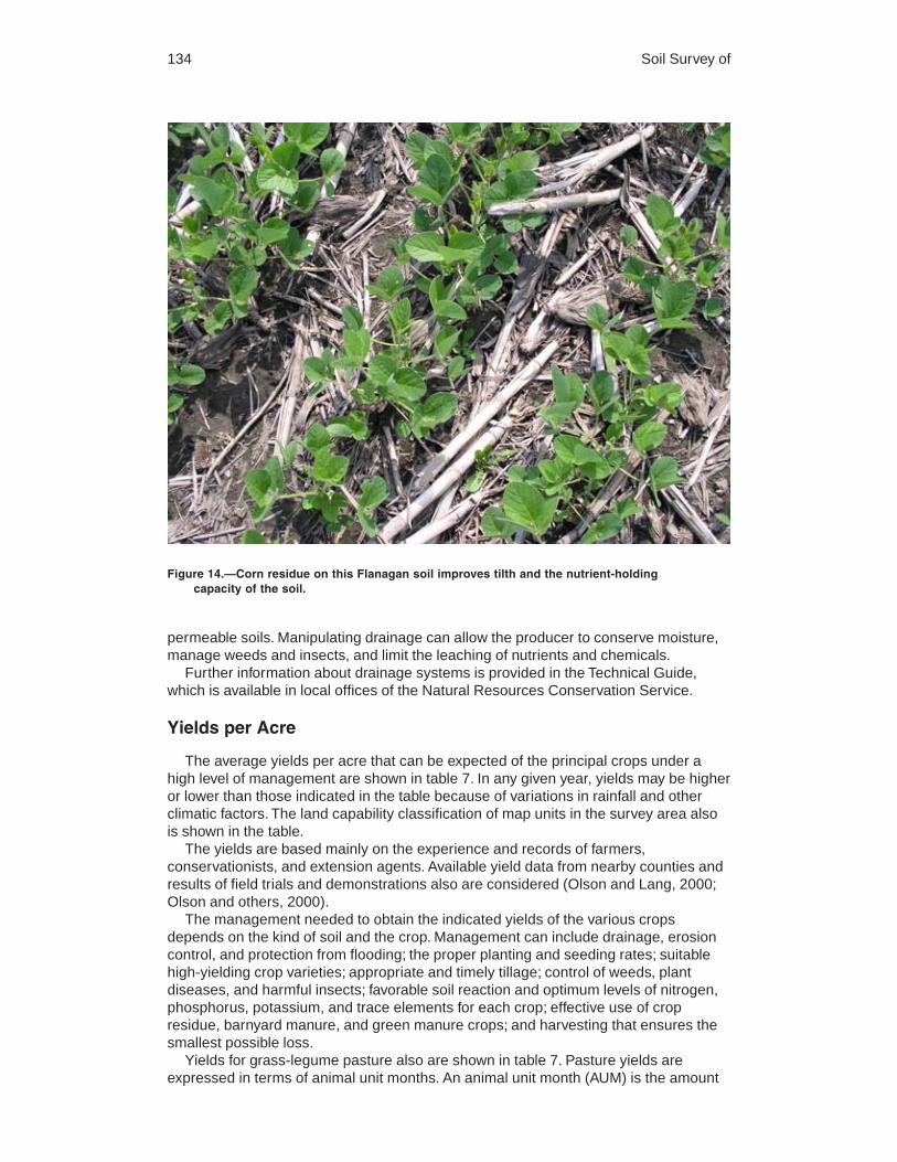
134 Soil Survey of
permeable soils. Manipulating drainage can allow the producer to conserve moisture,manage weeds and insects, and limit the leaching of nutrients and chemicals.
Further information about drainage systems is provided in the Technical Guide,which is available in local offices of the Natural Resources Conservation Service.
Yields per Acre
The average yields per acre that can be expected of the principal crops under ahigh level of management are shown in table 7. In any given year, yields may be higheror lower than those indicated in the table because of variations in rainfall and otherclimatic factors. The land capability classification of map units in the survey area alsois shown in the table.
The yields are based mainly on the experience and records of farmers,conservationists, and extension agents. Available yield data from nearby counties andresults of field trials and demonstrations also are considered (Olson and Lang, 2000;Olson and others, 2000).
The management needed to obtain the indicated yields of the various cropsdepends on the kind of soil and the crop. Management can include drainage, erosioncontrol, and protection from flooding; the proper planting and seeding rates; suitablehigh-yielding crop varieties; appropriate and timely tillage; control of weeds, plantdiseases, and harmful insects; favorable soil reaction and optimum levels of nitrogen,phosphorus, potassium, and trace elements for each crop; effective use of cropresidue, barnyard manure, and green manure crops; and harvesting that ensures thesmallest possible loss.
Yields for grass-legume pasture also are shown in table 7. Pasture yields areexpressed in terms of animal unit months. An animal unit month (AUM) is the amount
Figure 14.—Corn residue on this Flanagan soil improves tilth and the nutrient-holdingcapacity of the soil.

Coles County, Illinois 135
of forage required by one mature cow of approximately 1,000 pounds weight, with orwithout a calf, for 1 month.
The estimated yields in the table reflect the productive capacity of each soil for eachof the principal crops and pasture plants. Yields are likely to increase as newproduction technology is developed. The productivity of a given soil compared with thatof other soils, however, is not likely to change.
Crops other than those shown in table 7 are grown in the survey area, butestimated yields are not listed because the acreage of such crops is small. The localoffice of the Natural Resources Conservation Service or the Cooperative ExtensionService can provide information about the management and productivity of the soilsfor those crops.
Land Capability Classification
Land capability classification shows, in a general way, the suitability of soils for mostkinds of field crops. Crops that require special management are excluded. The soilsare grouped according to their limitations for field crops, the risk of damage if they areused for crops, and the way they respond to management. The criteria used ingrouping the soils do not include major and generally expensive landforming thatwould change slope, depth, or other characteristics of the soils, nor do they includepossible but unlikely major reclamation projects. Capability classification is not asubstitute for interpretations designed to show suitability and limitations of groups ofsoils for forestland or for engineering purposes.
In the capability system, soils are generally grouped at three levels—capabilityclass, subclass, and unit (USDA, 1961).
Figure 15.—Drainage tile is used extensively throughout Coles County in areas of poorly drainedsoils, such as Drummer soils. The drainage system allows earlier planting and results inhigher yields.

136 Soil Survey of
Capability classes, the broadest groups, are designated by the numbers 1 through8. The numbers indicate progressively greater limitations and narrower choices forpractical use. The classes are defined as follows:
Class 1 soils have slight limitations that restrict their use.Class 2 soils have moderate limitations that restrict the choice of plants or that
require moderate conservation practices.Class 3 soils have severe limitations that restrict the choice of plants or that require
special conservation practices, or both.Class 4 soils have very severe limitations that restrict the choice of plants or that
require very careful management, or both.Class 5 soils are subject to little or no erosion but have other limitations, impractical
to remove, that restrict their use mainly to pasture, rangeland, forestland, or wildlifehabitat.
Class 6 soils have severe limitations that make them generally unsuitable forcultivation and that restrict their use mainly to pasture, rangeland, forestland, or wildlifehabitat.
Class 7 soils have very severe limitations that make them unsuitable for cultivationand that restrict their use mainly to grazing, forestland, or wildlife habitat.
Class 8 soils and miscellaneous areas have limitations that preclude commercialplant production and that restrict their use to recreational purposes, wildlife habitat,watershed, or esthetic purposes.
Capability subclasses are soil groups within one class. They are designated byadding a small letter, e, w, s, or c, to the class numeral, for example, 2e. The letter eshows that the main hazard is the risk of erosion unless close-growing plant cover ismaintained; w shows that water in or on the soil interferes with plant growth orcultivation (in some soils the wetness can be partly corrected by artificial drainage); sshows that the soil is limited mainly because it is shallow, droughty, or stony; and c,used in only some parts of the United States, shows that the chief limitation is climatethat is very cold or very dry.
In class 1 there are no subclasses because the soils of this class have fewlimitations. Class 5 contains only the subclasses indicated by w, s, or c because thesoils in class 5 are subject to little or no erosion. They have other limitations thatrestrict their use to pasture, rangeland, forestland, or wildlife habitat.
Capability units are soil groups within a subclass. The soils in a capability unit areenough alike to be suited to the same crops and pasture plants, to require similarmanagement, and to have similar productivity. Capability units are generallydesignated by adding an Arabic numeral to the subclass symbol, for example, 2e-4and 3e-6. These units are not given in all soil surveys.
The capability classification of the soils in this survey area is given in the section“Soil Series and Detailed Soil Map Units” and in the yields table.
Prime Farmland
Prime farmland is one of several kinds of important farmland defined by the U.S.Department of Agriculture. It is of major importance in meeting the Nation’s short- andlong-range needs for food and fiber. Because the supply of high-quality farmland islimited, the U.S. Department of Agriculture recognizes that responsible levels ofgovernment, as well as individuals, should encourage and facilitate the wise use of ourNation’s prime farmland.
Prime farmland, as defined by the U.S. Department of Agriculture, is land that hasthe best combination of physical and chemical characteristics for producing food, feed,forage, fiber, and oilseed crops and is available for these uses. It could be cultivatedland, pastureland, forestland, or other land, but it is not urban or built-up land or waterareas. The soil qualities, growing season, and moisture supply are those needed for

Coles County, Illinois 137
the soil to economically produce sustained high yields of crops when propermanagement, including water management, and acceptable farming methods areapplied. In general, prime farmland has an adequate and dependable supply ofmoisture from precipitation or irrigation, a favorable temperature and growing season,acceptable acidity or alkalinity, an acceptable salt and sodium content, and few or norocks. It is permeable to water and air. It is not excessively erodible or saturated withwater for long periods, and it either is not frequently flooded during the growing seasonor is protected from flooding. Slope ranges mainly from 0 to 6 percent. More detailedinformation about the criteria for prime farmland is available at the local office of theNatural Resources Conservation Service.
A recent trend in land use in some parts of the survey area has been the loss ofsome prime farmland to industrial and urban uses. The loss of prime farmland to otheruses puts pressure on marginal lands, which generally are more erodible, droughty,and less productive and cannot be easily cultivated.
About 281,800 acres, or 86 percent of the total acreage in Coles County, meets therequirements for prime farmland.
The map units in the survey area that are considered prime farmland are listed intable 8. This list does not constitute a recommendation for a particular land use. Onsome soils included in the list, measures that overcome a hazard or limitation, such asflooding, wetness, and droughtiness, are needed. Onsite evaluation is needed todetermine whether or not the hazard or limitation has been overcome by correctivemeasures. The extent of each listed map unit is shown in table 5. The location isshown on the detailed soil maps. Some of the soil qualities that affect use andmanagement are described under the heading “Soil Series and Detailed Soil MapUnits.”
Hydric SoilsIn this section, hydric soils are defined and described and the hydric soils in the
survey area are listed.The three essential characteristics of wetlands are hydrophytic vegetation, hydric
soils, and wetland hydrology (Cowardin and others, 1979; U.S. Army Corps ofEngineers, 1987; National Research Council, 1995; Tiner, 1985). Criteria for all of thecharacteristics must be met for areas to be identified as wetlands. Undrained hydricsoils that have natural vegetation should support a dominant population of ecologicalwetland plant species. Hydric soils that have been converted to other uses should becapable of being restored to wetlands.
Hydric soils are defined by the National Technical Committee for Hydric Soils(NTCHS) as soils that formed under conditions of saturation, flooding, or ponding longenough during the growing season to develop anaerobic conditions in the upper part(Federal Register, 1994). These soils, under natural conditions, are either saturated orinundated long enough during the growing season to support the growth andreproduction of hydrophytic vegetation.
The NTCHS definition identifies general soil properties that are associated withwetness. In order to determine whether a specific soil is a hydric soil or nonhydric soil,however, more specific information, such as information about the depth and durationof the water table, is needed. Thus, criteria that identify those estimated soil propertiesunique to hydric soils have been established (Federal Register, 2002). These criteriaare used to identify map unit components that normally are associated with wetlands.The criteria used are selected estimated soil properties that are described in “SoilTaxonomy” (Soil Survey Staff, 1999) and “Keys to Soil Taxonomy” (Soil Survey Staff,2006) and in the “Soil Survey Manual” (Soil Survey Division Staff, 1993).
If soils are wet enough for a long enough period of time to be considered hydric,they should exhibit certain properties that can be easily observed in the field. These
138 Soil Survey of
visible properties are indicators of hydric soils. The indicators used to make onsitedeterminations of hydric soils are specified in “Field Indicators of Hydric Soils in theUnited States” (Hurt and Vasilas, 2006).
Hydric soils are identified by examining and describing the soil to a depth of about20 inches. This depth may be greater if determination of an appropriate indicator sorequires. It is always recommended that soils be excavated and described to the depthnecessary for an understanding of the redoximorphic processes. Then, using thecompleted soil descriptions, soil scientists can compare the soil features required byeach indicator and specify which indicators have been matched with the conditionsobserved in the soil. The soil can be identified as a hydric soil if at least one of theapproved indicators is present.
Map units that are dominantly made up of hydric soils may have small areas, orinclusions, of nonhydric soils in the higher positions on the landform, and map unitsdominantly made up of nonhydric soils may have inclusions of hydric soils in the lowerpositions on the landform. Approximately 107,622 acres, or 33 percent of the land areain Coles County, meets the criteria for hydric soils. Table 9 lists the map units thatinclude hydric soils, either as major components or as soils of minor extent. The hydricsoils listed in the table meet the definition of a hydric soil and have at least one of thehydric soil indicators. This list can help in planning land uses; however, onsiteinvestigation is recommended to determine the hydric soils on a specific site (NationalResearch Council, 1995; Hurt and Vasilas, 2006).
The criteria for hydric soils are represented by codes in the table (for example,2B3). Definitions for the codes are as follows:
1. All Histels except for Folistels, and Histosols except for Folists.2. Soils in Aquic suborders, great groups, or subgroups, Albolls suborder, Historthels
great group, Histoturbels great group, Pachic subgroups, or Cumulic subgroupsthat:
A. are somewhat poorly drained and have a water table at the surface (0.0 feet)during the growing season, or
B. are poorly drained or very poorly drained and have either:1) a water table at the surface (0.0 feet) during the growing season if textures
are coarse sand, sand, or fine sand in all layers within a depth of 20 inches,or
2) a water table at a depth of 0.5 foot or less during the growing season ifsaturated hydraulic conductivity (Ksat) is equal to or greater than 6.0 in/hr inall layers within a depth of 20 inches, or
3) a water table at a depth of 1.0 foot or less during the growing season ifsaturated hydraulic conductivity (Ksat) is less than 6.0 in/hr in any layer withina depth of 20 inches.
3. Soils that are frequently ponded for long or very long duration during the growingseason.
4. Soils that are frequently flooded for long or very long duration during the growingseason.
Windbreaks and Environmental PlantingsWindbreaks protect livestock, buildings, yards, fruit trees, gardens, and cropland
from wind and snow; help to keep snow on fields; and provide food and cover forwildlife. Such soils as Landes, Lenzburg, Milford, Peotone, and Shiloh soils have asurface layer that is moderately or moderately highly susceptible to wind erosion.These soils make up approximately 5.6 percent of the soils in the county. They have asurface layer of fine sandy loam or sandy loam, have a high amount of finely dividedcalcium carbonate, or have a high content of clay in the surface layer. Field windbreaks

Coles County, Illinois 139
can be beneficial in areas of these soils. Field windbreaks are narrow plantings madeat right angles to the prevailing wind and at specific intervals across the field. Theinterval depends on the erodibility of the soil.
Environmental plantings help to beautify and screen houses and other buildings andto abate noise. The plants, mostly evergreen shrubs and trees, are closely spaced. Toensure plant survival, a healthy planting stock of suitable species should be plantedproperly on a well prepared site and maintained in good condition.
Table 10 shows the height that locally grown trees and shrubs are expected toreach in 20 years on soils in the survey area. The estimates in the table are based onmeasurements and observation of established plantings that have been givenadequate care. They can be used as a guide in planning windbreaks and screens.Additional information on planning windbreaks and screens and planting and caring fortrees and shrubs can be obtained from the local office of the Natural ResourcesConservation Service or the Cooperative Extension Service or from a commercialnursery.
ForestlandWhen the first settlers arrived, forests covered about 32 percent of the land in the
survey area (Iverson and others, 1989). Since then, about 73 percent of the trees havebeen cleared from the areas that are most suitable for cultivation.
By 1985, only 27,700 acres, or about 8.5 percent of the acreage in Coles County,remained as forestland (Iverson and others, 1989). Most of the forestland acreage isprivately owned. The most common trees in the uplands are white oak, black oak,northern red oak, shagbark hickory, white ash, green ash, sugar maple, silver maple,boxelder, black walnut, black cherry, and American elm. The most common trees onflood plains are cottonwood, sycamore, willow, bur oak, pin oak, swamp white oak,hackberry, and silver maple.
The remaining forestland acres are predominantly in areas that are too steep, toowet, or too isolated for cultivation. Most of these areas are along the drainageways ofthe Little Wabash and Embarras Rivers and their tributaries. If they are properlymanaged, the soils in these remaining forestland areas are generally well suited togrowing high-quality trees (fig. 16).
The productivity of many of the remaining forestland stands could be improved withproper management. Excluding livestock from the forestland, providing protection fromfire, insects, and diseases, using proper logging methods, and applying provensilvicultural methods to enhance growth and regeneration are management practicesthat are commonly needed in these areas.
Table 11 can help woodland owners or forest managers plan the use of soils forwood crops. Only those soils commonly used for wood crops are listed.
The potential productivity of merchantable or common trees on a soil is expressedas a site index and as a volume number. The site index is the average height, in feet,that dominant and codominant trees of a given species attain in a specified number ofyears. The site index applies to fully stocked, even-aged, unmanaged stands.Commonly grown trees are those that forest managers generally favor in intermediateor improvement cuttings. They are selected on the basis of growth rate, quality, value,and marketability. More detailed information regarding site index is available in the“National Forestry Manual,” which is available in local offices of the Natural ResourcesConservation Service or online (http://soils.usda.gov/technical/).
The volume of wood fiber, a number, is the yield likely to be produced by the mostimportant tree species. This number, expressed as cubic feet per acre per year andcalculated at the age of culmination of the mean annual increment (CMAI), indicatesthe amount of fiber produced in a fully stocked, even-aged, unmanaged stand.

140 Soil Survey of
Suggested trees to plant are those that are preferred for planting, seeding, ornatural regeneration and those that remain in the stand after thinning or partialharvest.
RecreationThe demand for recreational facilities is increasing throughout Coles County. Public
lands available for recreation include Fox Ridge State Park and the Lincoln Log CabinState Historic Site. Public lakes and rivers, such as Lake Charleston, Lake Mattoon,Lake Paradise, Lake Oakland, Ridge Lake, and the Embarras, Kaskaskia, and LittleWabash Rivers and their tributaries, offer public boating and fishing opportunities.Other small areas throughout the county provide playgrounds, athletic fields, golfcourses, fishing ponds, camping and picnic areas, hunting areas, and facilities fortarget shooting.
The potential for further recreational development is favorable throughout thecounty. The soils having the best potential for such development are in the uplandsalong the banks and tributaries of the Embarras, Kaskaskia, and Little Wabash Rivers.These soils are in areas where the hilly terrain, wooded slopes, and numerousstreams provide a variety of locations suited to recreational uses.
The soils of the survey area are rated in tables 12a and 12b according to limitationsthat affect their suitability for recreation. The ratings are both verbal and numerical.Rating class terms indicate the extent to which the soils are limited by all of the soilfeatures that affect the recreational uses. Not limited indicates that the soil hasfeatures that are very favorable for the specified use. Good performance and very lowmaintenance can be expected. Somewhat limited indicates that the soil has featuresthat are moderately favorable for the specified use. The limitations can be overcome orminimized by special planning, design, or installation. Fair performance and moderatemaintenance can be expected. Very limited indicates that the soil has one or morefeatures that are unfavorable for the specified use. The limitations generally cannot be
Figure 16.—A reforested area of Senachwine silt loam, 18 to 35 percent slopes.


142 Soil Survey of
Paths and trails for hiking and horseback riding should require little or no slopemodification through cutting and filling. The ratings are based on the soil propertiesthat affect trafficability and erodibility. These properties are stoniness, depth to a watertable, ponding, flooding, slope, and texture of the surface layer.
Off-road motorcycle trails require little or no site preparation. They are not coveredwith surfacing material or vegetation. Considerable compaction of the soil material islikely. The ratings are based on the soil properties that influence erodibility, trafficability,dustiness, and the ease of revegetation. These properties are stoniness, slope, depthto a water table, ponding, flooding, and texture of the surface layer.
Golf fairways are subject to heavy foot traffic and some light vehicular traffic. Cuttingor filling may be required. Irrigation is not considered in the ratings. The ratings arebased on the soil properties that affect plant growth and trafficability after vegetation isestablished. The properties that affect plant growth are reaction; depth to a water table;ponding; depth to bedrock or a cemented pan; the available water capacity in theupper 40 inches; the content of salts, sodium, or calcium carbonate; and sulfidicmaterials. The properties that affect trafficability are flooding, depth to a water table,ponding, slope, stoniness, and the amount of sand, clay, or organic matter in thesurface layer. The suitability of the soil for traps, tees, roughs, and greens is notconsidered in the ratings.
Wildlife HabitatMuch of Coles County is located in an area that transitions from a broad, tall-grass
prairie that contained wet meadows, marshes, and areas of open water to an areadominated by central hardwood forest habitat. This area is near the southern limit ofthe Midwestern prairie pothole region that traditionally provided valuable nesting and
Figure 17.—The gravel base at this campsite in an area of Xenia soils provides drainage andkeeps the site stable during wet periods throughout the year.

Coles County, Illinois 143
stop-over habitat for migratory waterfowl and important habitat for other wetland andopenland wildlife species. Forestland areas, especially those along creeks and onmoderately steep to very steep landforms, provide habitat for turkey, songbirds, birdsof prey, and many mammals, including deer, squirrel, rabbits, fox, and beaver.
As the county was settled, the conversion of land for agriculture use altered thesenatural communities and the wildlife species associated with them. Long gone are thewolf, bison, otter, badger, black bear, cougar, and elk that roamed the area as recentlyas 150 years ago. The landscape of Coles County is now a mosaic of urbandevelopment, cropland, pasture, areas of forestland, wetlands, and waterways thatsupport wildlife species that have adapted to the human-altered landscape. Thesespecies include whitetail deer, fox, coyotes, mourning doves, pheasants, squirrels,cardinals, and raccoons.
The largest area in Coles County managed for wildlife is in the Fox Ridge StatePark along the Embarras River. This area is managed by the Illinois Department ofNatural Resources. It is 8 miles south of Charleston, Illinois. The area is composed of2,064 total acres, and hunting is available on 1,129 acres.
Other areas used as wildlife habitat are not necessarily set aside for this purpose.Wildlife habitat is commonly a secondary use in areas used for other purposes, suchas farming. For example, the large areas of nearly level and gently sloping soils usedfor cultivated crops and pasture are also generally well suited to use as habitat foropenland wildlife. Most areas in the county can be improved for wildlife habitat byproviding needed food, cover, and water.
Soils affect the kind and amount of vegetation that is available to wildlife as food andcover. They also affect the construction of water impoundments. The kind and
Figure 18.—A playground in an area of Xenia silt loam, 2 to 5 percent slopes. The playgroundfunctions well because the seasonal wetness of the soil was addressed in the design. Thisplayground is in Fox Ridge State Park south of Charleston.

144 Soil Survey of
abundance of wildlife depend largely on the amount and distribution of food, cover, andwater. Wildlife habitat can be created or improved by planting appropriate vegetation,by maintaining the existing plant cover, or by promoting the natural establishment ofdesirable plants.
In table 13, the soils in the survey area are rated according to their potential forproviding habitat for various kinds of wildlife. This information can be used in planningparks, wildlife refuges, nature study areas, and other developments for wildlife; inselecting soils that are suitable for establishing, improving, or maintaining specificelements of wildlife habitat; and in determining the intensity of management needed foreach element of the habitat.
The potential of the soil is rated good, fair, poor, or very poor. A rating of goodindicates that the element or kind of habitat is easily established, improved, ormaintained. Few or no limitations affect management, and satisfactory results can beexpected. A rating of fair indicates that the element or kind of habitat can beestablished, improved, or maintained in most places. Moderately intensivemanagement is required for satisfactory results. A rating of poor indicates thatlimitations are severe for the designated element or kind of habitat. Habitat can becreated, improved, or maintained in most places, but management is difficult and mustbe intensive. A rating of very poor indicates that restrictions for the element or kind ofhabitat are very severe and that unsatisfactory results can be expected. Creating,improving, or maintaining habitat is impractical or impossible.
The elements of wildlife habitat are described in the following paragraphs.Grain and seed crops are domestic grains and seed-producing herbaceous plants.
Soil properties and features that affect the growth of grain and seed crops are depth ofthe root zone, texture of the surface layer, available water capacity, wetness, slope,surface stoniness, and flooding. Soil temperature and soil moisture also areconsiderations. Examples of grain and seed crops are corn, wheat, oats, and barley.
Grasses and legumes are domestic perennial grasses and herbaceous legumes.Soil properties and features that affect the growth of grasses and legumes are depthof the root zone, texture of the surface layer, available water capacity, wetness, surfacestoniness, flooding, and slope. Soil temperature and soil moisture also areconsiderations. Examples of grasses and legumes are lovegrass, orchardgrass,bromegrass, clover, and alfalfa.
Wild herbaceous plants are native or naturally established grasses and forbs,including weeds. Soil properties and features that affect the growth of these plants aredepth of the root zone, texture of the surface layer, available water capacity, wetness,surface stoniness, and flooding. Soil temperature and soil moisture also areconsiderations. Examples of wild herbaceous plants are bluestem, goldenrod,ragweed, wildrye, and Illinois bundleflower (fig. 19).
Hardwood trees and woody understory produce nuts or other fruit, buds, catkins,twigs, bark, and foliage. Soil properties and features that affect the growth of hardwoodtrees and shrubs are depth of the root zone, available water capacity, and wetness.Examples of these plants are oak, hickory, sycamore, cottonwood, elm, sassafras,serviceberry, gray dogwood, flowering dogwood, hazelnut, sumac, and raspberry. Thebest choices for planting on soils rated good are native plants, such as hazelnut, graydogwood, silky dogwood, oak, and hickory.
Coniferous plants furnish browse and seeds. Soil properties and features that affectthe growth of coniferous trees, shrubs, and ground cover are depth of the root zone,available water capacity, and wetness. Examples of coniferous plants are white pine,Norway spruce, balsam fir, red cedar, and juniper.
Wetland plants are annual and perennial wild herbaceous plants that grow on moistor wet sites. Submerged or floating aquatic plants are excluded. Soil properties andfeatures affecting wetland plants are texture of the surface layer, wetness, reaction,

Coles County, Illinois 145
salinity, slope, and surface stoniness. Examples of wetland plants are smartweed, wildmillet, wildrice, saltgrass, cordgrass, rushes, sedges, and reeds.
Shallow water areas have an average depth of less than 5 feet. Some are naturallywet areas. Others are created by dams, levees, or other water-control structures. Soilproperties and features affecting shallow water areas are depth to bedrock, wetness,surface stoniness, slope, and permeability. Examples of shallow water areas aremarshes, waterfowl feeding areas, and ponds.
Shallow water areas can often be included in the design of ponds and lakes byutilizing the naturally shallow end of the impoundment. Wetland areas can also becreated by installing water control valves on field drainage tiles, allowing for flooding offields at times when they are not being used for crop production, such as after fallharvest. Valves can be opened to drain fields for spring planting while allowing soilmoisture to remain high enough for good productivity. Islands, wood duck boxes, andan even mix of open water and aquatic plants help to provide optimum wildlife habitatin permanent wetland areas.
The habitat for various kinds of wildlife is described in the following paragraphs.Habitat for openland wildlife consists of cropland, pasture, meadows, and areas that
are overgrown with grasses, herbs, shrubs, and vines. These areas produce grain andseed crops, grasses and legumes, and wild herbaceous plants. Wildlife attracted tothese areas include bobwhite quail, pheasant, meadowlark, field sparrow, cottontail,and red fox.
The habitat for openland wildlife can be improved by seeding roadsides, fence rows,and wildlife travel lanes to perennial plants and legumes, such as smooth bromegrass,timothy, redtop, bluegrass, alfalfa, red clover, ladino clover, and alsike clover. Grassyareas can be enhanced with perennial native prairie grasses, such as big bluestem,
Figure 19.—Native prairie plants provide food and cover for upland wildlife in an area ofSenachwine soils.

146 Soil Survey of
little bluestem, switchgrass, and indiangrass. Protecting nesting cover from fire, traffic,grazing, mowing, or other disturbance until after the nesting season also is important.
Warm-season grasses grow best if periodic prescribed burning is applied. Anyexisting woody cover should be protected from fire and grazing. Establishinghedgerows and windbreaks of trees and shrubs can provide a source of food androosting areas. Brush piles can be built for cover along fence rows and in odd-shapedareas that are inconvenient for cultivation. Leaving crop residue on the surface afterharvest and leaving waste grain in the fields can provide cover and food for wildlifethroughout the winter. Also, parts of fields that are adjacent to areas of wildlife covercan be left unharvested.
Habitat for woodland wildlife consists of areas of deciduous and/or coniferous plantsand associated grasses, legumes, and wild herbaceous plants. Wildlife attracted tothese areas include woodcock, thrushes, woodpeckers, squirrels, gray fox, raccoon,and deer.
Habitat for woodland wildlife can be improved by protecting native trees, shrubs,and prairie plants from grazing by livestock. Also, protecting the areas fromuncontrolled fire helps to minimize the destruction of the leaf mulch and of desirableyoung trees, shrubs, and sprouts that provide food and cover. Establishing hedgerows,farm windbreaks, brush piles, food plots, and strips of grass or grass-legume mixturescan provide additional food and cover. Plantings for food and cover may be difficult toestablish and maintain in the more sloping areas because of the hazard of erosion.Food plots of grain or seed crops should be established in the less sloping areas andshould be planted on the contour. Leaving dead trees to provide den sites for raccoon,woodpeckers, opossum, and other cavity-dwelling species also improves the habitat.
Habitat for wetland wildlife consists of open, marshy or swampy shallow waterareas. Some of the wildlife attracted to such areas are ducks, geese, herons, shorebirds, muskrat, mink, frogs, snakes, and turtles.
Measures that improve the habitat for wetland wildlife include delaying or limiting thecultivation and planting of commodity crops in the shallow depressions that are subjectto ponding. Areas of smartweeds, bulrushes, burreeds, and barnyard grasses shouldbe protected. Japanese millet, milo, and short corn varieties can be planted to providefood and cover. Blocking natural channels and manmade drainage systems can createshallow ponds and marshes. Pits dug in poorly drained or very poorly drained soilsshould be at least 30 feet in diameter and 2 to 3 feet deep. Such pits provide openwater through the spring and early summer and thus encourage nesting by ducks.Wetland areas should be protected from grazing by livestock.
EngineeringThis section provides information for planning land uses related to urban
development and to water management. Soils are rated for various uses, and the mostlimiting features are identified. Ratings are given for building site development, sanitaryfacilities, construction materials, and water management. The ratings are based onobserved performance of the soils and on the data in the tables described under theheading “Soil Properties.”
Information in this section is intended for land use planning, for evaluating land usealternatives, and for planning site investigations prior to design and construction. Theinformation, however, has limitations. For example, estimates and other data generallyapply only to that part of the soil between the surface and a depth of 5 to 7 feet.Because of the map scale, small areas of different soils may be included within themapped areas of a specific soil.
The information is not site specific and does not eliminate the need for onsiteinvestigation of the soils or for testing and analysis by personnel experienced in thedesign and construction of engineering works.

Coles County, Illinois 147
Government ordinances and regulations that restrict certain land uses or imposespecific design criteria were not considered in preparing the information in this section.Local ordinances and regulations should be considered in planning, in site selection,and in design.
Soil properties, site features, and observed performance were considered indetermining the ratings in this section. During the fieldwork for this soil survey,determinations were made about particle-size distribution, liquid limit, plasticity index,soil reaction, depth to bedrock, hardness of bedrock within 5 to 7 feet of the surface,soil wetness, depth to a water table, ponding, slope, likelihood of flooding, natural soilstructure aggregation, and soil density. Data were collected about kinds of clayminerals, mineralogy of the sand and silt fractions, and the kinds of adsorbed cations.Estimates were made for erodibility, permeability, corrosivity, shrink-swell potential,available water capacity, and other behavioral characteristics affecting engineeringuses.
This information can be used to evaluate the potential of areas for residential,commercial, industrial, and recreational uses; make preliminary estimates ofconstruction conditions; evaluate alternative routes for roads, streets, highways,pipelines, and underground cables; evaluate alternative sites for sanitary landfills,septic tank absorption fields, and sewage lagoons; plan detailed onsite investigationsof soils and geology; locate potential sources of gravel, sand, reclamation material,roadfill, and topsoil; plan structures for water management; and predict performance ofproposed small structures and pavements by comparing the performance of existingsimilar structures on the same or similar soils.
The information in the tables, along with the soil maps, the soil descriptions, andother data provided in this survey, can be used to make additional interpretations.
Some of the terms used in this soil survey have a special meaning in soil scienceand are defined in the Glossary.
Building Site Development
Soil properties influence the development of building sites, including the selection ofthe site, the design of the structure, construction, performance after construction, andmaintenance. Tables 14a and 14b show the degree and kind of soil limitations thataffect dwellings with and without basements, small commercial buildings, local roadsand streets, shallow excavations, and lawns and landscaping.
The ratings in the tables are both verbal and numerical. Rating class terms indicatethe extent to which the soils are limited by all of the soil features that affect buildingsite development. Not limited indicates that the soil has features that are very favorablefor the specified use. Good performance and very low maintenance can be expected.Somewhat limited indicates that the soil has features that are moderately favorable forthe specified use. The limitations can be overcome or minimized by special planning,design, or installation. Fair performance and moderate maintenance can be expected.Very limited indicates that the soil has one or more features that are unfavorable forthe specified use. The limitations generally cannot be overcome without major soilreclamation, special design, or expensive installation procedures. Poor performanceand high maintenance can be expected.
Numerical ratings in the tables indicate the severity of individual limitations. Theratings are shown as decimal fractions ranging from 0.01 to 1.00. They indicategradations between the point at which a soil feature has the greatest negative impacton the use (1.00) and the point at which the soil feature is not a limitation (0.00).
Dwellings are single-family houses of three stories or less. For dwellings withoutbasements, the foundation is assumed to consist of spread footings of reinforcedconcrete built on undisturbed soil at a depth of 2 feet or at the depth of maximum frost

148 Soil Survey of
penetration, whichever is deeper. For dwellings with basements, the foundation isassumed to consist of spread footings of reinforced concrete built on undisturbed soilat a depth of about 7 feet. The ratings for dwellings are based on the soil propertiesthat affect the capacity of the soil to support a load without movement and on theproperties that affect excavation and construction costs. The properties that affect theload-supporting capacity include depth to a water table, ponding, flooding, subsidence,linear extensibility (shrink-swell potential), and compressibility. Compressibility isinferred from the Unified classification. The properties that affect the ease and amountof excavation include depth to a water table, ponding, flooding, slope, depth to bedrockor a cemented pan, hardness of bedrock or a cemented pan, and the amount and sizeof rock fragments.
Small commercial buildings are structures that are less than three stories high anddo not have basements. The foundation is assumed to consist of spread footings ofreinforced concrete built on undisturbed soil at a depth of 2 feet or at the depth ofmaximum frost penetration, whichever is deeper. The ratings are based on the soilproperties that affect the capacity of the soil to support a load without movement andon the properties that affect excavation and construction costs. The properties thataffect the load-supporting capacity include depth to a water table, ponding, flooding,subsidence, linear extensibility (shrink-swell potential), and compressibility (which isinferred from the Unified classification). The properties that affect the ease and amountof excavation include flooding, depth to a water table, ponding, slope, depth to bedrockor a cemented pan, hardness of bedrock or a cemented pan, and the amount and sizeof rock fragments.
Local roads and streets have an all-weather surface and carry automobile and lighttruck traffic all year. They have a subgrade of cut or fill soil material; a base of gravel,crushed rock, or soil material stabilized by lime or cement; and a surface of flexiblematerial (asphalt), rigid material (concrete), or gravel with a binder. The ratings arebased on the soil properties that affect the ease of excavation and grading and thetraffic-supporting capacity. The properties that affect the ease of excavation andgrading are depth to bedrock or a cemented pan, hardness of bedrock or a cementedpan, depth to a water table, ponding, flooding, the amount of large stones, and slope.The properties that affect the traffic-supporting capacity are soil strength (as inferredfrom the AASHTO group index number), subsidence, linear extensibility (shrink-swellpotential), the potential for frost action, depth to a water table, and ponding.
Shallow excavations are trenches or holes dug to a maximum depth of 5 or 6 feetfor graves, utility lines, open ditches, or other purposes. The ratings are based on thesoil properties that influence the ease of digging and the resistance to sloughing.Depth to bedrock or a cemented pan, hardness of bedrock or a cemented pan, theamount of large stones, and dense layers influence the ease of digging, filling, andcompacting. Depth to the seasonal high water table, flooding, and ponding may restrictthe period when excavations can be made. Slope influences the ease of usingmachinery. Soil texture, depth to the water table, and linear extensibility (shrink-swellpotential) influence the resistance to sloughing.
Lawns and landscaping require soils on which turf and ornamental trees and shrubscan be established and maintained. Irrigation is not considered in the ratings. Theratings are based on the soil properties that affect plant growth and trafficability aftervegetation is established. The properties that affect plant growth are reaction; depth toa water table; ponding; depth to bedrock or a cemented pan; the available watercapacity in the upper 40 inches; the content of salts, sodium, or calcium carbonate;and sulfidic materials. The properties that affect trafficability are flooding, depth to awater table, ponding, slope, stoniness, and the amount of sand, clay, or organic matterin the surface layer.

Coles County, Illinois 149
Sanitary Facilities
Tables 15a and 15b show the degree and kind of soil limitations that affect septictank absorption fields, sewage lagoons, sanitary landfills, and daily cover for landfill.The ratings are both verbal and numerical. Rating class terms indicate the extent towhich the soils are limited by all of the soil features that affect these uses. Not limitedindicates that the soil has features that are very favorable for the specified use. Goodperformance and very low maintenance can be expected. Somewhat limited indicatesthat the soil has features that are moderately favorable for the specified use. Thelimitations can be overcome or minimized by special planning, design, or installation.Fair performance and moderate maintenance can be expected. Very limited indicatesthat the soil has one or more features that are unfavorable for the specified use. Thelimitations generally cannot be overcome without major soil reclamation, specialdesign, or expensive installation procedures. Poor performance and high maintenancecan be expected.
Numerical ratings in the tables indicate the severity of individual limitations. Theratings are shown as decimal fractions ranging from 0.01 to 1.00. They indicategradations between the point at which a soil feature has the greatest negative impacton the use (1.00) and the point at which the soil feature is not a limitation (0.00).
Septic tank absorption fields are areas in which effluent from a septic tank isdistributed into the soil through subsurface tiles or perforated pipe. Only that part of thesoil between depths of 24 and 60 inches is evaluated. The ratings are based on thesoil properties that affect absorption of the effluent, construction and maintenance ofthe system, and public health. Permeability, depth to a water table, ponding, depth tobedrock or a cemented pan, and flooding affect absorption of the effluent. Stones andboulders, ice, and bedrock or a cemented pan interfere with installation. Subsidenceinterferes with installation and maintenance. Excessive slope may cause lateralseepage and surfacing of the effluent in downslope areas.
Some soils are underlain by loose sand and gravel or fractured bedrock at a depthof less than 4 feet below the distribution lines. In these soils the absorption field maynot adequately filter the effluent, particularly when the system is new. As a result, theground water may become contaminated.
Sewage lagoons are shallow ponds constructed to hold sewage while aerobicbacteria decompose the solid and liquid wastes. Lagoons should have a nearly levelfloor surrounded by cut slopes or embankments of compacted soil. Nearly impervioussoil material for the lagoon floor and sides is required to minimize seepage andcontamination of ground water. Considered in the ratings are slope, permeability, depthto a water table, ponding, depth to bedrock or a cemented pan, flooding, large stones,and content of organic matter.
Soil permeability is a critical property affecting the suitability for sewage lagoons.Most porous soils eventually become sealed when they are used as sites for sewagelagoons. Until sealing occurs, however, the hazard of pollution is severe. Soils thathave a permeability rate of more than 2 inches per hour are too porous for the properfunctioning of sewage lagoons. In these soils, seepage of the effluent can result incontamination of the ground water. Ground-water contamination is also a hazard iffractured bedrock is within a depth of 40 inches, if the water table is high enough toraise the level of sewage in the lagoon, or if floodwater overtops the lagoon.
A high content of organic matter is detrimental to proper functioning of the lagoonbecause it inhibits aerobic activity. Slope, bedrock, and cemented pans can causeconstruction problems, and large stones can hinder compaction of the lagoon floor. Ifthe lagoon is to be uniformly deep throughout, the slope must be gentle enough andthe soil material must be thick enough over bedrock or a cemented pan to make landsmoothing practical.

150 Soil Survey of
A trench sanitary landfill is an area where solid waste is placed in successive layersin an excavated trench. The waste is spread, compacted, and covered daily with a thinlayer of soil excavated at the site. When the trench is full, a final cover of soil materialat least 2 feet thick is placed over the landfill. The ratings in the table are based on thesoil properties that affect the risk of pollution, the ease of excavation, trafficability, andrevegetation. These properties include permeability, depth to bedrock or a cementedpan, depth to a water table, ponding, slope, flooding, texture, stones and boulders,highly organic layers, soil reaction, and content of salts and sodium. Unless otherwisestated, the ratings apply only to that part of the soil within a depth of about 6 feet. Fordeeper trenches, onsite investigation may be needed.
Hard, nonrippable bedrock, creviced bedrock, or highly permeable strata in ordirectly below the proposed trench bottom can affect the ease of excavation and thehazard of ground-water pollution. Slope affects construction of the trenches and themovement of surface water around the landfill. It also affects the construction andperformance of roads in areas of the landfill.
Soil texture and consistence affect the ease with which the trench is dug and theease with which the soil can be used as daily or final cover. They determine theworkability of the soil when dry and when wet. Soils that are plastic and sticky whenwet are difficult to excavate, grade, or compact and are difficult to place as a uniformlythick cover over a layer of refuse.
The soil material used as the final cover for a trench landfill should be suitable forplants. It should not have excess sodium or salts and should not be too acid. Thesurface layer generally has the best workability, the highest content of organic matter,and the best potential for plants. Material from the surface layer should be stockpiledfor use as the final cover.
In an area sanitary landfill, solid waste is placed in successive layers on the surfaceof the soil. The waste is spread, compacted, and covered daily with a thin layer of soilfrom a source away from the site. A final cover of soil material at least 2 feet thick isplaced over the completed landfill. The ratings in the table are based on the soilproperties that affect trafficability and the risk of pollution. These properties includeflooding, permeability, depth to a water table, ponding, slope, and depth to bedrock ora cemented pan.
Flooding is a serious problem because it can result in pollution in areasdownstream from the landfill. If permeability is too rapid or if fractured bedrock, afractured cemented pan, or the water table is close to the surface, the leachate cancontaminate the water supply. Slope is a consideration because of the extra gradingrequired to maintain roads in the steeper areas of the landfill. Also, leachate may flowalong the surface of the soils in the steeper areas and cause difficult seepageproblems.
Daily cover for landfill is the soil material that is used to cover compacted solidwaste in an area sanitary landfill. The soil material is obtained offsite, transported tothe landfill, and spread over the waste. The ratings in the table also apply to the finalcover for a landfill. They are based on the soil properties that affect workability, theease of digging, and the ease of moving and spreading the material over the refusedaily during wet and dry periods. These properties include soil texture, depth to awater table, ponding, rock fragments, slope, depth to bedrock or a cemented pan,reaction, and content of salts, sodium, or lime.
Loamy or silty soils that are free of large stones and excess gravel are the bestcover for a landfill. Clayey soils may be sticky and difficult to spread; sandy soils aresubject to wind erosion.
Slope affects the ease of excavation and of moving the cover material. Also, it caninfluence runoff, erosion, and reclamation of the borrow area.

Coles County, Illinois 151
After soil material has been removed, the soil material remaining in the borrow areamust be thick enough over bedrock, a cemented pan, or the water table to permitrevegetation. The soil material used as the final cover for a landfill should be suitablefor plants. It should not have excess sodium, salts, or lime and should not be too acid.
Construction Materials
Tables 16a and 16b give information about the soils as potential sources of gravel,sand, reclamation material, roadfill, and topsoil. Normal compaction, minor processing,and other standard construction practices are assumed.
Gravel and sand are natural aggregates suitable for commercial use with aminimum of processing. They are used in many kinds of construction. Specificationsfor each use vary widely. In table 16a, only the likelihood of finding material in suitablequantity is evaluated. The suitability of the material for specific purposes is notevaluated, nor are factors that affect excavation of the material. The properties used toevaluate the soil as a source of sand or gravel are gradation of grain sizes (asindicated by the Unified classification of the soil), the thickness of suitable material,and the content of rock fragments. If the bottom layer of the soil contains sand orgravel, the soil is considered a likely source regardless of thickness. The assumption isthat the sand or gravel layer below the depth of observation exceeds the minimumthickness.
The soils are rated good, fair, or poor as potential sources of sand and gravel. Arating of good or fair means that the source material is likely to be in or below the soil.The bottom layer and the thickest layer of the soils are assigned numerical ratings.These ratings indicate the likelihood that the layer is a source of sand or gravel. Thenumber 0.00 indicates that the layer is a poor source. The number 1.00 indicates thatthe layer is a good source. A number between 0.00 and 1.00 indicates the degree towhich the layer is a likely source.
In table 16b, the rating class terms are good, fair, and poor. The features that limitthe soils as sources of reclamation material, roadfill, and topsoil are specified in thetable. The numerical ratings given after the specified features indicate the degree towhich the features limit the soils as sources of these materials. The lower the number,the greater the limitation.
Reclamation material is used in areas that have been drastically disturbed bysurface mining or similar activities. When these areas are reclaimed, layers of soilmaterial or unconsolidated geological material, or both, are replaced in a verticalsequence. The reconstructed soil favors plant growth. The ratings in the table do notapply to quarries and other mined areas that require an offsite source ofreconstruction material. The ratings are based on the soil properties that affect erosionand stability of the surface and the productive potential of the reconstructed soil. Theseproperties include the content of sodium, salts, and calcium carbonate; reaction;available water capacity; erodibility; texture; content of rock fragments; and content oforganic matter and other features that affect fertility.
Roadfill is soil material that is excavated in one place and used in roadembankments in another place. In this table, the soils are rated as a source of roadfillfor low embankments, generally less than 6 feet high and less exacting in design thanhigher embankments.
The ratings are for the whole soil, from the surface to a depth of about 5 feet. It isassumed that soil layers will be mixed when the soil material is excavated and spread.
The ratings are based on the amount of suitable material and on soil properties thataffect the ease of excavation and the performance of the material after it is in place.The thickness of the suitable material is a major consideration. The ease of excavation

152 Soil Survey of
is affected by large stones, depth to a water table, and slope. How well the soilperforms in place after it has been compacted and drained is determined by itsstrength (as inferred from the AASHTO classification of the soil) and linear extensibility(shrink-swell potential).
Topsoil is used to cover an area so that vegetation can be established andmaintained. The upper 40 inches of a soil is evaluated for use as topsoil. Alsoevaluated is the reclamation potential of the borrow area. The ratings are based on thesoil properties that affect plant growth; the ease of excavating, loading, and spreadingthe material; and reclamation of the borrow area. Toxic substances, soil reaction, andthe properties that are inferred from soil texture, such as available water capacity andfertility, affect plant growth. The ease of excavating, loading, and spreading is affectedby rock fragments, slope, depth to a water table, soil texture, and thickness of suitablematerial. Reclamation of the borrow area is affected by slope, depth to a water table,rock fragments, depth to bedrock or a cemented pan, and toxic material.
The surface layer of most soils is generally preferred for topsoil because of itsorganic matter content. Organic matter greatly increases the absorption and retentionof moisture and nutrients for plant growth.
Water Management
Tables 17a and 17b give information on the soil properties and site features thataffect water management. The degree and kind of soil limitations are given for pondreservoir areas; embankments, dikes, and levees; aquifer-fed excavated ponds;grassed waterways and surface drains; terraces and diversions; and tile drains andunderground outlets. The ratings are both verbal and numerical. Rating class termsindicate the extent to which the soils are limited by all of the soil features that affectthese uses. Not limited indicates that the soil has features that are very favorable forthe specified use. Good performance and very low maintenance can be expected.Somewhat limited indicates that the soil has features that are moderately favorable forthe specified use. The limitations can be overcome or minimized by special planning,design, or installation. Fair performance and moderate maintenance can be expected.Very limited indicates that the soil has one or more features that are unfavorable forthe specified use. The limitations generally cannot be overcome without major soilreclamation, special design, or expensive installation procedures. Poor performanceand high maintenance can be expected.
Numerical ratings in the tables indicate the severity of individual limitations. Theratings are shown as decimal fractions ranging from 0.01 to 1.00. They indicategradations between the point at which a soil feature has the greatest negative impacton the use (1.00) and the point at which the soil feature is not a limitation (0.00).
Table 17a
Pond reservoir areas hold water behind a dam or embankment. Soils best suited tothis use have low seepage potential in the upper 60 inches. The seepage potential isdetermined by the permeability of the soil and the depth to fractured bedrock or otherpermeable material. Excessive slope can affect the storage capacity of the reservoirarea (fig. 20).
Embankments, dikes, and levees are raised structures of soil material, generallyless than 20 feet high, constructed to impound water or to protect land againstoverflow. Embankments that have zoned construction (core and shell) are notconsidered. In this table, the soils are rated as a source of material for embankmentfill. The ratings apply to the soil material below the surface layer to a depth of about 5feet. It is assumed that soil layers will be uniformly mixed and compacted duringconstruction.

Coles County, Illinois 153
The ratings do not indicate the ability of the natural soil to support an embankment.Soil properties to a depth even greater than the height of the embankment can affectperformance and safety of the embankment. Generally, deeper onsite investigation isneeded to determine these properties.
Soil material in embankments must be resistant to seepage, piping, and erosionand have favorable compaction characteristics. Unfavorable features include less than5 feet of suitable material and a high content of stones or boulders, organic matter, orsalts or sodium. A high water table affects the amount of usable material. It also affectstrafficability.
Aquifer-fed excavated ponds are pits or dugouts that extend to a ground-wateraquifer or to a depth below a permanent water table. Excluded are ponds that are fedonly by surface runoff and embankment ponds that impound water 3 feet or moreabove the original surface. Excavated ponds are affected by depth to a permanentwater table, permeability of the aquifer, and quality of the water as inferred from thesalinity of the soil. Depth to bedrock and the content of large stones affect the ease ofexcavation.
Table 17b
Grassed waterways and surface drains are natural or constructed channels,generally broad and shallow, that conduct surface water to outlets at a nonerosivevelocity. Large stones, wetness, slope, and depth to bedrock affect the construction ofgrassed waterways. A hazard of wind erosion, a low available water capacity,restricted rooting depth, toxic substances such as salts and sodium, and restrictedpermeability adversely affect the growth and maintenance of the grass afterconstruction.
Figure 20.—More than 600 small ponds are scattered throughout the county. These ponds providerecreational opportunities and habitat for wetland wildlife.

154
Terraces and diversions are embankments or a combination of channels and ridgesconstructed across a slope to control erosion and conserve moisture by interceptingrunoff. Slope, wetness, large stones, and depth to bedrock affect the construction ofterraces and diversions. A restricted rooting depth, a severe hazard of wind erosion orwater erosion, an excessively coarse texture, and restricted permeability adverselyaffect maintenance.
Tile drains and underground outlets are used in some areas to remove excesssubsurface and surface water from the soil. The ratings in the table apply toundisturbed soils that commonly have a seasonal high water table within a depth ofabout 3.5 feet. Current land use is not considered in the ratings. Depth to bedrock, adense layer, or a cemented pan, the content of large stones, and the content of clayinfluence the ease of digging, filling, and compacting. A seasonal high water table,ponding, and flooding may restrict the period when excavations can be made. Theslope influences the use of machinery. Soil texture and depth to the water tableinfluence the resistance to sloughing. Subsidence of organic layers influences gradeand stability of tile drains. Limitations affecting areas where the tile line passes throughsoils in which the water table is generally below a depth of 3.5 feet are provided in thetable that includes the column “shallow excavations,” which is described under theheading “Building Site Development.”

155
Data relating to soil properties are collected during the course of the soil survey.Soil properties are ascertained by field examination of the soils and by laboratory
index testing of some benchmark soils. Established standard procedures are followed.During the survey, many shallow borings are made and examined to identify andclassify the soils and to delineate them on the soil maps. Samples are taken fromsome typical profiles and tested in the laboratory to determine particle-sizedistribution, plasticity, and compaction characteristics. These results are reported intable 23.
Estimates of soil properties are based on field examinations, on laboratory tests ofsamples from the survey area, and on laboratory tests of samples of similar soils innearby areas. Tests verify field observations, verify properties that cannot be estimatedaccurately by field observation, and help to characterize key soils.
The estimates of soil properties are shown in tables. They include engineering indexproperties, physical and chemical properties, and pertinent soil and water features.
Engineering Index PropertiesTable 18 gives the engineering classifications and the range of index properties for
the layers of each soil in the survey area.Depth to the upper and lower boundaries of each layer is indicated.Texture is given in the standard terms used by the U.S. Department of Agriculture.
These terms are defined according to percentages of sand, silt, and clay in the fractionof the soil that is less than 2 millimeters in diameter (fig. 21). “Loam,” for example, issoil that is 7 to 27 percent clay, 28 to 50 percent silt, and less than 52 percent sand. Ifthe content of particles coarser than sand is 15 percent or more, an appropriatemodifier is added, for example, “gravelly.” Textural terms are defined in the Glossary.
Classification of the soils is determined according to the Unified soil classificationsystem (ASTM, 2005) and the system adopted by the American Association of StateHighway and Transportation Officials (AASHTO, 2004).
The Unified system classifies soils according to properties that affect their use asconstruction material. Soils are classified according to particle-size distribution of thefraction less than 3 inches in diameter and according to plasticity index, liquid limit,and organic matter content. Sandy and gravelly soils are identified as GW, GP, GM,GC, SW, SP, SM, and SC; silty and clayey soils as ML, CL, OL, MH, CH, and OH; andhighly organic soils as PT. Soils exhibiting engineering properties of two groups canhave a dual classification, for example, CL-ML.
The AASHTO system classifies soils according to those properties that affectroadway construction and maintenance. In this system, the fraction of a mineral soilthat is less than 3 inches in diameter is classified in one of seven groups from A-1through A-7 on the basis of particle-size distribution, liquid limit, and plasticity index.Soils in group A-1 are coarse grained and low in content of fines (silt and clay). At theother extreme, soils in group A-7 are fine grained. Highly organic soils are classified ingroup A-8 on the basis of visual inspection.
If laboratory data are available, the A-1, A-2, and A-7 groups are further classifiedas A-1-a, A-1-b, A-2-4, A-2-5, A-2-6, A-2-7, A-7-5, or A-7-6. As an additional
Soil Properties

156 Soil Survey of
refinement, the suitability of a soil as subgrade material can be indicated by a groupindex number. Group index numbers range from 0 for the best subgrade material to 20or higher for the poorest. The AASHTO classification for selected soils, with groupindex numbers in parentheses, is given in table 23.
Rock fragments larger than 10 inches in diameter and 3 to 10 inches in diameterare indicated as a percentage of the total soil on a dry-weight basis. The percentagesare estimates determined mainly by converting volume percentage in the field toweight percentage.
Percentage (of soil particles) passing designated sieves is the percentage of thesoil fraction less than 3 inches in diameter based on an ovendry weight. The sieves,numbers 4, 10, 40, and 200 (USA Standard Series), have openings of 4.76, 2.00, 0.420,and 0.074 millimeters, respectively. Estimates are based on laboratory tests of soilssampled in the survey area and in nearby areas and on estimates made in the field.
Liquid limit and plasticity index (Atterberg limits) indicate the plasticitycharacteristics of a soil. The estimates are based on test data from the survey area orfrom nearby areas and on field examination.
The estimates of particle-size distribution, liquid limit, and plasticity index aregenerally rounded to the nearest 5 percent. Thus, if the ranges of gradation andAtterberg limits extend a marginal amount (1 or 2 percentage points) acrossclassification boundaries, the classification in the marginal zone is generally omitted inthe table.
Physical PropertiesTable 19 shows estimates of some physical characteristics and features that affect soil
behavior. These estimates are given for the layers of each soil in the survey area. Theestimates are based on field observations and on test data for these and similar soils.
Depth to the upper and lower boundaries of each layer is indicated.Particle size is the effective diameter of a soil particle as measured by
sedimentation, sieving, or micrometric methods. Particle sizes are expressed as
Figure 21.—Percentages of clay, silt, and sand in the basic USDA soil textural classes.

Coles County, Illinois 157
classes with specific effective diameter class limits. The broad classes are sand, silt,and clay, ranging from the larger to the smaller.
Sand as a soil separate consists of mineral soil particles that are 0.05 millimeter to2 millimeters in diameter. In the table, the estimated sand content of each soil layer isgiven as a percentage, by weight, of the soil material that is less than 2 millimeters indiameter.
Silt as a soil separate consists of mineral soil particles that are 0.002 to 0.05millimeter in diameter. In the table, the estimated silt content of each soil layer is givenas a percentage, by weight, of the soil material that is less than 2 millimeters indiameter.
Clay as a soil separate consists of mineral soil particles that are less than 0.002millimeter in diameter. In the table, the estimated clay content of each soil layer isgiven as a percentage, by weight, of the soil material that is less than 2 millimeters indiameter.
The content of sand, silt, and clay affects the physical behavior of a soil. Particlesize is important for engineering and agronomic interpretations, for determination ofsoil hydrologic qualities, and for soil classification.
The amount and kind of clay affect the fertility and physical condition of the soil andthe ability of the soil to adsorb cations and to retain moisture. They influence shrink-swell potential, permeability, plasticity, the ease of soil dispersion, and other soilproperties. The amount and kind of clay in a soil also affect tillage and earthmovingoperations.
Moist bulk density is the weight of soil (ovendry) per unit volume. Volume ismeasured when the soil is at field moisture capacity, that is, the moisture content at1/3- or 1/10-bar (33kPa or 10kPa) moisture tension. Weight is determined after the soil isdried at 105 degrees C. In the table, the estimated moist bulk density of each soilhorizon is expressed in grams per cubic centimeter of soil material that is less than 2millimeters in diameter. Bulk density data are used to compute shrink-swell potential,available water capacity, total pore space, and other soil properties. The moist bulkdensity of a soil indicates the pore space available for water and roots. Depending onsoil texture, a bulk density of more than 1.4 can restrict water storage and rootpenetration. Moist bulk density is influenced by texture, kind of clay, content of organicmatter, and soil structure.
Permeability (Ksat) refers to the ability of a soil to transmit water or air. The term“permeability,” as used in soil surveys, indicates saturated hydraulic conductivity(Ksat). The estimates in the table indicate the rate of water movement, in inches perhour, when the soil is saturated. They are based on soil characteristics observed in thefield, particularly structure, porosity, and texture. Permeability is considered in thedesign of soil drainage systems and septic tank absorption fields.
Available water capacity refers to the quantity of water that the soil is capable ofstoring for use by plants. The capacity for water storage is given in inches of water perinch of soil for each soil layer. The capacity varies, depending on soil properties thataffect retention of water. The most important properties are the content of organicmatter, soil texture, bulk density, and soil structure. Available water capacity is animportant factor in the choice of plants or crops to be grown and in the design andmanagement of irrigation systems. Available water capacity is not an estimate of thequantity of water actually available to plants at any given time.
Linear extensibility refers to the change in length of an unconfined clod as moisturecontent is decreased from a moist to a dry state. It is an expression of the volumechange between the water content of the clod at 1/3- or 1/10-bar tension (33kPa or10kPa tension) and oven dryness. The volume change is reported in the table aspercent change for the whole soil. Volume change is influenced by the amount andtype of clay minerals in the soil.

158 Soil Survey of
Linear extensibility is used to determine the shrink-swell potential of soils. Theshrink-swell potential is low if the soil has a linear extensibility of less than 3 percent;moderate if 3 to 6 percent; high if 6 to 9 percent; and very high if more than 9 percent.If the linear extensibility is more than 3, shrinking and swelling can cause damage tobuildings, roads, and other structures and to plant roots. Special design commonly isneeded.
Organic matter is the plant and animal residue in the soil at various stages ofdecomposition. In table 19, the estimated content of organic matter is expressed as apercentage, by weight, of the soil material that is less than 2 millimeters in diameter.
The content of organic matter in a soil can be maintained by returning crop residueto the soil. Organic matter has a positive effect on available water capacity, waterinfiltration, soil organism activity, and tilth. It is a source of nitrogen and other nutrientsfor crops.
Erosion factors are shown in table 19 as the K factor (Kw and Kf) and the T factor.Erosion factor K indicates the susceptibility of a soil to sheet and rill erosion by water.Factor K is one of six factors used in the Universal Soil Loss Equation (USLE) and theRevised Universal Soil Loss Equation (RUSLE) to predict the average annual rate ofsoil loss by sheet and rill erosion in tons per acre per year. The estimates are basedprimarily on percentage of silt, sand, and organic matter and on soil structure andpermeability. Values of K range from 0.02 to 0.69. Other factors being equal, the higherthe value, the more susceptible the soil is to sheet and rill erosion by water.
Erosion factor Kw indicates the erodibility of the whole soil. The estimates aremodified by the presence of rock fragments.
Erosion factor Kf indicates the erodibility of the fine-earth fraction, or the materialless than 2 millimeters in size.
Erosion factor T is an estimate of the maximum average annual rate of soil erosionby wind or water that can occur without affecting crop productivity over a sustainedperiod. The rate is in tons per acre per year.
Wind erodibility groups are made up of soils that have similar properties affectingtheir susceptibility to wind erosion in cultivated areas. The soils assigned to group 1are the most susceptible to wind erosion, and those assigned to group 8 are the leastsusceptible. The groups are described in the “National Soil Survey Handbook”(http://soils.usda.gov).
Wind erodibility index is a numerical value indicating the susceptibility of soil to winderosion, or the tons per acre per year that can be expected to be lost to wind erosion.There is a close correlation between wind erosion and the texture of the surface layer,the size and durability of surface clods, rock fragments, organic matter, and acalcareous reaction. Soil moisture and frozen soil layers also influence wind erosion.
Chemical PropertiesTable 20 shows estimates of some chemical characteristics and features that affect
soil behavior. These estimates are given for the layers of each soil in the survey area.The estimates are based on field observations and on test data for these and similarsoils.
Depth to the upper and lower boundaries of each layer is indicated.Cation-exchange capacity is the total amount of extractable bases that can be held
by the soil, expressed in terms of milliequivalents per 100 grams of soil at neutrality(pH 7.0) or at some other stated pH value. Soils having a low cation-exchangecapacity hold fewer cations and may require more frequent applications of fertilizerthan soils having a high cation-exchange capacity. The ability to retain cations reducesthe hazard of ground-water pollution.

Coles County, Illinois 159
Effective cation-exchange capacity refers to the sum of extractable bases plusaluminum expressed in terms of milliequivalents per 100 grams of soil. It is determinedfor soils that have pH of less than 5.5.
Soil reaction is a measure of acidity or alkalinity. The pH of each soil horizon isbased on many field tests. For many soils, values have been verified by laboratoryanalyses. Soil reaction is important in selecting crops and other plants, in evaluatingsoil amendments for fertility and stabilization, and in determining the risk ofcorrosion.
Calcium carbonate equivalent is the percent of carbonates, by weight, in thefraction of the soil less than 2 millimeters in size. The availability of plant nutrients isinfluenced by the amount of carbonates in the soil. Incorporating nitrogen fertilizerinto calcareous soils helps to prevent nitrite accumulation and ammonium-Nvolatilization.
Water FeaturesTable 21 gives estimates of various water features. The estimates are used in land
use planning that involves engineering considerations.Hydrologic soil groups are based on estimates of runoff potential. Soils are
assigned to one of four groups according to the rate of water infiltration when the soilsare not protected by vegetation, are thoroughly wet, and receive precipitation fromlong-duration storms.
The four hydrologic soil groups are:Group A. Soils having a high infiltration rate (low runoff potential) when thoroughly
wet. These consist mainly of deep, well drained to excessively drained sands orgravelly sands. These soils have a high rate of water transmission.
Group B. Soils having a moderate infiltration rate when thoroughly wet. Theseconsist chiefly of moderately deep or deep, moderately well drained or well drainedsoils that have moderately fine texture to moderately coarse texture. These soils havea moderate rate of water transmission.
Group C. Soils having a slow infiltration rate when thoroughly wet. These consistchiefly of soils having a layer that impedes the downward movement of water or soilsof moderately fine texture or fine texture. These soils have a slow rate of watertransmission.
Group D. Soils having a very slow infiltration rate (high runoff potential) whenthoroughly wet. These consist chiefly of clays that have a high shrink-swell potential,soils that have a high water table, soils that have a claypan or clay layer at or near thesurface, and soils that are shallow over nearly impervious material. These soils have avery slow rate of water transmission.
If a soil is assigned to a dual hydrologic group (A/D, B/D, or C/D), the first letter isfor drained areas and the second is for undrained areas.
Ponding is standing water in a closed depression. Unless a drainage system isinstalled, the water is removed only by percolation, transpiration, or evaporation. Table21 indicates surface water depth and the duration and frequency of ponding. Durationis expressed as very brief if less than 2 days, brief if 2 to 7 days, long if 7 to 30 days,and very long if more than 30 days. Frequency is expressed as none, rare, occasional,and frequent. None means that ponding is not probable; rare that it is unlikely butpossible under unusual weather conditions (the chance of ponding is nearly 0 percentto 5 percent in any year); occasional that it occurs, on the average, once or less in 2years (the chance of ponding is 5 to 50 percent in any year); and frequent that itoccurs, on the average, more than once in 2 years (the chance of ponding is morethan 50 percent in any year).

160 Soil Survey of
Flooding is the temporary inundation of an area caused by overflowing streams, byrunoff from adjacent slopes, or by tides (fig. 22). Water standing for short periods afterrainfall or snowmelt is not considered flooding, and water standing in swamps andmarshes is considered ponding rather than flooding.
Duration and frequency of flooding are estimated. Duration is expressed asextremely brief if 0.1 hour to 4 hours, very brief if 4 hours to 2 days, brief if 2 to 7 days,long if 7 to 30 days, and very long if more than 30 days. Frequency is expressed asnone, very rare, rare, occasional, frequent, and very frequent. None means thatflooding is not probable; very rare that it is very unlikely but possible under extremelyunusual weather conditions (the chance of flooding is less than 1 percent in any year);rare that it is unlikely but possible under unusual weather conditions (the chance offlooding is 1 to 5 percent in any year); occasional that it occurs infrequently undernormal weather conditions (the chance of flooding is 5 to 50 percent in any year);frequent that it is likely to occur often under normal weather conditions (the chance offlooding is more than 50 percent in any year but is less than 50 percent in all monthsin any year); and very frequent that it is likely to occur very often under normal weatherconditions (the chance of flooding is more than 50 percent in all months of any year).Common is used when the occasional and frequent classes are grouped for certainpurposes.
The information is based on evidence in the soil profile, namely thin strata of gravel,sand, silt, or clay deposited by floodwater; irregular decrease in organic matter contentwith increasing depth; and little or no horizon development.
Also considered are local information about the extent and levels of flooding and therelation of each soil on the landscape to historic floods. Information on the extent of
Figure 22.—Spring flooding is common in areas of Ross silt loam, 0 to 2 percent slopes,frequently flooded.

Coles County, Illinois 161
flooding based on soil data is less specific than that provided by detailed engineeringsurveys that delineate flood-prone areas at specific flood frequency levels.
Water table refers to a saturated zone in the soil. Table 21 indicates the depth to thetop (upper limit) and base (lower limit) of the saturated zone for the specified months inmost years. Estimates of the upper and lower limits are based mainly on observationsof the water table at selected sites and on evidence of a saturated zone, namelygrayish colors or mottles (redoximorphic features) in the soil. A saturated zone thatlasts for less than a month is not considered a water table.
The table also shows the kind of water table, that is, apparent or perched. Anapparent water table is a thick zone of free water in the soil. It is indicated by the levelat which water stands in an uncased borehole after adequate time is allowed foradjustment in the surrounding soil. A perched water table is water standing above anunsaturated zone. In places an upper, or perched, water table is separated from alower one by a dry zone.
Soil FeaturesTable 22 gives estimates of various soil features. The estimates are used in land
use planning that involves engineering considerations.A restrictive layer is a nearly continuous layer that has one or more physical,
chemical, or thermal properties that significantly impede the movement of water andair through the soil or that restrict roots or otherwise provide an unfavorable rootenvironment. Examples are bedrock, cemented layers, dense layers, and frozenlayers. The table indicates the hardness of the restrictive layer, which significantlyaffects the ease of excavation. Depth to top is the vertical distance from the soilsurface to the upper boundary of the restrictive layer.
Potential for frost action is the likelihood of upward or lateral expansion of the soilcaused by the formation of segregated ice lenses (frost heave) and the subsequentcollapse of the soil and loss of strength on thawing. Frost action occurs when moisturemoves into the freezing zone of the soil. Temperature, texture, density, permeability,content of organic matter, and depth to the water table are the most important factorsconsidered in evaluating the potential for frost action. It is assumed that the soil is notinsulated by vegetation or snow and is not artificially drained. Silty and highlystructured, clayey soils that have a high water table in winter are the most susceptibleto frost action. Well drained, very gravelly, or very sandy soils are the least susceptible.Frost heave and low soil strength during thawing cause damage to pavements andother rigid structures.
Risk of corrosion pertains to potential soil-induced electrochemical or chemicalaction that corrodes or weakens uncoated steel or concrete. The rate of corrosion ofuncoated steel is related to such factors as soil moisture, particle-size distribution,acidity, and electrical conductivity of the soil. The rate of corrosion of concrete is basedmainly on the sulfate and sodium content, texture, moisture content, and acidity of thesoil. Special site examination and design may be needed if the combination of factorsresults in a severe hazard of corrosion. The steel or concrete in installations thatintersect soil boundaries or soil layers is more susceptible to corrosion than the steelor concrete in installations that are entirely within one kind of soil or within one soillayer.
For uncoated steel, the risk of corrosion, expressed as low, moderate, or high, isbased on soil drainage class, total acidity, electrical resistivity near field capacity, andelectrical conductivity of the saturation extract.
For concrete, the risk of corrosion also is expressed as low, moderate, or high. It isbased on soil texture, acidity, and amount of sulfates in the saturation extract.

162
Engineering Index Test DataTable 23 shows laboratory test data for several pedons sampled at carefully
selected sites in the survey area. The pedons are representative of the seriesdescribed in the section “Soil Series and Detailed Soil Map Units.” The soil sampleswere tested by the Illinois Department of Transportation, Springfield, Illinois.
The testing methods generally are those of the American Association of StateHighway and Transportation Officials (AASHTO) or the American Society for Testingand Materials (ASTM).
The tests and methods are AASHTO classification—M 145 (AASHTO), D 3282(ASTM); Unified classification—D 2487-00 (ASTM); Mechanical analysis—T 88(AASHTO), D 422 (ASTM), D 2217 (ASTM); Liquid limit—T 89 (AASHTO), D 4318(ASTM); Plasticity index—T 90 (AASHTO), D 4318 (ASTM); and Moisture density—T99 (AASHTO), D 698 (ASTM).

163
Access Genealogy. Accessed May 2006. Indian tribal records Web site.[http://www.accessgenealogy.com/native/illinois/index.htm]
American Association of State Highway and Transportation Officials (AASHTO). 2004.Standard specifications for transportation materials and methods of sampling andtesting. 24th edition.
American Society for Testing and Materials (ASTM). 2005. Standard classification ofsoils for engineering purposes. ASTM Standard D2487-00.
Brady, Nyle C. 1984. The nature and properties of soils. 9th edition. Cornell Universityand U.S. Agency for International Development.
Cowardin, L.M., V. Carter, F.C. Golet, and E.T. LaRoe. 1979. Classification ofwetlands and deep-water habitats of the United States. U.S. Fish and Wildlife ServiceFWS/OBS-79/31.
Federal Register. July 13, 1994. Changes in hydric soils of the United States.
Federal Register. September 18, 2002. Hydric soils of the United States.
Hamilton, G. 1993. Soil survey of Coles County, Illinois. U.S. Department of Agriculture,Soil Conservation Service. Illinois Agricultural Experiment Station Soil Report 138.
Hansel, A.K., and W.H. Johnson. 1996. Wedron and Mason Groups: Lithostratigraphicreclassification of deposits of the Wisconsin Episode, Lake Michigan Lobe area.Department of Natural Resources, Illinois State Geological Survey. Bulletin 104.
Hurt, G.W., and L.M. Vasilas, editors. Version 6.0, 2006. Field indicators of hydric soilsin the United States.
Illinois Agricultural Statistics Service. Accessed June 21, 2006.[http://www.agstats.state.il.us/website/agstats.htm]
Illinois Department of Natural Resources. 1996. Digital data of Illinois. IllinoisGeographical Information Systems.
Illinois Environmental Protection Agency. Accessed November 7, 2005.[http://www.epa.state.il.us]
Illinois GenWeb Project. Coles County. Accessed November 8, 2005.[http://www.rootsweb.com/~ilcoles/]
Illinois State Geological Survey. Accessed June 7, 2006. [http://www.isgs.uiuc.edu/oilgas/oilgas.html and http://www.ablation.isgs.uiuc.edu/website/ilwater/viewer.htm]
References

164 Soil Survey of
Iverson, L.R., R.L. Oliver, D.P. Tucker, P.G. Risser, C.D. Burnett, and R.G. Rayburn.1989. The forest resources of Illinois: An atlas and analysis of spatial and temporalattributes. Illinois Natural History Survey, Special Publication 11.
Jenny, Hans. 1941. Factors of soil formation.
Leighton, M.M., G.E. Ekblaw, and L. Horberg. 1948. Physiographic divisions of Illinois.Illinois State Geological Survey, Report of Investigations 129.
Lineback, J.A., and others. 1979. Quaternary deposits of Illinois. Illinois StateGeological Survey. Map 1:500,000.
MacClintock, Paul. 1929. Physiographic divisions of the area covered by the Illinoiandrift-sheet in southern Illinois. Volume I. State Geological Survey, Report ofInvestigations 19.
National Research Council. 1995. Wetlands: Characteristics and boundaries.
Olson, K.R., and J.M. Lang. 2000. Optimum crop productivity ratings for Illinois soils.University of Illinois, College of Agricultural, Consumer and Environmental Sciences.Bulletin 811.
Olson, K.R., J.M. Lang, J.D. Garcia-Paredes, R.N. Majchrzak, C.I. Hadley, M.E.Woolery, and R.M. Rejesus. 2000. Average crop, pasture, and forestry productivityratings for Illinois soils. University of Illinois, College of Agricultural, Consumer andEnvironmental Sciences. Bulletin 810.
Piskin, K., and R.E. Bergstrom. 1975. Glacial drift in Illinois: Thickness and character.Illinois State Geological Survey Circular 490.
Smith, R.S., E.E. DeTurk, F.C. Bauer, and L.H. Smith. 1929. Coles County soils.University of Illinois Agricultural Experiment Station Soil Report 44.
Soil Survey Division Staff. 1993. Soil survey manual. Soil Conservation Service. U.S.Department of Agriculture Handbook 18. [http://soils.usda.gov/technical/]
Soil Survey Staff. 1999. Soil taxonomy: A basic system of soil classification for makingand interpreting soil surveys. 2nd edition. Natural Resources Conservation Service.U.S. Department of Agriculture Handbook 436.
Soil Survey Staff. 2003. Keys to soil taxonomy. 9th edition. U.S. Department ofAgriculture, Natural Resources Conservation Service.
Soil Survey Staff. 2006. Keys to soil taxonomy. 10th edition. U.S. Department ofAgriculture, Natural Resources Conservation Service.
Tiner, R.W., Jr. 1985. Wetlands of Delaware. U.S. Fish and Wildlife Service andDelaware Department of Natural Resources and Environmental Control, WetlandsSection.
United States Army Corps of Engineers, Environmental Laboratory. 1987. Corps ofEngineers wetlands delineation manual. Waterways Experiment Station TechnicalReport Y-87-1.

Coles County, Illinois 165
United States Department of Agriculture. 1961. Land capability classification. SoilConservation Service. U.S. Department of Agriculture Handbook 210.
United States Department of Agriculture, National Agricultural Statistics Service.Accessed January 1, 2006. Census of agriculture, county data for 1997 and 2002.[http://www.nass.usda.gov/index.asp]
United States Department of Agriculture, Natural Resources Conservation Service.National forestry manual. [http://soils.usda.gov/technical/]
United States Department of Agriculture, Natural Resources Conservation Service.National soil survey handbook, title 430-VI. [http://soils.usda.gov/technical/]
United States Department of Agriculture, Natural Resources Conservation Service.2006. Land resource regions and major land resource areas of the United States, theCaribbean, and the Pacific Basin. U.S. Department of Agriculture Handbook 296.[http://soils.usda.gov/]
United States Department of Commerce, Bureau of the Census. May 2006. Populationestimates by county. [http://www.census.gov/popest/estimates.php]
Willman, H.B., E. Atherton, T.C. Buschbach, C. Collinson, J.C. Frye, M.E. Hopkins, andJ.A. Simon. 1975. Handbook of Illinois stratigraphy. Illinois State Geological SurveyBulletin 95.
Willman, H.B., and J.C. Frye. 1970. Pleistocene stratigraphy of Illinois. IllinoisGeological Survey Bulletin 94.


167
Many of the terms relating to landforms, geology, and geomorphology are defined inmore detail in the “National Soil Survey Handbook” (available in local offices of theNatural Resources Conservation Service or on the Internet).
ABC soil. A soil having an A, a B, and a C horizon.Ablation till. Loose, relatively permeable earthy material deposited during the
downwasting of nearly static glacial ice, either contained within or accumulated onthe surface of the glacier.
AC soil. A soil having only an A and a C horizon. Commonly, such soil formed inrecent alluvium or on steep, rocky slopes.
Aeration, soil. The exchange of air in soil with air from the atmosphere. The air in awell aerated soil is similar to that in the atmosphere; the air in a poorly aerated soilis considerably higher in carbon dioxide and lower in oxygen.
Aggregate, soil. Many fine particles held in a single mass or cluster. Natural soilaggregates, such as granules, blocks, or prisms, are called peds. Clods areaggregates produced by tillage or logging.
Alluvium. Unconsolidated material, such as gravel, sand, silt, clay, and variousmixtures of these, deposited on land by running water.
Alpha,alpha-dipyridyl. A compound that when dissolved in ammonium acetate isused to detect the presence of reduced iron (Fe II) in the soil. A positive reactionimplies reducing conditions and the likely presence of redoximorphic features.
Animal unit month (AUM). The amount of forage required by one mature cow ofapproximately 1,000 pounds weight, with or without a calf, for 1 month.
Aquic conditions. Current soil wetness characterized by saturation, reduction, andredoximorphic features.
Argillic horizon. A subsoil horizon characterized by an accumulation of illuvial clay.Aspect. The direction toward which a slope faces. Also called slope aspect.Available water capacity (available moisture capacity). The capacity of soils to hold
water available for use by most plants. It is commonly defined as the differencebetween the amount of soil water at field moisture capacity and the amount atwilting point. It is commonly expressed as inches of water per inch of soil. Thecapacity, in inches, in a 60-inch profile or to a limiting layer is expressed as:
Very low .............................................................. 0 to 3
Low ...................................................................... 3 to 6
Moderate ............................................................. 6 to 9
High ................................................................... 9 to 12
Very high ................................................ more than 12
Backslope. The position that forms the steepest and generally linear, middle portion ofa hillslope. In profile, backslopes are commonly bounded by a convex shoulderabove and a concave footslope below.
Backswamp. A flood-plain landform. Extensive, marshy or swampy, depressed areasof flood plains between natural levees and valley sides or terraces.
Glossary
168 Soil Survey of
Basal area. The area of a cross section of a tree, generally referring to the section atbreast height and measured outside the bark. It is a measure of stand density,commonly expressed in square feet.
Basal till. Compact till deposited beneath the ice.Base saturation. The degree to which material having cation-exchange properties is
saturated with exchangeable bases (sum of Ca, Mg, Na, and K), expressed as apercentage of the total cation-exchange capacity.
Base slope (geomorphology). A geomorphic component of hills consisting of theconcave to linear (perpendicular to the contour) slope that, regardless of thelateral shape, forms an apron or wedge at the bottom of a hillside dominated bycolluvium and slope-wash sediments (for example, slope alluvium).
Batavia facies (geology). An informal separation of the Henry Formation. The Bataviafacies occurs on outwash plains and consists of stratified silt loam to gravellysandy loam with thin bands of finer or coarser material.
Batestown Member (geology). The medium textured, lowermost unit of diamicton inthe Lemont Formation. Diamicton of the Batestown Member generally consists ofcalcareous, dark gray to gray silt loam to loam that contains lenses of gravel,sand, silt, and clay. Locally, the Batestown Member is finer texturally and thereforesimilar to the Yorkville Member.
Bedding plane. A planar or nearly planar bedding surface that visibly separates eachsuccessive layer of stratified sediment or rock (of the same or different lithology)from the preceding or following layer; a plane of deposition. It commonly marks achange in the circumstances of deposition and may show a parting, a colordifference, a change in particle size, or various combinations of these. The term iscommonly applied to any bedding surface, even one that is conspicuously bent ordeformed by folding.
Bedding system. A drainage system made by plowing, grading, or otherwise shapingthe surface of a flat field. It consists of a series of low ridges separated by shallow,parallel dead furrows.
Bedrock. The solid rock that underlies the soil and other unconsolidated material orthat is exposed at the surface.
Bedrock-controlled topography. A landscape where the configuration and relief ofthe landforms are determined or strongly influenced by the underlying bedrock.
Bench terrace. A raised, level or nearly level strip of earth constructed on or nearly ona contour, supported by a barrier of rocks or similar material, and designed tomake the soil suitable for tillage and to prevent accelerated erosion.
Bisequum. Two sequences of soil horizons, each of which consists of an illuvialhorizon and the overlying eluvial horizons.
Blowout. A shallow depression from which all or most of the soil material has beenremoved by the wind. A blowout has a flat or irregular floor formed by a resistantlayer or by an accumulation of pebbles or cobbles. In some blowouts the watertable is exposed.
Bottom land. An informal term loosely applied to various portions of a flood plain.Boulders. Rock fragments larger than 2 feet (60 centimeters) in diameter.Breaks. A landscape or tract of steep, rough or broken land dissected by ravines and
gullies and marking a sudden change in topography.Breast height. An average height of 4.5 feet above the ground surface; the point on a
tree where diameter measurements are ordinarily taken.Brush management. Use of mechanical, chemical, or biological methods to make
conditions favorable for reseeding or to reduce or eliminate competition fromwoody vegetation and thus allow understory grasses and forbs to recover. Brushmanagement increases forage production and thus reduces the hazard of erosion.It can improve the habitat for some species of wildlife.

Coles County, Illinois 169
Cahokia Formation (geology). Deposits on flood plains and in channels of modernrivers and streams. Mostly poorly sorted sand, silt, or clay containing localdeposits of sandy gravel.
Calcareous soil. A soil containing enough calcium carbonate (commonly combinedwith magnesium carbonate) to effervesce visibly when treated with cold, dilutehydrochloric acid.
Calcium carbonate. A common mineral in sediments and soils.Canopy. The leafy crown of trees or shrubs. (See Crown.)Capillary water. Water held as a film around soil particles and in tiny spaces between
particles. Surface tension is the adhesive force that holds capillary water in thesoil.
Carmi facies (geology). Largely quiet-water lake sediments dominated by well beddedsilt and some clay. (See Equality Formation.)
Catena. A sequence, or “chain,” of soils on a landscape that formed in similar kinds ofparent material and under similar climatic conditions but that have differentcharacteristics as a result of differences in relief and drainage.
Cation. An ion carrying a positive charge of electricity. The common soil cations arecalcium, potassium, magnesium, sodium, and hydrogen.
Cation-exchange capacity. The total amount of exchangeable cations that can beheld by the soil, expressed in terms of milliequivalents per 100 grams of soil atneutrality (pH 7.0) or at some other stated pH value. The term, as applied to soils,is synonymous with base-exchange capacity but is more precise in meaning.
Catsteps. See Terracettes.Channery soil material. Soil material that has, by volume, 15 to 35 percent thin, flat
fragments of sandstone, shale, slate, limestone, or schist as much as 6 inches (15centimeters) along the longest axis. A single piece is called a channer.
Chemical treatment. Control of unwanted vegetation through the use of chemicals.Chiseling. Tillage with an implement having one or more soil-penetrating points that
shatter or loosen hard, compacted layers to a depth below normal plow depth.Clay. As a soil separate, the mineral soil particles less than 0.002 millimeter in
diameter. As a soil textural class, soil material that is 40 percent or more clay, lessthan 45 percent sand, and less than 40 percent silt.
Clay depletions. See Redoximorphic features.Clay film. A thin coating of oriented clay on the surface of a soil aggregate or lining
pores or root channels. Synonyms: clay coating, clay skin.Claypan. A dense, compact, slowly permeable subsoil layer that contains much more
clay than the overlying materials, from which it is separated by a sharply definedboundary. A claypan is commonly hard when dry and plastic and sticky when wet.
Climax plant community. The stabilized plant community on a particular site. Theplant cover reproduces itself and does not change so long as the environmentremains the same.
Coarse textured soil. Sand or loamy sand.Cobble (or cobblestone). A rounded or partly rounded fragment of rock 3 to 10
inches (7.6 to 25 centimeters) in diameter.Cobbly soil material. Material that has 15 to 35 percent, by volume, rounded or
partially rounded rock fragments 3 to 10 inches (7.6 to 25 centimeters) indiameter. Very cobbly soil material has 35 to 60 percent of these rock fragments,and extremely cobbly soil material has more than 60 percent.
COLE (coefficient of linear extensibility). See Linear extensibility.Colluvium. Unconsolidated, unsorted earth material being transported or deposited
on side slopes and/or at the base of slopes by mass movement (e.g., directgravitational action) and by local, unconcentrated runoff.
Complex slope. Irregular or variable slope. Planning or establishing terraces,diversions, and other water-control structures on a complex slope is difficult.

170 Soil Survey of
Complex, soil. A map unit of two or more kinds of soil or miscellaneous areas in suchan intricate pattern or so small in area that it is not practical to map themseparately at the selected scale of mapping. The pattern and proportion of thesoils or miscellaneous areas are somewhat similar in all areas.
Concretions. See Redoximorphic features.Congeliturbate. Soil material disturbed by frost action.Conglomerate. A coarse grained, clastic sedimentary rock composed of rounded or
subangular rock fragments more than 2 millimeters in diameter. It commonly has amatrix of sand and finer textured material. Conglomerate is the consolidatedequivalent of gravel.
Conservation cropping system. Growing crops in combination with needed culturaland management practices. In a good conservation cropping system, the soil-improving crops and practices more than offset the effects of the soil-depletingcrops and practices. Cropping systems are needed on all tilled soils. Soil-improving practices in a conservation cropping system include the use of rotationsthat contain grasses and legumes and the return of crop residue to the soil. Otherpractices include the use of green manure crops of grasses and legumes, propertillage, adequate fertilization, and weed and pest control.
Conservation tillage. A tillage system that does not invert the soil and that leaves aprotective amount of crop residue on the surface throughout the year.
Consistence, soil. Refers to the degree of cohesion and adhesion of soil material andits resistance to deformation when ruptured. Consistence includes resistance ofsoil material to rupture and to penetration; plasticity, toughness, and stickiness ofpuddled soil material; and the manner in which the soil material behaves whensubject to compression. Terms describing consistence are defined in the “SoilSurvey Manual.”
Contour stripcropping. Growing crops in strips that follow the contour. Strips of grassor close-growing crops are alternated with strips of clean-tilled crops or summerfallow.
Control section. The part of the soil on which classification is based. The thicknessvaries among different kinds of soil, but for many it is that part of the soil profilebetween depths of 10 inches and 40 or 80 inches.
Coprogenous earth (sedimentary peat). A type of limnic layer composedpredominantly of fecal material derived from aquatic animals.
Corrosion (geomorphology). A process of erosion whereby rocks and soil areremoved or worn away by natural chemical processes, especially by the solventaction of running water, but also by other reactions, such as hydrolysis, hydration,carbonation, and oxidation.
Corrosion (soil survey interpretations). Soil-induced electrochemical or chemicalaction that dissolves or weakens concrete or uncoated steel.
Cover crop. A close-growing crop grown primarily to improve and protect the soilbetween periods of regular crop production, or a crop grown between trees andvines in orchards and vineyards.
Crop residue management. Returning crop residue to the soil, which helps tomaintain soil structure, organic matter content, and fertility and helps to controlerosion.
Cropping system. Growing crops according to a planned system of rotation andmanagement practices.
Cross-slope farming. Deliberately conducting farming operations on sloping farmlandin such a way that tillage is across the general slope.
Crown. The upper part of a tree or shrub, including the living branches and theirfoliage.
Culmination of the mean annual increment (CMAI). The average annual increaseper acre in the volume of a stand. Computed by dividing the total volume of the

Coles County, Illinois 171
stand by its age. As the stand increases in age, the mean annual incrementcontinues to increase until mortality begins to reduce the rate of increase. Thepoint where the stand reaches its maximum annual rate of growth is called theculmination of the mean annual increment.
Cutbanks cave (in tables). The walls of excavations tend to cave in or slough.Decreasers. The most heavily grazed climax range plants. Because they are the most
palatable, they are the first to be destroyed by overgrazing.Deferred grazing. Postponing grazing or resting grazing land for a prescribed period.Delavan Member (geology). The lower part of the Tiskilwa Formation deposited
between 26,000 and 18,500 radiocarbon years ago. Consists of calcareous,brownish gray to pink or violet gray loam diamicton. Reclassified to include theformer Fairgrange Till Member.
Dense layer (in tables). A very firm, massive layer that has a bulk density of more than1.8 grams per cubic centimeter. Such a layer affects the ease of digging and canaffect filling and compacting.
Depth, soil. Generally, the thickness of the soil over bedrock. Very deep soils are morethan 60 inches deep over bedrock; deep soils, 40 to 60 inches; moderately deep,20 to 40 inches; shallow, 10 to 20 inches; and very shallow, less than 10 inches.
Diamicton. A generic term for a till-like mixture of unsorted, unstratified rock debriscomposed of a wide range of particle sizes. Use of this term carries no suggestionabout how such debris was formed or deposited.
Diatomaceous earth. A geologic deposit of fine, grayish siliceous material composedchiefly or entirely of the remains of diatoms.
Dip slope. A slope of the land surface, roughly determined by and approximatelyconforming to the dip of the underlying bedrock.
Diversion (or diversion terrace). A ridge of earth, generally a terrace, built to protectdownslope areas by diverting runoff from its natural course.
Divided-slope farming. A form of field stripcropping in which crops are grown in asystematic arrangement of two strips, or bands, across the slope to reduce thehazard of water erosion. One strip is in a close-growing crop that providesprotection from erosion, and the other strip is in a crop that provides lessprotection from erosion. This practice is used where slopes are not long enough topermit a full stripcropping pattern to be used.
Drainage class (natural). Refers to the frequency and duration of wet periods underconditions similar to those under which the soil formed. Alterations of the waterregime by human activities, either through drainage or irrigation, are not aconsideration unless they have significantly changed the morphology of the soil.Seven classes of natural soil drainage are recognized—excessively drained,somewhat excessively drained, well drained, moderately well drained, somewhatpoorly drained, poorly drained, and very poorly drained. These classes are definedin the “Soil Survey Manual.”
Drainage, surface. Runoff, or surface flow of water, from an area.Drainageway. A general term for a course or channel along which water moves in
draining an area. A term restricted to relatively small, linear depressions that atsome time move concentrated water and either do not have a defined channel orhave only a small defined channel.
Drift. A general term applied to all mineral material (clay, silt, sand, gravel, andboulders) transported by a glacier and deposited directly by or from the ice ortransported by running water emanating from a glacier. Drift includes unstratifiedmaterial (till) that forms moraines and stratified deposits that form outwash plains,eskers, kames, varves, and glaciofluvial sediments. The term is generally appliedto Pleistocene glacial deposits in areas that no longer contain glaciers.
Drumlin. A low, smooth, elongated oval hill, mound, or ridge of compact till that has acore of bedrock or drift. It commonly has a blunt nose facing the direction from

172 Soil Survey of
which the ice approached and a gentler slope tapering in the other direction. Thelonger axis is parallel to the general direction of glacier flow. Drumlins are productsof streamline (laminar) flow of glaciers, which molded the subglacial floor througha combination of erosion and deposition.
Duff. A generally firm organic layer on the surface of mineral soils. It consists of fallenplant material that is in the process of decomposition and includes everything fromthe litter on the surface to underlying pure humus.
Dune. A low mound, ridge, bank, or hill of loose, windblown granular material(generally sand), either barren and capable of movement from place to place orcovered and stabilized with vegetation but retaining its characteristic shape.
Earthy fill. See Mine spoil.Ecological site. An area where climate, soil, and relief are sufficiently uniform to
produce a distinct natural plant community. An ecological site is the product of allthe environmental factors responsible for its development. It is typified by anassociation of species that differ from those on other ecological sites in kind and/or proportion of species or in total production.
Eluviation. The movement of material in true solution or colloidal suspension from oneplace to another within the soil. Soil horizons that have lost material througheluviation are eluvial; those that have received material are illuvial.
End moraine. A ridgelike accumulation that is being or was produced at the outermargin of an actively flowing glacier at any given time.
Endosaturation. A type of saturation of the soil in which all horizons between theupper boundary of saturation and a depth of 2 meters are saturated.
Eolian deposit. Sand-, silt-, or clay-sized clastic material transported and depositedprimarily by wind, commonly in the form of a dune or a sheet of sand or loess.
Ephemeral stream. A stream, or reach of a stream, that flows only in direct responseto precipitation. It receives no long-continued supply from melting snow or othersource, and its channel is above the water table at all times.
Episaturation. A type of saturation indicating a perched water table in a soil in whichsaturated layers are underlain by one or more unsaturated layers within 2 metersof the surface.
Equality Formation (geology). This formation consists of gray to red silt and clay,generally shows evidence of bedding structures, and occurs above the SangamonGeosol. Predominantly occurs as a fine grained lacustrine sediment. Ranges from26,000 radiocarbon years to present in age. (See Mason Group.)
Erosion. The wearing away of the land surface by water, wind, ice, or other geologicagents and by such processes as gravitational creep.Erosion (geologic). Erosion caused by geologic processes acting over longgeologic periods and resulting in the wearing away of mountains and the buildingup of such landscape features as flood plains and coastal plains. Synonym: naturalerosion.Erosion (accelerated). Erosion much more rapid than geologic erosion, mainly asa result of human or animal activities or of a catastrophe in nature, such as a fire,that exposes the surface.
Erosion surface. A land surface shaped by the action of erosion, especially byrunning water.
Escarpment. A relatively continuous and steep slope or cliff breaking the generalcontinuity of more gently sloping land surfaces and resulting from erosion orfaulting. Most commonly applied to cliffs produced by differential erosion.Synonym: scarp.
Esker. A long, narrow, sinuous, steep-sided ridge of stratified sand and graveldeposited as the bed of a stream flowing in an ice tunnel within or below the ice(subglacial) or between ice walls on top of the ice of a wasting glacier and left

Coles County, Illinois 173
behind as high ground when the ice melted. Eskers range in length from less thana kilometer to more than 160 kilometers and in height from 3 to 30 meters.
Extrusive rock. Igneous rock derived from deep-seated molten matter (magma)deposited and cooled on the earth’s surface.
Fairgrange Till Member (geology). Abandoned nomenclature. Pink, reddish brown,and brownish gray sandy till in east-central Illinois. (See Delavan Member.)
Fallow. Cropland left idle in order to restore productivity through accumulation ofmoisture. Summer fallow is common in regions of limited rainfall where cerealgrain is grown. The soil is tilled for at least one growing season for weed controland decomposition of plant residue.
Fertility, soil. The quality that enables a soil to provide plant nutrients, in adequateamounts and in proper balance, for the growth of specified plants when light,moisture, temperature, tilth, and other growth factors are favorable.
Fibric soil material (peat). The least decomposed of all organic soil material. Peatcontains a large amount of well preserved fiber that is readily identifiableaccording to botanical origin. Peat has the lowest bulk density and the highestwater content at saturation of all organic soil material.
Field moisture capacity. The moisture content of a soil, expressed as a percentageof the ovendry weight, after the gravitational, or free, water has drained away; thefield moisture content 2 or 3 days after a soaking rain; also called normal fieldcapacity, normal moisture capacity, or capillary capacity.
Fill slope. A sloping surface consisting of excavated soil material from a road cut. Itcommonly is on the downhill side of the road.
Fine textured soil. Sandy clay, silty clay, or clay.Firebreak. An area cleared of flammable material to stop or help control creeping or
running fires. It also serves as a line from which to work and to facilitate themovement of firefighters and equipment. Designated roads also serve asfirebreaks.
First bottom. An obsolete, informal term loosely applied to the lowest flood-plainsteps that are subject to regular flooding.
Flaggy soil material. Material that has, by volume, 15 to 35 percent flagstones. Veryflaggy soil material has 35 to 60 percent flagstones, and extremely flaggy soilmaterial has more than 60 percent flagstones.
Flagstone. A thin fragment of sandstone, limestone, slate, shale, or (rarely) schist 6 to15 inches (15 to 38 centimeters) long.
Flood plain. The nearly level plain that borders a stream and is subject to floodingunless protected artificially.
Flood-plain landforms. A variety of constructional and erosional features producedby stream channel migration and flooding. Examples include backswamps, flood-plain splays, meanders, meander belts, meander scrolls, oxbow lakes, and naturallevees.
Flood-plain splay. A fan-shaped deposit or other outspread deposit formed where anoverloaded stream breaks through a levee (natural or artificial) and deposits itsmaterial (commonly coarse grained) on the flood plain.
Flood-plain step. An essentially flat, terrace-like alluvial surface within a valley that isfrequently covered by floodwater from the present stream; any approximatelyhorizontal surface still actively modified by fluvial scour and/or deposition. Mayoccur individually or as a series of steps.
Fluvial. Of or pertaining to rivers or streams; produced by stream or river action.Footslope. The concave surface at the base of a hillslope. A footslope is a transition
zone between upslope sites of erosion and transport (shoulders and backslopes)and downslope sites of deposition (toeslopes).
Forb. Any herbaceous plant not a grass or a sedge.

174 Soil Survey of
Forest cover. All trees and other woody plants (underbrush) covering the ground in aforest.
Forest type. A stand of trees similar in composition and development because ofgiven physical and biological factors by which it may be differentiated from otherstands.
Fragipan. A loamy, brittle subsurface horizon low in porosity and content of organicmatter and low or moderate in clay but high in silt or very fine sand. A fragipanappears cemented and restricts roots. When dry, it is hard or very hard and has ahigher bulk density than the horizon or horizons above. When moist, it tends torupture suddenly under pressure rather than to deform slowly.
Genesis, soil. The mode of origin of the soil. Refers especially to the processes orsoil-forming factors responsible for the formation of the solum, or true soil, fromthe unconsolidated parent material.
Geosol. A buried soil that formed on a landscape in the past with distinctivemorphological features resulting from a soil-forming environment that no longerexists at the site. The former pedogenic process was interrupted by burial. Ageosol is a laterally traceable, mappable, geologic weathering profile that has aconsistent stratigraphic position. (See Paleosol.)
Glacial (geology). This term embraces both the processes and results of erosion anddeposition arising from the presence of an ice mass (glacier) on a landscape.
Glacial lake (relict). An area formerly occupied by a glacial lake. (SeeGlaciolacustrine deposits.)
Glaciofluvial deposits. Material moved by glaciers and subsequently sorted anddeposited by streams flowing from the melting ice. The deposits are stratified andoccur in the form of outwash plains, valley trains, deltas, kames, eskers, and kameterraces.
Glaciolacustrine deposits. Material ranging from fine clay to sand derived fromglaciers and deposited in glacial lakes mainly by glacial meltwater. Many depositsare bedded or laminated.
Glasford Formation (geology). Encompasses all till members of Illinoian age inIllinois.
Gleyed soil. Soil that formed under poor drainage, resulting in the reduction of ironand other elements in the profile and in gray colors.
Graded stripcropping. Growing crops in strips that grade toward a protectedwaterway.
Grassed waterway. A natural or constructed waterway, typically broad and shallow,seeded to grass as protection against erosion. Conducts surface water away fromcropland.
Gravel. Rounded or angular fragments of rock as much as 3 inches (2 millimeters to7.6 centimeters) in diameter. An individual piece is a pebble.
Gravelly soil material. Material that has 15 to 35 percent, by volume, rounded orangular rock fragments, not prominently flattened, as much as 3 inches (7.6centimeters) in diameter.
Green manure crop (agronomy). A soil-improving crop grown to be plowed under inan early stage of maturity or soon after maturity.
Ground moraine. An extensive, fairly even layer of till having an uneven or undulatingsurface.
Ground water. Water filling all the unblocked pores of the material below the watertable.
Gully. A small channel with steep sides caused by erosion and cut in unconsolidatedmaterials by concentrated but intermittent flow of water. The distinction between agully and a rill is one of depth. A gully generally is an obstacle to farm machineryand is too deep to be obliterated by ordinary tillage; a rill is of lesser depth and canbe smoothed over by ordinary tillage.

Coles County, Illinois 175
Haeger Member (geology). The coarse grained, uppermost unit of diamicton in theLemont Formation. The Haeger Member consists of calcareous, light gray to gray,gravelly sandy loam diamicton that contains lenses of gravel, sand, silt, and clay.
Hard bedrock. Bedrock that cannot be excavated except by blasting or by the use ofspecial equipment that is not commonly used in construction.
Hard to reclaim (in tables). Reclamation is difficult after the removal of soil forconstruction and other uses. Revegetation and erosion control are extremelydifficult.
Hardpan. A hardened or cemented soil horizon, or layer. The soil material is sandy,loamy, or clayey and is cemented by iron oxide, silica, calcium carbonate, or othersubstance.
Head slope (geomorphology). A geomorphic component of hills consisting of alaterally concave area of a hillside, especially at the head of a drainageway. Theoverland waterflow is converging.
Hemic soil material (mucky peat). Organic soil material intermediate in degree ofdecomposition between the less decomposed fibric material and the moredecomposed sapric material.
Henry Formation (geology). Consists of stratified sand and gravel that occur abovethe Sangamon Geosol.
High-residue crops. Such crops as small grain and corn used for grain. If properlymanaged, residue from these crops can be used to control erosion until the nextcrop in the rotation is established. These crops return large amounts of organicmatter to the soil.
Hill. A generic term for an elevated area of the land surface, rising as much as 1,000feet above surrounding lowlands, commonly of limited summit area and having awell defined outline. Slopes are generally more than 15 percent. The distinctionbetween a hill and a mountain is arbitrary and may depend on local usage.
Hillslope. A generic term for the steeper part of a hill between its summit and thedrainage line, valley flat, or depression floor at the base of a hill.
Holocene (geology). Postglacial age or time period (interglacial). About 0 to 12,600years before present. (See Quaternary.)
Horizon, soil. A layer of soil, approximately parallel to the surface, having distinctcharacteristics produced by soil-forming processes. In the identification of soilhorizons, an uppercase letter represents the major horizons. Numbers orlowercase letters that follow represent subdivisions of the major horizons. Anexplanation of the subdivisions is given in the “Soil Survey Manual.” The majorhorizons of mineral soil are as follows:O horizon.—An organic layer of fresh and decaying plant residue.L horizon.—A layer of organic and mineral limnic materials, including coprogenousearth (sedimentary peat), diatomaceous earth, and marl.A horizon.—The mineral horizon at or near the surface in which an accumulationof humified organic matter is mixed with the mineral material. Also, a plowedsurface horizon, most of which was originally part of a B horizon.E horizon.—The mineral horizon in which the main feature is loss of silicate clay,iron, aluminum, or some combination of these.B horizon.—The mineral horizon below an A horizon. The B horizon is in part alayer of transition from the overlying A to the underlying C horizon. The B horizonalso has distinctive characteristics, such as (1) accumulation of clay, sesquioxides,humus, or a combination of these; (2) prismatic or blocky structure; (3) redder orbrowner colors than those in the A horizon; or (4) a combination of these.C horizon.—The mineral horizon or layer, excluding indurated bedrock, that is littleaffected by soil-forming processes and does not have the properties typical of theoverlying soil material. The material of a C horizon may be either like or unlike that

176 Soil Survey of
in which the solum formed. If the material is known to differ from that in the solum,an Arabic numeral, commonly a 2, precedes the letter C.Cr horizon.—Soft, consolidated bedrock beneath the soil.R layer.—Consolidated bedrock beneath the soil. The bedrock commonlyunderlies a C horizon, but it can be directly below an A or a B horizon.
Humus. The well decomposed, more or less stable part of the organic matter inmineral soils.
Hydrologic soil groups. Refers to soils grouped according to their runoff potential.The soil properties that influence this potential are those that affect the minimumrate of water infiltration on a bare soil during periods after prolonged wetting whenthe soil is not frozen. These properties are depth to a seasonal high water table,the infiltration rate and permeability after prolonged wetting, and depth to a veryslowly permeable layer. The slope and the kind of plant cover are not consideredbut are separate factors in predicting runoff.
Igneous rock. Rock that was formed by cooling and solidification of magma and thathas not been changed appreciably by weathering since its formation. Majorvarieties include plutonic and volcanic rock (e.g., andesite, basalt, and granite).
Illinoian (geology). In Illinois, represents the glacial age of ice advance preceding theSangamonian and Wisconsinan and following the Yarmouthian and pre-Illinoianduring the Pleistocene. This glaciation covered practically the entire State of Illinoiswith the exception of small portions in northwestern, western, and southernIllinois. (See Pleistocene.)
Illuviation. The movement of soil material from one horizon to another in the soilprofile. Generally, material is removed from an upper horizon and deposited in alower horizon.
Impervious soil. A soil through which water, air, or roots penetrate slowly or not at all.No soil is absolutely impervious to air and water all the time.
Increasers. Species in the climax vegetation that increase in amount as the moredesirable plants are reduced by close grazing. Increasers commonly are theshorter plants and the less palatable to livestock.
Infiltration. The downward entry of water into the immediate surface of soil or othermaterial, as contrasted with percolation, which is movement of water through soillayers or material.
Infiltration capacity. The maximum rate at which water can infiltrate into a soil undera given set of conditions.
Infiltration rate. The rate at which water penetrates the surface of the soil at any giveninstant, usually expressed in inches per hour. The rate can be limited by theinfiltration capacity of the soil or the rate at which water is applied at the surface.
Intake rate. The average rate of water entering the soil under irrigation. Most soilshave a fast initial rate; the rate decreases with application time. Therefore, intakerate for design purposes is not a constant but is a variable depending on the netirrigation application. The rate of water intake, in inches per hour, is expressed asfollows:
Less than 0.2 ................................................. very low
0.2 to 0.4 ................................................................ low
0.4 to 0.75 ........................................... moderately low
0.75 to 1.25 .................................................. moderate
1.25 to 1.75 ....................................... moderately high
1.75 to 2.5 ............................................................. high
More than 2.5 ............................................... very high
Interfluve. A landform composed of the relatively undissected upland or ridgebetween two adjacent valleys containing streams flowing in the same general

Coles County, Illinois 177
direction. An elevated area between two drainageways that sheds water to thosedrainageways.
Interfluve (geomorphology). A geomorphic component of hills consisting of theuppermost, comparatively level or gently sloping area of a hill; shoulders ofbackwearing hillslopes can narrow the upland or can merge, resulting in a stronglyconvex shape.
Interglacial. A period of time between major glacial stages. (See Holocene,Sangamonian, and Yarmouthian.)
Intermittent stream. A stream, or reach of a stream, that does not flow year-round butthat is commonly dry for 3 or more months out of 12 and whose channel isgenerally below the local water table. It flows only during wet periods or when itreceives ground-water discharge or long, continued contributions from meltingsnow or other surface and shallow subsurface sources.
Invaders. On range, plants that encroach into an area and grow after the climaxvegetation has been reduced by grazing. Generally, plants invade followingdisturbance of the surface.
Iron depletions. See Redoximorphic features.Irrigation. Application of water to soils to assist in production of crops. Methods of
irrigation include:Controlled flooding.—Water is released at intervals from closely spaced fieldditches and distributed uniformly over the field.Drip (or trickle).—Water is applied slowly and under low pressure to the surface ofthe soil or into the soil through such applicators as emitters, porous tubing, orperforated pipe.Sprinkler.—Water is sprayed over the soil surface through pipes or nozzles from apressure system.
Kame. A low mound, knob, hummock, or short irregular ridge composed of stratifiedsand and gravel deposited by a subglacial stream as a fan or delta at the marginof a melting glacier; by a supraglacial stream in a low place or hole on the surfaceof the glacier; or as a ponded deposit on the surface or at the margin of stagnantice.
Karst (topography). A kind of topography that formed in limestone, gypsum, or othersoluble rocks by dissolution and that is characterized by closed depressions,sinkholes, caves, and underground drainage.
Knoll. A small, low, rounded hill rising above adjacent landforms.Ksat. Saturated hydraulic conductivity. (See Permeability.)Lacustrine deposit. Material deposited in lake water and exposed when the water
level is lowered or the elevation of the land is raised.Lake plain. A nearly level surface marking the floor of an extinct lake filled by well
sorted, generally fine textured, stratified deposits, commonly containing varves.Lake terrace. A narrow shelf, partly cut and partly built, produced along a lakeshore in
front of a scarp line of low cliffs and later exposed when the water level falls.Landslide. A general, encompassing term for most types of mass movement
landforms and processes involving the downslope transport and outwarddeposition of soil and rock materials caused by gravitational forces; the movementmay or may not involve saturated materials. The speed and distance of movement,as well as the amount of soil and rock material, vary greatly.
Large stones (in tables). Rock fragments 3 inches (7.6 centimeters) or more across.Large stones adversely affect the specified use of the soil.
Leaching. The removal of soluble material from soil or other material by percolatingwater.
Lemont Formation (geology). The Lemont Formation of the Wedron Group is thesuccession of fine to coarse textured gray diamicton units that overlie the TiskilwaFormation. The Lemont Formation has four differentiated members: the Lemont

178 Soil Survey of
Member, the Batestown Member, the Yorkville Member, and the Haeger Member.In northern Illinois, the Lemont Formation is not subdivided. The LemontFormation consists of calcareous, gray, fine to coarse textured diamicton units thatcontain lenses of gravel, sand, silt, and clay.
Linear extensibility. Refers to the change in length of an unconfined clod as moisturecontent is decreased from a moist to a dry state. Linear extensibility is used todetermine the shrink-swell potential of soils. It is an expression of the volumechange between the water content of the clod at 1/3- or 1/10-bar tension (33kPa or10kPa tension) and oven dryness. Volume change is influenced by the amount andtype of clay minerals in the soil. The volume change is the percent change for thewhole soil. If it is expressed as a fraction, the resulting value is COLE, coefficientof linear extensibility.
Liquid limit. The moisture content at which the soil passes from a plastic to a liquidstate.
Loam. Soil material that is 7 to 27 percent clay particles, 28 to 50 percent silt particles,and less than 52 percent sand particles.
Loess. Material transported and deposited by wind and consisting dominantly of silt-sized particles.
Low strength. The soil is not strong enough to support loads.Low-residue crops. Such crops as corn used for silage, peas, beans, and potatoes.
Residue from these crops is not adequate to control erosion until the next crop inthe rotation is established. These crops return little organic matter to the soil.
Mackinaw facies (geology). An informal separation of the Henry Formation. TheMackinaw facies consists of well sorted sand and gravel outwash deposits invalleys leading outward from glacier fronts. Preserved today as terraces beneathHolocene deposits in major stream and river valleys.
Marl. An earthy, unconsolidated deposit consisting chiefly of calcium carbonate mixedwith clay in approximately equal proportions; formed primarily under freshwaterlacustrine conditions but also formed in more saline environments.
Mason Group (geology). The Mason Group comprises three proglacial and onepostglacial sorted sediment formations that represent distinct stratigraphic layersbased on grain size and bedding characteristics. The proglacial units are RoxanaSilt, Peoria Silt, and the Henry Formation. The postglacial unit is the EqualityFormation.
Mass movement. A generic term for the dislodgment and downslope transport of soiland rock material as a unit under direct gravitational stress.
Masses. See Redoximorphic features.Meander belt. The zone within which migration of a meandering channel occurs; the
flood-plain area included between two imaginary lines drawn tangential to theouter bends of active channel loops.
Meander scar. A crescent-shaped, concave or linear mark on the face of a bluff orvalley wall, produced by the lateral erosion of a meandering stream that impingedupon and undercut the bluff.
Meander scroll. One of a series of long, parallel, close-fitting, crescent-shaped ridgesand troughs formed along the inner bank of a stream meander as the channelmigrated laterally down-valley and toward the outer bank.
Mechanical treatment. Use of mechanical equipment for seeding, brushmanagement, and other management practices.
Medium textured soil. Very fine sandy loam, loam, silt loam, or silt.Metamorphic rock. Rock of any origin altered in mineralogical composition, chemical
composition, or structure by heat, pressure, and movement at depth in the earth’scrust. Nearly all such rocks are crystalline.

Coles County, Illinois 179
Mine spoil. An accumulation of displaced earthy material, rock, or other wastematerial removed during mining or excavation. Also called earthy fill.
Mineral soil. Soil that is mainly mineral material and low in organic material. Its bulkdensity is more than that of organic soil.
Minimum tillage. Only the tillage essential to crop production and prevention of soildamage.
Miscellaneous area. A kind of map unit that has little or no natural soil and supportslittle or no vegetation.
Moderately coarse textured soil. Coarse sandy loam, sandy loam, or fine sandyloam.
Moderately fine textured soil. Clay loam, sandy clay loam, or silty clay loam.Mollic epipedon. A thick, dark, humus-rich surface horizon (or horizons) that has high
base saturation and pedogenic soil structure. It may include the upper part of thesubsoil.
Moraine. In terms of glacial geology, a mound, ridge, or other topographically distinctaccumulation of unsorted, unstratified drift, predominantly till, deposited primarilyby the direct action of glacial ice in a variety of landforms. Also, a general term fora landform composed mainly of till (except for kame moraines, which arecomposed mainly of stratified outwash) that has been deposited by a glacier.Some types of moraines are disintegration, end, ground, kame, lateral,recessional, and terminal.
Morphology, soil. The physical makeup of the soil, including the texture, structure,porosity, consistence, color, and other physical, mineral, and biological propertiesof the various horizons, and the thickness and arrangement of those horizons inthe soil profile.
Morton Tongue (geology). The lower part or tongue of Peoria Silt. It is massive, grayto gray-tan, calcareous silt. It ranges up to 10 feet in thickness and ischaracteristically identified in areas below materials of the Wedron Group.Deposition occurred 25,000 to 20,000 radiocarbon years ago. (See also Richlandloess and Peoria Silt.)
Mottling, soil. Irregular spots of different colors that vary in number and size.Descriptive terms are as follows: abundance—few, common, and many; size—fine,medium, and coarse; and contrast—faint, distinct, and prominent. The sizemeasurements are of the diameter along the greatest dimension. Fine indicatesless than 5 millimeters (about 0.2 inch); medium, from 5 to 15 millimeters (about0.2 to 0.6 inch); and coarse, more than 15 millimeters (about 0.6 inch).
Muck. Dark, finely divided, well decomposed organic soil material. (See Sapric soilmaterial.)
Munsell notation. A designation of color by degrees of three simple variables—hue,value, and chroma. For example, a notation of 10YR 6/4 is a color with hue of10YR, value of 6, and chroma of 4.
Natric horizon. A special kind of argillic horizon that contains enough exchangeablesodium to have an adverse effect on the physical condition of the subsoil.
Neutral soil. A soil having a pH value of 6.6 to 7.3. (See Reaction, soil.)Nodules. See Redoximorphic features.Nose slope (geomorphology). A geomorphic component of hills consisting of the
projecting end (laterally convex area) of a hillside. The overland waterflow ispredominantly divergent. Nose slopes consist dominantly of colluvium and slope-wash sediments (for example, slope alluvium).
Nutrient, plant. Any element taken in by a plant essential to its growth. Plant nutrientsare mainly nitrogen, phosphorus, potassium, calcium, magnesium, sulfur, iron,manganese, copper, boron, and zinc obtained from the soil and carbon, hydrogen,and oxygen obtained from the air and water.

180 Soil Survey of
Organic matter. Plant and animal residue in the soil in various stages ofdecomposition. The content of organic matter in the surface layer is described asfollows:
Very low .................................... less than 0.5 percent
Low .................................................. 0.5 to 1.0 percent
Moderately low ............................... 1.0 to 2.0 percent
Moderate ......................................... 2.0 to 4.0 percent
High ................................................. 4.0 to 8.0 percent
Very high ................................. more than 8.0 percent
Outwash. Stratified and sorted sediments (chiefly sand and gravel) removed or“washed out” from a glacier by meltwater streams and deposited in front of orbeyond the end moraine or the margin of a glacier. The coarser material isdeposited nearer to the ice.
Outwash plain. An extensive lowland area of coarse textured glaciofluvial material. Anoutwash plain is commonly smooth; where pitted, it generally is low in relief.
Paleosol. A general term used to describe a soil that formed on a landscape of thepast; it may be a buried soil, a relict soil, or an exhumed soil. (See Geosol.)
Paleoterrace. An erosional remnant of a terrace that retains the surface form andalluvial deposits of its origin but was not emplaced by, and commonly does notgrade to, a present-day stream or drainage network.
Pan. A compact, dense layer in a soil that impedes the movement of water and thegrowth of roots. For example, hardpan, fragipan, claypan, plowpan, and traffic pan.
Parent material. The unconsolidated organic and mineral material in which soil forms.Parkland facies (geology). The Parkland facies is an informal separation of the Henry
Formation occurring as dunes in outwash areas and is an informal separation ofPeoria Silt if interfingered with silt in bluff areas. It consists of well sorted eoliansand deposits in the form of dunes or sheetlike deposits.
Peat. Unconsolidated material, largely undecomposed organic matter, that hasaccumulated under excess moisture. (See Fibric soil material.)
Ped. An individual natural soil aggregate, such as a granule, a prism, or a block.Pedisediment. A layer of sediment, eroded from the shoulder and backslope of an
erosional slope, that lies on and is being (or was) transported across a gentlysloping erosional surface at the foot of a receding hill or mountain slope.
Pedon. The smallest volume that can be called “a soil.” A pedon is three dimensionaland large enough to permit study of all horizons. Its area ranges from about 10 to100 square feet (1 square meter to 10 square meters), depending on the variabilityof the soil.
Peoria Silt (geology). Light yellow tan to gray calcareous silt that grades from sandysilt in the bluffs to clayey silt away from the bluffs. The upper part of Peoria Silt isalso informally known as Richland loess where it overlies the Wedron Group. Thelower part, where buried by materials of the Wedron Group, is known as theMorton Tongue. Peoria Silt covers most of Illinois and ranges in thickness from 80feet in bluff areas along the Mississippi River to 1 or 2 feet in areas away from thebluffs. Deposition occurred 25,000 to 12,000 years ago. (See Mason Group.)
Percolation. The movement of water through the soil.Permeability. The quality of the soil that enables water or air to move downward
through the profile. The rate at which a saturated soil transmits water is acceptedas a measure of this quality. In soil physics, the rate is referred to as “saturatedhydraulic conductivity,” which is defined in the “Soil Survey Manual.” In line withconventional usage in the engineering profession and with traditional usage inpublished soil surveys, this rate of flow continues to be expressed as

Coles County, Illinois 181
“permeability.” Terms describing permeability, measured in inches per hour, are asfollows:
Impermeable ............................. less than 0.0015 inch
Very slow ..................................... 0.0015 to 0.06 inch
Slow ................................................... 0.06 to 0.2 inch
Moderately slow ................................... 0.2 to 0.6 inch
Moderate .................................. 0.6 inch to 2.0 inches
Moderately rapid .............................. 2.0 to 6.0 inches
Rapid ................................................. 6.0 to 20 inches
Very rapid ................................... more than 20 inches
pH value. A numerical designation of acidity and alkalinity in soil. (See Reaction, soil.)Phase, soil. A subdivision of a soil series based on features that affect its use and
management, such as slope, stoniness, and flooding.Piatt Member (geology). The upper diamicton facies of the Tiskilwa Formation
deposited between 19,000 and 18,500 radiocarbon years ago. The Piatt Memberconsists of gray loam diamicton containing lenses of sorted sediment. Texturesmay vary, especially near the surface, where this member is commonlyinterbedded with stratified sediment.
Piping (in tables). Formation of subsurface tunnels or pipelike cavities by watermoving through the soil.
Pitting (in tables). Pits caused by melting around ice. They form on the soil after plantcover is removed.
Plastic limit. The moisture content at which a soil changes from semisolid to plastic.Plasticity index. The numerical difference between the liquid limit and the plastic limit;
the range of moisture content within which the soil remains plastic.Plateau (geomorphology). A comparatively flat area of great extent and elevation;
specifically, an extensive land region that is considerably elevated (more than 100meters) above the adjacent lower lying terrain, is commonly limited on at least oneside by an abrupt descent, and has a flat or nearly level surface. A comparativelylarge part of a plateau surface is near summit level.
Pleistocene (geology). The period in a geologic time series that encompasses allglacial and interglacial stages. Includes the Wisconsinan, Sangamonian, Illinoian,Yarmouthian, and pre-Illinoian. The period covered is about 12,600 to 2 millionyears before present.
Plowpan. A compacted layer formed in the soil directly below the plowed layer.Ponding. Standing water on soils in closed depressions. Unless the soils are
artificially drained, the water can be removed only by percolation orevapotranspiration.
Poorly graded. Refers to a coarse grained soil or soil material consisting mainly ofparticles of nearly the same size. Because there is little difference in size of theparticles, density can be increased only slightly by compaction.
Pore linings. See Redoximorphic features.Potential native plant community. See Climax plant community.Potential rooting depth (effective rooting depth). Depth to which roots could
penetrate if the content of moisture in the soil were adequate. The soil has noproperties restricting the penetration of roots to this depth.
Prescribed burning. Deliberately burning an area for specific management purposes,under the appropriate conditions of weather and soil moisture and at the propertime of day.
Productivity, soil. The capability of a soil for producing a specified plant or sequenceof plants under specific management.
Profile, soil. A vertical section of the soil extending through all its horizons and intothe parent material.

182 Soil Survey of
Proper grazing use. Grazing at an intensity that maintains enough cover to protectthe soil and maintain or improve the quantity and quality of the desirablevegetation. This practice increases the vigor and reproduction capacity of the keyplants and promotes the accumulation of litter and mulch necessary to conservesoil and water.
Quaternary (geology). The latest period of time in the stratigraphic column, about 0 to2 million years before present, represented by local accumulations of glacial(Pleistocene) and postglacial (Holocene) deposits. An artificial division of timeused to separate pre-human from post-human sedimentation.
Reaction, soil. A measure of acidity or alkalinity of a soil, expressed as pH values. Asoil that tests to pH 7.0 is described as precisely neutral in reaction because it isneither acid nor alkaline. The degrees of acidity or alkalinity, expressed as pHvalues, are:
Ultra acid ................................................. less than 3.5
Extremely acid ............................................. 3.5 to 4.4
Very strongly acid ........................................ 4.5 to 5.0
Strongly acid ................................................ 5.1 to 5.5
Moderately acid ........................................... 5.6 to 6.0
Slightly acid ................................................. 6.1 to 6.5
Neutral ......................................................... 6.6 to 7.3
Slightly alkaline ........................................... 7.4 to 7.8
Moderately alkaline ..................................... 7.9 to 8.4
Strongly alkaline .......................................... 8.5 to 9.0
Very strongly alkaline .......................... 9.1 and higher
Red beds. Sedimentary strata that are mainly red and are made up largely ofsandstone and shale.
Redoximorphic concentrations. See Redoximorphic features.Redoximorphic depletions. See Redoximorphic features.Redoximorphic features. Redoximorphic features are associated with wetness and
result from alternating periods of reduction and oxidation of iron and manganesecompounds in the soil. Reduction occurs during saturation with water, andoxidation occurs when the soil is not saturated. Characteristic color patterns arecreated by these processes. The reduced iron and manganese ions may beremoved from a soil if vertical or lateral fluxes of water occur, in which case thereis no iron or manganese precipitation in that soil. Wherever the iron andmanganese are oxidized and precipitated, they form either soft masses or hardconcretions or nodules. Movement of iron and manganese as a result ofredoximorphic processes in a soil may result in redoximorphic features that aredefined as follows:
1. Redoximorphic concentrations.—These are zones of apparent accumulation ofiron-manganese oxides, including:
A. Nodules and concretions, which are cemented bodies that can be removedfrom the soil intact. Concretions are distinguished from nodules on thebasis of internal organization. A concretion typically has concentric layersthat are visible to the naked eye. Nodules do not have visible organizedinternal structure; and
B. Masses, which are noncemented concentrations of substances within thesoil matrix; and
C. Pore linings, i.e., zones of accumulation along pores that may be eithercoatings on pore surfaces or impregnations from the matrix adjacent to thepores.

Coles County, Illinois 183
2. Redoximorphic depletions.—These are zones of low chroma (chromas lessthan those in the matrix) where either iron-manganese oxides alone or bothiron-manganese oxides and clay have been stripped out, including:
A. Iron depletions, i.e., zones that contain low amounts of iron andmanganese oxides but have a clay content similar to that of the adjacentmatrix; and
B. Clay depletions, i.e., zones that contain low amounts of iron, manganese,and clay (often referred to as silt coatings or skeletans).
3. Reduced matrix.—This is a soil matrix that has low chroma in situ butundergoes a change in hue or chroma within 30 minutes after the soil materialhas been exposed to air.
Reduced matrix. See Redoximorphic features.Regolith. All unconsolidated earth materials above the solid bedrock. It includes
material weathered in place from all kinds of bedrock and alluvial, glacial, eolian,lacustrine, and pyroclastic deposits.
Relief. The relative difference in elevation between the upland summits and thelowlands or valleys of a given region.
Residuum (residual soil material). Unconsolidated, weathered or partly weatheredmineral material that accumulated as bedrock disintegrated in place.
Richland loess (geology). An informal classification for the upper tongue of Peoria Siltthat overlies the Wedron Group and the Henry and Equality Formations of theMason Group. It is massive tan silt that is calcareous below the leach zone. Thesurface of modern soils in upland areas of the Wisconsinan till plain forms theupper boundary of this unit. The Richland loess ranges in thickness from 20 feet inbluff areas along the Illinois River to 1 or 2 feet in areas away from the bluffs.Deposition occurred 20,000 to 12,000 years ago. (See also Morton Tongue andPeoria Silt.)
Rill. A very small, steep-sided channel resulting from erosion and cut inunconsolidated materials by concentrated but intermittent flow of water. A rillgenerally is not an obstacle to wheeled vehicles and is shallow enough to besmoothed over by ordinary tillage.
Riser. The vertical or steep side slope (e.g., escarpment) of terraces, flood-plainsteps, or other stepped landforms; commonly a recurring part of a series ofnatural, steplike landforms, such as successive stream terraces.
Road cut. A sloping surface produced by mechanical means during road construction.It is commonly on the uphill side of the road.
Rock fragments. Rock or mineral fragments having a diameter of 2 millimeters ormore; for example, pebbles, cobbles, stones, and boulders.
Root zone. The part of the soil that can be penetrated by plant roots.Roxana Silt (geology). Brownish red and gray silt loam. Typically leached of
carbonates. It overlies the Sangamon Geosol and is typically bounded above byPeoria Silt. It can be distinguished from Peoria Silt by being darker brown andmore clayey. Deposition occurred 75,000 to 27,000 radiocarbon years ago. (SeeMason Group.)
Runoff. The precipitation discharged into stream channels from an area. The waterthat flows off the surface of the land without sinking into the soil is called surfacerunoff. Water that enters the soil before reaching surface streams is called ground-water runoff or seepage flow from ground water.
Saline soil. A soil containing soluble salts in an amount that impairs growth of plants.A saline soil does not contain excess exchangeable sodium.
Sand. As a soil separate, individual rock or mineral fragments from 0.05 millimeter to2.0 millimeters in diameter. Most sand grains consist of quartz. As a soil texturalclass, a soil that is 85 percent or more sand and not more than 10 percent clay.

184 Soil Survey of
Sandstone. Sedimentary rock containing dominantly sand-sized particles.Sangamonian (geology). In Illinois, represents an interglacial age between the
Illinoian and Wisconsinan glacial stages during the Pleistocene. (See Pleistocene;Geosol.)
Sapric soil material (muck). The most highly decomposed of all organic soil material.Muck has the least amount of plant fiber, the highest bulk density, and the lowestwater content at saturation of all organic soil material.
Saturated hydraulic conductivity (Ksat). See Permeability.Saturation. Wetness characterized by zero or positive pressure of the soil water.
Under conditions of saturation, the water will flow from the soil matrix into anunlined auger hole.
Scarification. The act of abrading, scratching, loosening, crushing, or modifying thesurface to increase water absorption or to provide a more tillable soil.
Sedimentary rock. A consolidated deposit of clastic particles, chemical precipitates,or organic remains accumulated at or near the surface of the earth under normallow temperature and pressure conditions. Sedimentary rocks include consolidatedequivalents of alluvium, colluvium, drift, and eolian, lacustrine, and marinedeposits. Examples are sandstone, siltstone, mudstone, claystone, shale,conglomerate, limestone, dolomite, and coal.
Sequum. A sequence consisting of an illuvial horizon and the overlying eluvial horizon.(See Eluviation.)
Series, soil. A group of soils that have profiles that are almost alike, except fordifferences in texture of the surface layer. All the soils of a series have horizonsthat are similar in composition, thickness, and arrangement.
Shale. Sedimentary rock that formed by the hardening of a deposit of clay, silty clay, orsilty clay loam and that has a tendency to split into thin layers.
Sheet erosion. The removal of a fairly uniform layer of soil material from the landsurface by the action of rainfall and surface runoff.
Shoulder. The convex, erosional surface near the top of a hillslope. A shoulder is atransition from summit to backslope.
Shrink-swell (in tables). The shrinking of soil when dry and the swelling when wet.Shrinking and swelling can damage roads, dams, building foundations, and otherstructures. It can also damage plant roots.
Side slope (geomorphology). A geomorphic component of hills consisting of a laterallyplanar area of a hillside. The overland waterflow is predominantly parallel. Sideslopes are dominantly colluvium and slope-wash sediments.
Silica. A combination of silicon and oxygen. The mineral form is called quartz.Silica-sesquioxide ratio. The ratio of the number of molecules of silica to the number
of molecules of alumina and iron oxide. The more highly weathered soils or theirclay fractions in warm-temperate, humid regions, and especially those in thetropics, generally have a low ratio.
Silt. As a soil separate, individual mineral particles that range in diameter from theupper limit of clay (0.002 millimeter) to the lower limit of very fine sand (0.05millimeter). As a soil textural class, soil that is 80 percent or more silt and less than12 percent clay.
Siltstone. An indurated silt having the texture and composition of shale but lacking itsfine lamination or fissility; a massive mudstone in which silt predominates overclay.
Similar soils. Soils that share limits of diagnostic criteria, behave and perform in asimilar manner, and have similar conservation needs or managementrequirements for the major land uses in the survey area.
Sinkhole. A closed, circular or elliptical depression, commonly funnel shaped,characterized by subsurface drainage and formed either by dissolution of thesurface of underlying bedrock (e.g., limestone, gypsum, or salt) or by collapse of

Coles County, Illinois 185
underlying caves within bedrock. Complexes of sinkholes in carbonate-rock terrainare the main components of karst topography.
Site index. A designation of the quality of a forest site based on the height of thedominant stand at an arbitrarily chosen age. For example, if the average heightattained by dominant and codominant trees in a fully stocked stand at the age of50 years is 75 feet, the site index is 75.
Slickensides (pedogenic). Grooved, striated, and/or glossy (shiny) slip faces onstructural peds, such as wedges; produced by shrink-swell processes, mostcommonly in soils that have a high content of expansive clays.
Slope. The inclination of the land surface from the horizontal. Percentage of slope isthe vertical distance divided by horizontal distance, then multiplied by 100. Thus, aslope of 20 percent is a drop of 20 feet in 100 feet of horizontal distance. In thissurvey, the slope classes are as follows:
Nearly level ........................................... 0 to 2 percent
Gently sloping ....................................... 2 to 5 percent
Strongly sloping .................................. 5 to 10 percent
Moderately steep .............................. 10 to 18 percent
Steep ................................................. 18 to 35 percent
Very steep ................................ 35 percent and higher
Slope alluvium. Sediment gradually transported down the slopes of mountains or hillsprimarily by nonchannel alluvial processes (i.e., slope-wash processes) andcharacterized by particle sorting. Lateral particle sorting is evident on long slopes.In a profile sequence, sediments may be distinguished by differences in size and/or specific gravity of rock fragments and may be separated by stone lines.Burnished peds and sorting of rounded or subrounded pebbles or cobblesdistinguish these materials from unsorted colluvial deposits.
Slow refill (in tables). The slow filling of ponds, resulting from restricted permeability inthe soil.
Sodium adsorption ratio (SAR). A measure of the amount of sodium (Na) relative tocalcium (Ca) and magnesium (Mg) in the water extract from saturated soil paste.It is the ratio of the Na concentration divided by the square root of one-half of theCa + Mg concentration.
Soft bedrock. Bedrock that can be excavated with trenching machines, backhoes,small rippers, and other equipment commonly used in construction.
Soil. A natural, three-dimensional body at the earth’s surface. It is capable ofsupporting plants and has properties resulting from the integrated effect of climateand living matter acting on earthy parent material, as conditioned by relief and bythe passage of time.
Soil separates. Mineral particles less than 2 millimeters in equivalent diameter andranging between specified size limits. The names and sizes, in millimeters, ofseparates recognized in the United States are as follows:
Very coarse sand ........................................ 2.0 to 1.0
Coarse sand ................................................ 1.0 to 0.5
Medium sand ............................................. 0.5 to 0.25
Fine sand ................................................. 0.25 to 0.10
Very fine sand .......................................... 0.10 to 0.05
Silt .......................................................... 0.05 to 0.002
Clay ..................................................... less than 0.002
Solum. The upper part of a soil profile, above the C horizon, in which the processes ofsoil formation are active. The solum in soil consists of the A, E, and B horizons.Generally, the characteristics of the material in these horizons are unlike those of

186 Soil Survey of
the material below the solum. The living roots and plant and animal activities arelargely confined to the solum.
Stone line. In a vertical cross section, a line formed by scattered fragments or adiscrete layer of angular and subangular rock fragments (commonly a gravel- orcobble-sized lag concentration) that formerly was draped across a topographicsurface and was later buried by additional sediments. A stone line generally capsmaterial that was subject to weathering, soil formation, and erosion before burial.Many stone lines seem to be buried erosion pavements, originally formed by sheetand rill erosion across the land surface.
Stones. Rock fragments 10 to 24 inches (25 to 60 centimeters) in diameter if roundedor 15 to 24 inches (38 to 60 centimeters) in length if flat.
Stony. Refers to a soil containing stones in numbers that interfere with or preventtillage.
Strath terrace. A type of stream terrace; formed as an erosional surface cut onbedrock and thinly mantled with stream deposits (alluvium).
Stream terrace. One of a series of platforms in a stream valley, flanking and more orless parallel to the stream channel, originally formed near the level of the stream;represents the remnants of an abandoned flood plain, stream bed, or valley floorproduced during a former state of fluvial erosion or deposition.
Stripcropping. Growing crops in a systematic arrangement of strips or bands thatprovide vegetative barriers to wind erosion and water erosion.
Structure, soil. The arrangement of primary soil particles into compound particles oraggregates. The principal forms of soil structure are—platy (laminated), prismatic(vertical axis of aggregates longer than horizontal), columnar (prisms with roundedtops), blocky (angular or subangular), and granular. Structureless soils are eithersingle grain (each grain by itself, as in dune sand) or massive (the particlesadhering without any regular cleavage, as in many hardpans).
Stubble mulch. Stubble or other crop residue left on the soil or partly worked into thesoil. It protects the soil from wind erosion and water erosion after harvest, duringpreparation of a seedbed for the next crop, and during the early growing period ofthe new crop.
Subsoil. Technically, the B horizon; roughly, the part of the solum below plow depth.Subsoiling. Tilling a soil below normal plow depth, ordinarily to shatter a hardpan or
claypan.Substratum. The part of the soil below the solum.Subsurface layer. Any surface soil horizon (A, E, AB, or EB) below the surface layer.Summer fallow. The tillage of uncropped land during the summer to control weeds
and allow storage of moisture in the soil for the growth of a later crop. A practicecommon in semiarid regions, where annual precipitation is not enough to producea crop every year. Summer fallow is frequently practiced before planting wintergrain.
Summit. The topographically highest position of a hillslope. It has a nearly level(planar or only slightly convex) surface.
Surface layer. The soil ordinarily moved in tillage, or its equivalent in uncultivated soil,ranging in depth from 4 to 10 inches (10 to 25 centimeters). Frequently designatedas the “plow layer,” or the “Ap horizon.”
Surface soil. The A, E, AB, and EB horizons, considered collectively. It includes allsubdivisions of these horizons.
Taxadjuncts. Soils that cannot be classified in a series recognized in the classificationsystem. Such soils are named for a series they strongly resemble and aredesignated as taxadjuncts to that series because they differ in ways too small tobe of consequence in interpreting their use and behavior. Soils are recognized astaxadjuncts only when one or more of their characteristics are slightly outside therange defined for the family of the series for which the soils are named.

Coles County, Illinois 187
Terminal moraine. An end moraine that marks the farthest advance of a glacier. Ittypically has the form of a massive arcuate or concentric ridge, or complex ofridges, and is underlain by till and other types of drift.
Terrace (conservation). An embankment, or ridge, constructed across sloping soils onthe contour or at a slight angle to the contour. The terrace intercepts surface runoffso that water soaks into the soil or flows slowly to a prepared outlet. A terrace in afield generally is built so that the field can be farmed. A terrace intended mainly fordrainage has a deep channel that is maintained in permanent sod.
Terrace (geomorphology). A steplike surface, bordering a valley floor or shoreline, thatrepresents the former position of a flood plain, lake, or seashore. The term isusually applied both to the relatively flat summit surface (tread) that was cut orbuilt by stream or wave action and to the steeper descending slope (scarp or riser)that has graded to a lower base level of erosion.
Terracettes. Small, irregular steplike forms on steep hillslopes, especially in pasture,formed by creep or erosion of surficial materials that may be induced or enhancedby trampling of livestock, such as sheep or cattle.
Texture, soil. The relative proportions of sand, silt, and clay particles in a mass of soil.The basic textural classes, in order of increasing proportion of fine particles, aresand, loamy sand, sandy loam, loam, silt loam, silt, sandy clay loam, clay loam,silty clay loam, sandy clay, silty clay, and clay. The sand, loamy sand, and sandyloam classes may be further divided by specifying “coarse,” “fine,” or “very fine.”
Thin layer (in tables). Otherwise suitable soil material that is too thin for the specifieduse.
Till. Dominantly unsorted and nonstratified drift, generally unconsolidated anddeposited directly by a glacier without subsequent reworking by meltwater, andconsisting of a heterogeneous mixture of clay, silt, sand, gravel, stones, andboulders; rock fragments of various lithologies are embedded within a finer matrixthat can range from clay to sandy loam.
Till plain. An extensive area of level to gently undulating soils underlain predominantlyby till and bounded at the distal end by subordinate recessional or end moraines.
Tilth, soil. The physical condition of the soil as related to tillage, seedbed preparation,seedling emergence, and root penetration.
Tiskilwa Formation (geology). The lowermost sequence of red to gray diamicton unitsof the Wedron Group. The Tiskilwa Formation has three differentiated members:the Tiskilwa Member, the Delavan Member, and the Piatt Member. The TiskilwaFormation consists of calcareous, reddish gray to gray, medium textured (clayloam to loam) diamicton units that contain lenses of gravel, sand, silt, and clay.Typically it oxidizes to reddish brown, brown, or yellowish brown.
Toeslope. The gently inclined surface at the base of a hillslope. Toeslopes in profileare commonly gentle and linear and are constructional surfaces forming the lowerpart of a hillslope continuum that grades to valley or closed-depression floors.
Topsoil. The upper part of the soil, which is the most favorable material for plantgrowth. It is ordinarily rich in organic matter and is used to topdress roadbanks,lawns, and land affected by mining.
Trace elements. Chemical elements, for example, zinc, cobalt, manganese, copper,and iron, in soils in extremely small amounts. They are essential to plant growth.
Tread. The flat to gently sloping, topmost, laterally extensive slope of terraces, flood-plain steps, or other stepped landforms; commonly a recurring part of a series ofnatural steplike landforms, such as successive stream terraces.
Upland. An informal, general term for the higher ground of a region, in contrast with alow-lying adjacent area, such as a valley or plain, or for land at a higher elevationthan the flood plain or low stream terrace; land above the footslope zone of thehillslope continuum.

188
Valley fill. The unconsolidated sediment deposited by any agent (water, wind, ice, ormass wasting) so as to fill or partly fill a valley.
Vandalia Till Member (geology). The Vandalia Till Member of the Glasford Formationconsists of clay loam diamicton. It is generally gray and calcareous, except whereweathered. It is commonly 25 to 30 feet thick and bounded at the top by theSangamon Geosol.
Variegation. Refers to patterns of contrasting colors assumed to be inherited from theparent material rather than to be the result of poor drainage.
Varve. A sedimentary layer or a lamina or sequence of laminae deposited in a body ofstill water within a year. Specifically, a thin pair of graded glaciolacustrine layersseasonally deposited, usually by meltwater streams, in a glacial lake or other bodyof still water in front of a glacier.
Wasco facies (geology). The Wasco facies is an informal separation of the HenryFormation. It consists of poorly sorted sand and gravel outwash deposits inkames, eskers, and deltas.
Water bars. Smooth, shallow ditches or depressional areas that are excavated at anangle across a sloping road. They are used to reduce the downward velocity ofwater and divert it off and away from the road surface. Water bars can easily bedriven over if constructed properly.
Weathering. All physical disintegration, chemical decomposition, and biologicallyinduced changes in rocks or other deposits at or near the earth’s surface byatmospheric or biologic agents or by circulating surface waters but involvingessentially no transport of the altered material.
Wedron Group (geology). Mostly diamicton of the Wisconsinan Age.Well graded. Refers to soil material consisting of coarse grained particles that are well
distributed over a wide range in size or diameter. Such soil normally can be easilyincreased in density and bearing properties by compaction. Contrasts with poorlygraded soil.
Wilting point (or permanent wilting point). The moisture content of soil, on anovendry basis, at which a plant (specifically a sunflower) wilts so much that it doesnot recover when placed in a humid, dark chamber.
Windthrow. The uprooting and tipping over of trees by the wind.Wisconsinan (geology). In Illinois, represents the last glacial stage of ice advance
during the Pleistocene. Follows the Sangamonian interglacial stage. (SeePleistocene.)
Yarmouthian (geology). In Illinois, represents an interglacial stage between the pre-Illinoian and Illinoian glacial stages during the Pleistocene. (See Pleistocene.)
Yorkville Member (geology). The Yorkville Member is the middle unit of diamicton inthe Lemont Formation. The Yorkville Member generally consists of calcareousgray, fine textured (silty clay to silty clay loam) diamicton that contains lenses ofgravel, sand, silt, and clay. It typically oxidizes to olive brown. Locally, the YorkvilleMember is coarser texturally and therefore similar to the Batestown Member.

189
Tables
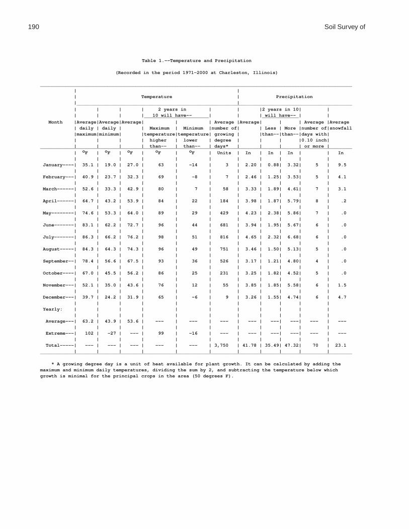
190 Soil Survey of
Table 1.--Temperature and Precipitation
(Recorded in the period 1971-2000 at Charleston, Illinois)
_______________________________________________________________________________________________________________ | | | Temperature | Precipitation | | __________________________________________________________________________________________________ | | | | 2 years in | | |2 years in 10| | | | | | 10 will have-- | | | will have-- | | _______________________ _____________ Month |Average|Average|Average| | | Average |Average| | | Average |Average | daily | daily | | Maximum | Minimum |number of| | Less | More |number of|snowfall |maximum|minimum| |temperature|temperature| growing | |than--|than--|days with| | | | | higher | lower | degree | | | |0.10 inch| | | | | than-- | than-- | days* | | | | or more |_______________________________________________________________________________________________________________ | oF | oF | oF | oF | oF | Units | In | In | In | | In | | | | | | | | | | | January----| 35.1 | 19.0 | 27.0 | 63 | -14 | 3 | 2.20 | 0.88| 3.32| 5 | 9.5 | | | | | | | | | | | February---| 40.9 | 23.7 | 32.3 | 69 | -8 | 7 | 2.46 | 1.25| 3.53| 5 | 4.1 | | | | | | | | | | | March------| 52.6 | 33.3 | 42.9 | 80 | 7 | 58 | 3.33 | 1.89| 4.61| 7 | 3.1 | | | | | | | | | | | April------| 64.7 | 43.2 | 53.9 | 84 | 22 | 184 | 3.98 | 1.87| 5.79| 8 | .2 | | | | | | | | | | | May--------| 74.6 | 53.3 | 64.0 | 89 | 29 | 429 | 4.23 | 2.38| 5.86| 7 | .0 | | | | | | | | | | | June-------| 83.1 | 62.2 | 72.7 | 96 | 44 | 681 | 3.94 | 1.95| 5.67| 6 | .0 | | | | | | | | | | | July-------| 86.3 | 66.2 | 76.2 | 98 | 51 | 816 | 4.65 | 2.32| 6.68| 6 | .0 | | | | | | | | | | | August-----| 84.3 | 64.3 | 74.3 | 96 | 49 | 751 | 3.46 | 1.50| 5.13| 5 | .0 | | | | | | | | | | | September--| 78.4 | 56.6 | 67.5 | 93 | 36 | 526 | 3.17 | 1.21| 4.80| 4 | .0 | | | | | | | | | | | October----| 67.0 | 45.5 | 56.2 | 86 | 25 | 231 | 3.25 | 1.82| 4.52| 5 | .0 | | | | | | | | | | | November---| 52.1 | 35.0 | 43.6 | 76 | 12 | 55 | 3.85 | 1.85| 5.58| 6 | 1.5 | | | | | | | | | | | December---| 39.7 | 24.2 | 31.9 | 65 | -6 | 9 | 3.26 | 1.55| 4.74| 6 | 4.7 | | | | | | | | | | | Yearly: | | | | | | | | | | | | | | | | | | | | | | Average---| 63.2 | 43.9 | 53.6 | --- | --- | --- | --- | ---| ---| --- | --- | | | | | | | | | | | Extreme---| 102 | -27 | --- | 99 | -16 | --- | --- | ---| ---| --- | --- | | | | | | | | | | | Total-----| --- | --- | --- | --- | --- | 3,750 | 41.78 | 35.49| 47.32| 70 | 23.1 | | | | | | | | | | |_______________________________________________________________________________________________________________
* A growing degree day is a unit of heat available for plant growth. It can be calculated by adding themaximum and minimum daily temperatures, dividing the sum by 2, and subtracting the temperature below whichgrowth is minimal for the principal crops in the area (50 degrees F).

Coles County, Illinois 191
Table 2.--Freeze Dates in Spring and Fall
(Recorded in the period 1971-2000 at Charleston, Illinois)
_____________________________________________________________ | | Temperature |__________________________________________ Probability | | | | 24 oF | 28 oF | 32 oF | or lower | or lower | or lower_____________________________________________________________ | | | | | |Last freezing | | | temperature | | | in spring: | | | | | | 1 year in 10 | | | later than-- | Apr. 11 | Apr. 15 | May 2 | | | 2 years in 10 | | | later than-- | Apr. 5 | Apr. 11 | Apr. 27 | | | 5 years in 10 | | | later than-- | Mar. 26 | Apr. 4 | Apr. 17 | | |First freezing | | | temperature | | | in fall: | | | | | | 1 year in 10 | | | earlier than-- | Oct. 27 | Oct. 12 | Oct. 1 | | | 2 years in 10 | | | earlier than-- | Nov. 2 | Oct. 18 | Oct. 6 | | | 5 years in 10 | | | earlier than-- | Nov. 13 | Oct. 29 | Oct. 16 | | |_____________________________________________________________
Table 3.--Growing Season
(Recorded in the period 1971-2000 at Charleston, Illinois)
__________________________________________________ | | Daily minimum temperature | during growing season |___________________________________ Probability | | | | Higher | Higher | Higher | than | than | than | 24 oF | 28 oF | 32 oF__________________________________________________ | Days | Days | Days | | |9 years in 10 | 210 | 186 | 160 | | |8 years in 10 | 217 | 193 | 167 | | |5 years in 10 | 231 | 207 | 181 | | |2 years in 10 | 245 | 221 | 194 | | |1 year in 10 | 253 | 228 | 201 | | |__________________________________________________

192 Soil Survey of
Table 4.--Classification of the Soils
(An asterisk in the first column indicates a taxadjunct to the series. See text for a description of those characteristics that are outside the range of the series)
_____________________________________________________________________________________ | Soil name | Family or higher taxonomic class |_____________________________________________________________________________________ | Bluford-----------|Fine, smectitic, mesic Aeric Fragic Epiaqualfs Brenton-----------|Fine-silty, mixed, superactive, mesic Aquic Argiudolls Brooklyn----------|Fine, smectitic, mesic Mollic Albaqualfs Brouillett--------|Fine-loamy, mixed, superactive, mesic Aquic Cumulic Hapludolls Camden------------|Fine-silty, mixed, superactive, mesic Typic Hapludalfs Cisne-------------|Fine, smectitic, mesic Mollic Albaqualfs Dana--------------|Fine-silty, mixed, superactive, mesic Oxyaquic Argiudolls*Dana--------------|Fine-silty, mixed, superactive, mesic Mollic Oxyaquic Hapludalfs Drummer-----------|Fine-silty, mixed, superactive, mesic Typic Endoaquolls Ebbert------------|Fine-silty, mixed, superactive, mesic Argiaquic Argialbolls*Fincastle---------|Fine-silty, mixed, superactive, mesic Aquic Hapludalfs Flanagan----------|Fine, smectitic, mesic Aquic Argiudolls Hartsburg---------|Fine-silty, mixed, superactive, mesic Typic Endoaquolls Hoyleton----------|Fine, smectitic, mesic Aquollic Hapludalfs Landes------------|Coarse-loamy, mixed, superactive, mesic Fluventic Hapludolls Lawson------------|Fine-silty, mixed, superactive, mesic Aquic Cumulic Hapludolls*Lenzburg----------|Fine-loamy, mixed, active, calcareous, mesic Typic Udorthents Martinsville------|Fine-loamy, mixed, active, mesic Typic Hapludalfs Milford-----------|Fine, mixed, superactive, mesic Typic Endoaquolls*Millbrook---------|Fine-silty, mixed, superactive, mesic Aquollic Hapludalfs Peotone-----------|Fine, smectitic, mesic Cumulic Vertic Endoaquolls Proctor-----------|Fine-silty, mixed, superactive, mesic Typic Argiudolls Raub--------------|Fine-silty, mixed, superactive, mesic Aquic Argiudolls Ross--------------|Fine-loamy, mixed, superactive, mesic Cumulic Hapludolls Russell-----------|Fine-silty, mixed, superactive, mesic Typic Hapludalfs Sawmill-----------|Fine-silty, mixed, superactive, mesic Cumulic Endoaquolls Senachwine--------|Fine-loamy, mixed, active, mesic Typic Hapludalfs Shiloh------------|Fine, smectitic, mesic Cumulic Vertic Endoaquolls Shoals------------|Fine-loamy, mixed, superactive, nonacid, mesic Fluventic | Endoaquepts Somonauk----------|Fine-silty, mixed, superactive, mesic Oxyaquic Hapludalfs*Starks------------|Fine-silty, mixed, superactive, mesic Aquic Hapludalfs Thorp-------------|Fine-silty, mixed, superactive, mesic Argiaquic Argialbolls Tice--------------|Fine-silty, mixed, superactive, mesic Fluvaquentic Hapludolls Toronto-----------|Fine-silty, mixed, superactive, mesic Udollic Epiaqualfs Wingate-----------|Fine-silty, mixed, superactive, mesic Mollic Oxyaquic Hapludalfs Wirt--------------|Coarse-loamy, mixed, superactive, mesic Dystric Fluventic | Eutrudepts Xenia-------------|Fine-silty, mixed, superactive, mesic Aquic Hapludalfs |_____________________________________________________________________________________

Coles County, Illinois 193
Table 5.--Acreage and Proportionate Extent of the Soils_______________________________________________________________________________________________________ | | | Map | Soil name | Acres |Percentsymbol | | |_______________________________________________________________________________________________________ | | |2A |Cisne silt loam, 0 to 2 percent slopes------------------------------------| 2,306 | 0.73A |Hoyleton silt loam, 0 to 2 percent slopes---------------------------------| 1,012 | 0.313A |Bluford silt loam, 0 to 2 percent slopes----------------------------------| 566 | 0.213B |Bluford silt loam, 2 to 5 percent slopes----------------------------------| 708 | 0.248A |Ebbert silt loam, 0 to 2 percent slopes-----------------------------------| 888 | 0.356B |Dana silt loam, 2 to 5 percent slopes-------------------------------------| 3,710 | 1.156B2 |Dana silt loam, 2 to 5 percent slopes, eroded-----------------------------| 10,234 | 3.1132A |Starks silt loam, 0 to 2 percent slopes-----------------------------------| 1,627 | 0.5136A |Brooklyn silt loam, 0 to 2 percent slopes---------------------------------| 607 | 0.2138A |Shiloh silty clay loam, 0 to 2 percent slopes-----------------------------| 664 | 0.2148B |Proctor silt loam, 2 to 5 percent slopes----------------------------------| 195 | *149A |Brenton silt loam, 0 to 2 percent slopes----------------------------------| 700 | 0.2152A |Drummer silty clay loam, 0 to 2 percent slopes----------------------------| 71,868 | 22.0154A |Flanagan silt loam, 0 to 2 percent slopes---------------------------------| 23,559 | 7.2206A |Thorp silt loam, 0 to 2 percent slopes------------------------------------| 275 | *219A |Millbrook silt loam, 0 to 2 percent slopes--------------------------------| 845 | 0.3244A |Hartsburg silty clay loam, 0 to 2 percent slopes--------------------------| 1,351 | 0.4291B |Xenia silt loam, 2 to 5 percent slopes------------------------------------| 30,320 | 9.3322B |Russell silt loam, 2 to 5 percent slopes----------------------------------| 1,737 | 0.5322C2 |Russell silt loam, 5 to 10 percent slopes, eroded-------------------------| 4,411 | 1.4330A |Peotone silty clay loam, 0 to 2 percent slopes----------------------------| 1,056 | 0.3348B |Wingate silt loam, 2 to 5 percent slopes----------------------------------| 15,531 | 4.8353A |Toronto silt loam, 0 to 2 percent slopes----------------------------------| 15,617 | 4.8481A |Raub silt loam, 0 to 2 percent slopes-------------------------------------| 27,207 | 8.3496A |Fincastle silt loam, 0 to 2 percent slopes--------------------------------| 20,378 | 6.2533 |Urban land----------------------------------------------------------------| 972 | 0.3570B |Martinsville silt loam, 2 to 5 percent slopes-----------------------------| 50 | *570C2 |Martinsville loam, 5 to 12 percent slopes, eroded-------------------------| 698 | 0.2618C2 |Senachwine silt loam, 5 to 10 percent slopes, eroded----------------------| 13,222 | 4.1618C3 |Senachwine clay loam, 5 to 10 percent slopes, severely eroded-------------| 703 | 0.2618D2 |Senachwine silt loam, 10 to 18 percent slopes, eroded---------------------| 2,558 | 0.8618D3 |Senachwine clay loam, 10 to 18 percent slopes, severely eroded------------| 526 | 0.2618F |Senachwine silt loam, 18 to 35 percent slopes-----------------------------| 5,912 | 1.8618G |Senachwine silt loam, 35 to 60 percent slopes-----------------------------| 10,222 | 3.1668B2 |Somonauk silt loam, 2 to 5 percent slopes, eroded-------------------------| 2,435 | 0.7722A |Drummer-Milford silty clay loams, 0 to 2 percent slopes-------------------| 30,022 | 9.2830 |Landfill------------------------------------------------------------------| 39 | *864 |Pits, quarry--------------------------------------------------------------| 211 | *865 |Pits, gravel--------------------------------------------------------------| 29 | *871B |Lenzburg gravelly loam, 1 to 5 percent slopes-----------------------------| 421 | 0.1871D |Lenzburg loam, 7 to 20 percent slopes-------------------------------------| 382 | 0.13073A |Ross silt loam, 0 to 2 percent slopes, frequently flooded-----------------| 1,336 | 0.43107A |Sawmill silty clay loam, 0 to 2 percent slopes, frequently flooded--------| 1,685 | 0.53226A |Wirt silt loam, 0 to 2 percent slopes, frequently flooded-----------------| 1,076 | 0.33284A |Tice silty clay loam, 0 to 2 percent slopes, frequently flooded-----------| 518 | 0.23304A |Landes fine sandy loam, 0 to 2 percent slopes, frequently flooded---------| 4,249 | 1.33424A |Shoals silt loam, 0 to 2 percent slopes, frequently flooded---------------| 1,026 | 0.33450A |Brouillett silt loam, 0 to 2 percent slopes, frequently flooded-----------| 309 | *3451A |Lawson silt loam, 0 to 2 percent slopes, frequently flooded---------------| 6,116 | 1.97132A |Starks silt loam, 0 to 2 percent slopes, rarely flooded-------------------| 387 | 0.17373B |Camden silt loam, sandy substratum, 2 to 5 percent slopes, rarely flooded | 1,146 | 0.47570B |Martinsville silt loam, 2 to 5 percent slopes, rarely flooded-------------| 537 | 0.2M-W |Miscellaneous water-------------------------------------------------------| 42 | *W |Water---------------------------------------------------------------------| 2,244 | 0.7 | |____________|_______ | Total----------------------------------------------------------------| 326,445 | 100.0 | | |_______________________________________________________________________________________________________
* Less than 0.1 percent.

194 Soil Survey of
Table 6.--Limitations and Hazards Affecting Cropland and Pastureland
(See text for a description of the limitations and hazards listed in this table. Only the soils that are generally available for use as cropland or pastureland are listed. Absence of an entry indicates that the soil is generally not suited to use as cropland or pastureland)
___________________________________________________________________________________________ | | Map symbol | Limitations and hazards | Limitations and hazards and soil name | affecting cropland | affecting pastureland | |___________________________________________________________________________________________ | |2A: | | Cisne--------------------|Ponding, restricted |Ponding, low pH, frost heave, | permeability, wetness | wetness | |3A: | | Hoyleton-----------------|Wetness |Wetness, low pH | |13A: | | Bluford------------------|Wetness, restricted |Wetness, low pH | permeability | | |13B: | | Bluford------------------|Wetness, water erosion, |Wetness, low pH, water erosion | restricted permeability | | |48A: | | Ebbert-------------------|Ponding, restricted |Ponding, low pH, frost heave, | permeability, wetness | wetness | |56B: | | Dana---------------------|Water erosion |Low pH, water erosion | |56B2: | | Dana---------------------|Crusting, water erosion |Low pH, water erosion | |132A: | | Starks-------------------|Wetness, crusting |Wetness, low pH | |136A: | | Brooklyn-----------------|Ponding, restricted |Ponding, low pH, frost heave, | permeability, wetness | wetness | |138A: | | Shiloh-------------------|Ponding, poor tilth, wetness |Ponding, frost heave, wetness | |148B: | | Proctor------------------|Water erosion |Low pH, water erosion | |149A: | | Brenton------------------|Wetness |Wetness | |152A: | | Drummer------------------|Ponding, wetness |Ponding, frost heave, wetness | |154A: | | Flanagan-----------------|Wetness |Wetness | |206A: | | Thorp--------------------|Ponding, restricted |Ponding, low pH, frost heave, | permeability, wetness | wetness | |219A: | | Millbrook----------------|Wetness |Wetness, low pH | |244A: | | Hartsburg----------------|Ponding, high pH, excess lime,|Ponding, high pH, excess lime, | wetness | frost heave, wetness | |

Coles County, Illinois 195
Table 6.--Limitations and Hazards Affecting Cropland and Pastureland--Continued___________________________________________________________________________________________ | | Map symbol | Limitations and hazards | Limitations and hazards and soil name | affecting cropland | affecting pastureland | |___________________________________________________________________________________________ | |291B: | | Xenia--------------------|Water erosion |Wetness, low pH, water erosion | |322B: | | Russell------------------|Water erosion |Low pH, water erosion | |322C2: | | Russell------------------|Crusting, water erosion |Low pH, water erosion | |330A: | | Peotone------------------|Ponding, poor tilth, wetness |Ponding, frost heave, wetness | |348B: | | Wingate------------------|Water erosion |Low pH, water erosion | |353A: | | Toronto------------------|Wetness |Wetness, low pH | |481A: | | Raub---------------------|Wetness, root-restrictive |Wetness, root-restrictive | layer | layer, low pH | |496A: | | Fincastle----------------|Wetness, root-restrictive |Wetness, root-restrictive | layer, crusting | layer, low pH | |570B: | | Martinsville-------------|Water erosion |Low pH, water erosion | |570C2: | | Martinsville-------------|Water erosion |Low pH, water erosion | |618C2: | | Senachwine---------------|High pH, crusting, water |Low pH, high pH, water | erosion | erosion | |618C3: | | Senachwine---------------|Poor tilth, high pH, crusting,|Poor tilth, low pH, high pH, | water erosion | water erosion, low fertility | |618D2: | | Senachwine---------------|High pH, crusting, water |Low pH, high pH, water | erosion | erosion | |618D3: | | Senachwine---------------|High pH, crusting, water |Poor tilth, low pH, high pH, | erosion | water erosion, low fertility | |618F: | | Senachwine---------------| --- |Equipment limitation, low pH, | | water erosion | |618G: | | Senachwine---------------| --- | --- | |668B2: | | Somonauk-----------------|Crusting, water erosion |Low pH, water erosion | |722A: | | Drummer------------------|Ponding, wetness |Ponding, frost heave, wetness | | Milford------------------|Ponding, poor tilth, wetness |Ponding, frost heave, wetness | |

196 Soil Survey of
Table 6.--Limitations and Hazards Affecting Cropland and Pastureland--Continued___________________________________________________________________________________________ | | Map symbol | Limitations and hazards | Limitations and hazards and soil name | affecting cropland | affecting pastureland | |___________________________________________________________________________________________ | |871B: | | Lenzburg-----------------| --- |High pH, low fertility, excess | | lime | |871D: | | Lenzburg-----------------| --- |High pH, water erosion, low | | fertility, excess lime | |3073A: | | Ross---------------------|Flooding |Flooding | |3107A: | | Sawmill------------------|Flooding, ponding, wetness |Flooding, ponding, frost | | heave, wetness | |3226A: | | Wirt---------------------|Flooding |Flooding | |3284A: | | Tice---------------------|Flooding, wetness, poor tilth |Flooding, wetness, poor tilth | |3304A: | | Landes-------------------|Flooding, excessive |Flooding, excessive | permeability | permeability | |3424A: | | Shoals-------------------|Flooding, wetness |Flooding, wetness | |3450A: | | Brouillett---------------|Flooding, wetness, crusting |Flooding, wetness | |3451A: | | Lawson-------------------|Flooding, wetness |Flooding, wetness | |7132A: | | Starks-------------------|Wetness |Wetness, low pH | |7373B: | | Camden-------------------|Water erosion |Low pH, water erosion | |7570B: | | Martinsville-------------|Water erosion |Low pH, water erosion | |___________________________________________________________________________________________
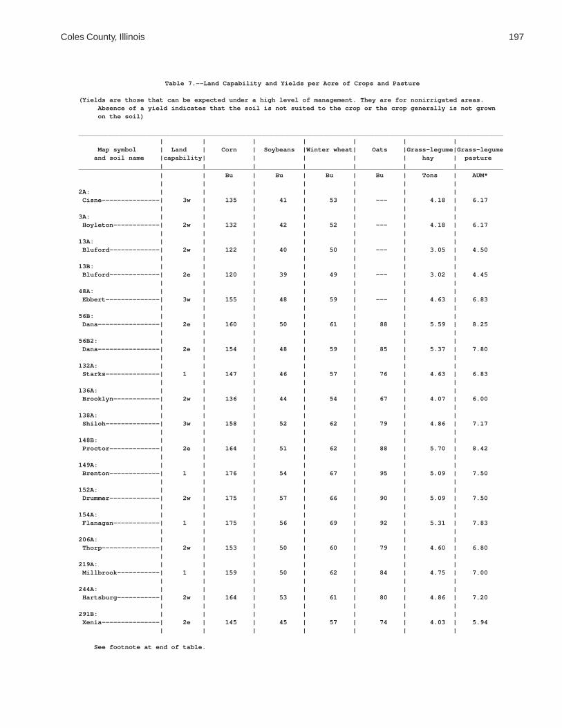
Coles County, Illinois 197
Table 7.--Land Capability and Yields per Acre of Crops and Pasture
(Yields are those that can be expected under a high level of management. They are for nonirrigated areas. Absence of a yield indicates that the soil is not suited to the crop or the crop generally is not grown on the soil)
______________________________________________________________________________________________________________ | | | | | | | Map symbol | Land | Corn | Soybeans |Winter wheat| Oats |Grass-legume|Grass-legume and soil name |capability| | | | | hay | pasture | | | | | | |______________________________________________________________________________________________________________ | | Bu | Bu | Bu | Bu | Tons | AUM* | | | | | | |2A: | | | | | | | Cisne---------------| 3w | 135 | 41 | 53 | --- | 4.18 | 6.17 | | | | | | |3A: | | | | | | | Hoyleton------------| 2w | 132 | 42 | 52 | --- | 4.18 | 6.17 | | | | | | |13A: | | | | | | | Bluford-------------| 2w | 122 | 40 | 50 | --- | 3.05 | 4.50 | | | | | | |13B: | | | | | | | Bluford-------------| 2e | 120 | 39 | 49 | --- | 3.02 | 4.45 | | | | | | |48A: | | | | | | | Ebbert--------------| 3w | 155 | 48 | 59 | --- | 4.63 | 6.83 | | | | | | |56B: | | | | | | | Dana----------------| 2e | 160 | 50 | 61 | 88 | 5.59 | 8.25 | | | | | | |56B2: | | | | | | | Dana----------------| 2e | 154 | 48 | 59 | 85 | 5.37 | 7.80 | | | | | | |132A: | | | | | | | Starks--------------| 1 | 147 | 46 | 57 | 76 | 4.63 | 6.83 | | | | | | |136A: | | | | | | | Brooklyn------------| 2w | 136 | 44 | 54 | 67 | 4.07 | 6.00 | | | | | | |138A: | | | | | | | Shiloh--------------| 3w | 158 | 52 | 62 | 79 | 4.86 | 7.17 | | | | | | |148B: | | | | | | | Proctor-------------| 2e | 164 | 51 | 62 | 88 | 5.70 | 8.42 | | | | | | |149A: | | | | | | | Brenton-------------| 1 | 176 | 54 | 67 | 95 | 5.09 | 7.50 | | | | | | |152A: | | | | | | | Drummer-------------| 2w | 175 | 57 | 66 | 90 | 5.09 | 7.50 | | | | | | |154A: | | | | | | | Flanagan------------| 1 | 175 | 56 | 69 | 92 | 5.31 | 7.83 | | | | | | |206A: | | | | | | | Thorp---------------| 2w | 153 | 50 | 60 | 79 | 4.60 | 6.80 | | | | | | |219A: | | | | | | | Millbrook-----------| 1 | 159 | 50 | 62 | 84 | 4.75 | 7.00 | | | | | | |244A: | | | | | | | Hartsburg-----------| 2w | 164 | 53 | 61 | 80 | 4.86 | 7.20 | | | | | | |291B: | | | | | | | Xenia---------------| 2e | 145 | 45 | 57 | 74 | 4.03 | 5.94 | | | | | | |
See footnote at end of table.

198 Soil Survey of
Table 7.--Land Capability and Yields per Acre of Crops and Pasture--Continued______________________________________________________________________________________________________________ | | | | | | | Map symbol | Land | Corn | Soybeans |Winter wheat| Oats |Grass-legume|Grass-legume and soil name |capability| | | | | hay | pasture | | | | | | |______________________________________________________________________________________________________________ | | Bu | Bu | Bu | Bu | Tons | AUM* | | | | | | |322B: | | | | | | | Russell-------------| 2e | 142 | 44 | 56 | 72 | 4.03 | 5.94 | | | | | | |322C2: | | | | | | | Russell-------------| 3e | 134 | 42 | 53 | 68 | 3.79 | 5.52 | | | | | | |330A: | | | | | | | Peotone-------------| 3w | 148 | 49 | 55 | 70 | 4.52 | 6.67 | | | | | | |348B: | | | | | | | Wingate-------------| 2e | 148 | 46 | 60 | 81 | 4.81 | 7.10 | | | | | | |353A: | | | | | | | Toronto-------------| 2w | 156 | 50 | 62 | 84 | 4.75 | 7.00 | | | | | | |481A: | | | | | | | Raub----------------| 1 | 165 | 52 | 66 | 92 | 5.09 | 7.50 | | | | | | |496A: | | | | | | | Fincastle-----------| 1 | 150 | 47 | 59 | 77 | 4.52 | 6.67 | | | | | | |533: | | | | | | | Urban land----------| 8 | --- | --- | --- | --- | --- | --- | | | | | | |570B: | | | | | | | Martinsville--------| 2e | 139 | 44 | 56 | 67 | 4.03 | 5.94 | | | | | | |570C2: | | | | | | | Martinsville--------| 3e | 130 | 41 | 53 | 63 | 3.79 | 5.52 | | | | | | |618C2: | | | | | | | Senachwine----------| 3e | 123 | 40 | 48 | 59 | 2.94 | 4.29 | | | | | | |618C3: | | | | | | | Senachwine----------| 3e | 114 | 37 | 45 | 54 | 2.72 | 3.90 | | | | | | |618D2: | | | | | | | Senachwine----------| 4e | 115 | 37 | 45 | 55 | 2.75 | 3.97 | | | | | | |618D3: | | | | | | | Senachwine----------| 4e | 104 | 34 | 41 | --- | 2.50 | 3.60 | | | | | | |618F: | | | | | | | Senachwine----------| 6e | --- | --- | --- | --- | 2.31 | 3.36 | | | | | | |618G: | | | | | | | Senachwine----------| 7e | --- | --- | --- | --- | --- | 2.20 | | | | | | |668B2: | | | | | | | Somonauk------------| 2e | 140 | 42 | 54 | 72 | 4.40 | 6.49 | | | | | | |722A: | | | | | | | Drummer-Milford-----| 2w | 167 | 55 | 64 | 86 | 5.04 | 7.40 | | | | | | |830. | | | | | | | Landfill | | | | | | | | | | | | | |864. | | | | | | | Pits, quarry | | | | | | | | | | | | | |
See footnote at end of table.


200 Soil Survey of
Table 8.--Prime Farmland
(Only the soils considered prime farmland are listed. Urban or built-up areas of the soils listed are not considered prime farmland. If a soil is prime farmland only under certain conditions, the conditions are specified in parentheses after the soil name)
_______________________________________________________________________________________________________ | Map | Soil namesymbol | |_______________________________________________________________________________________________________ |2A |Cisne silt loam, 0 to 2 percent slopes (where drained)3A |Hoyleton silt loam, 0 to 2 percent slopes13A |Bluford silt loam, 0 to 2 percent slopes (where drained)13B |Bluford silt loam, 2 to 5 percent slopes48A |Ebbert silt loam, 0 to 2 percent slopes (where drained)56B |Dana silt loam, 2 to 5 percent slopes56B2 |Dana silt loam, 2 to 5 percent slopes, eroded132A |Starks silt loam, 0 to 2 percent slopes136A |Brooklyn silt loam, 0 to 2 percent slopes (where drained)138A |Shiloh silty clay loam, 0 to 2 percent slopes (where drained)148B |Proctor silt loam, 2 to 5 percent slopes149A |Brenton silt loam, 0 to 2 percent slopes152A |Drummer silty clay loam, 0 to 2 percent slopes (where drained)154A |Flanagan silt loam, 0 to 2 percent slopes206A |Thorp silt loam, 0 to 2 percent slopes (where drained)219A |Millbrook silt loam, 0 to 2 percent slopes244A |Hartsburg silty clay loam, 0 to 2 percent slopes (where drained)291B |Xenia silt loam, 2 to 5 percent slopes322B |Russell silt loam, 2 to 5 percent slopes330A |Peotone silty clay loam, 0 to 2 percent slopes (where drained)348B |Wingate silt loam, 2 to 5 percent slopes353A |Toronto silt loam, 0 to 2 percent slopes (where drained)481A |Raub silt loam, 0 to 2 percent slopes496A |Fincastle silt loam, 0 to 2 percent slopes570B |Martinsville silt loam, 2 to 5 percent slopes668B2 |Somonauk silt loam, 2 to 5 percent slopes, eroded722A |Drummer-Milford silty clay loams, 0 to 2 percent slopes (where drained)3073A |Ross silt loam, 0 to 2 percent slopes, frequently flooded (where protected from flooding or | not frequently flooded during the growing season)3107A |Sawmill silty clay loam, 0 to 2 percent slopes, frequently flooded (where drained and either | protected from flooding or not frequently flooded during the growing season)3226A |Wirt silt loam, 0 to 2 percent slopes, frequently flooded (where protected from flooding or | not frequently flooded during the growing season)3284A |Tice silty clay loam, 0 to 2 percent slopes, frequently flooded (where protected from | flooding or not frequently flooded during the growing season)3304A |Landes fine sandy loam, 0 to 2 percent slopes, frequently flooded (where protected from | flooding or not frequently flooded during the growing season)3424A |Shoals silt loam, 0 to 2 percent slopes, frequently flooded (where drained and either | protected from flooding or not frequently flooded during the growing season)3450A |Brouillett silt loam, 0 to 2 percent slopes, frequently flooded (where protected from flooding | or not frequently flooded during the growing season)3451A |Lawson silt loam, 0 to 2 percent slopes, frequently flooded (where protected from flooding or | not frequently flooded during the growing season)7132A |Starks silt loam, 0 to 2 percent slopes, rarely flooded7373B |Camden silt loam, sandy substratum, 2 to 5 percent slopes, rarely flooded7570B |Martinsville silt loam, 2 to 5 percent slopes, rarely flooded |_______________________________________________________________________________________________________

Coles County, Illinois 201
Table 9.--Hydric Soils
(Only those map units that have hydric components are listed. See text for a description of hydric qualities and definitions of the hydric criteria codes)
______________________________________________________________________________________________ | | | | Map symbol and | Component | Hydric | Local landform | Hydric map unit name | | status | | criteria | | | |______________________________________________________________________________________________ | | | |2A: | | | | Cisne silt loam, 0 to 2 percent |Cisne | Hydric |till plain | 2B3 slopes | | | | | | | |3A: | | | | Hoyleton silt loam, 0 to 2 percent|Hoyleton |Not hydric|till plain | --- slopes |Cisne | Hydric |flat | 2B3 | | | |13A: | | | | Bluford silt loam, 0 to 2 percent |Bluford |Not hydric|till plain | --- slopes |Cisne | Hydric |flat | 2B3 | | | |13B: | | | | Bluford silt loam, 2 to 5 percent |Bluford |Not hydric|till plain | --- slopes |Cisne | Hydric |flat | 2B3 | | | |48A: | | | | Ebbert silt loam, 0 to 2 percent |Ebbert | Hydric |depression, till | 2B3 slopes | | | plain | | | | |56B: | | | | Dana silt loam, 2 to 5 percent |Dana |Not hydric|ground moraine | --- slopes |Drummer | Hydric |swale | 2B3 | | | |56B2: | | | | Dana silt loam, 2 to 5 percent |Dana |Not hydric|ground moraine | --- slopes, eroded |Drummer | Hydric |swale | 2B3 | | | |132A: | | | | Starks silt loam, 0 to 2 percent |Starks |Not hydric|outwash plain, | --- slopes | | | stream terrace | |Drummer | Hydric |swale | 2B3 |Brooklyn | Hydric |depression | 2B3 | | | |136A: | | | | Brooklyn silt loam, 0 to 2 percent|Brooklyn | Hydric |outwash plain, | 2B3 slopes | | | stream terrace | | | | |138A: | | | | Shiloh silty clay loam, 0 to 2 |Shiloh | Hydric |depression, till | 2B3 percent slopes | | | plain | | | | |148B: | | | | Proctor silt loam, 2 to 5 percent |Proctor |Not hydric|outwash plain | --- slopes |Drummer | Hydric |swale | 2B3 | | | |149A: | | | | Brenton silt loam, 0 to 2 percent |Brenton |Not hydric|outwash plain, | --- slopes | | | stream terrace | |Drummer | Hydric |swale | 2B3 | | | |152A: | | | | Drummer silty clay loam, 0 to 2 |Drummer | Hydric |outwash plain, | 2B3 percent slopes | | | stream terrace | | | | |154A: | | | | Flanagan silt loam, 0 to 2 percent|Flanagan |Not hydric|ground moraine | --- slopes |Drummer | Hydric |swale | 2B3 | | | |

202 Soil Survey of
Table 9.--Hydric Soils--Continued______________________________________________________________________________________________ | | | | Map symbol and | Component | Hydric | Local landform | Hydric map unit name | | status | | criteria | | | |______________________________________________________________________________________________ | | | |206A: | | | | Thorp silt loam, 0 to 2 percent |Thorp | Hydric |outwash plain, | 2B3 slopes | | | ground moraine | | | | |219A: | | | | Millbrook silt loam, 0 to 2 |Millbrook |Not hydric|outwash plain, | --- percent slopes | | | outwash terrace | |Drummer | Hydric |swale | 2B3 |Brooklyn | Hydric |depression | 2B3 | | | |244A: | | | | Hartsburg silty clay loam, 0 to 2 |Hartsburg | Hydric |outwash plain, | 2B3 percent slopes | | | ground moraine | | | | |291B: | | | | Xenia silt loam, 2 to 5 percent |Xenia |Not hydric|ground moraine | --- slopes |Drummer | Hydric |swale | 2B3 | | | |322B: | | | | Russell silt loam, 2 to 5 percent |Russell |Not hydric|ground moraine | --- slopes |Drummer | Hydric |swale | 2B3 | | | |322C2: | | | | Russell silt loam, 5 to 10 |Russell |Not hydric|ground moraine, end | --- percent slopes, eroded | | | moraine | |Drummer | Hydric |swale | 2B3 | | | |330A: | | | | Peotone silty clay loam, 0 to 2 |Peotone | Hydric |depression, closed | 2B3 percent slopes | | | depression | | | | |348B: | | | | Wingate silt loam, 2 to 5 percent |Wingate |Not hydric|ground moraine | --- slopes |Drummer | Hydric |swale | 2B3 | | | |353A: | | | | Toronto silt loam, 0 to 2 percent |Toronto |Not hydric|ground moraine | --- slopes |Drummer | Hydric |swale | 2B3 | | | |481A: | | | | Raub silt loam, 0 to 2 percent |Raub |Not hydric|ground moraine | --- slopes |Drummer | Hydric |swale | 2B3 | | | |496A: | | | | Fincastle silt loam, 0 to 2 |Fincastle |Not hydric|ground moraine | --- percent slopes |Drummer | Hydric |swale | 2B3 | | | |570B: | | | | Martinsville silt loam, 2 to 5 |Martinsville |Not hydric|outwash terrace, | --- percent slopes | | | outwash plain | |Drummer | Hydric |swale | 2B3 | | | |570C2: | | | | Martinsville loam, 5 to 12 |Martinsville |Not hydric|outwash terrace, | --- percent slopes, eroded | | | outwash plain | |Drummer | Hydric |swale | 2B3 |Sawmill | Hydric |flood plain | 2B3 | | | |618C2: | | | | Senachwine silt loam, 5 to 10 |Senachwine |Not hydric|ground moraine, end | --- percent slopes, eroded | | | moraine | |Drummer | Hydric |swale | 2B3 | | | |

Coles County, Illinois 203
Table 9.--Hydric Soils--Continued______________________________________________________________________________________________ | | | | Map symbol and | Component | Hydric | Local landform | Hydric map unit name | | status | | criteria | | | |______________________________________________________________________________________________ | | | |618C3: | | | | Senachwine clay loam, 5 to 10 |Senachwine |Not hydric|ground moraine, end | --- percent slopes, severely eroded | | | moraine | |Drummer | Hydric |swale | 2B3 | | | |618D2: | | | | Senachwine silt loam, 10 to 18 |Senachwine |Not hydric|end moraine, ground | --- percent slopes, eroded | | | moraine | |Drummer | Hydric |swale | 2B3 |Sawmill | Hydric |flood plain | 2B3 | | | |618D3: | | | | Senachwine clay loam, 10 to 18 |Senachwine |Not hydric|end moraine, ground | --- percent slopes, severely eroded | | | moraine | |Drummer | Hydric |swale | 2B3 | | | |618F: | | | | Senachwine silt loam, 18 to 35 |Senachwine |Not hydric|end moraine, ground | --- percent slopes | | | moraine | |Sawmill | Hydric |flood plain | 2B3 | | | |618G: | | | | Senachwine silt loam, 35 to 60 |Senachwine |Not hydric|end moraine, ground | --- percent slopes | | | moraine | |Sawmill | Hydric |flood plain | 2B3 | | | |668B2: | | | | Somonauk silt loam, 2 to 5 percent|Somonauk |Not hydric|stream terrace, | --- slopes, eroded | | | outwash plain | |Drummer | Hydric |swale | 2B3 | | | |722A: | | | | Drummer-Milford silty clay loams, |Drummer | Hydric |outwash plain | 2B3 0 to 2 percent slopes |Milford | Hydric |depression, outwash | 2B3 | | | plain | | | | |3073A: | | | | Ross silt loam, 0 to 2 percent |Ross |Not hydric|flood plain, | --- slopes, frequently flooded | | | flood-plain step | |Sawmill | Hydric |swale | 2B3 | | | |3107A: | | | | Sawmill silty clay loam, 0 to 2 |Sawmill | Hydric |flood plain | 2B3 percent slopes, frequently | | | | flooded | | | | | | | |3226A: | | | | Wirt silt loam, 0 to 2 percent |Wirt |Not hydric|flood-plain step | --- slopes, frequently flooded |Sawmill | Hydric |swale | 2B3 | | | |3284A: | | | | Tice silty clay loam, 0 to 2 |Tice |Not hydric|flood plain | --- percent slopes, frequently |Sawmill | Hydric |swale | 2B3 flooded |Sawmill | Hydric |backswamp | 4,3,2B3 | | | |3304A: | | | | Landes fine sandy loam, 0 to 2 |Landes |Not hydric|flood-plain step | --- percent slopes, frequently |Sawmill | Hydric |swale | 2B3 flooded |Sawmill | Hydric |backswamp | 4,2B3,3 | | | |

204 Soil Survey of
Table 9.--Hydric Soils--Continued______________________________________________________________________________________________ | | | | Map symbol and | Component | Hydric | Local landform | Hydric map unit name | | status | | criteria | | | |______________________________________________________________________________________________ | | | |3450A: | | | | Brouillett silt loam, 0 to 2 |Brouillett |Not hydric|flood plain | --- percent slopes, frequently |Sawmill | Hydric |swale | 2B3 flooded |Sawmill | Hydric |backswamp | 2B3,3,4 | | | |3451A: | | | | Lawson silt loam, 0 to 2 percent |Lawson |Not hydric|flood plain | --- slopes, frequently flooded |Sawmill | Hydric |swale | 2B3 |Sawmill | Hydric |backswamp | 4,3,2B3 | | | |7132A: | | | | Starks silt loam, 0 to 2 percent |Starks |Not hydric|stream terrace | --- slopes, rarely flooded |Sawmill | Hydric |flood plain | 2B3 | | | |7373B: | | | | Camden silt loam, sandy |Camden |Not hydric|stream terrace | --- substratum, 2 to 5 percent |Sawmill | Hydric |flood plain | 2B3 slopes, rarely flooded | | | | | | | |7570B: | | | | Martinsville silt loam, 2 to 5 |Martinsville |Not hydric|stream terrace | --- percent slopes, rarely flooded |Sawmill | Hydric |flood plain | 2B3 | | | |______________________________________________________________________________________________

Coles C
ounty, Illinois205
Table 10.--Windbreaks and Environmental Plantings
(Absence of an entry indicates that trees generally do not grow to the given height)
__________________________________________________________________________________________________________________________________ | Trees having predicted 20-year average height, in feet, of-- Map symbol |________________________________________________________________________________________________________ and soil name | <8 | 8-15 | 16-25 | 26-35 | >35__________________________________________________________________________________________________________________________________ | | | | |2A: | | | | | Cisne-------------------|American |Cockspur hawthorn, |Arborvitae, |Sweetgum, red maple,|Carolina poplar, | cranberrybush, | hazel alder, | blackgum, common | river birch, swamp | eastern cottonwood, | black chokeberry, | nannyberry, | hackberry, green | white oak | pin oak | buttonbush, common | roughleaf dogwood | hawthorn, northern | | | elderberry, common | | white-cedar, | | | ninebark, common | | shingle oak | | | winterberry, gray | | | | | dogwood, highbush | | | | | blueberry, northern| | | | | spicebush, redosier| | | | | dogwood, silky | | | | | dogwood | | | | | | | | |3A: | | | | | Hoyleton----------------|American |Cockspur hawthorn, |Arborvitae, |Sweetgum, red maple,|Carolina poplar, | cranberrybush, | hazel alder, | blackgum, common | river birch, swamp | eastern cottonwood, | black chokeberry, | nannyberry, | hackberry, green | white oak | pin oak | buttonbush, common | roughleaf dogwood | hawthorn, northern | | | elderberry, common | | white-cedar, | | | ninebark, common | | shingle oak | | | winterberry, gray | | | | | dogwood, highbush | | | | | blueberry, northern| | | | | spicebush, redosier| | | | | dogwood, silky | | | | | dogwood | | | | | | | | |13A: | | | | | Bluford-----------------|American |American plum, |Virginia pine, |Norway spruce-------|Carolina poplar | cranberrybush, | American | arborvitae, black | | | American hazelnut, | witchhazel, | oak, blackgum, bur | | | black chokeberry, | Washington | oak, chinkapin oak,| | | common juniper, | hawthorn, blackhaw,| common hackberry, | | | coralberry, gray | common chokecherry,| eastern redcedar | | | dogwood, mapleleaf | common | | | | viburnum, silky | serviceberry, | | | | dogwood | nannyberry, prairie| | | | | crabapple, | | | | | roughleaf dogwood, | | | | | staghorn sumac | | | | | | | |

206S
oil Survey of
Table 10.--Windbreaks and Environmental Plantings--Continued__________________________________________________________________________________________________________________________________ | Trees having predicted 20-year average height, in feet, of-- Map symbol |________________________________________________________________________________________________________ and soil name | <8 | 8-15 | 16-25 | 26-35 | >35__________________________________________________________________________________________________________________________________ | | | | |13B: | | | | | Bluford-----------------|American |American plum, |Virginia pine, |Norway spruce-------|Carolina poplar | cranberrybush, | American | arborvitae, black | | | American hazelnut, | witchhazel, | oak, blackgum, bur | | | black chokeberry, | Washington | oak, chinkapin oak,| | | common juniper, | hawthorn, blackhaw,| common hackberry, | | | coralberry, gray | common chokecherry,| eastern redcedar | | | dogwood, mapleleaf | common | | | | viburnum, silky | serviceberry, | | | | dogwood | nannyberry, prairie| | | | | crabapple, | | | | | roughleaf dogwood, | | | | | staghorn sumac | | | | | | | |48A: | | | | | Ebbert------------------|American |Cockspur hawthorn, |Arborvitae, |Sweetgum, red maple,|Carolina poplar, | cranberrybush, | hazel alder, | blackgum, common | river birch, swamp | eastern cottonwood, | black chokeberry, | nannyberry, | hackberry, green | white oak | pin oak | buttonbush, common | roughleaf dogwood | hawthorn, northern | | | elderberry, common | | white-cedar, | | | ninebark, common | | shingle oak | | | winterberry, gray | | | | | dogwood, highbush | | | | | blueberry, northern| | | | | spicebush, redosier| | | | | dogwood, silky | | | | | dogwood | | | | | | | | |56B: | | | | | Dana--------------------|American hazelnut, |American plum, |Washington hawthorn,|Douglas fir, Norway |Carolina poplar, | black chokeberry, | American | arborvitae, blue | spruce, black | eastern cottonwood, | common elderberry, | witchhazel, | spruce, common | walnut, blackgum, | eastern white pine | common juniper, | blackhaw, common | persimmon, eastern | common hackberry, | | common ninebark, | chokecherry, common| redcedar, | tuliptree, northern| | common winterberry,| serviceberry, | nannyberry, pecan, | red oak, pin oak | | coralberry, | prairie crabapple, | white oak | | | mapleleaf viburnum,| roughleaf dogwood, | | | | redosier dogwood, | smooth sumac, | | | | silky dogwood | southern arrowwood | | | | | | | |

Coles C
ounty, Illinois207
Table 10.--Windbreaks and Environmental Plantings--Continued__________________________________________________________________________________________________________________________________ | Trees having predicted 20-year average height, in feet, of-- Map symbol |________________________________________________________________________________________________________ and soil name | <8 | 8-15 | 16-25 | 26-35 | >35__________________________________________________________________________________________________________________________________ | | | | |56B2: | | | | | Dana--------------------|American hazelnut, |American plum, |Washington hawthorn,|Douglas fir, Norway |Carolina poplar, | black chokeberry, | American | arborvitae, blue | spruce, black | eastern cottonwood, | common elderberry, | witchhazel, | spruce, common | walnut, blackgum, | eastern white pine | common juniper, | blackhaw, common | persimmon, eastern | common hackberry, | | common ninebark, | chokecherry, common| redcedar, | tuliptree, northern| | common winterberry,| serviceberry, | nannyberry, pecan, | red oak, pin oak | | coralberry, | prairie crabapple, | white oak | | | mapleleaf viburnum,| roughleaf dogwood, | | | | redosier dogwood, | smooth sumac, | | | | silky dogwood | southern arrowwood | | | | | | | |132A: | | | | | Starks------------------|American |Blackhaw, cockspur |Austrian pine, |Norway spruce, |Carolina poplar, | cranberrybush, | hawthorn, common | Douglas fir, | blackgum, common | eastern cottonwood, | Canada yew, black | pawpaw, common | arborvitae, blue | hackberry, red | pin oak | chokeberry, common | serviceberry, | spruce, common | maple, swamp white | | elderberry, common | prairie crabapple, | persimmon, eastern | oak, sweetgum | | juniper, common | roughleaf dogwood, | redcedar, green | | | ninebark, common | rusty blackhaw, | hawthorn, | | | winterberry, | southern arrowwood,| nannyberry, pecan, | | | northern spicebush,| witchhazel | shingle oak | | | redosier dogwood, | | | | | silky dogwood | | | | | | | | |136A: | | | | | Brooklyn----------------|American |Cockspur hawthorn, |Arborvitae, |Sweetgum, red maple,|Carolina poplar, | cranberrybush, | hazel alder, | blackgum, common | river birch, swamp | eastern cottonwood, | black chokeberry, | nannyberry, | hackberry, green | white oak | pin oak | buttonbush, common | roughleaf dogwood | hawthorn, northern | | | elderberry, common | | white-cedar, | | | ninebark, common | | shingle oak | | | winterberry, gray | | | | | dogwood, highbush | | | | | blueberry, northern| | | | | spicebush, redosier| | | | | dogwood, silky | | | | | dogwood | | | | | | | | |
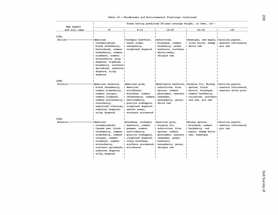
208S
oil Survey of
Table 10.--Windbreaks and Environmental Plantings--Continued__________________________________________________________________________________________________________________________________ | Trees having predicted 20-year average height, in feet, of-- Map symbol |________________________________________________________________________________________________________ and soil name | <8 | 8-15 | 16-25 | 26-35 | >35__________________________________________________________________________________________________________________________________ | | | | |138A: | | | | | Shiloh------------------|American |Cockspur hawthorn, |Arborvitae, |Sweetgum, red maple,|Carolina poplar, | cranberrybush, | hazel alder, | blackgum, common | river birch, swamp | eastern cottonwood, | black chokeberry, | nannyberry, | hackberry, green | white oak | pin oak | buttonbush, common | roughleaf dogwood | hawthorn, northern | | | elderberry, common | | white-cedar, | | | ninebark, common | | shingle oak | | | winterberry, gray | | | | | dogwood, highbush | | | | | blueberry, northern| | | | | spicebush, redosier| | | | | dogwood, silky | | | | | dogwood | | | | | | | | |148B: | | | | | Proctor-----------------|American hazelnut, |American plum, |Washington hawthorn,|Douglas fir, Norway |Carolina poplar, | black chokeberry, | American | arborvitae, blue | spruce, black | eastern cottonwood, | common elderberry, | witchhazel, | spruce, common | walnut, blackgum, | eastern white pine | common juniper, | blackhaw, common | persimmon, eastern | common hackberry, | | common ninebark, | chokecherry, common| redcedar, | tuliptree, northern| | common winterberry,| serviceberry, | nannyberry, pecan, | red oak, pin oak | | coralberry, | prairie crabapple, | white oak | | | mapleleaf viburnum,| roughleaf dogwood, | | | | redosier dogwood, | smooth sumac, | | | | silky dogwood | southern arrowwood | | | | | | | |149A: | | | | | Brenton-----------------|American |Blackhaw, cockspur |Austrian pine, |Norway spruce, |Carolina poplar, | cranberrybush, | hawthorn, common | Douglas fir, | blackgum, common | eastern cottonwood, | Canada yew, black | pawpaw, common | arborvitae, blue | hackberry, red | pin oak | chokeberry, common | serviceberry, | spruce, common | maple, swamp white | | elderberry, common | prairie crabapple, | persimmon, eastern | oak, sweetgum | | juniper, common | roughleaf dogwood, | redcedar, green | | | ninebark, common | rusty blackhaw, | hawthorn, | | | winterberry, | southern arrowwood,| nannyberry, pecan, | | | northern spicebush,| witchhazel | shingle oak | | | redosier dogwood, | | | | | silky dogwood | | | | | | | | |

Coles C
ounty, Illinois209
Table 10.--Windbreaks and Environmental Plantings--Continued__________________________________________________________________________________________________________________________________ | Trees having predicted 20-year average height, in feet, of-- Map symbol |________________________________________________________________________________________________________ and soil name | <8 | 8-15 | 16-25 | 26-35 | >35__________________________________________________________________________________________________________________________________ | | | | |152A: | | | | | Drummer-----------------|American |Cockspur hawthorn, |Arborvitae, |Sweetgum, red maple,|Carolina poplar, | cranberrybush, | hazel alder, | blackgum, common | river birch, swamp | eastern cottonwood, | black chokeberry, | nannyberry, | hackberry, green | white oak | pin oak | buttonbush, common | roughleaf dogwood | hawthorn, northern | | | elderberry, common | | white-cedar, | | | ninebark, common | | shingle oak | | | winterberry, gray | | | | | dogwood, highbush | | | | | blueberry, northern| | | | | spicebush, redosier| | | | | dogwood, silky | | | | | dogwood | | | | | | | | |154A: | | | | | Flanagan----------------|American |Blackhaw, cockspur |Austrian pine, |Norway spruce, |Carolina poplar, | cranberrybush, | hawthorn, common | Douglas fir, | blackgum, common | eastern cottonwood, | Canada yew, black | pawpaw, common | arborvitae, blue | hackberry, red | pin oak | chokeberry, common | serviceberry, | spruce, common | maple, swamp white | | elderberry, common | prairie crabapple, | persimmon, eastern | oak, sweetgum | | juniper, common | roughleaf dogwood, | redcedar, green | | | ninebark, common | rusty blackhaw, | hawthorn, | | | winterberry, | southern arrowwood,| nannyberry, pecan, | | | northern spicebush,| witchhazel | shingle oak | | | redosier dogwood, | | | | | silky dogwood | | | | | | | | |206A: | | | | | Thorp-------------------|American |Cockspur hawthorn, |Arborvitae, |Sweetgum, red maple,|Carolina poplar, | cranberrybush, | hazel alder, | blackgum, common | river birch, swamp | eastern cottonwood, | black chokeberry, | nannyberry, | hackberry, green | white oak | pin oak | buttonbush, common | roughleaf dogwood | hawthorn, northern | | | elderberry, common | | white-cedar, | | | ninebark, common | | shingle oak | | | winterberry, gray | | | | | dogwood, highbush | | | | | blueberry, northern| | | | | spicebush, redosier| | | | | dogwood, silky | | | | | dogwood | | | | | | | | |

210S
oil Survey of
Table 10.--Windbreaks and Environmental Plantings--Continued__________________________________________________________________________________________________________________________________ | Trees having predicted 20-year average height, in feet, of-- Map symbol |________________________________________________________________________________________________________ and soil name | <8 | 8-15 | 16-25 | 26-35 | >35__________________________________________________________________________________________________________________________________ | | | | |219A: | | | | | Millbrook---------------|American |Blackhaw, cockspur |Austrian pine, |Norway spruce, |Carolina poplar, | cranberrybush, | hawthorn, common | Douglas fir, | blackgum, common | eastern cottonwood, | Canada yew, black | pawpaw, common | arborvitae, blue | hackberry, red | pin oak | chokeberry, common | serviceberry, | spruce, common | maple, swamp white | | elderberry, common | prairie crabapple, | persimmon, eastern | oak, sweetgum | | juniper, common | roughleaf dogwood, | redcedar, green | | | ninebark, common | rusty blackhaw, | hawthorn, | | | winterberry, | southern arrowwood,| nannyberry, pecan, | | | northern spicebush,| witchhazel | shingle oak | | | redosier dogwood, | | | | | silky dogwood | | | | | | | | |244A: | | | | | Hartsburg---------------|Common winterberry, |Common pawpaw, |Arborvitae, bur oak,|Carolina poplar, | --- | gray dogwood, | nannyberry, | common hackberry, | eastern cottonwood | | redosier dogwood | roughleaf dogwood, | eastern redcedar, | | | | silky dogwood | green hawthorn | | | | | | |291B: | | | | | Xenia-------------------|American hazelnut, |American plum, |Washington hawthorn,|Douglas fir, Norway |Carolina poplar, | black chokeberry, | American | arborvitae, blue | spruce, black | eastern cottonwood, | common elderberry, | witchhazel, | spruce, common | walnut, blackgum, | eastern white pine | common juniper, | blackhaw, common | persimmon, eastern | common hackberry, | | common ninebark, | chokecherry, common| redcedar, | tuliptree, northern| | common winterberry,| serviceberry, | nannyberry, pecan, | red oak, pin oak | | coralberry, | prairie crabapple, | white oak | | | mapleleaf viburnum,| roughleaf dogwood, | | | | redosier dogwood, | smooth sumac, | | | | silky dogwood | southern arrowwood | | | | | | | |322B: | | | | | Russell-----------------|American hazelnut, |American plum, |Washington hawthorn,|Douglas fir, Norway |Carolina poplar, | black chokeberry, | American | arborvitae, blue | spruce, black | eastern cottonwood, | common elderberry, | witchhazel, | spruce, common | walnut, blackgum, | eastern white pine | common juniper, | blackhaw, common | persimmon, eastern | common hackberry, | | common ninebark, | chokecherry, common| redcedar, | tuliptree, northern| | common winterberry,| serviceberry, | nannyberry, pecan, | red oak, pin oak | | coralberry, | prairie crabapple, | white oak | | | mapleleaf viburnum,| roughleaf dogwood, | | | | redosier dogwood, | smooth sumac, | | | | silky dogwood | southern arrowwood | | | | | | | |

Coles C
ounty, Illinois211
Table 10.--Windbreaks and Environmental Plantings--Continued__________________________________________________________________________________________________________________________________ | Trees having predicted 20-year average height, in feet, of-- Map symbol |________________________________________________________________________________________________________ and soil name | <8 | 8-15 | 16-25 | 26-35 | >35__________________________________________________________________________________________________________________________________ | | | | |322C2: | | | | | Russell-----------------|American hazelnut, |American plum, |Douglas fir, |Norway spruce, |Carolina poplar, | black chokeberry, | American | arborvitae, black | common hackberry, | eastern white pine | common winterberry,| witchhazel, Arnold | walnut, blackgum, | pin oak, tuliptree | | coralberry, gray | hawthorn, blackhaw,| blue spruce, bur | | | dogwood, mapleleaf | common chokecherry,| oak, eastern | | | viburnum | common | redcedar, pecan | | | | serviceberry, | | | | | prairie crabapple | | | | | | | |330A: | | | | | Peotone-----------------|American |Cockspur hawthorn, |Arborvitae, |Sweetgum, red maple,|Carolina poplar, | cranberrybush, | hazel alder, | blackgum, common | river birch, swamp | eastern cottonwood, | black chokeberry, | nannyberry, | hackberry, green | white oak | pin oak | buttonbush, common | roughleaf dogwood | hawthorn, northern | | | elderberry, common | | white-cedar, | | | ninebark, common | | shingle oak | | | winterberry, gray | | | | | dogwood, highbush | | | | | blueberry, northern| | | | | spicebush, redosier| | | | | dogwood, silky | | | | | dogwood | | | | | | | | |348B: | | | | | Wingate-----------------|American hazelnut, |American plum, |Washington hawthorn,|Douglas fir, Norway |Carolina poplar, | black chokeberry, | American | arborvitae, blue | spruce, black | eastern cottonwood, | common elderberry, | witchhazel, | spruce, common | walnut, blackgum, | eastern white pine | common juniper, | blackhaw, common | persimmon, eastern | common hackberry, | | common ninebark, | chokecherry, common| redcedar, | tuliptree, northern| | common winterberry,| serviceberry, | nannyberry, pecan, | red oak, pin oak | | coralberry, | prairie crabapple, | white oak | | | mapleleaf viburnum,| roughleaf dogwood, | | | | redosier dogwood, | smooth sumac, | | | | silky dogwood | southern arrowwood | | | | | | | |353A: | | | | | Toronto-----------------|American |Blackhaw, cockspur |Austrian pine, |Norway spruce, |Carolina poplar, | cranberrybush, | hawthorn, common | Douglas fir, | blackgum, common | eastern cottonwood, | Canada yew, black | pawpaw, common | arborvitae, blue | hackberry, red | pin oak | chokeberry, common | serviceberry, | spruce, common | maple, swamp white | | elderberry, common | prairie crabapple, | persimmon, eastern | oak, sweetgum | | juniper, common | roughleaf dogwood, | redcedar, green | | | ninebark, common | rusty blackhaw, | hawthorn, | | | winterberry, | southern arrowwood,| nannyberry, pecan, | | | northern spicebush,| witchhazel | shingle oak | | | redosier dogwood, | | | | | silky dogwood | | | | | | | | |

212S
oil Survey of
Table 10.--Windbreaks and Environmental Plantings--Continued__________________________________________________________________________________________________________________________________ | Trees having predicted 20-year average height, in feet, of-- Map symbol |________________________________________________________________________________________________________ and soil name | <8 | 8-15 | 16-25 | 26-35 | >35__________________________________________________________________________________________________________________________________ | | | | |481A: | | | | | Raub--------------------|American |Blackhaw, cockspur |Austrian pine, |Norway spruce, |Carolina poplar, | cranberrybush, | hawthorn, common | Douglas fir, | blackgum, common | eastern cottonwood, | Canada yew, black | pawpaw, common | arborvitae, blue | hackberry, red | pin oak | chokeberry, common | serviceberry, | spruce, common | maple, swamp white | | elderberry, common | prairie crabapple, | persimmon, eastern | oak, sweetgum | | juniper, common | roughleaf dogwood, | redcedar, green | | | ninebark, common | rusty blackhaw, | hawthorn, | | | winterberry, | southern arrowwood,| nannyberry, pecan, | | | northern spicebush,| witchhazel | shingle oak | | | redosier dogwood, | | | | | silky dogwood | | | | | | | | |496A: | | | | | Fincastle---------------|American |Blackhaw, cockspur |Austrian pine, |Norway spruce, |Carolina poplar, | cranberrybush, | hawthorn, common | Douglas fir, | blackgum, common | eastern cottonwood, | Canada yew, black | pawpaw, common | arborvitae, blue | hackberry, red | pin oak | chokeberry, common | serviceberry, | spruce, common | maple, swamp white | | elderberry, common | prairie crabapple, | persimmon, eastern | oak, sweetgum | | juniper, common | roughleaf dogwood, | redcedar, green | | | ninebark, common | rusty blackhaw, | hawthorn, | | | winterberry, | southern arrowwood,| nannyberry, pecan, | | | northern spicebush,| witchhazel | shingle oak | | | redosier dogwood, | | | | | silky dogwood | | | | | | | | |533. | | | | | Urban land | | | | | | | | | |570B: | | | | | Martinsville------------|American hazelnut, |American plum, |Douglas fir, |Norway spruce, |Carolina poplar, | black chokeberry, | American | arborvitae, black | common hackberry, | eastern white pine | common winterberry,| witchhazel, Arnold | walnut, blackgum, | pin oak, tuliptree | | coralberry, gray | hawthorn, blackhaw,| blue spruce, bur | | | dogwood, mapleleaf | common chokecherry,| oak, eastern | | | viburnum | common | redcedar, pecan | | | | serviceberry, | | | | | prairie crabapple | | | | | | | |570C2: | | | | | Martinsville------------|American hazelnut, |American plum, |Douglas fir, |Norway spruce, |Carolina poplar, | black chokeberry, | American | arborvitae, black | common hackberry, | eastern white pine | common winterberry,| witchhazel, Arnold | walnut, blackgum, | pin oak, tuliptree | | coralberry, gray | hawthorn, blackhaw,| blue spruce, bur | | | dogwood, mapleleaf | common chokecherry,| oak, eastern | | | viburnum | common | redcedar, pecan | | | | serviceberry, | | | | | prairie crabapple | | | | | | | |

Coles C
ounty, Illinois213
Table 10.--Windbreaks and Environmental Plantings--Continued__________________________________________________________________________________________________________________________________ | Trees having predicted 20-year average height, in feet, of-- Map symbol |________________________________________________________________________________________________________ and soil name | <8 | 8-15 | 16-25 | 26-35 | >35__________________________________________________________________________________________________________________________________ | | | | |618C2: | | | | | Senachwine--------------|American hazelnut, |American plum, |Douglas fir, |Norway spruce, |Carolina poplar, | black chokeberry, | American | arborvitae, black | common hackberry, | eastern white pine | common winterberry,| witchhazel, Arnold | walnut, blackgum, | pin oak, tuliptree | | coralberry, gray | hawthorn, blackhaw,| blue spruce, bur | | | dogwood, mapleleaf | common chokecherry,| oak, eastern | | | viburnum | common | redcedar, pecan | | | | serviceberry, | | | | | prairie crabapple | | | | | | | |618C3: | | | | | Senachwine--------------|American hazelnut, |American plum, |Douglas fir, |Norway spruce, |Carolina poplar, | black chokeberry, | American | arborvitae, black | common hackberry, | eastern white pine | common winterberry,| witchhazel, Arnold | walnut, blackgum, | pin oak, tuliptree | | coralberry, gray | hawthorn, blackhaw,| blue spruce, bur | | | dogwood, mapleleaf | common chokecherry,| oak, eastern | | | viburnum | common | redcedar, pecan | | | | serviceberry, | | | | | prairie crabapple | | | | | | | |618D2: | | | | | Senachwine--------------|American hazelnut, |American plum, |Douglas fir, |Norway spruce, |Carolina poplar, | black chokeberry, | American | arborvitae, black | common hackberry, | eastern white pine | common winterberry,| witchhazel, Arnold | walnut, blackgum, | pin oak, tuliptree | | coralberry, gray | hawthorn, blackhaw,| blue spruce, bur | | | dogwood, mapleleaf | common chokecherry,| oak, eastern | | | viburnum | common | redcedar, pecan | | | | serviceberry, | | | | | prairie crabapple | | | | | | | |618D3: | | | | | Senachwine--------------|American hazelnut, |American plum, |Douglas fir, |Norway spruce, |Carolina poplar, | black chokeberry, | American | arborvitae, black | common hackberry, | eastern white pine | common winterberry,| witchhazel, Arnold | walnut, blackgum, | pin oak, tuliptree | | coralberry, gray | hawthorn, blackhaw,| blue spruce, bur | | | dogwood, mapleleaf | common chokecherry,| oak, eastern | | | viburnum | common | redcedar, pecan | | | | serviceberry, | | | | | prairie crabapple | | | | | | | |618F: | | | | | Senachwine--------------|American hazelnut, |American plum, |Douglas fir, |Norway spruce, |Carolina poplar, | black chokeberry, | American | arborvitae, | common hackberry, | eastern white pine | common winterberry,| witchhazel, Arnold | blackgum, blue | pin oak, tuliptree | | coralberry, gray | hawthorn, blackhaw,| spruce, bur oak, | | | dogwood, mapleleaf | common chokecherry,| eastern redcedar, | | | viburnum | common | pecan | | | | serviceberry, | | | | | prairie crabapple | | | | | | | |

214S
oil Survey of
Table 10.--Windbreaks and Environmental Plantings--Continued__________________________________________________________________________________________________________________________________ | Trees having predicted 20-year average height, in feet, of-- Map symbol |________________________________________________________________________________________________________ and soil name | <8 | 8-15 | 16-25 | 26-35 | >35__________________________________________________________________________________________________________________________________ | | | | |618G: | | | | | Senachwine--------------|American hazelnut, |American plum, |Douglas fir, |Norway spruce, |Carolina poplar, | black chokeberry, | American | arborvitae, | common hackberry, | eastern white pine | common winterberry,| witchhazel, Arnold | blackgum, blue | pin oak, tuliptree | | coralberry, gray | hawthorn, blackhaw,| spruce, bur oak, | | | dogwood, mapleleaf | common chokecherry,| eastern redcedar, | | | viburnum | common | pecan | | | | serviceberry, | | | | | prairie crabapple | | | | | | | |668B2: | | | | | Somonauk----------------|American hazelnut, |American plum, |Washington hawthorn,|Douglas fir, Norway |Carolina poplar, | black chokeberry, | American | arborvitae, blue | spruce, black | eastern cottonwood, | common elderberry, | witchhazel, | spruce, common | walnut, blackgum, | eastern white pine | common juniper, | blackhaw, common | persimmon, eastern | common hackberry, | | common ninebark, | chokecherry, common| redcedar, | tuliptree, northern| | common winterberry,| serviceberry, | nannyberry, pecan, | red oak, pin oak | | coralberry, | prairie crabapple, | white oak | | | mapleleaf viburnum,| roughleaf dogwood, | | | | redosier dogwood, | smooth sumac, | | | | silky dogwood | southern arrowwood | | | | | | | |722A: | | | | | Drummer-----------------|American |Cockspur hawthorn, |Arborvitae, |Sweetgum, red maple,|Carolina poplar, | cranberrybush, | hazel alder, | blackgum, common | river birch, swamp | eastern cottonwood, | black chokeberry, | nannyberry, | hackberry, green | white oak | pin oak | buttonbush, common | roughleaf dogwood | hawthorn, northern | | | elderberry, common | | white-cedar, | | | ninebark, common | | shingle oak | | | winterberry, gray | | | | | dogwood, highbush | | | | | blueberry, northern| | | | | spicebush, redosier| | | | | dogwood, silky | | | | | dogwood | | | | | | | | | Milford-----------------|American |Cockspur hawthorn, |Arborvitae, |Sweetgum, red maple,|Carolina poplar, | cranberrybush, | hazel alder, | blackgum, common | river birch, swamp | eastern cottonwood, | black chokeberry, | nannyberry, | hackberry, green | white oak | pin oak | buttonbush, common | roughleaf dogwood | hawthorn, northern | | | elderberry, common | | white-cedar, | | | ninebark, common | | shingle oak | | | winterberry, gray | | | | | dogwood, highbush | | | | | blueberry, northern| | | | | spicebush, redosier| | | | | dogwood, silky | | | | | dogwood | | | | | | | | |

Coles C
ounty, Illinois215
Table 10.--Windbreaks and Environmental Plantings--Continued__________________________________________________________________________________________________________________________________ | Trees having predicted 20-year average height, in feet, of-- Map symbol |________________________________________________________________________________________________________ and soil name | <8 | 8-15 | 16-25 | 26-35 | >35__________________________________________________________________________________________________________________________________ | | | | |830. | | | | | Landfill | | | | | | | | | |864. | | | | | Pits, quarry | | | | | | | | | |865. | | | | | Pits, gravel | | | | | | | | | |871B: | | | | | Lenzburg----------------|Coralberry, |American |Austrian pine, |Carolina poplar-----| --- | mapleleaf viburnum,| cranberrybush, Ohio| common hackberry, | | | redosier dogwood, | buckeye, bitternut | thornless | | | roughleaf dogwood | hickory, bur oak, | honeylocust | | | | chinkapin oak, | | | | | cockspur hawthorn, | | | | | common chokecherry,| | | | | eastern redcedar | | | | | | | |871D: | | | | | Lenzburg----------------|Coralberry, |American |Austrian pine, |Carolina poplar-----| --- | mapleleaf viburnum,| cranberrybush, Ohio| common hackberry, | | | redosier dogwood, | buckeye, bitternut | thornless | | | roughleaf dogwood | hickory, bur oak, | honeylocust | | | | chinkapin oak, | | | | | cockspur hawthorn, | | | | | common chokecherry,| | | | | eastern redcedar | | | | | | | |3073A: | | | | | Ross--------------------|American |Blackhaw, cockspur |Austrian pine, |Norway spruce, |Carolina poplar, | cranberrybush, | hawthorn, common | Douglas fir, | blackgum, common | eastern cottonwood, | Canada yew, black | pawpaw, common | arborvitae, blue | hackberry, red | pin oak | chokeberry, common | serviceberry, | spruce, common | maple, swamp white | | elderberry, common | prairie crabapple, | persimmon, eastern | oak, sweetgum | | juniper, common | roughleaf dogwood, | redcedar, green | | | ninebark, common | rusty blackhaw, | hawthorn, | | | winterberry, | southern arrowwood,| nannyberry, pecan, | | | northern spicebush,| witchhazel | shingle oak | | | redosier dogwood, | | | | | silky dogwood | | | | | | | | |

216S
oil Survey of
Table 10.--Windbreaks and Environmental Plantings--Continued__________________________________________________________________________________________________________________________________ | Trees having predicted 20-year average height, in feet, of-- Map symbol |________________________________________________________________________________________________________ and soil name | <8 | 8-15 | 16-25 | 26-35 | >35__________________________________________________________________________________________________________________________________ | | | | |3107A: | | | | | Sawmill-----------------|American |Cockspur hawthorn, |Arborvitae, |Sweetgum, red maple,|Carolina poplar, | cranberrybush, | hazel alder, | blackgum, common | river birch, swamp | eastern cottonwood, | black chokeberry, | nannyberry, | hackberry, green | white oak | pin oak | buttonbush, common | roughleaf dogwood | hawthorn, northern | | | elderberry, common | | white-cedar, | | | ninebark, common | | shingle oak | | | winterberry, gray | | | | | dogwood, highbush | | | | | blueberry, northern| | | | | spicebush, redosier| | | | | dogwood, silky | | | | | dogwood | | | | | | | | |3226A: | | | | | Wirt--------------------|American |Blackhaw, cockspur |Austrian pine, |Norway spruce, |Carolina poplar, | cranberrybush, | hawthorn, common | Douglas fir, | blackgum, common | eastern cottonwood, | Canada yew, black | pawpaw, common | arborvitae, blue | hackberry, red | pin oak | chokeberry, common | serviceberry, | spruce, common | maple, swamp white | | elderberry, common | prairie crabapple, | persimmon, eastern | oak, sweetgum | | juniper, common | roughleaf dogwood, | redcedar, green | | | ninebark, common | rusty blackhaw, | hawthorn, | | | winterberry, | southern arrowwood,| nannyberry, pecan, | | | northern spicebush,| witchhazel | shingle oak | | | redosier dogwood, | | | | | silky dogwood | | | | | | | | |3284A: | | | | | Tice--------------------|American |Blackhaw, cockspur |Austrian pine, |Norway spruce, |Carolina poplar, | cranberrybush, | hawthorn, common | Douglas fir, | blackgum, common | eastern cottonwood, | Canada yew, black | pawpaw, common | arborvitae, blue | hackberry, red | pin oak | chokeberry, common | serviceberry, | spruce, common | maple, swamp white | | elderberry, common | prairie crabapple, | persimmon, eastern | oak, sweetgum | | juniper, common | roughleaf dogwood, | redcedar, green | | | ninebark, common | rusty blackhaw, | hawthorn, | | | winterberry, | southern arrowwood,| nannyberry, pecan, | | | northern spicebush,| witchhazel | shingle oak | | | redosier dogwood, | | | | | silky dogwood | | | | | | | | |

Coles C
ounty, Illinois217
Table 10.--Windbreaks and Environmental Plantings--Continued__________________________________________________________________________________________________________________________________ | Trees having predicted 20-year average height, in feet, of-- Map symbol |________________________________________________________________________________________________________ and soil name | <8 | 8-15 | 16-25 | 26-35 | >35__________________________________________________________________________________________________________________________________ | | | | |3304A: | | | | | Landes------------------|American |Blackhaw, cockspur |Austrian pine, |Norway spruce, |Carolina poplar, | cranberrybush, | hawthorn, common | Douglas fir, | blackgum, common | eastern cottonwood, | Canada yew, black | pawpaw, common | arborvitae, blue | hackberry, red | pin oak | chokeberry, common | serviceberry, | spruce, common | maple, swamp white | | elderberry, common | prairie crabapple, | persimmon, eastern | oak, sweetgum | | juniper, common | roughleaf dogwood, | redcedar, green | | | ninebark, common | rusty blackhaw, | hawthorn, | | | winterberry, | southern arrowwood,| nannyberry, pecan, | | | northern spicebush,| witchhazel | shingle oak | | | redosier dogwood, | | | | | silky dogwood | | | | | | | | |3424A: | | | | | Shoals------------------|American |Blackhaw, cockspur |Austrian pine, |Norway spruce, |Carolina poplar, | cranberrybush, | hawthorn, common | Douglas fir, | blackgum, common | eastern cottonwood, | Canada yew, black | pawpaw, common | arborvitae, blue | hackberry, red | pin oak | chokeberry, common | serviceberry, | spruce, common | maple, swamp white | | elderberry, common | prairie crabapple, | persimmon, eastern | oak, sweetgum | | juniper, common | roughleaf dogwood, | redcedar, green | | | ninebark, common | rusty blackhaw, | hawthorn, | | | winterberry, | southern arrowwood,| nannyberry, pecan, | | | northern spicebush,| witchhazel | shingle oak | | | redosier dogwood, | | | | | silky dogwood | | | | | | | | |3450A: | | | | | Brouillett--------------|Common winterberry, |Blackhaw, common |Austrian pine, |Carolina poplar, | --- | gray dogwood, | pawpaw, common | arborvitae, bur | eastern cottonwood | | redosier dogwood, | serviceberry, downy| oak, common | | | silky dogwood | arrowwood, | hackberry, eastern | | | | roughleaf dogwood, | redcedar, green | | | | southern arrowwood | hawthorn, | | | | | nannyberry | | | | | | |3451A: | | | | | Lawson------------------|American |Blackhaw, cockspur |Austrian pine, |Norway spruce, |Carolina poplar, | cranberrybush, | hawthorn, common | Douglas fir, | blackgum, common | eastern cottonwood, | Canada yew, black | pawpaw, common | arborvitae, blue | hackberry, red | pin oak | chokeberry, common | serviceberry, | spruce, common | maple, swamp white | | elderberry, common | prairie crabapple, | persimmon, eastern | oak, sweetgum | | juniper, common | roughleaf dogwood, | redcedar, green | | | ninebark, common | rusty blackhaw, | hawthorn, | | | winterberry, | southern arrowwood,| nannyberry, pecan, | | | northern spicebush,| witchhazel | shingle oak | | | redosier dogwood, | | | | | silky dogwood | | | | | | | | |

218S
oil Survey of
Table 10.--Windbreaks and Environmental Plantings--Continued__________________________________________________________________________________________________________________________________ | Trees having predicted 20-year average height, in feet, of-- Map symbol |________________________________________________________________________________________________________ and soil name | <8 | 8-15 | 16-25 | 26-35 | >35__________________________________________________________________________________________________________________________________ | | | | |7132A: | | | | | Starks------------------|American |Blackhaw, cockspur |Austrian pine, |Norway spruce, |Carolina poplar, | cranberrybush, | hawthorn, common | Douglas fir, | blackgum, common | eastern cottonwood, | Canada yew, black | pawpaw, common | arborvitae, blue | hackberry, red | pin oak | chokeberry, common | serviceberry, | spruce, common | maple, swamp white | | elderberry, common | prairie crabapple, | persimmon, eastern | oak, sweetgum | | juniper, common | roughleaf dogwood, | redcedar, green | | | ninebark, common | rusty blackhaw, | hawthorn, | | | winterberry, | southern arrowwood,| nannyberry, pecan, | | | northern spicebush,| witchhazel | shingle oak | | | redosier dogwood, | | | | | silky dogwood | | | | | | | | |7373B: | | | | | Camden------------------|American hazelnut, |American plum, |Washington hawthorn,|Douglas fir, Norway |Carolina poplar, | black chokeberry, | American | arborvitae, blue | spruce, black | eastern cottonwood, | common elderberry, | witchhazel, | spruce, common | walnut, blackgum, | eastern white pine | common juniper, | blackhaw, common | persimmon, eastern | common hackberry, | | common ninebark, | chokecherry, common| redcedar, | tuliptree, northern| | common winterberry,| serviceberry, | nannyberry, pecan, | red oak, pin oak | | coralberry, | prairie crabapple, | white oak | | | mapleleaf viburnum,| roughleaf dogwood, | | | | redosier dogwood, | smooth sumac, | | | | silky dogwood | southern arrowwood | | | | | | | |7570B: | | | | | Martinsville------------|American hazelnut, |American plum, |Douglas fir, |Norway spruce, |Carolina poplar, | black chokeberry, | American | arborvitae, black | common hackberry, | eastern white pine | common winterberry,| witchhazel, Arnold | walnut, blackgum, | pin oak, tuliptree | | coralberry, gray | hawthorn, blackhaw,| blue spruce, bur | | | dogwood, mapleleaf | common chokecherry,| oak, eastern | | | viburnum | common | redcedar, pecan | | | | serviceberry, | | | | | prairie crabapple | | | | | | | |__________________________________________________________________________________________________________________________________

Coles County, Illinois 219
Table 11.--Forestland Productivity
(Only the soils suitable and likely to be available for production of commercial trees are listed)
_______________________________________________________________________________________________________________ | Potential productivity | ___________________________________________________________ Map symbol and | | | | soil name | Common trees | Site index |Volume of wood| Suggested trees to plant | | | fiber |_______________________________________________________________________________________________________________ | | | cu ft/ac | | | | |2A: | | | | Cisne--------------|Bitternut hickory-------------| --- | --- |Common hackberry, eastern |Black oak---------------------| --- | --- | cottonwood, pin oak, |Pin oak-----------------------| 70 | 57 | river birch, swamp white |White oak---------------------| --- | --- | oak, sweetgum. | | | |3A: | | | | Hoyleton-----------|Bur oak-----------------------| --- | --- |Common hackberry, eastern |Green ash---------------------| --- | --- | cottonwood, pin oak, |Northern red oak--------------| 70 | 57 | river birch, swamp white |White oak---------------------| 70 | 57 | oak, sweetgum. | | | |13A: | | | | Bluford------------|Bur oak-----------------------| --- | --- |Black oak, bur oak, chinkapin |Green ash---------------------| --- | --- | oak, common hackberry, |Northern red oak--------------| 70 | 57 | eastern redcedar. |Southern red oak--------------| 70 | 57 | |White oak---------------------| 70 | 57 | | | | |13B: | | | | Bluford------------|Bur oak-----------------------| --- | --- |Black oak, bur oak, chinkapin |Green ash---------------------| --- | --- | oak, common hackberry, |Northern red oak--------------| 70 | 57 | eastern redcedar. |Southern red oak--------------| 70 | 57 | |White oak---------------------| 70 | 57 | | | | |132A: | | | | Starks-------------|Northern red oak--------------| 80 | 57 |Common hackberry, common |White oak---------------------| 80 | 57 | persimmon, eastern |Black walnut------------------| --- | --- | cottonwood, pecan, pin | | | | oak, swamp white oak. | | | |136A: | | | | Brooklyn-----------|Pin oak-----------------------| 80 | 57 |Common hackberry, eastern |White oak---------------------| --- | --- | cottonwood, pin oak, |Green ash---------------------| --- | --- | river birch, swamp white |Tuliptree---------------------| --- | --- | oak, sweetgum. | | | |219A: | | | | Millbrook----------|White oak---------------------| 80 | 57 |Common hackberry, common |Black walnut------------------| --- | --- | persimmon, eastern |Northern red oak--------------| 80 | 57 | cottonwood, pecan, pin |Tuliptree---------------------| 90 | 86 | oak, swamp white oak. | | | |291B: | | | | Xenia--------------|White oak---------------------| 90 | 72 |Black walnut, eastern |Sweetgum----------------------| 76 | 72 | cottonwood, eastern white |Tuliptree---------------------| 98 | 100 | pine, northern red oak, | | | | pecan, pin oak, | | | | tuliptree, white oak. | | | |322B: | | | | Russell------------|Northern red oak--------------| 90 | 72 |Black walnut, eastern |Sweetgum----------------------| 76 | 72 | cottonwood, eastern white |Tuliptree---------------------| 96 | 100 | pine, northern red oak, |White oak---------------------| 90 | 72 | pecan, pin oak, | | | | tuliptree, white oak. | | | |

220 Soil Survey of
Table 11.--Forestland Productivity--Continued_______________________________________________________________________________________________________________ | Potential productivity | ___________________________________________________________ Map symbol and | | | | soil name | Common trees | Site index |Volume of wood| Suggested trees to plant | | | fiber |_______________________________________________________________________________________________________________ | | | cu ft/ac | | | | |322C2: | | | | Russell------------|White oak---------------------| 90 | 72 |Black walnut, bur oak, |Northern red oak--------------| 90 | 72 | eastern white pine, pecan, |Tuliptree---------------------| 96 | 100 | pin oak, tuliptree. | | | |348B: | | | | Wingate------------|White oak---------------------| 90 | 72 |Black walnut, eastern |Sweetgum----------------------| 76 | 72 | cottonwood, eastern white |Tuliptree---------------------| 98 | 100 | pine, northern red oak, | | | | pecan, pin oak, | | | | tuliptree, white oak. | | | |353A: | | | | Toronto------------|White oak---------------------| 75 | 57 |Common hackberry, common |Northern red oak--------------| 75 | 57 | persimmon, eastern |Pin oak-----------------------| 85 | 72 | cottonwood, pecan, pin |Tuliptree---------------------| 85 | 86 | oak, swamp white oak. | | | |496A: | | | | Fincastle----------|White oak---------------------| 75 | 57 |Common hackberry, common |Northern red oak--------------| 75 | 57 | persimmon, eastern |Pin oak-----------------------| 85 | 72 | cottonwood, pecan, pin |Tuliptree---------------------| 85 | 86 | oak, swamp white oak. | | | |570B: | | | | Martinsville-------|White oak---------------------| 80 | 57 |Black walnut, bur oak, |Sweetgum----------------------| 76 | 72 | eastern white pine, pecan, |Tuliptree---------------------| 98 | 100 | pin oak, tuliptree. | | | |570C2: | | | | Martinsville-------|White oak---------------------| 80 | 57 |Black walnut, bur oak, |Sweetgum----------------------| 76 | 72 | eastern white pine, pecan, |Tuliptree---------------------| 98 | 100 | pin oak, tuliptree. | | | |618C2: | | | | Senachwine---------|White oak---------------------| 90 | 72 |Black walnut, bur oak, |Sweetgum----------------------| 76 | 72 | eastern white pine, pecan, |Tuliptree---------------------| 98 | 100 | pin oak, tuliptree. | | | |618C3: | | | | Senachwine---------|White oak---------------------| 90 | 72 |Black walnut, bur oak, |Sweetgum----------------------| 76 | 72 | eastern white pine, pecan, |Tuliptree---------------------| 98 | 100 | pin oak, tuliptree. | | | |618D2: | | | | Senachwine---------|White oak---------------------| 90 | 72 |Black walnut, bur oak, |Sweetgum----------------------| 76 | 72 | eastern white pine, pecan, |Tuliptree---------------------| 98 | 100 | pin oak, tuliptree. | | | |618D3: | | | | Senachwine---------|White oak---------------------| 90 | 72 |Black walnut, bur oak, |Sweetgum----------------------| 76 | 72 | eastern white pine, pecan, |Tuliptree---------------------| 98 | 100 | pin oak, tuliptree. | | | |618F: | | | | Senachwine---------|White oak---------------------| 90 | 72 |Black walnut, bur oak, |Sweetgum----------------------| 76 | 72 | eastern white pine, pecan, |Tuliptree---------------------| 98 | 100 | pin oak, tuliptree. | | | |

Coles County, Illinois 221
Table 11.--Forestland Productivity--Continued_______________________________________________________________________________________________________________ | Potential productivity | ___________________________________________________________ Map symbol and | | | | soil name | Common trees | Site index |Volume of wood| Suggested trees to plant | | | fiber |_______________________________________________________________________________________________________________ | | | cu ft/ac | | | | |618G: | | | | Senachwine---------|White oak---------------------| 90 | 72 |Bur oak, eastern white pine, |Sweetgum----------------------| 76 | 72 | pecan, pin oak, tuliptree. |Tuliptree---------------------| 98 | 100 | | | | |668B2: | | | | Somonauk-----------|White oak---------------------| 85 | 72 |Black walnut, eastern |Green ash---------------------| 76 | 72 | cottonwood, eastern white |Northern red oak--------------| 85 | 72 | pine, northern red oak, |Sweetgum----------------------| 80 | 86 | pecan, pin oak, |Tuliptree---------------------| 95 | 100 | tuliptree, white oak. | | | |871B: | | | | Lenzburg-----------|Black walnut------------------| 73 | --- |Austrian pine, blue spruce, |Eastern cottonwood------------| --- | --- | bur oak, chinkapin oak, |Sweetgum----------------------| 76 | 72 | common hackberry, eastern | | | | cottonwood. | | | |871D: | | | | Lenzburg-----------|Black walnut------------------| 73 | --- |Black walnut, eastern |Eastern cottonwood------------| --- | --- | cottonwood, eastern white |Sweetgum----------------------| 76 | 72 | pine, northern red oak, | | | | pecan, pin oak, | | | | tuliptree, white oak. | | | |3073A: | | | | Ross---------------|Black cherry------------------| --- | --- |Common hackberry, common |Black walnut------------------| --- | --- | persimmon, eastern |Northern red oak--------------| 86 | 72 | cottonwood, pecan, pin |Sugar maple-------------------| 85 | 57 | oak, swamp white oak. |Tuliptree---------------------| 96 | 100 | |White ash---------------------| --- | --- | |White oak---------------------| --- | --- | | | | |3107A: | | | | Sawmill------------|Pin oak-----------------------| 90 | 72 |Common hackberry, eastern |American sycamore-------------| --- | --- | cottonwood, pin oak, |Eastern cottonwood------------| --- | --- | river birch, swamp white |Sweetgum----------------------| --- | --- | oak, sweetgum. | | | |3226A: | | | | Wirt---------------|Tuliptree---------------------| 105 | 114 |Common hackberry, common | | | | persimmon, eastern | | | | cottonwood, pecan, pin | | | | oak, swamp white oak. | | | |3284A: | | | | Tice---------------|Pin oak-----------------------| 96 | 72 |Common hackberry, common |Eastern cottonwood------------| --- | --- | persimmon, eastern |Sweetgum----------------------| 86 | 100 | cottonwood, pecan, pin |Tuliptree---------------------| 90 | 86 | oak, swamp white oak. |White ash---------------------| --- | --- | | | | |3304A: | | | | Landes-------------|American sycamore-------------| --- | --- |Common hackberry, common |Eastern cottonwood------------| 105 | 143 | persimmon, eastern |Green ash---------------------| --- | --- | cottonwood, pecan, pin |Sweetgum----------------------| --- | --- | oak, swamp white oak. |Tuliptree---------------------| 95 | 100 | | | | |

222 Soil Survey of
Table 11.--Forestland Productivity--Continued_______________________________________________________________________________________________________________ | Potential productivity | ___________________________________________________________ Map symbol and | | | | soil name | Common trees | Site index |Volume of wood| Suggested trees to plant | | | fiber |_______________________________________________________________________________________________________________ | | | cu ft/ac | | | | |3424A: | | | | Shoals-------------|Pin oak-----------------------| 90 | 72 |Common hackberry, common |Tuliptree---------------------| 90 | 86 | persimmon, eastern |Eastern cottonwood------------| --- | --- | cottonwood, pecan, pin |White ash---------------------| --- | --- | oak, swamp white oak. | | | |3450A: | | | | Brouillett---------|Red maple---------------------| --- | --- |Bur oak, common hackberry, |Silver maple------------------| 70 | 29 | eastern cottonwood, eastern |White ash---------------------| --- | --- | redcedar. | | | |3451A: | | | | Lawson-------------|White ash---------------------| --- | --- |Common hackberry, common |Red maple---------------------| --- | --- | persimmon, eastern |Silver maple------------------| 70 | 29 | cottonwood, pecan, pin | | | | oak, swamp white oak. | | | |7132A: | | | | Starks-------------|Northern red oak--------------| 80 | 57 |Common hackberry, common |White oak---------------------| 80 | 57 | persimmon, eastern |Black walnut------------------| --- | --- | cottonwood, pecan, pin | | | | oak, swamp white oak. | | | |7373B: | | | | Camden-------------|White oak---------------------| 85 | 72 |Black walnut, eastern |Green ash---------------------| 76 | 72 | cottonwood, eastern white |Northern red oak--------------| 85 | 72 | pine, northern red oak, |Sweetgum----------------------| 80 | 86 | pecan, pin oak, |Tuliptree---------------------| 95 | 100 | tuliptree, white oak. | | | |7570B: | | | | Martinsville-------|White oak---------------------| 80 | 57 |Black walnut, bur oak, |Sweetgum----------------------| 76 | 72 | eastern white pine, pecan, |Tuliptree---------------------| 98 | 100 | pin oak, tuliptree. | | | |_______________________________________________________________________________________________________________

Coles County, Illinois 223
Table 12a.--Recreational Development
(The information in this table indicates the dominant soil condition but does not eliminate the need for onsite investigation. The numbers in the value columns range from 0.01 to 1.00. The larger the value, the greater the limitation. See text for further explanation of ratings in this table)
___________________________________________________________________________________________________ | | | Map symbol | Camp areas | Picnic areas | Playgrounds and soil name | | | | | | _____________________________________________________________________________ | Rating class and |Value| Rating class and |Value| Rating class and |Value | limiting features | | limiting features | | limiting features |___________________________________________________________________________________________________ | | | | | |2A: | | | | | | Cisne---------------|Very limited | |Very limited | |Very limited | | Depth to |1.00 | Ponding |1.00 | Depth to |1.00 | saturated zone | | Depth to |1.00 | saturated zone | | Ponding |1.00 | saturated zone | | Ponding |1.00 | Slow water |0.98 | Slow water |0.98 | Slow water |0.98 | movement | | movement | | movement | | | | | | |3A: | | | | | | Hoyleton------------|Somewhat limited | |Somewhat limited | |Somewhat limited | | Depth to |0.88 | Depth to |0.56 | Depth to |0.88 | saturated zone | | saturated zone | | saturated zone | | Slow water |0.43 | Slow water |0.43 | Slow water |0.43 | movement | | movement | | movement | | | | | | |13A: | | | | | | Bluford-------------|Very limited | |Somewhat limited | |Very limited | | Depth to |1.00 | Slow water |0.96 | Depth to |1.00 | saturated zone | | movement | | saturated zone | | Slow water |0.96 | Depth to |0.94 | Slow water |0.96 | movement | | saturated zone | | movement | | | | | | |13B: | | | | | | Bluford-------------|Very limited | |Somewhat limited | |Very limited | | Depth to |1.00 | Slow water |0.96 | Depth to |1.00 | saturated zone | | movement | | saturated zone | | Slow water |0.96 | Depth to |0.94 | Slow water |0.96 | movement | | saturated zone | | movement | | | | | | Slope |0.12 | | | | | |48A: | | | | | | Ebbert--------------|Very limited | |Very limited | |Very limited | | Depth to |1.00 | Ponding |1.00 | Depth to |1.00 | saturated zone | | Depth to |1.00 | saturated zone | | Ponding |1.00 | saturated zone | | Ponding |1.00 | Slow water |0.96 | Slow water |0.96 | Slow water |0.96 | movement | | movement | | movement | | | | | | |56B: | | | | | | Dana----------------|Not limited | |Not limited | |Somewhat limited | | | | | | Slope |0.50 | | | | | |56B2: | | | | | | Dana----------------|Somewhat limited | |Somewhat limited | |Somewhat limited | | Depth to |0.07 | Depth to |0.03 | Slope |0.50 | saturated zone | | saturated zone | | Depth to |0.07 | | | | | saturated zone | | | | | | |132A: | | | | | | Starks--------------|Somewhat limited | |Somewhat limited | |Somewhat limited | | Depth to |0.81 | Depth to |0.48 | Depth to |0.81 | saturated zone | | saturated zone | | saturated zone | | Slow water |0.21 | Slow water |0.21 | Slow water |0.21 | movement | | movement | | movement | | | | | | |

224 Soil Survey of
Table 12a.--Recreational Development--Continued___________________________________________________________________________________________________ | | | Map symbol | Camp areas | Picnic areas | Playgrounds and soil name | | | | | | _____________________________________________________________________________ | Rating class and |Value| Rating class and |Value| Rating class and |Value | limiting features | | limiting features | | limiting features |___________________________________________________________________________________________________ | | | | | |136A: | | | | | | Brooklyn------------|Very limited | |Very limited | |Very limited | | Depth to |1.00 | Ponding |1.00 | Depth to |1.00 | saturated zone | | Depth to |1.00 | saturated zone | | Ponding |1.00 | saturated zone | | Ponding |1.00 | Slow water |0.96 | Slow water |0.96 | Slow water |0.96 | movement | | movement | | movement | | | | | | |138A: | | | | | | Shiloh--------------|Very limited | |Very limited | |Very limited | | Depth to |1.00 | Ponding |1.00 | Depth to |1.00 | saturated zone | | Depth to |1.00 | saturated zone | | Ponding |1.00 | saturated zone | | Ponding |1.00 | Slow water |0.21 | Slow water |0.21 | Slow water |0.21 | movement | | movement | | movement | | | | | | |148B: | | | | | | Proctor-------------|Not limited | |Not limited | |Somewhat limited | | | | | | Slope |0.50 | | | | | |149A: | | | | | | Brenton-------------|Somewhat limited | |Somewhat limited | |Somewhat limited | | Depth to |0.98 | Depth to |0.75 | Depth to |0.98 | saturated zone | | saturated zone | | saturated zone | | | | | | |152A: | | | | | | Drummer-------------|Very limited | |Very limited | |Very limited | | Depth to |1.00 | Ponding |1.00 | Depth to |1.00 | saturated zone | | Depth to |1.00 | saturated zone | | Ponding |1.00 | saturated zone | | Ponding |1.00 | | | | | |154A: | | | | | | Flanagan------------|Somewhat limited | |Somewhat limited | |Somewhat limited | | Depth to |0.98 | Depth to |0.75 | Depth to |0.98 | saturated zone | | saturated zone | | saturated zone | | Slow water |0.21 | Slow water |0.21 | Slow water |0.21 | movement | | movement | | movement | | | | | | |206A: | | | | | | Thorp---------------|Very limited | |Very limited | |Very limited | | Depth to |1.00 | Ponding |1.00 | Depth to |1.00 | saturated zone | | Depth to |1.00 | saturated zone | | Ponding |1.00 | saturated zone | | Ponding |1.00 | Slow water |0.96 | Slow water |0.96 | Slow water |0.96 | movement | | movement | | movement | | | | | | |219A: | | | | | | Millbrook-----------|Somewhat limited | |Somewhat limited | |Somewhat limited | | Depth to |0.98 | Depth to |0.75 | Depth to |0.98 | saturated zone | | saturated zone | | saturated zone | | Slow water |0.21 | Slow water |0.21 | Slow water |0.21 | movement | | movement | | movement | | | | | | |244A: | | | | | | Hartsburg-----------|Very limited | |Very limited | |Very limited | | Depth to |1.00 | Ponding |1.00 | Depth to |1.00 | saturated zone | | Depth to |1.00 | saturated zone | | Ponding |1.00 | saturated zone | | Ponding |1.00 | | | | | |

Coles County, Illinois 225
Table 12a.--Recreational Development--Continued___________________________________________________________________________________________________ | | | Map symbol | Camp areas | Picnic areas | Playgrounds and soil name | | | | | | _____________________________________________________________________________ | Rating class and |Value| Rating class and |Value| Rating class and |Value | limiting features | | limiting features | | limiting features |___________________________________________________________________________________________________ | | | | | |291B: | | | | | | Xenia---------------|Somewhat limited | |Somewhat limited | |Somewhat limited | | Depth to |0.98 | Depth to |0.75 | Depth to |0.98 | saturated zone | | saturated zone | | saturated zone | | | | | | Slope |0.50 | | | | | |322B: | | | | | | Russell-------------|Somewhat limited | |Somewhat limited | |Somewhat limited | | Slow water |0.21 | Slow water |0.21 | Slow water |0.21 | movement | | movement | | movement | | | | | | Slope |0.12 | | | | | |322C2: | | | | | | Russell-------------|Somewhat limited | |Somewhat limited | |Very limited | | Slope |0.01 | Slope |0.01 | Slope |1.00 | | | | | |330A: | | | | | | Peotone-------------|Very limited | |Very limited | |Very limited | | Depth to |1.00 | Ponding |1.00 | Depth to |1.00 | saturated zone | | Depth to |1.00 | saturated zone | | Ponding |1.00 | saturated zone | | Ponding |1.00 | Slow water |0.21 | Slow water |0.21 | Slow water |0.21 | movement | | movement | | movement | | | | | | |348B: | | | | | | Wingate-------------|Somewhat limited | |Somewhat limited | |Somewhat limited | | Depth to |0.07 | Depth to |0.03 | Slope |0.50 | saturated zone | | saturated zone | | Depth to |0.07 | | | | | saturated zone | | | | | | |353A: | | | | | | Toronto-------------|Very limited | |Very limited | |Very limited | | Depth to |1.00 | Depth to |1.00 | Depth to |1.00 | saturated zone | | saturated zone | | saturated zone | | | | | | |481A: | | | | | | Raub----------------|Somewhat limited | |Somewhat limited | |Somewhat limited | | Depth to |0.98 | Depth to |0.75 | Depth to |0.98 | saturated zone | | saturated zone | | saturated zone | | | | | | |496A: | | | | | | Fincastle-----------|Somewhat limited | |Somewhat limited | |Somewhat limited | | Depth to |0.98 | Depth to |0.75 | Depth to |0.98 | saturated zone | | saturated zone | | saturated zone | | Slow water |0.21 | Slow water |0.21 | Slow water |0.21 | movement | | movement | | movement | | | | | | |533: | | | | | | Urban land----------|Not rated | |Not rated | |Not rated | | | | | | |570B: | | | | | | Martinsville--------|Not limited | |Not limited | |Somewhat limited | | | | | | Slope |0.50 | | | | | |570C2: | | | | | | Martinsville--------|Somewhat limited | |Somewhat limited | |Very limited | | Slope |0.01 | Slope |0.01 | Slope |1.00 | | | | | |

226 Soil Survey of
Table 12a.--Recreational Development--Continued___________________________________________________________________________________________________ | | | Map symbol | Camp areas | Picnic areas | Playgrounds and soil name | | | | | | _____________________________________________________________________________ | Rating class and |Value| Rating class and |Value| Rating class and |Value | limiting features | | limiting features | | limiting features |___________________________________________________________________________________________________ | | | | | |618C2: | | | | | | Senachwine----------|Somewhat limited | |Somewhat limited | |Very limited | | Slow water |0.21 | Slow water |0.21 | Slope |1.00 | movement | | movement | | Slow water |0.21 | Slope |0.01 | Slope |0.01 | movement | | | | | | |618C3: | | | | | | Senachwine----------|Somewhat limited | |Somewhat limited | |Very limited | | Slow water |0.21 | Slow water |0.21 | Slope |1.00 | movement | | movement | | Slow water |0.21 | Slope |0.01 | Slope |0.01 | movement | | | | | | |618D2: | | | | | | Senachwine----------|Somewhat limited | |Somewhat limited | |Very limited | | Slope |0.96 | Slope |0.96 | Slope |1.00 | Slow water |0.21 | Slow water |0.21 | Slow water |0.21 | movement | | movement | | movement | | | | | | |618D3: | | | | | | Senachwine----------|Somewhat limited | |Somewhat limited | |Very limited | | Slope |0.96 | Slope |0.96 | Slope |1.00 | Slow water |0.21 | Slow water |0.21 | Slow water |0.21 | movement | | movement | | movement | | | | | | |618F: | | | | | | Senachwine----------|Very limited | |Very limited | |Very limited | | Slope |1.00 | Slope |1.00 | Slope |1.00 | | | | | |618G: | | | | | | Senachwine----------|Very limited | |Very limited | |Very limited | | Slope |1.00 | Slope |1.00 | Slope |1.00 | Slow water |0.21 | Slow water |0.21 | Slow water |0.21 | movement | | movement | | movement | | | | | | |668B2: | | | | | | Somonauk------------|Not limited | |Not limited | |Somewhat limited | | | | | | Slope |0.12 | | | | | |722A: | | | | | | Drummer-------------|Very limited | |Very limited | |Very limited | | Depth to |1.00 | Ponding |1.00 | Depth to |1.00 | saturated zone | | Depth to |1.00 | saturated zone | | Ponding |1.00 | saturated zone | | Ponding |1.00 | | | | | | Milford-------------|Very limited | |Very limited | |Very limited | | Depth to |1.00 | Ponding |1.00 | Depth to |1.00 | saturated zone | | Depth to |1.00 | saturated zone | | Ponding |1.00 | saturated zone | | Ponding |1.00 | Slow water |0.21 | Slow water |0.21 | Slow water |0.21 | movement | | movement | | movement | | | | | | |830: | | | | | | Landfill------------|Not rated | |Not rated | |Not rated | | | | | | |864: | | | | | | Pits, quarry--------|Not rated | |Not rated | |Not rated | | | | | | |865: | | | | | | Pits, gravel--------|Not rated | |Not rated | |Not rated | | | | | | |

Coles County, Illinois 227
Table 12a.--Recreational Development--Continued___________________________________________________________________________________________________ | | | Map symbol | Camp areas | Picnic areas | Playgrounds and soil name | | | | | | _____________________________________________________________________________ | Rating class and |Value| Rating class and |Value| Rating class and |Value | limiting features | | limiting features | | limiting features |___________________________________________________________________________________________________ | | | | | |871B: | | | | | | Lenzburg------------|Not limited | |Not limited | |Somewhat limited | | | | | | Gravel content |0.87 | | | | | Slope |0.12 | | | | | |871D: | | | | | | Lenzburg------------|Somewhat limited | |Somewhat limited | |Very limited | | Slope |0.16 | Slope |0.16 | Slope |1.00 | | | | | Gravel content |0.01 | | | | | |3073A: | | | | | | Ross----------------|Very limited | |Somewhat limited | |Very limited | | Flooding |1.00 | Flooding |0.40 | Flooding |1.00 | | | | | |3107A: | | | | | | Sawmill-------------|Very limited | |Very limited | |Very limited | | Depth to |1.00 | Ponding |1.00 | Depth to |1.00 | saturated zone | | Depth to |1.00 | saturated zone | | Flooding |1.00 | saturated zone | | Flooding |1.00 | Ponding |1.00 | Flooding |0.40 | Ponding |1.00 | | | | | |3226A: | | | | | | Wirt----------------|Very limited | |Somewhat limited | |Very limited | | Flooding |1.00 | Flooding |0.40 | Flooding |1.00 | | | | | |3284A: | | | | | | Tice----------------|Very limited | |Somewhat limited | |Very limited | | Flooding |1.00 | Depth to |0.48 | Flooding |1.00 | Depth to |0.81 | saturated zone | | Depth to |0.81 | saturated zone | | Flooding |0.40 | saturated zone | | | | | | |3304A: | | | | | | Landes--------------|Very limited | |Somewhat limited | |Very limited | | Flooding |1.00 | Flooding |0.40 | Flooding |1.00 | | | | | |3424A: | | | | | | Shoals--------------|Very limited | |Somewhat limited | |Very limited | | Depth to |1.00 | Depth to |0.94 | Depth to |1.00 | saturated zone | | saturated zone | | saturated zone | | Flooding |1.00 | Flooding |0.40 | Flooding |1.00 | | | | | |3450A: | | | | | | Brouillett----------|Very limited | |Somewhat limited | |Very limited | | Flooding |1.00 | Flooding |0.40 | Flooding |1.00 | Depth to |0.44 | Depth to |0.22 | Depth to |0.44 | saturated zone | | saturated zone | | saturated zone | | | | | | |3451A: | | | | | | Lawson--------------|Very limited | |Somewhat limited | |Very limited | | Flooding |1.00 | Flooding |0.40 | Flooding |1.00 | | | | | |7132A: | | | | | | Starks--------------|Very limited | |Somewhat limited | |Somewhat limited | | Flooding |1.00 | Depth to |0.48 | Depth to |0.81 | Depth to |0.81 | saturated zone | | saturated zone | | saturated zone | | Slow water |0.21 | Slow water |0.21 | Slow water |0.21 | movement | | movement | | movement | | | | | | | | | | |

228 Soil Survey of
Table 12a.--Recreational Development--Continued___________________________________________________________________________________________________ | | | Map symbol | Camp areas | Picnic areas | Playgrounds and soil name | | | | | | _____________________________________________________________________________ | Rating class and |Value| Rating class and |Value| Rating class and |Value | limiting features | | limiting features | | limiting features |___________________________________________________________________________________________________ | | | | | |7373B: | | | | | | Camden--------------|Very limited | |Somewhat limited | |Somewhat limited | | Flooding |1.00 | Slow water |0.21 | Slope |0.28 | Slow water |0.21 | movement | | Slow water |0.21 | movement | | | | movement | | | | | | |7570B: | | | | | | Martinsville--------|Very limited | |Not limited | |Somewhat limited | | Flooding |1.00 | | | Slope |0.50 | | | | | |___________________________________________________________________________________________________

Coles County, Illinois 229
Table 12b.--Recreational Development
(The information in this table indicates the dominant soil condition but does not eliminate the need for onsite investigation. The numbers in the value columns range from 0.01 to 1.00. The larger the value, the greater the limitation. See text for further explanation of ratings in this table)
___________________________________________________________________________________________________ | | | Map symbol | Paths and trails | Off-road | Golf fairways and soil name | | motorcycle trails | | | | _____________________________________________________________________________ | Rating class and |Value| Rating class and |Value| Rating class and |Value | limiting features | | limiting features | | limiting features |___________________________________________________________________________________________________ | | | | | |2A: | | | | | | Cisne---------------|Very limited | |Very limited | |Very limited | | Depth to |1.00 | Depth to |1.00 | Ponding |1.00 | saturated zone | | saturated zone | | Depth to |1.00 | Ponding |1.00 | Ponding |1.00 | saturated zone | | | | | | |3A: | | | | | | Hoyleton------------|Somewhat limited | |Somewhat limited | |Somewhat limited | | Depth to |0.18 | Depth to |0.18 | Depth to |0.56 | saturated zone | | saturated zone | | saturated zone | | | | | | |13A: | | | | | | Bluford-------------|Somewhat limited | |Somewhat limited | |Somewhat limited | | Depth to |0.86 | Depth to |0.86 | Depth to |0.94 | saturated zone | | saturated zone | | saturated zone | | | | | | |13B: | | | | | | Bluford-------------|Somewhat limited | |Somewhat limited | |Somewhat limited | | Depth to |0.86 | Depth to |0.86 | Depth to |0.94 | saturated zone | | saturated zone | | saturated zone | | | | | | |48A: | | | | | | Ebbert--------------|Very limited | |Very limited | |Very limited | | Depth to |1.00 | Depth to |1.00 | Ponding |1.00 | saturated zone | | saturated zone | | Depth to |1.00 | Ponding |1.00 | Ponding |1.00 | saturated zone | | | | | | |56B: | | | | | | Dana----------------|Not limited | |Not limited | |Not limited | | | | | | |56B2: | | | | | | Dana----------------|Not limited | |Not limited | |Somewhat limited | | | | | | Depth to |0.03 | | | | | saturated zone | | | | | | |132A: | | | | | | Starks--------------|Somewhat limited | |Somewhat limited | |Somewhat limited | | Depth to |0.11 | Depth to |0.11 | Depth to |0.48 | saturated zone | | saturated zone | | saturated zone | | | | | | |136A: | | | | | | Brooklyn------------|Very limited | |Very limited | |Very limited | | Depth to |1.00 | Depth to |1.00 | Ponding |1.00 | saturated zone | | saturated zone | | Depth to |1.00 | Ponding |1.00 | Ponding |1.00 | saturated zone | | | | | | |138A: | | | | | | Shiloh--------------|Very limited | |Very limited | |Very limited | | Depth to |1.00 | Depth to |1.00 | Ponding |1.00 | saturated zone | | saturated zone | | Depth to |1.00 | Ponding |1.00 | Ponding |1.00 | saturated zone | | | | | | |148B: | | | | | | Proctor-------------|Not limited | |Not limited | |Not limited | | | | | | |

230 Soil Survey of
Table 12b.--Recreational Development--Continued___________________________________________________________________________________________________ | | | Map symbol | Paths and trails | Off-road | Golf fairways and soil name | | motorcycle trails | | | | _____________________________________________________________________________ | Rating class and |Value| Rating class and |Value| Rating class and |Value | limiting features | | limiting features | | limiting features |___________________________________________________________________________________________________ | | | | | |149A: | | | | | | Brenton-------------|Somewhat limited | |Somewhat limited | |Somewhat limited | | Depth to |0.44 | Depth to |0.44 | Depth to |0.75 | saturated zone | | saturated zone | | saturated zone | | | | | | |152A: | | | | | | Drummer-------------|Very limited | |Very limited | |Very limited | | Depth to |1.00 | Depth to |1.00 | Ponding |1.00 | saturated zone | | saturated zone | | Depth to |1.00 | Ponding |1.00 | Ponding |1.00 | saturated zone | | | | | | |154A: | | | | | | Flanagan------------|Somewhat limited | |Somewhat limited | |Somewhat limited | | Depth to |0.44 | Depth to |0.44 | Depth to |0.75 | saturated zone | | saturated zone | | saturated zone | | | | | | |206A: | | | | | | Thorp---------------|Very limited | |Very limited | |Very limited | | Depth to |1.00 | Depth to |1.00 | Ponding |1.00 | saturated zone | | saturated zone | | Depth to |1.00 | Ponding |1.00 | Ponding |1.00 | saturated zone | | | | | | |219A: | | | | | | Millbrook-----------|Somewhat limited | |Somewhat limited | |Somewhat limited | | Depth to |0.44 | Depth to |0.44 | Depth to |0.75 | saturated zone | | saturated zone | | saturated zone | | | | | | |244A: | | | | | | Hartsburg-----------|Very limited | |Very limited | |Very limited | | Depth to |1.00 | Depth to |1.00 | Ponding |1.00 | saturated zone | | saturated zone | | Depth to |1.00 | Ponding |1.00 | Ponding |1.00 | saturated zone | | | | | | saturated zone | | | | | | |291B: | | | | | | Xenia---------------|Somewhat limited | |Somewhat limited | |Somewhat limited | | Depth to |0.44 | Depth to |0.44 | Depth to |0.75 | saturated zone | | saturated zone | | saturated zone | | | | | | |322B: | | | | | | Russell-------------|Not limited | |Not limited | |Not limited | | | | | | |322C2: | | | | | | Russell-------------|Not limited | |Not limited | |Somewhat limited | | | | | | Slope |0.01 | | | | | |330A: | | | | | | Peotone-------------|Very limited | |Very limited | |Very limited | | Depth to |1.00 | Depth to |1.00 | Ponding |1.00 | saturated zone | | saturated zone | | Depth to |1.00 | Ponding |1.00 | Ponding |1.00 | saturated zone | | | | | | |348B: | | | | | | Wingate-------------|Not limited | |Not limited | |Somewhat limited | | | | | | Depth to |0.03 | | | | | saturated zone | | | | | | |

Coles County, Illinois 231
Table 12b.--Recreational Development--Continued___________________________________________________________________________________________________ | | | Map symbol | Paths and trails | Off-road | Golf fairways and soil name | | motorcycle trails | | | | _____________________________________________________________________________ | Rating class and |Value| Rating class and |Value| Rating class and |Value | limiting features | | limiting features | | limiting features |___________________________________________________________________________________________________ | | | | | |353A: | | | | | | Toronto-------------|Very limited | |Very limited | |Very limited | | Depth to |1.00 | Depth to |1.00 | Depth to |1.00 | saturated zone | | saturated zone | | saturated zone | | | | | | |481A: | | | | | | Raub----------------|Somewhat limited | |Somewhat limited | |Somewhat limited | | Depth to |0.44 | Depth to |0.44 | Depth to |0.75 | saturated zone | | saturated zone | | saturated zone | | | | | | |496A: | | | | | | Fincastle-----------|Somewhat limited | |Somewhat limited | |Somewhat limited | | Depth to |0.44 | Depth to |0.44 | Depth to |0.75 | saturated zone | | saturated zone | | saturated zone | | | | | | |533: | | | | | | Urban land----------|Not rated | |Not rated | |Not rated | | | | | | |570B: | | | | | | Martinsville--------|Not limited | |Not limited | |Not limited | | | | | | |570C2: | | | | | | Martinsville--------|Not limited | |Not limited | |Somewhat limited | | | | | | Slope |0.01 | | | | | |618C2: | | | | | | Senachwine----------|Not limited | |Not limited | |Somewhat limited | | | | | | Slope |0.01 | | | | | |618C3: | | | | | | Senachwine----------|Not limited | |Not limited | |Somewhat limited | | | | | | Slope |0.01 | | | | | |618D2: | | | | | | Senachwine----------|Very limited | |Very limited | |Somewhat limited | | Water erosion |1.00 | Water erosion |1.00 | Slope |0.96 | | | | | |618D3: | | | | | | Senachwine----------|Not limited | |Not limited | |Somewhat limited | | | | | | Slope |0.96 | | | | | |618F: | | | | | | Senachwine----------|Very limited | |Very limited | |Very limited | | Water erosion |1.00 | Water erosion |1.00 | Slope |1.00 | Slope |1.00 | Slope |0.04 | | | | | | | |618G: | | | | | | Senachwine----------|Very limited | |Very limited | |Very limited | | Slope |1.00 | Water erosion |1.00 | Slope |1.00 | Water erosion |1.00 | Slope |1.00 | | | | | | | |668B2: | | | | | | Somonauk------------|Not limited | |Not limited | |Not limited | | | | | | |722A: | | | | | | Drummer-------------|Very limited | |Very limited | |Very limited | | Depth to |1.00 | Depth to |1.00 | Ponding |1.00 | saturated zone | | saturated zone | | Depth to |1.00 | Ponding |1.00 | Ponding |1.00 | saturated zone | | | | | | |

232 Soil Survey of
Table 12b.--Recreational Development--Continued___________________________________________________________________________________________________ | | | Map symbol | Paths and trails | Off-road | Golf fairways and soil name | | motorcycle trails | | | | _____________________________________________________________________________ | Rating class and |Value| Rating class and |Value| Rating class and |Value | limiting features | | limiting features | | limiting features |___________________________________________________________________________________________________ | | | | | |722A: | | | | | | Milford-------------|Very limited | |Very limited | |Very limited | | Depth to |1.00 | Depth to |1.00 | Ponding |1.00 | saturated zone | | saturated zone | | Depth to |1.00 | Ponding |1.00 | Ponding |1.00 | saturated zone | | | | | | |830: | | | | | | Landfill------------|Not rated | |Not rated | |Not rated | | | | | | |864: | | | | | | Pits, quarry--------|Not rated | |Not rated | |Not rated | | | | | | |865: | | | | | | Pits, gravel--------|Not rated | |Not rated | |Not rated | | | | | | |871B: | | | | | | Lenzburg------------|Not limited | |Not limited | |Very limited | | | | | | Droughty |1.00 | | | | | Content of large |0.16 | | | | | stones | | | | | | |871D: | | | | | | Lenzburg------------|Not limited | |Not limited | |Very limited | | | | | | Droughty |1.00 | | | | | Slope |0.16 | | | | | Content of large |0.01 | | | | | stones | | | | | | |3073A: | | | | | | Ross----------------|Somewhat limited | |Somewhat limited | |Very limited | | Flooding |0.40 | Flooding |0.40 | Flooding |1.00 | | | | | |3107A: | | | | | | Sawmill-------------|Very limited | |Very limited | |Very limited | | Depth to |1.00 | Depth to |1.00 | Ponding |1.00 | saturated zone | | saturated zone | | Flooding |1.00 | Ponding |1.00 | Ponding |1.00 | Depth to |1.00 | Flooding |0.40 | Flooding |0.40 | saturated zone | | | | | | |3226A: | | | | | | Wirt----------------|Somewhat limited | |Somewhat limited | |Very limited | | Flooding |0.40 | Flooding |0.40 | Flooding |1.00 | | | | | |3284A: | | | | | | Tice----------------|Somewhat limited | |Somewhat limited | |Very limited | | Flooding |0.40 | Flooding |0.40 | Flooding |1.00 | Depth to |0.11 | Depth to |0.11 | Depth to |0.48 | saturated zone | | saturated zone | | saturated zone | | | | | | |3304A: | | | | | | Landes--------------|Somewhat limited | |Somewhat limited | |Very limited | | Flooding |0.40 | Flooding |0.40 | Flooding |1.00 | | | | | |3424A: | | | | | | Shoals--------------|Somewhat limited | |Somewhat limited | |Very limited | | Depth to |0.86 | Depth to |0.86 | Flooding |1.00 | saturated zone | | saturated zone | | Depth to |0.94 | Flooding |0.40 | Flooding |0.40 | saturated zone | | | | | | |

Coles County, Illinois 233
Table 12b.--Recreational Development--Continued___________________________________________________________________________________________________ | | | Map symbol | Paths and trails | Off-road | Golf fairways and soil name | | motorcycle trails | | | | _____________________________________________________________________________ | Rating class and |Value| Rating class and |Value| Rating class and |Value | limiting features | | limiting features | | limiting features |___________________________________________________________________________________________________ | | | | | |3450A: | | | | | | Brouillett----------|Somewhat limited | |Somewhat limited | |Very limited | | Flooding |0.40 | Flooding |0.40 | Flooding |1.00 | | | | | Depth to |0.22 | | | | | saturated zone | | | | | | |3451A: | | | | | | Lawson--------------|Somewhat limited | |Somewhat limited | |Very limited | | Flooding |0.40 | Flooding |0.40 | Flooding |1.00 | | | | | |7132A: | | | | | | Starks--------------|Somewhat limited | |Somewhat limited | |Somewhat limited | | Depth to |0.11 | Depth to |0.11 | Depth to |0.48 | saturated zone | | saturated zone | | saturated zone | | | | | | |7373B: | | | | | | Camden--------------|Not limited | |Not limited | |Not limited | | | | | | |7570B: | | | | | | Martinsville--------|Not limited | |Not limited | |Not limited | | | | | | |___________________________________________________________________________________________________

234 Soil Survey of
Table 13.--Wildlife Habitat
(See text for definitions of terms used in this table. Absence of an entry indicates that no rating is applicable)
_____________________________________________________________________________________________________________ | Potential for habitat elements |Potential as habitat for-- _________________________________________________________________________________________ Map symbol | | | Wild | | | | | | | and soil name | Grain |Grasses | herba- |Hardwood| Conif- |Wetland |Shallow |Openland|Woodland|Wetland |and seed| and | ceous | trees | erous | plants | water |wildlife|wildlife|wildlife | crops |legumes | plants | | plants | | areas | | |_____________________________________________________________________________________________________________ | | | | | | | | | |2A: | | | | | | | | | | Cisne-------------|Poor |Fair |Fair |Fair |Poor |Good |Good |Fair |Fair |Good. | | | | | | | | | |3A: | | | | | | | | | | Hoyleton----------|Fair |Good |Good |Good |Good |Fair |Fair |Good |Good |Fair. | | | | | | | | | |13A: | | | | | | | | | | Bluford-----------|Fair |Good |Fair |Good |Good |Fair |Fair |Fair |Good |Fair. | | | | | | | | | |13B: | | | | | | | | | | Bluford-----------|Fair |Good |Fair |Good |Good |Poor |Poor |Fair |Good |Poor. | | | | | | | | | |48A: | | | | | | | | | | Ebbert------------|Poor |Fair |Fair |Fair |Poor |Good |Good |Fair |Fair |Good. | | | | | | | | | |56B: | | | | | | | | | | Dana--------------|Good |Good |Good |Good |Good |Poor |Very |Good |Good |Very | | | | | | | poor. | | | poor. | | | | | | | | | |56B2: | | | | | | | | | | Dana--------------|Good |Good |Good |Good |Good |Poor |Very |Good |Good |Very | | | | | | | poor. | | | poor. | | | | | | | | | |132A: | | | | | | | | | | Starks------------|Fair |Good |Good |Good |Good |Fair |Fair |Good |Good |Fair. | | | | | | | | | |136A: | | | | | | | | | | Brooklyn----------|Poor |Fair |Fair |Fair |Poor |Good |Good |Fair |Fair |Good. | | | | | | | | | |138A: | | | | | | | | | | Shiloh------------|Poor |Poor |Poor |Poor |Very |Good |Good |Poor |Poor |Good. | | | | | poor. | | | | | | | | | | | | | | |148B: | | | | | | | | | | Proctor-----------|Good |Good |Good |Good |Good |Poor |Very |Good |Good |Very | | | | | | | poor. | | | poor. | | | | | | | | | |149A: | | | | | | | | | | Brenton-----------|Fair |Good |Good |Good |Good |Fair |Fair |Good |Good |Fair. | | | | | | | | | |152A: | | | | | | | | | | Drummer-----------|Poor |Fair |Fair |Fair |Poor |Good |Good |Fair |Fair |Good. | | | | | | | | | |154A: | | | | | | | | | | Flanagan----------|Fair |Good |Good |Good |Good |Fair |Fair |Good |Good |Fair. | | | | | | | | | |206A: | | | | | | | | | | Thorp-------------|Poor |Fair |Fair |Fair |Poor |Good |Good |Fair |Fair |Good. | | | | | | | | | |219A: | | | | | | | | | | Millbrook---------|Fair |Good |Good |Good |Good |Fair |Fair |Good |Good |Fair. | | | | | | | | | |244A: | | | | | | | | | | Hartsburg---------|Poor |Fair |Fair |Fair |Poor |Good |Good |Fair |Fair |Good. | | | | | | | | | |

Coles County, Illinois 235
Table 13.--Wildlife Habitat--Continued_____________________________________________________________________________________________________________ | Potential for habitat elements |Potential as habitat for-- _________________________________________________________________________________________ Map symbol | | | Wild | | | | | | | and soil name | Grain |Grasses | herba- |Hardwood| Conif- |Wetland |Shallow |Openland|Woodland|Wetland |and seed| and | ceous | trees | erous | plants | water |wildlife|wildlife|wildlife | crops |legumes | plants | | plants | | areas | | |_____________________________________________________________________________________________________________ | | | | | | | | | |291B: | | | | | | | | | | Xenia-------------|Good |Good |Good |Good |Good |Poor |Very |Good |Good |Very | | | | | | | poor. | | | poor. | | | | | | | | | |322B: | | | | | | | | | | Russell-----------|Good |Good |Good |Good |Good |Poor |Very |Good |Good |Very | | | | | | | poor. | | | poor. | | | | | | | | | |322C2: | | | | | | | | | | Russell-----------|Fair |Good |Good |Good |Good |Poor |Very |Good |Good |Very | | | | | | | poor. | | | poor. | | | | | | | | | |330A: | | | | | | | | | | Peotone-----------|Poor |Poor |Poor |Poor |Very |Good |Good |Poor |Poor |Good. | | | | | poor. | | | | | | | | | | | | | | |348B: | | | | | | | | | | Wingate-----------|Good |Good |Good |Good |Good |Poor |Very |Good |Good |Very | | | | | | | poor. | | | poor. | | | | | | | | | |353A: | | | | | | | | | | Toronto-----------|Fair |Good |Fair |Good |Good |Fair |Fair |Fair |Good |Fair. | | | | | | | | | |481A: | | | | | | | | | | Raub--------------|Fair |Good |Good |Good |Good |Fair |Fair |Good |Good |Fair. | | | | | | | | | |496A: | | | | | | | | | | Fincastle---------|Fair |Good |Good |Good |Good |Fair |Fair |Good |Good |Fair. | | | | | | | | | |533. | | | | | | | | | | Urban land | | | | | | | | | | | | | | | | | | | |570B: | | | | | | | | | | Martinsville------|Good |Good |Good |Good |Good |Poor |Very |Good |Good |Very | | | | | | | poor. | | | poor. | | | | | | | | | |570C2: | | | | | | | | | | Martinsville------|Fair |Good |Good |Good |Good |Poor |Very |Good |Good |Very | | | | | | | poor. | | | poor. | | | | | | | | | |618C2: | | | | | | | | | | Senachwine--------|Fair |Good |Good |Good |Good |Poor |Very |Good |Good |Very | | | | | | | poor. | | | poor. | | | | | | | | | |618C3: | | | | | | | | | | Senachwine--------|Fair |Good |Good |Good |Good |Poor |Very |Good |Good |Very | | | | | | | poor. | | | poor. | | | | | | | | | |618D2: | | | | | | | | | | Senachwine--------|Fair |Good |Good |Good |Good |Very |Very |Good |Good |Very | | | | | | poor. | poor. | | | poor. | | | | | | | | | |618D3: | | | | | | | | | | Senachwine--------|Fair |Good |Good |Good |Good |Very |Very |Good |Good |Very | | | | | | poor. | poor. | | | poor. | | | | | | | | | |618F: | | | | | | | | | | Senachwine--------|Very |Fair |Good |Good |Good |Very |Very |Fair |Good |Very | poor. | | | | | poor. | poor. | | | poor. | | | | | | | | | |

236 Soil Survey of
Table 13.--Wildlife Habitat--Continued_____________________________________________________________________________________________________________ | Potential for habitat elements |Potential as habitat for-- _________________________________________________________________________________________ Map symbol | | | Wild | | | | | | | and soil name | Grain |Grasses | herba- |Hardwood| Conif- |Wetland |Shallow |Openland|Woodland|Wetland |and seed| and | ceous | trees | erous | plants | water |wildlife|wildlife|wildlife | crops |legumes | plants | | plants | | areas | | |_____________________________________________________________________________________________________________ | | | | | | | | | |618G: | | | | | | | | | | Senachwine--------|Very |Poor |Good |Good |Good |Very |Very |Poor |Good |Very | poor. | | | | | poor. | poor. | | | poor. | | | | | | | | | |668B2: | | | | | | | | | | Somonauk----------|Good |Good |Good |Good |Good |Poor |Very |Good |Good |Very | | | | | | | poor. | | | poor. | | | | | | | | | |722A: | | | | | | | | | | Drummer-----------|Poor |Fair |Fair |Fair |Poor |Good |Good |Fair |Fair |Good. | | | | | | | | | | Milford-----------|Poor |Fair |Fair |Fair |Poor |Good |Good |Fair |Fair |Good. | | | | | | | | | |830. | | | | | | | | | | Landfill | | | | | | | | | | | | | | | | | | | |864. | | | | | | | | | | Pits, quarry | | | | | | | | | | | | | | | | | | | |865. | | | | | | | | | | Pits, gravel | | | | | | | | | | | | | | | | | | | |871B: | | | | | | | | | | Lenzburg----------|Good |Good |Good |Good |Good |Poor |Very |Good |Good |Very | | | | | | | poor. | | | poor. | | | | | | | | | |871D: | | | | | | | | | | Lenzburg----------|Fair |Good |Good |Good |Good |Very |Very |Good |Good |Very | | | | | | poor. | poor. | | | poor. | | | | | | | | | |3073A: | | | | | | | | | | Ross--------------|Poor |Fair |Fair |Good |Fair |Fair |Very |Fair |Good |Poor. | | | | | | | poor. | | | | | | | | | | | | |3107A: | | | | | | | | | | Sawmill-----------|Poor |Fair |Fair |Fair |Poor |Good |Good |Fair |Fair |Good. | | | | | | | | | |3226A: | | | | | | | | | | Wirt--------------|Poor |Fair |Fair |Good |Fair |Fair |Very |Fair |Good |Poor. | | | | | | | poor. | | | | | | | | | | | | |3284A: | | | | | | | | | | Tice--------------|Poor |Fair |Fair |Good |Fair |Good |Fair |Fair |Good |Fair. | | | | | | | | | |3304A: | | | | | | | | | | Landes------------|Poor |Fair |Fair |Good |Fair |Fair |Very |Fair |Good |Poor. | | | | | | | poor. | | | | | | | | | | | | |3424A: | | | | | | | | | | Shoals------------|Poor |Fair |Fair |Good |Fair |Good |Fair |Fair |Good |Fair. | | | | | | | | | |3450A: | | | | | | | | | | Brouillett--------|Poor |Fair |Fair |Good |Fair |Good |Fair |Fair |Good |Fair. | | | | | | | | | |3451A: | | | | | | | | | | Lawson------------|Poor |Fair |Fair |Good |Fair |Good |Fair |Fair |Good |Fair. | | | | | | | | | |7132A: | | | | | | | | | | Starks------------|Fair |Good |Good |Good |Good |Fair |Fair |Good |Good |Fair. | | | | | | | | | |

Coles County, Illinois 237
Table 13.--Wildlife Habitat--Continued_____________________________________________________________________________________________________________ | Potential for habitat elements |Potential as habitat for-- _________________________________________________________________________________________ Map symbol | | | Wild | | | | | | | and soil name | Grain |Grasses | herba- |Hardwood| Conif- |Wetland |Shallow |Openland|Woodland|Wetland |and seed| and | ceous | trees | erous | plants | water |wildlife|wildlife|wildlife | crops |legumes | plants | | plants | | areas | | |_____________________________________________________________________________________________________________ | | | | | | | | | |7373B: | | | | | | | | | | Camden------------|Good |Good |Good |Good |Good |Poor |Very |Good |Good |Very | | | | | | | poor. | | | poor. | | | | | | | | | |7570B: | | | | | | | | | | Martinsville------|Good |Good |Good |Good |Good |Poor |Very |Good |Good |Very | | | | | | | | | | poor. | | | | | | | | | |_____________________________________________________________________________________________________________
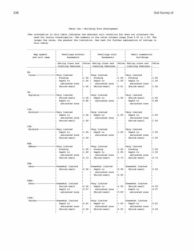
238 Soil Survey of
Table 14a.--Building Site Development
(The information in this table indicates the dominant soil condition but does not eliminate the need for onsite investigation. The numbers in the value columns range from 0.01 to 1.00. The larger the value, the greater the limitation. See text for further explanation of ratings in this table)
___________________________________________________________________________________________________ | | | Map symbol | Dwellings without | Dwellings with | Small commercial and soil name | basements | basements | buildings | | | _____________________________________________________________________________ | Rating class and |Value| Rating class and |Value| Rating class and |Value | limiting features | | limiting features | | limiting features |___________________________________________________________________________________________________ | | | | | |2A: | | | | | | Cisne---------------|Very limited | |Very limited | |Very limited | | Ponding |1.00 | Ponding |1.00 | Ponding |1.00 | Depth to |1.00 | Depth to |1.00 | Depth to |1.00 | saturated zone | | saturated zone | | saturated zone | | Shrink-swell |1.00 | Shrink-swell |0.01 | Shrink-swell |1.00 | | | | | |3A: | | | | | | Hoyleton------------|Very limited | |Very limited | |Very limited | | Shrink-swell |1.00 | Depth to |1.00 | Shrink-swell |1.00 | Depth to |0.88 | saturated zone | | Depth to |0.88 | saturated zone | | | | saturated zone | | | | | | |13A: | | | | | | Bluford-------------|Very limited | |Very limited | |Very limited | | Depth to |1.00 | Depth to |1.00 | Depth to |1.00 | saturated zone | | saturated zone | | saturated zone | | Shrink-swell |1.00 | | | Shrink-swell |1.00 | | | | | |13B: | | | | | | Bluford-------------|Very limited | |Very limited | |Very limited | | Depth to |1.00 | Depth to |1.00 | Depth to |1.00 | saturated zone | | saturated zone | | saturated zone | | Shrink-swell |1.00 | | | Shrink-swell |1.00 | | | | | |48A: | | | | | | Ebbert--------------|Very limited | |Very limited | |Very limited | | Ponding |1.00 | Ponding |1.00 | Ponding |1.00 | Depth to |1.00 | Depth to |1.00 | Depth to |1.00 | saturated zone | | saturated zone | | saturated zone | | Shrink-swell |0.73 | Shrink-swell |0.73 | Shrink-swell |0.73 | | | | | |56B: | | | | | | Dana----------------|Somewhat limited | |Somewhat limited | |Somewhat limited | | Shrink-swell |0.50 | Depth to |0.99 | Shrink-swell |0.50 | | | saturated zone | | | | | | Shrink-swell |0.50 | | | | | | | |56B2: | | | | | | Dana----------------|Somewhat limited | |Very limited | |Somewhat limited | | Shrink-swell |0.50 | Depth to |1.00 | Shrink-swell |0.50 | Depth to |0.07 | saturated zone | | Depth to |0.07 | saturated zone | | Shrink-swell |0.50 | saturated zone | | | | | | |132A: | | | | | | Starks--------------|Somewhat limited | |Very limited | |Somewhat limited | | Depth to |0.81 | Depth to |1.00 | Depth to |0.81 | saturated zone | | saturated zone | | saturated zone | | Shrink-swell |0.50 | Shrink-swell |0.50 | Shrink-swell |0.50 | | | | | |

Coles County, Illinois 239
Table 14a.--Building Site Development--Continued___________________________________________________________________________________________________ | | | Map symbol | Dwellings without | Dwellings with | Small commercial and soil name | basements | basements | buildings | | | _____________________________________________________________________________ | Rating class and |Value| Rating class and |Value| Rating class and |Value | limiting features | | limiting features | | limiting features |___________________________________________________________________________________________________ | | | | | |136A: | | | | | | Brooklyn------------|Very limited | |Very limited | |Very limited | | Ponding |1.00 | Ponding |1.00 | Ponding |1.00 | Depth to |1.00 | Depth to |1.00 | Depth to |1.00 | saturated zone | | saturated zone | | saturated zone | | Shrink-swell |1.00 | Shrink-swell |1.00 | Shrink-swell |1.00 | | | | | |138A: | | | | | | Shiloh--------------|Very limited | |Very limited | |Very limited | | Ponding |1.00 | Ponding |1.00 | Ponding |1.00 | Depth to |1.00 | Depth to |1.00 | Depth to |1.00 | saturated zone | | saturated zone | | saturated zone | | Shrink-swell |1.00 | Shrink-swell |1.00 | Shrink-swell |1.00 | | | | | |148B: | | | | | | Proctor-------------|Not limited | |Not limited | |Not limited | | | | | | |149A: | | | | | | Brenton-------------|Somewhat limited | |Very limited | |Somewhat limited | | Depth to |0.98 | Depth to |1.00 | Depth to |0.98 | saturated zone | | saturated zone | | saturated zone | | Shrink-swell |0.50 | Shrink-swell |0.50 | Shrink-swell |0.50 | | | | | |152A: | | | | | | Drummer-------------|Very limited | |Very limited | |Very limited | | Ponding |1.00 | Ponding |1.00 | Ponding |1.00 | Depth to |1.00 | Depth to |1.00 | Depth to |1.00 | saturated zone | | saturated zone | | saturated zone | | Shrink-swell |0.50 | Shrink-swell |0.50 | Shrink-swell |0.50 | | | | | |154A: | | | | | | Flanagan------------|Very limited | |Very limited | |Very limited | | Shrink-swell |1.00 | Depth to |1.00 | Shrink-swell |1.00 | Depth to |0.98 | saturated zone | | Depth to |0.98 | saturated zone | | Shrink-swell |1.00 | saturated zone | | | | | | |206A: | | | | | | Thorp---------------|Very limited | |Very limited | |Very limited | | Ponding |1.00 | Ponding |1.00 | Ponding |1.00 | Depth to |1.00 | Depth to |1.00 | Depth to |1.00 | saturated zone | | saturated zone | | saturated zone | | Shrink-swell |0.50 | Shrink-swell |0.50 | Shrink-swell |0.50 | | | | | |219A: | | | | | | Millbrook-----------|Somewhat limited | |Very limited | |Somewhat limited | | Depth to |0.98 | Depth to |1.00 | Depth to |0.98 | saturated zone | | saturated zone | | saturated zone | | Shrink-swell |0.68 | Shrink-swell |0.68 | Shrink-swell |0.68 | | | | | |244A: | | | | | | Hartsburg-----------|Very limited | |Very limited | |Very limited | | Ponding |1.00 | Ponding |1.00 | Ponding |1.00 | Depth to |1.00 | Depth to |1.00 | Depth to |1.00 | saturated zone | | saturated zone | | saturated zone | | Shrink-swell |0.50 | | | Shrink-swell |0.50 | | | | | |291B: | | | | | | Xenia---------------|Somewhat limited | |Very limited | |Somewhat limited | | Depth to |0.98 | Depth to |1.00 | Depth to |0.98 | saturated zone | | saturated zone | | saturated zone | | Shrink-swell |0.50 | Shrink-swell |0.50 | Shrink-swell |0.50 | | | | | |

240 Soil Survey of
Table 14a.--Building Site Development--Continued___________________________________________________________________________________________________ | | | Map symbol | Dwellings without | Dwellings with | Small commercial and soil name | basements | basements | buildings | | | _____________________________________________________________________________ | Rating class and |Value| Rating class and |Value| Rating class and |Value | limiting features | | limiting features | | limiting features |___________________________________________________________________________________________________ | | | | | |322B: | | | | | | Russell-------------|Somewhat limited | |Not limited | |Somewhat limited | | Shrink-swell |0.50 | | | Shrink-swell |0.50 | | | | | |322C2: | | | | | | Russell-------------|Somewhat limited | |Somewhat limited | |Very limited | | Shrink-swell |0.50 | Shrink-swell |0.50 | Slope |1.00 | Slope |0.01 | Slope |0.01 | Shrink-swell |0.50 | | | | | |330A: | | | | | | Peotone-------------|Very limited | |Very limited | |Very limited | | Ponding |1.00 | Ponding |1.00 | Ponding |1.00 | Depth to |1.00 | Depth to |1.00 | Depth to |1.00 | saturated zone | | saturated zone | | saturated zone | | Shrink-swell |1.00 | Shrink-swell |1.00 | Shrink-swell |1.00 | | | | | |348B: | | | | | | Wingate-------------|Somewhat limited | |Very limited | |Somewhat limited | | Shrink-swell |0.50 | Depth to |1.00 | Shrink-swell |0.50 | Depth to |0.07 | saturated zone | | Depth to |0.07 | saturated zone | | Shrink-swell |0.50 | saturated zone | | | | | | |353A: | | | | | | Toronto-------------|Very limited | |Very limited | |Very limited | | Depth to |1.00 | Depth to |1.00 | Depth to |1.00 | saturated zone | | saturated zone | | saturated zone | | Shrink-swell |0.50 | Shrink-swell |0.50 | Shrink-swell |0.50 | | | | | |481A: | | | | | | Raub----------------|Somewhat limited | |Very limited | |Somewhat limited | | Depth to |0.98 | Depth to |1.00 | Depth to |0.98 | saturated zone | | saturated zone | | saturated zone | | Shrink-swell |0.50 | | | Shrink-swell |0.50 | | | | | |496A: | | | | | | Fincastle-----------|Somewhat limited | |Very limited | |Somewhat limited | | Depth to |0.98 | Depth to |1.00 | Depth to |0.98 | saturated zone | | saturated zone | | saturated zone | | Shrink-swell |0.50 | Shrink-swell |0.50 | Shrink-swell |0.50 | | | | | |533: | | | | | | Urban land----------|Not rated | |Not rated | |Not rated | | | | | | |570B: | | | | | | Martinsville--------|Somewhat limited | |Somewhat limited | |Somewhat limited | | Shrink-swell |0.01 | Shrink-swell |0.01 | Shrink-swell |0.01 | | | | | |570C2: | | | | | | Martinsville--------|Somewhat limited | |Somewhat limited | |Very limited | | Shrink-swell |0.01 | Shrink-swell |0.01 | Slope |1.00 | Slope |0.01 | Slope |0.01 | Shrink-swell |0.01 | | | | | |618C2: | | | | | | Senachwine----------|Somewhat limited | |Somewhat limited | |Very limited | | Shrink-swell |0.50 | Slope |0.01 | Slope |1.00 | Slope |0.01 | | | Shrink-swell |0.50 | | | | | |618C3: | | | | | | Senachwine----------|Somewhat limited | |Somewhat limited | |Very limited | | Shrink-swell |0.50 | Slope |0.01 | Slope |1.00 | Slope |0.01 | | | Shrink-swell |0.50 | | | | | |

Coles County, Illinois 241
Table 14a.--Building Site Development--Continued___________________________________________________________________________________________________ | | | Map symbol | Dwellings without | Dwellings with | Small commercial and soil name | basements | basements | buildings | | | _____________________________________________________________________________ | Rating class and |Value| Rating class and |Value| Rating class and |Value | limiting features | | limiting features | | limiting features |___________________________________________________________________________________________________ | | | | | |618D2: | | | | | | Senachwine----------|Somewhat limited | |Somewhat limited | |Very limited | | Slope |0.96 | Slope |0.96 | Slope |1.00 | Shrink-swell |0.50 | | | Shrink-swell |0.50 | | | | | |618D3: | | | | | | Senachwine----------|Somewhat limited | |Somewhat limited | |Very limited | | Slope |0.96 | Slope |0.96 | Slope |1.00 | Shrink-swell |0.50 | | | Shrink-swell |0.50 | | | | | |618F: | | | | | | Senachwine----------|Very limited | |Very limited | |Very limited | | Slope |1.00 | Slope |1.00 | Slope |1.00 | Shrink-swell |0.50 | | | Shrink-swell |0.50 | | | | | |618G: | | | | | | Senachwine----------|Very limited | |Very limited | |Very limited | | Slope |1.00 | Slope |1.00 | Slope |1.00 | Shrink-swell |0.50 | | | Shrink-swell |0.50 | | | | | |668B2: | | | | | | Somonauk------------|Somewhat limited | |Somewhat limited | |Somewhat limited | | Shrink-swell |0.50 | Depth to |0.99 | Shrink-swell |0.50 | | | saturated zone | | | | | | Shrink-swell |0.50 | | | | | | | |722A: | | | | | | Drummer-------------|Very limited | |Very limited | |Very limited | | Ponding |1.00 | Ponding |1.00 | Ponding |1.00 | Depth to |1.00 | Depth to |1.00 | Depth to |1.00 | saturated zone | | saturated zone | | saturated zone | | Shrink-swell |0.50 | Shrink-swell |0.50 | Shrink-swell |0.50 | | | | | | Milford-------------|Very limited | |Very limited | |Very limited | | Ponding |1.00 | Ponding |1.00 | Ponding |1.00 | Depth to |1.00 | Depth to |1.00 | Depth to |1.00 | saturated zone | | saturated zone | | saturated zone | | Shrink-swell |0.50 | | | Shrink-swell |0.50 | | | | | |830: | | | | | | Landfill------------|Not rated | |Not rated | |Not rated | | | | | | |864: | | | | | | Pits, quarry--------|Not rated | |Not rated | |Not rated | | | | | | |865: | | | | | | Pits, gravel--------|Not rated | |Not rated | |Not rated | | | | | | |871B: | | | | | | Lenzburg------------|Not limited | |Not limited | |Not limited | | | | | | |871D: | | | | | | Lenzburg------------|Somewhat limited | |Somewhat limited | |Very limited | | Slope |0.16 | Slope |0.16 | Slope |1.00 | | | | | |3073A: | | | | | | Ross----------------|Very limited | |Very limited | |Very limited | | Flooding |1.00 | Flooding |1.00 | Flooding |1.00 | | | Depth to |0.35 | | | | | saturated zone | | | | | | | | |

242 Soil Survey of
Table 14a.--Building Site Development--Continued___________________________________________________________________________________________________ | | | Map symbol | Dwellings without | Dwellings with | Small commercial and soil name | basements | basements | buildings | | | _____________________________________________________________________________ | Rating class and |Value| Rating class and |Value| Rating class and |Value | limiting features | | limiting features | | limiting features |___________________________________________________________________________________________________ | | | | | |3107A: | | | | | | Sawmill-------------|Very limited | |Very limited | |Very limited | | Ponding |1.00 | Ponding |1.00 | Ponding |1.00 | Flooding |1.00 | Flooding |1.00 | Flooding |1.00 | Depth to |1.00 | Depth to |1.00 | Depth to |1.00 | saturated zone | | saturated zone | | saturated zone | | Shrink-swell |0.50 | Shrink-swell |0.50 | Shrink-swell |0.50 | | | | | |3226A: | | | | | | Wirt----------------|Very limited | |Very limited | |Very limited | | Flooding |1.00 | Flooding |1.00 | Flooding |1.00 | | | | | |3284A: | | | | | | Tice----------------|Very limited | |Very limited | |Very limited | | Flooding |1.00 | Flooding |1.00 | Flooding |1.00 | Depth to |0.81 | Depth to |1.00 | Depth to |0.81 | saturated zone | | saturated zone | | saturated zone | | Shrink-swell |0.50 | Shrink-swell |0.50 | Shrink-swell |0.50 | | | | | |3304A: | | | | | | Landes--------------|Very limited | |Very limited | |Very limited | | Flooding |1.00 | Flooding |1.00 | Flooding |1.00 | | | | | |3424A: | | | | | | Shoals--------------|Very limited | |Very limited | |Very limited | | Flooding |1.00 | Flooding |1.00 | Flooding |1.00 | Depth to |1.00 | Depth to |1.00 | Depth to |1.00 | saturated zone | | saturated zone | | saturated zone | | | | | | |3450A: | | | | | | Brouillett----------|Very limited | |Very limited | |Very limited | | Flooding |1.00 | Flooding |1.00 | Flooding |1.00 | Depth to |0.44 | Depth to |1.00 | Depth to |0.44 | saturated zone | | saturated zone | | saturated zone | | | | | | |3451A: | | | | | | Lawson--------------|Very limited | |Very limited | |Very limited | | Flooding |1.00 | Flooding |1.00 | Flooding |1.00 | | | Depth to |0.99 | | | | | saturated zone | | | | | | | | |7132A: | | | | | | Starks--------------|Very limited | |Very limited | |Very limited | | Flooding |1.00 | Flooding |1.00 | Flooding |1.00 | Depth to |0.81 | Depth to |1.00 | Depth to |0.81 | saturated zone | | saturated zone | | saturated zone | | Shrink-swell |0.50 | Shrink-swell |0.50 | Shrink-swell |0.50 | | | | | |7373B: | | | | | | Camden--------------|Very limited | |Very limited | |Very limited | | Flooding |1.00 | Flooding |1.00 | Flooding |1.00 | Shrink-swell |0.50 | Depth to |0.16 | Shrink-swell |0.50 | | | saturated zone | | | | | | | | |7570B: | | | | | | Martinsville--------|Very limited | |Very limited | |Very limited | | Flooding |1.00 | Flooding |1.00 | Flooding |1.00 | Shrink-swell |0.01 | Shrink-swell |0.01 | Shrink-swell |0.01 | | | | | |___________________________________________________________________________________________________

Coles County, Illinois 243
Table 14b.--Building Site Development
(The information in this table indicates the dominant soil condition but does not eliminate the need for onsite investigation. The numbers in the value columns range from 0.01 to 1.00. The larger the value, the greater the limitation. See text for further explanation of ratings in this table)
___________________________________________________________________________________________________ | | | Map symbol | Local roads and | Shallow excavations | Lawns and landscaping and soil name | streets | | | | | _____________________________________________________________________________ | Rating class and |Value| Rating class and |Value| Rating class and |Value | limiting features | | limiting features | | limiting features |___________________________________________________________________________________________________ | | | | | |2A: | | | | | | Cisne---------------|Very limited | |Very limited | |Very limited | | Ponding |1.00 | Ponding |1.00 | Ponding |1.00 | Depth to |1.00 | Depth to |1.00 | Depth to |1.00 | saturated zone | | saturated zone | | saturated zone | | Frost action |1.00 | Cutbanks cave |0.10 | | | Low strength |1.00 | | | | | Shrink-swell |1.00 | | | | | | | | | |3A: | | | | | | Hoyleton------------|Very limited | |Very limited | |Somewhat limited | | Low strength |1.00 | Depth to |1.00 | Depth to |0.56 | Shrink-swell |1.00 | saturated zone | | saturated zone | | Depth to |0.56 | Cutbanks cave |0.10 | | | saturated zone | | | | | | Frost action |0.50 | | | | | | | | | |13A: | | | | | | Bluford-------------|Very limited | |Very limited | |Somewhat limited | | Frost action |1.00 | Depth to |1.00 | Depth to |0.94 | Low strength |1.00 | saturated zone | | saturated zone | | Shrink-swell |1.00 | Cutbanks cave |0.10 | | | Depth to |0.94 | Too clayey |0.01 | | | saturated zone | | | | | | | | | | |13B: | | | | | | Bluford-------------|Very limited | |Very limited | |Somewhat limited | | Frost action |1.00 | Depth to |1.00 | Depth to |0.94 | Low strength |1.00 | saturated zone | | saturated zone | | Shrink-swell |1.00 | Cutbanks cave |0.10 | | | Depth to |0.94 | Too clayey |0.01 | | | saturated zone | | | | | | | | | | |48A: | | | | | | Ebbert--------------|Very limited | |Very limited | |Very limited | | Ponding |1.00 | Ponding |1.00 | Ponding |1.00 | Depth to |1.00 | Depth to |1.00 | Depth to |1.00 | saturated zone | | saturated zone | | saturated zone | | Frost action |1.00 | Cutbanks cave |0.10 | | | Low strength |1.00 | | | | | Shrink-swell |0.73 | | | | | | | | | |56B: | | | | | | Dana----------------|Very limited | |Somewhat limited | |Not limited | | Frost action |1.00 | Depth to |0.99 | | | Low strength |1.00 | saturated zone | | | | Shrink-swell |0.50 | Cutbanks cave |0.10 | | | | | | | |56B2: | | | | | | Dana----------------|Very limited | |Very limited | |Somewhat limited | | Frost action |1.00 | Depth to |1.00 | Depth to |0.03 | Low strength |1.00 | saturated zone | | saturated zone | | Shrink-swell |0.50 | Cutbanks cave |0.10 | | | Depth to |0.03 | | | | | saturated zone | | | | | | | | | | |

244 Soil Survey of
Table 14b.--Building Site Development--Continued___________________________________________________________________________________________________ | | | Map symbol | Local roads and | Shallow excavations | Lawns and landscaping and soil name | streets | | | | | _____________________________________________________________________________ | Rating class and |Value| Rating class and |Value| Rating class and |Value | limiting features | | limiting features | | limiting features |___________________________________________________________________________________________________ | | | | | |132A: | | | | | | Starks--------------|Very limited | |Very limited | |Somewhat limited | | Frost action |1.00 | Depth to |1.00 | Depth to |0.48 | Low strength |1.00 | saturated zone | | saturated zone | | Shrink-swell |0.50 | Cutbanks cave |0.10 | | | Depth to |0.48 | | | | | saturated zone | | | | | | | | | | |136A: | | | | | | Brooklyn------------|Very limited | |Very limited | |Very limited | | Ponding |1.00 | Ponding |1.00 | Ponding |1.00 | Depth to |1.00 | Depth to |1.00 | Depth to |1.00 | saturated zone | | saturated zone | | saturated zone | | Frost action |1.00 | Cutbanks cave |0.10 | | | Low strength |1.00 | Too clayey |0.01 | | | Shrink-swell |1.00 | | | | | | | | | |138A: | | | | | | Shiloh--------------|Very limited | |Very limited | |Very limited | | Ponding |1.00 | Ponding |1.00 | Ponding |1.00 | Depth to |1.00 | Depth to |1.00 | Depth to |1.00 | saturated zone | | saturated zone | | saturated zone | | Frost action |1.00 | Cutbanks cave |0.10 | | | Low strength |1.00 | Too clayey |0.02 | | | Shrink-swell |1.00 | | | | | | | | | |148B: | | | | | | Proctor-------------|Very limited | |Somewhat limited | |Not limited | | Frost action |1.00 | Cutbanks cave |0.10 | | | Low strength |1.00 | | | | | | | | | |149A: | | | | | | Brenton-------------|Very limited | |Very limited | |Somewhat limited | | Frost action |1.00 | Depth to |1.00 | Depth to |0.75 | Low strength |1.00 | saturated zone | | saturated zone | | Depth to |0.75 | Cutbanks cave |0.50 | | | saturated zone | | | | | | Shrink-swell |0.50 | | | | | | | | | |152A: | | | | | | Drummer-------------|Very limited | |Very limited | |Very limited | | Ponding |1.00 | Ponding |1.00 | Ponding |1.00 | Depth to |1.00 | Depth to |1.00 | Depth to |1.00 | saturated zone | | saturated zone | | saturated zone | | Frost action |1.00 | Cutbanks cave |0.10 | | | Low strength |1.00 | | | | | Shrink-swell |0.50 | | | | | | | | | |154A: | | | | | | Flanagan------------|Very limited | |Very limited | |Somewhat limited | | Frost action |1.00 | Depth to |1.00 | Depth to |0.75 | Low strength |1.00 | saturated zone | | saturated zone | | Shrink-swell |1.00 | Cutbanks cave |0.10 | | | Depth to |0.75 | | | | | saturated zone | | | | | | | | | | |

Coles County, Illinois 245
Table 14b.--Building Site Development--Continued___________________________________________________________________________________________________ | | | Map symbol | Local roads and | Shallow excavations | Lawns and landscaping and soil name | streets | | | | | _____________________________________________________________________________ | Rating class and |Value| Rating class and |Value| Rating class and |Value | limiting features | | limiting features | | limiting features |___________________________________________________________________________________________________ | | | | | |206A: | | | | | | Thorp---------------|Very limited | |Very limited | |Very limited | | Ponding |1.00 | Ponding |1.00 | Ponding |1.00 | Depth to |1.00 | Depth to |1.00 | Depth to |1.00 | saturated zone | | saturated zone | | saturated zone | | Frost action |1.00 | Cutbanks cave |1.00 | | | Low strength |1.00 | | | | | Shrink-swell |0.50 | | | | | | | | | |219A: | | | | | | Millbrook-----------|Very limited | |Very limited | |Somewhat limited | | Frost action |1.00 | Depth to |1.00 | Depth to |0.75 | Low strength |1.00 | saturated zone | | saturated zone | | Depth to |0.75 | Cutbanks cave |0.10 | | | saturated zone | | | | | | Shrink-swell |0.68 | | | | | | | | | |244A: | | | | | | Hartsburg-----------|Very limited | |Very limited | |Very limited | | Ponding |1.00 | Ponding |1.00 | Ponding |1.00 | Depth to |1.00 | Depth to |1.00 | Depth to |1.00 | saturated zone | | saturated zone | | saturated zone | | Frost action |1.00 | Cutbanks cave |0.10 | | | Low strength |1.00 | | | | | Shrink-swell |0.50 | | | | | | | | | |291B: | | | | | | Xenia---------------|Very limited | |Very limited | |Somewhat limited | | Frost action |1.00 | Depth to |1.00 | Depth to |0.75 | Low strength |1.00 | saturated zone | | saturated zone | | Depth to |0.75 | Dense layer |0.50 | | | saturated zone | | Cutbanks cave |0.10 | | | Shrink-swell |0.50 | | | | | | | | | |322B: | | | | | | Russell-------------|Very limited | |Somewhat limited | |Not limited | | Frost action |1.00 | Dense layer |0.50 | | | Low strength |1.00 | Cutbanks cave |0.10 | | | Shrink-swell |0.50 | | | | | | | | | |322C2: | | | | | | Russell-------------|Very limited | |Somewhat limited | |Somewhat limited | | Frost action |1.00 | Cutbanks cave |0.10 | Slope |0.01 | Low strength |1.00 | Slope |0.01 | | | Shrink-swell |0.50 | | | | | Slope |0.01 | | | | | | | | | |330A: | | | | | | Peotone-------------|Very limited | |Very limited | |Very limited | | Ponding |1.00 | Ponding |1.00 | Ponding |1.00 | Depth to |1.00 | Depth to |1.00 | Depth to |1.00 | saturated zone | | saturated zone | | saturated zone | | Frost action |1.00 | Cutbanks cave |0.10 | | | Low strength |1.00 | | | | | Shrink-swell |1.00 | | | | | | | | | |

246 Soil Survey of
Table 14b.--Building Site Development--Continued___________________________________________________________________________________________________ | | | Map symbol | Local roads and | Shallow excavations | Lawns and landscaping and soil name | streets | | | | | _____________________________________________________________________________ | Rating class and |Value| Rating class and |Value| Rating class and |Value | limiting features | | limiting features | | limiting features |___________________________________________________________________________________________________ | | | | | |348B: | | | | | | Wingate-------------|Very limited | |Very limited | |Somewhat limited | | Frost action |1.00 | Depth to |1.00 | Depth to |0.03 | Low strength |1.00 | saturated zone | | saturated zone | | Shrink-swell |0.50 | Dense layer |0.50 | | | Depth to |0.03 | Cutbanks cave |0.10 | | | saturated zone | | | | | | | | | | |353A: | | | | | | Toronto-------------|Very limited | |Very limited | |Very limited | | Depth to |1.00 | Depth to |1.00 | Depth to |1.00 | saturated zone | | saturated zone | | saturated zone | | Frost action |1.00 | Dense layer |0.50 | | | Low strength |1.00 | Cutbanks cave |0.10 | | | Shrink-swell |0.50 | | | | | | | | | |481A: | | | | | | Raub----------------|Very limited | |Very limited | |Somewhat limited | | Frost action |1.00 | Depth to |1.00 | Depth to |0.75 | Low strength |1.00 | saturated zone | | saturated zone | | Depth to |0.75 | Cutbanks cave |0.10 | | | saturated zone | | | | | | Shrink-swell |0.50 | | | | | | | | | |496A: | | | | | | Fincastle-----------|Very limited | |Very limited | |Somewhat limited | | Frost action |1.00 | Depth to |1.00 | Depth to |0.75 | Low strength |1.00 | saturated zone | | saturated zone | | Depth to |0.75 | Dense layer |0.50 | | | saturated zone | | Cutbanks cave |0.10 | | | Shrink-swell |0.50 | | | | | | | | | |533: | | | | | | Urban land----------|Not rated | |Not rated | |Not rated | | | | | | |570B: | | | | | | Martinsville--------|Somewhat limited | |Very limited | |Not limited | | Frost action |0.50 | Cutbanks cave |1.00 | | | Shrink-swell |0.01 | | | | | | | | | |570C2: | | | | | | Martinsville--------|Somewhat limited | |Very limited | |Somewhat limited | | Frost action |0.50 | Cutbanks cave |1.00 | Slope |0.01 | Shrink-swell |0.01 | Slope |0.01 | | | Slope |0.01 | | | | | | | | | |618C2: | | | | | | Senachwine----------|Very limited | |Somewhat limited | |Somewhat limited | | Low strength |1.00 | Cutbanks cave |0.10 | Slope |0.01 | Shrink-swell |0.50 | Slope |0.01 | | | Frost action |0.50 | | | | | Slope |0.01 | | | | | | | | | |618C3: | | | | | | Senachwine----------|Very limited | |Somewhat limited | |Somewhat limited | | Low strength |1.00 | Cutbanks cave |0.10 | Slope |0.01 | Shrink-swell |0.50 | Slope |0.01 | | | Frost action |0.50 | | | | | Slope |0.01 | | | | | | | | | |

Coles County, Illinois 247
Table 14b.--Building Site Development--Continued___________________________________________________________________________________________________ | | | Map symbol | Local roads and | Shallow excavations | Lawns and landscaping and soil name | streets | | | | | _____________________________________________________________________________ | Rating class and |Value| Rating class and |Value| Rating class and |Value | limiting features | | limiting features | | limiting features |___________________________________________________________________________________________________ | | | | | |618D2: | | | | | | Senachwine----------|Very limited | |Somewhat limited | |Somewhat limited | | Low strength |1.00 | Slope |0.96 | Slope |0.96 | Slope |0.96 | Cutbanks cave |0.10 | | | Shrink-swell |0.50 | | | | | Frost action |0.50 | | | | | | | | | |618D3: | | | | | | Senachwine----------|Very limited | |Somewhat limited | |Somewhat limited | | Low strength |1.00 | Slope |0.96 | Slope |0.96 | Slope |0.96 | Cutbanks cave |0.10 | | | Shrink-swell |0.50 | | | | | Frost action |0.50 | | | | | | | | | |618F: | | | | | | Senachwine----------|Very limited | |Very limited | |Very limited | | Slope |1.00 | Slope |1.00 | Slope |1.00 | Low strength |1.00 | Cutbanks cave |0.10 | | | Shrink-swell |0.50 | | | | | Frost action |0.50 | | | | | | | | | |618G: | | | | | | Senachwine----------|Very limited | |Very limited | |Very limited | | Slope |1.00 | Slope |1.00 | Slope |1.00 | Low strength |1.00 | Cutbanks cave |0.10 | | | Shrink-swell |0.50 | | | | | Frost action |0.50 | | | | | | | | | |668B2: | | | | | | Somonauk------------|Very limited | |Very limited | |Not limited | | Frost action |1.00 | Cutbanks cave |1.00 | | | Low strength |1.00 | Depth to |0.99 | | | Shrink-swell |0.50 | saturated zone | | | | | | | | |722A: | | | | | | Drummer-------------|Very limited | |Very limited | |Very limited | | Ponding |1.00 | Ponding |1.00 | Ponding |1.00 | Depth to |1.00 | Depth to |1.00 | Depth to |1.00 | saturated zone | | saturated zone | | saturated zone | | Frost action |1.00 | Cutbanks cave |0.10 | | | Low strength |1.00 | | | | | Shrink-swell |0.50 | | | | | | | | | | Milford-------------|Very limited | |Very limited | |Very limited | | Ponding |1.00 | Ponding |1.00 | Ponding |1.00 | Depth to |1.00 | Depth to |1.00 | Depth to |1.00 | saturated zone | | saturated zone | | saturated zone | | Frost action |1.00 | Cutbanks cave |0.10 | | | Low strength |1.00 | Too clayey |0.02 | | | Shrink-swell |0.50 | | | | | | | | | |830: | | | | | | Landfill------------|Not rated | |Not rated | |Not rated | | | | | | |864: | | | | | | Pits, quarry--------|Not rated | |Not rated | |Not rated | | | | | | |865: | | | | | | Pits, gravel--------|Not rated | |Not rated | |Not rated | | | | | | |

248 Soil Survey of
Table 14b.--Building Site Development--Continued___________________________________________________________________________________________________ | | | Map symbol | Local roads and | Shallow excavations | Lawns and landscaping and soil name | streets | | | | | _____________________________________________________________________________ | Rating class and |Value| Rating class and |Value| Rating class and |Value | limiting features | | limiting features | | limiting features |___________________________________________________________________________________________________ | | | | | |871B: | | | | | | Lenzburg------------|Somewhat limited | |Somewhat limited | |Very limited | | Frost action |0.50 | Cutbanks cave |0.10 | Droughty |1.00 | | | | | Content of large |0.16 | | | | | stones | | | | | | |871D: | | | | | | Lenzburg------------|Somewhat limited | |Somewhat limited | |Very limited | | Frost action |0.50 | Slope |0.16 | Droughty |1.00 | Slope |0.16 | Cutbanks cave |0.10 | Slope |0.16 | | | | | Content of large |0.01 | | | | | stones | | | | | | |3073A: | | | | | | Ross----------------|Very limited | |Somewhat limited | |Very limited | | Flooding |1.00 | Flooding |0.80 | Flooding |1.00 | Frost action |0.50 | Depth to |0.35 | | | | | saturated zone | | | | | | Cutbanks cave |0.10 | | | | | | | |3107A: | | | | | | Sawmill-------------|Very limited | |Very limited | |Very limited | | Ponding |1.00 | Ponding |1.00 | Ponding |1.00 | Depth to |1.00 | Depth to |1.00 | Flooding |1.00 | saturated zone | | saturated zone | | Depth to |1.00 | Frost action |1.00 | Flooding |0.80 | saturated zone | | Flooding |1.00 | Cutbanks cave |0.10 | | | Low strength |1.00 | | | | | | | | | |3226A: | | | | | | Wirt----------------|Very limited | |Somewhat limited | |Very limited | | Flooding |1.00 | Flooding |0.80 | Flooding |1.00 | Frost action |0.50 | Cutbanks cave |0.10 | | | | | | | |3284A: | | | | | | Tice----------------|Very limited | |Very limited | |Very limited | | Frost action |1.00 | Depth to |1.00 | Flooding |1.00 | Flooding |1.00 | saturated zone | | Depth to |0.48 | Low strength |1.00 | Flooding |0.80 | saturated zone | | Shrink-swell |0.50 | Cutbanks cave |0.10 | | | Depth to |0.48 | | | | | saturated zone | | | | | | | | | | |3304A: | | | | | | Landes--------------|Very limited | |Very limited | |Very limited | | Flooding |1.00 | Cutbanks cave |1.00 | Flooding |1.00 | Frost action |0.50 | Flooding |0.80 | | | | | | | |3424A: | | | | | | Shoals--------------|Very limited | |Very limited | |Very limited | | Frost action |1.00 | Depth to |1.00 | Flooding |1.00 | Flooding |1.00 | saturated zone | | Depth to |0.94 | Low strength |1.00 | Flooding |0.80 | saturated zone | | Depth to |0.94 | Cutbanks cave |0.10 | | | saturated zone | | | | | | | | | | |

Coles County, Illinois 249
Table 14b.--Building Site Development--Continued___________________________________________________________________________________________________ | | | Map symbol | Local roads and | Shallow excavations | Lawns and landscaping and soil name | streets | | | | | _____________________________________________________________________________ | Rating class and |Value| Rating class and |Value| Rating class and |Value | limiting features | | limiting features | | limiting features |___________________________________________________________________________________________________ | | | | | |3450A: | | | | | | Brouillett----------|Very limited | |Very limited | |Very limited | | Flooding |1.00 | Depth to |1.00 | Flooding |1.00 | Frost action |0.50 | saturated zone |0.80 | Depth to |0.22 | Depth to |0.22 | Flooding | | saturated zone | | saturated zone | | Cutbanks cave |0.10 | | | | | | | |3451A: | | | | | | Lawson--------------|Very limited | |Very limited | |Very limited | | Frost action |1.00 | Depth to |0.99 | Flooding |1.00 | Flooding |1.00 | saturated zone | | | | Low strength |1.00 | Flooding |0.80 | | | | | Cutbanks cave |0.10 | | | | | | | |7132A: | | | | | | Starks--------------|Very limited | |Very limited | |Somewhat limited | | Frost action |1.00 | Depth to |1.00 | Depth to |0.48 | Low strength |1.00 | saturated zone | | saturated zone | | Shrink-swell |0.50 | Cutbanks cave |0.10 | | | Depth to |0.48 | | | | | saturated zone | | | | | | Flooding |0.40 | | | | | | | | | |7373B: | | | | | | Camden--------------|Very limited | |Very limited | |Not limited | | Frost action |1.00 | Cutbanks cave |1.00 | | | Low strength |1.00 | Depth to |0.16 | | | Shrink-swell |0.50 | saturated zone | | | | Flooding |0.40 | | | | | | | | | |7570B: | | | | | | Martinsville--------|Somewhat limited | |Very limited | |Not limited | | Frost action |0.50 | Cutbanks cave |1.00 | | | Flooding |0.40 | | | | | Shrink-swell |0.01 | | | | | | | | | |___________________________________________________________________________________________________

250 Soil Survey of
Table 15a.--Sanitary Facilities
(The information in this table indicates the dominant soil condition but does not eliminate the need for onsite investigation. The numbers in the value columns range from 0.01 to 1.00. The larger the value, the greater the limitation. See text for further explanation of ratings in this table)
_________________________________________________________________________ | | Map symbol | Septic tank | Sewage lagoons and soil name | absorption fields | | | ___________________________________________________ | Rating class and |Value| Rating class and |Value | limiting features | | limiting features |_________________________________________________________________________ | | | |2A: | | | | Cisne---------------|Very limited | |Very limited | | Slow water |1.00 | Ponding |1.00 | movement | | Depth to |1.00 | Ponding |1.00 | saturated zone | | Depth to |1.00 | | | saturated zone | | | | | | |3A: | | | | Hoyleton------------|Very limited | |Very limited | | Depth to |1.00 | Depth to |1.00 | saturated zone | | saturated zone | | Slow water |1.00 | | | movement | | | | | | |13A: | | | | Bluford-------------|Very limited | |Very limited | | Slow water |1.00 | Depth to |1.00 | movement | | saturated zone | | Depth to |1.00 | | | saturated zone | | | | | | |13B: | | | | Bluford-------------|Very limited | |Very limited | | Slow water |1.00 | Depth to |1.00 | movement | | saturated zone | | Depth to |1.00 | Slope |0.08 | saturated zone | | | | | | |48A: | | | | Ebbert--------------|Very limited | |Very limited | | Slow water |1.00 | Ponding |1.00 | movement | | Depth to |1.00 | Ponding |1.00 | saturated zone | | Depth to |1.00 | Seepage |0.53 | saturated zone | | | | | | |56B: | | | | Dana----------------|Very limited | |Somewhat limited | | Depth to |1.00 | Seepage |0.53 | saturated zone | | Slope |0.32 | Slow water |1.00 | Depth to |0.04 | movement | | saturated zone | | | | |56B2: | | | | Dana----------------|Very limited | |Somewhat limited | | Depth to |1.00 | Seepage |0.53 | saturated zone | | Depth to |0.44 | Slow water |1.00 | saturated zone | | movement | | Slope |0.32 | | | |

Coles County, Illinois 251
Table 15a.--Sanitary Facilities--Continued_________________________________________________________________________ | | Map symbol | Septic tank | Sewage lagoons and soil name | absorption fields | | | ___________________________________________________ | Rating class and |Value| Rating class and |Value | limiting features | | limiting features |_________________________________________________________________________ | | | |132A: | | | | Starks--------------|Very limited | |Very limited | | Depth to |1.00 | Depth to |1.00 | saturated zone | | saturated zone | | Slow water |0.46 | Seepage |0.53 | movement | | | | | | |136A: | | | | Brooklyn------------|Very limited | |Very limited | | Slow water |1.00 | Ponding |1.00 | movement | | Depth to |1.00 | Ponding |1.00 | saturated zone | | Depth to |1.00 | | | saturated zone | | | | | | |138A: | | | | Shiloh--------------|Very limited | |Very limited | | Slow water |1.00 | Ponding |1.00 | movement | | Depth to |1.00 | Ponding |1.00 | saturated zone | | Depth to |1.00 | | | saturated zone | | | | | | |148B: | | | | Proctor-------------|Very limited | |Very limited | | Seepage, bottom |1.00 | Seepage |1.00 | layer | | Slope |0.32 | Slow water |0.46 | | | movement | | | | | | |149A: | | | | Brenton-------------|Very limited | |Very limited | | Depth to |1.00 | Depth to |1.00 | saturated zone | | saturated zone | | Slow water |0.46 | Seepage |0.53 | movement | | | | | | |152A: | | | | Drummer-------------|Very limited | |Very limited | | Ponding |1.00 | Ponding |1.00 | Depth to |1.00 | Depth to |1.00 | saturated zone | | saturated zone | | Slow water |0.46 | Seepage |0.53 | movement | | | | | | |154A: | | | | Flanagan------------|Very limited | |Very limited | | Depth to |1.00 | Depth to |1.00 | saturated zone | | saturated zone | | Slow water |1.00 | Seepage |0.53 | movement | | | | | | |206A: | | | | Thorp---------------|Very limited | |Very limited | | Slow water |1.00 | Ponding |1.00 | movement | | Depth to |1.00 | Ponding |1.00 | saturated zone | | Depth to |1.00 | Seepage |1.00 | saturated zone | | | | Seepage, bottom |1.00 | | | layer | | | | | | |

252 Soil Survey of
Table 15a.--Sanitary Facilities--Continued_________________________________________________________________________ | | Map symbol | Septic tank | Sewage lagoons and soil name | absorption fields | | | ___________________________________________________ | Rating class and |Value| Rating class and |Value | limiting features | | limiting features |_________________________________________________________________________ | | | |219A: | | | | Millbrook-----------|Very limited | |Very limited | | Depth to |1.00 | Depth to |1.00 | saturated zone | | saturated zone | | Slow water |0.46 | Seepage |0.53 | movement | | | | | | |244A: | | | | Hartsburg-----------|Very limited | |Very limited | | Ponding |1.00 | Ponding |1.00 | Depth to |1.00 | Depth to |1.00 | saturated zone | | saturated zone | | Slow water |0.46 | Seepage |0.53 | movement | | | | | | |291B: | | | | Xenia---------------|Very limited | |Very limited | | Depth to |1.00 | Depth to |1.00 | saturated zone | | saturated zone | | Slow water |1.00 | Seepage |0.53 | movement | | Slope |0.32 | | | |322B: | | | | Russell-------------|Very limited | |Somewhat limited | | Slow water |1.00 | Seepage |0.53 | movement | | Slope |0.08 | | | |322C2: | | | | Russell-------------|Very limited | |Very limited | | Slow water |1.00 | Slope |1.00 | movement | | Seepage |0.53 | Slope |0.01 | | | | | |330A: | | | | Peotone-------------|Very limited | |Very limited | | Ponding |1.00 | Ponding |1.00 | Depth to |1.00 | Depth to |1.00 | saturated zone | | saturated zone | | Slow water |1.00 | | | movement | | | | | | |348B: | | | | Wingate-------------|Very limited | |Somewhat limited | | Depth to |1.00 | Seepage |0.53 | saturated zone | | Depth to |0.44 | Slow water |1.00 | saturated zone | | movement | | Slope |0.32 | | | |353A: | | | | Toronto-------------|Very limited | |Very limited | | Depth to |1.00 | Depth to |1.00 | saturated zone | | saturated zone | | Slow water |1.00 | Seepage |0.53 | movement | | | | | | |481A: | | | | Raub----------------|Very limited | |Very limited | | Depth to |1.00 | Depth to |1.00 | saturated zone | | saturated zone | | Slow water |1.00 | Seepage |0.53 | movement | | | | | | |

Coles County, Illinois 253
Table 15a.--Sanitary Facilities--Continued_________________________________________________________________________ | | Map symbol | Septic tank | Sewage lagoons and soil name | absorption fields | | | ___________________________________________________ | Rating class and |Value| Rating class and |Value | limiting features | | limiting features |_________________________________________________________________________ | | | |496A: | | | | Fincastle-----------|Very limited | |Very limited | | Depth to |1.00 | Depth to |1.00 | saturated zone | | saturated zone | | Slow water |1.00 | Seepage |0.53 | movement | | | | | | |533: | | | | Urban land----------|Not rated | |Not rated | | | | |570B: | | | | Martinsville--------|Very limited | |Somewhat limited | | Seepage, bottom |1.00 | Seepage |0.53 | layer | | Slope |0.32 | Slow water |0.46 | | | movement | | | | | | |570C2: | | | | Martinsville--------|Very limited | |Very limited | | Seepage, bottom |1.00 | Slope |1.00 | layer | | Seepage |0.53 | Slow water |0.46 | | | movement | | | | Slope |0.01 | | | | | |618C2: | | | | Senachwine----------|Very limited | |Very limited | | Slow water |1.00 | Slope |1.00 | movement | | Seepage |0.53 | Slope |0.01 | | | | | |618C3: | | | | Senachwine----------|Very limited | |Very limited | | Slow water |1.00 | Slope |1.00 | movement | | Seepage |0.53 | Slope |0.01 | | | | | |618D2: | | | | Senachwine----------|Very limited | |Very limited | | Slow water |1.00 | Slope |1.00 | movement | | Seepage |0.53 | Slope |0.96 | | | | | |618D3: | | | | Senachwine----------|Very limited | |Very limited | | Slow water |1.00 | Slope |1.00 | movement | | Seepage |0.53 | Slope |0.96 | | | | | |618F: | | | | Senachwine----------|Very limited | |Very limited | | Slope |1.00 | Slope |1.00 | Slow water |1.00 | Seepage |0.53 | movement | | | | | | |618G: | | | | Senachwine----------|Very limited | |Very limited | | Slope |1.00 | Slope |1.00 | Slow water |1.00 | Seepage |0.53 | movement | | | | | | |

254 Soil Survey of
Table 15a.--Sanitary Facilities--Continued_________________________________________________________________________ | | Map symbol | Septic tank | Sewage lagoons and soil name | absorption fields | | | ___________________________________________________ | Rating class and |Value| Rating class and |Value | limiting features | | limiting features |_________________________________________________________________________ | | | |668B2: | | | | Somonauk------------|Very limited | |Very limited | | Depth to |1.00 | Depth to |1.00 | saturated zone | | saturated zone | | Seepage, bottom |1.00 | Seepage |0.53 | layer | | Slope |0.08 | Slow water |0.46 | | | movement | | | | | | |722A: | | | | Drummer-------------|Very limited | |Very limited | | Ponding |1.00 | Ponding |1.00 | Depth to |1.00 | Depth to |1.00 | saturated zone | | saturated zone | | Slow water |0.46 | Seepage |0.53 | movement | | | | | | | Milford-------------|Very limited | |Very limited | | Ponding |1.00 | Ponding |1.00 | Depth to |1.00 | Depth to |1.00 | saturated zone | | saturated zone | | Slow water |1.00 | Seepage |0.53 | movement | | | | | | |830: | | | | Landfill------------|Not rated | |Not rated | | | | |864: | | | | Pits, quarry--------|Not rated | |Not rated | | | | |865: | | | | Pits, gravel--------|Not rated | |Not rated | | | | |871B: | | | | Lenzburg------------|Not limited | |Somewhat limited | | | | Slope |0.08 | | | |871D: | | | | Lenzburg------------|Somewhat limited | |Very limited | | Slope |0.16 | Slope |1.00 | | | |3073A: | | | | Ross----------------|Very limited | |Very limited | | Flooding |1.00 | Flooding |1.00 | Seepage, bottom |1.00 | Seepage |1.00 | layer | | Depth to |0.17 | Depth to |0.84 | saturated zone | | saturated zone | | | | Slow water |0.46 | | | movement | | | | | | |3107A: | | | | Sawmill-------------|Very limited | |Very limited | | Flooding |1.00 | Ponding |1.00 | Ponding |1.00 | Flooding |1.00 | Depth to |1.00 | Depth to |1.00 | saturated zone | | saturated zone | | Slow water |0.46 | Seepage |0.53 | movement | | | | | | |

Coles County, Illinois 255
Table 15a.--Sanitary Facilities--Continued_________________________________________________________________________ | | Map symbol | Septic tank | Sewage lagoons and soil name | absorption fields | | | ___________________________________________________ | Rating class and |Value| Rating class and |Value | limiting features | | limiting features |_________________________________________________________________________ | | | |3226A: | | | | Wirt----------------|Very limited | |Very limited | | Flooding |1.00 | Flooding |1.00 | Seepage, bottom |1.00 | Seepage |1.00 | layer | | | | Slow water |0.46 | | | movement | | | | | | |3284A: | | | | Tice----------------|Very limited | |Very limited | | Flooding |1.00 | Flooding |1.00 | Depth to |1.00 | Depth to |1.00 | saturated zone | | saturated zone | | Slow water |0.46 | Seepage |0.53 | movement | | | | | | |3304A: | | | | Landes--------------|Very limited | |Very limited | | Flooding |1.00 | Flooding |1.00 | Seepage, bottom |1.00 | Seepage |1.00 | layer | | | | | | |3424A: | | | | Shoals--------------|Very limited | |Very limited | | Flooding |1.00 | Flooding |1.00 | Depth to |1.00 | Depth to |1.00 | saturated zone | | saturated zone | | Slow water |0.46 | Seepage |0.53 | movement | | | | | | |3450A: | | | | Brouillett----------|Very limited | |Very limited | | Flooding |1.00 | Flooding |1.00 | Depth to |1.00 | Depth to |1.00 | saturated zone | | saturated zone | | Seepage, bottom |1.00 | Seepage |1.00 | layer | | | | Slow water |0.46 | | | movement | | | | | | |3451A: | | | | Lawson--------------|Very limited | |Very limited | | Flooding |1.00 | Flooding |1.00 | Depth to |1.00 | Depth to |1.00 | saturated zone | | saturated zone | | Slow water |0.46 | Seepage |0.53 | movement | | | | | | |7132A: | | | | Starks--------------|Very limited | |Very limited | | Depth to |1.00 | Seepage |1.00 | saturated zone | | Depth to |1.00 | Seepage, bottom |1.00 | saturated zone | | layer | | Flooding |0.40 | Slow water |0.46 | | | movement | | | | Flooding |0.40 | | | | | |
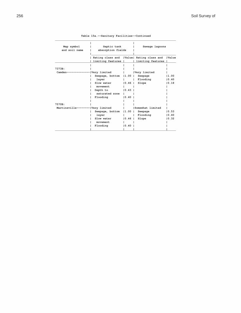
256 Soil Survey of
Table 15a.--Sanitary Facilities--Continued_________________________________________________________________________ | | Map symbol | Septic tank | Sewage lagoons and soil name | absorption fields | | | ___________________________________________________ | Rating class and |Value| Rating class and |Value | limiting features | | limiting features |_________________________________________________________________________ | | | |7373B: | | | | Camden--------------|Very limited | |Very limited | | Seepage, bottom |1.00 | Seepage |1.00 | layer | | Flooding |0.40 | Slow water |0.46 | Slope |0.18 | movement | | | | Depth to |0.43 | | | saturated zone | | | | Flooding |0.40 | | | | | |7570B: | | | | Martinsville--------|Very limited | |Somewhat limited | | Seepage, bottom |1.00 | Seepage |0.53 | layer | | Flooding |0.40 | Slow water |0.46 | Slope |0.32 | movement | | | | Flooding |0.40 | | | | | |_________________________________________________________________________

Coles County, Illinois 257
Table 15b.--Sanitary Facilities
(The information in this table indicates the dominant soil condition but does not eliminate the need for onsite investigation. The numbers in the value columns range from 0.01 to 1.00. The larger the value, the greater the limitation. See text for further explanation of ratings in this table)
___________________________________________________________________________________________________ | | | Map symbol | Trench sanitary | Area sanitary | Daily cover for and soil name | landfill | landfill | landfill | | | _____________________________________________________________________________ | Rating class and |Value| Rating class and |Value| Rating class and |Value | limiting features | | limiting features | | limiting features |___________________________________________________________________________________________________ | | | | | |2A: | | | | | | Cisne---------------|Very limited | |Very limited | |Very limited | | Depth to |1.00 | Ponding |1.00 | Ponding |1.00 | saturated zone | | Depth to |1.00 | Depth to |1.00 | Ponding |1.00 | saturated zone | | saturated zone | | Too clayey |0.50 | | | Too clayey |0.50 | | | | | |3A: | | | | | | Hoyleton------------|Very limited | |Very limited | |Somewhat limited | | Depth to |1.00 | Depth to |1.00 | Depth to |0.98 | saturated zone | | saturated zone | | saturated zone | | | | | | Too clayey |0.50 | | | | | |13A: | | | | | | Bluford-------------|Very limited | |Very limited | |Very limited | | Depth to |1.00 | Depth to |1.00 | Depth to |1.00 | saturated zone | | saturated zone | | saturated zone | | Too clayey |0.50 | | | Too clayey |0.50 | | | | | |13B: | | | | | | Bluford-------------|Very limited | |Very limited | |Very limited | | Depth to |1.00 | Depth to |1.00 | Depth to |1.00 | saturated zone | | saturated zone | | saturated zone | | Too clayey |0.50 | | | Too clayey |0.50 | | | | | |48A: | | | | | | Ebbert--------------|Very limited | |Very limited | |Very limited | | Depth to |1.00 | Ponding |1.00 | Ponding |1.00 | saturated zone | | Depth to |1.00 | Depth to |1.00 | Ponding |1.00 | saturated zone | | saturated zone | | Too clayey |0.50 | | | Too clayey |0.50 | | | | | |56B: | | | | | | Dana----------------|Somewhat limited | |Somewhat limited | |Somewhat limited | | Depth to |0.68 | Depth to |0.04 | Too clayey |0.50 | saturated zone | | saturated zone | | Depth to |0.24 | Too clayey |0.50 | | | saturated zone | | | | | | |56B2: | | | | | | Dana----------------|Somewhat limited | |Somewhat limited | |Somewhat limited | | Depth to |0.95 | Depth to |0.44 | Depth to |0.68 | saturated zone | | saturated zone | | saturated zone | | Too clayey |0.50 | | | Too clayey |0.50 | | | | | |132A: | | | | | | Starks--------------|Very limited | |Very limited | |Somewhat limited | | Depth to |1.00 | Depth to |1.00 | Depth to |0.96 | saturated zone | | saturated zone | | saturated zone | | Too clayey |0.50 | | | Too clayey |0.50 | | | | | |

258 Soil Survey of
Table 15b.--Sanitary Facilities--Continued___________________________________________________________________________________________________ | | | Map symbol | Trench sanitary | Area sanitary | Daily cover for and soil name | landfill | landfill | landfill | | | _____________________________________________________________________________ | Rating class and |Value| Rating class and |Value| Rating class and |Value | limiting features | | limiting features | | limiting features |___________________________________________________________________________________________________ | | | | | |136A: | | | | | | Brooklyn------------|Very limited | |Very limited | |Very limited | | Depth to |1.00 | Ponding |1.00 | Ponding |1.00 | saturated zone | | Depth to |1.00 | Depth to |1.00 | Ponding |1.00 | saturated zone | | saturated zone | | Too clayey |1.00 | | | Too clayey |1.00 | | | | | Hard to compact |1.00 | | | | | |138A: | | | | | | Shiloh--------------|Very limited | |Very limited | |Very limited | | Depth to |1.00 | Ponding |1.00 | Ponding |1.00 | saturated zone | | Depth to |1.00 | Depth to |1.00 | Ponding |1.00 | saturated zone | | saturated zone | | Too clayey |1.00 | | | Too clayey |1.00 | | | | | Hard to compact |1.00 | | | | | |148B: | | | | | | Proctor-------------|Very limited | |Not limited | |Not limited | | Seepage, bottom |1.00 | | | | | layer | | | | | | | | | | |149A: | | | | | | Brenton-------------|Very limited | |Very limited | |Very limited | | Depth to |1.00 | Depth to |1.00 | Depth to |1.00 | saturated zone | | saturated zone | | saturated zone | | Too clayey |0.50 | | | Too clayey |0.50 | | | | | |152A: | | | | | | Drummer-------------|Very limited | |Very limited | |Very limited | | Depth to |1.00 | Ponding |1.00 | Ponding |1.00 | saturated zone | | Depth to |1.00 | Depth to |1.00 | Ponding |1.00 | saturated zone | | saturated zone | | Too clayey |0.50 | | | Too clayey |0.50 | | | | | |154A: | | | | | | Flanagan------------|Very limited | |Very limited | |Very limited | | Depth to |1.00 | Depth to |1.00 | Depth to |1.00 | saturated zone | | saturated zone | | saturated zone | | Too clayey |0.50 | | | Too clayey |0.50 | | | | | |206A: | | | | | | Thorp---------------|Very limited | |Very limited | |Very limited | | Depth to |1.00 | Ponding |1.00 | Ponding |1.00 | saturated zone | | Depth to |1.00 | Depth to |1.00 | Ponding |1.00 | saturated zone | | saturated zone | | Seepage, bottom |1.00 | | | Too clayey |0.50 | layer | | | | | | Too clayey |0.50 | | | | | | | | | |219A: | | | | | | Millbrook-----------|Very limited | |Very limited | |Very limited | | Depth to |1.00 | Depth to |1.00 | Depth to |1.00 | saturated zone | | saturated zone | | saturated zone | | Too clayey |0.50 | | | Too clayey |0.50 | | | | | |244A: | | | | | | Hartsburg-----------|Very limited | |Very limited | |Very limited | | Depth to |1.00 | Ponding |1.00 | Ponding |1.00 | saturated zone | | Depth to |1.00 | Depth to |1.00 | Ponding |1.00 | saturated zone | | saturated zone | | | | | | |

Coles County, Illinois 259
Table 15b.--Sanitary Facilities--Continued___________________________________________________________________________________________________ | | | Map symbol | Trench sanitary | Area sanitary | Daily cover for and soil name | landfill | landfill | landfill | | | _____________________________________________________________________________ | Rating class and |Value| Rating class and |Value| Rating class and |Value | limiting features | | limiting features | | limiting features |___________________________________________________________________________________________________ | | | | | |291B: | | | | | | Xenia---------------|Very limited | |Very limited | |Very limited | | Depth to |1.00 | Depth to |1.00 | Depth to |1.00 | saturated zone | | saturated zone | | saturated zone | | Too clayey |0.50 | | | Too clayey |0.50 | | | | | |322B: | | | | | | Russell-------------|Not limited | |Not limited | |Somewhat limited | | | | | | Too clayey |0.50 | | | | | |322C2: | | | | | | Russell-------------|Somewhat limited | |Somewhat limited | |Somewhat limited | | Too clayey |0.50 | Slope |0.01 | Too clayey |0.50 | Slope |0.01 | | | Slope |0.01 | | | | | |330A: | | | | | | Peotone-------------|Very limited | |Very limited | |Very limited | | Depth to |1.00 | Ponding |1.00 | Ponding |1.00 | saturated zone | | Depth to |1.00 | Depth to |1.00 | Ponding |1.00 | saturated zone | | saturated zone | | Too clayey |0.50 | | | Hard to compact |1.00 | | | | | Too clayey |0.50 | | | | | |348B: | | | | | | Wingate-------------|Somewhat limited | |Somewhat limited | |Somewhat limited | | Depth to |0.95 | Depth to |0.44 | Depth to |0.68 | saturated zone | | saturated zone | | saturated zone | | Too clayey |0.50 | | | Too clayey |0.50 | | | | | |353A: | | | | | | Toronto-------------|Very limited | |Very limited | |Very limited | | Depth to |1.00 | Depth to |1.00 | Depth to |1.00 | saturated zone | | saturated zone | | saturated zone | | Too clayey |0.50 | | | Too clayey |0.50 | | | | | |481A: | | | | | | Raub----------------|Very limited | |Very limited | |Very limited | | Depth to |1.00 | Depth to |1.00 | Depth to |1.00 | saturated zone | | saturated zone | | saturated zone | | | | | | Too clayey |0.50 | | | | | |496A: | | | | | | Fincastle-----------|Very limited | |Very limited | |Very limited | | Depth to |1.00 | Depth to |1.00 | Depth to |1.00 | saturated zone | | saturated zone | | saturated zone | | Too clayey |0.50 | | | Too clayey |0.50 | | | | | |533: | | | | | | Urban land----------|Not rated | |Not rated | |Not rated | | | | | | |570B: | | | | | | Martinsville--------|Very limited | |Not limited | |Somewhat limited | | Seepage, bottom |1.00 | | | Too clayey |0.50 | layer | | | | | | Too clayey |0.50 | | | | | | | | | |

260 Soil Survey of
Table 15b.--Sanitary Facilities--Continued___________________________________________________________________________________________________ | | | Map symbol | Trench sanitary | Area sanitary | Daily cover for and soil name | landfill | landfill | landfill | | | _____________________________________________________________________________ | Rating class and |Value| Rating class and |Value| Rating class and |Value | limiting features | | limiting features | | limiting features |___________________________________________________________________________________________________ | | | | | |570C2: | | | | | | Martinsville--------|Very limited | |Somewhat limited | |Somewhat limited | | Seepage, bottom |1.00 | Slope |0.01 | Too clayey |0.50 | layer | | | | Slope |0.01 | Too clayey |0.50 | | | | | Slope |0.01 | | | | | | | | | |618C2: | | | | | | Senachwine----------|Somewhat limited | |Somewhat limited | |Somewhat limited | | Slope |0.01 | Slope |0.01 | Slope |0.01 | | | | | |618C3: | | | | | | Senachwine----------|Somewhat limited | |Somewhat limited | |Somewhat limited | | Slope |0.01 | Slope |0.01 | Slope |0.01 | | | | | |618D2: | | | | | | Senachwine----------|Somewhat limited | |Somewhat limited | |Somewhat limited | | Slope |0.96 | Slope |0.96 | Slope |0.96 | | | | | |618D3: | | | | | | Senachwine----------|Somewhat limited | |Somewhat limited | |Somewhat limited | | Slope |0.96 | Slope |0.96 | Slope |0.96 | | | | | |618F: | | | | | | Senachwine----------|Very limited | |Very limited | |Very limited | | Slope |1.00 | Slope |1.00 | Slope |1.00 | | | | | |618G: | | | | | | Senachwine----------|Very limited | |Very limited | |Very limited | | Slope |1.00 | Slope |1.00 | Slope |1.00 | | | | | |668B2: | | | | | | Somonauk------------|Very limited | |Very limited | |Somewhat limited | | Depth to |1.00 | Depth to |1.00 | Too clayey |0.50 | saturated zone | | saturated zone | | Depth to |0.24 | Seepage, bottom |1.00 | | | saturated zone | | layer | | | | | | Too clayey |0.50 | | | | | | | | | |722A: | | | | | | Drummer-------------|Very limited | |Very limited | |Very limited | | Depth to |1.00 | Ponding |1.00 | Ponding |1.00 | saturated zone | | Depth to |1.00 | Depth to |1.00 | Ponding |1.00 | saturated zone | | saturated zone | | Too clayey |0.50 | | | Too clayey |0.50 | | | | | | Milford-------------|Very limited | |Very limited | |Very limited | | Depth to |1.00 | Ponding |1.00 | Ponding |1.00 | saturated zone | | Depth to |1.00 | Depth to |1.00 | Ponding |1.00 | saturated zone | | saturated zone | | | | | | Too clayey |0.50 | | | | | |830: | | | | | | Landfill------------|Not rated | |Not limited | |Not rated | | | | | | |864: | | | | | | Pits, quarry--------|Not rated | |Not rated | |Not rated | | | | | | |865: | | | | | | Pits, gravel--------|Not rated | |Not rated | |Not rated | | | | | | |

Coles County, Illinois 261
Table 15b.--Sanitary Facilities--Continued___________________________________________________________________________________________________ | | | Map symbol | Trench sanitary | Area sanitary | Daily cover for and soil name | landfill | landfill | landfill | | | _____________________________________________________________________________ | Rating class and |Value| Rating class and |Value| Rating class and |Value | limiting features | | limiting features | | limiting features |___________________________________________________________________________________________________ | | | | | |871B: | | | | | | Lenzburg------------|Not limited | |Not limited | |Not limited | | | | | | |871D: | | | | | | Lenzburg------------|Somewhat limited | |Somewhat limited | |Somewhat limited | | Slope |0.16 | Slope |0.16 | Slope |0.16 | | | | | |3073A: | | | | | | Ross----------------|Very limited | |Very limited | |Not limited | | Flooding |1.00 | Flooding |1.00 | | | Depth to |1.00 | Depth to |1.00 | | | saturated zone | | saturated zone | | | | Seepage, bottom |1.00 | | | | | layer | | | | | | | | | | |3107A: | | | | | | Sawmill-------------|Very limited | |Very limited | |Very limited | | Flooding |1.00 | Flooding |1.00 | Ponding |1.00 | Depth to |1.00 | Ponding |1.00 | Depth to |1.00 | saturated zone | | Depth to |1.00 | saturated zone | | Ponding |1.00 | saturated zone | | Too clayey |0.50 | Too clayey |0.50 | | | | | | | | | |3226A: | | | | | | Wirt----------------|Very limited | |Very limited | |Somewhat limited | | Flooding |1.00 | Flooding |1.00 | Seepage |0.22 | Seepage, bottom |1.00 | Seepage |1.00 | | | layer | | | | | | | | | | |3284A: | | | | | | Tice----------------|Very limited | |Very limited | |Somewhat limited | | Flooding |1.00 | Flooding |1.00 | Depth to |0.96 | Depth to |1.00 | Depth to |1.00 | saturated zone | | saturated zone | | saturated zone | | Too clayey |0.50 | Too clayey |0.50 | | | | | | | | | |3304A: | | | | | | Landes--------------|Very limited | |Very limited | |Very limited | | Flooding |1.00 | Flooding |1.00 | Too sandy |1.00 | Seepage, bottom |1.00 | Seepage |1.00 | Seepage |1.00 | layer | | | | | | Too sandy |1.00 | | | | | | | | | |3424A: | | | | | | Shoals--------------|Very limited | |Very limited | |Very limited | | Flooding |1.00 | Flooding |1.00 | Depth to |1.00 | Depth to |1.00 | Depth to |1.00 | saturated zone | | saturated zone | | saturated zone | | | | | | | | |3450A: | | | | | | Brouillett----------|Very limited | |Very limited | |Somewhat limited | | Flooding |1.00 | Flooding |1.00 | Depth to |0.88 | Depth to |1.00 | Depth to |1.00 | saturated zone | | saturated zone | | saturated zone | | Seepage |0.22 | Seepage, bottom |1.00 | | | | | layer | | | | | | | | | | |

262 Soil Survey of
Table 15b.--Sanitary Facilities--Continued___________________________________________________________________________________________________ | | | Map symbol | Trench sanitary | Area sanitary | Daily cover for and soil name | landfill | landfill | landfill | | | _____________________________________________________________________________ | Rating class and |Value| Rating class and |Value| Rating class and |Value | limiting features | | limiting features | | limiting features |___________________________________________________________________________________________________ | | | | | |3451A: | | | | | | Lawson--------------|Very limited | |Very limited | |Somewhat limited | | Flooding |1.00 | Flooding |1.00 | Depth to |0.47 | Depth to |1.00 | Depth to |1.00 | saturated zone | | saturated zone | | saturated zone | | | | | | | | |7132A: | | | | | | Starks--------------|Very limited | |Very limited | |Somewhat limited | | Depth to |1.00 | Depth to |1.00 | Depth to |0.96 | saturated zone | | saturated zone | | saturated zone | | Seepage, bottom |1.00 | Seepage |1.00 | Too clayey |0.50 | layer | | Flooding |0.40 | | | Too clayey |0.50 | | | | | Flooding |0.40 | | | | | | | | | |7373B: | | | | | | Camden--------------|Very limited | |Very limited | |Somewhat limited | | Depth to |1.00 | Depth to |1.00 | Too clayey |0.50 | saturated zone | | saturated zone | | Seepage |0.22 | Seepage, bottom |1.00 | Flooding |0.40 | | | layer | | | | | | Flooding |0.40 | | | | | | | | | |7570B: | | | | | | Martinsville--------|Very limited | |Somewhat limited | |Somewhat limited | | Seepage, bottom |1.00 | Flooding |0.40 | Too clayey |0.50 | layer | | | | | | Too clayey |0.50 | | | | | Flooding |0.40 | | | | | | | | | |___________________________________________________________________________________________________

Coles County, Illinois 263
Table 16a.--Construction Materials
(The information in this table indicates the dominant soil condition but does not eliminate the need for onsite investigation. The ratings given for the thickest layer are for the thickest layer above and excluding the bottom layer. The numbers in the value columns range from 0.00 to 0.99. The greater the value, the greater the likelihood that the bottom layer or thickest layer of the soil is a source of sand or gravel. See text for further explanation of ratings in this table)
_______________________________________________________________________ | | Map symbol | Potential as source | Potential as source and soil name | of gravel | of sand | | ___________________________________________________ | Rating class |Value| Rating class |Value_______________________________________________________________________ | | | |2A: | | | | Cisne-------------|Poor | |Poor | | Bottom layer |0.00 | Bottom layer |0.00 | Thickest layer |0.00 | Thickest layer |0.00 | | | |3A: | | | | Hoyleton----------|Poor | |Poor | | Bottom layer |0.00 | Bottom layer |0.00 | Thickest layer |0.00 | Thickest layer |0.00 | | | |13A: | | | | Bluford-----------|Poor | |Poor | | Bottom layer |0.00 | Bottom layer |0.00 | Thickest layer |0.00 | Thickest layer |0.00 | | | |13B: | | | | Bluford-----------|Poor | |Poor | | Bottom layer |0.00 | Bottom layer |0.00 | Thickest layer |0.00 | Thickest layer |0.00 | | | |48A: | | | | Ebbert------------|Poor | |Poor | | Bottom layer |0.00 | Bottom layer |0.00 | Thickest layer |0.00 | Thickest layer |0.00 | | | |56B: | | | | Dana--------------|Poor | |Poor | | Bottom layer |0.00 | Bottom layer |0.00 | Thickest layer |0.00 | Thickest layer |0.00 | | | |56B2: | | | | Dana--------------|Poor | |Poor | | Bottom layer |0.00 | Bottom layer |0.00 | Thickest layer |0.00 | Thickest layer |0.00 | | | |132A: | | | | Starks------------|Poor | |Poor | | Bottom layer |0.00 | Thickest layer |0.00 | Thickest layer |0.00 | Bottom layer |0.00 | | | |136A: | | | | Brooklyn----------|Poor | |Poor | | Bottom layer |0.00 | Bottom layer |0.00 | Thickest layer |0.00 | Thickest layer |0.00 | | | |138A: | | | | Shiloh------------|Poor | |Poor | | Bottom layer |0.00 | Bottom layer |0.00 | Thickest layer |0.00 | Thickest layer |0.00 | | | |

264 Soil Survey of
Table 16a.--Construction Materials--Continued_______________________________________________________________________ | | Map symbol | Potential as source | Potential as source and soil name | of gravel | of sand | | ___________________________________________________ | Rating class |Value| Rating class |Value_______________________________________________________________________ | | | |148B: | | | | Proctor-----------|Poor | |Poor | | Bottom layer |0.00 | Bottom layer |0.00 | Thickest layer |0.00 | Thickest layer |0.00 | | | |149A: | | | | Brenton-----------|Poor | |Poor | | Bottom layer |0.00 | Bottom layer |0.00 | Thickest layer |0.00 | Thickest layer |0.00 | | | |152A: | | | | Drummer-----------|Poor | |Fair | | Bottom layer |0.00 | Thickest layer |0.00 | Thickest layer |0.00 | Bottom layer |0.01 | | | |154A: | | | | Flanagan----------|Poor | |Poor | | Bottom layer |0.00 | Bottom layer |0.00 | Thickest layer |0.00 | Thickest layer |0.00 | | | |206A: | | | | Thorp-------------|Poor | |Fair | | Bottom layer |0.00 | Thickest layer |0.00 | Thickest layer |0.00 | Bottom layer |0.01 | | | |219A: | | | | Millbrook---------|Poor | |Fair | | Bottom layer |0.00 | Thickest layer |0.00 | Thickest layer |0.00 | Bottom layer |0.01 | | | |244A: | | | | Hartsburg---------|Poor | |Poor | | Bottom layer |0.00 | Bottom layer |0.00 | Thickest layer |0.00 | Thickest layer |0.00 | | | |291B: | | | | Xenia-------------|Poor | |Poor | | Bottom layer |0.00 | Bottom layer |0.00 | Thickest layer |0.00 | Thickest layer |0.00 | | | |322B: | | | | Russell-----------|Poor | |Poor | | Bottom layer |0.00 | Bottom layer |0.00 | Thickest layer |0.00 | Thickest layer |0.00 | | | |322C2: | | | | Russell-----------|Poor | |Poor | | Bottom layer |0.00 | Bottom layer |0.00 | Thickest layer |0.00 | Thickest layer |0.00 | | | |330A: | | | | Peotone-----------|Poor | |Poor | | Bottom layer |0.00 | Bottom layer |0.00 | Thickest layer |0.00 | Thickest layer |0.00 | | | |348B: | | | | Wingate-----------|Poor | |Poor | | Bottom layer |0.00 | Bottom layer |0.00 | Thickest layer |0.00 | Thickest layer |0.00 | | | |

Coles County, Illinois 265
Table 16a.--Construction Materials--Continued_______________________________________________________________________ | | Map symbol | Potential as source | Potential as source and soil name | of gravel | of sand | | ___________________________________________________ | Rating class |Value| Rating class |Value_______________________________________________________________________ | | | |353A: | | | | Toronto-----------|Poor | |Poor | | Bottom layer |0.00 | Bottom layer |0.00 | Thickest layer |0.00 | Thickest layer |0.00 | | | |481A: | | | | Raub--------------|Poor | |Poor | | Bottom layer |0.00 | Bottom layer |0.00 | Thickest layer |0.00 | Thickest layer |0.00 | | | |496A: | | | | Fincastle---------|Poor | |Poor | | Bottom layer |0.00 | Bottom layer |0.00 | Thickest layer |0.00 | Thickest layer |0.00 | | | |533: | | | | Urban land--------|Not rated | |Not rated | | | | |570B: | | | | Martinsville------|Poor | |Poor | | Bottom layer |0.00 | Bottom layer |0.00 | Thickest layer |0.00 | Thickest layer |0.00 | | | |570C2: | | | | Martinsville------|Poor | |Poor | | Bottom layer |0.00 | Bottom layer |0.00 | Thickest layer |0.00 | Thickest layer |0.00 | | | |618C2: | | | | Senachwine--------|Poor | |Poor | | Bottom layer |0.00 | Bottom layer |0.00 | Thickest layer |0.00 | Thickest layer |0.00 | | | |618C3: | | | | Senachwine--------|Poor | |Poor | | Bottom layer |0.00 | Bottom layer |0.00 | Thickest layer |0.00 | Thickest layer |0.00 | | | |618D2: | | | | Senachwine--------|Poor | |Poor | | Bottom layer |0.00 | Bottom layer |0.00 | Thickest layer |0.00 | Thickest layer |0.00 | | | |618D3: | | | | Senachwine--------|Poor | |Poor | | Bottom layer |0.00 | Bottom layer |0.00 | Thickest layer |0.00 | Thickest layer |0.00 | | | |618F: | | | | Senachwine--------|Poor | |Poor | | Bottom layer |0.00 | Bottom layer |0.00 | Thickest layer |0.00 | Thickest layer |0.00 | | | |618G: | | | | Senachwine--------|Poor | |Poor | | Bottom layer |0.00 | Bottom layer |0.00 | Thickest layer |0.00 | Thickest layer |0.00 | | | |

266 Soil Survey of
Table 16a.--Construction Materials--Continued_______________________________________________________________________ | | Map symbol | Potential as source | Potential as source and soil name | of gravel | of sand | | ___________________________________________________ | Rating class |Value| Rating class |Value_______________________________________________________________________ | | | |668B2: | | | | Somonauk----------|Poor | |Poor | | Bottom layer |0.00 | Bottom layer |0.00 | Thickest layer |0.00 | Thickest layer |0.00 | | | |722A: | | | | Drummer-----------|Poor | |Fair | | Bottom layer |0.00 | Thickest layer |0.00 | Thickest layer |0.00 | Bottom layer |0.01 | | | | Milford-----------|Poor | |Poor | | Bottom layer |0.00 | Bottom layer |0.00 | Thickest layer |0.00 | Thickest layer |0.00 | | | |830: | | | | Landfill----------|Not rated | |Not rated | | | | |864: | | | | Pits, quarry------|Not rated | |Not rated | | | | |865: | | | | Pits, gravel------|Not rated | |Not rated | | | | |871B: | | | | Lenzburg----------|Poor | |Poor | | Bottom layer |0.00 | Bottom layer |0.00 | Thickest layer |0.00 | Thickest layer |0.00 | | | |871D: | | | | Lenzburg----------|Poor | |Poor | | Bottom layer |0.00 | Bottom layer |0.00 | Thickest layer |0.00 | Thickest layer |0.00 | | | |3073A: | | | | Ross--------------|Poor | |Poor | | Bottom layer |0.00 | Bottom layer |0.00 | Thickest layer |0.00 | Thickest layer |0.00 | | | |3107A: | | | | Sawmill-----------|Poor | |Poor | | Bottom layer |0.00 | Bottom layer |0.00 | Thickest layer |0.00 | Thickest layer |0.00 | | | |3226A: | | | | Wirt--------------|Poor | |Poor | | Bottom layer |0.00 | Bottom layer |0.00 | Thickest layer |0.00 | Thickest layer |0.00 | | | |3284A: | | | | Tice--------------|Poor | |Poor | | Bottom layer |0.00 | Bottom layer |0.00 | Thickest layer |0.00 | Thickest layer |0.00 | | | |3304A: | | | | Landes------------|Poor | |Fair | | Bottom layer |0.00 | Thickest layer |0.00 | Thickest layer |0.00 | Bottom layer |0.07 | | | |

Coles County, Illinois 267
Table 16a.--Construction Materials--Continued_______________________________________________________________________ | | Map symbol | Potential as source | Potential as source and soil name | of gravel | of sand | | ___________________________________________________ | Rating class |Value| Rating class |Value_______________________________________________________________________ | | | |3424A: | | | | Shoals------------|Poor | |Poor | | Bottom layer |0.00 | Bottom layer |0.00 | Thickest layer |0.00 | Thickest layer |0.00 | | | |3450A: | | | | Brouillett--------|Poor | |Poor | | Bottom layer |0.00 | Bottom layer |0.00 | Thickest layer |0.00 | Thickest layer |0.00 | | | |3451A: | | | | Lawson------------|Poor | |Poor | | Bottom layer |0.00 | Bottom layer |0.00 | Thickest layer |0.00 | Thickest layer |0.00 | | | |7132A: | | | | Starks------------|Poor | |Poor | | Bottom layer |0.00 | Thickest layer |0.00 | Thickest layer |0.00 | Bottom layer |0.00 | | | |7373B: | | | | Camden------------|Poor | |Fair | | Bottom layer |0.00 | Thickest layer |0.03 | Thickest layer |0.00 | Bottom layer |0.10 | | | |7570B: | | | | Martinsville------|Poor | |Poor | | Bottom layer |0.00 | Bottom layer |0.00 | Thickest layer |0.00 | Thickest layer |0.00 | | | |_______________________________________________________________________

268 Soil Survey of
Table 16b.--Construction Materials
(The information in this table indicates the dominant soil condition but does not eliminate the need for onsite investigation. The numbers in the value columns range from 0.00 to 0.99. The smaller the value, the greater the limitation. See text for further explanation of ratings in this table)
___________________________________________________________________________________________________ | | | Map symbol | Potential as source of | Potential as source | Potential as source and soil name | reclamation material | of roadfill | of topsoil | | | _____________________________________________________________________________ | Rating class and |Value| Rating class and |Value| Rating class and |Value | limiting features | | limiting features | | limiting features |___________________________________________________________________________________________________ | | | | | |2A: | | | | | | Cisne---------------|Fair | |Poor | |Poor | | Water erosion |0.06 | Wetness |0.00 | Wetness |0.00 | Low content of |0.12 | Low strength |0.00 | Too clayey |0.20 | organic matter | | Shrink-swell |0.93 | Too acid |0.95 | Too clayey |0.32 | | | | | Too acid |0.46 | | | | | | | | | |3A: | | | | | | Hoyleton------------|Fair | |Poor | |Fair | | Too clayey |0.02 | Low strength |0.00 | Too clayey |0.01 | Low content of |0.02 | Wetness |0.24 | Wetness |0.24 | organic matter | | Shrink-swell |0.78 | Too acid |0.92 | Water erosion |0.37 | | | | | Too acid |0.50 | | | | | | | | | |13A: | | | | | | Bluford-------------|Poor | |Poor | |Poor | | Too clayey |0.00 | Low strength |0.00 | Too clayey |0.00 | Low content of |0.05 | Wetness |0.04 | Wetness |0.04 | organic matter | | Shrink-swell |0.97 | Too acid |0.68 | Water erosion |0.37 | | | | | Too acid |0.50 | | | | | | | | | |13B: | | | | | | Bluford-------------|Poor | |Poor | |Poor | | Too clayey |0.00 | Low strength |0.00 | Too clayey |0.00 | Low content of |0.05 | Wetness |0.04 | Wetness |0.04 | organic matter | | Shrink-swell |0.97 | Too acid |0.68 | Water erosion |0.37 | | | | | Too acid |0.50 | | | | | | | | | |48A: | | | | | | Ebbert--------------|Fair | |Poor | |Poor | | Water erosion |0.37 | Wetness |0.00 | Wetness |0.00 | Too acid |0.54 | Low strength |0.00 | Too clayey |0.67 | Low content of |0.68 | Shrink-swell |0.97 | | | organic matter | | | | | | Too clayey |0.98 | | | | | | | | | |56B: | | | | | | Dana----------------|Fair | |Poor | |Fair | | Low content of |0.50 | Low strength |0.00 | Too clayey |0.76 | organic matter | | Shrink-swell |0.90 | Wetness |0.98 | Carbonate content|0.68 | Wetness |0.98 | | | Too acid |0.97 | | | | | Too clayey |0.98 | | | | | Water erosion |0.99 | | | | | | | | | |56B2: | | | | | | Dana----------------|Fair | |Poor | |Fair | | Carbonate content|0.68 | Low strength |0.00 | Wetness |0.76 | Too acid |0.95 | Wetness |0.76 | Too clayey |0.76 | Too clayey |0.98 | Shrink-swell |0.93 | | | Water erosion |0.99 | | | | | | | | | |

Coles County, Illinois 269
Table 16b.--Construction Materials--Continued___________________________________________________________________________________________________ | | | Map symbol | Potential as source of | Potential as source | Potential as source and soil name | reclamation material | of roadfill | of topsoil | | | _____________________________________________________________________________ | Rating class and |Value| Rating class and |Value| Rating class and |Value | limiting features | | limiting features | | limiting features |___________________________________________________________________________________________________ | | | | | |132A: | | | | | | Starks--------------|Fair | |Poor | |Fair | | Low content of |0.32 | Low strength |0.00 | Wetness |0.29 | organic matter | | Wetness |0.29 | Too clayey |0.61 | Water erosion |0.68 | Shrink-swell |0.99 | | | Too acid |0.68 | | | | | Too clayey |0.98 | | | | | | | | | |136A: | | | | | | Brooklyn------------|Poor | |Poor | |Poor | | Too clayey |0.00 | Wetness |0.00 | Wetness |0.00 | Water erosion |0.37 | Low strength |0.00 | Too clayey |0.00 | Low content of |0.50 | Shrink-swell |0.64 | | | organic matter | | | | | | Carbonate content|0.68 | | | | | Too acid |0.92 | | | | | | | | | |138A: | | | | | | Shiloh--------------|Poor | |Poor | |Poor | | Too clayey |0.00 | Wetness |0.00 | Wetness |0.00 | | | Low strength |0.00 | Too clayey |0.00 | | | Shrink-swell |0.22 | | | | | | | |148B: | | | | | | Proctor-------------|Fair | |Poor | |Good | | Low content of |0.50 | Low strength |0.00 | | | organic matter | | | | | | Water erosion |0.99 | | | | | | | | | |149A: | | | | | | Brenton-------------|Fair | |Fair | |Fair | | Too clayey |0.82 | Wetness |0.14 | Wetness |0.14 | Too acid |0.84 | | | Too clayey |0.64 | Water erosion |0.99 | | | | | | | | | |152A: | | | | | | Drummer-------------|Fair | |Poor | |Poor | | Too acid |0.95 | Wetness |0.00 | Wetness |0.00 | Too clayey |0.98 | Low strength |0.00 | Too clayey |0.86 | Water erosion |0.99 | Shrink-swell |0.99 | | | | | | | |154A: | | | | | | Flanagan------------|Fair | |Poor | |Fair | | Too clayey |0.18 | Low strength |0.00 | Too clayey |0.13 | Carbonate content|0.68 | Wetness |0.14 | Wetness |0.14 | Too acid |0.84 | Shrink-swell |0.90 | | | Low content of |0.88 | | | | | organic matter | | | | | | Water erosion |0.99 | | | | | | | | | |206A: | | | | | | Thorp---------------|Fair | |Poor | |Poor | | Low content of |0.68 | Wetness |0.00 | Wetness |0.00 | organic matter | | Low strength |0.00 | | | Water erosion |0.90 | Shrink-swell |0.99 | | | Too acid |0.97 | | | | | | | | | |

270 Soil Survey of
Table 16b.--Construction Materials--Continued___________________________________________________________________________________________________ | | | Map symbol | Potential as source of | Potential as source | Potential as source and soil name | reclamation material | of roadfill | of topsoil | | | _____________________________________________________________________________ | Rating class and |Value| Rating class and |Value| Rating class and |Value | limiting features | | limiting features | | limiting features |___________________________________________________________________________________________________ | | | | | |219A: | | | | | | Millbrook-----------|Fair | |Fair | |Fair | | Water erosion |0.06 | Wetness |0.14 | Wetness |0.14 | Low content of |0.40 | Shrink-swell |0.97 | | | organic matter | | | | | | Too acid |0.84 | | | | | | | | | |244A: | | | | | | Hartsburg-----------|Fair | |Poor | |Poor | | Low content of |0.18 | Wetness |0.00 | Wetness |0.00 | organic matter | | Low strength |0.00 | Too clayey |0.82 | Water erosion |0.68 | | | | | Carbonate content|0.68 | | | | | Too clayey |0.82 | | | | | | | | | |291B: | | | | | | Xenia---------------|Fair | |Poor | |Fair | | Low content of |0.32 | Low strength |0.00 | Wetness |0.14 | organic matter | | Wetness |0.14 | Too clayey |0.61 | Water erosion |0.68 | Shrink-swell |0.94 | Hard to reclaim |0.97 | Carbonate content|0.68 | | | (dense layer) | | Too acid |0.74 | | | | | Too clayey |0.98 | | | | | | | | | |322B: | | | | | | Russell-------------|Fair | |Fair | |Fair | | Low content of |0.02 | Shrink-swell |0.98 | Hard to reclaim |0.35 | organic matter | | | | (dense layer) | | Too acid |0.54 | | | Too clayey |0.57 | Carbonate content|0.68 | | | Too acid |0.98 | Water erosion |0.68 | | | | | Too clayey |0.92 | | | | | | | | | |322C2: | | | | | | Russell-------------|Fair | |Poor | |Fair | | Too acid |0.20 | Low strength |0.00 | Too clayey |0.57 | Low content of |0.32 | Shrink-swell |0.90 | Too acid |0.76 | organic matter | | | | | | Carbonate content|0.68 | | | | | Water erosion |0.90 | | | | | Too clayey |0.92 | | | | | | | | | |330A: | | | | | | Peotone-------------|Fair | |Poor | |Poor | | Too clayey |0.18 | Wetness |0.00 | Wetness |0.00 | | | Low strength |0.00 | Too clayey |0.18 | | | Shrink-swell |0.21 | | | | | | | |348B: | | | | | | Wingate-------------|Fair | |Poor | |Fair | | Low content of |0.08 | Low strength |0.00 | Hard to reclaim |0.29 | organic matter | | Wetness |0.76 | (dense layer) | | Water erosion |0.68 | Shrink-swell |0.95 | Too clayey |0.67 | Carbonate content|0.68 | | | Wetness |0.76 | Too acid |0.74 | | | | | Too clayey |0.98 | | | | | | | | | |

Coles County, Illinois 271
Table 16b.--Construction Materials--Continued___________________________________________________________________________________________________ | | | Map symbol | Potential as source of | Potential as source | Potential as source and soil name | reclamation material | of roadfill | of topsoil | | | _____________________________________________________________________________ | Rating class and |Value| Rating class and |Value| Rating class and |Value | limiting features | | limiting features | | limiting features |___________________________________________________________________________________________________ | | | | | |353A: | | | | | | Toronto-------------|Fair | |Poor | |Poor | | Low content of |0.08 | Wetness |0.00 | Wetness |0.00 | organic matter | | Low strength |0.00 | Hard to reclaim |0.20 | Too acid |0.39 | Shrink-swell |0.94 | (dense layer) | | Carbonate content|0.68 | | | Too clayey |0.67 | Water erosion |0.68 | | | Too acid |0.92 | Too clayey |0.98 | | | | | | | | | |481A: | | | | | | Raub----------------|Fair | |Fair | |Fair | | Low content of |0.08 | Wetness |0.14 | Wetness |0.14 | organic matter | | Shrink-swell |0.99 | | | Carbonate content|0.68 | | | | | Too acid |0.95 | | | | | Water erosion |0.99 | | | | | | | | | |496A: | | | | | | Fincastle-----------|Fair | |Fair | |Fair | | Low content of |0.32 | Wetness |0.14 | Wetness |0.14 | organic matter | | Shrink-swell |0.97 | Too clayey |0.57 | Water erosion |0.37 | | | Hard to reclaim |0.71 | Carbonate content|0.68 | | | (dense layer) | | Too acid |0.74 | | | | | Too clayey |0.92 | | | | | | | | | |533: | | | | | | Urban land----------|Not rated | |Not rated | |Not rated | | | | | | |570B: | | | | | | Martinsville--------|Fair | |Good | |Good | | Low content of |0.12 | | | | | organic matter | | | | | | Water erosion |0.37 | | | | | Too acid |0.54 | | | | | | | | | |570C2: | | | | | | Martinsville--------|Fair | |Good | |Good | | Low content of |0.12 | | | | | organic matter | | | | | | Too acid |0.84 | | | | | | | | | |618C2: | | | | | | Senachwine----------|Fair | |Good | |Poor | | Low content of |0.02 | | | Hard to reclaim |0.00 | organic matter | | | | (dense layer) | | Carbonate content|0.68 | | | | | Too acid |0.84 | | | | | Water erosion |0.90 | | | | | | | | | |618C3: | | | | | | Senachwine----------|Fair | |Good | |Poor | | Low content of |0.08 | | | Hard to reclaim |0.00 | organic matter | | | | (dense layer) | | Carbonate content|0.68 | | | | | Too acid |0.95 | | | | | Water erosion |0.99 | | | | | | | | | |

272 Soil Survey of
Table 16b.--Construction Materials--Continued___________________________________________________________________________________________________ | | | Map symbol | Potential as source of | Potential as source | Potential as source and soil name | reclamation material | of roadfill | of topsoil | | | _____________________________________________________________________________ | Rating class and |Value| Rating class and |Value| Rating class and |Value | limiting features | | limiting features | | limiting features |___________________________________________________________________________________________________ | | | | | |618D2: | | | | | | Senachwine----------|Fair | |Good | |Poor | | Low content of |0.02 | | | Hard to reclaim |0.00 | organic matter | | | | (dense layer) | | Carbonate content|0.68 | | | Slope |0.04 | Too acid |0.84 | | | | | Water erosion |0.90 | | | | | | | | | |618D3: | | | | | | Senachwine----------|Fair | |Good | |Poor | | Low content of |0.01 | | | Hard to reclaim |0.00 | organic matter | | | | (dense layer) | | Carbonate content|0.68 | | | Slope |0.04 | Water erosion |0.99 | | | | | | | | | |618F: | | | | | | Senachwine----------|Fair | |Poor | |Poor | | Low content of |0.02 | Slope |0.00 | Slope |0.00 | organic matter | | | | Hard to reclaim |0.00 | Carbonate content|0.68 | | | (dense layer) | | Too acid |0.74 | | | Too clayey |0.55 | Too clayey |0.98 | | | | | Water erosion |0.99 | | | | | | | | | |618G: | | | | | | Senachwine----------|Fair | |Poor | |Poor | | Low content of |0.01 | Slope |0.00 | Slope |0.00 | organic matter | | | | Hard to reclaim |0.00 | Too acid |0.54 | | | (dense layer) | | Carbonate content|0.68 | | | Too clayey |0.55 | Water erosion |0.68 | | | Too acid |0.98 | Too clayey |0.98 | | | | | | | | | |668B2: | | | | | | Somonauk------------|Fair | |Poor | |Fair | | Low content of |0.32 | Low strength |0.00 | Too clayey |0.57 | organic matter | | Shrink-swell |0.97 | Wetness |0.98 | Too acid |0.68 | Wetness |0.98 | | | Water erosion |0.90 | | | | | Too clayey |0.92 | | | | | | | | | |722A: | | | | | | Drummer-------------|Fair | |Poor | |Poor | | Too acid |0.92 | Wetness |0.00 | Wetness |0.00 | Too clayey |0.98 | Low strength |0.00 | Too clayey |0.81 | Water erosion |0.99 | Shrink-swell |0.99 | | | | | | | | Milford-------------|Fair | |Poor | |Poor | | Too clayey |0.18 | Wetness |0.00 | Wetness |0.00 | Low content of |0.18 | Shrink-swell |0.86 | Too clayey |0.18 | organic matter | | | | | | Water erosion |0.99 | | | | | | | | | |830: | | | | | | Landfill------------|Not rated | |Not rated | |Not rated | | | | | | |864: | | | | | | Pits, quarry--------|Not rated | |Not rated | |Not rated | | | | | | |

Coles County, Illinois 273
Table 16b.--Construction Materials--Continued___________________________________________________________________________________________________ | | | Map symbol | Potential as source of | Potential as source | Potential as source and soil name | reclamation material | of roadfill | of topsoil | | | _____________________________________________________________________________ | Rating class and |Value| Rating class and |Value| Rating class and |Value | limiting features | | limiting features | | limiting features |___________________________________________________________________________________________________ | | | | | |865: | | | | | | Pits, gravel--------|Not rated | |Not rated | |Not rated | | | | | | |871B: | | | | | | Lenzburg------------|Poor | |Poor | |Fair | | Droughty |0.00 | Low strength |0.00 | Rock fragments |0.18 | Low content of |0.88 | | | | | organic matter | | | | | | | | | | |871D: | | | | | | Lenzburg------------|Poor | |Poor | |Fair | | Droughty |0.00 | Low strength |0.00 | Rock fragments |0.99 | Low content of |0.88 | | | Slope |0.84 | organic matter | | | | | | | | | | |3073A: | | | | | | Ross----------------|Good | |Good | |Good | | | | | | |3107A: | | | | | | Sawmill-------------|Fair | |Poor | |Poor | | Too clayey |0.98 | Wetness |0.00 | Wetness |0.00 | Too acid |0.99 | Low strength |0.00 | Too clayey |0.98 | | | Shrink-swell |0.87 | | | | | | | |3226A: | | | | | | Wirt----------------|Fair | |Good | |Good | | Water erosion |0.68 | | | | | Low content of |0.82 | | | | | organic matter | | | | | | | | | | |3284A: | | | | | | Tice----------------|Fair | |Poor | |Fair | | Low content of |0.88 | Low strength |0.00 | Wetness |0.29 | organic matter | | Wetness |0.29 | Too clayey |0.98 | Too clayey |0.98 | Shrink-swell |0.87 | | | | | | | |3304A: | | | | | | Landes--------------|Fair | |Good | |Good | | Low content of |0.50 | | | | | organic matter | | | | | | Droughty |0.99 | | | | | | | | | |3424A: | | | | | | Shoals--------------|Fair | |Poor | |Fair | | Low content of |0.50 | Low strength |0.00 | Wetness |0.04 | organic matter | | Wetness |0.04 | | | Water erosion |0.90 | | | | | | | | | |3450A: | | | | | | Brouillett----------|Fair | |Fair | |Fair | | Low content of |0.88 | Wetness |0.50 | Wetness |0.50 | organic matter | | | | | | Water erosion |0.99 | | | | | | | | | |3451A: | | | | | | Lawson--------------|Fair | |Poor | |Fair | | Low content of |0.88 | Low strength |0.00 | Wetness |0.89 | organic matter | | Wetness |0.89 | | | Water erosion |0.99 | | | | | | | | | |
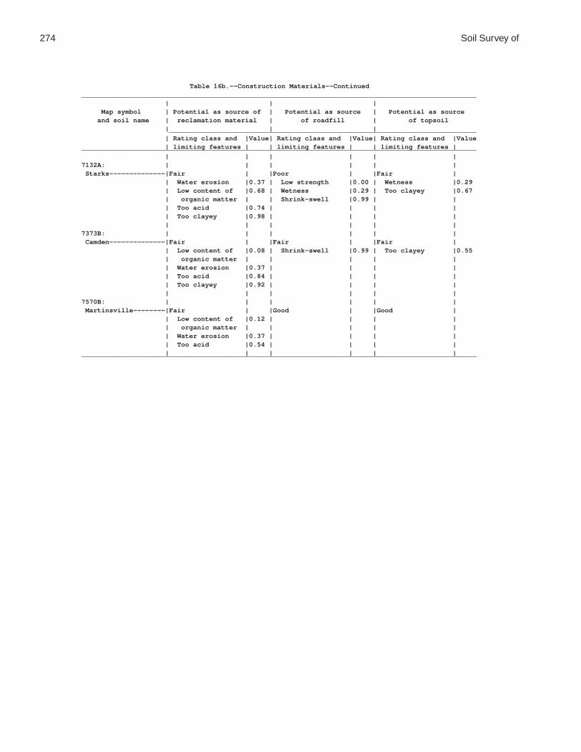
274 Soil Survey of
Table 16b.--Construction Materials--Continued___________________________________________________________________________________________________ | | | Map symbol | Potential as source of | Potential as source | Potential as source and soil name | reclamation material | of roadfill | of topsoil | | | _____________________________________________________________________________ | Rating class and |Value| Rating class and |Value| Rating class and |Value | limiting features | | limiting features | | limiting features |___________________________________________________________________________________________________ | | | | | |7132A: | | | | | | Starks--------------|Fair | |Poor | |Fair | | Water erosion |0.37 | Low strength |0.00 | Wetness |0.29 | Low content of |0.68 | Wetness |0.29 | Too clayey |0.67 | organic matter | | Shrink-swell |0.99 | | | Too acid |0.74 | | | | | Too clayey |0.98 | | | | | | | | | |7373B: | | | | | | Camden--------------|Fair | |Fair | |Fair | | Low content of |0.08 | Shrink-swell |0.99 | Too clayey |0.55 | organic matter | | | | | | Water erosion |0.37 | | | | | Too acid |0.84 | | | | | Too clayey |0.92 | | | | | | | | | |7570B: | | | | | | Martinsville--------|Fair | |Good | |Good | | Low content of |0.12 | | | | | organic matter | | | | | | Water erosion |0.37 | | | | | Too acid |0.54 | | | | | | | | | |___________________________________________________________________________________________________

Coles County, Illinois 275
Table 17a.--Water Management
(The information in this table indicates the dominant soil condition but does not eliminate the need for onsite investigation. The numbers in the value columns range from 0.01 to 1.00. The larger the value, the greater the limitation. See text for further explanation of ratings in this table)
_________________________________________________________________________________________________ | | | Map symbol | Pond reservoir areas | Embankments, dikes, and | Aquifer-fed and soil name | | levees | excavated ponds | | | _____________________________________________________________________________ | Rating class and |Value| Rating class and |Value| Rating class and |Value | limiting features | | limiting features | | limiting features |_________________________________________________________________________________________________ | | | | | |2A: | | | | | | Cisne-------------|Somewhat limited | |Very limited | |Somewhat limited | | Seepage |0.04 | Ponding |1.00 | Slow refill |0.28 | | | Depth to |1.00 | Cutbanks cave |0.10 | | | saturated zone | | | | | | Piping |0.23 | | | | | | | |3A: | | | | | | Hoyleton----------|Somewhat limited | |Very limited | |Somewhat limited | | Seepage |0.04 | Depth to |1.00 | Slow refill |0.96 | | | saturated zone | | Cutbanks cave |0.10 | | | Piping |0.01 | | | | | | | |13A: | | | | | | Bluford-----------|Somewhat limited | |Very limited | |Very limited | | Seepage |0.04 | Depth to |1.00 | Depth to water |1.00 | | | saturated zone | | | | | | Piping |0.26 | | | | | | | |13B: | | | | | | Bluford-----------|Somewhat limited | |Very limited | |Very limited | | Seepage |0.04 | Depth to |1.00 | Depth to water |1.00 | | | saturated zone | | | | | | Piping |1.00 | | | | | | | |48A: | | | | | | Ebbert------------|Somewhat limited | |Very limited | |Somewhat limited | | Seepage |0.04 | Ponding |1.00 | Slow refill |0.28 | | | Depth to |1.00 | Cutbanks cave |0.10 | | | saturated zone | | | | | | Piping |0.38 | | | | | | | |56B: | | | | | | Dana--------------|Somewhat limited | |Somewhat limited | |Very limited | | Seepage |0.72 | Depth to |0.68 | Depth to water |1.00 | | | saturated zone | | | | | | Piping |0.03 | | | | | | | |56B2: | | | | | | Dana--------------|Somewhat limited | |Somewhat limited | |Very limited | | Seepage |0.72 | Depth to |0.95 | Depth to water |1.00 | | | saturated zone | | | | | | Piping |0.12 | | | | | | | |132A: | | | | | | Starks------------|Somewhat limited | |Very limited | |Somewhat limited | | Seepage |0.72 | Depth to |1.00 | Slow refill |0.28 | | | saturated zone | | Cutbanks cave |0.10 | | | Piping |0.77 | | | | | | | |

276 Soil Survey of
Table 17a.--Water Management--Continued_________________________________________________________________________________________________ | | | Map symbol | Pond reservoir areas | Embankments, dikes, and | Aquifer-fed and soil name | | levees | excavated ponds | | | _____________________________________________________________________________ | Rating class and |Value| Rating class and |Value| Rating class and |Value | limiting features | | limiting features | | limiting features |_________________________________________________________________________________________________ | | | | | |136A: | | | | | | Brooklyn----------|Somewhat limited | |Very limited | |Very limited | | Seepage |0.72 | Ponding |1.00 | Depth to water |1.00 | | | Depth to |1.00 | | | | | saturated zone | | | | | | Piping |0.31 | | | | | | | |138A: | | | | | | Shiloh------------|Somewhat limited | |Very limited | |Somewhat limited | | Seepage |0.04 | Ponding |1.00 | Slow refill |0.96 | | | Depth to |1.00 | Cutbanks cave |0.10 | | | saturated zone | | | | | | Hard to pack |0.13 | | | | | | | |148B: | | | | | | Proctor-----------|Very limited | |Somewhat limited | |Very limited | | Seepage |1.00 | Piping |0.72 | Depth to water |1.00 | | | | | |149A: | | | | | | Brenton-----------|Somewhat limited | |Very limited | |Somewhat limited | | Seepage |0.72 | Depth to |1.00 | Cutbanks cave |0.50 | | | saturated zone | | Slow refill |0.28 | | | Piping |0.97 | | | | | | | |152A: | | | | | | Drummer-----------|Somewhat limited | |Very limited | |Somewhat limited | | Seepage |0.72 | Ponding |1.00 | Slow refill |0.28 | | | Depth to |1.00 | Cutbanks cave |0.10 | | | saturated zone | | | | | | Piping |0.43 | | | | | Seepage |0.01 | | | | | | | |154A: | | | | | | Flanagan----------|Somewhat limited | |Very limited | |Somewhat limited | | Seepage |0.72 | Depth to |1.00 | Slow refill |0.28 | | | saturated zone | | Cutbanks cave |0.10 | | | Piping |0.42 | | | | | | | |206A: | | | | | | Thorp-------------|Very limited | |Very limited | |Very limited | | Seepage |1.00 | Ponding |1.00 | Cutbanks cave |1.00 | | | Depth to |1.00 | | | | | saturated zone | | | | | | Piping |0.48 | | | | | Seepage |0.01 | | | | | | | |219A: | | | | | | Millbrook---------|Somewhat limited | |Very limited | |Somewhat limited | | Seepage |0.72 | Depth to |1.00 | Slow refill |0.28 | | | saturated zone | | Cutbanks cave |0.10 | | | Piping |0.80 | | | | | | | |244A: | | | | | | Hartsburg---------|Somewhat limited | |Very limited | |Somewhat limited | | Seepage |0.72 | Ponding |1.00 | Slow refill |0.28 | | | Depth to |1.00 | Cutbanks cave |0.10 | | | saturated zone | | | | | | Piping |0.39 | | | | | | | |

Coles County, Illinois 277
Table 17a.--Water Management--Continued_________________________________________________________________________________________________ | | | Map symbol | Pond reservoir areas | Embankments, dikes, and | Aquifer-fed and soil name | | levees | excavated ponds | | | _____________________________________________________________________________ | Rating class and |Value| Rating class and |Value| Rating class and |Value | limiting features | | limiting features | | limiting features |_________________________________________________________________________________________________ | | | | | |291B: | | | | | | Xenia-------------|Somewhat limited | |Very limited | |Very limited | | Seepage |0.72 | Depth to |1.00 | Depth to water |1.00 | | | saturated zone | | | | | | Piping |0.60 | | | | | | | |322B: | | | | | | Russell-----------|Somewhat limited | |Somewhat limited | |Very limited | | Seepage |0.72 | Piping |0.87 | Depth to water |1.00 | | | | | |322C2: | | | | | | Russell-----------|Somewhat limited | |Somewhat limited | |Very limited | | Seepage |0.72 | Piping |0.47 | Depth to water |1.00 | | | | | |330A: | | | | | | Peotone-----------|Somewhat limited | |Very limited | |Somewhat limited | | Seepage |0.04 | Ponding |1.00 | Slow refill |0.96 | | | Depth to |1.00 | Cutbanks cave |0.10 | | | saturated zone | | | | | | | | |348B: | | | | | | Wingate-----------|Somewhat limited | |Somewhat limited | |Very limited | | Seepage |0.72 | Depth to |0.95 | Depth to water |1.00 | | | saturated zone | | | | | | Piping |0.47 | | | | | | | |353A: | | | | | | Toronto-----------|Somewhat limited | |Very limited | |Very limited | | Seepage |0.72 | Depth to |1.00 | Depth to water |1.00 | | | saturated zone | | | | | | Piping |0.43 | | | | | | | |481A: | | | | | | Raub--------------|Somewhat limited | |Very limited | |Very limited | | Seepage |0.72 | Depth to |1.00 | Depth to water |1.00 | | | saturated zone | | | | | | Piping |0.84 | | | | | | | |496A: | | | | | | Fincastle---------|Somewhat limited | |Very limited | |Very limited | | Seepage |0.72 | Depth to |1.00 | Depth to water |1.00 | | | saturated zone | | | | | | Piping |0.89 | | | | | | | |533: | | | | | | Urban land--------|Not rated | |Not rated | |Not rated | | | | | | |570B: | | | | | | Martinsville------|Very limited | |Very limited | |Very limited | | Seepage |1.00 | Piping |1.00 | Depth to water |1.00 | | | | | |570C2: | | | | | | Martinsville------|Very limited | |Very limited | |Very limited | | Seepage |1.00 | Piping |1.00 | Depth to water |1.00 | | | | | |618C2: | | | | | | Senachwine--------|Somewhat limited | |Very limited | |Very limited | | Seepage |0.72 | Piping |1.00 | Depth to water |1.00 | | | | | |

278 Soil Survey of
Table 17a.--Water Management--Continued_________________________________________________________________________________________________ | | | Map symbol | Pond reservoir areas | Embankments, dikes, and | Aquifer-fed and soil name | | levees | excavated ponds | | | _____________________________________________________________________________ | Rating class and |Value| Rating class and |Value| Rating class and |Value | limiting features | | limiting features | | limiting features |_________________________________________________________________________________________________ | | | | | |618C3: | | | | | | Senachwine--------|Somewhat limited | |Somewhat limited | |Very limited | | Seepage |0.72 | Piping |0.95 | Depth to water |1.00 | | | | | |618D2: | | | | | | Senachwine--------|Somewhat limited | |Somewhat limited | |Very limited | | Seepage |0.72 | Piping |0.98 | Depth to water |1.00 | Slope |0.02 | | | | | | | | | |618D3: | | | | | | Senachwine--------|Somewhat limited | |Very limited | |Very limited | | Seepage |0.72 | Piping |1.00 | Depth to water |1.00 | Slope |0.02 | | | | | | | | | |618F: | | | | | | Senachwine--------|Somewhat limited | |Very limited | |Very limited | | Seepage |0.72 | Piping |1.00 | Depth to water |1.00 | Slope |0.36 | | | | | | | | | |618G: | | | | | | Senachwine--------|Somewhat limited | |Very limited | |Very limited | | Slope |0.99 | Piping |1.00 | Depth to water |1.00 | Seepage |0.72 | | | | | | | | | |668B2: | | | | | | Somonauk----------|Very limited | |Somewhat limited | |Very limited | | Seepage |1.00 | Piping |0.76 | Cutbanks cave |1.00 | | | Depth to |0.68 | Depth to |0.14 | | | saturated zone | | saturated zone | | | | | | |722A: | | | | | | Drummer-----------|Somewhat limited | |Very limited | |Somewhat limited | | Seepage |0.72 | Ponding |1.00 | Slow refill |0.28 | | | Depth to |1.00 | Cutbanks cave |0.10 | | | saturated zone | | | | | | Piping |0.43 | | | | | Seepage |0.01 | | | | | | | | Milford-----------|Somewhat limited | |Very limited | |Somewhat limited | | Seepage |0.72 | Ponding |1.00 | Slow refill |0.28 | | | Depth to |1.00 | Cutbanks cave |0.10 | | | saturated zone | | | | | | Piping |0.74 | | | | | | | |830: | | | | | | Landfill----------|Not limited | |Not rated | |Not rated | | | | | | |864: | | | | | | Pits, quarry------|Not rated | |Not rated | |Not rated | | | | | | |865: | | | | | | Pits, gravel------|Not rated | |Not rated | |Not rated | | | | | | |871B: | | | | | | Lenzburg----------|Somewhat limited | |Somewhat limited | |Very limited | | Seepage |0.04 | Piping |0.76 | Depth to water |1.00 | | | | | |871D: | | | | | | Lenzburg----------|Somewhat limited | |Somewhat limited | |Very limited | | Seepage |0.04 | Piping |0.76 | Depth to water |1.00 | | | | | |

Coles County, Illinois 279
Table 17a.--Water Management--Continued_________________________________________________________________________________________________ | | | Map symbol | Pond reservoir areas | Embankments, dikes, and | Aquifer-fed and soil name | | levees | excavated ponds | | | _____________________________________________________________________________ | Rating class and |Value| Rating class and |Value| Rating class and |Value | limiting features | | limiting features | | limiting features |_________________________________________________________________________________________________ | | | | | |3073A: | | | | | | Ross--------------|Very limited | |Very limited | |Somewhat limited | | Seepage |1.00 | Piping |1.00 | Depth to |0.96 | | | | | saturated zone | | | | | | Cutbanks cave |0.10 | | | | | |3107A: | | | | | | Sawmill-----------|Somewhat limited | |Very limited | |Somewhat limited | | Seepage |0.72 | Ponding |1.00 | Slow refill |0.28 | | | Depth to |1.00 | Cutbanks cave |0.10 | | | saturated zone | | | | | | Piping |0.02 | | | | | | | |3226A: | | | | | | Wirt--------------|Very limited | |Very limited | |Very limited | | Seepage |1.00 | Piping |1.00 | Depth to water |1.00 | | | | | |3284A: | | | | | | Tice--------------|Somewhat limited | |Very limited | |Somewhat limited | | Seepage |0.72 | Depth to |1.00 | Slow refill |0.28 | | | saturated zone | | Cutbanks cave |0.10 | | | Piping |0.02 | | | | | | | |3304A: | | | | | | Landes------------|Very limited | |Somewhat limited | |Very limited | | Seepage |1.00 | Seepage |0.07 | Depth to water |1.00 | | | | | |3424A: | | | | | | Shoals------------|Somewhat limited | |Very limited | |Somewhat limited | | Seepage |0.72 | Depth to |1.00 | Slow refill |0.28 | | | saturated zone | | Cutbanks cave |0.10 | | | Piping |0.88 | | | | | | | |3450A: | | | | | | Brouillett--------|Very limited | |Very limited | |Somewhat limited | | Seepage |1.00 | Piping |1.00 | Cutbanks cave |0.10 | | | Depth to |1.00 | | | | | saturated zone | | | | | | | | |3451A: | | | | | | Lawson------------|Somewhat limited | |Somewhat limited | |Somewhat limited | | Seepage |0.72 | Depth to |0.86 | Slow refill |0.28 | | | saturated zone | | Cutbanks cave |0.10 | | | Piping |0.84 | Depth to |0.06 | | | | | saturated zone | | | | | | |7132A: | | | | | | Starks------------|Very limited | |Very limited | |Somewhat limited | | Seepage |1.00 | Depth to |1.00 | Cutbanks cave |0.10 | | | saturated zone | | | | | | Piping |0.88 | | | | | | | |7373B: | | | | | | Camden------------|Very limited | |Very limited | |Very limited | | Seepage |1.00 | Piping |1.00 | Depth to water |1.00 | | | Seepage |0.10 | | | | | | | |

280 Soil Survey of
Table 17a.--Water Management--Continued_________________________________________________________________________________________________ | | | Map symbol | Pond reservoir areas | Embankments, dikes, and | Aquifer-fed and soil name | | levees | excavated ponds | | | _____________________________________________________________________________ | Rating class and |Value| Rating class and |Value| Rating class and |Value | limiting features | | limiting features | | limiting features |_________________________________________________________________________________________________ | | | | | |7570B: | | | | | | Martinsville------|Very limited | |Very limited | |Very limited | | Seepage |1.00 | Piping |1.00 | Depth to water |1.00 | | | | | |_________________________________________________________________________________________________

Coles County, Illinois 281
Table 17b.--Water Management
(The information in this table indicates the dominant soil condition but does not eliminate the need for onsite investigation. The numbers in the value columns range from 0.01 to 1.00. The larger the value, the greater the limitation. See text for further explanation of ratings in this table)
___________________________________________________________________________________________________ | | | Map symbol | Constructing grassed |Constructing terraces and| Tile drains and and soil name | waterways and surface | diversions | underground | drains | | outlets | | | _____________________________________________________________________________ | Rating class and |Value| Rating class and |Value| Rating class and |Value | limiting features | | limiting features | | limiting features |___________________________________________________________________________________________________ | | | | | |2A: | | | | | | Cisne---------------|Not limited | |Very limited | |Very limited | | | | Water erosion |1.00 | Restricted |0.98 | | | Ponding |1.00 | permeability | | | | Depth to |1.00 | Frequent ponding |0.33 | | | saturated zone | | Frost action |0.10 | | | | | |3A: | | | | | | Hoyleton------------|Not limited | |Very limited | |Somewhat limited | | | | Water erosion |1.00 | Restricted |0.43 | | | Depth to |1.00 | permeability | | | | saturated zone | | Deep to water |0.05 | | | | | |13A: | | | | | | Bluford-------------|Not limited | |Very limited | |Somewhat limited | | | | Water erosion |1.00 | Restricted |0.43 | | | Depth to |1.00 | permeability | | | | saturated zone | | Frost action |0.10 | | | | | Deep to water |0.01 | | | | | |13B: | | | | | | Bluford-------------|Somewhat limited | |Very limited | |Somewhat limited | | Slope |0.16 | Water erosion |1.00 | Restricted |0.21 | | | Depth to |1.00 | permeability | | | | saturated zone | | Frost action |0.10 | | | Slope |0.16 | Deep to water |0.01 | | | | | |48A: | | | | | | Ebbert--------------|Not limited | |Very limited | |Very limited | | | | Water erosion |1.00 | Restricted |0.96 | | | Ponding |1.00 | permeability | | | | Depth to |1.00 | Frequent ponding |0.33 | | | saturated zone | | Frost action |0.10 | | | | | |56B: | | | | | | Dana----------------|Somewhat limited | |Very limited | |Somewhat limited | | Slope |0.37 | Water erosion |1.00 | Deep to water |0.37 | | | Depth to |1.00 | Frost action |0.10 | | | saturated zone | | Slope |0.04 | | | Slope |0.37 | | | | | | | |56B2: | | | | | | Dana----------------|Somewhat limited | |Very limited | |Somewhat limited | | Slope |0.37 | Water erosion |1.00 | Deep to water |0.17 | | | Depth to |1.00 | Frost action |0.10 | | | saturated zone | | Slope |0.04 | | | Slope |0.37 | | | | | | | |132A: | | | | | | Starks--------------|Not limited | |Very limited | |Somewhat limited | | | | Water erosion |1.00 | Restricted |0.21 | | | Depth to |1.00 | permeability | | | | saturated zone | | Frost action |0.10 | | | | | Deep to water |0.06 | | | | | |

282 Soil Survey of
Table 17b.--Water Management--Continued___________________________________________________________________________________________________ | | | Map symbol | Constructing grassed |Constructing terraces and| Tile drains and and soil name | waterways and surface | diversions | underground | drains | | outlets | | | _____________________________________________________________________________ | Rating class and |Value| Rating class and |Value| Rating class and |Value | limiting features | | limiting features | | limiting features |___________________________________________________________________________________________________ | | | | | |136A: | | | | | | Brooklyn------------|Not limited | |Very limited | |Very limited | | | | Water erosion |1.00 | Restricted |0.96 | | | Ponding |1.00 | permeability | | | | Depth to |1.00 | Frequent ponding |0.33 | | | saturated zone | | Frost action |0.10 | | | | | |138A: | | | | | | Shiloh--------------|Not limited | |Very limited | |Somewhat limited | | | | Ponding |1.00 | Frequent ponding |0.47 | | | Depth to |1.00 | Restricted |0.21 | | | saturated zone | | permeability | | | | Water erosion |0.88 | Frost action |0.10 | | | | | |148B: | | | | | | Proctor-------------|Somewhat limited | |Very limited | |Very limited | | Slope |0.37 | Water erosion |1.00 | Very deep to |1.00 | | | Slope |0.37 | water | | | | | | Frost action |0.10 | | | | | Slope |0.04 | | | | | |149A: | | | | | | Brenton-------------|Not limited | |Very limited | |Somewhat limited | | | | Water erosion |1.00 | Frost action |0.10 | | | Depth to |1.00 | Deep to water |0.03 | | | saturated zone | | | | | | | | |152A: | | | | | | Drummer-------------|Not limited | |Very limited | |Somewhat limited | | | | Water erosion |1.00 | Frequent ponding |0.33 | | | Ponding |1.00 | Frost action |0.10 | | | Depth to |1.00 | | | | | saturated zone | | | | | | | | |154A: | | | | | | Flanagan------------|Not limited | |Very limited | |Somewhat limited | | | | Water erosion |1.00 | Restricted |0.21 | | | Depth to |1.00 | permeability | | | | saturated zone | | Frost action |0.10 | | | | | Deep to water |0.03 | | | | | |206A: | | | | | | Thorp---------------|Not limited | |Very limited | |Very limited | | | | Water erosion |1.00 | Restricted |0.96 | | | Ponding |1.00 | permeability | | | | Depth to |1.00 | Frequent ponding |0.33 | | | saturated zone | | Frost action |0.10 | | | | | |219A: | | | | | | Millbrook-----------|Not limited | |Very limited | |Somewhat limited | | | | Water erosion |1.00 | Restricted |0.21 | | | Depth to |1.00 | permeability | | | | saturated zone | | Frost action |0.10 | | | | | Deep to water |0.03 | | | | | |

Coles County, Illinois 283
Table 17b.--Water Management--Continued___________________________________________________________________________________________________ | | | Map symbol | Constructing grassed |Constructing terraces and| Tile drains and and soil name | waterways and surface | diversions | underground | drains | | outlets | | | _____________________________________________________________________________ | Rating class and |Value| Rating class and |Value| Rating class and |Value | limiting features | | limiting features | | limiting features |___________________________________________________________________________________________________ | | | | | |244A: | | | | | | Hartsburg-----------|Not limited | |Very limited | |Somewhat limited | | | | Water erosion |1.00 | Frequent ponding |0.33 | | | Ponding |1.00 | Frost action |0.10 | | | Depth to |1.00 | | | | | saturated zone | | | | | | | | |291B: | | | | | | Xenia---------------|Somewhat limited | |Very limited | |Somewhat limited | | Slope |0.37 | Water erosion |1.00 | Frost action |0.10 | | | Depth to |1.00 | Slope |0.04 | | | saturated zone | | Deep to water |0.03 | | | Slope |0.37 | | | | | | | |322B: | | | | | | Russell-------------|Somewhat limited | |Very limited | |Very limited | | Slope |0.16 | Water erosion |1.00 | Very deep to |1.00 | | | Slope |0.16 | water | | | | | | Restricted |0.21 | | | | | permeability | | | | | | Frost action |0.10 | | | | | |322C2: | | | | | | Russell-------------|Very limited | |Very limited | |Very limited | | Slope |1.00 | Water erosion |1.00 | Very deep to |1.00 | | | Slope |1.00 | water | | | | | | Slope |0.84 | | | | | Frost action |0.10 | | | | | |330A: | | | | | | Peotone-------------|Not limited | |Very limited | |Somewhat limited | | | | Ponding |1.00 | Frequent ponding |0.47 | | | Depth to |1.00 | Restricted |0.21 | | | saturated zone | | permeability | | | | Water erosion |0.12 | Frost action |0.10 | | | | | |348B: | | | | | | Wingate-------------|Somewhat limited | |Very limited | |Somewhat limited | | Slope |0.37 | Water erosion |1.00 | Deep to water |0.17 | | | Depth to |1.00 | Frost action |0.10 | | | saturated zone | | Slope |0.04 | | | Slope |0.37 | | | | | | | |353A: | | | | | | Toronto-------------|Not limited | |Very limited | |Somewhat limited | | | | Water erosion |1.00 | Frost action |0.10 | | | Depth to |1.00 | | | | | saturated zone | | | | | | | | |481A: | | | | | | Raub----------------|Not limited | |Very limited | |Somewhat limited | | | | Water erosion |1.00 | Frost action |0.10 | | | Depth to |1.00 | Deep to water |0.03 | | | saturated zone | | | | | | | | |
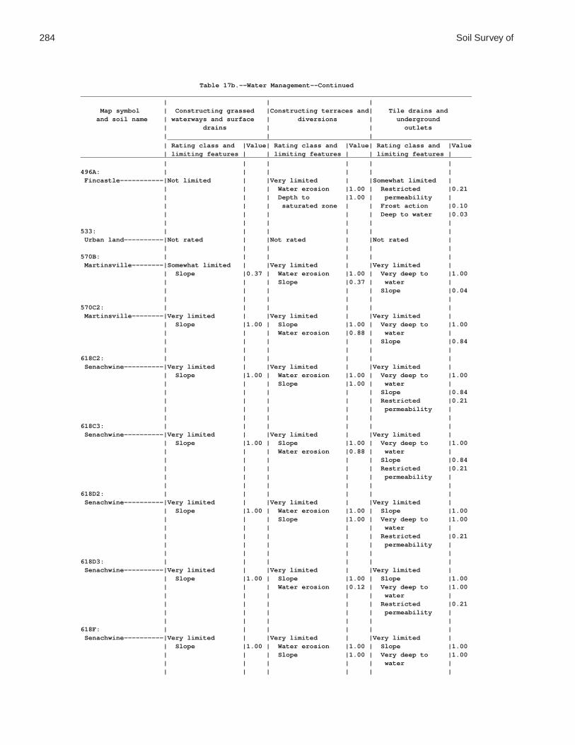
284 Soil Survey of
Table 17b.--Water Management--Continued___________________________________________________________________________________________________ | | | Map symbol | Constructing grassed |Constructing terraces and| Tile drains and and soil name | waterways and surface | diversions | underground | drains | | outlets | | | _____________________________________________________________________________ | Rating class and |Value| Rating class and |Value| Rating class and |Value | limiting features | | limiting features | | limiting features |___________________________________________________________________________________________________ | | | | | |496A: | | | | | | Fincastle-----------|Not limited | |Very limited | |Somewhat limited | | | | Water erosion |1.00 | Restricted |0.21 | | | Depth to |1.00 | permeability | | | | saturated zone | | Frost action |0.10 | | | | | Deep to water |0.03 | | | | | |533: | | | | | | Urban land----------|Not rated | |Not rated | |Not rated | | | | | | |570B: | | | | | | Martinsville--------|Somewhat limited | |Very limited | |Very limited | | Slope |0.37 | Water erosion |1.00 | Very deep to |1.00 | | | Slope |0.37 | water | | | | | | Slope |0.04 | | | | | |570C2: | | | | | | Martinsville--------|Very limited | |Very limited | |Very limited | | Slope |1.00 | Slope |1.00 | Very deep to |1.00 | | | Water erosion |0.88 | water | | | | | | Slope |0.84 | | | | | |618C2: | | | | | | Senachwine----------|Very limited | |Very limited | |Very limited | | Slope |1.00 | Water erosion |1.00 | Very deep to |1.00 | | | Slope |1.00 | water | | | | | | Slope |0.84 | | | | | Restricted |0.21 | | | | | permeability | | | | | | |618C3: | | | | | | Senachwine----------|Very limited | |Very limited | |Very limited | | Slope |1.00 | Slope |1.00 | Very deep to |1.00 | | | Water erosion |0.88 | water | | | | | | Slope |0.84 | | | | | Restricted |0.21 | | | | | permeability | | | | | | |618D2: | | | | | | Senachwine----------|Very limited | |Very limited | |Very limited | | Slope |1.00 | Water erosion |1.00 | Slope |1.00 | | | Slope |1.00 | Very deep to |1.00 | | | | | water | | | | | | Restricted |0.21 | | | | | permeability | | | | | | |618D3: | | | | | | Senachwine----------|Very limited | |Very limited | |Very limited | | Slope |1.00 | Slope |1.00 | Slope |1.00 | | | Water erosion |0.12 | Very deep to |1.00 | | | | | water | | | | | | Restricted |0.21 | | | | | permeability | | | | | | |618F: | | | | | | Senachwine----------|Very limited | |Very limited | |Very limited | | Slope |1.00 | Water erosion |1.00 | Slope |1.00 | | | Slope |1.00 | Very deep to |1.00 | | | | | water | | | | | | |

Coles County, Illinois 285
Table 17b.--Water Management--Continued___________________________________________________________________________________________________ | | | Map symbol | Constructing grassed |Constructing terraces and| Tile drains and and soil name | waterways and surface | diversions | underground | drains | | outlets | | | _____________________________________________________________________________ | Rating class and |Value| Rating class and |Value| Rating class and |Value | limiting features | | limiting features | | limiting features |___________________________________________________________________________________________________ | | | | | |618G: | | | | | | Senachwine----------|Very limited | |Very limited | |Very limited | | Slope |1.00 | Water erosion |1.00 | Slope |1.00 | | | Slope |1.00 | Very deep to |1.00 | | | | | water | | | | | | Restricted |0.21 | | | | | permeability | | | | | | |668B2: | | | | | | Somonauk------------|Somewhat limited | |Very limited | |Somewhat limited | | Slope |0.16 | Water erosion |1.00 | Deep to water |0.37 | | | Depth to |1.00 | Frost action |0.10 | | | saturated zone | | | | | | Slope |0.16 | | | | | | | |722A: | | | | | | Drummer-------------|Not limited | |Very limited | |Somewhat limited | | | | Water erosion |1.00 | Frequent ponding |0.33 | | | Ponding |1.00 | Frost action |0.10 | | | Depth to |1.00 | | | | | saturated zone | | | | | | | | | Milford-------------|Not limited | |Very limited | |Somewhat limited | | | | Ponding |1.00 | Frequent ponding |0.33 | | | Depth to |1.00 | Restricted |0.21 | | | saturated zone | | permeability | | | | Water erosion |0.88 | Frost action |0.10 | | | | | |830: | | | | | | Landfill------------|Not rated | |Not rated | |Not rated | | | | | | |864: | | | | | | Pits, quarry--------|Not rated | |Not rated | |Not rated | | | | | | |865: | | | | | | Pits, gravel--------|Not rated | |Not rated | |Not rated | | | | | | |871B: | | | | | | Lenzburg------------|Somewhat limited | |Somewhat limited | |Very limited | | Content of large |0.82 | Content of large |0.82 | Very deep to |1.00 | stones | | stones | | water | | Slope |0.16 | Water erosion |0.50 | | | | | Slope |0.16 | | | | | | | |871D: | | | | | | Lenzburg------------|Very limited | |Very limited | |Very limited | | Slope |1.00 | Slope |1.00 | Very deep to |1.00 | | | Water erosion |0.50 | water | | | | | | Slope |1.00 | | | | | |3073A: | | | | | | Ross----------------|Not limited | |Somewhat limited | |Very limited | | | | Water erosion |0.88 | Very deep to |1.00 | | | | | water | | | | | | Frequent flooding|0.35 | | | | | |


Coles County, Illinois 287
Table 17b.--Water Management--Continued___________________________________________________________________________________________________ | | | Map symbol | Constructing grassed |Constructing terraces and| Tile drains and and soil name | waterways and surface | diversions | underground | drains | | outlets | | | _____________________________________________________________________________ | Rating class and |Value| Rating class and |Value| Rating class and |Value | limiting features | | limiting features | | limiting features |___________________________________________________________________________________________________ | | | | | |7373B: | | | | | | Camden--------------|Somewhat limited | |Very limited | |Very limited | | Slope |0.26 | Water erosion |1.00 | Very deep to |1.00 | | | Slope |0.26 | water | | | | | | Restricted |0.21 | | | | | permeability | | | | | | Frost action |0.10 | | | | | Rare flooding |0.05 | | | | | Slope |0.01 | | | | | |7570B: | | | | | | Martinsville--------|Somewhat limited | |Very limited | |Very limited | | Slope |0.37 | Water erosion |1.00 | Very deep to |1.00 | | | Slope |0.37 | water | | | | | | Rare flooding |0.05 | | | | | Slope |0.04 | | | | | |___________________________________________________________________________________________________

288S
oil Survey of
Table 18.--Engineering Index Properties
(Absence of an entry indicates that data were not estimated)
_________________________________________________________________________________________________________________________________ | | | Classification | Fragments | Percentage passing | | Map symbol | Depth | USDA texture |___________________________|_____________| sieve number-- |Liquid| Plas- and soil name | | | | | >10 | 3-10 |___________________________|limit |ticity | | | Unified | AASHTO |inches|inches| 4 | 10 | 40 | 200 | |index_________________________________________________________________________________________________________________________________ | In | | | | Pct | Pct | | | | | Pct | | | | | | | | | | | | |2A: | | | | | | | | | | | | Cisne-----------| 0-8 |Silt loam |CL-ML, ML, CL|A-6, A-4 | 0 | 0 | 100 | 100 |96-100|88-99 |22-36 | 6-13 | 8-17 |Silt loam |CL, CL-ML |A-4, A-6 | 0 | 0 | 100 | 100 |95-100|88-100|21-34 | 6-13 | 17-37 |Silty clay loam, |CL, CH |A-7-6 | 0 | 0 | 100 | 100 |98-100|92-100|40-57 |19-33 | | silty clay | | | | | | | | | | | 37-60 |Silty clay loam, |CL |A-6, A-7-6 | 0 | 0 |95-100|84-100|78-99 |61-91 |29-46 |11-22 | | silt loam, clay | | | | | | | | | | | | loam, loam | | | | | | | | | | | 60-80 |Silt loam, loam, |CL |A-6, A-7-6 | 0 | 0 |95-100|82-97 |72-96 |52-89 |29-44 |13-25 | | clay loam, silty | | | | | | | | | | | | clay loam | | | | | | | | | | | | | | | | | | | | | |3A: | | | | | | | | | | | | Hoyleton--------| 0-8 |Silt loam |CL, CL-ML |A-4, A-6 | 0 | 0 | 100 | 100 |96-100|85-100|21-37 | 5-18 | 8-11 |Silt loam |CL, ML, CL-ML|A-4, A-6 | 0 | 0 | 100 | 100 |96-100|85-100|21-37 | 4-18 | 11-39 |Silty clay loam, |CH, CL |A-7-6 | 0 | 0 | 100 | 100 |96-100|91-100|44-57 |22-33 | | silty clay | | | | | | | | | | | 39-80 |Silt loam, silty |CL |A-6, A-7-6 | 0 | 0 | 100 |95-100|81-100|60-97 |28-46 |10-25 | | clay loam, clay | | | | | | | | | | | | loam, loam | | | | | | | | | | | | | | | | | | | | | |13A: | | | | | | | | | | | | Bluford---------| 0-7 |Silt loam |CL-ML, CL, ML|A-4 | 0 | 0 | 100 | 100 |93-100|89-98 |16-27 | 1-9 | 7-20 |Silt loam |CL, CL-ML |A-4, A-6 | 0 | 0 | 100 | 100 |96-100|90-98 |21-32 | 4-14 | 20-35 |Silty clay, silty |CH, CL |A-7-6 | 0 | 0 | 100 | 100 |98-100|93-100|46-56 |25-33 | | clay loam | | | | | | | | | | | 35-60 |Silty clay loam, |CL |A-7-6, A-6 | 0 | 0 | 100 |98-100|90-100|69-92 |29-46 |11-25 | | silt loam, loam | | | | | | | | | | | | | | | | | | | | | |13B: | | | | | | | | | | | | Bluford---------| 0-7 |Silt loam |CL-ML, CL, ML|A-4 | 0 | 0 | 100 | 100 |96-100|89-98 |16-27 | 1-9 | 7-20 |Silt loam |CL, CL-ML |A-4, A-6 | 0 | 0 | 100 | 100 |96-99 |90-98 |21-32 | 4-14 | 20-35 |Silty clay, silty |CH, CL |A-7-6 | 0 | 0 | 100 | 100 |98-100|93-99 |46-56 |25-33 | | clay loam | | | | | | | | | | | 35-60 |Silty clay loam, |CL |A-7-6, A-6 | 0 | 0 | 100 |98-100|90-98 |72-88 |29-46 |11-25 | | silt loam, loam | | | | | | | | | | | | | | | | | | | | | |

Coles C
ounty, Illinois289
Table 18.--Engineering Index Properties--Continued_________________________________________________________________________________________________________________________________ | | | Classification | Fragments | Percentage passing | | Map symbol | Depth | USDA texture |___________________________|_____________| sieve number-- |Liquid| Plas- and soil name | | | | | >10 | 3-10 |___________________________|limit |ticity | | | Unified | AASHTO |inches|inches| 4 | 10 | 40 | 200 | |index_________________________________________________________________________________________________________________________________ | In | | | | Pct | Pct | | | | | Pct | | | | | | | | | | | | |48A: | | | | | | | | | | | | Ebbert----------| 0-13 |Silt loam |CL-ML, CL |A-6, A-4 | 0 | 0 | 100 | 100 |96-100|90-100|24-35 | 5-13 | 13-22 |Silt loam |CL, CL-ML |A-6, A-4 | 0 | 0 | 100 | 100 |96-100|89-100|24-35 | 6-14 | 22-48 |Silty clay loam |CL |A-7-6, A-6 | 0 | 0 | 100 | 100 |96-100|89-100|37-46 |16-24 | 48-60 |Clay loam, silt |CL |A-6 | 0 | 0 |95-100|92-100|82-100|69-95 |29-40 |11-21 | | loam, silty clay | | | | | | | | | | | | loam | | | | | | | | | | | | | | | | | | | | | |56B: | | | | | | | | | | | | Dana------------| 0-11 |Silt loam |CL, ML |A-4, A-6 | 0 | 0 | 100 | 100 |95-100|85-100|30-35 | 8-15 | 11-32 |Silty clay loam |CL |A-6, A-7-6 | 0 | 0 | 100 | 100 |95-100|85-100|35-50 |20-35 | 32-58 |Clay loam |CL |A-6, A-7-6 | 0 | 0-3 |90-98 |90-98 |80-95 |55-80 |30-50 |15-30 | 58-80 |Loam, clay loam |CL-ML, CL |A-4, A-6 | 0-1 | 0-3 |90-98 |80-98 |70-90 |50-80 |15-30 | 5-15 | | | | | | | | | | | |56B2: | | | | | | | | | | | | Dana------------| 0-7 |Silt loam |CL, ML |A-6 | 0 | 0 | 100 |97-100|95-100|85-100|29-37 |10-16 | 7-34 |Silty clay loam |CL |A-7-6, A-6 | 0 | 0 | 100 |97-100|95-100|85-100|37-46 |17-24 | 34-53 |Clay loam |CL |A-6 | 0 | 0 |95-100|85-98 |75-95 |55-80 |33-39 |13-18 | 53-60 |Loam |CL, CL-ML, |A-4, A-6 | 0-1 | 0-3 |85-100|80-95 |70-90 |45-70 |22-33 | 4-14 | | | SC, SC-SM | | | | | | | | | | | | | | | | | | | | |132A: | | | | | | | | | | | | Starks----------| 0-8 |Silt loam |CL, ML |A-6, A-4 | 0 | 0 | 100 |97-100|95-100|85-100|24-40 | 9-15 | 8-13 |Silt loam |CL, ML |A-6, A-4 | 0 | 0 | 100 |97-100|95-100|85-100|24-40 | 9-15 | 13-36 |Silty clay loam |CL |A-7-6, A-6 | 0 | 0 | 100 |97-100|95-100|85-100|37-46 |17-24 | 36-44 |Sandy loam, sandy |SC, SM, CL, |A-4, A-6, A- | 0 | 0 | 100 |90-100|50-100|30-70 |22-35 | 4-15 | | clay loam | SC-SM, CL-ML| 2-4, A-2-6 | | | | | | | | | 44-60 |Stratified sandy |SC, SC-SM, |A-2-4, A-4 | 0 | 0 |85-100|75-100|40-100|25-70 |19-28 | 2-10 | | loam to sandy | SM, CL-ML, | | | | | | | | | | | clay loam | CL, ML | | | | | | | | | | | | | | | | | | | | |136A: | | | | | | | | | | | | Brooklyn--------| 0-9 |Silt loam |ML, CL-ML, CL|A-4 | 0 | 0 | 100 | 100 |95-100|85-100|24-36 | 6-11 | 9-14 |Silt loam |CL, CL-ML |A-4, A-6 | 0 | 0 | 100 | 100 |95-100|85-100|23-31 | 6-13 | 14-40 |Silty clay loam, |MH, CH, CL |A-7-5, A-7-6 | 0 | 0 | 100 | 100 |95-100|90-100|45-60 |20-35 | | silty clay | | | | | | | | | | | 40-62 |Clay loam, gravelly|SC, CL |A-6, A-7-6 | 0 | 0-2 |75-95 |70-90 |55-90 |40-80 |33-42 |12-20 | | clay loam | | | | | | | | | | | 62-73 |Stratified sandy |CL-ML, CL, |A-6, A-4, A- | 0 | 0 |85-100|80-100|53-100|31-84 |22-33 | 4-14 | | loam to loam | SC, SC-SM | 2-4 | | | | | | | | | 73-80 |Loam |ML, CL-ML, |A-6, A-4 | 0-1 | 0-3 |85-100|80-95 |65-95 |35-80 |23-33 | 4-14 | | | SC, SM, SC- | | | | | | | | | | | | SM, CL | | | | | | | | | | | | | | | | | | | | |

290S
oil Survey of
Table 18.--Engineering Index Properties--Continued_________________________________________________________________________________________________________________________________ | | | Classification | Fragments | Percentage passing | | Map symbol | Depth | USDA texture |___________________________|_____________| sieve number-- |Liquid| Plas- and soil name | | | | | >10 | 3-10 |___________________________|limit |ticity | | | Unified | AASHTO |inches|inches| 4 | 10 | 40 | 200 | |index_________________________________________________________________________________________________________________________________ | In | | | | Pct | Pct | | | | | Pct | | | | | | | | | | | | |138A: | | | | | | | | | | | | Shiloh----------| 0-19 |Silty clay loam |MH |A-7-5 | 0 | 0 | 100 | 100 |95-100|84-98 |50-55 |13-23 | 19-48 |Silty clay, silty |CH, MH |A-7-5, A-7-6 | 0 | 0 | 100 | 100 |98-100|84-100|50-63 |22-34 | | clay loam | | | | | | | | | | | 48-68 |Silty clay loam, |CL, CH |A-7-6 | 0 | 0 | 100 | 100 |98-100|87-99 |43-57 |24-33 | | silty clay | | | | | | | | | | | 68-86 |Clay, silty clay, |CL, CH |A-7-6 | 0 | 0 | 100 |91-100|84-100|62-95 |45-62 |25-36 | | silty clay loam, | | | | | | | | | | | | clay loam | | | | | | | | | | | | | | | | | | | | | |148B: | | | | | | | | | | | | Proctor---------| 0-13 |Silt loam |CL |A-6 | 0 | 0 | 100 | 100 |97-100|90-100|25-40 |10-20 | 13-25 |Silty clay loam, |CL |A-6, A-7-6 | 0 | 0 | 100 | 100 |97-100|92-100|25-50 |10-25 | | silt loam | | | | | | | | | | | 25-45 |Clay loam, sandy |CL, SC |A-4, A-6 | 0 | 0 |85-100|85-100|75-100|45-90 |20-40 | 7-20 | | loam, loam, sandy | | | | | | | | | | | | clay loam | | | | | | | | | | | 45-60 |Stratified sandy |SC-SM, SC, |A-4, A-6 | 0 | 0 |85-100|76-100|60-99 |36-80 |20-30 | 5-15 | | loam to silt loam | CL-ML, CL | | | | | | | | | | | | | | | | | | | | |149A: | | | | | | | | | | | | Brenton---------| 0-14 |Silt loam |CL, ML, CL-ML|A-4, A-6 | 0 | 0 | 100 |97-100|95-100|85-100|25-35 | 5-15 | 14-33 |Silty clay loam |CL |A-6, A-7-6 | 0 | 0 | 100 |97-100|95-100|85-100|35-45 |15-24 | 33-45 |Stratified loam to |CL |A-6, A-4 | 0 | 0 |95-100|90-100|75-90 |50-70 |25-38 | 9-19 | | fine sandy loam | | | | | | | | | | | 45-80 |Stratified silt to |CL-ML, CL |A-6, A-4 | 0 | 0 |95-100|90-100|75-90 |55-85 |20-38 | 6-19 | | fine sandy loam | | | | | | | | | | | | | | | | | | | | | |152A: | | | | | | | | | | | | Drummer---------| 0-14 |Silty clay loam |CL, ML |A-7-6, A-7-5 | 0 | 0 | 100 |97-100|95-100|85-100|40-46 |15-19 | 14-41 |Silty clay loam |CL |A-7-6, A-6 | 0 | 0 | 100 |97-100|95-100|85-100|37-46 |16-24 | 41-47 |Loam |CL |A-6, A-4 | 0 | 0 |95-100|90-100|75-95 |50-80 |25-33 | 8-14 | 47-60 |Stratified loam |SC, CL, CL- |A-4, A-2-4 | 0 | 0 |95-100|80-100|55-95 |30-65 |22-28 | 4-10 | | to sandy loam | ML, SC-SM | | | | | | | | | | | | | | | | | | | | |154A: | | | | | | | | | | | | Flanagan--------| 0-18 |Silt loam |CL, CL-ML, ML|A-4, A-6 | 0 | 0 | 100 | 100 |95-100|90-100|24-37 | 4-14 | 18-38 |Silty clay loam, |CL, CH |A-7-6 | 0 | 0 | 100 | 100 |95-100|95-100|45-52 |22-28 | | silty clay | | | | | | | | | | | 38-45 |Silty clay loam, |CL |A-6 | 0 | 0 | 100 | 100 |95-100|95-100|35-40 |14-20 | | silt loam | | | | | | | | | | | 45-49 |Silt loam, loam |CL |A-6, A-4 | 0 | 0-3 |85-100|80-100|75-90 |60-90 |25-33 | 9-13 | 49-60 |Loam |SC-SM, SC, |A-4, A-6 | 0-1 | 0-5 |85-100|80-100|75-90 |45-70 |22-33 | 4-14 | | | CL, CL-ML | | | | | | | | | | | | | | | | | | | | |

Coles C
ounty, Illinois291
Table 18.--Engineering Index Properties--Continued_________________________________________________________________________________________________________________________________ | | | Classification | Fragments | Percentage passing | | Map symbol | Depth | USDA texture |___________________________|_____________| sieve number-- |Liquid| Plas- and soil name | | | | | >10 | 3-10 |___________________________|limit |ticity | | | Unified | AASHTO |inches|inches| 4 | 10 | 40 | 200 | |index_________________________________________________________________________________________________________________________________ | In | | | | Pct | Pct | | | | | Pct | | | | | | | | | | | | |206A: | | | | | | | | | | | | Thorp-----------| 0-14 |Silt loam |CL |A-4, A-6 | 0 | 0 | 100 |95-100|90-100|85-100|20-40 | 8-20 | 14-19 |Silt loam |CL |A-4, A-6 | 0 | 0 | 100 |95-100|90-100|85-100|15-35 | 7-15 | 19-43 |Silty clay loam, |CL |A-6, A-7-6 | 0 | 0 | 100 |95-100|90-100|85-100|35-50 |15-30 | | silt loam | | | | | | | | | | | 43-50 |Loam, clay loam, |SC, CL |A-4, A-6 | 0 | 0 |90-100|85-100|70-95 |40-90 |20-40 |10-20 | | sandy clay loam | | | | | | | | | | | 50-65 |Stratified loamy |SC-SM, SM |A-2-4, A-4 | 0 | 0 |85-100|80-95 |35-80 |25-50 |15-25 | 2-7 | | sand to loam | | | | | | | | | | | | | | | | | | | | | |219A: | | | | | | | | | | | | Millbrook-------| 0-7 |Silt loam |CL-ML, CL, ML|A-4 | 0 | 0 | 100 | 100 |94-100|88-99 |21-29 | 3-9 | 7-14 |Silt loam |CL, CL-ML |A-4 | 0 | 0 | 100 | 100 |95-100|91-98 |21-29 | 5-11 | 14-35 |Silty clay loam, |CL |A-6, A-7-6 | 0 | 0 | 100 | 100 |97-100|90-100|29-46 |11-25 | | silt loam | | | | | | | | | | | 35-55 |Clay loam, loam, |CL, SC |A-6, A-7-6 | 0 | 0 | 100 |81-100|62-99 |40-77 |29-46 |11-25 | | sandy clay loam | | | | | | | | | | | 55-80 |Stratified |SC, CL-ML, |A-4, A-6, A- | 0 | 0 | 100 |82-100|51-99 |28-64 |19-29 | 3-12 | | sandy loam | CL, SC-SM | 2-6, A-2-4 | | | | | | | | | | | | | | | | | | | |244A: | | | | | | | | | | | | Hartsburg-------| 0-17 |Silty clay loam |ML, CL |A-7-6 | 0 | 0 | 100 | 100 |97-100|95-100|40-46 |15-19 | 17-34 |Silty clay loam, |CL |A-7-6, A-6 | 0 | 0 | 100 | 100 |97-100|95-100|37-46 |16-24 | | silt loam | | | | | | | | | | | 34-60 |Silt loam |CL |A-6, A-4 | 0 | 0 |95-100|90-100|90-100|85-100|24-37 | 7-18 | | | | | | | | | | | |291B: | | | | | | | | | | | | Xenia-----------| 0-4 |Silt loam |CL, ML, CL-ML|A-4, A-6 | 0 | 0 | 100 |97-100|95-100|85-100|24-37 | 5-15 | 4-16 |Silt loam |CL, ML, CL-ML|A-4, A-6 | 0 | 0 | 100 |97-100|95-100|85-100|24-37 | 5-15 | 16-37 |Silty clay loam |CL |A-7-6, A-6 | 0 | 0 | 100 |97-100|95-100|85-100|37-46 |17-24 | 37-57 |Clay loam, loam |CL |A-6 | 0 | 0 |90-100|85-99 |75-95 |55-85 |33-39 |12-18 | 57-72 |Loam |CL-ML, CL, |A-4 | 0-1 | 0-3 |90-100|85-99 |73-95 |45-75 |22-28 | 4-10 | | | SC-SM | | | | | | | | | | | | | | | | | | | | |322B: | | | | | | | | | | | | Russell---------| 0-6 |Silt loam |CL, ML |A-4, A-6 | 0 | 0 | 100 |97-100|95-100|85-100|24-40 | 9-15 | 6-13 |Silt loam |CL, ML |A-4, A-6 | 0 | 0 | 100 |97-100|95-100|85-100|24-40 | 9-15 | 13-28 |Silty clay loam |CL, ML |A-7-6, A-6 | 0 | 0 | 100 |97-100|95-100|85-100|37-46 |16-25 | 28-47 |Clay loam, loam |CL |A-6 | 0 | 0 |90-100|85-99 |75-95 |55-85 |33-39 |12-18 | 47-80 |Loam |CL-ML, CL, |A-4 | 0-1 | 0-3 |90-100|85-99 |70-90 |45-75 |22-28 | 4-10 | | | SC-SM | | | | | | | | | | | | | | | | | | | | |

292S
oil Survey of
Table 18.--Engineering Index Properties--Continued_________________________________________________________________________________________________________________________________ | | | Classification | Fragments | Percentage passing | | Map symbol | Depth | USDA texture |___________________________|_____________| sieve number-- |Liquid| Plas- and soil name | | | | | >10 | 3-10 |___________________________|limit |ticity | | | Unified | AASHTO |inches|inches| 4 | 10 | 40 | 200 | |index_________________________________________________________________________________________________________________________________ | In | | | | Pct | Pct | | | | | Pct | | | | | | | | | | | | |322C2: | | | | | | | | | | | | Russell---------| 0-7 |Silt loam |CL, ML |A-6 | 0 | 0 | 100 |97-100|95-100|85-100|29-37 |11-18 | 7-27 |Silty clay loam |CL |A-7-6, A-6 | 0 | 0 | 100 |97-100|95-100|85-100|37-46 |16-25 | 27-56 |Clay loam |CL |A-6 | 0 | 0 |90-100|85-100|75-95 |55-85 |33-39 |12-18 | 56-72 |Loam |CL, CL-ML, |A-4, A-6 | 0-1 | 0-3 |85-100|80-100|70-95 |45-80 |22-33 | 4-14 | | | SC, SC-SM | | | | | | | | | | | | | | | | | | | | |330A: | | | | | | | | | | | | Peotone---------| 0-6 |Silty clay loam |MH, CH |A-7-6 | 0 | 0 | 100 | 100 |97-100|95-100|50-55 |22-28 | 6-28 |Silty clay loam |MH, CH |A-7-6 | 0 | 0 | 100 | 100 |97-100|95-100|50-55 |22-28 | 28-44 |Silty clay loam, |MH, CH |A-7-6 | 0 | 0 | 100 |97-100|95-100|85-100|50-55 |25-34 | | silty clay | | | | | | | | | | | 44-60 |Silty clay loam |CL, CH |A-7-6, A-6 | 0 | 0 | 100 |97-100|95-100|85-100|37-52 |16-28 | | | | | | | | | | | |348B: | | | | | | | | | | | | Wingate---------| 0-9 |Silt loam |CL, ML, CL-ML|A-4, A-6 | 0 | 0 | 100 |97-100|95-100|85-100|24-37 | 5-15 | 9-12 |Silt loam |CL, ML, CL-ML|A-4, A-6 | 0 | 0 | 100 |97-100|95-100|85-100|24-37 | 5-15 | 12-27 |Silty clay loam |CL |A-7-6, A-6 | 0 | 0 | 100 |97-100|95-100|85-100|37-46 |17-24 | 27-52 |Clay loam, loam |CL |A-6 | 0 | 0 |90-100|85-99 |75-95 |55-85 |33-39 |12-18 | 52-60 |Loam |CL-ML, CL, |A-4 | 0-1 | 0-3 |90-100|85-99 |70-95 |45-75 |22-28 | 4-10 | | | SC-SM | | | | | | | | | | | | | | | | | | | | |353A: | | | | | | | | | | | | Toronto---------| 0-9 |Silt loam |CL, ML, CL-ML|A-4, A-6 | 0 | 0 | 100 |97-100|95-100|85-100|24-37 | 5-15 | 9-12 |Silt loam |CL, ML, CL-ML|A-4, A-6 | 0 | 0 | 100 |97-100|95-100|85-100|24-37 | 5-15 | 12-26 |Silty clay loam |CL |A-7-6, A-6 | 0 | 0 | 100 |97-100|95-100|85-100|37-46 |17-24 | 26-54 |Clay loam, loam |CL |A-6 | 0 | 0 |90-100|85-99 |75-95 |55-85 |33-39 |12-18 | 54-60 |Loam |CL-ML, CL |A-4 | 0-1 | 0-3 |90-100|85-99 |70-90 |50-75 |22-30 | 4-10 | | | | | | | | | | | |481A: | | | | | | | | | | | | Raub------------| 0-18 |Silt loam |CL-ML, CL, ML|A-4, A-6 | 0 | 0 | 100 |97-100|95-100|85-100|24-37 | 4-14 | 18-32 |Silty clay loam |CL |A-6, A-7-6 | 0 | 0 | 100 |97-100|95-100|85-100|37-46 |17-24 | 32-50 |Clay loam, loam |CL |A-6 | 0 | 0 |90-100|85-100|75-95 |55-85 |33-39 |12-18 | 50-60 |Loam, clay loam |CL-ML, CL, |A-4, A-6 | 0-1 | 0-3 |85-100|80-95 |70-90 |45-70 |22-33 | 4-14 | | | SC, SC-SM | | | | | | | | | | | | | | | | | | | | |496A: | | | | | | | | | | | | Fincastle-------| 0-8 |Silt loam |CL, ML, CL-ML|A-6, A-4 | 0 | 0 | 100 |97-100|95-100|85-100|24-37 | 6-15 | 8-11 |Silt loam |CL, ML |A-6, A-4 | 0 | 0 | 100 |97-100|95-100|85-100|24-37 | 7-18 | 11-32 |Silty clay loam |CL |A-7-6, A-6 | 0 | 0 | 100 |97-100|95-100|85-100|37-46 |16-25 | 32-40 |Clay loam |CL |A-6 | 0 | 0 |90-100|80-100|70-95 |50-80 |33-39 |12-18 | 40-50 |Clay loam, loam |CL |A-6, A-4 | 0 | 0 |90-100|80-100|70-95 |50-80 |27-34 | 8-14 | 50-80 |Loam |CL-ML, SC-SM,|A-4 | 0-1 | 0-3 |85-100|80-95 |70-90 |45-70 |22-28 | 4-10 | | | SC, CL | | | | | | | | | | | | | | | | | | | | |

Coles C
ounty, Illinois293
Table 18.--Engineering Index Properties--Continued_________________________________________________________________________________________________________________________________ | | | Classification | Fragments | Percentage passing | | Map symbol | Depth | USDA texture |___________________________|_____________| sieve number-- |Liquid| Plas- and soil name | | | | | >10 | 3-10 |___________________________|limit |ticity | | | Unified | AASHTO |inches|inches| 4 | 10 | 40 | 200 | |index_________________________________________________________________________________________________________________________________ | In | | | | Pct | Pct | | | | | Pct | | | | | | | | | | | | |533. | | | | | | | | | | | | Urban land | | | | | | | | | | | | | | | | | | | | | | | |570B: | | | | | | | | | | | | Martinsville----| 0-9 |Silt loam |ML, CL-ML |A-4 | 0 | 0 | 100 |85-100|70-100|50-95 |20-30 | 2-7 | 9-12 |Silt loam |ML, CL-ML, CL|A-4 | 0 | 0 | 100 |85-100|70-100|50-95 |20-30 | 3-9 | 12-45 |Clay loam, loam, |CL, SC |A-4, A-6 | 0 | 0 |95-100|85-100|60-100|40-85 |29-37 | 9-17 | | sandy clay loam | | | | | | | | | | | 45-57 |Sandy loam, sandy |CL, SC |A-4, A-6 | 0 | 0 |92-100|85-100|45-95 |35-80 |25-37 | 7-17 | | clay loam, loam | | | | | | | | | | | 57-80 |Stratified sand |SM, SC-SM, |A-4, A-2-4, | 0 | 0 |92-100|85-100|40-95 | 5-75 |15-25 | 2-7 | | to silt loam | ML, CL-ML, | A-1-b | | | | | | | | | | | SW-SM | | | | | | | | | | | | | | | | | | | | |570C2: | | | | | | | | | | | | Martinsville----| 0-9 |Loam |CL-ML |A-4 | 0 | 0 | 100 |85-100|65-100|50-80 |15-25 | 4-7 | 9-45 |Clay loam, loam, |CL, SC |A-4, A-6 | 0 | 0 |95-100|85-100|60-100|40-85 |29-37 | 9-17 | | sandy clay loam | | | | | | | | | | | 45-57 |Sandy loam, sandy |CL, SC |A-4, A-6 | 0 | 0 |92-100|85-100|50-100|35-80 |25-37 | 7-17 | | clay loam, loam | | | | | | | | | | | 57-80 |Stratified sand |SM, SC-SM, |A-4, A-2-4, | 0 | 0 |92-100|85-100|40-100| 5-70 |15-25 | 2-7 | | to silt loam | ML, CL-ML, | A-1-b | | | | | | | | | | | SW-SM | | | | | | | | | | | | | | | | | | | | |618C2: | | | | | | | | | | | | Senachwine------| 0-6 |Silt loam |CL, ML |A-6 | 0 | 0 |95-100|95-100|90-98 |77-90 |29-37 |10-16 | 6-12 |Silty clay loam, |CL |A-6 | 0 | 0 |95-100|95-100|90-99 |75-90 |33-39 |13-18 | | clay loam | | | | | | | | | | | 12-27 |Clay loam |CL |A-6 | 0 | 0 |90-100|85-99 |75-95 |55-85 |33-39 |12-18 | 27-60 |Loam |CL-ML, CL, |A-4 | 0-1 | 0-3 |90-100|85-99 |73-95 |45-75 |22-28 | 4-10 | | | SC-SM | | | | | | | | | | | | | | | | | | | | |618C3: | | | | | | | | | | | | Senachwine------| 0-4 |Clay loam |CL, ML |A-6 | 0 | 0 | 100 |90-100|83-95 |59-85 |30-40 |15-20 | 4-33 |Clay loam |CL, ML |A-6 | 0 | 0 |90-100|85-99 |75-95 |55-85 |33-39 |12-18 | 33-60 |Loam |CL-ML, CL, |A-4 | 0-1 | 0-3 |90-100|85-99 |73-95 |45-75 |22-28 | 4-10 | | | ML, SC-SM | | | | | | | | | | | | | | | | | | | | |618D2: | | | | | | | | | | | | Senachwine------| 0-6 |Silt loam |CL, ML |A-6 | 0 | 0 |95-100|95-100|90-100|80-90 |29-37 |10-16 | 6-15 |Silty clay loam, |CL |A-6 | 0 | 0 |95-100|95-100|90-99 |75-90 |33-39 |13-18 | | clay loam | | | | | | | | | | | 15-28 |Clay loam |CL |A-6 | 0 | 0 |90-100|85-99 |75-95 |55-85 |33-39 |12-18 | 28-34 |Loam, clay loam |CL, SC |A-6, A-4 | 0 | 0-2 |90-100|85-99 |72-95 |45-75 |25-33 | 8-14 | 34-60 |Loam |CL-ML, CL, |A-4 | 0-1 | 0-3 |90-100|85-99 |73-95 |45-75 |22-28 | 4-10 | | | SC-SM | | | | | | | | | | | | | | | | | | | | |

294S
oil Survey of
Table 18.--Engineering Index Properties--Continued_________________________________________________________________________________________________________________________________ | | | Classification | Fragments | Percentage passing | | Map symbol | Depth | USDA texture |___________________________|_____________| sieve number-- |Liquid| Plas- and soil name | | | | | >10 | 3-10 |___________________________|limit |ticity | | | Unified | AASHTO |inches|inches| 4 | 10 | 40 | 200 | |index_________________________________________________________________________________________________________________________________ | In | | | | Pct | Pct | | | | | Pct | | | | | | | | | | | | |618D3: | | | | | | | | | | | | Senachwine------| 0-3 |Clay loam |CL, ML |A-6 | 0 | 0 | 100 |90-100|83-95 |59-85 |30-40 |15-20 | 3-25 |Clay loam |CL, ML |A-6 | 0 | 0 |90-100|85-99 |75-95 |55-85 |33-39 |12-18 | 25-60 |Loam |CL-ML, CL, |A-4 | 0-1 | 0-3 |90-100|85-99 |73-95 |45-75 |22-28 | 4-10 | | | ML, SC-SM | | | | | | | | | | | | | | | | | | | | |618F: | | | | | | | | | | | | Senachwine------| 0-11 |Silt loam |CL-ML, CL, ML|A-4 | 0 | 0 |95-100|90-100|75-100|55-90 |19-29 | 2-10 | 11-17 |Silty clay loam, |CL, ML |A-6 | 0 | 0 |90-100|85-99 |75-95 |55-90 |33-39 |12-18 | | clay loam | | | | | | | | | | | 17-32 |Clay loam |CL |A-6 | 0 | 0 |90-100|85-99 |75-95 |55-85 |33-39 |12-18 | 32-40 |Loam, clay loam |CL, SC |A-6, A-4 | 0 | 0-2 |90-100|85-99 |70-90 |45-75 |25-33 | 8-14 | 40-60 |Loam |CL-ML, CL, |A-4 | 0-1 | 0-3 |90-100|85-99 |70-90 |45-75 |22-28 | 4-10 | | | SC-SM | | | | | | | | | | | | | | | | | | | | |618G: | | | | | | | | | | | | Senachwine------| 0-5 |Silt loam |CL-ML, CL |A-4 | 0 | 0 |95-100|90-100|75-100|55-90 |22-36 | 6-13 | 5-11 |Silt loam |CL-ML, CL |A-4 | 0 | 0 |95-100|90-100|80-100|55-90 |21-32 | 6-13 | 11-30 |Clay loam, silty |CL |A-7-6, A-6 | 0 | 0 |90-100|85-99 |75-95 |55-85 |37-46 |19-25 | | clay loam | | | | | | | | | | | 30-38 |Clay loam, loam |CL, ML, SC, |A-6 | 0 | 0-2 |90-100|85-99 |70-90 |45-75 |29-40 |13-21 | 38-60 |Loam |CL-ML, CL, |A-4, A-6 | 0-1 | 0-3 |90-100|85-99 |70-90 |45-75 |20-32 | 6-13 | | | SC, SC-SM | | | | | | | | | | | | | | | | | | | | |668B2: | | | | | | | | | | | | Somonauk--------| 0-6 |Silt loam |CL, ML |A-4, A-6 | 0 | 0 | 100 |97-100|95-100|85-100|24-40 | 9-15 | 6-33 |Silty clay loam, |CL, ML |A-7-6, A-6 | 0 | 0 | 100 |97-100|95-100|85-100|37-46 |16-25 | | silt loam | | | | | | | | | | | 33-55 |Clay loam, loam, |CL, SC |A-4, A-6 | 0 | 0 |95-100|85-100|60-100|40-85 |29-37 | 9-17 | | sandy clay loam, | | | | | | | | | | | | sandy loam | | | | | | | | | | | 55-68 |Sandy loam, sandy |CL, SC |A-4, A-6 | 0 | 0 |92-100|85-100|45-95 |35-80 |25-37 | 7-17 | | clay loam, loam | | | | | | | | | | | 68-80 |Stratified sand |SM, SC-SM, |A-4, A-2-4, | 0 | 0 |92-100|80-100|35-95 | 5-75 |15-25 | 2-7 | | to silt loam | SW-SM, SW- | A-1-b | | | | | | | | | | | SC, ML, CL- | | | | | | | | | | | | ML | | | | | | | | | | | | | | | | | | | | |722A: | | | | | | | | | | | | Drummer---------| 0-14 |Silty clay loam |CL, ML |A-7-6, A-7-5 | 0 | 0 | 100 |97-100|95-100|85-100|40-46 |15-19 | 14-41 |Silty clay loam |CL |A-7-6, A-6 | 0 | 0 | 100 |97-100|95-100|85-100|37-46 |16-24 | 41-47 |Loam |CL |A-6, A-4 | 0 | 0 |95-100|90-100|75-95 |50-80 |25-33 | 8-14 | 47-60 |Stratified loam |SC, CL, CL- |A-4, A-2-4 | 0 | 0 |95-100|80-100|55-95 |30-65 |22-28 | 4-10 | | to sandy loam | ML, SC-SM | | | | | | | | | | | | | | | | | | | | |

Coles C
ounty, Illinois295
Table 18.--Engineering Index Properties--Continued_________________________________________________________________________________________________________________________________ | | | Classification | Fragments | Percentage passing | | Map symbol | Depth | USDA texture |___________________________|_____________| sieve number-- |Liquid| Plas- and soil name | | | | | >10 | 3-10 |___________________________|limit |ticity | | | Unified | AASHTO |inches|inches| 4 | 10 | 40 | 200 | |index_________________________________________________________________________________________________________________________________ | In | | | | Pct | Pct | | | | | Pct | | | | | | | | | | | | |722A: | | | | | | | | | | | | Milford---------| 0-14 |Silty clay loam |CL, ML, MH, |A-7-6, A-7-5 | 0 | 0 | 100 |97-100|95-100|85-95 |40-55 |15-24 | | | CH | | | | | | | | | | 14-25 |Silty clay, silty |CH, MH, CL, |A-7-6, A-7-5 | 0 | 0 | 100 |95-100|90-100|85-95 |40-55 |15-24 | | clay loam | ML | | | | | | | | | | 25-45 |Silty clay loam |CL |A-6 | 0 | 0 |95-100|85-97 |80-95 |70-95 |33-39 |12-17 | 45-80 |Stratified silt |CL, CL-ML |A-4, A-6 | 0 | 0 |90-100|80-100|75-95 |60-85 |22-33 | 4-13 | | loam | | | | | | | | | | | | | | | | | | | | | |830. | | | | | | | | | | | | Landfill | | | | | | | | | | | | | | | | | | | | | | | |864. | | | | | | | | | | | | Pits, quarry | | | | | | | | | | | | | | | | | | | | | | | |865. | | | | | | | | | | | | Pits, gravel | | | | | | | | | | | | | | | | | | | | | | | |871B: | | | | | | | | | | | | Lenzburg--------| 0-8 |Gravelly loam |SC, CL |A-4, A-6 | 0-2 | 4-15 |60-99 |60-80 |40-80 |30-70 |25-35 | 9-15 | 8-60 |Clay loam, loam |CL, SC |A-6, A-4 | 0-2 | 0-5 |86-98 |84-97 |67-96 |43-80 |29-35 | 9-15 | | | | | | | | | | | |871D: | | | | | | | | | | | | Lenzburg--------| 0-8 |Loam |SC, CL |A-6, A-4 | 0-2 | 0-5 |85-99 |80-97 |65-95 |40-75 |25-35 | 9-15 | 8-60 |Clay loam, loam |CL, SC |A-6, A-4 | 0-2 | 0-5 |85-98 |84-97 |67-96 |43-80 |29-35 | 9-15 | | | | | | | | | | | |3073A: | | | | | | | | | | | | Ross------------| 0-13 |Silt loam |CL, CL-ML, ML|A-4 | 0 | 0 |90-100|90-100|80-100|55-80 |20-35 |NP-11 | 13-43 |Loam, silt loam |CL-ML, ML, CL|A-4, A-6 | 0 | 0 |90-100|85-100|70-100|50-85 |22-40 | 4-15 | 43-60 |Stratified sandy |SC-SM, SM, |A-2-4, A-4 | 0 | 0-5 |85-100|75-100|65-100|25-70 |10-30 |NP-10 | | loam to silt loam | SC, CL-ML, | | | | | | | | | | | | CL, ML | | | | | | | | | | | | | | | | | | | | |3107A: | | | | | | | | | | | | Sawmill---------| 0-10 |Silty clay loam |CL, ML |A-7-6 | 0 | 0 | 100 | 100 |95-100|85-100|40-46 |16-21 | 10-32 |Silty clay loam |CL |A-7-6 | 0 | 0 | 100 | 100 |95-100|85-100|40-46 |16-21 | 32-58 |Silty clay loam |CL |A-7-6, A-6 | 0 | 0 | 100 | 100 |90-100|80-95 |37-46 |16-22 | 58-65 |Silty clay loam, |CL |A-7-6, A-6 | 0 | 0 | 100 |97-100|90-100|80-95 |37-46 |16-22 | | clay loam | | | | | | | | | | | | | | | | | | | | | |

296S
oil Survey of
Table 18.--Engineering Index Properties--Continued_________________________________________________________________________________________________________________________________ | | | Classification | Fragments | Percentage passing | | Map symbol | Depth | USDA texture |___________________________|_____________| sieve number-- |Liquid| Plas- and soil name | | | | | >10 | 3-10 |___________________________|limit |ticity | | | Unified | AASHTO |inches|inches| 4 | 10 | 40 | 200 | |index_________________________________________________________________________________________________________________________________ | In | | | | Pct | Pct | | | | | Pct | | | | | | | | | | | | |3226A: | | | | | | | | | | | | Wirt------------| 0-3 |Silt loam |CL-ML, CL |A-4 | 0 | 0 | 100 |95-100|80-100|60-90 |20-30 | 5-10 | 3-32 |Silt loam, loam, |SM, CL-ML, |A-4 | 0 | 0 |97-100|80-100|65-100|35-85 |15-25 |NP-7 | | fine sandy loam | ML, SC-SM | | | | | | | | | | 32-60 |Stratified silt |SM, CL-ML, |A-2-4, A-4, | 0 | 0-1 |90-100|75-100|40-100|15-85 |10-25 |NP-7 | | loam to loam | ML, SC-SM | A-1-b | | | | | | | | | | to sandy loam | | | | | | | | | | | | | | | | | | | | | |3284A: | | | | | | | | | | | | Tice------------| 0-21 |Silty clay loam |CL, ML |A-7-6, A-6 | 0 | 0 | 100 | 100 |95-100|85-100|35-46 |16-21 | 21-66 |Silty clay loam, |CL, ML |A-7-6, A-6 | 0 | 0 | 100 | 100 |85-100|80-95 |35-46 |16-22 | | silt loam | | | | | | | | | | | 66-80 |Silt loam |CL, CL-ML, ML|A-4, A-6 | 0 | 0 | 100 | 100 |80-90 |65-85 |22-33 | 4-13 | | | | | | | | | | | |3304A: | | | | | | | | | | | | Landes----------| 0-18 |Fine sandy loam |SC, SC-SM, SM|A-2-4, A-4 | 0 | 0 |90-100|85-100|65-100|30-50 |10-25 |NP-10 | 18-24 |Loam, fine sandy |SC-SM, SM, |A-4 | 0 | 0 |90-100|85-100|70-100|35-75 |10-25 |NP-10 | | loam | CL-ML, SC, | | | | | | | | | | | | CL, ML | | | | | | | | | | 24-60 |Stratified fine |SP-SM, SM, |A-2-4, A-4 | 0 | 0 | 100 |85-100|70-100|10-50 |10-25 |NP-7 | | sand to fine | SC-SM | | | | | | | | | | | sandy loam | | | | | | | | | | | | | | | | | | | | | |3424A: | | | | | | | | | | | | Shoals----------| 0-8 |Silt loam |CL, CL-ML, ML|A-4, A-6 | 0 | 0 |99-100|95-100|86-100|67-100|24-35 | 6-15 | 8-60 |Stratified loam |CL, ML |A-6, A-4 | 0 | 0 |99-100|95-100|85-100|61-85 |27-37 | 9-18 | | to silt loam | | | | | | | | | | | | | | | | | | | | | |3450A: | | | | | | | | | | | | Brouillett------| 0-11 |Silt loam |CL, ML |A-4, A-6 | 0 | 0 |90-100|90-100|80-100|65-89 |25-35 | 7-14 | 11-26 |Silt loam, loam |CL |A-4, A-6 | 0 | 0 |90-100|90-100|80-100|65-89 |25-35 | 7-14 | 26-42 |Silt loam, loam |CL |A-4, A-6 | 0 | 0 |90-100|90-100|80-100|65-89 |25-35 | 7-16 | 42-60 |Stratified sandy |CL, SC, CL- |A-4, A-6 | 0 | 0 |85-100|85-100|56-100|43-89 |10-35 | 4-12 | | loam to silt loam | ML, SC-SM, | | | | | | | | | | | | ML, SM | | | | | | | | | | | | | | | | | | | | |3451A: | | | | | | | | | | | | Lawson----------| 0-8 |Silt loam |CL, ML, CL-ML|A-4, A-6 | 0 | 0 | 100 |97-100|95-100|85-100|20-40 | 5-15 | 8-35 |Silt loam, silty |CL, ML, CL-ML|A-4, A-6 | 0 | 0 | 100 |97-100|95-100|85-100|20-40 | 5-15 | | clay loam | | | | | | | | | | | 35-80 |Stratified silt |CL |A-6 | 0 | 0 | 100 |95-100|85-100|65-100|29-40 |11-20 | | loam to loam, | | | | | | | | | | | | silty clay loam | | | | | | | | | | | | | | | | | | | | | |

Coles C
ounty, Illinois297
Table 18.--Engineering Index Properties--Continued_________________________________________________________________________________________________________________________________ | | | Classification | Fragments | Percentage passing | | Map symbol | Depth | USDA texture |___________________________|_____________| sieve number-- |Liquid| Plas- and soil name | | | | | >10 | 3-10 |___________________________|limit |ticity | | | Unified | AASHTO |inches|inches| 4 | 10 | 40 | 200 | |index_________________________________________________________________________________________________________________________________ | In | | | | Pct | Pct | | | | | Pct | | | | | | | | | | | | |7132A: | | | | | | | | | | | | Starks----------| 0-8 |Silt loam |CL, CL-ML, ML|A-4 | 0 | 0 | 100 |95-100|90-100|75-95 |20-30 | 2-10 | 8-13 |Silt loam |CL, CL-ML, ML|A-6, A-4 | 0 | 0 | 100 | 100 |95-100|85-100|20-30 | 3-12 | 13-36 |Silty clay loam |CL |A-7-6, A-6 | 0 | 0 | 100 |97-100|95-100|85-100|37-46 |17-24 | 36-44 |Sandy loam, sandy |SC, SM, CL, |A-4, A-6, A- | 0 | 0 | 100 |90-100|55-100|30-60 |22-35 | 4-15 | | clay loam | SC-SM, CL-ML| 2-4, A-2-6 | | | | | | | | | 44-60 |Stratified sandy |SC, SC-SM, |A-2-4, A-4 | 0 | 0 |85-100|75-100|40-100|25-70 |19-28 | 2-10 | | loam to loam to | SM, CL-ML, | | | | | | | | | | | sandy clay loam | CL, ML | | | | | | | | | | | | | | | | | | | | |7373B: | | | | | | | | | | | | Camden----------| 0-7 |Silt loam |CL, CL-ML, ML|A-4 | 0 | 0 | 100 |95-100|90-100|75-95 |20-30 | 2-10 | 7-10 |Silt loam |CL, CL-ML, ML|A-6, A-4 | 0 | 0 | 100 | 100 |95-100|85-100|20-30 | 3-12 | 10-29 |Silty clay loam, |CL |A-6, A-7-6 | 0 | 0 | 100 | 100 |95-100|95-100|30-45 |12-25 | | silt loam | | | | | | | | | | | 29-45 |Clay loam, loam, |CL, SC |A-6 | 0 | 0 |95-100|85-100|70-99 |40-80 |25-40 |11-20 | | sandy loam | | | | | | | | | | | 45-66 |Stratified fine |SC, SC-SM, SM|A-4, A-2-4 | 0 | 0 |95-100|80-100|50-98 |15-50 |15-25 |NP-10 | | sandy loam to | | | | | | | | | | | | loamy sand | | | | | | | | | | | 66-80 |Stratified sand |SM, SP-SM |A-2-4, A-3 | 0 | 0 |90-100|80-100|50-95 | 6-34 |12-17 |NP-4 | | to loamy sand | | | | | | | | | | | | | | | | | | | | | |7570B: | | | | | | | | | | | | Martinsville----| 0-9 |Silt loam |ML, CL-ML |A-4 | 0 | 0 | 100 |85-100|70-100|50-95 |20-30 | 2-7 | 9-12 |Silt loam |ML, CL-ML, CL|A-4 | 0 | 0 | 100 |85-100|70-100|50-95 |20-30 | 3-9 | 12-45 |Clay loam, loam, |CL, SC |A-4, A-6 | 0 | 0 |95-100|85-100|60-100|40-85 |29-37 | 9-17 | | sandy clay loam | | | | | | | | | | | 45-57 |Sandy loam, sandy |CL, SC |A-4, A-6 | 0 | 0 |92-100|85-100|45-95 |35-80 |25-37 | 7-17 | | clay loam, loam | | | | | | | | | | | 57-80 |Stratified sand |SM, SC-SM, |A-4, A-2-4, | 0 | 0 |92-100|85-100|40-95 | 5-75 |15-25 | 2-7 | | to silt loam | ML, CL-ML, | A-1-b | | | | | | | | | | | SW-SM | | | | | | | | | | | | | | | | | | | | |_________________________________________________________________________________________________________________________________

298S
oil Survey of
Table 19.--Physical Properties of the Soils
(Entries under "Erosion factors--T" apply to the entire profile. Entries under "Wind erodibility group" and "Wind erodibility index" apply only to the surface layer. Absence of an entry indicates that data were not estimated)
______________________________________________________________________________________________________________________________________ | | | | | | | | | |Erosion factors|Wind |Wind Map symbol | Depth | Sand | Silt | Clay | Moist | Permea- |Available| Linear | Organic |_______________|erodi-|erodi- and soil name | | | | | bulk | bility | water |extensi- | matter | | | |bility|bility | | | | | density | (Ksat) |capacity | bility | | Kw | Kf | T |group |index______________________________________________________________________________________________________________________________________ | In | Pct | Pct | Pct | g/cc | In/hr | In/in | Pct | Pct | | | | | | | | | | | | | | | | | | |2A: | | | | | | | | | | | | | | Cisne---------------| 0-8 | 1-10| 70-83| 10-20|1.30-1.50| 0.6-2 |0.17-0.23| 0.0-2.9 | 1.5-3.5 | .37 | .37 | 3 | 5 | 56 | 8-17 | 0-10| 70-87| 10-20|1.40-1.60| 0.2-0.6 |0.18-0.24| 0.0-2.9 | 0.3-0.8 | .64 | .64 | | | | 17-37 | 0-10| 50-65| 35-45|1.30-1.50| 0.02-0.2 |0.09-0.15| 6.0-8.9 | 0.2-0.5 | .37 | .37 | | | | 37-60 | 15-30| 38-61| 20-35|1.50-1.70| 0.06-0.2 |0.12-0.16| 3.0-5.9 | 0.0-0.5 | .43 | .43 | | | | 60-80 | 15-35| 31-62| 20-35|1.50-1.70| 0.2-0.6 |0.12-0.16| 0.0-2.9 | 0.0-0.3 | .43 | .43 | | | | | | | | | | | | | | | | |3A: | | | | | | | | | | | | | | Hoyleton------------| 0-8 | 1-16| 57-87| 12-27|1.30-1.50| 0.6-2 |0.19-0.25| 0.0-2.9 | 1.5-3.5 | .37 | .37 | 5 | 5 | 56 | 8-11 | 1-16| 57-81| 18-27|1.30-1.50| 0.2-0.6 |0.16-0.22| 0.0-2.9 | 0.3-0.8 | .55 | .55 | | | | 11-39 | 1-10| 45-64| 35-45|1.30-1.50| 0.06-0.6 |0.11-0.17| 6.0-8.9 | 0.2-0.5 | .37 | .37 | | | | 39-80 | 6-40| 25-75| 19-35|1.40-1.60| 0.2-0.6 |0.15-0.18| 0.0-5.9 | 0.0-0.3 | .43 | .43 | | | | | | | | | | | | | | | | |13A: | | | | | | | | | | | | | | Bluford-------------| 0-7 | 5-12| 70-79| 10-18|1.30-1.50| 0.6-2 |0.19-0.25| 0.0-2.9 | 1.0-2.5 | .43 | .43 | 4 | 5 | 56 | 7-20 | 5-10| 70-80| 15-25|1.35-1.55| 0.2-0.6 |0.20-0.26| 0.0-2.9 | 0.2-0.8 | .55 | .55 | | | | 20-35 | 0-8 | 50-64| 35-45|1.30-1.50| 0.06-0.6 |0.11-0.17| 6.0-8.9 | 0.2-0.5 | .32 | .32 | | | | 35-60 | 15-30| 40-64| 20-35|1.50-1.70| 0.06-0.2 |0.08-0.12| 3.0-5.9 | 0.0-0.3 | .43 | .43 | | | | | | | | | | | | | | | | |13B: | | | | | | | | | | | | | | Bluford-------------| 0-7 | 5-12| 70-79| 10-18|1.30-1.50| 0.6-2 |0.19-0.25| 0.0-2.9 | 1.0-2.5 | .43 | .43 | 4 | 5 | 56 | 7-20 | 5-10| 70-80| 15-25|1.35-1.55| 0.2-0.6 |0.20-0.25| 0.0-2.9 | 0.2-1.5 | .55 | .55 | | | | 20-35 | 0-8 | 50-64| 35-45|1.30-1.50| 0.2-0.6 |0.11-0.17| 6.0-8.9 | 0.2-0.5 | .32 | .32 | | | | 35-60 | 15-30| 40-64| 20-35|1.50-1.70| 0.06-0.2 |0.08-0.12| 3.0-5.9 | 0.0-0.3 | .43 | .43 | | | | | | | | | | | | | | | | |48A: | | | | | | | | | | | | | | Ebbert--------------| 0-13 | 1-10| 67-82| 15-25|1.30-1.50| 0.6-2 |0.19-0.25| 0.0-2.9 | 2.0-4.0 | .32 | .32 | 5 | 5 | 56 | 13-22 | 1-13| 65-80| 15-25|1.35-1.55| 0.2-0.6 |0.16-0.22| 0.0-2.9 | 1.0-3.0 | .55 | .55 | | | | 22-48 | 1-12| 54-71| 27-35|1.35-1.55| 0.06-0.2 |0.13-0.19| 3.0-5.9 | 0.5-1.5 | .43 | .43 | | | | 48-60 | 10-25| 50-68| 20-30|1.45-1.65| 0.2-0.6 |0.15-0.20| 0.0-5.9 | 0.0-0.5 | .43 | .43 | | | | | | | | | | | | | | | | |56B: | | | | | | | | | | | | | | Dana----------------| 0-11 | 2-15| 58-80| 18-27|1.25-1.50| 0.6-2 |0.15-0.21| 0.0-2.9 | 3.0-5.0 | .28 | .28 | 5 | 6 | 48 | 11-32 | 2-15| 50-70| 27-35|1.25-1.55| 0.6-2 |0.13-0.19| 3.0-5.9 | 0.5-1.5 | .37 | .37 | | | | 32-58 | 20-40| 25-53| 27-35|1.40-1.70| 0.6-2 |0.15-0.19| 3.0-5.9 | 0.2-0.8 | .32 | .32 | | | | 58-80 | 20-45| 25-50| 15-30|1.65-1.85| 0.2-0.6 |0.08-0.12| 0.0-2.9 | 0.1-0.3 | .37 | .37 | | | | | | | | | | | | | | | | |56B2: | | | | | | | | | | | | | | Dana----------------| 0-7 | 2-15| 58-78| 20-27|1.40-1.60| 0.6-2 |0.16-0.21| 0.0-2.9 | 1.5-3.5 | .37 | .37 | 5 | 6 | 48 | 7-34 | 2-15| 50-70| 27-35|1.35-1.55| 0.6-2 |0.13-0.19| 3.0-5.9 | 0.5-1.5 | .37 | .37 | | | | 34-53 | 20-40| 25-53| 27-35|1.50-1.70| 0.6-2 |0.12-0.17| 3.0-5.9 | 0.1-0.5 | .32 | .32 | | | | 53-60 | 30-45| 28-50| 15-27|1.65-1.85| 0.2-0.6 |0.08-0.12| 0.0-2.9 | 0.0-0.5 | .37 | .43 | | | | | | | | | | | | | | | | |

Coles C
ounty, Illinois299
Table 19.--Physical Properties of the Soils--Continued______________________________________________________________________________________________________________________________________ | | | | | | | | | |Erosion factors|Wind |Wind Map symbol | Depth | Sand | Silt | Clay | Moist | Permea- |Available| Linear | Organic |_______________|erodi-|erodi- and soil name | | | | | bulk | bility | water |extensi- | matter | | | |bility|bility | | | | | density | (Ksat) |capacity | bility | | Kw | Kf | T |group |index______________________________________________________________________________________________________________________________________ | In | Pct | Pct | Pct | g/cc | In/hr | In/in | Pct | Pct | | | | | | | | | | | | | | | | | | |132A: | | | | | | | | | | | | | | Starks--------------| 0-8 | 2-15| 58-82| 15-27|1.25-1.50| 0.6-2 |0.19-0.25| 0.0-2.9 | 1.0-2.5 | .43 | .43 | 5 | 5 | 56 | 8-13 | 2-15| 58-82| 15-27|1.35-1.55| 0.2-0.6 |0.16-0.22| 0.0-2.9 | 0.3-0.8 | .49 | .49 | | | | 13-36 | 2-15| 50-70| 27-35|1.35-1.55| 0.6-2 |0.13-0.19| 3.0-5.9 | 0.2-0.5 | .37 | .37 | | | | 36-44 | 45-65| 15-35| 10-30|1.45-1.65| 0.6-2 |0.13-0.17| 0.0-5.9 | 0.2-0.5 | .24 | .24 | | | | 44-60 | 45-70| 10-35| 5-20|1.50-1.70| 0.6-2 |0.08-0.15| 0.0-2.9 | 0.1-0.3 | .28 | .28 | | | | | | | | | | | | | | | | |136A: | | | | | | | | | | | | | | Brooklyn------------| 0-9 | 2-14| 65-82| 15-22|1.30-1.50| 0.6-2 |0.19-0.25| 0.0-2.9 | 1.5-3.5 | .37 | .37 | 3 | 5 | 56 | 9-14 | 2-15| 71-82| 14-22|1.35-1.55| 0.2-0.6 |0.20-0.26| 0.0-2.9 | 0.2-0.8 | .55 | .55 | | | | 14-40 | 0-10| 47-63| 35-45|1.30-1.50| 0.06-0.2 |0.11-0.17| 6.0-8.9 | 0.1-0.5 | .37 | .37 | | | | 40-62 | 20-44| 23-52| 27-40|1.50-1.70| 0.2-0.6 |0.12-0.18| 3.0-5.9 | 0.1-0.5 | .28 | .32 | | | | 62-73 | 29-61| 28-44| 10-27|1.55-1.75| 0.6-2 |0.11-0.15| 0.0-2.9 | 0.1-0.3 | .37 | .37 | | | | 73-80 | 24-54| 29-50| 10-27|1.70-1.90| 0.06-0.2 |0.08-0.12| 0.0-2.9 | 0.1-0.3 | .37 | .43 | | | | | | | | | | | | | | | | |138A: | | | | | | | | | | | | | | Shiloh--------------| 0-19 | 1-17| 47-64| 35-40|1.25-1.45| 0.2-0.6 |0.12-0.18| 6.0-8.9 | 3.0-5.0 | .24 | .24 | 5 | 4 | 86 | 19-48 | 1-17| 40-64| 35-45|1.30-1.50| 0.2-0.6 |0.11-0.17| 6.0-8.9 | 1.0-3.5 | .32 | .32 | | | | 48-68 | 1-15| 43-66| 33-45|1.35-1.55| 0.06-0.2 |0.11-0.18| 6.0-8.9 | 0.2-1.0 | .37 | .37 | | | | 68-80 | 10-33| 30-53| 35-50|1.40-1.60| 0.06-0.2 |0.10-0.16| 6.0-8.9 | 0.2-1.0 | .28 | .28 | | | | | | | | | | | | | | | | |148B: | | | | | | | | | | | | | | Proctor-------------| 0-13 | 1-9 | 64-71| 18-27|1.10-1.30| 0.6-2 |0.15-0.21| 0.0-2.9 | 2.0-4.0 | .28 | .28 | 5 | 6 | 48 | 13-25 | 1-9 | 56 8-4-71L5-0|1.3 7|1.10-1.30| 0l | | | | | | | | | | | 13 Broo| 1-9j-76.2 -1.218-2731.30-1.50|0-1.30| 0l | | | 0.0-2.9 | 0.2-0.8 | .55 | .43 | | | | -65| -53|035-50| 5-20|1.5041.70| 0.6-2 60l | | 07 | 0-2.9 | 0.1-0.3 | .37 | .37 | | | | 40 | 40 | | | | | | | | | | | | P149 | | | | | | | | | | | | | | ShBrenton-----------| 0-13 | 2-15| 71582| 15-22|7.25-1.45| 0.2-| 0l | | 0.2 0.0-2.9 | 0.5 |.0 | .24 | .28 | 5 | 6 | 48 | 13-43| 2-15| 7150-| 0-4035.35-1.55| 0.2-| 0l | | | | 1 | .37 | .37 | | | | 40-45|1 40-64| 0-53| 0-22|7.2551.70| 0.6-2 0l | | |70.0-2.9 | 0.2-0.8 | .32 | .32 | | | | 48-50 | 10-50|1.8-446510-27|1.704 1 6 0.6-2 |0.11-0.15|4 0-2.9 | 0.1-0.3 | .37 | .32 | | | | 48 | 48 | | | | | | | | | | | | S152 | | | | | | | | | | | | | | ShDrumme------------| 0-13 | 2-35| 7150-| 0-4035.35 7|1.1 0.6-2 0l | | 0.18| 3.0-5.9 | 0.4 7 | .24 | .24 | 5 | 4 | 48 | 13-4341 2-35| 7150-| 0-4035.35-1.55| 0.2-| 0l | | | | 8 | | | | | | | 13 Br41-47 Broo| .8-44|1.8-27|1.704 1 6 0.6-2 |0.11-0.15|70.0-2.9 | 0.2-0.8 | .32 | .32 | | | | 48-75| -65|5Broo| .8-27|1.505 1 7 0.6-2 |0.11-0.15|70.0-2.9 | 0.2-0.153 .24 | .24 | 5 | | | 48 | 48 | | | | | | | | | | | | S154 | | | | | | | | | | | | | | ShFlanagan----------| 0-13 8 2-157 Br68-48.8-27|1.70-1.45| 0.2-| 0l | | 0.2 0.0-2.9 | 0.5 |.0 | .24 | .28 | 5 | 6 | 48 | 13-2738 2-157 Br566| 35-5040.30-1.50| 0.6-0.8 6 |0.11-0.15|70.0-8.9 | 0.2-1.45| .55 | .43 | | | | 0.0-9999 -0-9999 0 520-82543-40 |592 Tm | 40-85|1 40-35| 7150-|271L5-0|1.3-1.50| 0.6-| 0l | | | | 0.3 | .37 | .37 | | | | 40-6549 10-50| 0-65|5Bro27|1.7041.506 0.6-| 0l | | | 0-2.9 | 0.1-0.3 | .37 | .37 | | | | 40495| -53|035-44|1.8-27|1.7061.45|5 0.6-0.8 6 |0.1108 |2 0-2.9 | 0.1-0.3 | .37 | .37 | | | | 40 | 40 | | | | | | | | | | | |

300S
oil Survey of
Table 19.--Physical Properties of the Soils--Continued______________________________________________________________________________________________________________________________________ | | | | | | | | | |Erosion factors|Wind |Wind Map symbol | Depth | Sand | Silt | Clay | Moist | Permea- |Available| Linear | Organic |_______________|erodi-|erodi- and soil name | | | | | bulk | bility | water |extensi- | matter | | | |bility|bility | | | | | density | (Ksat) |capacity | bility | | Kw | Kf | T |group |index______________________________________________________________________________________________________________________________________ | In | Pct | Pct | Pct | g/cc | In/hr | In/in | Pct | Pct | | | | | | | | | | | | | | | | | | |206A: | | | | | | | | | | | | | | Thorp---------------| 0-14 | 0-10| 63-80| 20-27|1.15-1.35| 0.6-2 |0.16-0.22| 0.0-2.9 | 4.0-6.0 | .28 | .28 | 5 | 6 | 48 | 14-19 | 0-10| 65-82| 18-25|1.30-1.50| 0.2-0.6 |0.16-0.22| 0.0-2.9 | 0.2-1.0 | .43 | .43 | | | | 19-43 | 0-10| 55-78| 22-35|1.35-1.55| 0.06-0.2 |0.13-0.19| 3.0-5.9 | 0.2-1.0 | .37 | .37 | | | | 43-50 | 10-55| 15-72| 18-30|1.40-1.60| 0.6-2 |0.10-0.20| 0.0-5.9 | 0.2-0.5 | .32 | .32 | | | | 50-65 | 50-75| 10-40| 5-20|1.50-1.70| 0.6-6 |0.05-0.13| 0.0-2.9 | 0.0-0.1 | .24 | .24 | | | | | | | | | | | | | | | | |219A: | | | | | | | | | | | | | | Millbrook-----------| 0-7 | 1-10| 71-87| 12-20|1.30-1.50| 0.6-2 |0.19-0.25| 0.0-2.9 | 1.5-3.5 | .37 | .37 | 5 | 5 | 56 | 7-14 | 2-9 | 72-85| 12-20|1.40-1.60| 0.2-0.6 |0.20-0.26| 0.0-2.9 | 0.3-0.8 | .64 | .64 | | | | 14-35 | 1-10| 57-77| 20-35|1.30-1.50| 0.6-2 |0.13-0.19| 3.0-5.9 | 0.2-0.5 | .43 | .43 | | | | 35-55 | 35-53| 16-42| 21-33|1.40-1.60| 0.6-2 |0.13-0.17| 3.0-5.9 | 0.1-0.5 | .24 | .28 | | | | 55-80 | 55-69| 11-32| 12-20|1.45-1.65| 0.6-2 |0.11-0.15| 0.0-2.9 | 0.1-0.3 | .24 | .24 | | | | | | | | | | | | | | | | |244A: | | | | | | | | | | | | | | Hartsburg-----------| 0-17 | 2-7 | 58-71| 27-35|1.20-1.40| 0.6-2 |0.12-0.18| 3.0-5.9 | 4.5-6.0 | .24 | .24 | 5 | 6 | 48 | 17-34 | 2-7 | 58-71| 25-35|1.35-1.55| 0.6-2 |0.13-0.19| 3.0-5.9 | 0.5-2.0 | .37 | .37 | | | | 34-60 | 3-15| 66-82| 15-27|1.45-1.65| 0.6-2 |0.16-0.22| 0.0-2.9 | 0.1-0.5 | .49 | .49 | | | | | | | | | | | | | | | | |291B: | | | | | | | | | | | | | | Xenia---------------| 0-4 | 2-15| 58-82| 15-27|1.25-1.50| 0.6-2 |0.19-0.25| 0.0-2.9 | 1.0-2.5 | .43 | .43 | 5 | 5 | 56 | 4-16 | 2-15| 58-82| 15-27|1.35-1.55| 0.6-2 |0.16-0.22| 0.0-2.9 | 0.3-0.8 | .49 | .49 | | | | 16-37 | 2-15| 50-70| 27-35|1.35-1.55| 0.6-2 |0.13-0.19| 3.0-5.9 | 0.2-0.5 | .37 | .37 | | | | 37-57 | 20-40| 25-53| 24-35|1.45-1.65| 0.6-2 |0.14-0.17| 3.0-5.9 | 0.1-0.5 | .28 | .32 | | | | 57-72 | 30-50| 30-50| 12-20|1.65-1.95| 0.2-0.6 |0.08-0.12| 0.0-2.9 | 0.1-0.3 | .37 | .43 | | | | | | | | | | | | | | | | |322B: | | | | | | | | | | | | | | Russell-------------| 0-6 | 2-15| 58-82| 15-27|1.25-1.50| 0.6-2 |0.19-0.25| 0.0-2.9 | 1.0-3.0 | .43 | .43 | 5 | 5 | 56 | 6-13 | 2-15| 58-82| 15-27|1.35-1.55| 0.2-0.6 |0.16-0.22| 0.0-2.9 | 0.5-1.0 | .49 | .49 | | | | 13-28 | 3-15| 50-70| 27-35|1.35-1.55| 0.6-2 |0.13-0.19| 3.0-5.9 | 0.1-0.5 | .37 | .37 | | | | 28-47 | 20-40| 25-53| 24-35|1.45-1.65| 0.6-2 |0.14-0.17| 3.0-5.9 | 0.1-0.5 | .28 | .32 | | | | 47-80 | 30-50| 30-50| 12-20|1.65-1.95| 0.2-0.6 |0.08-0.12| 0.0-2.9 | 0.1-0.3 | .37 | .43 | | | | | | | | | | | | | | | | |322C2: | | | | | | | | | | | | | | Russell-------------| 0-7 | 3-15| 58-77| 20-27|1.40-1.60| 0.6-2 |0.15-0.21| 0.0-2.9 | 0.5-2.0 | .43 | .43 | 5 | 6 | 48 | 7-27 | 3-15| 50-70| 27-35|1.35-1.55| 0.6-2 |0.13-0.19| 3.0-5.9 | 0.1-0.5 | .43 | .43 | | | | 27-56 | 20-40| 27-53| 27-33|1.50-1.70| 0.6-2 |0.12-0.16| 3.0-5.9 | 0.1-0.5 | .24 | .28 | | | | 56-72 | 30-50| 28-50| 12-27|1.65-1.85| 0.2-0.6 |0.08-0.12| 0.0-2.9 | 0.1-0.3 | .37 | .43 | | | | | | | | | | | | | | | | |330A: | | | | | | | | | | | | | | Peotone-------------| 0-6 | 2-7 | 53-63| 35-40|1.25-1.45| 0.2-0.6 |0.12-0.18| 6.0-8.9 | 4.5-7.0 | .24 | .24 | 5 | 4 | 86 | 6-28 | 2-7 | 53-63| 35-40|1.35-1.55| 0.2-0.6 |0.12-0.18| 6.0-8.9 | 2.0-4.0 | .32 | .32 | | | | 28-44 | 3-15| 53-62| 35-40|1.30-1.50| 0.2-0.6 |0.11-0.17| 6.0-8.9 | 1.5-3.5 | .32 | .32 | | | | 44-60 | 3-15| 53-70| 27-40|1.30-1.50| 0.2-0.6 |0.11-0.18| 3.0-8.9 | 0.1-1.0 | .37 | .37 | | | | | | | | | | | | | | | | |

Coles C
ounty, Illinois301
Table 19.--Physical Properties of the Soils--Continued______________________________________________________________________________________________________________________________________ | | | | | | | | | |Erosion factors|Wind |Wind Map symbol | Depth | Sand | Silt | Clay | Moist | Permea- |Available| Linear | Organic |_______________|erodi-|erodi- and soil name | | | | | bulk | bility | water |extensi- | matter | | | |bility|bility | | | | | density | (Ksat) |capacity | bility | | Kw | Kf | T |group |index______________________________________________________________________________________________________________________________________ | In | Pct | Pct | Pct | g/cc | In/hr | In/in | Pct | Pct | | | | | | | | | | | | | | | | | | |348B: | | | | | | | | | | | | | | Wingate-------------| 0-9 | 2-15| 58-82| 15-27|1.25-1.50| 0.6-2 |0.19-0.25| 0.0-2.9 | 2.0-4.0 | .37 | .37 | 5 | 5 | 56 | 9-12 | 2-15| 58-82| 15-27|1.35-1.55| 0.6-2 |0.16-0.22| 0.0-2.9 | 0.5-2.0 | .49 | .49 | | | | 12-27 | 2-15| 50-70| 27-35|1.35-1.55| 0.6-2 |0.13-0.19| 3.0-5.9 | 0.2-0.8 | .37 | .37 | | | | 27-52 | 20-40| 25-53| 24-35|1.45-1.65| 0.6-2 |0.14-0.17| 3.0-5.9 | 0.1-0.5 | .32 | .32 | | | | 52-60 | 30-50| 28-50| 15-22|1.75-1.95| 0.2-0.6 |0.08-0.12| 0.0-2.9 | 0.1-0.3 | .37 | .43 | | | | | | | | | | | | | | | | |353A: | | | | | | | | | | | | | | Toronto-------------| 0-9 | 2-15| 58-82| 15-27|1.25-1.50| 0.6-2 |0.19-0.25| 0.0-2.9 | 2.0-4.0 | .37 | .37 | 5 | 5 | 56 | 9-12 | 2-15| 58-82| 15-27|1.35-1.55| 0.6-2 |0.16-0.22| 0.0-2.9 | 0.5-2.0 | .49 | .49 | | | | 12-26 | 2-15| 50-70| 27-35|1.35-1.55| 0.6-2 |0.13-0.19| 3.0-5.9 | 0.2-0.8 | .37 | .37 | | | | 26-54 | 20-40| 25-53| 24-35|1.45-1.65| 0.6-2 |0.14-0.17| 3.0-5.9 | 0.1-0.5 | .32 | .32 | | | | 54-60 | 30-45| 28-50| 15-27|1.75-1.95| 0.2-0.6 |0.08-0.12| 0.0-2.9 | 0.1-0.3 | .37 | .43 | | | | | | | | | | | | | | | | |481A: | | | | | | | | | | | | | | Raub----------------| 0-18 | 2-15| 58-82| 15-27|1.30-1.50| 0.6-2 |0.16-0.22| 0.0-2.9 | 3.5-5.0 | .28 | .28 | 5 | 6 | 48 | 18-32 | 2-15| 50-70| 27-35|1.35-1.55| 0.6-2 |0.13-0.19| 3.0-5.9 | 0.5-1.5 | .37 | .37 | | | | 32-50 | 20-35| 30-53| 26-35|1.50-1.70| 0.6-2 |0.12-0.16| 3.0-5.9 | 0.2-0.5 | .32 | .32 | | | | 50-60 | 30-50| 28-50| 20-30|1.65-1.85| 0.2-0.6 |0.08-0.12| 0.0-2.9 | 0.1-0.5 | .37 | .37 | | | | | | | | | | | | | | | | |496A: | | | | | | | | | | | | | | Fincastle-----------| 0-8 | 2-7 | 66-83| 15-27|1.35-1.55| 0.6-2 |0.19-0.25| 0.0-2.9 | 1.0-2.5 | .43 | .43 | 5 | 5 | 56 | 8-11 | 3-15| 58-82| 15-27|1.40-1.60| 0.2-0.6 |0.16-0.22| 0.0-2.9 | 0.1-1.0 | .55 | .55 | | | | 11-32 | 3-15| 50-70| 27-35|1.35-1.55| 0.6-2 |0.13-0.19| 3.0-5.9 | 0.1-0.5 | .37 | .37 | | | | 32-40 | 20-40| 28-53| 27-32|1.50-1.70| 0.6-2 |0.12-0.16| 3.0-5.9 | 0.1-0.5 | .32 | .32 | | | | 40-50 | 25-40| 32-53| 18-28|1.50-1.70| 0.6-2 |0.12-0.16| 0.0-5.9 | 0.1-0.5 | .32 | .32 | | | | 50-80 | 30-50| 30-50| 10-20|1.70-1.85| 0.2-0.6 |0.08-0.12| 0.0-2.9 | 0.0-0.5 | .37 | .43 | | | | | | | | | | | | | | | | |533. | | | | | | | | | | | | | | Urban land | | | | | | | | | | | | | | | | | | | | | | | | | | | |570B: | | | | | | | | | | | | | | Martinsville--------| 0-9 | 12-40| 50-79| 8-20|1.40-1.60| 0.6-2 |0.18-0.22| 0.0-2.9 | 1.0-3.0 | .37 | .37 | 5 | 5 | 56 | 9-12 | 12-40| 50-79| 8-20|1.35-1.55| 0.6-2 |0.17-0.21| 0.0-2.9 | 0.1-1.0 | .55 | .55 | | | | 12-45 | 20-50| 20-50| 20-33|1.50-1.70| 0.6-2 |0.11-0.15| 3.0-5.9 | 0.1-0.5 | .32 | .32 | | | | 45-57 | 26-60| 17-50| 15-25|1.55-1.75| 0.6-2 |0.12-0.16| 0.0-2.9 | 0.1-0.3 | .32 | .32 | | | | 57-80 | 35-95| 12-50| 5-15|1.55-1.75| 2-6 |0.09-0.13| 0.0-2.9 | 0.1-0.2 | .28 | .28 | | | | | | | | | | | | | | | | |570C2: | | | | | | | | | | | | | | Martinsville--------| 0-9 | 30-50| 35-50| 12-20|1.40-1.60| 0.6-2 |0.13-0.17| 0.0-2.9 | 1.0-2.0 | .32 | .32 | 5 | 5 | 56 | 9-45 | 20-50| 20-50| 20-33|1.50-1.70| 0.6-2 |0.11-0.15| 3.0-5.9 | 0.1-0.5 | .32 | .32 | | | | 45-57 | 26-60| 17-50| 15-25|1.55-1.75| 0.6-2 |0.12-0.16| 0.0-2.9 | 0.1-0.3 | .32 | .32 | | | | 57-80 | 45-95| 12-50| 5-15|1.55-1.75| 0.6-6 |0.09-0.13| 0.0-2.9 | 0.1-0.2 | .28 | .28 | | | | | | | | | | | | | | | | |

302S
oil Survey of
Table 19.--Physical Properties of the Soils--Continued______________________________________________________________________________________________________________________________________ | | | | | | | | | |Erosion factors|Wind |Wind Map symbol | Depth | Sand | Silt | Clay | Moist | Permea- |Available| Linear | Organic |_______________|erodi-|erodi- and soil name | | | | | bulk | bility | water |extensi- | matter | | | |bility|bility | | | | | density | (Ksat) |capacity | bility | | Kw | Kf | T |group |index______________________________________________________________________________________________________________________________________ | In | Pct | Pct | Pct | g/cc | In/hr | In/in | Pct | Pct | | | | | | | | | | | | | | | | | | |618C2: | | | | | | | | | | | | | | Senachwine----------| 0-6 | 15-20| 53-65| 20-27|1.35-1.55| 0.6-2 |0.18-0.20| 0.0-2.9 | 0.5-2.0 | .43 | .43 | 5 | 6 | 48 | 6-12 | 15-21| 45-58| 27-35|1.45-1.65| 0.6-2 |0.14-0.17| 3.0-5.9 | 0.1-0.5 | .32 | .32 | | | | 12-27 | 20-40| 25-53| 27-35|1.45-1.65| 0.6-2 |0.14-0.17| 3.0-5.9 | 0.1-0.5 | .28 | .28 | | | | 27-60 | 30-50| 30-50| 10-20|1.65-1.85| 0.2-0.6 |0.08-0.12| 0.0-2.9 | 0.1-0.3 | .37 | .43 | | | | | | | | | | | | | | | | |618C3: | | | | | | | | | | | | | | Senachwine----------| 0-4 | 20-40| 25-53| 27-35|1.45-1.65| 0.6-2 |0.18-0.20| 3.0-5.9 | 0.3-1.0 | .32 | .32 | 4 | 6 | 48 | 4-33 | 20-40| 25-53| 27-35|1.45-1.65| 0.6-2 |0.14-0.17| 3.0-5.9 | 0.1-0.5 | .24 | .28 | | | | 33-60 | 30-50| 30-50| 10-20|1.65-1.85| 0.2-0.6 |0.08-0.12| 0.0-2.9 | 0.0-0.5 | .37 | .43 | | | | | | | | | | | | | | | | |618D2: | | | | | | | | | | | | | | Senachwine----------| 0-6 | 15-20| 53-65| 20-27|1.35-1.55| 0.6-2 |0.18-0.20| 0.0-2.9 | 0.5-2.0 | .43 | .43 | 5 | 6 | 48 | 6-15 | 15-21| 45-58| 27-35|1.45-1.65| 0.6-2 |0.14-0.17| 3.0-5.9 | 0.1-0.5 | .32 | .32 | | | | 15-28 | 20-40| 25-53| 27-35|1.45-1.65| 0.6-2 |0.14-0.17| 3.0-5.9 | 0.1-0.5 | .28 | .32 | | | | 28-34 | 30-50| 28-50| 20-27|1.45-1.65| 0.6-2 |0.11-0.14| 0.0-2.9 | 0.1-0.5 | .28 | .32 | | | | 34-60 | 30-50| 30-50| 10-20|1.65-1.85| 0.2-0.6 |0.08-0.12| 0.0-2.9 | 0.1-0.3 | .37 | .43 | | | | | | | | | | | | | | | | |618D3: | | | | | | | | | | | | | | Senachwine----------| 0-3 | 20-40| 25-53| 27-35|1.45-1.65| 0.6-2 |0.18-0.20| 3.0-5.9 | 0.3-1.0 | .24 | .24 | 4 | 6 | 48 | 3-25 | 20-40| 25-53| 27-35|1.45-1.65| 0.6-2 |0.14-0.17| 3.0-5.9 | 0.1-0.5 | .24 | .28 | | | | 25-60 | 30-50| 30-50| 10-20|1.65-1.85| 0.2-0.6 |0.08-0.12| 0.0-2.9 | 0.0-0.5 | .37 | .43 | | | | | | | | | | | | | | | | |618F: | | | | | | | | | | | | | | Senachwine----------| 0-11 | 15-40| 50-72| 10-20|1.40-1.60| 0.6-2 |0.16-0.22| 0.0-2.9 | 1.0-2.5 | .37 | .37 | 5 | 5 | 56 | 11-17 | 15-40| 25-53| 27-35|1.45-1.65| 0.6-2 |0.14-0.17| 3.0-5.9 | 0.3-0.8 | .32 | .32 | | | | 17-32 | 20-40| 25-53| 27-35|1.45-1.65| 0.6-2 |0.14-0.17| 3.0-5.9 | 0.1-0.5 | .24 | .28 | | | | 32-40 | 30-50| 28-50| 20-27|1.45-1.65| 0.6-2 |0.11-0.14| 0.0-2.9 | 0.1-0.5 | .32 | .37 | | | | 40-60 | 30-50| 30-50| 10-20|1.65-1.85| 0.2-0.6 |0.08-0.12| 0.0-2.9 | 0.1-0.3 | .37 | .43 | | | | | | | | | | | | | | | | |618G: | | | | | | | | | | | | | | Senachwine----------| 0-5 | 15-40| 50-72| 10-20|1.40-1.60| 0.6-2 |0.16-0.22| 0.0-2.9 | 1.0-2.5 | .37 | .37 | 5 | 5 | 56 | 5-11 | 15-40| 50-74| 10-20|1.40-1.60| 0.6-2 |0.16-0.22| 0.0-2.9 | 0.3-0.8 | .49 | .49 | | | | 11-30 | 15-40| 25-53| 27-35|1.45-1.65| 0.6-2 |0.14-0.17| 3.0-5.9 | 0.1-0.5 | .28 | .32 | | | | 30-38 | 30-50| 28-50| 20-30|1.45-1.65| 0.6-2 |0.11-0.14| 0.0-2.9 | 0.1-0.5 | .32 | .37 | | | | 38-60 | 30-50| 30-50| 10-20|1.65-1.85| 0.2-0.6 |0.08-0.12| 0.0-2.9 | 0.0-0.5 | .37 | .43 | | | | | | | | | | | | | | | | |668B2: | | | | | | | | | | | | | | Somonauk------------| 0-6 | 2-15| 58-82| 15-27|1.25-1.50| 0.6-2 |0.15-0.21| 0.0-2.9 | 1.0-3.0 | .43 | .43 | 5 | 6 | 48 | 6-33 | 3-15| 50-72| 25-35|1.35-1.55| 0.6-2 |0.13-0.19| 3.0-5.9 | 0.1-0.5 | .37 | .37 | | | | 33-55 | 20-55| 20-50| 18-30|1.50-1.70| 0.6-2 |0.11-0.15| 0.0-5.9 | 0.1-0.5 | .32 | .32 | | | | 55-68 | 30-60| 17-50| 15-25|1.55-1.75| 0.6-2 |0.12-0.16| 0.0-2.9 | 0.1-0.3 | .32 | .32 | | | | 68-80 | 35-95| 5-50| 5-20|1.55-1.75| 0.6-6 |0.09-0.13| 0.0-2.9 | 0.1-0.2 | .28 | .28 | | | | | | | | | | | | | | | | |

Coles C
ounty, Illinois303
Table 19.--Physical Properties of the Soils--Continued______________________________________________________________________________________________________________________________________ | | | | | | | | | |Erosion factors|Wind |Wind Map symbol | Depth | Sand | Silt | Clay | Moist | Permea- |Available| Linear | Organic |_______________|erodi-|erodi- and soil name | | | | | bulk | bility | water |extensi- | matter | | | |bility|bility | | | | | density | (Ksat) |capacity | bility | | Kw | Kf | T |group |index______________________________________________________________________________________________________________________________________ | In | Pct | Pct | Pct | g/cc | In/hr | In/in | Pct | Pct | | | | | | | | | | | | | | | | | | |722A: | | | | | | | | | | | | | | Drummer-------------| 0-14 | 3-15| 50-70| 27-35|1.20-1.40| 0.6-2 |0.12-0.18| 3.0-5.9 | 4.5-7.0 | .24 | .24 | 5 | 6 | 48 | 14-41 | 3-15| 50-70| 27-35|1.35-1.55| 0.6-2 |0.13-0.19| 3.0-5.9 | 0.5-2.0 | .37 | .37 | | | | 41-47 | 25-45| 28-50| 20-27|1.45-1.65| 0.6-2 |0.11-0.17| 0.0-2.9 | 0.2-0.5 | .32 | .32 | | | | 47-60 | 45-65| 25-45| 10-20|1.55-1.75| 0.6-2 |0.11-0.17| 0.0-2.9 | 0.1-0.5 | .24 | .28 | | | | | | | | | | | | | | | | | Milford-------------| 0-14 | 2-15| 45-63| 35-40|1.30-1.50| 0.2-0.6 |0.12-0.18| 6.0-8.9 | 4.5-6.0 | .24 | .24 | 5 | 4 | 86 | 14-25 | 3-15| 40-62| 35-45|1.35-1.55| 0.2-0.6 |0.11-0.17| 6.0-8.9 | 1.0-2.0 | .32 | .32 | | | | 25-45 | 5-20| 45-68| 27-35|1.50-1.70| 0.6-2 |0.13-0.19| 3.0-5.9 | 0.1-0.5 | .37 | .37 | | | | 45-80 | 15-30| 50-65| 20-27|1.50-1.70| 0.6-2 |0.09-0.14| 0.0-2.9 | 0.1-0.5 | .43 | .43 | | | | | | | | | | | | | | | | |830: | | | | | | | | | | | | | | Landfill------------| --- | --- | --- | --- | --- | --- | --- | --- | --- | --- | --- | 2 | 6 | 48 | | | | | | | | | | | | | |864. | | | | | | | | | | | | | | Pits, quarry | | | | | | | | | | | | | | | | | | | | | | | | | | | |865: | | | | | | | | | | | | | | Pits, gravel--------| --- | --- | --- | --- | --- | --- | --- | --- | --- | --- | --- | --| 7 | 38 | | | | | | | | | | | | | |871B: | | | | | | | | | | | | | | Lenzburg------------| 0-8 | 25-50| 30-50| 18-27|1.30-1.60| 0.6-2 |0.11-0.15| 0.0-2.9 | 0.5-2.0 | .20 | .32 | 3 | 5 | 56 | 8-60 | 25-50| 30-50| 18-30|1.65-1.85| 0.2-0.6 |0.11-0.15| 0.0-2.9 | 0.1-0.3 | .28 | .37 | | | | | | | | | | | | | | | | |871D: | | | | | | | | | | | | | | Lenzburg------------| 0-8 | 25-50| 30-50| 18-27|1.30-1.60| 0.6-2 |0.11-0.15| 0.0-2.9 | 0.5-2.0 | .20 | .32 | 3 | 4L | 86 | 8-60 | 25-50| 30-50| 18-30|1.65-1.85| 0.2-0.6 |0.11-0.15| 0.0-2.9 | 0.1-0.3 | .28 | .37 | | | | | | | | | | | | | | | | |3073A: | | | | | | | | | | | | | | Ross----------------| 0-13 | 20-45| 50-65| 15-27|1.20-1.45| 0.6-2 |0.17-0.22| 0.0-2.9 | 2.0-4.0 | .32 | .32 | 5 | 5 | 56 | 13-43 | 20-45| 28-62| 18-27|1.20-1.50| 0.6-2 |0.14-0.18| 0.0-2.9 | 1.0-3.0 | .28 | .28 | | | | 43-60 | 40-70| 10-55| 5-20|1.35-1.60| 0.6-6 |0.05-0.18| 0.0-2.9 | 0.5-1.0 | .28 | .28 | | | | | | | | | | | | | | | | |3107A: | | | | | | | | | | | | | | Sawmill-------------| 0-10 | 3-15| 58-70| 27-35|1.25-1.45| 0.6-2 |0.12-0.18| 3.0-5.9 | 4.5-7.0 | .28 | .28 | 5 | 6 | 48 | 10-32 | 3-15| 58-70| 27-35|1.25-1.45| 0.6-2 |0.12-0.18| 3.0-5.9 | 4.5-7.0 | .28 | .28 | | | | 32-58 | 5-20| 45-68| 27-35|1.30-1.50| 0.6-2 |0.12-0.18| 3.0-5.9 | 1.5-3.5 | .32 | .32 | | | | 58-65 | 5-25| 40-70| 25-35|1.30-1.50| 0.6-2 |0.12-0.18| 3.0-5.9 | 0.8-3.5 | .32 | .32 | | | | | | | | | | | | | | | | |3226A: | | | | | | | | | | | | | | Wirt----------------| 0-3 | 15-40| 50-72| 7-18|1.20-1.60| 0.6-2 |0.12-0.17| 0.0-2.9 | 1.0-3.0 | .43 | .43 | 5 | 5 | 56 | 3-32 | 18-62| 30-72| 5-18|1.55-1.75| 0.6-2 |0.10-0.15| 0.0-2.9 | 0.5-1.0 | .49 | .49 | | | | 32-60 | 20-80| 10-72| 5-18|1.55-1.75| 0.6-6 |0.04-0.11| 0.0-2.9 | 0.3-0.8 | .32 | .32 | | | | | | | | | | | | | | | | |
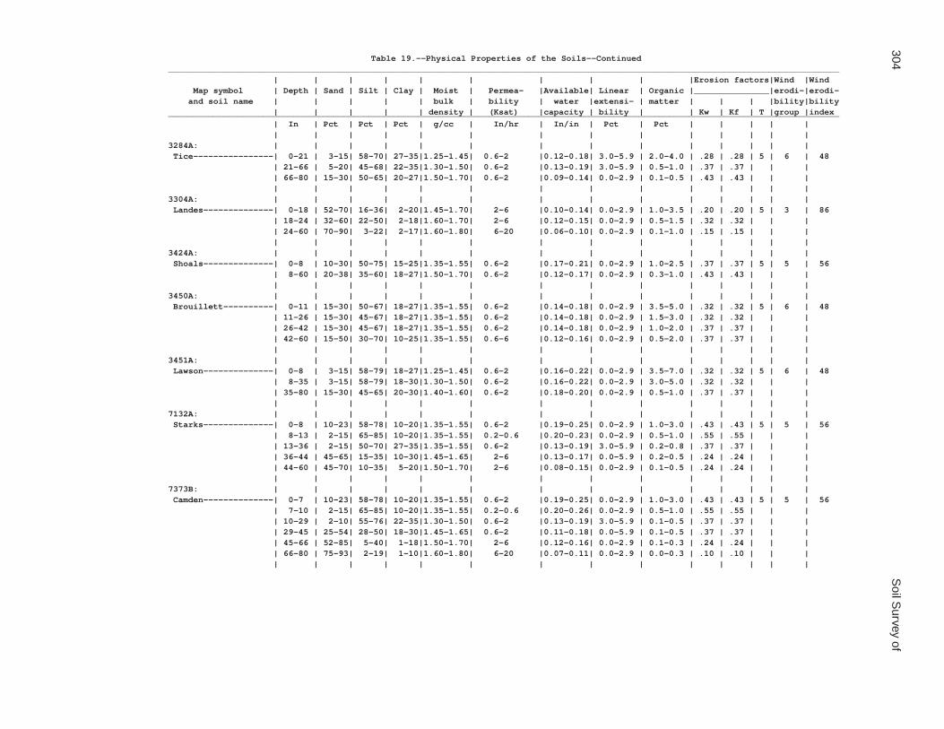
304S
oil Survey of
Table 19.--Physical Properties of the Soils--Continued______________________________________________________________________________________________________________________________________ | | | | | | | | | |Erosion factors|Wind |Wind Map symbol | Depth | Sand | Silt | Clay | Moist | Permea- |Available| Linear | Organic |_______________|erodi-|erodi- and soil name | | | | | bulk | bility | water |extensi- | matter | | | |bility|bility | | | | | density | (Ksat) |capacity | bility | | Kw | Kf | T |group |index______________________________________________________________________________________________________________________________________ | In | Pct | Pct | Pct | g/cc | In/hr | In/in | Pct | Pct | | | | | | | | | | | | | | | | | | |3284A: | | | | | | | | | | | | | | Tice----------------| 0-21 | 3-15| 58-70| 27-35|1.25-1.45| 0.6-2 |0.12-0.18| 3.0-5.9 | 2.0-4.0 | .28 | .28 | 5 | 6 | 48 | 21-66 | 5-20| 45-68| 22-35|1.30-1.50| 0.6-2 |0.13-0.19| 3.0-5.9 | 0.5-1.0 | .37 | .37 | | | | 66-80 | 15-30| 50-65| 20-27|1.50-1.70| 0.6-2 |0.09-0.14| 0.0-2.9 | 0.1-0.5 | .43 | .43 | | | | | | | | | | | | | | | | |3304A: | | | | | | | | | | | | | | Landes--------------| 0-18 | 52-70| 16-36| 2-20|1.45-1.70| 2-6 |0.10-0.14| 0.0-2.9 | 1.0-3.5 | .20 | .20 | 5 | 3 | 86 | 18-24 | 32-60| 22-50| 2-18|1.60-1.70| 2-6 |0.12-0.15| 0.0-2.9 | 0.5-1.5 | .32 | .32 | | | | 24-60 | 70-90| 3-22| 2-17|1.60-1.80| 6-20 |0.06-0.10| 0.0-2.9 | 0.1-1.0 | .15 | .15 | | | | | | | | | | | | | | | | |3424A: | | | | | | | | | | | | | | Shoals--------------| 0-8 | 10-30| 50-75| 15-25|1.35-1.55| 0.6-2 |0.17-0.21| 0.0-2.9 | 1.0-2.5 | .37 | .37 | 5 | 5 | 56 | 8-60 | 20-38| 35-60| 18-27|1.50-1.70| 0.6-2 |0.12-0.17| 0.0-2.9 | 0.3-1.0 | .43 | .43 | | | | | | | | | | | | | | | | |3450A: | | | | | | | | | | | | | | Brouillett----------| 0-11 | 15-30| 50-67| 18-27|1.35-1.55| 0.6-2 |0.14-0.18| 0.0-2.9 | 3.5-5.0 | .32 | .32 | 5 | 6 | 48 | 11-26 | 15-30| 45-67| 18-27|1.35-1.55| 0.6-2 |0.14-0.18| 0.0-2.9 | 1.5-3.0 | .32 | .32 | | | | 26-42 | 15-30| 45-67| 18-27|1.35-1.55| 0.6-2 |0.14-0.18| 0.0-2.9 | 1.0-2.0 | .37 | .37 | | | | 42-60 | 15-50| 30-70| 10-25|1.35-1.55| 0.6-6 |0.12-0.16| 0.0-2.9 | 0.5-2.0 | .37 | .37 | | | | | | | | | | | | | | | | |3451A: | | | | | | | | | | | | | | Lawson--------------| 0-8 | 3-15| 58-79| 18-27|1.25-1.45| 0.6-2 |0.16-0.22| 0.0-2.9 | 3.5-7.0 | .32 | .32 | 5 | 6 | 48 | 8-35 | 3-15| 58-79| 18-30|1.30-1.50| 0.6-2 |0.16-0.22| 0.0-2.9 | 3.0-5.0 | .32 | .32 | | | | 35-80 | 15-30| 45-65| 20-30|1.40-1.60| 0.6-2 |0.18-0.20| 0.0-2.9 | 0.5-1.0 | .37 | .37 | | | | | | | | | | | | | | | | |7132A: | | | | | | | | | | | | | | Starks--------------| 0-8 | 10-23| 58-78| 10-20|1.35-1.55| 0.6-2 |0.19-0.25| 0.0-2.9 | 1.0-3.0 | .43 | .43 | 5 | 5 | 56 | 8-13 | 2-15| 65-85| 10-20|1.35-1.55| 0.2-0.6 |0.20-0.23| 0.0-2.9 | 0.5-1.0 | .55 | .55 | | | | 13-36 | 2-15| 50-70| 27-35|1.35-1.55| 0.6-2 |0.13-0.19| 3.0-5.9 | 0.2-0.8 | .37 | .37 | | | | 36-44 | 45-65| 15-35| 10-30|1.45-1.65| 2-6 |0.13-0.17| 0.0-5.9 | 0.2-0.5 | .24 | .24 | | | | 44-60 | 45-70| 10-35| 5-20|1.50-1.70| 2-6 |0.08-0.15| 0.0-2.9 | 0.1-0.5 | .24 | .24 | | | | | | | | | | | | | | | | |7373B: | | | | | | | | | | | | | | Camden--------------| 0-7 | 10-23| 58-78| 10-20|1.35-1.55| 0.6-2 |0.19-0.25| 0.0-2.9 | 1.0-3.0 | .43 | .43 | 5 | 5 | 56 | 7-10 | 2-15| 65-85| 10-20|1.35-1.55| 0.2-0.6 |0.20-0.26| 0.0-2.9 | 0.5-1.0 | .55 | .55 | | | | 10-29 | 2-10| 55-76| 22-35|1.30-1.50| 0.6-2 |0.13-0.19| 3.0-5.9 | 0.1-0.5 | .37 | .37 | | | | 29-45 | 25-54| 28-50| 18-30|1.45-1.65| 0.6-2 |0.11-0.18| 0.0-5.9 | 0.1-0.5 | .37 | .37 | | | | 45-66 | 52-85| 5-40| 1-18|1.50-1.70| 2-6 |0.12-0.16| 0.0-2.9 | 0.1-0.3 | .24 | .24 | | | | 66-80 | 75-93| 2-19| 1-10|1.60-1.80| 6-20 |0.07-0.11| 0.0-2.9 | 0.0-0.3 | .10 | .10 | | | | | | | | | | | | | | | | |

Coles C
ounty, Illinois305
Table 19.--Physical Properties of the Soils--Continued______________________________________________________________________________________________________________________________________ | | | | | | | | | |Erosion factors|Wind |Wind Map symbol | Depth | Sand | Silt | Clay | Moist | Permea- |Available| Linear | Organic |_______________|erodi-|erodi- and soil name | | | | | bulk | bility | water |extensi- | matter | | | |bility|bility | | | | | density | (Ksat) |capacity | bility | | Kw | Kf | T |group |index______________________________________________________________________________________________________________________________________ | In | Pct | Pct | Pct | g/cc | In/hr | In/in | Pct | Pct | | | | | | | | | | | | | | | | | | |7570B: | | | | | | | | | | | | | | Martinsville--------| 0-9 | 12-40| 50-79| 8-20|1.40-1.60| 0.6-2 |0.18-0.22| 0.0-2.9 | 1.0-3.0 | .32 | .32 | 5 | 5 | 56 | 9-12 | 12-40| 50-79| 8-20|1.35-1.55| 0.6-2 |0.17-0.21| 0.0-2.9 | 0.1-1.0 | .55 | .55 | | | | 12-45 | 20-50| 20-50| 20-33|1.50-1.70| 0.6-2 |0.11-0.15| 3.0-5.9 | 0.1-0.5 | .32 | .32 | | | | 45-57 | 26-60| 17-50| 15-25|1.55-1.75| 0.6-2 |0.12-0.16| 0.0-2.9 | 0.1-0.3 | .32 | .32 | | | | 57-80 | 35-95| 12-50| 5-15|1.55-1.75| 2-6 |0.09-0.13| 0.0-2.9 | 0.1-0.2 | .28 | .28 | | | | | | | | | | | | | | | | |______________________________________________________________________________________________________________________________________

306 Soil Survey of
Table 20.--Chemical Properties of the Soils
(Absence of an entry indicates that data were not estimated)
_____________________________________________________________________ | | | | | Map symbol | Depth | Cation- |Effective| Soil |Calcium and soil name | |exchange | cation- |reaction |carbon- | |capacity |exchange | | ate | | |capacity | |_____________________________________________________________________ | In |meq/100 g|meq/100 g| pH | Pct | | | | |2A: | | | | | Cisne----------------| 0-8 | 9.0-17 | --- | 5.1-7.3 | 0 | 8-17 | 8.5-16 | --- | 5.1-6.5 | 0 | 17-37 | --- | 17-22 | 4.5-6.0 | 0 | 37-60 | 14-27 | --- | 5.1-6.5 | 0 | 60-80 | 14-26 | --- | 5.6-7.3 | 0 | | | | |3A: | | | | | Hoyleton-------------| 0-8 | 11-23 | --- | 4.5-7.3 | 0 | 8-11 | 14-22 | --- | 4.5-7.3 | 0 | 11-39 | --- | 17-22 | 4.5-5.5 | 0 | 39-80 | 14-26 | --- | 5.6-7.3 | 0 | | | | |13A: | | | | | Bluford--------------| 0-7 | 9.1-16 | --- | 5.6-7.3 | 0 | 7-20 | --- | 7.8-17 | 4.5-6.0 | 0 | 20-35 | --- | 18-29 | 4.5-6.0 | 0 | 35-60 | --- | 10-23 | 4.5-6.0 | 0 | | | | |13B: | | | | | Bluford--------------| 0-7 | 9.1-16 | --- | 5.6-7.3 | 0 | 7-20 | --- | 7.8-17 | 4.5-6.0 | 0 | 20-35 | --- | 18-29 | 4.5-6.0 | 0 | 35-60 | --- | 10-23 | 4.5-6.0 | 0 | | | | |48A: | | | | | Ebbert---------------| 0-13 | 13-21 | --- | 5.1-7.3 | 0 | 13-22 | --- | 8.3-14 | 5.1-6.0 | 0 | 22-48 | 21-28 | --- | 4.5-6.5 | 0 | 48-60 | 14-23 | --- | 5.6-7.3 | 0 | | | | |56B: | | | | | Dana-----------------| 0-11 | 17-26 | --- | 5.6-7.3 | 0 | 11-32 | 17-23 | --- | 5.1-7.3 | 0 | 32-58 | 14-19 | --- | 5.6-7.8 | 0-5 | 58-80 | 6.0-16 | --- | 7.4-8.4 | 15-40 | | | | |56B2: | | | | | Dana-----------------| 0-7 | 14-28 | --- | 5.6-6.5 | 0 | 7-34 | 18-27 | --- | 5.1-7.3 | 0 | 34-53 | 12-24 | --- | 5.6-7.8 | 0-5 | 53-60 | 4.0-16 | --- | 7.4-8.4 | 15-40 | | | | |132A: | | | | | Starks---------------| 0-8 | 13-23 | --- | 5.1-7.3 | 0 | 8-13 | 12-22 | --- | 5.1-7.3 | 0 | 13-36 | 20-27 | --- | 4.5-6.5 | 0 | 36-44 | 8.3-23 | --- | 5.1-7.3 | 0-5 | 44-60 | 4.3-16 | --- | 6.1-7.8 | 0-5 | | | | |136A: | | | | | Brooklyn-------------| 0-9 | 13-19 | --- | 5.6-7.3 | 0 | 9-14 | 11-18 | --- | 4.5-7.3 | 0 | 14-40 | 25-34 | --- | 4.5-7.3 | 0 | 40-62 | 20-30 | --- | 5.1-7.8 | 0-5 | 62-73 | 8.1-21 | --- | 6.6-7.8 | 0-15 | 73-80 | 8.1-21 | --- | 7.4-8.4 | 5-40 | | | | |

Coles County, Illinois 307
Table 20.--Chemical Properties of the Soils--Continued_____________________________________________________________________ | | | | | Map symbol | Depth | Cation- |Effective| Soil |Calcium and soil name | |exchange | cation- |reaction |carbon- | |capacity |exchange | | ate | | |capacity | |_____________________________________________________________________ | In |meq/100 g|meq/100 g| pH | Pct | | | | |138A: | | | | | Shiloh---------------| 0-19 | 29-33 | --- | 6.1-7.3 | 0 | 19-48 | 27-36 | --- | 6.1-7.3 | 0 | 48-68 | 24-34 | --- | 6.1-7.3 | 0 | 68-80 | 26-38 | --- | 6.1-7.8 | 0 | | | | |148B: | | | | | Proctor--------------| 0-13 | 15-24 | --- | 5.1-7.8 | 0 | 13-25 | 16-25 | --- | 5.6-7.3 | 0 | 25-45 | 15-23 | --- | 5.6-7.3 | 0 | 45-60 | 4.0-12 | --- | 6.1-7.8 | 0-10 | | | | |149A: | | | | | Brenton--------------| 0-14 | 13-23 | --- | 5.6-6.5 | 0 | 14-33 | 21-28 | --- | 5.6-6.5 | 0 | 33-45 | 12-21 | --- | 6.1-7.3 | 0 | 45-80 | 5.2-14 | --- | 6.6-7.8 | 0-15 | | | | |152A: | | | | | Drummer--------------| 0-14 | 23-30 | --- | 5.6-7.3 | 0 | 14-41 | 22-28 | --- | 6.1-7.3 | 0 | 41-47 | 16-21 | --- | 6.6-7.8 | 0-5 | 47-60 | 8.1-16 | --- | 7.4-8.4 | 0-15 | | | | |154A: | | | | | Flanagan-------------| 0-18 | 16-32 | --- | 5.6-7.3 | 0 | 18-38 | 22-35 | --- | 5.6-7.3 | 0 | 38-45 | 16-27 | --- | 5.6-7.3 | 0 | 45-49 | 6.0-18 | --- | 6.1-7.8 | 0-10 | 49-60 | 4.0-16 | --- | 7.4-8.4 | 15-40 | | | | |206A: | | | | | Thorp----------------| 0-14 | 20-28 | --- | 5.1-7.8 | 0 | 14-19 | 11-17 | --- | 5.1-7.3 | 0 | 19-43 | 14-23 | --- | 5.1-7.3 | 0 | 43-50 | 11-19 | --- | 5.6-7.8 | 0-5 | 50-65 | 3.0-19 | --- | 6.1-8.4 | 0-20 | | | | |219A: | | | | | Millbrook------------| 0-7 | 11-17 | --- | 5.6-7.3 | 0 | 7-14 |10.0-16 | --- | 5.6-7.3 | 0 | 14-35 | 16-27 | --- | 5.1-6.5 | 0 | 35-55 | 16-25 | --- | 5.6-7.3 | 0 | 55-80 | 9.3-16 | --- | 6.6-8.4 | 0-10 | | | | |244A: | | | | | Hartsburg------------| 0-17 | 27-40 | --- | 6.1-7.8 | 0-5 | 17-34 | 17-31 | --- | 6.6-8.4 | 0-25 | 34-60 | 9.0-23 | --- | 7.4-8.4 | 15-40 | | | | |291B: | | | | | Xenia----------------| 0-4 | 13-23 | --- | 5.6-7.3 | 0 | 4-16 | 12-22 | --- | 5.6-7.3 | 0 | 16-37 | 20-27 | --- | 5.1-7.3 | 0 | 37-57 | 18-27 | --- | 5.6-7.3 | 0-5 | 57-72 | 9.3-16 | --- | 7.4-8.4 | 15-40 | | | | |

308 Soil Survey of
Table 20.--Chemical Properties of the Soils--Continued_____________________________________________________________________ | | | | | Map symbol | Depth | Cation- |Effective| Soil |Calcium and soil name | |exchange | cation- |reaction |carbon- | |capacity |exchange | | ate | | |capacity | |_____________________________________________________________________ | In |meq/100 g|meq/100 g| pH | Pct | | | | |322B: | | | | | Russell--------------| 0-6 | 14-24 | --- | 5.1-7.3 | 0 | 6-13 | 12-20 | --- | 5.1-7.3 | 0 | 13-28 | --- | 13-17 | 4.5-6.0 | 0 | 28-47 | 11-22 | --- | 5.6-7.3 | 0-5 | 47-80 | 4.0-13 | --- | 7.4-8.4 | 15-40 | | | | |322C2: | | | | | Russell--------------| 0-7 | 13-24 | --- | 5.6-6.5 | 0 | 7-27 | --- | 13-17 | 4.5-5.5 | 0 | 27-56 | 11-22 | --- | 5.6-7.3 | 0-5 | 56-72 | 4.0-16 | --- | 7.4-8.4 | 15-40 | | | | |330A: | | | | | Peotone--------------| 0-6 | 29-33 | --- | 5.6-7.3 | 0 | 6-28 | 28-33 | --- | 5.6-7.8 | 0 | 28-44 | 28-33 | --- | 6.1-7.8 | 0 | 44-60 | 20-31 | --- | 6.6-8.4 | 0-15 | | | | |348B: | | | | | Wingate--------------| 0-9 | 14-24 | --- | 5.6-7.3 | 0 | 9-12 | 12-20 | --- | 5.6-7.3 | 0 | 12-27 | 18-27 | --- | 5.1-7.3 | 0 | 27-52 | 11-22 | --- | 5.6-7.3 | 0-5 | 52-60 | 4.0-13 | --- | 6.6-8.4 | 15-40 | | | | |353A: | | | | | Toronto--------------| 0-9 | 14-24 | --- | 5.6-7.3 | 0 | 9-12 | 12-22 | --- | 5.1-6.0 | 0 | 12-26 | --- | 13-18 | 4.5-7.3 | 0 | 26-54 | 11-22 | --- | 5.6-7.3 | 0-5 | 54-60 | 4.0-13 | --- | 7.4-8.4 | 15-40 | | | | |481A: | | | | | Raub-----------------| 0-18 | 16-32 | --- | 5.6-7.3 | 0 | 18-32 | 18-27 | --- | 5.1-6.5 | 0 | 32-50 | 12-24 | --- | 6.1-7.8 | 0-5 | 50-80 | 4.0-16 | --- | 7.4-8.4 | 15-40 | | | | |496A: | | | | | Fincastle------------| 0-8 | 13-22 | --- | 5.1-7.3 | 0 | 8-11 | 12-22 | --- | 5.1-6.5 | 0 | 11-32 | 20-27 | --- | 4.5-6.0 | 0 | 32-40 | 20-25 | --- | 5.1-6.5 | 0 | 40-50 | 14-22 | --- | 6.6-7.8 | 0-5 | 50-80 | 7.6-16 | --- | 7.4-8.4 | 15-40 | | | | |533. | | | | | Urban land | | | | | | | | | |570B: | | | | | Martinsville---------| 0-9 | 6.0-16 | --- | 5.1-7.3 | 0 | 9-12 | --- | 3.1-7.7 | 5.1-7.3 | 0 | 12-45 | 10-18 | --- | 5.1-7.3 | 0 | 45-57 | 7.8-13 | --- | 5.1-7.8 | 0-15 | 57-80 | 3.0-10 | --- | 6.6-8.4 | 0-25 | | | | |570C2: | | | | | Martinsville---------| 0-9 | 8.0-14 | --- | 5.1-7.3 | 0 | 9-45 | 8.0-18 | --- | 5.1-7.3 | 0 | 45-57 | 6.0-15 | --- | 5.1-7.8 | 0-15| | 57-80 | 3.0-10 | --- | 6.6-8.4 | 0-25 | | | | |

Coles County, Illinois 309
Table 20.--Chemical Properties of the Soils--Continued_____________________________________________________________________ | | | | | Map symbol | Depth | Cation- |Effective| Soil |Calcium and soil name | |exchange | cation- |reaction |carbon- | |capacity |exchange | | ate | | |capacity | |_____________________________________________________________________ | In |meq/100 g|meq/100 g| pH | Pct | | | | |618C2: | | | | | Senachwine-----------| 0-6 | 11-15 | --- | 5.6-7.3 | 0 | 6-12 | 14-18 | --- | 5.6-7.3 | 0 | 12-27 | 14-18 | --- | 5.1-7.3 | 0 | 27-60 | 5.2-11 | --- | 7.4-8.4 | 15-40 | | | | |618C3: | | | | | Senachwine-----------| 0-4 | 14-19 | --- | 5.6-7.3 | 0 | 4-33 | 14-18 | --- | 5.1-7.3 | 0 | 33-60 | 5.1-11 | --- | 7.4-8.4 | 15-40 | | | | |618D2: | | | | | Senachwine-----------| 0-6 | 11-15 | --- | 5.6-7.3 | 0 | 6-15 | 14-18 | --- | 5.6-7.3 | 0 | 15-28 | 14-18 | --- | 5.1-7.3 | 0 | 28-34 | 10-14 | --- | 5.1-7.3 | 0-5 | 34-60 | 5.2-11 | --- | 7.4-8.4 | 15-40 | | | | |618D3: | | | | | Senachwine-----------| 0-3 | 14-19 | --- | 5.6-7.3 | 0 | 3-25 | 14-18 | --- | 5.1-7.3 | 0 | 25-60 | 5.1-11 | --- | 7.4-8.4 | 15-40 | | | | |618F: | | | | | Senachwine-----------| 0-11 | 8.0-19 | --- | 5.6-7.3 | 0 | 11-17 | 12-24 | --- | 5.1-7.3 | 0 | 17-32 | 14-18 | --- | 5.1-7.3 | 0 | 32-40 | 9.0-19 | --- | 6.6-7.8 | 0-5 | 40-60 | 4.0-13 | --- | 7.4-8.4 | 15-40 | | | | |618G: | | | | | Senachwine-----------| 0-5 | 8.0-19 | --- | 5.6-7.3 | 0 | 5-11 | 7.0-19 | --- | 5.6-7.3 | 0 | 11-30 | --- | 9.1-15 | 5.1-7.3 | 0 | 30-38 | 9.0-19 | --- | 5.1-7.3 | 0-5 | 38-60 | 4.0-13 | --- | 7.4-8.4 | 15-40 | | | | |668B2: | | | | | Somonauk-------------| 0-6 | 14-24 | --- | 5.6-7.3 | 0 | 6-33 | --- | 13-18 | 5.1-7.3 | 0 | 33-55 | 8.0-18 | --- | 5.1-7.3 | 0 | 55-68 | 6.0-15 | --- | 6.6-7.8 | 0-5 | 68-80 | 3.0-10 | --- | 6.6-8.4 | 0-25 | | | | |722A: | | | | | Drummer--------------| 0-14 | 27-40 | --- | 5.6-7.3 | 0 | 14-41 | 17-31 | --- | 5.6-7.3 | 0 | 41-47 | 9.0-19 | --- | 6.1-7.8 | 0-5 | 47-60 | 4.0-13 | --- | 6.6-8.4 | 0-15 | | | | | Milford--------------| 0-14 | 29-33 | --- | 5.6-7.3 | 0 | 14-25 | 27-35 | --- | 6.1-7.8 | 0 | 25-45 | 20-27 | --- | 6.1-7.8 | 0-15 | 45-80 | 6.0-16 | --- | 6.6-8.4 | 0-25 | | | | |830. | | | | | Landfill | | | | | | | | | |864. | | | | | Pits, quarry | | | | | | | | | |

310 Soil Survey of
Table 20.--Chemical Properties of the Soils--Continued_____________________________________________________________________ | | | | | Map symbol | Depth | Cation- |Effective| Soil |Calcium and soil name | |exchange | cation- |reaction |carbon- | |capacity |exchange | | ate | | |capacity | |_____________________________________________________________________ | In |meq/100 g|meq/100 g| pH | Pct | | | | |865. | | | | | Pits, gravel | | | | | | | | | |871B: | | | | | Lenzburg-------------| 0-8 | 12-18 | --- | 6.6-8.4 | 0-20 | 8-60 | 11-17 | --- | 7.4-8.4 | 0-25 | | | | |871D: | | | | | Lenzburg-------------| 0-8 | 12-18 | --- | 6.6-8.4 | 0-20 | 8-60 | 11-17 | --- | 7.4-8.4 | 0-25 | | | | |3073A: | | | | | Ross-----------------| 0-13 | 13-23 | --- | 6.1-7.3 | 0 | 13-43 | 12-26 | --- | 6.1-7.3 | 0 | 43-60 | 4.6-17 | --- | 6.1-7.8 | 0-1 | | | | |3107A: | | | | | Sawmill--------------| 0-10 | 23-36 | --- | 6.1-7.8 | 0 | 10-32 | 23-36 | --- | 6.1-7.8 | 0 | 32-58 | 18-34 | --- | 6.1-7.8 | 0 | 58-65 | 18-34 | --- | 6.1-7.8 | 0-5 | | | | |3226A: | | | | | Wirt-----------------| 0-3 | 6.4-16 | --- | 5.6-7.3 | 0 | 3-32 | 4.6-15 | --- | 5.6-7.3 | 0 | 32-60 | 4.6-15 | --- | 5.6-7.3 | 0 | | | | |3284A: | | | | | Tice-----------------| 0-21 | 22-32 | --- | 6.1-7.3 | 0 | 21-66 | 18-30 | --- | 5.6-7.3 | 0 | 66-80 | 4.0-16 | --- | 6.6-7.8 | 0 | | | | |3304A: | | | | | Landes---------------| 0-18 | 5.0-15 | --- | 6.1-7.3 | 0 | 18-24 | 3.0-13 | --- | 6.1-7.3 | 0 | 24-60 | 1.5-11 | --- | 6.1-7.8 | 0-15 | | | | |3424A: | | | | | Shoals---------------| 0-8 | 13-21 | --- | 6.6-7.3 | 0 | 8-60 | 14-22 | --- | 6.6-7.8 | 0-5 | | | | |3450A: | | | | | Brouillett-----------| 0-11 | 16-23 | --- | 6.1-7.8 | 0 | 11-26 | 15-23 | --- | 6.1-7.8 | 0 | 26-42 | 15-22 | --- | 6.1-7.8 | 0-3 | 42-60 | 8.6-21 | --- | 6.6-8.4 | 0-15 | | | | |3451A: | | | | | Lawson---------------| 0-8 | 13-34 | --- | 6.1-7.3 | 0 | 8-35 | 11-28 | --- | 6.1-7.3 | 0 | 35-80 | 13-26 | --- | 6.1-7.8 | 0-3 | | | | |7132A: | | | | | Starks---------------| 0-8 | 7.0-18 | --- | 5.1-7.3 | 0 | 8-13 | 7.0-16 | --- | 5.1-7.3 | 0 | 13-36 | 20-27 | --- | 4.5-6.5 | 0 | 36-44 | 8.3-18 | --- | 5.1-7.3 | 0-5 | 44-60 | 2.0-19 | --- | 6.1-7.8 | 0-5 | | | | |

Coles County, Illinois 311
Table 20.--Chemical Properties of the Soils--Continued_____________________________________________________________________ | | | | | Map symbol | Depth | Cation- |Effective| Soil |Calcium and soil name | |exchange | cation- |reaction |carbon- | |capacity |exchange | | ate | | |capacity | |_____________________________________________________________________ | In |meq/100 g|meq/100 g| pH | Pct | | | | |7373B: | | | | | Camden---------------| 0-7 | 7.0-18 | --- | 5.6-7.3 | 0 | 7-10 | 7.0-16 | --- | 5.1-7.3 | 0 | 10-29 | 10-25 | --- | 5.1-7.3 | 0 | 29-45 | 9.0-19 | --- | 5.1-6.5 | 0 | 45-66 | 2.0-14 | --- | 5.1-7.3 | 0-5 | 66-80 | 3.3-8.5 | --- | 5.6-7.8 | 0-25 | | | | |7570B: | | | | | Martinsville---------| 0-9 | 6.0-16 | --- | 5.1-7.3 | 0 | 9-12 | --- | 3.1-7.7 | 5.1-7.3 | 0 | 12-45 | 8.0-18 | --- | 5.1-7.3 | 0 | 45-57 | 6.0-15 | --- | 5.1-7.8 | 0-15 | 57-80 | 3.0-10 | --- | 6.6-8.4 | 0-25 | | | | |_____________________________________________________________________

312 Soil Survey of
Table 21.--Water Features
(See text for definitions of terms used in this table. Estimates of the frequency of ponding and flooding apply to the whole year rather than to individual months. Absence of an entry indicates that the feature is not a concern or that data were not estimated)
____________________________________________________________________________________________________________________ | | Ponding | Flooding | | Water table ___________________________________________________ _________________________ Map symbol |Hydro-|Surface| Duration |Frequency | Duration | Frequency| Months| Upper | Lower | Kind of and soil name |logic | water | | | | | | limit | limit | water |group | depth | | | | | | | | table____________________________________________________________________________________________________________________ | | Ft | | | | | | Ft | Ft | | | | | | | | | | |2A: | | | | | | | | | | Cisne-----------------| D |0.0-0.5| Brief | Frequent | --- | None |Jan-May|0.0-1.0| >6.0 |Apparent | | --- | --- | --- | --- | --- |Jun-Dec| >6.0 | >6.0 | --- | | | | | | | | | |3A: | | | | | | | | | | Hoyleton--------------| C | --- | --- | None | --- | None |Jan-May|1.0-2.0| >6.0 |Apparent | | --- | --- | --- | --- | --- |Jun-Dec| >6.0 | >6.0 | --- | | | | | | | | | |13A: | | | | | | | | | | Bluford---------------| C | --- | --- | None | --- | None |Jan-May|0.5-2.0|2.5-4.6|Perched | | --- | --- | --- | --- | --- |Jun-Dec| >6.0 | >6.0 | --- | | | | | | | | | |13B: | | | | | | | | | | Bluford---------------| C | --- | --- | None | --- | None |Jan-May|0.5-2.0|2.5-4.6|Perched | | --- | --- | --- | --- | --- |Jun-Dec| >6.0 | >6.0 | --- | | | | | | | | | |48A: | | | | | | | | | | Ebbert----------------| C/D |0.0-0.5| Brief | Frequent | --- | None |Jan-May|0.0-1.0| >6.0 |Apparent | | --- | --- | --- | --- | --- |Jun-Dec| >6.0 | >6.0 | --- | | | | | | | | | |56B: | | | | | | | | | | Dana------------------| B | --- | --- | None | --- | None | Jan | >6.0 | >6.0 | --- | | --- | --- | --- | --- | --- |Feb-Apr|2.0-3.5|3.5-5.5|Perched | | --- | --- | --- | --- | --- |May-Dec| >6.0 | >6.0 | --- | | | | | | | | | |56B2: | | | | | | | | | | Dana------------------| B | --- | --- | None | --- | None | Jan | >6.0 | >6.0 | --- | | --- | --- | --- | --- | --- |Feb-Apr|2.0-3.5|3.3-5.0|Perched | | --- | --- | --- | --- | --- |May-Dec| >6.0 | >6.0 | --- | | | | | | | | | |132A: | | | | | | | | | | Starks----------------| B | --- | --- | None | --- | None |Jan-May|1.0-2.0| >6.0 |Apparent | | --- | --- | --- | --- | --- |Jun-Dec| >6.0 | >6.0 | --- | | | | | | | | | |136A: | | | | | | | | | | Brooklyn--------------| C/D |0.0-0.5| Brief | Frequent | --- | None |Jan-May|0.0-1.0|5.0-6.7|Perched | | --- | --- | --- | --- | --- |Jun-Dec| >6.0 | >6.0 | --- | | | | | | | | | |138A: | | | | | | | | | | Shiloh----------------| C/D |0.0-1.0| Brief | Frequent | --- | None |Jan-Jun|0.0-1.0| >6.0 |Apparent | | --- | --- | --- | --- | --- |Jul-Dec| >6.0 | >6.0 | --- | | | | | | | | | |148B: | | | | | | | | | | Proctor---------------| B | --- | --- | None | --- | None |Jan-Dec| >6.0 | >6.0 | --- | | | | | | | | | |149A: | | | | | | | | | | Brenton---------------| B | --- | --- | None | --- | None |Jan-May|1.0-2.0| >6.0 |Apparent | | --- | --- | --- | --- | --- |Jun-Dec| >6.0 | >6.0 | --- | | | | | | | | | |152A: | | | | | | | | | | Drummer---------------| B/D |0.0-0.5| Brief | Frequent | --- | None |Jan-May|0.0-1.0| >6.0 |Apparent | | --- | --- | --- | --- | --- |Jun-Dec| >6.0 | >6.0 | --- | | | | | | | | | |154A: | | | | | | | | | | Flanagan--------------| B | --- | --- | None | --- | None |Jan-May|1.0-2.0| >6.0 |Apparent | | --- | --- | --- | --- | --- |Jun-Dec| >6.0 | >6.0 | --- | | | | | | | | | |

Coles County, Illinois 313
Table 21.--Water Features--Continued____________________________________________________________________________________________________________________ | | Ponding | Flooding | | Water table ___________________________________________________ _________________________ Map symbol |Hydro-|Surface| Duration |Frequency | Duration | Frequency| Months| Upper | Lower | Kind of and soil name |logic | water | | | | | | limit | limit | water |group | depth | | | | | | | | table____________________________________________________________________________________________________________________ | | Ft | | | | | | Ft | Ft | | | | | | | | | | |206A: | | | | | | | | | | Thorp-----------------| C/D |0.0-0.5| Brief | Frequent | --- | None |Jan-May|0.0-1.0| >6.0 |Apparent | | --- | --- | --- | --- | --- |Jun-Dec| >6.0 | >6.0 | --- | | | | | | | | | |219A: | | | | | | | | | | Millbrook-------------| B | --- | --- | None | --- | None |Jan-May|1.0-2.0| >6.0 |Apparent | | --- | --- | --- | --- | --- |Jun-Dec| >6.0 | >6.0 | --- | | | | | | | | | |244A: | | | | | | | | | | Hartsburg-------------| B/D |0.0-0.5| Brief | Frequent | --- | None |Jan-May|0.0-1.0| >6.0 |Apparent | | --- | --- | --- | --- | --- |Jun-Dec| >6.0 | >6.0 | --- | | | | | | | | | |291B: | | | | | | | | | | Xenia-----------------| B | --- | --- | None | --- | None |Jan-May|1.5-2.5|2.5-5.0|Perched | | --- | --- | --- | --- | --- |Jun-Dec| >6.0 | >6.0 | --- | | | | | | | | | |322B: | | | | | | | | | | Russell---------------| B | --- | --- | None | --- | None |Jan-Dec| >6.0 | >6.0 | --- | | | | | | | | | |322C2: | | | | | | | | | | Russell---------------| B | --- | --- | None | --- | None |Jan-Dec| >6.0 | >6.0 | --- | | | | | | | | | |330A: | | | | | | | | | | Peotone---------------| C/D |0.0-1.0| Brief | Frequent | --- | None |Jan-Jun|0.0-1.0| >6.0 |Apparent | | --- | --- | --- | --- | --- |Jul-Dec| >6.0 | >6.0 | --- | | | | | | | | | |348B: | | | | | | | | | | Wingate---------------| B | --- | --- | None | --- | None | Jan | >6.0 | >6.0 | --- | | --- | --- | --- | --- | --- |Feb-Apr|1.5-3.0|2.4-4.6|Perched | | --- | --- | --- | --- | --- |May-Dec| >6.0 | >6.0 | --- | | | | | | | | | |353A: | | | | | | | | | | Toronto---------------| C | --- | --- | None | --- | None |Jan-May|0.5-2.0|3.3-5.0|Perched | | --- | --- | --- | --- | --- |Jun-Dec| >6.0 | >6.0 | --- | | | | | | | | | |481A: | | | | | | | | | | Raub------------------| B | --- | --- | None | --- | None |Jan-May|1.0-2.0|3.3-5.8|Perched | | --- | --- | --- | --- | --- |Jun-Dec| >6.0 | >6.0 | --- | | | | | | | | | |496A: | | | | | | | | | | Fincastle-------------| C | --- | --- | None | --- | None |Jan-May|1.0-2.0|3.3-5.0|Perched | | --- | --- | --- | --- | --- |Jun-Dec| >6.0 | >6.0 | --- | | | | | | | | | |533: | | | | | | | | | | Urban land------------| D | --- | --- | None | --- | None |Jan-Dec| >6.0 | >6.0 | --- | | | | | | | | | |570B: | | | | | | | | | | Martinsville----------| B | --- | --- | None | --- | None |Jan-Dec| >6.0 | >6.0 | --- | | | | | | | | | |570C2: | | | | | | | | | | Martinsville----------| B | --- | --- | None | --- | None |Jan-Dec| >6.0 | >6.0 | --- | | | | | | | | | |618C2: | | | | | | | | | | Senachwine------------| B | --- | --- | None | --- | None |Jan-Dec| >6.0 | >6.0 | --- | | | | | | | | | |618C3: | | | | | | | | | | Senachwine------------| B | --- | --- | None | --- | None |Jan-Dec| >6.0 | >6.0 | --- | | | | | | | | | |618D2: | | | | | | | | | | Senachwine------------| B | --- | --- | None | --- | None |Jan-Dec| >6.0 | >6.0 | --- | | | | | | | | | |

314 Soil Survey of
Table 21.--Water Features--Continued____________________________________________________________________________________________________________________ | | Ponding | Flooding | | Water table ___________________________________________________ _________________________ Map symbol |Hydro-|Surface| Duration |Frequency | Duration | Frequency| Months| Upper | Lower | Kind of and soil name |logic | water | | | | | | limit | limit | water |group | depth | | | | | | | | table____________________________________________________________________________________________________________________ | | Ft | | | | | | Ft | Ft | | | | | | | | | | |618D3: | | | | | | | | | | Senachwine------------| B | --- | --- | None | --- | None |Jan-Dec| >6.0 | >6.0 | --- | | | | | | | | | |618F: | | | | | | | | | | Senachwine------------| B | --- | --- | None | --- | None |Jan-Dec| >6.0 | >6.0 | --- | | | | | | | | | |618G: | | | | | | | | | | Senachwine------------| B | --- | --- | None | --- | None |Jan-Dec| >6.0 | >6.0 | --- | | | | | | | | | |668B2: | | | | | | | | | | Somonauk--------------| B | --- | --- | None | --- | None | Jan | >6.0 | >6.0 | --- | | --- | --- | --- | --- | --- |Feb-Apr|2.0-4.0| >6.0 |Apparent | | --- | --- | --- | --- | --- |May-Dec| >6.0 | >6.0 | --- | | | | | | | | | |722A: | | | | | | | | | | Drummer---------------| B/D |0.0-0.5| Brief | Frequent | --- | None |Jan-May|0.0-1.0| >6.0 |Apparent | | --- | --- | --- | --- | --- |Jun-Dec| >6.0 | >6.0 | --- | | | | | | | | | | Milford---------------| C/D |0.0-0.5| Brief | Frequent | --- | None |Jan-May|0.0-1.0| >6.0 |Apparent | | --- | --- | --- | --- | --- |Jun-Dec| >6.0 | >6.0 | --- | | | | | | | | | |830: | | | | | | | | | | Landfill--------------| C | --- | --- | None | --- | None |Jan-Dec| >6.0 | >6.0 | --- | | | | | | | | | |864. | | | | | | | | | | Pits, quarry | | | | | | | | | | | | | | | | | | | |865. | | | | | | | | | | Pits, gravel | | | | | | | | | | | | | | | | | | | |871B: | | | | | | | | | | Lenzburg--------------| C | --- | --- | None | --- | None |Jan-Dec| >6.0 | >6.0 | --- | | | | | | | | | |871D: | | | | | | | | | | Lenzburg--------------| C | --- | --- | None | --- | None |Jan-Dec| >6.0 | >6.0 | --- | | | | | | | | | |3073A: | | | | | | | | | | Ross------------------| B | --- | --- | None | Brief | Frequent | Jan | >6.0 | >6.0 | --- | | --- | --- | --- | --- | --- |Feb-Apr|4.0-6.0| >6.0 |Apparent | | --- | --- | --- | --- | --- |May-Dec| >6.0 | >6.0 | --- | | | | | | | | | |3107A: | | | | | | | | | | Sawmill---------------| B/D |0.0-0.5| Brief | Frequent | Brief | Frequent |Jan-May|0.0-1.0| >6.0 |Apparent | | --- | --- | --- | --- | --- |Jun-Dec| >6.0 | >6.0 | --- | | | | | | | | | |3226A: | | | | | | | | | | Wirt------------------| B | --- | --- | None | Brief | Frequent |Jan-Dec| >6.0 | >6.0 | --- | | | | | | | | | |3284A: | | | | | | | | | | Tice------------------| B | --- | --- | None | Brief | Frequent |Jan-May|1.0-2.0| >6.0 |Apparent | | --- | --- | --- | --- | --- |Jun-Dec| >6.0 | >6.0 | --- | | | | | | | | | |3304A: | | | | | | | | | | Landes----------------| B | --- | --- | None | Brief | Frequent |Jan-Dec| >6.0 | >6.0 | --- | | | | | | | | | |3424A: | | | | | | | | | | Shoals----------------| C | --- | --- | None | Brief | Frequent |Jan-May|0.5-2.0| >6.0 |Apparent | | --- | --- | --- | --- | --- |Jun-Dec| >6.0 | >6.0 | --- | | | | | | | | | |3450A: | | | | | | | | | | Brouillett------------| B | --- | --- | None | Brief | Frequent |Jan-May|1.0-2.0| >6.0 |Apparent | | --- | --- | --- | --- | --- |Jun-Dec| >6.0 | >6.0 | --- | | | | | | | | | |
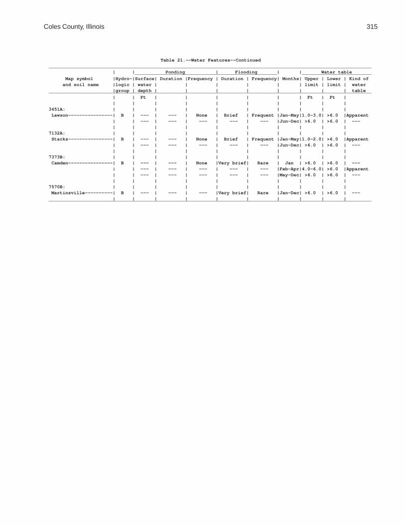
Coles County, Illinois 315
Table 21.--Water Features--Continued____________________________________________________________________________________________________________________ | | Ponding | Flooding | | Water table ___________________________________________________ _________________________ Map symbol |Hydro-|Surface| Duration |Frequency | Duration | Frequency| Months| Upper | Lower | Kind of and soil name |logic | water | | | | | | limit | limit | water |group | depth | | | | | | | | table____________________________________________________________________________________________________________________ | | Ft | | | | | | Ft | Ft | | | | | | | | | | |3451A: | | | | | | | | | | Lawson----------------| B | --- | --- | None | Brief | Frequent |Jan-May|1.0-3.0| >6.0 |Apparent | | --- | --- | --- | --- | --- |Jun-Dec| >6.0 | >6.0 | --- | | | | | | | | | |7132A: | | | | | | | | | | Starks----------------| B | --- | --- | None | Brief | Frequent |Jan-May|1.0-2.0| >6.0 |Apparent | | --- | --- | --- | --- | --- |Jun-Dec| >6.0 | >6.0 | --- | | | | | | | | | |7373B: | | | | | | | | | | Camden----------------| B | --- | --- | None |Very brief| Rare | Jan | >6.0 | >6.0 | --- | | --- | --- | --- | --- | --- |Feb-Apr|4.0-6.0| >6.0 |Apparent | | --- | --- | --- | --- | --- |May-Dec| >6.0 | >6.0 | --- | | | | | | | | | |7570B: | | | | | | | | | | Martinsville----------| B | --- | --- | --- |Very brief| Rare |Jan-Dec| >6.0 | >6.0 | --- | | | | | | | | | |____________________________________________________________________________________________________________________

316 Soil Survey of
Table 22.--Soil Features
(See text for definitions of terms used in this table. Absence of an entry indicates that the feature is not a concern or that data were not estimated)
___________________________________________________________________________________________________ | Restrictive layer | | Risk of corrosion Map symbol |______________________________________| Potential |______________________ and soil name | | Depth | | for | Uncoated | | Kind |to top | Hardness |frost action| steel |Concrete___________________________________________________________________________________________________ | | In | | | | | | | | | |2A: | | | | | | Cisne------------------|Abrupt textural| 16-21 |Noncemented |High |High |High | change | | | | | | | | | | |3A: | | | | | | Hoyleton---------------| --- | --- | --- |Moderate |High |High | | | | | |13A: | | | | | | Bluford----------------|Fragipan | 30-55 |Noncemented |High |High |High | | | | | |13B: | | | | | | Bluford----------------|Fragipan | 30-55 |Noncemented |High |High |High | | | | | |48A: | | | | | | Ebbert-----------------| --- | --- | --- |High |High |High | | | | | |56B: | | | | | | Dana-------------------| --- | --- | --- |High |High |Moderate | | | | | |56B2: | | | | | | Dana-------------------| --- | --- | --- |High |High |Moderate | | | | | |132A: | | | | | | Starks-----------------| --- | --- | --- |High |High |High | | | | | |136A: | | | | | | Brooklyn---------------|Dense material | 60-100|Noncemented |High |High |High | | | | | |138A: | | | | | | Shiloh-----------------| --- | --- | --- |High |High |Low | | | | | |148B: | | | | | | Proctor----------------| --- | --- | --- |High |Moderate |Moderate | | | | | |149A: | | | | | | Brenton----------------| --- | --- | --- |High |High |Moderate | | | | | |152A: | | | | | | Drummer----------------| --- | --- | --- |High |High |Low | | | | | |154A: | | | | | | Flanagan---------------| --- | --- | --- |High |High |Moderate | | | | | |206A: | | | | | | Thorp------------------| --- | --- | --- |High |High |Moderate | | | | | |219A: | | | | | | Millbrook--------------| --- | --- | --- |High |High |Moderate | | | | | |244A: | | | | | | Hartsburg--------------| --- | --- | --- |High |High |Low | | | | | |291B: | | | | | | Xenia------------------|Dense material | 40-60 |Noncemented |High |High |Moderate | | | | | |322B: | | | | | | Russell----------------|Dense material | 40-60 |Noncemented |High |Moderate |Moderate | | | | | |

Coles County, Illinois 317
Table 22.--Soil Features--Continued___________________________________________________________________________________________________ | Restrictive layer | | Risk of corrosion Map symbol |______________________________________| Potential |______________________ and soil name | | Depth | | for | Uncoated | | Kind |to top | Hardness |frost action| steel |Concrete___________________________________________________________________________________________________ | | In | | | | | | | | | |322C2: | | | | | | Russell----------------|Dense material | 40-60 |Noncemented |High |Moderate |Moderate | | | | | |330A: | | | | | | Peotone----------------| --- | --- | --- |High |High |Low | | | | | |348B: | | | | | | Wingate----------------| --- | --- | --- |High |High |Moderate | | | | | |353A: | | | | | | Toronto----------------| --- | --- | --- |High |High |Moderate | | | | | |481A: | | | | | | Raub-------------------|Dense material | 40-70 |Noncemented |High |High |Moderate | | | | | |496A: | | | | | | Fincastle--------------|Dense material | 40-70 |Noncemented |High |High |High | | | | | |533. | | | | | | Urban land | | | | | | | | | | | |570B: | | | | | | Martinsville-----------| --- | --- | --- |Moderate |Moderate |Moderate | | | | | |570C2: | | | | | | Martinsville-----------| --- | --- | --- |Moderate |Moderate |Moderate | | | | | |618C2: | | | | | | Senachwine-------------| --- | --- | --- |Moderate |Moderate |Moderate | | | | | |618C3: | | | | | | Senachwine-------------| --- | --- | --- |Moderate |Moderate |Moderate | | | | | |618D2: | | | | | | Senachwine-------------| --- | --- | --- |Moderate |Moderate |Moderate | | | | | |618D3: | | | | | | Senachwine-------------| --- | --- | --- |Moderate |Moderate |Moderate | | | | | |618F: | | | | | | Senachwine-------------| --- | --- | --- |Moderate |Moderate |Moderate | | | | | |618G: | | | | | | Senachwine-------------| --- | --- | --- |Moderate |Moderate |Moderate | | | | | |668B2: | | | | | | Somonauk---------------| --- | --- | --- |High |High |Moderate | | | | | |722A: | | | | | | Drummer----------------| --- | --- | --- |High |High |Moderate | | | | | | Milford----------------| --- | --- | --- |High |High |Low | | | | | |830. | | | | | | Landfill | | | | | | | | | | | |864. | | | | | | Pits, quarry | | | | | | | | | | | |865. | | | | | | Pits, gravel | | | | | | | | | | | |

318 Soil Survey of
Table 22.--Soil Features--Continued___________________________________________________________________________________________________ | Restrictive layer | | Risk of corrosion Map symbol |______________________________________| Potential |______________________ and soil name | | Depth | | for | Uncoated | | Kind |to top | Hardness |frost action| steel |Concrete___________________________________________________________________________________________________ | | In | | | | | | | | | |871B: | | | | | | Lenzburg---------------| --- | --- | --- |Moderate |Low |Low | | | | | |871D: | | | | | | Lenzburg---------------| --- | --- | --- |Moderate |Low |Low | | | | | |3073A: | | | | | | Ross-------------------| --- | --- | --- |Moderate |Low |Low | | | | | |3107A: | | | | | | Sawmill----------------| --- | --- | --- |High |High |Low | | | | | |3226A: | | | | | | Wirt-------------------| --- | --- | --- |Moderate |High |Moderate | | | | | |3284A: | | | | | | Tice-------------------| --- | --- | --- |High |High |Moderate | | | | | |3304A: | | | | | | Landes-----------------| --- | --- | --- |Moderate |Low |Moderate | | | | | |3424A: | | | | | | Shoals-----------------| --- | --- | --- |High |High |Low | | | | | |3450A: | | | | | | Brouillett-------------| --- | --- | --- |Moderate |High |Low | | | | | |3451A: | | | | | | Lawson-----------------| --- | --- | --- |High |High |Low | | | | | |7132A: | | | | | | Starks-----------------| --- | --- | --- |High |High |High | | | | | |7373B: | | | | | | Camden-----------------| --- | --- | --- |High |Moderate |Moderate | | | | | |7570B: | | | | | | Martinsville-----------| --- | --- | --- |Moderate |Moderate |Moderate | | | | | |___________________________________________________________________________________________________

Coles C
ounty, Illinois319
Table 23.--Engineering Index Test Data
(MAX means maximum dry density; OPT, optimum moisture; LL, liquid limit; PI, plasticity index; and NP, nonplastic)
_________________________________________________________________________________________________________________________________________ | | | | | Moisture | | | | Soil name and| Parent | Sample number | Horizon | Depth | density1 | Percentage passing sieve2 | LL3| PI4 | Classification ____________________________________________ ___________________ location | material | | | | MAX | OPT | No. | No. | No. | No. | | | AASHTO5 |Unified6
| | | | | | | 4 | 10 | 40 | 200 | | | |_________________________________________________________________________________________________________________________________________ | | | | In |lb/ft3 | Pct | | | | | Pct| | | | | | | | | | | | | | | | |Landes fine |Alluvium | 81IL029014-1 | Ap | 0-8 | 122 | 11 | 100 | 98 | 95 | 45 | 18 | 4 |A-4(0) |SM-SC sandy loam, | | 81IL029014-4 | Bw | 18-24 | 122 | 11 | 100 | 100 | 100 | 96 | 18 | NP |A-2-4(0) |SM 2,400 feet | | 81IL029014-6 | C | 30-60 | 117 | 11 | 100 | 100 | 100 | 20 | 18 | NP |A-2-4(0) |SM east and 800 | | | | | | | | | | | | | | feet north of| | | | | | | | | | | | | | the southwest| | | | | | | | | | | | | | corner of | | | | | | | | | | | | | | sec. 21, T. | | | | | | | | | | | | | | 12 N., R. 9 | | | | | | | | | | | | | | E. | | | | | | | | | | | | | | | | | | | | | | | | | | | |Lawson silt |Alluvium | 82IL029019-1 | Ap | 0-11 | 107 | 18 | 100 | 99 | 99 | 96 | 36 | 14 |A-6(14) |CL loam, 180 | | 82IL029019-3 | C1 | 26-41 | 102 | 19 | 100 | 100 | 100 | 97 | 44 | 21 |A-7-6(23) |CL feet east and| | | | | | | | | | | | | | 740 feet | | | | | | | | | | | | | | south of the | | | | | | | | | | | | | | northwest | | | | | | | | | | | | | | corner of | | | | | | | | | | | | | | sec. 1, T. 11| | | | | | | | | | | | | | N., R. 9 E. | | | | | | | | | | | | | | | | | | | | | | | | | | | |Millbrook silt|Loess over | 82IL029041-1 | Ap | 0-8 | 108 | 16 | 100 | 99 | 96 | 84 | 26 | 3 |A-4(12) |ML loam, 80 feet| outwash | 82IL029041-4 | Bt2 | 20-32 | 104 | 19 | 100 | 100 | 97 | 86 | 42 | 21 |A-7-6(18) |CL south and | | 82IL029041-7 | 2C | 52-60 | 120 | 13 | 100 | 100 | 97 | 65 | 22 | 7 |A-4(2) |CL-ML 1,960 feet | | | | | | | | | | | | | | east of the | | | | | | | | | | | | | | northwest | | | | | | | | | | | | | | corner of | | | | | | | | | | | | | | sec. 22, T. | | | | | | | | | | | | | | 11 N., R. 7 | | | | | | | | | | | | | | E. | | | | | | | | | | | | | | | | | | | | | | | | | | | |
See footnotes at end of table.

320S
oil Survey of
Table 23.--Engineering Index Test Data--Continued_________________________________________________________________________________________________________________________________________ | | | | | Moisture | | | | Soil name and| Parent | Sample number | Horizon | Depth | density1 | Percentage passing sieve2 | LL3| PI4 | Classification ____________________________________________ ___________________ location | material | | | | MAX | OPT | No. | No. | No. | No. | | | AASHTO5 |Unified6
| | | | | | | 4 | 10 | 40 | 200 | | | |_________________________________________________________________________________________________________________________________________ | | | | In |lb/ft3 | Pct | | | | | Pct| | | | | | | | | | | | | | | | |Senachwine |Till | 82IL029040-1 | Ap | 0-3 | 105 | 16 | 95 | 93 | 83 | 45 | 36 | 9 |A-4(2) |CL loam, 400 | | 82IL029040-4 | Bt2 | 20-25 | 112 | 17 | 98 | 98 | 92 | 70 | 35 | 19 |A-6(11) |CL feet west and| | 82IL029040-7 | C | 43-47 | 123 | 12 | 97 | 93 | 83 | 60 | 26 | 11 |A-6(3) |CL 2,400 feet | | | | | | | | | | | | | | north of the | | | | | | | | | | | | | | southeast | | | | | | | | | | | | | | corner of | | | | | | | | | | | | | | sec. 14, T. | | | | | | | | | | | | | | 11 N., R. 9 | | | | | | | | | | | | | | E. | | | | | | | | | | | | | | | | | | | | | | | | | | | |Starks silt |Loess over | 82IL029022-1 | Ap | 0-8 | 114 | 13 | 99 | 97 | 90 | 71 | 25 | 5 |A-4(2) |CL-ML loam, 600 | outwash | 82IL029022-5 | Bt3 | 26-36 | 99 | 22 | 99 | 98 | 93 | 83 | 46 | 26 |A-7-6(22) |CL feet east and| | 82IL029022-7 | 2C | 44-60 | 119 | 13 | 96 | 93 | 83 | 49 | 27 | 14 |A-6(3) |CL 1,300 feet | | | | | | | | | | | | | | north of the | | | | | | | | | | | | | | southwest | | | | | | | | | | | | | | corner of | | | | | | | | | | | | | | sec. 17, T. | | | | | | | | | | | | | | 11 N., R. 7 | | | | | | | | | | | | | | E. | | | | | | | | | | | | | | | | | | | | | | | | | | | |Tice silty |Alluvium | 82IL029025-1 | Ap | 0-7 | 102 | 20 | 100 | 100 | 99 | 95 | 44 | 20 |A-7-6(21) |CL clay loam, | | 82IL029025-4 | Bw2 | 20-31 | 105 | 20 | 100 | 100 | 99 | 92 | 44 | 24 |A-7-6(23) |CL 880 feet west| | | | | | | | | | | | | | and 400 feet | | | | | | | | | | | | | | north of the | | | | | | | | | | | | | | southeast | | | | | | | | | | | | | | corner of | | | | | | | | | | | | | | sec. 11, T. | | | | | | | | | | | | | | 11 N., R. 7 | | | | | | | | | | | | | | E. | | | | | | | | | | | | | | | | | | | | | | | | | | | |
See footnotes at end of table.

Coles C
ounty, Illinois321
Table 23.--Engineering Index Test Data--Continued_________________________________________________________________________________________________________________________________________ | | | | | Moisture | | | | Soil name and| Parent | Sample number | Horizon | Depth | density1 | Percentage passing sieve2 | LL3| PI4 | Classification ____________________________________________ ___________________ location | material | | | | MAX | OPT | No. | No. | No. | No. | | | AASHTO5 |Unified6
| | | | | | | 4 | 10 | 40 | 200 | | | |_________________________________________________________________________________________________________________________________________ | | | | In |lb/ft3 | Pct | | | | | Pct| | | | | | | | | | | | | | | | |Wirt silt |Alluvium | 82IL029026-1 | Ap | 0-9 | 114 | 14 | 100 | 100 | 99 | 70 | 26 | 7 |A-4(3) |CL-ML loam, 390 | | 82IL029026-3 | Bw2 | 23-32 | 123 | 11 | 93 | 91 | 87 | 54 | 23 | 8 |A-4(1) |CL feet west and| | | | | | | | | | | | | | 540 feet | | | | | | | | | | | | | | south of the | | | | | | | | | | | | | | northeast | | | | | | | | | | | | | | corner of | | | | | | | | | | | | | | sec. 14, T. | | | | | | | | | | | | | | 11 N., R. 9 | | | | | | | | | | | | | | E. | | | | | | | | | | | | | | | | | | | | | | | | | | | |_________________________________________________________________________________________________________________________________________
1 Based on AASHTO designation T99, method A.
2 Analysis according to AASHTO designation T88. Results by this procedure frequently differ somewhat from results obtained by thesoil survey procedure of the Natural Resources Conservation Service (NRCS).
3 Based on AASHTO designation T89.
4 Based on AASHTO designations T90-56 and T91-54.
5 Based on AASHTO designation M145-49.
6 Based on the Unified Soil Classification System.

The Natural Resources Conservation Service (NRCS) is committed to making itsinformation accessible to all of its customers and employees. If you are experiencingaccessibility issues and need assistance, please contact our Helpdesk by phone at1-800-457-3642 or by e-mail at [email protected]. For assistance withpublications that include maps, graphs, or similar forms of information, you may alsowish to contact our State or local office. You can locate the correct office and phonenumber at http://offices.sc.egov.usda.gov/locator/app.
NRCS Accessibility Statement