soil, land use and land capability - erm · soil, land use and land capability report for ......
TRANSCRIPT
Annex E4
Soil, Land Use and Land Capability
ENVIRONMENTAL RESOURCES MANAGEMENT SOUTH DEEP SOLAR PV EIA

August 2017
i
SOIL, LAND USE AND LAND CAPABILITY REPORT FOR THE ENEL GREEN POWER SOLAR SOUTHDEEP ESIA
For and on behalf of Terra Africa Consult Approved by: Mariné Pienaar Position: Soil scientist Date: 6 July 2017

ii
Executive Summary
Baseline description
The project site lies within a larger area where a mix of land uses are practiced. These land uses
include mining, agricultural, natural areas and human settlement. In order to determine what the
current land use is as well as possible other alternative land uses based on the inherent soil
properties of the proposed site, a soil site investigation was conducted. The soil study showed that
the largest portion of Site 1 (preferred project site), is dominated by the Glenrosa soil form (94.8 ha
or 72.4% of the site). The Glenrosa form is lithic in nature, indicating that soil formation processes
are still ongoing albeit very slow. The Glenrosa profiles on site are shallow (between 0.3 and 0.7 m)
and not suitable for crop production. It is suitable for grazing of livestock, although at a density of 7
– 10 hectares per large stock unit (one head of cattle) which is considered of intermediate value. The
Glenrosa soil form has limited grazing land capability (Class VI) and grazing on land with this
capability should be at light to medium density with strict control of cattle numbers.
In addition to the Glenrosa soil form, 26.6 ha (3.2% of the site) of land consists of the Hutton soil
form. This soil form has profiles between 1.3 and 1.5 m deep on site with land capability limitations
related to climate and soil depth. The Hutton form has Class IV land capability and can be used for
arable crop production, however, with the expectation of crop yield limitations. Small areas of
Oakleaf (7.7 ha) and Clovelly (1.8 ha) soil have also been identified. These land pockets have higher
land arable land capability (Class III) than the Hutton form as a result of these profiles to better
retain soil moisture. However, these pockets are small and not connected as a land unit and their
use for the proposed project is considered a negligible loss to productive soil in the area.
Impact Assessment and Management Measures
Three main potential impacts resulting from the proposed project’s construction and operation
phases are considered to alter the baseline properties described above. These impacts are:
Soil erosion caused by construction and operations
Soil chemical pollution caused by construction and operations
Loss of current land capability as a result of construction activities
Erosion should be mitigated by limiting unnecessary land clearance, doing dust suppression on soil
stockpiles and the use of erosion control mats. Revegetation of cleared areas and stormwater
management are important erosion control measures during the operational phases.

iii
Soil chemical pollution can be prevented b regular checks on vehicles and construction machinery
and the use of impermeable surfaces for storage tanks and vehicle parking. Should a spill occur or
any waste be detecting during monitoring procedures, immediate clean-up is required.
The loss of the current land capability happens once construction starts and this impact should be
limited to the project site boundaries as there are no other mitigation measures.
iv
DEFINITIONS AND ACRONYMS
Base status: A qualitative expression of base saturation. See base saturation percentage. Base
Saturation Base saturation refers to the proportion of the cation exchange sites in the soil that
are occupied by the various cations (hydrogen, calcium, magnesium, potassium). The surfaces
of soil minerals and organic matter have negative charges that attract and hold the positively
charged cations. Cations with one positive charge (hydrogen, potassium, sodium) will occupy
one negatively charged site. Cations with two positive charges (calcium, magnesium) will
occupy two sites.
Buffer capacity: The ability of soil to resist an induced change in pH.
Calcareous: Containing calcium carbonate or magnesium carbonate.
Catena: A sequence of soils of similar age, derived from similar parent material, and occurring
under similar macroclimatic conditions, but having different characteristics due to variation in
relief and drainage.
Cutan: Cutans occur on the surfaces of peds or individual particles (sand grains, stones). They
consist of material which is usually finer than, and that has an organisation different to the
material that makes up the surface on which they occur. They originate through deposition,
diffusion or stress. Synonymous with clayskin, clay film, argillan.
Erosion: The group of processes whereby soil or rock material is loosened or dissolved and
removed from any part of the earth’s surface.
Fertilizer: An organic or inorganic material, natural or synthetic, which can supply one or more
of the nutrient elements essential for the growth and reproduction of plants.
Fine sand: (1) A soil separate consisting of particles 0,25-0,1mm in diameter. (2) A soil texture
class (see texture) with fine sand plus very fine sand (i.e. 0,25-0,05mm in diameter) more than
60% of the sand fraction.
Gleying: The process whereby the iron in soils and sediments is bacterially reduced under
anaerobic conditions and concentrated in a restricted horizon within the soil profile. Gleying
usually occurs where there is a high water table or where an iron pan forms low down in the
soil profile and prevents run-off, with the result that the upper horizons remain wet. Gleyed
soils are typically green, blue, or grey in colour.
Land capability: The ability of land to meet the needs of one or more uses under defined
conditions of management.
Land type: (1) A class of land with specified characteristics. (2) In South Africa it has been used
as a map unit denoting land, map able at 1:250000 scale, over which there is a marked
uniformity of climate, terrain form and soil pattern.

v
Land use: The use to which land is put.
Orthic A horizon: A surface horizon that does not qualify as organic, humic, vertic or melanic
topsoil although it may have been darkened by organic matter.
Overburden: Material that overlies another material difference in a specified respect, but
mainly referred to in this document as materials overlying weathered rock.
Ped: Individual natural soil aggregate (e.g. block, prism) as contrasted with a clod produced by
artificial disturbance.
Pedocutanic, diagnostic B-horizon: The concept embraces B-horizons that have become
enriched in clay, presumably by illuviation (an important pedogenic process which involves
downward movement of fine materials by, and deposition from, water to give rise to cutanic
character) and that have developed moderate or strong blocky structure. In the case of a red
pedocutanic B-horizon, the transition to the overlying A-horizon is clear or abrupt.
Pedology: The branch of soil science that treats soils as natural phenomena, including their
morphological, physical, chemical, mineralogical and biological properties, their genesis, their
classification and their geographical distribution.
Saline, soil: Soils that have an electrical conductivity of the saturation soil extract of more than
400 mS/m at 25°C.
Slickensides: In soils, these are polished or grooved surfaces within the soil resulting from part
of the soil mass sliding against adjacent material along a plane which defines the extent of the
slickensides. They occur in clayey materials with a high smectite content.
Swelling clay: Clay minerals such as the smectites that exhibit interlayer swelling when
wetted, or clayey soils which, on account of the presence of swelling clay minerals, swell when
wetted and shrink with cracking when dried. The latter are also known as heaving soils.
Texture, soil: The relative proportions of the various size separates in the soil as described by
the classes of soil texture shown in the soil texture chart (see diagram on next page). The pure
sand, sand, loamy sand, sandy loam and sandy clay loam classes are further subdivided (see
diagram) according to the relative percentages of the coarse, medium and fine sand sub-
separates.
Vertic, diagnostic A-horizon: A-horizons that have both, high clay content and a
predominance of smectitic clay minerals possess the capacity to shrink and swell markedly in
response to moisture changes. Such expansive materials have a characteristic appearance:
structure is strongly developed, ped faces are shiny, and consistence is highly plastic when
moist and sticky when wet.
vi
Declaration of EAP
Details of practitioner
Report author: M Pienaar
Contact number: 082 828 3587
Email address: [email protected]
Declaration of Independence
I, Mariné Pienaar, hereby declare that TerraAfrica Consult, an independent consulting firm, has no
interest or personal gains in this project whatsoever, except receiving fair payment for rendering an
independent professional service.
I further declare that I was responsible for collecting data and compiling this report. All
assumptions, assessments and recommendations are made in good faith and are considered to be
correct to the best of my knowledge and the information available at this stage.
TerraAfrica Consult cc represented by M Pienaar
August 2017

vii
CURRICULUM VITAE A. Personal Details
Last name: Pienaar
First name: Mariné
Nationality: South African
Employment: Self-employed (Consultant)
B. Contact Details
Email address: [email protected]
Mailing address: PO Box 433, Ottosdal, 2610
Telephone: +27828283587
Address: Nr 8, 10th Street, Linden, Johannesburg, Republic of South Africa
Current Job: Lead Consultant and Owner of Terra Africa Consult
C. Concise biography
Mariné Pienaar is a professionally registered agricultural scientist who has consulted extensively in the fields of soil, agriculture and land use in several African countries. These countries include South Africa, Liberia, Ghana, DRC, Mozambique, Botswana, Angola, Malawi and Swaziland. She is currently part of a team of specialist scientists selected by the South African Government to conduct a strategic assessment on the impact of shale gas development on the Karoo (specifically soil quality and agricultural production). She is a guest lecturer at the University of the Witwatersrand, Johannesburg on the topic of “Soil and the Extractive Industries” as well as a contributing author on issues of soil quality and food security to the Bureau for Food and Agricultural Policy (BFAP) report. Mariné presented at the First Global Soil Week and organised sessions at the Second and Third Global Soil Weeks in Berlin, Germany. Mariné has also attended several international conferences and courses including the World Resources Forum in Davos, Switzerland and Conference on Environmental Toxicology and Chemistry, Barcelona. D. Areas of expertise

viii
Strategic assessment of land quality, soil properties and agricultural production as part
of a multi-disciplinary team for large development projects
Classification of soils according to their properties, genesis, use and environmental
significance
Sustainable land use and soil management
Restoration of degraded soils
Soil contamination assessment and remediation methods
Agricultural potential assessment
Resettlement planning
Food production systems
Assessment of ecosystem services and natural capital
E. Qualifications
Academic Qualifications:
BSc (Agric) Plant Production and Soil Science; University of Pretoria, South Africa,
2004
Senior Certificate / Matric; Wolmaransstad High School, South Africa, 2000
Courses Completed: World Soils and their Assessment; ISRIC – World Soil Information, Wageningen,
2015
Intensive Agriculture in Arid- and Semi-Arid Environments – Gilat Research
Centre, Israel, 2015
Hydrus Modelling of Soil-Water-Leachate Movement; University of KwaZulu-
Natal, South Africa, 2010
Global Sustainability Summer School 2012; Institute for Advanced Sustainability
Studies, Potsdam, Germany, 2012
Wetland Rehabilitation; University of Pretoria, South Africa, 2008
Enviropreneurship Institute; Property and Environment Research Centre [PERC],
Montana, U.S.A., 2011
Youth Encounter on Sustainability; ACTIS Education [official spin-off of ETH
Zürich], Switzerland, 2011
Environmental Impact Assessment │Environmental Management Systems – ISO
14001:2004 │Environmental Law; University of Potchefstroom, South Africa, 2008
Carbon Footprint Analyst Level 1; Global Carbon Exchange Assessed, 2011
Negotiation of Financial Transactions; United Nations Institute for Training and
Research, 2011
Food Security: Can Trade and Investment Improve it? United Nations Institute for
Training and Research, 2011
F. Language ability
Perfectly fluent in English and Afrikaans (native speaker of both) and conversant in French.

ix
G. Professional Experience
Name of firm Terra Africa Environmental Consultants
Designation Owner | Principal Consultant
Period of work December 2008 to Date
Successful Project Summary:
[Comprehensive project dossier available on request]
2015: Buffelsfontein Gold Mine, Northwest Province, South Africa: Soil and land contamination risk
assessment for as part of a mine closure application. Propose soil restoration strategies. Bauba A Hlabirwa Moeijelik Platinum mine [proposed] project, Mpumalanga, South Africa: soil,
land use and land capability assessment and impact on agricultural potential of soil. Commissiekraal Coal Mine [proposed] project, KwaZulu-Natal, South Africa: sustainable soil
management plans, assessment of natural resource and agricultural potential and study of the possible impacts of the proposed project on current land use. Soil conservation strategies included in soil management plan.
Cronimet Chrome Mine [proposed] project, Limpopo Province, South Africa: soil, land use and land capability of project area and assessment of the impacts of the proposed project.
Grasvally Chrome (Pty) Ltd Sylvania Platinum [proposed] Project, Limpopo Province, South Africa: Soil, land use and agricultural potential assessment.
Jeanette Gold mine project [reviving of historical mine], Free State, South Africa: Soil, land use and agricultural potential assessment.
Kangra Coal Project, Mpumalanga, South Africa: Soil conservation strategies proposed to mitigate the impact of the project on the soil and agricultural potential.
Mocuba Solar Photovoltaic Power Plant, Zambezia, Mozambique: soil, land use and land capability studies.
2014:
Italthai Railway & Macuse Port [proposed] Projects, Tete & Zambezia, Mozambique: soil, land use and land capability assessments.
Eskom Kimberley Strengthening Phase 4 Project, Northern Cape & Free State, South Africa: soil, agricultural potential and land capability assessment.
Richards Bay Integrated Development Zone Project, South Africa [future development includes an additional 1500 ha of land into industrial areas on the fringes of Richards Bay]: natural resource and agricultural potential assessment, including soil, water and vegetation.
TFM Mining Operations [proposed] Integrated Development Zone, Katanga, DRC [part of mining concession between Tenke and Fungurume]: soil and agricultural impact assessment study.
Exxaro Belfast Coal Mine [proposed] infrastructure development projects [linear: road and railway upgrade | site-specific coal loading facilities]: soil, land capability and agricultural potential assessment.
Marikana In-Pit Rehabilitation Project of Aquarius Platinum, South Africa: soil, land capability and land use assessment.
2013:
x
Eskom Bighorn Substation proposed upgrades, South Africa: soil, land capability and agricultural potential assessment.
Exxaro Leeuwpan Coal Mining Right Area, South Africa: consolidation of all existing soil and agricultural potential data. Conducted new surveys and identified and updated gaps in historic data sets.
WCL [proposed] development projects, Liberia: Soil, land use and land capability study. ESIA for [proposed] Musonoi Mine, Kolwezi area, Katanga, DRC: soil, land use and land
capability assessment. Camutue Mining Concession, Angola: Land use and agricultural assessment. Manica Mining Project, Mozambique: soil, land use and agricultural assessment. AQPSA Marikana Mine, South Africa: soil, land use and land capability data consolidation as
part of the EMP consolidation process.
2012:
Banro Namoya Mining Operation, DRC: soil, land use and agricultural scientist for field survey and reporting of soil potential, current land use activities and existing soil pollution levels, including proposed project extension areas and progressive soil and land use rehabilitation plan.
Bomi Hills Mining Project, Liberia: soil, land use and agricultural scientist for field survey and reporting of soil potential, current land use activities and existing soil pollution levels, as well as associated infrastructure upgrades of the port, road and railway.
Kumba Iron Ore’s Sishen Mine, Northern Cape, South Africa: soil, land use and agricultural scientist | Western Waste Rock Dumps [proposed] Project: soil, land use and agricultural potential assessment, including recommendations regarding stripping/stockpiling and alternative uses for the large calcrete resources available.
Vetlaagte Solar Development Project, De Aar, South Africa: soil, land use and agricultural scientist. Soil, land use and agricultural potential assessment for proposed new 1500 ha solar development project, including soil management plan.
Lunda Norte kimberlite diamond mining operation, Angola: land restoration specialist for the assessment of current soil environmental issues. Development of agricultural plans for mine closure and social contribution. Design of sediment control measures and bamboo plantations for land restoration purposes.
H. Prior Tenures
Integrated Development Expertise; Junior Land Use Consultant [July 2006 to October 2008] Omnia Fertilizer (Pty) Ltd; Horticulturist and Extension Specialist [January 2005 to June 2006]
I. Professional Affiliations
South African Council for Natural Scientific Professions [SACNASP]
Society for Environmental Toxicology and Chemistry [SETAC]
International Society for Sustainability Professionals [ISSP]
Soil Science Society of South Africa [SSSA]
South African Soil Surveyors’ Organisation [SASSO]

xi
South African Society for Crop Production [SASCP]
International Association for Impact Assessment, South Africa [IAIAsa]
Environmental Law Association [ELA]
Soil Science Society of America [SSSA]
Table of Contents
1. Introduction ..................................................................................................................... 13 2. Objective of the study ...................................................................................................... 14 3. Environmental legislation applicable to study ............................................................... 16 4. Terms of reference ........................................................................................................... 16 5. Assumptions .................................................................................................................... 17 6. Uncertainties, limitations and gaps ................................................................................. 17 7. Response to concerns raised by I&APs ........................................................................... 17 8. Methodology .................................................................................................................... 18 8.1 Desktop study and site walkover ................................................................................... 18
8.2 Study area survey ....................................................................................................... 18
8.3 Analysis of samples at soil laboratory ............................................................................ 18
8.4 Land capability classification ........................................................................................ 19
9. Baseline conditions .......................................................................................................... 19 9.1 Soil forms present in the study area .............................................................................. 19
9.2 Soil chemical conditions of the study area ...................................................................... 21
9.3 Agricultural potential ................................................................................................. 21
9.3.1 Dryland crop production ................................................................................................................... 21 9.3.2 Irrigated crop production .................................................................................................................. 21 9.3.3 Cattle farming ..................................................................................................................................... 21
9.4 Land capability ........................................................................................................... 24
10. Impact Assessment .......................................................................................................... 26 10.1 Introduction ............................................................................................................... 26
10.2 Susceptibility to erosion due to PV power facility construction activities ........................... 27
10.3 Susceptibility to erosion due to PV power facility operation activities ............................... 29
10.4 Chemical pollution due to PV power facility construction activities .................................. 31
10.5 Chemical pollution due to PV power facility operation activities ...................................... 34
10.6 Loss of land capability due to PV power facility operation activities .................................. 36
11. Soil, land use and land capability management plan ..................................................... 38

xii
12. Environmental Impact Statement .................................................................................... 41 10 A reasoned opinion as to whether the activity should or should not be authorised ......... 42 11 Reference list ..................................................................................................................... 43
List of Figures
Figure 1: Locality map of the proposed Enel South Deep solar plant area ................................................. 15
Figure 2: Soil map for the Enel SouthDeep Solar Project Area ................................................................... 23
Figure 6: Land Capability Map of the Enel Solar Project Area .................................................................. 25
August 2017
13
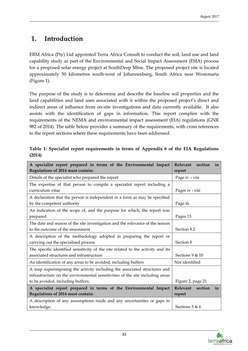
1. Introduction
ERM Africa (Pty) Ltd appointed Terra Africa Consult to conduct the soil, land use and land
capability study as part of the Environmental and Social Impact Assessment (ESIA) process
for a proposed solar energy project at SouthDeep Mine. The proposed project site is located
approximately 50 kilometres south-west of Johannesburg, South Africa near Westonaria
(Figure 1).
The purpose of the study is to determine and describe the baseline soil properties and the
land capabilities and land uses associated with it within the proposed project’s direct and
indirect areas of influence from on-site investigations and data currently available. It also
assists with the identification of gaps in information. This report complies with the
requirements of the NEMA and environmental impact assessment (EIA) regulations (GNR
982 of 2014). The table below provides a summary of the requirements, with cross references
to the report sections where these requirements have been addressed.
Table 1: Specialist report requirements in terms of Appendix 6 of the EIA Regulations
(2014)
A specialist report prepared in terms of the Environmental Impact
Regulations of 2014 must contain:
Relevant section in
report
Details of the specialist who prepared the report Page iv – viii
The expertise of that person to compile a specialist report including a
curriculum vitae Pages iv - viii
A declaration that the person is independent in a form as may be specified
by the competent authority Page iii
An indication of the scope of, and the purpose for which, the report was
prepared Pages 13
The date and season of the site investigation and the relevance of the season
to the outcome of the assessment Section 8.2
A description of the methodology adopted in preparing the report or
carrying out the specialised process Section 8
The specific identified sensitivity of the site related to the activity and its
associated structures and infrastructure Sections 9 & 10
An identification of any areas to be avoided, including buffers Not identified
A map superimposing the activity including the associated structures and
infrastructure on the environmental sensitivities of the site including areas
to be avoided, including buffers; Figure 2, page 21
A specialist report prepared in terms of the Environmental Impact
Regulations of 2014 must contain:
Relevant section in
report
A description of any assumptions made and any uncertainties or gaps in
knowledge; Sections 5 & 6

August 2017
14
A description of the findings and potential implications of such findings on
the impact of the proposed activity, including identified alternatives, on the
environment Section 10
Any mitigation measures for inclusion in the EMPr
Section 10
Any conditions for inclusion in the environmental authorisation Sections 10 and 11
Any monitoring requirements for inclusion in the EMPr or environmental
authorisation Section 11
A reasoned opinion as to whether the proposed activity or portions thereof
should be authorised and Section 12
If the opinion is that the proposed activity or portions thereof should be
authorised, any avoidance, management and mitigation measures that
should be included in the EMPr, and where applicable, the closure plan Section 13
A description of any consultation process that was undertaken during the
course of carrying out the study Not applicable
A summary and copies if any comments that were received during any
consultation process Not applicable
2. Objective of the study
The objective of the Soil, Land Use and Land Capability study is to fulfill the requirements of
the most recent South African Environmental Legislation with reference to the assessment
and management of these natural resource aspects (stipulated in Section 3 below). The key
components of assessment are to determine and describe the baseline soil properties and the
land capabilities and land uses associated with it within the proposed project’s direct and
indirect areas of influence from on-site investigations and data currently available. It also
assists with the identification of gaps in information. Once these conditions have been
established, the anticipated impacts of the project on these properties can be determined.
Mitigation and management measures can be recommended to minimise negative impacts
and maximise land rehabilitation success towards successful closure at the end of the project
life.

August 2017
15
Figure 1: Locality map of the proposed Enel South Deep solar plant area

August 2017
16
3. Environmental legislation applicable to study
The most recent South African Environmental Legislation that needs to be considered for any
new or expanding development with reference to management of soil and land use includes:
Soils and land capability are protected under the National Environmental
Management Act 107 of 1998, the Minerals Act 28 of 2002 and the Conservation of
Agricultural Resources Act 43 of 1983.
The National Environmental Management Act 107 of 1998 requires that pollution and
degradation of the environment be avoided, or, where it cannot be avoided be
minimised and remedied.
The Conservation of Agricultural Resources (Act 43 of 1983) states that the
degradation of the agricultural potential of soil is illegal.
The Conservation of Agriculture Resources Act 43 of 1983 requires the protection of
land against soil erosion and the prevention of water logging and salinization of soils
by means of suitable soil conservation works to be constructed and maintained. The
utilization of marshes, water sponges and watercourses are also addressed.
Government Notice R983 of 4 December 2014. The purpose of this Notice is to
identify activities that would require environmental authorisation prior to
commencement of that activity.
4. Terms of reference
The following Terms of Reference as stipulated by ERM Africa (Pty) Ltd applies to the soil,
land use and land capability study:
Undertake a desktop study and site walkover visit to establish broad baseline soil
conditions, land capability and areas of environmental sensitivity at all the proposed
alternative sites in order to rate their sensitivity to the proposed development;
Undertake a soil survey of the proposed subject property area focusing on all
landscape features including potentially wet areas;
Describe soils in terms of soil texture, depth, structure, moisture content, organic
matter content, slope and land capability of the area;
Describe and categorise soils using the South African Soil Classification Taxonomic
System;
Identify and assess potential soil, land use and land capability impacts resulting from
the proposed Enel SouthDeep Solar Project;
August 2017
17
Identify and describe potential cumulative soil, land use and land capability impacts
resulting from the proposed development in relation to proposed and existing
developments in the surrounding area;
Recommend mitigation and management measures to minimise impacts and/or
optimise benefits associated with the proposed project.
5. Assumptions
The following assumptions were made during the assessment and reporting phases:
The pre-assessment sensitivity screening of alternative sites have already eliminated
areas that were considered as alternative locations for the project that were most
sensitive to the proposed development;
The project layout and installation and operation procedures have been designed to
minimise environmental impacts as far as possible.
6. Uncertainties, limitations and gaps
The following uncertainties, limitations and gaps exists with regards to the study
methodology followed and conclusions derived from it:
Soil profiles were observed using a 1.5m hand-held soil auger. A description of the
soil characteristics deeper than 1.5m cannot be given.
The study does not include a land contamination assessment to determine pre-
construction soil pollution levels (should there be any present).
As a result of Health and Safety Requirements for the site assessment, only a limited
number of soil profiles could be observed.
7. Response to concerns raised by I&APs
Thus far, no concerns were raised by I & APs during the Public Participation Process
pertaining to the continuation of existing land uses in the surrounding area. As soon as
comment is received, it will be addressed in this report while still in the review process.

August 2017
18
8. Methodology
8.1 Desktop study and site walkover
The following data was obtained and studied for the desktop study:
Land type data for the study area was obtained from the Institute for Soil Climate and
Water (ISCW) of the Agricultural Research Council (ARC);
Broad geological, soil depth and soil description classes were obtained from the
Department of Environmental Affairs and studied. This data forms part of the
Environmental Potential Atlas (ENPAT) of South Africa;
The most recent aerial photography of the area available from Google Earth was
obtained. The aerial photography analysis was used to determine areas of existing
impact, land uses within the project area as well as the larger landscape, wetland
areas and preferential flow paths.
A site walkover followed the desktop study during which each of the alternative sites
considered for the proposed development were assessed for position in the landscape and
the associated soil properties. The observations made during the site walkover was used to
give each of the alternative sites a sensitivity rating as part of the overall process to choose
the most suitable site for the project.
8.2 Study area survey
A systematic soil survey was undertaken in May 2017. The season in which the site visit took
place has no influence on the results of the survey. The soil profiles were examined to a
maximum depth of 1.5m using a hand-held auger. Observations were made regarding soil
texture, structure, colour and soil depth at each survey point. A cold 10% hydrochloric acid
solution was used on site to test for the presence of carbonates in the soil. The soils are
described using the S.A. Soil Classification Taxonomic System (Soil Classification Working
Group, 1991) published as memoirs on the Agricultural Natural Resources of South Africa
No.15. For soil mapping, the soils were grouped into classes with relatively similar soil
characteristics.
8.3 Analysis of samples at soil laboratory

August 2017
19
Two soil samples (one topsoil and one subsoil sample) were collected at the study area. The
samples were sealed in soil sampling plastic bags and sent to Nvirotek Laboratories,
Hartbeespoortdam for analyses. Samples taken to determine baseline soil fertility were
analysed for electrical conductivity (EC), pH (KCl and H2O), phosphorus (Bray1),
exchangeable cations (calcium, magnesium, potassium, sodium), organic carbon (Walkley-
Black) and texture classes (relative fractions of sand, silt and clay).
8.4 Land capability classification
Agricultural potential is described through the term land capability. Land capability means
“the most intensive long term use of land for purposes of rainfed farming, determined by the
interaction of climate, soil and terrain and makes provision for eight land capability classes”.
Land capability classes I - IV is regarded as arable land whilst classes V – VII are more suited
for grazing purposes and class VIII for conservation. It is an expression of the effect of
physical factors for crop suitability and potential that require regular tillage, for grazing, for
forestry and for wildlife without damage to the resource.
9. Baseline conditions
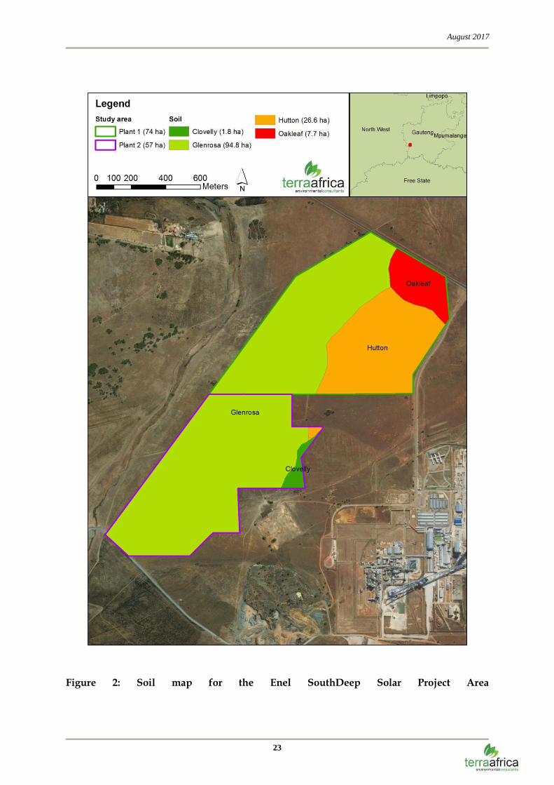
9.1 Soil forms present in the study area
Four different soil forms (Glenrosa, Hutton, Clovelly and Oakleaf) were identified within the
study area (Figure 2). Of these forms, the Glenrosa form are the most prevalent. Even though
the geotechnical report compiled by Mkn Consulting was evaluated to possibly incorporate
the data into this report, no relevance could be found in linking the data to the soil
productivity properties dicussed in this report. While the geotechnical report focuses on the
engineering properties of the soil, this report focuses on the soil properties associated with
land productivity and how it relates to land use. The parameters that were determined in this
study, are sufficient to address these. Below follows a description of each of these soil forms:
Hutton form (Hu) (26.6 ha or 3.2 % of the total study area)
The Hutton soil form consists of an orthic A horizon on a red apedal B horizon overlying
unspecified material. The red apedal soils B1-horizon has more or less uniform "red" soil
colours in both the moist and dry states and has weak structure or is structureless in the
moist state (Soil Classification Working Group, 1991). Soil depths of the Hutton profiles
surveyed on site ranged between 130cm and 150cm and deeper with restrictive layers of
unspecified material without signs of wetness. Hutton soils with no restrictions shallower
than 50cm are generally good for crop production (Fey, 2010). All Hutton profiles are
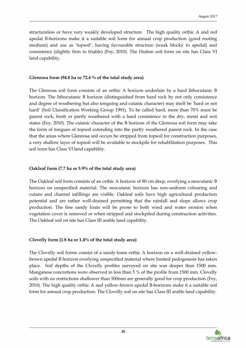
August 2017
20
structureless or have very weakly developed structure. The high quality orthic A and red
apedal B-horizons make it a suitable soil form for annual crop production (good rooting
medium) and use as ‘topsoil’, having favourable structure (weak blocky to apedal) and
consistence (slightly firm to friable) (Fey, 2010). The Hutton soil form on site has Class VI
land capability.
Glenrosa form (94.8 ha or 72.4 % of the total study area)
The Glenrosa soil form consists of an orthic A horizon underlain by a hard lithocutanic B
horizon. The lithocutanic B horizon (distinguished from hard rock by not only consistence
and degree of weathering but also tonguing and cutanic character) may itself be ’hard or not
hard’ (Soil Classification Working Group 1991). To be called hard, more than 70% must be
parent rock, fresh or partly weathered with a hard consistence in the dry, moist and wet
states (Fey, 2010). The cutanic character of the B horizon of the Glenrosa soil form may take
the form of tongues of topsoil extending into the partly weathered parent rock. In the case
that the areas where Glenrosa soil occurs be stripped from topsoil for construction purposes,
a very shallow layer of topsoil will be available to stockpile for rehabilitation purposes. This
soil form has Class VI land capability.
Oakleaf form (7.7 ha or 5.9% of the total study area)
The Oakleaf soil form consists of an orthic A horizon of 80 cm deep, overlying a neocutanic B
horizon on unspecified material. The neocutanic horizon has non-uniform colouring and
cutans and channel infillings are visible. Oakleaf soils have high agricultural production
potential and are rather well-drained permitting that the rainfall and slope allows crop
production. The fine sandy loam will be prone to both wind and water erosion when
vegetation cover is removed or when stripped and stockpiled during construction activities.
The Oakleaf soil on site has Class III arable land capability.
Clovelly form (1.8 ha or 1.4% of the total study area)
The Clovelly soil forms consist of a sandy-loam orthic A horizon on a well-drained yellow-
brown apedal B horizon overlying unspecified material where limited pedogenesis has taken
place. Soil depths of the Clovelly profiles surveyed on site was deeper than 1500 mm.
Manganese concretions were observed in less than 5 % of the profile from 1500 mm. Clovelly
soils with no restrictions shallower than 500mm are generally good for crop production (Fey,
2010). The high quality orthic A and yellow-brown apedal B-horizons make it a suitable soil
form for annual crop production. The Clovelly soil on site has Class III arable land capability.

August 2017
21
9.2 Soil chemical conditions of the study area
The pH of most of the analyzed soil samples in the study area ranges from 4.17 (very
strongly acid) to 5.11 (medium acid). For successful crop production, a pH of between 5.8
and 7.5 is optimum and crops produced in soils with lower pH may suffer aluminium (Al)
toxicities if toxic levels of Al are present. The danger of Al toxicity in maize only exists when
the pH (KCl) is lower than 4.5 (ARC, 2013). For the purpose of nutrient management for crop
production, the pH of soil can be improved by the addition of dolomitic lime or gypsum.
Phosphorus levels are very low (7.7 mg/kg and 3.9 mg/kg P) in all of the samples. The
texture is dominated by the sand fraction (70.4% and 71.5%).
No serious soil chemical issues such as soil salinity or sodicity occur on the study area.
Where the sodium (Na) concentration is more than 15% of the sum of all cations, plant
growth may be impaired. However, the sodium concentration at all sampling points ranges
from 0.65% to 1.34% of the cations.
9.3 Agricultural potential
9.3.1 Dryland crop production
The Hutton, Clovelly and Oakleaf soil forms are suitable for crop production. Signs of old
crop fields in these areas have been observed during the site visit. However, these sections
are fragmented now as a result of the mine infrastructure and has not been used for several
years for crop cultivation.
9.3.2 Irrigated crop production
The Enel Solar Project study area did not have any current irrigation infrastructure that was
being used for irrigation purposes. No large dams with irrigation potential have been
observed on the study area. The Hutton, Clovelly and Oakleaf soil forms identified on the
study area are suitable for irrigated crop production.
9.3.3 Cattle farming
The grazing capacity of a specified area for domestic herbivores is given either in large
animal units per hectare or in hectares per large animal unit. One large animal unit is
regarded as a steer of 450kg whose weight increases by 500g per day on veld with a mean
energy digestibility of 55%. The grazing capacity of the veld for the study area is 7 – 10
hectares per large animal unit or large stock unit (Morgenthal et al., 2005). These large stock

August 2017
22
units can further be converted to include small grazers and browsers such as Boer goats or
sheep.
August 2017
23
Figure 2: Soil map for the Enel SouthDeep Solar Project Area

August 2017
24
9.4 Land capability
Land capability can be defined as “the extent to which land can meet the needs of one or
more uses under defined conditions of management” (Schoeman, 2002). The land capability
of an area is the combination of the inherent soil properties and the climatic conditions as
well as other landscape properties such as slope and drainage patterns that may inhibit
agricultural land use or result in the development of specific land functionality such as
wetlands. Land capability affects the socio-economic aspects of human settlements and
determine the livelihood possibilities of an area. Baseline land capabilities are also used as a
benchmark for rehabilitation of land in the case of project decommissioning.
Following the classification system developed by the ARC (Schoeman, 2002) the soil on the
proposed project site has three different land capabilities. A small pocket of land (9.5 ha) has
Class III land capability (suitable for crop production but with climate limitations that restrict
yield), as a result of deeper soil profiles and the better innate water-holding capacity of these
profiles. The Hutton form has Class IV land capability (arable but with severe climate and
terrain limitations that restrict crop yield). The largest portion of the site (94.8 ha) has Class
VI grazing land capability (it has the ability to support livestock farming but the grazing
capacity is lower than that of land with Class V land capability as a result of the shallow,
rocky nature of soil). According to this classification system, the project site is therefore most
suitable to light and moderate grazing, forestry and wildlife as an agricultural or ecological
land use. Figure 3 below describes the land capability associated with the South Deep Solar
Project area.

August 2017
25
Figure 3: Land Capability Map of the Enel Solar Project Area
August 2017
26
10. Impact Assessment
10.1 Introduction
All infrastructure and activities required for the operational phase will be established during
the construction phase. The main envisaged activities include the following:
construction preparation which will require the limited clearance of vegetation and site
levelling;
construction of permanent access routes which entails the stripping of topsoil, dynamic
compaction and the importation of gravel;
construction of photovoltaic power plant (mounting frame structure installation,
installation of modules onto frames, digging of trenches to lay cables between modules);
construction of campsite and lay down area including:
o workshops and maintenance area;
o stores (for handling and storage of fuel, lubricants, solvents, paints and
construction material);
o contractor laydown areas;
o mobile site offices;
o temporary waste collection and storage area; and
o parking area for cars and equipment.
The site preparation activities are disruptive to natural soil horizon distribution and will
impact on the current soil hydrological properties and functionality of soil.
The following anticipated impacts have been assessed.
Soil erosion is anticipated due to slope and vegetation clearance. The impacts of soil
erosion are both direct and indirect. The direct impacts are the reduction in soil quality
which results from the loss of nutrient-rich upper layers of the soil and the reduced
water-holding capacity of severely eroded soils. The off-site indirect impacts of soil
erosion include the disruption of riparian ecosystems and sedimentation.
Soil chemical pollution because of storage of hazardous chemicals, concrete mixing,
broken PV panels, temporary sanitary facilities and potential oil and fuel spillages from
vehicles. This impact will be localised within the site boundary.

August 2017
27
In areas of permanent changes such as roads and the erection of infrastructure, rock spoil
material discard site and topsoil stockpiles, the current land capability and land use will
be lost permanently. This impact will also be localised within the site boundary.
During the operational phase the impacts related to loss of land use and land capability will
stay the same. Areas under temporary buildings, substations, transformers and other
covered surfaces are no longer susceptible to erosion, but hard surfaces will increase run-off
during rain storms onto bare soil surfaces.
Soil chemical pollution during the operational phase will be minimal. Possible sources are oil
that need to be replaced and oil and fuel spillage from maintenance vehicles. This impact will
be localised within the site boundary.
Although wind erosion may have an impact before revegetation on adjacent areas, the loss of
soil as a resource is restricted to the actual footprint of the solar photovoltaic (PV) power
facility. The only impact that may have effects beyond the footprint area is erosion which
may cause the sedimentation of the adjacent wetlands.
10.2 Susceptibility to erosion due to PV power facility construction
activities
Sensitive Receptors
The sensitive receptor is the soil within the PV power facility footprint that will be cleared of
vegetation.
Project Attribute / Activity
The construction of the PV power facility, access road, camp site and laydown area will
require the clearing and levelling of a limited area of land. The project will occupy up to a
maximum of 120 ha. The following construction activities will result in the generation of bare
soil surfaces that will be at risk of erosion:
vegetation removal during site clearing;
creating impenetrable surfaces during the construction phase that will increase run-off
onto bare soil surfaces; and
leaving soil surfaces uncovered during the rainy season during the construction phase.
Embedded Controls
The following embedded controls have been included in the Project design:

August 2017
28
The placement of soil stockpiles shall be indicated in the current designs to ensure that
they are located away from any waterway or preferential water flow path in the
landscape, to minimise soil erosion from these.
Geo-textiles shall be used to stabilize soil stockpiles and uncovered soil surfaces during
the construction phase and to serve as a sediment trap to contain as much soil as possible
that might erode away.
Pre-mitigation Impact Significance
The impact from the construction of the PV power facility, access road, camp site and
laydown area on the susceptibility of exposed soil surfaces to erosion during the construction
phase will be of Moderate Significance (Table 10.1).
Table 10.1 Pre-mitigation impact significance rating of susceptibility to erosion due to
PV power facility construction impacts
Type of Impact
Direct Negative Impact
Rating of Impacts
Characteristic Designation Summary of Reasoning
Extent Local This impact is expected to extend up to a maximum of 100 m from the Project
construction site and can thus be considered local in extent.
Duration Short term This is a short-term impact expected to occur during the construction phase.
Scale 120 ha The impact on soil as a resource is restricted to the actual footprint of the
Project construction site and thus has the potential to impact 120 ha.
Frequency Continuous The impact is expected to occur on a continuous basis (depending on rainfall
and wind) during the initial clearing and construction phases and will
continue once concrete surfaces and roads have been constructed (increased
runoff).
Likelihood Definite Given the sandy texture of the soil to be cleared and the occurrence of
thunderstorms, the likelihood of the impact occurring is definite.
Magnitude
Small
Sensitivity/Vulnerability/Importance of the Resource/Receptor
High
The soil in the footprint area as receptor is considered highly sensitive to the land degradation caused by soil
erosion.
Significance Rating Before Mitigation
Moderate
Mitigation Measures
The following mitigation measures shall be incorporated into the PV power facility, access
road, camp site and laydown area construction activities:
Soil stockpiles shall be dampened with dust suppressant or equivalent;

August 2017
29
Land clearance shall only be undertaken immediately prior to construction activities;
Unnecessary land clearance shall be avoided; and
All graded or disturbed areas shall be temporarily stabilised with erosion control mats
(e.g., geo-textiles).
Residual Impact Significance
The residual impact from the construction of the PV power facility, access road, camp site
and laydown area on the susceptibility to erosion during the construction phases will be
Negligible (Table 10.2).
Table 10.2 Residual impact significance rating of susceptibility to erosion due to PV
power facility construction activities
Type of Impact
Direct Negative Impact
Rating of Impacts
Characteristic Designation Summary of Reasoning
Extent Local This impact is expected to extend up to a maximum of 100 m from the Project
construction site and can thus be considered local in extent.
Duration Short term This is a short-term impact expected to occur during the construction phase.
Scale 120 ha The impact on soil as a resource is restricted to the actual footprint of the
Project construction site and thus has the potential to impact 120 ha.
Frequency Continuous Soil erosion will be limited to the occurrence of rainfall and wind events
continuously during the construction phase.
Likelihood Possible Although the mitigation measures applied will stabilise the cleared areas and
soil stockpiles, the occurrence of erosion is still possible since the soil of the
Project area is moderately erodible.
Magnitude
Negligible
Sensitivity/Vulnerability/Importance of the Resource/Receptor
High
The soil in the footprint area as receptor is considered highly sensitive to the land degradation caused by soil
erosion.
Residual Significance Rating
Negligible
10.3 Susceptibility to erosion due to PV power facility operation
activities

August 2017
30
Sensitive Receptors
The sensitive receptor is the soil within the PV power facility footprint that will be cleared of
vegetation.
Project Attribute / Activity
During the operational phase the impenetrable surfaces such as paved areas and covered
roads stay intact, however, the impact of increased run-off persists on surrounding areas.
Embedded Controls
The following embedded controls have been included in the Project design:
The installation of a purpose-designed drainage system for water running from the solar
panels.
Discharge of rainwater on roads will be channelled directly into the natural environment
and the application of diffuse flow measures will be included in the design.
Revegetate cleared areas as soon as possible after construction activities.
Pre-mitigation Impact Significance
The impact from the operation of the PV power facility on the susceptibility of exposed soil surfaces to erosion during the operation phase will be of Negligible Significance (
Table 10.3).
Table 10.3 Pre-mitigation impact significance rating of susceptibility to erosion due to
PV power facility operation activities
Type of Impact
Direct Negative Impact
Rating of Impacts
Characteristic Designation Summary of Reasoning
Extent Local This impact is expected to extend up to a maximum of 100 m from the Project
construction site and can thus be considered local in extent.
Duration Long term This is a long term impact expected to occur during the life of the operational
phase-
Scale 50m2 It is assumed that the area around and under the solar panels will be
revegetated during the operational phase. Only the runoff from the access
road may have an impact.
Frequency Irregular The impact is expected to occur only during the rainy season during intense
rainfall events.
Likelihood Possible Given the sandy texture of the soil within the Project area and the occurrence
of thunderstorms, the likelihood of the impact occurring is possible.
Magnitude
August 2017
31
Negligible
Sensitivity/Vulnerability/Importance of the Resource/Receptor
High
The soil in the footprint area as receptor is considered highly sensitive to the land degradation caused by soil
erosion.
Significance Rating Before Mitigation
Negligible
Mitigation Measures
No additional mitigation measures.
Residual Impact Significance
There are no residual impacts.
10.4 Chemical pollution due to PV power facility construction
activities
Sensitive Receptors
The sensitive receptors are the soils that will be cleared of vegetation and levelled within the
PV power facility footprint and campsite and laydown area as well as the access road to the
construction site.
Soil contamination is caused by the presence of xenobiotic chemicals in the natural soil
environment which is typically caused by industrial activity or improper disposal of waste.
The most common chemicals involved are petroleum hydrocarbons, solvents, pesticides, lead
(from batteries) and other heavy metals. Broken PV panels could release gallium arsenide
which is a known carcinogenic.
The concern over soil contamination stems primarily from health risks, from direct contact
with the contaminated soil, vapours from the contaminants and from secondary
contamination of water supplies by infiltration into groundwater aquifers.
Project Attribute / Activity
The construction of the PV power facility and related infrastructure will require the clearing
and levelling of a maximum of 120 ha of land. The following construction activities can
result in the chemical pollution of the soil:
Hydro-carbon spills by machinery and vehicles during earthworks and the mechanical
removal of vegetation during site clearing.
August 2017
32
Spills from vehicles transporting workers, equipment and construction material to and
from the construction site.
The accidental spills from temporary chemical toilets used by construction workers.
The generation of domestic waste by construction and operational workers.
Spills from fuel storage tanks during construction.
Polluted water from wash bays and workshops during the construction phase.
Accidental spills of other hazardous chemicals used and stored on site.
Pollution from concrete mixing and broken PV panels.
Embedded Controls
The following embedded controls have been included in the Project design:
High level maintenance on all vehicles and construction machinery to prevent
hydrocarbon spills;
The use of impermeable and bunded surfaces for storage tanks and to park vehicles on;
and
Site surface water and wash water to be contained and treated before reuse or discharge
from site.
Pre-mitigation Impact Significance
The impact from the construction of the PV power facility on the chemical pollution of soil
during the construction phase will be of Moderate Significance (Table 10.4).
Table 10.4 Pre-mitigation impact significance rating of the chemical pollution of soil
due to PV power facility construction and operation activities
Type of Impact
Direct Negative Impact
Rating of Impacts
Characteristic Designation Summary of Reasoning
Extent Local This impact is expected to be restricted to the Project site and access roads
during the construction and operational phases and can thus be considered
local in extent.
Duration Short term This is a short-term impact expected to occur during the construction phase.

August 2017
33
Scale 120 ha The impact is expected to be restricted to the Project construction site and haul
roads and thus has the potential to impact 120 ha.
Frequency Irregular The impact of chemical soil pollution is expected to occur on an irregular basis
during the initial clearing and construction phases.
Likelihood Likely Given the number of vehicles and machines used daily during the
construction phase, the likelihood of the impact occurring is likely.
Magnitude
Small
Sensitivity/Vulnerability/Importance of the Resource/Receptor
Medium
The soil in the footprint area as receptor is considered to be of medium sensitivity to the land degradation caused
by soil erosion.
Significance Rating Before Mitigation
Moderate
Mitigation Measures
The following mitigation measures shall be incorporated into the PV power facility
construction activities:
Spills of fuel and lubricants from vehicles and equipment shall be contained using a drip
tray with plastic sheeting filled with adsorbent material.
Waste disposal at the construction site shall be avoided by segregating, trucking out and
recycling of waste.
Potentially contaminating fluids and other wastes shall be contained in containers on
hard surface levels in bunded locations.
Accidental spillage of potentially contaminating liquids and solids shall be cleaned up
immediately by trained staff with the correct equipment with protocols outlined in the
EMP.
Residual Impact Significance
The residual impact from the construction of the PV power facility on the chemical pollution
of soil during the construction phase remains Moderate due to the high sensitivity rating of
the receptor (Table 10.5).
Table 10.5 Residual impact significance rating of the chemical pollution of soil due to PV power facility construction and operation activities
Type of Impact
Direct Negative Impact
Rating of Impacts
Characteristic Designation Summary of Reasoning

August 2017
34
Extent Local This impact is expected to occur only on the Project construction site, camp site
and access roads and can thus be considered local in extent.
Duration Short term This is a short-term impact expected to occur during the construction phase.
Scale 120 ha The impact is expected to only occur on the Project construction site and haul
roads and thus has the potential to impact maximum 120 ha.
Frequency Irregular The impact is expected to occur on an irregular basis during the initial clearing
and construction phase.
Likelihood Possible The impact of chemical soil pollution will possibly occur.
Magnitude
Small
Sensitivity/Vulnerability/Importance of the Resource/Receptor
High
The environment as receptor is considered highly sensitive to the land degradation caused by chemical soil
pollution.
Residual Significance Rating
Moderate
10.5 Chemical pollution due to PV power facility operation activities
Sensitive Receptors
The sensitive receptors are the soils that will be exposed within the PV power facility
footprint.
Project Attribute / Activity
The operation of the PV power facility can result in the chemical pollution of the soil:
Spills from vehicles transporting workers and equipment to and from the operation site.
The generation of domestic waste by operational workers.
Pollution caused by broken PV panels during the operational phase.
Accidental spills of other hazardous chemicals used and stored on site.
Embedded Controls
The following embedded controls have been included in the Project design:
High level maintenance on all vehicles and to prevent hydrocarbon spills;
The use of impermeable and bunded surfaces for storage tanks and to park vehicles on;
and
August 2017
35
The availability of a spill clearing kit on site.
Sensitivity of the soil as receptor
Soil contamination is caused by the presence of xenobiotic chemicals in the natural soil
environment which is typically caused by industrial activity or improper disposal of waste.
The most common chemicals involved are petroleum hydrocarbons, solvents, pesticides, lead
(from batteries) and other heavy metals. Broken PV panels could release gallium arsenide
which is a known carcinogenic.
The concern over soil contamination stems primarily from health risks, from direct contact
with the contaminated soil, vapours from the contaminants and from secondary
contamination of water supplies by infiltration into groundwater aquifers.
Pre-mitigation Impact Significance
The impact from the construction and operation of the PV power facility on the chemical
pollution of soil during the operation phase will be of Negligible Significance (Table 10.6).
Table 10.6 Pre-mitigation impact significance rating of the chemical pollution of soil
due to PV power facility operation activities
Type of Impact
Direct Negative Impact
Rating of Impacts
Characteristic Designation Summary of Reasoning
Extent Local This impact is expected to be restricted to the Project site and access roads during the operational phase and can thus be considered local in extent.
Duration Long term This is a long term impact expected to occur during the lifetime of the operational phase.
Scale Small The scale of the soils potentially exposed to chemical pollution is expected to be small and limited to the location of spills.
Frequency Irregular The impact of chemical soil pollution is expected to occur on an irregular basis during the lifetime of the operational phase.
Likelihood Unlikely Given the embedded controls in place for the minimisation and management of spills the likelihood of this event occurring is unlikely.
Magnitude
Negligible
Sensitivity/Vulnerability/Importance of the Resource/Receptor
High
The soil as receptor is considered highly sensitive to the land degradation caused by chemical pollution.
Significance Rating Before Mitigation
Negligible
Mitigation Measures
The following mitigation measures shall be incorporated into the PV power facility operation activities:
August 2017
36
Spills of fuel and lubricants from vehicles and equipment shall be contained using a drip
tray with plastic sheeting filled with adsorbent material.
Waste disposal at the PV power facility shall be avoided by segregating, trucking out and
recycling of waste.
Potentially contaminating fluids and other wastes shall be contained in containers on
hard surface levels in bunded locations.
Accidental spillage of potentially contaminating liquids and solids shall be cleaned up
immediately by trained staff with the correct equipment with protocols outlined in the
EMP.
Residual Impact Significance
There are no residual impacts.
10.6 Loss of land capability due to PV power facility operation
activities
Sensitive Receptor/s
The sensitive receptors are the soils that will be cleared of vegetation and levelled within the
PV power facility footprint as well as the access roads to the construction site. The largest
part (72.4 %) of the project area has grazing land capability and 27.6 % with arable land
capability.
Project Attribute / Activity
The construction of the PV power facility will require the clearing and levelling of maximum
120 ha of land. The land capability of the entire area where soil layers are changed and
construction of infrastructure is done, will be lost. The following construction activities can
result in the loss of land capability within the PV power facility footprint:
The removal of vegetation during site clearing;
Earthworks which destroy the natural layers of the soil profiles; and
The construction of access roads and photovoltaic power plant (frame structures and
installation of modules onto frames) and infrastructure which will cover soil surfaces.

August 2017
37
Embedded Controls
The embedded control for loss of land capability included in the PV power facility design is
to keep the footprint as small as possible.
Pre-mitigation Impact Significance
The impact from the construction of the PV power facility that would result in the loss of
land capability will be of Moderate Significance (Table 10.7).
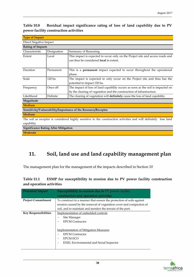
Table 10.7 Pre-mitigation impact significance rating of the loss of land capability of
soil due to PV power facility construction activities
Type of Impact
Direct Negative Impact
Rating of Impacts
Characteristic Designation Summary of Reasoning
Extent Local This impact is expected to be restricted to the Project site and access roads and
can thus be considered local in extent.
Duration Permanent This is a permanent impact expected to occur throughout the operational
phase.
Scale 120 ha The impact is expected to be restricted to the Project site and thus has the
potential to impact 120 ha.
Frequency Once off The impact occurs when construction activities change the land capability and
the change is permanent.
Likelihood Definite The clearing of vegetation will definitely cause the loss of land capability.
Magnitude
Medium
Sensitivity/Vulnerability/Importance of the Resource/Receptor
Medium
The soils of are suitable for grazing (72.4 %) and this land capability will be lost because of the construction
activities in the project footprint. However, due to the permanent loss of this land the sensitivity is considered
Medium.
Significance Rating Before Mitigation
Moderate
Mitigation Measures
The following mitigation measures will be incorporated into the port construction activities:
Keep the PV power facility footprint as small as possible.
Residual Impact Significance
The residual impact from the construction of the PV power facility resulting in loss of land
capability during the construction phase is considered to remain of Moderate Significance
(Table 10.8).
August 2017
38
Table 10.8 Residual impact significance rating of loss of land capability due to PV
power facility construction activities
Type of Impact
Direct Negative Impact
Rating of Impacts
Characteristic Designation Summary of Reasoning
Extent Local This impact is expected to occur only on the Project site and access roads and
can thus be considered local in extent.
Duration Permanent This is a permanent impact expected to occur throughout the operational
phase.
Scale 120 ha The impact is expected to only occur on the Project site and thus has the
potential to impact 120 ha.
Frequency Once off The impact of loss of land capability occurs as soon as the soil is impacted on
by the clearing of vegetation and the construction of infrastructure.
Likelihood Definite The clearing of vegetation will definitely cause the loss of land capability.
Magnitude
Medium
Sensitivity/Vulnerability/Importance of the Resource/Receptor
Medium
The soil as receptor is considered highly sensitive to the construction activities and will definitely lose land
capability
Significance Rating After Mitigation
Moderate
11. Soil, land use and land capability management plan
The management plan for the management of the impacts described in Section 10
Table 11.1 ESMP for susceptibility to erosion due to PV power facility construction
and operation activities
Potential Impact Susceptibility to erosion due to PV power facility
construction and operation activities
Project Commitment To construct in a manner that ensure the protection of soils against
erosion caused by the removal of vegetation cover and compaction of
soil, and to maintain and monitor the terrain of the port.
Key Responsibilities Implementation of embedded controls
Site Manager
EPCM Contractor
Implementation of Mitigation Measures
EPCM Contractor
EPCM ECO
ENEL Environmental and Social Inspector

August 2017
39
Potential Impact Susceptibility to erosion due to PV power facility
construction and operation activities
Implementation of Monitoring Programme
ENEL Environmental and Social Inspector
Independent Soil Specialist
Independent Accredited Laboratory
Performance Criteria Prevent, minimise and manage any visible erosion on the project site
during construction and operation of PV power facility.
Mitigation Measures Construction Phase
Soil stockpiles shall be dampened with dust suppressant or
equivalent to prevent erosion by wind.
Land clearance shall only be undertaken immediately prior to
construction activities.
Unnecessary land clearance shall be avoided.
All graded or disturbed areas which will not be covered by
permanent infrastructure such as paving, buildings or roads shall
be stabilised with erosion control mats (geo-textiles).
Operational Phase
No additional mitigation measures.
Monitoring &
Auditing
Monitoring
On-going visual assessment of compliance with erosion
prevention by EPCM Contractor and ECO.
Monitor visual signs of erosion such as the formation of gullies
after rainstorms and the presence of dust emissions during wind
storms.
Monitor compliance of construction workers to restrict
construction work to the clearly defined limits of the
construction site to keep footprint as small as possible.
Analyse permanent soil stockpiles for presence of plant nutrients
and ameliorate with fertilizer and/compost to enhance re-
vegetation bi-annually.
Monitor vegetation cover of stockpiles and the vegetation of the
project site monthly to detect problems like lack of moisture or
alien invader plants timeously.
Auditing
Erosion monitoring reports will be audited on an annual basis by
an independent soil specialist.
Reporting &
Corrective
Action
Records of all monitoring activities will be kept by the ECO and
a summary of the results reported to ENEL management bi-
annually.
Corrective actions must be implemented to address audit
findings.
Budget
Considerations
Monitoring
Monitoring will be undertaken by the ECO. This cost is built into
the EPCM contractor overall budget for capital expenditure
(CAPEX) for the construction phase and for the operations phase
is built into the operational expenditure (OPEX).
Auditing
Annual independent audit costs: ZAR 30 000.00
This calculation is based on the following:
Independent soil scientist conducting a bi-annual audit (wet and
dry season); 1-day site visit and 1-day reporting.
August 2017
40
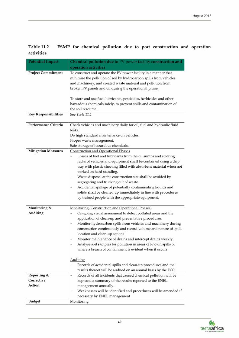
Table 11.2 ESMP for chemical pollution due to port construction and operation
activities
Potential Impact Chemical pollution due to PV power facility construction and
operation activities
Project Commitment To construct and operate the PV power facility in a manner that
minimise the pollution of soil by hydrocarbon spills from vehicles
and machinery, and created waste material and pollution from
broken PV panels and oil during the operational phase.
To store and use fuel, lubricants, pesticides, herbicides and other
hazardous chemicals safely, to prevent spills and contamination of
the soil resource.
Key Responsibilities See Table 11.1
Performance Criteria Check vehicles and machinery daily for oil, fuel and hydraulic fluid
leaks.
Do high standard maintenance on vehicles.
Proper waste management.
Safe storage of hazardous chemicals.
Mitigation Measures Construction and Operational Phases
Losses of fuel and lubricants from the oil sumps and steering
racks of vehicles and equipment shall be contained using a drip
tray with plastic sheeting filled with absorbent material when not
parked on hard standing.
Waste disposal at the construction site shall be avoided by
segregating and trucking out of waste.
Accidental spillage of potentially contaminating liquids and
solids shall be cleaned up immediately in line with procedures
by trained people with the appropriate equipment.
Monitoring &
Auditing
Monitoring (Construction and Operational Phases)
On-going visual assessment to detect polluted areas and the
application of clean-up and preventative procedures.
Monitor hydrocarbon spills from vehicles and machinery during
construction continuously and record volume and nature of spill,
location and clean-up actions.
Monitor maintenance of drains and intercept drains weekly.
Analyse soil samples for pollution in areas of known spills or
where a breach of containment is evident when it occurs.
Auditing
Records of accidental spills and clean-up procedures and the
results thereof will be audited on an annual basis by the ECO.
Reporting &
Corrective
Action
Records of all incidents that caused chemical pollution will be
kept and a summary of the results reported to the ENEL
management annually.
Weaknesses will be identified and procedures will be amended if
necessary by ENEL management
Budget Monitoring

August 2017
41
Potential Impact Chemical pollution due to PV power facility construction and
operation activities
Considerations See Table 11.1.
Auditing
See Table 11.1.
Table 11.3 ESMP for loss of land capability due to PV power facility construction and
operation activities
Potential Impact Loss of land capability due to PV power facility construction
and operation activities
Project Commitment To keep the PV power facility footprint as small as possible.
Key Responsibilities See Table 11.1 Performance Criteria Stay within the boundary of the PV power facility site as designed
and agreed upon.
Mitigation Measures Construction and Operational Phase
Land capability inside the fence of the PV power facility is lost.
No mitigation measures will alter the situation.
Keep PV power facility footprint as small as possible
Monitoring &
Auditing
Monitoring
On-going visual assessment of compliance by EPCM Contractor
to stay within the design footprint.
Monitor compliance of construction workers to restrict
construction work to the clearly defined limits of the construction
site by ECO.
Auditing
No auditing required. If an increase in the footprint is required,
an application for amendment of environmental authorization
will be required.
Reporting &
Corrective
Action
Reporting by ECO to ENEL management if any impacts outside
the PV power facility fence take place.
If any transgressions occur, corrective actions should be taken.
Budget
Considerations
Monitoring
None
Auditing
None
12. Environmental Impact Statement
The largest portion of the proposed Enel Solar Project site has Class VI grazing land
capability (94.8 ha) because of the shallow, rocky profiles. No areas of the study site are
currently used for crop production but cattle farming has been observed on site. The
proposed Enel Solar Project with the associated infrastructure will have medium to minor
August 2017
42
impacts upon soil and land capability properties as well as current land uses in the areas
where the footprint will cause surface disturbance. Cumulative impacts are also related to
increase in the disturbed land areas in addition to the areas already used for mining
infrastructure. These impacts can be reduced by keeping the footprint minimised where
possible and strictly following soil management measures pertaining to erosion control and
management and monitoring of any possible soil pollution sources such as vehicles
traversing over the site.
13. A reasoned opinion as to whether the activity
should or should not be authorised
The proposed Enel Solar Project development falls within a larger area of gold mines
intermixed with livestock and crop farming, informal and formal settlements. The land
capability and soil quality of land affected by the surface footprint of mining activities will be
slightly compromised but the proposed operation area will not impact on crop production
and will therefore not affect primary grain production.
If soil management measures are followed as outlined in this report and the land be
rehabilitated to the highest standard possible, livestock and game farming will be possible on
the rehabilitated land. It is therefore of my opinion that the activity should be authorised. It
follows that the recommendations and monitoring requirements as set out in this report
should form part of the conditions of the environmental authorisation for the proposed
project.
August 2017
43
10 Reference list
Brady, N.C., Weil, R.R., (2008). The Nature and Properties of Soils, New Jersey.
Chamber of Mines of South Africa. (1981). Handbook of Guidelines for Environmental
Protection, Volume 3/1981.
The Soil Classification Working Group (1991). Soil Classification – Taxonomic System for
South Africa. Dept. of Agric., Pretoria.
Fey, M. (2010). Soils of South Africa. Cambridge. Cape Town.
ARC – Grain Crops Institute (2013). Maize information guide. ARC. Pretoria.
Morgenthal, T.L., D.J. du Plessis, T.S. Newby and H.J.C. Smith (2005). Development and
Refinement of a Grazing Capacity Map for South Africa. ARC-ISCW, Pretoria.
Mucina, L and M.C. Rutherford (eds). (Reprint 2011). The vegetation of South Africa, Lesotho
and Swaziland. South African National Biodiversity Institute. Pretoria.