preliminary land capability assessment › files › planning › amendment_c86... ·...
TRANSCRIPT

1
Goolagar site 749 Cape Nelson Road Portland
PRELIMINARY LAND CAPABILITY ASSESSMENT
Land Capability Assessor
Dr Chris Day
Archaeo-Environments Pty Ltd
ABN 89 119 932 437
AUG 12 2016

2
NOTE: The following report has been prepared by Archaeo-Environments Pty Ltd at the request of
Golder Associates, to inform Glenelg Shire Council (Council) in its deliberations with respect to a
potential Planning Scheme Amendment at Cape Nelson. This report, and the findings herein are
subject to review and revision following consultation with EPA, which is yet to occur. The subsequent
outcomes of this assessment will then inform an Application for Works Approval to EPA, which is
currently being prepared.
ABOUT THE AUTHOR
Dr Chris Day DPhil, CEnvP, MIFA Director, Archaeo-Environments Ltd
Chris has over 30 years experience in geology, geomorphology, geoarchaeology, soils and heritage work
which included 12 years in Bendigo and Benalla with DSE and more recent experience with Golder
Associates. Land and soil management experience includes soil and groundwater survey with DSE on
catchment and salinity research teams across the Central and Western Victoria. More recent work has
included land capability assessment and land management consulting for private and commercial
developments throughout Victoria.

3
1) Introduction The following report has been prepared by Archaeo-Environments Pty Ltd at the request of Golder
Associates, to inform Glenelg Shire Council (Council) in its deliberations with respect to a potential
Planning Scheme Amendment at Cape Nelson. This report, and the findings herein are subject to
review and revision following consultation with EPA, which is yet to occur. The subsequent outcomes
of this assessment will then inform an Application for Works Approval to EPA, which is currently being
prepared.
Archaeo-Environments Ltd has been commissioned to prepare a Land Capability Assessment (LCA) by Golder Associates (Golder) as part of a pre-planning phase of a proposed stock Quarantine operation at 749 Cape Nelson Road (Project Portland) (Figure 1). Project Portland includes a proposal to apply for rezoning and development of a property (The Goolagar site), currently used for stock grazing. The development proposal includes use of the Goolagar site (167 ha) to quarantine up to 140,000 head of cattle bound for export to China over a year. Current quarantine requirements for cattle to be exported to China include the isolation and testing of animals at export holding facilities for a period of 7 days. The maximum consignment number at a time is proposed to be 14,000 head of cattle. This maximum consignment would likely take 4 days to load in the cattle, and another 2 days to load out the cattle. The total accommodation time on site for 14,000 head of cattle will be an average of 13 days. Smaller consignment sizes of 7,000 head may take closer to 2 days to load cattle in and 1 day to load cattle out. Depending on industry market factors, commercial aspects and quarantine protocols, the number of containment periods proposed for the Goolagar site may vary from year to year. The current proposal is for a maximum of up to 140,000 head of cattle per year. The LCA is conducted in general compliance with the Golder project proposal P1653686-P-Rev0.pdf as well as EPA Publication 891.32, ‘Guidelines for Environmental Management: Code of Practice – Onsite wastewater management’ with consideration to the 2014 Victorian LCA Framework. The LCA incorporates the following studies:
Surface water and water use
Wastewater treatment
Water use
Land Management
Potential contamination issues
Waste Management

4
Figure 1 Goolagar site at 749 Cape Nelson Road
2) Background 2.1 Geology, Hydrogeology and Soils 2.1.1 Regional geology
The geology of the Cape Nelson area has been summarized in the Environmental Effects Statement for the Portland Wind Energy Project (SKM, 2001). Cape Nelson comprises an undulating coastal plateau bounded by high sea cliffs cut into limestone and volcanic rocks. The plateau surfaces are capped by calcareous cliff-top dunes with various degrees of consolidation ranging from crystalline and strongly cemented limestone to masses of bare, mobile sand. Most of the dune areas currently have a vegetation cover, but the varied topography and several buried soils indicate multiple episodes of dune movement. The basement of the Cape Nelson peninsula is a volcanic complex overlain by limestone units, including windows of Nelson Bay Formation and sand. In and around the study area, the Quaternary deposits are typically 30 to 50 metres thick over weathered basalt. Holocene dune ridges cover the surface and hummocks with sand thickness of up to 20 metres. The more strongly cemented limestones occur in broad, undulating ridges. They have developed a number of surface and subsurface karst features, including small cavities, caves, pitted surfaces and stony and rocky pavements. There are no known cavities within the Goolagar site. The areas of unconsolidated dune sand, including active transgressive dune sheets and ridges, have a more complex surface, with many overlapping ridges, hummocks and enclosed hollows. The steepest slopes are on these materials where the Holocene (recently mobile) sands have a vegetation cover

5
(mainly pasture grasses), with some slopes up to 35%. Holocene dune soils may be subject to erosion where vegetation has been removed. With the exception of soils formed on basalt, all soils across the sites are on very young parent materials (late Pleistocene to Holocene age). Many of the soils are of limited depth and have little profile development. Some soils are developed on truncated older soil horizons. Soil covered Limestone occurs throughout Cape Nelson site and comprises soils derived from weathering of less consolidated sand beds. This unit is made up of two groups of soils:
(i) Terra rossa soils – friable, porous loams that become sticky when wet (ii) Rendzina soils – sandier loams containing fragments of limestone, with a high pH
(7-8) and high infiltration rates. The final unit occurring across the southern portion of Cape Nelson is siliceous sands. This unit comprises silica-rich sands.
2.1.2 Regional Hydrogeology The Hydrogeological Assessment (Golder, 2016) reports that the site is located in the Portland Catchment of the Otway Basin. Given the location of the site, the aquifers of significance at the Site are considered to be the Quaternary Aquifer, Newer Volcanics basalt. Table 1: Summary of Regional Aquifers (Golder, 2016)
Groundwater Layers
Geology Depth Below Ground
Encountered (m bgl)
Groundwater Salinity (TDS,
mg/L)
Inferred Geology Unit in Vicinity of the Site
Quaternary Aquifer
Sands, gravels, clay, silts
0 - 41 501 – 1,000 Bridgewater Formation (locally includes limestone units)
Upper Tertiary/ Quaternary
Aquifer
Basalt (fractured)
41- 111 1,001 – 3,500 Newer Volcanics
Upper Mid-Tertiary Aquifer
Limestone (fractured),
sand, gravel, clay, minor coal
111 – 468 501 – 1,000 Port Campbell Formation
Golder (2016) reported that the depth to water in the catchment is expected to be between 20 to 50 m bgl according to The Groundwater Resource Report (DELWP 2014), while the DEPI depth to groundwater map for the area indicates groundwater depth to be highly variable, and generally shallower (typically less than 20 m) in the centre of the peninsula, and deeper towards the edges with shallow groundwater at the coastline (i.e. below the cliffs). Under natural, unaltered groundwater flow conditions, groundwater flow is considered likely to flow to the coast, to the edges of the peninsular but broadly to the south. Shallower groundwater may be influenced by local topography.

6
2.1.3 Soil and landform investigation: Goolagar site A site inspection and field survey was conducted across the study area by Archaeo-Environments Ltd on April 29-30 and May 1, 2016 for the purpose of assessing general land capability, geology and soil type relevant to waste water and land management at the Goolagar site. The soil survey included:
(i) Reconnaissance survey and mapping (ii) Excavation of 7 test pits and one soil section (iii) Excavation of 4 auger holes
The soils assessment included field recording of soil profile development, colour, depth, texture, infiltration estimates and erosion risk. The primary aim of the assessment was to investigate soil properties relevant to planned stock use across the Goolagar site, with a focus on the operational (stockyard) area.
Figure 2 Soil test pit, section and auger sites

7
2.1.4 Test Pit Descriptions Test Pit 1 Test Pit 1 was located on gentle terrain in the northern part of the Goolagar site on an area of shallow basalt bedrock. Typical soil profiles included a relatively deep sand over heavy stiff brown clay at a depth of approximately 85 cm. A photo of the soil profile at TP1 is shown in Appendix B.
Depth (cm) Description
0-8 Dark brown silty loam
8-25 Dark grey sandy loam
25-85 Light grey sand (common rootlets)
85-119 Mid brown heavy clay (sharp boundary, common infilled cracks)
Test Pit 2
Test Pit 2 was located about 40 m north of the stock yards and in an area of the planned lunch-amenities building and truck turn-around. The profile indicated shallow fill to about 16 cm above light grey sand, with brown clay at 85 cm. The soil profile at TP2 is shown in Appendix B.
Depth (cm) Description
0-4 Dark brown loamy sand
4-14 Grey sandy FILL
14-16 Yellowish clay FILL
16-85 Grey light sand with common rootlets
85-115 Brown clay – diffuse boundary. Vertical cracks with sand infill.
Test Pit 3
Test Pit 3 was located about 30 m east and upslope of the stock yards. The profile indicated yellow-
brown sand over fragmented shallow limestone parent material at 20-110 cm. The soil profile for TP3 is shown in Appendix B.
Depth (cm) Description
0-12 Dark grey sandy loam (common roots)
12-20 Yellowish-brown fine sandy loam
20-110 Yellowish fine sand with common clay-lined weathered limestone parent material (75-110cm)

8
Test Pit 4
Test Pit 4 was located 10 m to the immediate west and downslope from the stockyards. The purpose of TP4 was to investigate soil conditions adjacent the stockyards. The profile indicated a relatively deep layer of fill material above grey fine sand. A dark grey/black sand horizon lies at a depth of 122 cm above yellow sandy clay at 135 cm. The soil profile at TP4 is shown in Appendix B.
Depth (cm) Description
0-50 Coarse clay and parent material FILL
50-57 Dark grey silty sand.
57 - 122 Grey fine sand
122-135 Dark grey/black horizon
135-155 Yellow clay/sandy clay
Test Pit 5
Test Pit 5 was located in the upper landscape in the mid-south of the Goolagar site. The profile indicated deep fine siliceous sand above yellow sandy clay at 115 cm. The soil profile at TP5 is shown in Appendix B.
Depth (cm) Description
0-3 Dark grey sandy organic loam (common roots)
3-12 Grey loamy sand
12 - 115 Light grey fine siliceous sand
115 -120 Dark grey heavy clay
Test Pit 6
Test Pit 6 was located on mid-slopes on the eastern part of the Goolagar site. The profile indicated deep
yellow-brown sand above reddish light-medium clay at 140 cm. The soil profile for TP6 is shown in Appendix B.
Depth (cm) Description
0-10 Brown organic sandy loam
10-52 Light yellow-brown sand
52-140 Yellow-brown sand
140-165 Reddish-light/medium clay
Test Pit 7
Test Pit 7 was located in low lying terrain on the western part of the site. The profile indicated dark grey
and grey loamy sand and light grey sand above light clayey sand at 120c m. The soil profile for TP7 is shown in Appendix B.
Depth (cm) Description
0-5 Dark brown sandy loam (common roots)
5-22 Mid-brown loamy sand
22-64 Light grey sand

9
64-120 Dark grey-brown sand/loamy sand
120-125 Dark grey clayey sand
Soil Profile 8: Quarry section, terra rossa soils Soil profile 8 was located on the eastern side of the Quarry in mid property, exposed at the edge of the quarry works. The soil profile included reddish-brown silty clay above limestone bedrock at 55 cm. These typical terra rossa soils become sticky when wet. A view to the east across the exposed quarry profile is shown in Plate 1. A soil profile photo is also shown in Appendix B.
Plate 1 Exposure of terra rossa soils in Quarry section.
Auger hole 1 Auger hole 1 was located on moderate slopes in the mid-south of the Goolagar site. The soil profile included deep grey-white fine sand above yellow-brown clay at 95 cm. The soil profile is shown in Appendix B.
Auger hole 2 Auger hole 2 was located on an exposed hillcrest in the south-west of the property. The soil profile included loamy sand over yellow-brown sand with a clay horizon at 75-85 cm. Yellow-brown clay was recorded at a depth of 85 cm. The soil profile is shown in Appendix B.
Auger hole 3 Auger hole 3 was located on a moderate east facing hillslope below a hillcrest on the western side of the Goolagar sites and within an erosion scar/ soil exposure. The soil profile included a dark silty loam topsoil above reddish fine silty clay and limestone bedrock at 55 cm (a typical terra rossa soil). The soil profile is shown in Appendix B.

10
Auger hole 4 Auger hole 4 was located on gentle terrain in the north-east corner of the site, and about 100 m south of an area of volcanic outcrop. The soil profile included a shallow veneer of sand above stiff brown clay at 35 cm. The soil profile is shown in Appendix B.
2.1.4 Summary Soils across the Goolagar site predominantly conform with the regional description in 2.1.3 above although mapping conducted on 29 April 2016 confirmed the distribution of sub-regional soil units formed on relatively shallow limestone geology and associated relatively shallow terra rossa soils through the elevated centre of the site. An area of gentle terrain to the north and north-east appears to reflect shallow basalt bedrock and stiff clays, south of a volcanic vent (Tonkin Plug) identified on the 1 inch-mile GSV Portland mapsheet (1961). Otherwise the site is covered by a veneer of dune sands of variable thickness with typical low nutrient status and low organic matter. A summary of land units and soil type across the Goolagar site is shown in Figure 3. Table 2 below describes infiltration capacity and erosion risk (based on soil type and general slope) for each land unit category. Table 2 Soil profile, infiltration and erosion risk
No. Land Unit/slope Soil Type Infiltration (tactile field assessment)
Erosion risk
1 Low lying (0-1%) Sand over clay Very High (>4m/day) Low
2 Gentle (0-2%) Sand (variable thickness) over clay and basalt
Very High (>4m/day) Mod
3 Elevated hillcrests (0-2%)
Terra Rossa silty clay over limestone Moderate-High (>1m/day)
Mod- High
4 Moderate slopes (5-15%)
Sand over clay – common limestone frags.
Very High (>4m/day) High
5 Swale-drainage (0-1%)
Small seasonally wet areas Moderate (<1m/day) Mod

11
Figure 3 Land Unit Map
2.1.5 Climate Average annual rainfall is 790 mm with a 90 percentile of about 960 mm. Four (sometimes five) months of the year (May to August) rainfall may exceed evaporation (Mt Gambier is the nearest evaporation station). The Goolagar site is open and exposed to wind, hence the use of the region for wind turbines.
2.1.6 Vegetation The predominant vegetation across the site is pasture. Surface cover at the time of assessment was considered moderate. Indigenous vegetation on site is limited largely to a small fenced wetland in the north-east corner, a belt of shrubs along the northern boundary and an area of planted native shrubs near the site boundary to the east. Beyond the site boundary to the east, retained coastal scrub leads down to the sea cliffs. In consideration of the intended land-use of the site as a livestock holding facility, the following points are noted in relation to the current state of vegetation across the site:
There are few mature trees on site to provide shade or shelter.
There are large patches of bracken fern in the south of the site. Bracken can colonise large areas of cleared land and disturbed ground. It can be difficult to eradicate and is potentially toxic to livestock.
Underlying soils have little cohesion and are susceptible to wind erosion if surface cover is removed.

12
Introduction of stock in large numbers may potentially increase the risk of weed invasion (from seeds in droppings).
2.1.7 Soil Test results
A program of soil sampling and analysis was undertaken within the test pits 1, 2, 4 and 7, described in Section 2.1.3. To provide a range of landscape settings, soil samples were taken from test pits located in areas immediately surrounding the stockyard area, from 150 m to the north, and from the low lying area west of the stockyards (refer to Figure 2). Three soil samples were taken in the topsoil and two samples were taken from >1000 mm to provide a broad characterisation of soil properties from a range of depths. The samples were submitted for laboratory analysis for a suite of standard agricultural pasture laboratory tests which included soil salinity, pH, soil nutrients, trace elements, exchangeable ions and exchange capacity. Soil results for the 6 samples are summarised in Table 3 below and are shown in full in Appendix C. RESULTS SUMMARY Soil profiles are commonly deep sands. The profiles are highly leachable and with no clay they are not expected to hold or retain nutrients. It is understood that low numbers of stock have been present across the Goolagar site and no active regular program of fertilizer application would have been carried out over the past year or so. The soil characterization suggests soils (with the exception of TP1) are typically low in nutrients with a high overall Calcium base saturation percentage. Most profiles contain or are in close proximity to limestone which would explain the high levels of Calcium. The Goolagar site is close to the sea and it would be expected that soils would be impacted by salt spray across the wind swept coastal location. However in 5 of the 6 samples, both electrical conductivity (EC) and Sodium (Na) are low. A possible explanation is that the very high soil permeability together with the moderately high rainfalls has resulted in leaching out the NaCl (and as such the Na). The pH values are variable and for the most part, near neutral. Samples that returned pH levels in the order of 8 (samples 2 & 3) could be the result of recent cattle presence where effluent (urine) deposited to land may be a contributing factor. All the samples (except 1) highlight a very low cation exchange capacity (CEC). Generally this is indicative of a highly leached soil or one that has been severely depleted of base metals over a period of time. It is also typical of soils with very low organic matter, which was observed to be the case in most of the sampled locations. Sample 1 may have a high CEC given the Ca present. The high Molybdenum values returned from soils sampled at depth in TP 4 and TP 7 may indicate high background concentrations or anomalies. It is noted these samples are from depth (1.35m and 0.95m respectively) and would not be expected to impact on stock. The soil characterisation indicates that pasture management across Goolagar would benefit from fertiliser and build-up of organic matter to improve the very low levels and to overcome further nutrient loss through leaching.

13
Table 3 Soil Chemistry Results
SAMPLE ID Sample depth (mm)
Land Unit
LOCATION DESCRIPTION (land unit)
Comments
TP1 55 2 200m N of stockyards Slightly higher N, P and EC. High calcium
TP2 50-100 2 near stock yards Low nutrients (N, P, K), low EC, High calcium, sl higher pH.
TP4 600-680 2 near stock yards Low nutrients (N, P, K), low EC, High calcium, sl higher pH.
TP4 (2) 1350-1360 2 near stock yards Low nutrients (N, P, K), low EC, Low calcium, High molybdenum
TP7 50 1 low lying area Slightly higher N, otherwise low nutrients. Low EC and calcium.
TP7(2) 950-1000 1 low lying are V low nutrients, slight Sulphur, low calcium, high molybdenum.
3) SURFACE WATER AND WATER USE Surface water flow is low within a landscape of non-incised drainage lines and sandy soils of high infiltration capacity (Fig 4). Small areas of terminal or impeded drainage exist throughout the study area which would be wet for short periods in winter. There is a waterbody/feature in the north-west of the study area which may be continuous/underground with a similar feature to the north which may represent a source of off-site transfer. The following information was referenced in the Environmental Effects Statement for the Portland Wind Energy Project (SKM 2001). The topography of the Cape Nelson comprises an elevated plateau in the southern section of the site (80 to 100 metres high) which slopes sharply to the coast on either side, and an undulating northern section, which drains generally to the north. There are no major drainage lines or surface water bodies however some low-lying depressions may become seasonally inundated and ephemeral drainage lines may appear during wetter months of the year. The surface geology of calcareous dune sands and dune limestone (aeolianites) of the Pleistocene age Bridgewater Formation outcrop over the majority of the site. The commonly-occurring sandy soils and limestone outcrops of the site have a high infiltration rate for rainfall and as a result there are no significant water-courses and few drainage features. There are no areas of exposed limestone pavements and a small area of basalt outcrop, part of the Tonkin plug near the north-east part of the study area. Less porous soils also occur in dune swales or hollows but water tends to collect in these depressions, rather than run off with potential for erosion. There appear to be no karst features within the study area.

14
Plate 2 Low lying ground in north-west of Goolagar site.
Figure 4 Digital Elevation Model showing elevation and drainage pattern.

15
4) WASTE WATER TREATMENT
4.1 On-site waste water : Lunchroom-amenities block There are plans to construct a small site lunch room/amenities block to the immediate north of the stockyards. It is estimated that the amenities block will include 2 toilets and 2 wash basins. Average daily water use is assumed to be in the order of 500 litres/day for facility and quarantine staff. In accord with EPA Publication 891.32 (EPA 2013) and infiltration estimates for local sandy soils (>4L/m2/day), a waste water field of 80 m2 is recommended. It is expected that 80 m of trench lines would be sufficient to dispose of waste water within highly permeable local soils. A conventional septic waste water system would be suitable and risk of off-site movement of waste water at this site would be very. The small waste water field could be located immediately adjacent the proposed site lunch room/amenities block (Figure 5).
4.1.1 Local soils and percolation rates Test trench 2 was located within the vicinity of the planned lunch room/amenities block. The soil profile included a siliceous sand with a diffuse boundary above brown silty clay at 85 cm (Plate 3).
Plate 3 Soil profile near location of planned lunch room/amenities block An estimate of soil infiltration based on tactile testing (EPA Septic Code 2013) was very high and in excess of 5m/day (Table 2). For the purposes of design of a suitable waste water field this conforms with a Design Loading Rate (DLR) of 5L/m2/day according to the EPA Septic Code 2013, Table 9.
4.1.2 Watertable Depth Risk of off-site movement of waste water to the local watertable is very low. Depth to watertable in the vicinity of the planned waste water envelope is >10m.

16
4.1.3 Rainfall Distribution Average monthly rainfall for Portland is shown below. While the nearest evaporation data is from Mount Gambier some 150km away, it is expected that evaporation would be less than rainfall between the months of May and October. The high permeability of local sandy soils would provide an effective buffer to seasonal soil saturation. Small areas of impeded/terminal drainage on the Goolagar site will become saturated during winter.
Jan Feb Mar Apr May Jun Jul Aug Sep Oct Nov Dec Ann
Mean Rain (mm)
36.6 26.6 47.0 58.7 79.2 112.6 110.3 108.1 85.1 61.6 52.5 50.7 831.7
Median Rain (mm)
27.0 17.4 35.4 56.2 64.8 104.8 106.9 98.1 82.6 54.6 42.4 41.8 800.0
Figure 5 Location of lunch-amenities building and associated septic system waste-water envelope north of stockyard area (area approximately 80 m2).

17
4.2 Proposed Quarantine operation - stockyard waste water management In order to manage the waste water on site at Goolagar Stockyard (including animal urine, wash down fluids and contact rainwater), an on-site treatment strategy in the form on an interception tank and reed bed is to be implemented. It is proposed that the primary waste water volumes at the Goolagar site would be generated from wash water and drainage from the expanded stockyards (1469m2). It is understood that cattle trucks will not be washed down at the Goolagar site. Waste water effluent from the above sources would be directed via concrete channels and a sump towards an appropriately designed Bioswale to the south-west of the stockyards. This proposed waste water management method is recognised as industry best practice as outlined further in the Golder 2016 Technical Memorandum presented as Appendix B of the Works Approval Application (WAA). A summary is provided below.
4.2.1 Proposed Bioswale Concept Design Description
The proposed stockyard waste water treatment train is described as follows:
Runoff from the concrete portion of the stockyard will flow to a sump on the south west edge of the yard.
From the sump this discharge will flow into an interception tank with two compartments such that settlement will occur in the first compartment where large solids will settle to the bottom and clarified effluent will overflow into the second compartment. The settled solids will be periodically removed from the first compartment.
The clarified effluent will then flow into a reed bed where a complex series of natural treatment processes will occur at the root zone level of the reed bed.
After the effluent has resided for a minimum of 7 days in the reed bed it may be used to irrigate the surrounding paddocks.Following a residence time of approximately 2 days within the designed interceptor tank, clarified waste water would flow to a constructed bioswale area termed “a reed bed”. A reed bed is essentially a lined basin filled with gravel and planted with reeds and rushes. The concept design proposed as part of the WAA would require the reed bed to be approximately 30m wide by 70m long and 0.75 m deep, and wastewater would be detained in the reed bed for a minimum of 7 days.
Treatment wetlands have been used successfully for animal wastewater treatment including dairy manure and cattle feedlot run-off, and piggeries. Additionally, reed bed use has been promoted for the treatment of sewage and wastewater in particular residential settings. Reed beds facilitate a variety of biological processes that are either anaerobic (no oxygen) or aerobic (with oxygen introduced by the roots of reeds) enabling microorganisms to break down the contaminants into nutrients that can be absorbed by plant matter.
5) LAND MANAGEMENT
5.1 Soil erosion and land management Section 2.1 describes the land units and soil types across the Goolagar site (Figure 3). Table 2 summarises land unit attributes, infiltration capacity and soil degradation risk. The open elevated

18
landscape and typical sandy soils at the Goolagar site – particularly the elevated and moderately sloping terrain - will need to be rigorously managed to maintain soil condition and facilitate the regeneration of pasture following the proposed cycles of stock consignment across Goolagar. The Goolagar proposal seeks approval for stocking rates between 60 and 121 head/ha during 10-13 day containment periods. The identified risks to the land from this activity include the periodic compaction of soils and the loss of soil cover from cattle grazing. Over time, this could impact upon soil structure and hasten erosion and landslip in the absence of practices which manage grazing intensity across more sensitive areas, and which allow for pasture regeneration and paddock spell between consignments. The introduction of cattle in the order of 7,000 – 14,000 head across the Goolagar site will also require installation of new tracks and upgrading of existing tracks as well as construction of feed and ancillary sheds. Construction activities involving soil disturbance on site should be managed during the construction period to minimise soil erosion and sedimentation impacts.
5.2 Management of potential stock impacts Based on an inspection of surrounding sites and similar operations as proposed at Goolagar, the land across Cape Nelson is susceptible to land degradation in the absence of adequate land management practices. Stock and land management programs that should be implemented at Goolagar to avoid land degradation include:
management/adjustment of stock numbers based on best industry practice and on-going assessment of land condition.
stock rotation and recovery paddocks – spelling of paddocks.
pasture (existing and new) management and weed control.
establishment of tree shelter belts and buffer zones.
management of high traffic areas, gates, access roads and trackways.
animal waste (manure) management.

19
Plate 5 View to the north of the Goolagar site showing moderate slopes and some subsoil exposure/scarring (Land Unit 4). Recommended soil management measures will be elaborated within an EMP but would include management measures for each land unit summarised in Table 4 below:
20
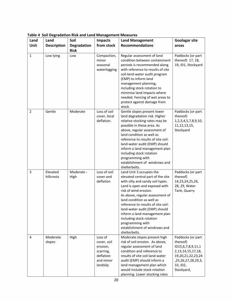
Table 4 Soil Degradation Risk and Land Management Measures
Land Unit
Land Description
Soil Degradation Risk
Impacts from stock
Land Management Recommendations
Goolagar site areas
1 Low lying Low Compaction, minor seasonal waterlogging
Regular assessment of land condition between containment periods is recommended along with reference to results of site soil-land-water audit program (EMP) to inform land management planning, including stock rotation to minimise land impacts where needed. Fencing of wet areas to protect against damage from stock.
Paddocks (or part thereof) 17, 18, 19, ID1, Stockyard
2 Gentle Moderate Loss of soil cover, local deflation.
Gentle slopes present lower land degradation risk. Higher relative stocking rates may be possible in these area. As above, regular assessment of land condition as well as reference to results of site soil-land-water audit (EMP) should inform a land management plan including stock rotation programming with establishment of windrows and shelterbelts.
Paddocks (or part thereof) 1,2,3,4,5,7,8,9,10,11,12,13,15, Stockyard
3 Elevated hillcrests
Moderate - High
Loss of soil cover and deflation
Land Unit 3 occupies the elevated central part of the site with silty and sandy soil types. Land is open and exposed with risk of wind erosion. As above, regular assessment of land condition as well as reference to results of site soil-land-water audit (EMP) should inform a land management plan including stock rotation programming with establishment of windrows and shelterbelts.
Paddocks (or part thereof) 14,23,24,25,26, 28, 29, Water Tank, Quarry
4 Moderate slopes
High Loss of cover, soil erosion, scarring, deflation and minor landslip.
Moderate slopes present high risk of soil erosion. As above, regular assessment of land condition and reference to results of site soil-land-water audit (EMP) should inform a land management plan which would include stock rotation planning. Lower stocking rates
Paddocks (or part thereof) ID15,6,7,8,9,11,12,13,14,15,17,18,19,20,21,22,23,24,25,26,27,28,29,3,33, ID2, Stockyard,

21
may be necessary within impacted paddocks together with pasture and weed management.
Quarry, Water Tank
5 Swale-impeded drainage (seasonal)
Moderate Compaction Small areas of seasonally poor drainage. Fencing of these area may be necessary. As above, regular assessment of land condition as well as reference to results of site soil-land-water audit (EMP) should inform land management across these areas and the wider site.
Paddocks (or part thereof) ID1, ID2, 9, 10, 13, 15, 22, 27, Stockyard, ID2
5.3 Vehicle-transport traffic The maximum additional truck traffic from livestock transport vehicles has been calculated as approximately 203 truck round trips per 4 day cycle of load in for the maximum consignment load of 14,000 head (GTA 2016). The cattle trucks would require access to the stockyards and turn-around areas. This number of trucks coming and going within the Goolagar site would require widening and management of access roads to maintain the road surface and allied drainage. While local sandy soils are not at high risk of bogging, surfaces will need to be assessed regularly to maintain stability. Access tracks may require additional grading and gravelling. It is suggested that the existing quarry area might be considered as a holding area/car park for long term vehicles. A site traffic management plan is recommended.
Plate 6 Single access track to stockyard operation area and truck-turnaround area.

22
5.4 Vegetation-Shelterbelt Plans Section 2.1.4 describes the Goolagar site as an open landscape with few areas of retained or mature vegetation (native or introduced). With the exception of a low shrub border along the northern boundary of the site, and two tree belts in the eastern part of the property, there are no established shelterbelts or windbreaks across the site. A program of tree planting has been implemented to the immediate west of the stockyards. It is understood that a program of tree planting will also be implemented along the planned corridors and trackways shown in the proposed Goolagar site design (Figure 6). The EMP would provide additional information about recommended vegetation species, planting preparation, weed control and planting density.
Figure 6 Proposed site design

23
6) WATER USE Adequate water will be supplied to each paddock to provide drinking water for livestock. Water for the operation will be provided from water bores located on the proposed land or from bores currently used to support existing operations at the adjacent Kobo facility. Bore water would be pumped to water tanks for storage and distribution as required.
The Hydrogeological Assessment (Golder 2016) reported that based on the recorded water use at Kobo and the predicted water needs of both the Goolagar and Kobo sites, the current Groundwater Licence No. 9019406 is sufficient to support the water usage of both the properties. This is without consideration of additional groundwater extraction from extraction well 96756 located on the Goolagar site. Golder (2016) estimated that the collective water use for the Kobo and Goolagar site would be approximately 30 ML/annum.
The Hydrogeological Assessment recommends that Goolagar verify the groundwater licence status of their on-site well (96756) to ensure this is appropriately licenced and/ or extraction from this well can be amalgamated into Groundwater Licence No. 9019406. Further to this, based on the licensed extraction volumes, the relatively low water use needs, and considering that borewater is utilised from a deep aquifer, no further risk assessment was undertaken by Golder in relation to water supply for the proposal on Goolagar.
7) POTENTIAL CONTAMINATION 7.1 Surface Water 7.1.1 Fuel, Chemicals and machinery There will be some storage of chemicals on the Goolagar site particularly under the roofed area of the crush within the stockyard where drenching chemicals are applied to inbound animals. Fuel will be stored on site to service the machinery and vehicles used by Goolagar. Goolagar proposes to install one 1000L above ground fuel tank which would be fully bunded to avoid leaks or spills of fuel to ground during truck fill up or refueling on site. There will be no wash down of trucks at the Goolagar site. It is expected that risks from unexpected discharge and leaks of fuel and oil from vehicles during cattle unloading and loading cycles will be low.
7.1.2 Nutrients from livestock Runoff from paddocks would carry dissolved nutrients and salts and may also entrain organic matter. The LCA DEM has determined that there is very little surface runoff expected from the Goolagar site to surrounding properties or crown land given the relatively high permeability of underlying soils. Further, the proposed revegetation plan for the site as proposed within the site EMP will minimise surface water runoff.
7.2 Groundwater 7.2.1 Livestock wastes and nutrients The Golder (2016) Hydrogeological Assessment has considered groundwater contamination risks from the project which are summarised below.

24
Groundwater at the site, based on available mapping and database information, and supported by groundwater sampling obtained from Goolagar and the adjacent Kobo property indicate that the groundwater is categorised as Segment A2 under the State Environmental Protection Policy (Groundwaters of Victoria), with the associated protected Beneficial Uses being:
Maintenance of Ecosystems
Potable Water Supply (acceptable)
Agriculture, Parks and Gardens
Stock Watering
Industrial Water Use
Primary Contact Recreation (e.g. bathing and swimming)
Buildings and Structures.
Site specific groundwater level data was not obtained as the groundwater extraction bore on the Goolagar site was screened in the underlying Newer Volcanics basalt aquifer. However, based on the DEPI maps, groundwater is typically expected to be > 10 metres below ground level (m bgl) over most of the site and up to 50 m bgl along the eastern boundary. Buildings and structures are therefore unlikely to intercept groundwater. Groundwater fed streams or creeks have not been identified in the vicinity of the site, nor have any other groundwater maintained ecosystems or areas available for primary contact recreation.
The defined uses for the groundwater resource have been identified as groundwater extracted for potable water, agriculture, parks and gardens, stock watering, and industrial water uses. While the risks of the project to groundwater are considered low (see Table 5 below) a number of recommendations have been made to monitor for, and help to prevent future impacts from the operation to groundwater.
Table 5 Groundwater risk assessment Potential Source
Ameliorating Factors Pathway to Groundwater Complete
Risk Recommendations
Cattle effluent (on land)
The depth to groundwater across the site (typically > 10 m). Limited time of cattle in paddocks. Groundwater flow expected to be towards coast, i.e. not towards land with extraction wells.
Potentially Low Rehabilitation of the monument (well cover) for the existing groundwater monitoring well adjacent to the eastern (down gradient) site boundary to establish the depth of the well. If the monitoring well is considered to be screened in the Quaternary Aquifer it should be included in the proposed bi-annual monitoring program, otherwise a downgradient monitoring well should be installed into the Quaternary Aquifer at the Site and a baseline quality established prior to commercial operations beginning.
Cattle effluent (via bio swale)
The bio swale is proposed include a 300 mm compacted clay base to increase retention time for water treatment and
Potentially Low Installation of a groundwater well screened across the water table down gradient of the bio swale to monitor for impact to groundwater quality. The well should be installed before operation of the bio swale to allow baseline sampling

25
limit infiltration to the underlying groundwater. It is understood that it is proposed that the treated water will be used to irrigate the paddocks.
of the groundwater quality to be undertaken. An additional groundwater well should be installed if the irrigation is to be undertaken across a limited area.
Manure pile A manure management program has been proposed in the LCA.
Potentially Low Implementation of the proposed manure management plan.
Chemical storage
Chemicals will be stored in appropriate contained and stored on concrete hard standing.
Incomplete Low Quarterly inspection of the stored chemical to check for leaks or stains on the concentrate hardstanding, damage to the containers and that appropriate containers are being used.
Fuel AST The AST will be appropriately designed and bunded.
Incomplete Low An inspection of the bund and AST should be undertaken at least annually.
Septic waste water system (amenities block)
A design for the septic waste water system in line with the EPA Septic Code 2013 has been proposed in the LCA.
Incomplete N/A N/A
8) WASTE MANAGEMENT The predominant waste generated by the facility is that of bio-solids and liquid effluent produced by stock while at the site. A suitable waste management regime must consider the frequency and size of consignments of cattle to Goolagar over each year, whilst being designed to adequately manage wastes associated with the maximum annual consignment level of 140,000 as proposed. As discussed below in Section 8.2, it is useful to consider scenarios based on the expectation of average consignment numbers, as well as maximum consignment numbers. A waste management regime should be adequate to manage the maximum waste scenario, but also be flexible and operationally practical to apply also to periods of much lower site activity. As a minimum, Goolagar would require the periodic off site removal of stockpiled manure from the concrete stockyard areas. This would be undertaken by a licensed sub-contractor at least three times annually (more frequently if required). Interim storage of stockpiled manure would occur within the existing quarry area where adequate separation distances exist between residents, and where sheltered conditions are afforded. Depending on consignment size and frequency of occupation at Goolagar, there will be varying needs to manage manure accumulation across the paddock areas as discussed in greater detail in Section 8.2. For example, if lower consignment numbers and timing between loads prove adequate for manure to breakdown in situ, Goolagar would not propose disturbance to the regenerating pasture through the scraping of manure from paddock surfaces. This would however be considered and carried out across paddock areas where manure build up is particularly heavy, with slippery conditions created. In these

26
instances, selective scraping of accumulated deposits would be carried out using a grader operated by Goolagar staff. This collected waste would be spread out across paddock areas and utilized as fertilizer, or it would be transferred to the quarry stockpile to be removed off site when stockpile size reaches a commercially viable size to warrant a truck load consignment. The monitoring, potential impacts and land management measures would form the basis for a Manure Management Plan, discussed in Section 8.2 below. Estimations of manure and urine effluent quantities discussed in Sections 8.1 and 8.2 below are intended for indicative purposes only. In addition to the variability of consignment size expected at Goolagar, it is noted that there is substantial variation in manure quantities from cattle of varying size and type. For this reason, our calculations below assume an average daily manure production per head of cattle of 10kg and urine volume of 54.7 L/day. The manure estimate is based on a literature review of cattle and feedlot industry publications (QLD Department of Agriculture and Fisheries 2011; Betteridge et
al. 1986) and the application of a number of assumptions formed by Golder through consultation with the proponent around fasting practices applied for cattle in transit, as well as feed type and quantity. The urine volume assumption is based on a literature review and considers a high end estimate to ensure a worst case volume is considered for the purposes of waste water treatment concept design. It is important to note industry practice and requirements to fast cattle for 24 hours prior to transporting in accordance with relevant animal welfare guidance. Similarly, in preparation for transport beyond the quarantine facility, the animals are again fasted for a period of time prior to shipment, therefore the actual solid and liquid wastes from the cattle are substantially overestimated quantities unlikely to be experienced at the Goolagar stockyard.
8.1 Stockyard manure management The stockyard is the primary area within the Goolagar site where regular and active management of accumulated manure waste is expected. To estimate the quantity of solid manure likely to be deposited across the hardstand stockyard area, this LCA has considered the estimated length of time for each cow to be loaded off the trucks and through the stockyard on the way in, and through the stockyards, up the ramps and onto trucks on the way out. The average time each animal spends within the stockyard in each instance is reported by Goolagar to be approximately 30 minutes. Considering that each cow can produce 10 kg of manure per day, that would be an average of 0.2 kg of manure per animal coming in, equivalent to 2800 kg wet manure deposit over the loading period in for the maximum number of head (14,000). Note this is likely to be an overestimate given that the animals are fasted prior to transport. Based on the conservative assumptions set out above, a solid volume of about 3m3 of manure could be expected to be scraped from the stockyard floor and managed at the end of 14,000 cattle walking through. Goolagar proposes to stockpile this collected manure within the existing quarry area on site. This location is considered ideal given that it is a sheltered location outside the line of view from closest residents, and affords a separation distance of over 500 m. Manure would be added to the stockpile upon scrape downs of the stockyard on the way in and out. When a sufficient quantity of this material is accumulated (i.e a truckload), Goolagar would arrange for pick up and load out of this stockpile in accordance with an established commercial arrangement between Goolagar and a local contractor who proposes to on sell this material as fertiliser. The estimation of the quantity of manure requiring off-site

27
removal and the frequency of this removal is complicated by the potential variability in consignment size and timing between them. Typically, manure is 85% - 90% water, therefore the total amount of manure that may require removal depends on cattle throughput, digestibility of the diet, moisture content, yard cleaning frequency and techniques, and climatic conditions (Queensland Government 2011). Timing between consignments would also significantly impact upon stockpiled volumes maintained within the Quarry area. Given the variability of factors outlined above, for the estimated 560 tonnes of manure which may be deposited within the stockyard during the load in and load out periods for the maximum proposed annual throughput of 140,000 head of cattle, an actual dry volume of accumulated manure closer to 10-15% of this may in fact be closer to the volume requiring off site removal. All manure volume loads removed from the Goolagar site across a year would be recorded and reported within the annual environmental audit recommend as part of the project’s EMP. The manure management strategy would be subject to ongoing review and evaluation to enable Goolagar to optimise waste management once volumes likely to be typical of operation are better determined.
8.2 Manure management across the site
8.2.1 Introduction Stocking densities of 60-121 head/ha and manure production of 10kg/head are estimated for the proposed operations on Goolagar. These estimates form the basis of an assessment of the volumes and potential impact of manure deposited across the Goolagar site beyond the stockyard area. Whilst beyond the scope of this LCA, the WAA presents a comparison of stocking densities between various operations from dairy farms, through to typical cattle sale yard or feedlot operations. The WAA also offers a comparison between the stocking densities of pre-export quarantine yard type facilities and paddock type pre-export quarantine facilities, such as those currently operating in the vicinity of the Goolagar site on Cape Nelson. This LCA recognises the Goolagar proposal to be similar to the typical stocking density of the pre-export quarantine paddock type facility. Relative to less intensive farm operations, stock densities as proposed for Goolagar would be higher, however accommodation of cattle across the site would be periodic and not across an entire year.
8.2.2 Manure estimates As the estimated volumes of manure deposition and breakdown across Goolagar will depend on stock density and frequency of containment periods throughout any year (itself a function of various commercial, transport and quarantine factors) a range of possible manure load scenarios are presented below. These estimates incorporate predicted manure volumes, a range of stock number estimates, containment periods and available land area. The maximum annual cattle throughput for which Goolagar is seeking approval is 140,000 head per year. It is understood that the consignment number will vary from shipment to shipment based on commercial factors, however the minimum confinement time on site required by quarantine laws for cattle bound for Chinese export markets is 7 days. Large consignments towards the maximum head of 14,000 would require 4 days to load in and 2 days to load out. For these larger loads, cattle would therefore be accommodated on site for an average of 13 days. Smaller loads of 7,000 head may be accommodated on the site for an average of 10 days (2 days load in, 7 days confinement, 1 day load out). Possible accommodation periods therefore range from between 10 days to 13 days.

28
Considering the operational area of the Goolagar site is in the order of 116 ha, Goolagar would operate at a stock density of between 60 head / hectare for a 7,000 consignment, or 121 head/ ha for a 14,000 head / ha. UPPER ESTIMATES An upper estimate calculation is based on the following: 14,000 head will be contained at the Goolagar site over a 13 day period; loaded in over 4 days in batches of 3,500 head/day. The manure estimate is
Day 1 (3,500 x 10kg) + Day 2 (7,000 x 10kg) + Day 3 (10,500 x 10kg)+ Day 4 (14,000 x 10kg) = 350 tonnes
Manure generated during confinement: 7 days x (14000 x 10kg) = 980 tonnes
Load out on Days 12 and 13: (7000 x 10kg) + (7000 x 10kg) = 140 tonnes NET Total manure/14,000 consignment= 1470 tonnes or 12.7 tonnes/ha (based on an operational site area of 116 hectares). If we assume 10 even consignments of 14,000 head over a year (to reach the maximum throughput of 140,000 head) then annual manure loading is equivalent to 14,700 tonnes or 126.7 tonnes/ha. MEDIUM ESTIMATES If it is assumed that 7000 head (at 60 head/ha) will be accommodated at the Goolagar site over a 10 day period and that stock are loaded in over 2 days in batches of 3,500/day then manure generation from stock on site will be as follows :
Day 1 (3,500 x 10kg) + Day 2 (7,000 x 10kg) = 105 tonnes
Manure generated during confinement: 7 days x (7000 x 10kg) = 490 tonnes
Load out on Day 10: (7000 x 10kg) = 70 tonnes NET Total manure/7,000 consignment= 665 tonnes or 5.7 tonnes/ha. If we assume 20 even consignments of 7,000 head over a year (to meet the annual maximum throughput of 140,000 head) then annual manure loading is equivalent to 13,300 tonnes or 114.6 tonnes/ha (based on an operational site area of 116 hectares). It should be noted that both the upper and medium figures above reflect estimated volumes of wet manure (which converts to dry manure with 85 - 90% loss of water). On this basis, the annual range of wet/dry manure deposition would be in the order of 114-128 tonnes/ ha (wet) and 11.5 – 12.7/ha (dry).
8.2.3 Range of containment periods and manure loads Manure would be deposited across the paddocks during periods of containment, with fallow periods in between when the site is stock-free. Using the above estimates of annual high and medium range manure volumes, some comment can be made about manure loads and potential impacts relative to periodic use of the site. Note that both scenarios assume the maximum annual stock throughput of 140,000 head. As such, these scenarios may be significantly overstating typical manure loading which may be experienced across the site. SCENARIO 1 - HIGH NUMBER LOW FREQUENCY SCENARIO
14,000 head per consignment 10 times per year. An assumption of 10 consignments (14,000 head) and 13 day containment periods is equivalent to the use of the Goolagar site for 130 days per year. Volumes calculated above equate to 126.7 tonnes/ha (wet) or 12.7 tonnes/ha (dry) per year. At these rates, there would be 235 days per year when the site would not be used. As above, consignment scheduling may be irregular but if even spacing between

29
consignments is considered, there would be 23.5 days (approximately 3.4 weeks) between consignments. It would be expected that a 3.4 week period would generally allow time for drying and breakdown of manure, or active management of particular areas of build-up through distribution (spreading) or collection for removal where necessary (in accordance with a Manure Management Plan (MMP)). Manure loads of 126.7 tonnes/ha (wet) per containment period equates to 12.67 kg of manure across a one metre squared area. This would be a considerable volume of manure, so there may be periods – particularly in winter – when the time between consignments would not be sufficient for manure breakdown and regeneration of pasture. If this were to eventuate, paddocks adversely impacted at the end of a maximum consignment may require active manure redistribution/ removal, and/or need to be spelled to allow regeneration of pasture.
SCENARIO 2 - MEDIUM NUMBER HIGH FREQUENCY SCENARIO 7000 head per consignment 20 times per year. An assumption of 20 consignments (7,000 head) and 10 day containment periods is equivalent to the use of the Goolagar site for 200 days over the year to meet the maximum cattle throughput proposed of 140,000. The volumes of manure from this scenario per year equates to 114.6 tonnes/ha (wet) and 11.5 tonnes/ha (dry) with a total of 165 days each year when the site is fallow. While consignments would not necessarily be scheduled regularly, on average this would equate to a fallow period of 8.25 days between consignments. This frequency provides for a reduced fallow period for recovery. While manure loads from the 7,000 head/consignment scenario are less than for Scenario 1, a period of 8 days between consignments would allow about a third the time for drying and breakdown of manure. However, the estimated manure loads for this scenario of 5.7 tonnes/ha wet manure per containment period (or 0.57 kg over a one metre squared area) is considered to be of low environmental risk. Regardless, given that manure deposition would not typically be evenly distributed across paddocks, a MMP would need to be implemented to monitor build-up from cumulative consignments throughout the year.
8.2.4 Discussion and Summary A Manure Management Plan (MMP) is recommended to appropriately manage waste generation for actual consignment numbers and frequency. This LCA acknowledges many variables potentially influencing manure loading which would be experienced across the proposed site. Most significant would be consignment numbers, stocking density across the paddocks, and time between consignments. This LCA also considers seasonal variation which has the potential to significantly influence rates of manure break-down, pasture growth and site access for manure management for example. While stocking scenarios are unpredictable at this stage and would be market-driven, an on-going MMP should inform Goolagar’s operation with the purpose of reconciling appropriate consignment numbers, containment times, seasonal, market and sustainable land management practices. The Department of Agriculture and Water Resources regulates the export livestock industry. Where premises are used for holding and assembling livestock for export, such premises must be registered. Registered premises operators are responsible for the design, maintenance, security and operation of

30
the premises, including the provision of appropriate shelter, feed and water supply systems, animal husbandry and care by competent animal handlers.
To operate as a stockholding facility, the Goolagar facility must be a registered premises. As such, the facility must comply with the Australian Standards for the Export of Livestock (Version 2.3, April 2011). Amongst other conditions, these standards set out the minimum Australian Standards for stocking densities at registered premises. For cattle with an individual live weight of 500kg, held less than 30 days, a minimum area of 4m2 is required for each animal. For comparison purposes, this equates to a stocking density of 2,500 head/ hectare, compared to Goolagar’s proposed 60-121 head/ hectare operation on Cape Nelson. It is acknowledged that the Australian Standard has regard to animal welfare rather than land capability, and that this standard is required to be met across registered premises of both paddock and yard/ feedlot type. However, to maintain their registration, Goolagar would be required to meet a full host of required standards for the condition of the premises, including that “the livestock confinement area of the registered premises is free draining and remains firm under foot”. In this regard specifically, it is incumbent upon Goolagar to ensure its land management practices are suitable to maintain the required conditions for the facility in order for it to maintain its registration for the operation. While these conditions are largely founded on the need to ensure safe and humane animal management, there are environmental benefits in ensuring land is not overstocked, and that grazing is not undertaken in areas susceptible to poor drainage. Goolagar has sought to address this with a lower stocking density compared to Australian Standards for the Export of Livestock (Version 2.3, April 2011), and applying a land use and management framework sympathetic to the landscape and prevailing seasonal conditions.
8.2.5 Manure Management Plan (MMP) The potential for manure and nutrient levels to impact on soil, surface water and groundwater across the Goolagar site will require a manure management and monitoring program. Volatilisation of manure can occur after deposition of wet manure with release of NH4. Soils are sandy and highly permeable across the site with the potential that harmful nutrients leached from manure build-up could percolate to groundwater. These impacts may be mitigated across much of the site where watertables are relatively deep (>20m), but areas included as Land Unit 1 (Figure 3) where watertables are less than 10m deep would be at higher risk of impact. A program of site monitoring included within the EMP would include periodic visual inspection of the site for build-up of manure. This program would also include monitoring of soil, surface and groundwater at the Goolagar site for potential high nutrient values (Phosphate, Potassium and Nitrogen). Future manure management recommendations which may be informed by the results of the above monitoring may include:
Periodic or ‘as required’ removal and/or spread of manure on-site informed by baseline or site monitoring results.
Stockpiling and off-site removal may be up to 3 times/yr or more frequently depending on requirements. It is understood that the quarry site would be a suitable location for manure stockpiling given that it is sheltered and out of view and well beyond 500m from the nearest residential receptor.

31
Periodic spelling of paddocks to allow pasture regeneration where necessary. It is noted that the spelling of paddocks will increase average stocking density across the site during these times.
Some scarifying and redistribution of manure between containment periods to mitigate the effects of manure concentration, impact/burning of pastures for example.
One of the long term objectives of pasture establishment and sustainable management would be for pastures to retain nutrients within the root zone, rather than allowing free transmission to subsoils and below.
Monitoring would be used to form the basis for any required adjustments of management controls.
8.2.6 Conclusion The LCA recommends environmental controls to manage the condition of the land according to the proposed livestock numbers. The proposed operators of the facility have significant local experience, through the operation of the adjacent Kobo Assembly facility, to maintain the standards for the ongoing registration of their facility by the Department of Agriculture and Water Resources. This LCA provides appropriate measures for land management at Goolagar for the proposed stocking densities for a maximum of 140,000 head per year. These environmental controls and management measures will include ongoing monitoring and review of management practices. The proposal’s stocking density is comparable to other livestock assembly facilities on Cape Nelson and the quarantine period for each consignment is expected to be less than the quarantine period at the other Cape Nelson assembly facilities.

32
9) BASELINE MONITORING AND AUDIT A baseline survey should be conducted to establish soil, surface water quality and groundwater data prior to commencement of operations at the Goolagar site. A schedule would be included within the EMP. Table 5: Example of site inspection and monitoring schedule.
Physical aspect Frequency
Baseline soil and groundwater monitoring
Installation of up to 3 groundwater wells screening the water table:
down gradient of the bio swale;
down gradient of the irrigation area associated with the bio swale if the irrigation area is small;
a well at the downgradient boundary of the site if the existing monitoring well cannot be rehabilitated .
A single set of samples would be required to provide a baseline dataset.
Soil Monitoring Annually and review for a period of at least 2 years. Monitoring frequency review at the completion of the 2 year program
Surface water monitoring (relating to onsite water features)
Annually and review for a period of at least 2 years. Monitoring frequency reviewed at the completion of the 2 year program
Groundwater monitoring Bi-annually (summer and winter) and review for a period of at least 2 years. Groundwater sampling and gauging to be undertaken. Monitoring frequency reviewed at the completion of the 2 year program.
Vegetation Annual reporting within EMP detailing number of seedlings planted (including species) and the location of plantings.
Weeds Annual reporting within EMP detailing weed distribution and control measures.
Environmental and Noxious Weeds
Monitoring and spot application of herbicide.

33
REFERENCES
Betteridge et al. (1986). Why we need to know what and where cows are urinating – a urine sensor to improve nitrogen models. http://grassland.org.nz/publications/nzgrassland_publication_2538.pdf EPA (2013) EPA Publication 891.32, “Guidelines for Environmental Management: Code of practice – Onsite wastewater management. ERM (a) 2004 Cape Nelson Livestock Assembly Depot EMP Environmental Assessment. ERM (b) 2004 Cape Nelson Livestock Assembly Depot Hydrogeological Assessment SKM (2001). Portland Wind Energy Project – Environmental Effects Statement and Planning Report. Queensland Government (2011) Website. The State of Queensland (Department of Agriculture and Fisheries) 2010–2015. < https://www.daf.qld.gov.au/environment/intensive-livestock/cattle-feedlots/managing-environmental-impacts/manure-production-data>. Accessed 05/04/2016. SKM (2001) Portland Wind Energy Project EES. Geotechnical and Geomorphological Issues Oct 2001. Douglas Partners (2014). Central Victorian Livestock Exchange, Western Hwy & Sunraysia Hwy Interchange Ballarat Stock Facility. Report on On-Site Effluent Disposal Assessment. Prepared for Regional Livestock Exchange (RXL) Investment Company Pty Ltd. Baxter et al (2001). Land Resource Assessment for the Glenelg-Hopkins Region (Natural Resources and Environment. October 2001. < http://vro.agriculture.vic.gov.au/dpi/vro/glenregn.nsf/pages/glenelg_soil_map_pref/$FILE/Preface.pdf> Glenelg Hopkins Soil Health Strategy 2014-2019 : Glenelg Hopkins Region. DAFF (2011). Australian Standards for the Export of Livestock Version 2.3 April 2011. < http://www.google.com.au/url?sa=t&rct=j&q=&esrc=s&source=web&cd=1&ved=0ahUKEwi1rLXgz7DOAhUDGpQKHcR1B2sQFggbMAA&url=http%3A%2F%2Fwww.agriculture.gov.au%2FSiteCollectionDocuments%2Fanimal-plant%2Fanimal-welfare%2Fstandards%2Fversion2-3%2Faustralian-standards-v2.3.pdf&usg=AFQjCNHKzyMAs9JNS4jvnHmPOF9t8g4rdg&sig2=8GZbWjMO1h4QugYbj8q8sA&bvm=bv.129391328,d.amc>

34
APPENDICES

35
APPENDIX A SOIL PROFILES

36
TRENCH SOIL PROFILES
Trench 1
Trench 2
Trench 3 Trench 4

37
Trench 5
Trench 6
Trench 7
PROFILE 8 Quarry Section : Terra Rossa Profile

38
Auger Hole 1
Auger Hole 2
Auger Hole 3

39
Auger Hole 4

40
APPENDIX B LCA RISK MATRIX : LUNCH/AMENITIES BUILDING
LCA RISK MATRIX (based on Municipal Association of Victoria : Victorian land capability assessment framework 1/1/2014)
Land Capability Class Rating
Land Features Very Good (1) Good (2) Fair (3) Poor (4) Very Poor (5)
General Characteristics Site Rating
Site drainage/runoff very slow slow moderate rapid very rapid
Flood/inundation potential
(yearly return exceedance)
never <1 in 100 <1 in 20 >1 in 20
Slope (%) 0-2 1-2% 8 to 12% 12 to 20 >20
Landslip never Present or past
failure
Seasonal water table depth (m) >5 > 8 2.5 - 2 2.0 - 1.5 <1.5
Rainfall (mm/yr) <450 450 - 650 650 - 750 750 - 1000 >1000
Nature of development (% of
allotment)
>80 70 – 80 60-70 50-60% <50
Pan Evaporation (mm/yr) >1500 1250 - 1500 1000 - 1250 <1000
Water supply (reticulated or
tank water)
tank Tank/reticulated tank
Soil Characteristics
Structure High Moderate-good Weak Massing Single Graded
Profile depth >2 0.8 – 1m 1.5 - 1.0 <1
Percolation (mm/hr) 50 - 75 12-18 mm/hour 15 - 20
150 - 300
300 - 500 <15
>500
Limestone deposits nil Present Present
Emersion test 4, 6, 8 N/a 7 2, 3 1

41
APPENDIX C SOIL CHEMISTRY RESULTS

REPORT ON SAMPLE OF SOIL
FILE NO : 1607120208 DATE ISSUED : 19/07/2016
ARCHAEO - ENVIRONMENTS PTY LTD CLIENT ID : DAY013
2 CHAUCER ST PHONE :
BOX HILL SOUTH , VIC 3128
E-mail: [email protected]
SAMPLE ID : TP7/2
DEPTH OF SAMPLE (cm): 0 to 100 DATE RECEIVED : 11/07/2016
LAND USE : PASTURE ANALYSIS REQUIRED : Full (ST-1)
ITEMS RESULTS DESIRABLE LEVEL
pH(1:5 Water)†
7.1 5.5-7.5
pH(1:5 0.01M CaCl2)†
6.57
Electrical Conductivity†
EC µS/cm 108 < 300
TOTAL SOLUBLE SALT TSS ppm 356.4 < 990
AVAILABLE CALCIUM†
Ca ppm 764 1134
AVAILABLE MAGNESIUM†
Mg ppm 107.4 150
AVAILABLE SODIUM†
Na ppm 150.65 < 96
AVAILABLE NITROGEN N ppm 0.56 22
AVAILABLE PHOSPHORUS†
P ppm 0.1 20
AVAILABLE POTASSIUM†
K ppm 6.201 153
AVAILABLE SULPHUR†
S ppm 8.59 7 - 10
AVAILABLE COPPER†
Cu ppm 0.11 2
AVAILABLE ZINC†
Zn ppm 0.12 3 - 5
AVAILABLE IRON†
Fe ppm 28 > 30
AVAILABLE MANGANESE†
Mn ppm 1 > 20
AVAILABLE COBALT Co ppm 0.11 0.5-0.7
AVAILABLE MOLYBDENUM Mo ppm 0.57 0.1-0.2
AVAILABLE BORON†
B ppm 0.19 0.4-0.6
TOTAL ORGANIC MATTER†
OM % 1.1 3 - 4
TOTAL ORGANIC CARBON†
OC % 0.55 1.5 - 2
TOTAL PHOSPHORUS†
TP ppm not required
EXTRACTABLE ALUMINIUM†
Al ppm not required
TOTAL NITROGEN†
N % not required
TOTAL CALCIUM Ca ppm not required
TOTAL MAGNESIUM Mg ppm not required
CHLORIDE Cl ppm not required
AVAILABLE SILICA Si ppm not required130593917 POTATO†This laboratory has been awarded a Certificate of Proficiency for specific soil and plant tissue analyses by the
Australiasian Soil and Plant Analysis Council (ASPAC). Test for which proficiency has been demonstrated are highlighted in this report.
PTY. LTD.
Tel: (03) 9701 6007 Fax: (03) 9701 5712 A member of the
Australasian Soil and Plant Analysis Council
SWEP Analytical Laboratories
45 - 47 / 174 Bridge Road
Keysborough VIC 3173 Australia
Website: www.swep.com.au
E-mail: [email protected]
Postal Address: P.O. Box 583 Noble Park VIC 3174

FILE NO : 1607120208 LAND USE: PASTURE
ITEMS RESULTS DESIRABLE LEVEL
EXCHANGEABLE CALCIUM Ca meq/100g of soil 3.31 4.95
EXCHANGEABLE MAGNESIUM Mg meq/100g of soil 0.78 1.14
EXCHANGEABLE SODIUM Na meq/100g of soil 0.57 < 0.38
EXCHANGEABLE POTASSIUM K meq/100g of soil 0.01 0.38
EXCHANGEABLE HYDROGEN H meq/100g of soil 3.5
ADJ. EXCHANG. HYDROGEN H meq/100g of soil 2.95 < 1.14
CATION EXCHANGE CAPACITY CEC 8.17
ADJUSTED CEC Adj.CEC 7.62
EXCH. SODIUM PERCENTAGE ESP 6.98 < 5
CALCIUM / MAGNESIUM RATIO Ca/Mg 4.27 2 - 4
BASE SATURATION PERCENTAGE BSP 61
ITEMS PERCENTAGE OF ADJUSTED CEC DESIRABLE LEVEL
EXCHANGEABLE CALCIUM Ca 43.4 65-70%
EXCHANGEABLE MAGNESIUM Mg 10.2 12-15%
EXCHANGEABLE SODIUM Na 7.5 0.5-5%
EXCHANGEABLE POTASSIUM K 0.1 3-5%
EXCHANGEABLE HYDROGEN H 38.7 <20%
PREVIOUS APPLICATIONS ( IF APPLICABLE) DATE OF APPLICATION
GYPSUM APPLIED t/ha
LIME APPLIED t/ha
DOLOMITE APPLIED t/ha
Magnesium Sulphate kg/ha
SWEP Analytical Laboratories
45 - 47 / 174 Bridge Road
Keysborough VIC 3173 Australia
Website: www.swep.com.au
E-mail: [email protected]
Postal Address: P.O. Box 583 Noble Park VIC 3174

FILE NO : 1607120208 LAND USE: PASTURE PAGE NO : 3
- Phosphorus fixation effects if Iron is more than 300 ppm - Manganese will be at toxicity level if it reaches 500 ppm
-100
-80
-60
-40
-20
0
20
40
60
80
100
Perc
en
tag
e
Deficiency and Excess Of Available Elements in The Soil
Desirable
Excess
Defi
cie
ncy
8%
43%
10%0%
39%
Actual Exchangeable Cation Percentage
Exchangeable Sodium
Exchangeable Calcium
Exchangeable Magnesium
Exchangeable Potassium
Exchangeable Hydrogen
5%
65%
15%
5%10%
Desirable Exchangeable Cation Percentage
Exchangeable Sodium
Exchangeable Calcium
Exchangeable Magnesium
Exchangeable Potassium
Exchangeable Hydrogen
SWEP Analytical Laboratories
45 - 47 / 174 Bridge Road
Keysborough VIC 3173 Australia
Website: www.swep.com.au
E-mail: [email protected]
Postal Address: P.O. Box 583 Noble Park VIC 3174

FILE NO : 1607120208 LAND USE: PASTURE PAGE NO : 4
RECOMMENDATION
3302 kg of Calcium is needed to raise the Available Calcium to 68% and/or Exchangeable Calcium to 65%
440 kg of Magnesium is needed to raise the Available Magnesium and Exchangeable Magnesium to 15%
GYPSUM REQUIREMENT 3.05 t/ha
LIME REQUIREMENT 4 t/ha
DOLOMITE REQUIREMENT 4 t/ha
MAGNESIUM SULPHATE 0 kg/ha or MAGNESIUM OXIDE 0 kg/ha
TOTAL FERTILISER REQUIREMENT (kg/ha) N P K S
21 20 80 0
with Trace Elements:
COPPER 0.75 kg/ha
ZINC 3 kg/ha
COBALT 0.03 kg/ha
MOLYBDENUM 0 kg/ha
IRON 2 kg/ha For this soil the CEC is less than 10meq/100g of soil,
MANGANESE 3.5 kg/ha therefore we advise the TOTAL FERTILISER
BORON 0.3 kg/ha REQUIREMENT, including Trace Elements, be applied
on three separate applications over the season.
- Gypsum Requirement is to increase the Calcium and Sulphur and decrease the Exchangeable Sodium and or
the Exchangeable Magnesium in the soil. For best results, use only 'A-grade' Gypsum.
- Lime Requirement is to increase the Calcium and decrease the hydrogen in the soil
- Lime Requirement is based on Lime containing 40% Calcium.
- We advise that Lime should be applied first in Autumn then followed by Fertiliser in Spring.
- Dolomite Requirement is to increase the Magnesium and Calcium and decrease the Hydrogen in the soil.
- Dolomite Requirement based on Dolomite containing 11% Magnesium and 25% Calcium.
- We advise that Dolomite should be applied first in Autumn then followed by Fertiliser in Spring.
- FOR DRYLAND AND IRRIGATED SOILS:
Lime - maximum application 2.5 t/ha per year for DRYLAND soils or 5 t/ha per year for IRRIGATED soils.
Dolomite - maximum application 2.5 t/ha per year for DRYLAND soils or 5 t/ha per year for IRRIGATED soils
We recommend that 25 kg/ha of Potassium should be applied after cutting of Hay.
SWEP Analytical Laboratories
45 - 47 / 174 Bridge Road
Keysborough VIC 3173 Australia
Website: www.swep.com.au
E-mail: [email protected]
Postal Address: P.O. Box 583 Noble Park VIC 3174

FILE NO : 1607120208 LAND USE: PASTURE PAGE NO : 5
Items Methods
ANALYTICAL METHODS
Desirable levels for Exchangeable Cations (Ca, Mg, Na, K and H) is directly related to the constant desirable level percentages (see pie graph page 3) and the soil's Adjusted CEC. The other elements vary in relation to the soil's CEC, landuse, leaching requirement and yield.
If soil pH (water) is below 5.7, trace elements should not be applied until Lime and/or Dolomite applications have had time to raise the pH to this level. For soils with pH (water) of 8.0 or more, apply trace elements as foliar spray only.
The recommendations for Gypsum/Lime/Dolomite/MgSO4 on page 4 are essential to the process of achieving
optimum soil balance. All other recommendations in this report (NPKS & trace elements) have been formulated on the assumption that the Gypsum/Lime/Dolomite/MgSO4 have been applied and given sufficient time for their effects to
develop. In most cases, six months will be required between application of cation balance correction and fertilisers, however, more time may be required in lower rainfall zones or dry seasons. In areas with shallow saline watertables and NO subsurface drainage, no Gypsum should be applied (even if recommended here) until adequate drainage can be provided. It should also be noted that the amounts recommended depend, in part, on the stated sample depth.
For all required materials - Gypsum/Lime/Dolomite/Magnesium Sulphate/Magnesium Oxide (where surface
application is necessary and irrigation is not available), the total application should be limited to roughly 2.5 t/ha per year. This limitation does not apply where materials can be cultivated or irrigated into the soil.
Important note: For all reports that have landuse as "Pasture". If molybdenum is needed to be applied, then copper needs to be applied as well even if available copper is high. Copper and molybdenum are antagonistic to each other so if molybdenum is applied without copper, molybdenum will deplete copper leading to copper deficiency in animals. The main problem occurs when animals graze treated pasture soon after application. For this reason, if you are worried about applying copper when there is enough in your soil, you can apply molybdenum alone BUT you MUST keep animals off the pasture for at least 6 weeks (longer if there has been little or no rain).
SWEP does not recommend or promote specific products, so all recommendations are given in kg/ha of actual nutrient. These must be converted into applications of fertiliser. For assistance in doing this, consult your local supplier.
pH (1:5 Water) 4A1pH (1:5 CaCl2) 4B1Electrical conductivity (1:5 Water) 3A1Total Soluble Salts Calculation from Electrical conductivityExchangeable Calcium, Magnesium, Sodium, Potassium 15D3 or 15A1
Exchangeable Hydrogen Barium Chloride-Triethanolamine method*
Available Nitrogen Copper-cadmium reductor column at a pH of 8.0Available Phosphorus Olsen extractable, 9C2aAvailable Sulphur KCl 40, 10D1Available Copper, Zinc, & Cobalt EDTA, 12B1Available Molybdenum Ammonium Oxalate-Oxalic acid-di-iso propyl etherAvailable Iron & Manganese method of E.H. Mikhail (1981)Available Boron 12C2Total Organic Matter modified Walkley & Black, 6A1Total Phosphorus, Calcium, Magnesium Acid digestionExtractable Aluminium 15G1Total Nitrogen Dumas method, 7A5Chloride 5A1
Available Silica Dithionite-Citrate method**
NB. For available Iron and Manganese, SWEP uses the method developed by E.H. Mikhail (1980) due to the tendency for the stand ard EDTA method to produce erroneously high results.
For numbered test methods:Rayment, G.E. & Lyons, D.J. (2011). Soil Chemical Methods - Australasia. CSIRO Publishing, 150 Oxford Street, Collingwood Vic 3066, Australia.
*Peech, M., Cowan, R.L. & Baker, J.H. (1962). Soil Science Society American Procedures, A critical studyof the Barium chloride-Triethanolamine
and ammonium acetate methods for determining exchangeable Hydrogen of soils.
** Ross, G.J. & Wang, C. (1993). Soil Sampling and Methods of Analysis, CRC Press, Boca Raton, Florida, USA.
AQIS Approved Quarantine Site.Victorian DPI acccreditation to receive samples from PIZ and PCN infested zones.
Disclaimer: All results and/or recommendations in this report are made in good faith and are based on past and ongoing research by SWEP PtyLtd. However, limitations such as the vagaries of climatic conditions mean that we cannot guarantee production of any crop by the use of this test and associated recommendations, and cannot be held responsible for any results obtained.
SWEP Analytical Laboratories
45 - 47 / 174 Bridge Road
Keysborough VIC 3173 Australia
Website: www.swep.com.au
E-mail: [email protected]
Postal Address: P.O. Box 583 Noble Park VIC 3174

REPORT ON SAMPLE OF SOIL
FILE NO : 1607120207 DATE ISSUED : 19/07/2016
ARCHAEO - ENVIRONMENTS PTY LTD CLIENT ID : DAY013
2 CHAUCER ST PHONE :
BOX HILL SOUTH , VIC 3128
E-mail: [email protected]
SAMPLE ID : TP 7
DEPTH OF SAMPLE (cm): 0 to 50 DATE RECEIVED : 11/07/2016
LAND USE : PASTURE ANALYSIS REQUIRED : Full (ST-1)
ITEMS RESULTS DESIRABLE LEVEL
pH(1:5 Water)†
7 5.5-7.5
pH(1:5 0.01M CaCl2)†
6.45
Electrical Conductivity†
EC µS/cm 232 < 300
TOTAL SOLUBLE SALT TSS ppm 765.6 < 990
AVAILABLE CALCIUM†
Ca ppm 2540 2155
AVAILABLE MAGNESIUM†
Mg ppm 259.2 285
AVAILABLE SODIUM†
Na ppm 137.31 < 182
AVAILABLE NITROGEN N ppm 43.1 27
AVAILABLE PHOSPHORUS†
P ppm 9.58 25
AVAILABLE POTASSIUM†
K ppm 152.1 236
AVAILABLE SULPHUR†
S ppm 12.3 11 - 15
AVAILABLE COPPER†
Cu ppm 0.58 2
AVAILABLE ZINC†
Zn ppm 3.94 5 - 7
AVAILABLE IRON†
Fe ppm 5 > 30
AVAILABLE MANGANESE†
Mn ppm 5 > 20
AVAILABLE COBALT Co ppm 0.11 0.7-0.8
AVAILABLE MOLYBDENUM Mo ppm 0.05 0.3-0.4
AVAILABLE BORON†
B ppm 0.47 0.6-0.7
TOTAL ORGANIC MATTER†
OM % 10.5 4 - 6
TOTAL ORGANIC CARBON†
OC % 5.25 2 - 3
TOTAL PHOSPHORUS†
TP ppm not required
EXTRACTABLE ALUMINIUM†
Al ppm not required
TOTAL NITROGEN†
N % not required
TOTAL CALCIUM Ca ppm not required
TOTAL MAGNESIUM Mg ppm not required
CHLORIDE Cl ppm not required
AVAILABLE SILICA Si ppm not required130593917 POTATO†This laboratory has been awarded a Certificate of Proficiency for specific soil and plant tissue analyses by the
Australiasian Soil and Plant Analysis Council (ASPAC). Test for which proficiency has been demonstrated are highlighted in this report.
PTY. LTD.
Tel: (03) 9701 6007 Fax: (03) 9701 5712 A member of the
Australasian Soil and Plant Analysis Council
SWEP Analytical Laboratories
45 - 47 / 174 Bridge Road
Keysborough VIC 3173 Australia
Website: www.swep.com.au
E-mail: [email protected]
Postal Address: P.O. Box 583 Noble Park VIC 3174

FILE NO : 1607120207 LAND USE: PASTURE
ITEMS RESULTS DESIRABLE LEVEL
EXCHANGEABLE CALCIUM Ca meq/100g of soil 10.98 8.91
EXCHANGEABLE MAGNESIUM Mg meq/100g of soil 1.87 2.06
EXCHANGEABLE SODIUM Na meq/100g of soil 0.52 < 0.69
EXCHANGEABLE POTASSIUM K meq/100g of soil 0.34 0.69
EXCHANGEABLE HYDROGEN H meq/100g of soil 3
ADJ. EXCHANG. HYDROGEN H meq/100g of soil 0 < 2.06
CATION EXCHANGE CAPACITY CEC 16.71
ADJUSTED CEC Adj.CEC 13.71
EXCH. SODIUM PERCENTAGE ESP 3.11 < 5
CALCIUM / MAGNESIUM RATIO Ca/Mg 5.88 2 - 4
BASE SATURATION PERCENTAGE BSP 84
ITEMS PERCENTAGE OF ADJUSTED CEC DESIRABLE LEVEL
EXCHANGEABLE CALCIUM Ca 80.1 65-70%
EXCHANGEABLE MAGNESIUM Mg 13.6 12-15%
EXCHANGEABLE SODIUM Na 3.8 0.5-5%
EXCHANGEABLE POTASSIUM K 2.5 3-5%
EXCHANGEABLE HYDROGEN H 0 <20%
PREVIOUS APPLICATIONS ( IF APPLICABLE) DATE OF APPLICATION
GYPSUM APPLIED t/ha
LIME APPLIED t/ha
DOLOMITE APPLIED t/ha
Magnesium Sulphate kg/ha
SWEP Analytical Laboratories
45 - 47 / 174 Bridge Road
Keysborough VIC 3173 Australia
Website: www.swep.com.au
E-mail: [email protected]
Postal Address: P.O. Box 583 Noble Park VIC 3174

FILE NO : 1607120207 LAND USE: PASTURE PAGE NO : 3
- Phosphorus fixation effects if Iron is more than 300 ppm - Manganese will be at toxicity level if it reaches 500 ppm
-100
-80
-60
-40
-20
0
20
40
60
80
100
Perc
en
tag
e
Deficiency and Excess Of Available Elements in The Soil
Desirable
Excess
Defi
cie
ncy
4%
80%
14%
2%
0%
Actual Exchangeable Cation Percentage
Exchangeable Sodium
Exchangeable Calcium
Exchangeable Magnesium
Exchangeable Potassium
Exchangeable Hydrogen
5%
65%
15%
5%10%
Desirable Exchangeable Cation Percentage
Exchangeable Sodium
Exchangeable Calcium
Exchangeable Magnesium
Exchangeable Potassium
Exchangeable Hydrogen
SWEP Analytical Laboratories
45 - 47 / 174 Bridge Road
Keysborough VIC 3173 Australia
Website: www.swep.com.au
E-mail: [email protected]
Postal Address: P.O. Box 583 Noble Park VIC 3174

FILE NO : 1607120207 LAND USE: PASTURE PAGE NO : 4
RECOMMENDATION
125 kg of Magnesium is needed to raise the Available Magnesium and Exchangeable Magnesium to 15%
GYPSUM REQUIREMENT 0 t/ha
LIME REQUIREMENT 0 t/ha
DOLOMITE REQUIREMENT 0 t/ha
MAGNESIUM SULPHATE 125 kg/ha or MAGNESIUM OXIDE 227 kg/ha
TOTAL FERTILISER REQUIREMENT (kg/ha) N P K S
0 20 80 0
with Trace Elements:
COPPER 2.25 kg/ha
ZINC 3 kg/ha
COBALT 0.03 kg/ha
MOLYBDENUM 0.025 kg/ha
IRON 4 kg/ha
MANGANESE 4 kg/ha
BORON 0.75 kg/ha
- Magnesium Sulphate Requirement is to increase Magnesium in the soil.
We recommend that 25 kg/ha of Potassium should be applied after cutting of Hay.
SWEP Analytical Laboratories
45 - 47 / 174 Bridge Road
Keysborough VIC 3173 Australia
Website: www.swep.com.au
E-mail: [email protected]
Postal Address: P.O. Box 583 Noble Park VIC 3174

FILE NO : 1607120207 LAND USE: PASTURE PAGE NO : 5
Items Methods
ANALYTICAL METHODS
Desirable levels for Exchangeable Cations (Ca, Mg, Na, K and H) is directly related to the constant desirable level percentages (see pie graph page 3) and the soil's Adjusted CEC. The other elements vary in relation to the soil's CEC, landuse, leaching requirement and yield.
If soil pH (water) is below 5.7, trace elements should not be applied until Lime and/or Dolomite applications have had time to raise the pH to this level. For soils with pH (water) of 8.0 or more, apply trace elements as foliar spray only.
The recommendations for Gypsum/Lime/Dolomite/MgSO4 on page 4 are essential to the process of achieving
optimum soil balance. All other recommendations in this report (NPKS & trace elements) have been formulated on the assumption that the Gypsum/Lime/Dolomite/MgSO4 have been applied and given sufficient time for their effects to
develop. In most cases, six months will be required between application of cation balance correction and fertilisers, however, more time may be required in lower rainfall zones or dry seasons. In areas with shallow saline watertables and NO subsurface drainage, no Gypsum should be applied (even if recommended here) until adequate drainage can be provided. It should also be noted that the amounts recommended depend, in part, on the stated sample depth.
For all required materials - Gypsum/Lime/Dolomite/Magnesium Sulphate/Magnesium Oxide (where surface
application is necessary and irrigation is not available), the total application should be limited to roughly 2.5 t/ha per year. This limitation does not apply where materials can be cultivated or irrigated into the soil.
Important note: For all reports that have landuse as "Pasture". If molybdenum is needed to be applied, then copper needs to be applied as well even if available copper is high. Copper and molybdenum are antagonistic to each other so if molybdenum is applied without copper, molybdenum will deplete copper leading to copper deficiency in animals. The main problem occurs when animals graze treated pasture soon after application. For this reason, if you are worried about applying copper when there is enough in your soil, you can apply molybdenum alone BUT you MUST keep animals off the pasture for at least 6 weeks (longer if there has been little or no rain).
SWEP does not recommend or promote specific products, so all recommendations are given in kg/ha of actual nutrient. These must be converted into applications of fertiliser. For assistance in doing this, consult your local supplier.
pH (1:5 Water) 4A1pH (1:5 CaCl2) 4B1Electrical conductivity (1:5 Water) 3A1Total Soluble Salts Calculation from Electrical conductivityExchangeable Calcium, Magnesium, Sodium, Potassium 15D3 or 15A1
Exchangeable Hydrogen Barium Chloride-Triethanolamine method*
Available Nitrogen Copper-cadmium reductor column at a pH of 8.0Available Phosphorus Olsen extractable, 9C2aAvailable Sulphur KCl 40, 10D1Available Copper, Zinc, & Cobalt EDTA, 12B1Available Molybdenum Ammonium Oxalate-Oxalic acid-di-iso propyl etherAvailable Iron & Manganese method of E.H. Mikhail (1981)Available Boron 12C2Total Organic Matter modified Walkley & Black, 6A1Total Phosphorus, Calcium, Magnesium Acid digestionExtractable Aluminium 15G1Total Nitrogen Dumas method, 7A5Chloride 5A1
Available Silica Dithionite-Citrate method**
NB. For available Iron and Manganese, SWEP uses the method developed by E.H. Mikhail (1980) due to the tendency for the stand ard EDTA method to produce erroneously high results.
For numbered test methods:Rayment, G.E. & Lyons, D.J. (2011). Soil Chemical Methods - Australasia. CSIRO Publishing, 150 Oxford Street, Collingwood Vic 3066, Australia.
*Peech, M., Cowan, R.L. & Baker, J.H. (1962). Soil Science Society American Procedures, A critical studyof the Barium chloride-Triethanolamine
and ammonium acetate methods for determining exchangeable Hydrogen of soils.
** Ross, G.J. & Wang, C. (1993). Soil Sampling and Methods of Analysis, CRC Press, Boca Raton, Florida, USA.
AQIS Approved Quarantine Site.Victorian DPI acccreditation to receive samples from PIZ and PCN infested zones.
Disclaimer: All results and/or recommendations in this report are made in good faith and are based on past and ongoing research by SWEP PtyLtd. However, limitations such as the vagaries of climatic conditions mean that we cannot guarantee production of any crop by the use of this test and associated recommendations, and cannot be held responsible for any results obtained.
SWEP Analytical Laboratories
45 - 47 / 174 Bridge Road
Keysborough VIC 3173 Australia
Website: www.swep.com.au
E-mail: [email protected]
Postal Address: P.O. Box 583 Noble Park VIC 3174

REPORT ON SAMPLE OF SOIL
FILE NO : 1607120206 DATE ISSUED : 19/07/2016
ARCHAEO - ENVIRONMENTS PTY LTD CLIENT ID : DAY013
2 CHAUCER ST PHONE :
BOX HILL SOUTH , VIC 3128
E-mail: [email protected]
SAMPLE ID : TP4/2 WEST OF YARD
DEPTH OF SAMPLE (cm): 0 to 14 DATE RECEIVED : 11/07/2016
LAND USE : PASTURE ANALYSIS REQUIRED : Full (ST-1)
ITEMS RESULTS DESIRABLE LEVEL
pH(1:5 Water)†
7.2 5.5-7.5
pH(1:5 0.01M CaCl2)†
6.61
Electrical Conductivity†
EC µS/cm 37.7 < 300
TOTAL SOLUBLE SALT TSS ppm 124.41 < 990
AVAILABLE CALCIUM†
Ca ppm 210 457
AVAILABLE MAGNESIUM†
Mg ppm 79.32 60
AVAILABLE SODIUM†
Na ppm 62.1 < 39
AVAILABLE NITROGEN N ppm 0.695 22
AVAILABLE PHOSPHORUS†
P ppm 0.1 20
AVAILABLE POTASSIUM†
K ppm 31.2 95
AVAILABLE SULPHUR†
S ppm 2.36 7 - 10
AVAILABLE COPPER†
Cu ppm 0.1 2
AVAILABLE ZINC†
Zn ppm 0.09 3 - 5
AVAILABLE IRON†
Fe ppm 6 > 30
AVAILABLE MANGANESE†
Mn ppm 1 > 20
AVAILABLE COBALT Co ppm 0.06 0.5-0.7
AVAILABLE MOLYBDENUM Mo ppm 0.41 0.1-0.2
AVAILABLE BORON†
B ppm 0.13 0.4-0.6
TOTAL ORGANIC MATTER†
OM % 0.6 3 - 4
TOTAL ORGANIC CARBON†
OC % 0.3 1.5 - 2
TOTAL PHOSPHORUS†
TP ppm not required
EXTRACTABLE ALUMINIUM†
Al ppm not required
TOTAL NITROGEN†
N % not required
TOTAL CALCIUM Ca ppm not required
TOTAL MAGNESIUM Mg ppm not required
CHLORIDE Cl ppm not required
AVAILABLE SILICA Si ppm not required130593917 POTATO†This laboratory has been awarded a Certificate of Proficiency for specific soil and plant tissue analyses by the
Australiasian Soil and Plant Analysis Council (ASPAC). Test for which proficiency has been demonstrated are highlighted in this report.
PTY. LTD.
Tel: (03) 9701 6007 Fax: (03) 9701 5712 A member of the
Australasian Soil and Plant Analysis Council
SWEP Analytical Laboratories
45 - 47 / 174 Bridge Road
Keysborough VIC 3173 Australia
Website: www.swep.com.au
E-mail: [email protected]
Postal Address: P.O. Box 583 Noble Park VIC 3174

FILE NO : 1607120206 LAND USE: PASTURE
ITEMS RESULTS DESIRABLE LEVEL
EXCHANGEABLE CALCIUM Ca meq/100g of soil 0.93 2.03
EXCHANGEABLE MAGNESIUM Mg meq/100g of soil 0.59 0.47
EXCHANGEABLE SODIUM Na meq/100g of soil 0.24 < 0.16
EXCHANGEABLE POTASSIUM K meq/100g of soil 0.07 0.16
EXCHANGEABLE HYDROGEN H meq/100g of soil 1.6
ADJ. EXCHANG. HYDROGEN H meq/100g of soil 1.3 < 0.47
CATION EXCHANGE CAPACITY CEC 3.43
ADJUSTED CEC Adj.CEC 3.13
EXCH. SODIUM PERCENTAGE ESP 7 < 5
CALCIUM / MAGNESIUM RATIO Ca/Mg 1.59 2 - 4
BASE SATURATION PERCENTAGE BSP 56
ITEMS PERCENTAGE OF ADJUSTED CEC DESIRABLE LEVEL
EXCHANGEABLE CALCIUM Ca 29.7 65-70%
EXCHANGEABLE MAGNESIUM Mg 18.8 12-15%
EXCHANGEABLE SODIUM Na 7.7 0.5-5%
EXCHANGEABLE POTASSIUM K 2.2 3-5%
EXCHANGEABLE HYDROGEN H 41.5 <20%
PREVIOUS APPLICATIONS ( IF APPLICABLE) DATE OF APPLICATION
GYPSUM APPLIED t/ha
LIME APPLIED t/ha
DOLOMITE APPLIED t/ha
Magnesium Sulphate kg/ha
SWEP Analytical Laboratories
45 - 47 / 174 Bridge Road
Keysborough VIC 3173 Australia
Website: www.swep.com.au
E-mail: [email protected]
Postal Address: P.O. Box 583 Noble Park VIC 3174

FILE NO : 1607120206 LAND USE: PASTURE PAGE NO : 3
- Phosphorus fixation effects if Iron is more than 300 ppm - Manganese will be at toxicity level if it reaches 500 ppm
-100
-80
-60
-40
-20
0
20
40
60
80
100
Perc
en
tag
e
Deficiency and Excess Of Available Elements in The Soil
Desirable
Excess
Defi
cie
ncy
8%
30%
19%
2%
41%
Actual Exchangeable Cation Percentage
Exchangeable Sodium
Exchangeable Calcium
Exchangeable Magnesium
Exchangeable Potassium
Exchangeable Hydrogen
5%
65%
15%
5%10%
Desirable Exchangeable Cation Percentage
Exchangeable Sodium
Exchangeable Calcium
Exchangeable Magnesium
Exchangeable Potassium
Exchangeable Hydrogen
SWEP Analytical Laboratories
45 - 47 / 174 Bridge Road
Keysborough VIC 3173 Australia
Website: www.swep.com.au
E-mail: [email protected]
Postal Address: P.O. Box 583 Noble Park VIC 3174

FILE NO : 1607120206 LAND USE: PASTURE PAGE NO : 4
RECOMMENDATION
306 kg of Calcium is needed to raise the Available Calcium to 68% and/or Exchangeable Calcium to 65%
GYPSUM REQUIREMENT 0.46 t/ha
LIME REQUIREMENT 0.5 t/ha
DOLOMITE REQUIREMENT 0 t/ha
MAGNESIUM SULPHATE 0 kg/ha or MAGNESIUM OXIDE 0 kg/ha
TOTAL FERTILISER REQUIREMENT (kg/ha) N P K S
21 20 64 0
with Trace Elements:
COPPER 0.75 kg/ha
ZINC 3 kg/ha
COBALT 0.03 kg/ha
MOLYBDENUM 0 kg/ha
IRON 2.5 kg/ha For this soil the CEC is less than 10meq/100g of soil,
MANGANESE 3.5 kg/ha therefore we advise the TOTAL FERTILISER
BORON 0.3 kg/ha REQUIREMENT, including Trace Elements, be applied
on three separate applications over the season.
- Gypsum Requirement is to increase the Calcium and Sulphur and decrease the Exchangeable Sodium and or
the Exchangeable Magnesium in the soil. For best results, use only 'A-grade' Gypsum.
- Lime Requirement is to increase the Calcium and decrease the hydrogen in the soil
- Lime Requirement is based on Lime containing 40% Calcium.
- We advise that Lime should be applied first in Autumn then followed by Fertiliser in Spring.
We recommend that 25 kg/ha of Potassium should be applied after cutting of Hay.
SWEP Analytical Laboratories
45 - 47 / 174 Bridge Road
Keysborough VIC 3173 Australia
Website: www.swep.com.au
E-mail: [email protected]
Postal Address: P.O. Box 583 Noble Park VIC 3174

FILE NO : 1607120206 LAND USE: PASTURE PAGE NO : 5
Items Methods
ANALYTICAL METHODS
Desirable levels for Exchangeable Cations (Ca, Mg, Na, K and H) is directly related to the constant desirable level percentages (see pie graph page 3) and the soil's Adjusted CEC. The other elements vary in relation to the soil's CEC, landuse, leaching requirement and yield.
If soil pH (water) is below 5.7, trace elements should not be applied until Lime and/or Dolomite applications have had time to raise the pH to this level. For soils with pH (water) of 8.0 or more, apply trace elements as foliar spray only.
The recommendations for Gypsum/Lime/Dolomite/MgSO4 on page 4 are essential to the process of achieving
optimum soil balance. All other recommendations in this report (NPKS & trace elements) have been formulated on the assumption that the Gypsum/Lime/Dolomite/MgSO4 have been applied and given sufficient time for their effects to
develop. In most cases, six months will be required between application of cation balance correction and fertilisers, however, more time may be required in lower rainfall zones or dry seasons. In areas with shallow saline watertables and NO subsurface drainage, no Gypsum should be applied (even if recommended here) until adequate drainage can be provided. It should also be noted that the amounts recommended depend, in part, on the stated sample depth.
For all required materials - Gypsum/Lime/Dolomite/Magnesium Sulphate/Magnesium Oxide (where surface
application is necessary and irrigation is not available), the total application should be limited to roughly 2.5 t/ha per year. This limitation does not apply where materials can be cultivated or irrigated into the soil.
Important note: For all reports that have landuse as "Pasture". If molybdenum is needed to be applied, then copper needs to be applied as well even if available copper is high. Copper and molybdenum are antagonistic to each other so if molybdenum is applied without copper, molybdenum will deplete copper leading to copper deficiency in animals. The main problem occurs when animals graze treated pasture soon after application. For this reason, if you are worried about applying copper when there is enough in your soil, you can apply molybdenum alone BUT you MUST keep animals off the pasture for at least 6 weeks (longer if there has been little or no rain).
SWEP does not recommend or promote specific products, so all recommendations are given in kg/ha of actual nutrient. These must be converted into applications of fertiliser. For assistance in doing this, consult your local supplier.
pH (1:5 Water) 4A1pH (1:5 CaCl2) 4B1Electrical conductivity (1:5 Water) 3A1Total Soluble Salts Calculation from Electrical conductivityExchangeable Calcium, Magnesium, Sodium, Potassium 15D3 or 15A1
Exchangeable Hydrogen Barium Chloride-Triethanolamine method*
Available Nitrogen Copper-cadmium reductor column at a pH of 8.0Available Phosphorus Olsen extractable, 9C2aAvailable Sulphur KCl 40, 10D1Available Copper, Zinc, & Cobalt EDTA, 12B1Available Molybdenum Ammonium Oxalate-Oxalic acid-di-iso propyl etherAvailable Iron & Manganese method of E.H. Mikhail (1981)Available Boron 12C2Total Organic Matter modified Walkley & Black, 6A1Total Phosphorus, Calcium, Magnesium Acid digestionExtractable Aluminium 15G1Total Nitrogen Dumas method, 7A5Chloride 5A1
Available Silica Dithionite-Citrate method**
NB. For available Iron and Manganese, SWEP uses the method developed by E.H. Mikhail (1980) due to the tendency for the stand ard EDTA method to produce erroneously high results.
For numbered test methods:Rayment, G.E. & Lyons, D.J. (2011). Soil Chemical Methods - Australasia. CSIRO Publishing, 150 Oxford Street, Collingwood Vic 3066, Australia.
*Peech, M., Cowan, R.L. & Baker, J.H. (1962). Soil Science Society American Procedures, A critical studyof the Barium chloride-Triethanolamine
and ammonium acetate methods for determining exchangeable Hydrogen of soils.
** Ross, G.J. & Wang, C. (1993). Soil Sampling and Methods of Analysis, CRC Press, Boca Raton, Florida, USA.
AQIS Approved Quarantine Site.Victorian DPI acccreditation to receive samples from PIZ and PCN infested zones.
Disclaimer: All results and/or recommendations in this report are made in good faith and are based on past and ongoing research by SWEP PtyLtd. However, limitations such as the vagaries of climatic conditions mean that we cannot guarantee production of any crop by the use of this test and associated recommendations, and cannot be held responsible for any results obtained.
SWEP Analytical Laboratories
45 - 47 / 174 Bridge Road
Keysborough VIC 3173 Australia
Website: www.swep.com.au
E-mail: [email protected]
Postal Address: P.O. Box 583 Noble Park VIC 3174

REPORT ON SAMPLE OF SOIL
FILE NO : 1607120205 DATE ISSUED : 19/07/2016
ARCHAEO - ENVIRONMENTS PTY LTD CLIENT ID : DAY013
2 CHAUCER ST PHONE :
BOX HILL SOUTH , VIC 3128
E-mail: [email protected]
SAMPLE ID : TP4 WEST OF YARDS
DEPTH OF SAMPLE (cm): 5 to 7 DATE RECEIVED : 11/07/2016
LAND USE : PASTURE ANALYSIS REQUIRED : Full (ST-1)
ITEMS RESULTS DESIRABLE LEVEL
pH(1:5 Water)†
8.3 5.5-7.5
pH(1:5 0.01M CaCl2)†
7.91
Electrical Conductivity†
EC µS/cm 23.8 < 300
TOTAL SOLUBLE SALT TSS ppm 78.54 < 990
AVAILABLE CALCIUM†
Ca ppm 654 480
AVAILABLE MAGNESIUM†
Mg ppm 18.24 64
AVAILABLE SODIUM†
Na ppm 20.631 < 41
AVAILABLE NITROGEN N ppm 2.14 22
AVAILABLE PHOSPHORUS†
P ppm 0.772 20
AVAILABLE POTASSIUM†
K ppm 6.552 91
AVAILABLE SULPHUR†
S ppm 1.62 7 - 10
AVAILABLE COPPER†
Cu ppm 0.19 2
AVAILABLE ZINC†
Zn ppm 0.1 3 - 5
AVAILABLE IRON†
Fe ppm 3 > 30
AVAILABLE MANGANESE†
Mn ppm 1 > 20
AVAILABLE COBALT Co ppm 0.01 0.5-0.7
AVAILABLE MOLYBDENUM Mo ppm 0.02 0.1-0.2
AVAILABLE BORON†
B ppm 0.15 0.4-0.6
TOTAL ORGANIC MATTER†
OM % 4.8 3 - 4
TOTAL ORGANIC CARBON†
OC % 2.4 1.5 - 2
TOTAL PHOSPHORUS†
TP ppm not required
EXTRACTABLE ALUMINIUM†
Al ppm not required
TOTAL NITROGEN†
N % not required
TOTAL CALCIUM Ca ppm not required
TOTAL MAGNESIUM Mg ppm not required
CHLORIDE Cl ppm not required
AVAILABLE SILICA Si ppm not required130593917 POTATO†This laboratory has been awarded a Certificate of Proficiency for specific soil and plant tissue analyses by the
Australiasian Soil and Plant Analysis Council (ASPAC). Test for which proficiency has been demonstrated are highlighted in this report.
PTY. LTD.
Tel: (03) 9701 6007 Fax: (03) 9701 5712 A member of the
Australasian Soil and Plant Analysis Council
SWEP Analytical Laboratories
45 - 47 / 174 Bridge Road
Keysborough VIC 3173 Australia
Website: www.swep.com.au
E-mail: [email protected]
Postal Address: P.O. Box 583 Noble Park VIC 3174

FILE NO : 1607120205 LAND USE: PASTURE
ITEMS RESULTS DESIRABLE LEVEL
EXCHANGEABLE CALCIUM Ca meq/100g of soil 3.03 2.13
EXCHANGEABLE MAGNESIUM Mg meq/100g of soil 0.14 0.49
EXCHANGEABLE SODIUM Na meq/100g of soil 0.08 < 0.16
EXCHANGEABLE POTASSIUM K meq/100g of soil 0.02 0.16
EXCHANGEABLE HYDROGEN H meq/100g of soil 0.01
ADJ. EXCHANG. HYDROGEN H meq/100g of soil 0 < 0.49
CATION EXCHANGE CAPACITY CEC 3.28
ADJUSTED CEC Adj.CEC 3.27
EXCH. SODIUM PERCENTAGE ESP 2.44 < 5
CALCIUM / MAGNESIUM RATIO Ca/Mg 21.51 2 - 4
BASE SATURATION PERCENTAGE BSP 100
ITEMS PERCENTAGE OF ADJUSTED CEC DESIRABLE LEVEL
EXCHANGEABLE CALCIUM Ca 92.7 65-70%
EXCHANGEABLE MAGNESIUM Mg 4.3 12-15%
EXCHANGEABLE SODIUM Na 2.5 0.5-5%
EXCHANGEABLE POTASSIUM K 0.6 3-5%
EXCHANGEABLE HYDROGEN H 0 <20%
PREVIOUS APPLICATIONS ( IF APPLICABLE) DATE OF APPLICATION
GYPSUM APPLIED t/ha
LIME APPLIED t/ha
DOLOMITE APPLIED t/ha
Magnesium Sulphate kg/ha
SWEP Analytical Laboratories
45 - 47 / 174 Bridge Road
Keysborough VIC 3173 Australia
Website: www.swep.com.au
E-mail: [email protected]
Postal Address: P.O. Box 583 Noble Park VIC 3174

FILE NO : 1607120205 LAND USE: PASTURE PAGE NO : 3
- Phosphorus fixation effects if Iron is more than 300 ppm - Manganese will be at toxicity level if it reaches 500 ppm
-100
-80
-60
-40
-20
0
20
40
60
80
100
Perc
en
tag
e
Deficiency and Excess Of Available Elements in The Soil
Desirable
Excess
Defi
cie
ncy
2%
93%
4%1%
0%
Actual Exchangeable Cation Percentage
Exchangeable Sodium
Exchangeable Calcium
Exchangeable Magnesium
Exchangeable Potassium
Exchangeable Hydrogen
5%
65%
15%
5%10%
Desirable Exchangeable Cation Percentage
Exchangeable Sodium
Exchangeable Calcium
Exchangeable Magnesium
Exchangeable Potassium
Exchangeable Hydrogen
SWEP Analytical Laboratories
45 - 47 / 174 Bridge Road
Keysborough VIC 3173 Australia
Website: www.swep.com.au
E-mail: [email protected]
Postal Address: P.O. Box 583 Noble Park VIC 3174

FILE NO : 1607120205 LAND USE: PASTURE PAGE NO : 4
RECOMMENDATION
8 kg of Magnesium is needed to raise the Available Magnesium and Exchangeable Magnesium to 15%
GYPSUM REQUIREMENT 0 t/ha
LIME REQUIREMENT 0 t/ha
DOLOMITE REQUIREMENT 0 t/ha
MAGNESIUM OXIDE 15 kg/ha
TOTAL FERTILISER REQUIREMENT (kg/ha) N P K S
20 19 80 20
with Trace Elements:
COPPER 0.75 kg/ha
ZINC 3 kg/ha
COBALT 0.03 kg/ha
MOLYBDENUM 0.025 kg/ha
IRON 3.5 kg/ha For this soil the CEC is less than 10meq/100g of soil,
MANGANESE 3.5 kg/ha therefore we advise the TOTAL FERTILISER
BORON 0.3 kg/ha REQUIREMENT, including Trace Elements, be applied
on three separate applications over the season.
- Magnesium Sulphate Requirement is to increase Magnesium in the soil.
We recommend that 25 kg/ha of Potassium should be applied after cutting of Hay.
SWEP Analytical Laboratories
45 - 47 / 174 Bridge Road
Keysborough VIC 3173 Australia
Website: www.swep.com.au
E-mail: [email protected]
Postal Address: P.O. Box 583 Noble Park VIC 3174

FILE NO : 1607120205 LAND USE: PASTURE PAGE NO : 5
Items Methods
ANALYTICAL METHODS
Desirable levels for Exchangeable Cations (Ca, Mg, Na, K and H) is directly related to the constant desirable level percentages (see pie graph page 3) and the soil's Adjusted CEC. The other elements vary in relation to the soil's CEC, landuse, leaching requirement and yield.
If soil pH (water) is below 5.7, trace elements should not be applied until Lime and/or Dolomite applications have had time to raise the pH to this level. For soils with pH (water) of 8.0 or more, apply trace elements as foliar spray only.
The recommendations for Gypsum/Lime/Dolomite/MgSO4 on page 4 are essential to the process of achieving
optimum soil balance. All other recommendations in this report (NPKS & trace elements) have been formulated on the assumption that the Gypsum/Lime/Dolomite/MgSO4 have been applied and given sufficient time for their effects to
develop. In most cases, six months will be required between application of cation balance correction and fertilisers, however, more time may be required in lower rainfall zones or dry seasons. In areas with shallow saline watertables and NO subsurface drainage, no Gypsum should be applied (even if recommended here) until adequate drainage can be provided. It should also be noted that the amounts recommended depend, in part, on the stated sample depth.
For all required materials - Gypsum/Lime/Dolomite/Magnesium Sulphate/Magnesium Oxide (where surface
application is necessary and irrigation is not available), the total application should be limited to roughly 2.5 t/ha per year. This limitation does not apply where materials can be cultivated or irrigated into the soil.
Important note: For all reports that have landuse as "Pasture". If molybdenum is needed to be applied, then copper needs to be applied as well even if available copper is high. Copper and molybdenum are antagonistic to each other so if molybdenum is applied without copper, molybdenum will deplete copper leading to copper deficiency in animals. The main problem occurs when animals graze treated pasture soon after application. For this reason, if you are worried about applying copper when there is enough in your soil, you can apply molybdenum alone BUT you MUST keep animals off the pasture for at least 6 weeks (longer if there has been little or no rain).
SWEP does not recommend or promote specific products, so all recommendations are given in kg/ha of actual nutrient. These must be converted into applications of fertiliser. For assistance in doing this, consult your local supplier.
pH (1:5 Water) 4A1pH (1:5 CaCl2) 4B1Electrical conductivity (1:5 Water) 3A1Total Soluble Salts Calculation from Electrical conductivityExchangeable Calcium, Magnesium, Sodium, Potassium 15D3 or 15A1
Exchangeable Hydrogen Barium Chloride-Triethanolamine method*
Available Nitrogen Copper-cadmium reductor column at a pH of 8.0Available Phosphorus Olsen extractable, 9C2aAvailable Sulphur KCl 40, 10D1Available Copper, Zinc, & Cobalt EDTA, 12B1Available Molybdenum Ammonium Oxalate-Oxalic acid-di-iso propyl etherAvailable Iron & Manganese method of E.H. Mikhail (1981)Available Boron 12C2Total Organic Matter modified Walkley & Black, 6A1Total Phosphorus, Calcium, Magnesium Acid digestionExtractable Aluminium 15G1Total Nitrogen Dumas method, 7A5Chloride 5A1
Available Silica Dithionite-Citrate method**
NB. For available Iron and Manganese, SWEP uses the method developed by E.H. Mikhail (1980) due to the tendency for the stand ard EDTA method to produce erroneously high results.
For numbered test methods:Rayment, G.E. & Lyons, D.J. (2011). Soil Chemical Methods - Australasia. CSIRO Publishing, 150 Oxford Street, Collingwood Vic 3066, Australia.
*Peech, M., Cowan, R.L. & Baker, J.H. (1962). Soil Science Society American Procedures, A critical studyof the Barium chloride-Triethanolamine
and ammonium acetate methods for determining exchangeable Hydrogen of soils.
** Ross, G.J. & Wang, C. (1993). Soil Sampling and Methods of Analysis, CRC Press, Boca Raton, Florida, USA.
AQIS Approved Quarantine Site.Victorian DPI acccreditation to receive samples from PIZ and PCN infested zones.
Disclaimer: All results and/or recommendations in this report are made in good faith and are based on past and ongoing research by SWEP PtyLtd. However, limitations such as the vagaries of climatic conditions mean that we cannot guarantee production of any crop by the use of this test and associated recommendations, and cannot be held responsible for any results obtained.
SWEP Analytical Laboratories
45 - 47 / 174 Bridge Road
Keysborough VIC 3173 Australia
Website: www.swep.com.au
E-mail: [email protected]
Postal Address: P.O. Box 583 Noble Park VIC 3174

REPORT ON SAMPLE OF SOIL
FILE NO : 1607120204 DATE ISSUED : 19/07/2016
ARCHAEO - ENVIRONMENTS PTY LTD CLIENT ID : DAY013
2 CHAUCER ST PHONE :
BOX HILL SOUTH , VIC 3128
E-mail: [email protected]
SAMPLE ID : TP 2
DEPTH OF SAMPLE (cm): 5 to 10 DATE RECEIVED : 11/07/2016
LAND USE : PASTURE ANALYSIS REQUIRED : Full (ST-1)
ITEMS RESULTS DESIRABLE LEVEL
pH(1:5 Water)†
8.6 5.5-7.5
pH(1:5 0.01M CaCl2)†
8.24
Electrical Conductivity†
EC µS/cm 101 < 300
TOTAL SOLUBLE SALT TSS ppm 333.3 < 990
AVAILABLE CALCIUM†
Ca ppm 1440 1093
AVAILABLE MAGNESIUM†
Mg ppm 64.08 145
AVAILABLE SODIUM†
Na ppm 36.8 < 92
AVAILABLE NITROGEN N ppm 0.864 22
AVAILABLE PHOSPHORUS†
P ppm 2.82 20
AVAILABLE POTASSIUM†
K ppm 54.6 138
AVAILABLE SULPHUR†
S ppm 6.76 7 - 10
AVAILABLE COPPER†
Cu ppm 0.27 2
AVAILABLE ZINC†
Zn ppm 0.95 3 - 5
AVAILABLE IRON†
Fe ppm 58 > 30
AVAILABLE MANGANESE†
Mn ppm 15 > 20
AVAILABLE COBALT Co ppm 0.05 0.5-0.7
AVAILABLE MOLYBDENUM Mo ppm 0.1 0.1-0.2
AVAILABLE BORON†
B ppm 0.25 0.4-0.6
TOTAL ORGANIC MATTER†
OM % 2 3 - 4
TOTAL ORGANIC CARBON†
OC % 1 1.5 - 2
TOTAL PHOSPHORUS†
TP ppm not required
EXTRACTABLE ALUMINIUM†
Al ppm not required
TOTAL NITROGEN†
N % not required
TOTAL CALCIUM Ca ppm not required
TOTAL MAGNESIUM Mg ppm not required
CHLORIDE Cl ppm not required
AVAILABLE SILICA Si ppm not required130593917 POTATO†This laboratory has been awarded a Certificate of Proficiency for specific soil and plant tissue analyses by the
Australiasian Soil and Plant Analysis Council (ASPAC). Test for which proficiency has been demonstrated are highlighted in this report.
PTY. LTD.
Tel: (03) 9701 6007 Fax: (03) 9701 5712 A member of the
Australasian Soil and Plant Analysis Council
SWEP Analytical Laboratories
45 - 47 / 174 Bridge Road
Keysborough VIC 3173 Australia
Website: www.swep.com.au
E-mail: [email protected]
Postal Address: P.O. Box 583 Noble Park VIC 3174

FILE NO : 1607120204 LAND USE: PASTURE
ITEMS RESULTS DESIRABLE LEVEL
EXCHANGEABLE CALCIUM Ca meq/100g of soil 6.21 4.50
EXCHANGEABLE MAGNESIUM Mg meq/100g of soil 0.46 1.04
EXCHANGEABLE SODIUM Na meq/100g of soil 0.14 < 0.35
EXCHANGEABLE POTASSIUM K meq/100g of soil 0.12 0.35
EXCHANGEABLE HYDROGEN H meq/100g of soil 0.01
ADJ. EXCHANG. HYDROGEN H meq/100g of soil 0 < 1.04
CATION EXCHANGE CAPACITY CEC 6.94
ADJUSTED CEC Adj.CEC 6.93
EXCH. SODIUM PERCENTAGE ESP 2.02 < 5
CALCIUM / MAGNESIUM RATIO Ca/Mg 13.48 2 - 4
BASE SATURATION PERCENTAGE BSP 100
ITEMS PERCENTAGE OF ADJUSTED CEC DESIRABLE LEVEL
EXCHANGEABLE CALCIUM Ca 89.6 65-70%
EXCHANGEABLE MAGNESIUM Mg 6.6 12-15%
EXCHANGEABLE SODIUM Na 2 0.5-5%
EXCHANGEABLE POTASSIUM K 1.7 3-5%
EXCHANGEABLE HYDROGEN H 0 <20%
PREVIOUS APPLICATIONS ( IF APPLICABLE) DATE OF APPLICATION
GYPSUM APPLIED t/ha
LIME APPLIED t/ha
DOLOMITE APPLIED t/ha
Magnesium Sulphate kg/ha
SWEP Analytical Laboratories
45 - 47 / 174 Bridge Road
Keysborough VIC 3173 Australia
Website: www.swep.com.au
E-mail: [email protected]
Postal Address: P.O. Box 583 Noble Park VIC 3174

FILE NO : 1607120204 LAND USE: PASTURE PAGE NO : 3
- Phosphorus fixation effects if Iron is more than 300 ppm - Manganese will be at toxicity level if it reaches 500 ppm
-100
-80
-60
-40
-20
0
20
40
60
80
100
Perc
en
tag
e
Deficiency and Excess Of Available Elements in The Soil
Desirable
Excess
Defi
cie
ncy
2%
89%
7% 2%
0%
Actual Exchangeable Cation Percentage
Exchangeable Sodium
Exchangeable Calcium
Exchangeable Magnesium
Exchangeable Potassium
Exchangeable Hydrogen
5%
65%
15%
5%10%
Desirable Exchangeable Cation Percentage
Exchangeable Sodium
Exchangeable Calcium
Exchangeable Magnesium
Exchangeable Potassium
Exchangeable Hydrogen
SWEP Analytical Laboratories
45 - 47 / 174 Bridge Road
Keysborough VIC 3173 Australia
Website: www.swep.com.au
E-mail: [email protected]
Postal Address: P.O. Box 583 Noble Park VIC 3174

FILE NO : 1607120204 LAND USE: PASTURE PAGE NO : 4
RECOMMENDATION
35 kg of Magnesium is needed to raise the Available Magnesium and Exchangeable Magnesium to 15%
GYPSUM REQUIREMENT 0 t/ha
LIME REQUIREMENT 0 t/ha
DOLOMITE REQUIREMENT 0 t/ha
MAGNESIUM OXIDE 64 kg/ha
TOTAL FERTILISER REQUIREMENT (kg/ha) N P K S
21 17 80 20
with Trace Elements:
COPPER 0.75 kg/ha
ZINC 3 kg/ha
COBALT 0.03 kg/ha
MOLYBDENUM 0.025 kg/ha
IRON 0 kg/ha For this soil the CEC is less than 10meq/100g of soil,
MANGANESE 2.5 kg/ha therefore we advise the TOTAL FERTILISER
BORON 0.3 kg/ha REQUIREMENT, including Trace Elements, be applied
on three separate applications over the season.
- Magnesium Sulphate Requirement is to increase Magnesium in the soil.
We recommend that 25 kg/ha of Potassium should be applied after cutting of Hay.
SWEP Analytical Laboratories
45 - 47 / 174 Bridge Road
Keysborough VIC 3173 Australia
Website: www.swep.com.au
E-mail: [email protected]
Postal Address: P.O. Box 583 Noble Park VIC 3174

FILE NO : 1607120204 LAND USE: PASTURE PAGE NO : 5
Items Methods
ANALYTICAL METHODS
Desirable levels for Exchangeable Cations (Ca, Mg, Na, K and H) is directly related to the constant desirable level percentages (see pie graph page 3) and the soil's Adjusted CEC. The other elements vary in relation to the soil's CEC, landuse, leaching requirement and yield.
If soil pH (water) is below 5.7, trace elements should not be applied until Lime and/or Dolomite applications have had time to raise the pH to this level. For soils with pH (water) of 8.0 or more, apply trace elements as foliar spray only.
The recommendations for Gypsum/Lime/Dolomite/MgSO4 on page 4 are essential to the process of achieving
optimum soil balance. All other recommendations in this report (NPKS & trace elements) have been formulated on the assumption that the Gypsum/Lime/Dolomite/MgSO4 have been applied and given sufficient time for their effects to
develop. In most cases, six months will be required between application of cation balance correction and fertilisers, however, more time may be required in lower rainfall zones or dry seasons. In areas with shallow saline watertables and NO subsurface drainage, no Gypsum should be applied (even if recommended here) until adequate drainage can be provided. It should also be noted that the amounts recommended depend, in part, on the stated sample depth.
For all required materials - Gypsum/Lime/Dolomite/Magnesium Sulphate/Magnesium Oxide (where surface
application is necessary and irrigation is not available), the total application should be limited to roughly 2.5 t/ha per year. This limitation does not apply where materials can be cultivated or irrigated into the soil.
Important note: For all reports that have landuse as "Pasture". If molybdenum is needed to be applied, then copper needs to be applied as well even if available copper is high. Copper and molybdenum are antagonistic to each other so if molybdenum is applied without copper, molybdenum will deplete copper leading to copper deficiency in animals. The main problem occurs when animals graze treated pasture soon after application. For this reason, if you are worried about applying copper when there is enough in your soil, you can apply molybdenum alone BUT you MUST keep animals off the pasture for at least 6 weeks (longer if there has been little or no rain).
SWEP does not recommend or promote specific products, so all recommendations are given in kg/ha of actual nutrient. These must be converted into applications of fertiliser. For assistance in doing this, consult your local supplier.
pH (1:5 Water) 4A1pH (1:5 CaCl2) 4B1Electrical conductivity (1:5 Water) 3A1Total Soluble Salts Calculation from Electrical conductivityExchangeable Calcium, Magnesium, Sodium, Potassium 15D3 or 15A1
Exchangeable Hydrogen Barium Chloride-Triethanolamine method*
Available Nitrogen Copper-cadmium reductor column at a pH of 8.0Available Phosphorus Olsen extractable, 9C2aAvailable Sulphur KCl 40, 10D1Available Copper, Zinc, & Cobalt EDTA, 12B1Available Molybdenum Ammonium Oxalate-Oxalic acid-di-iso propyl etherAvailable Iron & Manganese method of E.H. Mikhail (1981)Available Boron 12C2Total Organic Matter modified Walkley & Black, 6A1Total Phosphorus, Calcium, Magnesium Acid digestionExtractable Aluminium 15G1Total Nitrogen Dumas method, 7A5Chloride 5A1
Available Silica Dithionite-Citrate method**
NB. For available Iron and Manganese, SWEP uses the method developed by E.H. Mikhail (1980) due to the tendency for the stand ard EDTA method to produce erroneously high results.
For numbered test methods:Rayment, G.E. & Lyons, D.J. (2011). Soil Chemical Methods - Australasia. CSIRO Publishing, 150 Oxford Street, Collingwood Vic 3066, Australia.
*Peech, M., Cowan, R.L. & Baker, J.H. (1962). Soil Science Society American Procedures, A critical studyof the Barium chloride-Triethanolamine
and ammonium acetate methods for determining exchangeable Hydrogen of soils.
** Ross, G.J. & Wang, C. (1993). Soil Sampling and Methods of Analysis, CRC Press, Boca Raton, Florida, USA.
AQIS Approved Quarantine Site.Victorian DPI acccreditation to receive samples from PIZ and PCN infested zones.
Disclaimer: All results and/or recommendations in this report are made in good faith and are based on past and ongoing research by SWEP PtyLtd. However, limitations such as the vagaries of climatic conditions mean that we cannot guarantee production of any crop by the use of this test and associated recommendations, and cannot be held responsible for any results obtained.
SWEP Analytical Laboratories
45 - 47 / 174 Bridge Road
Keysborough VIC 3173 Australia
Website: www.swep.com.au
E-mail: [email protected]
Postal Address: P.O. Box 583 Noble Park VIC 3174

REPORT ON SAMPLE OF SOIL
FILE NO : 1607120203 DATE ISSUED : 19/07/2016
ARCHAEO - ENVIRONMENTS PTY LTD CLIENT ID : DAY013
2 CHAUCER ST PHONE :
BOX HILL SOUTH , VIC 3128
E-mail: [email protected]
SAMPLE ID : TP 1
DEPTH OF SAMPLE (cm): 0 to 6 DATE RECEIVED : 11/07/2016
LAND USE : PASTURE ANALYSIS REQUIRED : Full (ST-1)
ITEMS RESULTS DESIRABLE LEVEL
pH(1:5 Water)†
7.1 5.5-7.5
pH(1:5 0.01M CaCl2)†
6.64
Electrical Conductivity†
EC µS/cm 356 < 300
TOTAL SOLUBLE SALT TSS ppm 1174.8 < 990
AVAILABLE CALCIUM†
Ca ppm 4620 4204
AVAILABLE MAGNESIUM†
Mg ppm 750 556
AVAILABLE SODIUM†
Na ppm 173.88 < 356
AVAILABLE NITROGEN N ppm 60.9 26
AVAILABLE PHOSPHORUS†
P ppm 58.6 35
AVAILABLE POTASSIUM†
K ppm 315.51 362
AVAILABLE SULPHUR†
S ppm 18 16 - 20
AVAILABLE COPPER†
Cu ppm 0.78 2
AVAILABLE ZINC†
Zn ppm 6.83 7
AVAILABLE IRON†
Fe ppm 7 > 30
AVAILABLE MANGANESE†
Mn ppm 9 > 20
AVAILABLE COBALT Co ppm 0.23 > 1.0
AVAILABLE MOLYBDENUM Mo ppm 0.1 > 1.0
AVAILABLE BORON†
B ppm 0.64 => 1.0
TOTAL ORGANIC MATTER†
OM % 12.9 > 10
TOTAL ORGANIC CARBON†
OC % 6.45 > 5
TOTAL PHOSPHORUS†
TP ppm not required
EXTRACTABLE ALUMINIUM†
Al ppm not required
TOTAL NITROGEN†
N % not required
TOTAL CALCIUM Ca ppm not required
TOTAL MAGNESIUM Mg ppm not required
CHLORIDE Cl ppm not required
AVAILABLE SILICA Si ppm not required130593917 POTATO†This laboratory has been awarded a Certificate of Proficiency for specific soil and plant tissue analyses by the
Australiasian Soil and Plant Analysis Council (ASPAC). Test for which proficiency has been demonstrated are highlighted in this report.
PTY. LTD.
Tel: (03) 9701 6007 Fax: (03) 9701 5712 A member of the
Australasian Soil and Plant Analysis Council
SWEP Analytical Laboratories
45 - 47 / 174 Bridge Road
Keysborough VIC 3173 Australia
Website: www.swep.com.au
E-mail: [email protected]
Postal Address: P.O. Box 583 Noble Park VIC 3174

FILE NO : 1607120203 LAND USE: PASTURE
ITEMS RESULTS DESIRABLE LEVEL
EXCHANGEABLE CALCIUM Ca meq/100g of soil 20.55 17.88
EXCHANGEABLE MAGNESIUM Mg meq/100g of soil 5.56 4.13
EXCHANGEABLE SODIUM Na meq/100g of soil 0.67 < 1.38
EXCHANGEABLE POTASSIUM K meq/100g of soil 0.72 1.38
EXCHANGEABLE HYDROGEN H meq/100g of soil 4.5
ADJ. EXCHANG. HYDROGEN H meq/100g of soil 0 < 4.13
CATION EXCHANGE CAPACITY CEC 32
ADJUSTED CEC Adj.CEC 27.5
EXCH. SODIUM PERCENTAGE ESP 2.09 < 5
CALCIUM / MAGNESIUM RATIO Ca/Mg 3.7 2 - 4
BASE SATURATION PERCENTAGE BSP 87
ITEMS PERCENTAGE OF ADJUSTED CEC DESIRABLE LEVEL
EXCHANGEABLE CALCIUM Ca 74.7 65-70%
EXCHANGEABLE MAGNESIUM Mg 20.2 12-15%
EXCHANGEABLE SODIUM Na 2.4 0.5-5%
EXCHANGEABLE POTASSIUM K 2.6 3-5%
EXCHANGEABLE HYDROGEN H 0 <20%
PREVIOUS APPLICATIONS ( IF APPLICABLE) DATE OF APPLICATION
GYPSUM APPLIED t/ha
LIME APPLIED t/ha
DOLOMITE APPLIED t/ha
Magnesium Sulphate kg/ha
SWEP Analytical Laboratories
45 - 47 / 174 Bridge Road
Keysborough VIC 3173 Australia
Website: www.swep.com.au
E-mail: [email protected]
Postal Address: P.O. Box 583 Noble Park VIC 3174

FILE NO : 1607120203 LAND USE: PASTURE PAGE NO : 3
- Phosphorus fixation effects if Iron is more than 300 ppm - Manganese will be at toxicity level if it reaches 500 ppm
-100
-80
-60
-40
-20
0
20
40
60
80
100
Perc
en
tag
e
Deficiency and Excess Of Available Elements in The Soil
Desirable
Excess
Defi
cie
ncy
2%
75%
20%
3%0%
Actual Exchangeable Cation Percentage
Exchangeable Sodium
Exchangeable Calcium
Exchangeable Magnesium
Exchangeable Potassium
Exchangeable Hydrogen
5%
65%
15%
5%10%
Desirable Exchangeable Cation Percentage
Exchangeable Sodium
Exchangeable Calcium
Exchangeable Magnesium
Exchangeable Potassium
Exchangeable Hydrogen
SWEP Analytical Laboratories
45 - 47 / 174 Bridge Road
Keysborough VIC 3173 Australia
Website: www.swep.com.au
E-mail: [email protected]
Postal Address: P.O. Box 583 Noble Park VIC 3174

FILE NO : 1607120203 LAND USE: PASTURE PAGE NO : 4
RECOMMENDATION
317 kg of Calcium is needed to raise the Available Calcium to 68% and/or Exchangeable Calcium to 65%
GYPSUM REQUIREMENT 1.38 t/ha
LIME REQUIREMENT 0 t/ha
DOLOMITE REQUIREMENT 0 t/ha
MAGNESIUM SULPHATE 0 kg/ha or MAGNESIUM OXIDE 0 kg/ha
TOTAL FERTILISER REQUIREMENT (kg/ha) N P K S
0 0 46 0
with Trace Elements:
COPPER 3 kg/ha
ZINC 2.7 kg/ha
COBALT 0.03 kg/ha
MOLYBDENUM 0.05 kg/ha
IRON 4.5 kg/ha
MANGANESE 4.5 kg/ha
BORON 1.13 kg/ha
- Gypsum Requirement is to increase the Calcium and Sulphur and decrease the Exchangeable Sodium and or
the Exchangeable Magnesium in the soil. For best results, use only 'A-grade' Gypsum.
We recommend that 25 kg/ha of Potassium should be applied after cutting of Hay.
SWEP Analytical Laboratories
45 - 47 / 174 Bridge Road
Keysborough VIC 3173 Australia
Website: www.swep.com.au
E-mail: [email protected]
Postal Address: P.O. Box 583 Noble Park VIC 3174

FILE NO : 1607120203 LAND USE: PASTURE PAGE NO : 5
Items Methods
ANALYTICAL METHODS
Desirable levels for Exchangeable Cations (Ca, Mg, Na, K and H) is directly related to the constant desirable level percentages (see pie graph page 3) and the soil's Adjusted CEC. The other elements vary in relation to the soil's CEC, landuse, leaching requirement and yield.
If soil pH (water) is below 5.7, trace elements should not be applied until Lime and/or Dolomite applications have had time to raise the pH to this level. For soils with pH (water) of 8.0 or more, apply trace elements as foliar spray only.
The recommendations for Gypsum/Lime/Dolomite/MgSO4 on page 4 are essential to the process of achieving
optimum soil balance. All other recommendations in this report (NPKS & trace elements) have been formulated on the assumption that the Gypsum/Lime/Dolomite/MgSO4 have been applied and given sufficient time for their effects to
develop. In most cases, six months will be required between application of cation balance correction and fertilisers, however, more time may be required in lower rainfall zones or dry seasons. In areas with shallow saline watertables and NO subsurface drainage, no Gypsum should be applied (even if recommended here) until adequate drainage can be provided. It should also be noted that the amounts recommended depend, in part, on the stated sample depth.
For all required materials - Gypsum/Lime/Dolomite/Magnesium Sulphate/Magnesium Oxide (where surface
application is necessary and irrigation is not available), the total application should be limited to roughly 2.5 t/ha per year. This limitation does not apply where materials can be cultivated or irrigated into the soil.
Important note: For all reports that have landuse as "Pasture". If molybdenum is needed to be applied, then copper needs to be applied as well even if available copper is high. Copper and molybdenum are antagonistic to each other so if molybdenum is applied without copper, molybdenum will deplete copper leading to copper deficiency in animals. The main problem occurs when animals graze treated pasture soon after application. For this reason, if you are worried about applying copper when there is enough in your soil, you can apply molybdenum alone BUT you MUST keep animals off the pasture for at least 6 weeks (longer if there has been little or no rain).
SWEP does not recommend or promote specific products, so all recommendations are given in kg/ha of actual nutrient. These must be converted into applications of fertiliser. For assistance in doing this, consult your local supplier.
pH (1:5 Water) 4A1pH (1:5 CaCl2) 4B1Electrical conductivity (1:5 Water) 3A1Total Soluble Salts Calculation from Electrical conductivityExchangeable Calcium, Magnesium, Sodium, Potassium 15D3 or 15A1
Exchangeable Hydrogen Barium Chloride-Triethanolamine method*
Available Nitrogen Copper-cadmium reductor column at a pH of 8.0Available Phosphorus Olsen extractable, 9C2aAvailable Sulphur KCl 40, 10D1Available Copper, Zinc, & Cobalt EDTA, 12B1Available Molybdenum Ammonium Oxalate-Oxalic acid-di-iso propyl etherAvailable Iron & Manganese method of E.H. Mikhail (1981)Available Boron 12C2Total Organic Matter modified Walkley & Black, 6A1Total Phosphorus, Calcium, Magnesium Acid digestionExtractable Aluminium 15G1Total Nitrogen Dumas method, 7A5Chloride 5A1
Available Silica Dithionite-Citrate method**
NB. For available Iron and Manganese, SWEP uses the method developed by E.H. Mikhail (1980) due to the tendency for the stand ard EDTA method to produce erroneously high results.
For numbered test methods:Rayment, G.E. & Lyons, D.J. (2011). Soil Chemical Methods - Australasia. CSIRO Publishing, 150 Oxford Street, Collingwood Vic 3066, Australia.
*Peech, M., Cowan, R.L. & Baker, J.H. (1962). Soil Science Society American Procedures, A critical studyof the Barium chloride-Triethanolamine
and ammonium acetate methods for determining exchangeable Hydrogen of soils.
** Ross, G.J. & Wang, C. (1993). Soil Sampling and Methods of Analysis, CRC Press, Boca Raton, Florida, USA.
AQIS Approved Quarantine Site.Victorian DPI acccreditation to receive samples from PIZ and PCN infested zones.
Disclaimer: All results and/or recommendations in this report are made in good faith and are based on past and ongoing research by SWEP PtyLtd. However, limitations such as the vagaries of climatic conditions mean that we cannot guarantee production of any crop by the use of this test and associated recommendations, and cannot be held responsible for any results obtained.
SWEP Analytical Laboratories
45 - 47 / 174 Bridge Road
Keysborough VIC 3173 Australia
Website: www.swep.com.au
E-mail: [email protected]
Postal Address: P.O. Box 583 Noble Park VIC 3174

42
LIMITATIONS
This report has been prepared for the specific purpose outlined in the proposal and no responsibility is accepted for the use of this document, in whole or part, in other purposes or contexts. The scope and period of services are as described in the proposal. Conditions may exist which were undetectable given the limited nature of the enquiry AE ltd was engaged to assess with respect to the site. Conditions may vary between sample sites, with special conditions within the study area not revealed by the assessment and which have therefore not been accounted for in the report. Additional studies and actions may therefore be required. It is recognised that time affects the information and assessment provided in this report. The opinions of AE Ltd are based on information current at the time the report was produced. It is understood that the services provided by AE Ltd lead to opinions based on the actual conditions of the study area at the time the study area was visited. These opinions cannot be used to assess effects of any subsequent changes in the quality of the site or its surroundings or any laws and regulations. Any advice made in this report, are based on conditions from published sources and the investigation described herein. Where information provided by the client or other sources have been used, it is assumed that the information is correct unless otherwise stated. No responsibility is accepted by AE Ltd for incomplete or inaccurate data supplied by others. This report is provided for the sole use by the client. Any use a third party makes of this report or any reliance on decisions made based on it is the sole responsibility of such third parties. AE Ltd accepts no responsibility for any damages incurred by a third party as a result of decisions made based on this report.