slope processes hazards in geothermal areas: a … processes hazards in geothermal areas: a case...
TRANSCRIPT

Proceedings World Geothermal Congress 2015
Melbourne, Australia, 19-25 April 2015
1
Slope Processes Hazards in Geothermal Areas: A Case Study of the Geysers Valley,
Kamchatka
Irina P. Gvozdeva, Julia V. Frolova, Oleg V. Zerkal
Faculty of Geology, Lomonosov Moscow State University, Leninskie Gory 1, GSP-1, Moscow 119991, Russia
Keywords: Geysers Valley, slope processes, map of landslides, geothermal area
ABSTRACT
The Geysers Valley (valley of the Geysernaya River) is located on the territory of Kronotskiy State Natural Biosphere Reserve
(Kamchatka peninsula) being one of the most unique nature objects in Russia. The valley is known by numerous geysers and other
hydrothermal manifestations and is a tourist attraction. It is included in UNESCO World Natural Heritage Complex Object
“Volcanoes of Kamchatka”. The Geysernaya River cuts massif composed by lacustrine-volcanic hydrothermally altered deposits.
These rocks contain a large number of zeolites and clay minerals, are broken by tectonic and sedimentary fractures, and unstable to
humidifying. These and other geological and geomorphological factors such as high seismicity, contrast relief, steep slopes,
rainfalls, intense snowmelt and inflow of thermal water control formation of different slope processes such as landslides, rockfalls,
taluses, debris flows, mudflows etc. Interpretation of remote sensing data in combination with field work has shown that landslides
in the studied area are developed widely. Based on implemented studies several maps were made including map of landslide types
and map of landslide hazard assessment. Last catastrophic landslide with estimated volume of 16.3 million cubic meters was
happened on June, 2007; it changed regime or totally destroyed some geysers and effected strongly on landscape in lower part of
the Geysernaya River valley. Recently two debris flows took place in upper part of the valley. Slope displacement in the region is
very intense that can be dangerous for tourists and also causes damage to geysers and hot springs regime.
1. INTRODUCTION
On June 3, 2007 a large landslide occurred in the Geysers Valley (Kamchatka peninsula, Russia). The failure took place in the
lower reaches of the Geysernaya River, in its left side (fig. 1).
Figure 1: General view of the landslide 2007
According to the witnesses, the main displacement of the landslide body looked like viscoplastic flow of ground masses and lasted
in 2.5 minutes. As a result of slope deformations a landslide tongue was formed (about 1,5 km length and 0,2-0,4 km width).
Fortunately the landslide did not cause human victims but it changed strongly valley landscape: the Geysernaya River was dammed
up by landslide deposits. The dam thickness was 20-40 m, its length 300 m. The dammed reservoir was formed with the depth of 20
m. Several geysers lost forever, some of them changed their hydrothermal regime. This failure was the largest to have occurred in
the Valley since its discovery.
2. GEOLOGICAL AND GEOMORFOLOGICAL SETTING
Valley of the Geysernaya River is located in eastern part of the Uzon-Geysernaya volcano-tectonic depression formed according
radiocarbon dating about 40 ka ago and represented isolated reservoir where intense sedimentation occurred. The material came
from several sources such as pyroclastic flows, ash falls and was brought by rivers. As a result volcanic-sedimentary deposits were
accumulated with the thickness reached several hundred meters. The reservoir was broken through about 10 thousand years ago and
later conditions for sedimentation did not occur. Volcanic activity was very high in the study area that resulted in the formation of

Gvozdeva, Frolova, Zerkal
2
dykes of andesite-dacite composition and extrusions of rhyolite and dacite. (Belousov, 1983). Dykes and extrusions broke through
lacustrine sediments and covered them. Afterward lacustrine-volcanic strata was eroded by the Geysernaya River. Presently the
Geysers Valley is an erosive V-shaped valley with steep slopes and the depth varying from 300 m (in the top part) to 500-550 m (in
the bottom part). The width of the valley in the Middle Geysernaya River is no more than 2 km. The sides of the river are composed
of Quaternary tuffs of Geysernaya, Pemzovaya and “Yellow tuff” units (Q34gr, pmz, js), put into the ignimbrite strata and cut by
andesitic dykes and rhyolite-dacite extrusions (fig.2).
Figure 2: Schematic geological map and cross-sections of the Geysernaya River basin: 1 – lacustrine deposits (age of 9 – 12
thousand years); 2 - andesitic, dacitic and rhyolitic lavas; 3 – lacustrine deposits (age of 20 - 35 thousand years); 4 –
explosive deposits: pumice, ignimbrites – age of 39 -40 years (a), on-board rocks – dacitic and rhyolitic lavas (b); 5
pre-caldera deposits; 6 – erosive scarps; 7 – hydrothermal manifestations. Thermal fields: I – Verchne-Geysernoe, II
- Kichpinychskoe (Leonov, 2009)
The Uzon-Geysernaya volcano-tectonic depression belongs to Eastern volcanic belt of Kamchatka. It is connected with crossing
major north-eastern and latitudinal strikes and ring faults. High seismicity and volcanic activity are typical for the studied area
(Kugaenko, Saltykov, 2010). As a result of movements along faults rocks are broken by series of differently oriented cracks.
Geological, geomorphological, climatic factors cause wide spread slope processes in the valley.
3. ROCK CHARACTERISATIONS AND ASSOCIATED WITH THEM PROCESSES
The left side of the Geysernaya River in middle and bottom part is composed of the hydrothermally altered tuffs of Geysernaya and
Pemzovaya units (Q34gr, pmz). Rocks have monoclinal bedding with 20-25 degrees toward the river. These tuffs contain a lot of
secondary minerals among which smectites and zeolites are the most abundant. By the first approximation all tuffs can be
subdivided into two large groups: pelitic and coarse-grained. Pelitic tuffs consist of hydrothermally altered volcanic glass (fig.3a),
coarse-grained tuffs contain pumice and lithoclasts locating in fine-grained matrix (fig.3b).
a b
Figure 3: Photographs of thin sections: a – pelitic tuff and b – coarse-grained tuff
Gvozdeva, Frolova, Zerkal
3
The high content of smectite and zeolites determines the physical and mechanical properties of tuffs: a low density (ρ - 1,15 –
1,28g/cm3), high porosity (n - 50-59%) and hygroscopic moisture (Wg - 2,5% or higher). Pelitic tuffs are stronger than coarse-
grained. Uniaxial compressive strength (σc) of pelitic tuffs is 16 MPa, of coarse-grained – 7 MPa only (table 1). All tuffs lose their
strength by water saturation. Softning coefficient (Csoft) is 0,32 – 0,34.
Table. 1. Physical and mechanical properties of tuffs (average values)
Unit/type
of structure
Number
of
samples
g/cm3
n,
%
W,
%
Wg,
%
K gas,
mD
Vp,
km/s
E,
GPa
σc,
MPa Csoft
Pelitic tuffs 18 1,17 55 36 3,8 0 2,12 4,02 16 0,32
Coarse-
grained
tuffs
10 1,28 50 40 2,5 4 2,7 10,7 7 0,34
“Yellow
tuffs”
(Q34 js)
1 1,15 59 - 2,8 - 1,55 2,15 1,1 -
Table 2. Physical and mechanical properties of magmatic rocks (average values)
Type of
rock
Number of
samples
g/cm3
n,
%
Wg,
%
K gas,
mD
Vp,
km/s
E,
GPa
σc,
MPa
Liparite 1 2,02 24 0 0,6 2,67 10,77 16
Dacite 2 2,26 14 2 0 4,6 33,78 52
Andesite 2 2,19 17 0 0 2,67 11,73 34
Ignimbrite 1 2,22 15 0 0 3,68 25,24 30
This explains that relief-forming large landslides are located on the left riverside in the volcano-lacustrine deposits. They mostly
occur in the rainy and snowmelt periods, when strength of rocks decreases sharply. So it was in 2007 after intensive snow melting,
in 1981 during typhoon Elsa. By the mechanism of movement these landslides are complex, starting as a block and transforming
into the earthflows or mudflows.
The right side of the Geysernaya River is composed of tuffs of Geysernaya, Pemzovaya units (Q34gr, pmz) and “Yellow tuff” unit
(Q34js). Layers of rocks dip into the slope so block landslides are more typical for the right side. Magmatic rocks are much denser
and stronger than tuffs. Rockfalls and taluses are formed mainly in connection with extrusions and dykes (fig. 4).
a b
Figure 4: Slope processes: a – talus in dacite b – rockfall in andesite
Shallow landslides are developed in eluvium.
4. SLOPE PROCECCES DESTRIBUTION IN THE GEYSERS VALLEY
Traditional methods of GIS mapping were used to assess the slope processes hazard in the valley. Interpretation of remote sensing
data was provided using high resolution satellite images. As a result the surface of Uzon-Geysernaya depression area (fig. 5) and
3D-model of the studied area were constructed (fig.6).

Gvozdeva, Frolova, Zerkal
4
Figure 5: Orographic scheme of Uzon-Geysernaya depression based on STRM data
Figure 6: 3D model of the Geysers Valley prepared on Geo-Eye-1 (June 1, 2009)
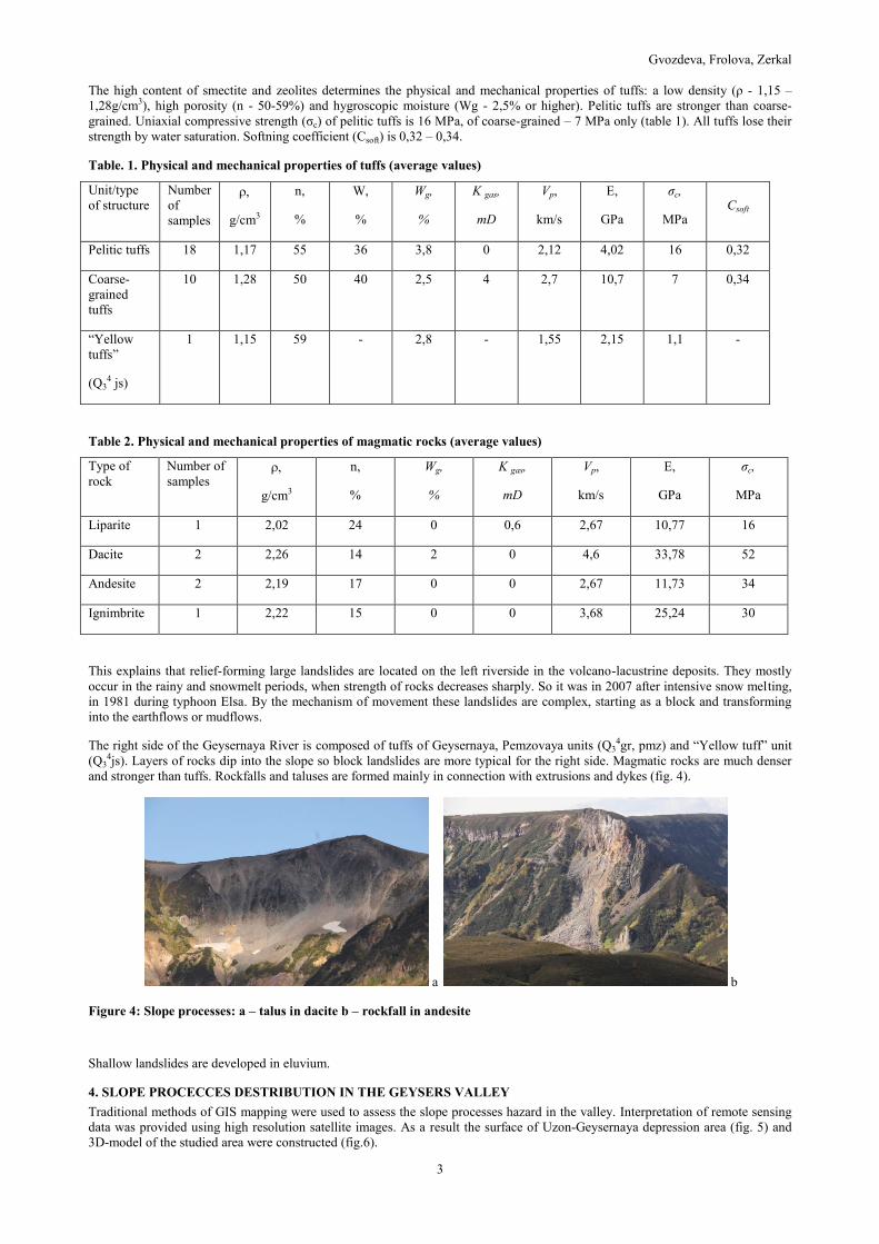
From the thematic processing of remote sensing data of high resolution and subsequent field verification of interpretation results
Inventory landslides map was prepared (fig.7). All landslides can be separated in two principal groups: 1. Large landslides with
complex mechanism of displacement that forming the modern relief. The volume involved in the displacement is more than a
million cubic meters; 2. different scale landslides with the volume of rocks involved in the displacement varying from a few
thousand to hundred thousand cubic meters. By the mechanism of displacement these landslides subdivided into rockfalls, block
landslides, and earthflow, complicating the modern relief. Five hundred thirty phenomena of slope processes have been allocated
the observed area. Among them 249 landslides occurred within the volcano-sedimentary strata. Identified slope processes have
different mechanism of displacement, including 74 rockfalls, 30 block landslides, 48 complex landslides, 295 earthflows, 20 from
them transformed to mudflows, and 60 taluses.
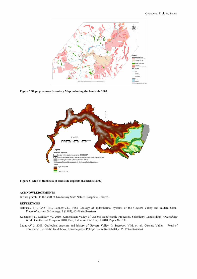
Also the landslide formed on June 3, 2007 has been investigated in detail. Constructed map shows that it developed within the
ancient landslide. Processing of electronic chart high resolution model of the territory and comparative analysis of relief models
before and after failure allowed to calculate the volume of landslide deposits which is 16.31 million m3 (fig. 8).
CONCLUSIONS
Investigations in the Valley of Geysers have showed that ancient and modern slope processes and phenomena are widespread in
this area. Identified slope processes have different mechanism of displacement, including rockfalls, block landslides, complex
landslides, earthflows, mudflows, and taluses. Recently there have been several major events in the studied area that changed the
landscape of the valley and damaged or destroyed the thermal manifestations. Geological, geomorphological and climatic factors
contributed to their development, but the type of process depends mainly on the composition, structure and physical and mechanical
properties of rocks. Analysis of remote sensing data showed an inherited character of slope processes, in particular landslides.
Many landslides were formed in ancient landslide circuses and can be expected in the near future. Taken into account that the
Valley of Geysers is a tourist site included in the UNESCO Heritage, it should be carefully studied in order to predict dangerous
slope processes.
Gvozdeva, Frolova, Zerkal
5
Figure 7 Slope processes Inventory Map including the landslide 2007
Figure 8: Map of thickness of landslide deposits (Landslide 2007)
ACKNOWLEDGEMENTS
We are grateful to the stuff of Kronotskiy State Nature Biosphere Reserve.
REFERENCES
Belousov V.I., Grib E.N., Leonov,V.L., 1983 Geology of hydrothermal systems of the Geysers Valley and caldera Uzon,
Volcanology and Seismology, 1 (1983), 65-79 (in Russian)
Kuganko Yu., Saltykov V., 2010. Kamchatkan Valley of Gysers: Geodynamic Processes, Seismicity, Landsliding. Proceedings
World Geothermal Congress 2010, Bali, Indonesia 25-30 April 2010, Paper № 1339.
Leonov,V.L. 2009. Geological structure and history of Geysers Valley. In Sugrobov V.M. et. al., Geysers Valley – Pearl of
Kamchatka. Scientific Guidebook, Kamchatpress, Petropavlovsk-Kamchatsky, 35-39 (in Russian)