sitka passenger fee fund implementation...
TRANSCRIPT
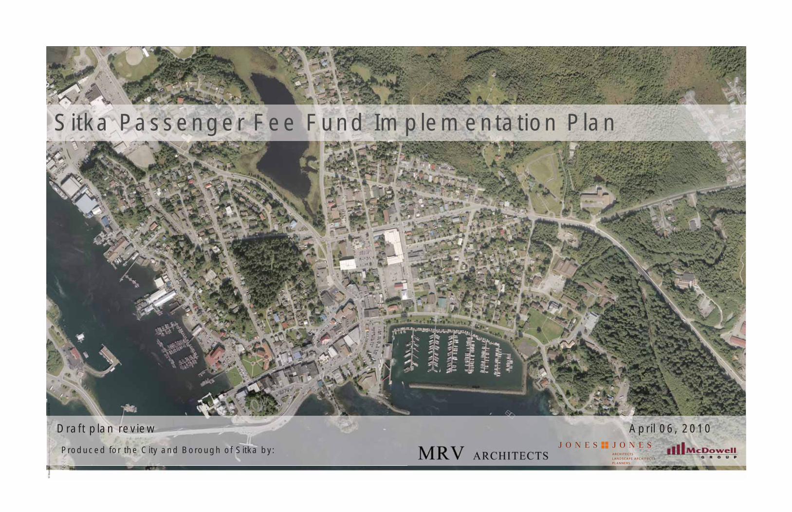
Sitka Passenger Fee Fund Implementation Plan
Draft plan review April 06, 2010
A R C H I T E C T SL A N D S C A P E A R C H I T E C T SP L A N N E R S
Produced for the City and Borough of Sitka by:

Sitka Passenger Fee Fund Implementation Plan 3
Background
Development of this plan, officially known as the Sitka Marine Passenger Fee Fund - Project Implementation Master Plan, was
initiated in the summer of 2009. But the greater planning process
was initiated by the community much earlier. It began with the
Gateway Plan of 1996, then the Non-motorized Transportation
Plan of 2002, the Sitka Comprehensive Plan, the Sitka Visitor
Industry Plan, Version 1.0 of 2007, and the final Sitka Visitor
Industry Plan, Version 2.0 later in 2007.
These earlier plans were limited, as plans often are, by an absence
of funding dedicated to implementing the plans or constructing
projects put forth in the plans. When the State Legislature
instituted the Commercial Passenger Excise Tax (CPET)1 a funding
source was created for those projects which would benefit safety,
transportation, or efficiency for cruise visitors. An opportunity was
recognized by the Administration and Assembly to fund projects
envisioned by the earlier plans. But it was uncertain how to obtain
the greatest benefit for the tourism industry and the community.
The Public Works Department recognized that a strategic first step
would be to integrate the work of the previous planning efforts
into a single master plan. That master plan would provide a road
map for both near term projects and work in future years. It could
help assure that various projects, large and small, near-term and
long-term, fit together into a coherent whole.
In July 2009 the city issued a request for proposals for a Marine
Passenger Fee Fund Master Plan; a contract was subsequently
awarded to MRV Architects of Juneau in October 2009. The
Sitka Marine Passenger Fee Fund - Project Implementation Master Plan (hereafter called Master Plan) was to be distinct from other
planning efforts in that a specific component of the plan would be
identifying specific projects to be constructed from the proceeds
of the Marine Passenger Fee Fund (CBS) and Commercial Passenger
Excise Tax (state). The plan would identify some projects would
could be safely commenced prior to completion of the overall plan.
The earlier plans grew out of a thoughtful process to identify
community needs, address both resident and visitor issues, and
achieve the broadest possible community consensus. Much of this 1 The CPET also goes by other names; it is sometimes referred to as the “cruise ship head tax,” and the funds are collected locally in a fund defi ned by ordi-nance as the “Marine Passenger Fee Fund.”
current planning and design effort is a direct out-growth of the
steps that were identified in the earlier planning processes, and
respects the significant expenditure of time and commitment that
went into their development.
Master Plan Chronology
The MRV team includes Jones & Jones of Seattle as landscape
architects; McDowell Group for tourism trending and interview
expertise; R&M Engineers as civil and geotechnical engineers;
PN&D as marine engineers; and Kittelson Engineers for traffic
analysis.
Planning and Design work included a broad Sitka reconnaissance
by the full team. This was followed by McDowell Group interviews
of day-visitors arriving by lighter craft. Master Plan work by MRV
and Jones & Jones continued through October and November,
resulting in an initial 35% review meeting with the Steering
Committee in early December, 2009.
After slight modifications, the Master Plan draft materials were
posted on the MRV web site in early January, and then reviewed
in a day-long series of meetings with groups and commissions in
mid-January, 2010. The groups and commissions meetings were
to gain review based on particular interest or expertise in issues
raised by the Master Plan, and to identify significant defects or
neglected issues prior to a broader public review. A full list of the
groups involved, and a listing of their comments and responses, is
included as an appendix to this full plan.
Subsequent to that informational meeting, the City and Borough
of Sitka posted the 35% Draft Master Plan materials on their web
site. A broad public meeting of the Master Plan draft, essentially
unchanged from the January presentations, was held March 10,
2010.
The Master Plan may ultimately be presented to the Assembly for
formal adoption, but for now we see the greatest value in using it
as a “living document” to guide implementation project rollout.
Implementation Project Chronology and Work Steps
As part of the 35% overall Master Plan, a draft list of recommended
implementation projects was developed. Many of the projects
included in that listing had been identified before the current
design contract was initiated, such as improved signage and
wayfinding information.
The list of projects was then vetted by the design team, a Steering
Committee, and Sitka staff, and refined accordingly. This list of
implementation projects, identifying project needs, rough cost,
and probable time priority, was developed through February, and
is included as a central element of the the current draft Master
Plan work product. This Implementation Plan list establishes a
framework for organizing, prioritizing and directing investment
to the downtown core. It is intended as a living document, with
continual updates in the future as projects are completed and
more information is developed on emerging projects.
Prioritization of projects for immediate construction projects this
spring and summer was completed in January, 2010. The first
project will be rebuilding and improving the Sea Walk portion
along Crescent Harbor, extending from the Harbor covered shelter,
and along the Crescent Harbor park to approximately the tennis
courts. Design documents for the Seawalk construction contract
will be completed in early April, with construction able to start
shortly thereafter.
The next project will focus on comprehensive informational and
way-faring signage across all plan areas. Shortly after this project,
construction work for the Seawalk link from O’Connell Bridge to
the library should be initiated.
The full listing of implementation projects includes those in, or
starting toward, design and construction in the short term, those
with an intermediate time frame (perhaps underway within a year),
and those that will occur at future date. The outline establishes
a long-range living document for the City and Borough of Sitka,
identifying projects of high value, and which link together to
achieve maximum benefit for the visitor industry and community.
April 06, 2010 | Sitka Passenger Fee Fund Implementation Plan4
Master Plan Approach and Goals
The Sitka Passenger Fee Fund Implementation Master Plan process
started with three key goals:
Build on the authenticity of Sitka; build on the qualities and character of the community and residents that make Sitka authentic.
Improve the Sitka experience for both visitors and residents; improvements for visitors, if carefully identified, will work positively for
residents as well.
Build on the work and effort invested in previous plans; such efforts identified a range of positive steps, many adopted as goals by the City
and Borough Assembly. Many other planning conclusions identified
steps for improvement, possible approaches to districts, and very
specific details to make Sitka function as a better community.
The community of Sitka —defined by its location on the coast
of Baranof Island, at the edge of the Pacific Ocean—is rooted at
the edge of the sea and the land. It’s past, present and future are
defined by this strong connection to both of these realms. It is
also powerfully shaped by history, with compelling stories that
intertwine Tlingit, Russian, and American (influx of the late 19th
century) threads.
Sitka offers a wealth of opportunity, given this setting and culture.
It is a remarkable setting, incredibly enriching to both resident
and visitor. The design team believes this plan identifies these
strengths, and focuses on steps to capitalize on their opportunity,
while minimizing the problem areas that might exist.
As such, specific principles that guide plan development are:
Develop a clear arrival sequence to improve visitor experience, including: Orientation and decision making spaces with primary
wayfinding and interpretive information, introduction to Sitka, and
protection from the weather at both lightering facilities.
Provide a safe queuing area for local operators and tour guides to explain and offer the multiple services and activities Sitka has to offer.
Develop a strong pedestrian character along the downtown district and Sitka shoreline to enhance walkability, image, and identity.
Improve safety for visitors and regular, continuing users of the downtown core.
Use materials that are sustainable and locally sourced, and that reflect the character of Sitka and Southeast Alaska.
Identify distinct neighborhoods and their distinct character(s) (Katlian, Lincoln, Shoreline, Japonski, Park, Lake)
Provide an interpretive framework with integrated wayfinding, story telling and information. Allow different constituencies, stakeholders
and interested groups to ‘tell their story’, stories of place, culture,
heritage and environment.
Provide new, and where appropriate, enhanced trails and walks as corridors linking all major amenities and places of interest.
Detailed Master Plan Organization and Districts
Through the two centuries of Sitka’s historic and physical
development, several distinct neighborhoods or districts have
emerged. The Master Plan starts by identifying these Districts, and
uses them as a way to sub-divide the downtown core of Sitka into
components which a visitor and residents would find recognizable.
Character districts represent areas of geographic continuity that
have an identifiable visual character usually with an associated
general use. Katlian District is unique in that it has two distinct
characters, the first being the historical and current Indian Village,
the second being the working waterfront).
Following this pattern, the Master Plan is organized into six key
Districts:
Katlian District.Japonski Island DistrictLincoln Street DistrictShoreline DistrictParks DistrictLake District
The Master Plan graphics for each District include a page of
photographs to capture the character or feel of each district, then
follows with an enlarged plan graphic that illustrates key plan
elements for each District.
Each of the District Plan sheets also includes a numbered and
keyed list of the Implementation Projects identified for that area,
keyed back to the overall Implementation List. The following are
the planning goals for each district:
Each Character District should include a walking loop that captures the main elements and attractions in the District.
Districts should develop walking loops, anchored with visible “nodes” or stopping spaces that include kiosks and
secondary wayfinding information.
Districts should emphasize Implementation projects that build on the best qualities of the Character Districts.
Some Implementation Project Details
An example implementation project is the Crescent SeaWalk, the first
phase of which is currently under design, and with construction hopefully
starting before the 2010 cruise visitor season. The overall SeaWalk, when
all portions are complete, will create a seamless connection along Sitka’s
waterfront. This will provide a powerful connection to Sitka’s roots,
allowing visitors to experience this water edge that Sitka grew out of. The
SeaWalk should be developed as a continuous pedestrian experience along
the water’s edge to the greatest extent possible, connecting the downtown
districts from Katlian to the National Park. The SeaWalk will become a multi-
use trail that is a core community resource, connecting character districts,
key interpretive nodes for visitors, and other implementation projects.
Other near-term recommended implementation projects are:
Develop a shared street zone surrounding St. Michael’s Cathedral along Lincoln Street to recognize the Cathedral as a downtown landmark,
provide an improved space where drivers, vehicles, and pedestrians can
share the space around the Cathedral with improved safety.
Develop improved orientation Kiosks and SeaWalk entry points at both lightering facilities.
Integrate Wayfinding signage at lightering facilities, SeaWalk and other places of interest.
Work with Sitka residents to help develop an Interpretive Framework for signage.

Sitka Passenger Fee Fund Implementation Plan 5
Centralized Visitor Functions and Future Visitor’s Center
A fundamental planning quandary exists now with the Sitka waterfront
development and arriving cruise ship visitors, with two competing arrival/
disembarkation points for the cruise ship lighter craft off serving the ships.
Roughly equivalent docks and shore-side facilities exist at both Crescent Harbor,
and the newer O’Connell dock facility.
This situation leads to a de-centralization of many functions, and inefficiency.
Examples include split vendor services and bus transportation arrangements.
Even more critical, this split leads to a fundamental confusion on the part of
arriving visitors. There is no single clear point of arrival/departure, exacerbated
by a lack of signage, and other orientation features. Confusion leads to anxiety,
in many cases, and a less-than-successful visitor experience.
Since we have two arrival/departure facilities at present, the Master Plan needs
to make suggestions to improve the functioning of this arrangement. An
obvious first step is a more positive linkage between the two points, hence the
high priority attached to the Implementation Project to extend the SeaWalk
between the two areas. The harder question relates to future improvements to
docks, visitor queuing areas, bus pick up and the like.
If a new visitor’s center is funded and built, it should be the primary anchor for
visitor arrival and orientation functions. Ideally, it would also offer secondary
visitor support services such as bathrooms, trip planning, and more in-depth
orientation. Finally, a visitor’s center can be utilized to provide an improved,
equitable vendor experience, with sufficient covered areas for vendors, and a
more relaxed queuing opportunity for visitors.
The Master Plan exercise studied six potential options for a future visitor’s center,
including an option at Crescent Harbor, O’Connell dock, a smaller visitor’s center
at each dock area, a single building between the two dock areas, and options to
re-use or expand either Harrington Centennial Building or the existing Library.
The result of this study was the clear recommendation that a future visitor center,
if constructed, should be located in the general location of the Centennial
Building and Crescent Harbor. This area has the ground space to support
centralized visitor services, and is well-located at the geographic center of
the Sitka downtown core. It is not clear at this point if the preferred option
would be a new stand-alone facility, or a facility developed as a renovation or
expansion to Harrington Centennial Building.
A number of related plan questions also focus on the Harrington Centennial
Hall/Crescent Harbor area. Such questions include the location for future
improvements to Lighter boat docking, visitor queuing, improved vendor
spacers and interaction, and bus staging.
Implementation projects are being developed for the Harrington Centennial
Building that make quick improvements to the difficult situation now, yet
attempt to work logically into long-term planning improvements to the area
as the visitor center questions, and related planning steps like parking, bus
queuing, and vendor services are resolved.

April 06, 2010 | Sitka Passenger Fee Fund Implementation Plan6

Sitka Passenger Fee Fund Implementation Plan 7
6
13
11
10
1
98
4
5
3
2
17
15
14
12
16
718
1920
22
21
Katlian District
Parks District
Lincoln District
Shoreline District
Japonski District
Lake District
Walking Tours Attractions:
1 Harrigan Centennial Hall 2 St. Michael’s Cathedral 3 Russian Bishop’s House 4 Princess Maksoutoff’s Grave 5 Pioneer Building 6 Totem Square 7 Castle Hill 8 Russian Block House 9 STA Community House10 Recycle Yard11 Sitka Sound Science Center
12 Sheldon Jackson Museum13 Sitka National Historic Park14 Battle Point Viewpoint15 Raptor Center16 Cemetery17 Boat House18 Kaisei Maru Memorial19 WW II Concrete Bunker20 Fishermen’s Memorial21 Alaska Native Brotherhood Hall #122 Russian Cemetery
April 06, 2010 | Sitka Passenger Fee Fund Implementation Plan8
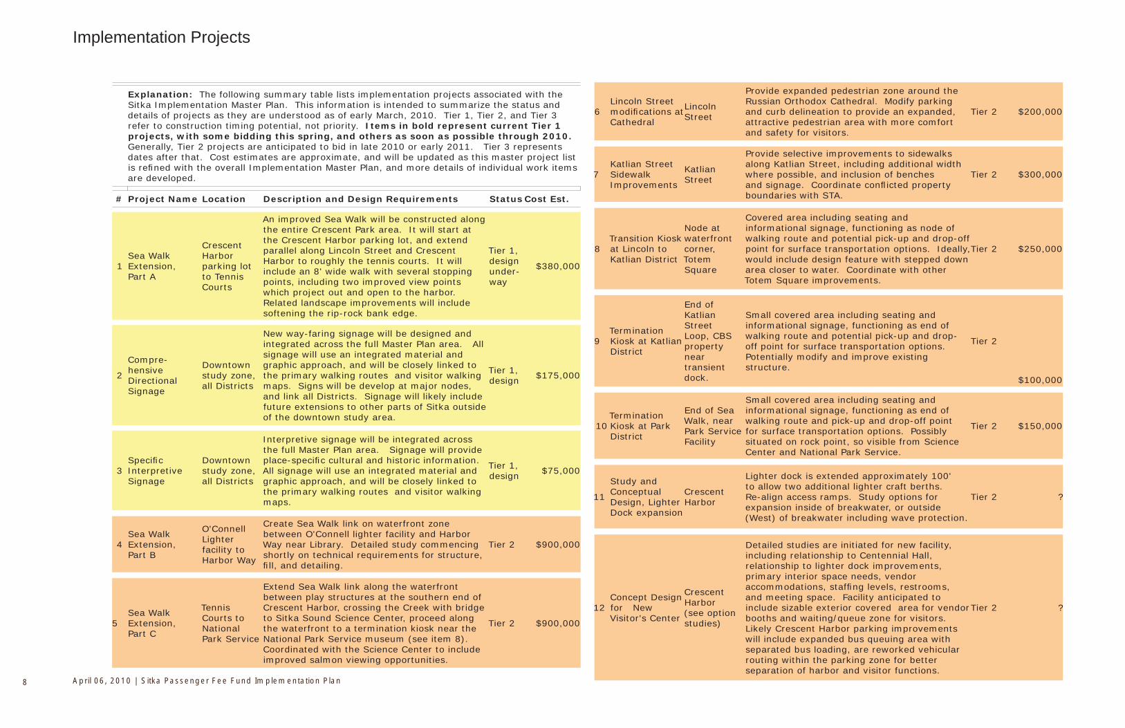
Implementation Projects
Explanation: The following summary table lists implementation projects associated with the Sitka Implementation Master Plan. This information is intended to summarize the status and details of projects as they are understood as of early March, 2010. Tier 1, Tier 2, and Tier 3 refer to construction timing potential, not priority. Items in bold represent current Tier 1 projects, with some bidding this spring, and others as soon as possible through 2010. Generally, Tier 2 projects are anticipated to bid in late 2010 or early 2011. Tier 3 represents dates after that. Cost estimates are approximate, and will be updated as this master project list is refi ned with the overall Implementation Master Plan, and more details of individual work items are developed.
# Project Name Location Description and Design Requirements Status Cost Est.
1Sea Walk Extension, Part A
Crescent Harbor parking lot to Tennis Courts
An improved Sea Walk will be constructed along the entire Crescent Park area. It will start at the Crescent Harbor parking lot, and extend parallel along Lincoln Street and Crescent Harbor to roughly the tennis courts. It will include an 8' wide walk with several stopping points, including two improved view points which project out and open to the harbor. Related landscape improvements will include softening the rip-rock bank edge.
Tier 1, design under-way
$380,000
2
Compre-hensive Directional Signage
Downtown study zone, all Districts
New way-faring signage will be designed and integrated across the full Master Plan area. All signage will use an integrated material and graphic approach, and will be closely linked to the primary walking routes and visitor walking maps. Signs will be develop at major nodes, and link all Districts. Signage will likely include future extensions to other parts of Sitka outside of the downtown study area.
Tier 1, design $175,000
3Specifi c Interpretive Signage
Downtown study zone, all Districts
Interpretive signage will be integrated across the full Master Plan area. Signage will provide place-specifi c cultural and historic information. All signage will use an integrated material and graphic approach, and will be closely linked to the primary walking routes and visitor walking maps.
Tier 1, design $75,000
4Sea Walk Extension, Part B
O'Connell Lighter facility to Harbor Way
Create Sea Walk link on waterfront zone between O'Connell lighter facility and Harbor Way near Library. Detailed study commencing shortly on technical requirements for structure, fi ll, and detailing.
Tier 2 $900,000
5Sea Walk Extension, Part C
Tennis Courts to National Park Service
Extend Sea Walk link along the waterfront between play structures at the southern end of Crescent Harbor, crossing the Creek with bridge to Sitka Sound Science Center, proceed along the waterfront to a termination kiosk near the National Park Service museum (see item 8). Coordinated with the Science Center to include improved salmon viewing opportunities.
Tier 2 $900,000
6Lincoln Street modifi cations at Cathedral
Lincoln Street
Provide expanded pedestrian zone around the Russian Orthodox Cathedral. Modify parking and curb delineation to provide an expanded, attractive pedestrian area with more comfort and safety for visitors.
Tier 2 $200,000
7Katlian Street Sidewalk Improvements
Katlian Street
Provide selective improvements to sidewalks along Katlian Street, including additional width where possible, and inclusion of benches and signage. Coordinate confl icted property boundaries with STA.
Tier 2 $300,000
8Transition Kiosk at Lincoln to Katlian District
Node at waterfront corner, Totem Square
Covered area including seating and informational signage, functioning as node of walking route and potential pick-up and drop-off point for surface transportation options. Ideally, would include design feature with stepped down area closer to water. Coordinate with other Totem Square improvements.
Tier 2 $250,000
9Termination Kiosk at Katlian District
End of Katlian Street Loop, CBS property near transient dock.
Small covered area including seating and informational signage, functioning as end of walking route and potential pick-up and drop-off point for surface transportation options. Potentially modify and improve existing structure.
Tier 2
$100,000
10Termination Kiosk at Park District
End of Sea Walk, near Park Service Facility
Small covered area including seating and informational signage, functioning as end of walking route and pick-up and drop-off point for surface transportation options. Possibly situated on rock point, so visible from Science Center and National Park Service.
Tier 2 $150,000
11
Study and Conceptual Design, Lighter Dock expansion
Crescent Harbor
Lighter dock is extended approximately 100' to allow two additional lighter craft berths. Re-align access ramps. Study options for expansion inside of breakwater, or outside (West) of breakwater including wave protection.
Tier 2 ?
12Concept Design for New Visitor's Center
Crescent Harbor (see option studies)
Detailed studies are initiated for new facility, including relationship to Centennial Hall, relationship to lighter dock improvements, primary interior space needs, vendor accommodations, staffi ng levels, restrooms, and meeting space. Facility anticipated to include sizable exterior covered area for vendor booths and waiting/queue zone for visitors. Likely Crescent Harbor parking improvements will include expanded bus queuing area with separated bus loading, are reworked vehicular routing within the parking zone for better separation of harbor and visitor functions.
Tier 2 ?
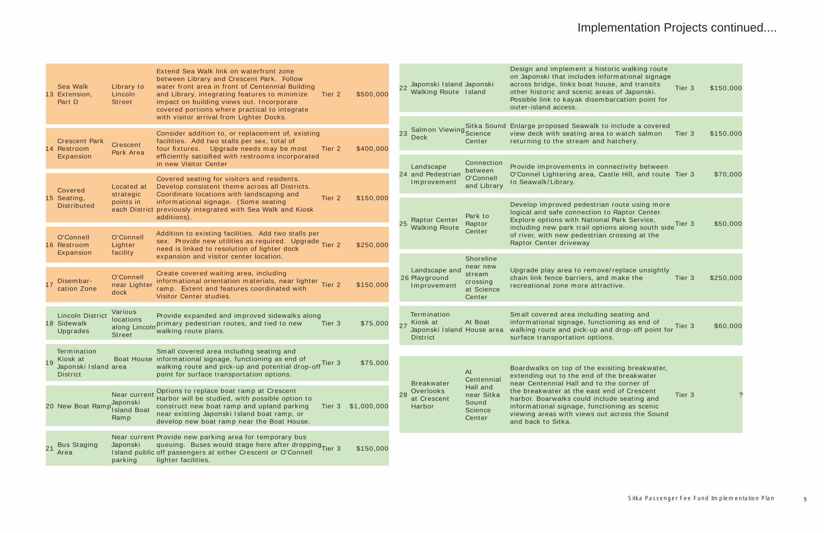
Sitka Passenger Fee Fund Implementation Plan 9
Implementation Projects continued....
13Sea Walk Extension, Part D
Library to Lincoln Street
Extend Sea Walk link on waterfront zone between Library and Crescent Park. Follow water front area in front of Centennial Building and Library, integrating features to minimize impact on building views out. Incorporate covered portions where practical to integrate with visitor arrival from Lighter Docks.
Tier 2 $500,000
14Crescent Park Restroom Expansion
Crescent Park Area
Consider addition to, or replacement of, existing facilities. Add two stalls per sex, total of four fi xtures. Upgrade needs may be most effi ciently satisifi ed with restrooms incorporated in new Visitor Center
Tier 2 $400,000
15Covered Seating, Distributed
Located at strategic points in each District
Covered seating for visitors and residents. Develop consistent theme across all Districts. Coordinate locations with landscaping and informational signage. (Some seating previously integrated with Sea Walk and Kiosk additions).
Tier 2 $150,000
16O'Connell Restroom Expansion
O'Connell Lighter facility
Addition to existing facilities. Add two stalls per sex. Provide new utilities as required. Upgrade need is linked to resolution of lighter dock expansion and visitor center location.
Tier 2 $250,000
17 Disembar-cation Zone
O'Connell near Lighter dock
Create covered waiting area, including informational orientation materials, near lighter ramp. Extent and features coordinated with Visitor Center studies.
Tier 2 $150,000
18Lincoln District Sidewalk Upgrades
Various locations along Lincoln Street
Provide expanded and improved sidewalks along primary pedestrian routes, and tied to new walking route plans.
Tier 3 $75,000
19
Termination Kiosk at Japonski Island District
Boat House area
Small covered area including seating and informational signage, functioning as end of walking route and pick-up and potential drop-off point for surface transportation options.
Tier 3 $75,000
20 New Boat Ramp
Near current Japonski Island Boat Ramp
Options to replace boat ramp at Crescent Harbor will be studied, with possible option to construct new boat ramp and upland parking near existing Japonski Island boat ramp, or develop new boat ramp near the Boat House.
Tier 3 $1,000,000
21 Bus Staging Area
Near current Japonski Island public parking
Provide new parking area for temporary bus queuing. Buses would stage here after dropping off passengers at either Crescent or O'Connell lighter facilities.
Tier 3 $150,000
22 Japonski Island Walking Route
Japonski Island
Design and implement a historic walking route on Japonski that includes informational signage across bridge, links boat house, and transits other historic and scenic areas of Japonski. Possible link to kayak disembarcation point for outer-island access.
Tier 3 $150,000
23 Salmon Viewing Deck
Sitka Sound Science Center
Enlarge proposed Seawalk to include a covered view deck with seating area to watch salmon returning to the stream and hatchery.
Tier 3 $150,000
24Landscape and Pedestrian Improvement
Connection between O'Connell and Library
Provide improvements in connectivity between O'Connel Lightering area, Castle Hill, and route to Seawalk/Library.
Tier 3 $70,000
25 Raptor Center Walking Route
Park to Raptor Center
Develop improved pedestrian route using more logical and safe connection to Raptor Center. Explore options with National Park Service, including new park trail options along south side of river, with new pedestrian crossing at the Raptor Center driveway
Tier 3 $50,000
26Landscape and Playground Improvement
Shoreline near new stream crossing at Science Center
Upgrade play area to remove/replace unsightly chain link fence barriers, and make the recreational zone more attractive.
Tier 3 $250,000
27
Termination Kiosk at Japonski Island District
At Boat House area
Small covered area including seating and informational signage, functioning as end of walking route and pick-up and drop-off point for surface transportation options.
Tier 3 $60,000
28
Breakwater Overlooks at Crescent Harbor
At Centennial Hall and near Sitka Sound Science Center
Boardwalks on top of the exisiting breakwater, extending out to the end of the breakwater near Centennial Hall and to the corner of the breakwater at the east end of Crescent harbor. Boarwalks could include seating and informational signage, functioning as scenic viewing areas with views out across the Sound and back to Sitka.
Tier 3 ?
April 06, 2010 | Sitka Passenger Fee Fund Implementation Plan10
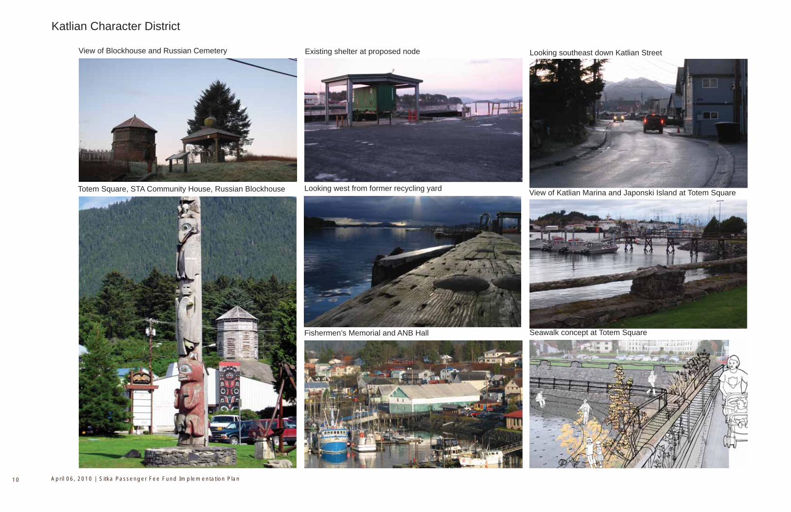
View of Blockhouse and Russian Cemetery
Katlian Character District
View of Katlian Marina and Japonski Island at Totem Square
Seawalk concept at Totem SquareFishermen’s Memorial and ANB Hall
Looking west from former recycling yard
Existing shelter at proposed node Looking southeast down Katlian Street
Totem Square, STA Community House, Russian Blockhouse
Sitka Passenger Fee Fund Implementation Plan 11
Katlian D
istrict
Katlian Character District
Proposed Node:CBS ‘recycling’ lot
Visual
access
Totem Square
Block House
Princess Maksoutoff’s Grave
STA Community House
PioneerBuilding
Implementation Projects:
2. Comprehensive Directional Signage, Downtown study zone, all Districts, Tier 1 3. Specific Interpretive Signage, Interpretive Points in each District, Tier 1 7. Katlian Street Sidewalk Improvements, ANB Hall to CBS ‘recycle’ lot, Tier 2 8. Transition Kiosk at Lincoln to Katlian District, corner of Totem Square and Lincoln Street, Tier 2 9. Transition Kiosk at Lincoln to Katlian District, corner of Totem Square and Lincoln Street, Tier 2 14. Covered Seating: Located at strategic points in each District, Tier 2
St. MichaelsCathedral
Diagram Key:
Heavy Traffic (existing) Pedestrian Connections (existing)
Node (existing red, proposed yellow)
Water Trail (existing)
Short Pedestrian Loop (proposed)
Sea Walk (proposed)
Implementation Project (tier 1)
Implementation Project (tier 2)
Implementation Project (tier 3)
Informational Signage
Comprehensive Signage
Covered Seating
###
Visual
ac
cess
Path to Skatepark
Russian Cemetery
ANB Hall
Fishermen’s memorial
9
8
April 06, 2010 | Sitka Passenger Fee Fund Implementation Plan12
O’Connell Bridge
Cruise ship viewed from O’Connell Lightering
O’Connell Bridge and Japonski Island
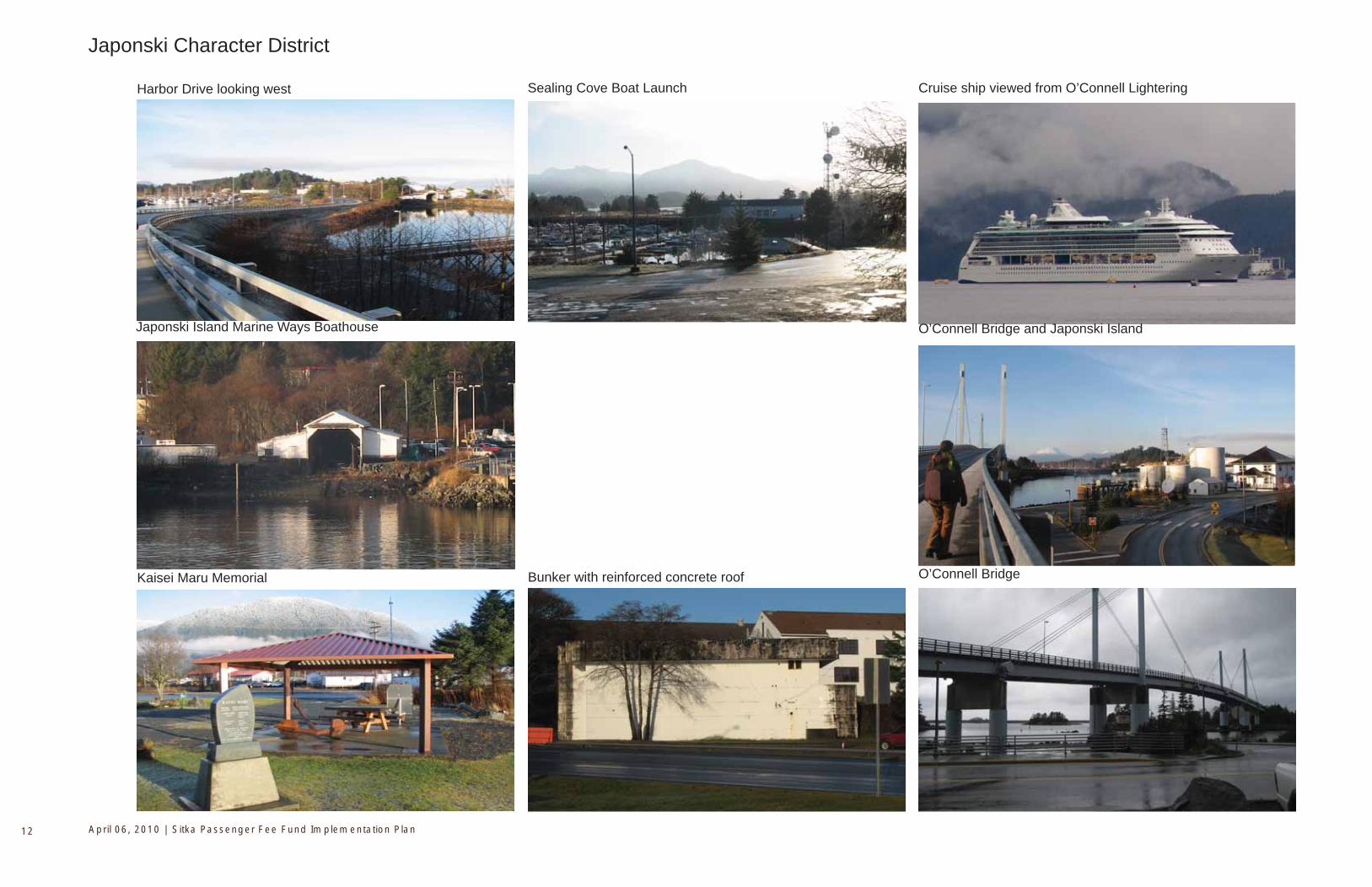
Japonski Character District
Harbor Drive looking west
Japonski Island Marine Ways Boathouse
Kaisei Maru Memorial Bunker with reinforced concrete roof
Sealing Cove Boat Launch
Sitka Passenger Fee Fund Implementation Plan 13
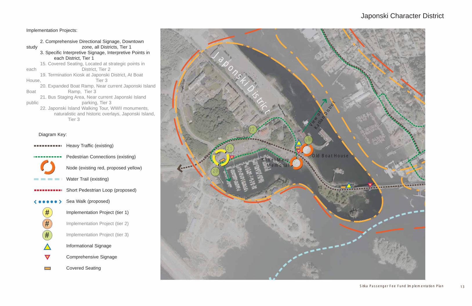
Japonski District
Japonski Character District
Vie
w o
f Ka
tlian
Dis
trict
Implementation Projects:
2. Comprehensive Directional Signage, Downtown study zone, all Districts, Tier 1 3. Specific Interpretive Signage, Interpretive Points in each District, Tier 1 15. Covered Seating, Located at strategic points in each District, Tier 2 19. Termination Kiosk at Japonski District, At Boat House, Tier 3 20. Expanded Boat Ramp, Near current Japonski Island Boat Ramp, Tier 3 21. Bus Staging Area, Near current Japonski Island public parking, Tier 3 22. Japonski Island Walking Tour, WWII monuments, naturalistic and historic overlays, Japonski Island, Tier 3
19
20
21
22
Kaisei Maru Memorial
Old Boat House
Diagram Key:
Heavy Traffic (existing) Pedestrian Connections (existing)
Node (existing red, proposed yellow)
Water Trail (existing)
Short Pedestrian Loop (proposed)
Sea Walk (proposed)
Implementation Project (tier 1)
Implementation Project (tier 2)
Implementation Project (tier 3)
Informational Signage
Comprehensive Signage
Covered Seating
###
April 06, 2010 | Sitka Passenger Fee Fund Implementation Plan14
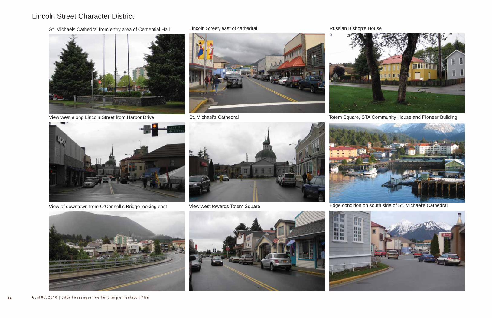
St. Michaels Cathedral from entry area of Centential Hall
Lincoln Street Character District
Edge condition on south side of St. Michael’s Cathedral
View west along Lincoln Street from Harbor Drive
View of downtown from O’Connell’s Bridge looking east
Lincoln Street, east of cathedral
St. Michael’s Cathedral
View west towards Totem Square
Russian Bishop’s House
Totem Square, STA Community House and Pioneer Building
Sitka Passenger Fee Fund Implementation Plan 15
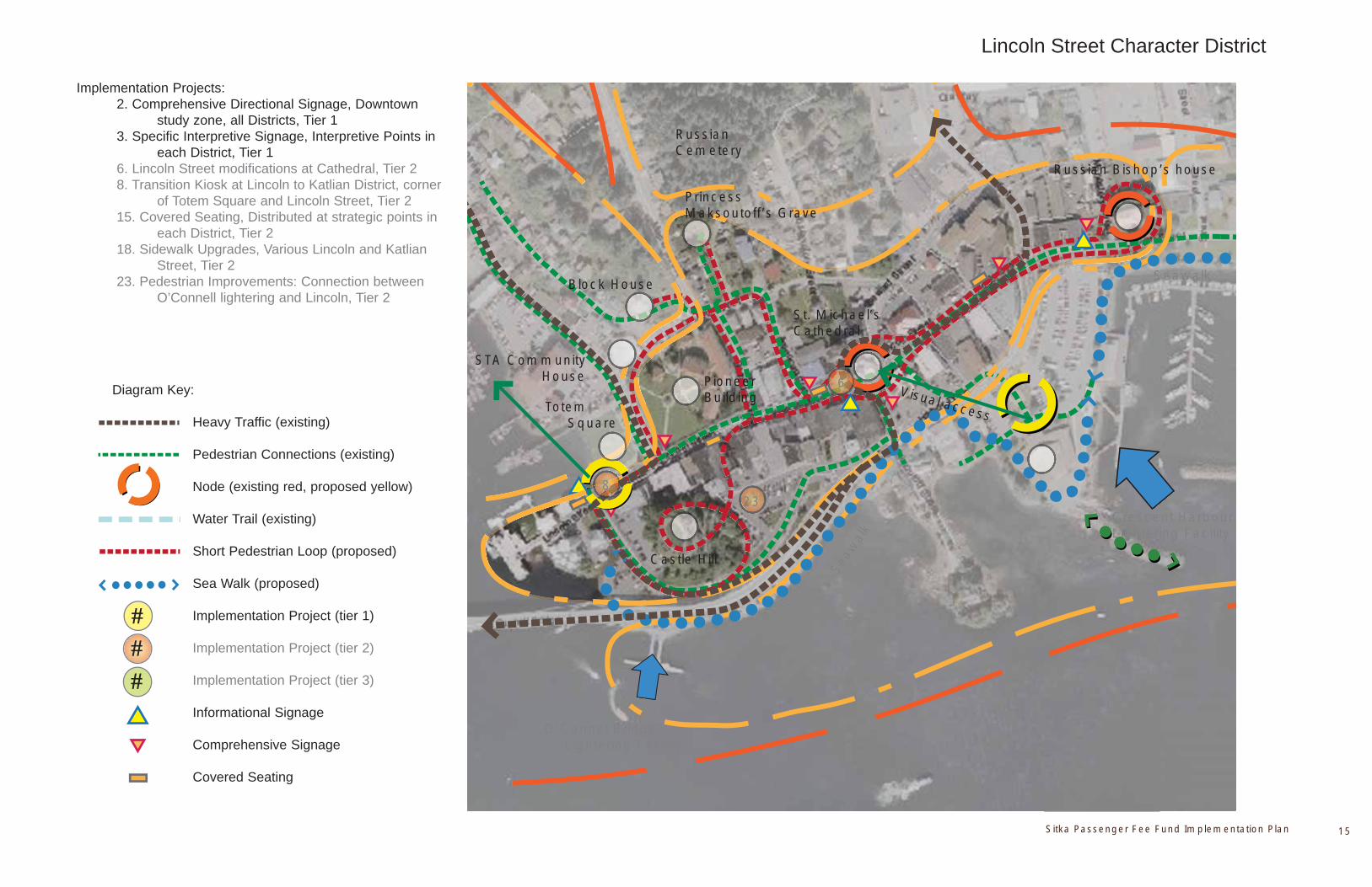
Lincoln Street Character District
Block House
Princess Maksoutoff’s Grave
St. Michael’s Cathedral
Castle Hill
O’Connel Bridge Lightering Facility
Seaw
alk
Crescent Harbour Lightering Facility
Implementation Projects: 2. Comprehensive Directional Signage, Downtown study zone, all Districts, Tier 1 3. Specific Interpretive Signage, Interpretive Points in each District, Tier 1 6. Lincoln Street modifications at Cathedral, Tier 2 8. Transition Kiosk at Lincoln to Katlian District, corner of Totem Square and Lincoln Street, Tier 2 15. Covered Seating, Distributed at strategic points in each District, Tier 2 18. Sidewalk Upgrades, Various Lincoln and Katlian Street, Tier 2 23. Pedestrian Improvements: Connection between O’Connell lightering and Lincoln, Tier 2
Seawalk
Russian Bishop’s house
STA Community House
Visual access Totem
Square
23
Diagram Key:
Heavy Traffic (existing) Pedestrian Connections (existing)
Node (existing red, proposed yellow)
Water Trail (existing)
Short Pedestrian Loop (proposed)
Sea Walk (proposed)
Implementation Project (tier 1)
Implementation Project (tier 2)
Implementation Project (tier 3)
Informational Signage
Comprehensive Signage
Covered Seating
###
Pioneer Building
RussianCemetery
6
8
April 06, 2010 | Sitka Passenger Fee Fund Implementation Plan16
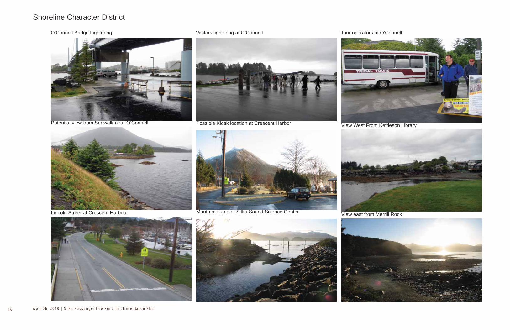
View West From Kettleson Library
Mouth of fl ume at Sitka Sound Science Center View east from Merrill RockLincoln Street at Crescent Harbour
Potential view from Seawalk near O’Connell
O’Connell Bridge Lightering Tour operators at O’Connell
Possible Kiosk location at Crescent Harbor
Visitors lightering at O’Connell
Shoreline Character District
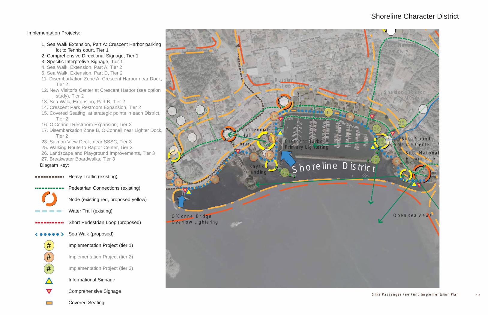
Sitka Passenger Fee Fund Implementation Plan 17
Shoreline District
Shoreline Character District
Russian Bishop’s House
Kayak landing
Centennial Hall
Sitka SoundScience Center
Sheldon Jackson Museum
Sitka National Historic Park
Crescent Harbour Primary Lightering
Sitka NationalCemetery
flum
e
Open sea viewsO’Connel Bridge Overflow Lightering
Library
1
12
1
23
26
Implementation Projects:
1. Sea Walk Extension, Part A: Crescent Harbor parking lot to Tennis court, Tier 1 2. Comprehensive Directional Signage, Tier 1 3. Specific Interpretive Signage, Tier 1 4. Sea Walk, Extension, Part A, Tier 2 5. Sea Walk, Extension, Part D, Tier 2 11. Disembarkation Zone A, Crescent Harbor near Dock, Tier 2 12. New Visitor’s Center at Crescent Harbor (see option study), Tier 2 13. Sea Walk, Extension, Part B, Tier 2 14. Crescent Park Restroom Expansion, Tier 2 15. Covered Seating, at strategic points in each District, Tier 2 16. O’Connell Restroom Expansion, Tier 2 17. Disembarkation Zone B, O’Connell near Lighter Dock, Tier 2 23. Salmon View Deck, near SSSC, Tier 3 25. Walking Route to Raptor Center, Tier 3 26. Landscape and Playground Improvements, Tier 3 27. Breakwater Boardwalks, Tier 3
Diagram Key:
Heavy Traffic (existing) Pedestrian Connections (existing)
Node (existing red, proposed yellow)
Water Trail (existing)
Short Pedestrian Loop (proposed)
Sea Walk (proposed)
Implementation Project (tier 1)
Implementation Project (tier 2)
Implementation Project (tier 3)
Informational Signage
Comprehensive Signage
Covered Seating
###
25
11
14
17
164
513
15
27
27

April 06, 2010 | Sitka Passenger Fee Fund Implementation Plan18
View of Sound From Sitka National HIstoric Park
Parks Character DistrictSheldon Jackson campus trail Sitka National Historic Park Trail
Indian River October salmon run
Sitka Sound wildlife
Sitka National Historic Park
Totem Trail in Sitka NHS
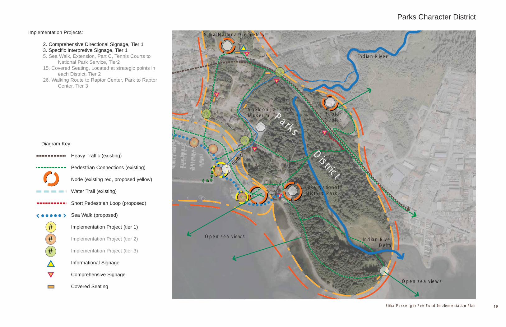
Sitka Passenger Fee Fund Implementation Plan 19
Parks
District
Sheldon Jackson Museum
Sitka National Historic Park
Sitka National Cemetery
Open sea views
Raptor Center
Open sea viewsflu
me
Indian River Delta
Parks Character District
Implementation Projects:
2. Comprehensive Directional Signage, Tier 1 3. Specific Interpretive Signage, Tier 1 5. Sea Walk, Extension, Part C, Tennis Courts to National Park Service, Tier2 15. Covered Seating, Located at strategic points in each District, Tier 2 26. Walking Route to Raptor Center, Park to Raptor Center, Tier 3
5
26
Diagram Key:
Heavy Traffic (existing) Pedestrian Connections (existing)
Node (existing red, proposed yellow)
Water Trail (existing)
Short Pedestrian Loop (proposed)
Sea Walk (proposed)
Implementation Project (tier 1)
Implementation Project (tier 2)
Implementation Project (tier 3)
Informational Signage
Comprehensive Signage
Covered Seating
###
Indian River
26
26
5

April 06, 2010 | Sitka Passenger Fee Fund Implementation Plan20
Sitka Passenger Fee Fund Implementation Plan 21
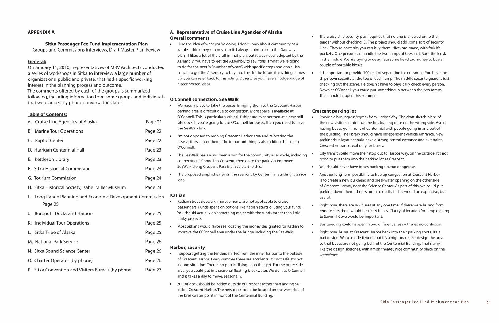
APPENDIX A
Sitka Passenger Fee Fund Implementation Plan
Groups and Commissions Interviews, Draft Master Plan Review
General:
On January 11, 2010, representatives of MRV Architects conducted
a series of workshops in Sitka to interview a large number of
organizations, public and private, that had a specific working
interest in the planning process and outcome.
The comments offered by each of the groups is summarized
following, including information from some groups and individuals
that were added by phone conversations later.
Table of Contents:
A. Cruise Line Agencies of Alaska Page 21
B. Marine Tour Operations Page 22
C. Raptor Center Page 22
D. Harrigan Centennial Hall Page 23
E. Kettleson Library Page 23
F. Sitka Historical Commission Page 23
G. Tourism Commission Page 24
H. Sitka Historical Society, Isabel Miller Museum Page 24
I. Long Range Planning and Economic Development Commission
Page 25
J. Borough Docks and Harbors Page 25
K. Individual Tour Operations Page 25
L. Sitka Tribe of Alaska Page 25
M. National Park Service Page 26
N. Sitka Sound Science Center Page 26
O. Charter Operator (by phone) Page 26
P. Sitka Convention and Visitors Bureau (by phone) Page 27
A. Representative of Cruise Line Agencies of Alaska
Overall commentsI like the idea of what you’re doing. I don’t know about community as a whole. I think they can buy into it. I always point back to the Gateway
plan - I liked a lot of the stuff in that plan, but it was never adopted by the
Assembly. You have to get the Assembly to say “this is what we’re going
to do for the next “x” number of years”, with specific steps and goals. It’s
critical to get the Assembly to buy into this. In the future if anything comes
up, you can refer back to this listing. Otherwise you have a hodgepodge of
disconnected ideas.
O’Connell connection, Sea WalkWe need a place to take the buses. Bringing them to the Crescent Harbor parking area is difficult due to congestion. More space is available at
O’Connell. This is particularly critical if ships are ever berthed at a new mill
site dock. If you’re going to use O’Connell for buses, then you need to have
the SeaWalk link.
I’m not opposed to redoing Crescent Harbor area and relocating the new visitors center there. The important thing is also adding the link to
O’Connell.
The SeaWalk has always been a win for the community as a whole, including connecting O’Connell to Crescent, then on to the park. An improved
SeaWalk along Crescent Park is a nice start to this.
The proposed amphitheater on the seafront by Centennial Building is a nice idea.
KatlianKatlian street sidewalk improvements are not applicable to cruise passengers. Funds spent on potions like Katlian starts diluting your funds.
You should actually do something major with the funds rather than little
dinky projects.
Most Sitkans would favor reallocating the money designated for Katlian to improve the O’Connell area under the bridge including the SeaWalk.
Harbor, securityI support getting the tenders shifted from the inner harbor to the outside of Crescent Harbor. Every summer there are accidents. It’s not safe. It’s not
a good situation. There’s no public dialogue on that yet. For the outer side
area, you could put in a seasonal floating breakwater. We do it at O’Connell,
and it takes a day to move, seasonally.
200’ of dock should be added outside of Crescent rather than adding 90’ inside Crescent Harbor. The new dock could be located on the west side of
the breakwater point in front of the Centennial Building.
The cruise ship security plan requires that no one is allowed on to the tender without checking ID. The project should add some sort of security
kiosk. They’re portable, you can buy them. Nice, pre-made, with forklift
pockets. One person can handle the two ramps at Crescent. Spot the kiosk
in the middle. We are trying to designate some head tax money to buy a
couple of portable kiosks.
It is important to provide 100 feet of separation for on-ramps. You have the ship’s own security at the top of each ramp. The middle security guard is just
checking out the scene. He doesn’t have to physically check every person.
Down at O’Connell you could put something in between the two ramps.
That should happen this summer.
Crescent parking lotProvide a bus ingress/egress from Harbor Way. The draft sketch plans of the new visitors’ center has the bus loading door on the wrong side. Avoid
having buses go in front of Centennial with people going in and out of
the building. The library should have independent vehicle entrance. New
parking/bus layout should have a strong central entrance and exit point.
Crescent entrance: exit only for buses.
City transit could move their stop out to Harbor way, on the outside. It’s not good to put them into the parking lot at Crescent.
You should never have buses backing up, too dangerous.
Another long-term possibility to free up congestion at Crescent Harbor is to create a new bulkhead and breakwater opening on the other side
of Crescent Harbor, near the Science Center. As part of this, we could put
parking down there. There’s room to do that. This would be expensive, but
useful.
Right now, there are 4-5 buses at any one time. If there were busing from remote site, there would be 10-15 buses. Clarity of location for people going
to Sawmill Cove would be important.
Bus queuing could happen in two different sites so there’s no confusion.
Right now, buses at Crescent Harbor back into their parking spots. It’s a bad design. We’ve made it work, but it’s a nightmare. Re-design the area
so that buses are not going behind the Centennial Building. That’s why I
like the design sketches, with amphitheater, nice community place on the
waterfront.
April 06, 2010 | Sitka Passenger Fee Fund Implementation Plan22
B. Representative of Marine Tour Operations
Overall
I’m glad you’re doing this. I’ve felt like I’ve had some significant informed viewpoint to give on this, but no venue previously to offer it in.
Starting with better signage is a great idea. It’s relatively inexpensive and very effective. The new signage in Ketchikan has allowed people a lot
better understanding of what’s available. I’m a big fan of signage. It benefits
everybody.
Raptor Center
The Raptor Center is big draw, especially for people exploring on their own. The present situation is horrible. People come out of park and they’ve
overshot the Raptor Center. People emerge confused. I’ve always wondered
about an overpass there, or other safer access route.
Katlian Street Improvements
The small ship facility at end of Katlian is an important entry point to the community for high-value visitors. It would be great if we could make it an
attractive entry point. That would be worth investing in.
The walking route along Katlian is problematic now but fascinating to visitors. It gives a great perspective on what Sitka’s about. Some portion of
funds to improve Katlian sidewalks is important.
Cruise Ship Docks/Tendering
Lightering: I think our two entry points for lightering are really nice. They’re at either end of Downtown. I don’t think the facilities are too bad at present.
Information and handling of visitors is slowly, steadily improving.
I’ve always felt that a cruise ship dock out the road is not a good solution; it’s not an improvement over tendering short distance. A bus solution would
create too much bus traffic through residential areas. Moving people on
water is efficient if you do it the right way. It’s better than bussing them.
Lightering can be very effective. I’ve been on cruise ships everywhere, there’s not a big difference in the number of people getting off the ship. The
one difference is that in Sitka, people are more likely to do one trip to shore,
since the travel is longer.
I’m not a fan of a cruise ship dock in downtown Sitka. I’ve seen how it creates negative impacts in other Southeast communities. There’s a charm
to being a tender port. I don’t see it as being a barrier. Sitka’s geographic
location in Southeast is more of a barrier.
I watch how the tendering traffic works. When ships are farther away, it’s harder to be successful. A better solution would be a seasonal facility that
located closer in the harbor. A fixed moorage, not connected to shore,
would still use a tender but be much closer to shore. There’s no reason this
tie-off dolphin couldn’t have water, phone lines, power. It’s secure, and
could allow two ships to tie up parallel. You could have water-based tours
departing from water side. More conversations with the cruise lines would
be warranted.
Kayak Launch
It is dangerous to have kayaks coming and going out of Crescent Harbor. We would happily buy a vehicle and drive our people to a better location. It’s
only a two minute drive. Right now we don’t have an alternative. I’ve heard
about doing kayaks from the basin next to Crescent but that’s not a good
idea, it would have to be dredged, you’d need a breakwater, it’s really rough.
Then you’d still have to cross heavy traffic lanes.
An improved situation could be that we build a kayak launching float and put it in Sealing Cove. Get people across bridge, start paddling from calm
area. Not as many traffic lanes to cross. As season went on, I felt that wasn’t
best solution. If weather is from the south, it can get rough. My wife is
still in favor of Sealing Cove. We have had conversations with the Harbor
Department, and they thought the idea would give many advantages.
If you put a kayak float at Thomsen Harbor, then you have to go past fuel dock. Boats are backing out a lot. Customers can get away. Hazardous area.
The boathouse renovation will be a gem for the community. It’s a logical place to launch human-powered craft. How does it fit with fuel dock?
If possible, the best location would be a new ramp at a pocket in Safe Harbor. It’s not a far drive, and it’s close to the boathouse. You have options
depending on weather. The upland area is big enough for tent camping
spots. Looks like great little spot. Locals could store kayaks for monthly fee.
Sitka has potential to become more of a Mecca for people who like human-powered craft.
Centennial Building/Visitor Center
Centennial area upgrades: I like the pedestrian improvements. There’s a fabulous view. People go out to take pictures. However it is important to
maintain some vehicle access behind the building because of functions
going on in the building.
This SeaWalk and amphitheatre around Centennial Building is neat. Welcoming, attractive area with nice view.
I’ve got some concerns about visitor center location. I like the option with the visitor center right in front of the Centennial Building.
Right now operating in the Crescent parking lot functions well (for upland uses) because we’re launching kayaks right there, and don’t need vehicles.
As a tour operator, my preference would be to have covered area in close proximity to the tender facility, rather than having vendor space inside a
visitor center. Being under cover is a big deal. People don’t want to talk to
you standing in the rain. I was thinking there could be an awning along side
of centennial hall. The draft plans for covered areas are good.
What’s going on now for the level of traffic we have is pretty good. People are civil, it’s low-tech. Operators are allowed a certain size sign. Last year
they added a little structure, made them spread out. Operators seemed to
work well with this, and were polite and self-regulating.
Crescent Harbor
Allen Marine has very good visitor logistics worked out. Our morning tours depart from side of ship, then we drop them off at the tender dock. We use
both tender docks. Afternoon tours leaves from tender dock, drop them at
ship. You just have to make sure that you’re not using more than your fair
share of dock time. Other operators include Sealife Discovery, ATA boats.
There’s only room for one or two boats in addition to tenders at a time.
Sealife always has rep with a radio. We have someone with a radio. We’re all
watching out for each other. I would say that as far as operators working
together, it’s quite collegial.
Re: tender dock on the west side of Centennial Building breakwater: as part of a bigger shore-side change, maybe this would make sense. But there are
service vehicles that need to get to the head of the dock a lot. Ambulances,
Customs guys, cruise line agents picking up crew. To me it’s better to
maintain tender traffic inside Crescent Harbor, and close to support vehicles.
I don’t see a problem with extending the existing Crescent Harbor dock. Improved tender management would be necessary. If two tenders are using
Crescent, frequently there’s a barricade. Ships will put a tender at end of the
dock. We’ve tried to coach them, take middle of dock out to base of ramp,
leave the end. We can have our boats out in the free water. It’s an education
process. If it was a longer dock, it would be great, and I think most tour
operators would agree.
There’s a big weather difference between tender docks. It’s the tenders that it affects. Our boats are fine in any weather. In bad weather, more capacity
at Crescent Harbor would be a definite plus.
It’s more challenging for a tender to come and go from Crescent, since they are not as maneuverable. The motion of the tender when people are
embarking/disembarking is strong.
If the expansion was on the West side of the Crescent Harbor breakwater, serious upgrades would be needed. There could be a seasonal floating
breakwater but there would have to be dredging.
C. Representative from the Raptor Center
I like the kiosk node near City Hall and Totem Square. When you lose sight of your ship, you get disoriented and lose perspective. They have no idea how
close they are.
Routing people to the Raptor Center is a very big issue. My experience over last few years says that the best direction to give people is to route
Sitka Passenger Fee Fund Implementation Plan 23
them through Totem Park. Jeff Davis Street is an alternative but it’s more
confusing. Some people have arrived angry because they’ve gone up Indian
River Road. The walking map had incorrect directions.
I would really try to move people through Totem Park instead. It’s a natural attraction, beautiful walk, better when weather is bad since it’s more
protected. When visitors ask us for directions back, we tell them to go back
through park. I haven’t measured out the distance but I don’t think it’s any
different. Plus the park rangers in the park help direct traffic. It’s also an
easier walk through the park, Jeff Davis has a hill.
Department of Transportation people who viewed the site access recently disagreed with earlier DOT statements that there couldn’t be a cross walk
right at the Raptor Center road access. They said you could do it -- it’s a
logical and safe spot for an intersection. The police department is in favor
too. Current situation is a catastrophe waiting to happen. The person
getting rear-ended is going to get pushed on top of a pedestrian.
An overpass was discussed but is way too expensive.
Possible “Flume” route through SJ campus: this is a very pretty alternate route, makes a nice loop.
We need an alternative route for when they shut the park down because of bears: Jeff Davis is good for this.
Improved signage at all key nodes is a must.
We only see one person a year that takes the public transport.
D. Harrigan Centennial Hall representative:
When there’s a concert, Centennial Building parking gets plugged. In the draft plans, it doesn’t look like enough parking with the Visitor Center
located in front of Centennial.
If the boat launch near the building is re-located, could there be a double ramp at Sealing Cove? Upland parking would have to increase as well.
Behind Centennial at present, there are eight spots for vehicles with trailers. Dancers also park back there, and buses turn around. For some big events
we need the rear service entrances, for equipment and catering. With a
limited-access road that still allows this kind of vehicle support, the plan
looks great.
One concern is snow removal. Area between Centennial Building and Library is the only spot in town for large capacities of snow to be dumped.
Another concern with removing boat launch: it is an important boat launch for commercial builders, contractors working on the islands. You would have
to provide for that. We offer permits for commercial loading. You can’t get
landing craft in Sealing Cove. There’s more maneuvering space, better water
depth, deeper angle at CB. Access is wide open. I agree with moving the
ramp, but it is important to provide a good workable alternative somewhere
else.
Last summer was okay for operators standing outside since the weather was great. Long-term, it is important to provide shelter for vendors out of wind
and rain.
You need to increase staff for a separate Visitor’s Center. What will Visitor center do? Mixed opinion about preferring new stand-alone building or
expansions to Centennial Building.
E. Kettleson Library Representative
The library needs an expansion. Senator Stedman has initiated a bill to fund library expansion and construction. Adding a second story does not
appear to be an option. Preferable to keep library on one level, and that
expansion cuts into our parking. Based on standards by the American
Library Association, for a population this size, and hours that we’re open,
we need 16,000 square feet, up from 7,500. My preference is to add on to
the entrance side. There are parking issues on the other side.
It would be beautiful to have Seawalk along the waterfront. During design, be careful to take a look at the condition of that bank, it’s eroding.
Re: new visitors center versus adding on to Centennial: reality is, if you attach it, you’re not staffing a whole separate building.
I think the current landscape approach to Centennial is attractive, so I don’t favor building the visitor center right in front of it.
F. Sitka Historical Commission
(Overall comments by group)
What were the starting points for this plan? Has the historical value of Sitka been sufficiently acknowledged and utilized?
Glaring omission: there should have been a member of Historical Commission on the project Steering Committee.
Concern about waiting until plan is at 90% level to involve public participation and the Assembly.
There’s a recommended planning process for cultural landscape: the National Park Service Preservation Brief 36. It addresses design principles
and cultural landscapes.
(Individual Comments)
Overall I feel that there are some resources in the community that aren’t being utilized with this plan funding, particularly cultural resources. I feel
like there are needs in this community that aren’t met with this plan.
The plans for a visitor center do not include a city museum. I can’t see
spending $2.4 million on a Visitor Center when we have no city museum.
This city museum is not adequate. Collections are in danger. Can funds be
re-allocated?
The boathouse renovation doesn’t appear in the plan. Why is there a Japonski district, when there’s nothing to see over there at this point?
(location of boat house was identified)
Acquisition of “Building 29” should be a consideration for Visitor Center. This is an important historic building along Lincoln Street. It’s currently vacant.
The Park Service has been working to acquire this building, and it might
potentially be used for a Visitor’s Center or associated office.
Kiosks and signs could obstruct the viewshed and need to be thoughtfully planned.
This draft plan was developed by small group of people with public money. It’s going to affect everybody in Sitka. I think you’re going to run into
trouble if you present it at 90%. It’s not in your best interest to do that if you
want to get it implemented.
People in Sitka have tons of really good ideas that should be incorporated, especially people with historical background. These are ideas you should be
using. The tourism plan is a very slim basis to utilize.
You identify Castle Hill as “overlook,” but it’s a historic landmark.
Concerning the relocation of the boat launch: have boat launch users have been consulted?
There is grossly too much here for this group to consider in this short review time period.
This is passenger tax money, it does have to be used for needs that it’s intended for. In light of fact that cruise industry is shrinking, and probably
not going to come back, I would hope that every consideration for this plan
is shared equally as benefit to community and to visitors. Considering cruise
industry decline, it would be foolhardy to over-bias this toward the cruise
ship visitor. There needs to be a 50/50 balance, rather than 65/35.
My #1 thing is boat ramp. I use that boat ramp so many times, and so do many other people. We use it functionally as community year round. Be
sensitive to that, and make adequate provisions. It would be necessary to
re-locate boat ramp to a place that is equally accessible. Good question on
Sitka mentality – is it too far to go across the bridge to new ramp?
I like the amphitheatre and Seawalk around Centennial Hall. Perfect area to be visitor access point.
There needs to be a link to the plan on the city website.
I don’t see the need to put tons and tons of concrete through green space. Strike balance between needs of community and visitors.
How can the planning process be made more public now?

April 06, 2010 | Sitka Passenger Fee Fund Implementation Plan24
Is there an opportunity for a maritime museum to fit into the plans?
You should bias plan to highest priority of community while meeting head tax legal needs. Does that mean sidewalks? That’s advantage of working
with historical groups to see what we can do that’s legal, but still going to
Sitka the most bang for our buck.
A recurring and consistent theme for downtown merchants: they don’t get enough time with cruise ship passengers: how do they view visitors
center? Would it potentially dilute their available time? There is already
some degree of visitor center in the Centennial Building. Is something more
elaborate required? There’s a kiosk at the bridge staffed by volunteers.
Wouldn’t it be more efficient to orient passengers on the boat? We could create map, walking tour route.
We request to have this plan material presented to public and assembly sooner than at the 90 percent level. You’d get a lot of good ideas. You should
have working committee of historical people involved.
Potentially dangerous to have dollars chasing projects, rather than other way around. That’s unusual for us. Contrast this with the process of planning
and building the performing arts center. They defined the needs first.
Be cautious over-emphasizing the Sitka Visitor Industry Plan 2.0. The final product was primarily the facilitator’s prose. Lots of people were
disappointed.
Balance concerns of visitor flow with keeping the authenticity of Sitka. People say it’s their favorite place because it’s not like Ketchikan. Jones
and Jones stuff looks great; designing buildings in context with historic
landscape. It seems like you guys are conscious of that. Definitely
the specific terminology and signage needs a lot of work. There is an
overabundance of kiosks and signage. It can be distracting to the viewshed.
Have a sign saying this is a rainforest, use an umbrella rather than covered
waiting areas. Overabundance of them. Strike a balance. We don’t need a
kiosk at Russian bishop’s house. Make use of resources that are already there.
G. Tourism Commission
Katlian Street
Katlian district sees lots of small cruise ship and tourist activity. Walk-ins come into our business asking directions. We’re concerned about signage
in this area, getting them down into harbor. We have a lodge on the point. I
have interaction with a lot of people that are coming off small cruise ships.
We need signage to get people around. Definitely add benches because
people will be tired.
STA council member: signage is desirable to identify the Indian village of Sitka. Is it doable to support cultural signage? We don’t call Castle Hill by
that name -- we have Native term. There should be cultural interpretation of
what was here prior to contact, and the use of dual-naming on place signs
would be a good touch.
Docks
Why are we still trying to improve or rehabilitate the O’Connell dock? It was a failure in design. The location is wrong for many reasons.
It seems ridiculous to have two different lightering facilities, since they require a duplication of staffing resources by operators.
What we have now at O’Connell is horrible, there’s no shelter from rain for visitors. The cover of the bridge is too high to protect from wind-driven rain.
What if the charter fishing fleet picked up at the O’Connell dock instead of Crescent harbor? (Later additional response by President of charter
association)- I don’t see a problem with using O’Connell for charter pick-up.
Maybe kayaks too. But might not be as good as Crescent Harbor weather-
wise.
One idea to pursue: if O’Connell is used for charter fishing boats, adding a sign and scale like Homer and Seward where people can pose for
photographs, weigh fish.
We have world class fishery here but we don’t do anything to promote it. Charter industry: amount of registered vessels was 188 vessels in 2008, went
down to 155 vessels in 2009, putting us back to 1999 level. We’ll see another
drop in 2010 and 2011 because of limited entry. We should do whatever we
can to help charter industry to hold ground.
Cruise ships are here such a short time. If operations shifted to O’Connell, the charters won’t be fighting traffic in Crescent, so time will be more
efficient.
Visitor Center
A lot of vendors might be disadvantaged if you put a Visitor Center in front of the Centennial Building, because passengers will bypass us after coming
up the ramp. This would be improved if there was a covered link leading
people to the visitor center from the lighter ramp including vendor spaces.
You should consider including the museum in the Visitor Center.
Where will people park for functions at Centennial Building? Response: Tourists are typically gone by the time anyone is using the building for other
purposes.
Do not put office space on the ground floor of a new Visitor Center – keep that for vendors and information area. You could put offices and storage on
the second floor. Storage and office space is big killer for floor space.
We have shortage of meeting space, so a good meeting room is desirable.
Lincoln Street Closure
Some studies and questionnaires are already underway by the Tourism Commission regarding Lincoln Street merchant needs.
Scott Brylinsky asked if they would help the study by formalizing a questionnaire on the potential to close Lincoln Street to motorized traffic on
peak visitor days. Agreed.
H. Representative of the Sitka Historical Society, Isabel Miller
Museum
Uncertain about the pros/cons of separated Visitor’s Center vs. improvements for visitors in the Centennial Building. In any case, improved
visitor services in the Crescent Harbor area make sense.
Concern: are all proposed projects in line with funding rules?
Could kiosks include electronic information capability? Covered areas for seating? Will they be staffed?
Tier one should include the improved pedestrian crosswalk to the Raptor Center as illustrated.
Planners should connect with the Convention and Visitors Bureau volunteers, as they have valuable insight on visitor flow.
Walking tour map and signage: my first two months I spent considerable time working on grants to implement high-quality signage, including
wireless connectivity. I had lots of research that I gave to tourism
commission to work with. I wanted to create a historic walking tour, and I
strongly support that aspect of the plan. I will provide information on key
historic aspects of town to include in cultural signage implementation.
There are 4-5 different models of walking tours across nation. We should consider one of these innovative approaches. Some use pure signs,
others have electronic capability. Semi-interactive: cell phones, podcasts,
headphones. Need variety of modes to accommodate different ages.
The current signage model development included local experts, PhDs, Tlingit elders, museum staff and historians.
Invest in durable, weather-resistant sign products.
Get Native perspective on everything – this can be challenging in terms of what story is to be told. Two perspectives on one sign? Native and non-
Native. Allows visitor to draw conclusion that there are two stories.
The Sitka museum is limited in the display space we have. Our mission and goals are quite different from the National Park museum and Sheldon
Jackson. They are narrowly focused. We’re focused on the rest of the Sitka
story, including fishing and forestry. There are many aspects so critical to
our history but we can’t tell the story. We partner with other museums on
projects. We all need depository space.
Is there a chance to use the head tax revenue to enhance the visitor experience by implementing museum improvements?
Locating the Visitor Center at the Crescent Harbor/Centennial Building area makes more sense than under the bridge at O’Connell.
Sitka Passenger Fee Fund Implementation Plan 25
Ways to manage traffic flows are critical. With big crowds, it’s hard to get them off the boat and going in the right directions. People do get confused.
They are not navigating well on their own.
I. Long Range Planning and Economic Development
Commission
There’s a bit of disconnect between the Assembly and the Long Range Planning Commission. We’re not involved in many issues. There are very
specific requirements in City charter that don’t seem to be followed.
Proposed plans show an impact on the green space at Crescent Harbor park. This area is used by the public so much. We would like the opportunity for
input before plans are finalized.
Wayfinding suggestion: use symbols on visitor maps to correspond with signage.
Could there be Tlingit names on signage?
Few buildings have signs in front of them to identify what they are or their significance.
Great idea to incorporate time limits to signage.
Would there be room in funds or in your design to study the totem pole in Totem Square? It is currently in bad repair and scheduled to be taken down.
There are no plans to replace it. If not repaired, can it be replicated?
Question on incorporating Clan houses as attractions. There are complications because they’re passed down in traditions sometimes
different than state law. Might be a problem making them available to
tourism. But there should be some serious consideration given to that
potential. There is one clan house that’s been boarded up but could be
rehabilitated.
The non-motorized transportation plan is somewhat outdated. Sitka has now been designated a bicycle-friendly community. There should be a layer
of analysis on new proposed plan improvements to insure that they do no
harm to the bicycle-friendly status. If the Seawalk is open to bicycles, it has
to be multi-use path, can’t be sidewalk, has to be 10 feet wide, and meet
ASHTO standards.
Bicycles should be evaluated as potentially hazardous to pedestrians, and therefore should preferably be on the road. This might be a challenge on
Lincoln Street along Crescent Harbor because the road there is so narrow.
On Crescent Park Seawalk stretch, would it be possible to do a walkway supported by pilings, or otherwise achieve areas with good visibility of the
harbor activity? (forward-projected nodes along walkway were discussed
and favorably received).
Two years ago, Sitka received a huge Russian anchor lost out in the channel. Could we use these revenues to get the anchor on display in Crescent
Harbor or Park? Right now it’s parked at an Assembly member’s house.
Inside library in summer, the locals hardly get a chance to use anything. Specific request to increase computer terminals at library.
Suggestion of introducing or coordinating with a bicycle tour that would extend beyond downtown area. Lots of sights. Cold include visit to Totem
Park, local bike shop.
Re: Suggestion about increasing pedestrian space in front of St. Michaels: the parishioners would have to weigh in on that. It would change the
character of the church.
It seems unsafe to route people with 2-way traffic on Seward.
Temporary closures on Lincoln Street as proposed for peak visitor times seems potentially workable.
Seawalk links: Be careful about potential impacts on residents that live in the tiny houses on Maksoutoff Street. They should be involved in a public
process. Maintain privacy of the neighbors.
Regarding planning process: it’s nice to have three different options for visitor center development for reaction and analysis. You have to start
somewhere. All these ideas were coming to forefront when we did visitor
meetings.
J. Borough Docks and Harbors
If a seasonal breakwater were added on the west side of the Centennial Building, we would have to find a place to store it. Unless the dock was
located relatively far out, the area would also need dredging.
I understand the value in shifting the boat ramp away from Centennial Building, but I am concerned that appropriate funds are allocated for a
good replacement.
Several reasonable options for a new/expanded boat ramp exist on Japonski Island, probably focusing on space at either side of the bridge abutment.
Other sites would require property acquisition for needed upland space.
K. Individual Tour Operations
Question: why is plan only around the downtown area? Some conflicts occur outside of the walking range. Trails, campgrounds, parks, etc.
I suggest designing a new dolphin structure closer to downtown with a floating mooring that ships could tie up to, and expedite getting people
to and from shore. Potentially usable by commercial fishing i.e. during
herring fishery. Cheaper than building dock connected to shore and less
controversial.
Cruise ships are offering Sitka as a destination but they can’t get everyone to shore.
Last summer we had ships cancel because they couldn’t safely offload onto tenders. We’ve had injuries on tenders.
Relative to head tax priorities: we should start with projects that are going to stabilize the visitor industry in Sitka. We’re losing ships faster than any
other port in Alaska. If we don’t do something, my business is done.
You could consolidate general visitor operations to Crescent Harbor/Centennial area, but there has been controversy in the past that some
businesses benefit more than others in case of single docking location, and
that this favored some balance with O’Connell.
Regarding Katlian: you need to keep people off the street – it is a working industrial area.
Regarding Seawalk: instead of sidewalk: floating walkway, “tidewalk.” Boats and kayaks could come and go. You could route the walk underwater to get
past harbor entrance.
Re: moving charter operations to O’Connell or elsewhere: We don’t want to change our operations from Crescent harbor. Crescent has the parking,
docking, and other capabilities needed.
This is all putting cart before horse if we don’t get more cruise visitors. We’re getting this cruise ship revenue to address visitor needs. Therefore, we
need to prioritize what they want us to do, and meet their needs.
Off the wall idea: why don’t they bring ships into Goose Cove in Hoonah Sound, bring 300-passenger fast ferry. 26 miles away, 1-hour each way.
L. Representatives from Sitka Tribe of Alaska
Katlian District
ANB hall is historic facility, and should be listed on the drawings and signage.
STA historic neighborhood designation: STA is in process of getting Federal recognition of the historic Native village. Perhaps the Katlian District name
and boundaries could be coordinated with this process.
Many property encroachments along Katlian have been recently identified with brass monuments in the sidewalk or roadway. Coordinate walk
improvements to honor property boundaries.
We’ve excluded Sitka Sound Seafood area from district. But other pieces of waterfront have been around 50 years, like the ANB hall. Up behind
Kagwontan street should be part of the historic district. Historically that was
all graves and cemeteries throughout the Russian cemetery.
There are 26 contributing historic elements of the village: Clan houses, historic buildings, grave sites and cemeteries. We’re including herring rock
as part of the historic district. There are individual clan houses eligible for
historic register.
April 06, 2010 | Sitka Passenger Fee Fund Implementation Plan26
The one thing that the village committee wants to do is get a sign put in, like the Pioneer Home sign, ”You are entering Sitka Indian Village.” The
community wants a traditional sign. Should we include that project as
part of this planning, or pursue outside funding? Or should the signage be
consistent? The Katlian district should complement STA proposal.
We’ve talked about two kinds of signs for village: one that says Sitka Indian Village. Two carved totems on either side like the sign at the park: Raven
and Eagle. Then we’d like a kiosk sign that says Sitka Indian Village and
points out different houses. We could work with the design team, maybe
develop this on a single sign. Perhaps STA participates in sign committee?
In terms of financing, we should consider how to use matching funds.
STA is talking with the Chamber of Commerce on a walking route along the shoreline. There is discussion of Sitka Sound Seafoods moving out to
Sawmill Cove industrial site.
Word of caution: a big part of contention between visitor industry and others is foot traffic. The plan sends visitors into a working industrial area.
This might not be received well.
Be careful of Katlian sidewalk improvements because there are several instances of sidewalk encroaching on private property. New survey markers
in the sidewalk were just added.
Katlian sidewalk improvements need to work with this information. More field work will be needed to see if Tier 1 implementation is reasonable.
Kiosk on base of Castle hill: originally point house. Signage should talk about that mixed history.
Seawalk
I have a daughter with a disability. Will you make Seawalk ADA-compliant? Make sure it is safe for disabled and children. Put in a raised curb at areas
with a drop-off.
Centennial Building/Visitor Center
People don’t like to walk far from parking. Locating the Visitor Center away from the entrance of Centennial Building is better for parking purposes.
Crescent Harbor
Crescent harbor boat traffic is a really dangerous situation. Boats try to hug the end of breakwater knowing the tenders are using the dock. But
this pattern doesn’t follow the rules of the road. There have been collisions
between boats and tenders. It’s a blind corner.
M. Representative of the National Park Service
The Sea Walk routing around the Science Center and extending to the National Park sounds good.
The Park would like to acquire the land parcels next to Science Center. If acquired by NPS, management needs to be coordinated with the City and
Borough. If it’s something to redirect to the City and Borough, that would
be optimal.
Could there be a shuttle between the Bishop’s House and Totem Park? People could walk one-way, ride one-way.
We are highly supportive of improved, inter-linked signage strategy. We can help with sign content and style.
Signage should be in English and Tlingit.
Most popular question is, how do I get to the Raptor Center? Anything we can do that facilitates that flow would be great. A shuttle? Something that
links our attractions.
A new direct path to a crosswalk near the Raptor Center is a possibility but it’s not going to happen anytime soon. The path would cross an
archeologically sensitive area.
Obvious alternative for safer approach to Raptor Center: improve the connection from our upper parking lot, provide an upgraded walking trail
along the Park side of the road, then cross at the Center.
There is also the potential to upgrade the rough trail that goes along the river. This puts people fairly close to the crosswalk.
Is it possible to go underneath the bridge? Engineers are afraid of 100 year flood. We could put together mitigation for that. Then you wouldn’t have to
backtrack, or cross the road. The water level is low during visitor season.
Agree that crosswalk by the Post Office is in a bad location and needs to be re-examined.
N. Representative of Sitka Sound Science Center
We are highly supportive of the proposed bridge in front of the science center, allowing Sea Walk to link across to the Science Center, then on to the
Park.
Could there also be a path onto breakwater? People go out on breakwater already -- to go fishing, to take photos.
Regarding directing people through Sheldon Jackson property: the route is beautiful, but are there concerns about access rights?
We support having a crosswalk at the Raptor Center. Having a cross walk every ½ mile is no big deal, it’s not a highway, it’s only 35 mph.
The park should acquire Arrowhead Trailer Park. It would need to happen over time, 25 years. Then you could develop an appropriate second
entrance to park.
O. Additional Charter Operator (by phone)
In the plans I saw, there was nothing addressing tour boats and/or charter boats using an extension to the O’Connell bridge dock. That was talked
about when they originally planned the dock: a fairly large H structure
incorporated into the lightering dock. That would create parking over there
for Allen marine and our fishing boats and tenders.
I like the idea of tenders on the west side of Centennial Building near Crescent Harbor. If they could add a lightering dock on that side of the
breakwater, then it would give all of Crescent Harbor to Allen Marine and
our boats.
A couple ideas I really like: improved Crescent Harbor site utilization for bus parking.
I really like the idea of the improved Sea Walk.
Problems at O’Connell currently: there is lot of wave action to fight, and it would only be workable if they had H formation dock with one side for
lightering, one side for tours. H with slips coming off it. We tried doing it
with the current design and it was an absolute disaster. Not enough room
for more than 1 or 2 charter boats to pull in with tenders coming in and out.
Did not work at all.
I’d be willing to offer charter operations at O’Connell with this new structure. I would not be willing to move it further away than that. From
tour departure standpoint, either expanded O’Connell or changing dock
utilization at Crescent Harbor.
Extending dock length inside Crescent: would be good, but it doesn’t seem like there’s room without other changes.
Only other option I see: on outside of Centennial breakwater that comes off next to the boat ramp, provide a new boardwalk and stairs to an outer
facility. Most desirable would be H formation with slips incorporated. H
would act as breakwater. All tour-associated operators could use that.
Couldn’t be all that much more expensive than expanding O’Connell. In
conjunction with walkway, people could walk to that area.
The Crescent Harbor boat launch doesn’t get used all that much.
Would be great to have either an extension to O’Connell or new addition outside of the short breakwater at Crescent Harbor, on the west side.
I’m in full support of a lot of the upland recommendations: better signage, nice Seawalk, safer staging for buses, expanded cover areas.
If we could update the Centennial Building, and make it more user-friendly, the whole area becomes a lot more usable.
I’m not 100% convinced we need a new visitor center. If it’s already a given that we’re getting one, I would like to hear pros and cons of different
locations.

Sitka Passenger Fee Fund Implementation Plan 27
I think that Seawalk improvements are key. Then anything to improve the design of O’Connell or existing Crescent to create additional tour boat/Allen
parking would be fantastic. It’s key for our operation to use Crescent or
O’Connell for tenders. I would not want to be stuck at the mill site and bus
people out there.
P. Representative of Sitka Convention and Visitors Bureau (by
phone)
Make sure there are plenty of covered benches in heavy traffic areas through the planning districts. No covered seating shown in heavy traffic
areas in center of downtown. See page 7 of 35% plan document. Focus on
seating Pioneers Home to St. Michaels, and in Centennial Bldg area.
Not seeing much for new informational signage at O’Connell. Provide proper signage by docking areas. Even if ship isn’t docked there, there could
be visitors wandering in the area.
On page 9 (map of Japonski). I realize most signage is by boathouse. Still have campers across the way. Should be benches or signs there.
On page 11 (detailed map of downtown). I didn’t see much for signage all along waterfront by Crescent Harbor, where they disembark now. Need
benches there. Elderly think they can walk but often need to sit down.
Page 11 shows foot traffic up to Princess Maksoutoff’s grave. Doesn’t mention Russian Cemetery. We get asked that a lot. Include on signs. If it
had better signage and route on map, it would get more visitors. Should be
part of walking route.
Page 13: no seating on route to Raptor Center. Could there be a bench at National Cemetery?
No seating or signage along Seawalk route on page 15.
In general, from our viewpoint, it would be hard to staff two separate centers. That’s really important. We have to staff our office and whatever
visitor center is developed.
If the decision is made to remodel Centennial Building, congestion in the doorways now is difficult, especially when buses are unloading for shows,
when people are all getting dropped off at once.
We have two bussing stops. If a tourist wants to get on visitor transit, their stop was way over at end of shelter. Difficult to get people to those bussing
stops.
I can see trade-offs with both Visitor Center scenarios, new facility or add-on. Depends on cost, layout, design.
If they were able to re-configure Centennial Building, that would be great.
A new visitor center would also be great, but if the plan takes out too much green space, people are going to scream. Having to staff two areas would
be difficult. From our viewpoint, it’s nice to have a separate floor, so we can
get work done. Nice to be in one central location, but we don’t want our
office staff to be helping visitors.
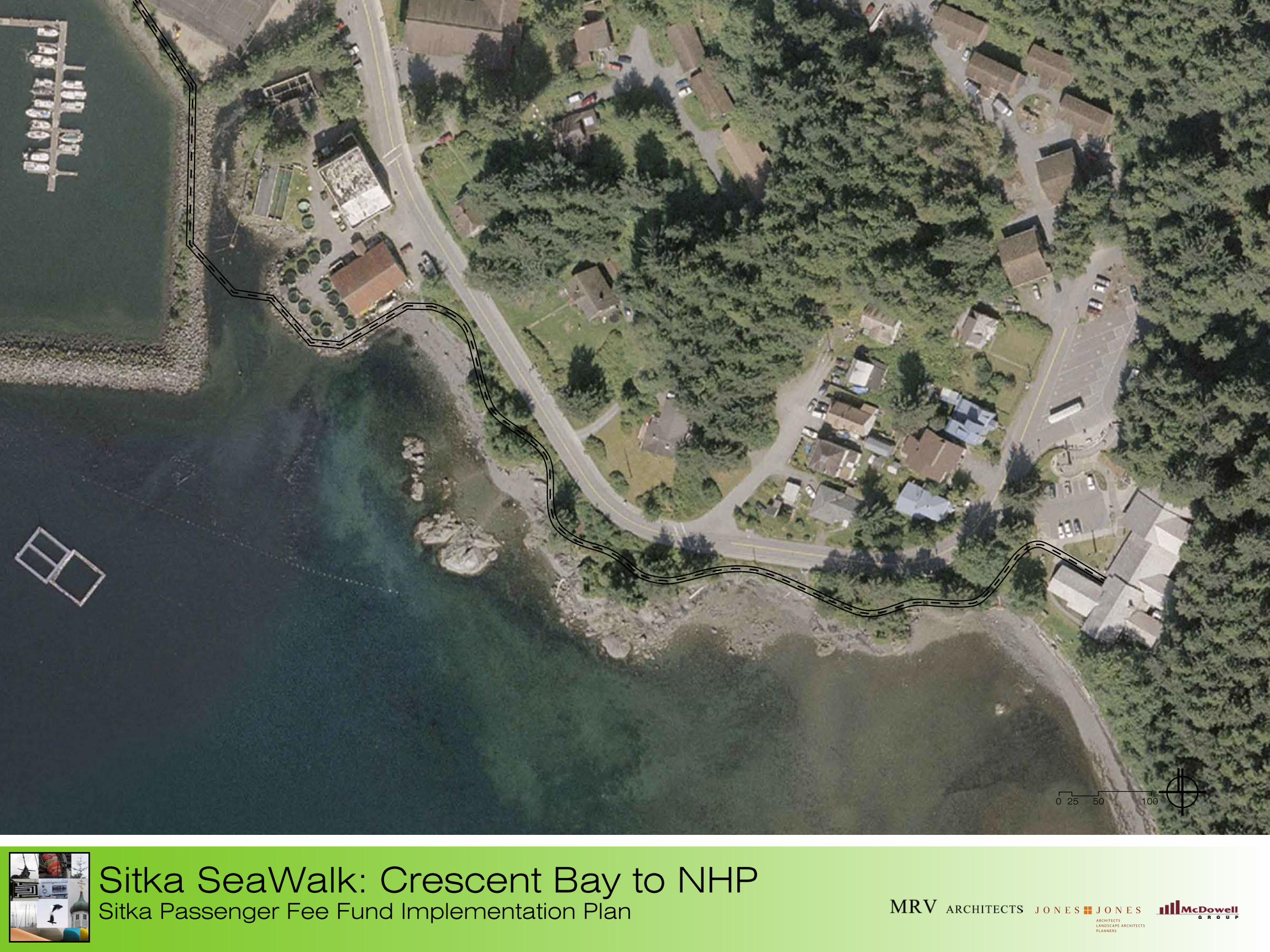
A R C H I T E C T SL A N D S C A P E A R C H I T E C T SP L A N N E R S
0 25 50 100
Sitka SeaWalk: Crescent Bay to NHP Sitka Passenger Fee Fund Implementation Plan
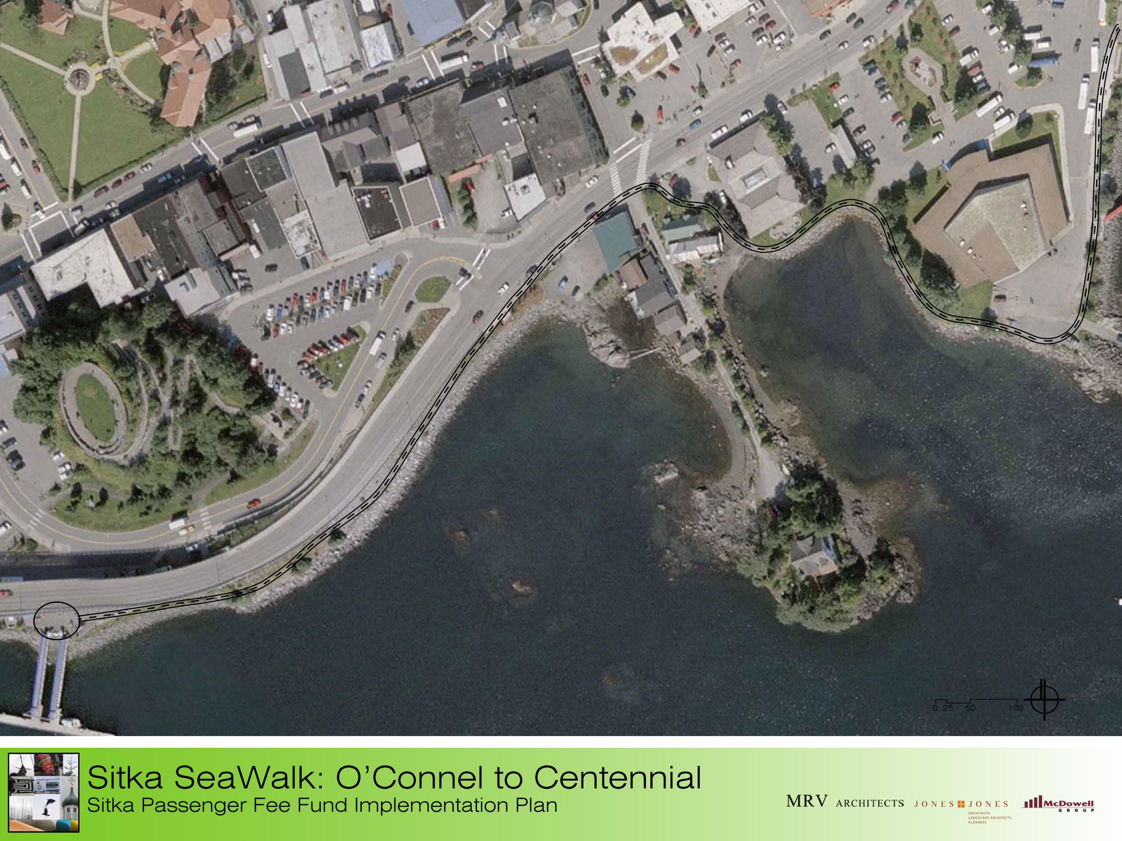
A R C H I T E C T SL A N D S C A P E A R C H I T E C T SP L A N N E R S
0 25 50 100
Sitka SeaWalk: O’Connel to Centennial Sitka Passenger Fee Fund Implementation Plan
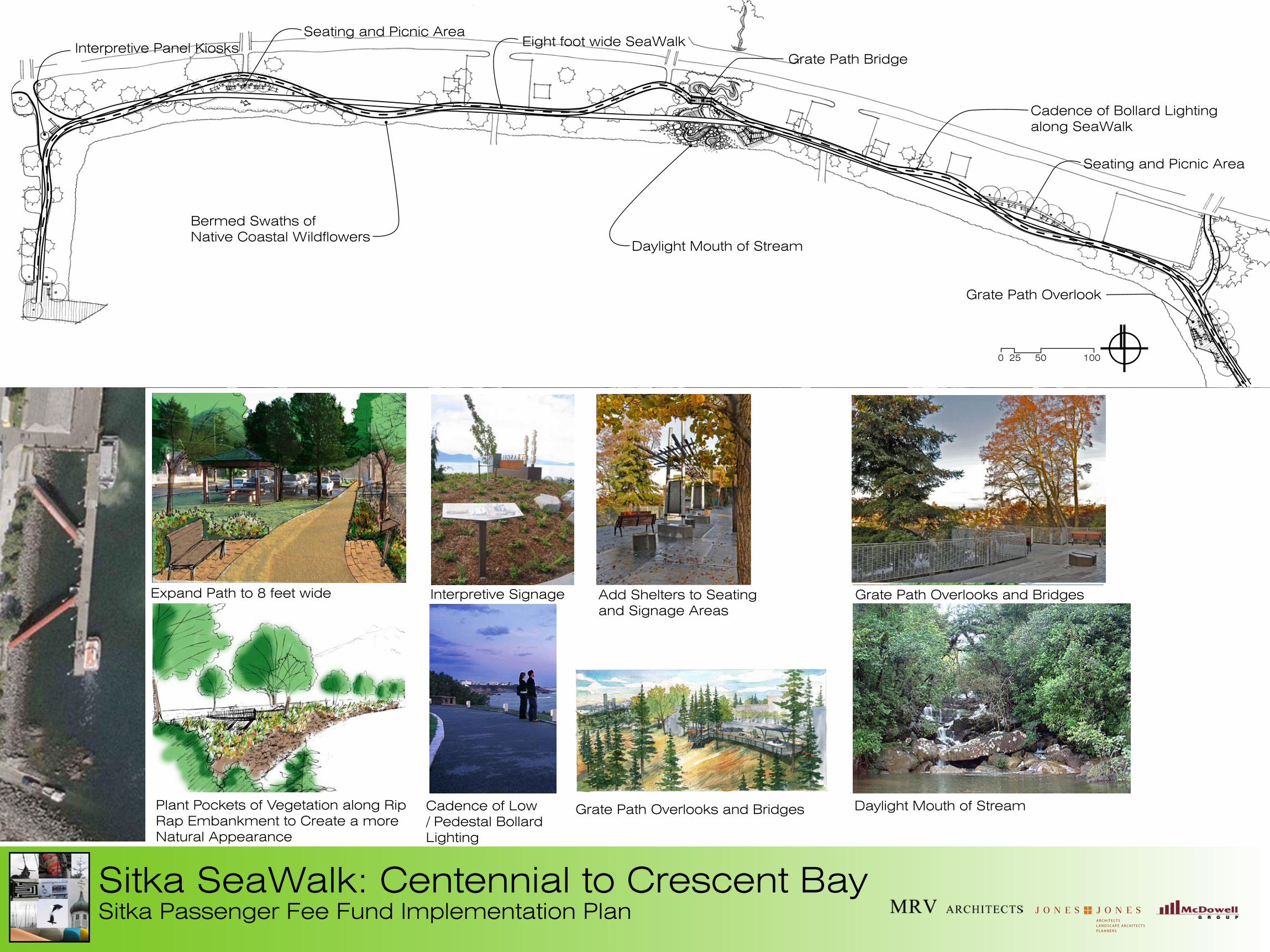
A R C H I T E C T SL A N D S C A P E A R C H I T E C T SP L A N N E R S
0 25 50 100
Sitka SeaWalk: Centennial to Crescent BaySitka Passenger Fee Fund Implementation Plan
Grate Path Overlooks and Bridges
Cadence of Low / Pedestal Bollard Lighting
Daylight Mouth of Stream
Seating and Picnic AreaEight foot wide SeaWalk
Grate Path Overlook
Bermed Swaths of Native Coastal Wildflowers
Cadence of Bollard Lighting along SeaWalk
Interpretive Panel Kiosks
Daylight Mouth of Stream
Add Shelters to Seating and Signage Areas
Plant Pockets of Vegetation along Rip Rap Embankment to Create a more Natural Appearance
Expand Path to 8 feet wide
Grate Path Overlooks and Bridges
Interpretive Signage
Seating and Picnic Area
Grate Path Bridge
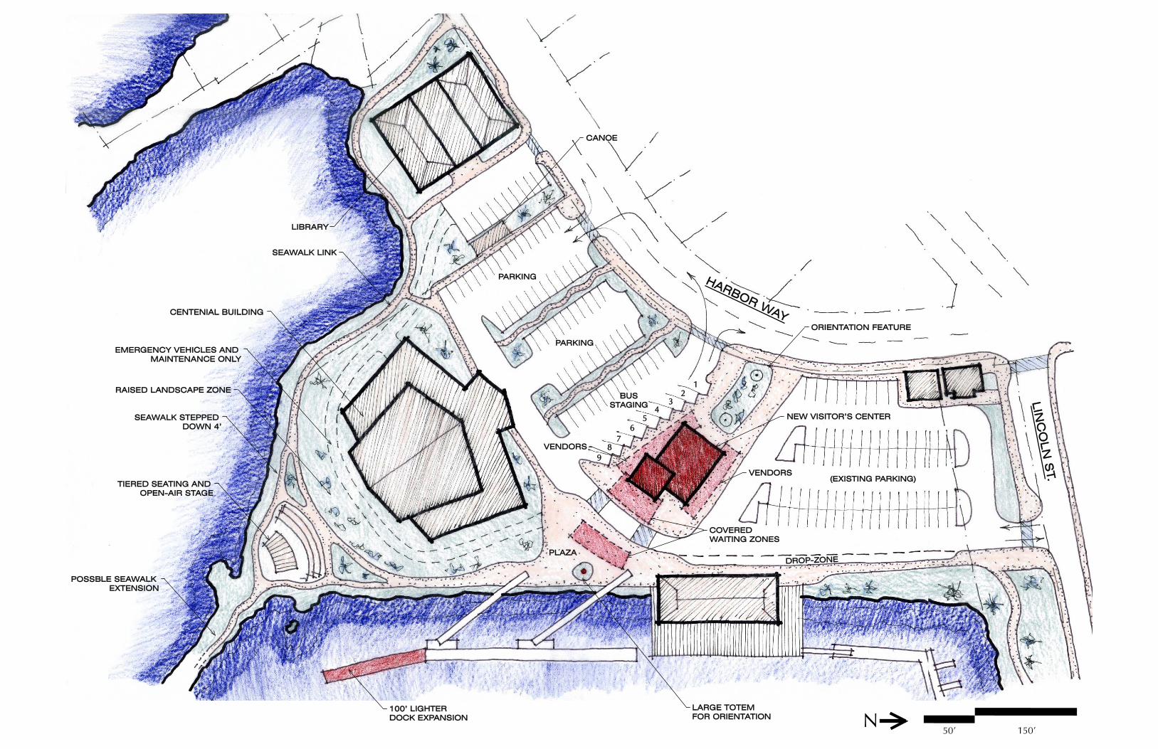
N
12
34
56
100’ LIGHTER100’ LIGHTERDOCK EXPANSIONDOCK EXPANSION
HARBOR WAY
HARBOR WAY
LIN
CO
LN
ST.
LIN
CO
LN
ST.
BUSBUSSTAGINGSTAGING
(EXISTING PARKING)(EXISTING PARKING)
PLAZAPLAZA
LARGE TOTEM LARGE TOTEM FOR ORIENTATIONFOR ORIENTATION
DROP-ZONEDROP-ZONE
POSSBLE SEAWALK POSSBLE SEAWALK EXTENSIONEXTENSION
TIERED SEATING AND TIERED SEATING AND OPEN-AIR STAGEOPEN-AIR STAGE
SEAWALK STEPPED SEAWALK STEPPED DOWN 4’DOWN 4’
RAISED LANDSCAPE ZONERAISED LANDSCAPE ZONE
EMERGENCY VEHICLES AND EMERGENCY VEHICLES AND MAINTENANCE ONLYMAINTENANCE ONLY
CENTENIAL BUILDINGCENTENIAL BUILDING
SEAWALK LINKSEAWALK LINK
LIBRARYLIBRARY
78
9
COVERED COVERED WAITING ZONESWAITING ZONES
VENDORSVENDORS
VENDORSVENDORS
ORIENTATION FEATUREORIENTATION FEATURE
PARKINGPARKING
PARKINGPARKING
CANOECANOE
NEW VISITOR’S CENTERNEW VISITOR’S CENTER
150’50’

150’50’N
POSSBLE SEAWALK POSSBLE SEAWALK EXTENSIONEXTENSION
TIERED SEATING AND TIERED SEATING AND OPEN-AIR STAGEOPEN-AIR STAGE
SEAWALK STEPPED SEAWALK STEPPED DOWN 4’DOWN 4’
RAISED LANDSCAPE ZONERAISED LANDSCAPE ZONE
EMERGENCY VEHICLES AND EMERGENCY VEHICLES AND MAINTENANCE ONLYMAINTENANCE ONLY
CENTENIAL BUILDINGCENTENIAL BUILDING
SEAWALK LINKSEAWALK LINK
LIBRARYLIBRARY
EXIT ONLYEXIT ONLY
12
34
56
CANOECANOE
COVERED CANOPIESCOVERED CANOPIES
ORIENTATION FEATUREORIENTATION FEATURE
NEW VISITOR’S CENTERNEW VISITOR’S CENTER
COVERED SEACOVERED SEAWALKWALK100’ LIGHTER100’ LIGHTER
DOCK EXPANSIONDOCK EXPANSIONCOVERED SEACOVERED SEA
WALKWALK
RE-ORIENTEDRE-ORIENTEDDOCK RAMPSDOCK RAMPS
COVERED COVERED WAITING ZONEWAITING ZONE25’ x 70’25’ x 70’
HARBOR WAY HARBOR WAY
LIN
CO
LN
ST.
LIN
CO
LN
ST.
BUSBUSSTAGINGSTAGING
PARKINGPARKING
(EXISTING PARKING)(EXISTING PARKING)
PLAZAPLAZA
LARGE TOTEM LARGE TOTEM FOR ORIENTATIONFOR ORIENTATION
DRO
P-ZON
E
DRO
P-ZON
E
VENDORSVENDORS
VENDORSVENDORS
DROP-ZONEDROP-ZONE