site investigation work plan
TRANSCRIPT


SITE INVESTIGATION WORK PLAN SHELL-BRANDED SERVICE STATION 1520 SOUTH 348TH STREET FEDERAL WAY, WASHINGTON SAP CODE 120698 INCIDENT NO. 94995029 VCP NO. NW2068 SEPTEMBER 4, 2009 REF. NO. 241848 (5) This report is printed on recycled paper.
Prepared by: Conestoga-Rovers & Associates 1420 80th St. SW, Ste. A Everett, Washington U.S.A. 98203
Office: 425-212-5100 Fax: 425-212-5199
web: http:\\www.CRAworld.com
W o r l d w i d e E n g i n e e r i n g , E n v i r o n m e n t a l , C o n s t r u c t i o n , a n d I T S e r v i c e s

241848 (5) CONESTOGA-ROVERS & ASSOCIATES
TABLE OF CONTENTS Page
1.0 INTRODUCTION ...................................................................................................................1 1.1 SITE INFORMATION.........................................................................................1 1.2 PURPOSE..............................................................................................................1 1.3 SITE DESCRIPTION AND BACKGROUND ..................................................1
2.0 WORK PLAN BACKGROUND INFORMATION .............................................................3
3.0 OBJECTIVES ............................................................................................................................4 3.1 TASK 1 – DELINEATE SOILS ...........................................................................4 3.2 TASK 2 – LOCATE POTENTIAL FORMER USTS REMAINING AT THE
PROPERTY ...........................................................................................................5
4.0 WORK TASK ...........................................................................................................................6 4.1 HEALTH AND SAFETY PLAN ........................................................................6 4.2 UTILITY CLEARANCE......................................................................................6 4.3 SITE INVESTIGATION AND FIELD SAMPLING PROCEDURES.............6 4.4 LABORATORY ANALYTICAL PROCEDURES ............................................9 4.5 WELL INSTALLATION .....................................................................................9 4.6 WELL DEVELOPMENT.....................................................................................9 4.7 WELL SAMPLING ............................................................................................10 4.8 WELL SURVEYING ..........................................................................................10 4.9 INVESTIGATION-DERIVED WASTE ...........................................................10 4.10 CERTIFICATION ..............................................................................................10

241848 (5) CONESTOGA-ROVERS & ASSOCIATES
LIST OF FIGURES (Following Text)
FIGURE 1 VICINITY MAP FIGURE 2 SITE PLAN WITH PROPOSED BORING LOCATIONS FIGURE 3 SOIL INVESTIGATION DATA MAP
LIST OF TABLES TABLE 1 SUMMARY OF HISTORICAL SOIL ANALYTICAL DATA TABLE 2 SUMMARY OF GROUNDWATER ANALYTICAL DATA –
PETROLEUM HYDROCARBONS, BTEX, MTBE, OXYGENATES AND LEAD
TABLE 3 SUMMARY OF GROUNDWATER ANALYTICAL DATA- POLYCYCLIC
AROMATIC HYDROCARBONS TABLE 4 LABORATORY ANALYSES REQUIREMENTS
LIST OF APPENDICES APPENDIX A AVAILABLE SOIL BORING LOGS APPENDIX B SUMMARY OF PREVIOUS SITE INVESTIGATIONS AND REMEDIAL
ACTIVITIES

241848 (5) CONESTOGA-ROVERS & ASSOCIATES
1
1.0 INTRODUCTION
1.1 SITE INFORMATION
Site Name: Active Shell Retail Facility
Site Address: 1520 South 348th Street, Federal Way, WA
Voluntary Cleanup Program Number: NW2068
Project Consultant: Conestoga-Rovers & Associates
Project Consultant Contact Information: Justin Foslien – Project Manager
1420 80th Street Southwest, Suite A
Everett, Washington, 98203
Office – 425.212.5100
Direct – 425.212.5111
Current Owner/Operator: Equilon Enterprises LLC dba Shell Oil Products US (Shell)
1.2 PURPOSE
Conestoga-Rovers and Associates (CRA) prepared this work plan on behalf of Equilon Enterprises LLC dba Shell to conduct additional investigation activities at 1520 South 348th Street, Federal Way, King County, Washington to further assess the extent of petroleum hydrocarbon impacts to subsurface soil and groundwater. 1.3 SITE DESCRIPTION AND BACKGROUND
The Site is defined as all affected areas from the petroleum release described below, including any potentially impacted adjacent parcels. The Property is an active Shell-branded service station located at the northwest corner of Kitts Corner Road South and South 348th Street in Federal Way, King County, Washington within a mixed use commercial and retail area (Figure 1). Kitts Corner Road is also referred to as 16th Avenue South. Site Background: The Property was developed in 1968. Uses of the Property prior to 1968 are unknown. Refer to Figure 2 for the Site configuration. Refer to Appendix A for a summary of available information reviewed prior to selecting tasks for this work plan.

241848 (5) CONESTOGA-ROVERS & ASSOCIATES
2
Site Discovery: During a 1993 Stage II Vapor Recovery retrofit, analytical results from shallow soil samples collected beneath the western dispensers indicated total petroleum hydrocarbons (TPH) as gasoline (TPHg) and TPH as diesel (TPHd) above Model Toxic Control Act (MTCA) Method A screening levels. A petroleum release impacting soil was reported to Washington State Department of Ecology (Ecology) on September 1, 1993. The Site’s leaking UST (LUST) program ID is #4443. In 2008, the Site was entered into Ecology’s Voluntary Cleanup Program (VCP) and issued Site number NW2068.

241848 (5) CONESTOGA-ROVERS & ASSOCIATES
3
2.0 WORK PLAN BACKGROUND INFORMATION
Four borings and seven monitoring wells have been completed at the Site to assess subsurface conditions since release discovery in 1993. The predominant area of soil impacted by petroleum-related compounds appears to be in the southern portion of the Site. All available historical boring logs for the previous investigations are included in Appendix A. A complete chronological summary of work completed during the investigations listed above at the Site is included as Appendix B. Table 1 summarizes historical soil analytical data for the Site and Table 2 presents sampling dates, groundwater elevations, and the analytical results for each sampling event. Figure 3 illustrates areas of the Site containing residual impacted soil.

241848 (5) CONESTOGA-ROVERS & ASSOCIATES
4
3.0 OBJECTIVES
3.1 TASK 1 – DELINEATE SOILS
Site soils are defined to non-detect or below the MTCA Method A screening levels to the northwest to 25 feet bgs, northeast to 30 feet bgs, and to the southwest to 40.5 feet bgs by MW-6, SB-1, and SB-3 and MW-5, respectively. Further evaluation of soils to the east, south, and southeast are necessary to define the Site. CRA proposes five soil borings with two borings completed as monitoring wells at the locations depicted on Figure 2: • Two borings (A & B) to at least 45 feet bgs to delineate the eastern Site boundary in
the vicinity of SB-2 and south of SB-2
o Boring B will be completed as a monitoring well
• One boring (C) to delineate south of MW-4 and the southern Site boundary
• One boring (D) to delineate the southern Site boundary
• One boring (E) to delineate the western Site boundary
o Preferred location for E is limited by utilities (between the planter and the building). Alternate location is at the southwest corner of the building
o Boring E will be completed as a monitoring well
Two soil samples per boring: • One directly above the field observed permeable zones
• One based on headspace PID readings in dry soils below permeable layer
Additional samples may be selected as determined by the project manager. If field personnel encounter a continuous saturated zone, rather than a distinct permeable layer (described in Section 2.0), the project manager will be notified to determine further investigatory actions. Refer to Appendix C for details of previous investigations at the Site.

241848 (5) CONESTOGA-ROVERS & ASSOCIATES
5
3.2 TASK 2 – LOCATE POTENTIAL FORMER USTS REMAINING AT THE PROPERTY
Refer to Appendix A “Past Property Use” for further detail on potential former USTs remaining at the Property. While it is commonly practiced and most practical to install the current UST system in the same configuration as the former UST system, the previous UST system noted on the 1984 Seattle Fire Marshal’s permit does not provide a location. CRA proposes conducting a geophysical survey to locate potential USTs that may be present at the Property. If the geophysical survey identifies potential USTs, additional soil borings may be added at the discretion of the Project Manager in the vicinity of the potential UST.

241848 (5) CONESTOGA-ROVERS & ASSOCIATES
6
4.0 WORK TASK
4.1 HEALTH AND SAFETY PLAN
CRA will prepare a comprehensive Site-Specific Health and Safety Plan to protect Site workers. The plan will be reviewed and signed by each Site worker and kept on the Site during field activities. 4.2 UTILITY CLEARANCE
Each proposed boring location will be cleared through Washington Utilities Coordinating Council (WUCC) prior to drilling. A private utility locating service will also be used to verify clearance of each boring from subsurface utilities or other obstructions. During work, the first 5 feet (non-critical areas) or 10 feet (critical areas) of each boring will be cleared to a diameter of 3 inches larger than the lead auger using an air-knife to minimize potential damage to underground structures not identified through WUCC or the private utility locating service. The final locations of completed borings will be based on the clearance of utilities. 4.3 SITE INVESTIGATION AND FIELD SAMPLING PROCEDURES
Five soil borings advanced to at least 45 feet bgs are proposed for this work plan. The borings will be advanced using a hollow-stem auger drill rig in accordance with CRA’s Standard Operating Procedures. Soil samples will be screened in the field for organic vapors using a photo-ionization detector (PID). Two soil samples per boring will be selected for laboratory analysis. One soil sample will be selected at the field observed permeable zones and one soil sample will be selected based on headspace PID readings in dry soils below permeable layer to delineate vertical extent on petroleum impacted soils. Additional samples may be selected as determined by the project manager. In the case of field personnel encountering a continuous permeable zone or saturated soil zone, rather than a distinct layer (described in Section 2.0), the project manager will be notified for further investigatory actions. Additional soil samples may be collected. Further advancement of each boring beyond total depth or the installation of additional monitoring wells, and additional boring locations may be advanced based on field personnel observations and PID readings, and as determined by the project manager. The table below outlines the selected analysis per boring location. Table 4 provides a complete list of analysis requirements for Site specific analytes.

241848 (5) CONESTOGA-ROVERS & ASSOCIATES
7
Proposed Boring
Soil Samples Total Depth Purpose Soil Analysis
A and B* 1 - observed permeable zone 1 – at or below 35 feet Boring B – complete as monitoring well
45 feet bgs Delineation of the eastern Site boundary in the vicinity of SB-2 and delineation south of SB-2
TPH-g, THP-d, VOCs, EDB, EDC, cPAHs, Lead, **TPH Fraction (EPH, VPH), PCBs***
C* 1 - observed permeable zone 1 – at or below 30 feet
45 feet bgs Delineation south of SB-5 and MW-4 and the southern Site boundary
TPH-g, THP-d, VOCs, EDB, EDC, cPAHs, Lead, **TPH Fraction (EPH, VPH), PCBs***
D* 1 - observed permeable zone 1 – at or below 30 feet
45 feet bgs Delineation at the southern Site boundary
TPH-g, THP-d, VOCs, EDB, EDC, cPAHs, Lead, **TPH Fraction (EPH, VPH), PCBs***
E* 1 - observed permeable zone 1 – at or below 30 feet Boring E – a complete as monitoring well
45 feet bgs Delineation at the western Site line. – optimal location for SB-10 is limited by utilities (between the planter and the building), alternate location is at the southwest corner of the building
TPH-g, THP-d, VOCs, EDB, EDC, cPAHs, Lead, **TPH Fraction (EPH, VPH), PCBs***
bgs = below ground surface TPH-g = Gasoline range organics per Method Northwest Total Petroleum Hydrocarbon Identification (NWTPH)-Gx; TPH-d = Diesel range organics per Method Northwest Total Petroleum Hydrocarbon Identification (NWTPH)-Dx; VOCs = Volatile organic compounds, including Benzene, Toluene, Ethylbenzene, Xylenes, and Halogenated VOCs per EPA Method 8260B; EDB = 1,2-Dibromoethane per EPA Method 8260B; EDC = 1,2-Dichloroethane per EPA Method 8260B; PAHs = Polycyclic aromatic hydrocarbon per EPA Method 8270C-Selective Ion Monitoring; Lead = Total lead per EPA Method 6010; PCB = Polychlorinated biphenyl per EPA Method 8082 TPH Fraction = Volatile Petroleum Hydrocarbon (VPH) and Extractable Petroleum Hydrocarbon (EPH) Method; * Sampling/boring may be advanced beyond designated depth based on indication of presence of petroleum constituents from field observations and PID readings. Field personnel will coordinate with Project Manager in these cases. ** Optional TPH Fraction analysis – based on indication of presence of petroleum constituents from field observations and PID readings. Field personnel will coordinate with Project Manager these optional analyses. ***PCBs – Analyzed only near GPR identified anomalies indicative of a UST. Field personnel will coordinate with Project Manager these optional analyses.

241848 (5) CONESTOGA-ROVERS & ASSOCIATES
8
CRA field staff is trained in soil sample collection field methods to ensure results are representative of media and conditions in accordance with CRA Standard Operating Procedures. Soil samples will be collected in accordance with Ecology’s Implementation Memorandum #5 concerning procedures for collecting and preparing soil samples for volatile organic compound analysis. CRA personnel will supervise the drilling, record times, dates, and locations of all samples as well as daily events, operations, field measurements, and any other notable details obtained during the Site investigation, and describe soil using the Unified Soil Classification System. Soil sampling equipment will be decontaminated before each use, including hand auger, mixing bowls, and spoons. Equipment will be cleaned with a bristle brush as necessary and concentrated detergent solution (e.g., Alconox) with tap water. A deionized water rinse will follow and the equipment will be air dried for as long as possible. All decontamination water will be contained in a labeled US Department of Transportation (DOT) approved 55-gallon drum for later offsite disposal. Management of investigation-derived wastes (IDW) is discussed below. Samples will be collected and labeled, and then placed immediately on ice within a pre-chilled insulated cooler. Samples will be kept at or below 4o C, but above freezing throughout storage, handling, and shipping. Breakable sample containers (e.g., glass jars) will be sealed in plastic bags and separated by bubble wrap or other packing material. At least a portion of each container must contact the ice; otherwise, the protective layer (e.g., bubble wrap) may insulate the sample from the cooling effects of the ice. Sample labeling and chain of custody procedures provide a legal record of sample transport, possession and handling. Waterproof labels will be used to identify each sample container. A permanent, waterproof marker will be used to mark the labels. Labels will not be placed directly onto container lids but on the container itself. Labels will include the following information: • the Site/project name
• a unique sample number
• the sample collector’s initials
• the date and time sample was collected
• the analyses required and preservative(s) added
A Chain of Custody (COC) form will be completed for each sampling event in the field after the samples are collected. Once a sample is collected, it will remain in the custody

241848 (5) CONESTOGA-ROVERS & ASSOCIATES
9
of the sampler or other qualified personnel until delivered to the laboratory. Upon transfer of sample containers to subsequent custodians, the persons relinquishing custody of the sample containers will sign the COC form. Upon receipt of samples at the laboratory, the receiver will sign the COC form and record the condition of the samples. COC forms will be included with the laboratory data in the report. 4.4 LABORATORY ANALYTICAL PROCEDURES
Collected soil and groundwater samples will be submitted to Calscience Environmental Laboratories, Inc. (Calscience) for analysis. Calscience will include Quality Assurance/Quality Control results with each batch of laboratory analysis performed with duplicate, method blank, spike, and quality control analyses results. Additionally, Calscience’s “Quality Systems Manual for Analytical Services” outlines QA/QC procedures. This 64-page document includes data verification and quality control methods, and is available for Ecology’s review upon request. 4.5 WELL INSTALLATION
The installation of two new groundwater monitoring wells are proposed. Based on existing data, groundwater at the Site has been gauged from 11 to 35 feet bgs. The screened interval depth will be determined in the field based on observations noted during boring advancement. The groundwater monitoring well will consist of approximately 20 feet of 2-inch schedule 40 PVC screen with 0.01-inch slots flush threaded with 2-inch PVC well casing. The well annulus will be backfilled with a 10-20 size washed sand pack to at least 2 feet above the top of the screen and sealed with bentonite chips or pellets to the surface. The surface of each well will be completed with a lockable steel housing embedded in concrete and installed flush with ground surface with a traffic-rated monument. 4.6 WELL DEVELOPMENT
The new monitoring wells will be developed after drilling in order to allow maximum flow of groundwater into the well screen and decrease turbidity. Development will continue until the groundwater turbidity values are uniform and field parameters have stabilized to within 10 percent agreement of each other or when the well becomes dry or

241848 (5) CONESTOGA-ROVERS & ASSOCIATES
10
recovery is slow. Additionally, the monitoring wells will be gauged prior to and after well development. 4.7 WELL SAMPLING
The newly installed and developed monitoring wells will be incorporated into the existing groundwater monitoring program and sampled by Blaine Tech Services, Inc. 4.8 WELL SURVEYING
The newly installed and existing monitoring wells will be surveyed by a licensed surveyor according to state plane coordinates. 4.9 INVESTIGATION-DERIVED WASTE
Investigation derived waste (IDW) will include personal protective equipment, decontamination fluids, soil from borings and purged well water. All IDW will be placed in properly labeled 55-gallon drums and stored onsite pending analyses. The IDW will be disposed of according to Shell procedures and applicable regulatory requirements. 4.10 CERTIFICATION
The scope of work described in this work plan will be performed under the supervision of a Washington state licensed geologist.

241848 (5)
FIGURES

10/17/08I:
\EV
ER
ET
T.S
HE
LL
\WA
SH
EL
L S
ITE
S\1
52
0 S
OU
TH
34
8T
H S
TR
EE
T\F
IGU
RE
S\2
41
84
8 V
ICIN
ITY
.AI
SCALE : 1" = 1/4 MILE
11/21/41/80
Vicinity MapShell-branded Service Station1520 348th Street South
Federal Way, Washington
1FIGURE
N
SOURCE: TOPO! MAPS
Washington
STO
NE
Y P
EA
K D
RIV
E
Site
SOUTH 348TH STREET
16
TH
A
VE
NU
E S
OU
TH


241848 (5)
TABLES

TABLE 1
SUMMARY OF HISTORICAL SOIL ANALYTICAL DATA
ACTIVE SHELL STATION 1520 SOUTH 348TH STREET, FEDERAL WAY, WASHINGTON
Sample ID DateDepth(fbg) TPHg TPHd TPHo Benzene Toluene Ethylbenzene Total Xylenes EDB EDC MTBE TBA DIPE ETBE TAME Total Lead
30/100 2,000 2,000 0.03 7 6 9 0.005 0.1 250
NPI-W 8/13/1993 3.1 630 16,000 -- <0.050 <0.050 <0.050 <0.10 -- -- -- -- -- -- -- --
NPI-E 8/13/1993 2.7 <1.0 -- -- <0.050 <0.050 <0.050 <0.10 -- -- -- -- -- -- -- --NT-1 8/13/1993 4 <1.0 47 -- <0.050 <0.050 <0.050 <0.10 -- -- -- -- -- -- -- --SPI-EW-2.8 8/13/1993 2.8 24 3,200 -- <0.050 <0.050 <0.050 <0.10 -- -- -- -- -- -- -- --
SPI-E 8/13/1993 2.2 21 -- -- <0.050 <0.050 <0.050 <0.10 -- -- -- -- -- -- -- --ST-1 8/13/1993 4 3.8 280 -- <0.050 <0.050 <0.050 <0.10 -- -- -- -- -- -- -- --
VE-1* 7/5/1994 15-15.25 210 980 31 <0.050 <0.050 0.20 0.57 -- -- -- -- -- -- -- --VE-1* 7/5/1994 20.5-21 1,700 1,400 33 0.34 8.0 16 83 -- -- -- -- -- -- -- --
VE-1* 7/5/1994 30.5-31 9.0 10 <25 <0.050 0.083 0.064 0.15 -- -- -- -- -- -- -- --VE-1* 7/5/1994 35.5 <1.0 <10 <25 <0.050 <0.050 <0.050 <0.10 -- -- -- -- -- -- -- --VE-1* 7/5/1994 45-45.5 <1.0 <10 <25 <0.050 0.082 <0.050 <0.10 -- -- -- -- -- -- -- --VE-1* 7/5/1994 60-60.5 <1.0 <10 <25 <0.050 <0.050 <0.050 <0.10 -- -- -- -- -- -- -- --VE-2* 7/5/1994 15.5-16 <1.0 <10 <25 <0.050 <0.050 <0.050 <0.10 -- -- -- -- -- -- -- --VE-2* 7/5/1994 25.5-26 120 <10 <25 <0.050 <0.050 0.44 1.1 -- -- -- -- -- -- -- --
VE-2* 7/5/1994 30.5-31 1.1 <10 <25 <0.050 <0.050 <0.050 <0.10 -- -- -- -- -- -- -- --VE-2* 7/5/1994 40-40.5 <1.0 <10 <25 <0.050 <0.050 <0.050 <0.10 -- -- -- -- -- -- -- --SB-3 7/5/1994 15-15.5 <1.0 <10 <25 <0.050 <0.050 <0.050 <0.10 -- -- -- -- -- -- -- --SB-3 7/5/1994 40-40.5 3.6 <10 <25 <0.050 <0.050 <0.050 <0.10 -- -- -- -- -- -- -- --
MW3-2 10/22/1997 11 <5.00 <10.0 -- <0.0500 <0.0500 <0.0500 <0.100 -- -- -- -- -- -- -- --MW3-3 10/22/1997 15.5 <5.00 <10.0 -- <0.0500 <0.0500 <0.0500 <0.100 -- -- -- -- -- -- -- 11MW3-4 10/22/1997 20.5 <5.00 <10.0 -- <0.0500 <0.0500 <0.0500 <0.100 -- -- -- -- -- -- -- --MW4-2 10/22/1997 10 <5.00 <10.0 -- <0.0500 <0.0500 <0.0500 <0.100 -- -- -- -- -- -- -- --MW4-3 10/22/1997 15 <5.00 22.1 -- <0.0500 <0.0500 <0.0500 <0.100 -- -- -- -- -- -- -- --MW4-4 10/22/1997 20 <5.00 <10.0 -- <0.0500 <0.0500 <0.0500 <0.100 -- -- -- -- -- -- -- --MW4-6 10/22/1997 30 5.22 <10.0 -- <0.0500 <0.0500 <0.0500 <0.100 -- -- -- -- -- -- -- <10.0MW5-2 10/22/1997 25 <5.00 11.8 -- <0.0500 <0.0500 <0.0500 <0.100 -- -- -- -- -- -- -- --MW5-3 10/22/1997 11 <5.00 <10.0 -- <0.0500 <0.0500 <0.0500 <0.100 -- -- -- -- -- -- -- <10.0MW5-4 10/22/1997 20.5 6.24 <10.0 -- <0.0500 <0.0500 <0.0500 <0.100 -- -- -- -- -- -- -- --
SB-1-25-060908 6/9/2008 25 2.9 <5.6 <11 0.0063 0.052 <0.0056 0.015 <0.0056 <0.0056 <0.0056 <0.11 <0.011 <0.0056 <0.0056 1.79SB-2-15-060908 6/9/2008 15 2.2 <5.7 <11 <0.0057 <0.0057 <0.0057 <0.0057 <0.0057 <0.0057 <0.0057 <0.11 <0.011 <0.0057 <0.0057 2.24SB-2-35-060908 6/9/2008 35 2,900 47 <11 <2.1 25 15 100 <2.1 <2.1 <2.1 <43 <4.3 <2.1 <2.1 1.94
SB-3-20-061008 6/10/2008 20 <0.065 13 22 <0.0055 0.034 0.0075 0.0515 <0.0055 <0.0055 <0.0055 <0.11 <0.011 <0.0055 <0.0055 2.52
MTCA Method A Screening Levels
CRA 241848 (5)
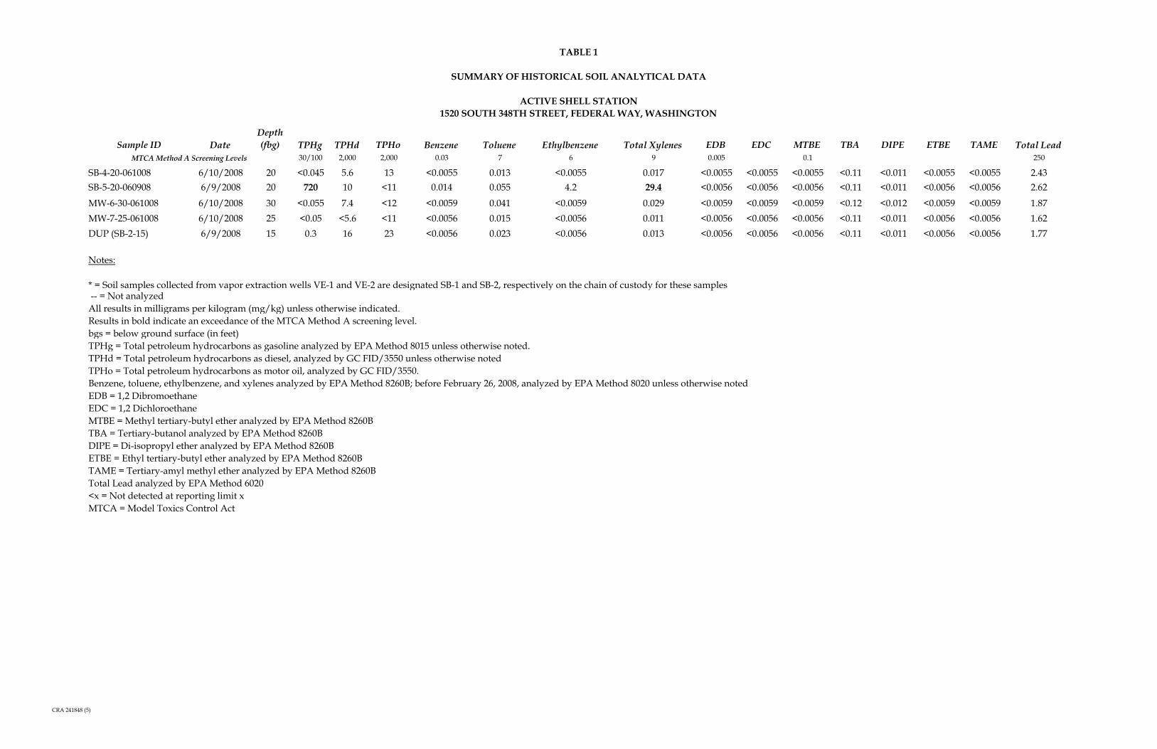
TABLE 1
SUMMARY OF HISTORICAL SOIL ANALYTICAL DATA
ACTIVE SHELL STATION 1520 SOUTH 348TH STREET, FEDERAL WAY, WASHINGTON
Sample ID DateDepth(fbg) TPHg TPHd TPHo Benzene Toluene Ethylbenzene Total Xylenes EDB EDC MTBE TBA DIPE ETBE TAME Total Lead
30/100 2,000 2,000 0.03 7 6 9 0.005 0.1 250MTCA Method A Screening Levels
SB-4-20-061008 6/10/2008 20 <0.045 5.6 13 <0.0055 0.013 <0.0055 0.017 <0.0055 <0.0055 <0.0055 <0.11 <0.011 <0.0055 <0.0055 2.43SB-5-20-060908 6/9/2008 20 720 10 <11 0.014 0.055 4.2 29.4 <0.0056 <0.0056 <0.0056 <0.11 <0.011 <0.0056 <0.0056 2.62
MW-6-30-061008 6/10/2008 30 <0.055 7.4 <12 <0.0059 0.041 <0.0059 0.029 <0.0059 <0.0059 <0.0059 <0.12 <0.012 <0.0059 <0.0059 1.87MW-7-25-061008 6/10/2008 25 <0.05 <5.6 <11 <0.0056 0.015 <0.0056 0.011 <0.0056 <0.0056 <0.0056 <0.11 <0.011 <0.0056 <0.0056 1.62DUP (SB-2-15) 6/9/2008 15 0.3 16 23 <0.0056 0.023 <0.0056 0.013 <0.0056 <0.0056 <0.0056 <0.11 <0.011 <0.0056 <0.0056 1.77
Notes:
* = Soil samples collected from vapor extraction wells VE-1 and VE-2 are designated SB-1 and SB-2, respectively on the chain of custody for these samples -- = Not analyzedAll results in milligrams per kilogram (mg/kg) unless otherwise indicated.Results in bold indicate an exceedance of the MTCA Method A screening level.bgs = below ground surface (in feet)TPHg = Total petroleum hydrocarbons as gasoline analyzed by EPA Method 8015 unless otherwise noted.TPHd = Total petroleum hydrocarbons as diesel, analyzed by GC FID/3550 unless otherwise notedTPHo = Total petroleum hydrocarbons as motor oil, analyzed by GC FID/3550.Benzene, toluene, ethylbenzene, and xylenes analyzed by EPA Method 8260B; before February 26, 2008, analyzed by EPA Method 8020 unless otherwise notedEDB = 1,2 DibromoethaneEDC = 1,2 Dichloroethane MTBE = Methyl tertiary-butyl ether analyzed by EPA Method 8260BTBA = Tertiary-butanol analyzed by EPA Method 8260BDIPE = Di-isopropyl ether analyzed by EPA Method 8260BETBE = Ethyl tertiary-butyl ether analyzed by EPA Method 8260BTAME = Tertiary-amyl methyl ether analyzed by EPA Method 8260BTotal Lead analyzed by EPA Method 6020<x = Not detected at reporting limit xMTCA = Model Toxics Control Act
CRA 241848 (5)
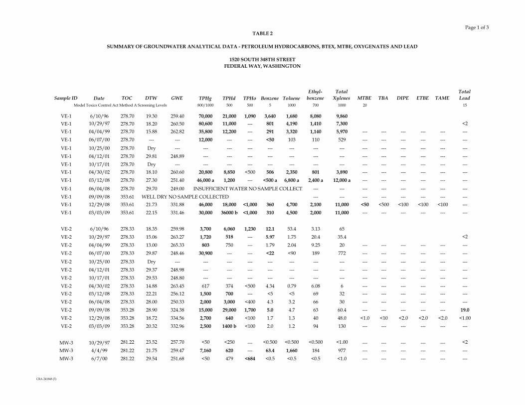
TABLE 2
SUMMARY OF GROUNDWATER ANALYTICAL DATA - PETROLEUM HYDROCARBONS, BTEX, MTBE, OXYGENATES AND LEAD
1520 SOUTH 348TH STREETFEDERAL WAY, WASHINGTON
Page 1 of 3
Sample ID Date TOC DTW GWE TPHg TPHd TPHo Benzene TolueneEthyl-
benzeneTotal
Xylenes MTBE TBA DIPE ETBE TAMETotalLead
800/1000 500 500 5 1000 700 1000 20 15
VE-1 6/10/96 278.70 19.30 259.40 70,000 21,000 1,090 3,640 1,680 8,080 9,860VE-1 10/29/97 278.70 18.20 260.50 80,600 11,000 --- 801 4,190 1,410 7,300 <2VE-1 04/04/99 278.70 15.88 262.82 35,800 12,200 --- 291 3,320 1,140 5,970 --- --- --- --- --- ---VE-1 06/07/00 278.70 --- --- 12,000 --- --- <50 103 110 529 --- --- --- --- --- ---
VE-1 10/25/00 278.70 Dry --- --- --- --- --- --- --- --- --- --- --- --- --- ---VE-1 04/12/01 278.70 29.81 248.89 --- --- --- --- --- --- --- --- --- --- --- --- ---VE-1 10/17/01 278.70 Dry --- --- --- --- --- --- --- --- --- --- --- --- --- ---VE-1 04/30/02 278.70 18.10 260.60 20,800 8,850 <500 506 2,350 801 3,890 --- --- --- --- --- ---VE-1 03/12/08 278.70 27.30 251.40 46,000 a 1,200 --- <500 a 6,800 a 2,400 a 12,000 a --- --- --- --- --- ---
VE-1 06/04/08 278.70 29.70 249.00 INSUFFICIENT WATER NO SAMPLE COLLECTE --- --- --- --- --- --- --- ---VE-1 09/09/08 353.61 --- --- --- --- --- --- --- ---VE-1 12/29/08 353.61 21.73 331.88 46,000 18,000 <1,000 360 4,700 2,100 11,000 <50 <500 <100 <100 <100 ---VE-1 03/03/09 353.61 22.15 331.46 30,000 36000 b <1,000 310 4,500 2,000 11,000 --- --- --- --- --- ---
VE-2 6/10/96 278.33 18.35 259.98 3,700 6,060 1,230 12.1 53.4 3.13 65VE-2 10/29/97 278.33 15.06 263.27 1,720 518 --- 5.97 1.75 20.4 35.4 <2
VE-2 04/04/99 278.33 13.00 265.33 803 750 --- 1.79 2.04 9.25 20 --- --- --- --- --- ---VE-2 06/07/00 278.33 29.87 248.46 30,900 --- --- <22 <90 189 772 --- --- --- --- --- ---
VE-2 10/25/00 278.33 Dry --- --- --- --- --- --- --- --- --- --- --- --- --- ---VE-2 04/12/01 278.33 29.37 248.98 --- --- --- --- --- --- --- --- --- --- --- --- ---VE-2 10/17/01 278.33 29.53 248.80 --- --- --- --- --- --- --- --- --- --- --- --- ---VE-2 04/30/02 278.33 14.88 263.45 617 374 <500 4.34 0.79 6.08 6 --- --- --- --- --- ---VE-2 03/12/08 278.33 22.21 256.12 1,500 700 --- <5 <5 69 32 --- --- --- --- --- ---VE-2 06/04/08 278.33 28.00 250.33 2,000 3,000 <400 4.3 3.2 66 30 --- --- --- --- --- ---VE-2 09/09/08 353.28 28.90 324.38 15,000 29,000 1,700 5.0 4.7 63 60.4 --- --- --- --- --- 19.0VE-2 12/29/08 353.28 18.72 334.56 2,700 640 <100 1.7 1.3 40 48.0 <1.0 <10 <2.0 <2.0 <2.0 <1.00VE-2 03/03/09 353.28 20.32 332.96 2,500 1400 b <100 2.0 1.2 94 130 --- --- --- --- --- ---
MW-3 10/29/97 281.22 23.52 257.70 <50 <250 --- <0.500 <0.500 <0.500 <1.00 --- --- --- --- --- <2
MW-3 4/4/99 281.22 21.75 259.47 7,160 620 --- 63.4 1,660 184 977 --- --- --- --- --- ---MW-3 6/7/00 281.22 29.54 251.68 <50 479 <684 <0.5 <0.5 <0.5 <1.0 --- --- --- --- --- ---
Model Toxics Control Act Method A Screening Levels
WELL DRY NO SAMPLE COLLECTED
CRA 241848 (5)

TABLE 2
SUMMARY OF GROUNDWATER ANALYTICAL DATA - PETROLEUM HYDROCARBONS, BTEX, MTBE, OXYGENATES AND LEAD
1520 SOUTH 348TH STREETFEDERAL WAY, WASHINGTON
Page 2 of 3
Sample ID Date TOC DTW GWE TPHg TPHd TPHo Benzene TolueneEthyl-
benzeneTotal
Xylenes MTBE TBA DIPE ETBE TAMETotalLead
800/1000 500 500 5 1000 700 1000 20 15Model Toxics Control Act Method A Screening Levels
MW-3 10/25/00 281.22 Dry --- --- --- --- --- --- --- --- --- --- --- --- --- ---MW-3 4/12/01 281.22 28.56 252.66 <50.0 <250 <500 <0.500 <0.500 <0.500 <1.00 --- --- --- --- --- ---MW-3 10/17/01 281.22 29.89 251.33 --- --- --- --- --- --- --- --- --- --- --- --- ---MW-3 4/30/02 281.22 20.77 260.45 159 <294 <588 <0.500 <0.500 2.29 9.81 --- --- --- --- --- ---
MW-3 3/12/08 281.22 27.10 254.12 <50.0 <1,200 a --- <5 <5 <5 <5 --- --- --- --- --- ---MW-3 6/4/08 281.22 28.44 252.78 60 <250 <400 <1 <1 <1 <1 --- --- --- --- --- ---MW-3 09/09/08 356.26 22.89 333.37 <100 <100 <100 <0.50 <1.0 <1.0 <1.0 --- --- --- --- --- <1.0MW-3 12/29/08 356.26 21.35 334.91 1,800 <100 <100 4.6 <1.0 <1.0 <1.0 <1.0 <10 <2.0 <2.0 <2.0 <1.00MW-3 03/03/09 356.26 26.10 330.16 1,500 230 b <100 22 <1.0 <1.0 <1.0 --- --- --- --- --- ---
MW-4 10/29/97 278.77 13.70 265.07 2,340 <250 --- 7.42 18.1 20 101 --- --- --- --- --- <2
MW-4 04/04/99 278.77 11.33 267.44 <50 <250 --- <0.5 <0.5 <0.5 <1.0 --- --- --- --- --- ---MW-4 06/07/00 278.77 --- --- --- --- --- --- --- --- --- --- --- --- --- --- ---MW-4 10/25/00 278.77 Dry --- --- --- --- --- --- --- --- --- --- --- --- --- ---MW-4 04/12/01 278.77 25.10 253.67 2,790 <250 <500 16.2 27.1 140 266 --- --- --- --- --- ---
MW-4 10/17/01 278.77 Dry --- --- --- --- --- --- --- --- --- --- --- --- --- ---MW-4 04/30/02 278.77 13.86 264.91 <50.0 <250 <500 <0.500 <0.500 <0.500 <1.00 --- --- --- --- --- ---MW-4 03/12/08 278.77 21.23 257.54 <50.0 <1,200 a --- <5 <5 <5 <5 --- --- --- --- --- ---MW-4 06/04/08 278.77 22.56 256.21 62 <250 <400 <1 <1 <1 <1 --- --- --- --- --- ---MW-4 09/09/08 353.67 20.72 332.95 1,400 240 <100 1.7 1.1 <1.0 4.3 --- --- --- --- --- ---MW-4 12/29/08 353.67 14.51 339.16 2,700 340 250 52 3.5 <1.0 6.4 <1.0 240 <2.0 <2.0 5.7 ---MW-4 03/03/09 353.67 19.61 334.06 1,300 260 b <100 25 <1.0 <1.0 <1.0 --- --- --- --- --- ---
MW-5 10/29/97 278.01 18.54 259.47 <50 <250 --- <0.500 <0.500 <0.500 <1.0 --- --- --- --- --- <2
MW-5 04/04/99 278.01 13.28 264.73 <50 <250 --- <0.5 <0.5 <0.5 <1.0 --- --- --- --- --- ---MW-5 06/07/00 278.01 --- --- --- --- --- --- --- --- --- --- --- --- --- --- ---MW-5 10/25/00 278.01 Dry --- --- --- --- --- --- --- --- --- --- --- --- --- ---MW-5 04/12/01 278.01 29.19 248.82 --- --- --- --- --- --- --- --- --- --- --- --- ---MW-5 10/17/01 278.01 Dry --- --- --- --- --- --- --- --- --- --- --- --- --- ---MW-5 04/30/02 278.01 17.13 260.88 <50.0 <250 <500 <0.500 <0.500 <0.500 <1.00 --- --- --- --- --- ---
CRA 241848 (5)
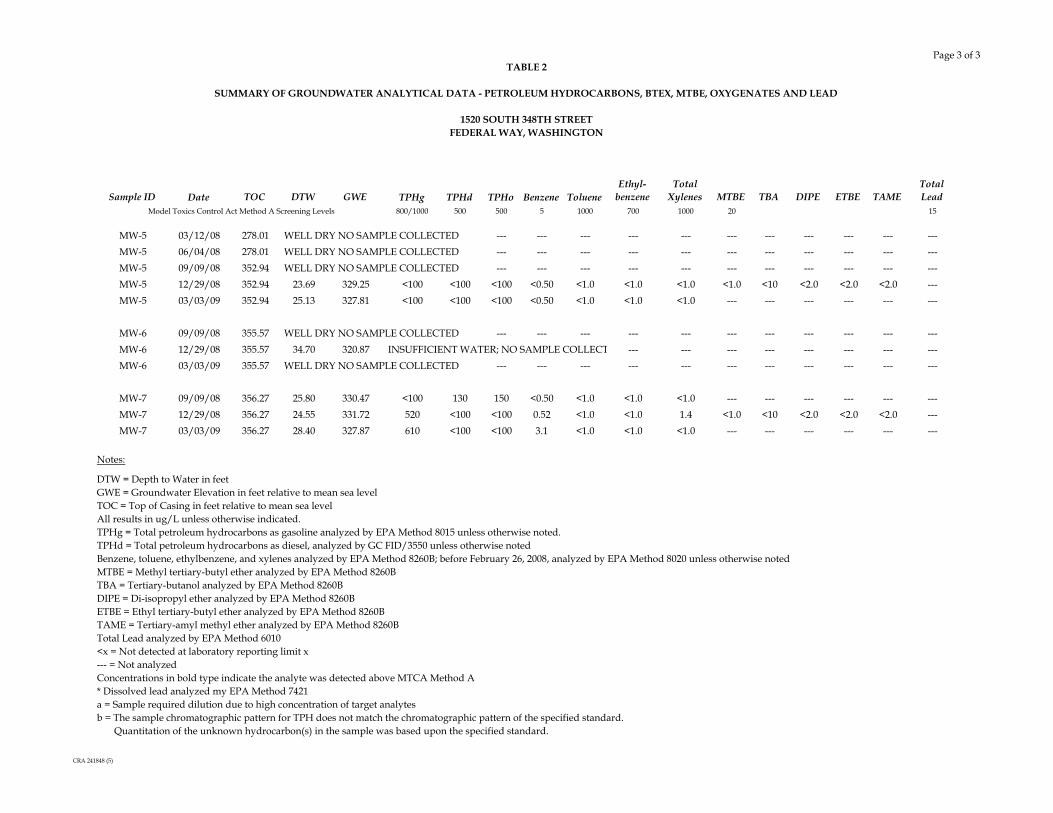
TABLE 2
SUMMARY OF GROUNDWATER ANALYTICAL DATA - PETROLEUM HYDROCARBONS, BTEX, MTBE, OXYGENATES AND LEAD
1520 SOUTH 348TH STREETFEDERAL WAY, WASHINGTON
Page 3 of 3
Sample ID Date TOC DTW GWE TPHg TPHd TPHo Benzene TolueneEthyl-
benzeneTotal
Xylenes MTBE TBA DIPE ETBE TAMETotalLead
800/1000 500 500 5 1000 700 1000 20 15Model Toxics Control Act Method A Screening Levels
MW-5 03/12/08 278.01 WELL DRY NO SAMPLE COLLECTED --- --- --- --- --- --- --- --- --- --- ---MW-5 06/04/08 278.01 WELL DRY NO SAMPLE COLLECTED --- --- --- --- --- --- --- --- --- --- ---MW-5 09/09/08 352.94 WELL DRY NO SAMPLE COLLECTED --- --- --- --- --- --- --- --- --- --- ---MW-5 12/29/08 352.94 23.69 329.25 <100 <100 <100 <0.50 <1.0 <1.0 <1.0 <1.0 <10 <2.0 <2.0 <2.0 ---MW-5 03/03/09 352.94 25.13 327.81 <100 <100 <100 <0.50 <1.0 <1.0 <1.0 --- --- --- --- --- ---
MW-6 09/09/08 355.57 WELL DRY NO SAMPLE COLLECTED --- --- --- --- --- --- --- --- --- --- ---MW-6 12/29/08 355.57 34.70 320.87 INSUFFICIENT WATER; NO SAMPLE COLLECT --- --- --- --- --- --- --- ---MW-6 03/03/09 355.57 WELL DRY NO SAMPLE COLLECTED --- --- --- --- --- --- --- --- --- --- ---
MW-7 09/09/08 356.27 25.80 330.47 <100 130 150 <0.50 <1.0 <1.0 <1.0 --- --- --- --- --- ---MW-7 12/29/08 356.27 24.55 331.72 520 <100 <100 0.52 <1.0 <1.0 1.4 <1.0 <10 <2.0 <2.0 <2.0 ---MW-7 03/03/09 356.27 28.40 327.87 610 <100 <100 3.1 <1.0 <1.0 <1.0 --- --- --- --- --- ---
Notes:
DTW = Depth to Water in feetGWE = Groundwater Elevation in feet relative to mean sea levelTOC = Top of Casing in feet relative to mean sea levelAll results in ug/L unless otherwise indicated.TPHg = Total petroleum hydrocarbons as gasoline analyzed by EPA Method 8015 unless otherwise noted.TPHd = Total petroleum hydrocarbons as diesel, analyzed by GC FID/3550 unless otherwise notedBenzene, toluene, ethylbenzene, and xylenes analyzed by EPA Method 8260B; before February 26, 2008, analyzed by EPA Method 8020 unless otherwise notedMTBE = Methyl tertiary-butyl ether analyzed by EPA Method 8260BTBA = Tertiary-butanol analyzed by EPA Method 8260BDIPE = Di-isopropyl ether analyzed by EPA Method 8260BETBE = Ethyl tertiary-butyl ether analyzed by EPA Method 8260BTAME = Tertiary-amyl methyl ether analyzed by EPA Method 8260BTotal Lead analyzed by EPA Method 6010<x = Not detected at laboratory reporting limit x--- = Not analyzed
* Dissolved lead analyzed my EPA Method 7421a = Sample required dilution due to high concentration of target analytesb = The sample chromatographic pattern for TPH does not match the chromatographic pattern of the specified standard. Quantitation of the unknown hydrocarbon(s) in the sample was based upon the specified standard.
Concentrations in bold type indicate the analyte was detected above MTCA Method A
CRA 241848 (5)

TABLE 3
SUMMARY OF GROUNDWATER ANALYTICAL DATA - POLYCYCLIC AROMATIC HYDROCARBONS
1520 SOUTH 348TH STREETFEDERAL WAY, WASHINGTON
Page 1 of 1
Sample ID Date
Benzo(a)-anthracen
eBenzo(a)-
pyrene
Benzo(b)-fluoranthen
e
Benzo(k)-fluoranthen
e ChryseneDibenzo(a,h)-anthracene
Indeno(1,2,3-cd)-pyrene
Total cPAH
Anthracene
Acenaph-thene
Acenaph-thylene
Benzo(g,h,i)-perylene
Fluoranthene Fluorene
1-Methyl-naphthalen
e
2-Methyl-naphthalen
eNaph-thalene
Phenan-threne Pyrene
VE-2 12/29/08 <0.10 <0.10 <0.10 <0.10 <0.10 <0.10 <0.10 <0.10 <0.10 <0.10 <0.10 <0.10 <0.10 1.1 2.3 2.5 3.2 1.4 <0.10
MW-3 09/09/08 <0.10 <0.10 <0.10 <0.10 <0.10 <0.10 <0.10 <0.10 <0.10 --- --- <0.10 <0.10 <0.10 <0.10 <0.10 <0.10 <0.10 <0.10MW-3 12/29/08 <0.10 <0.10 <0.10 <0.10 <0.10 <0.10 <0.10 <0.10 <0.10 <0.10 <0.10 <0.10 <0.10 <0.10 0.37 <0.10 <0.10 <0.10 <0.10
Notes:
All results in ug/L unless otherwise indicated.<x = Not detected at laboratory reporting limit x--- = Not analyzed
Polycyclic aromatic hydrocarbons analyzed by EPA Method 8270C-HVI. Table presents all detected analytes; for further details, see associated lab report.
cPAH PAHs
CRA 241848(6)

TABLE 4
LABORATORY ANALYSES REQUIREMENTS
1520 SOUTH 348TH STREET, FEDERAL WAY WASHINGTON
Page1 of 2
Parameters Analytical MethodTarget Reporting Limit
Minimum Sample Volume Preservative Holding Time
TPHg NWTPH-Gx 5 mg/kg One Terra Core kit per analysis
Methanol and Sodium Bisulfate, Iced, 4±2º C 14 days for analysis
TPHd NWTPH-Dx w/sgc 5 mg/kg One 4-ounce glass jar Iced, 4±2º C14 days for extraction, 40 days after extraction for analysis
TPHo NWTPH-Dx w/sgc 5 mg/kg
Benzene or VOCs EPA 8260B 0.005 mg/kg One Terra Core kit per
analysisMethanol and Sodium Bisulfate, Iced, 4±2º C 14 days for analysis
Toluene EPA 8260B 0.005 mg/kg
Ethylbenzene EPA 8260B 0.005 mg/kg
Total Xylenes EPA 8260B 0.01 mg/kgMTBE EPA 8260B 0.005 mg/kgEDB EPA 8260B 0.005 mg/kgEDC EPA 8260B 0.005 mg/kgTBA EPA 8260B 0.05 mg/kgDIPE EPA 8260B 0.01 mg/kgETBE EPA 8260B 0.01 mg/kgTAME EPA 8260B 0.01 mg/kg
Lead EPA 6020 0.1 mg/kg One 4-ounce glass jar Iced, 4±2º C 6 months
PCBs EPA 8082 0.1 mg/kg One 4-ounce glass jar NA2S2O3, Iced, 4±2ºC14 days for extraction, 40 days after extraction for analysis
PAHs EPA 8270C-SIM 0.02 mg/kg One 4-ounce glass jar Iced, 4±2º C14 days for extraction, 40 days after extraction for analysis
SOIL
CRA 241848 (5)

TABLE 4
LABORATORY ANALYSES REQUIREMENTS
1520 SOUTH 348TH STREET, FEDERAL WAY WASHINGTON
Page2 of 2
Parameters Analytical MethodTarget Reporting Limit
Minimum Sample Volume Preservative Holding Time
TPHg NWTPH-Gx 100 ug/LThree 40 mL teflon-lined septum vials per analysis
Iced, 4±2º C 14 days for analysis
TPHd NWTPH-Dx w/sgc 100 ug/L Two 1 L amber glass bottles per analysis
HCl to pH < 2, Iced, 4±2º C
14 days for extraction, 40 days after extraction for analysis
TPHo NWTPH-Dx w/sgc 100 ug/L
Benzene or VOCs EPA 8260B 1 ug/L
Three 40 mL teflon-lined septum vials per analysis
HCl to pH < 2, Iced, 4±2º C 14 days for analysis
Toluene EPA 8260B 1 ug/L
Ethylbenzene EPA 8260B 1 ug/L
Total Xylenes EPA 8260B 2 ug/LMTBE EPA 8260B 1 ug/LEDB EPA 8011 0.01 ug/LEDC EPA 8260B 1 ug/LTBA EPA 8260B 10 ug/LDIPE EPA 8260B 2 ug/LETBE EPA 8260B 2 ug/LTAME EPA 8260B 2 ug/L
Lead EPA 6020 1 ug/L One 1 liter plastic bottleHNO3 to pH < 2, Iced, 4±2º C
6 months
PCBs EPA 8082 0.01 ug/L Two 1 L amber glass bottles per analysis
NA2S2O3, Iced, 4±2ºC14 days for extraction, 40 days after extraction for analysis
PAHs EPA 8270C-SIM 0.01 ug/L Two 1 L amber glass bottles per analysis
HCl to pH < 2, Iced, 4±2º C
14 days for extraction, 40 days after extraction for analysis
Notes:EPA = Environmental Protection AgencyTPHg = Total petroleum hydrocarbons as gasolineTPHd = Total petroleum hydrocarbons as dieselNWTPH-Gx = Northwest Total Petroleum Hydrocarbons - gasolineNWTPH-Dx = Northwest Total Petroleum Hydrocarbons - dieselVOCs = Volatile Organic CompoundsMTBE = Methyl tertiary-butyl ether analyzed by EPA Method 8260BEDB = 1,2-DibromoethaneEDC = 1,2-DichloroethaneTBA = Tertiary-butanol analyzed by EPA Method 8260BDIPE = Di-isopropyl ether analyzed by EPA Method 8260BETBE = Ethyl tertiary-butyl ether analyzed by EPA Method 8260BTAME = Tertiary-amyl methyl ether analyzed by EPA Method 8260BPCB = Polychlorinated biphenylPAH = Polycyclic aromatic hydrocarbonSIM = Selective Ion Monitoring sgc = Silica Gel clean-up
WATER
CRA 241848 (5)

241848 (5)
APPENDIX A
AVAILABLE SOIL BORING LOGS


>50
0
>50
ASPHALTSW-GRAVELLY SAND, dense, medium grainedsand, subrounded to rounded gravel, olive (5YR4/4), dry, no PHO
- grayish brown (10YR 5/2) @ 10 ft BGS
SM-SILTY, GRAVELLY SAND, fine to mediumgrained sand, subangular to subrounded gravel,grayish brown (10YR 5/7), dry, no PHO
CONCRETE
2"0 PVC/RISER
BENTONITE
WELLSCREEN
SAND PACK
8"0/BOREHOLE
RE
C (f
t)
0.50
MW-6
STRATIGRAPHIC AND INSTRUMENTATION LOG
2
4
6
8
10
12
14
16
18
20
22
24
26
28
30
32
34
DEPTHft BGS
CHEMICAL ANALYSIS
HOLE DESIGNATION:
NU
MB
ER
STRATIGRAPHIC DESCRIPTION & REMARKS
MEASURING POINT ELEVATIONS MAY CHANGE; REFER TO CURRENT ELEVATION TABLENOTES:
DATE COMPLETED: June 10, 2008
DRILLING METHOD: Hollow Stem Auger
FIELD PERSONNEL: N. Acklam
OV
ER
BU
RD
EN
LO
G 2
4184
8.G
PJ
CR
A_C
OR
P.G
DT
8/7
/08
MONITORING WELLDEPTHft BGS
PROJECT NAME: FEDE 1520
PROJECT NUMBER: 241848
CLIENT: Shell Oil Products US
LOCATION: 1520 348th St South
Federal Way, Washington
PID
[ppm
]
0
0
0
45
0
>50
(OVERBURDEN)
32
Page 1 of 2
BLO
WC
OU
NTS
INTE
RV
AL
25.00
SAMPLE
MW-6-30-061008

NU
MB
ER
0
SAMPLE
INTE
RV
AL
BLO
WC
OU
NTS
Page 2 of 2
PID
[ppm
]
36.50
35.00WELL DETAILSScreened interval:
15.00 to 35.00ft BGSLength: 20ftDiameter: 2inSlot Size: 10Material: PVCSeal:
1.50 to 8.00ft BGSMaterial: BENTONITE CHIPSSand Pack:
8.00 to 35.00ft BGSMaterial: SAND
END OF BOREHOLE @ 36.5ft BGS
SM-SILTY SAND, dense, brown (7.5YR 5/3),dry, no PHO >50
(OVERBURDEN)
DEPTHft BGS MONITORING WELL
OV
ER
BU
RD
EN
LO
G 2
4184
8.G
PJ
CR
A_C
OR
P.G
DT
8/7
/08
DATE COMPLETED: June 10, 2008
DRILLING METHOD: Hollow Stem Auger
FIELD PERSONNEL: N. Acklam
NOTES:
RE
C (f
t)
MEASURING POINT ELEVATIONS MAY CHANGE; REFER TO CURRENT ELEVATION TABLE
CHEMICAL ANALYSIS
MW-6
STRATIGRAPHIC AND INSTRUMENTATION LOG
36
38
40
42
44
46
48
50
52
54
56
58
60
62
64
66
68
PROJECT NAME: FEDE 1520
PROJECT NUMBER: 241848
CLIENT: Shell Oil Products US
LOCATION: 1520 348th St South
Federal Way, Washington
HOLE DESIGNATION:
STRATIGRAPHIC DESCRIPTION & REMARKSDEPTHft BGS

>50
0.4
>50
>50
ASPHALTSW-GRAVELLY SAND, medium grained sand,subrounded to rounded gravel (up to 65 mm indiameter), brown (4.5YR 5/2), dry
- cobbles exist between 0.5 and 5 ft BGS
SM-GRAVELLY, SILTY SAND, dense, fine tomedium grained sand, subrounded gravel (up to65 mm in diameter), brown (4.5YR 5/2), dry, noPHO
CONCRETE
2"0 PVC/RISER
BENTONITE
WELLSCREEN
SAND PACK
8"0/BOREHOLE
STRATIGRAPHIC DESCRIPTION & REMARKS
NU
MB
ER
MW-7
STRATIGRAPHIC AND INSTRUMENTATION LOG
2
4
6
8
10
12
14
16
18
20
22
24
26
28
30
32
34
DEPTHft BGS
CHEMICAL ANALYSIS
PROJECT NAME: FEDE 1520
PROJECT NUMBER: 241848
CLIENT: Shell Oil Products US
LOCATION: 1520 348th St South
Federal Way, Washington
RE
C (f
t)
MEASURING POINT ELEVATIONS MAY CHANGE; REFER TO CURRENT ELEVATION TABLENOTES:
DATE COMPLETED: June 10, 2008
DRILLING METHOD: Hollow Stem Auger
FIELD PERSONNEL: N. Acklam
OV
ER
BU
RD
EN
LO
G 2
4184
8.G
PJ
CR
A_C
OR
P.G
DT
8/7
/08
MONITORING WELLDEPTHft BGS
HOLE DESIGNATION:
0.50
20.00
>50
0
0
0
0
SAMPLE
(OVERBURDEN)
INTE
RV
AL
Page 1 of 2
BLO
WC
OU
NTS
PID
[ppm
]
MW-7-25-061008

(OVERBURDEN)
0
RE
C (f
t)
SAMPLE
INTE
RV
AL
Page 2 of 2
PID
[ppm
]
36.50
WELL DETAILSScreened interval:
15.00 to 35.00ft BGSLength: 20ftDiameter: 2inSlot Size: 10Material: PVCSeal:
1.50 to 8.00ft BGSMaterial: BENTONITE CHIPSSand Pack:
8.00 to 35.00ft BGSMaterial: SAND
END OF BOREHOLE @ 36.5ft BGS
>50
BLO
WC
OU
NTS
MEASURING POINT ELEVATIONS MAY CHANGE; REFER TO CURRENT ELEVATION TABLE
DEPTHft BGS MONITORING WELL
OV
ER
BU
RD
EN
LO
G 2
4184
8.G
PJ
CR
A_C
OR
P.G
DT
8/7
/08
DATE COMPLETED: June 10, 2008
DRILLING METHOD: Hollow Stem Auger
FIELD PERSONNEL: N. Acklam
NU
MB
ER
NOTES:
MW-7
STRATIGRAPHIC AND INSTRUMENTATION LOG
36
38
40
42
44
46
48
50
52
54
56
58
60
62
64
66
68
DEPTHft BGS
CHEMICAL ANALYSIS
PROJECT NAME: FEDE 1520
PROJECT NUMBER: 241848
CLIENT: Shell Oil Products US
LOCATION: 1520 348th St South
Federal Way, Washington
HOLE DESIGNATION:
STRATIGRAPHIC DESCRIPTION & REMARKS
CEMENT
BENTONITECHIPS
8"0/BOREHOLE 0.1
0.50
15.00
31.50
1.1
0
0
>50
>50
>50
>50
ASPHALTSP-GRAVELLY SAND, dense, fine to mediumgrained sand, subrounded gravel (up to 35 mmin diameter), brown (7.5YR 5/2), dry, nopetroleum hydrocarbon odor (PHO)- boulder (32 cm in diameter) @ 3 ft BGS
SM-GRAVELLY SAND, with silt, dense, mediumgrained sand, subrounded to rounded gravel (upto 35 mm in diameter), brown (7.5YR 5/3), dry,no PHO
END OF BOREHOLE @ 31.5ft BGS
SB-1
2
4
6
8
10
12
14
16
18
20
22
24
26
28
30
32
34
CHEMICAL ANALYSIS
PROJECT NAME: FEDE 1520
PROJECT NUMBER: 241848
CLIENT: Shell Oil Products US
LOCATION: 1520 348th St South
Federal Way, Washington
HOLE DESIGNATION:
STRATIGRAPHIC AND INSTRUMENTATION LOG
MEASURING POINT ELEVATIONS MAY CHANGE; REFER TO CURRENT ELEVATION TABLENOTES:
DATE COMPLETED: June 9, 2008
DRILLING METHOD: Hollow Stem Auger
FIELD PERSONNEL: N. Acklam
OV
ER
BU
RD
EN
LO
G 2
4184
8.G
PJ
CR
A_C
OR
P.G
DT
8/7
/08
BOREHOLEDEPTHft BGSSTRATIGRAPHIC DESCRIPTION & REMARKS
RE
C (f
t)
BLO
WC
OU
NTS
DEPTHft BGS
(OVERBURDEN)
PID
[ppm
]
INTE
RV
AL
Page 1 of 1
NU
MB
ER
SAMPLE
SB-1-25-060908

0
CEMENT
BENTONITECHIPS
8"0/BOREHOLE
SM-GRAVELLY, SILTY SAND, fine to mediumgrained sand, grayish brown (2.5YR 5/2)
0.50
15.00
30.00
0
0
0
0.4
0
>50
46
>50
>50
SM-SILTY SAND, with gravel, dense, finegrained sand, subrounded gravel (up to 35 mmin diameter), dry, no PHO
ASPHALTSP-GRAVELLY SAND, dense, fine to mediumgrained sand, subrounded gravel (up to 30 mmin diameter), olive brown (2.5YR 4/3), dry, noPHO
- medium grained sand, subrounded gravel,slight plasticity, dark brown (10YR 3/3), dry
>50
SB-2
STRATIGRAPHIC AND INSTRUMENTATION LOG
DEPTHft BGS
CHEMICAL ANALYSIS
PROJECT NAME: FEDE 1520
PROJECT NUMBER: 241848
CLIENT: Shell Oil Products US
LOCATION: 1520 348th St South
Federal Way, Washington
HOLE DESIGNATION:
NU
MB
ER
STRATIGRAPHIC DESCRIPTION & REMARKS
2
4
6
8
10
12
14
16
18
20
22
24
26
28
30
32
34
MEASURING POINT ELEVATIONS MAY CHANGE; REFER TO CURRENT ELEVATION TABLENOTES:
DATE COMPLETED: June 9, 2008
DRILLING METHOD: Hollow Stem Auger
FIELD PERSONNEL: N. Acklam
OV
ER
BU
RD
EN
LO
G 2
4184
8.G
PJ
CR
A_C
OR
P.G
DT
8/7
/08
BOREHOLEDEPTHft BGS
SAMPLE
(OVERBURDEN)
PID
[ppm
]
Page 1 of 2
BLO
WC
OU
NTS
RE
C (f
t)
INTE
RV
AL
SB-2-15-060908

SAMPLE
INTE
RV
AL
BLO
WC
OU
NTS
2250
(OVERBURDEN)
PID
[ppm
]
RE
C (f
t)
41.50END OF BOREHOLE @ 41.5ft BGS
- very strong PHO @ 40 ft BGS
- very strong PHO @ 35 ft BGS
>50
>50
38.7
BOREHOLE
NOTES: MEASURING POINT ELEVATIONS MAY CHANGE; REFER TO CURRENT ELEVATION TABLE
Page 2 of 2
NU
MB
ER
OV
ER
BU
RD
EN
LO
G 2
4184
8.G
PJ
CR
A_C
OR
P.G
DT
8/7
/08
DATE COMPLETED: June 9, 2008
DRILLING METHOD: Hollow Stem Auger
FIELD PERSONNEL: N. Acklam
DEPTHft BGS
SB-2
STRATIGRAPHIC AND INSTRUMENTATION LOG
STRATIGRAPHIC DESCRIPTION & REMARKS
36
38
40
42
44
46
48
50
52
54
56
58
60
62
64
66
68
DEPTHft BGS
CHEMICAL ANALYSIS
PROJECT NAME: FEDE 1520
PROJECT NUMBER: 241848
CLIENT: Shell Oil Products US
LOCATION: 1520 348th St South
Federal Way, Washington
HOLE DESIGNATION:
SB-2-35-060908

0.9
BENTONITECHIPS
8"0/BOREHOLE
0.50
21.50
0
0
0
>50
>50
>50
CEMENTASPHALTSP-GRAVELLY SAND, dense, medium grainedsand, subangular gravel (up to 35 mm indiameter), olive brown (2.5YR 4/3), dry, no PHO
END OF BOREHOLE @ 21.5ft BGS
2
4
6
8
10
12
14
16
18
20
22
24
26
28
30
32
34
CHEMICAL ANALYSIS
MEASURING POINT ELEVATIONS MAY CHANGE; REFER TO CURRENT ELEVATION TABLE
STRATIGRAPHIC AND INSTRUMENTATION LOG
DEPTHft BGS
PROJECT NAME: FEDE 1520
PROJECT NUMBER: 241848
CLIENT: Shell Oil Products US
LOCATION: 1520 348th St South
Federal Way, Washington
HOLE DESIGNATION:
STRATIGRAPHIC DESCRIPTION & REMARKS
NOTES:
PID
[ppm
]
SAMPLEBOREHOLE
Page 1 of 1O
VE
RB
UR
DE
N L
OG
241
848.
GP
J C
RA
_CO
RP
.GD
T 8
/7/0
8
BLO
WC
OU
NTS
DATE COMPLETED: June 10, 2008
DRILLING METHOD: Hollow Stem Auger
FIELD PERSONNEL: N. Acklam
(OVERBURDEN)
DEPTHft BGS
INTE
RV
AL
RE
C (f
t)
NU
MB
ER
SB-3
SB-3-20-061008

BENTONITECHIPS
8"0/BOREHOLE 0
21.50
0
0
>50
>50
>50
CEMENTASPHALTSP-GRAVELLY SAND, dense, medium grainedsand, subangular to subrounded gravel (up to 30mm in diameter), olive (5YR 4/4), dry, no PHO
END OF BOREHOLE @ 21.5ft BGS
0.50
2
4
6
8
10
12
14
16
18
20
22
24
26
28
30
32
34
NOTES:
DATE COMPLETED: June 10, 2008
DRILLING METHOD: Hollow Stem Auger
FIELD PERSONNEL: N. Acklam
CHEMICAL ANALYSIS
STRATIGRAPHIC AND INSTRUMENTATION LOG
DEPTHft BGS
PROJECT NAME: FEDE 1520
PROJECT NUMBER: 241848
CLIENT: Shell Oil Products US
LOCATION: 1520 348th St South
Federal Way, Washington
HOLE DESIGNATION:
STRATIGRAPHIC DESCRIPTION & REMARKS
MEASURING POINT ELEVATIONS MAY CHANGE; REFER TO CURRENT ELEVATION TABLE
PID
[ppm
]
SAMPLEDEPTHft BGS BOREHOLE
BLO
WC
OU
NTS
OV
ER
BU
RD
EN
LO
G 2
4184
8.G
PJ
CR
A_C
OR
P.G
DT
8/7
/08
Page 1 of 1
INTE
RV
AL
(OVERBURDEN)
RE
C (f
t)
NU
MB
ER
SB-4
SB-4-20-061008

CEMENT
BENTONITECHIPS
8"0/BOREHOLE
15.6
0.50
20.00
21.50
ASPHALT
0
2021
>50
>50
>50
NOT SAMPLED
- NO RECOVERY-large cobbles, rounded tosubrounded (up to 180 mm in diameter) @ 5.5ft BGS
SP-GRAVELLY SAND, dense, medium grainedsand, subrounded gravel (up to 35 mm), darkolive brown (2.5YR), dry, no PHO
SM-GRAVELLY, SILTY SAND, fine to mediumgrained sand, subangular gravel, dry, strongPHOEND OF BOREHOLE @ 21.5ft BGS
10.00
STRATIGRAPHIC AND INSTRUMENTATION LOG
MEASURING POINT ELEVATIONS MAY CHANGE; REFER TO CURRENT ELEVATION TABLE
SB-5
NOTES:
DEPTHft BGS
CHEMICAL ANALYSIS
PROJECT NAME: FEDE 1520
PROJECT NUMBER: 241848
CLIENT: Shell Oil Products US
LOCATION: 1520 348th St South
Federal Way, Washington
HOLE DESIGNATION:
STRATIGRAPHIC DESCRIPTION & REMARKS
2
4
6
8
10
12
14
16
18
20
22
24
26
28
30
32
34
(OVERBURDEN)
DEPTHft BGS BOREHOLE
OV
ER
BU
RD
EN
LO
G 2
4184
8.G
PJ
CR
A_C
OR
P.G
DT
8/7
/08
DATE COMPLETED: June 9, 2008
DRILLING METHOD: Hollow Stem Auger
FIELD PERSONNEL: N. Acklam
PID
[ppm
]
NU
MB
ER
RE
C (f
t)
SAMPLE
INTE
RV
AL
Page 1 of 1
BLO
WC
OU
NTS
SB-5-20-060908

241848 (5)
APPENDIX B
SUMMARY OF PREVIOUS SITE INVESTIGATIONS AND REMEDIAL ACTIVITIES

SUMMARY OF PREVIOUS INVESTIGATIONS AND REMDIAL ACTIVITIES
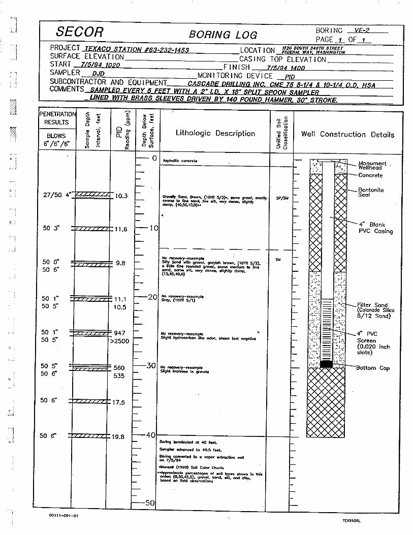
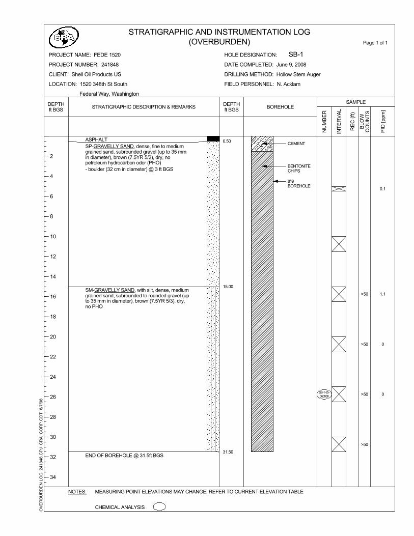
1993 Compliance Sampling Results: In 1993, EMCON Northwest, Inc. (EMCON) performed compliance soil sampling during the installation of Stage II vapor recovery lines at the site. Analytical results indicated that two of nine soil samples exceeded the Washington State Model Toxics Control Act (MTCA) Method A screening level for total petroleum hydrocarbons as diesel (TPH-D). One sample from beneath the northwest dispenser island exceeded the MTCA Method A screening levels for TPH as gasoline (TPH-G) as well. Complete results of this investigation are presented in EMCON’s Compliance Sampling Results, dated October 13, 1993. 1995 Subsurface Investigation: In July 1994, SECOR conducted a subsurface investigation at the site, including three soil borings (SB-1 through SB-3) advanced in areas of impacted soil identified from a former investigation. Soils were classified as silty sands and groundwater was not encountered during the investigation. Borings SB-1 and SB-2 were converted to vapor extraction wells VE-1 and VE-2, respectively. Soil samples collected from well VE-1 at 15 feet and 20.5 feet, and well VE-2 at 25.5 feet below ground surface (bgs) contained TPH-G exceeding the MTCA Method A screening level. The sample from 20.5 feet bgs also exceeded the Method A screening level for benzene, toluene, ethylbenzene, and total xylenes (BTEX). All other soil samples were below MTCA Method A screening levels for all other analytes. Complete results of this investigation are presented in SECOR’s Subsurface Investigation, dated April 11, 1995. 1997 Subsurface Soil and Groundwater Investigation Report: Boateng & Associates, Inc. (Boateng) conducted a subsurface investigation at the site with the goals of determining groundwater flow direction and installing three groundwater monitoring wells (MW-3 through MW-5) at the site. A total of ten soil samples were collected from the well borings and groundwater samples were collected following development of each monitoring well. No soil samples exceeded MTCA Method A screening levels for any analyte. Complete results for this report are presented in Boateng’s Subsurface Soil and Groundwater Investigation Report, dated November 1997. 2008 Phase II Environmental Assessment: Conestoga-Rovers & Asscociates (CRA) conducted a site assessment in June 2008, advancing seven soil borings (SB-1 through SB-5) and completing two of the borings as monitoring wells (MW-6 and MW-7). The soil sample collected from boring SB-2 at 35 feet bgs
241848 (5)

contained concentrations of TPH-G, toluene, ethylbenzene and total xylenes exceeding the MTCA Method A screening levels. The soil sample collected from boring SB-5 at 20 feet bgs contained concentrations of TPH-G and total xylenes exceeding the MTCA Method A screening levels. Complete results for this report are presented in CRA’s Phase II Environmental Site Assessment, dated August 2008. Groundwater Monitoring: The most recent groundwater monitoring event was performed by CRA in March 3, 2009. Wells VE-1, VE-2 and MW-3 through MW-5 and MW-7 were sampled and analyzed for TPH-G, TPH-D, TPH-O and BTEX constituents. Well VE-1 exceeded the MTCA Method A screening levels for TPH-G, TPH-D, and all BTEX constituents. Well VE-2 exceeded the MTCA Method A screening level for TPH-G and TPH-D. Monitoring wells MW-3 and MW-4 contained TPH-G concentration exceeding the MTCA Method A screening levels. Complete results of this monitoring event are presented in CRA’s Groundwater Monitoring Report-First Quarter 2009. CRA will continue the quarterly groundwater monitoring program at the site.
241848 (5)