site at dromahair, co. leitrim ground investigation
TRANSCRIPT

Site at Dromahair, Co. Leitrim Ground Investigation
Client: Sweeney Architects Report No.: 20-0735 Date: September 2020 Status: Final for Issue

Page 1 September 2020
Site at Dromahair, Co. Leitrim Report No. 20-0735
CONTENTS Document Control Sheet Note on: Methods of describing soils and rocks & abbreviations used on exploratory hole logs
1 AUTHORITY ................................................................................................................................................................................................. 4
2 SCOPE ............................................................................................................................................................................................................. 4
3 DESCRIPTION OF SITE ........................................................................................................................................................................... 4
4 SITE OPERATIONS .................................................................................................................................................................................... 5 4.1 Summary of site works ............................................................................................................................................................. 5 4.2 Boreholes ........................................................................................................................................................................................ 5
5 LABORATORY WORK .............................................................................................................................................................................. 5 5.1 Geotechnical laboratory testing of soils ............................................................................................................................ 6 5.2 Environmental laboratory testing of soils ....................................................................................................................... 6
6 GROUND CONDITIONS ........................................................................................................................................................................... 6 6.1 General geology of the area .................................................................................................................................................... 6 6.2 Ground types encountered during investigation of the site .................................................................................... 7 6.3 Groundwater ................................................................................................................................................................................. 7
7 DISCUSSION ................................................................................................................................................................................................. 7 7.1 Proposed construction ............................................................................................................................................................. 7 7.2 Recommendations for construction ................................................................................................................................... 8
7.2.1 Summary ........................................................................................................................................................................... 8 7.2.2 Soil strength parameters ........................................................................................................................................... 8 7.2.3 Foundations and ground floor construction ..................................................................................................... 8 7.2.4 Floor slabs ........................................................................................................................................................................ 9 7.2.5 Excavations for services ............................................................................................................................................. 9 7.2.6 Soil aggressivity .......................................................................................................................................................... 10
8 REFERENCES ........................................................................................................................................................................................... 11 APPENDICES Appendix A Site and exploratory hole location plans
Appendix B Borehole logs
Appendix C Laboratory test results
Appendix D SPT hammer energy measurement report

Page 2 September 2020
Site at Dromahair, Co. Leitrim Report No. 20-0735
Document Control Sheet
Report No.: 20-0735
Project Title: Site at Dromahair, Co. Leitrim
Client: Sweeney Architects
Revision: A00 Status: Final for issue Issue Date: 16th Sept 2020
Prepared by: Reviewed by: Approved by:
Stephen Franey BSc MSc MIEnvSc CEnv
Sean Ross BSc MSc MIEI
Darren O’Mahony BSc MSc MIEI EurGeol PGeo
The works were conducted in accordance with:
British Standards Institute (2015) BS 5930:2015, Code of practice for site investigations. BS EN 1997-2: 2007: Eurocode 7 - Geotechnical design - Part 2 Ground investigation and testing. Geotechnical Society of Ireland (2016), Specification & Related Documents for Ground Investigation in Ireland
Laboratory testing was conducted in accordance with:
British Standards Institute BS 1377:1990 parts 2, 4, 5, 7 and 9

Page 3 September 2020
Site at Dromahair, Co. Leitrim Report No. 20-0735
METHODS OF DESCRIBING SOILS AND ROCKS Soil and rock descriptions are based on the guidance in BS5930:2015, The Code of Practice for Site Investigation.
Abbreviations used on exploratory hole logs U Nominal 100mm diameter undisturbed open tube sample (thick walled sampler).
UT Nominal 100mm diameter undisturbed open tube sample (thin walled sampler).
P Nominal 100mm diameter undisturbed piston sample.
B Bulk disturbed sample.
LB Large bulk disturbed sample.
D Small disturbed sample.
C Core sub-sample (displayed in the Field Records column on the logs).
L Liner sample from dynamic sampled borehole.
W Water sample.
ES / EW Soil sample for environmental testing / Water sample for environmental testing.
SPT (s) Standard penetration test using a split spoon sampler (small disturbed sample obtained).
SPT (c) Standard penetration test using 60 degree solid cone.
(x,x/x,x,x,x) Blows per increment during the standard penetration test. The initial two values relate to the seating drive (150mm) and the remaining four to the 75mm increments of the test length.
(Y for Z/ Y for Z) Incomplete standard penetration test where the full test length was not achieved. The blows ‘X’ represent the total blows for the given seating or test length ‘Z’ (mm).
N=X SPT blow count ‘N’ given by the summation of the blows ‘X’ required to drive the full test length (300mm).
HVP / HVR In situ hand vane test result (HVP) and vane test residual result (HVR). Results presented in kPa.
V VR
Shear vane test (borehole). Shear strength stated in kPa. V: undisturbed vane shear strength VR: remoulded vane shear strength
Soil consistency description
In cohesive soils, where samples are disturbed and there are no suitable laboratory tests, N values may be used to indicate consistency on borehole logs – a median relationship of Nx5=Cu is used (as set out in Stroud & Butler 1975).
dd-mm-yyyy Date at the end and start of shifts, shown at the relevant borehole depth. Corresponding casing and water depths shown in the adjacent columns.
Water strike: initial depth of strike.
Water strike: depth water rose to.
Abbreviations relating to rock core – reference Clause 36.4.4 of BS 5930: 2015
TCR (%) Total Core Recovery: Ratio of rock/soil core recovered (both solid and non-intact) to the total length of core run.
SCR (%) Solid Core Recovery: Ratio of solid core to the total length of core run. Solid core has a full diameter, uninterrupted by natural discontinuities, but not necessarily a full circumference and is measured along the core axis between natural fractures.
RQD (%) Rock Quality Designation: Ratio of total length of solid core pieces greater than 100mm to the total length of core run.
FI Fracture Index: Number of natural discontinuities per metre over an indicated length of core of similar intensity of fracturing.
NI Non Intact: Used where the rock material was recovered fragmented, for example as fine to coarse gravel size particles.
AZCL Assessed zone of core loss: The estimated depth range where core was not recovered.
DIF Drilling induced fracture: A fracture of non-geological origin brought about by the rock coring.
(xxx/xxx/xxx) Spacing between discontinuities (minimum/average/maximum) measured in millimetres.

Page 4 September 2020
Site at Dromahair, Co. Leitrim Report No. 20-0735
Site at Dromahair, Co. Leitrim
1 AUTHORITY On the instructions of Sweeney Architects, (“the Client”), a ground investigation was undertaken at the above location to provide geotechnical and environmental information for input to the design and construction of a proposed residential and library development. This report details the work carried out both on site and in the geotechnical and chemical testing laboratories; it contains a description of the site and the works undertaken, the exploratory hole logs and the laboratory test results. A discussion on the recommendations for construction is also provided. All information given in this report is based upon the ground conditions encountered during the site investigation works, and on the results of the laboratory and field tests performed. However, there may be conditions at the site that have not been taken into account, such as unpredictable soil strata, contaminant concentrations, and water conditions between or below exploratory holes. It should be noted that groundwater levels usually vary due to seasonal and/or other effects and may at times differ to those recorded during the investigation. No responsibility can be taken for conditions not encountered through the scope of work commissioned, for example between exploratory hole points, or beneath the termination depths achieved. This report was prepared by Causeway Geotech Ltd for the use of the Client in response to a particular set of instructions. Any other parties using the information contained in this report do so at their own risk and any duty of care to those parties is excluded.
2 SCOPE The extent of the investigation, as instructed by the Client, included boreholes, soil sampling, in-situ and laboratory testing, and the preparation of a report on the findings including recommendations for construction.
3 DESCRIPTION OF SITE As shown on the site location plan in Appendix A, the works were conducted on the site of a disused public house and associated grounds along Main Street Dromahair, Co. Leitrim. Buildings occupy the northern and western portions of the site while open ground is present across the remaining site area. The site slopes down from the east with a steep bank in the central portion of the open ground.

Page 5 September 2020
Site at Dromahair, Co. Leitrim Report No. 20-0735
4 SITE OPERATIONS
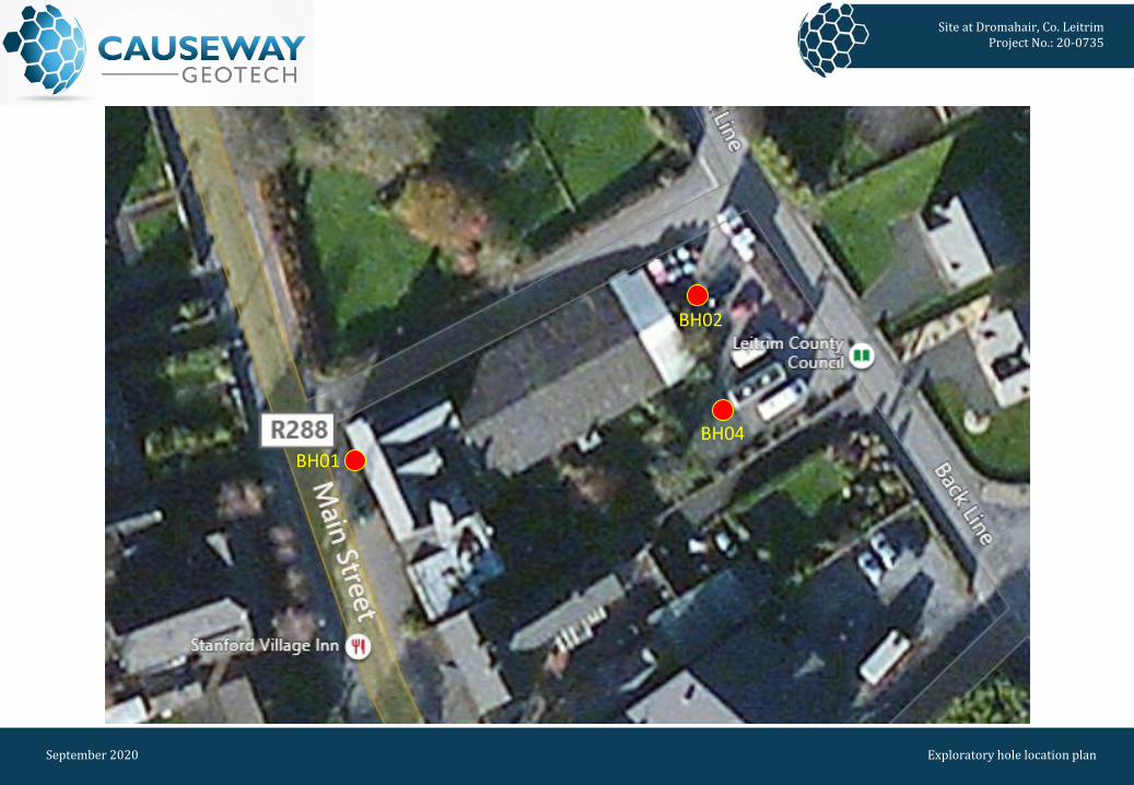
4.1 Summary of site works Site operations, which were conducted between 19th and 20th August 2020, comprised three boreholes by dynamic (windowless) sampling methods The exploratory holes and in-situ tests were located as instructed by the Client’s Representative, as shown on the exploratory hole location plan in Appendix A.
4.2 Boreholes Three boreholes (BH01, BH02 and BH04) were put down to completion by light percussion boring techniques using a Dando Terrier dynamic sampling rig. Note that BH03 proposed in the southern area of the site was inaccessible due to the steep bank in the central portion of the site. Hand dug inspection pits were carried out between ground level and 1.20m depth to ensure boreholes were put down clear of services or subsurface obstructions. The boreholes were taken to depths ranging between 1.10m and 4.15m where they were terminated on encountering virtual refusal on obstructions. Standard penetration tests were carried out in accordance with BS EN 22476-3:2005+A1:2011 at standard depth intervals using the split spoon sampler (SPT(s)) or solid cone attachment (SPT(c)). The penetrations are stated for those tests for which the full 150mm seating drive or 300mm test drive was not possible. The N-values provided on the borehole logs are uncorrected and no allowance has been made for energy ratio corrections. The SPT hammer energy measurement report is provided in Appendix D. Disturbed (bulk and small bag) samples were taken within the encountered strata. Environmental samples were taken at standard intervals. Undisturbed (U100) samples were taken as appropriate within fine grained strata. Any water strikes encountered during boring were recorded along with any changes in their levels as the borehole proceeded. Details of the water strikes are presented on the individual borehole logs. Appendix B presents the borehole logs.
5 LABORATORY WORK Upon their receipt in the laboratory, all disturbed samples were carefully examined and accurately described and their descriptions incorporated into the borehole logs.

Page 6 September 2020
Site at Dromahair, Co. Leitrim Report No. 20-0735
5.1 Geotechnical laboratory testing of soils Laboratory testing of soils comprised: • soil classification: moisture content measurement, Atterberg Limit tests and particle size
distribution analysis.
• soil chemistry: pH and water soluble sulphate content
Laboratory testing of soils samples was carried out in accordance with British Standards Institute: BS 1377, Methods of test for soils for civil engineering purposes; Part 1 (2016), and Parts 2-9 (1990). The test results are presented in Appendix C.
5.2 Environmental laboratory testing of soils Environmental testing, was conducted on selected environmental soil samples by Chemtest at its laboratory in Newmarket, Suffolk. Testing was carried out for a range of determinants, including: • Metals • Speciated total petroleum hydrocarbons (TPH) • Speciated polycyclic aromatic hydrocarbons (PAH) • Cyanides • Asbestos screen • pH. Results of environmental laboratory testing are presented in Appendix C.
6 GROUND CONDITIONS
6.1 General geology of the area Published GSI geological mapping does not present any superficial deposits underlying the site and surrounding area with bedrock outcrop recorded in this area. The bedrock mapping indicates that the site is located on a fault between the Dargan Limestone formation to the north and Oakport Limestone Formation to the south.

Page 7 September 2020
Site at Dromahair, Co. Leitrim Report No. 20-0735
6.2 Ground types encountered during investigation of the site A summary of the ground types encountered in the exploratory holes is listed below, in approximate stratigraphic order: • Paved surface: bitmac surfacing was present at each boreholes location in 60-90mm thickness. • Made Ground (fill): present in each borehole, typically as reworked sandy gravel clay with
occurrences of timber, glass, brick and ceramics extending to depths ranging between 0.90m and 1.30m.
• Glacial Till: encountered in each borehole, generally as sandy gravelly silty clay. Deposits were thin
in BH01, extending to 1.35m while thicker deposits to 4.15m were recorded in BH04. Each borehole was terminated on an obstruction of suspected bedrock which would relate to the GSI mapping of the area.
6.3 Groundwater
Groundwater was encountered during percussion boring through soil as water strikes at 2.80m and 3.50m in BH04. The remaining boreholes were dry during the intrusive works. Details of the individual groundwater strikes, along with any relative changes in levels as works proceeded, are presented on the exploratory hole logs for each location. Seasonal variation in groundwater levels should also be factored into design considerations.
7 DISCUSSION
7.1 Proposed construction It is proposed to construct new residential properties and a library on the site. No further details were available to Causeway Geotech at the time of preparing this report and any designs based on the recommendations or conclusions within this report should be completed in accordance with the current design codes, taking into account the variation and the specific details contained within the exploratory holes. Causeway Geotech were commissioned to provide a geotechnical report, and it is outwith our remit to advise on structure design.

Page 8 September 2020
Site at Dromahair, Co. Leitrim Report No. 20-0735
7.2 Recommendations for construction
7.2.1 Summary Based on the presence of stiff glacial till at relatively shallow depths across the footprint of the proposed building, the implementation of traditional shallow (spread) foundations (strip/pad and trench fill) are considered suitable.
7.2.2 Soil strength parameters When estimating the shear strength of fine soils (silt/clay), reference is made to the results of Standard Penetration Tests (SPT’s) carried out within the boreholes. The undrained shear strength of fine soils can be estimated using the correlation developed by Stroud & Butler:
Cu = f1 x N where f1 is typically in the range 4 to 6. A median f1 value of 5 is adopted for this report. For granular soils (sand/gravel), a graphical relationship between SPT “N” value and angle of shearing resistance, φ, has been developed by Peck, Hanson and Thorburn. This is published in Foundation Design and Construction (Tomlinson, 2001) and is referenced in this report when deriving angles of shearing resistance for the gravel soils.
7.2.3 Foundations and ground floor construction Foundations should transfer loading to below any Made Ground or subsoil. The recommended foundation construction and allowable bearing pressure (ABP) at the borehole locations are presented in Table 1.
Table 1: Construction recommendations
Borehole
Depth below EGL* to suitable bearing stratum
Estimated ABP (kPa)
Strata description
Foundation type
Ground floor construction Groundwater
BH01 1.20m 250 Very stiff Glacial Till Strip & pad Suspended Not encountered
BH02 2.80m 250 Possible BEDROCK Trench fill Suspended Not encountered
BH04 3.00m 250 Very stiff Glacial Till Trench fill Suspended Water strike at
2.80m *Existing Ground Level
Page 9 September 2020
Site at Dromahair, Co. Leitrim Report No. 20-0735
Based on the findings of the site investigation, spread foundations (strip/pad and trench fill) are considered suitable with estimated allowable bearing pressures of approximately 250kPa at depths between 1.20m and 3.0m on stiff glacial till or possible bedrock. Prior to site development it is recommended that trial pit excavations undertaken to prove bedrock across the footprint of the proposed structures. The base of foundation excavations should be thoroughly inspected; any soft soils should be removed with the resultant void backfilled with ST1 concrete. A consistent bearing stratum should be provided for any building unit to limit differential settlements. Given the generally fine grained/cohesive nature of the soils throughout the proposed formation levels, excavations for foundations are likely to be relatively stable. However, any instability can be minimised by battering the side slopes at 2 vertical to 1 horizontal and by limiting the duration that the excavation is open. Groundwater control, where required, will be possible by pumping from sumps formed in the base of excavations.
7.2.4 Floor slabs Floor slabs should not bear directly onto Made Ground or soft soils. Consequently, the use of ground bearing floor slabs is considered appropriate following the removal of any surface Made Ground and soft clay layers and their replacement using well-graded well-compacted granular fill. However, a suspended floor slab should be adopted where the difference in levels of the proposed floor and the base of Made Ground/soft soils is greater than 600mm. Therefore, given the depth to the base of Made Ground and relative low strength of upper soil layers, a suspended floor slab may be required over parts of the site. The use of intermediate lines of support stub walls would reduce the spans required for flooring units.
7.2.5 Excavations for services For the installation of services ducts/trenches, it is suggested that open trenching will be the most practicable construction method. Generally speaking, the ground conditions should render the use of open trenching by backhoe excavator possible. Where working in open trenches, it is thought that trench support systems, by way of a trench box (or possibly sheet piles), will be required to maintain trench stability and safe working conditions. Groundwater control at these locations should be possible by means of sump pumping. To preclude the eventuality of differential settlements in pipes, they should be laid on a consistent stratum of appropriate allowable bearing capacity and protected with appropriate fill cover.

Page 10 September 2020
Site at Dromahair, Co. Leitrim Report No. 20-0735
Where ducts and chambers must be installed in areas where localised soft spots are encountered, the use of geogrid reinforcement along the base of the excavation on is recommended. This will stiffen the base of the trench and help control longitudinal differential settlement. Backfilling of trenches may be completed by using compacted Cl 804 granular fill and reinstated as appropriate.
7.2.6 Soil aggressivity An assessment of the Aggressive Chemical Environment for Concrete (ACEC) was undertaken through reference to the Building Research Establishment (BRE) Special Digest 1 (2017). As noted by BRE Special Digest 1, sulphates in the soil and groundwater are the chemical agents most likely to attack concrete. The extent to which sulphates affect concrete is linked to their concentrations, the type of ground, the presence of groundwater, the type of concrete and the form of construction in which concrete is used. BRE Special Digest 1 identifies four different categories of site which require specific procedures for investigation for aggressive ground conditions:
• Sites not subjected to previous industrial development and not perceived as containing pyrite; • Sites not subjected to previous industrial development and perceived as containing pyrite; • Brownfield sites not perceived as containing pyrite; • Brownfield sites perceived as containing pyrite.
For the purposes of this report the site was classified as not having been subject to previous industrial development and not perceived as containing pyrite. The results of chemical tests (pH and water soluble sulphate contents) on soil samples indicate Design Sulphate Class DS-1 and ACEC Class AC-1 – reference Table C1 of BRE Special Digest 1 (Building Research Establishment, 2005). The Special Digest does not require any measures to protect underground concrete elements greater that 140mm thick.
Page 11 September 2020
Site at Dromahair, Co. Leitrim Report No. 20-0735
8 REFERENCES Geotechnical Society of Ireland (2016), Specification & Related Documents for Ground Investigation in Ireland IS EN 1997-2: 2007: Eurocode 7 - Geotechnical design - Part 2 Ground investigation and testing. BS 1377: 1990: Methods of test for soils for civil engineering purposes. British Standards Institution. BS 5930: 2015: Code of practice for ground investigations. British Standards Institution. BS EN 1997-2: 2007: Eurocode 7 - Geotechnical design - Part 2 Ground investigation and testing. British Standards Institution. BS EN ISO 14688-1:2018: Geotechnical investigation and testing. Identification and classification of soil. Part 1 Identification and description. BS EN ISO 14688-2:2018: Geotechnical investigation and testing. Identification and classification of soil. Part 2 Principles for a classification. BS EN ISO 22476-3:2005+A1:2011: Geotechnical investigation and testing. Field testing. Standard penetration test. Building Research Establishment (2005) BRE Special Digest 1, Concrete in aggressive ground.

APPENDIX A
SITE AND EXPLORATORY HOLE LOCATION PLAN

Site at Dromahair, Co. LeitrimProject No.: 20-0735
September 2020 Site location plan
Site location
Site at Dromahair, Co. LeitrimProject No.: 20-0735
September 2020 Exploratory hole location plan
BH04BH01
BH02

APPENDIX B
BOREHOLE LOGS

Depth(m)
Sample / Tests Field Records
CasingDepth
(m)
Water Depth
(m)
LevelmOD
Depth (m)
0.09
0.30
0.90
1.35
Legend Descrip on
BITMACMADE GROUND: Grey slightly clayey slightly sandy subangular ne to coarse GRAVEL. Sand is ne to coarse. MADE GROUND: So light brown slightly sandy slightly gravelly reworked CLAY with ceramic and concrete fragments. Sand is ne to coarse. Gravel is subangular ne to coarse.
Very s orangish brown slightly sandy slightly gravelly silty CLAY with fragments of rock. Sand is ne to coarse. Gravel is subangular
ne to medium.
End of Borehole at 1.35m
Wat
er
Back ll
0.5
1.0
1.5
2.0
2.5
3.0
3.5
4.0
4.5
5.0
5.5
6.0
6.5
7.0
0.09 - 0.30 B2
0.30 - 0.60 B3
0.50 ES10.60 - 0.90 B4
0.90 - 1.10 B5
1.20 D61.20 - 1.34 SPT (S) N=50 (25 for 65mm/50 for
70mm) Hammer SN = 0267
Project No.
20-0735
Project Name:
Client:
Client's Rep:
Dromahair, Co. Leitrim
Sweeney Architects
Borehole ID
BH01
Coordinates
E
N
Final Depth: 1.35 m
Eleva on: mOD
Start Date:
End Date:
20/08/2020
20/08/2020
Driller:
Logger:
PL
SF
Sheet 1 of 1
Scale: 1:40
DRAFT
RemarksHand pit excavated to 1.10m.Borehole dry on comple on.
Termina on Reason
Terminated on refusal on possible bedrock
Last Updated
16/09/2020
Method Plant Used Top (m) Base (m)Light Percussion Dando Terrier 0.00 1.35
Water StrikesStruck at (m) Casing to (m) Time (min) Rose to (m)
Casing DetailsTo (m) Diameter
Water AddedFrom (m) To (m)
Chiselling DetailsFrom (m) To (m) Time (hh:mm)

Depth(m)
Sample / Tests Field Records
CasingDepth
(m)
Water Depth
(m)
LevelmOD
Depth (m)
0.06
1.30
2.00
2.80
Legend Descrip on
BITMACMADE GROUND: So grey dark brown slightly sandy slightly gravelly reworked CLAY with low cobble content, mber and glass. Sand is
ne to medium. Gravel is subangular ne to medium.
Firm orangish brown slightly sandy slightly gravelly silty CLAY. Sand is ne to medium. Gravel is subrounded ne.
Very so light brown slightly gravelly sandy silty CLAY. Sand is ne to medium. Gravel is subrounded ne to medium.
End of Borehole at 2.80m
Wat
er
Back ll
0.5
1.0
1.5
2.0
2.5
3.0
3.5
4.0
4.5
5.0
5.5
6.0
6.5
7.0
0.06 - 1.30 B2
0.50 ES1
1.20 D51.20 - 1.65 SPT (S) N=11 (12,7/3,2,3,3) Hammer SN
= 0267Dry
1.30 - 2.00 B3
2.00 D62.00 - 2.80 B42.00 - 2.45 SPT (S) N=2 (1,0/1,0,0,1) Hammer SN =
0267Dry
2.80 D72.80 - 2.86 SPT (S) N=50 (25 for 35mm/50 for
25mm) Hammer SN = 0267Dry
Project No.
20-0735
Project Name:
Client:
Client's Rep:
Dromahair, Co. Leitrim
Sweeney Architects
Borehole ID
BH02
Coordinates
E
N
Final Depth: 2.80 m
Eleva on: mOD
Start Date:
End Date:
19/08/2020
19/08/2020
Driller:
Logger:
PL
SF
Sheet 1 of 1
Scale: 1:40
DRAFT
RemarksHand pit excavated to 1.20m.Borehole dry on comple on.
Termina on Reason
Terminated on refusal on possible bedrock
Last Updated
16/09/2020
Method Plant Used Top (m) Base (m)Light Percussion Dando Terrier 0.00 2.80
Water StrikesStruck at (m) Casing to (m) Time (min) Rose to (m)
Casing DetailsTo (m) Diameter
Water AddedFrom (m) To (m)
Chiselling DetailsFrom (m) To (m) Time (hh:mm)

Depth(m)
Sample / Tests Field Records
CasingDepth
(m)
Water Depth
(m)
LevelmOD
Depth (m)
0.06
1.20
2.00
3.00
4.15
Legend Descrip on
BITMACMADE GROUND: Firm greyish brown sandy gravelly reworked CLAY with fragments of bitmac and concrete. Sand is ne to coarse. Gravel is subangular ne to medium.
Very so orangish brown slightly sandy slightly gravelly silty CLAY. Sand is ne to medium. Gravel is subrounded ne.
Firm light brown slightly gravelly very sandy silty CLAY. Sand is ne to coarse. Gravel is subangular ne to medium.
Very s light brown slightly sandy gravelly CLAY. Sand is ne to coarse. Gravel is angular ne to medium.
End of Borehole at 4.15m
Wat
er
Back ll
0.5
1.0
1.5
2.0
2.5
3.0
3.5
4.0
4.5
5.0
5.5
6.0
6.5
7.0
0.50 ES1
1.20 D41.20 ES21.20 - 1.65 SPT (S) N=2 (4,5/1,0,1,0) Hammer SN =
0267Dry
2.00 U3 Ublow=62 35% 1.70
Water strike at 2.80m
3.00 - 3.45 SPT (S) N=35 (3,4/6,7,10,12) Hammer SN = 0267
2.80
Water strike at 3.50m
3.90 - 4.16 SPT (C) N=50 (25 for 75mm/50 for 185mm) Hammer SN = 0267
3.50
Project No.
20-0735
Project Name:
Client:
Client's Rep:
Dromahair, Co. Leitrim
Sweeney Architects
Borehole ID
BH04
Coordinates
E
N
Final Depth: 4.15 m
Eleva on: mOD
Start Date:
End Date:
20/08/2020
20/08/2020
Driller:
Logger:
PL
SF
Sheet 1 of 1
Scale: 1:40
DRAFT
RemarksHand pit excavated to 1.20m.Groundwater at 3.50m on comple on.
Termina on Reason
Terminated on refusal on possible bedrock
Last Updated
16/09/2020
Method Plant Used Top (m) Base (m)Light Percussion Dando Terrier 0.00 4.15
Water StrikesStruck at (m) Casing to (m) Time (min) Rose to (m)
2.80 2.803.50 3.50
Casing DetailsTo (m) Diameter
Water AddedFrom (m) To (m)
Chiselling DetailsFrom (m) To (m) Time (hh:mm)

APPENDIX C
LABORATORY TEST RESULTS

1
SOIL AND ROCK SAMPLE ANALYSIS LABORATORY TEST REPORT
8 September 2020
Project Name: Dromahair, Co. Leitrim
Project No.: 20-0735
Client: Sweeney Architects
We are pleased to attach the results of laboratory testing carried out for the above project. This memo and
its attachments constitute a report of the results of tests as detailed in the Contents page(s).
The attached results complete the testing requested and we would therefore wish to confirm that samples
will be retained without charge for a period of 28 days from the above date after which they will be
appropriately disposed of unless we receive written instructions to the contrary prior to that date.
We trust our report meets with your approval but if you have any queries or require additional information,
please do not hesitate to contact the undersigned.
Stephen Watson
Laboratory Manager
Signed for and on behalf of Causeway Geotech Ltd

2
Project Name: Dromahair, Co. Leitrim
Report Reference: Schedule 1
The table below details the tests carried out, the specifications used, and the number of tests included in this
report.
Tests marked with* in this report are not United Kingdom Accreditation Service (UKAS) accredited and are
not included in Causeway Geotech Limited’s scope of UKAS Accreditation Schedule of Tests. Opinions and
interpretations expressed herein are outside the scope of UKAS accreditation.
Material tested Type of test/Properties
measured/Range of
measurement
Standard
specifications
No. of results
included in
the report
SOIL Moisture Content of Soil BS 1377-2: 1990: Cl 3.2 3
SOIL Liquid and Plastic Limits of soil-1
point cone penetrometer method
BS 1377-2: 1990: Cl 4.4,
5.3 & 5.4
3
SOIL Particle size distribution - wet
sieving
BS 1377-2: 1990: Cl 9.2 1
SOIL Particle size distribution -
sedimentation hydrometer method
BS 1377-2: 1990: Cl 9.5 1
SUB-CONTRACTED TESTS
In agreement with Client, the following tests were conducted by an approved sub-contractor. All sub-
contracting laboratories used are UKAS accredited.
Material tested Type of test/Properties
measured/Range of
measurement
Standard
specifications
No. of results
included in
the report
SOIL – Subcontracted to
Chemtest Ltd (UKAS 2183)
pH Value of Soil 3
SOIL – Subcontracted to
Chemtest Ltd (UKAS 2183)
Sulphate Content water extract 3

Project No. Project Name
w Passing LL PL PI Particle
bulk dry 425µm density
% % % % % Mg/m3
5 0.90 B 28.0 68 41 -1pt 21 20
6 2.00 D 26.0 66 37 -1pt 21 16
3 2.00 B 16.0 41 25 -1pt 18 7
All tests performed in accordance with BS1377:1990 unless specified otherwise
Key Date Printed Approved By
Density test Liquid Limit Particle density
Linear measurement unless : 4pt cone unless : sp - small pyknometer
wd - water displacement cas - Casagrande method gj - gas jar
wi - immersion in water 1pt - single point test
Summary of Classification Test Results
20-0735 Dromahair, Co. Leitrim
Hole No.
Sample
Soil Description
DensityCasagrande
ClassificationRef Top Base TypeMg/m3
BH01Brownish grey sandy gravelly silty
CLAY. CI
BH02Brownish grey sandy slightly
gravelly silty CLAY. CI
BH04Brownish grey sandy gravelly silty
CLAY. CL
1
09/07/2020 00:00
Stephen.Watson110122
LAB 01R Version 4

3.45
mm
mm
mm
mm
RemarksPreparation and testing in accordance with BS1377-2 :1990 unless noted below
PARTICLE SIZE DISTRIBUTIONJob Ref 20-0735
Borehole/Pit No. BH02
Site Name Dromahair, Co. Leitrim Sample No. 4
Soil Description Brownish grey sandy slightly gravelly silty CLAY. Depth, m 2.00
Specimen Reference 2Specimen
Depth2 m Sample Type B
Test Method BS1377:Part 2:1990, clauses 9.2 and 9.5 KeyLAB ID Caus202008252
Sieving SedimentationDry Mass of sample, g 524
Particle Size mm % Passing Particle Size mm % Passing
125 100 0.06300 42 Sample Proportions % dry mass
90 100 0.04875 39 Cobbles 0
75 100 0.03470 37 Gravel 16
63 100 0.02470 36 Sand 42
50 100 0.01757 34 Silt 25
37.5 100 0.00925 30 Clay 17
28 100 0.00471 25
20 100 0.00277 20 Grading Analysis
14 99 0.00149 14 D100
10 97 D60 0.193
6.3 93 D30 0.00983
5 92 D10
3.35 88 Uniformity Coefficient
2 84 Curvature Coefficient
1.18 82
0.6 78 Particle density (assumed)
0.425 75 2.65 Mg/m3
0.3 70
0.212 63
0.15 53
0.063 42
ApprovedSheet printed
07/09/2020 17:30Stephen.Watson
÷÷
ø
ö
çç
è
æ
1m
m
SILT
Fine Medium Coarse
SAND
Fine Medium Coarse
GRAVEL
Fine Medium CoarseCLAY COBBLES BOULDERS
0
10
20
30
40
50
60
70
80
90
100
0.001 0.01 0.1 1 10 100 1000
Perc
enta
ge P
assin
g %
Particle Size mm
10122LAB 05R Version 4

Eurofins Chemtest Ltd
Depot Road
Newmarket
CB8 0AL
Tel: 01638 606070
Email: [email protected]
Report No.: 20-22446-1
Initial Date of Issue: 01-Sep-2020
Client Causeway Geotech Ltd
Client Address: 8 Drumahiskey Road
Balnamore
Ballymoney
County Antrim
BT53 7QL
Contact(s): Carin Cornwall
Colm Hurley
Darren O'Mahony
Gabriella Horan
Joe Gervin
John Cameron
Lucy Newland
Martin Gardiner
Matthew Gilbert
Neil Haggan
Paul Dunlop
Sean Ross
Stephen Franey
Stephen McCracken
Stephen Watson
Stuart Abraham
Thomas McAllis
Project 20-0735 Dromahair, Co. Leitrim
Quotation No.: Date Received: 24-Aug-2020
Order No.: Date Instructed: 25-Aug-2020
No. of Samples: 3
Turnaround (Wkdays): 5 Results Due: 01-Sep-2020
Date Approved: 01-Sep-2020
Approved By:
Details: Glynn Harvey, Technical Manager
Final Report
Page 1 of 6

Eurofins Chemtest Ltd
Depot Road
Newmarket
CB8 0AL
Tel: 01638 606070
Email: [email protected]
Page 2 of 6

Results - Soil
Client: Causeway Geotech Ltd 20-22446 20-22446 20-22446
Quotation No.: 1053478 1053480 1053481
Order No.: 1 1 2
BH01 BH02 BH04
SOIL SOIL SOIL
0.50 0.50 1.20
21-Aug-2020 21-Aug-2020 21-Aug-2020
COVENTRY COVENTRY COVENTRY
Determinand Accred. SOP Units LOD
ACM Type U 2192 N/A - - -
Asbestos Identification U 2192 % 0.001No Asbestos
Detected
No Asbestos
Detected
No Asbestos
Detected
ACM Detection Stage U 2192 N/A - - -
Moisture N 2030 % 0.020 19 23 26
pH U 2010 4.0 7.8 8.0 7.1
Boron (Hot Water Soluble) U 2120 mg/kg 0.40 1.5 2.5 11
Sulphate (2:1 Water Soluble) as SO4 U 2120 g/l 0.010 0.056 0.049 0.085
Cyanide (Free) U 2300 mg/kg 0.50 < 0.50 < 0.50 < 0.50
Cyanide (Total) U 2300 mg/kg 0.50 1.7 0.60 < 0.50
Thiocyanate U 2300 mg/kg 5.0 < 5.0 < 5.0 < 5.0
Sulphide (Easily Liberatable) N 2325 mg/kg 0.50 2.3 7.5 4.6
Sulphate (Total) U 2430 % 0.010 0.19 0.15 0.25
Arsenic U 2450 mg/kg 1.0 18 17 19
Cadmium U 2450 mg/kg 0.10 0.85 0.74 1.0
Chromium U 2450 mg/kg 1.0 24 20 22
Copper U 2450 mg/kg 0.50 35 27 51
Mercury U 2450 mg/kg 0.10 0.35 0.31 0.51
Nickel U 2450 mg/kg 0.50 34 31 32
Lead U 2450 mg/kg 0.50 220 180 220
Selenium U 2450 mg/kg 0.20 0.79 0.64 1.2
Zinc U 2450 mg/kg 0.50 190 160 200
Chromium (Hexavalent) N 2490 mg/kg 0.50 < 0.50 < 0.50 < 0.50
Organic Matter U 2625 % 0.40 7.1 3.6 10
Aliphatic TPH >C5-C6 N 2680 mg/kg 1.0 < 1.0 < 1.0 < 1.0
Aliphatic TPH >C6-C8 N 2680 mg/kg 1.0 < 1.0 < 1.0 < 1.0
Aliphatic TPH >C8-C10 U 2680 mg/kg 1.0 < 1.0 < 1.0 < 1.0
Aliphatic TPH >C10-C12 U 2680 mg/kg 1.0 < 1.0 < 1.0 < 1.0
Aliphatic TPH >C12-C16 U 2680 mg/kg 1.0 < 1.0 < 1.0 < 1.0
Aliphatic TPH >C16-C21 U 2680 mg/kg 1.0 < 1.0 < 1.0 < 1.0
Aliphatic TPH >C21-C35 U 2680 mg/kg 1.0 130 < 1.0 < 1.0
Aliphatic TPH >C35-C44 N 2680 mg/kg 1.0 < 1.0 < 1.0 < 1.0
Total Aliphatic Hydrocarbons N 2680 mg/kg 5.0 130 < 5.0 < 5.0
Aromatic TPH >C5-C7 N 2680 mg/kg 1.0 < 1.0 < 1.0 < 1.0
Aromatic TPH >C7-C8 N 2680 mg/kg 1.0 < 1.0 < 1.0 < 1.0
Aromatic TPH >C8-C10 U 2680 mg/kg 1.0 < 1.0 < 1.0 < 1.0
Aromatic TPH >C10-C12 U 2680 mg/kg 1.0 < 1.0 < 1.0 < 1.0
Aromatic TPH >C12-C16 U 2680 mg/kg 1.0 < 1.0 < 1.0 < 1.0
Project: 20-0735 Dromahair, Co. Leitrim
Top Depth (m):
Asbestos Lab:
Chemtest Job No.:
Chemtest Sample ID.:
Client Sample Ref.:
Sample Type:
Date Sampled:
Sample Location:
Page 3 of 6

Results - Soil
Client: Causeway Geotech Ltd 20-22446 20-22446 20-22446
Quotation No.: 1053478 1053480 1053481
Order No.: 1 1 2
BH01 BH02 BH04
SOIL SOIL SOIL
0.50 0.50 1.20
21-Aug-2020 21-Aug-2020 21-Aug-2020
COVENTRY COVENTRY COVENTRY
Determinand Accred. SOP Units LOD
Project: 20-0735 Dromahair, Co. Leitrim
Top Depth (m):
Asbestos Lab:
Chemtest Job No.:
Chemtest Sample ID.:
Client Sample Ref.:
Sample Type:
Date Sampled:
Sample Location:
Aromatic TPH >C16-C21 U 2680 mg/kg 1.0 < 1.0 < 1.0 < 1.0
Aromatic TPH >C21-C35 U 2680 mg/kg 1.0 380 < 1.0 < 1.0
Aromatic TPH >C35-C44 N 2680 mg/kg 1.0 < 1.0 < 1.0 < 1.0
Total Aromatic Hydrocarbons N 2680 mg/kg 5.0 380 < 5.0 < 5.0
Total Petroleum Hydrocarbons N 2680 mg/kg 10.0 510 < 10 < 10
Naphthalene U 2700 mg/kg 0.10 < 0.10 < 0.10 < 0.10
Acenaphthylene U 2700 mg/kg 0.10 < 0.10 < 0.10 < 0.10
Acenaphthene U 2700 mg/kg 0.10 < 0.10 < 0.10 < 0.10
Fluorene U 2700 mg/kg 0.10 < 0.10 < 0.10 < 0.10
Phenanthrene U 2700 mg/kg 0.10 < 0.10 < 0.10 < 0.10
Anthracene U 2700 mg/kg 0.10 < 0.10 < 0.10 < 0.10
Fluoranthene U 2700 mg/kg 0.10 0.36 0.51 0.43
Pyrene U 2700 mg/kg 0.10 0.46 0.73 0.56
Benzo[a]anthracene U 2700 mg/kg 0.10 < 0.10 < 0.10 < 0.10
Chrysene U 2700 mg/kg 0.10 < 0.10 < 0.10 < 0.10
Benzo[b]fluoranthene U 2700 mg/kg 0.10 < 0.10 < 0.10 < 0.10
Benzo[k]fluoranthene U 2700 mg/kg 0.10 < 0.10 < 0.10 < 0.10
Benzo[a]pyrene U 2700 mg/kg 0.10 < 0.10 < 0.10 < 0.10
Indeno(1,2,3-c,d)Pyrene U 2700 mg/kg 0.10 < 0.10 < 0.10 < 0.10
Dibenz(a,h)Anthracene U 2700 mg/kg 0.10 < 0.10 < 0.10 < 0.10
Benzo[g,h,i]perylene U 2700 mg/kg 0.10 < 0.10 < 0.10 < 0.10
Total Of 16 PAH's U 2700 mg/kg 2.0 < 2.0 < 2.0 < 2.0
Benzene U 2760 µg/kg 1.0 < 1.0 < 1.0 < 1.0
Toluene U 2760 µg/kg 1.0 < 1.0 < 1.0 < 1.0
Ethylbenzene U 2760 µg/kg 1.0 < 1.0 < 1.0 < 1.0
m & p-Xylene U 2760 µg/kg 1.0 < 1.0 < 1.0 < 1.0
o-Xylene U 2760 µg/kg 1.0 < 1.0 < 1.0 < 1.0
Total Phenols U 2920 mg/kg 0.30 < 0.30 < 0.30 < 0.30
Page 4 of 6

Test Methods
SOP Title Parameters included Method summary
2010 pH Value of Soils pH pH Meter
2030
Moisture and Stone Content of
Soils(Requirement of
MCERTS)
Moisture content
Determination of moisture content of soil as a
percentage of its as received mass obtained at
<37°C.
2040Soil Description(Requirement of
MCERTS)Soil description
As received soil is described based upon
BS5930
2120Water Soluble Boron, Sulphate,
Magnesium & ChromiumBoron; Sulphate; Magnesium; Chromium Aqueous extraction / ICP-OES
2192 Asbestos Asbestos Polarised light microscopy / Gravimetry
2300Cyanides & Thiocyanate in
Soils
Free (or easy liberatable) Cyanide; total
Cyanide; complex Cyanide; Thiocyanate
Allkaline extraction followed by colorimetric
determination using Automated Flow Injection
Analyser.
2325 Sulphide in Soils Sulphide
Steam distillation with sulphuric acid / analysis
by ‘Aquakem 600’ Discrete Analyser, using
N,N–dimethyl-p-phenylenediamine.
2430 Total Sulphate in soils Total SulphateAcid digestion followed by determination of
sulphate in extract by ICP-OES.
2450 Acid Soluble Metals in Soils
Metals, including: Arsenic; Barium; Beryllium;
Cadmium; Chromium; Cobalt; Copper; Lead;
Manganese; Mercury; Molybdenum; Nickel;
Selenium; Vanadium; Zinc
Acid digestion followed by determination of
metals in extract by ICP-MS.
2490 Hexavalent Chromium in Soils Chromium [VI]
Soil extracts are prepared by extracting dried
and ground soil samples into boiling water.
Chromium [VI] is determined by ‘Aquakem 600’
Discrete Analyser using 1,5-diphenylcarbazide.
2625 Total Organic Carbon in Soils Total organic Carbon (TOC)
Determined by high temperature combustion
under oxygen, using an Eltra elemental
analyser.
2680 TPH A/A Split
Aliphatics: >C5–C6, >C6–C8,>C8–C10,
>C10–C12, >C12–C16, >C16–C21, >C21–
C35, >C35– C44Aromatics: >C5–C7, >C7–C8,
>C8– C10, >C10–C12, >C12–C16, >C16– C21,
>C21– C35, >C35– C44
Dichloromethane extraction / GCxGC FID
detection
2700
Speciated Polynuclear
Aromatic Hydrocarbons (PAH)
in Soil by GC-FID
Acenaphthene; Acenaphthylene; Anthracene;
Benzo[a]Anthracene; Benzo[a]Pyrene;
Benzo[b]Fluoranthene; Benzo[ghi]Perylene;
Benzo[k]Fluoranthene; Chrysene;
Dibenz[ah]Anthracene; Fluoranthene; Fluorene;
Indeno[123cd]Pyrene; Naphthalene;
Phenanthrene; Pyrene
Dichloromethane extraction / GC-FID (GC-FID
detection is non-selective and can be subject to
interference from co-eluting compounds)
2760
Volatile Organic Compounds
(VOCs) in Soils by Headspace
GC-MS
Volatile organic compounds, including BTEX
and halogenated Aliphatic/Aromatics.(cf.
USEPA Method 8260)*please refer to UKAS
schedule
Automated headspace gas chromatographic
(GC) analysis of a soil sample, as received,
with mass spectrometric (MS) detection of
volatile organic compounds.
2920 Phenols in Soils by HPLC
Phenolic compounds including Resorcinol,
Phenol, Methylphenols, Dimethylphenols, 1-
Naphthol and TrimethylphenolsNote:
chlorophenols are excluded.
60:40 methanol/water mixture extraction,
followed by HPLC determination using
electrochemical detection.
Page 5 of 6

Report Information
Key
U UKAS accredited
M MCERTS and UKAS accredited
N Unaccredited
SThis analysis has been subcontracted to a UKAS accredited laboratory that is accredited for
this analysis
SNThis analysis has been subcontracted to a UKAS accredited laboratory that is not accredited
for this analysis
T This analysis has been subcontracted to an unaccredited laboratory
I/S Insufficient Sample
U/S Unsuitable Sample
N/E not evaluated
< "less than"
> "greater than"
Comments or interpretations are beyond the scope of UKAS accreditation
The results relate only to the items tested
Uncertainty of measurement for the determinands tested are available upon request
None of the results in this report have been recovery corrected
All results are expressed on a dry weight basis
The following tests were analysed on samples as received and the results subsequently
corrected to a dry weight basis TPH, BTEX, VOCs, SVOCs, PCBs, Phenols
For all other tests the samples were dried at < 37°C prior to analysis
All Asbestos testing is performed at the indicated laboratory
Issue numbers are sequential starting with 1 all subsequent reports are incremented by 1
Sample Deviation Codes
A - Date of sampling not supplied
B - Sample age exceeds stability time (sampling to extraction)
C - Sample not received in appropriate containers
D - Broken Container
E - Insufficient Sample (Applies to LOI in Trommel Fines Only)
Sample Retention and Disposal
All soil samples will be retained for a period of 45 days from the date of receipt
All water samples will be retained for 14 days from the date of receipt
Charges may apply to extended sample storage
If you require extended retention of samples, please email your requirements to:
Page 6 of 6

APPENDIX D
SPT HAMMER ENERGY MEASUREMENT REPORT
