geoenvironmental ground investigation the airfields …
TRANSCRIPT

GEOENVIRONMENTAL GROUND INVESTIGATION
The AirfieldsDeeside
Reference MT/GI/4671.v1
Date November 2014
Version 1
5 John Charles WayLEEDSLS12 6QA
Tel: 0113 263 1155Fax: 0113 263 [email protected]

The AirfieldsDeeside
_______________________________________________________________________________________________________
_______________________________________________________________________________________________________
4671 Praxis Real Estate Management Ltd
CONTENTS
Confidentiality Statement
Document History
1.0 Introduction 11.1 Instruction 11.2 Objectives 11.3 Scope of Works 11.4 Location 11.5 Site Description and Topography 11.6 Development Proposals 21.7 Previous Reports 21.8 Limitations 3
2.0 Fieldwork 42.1 Fieldwork 4
3.0 Laboratory Testing 53.1 Chemical Analysis 53.2 Geotechnical Testing 5
4.0 Ground and Groundwater Conditions 64.1 Introduction 64.2 Ground Conditions 64.3 Ground Gas 7
5.0 Geotechnical & Engineering Assessment 85.1 Development Proposals 85.2 Foundations 85.3 Ground Floor Construction 95.4 Roads, Pavements and Hardstanding Surfaces 95.5 Excavation and Re-Use 95.6 Obstructions 105.7 Chemical Attack on Buried Concrete 11
6.0 Environmental Risk Assessment 126.1 Introduction 126.2 Potential Sources 126.3 Potential Pathways 136.4 Potential Receptors 136.5 Pollutant Linkage Assessment 146.6 Risk Classification 146.7 Summary of Phase 2 Intrusive Investigation 14

The AirfieldsDeeside
_______________________________________________________________________________________________________
_______________________________________________________________________________________________________
4671 Praxis Real Estate Management Ltd
APPENDICES
Appendix A Figures/DrawingsFigure 1 - Site Location Plan
Appendix B Notes on Limitations

The AirfieldsDeeside
_______________________________________________________________________________________________________
_______________________________________________________________________________________________________
4671 Praxis Real Estate Management Ltd
CONFIDENTIALITY STATEMENT
This report is addressed to and may be relied upon by the following:
Praxis Real Estate Management Limited13 Police StreetManchesterGreater ManchesterM2 7LQ
This report has been prepared for the sole use and reliance of the above named party.This report shall not be relied upon or transferred to any other parties without theexpress written authorisation of JPG (Leeds) Limited. No responsibility will be acceptedwhere this report is used, either in its entirety or in part, by any other party.
DOCUMENT HISTORY
VERSION PURPOSE/DESCRIPTION DATE1 Final – For Issue to Client November 2014

The AirfieldsDeeside
_______________________________________________________________________________________________________
4671 Praxis Real Estate Management Ltd 1
1.0 INTRODUCTION
1.1 Instruction
JPG (Leeds) Limited has been instructed on behalf of Praxis Real EstateManagement Limited to carry out a geoenvironmental ground investigation for aproposed mixed use commercial and residential development.
1.2 Objectives
The main objective of the geoenvironmental ground investigation was to identifypotential geotechnical and environmental issues that may represent constraints tothe proposed development of the site.
1.3 Scope of Works
The scope of the investigation included the following works:
A description of the ground investigation works carried out, i.e. factual reporting.
Interpretative reporting.
Assessment of potential contaminants.
A quantitative (Tier 1) screening assessment using source-pathway-receptorlinkages.
Engineering assessment to include recommendations with respect tofoundations, ground floor and pavement design.
Comments on the likely requirements for remedial measures on the site, toaddress potential contamination or ground gas issues.
Recommendations for further work where appropriate; and
Presentation of the findings in a tabular non-technical summary.
1.4 Location
The site is located approximately 6km north west of Chester; the approximate centreof the site is located at NGR 332476,369703. A site location plan is given Figure 1 inAppendix A.
1.5 Site Description and Topography
The site is an irregular shape and occupies a total area of approximately 100ha. It isgenerally level, with some mounded stockpiles from the demolition of previousbuildings.
The northern boundary of the site follows a dismantled railway line which is now acycle track. The Deeside Industrial Estate is present further north.

The AirfieldsDeeside
_______________________________________________________________________________________________________
4671 Praxis Real Estate Management Ltd 2
The western boundary of the site follows an unnamed drainage ditch withagricultural land beyond.
The southern boundary of the site has an irregular form which follows fieldboundaries and the residential development at Garden City.
The eastern boundary of the site is formed by the Welsh Road and residentialdevelopments at Garden City.
The site is accessed from Welsh Road in the north east part of the site. Here theground is covered with concrete hard standing and tarmacked roadways.
The north eastern area of the site and the eastern margin and the south east corner,contained the buildings associated with the Airfields site. Many of the buildings inthe north east corner are still present. Demolition has recently been carried out ofbuildings along the eastern margin and in the south east corner. The building floorslabs remain for the demolished structures. Some World War II (WWII) pillboxes arealso present over the site.
An aerial photograph of the site is presented as Figure 2 and selected photographsof the site are presented in Appendix B.
1.6 Development Proposals
For the planned phased development, the site has been divided into commercialplots and residential pods. Plots A to F in the north and west of the site are proposedfor commercial development. The central and south eastern part of the site areidentified for residential development and divided into nine pods as shown in thedevelopment plan. The development scheme drawings available at this time arereferenced below:
Fletcher Rae. September 2013. The Airfields, Deeside. Plot MasterplanComposite. Drawing 13001_SK39.
JPG. January 2014. The Airfields. Overall Masterplan. Drawing 4671-SK1 rev B.
Separate development phases are identified on the masterplans and these areillustrated on the JPG drawing 4671-SK1 rev B. This ground investigation survey hasbeen carried out for the areas described as Pod 1, 2 and 3 and the northernhighway.
1.7 Previous Reports
There are some previous reports which have been made available for review andwhich are referenced as follows:
Gibb Environmental. 1996. Land Quality Assessment, Phase 1 Desk Study.
Entec, 2006. RAF Sealand Land Quality Assessment, Phase 2 IntrusiveInvestigation. Defence Estates ref: DE11/4471.
The AirfieldsDeeside
_______________________________________________________________________________________________________
4671 Praxis Real Estate Management Ltd 3
Halcrow Group Ltd. 2012. Geoenvironmental/Geotechnical Assessment of TheAirfields.
Ian Farmer Associates. 2012. The Airfields, Deeside, CH5 2RQ. Factual Report onGround Investigation. IFA Ref: 20864.
Capita Symonds. 2013. The Airfields, Deeside, Phase 1 GeoenvironmentalAppraisal. Capita Symonds Ref: SS/018782.
The reports taken together highlight the main issues for consideration at the site.
The 1996 Gibb Environmental report and 2006 Entec report includes interviews withpersonnel with knowledge of the site and the site Property Manager. The Entecinvestigation identified a number of areas of localised contamination based upontheir understanding of the operational use of the site. The later Halcrow report buildsupon this information and the Capita Symonds report supersedes this and makesreference to the 2012 Ian Farmers Associates factual report. It provides an overviewof development constraints and outlines the scope for further intrusive investigation.
This report provides an update of the available published geoenvironmental data.
A desk study report for the site has been prepared by JPG; which is referencedbelow:
JPG (Leeds) Limited. Geoenvironmental Desk Study Report. Airfields, Deeside,Blackburn. Report Ref. MT/DS/4671.v1. Dated July 2014 for Praxis Real EstateManagement.
The desk study report includes a summary of previous investigative works which havebeen carried out on the site and should be read in conjunction with this report.
1.8 Limitations
The general limitations to the nature of the investigation are outlined in Appendix F.The comments on groundwater conditions are based on observations made at thetime the site work was carried out. It should be noted that groundwater levels varyowing to seasonal or other effects.
The AirfieldsDeeside
_______________________________________________________________________________________________________
4671 Praxis Real Estate Management Ltd 4
2.0 FIELDWORK
2.1 Fieldwork
The intrusive investigation was designed to provide information on the generalground, groundwater and hazardous gas conditions at the site.
The ground investigation works were carried out by Ian Farmer Associates and areport was prepared which is referenced as follows:
Ian Farmer Associates. September 2014. The Airfields, Deeside. Report onGround Investigation. Ref. 41419v2.
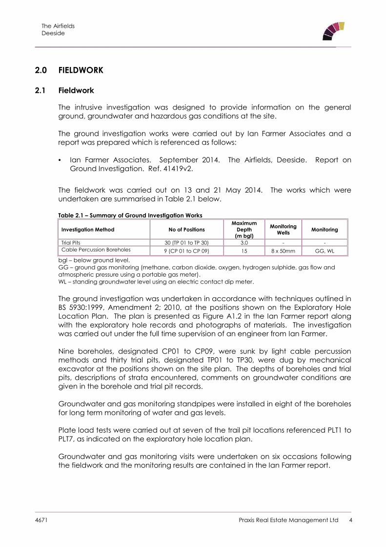
The fieldwork was carried out on 13 and 21 May 2014. The works which wereundertaken are summarised in Table 2.1 below.
Table 2.1 – Summary of Ground Investigation Works
Investigation Method No of PositionsMaximum
Depth(m bgl)
MonitoringWells Monitoring
Trial Pits 30 (TP 01 to TP 30) 3.0 - -Cable Percussion Boreholes 9 (CP 01 to CP 09) 15 8 x 50mm GG, WL
bgl – below ground level.GG – ground gas monitoring (methane, carbon dioxide, oxygen, hydrogen sulphide, gas flow andatmospheric pressure using a portable gas meter).WL – standing groundwater level using an electric contact dip meter.
The ground investigation was undertaken in accordance with techniques outlined inBS 5930:1999, Amendment 2; 2010, at the positions shown on the Exploratory HoleLocation Plan. The plan is presented as Figure A1.2 in the Ian Farmer report alongwith the exploratory hole records and photographs of materials. The investigationwas carried out under the full time supervision of an engineer from Ian Farmer.
Nine boreholes, designated CP01 to CP09, were sunk by light cable percussionmethods and thirty trial pits, designated TP01 to TP30, were dug by mechanicalexcavator at the positions shown on the site plan. The depths of boreholes and trialpits, descriptions of strata encountered, comments on groundwater conditions aregiven in the borehole and trial pit records.
Groundwater and gas monitoring standpipes were installed in eight of the boreholesfor long term monitoring of water and gas levels.
Plate load tests were carried out at seven of the trail pit locations referenced PLT1 toPLT7, as indicated on the exploratory hole location plan.
Groundwater and gas monitoring visits were undertaken on six occasions followingthe fieldwork and the monitoring results are contained in the Ian Farmer report.
The AirfieldsDeeside
_______________________________________________________________________________________________________
4671 Praxis Real Estate Management Ltd 5
3.0 LABORATORY TESTING
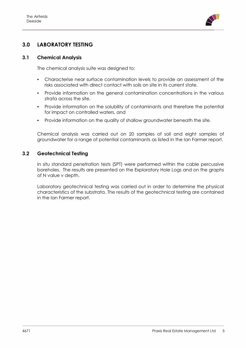
3.1 Chemical Analysis
The chemical analysis suite was designed to:
Characterise near surface contamination levels to provide an assessment of therisks associated with direct contact with soils on site in its current state.
Provide information on the general contamination concentrations in the variousstrata across the site.
Provide information on the solubility of contaminants and therefore the potentialfor impact on controlled waters, and
Provide information on the quality of shallow groundwater beneath the site.
Chemical analysis was carried out on 20 samples of soil and eight samples ofgroundwater for a range of potential contaminants as listed in the Ian Farmer report.
3.2 Geotechnical Testing
In situ standard penetration tests (SPT) were performed within the cable percussiveboreholes. The results are presented on the Exploratory Hole Logs and on the graphsof N value v depth.
Laboratory geotechnical testing was carried out in order to determine the physicalcharacteristics of the substrata. The results of the geotechnical testing are containedin the Ian Farmer report.
The AirfieldsDeeside
_______________________________________________________________________________________________________
4671 Praxis Real Estate Management Ltd 6
4.0 GROUND AND GROUNDWATER CONDITIONS
4.1 Introduction
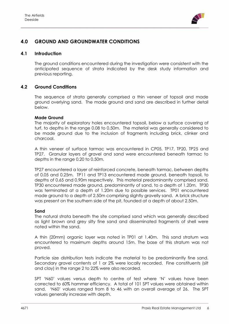
The ground conditions encountered during the investigation were consistent with theanticipated sequence of strata indicated by the desk study information andprevious reporting.
4.2 Ground Conditions
The sequence of strata generally comprised a thin veneer of topsoil and madeground overlying sand. The made ground and sand are described in further detailbelow.
Made GroundThe majority of exploratory holes encountered topsoil, below a surface covering ofturf, to depths in the range 0.08 to 0.50m. The material was generally considered tobe made ground due to the inclusion of fragments including brick, clinker andcharcoal.
A thin veneer of surface tarmac was encountered in CP05, TP17, TP20, TP25 andTP27. Granular layers of gravel and sand were encountered beneath tarmac todepths in the range 0.20 to 0.50m.
TP27 encountered a layer of reinforced concrete, beneath tarmac, between depthsof 0.05 and 0.25m. TP11 and TP13 encountered made ground, beneath topsoil, todepths of 0.65 and 0.90m respectively. This material predominantly comprised sand.TP30 encountered made ground, predominantly of sand, to a depth of 1.20m. TP30was terminated at a depth of 1.20m due to possible services. TP01 encounteredmade ground to a depth of 2.50m comprising slightly gravelly sand. A brick structurewas present on the southern side of the pit, founded at a depth of about 2.50m.
SandThe natural strata beneath the site comprised sand which was generally describedas light brown and grey silty fine sand and disseminated fragments of shell werenoted within the sand.
A thin (20mm) organic layer was noted in TP01 at 1.40m. This sand stratum wasencountered to maximum depths around 15m. The base of this stratum was notproved.
Particle size distribution tests indicate the material to be predominantly fine sand.Secondary gravel contents of 1 or 2% were locally recorded. Fine constituents (siltand clay) in the range 2 to 22% were also recorded.
SPT ‘N60’ values versus depth to centre of test where ‘N’ values have beencorrected to 60% hammer efficiency. A total of 101 SPT values were obtained withinsand. ‘N60’ values ranged from 8 to 46 with an overall average of 26. The SPTvalues generally increase with depth.
The AirfieldsDeeside
_______________________________________________________________________________________________________
4671 Praxis Real Estate Management Ltd 7
At depths about 1m to 2m ‘N60’ values ranged about an average of 15. The SPTvalues indicate strata that are predominantly medium dense, locally loose to depthsabout 3m, becoming medium dense locally dense below about 3m.
GroundwaterGroundwater was encountered within all exploratory holes at depths between0.40m and 2.70m. Water was added to boreholes during drilling to prevent sandblowing back up the casing, which may have masked some water strikes.
Monitoring of boreholes subsequent to fieldwork recorded groundwater standing atdepths at between 1.5m and 2m below ground level. It is possible that thegroundwater levels are influenced by the tidal effects of the nearby River Dee. Datalogging of groundwater levels over complete tidal cycles would be required toestablish any tidal influence.
4.3 Ground Gas
Ground gas monitoring has been undertaken on six occasions. The works includedmeasurements of methane, carbon dioxide, oxygen, hydrogen sulphide, carbonmonoxide, gas flows and atmospheric pressure. The results of the gas monitoring arepresented in the Ian Farmer report.
The AirfieldsDeeside
_______________________________________________________________________________________________________
4671 Praxis Real Estate Management Ltd 8
5.0 GEOTECHNICAL & ENGINEERING ASSESSMENT
5.1 Development Proposals
For the planned phased development, the site has been divided into commercialplots and residential pods with associated new infrastructure roadways.
The current investigation was located on Pods 1, 2 and 3, towards the southeast partof the overall development area which are proposed residential areas. Detaileddevelopment and structural plans are not available. For the purposes of this report ithas been assumed that residential development will be of one, two or three storeysand of traditional brick or block construction.
5.2 Foundations
Based on the results of the ground investigation, it is recommended that shallowspread foundations are used to support the proposed structures.
It is recommended that conventional shallow spread footings should be takenthrough any Made Ground and placed in the underlying natural strata. Across themajority of the site natural strata was encountered at depths up to 0.50m. Somelocalised increased thickness of made ground, up to 2.50m was encountered andshould be anticipated especially at the location of previous structures.
Traditional strip foundations at a nominal depth of 0.75m and widths about 1.00mmay be designed based on an allowable bearing pressure of 150kN/m2, assumingthat the water table remains below the base of the foundations, which wouldprovide an adequate factor of safety against shear failure and limit settlements tothe order of 10mm.
On this basis a strip foundation of width 0.60m would support wall loads about 90kNper metre run.
Square pad foundations with dimensions about 1m by 1m at a nominal depth of0.75m may be also be designed based on an allowable bearing pressure of150kN/m2 which would provide an adequate factor of safety against shear failureand limit settlements to the order of 10mm.
If site levels are significantly reduced this may result in foundation excavationsextending below groundwater with increased difficulties relating to groundwatercontrol and excavation stability.

The AirfieldsDeeside
_______________________________________________________________________________________________________
4671 Praxis Real Estate Management Ltd 9
Heavily loaded or settlement sensitive structures may consider the use of piledfoundations. Guidelines for the design of piles are given in Appendix 5, which maybe used with the plot of N value with depth included in Figures A1.3 and A1.4.
The carrying capacity of piles depends not only on their size and the groundconditions but also on their method of installation. Pile design and installation arecontinuously evolving processes and state-of-the-art methods are often employedbefore they reach the public domain, perhaps several years down the line.Therefore, it is recommended that specialist Piling Contractors be contacted as tothe suitability and carrying capacity of their piles in the ground conditions pertainingto the site.
5.3 Ground Floor Construction
On the basis of observation on site together with the results of laboratory tests it isrecommended that consideration is given to constructing the ground floor slab onformation prepared in the natural sand. Any deleterious material should beremoved and replaced with properly compacted granular fill.
Where the final levels dictate that the depth of sub floor fill exceeds 600mm, groundfloor slabs should be suspended in accordance with NHBC requirements.
5.4 Roads, Pavements and Hardstanding Surfaces
The structural design of a road or hard standing is based on the strength of thesubgrade, which is assessed on the California Bearing Ratio, CBR scale.
CBR values have been derived from in situ plate load tests. Seven tests derived CBRvalues in the range 1.5% to 8.2% with an average about 4.1%.
Modulus of sub-grade reaction values, K762, were measured in situ in the range 18 to49MN/m3.
Laboratory measurement of CBR recorded values between 0.21% and 5.7% on thetop of the samples (average 2.3%) and between 0.22% and 11% on the base of thesamples (average 6.0%).
For preliminary design of roadways and hardstanding areas it would be prudent toadopt a lower bound CBR value about 1.0%.
Formations should be proof rolled and any areas of deleterious material should beexcavated and replaced with a properly compacted granular fill.
5.5 Excavation and Re-Use
Excavation across the majority of the site will be carried out through topsoil andnatural sand. Excavation should be achievable by standard plant. Localisedobstructions may be encountered, such as old floor slabs and foundations. Thesemay require the use of hydraulic breakers for removal.
The AirfieldsDeeside
_______________________________________________________________________________________________________
4671 Praxis Real Estate Management Ltd 10
On the basis of observations on site, together with the results of in situ and laboratorytests, it is considered that excavations to less than 1.00m may not stand unsupportedin the short term. Side support for safety purposes should be provided to allexcavations which appear unstable, and those in excess of 1.20m deep, inaccordance with Health and Safety Regulations.
Significant groundwater inflows should not be expected in shallow excavations forfoundations however deeper excavations for services or drainage may encountergroundwater at depths below about 1.00m. Excavations to depths greater thanabout 1m may encounter standing water especially if left open for prolongedperiods.
Based on particle size distribution tests the majority of the natural sand may beclassified as Class 1B; uniformly graded granular fill and may be typically used forgeneral fill.
A number of samples of sand, 3 out of 14, do not classify as granular material forearthworks purposes due to the percentage of material passing the 0.063mm sieve.Percentages passing the 0.063mm sieve of 22%, 19% and 16% were measured versusa Class 1 limit of 15%.
It is likely that bulk mixing of sand on site would result in material that would fall withinthe limits for Class 1B; uniformly graded granular fill.
Laboratory determination of dry density versus moisture content recorded a rangeof dry density values from 1.43 to 2.03Mg/m3 at optimum moisture contents from 10%to 18%. The maximum dry densities do not appear to correlate with optimummoisture contents.
Laboratory measurement of natural moisture contents recorded values between19% and 28% indicating that the moisture content of the material is above optimummoisture contents. The samples were recovered from near or below the standinggroundwater levels. It is considered that moisture contents will reduce if material isstockpiled due to its granular nature.
Compaction of Class 1B material may be carried out either by method specification,such as that prescribed in Table 6/4 of specification for Highway Works; Series 600Earthworks (Ref 9.13) or by site specific end product compaction. Trial compactionsmay be carried out to determine the optimum methods for site compaction of thenatural materials.
5.6 Obstructions
Based on the site history and the ground conditions encountered it is consideredthat obstructions are likely to be encountered associated with former structures.
An allowance for excavation and processing of this material for re-use on site shouldbe made.
An allowance may need to be made for the excavation and processing of thesematerials for re-use in the earthworks.
The AirfieldsDeeside
_______________________________________________________________________________________________________
4671 Praxis Real Estate Management Ltd 11
5.7 Chemical Attack on Buried Concrete
The site has been classified in accordance with BRE Special Digest 1, ref. 9.15, asnatural ground without the presence of pyrite and laboratory testing undertakenaccordingly. It is recommended that the guidelines given in BRE Special Digest 1,ref. 9.15, be adopted.
The results of chemical tests indicate a sulphate concentration in the soil of between<10mg/l and 170mg/l as a 2:1 water/soil extract, with pH values in the range of 7.7 to9.7.
On the basis of the laboratory test results it is considered that a Design Sulphate Classmay be taken as DS-1. The site conditions would suggest that an ACEC class for thesite of AC-1 would be appropriate.

The AirfieldsDeeside
_______________________________________________________________________________________________________
4671 Praxis Real Estate Management Ltd 12
6.0 ENVIRONMENTAL RISK ASSESSMENT
6.1 Introduction
The presence of contaminated materials on a site is generally only of concern if anactual or potentially unacceptable risk exists. Within the context of current UKLegislation i.e. Part 2A of the Environmental Protection Act 1990, implementedthrough Section 57 of the Environment Act 1995, the interpretation of a “significantrisk” is termed to be one where:
Significant harm is being caused, or there is a significant possibility of such harmbeing caused, (where harm is defined as harm to health of living organisms orother interference with the ecological systems of which they form a part and, inthe case of man, includes harm to his property); and/or
Pollution of controlled waters is being caused.
The potential for harm to occur requires three conditions to be satisfied:
Presence of substances (potential contaminants/pollutants) that may causeharm (Sources).
The presence of a receptor which may be harmed, e.g. the water environmentor humans, buildings, fauna and flora (Receptors); and
The existence of a linkage between the Source and the Receptor (The Pathway).
In order to assess the contamination risk at the site, the above rationale has beenapplied and is discussed in the context of Contamination Sources and PotentialPollutant Linkages.
6.2 Potential Sources
The map records show a small area of the site was occupied by a sewagetreatment works and the northeast of the site was occupied as part of RAF Sealand.
The 2002 Gibb Environmental Report identifies a number of medium sized aboveground storage tanks (AST’s) and underground storage tanks. The above groundtanks were located at several locations around the site and were recorded to havebetween 1,000 and 7,500 litre capacity. Oils fuels and lubricants were recorded insmall quantities in a number of buildings at the site. At ‘Building 195’ a 95,000 litrefallback diesel UST was noted to be present in a restricted area (in 2002), theoperator stated that the tank was integrity tested and that no leaks had beendetected.
Based on the above, the following potentially contaminative sources may bepresent on the site:
Made ground associated with the former structures and construction of roads.

The AirfieldsDeeside
_______________________________________________________________________________________________________
4671 Praxis Real Estate Management Ltd 13
Potential localised spillages of hydrocarbons associated with the historicpresence of AST’s and UST’s.
Hazardous gases/soil vapours associated with the made ground.
Potential contaminants which could be present on and beneath the site are listedbelow:
Metals, metalloids and their compounds.
Inorganic compounds.
Organic compounds, e.g. hydrocarbons (fuels, oils).
Polycyclic Aromatic Hydrocarbons (PAH).
Hazardous Gases/Soil Vapours.
Asbestos.
6.3 Potential Pathways
Based on the available information and the proposed redevelopment for a mixedend use comprising residential and commercial, the following potential exposurepathways will require consideration, both during the redevelopment works and oncompletion of the construction:
Ingestion and dermal contact with contaminated soil and groundwater.
Inhalation of hazardous gases/soil vapours.
Leaching/migration of contaminants into groundwater via surface andgroundwater flow.
Permeation of water supply pipes and other services by organic and aggressivecontaminants; and
Uptake of contaminants by crops within residential gardens and planting inlandscape areas.
6.4 Potential Receptors
The potential receptors considered are:
Development workers and future maintenance workers involved in excavations, e.g.foundations or where services are being installed or repaired following development:
Future end users of the site, e.g. residents, employees, maintenance workers.
The underlying groundwater.
Buildings and services; and
Residential gardens and plants in landscape areas.

The AirfieldsDeeside
_______________________________________________________________________________________________________
4671 Praxis Real Estate Management Ltd 14
6.5 Pollutant Linkage Assessment
A potential pollutant linkage assessment has been completed and is summarised inthe Conceptual Site Model which is presented as Figure 3 in Appendix A. This isbased on the proposed redevelopment of the site for a mixed end use.
On the basis of the proposed end use and known history of the site, the followingpotential pollutant linkages may be present:
Site end users – future residents and visitors (public open space and privategardens).
Development and maintenance workers and site end users, e.g. employees,could come into contact with soils containing elevated concentrations ofcontaminants and hazardous gases/soil vapours.
Any underlying groundwater could become contaminated due to the leachingand migration of mobile contaminants from within the made ground.
Buildings and services could be affected by potential contaminants in the madeground; and
Crops in residential gardens and plants in landscape areas could be affected byphytotoxic elements within the made ground.
These are based on current site conditions and do not consider exposure pathwaysfollowing any remediation of the site.
If the site can be shown to pose no “significant harm” or pollution to controlledwaters, then the site can be considered to be uncontaminated.
6.6 Risk Classification
Based on the potential pollutant linkages present on the site, the site should beconsidered to be a moderate risk with respect to contamination. This designationwill be largely dependent on the nature of any made ground present on, oradjacent to the site.
In order to fully assess and classify the risks to human health, any underlying perchedgroundwater, surface water and buildings/services, a Phase 2 intrusive investigation,including chemical testing of soils and groundwater and gas monitoring will berequired.
6.7 Summary of Phase 2 Intrusive Investigation
An intrusive investigation and preliminary risk assessment has been carried out by IanFarmer Associates. This comprised the excavation of trial pits and drilling ofboreholes, sampling of soil and water, laboratory analysis and hazardous gasmonitoring.

The AirfieldsDeeside
_______________________________________________________________________________________________________
4671 Praxis Real Estate Management Ltd 15
The preliminary risk assessment was completed based on the findings of the intrusiveinvestigation, results of the chemical analysis and proposed end use of the site.
The risk assessment identified areas of concern that will require a further phase oftargeted investigation.
Reference should be made to the Ian Farmer Associates Report which includes anevaluation of the chemical analysis results for both soils and controlled waters, anupdated conceptual model and measures to be taken to manage potentialcontaminants on the site.
Further InvestigationsIt is recommended that a further ground investigation works are carried out todelineate potential contamination and monitor groundwater levels. The worksshould comprise the following:
Trial pitting to increase the density of investigation points and provide samples forchemical testing.
Window sampling boreholes to increase the density of investigation points andinclude in situ tests to provide geotechnical information in order to assess thenature of the sub-surface and confirm the depth and distribution of any madeground.
These boreholes will also facilitate the installation of gas and groundwatermonitoring wells.
Chemical analysis of soil and water samples in order to determine theconcentrations of potential contamination on the site.
Monitoring of standpipes to measure groundwater levels and to determine anyrelationship with local tidal conditions. The instruments will also be used to measurefurther hazardous gas measurement.
M TownendBSc MSc FGS CGeol
For and on behalf of JPG (Leeds) Limited
November 2014

The AirfieldsDeeside
_______________________________________________________________________________________________________
4671 Praxis Real Estate Management Ltd
Appendix A Figures/Drawings

The AirfieldsDeeside
_______________________________________________________________________________________________________
4671 Praxis Real Estate Management Ltd
Figure 1 – Site Location Plan
Site The Airfields, Deeside
Client Praxis Real Estate Management Ltd
Job Number 4671
Scale NTS
North
ApproximateSite Location

The AirfieldsDeeside
_______________________________________________________________________________________________________
4671 Praxis Real Estate Management Ltd
Appendix B Notes on Limitations

The AirfieldsDeeside
_______________________________________________________________________________________________________
4671 Praxis Real Estate Management Ltd
General
JPG (Leeds) Limited have prepared this report solely for the use of the Client and those parties with whom a warrantyagreement has been executed, or with whom an assignment has been agreed. Should any third party wish to use orrely upon the contents of the report, written approval must be sought from JPG (Leeds) Limited; a charge may belevied against such approval.
JPG (Leeds) Limited accepts no responsibility or liability for:
a) the consequences of this document being used for any purpose or project other than for which it wascommissioned, and
b) this document to any third party with whom an agreement has not been executed.
Phase I Desk Study Reports
The work undertaken to provide the basis of this report comprised a study of available documented information froma variety of sources (including the Client), together with (where appropriate) a brief walk over inspection of the siteand meetings and discussions with relevant authorities and other interested parties. The opinions given in this reporthave been dictated by the finite data on which they are based and are relevant only to the purpose for which thereport was commissioned. The information reviewed should not be considered exhaustive and has been accepted ingood faith as providing true and representative data pertaining to site conditions. Should additional informationbecome available which may affect the opinions expressed in this report, JPG (Leeds) Limited reserves the right toreview such information and, if warranted, to modify the opinions accordingly.
It should be noted that any risks identified in this report are perceived risks based on the information reviewed; actualrisks can only be assessed following a physical investigation of the site.
Phase II Geo-Environmental Investigations
The investigation of the site has been carried out to provide sufficient information concerning the type and degree ofcontamination, geotechnical characteristics and ground and groundwater conditions to allow a reasonableassessment of the environmental risks together with engineering and development implications. The objectives of theinvestigation have been limited to establishing the risks associated with potential human targets, building materials,the environment (including adjacent land), and to surface and groundwater.
The amount of exploratory work and chemical testing undertaken has necessarily been restricted by the shorttimescale available, and the locations of exploratory holes have been restricted to the areas unoccupied by thebuilding(s) on the site and by buried services. A more comprehensive investigation may be required if the site is to beredeveloped as, in addition to risk assessment, a number of important engineering and environmental issues mayneed to be resolved.
For these reasons if costs have been included in relation to site remediation these must be considered as tentativeonly and must, in any event, be confirmed by a qualified quantity surveyor.
The exploratory holes undertaken, which investigate only a small volume of the ground in relation to the size of the site,can only provide a general indication of site conditions. The opinions provided and recommendations given in thisreport are based on the ground conditions apparent at the site of each of the exploratory holes. There may beexceptional ground conditions elsewhere on the site which have not been disclosed by this investigation and whichhave therefore not been taken into account in this report.
The comments made on groundwater conditions are based on observations made at the time that site work wascarried out. It should be noted that groundwater levels will vary owing to seasonal, tidal and weather related effects.
The number of sampling points and the methods of sampling and testing do not preclude the existence of localised"hotspots" of contamination where concentrations may be significantly higher than those actually encountered.
The risk assessment and opinions provided, inter alia, take in to consideration currently available guidance valuesrelating to acceptable contamination concentrations; no liability can be accepted for the retrospective effects ofany future changes or amendments to these values.
The scope of the investigation was selected on the basis of the specific development proposed by the Client and maybe inappropriate to another form of development or scheme.