sir40 community watersheds: from objectives to results on ... · 2 fpb/sir/40 forest practices...
TRANSCRIPT

CCoommmmuunniittyy WWaatteerrsshheeddss:: FFrroomm OObbjjeeccttiivveess ttoo RReessuullttss oonn tthhee GGrroouunndd
Special Investigation
FPB/SIR/40
April 2014

Table of Contents
Board Commentary ......................................................................................................................................... i
Executive Summary ....................................................................................................................................... 1
Introduction .................................................................................................................................................... 4
Purpose .......................................................................................................................................................................... 4 Approach to the investigation ............................................................................................................................................. 5
Background .................................................................................................................................................... 6
How is drinking water regulated in BC? ............................................................................................................................... 6 What is a community watershed and how many are there? .................................................................................................... 6 What land uses are permitted in community watersheds? ...................................................................................................... 6 How much forest harvesting has occurred in community watersheds?..................................................................................... 7 How can forest and range activities affect water used for drinking? ......................................................................................... 7 What are FRPA’s requirements for the protection of drinking water in community watersheds? .................................................. 8
Findings and Observations ........................................................................................................................... 9
Is the objective for community watersheds and the practice requirement for drinking water quality in the FPPR clear and achievable? ................................................................................................................... 9 Are results or strategies in FSPs measurable or verifiable, do they provide meaningful content and are they consistent with the community watershed objective? ..................................................................... 11 How does government establish consistency between results or strategies specified in an FSP and FRPA’s objective for community watersheds? ........................................................................................... 13 Are licensees complying with FRPA’s planning requirements? ........................................................................... 14 Are licensees complying with FRPA’s practice requirements?............................................................................ 17 Are there current or past land use issues within the community watersheds that are affecting elements of FRPA’s objective including water quality, quantity or timing of flow? ................................................. 20 How does government monitor achievement of the community watershed objective? .......................................... 23 How does government decide which watersheds warrant community watershed designation or delisting? ................................................................................................................................ 24
Conclusions .................................................................................................................................................. 25
Recommendations ....................................................................................................................................... 26
APPENDICES
Appendix 1A: Criteria Used to Select the Sample Community Watersheds ......................................... 28
Appendix 1B: Community Watersheds (CWS) by MFLNRO Region and District, Including Watershed Selected for the Sample .......................................................................................... 29
Appendix 2: Methods Used in the Investigation ...................................................................................... 30
Appendix 3: Linkages Between FRPA, the Drinking Water Protection Act, Water Act and the Ministry of Environment’s Water Quality Objectives ......................................................................... 35
Appendix 4: Government’s Objectives that Applies to 6 of 466 Community Watersheds .................. 37
Appendix 5: Additional Observations Regarding Notification of Affected Water Licensees ............. 38
Appendix 6: Occurrence of Current and Past Land Use Activities Observed by Board Investigators in the 12 Field-Assessed Watersheds ................................................................................ 39
Appendix 7: Additional Findings and Observations of the Watershed Condition Assessment ......... 40
Forest Practices Board FPB/SIR/40 i
Board Commentary Community watersheds are regulated by government under the Forest and Range Practices Act (FRPA) because special forest management is required to protect the quality and amount of water available to users who rely on it for drinking. The findings of this investigation suggest that the designation of community watershed is inappropriate in some watersheds, and where it is warranted, the protection provided is inadequate.
The investigation found issues at all levels of the FRPA framework, from objectives through to practices on the ground, and the Forest Practices Board (the Board) has made recommendations on how these issues could be addressed. However, FRPA does not regulate users of community watersheds other than forest and range licensees. Currently, it is only those FRPA licensees required to have forest stewardship plans that are involved with assessing the risks to drinking water associated with forest development. Clearly, a more integrated approach to drinking water protection in community watersheds is required.
The Board does not believe that it is a lack of policy and legislative planning tools that limit government’s ability to take such an integrated approach. Many planning tools already exist in a number of provincial statutes (e.g., FRPA and the Drinking Water Protection Act) and we understand that new planning tools are included in the proposed Water Sustainability Act. Government needs to commit the necessary resources to move ahead with a more integrated approach to planning in community watersheds, especially where watersheds are at risk, and ensure that recommendations in those plans are fully implemented within a reasonable timeframe.
Finally, as seen in this investigation and other Board audits, most licensees are meeting or exceeding requirements for retention in riparian areas—areas adjacent to streams, lakes and wetlands, which are vital for the protection of drinking water and many other values. The Board believes that a culture of good riparian protection is now entrenched in forest management. The Board encourages all parties with responsibilities in road construction, maintenance and deactivation to foster a similar culture for the management of sediment and source water protection. We believe this could yield significant benefits to water quality.
Forest Practices Board FPB/SIR/40 1
Executive Summary Drinking water is of paramount concern to British Columbians. Government regulates the safe and reliable supply of drinking water primarily under the Drinking Water Protection Act. However, additional laws are in place to protect drinking water while carrying out activities like mining, forestry, range use and oil and gas development on Crown land. The law that regulates forest and range activities on Crown land is called the Forest and Range Practices Act (FRPA).
In the FRPA legislation, government sets rules that apply to all forest and range activities on the ground. Most harvesting in the provincial forest is conducted by licensees with a government approved forest stewardship plan (FSP). In the FSP, licensees propose results or strategies consistent with government’s objectives.
This special investigation is about how well forestry and range use provides for the protection of drinking water as required under FRPA. The investigation focuses on how the requirements for drinking water are being met in a sample of 466 designated areas, referred to as community watersheds. These areas are designated because government decided the watersheds require special forest management for the protection of drinking water.
The investigation sampled 48 of the 131 community watersheds where some amount of forest harvesting has occurred under FRPA. Investigators examined how each forest licensee working in those watersheds and required to have an FSP, addressed government’s community watershed objective and followed through with the commitments in their plans. In 12 of the 48 watersheds in the sample, investigators field-assessed watershed condition and determined whether forest and range practices complied with rules on the ground. In this investigation, the Board also explored whether the legislation provides clear direction to forest and range users; whether government is monitoring forest and range practices on the ground; and how government decides which watersheds need special forest management.
The Board’s investigation found several significant weaknesses and some positive aspects in how drinking water is protected in community watersheds.
Clarity of FRPA’s requirements and approval of forest stewardship plans by government
• Some legal requirements for the protection of drinking water in FRPA are too limited in scope or unclear.
• When government approved the FSPs examined in the 48 sample watersheds, it did not always ensure the content of the plans related to community watersheds met the requirements of FRPA. For instance, 3 of the 471 approved FSPs examined did not address the community watershed objective. Also, not all commitments made in the plans were measurable or verifiable as required. This means it may be difficult for government to enforce adherence to these commitments.
1 There were 47 FSPs that applied to the 48 community watersheds in the sample.

2 FPB/SIR/40 Forest Practices Board
Commitments made in forest stewardship plans
• Most forest licensees retained a professional to complete some type of watershed assessment prior to harvesting or road construction. However, deficiencies were identified in those professional assessments. Of the 31 assessments in the Board’s sample: 11 did not follow the content for the assessment as described in the FSP; 26 considered, to varying degrees, the hydrological effects of FRPA and pre-FRPA forest activities over the entire watershed; and only 6 considered the potential effects of planned forest development on water quality, quantity or timing of flow in relation to the licensed waterworks—key elements of the community watershed objective.
• Investigators found most results and strategies provided meaningful content because they were intended to assess hydrological responses associated with planned forest harvesting. However, for 41 of 44 FSPs, 2 the results or strategies were not sufficiently detailed for investigators to conclude if they were consistent with the community watershed objective.
Compliance with drinking water-related practice requirements3 on the ground (field sample of 12 community watersheds)
• Investigators found that woodlot licence holders and range agreement holders met the requirements of the legislation.
• Forest licensees4 met the requirements to retain buffers adjacent to streams, lakes and wetlands, and to provide water licensees with at least 48 hours notice of planned road construction or deactivation. However, on forest roads, investigators observed little evidence of measures to minimize erosion and control sediment deposition into streams. In 3 of 12 watersheds, investigators found those practices to be unsound. In 4 of 12 watersheds, licensees did not meet all of the requirements that provide for protection of drinking water quality, including prevention of landslides, road maintenance and maintenance of natural surface drainage patterns.
Monitoring achievement of the community watershed objective
• While, government has a program to monitor water quality, it does not specifically monitor the effectiveness of forest and range practices to protect drinking water quality generally or in community watersheds.
Designation of community watersheds and use for drinking water
• Government has draft guidelines for designating or delisting community watersheds. Since 2004, six community watersheds were designated and one was delisted.
• In 16 of the 48 community watersheds, the source of drinking water has changed from a stream to a well or lake. Of the 16 community watersheds, 7 still maintain the stream intake as an emergency back-up supply.
2 Three of the 47 FSPs did not include results or strategies as required, therefore, the 3 FSPs were not part of the analysis. 3 Practice requirements are rules that forest and range licensees must meet on the ground. 4 In this report, a forest licensee refers to a licensee required to have a FSP before commencing forest activities.

Forest Practices Board FPB/SIR/40 3
In 7 of the 12 community watersheds that were field-assessed, the condition of the watersheds is being affected primarily by pre-FRPA forest harvesting and, to a lesser extent, FRPA-related activities and other land uses like mining, activities on private land and recreation, such as off-road vehicle use.
The special investigation has identified several weaknesses in FRPA and how it is being implemented by forest licensees. Issues related to the requirements of FRPA, approval of FSPs, monitoring of drinking water and plans and practices undertaken by licensees were identified. Together, these issues have the potential to compromise the effective achievement of government’s objective for community watersheds.
The Board makes recommendations to:
• strengthen FRPA’s requirements for the protection of drinking water; • strengthen the content and approval of FSPs; • ensure the content of professional assessments is meaningful; • monitor the protection of drinking water; and • update the status of community watersheds.

4 FPB/SIR/40 Forest Practices Board
Introduction
Purpose
A safe and reliable supply of drinking water is of paramount concern to British Columbians and is often the subject of public complaints to the Board.
The water we rely on for drinking originates in thousands of watersheds located across the province and most of those watersheds occur on Crown land, which is available for a variety of activities including forestry, range use, mining and recreation. For some land uses, the activities are regulated and some may include requirements that provide for the protection of drinking water. Government regulates forestry and range use on Crown land under the Forest and Range Practices Act (FRPA). The legislation includes requirements that directly or indirectly provide for the protection of drinking water, including in specially designated areas identified as community watersheds.
This investigation examines how drinking water is being protected in community watersheds under FRPA’s requirements for forest and range activities. For planning, the investigation focuses on forest licensees that are required under FRPA to have a forest stewardship plan (FSP) (most harvesting on Crown land in BC is done under an FSP). This is because only licensees required to have an FSP must propose and carry out results or strategies consistent with government’s objectives as stated the Forest Planning and Practices Regulation (FPPR) (the community watershed objective is described on page 8 of this report). For practices, the investigation examines all forest and range activities on the ground.
The Board has previously audited forest and range practices in individual community watersheds. However, this investigation is the Board’s first comprehensive, province-wide examination of forest planning and practices in these areas. As such, this investigation of community watersheds is intended to provide further insight into how FRPA functions toward achieving good stewardship of our forest and range lands in community watersheds.
Specifically, the investigation examines the following seven questions:
1. Is the objective for community watersheds and the practice requirement for drinking water quality in the FPPR clear and achievable?
2. Are results or strategies in FSPs measurable or verifiable, do they provide meaningful content and are they consistent with the community watershed objective?
3. How does government establish consistency between results or strategies specified in an FSP and FRPA’s objective for community watersheds?
4. Are licensees complying with FRPA’s planning and practice requirements?
5. Are there current or past land use issues within the community watersheds that are affecting elements of FRPA’s objective including water quality, quantity or timing of flow?
6. How does government monitor achievement of the community watershed objective?
7. How does government decide which watersheds warrant community watershed designation or delisting?
Forest Practices Board FPB/SIR/40 5
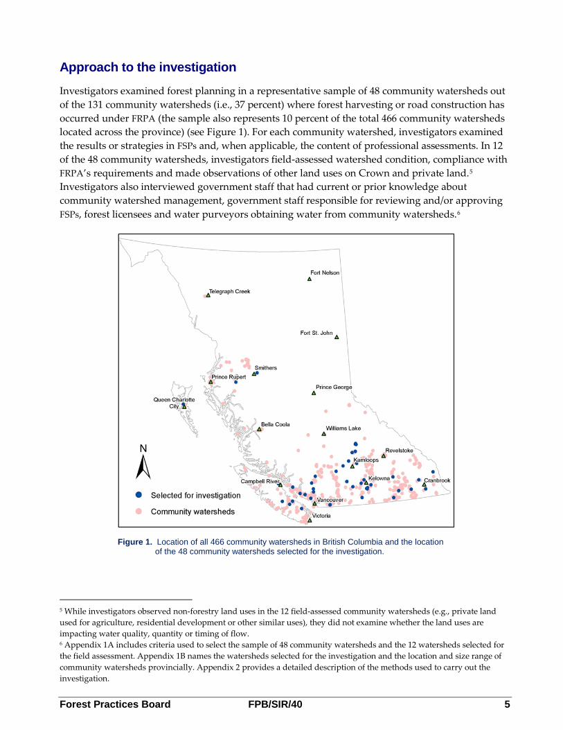
Approach to the investigation
Investigators examined forest planning in a representative sample of 48 community watersheds out of the 131 community watersheds (i.e., 37 percent) where forest harvesting or road construction has occurred under FRPA (the sample also represents 10 percent of the total 466 community watersheds located across the province) (see Figure 1). For each community watershed, investigators examined the results or strategies in FSPs and, when applicable, the content of professional assessments. In 12 of the 48 community watersheds, investigators field-assessed watershed condition, compliance with FRPA’s requirements and made observations of other land uses on Crown and private land.5 Investigators also interviewed government staff that had current or prior knowledge about community watershed management, government staff responsible for reviewing and/or approving FSPs, forest licensees and water purveyors obtaining water from community watersheds.6
5 While investigators observed non-forestry land uses in the 12 field-assessed community watersheds (e.g., private land used for agriculture, residential development or other similar uses), they did not examine whether the land uses are impacting water quality, quantity or timing of flow. 6 Appendix 1A includes criteria used to select the sample of 48 community watersheds and the 12 watersheds selected for the field assessment. Appendix 1B names the watersheds selected for the investigation and the location and size range of community watersheds provincially. Appendix 2 provides a detailed description of the methods used to carry out the investigation.
Figure 1. Location of all 466 community watersheds in British Columbia and the location of the 48 community watersheds selected for the investigation.

6 FPB/SIR/40 Forest Practices Board
Background
How is drinking water regulated in BC?
There are more than 12 different laws in BC that regulate or enable the regulation of water on Crown or private land. Two of the primary laws are the Drinking Water Protection Act (DWPA) and the Water Act (WA). The DWPA provides the regulatory authority to set requirements for drinking water quality and the WA7 regulates the allocation of water for various uses. Other laws are in place to regulate various land uses, such as mining, forestry and oil and gas development, which often include requirements to protect drinking water.
The law that regulates forest and range activities on Crown land is called the Forest and Range Practices Act (FRPA). The requirements of the legislation that directly or indirectly provide for the protection of drinking water in community watersheds are the focus of this investigation.
What is a community watershed and how many are there?
A community watershed is a watershed grandparented into FRPA (from the former Forest Practices Code) or established under FRPA because government has decided that special forest management is required in the watersheds to protect water used for drinking.8
When FRPA was enacted in 2004, all 461 community watersheds designated under the former Forest Practices Code, were brought under the legislation. Since 2004, 6 new community watersheds have been designated and 1 has been delisted (see Appendix 4). Currently, there are 466 community watersheds provincially with a total area of 1 413 543 hectares, or about 1.5 percent of the total area of the province (see Figure 1 on page 5).
What land uses are permitted in community watersheds?
About 26 percent of the roughly 1.4 million hectares of total land area in BC’s 466 community watersheds is private land,9 reserve or treaty area lands held by First Nations, or provincial and federal parks and reserves. The remaining 74 percent (1 million hectares) is provincial Crown land available for a variety of tenured and non-tenured land uses including forestry, mining and recreation.10 Currently, there are more than 1500 non-forestry tenures granted under the Land Act, Range Act and Mineral Tenures Act, with 18 different purposes, that overlap the 466 community watersheds.
7 The WA will be replaced by the Water Sustainability Act, which was given second reading on April 1, 2014. 8 A community watershed is not the same as a domestic watershed. A domestic watershed is used to describe any watershed in BC that provides drinking water, but is not designated as a community watershed. 9 Of the 466 community watersheds, 42 have more than 90 percent of the land area in private land and 24 of those watersheds are 100 percent private land. Seventy-one community watersheds have more than 40 percent of the land area in private land. FRPA does not apply to private land, unless the land is included in a tree farm licence or woodlot licence. 10 For a few community watersheds, like Capilano and Seymour in the lower mainland, the land is owned by municipalities or is Crown land subject to 999-year lease agreements (this type of lease is no longer granted). In these watersheds, the owners or lease holders have exclusive rights to the land base and restrict land uses because the sole purpose of the land is to provide drinking water for users.

Forest Practices Board FPB/SIR/40 7
How much forest harvesting has occurred in community watersheds?
Of the current 466 community watersheds, 295 had harvesting activity prior to their designation in 1995 (under the Forest Practices Code) (see Table 1). The amount of forest harvesting that took place in those 295 watersheds, prior to 1995, accounts for almost 70 percent of the total area harvested in community watersheds (the remaining 30 percent of area harvested occurred between 1995 and 2012). Under FRPA, Crown land forest harvesting has occurred in 131 of the 466 community watersheds. However, about half of the area harvested was in 10 community watersheds.11
Table 1. Number of community watersheds with forest harvesting from 1950 to present.
Period Event Community Watersheds with Forest Harvesting
1950-1994 Prior to community watershed designation 295 1995-2005 Forest Practices Code era 183
2006 to present FRPA era12 131 How can forest and range activities affect water used for drinking?
The disturbance of forest by harvesting, roads, fire, insects or disease can result in a variety of hydrological effects within a watershed. Depending on site conditions, this disturbance can alter the amount of snow accumulation, the infiltration of rainfall and the rate of snowmelt. In some cases, high rates of disturbance can result in channel erosion, debris flows and floods, which affects the quality, quantity and timing of water reaching the intake where it is diverted for human consumption. Although a variety of forest disturbances can affect watershed hydrology, forest licensees can only control forest harvesting and access roads.
Water quality can also be affected by fine sediment, mostly from forest roads but also from natural sources. When sediment enters a stream, the water becomes turbid, increasing the risk that pathogens13 from wild and domestic animals (e.g., livestock) and human sources will attach to the sediment particles. When water from the watershed reaches the intake, it must be treated so it is safe for human consumption. If the water is highly turbid, the treatment of water through ultraviolet light, chlorination and/or filtration is less effective.
Range use has the potential to affect water quality in two ways. Livestock use can damage riparian vegetation and stream banks, reducing the effectiveness of riparian areas to filter water and causing erosion. Livestock can also cause pathogens to enter streams from fecal matter. If the pathogens are carried downstream to the intake, it can compromise the quality of drinking water.
11 The majority of the harvesting in the 10 watersheds was likely undertaken to salvage pine beetle affected trees. 12 Although FRPA had legal effect in 2004, most forest licensees did not transition to the new legislation until 2006. 13 Human pathogens are micro-organisms like viruses, bacteria and protozoa that pose risks to human health. Source: Ministry of Health, Drinking water treatment objectives (microbiological) for surface water supplies in British Columbia, Version 1.1, November 2012 (document available for download at: http://www.health.gov.bc.ca/protect/dw_treatment-objectives.html).

8 FPB/SIR/40 Forest Practices Board
What are FRPA’s requirements for the protection of drinking water in community watersheds?
FRPA’s requirements for the protection of drinking water vary by the activity (i.e., a forest practice or a range practice), and by the type of licence. For example, forest licensees who must prepare an FSP have different requirements than forest licensees who hold a woodlot licence. Some requirements may only apply to community watersheds while others may apply generally to all watersheds. Each activity has rules contained in a applicable regulation, including objectives and practice requirements for various values.14 The objectives define what government wants to achieve for the protection of specific values and the practice requirements are rules that must be followed on the ground.
The FSP must address each of government’s objectives,15 including an objective for community watersheds. To do this, licensees write commitments in their plans referred to as results or strategies. All forest licensees, including those not required to have an FSP, must follow the applicable practice requirements.
1. Community Watershed Objective
The objective in section 8.2 of the FPPR that applies to the Crown forest landbase (if present) in 460 of 466 community watersheds is to (paraphrased):
Prevent the cumulative hydrological effects of primary forest activities16 within the community watershed from resulting in:
a) a material adverse impact on the quantity of water or the timing of the flow of the water to the licensed waterworks,17 or
b) the water from the licensed waterworks having a material adverse impact on human health that cannot be addressed by water treatment required under (i) an enactment, or (ii) the licence pertaining to the waterworks.
The objective applies to the extent that it does not unduly reduce the supply of timber from British Columbia's forests (the objectives that apply to 6 of 466 community watersheds can be found in Appendix 4).
14 These regulations include the Forest Planning and Practices Regulation (FPPR), the Woodlot Licence Planning and Practices Regulation (WLPPR) and the Range Planning and Practices Regulation (RPPR). 15 The objectives are in the FPPR and may also be designated under the Government Actions Regulation (GAR), other objectives established as higher level plan orders under the Forest Practices Code (and transitioned to FRPA), objectives under the Land Act and, on Haida Gwaii, objectives established by the Haida Gwaii Management Council. For about half of the objectives in the FPPR, licensees can include results in their FSPs or strategies to address the objective or they may chose to follow specific practice requirements. 16 The FPPR defines a ‘primary forest activity’ as timber harvesting, silviculture treatments or road construction, maintenance and deactivation. 17 FRPA defines a licensed waterworks as a water supply intake or water storage and delivery infrastructure that is licensed under the WA or authorized by an operating permit under the DWPA. The definition excludes a well serving one household or a surface water diversion for human consumption, where no WA licence has been obtained by the user.

Forest Practices Board FPB/SIR/40 9
2. Practice Requirements For FRPA licensees and agreement holders, there are practice requirements that directly or indirectly provide for the protection of drinking water and some rules only apply to community watersheds (requirements that apply to forest licensees can be found in Table 3, page 18).
The primary practice requirement for the protection of drinking water is contained in section 59 of the FPPR.18 This rule requires forest licensees to ensure that practices do not cause material harmful to human health to be deposited in, or transported to, water that is diverted for human consumption by a licensed waterworks (e.g., petroleum products, fertilizers). Under section 60(1), forest licensees must also ensure their practices do not cause damage to a licensed waterworks. Both requirements apply to all ‘licensed waterworks’, whether or not they are located within or outside a community watershed.
Findings and Observations The findings are organized according to the seven questions examined in the investigation (see page 4).
Is the objective for community watersheds and the practice requirement for drinking water quality in the FPPR clear and achievable?
All laws, including FRPA and its regulations, should be sufficiently clear that those who are subject to the laws know what is expected of them. Board investigators examined government’s objective for community watersheds and the primary water quality practice requirement in the FPPR to assess if they are sufficiently clear and achievable.
Findings and Observations Investigators found the FPPR’s objective for community watersheds, the exemption conditions and the water quality practice requirement, are too limited in scope or unclear. As it pertains to water quality, the objective only applies after the water is subject to treatment (if treatment is required), which implies more emphasis is placed on treatment than source water protection. Also, the primary drinking water practice requirement does not necessarily include sediment as material harmful to human health.
Government’s objective for community watersheds
The following observations were made about the interpretation or implementation of government’s objective for community watersheds:
1. The objective is to limit the cumulative hydrological effects of primary forest activities within community watersheds. Along with an objective for fish habitat that applies in most fisheries sensitive watersheds, they are currently the only objectives established under FRPA that require cumulative effects to be considered.
18 Section 47 of the Woodlot Licence Planning and Practices Regulation (WLPPR) and section 33 of the RPPR include a similar practice requirement for the protection of drinking water quality.

10 FPB/SIR/40 Forest Practices Board
FRPA requires forest licensees operating under an FSP to achieve the results and carry-out the strategies within a forest development unit,19 which in some cases might only be a portion of a community watershed. Forest licensees told investigators they believe the context of how the term cumulative is used in the objective, requires them to only consider cumulative effects of primary forest activities to the area of the forest development unit within the community watershed. The Board believes this interpretation is too narrow and is not consistent with government’s intent for addressing cumulative effects of primary forest activities within community watersheds or with conventional approaches for addressing cumulative effects at the watershed scale.
1. The objective applies to water quality “from” the waterworks and water quantity and timing of flow “to” the waterworks.20 It is unclear what government intended by setting the objective of water quality “from” the waterworks. The result, however, is the objective seems to emphasize water treatment at the waterworks instead of source water protection. In other words, if the objective stated “to the waterworks” there would be an implied emphasis on protecting source drinking water before it reached the waterworks.
2. The objective is limited to circumstances where “…water is being diverted for human consumption…” However, information obtained from holders of licensed waterworks in several sample watersheds confirms they have identified an alternate source of water, but wish to retain the water licence and infrastructure as an emergency back-up (see page 24). As the water is not currently being diverted, it raises the question of whether government intended for the objective to apply in situations where the water may be used for drinking water at some point in the future.
Conditional exemption to the drinking water quality related practice requirements
For government’s objective for community watersheds, the following exemption to the practice requirements is provided (section 12.32 FPPR, paraphrased):
An agreement holder who is required to prepare a forest stewardship plan is exempt from sections 59, 60(2) and 61 as they pertain to cumulative hydrological effects on water quality affecting human health in community watersheds…
Through the course of this investigation, Board investigators spoke with government staff and licensees about the exemption. Most were unclear about the meaning or intent of the exemption or how it would apply when conducting forest practices. The uncertainty stems from the fact that sections 59, 60(2) and 61 of the FPPR make no reference to cumulative hydrological effects.
19 A forest development unit (sometimes referred to as an FDU) is an area identified in a FSP where the holder may undertake forest development activities. The term is defined in the FPPR. 20 It should be noted that the GAR order establishing water quality objectives for the Mellott Creek community watershed, and the practice requirement in the WLPPR (section 58.1) include the wording “….a material adverse impact on the quantity of water or the timing of flow of the water from the licensed waterworks ….”. This wording is also problematic because a reliable quantity of water and timing of flow is required to the licensed waterworks, not from the waterworks.

Forest Practices Board FPB/SIR/40 11
Protection of drinking water quality practice requirement
Some government staff and forest licensees told Board investigators they are unsure about the meaning of the FPPR’s requirement to protect drinking water (section 59). For example, they are not certain about which substances, and in what concentration, are deemed to be harmful to human health and whether the harmful substance must reach the intake to be non-compliant.
Most forest harvesting involves the construction of new or upgraded access roads and can create soil disturbance within cutblocks. Often, access roads and cutblocks cross, or are situated adjacent to, streams, lakes and wetlands, increasing the risk that sediment from the exposed soils will enter waterways, particularly during rainfall events. If sediment reaches the intake of a licensed waterworks, it has the potential to affect drinking water quality. But it is not the sediment itself that is particularly harmful to human health; rather, it is the human pathogens that can adhere to sediment particles and be transported to the intake that are harmful. Sediment does have the potential to disrupt or overload drinking water treatment processes such as filtration, chlorination and ultraviolet light.
Although sediment is likely the most common risk to drinking water quality that can be caused by forestry operations,21 the section 59 requirement is not contravened unless the sediment contains human pathogens and is likely to reach the intake. Investigators identified numerous instances where sediment was being deposited into streams (see pages 17-19), but did not try to establish whether the sediment contained pathogens harmful to human health.
The Board believes the issues with the community watershed objective and primary drinking water quality practice requirement have the potential to compromise the protection of drinking water quality and, to a lesser extent, the quantity and timing of flow to the licensed waterworks.
Are results or strategies in FSPs measurable or verifiable, do they provide meaningful content and are they consistent with the community watershed objective? FRPA’s Requirements To be approved, results or strategies in an FSP must be measurable or verifiable and consistent with the objectives. There are some exceptions. For about half of the objectives in the FPPR, licensees can chose to propose a result or strategy or, may commit to complying with certain practice requirements. The community watershed objective is one of the objectives where forest licensees must propose a result or strategy.
The requirement to be consistent with the objectives is particularly important in the results-based framework of FRPA. This is because licensees are not required to achieve government’s objectives, rather, they are required to implement results or strategies in their FSPs which, once approved, are deemed by government to be consistent with the objectives.
21 If not properly managed, chemicals used in forest operations, like herbicides and fertilizer, may affect water quality.

12 FPB/SIR/40 Forest Practices Board
Results or strategies in FSPs that apply within the Okanagan Shuswap district.
The investigation did not include a formal comparison of FSP results and strategies between MFLNRO districts. However, Board investigators did observe that FSPs for licensees operating in the Okanagan Shuswap District contained results or strategies for community watersheds that were consistently measurable or verifiable.
Findings and Observations There were 47 FSPs applicable to the 48 community watersheds in the sample. Of the 47 FSPs, 3 did not include a result or strategy for the community watershed objective as required and should not have been approved by government.22 As a result, these 3 FSPs could not be included in the analysis of results and strategies. Table 2 includes the findings of the Board’s assessment of results and strategies in the 44 FSPs examined.
Table 2. Assessment of results and strategies in FSPs for the community watershed objective.
Results or strategies Number of FSPs (total = 44)
Measurable or verifiable 26
Partially measurable or verifiable (see footnote for example)23 14
Not measurable or verifiable (see footnote for example)24 4
For 43 of the 44 FSPs, licensees included a result or strategy that commits to having a professional complete an assessment of planned forest harvesting or road construction. For 13 of the 43 FSPs, the commitment was subject to certain conditions.
For all 44 FSPs, results or strategies were highly variable among FSPs. 25 Board investigators found most results and strategies provided meaningful content that was intended to assess hydrological responses associated with planned forest harvesting. However, for 41 of 44 FSPs, the results or strategies were not sufficiently detailed for Board investigators to conclude if they were consistent with the community watershed objective.
22 For the community watershed objective, the three FSPs made a commitment to “undertake to comply” with certain practice requirements. However, since they were approved, Board investigators did not assess the licensees who hold the FSPs as being non-compliant with FRPA. 23 For example, the result or strategy reads, in part, “recommendations in the hydrological assessment may be followed.” The result or strategy would be fully measurable or verifiable if the commitment stated “recommendations in the hydrological assessment will be followed.” 24 For example, a licensee’s result or strategy commits them to not exceeding an equivalent clearcut area (ECA) of 30 percent “considering important elevation bands.” Although ECA is measurable or verifiable, it is unclear if the 30 percent ECA is intended to apply to each “important elevation band” or is to be averaged over all “important elevation bands.” Clarifying the way ECA is calculated would ensure the result or strategy is fully measurable or verifiable. 25 Note: variability in results or strategies is an anticipated and potentially positive outcome of FRPA’s results-based framework. If monitored, variability can lead to identifying approaches that yield more positive results on the ground.

Forest Practices Board FPB/SIR/40 13
How does government establish consistency between results or strategies specified in an FSP and FRPA’s objective for community watersheds? FRPA’s Requirements When a licensee submits an FSP for approval, government must apply several approval tests. The approval test is set out in section 16 of FRPA, sections 25 and 25.1 of the FPPR and applied by a delegated decision maker (usually the district manager) within the Ministry of Forests, Lands and Natural Resource Operations (MFLNRO). A key aspect of the approval test is for the decision maker to establish whether results or strategies are consistent with government’s objectives.
Findings and Observations Board investigators found that when government considers an FSP for approval, it does not always ensure the results or strategies for the community watershed objective fully meets the approval test in FRPA or the FPPR. Rather, sometimes it considers other factors that may compensate for deficiencies in the results or strategies. This situation creates a potential gap in transparency and accountability under FRPA because, once approved, the public expects the plans to meet all content requirements and that the plans are fully enforceable by government. Government staff provided Board investigators with the following reasoning about the assessment of FSP content related to community watersheds.
Factors considered when applying FRPA’s approval test for FSPs
When examining consistency of proposed results or strategies, government staff said they do not necessarily consider consistency with each element of the community watershed objective (cumulative effects, water quality, water quantity and timing of flow). In their view, results or strategies are not necessarily required to be consistent with each element of the objective, but rather with the objective as a whole.
Staff said they sometimes make assumptions about whether a result or strategy is measurable or verifiable and based, in part, on key terms in the FSP, even if the terms are not always defined. For example, a result or strategy may commit the licensee to completing a hydrological assessment but the term is not defined in the FSP. In reviewing the FSP for approval, staff may make assumptions about what is required to complete a hydrological assessment based on their own experiences. However, since there is no standard definition of ‘hydrological assessment,’ the licensee’s assessment could range from a simple equivalent clearcut area calculation to a more sophisticated assessment of watershed condition.
Staff also said they are mindful of the challenges required to strike a balance between promoting innovation in FSPs, while requiring results or strategies detailing the innovative approach to be measurable or verifiable. They say the challenge exists because licensees assume greater risk when proposing innovative approaches, and it is sometimes difficult to express the approaches in a measurable or verifiable way.

14 FPB/SIR/40 Forest Practices Board
What is a ‘professional assessment’?
For the purposes of this investigation, a ‘professional assessment’ is an assessment completed by a professional engineer, geoscientist or forester, with experience in forest hydrology, who is employed or retained by a forest licensee. The assessment provides advice to forest licensees about planned forest harvesting and/or road construction.
Challenges when considering an application to extend an FSP
When a licensee submits an application to extend an FSP, government staff are generally reluctant to ask the licensee to make revisions if the results or strategies in the previously approved FSP are now viewed by government as being somewhat deficient. The reluctance stems from the view that, since the original FSP was deemed to have met all the requirements and the approval test did not change, only a compelling reason should require the licensee to make changes to the FSP.
Other factors considered by government staff
In some cases, government staff said they consider other factors that are not part of the FSP approval test to provide clarity and/or simply have confidence that the licensee’s intended results or strategies are consistent with the objectives. Some of the factors reported by government staff include: the licensee’s past performance; current knowledge about the licensee’s activities; and information contained in FSP supporting documentation. Government staff acknowledge there are risks in relying on other factors when reviewing whether a result or strategy is consistent with the objective.
Are licensees complying with FRPA’s planning requirements?
Section 21 of FRPA requires forest licensees to achieve the results and carry-out the strategies in their FSPs. This includes commitments such as having a professional prepare an assessment prior to undertaking planned activities.26
Findings and Observations Board investigators found 3 of the 47 FSPs reviewed did not include results or strategies for the community watershed objective.
All licensees retained professionals to complete assessments when committing to doing so in their FSP. For the 47 FSPs, a total of 31 professional assessments were prepared.27 (The Board’s overview analysis of these assessments is found in Part 1. Part 2 includes the Board’s detailed analysis of the 6 professional assessments completed for the 12 watersheds field-assessed by Board investigators.)
26 Once an FSP is approved, government may verify if the assessment was done, but staff do not review or approve the assessment. As well, under FRPA, assessments are not required to be made publicly available for review and comment. 27 Professional assessments were not completed for every watershed in the sample. This is because licensees may not have committed to completing a professional assessment in their FSP or made a determination, in accordance with their results or strategies, that a professional assessment was not required under the circumstances.

Forest Practices Board FPB/SIR/40 15
Part I - Overview analysis of thirty-one professional assessments
Of 31 professional assessments, 11 did not include content as committed to in the FSPs.28 This finding does not necessarily mean the professional assessments were not adequate under the circumstances. However, when an assessment is not carried out as prescribed in an approved FSP, there is a risk that certain issues or values may not be addressed by the professional completing the assessment.
Professional assessments varied widely by name and content, from full-scope watershed assessments to simple assessments limited to a calculation of ECA.29 Few assessments included all five suggested components of a conventional watershed assessment (i.e., scoping, assessment, synthesis, management solutions and adaptive management).30 In the assessments, there was limited content related to adaptive management, which is an on-going process of implementing, monitoring and revising practices as needed, including forward-thinking actions required to address conditions like climate change.
Of 31 assessments 26 considered, to varying degrees, the hydrological effects of FRPA and pre-FRPA related forest activities over the entire watershed. But none of the assessments fully evaluated the cumulative hydrological effects of all forestry related activities, such as FRPA and pre-FRPA forest harvesting and associated road networks, and their potential effect on surface and groundwater flows. About half of the professional assessments (i.e., 15 of 31) recognized other land uses in the watersheds. For 7 of 31 assessments, the methodology used was not adequately described; therefore, Board investigators were not able to fully evaluate watershed elements examined by the professional. The Board notes that FRPA does not define cumulative hydrological effects and the associations representing professionals who complete the watershed-type assessments, do not provide guidance to their members on assessing cumulative hydrological effects.
Only 6 of 31 assessments included content related to water quality, quantity and timing of flow to the licensed waterworks—the primary element’s of government’s objective for community watersheds. For most professional assessments, the focus was on factors and conditions such as peak flows, surface erosion, channel condition and riparian condition. However, the assessments do not link the assessed factors and conditions and the requirements or limitations of the licensed waterworks. For example, a professional may assess the anticipated effects of forest harvesting on peak flows, but does not determine whether the peak flows will affect the amount of water required by the licensed waterworks at certain times of the year (e.g., peak demand during summer months).
28 The investigation examined whether the assessments followed the content of the FSP as opposed to whether the assessments complied with the content of the FSP. This distinction is made because not all licensees chose to describe the content of the assessment in the FSP; or when the content was described, the language used was not always enforceable. Therefore, Board investigators did not undertake an evaluation of compliance with individual professional assessments. For 4 of 31 professional assessments, the corresponding FSPs did not define the content of the assessment. Therefore, they were not included in the analysis. 29 The ECA is defined as the area that has been clearcut, with a reduction factor to account for the hydrological recovery due to forest regeneration. In some cases it was the only assessment completed by the licensee in the watershed. 30 Source: R. Pike et al. 2009 (see Appendix 2 for full citation).

16 FPB/SIR/40 Forest Practices Board
Part II - Detailed analysis of six professional assessments
Methods used in the professional assessments
Five of six professional assessments used a hazard-based approach while one used a risk-based approach.31 Two of the five that focused on hazards used ECA as a surrogate for watershed condition, with little consideration to site conditions. In both cases, ECA in the watersheds was below 12 percent (well below levels where measurable effects on runoff and streamflow would be expected). However, the results of the Board’s field assessment of the two watersheds indicate that sedimentation, streamflow and/or hydrogeomorphic hazards in the watersheds are high to very high. This highlights the risk of using ECA, or other factors like road density, as the primary means of assessing and managing watershed condition.
Key findings in the professional assessments related to current watershed condition32
Water-related issues in interior community watersheds include exposure of waterworks infrastructure to potentially damaging hydrogeomorphic events, sediment generation and delivery from roads (some from non-status roads33), and moderate to high streamflow hazards associated, in part, with mountain pine beetle infestation. On the coast, road issues outweighed other factors with respect to negative effects on watershed condition. Roads of all types (FSR, licensee permitted and non-status) were identified as chronic sediment sources as a result of running surface erosion, natural and forest practice induced landslides, and other types of hillslope erosion, mostly the result of drainage diversion and concentration of flows.
Nature of recommendations made in the professional assessments
Board investigators did not examine whether recommendations made in the professional assessments were appropriate. However, assessments that involved more than an analysis of ECA included recommendations to address current and future watershed condition issues. Board investigators did note that none of the recommendations were written in a way that strongly emphasizes the need for implementation, or were site-specific (e.g., most assessments include phrases like ….“the licensee should consider”).
31 A hazard-based approach examines sources of potential harm to resources at stake, like water quality, and uses ratings to express the likelihood of hazard occurrence. The hazard approach assumes all resources are created equal and are susceptible in similar ways, which is not always the case. A risk-based approach combines the hazard assessment with an assessment of the consequence of actual harm to determine the real risk to the resource(s) at stake. Note: For the 12 field-assessed watersheds, Board investigators used a risk-based approach, involving the assessment of three hazards to describe watershed condition. 32 Because of the variability in methods used in the professional assessments, Board investigators did not compare outcomes between the professional assessments and its own assessment of watershed condition. 33 Non-status roads are roads built before 1995 and have been out of use since then. Non-status roads are not covered by legislation, and responsibility for their maintenance or deactivation rests with government.

Forest Practices Board FPB/SIR/40 17
Note about interpreting the Board’s findings in the 12 field-assessed watersheds
Selection of the 12 watersheds for field assessment considered several factors like geographic location and input from government staff and water purveyors. As a result, the findings for the 12 watersheds should not be extrapolated to all 131 community watersheds where some amount of harvesting has occurred under FRPA.
Are licensees complying with FRPA’s practice requirements? Background All licensees and agreement holders under FRPA must comply with practice requirements—rules that must be followed on the ground—as specified in regulations. A few of the requirements, some of which only apply within community watersheds, are directly related to the protection of drinking water. Other practice requirements, like preventing landslides, do not specifically refer to the protection of drinking water. However, if not prevented, landslides have the potential to adversely affect source drinking water quality.
Findings and observations All 12 field-assessed watersheds had forest harvesting, road construction or road deactivation regulated under the FPPR. Seven of the 12 community watersheds include a range tenure and 1 watershed has multiple woodlot licences. In those 8 watersheds, Board investigators found range and woodlot licence practice requirements were in compliance with the WLPPR and RPPR respectively, and no unsound practices were identified.
Board investigators found high levels of compliance with practice requirements that specifically apply to operations in community watersheds. However, some other practice requirements that apply both within and outside of community watersheds were found to be non-compliant in 4 of 12 community watersheds. In 3 of 12 community watersheds, Board investigators observed unsound34 practices resulting from multiple deposits of sediment into streams from roads regulated under FRPA (see Table 3, which presents findings of compliant, non-compliant and unsound practices in the 12 field-assessed watersheds). 35
34 An unsound practice means a licensee is complying with the law but the Board believes the practice is likely to harm personal safety or the environment. 35 This investigation does not attribute non-compliant practices to named watersheds. However, the reader may wish to cross-reference watershed identifiers on pages 18, 20, 21 and Appendix 6. Board investigators assessed compliance on the ground with FRPA’s practice requirements. None of the results or strategies stated in FSPs for the 12 field-assessed watersheds made commitments about practices that would be conducted on the ground. Also, Board investigators did not determine whether the MFLNRO’s compliance and enforcement program was either aware of or had taken action with regard to the identified non-compliances.

18 FPB/SIR/40 Forest Practices Board
Table 3. Assessment of forest licensees’ compliance with drinking water quality related practice requirements in the 12 field-assessed watersheds.
Requirements in the FPPR that provide for the protection of drinking water36
Field-assessed watersheds with non-compliant or unsound practices
Practice requirements that apply only in community watersheds
Provide enhanced riparian retention adjacent to streams, lakes and wetlands s. 47-52
037 See Figure 2 showing compliant practice
Ensure sediment from excavated or bladed trails does not affect drinking water s. 61 0
Avoid building a road within 100m of spring s. 62 0 Avoid fertilizer use near streams & waterworks s. 63(1) 0 Size culverts & bridges to pass peak flows s. 74(1) 0 Notify water purveyors s. 8438 0
Practice requirements that apply within and outside of community watersheds
Prevent landslides s. 37 1 (#6)* (see Figure 3 showing non-compliant practice)
Maintain natural surface drainage s. 39(1) 2 (#7 & #11)
Protect drinking water quality s.59 0 non-compliant
‘Unsound’ practices in 3 watersheds (#9, #11, #12) (see Figure 4)
Protect licensed waterworks s. 60 0
Build, maintain or deactivate roads s. 79(6), 81 1 (#12) (see Figure 5 showing compliant practice)
* The watershed identifiers in this table correspond to watershed identifiers used on pages 20 and 21 and Appendix 6. In 2 of 12 watersheds, non-compliant practices likely had, or are continuing to have, a significant impact on source drinking water quality. In watershed #6, a forest licensee did not sufficiently maintain a road, which led to a landslide about four hectares in size (see Figure 3). The water purveyor told Board investigators that the landslide caused highly turbid water to reach the intake, resulting in service interruptions for about 800 water users. In watershed #12, Board investigators found multiple incidents of FRPA regulated roads that did not meet the requirements for maintenance or deactivation. Poorly placed cross ditches and inadequate dispersal of surface water, resulted in higher concentrations of flows over potentially unstable terrain, and a general lack of soil erosion control resulted in sediment deposition into stream channels. In some cases, the practice resulted in hill-slope destabilization.
36 Presented as paraphrased text—consult the applicable regulations for the full wording. 37 In its audits of forest licensees’ compliance with FRPA’s requirements, the Forest Practices Board has also found generally good compliance with requirements to retain trees adjacent to streams, lakes and wetlands. 38 See Appendix 5 for additional findings and observations made about the notification requirement.

Forest Practices Board FPB/SIR/40 19
Figure 5. Compliant practice: This road was constructed for winter access to a cutblock. Following harvesting, the road was revegetated, reducing the potential for sediment to be eroded into streams.
Figure 4. Unsound practice: This figure shows a section of road that was deactivated, including the removal of stream crossing structures. Investigators observed that soil was placed immediately adjacent to the channel. Some of the soil had been eroded into the stream.
Figure 3. Non-compliant practice: This 4 hectare landslide originated from a road located near the top of the photo. A forest licensee did not sufficiently maintain the road which led to this landslide. The landslide likely had a material adverse effect on source water used for drinking.
Figure 2. Compliant practice: In this cutblock, trees have been retained along some streams even when there is no requirement to do so.
20 FPB/SIR/40 Forest Practices Board
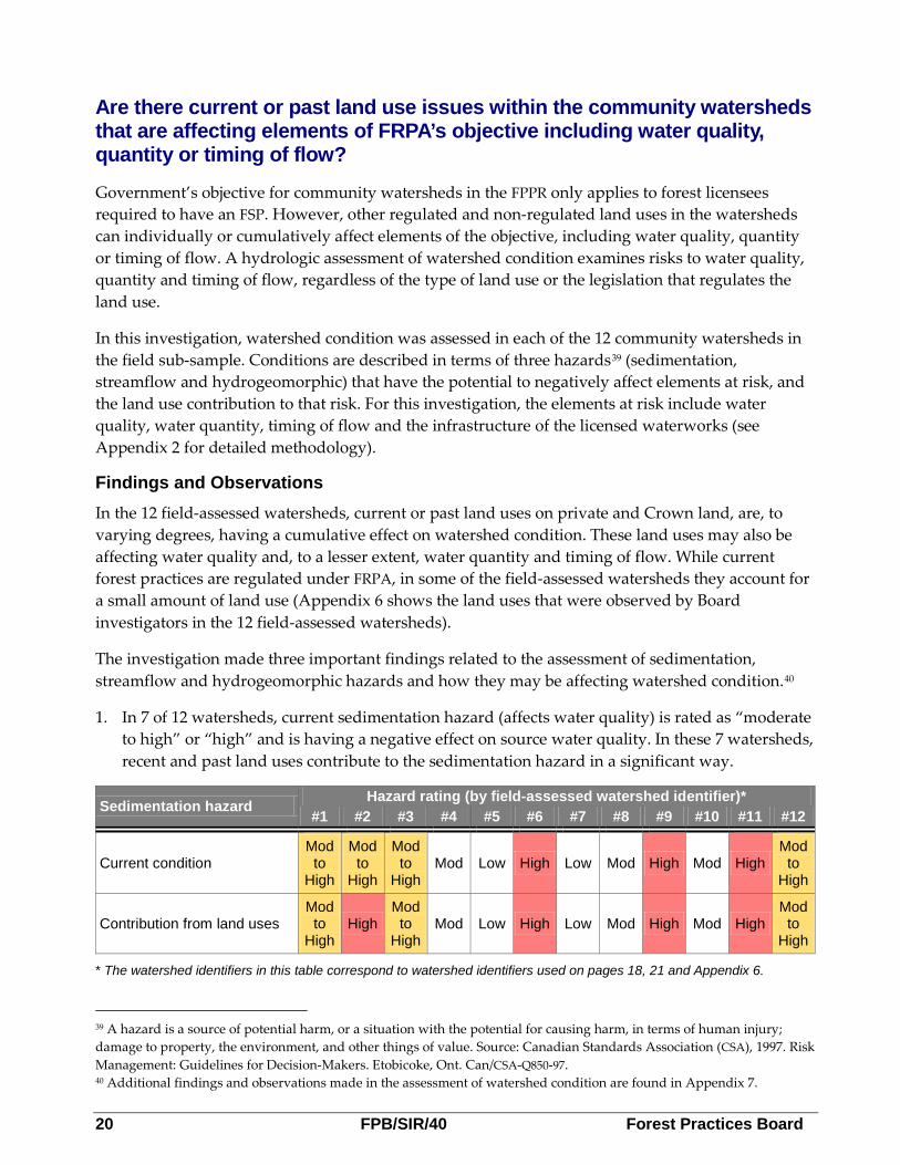
Are there current or past land use issues within the community watersheds that are affecting elements of FRPA’s objective including water quality, quantity or timing of flow?
Government’s objective for community watersheds in the FPPR only applies to forest licensees required to have an FSP. However, other regulated and non-regulated land uses in the watersheds can individually or cumulatively affect elements of the objective, including water quality, quantity or timing of flow. A hydrologic assessment of watershed condition examines risks to water quality, quantity and timing of flow, regardless of the type of land use or the legislation that regulates the land use.
In this investigation, watershed condition was assessed in each of the 12 community watersheds in the field sub-sample. Conditions are described in terms of three hazards39 (sedimentation, streamflow and hydrogeomorphic) that have the potential to negatively affect elements at risk, and the land use contribution to that risk. For this investigation, the elements at risk include water quality, water quantity, timing of flow and the infrastructure of the licensed waterworks (see Appendix 2 for detailed methodology).
Findings and Observations In the 12 field-assessed watersheds, current or past land uses on private and Crown land, are, to varying degrees, having a cumulative effect on watershed condition. These land uses may also be affecting water quality and, to a lesser extent, water quantity and timing of flow. While current forest practices are regulated under FRPA, in some of the field-assessed watersheds they account for a small amount of land use (Appendix 6 shows the land uses that were observed by Board investigators in the 12 field-assessed watersheds).
The investigation made three important findings related to the assessment of sedimentation, streamflow and hydrogeomorphic hazards and how they may be affecting watershed condition.40
1. In 7 of 12 watersheds, current sedimentation hazard (affects water quality) is rated as “moderate to high” or “high” and is having a negative effect on source water quality. In these 7 watersheds, recent and past land uses contribute to the sedimentation hazard in a significant way.
Sedimentation hazard Hazard rating (by field-assessed watershed identifier)* #1 #2 #3 #4 #5 #6 #7 #8 #9 #10 #11 #12
Current condition Mod to
High
Mod to
High
Mod to
High Mod Low High Low Mod High Mod High
Mod to
High
Contribution from land uses Mod to
High High
Mod to
High Mod Low High Low Mod High Mod High
Mod to
High
* The watershed identifiers in this table correspond to watershed identifiers used on pages 18, 21 and Appendix 6.
39 A hazard is a source of potential harm, or a situation with the potential for causing harm, in terms of human injury; damage to property, the environment, and other things of value. Source: Canadian Standards Association (CSA), 1997. Risk Management: Guidelines for Decision-Makers. Etobicoke, Ont. Can/CSA-Q850-97. 40 Additional findings and observations made in the assessment of watershed condition are found in Appendix 7.

Forest Practices Board FPB/SIR/40 21
2. With only one “high” rating in the streamflow hazard category, water quantity and timing of flow does not appear to be a substantial problem in most field-assessed watersheds. This finding is consistent with information from water purveyors who say the amount of water available at the intake is usually sufficient to meet demand. Where the hazard is high, the contribution from land uses is low to moderate, suggesting that the situation is largely the result of natural processes (e.g., steep, flashy, coastal watershed that naturally goes dry in the summer).
Streamflow hazard Hazard rating (by field-assessed watershed identifier)* #1 #2 #3 #4 #5 #6 #7 #8 #9 #10 #11 #12
Current condition Low High Mod Low Low Mod Low Mod Mod Low Low Mod
Contribution from land uses Low Low to
Mod
Low to
Mod Mod Low Mod Low Mod
Low to
Mod Mod Low Low
* The watershed identifiers in this table correspond to watershed identifiers used on pages 18, 20 and Appendix 6.
3. In 8 of 12 watersheds, current hydrogeomorphic hazards41 are rated as “high.” This means the likelihood of occurrence of a hydrogeomorphic event capable of damaging or destroying water intakes and primary treatment infrastructure is high. In 5 of the 8 watersheds, land uses are contributing to the situation in a significant way.
Hydrogeomorphic hazard Hazard rating (by field-assessed watershed identifier)* #1 #2 #3 #4 #5 #6 #7 #8 #9 #10 #11 #12
Current condition Mod High High Low Low High Low High High High High High
Contribution from land uses Low High Mod to
High Low Low Mod Low
Mod to
High High
Mod to
High Low Mod
* The watershed identifiers in this table correspond to watershed identifiers used on pages 18, 20 and Appendix 6.
41 Hydrogeomorphic hazards include flooding, debris floods and debris flows that can damage or destroy a water intake and primary treatment infrastructure. Hazard ratings reflect the likelihood of hazard occurrence, and land use contribution ratings describe the role of current land uses in that situation.

22 FPB/SIR/40 Forest Practices Board
CCaassee SSttuuddiieess –– HHooww LLaanndd--BBaasseedd IInnvveessttmmeennttss CCaann IImmpprroovvee WWaatteerrsshheedd CCoonnddiittiioonn
Deactivating non-status roads in a community watershed In one of the field-assessed watersheds (#9), the MFLNRO was completing a five-year watershed restoration project. The project involves permanently deactivating about 150 kilometres of non-status roads with the intent of reducing the sedimentation hazard in the watershed over the long-term. The permanent deactivation involves re-contouring the road to the natural slope gradient and removing all culverts and bridges (see Figure 6). Around 4.4 million dollars has been spent completing this project. Monitoring will be required to assess whether the investments will reduce the sediment hazard.
Benefits of a collaborative approach to managed recreation in a community watershed In the Okanagan Shuswap district, staff from Recreation Sites and Trails BC developed a collaborative partnership with the Okanagan Trail Riders Association to manage off-highway vehicle recreation at the 35 000 hectare Bear Creek Recreation Site—the largest recreation site in BC. This recreation site, which was established under section 56(1) of FRPA, is situated in the Lambly Creek community watershed, near Kelowna, BC. Prior to stakeholder and government management, the area had a long history of unmanaged motorized vehicle use which led to soil erosion and impacts to water quality, as well as damage to grasslands.
Board investigators assessed the recreation site and found numerous examples where trails previously causing soil erosion were being rehabilitated; off-road vehicle access to a stream used for drinking water had been eliminated and range developments, like water troughs, were installed to keep livestock away from riparian areas. The collaborative approach applied to this recreation site demonstrates that managed motorized recreation can be compatible with the protection of drinking water quality.
Figure 6. This photo shows a segment of road in watershed #9 that has been permanently deactivated by MFLNRO.

Forest Practices Board FPB/SIR/40 23
How does government monitor achievement of the community watershed objective?
With the FRPA model, government evaluates the effectiveness of forest and range practices in achieving management objectives for 11 values, including water quality, using monitoring conducted under its Forest and Range Evaluation Program (FREP). FREP monitors water quality using the water quality effectiveness evaluation (WQEE) protocol. The protocol measures the loss of sediment from roads and cutblocks with the potential of entering a stream and possibly affecting water quality.
Findings and Observations While FREP monitors water quality generally, it does not specifically monitor water quality used for drinking, nor does it monitor whether the objective for community watersheds is being achieved. As a result, government does not know if practices under FRPA are contributing to the protection of water quality, water quantity or timing of flow in community watersheds.
Can FREP’s water quality data provide information about how well forest activities are protecting drinking water quality?
Between 2008 and 2011, FREP WQEEs were completed at 3681 randomly selected sites throughout BC. Of those, 366 sites (about 10 percent) were completed upstream of a domestic water intake–many of which are used for drinking water. The majority of evaluations (3315 or about 90 percent) were completed on sites where no water intake was located downstream. For this investigation, FREP compared the WQEE scores between the 366 sites located upstream of a water intake and the 3315 sites where no intake was located downstream. The three site rankings used to predict the quantity of fine sediment that may be deposited into a stream are:42
1) very low to low (<0.2 to 1 cubic metres); 2) moderate (>1 to <5 cubic metres); and 3) high to very high (5 to >20 cubic metres).
The comparison of the WQEE data revealed no difference in the predicted quantity of fine sediment entering upstream of drinking water intakes and at sites where no intake was located downstream For example, FREP data revealed that about 30 percent of all sites assessed upstream of a water intake received a ‘moderate’ score, meaning that over the past year, each site was potentially contributing between one and five cubic metres of fine sediment. Similarly, about 23 percent of all sites assessed—where no licensed waterworks was located downstream—also received a moderate score. These results run counter to the expectation that greater care and attention would be taken by forest licensees to ensure practices were minimizing fine sediment deposition into streams, particularly when operating upstream of a drinking water intake.
42 The predicted quantity of fine sediment is calculated by combining the total sediment contribution from mass-wasting (like slides, slumps and road surface riling) that has occurred over the past year (primarily since snowmelt) and the potential quantity of fine sediment from surface erosion that is likely over the next year.

24 FPB/SIR/40 Forest Practices Board
How does government decide which watersheds warrant community watershed designation or delisting? Findings and Observations Community watershed designation or de-listing
Currently, government has interim draft guidelines43 for designating or delisting (cancelling) community watershed designations that compliment criteria that must be met in FRPA. For designations, the guidelines include six categories of eligible licensed waterworks and five criteria that may be considered. Also, a minimum of 2500 gallons per day of consumption is required from the licensed waterworks within the proposed community watershed.
To amend or delist a community watershed, the guidelines require one of five criteria to be met. In addition to the five criteria, staff applying the guidelines are required to take into account important fisheries values. This is because it is government policy to withhold delisting a community watershed with important fisheries until a fisheries sensitive watershed designation can be made over the same area.44
The interim draft guidelines were written in 2008. Since then, one new community watershed has been designated (Mellott Creek) and one has been delisted (Blueberry Creek45).
Changes in how water is being sourced from community watersheds
Through the investigation, Board investigators found that many changes have taken place in how water is being sourced in the 48 sample community watersheds since they were first designated under the Forest Practices Code. In 16 of the 48 sample watersheds:46
• 5 water purveyors have moved the water source from a stream to a well within the community watershed.
• 11 no longer obtain the primary water source from within the community watershed, instead obtaining water from a well, lake, or river located outside the watershed. Seven of the 11 purveyors continue to use the community watershed as an emergency back-up source.
None of the FSPs that apply to the 16 community watersheds refer to changes in how water is being sourced in the community watershed in which the forest licensee operates. Also, Board investigators are not aware of any instances where a delegated decision maker has provided a forest licensee with an exemption from proposing a result or strategy in an FSP because special management is no longer required in the community watershed (see section 8.2(4) FPPR).
43 Ministry of Environment, 2008. Interim Guidelines and Procedures on the Designation, Amendment and Cancellation of Community Watersheds under the Forest and Range Practices Act. Draft. 44 The policy is discussed in a Decision Note, approved by the Deputy Minister (dated June 18, 2010) about delisting the Blueberry Creek community watershed (ministry file: 77900-20). 45 In June 2010, the Minister of Environment rescinded the designation of one community watershed (Blueberry Creek) on application of the former water purveyor who is no longer using the watershed for source water. 46 Board investigators did not determine why water purveyors in the 16 community watersheds chose to locate alternate sources of water either within or outside the community watershed.

Forest Practices Board FPB/SIR/40 25
Conclusions This special investigation examined whether forest planning and practices undertaken by forest licensees and range agreement holders subject to FRPA, are likely to contribute to achievement of government’s objective for community watersheds. For planning, the investigation focused on FSPs in 48 community watersheds that were required to address government’s objectives in their plans. The practices of all licensees and agreement holders subject to FRPA were assessed on the ground in 12 community watersheds.
Board investigators found that government’s objective for community watersheds and the primary water quality practice requirement are not sufficiently clear or achievable. The objective emphasizes water treatment over source protection and the water quality practice requirement does not necessarily include sediment deposited into streams (a primary risk of forestry operations) as a substance harmful to human health. At the same time, government does not always ensure that FSP meet the requirements set out in FRPA.
Some weaknesses were found in FSP content related to community watersheds. Three of the 44 FSPs examined did not include results or strategies as required. For the remainder of the FSPs assessed, results or strategies were either partially (12 of 44) or not (4 of 44) measurable or verifiable, meaning that the commitments in the plans may not be enforceable. Also, results or strategies for the majority of FSPs lacked sufficient detail for Board investigators to conclude whether they were consistent with government’s objective—a FRPA requirement for FSP approval.
In the majority of FSPs, licensees included a commitment requiring them to retain a professional to complete an assessment of planned harvesting in the watershed. While licensees are not required to make such commitments, Board investigators did find some problems with the professional assessments completed. In particular, 11 of 31 assessments did not include content as described in the FSP, increasing the risk that certain issues or values identified in the FSP may not be addressed by the professional completing the assessment. Twenty-six of 31 assessments considered, to varying degrees, the hydrological effects of FRPA and pre-FRPA related forest activities over the entire watershed. However, the assessments either did not fully evaluate the cumulative nature of those hydrological effects, or methodologies were not sufficiently detailed to determine if such an evaluation was done. Also, only 6 of 31 assessments included content related to water quality, quantity and timing of flow to the licensed waterworks—the primary element’s of government’s objective for community watersheds.
In 12 field-assessed community watersheds, Board investigators found forest licensees were in compliance with requirements specific to community watersheds, like retaining wider forested buffers adjacent to streams, lakes and wetlands. However, non-compliance with requirements that indirectly provide for the protection of drinking water were found in 4 of 12 watersheds. These include the prevention of landslides, maintenance of natural surface drainage patterns and requirements for road construction, maintenance and deactivation. In 3 of 12 watersheds, licensees’ activities caused sediment to be deposited into streams. The Board found these practices to be compliant, but unsound, meaning the practice is not in keeping with good forest stewardship. All range and woodlot practices were found to be compliant with FRPA’s requirements.

26 FPB/SIR/40 Forest Practices Board
Board investigators observed a variety of land uses are contributing to the condition of the 12 field-assessed watersheds. In 7 of 12 watersheds, sedimentation from land uses is having a negative effect on source drinking water. While current watershed condition does not seem to be affecting water quantity or timing of flow in most watersheds, waterworks infrastructure is at risk in 8 of 12 watersheds, due mostly to the natural terrain conditions. Although FRPA regulated activities are present in all 12 watersheds, it is the legacy of pre-FRPA and, in particular, pre-Forest Practices Code activities that are having the greatest impact.
The investigation also found that the designation or delisting of community watersheds by government has not kept pace with changes in how water is being sourced from community watersheds. In 16 of 48 watersheds, the surface drinking water source has changed meaning that the watersheds may no longer meet the criteria for designation. Also, government’s monitoring of water quality on the forest landbase was found to be lacking because it currently does not monitor the effectiveness of practices to protect water used for drinking either within or outside of community watersheds.
The special investigation has identified several weaknesses in FRPA and how it is being implemented in community watersheds. Issues related to the requirements in FRPA, approval of FSPs, monitoring of drinking water and plans and practices undertaken by licensees were identified. Together, these issues have the potential to compromise the effective achievement of government’s objective for community watersheds.
Recommendations Under section 131(2) of the Forest and Range Practices Act, the Board makes the following recommendations to address key findings of the investigation:
1. Strengthening FRPA’s requirements for the protection of drinking water. Government should undertake a review of FRPA’s requirements for the protection of drinking water generally, and in community watersheds specifically. The review should include:
• revising government’s objective for community watersheds with the intent of emphasizing the importance of source water protection;
• revising the water quality practice requirement, in all applicable FRPA regulations, to address the inherent risk to human health associated with sediment;
• clarifying the meaning and scope of cumulative hydrological effects including whether the assessment and management of these effects is appropriate within the confines of FRPA or should be implemented under a different process; and
• examining the appropriate use of specific water quality objectives under the Government Actions Regulation and provisions under the Drinking Water Protection Act, where watershed condition is at risk.
2. Strengthening the content and approval of forest stewardship plans. Government should provide clear direction to delegated decision-makers that ensures results and strategies in FSPs pertaining to the community watershed objective are measurable or verifiable.

Forest Practices Board FPB/SIR/40 27
3. Ensuring the content of professional assessments is meaningful. The Association of BC Forest Professionals and the Association of Professional Engineers and Geoscientists of BC should develop guidance for their members on the appropriate content of a watershed or hydrological assessment. This should include:
• the elements necessary to address government’s objective for community watersheds, including where the surface water source has changed to a groundwater source;
• procedures for considering cumulative hydrological effects at the watershed scale; • integration of the needs of licensed waterworks; and • examples of recommendations providing clear direction for implementation.
4. Monitoring the protection of drinking water. Government should expand its monitoring of the effectiveness of forest and range practices in protecting water quality to include water used for drinking both within and outside of community watersheds.
5. Updating the status of community watersheds. Government should undertake a comprehensive review of the status of community watersheds and determine which watersheds warrant designation and require special management.
The Board requests that government advise it of progress made and timelines for implementing recommendations #1, #2, #4 and #5 by October 1, 2014. The Board requests that the Association of BC Forest Professionals and the Association of Professional Engineers and Geoscientists of BC advise it of progress made and timelines for implementing recommendation #3 by October 1, 2014.

28 FPB/SIR/40 Forest Practices Board
Appendix 1A: Criteria Used to Select the Sample Community Watersheds Forty eight community watersheds were selected out of the 131 community watersheds (i.e., 37 percent) where forest harvesting or road construction has occurred under the Forest Range and Practices Act (FRPA) (the 131 community watersheds comprise the ‘sample population’ and the 48 community watersheds comprise the ‘sample’). The watersheds were selected primarily based on the occurrence of forest harvesting undertaken under authority of FRPA (2006 to January 2012). Additional selection criteria included:
• regional distribution, with the intent of including as many resource districts as possible. The sample represents 5 of 7 the Ministry of Forests, Lands and Natural Resource Operations (MFLNRO) regions and 13 of 18 districts which have at least one community watershed (see Appendix 1B which shows community watersheds by MFLNRO region and district);
• additional watersheds were selected in resource districts having a high proportion of community watershed (e.g., South Island, Okanagan Shuswap, Selkirk, Chilliwack);
• watersheds with an extensive history of forest harvesting and watersheds with single vs. multiple forest development units; and
• suggestions made by water purveyors or government staff from various ministries (e.g., drinking water officers).
Criteria used to select the field sub-sample
Of the 48 watersheds in the sample, 12 were selected for field assessment (referred to as the field sub-sample). Selection criteria included:
• regional distribution, with the intent of including as many resource districts as possible. The field sub-sample represents 5 of 7 MFLNRO regions and 8 of 18 districts which have at least one community watershed (see Appendix 1B which shows community watersheds by MFLNRO region and district);
• adjacent community watersheds if they form a part of the water supply for a community (e.g., via diversions and other infrastructure); and
• suggestions made by government staff from various ministries.
Consistent with Board policy,47 watersheds were not selected for field assessment if the Board had audited the licensee within the previous five years.
47 Forest Practices Board, Policy for the Audit Frequency of a Given Licence or Licensee, 2004. Available at: www.fpb.gov.bc.ca.
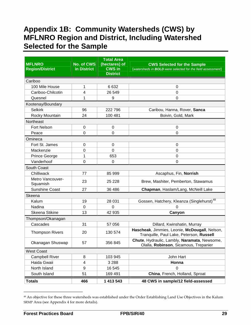
Forest Practices Board FPB/SIR/40 29
Appendix 1B: Community Watersheds (CWS) by MFLNRO Region and District, Including Watershed Selected for the Sample
MFLNRO Region/District
No. of CWS in District
Total Area (hectares) of
CWS in District
CWS Selected for the Sample (watersheds in BOLD were selected for the field assessment)
Cariboo 100 Mile House 1 6 632 0 Cariboo-Chilcotin 4 26 549 0 Quesnel 1 9 0
Kootenay/Boundary Selkirk 96 222 796 Caribou, Hanna, Rover, Sanca Rocky Mountain 24 100 481 Boivin, Gold, Mark
Northeast Fort Nelson 0 0 0 Peace 0 0 0
Omineca Fort St. James 0 0 0 Mackenzie 0 0 0 Prince George 1 653 0 Vanderhoof 0 0 0
South Coast Chilliwack 77 85 999 Ascaphus, Fin, Norrish Metro Vancouver-Squamish 23 25 228 Brew, Mashiter, Pemberton, Stawamus
Sunshine Coast 27 36 486 Chapman, Haslam/Lang, McNeill Lake Skeena
Kalum 19 28 031 Gossen, Hatchery, Kleanza (Singlehurst)48 Nadina 0 0 0 Skeena Stikine 13 42 935 Canyon
Thompson/Okanagan Cascades 31 57 056 Dillard, Kwinshatin, Murray
Thompson Rivers 20 130 574 Hascheak, Jimmies, Leonie, McDougall, Nelson, Tranquille, Paul Lake, Peterson, Russell
Okanagan Shuswap 57 356 845 Chute, Hydraulic, Lambly, Naramata, Newsome, Olalla, Robinson, Sicamous, Trepanier
West Coast Campbell River 8 103 945 John Hart Haida Gwaii 4 3 288 Honna North Island 9 16 545 0 South Island 51 169 491 China, French, Holland, Sproat
Totals 466 1 413 543 48 CWS in sample/12 field-assessed
48 An objective for these three watersheds was established under the Order Establishing Land Use Objectives in the Kalum SRMP Area (see Appendix 4 for more details).

30 FPB/SIR/40 Forest Practices Board
Appendix 2: Methods Used in the Investigation
Evaluation of results or strategies in forest stewardship plans (FSPs)
All applicable FSPs49 within the 48 sample community watersheds were retrieved from the FSP Tracking System. Government databases, including the Forest Tenure Administration System and spatial datasets (accessed through BC government web-based mapping services - iMapBC or MapView) were used to identify FRPA licensees in community watersheds.
The section of the sample FSPs that apply to community watersheds was assessed to determine if:
• the FSPs meet the content requirements of Forest Range and Practices Act (FRPA) including the identification of community watersheds and proposing intended results or strategies;
• the results or strategies are consistent with the objective; • results or strategies are measurable or verifiable; • results or strategies make commitments for undertaking assessments and, if so, when the
assessments would be conducted, who would do the assessments and the content of the assessments; and
• results and strategies are meaningful in relation to the objective.
Three references published by government were used, in part, to assess whether results and strategies in FSPs are measurable or verifiable:
• Ministry of Forests and Range, Guidance to C&E program staff on the assessment of measurable or verifiable results or strategies within a Forest Stewardship Plan, 2006. C&E Program Staff Bulletin #12, Revised June 26, 2006. Victoria, BC. Weblink: http://www.for.gov.bc.ca/ftp/HTH/external/!publish/web/frpa-admin/frpa-implementation/bulletins/CE_Guidance_MeasurVerify_2006.pdf
• Ministry of Forests and Range, Administrative guide for Forest Stewardship Plans, 2009. Volume I: Preparation and approval of an FSP. Version 2.1. Victoria, BC. Weblink: http://www.for.gov.bc.ca/ftp/hth/external/!publish/Web/frpa-admin/agFSP/AGFSP-I-ver-2_1-final.pdf
• Ministry of Forests and Range, Administrative guide for Forest Stewardship Plans, 2010. Volume II: Operating under an approved FSP. Version 1.1a. Victoria, BC. Weblink: http://www.for.gov.bc.ca/ftp/hth/external/!publish/Web/frpa-admin/agFSP/AGFSP-II-ver-1_1a.pdf
49 FSPs were included in the sample if they had a forest development unit within the 48 sample community watersheds and if harvesting or road construction was undertaken within the community watershed between January 2006 and January 2012.

Forest Practices Board FPB/SIR/40 31
Evaluation of professional assessments identified in FSPs
When an FSP included results or strategies committing the licensee to completing some type of assessment within the community watershed (usually prior to forest harvesting and/or road construction), Board investigators requested copies of the assessments from licensees (and updates if applicable) and completed an evaluation to determine if:
• assessments were completed as specified in the FSP; • assessments included the five suggested components of a conventional watershed assessment
(i.e., scoping, watershed assessment, synthesis, management solutions and adaptive management);50
• the scope of the assessments and underlying assumptions of risk; • the assessments included the components necessary to address water quality, quantity and
timing of flow; and • fully implemented, whether recommendations arising from the assessments would likely
contribute to government’s objective for community watersheds.51
Each assessment was evaluated to assess content criteria developed by two consulting hydrologists and reviewed by a government hydrologist. Fourteen questions were applied to each assessment completed within the 48 sample watersheds and an additional 15 criteria were applied to assessments completed for the 12 field sub-sample watersheds. For purposes of reporting the findings and observations, the content criteria were condensed and some were amalgamated. For all assessments, 5 criteria are reported.52 For the assessments completed in the 12 field-assessed watersheds, an additional 3 criteria are reported.
Assessments undertaken in the 12 field-assessed watersheds
The field investigation component employed a rapid assessment approach for each of the 12 community watersheds selected in the field sub-sample. The investigation team included one and sometimes two Board investigators; a consulting engineer specializing in forest roads; and, a consulting forest hydrologist. In each watershed, the investigation team spent between two to five days examining compliance with FRPA’s planning and practices requirements, as well as overall watershed condition.
50 Source: Pike, R.G, T.E. Redding, D.J. Wilford, G.I. Moore, M.L. Reiter and D. A Toews. 2009. Chapter 16: Detecting and Predicting Changes in Watersheds in Compendium of Forest Hydrology and Geomorphology in British Columbia R.G. Pike et al. (editors). B.C. Ministry of Forests and Range, Research Branch, Victoria, B.C. and FORREX Forest Research Extension Partnership, Kamloops, B.C. Land Management Handbook No. 66. pgs. 527-551. Available for download at: http://www.for.gov.bc.ca/hfd/pubs/docs/lmh/Lmh66.htm. 51 For the 12 field-assessed watersheds, Board investigators did not determine compliance with the recommendations made in the corresponding professional assessments. This is because some of the assessments were not available prior to Board investigators conducting the fieldwork. 52 When examining whether the professional assessments included content as described in the FSP, Board investigators did not examine 4 of the 31 sample assessments. This is because the FSP did not define the contents of the assessment.
32 FPB/SIR/40 Forest Practices Board
In 6 of the 12 community watersheds, the investigation team conducted an aerial overview flight of the watershed before commencing field work. The overview flight was deemed necessary because access to all parts of the watersheds was not available for a variety of reasons, including access through private land was not possible, poor road condition, bridge structures removed or roads which were deactivated and no longer drivable.
The following conditions were assessed in each of the 12 community watersheds:
• compliance with FRPA’s practice requirements related to activities that may have a direct or indirect effect on water quality, quantity or timing of flow;
• riparian protection adjacent to streams, lakes and wetlands; • protection of water quality on permitted, deactivated roads and wilderness roads; • past forest practices (pre-FRPA), including harvesting and non-status roads that may be
affecting achievement of government’s objective; • other tenured and non-tenured activities on Crown land and private land use; and • watershed condition. Conditions are described in terms of natural hazards53 (sedimentation,
streamflow and hydrogeomorphic) that have the potential to negatively affect elements at risk and the land use contribution to that risk. For this investigation, the elements at risk include water quality, water quantity, timing of flow and the infrastructure of the licensed waterworks.
Definition of terms used in the assessment of watershed condition
Hazard: A source of harm, or a situation with the potential for causing harm to elements at risk. Hazards can involve natural processes, land use related disturbances, or a combination of the two. Relevant hazards in this investigation include sedimentation, streamflow and hydrogeomorphic.
Consequence: The effect on human-health and infrastructure that may result from hazard occurrence.
Risk: The chance of injury or loss, defined as a measure of the probability and the consequence of an adverse effect on human health and infrastructure.
Sedimentation hazard: Involves naturally occurring sediment sources or those created through land use activity that result in stream sedimentation to an extent that negative effects on the licensed waterworks are realized (including degradation of water quality and/or damage to the intake). Forest practices have the potential to create or contribute to sedimentation hazards through road erosion, landslides, and destabilization of stream channels.
Streamflow hazard: Naturally occurring or land use induced variations in the quantity or timing of flow that have negative effects on water supply. Forest practices have the potential to create or contribute to streamflow hazards through reductions in forest cover, particularly in snowmelt dominated systems; increased drainage density from road construction; and creation of vigorous second growth conditions that have the potential to use more water than old-growth. Reductions in forest cover and increased drainage density can contribute to increases in peak flow and advanced 53 A hazard is a source of potential harm, or a situation with the potential for causing harm, in terms of human injury; damage to property, the environment, and other things of value. Source: Canadian Standards Association (CSA), 1997. Risk Management: Guidelines for Decision-Makers. Etobicoke, Ont. Can/CSA-Q850-97.

Forest Practices Board FPB/SIR/40 33
runoff timing. Increased moisture uptake by rejuvenating stands can result in less water available for runoff and a corresponding reduction in low flows.
Hydrogeomorphic hazard: A naturally occurring process in a watershed, including debris flows, debris floods and or other damaging flood events. These processes are influenced by the characteristics of a watershed including its hydrology, landforms and soils. Land use activities can contribute to the occurrence of hydrogeomorphic events through increases in peak flow that result from forest cover removal, sediment loading from landslides and other types of erosion, and landslide impact on stream channels.
Interviews with licence holders and government staff Water Licence Holders (Water Purveyors) In each of the 48 sample community watersheds, Board investigators contacted the water purveyor by phone (usually a local government staff member) to determine: whether the watershed was still being used for source water; the infrastructure used to divert water from the waterworks; whether the authority has experienced challenges with regard to water quality, quantity and timing of flow at the waterworks; and whether the authority was receiving the required notifications from forest licensees in advance of road construction or deactivation. For each of the 12 community watersheds in the investigation sub-sample, Board investigators met with the water system operator to gather additional information about the source watershed, water infrastructure and method for water treatment.
Government Staff Board investigators conducted interviews with staff from the MFLNRO and the Ministry of Health (including drinking water officers located in the five regional health authorities). During the interviews, enquiries were made about the history of community watershed designations, current management approaches for community watersheds and how drinking water officers consider source water protection.
To assess how government considers FSPs for approval, Board investigators interviewed either a tenures forester, stewardship forester or district manager in each district where 1 or more of the 12 field-assessed watersheds were located. In the context of government’s objective for community watersheds, government staff were asked about processes for reviewing FSP submissions and how results and strategies were deemed to be measurable, verifiable and consistent with government’s objectives (with specific reference to the community watershed objective).
Forest Licensees Board investigators interviewed a select number of forest licensees required to have an FSP and who operate within 1 of the 48 community watersheds in the sample. The purpose of the interviews was to either seek clarification on the results or strategies in their FSPs, to hear views on appropriate forest planning and practices in community watersheds and how the licensees’ practices may vary depending on whether they are working within or outside a community watershed.

34 FPB/SIR/40 Forest Practices Board
Analysis of land use in community watersheds
The following spatial layers were accessed to provide information on the extent of land uses in community watersheds (data found at https://apps.gov.bc.ca/pub/geometadata/): community watersheds, ownership, tenures, ungulate winter range, wildlife habitat areas, old growth management areas and scenic areas.
Analysis of forest harvesting in community watersheds was prepared by the Board from a combination of 2007 Vegetation Resources Inventory history records, reporting of forest harvesting to the RESULTS system and satellite image change detection conducted by the Forest Analysis and Inventory Branch of MFLNRO.

Forest Practices Board FPB/SIR/40 35
Appendix 3: Linkages Between FRPA, the Drinking Water Protection Act, Water Act and the Ministry of Environment’s Water Quality Objectives The investigation examines the protection of water by forest and range licensees operating under FRPA within community watersheds. However, the requirements under Forest Range and Practices Act (FRPA) are linked, both directly and indirectly, to the Drinking Water Protection Act and the Water Act as follows:
• Requirements of the Drinking Water Protection Act are in addition to FRPA’s requirements. • The Drinking Water Protection Act includes authority to assess impacts to source drinking
water, including forest and range practices regulated under FRPA. • The protection of water under FRPA pertains to a licensed waterworks, which includes a water
supply intake or water storage and delivery infrastructure, licensed under the Water Act and/or requires an operating permit under the Drinking Water Protection Act.
Drinking Water Protection Act (DWPA)
The DWPA, which came into force in 2003 (and was amended in 2005), is the predominant legislation that governs the protection of drinking water in BC, whether the source is surface or ground water, from private or Crown land.54 The DWPA makes no reference to community watersheds. Rather, legislative requirements are primarily based on the number of users served by the water supply system as follows:
• 1 household water connection – not defined as a “water supply system.” Users are not subject to most parts of the Act, including the requirement to obtain an operating permit.
• > 1 but < 500 household water connections – defined as a “small water system.” An operating permit is required. Small water systems have greater flexibility in meeting requirements (e.g., using in-home treatment devices).
• > 500 household water connections – must provide potable water to all users. An operating permit is required. Some health authorities require system operators to undertake a comprehensive assessment of source water and implement source protection planning.
Although specific requirements of the DWPA vary based on the number of users served by the water source, section 23 of the DWPA generally prohibits the introduction of any substance into a drinking water source or water system that results or likely to result in a drinking water health hazard. The DWPA also includes authority to require water system operators to conduct comprehensive assessments of source water (Part 3) and to implement source protection planning (Part 5).
Comprehensive assessments of source water, often referred to as source-to-tap assessments have been completed, or are in the process of being completed, in a number of source watersheds that generally supply more than 500 water users (some of the assessments have been completed in community
54 The Ministry of Health is the provincial lead agency responsible for safe drinking water. The Drinking Water Protection Act is administered by drinking water officers in five health authorities (Fraser, Vancouver Island, Northern, Vancouver Coastal and Interior). More information on the Act and the Ministry of Health’s drinking water program, can be found at http://www.health.gov.bc.ca/protect/dw_index.html.

36 FPB/SIR/40 Forest Practices Board
watersheds, but the designation is not a factor in deciding if the assessment is required). The assessments include the identification of hazards within source watersheds, including from practices subject to FRPA and other land uses that may affect water quality.
As of March 2009, there were 4550 water systems permitted by the health authorities. The vast majority of these (73 percent, n=3328) have fewer than 15 connections and an additional 357 water systems serve First Nations on reserve.55 About 10 percent of the total number of water systems are located within community watersheds. However, government does not track the number of water users served by water systems located in community watersheds.
Water Act (WA)
The WA regulates water resources, primarily by making decisions on licences to divert and use water in streams (water allocation); construct works or make other changes in and about a stream; and any change or transfer to water licences. Water management planning, water allocation planning and drought management are also included in the WA.
A WA licence is required for most surface water diversions (e.g., stream, spring, lake, etc.), whether the purpose is for irrigation, domestic (drinking) use or any other use.56 Currently, the WA does not licence groundwater.57 However, a licence is not required for domestic (household) water use on a stream that is not recorded (meaning that water rights on the stream have not already been allocated to another user(s)).
Ministry of Environment’s Water Quality Objectives
The Ministry of Environment has established water quality objectives for a range of water quality parameters in about 150 water bodies across the province, including some community watersheds. In some reports, the ministry makes reference to water quality objectives under FRPA. However, unless established by order as water quality objectives under section 8.2 of the Government Actions Regulation, the objectives are not legally binding under FRPA. To date, none of the ministry’s water quality objectives have been legally established as water quality objectives under FRPA.
In 2003, the Forest Practices Board reported on the potential for adopting the Ministry of Environment’s water quality objectives under FRPA. The Board concluded that water quality objectives are a useful tool for setting water-quality goals, measuring water-quality trends, evaluating the effectiveness of the regulatory regime, and guiding future resource management decisions.58
55 Office of the Provincial Health Officer, Progress on the Action Plan for Safe Drinking Water in British Columbia 2011, 2012, http://www.health.gov.bc.ca/pho/pdf/drinking-water-report-2011.pdf. 56 Water Act purpose definitions for human consumption can be found at: http://www.env.gov.bc.ca/wsd/water_rights/licence_application/cabinet/purpose_definitions_nov-2012.pdf 57 The Water Act includes measures to safeguard groundwater, but not to licence its use. The Water Act will be replaced by the Water Sustainability Act, which was given first reading on April 1, 2014. The proposed Water Sustainability Act will regulate groundwater use. In some areas of the province, the Ministry of Environment has issued Water Act licences for wells, even though use of groundwater does not currently require a licence under the legislation. As a result, for those wells that have been issued a Water Act licence, it is unclear if they are deemed to be ‘licensed waterworks’ under FRPA. 58 Forest Practices Board, A Special Report on the Use Of Water Quality Objectives under Forest Practices Legislation: Lessons for the Future, 2003. The report is available for download at: www.fpb.gov.bc.ca.

Forest Practices Board FPB/SIR/40 37
Appendix 4: Government’s Objectives that Applies to 6 of 466 Community Watersheds
Objective established under the Land Act that applies to five community watersheds in the Kalum Sustainable Resource Management Plan Area
This objective is established under section 93.4(1) of the Land Act as a land use plan order. It applies to forest licensees required to have an forest stewardship plan who have operations in the Rosswood, Usk, Kleanza, Gossen or Hatchery community watersheds (located near Terrace, BC):
Maintain the quality, quantity, and natural flow regimes of water in watersheds identified as newly established community watersheds. Ensure a clearcut equivalency of less than 20 percent of the watershed area in sub-basins larger than 250 hectares, unless a different threshold is determined as being more appropriate as a measure of maintenance of natural flow regimes.59
Objective established under the Government Actions Regulation that applies to one community watershed
The Mellott Creek community watershed, near Kamloops, BC, is the only community watershed with a water quality objective established by order under the Government Actions Regulation. The objective includes similar wording as government’s objective for community watersheds in the Forest Planning and Practices Regulation, but applies to all licensees and agreement holders under the Forest Range and Practices Act. It is a planning requirement under the Forest Planning and Practices Regulation and a practice requirement under the Woodlot Licence Planning and Practices Regulation (section 58) and Range Planning and Practices Regulation (section 34).
59 The Kalum Sustainable Resource Management Plan order can be viewed at: http://archive.ilmb.gov.bc.ca/slrp/srmp/north/kalum/plan/Kalum_SRMP.pdf.

38 FPB/SIR/40 Forest Practices Board
Appendix 5: Additional Observations Regarding Notification of Affected Water Licensees The investigation found that forest licensees are complying with the requirement under section 84 of the Forest Planning and Practices Regulation to provide 48 hours notification to water users prior to road construction or deactivation in a community watershed. However, in assessing compliance with the requirement, the investigation made several observations about the notification process required under the Forest Range and Practices Act (FRPA), which does not require forest licensees to consult with potentially affected water licensees, only to notify them of upcoming activities related to road construction or deactivation).
For most community watersheds, staff employed by the holders of a licensed waterworks (e.g., a municipality) told Board investigators they receive required notifications from licensees proposing to construct or deactivate roads in community watersheds. However, for some community watersheds, staff responsible for the delivery of drinking water said they had not received the notifications, most likely because they were not being forwarded to them by their own administration.
Staff in five community watersheds said that they do receive the notifications but are unsure about their intended purpose. Further, they said the notifications do not allow them to provide meaningful input into planned road construction or forest harvesting.
In 2010, government published a FRPA bulletin providing direction for applying the requirements for notification.60 The bulletin describes the intended purpose of the notification:
“The purpose of the notification is to provide the water licensees or water purveyors and their client’s sufficient time to assess and prepare for any potential temporary interruption of service or access to or from their residences or water intakes. Interruption of service in this situation concerns the temporary interruption of water delivery or water quality.”
The Board notes that a potential gap exists between the intended purpose of the 48 hour notification and the water quality practice requirement in the Forest Planning and Practices Regulation (section 59). The potential gap exists because the practice requirement does not permit “the temporary interruption of water delivery or water quality.”
60 FRPA General Bulletin (Number 23) – Providing Notice of Road Construction or Deactivation Activities in a Community Watershed. Available for download at: http://www.for.gov.bc.ca/ftp/hth/external/!publish/Web/frpa-admin/frpa-implementation/bulletins/frpa-general-no-23-providing-notice-of-road-construction-or-deactivation-activities-in-a-community-watershed-apr-1-2010.pdf.

Forest Practices Board FPB/SIR/40 39
Appendix 6: Occurrence of Current and Past Land Use Activities Observed by Board Investigators in the 12 Field-Assessed Watersheds
Land Use Activity Observed by Board Investigators
Occurrence of Land Use Activity (by field-assessed watershed identifier*)
#1 #2 #3 #4 #5 #6 #7 #8 #9 #10 #11 #12
CROWN LAND
FRPA regulated – forestry FRPA regulated – range - - - - - FRPA regulated - woodlots - - - - - - - - - - - Highway - - - - - - - - - - - Pre-FRPA forest harvesting including non-status roads
Mine development and associated access roads (past and current) - - - - - - - - -
Power generation or transmission and associated access roads - - - - - - - - -
Recreation – regulated - - - - - - - Recreation – motorized, non-regulated - - - Waterworks infrastructure other than the intake – including reservoirs, diversion channels, access roads, pipelines etc. managed by the water purveyor.
- - - - -
PRIVATE LAND61
Agriculture - - - - - - - - - - Managed forest land (regulated) - - - - - - - - - - Power generation or transmission - - - - - - - - - - - Residential (dwellings) - - - - - - - - - -
No. of observed land uses in the watershed 10 6 7 5 3 5 3 9 5 7 2 5
* The watershed identifiers in this table correspond to watershed identifiers used on pages 18, 20 and 21.
61 It was beyond the scope of this investigation to assess whether First Nations, provincial or local governments regulate private land use in community watersheds. However, Board investigators are aware that some private lands managed for forestry, including land in community watersheds, may be subject to legislation administered by the Private Managed Forest Land Council.

40 FPB/SIR/40 Forest Practices Board
Appendix 7: Additional Findings and Observations of the Watershed Condition Assessment
Sedimentation Hazards
• On the coast and steeper interior watersheds, natural sources of sediment are key contributors to the sedimentation hazard.
• The type of land use that has contributed to sedimentation hazards varies between watersheds assessed. On the coast, forest road erosion, landslides related to pre-Forest Range and Practices Act (FRPA) forest harvesting, ineffective road deactivation, channel destabilization from pre-Forest Practices Code harvesting in riparian areas, forest development on private land, recreation, and waterpower development are contributing factors. In the interior, forest road erosion, mining, range, and recreation are contributing factors. Sediment input to streams from forest road erosion is the common theme among watersheds assessed and issues occur on all types of roads (e.g., forest service roads, road permit roads, non-status roads and roads on private land).
• In 3 of the 12 field-assessed watersheds, moderate to high sedimentation hazards, combined with infrastructure limitations, affect the ability of the licensed waterworks to meet users’ demand. Problems relating to demand are regarded as a high consequence and where alternative supply is not available to fully meet demand, particularly peak demand that coincides with low flow, a high or very high risk situation exists (this is the situation for all three watersheds). Pre-FRPA forest development is a problem in all three watersheds but in two of the three watersheds, FRPA-era forest practices are a contributing factor. In 1 watershed, additional factors include unmanaged off-road vehicle use and the expansion of an electrical transmission line.
• In the remaining watersheds with moderate to high sedimentation hazards, the potential consequence and resulting risk is being addressed through advanced water treatment facilities and/or an alternative supply (usually a lake or well source) used during periods of poor water quality. This finding suggests there is a reliance upon water treatment infrastructure and alternative sources to address water quality issues rather than dealing with problems at the source (i.e., within the watershed).
• In 2 of the 12 watersheds, good forest road construction practices were found to contribute in a positive way to the protection of water quality. Erosion on forest service roads and road-permit roads in 5 watersheds, and chronic road erosion issues and landslides related to licensee activities in 2 watersheds, contributed in a negative way to the protection of water quality. In 3 watersheds, the licensee’s activities likely had no effect on government’s objective for community watersheds because the scale of FRPA-era activities was insignificant relative to watershed size and other land uses.

Forest Practices Board FPB/SIR/40 41
Streamflow Hazards
• Streamflow hazard is high in one field-assessed watershed as a result of natural conditions.
• Low hazard ratings occur in field-assessed watersheds where attenuation is present (natural storage and regulation achieved through lakes and wetlands or reservoirs created by owners of licensed waterworks). Moderate hazard ratings occur in field-assessed watersheds including either dry belt areas where water supply is limited by precipitation or steeper, wetter, and better drained watersheds that are naturally prone to dramatic high and low flow events. The high hazard rating occurs in a watershed with steep, well drained soils and high runoff response (i.e., ‘flashy’).
• The land use contribution to streamflow hazard is most significant in areas affected by mountain pine beetle where changes in the timing of flows are expected, or in watersheds with extensive and vigorous regeneration that could affect water yield and water supply.
• Low risk situations from a supply and timing of flow perspective include large systems supplying few people or those with storage and/or back up to deal with supply during low flow/high demand periods. Higher risk situations result from systems that are vulnerable to natural fluctuations in water supply and there is no alternative water source or storage (i.e., reservoirs). In two watersheds with water storage, forest harvesting (primarily salvage harvesting) has the potential to make more water available over the short to medium term. A similar increase in water yield is possible in one other field-assessed watershed but no storage is present so benefits may not be realized. The contribution of licensee activities to water quantity and the timing of flow are insignificant in the other nine field-assessed watersheds as a result of a limited amount of forest harvesting, large watersheds supplying few users, or attenuation provided by storage.
Hydrogeomorphic Hazards
• Low to moderate hydrogeomorphic hazard conditions occur in gentler watershed types (four watersheds), where flooding is the dominant process. Hydrogeomorphic hazards are high where evidence of contemporary debris flood or debris flow deposition was observed where non-forest values are at risk (public safety, private property, and infrastructure). The land use contribution to current hazard levels is moderate to high where forest development and other land use related landslides have occurred recently or are anticipated because of site conditions.
• In 10 watersheds, licensed waterworks are vulnerable to damage from hydrogeomorphic events. In 3 of the 10 watersheds, a high to very high risk situation exists because, if the licensed waterworks are damaged, alternative sources of water are either not available or an alternate supply may be insufficient to meet demand. In 2 watersheds, current forest practices contribute in an incremental way to hydrogeomorphic hazards. In those watersheds, FRPA-era landslides have occurred or appear imminent. Mountain pine beetle related damage to mature forest and subsequent salvage in 3 watersheds may also have an incremental effect on hydrogeomorphic hazard and potential damage to licensed waterworks.

PO Box 9905 Stn Prov Govt
Victoria, BC V8X 9R1 Canada
Tel. 250.213.4700 | Fax 250.213.4725 | Toll Free 1.800.994.5899
For more information on the Board, please visit our website at: www.fpb.gov.bc.ca