silverton web viewsilverton parish neighbourhood plan. site appraisal and allocation report....
TRANSCRIPT
Silverton Parish Neighbourhood PlanSite Appraisal and Allocation Report
Introduction 1. This report sets out the process by which future development sites in the parish of Silverton have been
identified and considered for inclusion in the Silverton Neighbourhood Plan.
Background2. Under the Localism Act 2011 “a neighbourhood plan can allocate additional sites to those in a Local Plan
where this is supported by evidence to demonstrate need above that identified in the Local Plan”. Also “a neighbourhood plan can propose allocating alternative sites to those in a Local Plan, but a qualifying body [the Parish Council] should discuss with the local planning authority why it considers the Local Plan allocations no longer appropriate”1.
3. National Planning Practice Guidance2 also makes it clear that “the qualifying body should carry out an appraisal of options and an assessment of individual sites against clearly identified criteria.” A form of development potential exercise is required.
4. The decision to allocate specific sites in the Neighbourhood Plan was taken by the Steering Group in June 2015. The Group took the decision on the basis that Silverton Parish Council had made plain that it wished to have a say on which sites were developed, how many dwellings were appropriate and to influence type and design. The Parish Council had felt bruised by the local reaction to the Local Plan Review and the 2013 SHLAA3. It was felt locally that sites had been put forward with little public consultation and the earmarked sites could potentially result in far more houses than were needed or were sustainable.
5. It was as a direct result of what was seen as an inadequate and flawed process that the Parish Council resolved in March 2014 to proceed with the preparation of a Neighbourhood Plan for the Parish of Silverton under the Localism Act 2011.
6. During the course of the Neighbourhood Plan’s development, the Steering Group considered whether allocating sites within the Plan is the best course to take. The alternatives considered were to allow Mid Devon District Council to do the allocating and deal with all matters relating to new housing development, or allow Mid Devon District Council to allocate sites with the Neighbourhood Plan having some say on how many houses would be built and their design. The discussion paper4 setting out the options was considered and a decision to allocate sites, subject to a successful consultation process, was taken by the Steering Group in June 2015.
Methodology7. The methodology adopted was based on tried and tested approaches used elsewhere. The process
followed was set out in a guidance note5 provided by the planning consultant. This was considered at a Steering Group meeting on October 2015. A task group was formed.
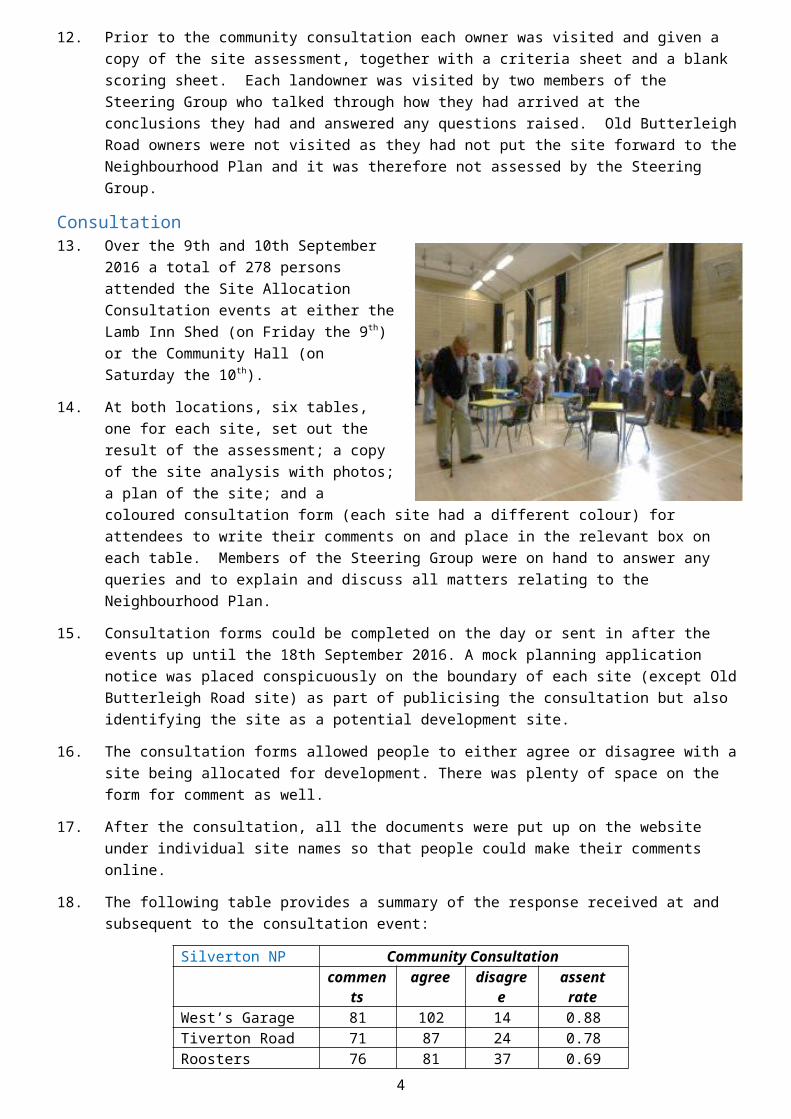
8. The stages of the process followed are: Site Identification – was started with the latest SHLAA sites (2014) and adding to them by putting out a
‘call for sites’ to all parishioners6; then creating a short-list of possible development sites based on their likely availability
Site Appraisal –a site appraisal form was used to record information about each site; the information came from the SHLAA technical appraisal; the sites’ owners and site visits by members of the task group
1 NPPG para: 044 Reference ID: 41-044-201403062 NPPG para: 042 Reference ID: 41-042-201403063 SHLAA = Strategic Housing Land Availability Assessment4 http://www.silvertonparishcouncil.co.uk/wp-content/uploads/2017/05/Site-Allocation-Options.pdf5 http://www.silvertonparishcouncil.co.uk/wp-content/uploads/2017/05/Silverton-Development-Site-Appraisal-Guidance-Notes.pdf6 http://www.silvertonparishcouncil.co.uk/document-category/neighbourhood-plan-housing-survey-documents/
1
Appraisal Analysis –a simple system was applied that allowed comparisons to be made and each site to be scored on the same basis
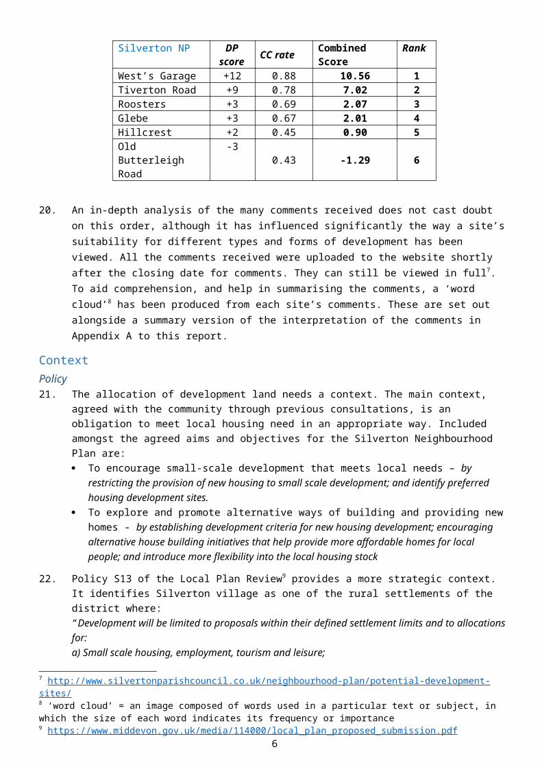
Community Consultation – the survey and findings were presented to the community at a ‘drop-in’ Consultation Event as well as putting all the information and site comment forms on the Parish Council website
Site Reconsideration – the scoring system was revisited in the light of the public response; and the results considered in the context of the 2016 housing need survey and demand-related evidence
Site Selection – after due consideration the site allocation options and their implications along with recommendations will be reported to the Parish Council
Site Identification9. Six sites in and around the village of Silverton were short-listed for further consideration. Five of the sites
were nominated by persons with a bona fide interest in the land in response to the local Call for Sites of February 2016. To ensure we carried out a comprehensive and equitable assessment we included on the short-list the two sites that have been included in the Mid Devon Local Plan one of which, West’s Garage, had also been nominated by its owner. Three of the sites have recently been subject to a SHLAA assessment as the table below illustrates.
10. Two further sites received some initial attention, but were not subsequently subjected to the full site assessment and analysis process. Land at Livinghayes Road was put forward in Mid Devon District Council’s Call for land in 2013 but was assessed by the SHLAA process as having significant access difficulties and was not included in the Local Plan Review as one of the twenty-one rural housing sites considered “achievable in principle” and thereby allocated for residential development. It was not put forward during the Neighbourhood Plan’s Call for Land in 2016. Secondly, a rural site was initially nominated by its owner during the Neighbourhood Plan Call for Land but was withdrawn by the landowner before the consultation event took place. By that time a site survey and assessment had already indicated that the site had a number of development issues and would achieve a very negative score.
Silverton NP Potential Development Sites (short-list)No.
Address: Call for Sites SHLAA
1 The Glebe, Church Road, Silverton EX5 4HS SHLAA2013 site 22 West’s Garage, Newcourt Road, Silverton EX5 4HR SHLAA2013 site 33 Land on Tiverton Road, Silverton EX5 4JQ 4 Roosters, Babylon Lane, Silverton EX5 4DT 5 Hillcrest, Land behind 7-9 Hillcrest Road, Silverton
EX5 4JS
6 Field on Old Butterleigh Road, Silverton EX5 4JE SHLAA2013 & 2014 site 1
Assessment11. Once the short-list of sites had been agreed, members of the task group carried out a desk study, spoke to
officers of Mid Devon Planning Department and visited each site. A summary of their findings, recorded on a site by site basis, can be found in Appendix B of this report. To enable comparison between sites, various criteria were first ranked as “positive” or “negative” in terms of the site’s ‘developability’ or the impact of its development on the nearby environment. Using a basic scoring system, i.e. positive = +1 and negative = -1, the following aggregate scores for the sites were derived.
Silverton NP Development Potential Exercisehectares net score
West’s Garage 0.11 +12Tiverton Road 0.07 +9Roosters 0.25 +3The Glebe 0.79 +3Hillcrest 0.05 +2
2
Old Butterleigh Road 0.41 -3
12. Prior to the community consultation each owner was visited and given a copy of the site assessment, together with a criteria sheet and a blank scoring sheet. Each landowner was visited by two members of the Steering Group who talked through how they had arrived at the conclusions they had and answered any questions raised. Old Butterleigh Road owners were not visited as they had not put the site forward to the Neighbourhood Plan and it was therefore not assessed by the Steering Group.
Consultation 13. Over the 9th and 10th September 2016 a total of
278 persons attended the Site Allocation Consultation events at either the Lamb Inn Shed (on Friday the 9th) or the Community Hall (on Saturday the 10th).
14. At both locations, six tables, one for each site, set out the result of the assessment; a copy of the site analysis with photos; a plan of the site; and a coloured consultation form (each site had a different colour) for attendees to write their comments on and place in the relevant box on each table. Members of the Steering Group were on hand to answer any queries and to explain and discuss all matters relating to the Neighbourhood Plan.
15. Consultation forms could be completed on the day or sent in after the events up until the 18th September 2016. A mock planning application notice was placed conspicuously on the boundary of each site (except Old Butterleigh Road site) as part of publicising the consultation but also identifying the site as a potential development site.
16. The consultation forms allowed people to either agree or disagree with a site being allocated for development. There was plenty of space on the form for comment as well.
17. After the consultation, all the documents were put up on the website under individual site names so that people could make their comments online.
18. The following table provides a summary of the response received at and subsequent to the consultation event:
Silverton NP Community Consultationcomment
sagree disagree assent rate
West’s Garage 81 102 14 0.88Tiverton Road 71 87 24 0.78Roosters 76 81 37 0.69Glebe 115 103 50 0.67Hillcrest 80 53 63 0.45Old Butterleigh Road 79 44 57 0.43
Analysis19. A basic computation indicates that for residential development, taking both Development Potential (DP)
and support from the Community Consultation (CC) into account, the sites rank as follows:
3
Silverton NP DP score CC rate Combined Score Rank
West’s Garage +12 0.88 10.56 1Tiverton Road +9 0.78 7.02 2Roosters +3 0.69 2.07 3Glebe +3 0.67 2.01 4Hillcrest +2 0.45 0.90 5Old Butterleigh Road -3 0.43 -1.29 6
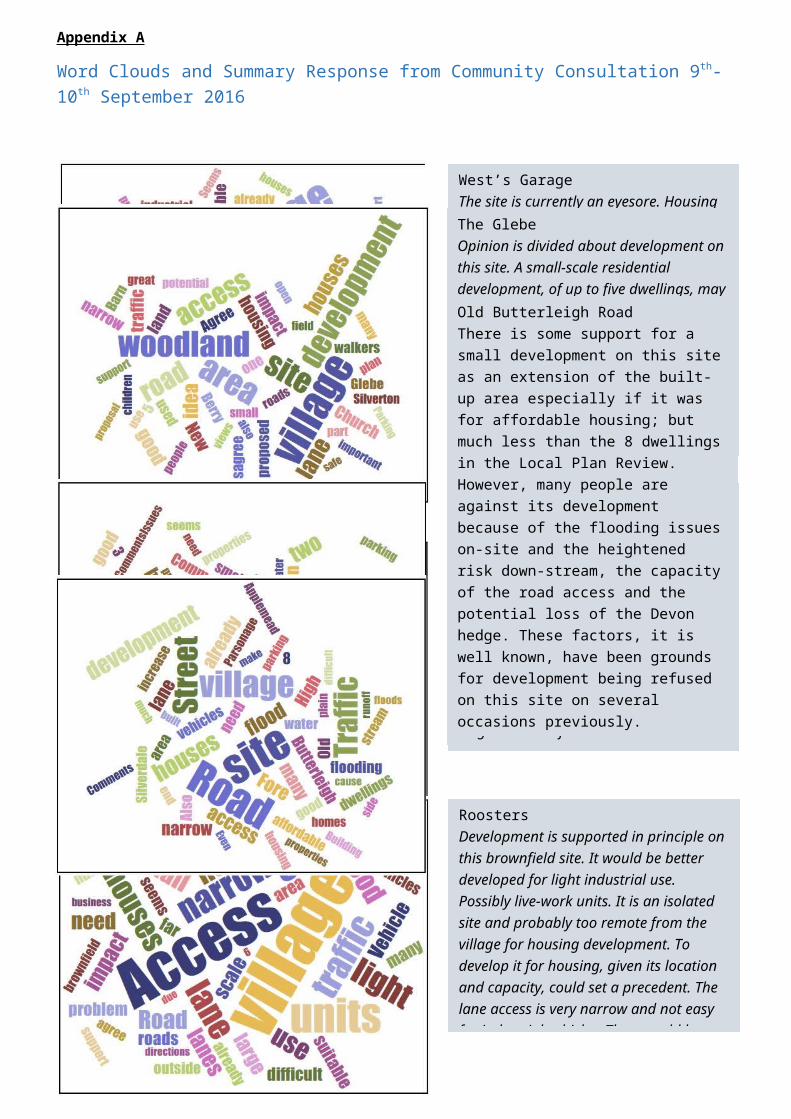
20. An in-depth analysis of the many comments received does not cast doubt on this order, although it has influenced significantly the way a site’s suitability for different types and forms of development has been viewed. All the comments received were uploaded to the website shortly after the closing date for comments. They can still be viewed in full7. To aid comprehension, and help in summarising the comments, a ‘word cloud’8 has been produced from each site’s comments. These are set out alongside a summary version of the interpretation of the comments in Appendix A to this report.
Context Policy21. The allocation of development land needs a context. The main context, agreed with the community
through previous consultations, is an obligation to meet local housing need in an appropriate way. Included amongst the agreed aims and objectives for the Silverton Neighbourhood Plan are: To encourage small-scale development that meets local needs – by restricting the provision of new
housing to small scale development; and identify preferred housing development sites. To explore and promote alternative ways of building and providing new homes - by establishing
development criteria for new housing development; encouraging alternative house building initiatives that help provide more affordable homes for local people; and introduce more flexibility into the local housing stock
22. Policy S13 of the Local Plan Review9 provides a more strategic context. It identifies Silverton village as one of the rural settlements of the district where: “Development will be limited to proposals within their defined settlement limits and to allocations for:a) Small scale housing, employment, tourism and leisure;b) Services and facilities serving the locality; andc) Other limited development which enhances community vitality or meets a local social or economic need.Proposals for more than 5 dwellings in villages will be required to provide 30% affordable housing, which will be in the form of off -site contributions for sites of 6-10 dwellings. Exception sites may also come forward outside settlement limits, but these will need to demonstrate a need for affordable housing, and any element of market housing must be limited to the lowest amount possible to facilitate the provision of affordable housing. In appropriate circumstances, self-build housing will be permitted through the exceptions policy (Policy DM6).
7 http://www.silvertonparishcouncil.co.uk/neighbourhood-plan/potential-development-sites/8 ‘word cloud’ = an image composed of words used in a particular text or subject, in which the size of each word indicates its frequency or importance9 https://www.middevon.gov.uk/media/114000/local_plan_proposed_submission.pdf
4

Local Housing Need23. In furtherance of the wishes of the community, the Steering Group decided to explore the extent and
nature of local housing need. A Study was commissioned late in 2015 to assess local housing needs. The whole of the Parish of Silverton was surveyed in early 201610. Approximately 30% of the Parish’s households responded to the survey. The focus of the survey was on households in need of a new/different home in the next few years. The opportunity was also taken to ask local people to confirm their attitude towards new housing development. Parishioners were asked if they are in favour of a small number of homes for local people being built if the need for affordable housing was proven. 86% of those that responded to the question said they were in favour.
24. In terms of local housing need the key findings of the report were:Affordability: The survey found fifteen households in housing need who could not afford to buy or rent in the open market. Eight additional replies were received by households on Devon Home Choice who had not completed the survey but were eligible for affordable housing in the village.Tenure: Eighteen of the households in need qualified for affordable rent, five may be able to afford a shared ownership property.Size of Property Required:
18 x 1 or 2 bedroom properties for singles/couples 3 x 2 bedroomed properties for families 1 x 3 bedroomed property for family 1 x 4 bedroomed property for family
25. A section of the housing needs survey focused on the actual and potential needs of older parishioners. 35 (19%) of the 182 mature households that answered the questions indicated that they were planning to move in the next five years. Of these, 18 households would like to remain in Silverton and 3 expect to need affordable housing. A further 29 (16%) expect to move after five years. Whilst affordability is not an identifiable issue for most mature households the type of property clearly is. The main reason for moving was to have a smaller, more manageable home. The comments indicated that for many this means a single-storey dwelling, that is easy to maintain and well connected to shops, amenities and health/support services.
26. To meet the need for affordable housing in the Parish, a site or sites could be allocated in the Neighbourhood Plan for open-market housing, which include a percentage11 of affordable housing. However, under a new national policy, affordable housing contributions should not be sought on sites of 10 dwellings or less in areas like Silverton. The Steering Group would therefore need to identify one or more sites with a total capacity for 11 or more dwellings, to secure the provision of affordable housing via the Neighbourhood Plan. The target quota for affordable housing on larger housing developments in the Local Plan Review is 30%. To provide for 20 affordable homes on a single site therefore would require a site with the capacity of 67 dwellings to be allocated; or up to four sites with a capacity of at least 17 dwellings each would be required.
27. In accordance with the guidance offered by the Planning Advisory Service about meeting housing needs, the Steering Group sought the opinion of the local planning authority. “With their experience in developing policy by bringing together evidence on the demand and the supply side, local authority planning officers could be well-placed to advise on balancing the various considerations. The contrast between demand-side and supply-side evidence can often be significant. For example, many smaller settlements……. outside major conurbations may have a high level of housing demand but almost no capacity to meet it. As such, there is a role for planning officers in reassuring QBs12 that a housing needs assessment indicating a high level of demand does not necessarily result in significant new housing development if the supply-side constraints indicate that there is insufficient land to do so.”13
10 Parish of Silverton Housing Needs Report, Devon Communities Together on behalf of: Silverton Parish Council, Mar 2016 http://www.silvertonparishcouncil.co.uk/document-category/neighbourhood-plan-housing-survey-documents/11 Policy S3 of the Local Plan Review requires a 30% percentage – see Appendix C12 QB = qualifying body to prepare a neighbourhood plan i.e. the Parish Council13 PAS Neighbourhood Planning Advice Note: Housing Needs Assessment for Neighbourhood Plans
5
28. Mid Devon District Council has confirmed14 that there is no obligation on the Parish Council to use the Neighbourhood Plan to meet the local need for affordable housing either in full or part within the Silverton neighbourhood area. Silverton Parish should not be treated as an isolated housing market. Housing opportunities in nearby areas and the overall policies for affordable housing provision being pursued by the District Council in different parts of the district can be taken into account. The Local Plan is designed to ensure that a five-year supply of housing land is and remains available through the plan period, from existing permissions and allocations. The current Local Plan Review has identified sites that could help provide 7,800 dwellings. It is hoped by Mid Devon District Council that this will help deliver just over 2,000 affordable dwellings in the district by 2033; equating to around 27% of the total housing built over that period.
29. The main responsibility for ensuring housing needs are met rests with the local planning authority i.e. the District Council. The Silverton Housing Need Report of 2016 has provided Mid Devon District Council with an up-dated statement on the scale and nature of local housing need. The local planning authority will be able to take this into account when applying Local Plan Policy S3 to help maximise the number of affordable dwellings on appropriate developments in the local housing market area.
30. If the Steering Group feel that some of the identified need for affordable housing should be met locally, it can opt for an ‘affordable housing, exception site’ approach, consistent with Policy DM615 of the Local Plan Review. In this case the proposed number of dwellings need not exceed the local affordable housing requirement identified in the Housing Needs Survey and should be a mix, type and form of tenure that will meet/contribute towards the identified need. At Mid Devon District Council’s discretion, a small number of open-market homes may be permitted to make the development and delivery of affordable homes viable. Rural exception sites are locations, outside the settlement area. The NPPF16 defines them as “small sites used for affordable housing in perpetuity where sites would not normally be used for housing… [they] seek to address the needs of the local community by accommodating households who are either current residents or have an existing family or employment connection. They can be used to deliver starter homes, retirement homes or to encourage self-build housing, if a need is proven.
31. Rural exception sites can be identified and allocated within the Neighbourhood Plan if there is good reason for specific sites to be so categorised. More often however, a rural exception policy is non-site specific. The Neighbourhood Plan policy sets criteria for the site by which a development proposal aimed at meeting an identifiable housing need during the plan period can be judged. Being non-site specific, avoids pressure to release identified sites for market housing and land value issues during consultation.
Housing Demand32. The local evidence report17 confirms that Silverton is a popular housing market. House prices are relatively
high compared with the more urban parts of the district18. Average house prices reflect the limited supply, of houses for sale, and the fact that Silverton is regarded as a desirable place to live. There is little doubt that, despite the high prices, new dwellings on the open market would be in demand; although they may not prove to be particularly affordable to many local people.
33. Mid Devon District Council is responsible for ensuring the supply of market and affordable housing required to meet the needs and demands of present and future generations in the area. To do this it has to make sure, through the Local Plan, that sufficient land is available of the right type, in the right place and delivered at the right time. It has to be assumed that in the Local Plan Review, Mid Devon District Council, having considered all the evidence available to it, has got it right both for the district and for Silverton. Therefore, the Parish Council’s obligation regarding meeting housing demand is to ensure that the Neighbourhood Plan will enable at least as many dwellings to be built in the Parish as are expected by the Local Plan. The, yet to be adopted, Local Plan Review states that 7,200 new dwellings are required in the district between 2013 and 2033 at a rate of 1,800 every five years. The Local Plan Review claims to have identified more than sufficient land in the district to achieve this requirement. Most of the land is in, or
14 Reference to written opinion from MDDC not yet received15 See Appendix C16 NPPF = National Planning Policy Framework17 http://www.silvertonparishcouncil.co.uk/documents/neighbourhood-plan-local-evidence-report/18 See Local Evidence Report http://www.silvertonparishcouncil.co.uk/documents/neighbourhood-plan-local-evidence-report/
6

near to, the main population centres of Tiverton (expected 2,258 new dwellings), Cullompton (expected 3,819 new dwellings) and Crediton (expected 907 new dwellings). The rural villages and hamlets combined are expected to deliver the balance of 844 dwellings by 2033. Sites in the rural areas with adequate capacity to deliver this target are identified in the Local Plan Review. Current commitments are taken into account and additional sites are identified via the SHLAA process. The list of additional sites includes ‘Old Butterleigh Road’ and ‘West’s Garage’, both in Silverton village, with an estimated combined yield of 13 new dwellings.
34. In accordance with the strategic context therefore a total of 13 new dwellings is the obligation that the Silverton Neighbourhood Plan has to comply with in contributing to meeting future housing demand. The Local Plan Review states that “all the sites in the Local Plan have been subject to the Strategic Housing Land Availability Assessment and have been deemed to be deliverable”.
35. There is however a caveat in the Local Plan Review policy S4 which states “If cumulative completions since 2013 fall below the expected completions total by over two years’ worth of the annual target (as expressed in the defined action level for that year), or a five-year supply of deliverable sites cannot be demonstrated, the Council will work proactively to bring forward allocations or outstanding planning consents. If this is insufficient to deliver the necessary level of housing, identified contingency sites [currently at Tiverton and Cullompton] will be permitted to boost housing supply”. The last Monitoring Report (to 31st March 2016) showed that Mid Devon had only 4.38 years’ supply. The monitoring report concluded “until the Council can demonstrate a 5-year land supply (with 20% buffer) there will be vulnerability to housing applications coming forward on sites that have not been planned for development.”
36. The Neighbourhood Plan Steering Group needs to ensure sufficient land for at least 13 new dwellings is allocated in the prevailing plans. However, it should also consider whether:
this is sufficient to satisfy demand; there is merit in identifying additional land to ensure demand is not overly constrained, thus
pushing prices up; and whether local contingency sites may be in the interests of a sustainable long-term housing market.
Open Space37. The Steering Group has also been mindful of the expressed need by the community for more public open
space. Community consultations have confirmed and highlighted dissatisfaction with inadequate local sporting facilities and dedicated outdoor recreation/leisure space. A strong interest has also been expressed in a community woodland. One of the agreed objectives in preparing the Neighbourhood Plan is to “provide more public open space for community use”.
Business Space38. As regards additional business and employment space. The community has been more ambivalent.
However, the idea of providing for local workshops and encouraging homeworking has been well received in community consultations and this too is reflected in the agreed aims and objectives of the Silverton Neighbourhood Plan.
Conclusions39. The priority throughout the site assessment exercise has been to ensure that sufficient land in the right
places is allocated to enable “the right types of development for our community”19 to take place. The Steering Group has been particularly mindful of the response received whenever it has consulted the local community on future housing development. Community Consultation in 2014 indicated clearly that large-scale growth or development, particularly in and around Silverton village, is not welcome nor tolerable. Concerns were raised about narrow access roads, parking, the capacity of the Primary School and of the GP surgery, and the additional space and facilities needed for exercise and recreation. Infrastructure, for example, drainage and sewage, might not cope with a large number of new dwellings. It is clear too from the results of the 2016 Housing Survey that the majority preference is for small scale developments of up to five houses. On that basis, Neighbourhood Plan policy HO1 was drafted to reflect the community’s desire to ensure that future housing development is appropriately small in scale so as not to have an adverse effect on the visual amenity and essential infrastructure of the area.
19 NPPG Para: 001 Reference ID: 41-001-201403067
40. The NPPF suggests it is appropriate to identify a supply of specific, developable sites or broad locations for growth, not just for the next five years, but for years 6-10 and where possible for years 11-15. Local demand should influence the planning for a mix of housing based on current and future demographic trends, market trends and the needs of different groups in the community (such as, but not limited to, families with children, older people, people with disabilities and people wishing to build their own homes).
41. Two Silverton sites are allocated in the Local Plan Review document, although this has yet to go through its examination. It includes: Land at Old Butterleigh Road, Silverton (policy SI120) allocated for 8 dwellings with 30% affordable housing, which may be in the form of a financial contribution to provide the affordable dwellings in another location (although no longer enforceable); andWest’s Garage Policy Silverton (policy SI221) allocated for 5 dwellings.
42. As regards these two sites, it seems clear that West’s Garage has the potential and there is substantial community support and/or acceptance that this is a suitable site for residential development.
43. The task group’s assessment, confirmed by the community consultation, indicates however that the Old Butterleigh Road site is neither an easy nor a popular development option. The problems associated with this site have been recognised previously by Mid Devon District Council. It has refused residential planning applications on the site on at least three occasions. It may not be the best site to meet either local housing need or the more strategic obligations.
44. Simple mathematics show that West’s Garage site, even with five new houses, will not meet the housing needs of the Parish over the next few years let alone satisfy the demand for new dwellings. To ensure that the Neighbourhood Plan provides the blueprint for future residential development it would need to allocate further land for residential development with the capacity to provide at least a further 20 dwellings. However, the Tiverton Road site, with a maximum yield of 2 dwellings is the only other site on the site assessment short-list that adequately meets both the developability and acceptability criteria.
45. The other sites on the site assessment short-list seem to fall short of being ideal for one reason or another:Roosters – is at a distance from the village centre and has access problemsGlebe – has access problems and could have a negative environmental impactHillcrest – is land-locked and crampedOld Butterleigh Road – has flood and access issues
Moreover: both Hillcrest and Old Butterleigh Road are proven to be unpopular choices with the community and Roosters has more community support for its redevelopment for business purposes than for residential.
46. Development at the Glebe appears to be the next best choice for new housing development. However, the recent consultation event suggests that this would be acceptable to the community only if the proposal is for a small-scale residential development and it enables community access to the rest of the site for recreation purposes. A development of more than five dwellings at the Glebe would be contrary to the current draft policies of the Neighbourhood Plan.
47. Alternative strategies open to the Steering Group are: To include an exception site policy in the Neighbourhood Plan that will specifically meet the need
for affordable housing To include a non-site-specific policy that recognises that additional small development sites for
market housing, yet to be identified, will need to come forward over the plan period To extend the site identification exercise to include other sites that were not considered such as
the land at the rear of Applemead and Silverdale, land east of Hederman Close and, perhaps, the site on Livinghayes Road
20 See Appendix C21 See Appendix C
8
Recommendations48. The above report was considered by the Silverton Neighbourhood Plan Steering Group at its meeting on
the 4th April 2017. The meeting agreed that:
Around 25 new dwellings over the plan period (2015-2031) would be acceptable Housing development should be small in scale i.e. approximately five dwelling per site Housing development should take place on small sites in or adjacent to existing settlement limits in the
Parish As an exception, a larger development would be acceptable if it was for ‘community housing’ provided
by a Community Land Trust that met an identifiable local need The design and layout of new housing development should comply with the Silverton Design Statement New housing development should provide or contribute to maintaining a mix of housing tenures, types
and sizes The West’s Garage policy (SI2) in the Local Plan Review can be endorsed by the Neighbourhood Plan The Glebe should be allocated for a small housing development of approximately five dwellings in the
Neighbourhood Plan if it enables the use of part of the site by the community for recreation purposes in perpetuity
The Neighbourhood Plan should include a policy that sets the criteria by which all proposals for further housing development will be judged
Roosters should be allocated in the Neighbourhood Plan as a site where redevelopment for business purposes would be supported
9
Appendix A
Word Clouds and Summary Response from Community Consultation 9th-10th September 2016
10
West’s GarageThe site is currently an eyesore. Housing would be a good alternative use of the site and would bring about a much needed improvement visually. It would also improve the look of one of the entrances to the village. Design is important to ensure that any development relates to its surroundings. There should be no more than five dwellings on the site. Local flood risk could be increased. There are access issues that would need to be addressed. It would be beneficial to provide for industrial units elsewhere to compensate for the loss of this site.
Tiverton RoadThis unused site at the entrance to the village would seem to be a natural extension to the built-up area. The access is good, although sight-lines could be a problem. Two dwellings on the site is a good idea and larger family homes are preferred. The idea of a self-build scheme is supported. Parking should be off-road and sufficient for the type of homes. It would be a shame to lose the hedge/Devon bank.
The GlebeOpinion is divided about development on this site. A small-scale residential development, of up to five dwellings, may be acceptable if there is a significant and permanent community gain in terms of play and recreation space and a woodland. The idea of a community woodland is very popular. Design and layout may be critical. There is significant concern about the visual impact of any development. There is concern about the environmental impact too. Access to the site may have to be via the only remaining quiet lane in the village that is much enjoyed by walkers which includes historic cobbles.
HillcrestThis is a back-land site with no access. Any housing development could lead to a loss of privacy for existing homes on adjacent land. There is insufficient space to provide proper access or an adequate parking area for the new dwellings. Allotments are a much better and good long-term use of this site.
RoostersDevelopment is supported in principle on this brownfield site. It would be better developed for light industrial use. Possibly live-work units. It is an isolated site and probably too remote from the village for housing development. To develop it for housing, given its location and capacity, could set a precedent. The lane access is very narrow and not easy for industrial vehicles. There could be flood risk issues.
Old Butterleigh RoadThere is some support for a small development on this site as an extension of the built-up area especially if it was for affordable housing; but much less than the 8 dwellings in the Local Plan Review. However, many people are against its development because of the flooding issues on-site and the heightened risk down-stream, the capacity of the road access and the potential loss of the Devon hedge. These factors, it is well known, have been grounds for development being refused on this site on several occasions previously.
Appendix B
Site Appraisals
Reference No. CfL Site1 *(SHLAA2013 Site2)
Site Name The Glebe, Church Road, Silverton EX5 4HS Site Location Land south of the Berry, Silverton
Gross Area 0.79 haCurrent Use Pasture FieldDescription The site is located outside of the settlement area, on the southern boundary of
the village of Silverton, below the parish church and the open green space of The Berry, a heritage asset, and agricultural grazing land lies beyond the site. The site is approached by narrow lanes on two sides with access facing the Berry, through a farm gate adjacent to a thatched cob building originally used for livestock. From this gateway to the east and the entrance to New Barn Road, the site is bordered by a converted farm building, its garden and outbuildings. The remaining boundaries comprise Devon hedges with mature trees. The land slopes from both the east and north divided by a gully running from the east to the boundary of the adjacent field which then falls away steeply.
Suitability The site is divorced from the settlement in open countrysideBiodiversity &
HeritageThe northern part of the site is located within the conservation area and adjacent to several heritage assets.
Flood Risk Flood zone 1, the land drains towards the stream on the western boundary of the field.
Impact Development would impact on the Historic, Cultural and Built Environment. The site lies on the edge of the historic core of the village and in an area where the mid 19thC Tithe Map shows a concentration of buildings which have largely disappeared. Archaeological mitigation may be required.The site offers views to the south, which will be impacted, though partly shielded by trees and hedges. Views from the higher ground to the north will be impacted.
Mineral Resource NoneAir Quality No issues
Land Status Greenfield pastureServices HT electricity crosses site on poles with substation, well for water, sewerage to
nearby treatment plant (may need to be pumped)
Availability Owner requests 4 bungalows, but is willing to release more of the field for development and supports residential development within five years.
Achievability The site will require removal of electrical poles crossing part of the field, possible sealing of the well situated on the southern side, and may also require archaeological investigation.
Acceptability Residential redevelopment could help meet local housing needs.Yield - requested 4 dwellings.
Planning History The land was considered by Mid Devon District Council in the 2013 ‘call for land’ and was withdrawn due to the environmental and high visual impact.
11
CfL Site 1 – The Glebe Positive Neutral NegativeCurrent use Positive
Suitability PositiveBiodiversity and Heritage Negative
Flood Risk PositiveImpact on surroundings Negative
Environment (Effect on local character) NegativeMineral Resources Positive
Air Quality PositiveLand status Negative
Services PositiveAvailability and Access Positive
Achievability NeutralResidential Score = +3 +7 0 -4
12
Reference No. CfL Site 2 *(SHLAA2013 Site 3)
Site Name The Garage, Newcourt Road, Silverton EX5 4HRSite Location Garage adjacent the converted farm buildings of Channons farm
Gross Area 0.11 haCurrent Use Vehicle repairs and servicingDescription The site is located on the southern edge of the village of Silverton and outside of
the settlement area. It is occupied by an industrial unit in use as a vehicle repair garage and adjoins the converted barns of Channons farmhouse, a heritage asset. Hedges and mature trees front the site with fencing to the side and rear. The site has access from the road, approximately 200 yards from this entrance the road narrows for a short distance. There are no pedestrian footpaths on this road.
Suitability The site is divorced from the settlement in open countryside.Biodiversity & Heritage Removed from Conservation Area, on revision, but near heritage asset.
Flood Risk Flood zone 1. Roadside ditch with underground run- off pipe, draining to the rear of the site into a field sloping away from the buildings.
Impact Non anticipated on the Historic, Cultural of Built Environment. Site falls within the ‘River valley slopes and coombes’ landscape character area. This area is typical of the Exe Valley with steep wooded sides and a strong sense of enclosure. The site is shielded along the lane with few opportunities for views into and out of the site. Minimal impact anticipated.
Mineral Resource NoneAir Quality No issues
Services Mains electricity, water, septic tank sufficient for use by 2 houses.Availability Owner supports residential redevelopment of up to 5 houses, including one for
his own occupancy within five years.Achievability The site will require decontamination from current use, there are no
underground tanks.Acceptability Residential redevelopment could help meet local housing needs.
Yield - max 6 dwellings, min 3 dwellings.Planning History In Local Plan is noted for development of 5 – 6 houses
Nb. The West’s Garage site is described in the Local Plan Review as: a small brownfield site which is located adjacent to a complex of residential dwellings, which is separated from and to the south of the main body of the village of Silverton. The site currently comprises an industrial unit which is used for storage and maintenance of vehicles.The design of the site is important as it lies at the edge of the village’s Conservation Area, being the first complex of buildings encountered when approaching Silverton along Newcourt Road. Design of the access to serve the five dwellings will need to be provided having specific regard to the
neighbouring access serving the adjacent barn conversions and detailing appropriate visibility splays.There is also the potential for land contamination as a result of the history of vehicle repairand fuel storage on the site. Assessment will therefore be required and remediation to take placewhere appropriate.
13

CfL Site 2 – West’s Garage Positive Neutral NegativeCurrent use Positive
Suitability PositiveBiodiversity and Heritage Positive
Flood Risk PositiveImpact on surroundings Positive
Environment (Effect on local character) PositiveMineral Resources Positive
Air Quality PositiveLand status Positive
Services PositiveAvailability and Access Positive
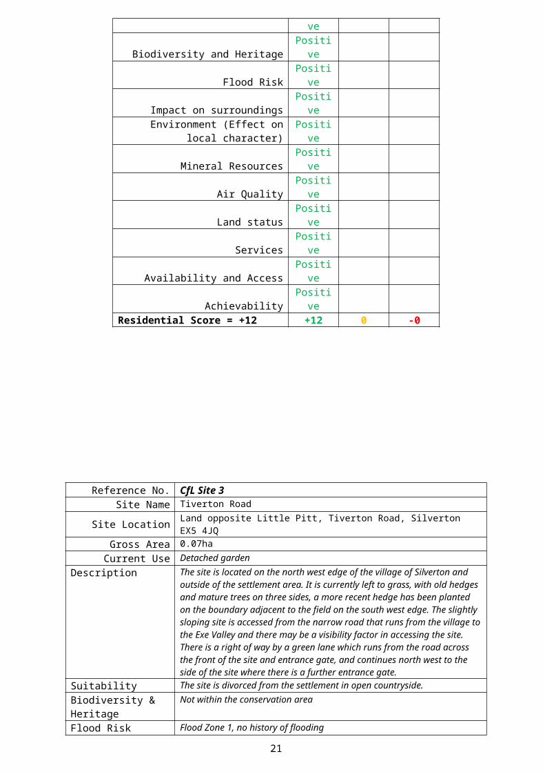
Achievability PositiveResidential Score = +12 +12 0 -0
14
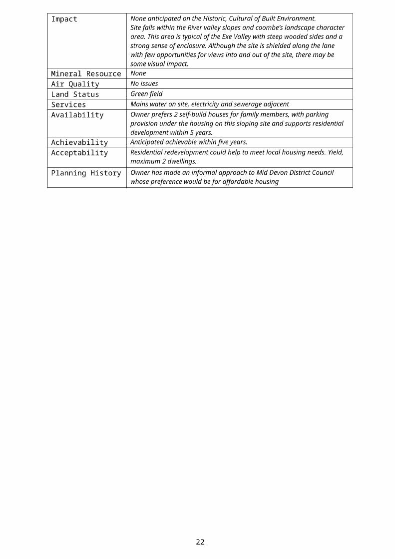
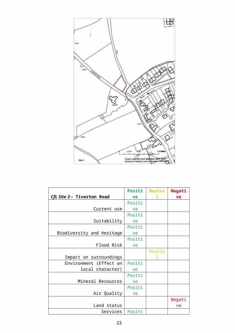
Reference No. CfL Site 3 Site Name Tiverton Road
Site Location Land opposite Little Pitt, Tiverton Road, Silverton EX5 4JQGross Area 0.07ha
Current Use Detached gardenDescription The site is located on the north west edge of the village of Silverton and outside
of the settlement area. It is currently left to grass, with old hedges and mature trees on three sides, a more recent hedge has been planted on the boundary adjacent to the field on the south west edge. The slightly sloping site is accessed from the narrow road that runs from the village to the Exe Valley and there may be a visibility factor in accessing the site. There is a right of way by a green lane which runs from the road across the front of the site and entrance gate, and continues north west to the side of the site where there is a further entrance gate.
Suitability The site is divorced from the settlement in open countryside.Biodiversity & Heritage Not within the conservation areaFlood Risk Flood Zone 1, no history of flooding Impact None anticipated on the Historic, Cultural of Built Environment.
Site falls within the River valley slopes and coombe’s landscape character area. This area is typical of the Exe Valley with steep wooded sides and a strong sense of enclosure. Although the site is shielded along the lane with few opportunities for views into and out of the site, there may be some visual impact.
Mineral Resource NoneAir Quality No issuesLand Status Green fieldServices Mains water on site, electricity and sewerage adjacentAvailability Owner prefers 2 self-build houses for family members, with parking provision
under the housing on this sloping site and supports residential development within 5 years.
Achievability Anticipated achievable within five years.Acceptability Residential redevelopment could help to meet local housing needs. Yield,
maximum 2 dwellings.
Planning History Owner has made an informal approach to Mid Devon District Council whose preference would be for affordable housing
15

CfL Site 3 – Tiverton Road Positive Neutral NegativeCurrent use Positive
Suitability PositiveBiodiversity and Heritage Positive
Flood Risk PositiveImpact on surroundings Neutral
Environment (Effect on local character) PositiveMineral Resources Positive
Air Quality PositiveLand status Negative
Services PositiveAvailability and Access Positive
Achievability PositiveResidential Score = +9 +10 0 -1
16

Reference No. CfL Site 4Site Name Roosters Chicken Farm, Babylon Lane, Silverton EX5 4DT
Site Location About I mile south of village in open countrysideGross Area 0.25ha
Current Use Vacant site and redundant chicken shed
Description
The site is located about 1 mile south of the village of Silverton. It forms the eastern end of a former intensive chicken rearing farm. Hedges and mature trees front and rear with fencing to east side. It lies in a valley between the original Babylon farmhouse and Roosters bungalow.
Suitability The site is divorced from the settlement in open countryside.Biodiversity & Heritage None
Flood Risk Flood Zone 1. Stream piped under site.Impact None anticipated on the Historic, Cultural or Built
Mineral Resource Site falls within the ‘Lower rolling farmed and settled valley’ landscape character area. The site is shielded along the lane with few opportunities for views into and out of the site. Minimal impact anticipated. The lane is narrow and well used. Traffic may be an implication.
Air Quality No IssuesLand Status Brownfield
Services Mains electricity, water, septic tank sewerage, surface water to streamAvailability Owner supports light industrial use or residential redevelopment within 5 years.
Achievability The site may need decontamination from previous use.Acceptability Use of the building for light industrial units or workshops, additional to those
adjoining, could provide local job opportunities. Residential redevelopment could help meet local housing need. Yield - max 24 dwellings; min 15 dwellings.
Planning History
17

CfL Site 4 – Roosters Positive Neutral NegativeCurrent use Positive
Suitability NegativeBiodiversity and Heritage Positive
Flood Risk PositiveImpact on surroundings Negative
Environment (Effect on local character) NeutralMineral Resources Positive
Air Quality PositiveLand status Negative
Services PositiveAvailability and Access Positive
Achievability NegativeResidential Score = +3 +7 0 -4
18

Reference No. CfL Site 5Site Name Hillcrest
Site Location Land r/o 7-9 Hillcrest Road, Silverton EX5 4JSGross Area 0.05ha
Current Use Allotment garden
DescriptionThe site is located south east of Silverton Primary School. Formerly surplus garden land to the rear of three bungalows, it has been cultivated for many years as a private allotment.
Suitability The site is within the existing settlement.Biodiversity & Heritage None
Flood Risk Flood Zone 1Impact None anticipated on the Historic or Cultural
Site falls within the ‘Upper farmed and wooded valley slopes’ landscape character area. The site is shielded by housing, a public footpath and school grounds. Development would overlook 7-9 Hillcrest and their rear gardens. Impact might be minimised in design & layout.
Mineral Resource NoneAir Quality No issues
Land Status GreenfieldServices Mains electricity, water and drainage
Availability Owner supports residential redevelopment within 5 years.Achievability The site has pedestrian access only. A recently built house (11a) controls access
from the public highway and a further plot of land, owned by a third party, intervenes. With the co-operation of the adjoining owners, access could be achieved to enable development.
Acceptability Site should be rejected as within settlement and therefore subject to existing planning policies. Residential development could help meet local housing need. Yield – max 3 dwellings; min 2 dwellings.
Planning History
19

CfL Site 5 – Hillcrest Positive Neutral NegativeCurrent use Negative
Suitability PositiveBiodiversity and Heritage Positive
Flood Risk PositiveImpact on surroundings Negative
Environment (Effect on local character) NegativeMineral Resources Positive
Air Quality PositiveLand status Positive
Services NegativeAvailability and Access Positive
Achievability NegativeResidential Score = +2 +7 0 -5
20
Reference No. CfL Site 6 *(SLHAA2013 Site1)Site Name Field, Old Butterleigh Road
Site Location Old Butterleigh Road, Silverton EX5 4JE (east-side)Gross Area 0.41ha
The assessment below has been taken from the SHLAA Rural Sites by Mid Devon District Council June 2014
Current Use Fallow small holding
Suitability
Site lies on narrow road, bounded by historic hedge-banks and trees, mains services available. Site floods from springs with stream at rear. Western part is steeply sloping.
Biodiversity & Heritage The site is adjacent to the Silverton Conservation Area. No European wildlife sites or SSSI designations.
Flood Risk Flood zone 1. A river runs to the eastern side of the site, and a small proportion of the eastern field falls within the flood zones 2 and 3.
Impact DCC Archaeology - No anticipated impact.Mineral Resource None
Air Quality No issuesLand Status Greenfield Grade 2 1.02ha (54% S) Grade 3 0.88ha (46% N)
Services
Access The highway would require widening across the site frontages. Narrow lane, access gate at south end of site
Availability Owners agent progressing development proposalsAchievability Identified in Local Plan Review for up to 8 houses
-Preferred use ResidentialAcceptability Development would infill ribbon of houses up the valley. High
impact on historic banks to former turnpike road.
Nb. The Field, Old Butterleigh Road is described in the Local Plan Review as such: The site falls on the northern boundary of the village of Silverton and is on the eastern side of Old Butterleigh Road. The site is shielded to the north and west by high hedges which limit inward views.
A small watercourse runs along the eastern boundary of the site and the small area of floodplain associated with this should not be developed.
The carriageway will need to be widened across the site frontage to accommodate two passing vehicles. The footpath network terminates some distance to the south of the site. Rather than provide a new footway which does not connect with existing provision, a grass verge along the site frontage should be provided as defensible space for pedestrians.
21
CfL Site 6 – Old Butterleigh Road Positive Neutral NegativeCurrent use positive
Suitability negativeBiodiversity and Heritage negative
Flood Risk negativeImpact on surroundings negative
Environment (Effect on local character) negativeMineral Resources positive
Air Quality positiveLand status negative
Services neutralAvailability and Access negative
Achievability positiveResidential Score = -3 +4 0 -7
22
Appendix C
Relevant Mid Devon Local Plan Review Policies
Policy S3 Meeting Housing Needsa) The diverse housing needs of Mid Devon will be met through the provision of approximately 7,200 dwellings between 1st April 2013 and 31st March 2033. In line with the predicted continuing need for new housing theexpected annual rate of new housing development will be 360 dwellings per annum;b) Unless otherwise stated in a site allocation policy, on open market housing sites (i.e. excluding exception sites provided under Rural Exception Sites under policy DM6) of 11 dwellings or more in Tiverton, Cullompton andCrediton a target of 28% affordable dwellings, and on sites elsewhere of 6 dwellings or more a target of 30% affordable dwellings will be applied to the total number of dwellings, depending on viability and providing a mix of dwelling sizes and types appropriate to the evolving needs of Mid Devon’s population. Sites of between 6 ‒ 10 dwellings outside Tiverton, Cullompton and Crediton will be permitted to make a financial contribution sufficient to provide the affordable dwellings in another location;c) To support self-build dwellings meeting the needs of local communities affordable self-build dwellings will be permitted in locations outside settlement limits in accordance with Policy DM6;d) To support self-build housing on sites of 20 dwellings or more developers will supply at least 5% of serviced dwelling plots for sale to self- builders for a period of 12 months per plot and any plots subsequently developedfor self-build must be completed within 3 years of purchase by a self-builder; ande) A five-year supply of gypsy and traveller pitches will be allocated on deliverable sites within Mid Devon to ensure that the predicted need for traveller sites will be met. A further supply of developable sites or broad locations for growth will be identified equivalent to a further ten years of predicted growth. The Housing Authority will seek to provide a public site for gypsy and traveller pitches within Mid Devon, subject to the availability of funding.
Policy DM6 Rural Exceptions SitesThe development of a site for predominantly affordable or low-cost housing, including self-build housing, to meet proven local need in rural areas will be permitted where:a) There is up-to-date evidence of housing need secured through a housing need survey or, in the case of a self-build proposal, evidence of eligibility for shared ownership housing through ‘Help to Buy’ or an equivalentscheme;b) The housing will be occupied by at least one person with a strong local connection to the parish;c) The site adjoins a settlement and is in a suitable location which takes account of the potential for any visual impact and other relevant planning issues;d) The type and scale of affordable or low-cost housing is appropriate to the proven need;e) The affordable or low-cost housing will remain affordable for and available to local people in perpetuity, limited to no more than 80% of its market value upon resale.The inclusion of a proportion of market housing within exception sites will be permitted where the proportion of market housing will be less than the provision of affordable or low-cost housing and the market housing will be atthe lowest level necessary to ensure that the development is deliverable.
23

Policy SI1 Land at Old Butterleigh Road, SilvertonA site of 0.35 hectares at Old Butterleigh Road is allocated for residential development subject to the following:a) 8 dwellings with 30% affordable housing which may be in the form of a financial contribution to provide the affordable dwellings in another location;b) No development on the floodplain to the east of the site;c) Widening of carriageway over site frontage and provision of grass verge; andd) Design and layout to respect the character of the Conservation Area.
Policy SI2 The Garage, SilvertonA site of 0.11 hectares at The Garage, Silverton is allocated for residential development subject to the following:a) 5 dwellings;b) Design and layout which respects the character of the Conservation Area;c) Suitable design and layout of access arrangements; andd) Site contamination and remediation where appropriate.
24