shyama prasad mukherji rurban mission (spmrm)jswm.nic.in/file/top_box/spmrm/files/project report on...
TRANSCRIPT
Shyama Prasad Mukherji Rurban Mission
(SPMRM)
PROJECT REPORT
ON
CLUSTERS SELECTION UNDER
RURBAN MISSION IN JHARKHAND STATE
Rural Development Department
Government of Jharkhand
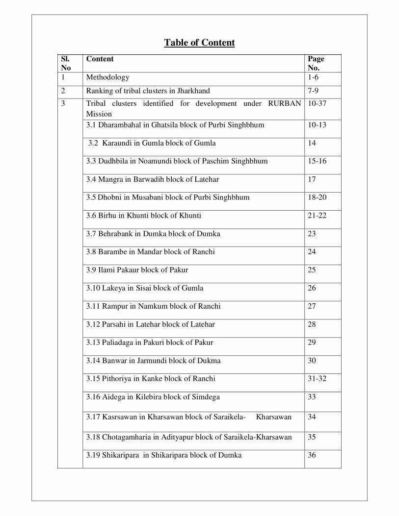
Table of Content
Sl.
No
Content Page
No.
1 Methodology 1-6
2 Ranking of tribal clusters in Jharkhand 7-9
3 Tribal clusters identified for development under RURBAN
Mission
10-37
3.1 Dharambahal in Ghatsila block of Purbi Singhbhum 10-13
3.2 Karaundi in Gumla block of Gumla 14
3.3 Dudhbila in Noamundi block of Paschim Singhbhum 15-16
3.4 Mangra in Barwadih block of Latehar 17
3.5 Dhobni in Musabani block of Purbi Singhbhum 18-20
3.6 Birhu in Khunti block of Khunti 21-22
3.7 Behrabank in Dumka block of Dumka 23
3.8 Barambe in Mandar block of Ranchi 24
3.9 Ilami Pakaur block of Pakur 25
3.10 Lakeya in Sisai block of Gumla 26
3.11 Rampur in Namkum block of Ranchi 27
3.12 Parsahi in Latehar block of Latehar 28
3.13 Paliadaga in Pakuri block of Pakur 29
3.14 Banwar in Jarmundi block of Dukma 30
3.15 Pithoriya in Kanke block of Ranchi 31-32
3.16 Aidega in Kilebira block of Simdega 33
3.17 Kasrsawan in Kharsawan block of Saraikela- Kharsawan 34
3.18 Chotagamharia in Adityapur block of Saraikela-Kharsawan 35
3.19 Shikaripara in Shikaripara block of Dumka 36
3.20 Sini in Saraikela block of Saraikela-Kharsawan 37
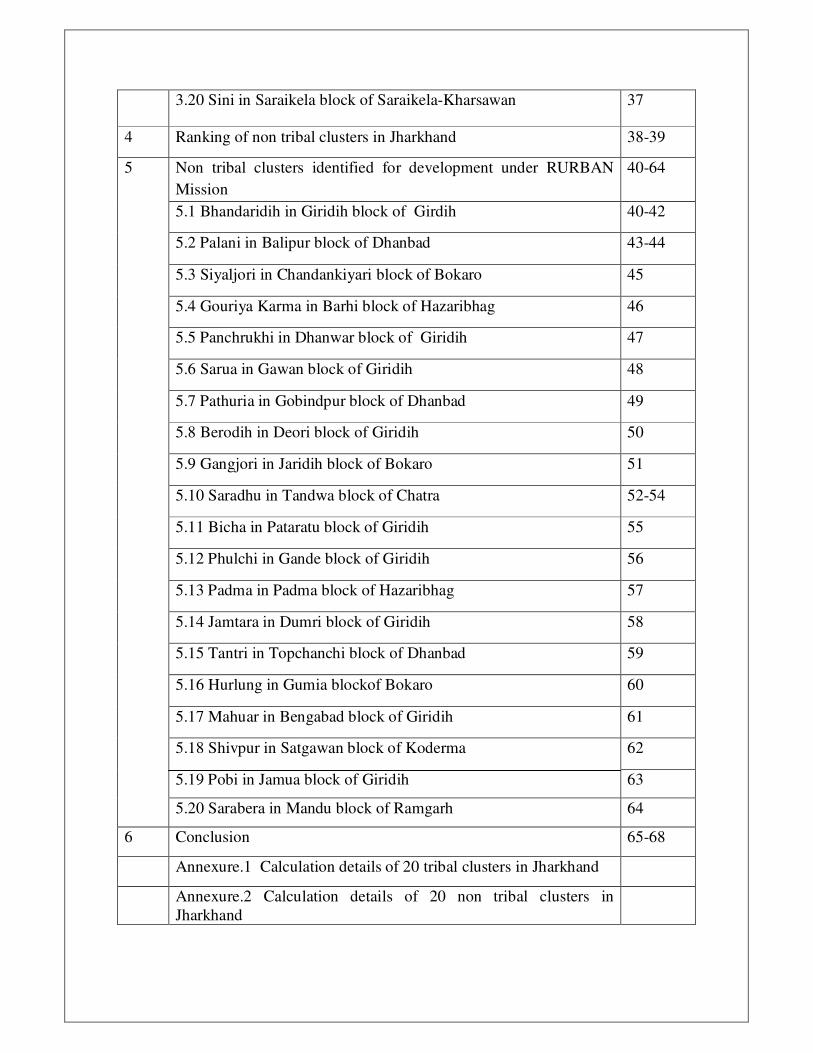
4 Ranking of non tribal clusters in Jharkhand 38-39
5 Non tribal clusters identified for development under RURBAN
Mission
40-64
5.1 Bhandaridih in Giridih block of Girdih 40-42
5.2 Palani in Balipur block of Dhanbad 43-44
5.3 Siyaljori in Chandankiyari block of Bokaro 45
5.4 Gouriya Karma in Barhi block of Hazaribhag 46
5.5 Panchrukhi in Dhanwar block of Giridih 47
5.6 Sarua in Gawan block of Giridih 48
5.7 Pathuria in Gobindpur block of Dhanbad 49
5.8 Berodih in Deori block of Giridih 50
5.9 Gangjori in Jaridih block of Bokaro 51
5.10 Saradhu in Tandwa block of Chatra 52-54
5.11 Bicha in Pataratu block of Giridih 55
5.12 Phulchi in Gande block of Giridih 56
5.13 Padma in Padma block of Hazaribhag 57
5.14 Jamtara in Dumri block of Giridih 58
5.15 Tantri in Topchanchi block of Dhanbad 59
5.16 Hurlung in Gumia blockof Bokaro 60
5.17 Mahuar in Bengabad block of Giridih 61
5.18 Shivpur in Satgawan block of Koderma 62
5.19 Pobi in Jamua block of Giridih 63
5.20 Sarabera in Mandu block of Ramgarh 64
6 Conclusion 65-68
Annexure.1 Calculation details of 20 tribal clusters in Jharkhand
Annexure.2 Calculation details of 20 non tribal clusters in
Jharkhand

��
�
1. Methodology
Methodology suggested by the Ministry of Rural Development-Government of India
was adopted for identification and ranking of clusters under the SPM Rurban Mission.
In both the cases i.e., tribal and non tribal clusters for identification and ranking the
parameters used are decadal growth in the population, decadal increase in the
proportional nonfarm work force and decadal growth in the literacy rate. In addition to
this in case of non tribal clusters rise in land value, percentage of active MGNREGA
workers with Adhar and bank account and performance in the Swatch Bharat Mission
(Grameen) are taken into consideration.
A ‘Rurban Cluster’, would be a cluster of geographically contiguous villages with a
population of about 25000 to 50000 in plain and coastal areas and a population of
5000 to 15000 in desert, hilly or tribal areas. For identification of cluster Gram
Panchayat is considered as a unit rather than the villages. Considering the population
limit for the cluster and organization of Gram Panchayat in Jharkhand state it would
reduce to a definition where in tribal cluster will have two Gram Panchayats and non
tribal clusters will have five Gram Panchayats located adjacent to each other, so that
they form cluster together and have potential for future growth.
The process of identification GP which are contiguous in nature with above
parameters like population growth, growth in non farm work force and others like
having growth centres is done with the help of Geo Jharkhand web portal developed
by Jharkhand Space Application Centre (JSAC) Ranchi and GIS Laboratory of
Jharkhand State Watershed Mission (JSWM) under the Rural Development
Department Government of Jharkhand.
Ranking of cluster:-
All the clusters identified in the state are ranked to select the most potential cluster for
the first phase of the project. The following list of parameters identified and
weightages defined for each parameter for ranking the cluster. The parameters are
different for clusters in tribal and non tribal blocks. The parameters for tribal and non
tribal clusters for ranking are as listed below,
��
�
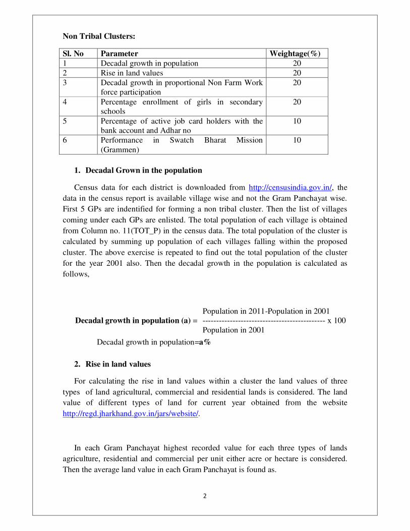
Non Tribal Clusters:
Sl. No Parameter Weightage(%)
1 Decadal growth in population 20
2 Rise in land values 20
3 Decadal growth in proportional Non Farm Work
force participation
20
4 Percentage enrollment of girls in secondary
schools
20
5 Percentage of active job card holders with the
bank account and Adhar no
10
6 Performance in Swatch Bharat Mission
(Grammen)
10
1. Decadal Grown in the population
Census data for each district is downloaded from http://censusindia.gov.in/, the
data in the census report is available village wise and not the Gram Panchayat wise.
First 5 GPs are indentified for forming a non tribal cluster. Then the list of villages
coming under each GPs are enlisted. The total population of each village is obtained
from Column no. 11(TOT_P) in the census data. The total population of the cluster is
calculated by summing up population of each villages falling within the proposed
cluster. The above exercise is repeated to find out the total population of the cluster
for the year 2001 also. Then the decadal growth in the population is calculated as
follows,
Decadal growth in population (a) =
Population in 2011-Population in 2001
--------------------------------------------- x 100
Population in 2001
Decadal growth in population=a%
2. Rise in land values
For calculating the rise in land values within a cluster the land values of three
types of land agricultural, commercial and residential lands is considered. The land
value of different types of land for current year obtained from the website
http://regd.jharkhand.gov.in/jars/website/.
In each Gram Panchayat highest recorded value for each three types of lands
agriculture, residential and commercial per unit either acre or hectare is considered.
Then the average land value in each Gram Panchayat is found as.

��
�
Average land value in GP =
Land value of Agri+residential+commercial
-----------------------------------------------------
3
Then the average land value for the cluster is found using average land values
in each GPs included in the cluster for the year 2015-16.
The land values for the year 2013-14 are obtained from CO office at block. The
above exercise is repeated to find the average land value for the year 2013-14.
Then the final rise in land value for the cluster is calculated as follows,
Rise in land value (b) =
(Average land value for cluster 2015-16)-
(Average land value for cluster 2013-14)
--------------------------------------------------- x 100
Average land value for cluster 2013-14
Rise in land value= b%
3. Decadal growth in Non Farm Work force participation
The non farm work force is calculated from the census dada as follows,
Non Farm Work Force (NF)= MAIN_HH_P (column no. 41) + MAIN_OT_P (column
no. 44) + MARG_HH_P (column no. 56) +
MARG_OT_P (column no. 59)
The total rural workforce (TF) is obtained from the column no 29
(TOT_WORK_P) in the census data. The percentage of workforce engaged in the non
farming activities in calculated as follows,
% of workforce in NF in 2011(x) =
(Non Farm work force NF)
----------------------------------- x 100
Total rural workforce (TF)
The exercise is repeated for the year 2001 also. Let us say percentage of
workforce engaged in the non farming activities in the year 2001 is y.
Then change in the proportional workforce engaged in the non farming
activities(c) is found as c=x-y.
Decadal growth in NF work force= c%
��
�
4. Percentage of enrollment of girls in secondary schools
Enrolment details are obtained from the District Education Officer (DEO) office.
First the list of secondary schools in the proposed cluster is enlisted. Then the
enrolment details of boys and girls in those are summed up get the enrolment details
for the cluster.
Then the percentage of enrolment of girls in secondary schools is calculated as
follows,
Percentage of girls (d)=
Girls enrolled in secondary schools
-------------------------------------------------x 100
Total students (boys and girls) in secondary
schools
Percentage of enrolment of girls in secondary schools= d%
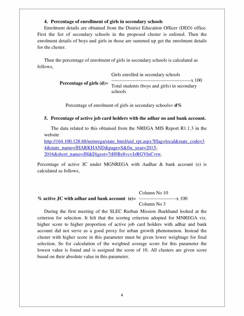
5. Percentage of active job card holders with the adhar no and bank account.
The data related to this obtained from the NREGA MIS Report R1.1.3 in the
website
http://164.100.128.68/netnrega/state_html/uid_rpt.aspx?lflag=local&state_code=3
4&state_name=JHARKHAND&page=S&fin_year=2015-
2016&short_name=JH&Digest=7tIf0Bz8vcvJzRGVlnCvtw.
Percentage of active JC under MGNREGA with Aadhar & bank account (e) is
calculated as follows,
% active JC with adhar and bank account (e)=
Column No 10
-----------------------x 100
Column No 3
During the first meeting of the SLEC Rurban Mission Jharkhand looked at the
criterion for selection. It felt that the scoring criterion adopted for MNREGA viz.
higher score to higher proportion of active job card holders with adhar and bank
account did not serve as a good proxy for urban growth phenomenon. Instead the
cluster with higher score in this parameter must be given lower weightage for final
selection. So for calculation of the weighted average score for this parameter the
lowest value is found and is assigned the score of 10. All clusters are given score
based on their absolute value in this parameter.
��
�
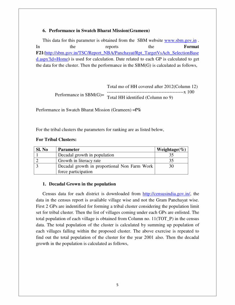
6. Performance in Swatch Bharat Mission(Grameen)
This data for this parameter is obtained from the SBM website www.sbm.gov.in .
In the reports the Format
F21(http://sbm.gov.in/TSC/Report_NBA/Panchayat/Rpt_TargetVsAch_SelectionBase
d.aspx?id=Home) is used for calculation. Date related to each GP is calculated to get
the data for the cluster. Then the performance in the SBM(G) is calculated as follows,
Performance in SBM(G)=
Total mo of HH covered after 2012(Column 12)
-------------------------------------------------x 100
Total HH identified (Column no 9)
Performance in Swatch Bharat Mission (Grameen) =f%
For the tribal clusters the parameters for ranking are as listed below,
For Tribal Clusters:
Sl. No Parameter Weightage(%)
1 Decadal growth in population 35
2 Growth in literacy rate 35
3 Decadal growth in proportional Non Farm Work
force participation
30
1. Decadal Grown in the population
Census data for each district is downloaded from http://censusindia.gov.in/, the
data in the census report is available village wise and not the Gram Panchayat wise.
First 2 GPs are indentified for forming a tribal cluster considering the population limit
set for tribal cluster. Then the list of villages coming under each GPs are enlisted. The
total population of each village is obtained from Column no. 11(TOT_P) in the census
data. The total population of the cluster is calculated by summing up population of
each villages falling within the proposed cluster. The above exercise is repeated to
find out the total population of the cluster for the year 2001 also. Then the decadal
growth in the population is calculated as follows,

��
�
Decadal growth in population (x) =
Population in 2011-Population in 2001
-------------------------------------------- x 100
Population in 2001
Decadal growth in population=x%
2. Growth in literacy rate
Literacy rate data is obtained from the column no 24 (P_LIT) in census report.
Data related to all the villages coming under a cluster is summed up to get data related
to the cluster.
Then the % of literate population is calculated as,
% of literate population in 2011(m) =
Literate population (Column no 24 P-LIT)
-------------------------------------------- x 100
Total rural population (Column no11TOT-P)
The above exercise is repeated to find out the percentage of literate population in the
year 2001. Let us data for that is (n).
Then the decadal growth in the literate rate(y) =m-n
Growth in literacy rate=y%
3. Decadal growth in Non Farm Work force participation
The non farm work force is calculated from the census dada as follows,
Non Farm Work Force (NF) = MAIN_HH_P (column no. 41) + MAIN_OT_P (column
no. 44) + MARG_HH_P (column no. 56) +
MARG_OT_P (column no. 59)
The total rural workforce (TF) is obtained from the column no 29
(TOT_WORK_P) in the census data. The percentage of workforce engaged in the non
farming activities in calculated as follows,
% of workforce in NF in 2011(x) =
(Non Farm work force NF)
----------------------------------- x 100
Total rural workforce (TF)
The exercise is repeated for the year 2001 also. Let us say percentage of
workforce engaged in the non farming activities in the year 2001 is y.
Then change in the proportional workforce engaged in the non farming
activities(c) is found as c=x-y.
��
�
2. Ranking of tribal clusters in Jharkhand
The Ministry of Rural Development –Government of India has provided twenty
potential sub districts for final selection of Rurabn clusters. Based on the criteria and
parameters given by the MoRD all the twenty sub districts are ranked in the ascending
order. In case of tribal clusters Ghatsila block and Gumla block have been ranked as
potential and growth centres for Rurban development.
Though Ministry of Rural Development-Government of India vide letter No D.O. No.
K-110033/13/2015-Rurban dated 2nd
December 2015 permitted to submit only three
clusters but seeing the importance of urbanisation in Jharkhand especially in the
context of mining, industries, tourism and other non farming activities like Tasar, Lac
cultivation, marketing of Non Timber Forest Produce (NTFC) etc., it is felt that all the
20 clusters identified in the Jharkhand state can be approved by the Ministry of Rural
Development-Government of India.
The following is the twenty clusters identified as growth centres in the ascending
order.

�
�
The score of each cluster in the various parameters defined and the final weighted
score of each cluster is as follows,
Name of the
cluster Name of the GPs
Sub
district
(Block)
District
Rank
Dharambahd 1. Dharambahd &
2.Kashida Ghatshila
Purbi
Singhbhum
1
Karaundi 1. Karaundi &
2.Telagaon Gumla Gumla
2
Dudhbila 1.Dudhbila & 2.Kotgarh Noamundi Paschim
Singhbhum
3
Mangra 1. Mangra & 2.Ukamanr Barwadih Latehar 4
Dhobni 1. Dhobni &
2.Koilisuta Musabani
Purbi
Singhbhum
5
Birhu 1.Birhu & 2.Tirla Khunti Khunti 6
Behrabank 1.Behrabank &
2.Rampur Dumka Dumka
7
Barambe 1.Barambe & 2.Murma Mandar Ranchi 8
Ilami 1. Ilami &
2.Ramchandrapur Pakaur Pakur
9
Lakeya 1. Bhargaon North &
2.Lakeya Sisai Gumla
10
Rampur 1. Rampur Namkum Ranchi 11
Parsahi 1. Parsahi & 2.Ichak Latehar Latehar 12
Paliadaga 1.Paliadaga & 2.Khaksa Pakuria Pakur 13
Pithoriya 1.Pithoriya & 2.Rarha Kanke Ranchi 14
Aidega 1. Aidega &
2.Lachragarh Kilebira Simdega
15
Kharsawan 1. Kharsawan & 2.Simla Kharsawan Saraikela-
Kharsawan
16
Chotagamharia 1.Chotagamharia &
2.Kalikapur Adityapur
Saraikela-
Kharsawan
17
Shikaripara 1.Shikaripara &
2.Kharudadma shikaripara Dumka
18
Sini 1.Sini & 2.Kamalpur Saraikela Saraikela-
Kharsawan
19
Banwar 1.Banwar & 2.Petsar Jarmundi Dumka 20

�
�
���
�
3. Tribal clusters identified for development under RURBAN Mission
3.1Dharambahal Cluster Ghatsila Block Purbi Singhbhum Distirct.
The two panchayats of Ghatsila cluster, Dharambahal and Kashida has ten villages, an
area of 14.83 sq km with a population of 5231 according to Census 2011. This area
has a literacy rate of 61% and a decadal literacy rate growth of 19%, while current
non-farm workplace participation accounts for 78%. There has been a stark growth in
non-farm activity participation of 49% during the 2001-2011 period. The cluster lies
in the periphery of the urban township Maubhandar, where Hindustan Copper Limited
digs copper and further extracts pure copper. This is the chief employer or indirect
source of income for the people of Moubhandar and nearby villages. This is Asia’s
first copper mines and world’s second deepest mines.
Ghatshila Block with its headquarter at Ghatshila was established on 04th May 1962 .
The Block is situated on the banks of River Subarnarekha at a distance of
approximately 45 Kms from District Headquarter Jamshedpur. It contains a
station on the main line of the South Eastern Railway. Ghatshila was formerly the
headquarters of the Rajas of Dhalbhum.
Connectivity:-
• By rail - It is a railway station on the Kharagpur-Tatanagar stretch of Howrah-
Mumbai track, 215 km from Howrah are 2781/2782 Ispat Express, 8030/8029
Kurla/ Howrah Express, 2813/2814 Steel Express. It is well connected to 3 Metros
in India namely Mumbai(by Bombay Express), Kolkata(many trains starting from
6AM by Steel Exp. to midnight at 1.15 by Samleshwari Exp) and New Delhi(by
Neelachal & Utkal Exp).
• By road – It is about 240 km from Kolkata. Those travelling from Kolkata first
have to take NH 6 to Bahragora and then take the road to Jamshedpur. Buses
plying between Kharagpur and Jamshedpur pass through Ghatshila. Buses going
from Kolkata to Jamshedpur and Ranchi also pass through Ghatshila.By road
Jamshedpur is 42 km away.
Drivers of Growth
1) Tourism
The town of Ghatshila is located on the bank of the River Subarnarekha (the word
‘Subarnarekha’ means golden streak), and is situated in an undulating forested area. It
has been a popular place frequented mostly by people from West Bengal, who have
been going there for a change of place and climate. The noted Bengali writer Bibhuti
Bhusan Bandopadhyay of Pather Panchali fame was a resident of the city. Raja
Dhaval Deb's built three temples dedicated to Goddess Rankini (an incarnation of
Goddess Durga)one at Rajdoha, another at Jamshedpur and the third
���
�
at Rhoinibera village near Ghatshila. On the northern fringe of Ghatshila town one
can climb the peak of Fuldungri to get a view of rolling hills and green valleys
fading into the horizon. According to the legend if seperated lovers pray here, they get
their partners back. Visit Burudih lake next to a tribal village settlement of mud huts
painted with vibrant motifs just 6km north of Ghatshila. Notable places in and around
Ghatshila are Dharagiri Falls which is placed 10 km north of Ghatshila where
waterfall is about 20 feet high. Naroa Forest, Mosaboni Mines & Surda Pahar can be a
few potential tourist stops. 8 km from Ghatshila is Galudi, another tourist spot on the
banks of the Subarnarekha. Tatanagar is just a day's trip from Ghatshila. One can go
for long walks in and around the Dalma range near Moubhandar.
Being well connected through railway and road network the natural beauty of this
place becomes a perfect getaway for the weary city-dwellers. With the river
Subarnarekha making its way through the town, if one follows its path along the banks
one will come across many ancient ruins and boulders that have come to become a
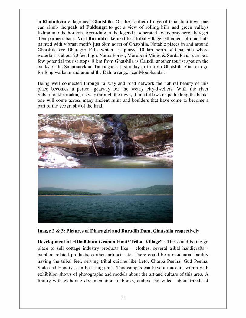
part of the geography of the land.
Image 2 & 3: Pictures of Dharagiri and Burudih Dam, Ghatshila respectively
Development of “Dhalbhum Gramin Haat/ Tribal Village” : This could be the go
place to sell cottage industry products like – clothes, several tribal handicrafts -
bamboo related products, earthen artifacts etc. There could be a residential facility
having the tribal feel, serving tribal cuisine like Leto, Charpa Peetha, Gud Peetha,
Sode and Handiya can be a huge hit. This campus can have a museum within with
exhibition shows of photographs and models about the art and culture of this area. A
library with elaborate documentation of books, audios and videos about tribals of
���
�
Jharkhand can be a part of this village. This could be the heart of promoting and
managing tourism related activities in and around this area.
�
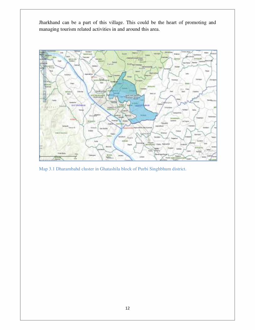
Map 3.1 Dharambahd cluster in Ghatashila block of Purbi Singhbhum district.
�
�
�
�
�
�
�
�
�
�
�

���
�
���
�
3.2 Karaundi cluster Gumla Block Gumla District
'Karaundi and Telgaon, with a rural population of 12976 cover an area of 38sq.km.
The cluster has seen a decadal population growth of 40.14% and an increase in
literacy rate of 18.85% (2011 census). Telgaon, situated 4 km from Gumla town is
partly forested.
There are seven temples in Telgaon panchayat, the most prominent ones being in
Karamtoli and Garhsaru. Telgaon Dam, constructed 35 years ago, has proved to be
very useful in the panchayat, especially in Telgaon and Belgaon villages.
The major crops grown in the panchayat are rice and wheat. With additional
investment, there is a potential for the production of ginger and lac plantations. Lac
plantations may prove to be lucrative due to its proximity to the lac processing factory
in Gumla, located 4 km from the panchayat.
There's also potential for tourism in the area if the temples are embellished and
beautified. Mitti Moran (kachha) roads have been constructed in all villages under
MGNREGA. These roads can be converted to pucca ones to increase connectivity and
help trade.'
• �
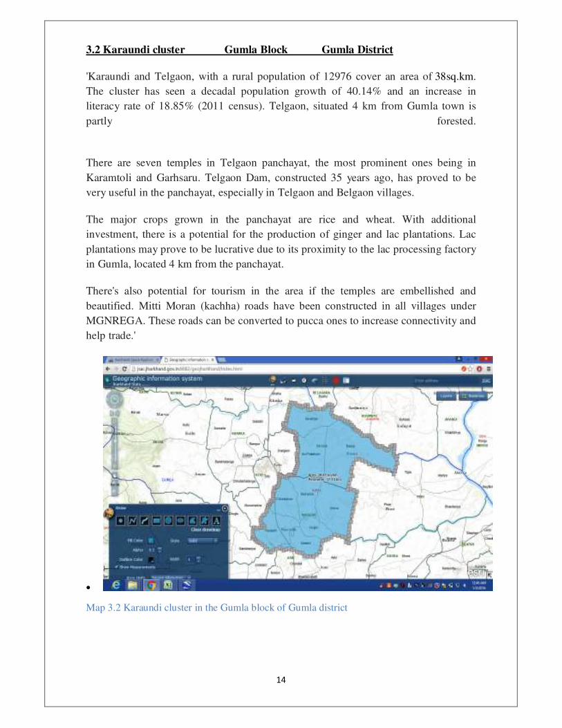
Map 3.2 Karaundi cluster in the Gumla block of Gumla district
���
�
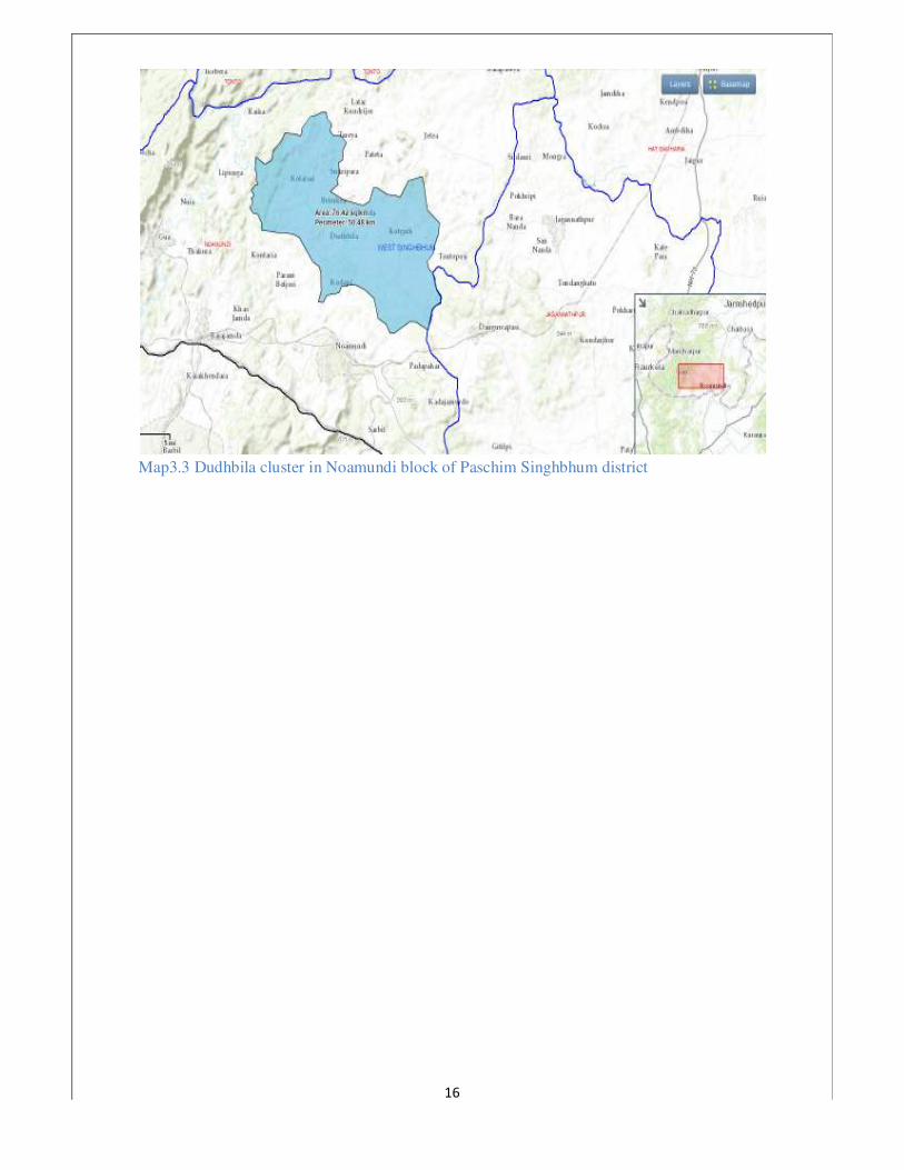
3.3 Dudhbila Cluster Noamundi Block Paschim Singhbhum Distirct
The proposed Kotgarh-Dudhbila cluster located at about 5 Km from Noamundi town.
A State Highway passes through Kotgarh village and connects District Headquater
Chaibasa and Block Headquater Noamundi.
Noamundi town has a large township owned by Tata Steel which serves as the
consumptional backbone of the local agricultural and non-agricultiral economy.
Additionally large number of people work as unskilled labor in Iron Ore mining in
Tata Steel and other mining companies.
One significant resource is a large relatively new lake of about 100 acres called
Katigoda Lake made with the help Tata Steel. The spot 5 Kms from the State
Highway can be developed into a tourist spot if augumented with boating facilities
and a park in the shape of rim around the lake. The Rurban Mission investment may
augment this. Additionally, there is a Shiv mandir near the lake which can be
refurbished.
The occupation is mostly farm based with seasonal labour migration to mines. The
water from Katigoda lake if used to potential may be used for horticulture activities
for sale in Noamundi and Chaibasa market. Large scale fisheries can be encouraged
considering the size of the lake.
The two pronged strategy of tourism and high-value agriculture with linkage to
Noamundi market therefore can help spur fast growth in the cluster. Noamundi is also
known for growth centres and gateway for Steel Authority of India Limited and
Badabil different kinds of mines in Orissa for West Singhbhum district because it
connects railway link between Tatanagar and Badbil(Odissa).The Tata Steel with the
help of mining and forest department organises flower show every year in the month
of the January in the rehabilitated mining area. This Naumudi park is one of the
greatest attraction for the people of West Sighnbhum.
���
�
Map3.3 Dudhbila cluster in Noamundi block of Paschim Singhbhum district
�
���
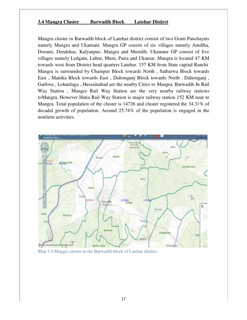
3.4 Mangra Cluster Barwadih Block Latehar Distirct
Mangra cluster in Barwadih block of Latehar district consist of two Gram Panchayats
namely Mangra and Ukamanr. Mangra GP consist of six villages namely Amdiha,
Dorami, Dendehas, Kalyanpur, Mangra and Muridih. Ukamanr GP consist of five
villages namely Ledgain, Luhur, Muru, Paira and Ukamar. Mangra is located 47 KM
towards west from District head quarters Latehar. 157 KM from State capital Ranchi
Mangra is surrounded by Chainpur Block towards North , Satbarwa Block towards
East , Manika Block towards East , Daltonganj Block towards North . Daltonganj ,
Garhwa , Lohardaga , Hussainabad are the nearby Cities to Mangra. Barwadih Jn Rail
Way Station , Mangra Rail Way Station are the very nearby railway stations
toMangra. However Hatia Rail Way Station is major railway station 152 KM near to
Mangra. Total population of the cluster is 14726 and cluster registered the 34.31% of
decadal growth of population. Around 25.74% of the population is engaged in the
nonfarm activities.
�
Map 3.4 Mangra cluster in the Barwadih block of Latehar district

��
�
3.5 Dhobni Cluster Musabani Block Purbi Singhbhum Distirct
The two panchayats of Musabani cluster, Dhobni and Koilisuta has nine villages, an
area of 38.62 sq km with a population of 11628 according to Census 2011. This area
has a literacy rate of 54.7% and a decadal literacy rate growth of 16 %, while current
non-farm workplace participation accounts for 23%. There has been a growth in non-
farm activity participation of 3.9% during the 2001-2011 periods. The cluster lies in
the periphery of the census town Musabani, is also home to a group of Copper Mines
once run by Hindustan Copper Limited. It is at a distance of 39 km from District
headquarters Jamshedpur.
Geography
Musabani is situated in the lap of Singhbhum Shear Zone, geologically one of the
richest places of Indian Subcontinent. This can be said a Geologist's Paradise. It is
surrounded by mountains and lush green vegetation. Banalopa, located in Musabani
once had the reputation of being second deepest mine after Kolar Gold mine.
Banalopa is the mine where mining of Copper re started for the first time by modern
methods. It is the best weather it has from September to March. The most exciting
feature of this small town is that you can get people from various parts of India as well
as Nepal living side by side.
People and Culture
Musabani is called Mini India for being home to people from different parts of India,
such as Tamil Nadu, Kerala, Andhra Pradesh, Rajasthan, Punjab, Bihar and the
neighboring states of West Bengal and Odisha. There are also good number of Nepalis
whose forefathers came to this part of India for livelihood in the copper mines.
Musaboni also boasts of being home to some Anglo Indian families. The local people
consist of heterogeneous mix of local Oriya and Bengali speakers along with
numerous Scheduled Tribes belonging to Munda branch of Indo-Austric stock like
Santhal, Kol, Mahali, Bhuinya, Munda etc. Mosaboni is also home to Sabars who are
recognized as Primitive Tribe by Constitution of India.
Rankini Devi a deity of Bhuinya origin is considered the patron deity of the region
and is revered by all people of Musabani in high esteem. A shrine dedicated to the
goddess is located in the lap of Dhanjouri Hills, locally called Dhobni near the
Uranium town of Jaduguda around 20 km north. Makar Sankranti is celebrated as
harvest festival by people of this region in which they wear new clothes and throng to
village fairs. Durga Pooja, Diwali, Sohrai, Id, Bakrid, Badadin or Christmas,
Saraswati Pooja and Holi are other important festivals celebrated. Rathayatra, Chariot
festival of lord Jagannatha is another addition to its already vibrant cultural panorama
awakening true nature of universal brotherhood imbibed in every fellow resident of
Musabani.
��
�
Education
There are innumerable schools and colleges in the block. Ironically, this area only sees
a literacy rate of 54%, much lower than literacy rate of Jharkhand state, which is 66%.
• St.Joseph's Convent High School
• Kendriya Vidyalaya, Surda
• Saraswati Sishu Vidya Mandir, No.1 Area
• G.C.J.D High school,Shastrinagar
• Mosaboni Mines Inter College, Mosaboni
• Sido kanhu janjatiya inter College, Mosaboni
• Ghatsila College, Ghatsila
• Mosabani Mines Middle School,Mosabani No.3 (Now Closed)
• Mosabani Mines High School,Mosabani No.3 (Now Closed)
• GYAN Bharti English Medium School,Pathargora,Mosaboni
• Yadunath Baskey Degree college,Mosabani No.3
• Sheolal High School,B-Type Area
• Project Girl's High School, Musabani no- 5, Mahulbera
• Urdu Middle school, Musabani No. 5, Mahulbera
• St. Barbara Catholic Church School,Mosabani No 1
• Azad Vidyapeth English Medium School, Musabani
• Bethel Model School,Musabani
• Grace Union Public School,No.2 Area
• Gulmohar School, Musabani No. 3
• Little Flower Play School, Musabani No. 1
• GYAN Bharti English School,Mosaboni
Bank Facility
• Bank of India
• State Bank of India
• Cooperative Bank
• Grameen Bank
• Apna Bank
• Musabani Lamps Ltd.
• Sahara India

���
�
Growth Drivers
• Promotion of Cottage Industry through SHGs – bamboo craft, wood craft
• NTFP promotion
• Capitalising education sector
• Retail sector expansion
• Improving private sector intervention in health sector
�
Map 3.5 Dhobni cluster in the Musabani block of Purbi Singhbhum district.

���
�
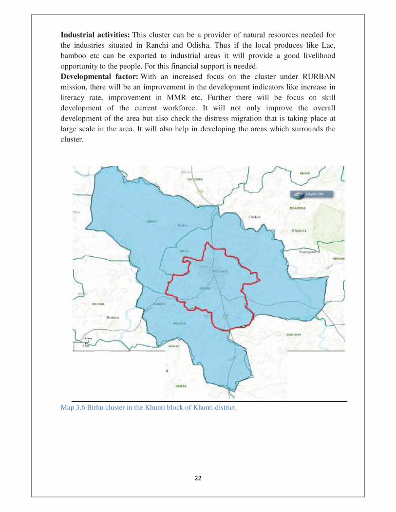
3.6 Birhu Cluster , Khunti Block , Khunti Distirct
Connectivity: The cluster is located 3 km from the district headquarter. It is situated
35km from the state capital Ranchi. The cluster has good road connectivity. NH 75
passes through the cluster which connects it to Ranchi and Chaibasa (West
Singhbhoom) and with Odisha. State highway passes through the cluster which
connects it to industrial towns of Odisha like Rourkela. The Birhu cluster is also near
to Karra rail station and the distance is around 20 km.
Occupational Pattern: The main occupational activity is agriculture. However as
being near to Khunti (district headquarter) people at large scale are involved in
various non farming commercial activities like trading locally produced goods in
Khunti and Ranchi markets. Many are involved in various employments like
electrician, Raj mistri, shopkeeping etc. However still there is a huge gap between
demand and supply of employment opportunities because of which people from this
cluster migrate to nearby towns like Ranchi for better employment opportunities. This
migration is distress migration.
Industries: Khunti has abundant natural resources, particularly the non-timber forest
produce. Lac deserves a special mention has Khunti produces one of the finest quality
Lac in Asia. Near the Birhu cluster there are two big Lac processing industries. If
properly developed, there is a scope for setting up many more Lac processing plants in
the cluster.
Tourism: Tourism, in future can become the biggest employment provider in the
cluster. Khunti is a beautiful place with lots of tourist attraction. There are There are 5
waterfalls situated within 25 km from the cluster. There is one deer park situated 12
km from the cluster and one ancient temple situated 15 km from the cluster.
Market structure: Market is predominantly traditional. Haats are held on fixed days
of the week where non timber forest produce are sold at large scale. Traders from
Ranchi and other places come to buy these produce. Permanent shops are also present
in sizeable number.
Additional investment under RURBAN Mission will help in a number of ways in the
development of the cluster.
Agriculture and allied activities: Funds can be utilized for developing various
farming activities which can provide good return and better job opportunities.
Activities like producing and processing non timber forest produce can be promoted.
Processing centres for Lac, Chiraunji, tamrind etc can be opened. Dairy farming can
be developed and milk chilling center can be opened to provide milk to nearest dairies
in Ranchi. Poultry farming, goat and pig rearing are other livelihood opportunities that
can be developed at large scale in the cluster.
Tourism: Planning can be done to provide support to run tourist places smoothly.
Transport linkages can be provided from the cluster for nearby tourist places as the
cluster is situated near to the district headquarter.
���
�
Industrial activities: This cluster can be a provider of natural resources needed for
the industries situated in Ranchi and Odisha. Thus if the local produces like Lac,
bamboo etc can be exported to industrial areas it will provide a good livelihood
opportunity to the people. For this financial support is needed.
Developmental factor: With an increased focus on the cluster under RURBAN
mission, there will be an improvement in the development indicators like increase in
literacy rate, improvement in MMR etc. Further there will be focus on skill
development of the current workforce. It will not only improve the overall
development of the area but also check the distress migration that is taking place at
large scale in the area. It will also help in developing the areas which surrounds the
cluster.
�
Map 3.6 Birhu cluster in the Khunti block of Khunti district.
���
�
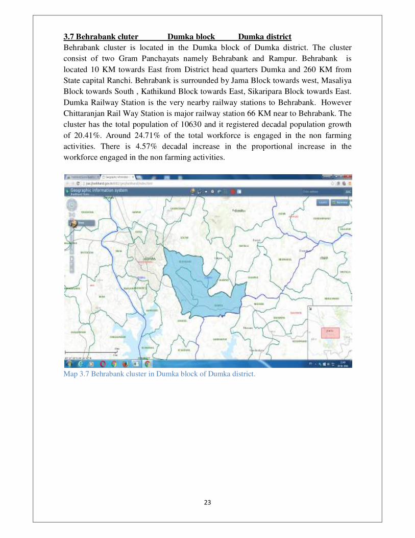
3.7 Behrabank cluter Dumka block Dumka district
Behrabank cluster is located in the Dumka block of Dumka district. The cluster
consist of two Gram Panchayats namely Behrabank and Rampur. Behrabank is
located 10 KM towards East from District head quarters Dumka and 260 KM from
State capital Ranchi. Behrabank is surrounded by Jama Block towards west, Masaliya
Block towards South , Kathikund Block towards East, Sikaripara Block towards East.
Dumka Railway Station is the very nearby railway stations to Behrabank. However
Chittaranjan Rail Way Station is major railway station 66 KM near to Behrabank. The
cluster has the total population of 10630 and it registered decadal population growth
of 20.41%. Around 24.71% of the total workforce is engaged in the non farming
activities. There is 4.57% decadal increase in the proportional increase in the
workforce engaged in the non farming activities.
�
Map 3.7 Behrabank cluster in Dumka block of Dumka district.
���
�
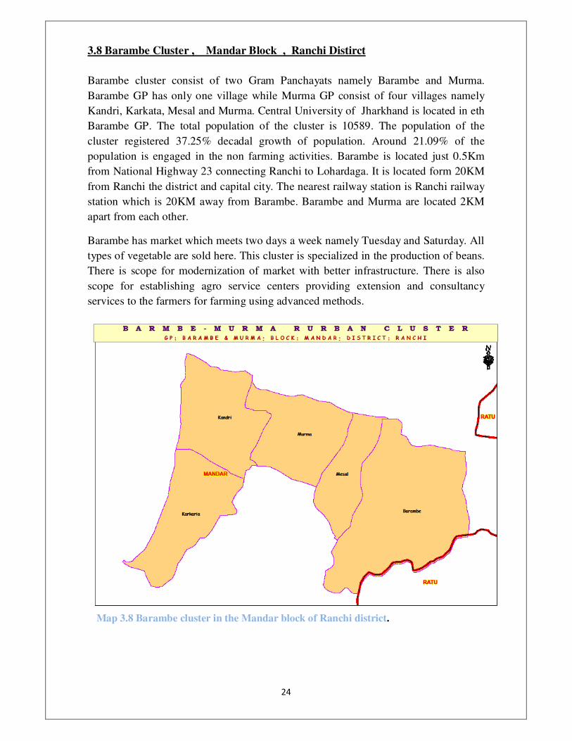
3.8 Barambe Cluster , Mandar Block , Ranchi Distirct
Barambe cluster consist of two Gram Panchayats namely Barambe and Murma.
Barambe GP has only one village while Murma GP consist of four villages namely
Kandri, Karkata, Mesal and Murma. Central University of Jharkhand is located in eth
Barambe GP. The total population of the cluster is 10589. The population of the
cluster registered 37.25% decadal growth of population. Around 21.09% of the
population is engaged in the non farming activities. Barambe is located just 0.5Km
from National Highway 23 connecting Ranchi to Lohardaga. It is located form 20KM
from Ranchi the district and capital city. The nearest railway station is Ranchi railway
station which is 20KM away from Barambe. Barambe and Murma are located 2KM
apart from each other.
Barambe has market which meets two days a week namely Tuesday and Saturday. All
types of vegetable are sold here. This cluster is specialized in the production of beans.
There is scope for modernization of market with better infrastructure. There is also
scope for establishing agro service centers providing extension and consultancy
services to the farmers for farming using advanced methods.
Map 3.8 Barambe cluster in the Mandar block of Ranchi district. �
���
�
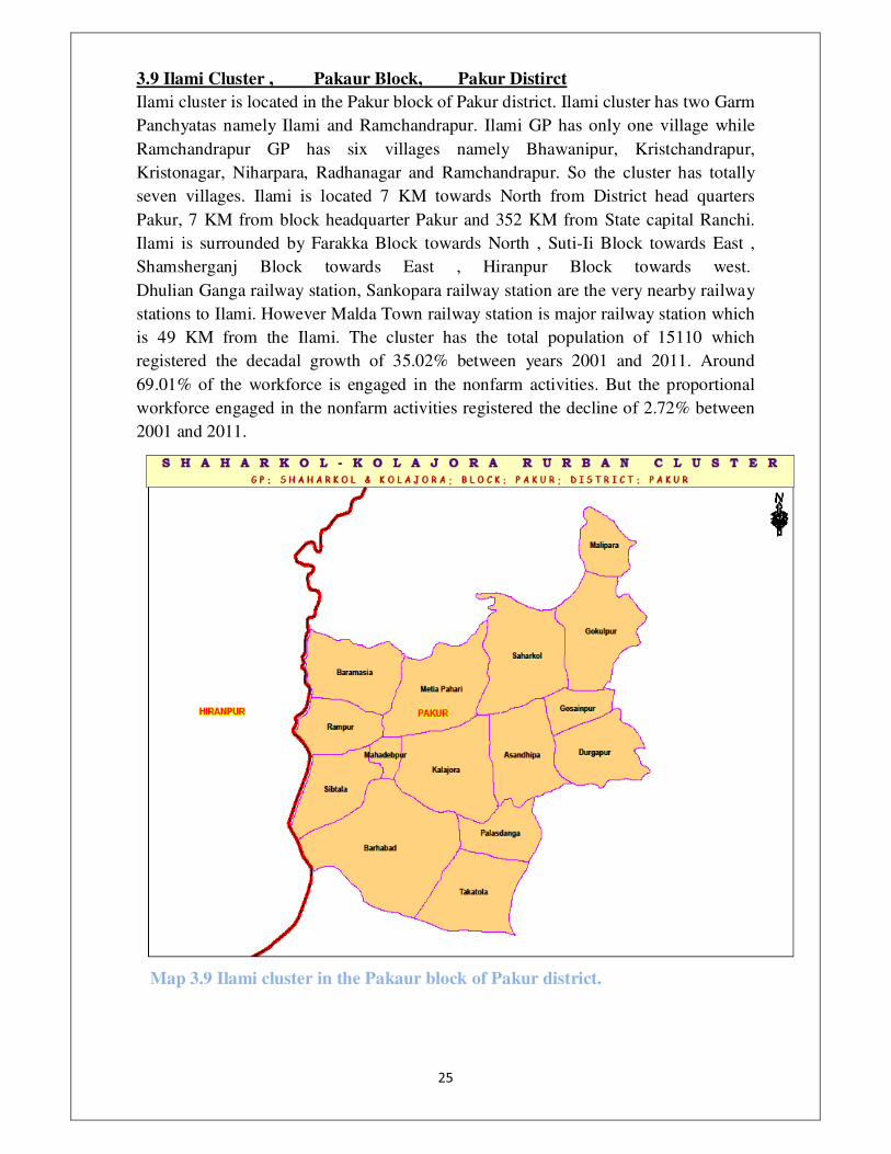
3.9 Ilami Cluster , Pakaur Block, Pakur Distirct
Ilami cluster is located in the Pakur block of Pakur district. Ilami cluster has two Garm
Panchyatas namely Ilami and Ramchandrapur. Ilami GP has only one village while
Ramchandrapur GP has six villages namely Bhawanipur, Kristchandrapur,
Kristonagar, Niharpara, Radhanagar and Ramchandrapur. So the cluster has totally
seven villages. Ilami is located 7 KM towards North from District head quarters
Pakur, 7 KM from block headquarter Pakur and 352 KM from State capital Ranchi.
Ilami is surrounded by Farakka Block towards North , Suti-Ii Block towards East ,
Shamsherganj Block towards East , Hiranpur Block towards west.
Dhulian Ganga railway station, Sankopara railway station are the very nearby railway
stations to Ilami. However Malda Town railway station is major railway station which
is 49 KM from the Ilami. The cluster has the total population of 15110 which
registered the decadal growth of 35.02% between years 2001 and 2011. Around
69.01% of the workforce is engaged in the nonfarm activities. But the proportional
workforce engaged in the nonfarm activities registered the decline of 2.72% between
2001 and 2011.
Map 3.9 Ilami cluster in the Pakaur block of Pakur district. �

���
�
3.10 Lakeya Cluster Sisai Block Gumla Distirct
Lakeya cluster is located in the Sisai block of Gumla district. The cluster has two
Gram Panchayats namely Bhargaon North and Lakeya. Bhargaon North GP has three
villages namely Kulangkeri, Bargaon, Makunda while Lakeya GP has only one
village. The cluster has the total population of 14563 and it registered the decadal
growth of 28.46% and decadal literacy growth rate of 71.38%. Lakeya Panchayat is
situated 1.5 KMs from Sisai block headquarters with 3-5% area covered with forests.
The area has four main temples. The main occupation is agriculture where rice and
maduva are largely grown. Villagers also make Bas ki Tokri, Ghada and Paila. With
additional investment, land levelling and check dam over Paras River can be
constructed to be useful for the villagers.
�
Map 3.10 Lakeya cluster in the Sisai block of Ranchi district.

���
�
3.11 Rampur Cluster Namkum Block Ranchi Distirct
Rampur the Gram Panchayt in Namkum Block in Ranchi District of Jharkhand State.
The GP consist of four villages namely Chene, Jamchuan, Jareya and Rampur. It is
located 16 KM towards East from District head quarters Ranchi. 12 KM from
Namkum block head quarters. The village is located adjacent to the National Highway
connecting Ranchi and Jamshedpur. The Nearest railway station Ranchi railway
station which is 15 KM away.Rampur is surrounded by Ranchi Block towards west,
Angara Block towards North , Kanke Block towards North , Ormanjhi Block towards
North . Total population of the GP is 5431 as per 2011 census. Around 32.33% of the
population engaged in non farming activities.
There is weekly market in the Rampur on every Friday. Lac is the most prominent
forest produce sold in this market. All primary lac producers bring their lac to sold it
here. The market can modernised with storage facilities and information systems to
help better price discovery for producers. Apart from lac all types of vegetables are
also sold in this market.
People often go to capital city Ranchi to work in many non farming activities. Skill
building of such people is necessary to upgrade their skills and help them in getting
more wages.
Map 3.11 Rampur block in Namkum block of Ranchi district. �

��
�
3.12 Parsahi Cluster Latehar Block Latehar Distirct
Parasahi cluster in the Latehar block of Latehar district consist of two Gram
Panchayats namely Parsahi and Ichak. The cluster has total 15 villages namely Dugile,
Dumariatanr, Hethtola, Hotwag, Ichak, Jalta, Kura, Labarpur, Lawagara, Matnag,
Nawadih, Negain, Patki, Rehra and Sotam. The cluster has the total population of
8482 and it registered the 7.95% decadal growth of the population. Around 42.91% of
the workforce is engaged in the non farming activities. Ichak is located 3 KM towards
North from District head quarters Latehar, 3 KM from block headquarter Latehar and
112 KM from State capital Ranchi. Ichak is surrounded by Manika Block towards
west , Chandwa Block towards East , Garu Block towards west , Panki Block towards
North . Latehar Railway Station , Bendi Railway Station are the very nearby railway
stations to Ichak. However Hatia Rail Way Station is major railway station 109 KM
fromIchak.
�
Map 3.12 Parsahi cluster in Latehar block of Latehar district.

��
�
3.13 Paliadaga Cluster Pakuria Block Pakur Distirct
Paliadaga cluster is located in the Pakuria block of Pakur district. The cluster has two
Gram Panchayats namely Paliadaga and Khaksa. Paliadaga GP has three villages
namely Ganglulia, Orpara and Paliadaha. Khaksa GP has six villages namely
Angardaria, Damohani, Khaksa, Meliachuan, Pitalgaria and Sarsa Bandh. So the
cluster has totally nine villages. The cluster has the total population of 12245 which
registered the decadal growth of 19.16% between 2001 and 2011. Around 17.99% of
the workforce is engaged in the non farming activities. There is 8.80% increase in the
proportional work force engaged in the nonfarm activities.
�
Map 3.13 Paliadaga cluster in the Pakuria block of Pakur district.
���
�
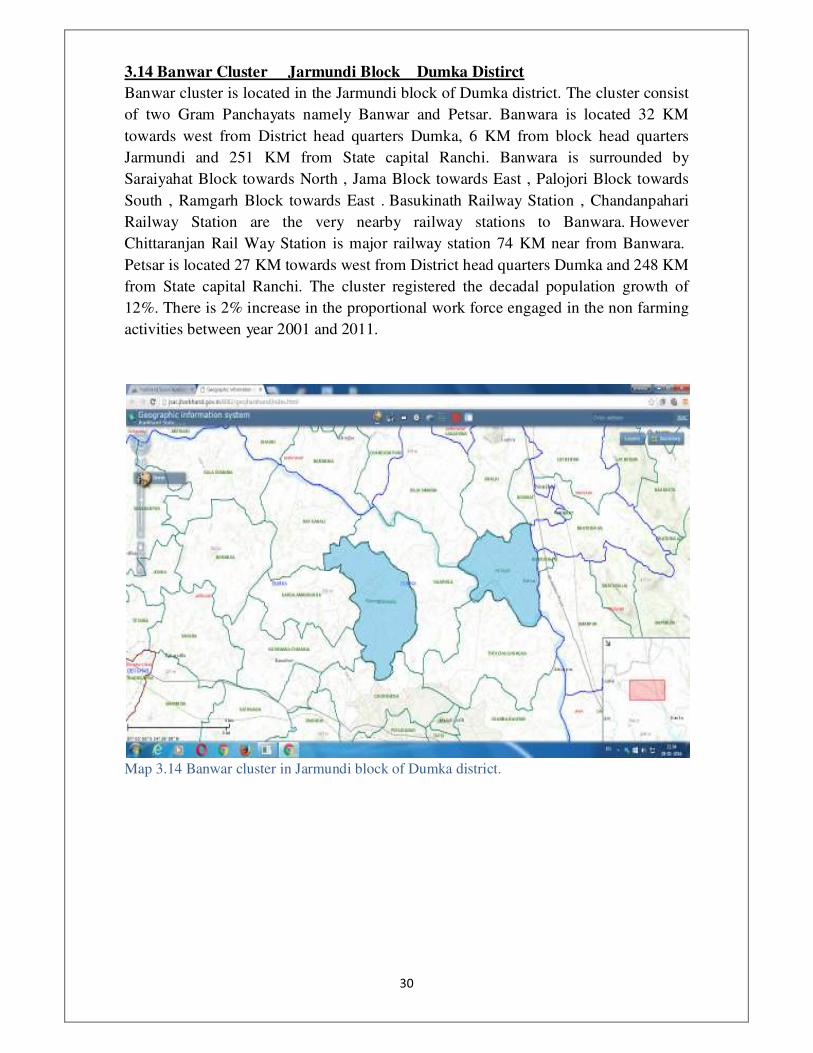
3.14 Banwar Cluster Jarmundi Block Dumka Distirct
Banwar cluster is located in the Jarmundi block of Dumka district. The cluster consist
of two Gram Panchayats namely Banwar and Petsar. Banwara is located 32 KM
towards west from District head quarters Dumka, 6 KM from block head quarters
Jarmundi and 251 KM from State capital Ranchi. Banwara is surrounded by
Saraiyahat Block towards North , Jama Block towards East , Palojori Block towards
South , Ramgarh Block towards East . Basukinath Railway Station , Chandanpahari
Railway Station are the very nearby railway stations to Banwara. However
Chittaranjan Rail Way Station is major railway station 74 KM near from Banwara.
Petsar is located 27 KM towards west from District head quarters Dumka and 248 KM
from State capital Ranchi. The cluster registered the decadal population growth of
12%. There is 2% increase in the proportional work force engaged in the non farming
activities between year 2001 and 2011.
�
Map 3.14 Banwar cluster in Jarmundi block of Dumka district.

���
�
3.15 Pithoriya Cluster Kanke Block Ranchi Distirct
Pithoriya cluster consist of two Gram Pancayats namely Pithoriya and Rarha.
Pithoriya GP consists of only village while Rarha GP consist of three villages namely
Madanpur, Rarha and Sutiambe. National Highway-33 connecting Ranchi and Patna
passes through the Pithoriya. It is located 15 KM away from Ranchi and 10Km from
the Kanke block head quarters. The nearest railway station is Ranchi which is 15Km
away. Pithoria is surrounded by Patratu Block towards North , Ratu Block towards
South , Burmu Block towards west , Bundu Block towards west. The total population
of the clusters is 12733. The cluster registered the 17.85% decadal growth of
population. Around 11.36% of population is engaged in the non farming activities.
But the proportional of non farming workforce to total workforce registered the
decline of 1.21% between 2001 to 2011. This indicates the agriculture dominance ofin
the cluster.
Pithoriya is a vegetable cluster. Most of the farmers here engaged in the vegetable
cultivation. The cluster specialised in the Gobi and Phul Gobi production. But farmers
still do not adopted modern practices of vegetable cultivation. The provision of
various agro inputs not determined scientifically. So there is scope for developing
agro service centres providing extension and consultancy services to the farmers.
There is vegetable market in the Pithoriya which meets every day. Farmers bring their
vegetable produce and sold it here. Many wholesale traders from Ranchi and other
cities come here to buy vegetable. But the market in not organised well. There is
scope developing market on modern lines with storage facilities and information
systems to help farmers in better price discovery. The vegetable from here is also sent
to Kolkatta, Jamshedpur, Bubaneshwar and other cities.

���
�
Map 3.15 Pithoriya cluster in the Kanke block of Ranchi district.
���
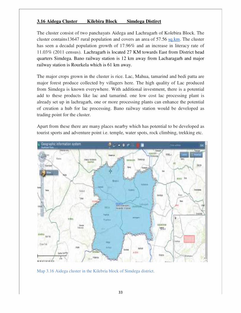
3.16 Aidega Cluster Kilebira Block Simdega Distirct
The cluster consist of two panchayats Aidega and Lachragarh of Kolebira Block. The
cluster contains13647 rural population and covers an area of 57.56 sq.km. The cluster
has seen a decadal population growth of 17.96% and an increase in literacy rate of
11.03% (2011 census). Lachragarh is located 27 KM towards East from District head
quarters Simdega. Bano railway station is 12 km away from Lacharagarh and major
railway station is Rourkela which is 61 km away.
The major crops grown in the cluster is rice. Lac, Mahua, tamarind and bedi patta are
major forest produce collected by villagers here. The high quality of Lac produced
from Simdega is known everywhere. With additional investment, there is a potential
add to these products like lac and tamarind. one low cost lac processing plant is
already set up in lachragarh, one or more processing plants can enhance the potential
of creation a hub for lac processing. Bano railway station would be developed as
trading point for the cluster.
Apart from these there are many places nearby which has potential to be developed as
tourist sports and adventure point i.e. temple, water spots, rock climbing, trekking etc.
Map 3.16 Aidega cluster in the Kilebria block of Simdega district.

���
�
3.17 Kharsawan cluster Kharsawan Block Saraikela-Kharsawan District
Kharsawan cluster is located in the Kharsawan block of Saraikela-Kharsawan district.
The cluster consist of two Gram Panchayats namely Kharsawan and Simla. The total
population of the cluster is 15412 which registered the decadal growth of 34.6%
between year 2001 and 2011. Around 49.1% of the total rural workforce in involved
in the non farming activities. The proportional workforce engaged in the non farming
activities registered the decline of 6.7% between the year 2001 and 2011. Kharsawan
is famous for its Tasar silk. Central Silk Board has its training centre here. Kharsawan
has historical significance as Shahid Park located in middle of it is witness of sacrifice
of martyrs on 1 January 1948. Aakarshni Temple on the hill is the tourist attraction. A
number of industrial plants are coming around the area. Keeping future needs of the
area in mind this cluster can be developed as a potential growth centre.
�
Map 5.17 Kharsawan cluster in Kharsawan block of Saraikela-Kharsawan district.
���
�
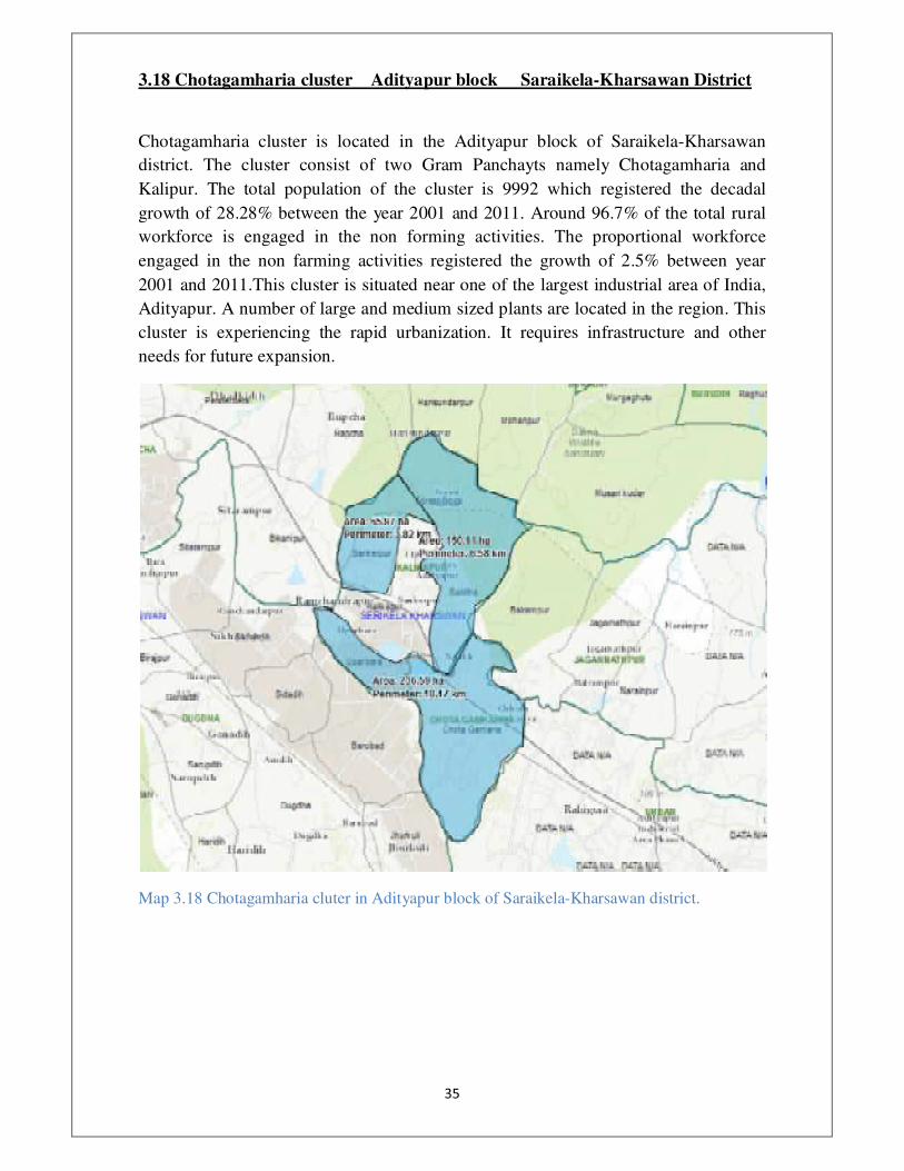
3.18 Chotagamharia cluster Adityapur block Saraikela-Kharsawan District
Chotagamharia cluster is located in the Adityapur block of Saraikela-Kharsawan
district. The cluster consist of two Gram Panchayts namely Chotagamharia and
Kalipur. The total population of the cluster is 9992 which registered the decadal
growth of 28.28% between the year 2001 and 2011. Around 96.7% of the total rural
workforce is engaged in the non forming activities. The proportional workforce
engaged in the non farming activities registered the growth of 2.5% between year
2001 and 2011.This cluster is situated near one of the largest industrial area of India,
Adityapur. A number of large and medium sized plants are located in the region. This
cluster is experiencing the rapid urbanization. It requires infrastructure and other
needs for future expansion.
�
Map 3.18 Chotagamharia cluter in Adityapur block of Saraikela-Kharsawan district.
���
�
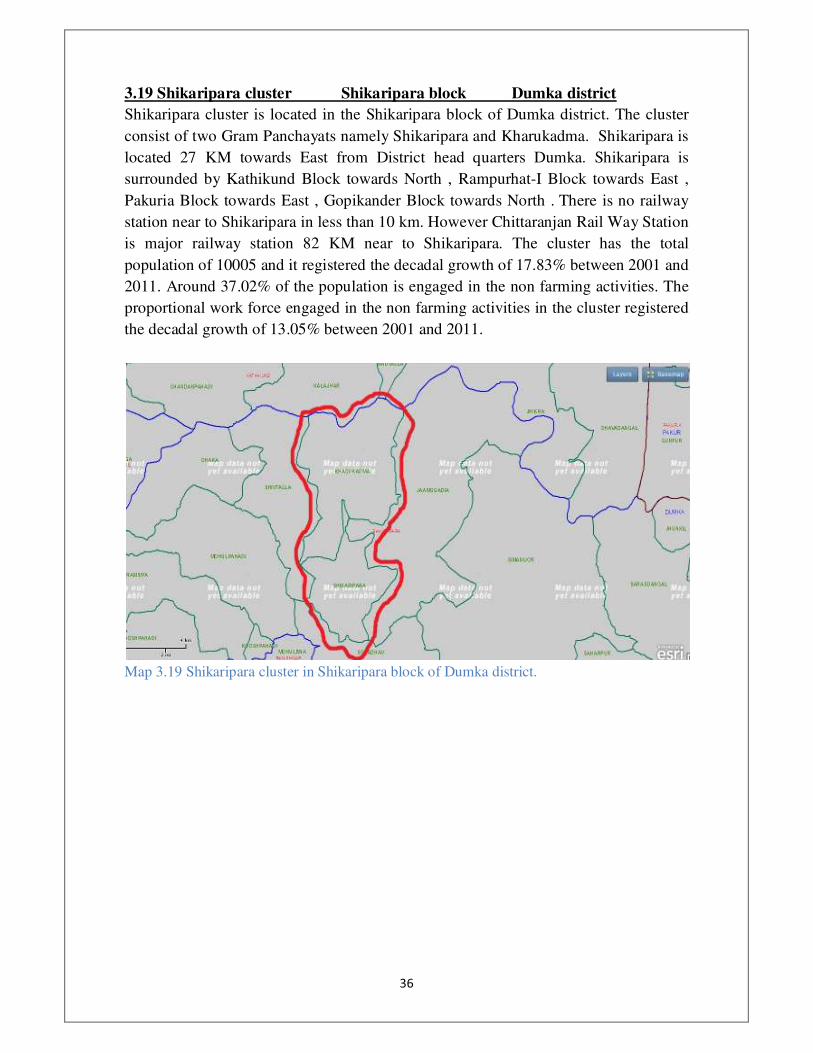
3.19 Shikaripara cluster Shikaripara block Dumka district
Shikaripara cluster is located in the Shikaripara block of Dumka district. The cluster
consist of two Gram Panchayats namely Shikaripara and Kharukadma. Shikaripara is
located 27 KM towards East from District head quarters Dumka. Shikaripara is
surrounded by Kathikund Block towards North , Rampurhat-I Block towards East ,
Pakuria Block towards East , Gopikander Block towards North . There is no railway
station near to Shikaripara in less than 10 km. However Chittaranjan Rail Way Station
is major railway station 82 KM near to Shikaripara. The cluster has the total
population of 10005 and it registered the decadal growth of 17.83% between 2001 and
2011. Around 37.02% of the population is engaged in the non farming activities. The
proportional work force engaged in the non farming activities in the cluster registered
the decadal growth of 13.05% between 2001 and 2011.
�
Map 3.19 Shikaripara cluster in Shikaripara block of Dumka district.
���
�
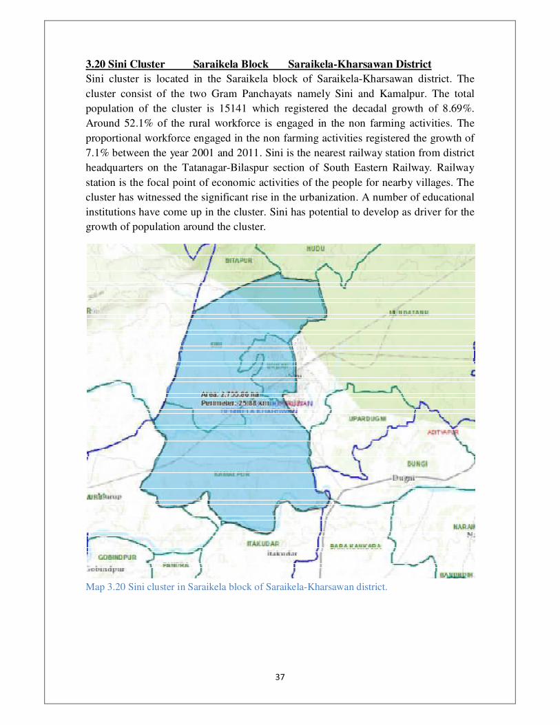
3.20 Sini Cluster Saraikela Block Saraikela-Kharsawan District
Sini cluster is located in the Saraikela block of Saraikela-Kharsawan district. The
cluster consist of the two Gram Panchayats namely Sini and Kamalpur. The total
population of the cluster is 15141 which registered the decadal growth of 8.69%.
Around 52.1% of the rural workforce is engaged in the non farming activities. The
proportional workforce engaged in the non farming activities registered the growth of
7.1% between the year 2001 and 2011. Sini is the nearest railway station from district
headquarters on the Tatanagar-Bilaspur section of South Eastern Railway. Railway
station is the focal point of economic activities of the people for nearby villages. The
cluster has witnessed the significant rise in the urbanization. A number of educational
institutions have come up in the cluster. Sini has potential to develop as driver for the
growth of population around the cluster.
�
Map 3.20 Sini cluster in Saraikela block of Saraikela-Kharsawan district.
��
�
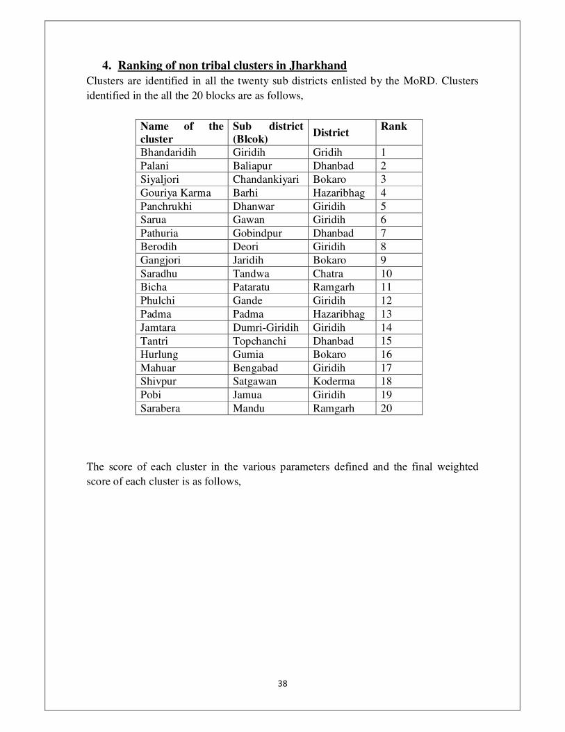
4. Ranking of non tribal clusters in Jharkhand
Clusters are identified in all the twenty sub districts enlisted by the MoRD. Clusters
identified in the all the 20 blocks are as follows,
Name of the
cluster
Sub district
(Blcok) District
Rank
Bhandaridih Giridih Gridih 1
Palani Baliapur Dhanbad 2
Siyaljori Chandankiyari Bokaro 3
Gouriya Karma Barhi Hazaribhag 4
Panchrukhi Dhanwar Giridih 5
Sarua Gawan Giridih 6
Pathuria Gobindpur Dhanbad 7
Berodih Deori Giridih 8
Gangjori Jaridih Bokaro 9
Saradhu Tandwa Chatra 10
Bicha Pataratu Ramgarh 11
Phulchi Gande Giridih 12
Padma Padma Hazaribhag 13
Jamtara Dumri-Giridih Giridih 14
Tantri Topchanchi Dhanbad 15
Hurlung Gumia Bokaro 16
Mahuar Bengabad Giridih 17
Shivpur Satgawan Koderma 18
Pobi Jamua Giridih 19
Sarabera Mandu Ramgarh 20
The score of each cluster in the various parameters defined and the final weighted
score of each cluster is as follows,

��
�
�
�

���
�
5 Non tribal clusters identified for development under RURBAN Mission
5.1 Bhandaridih cluster Giridih block Giridih District
Bhandaridih cluster is located in the Giridih block of Giridih district. The cluster has
five Gram Panchayats namely Bhandaridih, Mangrodih, Pandedih, Sihodih and Sirsia.
Bhandaridih GP has four villages namely Bhandaridih, Boro, Dandiadih, Jariagadi.
Mangrodih GP has only one village in it. Pandedih GP has four villages namely Bergi,
Garhatanr, Panedih and Phuljori. Sihodih has three villages namely BhalSumia,
Sankarchak and Sihodih. Sisia has only one village. The cluster has the total
population of 33381 which registered the decadal growth of 45.43% between year
2001 and 2011. Around 80.11% of the workforce is engaged in the non farming
activities which registered the decadal increase of 0.13% between 2001 and 2011.
This cluster surrounds the Giridih Municipal Area in over 2 Directions and is adjacent
to it. It houses the Giridih block officeand is only 4 km from the Giridih District
headquarters. Sirsia Cluster is well connected by road and rail. Giridih Railway station
is very close to Cluster and a passenger train presently connects it with Madhupur
junction, Deoghar District which is a major Railway junction in the region. Dhanbad
junction is also only 55 KM from cluster but has to be reached by road. Sirsia Cluster
is can connect to NH2 at 2 points Dumri, Giridih District and Govindpur, Dhanbad
District. Around 80.11% of the workforce is engaged in the non-farming activities.
The region is filled with hard working labourers, who work in the scattered industries
in Giridih and with small scale entrepreneurs majorly into retail. The major push to
this region is provided by the proximity to the urban area.

���
�
Map 5.1 Bhandaridih cluster in Giridih block of Giridih district.

���
�
���
�
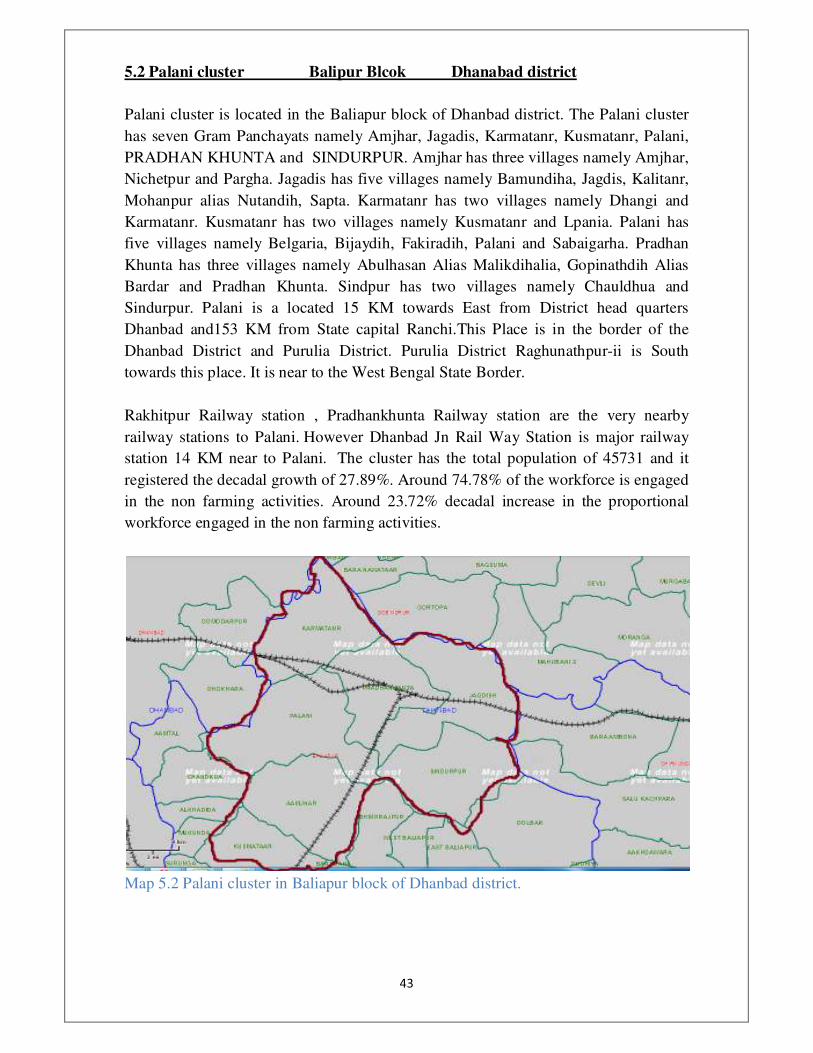
5.2 Palani cluster Balipur Blcok Dhanabad district
Palani cluster is located in the Baliapur block of Dhanbad district. The Palani cluster
has seven Gram Panchayats namely Amjhar, Jagadis, Karmatanr, Kusmatanr, Palani,
PRADHAN KHUNTA and SINDURPUR. Amjhar has three villages namely Amjhar,
Nichetpur and Pargha. Jagadis has five villages namely Bamundiha, Jagdis, Kalitanr,
Mohanpur alias Nutandih, Sapta. Karmatanr has two villages namely Dhangi and
Karmatanr. Kusmatanr has two villages namely Kusmatanr and Lpania. Palani has
five villages namely Belgaria, Bijaydih, Fakiradih, Palani and Sabaigarha. Pradhan
Khunta has three villages namely Abulhasan Alias Malikdihalia, Gopinathdih Alias
Bardar and Pradhan Khunta. Sindpur has two villages namely Chauldhua and
Sindurpur. Palani is a located 15 KM towards East from District head quarters
Dhanbad and153 KM from State capital Ranchi.This Place is in the border of the
Dhanbad District and Purulia District. Purulia District Raghunathpur-ii is South
towards this place. It is near to the West Bengal State Border.
Rakhitpur Railway station , Pradhankhunta Railway station are the very nearby
railway stations to Palani. However Dhanbad Jn Rail Way Station is major railway
station 14 KM near to Palani. The cluster has the total population of 45731 and it
registered the decadal growth of 27.89%. Around 74.78% of the workforce is engaged
in the non farming activities. Around 23.72% decadal increase in the proportional
workforce engaged in the non farming activities.
Map 5.2 Palani cluster in Baliapur block of Dhanbad district.

���
�
���
�
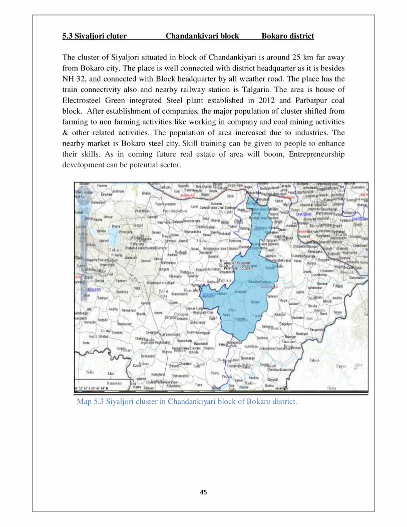
5.3 Siyaljori cluter Chandankiyari block Bokaro district
The cluster of Siyaljori situated in block of Chandankiyari is around 25 km far away
from Bokaro city. The place is well connected with district headquarter as it is besides
NH 32, and connected with Block headquarter by all weather road. The place has the
train connectivity also and nearby railway station is Talgaria. The area is house of
Electrosteel Green integrated Steel plant established in 2012 and Parbatpur coal
block. After establishment of companies, the major population of cluster shifted from
farming to non farming activities like working in company and coal mining activities
& other related activities. The population of area increased due to industries. The
nearby market is Bokaro steel city. Skill training can be given to people to enhance
their skills. As in coming future real estate of area will boom, Entrepreneurship
development can be potential sector.
Map 5.3 Siyaljori cluster in Chandankiyari block of Bokaro district.
���
�
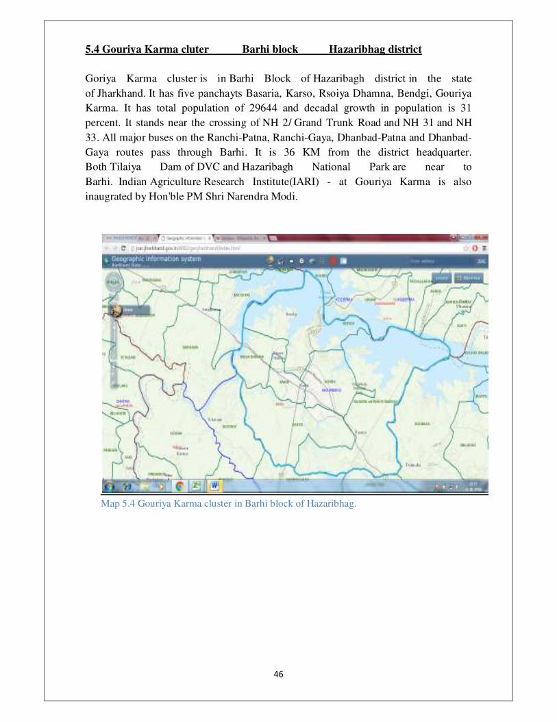
5.4 Gouriya Karma cluter Barhi block Hazaribhag district
Goriya Karma cluster is in Barhi Block of Hazaribagh district in the state
of Jharkhand. It has five panchayts Basaria, Karso, Rsoiya Dhamna, Bendgi, Gouriya
Karma. It has total population of 29644 and decadal growth in population is 31
percent. It stands near the crossing of NH 2/ Grand Trunk Road and NH 31 and NH
33. All major buses on the Ranchi-Patna, Ranchi-Gaya, Dhanbad-Patna and Dhanbad-
Gaya routes pass through Barhi. It is 36 KM from the district headquarter.
Both Tilaiya Dam of DVC and Hazaribagh National Park are near to
Barhi. Indian Agriculture Research Institute(IARI) - at Gouriya Karma is also
inaugrated by Hon'ble PM Shri Narendra Modi.
�
Map 5.4 Gouriya Karma cluster in Barhi block of Hazaribhag.
���
�
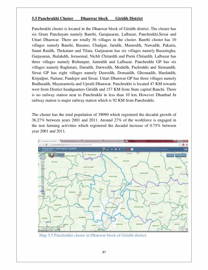
5.5 Panchrukhi Cluster Dhanwar block Giridih District
Panchrukhi cluster is located in the Dhanwar block of Giridih district. The cluster has
six Gram Panchayats namely Banrhi, Garajasaran, Lalbazar, Panchrukhi,Sirsai and
Uttari Dhanwar. There are totally 36 villages in the cluster. Banrhi cluster has 10
villages namely Banrhi, Baramo, Chadgar, Jaridih, Masnodih, Nawadih, Pakaria,
Saunt Raidih, Thekatanr and Tilaia. Garjasaran has six villages namely Basasingha,
Garjasaran, Jhalakdih, Jorasemal, Nichli Chitardih and Purni Chitardih. Lalbazar has
three villages namely Bishunpur, Jamridih and Lalbazar. Panchrukhi GP has six
villages namely Baghmari, Darudih, Darwedih, Modidih, Pachrukhi and Sirmandih.
Sirsai GP has eight villages namely Dasrodih, Domaidih, Ghosnadih, Hardatdih,
Kirpalpur, Naitanr, Pandejor and Sirsai. Uttari Dhanwar GP has three villages namely
Budhuadih, Mayaramtola and Upraili Dhanwar. Panchrukhi is located 47 KM towards
west from District headquarters Giridih and 157 KM from State capital Ranchi. There
is no railway station near to Panchrukhi in less than 10 km. However Dhanbad Jn
railway station is major railway station which is 92 KM from Panchrukhi.
The cluster has the total population of 39090 which registered the decadal growth of
36.27% between years 2001 and 2011. Around 27% of the workforce is engaged in
the non farming activities which registered the decadal increase of 0.75% between
year 2001 and 2011.
Map 5.5 Panchrukhi cluster in Dhanwar block of Giridih district.

��
�
5.6 Sarua cluster Gawan block Giridih district
Sarua cluster is located in the Gawan block of Giridih district. The cluster has five
Gram Panchayats namely Gawan, Malda, Nagwan, Patna and Sarua. Gawan GP has
four villages namely Donosot, Gawan, Harhara and Khotmanai. Malda GP has 12
villages namely Beonk, Darbedih, Gounrha, Kaneriabad, Lachhmipur, Loharpura,
Maharko, Maheshpur, Malda, Pandedih, Pathar and Siri. Nagwan GP has four villages
namely Kakmari, Koni, Nagwan and Sitochak. Patna GP has five villages namely
Bagdedih, Bhelwa, Patna, Purnadabar and Tikuli. Sarua GP has 13 villages namely
Bendro, Cherwa, Dabar, Harni, Jhajha, Karmatanr, Koar, Kurchi, Lakhikura,
Paharpur, Rakasia, Sarua and Semrapatal. Serua is located 71 KM towards North from
District headquarters Giridih and 181 KM from State capital Ranchi. There is no
railway station near to Serua in less than 10 KM. However Begu Sarai railway station
is major railway station which is at 103 KM from Serua.
The total population of the cluster is 38701 which registered the decadal growth of
33.78% between 2001 and 2011. Around 28% of the workforce in the cluster is
engaged in the non farming activities. The proportional workforce engaged in the non
farming activities registered the decadal growth of 4.43% between the years 2001 and
2011.
Map 5.6 Sarua cluster in Gawan block of Giridih district.
��
�
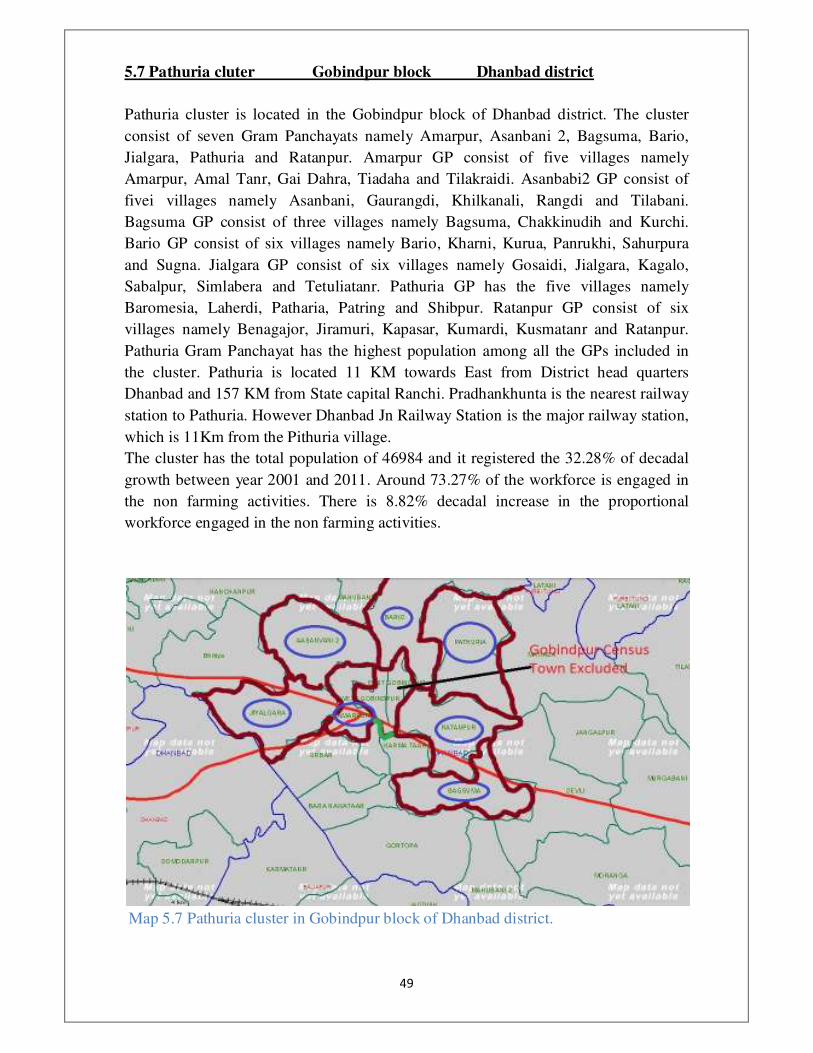
5.7 Pathuria cluter Gobindpur block Dhanbad district
Pathuria cluster is located in the Gobindpur block of Dhanbad district. The cluster
consist of seven Gram Panchayats namely Amarpur, Asanbani 2, Bagsuma, Bario,
Jialgara, Pathuria and Ratanpur. Amarpur GP consist of five villages namely
Amarpur, Amal Tanr, Gai Dahra, Tiadaha and Tilakraidi. Asanbabi2 GP consist of
fivei villages namely Asanbani, Gaurangdi, Khilkanali, Rangdi and Tilabani.
Bagsuma GP consist of three villages namely Bagsuma, Chakkinudih and Kurchi.
Bario GP consist of six villages namely Bario, Kharni, Kurua, Panrukhi, Sahurpura
and Sugna. Jialgara GP consist of six villages namely Gosaidi, Jialgara, Kagalo,
Sabalpur, Simlabera and Tetuliatanr. Pathuria GP has the five villages namely
Baromesia, Laherdi, Patharia, Patring and Shibpur. Ratanpur GP consist of six
villages namely Benagajor, Jiramuri, Kapasar, Kumardi, Kusmatanr and Ratanpur.
Pathuria Gram Panchayat has the highest population among all the GPs included in
the cluster. Pathuria is located 11 KM towards East from District head quarters
Dhanbad and 157 KM from State capital Ranchi. Pradhankhunta is the nearest railway
station to Pathuria. However Dhanbad Jn Railway Station is the major railway station,
which is 11Km from the Pithuria village.
The cluster has the total population of 46984 and it registered the 32.28% of decadal
growth between year 2001 and 2011. Around 73.27% of the workforce is engaged in
the non farming activities. There is 8.82% decadal increase in the proportional
workforce engaged in the non farming activities.
Map 5.7 Pathuria cluster in Gobindpur block of Dhanbad district.
���
�
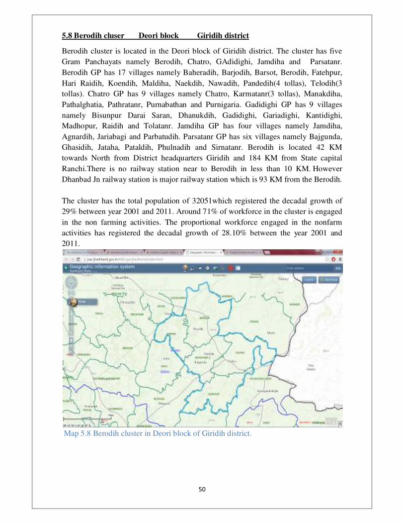
5.8 Berodih cluser Deori block Giridih district
Berodih cluster is located in the Deori block of Giridih district. The cluster has five
Gram Panchayats namely Berodih, Chatro, GAdidighi, Jamdiha and Parsatanr.
Berodih GP has 17 villages namely Baheradih, Barjodih, Barsot, Berodih, Fatehpur,
Hari Raidih, Koendih, Maldiha, Naekdih, Nawadih, Pandedih(4 tollas), Telodih(3
tollas). Chatro GP has 9 villages namely Chatro, Karmatanr(3 tollas), Manakdiha,
Pathalghatia, Pathratanr, Purnabathan and Purnigaria. Gadidighi GP has 9 villages
namely Bisunpur Darai Saran, Dhanukdih, Gadidighi, Gariadighi, Kantidighi,
Madhopur, Raidih and Tolatanr. Jamdiha GP has four villages namely Jamdiha,
Agnardih, Jariabagi and Parbatudih. Parsatanr GP has six villages namely Bajgunda,
Ghasidih, Jataha, Pataldih, Phulnadih and Sirnatanr. Berodih is located 42 KM
towards North from District headquarters Giridih and 184 KM from State capital
Ranchi.There is no railway station near to Berodih in less than 10 KM. However
Dhanbad Jn railway station is major railway station which is 93 KM from the Berodih.
The cluster has the total population of 32051which registered the decadal growth of
29% between year 2001 and 2011. Around 71% of workforce in the cluster is engaged
in the non farming activities. The proportional workforce engaged in the nonfarm
activities has registered the decadal growth of 28.10% between the year 2001 and
2011.
Map 5.8 Berodih cluster in Deori block of Giridih district.

���
�
5.9 Gangjori cluter Jaridih block Bokaro district
The cluster Baradih is located in Jaridih Block. The few villages of cluster are situated
on NH-32, all villages of cluster are connected with each other by all weather road.
The major railway Station is Bokaro Steel city which is around 20 Km from cluster.
Few villages of cluster share boundary with Purulia district of West Bengal. The
nearby market place is Jaina More and Bokaro steel city.
The population is mostly engaged in farm based activities in villages far from main
road as in roadside villages people are involved in non farming activities. Paddy and
vegetable are grown here in good quantity. Investment can be made to promote
entrepreneurship for agro products.
Map 5.9 Gangjori block in Jaridih block of Bokarod district.

���
5.10 Saradhu cluster Tandwa block Chatra district
Tandwa block is the Southern-most block of Chatra bordered by Ranchi District in the
South, Latehar District in the West and Hazaribag District in the East as shown in the
following figures. Although no State or National highway passes through the block, it
is well-connected to major cities such as Hazaribag and Ranchi. Moreover, the block
has huge resources of coal and the increased mining activity has promoted its growth
significantly in recent years.
Fig 5.10A Block-wise Map of Chatra District Fig. 2 Map of
Tandwa Block
Following figure shows the location of cluster (marked in red) in Tandwa block and
the panchayats included in it namely Tandwa, Garilaung, Kabra, Kasiadih, Koed and
Saradhu.

���
Fig 5.10B PanchayatWise Map of Tandwa Block with Cluster marked in Red
Cluster has been finalized based on the parameters mentioned for calculating the
score. The other important reasons for the selection of the cluster apart from its high
score are:
1. Block headquarters is situated in the cluster itself facilitating planning,
development and availability of administration.
2. Mining activity has been initiated in the cluster in 2015 by Amprapali Coal
Company
3. Upcoming NTPC’s North Karanpura Power Plant with a capacity of 1980 MW
that is expected to be operational by 2017 is situated within the cluster.
Though increased mining activity has led to higher population growth and increased
non-farm work force, it did not result in proportionate improvement in infrastructure.
The NTPC Power Plant in near future could fuel further growth in the cluster.
Absence of planned development may lead to urban chaos, development of slums,
increased inequalities along with growth in crime rate.

���
�
How RURBAN Mission can accelerate growth?
In this regard, components of RURBAN Mission such provision of piped water, street
lighting, sanitation, village streets and drains, inter-village road connectivity, solid and
liquid waste management would help in addressing the current infrastructure deficit
leading to sustainable growth.
In addition, the block is affected by Left-Wing Extremism. The other components of
RURBAN Mission such as Skill development, Upgrading school/higher education
facilities, Digital Literacy, improving governance through citizen centric services/ e-
gram connectivity would go a long way in addressing the major challenge that is being
faced in the cluster. It would also address the issue of inter-state migration that is very
high in Chatra district.
Further, the cluster is known for production of high-quality tomatoes that are exported
to Kolkata. The middlemen benefitted the denying the poor farmers their remunerative
price. Hence, development of Agro processing industry (related to Tomato) coupled
with skill development in the same, and NTPC power plant that guarantees
uninterrupted power supply – could really prove promising for the growth of food
processing industry. It would generate employment and could have far-reaching
effects on the surrounding areas.
Map 5.10 Saradhu cluster in Tandwa block of Chatra district.
���
�
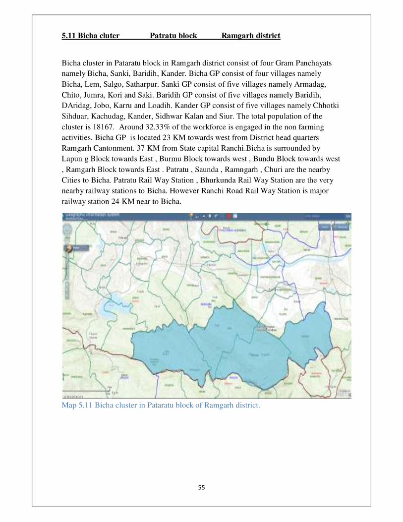
5.11 Bicha cluter Patratu block Ramgarh district
Bicha cluster in Pataratu block in Ramgarh district consist of four Gram Panchayats
namely Bicha, Sanki, Baridih, Kander. Bicha GP consist of four villages namely
Bicha, Lem, Salgo, Satharpur. Sanki GP consist of five villages namely Armadag,
Chito, Jumra, Kori and Saki. Baridih GP consist of five villages namely Baridih,
DAridag, Jobo, Karru and Loadih. Kander GP consist of five villages namely Chhotki
Sihduar, Kachudag, Kander, Sidhwar Kalan and Siur. The total population of the
cluster is 18167. Around 32.33% of the workforce is engaged in the non farming
activities. Bicha GP is located 23 KM towards west from District head quarters
Ramgarh Cantonment. 37 KM from State capital Ranchi.Bicha is surrounded by
Lapun g Block towards East , Burmu Block towards west , Bundu Block towards west
, Ramgarh Block towards East . Patratu , Saunda , Ramngarh , Churi are the nearby
Cities to Bicha. Patratu Rail Way Station , Bhurkunda Rail Way Station are the very
nearby railway stations to Bicha. However Ranchi Road Rail Way Station is major
railway station 24 KM near to Bicha.
Map 5.11 Bicha cluster in Pataratu block of Ramgarh district.

���
�
5.12 Phulchi cluster Gande block Giridih district
Phulchi cluster is located in the Gande block of Giridih district. The cluster consist of
five Gram Panchayats namely Champapur, Dokidih, Karibanka, Phulchi and
Udayapur. Champapur GP consist of seven villages namely Champapur, Dahuatanr,
Irchitta, Kairadih, Maheshmarwa, Mandardih and Nawadih. Dokidih GP consist of 11
villages namely Bamhandiha, Dalwadih, Dokidih, Girnia Kanhaidih, Kolhmarni,
Mehjori, Mohanpur, Parmadih, RAkaskuto and Turuktopa. Karibanka GP has consist
of 16 villages namely Asahna, Bhalua, Chakbasu Singha, Chirudih, Gobinddih,
Karibanki, Keradabar, Lalpur Maheshpur alias, Tilabani, Mandro, Mednipur,
Meghudih, Ojhadih, Parheta, Pejhwara and Sitla. Phulchi GP consist of 11 villages
namely Alaitanr, Ambadih, Barhagari, Chitarpurd, Jabardaha, Jodhpur, Lalbhita,
Merkhogundi, Pachrukhi, Pahardaha, Pandedih, Phulchi and Sankardih. Udayapur GP
consist of 11 villages namely Beldih, Charakmara, Chengarabad, Chutiadih, Dhobana,
Ghorajori, Haripaldih, Mahadeodih, Maheshmunda, Teljhori and Udaipur. Phulchi is
the largest Gram Panchayat among all the G among all the GPs in the cluster, so the
cluster is named after it.
Total population of the cluster is 31471 which registered the decadal growth of
29.78% between the year 2001 and 2011. Around 20.96% of the total rural workforce
is engaged in the non farming activities. The proportional rural workforce engaged in
the non farming activities registered the decadal growth of 7.91 between the year 2001
and 2011. The average land values in the cluster increased by 4.85% between the last
two years.
Map 5.12 Phulchi cluster in Gande block of Giridih district.

���
�
5.13 Padma cluster Padma block Hazaribhag district
Padma is a community development block that forms an administrative division
in Barhi subdivision of Hazaribagh district in the Indian state of Jharkhand. Padma
cluster has 5 Gram Panchayats Padma, Saraiya, Romi, Bandarbela and Suryapura. It
has total population of 33776 and decadal growth is 15 percent. Padma was the seat
of Ramgarh Raj and the palace is located there. A Police Training Academy is also
located there. Padma is 23KM from district headquarter and it is also connected by
rail to Hazaribagh and Koderma.
�
Map 5.13 Padma cluster in Padma block of Hazaribhag.
��
�
5.14 Jamtara cluster Dumri block Giridih District
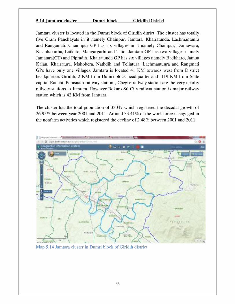
Jamtara cluster is located in the Dumri block of Giridih ditrict. The cluster has totally
five Gram Panchayats in it namely Chainpur, Jamtara, Khairatunda, Lachmantunra
and Rangamati. Chaninpur GP has six villages in it namely Chainpur, Domawara,
Kasmhakurha, Latkato, Mangargarhi and Tuio. Jamtara GP has two villages namely
Jamatara(CT) and Pipradih. Khairatunda GP has six villages namely Badkharo, Jamua
Kalan, Khairatura, Mahobera, Nathdih and Teliatura. Lachmantunra and Rangmati
GPs have only one villages. Jamtara is located 41 KM towards west from District
headquarters Giridih, 2 KM from Dumri block headquarter and 119 KM from State
capital Ranchi. Parasnath railway station , Chegro railway station are the very nearby
railway stations to Jamtara. However Bokaro Stl City railwat station is major railway
station which is 42 KM from Jamtara.
The cluster has the total population of 33047 which registered the decadal growth of
26.95% between year 2001 and 2011. Around 33.41% of the work force is engaged in
the nonfarm activities which registered the decline of 2.48% between 2001 and 2011.
Map 5.14 Jamtara cluster in Dumri block of Giridih district.
��
�
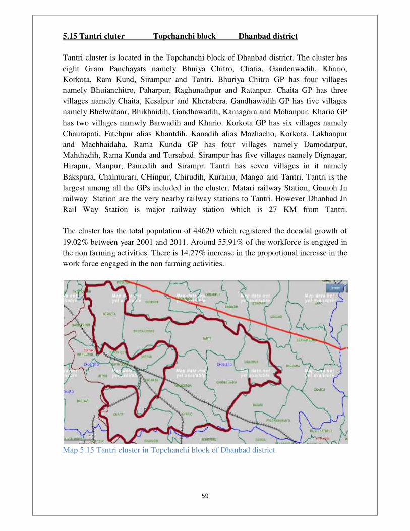
5.15 Tantri cluter Topchanchi block Dhanbad district
Tantri cluster is located in the Topchanchi block of Dhanbad district. The cluster has
eight Gram Panchayats namely Bhuiya Chitro, Chatia, Gandenwadih, Khario,
Korkota, Ram Kund, Sirampur and Tantri. Bhuriya Chitro GP has four villages
namely Bhuianchitro, Paharpur, Raghunathpur and Ratanpur. Chaita GP has three
villages namely Chaita, Kesalpur and Kherabera. Gandhawadih GP has five villages
namely Bhelwatanr, Bhikhnidih, Gandhawadih, Karnagora and Mohanpur. Khario GP
has two villages namwly Barwadih and Khario. Korkota GP has six villages namely
Chaurapati, Fatehpur alias Khantdih, Kanadih alias Mazhacho, Korkota, Lakhanpur
and Machhaidaha. Rama Kunda GP has four villages namely Damodarpur,
Mahthadih, Rama Kunda and Tursabad. Sirampur has five villages namely Dignagar,
Hirapur, Manpur, Panredih and Sirampr. Tantri has seven villages in it namely
Bakspura, Chalmurari, CHinpur, Chirudih, Kuramu, Mango and Tantri. Tantri is the
largest among all the GPs included in the cluster. Matari railway Station, Gomoh Jn
railway Station are the very nearby railway stations to Tantri. However Dhanbad Jn
Rail Way Station is major railway station which is 27 KM from Tantri.
The cluster has the total population of 44620 which registered the decadal growth of
19.02% between year 2001 and 2011. Around 55.91% of the workforce is engaged in
the non farming activities. There is 14.27% increase in the proportional increase in the
work force engaged in the non farming activities.
Map 5.15 Tantri cluster in Topchanchi block of Dhanbad district.

���
�
5.16 Hurlung cluter Gumia block Bokaro district
The cluster identified is Chartochatti. The cluster is situated near Konar dam build on
Konar river. The place is connected with all weather road by district and block
headquarters. The distance of block is 15-18 km and 55 Km. The area has scattered
forest cover. The major crops grown are paddy. Non timber forest products like
Mahua is also produced in good quantity here.
The presence of Konar Dam gives area the scenic view. The tourism activities can be
promoted at Konar Dam. Konar Washrey is proposed in nearby places which will give
employment to people.
�
Map 5.16 Hurlung cluster in Gumia block of Bokaro.
���
�
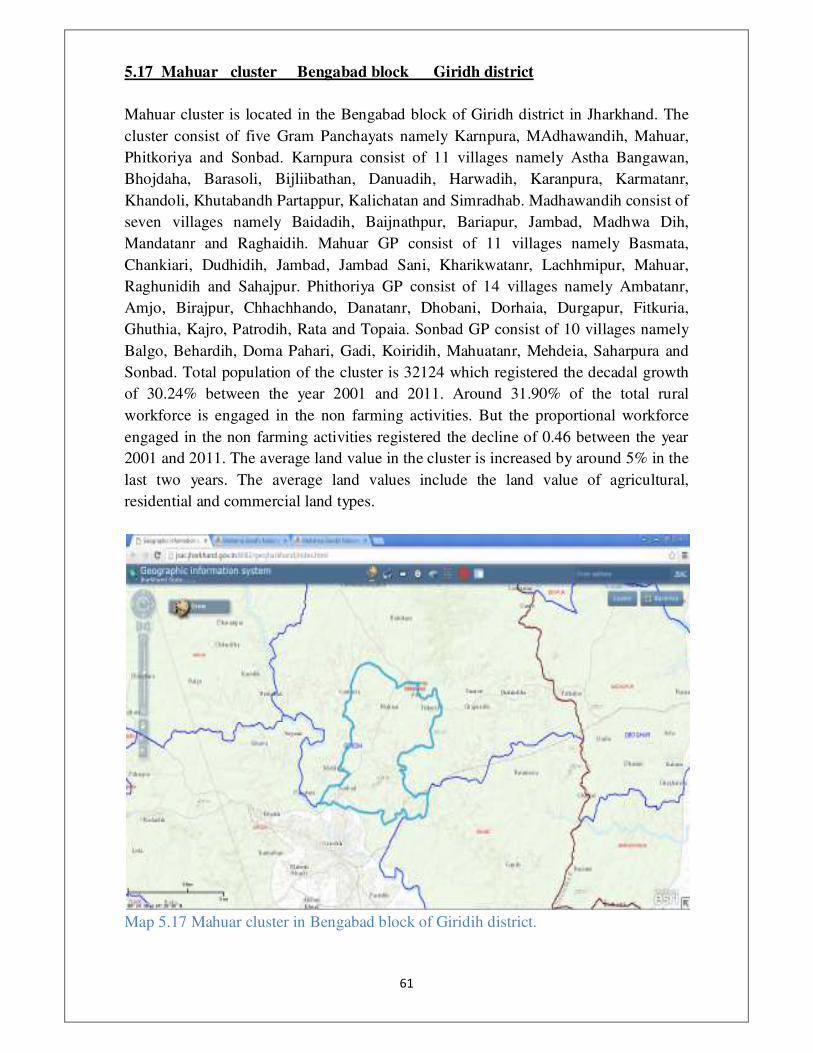
5.17 Mahuar cluster Bengabad block Giridh district
Mahuar cluster is located in the Bengabad block of Giridh district in Jharkhand. The
cluster consist of five Gram Panchayats namely Karnpura, MAdhawandih, Mahuar,
Phitkoriya and Sonbad. Karnpura consist of 11 villages namely Astha Bangawan,
Bhojdaha, Barasoli, Bijliibathan, Danuadih, Harwadih, Karanpura, Karmatanr,
Khandoli, Khutabandh Partappur, Kalichatan and Simradhab. Madhawandih consist of
seven villages namely Baidadih, Baijnathpur, Bariapur, Jambad, Madhwa Dih,
Mandatanr and Raghaidih. Mahuar GP consist of 11 villages namely Basmata,
Chankiari, Dudhidih, Jambad, Jambad Sani, Kharikwatanr, Lachhmipur, Mahuar,
Raghunidih and Sahajpur. Phithoriya GP consist of 14 villages namely Ambatanr,
Amjo, Birajpur, Chhachhando, Danatanr, Dhobani, Dorhaia, Durgapur, Fitkuria,
Ghuthia, Kajro, Patrodih, Rata and Topaia. Sonbad GP consist of 10 villages namely
Balgo, Behardih, Doma Pahari, Gadi, Koiridih, Mahuatanr, Mehdeia, Saharpura and
Sonbad. Total population of the cluster is 32124 which registered the decadal growth
of 30.24% between the year 2001 and 2011. Around 31.90% of the total rural
workforce is engaged in the non farming activities. But the proportional workforce
engaged in the non farming activities registered the decline of 0.46 between the year
2001 and 2011. The average land value in the cluster is increased by around 5% in the
last two years. The average land values include the land value of agricultural,
residential and commercial land types.
Map 5.17 Mahuar cluster in Bengabad block of Giridih district.

���
�
5.18 Shivpur cluter Satgawan block Koderma district
The identified cluster includes five Gram Panchayats namely Basodih, Samaldih,
Tehro, Shivpur, Nawadih with a total population of 25572 as per 2011 census report.
The cluster is about 55kms from the district headquarters. It is connected to the district
collectorate through road network. The main economic hub of the cluster is Basodih
which has the presence of bank and other trading centres. People move to the Basodih
Gram Panchayat to buy or sell their goods in the weekly Haat Bazaars. The cluster is
also connected to the neighbouring district of Giridih via road. Agriculture and
agriculture related activities form the main livelihood activity of majority of the
population. The cluster is surrounded by forests. Many of the villages in the cluster are
unhabitated. The nearby petro falls could be developed as tourist destination.
Map 5.18 Shivpur cluster in Satgawan block of Koderma district.

���
�
5.19 Pobi cluster Jamua blcok Giridih ditrict
Pobi cluster is located in the Jamua block of Giridih district. The cluster consist of five
Gram Panchayats namely Chakmanjo, Jagarnathdih, Khargagdiha, Pobi and
Thikamagha. Chakmanjo GP consist of seven villages namely Alardih, Chakmanjo,
Gando, Mangodih, Padumtola, Pargodih and Rahgarh. Jagarnathdih GP consist of two
villages namely Khairabad and Mirzaganj. Kharagdiha GP consist of three villages
namely Belkundi, Khamharbad and Kharagdiha. Pobi GP consist of six villages
namely Barwadih, Champadah, Pobi, Raiyodih, Sandih and Tejpur. Thikamagha GP
consist of seven villages namelu Ahardih, Bhathdih, Golodih, Harimagha, Kurumtanr,
Sakardiha and Thikamagha. Pobi is the largest GP among all the GPs included in the
cluster, so the cluster is named after that GP or village name.
Total population of the cluster is 31152 which registered the decadal growth of
35.03% between the years 2001 and 2011. Around 33.66% of the total rural workforce
is engaged in the non farming activities. The proportional workforce engaged in the
non farming activities registered the decadal growth of 1.40% between the year 2001
and 2011. The average land value in the cluster is increased by 1.3% between last two
years. The average land value included the land value of agriculture, residential and
commercial lands.
Map 5.19 Pobi cluster in Jamua block of Giridih district.

���
�
5.20 Sarabera cluter Mandu block Ramgarh district
Sarabera cluster in Mandu block of Ramgarh district consist of five Gram Panchayats
namely Sarabera, Badgaon, Nawadih, Barkidundi and Ratwe. Sarabera GP consist of
three villages namely Atna, Sarabera, Sirka. Badgaon GP consist of five villages
namely Badgon, Madaura, Bargaon, Bhuiyadih, Kumharbar. Nawadih GP consist of
two villages namely Chainpur and Nawadih. Barakidundi GP consist of two villages
namely Barkidundi and Chhotkidundi. Ratwe GP consist of only one village. The
cluster has the total population of 23062. The cluster registered the 11.21% decadal
growth of the population. Around 41.20% of the workforce is engaged in the non
farming activities.
Map 5.20 Sarabera cluster in Mandu block of Ramgarh district.

���
�
6. Conclusion District wise distribution of tribal and non tribal cluster in the Jharkhand state is as
follows,
Sl. No District No. of Tribal
clusters
No. of non
tribal clusters
Total no of
clusters
1 Boakro 3 3
2 Chatra 1 1
3 Dhanbad 3 3
4 Dumka 3 3
5 Giridih 8 8
6 Gumla 2 2
7 Hazaribhag 2 2
8 Khunti 1 1
9 Koderma 1 1
10 Latehar 2 2
11 Pakur 2 2
12 Paschim
Singhbhum
1 1
13 Purbi
Singhbhum
2 2
14 Ramgarh 2 2
15 Ranchi 3 3
16 Saraikela-
Kharsawan
3 3
17 Simdega 1 1
TOTAL 20 20 40
The following shows the district wise distribution of clusters in the Jharkhand state.

���
�
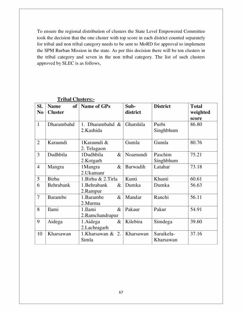
���
�
To ensure the regional distribution of clusters the State Level Empowered Committee
took the decision that the one cluster with top score in each district counted separately
for tribal and non tribal category needs to be sent to MoRD for approval to implement
the SPM Rurban Mission in the state. As per this decision there will be ten clusters in
the tribal category and seven in the non tribal category. The list of such clusters
approved by SLEC is as follows,
Tribal Clusters:-
Sl.
No
Name of
Cluster
Name of GPs Sub-
district
District Total
weighted
score
1 Dharambahd 1. Dharambahd &
2.Kashida
Ghatshila
Purbi
Singhbhum
86.80
2 Karaundi
1Karaundi &
2. Telagaon
Gumla Gumla 80.76
3 Dudhbila 1Dudhbila &
2.Kotgarh
Noamundi Paschim
Singhbhum
75.21
4 Mangra 1Mangra &
2.Ukamanr
Barwadih Latahar 73.18
5 Birhu 1.Birhu & 2.Tirla Kunti Khunti 60.61
6 Behrabank 1.Behrabank &
2.Rampur
Dumka Dumka 56.63
7 Barambe 1.Barambe &
2.Murma
Mandar Ranchi 56.11
8 Ilami 1.Ilami &
2.Ramchandrapur
Pakaur Pakur 54.91
9 Aidega 1.Aidega &
2.Lachragarh
Kilebira Simdega 39.60
10 Kharsawan 1.Kharsawan & 2.
Simla
Kharsawan Saraikela-
Kharsawan
37.16
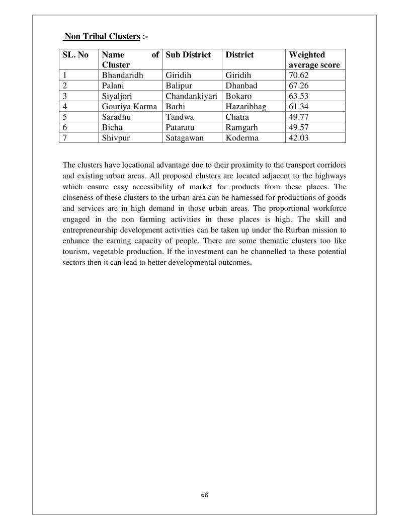
��
�
Non Tribal Clusters :-
SL. No Name of
Cluster
Sub District District Weighted
average score
1 Bhandaridh Giridih Giridih 70.62
2 Palani Balipur Dhanbad 67.26
3 Siyaljori Chandankiyari Bokaro 63.53
4 Gouriya Karma Barhi Hazaribhag 61.34
5 Saradhu Tandwa Chatra 49.77
6 Bicha Pataratu Ramgarh 49.57
7 Shivpur Satagawan Koderma 42.03
The clusters have locational advantage due to their proximity to the transport corridors
and existing urban areas. All proposed clusters are located adjacent to the highways
which ensure easy accessibility of market for products from these places. The
closeness of these clusters to the urban area can be harnessed for productions of goods
and services are in high demand in those urban areas. The proportional workforce
engaged in the non farming activities in these places is high. The skill and
entrepreneurship development activities can be taken up under the Rurban mission to
enhance the earning capacity of people. There are some thematic clusters too like
tourism, vegetable production. If the investment can be channelled to these potential
sectors then it can lead to better developmental outcomes.