shared pathways guidelines - melbourne water · shared pathways guidelines 1. g b b c e d f a a ......
TRANSCRIPT

Shared Pathways Guidelines
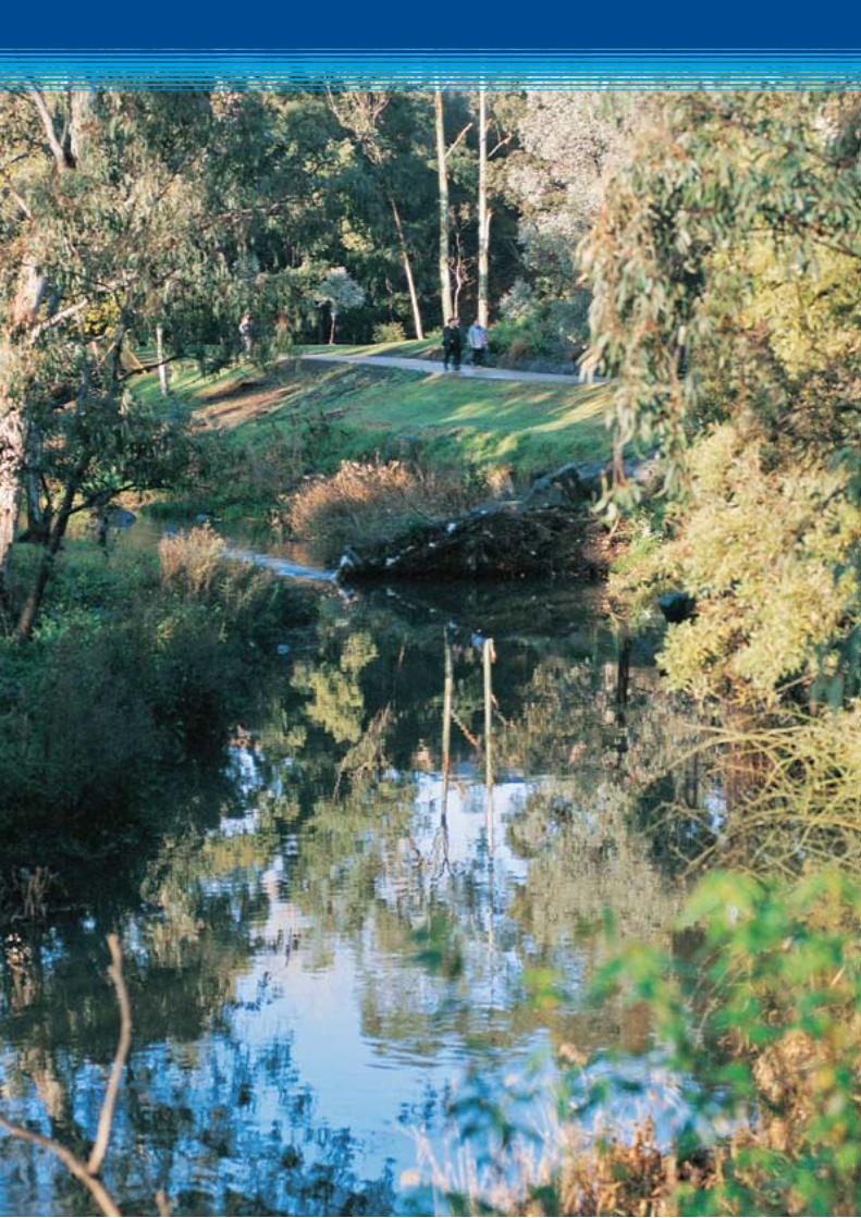
Paths beside waterways provide the community with the opportunity for walking, running, and bike riding and are often critical to the provision of recreation along stream corridors. In addition, as cycling becomes an ever more popular means of everyday transport, shared paths are doing much to facilitate sustainable travel.
As caretaker of the waterways of the Port Phillip and Westernport region, Melbourne Water welcomes the use of shared paths and seeks to work with local authorities and the community in the sustainable development of paths along our region’s waterways.
Melbourne Water has responsibility for significant areas of land such as waterway reserves, pipe reserves, floodways and retarding basins, and we are also responsible for ensuring the community is protected from flooding.
These shared path guidelines outline a standardised approach to design, construction, upgrade and maintenance of paths along waterways. They have been developed to ensure that, where shared paths are constructed along waterways, the community is able to enjoy them safely and that the condition of our waterways, and any adjacent Melbourne Water asset, is protected.
In addition to addressing key design concepts, these guidelines also describe the way in which you can most effectively liaise with Melbourne Water to ensure the successful construction of a shared path.
Melbourne Water: caretaker for the waterways of the Port Phillip and Westernport region
Shared pathwayS guidelineS 1
G
B
B
C
ED
F
A
A
A D F
E GB
C
B
C
ED
F
G
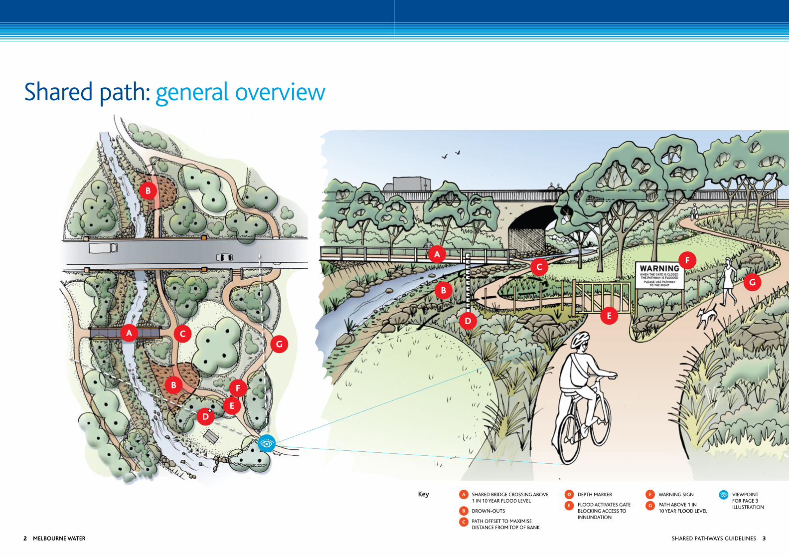
Shared path: general overview
Shared bridge croSSing above 1 in 10 year flood level
drown-outS
path offSet to maximiSe diStance from top of bank
depth marker
flood activateS gate blocking acceSS to innundation
warning Sign
path above 1 in 10 year flood level
viewpoint for page 3 illuStration
Key
2 melbourne water2 melbourne water Shared pathwayS guidelineS 3
About these guidelinesThese guidelines have been developed to assist you with regard to sites that Melbourne Water owns or manages. They are not intended to be prescriptive or displace other relevant standards, or seek to apply standards outside of those associated with waterway safety.
The most widely recognised standard for the design of paths is the Austroads Guide. All references to the Austroads guide within this document refer to the most recent version.
Please note that, once constructed, paths become the responsibility of the path manager and not Melbourne Water.
4 Melbourne water
Contents
Shared path – general overview 4
1. Shared pathway construction: guiding principles 6
2. Pathways Agreements 6
3. Things to consider when planning a shared pathway 7
4. Flood flows & hydraulic function 7
5. Path alignment – design parameters 8
6. Significant biodiversity values 9
7. Crossings of waterways/floodways 9-10
8. Road bridge underpasses 11
9. Levee banks, retarding basins & embankment structures 11
10. Pipe tracks 11
11. Path signage 11
12. Drown-outs 12
13. Pavement surface 13
14. Path drainage 13
15. Edge treatment and site reinstatement 13-14
16. Lighting 14
17. Path maintenance 14
18. Initial consultation – stage 1 15
19. Design approval – stage 2 16
20. Construction – stage 3 17
Glossary 18
References 18
Contacting Melbourne Water 18
Checklist forms 19-21
Melbourne Water is owned by the Victorian Government. We manage Melbourne’s water supply catchments, remove and treat most of Melbourne’s sewage, and manage rivers and creeks and major drainage systems throughout the Port Phillip and Westernport region.
Shared pathwayS guidelineS 5
2. Pathways Agreements
Melbourne Water has developed a standard agreement — a Pathways Agreement — for shared pathways and other recreational facilities situated within the land we own, or for which we are responsible.
If you are planning a new path along land managed by Melbourne Water you will need to enter into a Pathways Agreement with us.
The agreement will acknowledge that while Melbourne Water will provide all possible assistance as you plan for the pathway, Melbourne Water does not have ongoing responsibility for the ownership and maintenance of paths and crossings.
In the event that upgrades or alterations are made to existing paths you will need to contact Melbourne Water to update the Pathways Agreement for that site.
You will need to bear in mind that as part of your planning for paths/crossings affecting Melbourne Water assets — but where Melbourne Water is not the land owner — a separate legal agreement will need to be entered into with the owner of the land for the maintenance and operation of the path.
The Pathways Agreement includes a statement that the path manager indemnifies Melbourne Water for any loss or damage suffered as a result of the design, construction or maintenance of any path on Melbourne Water owned/managed land.
1. Shared pathway construction: guiding principles
Melbourne Water needs to be assured that the location of a path will not compromise:
› the safety of path users — especially their exposure to risks associated with inundation
› standards for flood protection
› the waterway and riparian corridor and its intrinsic and natural values
› the relationship between the waterway, its floodplain and any associated floodplain features
› the opportunity to undertake future improvement works
› Melbourne Water constructed assets, above or below ground
› the maintenance of those assets
› the hydraulic function of the waterway or drainage structure
› Maintenance access.
More broadly, the construction of paths along waterways should be compatible with the objectives for stream health that Melbourne Water has established as waterway caretaker for the Port Phillip and Westernport region.
If you are planning a new path along land managed by Melbourne Water you will need to enter into a pathways agreement with us.
6 Melbourne water
3. Things to consider when planning a shared pathway
3.1 Land ownership
Confirmation of land ownership is the first step in assessing the proposed location of a path. As the applicant, it will be your responsibility to confirm land ownership – Melbourne Water will provide all possible assistance in your efforts to do so.
3.2 Permit requirements
Depending on the zoning and overlays applicable to land associated with the path proposal, and requirements of the local planning scheme, you may be required to make a formal planning application to construct a path.
This most often applies where the location of the proposed path is covered by a Land Subject to Inundation Overlay (LSIO), a Special Building Overlay (SBO) or Environmental Significance Overlay (ESO), or is covered by more than one of the above mentioned overlays.
3.3 Certification & investigation
Where a path is to be constructed on land that is owned or managed by Melbourne Water, a copy of the design documents will need to be provided to us.
These documents have to include a letter of comfort from a qualified expert, assuring us that the path design complies with the relevant Australian standard.
3.4 Agreement requirements
For all existing and proposed paths located on Melbourne Water owned or managed land, Melbourne Water will seek a ratified Pathways Agreement.
4. Flood flows and hydraulic function
Pathway must not adversely affect the ability of waterways, drains and floodways to convey flood flows.
New bridges, culverts or additional works or fill in the floodplain can change the area available for transmission of flood flows.
As the path manager, you may be required to undertake hydraulic modelling and provide appropriately engineered plans and computations clearly detailing that there will be no impact on flood levels.
Generally, proposals that increase flood levels and flow velocity will not be approved. We will work with you during the feasibility stage to preclude the possibility of any such impacts so that the proposal has an increased chance of approval at the planning permit stage.
The drafting of a Pathways Agreement can run in parallel to the development of the planning application — thereby assisting in securing an outcome which clearly defines future maintenance and other responsibilities.
Shared pathwayS guidelineS 7
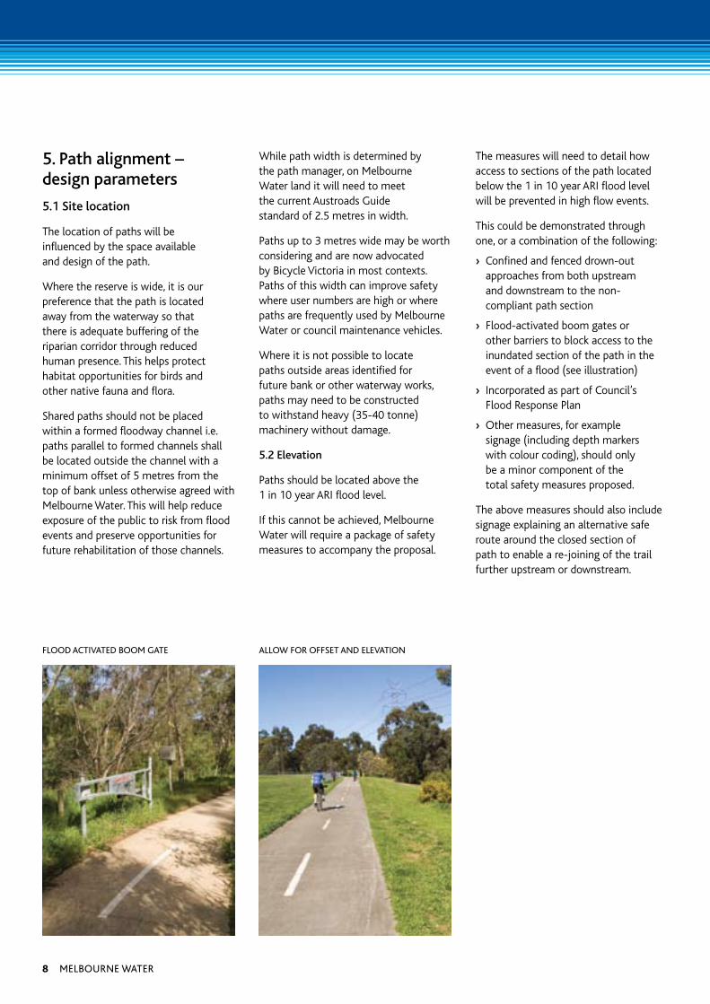
5. Path alignment – design parameters
5.1 Site location
The location of paths will be influenced by the space available and design of the path.
Where the reserve is wide, it is our preference that the path is located away from the waterway so that there is adequate buffering of the riparian corridor through reduced human presence. This helps protect habitat opportunities for birds and other native fauna and flora.
Shared paths should not be placed within a formed floodway channel i.e. paths parallel to formed channels shall be located outside the channel with a minimum offset of 5 metres from the top of bank unless otherwise agreed with Melbourne Water. This will help reduce exposure of the public to risk from flood events and preserve opportunities for future rehabilitation of those channels.
While path width is determined by the path manager, on Melbourne Water land it will need to meet the current Austroads Guide standard of 2.5 metres in width.
Paths up to 3 metres wide may be worth considering and are now advocated by Bicycle Victoria in most contexts. Paths of this width can improve safety where user numbers are high or where paths are frequently used by Melbourne Water or council maintenance vehicles.
Where it is not possible to locate paths outside areas identified for future bank or other waterway works, paths may need to be constructed to withstand heavy (35-40 tonne) machinery without damage.
5.2 Elevation
Paths should be located above the 1 in 10 year ARI flood level.
If this cannot be achieved, Melbourne Water will require a package of safety measures to accompany the proposal.
The measures will need to detail how access to sections of the path located below the 1 in 10 year ARI flood level will be prevented in high flow events.
This could be demonstrated through one, or a combination of the following:
› Confined and fenced drown-out approaches from both upstream and downstream to the non-compliant path section
› Flood-activated boom gates or other barriers to block access to the inundated section of the path in the event of a flood (see illustration)
› Incorporated as part of Council’s Flood Response Plan
› Other measures, for example signage (including depth markers with colour coding), should only be a minor component of the total safety measures proposed.
The above measures should also include signage explaining an alternative safe route around the closed section of path to enable a re-joining of the trail further upstream or downstream.
flood activated booM gate allow for offSet and elevation
8 Melbourne water
6. Significant biodiversity values
Waterway corridors contain some of the highest environmental values in urban areas. These values often relate to the stream itself and its immediate riparian fringe. Consequently, these values require protection from undue human activity and interference such as can be generated from the location of paths in close proximity to top of stream bank. An adequate offset from the stream will provide buffering of sensitive waterway environments and their habitat values.
Therefore, careful consideration should be given to path alignment and construction techniques, and/or mitigation options such as screening via vegetation, boardwalks and exclusion fencing. For highly significant areas, paths may need to be located at some distance from the stream.
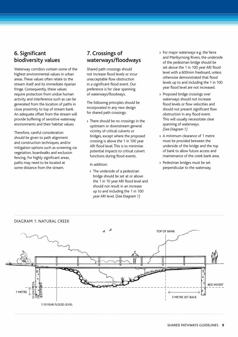
7. Crossings of waterways/floodways
Shared path crossings should not increase flood levels or incur unacceptable flow obstruction in a significant flood event. Our preference is for clear spanning of waterways/floodways.
The following principles should be incorporated in any new design for shared path crossings:
› There should be no crossings in the upstream or downstream general vicinity of critical culverts or bridges, except where the proposed crossing is above the 1 in 100 year ARI flood level. This is to minimise potential impacts to critical culvert functions during flood events.
In addition:
› The underside of a pedestrian bridge should be set at or above the 1 in 10 year ARI flood level and should not result in an increase up to and including the 1 in 100 year ARI level. (See Diagram 1)
› For major waterways e.g. the Yarra and Maribyrnong Rivers, the underside of the pedestrian bridge should be set above the 1 in 100 year ARI flood level with a 600mm freeboard, unless otherwise demonstrated that flood levels up to and including the 1 in 100 year flood level are not increased.
› Proposed bridge crossings over waterways should not increase flood levels or flow velocities and should not present significant flow obstruction in any flood event. This will usually necessitate clear spanning of waterways. (See Diagram 1)
› A minimum clearance of 1 metre must be provided between the underside of the bridge and the top of bank to allow future access and maintenance of the creek bank area.
› Pedestrian bridges must be set perpendicular to the waterway.
1:10 year flood level
1 Metre
bed invert
5 Metre Set back
DIAGRAM 1: NATuRAL CREEk
top of bank
Shared pathwayS guidelineS 9
› Bridge abutments must have a minimum offset of 5 metres from the top of bank or be outside the slipline, whichever is greater, or unless otherwise agreed by Melbourne Water. The setback distance may vary due to the creek bank profile and condition.
› Any foundations within the active flow path must extend below the waterway bed level by twice the calculated potential scour depth. The crossing superstructure must be appropriately anchored to the abutments/foundations.
› Rock beaching needs to be provided at the crossing location and both upstream and downstream of the bridge to prevent erosion. The beaching should be determined according to site conditions.
› Height clearances must be sufficient to enable machinery access to the underside of the crossing. Where this is not achievable appropriate rockwork/vegetation should be undertaken to minimise maintenance requirements.
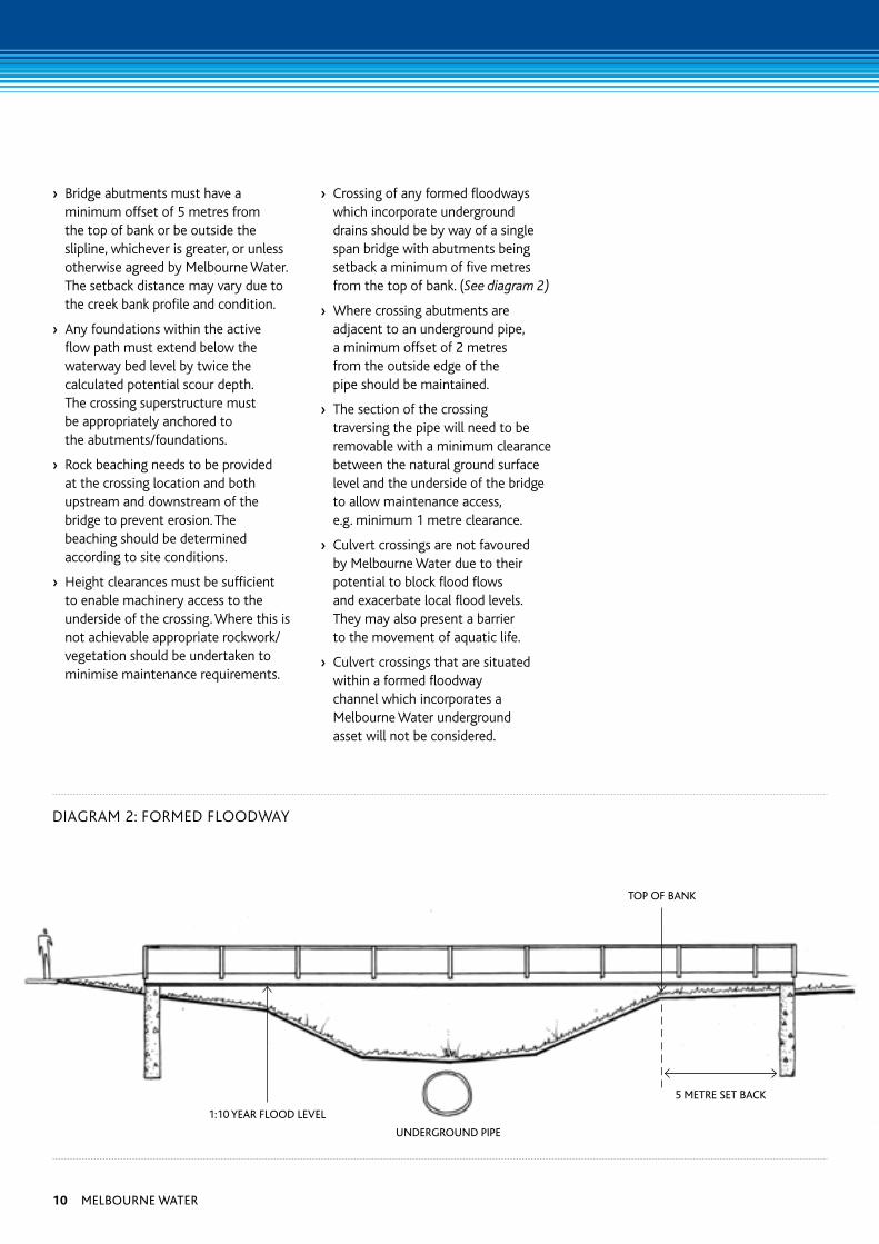
› Crossing of any formed floodways which incorporate underground drains should be by way of a single span bridge with abutments being setback a minimum of five metres from the top of bank. (See diagram 2)
› Where crossing abutments are adjacent to an underground pipe, a minimum offset of 2 metres from the outside edge of the pipe should be maintained.
› The section of the crossing traversing the pipe will need to be removable with a minimum clearance between the natural ground surface level and the underside of the bridge to allow maintenance access, e.g. minimum 1 metre clearance.
› Culvert crossings are not favoured by Melbourne Water due to their potential to block flood flows and exacerbate local flood levels. They may also present a barrier to the movement of aquatic life.
› Culvert crossings that are situated within a formed floodway channel which incorporates a Melbourne Water underground asset will not be considered.
DIAGRAM 2: FORMED FLOODWAY
1:10 year flood level
underground pipe
5 Metre Set back
top of bank
10 Melbourne water
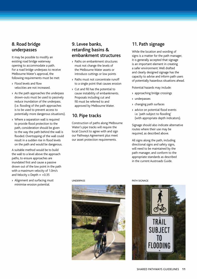
8. Road bridge underpasses
It may be possible to modify an existing road bridge waterway opening to accommodate a path. For a road bridge underpass to receive Melbourne Water’s approval, the following requirements must be met:
› Flood levels and flow velocities are not increased.
› As the path approaches the underpass drown-outs must be used to passively reduce inundation of the underpass. (i.e. flooding of the path approaches is to be used to prevent access to potentially more dangerous situations).
› Where a separation wall is required to provide flood protection to the path, consideration should be given to the way the path behind the wall is flooded. Overtopping of the wall could result in a sudden rise in flood levels on the path and would be dangerous.
A suitable method would be to build the wall to a level above the approach paths, to ensure approaches are inundated first and cause a passive drown out of the low point in the path with a maximum velocity of 1.0m/s and Velocity x Depth = <0.35
› Alignment and surfacing must minimise erosion potential.
9. Levee banks, retarding basins & embankment structures› Paths on embankment structures
must not change the levels of the Melbourne Water assets or introduce cuttings or low points
› Paths must not concentrate runoff to a single point that causes erosion
› Cut and fill has the potential to cause instability of embankments. Proposals including cut and fill must be referred to and approved by Melbourne Water.
10. Pipe tracks
Construction of paths along Melbourne Water’s pipe tracks will require the local Council to agree with and sign our Pathways Agreement plus meet our asset protection requirements.
11. Path signage
While the location and wording of signs is a matter for the path manager, it is generally accepted that signage is an important element in creating a safer environment. Well drafted and clearly designed signage has the capacity to advise and inform path users of potentially hazardous situations ahead.
Potential hazards may include:
› approaching bridge crossings
› underpasses
› changing path surfaces
› advice on potential flood events i.e. ‘path subject to flooding’ (with appropriate depth indicators).
Signage should also indicate alternative routes where their use may be required, as described above.
All signs along the path, including directional signs and safety signs, will need to be maintained by the path manager, and conform to the appropriate standards as described in the current Austroads Guide.
underpaSS path Signage
Shared pathwayS guidelineS 11
12 Melbourne water
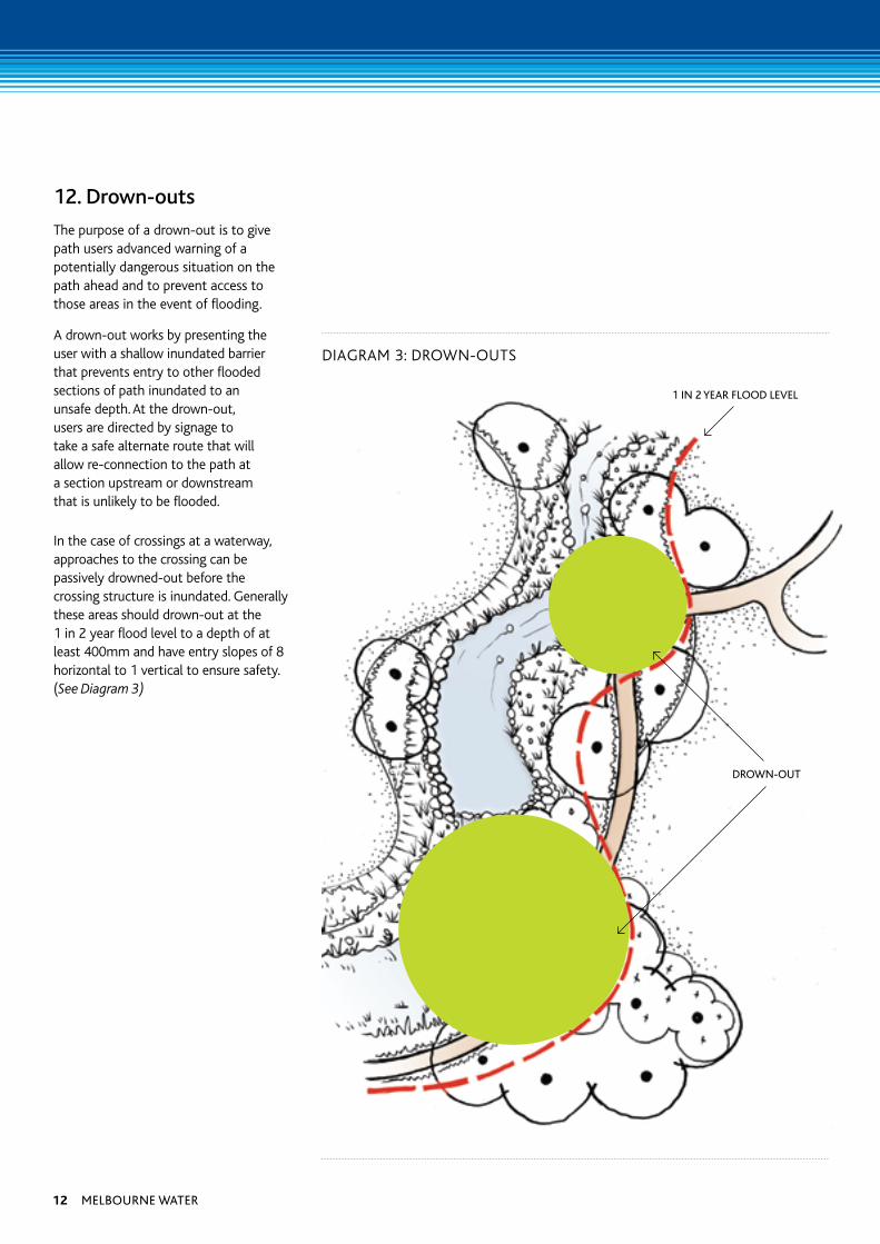
12. Drown-outs
The purpose of a drown-out is to give path users advanced warning of a potentially dangerous situation on the path ahead and to prevent access to those areas in the event of flooding.
A drown-out works by presenting the user with a shallow inundated barrier that prevents entry to other flooded sections of path inundated to an unsafe depth. At the drown-out, users are directed by signage to take a safe alternate route that will allow re-connection to the path at a section upstream or downstream that is unlikely to be flooded.
In the case of crossings at a waterway, approaches to the crossing can be passively drowned-out before the crossing structure is inundated. Generally these areas should drown-out at the 1 in 2 year flood level to a depth of at least 400mm and have entry slopes of 8 horizontal to 1 vertical to ensure safety. (See Diagram 3)
1 in 2 year flood level
drown-out
DIAGRAM 3: DROWN-OuTS
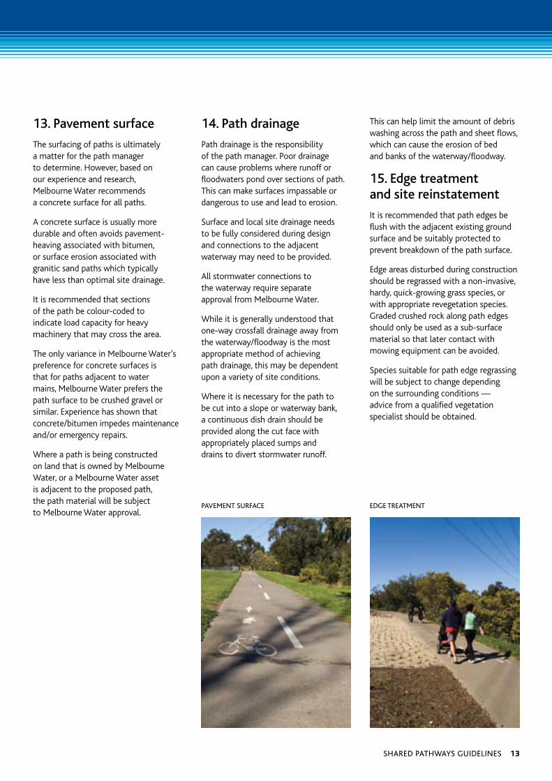
13. Pavement surface
The surfacing of paths is ultimately a matter for the path manager to determine. However, based on our experience and research, Melbourne Water recommends a concrete surface for all paths.
A concrete surface is usually more durable and often avoids pavement-heaving associated with bitumen, or surface erosion associated with granitic sand paths which typically have less than optimal site drainage.
It is recommended that sections of the path be colour-coded to indicate load capacity for heavy machinery that may cross the area.
The only variance in Melbourne Water’s preference for concrete surfaces is that for paths adjacent to water mains, Melbourne Water prefers the path surface to be crushed gravel or similar. Experience has shown that concrete/bitumen impedes maintenance and/or emergency repairs.
Where a path is being constructed on land that is owned by Melbourne Water, or a Melbourne Water asset is adjacent to the proposed path, the path material will be subject to Melbourne Water approval.
14. Path drainage
Path drainage is the responsibility of the path manager. Poor drainage can cause problems where runoff or floodwaters pond over sections of path. This can make surfaces impassable or dangerous to use and lead to erosion.
Surface and local site drainage needs to be fully considered during design and connections to the adjacent waterway may need to be provided.
All stormwater connections to the waterway require separate approval from Melbourne Water.
While it is generally understood that one-way crossfall drainage away from the waterway/floodway is the most appropriate method of achieving path drainage, this may be dependent upon a variety of site conditions.
Where it is necessary for the path to be cut into a slope or waterway bank, a continuous dish drain should be provided along the cut face with appropriately placed sumps and drains to divert stormwater runoff.
This can help limit the amount of debris washing across the path and sheet flows, which can cause the erosion of bed and banks of the waterway/floodway.
15. Edge treatment and site reinstatement
It is recommended that path edges be flush with the adjacent existing ground surface and be suitably protected to prevent breakdown of the path surface.
Edge areas disturbed during construction should be regrassed with a non-invasive, hardy, quick-growing grass species, or with appropriate revegetation species. Graded crushed rock along path edges should only be used as a sub-surface material so that later contact with mowing equipment can be avoided.
Species suitable for path edge regrassing will be subject to change depending on the surrounding conditions — advice from a qualified vegetation specialist should be obtained.
paveMent Surface edge treatMent
Shared pathwayS guidelineS 13
In circumstances where there is a surrounding cover of indigenous grasses and understorey, every effort should be made to:
› engage appropriate advice to assess the values associated with the remnant vegetation and how best to manage disturbance
› locate the path away from areas of more intact remnant vegetation
› construct the path using minimal disturbance techniques
› ensure minimal introduction of top soil for adjustment of surface levels as it is likely to be a source of weed germination
› ensure rehabilitation of the indigenous understorey through the engagement of appropriate vegetation and land management advice.
Where a path is to be used for both pedestrian/bicycle purposes and waterway maintenance access, the path edge must be capable of supporting maintenance vehicles and grass mowing equipment. Sections of path can be colour coded to indicate crossings for heavy machinery.
16. Lighting
While the location of path lighting is a matter for the path manager, it is recommended that path lighting be considered under all bridges or underpasses (The maintenance of lighting associated with the path will be the responsibility of the path manager).
17. Maintenance of paths
It is important that waterway corridor and pipe reserve paths and their immediate surrounds are maintained in a condition that sustains the life of the asset and provides for user safety.
A buffer of 2 metres each side of the path will need to be maintained by the path manager. Melbourne Water does not cut grass within this area under our mowing regimes — you will need to consider this issue as part of your path management plan.
It will also be necessary for the path manager to maintain any drains associated with the path. We recommended that for safety reasons path widths be maintained through regular trimming of overhanging branches and ground storey vegetation.
While litter and debris that collects on paths can be the result of flood events, it is the responsibility of the path manager to maintain the path and its surface in a safe condition.
It is recommended that the path manager undertake regular surveillance and sweeping to remove material such as soil, flood-deposited debris or other rubbish.
14 Melbourne water
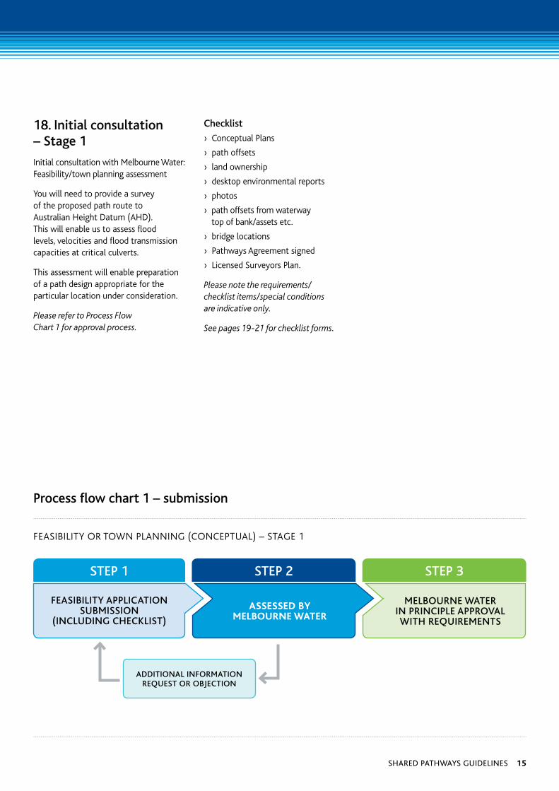
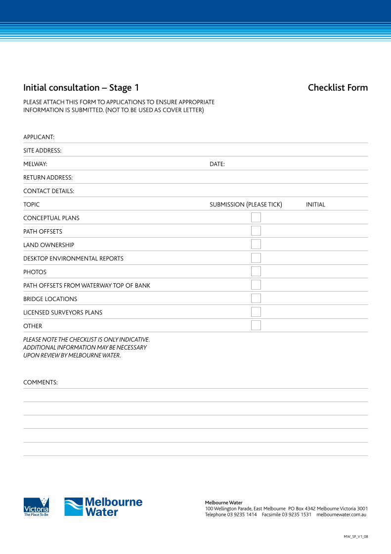
18. Initial consultation – Stage 1
Initial consultation with Melbourne Water: Feasibility/town planning assessment
You will need to provide a survey of the proposed path route to Australian Height Datum (AHD). This will enable us to assess flood levels, velocities and flood transmission capacities at critical culverts.
This assessment will enable preparation of a path design appropriate for the particular location under consideration.
Please refer to Process Flow Chart 1 for approval process.
Checklist
› Conceptual Plans
› path offsets
› land ownership
› desktop environmental reports
› photos
› path offsets from waterway top of bank/assets etc.
› bridge locations
› Pathways Agreement signed
› Licensed Surveyors Plan.
Please note the requirements/checklist items/special conditions are indicative only.
See pages 19-21 for checklist forms.
Process flow chart 1 – submission
FEASIbILITy APPLICATIon SubMISSIon
(InCLuDIng ChECKLIST)
AssEssED By mElBournE wAtEr
ADDITIonAL InFoRMATIon REquEST oR objECTIon
MELbouRnE wATER In PRInCIPLE APPRovAL wITh REquIREMEnTS
FEASIBILITY OR TOWN PLANNING (CONCEPTuAL) – STAGE 1
STEP 1 STEP 2 STEP 3
Shared pathwayS guidelineS 15
DESIgn APPLICATIon SubMISSIon
(InCLuDIng ChECKLIST)
AssEssED By mElBournE wAtEr
ADDITIonAL InFoRMATIon REquEST oR objECTIon
MELbouRnE wATER APPRovAL wITh
SPECIAL ConDITIonS
DESIGN OR TOWN PLANNING (DETAILED DESIGN) – STAGE 2
STEP 1 STEP 2 STEP 3
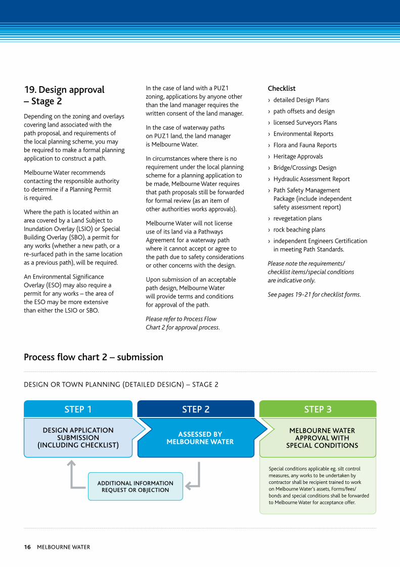
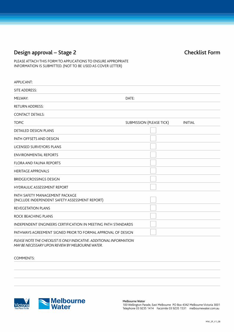
19. Design approval – Stage 2
Depending on the zoning and overlays covering land associated with the path proposal, and requirements of the local planning scheme, you may be required to make a formal planning application to construct a path.
Melbourne Water recommends contacting the responsible authority to determine if a Planning Permit is required.
Where the path is located within an area covered by a Land Subject to Inundation Overlay (LSIO) or Special Building Overlay (SBO), a permit for any works (whether a new path, or a re-surfaced path in the same location as a previous path), will be required.
An Environmental Significance Overlay (ESO) may also require a permit for any works – the area of the ESO may be more extensive than either the LSIO or SBO.
In the case of land with a PuZ1 zoning, applications by anyone other than the land manager requires the written consent of the land manager.
In the case of waterway paths on PuZ1 land, the land manager is Melbourne Water.
In circumstances where there is no requirement under the local planning scheme for a planning application to be made, Melbourne Water requires that path proposals still be forwarded for formal review (as an item of other authorities works approvals).
Melbourne Water will not license use of its land via a Pathways Agreement for a waterway path where it cannot accept or agree to the path due to safety considerations or other concerns with the design.
upon submission of an acceptable path design, Melbourne Water will provide terms and conditions for approval of the path.
Please refer to Process Flow Chart 2 for approval process.
Checklist
› detailed Design Plans
› path offsets and design
› licensed Surveyors Plans
› Environmental Reports
› Flora and Fauna Reports
› Heritage Approvals
› Bridge/Crossings Design
› Hydraulic Assessment Report
› Path Safety Management Package (include independent safety assessment report)
› revegetation plans
› rock beaching plans
› independent Engineers Certification in meeting Path Standards.
Please note the requirements/checklist items/special conditions are indicative only.
See pages 19-21 for checklist forms.
Process flow chart 2 – submission
Special conditions applicable eg. silt control measures, any works to be undertaken by contractor shall be recipient trained to work on Melbourne Water’s assets, Forms/fees/bonds and special conditions shall be forwarded to Melbourne Water for acceptance offer.
16 Melbourne water
Following items to be submitted prior to pre-inspection:
AcceptAnce/remittAnce Form, Fees/bond pAid, tAsk risk Assessment,
silt control meAsure plAns, Any other speciAl conditions
iF works Are sAtisFActory
prActicAl completion Form to be signed by both pArties
iF works Are sAtisFActory
end oF deFects Form to be signed by both pArties
melbourne wAter to reFund bond
CONSTRuCTION – STAGE 3 ACTION DOCuMENTATION
Pre-insPection
reSponSible party contactS Melbourne water’S
aSSet ServiceS inSpectionS officer
7 dayS notification See checkliSt
PrActicAL coMPLetion
reSponSible party contactS Melbourne water’S aSSet
ServiceS inSpectionS officer
7 dayS notification
end of defects Period
reSponSible party contactS Melbourne water’S aSSet
ServiceS inSpectionS officer
7 dayS notification
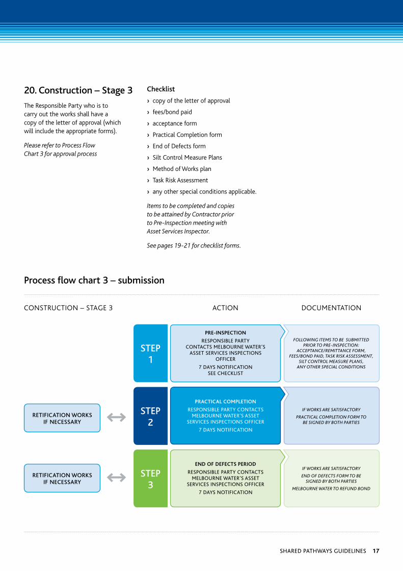
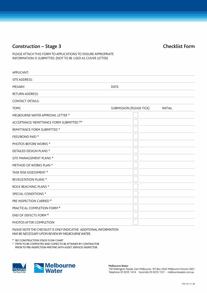
20. Construction – Stage 3
The Responsible Party who is to carry out the works shall have a copy of the letter of approval (which will include the appropriate forms).
Please refer to Process Flow Chart 3 for approval process
Checklist
› copy of the letter of approval
› fees/bond paid
› acceptance form
› Practical Completion form
› End of Defects form
› Silt Control Measure Plans
› Method of Works plan
› Task Risk Assessment
› any other special conditions applicable.
Items to be completed and copies to be attained by Contractor prior to Pre-Inspection meeting with Asset Services Inspector.
See pages 19-21 for checklist forms.
Process flow chart 3 – submission
RETIFICATIon woRKS IF nECESSARy
RETIFICATIon woRKS IF nECESSARy
STEP 1
STEP 2
STEP 3
Shared pathwayS guidelineS 17
glossary
Average Recurrence Interval (ARI): A statistical estimate of the average period in years between the occurrence of a flood of a given size or larger. The ARI of a flood event gives no indication of when a flood of that size will occur next.
Flood Level The maximum level that would be reached by floodwaters during a particular event.
Slipline The line of failure on banking.
100-year flood level The maximum level that would be reached by floodwaters during a 100-year event.
100-year event A large flooding event that has a probability of occurrence of 1 in 100 in any given year. Over a very long time period, such events would, on average, occur once per 100 years.
Riparian Streamside vegetation zone.
References
Austroads Guide to Traffic Engineering Practice Part 14 – Bicycles (1999)
Port Phillip and Westernport Regional River Health Strategy, Port Phillip and Westernport Catchment Management Authority and Melbourne Water (2006)
Contacting Melbourne water
IF YOu REquIRE FuRTHER INFORMATION PLEASE CONTACT MELBOuRNE WATER ASSET SERVICES TEAM FOR FuRTHER ASSISTANCE.
Asset Services Enquires: 03 9235 1414
website: http://melbournewater.com.au/ constructingnearassets
Guidelines may change, so please use latest version. Version dated September 2008.
Where design difficulties arise, it is important that path managers seek Melbourne Water’s advice regarding potential solutions.
Existing paths may not meet these guidelines. In these circumstances, all parties will need to work towards the achievement of safer standards.
It is only in circumstances of last resort that Melbourne Water may consider being indemnified from liability where a path manager seeks to undertake construction of a new path that has not received Melbourne Water approval.
In some circumstances this may be achieved by way of a formal legal agreement between the Council(s) and Melbourne Water and will need to be signed before a planning application or request for approval of the new path is made. If this is not achieved, in normal circumstances, Melbourne Water would be an objector to the planning permit application.
18 Melbourne water
Initial consultation – Stage 1 Checklist Form
PLEASE ATTACH THIS FORM TO APPLICATIONS TO ENSuRE APPROPRIATE INFORMATION IS SuBMITTED. (NOT TO BE uSED AS COVER LETTER)
APPLICANT:
SITE ADDRESS:
MELWAY: DATE:
RETuRN ADDRESS:
CONTACT DETAILS:
TOPIC SuBMISSION (PLEASE TICk) INITIAL
CONCEPTuAL PLANS
PATH OFFSETS
LAND OWNERSHIP
DESkTOP ENVIRONMENTAL REPORTS
PHOTOS
PATH OFFSETS FROM WATERWAY TOP OF BANk
BRIDGE LOCATIONS
LICENSED SuRVEYORS PLANS
OTHER
PleASe note the CheCklISt IS only InDICAtIve. ADDItIonAl InFormAtIon mAy be neCeSSAry uPon revIew by melbourne wAter.
COMMENTS:
Melbourne water 100 Wellington Parade, East Melbourne PO Box 4342 Melbourne Victoria 3001 Telephone 03 9235 1414 Facsimile 03 9235 1531 melbournewater.com.au
MW_SP_V1_08
Design approval – Stage 2 Checklist Form
PLEASE ATTACH THIS FORM TO APPLICATIONS TO ENSuRE APPROPRIATE INFORMATION IS SuBMITTED. (NOT TO BE uSED AS COVER LETTER)
APPLICANT:
SITE ADDRESS:
MELWAY: DATE:
RETuRN ADDRESS:
CONTACT DETAILS:
TOPIC SuBMISSION (PLEASE TICk) INITIAL
DETAILED DESIGN PLANS
PATH OFFSETS AND DESIGN
LICENSED SuRVEYORS PLANS
ENVIRONMENTAL REPORTS
FLORA AND FAuNA REPORTS
HERITAGE APPROVALS
BRIDGE/CROSSINGS DESIGN
HYDRAuLIC ASSESSMENT REPORT
PATH SAFETY MANAGEMENT PACkAGE (INCLuDE INDEPENDENT SAFETY ASSESSMENT REPORT)
REVEGETATION PLANS
ROCk BEACHING PLANS
INDEPENDENT ENGINEERS CERTIFICATION IN MEETING PATH STANDARDS
PATHWAYS AGREEMENT SIGNED PRIOR TO FORMAL APPROVAL OF DESIGN
PleASe note the CheCklISt IS only InDICAtIve. ADDItIonAl InFormAtIon mAy be neCeSSAry uPon revIew by melbourne wAter.
COMMENTS:
Melbourne water 100 Wellington Parade, East Melbourne PO Box 4342 Melbourne Victoria 3001 Telephone 03 9235 1414 Facsimile 03 9235 1531 melbournewater.com.au
MW_SP_V1_08
Construction – Stage 3 Checklist Form
PLEASE ATTACH THIS FORM TO APPLICATIONS TO ENSuRE APPROPRIATE INFORMATION IS SuBMITTED. (NOT TO BE uSED AS COVER LETTER)
APPLICANT:
SITE ADDRESS:
MELWAY: DATE:
RETuRN ADDRESS:
CONTACT DETAILS:
TOPIC SuBMISSION (PLEASE TICk) INITIAL
MELBOuRNE WATER APPROVAL LETTER *
ACCEPTANCE/ REMITTANCE FORM SuBMITTED #*
REMITTANCE FORM SuBMITTED *
FEES/BOND PAID *
PHOTOS BEFORE WORkS *
DETAILED DESIGN PLANS *
SITE MANAGEMENT PLANS *
METHOD OF WORkS PLAN *
TASk RISk ASSESSMENT *
REVEGETATION PLANS *
ROCk BEACHING PLANS *
SPECIAL CONDITIONS *
PRE INSPECTION CARRIED #
PRACTICAL COMPLETION FORM #
END OF DEFECTS FORM #
PHOTOS AFTER COMPLETION
PleASe note the CheCklISt IS only InDICAtIve. ADDItIonAl InFormAtIon mAy be neCeSSAry uPon revIew by melbourne wAter.
# See conStruction Stage flow chart * iteMS to be coMpleted and copieS to be attained by contractor
prior to pre-inSpection Meeting with aSSet ServiceS inSpector.
Melbourne water 100 Wellington Parade, East Melbourne PO Box 4342 Melbourne Victoria 3001 Telephone 03 9235 1414 Facsimile 03 9235 1531 melbournewater.com.au
MW_SP_V1_08
Melbourne water
100 Wellington Parade, East Melbourne PO Box 4342 Melbourne Victoria 3001 Telephone 131 722 Facsimile 03 9235 7200 melbournewater.com.au
For information on Melbourne’s water recources in languages other than English, call 131 722 or visit melbournewater.com.au and click on the Community Languages link.
ISBN 978-1-921603-00-6 (print) ISBN 978-1-921603-01-3 (web)
Disclaimer: This publication may be of assistance to you but Melbourne Water and its employees do not guarantee that the publication is without flaw of any kind or is wholly appropriate for your particular purposes and therefore disclaims all liability for any error, loss or other consequence which may arise from you relying on any information in this publication.
© Copyright January 2009 Melbourne Water Corporation All rights reserved