shandaken-belleayre mountani bike and cross … mountain bike/cross-country ski trail plan...
TRANSCRIPT
Concept Mountain Bike/Cross-Country Ski Trail Plan
Shandaken-Belleayre
Mountain Bike and Cross Country
Ski Trail System Concept Plan
Prepared by Eddie Walsh of Tahawus Trails, LLC and Mariah Keagy, Brooke
Scatchard of Sinuosity: Flowing Trails, LLC at the request of the Catskill
Watershed Corporation
March 22 2018
Concept Mountain Bike/Cross-Country Ski Trail Plan
2
Table of Contents
Page
Overview ____________________________________________________________ 3
Process _________________________________________________________ 4
Regional Existing Trail Systems____________________________________ 5
Opportunities____________________________________________________ 8
Constraints______________________________________________________ 11
Assessment Findings __________________________________________________ 12
Existing Conditions ______________________________________________ 13
Broad Improvement Prescriptions ________________________________ 15
Development Summary and Narrative– Mountain Bike____________________ 16
Development Narratives—Cross Country Skiing and Winter Biking _________ 22
Next Steps for Trail Development ________________________________ 25
Recommended Network Phasing Sequence ______________________________ 26
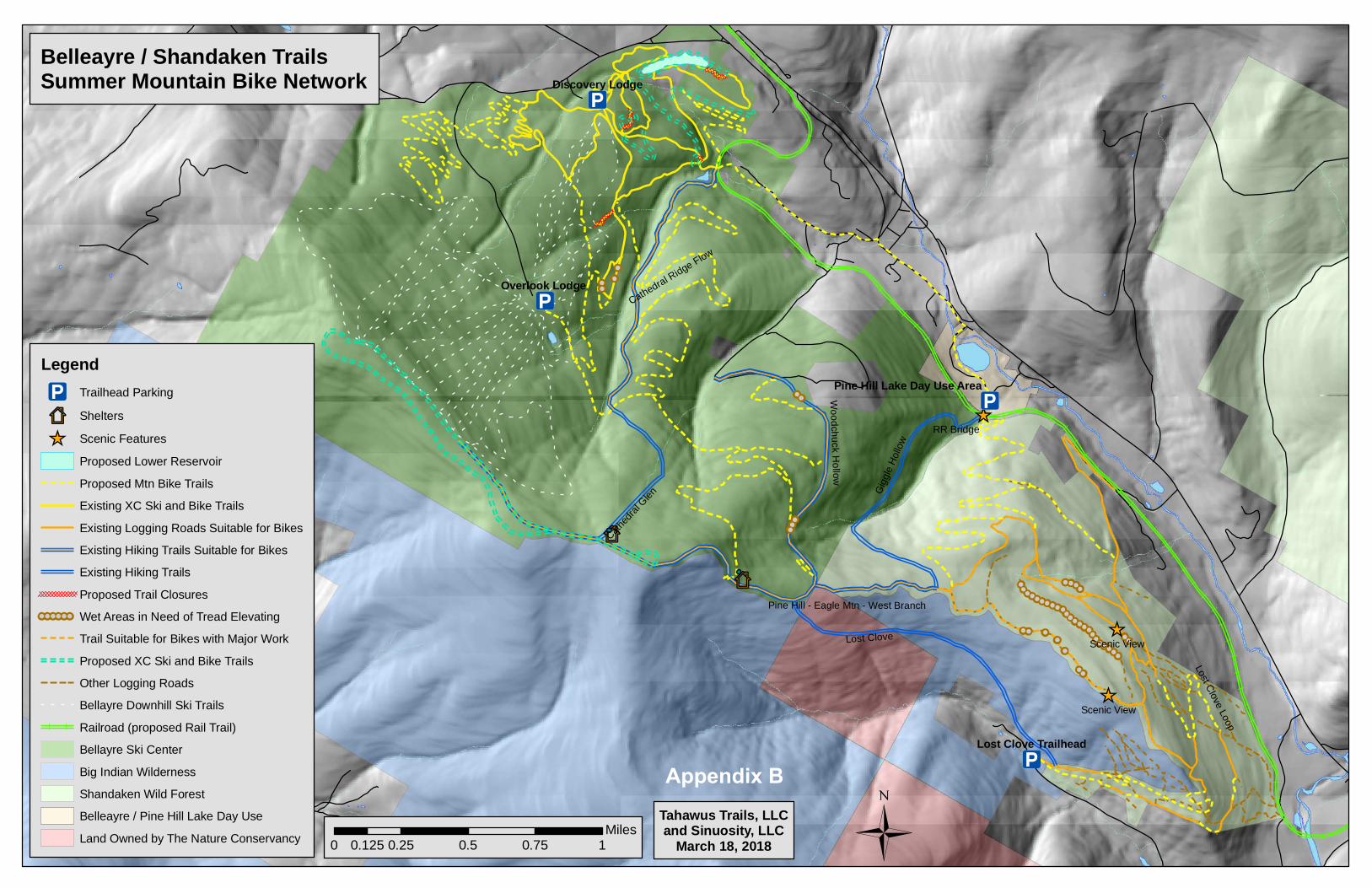
Appendix A: Additional Resources
Appendix B: Summer Map
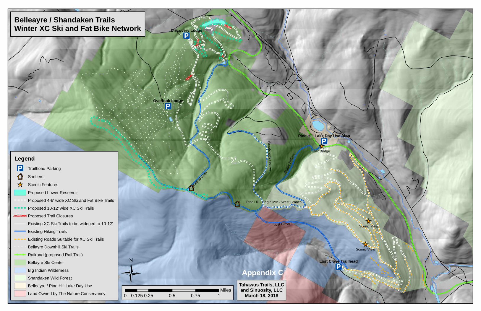
Appendix C: Winter Map
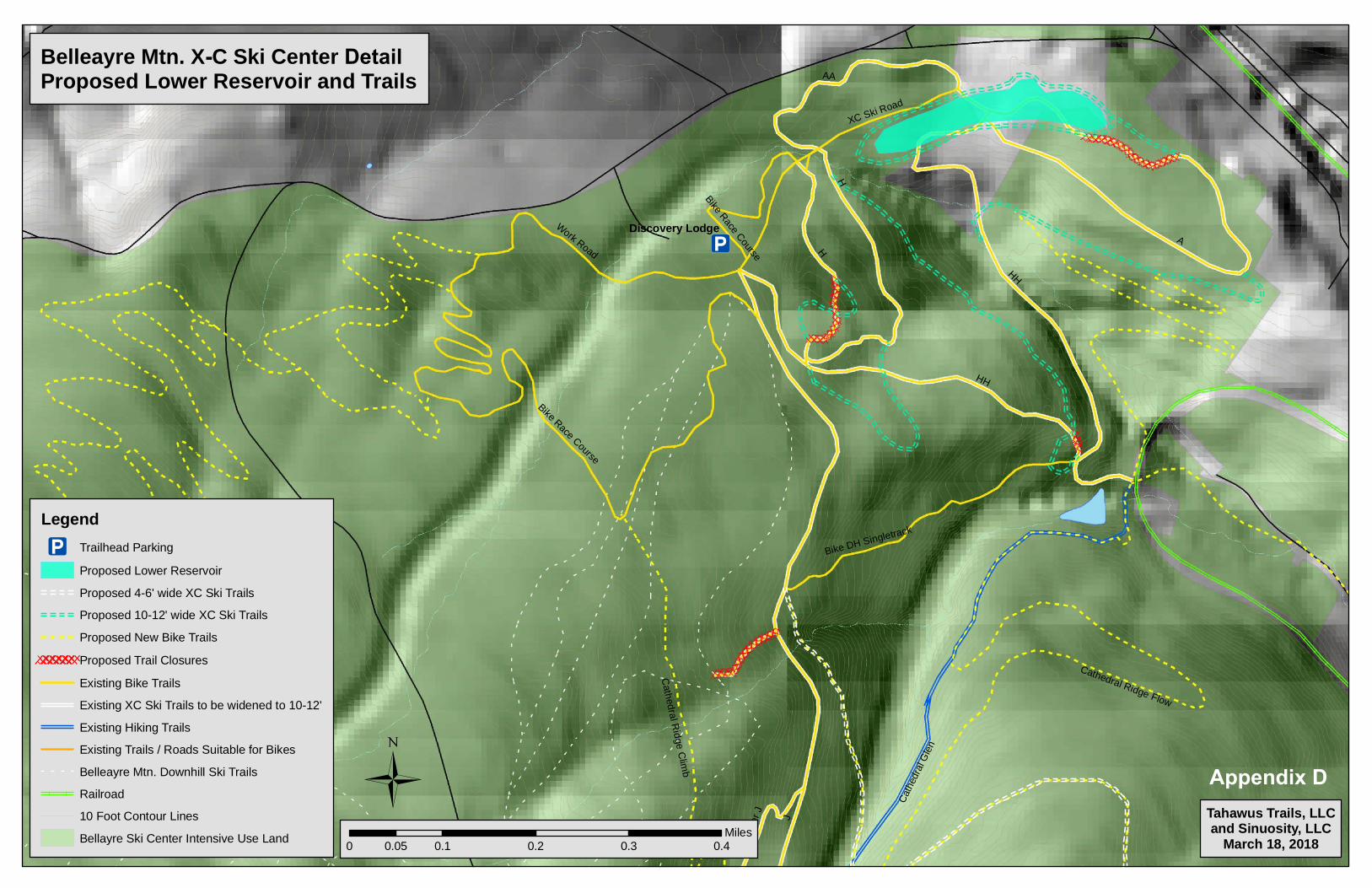
Appendix D: Cross Country Ski Area Detail Map
Concept Mountain Bike/Cross-Country Ski Trail Plan
3
Overview:
The objective of this Concept Mountain Bike and Cross-Country Ski Trail Plan is to identify and
conceptually design a trail network in order to expand opportunities for both modern mountain
biking and cross country skiing in the western parcel of the Shandaken Wild Forest and adjacent
Belleayre Mountain Ski Area Intensive Use within the town of Shandaken, NY in the Catskill Park.
In the Catskill Park State Land Master Plan Land Classification Amendment of 2014 , these portions
of land were identified for possible future recreational development for both skiing and mountain
biking. The adjacent Big Indian Wilderness Area was excluded from the scope of this plan.
The goal is create a destination-quality trail system designed to attract more users to this part of the
Catskill Mountains and to increase economic activity through enhanced year—round recreational
opportunities.
This plan was prepared at the request of the Catskill Watershed Corporation by the team of Eddie
Walsh of Tahawus Trails, LLC and Brooke Scatchard and Mariah Keagy of Sinuosity: Flowing
Trails, LLC.
Both Tahawus Trails, LLC and Sinuosity: Flowing Trails, LLC provide design, construction, and
maintenance services for diverse trail networks. The staff of Tahawus Trails, LLC have a history of
planning and building successful trail projects spanning over the past two decades with a variety of
creative trail structure designs dealing with steep and geologically challenging terrain in New York
State and the greater northeast. Sinuosity, LLC specializes in sustainable and fun mountain bike
specific trails and brings a strong history and commitment to mountain bike trails in Vermont.
The field assessment was completed to identify and classify existing trails and skid roads for inclu-
sion and exclusion in the plan, as well as general maintenance and reconstruction needs necessary
for those included in the plan. Zones were identified using maps and GPS which might be suitable
for new trail development, which fulfilled the requirements for sustainable grades and which might
lead to high quality recreational experiences while avoiding off-trail impacts to soils, waterways,
flora and fauna. Other goals included connectivity throughout the lands and identification of access
points and potential trailheads to utilize for these means, including a connection to the Pine Hill
hamlet.
The maps accompanying this report include the zones identified as viable areas for new trail con-
struction according to the parameters mentioned above of conservation and recreation, as well as
cost efficiency in construction. Although the conceptually designed trails are seen on maps as lines,
they represent only an identified corridor and approximate location potential for trails. The final de-
tailed trail alignments have not been identified in this plan. Further trail design, flagging of trail
alignments and features must be performed prior to construction. This next step may result in a
slightly altered mapped representation of the trails as shown on the conceptual maps.
Concept Mountain Bike/Cross-Country Ski Trail Plan
4
Process:
The team of Tahawus Trails, LLC and Sinuosity, LLC performed the services relevant to this plan
from April 2017 through March 2018. The process began with a meeting with NYS DEC Division of
Natural Resources andOlympic Regional Development Authority (ORDA) land managers and Cats-
kill Watershed and Development Corporation, and Catskill Center representative where the general
scope of the project was clearly defined. An overview of past planning work and site input from
the various individuals from these organizations and agencies most familiar with the parcels was
provided at that kick off meeting.
The meeting was followed up with 7 days of field assessments by Tahawus Trails LLC and Sinuosi-
ty LLC, during the Spring and Summer of 2017, where the entire area within the project scope was
analyzed and many of the existing woods roads and trails were mapped. The input, along with de-
tailed GIS analysis provided the basis for a draft conceptual plan which was provided to ORDA and
DEC stakeholders in October of 2017. Following that initial review, revisions were made to the
plan and preliminary concept plan was made public and presented at a public meeting held at Bel-
leayre’s Discovery Lodge in January 2018. Comments received during that public meeting and
through email correspondence with the CWCD were incorporated into this final plan.
This conceptual design and report do not represent trail alignments flagged in the field. They are
conceptual only, although all areas have been thoroughly field trothed for feasibility. The next
phase of trail planning involves revisions to the Unit Management Plans, with public input. That
should be followed by field locating precise trail and trail feature alignments, developing construc-
tion plans, and then implementing those plans.
Concept Mountain Bike/Cross-Country Ski Trail Plan
5
Regional Mountain Bike and Cross Country Skiing Trail Systems
There are a variety of opportunities for both mountain biking and skiing within the region. These
range greatly in terms of character, size and type of trail offered, but include the following:
• Rochester Hollow- Located across route 28 from the Big Indian Parcel, this trailhead and
parking area offers trails open to skiing and mountain biking within the Shandaken Wild For-
est. The total length is approximately 4.8 miles and provide opporunities to intermediate rid-
ers and skiers.
• Frost Valley YMCA (cross country skiing)- A half hour drive south, this facility offers 30 miles
of x-country skiing and hiking for a fee, as conditions allow, offering a range of trail difficul-
ties.
• Bluestone Wild Forest – Also a half hours drive east are 10 to 15 miles of trail open to moun-
tain biking, also called Jockey Hill and Onteora Lake Trails range from double track woods
roads to technical single track catering to intermediate to advanced riders. Sections of the
network are bootleg trails and extend onto private land.
• Windham Mountain Resort- Over half an hour drive northeast, this lift serviced downhill
bike park offers bike rentals and demos, as well as organized events throughout the season
for users who purchase lift tickets. During the past decade, Windham has hosted the World
Cup Downhill Mountain Bike Race and multiple cross country mountain bike racing events.
Currently, the resort offers ne beginner and two intermediate flow-style downhill trail as well
as multiple difficult and more technical descent trails. In the winter the country club offers
4.75 miles of cross country ski trails.
• Elm Ridge Wild Forest – Also in Windham, on NYS DEC lands, the Elm Ridge Wild Forest
has 14 miles of single track purpose-built mountain bike trails. Although these trail do offer a
range of trail challenge, they are designed and constructed to relatively simple standards and
lack modern features typical of world class mountain bike trail systems.
• Hathaway Trails – Half an hour to the north, the communities of Tannersville and Hunter are
developing an interconnected intermediate purpose-built mountain bike trail network.
• Lippman Park – Over one hour to the south, on the southern edge of the Catskills and adja-
cent to Vernooy Kill State Forest, Lippman Park is owned and managed by the Town of Wa-
warsing with over 14 miles of mountain bike specific trail densely packed into 170 acres. Of-
fering a wide range of technical challenge.
• Plattekill – Located about half an hour north, this ski area has been running lifts for mountain
bikes for 22 years and caters to intermediate and advanced riders.
• Catskill Scenic Trail – 26 miles of Rail Trail with the closest access near Plattekill, roughly 30
minutes north of this project area.
Concept Mountain Bike/Cross-Country Ski Trail Plan
6
Regional Mountain Bike and Cross Country Skiing Opportunities, continued
• Kenneth Wilson State Park—There is a mountain bike trail loop around this NYS DEC
Campground in the Town of Woodstock, about 25 minutes to the east of this project site.
• North—South Lake Campground—There are over 10 miles of trails suistable to mountain bik-
ing surrounding this NYS DEC Campground in Haines Falls. Although none of the trails are
purpose built for mountain biking, they provide opportunities for easy to advanced riding
• Round Top—Just outside of the Catskill Forest Preserve in Greene County, the Round Top trails
offer 20 of mountain bike miles of trails for a variety of skill levels approximately 40 minutes to
the northeast.
• Primitive Mountain Bike Corridors—Four identified backcountry bike corridors follow existing
(although they are not purpose-built mountain bike) trails within the Catskill Forest Preserve:
Overlook, Spruceton, Mink Hollow, and Balsam Lake. These rugged trails are suitable to inter-
mediate and advanced riders.
• Other trails within the Forest Preserve - The Catskill Forest Preserve contains over 200 miles of
backcountry trails. Although these trails are originally hiking trails, all are open to skiing and
all trails outside of Wilderness Areas are open to mountain biking. However, these trails are
rarely purpose-built for either use and rarely provide optimum experiences for either user
group.
Concept Mountain Bike/Cross-Country Ski Trail Plan
7
Organized Local Mountain Bike Events and Groups
There currently exists groups of mountain bikers in the area, organized through the local bike
shop and chapters of the International Mountain Bike Association. Working with these groups
offers the opportunity for volunteers, stewardship, support and appreciation of the proposed
bike trail network
Belleayre Mountain All Terrain Challenge- A mountain bike race event hosted by the local
bike shop from Woodstock, NY and part of the New York State Mountain Bike Series.
Local Bike Shop in Woodstock- Sales, service and rentals in Woodstock, NY. They offer week-
ly group rides and host regional events.
Fats in the Cats, IMBA chapter- A Kingston based bike club that builds, maintains, advocates
and hosts regional events in the Hudson Valley and the southern Catskills.
Renegade Mountain Bike Club – An Ulster and Sullivan County based mountain bike group
that organizes work trips and races in the Rondout Valley area of the southern Catskills.
Windham Area Recreation Foundation—A non-profit community organization devoted to
improving recreational opportunities in the Windham area, particularly mountain biking.
Round Top Mountain Bike Association—A community organization devoted to developing
and maintaining the trail system at Round Top in eastern Greene County.
“Team Overlook” - A 35 to 40 member bicycle team and club affiliated with Overlook Bikes in
Woodstock who organize races at Kenneth Wilson State Park and at Belleayre Mountain
and who are strong advocates for developing additional riding along the Route 28 corri-
dor.

Concept Mountain Bike/Cross-Country Ski Trail Plan
8
Opportunities and Current Infrastructure:
The target area for this conceptual design is adjacent, nearby, or encompassing supporting infra-
structure that should be incorporated into this trail system, as the opportunity arises.
Railroad Grade
The existing abandoned Ulster and Delaware Railroad grade runs approximately parallel to
Route 28 on the northeastern edge of the project area. It has a consistent gradual ascending
grade up the valley from Lasher Road to Highmount and Galli Gurci Road. The railroad
grade, has been identified in the Ulster County Long Range Transportation Plan as an ideal
long range Greenway Trail connector. It has the potential to connect all communities on the
Route 28 corridor, from Kingston to Margaretville with family friendly trail users of all types,
including biking and cross country skiing. The Town of Shandaken Comprehensive Recrea-
tion Master Plan further highlights the potential for trail connectivity within the Town. The
railroad grade intersects with all major potential access points to the Big Indian and Belleayre
parcels, including Lasher Road, Winding Mountain Road, Giggle Hollow Trail at Pine Hill
Day Use Area, Woodchuck Hollow Road, Station Road, Bonneview Road, and Galli Gurci
Road.
Although technically outside the scope of this plan (the railroad grade is not on NYS DEC owned
lands) it is a highly valuable potential component of a trail system incorporating both DEC
Units as it ultimately can provide realtively easy access for entrance to or exit from any part
of the trail system, including from / to the Pine Hill Hamlet.
Pine Hill Lake Day Use Area
Trailhead and Parking Opportunity. Parking facilities exist to support a trail network, picnick-
ing, trailhead, signage and other recreational opportunities are offered for a day use fee at
Pine Hill Lake Park. The Giggle Hollow hiking trail currently connects this park to up to the
ridgeline. Access to the Railroad Grade is currently enabled through social trails at either side
of the railroad trestle bridge. This ORDA managed area is seasonally open with restricted
hours and only by paying a day isefee.
Shandaken Wild Forest (Big Indian Parcel)
Existing Skid and Logging Roads- There is a network of existing skid and logging roads that run
throughout the Wild Forest classified lands. In places they are maintained at full width, while
others have received no maintenance. This quality of these skid roads vary greatly. Where
their grades are moderate and are aligned against the prevailing hillside grades, they are
generally sustainable with bench cut and fill construction. However, the majority of the
roads use fall line or near fall line alignments on extremely steep slopes which are unsustain-
able and unsuitable for recreation trails except for difficult backcountry skiing. Furthermore,
the layout of this skid road network, which is typical of most networks, contains few loop
opportunities, with many dead ends extraction routes. The conceptual plan integrates this
existing infrastructure as much as is feasible.
Concept Mountain Bike/Cross-Country Ski Trail Plan
9
Opportunities continued..
Shandaken Wild Forest—Existing Infrastructure continued..
Other Existing Forest Roads - There is an approximately 5 mile network of developed, grad-
ed roads which were improved for previously proposed development beginning from
Winding Mountain Road and climbing to the central part of the parcel. This road system
involves a long steep climb or descent to the railroad grade but more moderate grades
higher on mountain side.
Lost Clove Trail, trailhead, and Parking Area- A small trailhead exists for the Lost Clove Trail
off of the dead end Lost Clove Rd. The 2.6 mile hiking and winter use trail enters the Big
Indian Wilderness Area as it climbs to reach the ridgeline and further on the Pine Hill
West Branch Trail. The Lost Clove Trail is aligned too steep to accommodate anything but
very difficult cross country skiing and due to its location within the Wilderness Area, can
not accommodate mountain biking. There is a network of skid roads leading to northeast
from the Lost Clove Trailhead. As with other skid roads within the Wild Forest, some
sections are suitable and sustainable, while many are too steeply aligned , lead to the Wil-
derness Area and/or dead end.
Belleayre Ski Area—Existing Infrastructure
Cross Country Ski Trail—Includes a network of approximately 5.7 miles of cross country ski
trails exists near the base of the ski area, with access from Discovery Lodge and a simple
trailhead at the maintenance building. These are mapped and blazed, treadway widths
varying between 2 to 12 feet.
Mountain Bike Trails— All Cross Country Ski Trails are currently open to mountain biking,
and the area includes some constructed single track trails interlaced with some non-
maintained and likely non-sanctioned mountain bike trails. None of the single-track trails
are blazed or mapped. The Belleayre Mountain All Terrain Challenge Biking Event incor-
porates many of these trails.
Upper and Lower Mountain Ski Trails – All downhill ski and access trails are currently open
to mountain biking although none are purpose built or designed for modern mountain
biking with flow trail elements.
Hiking Trails – At the high point of Belleayre Mountain, the Lost Clove Trail connects from
Lost Clove Road, the Pine Hill – West Branch Trail connects from south, and continues
easterly down the ridge to connect with the Giggle Hollow Trail to the Pine Hill Day Use
Area. The Cathedral Glen trail ascends from the Village of Pine Hill to the ridgeline of
Belleayre Mountain, between the summit of Belleayre and the top of the ski lifts. None of
the hiking trails are purpose built or designed for mountain biking. And only the lower
half of the Cathedral Glen Trail and the upper portions of the Giggle Hollow Trail are suit-
able for intermediate level mountain biking. None of those trails are graded properly for
any type of cross country skiing aside from more difficult backcountry skiing opportuni-
ties.
Concept Mountain Bike/Cross-Country Ski Trail Plan
10
Opportunities continued..
Belleayre Ski Area—Existing Infrastructure continued
Trailheads and Parking Lots - The existing cross country ski and bike network has an existing
parking lot with lots of space, as well as an informational kiosk in place at Discovery Lodge
and the Maintenance Building. Additionally, the skiers’ parking lots at mid-mountain at the
Overlook Lodge provides ample parking.
Connections to Pine Hill —The village of Pine Hill offers meals and accomodations to potential
visitors with associated parking. The village is geographically situated as a potential hub be-
tween the two parcels, with potential for new direct trail connections via Bonnie View Ave-
nue and to the Day Use Area.
Existing Natural Feature Opportunities
Soils- The soils are generally clay-based with sandstone and shale boulders with bedrock exposed in
ledge formations typical of the Catskill Mountains. These soils are generally relatively resistant to
erosion, provided the trails do not utilize fall line alignments and are designed and constructed to
minimize water flow down the trail grades. The high content of small stones and gravel blended in
with the clay can be easily displaced on steeper grades, creating an unstable surface. Due to the
high clay content in the soils saturated wet areas with seasonal seeps should be avoided as much as
possible.
Terrain- There is great variety in the terrain across the two units. Gently to moderately sloped ter-
rain allows for sheet drainage off trail, if constructed properly and can lead to sustainable and dura-
ble trail surfaces. Moderately sloped terrain also allows for the simplest construction. This is
most prevalent on the middle and Lower Mountain at the Belleayre Ski Area, on the ridge east of
Cathedral Glen, and in the central part of the Wild Forest above 1800 feet of elevations Steeper ter-
rain is most present just below the top of the ridgeline slopes and along the western edges of most
the two major drainages.
Viewpoints- Opportunities for views exist from both the top of Belleayre ridgeline, the clearings
near the top of the improved road access in the central portion of the Wild forest parcel as well as
on the Belleayre ski area.
Aesthetically appealing forested areas- Section of the forest are quite aesthetically appealing, with
tall canopies and fern ground cover, interspersed with large fern topped boulders.

Concept Mountain Bike/Cross-Country Ski Trail Plan
11
Constraints for Suitable Trail Alignment
Steep Terrain/Cliff Bands- Sections of the parts of the project area are not possible to construct trail
in due to cliff and ledge constraints. Other steep sections of terrain were generally avoided when
possible due the higher cost involved in developing trails. Ski trails with greater widths can cause an
additional challenge when traversing steep terrain.
Steep Drainages- Many of the drainages become quite steep sided and deep further down the slope
of the project area. To sustainably construct trails across these steep and deep drainages extensive,
sidehill alignment must be used and stone crib walls would need to be constructed to stabilize the
upslope and downslope of the trail treadway. Due the relative cost of constructing trails in this
manner, these areas, although feasible are less desirable areas in which to work.
Seeps and poorly drained soils- Sections of seeps and poorly drained soils occur in areas, especially
on some of the flatter plateaus between rock bands. On the lower elevations near the base of the
ridge in places, there are seasonal and intermittent seeps on steep terrain. All wet areas can prove a
constraint for bike and cross country ski trail locations. Wet areas, like steep slopes, are feasible to
develop trails through but more costly due to the tread hardening or elevating and extensive drain-
age measures required.
Private Property- Private property, in the form of enclosed in-holdings or peninsular cutouts, creates
a constraints in some locations. Given that the major axis of the Forest Preserve units are east to
west and that connectivity from primary access points crosses the mountain sides, traversing trails
are required for connectivity. Private property can constrain the ability to traverse slopes in some
areas. This is especially true towards the bottom of slopes in this area where the majority of inhold-
ings exist.
Specificity of Grades for Beginner/Intermediate Enjoyable Bike Trails- Sustainable, fun, and main-
tainable bike trails for beginner and intermediate riders are best built in very moderately sloped and
well drained soils. Uphill travel trails must provide relief and not climb too aggressively. Turns and
trail grades must be gradual enough to avoid excessive braking during downhill travel. Additional-
ly, cross slopes must be moderate enough to construct corners that suit riders in either direction.
Climbing turns that are too steep can cause user created soil displacement due to tire spinning,
while downhill turns that are too steep can lead to user created “brake bumps.” Both are forms of
user created tread degradation that can be avoided by proper trail siting on appropriate grades for
the intended level of use and user.
The study area has numerous steeper slopes where such moderate grades would be difficult to con-
struct and where moderately graded turns can not be aligned. These are avoided in the conceptual
plan and must be further designed at the micro-level to create an optimal trail system for mountain
biking
Concept Mountain Bike/Cross-Country Ski Trail Plan
12
Trail Assessment Findings
The following is a summary of the trail assessment and design findings, in addition to those that were includ-
ed above in the opportunities/constraints.
Trailheads and Access Points
There are three primary access points to these units: from the Parking Lots at the Belleayre Ski Ar-
ea, from the Lost Clove Trailhead, and directly from Pine Hill. Both parking areas provide enough
parking to accommodate the expected use and Pine Hill has the potential to serve as a base for mul-
tiple day outings. The Pine Hill Day Use area is a secondary trail access point and trailhead area.
However, due to the steep climb to access the main trail network, it will provide only intermediate
user access. As previously mentioned, the Pine Hill Day Use area is currently only open seasonally
and with limited hours. To better serve as an access point, a direct trail connection from the village
of Pine Hill can be made to the Day Use area and the hours and seasons of operation can be expand-
ed for passive recreation use like mountain biking, hiking, and cross country skiing.
There is also access to the units at Winding Mountain Road and off Lasher Road. Winding Moun-
tain Road has only an easement connection and no opportunities for direction parking. However,
user can access the parcel from other trailheads either by crossing Route 28 from Rochester Hollow,
or potential connections along the Ulster—Delaware Railroad Grade. Lasher Road has a former log
landing just south of its crossing of the railroad grade. Although this area can be developed into an
additional parking lot and trailhead, it is not desirable as a primary access direct access point due to
steep and wet terrain constraints which must be traversed to access the main trail system closer to
the ridge line. The Lasher Road access does serve as an ideal secondary trailhead for the trail sys-
tem if the Ulster and Delaware railroad grade is developed into a trail.
Skid Roads
Old skid roads where assessed and categorized as suitable or not-suitable to be incorporated into
the plan. Of these, approximately 10% were deemed suitable for inclusion into the conceptual de-
sign for this network. Skid roads that were excluded fell into one of three categories: too steep (and
sometimes currently eroding), too poorly draining to be cost effective to remedy and include, and/
or not providing connectivity with the remainder the of the designed network. Even on the skid
road sections to be included in the trail network, final design work must plan for grade reversals /
rolling grade dips, choke points, and subtle alignment decisions with the wider corridor of the roads
to create a sustainable, easily maintained trail. While some of the steeper roads are unsustainable
for summer use, they are suitable for advanced backcountry skiing opportunities. Advanced
downhill backcountry skiing opportunities were not included in this conceptual plan since that style
of skiing is generally not considered classic cross country skiing.
Concept Mountain Bike/Cross-Country Ski Trail Plan
13
Trail Assessment Findings, continued..
Existing Natural Features
Terrain- The most gentle terrain was found in the central portion of the Wild Forest parcel, around
the existing lower Cross Country ski trail system, and along the top of the ridgelines. The remainder
of the units are either moderately sloped or steeply sloped. The steepest terrain is typically along the
sides of the hollows and adjacent to the streams and on the eastern edge of the ridgeline on the Wild
Forest Parcel. There are typical Catskill ledge systems which we determined to be un-buildable ter-
rain at approximately 1,900 feet of elevation on the eastern edge of the ridge, and shorter ledge sys-
tems between 2,800 and 3,200 feet elevation on Belleayre Mountain.
Drainage Crossings- Drainage crossings were determined to be most feasible higher on the slopes,
where the depth of the drainages were at their minimum and with the most moderately sloped
sides. Where drainages are deep and steep sided, long, high and thereby costly bridges would be
necessary and were avoided whenever possible.
A variety of new stream and drainage crossings will be needed according to this conceptual plan,.
The most significant bridge crossing is in the Cathedral Glen drainage where the new connector
trail is proposed to cross the mid point of the ravine. Several short crossings will also be needed at
the headwall of Woodchuck Hollow on the primary trail connecting the Wild Forest unit with the
Intensive Use Area. Several longer but short span crossings will also be needed in the central part of
the Wild Forest on some of the wet existing woods roads near the ridgeline.
Incorporating Natural Features- This design aims to highlight the aesthetically appealing attributes
of the area as much as possible. For this reason, the existing scenic vistas were included in this de-
sign. Areas where the forest was still in early stages of re-growth and regeneration from recent har-
vests were generally favored less than areas that highlighted open hardwood canopies with fern un-
derstories. As is typical with the Catskill Mountains, there are abundant opportunities to route
trails near interesting geological features such as ledges and large boulders, particularly on the
northern side of the ridge. This conceptual plan routes trails in areas where these features are pre-
sent but the final detailed design of any trails should incorporate these features more thoroughly in
the form of natural gateways, anchors, and tread features.
Concept Mountain Bike/Cross-Country Ski Trail Plan
14
Trail Assessment Findings, Existing Trails, continued
Existing Trails
The Cathedral Glen Trail connects the top of Belleayre Mountain at the Cathedral Glen Lean-to on
the eastern edge of the Belleayre Ski Area down to Pine Hill, ending at the Ulster and Delaware
Railroad grade, next to the snow-making pond. The upper 500 feet in elevation change is steeply
co-aligned or adjacent to the Cathedral Glen ski trail. From approximately 2500 feet in elevation
down to the railroad grade at approximately 1800 feet, the trail is a narrow single track, descending
just east of the Cathedral Glen stream. The upper portion is too steep for anything but extremely
difficult downhill mountain biking or advanced skiing and will require high maintenance inputs to
be sustainable. The lower two thirds is more moderately graded and a mix between fall line align-
ments and sustainable near -“contour” alignments. It currently makes for a fun intermediate level
descent trail, although several re-alignments would be optimal to eliminate steeper grades and
turns and damage that would result from skidding with higher use.
The Giggle Hollow Trail extends from the Pine Hill Park up to the ridgeline, which it joins with the
Pine Hill, Eagle Mountain, West Branch Trail. The uppermost section is suitable and in sustainable
condition, but it deteriorates dramatically with it’s first integration with the adjacent stream. The
rough texture of the tread, eroded surface, and steep alignment make it ill suited for sustainable
or high quality mountain biking
Pine Hill, Eagle Mountain, West Branch Trail connects the ridgeline down to Woodchuck Hollow
Rd. Overall the trail is in maintainable shape and can be integrated with a few alterations as a
downhill directional mountain bike trail, however, many sections are too steep to climb for uphill
travel for all but the most advanced and fit trail users.
Belleayre Cross Country Ski/Bike Network – The existing cross country network uses optimal ter-
rain for intermediate and beginner biking and skiing loops. Although each trail will require specif-
ic re-alignments to improve the experience for the intended challenge rating. In most cases, this
involves moderating trail grades and in some cases widening and removing obstructions from the
treadway.
Belleayre Downhill Ski Trails - The existing downhill ski trails are currently open to mountain bik-
ing but are generally too steeply aligned for a higher use trail system. The network of truck roads
accessing the trails are more suitable for mountain biking but are not purpose built or designed for
sustainable or enjoyable riding. Excellent opportunities do exist to incorporate components of both
types of trails as well as trailless areas in between ski runs to create high quality—even world class
mountain biking, particularly on the mid lower mountain with significant additional design work
and purpose built development. However, connections between the top of the mountain and the
lodges were not considered due to the desire by ORDA to refrain from developing a comprehen-
sive lift-serviced bike park and the associated management and safety infrastructure required to
operate such a service through this plan at this time. Such a planning process will need to simulta-
neously take into account the sites’ opportunities for trail development, operational plans, and
long term financial considerations to make such and endeavor sustainable.

Concept Mountain Bike/Cross-Country Ski Trail Plan
15
Broad Improvement Prescriptions
The following prescriptions would bring sections of roads/trail up to a maintainable status for the
suggested use, and would be necessary for inclusion in the proposed trail plan conceptually de-
signed in this report. All detailed design work should be completed by a professional trail designer,
documented , and approved by land managers prior to construction.
Drainage and re-grading of sections of Skid Road- Sections of existing skid roads to be included in
this plan will need drainage installation and regrading in some areas to create appropriately drained
tread ways with frequent rolling grade dips (grade reversals). Choke stones should be incorporated
to narrow the tread down and control user speeds on mountain bike trails and to create more of a
singletrack feel.
Reroute of unsustainable sections – Many sections of existing trails and skid roads will require re-
routes where optimal slopes and drainage can not be attained through re-grading. Most of these are
outlined in the maps, but minor relocations and trail alignment adjustments are not shown. The
details of which sections are to be relocated should be outlined in the trail master plan.
Concept Mountain Bike/Cross-Country Ski Trail Plan
16
Mountain Biking
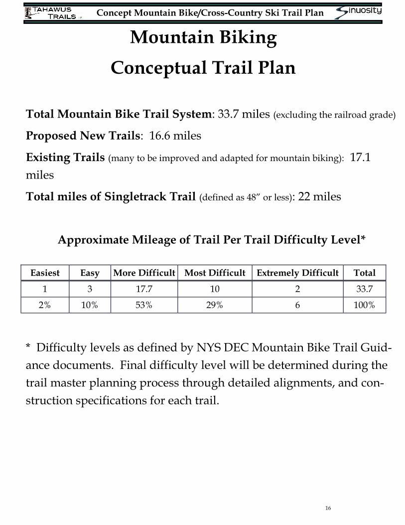
Conceptual Trail Plan
Total Mountain Bike Trail System: 33.7 miles (excluding the railroad grade)
Proposed New Trails: 16.6 miles
Existing Trails (many to be improved and adapted for mountain biking): 17.1
miles
Total miles of Singletrack Trail (defined as 48” or less): 22 miles
Approximate Mileage of Trail Per Trail Difficulty Level*
* Difficulty levels as defined by NYS DEC Mountain Bike Trail Guid-
ance documents. Final difficulty level will be determined during the
trail master planning process through detailed alignments, and con-
struction specifications for each trail.
Easiest Easy More Difficult Most Difficult Extremely Difficult Total
1 3 17.7 10 2 33.7
2% 10% 53% 29% 6 100%
Concept Mountain Bike/Cross-Country Ski Trail Plan
17
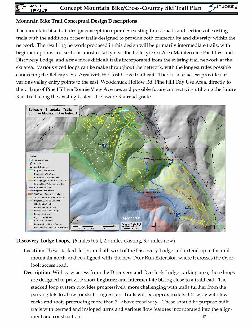
Mountain Bike Trail Conceptual Design Descriptions
The mountain bike trail design concept incorporates existing forest roads and sections of existing
trails with the additions of new trails designed to provide both connectivity and diversity within the
network. The resulting network proposed in this design will be primarily intermediate trails, with
beginner options and sections, most notably near the Belleayre ski Area Maintenance Facilities and-
Discovery Lodge, and a few more difficult trails incorporated from the existing trail network at the
ski area. Various sized loops can be make throughout the network, with the longest rides possible
connecting the Belleayre Ski Area with the Lost Clove trailhead. There is also access provided at
various valley entry points to the east: Woodchuck Hollow Rd, Pine Hill Day Use Area, directly to
the village of Pine Hill via Bonnie View Avenue, and possible future connectivity utilizing the future
Rail Trail along the existing Ulster—Delaware Railroad grade.
Discovery Lodge Loops, (6 miles total, 2.5 miles existing, 3.5 miles new)
Location: These stacked loops are both west of the Discovery Lodge and extend up to the mid-
mountain north and co-aligned with the new Deer Run Extension where it crosses the Over-
look access road.
Description: With easy access from the Discovery and Overlook Lodge parking area, these loops
are designed to provide short beginner and intermediate biking close to a trailhead. The
stacked loop system provides progressively more challenging with trails further from the
parking lots to allow for skill progression. Trails will be approximately 3-5’ wide with few
rocks and roots protruding more than 3” above tread way. These should be purpose built
trails with bermed and insloped turns and various flow features incorporated into the align-
ment and construction.
Concept Mountain Bike/Cross-Country Ski Trail Plan
18
Mountain Bike Trail Conceptual Design Descriptions, continued
Cathedral Glen Trails (12.3 miles total, 6 miles existing, 6.3 miles new)
Location: These existing trails with new trail additions are accessed from the Discovery Lodge Park-
ing lot and loop southeast of the lodge. Further south a “flow” style trail and connector trails
allow for linkage south to the remainder of the network.
Description: The existing trail network consists of intermediate trails ranging from single track (6-
12” tread width) to wider forest roads and cross country ski trails. Added to this network of
looping existing trails will be a trail that climbs up to the Overlook Lodge area and then over to
Cathedral Glen, where riders will have the option to continue southeast to the remainder of the
network or turn downhill on to a newly constructed intermediate “flow” trail down along the
ridge east of the Cathedral Glen stream. The flow trail will be characterized by a trail experience
that allows the mountain biker to maintain momentum and speed
Woodchuck Hollow Area (4.2 miles total, 1.4 miles existing, 2.8 miles new)
Location: In the middle of the network, a loop can be accessed via a new connector from the top of
the Cathedral Glen Bike Trails, through the Lost Clove and Winding Mountain Loops at the
southern end of the network, or from the existing trail to Pine Hill which utilizes Woodchuck
Hollow Road.
Description: The southern leg of the Woodchuck Hollow
loop consists of the existing trail, which could be used in
a downhill direction (with minimal reconstruction and
drainage improvements). The existing trail is steep in
some sections and would be an excessively challenging
climb on a bike. A newly constructed trail would allow
for a more gradual return/uphill or downhill option
that picks it’s way through the rock bands and mature
hardwood forests between Cathedral Glen, Woodchuck
Hollow Rd, and the Pine Hill-Eagle Mountain-West
Branch Trail. The existing trail has a corridor width of a
retired logging road, with a 12-24” impacted tread and
with existing rocks, roots, and steepness and is at an in-
termediate level. The newly constructed leg would be
more intermediate rather than beginner, due to some
regions of surface rock. The trail will maintain moderate
grades by traversing the slope with banked turns, creat-
ing an enjoyable dual direction experience through
these picturesque forests of mature hardwoods.
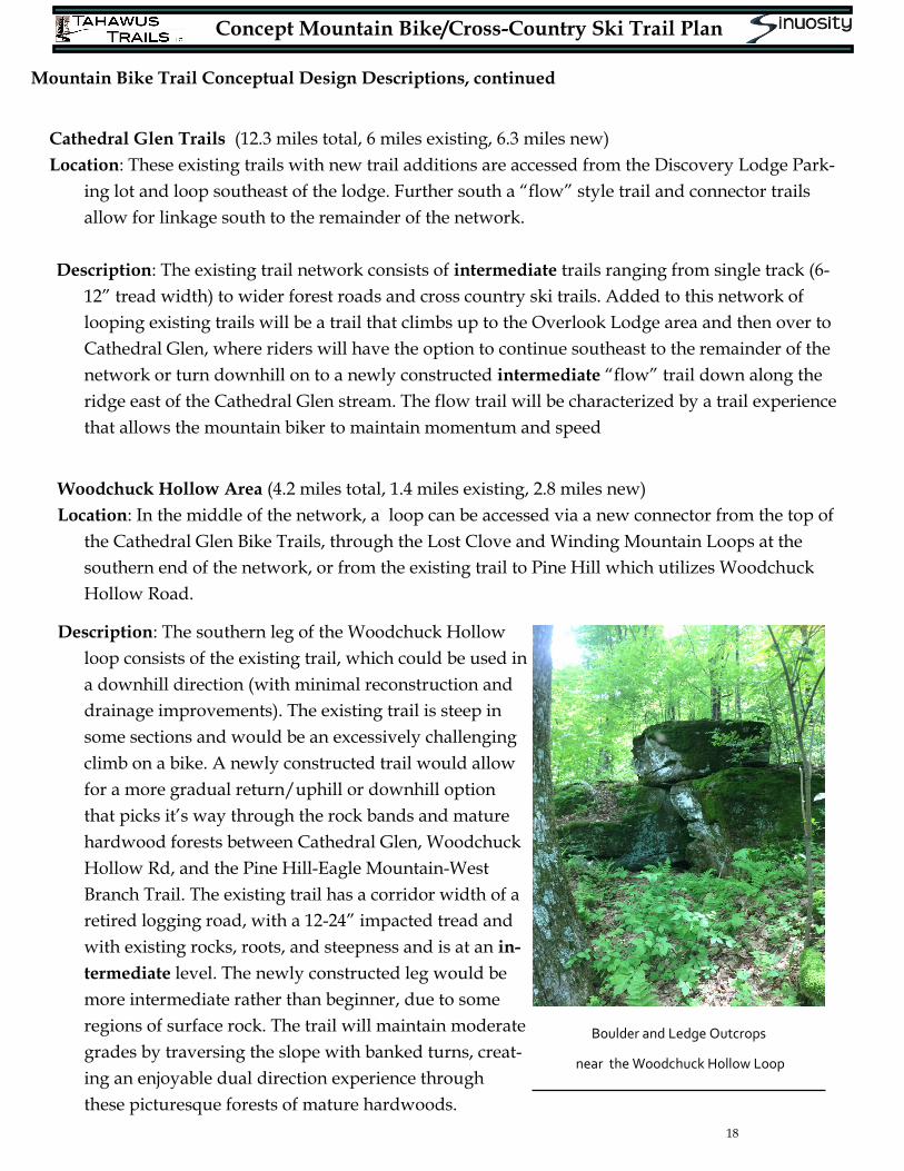
Boulder and Ledge Outcrops
near the Woodchuck Hollow Loop
Concept Mountain Bike/Cross-Country Ski Trail Plan
19
Mountain Bike Trail Conceptual Design Descriptions, continued
Lost Clove Loops, (4.1 miles total, 2 miles existing, 2.1 miles new)
Location: The Lost Clove Loops are on the north and south side of the ridge line at the far east-
ern edge of the Shandaken Wild Forest parcel. They connect the Lost Clove Trailhead with
the Winding Mountain and Woodchuck Loops.
Description: The Lost Clove Loops trail starts with two trails (a high and a low trail) which
climb steadily from the Lost Clove trailhead along the southern slope of the Belleayre ridge.
They both integrate sections of existing logging roads suitable for bike and ski travel with
sections of new trail to create various loops. Trail width will be 4-6’ and will be suitable for
beginner to intermediate mountain bikers.
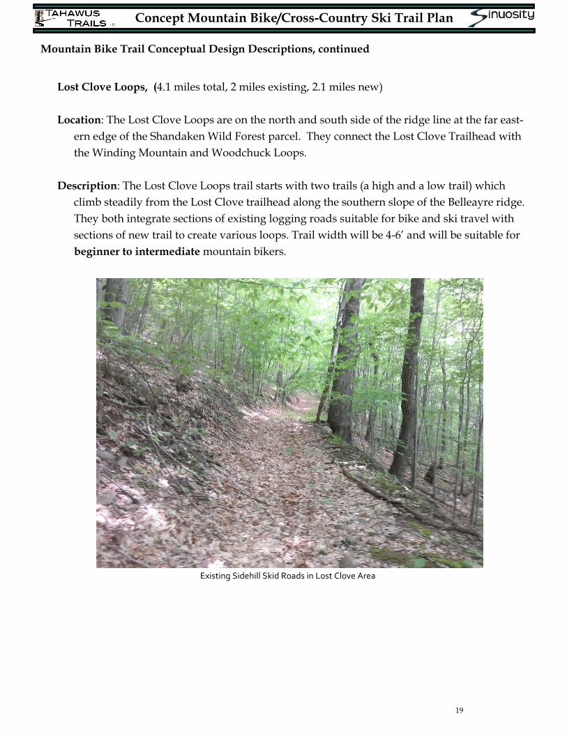
Existing Sidehill Skid Roads in Lost Clove Area
Concept Mountain Bike/Cross-Country Ski Trail Plan
20
Mountain Bike Trail Conceptual Design Descriptions, continued
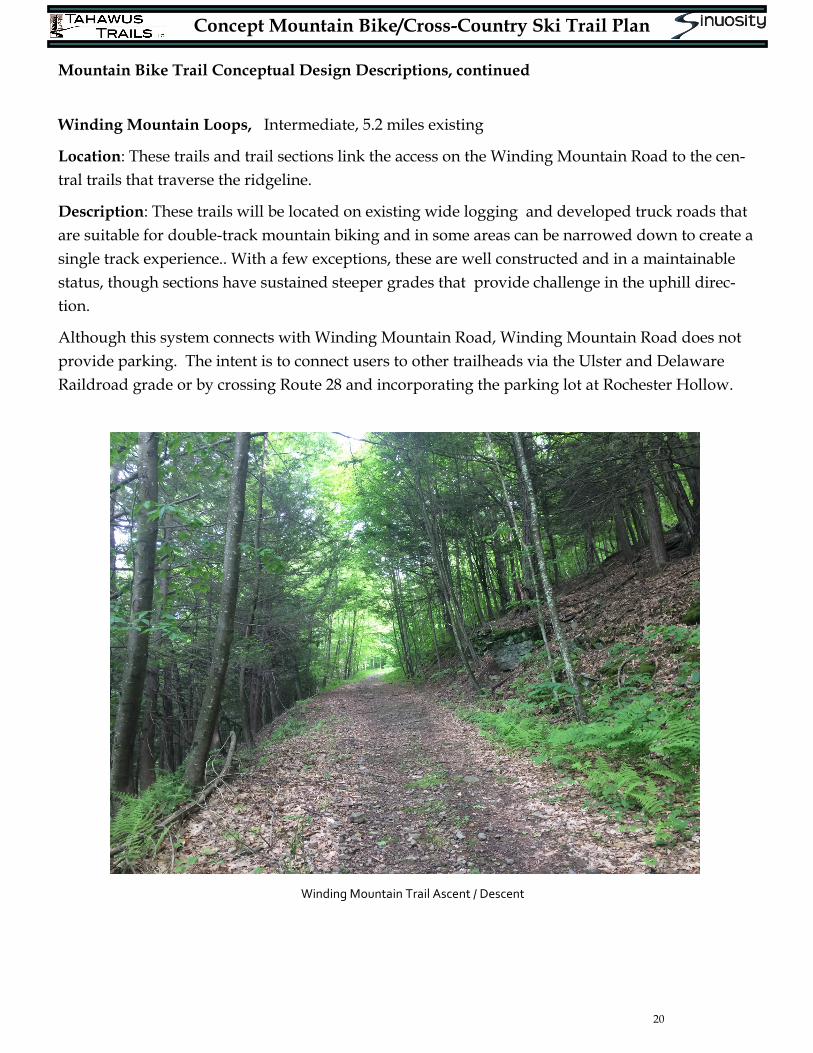
Winding Mountain Loops, Intermediate, 5.2 miles existing
Location: These trails and trail sections link the access on the Winding Mountain Road to the cen-
tral trails that traverse the ridgeline.
Description: These trails will be located on existing wide logging and developed truck roads that
are suitable for double-track mountain biking and in some areas can be narrowed down to create a
single track experience.. With a few exceptions, these are well constructed and in a maintainable
status, though sections have sustained steeper grades that provide challenge in the uphill direc-
tion.
Although this system connects with Winding Mountain Road, Winding Mountain Road does not
provide parking. The intent is to connect users to other trailheads via the Ulster and Delaware
Raildroad grade or by crossing Route 28 and incorporating the parking lot at Rochester Hollow.
Winding Mountain Trail Ascent / Descent
Concept Mountain Bike/Cross-Country Ski Trail Plan
21
Mountain Bike Trail Conceptual Design Descriptions, continued
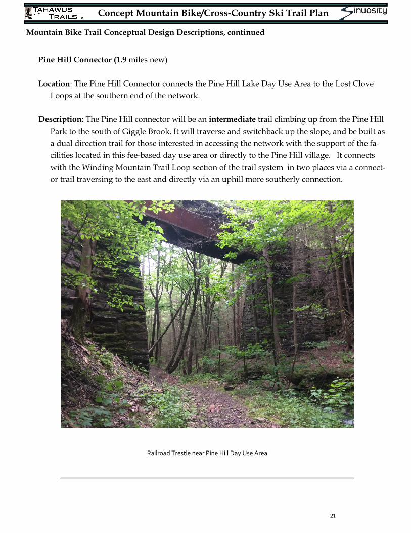
Pine Hill Connector (1.9 miles new)
Location: The Pine Hill Connector connects the Pine Hill Lake Day Use Area to the Lost Clove
Loops at the southern end of the network.
Description: The Pine Hill connector will be an intermediate trail climbing up from the Pine Hill
Park to the south of Giggle Brook. It will traverse and switchback up the slope, and be built as
a dual direction trail for those interested in accessing the network with the support of the fa-
cilities located in this fee-based day use area or directly to the Pine Hill village. It connects
with the Winding Mountain Trail Loop section of the trail system in two places via a connect-
or trail traversing to the east and directly via an uphill more southerly connection.
Railroad Trestle near Pine Hill Day Use Area
Concept Mountain Bike/Cross-Country Ski Trail Plan
22
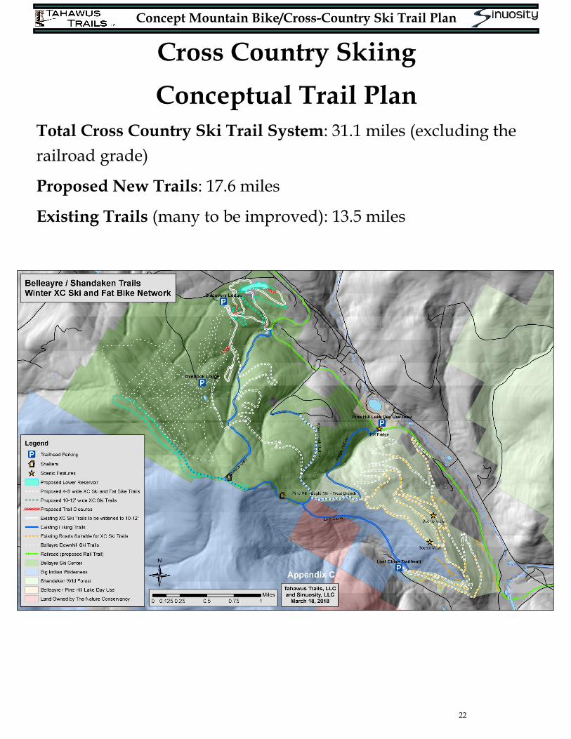
Cross Country Skiing
Conceptual Trail Plan
Total Cross Country Ski Trail System: 31.1 miles (excluding the
railroad grade)
Proposed New Trails: 17.6 miles
Existing Trails (many to be improved): 13.5 miles
Concept Mountain Bike/Cross-Country Ski Trail Plan
23
Cross Country Ski Trail Conceptual Design Descriptions
The cross country ski trail network utilizes the entire project area. Sections of existing trail and ex-
isting logging roads will be utilized to create this network, with sections of trail constructed to pro-
vide connectivity and loop options. These trails can be open to mountain bike traffic in the summer
and winter (fat tire) biking in most places and range from beginner to more advanced, and all are
multidirectional. Due to the restrictions on trail widths they will be used either in un-groomed nat-
ural snow conditions or with simple snowmobile grooming. Due to the soil conditions and the need
for different turn radii and mountain bike specific features, the bike and ski trails may have differ-
ent alignments for short segments. Trail widths range from 4’-12’.
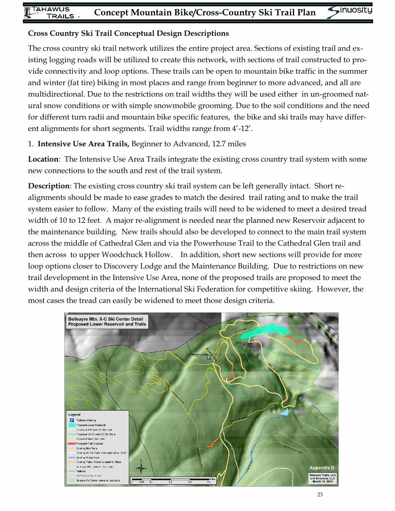
1. Intensive Use Area Trails, Beginner to Advanced, 12.7 miles
Location: The Intensive Use Area Trails integrate the existing cross country trail system with some
new connections to the south and rest of the trail system.
Description: The existing cross country ski trail system can be left generally intact. Short re-
alignments should be made to ease grades to match the desired trail rating and to make the trail
system easier to follow. Many of the existing trails will need to be widened to meet a desired tread
width of 10 to 12 feet. A major re-alignment is needed near the planned new Reservoir adjacent to
the maintenance building. New trails should also be developed to connect to the main trail system
across the middle of Cathedral Glen and via the Powerhouse Trail to the Cathedral Glen trail and
then across to upper Woodchuck Hollow. In addition, short new sections will provide for more
loop options closer to Discovery Lodge and the Maintenance Building. Due to restrictions on new
trail development in the Intensive Use Area, none of the proposed trails are proposed to meet the
width and design criteria of the International Ski Federation for competitive skiing. However, the
most cases the tread can easily be widened to meet those design criteria.
Concept Mountain Bike/Cross-Country Ski Trail Plan
24
Cross Country Ski Trail Conceptual Design Descriptions, continued
2. Lost Clove Ski Loops, Intermediate and Advanced, 4.1 miles
Location: The Lost Clove Ski trails start at the Lost Clove Trailhead off of Lost Clove Road and
junction and loop along the south face of the ridgeline, connecting to the central trails further north.
Description: These main connection trails will be constructed as both bike and ski trails, utilizing
existing logging roads, where suitable with new trail segments for connectivity and to increase suit-
ability in areas. These main connection trails will be intermediate trails with advanced connections
possible utilizing existing skid road connections along steeper grades.
3. Pine Hill Connector, Intermediate to Advanced, 1.9 Miles
Location: This trail connects the Pine Hill Lake Day use area to the central trail further up the ridge-
line. The top and bottom of the trail will be co-aligned or closely aligned with the Giggle Hollow
trail.
Description: This intermediate to advanced trail would be suitable for bikes and cross country ski-
ing. The difficulty rating is due to the overall steepness of the terrain in that area, and the general
layout will incorporate many switchbacks, which will require higher skill levels for cross country
skiers.
4. Winding Mountain Trail: Intermediate to Advanced, 5.2 miles
Location: These trails and trail sections link the access on the Winding Mountain Road to the cen-
tral trails that traverse the ridgeline.
Description: These trails will be located on existing wide logging and developed truck roads that
are suitable for skiing. These are well constructed and in a maintainable status, though sections are
steep and will provide challenging skiing in either direction. As with the summer use trails here,
there will be no direct parking access on Winding Mountain Road. Users will either park at Roch-
ester Hollow or connect back to other trailhead via the future rail trail.
5. Belleayre Summit Loop: Beginner, 3.0 miles
Location: A loop located on the summit of Belleayre, north and south along the ridgeline and con-
necting to the new gondola.
Description: These trails will be accessed by the chair lifts of Belleayre Ski Area during the winter
months. This 3 mile loop will provide more consistent snow conditions and give cross country ski-
ers access to the scenic vistas the summit affords. The entire southern half and much of the eastern
portion involves new construction , the north half of the loop follows the existing cleared area
along the top of the downhill skiing area.
Concept Mountain Bike/Cross-Country Ski Trail Plan
Next Steps in the Trail Development Process
As mentioned in the overview, this Trail Plan is a conceptual plan, providing a broad brush analysis
of a trail system that serves desired user groups. The next steps to move toward trail development
at Shandaken and Belleayre involve an amendment to the Unit Management Plans for that incorpo-
rates desired elements from this Concept Plan.
Following the UMP revision and adoption, the following additional steps should be followed as part
of the trail development process:
1. Create a Trail Master Plan . Such a plan should incorporate in more detail, the desired charac-
teristics of each trail with a comprehensive design that includes detailed flagged on-the-ground
and mapped trail alignments
2. Establish Trail Construction Guidelines and Specifications. This should include site specific
construction techniques for all man-made features and specifications for all different work ele-
ments on each trail, outlining their size and frequency (including sidehill construction, corridor
clearing, bridges, rollers, bermed turns, etc.). With a completed trail plan and clear specifica-
tions for construction, final construction cost estimates can be created at this stage.
3. Procurement and Construction. With the design and construction documentation process com-
plete, the project is ready to move to the construction phase. The procurement process for con-
struction depends on the on the available resources but having clear construction plans will
make the construction process go smoothly and insure the desired trail types are created.
The following are several excellent references, outlined in Appendix A that should be followed
when finalizing the design and construction of mountain bike trails:
Siting, Construction and Maintenance of Singletrack Bike Trail on Forest Preserve Lands in the Adirondack
and Catskill Parks. DRAFT August 2017. As of the March 2018, this document was still a Draft Guid-
ance Document, the Department of Environmental Conservation was still developping the Final
Guidance Document.
Guidelines for a Quality Trail Experience : Mountain Bike Trail Guidelines, published by IMBA and the
BLM
IMBA’s Guide to Sweet Single Track, published by IMBA
Concept Mountain Bike/Cross-Country Ski Trail Plan
26
Recommended Phasing Sequence
If the development of the project must be phased due to available resources for construction, the
following recommended phasing schedule is provided in order to maximize access to the trail sys-
tem for the greatest recreational benefit.
Phase 1A: Develop overall cross country bike/ski connectivity between Discovery Lodge and Lost
Clove using Trail J connection, Powerhouse Trail, then over to Lost Clove with the most direct con-
nection possible.
Phase 1B: Develop Summit XC Ski Loop. This phase can occur at any point, but is optimally per-
formed before the Phase 2, below.
Phase 2: Improve and build out Intensive Use Area Trails (bike and ski) including the mid-
mountain single track trails, Cathedral Ridge Trail, and Mountain and Ridge and Cathedral Glen.
Develop connection from Bonnie View Avenue to bottom of Cathedral Glen.
Phase 3: Develop alternate and parallel return routes to Phase 1A to create a loop options and alter-
native returns routes, where feasible.
Phase 4: Improve / Develop Woodchuck Hollow Trail and Pine Hill Day Use Access.
Phase 5: Provide and improve additional loop options in Central Area,: Winding Mountain Road
and Woodchuck Hollow.
Concept Mountain Bike/Cross-Country Ski Trail Plan
27
Additional Trail Management Resources
Appalachian Trail Conservancy. Planning a Trailhead Kiosk, 2012.A Revision to Planning a Trailhead Bulle-
tin Board (1998). Available at: http://www.appalachiantrail.org/docs/default-document-library/trailhead-
kiosks-2012-update-to-th-bulletinboards.pdf
Birkby, Robert C. Lightly on the Land: The Student Conservation Association Trail-Building and Maintenance
Manual. Seattle, WA: The Mountaineers, 2005. ISBN 0-89886-848-3. 344 pp. Available at 800-553-4453.
Davies, Mary, Hesselbarth, Woody, Vachowski, Brian. Trail Construction and Maintenance Notebook - 2007
Edition. Missoula, MT: U.S. Department of Agriculture, Forest Service, Missoula Technology and Develop-
ment Center, 2007. http://www.fhwa.dot.gov/environment/recreational_trails/publications/
fs_publications/07232806/
International Mountain Biking Associations and Bureau of Land Management. Guidelines for a Quality Trail
Experience : Mountain Bike Trail Guidelines, Boulder CO 2017/ http://gqte.imba.com/images/GQTE_digi_publish_FINAL_high_res.pdf
International Mountain Bike Association. Trail Solutions: IMBA’s guide to building sweet singletrack. Boulder,
CO: IMBA, 2004. ISBN 0-9755023-0-1.
Jeswald, P. How to Build Paths, Steps and Footbridges. North Adams, MA: Storey Publishing, 2005. ISBN 1-
58017-487-6.
Parker, Troy Scott. 2004. Natural surface trails by design: physical and human design essentials of sustainable, en-
joyable trails. ISBN: 0-9755872-0. Natureshape LLC. (http://www.natureshape.com)
Staff of AMC’s Trails Department. AMC’s Complete Guide to Trail Building & Maintenance: Proven techniques,
safety guidelines, equipment tips, 4th ed. Boston, MA: Appalachian Mountain Club Books, 2008. ISBN 978-1-
934028-16-2.
Steinholz, Robert T.; Vachowski, Brian. "Wetland Trail Design and Construction 2007 Edition." 0723 2804.
Missoula, MT: U.S. Department of Agriculture, Forest Service, Missoula Technology and Development Cen-
ter, 2007. 90 p. http://www.fhwa.dot.gov/environment/rectrails/trailpub.htm.
U.S. Department of Agriculture Forest Service. 1996. Forest Service National trail drawings and specifications.
EM-7720-103. Washington, DC: U.S. Department of Agriculture Forest Service. http://
www.fs.fed.us/.ftproot/pub/acad/dev/trails/trails.htm
International Ski Federation, FIS Cross Country Homologulation Manual. June 2016. Sixth Edition
Appendix A
Lost Clove
Cathedr
al Glen Gig
gle Ho
llow
Woodchuck Hollow
Cathedral Ridge Flow
Lost Clove Loop
RR Bridge
Scenic View
Scenic View
Overlook Lodge
Discovery Lodge
Lost Clove Trailhead
Pine Hill Lake Day Use Area
Pine Hill - Eagle Mtn - West Branch
LegendTrailhead ParkingSheltersScenic FeaturesProposed Lower ReservoirProposed Mtn Bike TrailsExisting XC Ski and Bike TrailsExisting Logging Roads Suitable for BikesExisting Hiking Trails Suitable for BikesExisting Hiking TrailsProposed Trail ClosuresWet Areas in Need of Tread ElevatingTrail Suitable for Bikes with Major WorkProposed XC Ski and Bike TrailsOther Logging RoadsBellayre Downhill Ski TrailsRailroad (proposed Rail Trail)Bellayre Ski CenterBig Indian WildernessShandaken Wild ForestBelleayre / Pine Hill Lake Day UseLand Owned by The Nature Conservancy
Belleayre / Shandaken TrailsSummer Mountain Bike Network
0 0.25 0.5 0.75 10.125Miles
Tahawus Trails, LLCand Sinuosity, LLC
March 18, 2018
Appendix B
Lost Clove
Cathedr
al Glen Gig
gle Ho
llow
Woodchuck Hollow
RR Bridge
Scenic View
Scenic View
Overlook Lodge
Discovery Lodge
Lost Clove Trailhead
Pine Hill Lake Day Use Area
Pine Hill - Eagle Mtn - West Branch
LegendTrailhead ParkingSheltersScenic FeaturesProposed Lower ReservoirProposed 4-6' wide XC Ski and Fat Bike TrailsProposed 10-12' wide XC Ski TrailsProposed Trail ClosuresExisting XC Ski Trails to be widened to 10-12'Existing Hiking TrailsExisting Roads Suitable for XC Ski TrailsBellayre Downhill Ski TrailsRailroad (proposed Rail Trail)Bellayre Ski CenterBig Indian WildernessShandaken Wild ForestBelleayre / Pine Hill Lake Day UseLand Owned by The Nature Conservancy
Belleayre / Shandaken TrailsWinter XC Ski and Fat Bike Network
0 0.25 0.5 0.75 10.125Miles
Tahawus Trails, LLCand Sinuosity, LLC
March 18, 2018
Appendix C
Cathe
dral G
len
J
A
HH
H
AA
XC Ski Road
Work Road
Bike DH Singletrack
Bike Race Course
Uppe
r J
H
HH
Bike Race Course
Cathedral Ridge FlowCathedral Ridge Climb
Discovery Lodge
LegendTrailhead ParkingProposed Lower ReservoirProposed 4-6' wide XC Ski TrailsProposed 10-12' wide XC Ski TrailsProposed New Bike TrailsProposed Trail ClosuresExisting Bike TrailsExisting XC Ski Trails to be widened to 10-12'Existing Hiking TrailsExisting Trails / Roads Suitable for BikesBelleayre Mtn. Downhill Ski TrailsRailroad10 Foot Contour LinesBellayre Ski Center Intensive Use Land
Belleayre Mtn. X-C Ski Center Detail Proposed Lower Reservoir and Trails
0 0.1 0.2 0.3 0.40.05Miles
Tahawus Trails, LLCand Sinuosity, LLC
March 18, 2018
Appendix D