ser 11 07 - california department of transportation engineering 2365 iron point road . project
TRANSCRIPT


PROJECT DESCRIPTION
Build Alternatives
Two build alternatives (Alternative 3 and Alternative 6) have been identified to satisfy the purpose and need for the project. Alternative 3 has been identified by the City of San Luis Obispo as the locally preferred alternative. Alternative 3 and Alternative 6 are described below.
Common Design Features of the Build Alternatives
This project is intended to accommodate current and future travel demands. Calle Joaquin Road south of LOVR has been realigned so that the existing “T” intersection of LOVR and Calle Joaquin Road north of LOVR has been converted to a four-way intersection. The Calle Joaquin Road realignment was developed and completed by the Costco Wholesale Corporation as a condition of approval and mitigation measure for traffic impacts.
The project limits extend along LOVR between Auto Park Way to the west and South Higuera Street to the east covering a distance of 0.52 mile and along US 101 for about 2,500 feet south and 4,300 feet north of the LOVR overcrossing.
Under both build alternatives, the San Luis Obispo Creek arch culvert would be changed. Built in 1986, the existing three-barrel structural steel-plate arch culvert is a large structure, carrying LOVR over San Luis Obispo Creek. This project would widen and raise the roadway. These roadway changes require lengthening the culvert with a new structural steel arch (matching what exists) and increasing the loading on the existing culvert that would remain. To determine the feasibility of this increased loading, a structural analysis was conducted. The analysis showed that the existing culvert can easily carry the additional loading, making this a viable option.
Included in the project, along both sides of all project-related local streets, are sidewalks with grades and curb ramps at intersections, in compliance with Americans with Disabilities Act requirements. To help non-motorized transportation (such as pedestrians and bicyclists) cross the intersections, the project would limit use of free-slip ramps, include single-lane ramps, and review the southwest corner of the US 101 northbound off-ramp/LOVR to determine if a widened area is needed to create a bigger “landing” area.
A portion of the proposed Bob Jones City-to-Sea Bike Trail passes through the project. This project would provide bikeway access to connect to LOVR at the northbound on- and off-ramp intersection. Project design would not preclude connection of the Prefumo Creek trail extension to the future Bob Jones City-to-Sea Bike Trail (including possible extension of the trail under or over LOVR). Each build alternative would provide 6.5-foot Class II bike lanes throughout the project on both sides of LOVR. These lanes would connect to the existing 6-foot sidewalks in front of the Los Verdes Parks I and II developments. Sidewalks on both sides of the San Luis Obispo Creek bridge would be widened to accommodate Class I trails. Safety device placement, striping, and signage of the Class I trail would be completed once the location and alignment of the Bob Jones City-to-Sea Bike Trail is determined south of the interchange. Any at-grade crossings of the LOVR by the Bob Jones City-to-Sea Bike Trail would use appropriate and safe design guidelines for visibility and signal operations. Bicycle detector loops would be placed at all intersections that have traffic signals. Project design would remain consistent with the Bob Jones City-to-Sea Bike Trail Project Master Plan and the City of San Luis Obispo Bicycle Transportation Plan.

Both alternatives would:
1. Widen LOVR to four lanes from South Higuera Street to 600 feet west of Calle Joaquin to meet the existing four-lane section west of Calle Joaquin.
2. Extend the existing San Luis Obispo Creek culvert crossing to accommodate widened LOVR
3. Construct retaining walls to avoid Prefumo Creek and business impacts at LOVR and the US 101 southbound ramps.
4. Construct sidewalks and Class II bike lanes along both sides of LOVR.
5. Change the existing signals at the LOVR and US 101 ramp intersections.
6. Widen and rebuild the US 101 northbound off-ramp and build a retaining wall to avoid creek impacts.
7. Change the landscaping and sidewalks along LOVR at Los Verdes.
8. Change the striping, medians, and lane widths along LOVR at Los Verdes.
9. Restripe South Higuera Street to optimize the capacity of the South Higuera Street/LOVR intersection, given the widening of LOVR.
10. Include pedestrian crossing controls at all intersections that have traffic signals unless determined unsafe or detrimental to traffic conditions.
11. Further widen San Luis Obispo Creek bridge to accommodate a future Class I trail on either shoulder of the structure.
12. Use concrete paving at off-ramp ends.
13. Use street print (stamped/imprinted asphalt or concrete) through crosswalks for increased visibility.
14. Use rubberized asphalt concrete, as a project feature, on LOVR in front of the Los Verdes Parks I and II.
15. Restripe LOVR from two to four lanes in front of the Los Verdes Parks I and II driveways to assist with access.
16. Plant native landscaping within the intersections and ramps where appropriate.
Unique Features of Build Alternatives
Alternative 3—Minimum Build
Alternative 3 is the minimum build alternative for this project and is the locally preferred alternative. This alternative would widen LOVR between the recently constructed Calle Joaquin intersection with LOVR west of US-101 and the Los Verdes Park community east of US-101 to 4 lanes, construct a new two lane structure adjacent the existing LOVR Overcrossing, and widening San Luis Obispo Creek culvert crossing.
The actual work to be performed under the project includes:
1. Widen LOVR to four lanes from South Higuera Street to the existing four-lane section west of Calle Joaquin.

2. Extend the existing San Luis Obispo Creek culvert crossing to accommodate widened LOVR.
3. Construct retaining walls to avoid Prefumo Creek and business impacts at LOVR and the US 101 southbound ramps.
4. Construct sidewalks and Class II bike lanes along both sides of LOVR.
5. Change the existing signals at the LOVR and US 101 ramp intersections.
6. Widen and rebuild the US 101 northbound off-ramp and build a retaining wall to avoid creek impacts.
7. Change the landscaping and sidewalks along LOVR at Los Verdes.
8. Change the striping, medians, and lane widths along LOVR at Los Verdes.
9. Restripe South Higuera Street to optimize the capacity of the South Higuera Street/LOVR intersection, given the widening of LOVR.
10. Pavement section for ramps and LOVR will be 0.2’ rubberized asphalt concrete over 0.3’ hot mix asphalt over 1.67’ aggregate based on the Life Cycle Pavement Cost Analysis findings. Concrete paving will be used at both off-ramp ends.
11. Use street print through crosswalks for increased visibility.
12. Use open-grade or rubberized asphalt on LOVR in front of the Los Verdes Parks I and II.
13. Plant native landscaping within the intersections and ramps where appropriate.
14. Construct retaining walls to avoid San Luis Obispo Creek impacts.
15. Construct a separate US 101 overcrossing to carry the two eastbound lanes with a split profile.
16. Raise the intersection of LOVR at the US 101 southbound ramps.
17. Construct new street lighting along LOVR.
18. Raise headwalls on Prefumo Creek box culvert under the southbound off-ramp to accommodate ramp raising and widening.
19. Widen the US 101 southbound off-ramp and construct retaining walls.
20. Change the storm drain system along LOVR to accommodate widening and profile changes.
21. Construct a standard acceleration lane from the southbound on-ramp.
Changes to Work to be Performed Resulting from Value Analysis and Public Comment
22. Include pedestrian crossing controls at all signalized intersections unless specific movements are determined unsafe or detrimental to traffic conditions.

23. Further widen San Luis Obispo Creek Bridge to accommodate a future Class I trail on either shoulder of the structure.
24. Restripe LOVR from two to four lanes in front of the Los Verdes Parks I and II driveways to assist with access.
25. Construct a right-turn lane from eastbound LOVR to northbound US-101 on-ramp.
26. Use concrete paving at off ramp termini.
27. Use imprinted AC for crosswalks for increased visibility, outside limits of state right-of-way.
28. Place bicycle detector loops at signalized intersections.
Alternative 6—Moderate Build, Near Full Standard
This alternative proposes to widen Los Osos Valley Road between Calle Joaquin west and the Los Verdes communities east of US 101 (see Figures 1.3-3 and 1.3-4). The existing LOVR overcrossing would be replaced to improve the profile, vertical clearance, and space required for the southbound hook off-ramp.
In addition, the existing northbound loop on-ramp to US 101 would be reconstructed, and the northbound off-ramp would be widened. A new northbound diagonal on-ramp to US 101 may be added in the northeast quadrant of the interchange as a phased improvement. An auxiliary lane would be added to northbound US 101 from the end of the northbound loop on-ramp to 1,000 feet beyond the end of the northbound diagonal on-ramp. The northbound diagonal on-ramp would be supported by retaining walls and an additional bridge over Prefumo Creek. The existing southbound on- and off-ramps from US 101 would be removed. South of LOVR, new/relocated southbound on- and off-ramps from US 101 would be constructed in a hook ramp configuration. Calle Joaquin south of LOVR is being realigned to accommodate the realigned southbound US 101 ramps and to create a four-way intersection with Calle Joaquin north LOVR.
The actual work to be performed under the project includes:
1. Widen LOVR to 4 lanes from South Higuera St. to 600 feet north of Calle Joaquin
2. Extend or reconstruct existing San Luis Obispo Creek Culvert Crossing to accommodate widened LOVR
3. Replace the LOVR US-101 Overcrossing
4. Relocate and reconstruct the southbound US-101 ramps
5. Reconstruct northbound US-101 loop on-ramp
6. Construct northbound US-101 slip on-ramp and merge lane to US-101
7. Construct northbound US-101 on-ramp bridge & retaining walls at Prefumo Creek
8. Construct signalized intersection of US-101 southbound ramps and Calle Joaquin

9. Construct sidewalks and combined bike lane/shoulder along LOVR
10. Construct new street lighting along LOVR and Calle Joaquin
11. Modify existing signals at LOVR/US-101 northbound off-ramp intersection
12. Abolish existing southbound US-101 ramps and Perfumo Creek Box Culvert
13. Widen US-101 northbound off-ramp and construct retaining wall
14. Extend the Perfumo Creek box culvert under US-101 for new southbound off ramp
15. Construct storm drain systems for LOVR and reconstruct ramps
16. Modify landscaping and sidewalks along LOVR at Los Verdes
17. Restripe South Higuera Street
No-Build Alternative
Environmental review must consider the effects of not implementing the proposed project. The No-Build Alternative provides a baseline for comparing the impacts of all alternatives.
Effects of the No-Build Alternative include deteriorating level of service, impacts to air quality, and continuing safety conditions. Unless operational improvements are made, future planned development and general regional growth will increase traffic volumes to a degree that all intersections in the vicinity of the LOVR/US 101 interchange would operate with severe congestion during both the morning and afternoon peak hours. This would result in congestion on US 101 from backups at the off-ramp intersections. This congestion would affect both local traffic on LOVR and regional traffic on US 101. Decreasing operational efficiency may negatively affect air quality and would likely affect existing safety


SCENIC RESOURCES EVALUATION
LOS OSOS VALLEY ROAD/US 101 INTERCHANGE IMPROVEMENT PROJECT
SAN LUIS OBISPO, CALIFORNIA
Submitted to:
City of San Luis Obispo Department of Public Works
919 Palm Street San Luis Obispo, California 93401
California Department of Transportation - District 5 50 Higuera Street
San Luis Obispo, California 93401
Prepared by:
Dokken Engineering 2365 Iron Point Road
Folsom, California 95630 (916) 858-0642
November 2006


SCENIC RESOURCES EVALUATION NOVEMBER 2007 LOS OSOS VALLEY ROAD/US 101 INTERCHANGE PROJECT
i
TABLE OF CONTENTS 1.0 INTRODUCTION.............................................................................................................................1 2.0 PROJECT DESCRIPTION...............................................................................................................2
2.1 PROJECT LOCATION..............................................................................................................2 2.2 PROJECT BACKGROUND ......................................................................................................2 2.3 PURPOSE AND NEED .............................................................................................................4 2.4 PROJECT COMPONENTS .......................................................................................................4
3.0 VISUAL ASSESSMENT METHODS .............................................................................................9
3.1 ASSESSMENT METHODS ......................................................................................................9 3.2 CRITERIA FOR VISUAL ASSESSMENT ...............................................................................9
4.0 AFFECTED ENVIRONMENT ......................................................................................................11
4.1 GENERAL SITE DESCRIPTION ...........................................................................................11 4.2 SCENIC DESIGNATIONS......................................................................................................11 4.3 LANDSCAPE UNITS..............................................................................................................12 4.3 VIEWER GROUPS AND RESPONSES .................................................................................15 4.5 VISUAL INVENTORY ...........................................................................................................18 4.6 VISUAL QUALITY EVALUATION ......................................................................................18
5.0 ENVIRONMENTAL CONSEQUENCES......................................................................................23
5.1 VISUAL QUALITY CHANGE ...............................................................................................23 5.2 SCENIC DESIGNATIONS......................................................................................................28 5.3 ADJACENT USES...................................................................................................................28 5.4 IMPACT SUMMARY .............................................................................................................28
6.0 MITIGATION AND DISCUSSION...............................................................................................29
6.1 IMPACTS AND MITIGATION ..............................................................................................29 6.2 VISUAL RESOURCE MANAGEMENT OBJECTIVES........................................................31 6.3 ALTERNATIVE SOLUTIONS ...............................................................................................31 6.4 EFFECTIVENESS EVALUATION ........................................................................................31 6.5 RECOMMENDATIONS..........................................................................................................31
7.0 REFERENCES ...............................................................................................................................32 APPENDIX A - LANDSCAPE UNIT CHECKLIST APPENDIX B - VISUAL QUALITY EVALUATION APPENDIX C - QUANTITATIVE IMPACT EVALUATION

SCENIC RESOURCES EVALUATION NOVEMBER 2007 LOS OSOS VALLEY ROAD/US 101 INTERCHANGE PROJECT
ii
FIGURES AND TABLES AND PHOTOGRAPHS
FIGURES Figure 1: Regional Location....................................................................................................................3 Figure 2: Alternative 3 ............................................................................................................................7 Figure 3: Alternative 6 ............................................................................................................................8 Figure 4: Landscape Unit Photograph Locations ..................................................................................14 Figure 5: Viewer Group Perspective Locations.....................................................................................18 Figure 6: Observer Locations ................................................................................................................20 TABLES Table A: View of the Road....................................................................................................................19 Table B: View from the Road ...............................................................................................................19 Table C: Aesthetic Changes with the Proposed Project.........................................................................27 Table D1: Evaluation - View of the Road Alternative 3 .......................................................................27 Table D2: Evaluation - View of the Road Alternative 6 .......................................................................28 Table E: Evaluation - View from the Road ...........................................................................................28 PHOTOGRAPHS Photograph 1: Landscape Unit Overview..............................................................................................13 Photograph 2: Landscape Unit Overview..............................................................................................13 Photograph 3: View of Traveler on LOVR ...........................................................................................16 Photograph 4: View of Traveler on Future Hook Ramp........................................................................16 Photograph 5: View of Traveler on Bridge ...........................................................................................16 Photograph 6: View of Traveler on Bridge ...........................................................................................16 Photograph 7: View of Traveler on US 101 ..........................................................................................16 Photograph 8: View of Traveler on US 101 ..........................................................................................16 Photograph 9: View of Traveler on US 101 ..........................................................................................21 Photograph 10: View of Traveler on US 101 ........................................................................................21 Photograph 11: View of Traveler on US 101 ........................................................................................22 Simulation 1: View South of Traveler on US 101.................................................................................24 Simulation 2: View North of Traveler on US 101.................................................................................25 Simulation 3: View West of Traveler on LOVR ...................................................................................26

SCENIC RESOURCES EVALUATION NOVEMBER 2007 LOS OSOS VALLEY ROAD/US 101 INTERCHANGE PROJECT
1
1.0 INTRODUCTION
This report presents the methods and results of an analysis of the effects on visual and scenic resources of the proposed Los Osos Valley Road/US 101 Interchange Improvement Project. The City of San Luis Obispo (City), in conjunction with the California Department of Transportation (Caltrans) and the Federal Highway Administration (FHWA), proposes to improve the Los Osos Valley Road/US-101 interchange and Los Osos Valley Road (LOVR) in the City and County of San Luis Obispo through the year 2030. The purpose of the proposed project is to maximize the efficiency of LOVR and the LOVR/US-101 interchange to preempt any degradation of traffic operations within the 20-year design period. The project limits extend along LOVR between Auto Park Way to the west and South Higuera Street to the east. The project length along US-101 totals approximately 762 meters (2500 feet) south and 1500 meters (4300 feet) north from the LOVR Overcrossing. The alternatives being considered include several design features such as widening of LOVR, possible reconfiguration and/or widening of the interchange ramps, the addition of bike lanes and sidewalks where lacking, and the addition of auxiliary lanes where warranted.
This analysis has been conducted consistent with Caltrans methods and other state and local ordinances as appropriate. As such, existing conditions were inventoried and evaluated for both “of the road” and “from the road” views and compared and contrasted with future conditions.
The improvements to the interchange, ramps, bridges, and associated roadways will have, ultimately, a low level of change on the existing visual environment within the project area. The change to the aesthetic quality of the site will likely be considered neutral. The existing interchange is a transportation facility located along a travel route that has provided views of the coast range setting since 1933. It is expected that the project, although widening the overcrossing and potentially reconfiguring ramp locations, will not impact the view shed because of the existing interchange and its previous integration with the surrounding land uses. Removal of vegetation, however, will result in temporary impacts to the visual quality of the project area itself. Quantitatively, this conclusion is reached through the Visual Quality Evaluation, generally indicating that the project will result in no net effect in visual quality throughout the project vicinity.
• Implementation of the project would not have an adverse affect under NEPA or a significant impact under the California Environmental Quality Act (CEQA) on visual and scenic resources, including scenic vistas.
• The proposed construction activities would result in temporary impacts. These impacts are considered less than adverse under NEPA and less than significant under CEQA with mitigation.
• The project would result in temporary impacts from vegetation removal and the resulting increase in visible concrete. These impacts are considered less than adverse under NEPA and less than significant under CEQA with mitigation. In areas of mature vegetation removal, mitigation planting and revegetation would occur.

SCENIC RESOURCES EVALUATION NOVEMBER 2007 LOS OSOS VALLEY ROAD/US 101 INTERCHANGE PROJECT
2
2.0 PROJECT DESCRIPTION
2.1 PROJECT LOCATION The project is located in San Luis Obispo County on US-101 at the Los Osos Valley Road Interchange (LOVR) beginning at Calle Joaquin west of US-101 and terminating at the existing intersection with South Higuera Street south of the Los Verdes housing development. The project covers a distance of 0.84 km (0.52 miles). Figures 1 illustrates the project’s regional location and vicinity. 2.2 PROJECT BACKGROUND Within the limits of the proposed project, US-101 is a four-lane freeway with 3.6-meter (12-foot) lanes, 2.4-meter (8-foot) right shoulders, and a median width of 12.2 meters (40 feet). The original two-lane roadway was built in 1933 and was replaced with a four-lane facility in 1954. The functional classification of this segment of US-101 is a Principal Arterial and is included in the National Highway System. US-101 is also a SHELL (State Highway Extra Legal Load) route and an oversize truck route. Commute traffic is the primary use through this portion of US-101, but a large percentage of travel through the study area is interregional. The Transportation Concept Report (TCR), dated 2001, recommends that US-101 be expanded to a six-lane freeway through this segment. However, widening of US-101 is not part of this project. The US-101/LOVR interchange is configured as a diamond interchange with the exception for a loop ramp in the southeast quadrant of the interchange that provides access from LOVR to northbound US-101. The LOVR Overcrossing (No. 49-0185) was built in 1962 to carry two lanes of traffic. The bridge was widened in 1987 to carry four lanes of traffic. The existing bridge is a four-span structure of approximately 91.6 meters (300.5 feet) in length and 16.8 meters (55 feet) in width. Roadway embankments up to 6 meters (20 feet) in height were constructed for the overcrossing. Southeast of the interchange, within the project limit, LOVR passes over San Luis Obispo Creek. On the northern side of the interchange, the on-ramp to southbound US-101 is accessed from Calle Joaquin-South and not directly from LOVR. The southbound US-101 off-ramp intersects LOVR at the LOVR/Calle Joaquin-South intersection. Calle Joaquin-North intersects LOVR approximately 91 meters (300 feet) to the west of the southbound US-101 off-ramp/Calle Joaquin-South intersection. The proposed project involves widening the existing freeway bridge and an adjacent bridge, crossing San Luis Obispo Creek, and the possible relocation and reconfiguration of the freeway ramps depending on the alternative chosen. This project is intended to accommodate current and future travel demands. Calle Joaquin south of LOVR is being realigned such that the existing “T” intersection of LOVR and Calle Joaquin north of LOVR will be converted to a “Four-Leg” intersection. The Calle Joaquin realignment is currently being developed by the Costco Wholesale Corporation as a condition of approval and mitigation measure for traffic impacts. The realignment is scheduled for completion

ProjectLocation
J: \
GIS
\ P
RO
JEC
TS \
DO
KKE
N \
0615
0_06
\ M
AP
DO
C \
NE
S \
FIG
_1_1
_PR
OJE
CT_
LOC
ATIO
N.M
XD L
D (
08-2
8-06
)
Figure 1Project Location
Base Map: Pismo Beach and San Luis ObispoUSGS 7.5' series quadrangles
2,000 0 2,0001,000Feet
±
[Project
Location
SANTA BARBARA CO
SAN LUISOBISPO CO
KERN CO
KINGS COMONTEREY CO
FRESNOCO

SCENIC RESOURCES EVALUATION NOVEMBER 2007 LOS OSOS VALLEY ROAD/US 101 INTERCHANGE PROJECT
4
prior to initiation of interchange improvements. The alternatives selected to be studied as a part of this project are summarized in Section 2.4. Under both build alternatives the San Luis Obispo Creek arch culvert will be modified. The existing three-barrel structural steel plate arch culvert is a large and modern (1986) structure, carrying Los Osos Valley Road over San Luis Obispo Creek. This project would widen and raise the roadway. These roadway revisions require lengthening the culvert with a new structural steel arch (matching the existing), as well as increasing the loading on the existing culvert that is to remain. To determine the feasibility of this increased loading, a structural analysis was conducted. The analysis showed that the existing culvert can easily carry the additional loading placed on it. Therefore, lengthening the culvert is a viable option. 2.3 PURPOSE AND NEED The purpose of this project is to respond to projected increases in regional and local traffic demand on the state and local roadway systems and to improve traffic operations and safety on LOVR and the LOVR/US-101 interchange. The acceptable Level of Service for the proposed project is level D. The project is to be designed such that it will not preclude the planned ultimate widening of US-101 or future interchange improvements. 2.4 PROJECT COMPONENTS Two viable build alternatives (Alternative 3 and Alternative 6) for the proposed improvements have been identified by the Project Development Team (PDT) that satisfy the purpose and need for this project. The estimated construction cost of these alternatives ranges from $21.7 million to $29.4 million. The major differences among the alternatives relate to the type and location of the southbound on/off ramps the configuration of the northbound on/off ramp intersection with LOVR. One alternative accommodates and widens the existing US-101 overcrossing while the other includes replacement of the overcrossing. Alternative 3 and Alternative 6 are described below. 2.4.1 Alternative 3 – Minimum Build Alternative 3 is the minimum build alternative for this project (Figure 2). This alternative proposes to widen LOVR between the recently constructed Calle Joaquin intersection with LOVR west of US-101 and the Los Verdes community east of US-101 to 4 lanes, including the existing LOVR Overcrossing structure, and San Luis Obispo Creek culvert crossing. The widening will be accomplished by constructing a separate US-101 overcrossing to carry the 2 eastbound lanes. LOVR will be a split profile over US-101 to accommodate the westbound lanes on the existing overcrossing. The project will lengthen the San Luis Obispo Creek culvert crossing on the south side and construct a cantilevered sidewalk on the north side. These widening efforts will accommodate four 12 foot through-lanes, bike lanes, sidewalks (on both sides), and a median 5’ to 16’ in width, which will be used for left turn pockets where needed. The northbound US-101 off-ramp will widened from the intersection with LOVR to 500 feet south. The southbound on-ramp will be reconstructed near the current location opposite the southbound off-ramp.

SCENIC RESOURCES EVALUATION NOVEMBER 2007 LOS OSOS VALLEY ROAD/US 101 INTERCHANGE PROJECT
5
The actual work to be performed under this alternative includes:
• Widen Los Osos Valley Road from 2 to 4 lanes from South Higuera St. to 600 feet north of Calle Joaquin to meet existing 4 lane section west of Calle Joaquin.
• Extend existing San Luis Obispo Creek Culvert Crossing to accommodate widened LOVR • Construct a separate US-101 Overcrossing to carry the 2 eastbound lanes with a split profile • Raise the intersection of LOVR/US-101 southbound ramps • Construct sidewalks and Class II bike lanes along both sides of LOVR • Construct new street lighting along LOVR • Modify existing signals at LOVR/US-101 ramp intersections • Construct additional box culvert capacity under US-101 for Prefumo Creek • Extend Prefumo Creek box culvert under southbound off-ramp • Remove deposited material from SLO Creek bed under LOVR to restore design hydraulic
capacity • Widen/reconstruct US-101 northbound off-ramp and construct retaining wall to avoid creek
impacts • Widen US-101 southbound off-ramp and construct retaining walls • Modify storm drain system along LOVR to accommodate widening and profile revisions • Modify landscaping and sidewalks along LOVR at Los Verdes • Modify striping, medians, and lane widths along LOVR at Los Verdes • Restripe on South Higuera Street • Construct retention basin within the northbound loop on ramp • Construct native landscaping within the intersection
2.4.2 Alternative 6 – Moderate Build, Near Full Standard This alternative proposes to widen LOVR between Calle Joaquin west and the Los Verdes Communities east of US-101 (Figure 3). The existing LOVR OC will be replaced to improve the profile, vertical clearance and space required for the SB hook off-ramp. The existing NB loop on-ramp to US-101 will be reconstructed and the NB off-ramp will be widened. A new NB diagonal on-ramp to US-101 may be added in the NE quadrant of the interchange as a phased improvement. An auxiliary lane will be added to NB US-101 beginning at the terminus of the NB loop on-ramp and ending 1000 feet beyond the terminus of the NB diagonal on-ramp. The NB diagonal on-ramp would be supported by retaining walls and an additional bridge over Prefumo Creek. The existing SB on- and off- ramps from US-101 will be removed. South of LOVR, new SB on- and off-ramps from US-101 would be constructed in a ‘Hook Ramp’ configuration. Calle Joaquin south of LOVR is being realigned to accommodate the realigned SB US-101 ramps and to create a ‘Four-Leg’ intersection with Calle Joaquin north of LOVR. The actual work to be performed under this alternative includes:
• Widen LOVR to 4 lanes from South Higuera St. to 600 feet north of Calle Joaquin • Extend or reconstruct existing San Luis Obispo Creek Culvert Crossing to accommodate
widened LOVR • Remove deposited material from the SLO Creek bed under LOVR to restore the design
hydraulic capacity • Replace the LOVR US-101 Overcrossing with a new 4 lane overcrossing • Relocate and reconstruct the southbound US-101 ramps • Reconstruct northbound US-101 loop on-ramp
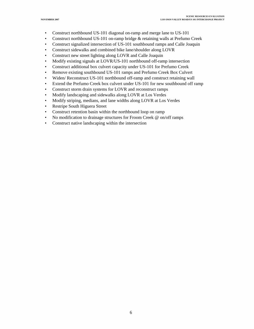
SCENIC RESOURCES EVALUATION NOVEMBER 2007 LOS OSOS VALLEY ROAD/US 101 INTERCHANGE PROJECT
6
• Construct northbound US-101 diagonal on-ramp and merge lane to US-101 • Construct northbound US-101 on-ramp bridge & retaining walls at Prefumo Creek • Construct signalized intersection of US-101 southbound ramps and Calle Joaquin • Construct sidewalks and combined bike lane/shoulder along LOVR • Construct new street lighting along LOVR and Calle Joaquin • Modify existing signals at LOVR/US-101 northbound off-ramp intersection • Construct additional box culvert capacity under US-101 for Prefumo Creek • Remove existing southbound US-101 ramps and Prefumo Creek Box Culvert • Widen/ Reconstruct US-101 northbound off-ramp and construct retaining wall • Extend the Prefumo Creek box culvert under US-101 for new southbound off ramp • Construct storm drain systems for LOVR and reconstruct ramps • Modify landscaping and sidewalks along LOVR at Los Verdes • Modify striping, medians, and lane widths along LOVR at Los Verdes • Restripe South Higuera Street • Construct retention basin within the northbound loop on ramp • No modification to drainage structures for Froom Creek @ on/off ramps • Construct native landscaping within the intersection


SCENIC RESOURCES EVALUATION NOVEMBER 2007 LOS OSOS VALLEY ROAD/US 101 INTERCHANGE PROJECT
9
3.0 VISUAL ASSESSMENT METHODS
3.1 ASSESSMENT METHODS Identification of existing conditions with regard to visual resources entails three steps.
1. Objective identification of the visual features (visual resources) of the landscape. 2. Assessment of the character and quality of those resources relative to overall regional visual
character. 3. Identification of the importance to people, or sensitivity, of views of visual resources in the
landscape. With an establishment of the baseline (existing) conditions, a proposed project or other change to the landscape can be systematically evaluated for its degree of impact. The degree of impact depends both on the magnitude of change in the visual resource (i.e., visual character and quality) and on viewers’ responses to and concern for those changes. The approach for this visual assessment is adapted from FHWA’s visual impact assessment system (Federal Highway Administration [FHWA] 1983). The visual impact assessment process involves identification of:
• Relevant policies and concerns for protection of visual resources; • Visual resources (i.e., visual character and quality) of the region, the immediate project area,
and the project site; • Important viewing locations (e.g., roads) and the general visibility of the project area and site
using descriptions and photographs; • Viewer groups and their sensitivity; and • Potential impacts.
3.2 CRITERIA FOR VISUAL ASSESSMENT Descriptions of visual character and quality in this assessment rely on the following standard terms (FHWA 1983).
• Vividness – The visual power or memorability of landscape components as they combine in striking or distinctive visual patterns.
• Intactness – The visual integrity of the natural and artificial landscape and its freedom from
encroaching elements. Intactness can be present in well-kept urban and rural landscapes as well as in natural settings.
• Unity – The visual coherence and compositional harmony of the landscape as a whole; it
frequently attests to the careful design of individual components in the artificial landscape. Vividness, intactness, and unity are the basic components used to describe visual character and quality for most visual assessments (FHWA 1983).

SCENIC RESOURCES EVALUATION NOVEMBER 2007 LOS OSOS VALLEY ROAD/US 101 INTERCHANGE PROJECT
10
For each of these factors a numeric score is assigned for the view from the key viewpoint, from 0 to 7, with 0 being the lowest and 7 being the highest. These scores are added and then divided by 3 to get the overall visual quality score (which is later used to compare to the “with project” condition to identify changes in visual quality). The formula for assessing visual quality is shown below:
Visual Quality = Vividness + Intactness + Unity 3
Viewer sensitivity or concern is based on the visibility of resources in the landscape, the proximity of viewers to the visual resource, the relative elevation of viewers to the visual resource, the frequency and duration of views, the number of viewers, and the types and expectations of individuals and viewer groups. The criteria for identifying importance of views are related in part to the position of the viewer relative to the resource. An area of the landscape that is visible from a particular location (e.g., an overlook) or series of points (e.g., a road or trail) is defined as a viewshed. To identify the importance of views of a resource, a viewshed may be broken into distance zones of foreground, middleground, and background. Generally, the closer a resource is to the viewer, the more dominant it is and the greater is its importance to the viewer. Although distance zones in viewsheds may vary between different geographic regions or types of terrain, a commonly used set of criteria identifies the foreground zone as 0.4 to 0.8 kilometer (0.25 to 0.5 mile) from the viewer, the middleground zone as extending from the foreground zone to 4.8–8 kilometers (3–5 miles) from the viewer, and the background zone as extending from the middleground zone to infinity. Visual sensitivity also depends on the number and type of viewers and the frequency and duration of views. Generally, visual sensitivity increases with an increase in total numbers of viewers, the frequency of viewing (e.g., daily or seasonally), and the duration of views (i.e., how long a scene is viewed). Also, visual sensitivity is higher for views seen by people who are driving for pleasure; people engaging in recreational activities such as hiking, biking, or camping; and homeowners. Visual sensitivity tends to be lower for views seen by people driving to and from work or as part of their work (FHWA 1983). Views from recreation trails and areas, scenic highways, and scenic overlooks are generally assessed as having high visual sensitivity.

SCENIC RESOURCES EVALUATION NOVEMBER 2007 LOS OSOS VALLEY ROAD/US 101 INTERCHANGE PROJECT
11
4.0 AFFECTED ENVIRONMENT
4.1 GENERAL SITE DESCRIPTION The LOVR Interchange was constructed in 1962 to carry two lanes of traffic through the project area and later widen in 1987 to four lanes. The US 101 alignment itself was constructed in 1933 and was replaced with a four lane facility in 1945. The alignment of US 101 through the project area is the route of El Camino Real, a historic route (Historic Property Survey Report 2007). Local commute traffic is the primary use through this portion of US 101 although a portion is also interregional traffic. The interchange is located in a historically agricultural and ranching area, although development in the past few decades has constructed commercial and industrial areas as well as residential neighborhoods on both sides of project, to the east and west of US 101. Growth of the commercial area to the west of the interchange continues today. Regionally, the project area is located within the Coast Ranges and has varied slopes on and adjacent to the project site, including the Irish Hills and Los Osos Valley, and even greater variability beyond the project, specifically the Cuesta Ridge of the Santa Lucia Mountains, within the viewshed of the interchange. The interchange sits at the edge of the Los Osos Valley, against the Irish Hills, and where three creeks run through the project area. The creeks include San Lois Obispo Creek, Prefumo Creek, and Froom Creek. The San Luis Obispo and Prefumo creeks are heavily vegetated, however, and are generally not visible even from the Irish Hills except as bands of riparian vegetation. The slopes and valley west of the interchange have historically been used for ranching by the Madonna Family and, east of the interchange, agricultural fields and industrial uses have dominated. Vegetation on the valley floor includes stands of native sycamore, cottonwood, Arroyo Willow, annual grassland, and also non-native ornamentals associated with the developed land within the project area (Natural Environment Study 2007). The adjacent hills remain largely unaltered with open California Annual Grassland and oak woodland. The project setting includes both natural resource features and a developed, urban environment. Natural resource features focus on the Irish Hills, Cuesta Ridge, and the Los Osos Valley. Built environment resources include Froom Ranch which is eligible for the National Register of Historic Places. Riparian vegetation, sycamore, and annual grasslands comprise the primary vegetation resources within the interchange area. 4.2 SCENIC DESIGNATIONS US 101 within the project area is not a designated scenic roadway but is an eligible scenic roadway by the California Department of Transportation. The City of San Luis Obispo 2006 Conservation and Open Space Element (COSE), however, identifies US 101 and the portion of Los Osos Valley Road north of the interchange in the Scenic Roadways section and gives these roadways a designation of high scenic value through the project area. No designated heritage trees occur within the project area.

SCENIC RESOURCES EVALUATION NOVEMBER 2007 LOS OSOS VALLEY ROAD/US 101 INTERCHANGE PROJECT
12
The City’s scenic designation for the interchange location is based on the visual quality of the landscape through which the roads travel. The high visual quality of the Los Osos Valley Road and US 101 corridors are generally defined by two primary factors; the unobstructed views of the adjacent hillsides and the rural character of the valley floor. This high visual quality rating for the project area is moderated in areas where views to the hillsides are reduced by the existing interchange or where the visual integrity of the rural open space has been compromised with existing transportation elements. The Los Osos Valley Road Interchange is also defined in the City of San Luis Obispo 1994 Circulation Element, including the April 4, 2006 amendment (Resolution No. 9785), as an entryway to the community of San Luis Obispo. The Traffic Management section states that “segments of these routes leading into San Luis Obispo should include landscaped medians and roadside areas to better define them as community entryways”. Additionally, the Scenic Roadways section establishes a policy to " preserve and improve views of important scenic resources form streets and roads". The following policies from the 2006 Conservation and Open Space Element and 1994 Circulation Element address the scenic importance of designated local roads, such as LOVR:
Policy 9.1.4. D – Streetscapes and Major roadways. Encourage the use of water-conserving landscaping, street furniture, decorative lighting and paving, arcaded walkways, public art, and other pedestrian-oriented features to enhance the streetscape appearance, comfort and safety. (Conservation and Open Space Element) Policy 9.2.1.B - Views to and from public places, including scenic roadways. Utilities, traffic signals, and public and private signs and lights shall not intrude on or clutter views, consistent with safety needs. (Conservation and Open Space Element)
Policy 15.1 – The City will participate with Caltrans, the county and other cities to establish a program for enhancing the visual character of the Highway 101 corridor. (Circulation Element)
The existing visual quality of the project setting is moderate. Views of the project site from the primary viewing corridors, Los Osos Valley Road and US 101, are oriented primarily toward open space and the scenic backdrop of the Irish Hills and Cuesta Ridge. Views from the project site, however, are sometimes obstructed by the existing interchange, which block background views. The rural character of that site location is also diminished somewhat by the presence of the adjacent development as well as the auto dealerships, commercial, and residential areas to the southeast. In spite of the increasing development and changing foreground appearance, the Irish Hills and Cuesta Ridge continue to provide a visually dominant scenic backdrop as seen from the Los Osos Valley Road interchange. 4.3 LANDSCAPE UNITS Landscape units can be broken into two units (Photographs 1&2 and Figure 4). The first is a relatively homogeneous combination of the valley bottom landform and mixed development with open space landcover that recur throughout the US 101 and Los Osos Valley corridors. Typical vegetation is mixed native species, mostly dominated by sycamore at the interchange, and also riparian vegetation along the creeks. From a view point within this unit, foreground and middleground views consist of the high vegetation and urban and residential land uses. The Irish Hills and Cuesta Ridge are visible in the background and are the most dominant features within the viewshed.

SCENIC RESOURCES EVALUATION NOVEMBER 2007 LOS OSOS VALLEY ROAD/US 101 INTERCHANGE PROJECT
13
The second unit is the hills of the Coast Range, including the Cuesta Ridge and Irish Hills, which are delineated topographic boundaries sloping up from the valley and moving from rolling to steep hills. These features are also the limit of the background views. Typical vegetation includes oak woodland and grassland that are typically uneven and random across the hills of the area. From view points within this unit, middleground views consist of the urban and residential land uses and also sycamore and riparian vegetation. Foreground and background views consist of slopes, hills, and ridgelines. Representative Photographs
Photograph 1. Landscape Units Overview (O-1) Looking North towards the US 101 corridor.
Photograph 2. Landscape Units Overview (O-2) looking east across the Los Osos Valley and to the
Cuesta Ridge

SCENIC RESOURCES EVALUATION NOVEMBER 2007 LOS OSOS VALLEY ROAD/US 101 INTERCHANGE PROJECT
14
Figure 4. Landscape Unit Photograph Locations
O-1 O-2

SCENIC RESOURCES EVALUATION NOVEMBER 2007 LOS OSOS VALLEY ROAD/US 101 INTERCHANGE PROJECT
15
4.4 VIEWER GROUPS AND RESPONSES 4.5.1 Roadway Users The roadway users exiting and entering US 101 at the Los Osos Valley Road interchange are the primary group of affected viewers. These viewers are more likely to be residents commuting to and from work or consumers coming to the developing commercial centers to the north and south of the interchange. The general speeds on the interchange are 20 miles per hour (mph) and below. Portions of the site are elevated on the bridge structures where views of the surrounding area are very visible. Other portions of the site such as the ramps are at grade with US 101, making the project site and surrounding areas difficult to view. Views are short in duration due to exiting and entrance movements, making this viewer group’s sensitivity moderate. 4.5.2 Commercial/Industrial The commercial industrial group includes patrons of the hotels, workers at the hotels, water treatment facility, and office complexes, including individuals standing at outdoor parking lots and perhaps exiting buildings. The existing commercial buildings are located mainly north of the project bordering the interchange. The views from the parking lot and buildings are largely obstructed by vegetation but due to proximity to the interchange the views of the valley are also obstructed. Views of the hills are less obstructed due to viewer position at grade with the roadway. Given the existing screening and the consideration that these viewers are at work rather than at home or in a recreational setting, their sensitivity is low. 4.5.3 Recreationists Recreationists who use the Irish Hills have largely unobstructed views of the US 101 corridor and surrounding areas. Typical recreation activities include hiking and biking. The dense riparian vegetation along the creeks in the project area obstructs many of the views of water resources although Froom Creek is visible. Recreationists using portions of the Irish Hills have limited views of the project site due to vegetation cover, in spite of their elevated position. Therefore, the viewer sensitivity for recreationists is moderate. 4.5.4 Residents The project site is within the viewshed of a very limited number of scattered residential receptors located east of the interchange. The Irish Hills are located within the viewshed of these residential properties. Dense vegetation obstructs much of the views of the project site, although it is higher in elevation. The sensitivity of these residents is considered low, because of existing screening.

SCENIC RESOURCES EVALUATION NOVEMBER 2007 LOS OSOS VALLEY ROAD/US 101 INTERCHANGE PROJECT
16
3. View of Traveler on LOVR (Looking North) 4. Looking East from Future Hook Ramps
5. View of Traveler on Bridge (Looking South) 6. View of Traveler on Bridge (Looking North)
7. View of Traveler on US 101 (Looking North) 8. View of Traveler on US 101 (Looking South) Photographs 3-8.

SCENIC RESOURCES EVALUATION NOVEMBER 2007 LOS OSOS VALLEY ROAD/US 101 INTERCHANGE PROJECT
17
Figure 5. Viewer Group Perspective Locations
V-8
V-7
V-6
V-5 V-4
V-3

SCENIC RESOURCES EVALUATION NOVEMBER 2007 LOS OSOS VALLEY ROAD/US 101 INTERCHANGE PROJECT
18
4.5 VISUAL INVENTORY In accordance with the Federal Highway Administration guidelines, an inventory of the project site’s existing visual condition was conducted. A Landscape Unit Checklist (Appendix A) was completed, which assigns numeric values to the various landscape units relevant to the project site. As indicated by the inventory, the visual resources within the landscape units are mainly the Irish Hills, Los Osos Valley, commercial urban development, transportation corridor, and existing vegetation associated with the interchange. As such, the existing aesthetic value for the project area is average to above average. The project site also demonstrates a variety of visual conditions. These conditions are summarized for the project area as follows: • The interchange and associated bridges date to 1962 and 1987, with no apparent unique design or
aesthetic value.
• The commercial and urban development around the interchange bisects the low valley between the Coast Range settings of the project area.
• The water resources (Froom Creek, San Louis Obispo Creek, and Prefumo Creek) are not visible from the roadway or from the hills.
• Land uses surrounding the project site are commercial, agricultural, recreational, and residential.
• The visual resources in the project area include the Irish Hills and views from the Los Osos Valley Road and US 101 corridors.
4.6 VISUAL QUALITY EVALUATION Consistent with the FHWA assessment, conditions relating to the project area were evaluated for visual quality. This analysis evaluates the value of visual quality within the right-of-way and outside of the right-of-way (both inside the landscape unit and outside the landscape unit). Southern views from the site are generally of lower quality than eastern views because of the proximity to the Irish Hills and curvature of US 101, which block the broader views of the mountains. Views north are of higher quality because of the picturesque qualities of the open valley and the Coast Range and rolling hills in the background. The general visual character in the vicinity of the proposed project has moderately high vividness because of the open space and rural elements, but unity and intactness are reduced to a low to moderate level because of the development, built features, and bisection with US 101 within and adjacent to the site. Therefore, the visual quality of the project area is moderate (VQ=3.7). Vividness is moderate (V=5), and intactness (I=3) and unity (U=3) are low. Figure 7 presents the observer locations for the evaluation and locations of site photographs. Appendix B presents the quantitative evaluation of these conditions. Photographs 1, 2 and 3 present the actual photographs.

SCENIC RESOURCES EVALUATION NOVEMBER 2007 LOS OSOS VALLEY ROAD/US 101 INTERCHANGE PROJECT
19
The evaluation is summarized as follows: Table A: View of the Road – Existing Conditions
OBSERVER VIEWPOINT
VISUAL QUALITY1
P1
3.39
P2
4.54
Table B: View from the Road – Existing Conditions
OBSERVER VIEWPOINT
VISUAL QUALITY1
P3
4.54
P4
3.31
1Based on a scale from one to seven (very low to very high).

SCENIC RESOURCES EVALUATION NOVEMBER 2007 LOS OSOS VALLEY ROAD/US 101 INTERCHANGE PROJECT
20
Figure 6: Observer Locations
P-4
P-1
P-2
P-3

SCENIC RESOURCES EVALUATION NOVEMBER 2007 LOS OSOS VALLEY ROAD/US 101 INTERCHANGE PROJECT
21
Photograph 9: Looking South along US 101 towards the LOVR Interchange (the view of the road/project from the roadway user perspective). Note the scaling of the interchange to the background views of the topography.
Photograph 10: Looking north on US 101 towards LOVR interchange (view of the road/project from the roadway user perspective). Note the limited and short duration views because of the curvature of US 101 leading up to the project site.

SCENIC RESOURCES EVALUATION NOVEMBER 2007 LOS OSOS VALLEY ROAD/US 101 INTERCHANGE PROJECT
22
Photograph 11: Looking north on Los Osos Valley Road overcrossing (view from the road/project from the roadway user perspective)

SCENIC RESOURCES EVALUATION NOVEMBER 2007 LOS OSOS VALLEY ROAD/US 101 INTERCHANGE PROJECT
23
5.0 ENVIRONMENTAL CONSEQUENCES
Improvements to the Los Osos Valley Road Interchange will change the visual environment within the project area. The primary change will be temporary and short-term visual impacts associated with vegetation removal. Although the improvements to the interchange will increase the size and height of the structure and introduce retaining walls, the ultimate scale of the interchange in relation to the setting will not increase and is therefore not considered an adverse impact. 5.1 VISUAL QUALITY CHANGE Site changes will not be substantially different from existing conditions due to the current presence of the interchange structures. The aesthetic character of the setting will not be adversely impacted. The visual setting from various viewpoints will have minor changes depending on the location of the vantage. Table C describes the visual changes resulting from the proposed project alternatives in a comparative format. To determine the difference in visual impact between existing conditions and the proposed project alternatives, a quantitative impact evaluation was conducted. The visual quality evaluation forms are included in Appendix C. The evaluation focuses on three visual quality features—vividness, intactness, and unity. The results are summarized below. Tables D1 and D2 summarize that views of the road and the existing surrounding environment, under either Alternative 3 or 6, are expected to result in relative neutral change in visual quality. Table E, views from the road, summarizes both Alternatives 3 and 6 together due to the similarity in visual change and suggests that a slightly positive improvement in visual quality is expected. This evaluation focuses on the motorist’s perspective traveling along US 101 and also along the Los Osos Valley roadway. 5.1.1 The Project Alternatives As Seen From Adjacent Views and US 101 As seen from US 101, Alternative 3 will be as visible as the current interchange from both the southerly and northerly views (Photo Simulation 1&2). Views of the ramps under Alternative 6 are more visible from the southerly view with the addition of the northbound on-ramp, but remain largely unchanged from the northerly view. The minimal increase in structure height under both Alternative 3 and 6 will not substantially increase or block current views of the Irish Hills or the Cuesta Ridge backdrops (Photo Simulation 1). Lighting will be added to the bridge under both Alternatives 3 and 6 which will increase the visibility of the structure. Removal of overhead utility lines will take away the break in the tree-line that currently exists from the southern view and will help to declutter the overall interchange appearance under both Alternatives 3 and 6. Removal of vegetation will temporarily increase visibility of concrete and retaining walls rather than natural vegetation.

SCENIC RESOURCES EVALUATION NOVEMBER 2007 LOS OSOS VALLEY ROAD/US 101 INTERCHANGE PROJECT
24
Photo Simulation 1. View South of Traveler on US 101- Existing Conditions Above, Alternative 3 Center, Alternative 6 Below.

SCENIC RESOURCES EVALUATION NOVEMBER 2007 LOS OSOS VALLEY ROAD/US 101 INTERCHANGE PROJECT
25
Photo Simulation 2. View North of Traveler on US 101- Existing Conditions Above, Alternative 3 Center, Alternative 6 Bottom.

SCENIC RESOURCES EVALUATION NOVEMBER 2007 LOS OSOS VALLEY ROAD/US 101 INTERCHANGE PROJECT
26
5.1.2 The Project Alternatives as Seen From Los Osos Valley Road
Photo Simulation 4. View West of Traveler on LOVR over US 101 - Existing Conditions Above, Alternative 3 center, Alternative 6 Bottom.

SCENIC RESOURCES EVALUATION NOVEMBER 2007 LOS OSOS VALLEY ROAD/US 101 INTERCHANGE PROJECT
27
Views for travelers on Los Osos Valley Road will remain largely unchanged under Alternatives 3 or 6. Broad background view of the Irish Hills and Cuesta Ridge may be slightly improved with removal of some large vegetation and increased height of the new bridge structures. The inclusion of lighting on the bridge will add a visual element to the setting. Table C: Aesthetic Changes with the Proposed Project
PROPOSED RECONSTRUCTED INTERCHANGE
EXISTING
INTERCHANGE Alternative 3 Alternative 6
Existing bridge reflects a simple concrete structure.
Proposed reconstruction, visible from northbound US 101, will reflect a simple concrete structure. Existing bridge, visible from southbound US 101, remains unchanged.
Proposed new structure will reflect simple concrete structure. New ramps will be visible from southbound US 101.
Existing bridge appears narrow and constricted in contrast to approach lanes.
Proposed reconstruction will restripe existing bridge and construct an adjacent structure to accommodate pedestrians and bicyclists.
Proposed structure will be widened to accommodate pedestrians and bicyclists.
Mature vegetation and trees are present within the quadrants of the interchange and at the creek crossing location.
Some vegetation and trees will be removed adjacent to the project to accommodate the widened bridge structure.
Some vegetation and trees will be removed adjacent to the project to accommodate the widened bridge structure.
Unobstructed views of hill and mountain ridges from existing bridge location.
Background and middleground views remain unchanged and may improve with removed vegetation.
Background and middleground views remain unchanged and may improve with removed vegetation.
Table D1: Evaluation - View of the Road Alternative 3
OBSERVER VIEWPOINT
EXISTING/ PROPOSED
VISUAL
QUALITY
VISUAL
QUALITY DIFFERENCE
POSITIVE OR
NEGATIVE IMPACT
Existing
3.39
P1 Proposed
3.39
-0.08
Negative
Existing
4.54
P2 Proposed
4.50
0.00
Neutral

SCENIC RESOURCES EVALUATION NOVEMBER 2007 LOS OSOS VALLEY ROAD/US 101 INTERCHANGE PROJECT
28
Table D2: Evaluation - View of the Road Alternative 6
OBSERVER VIEWPOINT
EXISTING/ PROPOSED
VISUAL
QUALITY
VISUAL
QUALITY DIFFERENCE
POSITIVE OR
NEGATIVE IMPACT
Existing
3.39
P1 Proposed
3.39
0.0
Neutral
Existing
4.54
P2 Proposed
4.50
-0.04
Negative
Table E: Evaluation - View from the Road Alternatives 3 & 6
OBSERVER VIEWPOINT
EXISTING/ PROPOSED
VISUAL
QUALITY
VISUAL
QUALITY DIFFERENCE
POSITIVE OR
NEGATIVE IMPACT
Existing
4.54
P3 Proposed
4.59
+0.04
Positive
Existing
3.31
P4 Proposed
3.58
+0.27
Positive
5.2 SCENIC DESIGNATIONS There are no designated scenic resources or natural landmarks within the project area. Consequently, proposed improvements will have no effect on scenic resources or natural landmarks. 5.3 ADJACENT USES Construction of the proposed interchange improvements will not significantly affect adjacent land uses outside of the project area. Some loss of agricultural land and property from the waste water treatment facility will not impact their current uses. Project impacts on local habitat and vegetation will be replaced in conjunction with biological mitigation requirements. 5.4 IMPACT SUMMARY From the above summary and site visits, it is suggested that visual impacts due to the project are considered neutral. This conclusion is based on 1) similarities between the existing structure and the proposed new/parallel structure, 2) views of the surrounding areas will be improved from some perspectives and remain unchanged in others, and 3) loss of mature vegetation will result in a short-term impact to viewer groups because more concrete will be visible than is currently. Although reconstruction of the existing bridge with a slightly larger structure and introduction of retaining walls will be an increase in impact to the visual environment, it is anticipated that the change will be considered a neutral aesthetic impact because of the existing structure and current setting.

SCENIC RESOURCES EVALUATION NOVEMBER 2007 LOS OSOS VALLEY ROAD/US 101 INTERCHANGE PROJECT
29
6.0 MITIGATION AND DISCUSSION
6.1 IMPACTS AND MITIGATION Visual mitigation measures must address the specific visual impacts caused by the project alternatives, including the two build alternatives described in Chapter 2 and evaluated in Chapter 5. For the build alternatives, such mitigation is relevant to the specific users of the roadway. As indicated in the Visual Quality Evaluation, the ultimate project conditions will not adversely or significantly impact visual conditions. For the perspective from US 101, aesthetic features should be considered for the bridge and roadway that enhance the entryway setting, per the City General Plan, while not increasing the current obstruction to vistas of the Irish Hills and Cuesta Ridge or of the valley bottom and riparian environment along the creeks. The addition of lighting should provide more security to pedestrians and bicyclists without compromising nighttime views or creating glare for non-roadway users. Although it is too early to select specific architectural features, consideration of aesthetic features may include ornamental lighting and open concrete and/or metal railing along the outside edge of the walkway. In addition, the concrete may have visual treatment or patterns on the bridge and associated retaining walls to soften the appearance of a large concrete structure. Landscaping should be considered for loss of mature vegetation features within the project site. Views from Los Osos Valley Road should also consider aesthetic features such as open railings along the bridge facilitating views and vistas of the Irish Hills and Cuesta Ridge as well as of the valley bottom and riparian environment along the creeks. The open feeling of the widened bridge structure and appropriate light fixtures will help to achieve the entryway setting for travelers using the interchange to access points north and south along Los Osos Valley Road. Continued coordination with the City and Caltrans will ensure adequate project consistency with City and Caltrans aesthetic standards. IMPACT 1
Both alternatives of the project would result in temporary impacts from vegetation removal and the resulting increase in visible concrete. These impacts are considered less than adverse under NEPA and less than significant under CEQA with mitigation. In areas of mature vegetation removal, mitigation planting and revegetation would occur.
VIS-1 Screening of increased concrete visibility. The landscape plan shall include a planting screen along exposures of bridge abutments and at some proposed retaining wall locations, where appropriate. The planting shall complement the naturally appearing form of the interchange and not look like a formal, manicured landscape. The design shall avoid a linear planting along the wall locations. The landscape plan shall be developed in coordination with Caltrans Landscape Architecture staff for areas within state right-of-way as well as with the City’s Architectural Review Committee and City staff. A

SCENIC RESOURCES EVALUATION NOVEMBER 2007 LOS OSOS VALLEY ROAD/US 101 INTERCHANGE PROJECT
30
Caltrans maintenance plan shall be developed during PS&E to ensure that plantings within the state right-of-way establish in order to sufficiently reduce the identified impact.
IMPACT 2
The proposed construction activities under Alternative 3 or 6 would result in temporary impacts. These impacts are considered less than adverse under NEPA and less than significant under CEQA with mitigation.
VIS-2 Replace vegetation lost because of construction. This mitigation will result in a naturalized condition comparable to the density, spacing, and species variety of the existing conditions. The site will be replanted with similar species that were affected by the project. Replacement plants will be sized so as to reach the existing plant sizes within the minimal time feasible. Maintenance and monitoring will be required to assure plant survival so that the existing conditions are closely replicated within the determined timeframe. The revegetation plan shall be developed in coordination with Caltrans Landscape Architecture staff for areas within state right-of-way as well as with the City’s Architectural Review Committee and City staff. IMPACT 3 Cumulatively, the visibility of Alternatives 3 or 6, seen in conjunction with other residential and commercial developments will diminish the remaining rural character of this entryway and could result in long-term visual impacts as seen from Los Osos Valley Road and the nearby community. This impact is considered less than adverse under NEPA and less than significant under CEQA. VIS-3 Consideration of aesthetic features for the bridge structure and interchange setting. Implementation of architectural features, developed with Caltrans and City aesthetic standards, shall be considered for the bridge structure and exposed concrete areas, as appropriate, to meet the desired goals as defined in the Conservation and Open Space Element of the City’s General Plan. The esthetic features shall be developed in coordination with Caltrans Landscape Architecture staff for areas within state right-of-way as well as with the City’s Architectural Review Committee and City staff. IMPACT 4 Lighting, proposed for each of the project build alternatives, would create increased light and glare within the project area that would detract from nighttime sky views. This impact is considered less than adverse under NEPA and less than significant under CEQA. VIS-4 A lighting plan shall be developed that requires project lighting to be appropriately shielded. Project lighting design shall be consistent with all Caltrans and City lighting guidelines and standards and shall be developed with Caltrans and City aesthetic standards. The lighting plan shall be developed in coordination with Caltrans Landscape Architecture staff for areas within state right-of-way as well as with the City’s Architectural Review Committee and City staff.

SCENIC RESOURCES EVALUATION NOVEMBER 2007 LOS OSOS VALLEY ROAD/US 101 INTERCHANGE PROJECT
31
6.2 VISUAL RESOURCE MANAGEMENT OBJECTIVES The proposed interchange improvements are needed to improve the local traffic operations and improve hydraulic and drainage conditions. The existing structure cannot achieve these primary objectives. Therefore, any net effects on visual resources due to the project are secondary, in light of the primary objectives. As indicated in the Visual Inventory and Analysis (Appendix A), the visual resources in the area consist mainly of the hills, ridges, and valley resources. Overall, with the new bridge and ramp improvements, the visual quality is expected be neutral and ultimately similar when compared with the existing conditions (e.g., No Build Alternative). 6.3 ALTERNATIVE SOLUTIONS The No Build Alternative does not accomplish any of the project objectives and would result in continued unacceptable traffic operations and restrict bike and pedestrian usage on the current bridge facility. With the build alternatives, the interchange improvements will be provided to improve these existing deficiencies. 6.4 EFFECTIVENESS EVALUATION In light of the infeasibleness of other design alternatives, the proposed build alternatives remain the only effective solution for achieving the fundamental project objectives. Both alternative would result in similar visual impacts and are the only effective designs available. Furthermore, there are no adverse impacts indicated. 6.5 RECOMMENDATIONS To achieve high visual quality for the project, it is recommended that the proposed mitigation measures are developed in conjunction with Caltrans, City staff and the Architectural Review Committee to ensure that aesthetic standards and objectives are maintained. The final mitigation measures will be included in the engineering plans and Mitigation, Monitoring, and Reporting Plan for the interchange improvements. No other recommendations or mitigation are deemed necessary in light of the neutral project effects.

SCENIC RESOURCES EVALUATION NOVEMBER 2007 LOS OSOS VALLEY ROAD/US 101 INTERCHANGE PROJECT
32
7.0 REFERENCES
Historical Property Survey Report. 2007. Jones & Stokes Associates. Historic Property Survey Report for the Los Osos Valley Road/US 101 Interchange Improvement Project, San Luis Obispo County, California.
Natural Environment Study Report. 2007. Jones & Stokes Assoicates. Natural Environment Study
Report for the Los Osos Valley Road/US 101 Interchange Improvements Project, San Luis Obispo County, California.
San Luis Obispo, City of. 1994. General Plan, Circulation Element. San Luis Obispo, City of. 2006. Amendments to the 1994 Circulation Element, Resolution No. 9785. San Luis Obispo, City of. 2006. Conservation and Open Space Element, Resolution No. 9785. U.S. Bureau of Land Management. 1980. Visual resource management program (Stock No.
024-001-00116-6). Washington, DC: U.S. Government Printing Office. U.S. Department of Transportation, Federal Highway Administration. Visual Impact Assessment for
Highway Projects (FHWA-HI-88-054).

SCENIC RESOURCES EVALUATION
NOVEMBER 2007 LOS OSOS VALLEY ROAD/US 101 INTERCHANGE PROJECT
APPENDIX A
LANDSCAPE UNIT CHECKLIST

LANDSCAPE UNIT CHECKLIST: VISUAL INVENTORY AND ANALYSIS
Project Name LOVR/US 101 Interchange Evaluator CampbellS.R. Number Date 5/25/2006Assessment Unit Valley/Urban Development Weather Clear L/F District L/F Section L/F Province
Visual Information Visual Character(Perception) (Cognition)
Resource Supply Pattern Elements Pattern Character3 High Prominence 3 High Prominence 3 High Prominence2 Moderate Prominence 2 Moderate Prominence 2 Moderate Prominence1 Present 1 Present 1 Present0 Absent 0 Absent 0 Absent
Landform0 Mountains 2 Form 2 Dominance of Landforms0 Steep Hills/Ridges 3 Line 2 Scale of Landforms0 Rolling Hills 2 Color 1 Diversity of Landforms2 Undulating Land 1 Texture 1 Continuity of Landform Pattern0 Plateaus/Plains3 Valleys0 Cliffs, Bluffs0 Points0 Beaches
Land Cover (Water)0 Bays/Inlets 0 Form 0 Dominance of Waterforms0 Rivers 0 Line 0 Scale of Waterforms1 Streams 0 Color 0 Diversity of Waterforms0 Lakes 0 Texture 0 Continuity of Waterform Pattern0 Ponds0 Marshes0 Waterfalls/Rapids
Land Cover (Vegetation)0 Coniferous Woods 1 Form 2 Dominance of Vegetation0 Deciduous Woods 1 Line 2 Scale of Vegetation2 Scrubland 3 Color 1 Diversity of Vegetation2 Grassland 2 Texture 1 Continuity of Vegetation Pattern1 Pasture/Croplands0 Parks/Lawns3 Street Trees1 Agriculture

Visual Information Visual Character(Perception) (Cognition)
Resource Supply Pattern Elements Pattern Character3 High Prominence 3 High Prominence 3 High Prominence2 Moderate Prominence 2 Moderate Prominence 2 Moderate Prominence1 Present 1 Present 1 Present0 Absent 0 Absent 0 Absent
Land Cover (Manmade Development)0 Urban Centers 2 Form 2 Dominance of Development2 Suburban Areas 1 Line 2 Scale of Development0 Industrial Areas 1 Color 2 Diversity of Development2 Commercial Areas 2 Texture 1 Continuity of Dev. Pattern0 Institutional Areas1 Residential Areas1 Historic Features3 Highways0 Railroads0 Utility Lines0 Towers/Structures0 Docks/Piers/Boats3 Bridges/Dams0 Parking/Storage Yard0 Embankments/Cuts/Pits1 Billboards/Signs

LANDSCAPE UNIT CHECKLIST: VISUAL INVENTORY AND ANALYSIS
Project Name LOVR/US 101 Interchange Evaluator CampbellS.R. Number Date 5/25/2006Assessment Unit Hills/Ridges Weather Clear L/F District L/F Section L/F Province
Visual Information Visual Character(Perception) (Cognition)
Resource Supply Pattern Elements Pattern Character3 High Prominence 3 High Prominence 3 High Prominence2 Moderate Prominence 2 Moderate Prominence 2 Moderate Prominence1 Present 1 Present 1 Present0 Absent 0 Absent 0 Absent
Landform0 Mountains 3 Form 3 Dominance of Landforms3 Steep Hills/Ridges 3 Line 3 Scale of Landforms2 Rolling Hills 2 Color 1 Diversity of Landforms1 Undulating Land 2 Texture 3 Continuity of Landform Pattern0 Plateaus/Plains0 Valleys0 Cliffs, Bluffs0 Points0 Beaches
Land Cover (Water)0 Bays/Inlets 0 Form 0 Dominance of Waterforms0 Rivers 0 Line 0 Scale of Waterforms0 Streams 0 Color 0 Diversity of Waterforms0 Lakes 0 Texture 0 Continuity of Waterform Pattern0 Ponds0 Marshes0 Waterfalls/Rapids
Land Cover (Vegetation)0 Coniferous Woods 1 Form 1 Dominance of Vegetation2 Deciduous Woods 1 Line 1 Scale of Vegetation0 Scrubland 2 Color 1 Diversity of Vegetation3 Grassland 1 Texture 2 Continuity of Vegetation Pattern0 Pasture/Croplands0 Parks/Lawns0 Street Trees0 Agriculture

Visual Information Visual Character(Perception) (Cognition)
Resource Supply Pattern Elements Pattern Character3 High Prominence 3 High Prominence 3 High Prominence2 Moderate Prominence 2 Moderate Prominence 2 Moderate Prominence1 Present 1 Present 1 Present0 Absent 0 Absent 0 Absent
Land Cover (Manmade Development)0 Urban Centers 0 Form 0 Dominance of Development0 Suburban Areas 0 Line 0 Scale of Development0 Industrial Areas 0 Color 0 Diversity of Development0 Commercial Areas 0 Texture 0 Continuity of Dev. Pattern0 Institutional Areas0 Residential Areas0 Historic Features0 Highways0 Railroads0 Utility Lines0 Towers/Structures0 Docks/Piers/Boats0 Bridges/Dams0 Parking/Storage Yard0 Embankments/Cuts/Pits0 Billboards/Signs

SCENIC RESOURCES EVALUATION NOVEMBER 2007 LOS OSOS VALLEY ROAD/US 101 INTERCHANGE PROJECT
APPENDIX B
VISUAL QUALITY EVALUATION

VIS
UA
L Q
UA
LITY
EV
ALU
ATI
ON
- V
IEW
OF
THE
RO
AD
- E
XIS
TIN
G C
ON
DIT
ION
Eval
uatio
n Sc
ale:
1-7
Proj
ect N
ame
Los
Oso
s Va
lley
Roa
d In
terc
hang
eEv
alua
tor
Cam
pbel
l1
= Ve
ry L
owS.
R. N
o.D
ate
5/25
/200
64
= M
ediu
mAs
sess
men
t Uni
tP1
and
P2
Wea
ther
Cle
ar7
= Ve
ry H
igh
VIEW
VISU
AL Q
UAL
ITY
ZON
EVI
VID
NES
SIN
TAC
TNES
SU
NIT
YC
RIT
ERIA
FEAT
UR
ESC
RIT
ERIA
ENC
RO
ACH
MEN
TC
RIT
ERIA
Observer Viewpoint
General Visual Quality
Landform
Water
Vegetation
Manmade Develop.
Vividness (1-7)
Absence of Encroachment
Overall Intactness
Intactness (Av. 1-7)
Man/Natural
Overall Unity
Unity (Av. 1-7)
Importance (1-3)
(V+I+U)/3
Visual Quality (Weighted av.)
Insi
de R
OW
1.00
*5.
001.
002.
33M
atur
e tre
es a
re
dist
inct
ive.
3.00
3.00
3.00
Stre
et s
igns
and
util
ity
lines
and
pol
es.
3.00
3.00
3.00
1.00
2.78
P1O
/SI/S
Uni
t3.
00*
5.00
2.00
3.33
Low
hills
are
dis
tinct
ive.
U
S 10
1 al
ignm
ent
pres
ent.
2.00
2.00
2.00
Stre
et li
ghts
, bui
ldin
gs,
US
101
and
utilit
y lin
es
and
pole
s.2.
003.
002.
502.
002.
613.
39
RO
WO
/S U
nit
6.00
*6.
001.
004.
33H
igh
hills
are
dis
tinct
ive.
5.00
5.00
5.00
Hig
h hi
lls a
nd ri
dge
lines
ar
e m
ostly
und
istu
rbed
, ut
ility
line
pres
ent.
5.00
5.00
5.00
3.00
4.78
Insi
de R
OW
4.00
*4.
003.
003.
67Fe
w d
istin
ct fe
atur
es.
4.00
4.00
4.00
US
101,
util
ity li
nes
and
pole
s.4.
004.
004.
002.
003.
89
P2O
/SI/S
Uni
t5.
00*
4.00
2.00
3.67
Prop
osed
brid
ge w
ill ad
d
feat
ures
to th
e ex
istin
g vi
ewsc
ape.
3.00
4.00
3.50
Stre
et li
ghts
, util
ity li
nes
and
pole
s, c
omm
erci
al
build
ings
.4.
005.
004.
502.
003.
894.
54
RO
WO
/S U
nit
6.00
*5.
00*
5.50
Hig
h hi
lls a
nd ri
dge
lines
ar
e di
stin
ctiv
e.6.
006.
006.
00La
rgel
y un
obst
ruct
ed
ridge
line.
6.00
6.00
6.00
3.00
5.83
O/S
RO
W =
Out
side
Rig
ht-o
f-Way
I/S U
nit =
Insi
de L
ands
cape
Uni
tO
/S U
nit =
Out
side
Lan
dsca
pe U
nit

VIS
UA
L Q
UA
LITY
EV
ALU
ATI
ON
- V
IEW
FR
OM
TH
E R
OA
D -
EXI
STI
NG
CO
ND
ITIO
NEv
alua
tion
Scal
e: 1
-7Pr
ojec
t Nam
eLo
s O
sos
Valle
y R
oad
Inte
rcha
nge
Eval
uato
rC
ampb
ell
1 =
Very
Low
S.R
. No.
Dat
e5/
25/2
006
4 =
Med
ium
Asse
ssm
ent U
nit
P3 a
nd P
4W
eath
erC
lear
7 =
Very
Hig
h
VIEW
VISU
AL Q
UAL
ITY
ZON
EVI
VID
NES
SIN
TAC
TNES
SU
NIT
YC
RIT
ERIA
FEAT
UR
ESC
RIT
ERIA
ENC
RO
ACH
MEN
TC
RIT
ERIA
Observer Viewpoint
General Visual Quality
Landform
Water
Vegetation
Manmade Develop.
Vividness (1-7)
Absence of Encroachment
Overall Intactness
Intactness (Av. 1-7)
Man/Natural
Overall Unity
Unity (Av. 1-7)
Importance (1-3)
(V+I+U)/3
Visual Quality (Weighted av.)
Insi
de R
OW
2.00
*5.
003.
003.
33M
atur
e tre
es a
re
dist
inct
ive.
2.00
3.00
2.50
Util
ity li
nes
and
pole
s an
d ov
ercr
ossi
ng s
truct
ure.
2.00
3.00
2.50
1.00
2.78
P3O
/SI/S
Uni
t6.
00*
4.00
5.00
5.00
Mat
ure
trees
and
low
hills
ar
e di
stin
ctiv
e. V
iew
of
Froo
m R
anch
.4.
005.
004.
50St
reet
ligh
ts, b
usin
esse
s an
d ut
ility
lines
and
pol
es.
6.00
5.00
5.50
2.00
5.00
4.54
RO
WO
/S U
nit
7.00
*5.
00*
6.00
Hig
h hi
lls a
nd ri
dge
lines
ar
e di
stin
ctiv
e.4.
005.
004.
50H
igh
hills
and
ridg
e lin
es
are
undi
stur
bed.
7.00
7.00
7.00
3.00
5.83
Insi
de R
OW
2.00
*2.
003.
002.
33Fe
w d
istin
ct fe
atur
es.
3.00
3.00
3.00
4.00
4.00
4.00
1.00
3.11
P4O
/SI/S
Uni
t3.
00*
4.00
*3.
50Pr
opos
ed b
ridge
will
add
feat
ures
to th
e ex
istin
g vi
ewsc
ape.
3.00
3.00
3.00
Stre
et li
ghts
, util
ity li
nes
and
pole
s.4.
004.
004.
001.
003.
503.
31
RO
WO
/S U
nit
**
**
**
**
**
**
*
* Abs
ent f
rom
Vie
w
O/S
RO
W =
Out
side
Rig
ht-o
f-Way
I/S U
nit =
Insi
de L
ands
cape
Uni
tO
/S U
nit =
Out
side
Lan
dsca
pe U
nit

VIS
UA
L Q
UA
LITY
EV
ALU
ATI
ON
- V
IEW
OF
THE
RO
AD
ALT
ER
NA
TIV
E 3
- P
RO
PO
SE
DEv
alua
tion
Scal
e: 1
-7Pr
ojec
t Nam
eLo
s O
sos
Valle
y R
oad
Inte
rcha
nge
Eval
uato
rC
ampb
ell
1 =
Very
Low
S.R
. No.
Dat
e5/
25/2
006
4 =
Med
ium
Asse
ssm
ent U
nit
Wea
ther
Cle
ar7
= Ve
ry H
igh
VIEW
VISU
AL Q
UAL
ITY
ZON
EVI
VID
NES
SIN
TAC
TNES
SU
NIT
YC
RIT
ERIA
FEAT
UR
ESC
RIT
ERIA
ENC
RO
ACH
MEN
TC
RIT
ERIA
Observer Viewpoint
General Visual Quality
Landform
Water
Vegetation
Manmade Develop.
Vividness (1-7)
Absence of Encroachment
Overall Intactness
Intactness (Av. 1-7)
Man/Natural
Overall Unity
Unity (Av. 1-7)
Importance (1-3)
(V+I+U)/3
Visual Quality (Weighted av.)
Insi
de R
OW
1.00
*5.
001.
002.
33M
atur
e tre
es a
re
dist
inct
ive.
3.00
3.00
3.00
Stre
et s
igns
and
util
ity
lines
and
pol
es.
3.00
3.00
3.00
1.00
2.78
P1O
/SI/S
Uni
t3.
00*
5.00
2.00
3.33
Low
hills
are
dis
tinct
ive.
U
S 10
1 al
ignm
ent
pres
ent.
2.00
2.00
2.00
Stre
et li
ghts
, bui
ldin
gs,
US
101
and
utilit
y lin
es
and
pole
s.2.
003.
002.
502.
002.
613.
39
RO
WO
/S U
nit
6.00
*6.
001.
004.
33H
igh
hills
are
dis
tinct
ive.
5.00
5.00
5.00
Hig
h hi
lls a
nd ri
dge
lines
ar
e m
ostly
und
istu
rbed
, ut
ility
line
pres
ent.
5.00
5.00
5.00
3.00
4.78
Insi
de R
OW
4.00
*3.
003.
003.
33Fe
w d
istin
ct fe
atur
es.
4.00
4.00
4.00
US
101,
util
ity li
nes
and
pole
s.4.
004.
004.
002.
003.
78
P2O
/SI/S
Uni
t5.
00*
4.00
2.00
3.67
Prop
osed
brid
ge w
ill m
aint
ain
exis
ting
view
scap
e.3.
004.
003.
50St
reet
ligh
ts, u
tility
line
s an
d po
les,
com
mer
cial
bu
ildin
gs.
4.00
5.00
4.50
2.00
3.89
4.50
RO
WO
/S U
nit
6.00
*5.
00*
5.50
Hig
h hi
lls a
nd ri
dge
lines
ar
e di
stin
ctiv
e.6.
006.
006.
006.
006.
006.
003.
005.
83
O/S
RO
W =
Out
side
Rig
ht-o
f-Way
I/S U
nit =
Insi
de L
ands
cape
Uni
tO
/S U
nit =
Out
side
Lan
dsca
pe U
nit

VIS
UA
L Q
UA
LITY
EV
ALU
ATI
ON
- V
IEW
OF
THE
RO
AD
ALT
ER
NA
TIV
E 6
- P
RO
PO
SE
DEv
alua
tion
Scal
e: 1
-7Pr
ojec
t Nam
eLo
s O
sos
Valle
y R
oad
Inte
rcha
nge
Eval
uato
rC
ampb
ell
1 =
Very
Low
S.R
. No.
Dat
e5/
25/2
006
4 =
Med
ium
Asse
ssm
ent U
nit
Wea
ther
Cle
ar7
= Ve
ry H
igh
VIEW
VISU
AL Q
UAL
ITY
ZON
EVI
VID
NES
SIN
TAC
TNES
SU
NIT
YC
RIT
ERIA
FEAT
UR
ESC
RIT
ERIA
ENC
RO
ACH
MEN
TC
RIT
ERIA
Observer Viewpoint
General Visual Quality
Landform
Water
Vegetation
Manmade Develop.
Vividness (1-7)
Absence of Encroachment
Overall Intactness
Intactness (Av. 1-7)
Man/Natural
Overall Unity
Unity (Av. 1-7)
Importance (1-3)
(V+I+U)/3
Visual Quality (Weighted av.)
Insi
de R
OW
1.00
*4.
001.
002.
00N
ew ra
mps
pre
sent
, in
crea
sed
asph
alt.
2.00
3.00
2.50
US
101
and
stre
et li
ghts
.3.
003.
003.
001.
002.
50
P1O
/SI/S
Uni
t3.
00*
4.00
2.00
3.00
Mat
ure
trees
are
di
stin
ctiv
e.
2.00
2.00
2.00
Stre
et li
ghts
.3.
003.
003.
002.
002.
673.
31
RO
WO
/S U
nit
6.00
*6.
001.
004.
33H
igh
hills
are
dis
tinct
ive.
5.00
5.00
5.00
Hig
h hi
lls a
nd ri
dge
lines
ar
e m
ostly
und
istu
rbed
.5.
005.
005.
003.
004.
78
Insi
de R
OW
4.00
*4.
003.
003.
67Fe
w d
istin
ct fe
atur
es.
4.00
4.00
4.00
US
101,
util
ity li
nes
and
pole
s, a
nd re
tain
ing
wal
ls.
4.00
4.00
4.00
2.00
3.89
P2O
/SI/S
Uni
t5.
00*
4.00
2.00
3.67
Prop
osed
brid
ge w
ill be
si
mila
r to
the
exis
ting
view
scap
e.3.
004.
003.
50St
reet
ligh
ts, u
tility
line
s an
d po
les,
com
mer
cial
bu
ildin
gs.
4.00
5.00
4.50
2.00
3.89
4.54
RO
WO
/S U
nit
6.00
*5.
00*
5.50
Hig
h hi
lls a
nd ri
dge
lines
ar
e di
stin
ctiv
e.6.
006.
006.
006.
006.
006.
003.
005.
83
O/S
RO
W =
Out
side
Rig
ht-o
f-Way
I/S U
nit =
Insi
de L
ands
cape
Uni
tO
/S U
nit =
Out
side
Lan
dsca
pe U
nit

VIS
UA
L Q
UA
LITY
EV
ALU
ATI
ON
- V
IEW
FR
OM
TH
E R
OA
D A
LTE
RN
ATI
VE
S 3
&6
- PR
OP
OS
ED
Eval
uatio
n Sc
ale:
1-7
Proj
ect N
ame
Los
Oso
s Va
lley
Roa
d In
terc
hang
eEv
alua
tor
Cam
pbel
l1
= Ve
ry L
owS.
R. N
o.D
ate
5/25
/200
64
= M
ediu
mAs
sess
men
t Uni
tW
eath
erC
lear
7 =
Very
Hig
h
VIEW
VISU
AL Q
UAL
ITY
ZON
EVI
VID
NES
SIN
TAC
TNES
SU
NIT
YC
RIT
ERIA
FEAT
UR
ESC
RIT
ERIA
ENC
RO
ACH
MEN
TC
RIT
ERIA
Observer Viewpoint
General Visual Quality
Landform
Water
Vegetation
Manmade Develop.
Vividness (1-7)
Absence of Encroachment
Overall Intactness
Intactness (Av. 1-7)
Man/Natural
Overall Unity
Unity (Av. 1-7)
Importance (1-3)
(V+I+U)/3
Visual Quality (Weighted av.)
Insi
de R
OW
2.00
*5.
003.
003.
33M
atur
e tre
es a
re
dist
inct
ive.
2.00
3.00
2.50
Util
ity li
nes
and
pole
s an
d ov
ercr
ossi
ng s
truct
ure.
3.00
3.00
3.00
1.00
2.94
P3O
/SI/S
Uni
t6.
00*
4.00
5.00
5.00
Mat
ure
trees
and
low
hills
ar
e di
stin
ctiv
e. V
iew
of
Froo
m R
anch
.4.
005.
004.
50St
reet
ligh
ts, b
usin
esse
s an
d ut
ility
lines
and
pol
es.
6.00
5.00
5.50
2.00
5.00
4.59
RO
WO
/S U
nit
7.00
*5.
00*
6.00
Hig
h hi
lls a
nd ri
dge
lines
ar
e di
stin
ctiv
e.4.
005.
004.
50H
igh
hills
and
ridg
e lin
es
are
undi
stur
bed.
7.00
7.00
7.00
3.00
5.83
Insi
de R
OW
2.00
*4.
003.
003.
00Fe
w d
istin
ct fe
atur
es.
4.00
4.00
4.00
4.00
4.00
4.00
1.00
3.67
P4O
/SI/S
Uni
t3.
00*
4.00
*3.
50Pr
opos
ed b
ridge
will
add
feat
ures
to th
e ex
istin
g vi
ewsc
ape.
3.00
3.00
3.00
Stre
et li
ghts
, util
ity li
nes
and
pole
s.4.
004.
004.
001.
003.
503.
58
RO
WO
/S U
nit
**
**
**
**
**
**
*
* Abs
ent f
rom
Vie
w
O/S
RO
W =
Out
side
Rig
ht-o
f-Way
I/S U
nit =
Insi
de L
ands
cape
Uni
tO
/S U
nit =
Out
side
Lan
dsca
pe U
nit

SCENIC RESOURCES EVALUATION
NOVEMBER 2007 LOS OSOS VALLEY ROAD/US 101 INTERCHANGE PROJECT
LEGEND Land Use:
URB = Urban SUB = Suburban IND = Industrial COM = Commercial INS = Institutional RES = Residential REC = Recreational TRA = Transportation
Observer Position:
S = Superior N = Normal I = Inferior
Road Distance:
F = Foreground (to ¼ mile/0.4 km) M = Middleground (¼ to 3 miles/0.4 km to 5 km) B = Background (beyond 3 miles/5 km)
Evaluation Scale: 1 to 7 (1 = Very Low; 4 = Medium; 7 = Very High)
VIVIDNESS
MANMADE DEVELOPMENT
ENCROACHMENTS/ UNDESIRABLE EYESORES
UNITY/ INTACTNESS
Very high
None
None
Very high
High
Little
Few
High
Moderately high
Some
Some
Moderately high
Average
Average
Average
Average
Moderately low
Moderately high
Several
Moderately low
Low
High
Many
Low
Very low
Very high
Very many
Very low

SCENIC RESOURCES EVALUATION
NOVEMBER 2007 LOS OSOS VALLEY ROAD/US 101 INTERCHANGE PROJECT
APPENDIX C
QUANTITATIVE IMPACT EVALUATION

VIS
UA
L Q
UA
LITY
EV
ALU
ATI
ON
- V
IEW
OF
THE
RO
AD
ALT
ER
NA
TIV
E 3
- E
XIS
TIN
G /
PR
OP
OS
ED
CO
ND
ITIO
NS
Eval
uatio
n Sc
ale:
1-7
Proj
ect N
ame
Los
Oso
s V
alle
y R
oad/
US
101
Eval
uato
rC
ampb
ell
1 =
Very
Low
S.R
. No.
Dat
e3/
24/2
006
4 =
Med
ium
Asse
ssm
ent U
nit
Wea
ther
Clo
udy
7 =
Very
Hig
h
VIE
WIM
PA
CT
SE
TTIN
GV
IVID
NE
SS
UN
ITY
Observer Viewpoint
Proposed/Existing
Land Use
Observer Position
Road Distance
General Visual Quality
Overall VividnessThe
mem
orab
ility
of t
he
visu
al im
pres
sion
rece
ived
fro
m c
ontra
stin
g la
ndsc
ape
elem
ents
as
they
com
bine
to
form
stri
king
and
di
stin
ctiv
e vi
sual
pat
tern
.
General IntactnessThe
inte
grity
of v
isua
l ord
er in
th
e na
tura
l and
man
-bui
lt la
ndsc
ape,
and
the
exte
nt to
w
hich
the
land
scap
e is
free
fro
m v
isua
l enc
roac
hmen
t.
Overall UnityThe
degr
ee to
whi
ch v
isua
l re
sour
ces
of th
e la
ndsc
ape
join
to fo
rm a
coh
eren
t, ha
rmon
ious
vis
ual p
atte
rn.
Uni
ty re
fers
to th
e co
mpo
sitio
nal h
arm
ony
or
inte
r-co
mpa
tibili
ty b
etw
een
land
scap
e el
emen
ts.
(V+I+U) / 3
Visual Quality Difference
Positive Impact
Negative Impact
FEA
TUR
ES
EN
CR
OA
CH
ME
NT
ELE
ME
NTS
P1
ETR
AN
F3.
393.
33M
atur
e tre
es, l
ow h
ills,
and
rid
ge li
nes
are
dist
inct
ive.
3.33
Stre
et s
igns
, pol
es a
nd
fenc
ing
alon
g ro
adw
ay.
3.50
Exi
stin
g vi
ewsc
ape
is
som
ewha
t har
mon
ious
.3.
39
PN
F3.
393.
33
Pro
pose
d de
sign
will
be
a si
mila
r sim
ple
conc
rete
st
ruct
ure.
3.33
Pro
pose
d de
sign
will
be
sim
ilar a
nd w
ill n
ot in
trodu
ce
new
enc
roac
hing
feat
ures
.3.
50
Pro
pose
d de
sign
will
mai
ntai
n cu
rren
t vis
ual p
atte
rn.
3.39
P2
ETR
AN
F4.
544.
28
Few
dis
tinct
feat
ures
.
4.50
Ove
rcro
ssin
g, U
S 1
01,
stee
t si
gns,
util
ity p
oles
and
line
s.
Tree
s bu
ffer t
hese
ele
men
ts
slig
htly
.
4.83
Exi
stin
g el
emen
ts a
re
som
ewha
t bis
ectin
g, h
owev
er,
esta
blis
hed
vege
tatio
n ad
ds
unity
.
4.54
PN
F4.
504.
16
Pro
pose
d de
sign
will
re
duce
dis
tinct
ivne
ss o
f fo
regr
ound
veg
etat
ion.
4.50
Pro
pose
d de
sign
will
be
sim
ilar a
nd w
ill n
ot in
trodu
ce
new
enc
roac
hing
feat
ures
.4.
83
Pro
pose
d de
sign
will
mai
ntai
n cu
rren
t vis
ual p
atte
rn.
4.50
-0.0
4
VIS
UA
L Q
UA
LITY
0.00 V
isua
l Im
pact
Ass
essm
ent
Vie
w fr
om th
e R
oad

VIS
UA
L Q
UA
LITY
EV
ALU
ATI
ON
- V
IEW
OF
THE
RO
AD
ALT
ER
NA
TIV
E 6
- E
XIS
TIN
G /
PR
OP
OS
ED
CO
ND
ITIO
NS
Eval
uatio
n Sc
ale:
1-7
Proj
ect N
ame
Los
Oso
s V
alle
y R
oad/
US
101
Eval
uato
rC
ampb
ell
1 =
Very
Low
S.R
. No.
Dat
e3/
24/2
006
4 =
Med
ium
Asse
ssm
ent U
nit
Wea
ther
Clo
udy
7 =
Very
Hig
h
VIE
WIM
PA
CT
SE
TTIN
GV
IVID
NE
SS
UN
ITY
Observer Viewpoint
Proposed/Existing
Land Use
Observer Position
Road Distance
General Visual Quality
Overall VividnessThe
mem
orab
ility
of t
he
visu
al im
pres
sion
rece
ived
fro
m c
ontra
stin
g la
ndsc
ape
elem
ents
as
they
com
bine
to
form
stri
king
and
di
stin
ctiv
e vi
sual
pat
tern
.
General IntactnessThe
inte
grity
of v
isua
l ord
er in
th
e na
tura
l and
man
-bui
lt la
ndsc
ape,
and
the
exte
nt to
w
hich
the
land
scap
e is
free
fro
m v
isua
l enc
roac
hmen
t.
Overall UnityThe
degr
ee to
whi
ch v
isua
l re
sour
ces
of th
e la
ndsc
ape
join
to fo
rm a
coh
eren
t, ha
rmon
ious
vis
ual p
atte
rn.
Uni
ty re
fers
to th
e co
mpo
sitio
nal h
arm
ony
or
inte
r-co
mpa
tibili
ty b
etw
een
land
scap
e el
emen
ts.
(V+I+U) / 3
Visual Quality Difference
Positive Impact
Negative Impact
FEA
TUR
ES
EN
CR
OA
CH
ME
NT
ELE
ME
NTS
P1
ETR
AN
F3.
393.
33M
atur
e tre
es, l
ow h
ills,
and
rid
ge li
nes
are
dist
inct
ive.
3.33
Stre
et s
igns
, pol
es a
nd
fenc
ing
alon
g ro
adw
ay.
3.50
Exi
stin
g vi
ewsc
ape
is
som
ewha
t har
mon
ious
.3.
39
PN
F3.
313.
11
Pro
pose
d de
sign
will
hav
e lo
w in
tens
ity fe
atur
es th
at
will
com
plim
ent e
xist
ing
visu
al c
hara
cter
.3.
16
Pro
pose
d de
sign
to h
ave
low
in
tens
ity g
atew
ay fe
elin
g th
an
the
exis
ting
stru
ctur
e.3.
66
Pro
pose
d de
sign
will
add
to
the
harm
ony
of v
iew
scap
e.
Loss
of v
eget
atio
n to
be
offs
et
by m
oder
ate
brid
ge
arch
itect
ural
ele
men
ts.
3.31
P2
ETR
AN
F4.
544.
28
Few
dis
tinct
feat
ures
.
4.50
Ove
rcro
ssin
g, U
S 1
01,
stee
t si
gns,
util
ity p
oles
and
line
s.
Tree
s bu
ffer t
hese
ele
men
ts
slig
htly
.
4.83
Exi
stin
g el
emen
ts a
re
som
ewha
t bis
ectin
g, h
owev
er,
esta
blis
hed
vege
tatio
n ad
ds
unity
.
4.54
PN
F4.
544.
28
Pro
pose
d br
idge
will
add
fe
atur
es to
the
exis
ting
view
scap
e to
mod
erat
ely
incr
ease
dis
tinct
ivne
ss.
4.50
New
stru
ctur
e w
ill c
reat
e
slig
htly
mor
e un
ity in
the
visu
al e
nviro
nmen
t.4.
83
Pro
pose
d st
ruct
ure
will
cre
ate
a m
ore
harm
onio
us v
isua
l pa
ttern
by
inco
rpor
atin
g lo
w
inte
nsity
gat
eway
inte
rcha
nge
elem
ents
.
4.54
0.00
VIS
UA
L Q
UA
LITY
-0.0
8 Vis
ual I
mpa
ct A
sses
smen
tV
iew
from
the
Roa
d

VIS
UA
L Q
UA
LITY
EV
ALU
ATI
ON
- V
IEW
FR
OM
TH
E R
OA
D A
LTE
RN
ATI
VE
S 3
&6
- EXI
STI
NG
/ P
RO
PO
SE
D C
ON
DIT
ION
SEv
alua
tion
Scal
e: 1
-7Pr
ojec
t Nam
eLo
s O
sos
Val
ley
Roa
d/U
S 1
01Ev
alua
tor
Cam
pbel
l1
= Ve
ry L
owS.
R. N
o.D
ate
3/24
/200
64
= M
ediu
mAs
sess
men
t Uni
tW
eath
erC
loud
y7
= Ve
ry H
igh
VIE
WIM
PA
CT
SE
TTIN
GV
IVID
NE
SS
UN
ITY
Observer Viewpoint
Proposed/Existing
Land Use
Observer Position
Road Distance
General Visual Quality
Overall VividnessThe
mem
orab
ility
of t
he
visu
al im
pres
sion
rece
ived
fro
m c
ontra
stin
g la
ndsc
ape
elem
ents
as
they
com
bine
to
form
stri
king
and
di
stin
ctiv
e vi
sual
pat
tern
.
General IntactnessThe
inte
grity
of v
isua
l ord
er in
th
e na
tura
l and
man
-bui
lt la
ndsc
ape,
and
the
exte
nt to
w
hich
the
land
scap
e is
free
fro
m v
isua
l enc
roac
hmen
t.
Overall UnityThe
degr
ee to
whi
ch v
isua
l re
sour
ces
of th
e la
ndsc
ape
join
to fo
rm a
coh
eren
t, ha
rmon
ious
vis
ual p
atte
rn.
Uni
ty re
fers
to th
e co
mpo
sitio
nal h
arm
ony
or
inte
r-co
mpa
tibili
ty b
etw
een
land
scap
e el
emen
ts.
(V+I+U) / 3
Visual Quality Difference
Positive Impact
Negative Impact
FEA
TUR
ES
EN
CR
OA
CH
ME
NT
ELE
ME
NTS
P3
ETR
AN
F4.
544.
78M
atur
e tre
es, l
ow h
ills,
and
rid
ge li
nes
are
dist
inct
ive.
3.83
Stre
et s
igns
, pol
es a
nd
fenc
ing
alon
g ro
adw
ay.
5.00
Exi
stin
g vi
ewsc
ape
is
som
ewha
t har
mon
ious
.4.
54
PN
F4.
594.
78
Pro
pose
d st
ruct
ure
will
be
sim
ple,
mat
chin
g ex
istin
g vi
sual
cha
ract
er.
3.83
Pro
pose
d st
ruct
ure
will
be
mor
e op
en d
ecre
asin
g vi
sual
en
croa
chm
ent b
etw
een
land
scap
es.
5.17
Pro
pose
d st
ruct
ure
will
be
sim
ilar t
o ex
istin
g vi
ewsc
ape.
4.59
P4
ETR
AI
F3.
312.
92
Few
dis
tinct
feat
ures
.
3.00
Ove
rcro
ssin
g, U
S 1
01,
stee
t si
gns,
util
ity p
oles
and
line
s.
Tree
s bu
ffer t
hese
ele
men
ts
slig
htly
.
4.00
Exi
stin
g el
emen
ts a
re
som
ewha
t bis
ectin
g, h
owev
er,
esta
blis
hed
vege
tatio
n ad
ds
unity
.
3.31
PI
F3.
583.
25
Pro
pose
d br
idge
will
mat
ch
exis
ting
view
scap
e an
d di
stin
ctiv
ness
.3.
50
New
stru
ctur
e w
ill c
reat
e
sim
ilar u
nity
in th
e vi
sual
en
viro
nmen
t.4.
00
Pro
pose
d st
ruct
ure
will
m
aint
ain
harm
onio
us v
isua
l pa
ttern
.3.
58
+0.2
7
VIS
UA
L Q
UA
LITY
+0.0
4 Vis
ual I
mpa
ct A
sses
smen
tV
iew
from
the
Roa
d