sedimentary geology - ucsc directory of individual …acr/migrated/beringresources/articles...
TRANSCRIPT
�������� ����� ��
Evolution of Mesozoic fluvial systems along the SE flank of the West SiberianBasin, Russia
Daniel Paul Le Heron, Micha M. Buslov, Clare Davies, Keith Richards,Inna Safonova
PII: S0037-0738(08)00108-5DOI: doi: 10.1016/j.sedgeo.2008.05.001Reference: SEDGEO 3930
To appear in: Sedimentary Geology
Received date: 13 August 2007Revised date: 25 April 2008Accepted date: 10 May 2008
Please cite this article as: Le Heron, Daniel Paul, Buslov, Micha M., Davies, Clare,Richards, Keith, Safonova, Inna, Evolution of Mesozoic fluvial systems along theSE flank of the West Siberian Basin, Russia, Sedimentary Geology (2008), doi:10.1016/j.sedgeo.2008.05.001
This is a PDF file of an unedited manuscript that has been accepted for publication.As a service to our customers we are providing this early version of the manuscript.The manuscript will undergo copyediting, typesetting, and review of the resulting proofbefore it is published in its final form. Please note that during the production processerrors may be discovered which could affect the content, and all legal disclaimers thatapply to the journal pertain.

ACC
EPTE
D M
ANU
SCR
IPT
ACCEPTED MANUSCRIPT
Evolution of Mesozoic fluvial systems along the SE flank of the
West Siberian Basin, Russia
Daniel Paul Le Heron1*, Micha M. Buslov2, Clare Davies3, Keith Richards4, Inna
Safonova2
1 Department of Earth Sciences, Royal Holloway University of London, Egham, Surrey, TW20 0EX.2Institute of Geology, Geophysics and Mineralogy, Russian Academy of Sciences, Siberian Branch,
Novosibirsk, Russia.
3Woodside Energy, Ltd, Woodside Plaza, 240 St Georges Terrace, Perth, Western Australia 6000.
4KrA Stratigraphic, Bryn Ash, 116 Albert Drive, Deganwy, Conwy, Wales.
*Corresponding author. E-mail: [email protected]
Abstract
The Mesozoic stratigraphy in the subsurface of the West Siberian Basin contains prolific hydrocarbon
accumulations, and thus the depositional environments of marine and marginal marine Jurassic and
Cretaceous age sediments are well established. However, no information is currently available on strata of
equivalent age that crop out along the SE basin margin in the Mariinsk-Krasnoyarsk region, despite the
potential of these exposures to supply important information on the sediment supply routes into the main
basin. Detailed sedimentological analysis of Jurassic-Cretaceous clastic sediments, in conjunction with
palaeo-botanical data, reveals five facies associations that reflect deposition in a range of continental
environments. These include sediments that were deposited in braided river systems, which were best
developed in the Early Jurassic. These early river systems infilled the relics of a topography that was
possibly inherited from earlier Triassic rifting. More mature fluvial land systems evolved in the Mid to Late
Jurassic. By the Mid Jurassic, well-defined overbank areas had become established, channel abandonment
was commonplace, and mudrocks were deposited on floodplains. Coal deposition occurred in mires, which
were subject to periodic incursions by crevasse splay processes. Cretaceous sedimentation saw a renewed
influx of sand-grade sediment into the region. It is proposed that landscape evolution throughout the
Jurassic was driven simply by peneplanation that was unaffected by tectonic processes. By contrast, the
influx of sandstones in the Cretaceous is tentatively linked to hinterland rejuvenation/ tectonic uplift,
possibly coeval with the growth of large deltaic clinoform complexes of the Neocomian in the basin
subsurface.
Keywords: West Siberian Basin, Fluvial deposits, Jurassic, Cretaceous

ACC
EPTE
D M
ANU
SCR
IPT
ACCEPTED MANUSCRIPT
1. IntroductionThis paper presents new data and interpretations of Jurassic and Cretaceous clastic
sedimentary rocks that crop out at the southeastern flank of the West Siberian Basin,
Russia (Fig. 1). This basin, which is bounded by the Urals to the west, the Kara Sea to the
north, the Siberian Craton to the east and the Altai-Sayan folded area to the south, is
Earth’s largest continental sedimentary basin (Peterson and Clark, 1991) and contains
~60% of Russian hydrocarbon reserves (Kontorovich et al., 1997). Because of
hydrocarbon exploration, there exists extensive subsurface data north of the outcrops that
has helped to reveal aspects of the Mesozoic geology of this basin in some detail. These
studies have included seismostratigraphy (Rudkevich et al., 1988), source rock and
petroleum system analysis (Kontorovich et al., (1997), and sequence stratigraphic study
of specific parts of the Jurassic and Cretaceous systems (Pinous et al., 1999, 2001). These
latter authors (2001) focussed on the Upper Jurassic- Lower Cretaceous interval because
over much of the West Siberian Basin subsurface, Volgian black shale of the Bazhenov
Formation is a prolific hydrocarbon source rock (Kontorovich et al., 1997). This shale
forms the bottomsets for Neocomian deltaic clinoforms, which are also the principal
hydrocarbon reservoir target in the basin (Rudkevich et al., 1988) (Fig. 2).
In contrast to a tradition of detailed and thorough research in the subsurface of the
West Siberian Basin, very little is known about the Mesozoic geology of the basin
margins, and their exist no publications on Jurassic and Cretaceous outcrops in the
international literature. What is known about them is written in the Russian language,
mostly in memoirs and geological maps of research organisations such as the
Krasnoyarsk Geological Survey (Berzon and Barsegyan, 2002). One possible explanation
for this is that the study of Jurassic and Cretaceous rocks at the basin margins has been
neglected deliberately. Unlike their oil-bearing counterparts in the basin subsurface,
numerous versions of palaeogeographic maps (Nesterov 1976 and others) suggest that
sand-dominated continental sediments with little hydrocarbon potential crop out in the
Mariinsk-Krasnoyarsk region.
There are several good reasons why continental deposits should be studied at the
ACC
EPTE
D M
ANU
SCR
IPT
ACCEPTED MANUSCRIPT
margins of the West Siberian Basin. The first is that basin-flanking deposits tend to be
situated in greater proximity to regional uplifts, and hence might provide the opportunity
to better unravel tectonic events that influence stratigraphic architecture in the basin
subsurface. The second is that basin-flanking sediments are ultimately a sediment source
for strata of equivalent or slightly younger age in the subsurface of sedimentary basins.
Lithological description of sediments, and the types of clast in coarser-grained sediments,
provides valuable information on the likely quality of potential reservoir facies. Thirdly,
the palaeo-drainage network during Jurassic and Cretaceous times should be
characterised in order to predict the patterns of sediment distribution in the basin
subsurface. Palaeocurrent analysis of outcrops potentially provides clues as to whether
the evolution of palaeo-drainage network was moderated by tectonism or passive
subsidence. The simple objective of this paper, therefore, is to characterise the
sedimentology of Jurassic and Cretaceous sedimentary rocks at the SE basin margin for
the first time in the international literature. The results of this paper are thus relevant to
the petroleum exploration community, to scholars of Mesozoic palaeogeographic
reconstructions of Asia, and to sedimentologists engaged in researching basin-flanking
sedimentary architectures.
2. Sedimentology of Jurassic-Cretaceous strata
2.1 Exposure quality and data quality issuesIn West Siberia, the outcrop area of the Mesozoic is extensive (Fig. 3). However, it is
also densely vegetated, and consequently characterised by low-lying, poorly exposed
sections. Regionally, dip angles are low (2º N). Cretaceous strata are conformable to
disconformable on Jurassic rocks, overstepping them to the north of the Angara River and
to the south of the Bolshoy Kemchuk River (Fig. 3). Good quality exposures occur in
three situations. Firstly, large open cast coal mines expose high quality sections of coal
and its overburden together with limited stratigraphic sections beneath large coal seams.
The thickest coal accumulations occur within the Middle Jurassic (Bajocian-Bathonian),
and thus the database in this paper is inevitably skewed towards rocks of this age. Data
recovered from Lower and Upper Jurassic intervals, and also Lower Cretaceous strata,

ACC
EPTE
D M
ANU
SCR
IPT
ACCEPTED MANUSCRIPT
are less comprehensive. The second type of exposure occurs on outer meander bends of
modern rivers, such as the Bolshoy Kemchuk, Chulym and Yenisey (Fig. 3). In such
settings, outcrop quality is good, but the low dip angle and distance between exposures
means that constructing accurate vertical profiles is difficult without recourse to
biostratigraphic data. The third type of high quality exposure occurs in road cuttings.
2.2 Age determination and stratigraphy
The study area shown in Fig. 1 comes under the remit of investigation of the Krasnoyarsk
Geological Survey. Research published in Russian by this organisation has included the
results of outcrop investigations by Berzon and Barsegyan (2002). These workers
undertook comprehensive palaeobotanical analyses of samples from outcrops along the
Bolshoy Kemchuk River, and integrated these results with data from shallow boreholes in
order to establish a chronostratigraphy for the outcrops that we describe in this paper.
Despite obtaining >90 samples, we were not able to establish a detailed biostratigraphic
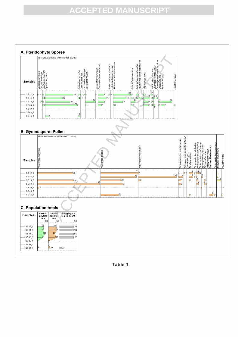
zonation for Jurassic-Cretaceous deposits (Table 1). We attribute this to 1) over-
representation of sandstone samples with respect to mudstones (from which recovery of
palynological material is much better) and 2) the tendency of organic materials to oxidise
in contact with air and water on present day outcrops. Nevertheless, in certain samples
palynological recovery is good (Table 1), providing data that are valuable for palaeo-
environmental analysis.
In the Mariinsk-Krasnoyarsk region, Mesozoic sedimentary deposits rest
unconformably upon variably-aged basement (Fig. 2) which includes Devonian and
Carboniferous mixed clastic successions and Devonian granite. According to previous
research documented in the Russian literature, Russian workers have constructed a
lithostratigraphic framework for the Jurassic and Cretaceous stratigraphy (Berzon and
Barsegyan 2002). In Russian terminology, the basic lithostratigraphic unit is the свита
(svita or suite). This is commonly mis-translated as formation, but the concepts are
different, since the word “suite” contains an implication that the unit has a particular age
range. To emphasise this difference, we have used the word suite throughout when
referring to stratigraphic units. For clarity, we have omitted the feminine adjectival
ending (-ская -skaya), which is a formal part of every suite name.

ACC
EPTE
D M
ANU
SCR
IPT
ACCEPTED MANUSCRIPT
The Early Jurassic succession comprises coarse-grained sandstones and
conglomerates of the Makarov Suite, and is overlain by sandstones of the finer-grained
Ilinsk Suite (Fig. 2). The overlying Mid Jurassic Itats Suite is notably coal-bearing (Fig.
2); extraction of coals from this suite includes those of the Borodino Quarry, Asia’s
largest open cast coal mine. Sediments of the upper Mid Jurassic and the Late Jurassic
belong to the Tyagin Suite, a siltstone and mudstone-prone deposit lacking coal.
Cretaceous rocks, which disconformably overlie the Jurassic, are locally referred to a
three-fold stratigraphic subdivision. These are the Ileks Suite (Early Cretaceous) and the
overlying Semonovs and Smes Suites (Fig. 2). For the sake of clarity, the present paper
refers to Early, Mid and Late Jurassic rocks, and to Early and Late Cretaceous rocks,
rather than referring to individual Suite names.
In this study, nine detailed sedimentary logs were produced, representing various
stratigraphic levels ranging from Early Jurassic to Late Cretaceous (Berzon and
Barsegyan, 2002). Eight of these belong to relatively narrow stratigraphic intervals (Fig.
4), but the ninth spans a >700 m thick succession from Mid Jurassic (Aalenian) through
Early Cretaceous (Neocomian) age (Fig. 5). The latter represents a discontinuous section
compiled from river exposures accessible by boat along the Bolshoy Kemchuk River.
2.3 Facies analysisFacies associations, of which five are recognized, are shown to the right of each log.
These include mudrock, coal, silty sandstone, fine to medium-grained sandstone, and
coarse-grained sandstone facies associations. Information on the external geometry of
facies associations including their lateral extent is provided wherever possible to enhance
the interpretations. However, in some cases where this is not possible, e.g. due to isolated
exposure, analogues are drawn from the appropriate literature. In the following section,
these facies associations are described and interpreted before their stratigraphic and
lateral relations are considered.
2.3.1 Mudrock facies association: descriptionThe mudrock facies association encompasses shale (laminated clay-grade sediments: Fig.

ACC
EPTE
D M
ANU
SCR
IPT
ACCEPTED MANUSCRIPT
6 A), mudstone (non-laminated clay-grade sediments: Fig. 6 B), minor siltstone and
subordinate coal material. Mudstones and shales are grey, dark grey, red or green in
colour, and form metre to tens of metre thick units (Fig. 4, log B) that can be traced
laterally for >200 m (where they are bounded above and below by coal; Fig. 6 C) and
>100 m (where they are bounded by sandstone facies). The lateral extent of this facies
association is potentially much greater but limited by outcrop continuity. The measured
thickness of mudrocks may be under-representative because they are commonly truncated
by overlying sandstone beds (Fig. 4: log E, 0-2 m; log G, 0-1 m). Laminae in both shale
and siltstone are defined by organic material, whereas mudstones contain scattered coal
fragments. In the thickest accumulations of these latter facies, the content of organic
materials (coal fragments) typically increases up-section, particularly where these rocks
underlie coal (Fig. 4: log C, 8.7-11.8 m). Mudrocks locally rest sharply on other
lithofacies such as sandstone (Fig. 6 D), where they infill channels on the scale of 1-3 m
deep and 5-30 m wide.
The mudrock facies association yields a diverse assemblage of both Pteridophyte
spores and Gymnosperm (conifer) pollen (Table 1). Notably among these, green algae
(Botryococcus braunii) occur in Mid Jurassic mudstones and Classopolis sporomorphs
are represented within Late Jurassic mudstones (Table 1).
2.3.2 Mudrock facies association: interpretationThe mudstone facies association records low energy suspension fallout of silt and clay in
non-agitated waters within a terrestrial environment. The vari-coloured nature of this
facies association is attributed to an admixture of different clay mineral species, in
variable states of oxidation, and with differing contents of organic matter. The significant
thickness of this facies association, and its lateral extent, raises two main interpretive
possibilities. These interpretations are firstly a lacustine depositional setting and secondly
an overbank fluvial setting. The first interpretation is less likely because of the
homogenous nature of mudrocks and lack of interstratified sandstones and associated
turbidites that might indicate the progradation of deltas into a lake (e.g. Etienne et al.,
2006). The small-scale thickness variations of the facies association, and its occurrence

ACC
EPTE
D M
ANU
SCR
IPT
ACCEPTED MANUSCRIPT
directly above channel scours is more indicative of its deposition within formerly active
channels that became filled with overbank deposits (e.g. Plint, 1988). Commonly,
overbank flow processes play an important part in the infilling of such channels
following avulsion (Nichols and Fisher, 2007).
The occurrence of green algae (Botryococcus braunii) in association with fern
spores in Mid Jurassic mudrocks strongly supports the fluvial interpretation given above.
This alga is a freshwater variety (Guy-Ohlsen, 1998) and hence indicates accumulation of
plant material in settings such as oxbow lakes and floodplains. Likewise, the occurrence
of Classopolis sporomorphs within mudrocks of the Upper Jurassic section also supports
continental (floodplain) deposition of rocks of this interval. Classopolis is typical of Late
Jurassic and Cretaceous intervals across central Asia, including the Tien Shan in
neighbouring Mongolia (Hendrix et al. 1992). This genus derives from a now extinct
drought-resistant conifer (Pocock and Jansonius, 1961).
2.3.3 Coal facies association: descriptionThis facies association includes anthracitic/ bituminous coal and subordinate interbedded
mudstone and shale. Coal seams reach 40-50 m thick (Fig. 4, log C; Fig. 6 E), and are up
to tens of kilometres in lateral extent. Rootlets are absent. The thickest seams often
exhibit sharp and flat upper surfaces (Fig. 6 F), and are most commonly overlain by
sandstone facies associations. Coal seams also occur at the smaller scale (several cm to
dm thick) and these are interbedded with 3-4 m thick shale deposits (Fig. 4, log B). Pyrite
commonly occurs as mm-scale crystals and aggregates. Thin seams (<1 m thick),
containing fossil tree material and with a crystalline texture also occur (Fig. 6 G).
2.3.4 Coal facies association: interpretationThe coal facies association is interpreted as the accumulation and preservation of plant
material over a prolonged period in a swamp on a poorly drained floodplain. According
to Fielding (1987), three principal conditions are required to form peaty organic residues,
namely (1) sufficient vegetation growth, (2) reduced oxidation and suppression of
bacterial reduction probably by an elevated water table and (3) reduced clastic input.
ACC
EPTE
D M
ANU
SCR
IPT
ACCEPTED MANUSCRIPT
With these conditions in mind, the absence of rootlets in this facies association may be
indicative of peat sourced from mires, or alternatively introduction of plant material by
fluvial processes. A swamp of considerable depth is required to produce a coal seam
some 40-50 m thick, which assuming a compaction ratio of 1.2:1 to 2.2:1 (Nadon, 1998)
would indicate a peat mire some 60-110 m deep for these thickest seams. The smaller-
scale (cm to dm thick) coal seams that occur interbedded with shale indicate the
development of mires on a much smaller scale, within shallower bodies of standing
water. The associated shale records the intermittent influx of oxygenated fresh water into
the mire. In overbank settings, crevasse splay processes may provide a suitable
mechanism for such an influx of fresh water into an otherwise stagnant mire (Farrell,
2001).
2.3.5 Silty sandstone facies association: descriptionThis facies association comprises siltstones and very fine-grained sandstones (e.g. Fig. 4,
log H). These deposits are dominated by parallel-laminated facies with a common
upward transition into ripple cross-laminated facies. Massive siltstones also occur,
containing organic-rich streaks (Fig. 7 A). Siltstones are also interlaminated with
centimetre-thick coal seams (Fig. 7 B) and drape current ripple foresets. Typically, this
facies association has a limited vertical extent in any given section (30-50 cm thick), and
can be traced laterally for ~5-10 m. Siltstones and sandstones of this facies association
typically rest in flat concordant contact upon underlying facies associations (Fig. 5, 48
m).
2.3.6 Silty sandstone facies association: interpretationSiltstones and very fine-grained sandstones of this facies association, are relatively fine-
grained sediments, and were deposited during intervals of low depositional energy. In a
fluvial setting, such deposits record low stream power (lower flow regime parallel
lamination: Ashley 1990), typically in low capacity streams or overbank conditions such
as crevasse splays (Farrell, 2001). The generally flat contacts at the base of this facies
association favour the latter interpretation. The upward transition from parallel to ripple
cross-laminated deposits indicates flow deceleration, resulting from flow expansion over
the alluvial plain during waning flow events. Previous detailed study of the products of
ACC
EPTE
D M
ANU
SCR
IPT
ACCEPTED MANUSCRIPT
avulsion processes has likened crevasse splay deposits to small scale delta complexes,
where ~3 m thick distributary mouth bars and reworked marginal to distal mouth bars can
be recognised in exceptional exposures (Farell, 2001). By comparison, the low thickness
(30-50 cm) and restricted extent (5-10 m) of the silty sandstone facies association in our
current paper points to small-scale, localised crevasse splay deposits.
2.3.7 Fine to medium grained sandstone facies association: descriptionThis facies association is dominated by fine to medium-grained sandstones, with a
generally low overall concentration of pebble sized clasts. At least ten stratigraphic
occurrences of this facies association can be observed along the Bolshoy Kemchuk river
(Fig. 5). The base of the facies association is typically channelised, with well-defined
channels 10-20 m wide (Fig. 7 C) that are lined at their bases with mudstone, siltstone
and to a lesser extent chert clasts 0.5-15 cm diameter. The channels form the most
conspicuous erosional features within a 15 m thick sand sheet, the lateral extent of which
is impossible to demonstrate owing to the limited extent of most exposures to small
quarries. Trough cross-stratification is common in these deposits, with foresets 0.1-1 m
high (Fig. 7 D) that are lined with abundant coal, fossil wood fragments and millimetre-
scale clay clasts. Bedsets are typically amalgamated and stacked (Fig. 4: log D, 3-14 m).
Horizontal parallel lamination (Fig. 7 E) also occurs in fine to medium-grained sandstone
successions of 2-3 m thickness, with laminae incorporating a high percentage of organic
matter (including wood fragments 40 cm length) and siltstone. Moderate amplitude ripple
cross-stratification (ripple crests 1-2 cm high; Fig. 7 F), cap both the trough cross-bedded
facies and the parallel laminated sandstones. Uppermost contacts of the fine to medium-
grained sandstone facies association are typically irregular or channelised, and it is
commonly overlain by the mudrock facies association (e.g. Fig. 4, log F).
2.3.8 Fine to medium grained sandstone facies association: interpretationThe fine to medium-grained sandstone facies association is interpreted to record
deposition within a fluvial intra-channel setting in a mixed load system that was
characterised by a minor component of bedload transport (exemplified by pebble lined
channels). The stacked nature of trough cross-bedding indicates high rates of sediment
aggradation (e.g. Leclair et al., 1997; Mack and Leeder, 1999). Significant
ACC
EPTE
D M
ANU
SCR
IPT
ACCEPTED MANUSCRIPT
cannibalisation and reworking of underlying deposits is implied by the pebble trains at
the bases of channels and the mud clasts. Together, the occurrence of trough-cross beds
and channels amalgamated into a sand sheet bears some resemblance to fluvial
sandsheets from the Permian of Queensland (Allen and Fielding 2007). The presence of
coal fragments and wood fragments within parallel laminated sandstones suggests
deposition of organic matter along the bedding surfaces. The scale of preserved foresets
(0.1 - 1 m) suggests initial dune bedforms in the range 0.5 – 1 m height to a maximum of
5 m (Leclair et al., 1997; Ashley, 1990). The vertical transition from parallel laminated to
current rippled sandstones is interpreted as a typical waning flow signature. This waning
flow signature may be attributed to either overtopping of river banks with sediment (i.e.
intra-channel equivalents to crevasse splay deposits; Farell, 2001) or alternatively
reduced discharge during lowering of river water levels.
2.3.9 Coarse-grained sandstone facies association: descriptionThese deposits comprise coarse-grained sandstones that are associated with gravels,
pebble and cobble-grade conglomerates (Fig. 8 A-D), together with subordinate finer-
grained sandstones (Fig. 4, log A). The base of this facies association is highly irregular
to channelised where contact with pre-Mesozoic crystalline basement can be
demonstrated (Fig. 9 A). Clasts in the conglomeratic horizons range 0.5 - 6 cm in length,
and include grey and green mudstone, green siltstone, black and red cherts, sandstone
(locally deformed and metamorphosed), carbonate fragments, granite, granite pegmatites,
tuffs, vein quartz, quartzite, andesite and coal. Clasts are typically moderately to well-
rounded, although unusually large and angular clasts occur where this facies association
rests directly upon crystalline or pre-Mesozoic basement (Fig. 8 B). Lenticular sandstone
beds are preserved within pebble conglomerates (Fig. 8 C). The sandstone beds sharply
overlie underlying conglomerates, and this latter lithofacies is characterised by both
trough and planar cross beds (Fig. 8 C), the sets of which exhibit normally graded
bedding and well developed imbrication of the pebbles (Fig. 8 D). Low-angle (<5°)
stratification also occurs. These sandstone lenses comprise 1-2 clast thick trains of
pebbles and cobbles.

ACC
EPTE
D M
ANU
SCR
IPT
ACCEPTED MANUSCRIPT
2.3.10 Coarse-grained sandstone facies association: interpretationThe coarse sediment calibre of this facies association points to deposition in an intra-
channel, mixed load to bedload dominated fluvial system where moderate to high current
velocities were commonplace (Miall, 1996). The irregular to channelised contacts typical
of the base of this facies association, coupled with the predominance of large and angular
clasts where it is observed to overlie basement, is indicative of a high stream power.
Some of these river channels appear to have been topographically constrained (Fig. 9A).
The coarse-grained sandstone facies association shares many characteristics with
the deposits of modern braided rivers such as the Sagavanirktok River, Alaska (Lunt and
Bridge, 2004). Analysis of such modern river deposits shows that gravelly braid bars are
architecturally composed of large scale cross-strata with a complex and composite
internal structure reflecting medium scale cross- and planar strata (Lunt and Bridge,
2004), produced during the lateral migration or bifurcation of streams (point bars and
mid-channel bars respectively). Pebble lags at the base of trough cross-beds are
interpreted as traction deposits, whereas the matrix supported nature of conglomerates
along other bedding surfaces, scour surfaces and cross bed forsets may signify grain-
dispersive processes operating under the influence of gravity. Such matrix supported
conglomerates are common features of deposits laid down in the lee of topographic
scarps and may point to the development of hyperconcentrated flows in the immature
fluvial land system (Mack and Leeder, 1999). The low angle stratification within some of
these deposits is interpreted as the migration of low-profile bedforms along the riverbed.
The similar size of the clasts, and their overall moderate to well-rounded character,
indicates prolonged transport periods as river bedload. The relative abundance of chert
and intermediate to acid intrusive and extrusive igneous rocks is compatible with their
provenance from the Altaid region of northern Kazakhstan: in this region, the crystalline
basement comprises island arcs, ophiolites and accretionary wedge complexes (Buslov et
al., 2004). By comparison, the carbonate and sandstone clasts are suggestive of a more
local source from Devonian mixed carbonate-clastic succession in the Mariinsk-
Krasnoyarsk region (Berzon and Barsegyan 2002).
2.3.11 Lateral and vertical evolution of palaeoslopes

ACC
EPTE
D M
ANU
SCR
IPT
ACCEPTED MANUSCRIPT
An extensive palaeocurrent database was compiled from 156 palaeocurrent
measurements at >20 localities. Palaeocurrent data along the composite Bolshoy
Kemchuk river section (Fig. 5) derive from five separate observation points. Data were
collected from trough cross beds of ~1 m height from sandy deposits, namely the silty
sandstone facies association, the fine to medium-grained sandstone facies association,
and the coarse-grained sandstone facies association. These data were plotted on standard
rose diagrams, which have been superimposed on a sketch geological map (Fig. 3). This
figure does not discriminate between the three sand-prone facies associations, although
since it was established above that all were deposited as fluvial bedload within Jurassic
and Cretaceous river systems, the data can be considered together.
Figure 3 separates data collected from Lower, Middle and Upper Jurassic intervals,
and distinguishes between Lower and Upper Cretaceous rocks. Data from the Early
Jurassic indicate the migration of dunes in several directions: those cropping out in the
west of the study area (SE42, SE44, SE20 & 21) show predominantly westward
dispersals, whereas those in the centre and east of the study area show southwestward
(SE38) and a swath of northwest to eastward (SE29, SE30) directions. In the Middle
Jurassic, north and northeastward vectors predominate in the western part of the study
area (SE2, SE9, Bolshoy Kemchuk river section), but east to east-north-east dispersals
are recorded for the centre and east of the region (SE10, SE25, SE31). For the Upper
Jurassic, no data are available. Lower Cretaceous sandstones were shed in a north (SE19)
to north-westward (SE3) direction, and Upper Cretaceous dunes migrated in a range of
directions from north to southwest (SE20 & 21, SE22).
In summary, these data suggest that the southeastern edge of the West Siberian
Basin was characterised by a northwest to northeastward dipping slope and that this slope
did not vary significantly laterally or during the Jurassic and Cretaceous, although local
south and southwestward dune migration is recognised. The spread of palaeocurrents
observed in certain localities (e.g. SE9) probably reflects the tendency of intra-channel
dune systems to infill hollows (such as scour pools produced by eddies etc) which record
local departure from the regional topographic gradient of the landscape.
ACC
EPTE
D M
ANU
SCR
IPT
ACCEPTED MANUSCRIPT
3. Lateral and vertical relationships between facies associationsThe sedimentary facies described and interpreted above show marked vertical and lateral
changes, some of which are gradual, whilst other facies transitions are sharper. The most
notable vertical and (and hence temporal) change in facies throughout the Jurassic is the
progressive up-section appearance of mudstones. The Lower Jurassic sections are
dominated by either the coarse-grained or medium-grained sandstone facies association
(Fig. 4, log A; Fig. 8), whilst the mudrock facies association is conspicuously absent
from this level. However, mudstones are well represented within the Mid Jurassic and to
a lesser extent in the Lower and Upper Cretaceous (Fig. 4). Vertical alternation between
the mudstone facies association and the coal facies association is also apparent (Fig. 4 B).
These lithological changes are interpreted to record the transition from an immature
fluvial landscape, dominated by a fluvial system that was locally influenced and confined
by a bedrock topography (Fig. 9 A) to a more mature palaeo-landscape characterised by
stable meandering rivers with extensively developed overbank areas and mires. The
overbank areas were subject to deposition of fine sand grade materials (silty sandstone
facies association) by the Middle Jurassic, probably in response to high discharge events.
In the Middle Jurassic, the sharp contact between the thickest developments of the
coal facies association and overlying fine to medium grained sandstone association (Fig.
6 A) provides evidence that the mature fluvial system was episodically prone to avulsion.
The remarkably planar, as opposed to channelised contact between these facies
associations may be attributable to the elastic rheology of peat, which significantly
reduces the potential for vertical erosion by avulsing rivers (McCabe 1984; Collinson
1996). The occurrence of fluvial channel deposits directly overlying coal may provide
evidence of significant avulsion of a large fluvial system, at least at the scale of several
kilometres. Such large-scale avulsion is a common for rivers of an anastomosing
geometry (Makaske 2001). Additional evidence for channel abandonment and avulsion
is provided by the occurrence of the mudrock facies association in channels on the upper
surface of the fine to medium-grained sandstone facies association (Fig. 4 C). These
stratigraphic relationships indicate erosion and scouring on the upper surface of the fine

ACC
EPTE
D M
ANU
SCR
IPT
ACCEPTED MANUSCRIPT
to medium-grained sandstone facies association, bypass of bedload sediments, and
deposition of slackwater mudrocks in the absence of traction currents. Therefore, these
stratigraphic relationships imply an abandonment process analogous to the formation of
oxbow lakes in meandering fluvial systems (e.g. Constantine and Dunne 2008).
The contact between coal and overlying sandstone is not everywhere sharp and
planar, however. At several intervals along the Bolshoy Kemchuk river section (Fig. 5),
the contact between coal and the fine to medium-grained sandstone facies association is
characterised by a disrupted and irregular interface between these two contrasting
lithofacies (Fig. 9 B, C). The relationship varies between pods of coal enclosed by
sandstone (Fig. 9 B), and sandstone pods occurring within the upper portion of the coal
(Fig. 9 C). These features are compatible with the entrainment of rafts of peat by an
overlying fluvial system. The more irregular coal pods and sands within the upper coals
may be due to the liquefied nature of the peat during sand deposition and, in such
instances, gravitational instability between the two lithologies would have been promoted
more easily.
The facies associations discussed above were studied at widely separated outcrops
between Krasnoyarsk and Novosibirsk, the ages of which were determined following
consultation with the Krasnoyarsk Geological Survey (Berzon, 2005, pers. comm.).
Consideration of outcrops in isolation, however, provides an understanding that is quite
limited by lack of information on lateral and vertical relationships between facies
associations. In order to reduce this problem, a composite log through Mid Jurassic to
Cretaceous strata was compiled along the Bolshoy Kemchuk river (Fig. 5). This
composite section, which is >700 m thick, is dominated by Middle Jurassic (Aalenian-
Bathonian) strata but extents into the Lower Cretaceous (Neocomian) (Berzon and
Barsegyan 2002). The outcrops used to construct the composite section are spread over a
~26 km stretch of the river. Where they occur, the quality of exposures is very high.
However, each outcrop is disconnected. Regional dips are low (always <10°), and there is
little stratigraphic overlap from section to section. Therefore, the total thickness of the
section presented herein (Fig. 5) may be an underestimate.

ACC
EPTE
D M
ANU
SCR
IPT
ACCEPTED MANUSCRIPT
The log reveals a partly cyclic evolution of the depositional system as follows. The
coal facies association is sharply overlain by either the silty sandstone or fine to medium-
grained sandstone facies association. Sand injection structures, penetrating downward
into coal, are observed at several intervals (Fig. 5, 46 m, 80 m, 127 m, 275 m). Above, a
fining up occurs, culminating in the mudrock facies association. On the Bolshoy
Kemchuk river section, four principal coal-bearing intervals are noted, all of which are
restricted to the Middle Jurassic section. Exposures of the Upper Jurassic (Oxfordian) are
poor and exclusively muddy (Fig. 5, 360 m), but overlying Lower Cretaceous deposits
comprise the coarse-grained sandstone facies association with interbedded mudstones
(Fig. 5, 720-740 m). In summary, in the Mariinsk-Krasnoyarsk area, most coal horizons
are restricted to the Middle Jurassic (Figs 4, 5).
4. Depositional ModelThe temporal evolution of the Mariinsk-Krasnoyarsk region in the Early, Mid, and Late
Jurassic, and in the Cretaceous can be summarised as follows. During the Early Jurassic,
bedrock-constrained fluvial systems deposited bedload-dominated sediments including
coarse-grained sands, gravels and conglomerates of both a local and regional (e.g. Altai-
Sayan) provenance (Fig. 10 A). These fluvial systems were probably ephemeral, and
lacked the presence of well-defined overbank areas where mud deposition could occur
(Fig. 10 A). By Mid Jurassic times, progressive denudation of the landscape by high
capacity rivers resulted in a low profile alluvial plain that was characterised by
anastomosing rivers and well defined floodplains (Fig. 10 B). Freshwater algae were able
to populate standing water areas. During peak flow conditions, river banks were
overtopped and crevasse splay sediments were deposited. Choking of older channel
courses resulted in major avulsion, during which minor channels were also abandoned
and filled with overbank fines in oxbow lakes. The extensive overbank areas were
waterlogged and perhaps topographically depressed beyond the levees, allowing for thick
peat accumulation in floating mires (Fig. 10 B). These mires were also periodically
subject to freshwater incursions that interbedded mudstones with peat.

ACC
EPTE
D M
ANU
SCR
IPT
ACCEPTED MANUSCRIPT
By the Late Jurassic, coal deposition had generally ceased, but fluvial
sedimentation continued. The deposition of coarser-grained sandstones during this
interval may record subtle rejuvenation of the source area for these sediments by a
process such as hinterland uplift/ tilting or alternatively base level fall. The presence of
Classopolis pollen in these deposits may provide a subtle indication of climatic change
that accompanied the shift away from coal deposition: this genus is able to withstand
desiccation (Pocock and Jansonius 1961), and may thus hint at subtle climatic changes in
the Late Jurassic toward a slightly drier climate. By Cretaceous times, deposition of
medium to coarse-grained sediments recorded a continued prevalence of bedload-
dominated fluvial sedimentation, although mudstone sedimentation continued in
overbank areas.
5. Discussion5.1 Controls on sediment architecture at the margin of the West Siberian Basin
The data provided in this paper allow us to infer the depositional history of a portion of
the West Siberian Basin throughout the Jurassic and Cretaceous. In recent years, there
have been intense efforts to investigate the sedimentary architecture of similar continental
successions across the globe, many incorporating novel techniques such as laser-scanning
and high resolution GPS studies to unravel the three-dimensional architecture of
amalgamated sandstone deposits (e.g. Labourdette and Jones, 2007). In addition to
technological advances, syntheses of outcrop data (e.g. Nichols and Fisher, 2007) and
new angles on sequence stratigraphic models that may have value in coal bearing
successions (Yoshida et al., 2007), provide a valuable starting point from which to
consider controls on sediment architecture.
It has long been known that the subsidence regime, and to a lesser extent sediment
availability, play an important role in determining the architecture of coal bearing
successions, although a detailed understanding of the environment of deposition remains
important (Fielding, 1987). Much emphasis has been placed upon coals by sequence
stratigraphers, not least because they have the potential to form laterally continuous

ACC
EPTE
D M
ANU
SCR
IPT
ACCEPTED MANUSCRIPT
horizons readily interpreted as an “instant” reduction in clastic input. In the Permian of
the Bowen and Galilee basins, Australia, 10-15 m thick fining upward cycles are
interpreted as depositional sequences sensu stricto (Allen and Fielding, 1987). According
to these authors, the base of an ideal sequence developed over low gradient basin margins
is sharply flat though minimally erosional. This is because unlike areas of higher relief,
extensive and flat coastal or alluvial plains tend to be cut by relatively shallow channels
along the sequence boundary (Posamentier and Allen, 1999). In the study area of Allen
and Fielding (1987), the sequence boundary is overlain by coarse to very-coarse grained,
trough cross-bedded fluvial sandstone. Crucially, their sequence stratigraphic
interpretation hinges on the recognition on the identification of such subtle
palaeoenvironmental indicators as a tidally reworked sandstones or bioturbation. As our
sedimentological and palynological data failed to unveil any evidence for a marine
influence on sedimentation, we prefer not to speculate as to plausible sequence
stratigraphic interpretations of our data.
Integrating observations from large open cast coal mines and subsurface data,
Fielding (1984) proposed a three-tiered hierarchy to explain sediment architecture in the
Coal Measures (Upper Carboniferous) of NE England. For that area, Fielding (1984)
envisaged that patterns of delta progradation and switching exerted large-scale controls,
structural and compaction subsidence controlled medium-scale variation, whereas
sedimentary processes and additional subsidence influenced local-scale variability.
Compaction-related subsidence for these 900 m thick deposits was held accountable for
the formation of sedimentary “basins” up to 8 m deep and several tens of kilometres
wide. At the SE flanks of the West Siberian Basin, however, where our logging indicates
a Jurassic through Cretaceous section >700 m in thickness (Fig. 5) the influence of
compacting Middle Jurassic coals is likely to have been much more significant. Taking
the compaction estimate above, a peat bed some 50 m thick may have created a
sedimentary “basin” several tens of metres deep. Thus, the compaction of plant material
to produce peat beds and ultimately coal seams may help explain the exceptionally sharp
stratigraphic contact with overlying fine-grained sandstone (Fig. 6 E).
ACC
EPTE
D M
ANU
SCR
IPT
ACCEPTED MANUSCRIPT
5.2 Regional and global implications
A huge database on aspects the Jurassic-Cretaceous succession is available from
boreholes in the subsurface of the West Siberian Basin in the international literature (e.g.
Kontorovich et al., 1997; Pinous et al., 1999, 2001). Here, attempts are made to link our
new outcrop database, and the evolving fluvial depositional system of the Jurassic and
Cretaceous, with disparate studies conducted across the extensive (3.5 M km2)
subsurface area of the basin.
Tentative correlation between surface (Berzon and Barsegyan, 2002) and subcrop
(Rudkevich et al., 1988) is attempted in Fig. 2 to frame the present study in a regional
context. It should be noted that no such correlation has been previously been attempted,
and thus the correlation of the key unconformities and discontinuities should be regarded
as preliminary, and to be confirmed in the course of future research. At outcrop, a
significant unconformity occurs at the base of the Jurassic succession, a disconformity at
the boundary between the Middle and Upper Jurassic, an irregular unconformity at the
Jurassic-Cretaceous boundary, and a disconformity in the Upper Cretaceous (Fig. 2).
These discontinuities can be traced into the subsurface and have been identified by
various authors as follows. The first, at the base of the Jurassic, corresponds to the initial
phase of stable sedimentation following rifting and the outpouring of the Siberian Traps
(Reichow et al., 2002; Saunders et al., 2005; Allen et al., 2006). The second, at the base
of the Callovian, corresponds to a major transgressive event that deposited marginal
marine to lacustrine sediments over large areas: the Callovian source rock (Kontorovich
et al., 1997; Pinous et al., 1999). The third is time-transgressive throughout the
Neocomian and corresponds to the downlapping of large deltaic clinoforms shed from the
Siberian Craton and to a lesser extent from the Urals (Pinous et al., 2001). The fourth
discontinuity corresponds to a transgressive onlap of the Kuznetsov Suite and correlative
lacustrine shales onto older deposits (Rudkevich et al., 1988; Fig. 2).
Many models of sedimentary basin formation invoke an active tectonic phase
followed by a passive phase (Allen and Allen 1991). In the case of the West Siberian
Basin, the active phase it attributed to rifting (and possibly dextral oblique-slip faulting:

ACC
EPTE
D M
ANU
SCR
IPT
ACCEPTED MANUSCRIPT
Allen et al., 2006), whilst the passive phase might be assumed to be represented by the
post-Triassic sedimentary record. However, there are important stratigraphic reasons to
question whether the phase of active basin formation ceased by the Early Triassic, with
implications for the way in which we might view the Jurassic-Cretaceous sedimentary
succession discussed in the present paper. In terms of stratigraphic architecture, Early to
Mid-Jurassic sedimentary rocks north of our outcrops in the Nyorlskaya depression are
suitable for sequence stratigraphic analysis because they comprise marginal marine to
shallow marine facies, including marine fauna and shales on maximum flooding surfaces:
features which facilitate direct comparison to the international sea level curve (Pinous et
al., 1999). These features enable Pinous et al. (1999) to link the creation of
accommodation space in the basin (indicated by backstepping parasequence sets) to
global sea level variation, effectively discounting active/ tectonic processes from basin
evolution during the Early to Late Jurassic.
One of the key stratigraphic questions in the subsurface of the West Siberian Basin
is the origin of enormous deltaic clinoforms of Neocomian age that were shed from the
Siberian Craton and to a lesser extent from the Urals. Progradation of shallow marine and
subaerial environments resulted in regional regression and the shift of shorelines
basinwards by ~1000 km during the earliest Early Cretaceous (Pinous et al., 2001). In the
Gydan Peninsula, in the northernmost extremity of the basin, seismic data show that
Neocomian clinoforms offlap the fault-bounded Messoyakh Ridge system, hence
providing evidence for uplift at the beginning of the Cretaceous (Kunin and Segalovich
1996). Furthermore, in the Altai-Sayan region of northern Kazakhstan, significant strike-
slip deformation is thought to have occurred around the Jurassic-Cretaceous boundary
(Buslov et al., 2004). According to De Grave et al. (2007), apatite fission track
thermochronology suggests an uplift of the Altai-Sayan region between ~140-100 Myr
BP, commencing 4 Myr into the Early Cretaceous. Additionally, Glasmacher et al. (2002)
document a change in the regional stress field of the southern Urals during the Late
Jurassic and Early Cretaceous. Therefore, these studies suggest that Early Cretaceous
regression in the West Siberian Basin was potentially driven by uplift of the basin
margins. As the present paper has shown, a fluvial system which reflects progressive

ACC
EPTE
D M
ANU
SCR
IPT
ACCEPTED MANUSCRIPT
landscape denudation and evolution from bedrock-confined fluvial channels to mature,
anastomosing rivers characterised the Jurassic evolution of the south-east basin margin.
Given the evidence for extensive and far-reaching Neocomian regression in the
subsurface of the basin, the influx of coarser-grained clastics in the Cretaceous of the
Mariinsk-Krasnoyarsk region are potentially explained by tectonically-related hinterland
rejuvenation, although our data do not allow us to discount the possibility of regular
fluvial avulsion processes.
Our outcrop dataset also contribute a valuable palaeoclimatic data point for the
Jurassic and Cretaceous in a region that has never previously been studied outside Russia.
As noted above, the loss of coal up-section from the Mid Jurassic into Late Jurassic times
may be allied to a transition to a less humid climate, as might also the appearance of
Classopolis as noted above, even if a hinterland rejuvenation event cannot be ruled out.
The interval also spans the much elusive Late Jurassic-Early Cretaceous glaciation for
which sedimentological evidence has never been found, although a global cooling in
temperatures for this interval is recognised from the isotopic composition of belemnites
collected previously from the Urals (Price and Mutterlose 2004).
6. Conclusions• Jurassic and Cretaceous sediments cropping out at the SE flank of the West Siberian
Basin in the Mariinsk-Krasnoyarsk region are exclusively clastic and comprise five
facies associations.
• A coarse-grained sandstone facies association was deposited within an intra-channel
setting where mixed load to bedload processes were dominant. A fine- to medium-
grained sandstone facies association was also deposited within an intra-channel setting
where mixed load sedimentation was dominant, characterised by migrating bedforms
and waning flow processes. The finest sand component and silt, represented by the silty
sandstone facies association, is interpreted to record overbrimming of channels and
crevasse splay sedimentation. These processes interrupted the accumulation of a
mudrock facies association in non-agitated waters, which took place on both the

ACC
EPTE
D M
ANU
SCR
IPT
ACCEPTED MANUSCRIPT
floodplain and within abandoned channels. Quiescent (low energy) sedimentation of the
coal facies association, particularly in the thickest developed sections, took place in
mires beyond channel levees.
• A clear vertical and hence temporal evolution of the fluvial system that deposited these
facies associations is identified. Initial sedimentation during the Early Jurassic was
restricted to bedrock-confined fluvial systems that cut into a range of Palaeozoic
lithologies including crystalline basement. By Mid Jurassic times, a more mature fluvial
landscape system had evolved, where well-defined overbank areas separated
anastomosing river courses. Coal accumulation testifies to these extensive overbank
areas and signifies humid climatic conditions. By Late Jurassic times, fluvial
sedimentation continued with Classopolis pollen indicating a less humid climate. By
the Cretaceous, a renewed influx of coarse clastic material indicates hinterland
rejuvenation.
• Comparison between outcrop and subsurface stratigraphy of the West Siberian Basin
suggests that the evolution of fluvial systems in the Jurassic took place during a period
of tectonic quiescence. However, hinterland rejuvenation in the Cretaceous potentially
corresponds to the progradation of major deltaic clinoform complexes in the basin
subsurface during the Neocomian.
7. AcknowledgementsThis paper is published with the permission of CASP, when this study was conducted by
two of the authors (DPLeH and CD) in conjunction with the Institute of Geology,
Geophysics and Mineralogy, Novosibirsk. The authors thank the consortium of oil
industry sponsors to the West Siberian Basin Project Phase II for the financial support
needed to conduct this study, to Mr Benoit Vautravers for drafting some of the logs, and
to Drs Robert Scott and Jutta Winsemann for their thoughtful pre-reviews. We extend our
thanks to Professor Fielding and to Anonymous for detailed reviews whose constructive
comments greatly improved the manuscript.

ACC
EPTE
D M
ANU
SCR
IPT
ACCEPTED MANUSCRIPT
ReferencesAllen, J.P., Fielding, C.R., 2007. Sequence architecture within a low-accommodation
setting: An example from the Permian of the Galilee and Bowen basins, Queensland,
Australia. AAPG Bulletin, 91 (11), 1503-1539.
Allen, P.A., Allen, J.R., 1991. Basin Analysis. Blackwell, Bath, 451p.
Allen, M.B., Anderson, L., Searle, R.C., Buslov, M. 2006. Oblique rift geometry of the
West Siberian Basin; tectonic setting for the Siberian flood basalts. Journal of the
Geological Society, London, 163 (6), 901-904.
Ashley, G.M., 1990. Classification of large-scale subaqueous bedforms: A new look at an
old problem. Journal of Sedimentary Petrology 60 (1), 160-172.
Berzon, E.I., Barsegyan, V.E., 2002. Geological maps and stratigraphic sections for the
Krasnoyarsk Region 1:200 000. In: Gluhov, Yu. S. (Ed.), VSEGEI, St Petersburg.
Buslov M.M., Watanabe T., Fujiwara Y., Iwata K., Smirnova L.V., Safonova I.Yu.,
Semakov N.N., Kiryanova A.P. Late Paleozoic faults of the Altai region, Central Asia:
tectonic pattern and model of formation. Journal of Asian Earth Sciences 23, 655-671.
Collinson, J.D., 1996. Alluvial sediments. In: Reading, H.G. (Ed.), Sedimentary
environments: Processes, Facies and Stratigraphy. Blackwell Science.
Constantine, J.A., Dunne, T., 2008. Meander cutoff and the controls on the production of
oxbow lakes. Geology 36 (1), 23-26.
De Grave, J., Buslov, M.M., Van den haute, P., 2007. Distant effects of India-Eurasia
convergence and Mesozoic intracontinental deformation in Central Asia: Constraints
from apatite fission-track thermochronology. Journal of Asian Earth Sciences 29, 188-
204.
Etienne, J.L., Janssona, K.N., Glasser, N.F., Hambrey, M.J., Davies, J.R., Waters, R.A.,
Maltman, A.J., and Wilby, P.R., 2006. Palaeoenvironmental interpretation of an ice-
contact glacial lake succession: an example from the late Devensian of southwest Wales,
UK. Quaternary Science Reviews 25 (7-8), 739-762.
ACC
EPTE
D M
ANU
SCR
IPT
ACCEPTED MANUSCRIPT
Farrell, K.M., 2001. Geomorphology, facies architecture, and high-resolution, non-marine
sequence stratigraphy in avulsion deposits, Cumberland Marshes, Saskatchewan.
Sedimentary Geology 139 (2), 93-150.
Fielding, C.R., 1984. A coal depositional model for the Durham Coal Measures of NE
England. Journal of the Geological Society, London 141, 919-931.
Fielding, C.R., 1987. Coal depositional models for deltaic and alluvial plain sequences.
Geology 15, 661-664.
Glasmacher, U.A.,Wagner, G.A., Puchkov, V.N., 2002. Thermotectonic evolution of the
western fold-and-thrust belt, southern Uralides, Russia, as revealed by apatite fission
track data. Tectonophysics 354, 25-48.
Guy-Ohlson, D., 1998. The use of the microalga Botryococcus in the interpretation of
lacustrine environments at the Jurassic-Cretaceous transition in Sweden.
Palaeogeography, Palaeoclimatology, Palaeoecology 140 (1-4), 347-356.
Hendrix, M. S., Graham, S. A., Carroll, A. R., Sobel, E. R., McKnight, C. L., Schulein, B.
J., Wang, Z., 1992. Sedimentary record and climatic implications of recurrent
deformation in the Tian Shan: Evidence from Mesozoic strata of the north Tarim, south
Junggar, and Turpan basins, northwest China. Geological Society of America Bulletin
104, 53-79.
Kontorovich, A. E., Moskvin, V. I., Bostrikov, O. I., Danilova, V. P., Fomin, A. N.,
Fomichev, A. S., Kostyreva, E. A. & Melenevsky, V. N., 1997. Main oil source
formations of the West Siberian Basin. Petroleum Geoscience 3, 343-358.
Kunin, N.Y., Segalovich, I.E., 1996. A sesimostratigraphic analysis of Lower Cretaceous
deposits in the northern part of the West Siberian Basin. Sedimentary Geology, 102 (1-2),
23-32.
Labourdette, R., Jones, R.R., 2007. Characterization of fluvial architectural elements using
a three-dimensional outcrop data set: Escanilla braided system, South-Central Pyrenees,
Spain. Geosphere 3 (6), 422-434.
Leclair, S. F., Bridge, J.S., Wang, F., 1997. Preservation of coarse-strata due to migration
of subaqueous dunes over aggrading and non-aggrading beds: Comparison of

ACC
EPTE
D M
ANU
SCR
IPT
ACCEPTED MANUSCRIPT
experimental data with theory. Geoscience Canada 24 (1), 55-66.
Lunt, I.A., Bridge, J.S., 2004. Evolution and deposits of a gravelly braid bar,
Sagavanirktok River, Alaska. Sedimentology 51, 415- 432.
Mack, G.H., Leeder, M.R., 1999. Climatic and Tectonic controls on Alluvial Fan and
Axial-Fluvial Sedimentation in the Plio-Pleistocene Palomas half-graben, southern Rio
Grande rift. Journal of Sedimentary Research 69, 635-652.
Makaske, B., 2001. Anastomosing rivers: a review of their classification, origin and
sedimentary products. Earth Science Reviews 53, 149-196.
McCabe, P. J., 1984. Depositional environments of coal and coal-bearing strata. In:
Sedimentology of coal and coal-bearing sequences. In: Rahmani, R.A., Flores, R.M.
(Eds.), Special Publication of the International Association of Sedimentologists 7, 13-42.
Miall, A. D., 1996. The geology of fluvial deposits: sedimentary facies, basin analysis and
petroleum geology. Springer-Verlag Inc., Berlin, 582 p.
Nadon, G.C., 1998. Magnitude and timing of peat-to-coal compaction. Geology 26, 727 –
730.
Nesterov, I.I., 1976. Atlas of Lithologic-Palaeogeographic maps of the Jurassic and
Cretaceous of the West Siberian Floodplain. Russian Academy of Sciences, Moscow
(incl. 26 maps).
Nichols, G.J., Fisher, J.A., 2007. Processes, faces and architecture of fluvial distributary
system deposits. Sedimentary Geology 195, 75-90.
Peterson, J.A., Clarke, J.W., 1991. Geology and hydrocarbon habitat of the West Siberian
Basin. AAPG Studies in Geology 32, Tulsa, Oklahoma, 96p.
Pinous, O.V., Sahagian, D.L., Shurygin, B.N., Nikitenko, B.L., 1999. High-resolution
sequence stratigraphic analysis and sea-level interpretation of the middle and upper
Jurassic strata of the Nyurolskaya depression and vicinity (southeastern West Siberia,
Russia). Marine and Petroleum Geology 16, p 245-257.
Pinous, O.V., Levchuk, M.A., Sahagian, D., 2001. Regional synthesis of the productive
Neocomian complex of West Siberia: sequence stratigraphic framework. American
ACC
EPTE
D M
ANU
SCR
IPT
ACCEPTED MANUSCRIPT
Association of Petroleum Geologists Bulletin 85 (10), 1713-1730.
Plint, A.G., 1988. Global eustacy and the Eocene sequence in the Hampshire Basin,
England. Basin Research 1, 11-22.
Pocock, S.J., Jansonius, J., 1961. The pollen genus Classopolis Pflug, 1953.
Micropalaeontology 7 (4), 439-449.
Posamentier, H.W., Allen, G.P., 1999. Siliciclastic sequence stratigraphy- Concepts and
Applications. SEPM Concepts in Sedimentology and Paleontology 7, 210p.
Price, G.D., Mutterlose, J., 2004. Isotopic signals from late Jurassic- early Cretaceous
(Volgian-Valanginian) sub-Arctic belemnites, Yatria River, West Siberia. Journal of the
Geological Society, London 161, 959-968.
Rudkevich, M.Ya., Ozeranskaya, L.S., Chistyakova, N.F., Kornev, V.A., Maksimov, E. M.,
1988. Oil-gas complexes of the West Siberian basin [Neftegazonosnye kompleksy
Zapadno-Sibirskogo basseyna]. Moscow, Nedra, 304pp.
Saunders, A.D., England, R.W., Reichow, M.K., White, R.S., 2005. A mantle plume origin
for the Siberian Traps; uplift and extension in the West Siberian Basin, Russia. Lithos 79
(3-4), 407-424.
Reichow, M.K., Saunders, A.D., White, R.V., Pringle, M.S., Al'Mukhamedov, A.I.,
Medvedev, A.I., Kirda, N.P. 2002. 40Ar/ 39Ar dates from the West Siberian Basin:
Siberian flood basalt province doubled. Science 296, 1846-1849.
Yoshida, S., Steel, R.S., Dalrymple, R.W., 2007. Changes in depositional processes- an
ingredient in a new generation of sequence-stratigraphic models. Journal of Sedimentary
Research 77, 447-460.
Figure captionsFigure 1: Location map of the West Siberian Basin (inset) to the west of the Siberian
craton, to the east of the Urals, and to the north of the Altaid Mountains. Large map
shows location of study sections in the Mariinsk-Krasnoyarsk region at the southern flank
of the basin (see Fig. 3).

ACC
EPTE
D M
ANU
SCR
IPT
ACCEPTED MANUSCRIPT
Figure 2: Chronostratigraphic chart for Jurassic-Cretaceous rocks in the West Siberian
Basin, Russia. The chart attempts to link the stratigraphy of the outcrop area in this paper
(Mariinsk-Krasnoyarsk region) with the subsurface of the basin from the Vasyugan
region in the south-east to the Yamal-Gyda peninsula regions in the north. Stratigraphic
charts are after Berzon and Barsegyan (2002): outcrop, and Rudkevich et al. (1988):
subcrop. Correlation between outcrop and subsurface regions is difficult although four
tentative regionally developed erosion surfaces are proposed: for details see the text.
Figure 3: Palaeocurrent data collected from Mesozoic dune-scale cross bedded sandstone
(Lower Jurassic to Upper Cretaceous). The palaeocurrent data were collected from both
the fine- to medium-grained sandstone facies association and the coarse-grained
sandstone facies association.
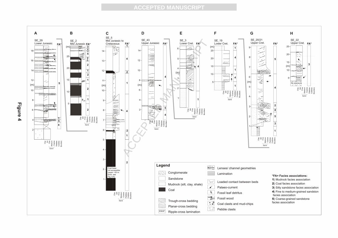
Figure 4: Sedimentary logs constructed from eight separate localities and used to define
the five facies associations that are recognised in Jurassic and Cretaceous rocks across the
Mariinsk-Krasnoyarsk region. The logs span Lower Jurassic to Upper Cretaceous
intervals. The facies associations identified on each measured section are shown to the
right of each log. Palaeocurrent data are indicated by the arrows on the side of each log.
Note that the vertical scale varies significantly from log to log. Co-ordinates for each of
the localities are as follows. Log A (SE_29), 56° 08.627'N 91° 36.427'E; Log B (SE_2,
Kaichak Quarry), 55° 44.707' N 88° 35.479'E; Log C (SE_5), 55° 40.516'N 89°
13.140'E; Log D (SE_43), 55° 52.641'N 88°19.127'E; Log E (SE_3) 55° 46.169'N
88°45.530'E; Log F (SE_19), 56° 21.698'N 91° 40.354'E ; Log G (SE_20 & 21) and Log
H (SE_22) correspond to detailed sections along the Bolshoy Kemchuk River north and
eastwards of 56° 21.698'N 91° 40.354'E.
Figure 5: Discontinuous profile (log) of Middle Jurassic to Cretaceous sedimentary rocks
cropping out along the Bolshoy Kemchuk river. The sections were accessed by rubber
dinghy. The degree of up-section non-exposure was determined by GPS waypoints
combine with regional dip measurements. Large sections are non-exposed, particularly in

ACC
EPTE
D M
ANU
SCR
IPT
ACCEPTED MANUSCRIPT
the Upper Jurassic. Palaeocurrent measurements were restricted to metre-scale trough
cross-beds in sandstone and are shown to the right of the log. The vertical arrangement of
facies associations is partly cyclic and this is interpreted to record phases of major and
far-reaching avulsion of the river system (see text for details). For legend see Fig. 4.
Figure 6: Fine-grained sedimentary facies in Jurassic and Cretaceous strata. Photos A-D
depict aspects of the mudrock facies association. A: Shale showing variably grey and
brown laminae. B: Mudstone showing alternating pink (oxidised) and green (reduced)
intervals, and no fissility. C: View of the mudstone facies association (grey) interbedded
with the coal facies association (black) in Middle Jurassic deposits at Kaichak quarry,
(log B, Fig. 4). D: Mudstones (brown) capping an abandoned channel that is cut into
sandstone (buff colour). Photos E-F show aspects of the coal facies association. E:
Berezovsky open cast mine (log C, Fig. 4). The coal seam is ~ 50 m in thickness and has
a lateral extent of ~3 km. Note the knife-sharp contact between coal and sandstone. F:
Another example of a knife-sharp contact between a 4 m thick coal overlain by a
medium-grained sandstone along the Bolshoy Kemchuk river. G: Fossil tree trunk within
coal (log B, Fig. 4). This specimen exhibits a crystalline texture, a result of graphitisation
in response to modern day autocombustion of the coal at outcrop.
Figure 7: Sandstones and siltstones of two facies associations in rocks of Jurassic and
Cretaceous age. Photos A and B shows aspects of the silty sandstone facies association.
A: Siltstones with a poor fissility. Bedding is horizontal. The laminae are defined by
concentration of organic material (coal grains and granules). B: Interlaminated siltstone,
shale and coal deposits. Pencil for scale. Photos C-E depict aspects of the fine- to
medium-grained sandstone facies association. C: Large channels developed in fine- to
medium-grained sandstone. The channels are identified by a zone of ferruginisation at
their bases, and by pebble-sized conglomeratic material (including wood fragments,
exotic clasts) above. D: A large trough-cross bed typical of this facies association,
yielding excellent palaeo-current information. Note hammer for scale. The bedform is
capped/ truncated by a metre-thick bed that contains the parallel lamination shown in (E).
F: Stacked sets of ripple within fine-grained sandstone typically occur toward the top of
ACC
EPTE
D M
ANU
SCR
IPT
ACCEPTED MANUSCRIPT
fining-upward cycles, interpreted as a classic waning flow signature.
Figure 8: Representative photographs of the coarse-grained sandstone facies association.
A: 10 m thick succession of interstratified sand and gravel at locality SE 29 (log A, Fig.
4). B: Detail of conglomerate bed at the same locality two metres above the lower contact
between this facies association and Devonian granite. The large angular clast to the right
of the pen is a clast of this Devonian granite. Conglomerate horizons show lateral
pinching and swelling, and thin onto the Devonian granite basement, suggesting bedrock-
confined river conditions. C: Complex facies relationships between conglomeratic
intervals and medium-grained sandstone. The wedge/ lens of sandstone towards the top
of the photo is interpreted as a sand-filled channel body. Beneath it, a pen is positioned
for scale on forsets that are developed in granule to pebble-grade conglomerate. Photo D
shows a close-up of these foresets, which are normally graded.
Figure 9: Vertical relationships between facies associations in Jurassic and Cretaceous
strata. A: Contact between Devonian granite basement and Lower Jurassic sands of the
coarse-grained sandstone facies association (see Fig. 4, log A). B: Irregular contact
between the mudrock facies association (brown/ grey lithology: in the lower and middle
part of the photo) and the coarse-grained sandstone facies association (buff yellow: above
the hammer). This juncture is attributed to gravitational/ load instability of the coarse-
grained sands and gravels onto unconsolidated mudstones. C: Highly irregular contact
between the coal facies association and the fine-to medium-grained sandstone facies
association exposed as a result of coal mining at Periyaslovski Quarry. Note the enclosure
of pods of coal by the sandstone. Coal seam is ~10 m thick. D: Similar irregular contact
between coal and fine-grained sandstone in a section along the Bolshoy Kemchuk river.
Note the development of isolated pods of sandstone beneath a load feature in the
overlying sandstone bed, resulting in complete enclosure by the coal. The features in C
and D stand in contrast to the localities shown in Figs 6 E and F where lithological
contrasts are sharp and well defined, and might imply the presence of residual water
within the peat before the coalification process was complete.
ACC
EPTE
D M
ANU
SCR
IPT
ACCEPTED MANUSCRIPT
Figure 10: Depositional model for continental sedimentary systems of the south-eastern
West Siberian Basin during the Jurassic, developed from outcrops in the Mariinsk-
Krasnoyarsk region. A: Early Jurassic depositional environments, dominated by
relatively immature fluvial environments, coarse bedload fluvial systems, and the
continuing influence of bedrock topography upon sedimentary architecture. B: Cartoon
summarizing depositional environments of the Mid Jurassic, which were characterised by
a more mature/ evolved fluvial landscape system that included well defined overbank
areas. These overbank areas were the depocentres for peat accumulation (and hence
economically significant coal accumulations). These coals may also contribute to a
hitherto untapped source of natural gas in the southern part of the West Siberian Basin.
Table 1: Palynological data from the Mesozoic samples of the Mariinsk-Krasnoyarsk
region. 15 samples were prepared but only 6 contain enough palynomorphs to provide
reliable results. Two principal types of palynomorphs can be identified within mudstones
of Jurassic and Cretaceous age, namely 1) pteridophyte spores and 2) gymnosperm
pollen. Of particular interest are the occurrences of Classopolis classoides and
Botryococcus braunii: see section on the mudrock facies association for details.

ACC
EPTE
D M
ANU
SCR
IPT
ACCEPTED MANUSCRIPT

ACC
EPTE
D M
ANU
SCR
IPT
ACCEPTED MANUSCRIPT
Yamal-GydaNadym-TazSouth East
A’A
TuronianLate
Albian
Aptian
Barremian
Hauterivian
Valanginian
Jura
ssic
Cre
tace
ou
s
La
teM
idE
arly
Early
Ryazanian
Cenomanian
Volgian
KimmeridgianOxfordianCallovianBathonian
Bajocian
Aalenian
Toarcian
Pleinsbachian
Depocentre
Tyumen
Bazhenov
Abalak
Tyumen
KulomzinMegion
Vartov
Kuznetsov Kuznetsov
Bol’shekhet
Tochin
Sigov
Yeloguy
Vartov
Malokhet
Yakovlev
Makov
SUBSURFACE
OUTCROP,MARIINSK-
KRASNOYARSK
Ne
oco
mia
nSemonov-skaya
Ilekskaya
Tyaginskaya
Itatskaya
Ilinskskaya
Makarov-skaya
Marine mud (bituminous)
Graded turbidites
Heterolithic silt and clay
Marginal marine rhythmites
Marginal marine, lagoonal &deltaic sand, silt and clay
Alluvial sand, silt and clay
Fluvial (intra-channel) sand and silt
Hiatus
Coal seam
Fluvial (intra-channel) conglomerate
Marine mud (no-bituminous)
Regionally extensive erosion surface
Uvat
Pokur Pokur
Figure 2
CHRONO- STRATIGRAPHY
Hiatusin continentalsetting?
Kiyalin
Pre-JurassicUnconformity
Legend
Marine deposits (mainly subsurface) Terrestrial deposits (mainly outcrop)

ACC
EPTE
D M
ANU
SCR
IPT
ACCEPTED MANUSCRIPT
Figure 3
West SiberianBasin Angara river
Yen
isey riv
er
BolshoyKemchuk
river
Kiya river
55°N
56°N
57°N
58°N
59°N
o87 E o88 E o89 E o90 E o91 E o92 E o93 E o94 E o95 Eo96 E
o97 E
SE_30
EJ
SE_10
MJ
SE_25
MJ
SE_31
MJ
SE_5
MJ
SE_38
EJ
SE_29
EJ
SE_3
EC
SE_20+21
LC
SE_44
LJ
SE_22
LCLJ
SE_42
MJ*
MJ
SE_9
ECSE_19
SiberianCraton
Legend Tertiary and Quaternary
Cretaceous
Jurassic
Mean palaeo-current vector
Bolshoy KemchukRiver section (Fig. 5)
EC = Early CretaceousLJ = Late JurassicMJ = Mid JurassicEJ = Early Jurassic
LJ
LC
ACC
EPTE
D M
ANU
SCR
IPT
ACCEPTED MANUSCRIPT

ACC
EPTE
D M
ANU
SCR
IPT
ACCEPTED MANUSCRIPT
Figure 5
cla
y
silt
mu
d
v. fin
efin
em
ed
ium
coa
rse
v. c
oa
rse
SE 11
Aa
len
ian
Ba
joc
ian
SE 13
SE 12
No Exposure ~ 100m
No Exposure~ 20m?
No Exposure ~ 30m?
SE 14
No Exposure~ 50m?
Ox
ford
ian
?
SE 18
?
No Exposure~ 330m
380
390
Ne
oc
om
ian
SE 19
720
730
740
SE 15
No Exposure~ 40m?
Ba
tho
nia
n
180
190
200
210
220
260
270
280
10
20
30
40
50
60
80
90
125
135
Mid
Late
Sand
Height(m)
1
3
4
2
3
2
4
1
2
4
1
4
2
4
1
4
4
2
4
1
1
4
1
4
Faciesassociations
1

ACC
EPTE
D M
ANU
SCR
IPT
ACCEPTED MANUSCRIPT
D
1 m
BA
C
Figure 6
Fig. 4 log C
50 m
E
F G

ACC
EPTE
D M
ANU
SCR
IPT
ACCEPTED MANUSCRIPT
C D
Figure 7
A B
E E

ACC
EPTE
D M
ANU
SCR
IPT
ACCEPTED MANUSCRIPT
A B
C D
Figure 8

ACC
EPTE
D M
ANU
SCR
IPT
ACCEPTED MANUSCRIPT
Figure 9
A B
C D2 m
Base Jurassic unconformity
Devoniangranite
LowerJurassic
1 m

ACC
EPTE
D M
ANU
SCR
IPT
ACCEPTED MANUSCRIPT
ACC
EPTE
D M
ANU
SCR
IPT
ACCEPTED MANUSCRIPT