section 700 environmental systems storm drainage, grading ... · pdf fileadopted june 17, 2014...
TRANSCRIPT
Adopted June 17, 2014 Effective July 1, 2014 1
SECTION 700
ENVIRONMENTAL SYSTEMS
STORM DRAINAGE, GRADING, STORM WATER MANAGEMENT, FLOODPLAINS, CHESAPEAKE BAY PRESERVATION AREA, EROSION AND SEDIMENT CONTROL, AND
SOIL TESTING (GEOTECHNICAL)
Table of Contents 701.00 STORM DRAINAGE SYSTEMS - POLICY: ....................................................................... 6 701.01 Definitions: .............................................................................................................................. 6 701.02 Adequate Storm Drainage Design: ........................................................................................ 10 701.03 Channel Protection and Flood Protection: ............................................................................. 11 701.04 Improvement to Conveyance System: ................................................................................... 14 701.05 Reference Manuals and Standards: All manuals and/or standards referenced in this section shall refer to the latest version of such manual or standard. .................................................................... 15 701.06 Design Storms And Hydrologic Methods: ............................................................................ 15 702.00 STORM DRAINAGE SYSTEMS - PLANNING AND DESIGN: ...................................... 16 702.01 Rainfall Frequencies and Duration: ....................................................................................... 16 702.02 Storm Drainage Systems in General: .................................................................................... 16 702.03 Storm Drainage Systems for Streets: ..................................................................................... 18 702.04 Ditches: .................................................................................................................................. 18 702.05 Headwater and Tailwater Computations: .............................................................................. 19 702.06 Easements in General: ........................................................................................................... 19 702.07 Easements for Areas of Concentrated Flow: ......................................................................... 20 702.08 Storm Drainage Systems in Relation to Utility Lines: .......................................................... 20 702.09 Storm Drainage Systems in Relation to Property Lines: ....................................................... 20 702.10 Storm Drainage Systems in Relation to Slope: ..................................................................... 21 702.11 Pipe in General: ..................................................................................................................... 21 702.12 Corrugated Metal Pipe: ......................................................................................................... 22 702.13 High Density Polyethylene Pipe (HDPE) , Polypropylene Pipe, and Polyvinyl Chloride Pipe (PVC): ............................................................................................................................................... 22 702.14 Use of High Density Polyethylene Pipe (HDPE), Polypropylene Pipe, and Polyvinyl Chloride Pipe (PVC): ............................................................................................................................... 22 702.15 Pipe for High Velocity Flow ................................................................................................. 22 702.16 Pipe Cover: ............................................................................................................................ 23 702.17 Major Culverts: ...................................................................................................................... 23 702.18 Storm Drainage Structures in General: ................................................................................. 23 702.19 Headwalls and Endwalls: ...................................................................................................... 24 702.20 Erosion Protection in General ............................................................................................... 24

Adopted June 17, 2014 Effective July 1, 2014 2
702.21 Erosion Protection at Outfalls: .............................................................................................. 24 703.00 STORM DRAINAGE SYSTEMS - SUBMISSION REQUIREMENTS ............................. 25 703.01 Schematic Drainage Plan: ..................................................................................................... 25 703.02 Plan, Plat, and Profile Elements: ........................................................................................... 26 703.03 Drainage Computation Sheets: .............................................................................................. 26 703.04 Headwater and Tailwater Computation Forms: .................................................................... 26 703.05 Cut Sheets: ............................................................................................................................. 26 704.00 STORM DRAINAGE SYSTEMS - CONSTRUCTION STANDARDS ............................. 27 704.01 Construction in General: ....................................................................................................... 27 704.02 Line and Grade Stakes: .......................................................................................................... 27 704.03 Cut Sheets .............................................................................................................................. 27 704.04 Bedding and Trenching: ........................................................................................................ 27 704.05 Pipe Joining: .......................................................................................................................... 27 704.06 Backfilling: ............................................................................................................................ 28 704.07 Grading within Jurisdictional Wetlands: ............................................................................... 28 710.00 GRADING - POLICY: .......................................................................................................... 28 710.01 General Policy for Grading and Clearing: ............................................................................. 28 710.02 Disturbed Area Greater Than 5,000 Square Feet: ................................................................. 29 710.03 Disturbed Areas Less than 5,000 Square Feet: ...................................................................... 29 710.04 Land Disturbance Permit ....................................................................................................... 29 710.05 Grading Permit: ..................................................................................................................... 29 710.06 Permit for Retaining Walls: ................................................................................................... 30 711.00 GRADING - DESIGN ........................................................................................................... 31 711.01 Grading Design in General: ................................................................................................... 31 711.02 Flood Protection for Residential Development: .................................................................... 32 711.03 Grading Design for Single-family Attached Development: .................................................. 33 711.04 Yard Lighting: ....................................................................................................................... 33 712.00 GRADING - SUBMISSION REQUIREMENTS ................................................................. 34 712.01 Grading Plans in General: ..................................................................................................... 34 712.02 Lot Grading Plan Elements: .................................................................................................. 34 720.00 STORM WATER MANAGEMENT (SWM) – POLICY: ................................................... 38 720.01 General Policy for SWM: ...................................................................................................... 38 720.02 General Policy for BMP and Storm Water Quality: .............................................................. 39 720.03 Exemptions: ........................................................................................................................... 39 720.04 Exception of Storm Water Quantity Control Requirements: ................................................ 40 720.05 Exception to BMP (Storm Water Quality) Requirements: .................................................... 41 720.06 Pro Rata Share Contribution for SWM in General: .............................................................. 42 720.07 Pro Rata Share Contribution for a Regional SWM Facility with Allocated Funds: ............. 42 720.08 Pro Rata Share Contribution for a Regional SWM Facility Without Allocated Funds: ....... 43 720.09 Pro Rata Share Payments: ..................................................................................................... 43 720.10 Maintenance Policy for SWM/BMP Facilities in General: ................................................... 43 720.11 Residential Properties ............................................................................................................ 44 720.12 Nonresidential Properties: ..................................................................................................... 44 720.13 Apartment Rental Complexes and Mobile Homes ................................................................ 45

Adopted June 17, 2014 Effective July 1, 2014 3
720.14 Regional Facilities in Residential and Nonresidential Properties: ........................................ 45 720.15 Maintenance Agreements for Owner-maintained SWM/BMP Facilities: ............................ 45 720.16 County Maintained SWM/BMP Facilities: ........................................................................... 45 720.17 Golf Courses: ......................................................................................................................... 45 721.00 SWM/BMP FACILITIES - PLANNING AND DESIGN .................................................... 46 721.01 Facilities Design in General: ................................................................................................. 46 721.02 Design Criteria for SWM/BMP Facilities: ............................................................................ 47 721.03 Design Criteria for Stormwater Quality: ............................................................................... 49 721.04 Water Quality Compliance: ................................................................................................... 50 721.05 Offsite compliance options: ................................................................................................... 51 721.06 Comprehensive Stormwater Management Plans: .................................................................. 52 721.07 Design Criteria for Water Quantity: ...................................................................................... 53 721.08 Location of SWM/BMP Facilities: ........................................................................................ 55 721.09 Easements for SWM/BMP Facilities: ................................................................................... 56 721.10 Access to SWM/BMP Facilities: ........................................................................................... 56 721.11 Protection of SWM/BMP Facilities: ..................................................................................... 57 721.12 Dams: ..................................................................................................................................... 57 721.13 Sedimentation and Debris Basins: ......................................................................................... 59 722.00 SWM/BMP - SUBMISSION REQUIREMENTS: ............................................................... 60 722.01 General Requirements: .......................................................................................................... 60 722.02 Stormwater Management Plan Elements: ............................................................................. 60 722.03 Review, Approval, and Modification of Stormwater Management Plans: ........................... 62 722.04 Construction Record Drawing (As-Built Plan): .................................................................... 63 722.05 Maintenance Notes for Residential Properties (Not Including Apartments and Mobile Home Parks) Where SWM, BMP and Storm Drainage Systems Qualify for County Maintenance: ................ 64 722.06 Maintenance Notes for Nonresidential Properties (Including Apartments and Mobile Home Parks) Where the SWM, BMP and Storm Drainage Systems Do Not Qualify for County Maintenance:64 722.07 Maintenance Notes for Nonresidential Properties (Including Apartments and Mobile Home Parks) Where the SWM and BMP Systems Qualify for County Maintenance but All Other Storm Drainage Systems are Maintained by the Fee Title Owner: .................................................................... 64 723.00 INSPECTION AND MAINTENANCE: ............................................................................... 65 724.00 COMPLIANCE AND ENFORCEMENT: ............................................................................ 65 725.00 DEVELOPMENT IN DAM BREAK INUNDATION ZONES ........................................... 65 726.00 REPORTS AND RECORD KEEPING: ............................................................................... 66 730.00 FLOODPLAIN MANAGEMENT - POLICY ...................................................................... 67 730.01 General Policy: ...................................................................................................................... 67 730.02 Definitions: ........................................................................................................................... 67 730.03 Designation of the Floodplain Administrator: ....................................................................... 72 730.04 Duties and Responsibilities of the Floodplain Administrator ............................................... 72 730.05 Floodplain Studies: ................................................................................................................ 74 730.06 Platting Lots within the One Hundred (100) Year Floodplain: ............................................. 75 730.07 Variances .............................................................................................................................. 75 730.08 Waivers: ................................................................................................................................. 75 730.09 Nonconforming Use Policy: ............................................................................................... 77

Adopted June 17, 2014 Effective July 1, 2014 4
730.10 Conflicting Provisions Policy:............................................................................................... 77 730.11 Disclaimer of Liability: ......................................................................................................... 77 731.00 FLOODPLAIN MANAGEMENT - PLANNING AND DESIGN: ...................................... 77 731.01 Determination of Floodway and Limits of the Regulatory Flood: ........................................ 77 731.02 Floodplain Studies: ................................................................................................................ 78 731.03 Effects of Fills: ...................................................................................................................... 79 731.04 Flood Damage Control: ......................................................................................................... 79 732.00 FLOODPLAIN MANAGEMENT - SUBMISSION REQUIREMENTS: ........................... 85 732.01 General Requirements: .......................................................................................................... 85 732.02 Floodplain Study Criteria: ..................................................................................................... 85 732.03 Plan Elements: ....................................................................................................................... 86 732.04 Watercourse Stabilization: .................................................................................................... 87 732.05 Submission of Technical Data: .............................................................................................. 88 740.00 CHESAPEAKE BAY PRESERVATION AREA – POLICY: ............................................. 89 740.01 General Policy: ...................................................................................................................... 89 740.02 Definitions: ............................................................................................................................ 89 740.03 Resource Protection Area (RPA) Boundaries: ...................................................................... 92 740.04 Exemptions in Resource Protection Areas: ........................................................................... 92 740.05 Permitted Uses in Resource Protection Areas: ...................................................................... 93 740.06 Exceptions for Encroachments into the RPA: ....................................................................... 93 741.00 CHESAPEAKE BAY PRESERVATION AREA – PLANNING AND DESIGN: .............. 95 741.01 General Performance Standards: ........................................................................................... 95 741.02 Additional Performance Criteria for RPA: ............................................................................ 96 741.03 RPA Buffers in Intensely Developed Areas (IDA): .............................................................. 97 741.04 Minimum Lot Size in Relation to RPA: ................................................................................ 97 741.05 Special Provisions for SWM Facilities: ................................................................................ 98 742.00 CHESAPEAKE BAY PRESERVATION AREA – SUBMISSION REQUIREMENTS: ... 98 742.01 CBPA Overlay District: ......................................................................................................... 98 742.02 Perennial Flow Determinations: ............................................................................................ 99 742.03 Preservation Area Site Assessment (PASA): ...................................................................... 100 742.04 Water Quality Impact Assessment: ..................................................................................... 100 742.05 Water Quality Impact Assessment Elements ...................................................................... 101 742.06 RMA Limits Study: ............................................................................................................. 102 742.07 Final Site Plans: ................................................................................................................... 103 743.00 CHESAPEAKE BAY PRESERVATION AREA – VIOLATIONS .................................. 103 743.01 Disturbance of RPA: ........................................................................................................... 103 743.02 Violation of Chesapeake Bay Regulations: ......................................................................... 103 743.03 RPA Restoration Plan: ......................................................................................................... 104 743.04 Criminal Violations and Penalties: ...................................................................................... 105 743.05 Civil Penalties: .................................................................................................................... 105 750.00 EROSION AND SEDIMENT CONTROL – POLICY ...................................................... 105 750.01 Definitions: .......................................................................................................................... 105 750.02 General Policy: .................................................................................................................... 107 750.03 Permits ................................................................................................................................. 107

Adopted June 17, 2014 Effective July 1, 2014 5
750.04 Erosion and Sedimentation Control Management: ............................................................. 108 750.05 Exceptions: .......................................................................................................................... 109 750.06 Pollution Prevention Plan: ................................................................................................... 110 750.07 Monitoring, Reports, and Inspections: ................................................................................ 111 750.08 Violations: ........................................................................................................................... 112 750.09 Stop Work Order: ................................................................................................................ 115 750.10 Injunctions and Other Relief: .............................................................................................. 115 750.11 Appeals: ............................................................................................................................... 116 750.12 Escrows for Site Development Projects: ............................................................................. 116 750.13 Erosion Control Escrow for Building Single-family Detached Dwellings: ........................ 117 751.00 EROSION AND SEDIMENT CONTROL - PLANNING AND DESIGN ........................ 117 751.01 General Requirements: ........................................................................................................ 117 751.02 Two-Layer Perimeter Erosion Control Measures: .............................................................. 119 751.03 Sedimentation and Debris Basins: ....................................................................................... 119 752.00 EROSION AND SEDIMENT CONTROL SUBMISSION REQUIREMENTS ................ 120 752.01 General Requirements: ........................................................................................................ 120 752.02 Phased Plan: ........................................................................................................................ 120 770.00 SOIL TESTING (GEOTECHNICAL) POLICY ................................................................ 120 770.01 General Purpose: ................................................................................................................. 120 770.02 Engineering Soils Categorization: ....................................................................................... 120 770.10 Soils Report Requirement: .................................................................................................. 122 770.11 Commercial Structures: ....................................................................................................... 122 770.12 Residential Project: .............................................................................................................. 122 770.13 Additional Requirements: .................................................................................................... 123 770.20 Guidelines for the Preparation of Geotechnical Studies: .................................................... 123 770.30 Soils Report Review by Third Party: .................................................................................. 123 770.40 Soils Report Approval: ........................................................................................................ 123 770.50 Additional Requirements for Slopes: .................................................................................. 123 770.51 Additional Requirements for Retaining Walls .................................................................... 124 770.60 Requirements for Structural Fill: ......................................................................................... 124 770.70 Requirements for Soil Stabilization or Modification .......................................................... 124 770.80 Geotechnical Report Requirements for Revisions to an Approved Plan: ........................... 124 770.90 Guidelines for the Change of Geotechnical Engineer of Record (GER) ............................ 125
Adopted June 17, 2014 Effective July 1, 2014 6
SECTION 700
ENVIRONMENTAL SYSTEMS
GRANDFATHERED PROJECTS: REGULATED LAND-DISTURBING ACTIVITIES FOR
GRANDFATHERED PROJECTS SUBJECT TO THE PROVISION OF SECTION 23.2-37 OF
THE STORMWATER MANAGEMENT CODE SHALL BE SUBJECT TO THE TECHNICAL
CRITERIA FOUND IN SECTION 700 OF THE COUNTY’S DESIGN AND CONSTRUCTION
STANDARDS MANUAL IN EFFECT AS OF JUNE 30, 2014.
------------
STORM DRAINAGE, GRADING, STORM WATER MANAGEMENT, FLOODPLAINS, CHESAPEAKE BAY PRESERVATION AREA, EROSION AND SEDIMENT CONTROL, AND
SOIL TESTING (GEOTECHNICAL)
701.00 STORM DRAINAGE SYSTEMS - POLICY: 701.01 Definitions:
The following words and terms used in the Stormwater Management Code have the following meanings unless otherwise specified herein. Where definitions differ, those incorporated herein shall have precedence.
"Administrator" means the VSMP authority including the Director of Public Works, Prince William County staff person or department responsible for administering the VSMP on behalf of the County.
"Agreement in lieu of a stormwater management plan" means a contract between the VSMP
authority and the owner or permittee that specifies methods that shall be implemented to comply with the requirements of a VSMP for the construction of a single-family residence; such contract may be executed by the VSMP authority in lieu of a stormwater management plan.
"Applicant" means any person submitting an application for a permit or requesting issuance of a permit under the Stormwater Management Code.
"Approval authority" means the State Water Control Board or its designee.
"Best management practice" or "BMP" means schedules of activities, prohibitions of practices,
including both structural and nonstructural practices, maintenance procedures, and other management practices to prevent or reduce the pollution of surface waters and groundwater systems from the impacts of land-disturbing activities.
“BOCS” means the Prince William Board of County Supervisors.
"Certificate of competence" means an individual who holds a certificate of competence in an appropriate field (i.e. plan review, inspection, and program administration under VSMP program) from

Adopted June 17, 2014 Effective July 1, 2014 7
the board or is enrolled in the board's training program and successfully completes such program within one year after enrollment.
"Chesapeake Bay Preservation Act land-disturbing activity" means a land-disturbing activity
including clearing, grading, or excavation that results in a land disturbance equal or greater than 2,500 square feet and less than one acre in all areas of jurisdictions designated as subject to the regulations adopted pursuant to the Chesapeake Bay Preservation Act, Code of Virginia, § 10.1-2100, et seq.
“Common plan of development, site plan, subdivision plan or sale” means a contiguous area where separate and distinct construction activities may be taking place at different times on different schedules.
"Control measure" means any best management practice or stormwater facility, or other method used to minimize the discharge of pollutants to state waters.
"Clean Water Act” or “CWA" means the federal Clean Water Act (33 U.S.C §1251 et seq.), formerly referred to as the Federal Water Pollution Control Act or Federal Water Pollution Control Act Amendments of 1972, Public Law 92-500, as amended by Public Law 95-217, Public Law 95-576, Public Law 96-483, and Public Law 97-117, or any subsequent revisions thereto.
“DCSM” means the Prince William County Design and Construction Standards Manual.
"Department" means the Department of Environmental Quality (DEQ).
"Development" means land disturbance and the resulting landform associated with the construction of residential, commercial, industrial, institutional, recreation, transportation or utility facilities or structures or the clearing of land for non-agricultural or non-silvicultural purposes.
“Director” means the Director of Public Works
“Fee Schedule” means the Prince William County Land Development Fee Schedule as adopted by the Prince William Board of County Supervisors.
"General permit" means the state permit titled GENERAL PERMIT FOR DISCHARGES OF STORMWATER FROM CONSTRUCTION ACTIVITIES found in Part XIV (9VAC25-880 et seq.) of the Regulations authorizing a category of discharges under the CWA and the Act within a geographical area of the Commonwealth of Virginia.
"Hydrologic Unit Code" or "HUC" means a watershed unit established in the most recent version of Virginia's 6th Order National Watershed Boundary Dataset.
"Land disturbance" or "land-disturbing activity" means a man-made change to the land surface that potentially changes its runoff characteristics including clearing, grading, or excavation except that the term shall not include those exemptions specified in Section 23.2-24 of the Stormwater Management Code.
“Layout” means a conceptual drawing sufficient to provide for the specified stormwater management facilities required at the time of approval.
"Linear development project" means a land-disturbing activity that is linear in nature such as, but
not limited to, (i) the construction of electric and telephone utility lines, and natural gas pipelines; (ii)

Adopted June 17, 2014 Effective July 1, 2014 8
construction of tracks, rights-of-way, bridges, communication facilities and other related structures of a railroad company; (iii) highway construction projects; (iv) construction of stormwater channels and stream restoration activities; and (v) water and sewer lines. Private subdivision roads or streets shall not be considered linear development projects. “Locality” means the Prince William County or the County
"Localized flooding" means smaller scale flooding that may occur outside of a stormwater conveyance system. This may include shallow, localized flooding problems outside of the SFHA resulting from ponding, poor drainage, inadequate storm sewers, clogged culverts or catch basins, sheet flow, obstructed drainageways, sewer backup, overbank flooding from small streams, or standing water from stormwater runoff, which is likely to cause property damage or unsafe conditions.
"Minor modification" means an amendment to an existing general permit before its expiration not requiring extensive review and evaluation including, but not limited to, changes in EPA promulgated test protocols, increasing monitoring frequency requirements, changes in sampling locations, and changes to compliance dates within the overall compliance schedules. A minor general permit modification or amendment does not substantially alter general permit conditions, substantially increase or decrease the amount of surface water impacts, increase the size of the operation, or reduce the capacity of the facility to protect human health or the environment.
"Operator" means the owner or operator of any facility or activity subject to regulation under the Stormwater Management Code.
"Permit" or "VSMP Authority Permit" or “Stormwater Permit” means an approval to conduct a land-disturbing activity issued by the director for the initiation of a land-disturbing activity, in accordance with the Stormwater Management Code, and which may only be issued after evidence of general permit coverage has been provided by the Department.
"Permittee" means the person to whom the state and/or County Permit is issued.
"Person" means any individual, corporation, partnership, association, state, municipality, commission, or political subdivision of a state, governmental body, including federal, state, or local entity as applicable, any interstate body or any other legal entity.
"Prior developed lands" means land that has been previously utilized for residential, commercial,
industrial, institutional, recreation, transportation or utility facilities or structures, and that will have the impervious areas associated with those uses altered during a land-disturbing activity.
"Regulations" means the Virginia Stormwater Management Program (VSMP) Permit Regulations, 9VAC25-870, as amended.
"Subdivision" means the same as defined in Section 25-2 of Prince William County Subdivision Ordinance.
"Site" means the land or water area where any facility or land-disturbing activity is physically located or conducted, including adjacent land used or preserved in connection with the facility or land-disturbing activity. Areas channelward of mean low water in tidal Virginia shall not be considered part of a site.

Adopted June 17, 2014 Effective July 1, 2014 9
"State" means the Commonwealth of Virginia.
"State Board/Board" means the State Water Control Board.
"State permit" means an approval to conduct a land-disturbing activity issued by the State Water Control Board in the form of a state stormwater individual permit or coverage issued under a state general permit or an approval issued by the State Water Control Board for stormwater discharges from an MS4. Under these state permits, the Commonwealth imposes and enforces requirements pursuant to the federal Clean Water Act and regulations, the Virginia Stormwater Management Act and the Regulations.
"State Water Control Law" means Chapter 3.1 (§ 62.1-44.2 et seq.) of Title 62.1 of the Code of Virginia.
"State waters" means all water, on the surface and under the ground, wholly or partially within or bordering the Commonwealth or within its jurisdiction, including wetlands.
"Stormwater" means precipitation that is discharged across the land surface or through conveyances to one or more waterways and that may include stormwater runoff, snow melt runoff, and surface runoff and drainage.
"Stormwater management plan" means a document(s) containing material describing methods for complying with the requirements of Section 23.2-32 of the Stormwater Management Code.
"Stormwater Pollution Prevention Plan" or "SWPPP" means a document that is prepared in accordance with good engineering practices and that identifies potential sources of pollutants that may reasonably be expected to affect the quality of stormwater discharges from the construction site, and otherwise meets the requirements of the Stormwater Management Code. In addition the document shall identify and require the implementation of control measures, and shall include, but not be limited to the inclusion of or the incorporation by reference of, an approved erosion and sediment control plan, an approved stormwater management plan, and a pollution prevention plan.
"VDOT" means Virginia Department of Transportation.
"Total maximum daily load" or "TMDL" means the sum of the individual wasteload allocations for point sources, load allocations for nonpoint sources, natural background loading and a margin of safety. TMDLs can be expressed in terms of either mass per time, toxicity, or other appropriate measure. The TMDL process provides for point versus nonpoint source trade-offs.
"Virginia Erosion and Sediment Control Program" or "VESCP" means a program approved by
the State Water Control Board that has been established by a VESCP authority for the effective control of soil erosion, sediment deposition, and nonagricultural runoff associated with a land-disturbing activity to prevent the unreasonable degradation of properties, stream channels, waters, and other natural resources and shall include such items where applicable as local ordinances, rules, permit requirements, annual standards and specifications, policies and guidelines, technical materials, and requirements for plan review, inspection, enforcement where authorized in the Erosion and Sediment Control Act and its attendant regulations, and evaluation consistent with the requirements of the Erosion and Sediment Control Act and its attendant regulations.
"Virginia Erosion and Sediment Control Program authority" or "VESCP authority" means an authority approved by the State Water Control Board to operate a Virginia Erosion and Sediment

Adopted June 17, 2014 Effective July 1, 2014 10
Control Program. An authority may include a state entity, including the department; a federal entity; a district, county, city, or town; or for linear projects subject to annual standards and specifications, electric, natural gas and telephone utility companies, interstate and intrastate natural gas pipeline companies, railroad companies, or authorities created pursuant to § 15.2-5102 of the Code of Virginia.
"Virginia Stormwater Management Act" or "Act" means Article 2.3 (§ 62.1-44.15:24 et seq.) of Chapter 3.1 of Title 62.1 of the Code of Virginia.
“Virginia Stormwater BMP Clearinghouse website” means a website that contains detailed design standards and specifications for control measures that may be used in Virginia to comply with the requirements of the Virginia Stormwater Management Act and associated regulations.
“Virginia Stormwater Management Program” or “VSMP” means a program approved by the State Water Control Board after September 13, 2011, that has been established by a locality to manage the quality and quantity of runoff resulting from land-disturbing activities and shall include such items as local ordinances, rules, permit requirements, annual standards and specifications, policies and guidelines, technical materials, and requirements for plan review, inspection, enforcement, where authorized in this article, and evaluation consistent with the requirements of this article and associated regulations.
"Virginia Stormwater Management Program authority" or "VSMP authority" means the director of Public Works or any duly authorized agent of the director approved by the State Water Control Board after September 13, 2011, to operate a Virginia Stormwater Management Program.
"Wasteload allocation" or "wasteload" or "WLA" means the portion of a receiving surface
water's loading or assimilative capacity allocated to one of its existing or future point sources of pollution. WLAs are a type of water quality-based effluent limitation. 701.02 Adequate Storm Drainage Design: A. Adequate drainage must have the hydraulic characteristics to accommodate the expected flow of storm waters from a given watershed, or portion thereof, for a specified duration and intensity of rainfall. B. The size and capacity of an adequate drainage system shall be determined in accordance with the densities and intensities reflected in the Long Range Future Land Use Plan, the existing zoning, or development in the watershed or affected portions thereof, whichever is greater. C. Adequate drainage systems shall be designed in accordance with the following: 1. To accommodate storm water runoff resulting from the ultimate development of the drainage
area, unless existing SWM facilities already provided or SWM facilities bonded for construction will provide the required controls. In such cases, the design outflow rates from these facilities shall be considered in the design of the drainage system.
2. To honor major natural drainage divides. 3. To account for both offsite and onsite peak and base flows.

Adopted June 17, 2014 Effective July 1, 2014 11
4. To convey surface and subsurface (seeps, springs, etc.) waters to a stream, water channel, pipe system, natural drainageway, or existing facility.
5. To discharge surface and subsurface waters to a natural drainageway by tying into the
drainageway at natural elevations or by discharging the storm water into an existing facility of sufficient capacity to receive the same.
D. Drainage structures shall be constructed in such a manner that they can be maintained at reasonable cost. To facilitate design, construction and maintenance, said drainage structures shall meet or conform to County or VDOT standards. E. State law requires that properties and waterways downstream from new development sites be protected from sediment deposition, erosion and damage due to increases in the volume, velocity, and peak flow rate of stormwater runoff. Concentrated storm water runoff leaving a development site shall be discharged directly into a well-defined, natural, restored, or man-made on-site or off-site receiving conveyance system. To satisfy these requirements, the adequacy of all manmade (including pipes), restored, and natural stormwater conveyance systems shall be verified in accordance with the channel protection and flood protection requirements of this manual. 701.03 Channel Protection and Flood Protection: A. Channel protection and flood protection shall be addressed in accordance with the minimum standards set out in this section and other applicable regulations.
B. Channel protection: Concentrated stormwater flow shall be released into a stormwater conveyance system and shall meet the criteria in subdivision 1, 2, or 3 of this subsection, where applicable, from the point of discharge to a point to the limits of analysis in subdivision 4 of this subsection.
1. Manmade stormwater conveyance systems. When stormwater from a development is discharged to a manmade stormwater conveyance
system, following the land-disturbing activity, either: a. The manmade stormwater conveyance system shall convey the postdevelopment peak flow
rate from the two-year 24-hour storm event without causing erosion of the system. Detention of stormwater or downstream improvements may be incorporated into the approved land-disturbing activity to meet this criterion, at the discretion of the director; or
b. The peak discharge requirements for concentrated stormwater flow to natural stormwater
conveyance systems in subdivision 3 of this subsection shall be met. 2. Restored stormwater conveyance systems. When stormwater from a development is discharged to a restored stormwater conveyance system
that has been restored using natural design concepts, following the land-disturbing activity, either: a. The development shall be consistent, in combination with other stormwater runoff, with the
design parameters of the restored stormwater conveyance system that is functioning in accordance with the design objectives; or

Adopted June 17, 2014 Effective July 1, 2014 12
b. The peak discharge requirements for concentrated stormwater flow to natural stormwater conveyance systems in subdivision 3 of this subsection shall be met.
3. Natural stormwater conveyance systems. When stormwater from a development is discharged to a natural stormwater conveyance system,
the maximum peak flow rate from the one-year 24-hour storm following the land-disturbing activity shall be calculated either:
a. In accordance with the following methodology:
QDeveloped ≤ I.F.*(QPre-developed* RVPre-Developed)/RVDeveloped Under no condition shall QDeveloped be greater than QPre-Developed nor shall QDeveloped be required to
be less than that calculated in the equation (QForest * RVForest)/RVDeveloped; where I.F. (Improvement Factor) equals 0.8 for sites > 1 acre or 0.9 for sites ≤ 1 acre. QDeveloped = The allowable peak flow rate of runoff from the developed site. RVDeveloped = The volume of runoff from the site in the developed condition. QPre-Developed = The peak flow rate of runoff from the site in the pre-developed condition. RVPre-Developed = The volume of runoff from the site in pre-developed condition. QForest = The peak flow rate of runoff from the site in a forested condition. RVForest = The volume of runoff from the site in a forested condition; or b. In accordance with another methodology that is demonstrated by the director to achieve
equivalent results and is approved by the State Water Control Board.
4. Limits of analysis. Unless subdivision 3 of this subsection is utilized to show compliance with the channel
protection criteria, stormwater conveyance systems shall be analyzed for compliance with channel protection criteria to a point where either:
a. Based on land area, the site's contributing drainage area is less than or equal to 1.0% of the
total watershed area; or b. Based on peak flow rate, the site's peak flow rate from the one-year 24-hour storm is less than
or equal to 1.0% of the existing peak flow rate from the one-year 24-hour storm prior to the implementation of any stormwater quantity control measures.
C. Flood protection. Concentrated stormwater flow shall be released into a stormwater conveyance system and shall meet one of the following criteria as demonstrated by use of acceptable hydrologic and hydraulic methodologies:
1. Concentrated stormwater flow to stormwater conveyance systems that currently do not
experience localized flooding during the 10-year 24-hour storm event: The point of discharge releases stormwater into a stormwater conveyance system that, following
the land-disturbing activity, confines the postdevelopment peak flow rate from the 10-year 24-hour

Adopted June 17, 2014 Effective July 1, 2014 13
storm event within the stormwater conveyance system. Detention of stormwater or downstream improvements may be incorporated into the approved land-disturbing activity to meet this criterion, at the discretion of the director
2. Concentrated stormwater flow to stormwater conveyance systems that currently experience
localized flooding during the 10-year 24-hour storm event: a. Confines the postdevelopment peak flow rate from the 10-year 24-hour storm event within the
stormwater conveyance system to avoid the localized flooding. Detention of stormwater or downstream improvements may be incorporated into the approved land-disturbing activity to meet this criterion, at the discretion of the director; or
b. Releases a postdevelopment peak flow rate for the 10-year 24-hour storm event that is less
than the predevelopment peak flow rate from the 10-year 24-hour storm event. Unless required by the director, downstream stormwater conveyance systems do not require any additional analysis to show compliance with flood protection criteria if this option is utilized.
3. Limits of analysis: Unless subdivision 2(b) of this subsection is utilized to comply with the flood protection criteria,
stormwater conveyance systems shall be analyzed for compliance with flood protection criteria to a point where:
a. The site's contributing drainage area is less than or equal to 1.0% of the total watershed area
draining to a point of analysis in the downstream stormwater conveyance system; b. Based on peak flow rate, the site's peak flow rate from the 10-year 24-hour storm event is less
than or equal to 1.0% of the existing peak flow rate from the 10-year 24-hour storm event prior to the implementation of any stormwater quantity control measure; or
c. When the stormwater conveyance system enters a mapped floodplain or other flood-prone
area, adopted by ordinance, adequate outfall protection measures shall be provided to prevent erosion of the overbank areas.
D. Increased volumes of sheet flow resulting from pervious or disconnected impervious areas, or from physical spreading of concentrated flow through level spreaders, must be identified and evaluated for potential impacts on down-gradient properties or resources. Increased volumes of sheet flow that will cause or contribute to erosion, sedimentation, or flooding of down gradient properties or resources shall be diverted to a stormwater management facility or a stormwater conveyance system that conveys the runoff without causing down-gradient erosion, sedimentation, or flooding. If all runoff from the site is sheet flow and the conditions of this subsection are met, no further water quantity controls are required.

Adopted June 17, 2014 Effective July 1, 2014 14
E. Predevelopment and postdevelopment runoff characteristics and site hydrology shall be verified by site inspections, topographic surveys, available soil mapping or studies, and calculations consistent with good engineering practices. Guidance provided in this manual, Virginia Stormwater Management Handbook, VDOT Drainage Manual, and by the Virginia Stormwater BMP Clearinghouse shall be considered appropriate practices. F. The engineer shall use the following procedure to establish the adequacy of receiving conveyance system based on a personal visit by the design engineer and the procedures noted under determination of an adequate channel of the Virginia Erosion and Sediment Control Handbook. All plan submissions must contain supporting computations as justification for the conclusions contained in the outfall narrative. For consistency, the following items are to be included:
1. Site-specific narrative with a description of the elements of the storm drainage system and adjoining properties. 2. Outfall location(s) map with the contributing drainage areas for each outfall and detailed hydrologic and hydraulic calculations. Digital pictures of the outfall and conveyance system shall be included. 3. A profile for each outfall channel.
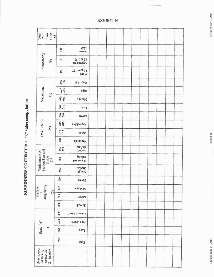
4. Two field-run cross-sections, at a minimum, at each critical and representative location to verify the outfall adequacy. Cross-sections shall be based on a 2-foot field run contour interval and additional spot elevations in the vicinity. The cross-sections shall have the same vertical and horizontal scales and should identify the top of banks for the stream channel. If the top of the banks do not appear to be obvious, the banks should correspond to the corresponding stream cross sectional area for a 2-year undeveloped peak discharge based on hydrologic analysis. In situations where the developer is unable to obtain access to the downstream property for collection of required field data, the developer shall provide evidence of refusal (i.e. return receipts of certified mail) by the property owner. In this instance, the developer shall provide alternate method i.e. aerial surveys, as-built drawings that is satisfactory to the director. The selection of cross section shall be in accordance with the procedures noted under determination of an adequate channel of the Virginia Erosion and Sediment Control Handbook. Description of the outfall channel and permissible velocity. The Manning's roughness coefficient shall be supported by soil classification, cover material and/or channel lining. The description of physical characteristics shall include the amount of stream meandering, material classification of stream and its banks, vegetation, obstruction to flow, variations in cross sections and surface irregularity. 5. Design velocities shall be compared with the permissible velocities of the existing conveyance system as given in the State’s E&S Handbook. If the protection measures are provided, necessary design details shall be shown and supported by calculations.
701.04 Improvement to Conveyance System: If improvements are proposed to a conveyance system, the following options shall apply: A. Improvements to the receiving channel to an adequate condition may be made with permission from downstream property owners. Channel modifications shall comply with applicable laws and regulations.

Adopted June 17, 2014 Effective July 1, 2014 15
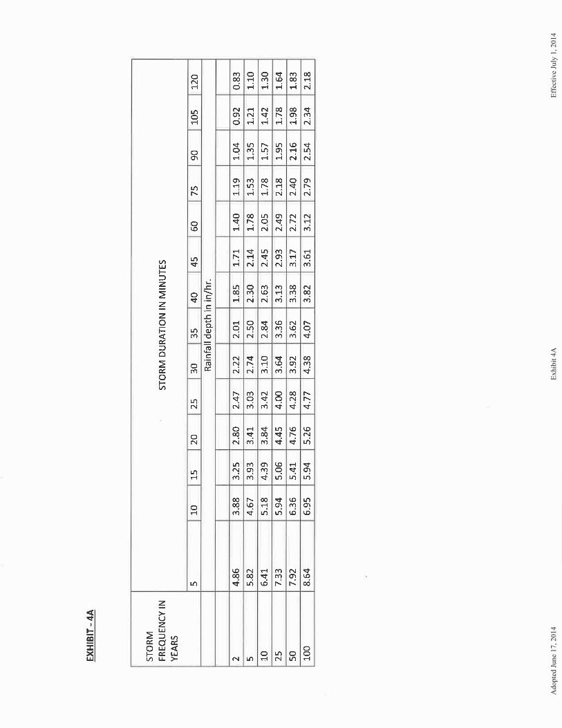
B. A site plan may be developed that will maintain the predevelopment peak storm water runoff rate. This may be accomplished by enhancing the infiltration capability of the site or by providing on-site storm water detention measures. The predevelopment and post development peak runoff rates shall be verified by engineering calculations. C. A combination of channel modifications, storm water detention, nonstructural practices, low impact development site design or other measures which are satisfactory to the director of Public Works and VDOT may be provided to prevent downstream channel erosion. D. Drainage easements are required when channel improvements are proposed and the easement shall be provided in accordance with Section 702.06 of this manual. 701.05 Reference Manuals and Standards: All manuals and/or standards referenced in this section shall refer to the latest version of such manual or standard. 701.06 Design Storms And Hydrologic Methods: A. 24 hour rainfall depths presented in Exhibit 4 are obtained from Virginia Department of Transportation’s Hydraulic Design Advisory, HAD 05-04.2, dated July 28, 2005 and revised February 1, 2008. This revision reflects the NOAA “ATLAS-14” data for the 1-yr. to 100-yr. rainfall events. These rainfall depths shall be used in computing runoff except for rational method. B. Rainfall intensity table presented in Exhibit 4A is also developed based on the above referenced VDOT’s design advisory and VDOT’s Drainage Manual for use with Rational Method and Modified Rational Method Refer to the latest version of VDOT’s DRAINAGE MANUAL and the Hydraulic Design Advisory, and latest version of Virginia Stormwater Management Handbook for additional details. C. All hydrologic analyses shall be based on the existing watershed characteristics and how the ultimate development condition of the subject project will be addressed. For purposes of computing predevelopment runoff, all pervious lands on the site shall be assumed to be in good hydrologic condition in accordance with the U.S. Department of Agriculture's Natural Resources Conservation Service (NRCS) standards, regardless of conditions existing at the time of computation. All computations of predevelopment conditions shall use those NRCS runoff curve numbers assigned for a forested "good" hydrologic condition for pervious lands in the site regardless of the conditions existing at the time of design for each land cover type.
D. The U.S. Department of Agriculture's Natural Resources Conservation Service (NRCS) synthetic 24-hour rainfall distribution and models, including, but not limited to TR-55 and TR-20; hydrologic and hydraulic methods developed by the U.S. Army Corps of Engineers; shall be used to conduct the analyses described in this manual for drainage areas greater than 200 acres.
E. For drainage areas of 200 acres or less, the director may allow for the use of the Rational Method as set forth in VDOT Drainage Manual and as outlined in Table 7.1 for evaluating peak discharges EXCEPT for the design of stormwater management facilities.
F. The director may allow use of the Rational Method as a hydrologic method for stormwater management facility design under the following conditions:
1. The contributing drainage area is highly impervious;

Adopted June 17, 2014 Effective July 1, 2014 16
2. The contributing drainage area has a time of concentration, Tc, less than 20 minutes; and 3. The contributing drainage area is less than 20 acres.
G. For drainage areas of 20 acres or less, the director may allow for the use of the Modified Rational Method for evaluating volumetric flows to stormwater conveyances. Other methodologies may be used if approved by the director prior to the submission of final plans.
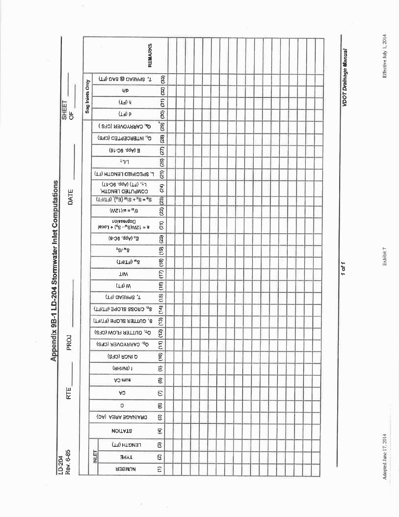
H. The SCS methodologies should be used to compute times of concentration and runoff curve numbers. I. Overland flow time shall be calculated using the Seelye Chart presented in Exhibit 3 of the Appendix. 702.00 STORM DRAINAGE SYSTEMS - PLANNING AND DESIGN: 702.01 Rainfall Frequencies and Duration: A. For storm drainage systems that are located within public right-of-ways and/or will be included for maintenance under the state highway system, the rainfall frequencies required by the VDOT drainage manual shall be used, with the exception that no system shall be designed for less than a ten (10) year 24-hr. storm unless allowed elsewhere in the Design and Construction Standards Manual. B. The VDOT Drainage Manual shall be used for the design of inlets or catch basins unless the conditions require the design for a larger storm event as determined by the director of Public Works. The ten (10) year 24-hr. storm and the actual time of concentration shall be used for the design of grate inlets. The grate inlets (DI-7) shall be designed using a fifty percent (50%) clogging factor. The depth of water shall not exceed four (4) inches. C. For the design of storm drainage systems not to be included in the state highway system, the twenty-five (25) year 24-hr. storm shall be used for drainage areas larger than six hundred (600) acres. D. The ten (10) year 24-hr. frequency storm shall be used for storm drainage systems in drainage areas equal to or less than six hundred (600) acres. E. Floodplain studies shall be based on the one hundred (100) year 24-hr. storm. F. A two (2) hour storm duration shall be used if the rational formula is applied. A twenty-four (24) hour storm duration shall be used for TR-55, TR-20, HEC-HMS, and HEC-1. G. The storm drainage systems proposed within the existing or future VDOT’s right of way may use the storm rainfall depths and intensities acceptable to VDOT. However, drainage systems located outside of VDOT’s right-of-way shall incorporate the rainfall depths and intensities outlined in Section 701.06 (Design Storms and Hydrologic Method) of this manual and the Appendix. 702.02 Storm Drainage Systems in General: A. At a minimum, storm drainage systems shall be designed to provide the overland relief from the one hundred (100) year 24-hr. storm event, without damaging or endangering nearby buildings due to the proposed development. The design and the limits of the 100 year overland ponding and elevations shall be shown on the plans to ensure that nearby buildings are not impacted. The overland relief

Adopted June 17, 2014 Effective July 1, 2014 17
computations are required when the drainage area flowing into a given inlet exceeds 0.5 acre. The overland relief shall be computed assuming that the inlet is completely clogged. In addition, the engineer shall also take into consideration the elevation difference between the overland relief and the lowest opening in a structure to ensure that the structures are not affected. In some situations, the director of Public Works may require the computations for drainage areas less than 0.5 acre to prevent potential localized flooding problems due to overland relief. B. Closed storm drainage systems, generally, shall be designed to minimize the possibility of interior water surface elevations approaching the level of the inlet throats or manhole covers. The following design characteristics of closed systems shall be avoided or their effect compensated for: 1. Numerous bends. 2. Shallow systems. 3. Junctions with directly opposed laterals. 4. Systems which rely on pipes flowing full at high velocities. C. The design capacity of piped storm drainage systems shall not be computed using headwater pressure in junctions, such as curb inlets, manholes, etc. Piped storm drainage systems shall be acceptable where the hydraulic grade line for the applicable design storm flow is below the elevation of the inlet throats or manhole rim and the capacity of pipes flowing full (by Manning’s formula) equals or exceeds the applicable designed storm flow. D. The location of the hydraulic grade line (HGL) shall be calculated and submitted with the site plans for systems when the design flow in the proposed system exceeds 80 percent of its capacity. When the flow velocity within the proposed system exceeds 12 feet per second, HGL is required, even when the system carries less than 80 percent of its capacity. The HGL shall be at least 9 inches below the top elevation of structures. The HGL shall be shown on storm sewer profiles. VDOT Form LD-347 provided as Exhibit 14 shall be used for hydraulic grade line computations. E. Calculation of the hydraulic grade line shall include consideration of head losses at all junction structures (Refer to Exhibit 6 for determining “K” factors for changes in flow direction). The hydraulic grade line shall be computed by the method set forth in the VDOT drainage manual. Other established methods may also be used with the approval of the director of Public Works prior to the submission of final plans. F. The hydraulic grade line may be lowered in a system by the following methods: 1. Increasing pipe sizes to reduce the necessary velocities. 2. Eliminating bends 3. Lowering the elevation of the system to provide deeper structures. 4. Eliminating opposing laterals by offsetting their centerline a distance equal to the sum of the diameters. 5. Limiting the extent of individual systems.
Adopted June 17, 2014 Effective July 1, 2014 18
6. Providing effective channelization. 7. Providing inlet shaping. 702.03 Storm Drainage Systems for Streets: A. Storm drainage systems shall be provided when the storm water reaches an eight (8) foot spread, measured from the face of curb on public streets with a pavement width up to thirty-six (36) feet. B. Storm drainage systems shall be provided when the storm water reaches a ten (10) foot spread on public streets with a pavement width greater than thirty-six feet (36) feet. Stormwater inlet computation sheet (VDOT’s Form LD-204), provided as Exhibit 7 in the appendix shall be used to document the computations for items A and B above. C. Whenever streets with curb and gutter are proposed, storm water shall not be allowed to cross the surface of the street intersection, except in unusual circumstances where the subsurface conveyance of storm water is deemed impractical by the director of Public Works, such as the distance to the nearest structure. The surface storm water flow shall not exceed one (1) cubic foot per second (fps). In such cases, the means of surface conveyance shall be approved by the director of Public Works and VDOT. D. For curb inlets occurring in sag points of a street, a minimum length of throat of six (6) feet shall be required. Spread shall be calculated based on a one-tenth percent (0.1%) grade and the incremental flow from each direction. For most streets, the vertical curve has sufficient length to result in a gutter section whose effective gradient is one tenth (0.1) of a percent. In cases where special treatment of the gutter gradient is provided, the flattest slope that will actually occur should be used in lieu of the customary one tenth (0.1) of a percent. The spread requirements at the one-tenth (0.1) of a percent grade do not apply to inlets at sump locations within the turnaround of a cul-de-sac, provided that the flow does not overtop the curb or adjacent driveways. E. Storm drainage systems occurring under curb and gutter shall have a minimum of nine (9) inches of clearance from the bottom of the gutter or as may be permitted by the director of Public Works. F. Whenever streets without curb and gutter are proposed, storm water shall not be allowed to cross a street intersection. The storm water shall be handled by a storm sewer pipe or culvert. G. Expansion joints in storm drainage structures shall be placed and constructed in accordance with VDOT requirements and standards. 702.04 Ditches: A. Open drainageways shall be designed in accordance with the current VDOT drainage manual. B. Open drainageway stabilization shall be required based on velocity as referenced in Chapter 3, Tables 3.17A and 3.17B, of the Virginia Erosion and Sediment Control Handbook, current edition. C. Graded grass or sod-lined swales and ditches outside of the right-of-way shall be sloped a minimum of two percent (2%).

Adopted June 17, 2014 Effective July 1, 2014 19
D. Riprap lined ditches shall be sloped adequately to ensure positive flow. Within the right-of-way, paved ditches shall be required when the ditch centerline grades are in excess of five percent (5%) unless it can be shown through calculations that the velocity of flows is permissible for the alternative lining specified and/or the soil type. If the slope of a ditch located outside of a right of way exceeds 15 percent, the ditch is required to be paved. E. Ditch linings of poured concrete are generally acceptable. F. Permanent ditch linings of part-circle section composed of bituminous or asbestos fiber pipe, or plastic or similar lightweight materials with nonrigid properties, shall not be acceptable. G. Swales shall be designed and located to preclude water from entering the dwellings/buildings. The elevation of flow resulting from the ten (10) year, 24-hr. storm flow level shall be kept below the nearest opening (doors, windows, etc.) to the dwelling/building. If requested by Public Works, the swales shall be designed for 100 –yr. storm in lieu of 10-yr. storm. 702.05 Headwater and Tailwater Computations: A. The current edition of the VDOT drainage manual shall be used for these computations. B. The maximum allowable headwater depth is that depth where the water does not exceed a height greater than eighteen (18) inches below the edge of the roadway shoulder, or where the depth of the ponded area equals fifteen (15) feet. 702.06 Easements in General: A. Easements shall be provided for storm drainage systems and areas of concentrated flow. B. Easements for natural stream channels shall not be required. C. Adequate access shall be provided for storm drainage systems. Generally, storm sewer systems shall be constructed to the property line. If a storm drainage system terminates or starts short of a property line, adequate easements shall be dedicated to allow for maintenance and future extension of the system to or from adjoining properties. D. The drainage easement shall not be less than the widths listed in Table 7-2. Trenches with depths greater than six (6) feet shall have five (5) feet of additional easement width for each five (5) foot increment of additional depth. E. Storm drainage pipe shall be placed within the middle third of the easement. F. Permanent structures or unauthorized obstructions and encroachments such as fences and walls shall not be located within easements. Existing trees may remain but new trees shall not be planted within the easements unless otherwise approved by Public Works. The location of drainage systems shall be taken into consideration in platting of subdivisions or lots to minimize the possibility of such encroachments. G. Offsite drainage easements are required where water backs up into adjoining property as a result of the installation of culverts and other storm drainage systems and appurtenances. Easements shall include the ponded area associated with the applicable design storm for the drainage system. An

Adopted June 17, 2014 Effective July 1, 2014 20
easement is not required if the resulting ponding area from the proposed development does not exceed the predevelopment ponding area. H. Ponding area for the Ten (10) year water surface elevation and tail water shall be included within storm drainage easements. I. Drainage easements shall not be located within buffer areas with the exception of minimum utility crossings in accordance with Section 800 of the DCSM, or subject to approval of the director of Planning and provided that these crossings are allowed by applicable proffers. 702.07 Easements for Areas of Concentrated Flow: A. Easements shall be required for areas of concentrated flow as determined by the director of Public Works. Areas of concentrated flow shall mean modified or constructed swales of ditches concentrating flows from more than one lot and where the drainage area exceeds two (2) acres. It shall also mean modified or constructed swales or stabilized existing drainageways leading into and handling the outfall of culverts located within public rights-of-way. B. For open drainageways (areas of concentrated flow) an easement is required of the same width that is required for a pipe sized to carry the designed flow based on the drainageway slope. Easements for drainage ditches shall be of sufficient width for proper maintenance. 702.08 Storm Drainage Systems in Relation to Utility Lines: A. The minimum allowable vertical distance between storm drainage pipe and other underground piping, with the exception of waterlines, shall be one (1) foot. The minimum allowable vertical distance between storm drainage pipes and waterlines shall be 0.5 feet. B. Where a storm drainage pipe crosses below a sanitary sewer line within three and one-half (3 1/2) feet, ductile iron pipe shall be required for the sanitary system connecting the two structures. Sanitary sewer lines smaller than 4 inches in diameter shall be encased in a steel or ductile iron pipe that extends not less than 10 feet on both sides of the crossing. 702.09 Storm Drainage Systems in Relation to Property Lines: A. Storm drainage pipes or systems, including energy dissipating devices, shall be extended to the property line to protect adjacent properties. In circumstances where there is a fill slope, existing or proposed at the property boundary, the system shall be continued to the toe of the slope to prevent potential erosion. B. When a storm drainage system is proposed to tie-in with an existing drainage system, the developer shall be required to notify the owners of that system and inform them about the proposal in writing. In addition, the developer shall be responsible to inform the owners prior to the start of construction in the vicinity of the existing system. C. Outfall structures shall be terminated at the property lines.

Adopted June 17, 2014 Effective July 1, 2014 21
702.10 Storm Drainage Systems in Relation to Slope: A. Slopes over twenty percent (20%) for a storm drainage system are generally not acceptable, unless specifically approved by the director of Public Works. B. When the slope of a storm drainage system exceeds sixteen percent (16%), anchors shall be required to prevent sliding of the pipe. Adequate erosion control shall be installed at the outlet to prevent undermining of the endwall. C. A cut-off wall shall be required at the outfall of a storm drainage system exceeding sixteen percent (16%) slope (see VDOT Road and Bridge Standards, Detail 101.27). D. For closed drainage systems, the minimum required velocity is 3 feet per second to prevent the sediment in runoff settling within the pipes. 702.11 Pipe in General: A. Pipe used for storm drainage systems shall generally be concrete. Concrete pipes within the right-of-way of a public street or beyond the limits of the right-of-way, shall meet the three (3) edge-bearing strength test requirements for ASTM C76 Class III reinforced concrete pipe, latest revision. Culvert pipe classed as "seconds" by the manufacturer, or pipe which has been rejected from another project, shall not be permitted. The laying length shall not be less than three (3) feet. B. Pipe size shall, generally, not be reduced along the direction of flow except for storm water management systems. The director of Public Works may also allow reduction in one pipe size increment when tying into an existing drainage structure where the outflow pipe is at least thirty-six (36) inches in diameter. C. Storm sewer pipe size shall be determined by using Manning's formula, where:
V = 1.49 R2 / 3 S1/2 feet/sec n
D. Pipe shall have a minimum coefficient of roughness in accordance with Table 7-3. E. The minimum pipe size for a culvert and storm drainage system shall be fifteen (15) inches or equivalent, except when used under a driveway entrance on a ditch section street where twelve (12) inch or equivalent culverts may be permitted. VDOT Form LD-269 provided as Exhibit-8 shall be used in the culvert design. F. The maximum distance of piping to be uninterrupted by appurtenances shall be eight hundred (800) feet for pipes thirty-six (36) inches in diameter or greater and four hundred (400) feet for pipes less than thirty-six (36) inches in diameter. G. Pipe shall be straight between manholes, catch basins, or other appurtenances. H. VDOT Form LD-229 provided as Exhibit 9 shall be used in the storm sewer design computations.
Adopted June 17, 2014 Effective July 1, 2014 22
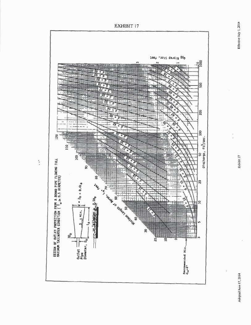
702.12 Corrugated Metal Pipe: A. Corrugated metal pipe, where permitted by the director of Public Works and VDOT, shall meet current VDOT standards. B. Corrugated metal pipe, when permitted by VDOT east of Interstate 95, shall be fully bituminous coated with a paved invert. 702.13 High Density Polyethylene Pipe (HDPE) , Polypropylene Pipe, and Polyvinyl Chloride Pipe (PVC): High density polyethylene pipe (HDPE), polypropylene pipe and polyvinyl chloride pipe (PVC), may be used in both residential and nonresidential sites under the conditions specified in Section 702.14. 702.14 Use of High Density Polyethylene Pipe (HDPE), Polypropylene Pipe, and Polyvinyl Chloride Pipe (PVC): The use of HDPE, polypropylene pipe and PVC in storm drainage systems shall be conditioned upon the following: A. The system is completely enclosed. B. The maximum pipe size is forty-eight (48) inches. However, if located inside state right-of-way and approved by the Virginia Department of Transportation, the maximum culvert size may be sixty (60) inches. C. For the pipes to be installed in residential (excluding apartment rental complexes) sites, the maximum depth of a trench, when measured from final grade, shall be 10 (ten) feet or less. D. Pipe used shall have a smooth interior. E. Installation shall be in accordance with manufacturer's specifications (ASTM D2321) or latest VDOT standards, whichever is more stringent. F. HDPE pipe joints shall have rubber gaskets with a bell and spigot joint. Gaskets shall meet or exceed ASTM F 477. Joints shall be certified to meet a minimum lab air test of 3.5 psi when tested in accordance with ASTM 3212. G. Polypropylene pipe and pipe joints shall be installed in accordance with the VDOT approved specification. H. For residential installations, pipes shall be checked by visual inspection prior to bond release and acceptance. During the visual inspection, the County may choose to conduct mandrel testing randomly on the pipe. Installed pipe deflections that exceed 7.5 percent of the initial inside diameter should not be accepted and shall require the replacement of the pipe. For pipe installations in non-residential sites and in apartment complexes, the County recommends that a visual inspection be performed to ensure proper installation similar to residential installations. 702.15 Pipe for High Velocity Flow: Pipe manufactured with six thousand (6,000) pounds per square inch concrete, and meeting the strength requirements of ASTM C76 Class III, latest revision shall be

Adopted June 17, 2014 Effective July 1, 2014 23
used if velocities in storm sewer pipe exceed twenty (20) feet per second, based on the ten (10) year storm. Such velocities shall require approval of the director of Public Works. 702.16 Pipe Cover: A. Class of concrete pipe shall be increased above the requirements in Section 702.11 of this manual based on the amount of cover. B. The minimum and maximum cover shall conform to VDOT standard PC-1 for drainage pipes within the street right-of-way. C. Pipe laid outside of street right-of-way shall have a minimum of one (1) foot of cover. D. If the minimum cover requirements as set forth in this section cannot be met, then structural modifications may be submitted for approval by the director of Public Works and VDOT. 702.17 Major Culverts: A. Major culverts shall be designed in accordance with VDOT standards. B. A pipe culvert may be used where drainage requirements call for an opening of thirty-six (36) square feet or less. C. A box culvert, a standard span, or a specially designed bridge shall be used where drainage requirements call for an opening over fifty (50) square feet D. The installation of culverts in streams shall comply with the U.S. Army Corps of Engineers and the Virginia Department of Environmental Quality requirements to countersink the culverts, if applicable. 702.18 Storm Drainage Structures in General: A. Structures and appurtenances for inlets, curb and gutter, endwalls, junctions, etc., shall conform to the current edition of the road and bridge standards of VDOT unless approved otherwise in writing by the director of Public Works. The use of pre-cast structures from an approved manufacturer shall be in accordance with VDOT standards and specifications. B. A drainage structure shall be located at every change in line and grade and change in pipe size. Where permitted by the director of Public Works and VDOT, pipes may tie directly into box culverts. C. Where pick up of additional storm water is required, a curb inlet or drop inlet shall be constructed. D. At every structure, a tenth (0.10) of a foot drop in invert is required. E. The ends, entry or exit, of a storm drainage system shall be provided with a standard headwall, endwall, curb inlet, flared end section, or other appurtenance suitable for the intended use of the storm drainage system.

Adopted June 17, 2014 Effective July 1, 2014 24
702.19 Headwalls and Endwalls: A. Standard endwalls or end sections shall be provided on culvert pipe, except twelve (12) inch and fifteen (15) inch diameter pipe culverts under driveways along streets with open drainage ditches. B. A standard endwall or end section shall be provided at the outlet of a closed storm drainage system and at the inlet of such a system where no other approved structure is required. C. The following guidelines shall be used to determine the use of headwalls and endwalls: 1. On culverts or storm drainage system inlets and outlets from twelve (12) inches in diameter to
twenty-four (24) inches in diameter, a flared end section shall be used unless the height of fill and side slopes exceeds ten (10) or two-to-one (2:1), respectively, in which case a standard headwall should be used. Generally, if the headwater over diameter (HW/D) ratio is up to one and one-half (1-1/2), then a headwall or approved end treatment shall be required, provided it can be installed safely and not create a potential traffic hazard in the opinion of VDOT and the Department of Public Works.
2. On a culvert or a storm drainage system inlet and outlets between twenty-four (24) inches and thirty-six (36) inches in diameter, either a standard flared end section or headwall shall be required depending upon the height of the fill and the quantity of water and its velocity for the designed year storm. Generally, a flared end section can be used in accordance with the following:
a. if the fills are ten (10) feet or less. b. HW/D is less than one and one-half (1-1/2), c. less than fifty (50) cfs inflow, or d. If the installation of a headwall would constitute a safety hazard in the opinion of VDOT and the Department of Public Works.
3. If the culvert or closed storm drainage inlet and outlet exceeds thirty-six (36) inches in diameter, a standard headwall shall be provided, unless this headwall would constitute a safety hazard to the traveling public in the opinion of VDOT and the Department of Public Works. In this case, a flared end section should be considered. Only endwalls are available for oval elliptical concrete culverts.
702.20 Erosion Protection in General: Erosion protection shall be required where curb and gutter terminates on fill sections, or on soil that has eroding characteristics as determined by the director of Public Works. 702.21 Erosion Protection at Outfalls: A. Erosion protection at the outlets of storm drainage systems shall be provided in accordance with the outlet protection standards contained in the Virginia Erosion and Sediment Control Handbook and the VDOT drainage manual, with the exception that the use of grouted riprap will not be acceptable (See Exhibits 17 and 18).

Adopted June 17, 2014 Effective July 1, 2014 25
B. Velocities in excess of eighteen (18) feet per second shall require special design energy dissipaters or impact basins. These structures may be designed in accordance with the following publications: Hydraulic Design of Stilling Basins and Energy Dissipaters, Engineering Monograph #24, U.S. Department of the Interior, Bureau of Reclamation; Design of Small Dams, U.S. Department of the Interior, Bureau of Reclamation, or similar text. Appropriate riprap protection should be provided in conjunction with these devices to prevent erosion and scour below the structure. C. The following guidelines shall be considered in the layout of storm drainage systems to minimize the erosion problems and subsequent construction failures which occur at a storm drainage system outlet: 1. The outlet of the storm drainage system and stormwater management/bmp facilities shall discharge directly into a stabilized existing drainageway, natural channel, or other conveyance system in accordance with channel protection and flood protection requirement of this manual. 2. The outlet of the storm drainage system should be as compatible as possible with the grade, horizontal and vertical alignment, and location of the existing drainageway. 3. Placing outlet structures of storm drainage systems on fill material should be avoided. If the outlet is on fill, additional erosion protection shall be provided.
4. Stream channel erosion impacts due to development, shall be addressed for each point of discharge of concentrated flow from the development project.
703.00 STORM DRAINAGE SYSTEMS - SUBMISSION REQUIREMENTS 703.01 Schematic Drainage Plan: A. A schematic drainage plan shall be submitted with a final plan. B. A drainage plan shall include the following: 1. Proposed detention areas. 2. Proposed major drainage systems. 3. Existing drainage divides, and proposed modifications to these divides. 4. Outline of the on-site drainage area. 5. Contours of a two (2) foot interval. 6. Differential areas shown with respect to the point of concentration and the acreage. 7. A minimum scale of one (1) inch equals one hundred (100) feet, unless otherwise approved by the director of Public Works.

Adopted June 17, 2014 Effective July 1, 2014 26
8. Off-site drainage areas contributing storm water runoff to the system being designed shown on County topographic maps or other acceptable maps. 703.02 Plan, Plat, and Profile Elements: A. Storm drainage systems shall be shown in plan and profile on twenty-four (24) by thirty-six (36) inch sheets. B. The plans and profiles shall contain the following: 1. Construction information, including invert elevations (in and out), size, type of pipe, gauge, length and percent of slope shown in plan and profile. 2. Storm drainage appurtenances identified by the type and number (i.e., DI-1, DI-3B), including number and length of throats and locations on the profile and/or the plan. 3. The appropriate notes and details for construction of erosion control measures at outlets shown on the plan. 4. Drainage arrows shown on curb and gutter, storm sewers, ditches, site pavement, and drainage divide maps. C. Easements for storm drainage systems and areas of concentrated flow shall be shown on the plan and plats. D. Ditches: 1. All ditches to be utilized for open conveyance of storm water shall be shown in plan and profile with stationing and grade. 2. Computations used in drainage ditch design shall be shown on the plans. 3. A typical ditch section shall be shown on the plan. The transitioning of paved ditches to other appurtenances shall also be shown. 703.03 Drainage Computation Sheets: Drainage computation sheets shall be submitted on forms approved by the Department of Public Works and shown on the plan. This shall include consideration of both onsite and offsite drainage. 703.04 Headwater and Tailwater Computation Forms: Headwater and tailwater computations shall be submitted on standard forms approved by the director of Public Works. 703.05 Cut Sheets: Cut sheets shall be submitted to the Department of Public Works in accordance with Section 704.03 of this manual.

Adopted June 17, 2014 Effective July 1, 2014 27
704.00 STORM DRAINAGE SYSTEMS - CONSTRUCTION STANDARDS 704.01 Construction in General: A. Construction of storm drainage systems shall be in accordance with the approved plans, specifications, and/or the cut sheets submitted to the Department of Public Works. B. Substantial deviations in location, line, or grade of a storm drain, structure, or accessory from that shown on the approved construction plans shall be submitted to the Department of Public Works for review and approval prior to construction. C. Drainage ditches shall be constructed in accordance with the current VDOT drainage manual. Ditch stabilization will be required based on velocity as is referenced in Chapter 3 of the Virginia Erosion and Sediment Control Handbook, current edition. D. Drainage ditches shall be constructed true to the approved cross section and shall be set on a uniform grade and a straight line with the longitudinal axis of the pipe, unless otherwise approved by the director of Public Works. The side slopes shall be free from rocks, stumps, and woody vegetation. After dressing the slopes to the proper cross section, they shall be seeded or sodded with grass to prevent erosion in accordance with the Virginia Erosion and Sediment Control Handbook. 704.02 Line and Grade Stakes: The field layout of storm drainage systems shall be performed by the applicant's engineer or surveyor, who shall place adequate line and grade stakes and furnish elevation for manhole tops in accordance with the approved plans. 704.03 Cut Sheets A. After setting grade lines and stakes, the applicant's engineer or surveyor shall prepare suitable cut sheets in a clear and legible manner, giving necessary construction data. B. Two (2) sets of cut sheets, certified by a professional engineer or surveyor shall be submitted to the Department of Public Works. The engineer or surveyor who certifies the cut sheets shall also provide the following statement on both sets: "The professional seal and signature appearing on this document certifies that information shown conforms to the approved plan and/or actual field conditions. Minor deviation from the approved plan shall be performed in a manner comparable to the original design and shall meet applicable standards." The Department of Public Works may perform a cursory review to verify conformance to the approved plans. 704.04 Bedding and Trenching: VDOT standards shall apply to bedding. 704.05 Pipe Joining: A. The use of rubber gaskets when joining pipes is permitted, provided that installation is in strict accordance with manufacturer's specifications and the recommended lubricant is used. The type of rubber gasket, lubricant, and pipe shall be subject to approval by the director of Public Works or designated agent.
Adopted June 17, 2014 Effective July 1, 2014 28
B. When corrugated metal pipe culvert is used, jointing shall be in strict accordance with the pipe manufacturer's specifications and VDOT standards. 704.06 Backfilling: A. Backfill in areas subject to vehicular traffic or structural loading shall begin at the top of the standard granular bedding and shall be placed in uncompacted lifts no greater than eight inches thick. These lifts shall be compacted ninety-five percent (95%) of the maximum dry density, as determined by ASTM D698, AASHTO T99, or VTM-1. B. Backfill material shall be free of organic material, frozen clods, highly plastic silt or clay and other unsuitable material. Rock pieces larger than one inch shall not be used in the backfill which is within two feet of the pipe. No stone or rock larger than 10 inches in any dimension shall be used in backfilling of sewer lines. C. Backfill in areas not subject to vehicular traffic shall be compacted sufficiently so that any subsidence that may occur shall not be objectionable or detrimental to normal use. D. Backfill and replacement work in existing or proposed roads to be accepted into the VDOT system shall be executed in accordance with all applicable VDOT standards. All surplus materials shall be disposed in approved areas. 704.07 Grading within Jurisdictional Wetlands: The site and subdivision plans must clearly show the streams, ponds, and jurisdictional wetlands areas on the project parcel(s). Any proposed impacts to the wetlands and the stream, including the impacts associated with stream crossings must be clearly shown on the plans. The wetlands and the wetlands impact shall also be identified on the plan by type, such as forested, shrub-scrub, emergent, etc. If the project proposes wetlands/stream disturbance, the developer shall submit a wetlands permit application and plan to the state and federal agencies for review. The applicant shall demonstrate evidence of appropriate permit approval from state and federal agencies prior to final plan approval. The County will also require two additional plan sets to address the wetlands impacts in accordance with the County’s “Administrative Procedures for the Management of the Site Development Plan Process”. 710.00 GRADING - POLICY: 710.01 General Policy for Grading and Clearing: A. Grading within the following areas should be avoided: 1. Wooded slopes equal to or greater than twenty-five percent (25%) and having a continuous area of ten thousand (10,000) square feet or greater. 2. Wooded one hundred (100) year floodplain. 3. Wooded slopes equal to or greater than fifteen percent (15%) adjacent to a stream. 4. Jurisdictional wetlands, to the extent practicable.
Adopted June 17, 2014 Effective July 1, 2014 29
B. Slopes steeper than three to one (3:1) are not acceptable, unless the existing grades are already in excess of three to one (3:1), or tying out steeper slopes to existing grades is required to preserve woodland areas that are to remain undisturbed. These preserved woodland areas must be in addition to the required minimum tree canopy and landscaping. In this instance, the developer shall be responsible to have a geotechnical engineering report prepared by a professional engineer and shall implement the recommendation in the report for the grading and stabilization of the area. C. Graded slopes steeper than two to one (2:1) are not permitted D. The limits of clearing shall be depicted on the grading plans. They shall be located at the outermost limits of the area to be cleared, which shall include the erosion and sediment controls. The limits of clearing shall not include any unnecessary clearing. 710.02 Disturbed Area Greater Than 5,000 Square Feet: An approved grading plan certified by a land surveyor or professional engineer is required where the generated disturbed area exceeds five thousand (5,000) square feet. 710.03 Disturbed Areas Less than 5,000 Square Feet: A non-engineered plan, showing the land to be disturbed, is required where the disturbed area is less than five thousand (5,000) square feet. Any proposed grading shall clearly demonstrate that the storm water flow is not impeded and affecting adjoining properties by the improvement as evidenced by elevations or grading as necessary around the improvement. 710.04 Land Disturbance Permit: A land disturbance permit, as defined in the Administrative Procedures Manual, is required when no other permits are required for land disturbances greater than two thousand five hundred (2,500) square feet but less than five thousand (5,000) square feet, or within easements when changes in grade are proposed. The permit shall require compliance with the appropriate erosion control criteria in accordance with Section 750.00 of this manual. 710.05 Grading Permit: A. All approved plan(s) and permit shall be required to be on the job site during construction. The approved grading plan is used to check the final grading prior to the issuance of the occupancy permit. The occupancy permit may be denied if the grading plan and the actual grading of the site do not substantially agree. B. Substantial deviation from the approved lot grading plan shall require approval of a revised grading plan. The director of Public Works may approve deviations if they are substantially in accordance with the intent of this manual. Those not in substantial accordance shall be denied. C. Lot grading plans that are part of subdivision plans are valid for the life of the subdivision plans, provided there have not been any approved revisions to the lot grading portions of the subdivision plan in the interim. D. The validity period for lot grading plans that are not part of the subdivision plans shall be equal to the time specified for final site plans in Section 100 of this manual. If, during that period, a building

Adopted June 17, 2014 Effective July 1, 2014 30
permit is not issued, then a new lot grading plan conforming to the current requirements of the DCSM must be submitted and approved prior to the issuance of a building permit. 710.06 Permit for Retaining Walls: A. Retaining walls shall require a structural design certified by a professional engineer to be submitted for plan review approval and issuance of a building permit. Following are two exceptions to this requirement:
1. A single retaining wall that does not support the surge from any other structure and retains a total elevation difference equal to or less than two (2) feet in height shall be exempt from the requirements set forth in subparagraph A above.
2. The structural design for a single retaining wall or a tiered retaining wall system that retains a
total elevation difference equal to or less than forty-eight (48) inches and is not associated with any other buildings or structures shall not require the certification and signature of a professional engineer, but does require plan review approval and issuance of a building permit.
B. Prior to construction, the developer or builder shall post a bond with the County equal to the cost of constructing the permitted retaining walls. C. Retaining walls must meet the approval of the zoning administrator.
1. The design of all wall systems shall show all topographic information for a distance of one and one-half (1.5) times the height of the wall to the high side and at least twice the height in front of the wall; under no circumstances shall the distance shown on either side of the wall be less than twenty (20) feet. 2. Walls greater than two (2) feet made of timber or other materials subject to decay or rot or walls located in more than one lot shall have an easement in accordance with subparagraph (4) below for maintenance, repair, reconstruction and/or restoration. The owner shall record restrictive covenants on the property in accordance with subparagraph (4) below that shall prohibit the installation of other structures, buildings and utility lines which were not designed in conjunction with the wall design.
3. All non-engineered walls greater than two (2) feet and less than or equal to forty-two (42) inches
shall be subject to restrictive covenants, which are in accordance with the distances set forth in subparagraph (4) below, that prohibit the installation of other structures, buildings and utility lines on, below, or through the retaining wall system.
4. When required, retaining wall maintenance easements shall be granted to property owners,
homeowners associations or other similar organizations. The “durable” retaining walls such as, concrete and masonry may not require a maintenance easement. The scope of the retaining wall maintenance easement and/or restrictive covenants shall encompass the entire retaining wall system. This easement and/or restrictive covenants shall extend along the ground above the retaining wall system and along the ground below the retaining wall system a distance of at least two and one-half (2.5) times the total height of the retaining wall system, and the distance of this easement and/or restrictive covenants shall be not less than ten (10) feet, regardless of the height of the retaining wall system. The retaining wall maintenance easement and/or restrictive covenants shall extend a minimum of ten (10) feet from each end of the retaining wall system. The retaining wall

Adopted June 17, 2014 Effective July 1, 2014 31
maintenance easement and/or restrictive covenants shall be placed to provide an equal amount of clear access space on all sides of the retaining wall system. For retaining walls that utilize soil reinforcement techniques for stability, appropriate “soil reinforcement zone easements” shall be recorded and shown on the plat to ensure the long-term stability of the retaining wall.
When the proposed retaining wall crosses multiple lots, the director of Public Works may require that the retaining wall be located in HOA common areas. D. When a retaining wall is determined by a County field inspection to have the characteristics or conditions that may be hazardous to public health, safety, and welfare, safety devices such as guardrails, fences or any other measures as required by the County building official shall be installed. E. In areas prone to graffiti vandalism, the surface of retaining wall shall be treated by a protective coating which can easily be washed and wiped. Instead of a protective surface coating, the retaining wall can be covered or access to the wall blocked with plantings in accordance with Section 804.04 of this manual. F. No occupancy permit shall be issued until all retaining walls in the general area of the units scheduled for occupancy have been constructed, inspected and approved. 711.00 GRADING - DESIGN 711.01 Grading Design in General: A. Where permitted, slopes steeper than three to one (3:1) shall be stabilized with pegged sod or other vegetation approved by the director of Public Works. B. Benches or diversions shall be provided on slopes steeper than three to one (3:1) when the vertical height of slope exceeds fifteen (15) feet. Benching shall be in accordance with Exhibit 11 to minimize the flow of stormwater along the face of the slope. The flow shall be directed to and collected by a storm drainage system at each bench. The width of benches may be decreased to four (4) feet, if runoff is diverted away from the top of the bench and into a defined drainage system. For retaining wall applications, refer to Section 710.06 of this manual. C. Swales shall be sloped a minimum of two percent (2%), but should preferably be three percent (3%). Any swale with steep longitudinal slopes shall be properly stabilized in accordance with the most recent edition of the Virginia Erosion & Sediment Control Handbook. D. Grading for the perimeter area immediately adjacent to a proposed building shall be designed in such a manner as to lead water away from the building, with a minimum 6 inches fall within the first 10 feet. Where lot lines, walls, slopes or other physical barriers prohibit 6 inches of fall within the first 10 feet, drains or swales shall be provided to ensure drainage away from the structure. In single-family dwellings where the finished yard slopes are steeper than four to one (4:1), a ten (10) foot wide transition area with slopes no greater than ten percent (10%) shall be provided. E. Utilizing the side yards between houses as a route for a significant amount of surface water can create problems, i.e., the discharge of significant volumes of water at a single point across a street

Adopted June 17, 2014 Effective July 1, 2014 32
sidewalk. Where the longitudinal grade of the street exceeds five percent (5%), the water has a tendency to run along the outer edge of the sidewalk, rather than running directly into the street. This can create serious erosion problems around and under sidewalks which may be avoided as follows: 1. Design overlot grading, to route storm water between several houses and toward the street so that
only small amounts of water drain between one (1) pair of adjacent houses. This solution may not always be adequate to prevent storm water from running parallel with a steeper street along the outer edge of the sidewalk.
2. Install adequate inlets at intervals in the mid-block drainage swale with the storm water being
intercepted by the inlet and carried in a storm drainage system between houses to connect with the storm drainage system in the street. If possible, this should be designed when the drainage plan is approved, otherwise the approved drainage plan shall be revised to compensate for this occurrence. If construction of the streets has taken place, the finished construction could be affected.
F. Grading for single-family detached development, where the minimum lot size required is one-half (1/2) acre or less, shall be designed so that the maximum drainage area for a surface swale located within individual lots shall be one (1) acre and the total drainage area flowing into any grate inlet within these lots shall not exceed one (1) acre. A closed storm drainage system shall be required when the drainage area exceeds one (1) acre. Surface swales draining more than one acre may be located within common areas. Particular circumstances and other considerations may require other measures to be shown on the plan. G. When a structure is proposed in a problem soil or a high ground water area, the builder shall be responsible to have a geotechnical engineering report prepared by a professional engineer. The recommendation in the geotechnical report shall be applied to the proposed dwellings. 711.02 Flood Protection for Residential Development: A. Lot grading, house siting, and house elevation shall provide for protection of the house against flooding from storms exceeding the capacity of the normal designed storm for which the storm drainage system is sized. Consideration of this factor will also provide protection against occasional blockage of pipes. B. Houses shall be sited outside of depressed grade areas, particularly where overland flow from the depressed area could only take place when ponded water reaches an elevation higher than that of the first floor elevation of the house. Provision of an inlet in the depression is required, but not sufficient by itself, since it can be blocked or its capacity exceeded by a storm exceeding the ten (10) year designed storm. C. County requirements for storm drainage systems in relation to the one hundred (100) year flood shall be considered. Paths of overland flow should, in conjunction with the pipe system, provide for discharge of similar flows through internal areas of a development without flooding of homes. Where overlot grading and house locations do not appear to meet this requirement, the Department of Public Works shall require that hydraulic calculations be submitted which provide the adequacy of the proposed plan to dispose of the designed flood. D. Where flood elevations have been established with floodplain studies, the siting of the lots shall be in accordance with Section 730.04 of this manual.
Adopted June 17, 2014 Effective July 1, 2014 33
711.03 Grading Design for Single-family Attached Development: A. Grading plans for single-family attached dwellings shall account for access to the rear of the lots. An owner or builder of a single-family attached dwelling may erect a fence along the rear property lines to enclose the maximum available area of rear yard. If a cut or fill slope begins at the rear yard line, and fences are erected at the line, then pedestrian access is severely restricted. A pathway area five (5) feet in width abutting the rear line of lots shall be provided with a maximum cross slope of 8 percent. B. Storm drainage, sanitary sewer and water line easements shall not be located within fifteen (15) feet of the rear wall of any individual single-family attached dwelling unit. C. Drainage swales shall not be routed through an individual single-family attached lot. Such swales may be blocked by fences and other improvements and generally restrict the use of the available yard area. D. Open ditches within single-family attached development should be carefully considered from the viewpoint of maintenance, attracting nuisance, erosion, and the limitations on pedestrian access. Carrying the flow within pipes rather than open ditches eliminates these problems. However, where ditches or swales are used, shallow channels with flat side slopes utilizing partial protective linings should be considered. For major storm drainage channels, where carrying the flow in pipes would be economically impractical, such considerations become even more important. Where major channels intervene between units and important pedestrian destinations (such as a school site), consideration should be given to provide a pedestrian bridge. Where major channels are immediately adjacent to housing, fencing to prevent nuisance shall be considered. All channels should be designed to prevent ponding of water. This should be particularly considered in flat bottom channels with flow-line grades by providing a cross slope to a minor low flow channel in the bottom of the main channel. E. Utility lines (including sewer, water, gas, telephone, and electric lines), shall be placed to avoid conflicts with the other utilities, and provide accessibility for their maintenance and repair, particularly in off-street areas. F. The slope of a driveway for a single family attached home shall not exceed twelve (12%). 711.04 Yard Lighting: A. Subdivision Lighting: On each single-family detached residential building lot within a subdivision, where the minimum required lot area is twenty thousand (20,000) square feet or less including lots with no minimum area requirements, the subdivider shall install a yard light on each lot which conforms to the design standards of this manual (See Exhibit 21). All required yard lights shall be installed prior to occupancy. B. A photoelectric yard light (Exhibit 21) must also be installed on single-family attached building lots, unless the owner or builder elects, pursuant to the Uniform Statewide Building Code, to install photoelectric lighting at individual outdoor entrances. Notwithstanding anything in this manual to the contrary, photoelectric cell lights are not required to be placed at dwelling entrances to single-family attached dwelling units, unless the owner or builder so elects, pursuant to this provision and the Uniform Statewide Building Code.

Adopted June 17, 2014 Effective July 1, 2014 34
C. A photoelectric entrance light shall be used on an individual single-family attached dwelling unit unless an alternative is approved by the director of Public Works. 712.00 GRADING - SUBMISSION REQUIREMENTS 712.01 Grading Plans in General: A. A lot grading plan, certified by a professional engineer or land surveyor, shall be submitted for review and approval prior to or concurrent with a building permit application. An approved lot grading plan is a prerequisite to the issuance of a building permit for single family attached and detached dwellings. B. Site development plans for single-family development where the minimum lot size required is less than one acre shall incorporate future grading for all individual lots to provide effective erosion and sediment control measures and reduce future drainage problems. Individual lot grading plan with actual house type shall be submitted separately for review and approval after the subdivision plan for single family development is approved and the plat is recorded. Any deficiencies identified in the lot grading plan under review, shall be addressed with a resubmission within six month of issuing the review comments. C. A site plan for single-family attached dwellings shall be included with the final subdivision plan. D. A grading plan may be submitted for review after approval and release of the final subdivision plan. Building permits shall be issued after the subdivision plat has been recorded. E. Some revisions to the grading plan may be permitted, should the house type be revised if the owner demonstrates that the change does not materially affect proposed grading adjacent to major drainage systems or preclude erosion control in accordance with Section 750.00 of this manual. F. The plan shall clearly delineate and show the areas that are highly erodible, highly permeable, and/or marine clay on slopes greater than 15 percent that may be disturbed only if mitigation measures are approved and used in accordance with the requirements of DCSM. G. The plan shall also clearly delineate and show the areas with slopes 25 percent and greater. These areas shall not be disturbed unless mitigation measures are used to preclude adverse impacts. H. Wooded slopes 25 percent and greater that abut perennial streams and have a contiguous area of 10,000 square feet or greater shall be clearly shown on the plans as conservation areas. These slopes shall not be disturbed before, during or after development, except for the installation of utilities and road crossings as approved on a site or subdivision plan. Exceptions to the requirement to establish conservation areas may be considered by the Zoning Administrator in accordance with the provisions in the Zoning Ordinance. I. The site-specific mitigation measures proposed by the engineer will be reviewed by the director of Public Works. 712.02 Lot Grading Plan Elements:

Adopted June 17, 2014 Effective July 1, 2014 35
A. The following items shall be provided and indicated on grading plans for residential development: 1. Scale of one (1) inch equals thirty (30) feet or less for lots with areas less than one (1) acre. A
scale of up to one (1) inch equals fifty (50) feet shall be allowed for lots with areas of one (1) or greater.
2. Legend in accordance with Table 7-4.
3. Contours at two (2) foot intervals defining the lot grading. All contours and spot elevations shall be referred to USGS datum and certified by the professional who prepares the plan. The five (5) foot contour topographic maps prepared by the County may be used to prepare individual lot grading plans for lots which were not platted and approved as part of a subdivision, provided that: (1) the lots are greater than two (2) acres, and (2) the limits of clearing and grading are no less than fifty (50) feet from any property line. Any information prepared by others shall be verified to be reasonably accurate at the time the plans are submitted for review.
4. Only for individual lots, distances from structures to the property lines, building restriction lines,
and other proposed changes. 5. Spot elevations at building entrances, each corner of the buildings, at driveway entrances and at changes in the grade of driveways. 6. Walkout basements showing the proposed elevations and spot elevations at basement entrances. Outside finished grades shall be located at least six (6) inches below walkout and walkup (areaway) entrances, as well as other openings.
7. Driveways for single-family development dimensioned at a minimum of ten (10) feet in width; sloped a minimum of one percent (1%) average and a maximum of twelve percent (12%) average if the driveway is fifty feet or less in length. For driveways exceeding fifty feet, the first twenty feet from the right-of-way and the last twenty feet adjacent to the garage shall not exceed 12%. All other portions of the driveway shall not exceed a slope of 15%. The driveways for single-family dwelling lots with required minimum areas of less than one (1) acre shall be paved with a minimum of four (4) inches of VDOT 21A stone and two (2) inches of asphalt or bituminous concrete, or 5 inches of concrete over adequately compacted subgrade. For lots where the minimum lot area is one (1) acre or more and the streets are paved, driveways shall be paved from the edge of pavement to the right-of-way line. Driveway apron construction shall be included in the subdivision construction bond. Where allowed, gravel driveways shall have a minimum of six (6) inches of VDOT number 21A stone. The 21A stone may be topped with additional clean aggregate
8. Parking pads for single-family development not less than three hundred sixty (360) square feet,
sloped a minimum of one percent (1%) and a maximum of five percent (5%) where there is no garage or carport for two or more vehicles.
9. Driveway entrances for single-family development aligned with garages and carports. When the driveway length is less than forty (40) feet (measured from the garage entrance or carport front wall to the street right-of-way), the driveway entrance and entire driveway length shall be in accordance with Section 650.36 (DE-2), typical section of this manual. An appropriate turnaround shall be provided when the driveway length is fifty (50) feet or more.

Adopted June 17, 2014 Effective July 1, 2014 36
10. Lead walks, risers, and the elevations at landings.
11. Grading of the front of the lots and cuts and fills which define the ditch line and the location of the driveway culvert.
12. Driveway culvert, computations designed to pass the ten (10) year storm, drainage area map, and culvert invert elevations. A minimum culvert size of twelve (12) inches shall be required, and in VDOT right-of-way, the minimum culvert size shall be 15 inches.
13. Yard light locations shown on each lot in accordance with Section 711.04. 14. Platted storm drainage and sanitary sewer easements.
15. Areas to remain undisturbed as intended by Section 710.01 of this manual, and indicated by a limit of disturbance line.
16. An appropriate construction entrance and erosion control measures only for individual lots to be disturbed.
The erosion and sediment control measures shown on individual lot grading plan shall clearly identify and reference all applicable erosion and sediment control measures used, by the state minimum standard number, in accordance with the current Virginia Erosion and Sediment Control Handbook.
17. Steep slope stabilization methods when disturbance of steep slopes is permitted. 18. Retaining walls with proposed elevations. 19. The location of the driveway entrance for a single-family dwelling shall conform to the requirements of Section 600. 20. Landscaping requirements including size and type of trees. 21. Signature and seal of a professional licensed to prepare the design by the Commonwealth of Virginia.
22. The downspouts shall discharge into stabilized areas and not cause erosion on adjacent lots. 23. Geotechnical report submission as required by Section 770.12 of the DCSM
B. A grading plan shall include the appropriate notes and/or details for the necessary erosion and sediment control measures. The original erosion controls for a subdivision may be satisfactory for an addition to a subdivision as long as the erosion controls will not be removed until the construction on the lot is completed, the ground stabilized, or the release of the escrow is requested and approved. C. Storm drainage system plans for pipes, inlets, etc. (which are approved as part of street construction plans) are based upon a storm drainage map showing the areas contributing to flow at various inlets. Overlot grading plans should delineate the drainage divide lines to insure that an approved drainage map is followed, or notation should be made on the plan that it conforms to the approved overall drainage plan.

Adopted June 17, 2014 Effective July 1, 2014 37
D. A block for approval with the following minimum information in the same order as it appears for lot grading plans submitted individually: GPIN: __________________________________________ Zoning: _________________________________________ Address: ________________________________________ Owner: _________________________________________ Zoning Approved By: ______________________________ Date: ___________________________________________ Maximum Height 35' Approved Lot Grading Only Department of Public Works By: _____________________________________________ Date: ___________________________________________ E. A block with the following minimum notes for lot grading plans submitted individually: 1. No inspection will be made unless an approved lot grading plan is on the job site. 2. The approval of this lot grading is for building permit application only as shown on the site development plan. Mass grading is not permitted unless building permits are obtained. 3. This lot grading plan is approved for: Non-manufactured dwelling(s) ________ Manufactured dwellings(s) ________ Original siting ________ Revised siting ________ 4. A note that sidewalks or trails must be in place prior to occupancy permit if the approved subdivision plans show them in the vicinity of this lot. 5. A note that a yard light must be in place prior to occupancy permit if such light is required. 6. A note to indicate if the lot grading plan is a revision of the original approved one. 7. A note to indicate if a proffer contribution is required prior to the issuance of any building permits.
8. A note that all required landscaping associated with the lot must be in place prior to the issuance of a final occupancy permit, unless a winter waiver is obtained.
9. A note to indicate that “All erosion and sediment control practices shall be constructed and maintained according to the approved lot grading plan, which meets the minimum standards and specifications of the Virginia Erosion and Sediment Control Handbook and the County’s Design & Construction Standards Manual. No trade or site inspections will be made unless the required erosion and sediment control practices are in place”.

Adopted June 17, 2014 Effective July 1, 2014 38
720.00 STORM WATER MANAGEMENT (SWM) – POLICY: 720.01 General Policy for SWM: A. All development occurring within the County shall provide storm water management facilities and best management practices adequate to reduce increased runoff rates, runoff volumes and non point source pollution from developments to minimize the adverse effect on downstream properties and natural resources. All regulated land disturbing activities shall meet the stormwater Quality and Quantity requirements set out in this manual, Stormwater Management Code, and other applicable regulations. B. Developers are encouraged to discuss, with the Department of Public Works, the possibility of participating in the construction of a regional SWM facility and to share in the benefits of larger facilities downstream. C. The Department of Public Works reserves the right to disapprove certain types of SWM and BMP systems for certain types of development, if there are documented concerns regarding the effectiveness or maintainability of these systems. D. The Department of Public Works reserves the right to ask for a pro rata share contribution for certain sites, in lieu of providing onsite storm water management facilities, based on watershed conditions, as stated in Section 720.06.A. of this manual. E. If SWM facilities that rely on infiltration into underlying soils are proposed, the engineer shall ascertain that the soils are suitable. F. Linear development projects.
Linear development projects shall control postdevelopment stormwater runoff in accordance with a site-specific stormwater management plan or a comprehensive watershed stormwater management plan developed in accordance with these regulations.
(1) This requirement is applicable to a land-disturbing activity that is linear in nature such as, but not limited to:
(i) The construction of electric and telephone utility lines, and natural gas pipelines;
(ii) Construction of tracks, rights-of-way, bridges, communication facilities and other related structures of a railroad company;
(iii) Highway construction projects;
(iv) Construction of stormwater channels and stream restoration activities; and
(v) Water and sewer lines.
(2) However, private subdivision roads or streets shall not be considered linear development projects. (G) Stormwater Harvesting.
Adopted June 17, 2014 Effective July 1, 2014 39
In accordance with § 62.1-44.15:28 of the Code of Virginia, stormwater harvesting is encouraged for the purposes of landscape irrigation systems, fire protection systems, flushing water closets and urinals, and other water handling systems to the extent such systems are consistent with federal, state, and local regulations. 720.02 General Policy for BMP and Storm Water Quality: A. All development or redevelopment occurring within the County shall incorporate water quality measures (best management practices) as required by Section 721.03 of the DCSM. B. The engineer as a first step in the design shall evaluate the site for application of environmentally sensitive design techniques, often referred to as low impact development, that incorporate infiltration and ground water recharge as well as the replication of predevelopment volume, runoff rates and times of concentration, in-lieu of conventional SWM/BMP devices. C. Residential lots 20,000 square feet or smaller shall not be platted with tree save areas credited towards satisfying BMP requirements (BMP conservation areas). D. For all other residential lots, tree save areas credited towards satisfying BMP requirements may be platted within individual lots, if setbacks are a minimum distance of 30 feet from the principal structure. BMP conservation areas shall be delineated on the plan and plat with a note “BMP Conservation Area, no use or disturbance of the area is permitted without the written approval of the director of Public Works”. E. For sites containing gas-dispensing facilities (gas dispensing/pumping stations, and certain landscape services, etc.), a pretreatment device shall be installed to prevent petroleum products from entering the storm water system. The pretreatment device/ water quality inlet shall be of a type approved by the Department of Public Works.
720.03 Exemptions: Development exemptions from Prince William County SWM plan submission requirements are as follows: A. Minor land disturbing activity involving less than two thousand five hundred (2,500) square feet of disturbed area, which is promptly stabilized to prevent erosion and sedimentation, not including creation of paved or other impervious surfaces. B. Accepted agricultural and management practices permitted by the Zoning Ordinance and/or in accordance with an approved siltation and erosion control plan. Examples of such practices in an agricultural zoning district are plowing, nursery operations, such as the removal or transplanting of cultivated sod, shrubs, trees, and tree cutting at or above existing ground, and logging operations leaving the stump, ground cover and root intact. C. Individual private septic systems which do not alter the natural terrain. D. Single-family detached residences separately built and disturbing less than one acre and not part of a larger common plan of development or sale (IN-FILL LOTS), including additions or modifications to existing single-family detached residential structures.

Adopted June 17, 2014 Effective July 1, 2014 40
720.04 Exception of Storm Water Quantity Control Requirements: A. The director of Public Works may consider granting an exception of the stormwater quantity control requirement under the following conditions, provided that the applicant has provided adequate justification for an exception consideration: 1. The hydraulic characteristics of the receiving stream or the environmental characteristics of the
stream or the site are such that on-site management or detention of flows are contrary to sound engineering practices and detrimental to the environment.
2. The increased amount or velocity of storm water generated by the development will have no adverse effect on the downstream properties or receiving stream. 3. An off-site SWM facility has been identified for construction in the capital improvements program, and the applicant agrees to a financial contribution or dedication of an easement or land for the construction thereof.
4. Two or more developments (including that of the applicant) have provided for the management of storm water, jointly, through reciprocal easements or other means.
5. Existing off-site SWM facilities provide the required control. In such cases, on-site SWM shall be exempt, provided that the delivery system from the developing site to the off-site SWM facility is adequately protected against erosion and flooding in accordance with channel protection and flood protection requirements. 6. Inadequate site availability for a suitable structure, or where the only feasible structure would entail unreasonable cost, as determined by the Department of Public Works.
B. The exception application shall include technical documentation and computations necessary to support any of the above items. C. Each exception request shall be considered individually by the director of Public Works. D. In reviewing the exception application, storm drainage outfalls, receiving channels, channel capacities, velocities, and other related storm drainage discharge, considerations shall be closely examined to determine the need for additional outfall treatment and/or channel and flood protection measures. E. The applicant shall furnish the Department of Public Works a declaration of adequacy in accordance with the requirements (Adequate Channel and Flood Protection Requirements) of this manual, prior to granting an exception. F. A monetary contribution shall be substituted when an exception to on-site SWM is issued. This contribution shall be computed in accordance with sections 720.07, 720.08 and 720.09 of this manual. G. In addition to the above, a request for exception, including the reasons for making the request, shall be submitted in writing to the director. H. An exception may be granted by the director provided that:
(1) the exception is the minimum necessary to afford relief,

Adopted June 17, 2014 Effective July 1, 2014 41
(2) reasonable and appropriate conditions shall be imposed as necessary upon any exception granted so that the intent of the Act and this section are preserved, (3) granting the exception will not confer any special privileges that are denied in other similar circumstances, and (4) exception requests are not based upon conditions or circumstances that are self-imposed or self-created.
I. Economic hardship alone is not sufficient reason to grant an exception from the requirements of this chapter. J. An exception to the requirement that the land-disturbing activity obtain required state permits will not be granted by the director. K. A record of all exceptions granted is maintained by the County in accordance with 9VAC25-870-126. 720.05 Exception to BMP (Storm Water Quality) Requirements: A. Maintenance, alteration, use, or improvement to an existing structure (but not a redevelopment) which does not degrade the quality of surface water discharge, as determined by the director of Public Works, may qualify for an exception of the requirements of this subsection, provided that it complies with erosion and sediment control, and stormwater quantity control requirements of this manual. B. An exception request to the water quality requirement shall meet the criteria set out below.
C. A request for exception, including the reasons for making the request, shall be submitted in writing to the director.
D. An exception may be granted by the director provided that:
(1) the exception is the minimum necessary to afford relief,
(2) reasonable and appropriate conditions shall be imposed as necessary upon any exception granted so that the intent of the Act and this section are preserved,
(3) granting the exception will not confer any special privileges that are denied in other similar circumstances, and
(4) exception requests are not based upon conditions or circumstances that are self-imposed or self-created.
E. Economic hardship alone is not sufficient reason to grant an exception from the water quality requirements.
F. An exception to the requirement that the land-disturbing activity obtain required state permits, nor approve the use of a BMP not found on the Virginia Stormwater BMP Clearinghouse Website will not be granted by the director.

Adopted June 17, 2014 Effective July 1, 2014 42
G. The director will not grant exceptions to the requirements for phosphorus reductions unless offsite options available in accordance with the requirement of Section 721.05 (Offsite Compliance Section) of the DCSM have been considered and found not available.
H. A record of all exceptions granted is maintained by the County in accordance with 9VAC25-870-126. 720.06 Pro Rata Share Contribution for SWM in General: A. The Department of Public Works encourages the use of various methods of on-site storm water detention to minimize the adverse effects of increased runoff on upstream and downstream drainageways. Where the public interest is diminished, however, the director of Public Works reserves the right to deny on-site detention and requires a financial contribution from the applicant. Conditions under which the director of Public Works might deny on-site detention could include, but not be limited to, the following: 1. Proximity of a major waterway to which storm water could be adequately discharged. 2. Proximity of an existing or proposed off-site facility that has adequate storage capacity for handling storm water flows. 3. Indication from the hydrology and hydraulic model available to the Department of Public Works
that detention will cause more harm than benefit. B. An applicant may seek permission to either construct or provide the funds for the construction of more than the proportionate share of the downstream off-site drainage improvements in order to proceed with land improvements without damaging other properties. C. The County shall attempt to collect (on a pro rata basis) excess funds expended beyond the proportionate share from other property owners within the watershed served by drainage improvements. Such properties shall be developed within a period of ten (10) years from the date that the drainage improvements are financed or constructed. These funds shall be released (without interest) to the initial developer or assigns. 720.07 Pro Rata Share Contribution for a Regional SWM Facility with Allocated Funds: A. In watersheds where a major off-site detention facility is planned, and funds are allocated to the facility design, the applicant shall be required to pay a pro rata share of the cost of the facility, dedicate land, and/or provide easements to be used for the proposed facility, or for other improvements. B. The Department of Public Works shall study and compute the total estimated cost of the ultimate SWM facilities required to serve a watershed, when and if such watershed is fully developed (in accordance with the adopted Comprehensive Plan). The computation of estimated costs shall include a watershed study and the total cost and design, construction, operation, maintenance, and land or easement acquisition. The total cost shall be updated annually by applying the Engineering News Record cost index factor to the construction costs. C. The watershed studies and cost estimates mentioned in B above shall constitute the general drainage improvement program for the affected watershed.

Adopted June 17, 2014 Effective July 1, 2014 43
D. A list of the watersheds where major off-site facilities are planned, and design funds allocated, shall be published and updated once adopted by the Board of County Supervisors. E. An applicant may be required to contribute to necessary drainage facilities located outside the land owned or controlled by the applicant, but necessitated or required, at least in part, by the construction or improvement of the applicant's development. If a general drainage improvement program has been established, pro rata share shall be determined based on the total updated cost of the program. 720.08 Pro Rata Share Contribution for a Regional SWM Facility Without Allocated Funds: A. In watersheds where the total improvement costs for a particular drainage project have not been calculated, and where monetary contribution in addition to (or in lieu of) on-site detention is allowed, the pro rata share shall not be determined by Table 7-5. The pro rata share shall not exceed the calculated cost required to provide full SWM in accordance with the applicable provisions of this manual. B. The amount calculated from Table 7-5 shall not exceed the estimated construction cost for a SWM facility that will provide the full SWM requirements for a site. Construction quantity estimates, certified by a professional engineer or land surveyor, shall be submitted for the SWM facilities. The current Prince William County bond estimate price list shall be applied to the quantities to arrive at the calculated cost. C. The required pro rata share contribution shall be paid prior to the issuance of site preparation, site development or early grading permits. Contributions not paid within six (6) months of the exception (waiver) approval shall be recalculated using the current ENR construction cost index. 720.09 Pro Rata Share Payments: A. Payments received pursuant to this section shall be expended for the administrative costs, land acquisition, design, construction, operation, and maintenance of those drainage facilities for which payment was required. This contribution is nonrefundable. B. The payment of the applicable pro rata share calculated in the manner described in sections 720.07, 720.08 and 720.09 of this manual shall be a condition of the issuance of any permits. 720.10 Maintenance Policy for SWM/BMP Facilities in General: The entity responsibility for the maintenance of storm water management and drainage facilities shall depend on the type of development containing these facilities as outlined in sections 720.11 through 720.14, and BMP Table 7-6. In addition, the following policies apply: A. When the storm drainage system is eligible for maintenance by the County, in accordance with this section, it shall be accepted only if it is bonded and inspected by County inspectors during construction. B. The Department of Public Works shall maintain the SWM/BMP facilities and the storm drainage systems to prevent a potential safety hazard, a significant impediment to flow, danger of severe flooding, or erosion. Drainage facilities located within the public street right-of-way are the responsibility of VDOT.

Adopted June 17, 2014 Effective July 1, 2014 44
C. The owner of the property on which there is located an easement for storm drainage or SWM purposes shall be responsible for the following items when applicable: 1. Grass mowing with reasonable frequency.
2. Removal of debris and other matter to the best of owner's ability, where such debris or matter has impeded or threatens to impede free flow of storm water.
3. To notify the Prince William County Department of Public Works of: (1) any defects with the structures, pipes, if applicable, and fencing within the easements; (2) any debris or other matter which is beyond the ability of the owner to remove; and (3) any excessive flooding, sedimentation or soil erosion within the area of the easement.
720.11 Residential Properties: A. The County is responsible for the maintenance of SWM/BMP, as well as other drainage facilities within the drainage easements, in residential properties as identified in the SWM/ BMP Table7-6. Wet ponds are accepted for maintenance in accordance with paragraph D. B. For drainage facilities under privately owned roads, drives (excluding private driveway culvert) and parking areas, the County shall also be responsible for maintenance. However, the maintenance responsibilities exclude resurfacing, paving, and landscaping. C. The County shall accept maintenance responsibilities of SWM/BMP and other facilities in existing developments (i.e., single-family attached subdivisions with plans approved prior to 1985); after the fee owner(s) have demonstrated that the facilities are operating according to approved plans and have properly dedicated easements. In cases where the plans are not available, or better technology is available, the property owner(s) have to demonstrate that the facility is properly operating. D. For regional wet ponds, the County may accept certain maintenance items, such as inspections of dams and outlet structures, removal of debris, dredging activities, etc. The maintenance responsibility shall, however, be determined on a case-by-case basis. Landscaping, special features such as fountains, and maintenance for aesthetics shall not be part of the County maintenance responsibilities. 720.12 Nonresidential Properties: A. The County is responsible for maintenance of all (dry) detention ponds in nonresidential properties. However, the fee owner(s) shall demonstrate that the facilities are functioning according to approved plans and that the facility has properly dedicated easements, prior to the County assuming maintenance responsibilities. In cases where the plans are not available, or better technology is available, the property owner(s) have to demonstrate that the facility is properly operating. B. For regional wet ponds, the County may accept certain maintenance items, such as inspection of dams and outlet structures, removal of debris, dredging activities, etc. The maintenance responsibility shall, however, be determined on a case-by-case basis. Landscaping and maintenance for aesthetics shall not be part of the County maintenance.

Adopted June 17, 2014 Effective July 1, 2014 45
C. The County will not accept maintenance of any underground SWM/BMP facilities. Fee title owners are responsible for the maintenance of underground SWM/BMP facilities, and all other types of facilities as identified in the SWM/BMP TABLE (Refer to the BMP Table 7-6 for additional details). 720.13 Apartment Rental Complexes and Mobile Homes: Apartment rental complexes and mobile home developments shall be considered as nonresidential properties for maintenance purposes. 720.14 Regional Facilities in Residential and Nonresidential Properties: The County shall be responsible for the maintenance of hydraulic features of all public regional BMP/SWM facilities. This excludes grass mowing, and aesthetic items, such as fountains, landscaping, etc. 720.15 Maintenance Agreements for Owner-maintained SWM/BMP Facilities: Long-term maintenance agreements for privately maintained swm/bmp facilities shall be prepared and recorded in accordance with Section 23.2-41 of the County Stormwater Management Code and this section. 720.16 County Maintained SWM/BMP Facilities: A. County maintained SWM/BMP facilities shall be inspected and maintained by the Department of Public Works. Easements shall be dedicated to public use during the land development process. Drainage easements are required for the maintenance of storm sewer systems, open channels as defined by the Virginia Erosion and Sediment Control Handbook, improved drainageways of increased concentrated runoff, and for facilities where required by this section. B. Access easements and driveways are necessary for emergency public access to maintain a drainage way or a storm drainage system located on private property. Furthermore, drainage easements are intended to restrict disturbance of land in the easement which would detrimentally alter the drainage way. C. Prior to the County performing maintenance or repair on SWM/BMP and drainage facilities, the property owner will be required to enter into an agreement with the County which will hold harmless the County and its agents and employees for any and all damages, accidents, casualties, occurrences or claims which might arise or be asserted against the County for the repair or maintenance of the SWM/BMP or drainage facilities.
720.17 Golf Courses: A. Prior to the issuance of site development permits, owners of the golf courses, new or expanded, shall be required to execute an agreement. This agreement is designed to give the County the authority to ensure that nutrient management and Integrated Pest Management (IPM) plans (water quality agreements) are developed for the golf course within one year following the construction of the golf course. B. Reports to document the implementation of the nutrient management and IPM plan, in accordance with the executed water quality agreements, shall be forwarded to the Department of Public Works before June 30th of each year.

Adopted June 17, 2014 Effective July 1, 2014 46
721.00 SWM/BMP FACILITIES - PLANNING AND DESIGN 721.01 Facilities Design in General: A. Storm water management (SWM) addresses the quantity of runoff while best management practices (BMP) addresses the quality of runoff. While there are differences between performance criteria, the two management strategies will often be employed within the same structure or facility. Standards which apply to one set of performance criteria shall not lessen the performance criteria for the other. B. If both SWM and BMP are provided within the same facility, the final design shall ensure that the performance criteria and maintenance are compatible. C. The engineer shall use the latest approved version of the “Virginia Storm Water Management Handbook” and “Virginia Stormwater BMP Clearinghouse Website” as a supplement to the DCSM for the design of SWM and BMP facilities. Stormwater management wet ponds and extended detention ponds that are not covered by the Impounding Structure Regulations (4VAC50-20) shall, at a minimum, be engineered for structural integrity for the 100-year storm event. The engineer shall complete the “Design and Plan Review Checklist and BMP Design Checklist” provided in the Virginia SWM Handbook (Appendix 3F and 8A as amended by the County) for each SWM/BMP facility and incorporate the same in the plan. D. An acceptable SWM plan can be obtained by the following measures: 1. Providing the necessary facilities within the project area. 2. Entering into a joint effort with other developers to provide multisite facilities .
3. Entering into an agreement with the County, subject to prior approval by the Department of Public Works for a financial contribution for off-site SWM. Such contributions shall be held by the County and used only for SWM facilities within the major drainage basin wherein the developer's project is located. The County may choose to construct such facilities, or may use the contributions to reimburse developers who provide SWM facilities in excess of their own needs.
4. Granting an easement or dedicating land for a larger SWM facility, subject to prior approval by the Department of Public Works, in lieu of the required on-site SWM.
5. When the County determines that additional storage capacity (beyond that required by the applicant for on-site SWM) is necessary, it may acquire from the applicant or owner, by purchase or dedication, additional land as may be necessary, and/or participate financially in the construction of the SWM facility to the extent that it exceeds the required on-site SWM.
6. Participation in a regional SWM facility. In this instance, the plan shall be developed in
accordance with Section 721.06 of the DCSM for review and approval by the County and DEQ
7. The existing regional SWM facilities listed below are approved by the Prince William Board of County Supervisors and satisfy the criteria set forth in Section 721.06 for Comprehensive SWM plans. The design drainage areas served by these facilities satisfy the water quality and flood control requirements. Adequate outfall requirements for the project site shall be satisfied at each

Adopted June 17, 2014 Effective July 1, 2014 47
point of discharge in accordance with the requirements of Section 700 of the Design and Construction Standards Manual in effect as of June 30, 2014. 1. Prince William Parkway Regional SWM facility 2. Innovation Pond 1 3. Innovation Pond 3 4. Innovation (Sowder facility) 5. Potomac Club Regional SWM Facility 6. Hornbaker regional SWM Facility
721.02 Design Criteria for SWM/BMP Facilities: A. BEST MANAGEMENT PRACTICES: "Best management practice" or "BMP" as defined in the state stormwater regulations means schedules of activities, prohibitions of practices, including both structural and nonstructural practices, maintenance procedures, and other management practices to prevent or reduce the pollution of surface waters and groundwater systems from the impacts of land-disturbing activities. BMPs are employed to reduce pollutant levels in stormwater runoff. This section describes a new approach for managing stormwater quality on development sites. This approach seeks to reduce the size of perimeter detention basins by reducing runoff volumes and distributing stormwater quality treatment throughout the site. This strategy is expected to reduce runoff rates, volumes, and pollutant loads by using pervious areas to infiltrate rainfall into the ground to better reproduce conditions that existed before the site was developed. B. GENERAL DESIGN, COSTRUCTION AND INSPECTION GUIDELINES:
1) All Best Management Practice Facilities shall meet the design requirements of the Virginia Stormwater BMP Clearinghouse Website and Virginia Stormwater Management Handbook (latest version as amended) except as noted in this manual. 2) A LID Concept Plan must be submitted to the Department of Public Works for approval, prior to the final plan submission. The submission, processing, and review of the plan shall be in accordance with the requirements set out in Section 100 of the DCSM and the Administrative Procedures Manual. 3) Stand-alone LID techniques shall not be applied to satisfy the SWM requirements in critical watershed areas or for developments which are upstream of existing residential developments with required minimum lot sizes less than one acre and located adjacent to special flood hazard areas, as delineated in County's FIRM. Stand-alone LID techniques shall not also be used for SWM in areas identified by the County with known flooding and erosion problems, unless LID technique is used in combination with other conventional SWM techniques. The engineer should consult with the Department of Public Works for information. 4) In residential subdivision, due consideration must be given during site design to ensure proper horizontal and vertical setbacks from the building foundation and lowest floor to prevent wet/flooding of basements.

Adopted June 17, 2014 Effective July 1, 2014 48
5) Soils utilized in construction of structural components of the facilities (i.e. embankments, dikes, berms) shall comply with the structural fill requirements specified in Section 770.00 of the DCSM. 6) PLAN ELEMENTS: Plan for the facility drawn to a scale no smaller than 1"=20' or as requested by the director of Public Works. The following information shall be included in the final plans:
a) Contours that adequately describe the existing and final topography but no greater than 1 ft. intervals. Six (6) inch contours are ideal. b) Spot elevations throughout the facility c) Locations, setbacks, dimensions, construction specifications, and design details required for the construction of facilities including appurtenant structures. d) Calculations, assumptions, and criteria used in the design of the facilities. This includes, but is not limited to, time of concentration, time of concentration flow paths, runoff curve numbers, soil types, runoff coefficients, etc. e) Plans, cross sections, and profiles of proposed facilities, including horizontal and vertical controls, elevations, sizes, slopes, and materials. f) Field soil infiltration test results when applicable g) Field verification information related to seasonal high water table and bedrock when applicable. h) Easements for facility and Access Road i) Detailed narrative describing the stormwater management strategy including details on the outfalls from the facility. j) The 100 year overland relief including water surface elevations shall be shown on the plans in accordance with Section 702.02 of the DCSM to ensure that nearby buildings are not impacted.
7) Easements for BMP facilities shall be provided in accordance with BMP Table 7-6 of this Section. 8) Privately maintained facilities shall require Maintenance Agreements 9) A maintenance access easement shall be provided for all BMP facilities. Travelway for facilities located on individual buildable single family detached lots may have a grass surface instead of stone or asphalt surface. 10) Construction Inspection and As-Built Certification requirements shall be incorporated on to the site and subdivision plans. 11) Construction Inspection: Inspections are needed during construction to ensure that the facilities are built in accordance with the approved plans and design specifications. The developer/owner shall provide for periodic inspections of the facility during construction. Detailed inspection checklists shall be used that include sign-offs by a licensed land surveyor or professional engineer registered in Virginia at

Adopted June 17, 2014 Effective July 1, 2014 49
critical stages of construction, to ensure that the contractor’s interpretation of the plan is consistent with the designer’s intent. The actual inspections may be performed by an individual under the direct supervision of the licensed professional. 12) As-Built Certification: After the facility has been constructed, the developer shall have an as-built certification conducted by a licensed land surveyor or professional engineer registered in Virginia and submitted to the County along with the as-built checklist and as-built plan. The as-built certification verifies that the facility was installed as designed and approved. The following components shall be addressed in the as-built certification:
a) The filter media is in conformance with the specification and is installed to the correct depth (if applicable). b) Elevations (e.g., the invert of the underdrain, inverts for the inflow and outflow points, etc.) and the surface slope are per the plan (if applicable). c) Pretreatment structures (if applicable) are properly installed and working effectively. d) Observation wells are installed and working effectively (if applicable). e) Any material delivery tickets and certifications from the material suppliers and results of the tests and inspections (if applicable). f) Infiltration based facilities shall be inspected at the observation well 24 hours following a storm event in excess of 0.5 inches of rainfall or artificial flooding to determine that the facility is draining properly. Report of field performance test results shall be included along with the as-built submission package. g) Planting is installed per the plan (if applicable) h) Based on the type of the facility, digital photographs documenting construction and showing the site before beginning construction, the excavation’s walls and bottom before any backfill, placement of each material layer showing the final top surface of each layer, placement of the underdrain system, observation wells, and, outlet works (if applicable). i) GPS coordinates for each facility.
13) As-built submittal and certification shall comply with the requirements provided in this manual, Administrative Procedures Manual, and Virginia Stormwater Management Handbook.
721.03 Design Criteria for Stormwater Quality:
A. In order to protect the quality of state waters and to control the discharge of stormwater pollutants from regulated activities, the following minimum design criteria shall be applied to the site.
1. New development. The total phosphorus load of new development projects shall not exceed 0.41 pounds per acre per year, as calculated pursuant to Section 721.04 (Water Quality Compliance Section 9VAC25-870-65). 2. Development on prior developed lands.

Adopted June 17, 2014 Effective July 1, 2014 50
a. For land-disturbing activities disturbing greater than or equal to one acre that result in no net increase in impervious cover from the predevelopment condition, the total phosphorus load shall be reduced at least 20% below the predevelopment total phosphorus load. b. For regulated land-disturbing activities disturbing less than one acre that result in no net increase in impervious cover from the predevelopment condition, the total phosphorus load shall be reduced at least 10% below the predevelopment total phosphorus load. c. For land-disturbing activities that result in a net increase in impervious cover over the predevelopment condition, the design criteria for new development shall be applied to the increased impervious area. Depending on the area of disturbance, the criteria of subdivisions (a) or (b) above, shall be applied to the remainder of the site. d. In lieu of subdivision (c), the total phosphorus load of a linear development project occurring on prior developed lands shall be reduced 20% below the predevelopment total phosphorus load. e. The total phosphorus load shall not be required to be reduced to below the applicable standard for new development unless a more stringent standard has been established by the County.
B. Compliance with subsection A of this section shall be determined in accordance with Section 721.04 (Water Quality Compliance Section 9VAC25-870-65).
C. The director may establish more stringent requirements if necessary to comply with County’s
MS4 permit or TMDL requirements. 721.04 Water Quality Compliance: A. Compliance with the water quality design criteria set out in this Section, shall be determined by utilizing the Virginia Runoff Reduction Method (VRRM) or another equivalent methodology that is approved by the State Water Control Board. B. Non-proprietary Best Management Practices: Non-proprietary BMPs approved by the Virginia Stormwater BMP Clearinghouse are allowed for use, subject to the limitations set forth in this section, to effectively reduce the phosphorus load and runoff volume in accordance with the Virginia Runoff Reduction Method. Design specifications and the pollutant removal efficiencies for all approved BMPs are found on the Virginia Stormwater BMP Clearinghouse Website. C. Proprietary/Manufactured Best Management Practice Devices: Proprietary/Manufactured Treatment Devices are defined as manufactured stormwater treatment systems that are available from commercial vendors. All the proprietary /manufactured BMP’s are reviewed and approved by the Virginia Stormwater BMP Clearinghouse Website. These approved BMP’s qualify for

Adopted June 17, 2014 Effective July 1, 2014 51
use in the County. However, their applicability may not be feasible for certain land uses. The design, installation, maintenance shall be in accordance with the manufactures specifications and the County requirements. All designs shall be reviewed and certified by the manufacturer to ensure that the system is properly designed and sized. D. BMPs differing from those listed on the BMP Clearinghouse Website shall be reviewed and approved by the director of the Department of Environmental Quality in accordance with procedures established by the BMP Clearinghouse Committee and approved by the State Water Control Board. E. The director shall have the discretion to allow for application of the design criteria to each drainage area of the site. Where a site drains to more than one HUC, the pollutant load reduction requirements shall be applied independently within each HUC unless reductions are achieved in accordance with a comprehensive stormwater management plan per Section 721.06 of this manual (9VAC25-870-92). F. Details relative to the applicability of these BMP’s including easement requirements and maintenance responsibility are provided in BMP TABLE 7-6 of the DCSM (refer to the Appendix). 721.05 Offsite compliance options:
A. The following offsite compliance options where allowed by the director, at his/her discretion, may be used by an operator to meet required phosphorus reductions:
1. Offsite controls utilized in accordance with a comprehensive stormwater management
plan adopted pursuant to Section 721.06 (Comprehensive stormwater management plans 9VAC25-870-92) for the local watershed within which a project is located;
2. A locality pollutant loading pro rata share program established pursuant to § 15.2-2243
of the Code of Virginia or similar local funding mechanism; 3. The nonpoint nutrient offset program established pursuant to § 62.1-44.15:35 of the
Code of Virginia; 4. Any other offsite options approved by an applicable state agency or state board; and 5. When an operator has additional properties available within the same HUC or
upstream HUC that the land-disturbing activity directly discharges to or within the same watershed as determined by the director, offsite stormwater management facilities on those properties may be utilized to meet the required phosphorus nutrient reductions from the land-disturbing activity.
B. Notwithstanding subsection A of this section, and pursuant to § 62.1-44.15:35 of the Code of
Virginia, operators shall be allowed to utilize offsite options identified in subsection A of this section under any of the following conditions:
1. Less than five acres of land will be disturbed; 2. The postconstruction phosphorus control requirement is less than 10 pounds per year;
or

Adopted June 17, 2014 Effective July 1, 2014 52
3. At least 75% of the required phosphorus nutrient reductions are achieved on-site. If at least 75% of the required phosphorus nutrient reductions can not be met on-site, and the operator can demonstrate to the satisfaction of the County that (i) alternative site designs have been considered that may accommodate on-site best management practices, (ii) on-site best management practices have been considered in alternative site designs to the maximum extent practicable, (iii) appropriate on-site best management practices will be implemented, and (iv) full compliance with postdevelopment nonpoint nutrient runoff compliance requirements cannot practicably be met on-site, then the required phosphorus nutrient reductions may be achieved, in whole or in part, through the use of off-site compliance options.
C. Notwithstanding subsections A and B of this section, offsite options shall not be allowed:
1. Unless the selected offsite option achieves the necessary nutrient reductions prior to the commencement of the operator's land-disturbing activity. In the case of a phased project, the operator may acquire or achieve offsite nutrient reductions prior to the commencement of each phase of land-disturbing activity in an amount sufficient for each phase.
2. In contravention of local water quality-based limitations at the point of discharge that
are (i) consistent with the determinations made pursuant to subsection B of § 62.1-44.19:7 of the Code of Virginia, (ii) contained in a municipal separate storm sewer system (MS4) program plan accepted by the DEQ, or (iii) as otherwise may be established or approved by the State Water Control Board.
D. In order to meet the requirements of 701.03 and 701.04 (water quantity requirements of
9VAC25-870-66), offsite options described in subdivisions 1 and 2 of subsection A of this section may be utilized.
721.06 Comprehensive Stormwater Management Plans: The County may develop comprehensive stormwater management plans to be approved
by the Department of Environmental Quality that meet the water quality objectives, quantity objectives, or both of this section of the manual:
1. Such plans shall ensure that offsite reductions equal to or greater than those that would
be required on each contributing site are achieved within the same HUC or within another locally designated watershed. Pertaining to water quantity objectives, the plan may provide for implementation of a combination of channel improvement, stormwater detention, or other measures that are satisfactory to the director to prevent downstream erosion and flooding.
2. If the land use assumptions upon which the plan was based change or if any other
amendments are deemed necessary by the director, then the director shall provide plan amendments to the Department of Environmental Quality for review and approval.
3. During the plan's implementation, the stormwater program implementation team shall
document nutrient reductions accredited to the BMPs specified in the plan. 4. State and federal agencies may develop comprehensive stormwater management plans,
and may participate in County-developed comprehensive stormwater management plans where practicable and permitted by the director.
Adopted June 17, 2014 Effective July 1, 2014 53
721.07 Design Criteria for Water Quantity: A. Peak flows and rainfall frequencies and durations shall be determined using the provisions of this subsection and Section 701.06 (DESIGN STORMS AND HYDROLOGIC METHODS) of this manual. B. Except in critical watershed areas, swm facilities shall be designed to regulate the two (2) and ten (10) year 24-hr. storm such that the post development peak flows do not exceed predevelopment peak flows. In certain watersheds, the director of Public Works may require that the SWM facilities be designed to regulate the one (1) and ten (10) year 24-hr. storm events. C. SWM facilities located upstream of existing or future (in accordance with the Comprehensive Plan) residential areas with required minimum lot sizes less than one (1) acre shall be designed to regulate the peak discharge from the two (2) and ten (10) year 24-hr. storm. D. SWM facilities shall be designed to regulate the peak discharge from the two (2), ten (10), and one hundred (100) year 24 hr. storm events, if located upstream of existing residential developments with required minimum lot sizes less than one (1) acre and located adjacent to special flood hazard areas, as delineated in the County's FIRM. E. In critical watershed areas, in addition to the two (2) year and ten (10) year 24 hr. storm events, SWM facilities must also be designed to regulate post development flows to the predevelopment levels for the twenty-five (25) year 24 hr. storm events. . F. The effect of the one hundred (100) year 24 hr. storm must be considered in the design of all SWM facilities unless, due to the height of the dam and the capacity of the impoundment, smaller frequency storms have to be considered during the design. Emergency spillways and ponds shall be designed to pass the one hundred (100) year 24 hr. storm, with the assumption that the principal outlet structure is inoperative. Dam design shall be performed in conformance with Section 721.12 of this manual. G. Where required, the use of anti-vortex devices and trash racks shall be included in the design of the principal spillway. Possible flotation of the outlet devices and structures shall be avoided. H. Concrete trickle ditches shall not be allowed in SWM facilities, unless a continuous low flow exists. To ensure positive drainage, dry ponds shall have a minimum slope of 2% (two percent). The SWM facilities shall be designed to minimize standing water beyond the design detention time to prevent the problems associated with the propagation of insects, particularly mosquitoes. I. Slopes associated with stormwater management facility shall be graded at 3H:1V or flatter gradients. J. For redevelopment incorporating an existing BMP, licensed professional engineer registered in Virginia shall certify that the facility is in good working order and performing at the necessary level of service in addition to providing required computations for water quality compliance section 721.04 (WATER QUALITY COMPLIANCE SECTION) of this manual. Maintenance records may be necessary to verify that the facility has been operating correctly. K. Underground structures detaining flows but not providing inground percolation, or not documented to reduce pollution loads, shall not be allowed. L. Concrete shall be used for outlet pipes and structures. Outflows from a BMP facility shall be regulated by either a bolted-on plate or a lockable gate valve. Outlet structures shall be designed so that the downstream side of the BMP orifices is accessible when ponds are at the flooding stage. BMP plates

Adopted June 17, 2014 Effective July 1, 2014 54
shall have only one hole and shall be made of rustproof material or rendered rustproof. The BMP plate shall be provided on the inside of the riser structure to allow for easier maintenance. The engineer shall provide a debris cage or other appropriate measures in front of the BMP orifice to prevent the potential clogging of the BMP orifice. M. Storm water outfalls should be located at a distance equal to or greater than two-thirds (2/3) the maximum dimension of the pond (length or width) from the outlet structure. The two (2) year and ten (10) year 24 hr. storm should be used in determining the pond's dimensions. Baffles may be used to increase the effective distance between inlets and outlets. N. Wet pond designs shall include specific provisions to permit dredging of sediment. Areas designated for temporary storage of the dredged sediment, should be located adjacent to the facility, drain into the facility, and be protected by an easement. Gate valves shall be provided to permit the dewatering of the facility. O. For infiltration trenches/pits that receive surface flow, sheet flow across a grass filter strip shall be used. This grass filter strip shall be a minimum of ten (10) feet wide or per the states bmp design requirement, whichever is greater and included within the easement. P. For infiltration trenches that receive runoff through a pipe, pretreatment devices for the removal of oil, sand and gravel shall be incorporated in the design. The use of oil and grit separators as primary BMPs is not acceptable. Q. Infiltration trenches shall have monitoring wells or other equally accurate means to evaluate the need for maintenance of the facility. Such devices shall be provided at the rate of one (1) per each two hundred (200) cubic yards of stone or as required by the states bmp design requirement, whichever is more stringent. R. All parking lots, as conventionally constructed, shall be considered impervious and therefore included in the impervious area considerations. Specially designed treatments with proven results and accompanying supportive documentation may be considered. S. Resurfacing a previously approved or legally nonconforming impervious area shall not require SWM or BMP, nor shall it be included in the impervious area calculation. T. Impervious area calculations for buildings shall include overhanging projections such as eaves, canopies, and porticos. A certified “Impervious Area Survey Form” provided as Exhibit 10, if applicable shall be submitted with as-built plans. U. All dry pond/BMP designs shall include a minimum 6-inch diameter gate valve to permit complete dewatering of the facility in the event of a clog. V. In general, SWM facilities, BMPs and associated features shall be designed to ensure positive drainage. W. The invert of the inflow pipes (outfalls) discharging into a wet pond shall not be kept below the normal (permanent) pool elevation, unless the design accommodates for the backwater conditions within the storm sewer. In a submergence situation, the backwater from the normal pool shall not extend beyond the first upstream structure, and the first upstream structure shall not be located closer than 50 feet from the nearest dwelling. For dry ponds, as a general rule, the invert of the inflow pipe should be kept above the BMP water surface elevation to the extent possible. In any case, the invert of the inflow

Adopted June 17, 2014 Effective July 1, 2014 55
pipes into a dry pond shall be kept at least 2 feet above the bottom elevation of the pond. For both dry and wet ponds, the backwater within the storm sewers shall not cause inundation within the VDOT right of way or any private street during a 10-year storm event. X. The director may establish more stringent standards where necessary to address channel protection
and flooding issues.
721.08 Location of SWM/BMP Facilities: A. SWM and BMP facilities shall be located in conformance with the applicable sections of the Zoning Ordinance, BMP Table 7-6, and this manual. B. Wet and dry (including extended detention) SWM and BMP facilities shall be set back at least fifty (50) feet from a dwelling unit. Likewise, a dwelling unit shall be set back at least fifty (50) feet from a SWM and BMP facility. C. Unless authorized by the Zoning Ordinance, SWM and BMP facilities shall not be located in required buffer areas. They shall be set back from property lines a distance equal to the minimum width of the applicable required buffer yard established in Section 800.00 of this manual or setback established in the applicable zoning district or ten (10) feet whichever distance is greater. D. Notwithstanding the provisions of the preceding paragraph, a SWM and BMP facility in nonresidential districts shall not be located within thirty (30) feet of a property line along which a buffer zone is required. E. In single-family detached and single-family attached developments, SWM and BMP facilities shall be located within easements in lots which will be conveyed to and maintained by a homeowners' association. In the absence of a homeowners' association, SWM and BMP facilities may be located in individual lots, provided that the minimum lot area required is met outside the area devoted to the SWM and BMP facilities and floodplains. The area devoted to storm drainage systems (including SWM and BMP) shall not exceed twenty percent (20%) of the total area of the lot. F. SWM and BMP facilities shall not be located within individual single-family attached lots. G. Nonregional SWM facilities shall not be located within identified special flood hazard areas delineated in the County's FIRM. H. SWM and BMP setback areas shall be stabilized and landscaped based on the type of facility. Access areas shall remain clear in accordance with Section 721.10 and 800 of this manual. I. All measured distances of setbacks mentioned above shall be to the one hundred (100) year ponding limits, except as identified in the BMP Table 7-6. J. SWM and BMP facilities shall not be located within Resource Protection Areas except as allowed or in conformance with Section 740. K. SWM Facilities shall not be designed and constructed to include jurisdictional wetlands, unless the wetland disturbance has been authorized by the state and federal agencies.

Adopted June 17, 2014 Effective July 1, 2014 56
721.09 Easements for SWM/BMP Facilities: A. An easement around the SWM/BMP facility shall be provided in conformance with applicable Sections of Zoning Ordinance, BMP Table 7-6, and this manual. B. For wet and dry (including extended detention) SWM and BMP facilities, the easements shall be provided to adequately contain the one hundred (100) year ponding level (plus required freeboard), embankment, outlet structures, and an appropriate width of maintenance area around the one hundred (100) year ponding area that permits access to the dam, outlet structures, and embankment. C. For infiltration practices and underground systems, the easement shall include a ten (10) foot wide strip outside the edges of the facility. A wider strip may be required per State design requirements. This width will be increased one (1) foot for each foot that the depth of structure exceeds six (6) feet. D. The easement shall include a space to stockpile material which would be excavated during reconstruction or maintenance of the facility. If the stockpile area cannot be accommodated within the SWM easement, then an equally accessible area outside of the easement shall be provided. E. Easement for pipes used as SWM and BMP facilities shall be provided in a manner similar to that described in Section 702.06 of this manual. F. Retaining walls shall not be located within SWM/BMP easements located in residential subdivisions and/or within County maintained SWM/BMP facilities, unless approved by the director of Public Works. 721.10 Access to SWM/BMP Facilities: A. Access to SWM/BMP facilities shall be within an easement of not less than twenty (20) feet in width and shall not exceed a grade of twenty percent (20%). If the grade exceeds ten percent (10%), the travelway shall be built in accordance with Category I pavement design. A curb cut from the road shall be provided. B. The access easement and a minimum ten (10) foot travelway shall not have obstacles, vegetation, cross slopes, or grades which would prevent easy access by a four-wheel drive light truck onto the embankment and to the BMP or other outlet structures within the impoundment areas. The travelway shall have a minimum of six (6) inch VDOT 21A stone. A turnaround at the end of the travelway shall be provided if the length exceeds one hundred fifty (150) feet. C. The access travelways to SWM facilities shall be built prior to the issuance of building permits for residential lots abutting the access easements. D. The site development plans should consider the provision of adequate access to open space areas surrounding watercourses to allow equipment to maintain the area and watercourse, and any sanitary sewer or utility lines therein. The access should also relate to prospective recreational and park uses. Pedestrian crossings of streams may also be desirable in some instances. E. Use of SWM/BMP access road for any other purpose (i.e. driveway, trails, etc.) shall require approval by Public Works in the form of a hold harmless agreement.

Adopted June 17, 2014 Effective July 1, 2014 57
721.11 Protection of SWM/BMP Facilities: A. The Department of Public Works shall require protective devices and warning signs in conjunction with SWM and BMP facilities. Protective devices shall be in the form of one of the following:
1. Four (4) foot high chain link fence or approved equivalent with gate, in accordance with VDOT road and bridge standards.
2. Gradual slopes no steeper than ten to one (10:1) in the inner perimeter of the facility and a shallow water depth for a minimum horizontal distance of twenty (20) feet measured from the ten (10) year ponding elevation.
3. Alternate means of protection as approved by the director of Public Works. B. Permanent fencing, when required, shall be installed with a fifteen (15) foot wide gate where the access road enters the facility. Fencing shall be installed around the easement in such a manner to minimize obstruction of the emergency spillway. Adequate access must be provided within the facility for maintenance. Wet ponds shall not require fencing. C. Ponds in industrial or business parks remotely located from residential development and the public shall not require fencing. Wet ponds must have aquatic benches along the entire shoreline, except portions having slopes of ten to one (10:1) or flatter to a two (2) foot depth of water. D. A minimum of two warning signs or more, as required by the director of Public Works, shall be posted at SWM and BMP facilities within residential developments and commercial or industrial developments which are close to residential communities. These signs shall be in accordance with Exhibit 19 and 20 of this manual and are available from the sign shop. 721.12 Dams: A. Items to be considered in the design of dams should include, but not necessarily be limited to, the following:
1. Embankment: Type of material, placement of material, compaction, permeability of material, settlement, vegetative cover, cross-section shape, stability, site geology, deformation and foundation contact conditions. Any design and stabilization recommended by the geotechnical engineer shall be shown on the plans. No other utilities shall be located within the SWM facilities and embankment areas. In addition, no trees shall be planted within the embankment area.
2. Seepage Considerations: Placement of impervious material or zoning of embankment materials, foundation material, cut-off trench, drains, concrete cradle drainage blankets, and internal drains, differential settlement, local ground water condition and foundation under seepage. 3. Riser and Culvert: Materials, joint connections, trash control, clogging, anti-vortex device, structural strength and stability, flotation, lake drawdown device, and differential settlement. Trash racks shall extend a minimum of one (1) foot beyond all sides of the riser structure.

Adopted June 17, 2014 Effective July 1, 2014 58
4. Hydrology and Hydraulics: Ultimate upstream land use, freeboard, erosive velocities, water surface fluctuation, storage capacity, spillway capacity, staff gage, and storm durations and distributions. 5. Downstream Area: Existing development, existing zoning, ultimate land use, dam failure and analysis, and determination of inundated area with and without dam. 6. Maintenance: Vehicular access, safety of dam and appurtenances.
B. Any proposals for the construction of dams to form dry and wet ponds or lakes shall be fully supported by detailed engineering plans and calculations and shall generally include the following:
1. Inflow and outflow hydrographs for the two (2) year, ten (10) year, and one hundred (100) year floods, and principal spillway hydrograph, emergency spillway, and freeboard hydrograph.
2. Design calculations and details for the principal spillway, emergency spillway, and outlet works. Outlet analysis shall be provided in accordance with Section 701.02 and Section 701.03 of this manual.
3. Depth (elevation) versus volume of storage curve and depth (elevation) versus outflow curve. All
formulas and assumptions used to develop these curves shall be included. 4. Emergency spillway design calculations for ponds with storage in excess of two (2) acre-feet
shall include a free board safety factor in accordance with practices set forth in the National Engineering Handbook, Chapter 4, of the SCS. When the riser is used as the emergency spillway, the two (2) and ten (10) year flows must be controlled with a separate orifice or weir. A minimum of one (1) foot of freeboard from the one hundred (100) year ponding limits to the top of embankment shall be provided.
5. Embankment design computations, including seepage control, slope protection, freeboard
calculations, and stability analysis. 6. Calculations or effects (if any) on established floodplain boundaries. 7. Description of the operation and maintenance plan for the facility, including an inspection
schedule. The maintenance plan shall also include sediment deposition computations. C. Special requirements: 1. A dam break analysis shall be required:
a) For wet ponds with a dam height of fifteen (15) feet or greater and an impoundment capacity of twenty five (25) acre feet or greater.
b) Following State dam safety requirements:
i. If the impounding structure is twenty five (25) feet or greater in height and creates a maximum impounding capacity of fifteen (15) acre-feet or greater.
ii. If the impounding structure is six (6) feet or greater in height and creates a maximum
impounding capacity of fifty (50) acre-feet or greater

Adopted June 17, 2014 Effective July 1, 2014 59
2. The design of the dam shall comply with Virginia Dam Safety Regulations as applicable. For dams regulated by the state, the owner is responsible for procuring necessary approval from the state. 3. The use of roadways as dam embankments for storm water management facilities should be avoided. If the roadway embankment is proposed as a dam for storm water management facility, the applicant shall obtain written approval from the County and VDOT (wherever applicable) prior to approval of the final plan.
D. Water quality impact assessment as may be required by Section 742.04 of this manual. For any impoundment, the design procedures, manuals, and criteria used by the United States Army Corps of Engineers, SCS, the Water and Power Resources Services (formerly the Bureau of Reclamation), the National Weather Service, Virginia Department of Environmental Quality, and the Virginia Department of Conservation and Recreation may be used. In addition, other recognized design methods may be used with approval of the Department of Public Works. E. Soil structures and characteristics shall be investigated. Plans, data and subsurface investigations conducted by a professional engineer, qualified as an expert in geotechnical engineering, shall be submitted with the plans. These submissions at a minimum should consider and offer design solutions for frost heave potential, shrink-swell potential, soil bearing strength, water infiltration, soil settling characteristics, fill and backfilling procedures, and soil treatment techniques as required to protect the improvements or structures. 721.13 Sedimentation and Debris Basins: A. In some locations, as may be allowed by Section 740.00 of this manual, sedimentation basins or debris barriers may be situated in the watercourses for the control of silt or debris while upstream construction is taking place. B. The planning of these basins should include consideration of the necessity to remove these basins, and the trapped materials, when the construction process is completed. The effects of these facilities on the surrounding environment shall also be considered (i.e., the deposition of silt over root systems, the preservation of existing woodland, etc.). C. Sedimentation basins are not normally acceptable as permanent facilities due to maintenance problems and the long term desirability of eliminating erosion, rather than merely trapping a percentage of the eroded material. D. The installation of permanent debris barriers (designs may be found in BPR publication, Hydraulic Engineering Circular No. 9) may be desirable in particular instances. The desirability of permanent debris barriers shall be assessed on an individual basis. E. Permanent debris barriers, if approved, should be in a location accessible to heavy equipment and trucks and would primarily be for the purpose of trapping large debris such as dead tree limbs before such material could float downstream to block a culvert system. Location of such debris barriers should include consideration of flood water levels that could occur if the barrier had trapped a considerable amount of such debris.

Adopted June 17, 2014 Effective July 1, 2014 60
F. A final step in the construction process should include the removal of any debris, rubbish, trash and waste construction material in a similar manner to that done for other portions of the development. 722.00 SWM/BMP - SUBMISSION REQUIREMENTS: 722.01 General Requirements: A. An application for a final plan shall not be approved unless it includes the manner in which erosion, sediment, pollutant loading, and storm water resulting from the development will be controlled, managed, or waived. This plan shall indicate whether storm water and BMP shall be managed on-site or off-site, the location design criteria of facilities, and type of management proposed. B. A building permit shall not be issued for a parcel or lot until a stormwater management plan addressing water quality and quantity requirement, or exception (waiver) thereof (for the plat or parcel), shall have been approved by the Department of Public Works as meeting applicable requirements. C. A stormwater management plan which is a component of the stormwater pollution prevention plan shall be developed and submitted to the County as a part of every site development plan submission. The stormwater management plan shall be implemented as approved or modified in accordance with the modification requirement Section 722.03 of this manual. D. Final stormwater management plans shall be submitted with final site development plans. These plans shall be subject to the applicable review and notification procedures and time schedules presented in Section 100 and Section 722.03 of the DCSM; and the Administrative Procedures Manual. 722.02 Stormwater Management Plan Elements: A. A stormwater management plan shall be developed and submitted to the VSMP authority. The stormwater management plan shall be implemented as approved or modified by the VSMP authority and shall be developed in accordance with the following and this manual:
1. A stormwater management plan for a regulated land-disturbing activity shall apply the
stormwater management technical criteria set forth in this section of the manual to the entire land-
disturbing activity. Individual lots in new residential, commercial, or industrial developments shall not
be considered separate land-disturbing activities.
2. A stormwater management plan shall consider all sources of surface runoff and all sources of
subsurface and groundwater flows converted to surface runoff.
B. A complete stormwater management plan shall include the following elements: 1. Information on the type of and location of stormwater discharges, information on the features
to which stormwater is being discharged including surface waters or karst features if present, and
predevelopment and postdevelopment drainage areas;
2. Contact information including the name, address, and telephone number of the owner and the
parcel number of the property or properties affected;

Adopted June 17, 2014 Effective July 1, 2014 61
3. A narrative that includes a description of current site conditions and final site conditions or if
allowed by the VSMP authority, the information provided and documented during the review process
that addresses the current and final site conditions; information provided in the preliminary plan with
required changes: and land use conditions (i.e. proffer, SUP) associated with stormwater;
4. A general description of the proposed stormwater management facilities and the mechanism
through which the facilities will be operated and maintained after construction is complete;
5. Information on the proposed stormwater management facilities, including (i) the type of
facilities; (ii) location, including geographic coordinates; (iii) acres treated; and (iv) the surface waters
into which the facility will discharge;
6. Hydrologic and hydraulic computations, including runoff characteristics; This includes, but is
not limited to, time of concentration, time of concentration flow paths, runoff curve numbers, runoff
coefficients, etc.
7. Documentation and calculations verifying compliance with the water quality and quantity
requirements;
8. A map or maps of the site that depicts the existing and final topography of the site and
includes:
a. All contributing drainage areas;
b. Existing streams, ponds, culverts, ditches, wetlands, other water bodies, and floodplains;
c. Soil types, forest cover, and other vegetative areas;
d. Current land use including existing structures, roads, and locations of known utilities and
easements;
e. Sufficient information on adjoining parcels to assess the impacts of stormwater from the site
on these parcels;
f. The limits of clearing and grading, and the proposed drainage patterns on the site;
g. Proposed buildings, roads, parking areas, utilities, and stormwater management facilities; and
h. Proposed land use with tabulation of the percentage of surface area to be adapted to various
uses, including but not limited to planned locations of utilities, roads, and easements;
9. If an applicant intends to meet the requirements established in Section 721.05 through the use
of off-site compliance options, where applicable, then a letter of availability from the off-site provider
shall be included;
C. Plans and profiles of proposed facility and associated storm drainage systems. D. Locations, dimensions, and design details required for the construction of facilities, including details for installation of trash rack and antivortex devices on riser pipes.

Adopted June 17, 2014 Effective July 1, 2014 62
E. Drainage area maps, soil maps, and land use maps, no smaller than 1”=200’ scale or as requested by the director of Public Works. F. Inflow and outflow hydrographs generated by the design storms for pre- and post-developed conditions. G. Depth (elevation) versus volume of storage curve and depth (elevation) versus outflow curve, including formulas and assumptions used to develop these curves. H. Project specifications for erosion and sedimentation control (refer to Section 750.00). I. Deed restrictions, easements, and rights-of-way. J. Description of the operation and maintenance needs for SWM and BMP facilities, including a schedule of sediment removal and/or control, and other maintenance needs specific to the type of facility. A maintenance agreement, as shown in the exhibit section of this manual (See Exhibit 2), stating the ownership and maintenance responsibilities for SWM and BMP facilities, both during and after development. The identity of the responsible individual, corporation, association, or other specific entity, including the specific maintenance outlined on the plan and plat. K. SWM fact sheet (See Exhibit 15). L. Depth to severest high water table or peaked water table. Percolation tests and calculations for gravel trenches or pits proposed to incorporate infiltration into soil. The Department of Public Works reserves the right to require additional calculations or information which may be necessary to evaluate the design of the facility. M. Design water surface elevations associated with water quality and quantity shall be shown on the plan, profile, and details. N. Stormwater management plans shall be appropriately sealed and signed by a professional registered in the Commonwealth of Virginia pursuant to Article 1 (§ 54.1-400 et seq.) of Chapter 4 of Title 54.1 of the Code of Virginia. 722.03 Review, Approval, and Modification of Stormwater Management Plans:
A. Review and Approval of Stormwater Management Plans: Final stormwater management plans shall be submitted with final site development plans. These plans shall be subject to the applicable review and notification procedures and time schedules presented in Section 100 of the DCSM and the Administrative Procedures Manual, except as noted below.
1) Electronic communication may be considered communication in writing. 2) If a determination of completeness is not made and communicated to the applicant within the 15 calendar days, the plan shall be deemed complete as of the date of submission and a total of 60 calendar days from the date of submission will be allowed for the review of the plan. 3) The VSMP authority shall review, within 45 calendar days of the date of resubmission, any of the stormwater management plan that has been previously disapproved.

Adopted June 17, 2014 Effective July 1, 2014 63
4) If a plan meeting all requirements is submitted and no action is taken within the time specified above, the plan shall be deemed approved.
B. Modification of Approved Stormwater Management Plans: Modification of an approved stormwater management (SWM/BMP) plan involving a change in control methods or techniques, the relocation or redesign of control measures, or where soil or other conditions are not as stated on the approved application/plan, shall be approved under the procedures contained in the Administrative Procedures Manual. The applicant shall notify the Department of Public Works on deviations from the approved plan/specifications, and submit revised stormwater management plan for the County’s review and approval. Based on an inspection, the County may require amendments to the approved stormwater management plan to address any deficiencies within a time frame set out in the DCSM and APM. 722.04 Construction Record Drawing (As-Built Plan): A. A construction record drawing (as-built plan) is required for all permanent stormwater management and bmp facilities. Construction record drawing shall be prepared in accordance with the requirement of this section, administrative procedures manual, checklist, Appendix 3G of the Virginia Stormwater Management Handbook, and other applicable requirements. The construction record drawing shall be appropriately sealed and signed by a professional registered in the Commonwealth of Virginia, certifying that the stormwater management facilities have been constructed in accordance with the approved plan and specifications. B. In addition to the above, an electronic spreadsheet with the following information shall be submitted along with the as-built plan:
1. SWM/BMP Facility
a. SWM/BMP Facility Type b. Location c. Subdivision/Site Name d. Hydrologic Unit Code (HUC) of the receiving stream (in most cases, the HUC of the
development) (“HUC” means a watershed unit established in the most recent version of Virginia’s 6th Order National Watershed Boundary Datasheet)
e. Total acres treated (BMP Acres) f. Year Built g. Land Use (Commercial, Single Family, Industrial, etc.) h. Latitude and Longitude of the Facility. i. Maintenance (County/ private) j. Copy of maintenance agreement (if applicable)
2. Each Outfall
a. Size of outfall (diameter or equivalent) b. Subdivision/Site Name c. Hydrologic Unit Code of the Receiving Stream (Development) d. Drainage Area to the outfall e. Year Built f. Land Use g. Latitude and Longitude

Adopted June 17, 2014 Effective July 1, 2014 64
C. A completed “construction inspection and as-built survey checklist”, certified by a professional engineer or surveyor verifying that the storm water management facilities and associated conveyance systems have been built in accordance with the approved plan and design specifications. The completed checklist shall be incorporated on the plan. 722.05 Maintenance Notes for Residential Properties (Not Including Apartments and Mobile
Home Parks) Where SWM, BMP and Storm Drainage Systems Qualify for County Maintenance:
The record plats and plans shall contain the following notes for facilities and systems that are eligible for County maintenance: "The County shall maintain drainage, storm water management, and best management
practices facilities and systems to ensure that they function properly. The County shall not be responsible for repaving or resurfacing paved areas or maintaining landscaping within easements. The fee title owner shall be responsible for grass mowing with reasonable frequency, maintenance of vegetation, and for the removal of debris and other matter that has impeded or threatens to impede the free flow of storm water.
The fee title owner shall notify the Department of Public Works of any defects with the
structures, pipes and fencing within the easement, of any debris or other matter which is beyond the ability of the owner to remove, and of any excessive flooding, sedimentation or soil erosion within the area of easement."
722.06 Maintenance Notes for Nonresidential Properties (Including Apartments and Mobile
Home Parks) Where the SWM, BMP and Storm Drainage Systems Do Not Qualify for County Maintenance:
The record plats and plans shall contain the following notes for facilities and systems that are not eligible for County maintenance: "The fee title owner shall be responsible for the maintenance of all drainage, storm water
management, and best management practices facilities and systems in accordance with the maintenance agreement to ensure that they function properly.
Subject to other limitations, the fee title owner may landscape the easement to include
vegetation, signs and fences, provided that drainage and the County's or the owner's ability to access the easement is not compromised and that the County is not in any way responsible for the repairs of these landscape items even if damaged by County forces."
722.07 Maintenance Notes for Nonresidential Properties (Including Apartments and Mobile
Home Parks) Where the SWM and BMP Systems Qualify for County Maintenance but All Other Storm Drainage Systems are Maintained by the Fee Title Owner:
"The fee title owner shall be responsible for the maintenance of all storm drainage systems,
except the storm water management and best management practices pond(s) to ensure that they function properly.
Adopted June 17, 2014 Effective July 1, 2014 65
The County shall maintain storm water management and best management practices pond(s) to ensure that they function properly. The County shall not be responsible for repaving or resurfacing paved areas or for maintaining landscaping within easements.
The fee title owner shall be responsible for grass mowing with reasonable frequency,
maintenance of vegetation, and for the removal of debris and other matter that has impeded or threatens to impede the free flow of storm water. The fee title owner shall notify the Department of Public Works of any defects with the structures, pipes, and fencing within the easement, of any debris or other matter which is beyond the ability of the owner to remove, and of any excessive flooding sedimentation or soil erosion within the area of easement.
Subject to other limitations, the fee title owner may landscape the easements to include
vegetation, signs, and fences, provided that drainage and the County's or the owner's ability to access the easement is not compromised and that the County is not in any way responsible for the repairs to these landscape items, even if damaged by County forces."
723.00 INSPECTION AND MAINTENANCE: Inspection and maintenance of each stormwater management and BMP facilities shall be performed in accordance with maintenance agreement, bmp inspection checklist provided in Appendix 9(C) of the Virginia Stormwater Management Handbook (as amended by the County), County’s Stormwater Management Code and this Section of the Manual. 724.00 COMPLIANCE AND ENFORCEMENT: If the director determines that there is a FAILURE to comply with the approved plan and specifications, VSMP authority permit conditions including post construction inspection and maintenance, or unauthorized discharge, the compliance actions shall be enforced pursuant to ENFORCEMENT Section of the County Stormwater Management Code, Sections 100.00, 740.00, and 750.00 of the DCSM, and other applicable state code. 725.00 DEVELOPMENT IN DAM BREAK INUNDATION ZONES
A. Any proposed development that will occur within mapped dam break inundation zones of state-regulated dams must be identified on all Rezoning applications, Preliminary Plats, Subdivision Plan, Site Plan and Minor Site Plan submissions, effective July 1, 2009. A dam break inundation zone refers to the area downstream of a dam that would be inundated by the failure of the dam.
B. As part of the plan review process, the county will notify dam owners and the Virginia Department of Conservation and Recreation (DCR) of any proposed development within the boundaries of a dam break inundation zone of a state-regulated dam. DCR is required to make a determination of the potential impacts of the proposed development on the spillway design flood required of the affected dam and notify the dam owner and the county of its determination. If the proposed development will change the spillway design flood standards of the impounding structure, the development cannot be approved unless it is modified or the developer contributes a payment for the necessary upgrades to the impounding structure. In addition, when any part of the land proposed for subdivision lies in a mapped dam break inundation zone, this fact must be noted on the Final Subdivision Plat for the development.

Adopted June 17, 2014 Effective July 1, 2014 66
C. The requirements apply only to proposed development downstream of a dam for which a dam break inundation zone map is on file with the county at the time of the official submission of a plan to the county.
D. The developer is responsible to submit inundation zone study and operation and maintenance application to the state to meet dam safety criteria. Two approved copies of these documents as well as one soft copy shall be submitted to the County. Site finalization and final bond release is subject to meeting this requirement.
726.00 REPORTS AND RECORD KEEPING: A. On a fiscal year basis (July 1 to June 30), a VSMP authority shall report to the DEQ by October 1 of each year in a format provided by the DEQ. The information to be provided shall include the following:
1. Information on each permanent stormwater management facility completed during the fiscal year to include type of stormwater management facility, geographic coordinates, acres treated, and the surface waters or karst features into which the stormwater management facility will discharge; 2. Number and type of enforcement actions during the fiscal year; and 3. Number of exceptions granted during the fiscal year.
B. A VSMP authority shall keep records in accordance with the following:
1. Project records, including approved stormwater management plans, shall be kept for three years after state permit termination or project completion. 2. Stormwater management facility inspection records shall be documented and retained for at least five years from the date of inspection. 3. Construction record drawings shall be maintained in perpetuity or until a stormwater management facility is removed. 4. All registration statements submitted in accordance with 9VAC25-870-59 shall be documented and retained for at least three years from the date of project completion or state permit termination.
[

Adopted June 16, 2015 Effective August 3, 2015 67
730.00 FLOODPLAIN MANAGEMENT - POLICY 730.01 General Policy: A. Whenever the balance established by nature between a watershed and its naturally stabilized drainageways is disturbed by development, some corrective measures shall be taken to restore the balance and to avoid downstream flooding and damage. The need for corrective measures does not preempt any requirements established in Section 740.00 or elsewhere in this manual. B. No land shall hereafter be developed and no structure shall be located, relocated, constructed, reconstructed, enlarged, or structurally altered except in full compliance with the terms and provisions of this manual and any other applicable ordinances and regulations which apply to uses within the jurisdiction of this manual. C. Persons wishing to construct or repair bridges, culverts, embankments, channelizations, dams, reservoirs, and small ponds must obtain any necessary permits or certificates from the federal or state agencies regulating these types of activities in the County's waterways. D. Permits or certificates obtained from federal or state agencies do not obviate the need to submit the required information and plans to the Department of Development Services for distribution to other County agencies and for review and approval of this information and plans. The agencies that are often involved with or regulate construction on waterways are the U.S. Army Corps of Engineers, the Federal Emergency Management Agency (FEMA), the Virginia Marine Resources Commission, the Division of Soil and Water Conservation of the Virginia Department of Conservation and Recreation (DCR), and the Department of Environmental Quality (DEQ). It is the responsibility of the property owner to initiate and obtain the necessary FEMA flood insurance map revisions or amendments if floodplain modifications occur in areas identified as special flood hazard areas in the Flood Insurance Rate Map (FIRM). Copies of correspondence with these agencies regarding the project shall be provided. 730.02 Definitions: The following words and terms used in this subsection of the manual have the following meanings, unless the context clearly indicates otherwise: A. A Zone - An area for which no detailed flood profiles or elevations are provided, but the one percent annual chance floodplain boundary has been approximated. B. AE Zone - An area inundated by the one percent annual chance flooding, for which base flood elevations have been determined. C. Base Flood - The flood having a one percent chance of being equaled or exceeded in any given year. D. Base Flood Elevation (BFE) - The water surface elevations of the base flood, that is, the flood level that has a one percent or greater chance of occurrence in any given year. The water surface elevation of the base flood in relation to the datum specified on the County’s FIRM. E. Basement - Any area of the building having its floor subgrade (below ground level) on all sides. F. Board of Zoning Appeals - The board appointed to review appeals made by individuals with regard to decisions of the Zoning Administrator in the interpretation of the flood hazard overlay district ordinance.

Adopted June 16, 2015 Effective August 3, 2015 68
G. Coastal A Zone - Flood hazard areas, as defined by the Uniform Statewide Building Code (USBC), that have been delineated as subject to wave heights between 1.5 feet and three (3) feet. The 1.5–foot wave height line is referred to as the Limit of Moderate Wave Action (LiMWA) line. The Coastal A Zone is part of the County’s Tidal Flood Zone District, as defined in the County Zoning Ordinance. H. Development - Any man-made change to improved or unimproved real estate including, but not limited to, buildings or other structures, mining, dredging, filling, grading, paving, excavation or drilling operations or storage of equipment or materials. I. Elevated building - A non-basement building built to have the lowest floor elevated above the ground level by means of solid foundation perimeter walls, pilings, or columns (posts and piers). J. Encroachment - The advance or infringement of uses, plant growth, fill, excavation, buildings, permanent structures or development into a floodplain, which may impede or alter the flow capacity of a floodplain. K. Existing Manufactured Home Park – Any manufactured home park that was in existence on or prior to December 1, 1981.
L. Expansion to an Existing Manufactured Home Park – Any increase in the total number of manufactured home spaces or increase in the number of double-wide spaces within an existing manufactured home park or an expansion of the total area of the manufactured home park.
M. Flood or flooding -
1. A general or temporary condition of partial or complete inundation of normally dry land areas from a. the overflow of inland or tidal waters; or b. the unusual and rapid accumulation or runoff of surface waters from any source. c. mudflows which are proximately caused by flooding as defined in paragraph (1)(b) of
this definition and are akin to a river of liquid and flowing mud on the surfaces of normally dry land areas, as when earth is carried by a current of water and deposited along the path of the current.
2. The collapse or subsidence of land along the shore of a lake or other body of water as a result
of erosion or undermining caused by waves or currents of water exceeding anticipated cyclical levels or suddenly caused by an unusually high water level in a natural body of water, accompanied by a severe storm, or by an unanticipated force of nature such as flash flood or an abnormal tidal surge, or by some similarly unusual and unforeseeable event which results in flooding as defined in paragraph 1(a) of this definition.
N. Flood Insurance Rate Map (FIRM) - An official map of Prince William County on which FEMA has delineated both the special hazard areas and the risk premium zones applicable to Prince William County with an effective date of August 3, 2015. A FIRM that has been made available digitally is called a Digital Flood Insurance Rate Map (DFIRM). O. Flood Insurance Study (FIS) – A report by FEMA that examines, evaluates and determines flood hazards and, if appropriate, corresponding water surface elevations, or an examination, evaluation and determination of mudflow and/or flood-related erosion hazards, adopted by the Board of County Supervisors, with an effective date of August 3, 2015.P. Floodplain or flood-prone area - Any land area that would be inundated by floodwater as a result of the base flood.

Adopted June 16, 2015 Effective August 3, 2015 69
Q. Flood proofing - Any combination of structural and non-structural additions, changes, or adjustments to structures which reduce or eliminate flood damage to real estate or improved real property, water and sanitary facilities, structures and their contents. R. Floodway - The channel of a river or other watercourse and the adjacent land areas that must be reserved in order to discharge the base flood without cumulatively increasing the water surface elevation more than one foot in height for FEMA-studied streams. The Floodway District includes all areas delineated as floodways in the Flood Insurance Study and shown on the accompanying Flood Insurance Rate Map and all floodways delineated from studies. Refer to Section 731.01B of this manual for determination of floodways for unstudied or approximate floodplain areas. S. Floodway Fringe – That portion of the 100-year floodplain outside the floodway. T. Flood Profile – A graph or a longitudinal profile showing the relationship of water surface elevation of a flood event to locations along a stream or river. U. Freeboard - A factor of safety, usually expressed in feet, above a flood level for purposes of floodplain management. Freeboard tends to compensate for the many unknown factors that could contribute to flood heights greater than the height calculated for a selected size flood and floodway conditions, such as wave action, bridge openings, and the hydrological effect of urbanization in the watershed. V. Highest adjacent grade - The highest natural elevation of the ground surface prior to construction next to the proposed walls of a structure. W. Historic structure - Any structure that is
1. listed individually in the National Register of Historic Places (a listing maintained by the Department of Interior) or preliminarily determined by the Secretary of the Interior as meeting the requirements for individual listing on the National Register;
2. certified or preliminarily determined by the Secretary of the Interior as contributing to the historical significance of a registered historic district or a district preliminarily determined by the Secretary to qualify as a registered historic district;
3. individually listed on a state inventory of historic places in states with historic preservation programs which have been approved by the Secretary of the Interior; or,
4. individually listed on a local inventory of historic places in the County that has been certified either
a. by an approved state program as determined by the Secretary of the Interior; or, b. directly by the Secretary of the Interior in states without approved programs.
X. Hydrologic and Hydraulic Engineering Analysis – Analyses performed by a licensed professional engineer, in accordance with standard engineering practices that are accepted by DCR and FEMA, used to determine the base flood, other frequency floods, flood elevations, floodway information and boundaries, and flood profiles. Y. Letters of Map Change (LOMC) - An official FEMA determination, by letter, that amends or revises an effective FIRM or FIS. LOMC include:
Letter of Map Amendment (LOMA): An amendment based on technical data showing that a property was incorrectly included in a designated SFHA. A LOMA amends the current effective FIRM and establishes that a land as defined by meets and bounds or structure is not located in a SFHA.

Adopted June 16, 2015 Effective August 3, 2015 70
Letter of Map Revision (LOMR): A revision based on technical data that may show changes to flood zones, flood elevations, floodplain and floodway delineations, and planimetric features. A Letter of Map Revision Based on Fill (LOMR-F), is a determination that a structure or parcel of land has been elevated by fill above the base flood elevation and is, therefore, no longer exposed to flooding associated with the base flood. In order to qualify for this determination, the fill must have been permitted and placed in accordance with the County’s floodplain management regulations.
Conditional Letter of Map Revision (CLOMR): A formal review and comment as to whether a proposed flood protection project or other project complies with the minimum NFIP requirements for such projects with respect to delineation of SFHAs. A CLOMR does not revise the effective FIRM or FIS. Z. Lowest adjacent grade - The lowest natural elevation of the ground surface next to the walls of a structure. AA. Lowest Floor - The lowest floor of the lowest enclosed area including basement. An unfinished or flood-resistant enclosure, usable solely for parking of vehicles, building access or storage in an area other than a basement area is not considered a building’s lowest floor; provided, that such enclosure is not built so as to render the structure in violation of the applicable non-elevation design requirements of 44CFR §60.3. BB. Manufactured home - A structure, transportable in one or more sections, which is built on a permanent chassis and is designed for use with or without a permanent foundation when connected to the required utilities. For floodplain management purposes manufactured home also includes park trailers, travel trailers, and other similar vehicles placed on a site for greater than 180 consecutive days. CC. Manufactured home park or subdivision - A parcel (or contiguous parcels) of land divided into two or more manufactured home lots for rent or sale. DD. Mean Sea Level - Is an elevation point that represents the average height of the ocean's surface (such as the halfway point between the mean high tide and the mean low tide) which is used as a standard in reckoning land elevation. EE. National Flood Insurance Program (NFIP) – The program of flood insurance and floodplain management administered under the National Flood Insurance Act and applicable federal regulations promulgated in Title 44 of the Code of Federal Regulations Subchapter B. FF. New construction - For the purposes of determining insurance rates, structures for which the start of construction commenced on or after December 1, 1981 and includes any subsequent improvements to such structures. For floodplain management purposes, new construction means structures for which the start of construction commenced on or after the effective date of a floodplain management regulation adopted by the County and includes any subsequent improvements to such structures. GG. Recreational Vehicle - A vehicle which is (a) built on a single chassis; (b) four hundred (400) square feet or less when measured at the largest horizontal projection; (c) designed to be self-propelled or permanently towable by a light duty truck; and (d) designed primarily not for use as a permanent dwelling but as temporary living quarters for recreational camping, travel, or seasonal use. HH. Special flood hazard area (SFHA) - The land in the floodplain subject to a one percent or greater chance of being flooded in any given year. The following districts are included in the SFHA:

Adopted June 16, 2015 Effective August 3, 2015 71
Floodway District, Floodway Fringe District, Approximate Floodplain District, Coastal High Hazard District, Tidal Flood Zone District and Non-Tidal Flood Zone District (Zone AE Without Floodway). II. Start of construction - The date the building permit was issued, provided the actual start of construction, repair, reconstruction, rehabilitation, addition, placement, substantial improvement or other improvement was within 180 days of the permit date. The actual start means either the first placement of permanent construction of a structure on a site, such as the pouring of slab or footings, the installation of piles, the construction of columns, or any work beyond the stage of excavation; or the placement of a manufactured home on a foundation. Permanent construction does not include land preparation, such as clearing, grading and filling; nor does it include the installation of streets and/or walkways; nor does it include excavation for a basement, footings, piers, or foundations or the erection of temporary forms; nor does it include the installation on the property of accessory buildings, such as garages or sheds not occupied as dwelling units or not part of the main structure. For a substantial improvement, the actual start of the construction means the first alteration of any wall, ceiling, floor, or other structural part of a building, whether or not that alteration affects the external dimensions of the building. JJ. Structure – For floodplain management purposes, a walled and roofed building, including gas or liquid storage tank, that is principally above ground, as well as a manufactured home. KK. Substantial Damage - Damage of any origin sustained by a structure whereby the cost of restoring the structure to its before-damaged condition would equal or exceed fifty percent (50%) of the market value of the structure before the damage occurred. LL. Substantial Improvement - Any reconstruction, rehabilitation, addition, or other improvement of a structure, the cost of which equals or exceeds fifty percent (50%) of the market value of the structure before the start of construction of the improvement. This term includes structures which have incurred substantial damage, regardless of the actual repair work performed. The term does not, however, include either (1) any project for improvement of a structure to correct existing violations of state or local health, sanitary, or safety code specifications which have been identified by the local code enforcement official and which are the minimum necessary to assure safe living conditions, (2) any alteration of a historic structure, provided that the alteration will not preclude the structure's continued designation as a historic structure, or (3) historic structures undergoing repair or rehabilitation that would constitute a substantial improvement as defined above, must comply with all ordinance requirements that do not preclude the structure’s continued designation as a historic structure. Documentation that a specific ordinance requirement will cause removal of the structure from the National Register of Historic Places or the State Inventory of Historic places must be obtained from the Secretary of the Interior or the State Historic Preservation Officer. Any exemption from ordinance requirements will be the minimum necessary to preserve the historic character and design of the structure. MM. VE Zone – An area that is known as a Coastal High Hazard area, and is inundated by a one percent annual chance flooding, with velocity hazard (wave action) and for which BFEs have been determined. NN. Violation - The failure of a structure or other development to be fully compliant with the County’s floodplain management regulations. A structure or other development without the elevation certificate, other certifications, or other evidence of compliance required in this manual or the Prince William County Zoning Ordinance is presumed to be in violation until such time as that documentation is provided.

Adopted June 16, 2015 Effective August 3, 2015 72
OO. Watercourse - A lake, river, creek, stream, wash, channel or other topographic feature on or over which waters flow at least periodically. Watercourse includes specifically designated areas in which substantial flood damage may occur. 730.03 Designation of the Floodplain Administrator: The Director of Public Works administers and implements these regulations and is referred to herein as the Floodplain Administrator. The Floodplain Administrator may delegate duties and responsibilities set forth in these regulations to qualified technical personnel, plan examiners, inspectors, and other employees.
730.04 Duties and Responsibilities of the Floodplain Administrator
A. Review applications for permits to determine whether proposed activities will be located in the SFHA. B. Interpret floodplain boundaries and provide available BFE and flood hazard information. C. Review applications to determine whether proposed activities will be reasonably safe from flooding and require new construction and substantial improvements to meet the requirements of these regulations. D. Review applications to determine whether all necessary permits have been obtained from the Federal, State or local agencies from which prior or concurrent approval is required; in particular, permits from state agencies for any construction, reconstruction, repair, or alteration of a dam, reservoir, or waterway obstruction (including bridges, culverts, structures), any alteration of a watercourse, or any change of the course, current, or cross section of a stream or body of water, including any change to the 100-year frequency floodplain of free-flowing non-tidal waters of the State. E. Verify that applicants proposing an alteration of a watercourse have notified adjacent jurisdictions, DCR (Division of Dam Safety and Floodplain Management), and other appropriate agencies (including DEQ and USACE) and submitted copies of such notifications to FEMA. F. Approve applications and issue permits to develop in flood hazard areas if these regulations have been met, or disapprove applications if these regulations have not been met, in coordination with the Zoning Administrator. G. Inspect or cause to be inspected, buildings, structures, and other development for which permits have been issued to determine compliance with these regulations or to determine if non-compliance has occurred or violations have been committed. H. Review Elevation Certificates and require incomplete or deficient certificates to be corrected. I. Submit to FEMA, or require applicants to submit to FEMA, data and information necessary to maintain FIRMs, including hydrologic and hydraulic engineering analyses prepared by or for the County, within six months after such data and information becomes available if the analyses indicate changes in BFEs.
J. Maintain and permanently keep records that are necessary for the administration of these regulations, including:

Adopted June 16, 2015 Effective August 3, 2015 73
1. FISs, FIRMs (including historic studies and maps and current effective studies and maps) and LOMC; and 2. Documentation supporting issuance and denial of permits, Elevation Certificates, documentation of the elevation (in relation to the datum on the FIRM) to which structures have been floodproofed, other required design certifications, variances, and records of enforcement actions taken to correct violations of these regulations.
K. In conjunction with the Zoning Administrator, enforce these regulations, investigate violations, issue notices of violations or stop work orders, and require permit holders to take corrective action. L. In conjunction with the Zoning Administrator, advise the Board of Zoning Appeals regarding the intent of these regulations and, for each application for a variance, assist in preparing a staff report and recommendation. M. Administer the requirements related to proposed work on existing buildings:
1. Make determinations as to whether buildings and structures that are located in flood hazard areas and that are damaged by any cause have been substantially damaged. 2. Make reasonable efforts to notify owners of substantially damaged structures of the need to obtain a permit to repair, rehabilitate, or reconstruct, and prohibit the non-compliant repair of substantially damaged buildings except for temporary emergency protective measures necessary to secure a property or stabilize a building or structure to prevent additional damage.
N. Undertake, as determined appropriate by the Floodplain Administrator under the circumstances, other actions which may include but are not limited to: issuing press releases, public service announcements, and other public information materials related to permit requests and repair of damaged structures; coordinating with other Federal, State, and local agencies to assist with substantial damage determinations; providing owners of damaged structures information related to the proper repair of damaged structures in special flood hazard areas; and assisting property owners with documentation necessary to file claims for Increased Cost of Compliance coverage under NFIP flood insurance policies. O. Notify the FEMA when the corporate boundaries of the County have been modified and:
1. Provide a map that clearly delineates the new corporate boundaries or the new area for which the authority to regulate pursuant to these regulations has either been assumed or relinquished through annexation; and 2. If the FIRM for any annexed area includes SFHAs that have flood zones that have regulatory requirements that are not set forth in these regulations, prepare amendments to these regulations to adopt the FIRM and appropriate requirements, and submit the amendments to the Board of County Supervisors for adoption; such adoption shall take place at the same time as or prior to the date of annexation and a copy of the amended regulations shall be provided to DCR (Division of Dam Safety and Floodplain Management) and FEMA.
P. Upon the request of FEMA, complete and submit a report concerning participation in the NFIP which may request information regarding the number of buildings in the SFHA, number of permits issued for development in the SFHA, and number of variances issued for development in the SFHA.

Adopted June 16, 2015 Effective August 3, 2015 74
Q. It is the duty of the Floodplain Administrator to take into account flood, mudslide and flood-related erosion hazards, to the extent that they are known, in all official actions relating to land management and use throughout the entire jurisdictional area of the County, whether or not those hazards have been specifically delineated geographically (e.g. via mapping or surveying). R. The Floodplain Administrator shall make interpretations, where needed, as to the exact location of SFHAs, floodplain boundaries, and floodway boundaries. The following shall apply to the use and interpretation of FIRMs and data:
1. Where field surveyed topography indicates that adjacent ground elevations:
a. Are below the base flood elevation, even in areas not delineated as a SFHA on a FIRM, the area shall be considered as SFHAs and subject to the requirements of these regulations; b. Are above the base flood elevation, the area shall be regulated as SFHA unless the applicant obtains a LOMC that removes the area from the SFHA.
2. In FEMA-identified SFHAs where BFE and floodway data have not been identified and in areas where FEMA has not identified SFHAs, any other flood hazard data available from a Federal, State, or other source shall be reviewed and reasonably used. 3. BFEs and designated floodway boundaries on FIRMs and in FISs shall take precedence over BFEs and floodway boundaries by any other sources if such sources show reduced floodway widths and/or lower base flood elevations. 4. Other sources of data shall be reasonably used if such sources show increased BFEs and/or larger floodway areas than are shown on FIRMs and in FISs. 5. If a preliminary FIRM and/or a preliminary FIS has been provided by FEMA:
a. Upon the issuance of a Letter of Final Determination by FEMA, the preliminary flood hazard data shall be used and shall replace the flood hazard data previously provided from FEMA for the purposes of administering these regulations. b. Prior to the issuance of a Letter of Final Determination by FEMA, the use of preliminary flood hazard data shall be deemed the best available data and used where no BFEs and/or floodway areas are provided on the effective FIRM. c. Prior to issuance of a Letter of Final Determination by FEMA, the use of preliminary flood hazard data is permitted where the preliminary BFEs or floodway areas exceed the BFEs and/or designated floodway widths in existing flood hazard data provided by FEMA. Such preliminary data may be subject to change and/or appeal to FEMA.
730.05 Floodplain Studies: A. Floodplain studies shall be required whenever the drainage area is greater than one hundred (100) acres. B. Drainage studies may be required for drainage areas greater than forty (40) acres if building lots (zoned for less than one acre minimum lot requirement) are proposed adjacent to the stream.
Adopted June 16, 2015 Effective August 3, 2015 75
C. Minor drainage studies may only be required with a drainage area less than forty (40) acres if there are lots proposed adjacent to the stream on which the proposed building site is less than ten (10) feet above flow line of the stream. In lieu of a drainage study, a flood hazard area may be shown on the plan, coinciding as a minimum, with the contour which is ten (10) feet above the flow line of the stream. No permanent construction shall be permitted within this flood hazard area. D. In addition to determining the one hundred (100) year floodplain, calculation of a floodway shall be required for drainage areas of one square mile or larger. E. The areas as established by the floodplain studies above shall be identified with boundary lines with bearings and distances and identified as a flood hazard area. F. In Zone A, obtain, review and reasonably utilize any BFE and floodway data available from a Federal, State or other source. G. In Zone A, new subdivision proposals and other proposed developments (including proposals for manufactured home parks and subdivisions) greater than 50 lots or 5 acres, whichever is lesser, must include within such proposals BFE data. 730.06 Platting Lots within the One Hundred (100) Year Floodplain: A. Residential lots in zoning districts where the required lot area is ten thousand (10,000) square feet or less shall not be platted within the one hundred (100) year floodplain as established in accordance with this section. This includes lots with no minimum area requirements. B. In all other residential zones (other than those listed in A. above), lots may be platted within the one hundred (100) year floodplain as established in accordance with this subsection provided that all primary and accessory structures and onsite sewage disposal systems including septic tanks and drainfields are located outside of the floodplain:
1. For lots where the minimum required area is up to five (5) acres, the minimum lot area required by the particular zone, or one acre, whichever is less, shall be located outside the limits of the one hundred (100) year floodplain; or
2. For lots where the minimum required area is greater than five (5) acres, a minimum of two (2)
acres shall be located outside the limits of the one hundred (100) year floodplain. 730.07 Variances Non-compliance with the minimum NFIP floodplain regulations shall require a Variance in accordance with County Code Sec. 32-501.14 of the Prince William County Zoning Ordinance. 730.08 Waivers: Waivers of standards that exceed, or are not part of, the minimum NFIP floodplain regulations shall require approval of the Floodplain Administrator. No waiver shall be granted for any proposed use, development, or activity within any Floodway District that will cause any increase in the one percent chance flood elevation.

Adopted June 16, 2015 Effective August 3, 2015 76
A. In reviewing waivers for activities in the flood hazard overlay district, the Floodplain Administrator shall consider the following factors:
1. The relative danger to life and property due to increased flood heights or velocities caused by encroachments.
2. The relative danger that materials may be swept onto other lands or downstream to the injury of others.
3. The degree to which the proposed water supply and sanitation systems are able to prevent
disease, contamination and unsanitary conditions.
4. The degree to which the proposed facility and its contents is susceptible to flood damage and the effect of such damage on the individual owners.
5. The degree to which the proposed facility provides public service. 6. The need that facility has for a waterfront location. 7. The availability of alternative locations within the flood hazard area for the proposed use.
8. The extent to which the proposed use is compatible with existing development and development anticipated in the foreseeable future.
9. The extent to which the proposed use is compatible with the Comprehensive Plan. 10. The extent to which the property is safely accessible in time of flood.
11. The expected height, velocity, duration, rate of rise and sediment transport of the flood waters expected at the site.
12. The repair or rehabilitation of historic structures upon determination that the proposed repair or rehabilitation will not preclude the structure's continued designation as a historic structure and the waiver is the minimum necessary to preserve the historic character and design of the structure.
13. Such other factors which are relevant to the purpose of this section of the manual. B. Waivers shall be issued only after the Floodplain Administrator has determined that the granting of such will not result in (a) unacceptable or prohibited increases in flood height, as identified in Section 731.01(A), (B) and 731.04(G); (b) additional threats to public safety; (c) extraordinary public expense; (d) and will not create nuisances; (e) cause fraud or victimization of the public; or (f) conflict with local laws or ordinances. Waivers will be issued only after the Floodplain Administrator has determined that deviations will be the minimum required to provide relief from any hardship to the applicant. The Floodplain Administrator shall notify the applicant for a waiver, in writing, that the issuance of a waiver to construct a structure below the one percent chance flood elevation (a) increases the risks to life and property, and (b) will result in increased premium rates for flood insurance. C. A record shall be maintained of the above notification as well as all waiver actions, including justification for the issuance of the waivers. Any waivers which are issued shall be noted in the annual or biennial report submitted to the federal insurance administrator.

Adopted June 16, 2015 Effective August 3, 2015 77
730.09 Nonconforming Use Policy: A structure or the use of a structure or premises which was lawful before September 23, 1975, or the date of adoption of an applicant amendment to this article, but which is not in conformity with the provisions of this article, may be continued subject to the following conditions: A. No structural alterations, additions, or repairs singularly or cumulatively to any nonconforming structure shall exceed fifty percent (50%) of its current appraised value, unless the structure is permanently changed to a conforming use in compliance with USBC and the floodplain regulations. B. Any modification, alteration, repair, reconstruction, or improvement of any kind to a structure and/or use located in any floodplain areas to an extent or amount of less than 50% of its market value shall conform to the USBC and the floodplain regulations. C. If a nonconforming use is discontinued for twelve (12) consecutive months, any future use of the building/premises shall conform to this article. D. If any nonconforming use or structure is destroyed by any means, including floods, to an extent of fifty percent (50%) or more of its value, it shall not be reconstructed, except in conformity with the provisions of this article. 730.10 Conflicting Provisions Policy: A. Whenever any provisions of this section impose a greater requirement or a higher standard than is required in a state or federal regulation or other provision of this manual, or other County ordinances or regulations, the provisions of this section shall govern. B. Whenever any provisions of any state or federal statute or other provision of this manual or other County ordinances or regulations impose a greater requirement or a higher standard than is required by this section, the provisions of the state or federal statute or other provisions of this manual or other County ordinances or regulations shall govern. 730.11 Disclaimer of Liability: A. The degree of flood protection required by this article is considered reasonable for regulatory purposes and is based on acceptable engineering methods of study, but does not imply total flood protection. Larger floods may occur on rare occasions, or flood heights may be increased by man-made or natural causes, such as bridge openings restricted by debris. This article does not imply that areas outside the one hundred (100) year floodplain or land uses permitted within such districts will be free from flooding or flood damages. B. The granting of a permit or approval of a site development plan in an identified flood hazard area shall not constitute a representation, guarantee, or warranty of any kind by any official or employee of the County of the practicability or safety of the proposed use and shall create no liability upon the County, its officials, or employees. 731.00 FLOODPLAIN MANAGEMENT - PLANNING AND DESIGN: 731.01 Determination of Floodway and Limits of the Regulatory Flood: A. In the floodway district no encroachments, including fill, new construction, substantial improvements, or other development shall be permitted unless it has been demonstrated through

Adopted June 16, 2015 Effective August 3, 2015 78
hydrologic and hydraulic analyses, performed in accordance with standard engineering practice that the proposed encroachment would not result in any increase in base flood elevation within the County during the occurrence of the base flood discharge. For AE Zones that are not tidally influenced, until a regulatory floodway is designated, no new construction, substantial improvements, or other development (including fill) shall be permitted within the areas of special flood hazard on the FIRM, unless it is demonstrated that the cumulative effect of the proposed development, when combined with all other existing and anticipated development, will not increase the water surface elevation of the base flood more than one foot at any point within the County. B. In unstudied (areas outside of the AE zones) or approximate floodplain areas, computation of the floodway shall be based on the area required to convey the base flood without increasing flood heights more than one-half (1/2) foot at any point. Computation of increases in flood heights caused by an encroachment shall be based upon equal conveyance reduction on both sides of the watercourse within that reach. The Department of Public Works may allow use of the floodway delineation for streams studied in detail (Zone AE) in the flood insurance study, if determined to be an accurate representation of current conditions, and no floodplain disturbance is proposed.
C. For any floodplain disturbance or modification, the water surface elevations shall be established in accordance with Section 732.02 of this manual. 731.02 Floodplain Studies: The following procedure shall be used by the Department of Public Works in reviewing the computations for establishment of water surface elevations and balance of energy of flowing streams and their floodplains. Floodplain studies for VE Zones shall comply with FEMA requirements. A. Examination of the topography of the floodplain area for the location of major constrictions, sharp changes of slope, or where the cross-section becomes narrow relative to the width of the channel. B. Review of the plotted cross-sections of the stream. C. Review of the water surface profiles for the one hundred (100) year discharges using the U.S. Army Corps of Engineers' HEC-2 water surface profiles program, and HEC-RAS. D. Comparisons of determined values with available gauge data, USGS regional equations, or any existing reports by federal, state, or local agencies. E. Check of the hydrologic models in the following areas: 1. Model representation of the watershed (schematic); 2. Tabular data for cross-sections and structures; 3. Precipitation data; 4. Drainage areas; 5. Runoff curve numbers; 6. Times of concentration; 7. Reservoir and channel routing parameters;

Adopted June 16, 2015 Effective August 3, 2015 79
8. Miscellaneous items (assumptions, back-up data, other input parameters etc.) F. Check of the hydraulic models in the following areas: 1. Length of study and relationship with other cases. 2. Discharges check. 3. Starting water surface elevations. 4. Manning's "n" values and contraction and expansion coefficients. 5. Cross-section spacing and accuracy. 6. Bridge modeling. 7. Floodway computations, if applicable. 8. Miscellaneous items (assumptions, critical depths, etc.). G. Check of the representation of the hydrologic and hydraulic analyses on the plans and profiles. 731.03 Effects of Fills: A. Filling within the one hundred (100) year floodplain of the original stream will frequently create an obstruction that will cause higher water levels upstream during flood flows. Such filling in floodplains must conform to NFIP and County floodplain regulations, including Section 731.01A, unless a CLOMR and LOMR are obtained from FEMA. B. When filling of floodplain is allowed, hydrologic analyses shall be prepared and backwater curves should be carefully calculated based on the presence of the fill or other obstructions. Included shall be a comparison of the flood level at the upstream and downstream property line for existing and modified channel cross conditions. C. If filling within the one hundred (100) year floodplain impacts offsite properties with regard to floodplain boundaries, the developer shall procure necessary flood hazard areas from the offsite property owners and duly record the flood hazard areas. In addition, the developer shall obtain necessary approvals from the County and FEMA, as applicable. 731.04 Flood Damage Control: When a development is permitted in the flood hazard overlay district, it shall, at a minimum, comply with the following standards, except that the Department of Public Works may impose more restrictive standards as warranted: A. All development proposals shall be consistent with the need to minimize flood damage. B. All development proposals shall have public utilities and facilities such as sewer, gas, electrical and water systems located and constructed to minimize flood damage. C. All development proposals shall have adequate drainage provided to reduce exposure to flood hazards.

Adopted June 16, 2015 Effective August 3, 2015 80
D. New construction or substantial improvement of any residential structure (including manufactured homes) in Zones AE, and A (including Coastal Zone A as defined in Section 730.02G) with detailed BFEs shall have the lowest floor, including basement, elevated to at least 18 inches above the BFE for developed conditions. E. New construction or substantial improvement of any commercial, industrial, or non-residential building (or manufactured home) shall have the lowest floor, including basement, elevated to at least 18 inches above the base flood level for developed conditions. Nonresidential structures, or parts thereof, may be constructed below the base flood elevation for developed conditions, provided these structures are flood-proofed, being water tight with walls substantially impermeable to the passage of water, and use structural components having the capability of resisting hydrostatic and hydrodynamic loads and the effect of buoyancy to an elevation of at least 18 inches above the base flood water surface elevation for developed conditions. A registered professional engineer or architect shall certify that the requirements of this subsection are satisfied. Such certification, including the specific elevation (in relation to mean sea level) to which such structures are floodproofed, shall be maintained by the Director of Public Works. F. Space Below the Lowest Floor:
In zones A and AE, fully enclosed areas of new construction or substantially improved structures, which are below the regulatory flood protection elevation shall:
1. not be designed or used for human habitation, but shall only be used for parking of vehicles, building access, or limited storage of maintenance equipment used in connection with the premises. Access to the enclosed area shall be the minimum necessary to allow for parking of vehicles (garage door) or limited storage of maintenance equipment (standard exterior door), or entry to the living area (stairway or elevator).
2. be constructed entirely of flood resistant materials below the regulatory flood protection elevation.
3. include measures to automatically equalize hydrostatic flood forces on walls by allowing for the entry and exit of floodwaters. To meet this requirement, the openings must either be certified by a professional engineer or architect or meet the following minimum design criteria:
a. Provide a minimum of two openings on different sides of each enclosed area subject to
flooding. b. The total net area of all openings must be at least one square inch for each square foot of
enclosed area subject to flooding.
c. If a building has more than one enclosed area, each area must have openings to allow floodwaters to automatically enter and exit.
d. The bottom of all required openings shall be no higher than one foot above the adjacent
grade.
e. Openings may be equipped with screens, louvers, or other opening coverings or devices, provided they permit the automatic flow of floodwaters in both directions.
f. Foundation enclosures made of flexible skirting are not considered enclosures for

Adopted June 16, 2015 Effective August 3, 2015 81
regulatory purposes, and, therefore, do not require openings. Masonry or wood underpinning, regardless of structural status, is considered an enclosure and requires openings as outlined above.
G. Uses shall not be permitted in flood fringes and approximated floodplains, including fills and landfills, unless the applicant has demonstrated through the delineation of a floodway that the proposed uses, in combination with all other existing and reasonably anticipated uses, will not raise the predeveloped base flood elevation more than one-half (1/2) foot at any point. H. Fill shall comply with the following:
1. The fill shall be sloped to provide positive drainage away from any building or structure and shall extend fifteen (15) feet beyond the limits of such building or structure to a point which is no lower than the regulatory flood elevation for the particular area.
2. All fill shall consist of soil or small rock materials only. Sanitary and/or debris landfills shall be prohibited. The fill materials shall be compacted to provide the necessary permeability and resistance to erosion or scouring.
3. Fill slopes shall be no steeper than one (1) vertical unit to three (3) horizontal units, unless substantiating data justifying steeper slopes are submitted to and approved by the Department of Public Works.
4. The toe of fill shall not be within the designated floodway.
5. Compensatory excavation shall normally be required for fills in the floodplain, unless waived for environmental reasons.
I. Placement of buildings and structures shall comply with the following:
1. All buildings and structures shall be designed, constructed and placed on the lot so as to offer the minimum obstruction to the flow of water according to the USBC.
2. Fences, except two-wire fences, and other structures or matter which may impede, retard or change the direction of the flow of water, or may catch or collect debris carried by such water, or that could be carried downstream by the natural flow of the stream, shall not be placed in the floodway.
3. New construction and substantial improvements shall be constructed with materials and utility equipment resistant to flood damage.
4. New construction or substantial improvements shall be constructed by methods and practices that minimize flood damage.
J. Anchoring shall comply with the following: 1. Buildings or structures shall be firmly anchored to prevent flotation, lateral movement or collapse
from the action of the regulatory flood. 2. Air ducts, large pipes, and storage tanks located at or below the regulatory flood elevation shall
be firmly anchored to prevent floatation.

Adopted June 16, 2015 Effective August 3, 2015 82
3. Minor structures which may be allowed within areas subject to major flooding (e.g., possible park
structures, picnic tables, etc.) should be considered from the viewpoint of what will happen when a major flood occurs. Anchoring such structures will prevent them from being floated downstream to block a major culvert.
K. Wood flooring used below an elevation of 18 inches above the base flood elevation shall be installed to accommodate a lateral expansion of the flooring, perpendicular to the flooring grain, without incurring structural damage to the building. L. Electrical systems shall comply with the following: 1. All electrical water heaters, electric furnaces and other critical electrical installations shall be
elevated no less than 18 inches above the base flood elevation. 2. Electrical distribution panels shall be placed at least 3 feet above the base flood elevation.
Separate electrical circuits serving areas below the base flood elevation shall be dropped from above. M. Plumbing and other mechanical installations shall comply with the following: 1. Water heaters, furnaces, ventilation, air conditioning equipment and other critical mechanical
installations shall be elevated no less than 18 inches above the base flood elevation except for nonresidential structures which are floodproofed.
2. New and replacement water supply systems shall be designed to minimize or eliminate infiltration of flood waters into the system.
3. Gas and oil supply systems shall be designed to preclude the infiltration of flood waters into the
systems and discharges from the systems into flood waters. Additional provisions shall be made for the drainage of these systems in the event that flood water infiltration occurs.
4. No part of an on-site disposal system, including drainfields, shall be allowed within the one
hundred (100) year floodplain. N. Paints and adhesives shall comply with the following:
1. Adhesives used below an elevation of 18 inches above the base flood elevation shall have a bonding strength that is unaffected by inundation. 2. Doors and wood trim used below an elevation of 18 inches above the base flood elevation shall be sealed with a waterproof paint or similar product. 3. Paints or other finishes used below an elevation of 18 inches above the base flood elevation shall be capable of surviving inundation.
O. Materials that are buoyant, flammable, explosive, or in times of flooding could be injurious to human, animal, or plant life, shall not be stored in the 100 year floodplain, unless they are properly anchored or flood proofed to preclude their causing damage to life or property. P. Sanitary sewers designed for flooding conditions shall comply with the following:

Adopted June 16, 2015 Effective August 3, 2015 83
1. Sanitary sewers through areas which are frequently subject to flooding should be designed to prevent flood water infiltration into the systems and discharges from the systems into flood waters as would occur through ordinary vented manhole covers when placed at elevations below the flood surface.
2. Aerial sewers crossing a stream on supports should be designed with consideration of possible erosive scour around pier footings and for the prevention of access by children to such utility installations.
3. Design consideration should also be given to preventing a "picket fence" effect caused by using very closely placed piers which would act as a natural trap for debris.
Q. Recreational vehicles placed within flood hazard areas shall be on the site for fewer than one hundred eighty (180) consecutive days, be fully licensed and ready for highway use, or meet the permit requirements for placement and the elevation and anchoring requirements for manufactured homes as contained in Sections 731.04D and 731.04R. A recreational vehicle is ready for highway use if it is on its wheels or jacking system, is attached to the site only by quick disconnect type utilities and security devices, and has no permanently attached additions. R. All manufactured homes placed, or substantially improved, on individual lots or parcels, must meet all the requirements for new construction, including the elevation and anchoring requirements in Section 731.04D, E and J as well as Section 731.04W in VE Zones. Manufactured homes shall be anchored to prevent flotation, collapse, or lateral movement. Methods of anchoring may include, but are not limited to, use of over-the-top or frame ties to ground anchors. This requirement shall be in addition to and consistent with applicable State anchoring requirements for resisting wind forces. S. Prior to any proposed alteration or relocation of any channels or of any watercourse within the County, a permit shall be obtained from the U. S. Corps of Engineers, DEQ, and the Virginia Marine Resources Commission (a joint permit application is available from any of these organizations). Furthermore, in riverine areas, the applicant shall notify all affected adjacent jurisdictions, the DCR (Department of Dam Safety and Floodplain Management), FEMA, and all other required federal and state departments and agencies of the proposal. T. The flood carrying capacity within an altered or relocated portion of any watercourse shall be maintained. U. The applicant shall provide the following factual information as certified by a registered professional engineer, surveyor or architect:
1. The base flood water surface elevation(s) on the development plan; 2. Proposed structure or substantial modifications to the floodplain that will not adversely affect the predeveloped base flood level; 3. Verify the lowest floor elevation (including basement) of the proposed structure (including manufactured homes) is located at least 18 inches above the base flood elevation for developed conditions;
4. Verify the minimum horizontal distance of 15 feet is provided between the base flood water surface and the structure proper (the 15-foot setback requirement may be waived for specially-designed commercial structures);

Adopted June 16, 2015 Effective August 3, 2015 84
5. Adequate emergency access available to the structure during periods of maximum flooding.
6. The elevation of the lowest floor (including the basement), or in VE Zones, the lowest horizontal structural member of all structures.
7. For structures to be flood-proofed (non-residential only), the elevation to which the structure will be flood-proofed.
V. Buildings and structures within the Tidal Flood Zone District shall have the lowest floor elevated to or above the base flood elevation plus 18 inches of freeboard. W. For structures (including manufactured homes) located within the VE Zone, the following additional requirements shall apply:
1. All new construction and substantial improvements in the VE Zone shall be elevated on pilings or columns so that:
a. The bottom of the lowest horizontal structural member of the lowest floor (excluding the pilings or columns) is elevated to at least 18 inches above the base flood elevation; and,
b. The pile or column foundation and structure attached thereto is anchored to resist flotation, collapse, and lateral movement due to the effects of wind and water loads acting simultaneously on all building components. Wind and water loading values shall each have a one percent chance of being equaled or exceeded in any given year (one-percent annual chance).
2. A registered professional engineer or architect shall develop or review the structural design, specifications and plans for the construction, and shall certify that the design and methods of construction to be used are in accordance with accepted standards of practice.
3. The Floodplain Administrator shall obtain the elevation (in relation to mean sea level) of the bottom of the lowest horizontal structural member of the lowest floor (excluding pilings and columns) of all new and substantially improved structures in Zone VE. The Floodplain Administrator shall maintain a record of all such information.
4. All new construction shall be located landward of the reach of mean high tide.
5. All new construction and substantial improvements shall have the space below the lowest floor either free of obstruction or constructed with non-supporting breakaway walls, open wood-lattice work, or insect screening intended to collapse under wind and water loads without causing collapse, displacement, or other structural damage to the elevated portion of the building or supporting foundation system. For the purpose of this section, a breakaway wall shall have a design safe loading resistance of not less than 10 and no more than 20 pounds per square foot. Use of breakaway walls which exceed a design safe loading resistance of 20 pounds per square foot (either by design or when so required by local codes) may be permitted only if a registered professional engineer or architect certifies that the designs proposed meet the following conditions:
a. Breakaway wall collapse shall result from water load less than that which would occur during the base flood; and

Adopted June 16, 2015 Effective August 3, 2015 85
b. The elevated portion of the building and supporting foundation system shall not be subject to collapse, displacement, or other structural damage due to the effects of wind and water loads acting simultaneously on all building components (structural and nonstructural). Maximum wind and water loading values to be used in this determination shall each have a one percent chance of being equaled or exceeded in any given year.
6. The enclosed space below the lowest floor shall be used solely for parking of vehicles, building access, or storage. Such space shall not be partitioned into multiple rooms, temperature-controlled, or used for human habitation.
7. The use of fill for structural support of buildings is prohibited. When non-structural fill is proposed in a coastal high hazard area, appropriate engineering analyses shall be conducted to evaluate the impacts of the fill prior to issuance of a development permit.
8. The man-made alteration of sand dunes, which would increase potential flood damage, is
prohibited. 9. Recreational vehicles placed within VE Zones shall meet the requirements of Section 731.04Q.
732.00 FLOODPLAIN MANAGEMENT - SUBMISSION REQUIREMENTS: 732.01 General Requirements: A. The data required under this section and sections 730.00 through 732.00 of this manual shall be submitted to the Department of Public Works for technical evaluation and approval before development in the flood hazard overlay district. When development within the floodplain will cause or causes a change in the BFE, the applicant, including State agencies, shall obtain a conditional letter of map revision (CLOMR) from FEMA prior to the approval of site development or construction plans, and prior to issuance of any building or flood hazard use permits. An escrow or bond equal to the cost of processing a final letter of map revision (LOMR) shall be posted with the construction plans. The occupancy of any structures built within the flood overlay district will be contingent upon obtaining a LOMR and the submission of a certified FEMA elevation certificate. The issuance of a LOMR shall be required prior to the release of the escrow or construction bonds. B. Plans drawn to scale, showing the base flood elevation, topographic information showing existing and proposed ground elevations, the nature, location, dimensions and elevation of the lots, existing or proposed structures, fill, storage of materials, streets, water supply, sanitary facilities, flood proofing measures, and the relationship of the above to the location of the channel. For structures to be elevated, the elevation of the lowest floor (including basement) must be shown. For nonresidential structures to be flood proofed, show the elevation to which the structure will be flood proofed. C. If required, a floodplain study as described in Section 731.02 of this manual, or the file number of the approved floodplain study shall be submitted to the Department of Development Services. 732.02 Floodplain Study Criteria: The following items provide general criteria to be used in the preparation of floodplain studies. A. Friction coefficient, "n" factor, both on-site and off-site shall be computed using the approved form (see Exhibit 16). Photographs of the stream, taken at appropriate cross-sections shall be submitted with the computations. The "n" factor must be approved prior to the submission of the floodplain study.

Adopted June 16, 2015 Effective August 3, 2015 86
B. The discharge (Q) and the time of concentration shall be determined in accordance with Section 701.06 of this manual. Runoff curve numbers or coefficient of runoff shall be established based on ultimate development of the watershed in accordance with the current Comprehensive Land Use Plan and consultation with the Department of Public Works. C. Field or certified aerial run topography of the stream through the site is required. The topography must extend three hundred (300) feet up and downstream from the property lines or to a control section. Field run or certified aerial topography shall extend to cover the limits of the floodplain freeboard, except in cases of abrupt change in the characteristics of the terrain. Additional topography may be required. D. The cross-sections shall be perpendicular to the stream channel and/or floodplain and taken at all constrictions and other areas of change in the channel and/or floodplain. E. For streams not identified as special flood hazard areas in the flood insurance study of Prince William County, the base flood discharge for predeveloped and developed conditions shall be provided. The discharges shall be determined using the methodology stated in Section 701.06 of this manual. The water surface elevations shall be computed using the methodology stated in Section 731.02 of this manual. For minor floodplain studies, normal depth calculations, using Manning's equation, shall be accepted. F. For streams identified in the flood insurance study of Prince William County, the hydrologic and hydraulic analysis shall be prepared in conformance with the National Flood Insurance Program Regulations as stated in Parts 60, 65, 70 and 72 (Title 44) of the Code of Federal Regulations (CFR) as applicable. In addition, base flood discharges and water-surface elevations for developed conditions shall be submitted to the Department of Public Works for review. G. All hydrologic and hydraulic computations shall be submitted in hard copy and digital format. H. Hydrologic and hydraulic analyses shall be undertaken only by professional engineers who shall certify that the technical methods used correctly reflect currently-accepted technical concepts. 732.03 Plan Elements: The following information shall be provided on the plans: A Drainage divides of contributing areas and their relation to the site in question at a maximum scale of one (1) inch equals one thousand (1,000) feet, or smaller as requested by the director of Public Works, using the County topographic maps as a base. B. Cross-sections every one hundred (100) feet shall be plotted at a scale of one (1) inch equals ten (10) feet vertically, and one (1) inch equals fifty (50) feet horizontally. In cases of extremely flat terrain, a scale of one (1) inch equals five (5) feet vertically, and one (1) inch equals fifty (50) feet horizontally, shall be used. The cross-sections shall show existing and developed water surface elevations for the one hundred (100) year storms. C. A profile of the floodplain and stream bed indicating the elevation of the water surface and invert of the stream every fifty (50) feet for the full length of the floodplain study area shall be submitted with the cross-sections. The scale of the profile shall be one (1) inch equals five (5) feet vertically, and one (1) inch equals fifty (50) feet horizontally. The profile shall show the base flood elevations for developed conditions. D. A written description of the methodology used to determine hydrologic and/or hydraulic parameters.

Adopted June 16, 2015 Effective August 3, 2015 87
E. Delineation of the base flood boundaries predeveloped and developed conditions and floodway, and the location and alignment of cross-sections used in the hydraulic model.
1. This information shall be shown on maps of suitable scale and topographic definition to provide reasonable accuracy.
2. All items shall be labeled for easy cross-referencing to the hydrologic and hydraulic models and
summary tables. 3. All lots and structures adjacent to the floodplain shall be shown. F. Source data, engineering documentation, and back-up data, for the previously mentioned items, as well as a reference list of other sources of information used. G. The flood hazard areas shall be placed on all plats and plans for the site. Flood hazard areas shall coincide with the base flood boundaries for developed conditions. The mathematical ties between the flood hazard area and the lot lines shall be required on the plats. The plats and plans shall also describe flood hazard area with metes and bounds. The following notes shall be clearly shown: "No use shall be made of, nor shall any improvements be made in the flood hazard area, without specific authorization from the Department of Public Works." In addition, a flood hazard use permit (FHUP) shall be required for any work within the flood hazard area. H. Once the floodplain modifications are completed, the floodplain study shall be resubmitted and shall include construction plans for as-built conditions, if applicable. This as-built package is required as per part 65.6 (C), Title 44, CFR, and will be submitted to FEMA to obtain a revision of the flood maps. 732.04 Watercourse Stabilization: A. Once the adequate capacity of the watercourse has been established, the engineer shall provide details of the work required to maintain a stable channel and floodplain, and to prevent erosion or other adverse effects which could place an extreme maintenance burden on future users of the area. B. All watercourse improvements and maintenance shall be in accordance with Section 740.00 of this manual. C. Every plan submitted for areas containing a watercourse shall, in addition to the floodplain studies, be accompanied by a written report, signed by a professional engineer, setting forth his or her study, conclusions, and recommendations regarding the following factors and any others that may be pertinent to particular conditions:
1. Predeveloped watercourse conditions: The original condition of the watercourse and floodplain area, including such matters as probable velocities for the two (2) and ten (10) year storm under present watershed conditions (prior to development), particularly where no continuous channel improvements are proposed, the presence or absence of a meander pattern that may be shifting, areas of existing erosion processes, or where sedimentation is taking place, whether the watercourse appears to be perennial or merely wet weather, the material forming the bed of the natural channel (rock, cobbles, sediment and soil materials, etc.), the state of natural stability of banks and adjacent slopes, whether they are present within the floodplain, abandoned or cut off former courses of the stream, natural levees, etc.

Adopted June 16, 2015 Effective August 3, 2015 88
2. Effect of developed conditions on the existing watercourse: For comparison, the velocity of the two (2) and ten (10) year flows, if the stream is left in an entirely natural condition, but after all of the watershed area has been completely developed according to the Comprehensive Land Use Plan, or in lieu of same, according to reasonable estimates of future development (where no continuous channel improvements are planned). These comparative calculations are to serve as a guide in assessing the probable effect on the stream of increased water discharges.
3. Proposed modifications: If the foregoing comparison, and other investigations made by the engineer, indicate that watershed environmental changes due to development will adversely affect the stream and probably create a heavy maintenance burden (unless modifications are made to the channel), then a thorough discussion of proposed modifications necessary to eliminate undue maintenance shall be included. Factors involved in such modifications include the use of concrete lining, rubble riprap lining, etc. Possible needed improvements could involve natural levees or abandoned portions of the old meander pattern. In certain areas, these may be for depressions with imperfect natural drainage, which are swampy in times of heavy rainfall, which may be valuable as a natural water quality element to remain.
4. Other uses as affected: Other proposed uses should also be covered in this report such as utility lines, road crossings, park and recreation areas and trails, etc.
5. Detailed hydraulic considerations: Adequate measures shall be proposed to prevent erosion from
any entering flows, i.e., pipes or streams. Channel changes or partial linings should take into consideration increased erosive forces at bends. Wave action in supercritical flow should be allowed in linings. Riprap should be designed to withstand anticipated velocities. The effects of increased velocity on immediate downstream areas should be considered. Proposed channel changes which decrease velocity should be considered to determine if silt deposition will occur.
6. Effects on downstream and upstream lands: The engineer's report shall include a discussion of the effects of increased runoff on developed downstream and upstream properties and any mitigation measures.
732.05 Submission of Technical Data: A community’s BFEs may increase or decrease resulting from physical changes affecting flooding conditions. As soon as practicable, but not later than six months after the date such information becomes available, the Floodplain Administrator shall notify FEMA of the changes by submitting technical or scientific data. Such a submission is necessary so that upon confirmation of those physical changes affecting flooding conditions, risk premium rates and floodplain management requirements will be based upon current data

Adopted June 17, 2014 Effective July 1, 2014 89
740.00 CHESAPEAKE BAY PRESERVATION AREA – POLICY: 740.01 General Policy: A. The performance standards of this section implement the requirements of Part 504 of Chapter 32 of the Prince William County Code. These performance standards establish the means to minimize erosion and sedimentation potential, reduce land application of nutrients and toxicants, and maximize rainwater infiltration. Natural ground cover, especially indigenous woody vegetation, is most effective in holding soil in place and preventing site erosion. Indigenous woody vegetation, with its adaptability to local conditions without the use of harmful fertilizers or pesticides, filters storm water runoff. Minimizing impervious cover enhances rainwater infiltration and effectively reduces storm water runoff potential. B. In addition to the objectives in part A of this subsection, the purpose and intent of the requirements of this section are also to implement the following objectives: 1. Prevent a net increase in nonpoint source pollution from new development.
2. Achieve a ten percent (10%) reduction in nonpoint source pollution from redevelopment. C. Any development or redevelopment exceeding two thousand five hundred (2,500) square feet of land disturbance shall be permitted only upon compliance with the requirements of this section, in addition to any other requirements imposed by this manual prior to any clearing or grading of the site or the issuance of any building permit. 740.02 Definitions: The following words and terms used in this part have the following meanings, unless the context clearly indicates otherwise: A. Agricultural land uses – Activities such as the tilling of the soil, planting and harvesting of crops or plant growth of any kind in the open, pasture, horticulture, dairying, floriculture, or raising of poultry or livestock. This does not include noncommercial ancillary agricultural activities on lands within existing platted residential subdivisions. B. Applicant - A person seeking any determination under this part or permit required by this ordinance. C. Best Management Practices (BMPs) - Practices, or combination of practices, that are determined by the County to be the most effective, practical means of preventing or reducing pollution inputs from nonpoint sources to water bodies. D. Chesapeake Bay Preservation Area - Any land so designated by the Board of County Supervisors pursuant to Part III of the Chesapeake Bay Preservation Area Designation and Management Regulations, 9 VAC 10-20-070, et seq. , and Section 62.1-44.15:72 of the Code of Virginia. Chesapeake Bay Preservation Areas shall consist of Resource Protection Areas (RPAs) and Resource Management Areas (RMAs). E. Chesapeake Bay Preservation Area Review Board – Board of County Supervisors appointed body which reviews exception requests for encroachment into RPA and takes action following a public hearing.

Adopted June 17, 2014 Effective July 1, 2014 90
F. Development - The subdivision of land or construction, or substantial alteration of residential, commercial, industrial, institutional, recreation, transportation, or utility facilities or structures. G. Dripline - A vertical projection to the ground surface from the lateral extent of a tree's leaf canopy. H. Floodplain - All lands that would be inundated by flood water as a result of a storm event of a one hundred (100) year return interval. The limits of the floodplain shall be established in accordance with Section 731.00 of this manual. I. Highly Erodible Soils - Soils (excluding vegetation) with an erodibility index (EI) from sheet and rill erosion equal to or greater than eight (8). The erodibility index for any soil is defined as the product of the formula RKLS/T where K is the soil susceptibility to water erosion in the surface layer; R is the rainfall and runoff; LS is the combined effects of slope length and steepness; and T is the soil loss tolerance. J. Highly Permeable Soils - Soils with a given potential to transmit water through the soil profile. Highly permeable soils are identified as any soil having a permeability equal to or greater than six (6) inches of water movement per hour in any part of the soil profile to a depth of seventy-two (72) inches (“permeability groups rapid and very rapid”) as found in the National Soil Survey Handbook of November 1996, in the Field Office Technical Guide of the U.S. Department of Agriculture Soil Conservation Service. K. Impervious Cover - A surface composed of any material that significantly impedes or prevents natural infiltration of water into the soil. Impervious surfaces include, but are not limited to roofs, buildings, streets, parking areas, and any concrete, asphalt, or compacted gravel. L. Infill IDA- Utilization of vacant land in previously developed areas. M. Intensely Developed Area (IDA) – means those areas designated by the Board of County Supervisors to meet the criteria for designation as an Intensely Developed Area, as provided in Section 32-504.07 of the County Code and pursuant to 9 VAC 10-20-60 of the Chesapeake Bay Preservation Area Designation and Management Regulations. N. Nonpoint Source Pollution - Pollution consisting of constituents such as sediment, nutrients, and organic and toxic substances from diffuse sources, such as runoff from agricultural and urban land development and use. O. Nontidal Wetlands - Those wetlands other than tidal wetlands that are inundated or saturated by surface or ground water at a frequency and duration sufficient to support and that, under normal circumstances, do support a prevalence of vegetation typically adapted for life in saturated soil conditions, as defined by the U.S. Environmental Protection Agency, pursuant to Section 404 of the Federal Clean Water Act, in 33 C.F.R. 328.3b. P. Noxious Weeds - Weeds that are difficult to control effectively, such as Johnson Grass, Kudzu, thistle and multiflora rose. Q. Perennial water body –All water bodies identified as perennial when using a scientifically valid system of in-field indicators. Water bodies shall include all areas of natural inflow, including but not limited to: streams, impoundments, lakes and all areas of concentrated flow.

Adopted June 17, 2014 Effective July 1, 2014 91
R. Plan of Development - The process for site plan or subdivision plat review to ensure compliance with Part 504 of Chapter 32 of the Prince William County Code, prior to any clearing or grading of a site or the issuance of a building permit. S. Private road – a privately owned and maintained road designed and constructed in accordance with DCSM standards. T. Public road – a publicly maintained road designed and constructed in accordance with DCSM or the Virginia Department of Transportation standards. U. Redevelopment - The process of developing land that is or has been previously developed lawfully under then existing regulations. V. Resource Management Area (RMA) - That component of the Chesapeake Bay Preservation Area that is not classified as Resource Protection Area and includes land types that, if improperly used or developed, have a potential for causing significant water quality degradation or for diminishing the functional value of the Resource Protection Areas. The following land categories have been considered by the Board of County Supervisors in establishing the resource management areas: floodplains; highly erodible soils including steep slopes; highly permeable soils nontidal wetlands not included in the resource protection area. W. Resource Protection Area (RPA) - That component of the Chesapeake Bay Preservation Area comprised of lands adjacent to water bodies with perennial flow that have an intrinsic water quality value due to the ecological and biological processes they perform, or are sensitive to impacts which may result in significant degradation to the quality of state waters. X. Silvicultural Activities – Forest management activities, including but not limited to the harvesting of timber, the construction of roads and trails for forest management purposes, and the preparation of property for reforestation that are conducted in accordance with the silvicultural best management practices developed and enforced by the State Forester pursuant to Section 10.1-1105 of the Code of Virginia and are located on property defined as real estate devoted to forest use under Section 58.1-3230 of the Code of Virginia for the purposes of this act only. Y. Substantial Alteration - Expansion or modification of a building or development that would result in a disturbance of land exceeding an area of two thousand five hundred (2,500) square feet in the Resource Management Area only. Z. Tidal Shore or Shore - Land contiguous to a tidal body of water between the mean low water level and the mean high water level. AA. Tidal Wetlands - Vegetated and non-vegetated wetlands as defined in Section 28.2-1300 of the Code of Virginia. BB. Water-Dependent Facility - A development of land that cannot exist outside of a resource protection area and must be located on the shoreline by reason of the intrinsic nature of its operation. As provided in Part 504 of Chapter 32 of the Prince William County Code, these facilities include, but are not limited to, (i) ports; (ii) the intake and outfall structures of power plants, of water treatment plants, of sewage treatment plants, and of storm sewers; (iii) marinas and other boat docking structures; (iv) beaches and other public water-oriented recreation areas; and (v) fisheries or other marine resources facilities.

Adopted June 17, 2014 Effective July 1, 2014 92
CC. Wetlands –Tidal and nontidal wetlands. 740.03 Resource Protection Area (RPA) Boundaries: A. Resource Protection Areas (RPAs) consist of lands adjacent to water bodies with perennial flow that have an intrinsic water quality value due to the biological and ecological processes they perform and are sensitive to impacts which may cause significant degradation to the quality of state waters. In their natural condition, these lands provide for the removal, reduction or assimilation of sediments, nutrients, and potentially harmful or toxic substances in runoff entering the Bay and its tributaries and minimize the adverse effects of human activities on state waters and aquatic resources. B. The Resource Protection Area shall consist of lands that would include: 1. Tidal wetlands.
2. Nontidal wetlands connected by surface flow and contiguous to tidal wetlands or water bodies with perennial flow.
3. Tidal shores. 4. Perennial water bodies.
5. An area of 100 feet in width shall be located adjacent to and landward of the components listed in subsections 1 thru 4 listed above and along both sides of a water body with perennial flow. Such area shall be designated as the landward component of RPA, notwithstanding the presence of permitted uses, encroachments, permitted vegetation clearing in compliance with Part IV (9 VAC 10-20- 130 et seq.) of the Chesapeake Bay Preservation Area Designation and Management Regulations.
6. Other lands with sensitive environmental features that have the potential of significantly affecting water quality, as determined by the director of Public Works. C. The designation of the components listed under section B. 1-4 above shall be determined based on reliable, site-specific information as detailed in section 742 of this manual. 740.04 Exemptions in Resource Protection Areas: Land disturbances in RPA may be commenced for the following uses or purposes without the submissions and approvals otherwise required under section 740. A. Water wells, passive recreation facilities such as boardwalks, trails, and pathways and historic preservation and archaeological activities. The trails and pathways shall be so located as to minimize the disturbance to RPA. B. Construction, installation, operation and maintenance of electric, natural gas, fiber optic and telephone transmission lines, underground telecommunications and cable television lines, railroads, public roads and their appurtenant structures so long as they comply with Erosion & Sediment Control regulations and the Stormwater Management (SWM) Act of the Code of Virginia. The exemption of public roads is further conditioned on the road alignment and design being such as to minimize encroachment into the RPA and adverse effects on water quality is minimized. A WQIA will be required for public roads, as determined by the director of Public Works.

Adopted June 17, 2014 Effective July 1, 2014 93
C. Construction, installation and maintenance of water and sewer lines owned, permitted or both by Prince William County or a regional service authority provided that:
1. To the degree possible, the location of such utilities should be outside RPA. 2. No more land shall be disturbed than is necessary to provide the necessary utility installation.
3. The construction, installation and maintenance of such utilities and facilities shall comply with all applicable state and federal permits and shall be designed and constructed in a manner that protects water quality.
D. Any disturbance exceeding 2,500 square feet shall comply with Erosion & Sediment Control requirements. 740.05 Permitted Uses in Resource Protection Areas: The following uses will be allowed in the RPA with the submission of a Water Quality Impact Assessment (WQIA): A. A new or an expanded water dependent facility may be allowed provided that the following criteria are met: 1. It does not conflict with the Comprehensive Plan.
2. It complies with the performance criteria set forth in Section 741.01. 3. Any non-water dependent component such as, but not limited to parking, shall be located
outside of RPAs.
4. Access to water dependent facility will be provided with the minimum necessary disturbance to the RPA. Where practicable, a single point of access will be provided.
B. Development or redevelopment within the designated Intensely Developed Area (IDA) C. Regional SWM facility as defined in section 741.05. D. Private roads or driveway crossings may be constructed in or across RPAs if the following conditions are met:
1. There are no reasonable alternatives to aligning the road or driveway in or across RPA.
2. The alignment and design of the road or driveway are optimized, consistent with applicable requirements, to minimize the encroachment in RPA and adverse effects on water quality.
3. The design and construction of the road or driveway satisfy all criteria of the Chesapeake Bay Preservation Area regulations including submission of a WQIA, as required by the director of Public Works.
4. A plan for the private road or driveway crossing is reviewed and approved by the County.
740.06 Exceptions for Encroachments into the RPA: Any proposed encroachment into the RPA area which is not exempt under section 740.04 or permitted under section 740.05 of this manual shall submit a request for an exception in writing to the director of Public Works. This request shall

Adopted June 17, 2014 Effective July 1, 2014 94
identify the impacts of the proposed exception on water quality and on lands within the RPA through the performance of a Water Quality Impact Assessment (WQIA) which complies with the provisions of section742.05. An exception may be granted with such conditions and safeguards as deemed necessary to further the purpose and intent of Part 504 of Chapter 32 of the Prince William County Code and this section, provided that it is found that:
1. Granting the exception will not confer upon the applicant any special privileges that are denied to other property owners in the CBPA overlay district. 2. The exception request is not based on conditions or circumstance that are self-created or self-imposed, nor does the request arise from conditions or circumstances either permitted or nonconforming that are related to adjacent parcels.
3. The exception requested is the minimum necessary to afford relief.
4. The exception request will be consistent with the purpose and intent of the overlay district, and not injurious to the neighborhood or otherwise detrimental to the public welfare or water quality.
5. Reasonable and appropriate conditions are imposed which will prevent the exception request from causing a degradation of water quality.
A. Administrative exception: The director of Public Works shall review the request for an exception and associated WQIA and may grant an administrative exception with such conditions and safeguards as deemed necessary to further the purpose of this section of the manual. An administrative exception will be considered in the following situations:
1. Lots lawfully recorded prior to November 27, 1990 when the application of the RPA would result in the loss of buildable area, provided that:
a. Encroachments into the RPA shall be the minimum necessary to achieve a reasonable buildable area for a principal structure and necessary utilities; accessory structures shall not be allowed if their construction will further reduce the RPA width. b. Where practicable, a vegetated area that will maximize water quality protection, mitigate the effects of buffer encroachment, and is equal to the area of encroachment into the buffer area, shall be established elsewhere on the lot or parcel
c. The encroachment into the RPA area shall not be greater than fifty (50) feet in width unless the encroachment is authorized by the Chesapeake Bay Preservation Area Review Board. d. Where the necessary encroachment in the RPA is greater than 50 feet, such exception may be granted only following a public hearing conducted by the Chesapeake Bay Preservation Area Review Board.
2. Lots lawfully recorded between November 27, 1990 and March 1, 2002 which meet conditions 740.06A1a through 740.06A1c as listed above and the additional following conditions:
a. Conditions or mitigation measures imposed through a previously approved exception shall be met.

Adopted June 17, 2014 Effective July 1, 2014 95
b. If the use of a best management practice was previously required, the BMP shall be evaluated to determine if it continues to function effectively and if necessary, the BMP shall be reestablished or repaired and maintained as required.
3. Lots for which encroachment into RPA is necessary to install septic drainfields and where no alternate percolation sites are available as verified by the Health Department. 4. Expansion of a non-conforming principal structure for minor alteration in conformance with Section 601.32 of the Zoning Ordinance. Expansion of any non-conforming accessory structure within RPA that proposes additional RPA disturbance shall be handled as an exception requiring a public hearing in conformance with Section 740.06 (C) 5. Waivers to the requirements of Section 741.01, General Performance Standards, may be granted, provided that the findings enumerated in Section 740.06, subsections 1 through 5 above, are made.
B. If the administrative exception request is denied, the director of Public Works shall provide the rationale for the decision to the applicant. The applicant may then appeal the decision to the Chesapeake Bay Preservation Area Review Board, within 30 days of denial. C. Exceptions requiring a Public Hearing - The director of Public Works shall review and forward its recommendation on all other exception requests, with accompanying WQIA, to the Chesapeake Bay Preservation Area Review Board for consideration and action following a public hearing. D. The Chesapeake Bay Preservation Area Review Board shall conduct a public hearing to review the request for an exception and the WQIA and may grant the exception with such conditions and safeguards as deemed necessary to further the purpose and intent of Part 504 of Chapter 32 of the Prince William County Code and this section. E. If the exception request is denied, the Chesapeake Bay Preservation Area Review Board shall provide its written findings and rationale for the decision to the applicant. The decision of the Board is final and can be appealed by the applicant to the Circuit Court within 30 days of the denial. 741.00 CHESAPEAKE BAY PRESERVATION AREA – PLANNING AND DESIGN: 741.01 General Performance Standards: A. Land disturbance shall be limited to the area necessary to provide for the proposed use or development and shall comply with the following:
1. The proposed limits of disturbance shall be clearly shown on all plans. The limits shown on the approved plans shall be physically marked and protected on the development site.
2. No construction access should be permitted through an RPA unless specifically approved by the director of Public Works.
B. Indigenous vegetation shall be preserved to the maximum extent possible, consistent with the use and development proposed and in accordance with the Virginia Erosion and Sediment Control Handbook. All development or redevelopment shall conform to the requirements of Section 800.00 of this manual. Site design shall preserve existing tree cover to the greatest extent feasible. Diseased trees

Adopted June 17, 2014 Effective July 1, 2014 96
or trees weakened by age, storm, fire, or other injury may be selectively removed in accordance with the requirements of Section 800.00 of this manual. C. In situations where it is likely that RPA buffer from adjacent offsite property may extend into subject property which is under review, the director of Public Works may require the developer to study the stream and wetlands in adjacent offsite properties within 100 feet of the boundary lines. D. Land development shall minimize impervious cover to promote infiltration of storm water into the ground consistent with the proposed use or development, in accordance with Section 720.00 of this manual. E. Any land disturbing activity cumulatively exceeding two thousand five hundred (2,500) square feet, including construction of single-family houses, shall comply with the requirements of Section 751.00 of this manual. Any disturbance within RPA, regardless of the size, requires a written approval from the County. F. All on-site sewage disposal systems not requiring an National Pollutant Discharge Elimination System (NPDES) permit shall be pumped out at least once every five (5) years, in accordance with the provisions of Chapter 23 of the Prince William County Code. G. A reserve sewage disposal site with a capacity at least equal to that of the primary sewage disposal site shall be provided in accordance with the requirement of Section 500.00 of this manual. H. For any use or development, including redevelopment, storm water runoff shall be controlled by the use of best management practices in accordance with Section 720.00 of this manual. I. Prior to issuing a permit that allows any type of land disturbance, related to a final site and subdivision plan all wetland permits required by federal, state, and local laws and regulations shall have been obtained and evidence of such submitted to the County. 741.02 Additional Performance Criteria for RPA: A. To minimize the adverse effects of human activities on the other components of RPA, state waters, and aquatic life, a one hundred (100) foot buffer area of vegetation that is effective in retarding runoff, preventing erosion, and filtering nonpoint source pollution from runoff shall be retained if present and established where it does not exist adjacent to water bodies with perennial flow. B. In accordance with the regulations of this section, the one hundred (100) foot RPA buffer area of natural or established vegetation is deemed to achieve a forty percent (40%) reduction of nutrients provided that runoff is conveyed by sheet flow through the buffer area. C. In order to maintain the functional value of the RPA buffer area, indigenous vegetation may be removed subject to written approval by the director of Public Works or approval of a plan to provide reasonable access paths, sight lines, general woodlot management, and best management practices, including those that prevent upland erosion and concentrated storm water flows, as follows: 1. Trees may be pruned or removed as necessary to provide for sight lines and vistas provided that
where removed, they shall be replaced with other vegetation that is equally effective in retarding runoff, preventing erosion and filtering nonpoint source pollution from runoff.

Adopted June 17, 2014 Effective July 1, 2014 97
2. Where indigenous vegetation is removed to create passive recreation trails, the path shall be constructed and surfaced so as to effectively control erosion.
3. Dead, diseased, or dying trees or shrubbery and noxious weeds may be removed and thinning of
trees may be conducted based upon the best available technical information in conformance with section 800 of this manual and pursuant to sound horticultural practice as determined by the director of Public Works.
4. Where areas to be preserved in RPA are encroached upon, replacement of existing trees and other vegetation will be achieved in accordance with a site specific RPA restoration plan approved by the director of Public Works. 5. For shoreline erosion control projects, trees, and woody vegetation may be removed, necessary control techniques employed, and appropriate vegetation established to protect or stabilize the shoreline in accordance with the best available technical advice and applicable permit conditions or requirements. If the projects propose disturbance to RPAs, the disturbance within RPAs must be approved by the director of Public Works.
D. Where land uses such as agriculture or silviculture within the area of the buffer cease, and the land is proposed to be converted to other uses, the full 100-foot buffer area shall be reestablished. In reestablishing the buffer, management measures shall be undertaken to provide woody vegetation that assures the buffer functions as set forth in the Chesapeake Bay Regulations. (9VAC10-20-130) 741.03 RPA Buffers in Intensely Developed Areas (IDA): Development and redevelopment within intensely developed areas (IDA) and IDA infill shall be exempt from the provisions of Section 741.02, but only in accordance with the following: A. The proposed development or redevelopment is permitted under the provisions of Part 601 of Chapter 32 of the Prince William County Code and Section 740.06 of this manual, as applicable. B. Any proposed development or redevelopment shall not increase the areas of disturbed RPA, exclusive of RPA buffers, unless such disturbance is otherwise permitted by and consistent with the requirements of Part 504 of Chapter 32 of the Prince William County Code and all applicable requirements of this manual. C. Development or redevelopment shall meet all RPA buffer standards established in Section 741.02, except that encroachment due to redevelopment may occur within the full width of the buffer. D. Notwithstanding the provisions of subparagraphs A, B, and C above, the RPA buffer shall be established to the extent feasible consistent with the proposed development of redevelopment of the site. E. All other requirements of this manual, the Prince William County Code and other applicable laws are met. 741.04 Minimum Lot Size in Relation to RPA: A. All residential lots, of 20,000 square feet or less, shall not be platted incorporating land within an RPA, irrespective of zoning designation. B. For all other residential lots, RPA land may be incorporated within the lots, when the following criteria are met:

Adopted June 17, 2014 Effective July 1, 2014 98
1. Lots must have 20,000 square feet or more outside of the RPA. 2. All minimum required yard, setbacks and other applicable development standards have been met
and shown on the plats. 3. A minimum distance of fifty (50) feet shall be between the principal structure, and any
attachments thereto, and the RPA. C. For lots two (2) acres or greater in size, RPA acreage may be used to calculate minimum lot size, provided that sufficient acreage lies outside that portion of the lot zoned RPA to permit reasonable use and enjoyment of any proposed use not permitted in the RPA. D. Residential lots, 20,000 square feet or smaller, shall not be platted with jurisdictional wetlands. In addition and regardless of lot size the dwellings shall be at least forty (40) feet away from the wetlands. This requirement applies only to the wetlands for which an impact has not been authorized by the state and federal agencies. 741.05 Special Provisions for SWM Facilities: The SWM facilities, in general, must be located outside of RPAs. The SWM facilities may be allowed within RPAs under the following circumstances, subject to approval by the Chesapeake Bay Preservation Area Review Board. A. Regional storm water management facilities, part of an approved watershed management plan or as hereafter provided, may be located in the RPA, provided that one of the following criteria is met:
1. They are part of an overall watershed management plan which considers environmentally sensitive features and minimizes negative impacts on them. 2. The SWM facility provides controls for a drainage area of 100 acres or more. The SWM facilities designed to provide BMP controls for offsite drainage areas, particularly those offsite drainage areas developed without BMP controls, are encouraged. 3. If the regional SWM facility is offsite, its location shall be in conformance with the Zoning Ordinance.
4. The director of Public Works may consider a SWM facility as regional, when the facility provides for the conservation and reuse of storm water runoff; such as an irrigation use within a golf course.
B. A water quality impact assessment is required for each SWM facility. C. All performance criteria must be met, including wetlands permits, locating nonwater-dependent elements outside of RPAs, and minimum vegetative removal and access disturbances. 742.00 CHESAPEAKE BAY PRESERVATION AREA – SUBMISSION
REQUIREMENTS: 742.01 CBPA Overlay District: In addition to the requirements of chapters 25 and 32 of the Prince William County Code, the applicant shall submit the following prior to any development or redevelopment of lands within Chesapeake Bay preservation areas:

Adopted June 17, 2014 Effective July 1, 2014 99
A. Perennial Flow Determination in accordance with section 742.02 of this manual. B. Preservation Area Site Assessment (PASA), in accordance with Section 742.03 of this manual, as applicable. . C. Water Quality Impact Assessment (WQIA) study, in accordance with sections 742.04and 742.05 of this manual, as applicable. D. RMA limits study, if desired, in accordance with the provisions of Section 742.06 of this manual, as applicable. E. Studies or plans as required by all applicable sections of this Design and Construction Manual. (Landscaping plan, Stormwater Management plan, E&S control plan, etc.) 742.02 Perennial Flow Determinations: A reliable, site-specific determination shall be conducted to determine whether water bodies within the development site have perennial flow. Such determination will be made using a scientifically valid system of in-field indicators acceptable to the director of Public Works. The engineer must provide the drainage area for every stream for which a perennial flow determination study is submitted. A. If water bodies exist on the development site and have a drainage area greater than 50 acres, a perennial flow determination study shall be submitted before or concurrently with the submission of a rezoning or a special use permit application, a preliminary, subdivision or a site plan, whichever occurs first. This determination shall identify all perennial streams located on the proposed development site using a method approved by the director of Public Works. B. If water bodies exist on the development site and have a drainage area less than 50 acres, a perennial flow determination can be limited to a modified flow determination study of less detail which is acceptable to the director of Public Works. This simplified perennial stream documentation can be in the form of field notes, observed flow conditions, photos with short narrative or survey or other relevant observations. The dated pictures taken during field visit shall be submitted to the County. C. The director of Public Works may require a detailed perennial flow determination for water bodies on the development site with a drainage area less than 50 acres under unique circumstances where field data is available from the Department of Public Works. D. For development sites containing Resource Protection Areas (RPAs) as mapped on the County’s Chesapeake Bay Preservation Area Overlay District Map, the director of Public Works may allow the applicant to use the Overlay Map as a representation of perennial flow for all water bodies mapped as RPA. However, the applicant is still required to determine the RPA width with site specific investigation and provide the 100-foot RPA buffer. The applicant is also required to establish whether all other water bodies within the development site not mapped as RPA exhibit perennial flow through site-specific determination. E. If there are no water bodies on the site, as documented by digital pictures, topography, and other pertinent findings, the director of Public Works will not require a perennial flow determination study. The engineer/land surveyor must submit a statement or certification to justify that the study is not required.

Adopted June 17, 2014 Effective July 1, 2014 100
742.03 Preservation Area Site Assessment (PASA): A. A Preservation Area Site Assessment (PASA) shall be submitted for any proposed development site where RPA is located on the site based on Chesapeake Bay Preservation Area Overlay maps or on Perennial Flow Determination. This PASA shall be submitted to delineate the extent of wetlands on the site and to define RPA boundaries. The PASA shall be submitted in conjunction with a rezoning or special use permit application, preliminary subdivision plan or first plan submission. B. A PASA study submission shall include a narrative report and associated plans which detail the field investigation done at the site to determine the extent of wetlands on the site at the time of investigation. C. Wetland delineation shall be performed during field investigation of PASA and shall be in accordance with the United States Army Corps of Engineers “Wetlands Delineation Manual, Technical Report Y-87-1, January 1987, Final Report (Federal Manual) or latest effective edition. D. The PASA shall clearly delineate RPA boundaries as defined in section 740.03 of this manual. E. The PASA shall be drawn at the same scale as the preliminary site plan or subdivision plan, and plans shall be certified as complete and accurate by a licensed professional engineer, or a 3-B land surveyor. Alternatively, the accuracy of the wetlands delineation or perennial flow determination may be certified by a “Professional Wetlands Delineator”. F. Upon the submission by an applicant of the Preservation Area Site Assessment, the Department of Public Works shall verify the accuracy of and, may require adjustments to the boundary delineation shown therein. G. The following information shall be provided on the coversheet of the PASA submission on the plan for the project site: 1. Total area of County-mapped RPAs 2. Total area of RPAs based on PASA 3. Length of County mapped perennial streams 4. Length of perennial streams based on PFD 742.04 Water Quality Impact Assessment: A Water Quality Impact Assessment (WQIA) is required for any proposed development in RPA or as determined by the director of Public Works, based on the unique characteristics of the site or intensity of the proposed use or development. A. The purpose of the WQIA is as follows:
1. Identify the impacts of proposed development on water quality and lands within RPAs and other environmentally sensitive lands that have the potential to significantly affect water quality.
2. Ensure that, where development does take place within RPAs and other sensitive lands, it will be located on those portions of a site and in a manner that will be least disruptive to the natural functions of RPAs and other sensitive lands important to the natural functioning of RPA lands, consistent with the goals and objectives of the Chesapeake Bay Preservation Act, the regulations of Part 504 of Chapter 32 of the Prince William County Code, and this section of the manual.
B. The submission of a simplified WQIA may be accepted by the director of Public Works in conjunction with the processing of exceptions as identified in section 740.06A.

Adopted June 17, 2014 Effective July 1, 2014 101
C. All information required for a WQIA in this section shall be certified as complete and accurate by a licensed professional engineer or a 3-B land surveyor. D. Upon the completed review of a water quality impact assessment, the Department of Public Works will determine if the proposed development is consistent with the purpose and intent of Part 504 of Chapter 32 of the Prince William County Code and this section and make a finding based upon the following criteria:
1. The proposed development within any RPA is permitted pursuant to Section 32-504.06 of the Prince William County Code.
2. The disturbance of wetlands will be minimized. 3. The development will not result in significant disruption of the hydrology of the site.
4. The development will not result in significant degradation to aquatic vegetation or life.
5. The development will not result in unnecessary destruction of plant materials on-site. 6. Development is consistent with all applicable standards of the DCSM, including storm water,
erosion and sediment control, drainfields, etc. and the intent of the Chesapeake Bay Preservation Act.
7. The cumulative impact of the proposed development, when considered in relation to other
development of the vicinity, both existing and proposed, will not result in a significant degradation of water quality.
E. The director of Public Works shall require additional mitigation where potential impacts have not been adequately addressed. Evaluation of mitigation measures will be made by the Department of Public Works based on the criteria listed in this section. F. The director of Public Works shall find the proposal to be inconsistent with the purpose and intent of this article when the impacts created by the proposal cannot be mitigated. Evaluation of the impacts will be made by the Department of Public Works, based on the criteria listed in this section. G. Approval of the water quality impact assessment shall be conditioned upon review and approval of final design calculations which validate the design provisions of the plan.
742.05 Water Quality Impact Assessment Elements: A water quality impact assessment shall include a site drawing to scale which shows the following: A. Location of the components of the RPA, including the one hundred (100) foot RPA buffer area. B. Location and nature of the proposed encroachment into the RPA buffer. C. Mitigation proposal to include:
1. Appropriate best management practice(s) at the right location to mitigate the impacts of the proposed encroachment.

Adopted June 17, 2014 Effective July 1, 2014 102
2. Compensatory vegetation using the State’s Riparian Buffers Modification and Mitigation Manual as a guideline.
D A hydrogeological element that provides the following: 1. Existing topography, soils, hydrology and geology of the site and adjacent lands.
2. Description of the impacts of the proposed development on topography, soils, hydrology and geology on the site and adjacent lands.
3. Anticipated duration and phasing schedule of the construction. 4. Estimation of pre and post development pollutant loads in runoff.
5. Listing of all requisite permits from all application agencies necessary to develop the project.
6. Proposed mitigation measures for the potential hydrogeological impacts shown on the site plan or plat. Potential mitigation measures include:
a. Proposed erosion and sediment control concepts, which may include minimizing the extent of the cleared area, perimeter controls, reduction of runoff velocities, measures to stabilize disturbed areas, schedule and personnel for site inspection.
b. Proposed storm water management and BMP systems. c. Creation of wetlands to replace those lost. d. Minimizing cut and fill and land disturbance. E. A wastewater element, where applicable, that provides the following: 1. Size and locations of anticipated drainfield or wastewater irrigation areas.
2. Justification for sewer line locations in environmentally sensitive areas, where applicable, and of construction techniques and standards.
3. Proposed on-site collection and treatment systems, their treatment levels, and impacts on receiving watercourses.
742.06 RMA Limits Study: A. An applicant electing to establish the limits of RMA on the subject property shall submit an RMA limits study establishing concentrations of the following: 1. Floodplain. 2. Highly erodible soils, including steep slopes greater than twenty-five percent (25%). 3. Highly permeable soils.
Adopted June 17, 2014 Effective July 1, 2014 103
4. Nontidal wetlands not included in the RPA. B. Upon review of the RMA limits study, if the Department of Public Works is satisfied the applicant has established the absence of concentrations of land types protected as RMA on the entire property, the director of Public Works shall approve the exemption of such property area from the application of these provisions. The applicant shall cause a plat depicting the areas approved for exemption to be recorded among the land records of the County. 742.07 Final Site Plans: In addition to all other requirements applicable to site development plans such as a landscaping plan, a storm water management plan, and an erosion and sediment control plan, all projects within Chesapeake Bay preservation areas shall include the following additional information, in addition to showing the RPA boundaries with metes and bounds on the plan: A. The delineation of the full width RPA boundary, a minimum of 100 feet, by metes and bounds on the plan and record plat with the following note: "No use shall be made of, nor shall any improvements or modifications be made in the resource protection area without specific written authorization from the director of Public Works.” B. Plat notation or stamp containing notification of 5-year septic pump out and 100% reserve drainfield requirements for onsite sewage treatment systems. C. Wetlands permit submissions. D. A maintenance agreement, as deemed necessary and appropriate by the director of Public Works to ensure proper maintenance of best management practices in order to continue their functions in accordance with the provisions of Section 23.2-41 of the Stormwater Management Code and 100.00 of this manual. A delineation of the RMA by metes and bounds description, if the director of Public Works has approved an RMA limits study, pursuant to Section 742.06. 743.00 CHESAPEAKE BAY PRESERVATION AREA – VIOLATIONS 743.01 Disturbance of RPA: If areas designated as RPA are encroached upon without prior approval in accordance with Sections 740.04, 740.05 and 740.06, they shall be restored in accordance with a plan approved by the director of Public Works. Restoration of the disturbed areas shall be performed as necessary to meet the intent of the regulations and shall be in accordance with a site specific restoration plan detailing both any existing vegetation and all supplemental plantings to adequately reestablish the natural vegetative condition which existed previously on the site, including trees, shrubs and groundcover. The Virginia “Riparian Buffers Modification & Mitigation Guidance Manual” shall be used as a guide for preparing the restoration plan. 743.02 Violation of Chesapeake Bay Regulations: Any construction, vegetation removal or land disturbing activity in the Resource Protection Area contrary to permitted or allowable provisions of this Section shall be a violation and shall be enforced in accordance with Section 100. A. Any construction, vegetation removal or land disturbing activity in the Resource Protection Area contrary to permitted or allowable provisions of this section shall be unlawful. B. Any person, including, but not limited to, the owner, lessee, principal, agent, employee or an authorized agent of the owner, who violates any of the provisions of this

Adopted June 17, 2014 Effective July 1, 2014 104
section shall be subject to the enforcement provisions of this Section 743.04. C. Upon becoming aware of any violation of any provisions of this Section, the director or his designee shall serve a written notice of violation on the property owner, the person committing or permitting the same, either in person or by registered or certified mail to the property or the owner’s address. Such notice shall specify the provisions of the Section which have been violated, the measures needed to remedy the violation, and a reasonable time in which to remedy the violations. Failure to take steps to comply with such notice within the time provided for therein shall constitute a separate violation of this Chapter.
D. Restoration of Chesapeake Bay Preservation Areas shall be performed to meet the intent of this Section. Submission of an RPA Restoration plan detailing restoration plantings of tree and vegetation will be required. The RPA restoration plan shall detail both any existing vegetation and all supplemental plantings to re-establish natural vegetation of previous conditions. 743.03 RPA Restoration Plan:
A. The following information shall be included in the RPA Restoration Plan, unless the director of Public Works does not deem the information necessary.
1. Project Location / Vicinity Map.
2. Contours that adequately describe the existing topography and all proposed contour changes. 3. Field verified RPA and wetland limits on property. 4. Area of RPA (sf) which has been disturbed previously. If significant RPA area has been disturbed, it may be divided into segments which better identify the areas. 5. Planting or restoration measures which are proposed for the disturbed RPA and any adjacent areas. Number of overstory, understory and shrub trees shall be detailed for all restored areas. (Planting guidelines shall be taken from CBLAD Riparian Buffer Manual with preference given to native vegetation.) 6. Escrows for such planting and restoration measures. 7. RPA Buffer Restoration Narrative and Notes 8. Planting detail or other applicable detail (i.e. matting, techniques, etc.) 9. Erosion & Sediment controls to be used with RPA Restoration.
10. Escrows for such Erosion and Sediment controls 11. Landscape escrows which will be posted with permit. 12. A date by which the plan will be implemented and completed. 13. The director of Public Works may require different information depending upon the type of violation.

Adopted June 17, 2014 Effective July 1, 2014 105
B. An escrow in the form of cash, letter of credit or bond, as provided for in the Administrative and Procedures Manual, shall be posted in an amount sufficient to cover the costs to implement the approved plan. This escrow shall also be used to correct violations for failure to comply with any requirements of this section or with the approved plan. 743.04 Criminal Violations and Penalties:
A. Violators of this Chapter shall be guilty of a Class 1 misdemeanor. B. Each day any violation of this Chapter shall continue shall constitute a separate offense. C. In addition to any criminal penalties provided under this Article, any person who violates any provision of this Chapter may be liable to the County in a civil action for damages, or for injunctive relief. 743.05 Civil Penalties:
A. Any person who violates any provision of 740.00 et seq., as it relates to disturbance in RPA, or who violates or fails, neglects, or refuses to obey notice, order, rule, regulation, or variance or permit condition authorized under this Chapter shall, upon such finding by an appropriate circuit court, be assessed a civil penalty not to exceed $5,000 for each day of violation. Such civil penalties may, at the discretion of the court assessing them, be directed to be paid into the treasury of the county for the purpose of abating environmental damage to or restoring Chesapeake Bay Preservation Areas therein, in such a manner as the court may direct by order, except that where the violator is the county itself or its agent, the court shall direct the penalty to be paid into the state treasury. B. With the consent of any person who (1) violates any provision of any local ordinance related to the protection of water quality in Chesapeake Bay Preservation Areas or (2) violates or fails, neglects, or refuses to obey any local governmental body’s or official’s notice, order, rule, regulation, or variance or permit condition authorized under such ordinance, the local government may provide for the issuance of an order against such person for the payment of civil charges for each violation in specific sums, not to exceed $10,000 for each violation. Such civil charges shall be paid into the treasury of the county for the purpose of abating environmental damage to or restoring Chesapeake Bay Preservation Areas therein, except that where the violator is the county itself or its agent, the civil charges shall be paid into the state treasury. Civil charges shall be in lieu of any appropriate civil penalty that could be imposed under subsection A above. Civil charges may be in addition to the cost of any restoration required or ordered by the local government body or official. 750.00 EROSION AND SEDIMENT CONTROL – POLICY 750.01 Definitions: For the purpose of this section, the following words and phrases shall have meanings respectively ascribed to them as follows: A. Applicant - A person or persons required herein and hereby to accept legal responsibility for the land disturbing activity for which a permit is requested, namely the owner of the property on which such land disturbing activity is proposed to be accomplished as well as any contractor, agent, or other person who, by virtue of contractual employment or other relationship to the owner of the property of which such land disturbing activity is proposed to be accomplished, is or will be in actual or effective control of all or a substantial portion of the land disturbing activity for which the application is or has been made.

Adopted June 17, 2014 Effective July 1, 2014 106
B. Conservation Plan, Erosion and Sediment Control Plan - A document containing material for the conservation of soil and water resources of a parcel or parcels of land. It may include appropriate maps, an appropriate soil and water plan inventory and management information with needed interpretations, and a record of decisions contributing to conservation treatment. The plan shall contain all major conservation decisions to assure that the entire parcel or parcels of land will be so treated to achieve the conservation objectives. C. Soil and Water Conservation District - A political subdivision of the commonwealth organized in accordance with the provision of Section 10.1-506 of the Code of Virginia, 1950, as amended. D. Erosion Impact Area - An area of land not associated with current land disturbing activity but subject to persistent soil erosion resulting in the delivery of sediment onto neighboring properties or into drainageways. This definition shall not apply to any lot or parcel of land of two thousand five hundred (2,500) square feet or less used for residential purposes. E. Land Disturbing Activity - Any land change which may result in soil erosion from water or wind and the movement of sediments into drainageways or state waters, or onto lands in the commonwealth, including but not limited to, clearing, grading, excavating, transporting, and filling of land. The term shall not include those activities identified in Section 750.05 of this manual. F. Local Erosion and Sediment Control Program - An outline of the various methods employed by a program authority to regulate land disturbing activities and thereby minimize erosion and sedimentation in compliance with the state program, and may include such items as local ordinances, policies and guidelines, technical materials, inspection, enforcement, and evaluation. G. Owner - The owner or owners of the freehold of the premises or lesser estate therein, a mortgagee, or vendee in possession, assignee of rents, receiver, executor, trustee, lessee, or other person, firm, or corporation in control of a property. H. Permittee - The person to whom the permit authorizing land disturbing activities is issued or the person who certifies the approved erosion and sediment control plan will be followed. I. Person - Any individual, partnership, firm, association, joint venture, public or private institution, utility, cooperative, county, city, town, or other political subdivision of the commonwealth, any interstate body, or other legal entity. J. Plan Approving Authority - The director of Planning or the director of Public Works or either of their designees. K. State Erosion and Sediment Control Program - The program administered by the Virginia State Water Control Board, pursuant to Article 2.4, Chapter 3.1, Title 62.1 of the Code of Virginia, 1950, as amended, including regulations designed to minimize erosion and sedimentation. L. Program Authority - The director of Public Works of Prince William County. M. Certified Inspector - An employee or agent of the program authority who holds a certificate of competence from the Virginia Soil and Water Conservation Board in the area of project inspection, or is enrolled in the Board’s training program for “certified inspector” and successfully completes such program within one year after enrollment..

Adopted June 17, 2014 Effective July 1, 2014 107
N. Certified Plan Reviewer - An employee or agent of the program authority who holds a certificate of competence from the Virginia Soil and Water Conservation Board in the area of plan review or enrolled in the Board’s training program for “certified plan reviewer” and successfully completes such program within one year after enrollment. A licensed professional engineer or land surveyor pursuant to Article 1 of Chapter 4 of Title 54.1 of the Code of Virginia can also serve as a certified plan reviewer. O. Certified Program Administrator - An employee or agent of the program authority who holds a certificate of competence from the Virginia Soil and Water Conservation Board in the area of program administration, or is enrolled in the Board’s training program for “certified program administrator” and successfully completes such program within one year after enrollment. P. Responsible Land Disturber (RLD) - RLD is the individual holding a valid RLD Certificate who will be in charge of and responsible for carrying out a regulated "land-disturbing activity." 750.02 General Policy: A. The purpose of this section is to protect the soil and water resources of Prince William County through a coordinated program to minimize soil erosion and sediment deposits, and to prevent discharge of pollutants caused by land disturbance actives related to urban development. B. The County accepts and shall enforce all provisions of the Virginia Erosion and Sediment Control Law (Title 62.1 Chapter 3.1, Article 2.4 (Section 62.1-44.15:51 et seq. of the Code of Virginia). In addition, the County shall enforce the state's current erosion and sediment control regulations. Additional County requirements are described in sections 751.00 and 752.00 of this manual. C. Whenever a land disturbing activity is proposed to be conducted by a contractor performing construction work pursuant to a construction contract, the preparation, submission, and approval of the required erosion and sediment control plan and pollution prevention plan shall be the responsibility of the owner of the land. D. Any erosion and sedimentation plan submitted under the provisions of this section will be acted on within forty-five (45) days from receipt by either approving or disapproving in writing and, if disapproved, giving specific reasons for such disapproval. If no formal action has been taken within forty-five (45) days after receipt of a plan, the plan shall be deemed approved. An erosion and sediment control plan submitted as part of a final subdivision or site plan will be reviewed within the time specified in the Administrative Procedures Manual. Where land disturbing activities involve lands under the jurisdiction of more than one local program, an erosion and sediment control plan may, at the option of the applicant, be submitted to the Board for review and approval, rather than to each jurisdiction. However, the applicant shall still be required to obtain appropriate permits from the County. 750.03 Permits: A. No person shall engage in land disturbing activities of more than two thousand five hundred (2,500) square feet until the appropriate plan approvals as stated in subsection (B), and a consolidated Stormwater and land disturbance permit has been acquired in accordance with Section 23.2-30 of the Stormwater Management Code. However, any land disturbance within a floodplain or a Resources Protection Area (including vegetation removal) requires authorization and approval from the director of

Adopted June 17, 2014 Effective July 1, 2014 108
Public Works, regardless of the size of disturbance. The permit application for the land disturbance activity must clearly provide the name of the individual holding a valid Responsible Land Disturber (RLD) certificate, who will be in charge of the land disturbing activity, to the County. B. The following documents where applicable shall be required for issuance of site development, grading, building, consolidated stormwater and land disturbance, or other permits.
1) A stormwater pollution prevention plan as set forth in Section 23.2-31 of the Stormwater Management Code that includes:
a) An approved erosion and sediment control plan consistent with this Section 752.00 of this manual
and the states Erosion and Sediment Control Regulations;
b) An approved stormwater management plan consistent with Section 722.02 of this manual; c) An approved pollution prevention plan consistent with Section 750.06 of this manual; 2) A construction general registration statement and evidence of general permit coverage, and 3) A certification that the above plans will be implemented. C. Erosion and sediment control measures shall be installed, inspected, and approved prior to the initiation of construction. D. Neither a registration statement nor payment of the State's portion of the permit fee shall be required for coverage under the General Permit for discharges of stormwater from construction activities for construction activity involving a single-family detached residential structure, within or outside a common plan of development or sale. However such projects must adhere to the requirements of the general permit. 750.04 Erosion and Sedimentation Control Management: A. An agreement and/or permit shall be required on all projects which will obligate the developer to construct and maintain required erosion and sediment control devices, as specified on approved site development plans. B. The agreement and/or permit shall be between the developer and the Board of County Supervisors. It shall ensure that measures could be taken by the Department of Public Works, at the applicant's expense, should erosion and sediment control devices fail. Such action shall occur after proper notice and within the time specified to initiate or maintain appropriate conservation action, which may be required by the approved plan as a result of land disturbing activity. C. The agreement and/or permit document shall provide for a right-of-entry by representatives of the County, for purposes of inspection, reinstallation, maintenance, or any conservation practices as may be necessary.

Adopted June 17, 2014 Effective July 1, 2014 109
D. If the Department of Public Works takes conservation action, upon failure of the erosion and sediment control devices from the applicant, it may collect the difference between the amounts of the reasonable cost of such action which exceeds the amount of the security held. 750.05 Exceptions: Although the state agency projects are not required to submit an erosion and sediment control plan to the County for approval, the plans must be approved by the Virginia Department of Environmental Quality. Also, linear utility and railroad projects shall have their specifications approved annually by the Virginia Water Control Board. A. The following activities shall not be required to provide erosion and sediment control unless subject to the requirements of the Chesapeake Bay regulations:
1. Minor land disturbing activities of less than 2,500 square feet, such as home gardens, individual home landscaping, repairs, and maintenance.
2. Individual service connections of telephone, cable, and electricity. 3. Installation, maintenance or repair of any underground public utility lines when such activity
occurs on an existing hard surface road, street, or sidewalk, provided the land disturbing activity is confined to the area of the road, street, or sidewalk, which is hard surfaced.
4. Septic tank lines or drainage fields, unless included in an overall plan for land disturbing activity relating to construction of the building to be served by a septic system.
5. Surface or deep mining.
6. Exploration or drilling for oil and gas including well site, feeder lines, and off-site disposal areas.
7. Tilling, planting, harvesting of agricultural, horticultural or forest crops, or livestock feedlot operations, including engineering, operating as follows: Construction of terraces, terrace outlets, check dams, desilting basins, dikes, ponds, ditches, strip cropping, lister furrowing, contour cultivating, contour furrowing, land drainage, and land irrigation. However, this exception shall not apply to harvesting of forest crops unless the area on which harvesting occurs is reforested artificially or naturally in accordance with the provisions of Virginia Code Section 10.1-1100 et seq. or is converted to bona fide agricultural or improved pasture use as described in subsection B of Virginia Code Section 10.1-1163.
8. Repair or rebuilding of the tracks, right-of-way, bridges, communication facilities, and other
related structures and facilities of a railroad company.
9. Agricultural engineering operations including, but not limited to, the construction of terraces, terrace outlets, check dams, desilting basins, dikes, ponds not required to comply with the provisions of the Dam Safety Act (Section 10.1-604 et seq. of the Code of Virginia, as amended), ditches, strip cropping, lister furrowing, contour cultivating, contour furrowing, land drainage, and land irrigation. The construction of agricultural buildings is not exempt and shall conform to the requirements of Section 710 and 712 of the DCSM.
10. Disturbed land areas of less than two thousand five hundred (2,500) square feet in size.

Adopted June 17, 2014 Effective July 1, 2014 110
11. Installation of fence and sign posts or telephone and electric poles and other kinds of posts or poles.
12. Shore erosion control projects on tidal waters when the projects are approved by the local wetlands board, the Marine Resources Commission or the United States Corps of Engineers. However, shoreline erosion control projects involving land disturbances outside of the authority of the environmental review agencies shall require approval from the County. 13. Emergency work to protect life on property and emergency repairs. However, if the land disturbing activity would have required an approved erosion and sediment control plan, had there not been an emergency, then the land disturbed shall be stabilized in accordance with this section.
750.06 Pollution Prevention Plan: A. A plan for implementing pollution prevention measures during construction activities shall be developed, implemented, and updated as necessary. The pollution prevention plan shall detail the design, installation, implementation, and maintenance of effective pollution prevention measures to minimize the discharge of pollutants. At a minimum, such measures must be designed, installed, implemented, and maintained to:
1. Minimize the discharge of pollutants from equipment and vehicle washing, wheel wash water, and other wash waters. Wash waters must be treated in a sediment basin or alternative control that provides equivalent or better treatment prior to discharge;
2. Minimize the exposure of building materials, building products, construction wastes, trash,
landscape materials, fertilizers, pesticides, herbicides, detergents, sanitary waste, and other materials present on the site to precipitation and to stormwater; and
3. Minimize the discharge of pollutants from spills and leaks and implement chemical spill and leak prevention and response procedures. B. In addition to the above, the pollution prevention plan shall include effective best management practices to prohibit the following discharges:
1. Wastewater from washout of concrete, unless managed by an appropriate control; 2. Wastewater from washout and cleanout of stucco, paint, form release oils, curing compounds, and other construction materials; 3. Fuels, oils, or other pollutants used in vehicle and equipment operation and maintenance; and 4. Soaps or solvents used in vehicle and equipment washing. 5. Discharges from dewatering activities, including discharges from dewatering of trenches and excavations, are prohibited unless managed by appropriate controls.
C. A pollution prevention plan that identifies potential sources of pollutants that may reasonably be expected to affect the quality of stormwater discharges from the construction site and describe control measures that will be used to minimize pollutants in stormwater discharges from the construction site shall be developed and submitted for the County’s review and approval along with the erosion and sediment control plan.

Adopted June 17, 2014 Effective July 1, 2014 111
750.07 Monitoring, Reports, and Inspections: A. The Department of Public Works shall provide for periodic inspections of the land disturbing activity in compliance with Virginia Stormwater Program Permit, (see Attachment 2A and 2B of State Stormwater Enforcement Manual) and require monitoring and inspection reports from the person (RLD) responsible for carrying out the plan. The purpose of the periodic inspections is to ensure compliance with the approved plan and permit, and to determine whether the measures required in the plan are effective in controlling erosion and sediment. The County’s inspection includes an inspection during or immediately following the installation of erosion and sediment controls, at least once every two-week period, within 48 hours following any runoff producing storm event, and the completion of the project prior to the release of any performance bonds. The owner, permittee, or person responsible for carrying out the plan shall be given notice of the inspection. B. If a County inspector determines that there is a failure to comply with the plan, a notice to comply shall be served upon the permittee or person responsible for carrying out the plan by registered or certified mail to the address specified in the permit application, or by delivery at the site of the land disturbing activity to the agent or employee supervising such activities. The notice shall specify the measures needed to comply with the plan and shall specify the time within which such measures shall be completed. Upon failure to comply within the time specified, the permit may be revoked; the permittee or person responsible for carrying out the plan and the applicant shall be deemed in violation of this section. Upon conviction, the applicant shall be subject to the penalties provided in sections 750.08, 750.09, and 750.10 of this manual. C. After land clearing operations have begun, no area shall be denuded for more than fourteen (14) days, except that portion of the site in which work will be continued beyond fourteen (14) days. All trenches for storm, sewer, water, and gas lines are to be backfilled, compacted, seeded, and mulched within seven (7) days of backfill. D. A County inspector may ask the person responsible for carrying out the approved plan to change it in accordance with the following: 1. Where inspection has revealed that the plan is inadequate to satisfy applicable regulations. 2. During construction, the person responsible for implementing the approved plan may request a
deviation for the erosion and sediment controls, in writing, to the director of Public Works, based on the actual site conditions. The director of Public Works or his designee shall promptly respond to this request in writing.
E. The person responsible for implementing the approved plan (RLD) shall: 1. Attend the pre-construction meeting. 2. Inspect erosion and sediment control measures periodically as required by the State Erosion and
Sediment Control Law and Regulations. 3. Submit completed inspection reports to the site inspector once every two weeks. The inspection
report shall document in detail each conservation measure(s) inspected, deficiencies found, and any corrections needed. If deficiencies were found and corrections were needed, a follow up inspection shall be conducted by the RLD and specifically identify when each of the deficiencies were corrected. Document fully compliant if no deficiencies were found.
Adopted June 17, 2014 Effective July 1, 2014 112
4. Maintain inspection logs and reports on the site and make available for review by the County/DEQ staff.
750.08 Violations: A. If, after written notification, in accordance with sections 62.1-44.15:58 and 62.1-44.15:63 of the Code of Virginia, erosion and sediment control compliance is not obtained, appropriate administrative/legal action will be initiated which shall include authorizing the Department of Public Works to take erosion control escrow funds to correct the deficiencies listed on the violation in the event the suspense date is not met. B. In the event that a violation of sections 62.1-44.15:55 or 62.1-44.15:58 of the Virginia Code is observed, a stop work order may be sought, pursuant to Section 62.1-44.15:58 C of the Code of Virginia, to prevent the unreasonable degradation of properties, stream channels, waters, and other natural resources. C. The director of Public Works shall not begin any legal action to enforce the provisions of this section, unless notice has been given to the applicant of a violation of this section. Such notice shall give the applicant a reasonable opportunity under particular circumstances to correct the situation before enforcement action. D. Violators of sections 62.1-44.15:55 or 62.1-44.15:58 of the Code of Virginia shall be guilty of a Class I misdemeanor. E. Any person who violates this section may be liable to the County in a civil action for damages, as appropriate. F. Any person violating or failing, neglecting, or refusing to obey any injunction, mandamus, or other remedy obtained pursuant to this section shall be subject, in the discretion of the court, to a civil penalty not to exceed two thousand dollars ($2,000) for each violation. A civil action for such violation or failure may be brought by the Board of County Supervisors. Any civil penalties assessed by the court shall be paid to the County. G. Violation of any regulation or order of the Virginia Water Control Board, any provision of the erosion and sediment control program and any condition of a permit shall be subject to the Enforcement Section of the Stormwater Management Code and the following:
1. The civil penalty for commencement of land-disturbing activities without an approved plan, as provided in Section 750.03 of this manual, shall be one thousand dollars ($1,000). Each day during which the violation is found to have existed shall constitute a separate offense. In no event shall a series of violations arising from the commencement of land disturbing activities without an approved plan for any site result in civil penalties which exceed a total of ten thousand dollars ($10,000).
2. The civil penalty for any one violation including any one violation of the minimum standards as codified at 9VAC25-840-40 et seq., as amended, and which are incorporated herein by reference, shall be not less than one hundred dollars ($100) nor more than one thousand dollars ($1,000). Each day during which the violation is found to have existed shall constitute a separate offense. In no event shall a series of specified violations arising from the same operative set of facts result in civil penalties which exceed a total of ten thousand dollars ($10,000).

Adopted June 17, 2014 Effective July 1, 2014 113
a. Permanent or temporary soil stabilization shall be applied to denuded areas within seven days after final grade is reached on any portion of the site. Temporary soil stabilization shall be applied within seven (7) days to denuded areas that may not be at final grade but will remain dormant for longer than fourteen (14) days. Permanent stabilization shall be applied to areas that are to be left dormant for more than six (6) months.
b. During construction of the project, soil stockpiles and borrow areas shall be stabilized or
protected with sediment trapping measures. The applicant is responsible for the temporary protection and permanent stabilization of all soil stockpiles on site as well as borrows areas and soil intentionally transported from the project site.
c. A permanent vegetative cover shall be established on denuded areas not otherwise permanently
stabilized. Permanent vegetation shall not be considered established until ground cover is achieved that is uniform, mature enough to survive, and will inhibit erosion.
d. Sediment basins and traps, perimeter dikes, sediment barriers and other measures intended to trap sediment shall be constructed as a first step in any land-disturbing activity and shall be made functional before upslope land disturbance takes place.
e. Stabilization measures shall be applied to earthen structures such as dams, dikes and diversions immediately after installation.
f. Sediment traps and sediment basins shall be designed and constructed, based upon the total drainage area to be served by the trap or basin.
1) The minimum storage capacity of a sediment trap shall be one hundred thirty-four (134) cubic yards per acre of drainage area and the trap shall only control drainage areas less than three (3) acres.
2) Surface runoff from disturbed areas that is comprised of flow from drainage areas greater than or equal to three acres shall be controlled by a sediment basin. The minimum storage capacity of a sediment basin shall be one hundred thirty-four (134) cubic yards per acre of drainage area. The outfall system shall, at a minimum, maintain the structural integrity of the basin during a twenty-five (25) year storm of twenty-four (24) hour duration. Runoff coefficients used in runoff calculations shall correspond to a bare earth condition or those conditions expected to exist while the sediment basin is utilized.
g. Cut and fill slopes shall be designed and constructed in a manner that will minimize erosion. Slopes that are found to be eroding excessively within one year of permanent stabilization shall be provided with additional slope stabilization measures until the problem is corrected.
h. Concentrated runoff shall not flow down cut or fill slopes, unless contained within an adequate temporary or permanent channel, flume or slope drain structure. i. Whenever water seeps from a slope face, adequate drainage or other protection shall be provided.
j. All storm sewer inlets that are made operable during construction shall be protected so that sediment-laden water cannot enter the conveyance system without first being filtered or otherwise treated to remove sediment.

Adopted June 17, 2014 Effective July 1, 2014 114
k. Before newly constructed stormwater conveyance channels or pipes are made operational, adequate outlet protection and any required temporary or permanent channel lining shall be installed in both the conveyance channel and receiving channel.
l. When work in a live watercourse is performed, precautions shall be taken to minimize encroachment, control sediment transport and stabilize the work area to the greatest extent possible during construction. Nonerodible material shall be used for the construction of causeways and cofferdams. Earthen fill may be used for these structures, if armored by nonerodible cover materials. m. When a live watercourse must be crossed by construction vehicles more than twice in any six-month period, a temporary vehicular stream crossing constructed of nonerodible material shall be provided.
n. All applicable federal, state and local regulations pertaining to working in or crossing live watercourses shall be met. o. The bed and banks of a watercourse shall be stabilized immediately after work in the watercourse is completed. p. Underground utility lines shall be installed in accordance with the following standards, in addition to other applicable criteria:
1) No more than five hundred (500) linear feet of trench may be opened at one time. 2) Excavated material shall be placed on the uphill side of trenches.
3) Effluent from dewatering operations shall be filtered or passed through an approved sediment trapping device, or both, and discharged in a manner that does not adversely affect flowing streams or off-site property. 4) Materials used for backfilling trenches shall be properly compacted in order to minimize erosion and promote stabilization.
5) Restabilization shall be accomplished in accordance with these regulations. 6) Applicable safety regulations shall be complied with.
q. Where construction vehicle access routes intersect paved or public roads, provisions shall be made to minimize the transport of sediment by vehicular tracking onto the paved surface. Where sediment is transported onto a paved or public road surface, the road surface shall be cleaned thoroughly at the end of each day. Sediment shall be removed from the roads by shoveling or sweeping and transported to a sediment control disposal area. Street washing shall be allowed only after sediment is removed in this manner. This provision shall apply to individual development lots, as well as to larger land disturbing activities. r. All temporary erosion and sediment control measures shall be removed within 30 days after final site stabilization or after the temporary measures are no longer needed, unless otherwise authorized by Public Works. Trapped sediment and the disturbed soil areas resulting from the disposition of temporary measures shall be permanently stabilized to prevent further erosion and sedimentation.
Adopted June 17, 2014 Effective July 1, 2014 115
s. The specification of civil penalties for the civil violations set forth in this subsection 750.08.G. shall be in lieu of criminal sanctions and shall preclude the prosecution of the violations specified in this subsection as a misdemeanor. However, violations not specified in this civil summons violation still are subject to prosecution as a misdemeanor under Section 62.1-44.15:63 (A), Virginia Code Ann.
750.09 Stop Work Order: Upon receipt of a sworn complaint of a violation of this section, or Virginia Code § 62.1-44.15:55 or § 62.1-44.15:56 from a County inspector, the director of Public Works or his designee, may, in conjunction with or subsequent to a notice to comply pursuant to Virginia Code § 62.1-44.15:58(A), issue an order requiring that all or part of the land-disturbing activities permitted on the site be stopped until the specified corrective measures have been taken or, if land-disturbing activities have commenced without an approved plan, requiring that all of the land-disturbing activities be stopped until an approved plan or any required permits are obtained. Where the alleged noncompliance is causing or is in imminent danger of causing harmful erosion of lands or sediment deposition in waters within the watersheds of the Commonwealth, or where the land-disturbing activities have commenced without an approved plan or any required permits, such an order may be issued whether or not the alleged violator has been issued a notice to comply pursuant to Virginia Code § 62.1-44.15:58 (A). Otherwise, such an order may be issued only after the alleged violator has failed to comply with a notice to comply. The order shall be served in the same manner as a notice to comply pursuant to Virginia Code § 62.1-44.15:58 (A), and shall remain in effect for seven days from the date of service pending application by the enforcing authority or alleged violator for appropriate relief to the circuit court of the jurisdiction wherein the violation was alleged to have occurred. If the alleged violator has not obtained an approved plan or any required permits within seven days from the date of service of the order, the director of Public Works or his designee may issue an order to the owner requiring that all construction and other work on the site, other than corrective measures, be stopped until an approved plan and any required permits have been obtained. Such an order shall be served upon the owner by registered or certified mail to the address specified in the permit application or the land records of the locality in which the site is located. The owner may appeal the issuance of an order to the circuit court of the jurisdiction wherein the violation was alleged to have occurred. Any person violating or failing, neglecting or refusing to obey an order issued by the director of Public Works or his designee may be compelled in a proceeding instituted in the circuit court of the jurisdiction wherein the violation was alleged to have occurred to obey same and to comply therewith by injunction, mandamus or other appropriate remedy. Upon completion and approval of corrective action or obtaining an approved plan or any required permits, the order shall immediately be lifted. Nothing in this section shall prevent the director of Public Works or his designee from taking any other action specified in pursuant to Virginia Code § 62.1-44.15:63. 750.10 Injunctions and Other Relief: A. Notwithstanding any other relief or remedy available under this section, the director of Public Works may apply to the Circuit Court of Prince William County for injunctive or such other equitable relief as

Adopted June 17, 2014 Effective July 1, 2014 116
may be appropriate in the case of a violation or threatened violation of any of the provisions of this section, without the necessity of showing that there does not exist an adequate remedy at law. B. The remedies provided for in this section shall be cumulative in the sense that the imposition of, or attempt to, impose one remedy shall not act as a restriction of any right to impose, or attempt to impose, any other remedy authorized by this section. C. With the consent of any person who has violated, failed, neglected, or refused to obey any regulation or order of the director of Public Works of a permit or any provision of this section, the director of Public Works may provide, in an order issued by the BOCS against such person, for payment of civil charges for violations in specific sums, not to exceed two thousand ($2,000.00) dollars for each violation. Such civil charges shall be instead of any appropriate civil penalties which could be imposed as outlined in Section 750.08 of this manual. 750.11 Appeals: Final County decisions are subject to review by the Prince William Circuit Court, provided an appeal is filed within thirty (30) days of the date of written decision. 750.12 Escrows for Site Development Projects: A. Prior to issuance of a soil erosion control permit, an escrow shall be required to be posted in one of the following forms: 1. Deposited with the Prince William County director of Finance.
2. Deposited in an appropriate financial institution. The agent shall be a permanent resident of, and shall be bonded in, the state of Virginia, for an amount in excess of the aforementioned amount of deposit.
3. Letter of Credit. The institution must be FDIC or FSLIC insured. B. The minimum acceptable amount for the erosion control escrow shall be one thousand ($1,000.00) dollars, other than for detached single family dwellings, which shall conform to section 750.13. It shall include an amount sufficient for the County, should the applicant fail to perform in accordance with the agreement required in Section 750.03 of this manual, to implement and maintain the following:
1. Conservation measures. 2. Stabilization of all denuded areas through seeding, landscaping, and/or ground cover.
3. Cleaning of sediment from sediment basins, traps and SWM ponds which function as sediment traps.
4. The total amount of the escrow shall be inclusive of fifteen percent (15%) of the above costs for supervision, administration, and inflation.
C. The escrow shall be released when the site is adequately stabilized and all requirements have been completed, inspected and accepted, to include compliance with County administrative release requirements.

Adopted June 17, 2014 Effective July 1, 2014 117
D. A one-time reduction of a maximum of fifty percent (50%) of the escrow amount may be approved when work has satisfactorily progressed to the stage where sufficient escrow monies would remain to ensure the installation, maintenance, and performance of erosion and sediment control measures. 750.13 Erosion Control Escrow for Building Single-family Detached Dwellings: A. Amount of Guarantee. The escrow amount required for erosion control for each disturbed lot will be two thousand dollars ($2,000.00), but will not exceed fifty thousand dollars ($50,000.00) per builder per section of project.
B. Form or Guarantee same as in Section 750.12A of this manual. C. Subdividers who are Homebuilders: Homebuilders who have posted an escrow pursuant to 750.12 shall not have to post an additional escrow for individual lots. In this instance, deposits shall be retained until the “on-lot” work has been completed as well as the subdivision construction plan work pursuant to 750.12D. 751.00 EROSION AND SEDIMENT CONTROL - PLANNING AND DESIGN 751.01 General Requirements: Conservation standards shall be the state minimum criteria, standards and specifications as contained in the current Virginia Erosion and Sediment Control Handbook, with modifications as follows: A. Standard and Specification #3.02, Temporary Gravel Construction Entrance. The minimum length for the temporary gravel construction entrance shall be seventy (70) feet. Wash racks shall be required with an appropriate water source to wash the mud off the tires before entering the public road. The source of the water shall be stated on the plans. The wash water must be carried away from the entrance to a settling area to remove sediment. In addition, a construction entrance pad shall be provided for each detached single-family dwelling unit. The construction entrance shall be a minimum of thirty (30) feet long, twelve (12) feet wide, and a minimum of four (4) inches thick. VDOT #1 coarse aggregate (2 to 3 inch) stone shall be used. The pads shall be located at the proposed location of the individual driveways so that the coarse aggregate could be used as subgrade for the driveways. B. Standard and Specification #3.04, Straw Bale Barriers. Straw bales shall be used only for sheet flow application; they shall not be used for any drainageway or channel flow applications or as perimeter controls for the site to be developed. C. Standard and Specification #3.05, Silt Fence. Manufacturer's certification shall be required to meet the physical properties given for synthetic filter fabric per the construction specifications as noted in the current Virginia Erosion and Sediment Handbook. Prince William County shall maintain a list of acceptable materials. D. Standard and Specification #3.06, Brush Barrier. This practice shall not be used without the specific authorization of the director of Public Works. E. Standard and Specification #3.07, Storm Drain Inlet Protection. Any storm drain inlet protection measure which completely blocks the drain throat or entrance shall not be used. Straw bales and cinder block wrapped with filter fabric shall not be used for curb inlet protection. Block and gravel sediment filters are to be used for curb or drop inlet protection. Inlet protection devices are for drainage areas of

Adopted June 17, 2014 Effective July 1, 2014 118
less than one acre. Runoff from larger disturbed areas should be routed through a temporary sediment trap (Standard and Specification #3.13). F. Standard and Specification #3.09, Temporary Diversion Dike. The maximum allowable drainage area is five (5) acres. The dike should be located to minimize damage by construction operations and traffic. It should be adequately compacted to prevent failure and stabilized with temporary or permanent seeding and mulch immediately after construction. Dikes shall not be used to break up drainage divides to support the use of sediment traps in place of sediment basins where it will inhibit the constructability of the site. Construction of the dikes shall be in accordance with Standard and Specification #3.09 of the Virginia Erosion and Sediment Control Handbook. G. Standard and Specification #3.13, Temporary Sediment Trap: One hundred thirty-four (134) cubic yards per acre of the total contributing drainage area shall be required for the storage volume. One half of the design volume shall be in the form of permanent pool or wet storage and the remaining half in the form of drawdown or dry storage. Construction of the sediment trap shall be in accordance with Standard and Specification #3.13 of the Virginia Erosion and Sediment Control Handbook. The dimensions (length, width, and depth) for each trap shall be clearly labeled on the erosion and sediment control plans. H. Standard and Specification #3.14, Temporary Sediment Basin. A designed basin shall be provided where the total contributing drainage area exceeds three (3) acres. One hundred thirty-four (134) cubic yards per acre of total contributing drainage area shall be required for the storage volume. The design of the sediment basin shall be in accordance with Standard and Specification #3.14 of the Virginia Erosion and Sediment Control Handbook. One half of the design volume shall be in the form of permanent pool or wet storage and the remaining half in the form of drawdown or dry storage. Construction of the sediment trap shall be in accordance with Standard and Specification #3.14 of the Virginia Erosion and Sediment Control Handbook. The dimensions (length, width and depth) for each basin shall be clearly labeled on the erosion and sediment control plans. I. Permanent or temporary soil stabilization shall be applied to denuded areas within seven (7) days after final grading is reached on any portion of the site. Temporary soil stabilization shall be applied within seven (7) days to denuded areas that may not be at final grade but will remain dormant for longer than fourteen (14) days, except for that portion of the site on which work will be continuous beyond fourteen (14) days. Permanent soil stabilization shall be applied to areas that are to be left dormant for more than six (6) months. For winter stabilization, any area denuded for more than fourteen (14) days after November 1 and before March 1 shall be mulched and seeded appropriate to the season and site conditions. Preparation of areas for permanent stabilization shall be performed in accordance with standard specification #3.32 of the Virginia Erosion and Sediment Control Handbook. J. The developer shall provide safety fence around sediment traps and sediment basins immediately after these facilities are constructed. K. When the proposed development is located in or adjacent to environmentally sensitive areas, the director of Public Works shall require more stringent erosion and sediment control measures. In addition, the director of Public Works may also require additional storage volume to be provided for the sediment basins and traps. L Completed Checklists including MS-1 through MS-19 from the Virginia Erosion and Sediment Control Handbook shall be shown on E&S plans. The E&S narrative shall include all items in the checklist.

Adopted June 17, 2014 Effective July 1, 2014 119
751.02 Two-Layer Perimeter Erosion Control Measures: A. To protect adjacent properties and to limit erosion and to control sediments, two layered erosion control measures shall be installed under the following conditions:
1. Slopes of fifteen percent (15%) or greater with soils showing severe erodibility as per Prince William County soils classifications.
2. Tidal and nontidal wetlands. 3. Expected detrimental impact on adjacent properties, waterways, or water courses. 4. Resource Protection Areas
B. Two-layered erosion control measures shall consist of diversion dikes (Standard and Specification #3.09) with adequate gravel outlet structures, and silt fence (Standard and Specification #3.05. The measures shall be placed approximately parallel to each other and no closer than ten (10) feet. The outer layer shall be placed within the limits of the disturbance area identified on the approved plans. Both layers shall remain in place and functional until all disturbed areas which contribute runoff towards these measures are properly stabilized. Under certain conditions, the director at his discretion, may allow the use of silt fence and a super silt fence in lieu of diversion dike and a silt fence. 751.03 Sedimentation and Debris Basins: A. In some locations, as may be allowed by Section 740.00 of this manual, sedimentation basins or debris barriers may be situated in the watercourses for the control of silt or debris while upstream construction is taking place. B. The planning of these basins should include consideration of the necessity to remove these basins and the trapped materials when the construction process is completed. The effects of these facilities on the surrounding environment shall also be considered (i.e., the deposition of silt over root systems, the preservation of existing woodland, etc.). C. Sedimentation basins are not normally acceptable as permanent facilities due to maintenance problems and the long term desirability of eliminating erosion rather than merely trapping a percentage of the eroded material. D. The installation of permanent debris barriers may be desirable in particular instances. The desirability of permanent debris barriers shall be assessed on an individual basis. E. Permanent debris barriers, if approved, should be in a location accessible to heavy equipment and trucks and would primarily be for the purpose of trapping large debris such as dead tree limbs before such material could float downstream to block a culvert system. Location of such debris barriers should include consideration of flood water levels that could occur if the barrier had trapped a considerable amount of such debris. F. A final step in the construction process should include the removal of any debris, rubbish, trash and waste construction material in a similar manner to that done for other portions of the development.

Adopted June 17, 2014 Effective July 1, 2014 120
752.00 EROSION AND SEDIMENT CONTROL SUBMISSION REQUIREMENTS 752.01 General Requirements: A. An erosion and sediment control plan shall be required for all land disturbing activity that exceeds two thousand five hundred (2,500) square feet. The erosion and sediment control plan shall detail those methods and techniques to be utilized in the control of the erosion and sedimentation. B. The erosion and sediment control plan shall follow the format as set forth in the Virginia Erosion and Sediment Control Handbook, which is adopted as part of this section. C. The checklist contained in Chapter 6 of the Virginia Erosion and Sediment Control Handbook shall be used by site planners to determine if all of the major items are included in the erosion and sediment control plan. D. In order to prevent further erosion, the Department of Public Works may require the submission and approval of a conservation plan for any land identified by the Department as an erosion impact area. 752.02 Phased Plan: A. A two-phased plan for the control of erosion and sedimentation, with a detailed narrative explaining each phase, is required to be submitted to address the topographical and site drainage features of a development site. B. The narrative portion of the phased plan shall indicate at which stage of construction the transition is to be made from the initial plan to the secondary plan. This two-phased plan is designed to ensure adequate erosion and sediment control protection from the beginning of a project until its completion. C. The phased plan shall consist of two (2) independent plans. The first plan shall describe the conservation measures required during the initial land clearing and rough grading phase. Street and travelway layout shall be shown on Phase 1 plan to ensure that the measures are not impacted. The second plan shall specify the conservation measures required once the storm sewer system is installed and operational and the roads are near completion. The plans must clearly state when a storm water management facility is to be constructed, if it is not a sediment basin. 770.00 SOIL TESTING (GEOTECHNICAL) POLICY 770.01 General Purpose: The purpose of this policy is to promote safety and protect property through a coordinated program of adequate soil testing and approval in the early stages of site development. This policy is required by the Uniform Statewide Building Code. 770.02 Engineering Soils Categorization: A. The only comprehensive source of information about soils in the County is the Soil Survey of Prince William County, Virginia, 1989, published by the Soil Conservation Service of the United States Department of Agriculture. This survey is useful for agricultural, planning, engineering and environment enhancements.

Adopted June 17, 2014 Effective July 1, 2014 121
1. The survey referenced above describes fifty-six (56) different kinds of soils, numbered one (1) through fifty-six (56). Each of these soils carry a suffix of A through E, representing the class of slope, and a final number indicating the degree of erodibility. This results in a total of ninety-one (91) soil units.
2. The survey has some limitations, e.g., the depth of exploration does not exceed seventy-two (72) inches, and the areas already developed at the time of survey have not been studied
B. For the purpose of implementation of this policy, the engineering information contained in the above soil survey has been utilized for expedient and dependable engineering evaluation. Based on the engineering characteristics of the type of soil, the ninety-one (91) units are divided into three (3) categories: 1. Category I Soils: Good soils. (No engineering difficulties anticipated.)
2. Category II Soils: Potential problem soils (Some engineering difficulties anticipated which may require special engineering solutions.)
3. Category III Soils: Problem soils. (Significant engineering difficulties anticipated which may
require special engineering solutions.) C. The following criteria were utilized to determine the soil categories: 1. Category I Soils: Soils that are not anticipated to represent any engineering problems that are associated with category II and III soils are listed below. 2. Category II Soils: Any of the following conditions will cause an area to be designated as Category II soil: a. High groundwater table (seasonal or perched). b. Shallow rock. c. Natural asbestos formations. d. Areas located in the western coastal plain (soil unit Neabsco-Quantico-Dumfries).
3. Category III Soils: Any of the following conditions will cause an area to be designated as a Category III soil:
a. High shrink/swell potential. b. Compressible soils. c. Existing uncontrolled or undocumented fills. d. Flood plain and perennial high groundwater table. e. Eastern coastal plain/marine clay soils (soil unit Dumfries-Lunt-Marr).

Adopted June 17, 2014 Effective July 1, 2014 122
D. Based on the above criteria, all ninety-one (91) soils in PWC have been categorized and the results presented in a table and a digitized map available at the Department of Public Works. 770.10 Soils Report Requirement: A. A soils report shall be prepared and submitted for approval at the time of first site plan submission. The report shall be prepared, sealed and signed by a professional engineer, registered in the Commonwealth of Virginia, known as the geotechnical engineer of record (GER). The GER shall be experienced in the planning of exploration, sampling and testing, close supervision of geotechnical work, and the preparation of geotechnical recommendations and specifications. The geotechnical recommendations made in the report (including construction drawings, details, etc.) shall be transposed in the form of construction drawings and specifications onto the project site/subdivision plan in a legible form. The GER shall review, sign, date and seal 3 plan sets with an original signature. B. A soils report shall be required to be submitted, depending on the type of project and the types of soils encountered within the project, in accordance with Section 770.11 to 770.13 below. 770.11 Commercial Structures: All commercial structures will be governed by the provisions of the latest revision of the IBC adopted by the uniform statewide building code and special inspection program of Prince William County. The County’s requirement for a geotechnical study for the entire project in Category II and III soils is in addition to the provisions in the IBC Code. 770.12 Residential Project: A. Limited Geotechnical Study: Any of the following conditions will warrant a limited geotechnical study to be conducted, followed by the submission of a geotechnical report. However, based on reconnaissance of the site and literature review, performed for the limited geotechnical report, the GER may decide that a detailed geotechnical investigation and report is required. 1. Category II soils. 2. Unmapped areas outside eastern coastal plain (soil unit Dumfries-Lunt-Marr).
3. Disturbed areas, defined as those areas that have been altered by mankind without the availability of compaction or other disturbance record.
B. Detailed Geotechnical Study: Any of the following conditions will warrant a detailed geotechnical study to be conducted, followed by the submission of a detailed geotechnical report: 1. Category III soils. 2. Specialty engineering solutions expected (reinforced slope/deep foundations/ground improvement, etc.). 3. Retaining walls - Refer to Section 710.06 of the DCSM and special inspection program. 4. Ponds/dams higher than ten (10) feet.

Adopted June 17, 2014 Effective July 1, 2014 123
770.13 Additional Requirements: If necessary, the director of Public Works may require a geotechnical study for special situations not foreseen by this policy. Likewise, if the director of Public Works determines that problem soils are not located adjacent to or within the construction areas and that the proposed construction on a site with problem soils will not adversely impact either the subject property or adjoining properties, the director of Public Works may exempt the project from the requirement of a soils report upon submission of a letter of exception by the developer. 770.20 Guidelines for the Preparation of Geotechnical Studies: The required soils report and associated plans, specifications and other documentation must be prepared in accordance with the Prince William County Guidelines for Soils (Geotechnical) Studies (Appendix A). 770.30 Soils Report Review by Third Party: A. After a soils report on the proposed work has been submitted, the director of Public Works may refer the report to a third party for review, analysis, advice and recommendations. Referral to a third party could be to supplement the County staff technical expertise, or when the recommendations of the GER are not satisfactory to the County. B. The recommendations of the third party shall not be binding to the director of Public Works. However, if the director makes a finding contrary to the third party recommendations, the director shall file a written statement of reasons for such finding. 770.40 Soils Report Approval: A. No work shall be commenced until approved by the County. Approval as to soil conditions shall not relieve any person from obtaining all other approvals and permits necessary for the proposed work. B. The review and approval plans, specifications and reports by the County, with or without the recommendations of a third party, shall in no way relieve the developer of the responsibility for the design, construction and performance of the structures, pavement and slopes on the project and any damage to surrounding properties. 770.50 Additional Requirements for Slopes:
The GER shall provide a written certification on the constructed (graded) slopes under the following conditions: A. For as-built slopes in coastal plain areas, steeper than 6:1 and have an elevation difference of 10 ft.
B. For all other as-built slopes, in other areas, steeper than 3:1 and have an elevation difference of 15 Ft.
The written certification shall include all geotechnical elements, but is not limited to, the type of material, compaction, depth and spacing of piles/piers, location, length, spacing, strength and type of geogrid, and ground cover to protect the slope as specified, and any other stabilization measures as recommended in the approved geotechnical report. The GER shall verify and certify that the final slope is in accordance with the slope approved in the geotechnical report at the time of as-built plan submission.
C. The Site Civil Engineer of Record (SER) or a Land Surveyor duly licensed in the Commonwealth of Virginia shall provide a written certification on the gradient of the constructed slope as directed by County staff.

Adopted June 17, 2014 Effective July 1, 2014 124
770.51 Additional Requirements for Retaining Walls The site and subdivision grading plans shall provide a note stating that “a building permit shall be obtained from the Building Division in accordance with Section 710.06 prior to construction of the retaining wall”. 770.60 Requirements for Structural Fill:
Soils used in compacted structural fills shall be free of debris and organic material, root mat, top soil, highly plastic silts or clays and other unsuitable material. Surface material containing organics shall not be used in either treated or in untreated condition. Suitable structural fill material shall classify as SM, SM-SP, SP, SW, GM, GM-GP, GP, GW, ML, or CL using the Unified Soil Classification System. The liquid limit and the plasticity index of the minus 40 sieve fraction shall be less than 45 and 20, respectively. Medium to high plasticity soils (LL>45, PI>20) shall not be used in controlled structural fill areas. In addition, the structural fill material for the building pads shall be tested in accordance with the requirements of IBC and IRC, as applicable to determine whether the proposed structural fill material is expansive. Fill material comprised of expansive soils as determined by the tests stipulated in IBC and IRC shall not be used under the building pads. If chemical or other type of stabilization is proposed, the specification to alter the performance and behavior of plastic silts and clays shall be submitted to the County for review and approval. 770.70 Requirements for Soil Stabilization or Modification
A. If chemical or other soil stabilization measures to alter the performance and behavior of expansive soils are proposed, the plan and specifications shall be submitted for the County’s review and approval prior to implementation.
B. The submission for soil stabilization and modification with lime shall conform to the lime policy - “Geotechnical Guidelines for the Use of Lime during Construction” adopted by the County on September 4, 2007.
770.80 Geotechnical Report Requirements for Revisions to an Approved Plan:
Geotechnical requirement for plans submitted with proposed grading modifications shall submit a soil report under the following provisions:
A. The GER shall review the latest civil site grading plan to determine if the previously approved geotechnical specifications are applicable to the current revision. 1. If determined that the previous approved geotechnical requirements are still valid or
applicable to the plan revision, the geotechnical recommendations sheet, approved under the original plan submittal, shall be copied, re-certified, signed, and resealed by the GER and be incorporated to the plan revision as part of the submission requirements.
2. If the changes to the proposed grading plan is minor but require an update to the geotechnical specifications due to changes in the County requirements or additional fill placements, etc, the GER shall review the plan and update the geotechnical specifications

Adopted June 17, 2014 Effective July 1, 2014 125
sheet to the current PWC requirements. The geotechnical recommendations sheet shall be certified, signed, and sealed by the GER and shall be incorporated to the plan revision as part of the submission requirements.
3. In addition to above, the GER shall provide a re-certification note onto the Geotechnical Recommendations Sheet, stating that “I have reviewed this grading plan and the previously approved geotechnical specifications and certify that the recommendations provided are still valid and or applicable to the proposed site plan revision”. The re-certified geotechnical plan sheet shall be signed and sealed by the GER with an original signature and current date.
B. If slope, retaining wall or SWM/BMP facility is proposed as part of the revision, an update to the geotechnical report shall be required within the scope of the provisions of the applicable DCSM Sections.
C. If grading changes only involve utilities, the civil engineer shall provide a note stating that “The Revision to this grading plan only involves utilities. The geotechnical specifications of the approved plan shall apply to the construction of the utilities”
770.90 Guidelines for the Change of Geotechnical Engineer of Record (GER)
If the GER changes either during the design or the construction phase of the project, the developer shall submit a completed “Change of GER” form in accordance with the Department of Public Works’ requirements.


Adopted June 17, 2014 Effective July 1, 2014 1

Adopted June 17, 2014 Effective July 1, 2014 2

Adopted June 17, 2014 Effective July 1, 2014 3

Adopted June 17, 2014 Effective July 1, 2014 4

Adopted June 17, 2014 Effective July 1, 2014 5
Adopted June 17, 2014 Effective July 1, 2014 6

Adopted June 17, 2014 Effective July 1, 2014 7

Adopted June 17, 2014 Effective July 1, 2014 8

Adopted June 17, 2014 Effective July 1, 2014 9
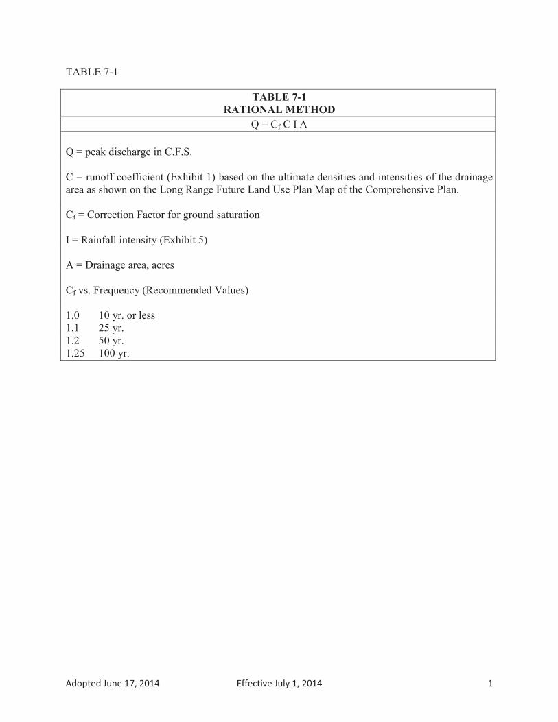
Adopted June 17, 2014 Effective July 1, 2014 1

Adopted June 17, 2014 Effective July 1, 2014 2

Adopted June 17, 2014 Effective July 1, 2014 3


Adopted June 17, 2014 Effective July 1, 2014 5

BMP
Tabl
e 7-
6
⁴ ̛ ⁵
1 2 3 4 5 6 7 8 9 10
Adop
ted
June
17,
201
4
E
ffect
ive
July
1, 2
014
1

BMP
Tabl
e 7-
6
⁴ ̛ ⁵
11 12 13 14 15 16
⁵
Adop
ted
June
17,
201
4
E
ffect
ive
July
1, 2
014
2