section 6 ground water resources
TRANSCRIPT
LCFRB/4-00-247/wria25-26/Section 6.doc August 2001
Section 6 - Ground Water Resources 6-1
Section 6 Ground Water Resources
6.1 Introduction
Unlike the surface water features within each WRIA, the ground water resources are not visible or readily accessible. Hence, the ground water system tends to be comparatively less defined and sparsely understood. Yet, the two are related. Hydraulically, the ground water is generally linked to the surface water system, especially with regards to the more shallow underground systems. The two rely on one another for elements of their existence and movement within the area. As one moves deeper into the subsurface, this connection becomes generally less apparent and the ground water often becomes part of a larger regional flow system that extends beyond the traditional closed boundaries of defined hydrologic basins.
Furthermore, the ground water system is part of the regional geologic landscape, which in the case of WRIA 25 and 26 is dominated by a history of catastrophic events including volcanism, tectonic movement, glaciation, and flooding. That history has created a physical setting that is very complex and poorly identified. Hence, knowledge of the ground water system is limited. The extent and depth of potential aquifers is often not known nor is the capacity to which this resource may be utilized and sustained.
Notwithstanding, the ground water system remains as an important resource for municipal, industrial and agricultural supplies. An improved understanding of its quantity and quality are vital in developing an appropriate long-term regional water management strategy. The ground water system offers unique options as an alternate means of storage and recovery of potentially available waters. Moreover, it can be used to manage streamflows during periods of low flow and provide substantial support for meeting habitat and other environmentally sensitive goals for the region.
Accordingly, this section is intended to provide a comprehensive review of the current knowledge with respect to the ground water systems in both WRIAs 25 and 26. This review includes elements for examining both the geology and hydrogeology in the area. The intent is to document the known elements of the ground water system and identify data gaps that may be critical in developing a regional watershed management plan.

LCFRB/4-00-247/wria25-26/Section 6.doc August 2001
Section 6 - Ground Water Resources 6-2
6.2 Regional Geology
WRIAs 25 and 26 span a physiographically diverse region in southwestern Washington that includes portions of the coast range (Willapa Hills uplift), Puget-Willamette Lowland, and the Cascade Range provinces. The physiographic diversity of WRIAs 25 and 26 is a direct reflection of the complex geologic and tectonic processes that have created and shaped this region over the last 60 million years. Some of the significant geologic/tectonic events include:
q Attachment (accretion) of a large block of oceanic crust (Siletzia terrane) to western North America approximately 48 to 50 million years ago that forms the “basement” bedrock of western Washington and Oregon (Silberling and Jones, 1984; Wells and others, 1984; Phillips and others, 1989; Snavely and Wells, 1996);
q The volcanism which continued within the Siletzia terrane to about 38 million years ago (Wells, 1982; Duncan, 1982; Wells and others, 1984; Phillips and others, 1989);
q The presence of three, long-lived, forearc basins (Centralia, Grays Harbor, and Astoria) that were major deposition centers for sediments and volcanic rock (accumulations greater than 10,000 ft-thick) from about 48 to 15 million years ago (Wells and others, 1984; Niem and Niem, 1985; Armemtrout, 1987; Heller and others, 1987; Trehu and others, 1994; Snavely and Wells, 1996);
q Onset of Cascade volcanism approximately 42 to 40 million years ago and which has continued to the present (Phillips and others, 1989; Smith, 1993);
q The emplacement of huge continental flood-basalt lava flows of the Columbia River Basalt Group from about 16 to 12 million years ago in portions of the WRIAs 25 and 26;
q Pleistocene-age (approximately 1,000,000 to 13,000 years ago) sediment deposition during glaciation periods;
q Tectonic deformation (faulting, folding, and uplift/subsidence) of this region over the past 40 million years (Wells, 1982; Heller and others, 1987; Armentrout, 1987; Phillips and others, 1989; Snavely and Wells, 1996).
These geologic/tectonic events and processes gave rise to a wide-range of sedimentary and volcanic rock-types that now underlie WRIAs 25 and 26. These rock types are distributed across the area in a complex pattern as depicted on regional geologic maps that cover WRIAs 25 and 26 (Walsh and others, 1987; Walsh, 1987; Schasse, 1987a,b; Phillips, 1987a,b; Korosec, 1987a,b; Logan, 1987).

LCFRB/4-00-247/wria25-26/Section 6.doc August 2001
Section 6 - Ground Water Resources 6-3
Exhibit 6-1 presents a “generalized” version of the regional-scale geologic map (Walsh and others, 1987) in which the individual geologic units that generally share similar hydrogeologic characteristics and properties were grouped together to form single “hydrostratigraphic” units. These units are briefly described below (from youngest to oldest) and their stratigraphic position/relationships are depicted in Exhibit 6-2.
6.2.1 Older Alluvium and Alluvium This unit consists of unconsolidated to poorly consolidated, Quaternary-age sand, gravel, and silt that form undissected terrace deposits and floodplain deposits within major river and stream valleys. In WRIA 26, this unit also includes volcaniclastic deposits (debris flows/lahars and reworked debris flow/lahar deposits). Thickness of this unit is highly variable, commonly ranging from less than 5 ft to more than 100 ft (Livingston, 1966; Phillips, 1987a; Walsh and others, 1987). These deposits typically display little evidence of any post-depositional alteration.
6.2.2 Glacial and Terrace Units
Glacial Deposits
Quaternary-age (Pleistocene to Holocene) deposits consisting of stratified to massive gravel, sand, silt, and clay created by repeated episodes of alpine glaciation that occurred on Mt. St. Helens, Mt. Adams, Mt. Rainier, and adjacent highland areas within the southern Washington Cascade Range (Crandell and Miller, 1974; Dethier and Bethel, 1981; Phillips, 1987a; Walsh and others, 1987). This unit includes pre-Evans Creek deposits, Evans Creek related deposits, Hayden Creek related deposits, Wingate Hill related deposits, and Logan Hill Formation. These deposits are generally restricted to river valleys and lowland areas in WRIA 26, but are also found mantling some highland areas within the eastern portion of WRIA 26. Thickness of these deposits are highly variable, ranging from less than 10 ft to greater than 200 ft (Crandell and Miller, 1974; Dethier and Bethel, 1981; Phillips, 1987a). Degree of alteration and the depth to which it extends within these deposits is variable. Alteration can range from slight (oxidation and weathering rinds on clasts) to complete (clasts totally altered) (Roberts, 1958; Crandell and Miller, 1974; Dethier and Bethel, 1981; Phillips, 1987a).

LCFRB/4-00-247/wria25-26/Section 6.doc August 2001
Section 6 - Ground Water Resources 6-4
Spacer for Exhibit 6-1

LCFRB/4-00-247/wria25-26/Section 6.doc August 2001
Section 6 - Ground Water Resources 6-5
LCFRB/4-00-247/wria25-26/Section 6.doc August 2001
Section 6 - Ground Water Resources 6-6
Terrace Deposits
Quaternary-age dissected terrace deposits found in the Kelso-Castle Rock areas that are composed of stratified, light-colored silt (Roberts, 1958; Livingston, 1966; Phillips, 1987a). Phillips (1987a) has interpreted these deposits to be slackwater deposits produced by the Pleistocene-age outburst floods from Glacial Lake Missoula (Cataclysmic or Missoula Floods). Unit thickness ranges from less than 30 ft to greater than 80 ft (Roberts, 1958; Livingston, 1966; Phillips, 1987a).
6.2.3 Continental Sedimentary Units
Tertiary Marine and Nearshore Sedimentary Rocks
Composed of primarily consolidated, marine, sedimentary rocks consisting of mudstone, siltstone, and sandstone, and lesser non-marine conglomerates, tuffs, and minor lignite/coal beds (Phillips, 1987; Walsh and others, 1987) found in WRIA 25 and the western portion of WRIA 26. Formations combined into the Tertiary marine unit include middle to upper Eocene McIntosh, Cowlitz, and Skookumchuck Formations. The Tertiary nearshore unit for WRIAs 25 and 26 includes upper Eocene to Oligocene Lincoln Creek Formation, upper Eocene to lower Oligocene Toutle Formation, lower to middle Miocene Astoria Formation, and middle to upper Miocene Montesano Formation. Total thickness of these sedimentary units is variable, but can range from 0 to greater than 10,000 ft (Armentrout, 1987; Armentrout and others, 1983; Phillips and others, 1989; Snavely and Wells, 1996; Niem and Niem, 1985).
Tertiary Continental Sedimentary Rocks
Composed mainly of moderate- to well-indurated fluvial (river/stream) sediments (sandstone, conglomerates, siltstones), volcaniclastic sediments, and minor paludal (swamp/marsh) and lacustrine (lake) deposits (Armentrout, 1987; Armentrout and others, 1983; Snavely and Wells, 1996; Walsh and others, 1987). Provenance of the sediments range from locally derived (e.g., Cascade volcanic arc, coast range uplift) to distal continental sources (e.g., Rocky Mountains). Age of this composite unit ranges from Eocene to Pliocene and includes the Puget Group, Wilkes Formation, and Troutdale Formation. This unit occurs mainly within WRIA 26 and the eastern portion of WRIA 25 and has a thickness that ranges from 0 to more than 2,000 ft (Armentrout, 1983).

LCFRB/4-00-247/wria25-26/Section 6.doc August 2001
Section 6 - Ground Water Resources 6-7
6.2.4 Basalt Units and Older Rocks
Pre-Tertiary Rocks
This unit consists of metavolcanic, plutonic, and marine sedimentary rocks (Russell Ranch Formation/Indian Creek Complex; Miller, 1985) that are exposed in the Rimrock Lake area in the easternmost portion of WRIA 26. These rocks are Cretaceous to Jurassic (Mesozoic) in age and represent the oldest rocks exposed within WRIAs 25 and 26 area.
Crescent Formation And Grays River Volcanics
Undifferentiated sequence of marine to subareal tholeiitic basalt flows, pillow basalts, flow breccias, basaltic tuffs, and hyaloclastic breccias interbedded with marginal marine/non-marine deltaic sediments. The oldest portion of this sequence (approximately 60 to 48 million years old) consists of mid-ocean ridge basalts/oceanic island basalts (oceanic crust) of the Crescent Formation which were accreted to western North America approximately 48 million years ago (Wells, 1981, 1982; Snavely and Wells, 1996; Phillips and others, 1989). In southwestern Washington (western-half of WRIAs 25 and 26), the Crescent Formation represents the oldest rock unit present (“basement”) in this region (Wells, 1981, 1982; Snavely and Wells, 1996). The Grays River Volcanics consist of a younger sequence (48 to 38 million year old) of submarine to subareal, tholeiitic basalt flows, pillow basalts, flow breccias, basaltic tuffs, and hyaloclastic breccias that are interbedded with sedimentary rocks of the Cowlitz Formation. While the Grays River Volcanics is thought to unconformably overlie the Crescent Formation (Walsh and others, 1987), stratigraphic and geochemical relationships in the Willapa Hills/Fort Columbia area suggest that Crescent and Grays River volcanism may overlap (Phillips and others, 1989). Secondary minerals (e.g., calcite, zeolites, chlorite) commonly fill vesicular zones, fractures, and voids within the basalt flows, pillow basalts, and breccias that comprise this unit (Phillips, 1987a).
Columbia River Basalt Group (CRBG) In WRIAs 25 and 26 the CRBG consists of the distal portions of a series of continental flood basalt flows that were erupted from linear vent systems in northeastern Oregon, southeastern Washington, and western Idaho from about 17 to 6 million years ago (Tolan and others, 1989). Of the more than 300 CRBG flows erupted, fewer than 10 flows made it to the WRIA 25 and 26 region (Wells, 1981, 1982; Wells and others, 1989); CRBG flows occur mainly in WRIA 25 and the western-most portion of WRIA 26. Flows present have been identified as the Grande Ronde, Wanapum (Frenchman Springs

LCFRB/4-00-247/wria25-26/Section 6.doc August 2001
Section 6 - Ground Water Resources 6-8
Member), and Saddle Mountains (Pomona Member) Basalts (Wells, 1981, 1982; Wells and others, 1989; Tolan and others, 1989). Total thickness (and number of flows present) of the CRBG is highly variable, ranging from 50 ft to more than 400 ft (Wells, 1981, 1982). CRBG flows in the WRIAs 25 and 26 region are known to have burrowed into unconsolidated sediments (invasive flows) during their emplacement creating “intrusive complexes” consisting of
rite breccias” (Beeson and others, 1979; Wells and others, 1989). In the Cathlamet area upper portions of the uppermost CRBG flows (Pomona Member and Frenchman Springs Member; Wells, 1981; Walsh and others, 1987) often exhibit varying degrees of alteration from slight to nearly complete (Livingston, 1966). A product of this extensive alteration (laterization) of the CRBG flow is the development of ferruginous bauxite (Livingston, 1966). Tertiary Cascadian Volcanics Cascade volcanic arc related rocks (stratigraphically complex and lithologically heterogeneous sequence of lava flows, pyroclastic/ volcaniclastic rocks, intrusions) generated from the inception of the volcanic arc (approximately 42 to 40 million years ago) to the end of the Miocene (approximately 5 million years ago). This unit is equivalent to the Western Cascade Group of Hammond (1979, 1980). This unit includes late Eocene to Oligocene Goble Volcanics, Hatchet Mountain Formation, and Ohanapecosh Formation, and upper Oligocene to Miocene volcanic rocks of Phillips (1987a), and the Oligocene to Miocene Fifes Peak and Stevens Ridge Formations (Vance and others, 1987). This unit comprises the bulk of the stratigraphic section in WRIA 26 with an overall thickness increasing from several hundred feet in the west to greater than 7,000 ft in the east. Rocks of this unit commonly display varying degrees of alteration produced by either burial metamorphism (zeolite facies) and/or hydrothermal alteration/mineralization related to volcanism and/or plutonic activity (Wise, 1970; Evarts and others, 1987; Evarts and Ashley, 1993). High Cascade Volcanics Cascade volcanic arc related rocks (stratigraphically complex and lithologically heterogeneous sequence of lava flows, pyroclastic/ volcaniclastic rocks, intrusions) produced by arc-related activity from approximately 5 million years ago to the present-day. This unit is equivalent to the High Casacde Group of Hammond (1979, 1980). This unit includes the Mt. St. Helens, Mt. Adams, and Mt. Rainier stratovolcanoes as well as their medial to distal deposits found in river valleys that originate on the flanks of these stratovolcanoes (debris flows/lahars). Thickness of this unit is highly variable, ranging from less than 100 ft to more than 10,000 ft at the major edifices. Degree of alteration of this unit is highly variable, ranging from

LCFRB/4-00-247/wria25-26/Section 6.doc August 2001
Section 6 - Ground Water Resources 6-9
none to very extensive where hydrothermal systems have been, or are, present.
6.3 Principal Ground Water Resources The primary sources for the hydrogeologic descriptions and information summarized in this section are Weigle and Foxworthy (1962), and Myers (1970) with additional information and data from Wegner (1956), Eddy (1971a,b), WADOE (1972), Cline (1973), Molenaar and others, 1980, Cowlitz County (1983), Sweet and Edwards (1983), Ebbert and Payne (1985), Cowlitz County Conservation District (1994), Piechowski and Krautkramer (1998). Given the relative scarcity of detailed, area-wide hydrogeologic studies and the “age” of those few that do exist (i.e., Weigle and Foxworthy, 1962; Myers, 1970), it is not possible to develop a “relatively current” assessment of groundwater conditions and usage within WRIAs 25 and 26 based solely on these information sources. Information and data available does allow the hydrogeologic characteristics of units to be generally defined and general patterns of past groundwater availability and usage to be summarized. The following discussion of WRIAs 25 and 26 hydrogeology is organized based on the relative groundwater producing capabilities of the hydrogeologic units, beginning with those that commonly exhibit the greatest yields. Table 6-1 lists the areal extents of the main aquifers in WRIAs 25 and 26.
6.3.1 Alluvium and Older Alluvium Units
The principal hydrogeologic units that yield the largest quantities of groundwater to wells within WRIAs 25 and 26 are the unconsolidated to poorly consolidated sediments of the Alluvium and Older Alluvium units (Weigle and Foxworthy, 1962; Myers, 1970; WADOE, 1972; Cowlitz County, 1983; Sweet and Edwards, 1983; Piechowski and Krautkramer, 1998) that occur within the major river and stream valleys. Most wells in WRIAs 25 and 26 with high groundwater yields (300 to greater than 3,000 gpm) that have been documented within the literature are completed within these units (Weigle and Foxworthy, 1962; Myers, 1970). The hydraulic characteristics of these deposits are highly variable and dependent on the geologic source of the sediments, mode of deposition, and thickness. The alluvial deposits in WRIAs 25 and 26 can be generally divided into three categories, based on primary sediment-source region, as follows:

LCFRB/4-00-247/wria25-26/Section 6.doc August 2001
Section 6 - Ground Water Resources 6-10
Table 6-1 Areal Extent of Main Aquifers by Sub-Basin
Geologic Units Sub-Basins Alluvium and
Older Alluvium
(Acres)
Glacial and Terrace Units
(Acres)
Tertiary Continental Sedimentary
Rocks (Acres)
Columbia River Basalt
Group (Acres)
WRIA 25
Grays River 8,359 0 0 1,932
Skamokawa Creek 5,587 0 0 3,230
Elochoman River 2,891 0 0 11,802
Abernathy/ Germany Cr 984 0 0 38,206
Coal Creek/ Longview Slough 12,190 0 1,345 12,997
Totals 30,011 0 1,345 68,168
WRIA 26
Coweeman River 1,858 605 1,859 0
Toutle River 8,327 28,112 18,212 0
Lower Cowlitz River 24,383 101,802 31,996 3,428
Mayfield Dam 991 43,998 42 0
Tilton River 5,499 7,219 22,142 0
Cispus River 11,367 9,157 2,120 0
Upper Cowlitz River 5,249 29,211 12,242 0
Totals 57,674 220,104 88,613 3,428

LCFRB/4-00-247/wria25-26/Section 6.doc August 2001
Section 6 - Ground Water Resources 6-11
q Cascade volcanic arc (e.g., Cowlitz River system – WRIA 26);
q Marine sediments/non-Cascadian volcanics (Grays River system – WRIA 25);
q Columbia River.
The areal extent of these deposits are depicted on Exhibit 6-3. Moreover, the characteristics of these deposits are described in their respective subsections below.
Cascade Volcanic Arc-Source. The dominant source for alluvial sediment deposits along the Cowlitz River system in WRIA 26 is the Cascade volcanic arc. Sediment supplied to this river system includes both that produced by erosion and geologically recent volcanic activity (i.e., lahars/debris flows) from Mt St. Helens, Mt. Rainier, and Mt. Adams. Clay-rich volcanic lahars and debris flows deposited within the floodplain often act as aquitards since they typically have little or no permeability. The aquifers within the Alluvium/Older Alluvium units are hosted by the highly permeable sands and/or gravels that were directly deposited, or reworked, by normal fluvial channel processes. Therefore the location and extent of potential aquifer horizons within these units is controlled by the extent and preservation of these permeable fluvial channel deposits. The depth to permeable, water-producing sediments, and the thickness of these sediments, has been described to be highly variable within these units. These units are typically inferred to behave as an unconfined aquifer (Weigle and Foxworthy, 1962; Myers, 1970; WADOE, 1972), but water level behavior and water quality data (discussed below) suggests that portions of these units may behave as a semi-confined to confined aquifer in some areas (e.g., Myers, 1970).
Recharge to these units is inferred to be from (1) direct infiltration from precipitation, (2) recharge from stream runoff during high flow periods, and (3) direct discharge of groundwater from bedrock aquifers (Weigle and Foxworthy, 1962; Myers, 1970; WADOE, 1972). Myers (1970, p. 17) noted that groundwater levels in wells completed in alluvial units in Cowlitz County are observed to generally rise during the period of October through March coinciding with the period of maximum precipitation. Exhibit 6-4 depicts an example hydrograph for a well completed in this unit. Discharge from these units is from (1) seepage back to the stream/river, (2) evaportranspiration, (3) discharge from springs, and (4) pumpage from wells (Weigle and Foxworthy, 1962; Myers, 1970; WADOE, 1972).

LCFRB/4-00-247/wria25-26/Section 6.doc August 2001
Section 6 - Ground Water Resources 6-12
Insert Exhibit 6-3 (GIS Map)

LCFRB/4-00-247/wria25-26/Section 6.doc August 2001
Section 6 - Ground Water Resources 6-13

LCFRB/4-00-247/wria25-26/Section 6.doc August 2001
Section 6 - Ground Water Resources 6-14
The depth of producing wells in the Cowlitz River system alluvial units has been reported to be generally between 10 to less than 100 feet (ft) (Myers, 1970; Weigle and Foxworthy, 1962; Sweet and Edwards, 1983; WADOE, 1972). Well yields from these units are also highly variable, and is controlled by the sedimentological nature (and resultant hydraulic properties) of the alluvium at any location. Weigle and Foxworthy (1962, p. 61) characterize typical well yields from these units in the Lewis County portion of WRIA 26 to be about 5 to 20 gpm with few wells having yields at, or above, 100 gpm. In the Cowlitz County portion of WRIA 26, the Cowlitz River system alluvial units typically have yields in the 100 to greater than 500 gpm range (Weigle and Foxworthy, 1962; Myers, 1970; WADOE, 1972; Sweet and Edwards, 1983). In the vicinity of the mouth of the Cowlitz River (Cowlitz River delta), the alluvial unit is greater than 200 ft-thick and interfingers with Columbia River alluvium (Myers, 1970; Gates, 1994) and wells typically have yields of 500 to greater than 1,000 gpm (Myers, 1970; WADOE, 1972; Piechowski and Krautkramer, 1998; Krautkramer and Ellis, 2000).
Marine Sediments/Non-Cascadian Volcanics. The dominant source for alluvial sediment deposits by major streams and rivers in WRIA 25 (e.g., Grays River) is Tertiary-age marine sedimentary rocks and non-Cascadian basalts (e.g., Crescent Formation, Grays River Volcanics, CRBG). Reworking of fine-grained marine sediments (shales, silstones) and the chemical weathering of basalts provide an abundance of “fines” (silt- to clay-size particles), and a comparably lesser amounts of coarse clastics (sand, gravel), for the streams and rivers to transport and deposit. The aquifers within the Alluvium/Older Alluvium units within this WRIA are found within permeable sands and/or gravels that were directly deposited, or reworked, by normal fluvial channel processes. Therefore the location and extent of potential aquifer horizons within these units is controlled by the extent and preservation of these permeable fluvial channel deposits. The depth to permeable, water-producing sediments, and the thickness of these sediments, has been described to be highly variable within these units. These units in WRIA 25 are inferred to behave as an unconfined aquifer (Myers, 1970; WADOE, 1972), but little detail hydrologic data and information is currently available for this area.
Recharge to these units is inferred to be from (1) direct infiltration from precipitation, (2) recharge from stream runoff during high flow periods, and (3) direct discharge of groundwater from bedrock aquifers (WADOE, 1972). There is no available data on the annual behavior of water levels for wells completed in alluvial aquifers. Discharge from these units is from (1) seepage back to the stream/river, (2) evaportranspiration, (3) discharge from springs, and (4) pumpage from wells (WADOE, 1972).

LCFRB/4-00-247/wria25-26/Section 6.doc August 2001
Section 6 - Ground Water Resources 6-15
The depth of producing wells in these units within WRIA 25 has been reported to range from 10 to less than 100 ft (Myers, 1970; WADOE, 1972). Well yields from this unit are also highly variable, and is controlled by the sedimentological nature (and resultant hydraulic properties) of the alluvium at any location. WADOE (1972) characterize typical well yields from these units in WRIA 25 as “small” (probably less than 10 to 20 gpm) with few wells having yields at, or above, 100 gpm. Wells completed within the alluvial aquifers along the Columbia River (discussed below) typically have yields ranging from 500 to greater than 3,000 gpm (Myers, 1970; WADOE, 1972; Piechowski and Krautkramer, 1998; Krautkramer and Ellis, 2000).
Columbia River. Alluvium along the floodplain of the Columbia River within WRIAs 25 and 26 consists of sediments derived from the Columbia River basin upstream of WRIAs 25 and 26 and sediments from WRIAs 25 and 26 streams and rivers (e.g., Cowlitz River, Grays River). The alluvial sediments present consist dominantly of sand with lesser silt and gravel (Gates, 1994). Volcaniclastic deposits (distal debris flow deposits) at, and immediately downstream of, the confluence with the Cowlitz River are also present (Gates, 1994). The dominance of sand, and the lack of any significant alteration of this sand, results in the presence of highly permeable sand-hosted aquifers. Columbia River alluvium often has the capability to produce groundwater throughout most of its thickness which lies at, or below, river level (Myers, 1970; WADOE; 1972; Krautkramer and Ellis, 2000) This unit is typically inferred to hydrologically behave as an unconfined aquifer (Myers, 1970; WADOE, 1972), but water level behavior and water quality data (discussed later in this memorandum) suggests that portions of this unit may behave as a semi-confined to confined aquifer in some areas (e.g., Myers, 1970; Krautkramer and Ellis, 2000).
Recharge to this unit is inferred to be from (1) the Columbia River and tributary streams, (2) direct infiltration from precipitation, and (3) direct discharge of groundwater from bedrock aquifers (Myers, 1970; WADOE, 1972). Discharge from this unit is from (1) seepage back to the Columbia River, (2) evaportranspiration, and (3) pumpage from wells (Myers, 1970; WADOE, 1972).
The depth of producing wells in the Columbia River alluvial unit ranges from 50 ft to greater than 350 ft (Myers, 1970; WADOE, 1972). Well yields from this unit are generally great, with wells typically having yields in excess of 1,000 gpm (Myers, 1970; WADOE, 1972). Myers (1970, pp. 17, 21, 46) notes that the behavior of groundwater level within wells completed in this aquifer in the Longview area is directly related to Columbia River fluctuations, as shown on the hydrograph for a well depicted on Exhibit 6-5.

LCFRB/4-00-247/wria25-26/Section 6.doc August 2001
Section 6 - Ground Water Resources 6-16

LCFRB/4-00-247/wria25-26/Section 6.doc August 2001
Section 6 - Ground Water Resources 6-17
6.3.2 Glacial And Terrace Units
The next units that most consistently yield significant quantities of groundwater within WRIAs 25 and 26 are the unconsolidated to moderately consolidated sediments of the Glacial till, drift, and outwash and Terrace deposit units found within WRIA 26 (Weigle and Foxworthy, 1962; Myers, 1970; WADOE, 1972; Cowlitz County, 1983; Sweet and Edwards, 1983). The most areally extensive occurrence of these units is found in the northwest portion of WRIA 26 where they have been mapped as the Pleistocene-age Logan Hill Formation. These units are absent in WRIA 25. The areal extent of these units are shown on Exhibit 6-6.
As described above, the source of these sediments was largely glacial outwash from Pleistocene Cascade alpine glaciers. However these deposits also include volcaniclastic deposits (debris flows/lahars) and “normal” fluvial (channel) deposits. This mix of deposits, coupled with the deep alteration weathering of the upper portions of these units (Weigle and Foxworthy, 1962; Myers, 1970), creates a complex aquifer system with heterogeneous hydraulic characteristics. The most detailed description and discussion of the aquifer characteristics of these units are found in Weigle and Foxworthy (1962) and Myers (1970).
In the northwest portion of WRIA 26 these sediments average approximately 140 ft-thick and are described as containing small, shallow perched water “bodies” and a deeper “main” water table (Weigle and Foxworthy, 1962). Depth to the “main” water table in the 1950’s to early 1960’s was variable, ranging from 10 ft to greater than 100 ft below ground surface (Weigle and Foxworthy, 1962, p. 47-48). Weigle and Foxworthy (1962, p. 47) describes the main water table as sloping to the west-southwest in the Jackson/Napavine Prairie area. The upper portion of these units are inferred to hydrologically behave as an unconfined aquifer (Weigle and Foxworthy, 1962; Myers, 1970), while the “main” water table behaves as a semi-confined to confined aquifer (Weigle and Foxworthy, 1962; Myers, 1970). Well yields from these units are also highly variable, and is controlled by the sedimentological nature (and resultant hydraulic properties) of the units at any location. Weigle and Foxworthy (1962, p. 48) reports typical well yields from these units in the Jackson Prairie portion of WRIA 26 as ranging from 15 to 350 gpm.
Little information is available on the characteristics of aquifers present in these units in the river valleys in the central and eastern portions of WRIA 26. Weigle and Foxworthy (1962, p. 61) indicates that groundwater quantities sufficient for domestic usage (up to 42 gpm) are available from these units.

LCFRB/4-00-247/wria25-26/Section 6.doc August 2001
Section 6 - Ground Water Resources 6-18
Insert Exhibit 6-6

LCFRB/4-00-247/wria25-26/Section 6.doc August 2001
Section 6 - Ground Water Resources 6-19
Recharge to these units is inferred to be from (1) direct infiltration from precipitation, (2) recharge from stream runoff during high flow periods, and (3) direct discharge of groundwater from bedrock aquifers (Weigle and Foxworthy, 1962; Myers, 1970; WADOE, 1972). Weigle and Foxworthy (1962, figure 8, p. 64) present hydrographs (years 1952-1955) of selected wells completed in the Logan Hill Formation that indicate water levels generally rise during the period of October through March coinciding with the period of maximum precipitation, as shown on a well hydrograph depicted on Exhibit 6-7. Discharge from these units is from (1) seepage back to the stream/river, (2) evaportranspiration, (3) discharge from springs, and (4) pumpage from wells (Weigle and Foxworthy, 1962; Myers, 1970; WADOE, 1972).
6.3.3 Tertiary Continental Sedimentary Rock Unit As described above, this unit consists of Eocene to Pliocene, consolidated fluvial sandstone, conglomerates, siltstones, volcaniclastic sediments, and minor paludal (swamp/marsh) and lacustrine (lake) deposits (Armentrout, 1987; Armentrout and others, 1983; Snavely and Wells, 1996; Walsh and others, 1987). Provenance of the sediments range from locally derived (e.g., Cascade volcanic arc, coast range uplift) to distal continental sources (e.g., Rocky Mountains). This unit consists of the middle Miocene Pliocene Troutdale Formation, middle to upper Miocene Wilkes Formation, and Eocene Puget Group. The Troutdale and Wilkes Formations are contemporaneous units that have similar hydrogeologic characteristics and are utilized more as a groundwater source than the older Puget Group. The areal extent of these units is shown on Exhibit 6-8.
Troutdale and Wilkes Formations. The Troutdale Formation represents deposits of the ancestral Columbia River (Livingston, 1966; Tolan and Beeson, 1984; Phillips, 1987a) and are found mostly in the southeastern portion of WRIA 25 and the southwestern portion of WRIA 26. The areal extent of the Troutdale Formation within WRIAs 25 and 26 is very limited and its thickness ranges from less than 50 to about 500 ft (Livingston, 1966; Phillips, 1987a). The Wilkes Formation represents deposits of tributary streams/rivers to the ancestral Columbia River deposited in the Napavine syncline and is found primarily in the western portion of WRIA 26 (Silver Lake to Jackson Prairie region). The areal extent of the Wilkes Formation within WRIAs 25 and 26 is much greater than the Troutdale and its thickness ranges from 100 to greater than 700 ft (Roberts, 1958; Myers, 1970; Phillips, 1987a). Both of these formations are typically described as consisting of poorly to moderately indurated, variably weathered, sandstone,

LCFRB/4-00-247/wria25-26/Section 6.doc August 2001
Section 6 - Ground Water Resources 6-20

LCFRB/4-00-247/wria25-26/Section 6.doc August 2001
Section 6 - Ground Water Resources 6-21
Insert Exhibit 6-8
LCFRB/4-00-247/wria25-26/Section 6.doc August 2001
Section 6 - Ground Water Resources 6-22
siltstone, claystone, and conglomerates (Roberts, 1958; Livingston, 1966; Myers, 1970; Phillips, 1987a), with the Wilkes Formation sediments commonly displaying a greater degree of weathering (alteration) than the Troutdale Formation (Roberts, 1958; Myers, 1970; Phillips, 1987a).
The primary sedimentological characteristics of the Troutdale Formation typically allow it to have good to excellent hydraulic properties/behavior (e.g., high permeability/transmissivity/ yields) which makes for highly productive aquifers that usually have excellent groundwater quality (e.g., Portland/Vancouver region; Mundorff, 1964). However the areally restricted extent and relative thinness of the Troutdale Formation in WRIAs 25 and 26 limits its usefulness as an aquifer. Myers (1970, p. 10) notes that a “few” wells are completed in the Troutdale Formation but characterized their yields as “low” due to the restricted extent and thinness of this formation.
Recharge to the Troutdale Formation is from direct infiltration from precipitation and direct discharge of groundwater from bedrock aquifers (Myers, 1970; WADOE, 1972). Discharge from the Troutdale formation units is from discharge from springs, evaportranspiration, and pumpage from wells (Myers, 1970; WADOE, 1972). There is no available data on the chemical quality of groundwater produced from the Troutdale Formation in WRIAs 25 and 26.
The Wilkes Formation is more extensively utilized as a source for groundwater within WRIAs 25 and 26 (Weigle and Foxworthy, 1962; Myers, 1970; WADOE, 1972). Based on descriptions from Weigle and Foxworthy (1962) and Myers (1970) much of the formation is relatively impermeable with thin sand/sandstone beds serving as the primary water producing zones (confined aquifer conditions) with yields ranging from 10 to 50 gpm. Where this formation is relatively thin (less than 100 ft-thick) and deeply weathered (e.g., Silver Lake region), it typically has yields of less than 10 gpm and is only capable of supplying domestic water needs (Myers, 1970, p. 10). However immediately north of the boundary of WRIA 26 along the Newaukum River, Weigle and Foxworthy (1962, p. 27) describe a number of wells that are completed in the Wilkes Formation as “flowing” (artesian conditions) with yields as great as 600 gpm.
The depth to water-producing sediments within the Wilkes Formation is variable, ranging from 50 ft to greater than 600 ft (Weigle and Foxworthy, 1962; Myers, 1970). Recharge to this formation is inferred to be from direct infiltration from precipitation, direct discharge of groundwater from bedrock aquifers, and potential recharge from stream runoff during high flow periods (Weigle and Foxworthy, 1962; Myers, 1970; WADOE, 1972). Discharge from this formation is inferred to be primarily from discharge from springs and to younger units (e.g., Logan Hill Formation, alluvium) and pumpage from wells (Weigle and Foxworthy, 1962; Myers, 1970; WADOE, 1972).

LCFRB/4-00-247/wria25-26/Section 6.doc August 2001
Section 6 - Ground Water Resources 6-23
Puget Group. The Puget Group consists of Eocene-age, moderate to well indurated, siltstone, claystone, sandstones, and conglomerates that are exposed in northern portion of WRIA 26 (Tilton River region; Plate 1). No information is available on the groundwater-bearing capabilities of these rocks or its chemical quality within WRIAs 25 and 26. Weigle and Foxworthy (1962) refer to rocks of this age as generally being capable of only supplying groundwater in quantities “adequate” for most domestic uses.
6.3.4 Columbia River Basalt Group (CRBG)
The flood basalt flows of the CRBG often serve as good aquifers capable of groundwater yields of 20 to greater than 1,000 gpm and produce groundwater that is typically of good quality (Mundorff, 1964; Gannett and Caldwell, 1998). However in WRIAs 25 and 26 the area covered by CRBG flows is relatively small and primarily restricted to the southeastern portion of WRIA 25. It is only within the Cathlamet region that the CRBG is thick enough (200 ft to greater than 400 ft thick) and consists of multiple flows (Wells, 1981, 1982) which allows it to be a viable aquifer (Myers, 1970). The areal extent of these units is shown on Exhibit 6-9.
In undisturbed settings, the permeability within a sequence of CRBG flows will be found at the tops and bottoms of the flows (aquifers) while the dense interior of the flows are impermeable (Tolan and others, 2000). Myers (1970) does not give specific data on degree of utilization of the CRBG as groundwater source in WRIA 25, but does note that at the time of his study (late 1960’s) that the CRBG was not extensively tapped by wells. Myers (1970, p. 9) reported that several wells completed in the CRBG had yields of 120 gpm and one well supplying water to a hatchery yields 450 gpm. WADOE (1972, p. 139) indicated that one well within WRIA 25 completed in the CRBG had a yield of more than 1,200 gpm.
Recharge to the CRBG is inferred to be largely from direct infiltration from precipitation and recharge from stream runoff (Myers, 1970; WADOE, 1972). Structural deformation (i.e., uplift, folding, faulting), coupled with erosion, of the CRBG in WRIA 25 has combined to expose the aquifer-hosting horizons (flow tops/bottoms) around the northern extent of the CRBG in WRIA 25 enhancing the potential for recharge to this unit from precipitation. Discharge from the CRBG is inferred to be primarily from springs and to younger units (e.g., alluvium) and pumpage from wells (Myers, 1970; WADOE, 1972).

LCFRB/4-00-247/wria25-26/Section 6.doc August 2001
Section 6 - Ground Water Resources 6-24
Insert Exhibit 6-9

LCFRB/4-00-247/wria25-26/Section 6.doc August 2001
Section 6 - Ground Water Resources 6-25
6.3.5 Other Low Water Producing Units
Several other units underlie portions of WRIA 25 and 26. These units have generally low permeability, varying hydraulic properties, and/or varying water quality. These units do not appear to host significant water producing zones. A brief description of these units, based on information that is currently available, is provided below for completeness.
Tertiary Cascade Volcanics. This unit consists of Eocene- to Pliocene-age Cascade volcanic arc related rocks (stratigraphically complex and lithologically heterogeneous sequence of lava flows, pyroclastic/ volcaniclastic rocks, intrusions). This unit is restricted to WRIA 26 and encompasses the Goble Volcanics, Hatchet Mountain Formation, and Ohanapecosh Formation, and upper Oligocene to Miocene volcanic rocks of Phillips (1987a), and the Oligocene to Miocene Fifes Peak and Stevens Ridge Formations (Vance and others, 1987). Together these formations comprise the bulk of the stratigraphic section in WRIA 26.
Because the rocks of this unit commonly display varying degrees of alteration and secondary mineralization (Myers, 1970; Wise, 1970; Evarts and others, 1987; Evarts and Ashley, 1993), they often have limited permeability and poor aquifer properties. In some cases groundwater is found in joints and fractures (secondary porosity) created by tectonic deformation (Weigle and Foxworthy, 1962; Myers, 1970). Wells drilled into rocks of this unit (e.g., Goble Volcanics – southwestern portion of WRIA 26) typically range from 50 ft to greater than 400 ft deep and, if groundwater is encountered, generally have yields of less than 10 gpm with an occasional rare well having a yield greater than 50 gpm (Myers, 1970; Weigle and Foxworthy, 1962; WADOE, 1972).
Recharge to this unit is inferred to be largely from direct infiltration from precipitation and recharge from stream runoff (Myers, 1970; WADOE, 1972). Discharge from this unit is inferred to be primarily from springs and to younger units (e.g., alluvium units in stream/river valleys) and pumpage from wells (Myers, 1970; WADOE, 1972).
Tertiary Marine & Nearshore Sedimentary rocks. This unit consists of Eocene to middle Miocene marine, consolidated, sedimentary rocks consisting of mudstone, siltstone, and sandstone, and lesser non-marine conglomerates, tuffs, and minor lignite/coal beds (Phillips, 1987; Walsh and others, 1987) that underlie most of WRIA 25 and the western-most portion of WRIA 26. Formations combined into the Tertiary marine unit include middle to upper Eocene McIntosh, Cowlitz, and Skookumchuck Formations. The Tertiary nearshore unit for WRIAs 25 and 26 includes upper Eocene to Oligocene

LCFRB/4-00-247/wria25-26/Section 6.doc August 2001
Section 6 - Ground Water Resources 6-26
Lincoln Creek Formation, upper Eocene to lower Oligocene Toutle Formation, lower to middle Miocene Astoria Formation, and middle to upper Miocene Montesano Formation.
The hydraulic properties, groundwater yields, and chemical quality of groundwater from these units are highly variable due to the complex geology and physical properties (secondary porosity created by tectonic deformation) of these rocks. In general, wells completed into these units have low yields (less than 15 gpm) and highly variable water quality but generally sufficient for most domestic purposes (Weigle and Foxworthy, 1962; Myers, 1970; WADOE, 1972).
Recharge to this unit is inferred to be from direct infiltration from precipitation and potential recharge from stream runoff during high flow periods (Weigle and Foxworthy, 1962; Myers, 1970; WADOE, 1972). Structural deformation (i.e., uplift, folding, faulting) of these units in WRIA 25 has enhanced the potential for recharge from precipitation and the potential for “flushing” of connate (saline) formation waters. Discharge from this formation is inferred to be primarily from springs and to younger units (e.g., Logan Hill Formation, alluvium) and pumpage from wells (Weigle and Foxworthy, 1962; Myers, 1970; WADOE, 1972).
Crescent Formation & Grays River Volcanics. This unit consists of Eocene- to early Oligocene-age basalts and interbedded volcaniclastic/sedimentary rocks. These units are found mainly in WRIA 25 and the western portion of WRIA 26. Because the rocks of this unit commonly display varying degrees of alteration and secondary mineralization (Myers, 1970; Phillips and others, 1987; Wells, 1981), they often have limited permeability and poor aquifer properties. In some cases groundwater is found in joints and fractures (secondary porosity) created by tectonic deformation (Weigle and Foxworthy, 1962; Myers, 1970). Water wells drilled into rocks of this unit are often shallow (less than 50 ft deep) and, if groundwater is encountered, generally have yields of less than 10 gpm with an occasional rare well having a yield greater than 20 gpm (Myers, 1970; Weigle and Foxworthy, 1962; WADOE, 1972).
Recharge to this unit is inferred to be largely from direct infiltration from precipitation and recharge from stream runoff (Myers, 1970; WADOE, 1972). Discharge from this unit inferred to be primarily from springs and to younger units (e.g., alluvium units in stream/river valleys) and pumpage from wells (Weigle and Foxworthy, 1962; Myers, 1970; WADOE, 1972).
High Cascade Volcanics. This unit consists of stratigraphically complex and lithologically heterogeneous sequence of lava flows, pyroclastic/ volcaniclastic rocks, intrusions produced by Cascade volcanic activity during the last 5 million years. Lava flows associated with this unit are restricted to the major

LCFRB/4-00-247/wria25-26/Section 6.doc August 2001
Section 6 - Ground Water Resources 6-27
stratovolcanoes (Mt. St. Helens, Mt. Adams, and Mt. Rainier) and the eastern portion of WRIA 26, with debris flow/lahar deposits extending down river valleys that originate on the flanks of the stratovolcanoes. As discussed in the section on Cowlitz River alluvium, debris flows/lahars by their nature are basically impermeable and do not serve as aquifers. No information is available on the groundwater-bearing capabilities of lava flows and pyroclastic deposits associated with this unit in WRIA 26.
Pre-Tertiary rocks & Intrusions. No information was available on the groundwater availability or chemical quality for these units in WRIA 26. The rock-types associated with these units normally do not have any primary permeability sufficient to host widespread aquifers, but groundwater may be present in tectonic joints and fractures (secondary porosity).
6.4 Impact Of Geologic Deformation On Ground-Water Occurrence & Movement
Presence of tectonic structures and related deformations (i.e., folds, faults, joints) in WRIAs 25 and 26 may fundamentally modify or change the hydraulic properties of the aquifer host-rock(s) as well as the aquifer(s) hydrologic flow regime on a local basis compared with the regional descriptions provided above. Due to the relatively complex geology of the WRIA 25 and 26, the degree of their impact on groundwater flow regime on a local, sub-basin scale cannot be evaluated in this memorandum. Based on the evidence of their presence in WRIAs 25 and 26 presented below, a basic understanding of their potential impact on availability of groundwater resources for withdrawal should be included in future hydrogeologic assessments.
Examples of tectonic structures and related deformations with potentially significant impact on availability of groundwater resources in WRIAs 25 and 26 include the following:
q Tectonic joints that create permeability within a rock unit where none existed before;
q Tectonic joints and faults that act as vertical pathways for groundwater recharge and/or discharge;
q Tectonic joints and faults that act impermeable barriers to both horizontal and vertical groundwater movement within aquifers;
q Folding of the rock units that contain aquifer horizons which allows steeper hydraulic gradients to exist;
q Folding of aquifer-containing rock units (coupled with erosion) that allows either recharge or discharge to occur.
LCFRB/4-00-247/wria25-26/Section 6.doc August 2001
Section 6 - Ground Water Resources 6-28
The tectonic activity, described previously in this memorandum, produced regional stress regimes which resulted in the uplift and subsidence of various areas through time (e.g., uplift - Willapa Hills, Cascade Range; subsidence – Astoria Basin, Puget-Willamette lowland) and lead to the formation of folds, faults, and joints. Evidence for regional uplift and subsidence is found both in the stratigraphic record and in the present-day landscape of WRIAs 25 and 26.
Examples of regional-scale subsidence are indicated by the thick (greater than 10,000 ft) sequence of marine/non-marine sediments found flanking the Willapa Hills uplift. These sediments accumulated in two separate basins (Astoria basin – portion of this basin found in the southwestern part of WRIA 25; Chehalis basin – portion of this basin found in western-most part of WRIA 26) from about 48 to approximately 3 million years ago (Wells, 1982; Niem and Niem, 1985; Phillips and others, 1989; Armentrout, 1987; Snavely and Wells, 1996). Today these areas are not lowland areas that are centers for sediment accumulation (sedimentary basins) due to general uplift of this region.
Examples of regional-scale uplift are Willapa Hills uplift (WRIA 25) in which “basement rock” (Crescent Formation) is exposed and the Cascade Range area (WRIA 26) where numerous igneous intrusions (e.g., plutons, stocks, and dikes) are now exposed that represent the subsurface “plumbing systems” of extinct volcanoes (Wise, 1971; Hammond, 1979, 1980; Evarts and others, 1986; Smith, 1993).
Geologic mapping by Wells (1981, 1982) found that faults were common in WRIA 25 and included faults associated with the limbs of the major uplifts that have several thousand feet of vertical stratigraphic offset, faults with 30 ft to greater than 500 ft of normal, vertical stratigraphic offset, left-lateral strike-slip faults, and faults that are found between larger faults and typically display normal, vertical stratigraphic offsets. Most of the exposed fault surfaces examined by Wells (1982) displayed indications that strike-slip (i.e., horizontal) movement has played an important role in this area.
Fewer faults are mapped within WRIA 26 than within WRIA 25. Faults that have been mapped within WRIA 26 have typically large vertical stratigraphic offsets (Hammond, 1980; Walsh and others, 1987). The reason for fewer mapped faults is partly associated with the physical nature of the stratigraphic units in this region (Cascade volcanics) which makes recognition and mapping of faults a very difficult task (Wise, 1971; Hammond, 1980).
Folds (anticlines and synclines) within the WRIAs 25 and 26 generally have trends that are similar to that of the faults. Most of the folds display an open geometry and have variable amplitudes ranging from hundreds to thousands of feet (Wells, 1982; Hammond, 1980; Walsh and others, 1987). The similarity in trend between faults and folds is a natural consequence of the tectonic history (regional stress regime) that this region has experienced.

LCFRB/4-00-247/wria25-26/Section 6.doc August 2001
Section 6 - Ground Water Resources 6-29
6.5 Principal Aquifer By Sub-Basin
6.5.1 WRIA 25 – Grays River Sub-Basin
The main principal aquifer mapped in this sub-basin is the Alluvium and Older Alluvium. This aquifer is most extensive along the Grays River from its confluence with the Columbia River to the confluence of the West and the East Forks. The water bearing zones within this aquifer are found within permeable sands and/or gravels with variable amounts of inter-layering by fine-grained potentially restricting layers. The depth to, and thickness of, these permeable, water-producing sediments have been described to be highly variable. As a result the well yields from this unit are also highly variable and controlled by the hydraulic properties of the alluvial sediments at any location (See Table 6-2). Therefore, the potential for hydraulic continuity between a given well and stream exists on a local basis. On a sub-basin scale, however, the degree of current or projected groundwater withdrawal that may significantly affect stream water flow rates in the main stem of the Grays River may not be great. Although this conclusion needs to be verified with more detailed data and analysis, it is supported by the evaluation presented below.
Based on the population numbers provided in Section 3 there were 1,410 people residing within the sub-basin in 1996, projected to grow to 2,064 people in 2010, all expected to live in unincorporated areas. However, there is no comprehensive mapping of wells in the sub-basin to evaluate whether areas of dense well clusters exist that may impact stream water levels. Yet, based on the population projections and the estimated total groundwater use in this sub-basin (Table 6-2), the groundwater withdrawal does not appear to be significant compared to groundwater baseflow within the sub-basin, as shown in Table 6-3. The sub-basin scale evaluation of the potential impact of groundwater pumping on stream water levels can be significantly aided by developing geologic cross sections based on well log information, where available.

LCFRB/4-00-247/wria25-26/Section 6.doc August 2001
Section 6 - Ground Water Resources 6-30
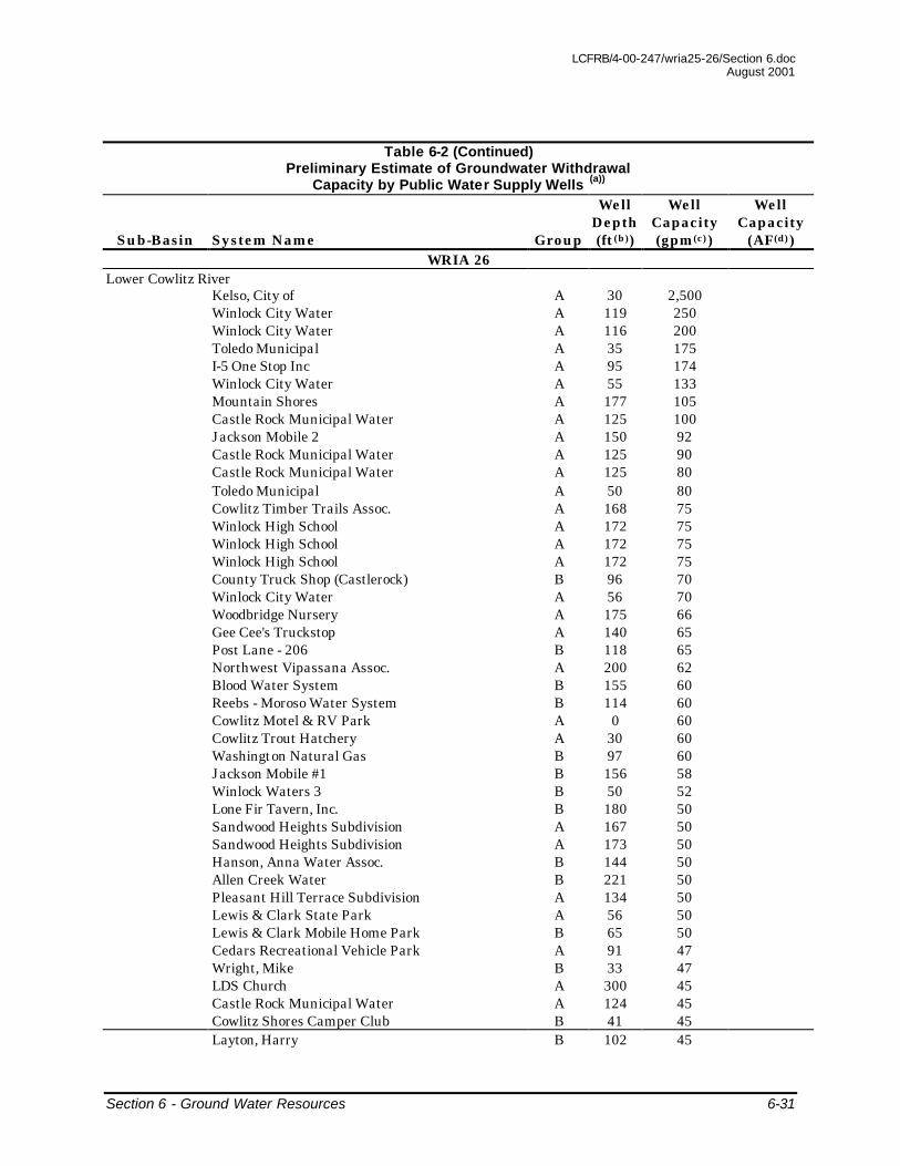
Table 6-2 Preliminary Estimate of Groundwater Withdrawal
Capacity by Public Water Supply Wells (a))
Sub-Basin System Name Group
Well Depth (ft(b))
Well Capacity (gpm(c))
Well Capacity
(AF(d))
WRIA 25 Grays River
Western Wahkiakum A 20 300 Grays River State Salmon Hatchery B 15 300 Grays River State Salmon Hatchery B 0 200 West Side Water Works A 122 45 Wahkiakum Fairgrounds B 108 38 Skamokawa Vista Park A 125 20 Total 903 1,460
Skamokawa Creek West Side Water Works A 122 45 Brooks Slough Water Assoc. B 0 20 Duck Inn A 0 5 Central Skamokawa Water System A 0 4 Gollersrud B 0 1 Total 75 120
Elochoman River Beaver Creek Trout Hatchery A 246 300 Elochoman Salmon Hatchery A 108 30 Total 330 530
Abernathy-Germany Creek Abernathy SCTC Hatchery A 550 3,000 Abernathy SCTC Hatchery A 266 300 Koenig Water System B 165 150 Camp Evergreen A 124 100 County Line Park A 233 30 West Cape Horn Water District B 90 30 Spicknall Water System B 245 27 Traveller's Rest B 210 20 Crow Butte B 542 15 Oak Point Community Church B 345 10 Schneider, Paul B 10 10 Nassa Point B 41 10 Gallery Bed & Breakfast, The B 143 10 Robertson Road Water #1 B 420 5 Total 3,717 6,000
Coal Creek/Longview Slough Reynolds Metals Company A 353 2,500 Reynolds Metals Company A 410 2,500 Gp Water System B 282 75 Eufaula Store A 40 40 The New Mansion (Rutherglen) A 154 15 Laestadian Lutheran Church A 405 13 Total 5,143 8,300
LCFRB/4-00-247/wria25-26/Section 6.doc August 2001
Section 6 - Ground Water Resources 6-31
Table 6-2 (Continued) Preliminary Estimate of Groundwater Withdrawal
Capacity by Public Water Supply Wells (a))
Sub-Basin System Name Group
Well Depth (ft(b))
Well Capacity (gpm(c))
Well Capacity
(AF(d)) WRIA 26
Lower Cowlitz River Kelso, City of A 30 2,500 Winlock City Water A 119 250 Winlock City Water A 116 200 Toledo Municipal A 35 175 I-5 One Stop Inc A 95 174 Winlock City Water A 55 133 Mountain Shores A 177 105 Castle Rock Municipal Water A 125 100 Jackson Mobile 2 A 150 92 Castle Rock Municipal Water A 125 90 Castle Rock Municipal Water A 125 80 Toledo Municipal A 50 80 Cowlitz Timber Trails Assoc. A 168 75 Winlock High School A 172 75 Winlock High School A 172 75 Winlock High School A 172 75 County Truck Shop (Castlerock) B 96 70 Winlock City Water A 56 70 Woodbridge Nursery A 175 66 Gee Cee's Truckstop A 140 65 Post Lane - 206 B 118 65 Northwest Vipassana Assoc. A 200 62 Blood Water System B 155 60 Reebs - Moroso Water System B 114 60 Cowlitz Motel & RV Park A 0 60 Cowlitz Trout Hatchery A 30 60 Washington Natural Gas B 97 60 Jackson Mobile #1 B 156 58 Winlock Waters 3 B 50 52 Lone Fir Tavern, Inc. B 180 50 Sandwood Heights Subdivision A 167 50 Sandwood Heights Subdivision A 173 50 Hanson, Anna Water Assoc. B 144 50 Allen Creek Water B 221 50 Pleasant Hill Terrace Subdivision A 134 50 Lewis & Clark State Park A 56 50 Lewis & Clark Mobile Home Park B 65 50 Cedars Recreational Vehicle Park A 91 47 Wright, Mike B 33 47 LDS Church A 300 45 Castle Rock Municipal Water A 124 45 Cowlitz Shores Camper Club B 41 45 Layton, Harry B 102 45

LCFRB/4-00-247/wria25-26/Section 6.doc August 2001
Section 6 - Ground Water Resources 6-32
Table 6-2 (Continued) Preliminary Estimate of Groundwater Withdrawal
Capacity by Public Water Supply Wells (a))
Sub-Basin System Name Group
Well Depth (ft(b))
Well Capacity (gpm(c))
Well Capacity
(AF(d)) Edgewater Mobile Estates A 100 43 Neilson, Gloyd B 10 42 Castle Rock Municipal Water A 124 40 Castle Rock Municipal Water A 125 40 Camelot Subdivision A 114 40 Toutle River Rest Area NB/SB A 358 40 Toledo Girls Softball A 47 40 Toledo Maintenance Site B 101 40 Stanley’s Store B 102 40 Forest Acres #2 B 140 40 Dilgin #2 B 0 38 C & C Enterprises B 74 38 Washington Truck Rebuilders B 20 37 Peterson Estate #1 B 60 37 Peterson Estate #2 B 60 37 Peterson Estate #3 B 60 37 Peterson Estate #4 B 60 37 Stanley, Rocky B 181 35 Mustard Seed A 120 35 Hauschild B 85 35 Tella Lane B 157 35 Tory Lynn East B 89 34 Shiloh Lane B 157 34 Hazel Dell Mobile Park A 103 33 4199 A B 80 33 Forest Acres #1 B 140 33 Winlock City Water A 150 33 Miller A 0 32 Dave's Texaco/Country House A 47 31 Tory Lynn West B 86 31 All Season Landscapes & Nursery B 105 30 Fox Park Store & RV Park A 150 30 Stevenson Water Supply B 22 30 Boland, John B 47 30 Lewis County Shop/Ethel B 98 30 Sweetman Water System B 360 30 Layton, Harry B 115 30 Klein Bicycle #1 A 100 30 Park Tavern A 65 30 Tiffany Lane MHP B 58 30 Frost Road Mobile Park A 62 30 Viking Village Mobile Home Park A 79 28 NWP Chehalis C/S B 0 28 Bay Water Supply B 108 27 Vista Village #3 B 84 26 Skye Village, LLC A 120 26 South Lewis County Regional Park A 24 25

LCFRB/4-00-247/wria25-26/Section 6.doc August 2001
Section 6 - Ground Water Resources 6-33
Table 6-2 (Continued) Preliminary Estimate of Groundwater Withdrawal
Capacity by Public Water Supply Wells (a))
Sub-Basin System Name Group
Well Depth (ft(b))
Well Capacity (gpm(c))
Well Capacity
(AF(d)) Camp Singing Wind A 0 25 Vista Village II B 78 25 Salkum Water Supply A 400 25 Winolequa Park (City Of Winlock) A 56 25 Winolequa Park (City Of Winlock) A 56 25 Harkins Road H20 System B 141 25 Mabels Water Supply B 90 24 Henry Water System #1 B 190 24 Fir Lane Water Assoc. B 145 23 Lyle Boss B 91 23 Marys Corner Market A 63 23 Ryderwood Improvement & Service Assoc. A 23 22 Bearse Water Works B 145 22 Friends Of Cloud Mountain A 223 20 Overlook Mobile Home Park B 144 20 Mobile Tip Top Burger A 29 20 Salkum Maintenance Site B 73 20 Klein Bicycle #2 B 60 20 Cowlitz Prairie Grange B 70 20 Mickelsen Mobile Home Park B 0 20 Cowlitz BP Mart A 70 18 Timberland Library-Salkum A 202 17 Vista Village Park B 114 16 Moorehead Water System B 100 16 Cowlitz Timber Trails Assoc. A 13 16 Bolar, Bill B 0 15 Country House Restaurant A 60 15 Carter's Country Corner B 110 15 Tire Recyclers, Inc. B 80 15 Trulson Motocross B 179 15 Judy’s Water Supply A 53 14 Ostrander Community Well Assoc. B 109 13 Ostrander Community Well Assoc. B 109 13 Mossyrock Horse & Rider B 200 13 Walker, R.L. B 188 12 River Oaks RV Park, Inc. A 160 12 Jarvis Water System B 43 12 Shepherds Inn, The B 145 12 Hamm Water System B 164 10 Sunnyridge Mobile Home Park B 61 10 Dilgin Water Assoc. B 0 10 Toledo VFW A 60 10 McDaniel, Bill Water Supply B 95 10 North Toutle 19 Mile House, Inc. A 125 8 Roe Well B 120 8 Jackson Prairie Church B 35 6 St. Mary’s Conference Center B 0 5

LCFRB/4-00-247/wria25-26/Section 6.doc August 2001
Section 6 - Ground Water Resources 6-34
Table 6-2 (Continued) Preliminary Estimate of Groundwater Withdrawal
Capacity by Public Water Supply Wells (a))
Sub-Basin System Name Group
Well Depth (ft(b))
Well Capacity (gpm(c))
Well Capacity
(AF(d)) Toledo Maintenance Shop B 3 5 Harry Barto Holcomb Rd. B 370 4 Total 8,147 9,200
Coweeman River Carrolls Water Assoc. A 180 105 Luxury Lane Water #1 B 206 60 Carrolls Water Assoc. A 200 47 Owl Creek A 83 39 Hamer Water System B 999(e) 21 Rose Valley Youth Center B 130 10 Rose Valley Friends Church A 150 8 H & I Grocery B 50 8 Owl Creek A 120 7 Total 305 500
Toutle River Coldwater Lake Well #1 A 268 60 Green Mountain Mill Weyerhaeuser C A 33 60 Green Mountain Mill Weyerhaeuser C A 33 60 Green Mountain Mill Weyerhaeuser C A 38 60 Green Mountain Mill Weyerhaeuser C A 39 60 Exit 57 RV Park & Mini Storage B 45 44 Buker, Ken Water System B 313 43 County View Point (SRS) A 56 40 Johnston Ridge Observatory A 480 34 Streeters Resort & Store B 55 33 Mt St Helens Section Facility B 90 33 12 Road Camp B 262 30 Salmon Falls Bible Camp A 90 26 Hilley Estates #1 B 55 25 Hilley Estates #2 B 62 25 Hilley Estates #3 B 62 25 Kid Valley Store A 80 25 Winter Lane B 183 25 Headquarters Camp #2 B 283 20 North Fork Survivors A 204 17 Kid Valley Maintenance Site B 224 16 North Fork Ridge - Learning Center A 862 16 Silver Lake Motel & Resort A 98 15 Toutle River Ranch B 421 15 Headquarters Camp #2 B 190 15 Headquarters Camp #2 B 262 15 Kid Valley RV A 87 13 Woodring Mobile Home Park B 115 13 Shady Grove Court B 47 12 Cowlitz Valley Wildlife League B 150 10 Headquarters Camp #2 B 402 10 Headquarters Camp #2 B 402 10

LCFRB/4-00-247/wria25-26/Section 6.doc August 2001
Section 6 - Ground Water Resources 6-35
Table 6-2 (Continued) Preliminary Estimate of Groundwater Withdrawal
Capacity by Public Water Supply Wells (a))
Sub-Basin System Name Group
Well Depth (ft(b))
Well Capacity (gpm(c))
Well Capacity
(AF(d)) Toutle River View A 27 10 Hoffstadt Bluffs Visitor Center A 602 8 Hoffstadt Bluffs Visitor Center A 482 6 Toutle River View A 420 5 Higgins Water System B 520 5 Norway Pass Trailhead HP A 32 5 Toutle River View A 220 4 Total 948 1,500
Mayfield Dam Mossyrock Public Utility, City Of A 140 200 Rainey Valley Water Co. B 55 175 Mossyrock Public Utility, City Of A 155 170 Ike Kinswa State Park A 350 150 Lake Mayfield Village A 93 125 Mossyrock Park A 235 110 Mossyrock Power Plant A 235 110 Lake Mayfield Community Club A 77 95 Lake Mayfield Community Club A 77 95 Lake Mayfield Community Club A 77 95 Al Justice Water B 110 73 Taidnapam Park A 92 69 Harmony Park Lot Owners Assoc. A 90 60 Lakeside Village Water Assoc. A 96 60 Lakeview Terrace Water Group A 104 60 Swofford Hills #1 B 180 60 Lake Mayfield Community Club A 84 50 Pickering Water Supply B 240 50 Siefferman Water System B 206 50 Glenoma Elementary School A 60 50 Glenoma County Park A 40 50 Mayfield Kamper Klub A 100 42 Leisure Time Resorts (Paradise) A 400 40 Hillside Improvements B 152 39 Cindy Lane B 110 38 Thomas Mobile Home Park #2 B 65 36 Harmony Park Lot Owners Assoc. A 152 32 Lake Mayfield Community Club A 84 32 Rim Water Corp. B 436 30 Hudlicky Homes B 40 30 Mossyrock Power Plant A 65 30 Main’s Gift Shop A 142 30 Main’s Gift Shop B 142 30 Drew Higson Water System B 305 27 Mountain Lakeview Addition A 180 25 Boren B 40 24 Davis Valley Water Group B 211 22 Johnson - 359 B 220 20
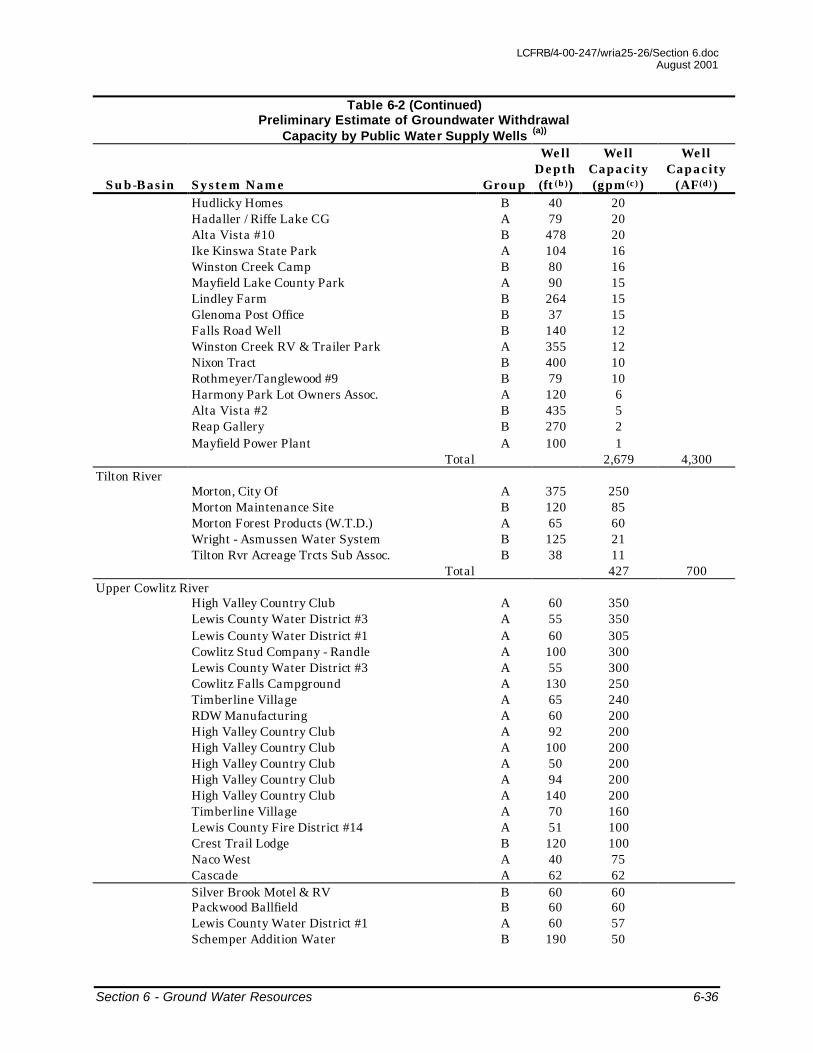
LCFRB/4-00-247/wria25-26/Section 6.doc August 2001
Section 6 - Ground Water Resources 6-36
Table 6-2 (Continued) Preliminary Estimate of Groundwater Withdrawal
Capacity by Public Water Supply Wells (a))
Sub-Basin System Name Group
Well Depth (ft(b))
Well Capacity (gpm(c))
Well Capacity
(AF(d)) Hudlicky Homes B 40 20 Hadaller / Riffe Lake CG A 79 20 Alta Vista #10 B 478 20 Ike Kinswa State Park A 104 16 Winston Creek Camp B 80 16 Mayfield Lake County Park A 90 15 Lindley Farm B 264 15 Glenoma Post Office B 37 15 Falls Road Well B 140 12 Winston Creek RV & Trailer Park A 355 12 Nixon Tract B 400 10 Rothmeyer/Tanglewood #9 B 79 10 Harmony Park Lot Owners Assoc. A 120 6 Alta Vista #2 B 435 5 Reap Gallery B 270 2 Mayfield Power Plant A 100 1 Total 2,679 4,300
Tilton River Morton, City Of A 375 250 Morton Maintenance Site B 120 85 Morton Forest Products (W.T.D.) A 65 60 Wright - Asmussen Water System B 125 21 Tilton Rvr Acreage Trcts Sub Assoc. B 38 11 Total 427 700
Upper Cowlitz River High Valley Country Club A 60 350 Lewis County Water District #3 A 55 350 Lewis County Water District #1 A 60 305 Cowlitz Stud Company - Randle A 100 300 Lewis County Water District #3 A 55 300 Cowlitz Falls Campground A 130 250 Timberline Village A 65 240 RDW Manufacturing A 60 200 High Valley Country Club A 92 200 High Valley Country Club A 100 200 High Valley Country Club A 50 200 High Valley Country Club A 94 200 High Valley Country Club A 140 200 Timberline Village A 70 160 Lewis County Fire District #14 A 51 100 Crest Trail Lodge B 120 100 Naco West A 40 75 Cascade A 62 62 Silver Brook Motel & RV B 60 60 Packwood Ballfield B 60 60 Lewis County Water District #1 A 60 57 Schemper Addition Water B 190 50

LCFRB/4-00-247/wria25-26/Section 6.doc August 2001
Section 6 - Ground Water Resources 6-37
Table 6-2 (Continued) Preliminary Estimate of Groundwater Withdrawal
Capacity by Public Water Supply Wells (a))
Sub-Basin System Name Group
Well Depth (ft(b))
Well Capacity (gpm(c))
Well Capacity
(AF(d)) Woodland Motel B 35 40 Skate Creek Terrace Association A 100 38 Sunrise Mobile Court B 82 37 Mountain Hideway Cabins B 38 32 Tires, Inc (Garden Patch) B 50 30 Randle One Stop A 41 30 Inn At Tatoosh Meadows Corporation B 350 28 Crista Vista A 0 28 Russell Water Supply B 100 27 Mullins B 48 20 Skate Creek B 67 20 Bevin Lake Rest Area A 52 19 Schemper Addition Water B 90 15 Mountain Hideaway Apts B 40 15 Skate Creek Terrace Association A 176 6 Total 4,404 7,100
Cispus River North Fork Campground A 95 85 Tower Rock Trout Farm A 28 60 Tower Rock Water System B 173 54 Tower Rock A 48 50 Walupt Horse Camp B 60 40 Cispus Environmental Center A 65 31 Rom Mutual Water Co B 112 31 Soule, Lawrence E B 150 30 Woerth-Collins B 146 22 Walupt Lake A 84 10 Adams Fork #5 A 29 5 Adams Fork #3 A 51 5 Blue Lake Creek CG HP A 118 5 Total 428 700
Notes: (a) Data obtained from Ecology database of water supply wells. (b) ft = feet. (c) gpm = gallons per minute. (d) AF = Acre-Feet. (e) The value likely represents missing data.

LCFRB/4-00-247/wria25-26/Section 6.doc August 2001
Section 6 - Ground Water Resources 6-38
Table 6-3
Estimated Baseflow Volumes
Sub-Basin BF as % of
TF(a) Stream Outflow
(AF(b)) BF
(AF) BF as % of
Precipitation
WRIA 25 Grays River 57 907,073 517,000 58 Skamokawa Creek 60 332,476 199,500 56 Elochoman River 63 327,815 206,500 54 Abernathy-Germany Creek 71 307,263 218,200 63 Coal Creek/Longview Slough -- -- -- --
WRIA 26 Lower Cowlitz River 44 9,554,354 4,203,900 42 Coweeman River 64 314,438 201,200 42 Toutle River 69 1,533,302 1,058,000 48 Mayfield Dam 66 --(c) -- -- Tilton River 66 659,561 435,300 63 Upper Cowlitz River 67 2,178,231 1,459,400 53 Cispus River 67 1,251,936 838,800 43 Notes:
(a) Baseflow as percentage of streamflow. (b) AF = Acre-Feet. (c) Not performed since significantly influenced by the Mayfield and Riffe Lakes.
6.5.2 WRIA 25 - Skamokawa Creek Sub-Basin
The principal aquifers mapped in this sub-basin are the Alluvium and Older Alluvium and the CRB Group. The alluvial aquifer is most extensive along the main stem Skamokawa Creek and its tributaries and also along the Columbia River. The basalt aquifer underlies slivers of land on the east side of the sub-basin. The characteristics of the alluvial aquifer are similar to the Grays River sub-basin and the potential for hydraulic continuity between a given well and stream should be evaluated on a local basis. Information is lacking regarding the extent to which the basalt aquifer may be in hydraulic communication with the streams. Similar to the Grays River sub-basin, the degree of current or projected groundwater withdrawal that may significantly affect stream water levels in the main stem Skamokawa Creek and its tributaries may not be great on a sub-basin scale. Where the alluvial aquifers adjacent to the Columbia River are pumped, part of the groundwater can be expected to be come from the Columbia River.
6.5.3 WRIA 25 - Elochoman River Sub-Basin
The principal aquifers mapped in this sub-basin are the Alluvium and Older Alluvium and the CRB Group. The alluvial aquifer are most extensive along

LCFRB/4-00-247/wria25-26/Section 6.doc August 2001
Section 6 - Ground Water Resources 6-39
the main stem Elochoman River upstream to approximately Rock Creek and in the area of the national wildlife refuge North of Hunting Islands. The basalt aquifers cover relatively extensive areas of the sub-basin approximately between Clear Creek north to West Fork, along the western boundary of the sub-basin, and around Cathlamet, stretching east along the Columbia River to the sub-basin boundary.
The characteristics of the alluvial aquifers are expected to be similar to the other sub-basins. The one well at the Elochoman Salmon Hatchery is apparently pumping water from this aquifer. Sufficient information is not available to evaluate how many other wells may be drawing water from this aquifer. However, compared with the baseflow and volume of groundwater expected to be in storage in this aquifer, the degree of current or projected groundwater withdrawal that may significantly affect stream flow rates is not expected to be great on a sub-basin scale.
Certain reaches of the Elochoman River and its tributaries intersect the CRB Group. The Beaver Creek Trout Hatchery has a well that obtain its water from a water bearing zone in the CRB Group. In the Cathlamet area, the CRB Group is thick enough to contain viable water bearing zones. However, sufficient information is not available to determine how many wells may penetrate the basalt aquifers. Where wells penetrate water bearing zones that are intersected by streams, water withdrawals may directly influence stream flow rates.
6.5.4 WRIA 25 - Abernathy-Germany Creek Sub-Basin
The principal aquifer mapped in this sub-basin is the CRB Group. The basalt layers underlie the lower portion of this sub-basin. Mill Creek, Abernathy Creek, and approximately the lower half of Germany Creek intersect the CRB Group. Several wells, such as a well for the Abernathy Salmon Culture Technology Center and Hatchery, appear to be withdrawing water from water bearing zones in the basalt (Table 6-2). Where wells penetrate water bearing zones in the basalt that are intersected by streams, water withdrawals may directly influence stream flow rates. On a sub-basin scale, the degree of current or projected groundwater withdrawal that may significantly affect stream flow rates in Mill Creek, Abernathy Creek, and Germany Creek and their tributaries may not be great.
6.5.5 WRIA 25 - Coal Creek/Longview Slough Sub-Basin
The principal aquifers mapped in this sub-basin are the Alluvium and Older Alluvium and the CRB Group. The alluvial aquifer is most extensive in the lower parts of the sub-basin along streams and their tributaries. This aquifer is comprised of the sediments derived from the Cascade volcanic arc inter-fingered with the Columbia River alluvium. These sediments are generally

LCFRB/4-00-247/wria25-26/Section 6.doc August 2001
Section 6 - Ground Water Resources 6-40
highly permeable and under unconfined conditions. Wells completed in this aquifer have generally high yields (to greater than 1,000 gpm). The recharge to this aquifer has been described to be from the Columbia and Cowlitz Rivers and tributaries (such as Coal Creek). It is apparent that the wells in this aquifer are in some degree of communication with either or both of these rivers and their tributaries. The density and types of wells in this sub-basin can be mapped to allow a more refined evaluation of the potential impact of groundwater pumping on stream water flow rates. The sub-basin scale evaluation of the potential impact of groundwater pumping on stream water flow rates can also be significantly aided by developing geologic cross sections based on well log information, where available.
The CRB Group is found in the upper parts of the Coal Creek watershed. It is not known how many wells are completed in this aquifer. The potential for hydraulic continuity between any of the existing or future wells and the Coal Creek or its upper tributaries should be evaluated on a local basis. However, the groundwater use values presented in Table 6-2 do not indicate that significant water withdrawal from the basalt water bearing zones is currently occurring. Additionally, the bulk of the groundwater withdrawal is currently occurring from the alluvial aquifers where most of the population resides.
The population in the Coal Creek/Longview Slough sub-basin is estimated to grow from nearly 60,000 in 1996 to nearly 80,000 in 2020. To the best of our knowledge, there are no programs to evaluate the effect of additional groundwater withdrawal that may occur in the sub-basin on stream water flow rates. However, on a sub-basin scale, the degree of current or projected groundwater withdrawal that may significantly affect water flow rates in Coal Creek, and Columbia or Cowlitz Rivers may not be great.
6.5.6 WRIA 26 - Lower Cowlitz River Sub-Basin
The principal aquifers mapped in this sub-basin include the Alluvium and Older Alluvium, Glacial And Terrace Units, and the Wilkes Formation of the Tertiary Continental Sedimentary Rock Units. The alluvial aquifers occur predominantly in the bottom of the stream valleys adjacent to the streams. The water bearing zones within the alluvial aquifers are typically found within the highly permeable sand and/or gravels that were directly deposited or reworked by normal fluvial process. These deposits may locally contain very low permeability clay-rich layers (volcanic lahars and debris flows) that may impede groundwater movement between streams and the water-bearing zones. The depth to, and thickness of, these permeable, water-producing sediments have been described to be highly variable. As a result the well yields from this unit are also highly variable and controlled by the hydraulic properties of the alluvial sediments (See Table 6-2). Because the alluvial aquifers are near the streams they can be expected to be in hydraulic communication. However, it is not known how many of the wells in this sub-

LCFRB/4-00-247/wria25-26/Section 6.doc August 2001
Section 6 - Ground Water Resources 6-41
basin draw water from the alluvial aquifers and no mapping of wells in the sub-basin has been performed to evaluate whether areas of dense well clusters exist that may impact stream water levels.
The aquifers hosted by the Glacial and Terrace Units occur predominantly in the northern part of the sub-basin north of Toledo and Vader east to the sub-basin boundary. Stream tributaries north of the Cowlitz River such as Olequa Creek, Bear Creek, Lakamas Creek, and smaller streams intersect these units along portions of their length. Where these tributaries and the Cowlitz River flow within the alluvial aquifers, the aquifers within the Glacial And Terrace Units underlie the alluvial aquifers. The groundwater within the underlying Glacial And Terrace Units aquifers may flow upward into the shallower alluvial aquifers and potentially into streams, where not impeded by restricting layers or other geological impediments. Hydrographs for some wells completed in this unit in the Jackson Prairie area indicate rising well water levels with precipitation in winter (Weigle and Foxworthy 1962). Discharge of this water is expected to be to the area streams. However, the distribution and type of wells completed in this unit has not been mapped. Additionally, the sediments hosting groundwater in these units are mixtures of deposits from glacial outwash, debris flows, and normal fluvial deposits creating a locally complex aquifer system. Therefore, no specific evaluation of hydraulic continuity between the Glacial And Terrace Units aquifers and the streams in different areas can be provided at this time.
The aquifers hosted by the Wilkes Formation are mostly found in the Salmon Creek watershed east of Toledo. Salmon Creek and its tributaries intersect these units along portions of their length. Where Salmon Creek and its tributaries flow within the alluvial aquifers, the aquifers within the Wilkes Formation underlie the alluvial aquifers. The groundwater within the deeper Wilkes Formation aquifers is expected to flow upward into the alluvial aquifers and potentially into streams, where not impeded by restricting layers or other geological impediments. Otherwise, groundwater discharge is expected to be to the area streams. Similar to the Glacial And Terrace Unit aquifers, the distribution and type of wells completed in this unit has not been mapped and no specific evaluation of hydraulic continuity in different areas can be provided at this time.
Based on the population projections and the estimated total groundwater use in the sub-basin (Table 6-2), the current, or projected, groundwater withdrawal appears to be much less than the groundwater available in the sub-basin (Table 6-3). To the best of our knowledge, there are no programs to evaluate the effect of additional groundwater withdrawal that may occur in the sub-basin on stream water flow rates. The density and types of wells in this sub-basin can however, be mapped, and geologic cross sections developed

LCFRB/4-00-247/wria25-26/Section 6.doc August 2001
Section 6 - Ground Water Resources 6-42
based on well log information, where available, to allow a more refined evaluation of the potential impact of groundwater pumping from the alluvial aquifers on stream water flow rates.
6.5.7 WRIA 26 - Coweeman River Sub-Basin
This sub-basin does not contain any of the principal aquifers to any great extent. The Alluvium and Older Alluvium aquifers are found near the confluence of the Cowlitz and Columbia Rivers and can be described similarly to the Coal Creek/Longview Slough and Lower Cowlitz River sub-basins where these aquifers also occur. The wells pumping in this sub-basin likely tap the alluvial aquifers along the streams or non-principal aquifers. The current, or projected, groundwater withdrawal appears to be much less than the groundwater available in the sub-basin (Table 6-3). The extent of impact of groundwater pumping on stream flow rates appears to be minimal on a sub-basin scale.
6.5.8 WRIA 26 - Tilton River Sub-Basin
The principal aquifers located within this sub-basin are the Alluvium and Older Alluvium, Glacial And Terrace Units, and the Wilkes Formation of the Tertiary Continental Sedimentary Rock Units. Most of the area of this sub-basin is within the Gifford Pinchot National Forest and not developed. The population base in this sub-basin is centered in the City of Morton and other small rural communities. Although the distribution and type of wells completed in these units have not been mapped in the sub-basin, the current and projected groundwater withdrawal rates appear to be much less than the groundwater available in the sub-basin (Table 6-3). The extent of impact of groundwater pumping on stream flow rates appears to be minimal on a sub-basin scale.
6.5.9 WRIA 26 - Mayfield Dam Sub-Basin
The principal aquifer in this sub-basin is the Glacial and Terrace Units. The distribution and type of wells completed in this unit has not been mapped. However, the Group A and B wells have mostly been drilled along Rainey Creek, northeast of Riffe Lake, and around Mayfield Lake. The sediments hosting groundwater in these units are mixtures of deposits from glacial outwash, debris flows, and normal fluvial deposits creating locally complex aquifer systems. Potential does exist for hydraulic continuity between a given well and stream (such as Rainey Creek) on a local basis. However, based on the presence of Mayfield and Riffe Lakes and low population of the sub-basin, the impact from current or projected groundwater withdrawals on stream flow rates is expected to be minimal.
LCFRB/4-00-247/wria25-26/Section 6.doc August 2001
Section 6 - Ground Water Resources 6-43
6.5.10 WRIA 26 - Toutle River, Upper Cowlitz River, and Cispus River Sub-Basins
These sub-basins contain water bearing strata hosted within the Alluvium and Older Alluvium, Glacial And Terrace Units, and the Wilkes Formation. The aquifers are expected to generally be in hydraulic communication with the streams similar to other sub-basins where they contain similar aquifers. No specific evaluation of the hydraulic continuity is needed for these sub-basins since they are very sparsely populated and not projected to gain significant population between now and 2020.
6.6 Inter-Aquifer Movement
The groundwater quality information summarized for each principal aquifer suggests that the net direction of groundwater flow between overlying and deeper aquifers may be generally upward. Additionally, the recharge zones of the deeper aquifers are located at a topographically higher elevations than the shallower aquifers causing an upward driving force for groundwater near the topographic low areas and depressions near streams or surface drainage courses. For example, the aquifers in the Glacial And Terrace Units in the Lower Cowlitz River sub-basin are recharged in the extensive area around, north, and northeast of Toledo. The recharged groundwater flowing toward the Cowlitz River would tend to flow upward into the Alluvium and Older Alluvium aquifers that overly it near the river. However, no information is available on the extent of upward transfer of groundwater between the principal aquifers in WRIAs 25 and 26.
6.7 Inter-Basin Movement
A number of the principal aquifers extend into multiple adjacent sub-basins in WRIAs 25 and 26. Groundwater within these aquifers may move between sub-basins in response to natural hydraulic gradients. The extent of the net sub-surface transfer of groundwater between adjacent sub-basins is an outflow component of the sub-basin water balance and important to understanding of groundwater supply for that sub-basin.
The maps presented in this section depict the lateral extent of the principal aquifers in WRIAs 25 and 26 on a sub-basin scale. These maps suggest the following regarding the extent of the inter-basin groundwater movement for these aquifers:
• Alluvium and Older Alluvium Units – The extent of sharing of this aquifer between sub-basins is generally minimal. This unit is shared to some extent between the Skamokawa and Elochoman sub-basins adjacent to the Columbia River where the general direction of groundwater flow is presumed to be toward the Columbia River. Therefore, the net groundwater movement in this aquifer between these two sub-basins is assumed to be zero.

LCFRB/4-00-247/wria25-26/Section 6.doc August 2001
Section 6 - Ground Water Resources 6-44
• Glacial And Terrace Units – These units are shared most extensively between the Upper Cowlitz River and Mayfield Dam and between the Mayfield Dam and the Lower Cowlitz River sub-basins. Based on the aerial extent of this aquifer, groundwater movement out of the Upper Cowlitz River and into Mayfield Dam sub-basins appears to be much less than between the Mayfield Dam and the Lower Cowlitz River sub-basins. The actual sub-surface groundwater outflow from this aquifer cannot be estimated without a knowledge of aquifer thickness and groundwater levels.
• The Tertiary Continental Sedimentary Rock Units – These units are not shared extensively between sub-units. The net groundwater movement in this aquifer between these two sub-basins is assumed to be zero.
• The Columbia River Basalt (CRB) Group – This aquifer is present in WRIA 25 and shared between the Coal Creek/Longview Slough and the Abernathy-Germany Creek sub-basins and the Abernathy-Germany Creek and the Elochoman River sub-basins. Of these, groundwater movement between the Coal Creek/Longview Slough and the Abernathy-Germany Creek sub-basins may be of significance to further development of this aquifer. The extent of groundwater movement between these two sub-basins cannot be quantified at this time due to the dearth of data available regarding the depth and extent of the specific water bearing strata and water levels. Presence of several faults within the area underlain by this aquifer is expected to generally hinder lateral groundwater movement. Therefore, as a first approximation, it is assumed that the groundwater movement across sub-basin boundaries is zero.
It should be realized that the aquifers may not be contiguous within any of the principal aquifers due to presence of confining or restricting layers (for example in the alluvial aquifers), faults (for example in the CRB aquifers), or other geologic strata. The extent of inter-basin groundwater movement depends strongly on the degree of interconnection of the various water bearing zones across the sub-basin boundaries. The interconnection has not been evaluated for WRIAs 25 and 26.
Groundwater movement may also occur within the geologic units that do not host principal aquifers in WRIAs 2 and 26. For example, the Tertiary Cascade Volcanic Units cover extensive areas in WRIA 26. The Tertiary Marine and Nearshore Sedimentary Rocks also underlie a large area in WRIA 25. These units have typically low permeability and contain laterally disconnected water bearing zones. Due to their large geographical extent, they receive substantial recharge from precipitation. The recharged water is assumed to principally discharge to overlying aquifers with minimal net movement between sub-basins. In the sedimentary rock units, the regional direction of groundwater flow is expected to be toward the Columbia or Cowlitz Rivers (due to topography) than to adjacent sub-basins.
6.8 Pumping

LCFRB/4-00-247/wria25-26/Section 6.doc August 2001
Section 6 - Ground Water Resources 6-45
Groundwater is pumped in WRIAs 25 and 26 using relatively small domestic wells pumping about 10 gallons per minute (gpm) to relatively large municipal and industrial wells pumping at rates of up to 2,500 or 3,000 gpm. Groundwater pumping constitutes a water loss from the aquifer. Knowledge of extent of groundwater pumping (quantity and location) is important to local planning of developable groundwater resources.
A preliminary estimate of the amount of groundwater pumped in each sub-basin was calculated based on capacity values for Groups A and B public water supply wells available from Ecology. Although well capacity does not typically equate to actual water use, it was used to provide general indications of the relative degree of groundwater use compared to other water balance components such as groundwater storage volumes and discharge to streams as baseflow.
Table 6-4 contains the values of groundwater withdrawal capacities by sub-basin. The values range from 120 acre-feet in the Skamokawa Creek sub-basin to 9,200 acre-feet in the Lower Cowlitz River sub-basin. The Ecology database does not contain information on other wells such as domestic wells. Additionally, exempt wells are not included in Table 4 as information regarding them is not readily available. However, the total capacities do indicate that the extent of groundwater use in WRIAs 25 and 26 is likely much smaller than the volume of groundwater available on a sub-basin scale. Attachment A contains the list of water supply systems whose data was used to obtain the total sub-basin estimates.
It should be noted that on a sub-basin scale, a large portion of the pumped groundwater may return to the shallow aquifer through application to ground or following discharge to streams. When a deeper aquifer is pumped in WRIAs 25 and 26 however (for example, the CRB aquifer in Abernathy/Germany Creek sub-basin), water is entirely lost from that aquifer since there is no mechanism to return the unused pumped water to the aquifer.
6.9 Hydraulic Continuity
Groundwater and surface water are said to be in hydraulic continuity when water can freely move between an aquifer and a stream. Therefore, where streams recharge an aquifer in parts of a sub-basin within WRIAs 25/26 or where an aquifer discharges to a stream in other parts, the aquifer and the stream comprise a hydraulically continuous system. The baseflow component of a stream’s total flow due to groundwater discharge is a result of this continuity. Groundwater discharge to streams was previously discussed in more detail.
The hydraulic continuity is generally not a factor in the overall water balance of a sub-basin. However, it is important to the management of the basin’s surface and groundwater resources since it is the only direct natural connection between the surface water and groundwater regimes. Pumping from wells completed in aquifers that are in hydraulic continuity with a stream is expected to decrease the flow of

LCFRB/4-00-247/wria25-26/Section 6.doc August 2001
Section 6 - Ground Water Resources 6-46
water in the stream. For example, in the upper reaches of a stream where it may lose water to an aquifer, pumping may increase water loss from the river to recharge to levels more than naturally occur. In the lower reaches of a stream, where groundwater seeps out to the stream, pumping may reduce the seepage rate and decrease stream flow rate. Decreased stream flow rate may adversely impact water rights and reduce water needed to maintain fish habitats.
The extent to which stream water flow rates may be affected by groundwater pumping depends on the extent of hydraulic communication between the aquifer being pumped and the stream in question. This is determined based on presence of groundwater flow restricting features between the stream and the aquifer (confining units, low permeability zones, faults, folds, etc.), natural rate of groundwater flow within the aquifer media, pumping rate, groundwater flow rate and direction during pumping, time of the year, and stream flow rate. Pumping from multiple wells may have a cumulative effect on the stream flow rate.
The actual extent of the hydraulic continuity between streams and the principal aquifers in WRIAs 25/26 cannot be determined for this Level I Assessment because of the lack of the following data and information:
q Groundwater level data – Groundwater level data is available for many wells in the U.S. Geological Survey NWIS database. However, this data is mostly available only for the time when the well was originally drilled. Water level records of any significant length is only available for four wells in WRIAs 25/26 in the NWIS database. Choose wells suitably located near rivers to begin checking water levels with stage. Also exempt wells
q Aquifer source of water to wells – Well depth is provided for most wells completed in WRIAs 25/26 in Ecology well log database. However, the depths have not been correlated to aquifer source of water. Therefore, the NWIS water level database is of even more limited use since regional maps cannot be developed over time.
q Data on stream flow rates near any well with water level data - As a result, direct impact of pumping on stream flow rates cannot be quantified.
q Descriptions of the lateral and vertical extents of the principal aquifers in key areas of the sub-basins – This information can significantly help evaluate the potential for hydraulic continuity.
q Data or analysis results from local studies evaluating continuity on a local basis - We have not found information suggesting that local studies have been competed.

LCFRB/4-00-247/wria25-26/Section 6.doc August 2001
Section 6 - Ground Water Resources 6-47
Nevertheless, based on a sub-basin scale understanding of the hydrogeology of WRIAs 25/26, lateral extent of the principal aquifers in each sub-basin, and population base and projected future growth, a preliminary qualitative assessment of the potential impact of groundwater pumping on stream flow rates is presented below for each sub-basin.
6.9.1 WRIA 25 - Grays River Sub-Basin
The main principal aquifer mapped in this sub-basin is the Alluvium and Older Alluvium (see Exhibit 6-3). This aquifer is most extensive along the Grays River from its confluence with the Columbia River to the confluence of the West and the East Forks. The water bearing zones within this aquifer are found within permeable sands and/or gravels with variable amounts of inter-layering by fine-grained potentially restricting layers. The depth to, and thickness of, these permeable, water-producing sediments have been described to be highly variable. As a result the well yields from this unit are also highly variable and controlled by the hydraulic properties of the alluvial sediments at any location (See Table 6-2). Therefore, the potential for hydraulic continuity between a given well and stream exists on a local basis. On a sub-basin scale, however, the degree of current or projected groundwater withdrawal that may significantly affect stream water flow rates in the main stem of the Grays River may not be great. Although this conclusion needs to be verified with more detailed data and analysis, it is supported by the evaluation presented below.
Based on the population numbers provided in Section 3, there were 1,410 people residing within the sub-basin in 1996, projected to grow to 2,064 people in 2010, all expected to live in unincorporated areas. There is no comprehensive mapping of wells in the sub-basin to evaluate whether areas of dense well clusters exist that may impact stream water levels. However, based on the population projections and the estimated total groundwater use in the sub-basin (Table 6-2), there groundwater withdrawal does not appear to be significant compared to groundwater baseflow within the sub-basin (Table 6-3). The sub-basin scale evaluation of the potential impact of groundwater pumping on stream water levels can be significantly aided by developing geologic cross sections based on well log information, where available.
6.9.2 WRIA 25 - Skamokawa Creek Sub-Basin
The principal aquifers mapped in this sub-basin are the Alluvium and Older Alluvium and the CRB Group (see Exhibit 6-3). The alluvial aquifer is most extensive along the main stem Skamokawa Creek and its tributaries and also along the Columbia River. The basalt aquifer underlies slivers of land on the east side of the sub-basin. The characteristics of the alluvial aquifer are similar to the Grays River sub-basin and the potential for hydraulic

LCFRB/4-00-247/wria25-26/Section 6.doc August 2001
Section 6 - Ground Water Resources 6-48
continuity between a given well and stream should be evaluated on a local basis. Information is lacking regarding the extent to which the basalt aquifer may be in hydraulic communication with the streams. Similar to the Grays River sub-basin, the degree of current or projected groundwater withdrawal that may significantly affect stream water levels in the main stem Skamokawa Creek and its tributaries may not be great on a sub-basin scale. Where the alluvial aquifers adjacent to the Columbia River are pumped, part of the groundwater can be expected to be come from the Columbia River.
6.9.3 WRIA 25 - Elochoman River Sub-Basin
The principal aquifers mapped in this sub-basin are the Alluvium and Older Alluvium and the CRB Group (see Exhibit 6-3). The alluvial aquifer are most extensive along the main stem Elochoman River upstream to approximately Rock Creek and in the area of the national wildlife refuge North of Hunting Islands. The basalt aquifers cover relatively extensive areas of the sub-basin approximately between Clear Creek north to West Fork, along the western boundary of the sub-basin, and around Cathlamet, stretching east along the Columbia River to the sub-basin boundary.
The characteristics of the alluvial aquifers are expected to be similar to the other sub-basins. The one well at the Elochoman Salmon Hatchery is apparently pumping water from this aquifer. Sufficient information is not available to evaluate how many other wells may be drawing water from this aquifer. However, compared with the baseflow and volume of groundwater expected to be in storage in this aquifer, the degree of current or projected groundwater withdrawal that may significantly affect stream flow rates is not expected to be great on a sub-basin scale.
Certain reaches of the Elochoman River and its tributaries intersect the CRB Group. The Beaver Creek Trout Hatchery has a well that obtain its water from a water bearing zone in the CRB Group. In the Cathlamet area, the CRB Group is thick enough to contain viable water bearing zones. However, sufficient information is not available to determine how many wells may penetrate the basalt aquifers. Where wells penetrate water bearing zones that are intersected by streams, water withdrawals may directly influence stream flow rates.
6.9.4 WRIA 25 - Abernathy-Germany Creek Sub-Basin
The principal aquifer mapped in this sub-basin is the CRB Group (see Exhibit 6-9). The basalt layers underlie the lower portion of this sub-basin. Mill Creek, Abernathy Creek, and approximately the lower half of Germany Creek intersect the CRB Group. Several wells, such as a well for the Abernathy Salmon Culture Technology Center and Hatchery, appear to be withdrawing water from water bearing zones in the basalt (Table 6-2).

LCFRB/4-00-247/wria25-26/Section 6.doc August 2001
Section 6 - Ground Water Resources 6-49
Where wells penetrate water bearing zones in the basalt that are intersected by streams, water withdrawals may directly influence stream flow rates. On a sub-basin scale, the degree of current or projected groundwater withdrawal that may significantly affect stream flow rates in Mill Creek, Abernathy Creek, and Germany Creek and their tributaries may not be great.
6.9.5 WRIA 25 - Coal Creek/Longview Slough Sub-Basin
The principal aquifers mapped in this sub-basin are the Alluvium and Older Alluvium and the CRB Group (see Exhibits 6-3 and 6-9). The alluvial aquifer is most extensive in the lower parts of the sub-basin along streams and their tributaries. This aquifer is comprised of the sediments derived from the Cascade volcanic arc inter-fingered with the Columbia River alluvium. These sediments are generally highly permeable and under unconfined conditions. Wells completed in this aquifer have generally high yields (to greater than 1,000 gpm). The recharge to this aquifer has been described to be from the Columbia and Cowlitz Rivers and tributaries (such as Coal Creek). It is apparent that the wells in this aquifer are in some degree of communication with either or both of these rivers and their tributaries. The density and types of wells in this sub-basin can be mapped to allow a more refined evaluation of the potential impact of groundwater pumping on stream water flow rates. The sub-basin scale evaluation of the potential impact of groundwater pumping on stream water flow rates can also be significantly aided by developing geologic cross sections based on well log information, where available.
The CRB Group is found in the upper parts of the Coal Creek watershed. It is not known how many wells are completed in this aquifer. The potential for hydraulic continuity between any of the existing or future wells and the Coal Creek or its upper tributaries should be evaluated on a local basis. However, the groundwater use values presented in Tables A-1 does not indicate that significant water withdrawal from the basalt water bearing zones is currently occurring. Additionally, the bulk of the groundwater withdrawal is currently occurring from the alluvial aquifers where most of the population resides.
The population in the Coal Creek/Longview Slough sub-basin is estimated to grow from nearly 60,000 in 1996 to nearly 80,000 in 2020 (see Section 3). To the best of our knowledge, there are no programs to evaluate the effect of additional groundwater withdrawal that may occur in the sub-basin on stream water flow rates. However, on a sub-basin scale, the degree of current or projected groundwater withdrawal that may significantly affect water flow rates in Coal Creek, and Columbia or Cowlitz Rivers may not be great.
6.9.6 WRIA 26 - Lower Cowlitz River Sub-Basin

LCFRB/4-00-247/wria25-26/Section 6.doc August 2001
Section 6 - Ground Water Resources 6-50
The principal aquifers mapped in this sub-basin include the Alluvium and Older Alluvium, Glacial And Terrace Units, and the Wilkes Formation of the Tertiary Continental Sedimentary Rock Units (see Exhibits 6-3, 6-6 and 6-8). The alluvial aquifers occur predominantly in the bottom of the stream valleys adjacent to the streams. The water bearing zones within the alluvial aquifers are typically found within the highly permeable sand and/or gravels that were directly deposited or reworked by normal fluvial process. These deposits may locally contain very low permeability clay-rich layers (volcanic lahars and debris flows) that may impede groundwater movement between streams and the water-bearing zones. The depth to, and thickness of, these permeable, water-producing sediments have been described to be highly variable. As a result the well yields from this unit are also highly variable and controlled by the hydraulic properties of the alluvial sediments (See Table A-1). Because the alluvial aquifers are near the streams they can be expected to be in hydraulic communication. However, it is not known how many of the wells in this sub-basin draw water from the alluvial aquifers and no mapping of wells in the sub-basin has been performed to evaluate whether areas of dense well clusters exist that may impact stream water levels.
The aquifers hosted by the Glacial and Terrace Units occur predominantly in the northern part of the sub-basin north of Toledo and Vader east to the sub-basin boundary. Stream tributaries north of the Cowlitz River such as Olequa Creek, Bear Creek, Lakamas Creek, and smaller streams intersect these units along portions of their length. Where these tributaries and the Cowlitz River flow within the alluvial aquifers, the aquifers within the Glacial and Terrace Units underlie the alluvial aquifers. The groundwater within the underlying Glacial And Terrace Units aquifers may flow upward into the shallower alluvial aquifers and potentially into streams, where not impeded by restricting layers or other geological impediments. Hydrographs for some wells completed in this unit in the Jackson Prairie area indicate rising well water levels with precipitation in winter (Weigle and Foxworthy 1962). Discharge of this water is expected to be to the area streams. However, the distribution and type of wells completed in this unit has not been mapped. Additionally, the sediments hosting groundwater in these units are mixtures of deposits from glacial outwash, debris flows, and normal fluvial deposits creating a locally complex aquifer system. Therefore, no specific evaluation of hydraulic continuity between the Glacial and Terrace Units aquifers and the streams in different areas can be provided at this time.
The aquifers hosted by the Wilkes Formation are mostly found in the Salmon Creek watershed east of Toledo. Salmon Creek and its tributaries intersect these units along portions of their length. Where Salmon Creek and its tributaries flow within the alluvial aquifers, the aquifers within the Wilkes Formation underlie the alluvial aquifers. The groundwater within the deeper

LCFRB/4-00-247/wria25-26/Section 6.doc August 2001
Section 6 - Ground Water Resources 6-51
Wilkes Formation aquifers is expected to flow upward into the alluvial aquifers and potentially into streams, where not impeded by restricting layers or other geological impediments. Otherwise, groundwater discharge is expected to be to the area streams. Similar to the Glacial And Terrace Unit aquifers, the distribution and type of wells completed in this unit has not been mapped and no specific evaluation of hydraulic continuity in different areas can be provided at this time.
Based on the population projections and the estimated total groundwater use in the sub-basin (Table 6-2), the current, or projected, groundwater withdrawal appears to be much less than the groundwater available in the sub-basin (Table 6-3). To the best of our knowledge, there are no programs to evaluate the effect of additional groundwater withdrawal that may occur in the sub-basin on stream water flow rates. The density and types of wells in this sub-basin can however, be mapped, and geologic cross sections developed based on well log information, where available, to allow a more refined evaluation of the potential impact of groundwater pumping from the alluvial aquifers on stream water flow rates.
6.9.7 WRIA 26 - Coweeman River Sub-Basin
This sub-basin does not contain any of the principal aquifers to any great extent. The Alluvium and Older Alluvium aquifers are found near the confluence of the Cowlitz and Columbia Rivers and can be described similarly to the Coal Creek/Longview Slough and Lower Cowlitz River sub-basins where these aquifers also occur. The wells pumping in this sub-basin likely tap the alluvial aquifers along the streams or non-principal aquifers. The current, or projected, groundwater withdrawal appears to be much less than the groundwater available in the sub-basin (Table 6-3). The extent of impact of groundwater pumping on stream flow rates appears to be minimal on a sub-basin scale.
6.9.8 WRIA 26 - Tilton River Sub-Basin
The principal aquifers located within this sub-basin are the Alluvium and Older Alluvium, Glacial and Terrace Units, and the Wilkes Formation of the Tertiary Continental Sedimentary Rock Units (see Exhibits 6-3, 6-6, and 6-8). Most of the area of this sub-basin is within the Gifford Pinchot National Forest and not developed. The population base in this sub-basin is centered in the City of Morton and other small rural communities. Although the distribution and type of wells completed in these units have not been mapped in the sub-basin, the current and projected groundwater withdrawal rates appear to be much less than the groundwater available in the sub-basin (Table 6-3). The extent of impact of groundwater pumping on stream flow rates appears to be minimal on a sub-basin scale.

LCFRB/4-00-247/wria25-26/Section 6.doc August 2001
Section 6 - Ground Water Resources 6-52
6.9.9 WRIA 26 - Mayfield Dam Sub-Basin
The principal aquifer in this sub-basin is the Glacial And Terrace Units (see Exhibit 6-6). The distribution and type of wells completed in this unit has not been mapped. However, the Group A and B wells have mostly been drilled along Rainey Creek, northeast of Riffe Lake, and around Mayfield Lake. The sediments hosting groundwater in these units are mixtures of deposits from glacial outwash, debris flows, and normal fluvial deposits creating locally complex aquifer systems. Potential does exist for hydraulic continuity between a given well and stream (such as Rainey Creek) on a local basis. However, based on the presence of Mayfield and Riffe Lakes and low population of the sub-basin, the impact from current or projected groundwater withdrawals on stream flow rates is expected to be minimal.
6.9.10 WRIA 26 - Toutle River, Upper Cowlitz River, and Cispus River Sub-Basins
These sub-basins contain water bearing strata hosted within the Alluvium and Older Alluvium, Glacial and Terrace Units, and the Wilkes Formation. The aquifers are expected to generally be in hydraulic communication with the streams similar to other sub-basins where they contain similar aquifers. No specific evaluation of the hydraulic continuity is needed for these sub-basins since they are very sparsely populated and not projected to gain significant population between now and 2020.
6.10 Summary of Ground Water Resources The WRIAs 25 and 26 span a physiographically diverse region in southwestern Washington. The physiographic diversity is directly associated with the complex geologic and tectonic processes that have created and shaped this region over the last 60 million years. As a result, the three-dimensional extent of water bearing strata and amount and quality of groundwater that can be produced from them is highly variable across the region. The information contained in region-wide hydrogeologic assessments and in a few local assessments of groundwater availability and quality provides the following conclusions regarding the occurrence, quantity, and natural quality of groundwater in WRIAs 25 and 26:
q The primary aquifers within WRIAs 25 and 26 have historically been encountered within four geologic units: 1) Alluvium and Older Alluvium, 2) Glacial and Terrace Units, 3) Wilkes Formation of the Tertiary Continental Sedimentary Rock Units, and 4) the Columbia River Basalt Group. These units are briefly described below.
q The main water bearing units in WRIAs 25 and 26 are the unconsolidated to poorly consolidated sediments of the Alluvium and Older Alluvium units that occur in the Cowlitz River system valleys in WRIA 26, Grays
LCFRB/4-00-247/wria25-26/Section 6.doc August 2001
Section 6 - Ground Water Resources 6-53
River system valleys in WRIA 25, and along the Columbia River in both WRIAs. These units host mostly unconfined to semi-confined aquifers that have highly variable depth and thickness across the area. They underlie approximately 30,000 and 58,000 acres of area in WRIAs 25 and 26, respectively. Historically, these units have yielded between 5 and 500 gallons per minute (gpm) and up to 20 gpm of groundwater to wells in the upper parts of the Cowlitz and Grays River systems, respectively. Yields to wells located near the mouths of both river systems and along the Columbia River range from 500 to greater than 3,000 gpm. These units are recharged by precipitation, seasonal gains from rivers and streams, and inflow from deeper bedrock aquifers. Groundwater outflow from these units includes seasonal losses to rivers, streams, and springs, and pumpage from wells. Groundwater quality appears to be excellent near surface waters but degrades farther away and with depth for iron, manganese, dissolved solids, and locally phenols, mostly because of mixing with inflowing deeper groundwater.
q The unconsolidated to moderately consolidated sediments of the Glacial And Terrace Units are the next units that most consistently yield groundwater to wells in WRIA 26. These units are absent in WRIA 25. These units underlie approximately 220,000 acres in WRIA 26. These units are composed of a mixture of sediments producing a relatively complex aquifer system with heterogeneous hydraulic characteristics. These units contain small, shallow perched groundwater and a deeper semi-confined to confined “main” water table. Historically, typical well yields from these units in the Jackson Prairie portion of WRIA 26 has ranged from 15 to 350 gpm. Little information is available on the characteristics of aquifers present in these units in the river valleys in the central and eastern portions of WRIA 26. However, available data indicates that sufficient quantities of groundwater may be present for domestic usage (up to 42 gpm). Recharge and discharge mechanisms to these units is similar to the alluvial units. Based on limited data and qualitative descriptions, iron and/or manganese concentrations may locally be in excess of secondary drinking water standards. Water in wells in part of the Jackson Prairie area (Marys Corner) was reported to consistently contain sodium and chloride at up to 6.4 and 144 mg/L, respectively. Potential sources of these elevated constituents include leaching from host sediments and/or inflowing bedrock groundwater.
q Other units that can potentially have significant sustainable groundwater yield on a local scale include the Wilkes Formation of the Tertiary Continental Sedimentary Rock Units and the Columbia River Basalt Group. The Tertiary Continental Sedimentary Rock Units underlie approximately 1,345 and 89,000 acres of WRIAs 25 and 26, respectively. The Columbia River Basalt Group underlies approximately 68,000 and

LCFRB/4-00-247/wria25-26/Section 6.doc August 2001
Section 6 - Ground Water Resources 6-54
3,400 acres of WRIAs 25 and 26, respectively. Existing reports indicate that the relatively thin sand/sandstone beds in the Wilkes Formation have generally yielded up to 50 gpm to wells with the exception of several wells along Newaukum River that produce as much as 600 gpm. The CRBG units hosting groundwater appear to be mostly limited to the southeastern portion of WRIA 25 (e.g., within the Cathlamet region). Reported yields for a few wells indicate that these aquifers may locally be able to produce a few hundred gpm’s to more than 1,200 gpm of water. The limited amount of available water quality information suggests that groundwater produced form the Wilkes Formation may have elevated levels of iron and manganese but that the CRBG aquifers may have very good quality groundwater.
q Presence of tectonic structures and related deformation (i.e., folds, faults, joints) in WRIAs 25 and 26 may fundamentally modify or change the hydraulic properties of the aquifer host-rock(s) as well as the aquifer(s) hydrologic flow regime on a local basis compared with the regional descriptions provided above. Due to the relatively complex geology of the WRIA 25 and 26, the degree of their impact on groundwater flow regime on a local, sub-basin scale cannot be evaluated in this memorandum. Based on the evidence of their presence in WRIAs 25 and 26 presented below, a basic understanding of their potential impact on availability of groundwater resources for withdrawal should be included in future hydrogeologic assessments.