schedule 2 - activities · schedule 2 - activities 1. ... (sunpoz) into a regional ... real-time...
TRANSCRIPT

Deed of Variation | CRC for Spatial Information | June 2015 page 1
Schedule 2 - Activities
1. Overview (clause 1.1)
The research program of the Cooperative Research Centre for Spatial Information - 2 (CRCSI-2) is
designed to meet three strategic objectives for spatially enabling Australia. These have been developed
following extensive consultation with all of Australia’s spatial industry peak bodies and has their strong
support.
The first objective is to conduct the research that will support the creation of a coordinated national
network of satellite system reference stations to permit real-time positioning at two centimetre accuracy
providing precise positioning of people, vehicles, built infrastructure and natural assets across the nation.
This is to be known as the National Positioning Infrastructure. Allen Consulting (2008) estimates the
cumulative gross benefit to Australia from this development is at least $32 billion over 20 years.
Realising such a network requires substantial research to optimise use of existing and new reference
stations, including the 75 new positioning satellites being launched by Europe, Russia, China, Japan and
India over the next five years.
The second objective is to establish a fully functioning market place for spatial information, to be known
as the Australian Spatial Marketplace strategy. This will enable government agencies to lift the licensing,
governance and technical restrictions on providing the vast stores of existing government-held spatial data
to the open market and to encourage other users to trade and value-add their data as well. ACIL Tasman
(2008) estimate that the spatial information industry contributes about $10 billion to GDP, but state that
this could be 50% greater if Australia improves access to, and development of, its spatial information,
amongst other developments.
There is a pressing need to combine in smarter ways the existing data stores with the rapidly increasing
stream of data from earth observation satellites, airborne imaging platforms, and ground-based sensor
systems and to increasingly automate the production of essential spatial information products. This is the
third key objective.
CRCSI-2 assembles a powerful array of partners and stakeholders, including the peak government body
ANZLIC and its member jurisdictions; 68 spatial companies through 43pl; the peak industry association
Spatial Industries Industry Association (SIBA) with its 500 member companies; the peak professional
body, the Surveying & Spatial Sciences Institute (SSSI), representing 4,000 spatial professionals; and the
Australian Spatial Consortium. In addition six Australian Universities have joined the bid. CRCSI-2 will
bring rapid and powerful collaboration on all critical research and education issues that involve a spatial
aspect, and by doing so accelerate the take up of spatial science in key end-users, and spawn major
innovation and productivity advances in five key industry sectors: Health, Defence and Security, Energy
and Utilities, Urban Development, and Agriculture-Natural Resources-Climate Change
The expected economic benefits from all programs totals $305,311,385 based on costs for all programs of
$186,792,935 over a 15 year period. This gives a benefit:cost ratio of 1.63. The research also has
significant broader societal benefits. The health related outputs will contribute to improved health
planning assisting Australia shift from a focus on clinical health to preventative health. The defence
related outcomes strengthen our indigenous intelligence capacity and provide an analysis capability that
we do not currently possess. The environmental research grows our ability to assess and manage biomass,
to better manage the use of water, and to create more sustainable cities, all critical components of the
strategy to manage global climate change.

Deed of Variation | CRC for Spatial Information | June 2015 page 2
2. National Research Priorities (clause 1.1)
NRP Theme Associated NRP priority goal(s)
Research Program 1:
Positioning
Frontier technologies for building
and transforming Australian
industries
Safeguarding Australia
Frontier technologies
Smart information use
Promoting an innovation culture and
economy
Critical infrastructure
Research Program 2
Automated Spatial
Information Generation
Frontier technologies for building
and transforming Australian
industries
Frontier technologies
Smart information use
Research Program 3
Spatial Infrastructure
Frontier technologies for building
and transforming Australian
industries
Safeguarding Australia
Smart information use
Promoting an innovation culture and
economy
Critical infrastructure
Research Program 4
Spatial Information
Applications
An Environmentally Sustainable
Australia
Frontier technologies for building
and transforming Australian
industries
Safeguarding Australia.
Promoting and maintaining good
health
Water – a critical resource
Transforming existing industries
Responding to climate change and
variability
Reducing and capturing emissions in
transport and energy generation
Smart information use
Promoting an innovation culture and
economy
Critical infrastructure
Protecting Australia from terrorism
and crime
Preventive healthcare
Strengthening Australia’s social and
economic fabric

Deed of Variation | CRC for Spatial Information | June 2015 page 3
3. Milestones (clauses 1.1 and 4.1(d))
3.1 Research Program No. 1 - Positioning
The Positioning program is designed to enhance the performance, uptake and long term operational
capability of the national positioning infrastructure; it consists of three related and complementary
research projects.
Key activities in this program include the development of algorithms, models and software to facilitate
the optimal acquisition, processing and analysis and utilisation of multi-constellation GNSS data and the
integration of research activities with end-user requirements.
Key education activities include the training of 11 PhD students (in the fields of satellite positioning and
geodesy), along with training of and knowledge transfer to program participants and end users.
Output No. 1.1 Description
Development of algorithms, software, procedures and operational standards to create new services
and products built on next generation GNSS data.
A complete positioning infrastructure will require that next generation GNSS signals be acquired and
communicated to a central site (or sites) for processing and analysis. This data will be used, in
combination with data from other sources, to create new products and value added services - to be
supplied to users, under appropriate business models. Output 1.1 will provide the computational
capability to optimally manipulate next generation GNSS data to service the operational needs of a
diverse and expanding user community. New principles and standards for operation will also be
developed along with revised scientific foundations to support the geodetic requirements underlying the
development and implementation of a national positioning infrastructure by governments and industry.
Output Milestones Due date
R1.1.1 Develop, implement and test a solution to the vertical datum harmonisation
problem at the land-sea interface.
R1.1.2 Report on relationship between Australia Height Datums
2009-10
R1.1.3 Analysis Centre Software (ACS) architecture finalised, development tasks scoped
and allocated to research teams 2010-11
R1.1.4 25% of ACS functionality completed 2012-13
R1.1.5 50% of ACS functionality completed
R1.1.6 Software to generate Regional orbit and clock models for four GNSS
constellations (eg GPS, Glonass, Beidou, QZSS satellites) completed
2013-14
R1.1.7 Software to generate Regional orbit and clock models for two GNSS
constellations (eg GPS, Glonass) completed
R1.1.8 Recommendations made to government partners regarding a new dynamic 3D
datum for Australia
2014-15
R1.1.9 Version 1.0 of ACS released for initial beta testing
R1.1.10 75% of ACS functionality completed 2015-16
R1.1.11 National ACS software training sessions held to train users (at least 4 sessions in
capital cities) 2016-17

Deed of Variation | CRC for Spatial Information | June 2015 page 4
Output No. 1.1 Description
R1.1.12 GNSS network design tool released for initial beta testing
R1.1.13 100% of ACS functionality completed
R1.1.14 Version 2.0 of ACS released for beta testing
R1.1.15 ACS operational procedure guide completed and released to partners
R1.1.16 Operational guidelines for a new 3D dynamic datum released
R1.1.17 Software to generate Regional orbit and clock models for two GNSS
constellations (eg Beidou, QZSS satellites) completed
R1.1.18 Final version of ACS released for operational use to partners
R1.1.19 ACS software training workshops held to train users (at least 4 sessions in capital
cities)
R1.1.20 Final version of network design tool released for partner use
2017-18
Output No. 1.2 Description
Demonstration of Output 1.1 in targeted application areas such as precision agriculture.
Output 1.2 will focus on the prototype demonstration and evaluation of research outputs in end-user
driven application areas. This work will provide an important feedback mechanism from industry for the
development team as well as cross-linkages to Program 4. It will deploy research outputs in areas where
strong user demand exists and where early benefits can be demonstrated. Particular emphasis will be
given to equipping target industries with early access to the enhanced national positioning infrastructure.
At least one non-positioning application will also be undertaken as a means of broadening the scope of
benefits to be realised.
Output Milestones Due date
R1.2.1 Application project #1 (GNSS test track) scoped
R1.2.2 Application project #1 commenced 2011-12
R1.2.3 Application project #2 (e.g. automated machine guidance) scoped 2013-14
R1.2.4 Application project #2 commenced
R1.2.5 Application project #1 completed 2014-15
R1.2.6 Application project #3 (e.g. non-positioning application such as advanced
atmospheric modelling) scoped 2015-16
R1.2.7 Application project #2 completed
R1.2.8 Application project #3 commenced 2016-17
R1.2.9 Application project #3 completed 2017-18

Deed of Variation | CRC for Spatial Information | June 2015 page 5
Output No. 1.3 Description
11 PhD completions and at least 55 journal and conference publications.
Output Milestones Due date
R1.3.1 2 PhD candidates commence research
R1.3.2 4 refereed papers submitted for publication 2010-11
R1.3.3 6 refereed papers submitted for publication 2011-12
R1.3.4 4 PhD candidates commence research
R1.3.5 7 refereed papers submitted for publication 2012-13
R1.3.6 2 PhD candidates submit theses for examination
R1.3.7 7 refereed papers submitted for publication 2013-14
R1.3.8 2 PhD candidates commence research
R1.3.9 4 PhD candidates submit theses for examination
R1.3.10 7 refereed papers submitted for publication
2014-15
R1.3.11 3 PhD candidates commence research
R1.3.12 8 refereed papers submitted for publication 2015-16
R1.3.13 2 PhD candidates submit theses for examination
R1.3.14 8 refereed papers submitted for publication 2016-17
R1.3.15 3 PhD candidates submit theses for examination
R1.3.16 8 refereed papers submitted for publication 2017-18
Output No. 1.4 Description
Project 1.4: Integrating electricity, telecommunications and government infrastructure to deliver
precise positioning services in regional areas.
1.4.1 - commercial, operational and institutional enablers to expand precise positioning services in
regional areas.
This demonstrator will undertake applied research to develop an extension of the Queensland precise
positioning service (SunPOZ) into a regional area to facilitate the adoption of precise positioning services
in agriculture, mining, utilities, tourism and construction.
1.4.2 - the impact of future GNSS (Global Navigation Satellite Systems) on precise positioning networks
in regional areas.
This research will examine precise positioning network and communications architecture for regional
areas using existing and future GNSS.
Output Milestones Due date
R1.4.1 Market testing of precise positioning services completed by Jan 2010
R1.4.2 Field testing of research output completed by Jun 2010
R1.4.3 Feasibility Plan completed for a national research capability that can deliver
real-time analysis products to regional CORS networks
2009-10

Deed of Variation | CRC for Spatial Information | June 2015 page 6
Utilisation No. 1.1 Description
Output 1.1 will be used internally by CRCSI-2 researchers, network designers, manufacturers, and large
scale end users to design, build, operate, analyse and benchmark the performance of the new national
positioning infrastructure (NPI). Outputs 1.1- 1.4 will improve NPI performance, enhance application
functionality and enable forward compatibility of ground infrastructure. This will result in a common
operational framework and flexible architecture for current and planned Global Navigation Satellite
Systems (GNSS) constellations and optimised, robust positioning signals. Together, these outputs will
accelerate the adoption rate and fully realise the economic benefits of a NPI (Allen Consulting Report:
Benefits of Precision GNSS, 2008) beyond the limitations of a single GPS or dual GPS/Glonass service.
Utilisation Milestones Due date
U1.1.1 Test and commence precise positioning service in selected regional test area and
Test and implement a mix of CORS equipment types and equipment generations 2009-10
U1.1.2 1st year GPS/Glonass NPI rolled out 2010-11
U1.1.3 National plan for a multi-GNSS NPI prepared and adopted by government 2012-13
U1.1.4 Version 1.0 of ACS released beta tested by 2 government agencies 2015-16
U1.1.5 Version 2.0 of ACS beta tested by at least 2 government partners
U1.1.6 GNSS network planning tool beta tested by 2 government agencies 2016-17
U1.1.7 Operational version of ACS released
U1.1.8 New 3D dynamic datum guidelines adopted
U1.1.9 Roll-out of new multi-GNSS NPI commenced in Australia and New Zealand
U1.1.10 Integration of new 3D ionospheric model into ACS
2017-18
Utilisation No. 1.2 Description
Of the 11 PhD students that complete during this research program, 7-8 graduates are expected to find
employment within Australian industry or government. The 3-4 remaining will go on to post-doctoral
research positions with Australian-based or overseas research organisations.
Utilisation Milestones Due date
U1.2.1 First 2 PhD graduates in full time employment 2013-14
U1.2.2 Further 4 PhD graduates in full time employment 2014-15
U1.2.3 Further 2 PhD graduates in full time employment 2016-17
U1.2.4 Further 3 PhD graduates in full time employment 2017-18
3.2 Research Program No. 2 - Automated Spatial Information Generation
One program comprising two projects:
- One project with three interrelated sub-projects to develop automated information extraction algorithms,
computational processes and software tools from integrated imagery, laser scanning and sensor network
technologies for use by State land agencies, Utilities, Department of Defence, and Australian mapping
companies, as well as the agriculture, natural resources and environment sectors.

Deed of Variation | CRC for Spatial Information | June 2015 page 7
- One project with two interrelated sub-projects to develop automated feature extraction methodologies,
tools and software for imagery and ranging data obtained from radar and high-resolution satellites for
landform monitoring, landscape modelling, topographic mapping and defence and security applications.
Key educational activities include the training of 11 PhD students (in the IT and environmental sciences
fields) in research activities and the provision of training, information sessions and technology transfer to
program participants and users.
Output No. 2.1 Description
Development of software tools for automated feature extraction, change detection and database
updating
Output 2.1 will focus on the development of algorithms, methodologies and software tools from
integrated aerial and space-borne imagery and laser scanning systems. This will support topographic
mapping, 3D city modelling and urban planning for use by state and federal land and planning agencies,
and mapping companies in the spatial information industry. Research and development includes metric
sensor modelling, calibration, sensor orientation and geopositioning and development of the necessary
mathematical models and computational processes needed to generate the data products from which
cartographic features are subsequently extracted. Projects will be based on work completed under
CRCSI-1.
Output Milestones Due date
R2.1.1 Software and procedures developed during CRCSI-1 for automated feature
detection, extraction and reconstruction for the updating of geospatial databases
completed.
R2.1.2 New calibration procedures, software, validation and assessment techniques
developed during CRCSI-1 for assessment of calibration and application-specific
multi-source data processing models for integrated sensor systems, with
emphasis upon imaging systems linked with laser-ranging and GPS positioning,
completed.
2009-10
R2.1.3 Literature review on feature extraction completed 2010-11
R2.1.4 Characterisation of integrated imaging & laser scanning finalised 2011-12
R2.1.5 Formulation of feature extraction models & algorithms for linear features
completed 2012-13
R2.1.6 Software tools for automated road mapping developed 2013-14
R2.1.7 Experimental validation of cartographic feature extraction software finalised 2014-15
R2.1.8 Software tools for automated building extraction & modelling developed 2015-16
R2.1.9 Testing & validation of automatic building extraction software completed 2016-17
R2.1.10 Industry-based evaluation of project outputs completed 2017-18

Deed of Variation | CRC for Spatial Information | June 2015 page 8
Output No. 2.2 Description
Development of hardware and software suite and processing methodologies for autonomous data
capture & feature extraction for asset management of powerline infrastructure.
The multi-sensor feature extraction software suite for vegetation mapping, clearance determination and
asset recording along powerline corridors will be used by the Australian energy utilities sector. Essential
participant Ergon Energy will act as a beach head to other chosen Australian electricity distributors such
as Energex. The project activity will draw on outcomes from Program 3 in relation to quality and access
issues for cadastral data within Spatial data infrastructures.
Output Milestones Due date
R2.2.1 Technical options and research literature (especially powerline inspection based on
computer vision) reviewed 2010-11
R2.2.2 Design specification for laser scanning & imagery configuration finalised
R2.2.3 Hybrid sensor system verified 2011-12
R2.2.4 Improved 3D aircraft guidance software developed
R2.2.5 Algorithms/ tools for sensor calibration & georeferencing completed 2012-13
R2.2.6 Tests for detection of high priority faults completed
R2.2.7 Tools for automated vegetation profiling and classification completed
R2.2.8 Initial flight trial of payload inspection system completed
2013-14
R2.2.9 Fault detection/ line inspection demonstrated 2014-15
R2.2.10 Precise guidance of very-low-level aircraft for linear inspection demonstrated
R2.2.11 Processing hardware for new platform finalised 2015-16
R2.2.12 Experimental validation concluded 2016-17
R2.2.13 User and operations manuals completed
R2.2.14 Training requirements defined
R2.2.15 Transition to broad service adoption initiated
2017-18
Output No. 2.3 Description
Development of asset recording feature extraction software for use in mobile mapping systems
Output 2.3 will develop algorithms, methodologies and software tools for use by State road and land
agencies and commercial mapping companies supplying Terrestrial Laser scanning services. Outputs will
be applied to road network extraction from aerial imagery and building extraction from Lidar. Greater
levels of automation need to be accomplished if spatial information product generation is to keep pace
with both user needs and the volume of imagery and lidar data being acquired. Outputs are planned to be
algorithms, computational systems and processes that incorporate self-evaluation and self-diagnosis,
which are suited to adoption and commercialisation by industry. This project will commence in 2010-11.
Output Milestones Due date
R2.3.1 Review of state of the art & problem scoping completed 2012-13

Deed of Variation | CRC for Spatial Information | June 2015 page 9
R2.3.2 Models for feature extraction for road-based asset recording developed 2013-14
R2.3.3 Software toolkit for integrated laser & imagery sensor calibration & orientation
completed 2014-15
R2.3.4 Software tools for automatic asset feature extraction and mapping developed 2015-16
Output No. 2.4 Description
Development of software for automated vegetation mapping and for biomass estimation
Output 2.4 will be applied by commercial agencies and natural resource and water management agencies.
Output Milestones Due date
R2.4.1 Literature review for determining optimal data primitives, for characterising
Australian woody vegetation and scalable for landscape level woody vegetation
feature generation completed
R2.4.2 Test sites established and field procedures designed and tested
2011-12
R2.4.3 Algorithms to metrically process hybrid sensor data developed 2012-13
R2.4.4 Data processing tools (with Program 4) for vegetation profiling completed
R2.4.5 Operating procedures developed for woody vegetation field data collection
R2.4.6 Procedures to scale up field-to-sensor fused data for woody vegetation
landscapes validated
2013-14
R2.4.7 Integration of radiometric feature extraction tools with metric processing
completed 2014-15
R2.4.8 Verification of multi-sensor data fusion and processing for automated multi-
scale landscape feature generation, mapping and change detection completed 2015-16
R2.4.9 Trialling of outputs by industry, state and federal government participants
completed 2016-17
R2.4.10 Technology transferred to end users via prototype systems and verified data
processing 2017-18
Output No. 2.5 Description
Review of software for metric processing and feature extraction for full motion video from
Unmanned Aerial Vehicle (UAV) platforms.
The review will benefit the Department of Defence and is expected to flow on to utilities which require
asset monitoring in remote areas.
Output Milestones Due date
R2.5.1 Technology review for UAVs & applicable integrated sensor undertaken 2010-11

Deed of Variation | CRC for Spatial Information | June 2015 page 10
Output No. 2.6 Description
11 PhD student completions (in the IT and environmental sciences fields) and at least 60
publications
Output Milestones Due date
R2.6.1 4 Refereed Conference papers submitted
R2.6.2 4 PhD candidates commence 2010-11
R2.6.3 4 Refereed Journal Articles and Conference publications submitted 2011-12
R2.6.4 6 Refereed Journal Articles and Conference publications submitted
R2.6.5 4 PhD candidates commence 2012-13
R2.6.6 4 PhD candidates submit theses for examination
R2.6.7 10 Refereed Journal Articles and Conference publications submitted 2013-14
R2.6.8 10 Refereed Journal Articles and Conference publications submitted
R2.6.9 3 PhD candidates commence 2014-15
R2.6.10 2 PhD candidates submit theses for examination
R2.6.11 10 Refereed Journal Articles and Conference publications submitted 2015-16
R2.6.12 10 Refereed Journal Articles and Conference publications submitted
R2.6.13 2 PhD candidates submit theses for examination 2016-17
R2.6.14 3 PhD candidates submit theses for examination
R2.6.15 10 Refereed Journal Articles and Conference publications submitted 2017-18
Utilisation No. 2.1 Description
Program Output 2.4 will be used by State Departments of Land, Environment and Primary Industries.
Program Output 2.1 will be evaluated and implemented in topographic mapping applications.
Utilisation Milestones Due date
U2.1.1 Initial processing tools for vegetation mapping and profiling implemented with
user training 2013-14
U2.1.2 First-generation automatic change detection software used by two government
agencies
U2.1.3 User training sessions held at two government agencies
2015-16
U2.1.4 Prototype systems for automated processing accepted by two government
agencies
U2.1.5 Operational system implemented by at least two government agencies
2017-18

Deed of Variation | CRC for Spatial Information | June 2015 page 11
Utilisation No. 2.2 Description
The Utilities industry will be a major user. Ergon Energy and Energex, two large electricity distribution
providers, are CRCSI-2 partners and program participants. Ergon will directly implement Output 2.2.
Energex and Ergon will also evaluate the Output 2.5 for use.
The outputs will be used to enhance operational efficiencies, reliability and quality of service through
improved strategic asset management and planning practices including:
Improved data capture - through semi automated and automated airborne image collection of data.
Improved data analysis - through automated data processing and classification of vegetation data and
manmade powerline assets.
Improved data management, coordination and integration – through customised ‘on-demand’ spatial data
sets combining land titles, environment and cultural heritage with other network and topographic data.
Key usage assumes a gradual ramp up of low-level aerial inspection within Ergon (QLD) with transition
to commercial service operations in later years.
Utilisation Milestones Due date
U2.2.1 Platform specifications for laser scanning & imaging system adopted
U2.2.2 Initial uptake by Ergon of limited foundation data to explore new business
processes
2011-12
U2.2.3 Entire network dataset captured by conventional technologies
U2.2.4 1000 km proof of concept payload demonstrator rolled out 2012-13
U2.2.5 Semi-automated vegetation classification and line clearance mapping tools
adopted
U2.2.6 User training session held at Ergon Energy
U2.2.7 15,000 km of Ergon network captured by UAV and manned aircraft
2013-14
U2.2.8 30,000 km of Ergon network captured by UAV and manned aircraft 2014-15
U2.2.9 Ergon deploys commercial low-level aircraft for routine operations
U2.2.10 Autonomous flight control system approved for use in different aircraft type
(Cessna or other)
U2.2.11 Data capture and processing of 180,000 km of Ergon line using developed
technology
U2.2.12 Prototype system completed
2015-16
U2.2.13 Routine Ergon annual data capture and processing of 230,000 km line using
developed technology.
U2.2.14 At least one other utility use the inspection service
2016-17
U2.2.15 Routine Ergon annual data capture and processing of 280,000 km line using
developed technology.
U2.2.16 At least two other utilities use the inspection service
2017-18

Deed of Variation | CRC for Spatial Information | June 2015 page 12
Utilisation No. 2.3 Description
Natural Environment management agencies and State Lands departments will be distinct users of
software that arises from Outputs 2.1, 2.3, 2.4 and 2.5.
These software solutions will be applied in production to operate on various types of data sources
(imagery/ LIDAR /radar) alongside existing software. Research will develop software to stand-alone
with existing commercial software, e.g. efficiency improvements in converting data for 1) topographic
mapping, 2) GIS, 3) 3D city modelling, 4) dimensional audit of as-built road infrastructure and 5) the
automatic logging and feature extraction of road centrelines for in-car navigation.
Utilisation Milestones Due date
U2.3.1 After initial testing, new data processing algorithms for metrically enhancing
spatial information generated from imagery and LIDAR are implemented and
used by 2 partners
2011-12
U2.3.2 Project activity outputs adopted to improve feature extraction via semi-
automated processes by 2 further partners 2012-13
U2.3.3 Automated computational system for linear feature extraction and vegetation
profiling implemented (in conjunction with Program 4)
U2.3.4 62 individual government and private company users of developed software
U2.3.5 3 initial user training sessions held for users of developed software
2013-14
U2.3.6 New feature extraction processes for integrated laser scanning and imagery data
implemented
U2.3.7 Total of 74 individual government and private company users of developed
software
2014-15
U2.3.8 Software tools for automated building extraction from hybrid imaging/laser
sensors adopted
U2.3.9 Total of 90 individual government and private company users of developed
software
U2.3.10 Training session held for users of developed software
2015-16
U2.3.11 Adoption & continued trialling of automated feature extraction and mapping
tools
U2.3.12 Total of 105 individual government and private company users of developed
software
2016-17
U2.3.13 Automated information generation via feature extraction for the different
cartographic feature classes and application domains implemented
U2.3.14 Total of 130 individual government and private company users of developed
software
2017-18

Deed of Variation | CRC for Spatial Information | June 2015 page 13
Utilisation No. 2.4 Description
Outputs 2.1, 2.2 and 2.4 will be used by private companies with laser scanning, mapping, satellite and
aerial imagery, and survey capability. These companies service the mapping, mining, natural resource,
agriculture and IT sectors. In the first instance these companies are participants in the CRC and these
software solutions will be applied in production to service the above industries.
The implementation of software amongst these companies within these partner groups is expected to be
high. The aim is to have 20 company partners using the new computational processes and software by the
completion of the project outputs. There is an anticipated 20% yearly increase in the initial software user
base.
Utilisation Milestones Due date
U2.4.1 New data processing algorithms for metrically enhancing spatial information
generated from imagery and LIDAR implemented 2011-12
U2.4.2 Project activity outputs to improve feature extraction via semi-automated
processes adopted 2012-13
U2.4.3 Automated computational system (ACS) for specific feature types in
topographic mapping and asset recording implemented
U2.4.4 Total of 24 individual private company and government users of ACS
2013-14
U2.4.5 New feature extraction processes for integrated laser scanning and imagery data
implemented
U2.4.6 Total of 28 individual private company and government users of ACS
2014-15
U2.4.7 Software tools for automated building extraction from hybrid imaging/laser
sensors adopted
U2.4.8 Total of 34 individual private company and government users of ACS
2015-16
U2.4.9 Adoption & continued trialling of automated feature extraction and mapping
tools completed
U2.4.10 Total of 41 individual private company and government users of ACS
2016-17
U2.4.11 Automated spatial information generation via feature extraction for the different
cartographic feature classes and application domains adopted.
U2.4.12 Total of 50 individual private company and government users of ACS
2017-18
Utilisation No. 2.5 Description
Of the 11 PhD students that complete during this research program, 5-6 are expected to be employed
directly in Australian industry. A further 1-2 will be employed in Australian Government organisations.
The 3-5 remaining graduates are expected to find employment in within Australian or overseas
universities and research centres.
Utilisation Milestones Due date
U2.5.1 4 graduates in full employment 2013-14
U2.5.2 2 further PhD graduates in full employment 2015-16

Deed of Variation | CRC for Spatial Information | June 2015 page 14
Utilisation No. 2.5 Description
U2.5.3 2 further PhD graduates in full employment 2016-17
U2.5.4 Final 3 PhD graduates in full employment 2017-18

Deed of Variation | CRC for Spatial Information | June 2015 page 15
3.3 Research Program No. 3 - Spatial Infrastructure
Three related research projects that deliver fundamental building blocks and expanded capability and
relevance to existing and emerging spatial information infrastructure environments through the
development of standards and software tools that manage digital rights, governance, federated data
integration and distributed processing capabilities. The infrastructure environments enable online spatial
resource trading and spatial information delivery to all levels of government and to traditional and non
traditional spatial industry participants.
Key research activities include: the development of national standards for online digital rights, privacy
and governance; the development and implementation of a federated data model that spatially enables
data associated with national wellbeing and whole-of-landscape; and an investigation and application of
online processing of distributed spatial information sources and services.
Key educational activities include the training of 6 PhD students and 4 Masters students (in the IT field)
in research activities and the provision of training and technology transfer to program participants and
users.
Output No. 3.1 Description
Development of national/international standards framework and software tools to enable effective
governance and management of online digital rights, privacy and security
Output 3.1 will be used for existing and emerging spatial infrastructure environments delivering online
ready resource trading and business critical information delivery to government and industry.
Output Milestones Due date
R3.1.1 Standards for digital rights developed
R3.1.2 Consumer experience model completed for testing in resource marketplace 2010-11
R3.1.3 Regional (ANZ) Governance / Business Model for implementation within the
ANZ Spatial Marketplace completed
R3.1.4 Framework developed to allow specific security and privacy policies to be
applied to specific individuals, organisations and applications in a health context
2012-13
R3.1.5 Software tools for implementation of digital rights, privacy and governance in
spatial information infrastructure tested 2013-14
R3.1.6 Deliver tools and methodologies to enable end users to measure fitness for purpose
of data by tracking Trust, Quality, Auditing, and Licensing 2015-16

Deed of Variation | CRC for Spatial Information | June 2015 page 16
Output No. 3.2 Description
The development and implementation of automated machine readable tools to improve spatial data
supply chains
Output 3.2 will develop tools that will significantly reduce manual processes along supply chains.. It will
allow government agencies to move to a self service model for delivery of information by speeding up
processes; providing consistency of information to end users; enabling automatic federation across
agencies and integration of crowd sourced information
Output Milestones Due date
R3.2.1 Recommendations report for steps to spatially enable health sector released
R3.2.2 High quality spatially enabled health and agriculture data released 2010-11
R3.2.3 Study reviewing Supply Chain and e-research initiatives in Australia and New
Zealand to identify opportunities and gaps completed 2011-12
R3.2.4 Integration tools developed for the delivery of automated federated data models
R3.2.5 Tools to identify and manage inconsistencies within federated data developed
R3.2.6 Tools and methodologies to allow for self service of government information
2015-16
R3.2.7 Recommendations for Implementation framework for spatial enablement of
whole-of-landscape data completed
R3.2.8 Trust models and tools developed to automatically integrate crowdsourced data
into authoritative sources
R3.2.9 Search and delivery tools using semantic web technologies developed
2017-18
Output No. 3.3 Description
Investigation of online processing of distributed spatial information sources and services
Output 3.3 will enable highly interoperable, large scale and high data volume processing of online
distributed spatial information sources such as those emerging from advanced positioning technologies,
and distributed sensor networks from public and private services. This project will commence in 2012-13.
Output Milestones Due date
R3.3.1 Project scope agreed by partners and research team recruited 2012-13
R3.3.2 Prototype online processing software business requirements developed 2015-16
R3.3.3 Prototype online processing software completed and trialled 2016-17
R3.3.4 Standards extension of advanced online processing and services of distributed
spatial information finalised
R3.3.5 Online processing software implemented to offer distributed spatial data and
services
2017-18

Deed of Variation | CRC for Spatial Information | June 2015 page 17
Output No. 3.4 Description
6 PhD and 4 Masters student completions (in the IT field), and at least 20 publications.
Output Milestones Due date
R3.4.1 1 Masters and 3 PhD candidates commence 2010-11
R3.4.2 1 PhD candidate commences 2011-12
R3.4.3 1 Master candidate submits thesis for examination
R3.4.4 1 Masters and 2 PhDs candidates commence 2012-13
R3.4.5 Publication of 4 refereed papers 2013-14
R3.4.6 4 PhD and 1 Masters candidates submit theses for examination
R3.4.7 2 Masters candidates commence
R3.4.8 Publication of 8 refereed papers
2015-16
R3.4.9 2 PhD candidates submit theses for examination
R3.4.10 Publication of 4 refereed papers 2016-17
R3.4.11 2 Masters candidates submit theses for examination
R3.4.12 Publication of 4 refereed papers 2017-18
Output No. 3.5 Description
Enabling real-time information access in both urban and regional areas.
This project focuses upon developing and implementing an open content licensing model for access to
and re-use of government information. The underlying purpose is to realise the full potential of under-
utilised government information, with special reference to its social, economic cultural and environmental
value.
Output Milestones Due date
R3.5.1 A model licensing framework for whole of government developed and drafted
R3.5.2 Review benefit/cost methodology to evaluate policy on dissemination of
government information by Jun 2010
R3.5.3 Recommendations for systematising information management regulations to
improve efficiency and reduce unnecessary complexity released by Jun 2010
R3.5.4 Licensing module integrated into the Information Queensland portal and the WA
SLIP portal
2009-10
Output No. 3.6 Description
National Data Grid.
This project focuses upon providing a data infrastructure through a national nested grid, for publishing
national and jurisdictional grid cell-based information, which is more amenable to statistical and

Deed of Variation | CRC for Spatial Information | June 2015 page 18
Output No. 3.6 Description
mathematical analyses, typically in models. Examples include the national assessments of land-cover and
national elevation model
Output Milestones Due date
R3.6.1 System and user acceptance testing completed.
R3.6.2 Deployment of a minimum of five use case scenarios – 1. Data support for
ENSYM at DSE Victoria, 2. Integrated Fire Planning support at OESC
Victoria, , 3. Climate Change Adaptive Capacity Index at DPI Victoria, 4. Reef
Rescue at Geoscience Australia and Bureau of Rural Sciences, 5. Rapid Site
Selection at Victoria DSE, Integration with Spatial Data Mart at Victoria DSE,
6. Hosting of National dataset at Geoscience Australia.
2009-10
Utilisation No. 3.1 Description
Output 3.2 will have both immediate government users and in the longer term more users from industry
and research agencies. Users include governmental agencies with a mandate for participating in national
human health improvement and those involved in the monitoring and reporting of sustainable land
management activities (CRCSI-2 partners: WA Depts of Health and Agriculture & Food; Victorian
Departments of Primary Industries and Sustainability & Environment, Geoscience Australia, and
Department of Climate Change, and partners involved in State of Environment reporting). Other users
include researchers requiring national data cohesion and industry partners seeking benefit from a cohesive
national data approach for strategic/ technology development opportunities.
Utilisation Milestones Due date
U3.1.1 High quality spatially enabled data for research use delivered to Program 4
Health and Agricultural based government users 2010-11
U3.1.2 National guidelines used by at least 1 health agency to support data collaboration
U3.1.3 Geocoding tools (from PSMA and WA infrastructure) adopted by 1 health
agency and 1 agriculture application
2013-14
U3.1.4 National implementation plan for federated model for whole-of-landscape
related datasets used by at least two government agencies. 2015-16
U3.1.5 Online tools delivering federated data product/services from 1 existing online
infrastructure 2016-17
U3.1.6 Federated data maintenance tools used by 1 existing infrastructure ( 2017-18

Deed of Variation | CRC for Spatial Information | June 2015 page 19
Utilisation No. 3.2 Description
Usage of Output 3.1 (standards and Web 2.0 enabled online tools for national framework for spatial
infrastructure access rights and governance) will have three users – (1) spatial infrastructure owners and
operators, (2) government and industry resource suppliers and (3) users of spatial data and online service
resources. The full software toolset accompanying the framework will be implemented by existing
government spatial infrastructure operators. The beneficiaries of the implementation will then be resource
suppliers and users in government, industry and academia. Government, as data creators and suppliers of
spatial resources will adopt simplified rights and privacy assurance models through online infrastructure
to reduce costs associated with current manual and inconsistent contractual approaches.
Utilisation Milestones Due date
U3.2.1 CRC Program 1 Positioning, Program 4 Health and Agriculture users along with
initiatives external to CRC such as Australian Spatial Marketplace, provided
with access to national data for research use
2010-11
U3.2.2 CRC Program 4 Defence and WA SLIP and PSMA LYNX implement
infrastructure governance guidelines developed under Output 3.1 2012-13
U3.2.3 2 infrastructures (Australian Spatial Marketplace and WA SLIP) implement
software for access rights application
U3.2.4 1 infrastructure (WA SLIP) implements online governance tools
2013-14
U3.2.5 1 infrastructure (FSDF) implements software tools for access rights application
U3.2.6 Integrated tools developed for the delivery of automated federated data models
used by one partner
2015-16
U3.2.7 Two agencies utilise tools to identify and manage inconsistencies and duplication
within federated data 2015-16
U3.2.8 Two agencies implement trust models to automatically integrate crowdsourced
data into authoritative sources 2016-17
U3.2.9 Two pilot trials of search and delivery tools using semantic web technologies 2017-18
Utilisation No. 3.3 Description
Of the 6 PhD and 4 Masters students that complete during this research program, 6-8 graduates are
expected to find employment within Australian industry or government. The 2-4 remaining are likely to
take post-doctoral research positions with Australian based or overseas research organisations.
The final two Masters students will finish in the final year of the CRC and may not be in full employment
by the end of the Funding Period. There is therefore no milestone listed for these students, however, they
would be expected to be in full employment in 2018-19.
Utilisation Milestones Due date
U3.3.1 1 graduate in full employment 2013-14
U3.3.2 Further 4 graduates in full employment 2016-17
U3.3.3 Further 3 graduates in full employment 2017-18

Deed of Variation | CRC for Spatial Information | June 2015 page 20
3.4 Research Program No. 4 - Spatial Information Applications
Program activities relate to the application of spatial sciences into thematic areas including:
1) Agriculture, Natural Resources and Climate Change - development of process and web-based systems
and enhanced spatial data techniques to assist in decision-making in the agriculture, natural resources and
environment sectors, specifically farmers and resource management agencies through four projects.
2) Health - development and demonstration of spatial techniques and frameworks for spatially enabling
health information, modelling health risk and uncertainty and visualisation and dissemination of health
information in a spatial context through three inter-related projects.
3) Urban Development - a single project to pilot development of a decision support system to optimise
local, state and national user decisions for economic, social and environmental sustainability. This will
reduce carbon impact and increase urban viability/community well being.
Key educational activities include the training of 19 PhD students in agriculture (5), IT (7), and
environmental sciences (5), humanities (2) and the training, information sessions and technology transfer
to program participants, service providers, and practitioners.
Output No. 4.1 Description
Development of a web-based software system to support the use of natural resource management
information across farms, landscapes and catchments.
Output 4.1 will comprise a Whole of Landscape Accounting Infrastructure that will provide an analytical,
monitoring and reporting capability for environmental land management. The key outputs are tools
which include the latest satellite images of paddocks, tools for geospatial asset monitoring, and tools for
(historic) record management and information exchange.
Output Milestones Due date
R4.1.1 Develop System Plan to support farm management program (FMP) and
environmental monitoring program (EMP) 2010-11
R4.1.2 System Plan developed for delivering existing and value-added spatial
information and system enhancement (“programming”) capability for individual
farm and whole-of-landscape environmental management (farm management
program -FMP and environmental monitoring program-EMP)
2012-13
R4.1.3 Joint project with Program 3 (SDI) for the creation of the system initiated.
Building of high resolution data retrieval gateway initiated
R4.1.4 Review of needs, information usage, and knowledge availability for spatialised
individual farm and whole-of-landscape environment management completed
R4.1.5 EMP designed for data retrieval gateway
2013-14
R4.1.6 Prototype FMP Toolkit developed
R4.1.7 Reporting methodology for EMP determined
R4.1.8 Base information delivery and system enhancement capability established.
2014-15
R4.1.9 Reporting for EMP finalised and implemented
R4.1.10 Beta testing of FMP Toolkit and EMP completed 2015-16

Deed of Variation | CRC for Spatial Information | June 2015 page 21
R4.1.11 FMP Toolkit and EMP finalised, sustaining business model developed, user
education begun
R4.1.12 Added FMP Toolkit and EMP functionality finalised
2016-17
R4.1.13 Training materials made available for FMP Toolkit and EMP and documentation
completed
R4.1.14 Publicity and adoption workshops hosted for FMP Toolkit and EMP
R4.1.15 Fully functional FMP Toolkit and EMP released
2017-18
Output No. 4.2 Description
Development of a process model for image and data fusion for agriculture and forest management
users.
Output 4.2 will develop process models that will use various types of digital imagery and associated
processing techniques to obtain precise maps of the amount, 3-D structure, and species composition of
woody vegetation carbon biomass in the landscape.
Output Milestones Due date
R4.2.1 Current data sources and approaches to high resolution carbon estimation
assessed 2010-11
R4.2.2 Radar, LiDAR, hyperspectral imagery used as inputs to biophysical model 2011-12
R4.2.3 Initial data acquisition and analysis completed 2012-13
R4.2.4 Most promising approaches identified and potential of emerging sensors and
technologies assessed 2013-14
R4.2.5 Analysis and final recommendation on biophysical models and image sources
finalised
R4.2.6 Protocols for un-trialled regions and landscapes produced
2014-15
Output No. 4.3 Description
Protocols for merging geospatial data sets to assess key vegetative development characteristics for
crops and pastures at a high spatial resolution
Output 4.3 will comprise protocols for merging geospatial data and imagery with economically collected
ground-based data to assess key vegetative development characteristics for crops and pastures at a high
spatial resolution. Output will include descriptions of analytical techniques for using the information
produced to improve water-use and pasture-use efficiencies. It will build upon work carried out under
CRCSI-1 which developed a pre-cursor tool to improve system productivity, resource utilisation and
management efficiency on farms.

Deed of Variation | CRC for Spatial Information | June 2015 page 22
Output Milestones Due date
R4.3.1 Operational implementation of CRCSI-1 farm based decision making tool
(integrates historical, real-time or predictive crop/pasture-related productivity
data)
2009-10
R4.3.2 Experimental design including imagery, sensors and field trials begun 2010-11
R4.3.3 Demonstrator sites established
R4.3.4 Imagery acquisition begun 2011-12
R4.3.5 Data collection completed 2012-13
R4.3.6 Localised soil map protocols established 2013-14
R4.3.7 Localised crop and pasture protocols established
R4.3.8 Experimental design for protocol enhancement based on emerging sensor
technology finalised
2014-15
Output No. 4.4 Description
Process for geocoding of health information and creation of an enabling framework for health
agencies to access health-related spatial information.
Output 4.4 will develop a process for geocoding of health information and creation of an enabling
framework for health agencies to access health-related spatial information from new sources, while
considering the sensitivities of health data and uncertainty measurements. Outputs from Program 3 will
form inputs to Output 4.4 & Output 4.5.
Output Milestones Due date
R4.4.1 Data sources reviewed, audit spatial referencing audited and barriers to access
addressed 2010-11
R4.4.2 Data sources and linkage engines for geocoding health information reviewed and
protocol for spatial referencing across various health jurisdictions in Australia
and New Zealand audited
R4.4.3 Robust guidelines and protocol for the integration of spatial data into health
models developed
R4.4.4 Methods and tools for health researchers and policy makers to assess sensitivity
of geocoding positional error in health analysis developed and trialled in
partnering academic and government institutions
2012-13
R4.4.5 Spatial and temporal population exposure models assessed for application in
health research and decision-making 2013-14
R4.4.6 Innovative capture of spatial references at the point of collection for health data
sources enabled in multiple private and public health agencies 2016-17
R4.4.7 Analytic Methods developed for Real Time Chronic Disease modelling 2016-17

Deed of Variation | CRC for Spatial Information | June 2015 page 23
Output No. 4.5 Description
Development of tools for spatial modelling and visualisation of health risk and uncertainty.
Output 4.5 will deliver tested spatial statistical models and a novel geovisualisation system – both tools to
analyse diseases, visualise and disseminate information to health professionals. An initial focus will be
small area risk factors and identifying spatial disparities in cancer incidence and services delivery.
Output Milestones Due date
R4.5.1 Spatial health reporting systems and user requirements reviewed
R4.5.2 Case study: Spatial disparities in cancer incidence completed 2010-11
R4.5.3 Spatial and temporal models of disparities in cancer incidence at the area and
point level commenced
R4.5.4 Geovisualisation system prototype with visualisation/ privacy functions to
present government health and environmental datasets developed and tested by
stakeholders and partners
R4.5.5 Spatial and temporal analysis of screening services and risk factors associated
with cancer incidence and survival commenced
2011-12
R4.5.6 Geovisualisation system deployed to a wider group of stakeholders in secure
environment and inclusion of non-government datasets included
R4.5.7 Spatial and temporal models for cancer incidence, survival, services and risk
factors finalised and validated
R4.5.8 Spatial models and algorithms completed for use with other chronic health issues
(eg diabetes and related conditions)
2012-13
R4.5.9 Geovisualisation system expanded to include environmental health issues and
models for post-disaster scenarios
R4.5.10 Spatial modelling output and algorithms integrated into the geovisualisation
system
2013-14
R4.5.11 Application of spatial models and algorithms to a range of health outcomes and
public health priorities completed 2015-16
Output No. 4.6 Description
Development of decision support software for improved Urban Planning decisions
A software based decision support system that will rank and deploy measures of economic, social and
environmental sustainability for the purposes of optimised urban planning, decision support and policy
guidance.
Output Milestones Due date
R4.6.1 Australian urban development economics defined
R4.6.2 Key social, environment, & economic measures identified 2010-11
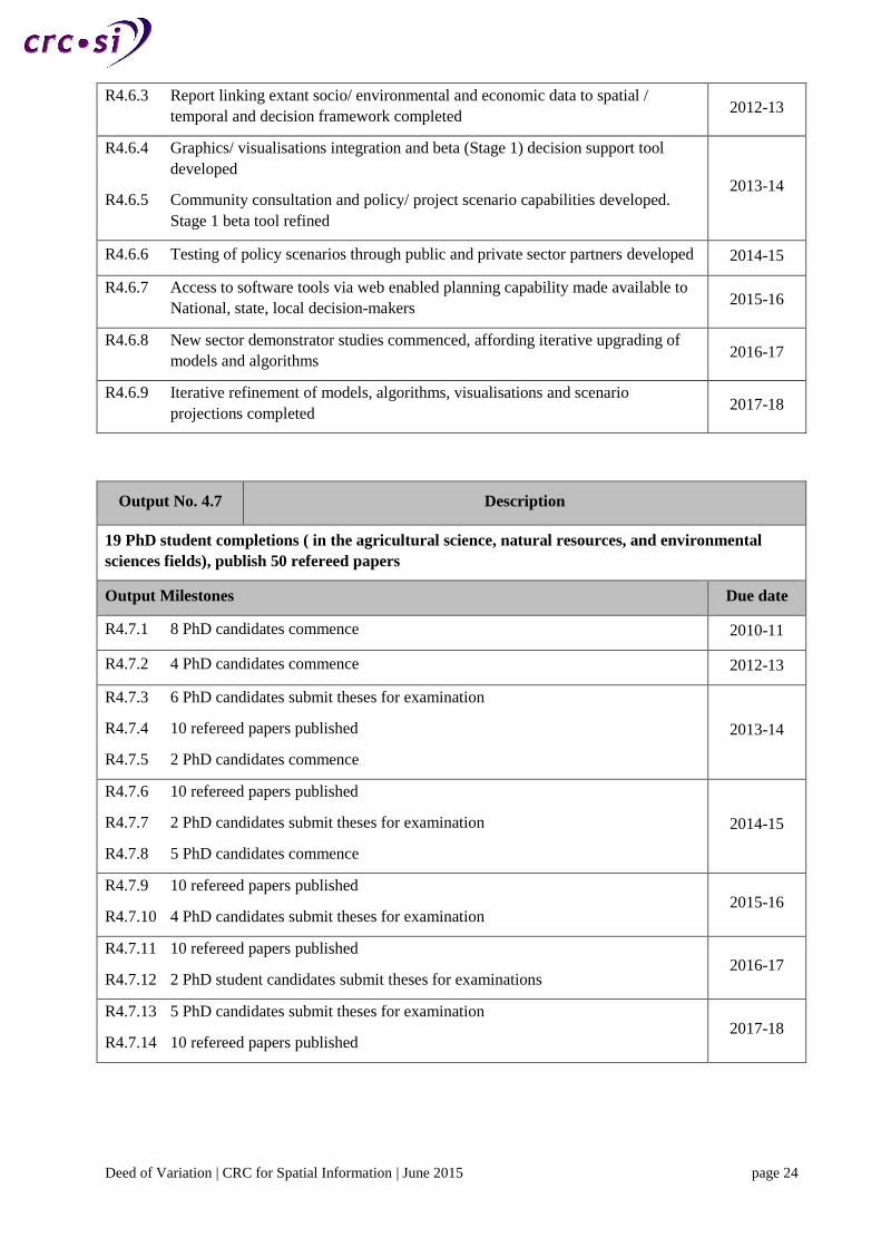
Deed of Variation | CRC for Spatial Information | June 2015 page 24
R4.6.3 Report linking extant socio/ environmental and economic data to spatial /
temporal and decision framework completed 2012-13
R4.6.4 Graphics/ visualisations integration and beta (Stage 1) decision support tool
developed
R4.6.5 Community consultation and policy/ project scenario capabilities developed.
Stage 1 beta tool refined
2013-14
R4.6.6 Testing of policy scenarios through public and private sector partners developed 2014-15
R4.6.7 Access to software tools via web enabled planning capability made available to
National, state, local decision-makers 2015-16
R4.6.8 New sector demonstrator studies commenced, affording iterative upgrading of
models and algorithms 2016-17
R4.6.9 Iterative refinement of models, algorithms, visualisations and scenario
projections completed 2017-18
Output No. 4.7 Description
19 PhD student completions ( in the agricultural science, natural resources, and environmental
sciences fields), publish 50 refereed papers
Output Milestones Due date
R4.7.1 8 PhD candidates commence 2010-11
R4.7.2 4 PhD candidates commence 2012-13
R4.7.3 6 PhD candidates submit theses for examination
R4.7.4 10 refereed papers published
R4.7.5 2 PhD candidates commence
2013-14
R4.7.6 10 refereed papers published
R4.7.7 2 PhD candidates submit theses for examination
R4.7.8 5 PhD candidates commence
2014-15
R4.7.9 10 refereed papers published
R4.7.10 4 PhD candidates submit theses for examination 2015-16
R4.7.11 10 refereed papers published
R4.7.12 2 PhD student candidates submit theses for examinations 2016-17
R4.7.13 5 PhD candidates submit theses for examination
R4.7.14 10 refereed papers published 2017-18

Deed of Variation | CRC for Spatial Information | June 2015 page 25
Utilisation No. 4.1 Description
Outputs of 4.1, 4.2, and 4.3 will have two types of user – application users and researchers/ software
developers. Application users are individuals within state and regional governmental agencies. The
researchers/software developer users will be within the CRC who are addressing specific needs of non-
CRCSI-2 end-users. These groups include CRC industry participants and also include government
organisations whose focus is spatial data.
Utilisation Milestones Due date
U4.1.1 Consultations with 25 potential end-users completed
U4.1.2 Independent review of design completed 2013-14
U4.1.3 Formal trialling of outputs with 25 application end-users completed.
U4.1.4 Informal trialling with 5 developers completed
U4.1.5 Independent review of design completed.
2015-16
U4.1.6 Business case for implementation of system developed
U4.1.7 Three focus workshops on embedding outputs into organisational business
processes hosted
2016-17
U4.1.8 Application documentation (tutorials, user manuals) finalised with end-users.
System design documentation finalised with developers.
U4.1.9 Informational training courses hosted for end-users at three locations across
Australia.
U4.1.10 60 government users of applications
2017-18
Utilisation No. 4.2 Description
Usage of outputs of 4.2, and 4.3 will also be by technology-literate farm managers from small, medium
and large farms, and agricultural service providers such as consultants and agronomists. New spatially-
enabled tools for quantifying water demand and differentially managing fertilizer applications will be
used by crop growers to improve irrigated water use efficiency (mass of produce per megalitre of water)
and reduce fertilizer inputs. Grazing managers will benefit from spatially-enabled tools to improve
pasture utilization, stabilise grazing systems, reduce land degradation, and improve nutrient management.
Utilisation Milestones Due date
U4.2.1 Participation of 10 end-user service providers to incorporate improved data and
analysis in everyday farm management activities. 2013-14
U4.2.2 Training and information sessions for 100 farmers and 10 providers hosted at
three locations around the country. 2015-16
U4.2.3 Training and information sessions for additional 500 farmers and 20 providers
hosted at five locations around the country (600 farmers and 30 providers in
total).
2016-17
U4.2.4 1050 end-users and service providers (50 agriculture providers and 1000
farmers) incorporate improved data and analysis in farm management
U4.2.5 System documentation, tutorials, and user manuals reviewed independently; 50
service providers contacted and trained
2017-18

Deed of Variation | CRC for Spatial Information | June 2015 page 26
Utilisation No. 4.3 Description
Usage for Outputs 4.4 and 4.5 are expected to build over the 8.5-year timeframe starting with the
Department of Health, WA, Telethon Institute for Child Health Research and Queensland Cancer
Council. A gradual build up to Commonwealth Health Agencies and other Cancer Councils and Research
Institutes will follow. After the establishment of spatial health privacy protocols (Year 3) the front-line of
health care - Primary Care clinics, Community Health Providers and Local Government Areas will
benefit.
Government Health Professionals- Initial WA Department of Health branches engaged include the
Public Health Intelligence, Child & Adolescent Health, Environmental Heath.
Industry End-users -Health Researchers, NGO Health Agencies (Cancer Councils/ Diabetes
Australia/Asthma Foundation), Primary Care Clincs, Local Government Authorities (LGA).
Utilisation Milestones Due date
U4.3.1 Department of Health, WA use Visualisation Tool for trial/testing.
U4.3.2 Privacy modules delivered (1 major agency). 2011-12
U4.3.3 Geocoding evaluation results used by WA Department of Health
U4.3.4 Roll-out to two further Health agencies.
U4.3.5 Health researchers and GP Divisions trial involving above three major agencies
completed
U4.3.6 Health researchers from 3 Universities use results of geocoding positional error
sensitivity research
2012-13
U4.3.7 Roll-out to four further Health agencies
U4.3.8 Further release to three GP Divisions, and three LGA partners for trial (6 major
agencies in total)
U4.3.9 Results of population exposure modelling assessment used by health researchers
at three Universities
2013-14
U4.3.10 Temporal spatial models of risk factors used in health research fields such as
cancer, injury, diabetes and asthma.
U4.3.11 Spatial referencing at point of capture process adopted by at least three health
agencies
2015-16
U4.3.12 Roll-out to other government agencies to assist with communication of complex
multi-dimensional data (eg transport, natural resources) (20 end users in total ) 2016-17
U4.3.13 Use of Chronic Disease prediction algorithms by at least 1 Hospital.
U4.3.14 Continued roll-out to local end users (8 agencies + 35 end users in total) 2017-18

Deed of Variation | CRC for Spatial Information | June 2015 page 27
Utilisation No. 4.4 Description
Output 4.6 (Data, metrics, visualisations, scenario projections and communication tools) will be used by
policy makers, planners and regulators across the three tiers of government and key user communities
(developers, professional advisers, financiers, business, industry and community). The take-up pathway
will commence with trial and demonstration initiatives conducted with large project partners (User Group
B consists of large organisations eg, Infrastructure Australia, WA Department of Planning and
Infrastructure, Victorian Department of Planning and Community Development interfacing with
national/international professional advisers such as Hassell). Large users are characterised by annual
throughput of 25 or more projects and the size and diversity spread of such projects.
User Group A consists of SME scale planning groups, developers and Local Governments. Group A users
have a lower annual project volume (typically 10 - 20 per year) and their projects are of a smaller average
size than Group B organisations.
Utilisation Milestones Due date
U4.4.1 Status implementation trial report completed covering evaluation of manually
delivered data and related metrics
U4.4.2 1 User Group B deployment (eg Dept of Planning & Infrastructure WA)
2011-12
U4.4.3 2 further Group B deployments
U4.4.4 Status Implementation Report completed on initial trial projects covering first
three end user Group B deployments
2012-13
U4.4.5 First small user deployment: 1 Group A deployment; 1 further Group B
deployment 2013-14
U4.4.6 2 further Group B deployments 2014-15
U4.4.7 2 further Group A deployments 2015-16
U4.4.8 Full web functionality, enabling e-planning between remote partners
participating in national, state, local decision-making
U4.4.9 1 further Group A deployment
U4.4.10 2 further Group B deployments
2016-17
U4.4.11 7 further Group A deployments (11 in total)
U4.4.12 1 further Group B deployment (9 in total) 2017-18
Utilisation No. 4.5 Description
Of the 19 PhD students that commence during this research program, 10-12 of these are expected to be
employed directly in Australian industry. A further 5-6 will be employed in Australian Government
organisations. The 1-4 remaining graduates are expected to go on to post-doctoral research positions with
Australian-based research organisations.
Utilisation Milestones Due date
U4.5.1 6 graduates in full employment 2013-14
U4.5.2 Further 2 graduates in full employment 2014-15
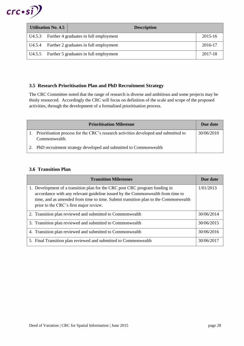
Deed of Variation | CRC for Spatial Information | June 2015 page 28
Utilisation No. 4.5 Description
U4.5.3 Further 4 graduates in full employment 2015-16
U4.5.4 Further 2 graduates in full employment 2016-17
U4.5.5 Further 5 graduates in full employment 2017-18
3.5 Research Prioritisation Plan and PhD Recruitment Strategy
The CRC Committee noted that the range of research is diverse and ambitious and some projects may be
thinly resourced. Accordingly the CRC will focus on definition of the scale and scope of the proposed
activities, through the development of a formalised prioritisation process.
Prioritisation Milestone Due date
1. Prioritisation process for the CRC’s research activities developed and submitted to
Commonwealth.
2. PhD recruitment strategy developed and submitted to Commonwealth
30/06/2010
3.6 Transition Plan
Transition Milestones Due date
1. Development of a transition plan for the CRC post CRC program funding in
accordance with any relevant guideline issued by the Commonwealth from time to
time, and as amended from time to time. Submit transition plan to the Commonwealth
prior to the CRC’s first major review.
1/01/2013
2. Transition plan reviewed and submitted to Commonwealth 30/06/2014
3. Transition plan reviewed and submitted to Commonwealth 30/06/2015
4. Transition plan reviewed and submitted to Commonwealth 30/06/2016
5. Final Transition plan reviewed and submitted to Commonwealth 30/06/2017