scenario planning - mindmixer
TRANSCRIPT

Community Plans alternative PoliCy iDeas
► Promote more intensive development in cities/towns and in nodes.
► Direct employment uses to municipalities and key areas, such as the I-77 corridor.
► Support the integration of transit in I-77 corridor
► Support growth in Utility Service Area and in activity nodes.
► Allow medium density residential along the 274 corridor and near Lake Wylie
► Maintain rural areas.
Community Plans (CP) sCenarioThis scenario shows how the County might develop if current land use policies are followed.
Community Plans (CP) imPaCtsThese numbers measure the potential impacts of growth, if growth occurs according to current policies.
Community Plans alternative
Scenario Planning
Forecast Map: Blue dots represent forecasted homes, red dots represent forecasted jobs
Community Plans scenario land use CategoriesSuitability Map: Reds and oranges represent areas wheregrowth is encouraged through land use policy
HigHest sewer DemanD insiDe utility serviCe BounDary (usB) for all sCenarios.
► 1 MGD more in sewer demand equates to about $600,000 extra in annual revenue.

regional PreferenCe alternative PoliCy iDeas
► Promote development in cities/towns and in nodes.
► Expand range and size of employment areas and direct future employment accordingly.
► Support the integration of premium transit in I-77 corridor and development that can be served by transit ridership.
► Support growth in [reduced] Utility Service Areas.
► Support growth in activity nodes.
► Maintain rural areas.
► Increase preserved open space.
ConneCt regional PreferenCe (rP) sCenarioThis scenario shows how the County might develop if policies are consistent with the preferences expressed during the regional planning process, CONNECT.
regional PreferenCe (rP) imPaCts These numbers measure the potential impacts of growth if growth occurs according to the CONNECT regional planning assumptions.
regional PreferenCe alternative
Scenario Planning
ConneCt regional Preference land use CategoriesSuitability Map: Reds and oranges represent areas wheregrowth is encouraged through land use policy
Forecast Map: Blue dots represent forecasted homes, red dots represent forecasted jobs
smallest urBan footPrint of all sCenarios

BalanCeD growtH alternative PoliCy iDeas
► Promote mixed-use development in cities/towns and in nodes.
► Direct future employment to areas identified as suitable for future employment centers.
► Concentrate development (mixed use and higher density mixed residential) in areas that can be served by multimodal transportation network.
► Support the integration of premium transit in I-77 corridor and express bus along SC 160 and to Lake Wylie
► Support growth in [reduced] Utility Service Areas as well as development that utilizes available utility capacity.
► Support alternatives to conventional residential subdivisions to reduced impacts to environment and existing development.
► Maintain rural areas and viable agriculture.
► Proactively promote conservation of open space and natural and cultural resources.
► Encourage a development pattern that can facilitate a connected system of parks and recreation.
BalanCeD growtH (Bg)This scenario shows how the County might develop with more proactive environmental, infrastructure and economic development policies in place.
BalanCeD growtH (Bg) imPaCts These numbers measure the potential impacts of growth according to an alternative growth scenario.
BalanCeD growtH alternative
Scenario Planning
Balanced growth land use CategoriesSuitability Map: Reds and oranges represent areas wheregrowth is encouraged through land use policy
Forecast Map: Blue dots represent forecasted homes, red dots represent forecasted jobs
HigHest Parks anD oPen sPaCe statistiCs
lowest imPervious surfaCe near lake wylie

Sing
le F
amily
N
eigh
borh
oods
Wal
kabl
e N
eigh
borh
oods
Subu
rban
Co
mm
erci
al
Land
Use
Typ
esRu
ral L
ivin
g /
Gre
enbe
lt Re
side
ntia
l
Wat
erfr
ont
Resi
dent
ial
Larg
e Lo
t Re
side
ntia
lM
ultif
amily
Re
side
ntia
lTr
ansi
t Act
ivity
Ce
nter
Indu
stria
l
Offi
ce
Tow
n Ce
nter

3. Choose 5 elements/outComes that should be in the York CountY Preferred sCenario (that will be used to uPdate the future land use maP and draft land use PoliCies for the ComPrehensive Plan).
outCome
Jobs
Identify and preserve lands highly suitable for industrial and office uses along I-77Identify and preserve lands highly suitable for industrial and office uses along the US-321 Corridor
Growth manaGement and infrastruCture
Promote large lot subdivisions in rural and agricultural areasEncourage a mix of commercial and walkable residential development near defined activity centersRequire transit oriented development (TOD) along I-77 and US-21 to support bus rapid transit (BRT)Encouraage TOD along US 21 BRT route, support express bus along SC 160 and to Lake Wylie/274Restrict utility service to the currently adopted Utility Service BoundaryReduce the size of the currently adopted Utility Service BoundaryExpand the Utility Service Boundary but require context sensitive rural conservation developments in the Greenbelt Area (between Lake Wylie and Clover and Rock Hill and the City of York)
Expand the Utility Service Boundary and provide water and sewer service to areas along I-77 that are prime for recruitment of new industrial and office jobsParks and oPen sPaCe
Plan for and fund/require connected system of high quality public and private open space throughout the CountyPromote conservation subdivisions (with >= 40% open space) in rural and agricultural areasRequire the incorporation of usable, upland open space (not just floodplain and other undevelopable areas) in new developments in rural and agricultural areas
natural resourCes
Allow medium-high density residential development (>3 DU/Acre) near Lake Wylie and the Catawba RiverAllow only low density residential development near Lake Wylie and the Catawba River unless located at a planned mixed use activity centerReduce impervious surface in new development to protect water quality in Lake WyliePromote clustering of development to preserve rural views and natural resources
other
Other:
sCenario PlanninG worksheet
1. whiCh sCenario best rePresents Your vision for the future of York CountY?
Community Plans Scenario Regional Preference Scenario Balanced Growth Scenario
2. what ChanGe would You make to the sCenario above to be more in line with Your vision?
Continued on the following page.
sCenario PlanninG worksheet
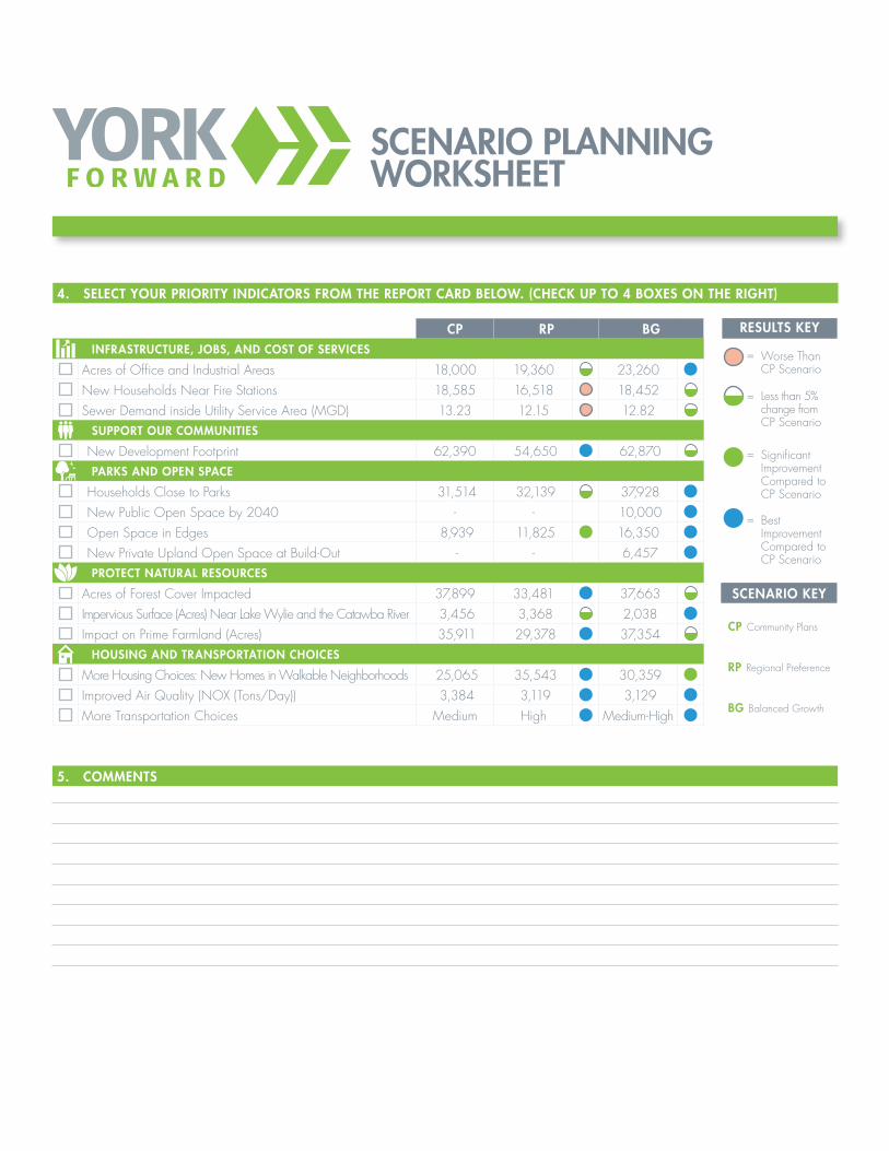
4. seleCt Your PrioritY indiCators from the rePort Card below. (CheCk uP to 4 boxes on the riGht)
5. Comments
CP rP bGinfrastruCture, Jobs, and Cost of serviCes
Acres of Office and Industrial Areas 18,000 19,360 23,260New Households Near Fire Stations 18,585 16,518 18,452Sewer Demand inside Utility Service Area (MGD) 13.23 12.15 12.82
suPPort our Communities
New Development Footprint 62,390 54,650 62,870Parks and oPen sPaCe
Households Close to Parks 31,514 32,139 37,928New Public Open Space by 2040 - - 10,000Open Space in Edges 8,939 11,825 16,350New Private Upland Open Space at Build-Out - - 6,457ProteCt natural resourCes
Acres of Forest Cover Impacted 37,899 33,481 37,663Impervious Surface (Acres) Near Lake Wylie and the Catawba River 3,456 3,368 2,038Impact on Prime Farmland (Acres) 35,911 29,378 37,354
housinG and transPortation ChoiCes
More Housing Choices: New Homes in Walkable Neighborhoods 25,065 35,543 30,359Improved Air Quality (NOX (Tons/Day)) 3,384 3,119 3,129More Transportation Choices Medium High Medium-High
results keY
= Worse Than CP Scenario
= Less than 5% change from CP Scenario
= Significant
Improvement Compared to CP Scenario
= Best Improvement Compared to CP Scenario
sCenario keY
CP Community Plans
rP Regional Preference
bG Balanced Growth

York County Comprehensive Plan Scenario Planning Indicator Descriptions
Infrastructure, Jobs and Cost of Services
Acres of Office and Industrial Areas: Acres of land devoted in the scenario devoted to employment bearing uses like office and industrial development.
New Households Near Fire Stations: Number of forecasted households located within 1 mile of fire stations that received a good ISO rating (6, 7, 6-9 and 7-9).
Sewer Demand Inside Utility Service Boundary (USB): Forecasted sewer demand inside the adopted Utility Service Area (USA), reported in millions of gallons per day (MGD). 1 MGD equates to about $600,000 in annual revenue. This does not include tap fees or other one-time revenue sources.
Support Our Communities New Development Footprint: Acres of new developed land. Based on where growth is
forecasted to occur over a density threshold of 1 dwelling unit or job per four acres.
Parks and Open Space Households Close to Parks: Forecasted households near parks. Balanced Growth (BG)
scenario assumes future county parks and recreation system at locations identified through public input.
New Public Open Space by 2040: BG scenario assumes resuming funding of York County Forever, which has preserved 9,000 acres of farmland and forest since 1998, but has not been fully funded since the recession.
Open Space in Edges: Acres of open space included in new developments on the “edges” of developed areas. Assumes improved open space requirements in BG scenario in the “greenbelt” between Lake Wylie and Clover, and Rock Hill and the City of York. This area includes farmland and the forested watersheds of Crowder’s Creek, Beaverdam Creek, Allison Creek and Fishing Creek.
New Private Upland Open Space at Build Out: Acres of private open space in new developments that are “uplands”—areas that are not located in floodplains, wetlands and other undevelopable areas. Upland open space requirements, like the 10% requirement included in the Greenbelt Residential area in the BG scenario, can help protect farmland and mature forest.