satellite technology & innovation - · pdf filesatellite technology & innovation use...
TRANSCRIPT

SATELLITE
TECHNOLOGY
& INNOVATIONUSE CASES FOR THE UNICEF
INNOVATION FUND - APRIL 2016
This publication is a market research study
commissioned for UNICEF Innovation. The case
studies mentioned and companies reflected in this
document are hypothetical and do not necessarily
reflect the views or intentions of UNICEF.
STEPHEN DENG
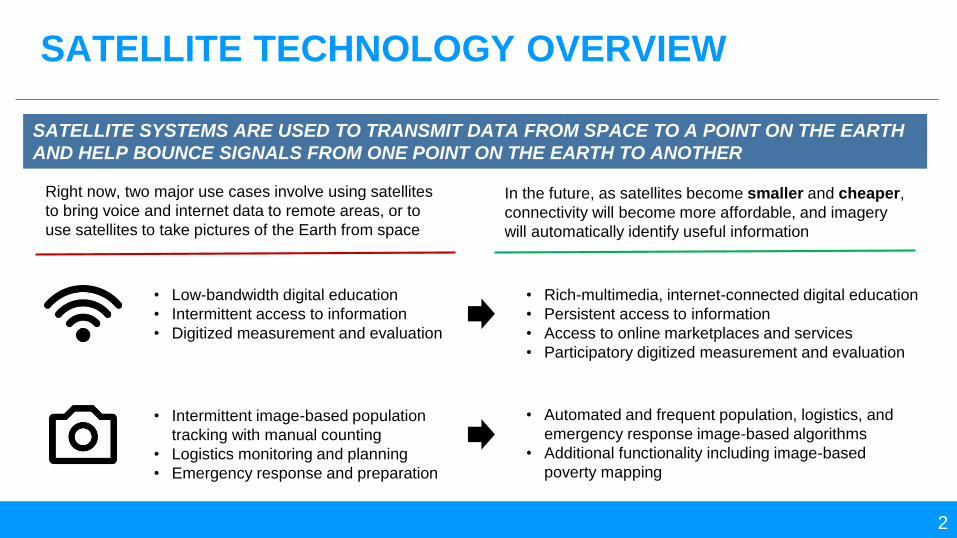
SATELLITE TECHNOLOGY OVERVIEW
2
SATELLITE SYSTEMS ARE USED TO TRANSMIT DATA FROM SPACE TO A POINT ON THE EARTH
AND HELP BOUNCE SIGNALS FROM ONE POINT ON THE EARTH TO ANOTHER
Right now, two major use cases involve using satellites
to bring voice and internet data to remote areas, or to
use satellites to take pictures of the Earth from space
In the future, as satellites become smaller and cheaper,
connectivity will become more affordable, and imagery
will automatically identify useful information
• Low-bandwidth digital education
• Intermittent access to information
• Digitized measurement and evaluation
• Intermittent image-based population
tracking with manual counting
• Logistics monitoring and planning
• Emergency response and preparation
• Rich-multimedia, internet-connected digital education
• Persistent access to information
• Access to online marketplaces and services
• Participatory digitized measurement and evaluation
• Automated and frequent population, logistics, and
emergency response image-based algorithms
• Additional functionality including image-based
poverty mapping

SATELLITE PARTNERSHIPS OVERVIEW
3
2. MARKET OPPORTUNITY 3. JOINT RESEARCH1. CURRENT NEEDS
UN
ICE
F
SA
TE
LL
ITE
PA
RT
NE
RS Satellite partners want to provide
and showcase access and imagery
opportunities with UNICEF using
current technologies and UNICEF’s
brand to highlight its CSR approach
UNICEF wants to increase access
for the needs that can be addressed
now, capitalizing on situations where
variable costs are low for the satellite
partner to expand long-term access
to connectivity and the use of
imagery
Satellite partners look to create real
shared-value, where new, high-growth
markets and use-cases may help fend
off the increasing commodification of
satellite technologies
UNICEF hopes to provide assistance
with demand aggregation and
partnership facilitation that may result in
more a sustainable network of
connectivity and imagery providers
using current and near-term
technologies
Satellite partners are looking to adapt
or disrupt the market altogether with
new satellite platforms, analysis tools,
and ground equipment to lower prices
and increase capability of satellite tech
UNICEF is a close research partner,
helping provide access to spectrum,
assisting with pilots in emerging
markets, and ground-truthing results in
an effort to confirm a new technology’s
use in UNICEF’s mission as well as the
R&D goals of UNICEF’s partners
A tiered partnership approach that capitalizes on current needs to increase access to satellite
technologies, seeks out opportunities in a quickly changing marketplace, and collaborates on research
that can truly shift cost and capability

SATELLITE SYSTEMS ARE USED TO TRANSMIT DATA
FROM SPACE TO A POINT ON THE EARTH
4Photo Credit: BBC
DISTINCT ADVANTAGES
1 HIGH COVERAGESatellites can quickly receive and transmit
information across the entire globe
3 LOW INFRASTRUCTUREGround equipment can be deployed quickly, and
in certain cases, be battery and/or solar-powered
HIGH MOBILITY2Satellite services are transportable, from small
terminals on automobiles to hand-held devices

MOST SATELLITES ARE MADE OF TWO COMPONENTS:
THE BUS, WHICH HELPS DELIVER THE PAYLOAD
5
THE BUS
• Power Subsystems
• Telemetry and Command Subsystems
• Altitude and Control Subsystems
• Propulsion Subsystems
1
SATELLITE STRUCTURE & SUPPORT
• Signal Repeaters
• Antennas
• Note: Payloads can be “hosted” for independent
satellite service providers
THE PAYLOAD2
SIGNAL EQUIPMENT AND SENSORS
Example GEO Satellite

HIGHER ORBITS OFFER GLOBAL COVERAGE WITH
FEWER SATELLITES, BUT INCREASED SIGNAL DELAY
6
Geosynchronous Orbit (GEO)
Low Earth Orbit (LEO)
In comparison, the moon’s orbit is 384,000 km away
• 35,789 km above sea-level
• 250-280 millisecond propagation delay
• 3 satellites to cover most of the globe
• In a fixed position above the Earth
Mid-Earth Orbit (MEO)
• 2,000 to 35,789 km above sea-level
• 110-130 millisecond propagation delay
• 10-18 satellites to cover most of the globe
• Revolves around the Earth in 2 to 12 hours
• 180 to 2,000 km above sea-level
• 20-25 millisecond propagation delay
• 40-70 satellites to cover most of the globe
• Revolves around the Earth in about 90 minutes

THE ITU HAS DEFINED SPECIFIC MICROWAVE
FREQUENCIES TO BE USED IN SATELLITE SERVICES
7
Band Frequency Usage
L 1-2 GHz Mobile Satellite Services (MSS)
S 2-4 GHzMSS, Digital Audio Radio
Services (DARS)
C 4-8 GHz Fixed Satellite Services (FSS)
X 8 -12 GHzMilitary, Satellite Imagery
Downlink
Ku 12-18 GHzFSS, Broadcast Satellite Services
(BSS)
Ka 26-40 GHzFSS Broadband and inter-
satellite links
Incre
asin
g
Wave
length
Incre
asin
g
Fre
qu
en
cy
The Ka-band is being used in the latest satellite
communication technologies, but is far more
susceptible to interference in rain
MSS and FSS are simply ITU designations
defined by the user terminal (mobile or fixed)
and the segments are quickly overlapping due to
the evolution of mobile FSS terminals such as
Very-Small-Aperture Terminals (VSATs).

TWO ESTABLISHED SATELLITE SERVICES INCLUDE
SATELLITE CONNECTIVITY AND REMOTE IMAGERY
8
VOICE & DATA CONNECTIVITYSatellites can provide a nearly-instant communications channel
that is always up and accessible from anywhere
REMOTE IMAGERYSatellites can take high-resolution images of the Earth on a
daily basis and capture a variety of visual information

SATELLITES HELP EXTEND CONNECTIVITY INTO THE
MOST REMOTE “LAST-MILE” SITUATIONS
9
SATELLITE COMMUNICATION NETWORK
1 SPACE SEGMENTBounces the signals from space to the Earth.
3 USER TERMINALSDevices for end-users to connect with the satellite
signal. Examples include satellite-specific phones,
satellite dishes, and Wi-Fi hotspots.
GROUND SEGMENT2“Translates” the signal so it can communicate with
landlines, mobile phones, and/or the internet. Can
also serve as way to move the signal.
Satellite
Wi-Fi Hotspot
Satellite Assembly
(VSAT)
Satellite Mobile
Internet
Mobile Network
Ground Station
1
3
2

…BUT QUICK-DEPLOY VSATS OFFER A SUPERIOR
COMBINATION OF MOBILITY AND CONNECTION SPEED
11
Inmarsat IsatHub
• 850g
• 179 x 170 x 30 mm
• 200 Kbps
GD Satcoms 1244
• 2.4 meters
• 256 to 3072 kbps
Thuraya XT
• 193g
• 128 x 53 x 27 mm
• 60 Kbps GD Satcoms 1138QD
• 1.2 meters
• 256 to 3072 kbps
Connectivity Speed
Eq
uip
me
nt
Mo
bil
ity
Satellite Mobile Phone
Wi-Fi Hotspot Quick-Deploy VSAT
Fixed VSAT

SATELLITES ENABLE DAILY, SUB-METER PER PIXEL
IMAGES OF THE EARTH
12
SATELLITE IMAGERY NETWORK
1 SPACE SENSORCaptures various wavelengths of light coming from the
Earth which are converted to pixels by the sensors
3 DATA PLATFORMImagery data is then able to be accessed,
analyzed, and represented in software
DOWNLINK2Sends the information down to datacenters on the
ground to convert pixels into data
Imaging Satellite
Data & Analytics
Platform
Downlink
1
2
3
Light from the
Earth
Note: There is an outstanding overview of satellite imagery at http://satsummit.github.io/landscape

SATELLITE IMAGERY SERVICES HAVE FOUR MAIN
MEASURES OF “RESOLUTION”
13
1
What area is covered and in how much
detail?
3
What wavelengths of light can be picked
up by the sensors?
2
How often do satellites “revisit” the same
areas for capture?
4
How sensitive is the sensor in detecting
differences within the image? (e.g.
brightness)
4 RADIOLOGICAL
3 SPECTRAL
2 TEMPORAL
1 SPATIALDifferent spatial resolutions
covering and American
football field – measured in
meters per pixel
The electromagnetic
spectrum – satellites imagery
can often measure visible,
UV, and IR light, depending
on spectral resolution

IMAGERY COSTS DEPEND ON SPECTRAL AND SPATIAL
RESOLUTION AS WELL AS ARCHIVAL OR NEW IMAGES
14
Spectral Resolution0.5m High Spatial Resolution 1.5m Medium Spatial Resolution
Archive New Task Archive New Task
Panchromatic $10-14.50/km2 $23-24/km2 $3.90/km2 $4.50/km2
3-Band Pan-Sharpened $10-17.50/km2 $23-27.50/km2 $5.15/km2 $6.20/km2
4 Band Pan-Sharpened $10-17.50/km2 $23-27.50/km2 $5.15/km2 $6.20/km2
Panchromatic + 4-band
Multispectral$10-17.50/km2 $23-27.50/km2 $5.15/km2
(6m Multispectral)
$6.20/km2
(6m Multispectral)
8-Band Multispectral $20/km2 $31.50/km2
8-Band Panchromatic +
Multispectral$20/km2 $31.50/km2
At lower spatial resolutions (e.g. 5m
or 6m per pixel) prices drop to
approx. $1.70/km2
*Note: Prices from an image reseller for older, more traditional satellites (e.g. WorldView-1,2,3, QuickBird, GeoEye-1, IKONOS, RapidEye)

47% OF SATELLITE INDUSTRY REVENUE COMES FROM
SATELLITE TV
15
Global Satellite Industry Revenues (2014)
Total: $203B
4% Growth
Satellite
Services
$122.9B
Ground
Equip.
$58.3B
Launch Industry
$5.9B
Satellite
Manufacturing
$15.9B
Global Satellite Services Revenue (2014)
Total: $122.9B
4% Growth
Consumer*
$100.9B
Fixed
$17.1B
Mobile
$3.3B
Earth
Observation
$1.6B
*In Consumer Services,Satellite TV makes up
94% while Consumer Broadband makes up <2%

SATELLITE SERVICES HAVE EXPERIENCED SLOWING
GROWTH OVER THE LAST 5 YEARS…
16
Global Satellite Service Revenues (2009 to 2014)

…BUT NEW SERVICES LIKE MOBILE DATA AND
SATELLITE IMAGERY ARE EXPANDING RAPIDLY
17
Segment Services 2014 Segment
Market Share
2014 Segment
GrowthDrivers of Growth
Consumer • Satellite TV
• Satellite Radio
• Consumer Broadband 82% 3%
The consumer segment grew by 3% in 2014 and
was driven by the growth of high definition
television and bandwidth savings from compression
tech
Fixed (FSS) • Transponder Agreements
• Managed Network Services 14% 4%Seeing growth of 4% in 2014 that matches the
overall growth of the satellite industry but saw no
growth in 2013
Mobile (MSS) • Mobile Data
• Mobile Voice2.6% 25%
Strongest segment with 25% growth in 2014, driven
by 19% growth in mobile voice and 27% growth in
mobile data supported by demand from the aviation
industry
Earth
Observation
• Remote Imaging
• Imagery Analysis 1.3% 9%Encouraging growth of 9% in 2014 supported by
strong demand (mostly gov’t) and new competitors
in remote imaging and meteorology

IN FSS/MSS, SEVERAL PROVIDERS COVER THE GLOBE
WHILE SMALLER ONES FOCUS ON GEO OR SECTOR
18
FSS and MSS Satellite Service Providers
Global Providers
Example Regional/Sector-Specific Providers
FSS and MSS providers now often
compete in the same markets due
to newer terminals that allow high-
frequency and high-bandwidth
(traditionally FSS) signals to be
used on moving platforms
There are services providers that
operate satellites and service
providers that resell others’ satellite
bandwidth (e.g. Talia and
Paradigm)
Smaller providers specialize in
region and/or sector (e.g. XTAR &
Paradigm’s focus on military
support)

THE EARTH OBSERVATION SERVICES SECTOR IS SEEING
INCREASED COMPETITION FROM NEW ENTRANTS
19
Traditional companies like DigitalGlobe feel the
competition of new entrants like Planet Labs and Skybox
(acquired by Google, now Terra Bella) who seek to
operate “constellations” of small, low-cost satellites.
The customer base of imagery is beginning to expand
from primarily governments to the private sector as well
These newer companies offer not only images, but an
API-driven data platform that can help filter and analyze
its satellite images. Older players are still using physical
media (DVD, external HD) to deliver images, or a web-
based FTP.
Satellite sensors are also being used to help produce
higher fidelity weather data (e.g. Spire, Tempest Global,
etc.)
Re
mo
te Im
ag
ing
an
d S
en
sin
g P
rovid
ers

SATELLITE TECHNOLOGY WILL BECOME SMALLER,
CHEAPER, AND MORE UBIQUITOUS
20
Present Next Generation (0-2 yrs) Future Generations (2-5+ yrs)
• Mobile Satellite Phones
• Satellite Wi-Fi Hotspots
• Quick-Deploy VSATS
• Much smaller and cheaper
low-earth orbit satellites with
API-based analytics platforms
• Satellite imagery-based
weather monitoring
• Large geostationary imagery
satellites
• Ground-based stations for
weather monitoring
• Flexible spot-beam high-
throughput satellite (HTS)
services
Project Loon
Internet via
balloons in space
Nano & Pico Satellites
Continued development
and launches of smaller
satellites
Outernet
Downlink satellite-
based edu w/o internet
OneWeb
Extending mobile
networks using a global
satellite constellation
GPS-RO
Satellites that track
the bending of GPS
signals to estimate
weather conditions
Research & DevelopmentPilotsScaling Up
Solar Drones
Internet via solar-
powered drones

NEAR TERM ADVANCES WILL HELP DRIVE DOWN
COSTS AND INCREASE COMPETITION IN THE MARKET
21
EXPANSION OF HIGH-THROUGHPUT SATELLITES (HTS)
HTS reduces the cost of
providing gigabit connectivity
from space by 90 to 97%,
depending on the band,
because it offers much higher
capacity per payload
The increase in capacity HTS offers
is a result of high-level frequency re-
use and spot beam technology which
enables multiple, very focused beams
used to cover an area.
By contrast, traditional satellite
technology utilizes a broad single
beam or a few beams.
• While not new, HTS are
being accelerated due to
demand from industries like
commercial airlines for
onboard Wi-Fi
• Available bandwidth
increases with multi-beam
technology, especially in
the Ka-band
NANOSATS AND THE COMMODIFICATION OF SATELLITE TECH
Nanosats (and their
payloads) cost hundreds of
thousands of USD instead of
the hundreds of millions for
previous generation satellites
Satellites have shrunk down
to the size of a shoebox;
“CubeSat” standard is about
a liter in volume and 1.33 kg
The cost reduction comes from the
use of constellations of satellites in
low-earth orbit to provide global
coverage.
The satellites are built with many off-
the-shelf parts from consumer
industries (e.g. smartphones, cars)
and can be launched more cheaply –
SpaceX now has a reusable rocket
• Cheaper tech and launch
mechanisms mean private-
sector start-ups can now
launch satellites
• Downsizing of sensors offer
capabilities that previously
could not fit on nanosats
• Built to be Big Data
platforms: “Satellite
Imagery As A Service”

CASE STUDY: GOOGLE’S PROJECT LOON EXTENDS CURRENT
MOBILE NETWORKS BUT REQUIRE SPECTRUM RIGHTS
22
Project Loon: 4G internet via balloons
Technology • A network of balloons in the stratosphere controlled through
wind patterns; each balloon can last more than 100 days
• Each balloon broadcasts LTE/4G signal to an area of about
80km on the ground directly to handsets and ground stations
• Connectivity speeds of about 5 MB/s to handsets
• Google partners with local mobile network providers to share
cellular spectrum and connect to the internet
Significance • Very low infrastructure since handsets can directly connect to
the LTE signal that is being broadcasted by the balloons
• Extends current terrestrial-based mobile networks to the most
remote areas using a relatively high-throughput signal
Companies • Internally funded Google[X] project with mobile operator
partners in each country
Timeline • In a scaling-up phase with large country-level projects
• Started a country-wide project with Sri Lanka in 2015, plans
for a similar project in Indonesia in 2016
Barriers • It is unclear how Google plans to create a profitable business
model; it may attempt to share revenues with mobile phone
operators, but pricing is unclear
• Spectrum rights are difficult to obtain with incumbent operators
Much like a mobile phone tower in
the sky
UNICEF opportunity: to help shape the development
of a cheaper, globally accessible 4G LTE network by
assisting with spectrum rights and demand
aggregation

CASE STUDY: OUTERNET OFFERS SLOW, BUT FREE SATELLITE
DATA ACCESS THROUGH ITS OWN RECEIVERS
23
Outernet: Delivering educational files over satellite for free
Technology • A downlink-only satellite data access point used to broadcast
curated educational material over Wi-Fi for free; costs $99
• 50ft of Wi-Fi range; up to 5 devices connected (expandable)
• Requires more equipment including an external satellite dish
that adds $60+ to the cost
Significance • Aiming to create a low-cost, open-source satellite data access
point to provide educational resources everywhere
• Outernet sends files for offline consumption, not links
• In development for a portable, solar-powered access point that
can connect to ViaSat’s L-band satellite signal
• Starting an open content platform that allows user contribution
Companies • Outernet, partnership with ViaSat, content providers
Timeline • In the late R&D phase with some pilots started using its current
products, including in 1,000 schools in Latin America
• Plans to deliver its portable, solar-powered “Lantern” access
point in Summer 2016
Barriers • Team is struggling to finalize the design for its portable product,
needing robustness, solar-power, and usable UI
• Will be difficult to localize content for regional needs
The Outernet “Lighthouse” receiver
costs $99, but still needs an external
satellite dish, a downconverter and
cabling
UNICEF opportunity: to usher in free, but low-
bandwidth satellite connectivity by assisting with
government access, content creation, and demand
aggregation

CASE STUDY: FACEBOOK’S IMAGE RECOGNITION PLATFORM
USED TO AUTOMATE POPULATION TRACKING
24
Automated Population Mapping via Imagery
Technology • A machine-learning process by which populations can be
estimated using satellite imagery of inhabited areas
• The crucial breakthrough is the ability to automatically identify
buildings and other living structures
• Populations are estimated by comparing the structure
information to currently available census data and extrapolating
that to areas without reliable population figures
Significance • Allows for population tracking that is much quicker, easier, and
cheaper than current survey-based methods
• Automated structure information can help in situations where
there is a lack of previous mapping information
• Facebook will continue to build on the algorithms to attempt to
identify even more than population (e.g. poverty)
Companies • Facebook, license from DigitalGlobe for 0.5 meter imagery
Timeline • Looking to ground-truth its estimates in 2016
Barriers • Additional ground-truthing is needed and Facebook needs
partners who already conduct very granular population surveys
• Currently cannot find changes very quickly due to the images
being derived from a variety of time periods
Machine learning can automatically
identify and visually mark structures
where people live
UNICEF opportunity: to replace expensive and slow
manual surveys with automated population and
poverty mapping by assisting with ground-truthing

CASE STUDY: PERSISTENT SOLAR DRONES MAY OFFER A HIGHLY
MANEUVERABLE “HOTSPOT-ON-DEMAND”
25
Persistent Drones: Internet via laser-enabled drones
Technology • Ground stations will send radio signals to drones which will
communicate with each other via laser; the drones will then
send laser signals back down to transponders which convert
into Wi-Fi or 4G networks
• Facebook aims to launch 10,000 drones called “Aquilas”
• Imagery from these platforms will also be possible
Significance • Another HAPS (High-Altitude Platform Station) type project but
due to its laser-based communications, theoretically offers
very high throughput
• Drones are remotely controllable and can perform as
“hotspots-on-demand” compared to other methods which are
much harder to maneuver
Companies • Facebook, Google
Timeline • In the R&D phase, but hoping to test the first pilot by the end
of 2016
Barriers • No idea about pricing or business model just yet
• The laser technology is hampered by weather
• Free Basics backlash (net neutrality arguments) will linger
when Facebook tries scale-up
Facebook’s Internet drone has the
wingspan of a 737 passenger jet
and can stay aloft for months
UNICEF opportunity: to explore use cases for high-
bandwidth connectivity in the most remote areas; an
early stage initiative

CASE STUDY: LAUNCHING A TRULY GLOBAL CONSTELLATION OF
LEO SATELLITES TO EXPAND CURRENT NETWORKS
26
OneWeb: Extending Current internet networks via microsats
Technology • A constellation of approximately 650 microsatellites orbiting at
750 miles providing global internet access; an estimated price
tag of about $2 billion USD
• Will offer user terminals on the ground that include Wi-
Fi/LTE/3G and 2G radios to provider coverage directly to end-
user handsets and tablets; a mobile terminal available as well
Significance • An extension of existing networks, not a replacement so
unlicensed and partner operator’s frequencies can be used
• Technology will be fully 3GPP compatible
Companies • OneWeb, backed 50% by Airbus to assemble microsats,
contracts with Arianespace SA to use rockets for launch
Timeline • In the research and development phase and pushing to launch a
commercial service by 2020
• Plans to launch first 10 pilot satellites in 2017
• Satellite assembly
Barriers • There is pushback about OneWeb’s ability to avoid interference
with other satellites at that lower orbit; OneWeb claims they
have a technology called Progressive Pitch that allows them to
tilt their microsats to avoid interference
OneWeb plans to launch and
maintain 648 satellites
encircling the Earth
UNICEF opportunity: to explore use cases for
ubiquitous satellite connectivity in the most remote
areas; an early stage initiative

CASE STUDY: NANOSATS CAN DRAMATICALLY IMPROVE THE
VOLUME OF WEATHER DATA BY READING GPS SIGNALS
27
GPS-RO: Using nanosats to vastly improve weather data
Technology • Nanosatellites that can sense the bending of GPS signals
(from established GPS satellites). The amount of bending in
the GPS signals allow for calculations of temperature,
pressure, and humidity in a process called GPS Radio
Occultation (GPS-RO)
Significance • The main benefits include a vastly increased volume (1,500 to
10,000+) of accurate weather data that can help remove the
errors in today’s complicated weather modeling
• More accurate predictive modeling will provide more effective
warnings of adverse weather conditions and disasters
Companies • Spire Global, GeoOptics, PlanetIQ
Timeline • Still in the early piloting, with Spire launching its first satellites
at the end of 2015 and competitors following suite in 2016 and
beyond
Barriers • Unclear much of an advancement in weather prediction a
constellation of nanosats can practically provide
• Business model is unproven with uncertainly around pricing,
partnerships, and value-chain
Using GPS signals to produce tens
of thousands of weather data
points every day
UNICEF opportunity: to improve weather prediction
models for emergency preparedness and food
security; an early stage initiative

SATELLITE CONNECTIVITY AND IMAGING HAS USE-
CASES THAT SPAN A BREADTH OF UNICEF FOCUSES
28
SATELLITE CONNECTIVITY SATELLITE IMAGERY
Education • Internet-connected digital learning hotspots in
remote areas
• Quickly updated and pertinent educational
content
• Educational content creation around
archeology, environment, and geography
Access to Information • Internet-connected hotspots to distribute
critical information around health, agriculture,
local news, etc.
• Road and logistics information for product and
service delivery
• Localized evidence of the effect of global
warming and climate change
Measurement and
Evaluation
• Digitized M&E tools to share information more
quickly and effectively
• Participatory survey schemes (i.e. U-Report)
• Image-based population and poverty mapping
in areas where field surveys are impossible or
too slow and/or costly (e.g. refugee camps)
Emergency Preparedness
and Response
• Two-way communication in the most remote
areas where terrestrial infrastructure does not
exist or has been damaged
• Hyper-local population and building maps to
target search and rescue
• Danger and damage assessments

THERE ARE “QUICK-WIN” USE CASES FOR SATELLITE
IMAGERY AND HIGH-POTENTIAL FOR IMAGE ANALYSIS
29
Country Issues Current Solutions Improved Solutions
Jordan: Refugee
Populations
• The growth of difficult to reach
asylum-seeking population at
the Syrian border is growing
rapidly
• Need population data without
access to ground surveying
• Through OCHA/UNHCR
partnership with Digital Globe
they receive high resolution
(40 cm) analyzed images, but
only few times a year
• UNOSAT is supporting with
lower resolution analyzed
images every 3 months
• Monthly, high-resolution imagery (0.5-meter
or better), for manual or automated
population mapping and counting
• Could use better imagery ASAP
• Other country offices with refugee situations
also have population tracking problems
Mozambique:
Urbanization and
Slums
• Mozambique has urbanization
occurring with a high poverty
concentration in slums
• Population surveys are
extensive and difficult due to
poor digital connectivity
• No great solutions; some
field surveys but there is a
general lack of information
about population and poverty
• Google Maps have helped
• Low frequency, medium resolution imagery to
identify the location and growth of slum
communities in Mozambique
• Poverty mapping through imagery to identify
pockets of poverty within urbanized areas
Brazil: Logistics
on the Amazon
River
• The Amazon region
communities are spread out,
remote and rely upon the river
for transportation, but lack of
information about the river
leads to failed logistics
• UNICEF itself has no access
to river data other than
limited government data
based on weather modelling
• Daily, lower-resolution imagery to identify
Amazon river conditions that can be
accessed via mobile (trips can be 2-weeks)
• Generally, even better mapping of smaller
remote communities along the river would be
beneficial for service delivery

CONNECTIVITY IS TOO COSTLY AND MOST USE CASES
DEMAND CHEAPER SOLUTIONS TO USE & MAINTAIN
30
Country Issues Current Solutions Improved Solutions
Brazil: Internet
“Hotspots” for
Education
• Need to provide
secondary education
resources for 35,000 to
40,000 people
• Universities, Health
Centers, and Technical
Education Centers also
hope to provide
material via internet
• The Ministry of Education is
providing 3,000 centers with
an expensive satellite
internet connection
(~$1000/month in cost)1
• Ministry of Health,
Universities, etc. are also
paying for their own
connected centers
• In the short term, access points like the Outernet receiver,
combined with Wi-Fi caching would be a much cheaper
way to download and digitally distribute materials
• In the longer term, a cheaper overall solution needs to be
developed; Google Loon has specifically built its system to
provide service through Brazil’s cloud coverage and would
be a useful partner for the government; Loon is looking for
spectrum assistance and aggregation of users and the
Brazilian government wants to reduce their delivery costs
Kenya: Wi-Fi
Cached
Information
• Providing life-saving
content to rural
communities around
topics such as
Agriculture, Health,
Learning, Education,
Entrepreneurship, and
News & Entertainment
• Partnered with Equity Bank,
Inmarsat, and MAMA to
provide Wi-Fi access points
to 10 schools and 190
merchant agent sites
• Using Wi-Fi caching to
provide offline access;
internet access is simply to
update the services
• Expensive to scale and
maintain
• An Outernet-like self-contained mobile receiver could be
the next generation of these Wi-Fi caching hotspots. The
Outernet receiver will be based off of commercially
available components (e.g. the compute module is
Raspberry Pi 3), will not require a separate satellite dish,
and will be solar powered. Most importantly, data usage
with Outernet is free.
• Improving bandwidth allows for richer media (e.g. videos,
interactive programs) to deliver more compelling content
[1] Based on a quick conversation with Gabriel Ribenboim from Fundacao Amazonas Sustentavel

Satellite connectivity providers want access
to a growing market while developing more
affordable and effective technologies
UNICEF HAS SEVERAL LEVERS TO NEGOTIATE
PARTNERSHIPS AND A WEALTH OF VALUE TO PROVIDE
31
UN
ICE
F
Satellite Connectivity
Providers
Satellite Imagery
Providers
Connectivity & Imagery
Start-Ups
• Use of Intermittent data to refresh contents of Wi-Fi caching
• Use of lower-throughput bands for smaller data needs
• Use of satellite connections during “non-peak” hours1
• Government relationship broker
• Aggregation of demand (e.g. entire regions of schools, hospitals, etc.)
• Locally relevant content and physical access points on the ground
• Trusted field workers and implementation partners
Satellite imagery providers want to find new
use cases for their imagery and make the
jump to more commercial applications and
fend off new entrants
New players want funding and expertise,
assistance with pilots and ground-truthing,
and policy change to allow competition with
incumbents
• Use of archival footage when possible to reduce costs
• Use of lower resolution imagery while addressing needs
• Government relationship broker
• Research partner and test-bed for new use cases
• Ground-truthing to confirm accuracy of image analytics
• Government relationship broker; especially for spectrum rights
• Aggregation of demand to generate economies of scale quickly
• Research partner to help improve new technologies
• Expertise in innovation, design, and in-country implementation
• Early adoption of new technologies to help shape its ability
to lower costs and increase accessibility and capability
[1] Non-peak hours are generally 2am to 8am local time; some start earlier at around 11pm depending on regional usage

SATELLITE CONNECTIVITY COULD USE ADDITIONAL
INNOVATION AND DEV ASSISTANCE FROM UNICEF
33
UNICEF Needs Use Cases Potential Partner Solutions Market Cost
Affordable,
satellite-based
Wi-Fi caching
Intermittent connectivity to
update digital education
materials. Providing life-
saving information at the
right time.
• Outernet’s current Lighthouse fixed Wi-Fi
hotspot and planned mobile L-band access
point
• Wi-Fi caching and down-link only are still
very useful
• Fixed equipment kit runs about $200
per location while the target price for
mobile L-band solutions are unknown
• Outernet has a business model that
offers free access
Affordable
extension of
cellular
networks
Long-term access
solutions to replace ad-
hoc solutions and
stimulate an inclusive
digital economy
• Google’s Project Loon, 4G LTE connectivity
• OneWeb LEO Satellites and Ground
Receivers
• High-fixed cost to develop, promote,
and test solutions
• Google Loon: “Very expensive with
small numbers but can be very cheap at
scale”